141210 grhs draft_framework_draft update_high res
TRANSCRIPT

ACTIVITY CENTRE STRUCTURE PLAN
GLENFERRIE ROADHIGH STREET20
14DRAFT STRUCTURE PLANNovember 2014
CABRINIHOSPITAL
TOWNHALL
MALVERNCENTRAL
MALVERNSTATION
ARMADALESTATION
TRAMDEPOT
PAPP KENHAMCRARR
NBOURNEFRARR
NCKSTON
LINES
UNIONSTREET
RESERVE
MALVERNNCRICKETGROUND
shoppingsho working
dini
ngg
wor
king
shop
ping
livin
g
play
H I G H S T R E E TS
GLE
NFE
RR
IE R
OA
D
WATTLETREE ROADR

glenferrie road - high street structure plan | hansen partnership pty ltd DRAFT2
Contents Acknowledgements1 Introduction 3
what is a structure plan? 3 how will the structure plan be used? 3
2 Vision Statement 5
3 Study Area 6
4 Background Analysis 8
5 Community Views 9
6 Structure Plan Framework 10
key directions and design principles 10key directions 10land use & economic activity 12built form & heritage 14access and movement 16public realm and landscape 20
7 Main Street Built Form Brochures 22
glenferrie road 22high street 24wattletree west 26wattletree east 27
8 Neighbourhood Framework Plans 28
civic centre 28armadale station 30malvern station 32malvern central 34coldblo tram depot 36drysdale car park 38
9 Implementation 40
10 Action Plan 42
Figures Council Project TeamThe following members are particularly thanked for their contribution,
▪ Susan Price: Project Director/ Manager City Strategy
▪ Pia Howkins: Project Planner
▪ Casey Lord: Project Member/ Strategic Coordinator
▪ Project Working Group (PCG)
Hansen Partnership ▪ Craig Czarny: Project Director
▪ Richard Stevenson: Project Manager / Urban Planner
▪ Gerhana Waty : Senior Urban Designer
▪ Andy Fergus: Urban Designer / Urban Planner
▪ Danielle Jewson: Urban Designer / Landscape Architect
O’brien (integrated transport) ▪ Simon Beal: Project Director
▪ Aaron Roozenburg: Transportation Engineer
Essential Economics Sean Stephens: Project Director
Andrew Rossiter: Project Member
Stonnington City Council OfficersInvaluable contributions have also been provided a range of Council officers within their areas of expertise.
Figure 1 The study area: strategic illustration of key componentsFigure 2 Precinct BoundariesFigure 3 Study Area and Activity Centre BoundaryFigure 4 Metropolitan ContextFigure 5 Framework PlanFigure 6 Land Use and Economic ActivityFigure 7 Built Form and HeritageFigure 8 Access and Movement Figure 9 Public Realm and LandscapeFigure 10 Aerial context view (precinct 1: Civic Centre)Figure 11 Precinct Identification (precinct 1: Civic Centre)Figure 12 Precinct Framework Plan (precinct 1: Civic Centre)Figure 13 Aerial context view (precinct 2: Armadale Station)Figure 14 Precinct Identification (precinct 2: Armadale Station)Figure 15 Precinct Framework Plan (precinct 2: Armadale Station)Figure 16 Aerial context view (precinct 3: Malvern Station)Figure 17 Precinct Identification (precinct 3: Malvern Station)Figure 18 Precinct Framework Plan (precinct 3: Malvern Station)Figure 19 Aerial context view (precinct 4: Malvern CentralFigure 20 Precinct Identification (precinct 4: Malvern CentralFigure 21 Precinct Framework Plan (precinct 4: Malvern CentralFigure 22 Aerial context view (precinct 5: Coldblo Tram DepotFigure 23 Precinct Identification (precinct 5: Coldblo Tram DepotFigure 24 Precinct Framework Plan (precinct 5: Coldblo Tram DepotFigure 25 Aerial context view (precinct 6: Drysdale Street car park)Figure 26 Precinct Identification (precinct 6: Drysdale Street car park)Figure 27 Precinct Framework Plan (precinct 6: Drysdale Street car park)
Appendices
Appendix A: Community Consultation Stage 1 and 2 Summary (City of Stonnington)
Appendix B: Economic Technical Report (Essential Economics)
Appendix C: Social Impact Assessment (ASR Research)
Appendix D: Appendix D Background Transportation Report (O’Brien Traffic)

DRAFT glenferrie road - high street structure plan | hansen partnership pty ltd3
CABRINIHOSPITAL
TOWNHALL
MALVERNCENTRAL
MALVERNSTATION
ARMADALESTATION
TRAMDEPOT
PAKENHAM CRANBOURNE FRANKSTON LINES
UNIONSTREET
RESERVE
MALVERNCRICKETGROUND
shopping working
dini
ng
wor
king
shop
ping
livin
g
play
H I G H S T R E E T
GLE
NFE
RR
IE R
OA
D
WATTLETREE ROAD
figure 1 the study area: strategic illustration of key components

glenferrie road - high street structure plan | hansen partnership pty ltd DRAFT4
Glenferrie Road/ High Street Activity Centre Structure Plan
This Structure Plan builds upon the earlier analysis and findings documented within the following documents:
▪ Glenferrie Road/ High Street Activity Centre Structure Plan Background Report: June 2014.
▪ Glenferrie Road/ High Street Activity Centre Structure Plan issues and opportunities paper: August, 2014.
▪ Economic Technical Report, Essential Economics, 2014.
This document does not seek to replicate the detailed content of above documents; rather they form necessary background information which is relevant to the detail contained within this Structure Plan.
The combined retail areas of Glenferrie Road and High Street form an important, and historical, retail precinct that is popular within the local catchment primarily for its convenience, as well as containing a range of retailing activity which has a wider regional catchment. As a combined centre the Glenferrie Road / High Street Activity Centre is an important hub in Melbourne’s inner south east. It provides a range of retail and hospitality services and is well located within the Melbourne metropolitan context to capture future development, both residential and non-residential.
Stonnington City Council have engaged Hansen Partnership, a planning and design consultancy, to work with key stakeholders in preparing the Structure Plan for the Glenferrie Road / High Street Activity Centre. Hansen Partnership have been assisted with a supporting sub-consultant’s team of O’Brien Traffic (transportation) and Essential Economics (economic analysis).
The Structure Plan constitutes a strategic document that sets out a long term planning and design vision for the evolution of the precinct and is intended to set a 10-25 year strategic framework to manage and guide the future development the centre.
Project Stages
This project is being undertaken in a four stage process. The first stage of the project involved the collation of range of background materials, whilst the second stage involved the preparation of an issues and opportunities paper including consultation with the local community. The current third stage involves the preparation the Structure Plan itself including further community consultation and, following on from this the final stage will involve the implementation of the Structure Plan.
How will the Structure Plan be used?
The aim of the Structure Plan for the Glenferrie Road / High Street Activity Centre is to guide future land use and development in a coordinated manner and provide greater certainty for all stakeholders to deliver a preferred future. A vision for the centre for a period of 10 - 25 years is established. Key policy directions, and important physical outcomes as they relate to the Glenferrie Road / High Street Activity Centre’s built form and activity, landscape and environment and access and movement are identified. The Structure Plan will be used by:
Stonnington City Council:
▪ as a basis for introducing new planning policies, zones and overlay controls into its planning scheme (as appropriate);
▪ in assessing planning permit applications;
▪ in assessing requests to rezone land;
▪ in guiding non-statutory initiatives, arrangements or partnerships to assist in realising potential future opportunities within the centre;
▪ in preparing capital works budgets to implement public works; and
▪ in delivering community services.
The Community:
▪ to understand how the area, and specific precincts within the activity centre, are likely to change in the future;
▪ to assist community groups in prioritising future work and in seeking funding for projects; and
▪ to provide a framework for community groups to assist in making long term plans.
Existing Business Owners:
▪ to create greater certainty and appreciation regarding the future direction of the centre.
Developers:
▪ to understand the development opportunities that exist and the matters that will be taken into account in assessing development proposals.
Other government agencies:
▪ in coordinating infrastructure improvements with work undertaken by Stonnington City Council and other agencies including public transport, roads and water.
The Structure Plan must be regularly reviewed to ensure its directions and ambitions continue to be relevant to the centre as it changes over time.
1 IntroductionWhat is a Structure Plan?
A Structure Plan is a strategic planning tool which sets out a shared long-term vision for the future growth and change of a defined area. The Structure Plan aims to give effect to the policies and objectives set out in the State Planning Policy Framework to provide effectively for community needs. The Structure Plan will guide the major change to land use, built form and public spaces that together aim to achieve economic, social and environmental objectives for the place.
A coordinated plan allows a wide range of stakeholders, service authorities, State Government departments and internal Stonnington Council departments to all ‘read from the same page’ to produce a coherent outcome and provide certainty for both residents and the Council.
A Structure Plan also provides the framework for statutory planning controls which are implemented through the Stonnington Planning Scheme. Structure Plans are informed by extensive public consultation and discussion. While everyone may not agree on every aspect of the plan, it should reflect broad community consensus.

DRAFT glenferrie road - high street structure plan | hansen partnership pty ltd5
2 Vision StatementThe Vision Statement which underpins the Glenferrie Road/ High Street Activity Centre Structure Plan is as follows:
In 2040 Glenferrie Road and High Street Activity Centre will be:
▪ A thriving shopping centre, serving the day to day needs of the local community, coupled with a range of specialist retailers serving a wider regional area.
▪ A vibrant, inviting, attractive and clean centre with well-designed, ‘green’ streetscapes, pedestrian connections and community gathering nodes.
▪ A centre where new development respects and enhances the form and scale of heritage buildings, which retain prominence.
▪ A centre for localised employment and housing within the commercial spines whilst protecting the valued residential hinterland.
Objectives
The primary objectives for the Structure Plan are:
▪ To protect and enhance the existing heritage and built form fabric.
▪ To provide clear urban and built form guidance for new infill development and additions and alterations of existing buildings.
▪ To strengthen the commercial and retail role of the centres.
▪ To improve pedestrian and cyclist mobility and infrastructure throughout the centre and minimise pedestrian and vehicular conflict zones.
▪ To improve the appearance of the public spaces within the centre, including primary streetscapes and secondary areas such as public car parks and laneways.
▪ Provide additional vegetated corridors and spaces in strategic locations to develop the urban forest and enhance the public realm.
▪ To provide for pause points at and around important junctions.
▪ To improve access and connection of Malvern Central with Glenferrie Road.
▪ To consolidate medical and health related facilities along Wattletree Road.
▪ To consolidate and strengthen the community node around Malvern Library.
▪ To establish clearly defined gateways and entries into the centre.
▪ To provide healthy and diverse vegetated streets and public spaces.
▪ To provide clear guidance on the inclusion of vegetation into new infill development and additions and alterations of existing buildings
the study area comprises a diverse range of urban environnments and experiences from hostile Dandenong Road, to the intimate leafy residential side streets off High Street
glenferrie road - high street structure plan | hansen partnership pty ltd DRAFT6
high st
wattletree rd
glenfe
rrie r
d
kooy
ong r
d
princes highway
nferri
e rd
e rd
1
3
4
5
6
2
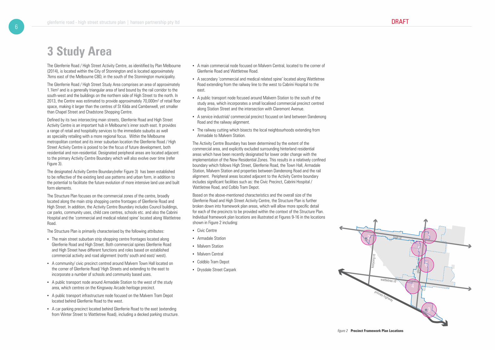
3 Study AreaThe Glenferrie Road / High Street Activity Centre, as idenitified by Plan Melbourne (2014), is located within the City of Stonnington and is located approximately 7kms east of the Melbourne CBD, in the south of the Stonnington municipality.
The Glenferrie Road / High Street Study Area comprises an area of approximately 1.1km² and is a generally triangular area of land bound by the rail corridor to the south-west and the buildings on the northern side of High Street to the north. In 2013, the Centre was estimated to provide approximately 70,000m² of retail floor space, making it larger than the centres of St Kilda and Camberwell, yet smaller than Chapel Street and Chadstone Shopping Centre.
Defined by its two intersecting main streets, Glenferrie Road and High Street Activity Centre is an important hub in Melbourne’s inner south east. It provides a range of retail and hospitality services to the immediate suburbs as well as speciality retailing with a more regional focus. Within the Melbourne metropolitan context and its inner suburban location the Glenferrie Road / High Street Activity Centre is poised to be the focus of future development, both residential and non-residential. Designated peripheral areas are located adjacent to the primary Activity Centre Boundary which will also evolve over time (refer Figure 3).
The designated Activity Centre Boundary(refer Figure 3) has been established to be reflective of the existing land use patterns and urban form, in addition to the potential to facilitate the future evolution of more intensive land use and built form elements.
The Structure Plan focuses on the commercial zones of the centre, broadly located along the main strip shopping centre frontages of Glenferrie Road and High Street. In addition, the Activity Centre Boundary includes Council buildings, car parks, community uses, child care centres, schools etc. and also the Cabrini Hospital and the ‘commercial and medical related spine’ located along Wattletree Road.
The Structure Plan is primarily characterised by the following attributes:
▪ The main street suburban strip shopping centre frontages located along Glenferrie Road and High Street. Both commercial spines Glenferrie Road and High Street have different functions and roles based on established commercial activity and road alignment (north/ south and east/ west).
▪ A community/ civic precinct centred around Malvern Town Hall located on the corner of Glenferrie Road/ High Streets and extending to the east to incorporate a number of schools and community based uses.
▪ A public transport node around Armadale Station to the west of the study area, which centres on the Kingsway Arcade heritage precinct.
▪ A public transport infrastructure node focused on the Malvern Tram Depot located behind Glenferrie Road to the west.
▪ A car parking precinct located behind Glenferrie Road to the east (extending from Winter Street to Wattletree Road), including a decked parking structure.
▪ A main commercial node focused on Malvern Central, located to the corner of Glenferrie Road and Wattletree Road.
▪ A secondary ‘commercial and medical related spine’ located along Wattletree Road extending from the railway line to the west to Cabrini Hospital to the east.
▪ A public transport node focused around Malvern Station to the south of the study area, which incorporates a small localised commercial precinct centred along Station Street and the intersection with Claremont Avenue.
▪ A service industrial/ commercial precinct focused on land between Dandenong Road and the railway alignment.
▪ The railway cutting which bisects the local neighbourhoods extending from Armadale to Malvern Station.
The Activity Centre Boundary has been determined by the extent of the commercial area, and explicitly excluded surrounding hinterland residential areas which have been recently designated for lower order change with the implementation of the New Residential Zones. This results in a relatively confined boundary which follows High Street, Glenferrie Road, the Town Hall, Armadale Station, Malvern Station and properties between Dandenong Road and the rail alignment. Peripheral areas located adjacent to the Activity Centre boundary includes significant facilities such as: the Civic Precinct, Cabrini Hospital / Wattletree Road, and Colblo Tram Depot.
Based on the above-mentioned characteristics and the overall size of the Glenferrie Road and High Street Activity Centre, the Structure Plan is further broken down into framework plan areas, which will allow more specific detail for each of the precincts to be provided within the context of the Structure Plan. Individual framework plan locations are illustrated at Figures 9-16 in the locations shown in Figure 2 including:
▪ Civic Centre
▪ Armadale Station
▪ Malvern Station
▪ Malvern Central
▪ Coldblo Tram Depot
▪ Drysdale Street Carpark
figure 2 Precinct Framework Plan Locations

DRAFT glenferrie road - high street structure plan | hansen partnership pty ltd7
town hall
tramdepot
malverncentral
cabrinihospital
armadalestation
malvernstation
malvernlibrary
de la sallecollege
malvern cricketground
malvernpublic gardens
de la sallecollege
st josephs
milton grayreserve
malvernbowling club
unitingchurch
churchof christ
armadalereserve
figure 3 Study Area and Activity Centre Boundary

glenferrie road - high street structure plan | hansen partnership pty ltd DRAFT8
couples without children, compared to Greater Melbourne (42% of 35%). There is a lower proportion of one parent families (11% of 15%). As such, the average household size of 2.3 persons per household is significantly lower than the average of 2.6 persons per household for Greater Melbourne.
▪ Cultural background: there is a relatively low degree of ethnic diversity compared to Greater Melbourne. 70% of residents were born in Australia, with approximately 80% speaking English only at home. These percentages compare to approximately 67% and 70% for Greater Melbourne respectively.
▪ Dwelling Type: Compared to Melbourne, the wider study area is characterised by a high number of apartments (39% of housing stock cf 15% of housing stock) and semi-detached dwellings and terraces (18% of housing stock of 12%).
▪ Tenure: the share of dwellings rented (37%) is significantly higher compared to Greater Melbourne (28%), while the share of homes that are owned with a mortgage is significantly lower (26%) compared to Greater Melbourne (38%).
▪ Housing Costs: housing costs in terms of both average rents ($350/week) and mortgage repayments ($2,510/month) are significantly higher than the Greater Melbourne averages ($310/week) and ($1,840/ month).
▪ Internet, Car Ownership: levels of car ownership are slightly lower compared to Greater Melbourne (89% of 91%), while a higher share of households in the MTA are connected to the internet (87% cf 82%).
▪ Employment: unemployment (4.3%) is lower than the Greater Melbourne average (5.5%), with a high labour force participation rate (69%) relative to Greater Melbourne (66%).
▪ Occupation: approximately 90% of the labour force are employed in white-collar occupations (Managers & Professionals, and Clerical & Sales workers), compared to Greater Melbourne (72%).
Population Growth
Analysis of ABS Census data shows recent changes in population and housing in the Glenferrie Road-High Street Activity Centre has occurred over the period 2006 to 2011. In 2011 the Centre contained an estimated 165 dwellings accommodating approximately 270 residents, representing an increase of +55 dwellings (+50%) and +85 residents (+46%) over the census period. Overall, the average household size in the Centre is 1.6 persons, which is in line with household sizes found in Activity Centres across Melbourne. In comparison, the broader study area has an average household size of 2.0 persons per household which is indicative of the larger detached dwellings and family homes in the centre’s residential areas. Given the proximity of Glenferrie Road-High to central Melbourne and its desirable neighbourhood location, the centre can be expected to experience increasing pressure for additional residential development.
4 Background AnalysisIn addition to the brief background analysis provided below, further detailed information is provided within the June 2014 Background Report.
History
▪ The Structure Plan area has a rich history; having originally been occupied by the Woi Worrung (Wurundjeri) and Boon Wurrong (Bunurong) people, forming part of the larger language group of the Kulin Nation, with a geographic range extending across the majority of metropolitan Melbourne down to Gippsland in the east.
▪ Post-settlement, the land was initially used for grazing and a number of stock routes which connected to Dandenong, Gippsland and Western Port Bay. Further subdivision and development of the land, in the form of a hotel, dwellings and shops commenced in the 1850s.
▪ The construction of the Oakleigh Rail Line in 1879 lead to the development of Toorak, Hawksburn, Armadale and Malvern Stations. As is seen elsewhere in 19th century Melbourne, the suburban rail stations established the nodes from which growth radiated, and the clusters of commercial development at Malvern and Armadale Station particularly exemplify this.
▪ Other historical events of note within the Structure Plan area include:
▪ The establishment of the Civic Precinct of Malvern Council in 1886.
▪ The construction of the Coldblo Tram Depot 1910, leading to the creation of an L shaped tram route along this portion Glenferrie Road and High Street, stimulating the development of a combined Glenferrie Road and High Street commercial spine.
▪ The development of the majority of the residential hinterland by the 1930s; resulting in a primarily Victorian through Edwardian to Interwar residential building stock characterising these residential areas.
▪ The redefining of the role of the High Street commercial spine to specialise in high end retail, including wedding attire, serving a wider, regional, catchment in the 1980s.
The People
The demographic and socio-economic profile of residents can be summarised as follows:
▪ Income levels: are significantly higher than the Greater Melbourne average, with median individual incomes +50% above and median household incomes +35% above the Greater Melbourne median.
▪ Age Profile: is similar to the Greater Melbourne profile, with a median age of 37 years compared to a 36 years median for Melbourne. However, there is a higher proportion ‘young professional’ residents compared to Melbourne. Approximately 27% of residents are aged between 20 and 34 years compared to the Greater Melbourne average 23%.
▪ Family Composition and Household Size: a higher proportion of families are
Metropolitan Context
A Structure Plan seeks to influence land use, transport networks and development and this is guided primarily by a State Planning Policy Framework and a Local Planning Policy Framework. The Local Planning Policy Framework must support the State Planning Policy framework. The Glenferrie Road. High Street Activity Centre Structure Plan Background Report: June 2014 provides a detailed review of applicable policy of the Stonnington Planning Scheme.
The Strategic Framework Plan at Clause 21.03 of the Stonnington Planning Scheme nominates the Glenferrie Road and High Street centre as a Major Activity Centre. Within the Stonnington Activity Centre Hierarchy, a Major Activity Centres is situated below the Principal Activity Centres of Chapel Street and Chadstone.
The Stonnington Planning Scheme provides policies, objectives and strategies that apply to development within the Structure Plan Area, however these are not specific to the Glenferrie Road/ High Street Activity Centre. This Structure Plan will form the detailed policy and strategy basis relating to the Glenferrie Road/ High Street Activity Centre.
In addition to the above, the current State Government’s Metropolitan Planning Strategy Plan Melbourne was released in May 2014, which sets a new planning vision for the future development of Metropolitan Melbourne. Whilst Melbourne 2030 previously classified the Glenferrie Road/ High Street Activity Centre as a Major Activity Centre (MAC), it is noted that in accordance with Plan Melbourne, it is now referred to as simply an ‘Activity Centre’ which is equally applied to both Principal and Major Activity Centres.
figure 4 Metropolitan Context

DRAFT glenferrie road - high street structure plan | hansen partnership pty ltd9
5 Community ViewsMeaningful engagement with the community has been a key focus of this project. A series of events have been held to ensure that the community have had the opportunity to identify issues that currently affect the centre and to actively participate in the generation of ideas and concepts to guide the future direction for the centre.
Community consultation was undertaken in two stages, with Stage 1 occurring at the commencement of the Structure Plan process in March 2014 and Stage 2 in August to September 2014. The following is a summary of the main consultation events undertaken and the feedback received from the community.
Vision
The community raised the following comments in relation to the nominated Vision Statement for the Glenferrie Road / High Street Structure Plan:
▪ It is deemed beneficial to have a mixture of regional and local functions. There was a strong view that it would be beneficial for the centre to have a greater balance of uses to achieve its vibrancy and long term resilience by finding its niche and own unique offering.
▪ There was support for converting more areas to green spaces, retaining street trees and incorporating environmentally sustainable initiatives such as solar panels and green roofs. Amenity enhancements could include activating public spaces (car parks), improved lighting, public toilets, way-finding, landscaping and management of litter and graffiti.
▪ Heritage and its maintenance is deemed to be a very important element of the activity centre. There was a desire for a reasonable approach to be taken to development and protection that balances the amenity of heritage with functional needs.
▪ Support for mixture of residential and retail / commercial use while balancing the impact on existing residential amenity and not displacing commercial uses. The scale of development should be identified and strictly managed.
Significant sites
▪ A number of significant sites have been identified in the study area, where a summary of the main comments relating to the opportunities at these sites include:
▪ Creation of a ‘gateway’ at the Dandenong Road entry to the centre which protects existing heritage buildings and provides setbacks to allow for greenery on Glenferrie Road.
▪ An improved interface way-finding, amenity and vibrancy of Malvern Central at all access points, and improved links with the surrounding street network.
▪ A potential increase in the size of Malvern Central, including the provision of additional car parking and introduction of entertainment uses.
▪ The creation of a green corridor between the railway line and Malvern Central
▪ The redevelopment of the Malvern Train Station which protects existing heritage elements, and increases accessibility through the station.
▪ Creating a more vibrant and activated Armadale Train Station though a higher quality public realm, the introduction of shared zones and the possible building over the railway corridor.
▪ Support for the presence of a health precinct along Wattletree Road associated with Cabrini hospital, provided it does not adversely impact on the adjacent residential and heritage areas. Car parking was identified as a key issue in this precinct.
▪ Redevelopment of the Tram Depot precinct which is sensitive to the existing heritage buildings.
▪ The activation of the Malvern Town Hall / civic precinct more as a civic space with increased way-finding pedestrian access to and through the site and improved landscaping.
▪ Potential reinterpretation of Malvern Square with increased landscaping and its use for markets and other activities, making the site more level so that it can be used as more of a congregation space, and increasing public seating.
▪ Retention and possible expansion of car parking areas.
Pedestrian, cycle, public transport friendly environment
▪ Strategies for creating a pedestrian, cycling and public transport friendly environment were sought from residents and traders, where the following suggestions were made:High Street and Glenferrie road act as community hubs where pedestrian access should be prioritised and the street spaces should service as community spaces.
▪ The potential reducing of speed limits, limiting turning options and creating one-way areas in and around side streets.
▪ Streetscape improvements (e.g. widening footpaths, kerb ‘outstands’ with shelters and seating at side street junctions) to enhance pedestrian amenity and connections.
▪ A better link the Kooyong Road bus route and increase in public transport services in the centre.
▪ Improved bicycle routes through the centre, including safe alternatives off Glenferrie Road and High Street, as well as improved way-finding and bicycle parking facilities.
Open / public space
▪ There was a view that there should be an increase in the amount of open space and green spaces within the centre.
▪ A general view was expressed for the need for general streetscape improvements.
▪ The vacant King David School site * was noted as an opportunity for creating additional public open space (* site noted to be located outside of the study area).
Built form
▪ The encouragement of shop top development (residential and office), and development of infill sites with ‘delicate’ multi storey buildings including the protection of heritage buildings and amenity from the street face (ie. through the use of set-backs, no overlooking or overshadowing).
▪ Shop top development was generally supported at appropriate sites. It was recognised that the greatest opportunity for development in the activity centre is infill at individual sites – which should occur at a scale that reflects surrounding buildings.
▪ Better utilising second storeys of buildings and shop tops for residential / office spaces was suggested.
Land use
▪ A focus on the local catchment needs in terms of the retail sector.
▪ The consideration of alternative purposes for shops as a response to the changing retail sector.
▪ The need for development and land use to build a sense of community through street life and activity.
▪ Support to build night time activity in the centre, providing it is appropriately located and sensitive to surrounding residences.
▪ The need for additional public toilets throughout the activity centre.
A more detailed summary of the Community Consultation Stages 1 and 2 can be found at Appendix A.
Social Impact Assessment
A Social Impact Assessment (SIA) on the Draft Structure Plan has been prepared examining the social impacts of the physical, demographic, environmental, visual and economic change that could result from the implementation of the Structure Plan. The SIA also considers the implications that this change will have on the access of local resident to services and facilities located in or near the Structure Plan area. Potential negative and positive social impacts have been identified as well as actions that could be taken to mitigate the negative impacts. Key strategies have been incorporated into the Structure Plan. The SIA is included in full at Appendix C: Social Impact Assessment.

glenferrie road - high street structure plan | hansen partnership pty ltd DRAFT10
6 Structure Plan FrameworkAs overarching strategic documents Structure Plans contain a range of strategies and objectives, some of which are more important to the broad aspirations of the Structure Plan, whilst others are more relevant to specific precincts and locations. During the background investigations and preparation of the Structure Plan a series of ‘key directions’ were identified. These ‘key directions ‘ represent the ‘grand gestures’ of the plan and should influence thinking on the range of smaller matters which will be needed to implement the preferred future for the Glenferrie Road / High Street Activity Centre. Furthermore there are more specific strategies and objectives relating to individually designated precincts which are addressed separately within the relevant neighbourhood framework plans.
Nominated key directions focus on five key areas including:
• Contribute to the local economy
• Facilitate place making
• Allow for mobility and safe access
• Celebrate heritage and embrace new development
• Green streets for everyone
Keeping the focus on these five key focal areas is intended to ensure that the key messages of the project are not lost within the detail. These key directions should be considered in all decision making within the centre.
Key Directions
Contribute to the local economy• Acknowledge High Street as a regional commercial and retail destination.
• Strengthen local and retail role of Glenferrie Road.
• Provide guidance to possible future expansion of Malvern Central.
• Consolidate medical and health facilities along Wattletree Road.
• Encourage entrepreneurship, creative industry and special focal points (i.e. market, events etc.) in the Centre.
Facilitate place making• Strengthen and Establish clearly defined gateways and entries into the
Centre.
• Establish diverse experiences along different streets within the Centre.
• Establish active and attractive street presentations along High Street.
• Establish clear urban form and design guidance throughout key strategic development areas.
• Consolidate and strengthen community node around Malvern Library.
• Establish clear urban form and design guidance throughout key strategic development areas.
Allow for mobility and safe access• Establish clear streets hierarchy and users’ priorities.
• Encourage and facilitate more sustainable modes of travel within and around the Centre.
• Establish clearly defined pedestrian linkages and manage road crossing points.
Celebrate heritage and embrace new development• Protect and enhance significant heritage fabric along Glenferrie Road and
High Street.
• Protect and enhance the laneway network within the Centre.
• Encourage development to provide a secondary address to rear lanes behind Glenferrie Road.
• Encourage development to provide a secondary address to the rear at Commercial interfaces.
Green streets for everyone• Strengthen public meeting space at and around important junctions.
• Establish equitable access to all existing open spaces.
• Establish potential event spaces at key sites (market, special event etc).
• Establish additional vegetation in the public realm to contribute to the urban forest.
establish a clearly defined gateway and entry into the centre from the south

250m
200
1. Contribute to Local Economy
Great Streets:
2. Facilitate Place Making
3. Allow for Mobility & Safe Access
4. Celebrate its Heritage & Embrace the Future
5. Green & For Everyone
figure 5 Framework Plan

glenferrie road - high street structure plan | hansen partnership pty ltd DRAFT12
Land Use
This Structure Plan does not seek to implement significant and wholesale changes to the current land use patterns within the Centre. Instead, it seeks to enhance and improve the existing distribution of land uses, attract supporting services and retain the competitive position of the Centre.
As identified in the background economic analysis the High Street and Glenferrie Road Activity Centre “manages to retain a sense of vibrancy and activity throughout virtually all of the centre, despite its relative size and extensive length” and has an “extremely diverse range of traders that is comparable to only a small number of locations in Melbourne”.
While there are particular uses which would be welcomed by the local community (such as a cinema, bars, a bowling alley and music venues) the planning system has limited ability to guide the establishment of specific businesses. What it can do is continue to support the existing situation while making minor changes to the planning controls to ensure that, as development pressures increase, land uses reflect the best outcome for the Centre.
Given the projected continued successful functional commercial operation of the Centre, the Structure Plan focuses on, and seeks to encourage the expansion, consolidation and augmentation of key places, including Malvern Central, the medical and health facilities along Wattletree Road and the community node around Malvern Library. Aspirations for new localised hubs are encouraged through the Structure Plan (such as creative industry etc) and particularly including Malvern and Armadale Train Stations.
Also by moderately increasing the amount of people living within the Structure Plan area, as well as increasing populations in the surrounding residential areas, will be of benefit to the Activity Centre by increasing the hours of activity and offer further custom for local businesses. Given the constraints of the Heritage Overlay and Neighbourhood Residential Zone, which apply to much of the residential hinterland, it is anticipated that the majority of the increases in residential population are likely to be accommodated by suitably integrated ‘above-shop’ infill development, however noting that the such increased above street level activity may accommodate both residential and office uses.
an increased residential population within the Activity Centre will support existing and new businesses

DRAFT glenferrie road - high street structure plan | hansen partnership pty ltd13
Economic Activity
Glenferrie Road-High Street Today
• Glenferrie Road-High Street serves a wider role than is typical for similar-sized centres and provides a diverse range of fresh food, café/restaurant, apparel and comparison shopping, retail and professional services.
• A total 617 shopfront tenancies were identified in Glenferrie-High Street Activity Centre, comprising 489 retail tenancies, 76 other commercial tenancies and 52 vacancies.
• The 52 vacant shopfront tenancies account for 8.4% of total shopfront tenancies and is higher than the typical range of vacancies for a well-performing street-based centre of between 4% and 6%. A higher share of vacant tenancies are present in the High Street component of the centre.
Glenferrie Road-High Street Main Trade Area
• Glenferrie Road-High Street serves a main trade area (MTA) which reflects the geographic region within which residents are likely to regularly use the centre for day-to-day retail and other needs. The boundaries of the MTA are based on factors such as strength of retail offering in Glenferrie Road-High Street, the location and performance of competing centres, access via main road routes and via public transport, and existing travel to work patterns.
• The MTA is located entirely to the south of the Monash Freeway and is generally bounded by the East Malvern Train Station, Waverly Oval and Darling Road to the east, Dandenong Road and Balaclava Road to the south, and Orrong Road, Chomley Street and Toorak Village to the west.
• The MTA has a socio-economic profile which is significantly more affluent than the metropolitan Melbourne average. This aspect is reflected in the higher levels of retail spending by MTA residents compared with the metropolitan area. The population of the MTA served by the centre is estimated at 62,190 persons in 2014 and is expected to increase by approximately 6,000 persons, to 68,190 persons in 2031.
Floorspace Assessment
• It is forecast that the Glenferrie Road-High Street centre could accommodate additional retail floorspace of up to 11,500m2 by 2031. Retail floorspace growth could be accommodated through initiatives such as expansion of the existing Malvern Central Shopping Centre, supermarket expansion on Glenferrie Road, and/or the redevelopment and intensification of the existing built form in the centre, particularly along High Street and around Malvern Station/Dandenong Road and the Armadale Station.
• As an aspirational goal for the encourage the development of up to 20,000m2 of commercial floorspace, focused around the Dandenong Road gateway. Such an outcome is likely to be achieved over the longer-term in view of current economic conditions which do not support strong levels of office development.
• It is expected that Glenferrie Road-High Street, as an activity centre, will accommodate in the order of 75%-85% of the projected dwelling demand for Armadale and Malvern South over the period to 2031.
• On this basis it is considered prudent to plan for dwelling growth in the activity centre in the order of +800 to +900 dwellings by 2031, at an average rate in the order of +50 dwellings pa.
Relevant Key Directions
• Acknowledge High Street as a regional commercial and retail destination.
• Strengthen local and retail role of Glenferrie Road.
• Consolidate medical and health facilities along Wattletree Road.
• Encourage entrepreneurship, creative industry and special focal points (i.e. market, events etc.) in the Centre.
Objectives
Retail
• Build on the history of High Street and Glenferrie Road as a unique Melbourne shopping destination that does things differently and better than other shopping centres.
• Provide an integrated approach to the planning and development of Glenferrie Road-High Street, which reflects the various precincts that reflect how customers and visitors use different parts of the centre.
• Ensure that growth and change in the centre occurs in manner that doesn’t negatively impact on the amenity of the centre to visitors and the local community.
• Increase market share in the face of continuing retail competition and generate new uses for existing and new retail floorspace. Retaining the popularity of Glenferrie Road–High Street with shoppers is essential in the face of increased competitive pressure from other centres.
• Accommodate additional retail floorspace through the expansion of the existing Malvern Central Shopping Centre, development of a future supermarket expansion on Glenferrie Road, and/or the redevelopment and intensification of retail activity in the balance of the centre.
• Find new niches in the retail sector and attract supporting activities, provide attractive amenities, and develop an enhanced sense of ‘place’ for the centre.
• Promote greater awareness of the diversity which exists in High Street-Glenferrie Road in order to generate higher levels of multi-purpose shopping trips.
• Better integration of key anchors the balance of the activity centre. For example, through better pedestrian linkages with Malvern Central, increased development of medical and para-medical uses adjacent to Cabrini Hospital, and higher levels of activity near the intersection of High Street and Glenferrie Road.
Ensure that growth and change doesn’t negatively impact the amenity of the centre for residents and visitors

glenferrie road - high street structure plan | hansen partnership pty ltd DRAFT14
• Review, and if necessary upgrade, cycling access and infrastructure to reflect the growing popularity of this form of transport.
• Accommodate higher residential densities, particularly in the Malvern Station Precinct to the south of the rail line.
• Recognise the concentration of community and civic functions on the north-eastern fringe of the centre (without precluding retail and commercial development opportunities)
• Implement a set of performance benchmarks for marketing and promotional activities.
Additional detail on economic analysis and related recommendations is contained within the Economic Technical Report, which can be can be found at Appendix B.
Office
• Ensure that the quality of office stock in the centre remains strong, particularly in the northern and southern parts of the centre where most of the dedicated office space exists.
• Seek more intensive office uses in Glenferrie Road-High Street through small-to-medium sized boutique developments that reflect the well-established built-form within the centre.
Residential
• Evidence across Melbourne shows that demand for higher-density residential development is extending outwards from the inner-city over time. In coming years, Glenferrie Road-High Street is expected to experience increasing pressure to accommodate higher-density residential development. This requires an appropriate response in the Structure Plan to ensure that market demand for additional housing is met without undermining the amenity of the centre for existing users.
Strategies
Important initiatives for future economic development, employment and investment in the Glenferrie Road-High Street activity centre include:
• Council to develop a strategy for the intersection of High Street and Glenferrie Road to become the symbolic ‘heart’ of the centre
• Support more-intensive retail activity by encouraging the redevelopment of the existing sites and tenancies in the centre
• Support comparison shopping in Glenferrie Road-High Street, with a particular emphasis on niche, independent and other non-chain stores (as appropriate, and not undermining the important role of major chain stores)
• Continue to work on improving the streetscape on Glenferrie Road-High Street to ensure that the centre continues to be seen as ‘best practice’ in Melbourne as a suburban street-based shopping and commercial precinct
• Allow flexibility for the provision of additional commercial floorspace should demand/interest eventuate.
• Work with property owners to unlock the potential for higher density-housing and other above-shop commercial development. This includes ensuring that the height limits applying in the centre are clearly understood by property owners and developers.
• Emphasise to developers the opportunity to incorporate residential and office components into mixed-use development schemes during pre-application discussions.
accommodate higher residential densities, particularly in the Malvern Station Precinct to the south of the rail line

DRAFT glenferrie road - high street structure plan | hansen partnership pty ltd15
40
0m4444440000000
00000mmmmmmmmm
town hall
tramdepot
malverncentral
cabrinihospital
armadalestation
malvernstation
coles
malvernlibrary
drysdalecarpark
de la sallecollege
malvern cricketground
malverncentralschool
malvernpublic gardens
de la sallecollege
st josephs
milton grayreserve
malverncentralschool
the veryspecial kids
centre
malvernbowling club
unitingchurch
churchof christ
armadalereserve
blockbusterc’park
high st
wattletree rd
glenfe
rrie r
d
kooy
ong r
d
dandenong road
250m
0 100 200
50 150
hansen partnership pty ltdmelbourne | vietnamlevel 4 136 exhibition stmelbourne vic 3000 t 61 3 9654 8844 f 61 3 9654 8088 e [email protected] hansen-online.com.au
Project Ref: Dwg No.:ScaleDate:Revision:
14.021UD-003
A
DRAFT
retail anchor
legend
existing open space
retail/ commercial/ mixed use
railway station
railway line (pakenham, cranbourne, frankston lines)
existing civic square
transport related uses
light industrial
existing car park(public and private)
residential/ retirement living
hospital/ clinic
civic/ education/ institution
activity node
employment node
boulevard
main streets
walking distance (400 - 800m)
specialty retail (bridal) cluster
activity centre boundary (primary)
peripheral areas
study area boundary
figure 6 Land Use and Economic Activity

glenferrie road - high street structure plan | hansen partnership pty ltd DRAFT16
Built Form and Heritage
Given the relatively modest level of growth anticipated both in residential and commercial development within the Study Area, the area as a whole is not anticipated to change substantially from its current image when compared to the substantial growth anticipated for other Activity Centres such as Chapel Street Activity Centre. Accordingly, the proposed built form and heritage guidance seeks to reinforce the existing qualities and difference between sub precincts within the Study Area, whilst ensuring that new insertions or precincts of greater change are carefully managed carefully within the overall framework.
Based on current growth trajectories, it is estimated that 80% of the houses that exist today will still be standing in 50 years (Trina Day, 2012)1. Further to this, additional housing growth within the Neighbourhood Residential Zone areas and Heritage Overlay precincts proximate to the Activity Centre Boundary will be minimal, emphasising the need for growth to be contained within the Activity Centre Boundary. This suggests that the existing, positive abrupt transition between commercial and low rise residential building stock in the hinterland will be maintained and emphasised in some instances. In this sense, rather than promoting a typical ‘wedding cake’ or terracing of building format, that it may be acceptable to have a more shear profile of 3-4 storeys, with a single setback above a single storey form. Through a uniform requirement for a 4.5m laneway offset, privacy mitigation can be more readily dealt with by measures other than screening, whilst rear facades at might take on equivalent significance through exposure to the street frontage and improved building composition.
From yield and typology testing, the built form scale proposed by the Structure Plan has been devised to comfortably enable the housing growth projections anticipated by the Economic Technical Report. This is to be realised through a combination of selective infill, as well the concentration of higher order growth to large lots within the Dandenong Road Precinct, as well as along High Street and Wattletree Road. The general scale of 4 storeys with some potential for a 5th level in designated areas on larger than typical allotments is sufficient to encourage investment whilst not representing a significant departure from the existing scale of built form. Conversely, the heights proposed for Dandenong Road and Malvern Central represent a concerted ambition to transform and strengthen the image of these precincts, based on their ability to accommodate more robust built form without negative impacts on surrounds.
The method of built form and heritage management is broken into a series of elements, comprising ‘generic’ streetscape conditions and ‘framework plan’ areas. The generic streetscape condition principle assumes that there are a series of common allotment types within High Street, Glenferrie Road and Wattletree Road, within which a range of small, medium, large and corner allotments will occur, for which built form modelling has been prepared.
With respect to areas of specific interest, the approach slightly differs, with an Figure 1. Day, T. 2011. ‘Suburban Adaptation’ ARBV
‘acupuncture’ approach to new built form initiatives, to strengthen interfaces, preserve heritage values and enhance the intensity and activity of the space. These framework plans have been prepared for 5 specific precincts including: Armadale Station, the Civic Precinct, Drysdale Street Carpark, Coldblo Tram Depot and Malvern Station. Additional attention is given to Dandenong Road, where the area suffers from a poor built form image, and naturally invites a higher order of infill development, in order to strengthen the gateway function as well as to position a greater population directly adjacent to Malvern Station.
A common challenge for higher intensity infill development within period tram-street shopping centres is the desire to preserve the heritage built form which makes the places unique and valued by the community. The desire in this instance is to ensure that this valuing of heritage extends beyond the immediate façade to some greater portion of the fabric of the building (including the retention of original roof forms where possible). Whilst the preferred setback of upper level form is 3m for non-contributory built form, the response to heritage conditions will defer to the requirements of the Heritage Overlay and existing policies at Clause 22.04, as distinct from the generic outcomes sought in the built form precinct diagrams.
The retention of heritage commercial forms, will also warrant some greater consideration of rear interfaces, which will have an increased role as a secondary address as well as the primary location for servicing and vehicular access. These rear areas will require further consideration of lighting, tactile materiality and wayfinding signage. Widening of laneways will be necessary to ensure their ongoing function, in order to maintain a primary active commercial frontage to High Street, Glenferrie Road and Wattletree Road.
Relevant Key Directions
• Provide guidance to possible future expansion of Malvern Central.
• Strengthen and Establish clearly defined gateways and entries into the Centre.
• Establish clear urban form and design guidance throughout key strategic development areas.
• Protect and enhance significant heritage fabric along Glenferrie Road and High Street.
• Encourage development to provide a secondary address to rear lanes behind Glenferrie Road.
• Encourage development to provide a secondary address to the rear at Commercial interfaces.
Objectives
• To ensure that individually significant heritage forms within the centre are given adequate regard in terms of retention of substantial fabric in any infill development scenario.
• To maintain a modest scale of infill development within High Street and Glenferrie Road, which complements the existing heritage fabric.
• To ensure that new insertions along High Street are clearly distinguished as high quality contemporary elements adding a layer of diversity to the streetwall.
• Ensure that new buildings along High Street enhances the image of the street as a boutique retail destination through high quality contemporary architecture, integrating branding and signage where appropriate.
• To ensure that new insertions within Glenferrie Road are more recessive and neutral in profile and presentation to draw attention to the primary order of existing heritage built form.
• To facilitate and focus use and development of medical aligned activities along Wattletree Road to better stitch Medical uses back to the Glenferrie Road spine.
• To establish substantial growth opportunity south of the railway alignment within the Dandenong Road precinct, to enhance the image and sense of arrival to the Activity Centre at the entrance to Glenferrie Road
• Carefully manage change within significant character precincts of Claremont Avenue and Kingsway with a greater emphasis on heritage over new development opportunities.
• Ensure that development of Malvern Central is carefully managed within a vertical footprint with improved public realm interfaces.
• Should Malvern Central seek to expand over the rail alignment, ensure that this provides improved interface and connection conditions to Glenferrie Road and positive presentation from the rail corridor.
• Should the Coldblo Tram Depot become redundant for public transport requirements in future, seek to ensure that the significant cultural and architectural value is preserved, integration with the surrounding street network is improved and interfaces with lower scale residential neighbours is carefully managed.
• Ensure that new built form oriented onto rear carparks provides high levels of surveillance from upper level uses, and an improved presentation.
Strategies
• Draft a local planning policy and Design and Development Overlay for land within the Activity Centre Boundary and implement through a formal Planning Scheme Amendment, so as to give effect to the findings and recommendations of the Structure Plan.

high st
wattletree rd
glenfe
rrie r
d
kooy
ong r
d
dandenong road
250m
0 100 200
50 150
hansen partnership pty ltdmelbourne | vietnamlevel 4 136 exhibition stmelbourne vic 3000 t 61 3 9654 8844 f 61 3 9654 8088 e [email protected] hansen-online.com.au
Project Ref: Dwg No.:ScaleDate:Revision:
14.021UD-00
B
DRAFT
gnfe
rrie r
drddddrd
wattletreewwwawattttttttllleletttrtreettltl t e ddddde rrddd
town hall
tramdepot
malverncentral
cabrinihospital
armadalestation
malvernstation
coles
malvernlibrary
drysdalecarpark
de la sallecollege
malvern cricketground
malverncentralschool
malvernpublic gardens
de la sallecollege
st josephs
milton grayreserve
malverncentralschool
the veryspecial kids
centre
malvernbowling club
unitingchurch
churchof christ
armadalereserve
blockbusterc’park
legend
activity centre boundary (primary)
peripheral areas
study area boundary
preferred maximum buidling height5 storey
railway station
railway line (pakenham, cranbourne, frankston lines)
preferred maximum buidling height6 storey
preferred maximum buidling height8 storey
strategic redevelopment site
preferred maximum buidling height4 storey
building height subject to site specific investigation
highway interface
rear/ laneway interface
manage future potential expansion over rail corridor to enhance public realm & interface
high street interface
residential/ local street interface
glenferrie road interface
wattletree road east interface
wattletree road west interface
existing retail anchor
DRAFT glenferrie road - high street structure plan | hansen partnership pty ltd17
figure 7 Built Form and Heritage

glenferrie road - high street structure plan | hansen partnership pty ltd DRAFT18
Access and Movement
The Glenferrie Road / High Street Activity Centre is anticipated to change over time, with an increase in the number of visitors and residents. This partly reflects the renewed desire of many people to live in close proximity to the range of retail, eating, services, and public transport. People living in the areas surrounding the Centre will also continue to be attracted to the evolving retail offering.
The changes envisaged are not a major readjustment to the nature of the area, however, they are likely to impact on how transport is used. Currently, travel by car to and from the Centre is the predominant mode choice, with congestion occurring at times. In the consultation process, provision of convenient car parking was one of the key issues raised. Whilst there is generally sufficient short-term parking for shoppers, at times parking opportunities become limited. Whilst many options for providing additional parking were put forward and explored as part of this process it was concluded that there is limited opportunity for the Council to significantly increase parking supply without the construction of costly decked or underground parking structures. There is also limited opportunity to provide for additional customer parking on most development sites (as they are not large enough to allow for convenient parking). Clearly, a new approach is necessary.
Council’s Sustainable Transport Policy and supporting documents recognise that travel relates to the movements of people (and goods where appropriate) and not the movement of vehicles, thereby it prioritises transport modes in the following order:
• Walking
• Cycling
• Public Transport
• Commercial vehicles serving local businesses and institutions
• Multiple-occupancy vehicles
• Single-occupancy vehicles
This Structure Plan recognises that the continued dominance of the motor vehicle in the Centre would lead to a decline in its attractiveness as a place to live, shop and do business. By increasing the proportion of people using sustainable modes of travel the Centre will be more able to cater to any growth in the number of residents and visitors.
The Centre is well served by public transport with two rail stations (both on the Cranbourne, Frankston and Pakenham lines), and three tram routes providing easy access to a wide range of destinations. There are some good quality pedestrian facilities and urban realm treatments, and quiet local streets. However, a significant proportion of those living within close proximity still choose to drive. By enhancing existing pedestrian and cycling networks including the provision of ‘Green Routes’ around the Centre, it is these visitors and residents that the Structure Plan aims to attract away from the car.
Through these actions both road and parking capacity will also be freed up to allow those travelling from further afield, and those unable to use alternative modes to continue to drive to the Centre.
Among the outcomes pursued, a recasting of the area surrounding Armadale Station, investigate a ‘shared space’, where pedestrians, vehicles and cyclists can safely share the same road surface. These improvements will enhance the existing urban realm associated with Kingsway. Additional improvements for those walking in and through the area are also proposed, with measures to bring the walking environment on High Street more in line to that offered by Glenferrie Road. These are further supported by a network of ‘Green Routes’ linking routes along quiet streets to the centre where improved facilities are proposed.
The relative density of existing neighbourhoods in the vicinity of the Centre and the proximity of key attractions and services are ideally suited to travel by bicycle. One type of bicycle trip that is not currently catered for is utility trips. These trips are generally for specific purposes such as to visit shops and services, and are shorter (up to 2 km), often at slower speeds than longer commuter cycling trips. By providing cycling infrastructure aimed at this user type, demand could be reduced for other modes of transport. Therefore, cycling related improvements are proposed along the ‘Green Routes’ in addition to improved end of trip facilities (cycle parking) at key destinations.
A number of changes to the VicRoads controlled roads of High Street and Glenferrie Road are proposed, including a new signalised pedestrian crossing across Glenferrie Road in the northern end of the centre, to address the lack of pedestrian crossing opportunities in the area. Additionally, the establishment of bicycle lanes on Glenferrie Road is considered important to encourage users to cycle to the centre.
The Structure Plan will guide development within the Centre, and the transport aspects of development are no different with measures proposed to encourage low car use developments and to ensure that developments do not adversely impact their environs. An example of this is the strategy of preference of vehicle access by laneway (where appropriate) to ensure that main street frontages remain intact and that vehicle accesses are not scattered along the major pedestrian thoroughfares.
Relevant Key Directions
• Establish clear streets hierarchy and users’ priorities
• Encourage and facilitate more sustainable modes of travel within and around the Centre
• Establish clearly defined pedestrian linkages and manage road crossing points
• Protect and enhance the laneway network within the Centre
• Encourage development to provide a secondary address to rear lanes behind Glenferrie Road.
• Encourage development to provide a secondary address to the rear at Commercial interfaces.
despite the excellent level of public transport, cars will continue to have a significant ongoing role
access to existing transport infrastructure increases the opportunity for sustainable transit uptake

DRAFT glenferrie road - high street structure plan | hansen partnership pty ltd19
Objectives
• To improve pedestrian amenity thereby encouraging visitors to walk to and around the centre.
• To provide improved connections to and through the centre and end of trip facilities for cyclists to encourage travel by bicycle.
• To maximise the use of existing car parking facilities given the limited opportunities to provide additional car parking.
• To improve pedestrian crossing opportunities across the arterial roads in the centre.
• To address areas of pedestrian/cyclist/tram/vehicular conflict.
• To reduce the dominance of motor vehicles in predominantly pedestrian areas (e.g. Kingsway, Armadale).
• To integrate and enhance public transport infrastructure appropriate to the Centre.
• To guide the design of new developments to support low car use.
Strategies
A range of transport related strategies are proposed, which individually addresses various modes of transport, including: walking, cycling, public transport, private vehicles and new development, each of which are addressed in turn below.
walking
• Investigate the provision of a pedestrian crossing facility at a suitable location on Glenferrie Road between High Street and the signalised crossing south of Edsall Street to improve pedestrian crossing opportunities within this strip.
• Enhance the High Street walking environment through improved footpath surfacing and side road intersection upgrades (e.g. as per Glenferrie Road).
• Provide kerb buildouts to assist pedestrians (by reducing the width of road to be crossed) where formal pedestrian crossings facilities are not warranted.
• Provide pause points including the provision of seating at key locations.
• Enhance existing pedestrian and cyclist connections parallel to the rail line, including investigating a new link along the northern side of the railway reserve adjacent Malvern Central.
• Encourage safety and public realm improvements at the intersection of Glenferrie Road and Coldblo Road through discussions with tram operators.
• Introduce enhancements to the walking environment along designated “green routes” through ensuring high quality walking surfaces, provision of pedestrian refuges to assist in the crossing of roads, additional seating for pedestrians (particularly older pedestrians), and adequate lighting for security.
• Improve pedestrian wayfinding signage to key destinations within the Centre, including showing walking times on signs.
• Support programmes that encourage students of schools within the Study Area to walk to and from schools, such as those that support ‘safe routes’.
cycling
• Liaise with VicRoads to advocate for the establishment of bicycle lanes on Glenferrie Road and High Street (part-time only) given that this route is identified as a part of VicRoads Principal Bicycle Network.
• Encourage VicRoads for the provision of bicycle priority road marking at the signalised intersections within the centre to protect cyclists.
• Review the bicycle wayfinding strategy that guides cyclists around the Centre via safe and convenient routes.
• Support programmes that encourage school students within the area to participate in cycling, such as the Cycle with Confidence programme and Ride 2 School programme.
• Encourage Metro Trains to install secure long-stay bicycle parking facilities at Armadale and Malvern rail stations to encourage mixed mode trips.
• Provide additional bicycle parking facilities in areas of high demand, including at community facilities, parks, and in the vicinity of cafes that integrate into surrounds.
• Improve connections between Union Street Reserve and High Street through cyclist bypasses (Orchard Street and William Street), and contra-flow cycling lanes along one-way streets (Clarendon Street).
• Enhance the cycling environment along the designated “green routes” through additional cycle parking, converting the existing pedestrian operated traffic signals on Kooyong Road at the intersection of Morey Street to a pedestrian and cyclist (Toucan) crossing, and converting off-road pedestrian paths to paths (where appropriate).
public transport
• In conjunction with Tram Operators and VicRoads investigate additional tram priority measures at signalised intersections and pedestrian operated signals.
• Investigate the benefits of an eastbound evening peak hour tram lane on High Street to coincide with the existing clearway hours of operation.
• Encourage PTV to provide pedestrian wayfinding signage to Armadale Station from High Street (via Morey Street).
lobby for the establishment of bicycle lanes on the main road network
provide for designated bicycle facilities near to public transport nodes
glenferrie road - high street structure plan | hansen partnership pty ltd DRAFT20
Access and Movement (continued)
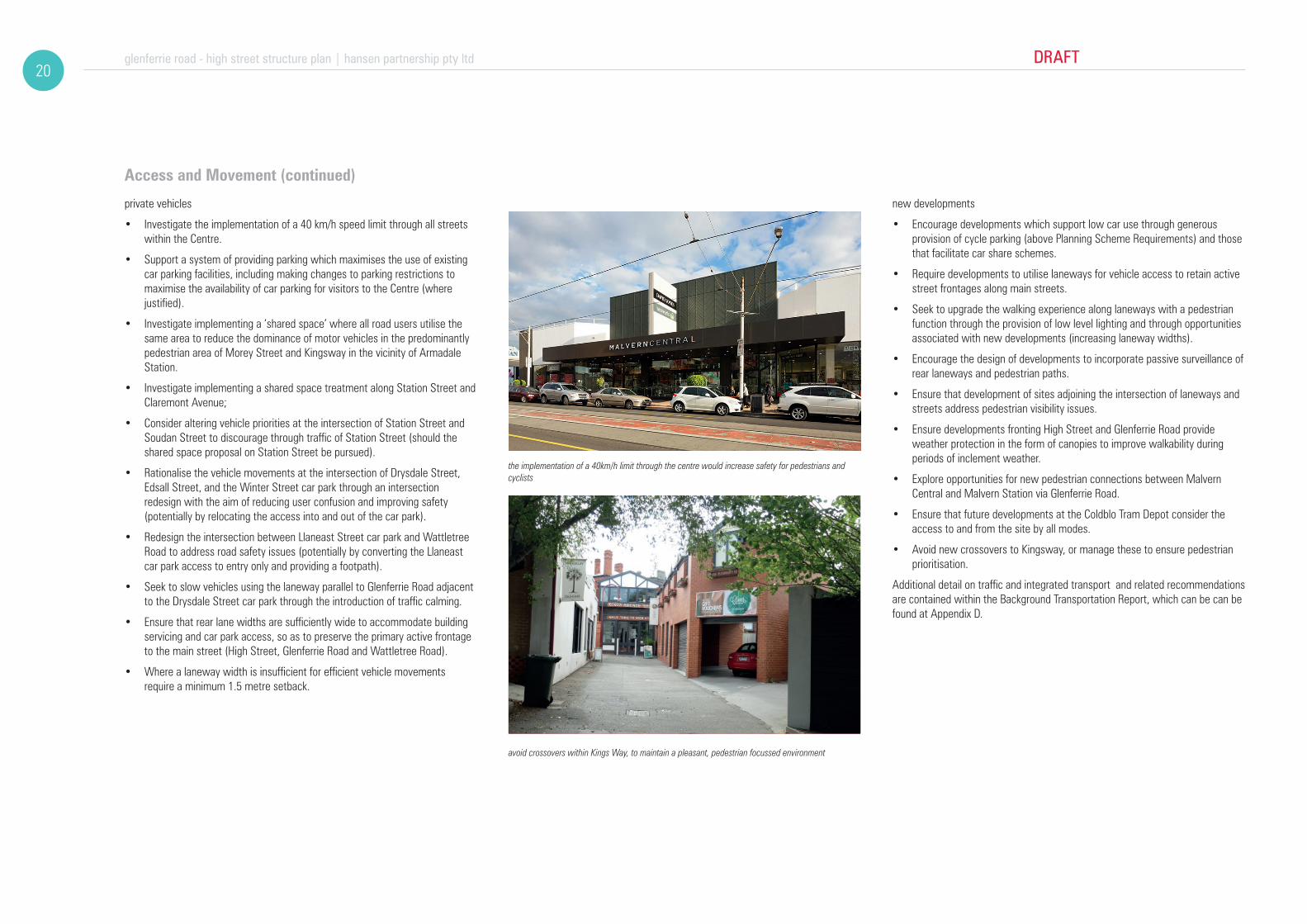
private vehicles
• Investigate the implementation of a 40 km/h speed limit through all streets within the Centre.
• Support a system of providing parking which maximises the use of existing car parking facilities, including making changes to parking restrictions to maximise the availability of car parking for visitors to the Centre (where justified).
• Investigate implementing a ‘shared space’ where all road users utilise the same area to reduce the dominance of motor vehicles in the predominantly pedestrian area of Morey Street and Kingsway in the vicinity of Armadale Station.
• Investigate implementing a shared space treatment along Station Street and Claremont Avenue;
• Consider altering vehicle priorities at the intersection of Station Street and Soudan Street to discourage through traffic of Station Street (should the shared space proposal on Station Street be pursued).
• Rationalise the vehicle movements at the intersection of Drysdale Street, Edsall Street, and the Winter Street car park through an intersection redesign with the aim of reducing user confusion and improving safety (potentially by relocating the access into and out of the car park).
• Redesign the intersection between Llaneast Street car park and Wattletree Road to address road safety issues (potentially by converting the Llaneast car park access to entry only and providing a footpath).
• Seek to slow vehicles using the laneway parallel to Glenferrie Road adjacent to the Drysdale Street car park through the introduction of traffic calming.
• Ensure that rear lane widths are sufficiently wide to accommodate building servicing and car park access, so as to preserve the primary active frontage to the main street (High Street, Glenferrie Road and Wattletree Road).
• Where a laneway width is insufficient for efficient vehicle movements require a minimum 1.5 metre setback.
new developments
• Encourage developments which support low car use through generous provision of cycle parking (above Planning Scheme Requirements) and those that facilitate car share schemes.
• Require developments to utilise laneways for vehicle access to retain active street frontages along main streets.
• Seek to upgrade the walking experience along laneways with a pedestrian function through the provision of low level lighting and through opportunities associated with new developments (increasing laneway widths).
• Encourage the design of developments to incorporate passive surveillance of rear laneways and pedestrian paths.
• Ensure that development of sites adjoining the intersection of laneways and streets address pedestrian visibility issues.
• Ensure developments fronting High Street and Glenferrie Road provide weather protection in the form of canopies to improve walkability during periods of inclement weather.
• Explore opportunities for new pedestrian connections between Malvern Central and Malvern Station via Glenferrie Road.
• Ensure that future developments at the Coldblo Tram Depot consider the access to and from the site by all modes.
• Avoid new crossovers to Kingsway, or manage these to ensure pedestrian prioritisation.
Additional detail on traffic and integrated transport and related recommendations are contained within the Background Transportation Report, which can be can be found at Appendix D.
the implementation of a 40km/h limit through the centre would increase safety for pedestrians and cyclists
avoid crossovers within Kings Way, to maintain a pleasant, pedestrian focussed environment

DRAFT glenferrie road - high street structure plan | hansen partnership pty ltd21
high st
wattletree rd
glenfe
rrie r
d
kooy
ong r
d
dandenong road
town hall
tramdepot
malverncentral
cabrinihospital
armadalestation
malvernstation
coles
malvernlibrary
drysdalecarpark
de la sallecollege
malvern cricketground
malverncentralschool
malvernpublic gardens
de la sallecollege
st josephs
milton grayreserve
malverncentralschool
the veryspecial kids
centre
malvernbowling club
unitingchurch
churchof christ
armadalereserve
blockbusterc’park
250m
0 100 200
50 150
hansen partnership pty ltdmelbourne | vietnamlevel 4 136 exhibition stmelbourne vic 3000 t 61 3 9654 8844 f 61 3 9654 8088 e [email protected] hansen-online.com.au
Project Ref: Dwg No.:ScaleDate:Revision:
14.021UD-00
A
DRAFT
G legend
railway station
railway line (pakenham, cranbourne, frankston lines)
regional road
major road
tram route
tram stop
bus route
bus stop
400m pedestrian radius
enhanced pedestrian and cycleconnection
green routes
proposed shared path
existing car park
existing signalised junction
enhanced pedestrian crossing
improve vehicular access
activity centre boundary (primary)
peripheral areas
study area boundary
figure 8 Access and Movement
glenferrie road - high street structure plan | hansen partnership pty ltd DRAFT22
Public Realm and Landscape
The urban structure of the study area provides an opportunity for street based connections between the main streets, including access to open space assets. However, these routes are often convoluted, and lack the legibility to function as important pedestrian links. There is an excellent opportunity to enhance these existing links through improvements to residential streets which connect between the Glenferrie Road, High Street and Wattletree Road spines. These works should be underpinned by a focus on green infrastructure, comprising new soft landscaping, Water Sensitive Urban Design (WSUD) treatments, public realm fixtures and high quality way-finding. It will be important that the footpath connections and street crossings provide for Disability Discrimination Act (DDA) compliant movement to ensure equitable access. Given new opportunities for green space are limited, the ability to better utilise and connect to existing open space such as Malvern Cricket Ground and Union Street Park will be imperative to the management of a high quality environment for a growing localised population of workers and residents.
The diversity of experience between Glenferrie Road and High Street is a positive attribute which should continue to be built upon, both in built form and public realm terms. Whilst Glenferrie Road has a high quality pedestrian experience, with slower vehicle movements, the hostility of vehicle movements along Wattletree Road and High Street however will warrant some further consideration of footpath layering devices such as planters or other public realm fixtures to improve the sense of refuge for pedestrians.
The Town Hall and Library are significant anchors within the centre, but lack connectivity to one another, with poorly considered ‘in between’ spaces around the edges of Malvern Cricket Ground. An excellent opportunity exists to rework existing accessways, parking areas and residual garden space to provide for informal recreation opportunities and enhance the role of Malvern Cricket Ground as a significant open space asset. This treatment should also seek to connect through to and complement Malvern Square and new Council Offices across Glenferrie Road to the west.
Existing kerb build-outs occur throughout the centre and in combination with priority surface treatments at crossings achieve a pleasant pedestrian environment. This strategy should be extended along High Street and Glenferrie Road and combined with new public realm fixtures integrated in an overall ‘kit of parts’ to create a unique sense of identity for the centre. These stopping spaces are an important part of the sequence of movement along the main streets, and provides a valuable opportunity for canopy tree planting.
A number of significant spaces are noted within the study area which represent an excellent potential opportunity for temporary or more permanent event spaces. Such temporary uses are a proven method of resolving conflicts with vehicular requirements, whilst also allowing the ‘claiming’ of additional space for community use. More specific opportunities exist to leverage off the distinct spaces at Claremont Avenue / Station Street (Malvern Station), Kingsway/ Arcade (Armadale Station) and Coldblo Tram Depot, where street based festivals,
community arts and cultural events or markets could be accommodated. Permanent public realm improvements within these precincts should have regard to the potential function of these event spaces and allow for a suitable flexible condition, through the use of kerb-less streets, and limited or movable physical barriers between vehicle and pedestrian movement.
Relevant Key Directions
• Strengthen and Establish clearly defined gateways and entries into the Centre.
• Establish diverse experiences along different streets within the Centre
• Establish clearly defined pedestrian linkages and manage road crossing points
• Strengthen public meeting space at and around important junctions
• Establish equitable access to all existing open spaces
• Establish potential event spaces at key sites (market, special event etc.)
• Establish additional vegetation in the public realm to contribute to the urban forest.
Objectives
• Provide for a strong way-finding and branding strategy for the centre, to better unify disparate precincts within the broader study area.
• To provide public realm treatments at key gateways into the study area which respond to both the pedestrian and vehicle scale of movement.
• Strengthen the legibility of existing street based connections between the main streets, public open spaces and local streets within the study area.
• Incorporate green infrastructure initiatives as an integral component of any new public realm works through management of stormwater runoff, canopy planting and soft landscaping works.
• Encourage the potential use of special places within the Activity Centre for temporary public use, including Coldblo Tram Depot, Claremont Avenue and Kingsway to increase public appreciation of existing ‘gems’ within the study area.
• Provide opportunity for residents and visitors to linger and meet without having to spend money within the public realm of Glenferrie Road, High Street and Wattletree Road.
• Improve the public realm experience within the Civic Precinct, and legibility of connections between Malvern Square, the Town Hall, Library, Police Station and Malvern Cricket Ground.
• Encourage greater use of Malvern Cricket Ground and its edges for informal public recreation use.
• Ensure that intensive redevelopment of the allotments fronting Dandenong Road to contribute to public realm enhancements along the rail alignment and adjacent to Malvern Station.
• Improve the legibility of the Malvern Station, Claremont Avenue and Station Street connections to Glenferrie Road.
• Enhance the existing qualities of Kingsway/ Arcadeand Armadale Station public realm, whilst increasing the emphasis on priority pedestrian movement.
• Encourage the potential provision of a pedestrian connection between Malvern Central and Glenferrie Road, so as to increase connectivity between Malvern Station and Malvern Central.
• Reconfigure back of house surface parking areas with increased emphasis on public realm treatment, and the creation of new safe and high quality pedestrian connections.
• Encourage the retention of arcades between Glenferrie Road and back of house parking with greater emphasis on the creation of safe, well lit and pleasant pedestrian environments with all-hours access.
• Encourage the retention of existing significant trees and street trees which contribute an important amenity to the public realm, whilst forming an important part of Stonnington’s urban forest.
Strategies
• Develop a strong wayfinding and branding strategy for the centre, comprising a ‘kit of parts’ for public realm fixtures with a high level of design quality reflective of its time and place. This should be distinctive for the study area rather than one which applies throughout Stonnington.
• Prepare a landscape masterplan for the Civic Precinct encompassing new shared and pedestrian links, passive open space and informal gathering spaces.
• Prepare a landscape masterplan for the Drysdale Street car park to incorporate new public realm treatments and enhanced north-south pedestrian connections through the space. Ensure works complement future development opportunities and ambitions of adjacent key tenants.
• Provide for increased function for existing and future kerb build outs comprising seating, planting and other public realm fixtures to enhance their role as pause points, and to create subtle differences between each location.
• Develop a typical street section treatment for ‘green streets’ which connect the main roads through the residential hinterland with integral green infrastructure, way finding and public realm fixtures.
• Facilitate or engage with local community groups, within Council and private operators to explore opportunities for the establishment of temporary or more regular event spaces within Claremont Avenue, Station Street, Kingsway and Coldblo Tram Depot.
• Engage with the owners of Malvern Central to explore opportunities for a new pedestrian connection to Glenferrie Road.

DRAFT glenferrie road - high street structure plan | hansen partnership pty ltd23
town hall
tramdepot
malverncentral
cabrinihospital
armadalestation
malvernstation
coles
malvernlibrary
drysdalecarpark
de la sallecollege
malvern cricketground
malverncentralschool
malvernpublic gardens
de la sallecollege
st josephs
milton grayreserve
malverncentralschool
the veryspecial kids
centre
malvernbowling club
unitingchurch
churchof christ
armadalereserve
blockbusterc’park
high st
wattletree rd
glenfe
rrie r
d
kooy
ong r
d
dandenong road
250m
0 100 200
50 150
hansen partnership pty ltdmelbourne | vietnamlevel 4 136 exhibition stmelbourne vic 3000 t 61 3 9654 8844 f 61 3 9654 8088 e [email protected] hansen-online.com.au
Project Ref: Dwg No.:ScaleDate:Revision:
14.021UD-005
A
DRAFT
study area boundary
activity centre boundary (primary)
railway line (pakenham,
potential event space
enhance boulevard interface within study area
existing open space
existing civic sqaure
potential threshold tree planting
investigate landscape enhancement
existing landscaping
legend
create visual link
improve streetscape presentation
facilitate shared space
way-finding / street furniture hub
existing public space
potential pedestrian space
walking distance to significant public open space (400 m)
priority green streets with enhanced public realm
enhance pedestrian connection to glenferrie road
peripheral areas
figure 9 Public Realm and Landscape

attractive rear interfaces with adequate design effectsminimum typical site dimensions for a SMALL allotment on Glenferrie Road new infill building should reflect the existing parapet line
Glenferrie Road exhibits the highest level of consistency of small, fine-grained allotments due to its continued economic success since settlement. The spine between the rail cutting to the south and the Civic Precinct is perceived as a continuous set of 2 storey forms with pronounced parapets. As opposed to High Street where a greater degree of infill is anticipated, Glenferrie Road will emphasise the existing streetwall condition with any new built form set behind the parapet. New built form should seek to provide surveillance of rear laneways and incorporate softening of the laneway with tactile materiality and landscape elements where possible. Larger non-contributory forms within the street are to be carefully managed to complement existing built form in scale and vertical rhythm whilst avoiding heritage mimicry.
ATTRIBUTES
GLENFERRIE ROAD S
GUIDELINESbuilding forms to retain heritage fabric where possible, with new built form setback to a maximum height of 4 storeys based on an appreciation of the buildings relative significance, key views from the public realm within Glenferrie Road and side streets.
The preferred setback above the streetwall is 3m to ensure reduced visual prominence, whilst accepting a degree of visibility. If an existing building is of heritage significance then a more substantive setback should be provided to maintain a greater proportion of heritage fabric.
building setbacks should be simplified to provide for good building composition and avoid a ‘wedding cake’ profile, whilst party walling should be maintained to at least 2 levels to encourage a strong street edge profile.
where new infill replaces non-contributory buildings, they will be of a high design quality, and respond to the dominant parapet height of adjoining buildings and setback built form above this datum a minimum of 3m to a height of 4 storeys.
rear elevations should step down mid-block from 4 to 3 storeys where a sensitive interface occurs beyond the ROW (this does not apply to rear non-residential interfaces).
above ground level, rear elevations should be setback a minimum of 4.5m from the rear boundary to manage building bulk, avoid a ‘wedding cake’ profile, and provide sufficient spatial separation to ensure good management of privacy outcomes. Level 1 balconies may project into this setback.
primary active frontages be maintained at the ground level of Glenferrie Road with attractive frontages to the rear lane incorporating tactile materiality, signage, lighting and low level softening vegetation in planter box format to provide a secondary address.
1.5m minimum rear lane offset is required at the ground level to facilitate the ongoing function of the laneway with all vehicle access from the rear lane.
GUIDELINES11
11
22
22
24
33
33
44
55
55
56
56 57
57
58
58
adaptively re-use heritage fabric
indicative rear view
indicative front view
glenferrie road - high street structure plan | hansen partnership pty ltd DRAFT24
7 Main Street Built Form Brochures

setback new built form beyond heritage fabricminimum typical site dimensions for a MEDIUM to LARGE allotment on Glenferrie Road contemporary infill should achieve high standards of design
Whilst Glenferrie Road is dominated by fine-grained allotments a handful of heritage replica forms and non-contributory forms are noted which constitute medium or large allotments. These allotments include supermarkets, and mini-malls with arcades, and require positive management in terms of infill opportunity. As opposed to High Street where a departure in character on these larger sites is anticipated, new infill of larger allotments along Glenferrie Road will continue to emphasise the existing streetwall condition with any new built form set behind the parapet. New built form on larger sites should seek to provide a secondary address, with surveillance of rear laneways and incorporate softening of the laneway with tactile materiality and landscape elements where possible. Larger allotments should complement or instate an appropriate sense of vertical rhythm in ground and upper level treatments, whilst heritage mimicry should be avoided.
ATTRIBUTES
GLENFERRIE ROAD
building forms to retain heritage fabric where possible, with new built form setback to a maximum height of 4 storeys based on an appreciation of the buildings relative significance, key views from the public realm within Glenferrie Road and side streets.
Preferred setback above the streetwall of 3m to ensure reduced visual prominence, whilst accepting a degree of visibility. If an existing building is of heritage significance as part of a larger site redvelopment then a greater setback should be provided to that part of the building to maintain a greater proportion of heritage fabric.
building setbacks should be simplified to provide for good building composition and avoid a ‘wedding cake’ profile, whilst party walling should be maintained to at least 2 levels to encourage a strong street edge profile.
where new infill replaces non-contributory buildings, they will be of a high design quality, and respond to the dominant parapet height of adjoining buildings and setback built form above this datum a minimum of 3m to a height of 4 storeys.
rear elevations should step down mid-block from 4 to 3 storeys where a sensitive interface occurs beyond the ROW (this does not apply to rear non-residential interfaces).
above ground level , rear elevations should be setback a minimum of 4.5m from the rear boundary to manage building bulk, avoid a ‘wedding cake’ profile, and provide sufficient spatial separation to ensure good management of privacy outcomes. Level 1 balconies may project into this setback.
on larger allotments primary active frontages be maintained at the ground level of Glenferrie Road with secondary acces from the rear lane to the circulation core. The rear lane interface will incorporate tactile materiality, signage, lighting and low level softening vegetation in planter box format to provide a sense of address.
1.5m minimum rear lane offset is required at the ground level to facilitate the ongoing function of the laneway with all vehicle access from the rear lane.
GUIDELINES11
22
33
44
55
56
57
58
M/L
11
22
33 44
56
57
55
indicative rear view
indicative front view
adaptively re-use heritage fabric
DRAFT glenferrie road - high street structure plan | hansen partnership pty ltd25

44
56
57
55
high quality architecture is permitted to projectabove the parapet line by 1 level in height
minimum typical site dimensions for a SMALL allotment on High Street encourage party-walls with apartments orientedfront and back wherever possible
adaptively re-use heritage fabric
ATTRIBUTES GUIDELINESHigh Street has a more varied character, influenced by a gently sloping street profile, varied parapet height and non-contributory buildings interspersed with valued period stock. New buildings should maintain and enhance streetscape diversity, with a combination of retained heritage fabric, and marginally taller contemporary streetwalls. Narrow and moderate sites can accommodate 4 levels. Where a sensitive residential interface exists to the rear, the building should step down in height by 1 level toward the rear boundary. New buildings should maintain the sense of openness to the sky through lightweight or retractable canopy treatments. All new apartments should be oriented with adequate spatial separation from adjoining development sites in accordance with equitable development principles. Apartments oriented with primary aspect to side boundaries should be discouraged.
HIGH ST S
building forms to retain heritage fabric where possible, with new built form setback to a maximum height of 4 storeys based on an appreciation of the buildings relative significance, key views from the public realm within Glenferrie Road and side streets.
The preferred setback above the streetwall is 3m to ensure reduced visual prominence, whilst accepting a degree of visibility. If an existing building is of heritage significance then a more substantive setback should be provided to maintain a greater proportion of heritage fabric.
building setbacks should be simplified to provide for good building composition and avoid a ‘wedding cake’ profile, whilst party walling should be maintained to at least 3 levels to encourage a strong street edge profile.
where a site is non-contributory or does not warrant retention, allow for a parapet height discrepancy of 1 level to achieve positive diversity, except where neighbouring heritage built form necessitates a site specific design response.
rear elevations should step down mid-block from 4 to 3 storeys where a sensitive interface occurs beyond the ROW (this does not apply to rear non-residential interfaces).
above ground level, rear elevations should be setback a minimum of 4.5m from the rear boundary to manage building bulk, avoid a ‘wedding cake’ profile, and provide sufficient spatial separation to ensure good management of privacy outcomes. Level 1 balconies may project into this setback.
primary active frontages be maintained at the ground level of High Street with attractive frontages to the rear lane incorporating tactile materiality, signage, lighting and low level softening vegetation in planter box format to provide a secondary address.
1.5m minimum rear lane offset is required at the ground level to facilitate the ongoing function of the laneway with all vehicle access from the rear lane.
11
22
33
44
55
56
57
58
11
22
33
44
56
57
55
indicative rear view
indicative front view
glenferrie road - high street structure plan | hansen partnership pty ltd DRAFT26
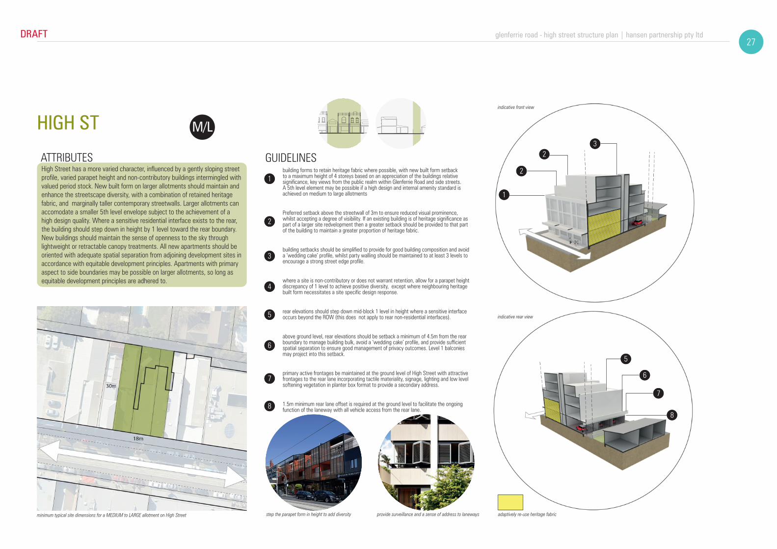
step the parapet form in height to add diversityminimum typical site dimensions for a MEDIUM to LARGE allotment on High Street provide surveillance and a sense of address to laneways
ATTRIBUTES GUIDELINESHigh Street has a more varied character, influenced by a gently sloping street profile, varied parapet height and non-contributory buildings intermingled with valued period stock. New built form on larger allotments should maintain and enhance the streetscape diversity, with a combination of retained heritage fabric, and marginally taller contemporary streetwalls. Larger allotments can accomodate a smaller 5th level envelope subject to the achievement of a high design quality. Where a sensitive residential interface exists to the rear, the building should step down in height by 1 level toward the rear boundary. New buildings should maintain the sense of openness to the sky through lightweight or retractable canopy treatments. All new apartments should be oriented with adequate spatial separation from adjoining development sites in accordance with equitable development principles. Apartments with primary aspect to side boundaries may be possible on larger allotments, so long as equitable development principles are adhered to.
HIGH ST M/L
building forms to retain heritage fabric where possible, with new built form setback to a maximum height of 4 storeys based on an appreciation of the buildings relative significance, key views from the public realm within Glenferrie Road and side streets. A 5th level element may be possible if a high design and internal amenity standard is achieved on medium to large allotments
Preferred setback above the streetwall of 3m to ensure reduced visual prominence, whilst accepting a degree of visibility. If an existing building is of heritage significance as part of a larger site redvelopment then a greater setback should be provided to that part of the building to maintain a greater proportion of heritage fabric.
building setbacks should be simplified to provide for good building composition and avoid a ‘wedding cake’ profile, whilst party walling should be maintained to at least 3 levels to encourage a strong street edge profile.
where a site is non-contributory or does not warrant retention, allow for a parapet height discrepancy of 1 level to achieve positive diversity, except where neighbouring heritage built form necessitates a site specific design response.
rear elevations should step down mid-block 1 level in height where a sensitive interface occurs beyond the ROW (this does not apply to rear non-residential interfaces).
above ground level, rear elevations should be setback a minimum of 4.5m from the rear boundary to manage building bulk, avoid a ‘wedding cake’ profile, and provide sufficient spatial separation to ensure good management of privacy outcomes. Level 1 balconies may project into this setback.
primary active frontages be maintained at the ground level of High Street with attractive frontages to the rear lane incorporating tactile materiality, signage, lighting and low level softening vegetation in planter box format to provide a secondary address.
1.5m minimum rear lane offset is required at the ground level to facilitate the ongoing function of the laneway with all vehicle access from the rear lane.
adaptively re-use heritage fabric
11
22
33
44
55
56
57
58
11
2
32
43
56
55
58
57
indicative rear view
indicative front view
DRAFT glenferrie road - high street structure plan | hansen partnership pty ltd27
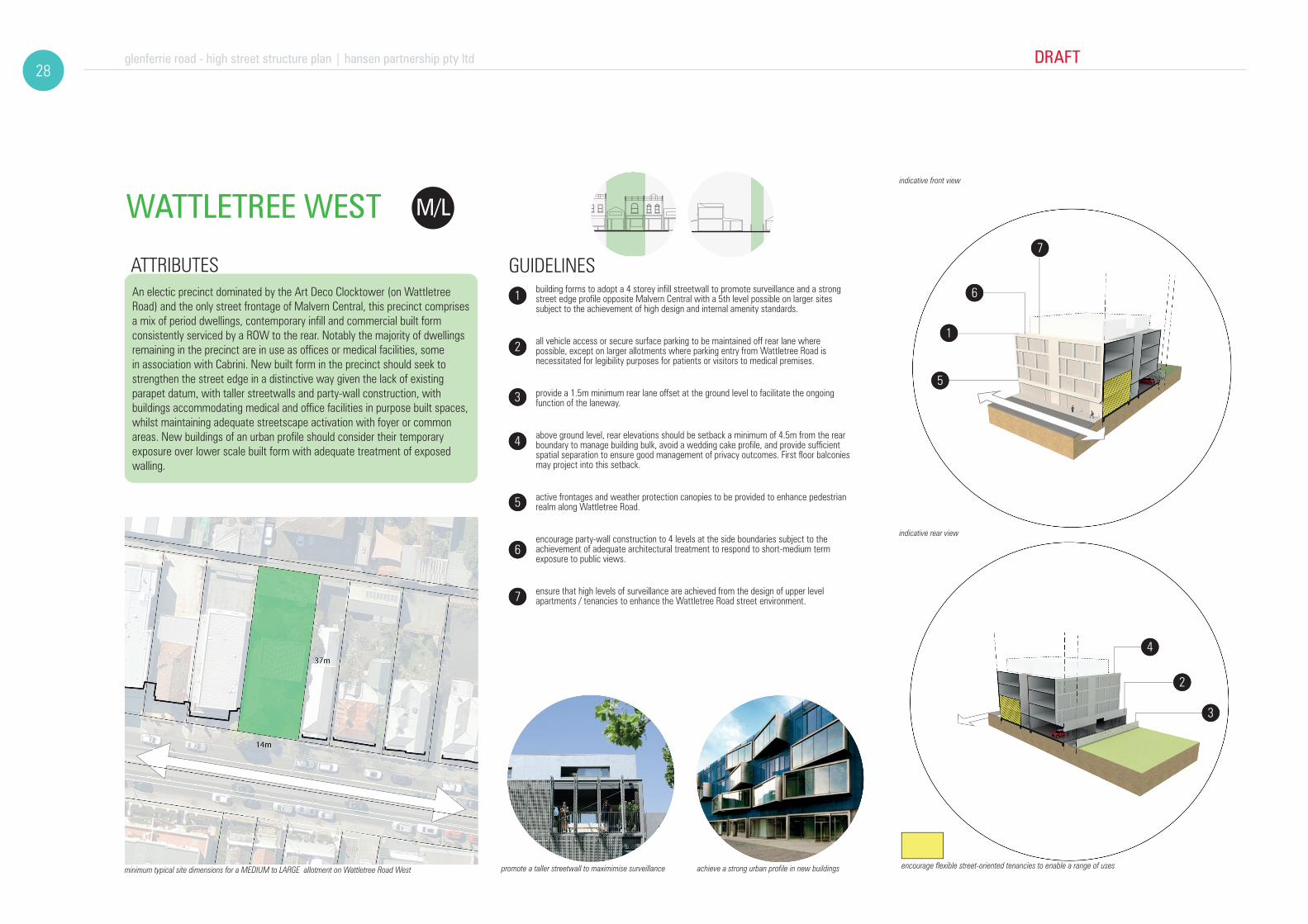
promote a taller streetwall to maximimise surveillanceminimum typical site dimensions for a MEDIUM to LARGE allotment on Wattletree Road West achieve a strong urban profile in new buildings
ATTRIBUTES GUIDELINESAn electic precinct dominated by the Art Deco Clocktower (on Wattletree Road) and the only street frontage of Malvern Central, this precinct comprises a mix of period dwellings, contemporary infill and commercial built form consistently serviced by a ROW to the rear. Notably the majority of dwellings remaining in the precinct are in use as offices or medical facilities, some in association with Cabrini. New built form in the precinct should seek to strengthen the street edge in a distinctive way given the lack of existing parapet datum, with taller streetwalls and party-wall construction, with buildings accommodating medical and office facilities in purpose built spaces, whilst maintaining adequate streetscape activation with foyer or common areas. New buildings of an urban profile should consider their temporary exposure over lower scale built form with adequate treatment of exposed walling.
building forms to adopt a 4 storey infill streetwall to promote surveillance and a strong street edge profile opposite Malvern Central with a 5th level possible on larger sites subject to the achievement of high design and internal amenity standards.
all vehicle access or secure surface parking to be maintained off rear lane where possible, except on larger allotments where parking entry from Wattletree Road is necessitated for legibility purposes for patients or visitors to medical premises.
provide a 1.5m minimum rear lane offset at the ground level to facilitate the ongoing function of the laneway.
above ground level, rear elevations should be setback a minimum of 4.5m from the rear boundary to manage building bulk, avoid a wedding cake profile, and provide sufficient spatial separation to ensure good management of privacy outcomes. First floor balconies may project into this setback.
active frontages and weather protection canopies to be provided to enhance pedestrian realm along Wattletree Road.
encourage party-wall construction to 4 levels at the side boundaries subject to the achievement of adequate architectural treatment to respond to short-medium term exposure to public views.
ensure that high levels of surveillance are achieved from the design of upper level apartments / tenancies to enhance the Wattletree Road street environment.
WATTLETREE WEST M/L
encourage flexible street-oriented tenancies to enable a range of uses
1
2
3
4
5
5
5
1
2
3
4
5
6
7
11
22
33
44
56
57
55
indicative rear view
indicative front view
glenferrie road - high street structure plan | hansen partnership pty ltd DRAFT28

promote front setback with landscape treatmentsminimum typical site dimensions for a MEDIUM to LARGE allotment on Wattletree Road East encourage recessed upper storey forms
ATTRIBUTES GUIDELINES
Wattletree East is distinctive from Wattletree West due to the dominant residential character and landscape quality within the Residential Growth Zone. Whilst some infill medical built form is noted, the primary stock is a combination of semi-detached dwellings in a garden and some multi-unit development. New built form in the precinct should seek to maintain the garden setting with more intensive built form sited off at least one side boundary with a garden lane effect, whilst small front and rear setbacks are to be maintained to accommodate small tree planting. Buildings will provide for adaptable ground levels which can accommodate either medical or office facilities, or home occupation components of maisonette dwellings.
building forms to adopt a 3 storey street elevation profile positioned with a 3m minimum setback to accommodate shrubs and small canopy trees within the frontage to contribute to the urban forest.
a recessed 4th level to be treated as a ‘roof form’ element and distinguished in materiality.
provision of a setback to one side boundary of at least 2.5m to create a garden lane effect and streetscape rhythm.
a rear setback should be provided of sufficient dimensions to enable the planting of at least one medium canopy tree abutting the rear lane
1.5m minimum rear lane offset is required to facilitate the ongoing function of the laneway with all vehicle access or secure surface parking accessed from the rear lane except where sites with a broad frontage (>18m) permit side access for legibility of medical facilities.
above ground level, rear elevations should be setback a minimum of 4.5m from the rear boundary to manage building bulk, avoid a wedding cake profile, and provide sufficient spatial separation to ensure good management of privacy outcomes.
activate ground level frontages through medical uses, or provide planter box buffers to ground level residences.
WATTLETREE EAST M/L
encourage flexible street-oriented tenancies to enable a range of uses
11
22
33
44
55
56
57
11
22
33
44
56
57
55
indicative rear view
indicative front view
DRAFT glenferrie road - high street structure plan | hansen partnership pty ltd29

glenferrie road - high street structure plan: concept framework plan | hansen partnership pty ltd 30
Key Site Features
figure 10 aerial context view
figure 11 Precinct Identificationmalvern library terminal view along glenferrie road to malvern town hall malvern square adjacent to giorgio’s
8 Neighbourhood Framework Plans
▪ administrative and civic centre of the City of Stonnington;
▪ existing function and image as the northern gateway to the centre from the broad grain residential character of Glenferrie Road to the north;
▪ significant heritage asset in Malvern Town Hall;
▪ significant source of trips and custom in the school and other institutional buildings;
▪ community orientated uses, including library, police station and public open space at Malvern Cricket Ground;
▪ poor connectivity and image of back of house areas around the Malvern Cricket Ground; and
▪ existing but poorly utilised public square at Malvern Square to the north western corner of Glenferrie Road and High Street junction.
Precinct 1: Civic Centre

50m
02 0 40
10 30
The Civic Precinct will retain and strengthen its role as the central focus for municipal, community, educational and recreational activities in Stonnington. It will be a major destination attracting visitors from within and outside the municipality. As an integrated community and civic precinct set within an attractive landscape setting and supported by high quality public open space, the precinct will present itself as inviting to the local community, employees, customers and visitors alike.
▪ to retain the primary focus as the municipal’s centre for civic services, education and recreation. Accommodate current and future requirements for Council and Community services and facilities in a manner which provides easy and direct access for the community;
▪ to recognise the existing Town Hall and Clocktower as a municipal landmark and to retain its role as a prominent built form in the Centre;
▪ to protect key vistas to Malvern Town Hall;
▪ to encourage future development around Malvern Cricket Ground to activate its interface and establish a safe and attractive environment;
▪ to encourage activities and linkages within the precinct and establish to be more closely integrated with the Town Hall, Malvern Square and Malvern Cricket Ground;
▪ to encourage activities and develop the existing Malvern Square as a premier public gathering space in the Centre;
▪ encourage the tactful siting of new public facilities within underutilised land between existing buildings reinforce the public realm and movement corridors;
▪ to strengthen the ‘leafy’ street character along the eastern side of High Street.
figure 12 Precinct Framework Plan
glenferrie road - high street structure plan: concept framework plan | hansen partnership pty ltd31
Vision
Objectives

glenferrie road - high street structure plan: concept framework plan | hansen partnership pty ltd 32
Key Site Features
internal view of kings arcade the elaborate facade of kings arcade single storey period built form adjacent to the railway line
▪ gateway to the Centre from the west along High Street;
▪ proximity to rail, tram and bus services with a multi-modal opportunity;
▪ established boutique retail hub around Armadale Railway Station;
▪ existing Council surface car park off Morey Street;
▪ pedestrian access between Armadale Station and High Street via Kingsway Arcade; and
▪ characterised by back of house presentation and informal intimate streetscape setting.
Precinct 2: Armadale Station
figure 13 aerial context view
figure 14 Precinct Identification

glenferrie road - high street structure plan: concept framework plan | hansen partnership pty ltd33
Vision
Objectives
50m
02 0 40
10 30
Armadale Station Precinct will strengthen its role as a key attractor within the Centre and point of arrival. It will be experienced as a hidden ‘gem’ offering boutique retail experience complemented by high quality pedestrian realm. The Kingsway Arcade will retain its role to provide intimate connection to High Street and Kooyong Road with improved multi- modal linkages.
▪ enhance the legibility and image of the precinct as the western gateway into the Centre;
▪ bolster the identity of this precinct as a unique destination associated with Armadale Station and Kingsway Arcade;
▪ establish high pedestrian amenity and gathering space around Armadale Station to facilitate safe access and to accommodate safe pedestrian refuge;
▪ strengthen connections through the precinct to enhance the function of multi-modal links, connecting bus, train and tram services through public realm improvements;
▪ facilitate north – south pedestrian movement through improved connections to and from the heritage Armadale Station railway bridge; and
▪ carefully manage any new vehicle crossovers or building services from Morey Street to prioritise a pleasant pedestrian environment.
figure 15 Precinct Framework Plan

glenferrie road - high street structure plan: concept framework plan | hansen partnership pty ltd 34
Key Site Features
view down claremont avenue from station street view from heritage rail bridge at malvern station public realm along station street with median planting
▪ historic role as a gateway to the Centre from Dandenong Road to the south;
▪ distinctive high-quality streetscape along Claremont Avenue;
▪ existence of higher built form along Station Street to the east of Malvern Station;
▪ significant heritage station as a focal point of the precinct;
▪ proximity to rail, tram and bus services;
▪ prominent highway exposure to the south and more sensitive residential frontage to the north;
▪ underutilised public space and pedestrian access; and
▪ degraded and poorly surveilled public realm south of the railway line and low quality street environment along Dandenong Road.
Precinct 3: Malvern Station
figure 16 aerial context view
figure 17 Precinct Identification

glenferrie road - high street structure plan: concept framework plan | hansen partnership pty ltd35
Vision
Objectives
50m
02 0 40
10 30
This precinct will redefine the southern approach into the Activity Centre from Dandenong Road through its built form definition at the south-eastern corner of Glenferrie Road. It will promote the establishment of a commercial hub with capacity to accommodate higher density residential for properties fronting Dandenong Road. To the north of the railway line, a mixture of uses will remain in this area, with complementary retail and creative industries retained and expanded on. Pedestrian permeability will be enhanced with a better east – west connection across Glenferrie Road, as well as north- south connection across the railway line via Malvern Station. A new-shared space around Malvern Station seeks to establish a consistent pedestrian friendly environment connecting Glenferrie Road to the Station.
▪ enhance the image of the precinct as the southern gateway of the Centre and maintain its role in supporting the highest intensity of commercial and mixed use activity;
▪ establish a strong sense of arrival into the Centre from Dandenong Road and demarcate the south eastern corner with a landmark building;
▪ retain individually significant heritage buildings and integrate intensive infill development where possible;
▪ encourage active ground floor uses with potential pedestrian access along the southern side of the railway reserve;
▪ clearly define desired pedestrian line of movement for pedestrian and cyclists between tram stops, railway station and key destinations, including Malvern Central and Cabrini Hospital;
▪ maximise connections to the north – south pedestrian connection through the Railway Station;
▪ establish high pedestrian amenity and a publicly accessible meeting/ gathering space as part of an ‘activity node‘ to the north of Malvern Station to connect to the Station Street and Claremont Avenue; and
▪ direct higher intensity built form to the south along Dandenong Road with a scale transition to more modest forms to the north, responding to the existing residential interface; and
▪ support the establishment of a ‘creative’ hub centred around Claremont Street and Station Street, including potential street market or special events.
figure 18 Precinct Framework Plan

glenferrie road - high street structure plan: concept framework plan | hansen partnership pty ltd 36
Key Site Features
landmark art deco clocktower on wattletree road positive street integration of malvern central at wattletree road laneway interface between malvern central and glenferrie road shops
▪ significant destination within the Centre, with Malvern Central providing a significant retail offering;
▪ strong association with Cabrini Hospital to the east and the Wattletree Road spine;
▪ poor integration, connectivity and legibility between the precinct and Malvern Station;
▪ broad underutilised public depot land adjacent to the rail alignment;
▪ car dominated environment due to the arrangement of ramping vehicle circulation into Malvern Central; and
▪ mixed built form image along Wattletree Road, clearly distinct from the consistent character of Glenferrie Road.
Precinct 4: Malvern Central
figure 19 aerial context view
figure 20 Precinct Identification

glenferrie road - high street structure plan: concept framework plan | hansen partnership pty ltd37
Vision
Objectives
50m
02 0 40
10 30
The Malvern Central precinct will strengthen its role as the Centre’s regional shopping destination. Improved connections will be established to surrounding areas, including to Glenferrie Road and Malvern Station. This will be achieved through way-finding and public realm upgrades to enhance its legibility within the broader activity centre. Future redevelopment of this precinct will accommodate a higher intensity of residential accommodation in a mixed- use format, which will consider the heritage significance of period commercial forms fronting Glenferrie Road.
▪ to achieve a high quality mixed use precinct including retail, office, residential and entertainment to establish a vibrant living and working environment;
▪ to enhance ground floor retail and pedestrian generated activities along Wattletree and Glenferrie Roads;
▪ manage positive future expansion of Malvern Central within a vertical footprint;
▪ explore opportunity for new connections between Malvern Central and Malvern Station via Glenferrie Road with integral public realm and landscape treatment;
▪ increase the intensity of built form within Wattletree West in response to the reduced heritage values;
▪ explore opportunities for a shared pedestrian and cyclist path along the northern edge of rail alignment generally between Malvern and Armadale Station framed by new built form to provide surveillance;
▪ explore opportunities for landscape works along the rail corridor to improve the image of the public works depot;
▪ to rationalise car park entry into Malvern Central to facilitate safer pedestrian movement; and
▪ to improve visual presentation of Malvern Central’s southern elevation.
figure 21 Precinct Framework Plan
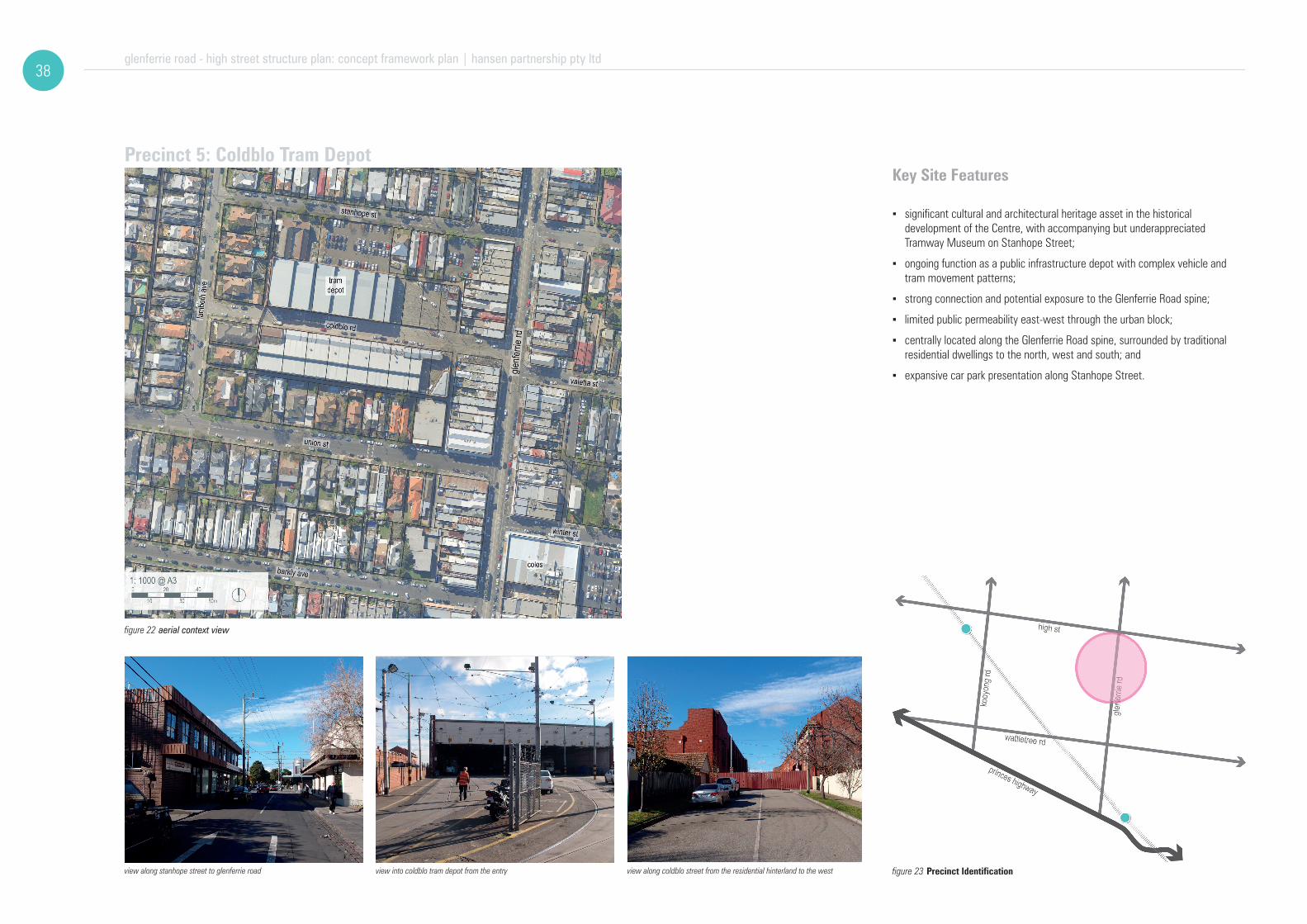
glenferrie road - high street structure plan: concept framework plan | hansen partnership pty ltd 38
Key Site Features
view along stanhope street to glenferrie road view into coldblo tram depot from the entry view along coldblo street from the residential hinterland to the west
▪ significant cultural and architectural heritage asset in the historical development of the Centre, with accompanying but underappreciated Tramway Museum on Stanhope Street;
▪ ongoing function as a public infrastructure depot with complex vehicle and tram movement patterns;
▪ strong connection and potential exposure to the Glenferrie Road spine;
▪ limited public permeability east-west through the urban block;
▪ centrally located along the Glenferrie Road spine, surrounded by traditional residential dwellings to the north, west and south; and
▪ expansive car park presentation along Stanhope Street.
Precinct 5: Coldblo Tram Depot
figure 22 aerial context view
figure 23 Precinct Identification

glenferrie road - high street structure plan: concept framework plan | hansen partnership pty ltd39
Vision
Objectives
50m
02 0 40
10 30
The Coldblo Tram depot will retain its infrastructural role with opportunities for temporary or incremental provision of public access to the site through festivals, open days, or some other regular public event. It will foster community interest through facilitating visual and physical connections and to open up the facility to a wider audience. Future redevelopment of the Tram depot will emphasize the adaptive re-use of its existing high valued built forms.
▪ explore opportunities for greater public access to and appreciation of the heritage buildings within the Coldblo Tram Depot and adjacent Tramway Museum;
▪ explore opportunities for temporary community or trader group lead events in key areas of the site;
▪ encourage improvement within and to the edges of the precinct, through landscaping and public realm improvements connecting to Glenferrie Road;
▪ to improve the Coldblo Street and Glenferrie Road junction and its role in facilitating safe and efficient access for all modes of transport;
▪ to improve pedestrian and cyclist connections throughout the precinct in particular along Union Street; and
▪ ensure that any future disposal of the Coldblo Tram Depot complex is carefully managed through the application of planning and design controls to protect heritage and integrate with the surrounding neighbourhood.
figure 24 Precinct Framework Plan

glenferrie road - high street structure plan: concept framework plan | hansen partnership pty ltd 40
Key Site Features
view of consistent street wall along glenferrie road view through a post-war arcade to rear car parking view to multi-level car park behind glenferrie road spine
▪ contains key retail anchors, which provide for local convenience shopping within the broader Centre context;
▪ important source of custom and point of arrival to the Glenferrie Road local retail strip;
▪ community facilities located within the threshold space between retail strip to the west and residential hinterland to the west;
▪ proximity to Cabrini Hospital with direct linkages along Winter and Edsall Streets;
▪ significant landholding acts as a buffer between residential land and Glenferrie Road commercial built form;
▪ back of house presentation along the western end of Drysdale Street;
▪ vehicle dominated environment with low levels of pedestrian amenity;
▪ connection to Glenferrie Road is via Winter and Edsall Streets, as well as a privately owned arcade; and
▪ limited provision of public realm elements such as lighting and pedestrian refuge zones.
Precinct 6: Drysdale Street Car Park
figure 25 aerial context view
figure 26 Precinct Identification

glenferrie road - high street structure plan: concept framework plan | hansen partnership pty ltd41
Vision
Objectives
50m
02 0 40
10 30
Opportunities exist for the anchor retail tenancy to expand and complement the vibrant, pedestrian – focused, mixed-use precinct. It will accommodate a range of retail offer, community facilities, and car parking in addition to modest development in shop- top format. New built form will provide active and attractive presentation to the public laneways and car park to the rear. Re-configuration of the Winter Street car park to introduce a new north- south street with dedicated pedestrian paths to minimise potential conflicts. A new public open space will be accommodated around the existing Toy Library to provide a pedestrian refuge and resting area away from the busy main streets.
▪ to reinforce and enhance the role of retail anchor tenancy in this precinct;
▪ to achieve an enhanced presence of community facilities including the upgrade of the Toy Library and to establish a public space at and around the community facility;
▪ to encourage shop-top infill development along Glenferrie Road with appropriate presentation to the car park;
▪ manage positive expansion of the anchor retail tenancies vertically, and ensure the protection of period commercial forms further to the south;
▪ encourage reinstatement of rhythmic active frontage treatments to Drysdale Street and Glenferrie Road, with attractive frontages to the car park interface;
▪ intensify built form scale in the back-of-house area to provide surveillance an improved interface to the car park;
▪ simplify and improve the quality of north-south pedestrian, bicycle and vehicle access through the at-grade car park; and
▪ incorporate public realm improvements within the surface parking area to enhance the sense of place of an important arrival point to the Centre.
figure 27 Precinct Framework Plan
9 Implementation
glenferrie road - high street structure plan | hansen partnership pty ltd DRAFT42
How will the Structure Plan be Implemented?
The implementation of this Structure Plan will occur progressively over a long time period (10-25 years), and will require careful on-going management and continued communication with the local community, business owners and landowners. The co-ordination across a wide range of stakeholders and funding partners is necessary to ensure a productive approach to the development of this important Centre and improvements in keeping with the valuable role the centre plays within the City of Stonnington.
The Glenferrie Road / High Street Activity Centre Structure Plan outlines a series of objectives and strategies that will serve to enhance the character, image and potential of the centre. Key actions, which are directly drawn from stated strategies, will be prepared once the broader directions of the Structure Plan have been considered by the community. It is these actions which will follow the formulation of this document which will be critical to the implementation of this Plan. While many immediate actions will be the responsibility of departments within Stonnington City Council, initiatives will also need to be pursued by other government agencies and landowners as indicated in the tables.
While the Council’s lead role in review of development proposals is critical, it is also acknowledged that the centre has a strong history of community engagement and involvement through associations such as the traders associations for Glenferrie Road and High Streets respectively. These groups will all have opportunities to influence the implementation of this plan and their support for the document will add weight and urgency to the actions contained within it.
In addition, the role of private and public organisations in facilitating the development of many of these ideas should not be underestimated through the use of public-private partnerships where appropriate. Where these are supported by the plan, Council has a role to play in facilitating the plans outcomes.
As with many Activity Centres, the Structure Plan area has a basic zoning structure that includes a strip of commercial zoned land surrounded by residential land, with little guidance provided to balance the existing State Planning Policy. The existing policy regarding development in Activity Centres has been developed on planning principles which seek to consolidate increased populations and intensity of development where there are existing nodes of activity, which as is the case with the Glenferrie Road / High Street Activity Centre.
Providing increased densities where there is excellent access to services, facilities and transport also makes for a more equitable and environmentally sustainable society. However, it is important to recognise the local conditions and to ensure that how this density is accommodated actually reflects the existing conditions, particularly within an Activity Centre with such a strong local character. By allowing this Strucutre Plan to carefully consider and identify areas which will be suitable to accommodate modest increases in density and height the position of protecting other areas within the centre form more intensive development is strengthened.
The first and critical step in realising the objectives of the Structure Plan is the establishment of appropriate planning controls to implement the overarching directions of the Structure Plan, involving a range of options, including: local polices and specific design controls which require formal implementation into the Stonnington Planning Scheme. The potential suite of local polices and design controls will be determined in detail later, following the community consultation process. Notwithstanding, the range of potential statriry planning tools is briefly outlined below.
Likewise once the Structure Plan and the associated recommendations for an appropriate suite of local polices and design controls has been considered and formally adopted by Council, it will be necessary to facilitate a Planning Scheme Amendment to formally incorporate the recommendations into the Stonnington Planning Scheme.
Finally, it must be accepted that changes in the centre will unfold over a long time period and the needs and aspirations of the community will change over time. Therefore the Structure Plan must be flexible enough to be adapted to changing circumstances, be they relating to economic, social or environmental factors. Continued monitoring and evaluation of the Structure Plan must be undertaken by the Council to ensure that it remains relevant to current practice and community expectation.
Planning Policy
In order to achieve the Objectives and Strategies detailed in this Structure Plan, the Local Planning Policy Framework would need to be updated, either through amendment of existing policies, or addition of a new local policy specifically applicable to the Glenferrie Road / High Street Activity Centre..
Within the Stonnington Planning Scheme, the Municipal Strategic Statement (MSS) at Clause 21 sets the strategic directions for planning across a range of issues and Clause 22 provides specific direction on a range of matters where additional guidance is required for the exercise of discretion. In example of the Glenferrie Road / High Street Structure Plan it is suggested for applicable references to the Structure Plan to be included in Clause 21 and for a specific local planning policy to be drafted for inclusion in Clause 22.
design and development overlayWithin the detail of the Structure Plan, it makes a range of recommendations regarding built form scale and design, which will result in the variation of the existing built form environment. Accordingly is it suggested for such built form guidance to be translated into a specific Design and Development Overlay for the Structure Plan area, which would logically address building heights, setbacks and design controls.
Of note, the drafting of any Design and Development Overlay control would need to seek to minimise any potential conflict between the Local Planning Policy Framework, Zone provisions and Heritage Overlay provisions.
Funding Strategies
The Structure Plan requires a funding strategy to outline the means by which concepts may be implemented over time. Stonnington City Council will need to carefully consider how this will occur as part of the broader funding strategies. The role of a funding strategy will be to identify sources from which funds will be derived for this particular project. A funding strategy will need to look at all income sources and the potential of different sources to contribute to the total cost of implementing the plan. Importantly, in the Glenferrie Road / High Street context, the on-going partnership and collaboration between Council and the many active community associations and other agencies operating in the area will be crucial to identifying and accessing a broad range of funding opportunities to achieve the aims of this plan. Other elements of the funding equation are likely to include the following:
Funding from General Rates - The ability of the Council to fund public works from general rates is limited by budgetary constraints and the current commitment of funds for existing major capital works projects. However, in order to demonstrate its commitment to civic improvements in this important local centre, the Council should to provide some funds from general revenue. This could be either for specific projects, or on a dollar for dollar basis (or some other proportion) to match funds derived from other sources.
State Government Funds - The State Government makes funds available to local government for public works and urban improvements. This document will provide the Council with strong strategic justification to support applications to the State Government for project funds as they become available. It is also noted that some elements of this Structure Plan, such as cycling infrastructure, is outside of the control of Council and needs to be actioned by State Government agencies (eg. VicRoads).
Special Charges - The levying of a special charge to cover the cost of works would be an option for generating funds for works, in situation where existing property owners and businesses benefit (such as the provision of road upgrades or consolidated car parking opportunities for example). A special charge could also be levied to cover the administrative and operational costs of any implementation body established to implement the plan. Political and equity considerations need to be taken into account in deciding to introduce a special charge
Other Sources - A series of new and innovative approaches to development funding are also available, including the opportunities for ‘partnership projects’ that demonstrate collaboration and joint venturing between the private and public sector. In addition, funding is available through agencies such as Sustainability Victoria and other organisations that focus specific areas. More standard public / private partnerships could also be pursued by Council to achieve some key identified projects.

DRAFT glenferrie road - high street structure plan | hansen partnership pty ltd43
Other Actions
In addition to implementing the Structure Plan through the Stonnington Planning Scheme, a number of other actions should be initiated by Stonnington City Council, other authorities and local stakeholders to achieve the ‘vision’ of this plan. There is also further work which this plan has identified which will need to be undertaken before particular strategies can be pursued. These are also outlined on the following page. As mentioned in the introduction to this section, the development of the initiatives identified above will happen over a period of time as developments are proposed and funding becomes available. Priorities may also change over time, as selected initiatives of the plan become more critical or of greater importance to the Glenferrie Road / High Street community. To assist in the process, however, a number of priorities have been identified which should be the focus for the pursuit of funding. The resolution of some more specific areas through a process of more detailed concept design is also highlighted.
Identified actions will require the cooperation of a number of different parties including landowners and other government authorities. Prioritising the actions allows not only for the key projects to be highlighted but for additional weight to be added when seeking funding for specific projects identified as priorities. As opportunities for funding become available this Structure Plan will demonstrate the strategic importance of noted projects. The following timeframes have been adopted for this project (immediate: as soon as possible, short term: 2015 - 2020, medium term: 2020 - 2025 and long term: 2025-2035). The table outlining these actions can be found on the following page.

10 Action Plan
glenferrie road - high street structure plan | hansen partnership pty ltd DRAFT44
action table# action council responsibility external /
groupspriority
1 Facilitate working group with the Glenferrie Road / High Street traders’ associations to develop current strategies to strengthen the local and retail role of the Activity Centre, which focuses on the differences and combined strengths of Glenferrie Road and High Street. Economic & Cultural Development Traders Associations, local
business owners Short Term
2 Set up working group with Cabrini Hospital and allied health care providers to establish further needs, with respect to expansion of medical facilities along the designated Wattletree Road medical related spine.
City Strategy, Economic & Cultural Development, Aged Diversity & Health
Cabrini Hospital, health care providers Short Term
3 Initiate additional contact with Malvern Central Management regarding pedestrian access upgrades and future redevelopment potential of Malvern Central. City Strategy, Statutory Planning, Economic & Cultural Development Malvern Central
management Short Term
4 Undertake detailed design to facilitate and implement upgrades to the public realm within the centre in line with the Structure Plan and with a focus on the ‘pedestrian priority’ areas, key public notes and the ‘key movement corridors’.
Environment and Public Spaces, Corporate and Community Planning, Infrastructure Services, Public Spaces & Capital Works
VicRoads, Traders Groups, local business owners Short to Medium Term
5 Introduce traffi c yield control treatments (textured surface, speed bumps or raised thresholds) at the identifi ed ‘pedestrian safety’ road areas. City Strategy, Infrastructure Services, Transport & Parking. VicRoads Medium Term
6 Set up working group with traders associations and Yarra Trams to establish potential options for markets and special events adjacent to the Malvern and Armadale Train Stations and the Coldblo Tram Depot.
City Strategy, Statutory Planning, Economic & Cultural Development, Corporate & Community Planning Yarra Trams Short Term
7 Draft new Local Planning Policy and Design and Development Overlays as part of an amendment to the Stonnington Planning Scheme to implement the recommendations of the Structure Plan. City Strategy, Statutory Planning Short Term
8 Work with VicRoads to introduce on-road cycle lanes, road markings, wayfi nding signage, cycle and pedestrian prioritised traffi c signalling, and green bicycle boxes at traffi c lights within existing street network. Infrastructure Services, VicRoads Short Term
9 Provide additional bicycle parking facilities in areas of high demand, including at community facilities, parks, and in the vicinity of cafes. Engineering + Infrastructure Services VicRoads Short Term
10 Commence a detailed review of the community node surrounding Malvern Library, and investigate measures to improve pedestrian prioritisation and connectivity with the adjacent Malvern Cricket Ground and the nearby Malvern Town Hall / Town Square.
City Strategy, Statutory Planning, Economic & Cultural Development, Leisure & Libraries Medium Term
11 Develop a strategy for the intersection of High Street and Glenferrie Road to become the symbolic ‘heart’ of the centre. City Strategy, Leisure, Infrastructure Services VicRoads, Yarra Trams Short to Medium Term
12 Investigate the provision of a signalised pedestrian crossing on Glenferrie Road between the traffi c signals at High Street and the signalised crossing south of Edsall Street to improve pedestrian crossing opportunities within this strip. Infrastructure Services VicRoads Medium Term
13 Investigating a new link along the northern side of the railway reserve adjacent Malvern Central. City Strategy, Infrastructure Services VicTrack, Malvern Central Medium Term
14 Investigate the benefi ts of an eastbound evening peak hour tram lane on High Street to coincide with the existing clearway hours of operation. Infrastructure Services Yarra Trams, Vic Roads Medium Term
15 Implement a‘shared space’where all road users utilise the same area to reduce the dominance of motor vehicles in the predominantly pedestrian area of Morey Street and Kings Way in the vicinity of Armadale Station. City Strategy, Infrastructure Services Medium Term
16 Investigate the implementation of a 40 km/h speed limit through all streets within the Centre. Transport and Parking, Infrastructure Services VicRoads, Yarra Trams Short Term
17 Redesign the intersection between Llaneast Street car park and Wattletree Road to address road safety issues (potentially by converting the Llaneast car park access to entry only and providing a footpath). Transport and Parking, Infrastructure Services VicRoads Medium Term
18 Set up a working group with VicTrack seeking opportunity to provide aesthetic landscaping within the rail corridor. Strategic Planning, Engineering + Infrastructure Services VicRoads
19 Develop a set of ‘public realm’ guidelines for an identifi ed style of street furniture, wayfi nding signage and other fi xtures to be utilised throughout the Study Area. The design of all elements of street furniture should refl ect the identifi ed ‘branding’ for the centre.
City Strategy, Economic and Cultural Development,Environment and Public Spaces
VicRoads Short Term
20 Develop guidelines for vegetation / tree species selection for use in public realm works throughout the Study Area Environment and Public Spaces VicRoad, Yarra Trams Short Term
21 Investigate potential community hub and public open space at 3 Winter Street, Malvern City Strategy, Statutory Planning, Economic & Cultural Development, Leisure & Libraries, Environment and Public Spaces. Short Term
figure 28 Implementation Action Plan

hansen partnership pty ltd
melbourne | vietnamlevel 4 136 exhibition stmelbourne vic 3000t +613 9654 8844 f +613 9654 8088
e [email protected] hansen-online.com.au
ABN 20 079 864 | ACN 079 864 716

DRAFT glenferrie road - high street structure plan | hansen partnership pty ltd47
Appendix A Community Consultation Stage 1 and 2 Summary (City of Stonnington)

DRAFT glenferrie road - high street structure plan | hansen partnership pty ltd49
Appendix B Economic Technical Report (Essential Economics)


DRAFT glenferrie road - high street structure plan | hansen partnership pty ltd51
Appendix C Social Impact Assessment (ASR Research)

DRAFT glenferrie road - high street structure plan | hansen partnership pty ltd53
Appendix D Background Transportation Report (O’Brien Traffic)