12 nov 2017 u.s. coast pilot 7, chapter 2 navigation ... · 2017-11-11 · 12 nov 2017 u.s. coast...
TRANSCRIPT

12 NOV 2017 U.S. Coast Pilot 7, Chapter 2 ¢ 33
Navigation Regulations
(1) This chapter contains extracts from Code of Federal Regulations (CFR) that are of importance to mariners in the area covered by this Coast Pilot. Sections of little value to the mariner are sometimes omitted. Omitted sections are signified by the following [...]
(2) Extracts from the following titles are contained in this chapter.
(2.01) Title 15: Commerce and Foreign Trade
Part 922—National Marine Sanctuary Program Regulations
Title 33: Navigation and Navigable WatersPart 26—Vessel Bridge-to-Bridge Radiotelephone RegulationsPart 80—COLREGS Demarcation LinesPart 110—Anchorage RegulationsPart 117—Drawbridge Operation RegulationsPart 147—Safety Zones
Part 157—Rules for the Protection of the Marine Environment Relating to Tank Vessels Carrying Oil in Bulk
Part 160—Ports and Waterways Safety-GeneralPart 161—Vessel Traffic ManagementPart 162—Inland Waterways Navigation RegulationsPart 164—Navigation Safety Regulations (in part)Part 165—Regulated Navigation Areas and Limited Access AreasPart 166—Shipping Safety FairwaysPart 167—Offshore Traffic Separation SchemesPart 168—Escort Requirements for Certain TankersPart 169—Ship Reporting SystemsPart 207—Navigation RegulationsPart 334—Danger Zones and Restricted Area Regulations
Title 40: Protection of EnvironmentPart 140—Marine Sanitation Device Standard
Title 46: ShippingPart 15—Manning Requirements
Title 50: Wildlife and FisheriesPart 224—Endangered Marine and Anadromous SpeciesPart 404—Papahanaumokuakea Marine National Monument
These regulations can only be amended by the enforcing agency or other authority cited in the regulations. Accordingly, requests for changes to these regulations should be directed to the appropriate agency for action. In those regulations where the enforcing agency is not cited or is unclear, recommendations for changes should be directed to the following Federal agencies for action:National Oceanic and Atmospheric Administration
15 CFR 922
United States Coast Guard33 CFR 26, 80, 110, 117, 147, 157, 160, 161, 162, 164, 165, 166, 167 and 168
46 CFR 15
United States Army Corps of Engineers33 CFR 207
Environmental Protection Agency40 CFR 140
(3) <3-31 Deleted> (32) <Deleted Paragraph> (33) <Deleted Paragraph> (34) <Deleted Paragraph> (35) <Deleted Paragraph>
(36) TITLE 15–COMMERCE AND FOREIGN TRADE
(37) Part 922–National Marine Sanctuary Program Regulations
(38) Subpart A–General
(39) §922.1 Applicability of regulations.
(40) Unless noted otherwise, the regulations in subparts A, D and E apply to all thirteen National Marine Sanctuaries for which site-specific regulations appear in Subparts F through R, respectively. Subparts B and C apply to the site evaluation list and to the designation of future Sanctuaries.
(41) §922.2 Mission, goals, and special policies.
(42) (a) In accordance with the standards set forth in title III of the Marine Protection, Research, and Sanctuaries Act of 1972, as amended, also known as the National Marine Sanctuaries Act (Act) the mission of the National Marine Sanctuary program (Program) is to identify, designate and manage areas of the marine environment of special national, and in some cases international, significance due to their conservation, recreational, ecological, historical, research, educational, or aesthetic qualities.
(43) (b) The goals of the Program are to carry out the mission to:

34 ¢ U.S. Coast Pilot 7, Chapter 2 12 NOV 2017
(44) (1) Identify and designate as National Marine Sanctuaries areas of the marine environment which are of special national significance;
(45) (2) Provide authority for comprehensive and coordinated conservation and management of these marine areas, and activities affecting them, in a manner which complements existing regulatory authorities;
(46) (3) Support, promote, and coordinate scientific research on, and monitoring of, the resources of these marine areas, especially long-term monitoring and research of these areas;
(47) (4) Enhance public awareness, understanding, appreciation, and wise use of the marine environment;
(48) (5) Facilitate to the extent compatible with the primary objective of resource protection, all public and private uses of the resources of these marine areas not prohibited pursuant to other authorities;
(49) (6) Develop and implement coordinated plans for the protection and management of these areas with appropriate Federal agencies, State and local governments, Native American tribes and organizations, international organizations, and other public and private interests concerned with the continuing health and resilience of these marine areas;
(50) (7) Create models of, and incentives for, ways to conserve and manage these areas;
(51) (8) Cooperate with global programs encouraging conservation of marine resources; and
(52) (9) Maintain, restore, and enhance living resources by providing places for species that depend upon these marine areas to survive and propagate.
(53) (c) To the extent consistent with the policies set forth in the Act, in carrying out the Program’s mission and goals:
(54) (1) Particular attention will be given to the establishment and management of marine areas as National Marine Sanctuaries for the protection of the area’s natural resource and ecosystem values; particularly for ecologically or economically important or threatened species or species assemblages, and for offshore areas where there are no existing special area protection mechanisms;
(55) (2) The size of a National Marine Sanctuary, while highly dependent on the nature of the site’s resources, will be no larger than necessary to ensure effective management;
(56) (d) Management efforts will be coordinated to the extent practicable with other countries managing marine protected areas;
(57) (e) Program regulations, policies, standards, guidelines, and procedures under the Act concerning the identification, evaluation, registration, and treatment of historical resources shall be consistent, to the extent practicable, with the declared national policy for the protection and preservation of these resources as stated in the National Historic Preservation Act of 1966, 16 U.S.C. 470 et seq., the Archeological and Historical Preservation Act of 1974, 16 U.S.C. 469 et seq., and the
Archeological Resources Protection Act of 1979 (ARPA), 16 U.S.C. 470aa et seq. The same degree of regulatory protection and preservation planning policy extended to historical resources on land shall be extended, to the extent practicable, to historical resources in the marine environment within the boundaries of designated National Marine Sanctuaries. The management of historical resources under the authority of the Act shall be consistent, to the extent practicable, with the Federal archeological program by consulting the Uniform Regulations, ARPA (43 CFR part 7) and other relevant Federal regulations. The Secretary of the Interior’s Standards and Guidelines for Archeology may also be consulted for guidance. These guidelines are available from the Office of Ocean and Coastal Management at (301) 713–3125.
(58) §922.3 Definitions.
(59) Act means title III of the Marine Protection, Research, and Sanctuaries Act of 1972, as amended, 16 U.S.C. 1431 et seq., also known as the National Marine Sanctuaries Act.
(60) Assistant Administrator means the Assistant Administrator for Ocean Services and Coastal Zone Management, National Oceanic and Atmospheric Administration (NOAA), or designee.
(61) Benthic community means the assemblage of organisms, substrate, and structural formations found at or near the bottom that is periodically or permanently covered by water.
(62) Commercial fishing means any activity that results in the sale or trade for intended profit of fish, shellfish, algae, or corals.
(63) Conventional hook and line gear means any fishing apparatus operated aboard a vessel and composed of a single line terminated by a combination of sinkers and hooks or lures and spooled upon a reel that may be hand or electrically operated, hand-held or mounted. This term does not include bottom longlines.
(64) Cultural resources means any historical or cultural feature, including archaeological sites, historic structures, shipwrecks, and artifacts.
(65) Director means, except where otherwise specified, the Director of the Office of Ocean and Coastal Resource Management, NOAA, or designee.
(66) Exclusive economic zone means the exclusive economic zone as defined in the Magnuson Fishery Conservation and Management Act, 16 U.S. 1801 et seq.
(67) Fish wastes means waste materials resulting from commercial fish processing operations.
(68) Historical resource means any resource possessing historical, cultural, archaeological or paleontological significance, including sites, contextual information, structures, districts, and objects significantly associated with or representative of earlier people, cultures, maritime heritage, and human activities and events. Historical resources include “submerged cultural resources”, and also include “historical properties,” as defined in the

12 NOV 2017 U.S. Coast Pilot 7, Chapter 2 ¢ 35
National Historic Preservation Act, as amended, and its implementing regulations, as amended.
(69) Indian tribe means any American Indian tribe, band, group, or community recognized as such by the Secretary of the Interior.
(70) Injure means to change adversely, either in the long or short term, a chemical, biological or physical attribute of, or the viability of. This includes, but is not limited to, to cause the loss of or destroy.
(71) Inventory means a list of nominated areas selected by the Director as qualifying for future consideration of designation as a national marine sanctuary.
(72) Lightering means at-sea transfer of petroleum-based products, materials or other matter from vessel to vessel.
(73) Marine means those areas of coastal and ocean waters, the Great Lakes and their connecting waters, and submerged lands over which the United States exercises jurisdiction, including the exclusive economic zone, consistent with international law.
(74) Mineral means clay, stone, sand, gravel, metalliferous ore, non-metalliferous ore, or any other solid material or other matter of commercial value.
(75) National historic landmark means a district, site, building, structure or object designated as such by the Secretary of the Interior under the National Historic Landmarks Program (36 CFR part 65).
(76) National Marine Sanctuary means an area of the marine environment of special national significance due to its resource or human-use values, which is designated as such to ensure its conservation and management.
(77) Person means any private individual, partnership, corporation or other entity; or any officer, employee, agent, department, agency or instrumentality of the Federal Government, of any State or local unit of government, or of any foreign government.
(78) Regional Fishery Management Council means any fishery council established under section 302 of the Magnuson Fishery Conservation and Management Act, 16 U.S.C. 1801 et seq.
(79) Sanctuary quality means any particular and essential characteristic of a Sanctuary, including, but not limited to, water, sediment, and air quality.
(80) Sanctuary resource means any living or non-living resource of a National Marine Sanctuary that contributes to the conservation, recreational, ecological, historical, research, educational, or aesthetic value of the Sanctuary, including, but not limited to, the substratum of the area of the Sanctuary, other submerged features and the surrounding seabed, carbonate rock, corals and other bottom formations, coralline algae and other marine plants and algae, marine invertebrates, brine-seep biota, phytoplankton, zooplankton, fish, seabirds, sea turtles and other marine reptiles, marine mammals and historical resources.
(81) Secretary means the Secretary of the United States Department of Commerce, or designee.
(82) Shunt means to discharge expended drilling cuttings and fluids near the ocean seafloor.
(83) State means each of the several States, the District of Columbia, the Commonwealth of Puerto Rico, the Commonwealth of the Northern Mariana Islands, American Samoa, the United States Virgin Islands, Guam, and any other commonwealth, territory, or possession of the United States.
(84) Subsistence use means the customary and traditional use by rural residents of areas near or in the marine environment for direct personal or family consumption as food, shelter, fuel, clothing, tools, or transportation; for the making and selling of handicraft articles; and for barter, if for food or non-edible items other than money, if the exchange is of a limited and non-commercial nature.
(85) Take or taking means:(86) (1) For any marine mammal, sea turtle, or seabird
listed as either endangered or threatened pursuant to the Endangered Species Act, to harass, harm, pursue, hunt, shoot, wound, kill, trap, capture, collect or injure, or to attempt to engage in any such conduct;
(87) (2) For any other marine mammal, sea turtle, or seabird, to harass, hunt, capture, kill, collect or injure, or to attempt to engage in any such conduct.
(88) For the purpose of both (1) and (2) of this definition, this includes, but is not limited to, to collect any dead or injured marine mammal, sea turtle or seabird, or any part thereof; to restrain or detain any marine mammal, sea turtle or seabird, or any part thereof, no matter how temporarily; to tag any sea turtle, marine mammal or seabird; to operate a vessel or aircraft or to do any other act that results in the disturbance or molestation of any marine mammal, sea turtle or seabird.
(89) Tropical fish means fish or minimal sport and food value, usually brightly colored, often used for aquaria purposes and which lives in a direct relationship with live bottom communities.
(90) Vessel means a watercraft of any description capable of being used as a means of transportation in/on the waters of the Sanctuary.
(91) §922.4 Effect of National Marine Sanctuary desig-nation.
(92) The designation of a National Marine Sanctuary, and the regulations implementing it, are binding on any person subject to the jurisdiction of the United States. Designation does not constitute any claim to territorial jurisdiction on the part of the United States for designated sites beyond the U.S. territorial sea, and the regulations implementing the designation shall be applied in accordance with generally recognized principles of international law, and in accordance with treaties, conventions, and other agreements to which the United States is a party. No regulation shall apply to a person who is not a citizen, national, or resident alien of the United States, unless in accordance with:
(93) (a) Generally recognized principles of international law;

36 ¢ U.S. Coast Pilot 7, Chapter 2 12 NOV 2017
(94) (b) An agreement between the United States and the foreign state of which the person is a citizen; or
(95) (c) An agreement between the United States and the flag state of the foreign vessel, if the person is a crew member of the vessel.
(96) Subpart D–Management Plan Development and Implementation
(97) §922.30 General.
(98) (a) The Secretary shall implement each management plan, and applicable regulations, including carrying out surveillance and enforcement activities and conducting such research, monitoring, evaluation, and education programs as are necessary and reasonable to carry out the purposes and policies of the Act.
(99) (b) Consistent with Sanctuary management plans, the Secretary shall develop and implement site-specific contingency and emergency-response plans designed to protect Sanctuary resources. The plans shall contain alert procedures and actions to be taken in the event of an emergency such as a shipwreck or an oil spill.
(100) §922.31 Promotion and coordination of Sanctuary use.
(101) The Secretary shall take such action as is necessary and reasonable to promote and coordinate the use of National Marine Sanctuaries for research, monitoring, and education purposes. Such action may include consulting with Federal agencies, or other persons to promote use of one or more Sanctuaries for research, monitoring and education, including coordination with the National Estuarine Research Reserve System.
(102) Subpart E–Regulations of General Applicability
(103) §922.40 Purpose.
(104) The purpose of the regulations in this Subpart and in Subparts F through R is to implement the designations of the thirteen National Marine Sanctuaries for which site specific regulations appear in Subparts F through R, respectively, by regulating activities affecting them, consistent with their respective terms of designation in order to protect, preserve and manage and thereby ensure the health, integrity and continued availability of the conservation, ecological, recreational, research, educational, historical and aesthetic resources and qualities of these areas. Additional purposes of the regulations implementing the designation of the Florida Keys and Hawai‘ian Islands Humpback Whale National Marine Sanctuaries are found at §§922.160, and 922.180, respectively.
(105) §922.41 Boundaries.
(106) The boundary for each of the thirteen National Marine Sanctuaries covered by this part is described in Subparts F through R, respectively.
(107) §922.42 Allowed Activities.
(108) All activities (e.g., fishing, boating, diving, research, education) may be conducted unless prohibited or otherwise regulated in Subparts F through R, subject to any emergency regulations promulgated pursuant to §§922.44, 922.111(c), 922.165, 922.186, or 922.196, subject to all prohibitions, regulations, restrictions, and conditions validly imposed by any Federal, State, or local authority of competent jurisdiction, including Federal and State fishery management authorities, and subject to the provisions of section 312 of the National Marine Sanctuaries Act (NMSA), (16 U.S.C. 1431 et seq.). The Assistant Administrator may only directly regulate fishing activities pursuant to the procedure set forth in section 304(a)(5) of the NMSA.
(109) §922.43 Prohibited or otherwise regulated activi-ties.
(110) Subparts F through R set forth site-specific regulations applicable to the activities specified therein.
(111) §922.44 Emergency Regulations.
(112) Where necessary to prevent or minimize the destruction of, loss of, or injury to a Sanctuary resource or quality, or minimize the imminent risk of such destruction, loss, or injury, any and all such activities are subject to immediate temporary regulation, including prohibition. The provisions of this section do not apply to the Cordell Bank, Florida Keys, Hawai‘ian Islands Humpback Whale, and Thunder Bay National Marine Sanctuaries. See §§922.111(c), 922.165, 922.186, and 922.196, respectively, for the authority to issue emergency regulations with respect to those sanctuaries.
(113) §922.45 Penalties.
(114) (a) Each violation of the NMSA or FKNMSPA, any regulation in this part, or any permit issued pursuant thereto, is subject to a civil penalty of not more than $100,000. Each day of a continuing violation constitutes a separate violation.
(115) (b) Regulations setting forth the procedures governing administrative proceedings for assessment of civil penalties, permit sanctions, and denials for enforcement reasons, issuance and use of written warnings, and release or forfeiture of seized property appear at 15 CFR part 904.
(116) §922.46 Response costs and damages.
(117) Under section 312 of the Act, any person who destroys, causes the loss of, or injures any Sanctuary resource is liable to the United States for response costs

12 NOV 2017 U.S. Coast Pilot 7, Chapter 2 ¢ 37
and damages resulting from such destruction, loss or injury, and any vessel used to destroy, cause the loss of, or injure any Sanctuary resource is liable in rem to the United States for response costs and damages resulting from such destruction, loss or injury.
(118) §922.47 Pre-existing authorizations or rights and certifications of pre-existing authorizations or rights.
(119) (a) Leases, permits, licenses, or rights of subsistence use or access in existence on the date of designation of any National Marine Sanctuary shall not be terminated by the Director. The Director may, however, regulate the exercise of such leases, permits, licenses, or rights consistent with the purposes for which the Sanctuary was designated.
(120) (b) The prohibitions listed in Subparts F through P, and Subpart R do not apply to any activity authorized by a valid lease, permit, license, approval or other authorization in existence on the effective date of Sanctuary designation, or in the case of the Florida Keys National Marine Sanctuary the effective date of the regulations in Subpart P, and issued by any Federal, State or local authority of competent jurisdiction, or by any valid right of subsistence use or access in existence on the effective date of Sanctuary designation, or in the case of the Florida Keys National Marine Sanctuary the effective date of the regulations in Subpart P, provided that the holder of such authorization or right complies with certification procedures and criteria promulgated at the time of Sanctuary designation, or in the case of the Florida Keys National Marine Sanctuary the effective date of the regulations in Subpart P, and with any terms and conditions on the exercise of such authorization or right imposed by the Director as a condition of certification as the Director deems necessary to achieve the purposes for which the Sanctuary was designated.
(121) §922.48 National Marine Sanctuary permits–appli-cation procedures and issuance criteria.
(122) (a) A person may conduct an activity prohibited by Subparts F through O, if conducted in accordance with the scope, purpose, terms and conditions of a permit issued under this section and Subparts F through O, as appropriate. For the Florida Keys National Marine Sanctuary, a person may conduct an activity prohibited by Subpart P if conducted in accordance with the scope, purpose, terms and conditions of a permit issued under §922.166. For the Thunder Bay National Marine Sanctuary and Underwater Preserve, a person may conduct an activity prohibited by Subpart R in accordance with the scope, purpose, terms and conditions of a permit issued under §922.195.
(123) (b) Applications for permits to conduct activities otherwise prohibited by Subparts F through O should be addressed to the Director and sent to the address specified
in Subparts F through O, or Subpart R, as appropriate. An application must include:
(124) (1) A detailed description of the proposed activity including a timetable for completion;
(125) (2) The equipment, personnel and methodology to be employed;
(126) (3) The qualifications and experience of all personnel;(127) (4) The potential effects of the activity, if any, on
Sanctuary resources and qualities; and(128) (5) Copies of all other required licenses, permits,
approvals or other authorizations.(129) (c) Upon receipt of an application, the Director may
request such additional information from the applicant as he or she deems necessary to act on the application and may seek the views of any persons or entity, within or outside the Federal government, and may hold a public hearing, as deemed appropriate.
(130) (d) The Director, at his or her discretion, may issue a permit, subject to such terms and conditions as he or she deems appropriate, to conduct a prohibited activity, in accordance with the criteria found in Subparts F through O, or Subpart R, as appropriate. The Director shall further impose, at a minimum, the conditions set forth in the relevant subpart.
(131) (e) A permit granted pursuant to this section is nontransferable.
(132) (f) The Director may amend, suspend, or revoke a permit issued pursuant to this section for good cause. The Director may deny a permit application pursuant to this section, in whole or in part, if it is determined that the permittee or applicant has acted in violation of the terms and conditions of a permit or of the regulations set forth in this section or Subparts F through O, Subpart R or for other good cause. Any such action shall be communicated in writing to the permittee or applicant by certified mail and shall set forth the reason(s) for the action taken. Procedures governing permit sanctions and denials for enforcement reasons are set forth in subpart D of 15 CFR part 904.
(133) §922.49 Notification and review of applications for leases, licenses, permits, approvals or other authori-zations to conduct a prohibited activity.
(134) (a) A person may conduct an activity prohibited by Subparts L through P, or Subpart R, if such activity is specifically authorized by any valid Federal, State, or local lease, permit, license, approval, or other authorization issued after the effective date of Sanctuary designation, or in the case of the Florida Keys National Marine Sanctuary after the effective date of the regulations in Subpart P provided that:
(135) (1) The applicant notifies the Director, in writing, of the application for such authorization (and of any application for an amendment, renewal, or extension of such authorization) within fifteen (15) days of the date of filing of the application or the effective date of Sanctuary designation, or in the case of the Florida Keys National

38 ¢ U.S. Coast Pilot 7, Chapter 2 12 NOV 2017
Marine Sanctuary the effective date of the regulations in Subpart P of this part, whichever is later;
(136) (2) The applicant complies with the other provisions of this §922.49;
(137) (3) The Director notifies the applicant and authorizing agency that he or she does not object to issuance of the authorization (or amendment, renewal or extension); and
(138) (4) The applicant complies with any terms and conditions the Director deems reasonably necessary to protect Sanctuary resources and qualities.
(139) (b) Any potential applicant for an authorization described in Paragraph (a) of this section may request the Director to issue a finding as to whether the activity for which an application is intended to be made is prohibited by Subparts L through P, or Subpart R, as appropriate.
(140) (c) Notification of filings of applications should be sent to the Director, Office of Ocean and Coastal Resource Management at the address specified in Subparts L through P, or Subpart R as appropriate. A copy of the application must accompany the notification.
(141) (d) The Director may request additional information from the applicant as he or she deems reasonably necessary to determine whether to object to issuance of an authorization described in Paragraph (a) of this section, or what terms and conditions are reasonably necessary to protect Sanctuary resources and qualities. The information requested must be received by the Director within 45 days of the postmark date of the request. The Director may seek the views of any persons on the application.
(142) (e) The Director shall notify, in writing, the agency to which application has been made of his or her pending review of the application and possible objection to issuance. Upon completion of review of the application and information received with respect thereto, the Director shall notify both the agency and applicant, in writing, whether he or she has an objection to issuance and what terms and conditions he or she deems reasonably necessary to protect Sanctuary resources and qualities, and reasons therefor.
(143) (f) The director may amend the terms and conditions deemed reasonably necessary to protect Sanctuary resources and qualities whenever additional information becomes available justifying such an amendment.
(144) (g) Any time limit prescribed in or established under this §922.49 may be extended by the Director for good cause.
(145) (h) The applicant may appeal any objection by or terms or conditions imposed by the Director, to the Assistant Administrator in accordance with the procedures set forth in §922.50.
(146) §922.50 Appeals of administrative action.
(147) (a)(1) Except for permit actions taken for enforcement reasons (see subpart D of 15 CFR part 904 for applicable procedures), an applicant for, or a holder of, a National Marine Sanctuary permit; an applicant for, or a holder of, a Special Use permit pursuant to section 310 of the
Act; a person requesting certification of an existing lease, permit, license or right of subsistence use or access under §922.47; or, for those Sanctuaries described in Subparts L through P and Subpart R, an applicant for a lease, permit, license or other authorization issued by any Federal, State, or local authority of competent jurisdiction (hereinafter appellant) may appeal to the Assistant Administrator:
(148) (i) The granting, denial, conditioning, amendment, suspension or revocation by the Director of a National Marine Sanctuary or Special Use permit;
(149) (ii) The conditioning, amendment, suspension or revocation of a certification under §922.47; or
(150) (iii) For those Sanctuaries described in Subparts L through P and Subpart R, the objection to issuance of the imposition of terms and conditions on a lease, permit, license or other authorization issued by any Federal, State, or local authority of competent jurisdiction.
(151) (2) For those National Marine Sanctuaries described in subparts F through K, any interested person may also appeal the same actions described in §922.50(a)(1)(i) and (ii). For appeals arising from actions taken with respect to these National Marine Sanctuaries, the term “appellant” includes any such interested persons.
(152) (b) An appeal under Paragraph (a) of this section must be in writing, state the action(s) by the Director appealed and the reason(s) for the appeal, and be received within 30 days of receipt of notice of the action by the Director. Appeals should be addressed to the Assistant Administrator for Ocean Services and Coastal Zone Management, NOAA 1305 East-West Highway, 13th Floor, Silver Spring, MD 20910.
(153) (c)(1) The Assistant Administrator may request the appellant to submit such information as the Assistant Administrator deems necessary in order for him or her to decide the appeal. The information requested must be received by the Assistant Administrator within 45 days of the postmark date of the request. The Assistant Administrator may seek the views of any other persons. For the Monitor National Marine Sanctuary, if the appellant has request a hearing, the Assistant Administrator shall grant an informal hearing. For all other National Marine Sanctuaries, the Assistant Administrator may determine whether to hold an informal hearing on the appeal. If the Assistant Administrator determines that an informal hearing should be held, the Assistant Administrator may designate an officer before whom the hearing shall be held.
(154) (2) The hearing officer shall give notice in the Federal Register of the time, place and subject matter of the hearing. The appellant and the Director may appear personally or by counsel at that hearing and submit such material and present such arguments as deemed appropriate by the hearing officer. Within 60 days after the record for the hearing closes, the hearing officer shall recommend a decision in writing to the Assistant Administrator.
(155) (d) The Assistant Administrator shall decide the appeal using the same regulatory criteria as for the

12 NOV 2017 U.S. Coast Pilot 7, Chapter 2 ¢ 39
initial decision and shall base the appeal decision on the record before the Director and any information submitted regarding the appeal, and, if a hearing has been held, on the record before the hearing officer and the hearing officer’s recommended decision. The Assistant Administrator shall notify the appellant of the final decision and the reason(s) therefore in writing. The Assistant Administrator’s decision shall constitute final agency action for the purpose of the Administrative Procedure Act.
(156) (e) Any time limit prescribed in or established under this section other than the 30-day limit for filing an appeal may be extended by the Assistant Administrator or hearing office for good cause.
(157) Subpart G–Channel Islands National Marine Sanctuary
(158) §922.70 Boundary.
(159) The Channel Islands National Marine Sanctuary (Sanctuary) consists of an area of approximately 1,110 square nautical miles (nmi) of coastal and ocean waters, and the submerged lands thereunder, off the southern coast of California. The Sanctuary boundary begins at the Mean High Water Line of and extends seaward to a distance of approximately six nmi from the following islands and offshore rocks: San Miguel Island, Santa Cruz Island, Santa Rosa Island, Anacapa Island, Santa Barbara Island, Richardson Rock, and Castle Rock (the Islands). The seaward boundary coordinates are listed in Appendix A to this subpart.
(160) §922.71 Definitions.
(161) In addition to those definitions found at 15 CFR 922.3, the following definitions apply to this subpart:
(162) Cruise ship means a vessel with 250 or more passenger berths for hire.
(163) Graywater means galley, bath or shower water.(164) Introduced species means any species (including
but not limited to any of its biological matter capable of propagation) that is non-native to the ecosystems of the Sanctuary; or any organism into which altered genetic matter, or genetic matter from another species, has been transferred in order that the host organism acquires the genetic traits of the transferred genes.
(165) Motorized personal watercraft means a vessel, usually less than 16 feet in length, which uses an inboard, internal combustion engine powering a water jet pump as its primary source of propulsion. The vessel is intended to be operated by a person or persons sitting, standing or kneeling on the vessel, rather than within the confines of the hull. The length is measured from end to end over the deck excluding sheer, meaning a straight line measurement of the overall length from the foremost part of the vessel to the aftermost part of the vessel, measured parallel to the centerline. Bow sprits, bumpkins, rudders, outboard
motor brackets, and similar fittings or attachments, are not included in the measurement. Length is stated in feet and inches.
(166) Oceangoing ship means a private, commercial, government or military vessel of 300 gross registered tons or more, not including cruise ships.
(167) Pelagic finfish are defined as: Northern anchovy (Engraulis mordax), barracudas (Sphyraena spp.), billfishes (familyIstiophoridae), dolphinfish (Coryphaena hippurus), Pacific herring (Clupea pallasi), jack mackerel (Trachurus symmetricus), Pacific mackerel (Scomber japonicus), salmon (Oncorhynchus spp.), Pacific sardine (Sardinops sagax), blue shark (Prionace glauca), salmon shark (Lamna ditropis), shortfin mako shark (Isurus oxyrichus), thresher sharks (Alopias spp.), swordfish (Xiphias gladius), tunas (family Scombridae), and yellowtail (Seriola lalandi).
(168) Stowed and not available for immediate use means not readily accessible for immediate use, e.g., by being securely covered and lashed to a deck or bulkhead, tied down, unbaited, unloaded, or partially disassembled (such as spear shafts being kept separate from spear guns).
(169) §922.72 Prohibited or otherwise regulated activi-ties–Sanctuary-wide.
(170) (a) Except as specified in paragraphs (b) through (e) of this section, the following activities are prohibited and thus unlawful for any person to conduct or cause to be conducted:
(171) (1) Exploring for, developing, or producing hydrocarbons within the Sanctuary, except pursuant to leases executed prior to March 30, 1981, and except the laying of pipeline pursuant to exploring for, developing, or producing hydrocarbons.
(172) (2) Exploring for, developing, or producing minerals within the Sanctuary, except producing byproducts incidental to hydrocarbon production allowed by paragraph (a) (1) of this section.
(173) (3)(i) Discharging or depositing from within or into the Sanctuary any material or other matter except:
(174) (A) Fish, fish parts, or chumming materials (bait) used in or resulting from lawful fishing activity within the Sanctuary, provided that such discharge or deposit is during the conduct of lawful fishing activity within the Sanctuary;
(175) (B) For a vessel less than 300 gross registered tons (GRT), or an oceangoing ship without sufficient holding tank capacity to hold sewage while within the Sanctuary, biodegradable effluent generated incidental to vessel use by an operable Type I or II marine sanitation device (U.S. Coast Guard classification) approved in accordance with section 312 of the Federal Water Pollution Control Act, as amended, (FWPCA), 33 U.S.C. 1321 et seq. Vessel operators must lock all marine sanitation devices in a manner that prevents discharge or deposit of untreated sewage;

40 ¢ U.S. Coast Pilot 7, Chapter 2 12 NOV 2017
(176) (C) Biodegradable matter from:(177) (1) Vessel deck wash down;(178) (2) Vessel engine cooling water;(179) (3) Graywater from a vessel less than 300 gross
registered tons;(180) (4) Graywater from an oceangoing ship without
sufficient holding tank capacity to hold graywater while within the Sanctuary;
(181) (D) Vessel engine or generator exhaust;(182) (E) Effluent routinely and necessarily discharged
or deposited incidental to hydrocarbon exploration, development, or production allowed by paragraph (a) (1) of this section; or
(183) (F) Discharge allowed under section 312(n) of the FWPCA.
(184) (ii) Discharging or depositing from beyond the boundary of the Sanctuary any material or other matter that subsequently enters the Sanctuary and injures a Sanctuary resource or quality, except those listed in paragraphs (a)(3)(i)(B) through (F) of this section and fish, fish parts, or chumming materials (bait) used in or resulting from lawful fishing activity there.
(185) (4) Drilling into, dredging, or otherwise altering the submerged lands of the Sanctuary, or constructing or placing any structure, material, or other matter on or in the submerged lands of the Sanctuary, except as incidental to and necessary to:
(186) (i) Anchor a vessel;(187) (ii) Install an authorized navigational aid;(188) (iii) Conduct lawful fishing activity;(189) (iv) Lay pipeline pursuant to exploring for,
developing or producing hydrocarbons; or(190) (v) Explore for, develop, or produce hydrocarbons
as allowed by paragraph (a)(1) of this section. (191) (5) Abandoning any structure, material, or other
matter on or in the submerged lands of the Sanctuary.(192) (6) Except to transport persons or supplies to or from
any Island, operating within one nmi of any Island any vessel engaged in the trade of carrying cargo, including, but not limited to, tankers and other bulk carriers and barges, any vessel engaged in the trade of servicing offshore installations, or any vessel of three hundred gross registered tons or more, except fishing or kelp harvesting vessels.
(193) (7) Disturbing marine mammals or seabirds by flying motorized aircraft at less than 1,000 feet over the waters within one nautical mile of any Island, except to engage in kelp bed surveys or to transport persons or supplies to or from an Island. Failure to maintain a minimum altitude of 1,000 feet above ground level over such waters is presumed to disturb marine mammals or seabirds.
(194) (8) Moving, removing, injuring, or possessing, or attempting to move, remove, injure, or possess a Sanctuary historical resource.
(195) (9) Taking any marine mammal, sea turtle, or sea bird within or above the Sanctuary, except as authorized by the Marine Mammal Protection Act, as amended, (MMPA),
16 U.S.C. 1361 et seq., Endangered Species Act, as amended, (ESA), 16 U.S.C. 1531 et seq., Migratory Bird Treaty Act, as amended, (MBTA), 16 U.S.C. 703 et seq., or any regulation, as amended, promulgated under the MMPA, ESA, or MBTA.
(196) (10) Possessing within the Sanctuary (regardless of where taken from, moved, or removed from) any marine mammal, sea turtle, or seabird, except as authorized by the MMPA, ESA, MBTA, or any regulation, as amended, promulgated under the MMPA, ESA, or MBTA.
(197) (11) Marking, defacing, damaging, moving, removing, or tampering with any sign, notice, or placard, whether temporary or permanent, or any monument, stake, post, or other boundary marker related to the Sanctuary.
(198) (12) Introducing or otherwise releasing from within or into the Sanctuary an introduced species, except striped bass (Marone saxatilis) released during catch and release fishing activity.
(199) (13) Operating a motorized personal watercraft within waters of the Sanctuary that are coextensive with the Channel Islands National Park, established by 16 U.S.C. 410(ff).
(200) (b)(1) The prohibitions in paragraphs (a)(3) through (13) of this section and in §922.73 do not apply to military activities carried out by DOD as of the effective date of these regulations and specifically identified in section 3.5.9 (Department of Defense Activities) of the Final Channel Islands Marine Sanctuary Management Plan/ Final Environmental Impact Statement (FMP/FEIS), Volume II: Environmental Impact Statement, 2008, authored and published by NOAA (“pre-existing activities”). Copies of the document are available from the Channel Islands National Marine Sanctuary, 113 Harbor Way, Santa Barbara, CA 93109. Other military activities carried out by DOD may be exempted by the Director after consultation between the Director and DOD.
(201) (2) A military activity carried out by DOD as of the effective date of these regulations and specifically identified in the section entitled “Department of Defense Activities” of the FMP/FEIS is not considered a pre-existing activity if:
(202) (i) It is modified in such a way that requires the preparation of an environmental assessment or environmental impact statement under the National Environmental Policy Act, 42 U.S.C. 4321 et seq., relevant to a Sanctuary resource or quality;
(203) (ii) It is modified, including but not limited to changes in location or frequency, in such a way that its possible adverse effects on Sanctuary resources or qualities are significantly greater than previously considered for the unmodified activity;
(204) (iii) It is modified, including but not limited to changes in location or frequency, in such a way that its possible adverse effects on Sanctuary resources or qualities are significantly different in manner than previously considered for the unmodified activity; or

12 NOV 2017 U.S. Coast Pilot 7, Chapter 2 ¢ 41
(205) (iv) There are new circumstances or information relevant to a Sanctuary resource or quality that was not addressed in the FMP/FEIS.
(206) (3) In the event of destruction of, loss of, or injury to a Sanctuary resource or quality resulting from an incident, including, but not limited to, discharges, deposits, and groundings caused by a DOD activity, DOD, in coordination with the Director, must promptly prevent and mitigate further damage and must restore or replace the Sanctuary resource or quality in a manner approved by the Director.
(207) (4) All DOD activities must be carried out in a manner that avoids to the maximum extent practicable any adverse impacts on Sanctuary resources and qualities.
(208) (c) The prohibitions in paragraphs (a)(3) through (10), (a)(12), and (a)(13) of this section and in § 922.73 do not apply to any activity conducted under and in accordance with the scope, purpose, terms, and conditions of a National Marine Sanctuary permit issued pursuant to 15 CFR 922.48 and 922.74.
(209) (d) The prohibitions in paragraphs (a)(3) through (11) and (a)(13) of this section and in §922.73 do not apply to any activity necessary to respond to an emergency threatening life, property, or the environment.
(210) (e) The prohibitions in paragraphs (a)(3) through (11) and (a)(13) of this section and in § 922.73 do not apply to any activity necessary for valid law enforcement purposes in the Sanctuary.
(211) §922.73 Additional prohibited or otherwise regulated activities–marine reserves and marine conservation area.
(212) (a) Marine reserves. The following activities are prohibited and thus unlawful for any person to conduct or cause to be conducted within a marine reserve, except as specified in paragraphs (b) through (e) of § 922.72:
(213) (1) Harvesting, removing, taking, injuring, destroying, collecting, moving, or causing the loss of any Sanctuary resource, or attempting any of these activities.
(214) (2) Possessing fishing gear on board a vessel unless such gear is stowed and not available for immediate use.
(215) (3) Possessing any Sanctuary resource, except legally harvested fish on board a vessel at anchor or in transit.
(216) (b) Marine conservation area. The following activities are prohibited and thus unlawful for any person to conduct or cause to be conducted within the marine conservation area as specified in paragraphs (b) through (e) of §922.72.
(217) (1) Harvesting, removing, taking, injuring, destroying, collecting, moving, or causing the loss of any Sanctuary resource, or attempting any of these activities, except:
(218) (i) Recreational fishing of pelagic finfish; or(219) (ii) Commercial and recreational fishing for lobster.(220) (2) Possessing fishing gear on board a vessel, except
legal fishing gear used to fish for lobster or pelagic finfish
unless such gear is stowed and not available for immediate use.
(221) (3) Possessing any Sanctuary resource except for legally harvested fish.
(222) §922.74 Permit procedures and issuance criteria.
(223) (a) A person may conduct an activity prohibited by §922.72 (a)(3) through (10), (a)(12), and (a)(13), and §922.73, if such activity is specifically authorized by, and conducted in accordance with the scope, purpose, terms, and conditions of, a permit issued under §922.48 and this section.
(224) (b) The Director, at his or her sole discretion, may issue a permit, subject to terms and conditions as he or she deems appropriate, to conduct an activity prohibited by §922.72 (a)(3) through (10), (a)(12), and (a)(13), and §922.73, if the Director finds that the activity:
(225) (1) Is appropriate research designed to further understanding of Sanctuary resources and qualities;
(226) (2) Will further the educational value of the Sanctuary;
(227) (3) Will further salvage or recovery operations in or near the Sanctuary in connection with a recent air or marine casualty;
(228) (4) Will assist in managing the Sanctuary; or(229) (5) Will further salvage or recovery operations in
connection with an abandoned shipwreck in the Sanctuary title to which is held by the State of California.
(230) (c) The Director may not issue a permit under §922.48 and this section unless the Director also finds that:
(231) (1) The proposed activity will have at most short-term and negligible adverse effects on Sanctuary resources and qualities;
(232) (2) The applicant is professionally qualified to conduct and complete the proposed activity;
(233) (3) The applicant has adequate financial resources available to conduct and complete the proposed activity;
(234) (4) The duration of the proposed activity is no longer than necessary to achieve its stated purpose;
(235) (5) The methods and procedures proposed by the applicant are appropriate to achieve the goals of the proposed activity, especially in relation to the potential effects of the proposed activity on Sanctuary resources and qualities;
(236) (6) The proposed activity will be conducted in a manner compatible with the primary objective of protection of Sanctuary resources and qualities, considering the extent to which the conduct of the activity may diminish or enhance Sanctuary resources and qualities, any potential indirect, secondary, or cumulative effects of the activity, and the duration of such effects;
(237) (7) The proposed activity will be conducted in a manner compatible with the value of the Sanctuary as a source of recreation and as a source of educational and scientific information, considering the extent to which the conduct of the activity may result in conflicts between

42 ¢ U.S. Coast Pilot 7, Chapter 2 12 NOV 2017
different users of the Sanctuary and the duration of such effects;
(238) (8) It is necessary to conduct the proposed activity within the Sanctuary;
(239) (9) The reasonably expected end value of the proposed activity furthers Sanctuary goals and purposes and outweighs any potential adverse effects on Sanctuary resources and qualities from the conduct of the activity; and
(240) (10) Any other matters the Director deems appropriate do not make the issuance of a permit for the proposed activity inappropriate.
(241) (d) Applications. (1) Applications for permits should be addressed to the Director, Office of National Marine Sanctuaries; ATTN: Manager, Channel Islands National Marine Sanctuary, 113 Harbor Way, Santa Barbara, CA 93109.
(242) (2) In addition to the information listed in §922.48(b), all applications must include information the Director needs to make the findings in paragraphs (b) and (c) of this section.
(243) (e) In addition to any other terms and conditions that the Director deems appropriate, a permit issued pursuant to this section must require that the permittee agree to hold the United States harmless against any claims arising out of the conduct of the permitted activities.
(244) Appendix A to Subpart G of Part 922 – Channel Islands National Marine Sanctuary Boundary Coor-dinates
(245)
[Coordinates listed in this Appendix are unprojected (Geographic) and based on the North American Datum of 1983.]
Point Latitude Longitude
1 33°56'28.9"N. 119°16'27.1"W.
2 33°58'03.9"N. 119°15'00.3"W.
3 34°01'33.8"N. 119°14'11.1"W.
4 34°04'24.2"N. 119°15'24.6"W.
5 34°06'06.6"N. 119°17'30.4"W.
6 34°06'54.8"N. 119°19'49.4"W.
7 34°06'57.9"N. 119°23'28.3"W.
8 34°06'51.6"N. 119°23'28.3"W.
9 34°07'01.6"N. 119°25'44.2"W.
10 34°06'59.9"N. 119°26'54.3"W.
11 34°08'02.0"N. 119°28'50.9"W.
12 34°08'17.7"N. 119°29'31.1"W.
13 34°08'52.2"N. 119°30'42.9"W.
14 34°09'03.0"N. 119°32'48.1"W.
15 34°09'16.2"N. 119°32'48.1"W.
16 34°09'16.2"N. 119°35'30.1"W.
17 34°09'05.1"N. 119°36'45.1"W.
18 34°08'02.7"N. 119°39'36.8"W.
19 34°08'46.8"N. 119°41'52.0"W.
20 34°09'35.5"N. 119°46'00.7"W.
[Coordinates listed in this Appendix are unprojected (Geographic) and based on the North American Datum of 1983.]
Point Latitude Longitude
21 34°09'32.6"N. 119°46'40.8"W.
22 34°09'33.4"N. 119°47’35.7”W.
23 34°09'43.6"N. 119°48’12.4”W.
24 34°10'10.6"N. 119°50'11.1"W.
25 34°10'21.5"N. 119°51'08.6"W.
26 34°10'33.1"N. 119°53'20.5"W.
27 34°10'36.5"N. 119°56'00.8"W.
28 34°10'21.2"N. 119°57'29.8"W.
29 34°08'07.2"N. 120°01'10.7"W.
30 34°08'13.1"N. 120°02'31.4"W.
31 34°07'47.7"N. 120°05'08.9"W.
32 34°07'29.3"N. 120°06'39.7"W.
33 34°07'30.6"N. 120°09'38.7"W.
34 34°06'36.2"N. 120°12'42.8"W.
35 34°06'40.6"N. 120°13'37.4"W.
36 34°08'10.7"N. 120°15'10.5"W.
37 34°09'12.2"N. 120°17'10.5"W.
38 34°09'50.6"N. 120°17'35.1"W.
39 34°10'37.3"N. 120°18'24.1"W.
40 34°12'17.7"N. 120°18'24.1"W.
41 34°12'17.7"N. 120°23'17.8"W.
42 34°12'25.4"N. 120°25'4.8"W.
43 34°12'18.7"N. 120°25'42.9"W.
44 34°11'33.1"N. 120°27'37.4"W.
45 34°12'19.4"N. 120°30'26.2"W.
46 34°12'17.4"N. 120°32'23.5"W.
47 34°10'54.5"N. 120°36'1.4"W.
48 34°06'07.4"N. 120°38'31.4"W.
49 34°04'53.4"N. 120°38'20.1"W.
50 34°03'30.5"N. 120°37'43.0"W.
51 34°01'09.8"N. 120°35'08.4"W.
52 34°00'48.5"N. 120°34'28.7"W.
53 33°59'13.1"N. 120°33'56.9"W.
54 33°57'01.4"N. 120°31'58.1"W.
55 33°55'36.9"N. 120°27'40.7"W.
56 33°55'30.0"N. 120°25'18.1"W.
57 33°54'50.5"N. 120°22'33.0"W.
58 33°55'01.6"N. 120°19'30.2"W.
59 33°54'34.4"N. 120°18'30.8"W.
60 33°53'23.1"N. 120°17'43.4"W.
61 33°50'39.9"N. 120°15'17.3"W.
62 33°49'53.2"N. 120°13'45.3"W.
63 33°49'03.4"N. 120°12'10.2"W.
64 33°48'36.1"N. 120°11'14.3"W.
65 33°47'39.3"N. 120°08'03.1"W.
66 33°47'37.6"N. 120°06'07.4"W.
67 33°47'59.3"N. 120°04'11.8"W.
68 33°48'38.7"N. 120°02'36.6"W.

12 NOV 2017 U.S. Coast Pilot 7, Chapter 2 ¢ 43
[Coordinates listed in this Appendix are unprojected (Geographic) and based on the North American Datum of 1983.]
Point Latitude Longitude
69 33°48'52.2"N. 120°01'53.6"W.
70 33°50'28.5"N. 119°57'54.2"W.
71 33°50'55.1"N. 119°55'23.3"W.
72 33°52'11.7"N. 119°52'59.8"W.
73 33°51'43.0"N. 119°52'59.8"W.
74 33°51'43.0"N. 119°48'00.0"W.
75 33°51'39.9"N. 119°47'24.6"W.
76 33°51'48.6"N. 119°46'16.6"W.
77 33°51'35.8"N. 119°44'38.0"W.
78 33°51'44.3"N. 119°41'16.1"W.
79 33°52'23.8"N. 119°39'18.1"W.
80 33°53'09.3"N. 119°37'34.2"W.
81 33°53'12.7"N. 119°35'39.2"W.
82 33°53'17.1"N., 119°34'58.0"W.
83 33°53'38.9"N. 119°32'54.9"W.
84 33°54'02.3"N. 119°31'09.6"W.
85 33°54'07.1"N. 119°30'57.9"W.
86 33°54'07.1"N. 119°25'59.1"W.
87 33°54'21.0"N. 119°25'59.1"W.
88 33°54'15.2"N. 119°25'27.1"W.
89 33°54'07.8"N. 119°24'26.2"W.
90 33°54'04.7"N. 119°23'01.4"W.
91 33°54'13.3"N. 119°21'47.9"W.
92 33°54'22.8"N. 119°21'12.4"W.
93 33°54'46.9"N. 119°19'58.0"W.
94 33°55'05.8"N. 119°19'19.4"W.
95 33°28'57.0"N. 119°10'07.4"W.
96 33°26'32.4"N. 119°10'04.6"W.
97 33°24'19.9"N. 119°08'55.6"W.
98 33°23'26.1"N. 119°07'58.1"W.
99 33°22'04.9"N. 119°05'20.0"W.
100 33°21'49.5"N. 119°04'04.9"W.
101 33°21'44.6"N. 119°02'53.2"W.
102 33°21'47.5"N. 119°02'12.1"W.
103 33°21'47.5"N. 118°54'31.6"W.
104 33°28'30.0"N. 118°54'31.6"W.
105 33°29'02.9"N. 118°54'25.6"W.
106 33°31'27.9"N. 118°54'53.7"W.
107 33°32'18.0"N. 118°55'21.7"W.
108 33°35'10.1"N. 118°59'43.4"W.
109 33°35'24.6"N. 119°01'25.4"W.
110 33°35'06.5"N. 119°04'02.8"W.
111 33°34'48.3"N. 119°05'06.7"W.
112 33°32'37.2"N. 119°08'40.5"W.
113 33°30'41.7"N. 119°09'49.2"W.
(246) Subpart H–Greater Farallones National Marine Sanctuary
(247) §922.80 Boundary.
(248) (a) Greater Farallones National Marine Sanctuary (Sanctuary) encompasses an area of approximately 2,488 square nautical miles (3,295 square miles) of coastal and ocean waters, and submerged lands thereunder, surrounding the Farallon Islands and Noonday Rock along the northern coast of California. The precise boundary coordinates are listed in appendix A to this subpart.
(249) §922.81 Definitions.
(250) In addition to those definitions found at §922.3, the following definitions apply to this subpart:
(251) Attract or attracting means the conduct of any activity that lure or may lure any animal in the Sanctuary by using food, bait, chum, dyes, decoys (e.g., surfboards or body boards used as decoys), acoustics or any other means, except the mere presence of human beings (e.g., swimmers, divers, boaters, kayakers, surfers).
(252) Clean means not containing detectable levels of harmful matter.
(253) Cruise ship means a vessel with 250 or more passenger berths for hire.
(254) Deserting means leaving a vessel aground or adrift without notification to the Director of the vessel going aground or becoming adrift within 12 hours of its discovery and developing and presenting to the Director a preliminary salvage plan within 24 hours of such notification, after expressing or otherwise manifesting intention not to undertake or to cease salvage efforts, or when the owner/operator cannot after reasonable efforts by the Director be reached within 12 hours of the vessel's condition being reported to authorities; or leaving a vessel at anchor when its condition creates potential for a grounding, discharge, or deposit and the owner/operator fails to secure the vessel in a timely manner.
(255) Harmful matter means any substance, or combination of substances, that because of its quantity, concentration, or physical, chemical, or infectious characteristics may pose a present or potential threat to Sanctuary resources or qualities, including but not limited to: fishing nets, fishing line, hooks, fuel, oil, and those contaminants (regardless of quantity) listed pursuant to 42 U.S.C. 101(14) of the Comprehensive Environmental Response, Compensation and Liability Act at 40 CFR 302.4.
(256) Introduced species means any species (including, but not limited to, any of its biological matter capable of propagation) that is non-native to the ecosystems of the Sanctuary; or any organism into which altered genetic matter, or genetic matter from another species, has been transferred in order that the host organism acquires the genetic traits of the transferred genes.

44 ¢ U.S. Coast Pilot 7, Chapter 2 12 NOV 2017
(257) Motorized personal watercraft means a vessel which uses an inboard motor powering a water jet pump as its primary source of motive power and which is designed to be operated by a person sitting, standing, or kneeling on the vessel, rather than the conventional manner of sitting or standing inside the vessel.
(258) Routine maintenance means customary and standard procedures for maintaining docks or piers.
(259) Seagrass means any species of marine angiosperms (flowering plants) that inhabit portions of the submerged lands in the Sanctuary. Those species include, but are not limited to: Zostera asiatica and Zostera marina.
(260) Special Wildlife Protection Zones are areas surrounding or adjacent to high abundance of white sharks, breeding pinnipeds (seals and sea lions) or high abundance and high biological diversity of breeding birds that are susceptible to human caused disturbance, including federally listed and specially protected species. Coordinates for Special Wildlife Protection Zones are found in appendix C of this Subpart.
(261) §922.82 Prohibited or otherwise regulated activi-ties.
(262) (a) The following activities are prohibited and thus are unlawful for any person to conduct or to cause to be conducted within the Sanctuary:
(263) (1) Exploring for, developing, or producing oil, gas or minerals.
(264) (2) Discharging or depositing from within or into the Sanctuary, other than from a cruise ship, any material or other matter except:
(265) (i) Fish, fish parts, or chumming materials (bait) used in or resulting from lawful fishing activity within the Sanctuary, provided that such discharge or deposit is during the conduct of lawful fishing activity within the Sanctuary;
(266) (ii) For a vessel less than 300 gross registered tons (GRT), or a vessel 300 GRT or greater without sufficient holding tank capacity to hold sewage while within the Sanctuary, clean effluent generated incidental to vessel use by an operable Type I or II marine sanitation device (U.S. Coast Guard classification) that is approved in accordance with section 312 of the Federal Water Pollution Control Act, as amended (FWPCA), 33 U.S.C. 1322. Vessel operators must lock all marine sanitation devices in a manner that prevents discharge or deposit of untreated sewage;
(267) (iii) Clean vessel deck wash down, clean vessel engine cooling water, clean vessel generator cooling water, clean bilge water, or anchor wash;
(268) (iv) For a vessel less than 300 GRT or a vessel 300 GRT or greater without sufficient holding capacity to hold graywater while within the Sanctuary, clean graywater as defined by section 312 of the FWPCA; or
(269) (v) Vessel engine or generator exhaust.(270) (3) Discharging or depositing from within or into
the Sanctuary any material or other matter from a cruise
ship except clean vessel engine cooling water, clean vessel generator cooling water, vessel engine or generator exhaust, clean bilge water, or anchor wash.
(271) (4) Discharging or depositing, from beyond the boundary of the Sanctuary, any material or other matter that subsequently enters the Sanctuary and injures a Sanctuary resource or quality, except for the material or other matter excepted in paragraphs (a)(2)(i) through (v) and (a)(3) of this section.
(272) (5) Constructing any structure other than a navigation aid on or in the submerged lands of the Sanctuary; placing or abandoning any structure on or in the submerged lands of the Sanctuary; or drilling into, dredging, or otherwise altering the submerged lands of the Sanctuary in any way, except:
(273) (i) By anchoring vessels (in a manner not otherwise prohibited by this part (see paragraph (a)(16) of this section);
(274) (ii) While conducting lawful fishing activities;(275) (iii) Routine maintenance and construction of docks
and piers on Tomales Bay; or(276) (iv) Aquaculture activities conducted pursuant to a
valid lease, permit, license or other authorization issued by the State of California.
(277) (6) Operating motorized personal watercraft (MPWC) anywhere in Bodega Bay and anywhere in the Sanctuary south of 38.29800 degrees North Latitude (the southernmost tip of Bodega Head), except for emergency search and rescue missions or law enforcement operations (other than routine training activities) carried out by the National Park Service, U.S. Coast Guard, Fire or Police Departments or other Federal, State or local jurisdictions.
(278) (7) Taking any marine mammal, sea turtle, or bird within or above the Sanctuary, except as authorized by the Marine Mammal Protection Act, as amended, (MMPA), 16 U.S.C. 1361 et seq., Endangered Species Act (ESA), as amended, 16 U.S.C. 1531 et seq., Migratory Bird Treaty Act, as amended, (MBTA), 16 U.S.C. 703 et seq., or any regulation, as amended, promulgated under the MMPA, ESA, or MBTA.
(279) (8) Possessing within the Sanctuary (regardless of where taken, moved or removed from), any marine mammal, sea turtle, or bird taken, except as authorized by the MMPA, ESA, MBTA, by any regulation, as amended, promulgated under the MMPA, ESA, or MBTA, or as necessary for valid law enforcement purposes.
(280) (9) Possessing, moving, removing, or injuring, or attempting to possess, move, remove or injure, a Sanctuary historical resource.
(281) (10) Introducing or otherwise releasing from within or into the Sanctuary an introduced species, except:
(282) (i) Striped bass (Morone saxatilis) released during catch and release fishing activity; or
(283) (ii) Species cultivated by commercial shellfish aquaculture activities in Tomales Bay pursuant to a valid lease, permit, license or other authorization issued by the State of California. Tomales Bay is defined in §922.80.

12 NOV 2017 U.S. Coast Pilot 7, Chapter 2 ¢ 45
The coordinates for the northern terminus of Tomales Bay are listed in appendix C to this subpart.
(284) (11) Disturbing marine mammals or seabirds by flying motorized aircraft at less than 1,000 feet over the waters within any of the seven designated Special Wildlife Protection Zones described in appendix D to this subpart, except transiting Zone 6 to transport persons or supplies to or from Southeast Farallon Island authorized by the U.S. Fish and Wildlife Service, Farallon National Wildlife Refuge, or for enforcement purposes. Failure to maintain a minimum altitude of 1,000 feet above ground level over such waters is presumed to disturb marine mammals or seabirds.
(285) (12) Operating any vessel engaged in the trade of carrying cargo within any area designated Special Wildlife Protection Zone or within one nautical mile from these zones. The coordinates are listed in appendix E to this subpart. This includes but is not limited to tankers and other bulk carriers and barges, or any vessel engaged in the trade of servicing offshore installations, except to transport persons or supplies to or from the Farallon Islands. In no event shall this section be construed to limit access for fishing, recreational or research vessels.
(286) (13) Attracting a white shark anywhere in the Sanctuary; or approaching within 50 meters of any white shark within Special Wildlife Protection Zone 6 and 7 or within one nautical mile from these zones The coordinates are listed in appendix F to this subpart.
(287) (14) Deserting a vessel aground, at anchor, or adrift in the Sanctuary.
(288) (15) Leaving harmful matter aboard a grounded or deserted vessel in the Sanctuary.
(289) (16) Anchoring a vessel in a designated seagrass protection zone in Tomales Bay, except as necessary for aquaculture operations conducted pursuant to a valid lease, permit or license. The coordinates for the noanchoring seagrass protection zones are listed in Appendix B to this subpart.
(290) (17) Interfering with, obstructing, delaying, or preventing an investigation, search, seizure, or disposition of seized property in connection with enforcement of the Act or any regulation or permit issued under the Act.
(291) (b) All activities currently carried out by the Department of Defense within the Sanctuary are essential for the national defense and, therefore, not subject to the prohibitions in this section. The exemption of additional activities shall be determined in consultation between the Director and the Department of Defense.
(292) (c) The prohibitions in paragraph (a) of this section do not apply to activities necessary to respond to an emergency threatening life, property, or the environment.
(293) (d) The prohibitions in paragraphs (a)(2) through (9) and (a)(11) through (16) of this section do not apply to any activity executed in accordance with the scope, purpose, terms, and conditions of a National Marine Sanctuary permit issued pursuant to §§922.48 and 922.83 or a Special Use permit issued pursuant to section 310 of the Act.
(294) §922.83 Permit procedures and issuance criteria.
(295) (a) A person may conduct an activity prohibited by §922.82(a)(2) through (9) and (a)(11) through (16) if such activity is specifically authorized by, and conducted in accordance with the scope, purpose, terms and conditions of, a permit issued under §922.48 and this section.
(296) (b) The Director, at his or her discretion, may issue a National Marine Sanctuary permit under this section, subject to terms and conditions as he or she deems appropriate, if the Director finds that the activity will:
(297) (1) Further research or monitoring related to Sanctuary resources and qualities;
(298) (2) Further the educational value of the Sanctuary;(299) (3) Further salvage or recovery operations; or(300) (4) Assist in managing the Sanctuary.(301) (c) In deciding whether to issue a permit, the Director
shall consider factors such as:(302) (1) The applicant is qualified to conduct and complete
the proposed activity;(303) (2) The applicant has adequate financial resources
available to conduct and complete the proposed activity;(304) (3) The methods and procedures proposed by the
applicant are appropriate to achieve the goals of the proposed activity, especially in relation to the potential effects of the proposed activity on Sanctuary resources and qualities;
(305) (4) The proposed activity will be conducted in a manner compatible with the primary objective of protection of Sanctuary resources and qualities, considering the extent to which the conduct of the activity may diminish or enhance Sanctuary resources and qualities, any potential indirect, secondary or cumulative effects of the activity, and the duration of such effects;
(306) (5) The proposed activity will be conducted in a manner compatible with the value of the Sanctuary, considering the extent to which the conduct of the activity may result in conflicts between different users of the Sanctuary, and the duration of such effects;
(307) (6) It is necessary to conduct the proposed activity within the Sanctuary;
(308) (7) The reasonably expected end value of the proposed activity to the furtherance of Sanctuary goals and purposes outweighs any potential adverse effects on Sanctuary resources and qualities from the conduct of the activity; and
(309) (8) Any other factors as the Director deems appropriate.
(310) (d) Applications. (1) Applications for permits should be addressed to the Director, Office of National Marine Sanctuaries; ATTN: Superintendent, Greater Farallones National Marine Sanctuary, 991 Marine Dr., The Presidio, San Francisco, CA 94129.
(311) (2) In addition to the information listed in §922.48(b), all applications must include information to be considered by the Director in paragraph (b) and (c) of this section.

46 ¢ U.S. Coast Pilot 7, Chapter 2 12 NOV 2017
(312) (e) The permittee must agree to hold the United States harmless against any claims arising out of the conduct of the permitted activities.
(313) §922.84 Certification of preexisting leases, licenses, permits, approvals, other authorizations, or rights to conduct a prohibited activity.
(314) (a) A person may conduct an activity prohibited by §922.82(a)(1) through (17) if such activity is specifically authorized by a valid Federal, State, or local lease, permit, license, approval, or other authorization in existence prior to the effective date of sanctuary expansion and within the sanctuary expansion area and complies with §922.47 and provided that the holder of the lease, permit, license, approval, or other authorization complies with the requirements of paragraph (e) of this section.
(315) (b) In considering whether to make the certifications called for in this section, the Director may seek and consider the views of any other person or entity, within or outside the Federal government, and may hold a public hearing as deemed appropriate.
(316) (c) The Director may amend, suspend, or revoke any certification made under this section whenever continued operation would otherwise be inconsistent with any terms or conditions of the certification. Any such action shall be forwarded in writing to both the holder of the certified permit, license, or other authorization and the issuing agency and shall set forth reason(s) for the action taken.
(317) (d) Requests for findings or certifications should be addressed to the Director, Office of National Marine Sanctuaries; ATTN: Sanctuary Superintendent, Greater Farallones National Marine Sanctuary, 991 Marine Drive, The Presidio, San Francisco, CA 94129. A copy of the lease, permit, license, approval, or other authorization must accompany the request.
(318) (e) For an activity described in paragraph (a) of this section, the holder of the authorization or right may conduct the activity prohibited by §922.82 (a)(1) through (17) provided that:
(319) (1) The holder of such authorization or right notifies the Director, in writing, within 90 days of the effective date of Sanctuary designation, of the existence of such authorization or right and requests certification of such authorization or right;
(320) (2) The holder complies with the other provisions of this section; and
(321) (3) The holder complies with any terms and conditions on the exercise of such authorization or right imposed as a condition of certification, by the Director, to achieve the purposes for which the Sanctuary was designated.
(322) (f) The holder of an authorization or right described in paragraph (a) of this section authorizing an activity prohibited by §922.82 may conduct the activity without being in violation of applicable provisions of §922.82, pending final agency action on his or her certification
request, provided the holder is otherwise in compliance with this section.
(323) (g) The Director may request additional information from the certification requester as he or she deems reasonably necessary to condition appropriately the exercise of the certified authorization or right to achieve the purposes for which the Sanctuary was designated. The Director must receive the information requested within 45 days of the postmark date of the request. The Director may seek the views of any persons on the certification request.
(324) (h) The Director may amend any certification made under this section whenever additional information becomes available that he determines justifies such an amendment.
(325) (i) Upon completion of review of the authorization or right and information received with respect thereto, the Director shall communicate, in writing, any decision on a certification request or any action taken with respect to any certification made under this section, in writing, to both the holder of the certified lease, permit, license, approval, other authorization, or right, and the issuing agency, and shall set forth the reason(s) for the decision or action taken.
(326) (j) The holder may appeal any action conditioning, amending, suspending, or revoking any certification in accordance with the procedures set forth in §922.50.
(327) (k) Any time limit prescribed in or established under this section may be extended by the Director for good cause.
(328) §922.85 Review of State permits and leases for certain aquaculture projects.
(329) NOAA has described in a Memorandum of Agreement (MOA) with the State of California how the State will consult and coordinate with NOAA to review any new, amended or expanded lease or permit application for aquaculture projects in Tomales Bay involving introduced species.
(330) Appendix A to Subpart H of Part 922 – Greater Farallones National Marine Sanctuary Boundary Coordinates
(331) Coordinates listed in this appendix are unprojected (Geographic) and based on the North American Datum of 1983.
(332) Point Latitude Longitude
1 39.00000 -124.33350
2 38.29989 -123.99988
3 38.29989 -123.20005
4 38.26390 -123.18138
5 38.21001 -123.11913
6 38.16576 -123.09207
7 38.14072 -123.08237
8 38.12829 -123.08742

12 NOV 2017 U.S. Coast Pilot 7, Chapter 2 ¢ 47
Point Latitude Longitude
9 38.10215 -123.09804
10 38.09069 -123.10387
11 38.07898 -123.10924
12 38.06505 -123.11711
13 38.05202 -123.12827
14 37.99227 -123.14137
15 37.98947 -123.23615
16 37.95880 -123.32312
17 37.90464 -123.38958
18 37.83480 -123.42579
19 37.76687 -123.42694
20 37.75932 -123.42686
21 37.68892 -123.39274
22 37.63356 -123.32819
23 37.60123 -123.24292
24 37.59165 -123.22641
25 37.56305 -123.19859
26 37.52001 -123.12879
27 37.50819 -123.09617
28 37.49418 -123.00770
29 37.50948 -122.90614
30 37.52988 -122.85988
31 37.57147 -122.80399
32 37.61622 -122.76937
33 37.66641 -122.75105
34* 37.88225 -122.62753
35* 38.35045 -123.06711
36* 38.35665 -123.06724
37* 38.44575 -123.12602
38* 38.45531 -123.13469
39* 38.76231 -123.52957
40* 38.76941 -123.53541
41* 38.91136 -123.71061
42* 38.91766 -123.72568
43* 38.95404 -123.73405
44* 38.95944 -123.71820
45* 39.00000 -123.69710
46* 39.00000 -124.33350
Note: The coordinates in the table above marked with an asterisk (*) are not a part of the sanctuary boundary. These coordinatesare landward reference points used to draw a line segment that intersects with the shoreline.
(333) Appendix B to Subpart H of Part 922 – No Anchor-ing Seagrass Protection Zones in Tomales Bay
(334) Coordinates listed in this appendix are unprojected (Geographic) and based on the North American Datum of 1983.
(335) (1) No-Anchoring Seagrass Protection Zone 1 encompasses an area of approximately .11 square nautical miles (.15 square miles) offshore south of Millerton Point. The precise boundary coordinates are listed in the
table following this description. The eastern boundary is a straight line arc that connects points 1 and 2 listed in the coordinate table below. The southern boundary is a straight line arc that connects points 2 and 3, the western boundary is a straight line arc that connects points 3 and 4 and the northern boundary is a straight line arc that connects point 4 to point 5.
(336) Zone 1 Point ID Latitude Longitude
1 38.10571 -122.84565
2 38.09888 -122.83603
3 38.09878 -122.84431
4 38.10514 -122.84904
5 38.10571 -122.84565
(337) (2) No-Anchoring Seagrass Protection Zone 2 encompasses an area of approximately .15 square nautical miles (.19 square miles) that begins just south of Marconi and extends approximately 1.6 nautical miles (1.9 miles) south along the eastern shore of Tomales Bay. The precise boundary coordinates are listed in the table following this description. The western boundary is a series of straight line arcs that sequentially connect point 1 to point 5 listed in the coordinate table below. The southern boundary is a straight line arc that extends from point 5 towards point 6 until it intersects the Mean High Water Line. From this intersection the eastern boundary follows the Mean High Water Line north until it intersects the straight line arc that connects point 7 to point 8. From this intersection the northern boundary extends to point 8.
(338) Zone 2 Point ID Latitude Longitude
1 38.13326 -122.87178
2 38.12724 -122.86488
3 38.12563 -122.86480
4 38.11899 -122.86731
5 38.11386 -122.85851
6* 38.11608 -122.85813
7* 38.14078 -122.87433
8 38.13326 -122.87178
Note: The coordinates in the table above marked with an asterisk (*) are not a part of the zone boundary. These coordinates are landward reference points used to draw a line segment that intersects with the shoreline.
(339) (3) No-Anchoring Seagrass Protection Zone 3 encompasses an area of approximately .01 square nautical miles (.02 square miles) that begins just south of Marshall and extends approximately .5 nautical miles (.6 miles) south along the eastern shore of Tomales Bay. The precise boundary coordinates are listed in the table following this description. The western boundary is a straight line arc that connects point 1 to point 2 listed in the coordinate table below. The southern boundary is a straight line arc that extends from point 2 towards point 3 until it intersects the Mean High Water Line. From this intersection the eastern boundary follows the Mean High Water Line
48 ¢ U.S. Coast Pilot 7, Chapter 2 12 NOV 2017
northward until it intersects the straight line arc that connects point 4 to point 5. From this intersection the northern boundary extends westward along the straight line arc that connects point 4 to point 5.
(340) Zone 3 Point ID Latitude Longitude
1 38.15956 -122.89573
2 38.15250 -122.89042
3* 38.15292 -122.88984
4* 38.16031 -122.89442
5 38.15956 -122.89573
Note: The coordinates in the table above marked with an asterisk (*) are not a part of the zone boundary. These coordinates are landward reference points used to draw a line segment that intersects with the shoreline.
(341) (4) No-Anchoring Seagrass Protection Zone 4 is an area of approximately .18 square nautical miles (.21 square miles) that begins just north of Nicks Cove and extends approximately 2.7 nautical miles (3.1 miles) south along the eastern shore of Tomales Bay to just south of Cypress Grove. The precise boundary coordinates are listed in the table following this description. The western boundary is a series of straight line arcs that sequentially connect point 1 to point 8 listed in the coordinate table below. The southern boundary is a straight line arc that extends from point 8 towards point 9 until it intersects the Mean High Water Line. From this intersection the eastern boundary follows the Mean High Water Line north until it intersects the straight line arc that connects point 10 to point 11. From this intersection the northern boundary extends westward along the straight line arc that connects point 10 to point 11.
(342) Zone 4 Point ID Latitude Longitude
1 38.20004 -122.92315
2 38.18881 -122.91740
3 38.18651 -122.91404
4 38.17919 -122.91021
5 38.17450 -122.90545
6 38.16869 -122.90475
7 38.16535 -122.90308
8 38.16227 -122.89650
9* 38.16266 -122.89620
10* 38.20080 -122.92174
11 38.20004 -122.92315
Note: The coordinates in the table above marked with an asterisk (*) are not a part of the zone boundary. These coordinates are landward reference points used to draw a line segment that intersects with the shoreline.
(343) (5) No-Anchoring Seagrass Protection Zone 5 encompasses an area of approximately 1.3 square nautical miles (1.6 square miles) that begins east of Lawson’s Landing and extends approximately 2.7 nautical miles (3.1 miles) east and south along the eastern shore of Tomales Bay but excludes areas adjacent (approximately
.32 nautical miles or .37 miles) to the mouth of Walker Creek. The precise boundary coordinates are listed in the table following this description. The western boundary is a series of straight line arcs that sequentially connect point 1 to point 3 listed in the coordinate table below. From point 3 the southern boundary trends eastward along the straight line arc that connects point 3 to point 4 until it intersects the Mean High Water Line. From this intersection the boundary follows the Mean High Water Line northward until it intersects the straight line arc that connects point 5 to point 6. From this intersection the boundary extends westward along the straight line arc that connects point 5 to point 6. From point 6 the boundary follows the straight line arc that connects point 6 to point 7, and then extends along the straight line arc that connects point 7 to point 8 until it again intersects the Mean High Water Line. From this intersection the boundary follows the Mean High Water Line until it intersects the straight line arc that connects point 9 to point 10. From this intersection the boundary extends to point 10 along the straight line arc that connects point 9 to point 10.
(344) Zone 5 Point ID Latitude Longitude
1 38.21825 -122.96041
2 38.20666 -122.94397
3 38.19431 -122.93431
4* 38.20080 -122.92174
5* 38.20522 -122.92446
6 38.20366 -122.93246
7 38.20938 -122.94153
8* 38.21599 -122.93742
9* 38.23129 -122.96293
10 38.21825 -122.96041
Note: The coordinates in the table above marked with an asterisk (*) are not a part of the zone boundary. These coordinates are landward reference points used to draw a line segment that intersects with the shoreline.
(345) (6) No-Anchoring Seagrass Protection Zone 6 encompasses an area of approximately .01 square nautical miles (.02 square miles) in the vicinity of Indian Beach along the western shore of Tomales Bay. The precise boundary coordinates are listed in the table following this description. The eastern boundary is a straight line arc that connects point 1 to point 2 listed in the coordinate table below. The southern boundary extends westward along the straight line arc that connects point 2 to point 3 until it intersects the Mean High Water Line. From this intersection the eastern boundary follows the Mean High Water Line northward until it intersects the straight line arc that connects point 3 to point 4. From this intersection the northern boundary extends eastward along the straight line arc that connects point 4 to point 5.
(346) Zone 6 Point ID Latitude Longitude
1 38.14103 -122.89537

12 NOV 2017 U.S. Coast Pilot 7, Chapter 2 ¢ 49
Zone 6 Point ID Latitude Longitude
2 38.13919 -122.89391
3* 38.13804 -122.89610
4* 38.14033 -122.89683
5 38.14103 -122.89537
Note: The coordinates in the table above marked with an asterisk (*) are not a part of the zone boundary. These coordinates are landward reference points used to draw a line segment that intersects with the shoreline.
(347) (7) No-Anchoring Seagrass Protection Zone 7 encompasses an area of approximately .09 square nautical miles (.12 square miles) that begins just south of Pebble Beach and extends approximately 1.6 nautical miles (1.9 miles) south along the western shore of Tomales Bay. The precise boundary coordinates are listed in the table following this description. The eastern boundary is a series of straight line arcs that sequentially connect point 1 to point 5 listed in the coordinate table below. The southern boundary extends along the straight line arc that connects point 5 to point 6 until it intersects the Mean High Water Line. From this intersection the western boundary extends north along the Mean High Water Line until it intersects the straight line arc that connects point 7 to point 8. From this intersection the northern boundary extends eastward along the straight line arc that connects point 7 to point 8.
(348) Zone 7 Point ID Latitude Longitude
1 38.13067 -122.88620
2 38.12362 -122.87984
3 38.11916 -122.87491
4 38.11486 -122.86896
5 38.11096 -122.86468
6* 38.11027 -122.86551
7* 38.13001 -122.88749
8 38.13067 -122.88620
Note: The coordinates in the table above marked with an asterisk (*) are not a part of the zone boundary. These coordinates are landward reference points used to draw a line segment that intersects with the shoreline.
(349) Appendix C to Subpart H of Part 922 – Northern Extent of Tomales Bay
(350) For the purpose of §922.85(a)(10)(ii), NOAA is codifying the northern geographical extent of Tomales Bay via a line running from Avalis Beach (Point 1) east to Sand Point (Point 2). Coordinates listed in this Appendix are unprojected (geographic) and based on the North American Datum of 1983.
(351) Point ID No. Tomales Bay
Boundary Latitude Longitude
1 38.23165 -122.98148
2 38.23165 -122.96955
(352) Appendix D to Subpart H of Part 922 – Special Wild-life Protection Zones Within the Sanctuary
(353) Coordinates listed in this appendix are unprojected (Geographic) and based on the North American Datum of 1983.
(354) (1) Special Wildlife Protection Zone 1 (SWPZ 1) encompasses an area of approximately 7.9 square nautical miles (10.5 square miles). The precise boundary coordinates are listed in the table following this description. The western boundary of SWPZ 1 extends south from Point 1, west of Haven’s Neck in Mendocino County, to Point 2, west of Del Mar Point. The boundary then extends east from Point 2 along a straight line arc connecting Point 2 and Point 3 until it intersects the Mean High Water Line at Del Mar Point. The SWPZ 1 boundary then turns north to follow the Mean High Water Line towards Haven’s Neck and continues until it intersects a straight line arc connecting Point 4 and Point 5. From this intersection the Sanctuary boundary continues west along its northernmost extent to Point 5.
(355) Zone 1 Point ID Latitude Longitude
1 38.80865 -123.63227
2 38.74096 -123.54306
3* 38.74096 -123.51051
4* 38.80865 -123.60195
5 38.80865 -123.63227
Note: The coordinates in the table above marked with an asterisk (*) are not a part of the zone boundary. These coordinates are landward reference points used to draw a line segment that intersects with the shoreline.
(356) (2) Special Wildlife Protection Zone 2 (SWPZ 2) encompasses an area of approximately 16.2 square nautical miles (21.4 square miles). The precise boundary coordinates are listed in the table following this description. The western boundary of SWPZ 2 extends south and east from Point 1, south of Windermere Point in Sonoma County, to Point 2 and then to Point 3 in sequence. Point 3 is west of Duncans Point in Sonoma County. The boundary then extends east from Point 3 along a straight line arc connecting Point 3 and Point 4 until it intersects the Mean High Water Line at Duncans Point. The boundary then turns north to follow the Mean High Water Line towards Windermere Point until it intersects a straight line arc connecting Point 5 and Point 6. From this intersection the boundary continues due south along a straight line arc to Point 6.
(357) Zone 2 Point ID Latitude Longitude
1 38.49854 -123.26804
2 38.45095 -123.18564
3 38.39311 -123.12068
4* 38.39311 -123.09527
5* 38.52487 -123.26804
6 38.49854 -123.26804

50 ¢ U.S. Coast Pilot 7, Chapter 2 12 NOV 2017
Zone 2 Point ID Latitude Longitude
Note: The coordinates in the table above marked with an asterisk (*) are not a part of the zone boundary. These coordinates are landward reference points used to draw a line segment that intersects with the shoreline.
(358) (3) Special Wildlife Protection Zone 3 (SWPZ 3) encompasses an area of approximately 7 square nautical miles (9.3 square miles). The precise boundary coordinates are listed in the table following this description. The western boundary of SWPZ 3 extends south and east from Point 1, southwest of the Estero de San Antonio in Sonoma County, to Point 2, south of Tomales Point in Marin County. The boundary then extends north and east from Point 2 along a straight line arc connecting Point 2 and Point 3 until it intersects the boundary of the Point Reyes National Seashore. From this intersection the SWPZ 3 boundary follows the Point Reyes National Seashore boundary around Tomales Point into Tomales Bay and continues until it again intersects the straight line arc that connects Point 2 and Point 3. From this intersection the SWPZ 3 boundary follows the straight line arc north and east toward Point 3 until it intersects the Mean High Water Line at Toms Point in Tomales Bay. The SWPZ 3 boundary then follows the Mean High Water Line northward towards the Estero de San Antonio until it intersects the straight line arc that connects Point 4 and Point 5. From this intersection the Sanctuary boundary continues south and west to Point 5.
(359) Zone 3 Point ID Latitude Longitude
1 38.24001 -123.02963
2 38.19249 -122.99523
3* 38.21544 -122.95286
4* 38.27011 -122.97840
5 38.24001 -123.02963
Note: The coordinates in the table above marked with an asterisk (*) are not a part of the zone boundary. These coordinates are landward reference points used to draw a line segment that intersects with the shoreline.
(360) (4) Special Wildlife Protection Zone 4 (SWPZ 4) encompasses an area of approximately 10.2 square nautical miles (13.5 square miles). The precise boundary coordinates are listed in the table following this description. The western boundary of SWPZ 4 extends south and west from Point 1, west of Point Reyes in Marin County, to Point 2, south and west of Point Reyes Lighthouse. The boundary then follows a straight line arc east and south from Point 2 to Point 3. From Point 3 the boundary follows a straight line arc north to Point 4. From Point 4 the SWPZ 4 boundary proceeds west along the straight line arc that connects Point 4 and Point 5 until it intersects the Point Reyes National Seashore boundary north of Chimney Rock. The SWPZ 4 boundary then follows the Point Reyes National Seashore boundary around Point Reyes until it again intersects the straight line arc that connects Point 4 and Point 5 north of the
Point Reyes Lighthouse. From this intersection the SWPZ 4 boundary turns seaward and continues west to Point 5.
(361) Zone 4 Point ID Latitude Longitude
1 38.01475 -123.05013
2 37.97536 -123.05482
3 37.96521 -122.93771
4 38.00555 -122.93504
5 38.01475 -123.05013
(362) (5) Special Wildlife Protection Zone 5 (SWPZ 5) encompasses an area of approximately 14.8 square nautical miles (19.6 square miles). The precise boundary coordinates are listed in the table following this description. The western boundary of SWPZ 5 extends south and east from Point 1, near Millers Point in Marin County, to Point 2, which is south and west of Bolinas Point. The SWPZ 5 boundary then follows a straight line arc east from Point 2 towards Point 3 until it intersects the Mean High Water Line at Rocky Point. From this intersection, the SWPZ 5 boundary follows the Sanctuary boundary north to Bolinas Point and Millers Point, respectively, including Bolinas Lagoon but not including Seadrift Lagoon, until it intersects the straight line arc that connects Point 4 and Point 5. From this intersection the SWPZ 5 boundary turns seaward and continues west and south along the straight line arc to Point 5.
(363) Zone 5 Point ID Latitude Longitude
1 37.96579 -122.83284
2 37.88195 -122.73989
3* 37.88195 -122.62873
4* 37.98234 -122.81513
5 37.96579 -122.83284
Note: The coordinates in the table above marked with an asterisk (*) are not a part of the zone boundary. These coordinates are landward reference points used to draw a line segment that intersects with the shoreline.
(364) (6) Special Wildlife Protection Zone 6 (SWPZ 6) encompasses an area of approximately 6.8 square nautical miles (9 square miles) and extends from the Mean High Water Line seaward to the SWPZ 6 boundary. The precise boundary coordinates are listed in the table following this description. The boundary of SWPZ 6 extends south and west from Point 1, north of Southeast Farallon Island, along a straight line arc to Point 2, then south and east along a straight line arc to Point 3, then north and east along a straight line arc to Point 4, then north and west along a straight line arc to Point 5.
(365) Zone 6 Point ID Latitude Longitude
1 37.72976 -123.00961
2 37.69697 -123.04374
3 37.66944 -123.00176

12 NOV 2017 U.S. Coast Pilot 7, Chapter 2 ¢ 51
Zone 6 Point ID Latitude Longitude
4 37.70246 -122.96608
5 37.72976 -123.00961
(366) (7) Special Wildlife Protection Zone 7 (SWPZ 7) encompasses an area of approximately 6 square nautical miles (7.9 square miles) and extends from the Mean High Water Line seaward to the SWPZ 7 boundary. The precise boundary coordinates are listed in the table following this description. The boundary of SWPZ 7 extends south and west from Point 1, north of North Farallon Island, along a straight line arc to Point 2, then south and east along a straight line arc to Point 3, then north and east along a straight line arc to Point 4, then north and west along a straight line arc to Point 5.
(367) Zone 7 Point ID Latitude Longitude
1 37.79568 -123.10845
2 37.76746 -123.13869
3 37.73947 -123.09341
4 37.76687 -123.06330
5 37.79568 -123.10845
(368) Appendix E to Subpart H of Part 922 – Cargo Vessel Prohibition Zones in the Sanctuary
(369) Coordinates listed in this appendix are unprojected (Geographic) and based on the North American Datum of 1983.
(370) (1) Cargo Vessel Prohibition Zone 1 (CVPZ 1) is an area of approximately 20 square nautical miles (26 square miles) immediately offshore of Anchor Bay. The precise boundary coordinates are listed in the table following this description. The western boundary of extends south and east from Point 1, north and west of Haven’s Neck, to Point 2, west and south of Del Mar Point. The CVPZ 1 boundary then extends east from Point 2 along a straight line arc connecting Point 2 and Point 3 until it intersects the Sanctuary boundary. The CVPZ 1 boundary then turns north to follow the Sanctuary boundary past Haven’s Neck and continues until it intersects the straight line arc connecting Point 4 and Point 5. From this intersection the CVPZ 1 boundary continues west along its northernmost extent to Point 5.
(371) Zone 1 Point ID Latitude Longitude
1 38.82485 -123.68420
2 38.72330 -123.55145
3* 38.72330 -123.47658
4* 38.82485 -123.60953
5 38.82485 -123.68420
Note: The coordinates in the table above marked with an asterisk (*) are not a part of the zone boundary. These coordinates are landward reference points used to draw a line segment that intersects with the shoreline.
(372) (2) Cargo Vessel Prohibition Zone 2 (CVPZ 2) encompasses an area of approximately 30 square nautical miles (40 square miles). The precise boundary coordinates are listed in the table following this description. The western CVPZ 2 boundary extends south and east from Point 1, west of Windermere Point in Sonoma County, to Point 2 and then to Point 3 in sequence. Point 3 is west of Duncans Point in Sonoma County. The CVPZ 2 boundary then extends east from Point 3 along a straight line arc connecting Point 3 and Point 4 until it intersects the Sanctuary boundary south of Duncans Point. The CVPZ 2 boundary then turns north to follow the Sanctuary boundary past Windermere Point until it intersects the straight line arc connecting Point 5 and Point 6. From this intersection the CVPZ 2 boundary continues due south along this straight line arc to Point 6.
(373) Zone 2 Point ID Latitude Longitude
1 38.48995 -123.28994
2 38.43749 -123.19789
3 38.37614 -123.13153
4* 38.37614 -123.07843
5* 38.54099 -123.28994
6 38.48995 -123.28994
Note: The coordinates in the table above marked with an asterisk (*) are not a part of the zone boundary. These coordinates are landward reference points used to draw a line segment that intersects with the shoreline.
(374) (3) Cargo Vessel Prohibition Zone 3 (CVPZ 3) encompasses an area of approximately 17 square nautical miles (22 square miles). The precise boundary coordinates are listed in the table following this description. The western CVPZ 3 boundary extends south and east from Point 1, west of the Estero de San Antonio in Sonoma County, to Point 2, south of Tomales Point in Marin County. The CVPZ 3 boundary then extends north and east from Point 2 along a straight line arc connecting Point 2 and Point 3 until it intersects the Sanctuary boundary. From this intersection the CVPZ 3 boundary follows the Sanctuary boundary around Tomales Point into Tomales Bay and continues until it again intersects the straight line arc that connects Point 2 and Point 3. From this intersection the CVPZ 3 boundary follows the straight line arc north and east across Tomales Bay until it intersects the Sanctuary boundary south of Toms Point in Tomales Bay. The CVPZ 3 boundary then follows the Sanctuary boundary northward past the Estero de San Antonio until it intersects the straight line arc that connects Point 4 and Point 5. From this intersection the boundary continues south and west to Point 5.
(375) Zone 3 Point ID Latitude Longitude
1 38.24496 -123.05698
2 38.16758 -123.00179
3* 38.21170 -122.92566
4* 38.28215 -122.99278

52 ¢ U.S. Coast Pilot 7, Chapter 2 12 NOV 2017
Zone 3 Point ID Latitude Longitude
5 38.24496 -123.05698
Note: The coordinates in the table above marked with an asterisk (*) are not a part of the zone boundary. These coordinates are landward reference points used to draw a line segment that intersects with the shoreline.
(376) (4) Cargo Vessel Prohibition Zone 4 (CVPZ 4) encompasses an area of approximately 28 square nautical miles (37 square miles). The precise boundary coordinates are listed in the table following this description. The western CVPZ 4 boundary extends south and west from Point 1, west and north of Point Reyes in Marin County, to Point 2, south and west of Point Reyes Lighthouse. The CVPZ 4 boundary then follows a straight line arc east and south from Point 2 to Point 3. From Point 3 the CVPZ 4 boundary follows a straight line arc north to Point 4. From Point 4 the CVPZ 4 boundary proceeds west along the straight line arc that connects Point 4 and Point 5 until it intersects the Sanctuary boundary at Drakes Beach. The CVPZ 4 boundary then follows the Sanctuary boundary around Point Reyes until it again intersects the straight line arc that connects Point 4 and Point 5, north of the Point Reyes Lighthouse. From this intersection the CVPZ 4 boundary turns seaward and continues west to Point 5 along this arc.
(377) Zone 4 Point ID Latitude Longitude
1 38.03311 -123.06923
2 37.96053 -123.07801
3 37.94655 -122.91781
4 38.02026 -122.91261
5 38.03311 -123.06923
(378) (5) Cargo Vessel Prohibition Zone 5 (CVPZ 5) encompasses an area of approximately 29 square nautical miles (39 square miles). The precise boundary coordinates are listed in the table following this description. The western CVPZ 5 boundary extends south and east from Point 1, west of Millers Point in Marin County, to Point 2, south and west of Bolinas Point. The CVPZ 5 boundary then follows a straight line arc east from Point 2 towards Point 3 until it intersects the Sanctuary boundary. From this intersection, the CVPZ 5 boundary follows the Sanctuary boundary north towards Rocky Point and continues along the Sanctuary boundary past Bolinas Point and Millers Point, respectively, including Bolinas Lagoon but not including Seadrift Lagoon, until it intersects the straight line arc that connects Point 4 and Point 5. From this intersection the CVPZ 5 boundary turns seaward and continues west and south along the straight line arc to Point 5.
(379) Zone 5 Point ID Latitude Longitude
1 37.96598 -122.85997
2 37.86532 -122.74797
3* 37.86532 -122.63720
Zone 5 Point ID Latitude Longitude
4* 37.99449 -122.82841
5 37.96598 -122.85997
Note: The coordinates in the table above marked with an asterisk (*) are not a part of the zone boundary. These coordinates are landward reference points used to draw a line segment that intersects with the shoreline.
(380) (6) Cargo Vessel Prohibition Zone 6 (CVPZ 6) encompasses an area of approximately 21 square nautical miles (28 square miles) surrounding Southeast Farallon Island and extends from the Mean High Water Line to the CVPZ 6 boundary. The precise boundary coordinates are listed in the table following this description. The boundary extends south and west from Point 1, north of Southeast Farallon Island, along a straight line arc to Point 2, then south and east along a straight line arc to Point 3, then north and east along a straight line arc to Point 4, then north and west along a straight line arc to Point 5.
(381) Zone 6 Point ID Latitude Longitude
1 37.75264 -123.01175
2 37.69461 -123.07333
3 37.64621 -122.99867
4 37.70538 -122.93567
5 37.75264 -123.01175
(382) (7) Cargo Vessel Prohibition Zone 7 (CVPZ 7) encompasses an area of approximately 20 square nautical miles (26 square miles) surrounding the North Farallon Islands and extends from the Mean High Water Line to the CVPZ 7 boundary. The precise boundary coordinates are listed in the table following this description. The boundary extends south and west from Point 1, north of North Farallon Island, along a straight line arc to Point 2, then south and east along a straight line arc to Point 3, then north and east along a straight line arc to Point 4, then north and west along a straight line arc to Point 5.
(383) Zone 7 Point ID Latitude Longitude
1 37.81914 -123.11155
2 37.76497 -123.16939
3 37.71623 -123.09089
4 37.76872 -123.03359
5 37.81914 -123.11155
(384) Appendix F to Subpart H of Part 922 – White Shark Approach Prohibition Zones in the Sanctuary
(385) Coordinates listed in this appendix are unprojected (Geographic) and based on the North American Datum of 1983.
(386) (1) White Shark Approach Prohibition Zone 1 (WSAPZ 1) encompasses an area of approximately 21 square nautical miles (28 square miles) surrounding

12 NOV 2017 U.S. Coast Pilot 7, Chapter 2 ¢ 53
Southeast Farallon Island and extends from the Mean High Water Line to the WSAPZ 1 boundary. The precise boundary coordinates are listed in the table following this description. The boundary extends south and west from Point 1, north of Southeast Farallon Island, along a straight line arc to Point 2, then south and east along a straight line arc to Point 3, then north and east along a straight line arc to Point 4, then north and west along a straight line arc to Point 5.
(387) Zone 1 Point ID Latitude Longitude
1 37.75264 -123.01175
2 37.69461 -123.07333
3 37.64621 -122.99867
4 37.70538 -122.93567
5 37.75264 -123.01175
(388) (2) White Shark Approach Prohibition Zone 2 (WSAPZ 2) encompasses an area of approximately 20 square nautical miles (26 square miles) surrounding the North Farallon Islands and extends from the Mean High Water Line to the WSAPZ 2 boundary. The precise boundary coordinates are listed in the table following this description. The boundary extends south and west from Point 1, north of North Farallon Island, along a straight line arc to Point 2, then south and east along a straight line arc to Point 3, then north and east along a straight line arc to Point 4, then north and west along a straight line arc to Point 5.
(389) Zone 2 Point ID Latitude Longitude
1 37.81914 -123.11155
2 37.76497 -123.16939
3 37.71623 -123.09089
4 37.76872 -123.03359
5 37.81914 -123.11155
(390) Subpart J–National Marine Sanctuary of Ameri-can Samoa
(391) §922.100 Scope of regulations.
(392) The provisions of this subpart J apply only to the waters of the United States and the Territory of American Samoa that are located within the boundary of the National Marine Sanctuary of American Samoa (Sanctuary). Neither the provisions of this subpart J nor any permit issued under its authority shall be construed to relieve a person from any other requirements imposed by statute or regulation of the Territory of American Samoa or of the United States. In addition, no statute or regulation of the Territory of American Samoa shall be construed to relieve a person from the restrictions, conditions, and requirements contained in this subpart J.
(393) §922.101 Boundary.
(394) The Sanctuary is comprised of six distinct units, forming a network of marine protected areas around the islands of the Territory of American Samoa. Tables containing the exact coordinates of each point described below can be found in Appendix to Subpart J—National Marine Sanctuary of American Samoa Boundary Coordinates.
(395) (a) Fagatele Bay Unit. The Fagatele Bay Unit is a 163-acre (0.25 sq. mi.) coastal embayment formed by a collapsed volcanic crater on the island of Tutuila, Territory of American Samoa, and includes Fagatele Bay in its entirety. The landward boundary is defined by the mean higher high water line of Fagatele Bay until the point at which it intersects the seaward boundary of the Sanctuary as defined by a straight line between Fagatele Point (–14.36527, –170.76932) and Steps Point (–14.37291, –170.76056) from the point at which it intersects the mean higher high water line seaward.
(396) (b) Fagalua/Fogama’a Unit. The landward boundary of the Fagalua/Fogama’a Unit is defined by the mean higher high water line of Fagalua/Fogama’a until the point at which it intersects the seaward boundary of the Fagalua/Fogama’a Unit as defined by a straight line between Steps Point (–14.37307, –170.75852) and Sail Rock Point (–14.36534, –170.74119) from the point at which it intersects the mean higher high water line seaward.
(397) (c) Aunu’u Unit. The Aunu’u Unit is comprised of two adjacent zones.
(398) (1) Zone A. The Aunu’u Unit boundary for Zone A is defined by the coordinates provided in Table 1 and the following textual description. The Zone A boundary extends from Point 1, the northwest corner of the unit, southward to Point 2 along a straight line following the western boundary of the unit, which is aligned with Taugamalama Point on Tutuila. It then extends northeastward in a multi-part line along the deepest seaward edge of Nafanua Bank from Point 2 to Point 3 and then to Point 4, which lies on the southern boundary of Zone B. The boundary then follows a straight line westward towards Point 5 until it intersects the mean higher high water line at the southern tip of Ma’ama’a Cove. The landward boundary of Zone A is defined by the mean higher high water line from this intersection point at the southern tip of Ma’ama’a Cove to the intersection of the mean higher high water line and the straight line between Point 6 and Point 7 at Salevatia Point. From this intersection point at Salevatia Point, the boundary extends straight west to Point 7, which has the exact same coordinates as Point 1.
(399) (2) Zone B. The Aunu’u Unit boundary for Zone B is defined by the coordinates provided in Table 2 and the following textual description. The Zone B boundary extends from Point 1, the northeast corner of the unit, southward along a straight line following the eastern boundary of the unit to Point 2, which is on the southern

54 ¢ U.S. Coast Pilot 7, Chapter 2 12 NOV 2017
boundary of the unit. The southern boundary then follows a line westward towards Point 3 until it intersects the mean higher high water line at the southern tip of Ma’ama’a Cove Point. The landward boundary of Zone B is defined by the mean higher high water line from this intersection point at the southern tip of Ma’ama’a Cove around the volcanic crater to the intersection of the mean higher high water line and the straight line between Point 4 and Point 5. From here, the boundary extends seaward straight north to Point 5. The northern border, the last straight line, is defined by connecting Point 5 and Point 6, along the northern boundary of the unit, which is aligned with Matuli Point on Tutuila. Point 6 has the exact same coordinates at Point 1.
(400) (d) Swains Island Unit. The Swains Island Unit boundary is defined by the coordinates in Table 3 and the following textual description. The seaward boundary of the Swains Island Unit approximates the three nautical mile territorial sea boundary from the mean higher high water line (shoreline) of the island. The seaward boundary begins south of the island at Point 1 and continues initially to the west in sequential order clockwise around the island to Point 33. The landward boundary of the Swains Island Unit is the mean higher high water line and begins on the northern shoreline of the island and follows the shoreline counterclockwise initially to the west until it intersects the line segment between Point 34 and 35. From this intersection the boundary continues offshore to the northwest to Point 35 and then to Point 36 and Point 37. From Point 37 the boundary continues eastnortheast towards Point 38 until it intersects the shoreline. From this intersection the boundary follows the shoreline southeast around the southernmost part of the island and then to the northeast until it intersects the line segment between Point 39 and Point 40. From this intersection the boundary continues offshore to the southeast to Point 40 and then to the northeast to Point 41. From Point 41 the boundary continues to the northwest towards Point 42 until it intersects the shoreline. From this intersection the boundary follows the shoreline initially to the northeast around the island counterclockwise and then to the northwest back to where it began on the northern shoreline.
(401) (e) Muliava Unit. The Muliava Unit boundary is defined by the coordinates provided in Table 4 and the following textual description. The landward boundary of the Muliava Unit is the extreme low water line, which adjoins the boundary of the Rose Atoll National Wildlife Refuge. The Muliava Unit seaward boundary extends from Point 1, the southwest corner of the unit, to Point 2 along a straight line northward following the western boundary of the unit. From Point 2, the line extends in a straight line westward to Point 3. It then extends along a straight line northward to Point 4. From Point 4, the line extends in a straight line eastward to Point 5. From Point 5, the line extends along a straight line northward to Point 6. It then extends along a straight line eastward from Point
6 to Point 7, which is on the eastern boundary of the unit. The boundary then follows a straight line southward until it intersects the line of the southern boundary of the unit at Point 8, the southeastern corner of the unit. The last straight line is defined by connecting Point 8 and Point 9, which has the exact same coordinates as Point 1, along the southern boundary of the unit.
(402) (f) Ta’u Unit. The Ta’u Unit boundary is defined by the coordinates provided in Table 5 and the following textual description. The Ta’u Unit boundary extends from Point 1, Vaita Point, along the mean higher high water line southward along the western coast to Point 2, Si’ufa’alele Point. From Point 2, the boundary extends offshore 0.25 miles to Point 3 to become conterminous with the offshore boundary of the National Park of American Samoa. From Point 3 the boundary continues to follow the coastline 0.25 miles offshore until it reaches Point 4, which is directly south of Si’u Point. From Point 4, the boundary extends due south to Point 5. From Point 5, the boundary extends due west to Point 6, forming the southern border of the unit. From Point 6, the boundary extends due north until it reaches Point 7, directly west and one mile offshore from Point 8, which is Point 1, also known as Vaita Point.
(403) §922.102 Definitions.
(404) In addition to those definitions found at §922.3, the following definitions apply to this subpart:
(405) Clean means not containing detectable levels of harmful matter.
(406) Fishing means the catching, taking, or harvesting of marine species; the attempted catching, taking, or harvesting of marine species; any other activity which can reasonably be expected to result in the catching, taking, or harvesting of marine species; or any operation at sea in support of, or in preparation for, any activity described in this definition.
(407) Harmful matter means any substance, or combination of substances that, because of its quantity, concentration, or physical, chemical, or infectious characteristics, may pose a present or potential threat to Sanctuary resources or qualities, including but not limited to: fishing nets, fishing line, hooks, fuel, oil, and those contaminants (regardless of quantity) listed at 40 CFR 302.4 pursuant to 42 U.S.C. 101(14) of the Comprehensive Environmental Response, Compensation, and Liability Act.
(408) Introduced species means any species (including, but not limited to, any of its biological matter capable of propagation) that is nonnative to the ecosystem(s) protected by the Sanctuary; or any organism into which altered genetic matter, or genetic matter from another species, has been transferred in order that the host organism acquires the genetic traits of the transferred genes.
(409) Live rock means any Coral, basalt rock, or other natural structure with any living organisms growing in or on the Coral, basalt rock, or structure.

12 NOV 2017 U.S. Coast Pilot 7, Chapter 2 ¢ 55
(410) Stowed and not available for immediate use means not readily accessible for immediate use, e.g., by being securely covered and lashed to a deck or bulkhead, tied down, unbaited, unloaded, or partially disassembled (such as spear shafts being kept separate from spear guns).
(411) §922.103 Prohibited or otherwise regulated activi-ties—Sanctuary-wide.
(412) (a) The following activities are prohibited and thus are unlawful for any person to conduct or to cause to be conducted within the Sanctuary:
(413) (1) Introducing or releasing introduced species from within or into the sanctuary.
(414) (2) Anchoring a vessel.(415) (3) Deserting a vessel aground, adrift, or at anchor.(416) (4) Leaving harmful matter on an abandoned or
deserted vessel or structure.(417) (5) Operating a vessel at a speed exceeding three
knots when closer than 200 feet (60.96 meters) of another vessel displaying a dive flag.
(418) (6) Operating a vessel in a manner which causes the vessel to strike or otherwise cause damage to Sanctuary resources.
(419) (7) Diving, snorkeling, or conducting diving or snorkeling operations from a vessel not in compliance with applicable U.S. Coast Guard navigation rules governing the display of lights and signals, and not flying in a conspicuous manner the international code flag alpha “A” or the standard red-and-white U.S. “diver down” flag.
(420) (8) Discharging, or depositing from within or into the Sanctuary, any material or other matter, except clean vessel deck wash down, clean vessel engine cooling water, clean vessel generator cooling water, clean bilge water, anchor wash, or vessel engine or generator exhaust.
(421) (9) Discharging or depositing from beyond the boundary of the Sanctuary any material or other matter that subsequently enters the Sanctuary and injures a Sanctuary resource or quality, except those listed in paragraph (a)(8) of this section and §922.105(c).
(422) (10) Sand mining, dredging, filling, dynamiting, or otherwise disturbing or altering the seabed.
(423) (11) Removing, damaging, or tampering with any historical or cultural resource.
(424) (12) Taking any marine mammal, sea turtle, or seabird within or above the Sanctuary, except as authorized by the Marine Mammal Protection Act, as amended, (MMPA), 16 U.S.C. 1361 et seq., Endangered Species Act, as amended, (ESA), 16 U.S.C. 1531 et seq., Migratory Bird Treaty Act, as amended, (MBTA), 16 U.S.C. 703 et seq., or any regulation, as amended, promulgated under the MMPA, ESA, or MBTA.
(425) (13) Using or discharging explosives or weapons of any description. Distress signaling devices, necessary
and proper for safe vessel operation, and knives generally used by fishermen and swimmers shall not be considered weapons for purposes of this section.
(426) (14) Marking, defacing, or damaging in any way, or displacing or removing or tampering with any signs, notices, or placards, whether temporary or permanent, or with any monuments, stakes, posts, or other boundary markers related to the Sanctuary.
(427) (15) Abandoning a structure, material, or other matter on or in the submerged lands of the Sanctuary.
(428) (b) The prohibitions in paragraphs (a)(1) through (15) of this section, §922.104, and §922.105 do not apply to any activity necessary for national defense.
(429) (c) The prohibitions in paragraphs (a)(2) through (15) of this section, §922.104, and §922.105 do not apply to any activity necessary to respond to an emergency threatening life, property, or the environment.
(430) (d) The prohibitions in paragraphs (a)(2) through (15) of this section, §922.104, and §922.105 do not apply to any activity necessary for valid law enforcement purposes in the Sanctuary.
(431) (e) The prohibitions in paragraphs (a)(2) through (15) of this section, §922.104, and §922.105 do not apply to any activity conducted under and in accordance with the scope, purpose, terms, and conditions of a National Marine Sanctuary permit issued pursuant to 15 CFR 922.48 and 922.107.
(432) §922.104 Prohibited or otherwise regulated activi-ties—Sanctuary-Wide except in the Muliava Unit.
(433) (a) The following activities are prohibited and thus are unlawful for any person to conduct or to cause to be conducted within any unit of the Sanctuary except the Muliava Unit:
(434) (1) Gathering, taking, breaking, cutting, damaging, destroying, or possessing any giant clam [Tridacna spp.], live coral, bottom formation including live rock and crustose coralline algae.
(435) (2) Possessing or using poisons, electrical charges, explosives, or similar environmentally destructive methods of fishing or harvesting.
(436) (3) Possessing or using spearguns, including such devices known as Hawaiian slings, pole spears, arbalettes, pneumatic and spring-loaded spearguns, bows and arrows, bang sticks, or any similar taking device while utilizing SCUBA equipment.
(437) (4) Possessing or using a seine, trammel, drift gill net, or any type of fixed net.
(438) (5) Disturbing the benthic community by bottom trawling.
(439) (b) There shall be a rebuttable presumption that any items listed in paragraph (a) of this section found in the possession of a person within the Sanctuary have been used, collected, or removed within or from the Sanctuary.

56 ¢ U.S. Coast Pilot 7, Chapter 2 12 NOV 2017
(440) §922.105 Prohibited or otherwise regulated activi-ties—Unit-specific.
(441) In addition to the prohibitions set forth in §922.103 and §922.104, the following regulations apply to activities conducted within specified Sanctuary units described in the appendix to this subpart.
(442) (a) The following activities are prohibited in the Fagatele Bay Unit:
(443) (1) Harvesting, catching, removing, taking, injuring, destroying, collecting, moving, possessing or causing the loss of any Sanctuary resource, including but not limited to fishing, or attempting any of these activities.
(444) (2) Possessing fishing gear unless such gear is stowed and not available for immediate use.
(445) (b) The following activities are prohibited in the Aunu’u Unit:
(446) (1) In Zone A: Fishing from a vessel without providing notification to the Sanctuary Superintendent or his/her designee in the village of Aunu’u prior to each fishing trip.
(447) (2) In Zone B:(448) (i) Fishing for bottom-dwelling species or otherwise
harvesting, catching, removing, taking, injuring, destroying, collecting, moving, or causing the loss of any bottom-dwelling species, or attempting any of these activities. Surface fishing for pelagic species, including trolling, is allowed.
(449) (ii) Disturbing the benthic community.(450) (iii) Possessing any Sanctuary resource, except
legally harvested fish on board a vessel.(451) (c) In the Muliava Unit:(452) (1) The prohibitions in paragraphs (a)(2) through
(7) and (a)(9) through (15) of §922.103 do not apply to scientific exploration or research activities conducted by or for the Department of Commerce or the Department of the Interior.
(453) (2) Notwithstanding the prohibition in §922.103(a)(8), the following vessels may discharge treated waste from a U.S. Coast Guard approved Type I, II, or III Marine Sanitation device 12 nautical miles seaward of the Rose Atoll National Wildlife Refuge:
(454) (i) Vessels engaged in scientific exploration or research activities conducted by or for the Department of Commerce or the Department of the Interior; or
(455) (ii) All other vessels engaged in scientific exploration or research activities, if authorized under a permit issued in consultation with the U.S. Fish and Wildlife Service and in accordance with §922.48 and §922.107.
(456) §922.106 Management and enforcement.
(457) The National Oceanic and Atmospheric Administration (NOAA) has primary responsibility for the management of the Sanctuary pursuant to the Act. The American Samoa Department of Commerce (ASDOC) will assist NOAA in the administration of the Sanctuary, and act as the lead territorial agency, in conformance with
the terms of designation, these regulations, and the terms and provisions of any grant or cooperative agreement.
(458) §922.107 Permit procedures and criteria.
(459) (a) Any person in possession of a valid permit issued by the Director, in consultation with the ASDOC, in accordance with this section and §922.48, may conduct an activity otherwise prohibited by §922.103, §922.104, and §922.105 in the Sanctuary if such activity is judged not to cause long-term or irreparable harm to the resources of the Sanctuary, and is:
(460) (1) Related to research involving Sanctuary resources designed to enhance understanding of the Sanctuary environment or to improve resource management decision-making;
(461) (2) Intended to further the educational value of the Sanctuary and thereby enhance understanding of the Sanctuary environmental or improve resource management decision-making;
(462) (3) Intended to further the management of the Sanctuary; or
(463) (4) For salvage or recovery operations.(464) (b) Permit applications shall be addressed to the
Director, Office National Marine Sanctuaries; ATTN: Sanctuary Superintendent, American Samoa National Marine Sanctuary, P.O. Box 4318, Pago Pago, AS 96799.
(465) (c) In considering whether to grant a permit, the Director shall evaluate such matters as:
(466) (1) The general professional and financial responsibility of the applicant;
(467) (2) The appropriateness of the methods being proposed for the purpose(s) of the activity;
(468) (3) The extent to which the conduct of any permitted activity may diminish or enhance the value of the Sanctuary as a source of recreation, education, or scientific information; and
(469) (4) The end value of the activity.(470) (d) In addition to meeting the criteria in this section
and §922.48, the applicant also must demonstrate to the Director that:
(471) (1) The activity shall be conducted with adequate safeguards for the environment; and
(472) (2) The environment shall be returned to, or will regenerate to, the condition which existed before the activity occurred.
(473) (e) The Director may, at his or her discretion, grant a permit which has been applied for pursuant to this section, in whole or in part, and subject the permit to such condition(s) as he or she deems necessary.
(474) Appendix to Subpart J of Part 922—American Sa-moa National Marine Sanctuary Boundary Coordi-nates
(475) [Coordinates listed in this Appendix are unprojected (Geographic) and based on the North American Datum of 1983.]
(476) (a) Fagatele Bay

12 NOV 2017 U.S. Coast Pilot 7, Chapter 2 ¢ 57
(477) No coordinates are needed in addition to those described in §922.101(a).
(478) (b) Fagalua/Fogama’a(479) No coordinates are needed in addition to those
described in §922.101(b).(480) (c) Aunu‘u (Zones A, B)(481) The Aunu‘u Unit is comprised of two adjacent zones,
described in §922.101(c), for which the point coordinates are provided in following tables 1 and 2.
(482) Table 1 – Coordinates for the Aunu‘u Unit, Zone A
Point ID Latitude Longitude
1 14.286 S 170.577 W
2 14.304 S 170.577 W
3 14.302 S 170.566 W
4 14.286 S 170.533 W
5 14.286 S 170.546 W
6 14.286 S 170.562 W
7 14.286 S 170.577 W
(483) Table 2 – Coordinates for the Aunu‘u Unit, Zone B
Point ID Latitude Longitude
1 14.270 S 170.496 W
2 14.286 S 170.496 W
3 14.286 S 170.546 W
4 14.280 S 170.550 W
5 14.270 S 170.550 W
6 14.270 S 170.496 W
(484) (d) Swains Island(485) The Swains Island Unit boundary is defined by the
coordinates provided in Table 3 and the textual description in §922.101(d).
(486) Table 3 – Coordinates for the Swains Island Unit
Point ID Latitude Longitude
1 11.11457 S 171.06870 W
2 11.11565 S 171.07980 W
3 11.11422 S 171.09248 W
4 11.11005 S 171.10445 W
5 11.10388 S 171.11445 W
6 11.09533 S 171.12392 W
7 11.08375 S 171.13272 W
8 11.07268 S 171.13775 W
9 11.06112 S 171.14042 W
10 11.04880 S 171.14067 W
11 11.03618 S 171.13800 W
12 11.02673 S 171.13367 W
13 11.01853 S 171.12773 W
14 11.01010 S 171.11828 W
15 11.00402 S 171.10710 W
Table 3 – Coordinates for the Swains Island Unit
Point ID Latitude Longitude
16 11.00083 S 171.09728 W
17 10.99817 S 171.08305 W
18 10.99783 S 171.06825 W
19 10.99983 S 171.05732 W
20 11.00373 S 171.04790 W
21 11.00955 S 171.03862 W
22 11.01752 S 171.02985 W
23 11.02703 S 171.02290 W
24 11.03763 S 171.01805 W
25 11.04812 S 171.01558 W
26 11.05860 S 171.01527 W
27 11.06860 S 171.01695 W
28 11.07957 S 171.02133 W
29 11.08850 S 171.02727 W
30 11.09637 S 171.03502 W
31 11.10637 S 171.04840 W
32 11.11122 S 171.05753 W
33 11.11457 S 171.06870 W
34 11.05188 S 171.08921 W
35 11.04856 S 171.09269 W
36 11.05487 S 171.09445 W
37 11.06024 S 171.09283 W
38 11.05848 S 171.08824 W
39 11.06369 S 171.07618 W
40 11.06741 S 171.07364 W
41 11.06217 S 171.06622 W
42 11.05836 S 171.06879 W
(487) (e) Muliāva(488) The Muliāva Unit boundary is defined by the
coordinates provided in Table 4 and the textual description in §922.101(e).
(489) Table 4 – Coordinates for the Muliāva Unit
Point ID Latitude Longitude
1 15.387 S 169.012 W
2 14.271 S 169.012 W
3 14.271 S 169.121 W
4 14.150 S 169.121 W
5 14.150 S 169.012 W
6 13.698 S 169.012 W
7 13.698 S 167.283 W
8 15.387 S 167.283 W
9 15.387 S 169.012 W
(490) (f) Ta‘ū Unit(491) The Ta‘ū Unit boundary is defined by the coordinates
provided in Table 5 and the textual description in §922.101(f).

58 ¢ U.S. Coast Pilot 7, Chapter 2 12 NOV 2017
(492) Table 5 – Coordinates for the Ta‘ū Unit
Point ID Latitude Longitude
1 14.24889 S 169.503056 W
2 14.273056 S 169.488056 W
3 14.277222 S 169.488056 W
4 14.261111 S 169.429167 W
5 14.293889 S 169.429167 W
6 14.293889 S 169.519722 W
7 14.24889 S 169.519722 W
8 14.24889 S 169.503056 W
(493) Subpart K–Cordell Bank National Marine Sanc-tuary
(494) §922.110 Boundary.
(495) The Cordell Bank National Marine Sanctuary (Sanctuary) boundary encompasses a total area of approximately 971 square nautical miles (1,286 square miles) of offshore ocean waters, and submerged lands thereunder, surrounding the submarine plateau known as Cordell Bank along the northern coast of California, approximately 45 nautical miles west-northwest of San Francisco, California. The precise boundary coordinates are listed in appendix A to this subpart. The northern boundary of the Sanctuary is a rhumb line that begins approximately 6 nautical miles (7 miles) west of Bodega Head in Sonoma County, California at Point 1 and extends west approximately 38 nautical miles (44 miles) to Point 2. This line is part of a shared boundary between the Sanctuary and Greater Farallones National Marine Sanctuary (GFNMS). The western boundary of the Sanctuary extends south from Point 2 approximately 34 nautical miles (39 miles) to Point 3. From Point 3 the Sanctuary boundary continues east 15 nautical miles (17 miles) to Point 4 where it intersects the GFNMS boundary again. The line from Point 3 to Point 4 forms the southernmost boundary of the Sanctuary. The eastern boundary of the Sanctuary is a series of straight lines connecting Points 4 through 20 in numerical sequence. The Sanctuary is coterminous with GFNMS along both its (the Sanctuary’s) eastern and northern boundaries.
(496) §922.111 Definitions.
(497) In addition to the definitions found in §922.3, the following definitions apply to this subpart:
(498) Clean means not containing detectable levels of harmful matter.
(499) Cruise ship means a vessel with 250 or more passenger berths for hire.
(500) Harmful matter means any substance, or combination of substances, that because of its quantity, concentration, or physical, chemical, or infectious characteristics may
pose a present or potential threat to Sanctuary resources or qualities, including but not limited to: fishing nets, fishing line, hooks, fuel, oil, and those contaminants (regardless of quantity) listed pursuant to title 42 of the United States Code.
(501) Introduced species means any species (including, but not limited to, any of its biological matter capable of propagation) that is non-native to the ecosystems of the Sanctuary; or any organism into which altered genetic matter, or genetic matter from another species, has been transferred in order that the host organism acquires the genetic traits of the transferred genes.
(502) §922.112 Prohibited or otherwise regulated activi-ties.
(503) (a) The following activities are prohibited and thus are unlawful for any person to conduct or to cause to be conducted within the Sanctuary:
(504) (1) Exploring for, developing, or producing oil, gas, or minerals.
(505) (2)(i) Discharging or depositing from within or into the Sanctuary, other than from a cruise ship, any material or other matter except:
(506) (A) Fish, fish parts, chumming materials, or bait used in or resulting from lawful fishing activities within the Sanctuary, provided that such discharge or deposit is during the conduct of lawful fishing activity within the Sanctuary;
(507) (B) For a vessel less than 300 gross registered tons (GRT), or a vessel 300 GRT or greater without sufficient holding tank capacity to hold sewage while within the Sanctuary, clean effluent generated incidental to vessel use and generated by an operable Type I or II marine sanitation device (U.S. Coast Guard classification) approved in accordance with section 312 of the Federal Water Pollution Control Act, as amended, (FWPCA), 33 U.S.C. 1322. Vessel operators must lock all marine sanitation devices in a manner that prevents discharge or deposit of untreated sewage;
(508) (C) Clean vessel deck wash down, clean vessel engine cooling water, clean vessel generator cooling water, clean bilge water, or anchor wash;
(509) (D) For a vessel less than 300 GRT or a vessel 300 GRT or greater without sufficient holding capacity to hold graywater while within the Sanctuary, clean graywater as defined by section 312 of the FWPCA; or
(510) (E) Vessel engine or generator exhaust.(511) (ii) Discharging or depositing from within or into
the Sanctuary any material or other matter from a cruise ship except clean vessel engine cooling water, clean vessel generator cooling water, vessel engine or generator exhaust, clean bilge water, or anchor wash.
(512) (iii) Discharging or depositing, from beyond the boundary of the Sanctuary, any material or other matter that subsequently enters the Sanctuary and injures a Sanctuary resource or quality, except as listed in paragraphs (a)(2)(i) and (ii) of this section.

12 NOV 2017 U.S. Coast Pilot 7, Chapter 2 ¢ 59
(513) (3) On or within the line representing the 50-fathom isobath surrounding Cordell Bank, removing, taking, or injuring or attempting to remove, take, or injure benthic invertebrates or algae located on Cordell Bank. This prohibition does not apply to use of bottom contact gear used during fishing activities, which is prohibited pursuant to 50 CFR part 660 (Fisheries off West Coast States). The coordinates for the line representing the 50-fathom isobath are listed in appendix B to this subpart, and the 50-fathom isobath is approximated by connecting these coordinates with straight line arcs in numerical sequence from Point 1 to Point 15. There is a rebuttable presumption that any such resource found in the possession of a person within the Sanctuary was taken or removed by that person.
(514) (4)(i) On or within the line representing the 50-fathom isobath surrounding Cordell Bank, drilling into, dredging, or otherwise altering the submerged lands; or constructing, placing, or abandoning any structure, material or other matter on or in the submerged lands. This prohibition does not apply to use of bottom contact gear used during fishing activities, which is prohibited pursuant to 50 CFR part 660 (Fisheries off West Coast States). The coordinates for the line representing the 50-fathom isobath are listed in appendix B to this subpart, and the 50-fathom isobath is approximated by connecting these coordinates with straight line arcs in numerical sequence from Point 1 to Point 15.
(515) (ii) In the Sanctuary beyond the line representing the 50-fathom isobath surrounding Cordell Bank, drilling into, dredging, or otherwise altering the submerged lands; or constructing, placing, or abandoning any structure, material or matter on the submerged lands except as incidental and necessary for anchoring any vessel or lawful use of any fishing gear during normal fishing activities. The coordinates for the line representing the 50-fathom isobath are listed in Appendix B to this subpart, and the 50-fathom isobath is approximated by connecting these coordinates with straight line arcs in numerical sequence from Point 1 to Point 15.
(516) (5) Taking any marine mammal, sea turtle, or bird within or above the Sanctuary, except as authorized by the Marine Mammal Protection Act, as amended, (MMPA), 16 U.S.C. 1361 et seq., Endangered Species Act, as amended, (ESA), 16 U.S.C. 1531 et seq., Migratory Bird Treaty Act, as amended, (MBTA), 16 U.S.C. 703 et seq., or any regulation, as amended, promulgated under the MMPA, ESA, or MBTA.
(517) (6) Possessing within the Sanctuary (regardless of where taken, moved or removed from), any marine mammal, sea turtle or bird taken, except as authorized by the MMPA, ESA, MBTA, by any regulation, as amended, promulgated under the MMPA, ESA, or MBTA, or as necessary for valid law enforcement purposes.
(518) (7) Possessing, moving, removing, or injuring, or attempting to possess, move, remove or injure, a Sanctuary historical resource.
(519) (8) Introducing or otherwise releasing from within or into the Sanctuary an introduced species, except striped bass (Morone saxatilis) released during catch and release fishing activity.
(520) (9) Interfering with, obstructing, delaying, or preventing an investigation, search, seizure, or disposition of seized property in connection with enforcement of the Act or any regulation or permit issued under the Act.
(521) (b) The prohibitions in paragraph (a) of this section do not apply to activities necessary to respond to an emergency threatening life, property or the environment.
(522) (c) All activities being carried out by the Department of Defense (DOD) within the Sanctuary on the effective date of designation or expansion of the Sanctuary that are necessary for national defense are exempt from the prohibitions contained in the regulations in this subpart. Additional DOD activities initiated after the effective date of designation or expansion that are necessary for national defense will be exempted by the Director after consultation between the Department of Commerce and DOD. DOD activities not necessary for national defense, such as routine exercises and vessel operations, are subject to all prohibitions contained in the regulations in this subpart.
(523) (d) The prohibitions in paragraphs (a)(2) through (7) of this section do not apply to any activity executed in accordance with the scope, purpose, terms, and conditions of a National Marine Sanctuary permit issued pursuant to §§922.48 and 922.113 or a Special Use permit issued pursuant to section 310 of the Act.
(524) (e) Where necessary to prevent immediate, serious, and irreversible damage to a Sanctuary resource, any activity may be regulated within the limits of the Act on an emergency basis for no more than 120 days.
(525) §922.113 Permit procedures and issuance criteria.
(526) (a) A person may conduct an activity prohibited by §922.112(a)(2) through (7), if such activity is specifically authorized by, and conducted in accordance with the scope, purpose, terms and conditions of, a permit issued under §922.48 and this section.
(527) (b) The Director, at his or her discretion, may issue a national marine sanctuary permit under this section, subject to terms and conditions, as he or she deems appropriate, if the Director finds that the activity will:
(528) (1) Further research or monitoring related to Sanctuary resources and qualities;
(529) (2) Further the educational value of the Sanctuary;(530) (3) Further salvage or recovery operations in or near
the Sanctuary in connection with a recent air or marine casualty; or
(531) (4) Assist in managing the Sanctuary.(532) (c) In deciding whether to issue a permit, the Director
shall consider such factors as:(533) (1) The applicant is qualified to conduct and complete
the proposed activity;

60 ¢ U.S. Coast Pilot 7, Chapter 2 12 NOV 2017
(534) (2) The applicant has adequate financial resources available to conduct and complete the proposed activity;
(535) (3) The methods and procedures proposed by the applicant are appropriate to achieve the goals of the proposed activity, especially in relation to the potential effects of the proposed activity on Sanctuary resources and qualities;
(536) (4) The proposed activity will be conducted in a manner compatible with the primary objective of protection of Sanctuary resources and qualities, considering the extent to which the conduct of the activity may diminish or enhance Sanctuary resources and qualities, any potential indirect, secondary or cumulative effects of the activity, and the duration of such effects;
(537) (5) The proposed activity will be conducted in a manner compatible with the value of the Sanctuary, considering the extent to which the conduct of the activity may result in conflicts between different users of the Sanctuary, and the duration of such effects;
(538) (6) It is necessary to conduct the proposed activity within the Sanctuary;
(539) (7) The reasonably expected end value of the proposed activity to the furtherance of Sanctuary goals and purposes outweighs any potential adverse effects on Sanctuary resources and qualities from the conduct of the activity; and
(540) (8) The Director may consider additional factors as he or she deems appropriate.
(541) (d) Applications. (1) Applications for permits should be addressed to the Director, Office of National Marine Sanctuaries; ATTN: Superintendent, Cordell Bank National Marine Sanctuary, P.O. Box 159, Olema, CA 94950.
(542) (2) In addition to the information listed in §922.48(b), all applications must include information to be considered by the Director in paragraph (b) and (c) of this section.
(543) (e) The permittee must agree to hold the United States harmless against any claims arising out of the conduct of the permitted activities.
(544) Appendix A to Subpart K of Part 922–Cordell Bank National Marine Sanctuary Boundary Coordinates
(545) Coordinates listed in this Appendix are unprojected (Geographic Coordinate System) and based on the North American Datum of 1983 (NAD83).
(546) Sanctuary Boundary Coordinates
Point ID Latitude Longitude
1 38.29989 -123.20005
2 38.29989 -123.99988
3 37.76687 -123.75143
4 37.76687 -123.42694
5 37.83480 -123.42579
6 37.90464 -123.38958
7 37.95880 -123.32312
8 37.98947 -123.23615
Sanctuary Boundary Coordinates
Point ID Latitude Longitude
9 37.99227 -123.14137
10 38.05202 -123.12827
11 38.06505 -123.11711
12 38.07898 -123.10924
13 38.09069 -123.10387
14 38.10215 -123.09804
15 38.12829 -123.08742
16 38.14072 -123.08237
17 38.16576 -123.09207
18 38.21001 -123.11913
19 38.26390 -123.18138
20 38.29989 -123.20005
(547) Appendix B to Subpart K of Part 922–Line Repre-senting the 50-Fathom Isobath Surrounding Cordell Bank
(548) Coordinates listed in this Appendix are unprojected (Geographic Coordinate System)and based on the North American Datum of 1983 (NAD83).
(549) Cordell Bank Fifty Fathom Line
Point ID Latitude Longitude
1 37.96034 -123.40371
2 37.96172 -123.42081
3 37.9911 -123.44379
4 38.00406 -123.46443
5 38.01637 -123.46076
6 38.04684 -123.47920
7 38.07106 -123.48754
8 38.07588 -123.47195
9 38.06451 -123.46146
10 38.07123 -123.44467
11 38.04446 -123.40286
12 38.01442 -123.38588
13 37.98859 -123.37533
14 37.97071 -123.38605
15 37.96034 -123.40371
(550) Subpart M–Monterey Bay National Marine Sanctuary
(551) §922.130 Boundary.
(552) The Monterey Bay National Marine Sanctuary (Sanctuary) consists of two separate areas.
(553) (a) The first area consists of an area of approximately 4,016 square nautical miles (nmi) of coastal and ocean waters, and submerged lands thereunder, in and surrounding Monterey Bay off the central coast of

12 NOV 2017 U.S. Coast Pilot 7, Chapter 2 ¢ 61
California. The northern terminus of the Sanctuary boundary is located along the southern boundary of the Greater Farallones National Marine Sanctuary (GFNMS) beginning at Rocky Point just south of Stinson Beach in Marin County. The Sanctuary boundary follows the GFNMS boundary westward to a point approximately 29 nmi offshore from Moss Beach in San Mateo County. The Sanctuary boundary then extends southward in a series of arcs, which generally follow the 500 fathom isobath, to a point approximately 27 nmi offshore of Cambria, in San Luis Obispo County. The Sanctuary boundary then extends eastward towards shore until it intersects the Mean High Water Line (MHWL) along the coast near Cambria. The Sanctuary boundary then follows the MHWL northward to the northern terminus at Rocky Point. The shoreward Sanctuary boundary excludes a small area between Point Bonita and Point San Pedro. Pillar Point Harbor, Santa Cruz Harbor, Monterey Harbor, and Moss Landing Harbor are all excluded from the Sanctuary shoreward from the points listed in appendix A except for Moss Landing Harbor, where all of Elkhorn Slough east of the Highway One bridge, and west of the tide gate at Elkhorn Road and toward the center channel from the MHWL is included within the Sanctuary, excluding areas within the Elkhorn Slough National Estuarine Research Reserve. Exact coordinates for the seaward boundary and harbor exclusions are provided in appendix A to this subpart.
(554) (b) The Davidson Seamount Management Zone is also part of the Sanctuary. This area, bounded by geodetic lines connecting a rectangle centered on the top of the Davidson Seamount, consists of approximately 585 square nmi of ocean waters and the submerged lands thereunder. The shoreward boundary of this portion of the Sanctuary is located approximately 65 nmi off the coast of San Simeon in San Luis Obispo County. Exact coordinates for the Davidson Seamount Management Zone boundary are provided in Appendix F to this subpart.
(555) §922.131 Definitions.
(556) In addition to those definitions found at 15 CFR 922.3, the following definitions apply to this subpart:
(557) Attract or attracting means the conduct of any activity that lures or may lure any animal by using food, bait, chum, dyes, decoys, acoustics, or any other means, except the mere presence of human beings (e.g., swimmers, divers, boaters, kayakers, surfers).
(558) Clean means not containing detectable levels of harmful matter.
(559) Cruise ship means a vessel with 250 or more passenger berths for hire.
(560) Davidson Seamount Management Zone means the area bounded by geodetic lines connecting a rectangle centered on the top of the Davidson Seamount, and consists of approximately 585 square nmi of ocean waters and the submerged lands thereunder. The shoreward boundary of this portion of the Sanctuary is located approximately 65 nmi off the coast of San Simeon in San
Luis Obispo County. Exact coordinates for the Davidson Seamount Management Zone boundary are provided in Appendix F to this subpart.
(561) Deserting means leaving a vessel aground or adrift without notification to the Director of the vessel going aground or becoming adrift within 12 hours of its discovery and developing and presenting to the Director a preliminary salvage plan within 24 hours of such notification, after expressing or otherwise manifesting intention not to undertake or to cease salvage efforts, or when the owner/operator cannot after reasonable efforts by the Director be reached within 12 hours of the vessel's condition being reported to authorities; or leaving a vessel at anchor when its condition creates potential for a grounding, discharge, or deposit and the owner/operator fails to secure the vessel in a timely manner.
(562) Federal Project means any water resources development project conducted by the U.S. Army Corps of Engineers or operating under a permit or other authorization issued by the U.S. Army Corps of Engineers and authorized by Federal law.
(563) Hand tool means a hand-held implement, utilized for the collection of jade pursuant to 15 CFR 922.132(a)(1), that is no greater than 36 inches in length and has no moving parts (e.g., dive knife, pry bar, or abalone iron). Pneumatic, mechanical, electrical, hydraulic, or explosive tools are, therefore, examples of what does not meet this definition.
(564) Harmful matter means any substance, or combination of substances, that because of its quantity, concentration, or physical, chemical, or infectious characteristics may pose a present or potential threat to Sanctuary resources or qualities, including but not limited to: Fishing nets, fishing line, hooks, fuel, oil, and those contaminants (regardless of quantity) listed pursuant to 42 U.S.C. 9601(14) of the Comprehensive Environmental Response, Compensation and Liability Act at 40 CFR 302.4.
(565) Introduced species means: Any species (including but not limited to any of its biological matter capable of propagation) that is non-native to the ecosystems of the Sanctuary; or any organism into which altered genetic matter, or genetic matter from another species, has been transferred in order that the host organism acquires the genetic traits of the transferred genes.
(566) Motorized personal watercraft (MPWC) means any vessel, propelled by machinery, that is designed to be operated by standing, sitting, or kneeling on, astride, or behind the vessel, in contrast to the conventional manner, where the operator stands or sits inside the vessel; any vessel less than 20 feet in length overall as manufactured and propelled by machinery and that has been exempted from compliance with the U.S. Coast Guard's Maximum Capacities Marking for Load Capacity regulation found at 33 CFR Parts 181 and 183, except submarines; or any other vessel that is less than 20 feet in length overall as manufactured, and is propelled by a water jet pump or drive.

62 ¢ U.S. Coast Pilot 7, Chapter 2 12 NOV 2017
(567) §922.132 Prohibited or otherwise regulated activi-ties.
(568) (a) Except as specified in paragraphs (b) through (e) of this section, the following activities are prohibited and thus are unlawful for any person to conduct or to cause to be conducted:
(569) (1) Exploring for, developing, or producing oil, gas, or minerals within the Sanctuary, except: Jade may be collected (meaning removed) from the area bounded by the 35.92222 N latitude parallel (coastal reference point: Beach access stairway at south Sand Dollar Beach), the 35.88889 N latitude parallel (coastal reference point: Westernmost tip of Cape San Martin), and from the mean high tide line seaward to the 90-foot isobath (depth line) (the “authorized area”) provided that:
(570) (i) Only jade already loose from the submerged lands of the Sanctuary may be collected;
(571) (ii) No tool may be used to collect jade except:(572) (A) A hand tool (as defined at 15 CFR 922.131) to
maneuver or lift the jade or scratch the surface of a stone as necessary to determine if it is jade;
(573) (B) A lift bag or multiple lift bags with a combined lift capacity of no more than two hundred pounds; or
(574) (C) A vessel (except for motorized personal watercraft) (see paragraph (a)(7) of this section) to provide access to the authorized area;
(575) (iii) Each person may collect only what that person individually carries; and
(576) (iv) For any loose piece of jade that cannot be collected under paragraphs (a)(1) (ii) and (iii) of this section, any person may apply for a permit to collect such a loose piece by following the procedures in 15 CFR 922.133.
(577) (2)(i) Discharging or depositing from within or into the Sanctuary, other than from a cruise ship, any material or other matter, except:
(578) (A) Fish, fish parts, chumming materials, or bait used in or resulting from lawful fishing activities within the Sanctuary, provided that such discharge or deposit is during the conduct of lawful fishing activities within the Sanctuary;
(579) (B) For a vessel less than 300 gross registered tons (GRT), or a vessel 300 GRT or greater without sufficient holding tank capacity to hold sewage while within the Sanctuary, clean effluent generated incidental to vessel use by an operable Type I or II marine sanitation device (U.S. Coast Guard classification) approved in accordance with section 312 of the Federal Water Pollution Control Act, as amended (FWPCA), 33 U.S.C. 1322. Vessel operators must lock all marine sanitation devices in a manner that prevents discharge or deposit of untreated sewage;
(580) (C) Clean vessel deck wash down, clean vessel engine cooling water, clean vessel generator cooling water, clean bilge water, or anchor wash;
(581) (D) For a vessel less than 300 gross registered tons (GRT), or a vessel 300 GRT or greater without sufficient
holding capacity to hold graywater while within the Sanctuary, clean graywater as defined by section 312 of the FWPCA;
(582) (E) Vessel engine or generator exhaust; or(583) (F) Dredged material deposited at disposal sites
authorized by the U.S. Environmental Protection Agency (EPA) (in consultation with the U.S. Army Corps of Engineers (COE)) prior to the effective date of Sanctuary designation (January 1, 1993), provided that the activity is pursuant to, and complies with the terms and conditions of, a valid Federal permit or approval existing on January 1, 1993. Authorized disposal sites within the Sanctuary are described in Appendix C to this subpart.
(584) (ii) Discharging or depositing from within or into the Sanctuary any material or other matter from a cruise ship except clean vessel engine cooling water, clean vessel generator cooling water, vessel engine or generator exhaust, clean bilge water, or anchor wash.
(585) (iii) Discharging or depositing from beyond the boundary of the Sanctuary any material or other matter that subsequently enters the Sanctuary and injures a Sanctuary resource or quality, except those listed in paragraphs (a)(2)(i)(A) through (E) and (a)(2)(ii) of this section and dredged material deposited at the authorized disposal sites, described in Appendix D to this subpart, provided that the dredged material disposal is pursuant to, and complies with the terms and conditions of, a valid Federal permit or approval.
(586) (3) Possessing, moving, removing, or injuring, or attempting to possess, move, remove, or injure, a Sanctuary historical resource. This prohibition does not apply to, moving, removing, or injury resulting incidentally from kelp harvesting, aquaculture, or lawful fishing activities.
(587) (4) Drilling into, dredging, or otherwise altering the submerged lands of the Sanctuary; or constructing, placing, or abandoning any structure, material, or other matter on or in the submerged lands of the Sanctuary, except as incidental and necessary to:
(588) (i) Conduct lawful fishing activities;(589) (ii) Anchor a vessel;(590) (iii) Conduct aquaculture or kelp harvesting;(591) (iv) Install an authorized navigational aid;(592) (v) Conduct harbor maintenance in an area necessarily
associated with a Federal Project in existence on January 1, 1993, including dredging of entrance channels and repair, replacement, or rehabilitation of breakwaters and jetties;
(593) (vi) Construct, repair, replace, or rehabilitate a dock or pier; or
(594) (vii) Collect jade pursuant to paragraph (a)(1) of this section, provided that there is no constructing, placing, or abandoning any structure, material, or other matter on or in the submerged lands of the Sanctuary, other than temporary placement of an authorized hand tool as provided in paragraph (a)(1) of this section. The exceptions listed in paragraphs (a)(4)(ii) through (a)(4)

12 NOV 2017 U.S. Coast Pilot 7, Chapter 2 ¢ 63
(vii) of this section do not apply within the Davidson Seamount Management Zone.
(595) (5) Taking any marine mammal, sea turtle, or bird within or above the Sanctuary, except as authorized by the Marine Mammal Protection Act, as amended, (MMPA), 16 U.S.C. 1361 et seq., Endangered Species Act, as amended, (ESA), 16 U.S.C. 1531 et seq., Migratory Bird Treaty Act, as amended, (MBTA), 16 U.S.C. 703 et seq., or any regulation, as amended, promulgated under the MMPA, ESA, or MBTA.
(596) (6) Disturbing marine mammals or seabirds by flying motorized aircraft, except as necessary for valid law enforcement purposes, at less than 1,000 feet above any of the four zones within the Sanctuary described in Appendix B to this subpart. Failure to maintain a minimum altitude of 1,000 feet above ground level above any such zone is presumed to disturb marine mammals or seabirds.
(597) (7) Operating motorized personal watercraft within the Sanctuary except within the five designated zones and access routes within the Sanctuary described in Appendix E to this subpart. Zone Five (at Pillar Point) exists only when a High Surf Warning has been issued by the National Weather Service and is in effect for San Mateo County, and only during December, January, and February.
(598) (8) Possessing within the Sanctuary (regardless of where taken, moved, or removed from), any marine mammal, sea turtle, or bird, except as authorized by the MMPA, ESA, MBTA, by any regulation, as amended, promulgated under the MMPA, ESA, or MBTA, or as necessary for valid law enforcement purposes.
(599) (9) Deserting a vessel aground, at anchor, or adrift in the Sanctuary.
(600) (10) Leaving harmful matter aboard a grounded or deserted vessel in the Sanctuary.
(601) (11)(i) Moving, removing, taking, collecting, catching, harvesting, disturbing, breaking, cutting, or otherwise injuring, or attempting to move, remove, take, collect, catch, harvest, disturb, break, cut, or otherwise injure, any Sanctuary resource located more than 3,000 feet below the sea surface within the Davidson Seamount Management Zone. This prohibition does not apply to fishing below 3,000 feet within the Davidson Seamount Management Zone, which is prohibited pursuant to 50 CFR part 660 (Fisheries off West Coast States).
(602) (ii) Possessing any Sanctuary resource the source of which is more than 3,000 feet below the sea surface within the Davidson Seamount Management Zone. This prohibition does not apply to possession of fish resulting from fishing below 3,000 feet within the Davidson Seamount Management Zone, which is prohibited pursuant to 50 CFR part 660 (Fisheries off West Coast States).
(603) (12) Introducing or otherwise releasing from within or into the Sanctuary an introduced species, except striped bass (Morone saxatilis) released during catch and release fishing activity.
(604) (13) Attracting any white shark within the Sanctuary.(605) (14) Interfering with, obstructing, delaying, or
preventing an investigation, search, seizure, or disposition of seized property in connection with enforcement of the Act or any regulation or permit issued under the Act.
(606) (b) The prohibitions in paragraphs (a)(2) through (11) of this section do not apply to an activity necessary to respond to an emergency threatening life, property, or the environment.
(607) (c)(1) All Department of Defense activities must be carried out in a manner that avoids to the maximum extent practicable any adverse impacts on Sanctuary resources and qualities. The prohibitions in paragraphs (a)(2) through (12) of this section do not apply to existing military activities carried out by the Department of Defense, as specifically identified in the Final Environmental Impact Statement and Management Plan for the Proposed Monterey Bay National Marine Sanctuary (NOAA, 1992). (Copies of the FEIS/MP are available from the Monterey Bay National Marine Sanctuary, 299 Foam Street, Monterey, CA 93940.) For purposes of the Davidson Seamount Management Zone, these activities are listed in the 2008 Final Environmental Impact Statement. New activities may be exempted from the prohibitions in paragraphs (a)(2) through (12) of this section by the Director after consultation between the Director and the Department of Defense.
(608) (2) In the event of destruction of, loss of, or injury to a Sanctuary resource or quality resulting from an incident, including but not limited to discharges, deposits, and groundings, caused by a Department of Defense activity, the Department of Defense, in coordination with the Director, must promptly prevent and mitigate further damage and must restore or replace the Sanctuary resource or quality in a manner approved by the Director.
(609) (d) The prohibitions in paragraph (a)(1) of this section as it pertains to jade collection in the Sanctuary, and paragraphs (a)(2) through (11) and (a)(13) of this section, do not apply to any activity conducted under and in accordance with the scope, purpose, terms, and conditions of a National Marine Sanctuary permit issued pursuant to 15 CFR 922.48 and 922.133 or a Special Use permit issued pursuant to section 310 of the Act.
(610) (e) The prohibitions in paragraphs (a)(2) through (a)(8) of this section, and (a)(12) of this section regarding any introduced species of shellfish that NOAA and the State of California have determined is non-invasive and will not cause significant adverse effects to sanctuary resources or qualities, and that is cultivated in state waters as part of commercial shellfish aquaculture activities, do not apply to any activity authorized by any lease, permit, license, approval, or other authorization issued after the effective date of Sanctuary designation (January 1, 1993) and issued by any Federal, State, or local authority of competent jurisdiction, provided that the applicant complies with 15 CFR 922.49, the Director notifies the applicant and authorizing agency that he or she does not object to issuance of the authorization, and

64 ¢ U.S. Coast Pilot 7, Chapter 2 12 NOV 2017
the applicant complies with any terms and conditions the Director deems necessary to protect Sanctuary resources and qualities. Amendments, renewals, and extensions of authorizations in existence on the effective date of designation constitute authorizations issued after the effective date of Sanctuary designation.
(611) (f) Notwithstanding paragraphs (d) and (e) of this section, in no event may the Director issue a National Marine Sanctuary permit under 15 CFR 922.48 and 922.133 or a Special Use permit under section 310 of the Act authorizing, or otherwise approve: the exploration for, development, or production of oil, gas, or minerals within the Sanctuary, except for the collection of jade pursuant to paragraph (a)(1) of this section; the discharge of primary-treated sewage within the Sanctuary (except by certification, pursuant to 15 CFR 922.47, of valid authorizations in existence on January 1, 1993 and issued by other authorities of competent jurisdiction); or the disposal of dredged material within the Sanctuary other than at sites authorized by EPA (in consultation with COE) prior to January 1, 1993. Any purported authorizations issued by other authorities within the Sanctuary shall be invalid.
(612) §922.133 Permit procedures and criteria.
(613) (a) A person may conduct an activity prohibited by §922.132(a)(1) as it pertains to jade collection in the Sanctuary, §922.132(a)(2) through (11), and §922.132(a)(13), if such activity is specifically authorized by, and conducted in accordance with the scope, purpose, terms, and conditions of, a permit issued under this section and 15 CFR 922.48.
(614) (b) The Director, at his or her sole discretion, may issue a permit, subject to terms and conditions as he or she deems appropriate, to conduct an activity prohibited by §922.132(a)(1) as it pertains to jade collection in the Sanctuary, §922.132(a)(2) through (11), and §922.132(a)(13), if the Director finds that the activity will have at most short-term and negligible adverse effects on Sanctuary resources and qualities and:
(615) (1) Is research designed to further understanding of Sanctuary resources and qualities;
(616) (2) Will further the educational, natural, or historical value of the Sanctuary;
(617) (3) Will further salvage or recovery operations within or near the Sanctuary in connection with a recent air or marine casualty;
(618) (4) Will assist in managing the Sanctuary;(619) (5) Will further salvage or recovery operations in
connection with an abandoned shipwreck in the Sanctuary title to which is held by the State of California; or
(620) (6) Will allow the removal, without the use of pneumatic, mechanical, electrical, hydraulic or explosive tools, of loose jade from the Jade Cove area under §922.132(a)(1)(iv).
(621) (c) In deciding whether to issue a permit, the Director shall consider such factors as:
(622) (1) Will the activity be conducted by an applicant that is professionally qualified to conduct and complete the activity;
(623) (2) Will the activity be conducted by an applicant with adequate financial resources available to conduct and complete the activity;
(624) (3) Is the activity proposed for no longer than necessary to achieve its stated purpose;
(625) (4) Must the activity be conducted within the Sanctuary;
(626) (5) Will the activity be conducted using methods and procedures that are appropriate to achieve the goals of the proposed activity, especially in relation to the potential effects of the proposed activity on Sanctuary resources and qualities;
(627) (6) Will the activity be conducted in a manner compatible with the primary objective of protection of Sanctuary resources and qualities, considering the extent to which the conduct of the activity may diminish or enhance Sanctuary resources and qualities, any potential indirect, secondary, or cumulative effects of the activity, and the duration of such effects;
(628) (7) Will the activity be conducted in a manner compatible with the value of the Sanctuary as a source of recreation and as a source of educational and scientific information, considering the extent to which the conduct of the activity may result in conflicts between different users of the Sanctuary and the duration of such effects; and
(629) (8) Does the reasonably expected end value of the activity to the furtherance of the Sanctuary goals and objectives outweigh any potential adverse effects on Sanctuary resources and qualities from the conduct of the activity.
(630) (d) For jade collection, preference will be given for applications proposing to collect loose pieces of jade for research or educational purposes.
(631) (e) The Director may consider such other factors as he or she deems appropriate.
(632) (f) Applications.(633) (1) Applications for permits should be addressed
to the Director, Office of National Marine Sanctuaries; ATTN: Superintendent, Monterey Bay National Marine Sanctuary, 299 Foam Street, Monterey, CA 93940.
(634) (2) In addition to the information listed in 15 CFR 922.48(b), all applications must include information the Director needs to make the findings in paragraph (b) of this section and information to be considered by the Director pursuant to paragraph (c) of this section.
(635) (g) In addition to any other terms and conditions that the Director deems appropriate, a permit issued pursuant to this section must require that the permittee agree to hold the United States harmless against any claims arising out of the conduct of the permitted activities.

12 NOV 2017 U.S. Coast Pilot 7, Chapter 2 ¢ 65
(636) §922.134 Review of certain State permits and leases.
(637) (a)(1) NOAA has described in a Memorandum of Agreement (MOA) with the State of California how NOAA will coordinate review of any introduction of non-invasive introduced species from a proposed shellfish aquaculture project when considering an authorization under §922.132(e).
(638) (2) The MOA specifies how the process of 15 CFR 922.49 will be administered within State waters within the sanctuary in coordination with State permit and lease programs as administered by the California Fish and Game Commission, the Department of Fish and Wildlife and the California Coastal Commission.
(639) (b)(1) NOAA has entered into a Memorandum of Agreement (MOA) with the State of California, EPA, and the Association of Monterey Bay Area Governments regarding the Sanctuary regulations relating to water quality within State waters within the Sanctuary.
(640) With regard to permits, the MOA encompasses:(641) (i) National Pollutant Discharge Elimination System
(NPDES) permits issued by the State of California under section 13377 of the California Water Code; and
(642) (ii) Waste Discharge Requirements issued by the State of California under section 13263 of the California Water Code.
(643) (2) The MOA specifies how the process of 15 CFR 922.49 will be administered within State waters within the Sanctuary in coordination with the State permit program.
(644) Appendix A to Subpart M of Part 922–Monterey Bay National Marine Sanctuary Boundary Coordinates
(645) Coordinates listed in this Appendix are unprojected (Geographic) and based on the North American Datum of 1983.
(646) Seaward Boundary
Point ID Latitude Longitude
1 37°52'56.1"N. 122°37'39.1"W.
2 37°39'59.0"N. 122°45'03.7"W.
3 37°36'58.3"N. 122°46'09.7"W.
4 37°34'17.2"N. 122°48'14.3"W.
5 37°31'47.5"N. 122°51'35.5"W.
6 37°30'34.1"N. 122°54'22.1"W.
7 37°29'39.0"N. 123°00'27.7"W.
8 37°30'29.4"N. 123°05'46.2"W.
9 37°31'12.0"N. 123°07'43.6"W.
10 37°27'10.9"N. 123°08'24.3"W.
11 37°20'35.3"N. 123°07'54.1"W.
12 37°13'50.2"N. 123°06'15.5"W.
13 37°07'48.7"N. 123°01'43.1"W.
14 37°03'46.6"N. 122°54'45.3"W.
15 37°02'06.3"N. 122°46'35.0"W.
16 36°55'17.5"N. 122°48'21.4" W.
17 36°48'22.7"N. 122°48'56.3"W.
18 36°41'30.9"N. 122°48'19.4"W.
19 36°34'45.7"N. 122°46'26.9"W.
20 36°28'24.1"N. 122°43'32.4"W.
21 36°22'20.7"N. 122°39'28.4"W.
22 36°16'43.9"N. 122°34'26.7"W.
23 36°11'44.5"N. 122°28'37.1"W.
24 36°07'26.9"N. 122°21'54.9"W.

66 ¢ U.S. Coast Pilot 7, Chapter 2 12 NOV 2017
Seaward Boundary
Point ID Latitude Longitude
25 36°04'07.1"N. 122°14'39.7"W.
26 36°01'28.2"N. 122°07'00.1"W.
27 35°59'45.4"N. 121°58'56.3"W.
28 35°58'59.1"N. 121°50'26.4"W.
29 35°58'53.6"N. 121°45'22.8"W.
30 35°55'45.5"N. 121°42'40.2"W.
31 35°50'15.8"N. 121°43'09.1"W.
32 35°43'14.2"N. 121°42'43.7"W.
33 35°35'41.8"N. 121°41'25.0"W.
34 35°33'11.7"N. 121°37'49.7"W.
35 35°33'17.4"N. 121°06'14.4"W.
36 37°35'39.2"N. 122°31'12.0"W.
37 37°36'49.2"N. 122°37'00.2"W.
38 37°46'00.9"N. 122°39'00.3"W.
39 37°49'04.0"N. 122°31'48.3"W.
Harbor Exclusions
40 37°29'38.9"N. 122°29'05.3"W.
41 37°29'43.4"N. 122°29'08.7"W.
42 36°57'38.9"N. 122°00'06.3"W.
43 36°57'41.1"N. 122°00'04.0"W.
44 36°48'24.6"N. 121°47'29.2"W.
45 36°48'04.7"N. 121°47'25.6"W.
46 36°36'30.1"N. 121°53'22.9"W.
47 36°36'20.8"N. 121°53'22.7"W.
(647) Appendix B to Subpart M of Part 922–Zones Within the Sanctuary Where Overflights Below 1,000 Feet are Prohibited
(648) The four zones are:(649) (1) From mean high water to 3 nautical miles (nmi)
between a line extending from Point Santa Cruz on a southwesterly bearing of 220° true and a line extending from 2.0 nmi north of Pescadero Point on a southwesterly bearing of 240° true;
(650) (2) From mean high water to 3 nmi offshore between a line extending from the Carmel River mouth on a westerly bearing of 270° true and a line extending due west along latitude parallel 35°33'17.6"N off of Cambria;
(651) (3) From mean high water and within a 5 nmi seaward arc drawn from a center point of 36°48'04.6"N., 121°47'25.2"W. (the end of the Moss Landing ocean pier as it appeared on the most current NOAA nautical charts as of January 1, 1993); and
(652) (4) Over the Sanctuary's jurisdictional waters of Elkhorn Slough east of the Highway One bridge to Elkhorn Road.
(653) Appendix C to Subpart M of Part 922–Dredged Material Disposal Sites within the Sanctuary
(654) [Coordinates in this appendix are unprojected (Geographic Coordinate System) and are calculated using the North American Datum of 1983]
(655) Point ID Latitude Longitude
Santa Cruz Harbor/Twin Lakes Dredge Disposal Site
1 36°57'45.0"N. 122°00'02.0"W.
2 36°57'45.0"N. 121°59'54.9"W.
3 36°57'41.0"N. 121°59'53.9"W.
4 36°57'41.0"N. 122°00'02.9"W.
SF-12 Dredge Disposal Site
1 36°48'07.4"N. 121°47'31.4"W.
2 36°48'05.6"N. 121°47'31.8"W.
3 36°48'06.1"N. 121°47'35.7"W.
4 36°48'08.7"N. 121°47'34.6"W.
SF-14 Dredge Disposal Site(circle with 500 yard radius)
1 36°47'52.8"N. 121°49'08.6"W.
Monterey Harbor/Wharf II Dredge Disposal Site
1 36°36'10.7"N. 121°53'21.9"W.
2 36°36'10.2"N. 121°53'16.3"W.
3 36°36'03.3"N. 121°53'17.7"W.
4 36°36'04.3"N. 121°53'23.2"W.
(656) Appendix D to Subpart M of Part 922–Dredged Material Disposal Sites Adjacent to the Monterey Bay National Marine Sanctuary
(657) [Coordinates in this appendix are unprojected (Geographic Coordinate System) and are calculated using the North American Datum of 1983]
(658) As of January 1, 1993, the U.S. Army Corps of Engineers operates the following dredged material disposal site adjacent to the Sanctuary off of the Golden Gate:
(659) Point ID Latitude Longitude
1 37°45'52.4"N. 122°34'08.4"W.
2 37°44'58.6"N. 122°37'22.1"W.
3 37°44'29.4"N. 122°37'09.5"W.
4 37°45'24.3"N. 122°33'53.3"W.
5 37°45'52.4"N. 122°34'08.4"W.
(660) Appendix E to Subpart M of Part 922–Motorized Personal Watercraft Zones and Access Routes within the Sanctuary
(661) [Coordinates in this appendix are unprojected (Geographic Coordinate System) and are calculated using the North American Datum of 1983]
(662) The five zones and access routes are:

12 NOV 2017 U.S. Coast Pilot 7, Chapter 2 ¢ 67
(663) (1) The approximately one [1.0] nmi2 area off Pillar Point Harbor from harbor launch ramps, through the harbor entrance to the northern boundary of Zone One:
(664) Point ID Latitude Longitude
1 (flashing 5-second breakwater entrance light and horn locat-ed at the seaward end of the outer west breakwater).
37°29'38.2"N. 122°29'05.1"W.
2 (bell buoy) 37°28'54.0"N. 122°28'59.9"W.
3 37°28'48.0"N. 122°28'00.0"W.
4 37°29'35.9"N. 122°28'00.0"W.
(665) (2) The approximately five [5.0] nmi2 area off of Santa Cruz Small Craft Harbor from harbor launch ramps, through the harbor entrance, and then along a 100-yard wide access route southwest along a bearing of approximately 196° true (180° magnetic) to the red and white whistle buoy at 36°56'17.9"N., 122°00'36.0"W. Zone Two is bounded by:
(666) Point ID Latitude Longitude
1 36°55'00.0"N. 122°01'59.9"W.
2 36°55'00.0"N. 121°58'00.0"W.
3 36°56'30.0"N. 121°58'00.0"W.
4 36°56'30.0"N. 122°01'59.9"W.
(667) (3) The approximately six [6.0] nmi2 area off of Moss Landing Harbor from harbor launch ramps, through harbor entrance, and then along a 100-yard wide access route southwest along a bearing of approximately 230° true (215° magnetic) to the red and white bell buoy at the eastern boundary of Zone Three bounded by:
(668) Point ID Latitude Longitude
1 36°49'59.9"N. 121°49'18.0"W.
2 36°49'59.9"N. 121°50'48.0"W.
3 36°46'41.9"N. 121°50'48.0"W.
4 36°46'41.9"N. 121°49'00.0"W.
5 (red and white bell buoy) 36°47'53.9"N. 121°48'06.0"W.
6 36°48'54.0"N. 121°48'11.9"W.
(669) (4) The approximately five [5.0] nmi2 area off of Monterey Harbor from harbor launch ramps to the seaward end of the U.S. Coast Guard Pier, and then along a 100-yard wide access route northeast along a bearing of approximately 15° true (0° magnetic) to the southern boundary of Zone Four bounded by:
(670) Point ID Latitude Longitude
1 36°38'42.0"N. 121°55'23.9"W.
2 36°36'54.0"N. 121°52'30.0"W.
3 36°38'17.9"N. 121°51'18.0"W.
Point ID Latitude Longitude
4 36°40'00.0"N. 121°54'24.0"W.
(671) (5) The approximately one-tenth [0.10] nmi2 area near Pillar Point from the Pillar Point Harbor entrance along a 100-yard wide access route southeast along a bearing of approximately 174° true (159° magnetic) to the green bell buoy (identified as “Buoy 3”) at 37°28'53.5"N., 122°28'53.6"W. and then along a 100-yard wide access route northwest along a bearing of approximately 284° true (269° magnetic) to the green gong buoy (identified as “Buoy 1”) at 37°29'10.5"N., 122°30'21.7"W., the southwest boundary of Zone Five. Zone Five exists only when a High Surf Warning has been issued by the National Weather Service and is in effect for San Mateo County and only during December, January, and February. Zone Five is bounded by:
(672) Point ID Latitude Longitude
1 (gong buoy identified as “Buoy 1”).
37°29'10.5"N. 122°30'21.7"W.
2 37°29'34.9"N. 122°30'21.7"W.
3 (Sail Rock) 37°29'34.9"N. 122°30'03.7"W.
4 37°29'10.5"N. 122°30'03.7"W.
(673) Appendix F to Subpart M of Part 922–Davidson Seamount Management Zone
(674) [Coordinates in this appendix are unprojected (Geographic Coordinate System) and are calculated using the North American Datum of 1983]
(675) Point ID Latitude Longitude
1 35°54'00"N. 123°00'00"W.
2 35°54'00"N. 122°30'00"W.
3 35°30'00"N. 122°30'00"W.
4 35°30'00"N. 123°00'00"W.
(676) Subpart O–Olympic Coast National Marine Sanctuary
(677) §922.150 Boundary.
(678) (a) The Olympic Coast National Marine Sanctuary (Sanctuary) consists of an area of approximately 2,408 square nautical miles (nmi) of coastal and ocean waters, and the submerged lands thereunder, off the central and northern coast of the State of Washington.
(679) (b) The Sanctuary boundary extends from Koitlah Point due north to the United States/Canada international boundary. The Sanctuary boundary then follows the U.S./Canada international boundary seaward to the 100 fathom isobath. The seaward boundary of the Sanctuary approximates the 100 fathom isobath in a southerly

68 ¢ U.S. Coast Pilot 7, Chapter 2 12 NOV 2017
direction from the U.S./Canada international boundary to a point due west of the mouth of the Copalis River cutting across the heads of Nitnat, Juan de Fuca and Quinault Canyons. The coastal boundary of the Sanctuary is the mean higher high water line when adjacent to Federally managed lands cutting across the mouths of all rivers and streams, except where adjacent to Indian reservations, State and county owned lands; in such case, the coastal boundary is the mean lower low water line. La Push harbor is excluded from the Sanctuary boundary shoreward of the International Collision at Sea regulation (Colreg.) demarcation lines. The boundary coordinates are listed in appendix A to this subpart.
(680) §922.151 Definitions.
(681) In addition to those definitions found at §922.3, the following definitions apply to this subpart:
(682) Clean means not containing detectable levels of harmful matter.
(683) Cruise ship means a vessel with 250 or more passenger berths for hire.
(684) Harmful matter means any substance, or combination of substances, that because of its quantity, concentration, or physical, chemical, or infectious characteristics may pose a present or potential threat to Sanctuary resources or qualities, including but not limited to: Fishing nets, fishing line, hooks, fuel, oil, and those contaminants (regardless of quantity) listed pursuant to 42 U.S.C. 101(14) of the Comprehensive Environmental Response, Compensation and Liability Act at 40 CFR 302.4.
(685) Indian reservation means a tract of land set aside by the Federal Government for use by a federally recognized American Indian tribe and includes, but is not limited to, the Makah, Quileute, Hoh, and Quinault Reservations.
(686) Lawful fishing means fishing authorized by a tribal, State or Federal entity with jurisdiction over the activity.
(687) Treaty means a formal agreement between the United States Government and an Indian tribe.
(688) §922.152 Prohibited or otherwise regulated activi-ties.
(689) (a) Except as specified in paragraphs (b) through (g) of this section, the following activities are prohibited and thus are unlawful for any person to conduct or to cause to be conducted:
(690) (1) Exploring for, developing or producing oil, gas or minerals within the Sanctuary.
(691) (2)(i) Discharging or depositing, from within or into the Sanctuary, other than from a cruise ship, any material or other matter except:
(692) (A) Fish, fish parts, chumming materials or bait used in or resulting from lawful fishing operations in the Sanctuary;
(693) (B) Biodegradable effluent incidental to vessel use and generated by marine sanitation devices approved in accordance with section 312 of the Federal Water
Pollution Control Act, as amended, (FWPCA), 33 U.S.C. 1322 et seq.;
(694) (C) Water generated by routine vessel operations (e.g., cooling water, deck wash down, and graywater as defined by section 312 of the FWPCA) excluding oily wastes from bilge pumping;
(695) (D) Engine exhaust; or(696) (E) Dredge spoil in connection with beach
nourishment projects related to the Quillayute River Navigation Project.
(697) (ii) Discharging or depositing, from beyond the boundary of the Sanctuary, any material or other matter, except those listed in paragraphs (a)(2)(i)(A) through (E) of this section, that subsequently enters the Sanctuary and injures a Sanctuary resource or quality.
(698) (3) Discharging or depositing, from within or into the Sanctuary, any materials or other matter from a cruise ship except clean vessel engine cooling water, clean vessel generator cooling water, clean bilge water, engine exhaust, or anchor wash.
(699) (4) Moving, removing or injuring, or attempting to move, remove or injure, a Sanctuary historical resource. This prohibition does not apply to moving, removing or injury resulting incidentally from lawful fishing operations.
(700) (5) Drilling into, dredging or otherwise altering the submerged lands of the Sanctuary; or constructing, placing or abandoning any structure, material or other matter on the submerged lands of the Sanctuary, except as an incidental result of:
(701) (i) Anchoring vessels;(702) (ii) Lawful fishing operations;(703) (iii) Installation of navigation aids;(704) (iv) Harbor maintenance in the areas necessarily
associated with the Quillayute River Navigation Project, including dredging of entrance channels and repair, replacement or rehabilitation of breakwaters and jetties, and related beach nourishment;
(705) (v) Construction, repair, replacement or rehabilitation of boat launches, docks or piers, and associated breakwaters and jetties; or
(706) (vi) Beach nourishment projects related to harbor maintenance activities.
(707) (6) Taking any marine mammal, sea turtle or seabird in or above the Sanctuary, except as authorized by the Marine Mammal Protection Act, as amended, (MMPA), 16 U.S.C. 1361 et seq., the Endangered Species Act, as amended, (ESA), 16 U.S.C. 1531 et seq., and the Migratory Bird Treaty Act, as amended, (MBTA), 16 U.S.C. 703 et seq., or pursuant to any Indian treaty with an Indian tribe to which the United States is a party, provided that the Indian treaty right is exercised in accordance with the MMPA, ESA, and MBTA, to the extent that they apply.
(708) (7) Disturbing marine mammals or seabirds by flying motorized aircraft at less than 2,000 feet over the waters within one nautical mile of the Flattery Rocks, Quillayute Needles, or Copalis National Wildlife Refuges or within one nautical mile seaward from the coastal boundary

12 NOV 2017 U.S. Coast Pilot 7, Chapter 2 ¢ 69
of the Sanctuary, except for activities related to tribal timber operations conducted on reservation lands, or to transport persons or supplies to or from reservation lands as authorized by a governing body of an Indian tribe. Failure to maintain a minimum altitude of 2,000 feet above ground level over any such waters is presumed to disturb marine mammals or seabirds.
(709) (8) Possessing within the Sanctuary (regardless of where taken, moved or removed from) any historical resource, or any marine mammal, sea turtle, or seabird taken in violation of the MMPA, ESA, or MBTA, to the extent that they apply.
(710) (9) Interfering with, obstructing, delaying or preventing an investigation, search, seizure or disposition of seized property in connection with enforcement of the Act or any regulation or permit issued under the Act.
(711) (b) The prohibitions in paragraph (a)(2) through (5), (7), and (8) of this section do not apply to activities necessary to respond to emergencies threatening life, property, or the environment.
(712) (c) The prohibitions in paragraphs (a)(2) through (5), (7), and (8) of this section do not apply to activities necessary for valid law enforcement purposes.
(713) (d)(1) All Department of Defense military activities shall be carried out in a manner that avoids to the maximum extent practicable any adverse impacts on Sanctuary resources and qualities.
(714) (i) Except as provided in paragraph (d)(2) of this section, the prohibitions in paragraphs (a)(2) through (8) of this section do not apply to the following military activities performed by the Department of Defense in W–237A, W–237B, and Military Operating Areas Olympic A and B in the Sanctuary:
(715) (A) Hull integrity tests and other deep water tests;(716) (B) Live firing of guns, missiles, torpedoes, and
chaff;(717) (C) Activities associated with the Quinault Range
including the in-water testing of non-explosive torpedoes; and
(718) (D) Anti-submarine warfare operations.(719) (ii) New activities may be exempted from the
prohibitions in paragraphs (a)(2) through (8) of this section by the Director after consultation between the Director and the Department of Defense. If it is determined that an activity may be carried out such activity shall be carried out in a manner that avoids to the maximum extent practicable any adverse impact on Sanctuary resources and qualities. Civil engineering and other civil works projects conducted by the U.S. Army Corps of Engineers are excluded from the scope of this paragraph (d).
(720) (2) The Department of Defense is prohibited from conducting bombing activities within the Sanctuary.
(721) (3) In the event of threatened or actual destruction of, loss of, or injury to a Sanctuary resource or quality resulting from an untoward incident, including but not limited to spills and groundings caused by the Department of Defense, the Department of Defense shall promptly coordinate with the Director for the purpose of taking
appropriate actions to respond to and mitigate the harm and, if possible, restore or replace the Sanctuary resource or quality.
(722) (e) The prohibitions in paragraphs (a)(2) through (8) of this section do not apply to any activity executed in accordance with the scope, purpose, terms and conditions of a National Marine Sanctuary permit issued pursuant to §§922.48 and 922.153 or a Special Use permit issued pursuant to section 310 of the Act.
(723) (f) Members of a federally recognized Indian tribe may exercise aboriginal and treaty-secured rights, subject to the requirements of other applicable law, without regard to the requirements of this part. The Director may consult with the governing body of a tribe regarding ways the tribe may exercise such rights consistent with the purposes of the Sanctuary.
(724) (g) The prohibitions in paragraphs (a)(2) through (8) of this section do not apply to any activity authorized by any lease, permit, license, or other authorization issued after July 22, 1994, and issued by any Federal, State or local authority of competent jurisdiction, provided that the applicant complies with § 922.49, the Director notifies the applicant and authorizing agency that he or she does not object to issuance of the authorization, and the applicant complies with any terms and conditions the Director deems necessary to protect Sanctuary resources and qualities. Amendments, renewals and extensions of authorizations in existence on the effective date of designation constitute authorizations issued after the effective date.
(725) (h) Notwithstanding paragraphs (e) and (g) of this section, in no event may the Director issue a National Marine Sanctuary permit under §§922.48 and 922.153 or a Special Use permit under section 310 of the Act authorizing, or otherwise approve: The exploration for, development or production of oil, gas or minerals within the Sanctuary; the discharge of primary-treated sewage within the Sanctuary; the disposal of dredged material within the Sanctuary other than in connection with beach nourishment projects related to the Quillayute River Navigation Project; or bombing activities within the Sanctuary. Any purported authorizations issued by other authorities after July 22, 1994 for any of these activities within the Sanctuary shall be invalid.
(726) §922.153 Permit procedures and criteria.
(727) (a) A person may conduct an activity prohibited by paragraphs (a)(2) through (8) of §922.152 if conducted in accordance with the scope, purpose, terms and conditions of a permit issued under this section and §922.48.
(728) (b) Applications for such permits should be addressed to the Director, Office of National Marine Sanctuaries; ATTN: Superintendent, Olympic Coast National Marine Sanctuary, 115 East Railroad Avenue, Suite 301, Port Angeles, WA 98362–2925.
(729) (c) The Director, at his or her discretion, may issue a permit, subject to such terms and conditions as he or

70 ¢ U.S. Coast Pilot 7, Chapter 2 12 NOV 2017
she deems appropriate, to conduct an activity prohibited by paragraphs (a)(2) through (8) of §922.152, if the Director finds that the activity will not substantially injure Sanctuary resources and qualities and will: Further research related to Sanctuary resources and qualities; further the educational, natural or historical resource value of the Sanctuary; further salvage or recovery operations in or near the Sanctuary in connection with a recent air or marine casualty; assist in managing the Sanctuary; further salvage or recovery operations in connections with an abandoned shipwreck in the Sanctuary title to which is held by the State of Washington; or be issued to an American Indian tribe adjacent to the Sanctuary, and/or its designee as certified by the governing body of the tribe, to promote or enhance tribal self-determination, tribal government functions, the exercise of treaty rights, the economic development of the tribe, subsistence, ceremonial and spiritual activities, or the education or training of tribal members. For the purpose of this part, American Indian tribes adjacent to the sanctuary mean the Hoh, Makah, and Quileute Indian Tribes and the Quinault Indian Nation. In deciding whether to issue a permit, the Director may consider such factors as: The professional qualifications and financial ability of the applicant as related to the proposed activity; the duration of the activity and the duration of its effects; the appropriateness of the methods and procedures proposed by the applicant for the conduct of the activity; the extent to which the conduct of the activity may diminish or enhance Sanctuary resources and qualities; the cumulative effects of the activity; the end value of the activity; and the impacts of the activity on adjacent American Indian tribes. Where the issuance or denial of a permit is requested by the governing body of an American Indian tribe, the Director shall consider and protect the interests of the tribe to the fullest extent practicable in keeping with the purposes of the Sanctuary and his or her fiduciary duties to the tribe. The Director may also deny a permit application pursuant to this section, in whole or in part, if it is determined that the permittee or applicant has acted in violation of the terms or conditions of a permit or of these regulations. In addition, the Director may consider such other factors as he or she deems appropriate.
(730) (d) It shall be a condition of any permit issued that the permit or a copy thereof be displayed on board all vessels or aircraft used in the conduct of the activity.
(731) (e) The Director may, inter alia, make it a condition of any permit issued that any data or information obtained under the permit be made available to the public.
(732) (f) The Director may, inter alia, make it a condition of any permit issued that a NOAA official be allowed to observe any activity conducted under the permit and/or that the permit holder submit one or more reports on the status, progress or results of any activity authorized by the permit.
(733) (g) The Director shall obtain the express written consent of the governing body of an Indian tribe prior to issuing a permit, if the proposed activity involves or
affects resources of cultural or historical significance to the tribe.
(734) (h) Removal, or attempted removal of any Indian cultural resource or artifact may only occur with the express written consent of the governing body of the tribe or tribes to which such resource or artifact pertains, and certification by the Director that such activities occur in a manner that minimizes damage to the biological and archeological resources. Prior to permitting entry onto a significant cultural site designated by a tribal governing body, the Director shall require the express written consent of the governing body of the tribe or tribes to which such cultural site pertains.
(735) §922.154 Consultation with the State of Washing-ton, affected Indian tribes, and adjacent county governments.
(736) (a) The Director shall regularly consult with the State of Washington, the governing bodies of tribes with reservations adjacent to the Sanctuary, and adjacent county governments regarding areas of mutual concern, including Sanctuary programs, permitting, activities, development, and threats to Sanctuary resources.
(737) (b) The Director shall, when requested by such governments, enter into a memorandum of understanding regarding such consultations.
(738) Appendix A to Subpart O of Part 922–Olympic Coast National Marine Sanctuary Boundary Coor-dinates
(739) [Based on North American Datum of 1983](740)
Point ID Latitude Longitude
1 47°07'45.0"N. 124°11'02.0"W.
2 47°07'45.0"N. 124°58'12.0"W.
3 47°35'05.0"N. 125°00'00.0"W.
4 47°40'05.0"N. 125°04'44.0"W.
5 47°50'01.0"N. 125°05'42.0"W.
6 47°57'13.0"N. 125°29'13.0"W.
7 48°07'33.0"N. 125°38'20.0"W.
8 48°15'00.0"N. 125°40'54.0"W.
9 48°18'21.2"N. 125°30'02.9"W.
10 48°20'15.2"N. 125°22'52.9"W.
11 48°26'46.2"N. 125°09'16.9"W.
12 48°27'09.2"N. 125°08'29.9"W.
13 48°28'08.2"N. 125°05'51.9"W.
14 48°29'43.2"N. 125°00'10.9"W.
15 48°29'56.2"N. 124°59'19.9"W.
16 48°30'13.2"N. 124°54'56.9"W.
17 48°30'21.2"N. 124°50'25.9"W.
18 48°30'10.2"N. 124°47'17.9"W.
19 48°29'36.4"N. 124°43'38.1"W.
20 48°28'08.0"N. 124°38'13.0"W.
21 48°23'17.0"N. 124°38'13.0"W.

12 NOV 2017 U.S. Coast Pilot 7, Chapter 2 ¢ 71
(741) Subpart Q–Hawai‘ian Islands Humpback Whale National Marine Sanctuary
(742) §922.180 Purpose.
(743) (a) The purpose of the regulations in this subpart is to implement the designation of the Hawai‘ian Islands Humpback Whale National Marine Sanctuary by regulating activities affecting the resources of the Sanctuary or any of the qualities, values, or purposes for which the Sanctuary was designated, in order to protect, preserve, and manage the conservation, ecological, recreational, research, educational, historical, cultural, and aesthetic resources and qualities of the area. The regulations are intended to supplement and complement existing regulatory authorities; to facilitate to the extent compatible with the primary objective of protecting the humpback whale and its habitat, all public and private uses of the Sanctuary, including uses of Hawai‘ian natives customarily and traditionally exercised for subsistence, cultural, and religious purposes, as well as education, research, recreation, commercial and military activities; to reduce conflicts between compatible uses; to maintain, restore, and enhance the humpback whale and its habitat; to contribute to the maintenance of natural assemblages of humpback whales for future generations; to provide a place for humpback whales that are dependent on their Hawai‘ian Islands wintering habitat for reproductive activities, including breeding, calving, and nursing, and for the long-term survival of their species; and to achieve the other purposes and policies of the HINMSA and NMSA.
(744) (b) These regulations may be modified to fulfill the Secretary’s responsibilities for the Sanctuary, including the provision of additional protections for humpback whales and their habitat, if reasonably necessary, and the conservation and management of other marine resources, qualities and ecosystems of the Sanctuary determined to be of national significance. The Secretary shall consult with the Governor of the State of Hawaii on any modification to the regulations contained in this part. For any modification of the regulations contained in this part that would constitute a change in a term of the designation, as contained in the Designation Document for the Sanctuary, the Secretary shall follow the applicable requirements of section 303 and 304 of the NMSA, and sections 2305 and 2306 of the HINMSA.
(745) (c) Section 304(e) of the NMSA requires the Secretary to review management plans and regulations every five years, and make necessary revisions. Upon completion of the five year review of the Sanctuary management plan and regulations, the Secretary will re-propose the Sanctuary management plan and regulations in their entirety with any proposed changes thereto. The Governor of the State of Hawaii will have the opportunity to review the re-proposed management plan and regulations before they
take effect and if the Governor certifies any term or terms of such management plan or regulations as unacceptable, the unacceptable term or terms will not take effect in State waters of the Sanctuary.
(746) §922.181 Boundary.
(747) (a) Except for excluded areas described in Paragraph (b) of this section, the Hawai‘ian Islands Humpback Whale National Marine Sanctuary consists of the submerged lands and waters off the coast of the Hawai‘ian Islands seaward from the shoreline, cutting across the mouths of rivers and streams:
(748) (1) To the 100-fathom (183 meter) isobath from Kailiu Point eastward to Mokolea Point, Kauai;
(749) (2) To the 100-fathom (183 meter) isobath from Puaena Point eastward to Mahie Point, and from the Kapahulu Groin in Waikiki eastward to Makapuu Point, Oahu;
(750) (3) To the 100-fathom (183 meter) isobath from Cape Halawa, Moloka‘i, south and westward to Ilio Point, Moloka‘i; southwestward to include Penguin Banks; eastward along the east side of Lanai; to the waters seaward of the three nautical mile limit north of Kahoolawe, to the Hanamanoia Lighthouse on Maui, and northward along the shoreline to Lipoa Point, Maui;
(751) (4) To the deep water area of Pailolo Channel from Cape Halawa, Moloka‘i, to Lipoa Point, Maui, and southward;
(752) (5) To the 100-fathom (183 meter) isobath from Upolu Point southward to Keahole Point, Hawaii.
(753) (b) Excluded from the Sanctuary boundary are the following commercial ports and small boat harbors:
(754) Hawaii (Big Island)
Kawaihae Boat Harbor & Small Boat Basin
Lanai
Kaumalapau Harbor, Manele Harbor
Maui
Lahaina Boat Harbor, Maalaea Boat Harbor
Molokai
Hale o Lono Harbor, Kaunakakai Harbor
Oahu
Kuapa Pond (Hawaii Kai)
(755) (c) The coordinates of the lateral extents of each boundary area within the Sanctuary boundary appear in Appendix A of this subpart Q.
(756) §922.182 Definitions.
(757) (a) Acts means the Hawai‘ian Islands National Marine Sanctuary Act (HINMSA; sections 2301-2307 of Public Law 102-587), and the National Marine Sanctuaries Act (NMSA; also known as Title III of the Marine Protection, Research, and Sanctuaries Act (MPRSA), as amended, 16 U.S.C. 1431 et seq.).

72 ¢ U.S. Coast Pilot 7, Chapter 2 12 NOV 2017
(758) Adverse impact means an impact that independently or cumulatively damages, diminishes, degrades, impairs, destroys, or otherwise harms.
(759) Alteration of the seabed means drilling into, dredging, or otherwise altering a natural physical characteristic of the seabed of the Sanctuary; or constructing, placing, or abandoning any structure, material, or other matter on the seabed of the Sanctuary.
(760) Habitat means those areas that provide space for individual and population growth and normal behavior of humpback whales, and include sites used for reproductive activities, including breeding, calving and nursing.
(761) Military activities means those military activities conducted by or under the auspices of the Department of Defense and any combined military activities carried out by the Department of Defense and the military forces of a foreign nation.
(762) Sanctuary means the Hawai‘ian Islands Humpback Whale National Marine Sanctuary.
(763) Sanctuary resource means any humpback whale, or the humpback whale’s habitat within the Sanctuary.
(764) Shoreline means the upper reaches of the wash of the waves, other than storm or seismic waves, at high tide during the season of the year in which the highest wash of the waves occurs, usually evidenced by the edge of vegetation growth, or the upper limit of debris left by the wash of the waves.
(765) Take or taking a humpback whale means to harass, harm, pursue, hunt, shoot, wound, kill, capture, collect or injure a humpback whale, or to attempt to engage in any such conduct. The term includes, but is not limited to, any of the following activities: collecting any dead or injured humpback whale, or any part thereof; restraining or detaining any humpback whale, or any part thereof, no matter how temporarily; tagging any humpback whale; operating a vessel or aircraft or doing any other act that results in the disturbing or molesting of any humpback whale.
(766) (b) Other terms appearing in the regulations in this subpart are defined at 15 CFR 922.3, and/or in the Marine Protection, Research, and Sanctuaries Act, as amended, 33 U.S.C. 1401 et seq., and 16 U.S.C. 1431 et seq.
(767) §922.183 Allowed activities.
(768) (a) All activities except those prohibited by §922.184 may be undertaken in the Sanctuary subject to any emergency regulations promulgated pursuant to §922.185, subject to the interagency cooperation provisions of section 304(d) of the NMSA [16 U.S.C. 1434(d)] and §922.187 of this subpart, and subject to the liability established by section 312 of the NMSA and §922.46. All activities are also subject to all prohibitions, restrictions, and conditions validly imposed by any other Federal, State, or county authority of competent jurisdiction.
(769) (b) Included as activities allowed under the first sentence of paragraph (a) of this §922.183 are all
classes of military activities, internal or external to the Sanctuary, that are being or have been conducted before the effective date of these regulations, as identified in the Final Environmental Impact Statement/Management Plan. Paragraphs (a)(1) through (a)(5) of §922.184 do not apply to these classes of activities, nor are these activities subject to further consultation under section 304(d) of the NMSA.
(770) (c) Military activities proposed after the effective date of the regulations in this subpart, are also included as allowed activities under the first sentence of Paragraph (a) of this section. Paragraphs (a) (1) through (5) of §922.184 apply to these classes of activities unless–
(771) (1) They are not subject to consultation under section 304(d) of the NMSA and §922.187 of this subpart, or
(772) (2) Upon consultation under section 304(d) of the NMSA and §922.187 of this subpart, NOAA’s findings and recommendations include a statement that paragraphs (a)(1) through (5) of §922.184 do not apply to the military activity.
(773) (d) If a military activity described in paragraphs (b) or (c)(2) of this section is modified such that it is likely to destroy, cause the loss of, or injure a Sanctuary resource in a manner significantly greater than was considered in a previous consultation under section 304(d) of the NMSA and §922.187 of this subpart, or if the modified activity is likely to destroy, cause the loss of, or injure any Sanctuary resource not considered in a previous consultation under section 304(d) of the NMSA and §922.187 of this subpart, the modified activity will be treated as a new military activity under Paragraph (c) of this section.
(774) (e) If a proposed military activity subject to section 304(d) of the NMSA and §922.187 of this subpart is necessary to respond to an emergency situation and the Secretary of Defense determines in writing that failure to undertake the proposed activity during the period of consultation would impair the national defense, the Secretary of the military department concerned may request the Director that the activity proceed during consultation. If the Director denies such a request, the Secretary of the military department concerned may decide to proceed with the activity. In such case, the Secretary of the military department concerned shall provide the Director with a written statement describing the effects of the activity on Sanctuary resources once the activity is completed.
(775) §922.184 Prohibited activities.
(776) (a) The following activities are prohibited and thus unlawful for any person to conduct or cause to be conducted.
(777) (1) Approaching, or causing a vessel or other object to approach, within the Sanctuary, by any means, within 100 yards of any humpback whale except as authorized under the Marine Mammal Protection Act, as amended (MMPA), 16 U.S.C. 1361 et seq., and the Endangered Species Act, as amended (ESA), 16 U.S.C. 1531 et seq.;
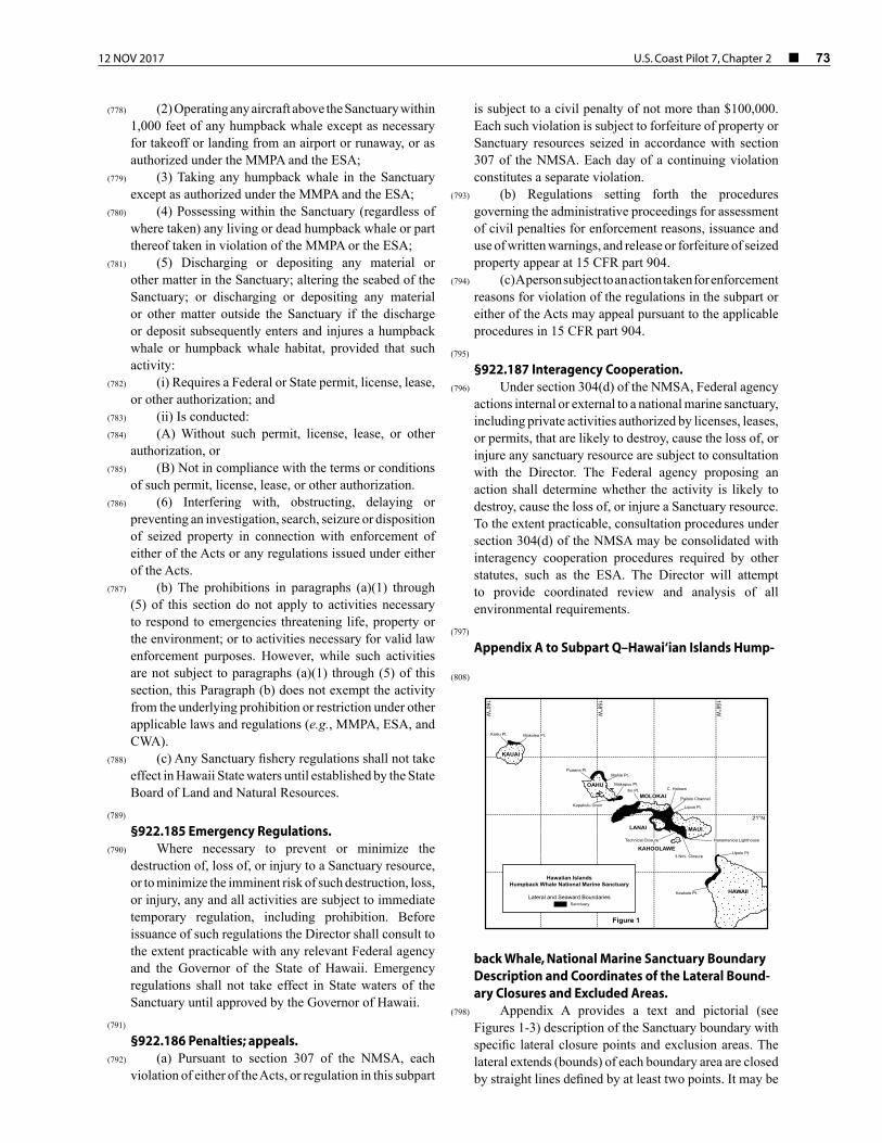
12 NOV 2017 U.S. Coast Pilot 7, Chapter 2 ¢ 73
(778) (2) Operating any aircraft above the Sanctuary within 1,000 feet of any humpback whale except as necessary for takeoff or landing from an airport or runaway, or as authorized under the MMPA and the ESA;
(779) (3) Taking any humpback whale in the Sanctuary except as authorized under the MMPA and the ESA;
(780) (4) Possessing within the Sanctuary (regardless of where taken) any living or dead humpback whale or part thereof taken in violation of the MMPA or the ESA;
(781) (5) Discharging or depositing any material or other matter in the Sanctuary; altering the seabed of the Sanctuary; or discharging or depositing any material or other matter outside the Sanctuary if the discharge or deposit subsequently enters and injures a humpback whale or humpback whale habitat, provided that such activity:
(782) (i) Requires a Federal or State permit, license, lease, or other authorization; and
(783) (ii) Is conducted:(784) (A) Without such permit, license, lease, or other
authorization, or(785) (B) Not in compliance with the terms or conditions
of such permit, license, lease, or other authorization.(786) (6) Interfering with, obstructing, delaying or
preventing an investigation, search, seizure or disposition of seized property in connection with enforcement of either of the Acts or any regulations issued under either of the Acts.
(787) (b) The prohibitions in paragraphs (a)(1) through (5) of this section do not apply to activities necessary to respond to emergencies threatening life, property or the environment; or to activities necessary for valid law enforcement purposes. However, while such activities are not subject to paragraphs (a)(1) through (5) of this section, this Paragraph (b) does not exempt the activity from the underlying prohibition or restriction under other applicable laws and regulations (e.g., MMPA, ESA, and CWA).
(788) (c) Any Sanctuary fishery regulations shall not take effect in Hawaii State waters until established by the State Board of Land and Natural Resources.
(789) §922.185 Emergency Regulations.
(790) Where necessary to prevent or minimize the destruction of, loss of, or injury to a Sanctuary resource, or to minimize the imminent risk of such destruction, loss, or injury, any and all activities are subject to immediate temporary regulation, including prohibition. Before issuance of such regulations the Director shall consult to the extent practicable with any relevant Federal agency and the Governor of the State of Hawaii. Emergency regulations shall not take effect in State waters of the Sanctuary until approved by the Governor of Hawaii.
(791) §922.186 Penalties; appeals.
(792) (a) Pursuant to section 307 of the NMSA, each violation of either of the Acts, or regulation in this subpart
is subject to a civil penalty of not more than $100,000. Each such violation is subject to forfeiture of property or Sanctuary resources seized in accordance with section 307 of the NMSA. Each day of a continuing violation constitutes a separate violation.
(793) (b) Regulations setting forth the procedures governing the administrative proceedings for assessment of civil penalties for enforcement reasons, issuance and use of written warnings, and release or forfeiture of seized property appear at 15 CFR part 904.
(794) (c) A person subject to an action taken for enforcement reasons for violation of the regulations in the subpart or either of the Acts may appeal pursuant to the applicable procedures in 15 CFR part 904.
(795) §922.187 Interagency Cooperation.
(796) Under section 304(d) of the NMSA, Federal agency actions internal or external to a national marine sanctuary, including private activities authorized by licenses, leases, or permits, that are likely to destroy, cause the loss of, or injure any sanctuary resource are subject to consultation with the Director. The Federal agency proposing an action shall determine whether the activity is likely to destroy, cause the loss of, or injure a Sanctuary resource. To the extent practicable, consultation procedures under section 304(d) of the NMSA may be consolidated with interagency cooperation procedures required by other statutes, such as the ESA. The Director will attempt to provide coordinated review and analysis of all environmental requirements.
(797) Appendix A to Subpart Q–Hawai‘ian Islands Hump-
back Whale, National Marine Sanctuary Boundary Description and Coordinates of the Lateral Bound-ary Closures and Excluded Areas.
(798) Appendix A provides a text and pictorial (see Figures 1-3) description of the Sanctuary boundary with specific lateral closure points and exclusion areas. The lateral extends (bounds) of each boundary area are closed by straight lines defined by at least two points. It may be
158°W
156°W
21°N
HAWAII
MAUI
MOLOKAI
KAHOOLAWE
LANAI
KAUAI
OAHU
160°W
Hawaiian IslandsHumpback Whale National Marine Sanctuary
Lateral and Seaward Boundaries Sanctuary
Figure 1
Upolo Pt.
Keahole Pt.
Lipoa Pt.
Pailolo Channel
C. Halawallio Pt.Makapuu Pt.
Kapahulu Groin
Mahie Pt.Puaena Pt.
Mokolea Pt.Kailiu Pt.
3 Nmi. Closure
Technical Closure Hanamanioa Lighthouse
(808)

74 ¢ U.S. Coast Pilot 7, Chapter 2 12 NOV 2017
necessary to extend these lines beyond the defining points to intersect the actual 100 fathom contour or the shoreline. Each point corresponds to a bounds number indicated in Figure 2. Digital files of the Sanctuary boundary (available in three common formats, ESRI Shape File, MapInfo Table and an ASCII Exchange format) are available from the Sanctuary office in Kihei, Maui, at the address listed above or by calling 808–879–2818. These digital geographies are the best available representation of the verbal legal delineation and were derived from: the Hawai‘ian shoreline as supplied by State of Hawaii through the Office of Planning GIS Office, the NOAA and State of Hawaii agreed upon lateral boundary and exclusion areas, and the 100 fathom isobath digitized
from the following 1:80,000 scale NOAA nautical charts:(799) 19327–West Coast of Hawaii (9th ED, 4/29/89),(800) 19347–Channels between Moloka‘i, Maui, Lanai,
and Kahoolawe (17th ED, 12/13/97),(801) 19351–Channels between Oahu, Moloka‘i, and
Lanai (8th ED, 7/01/89),(802) 19357–Island of Oahu (20th ED, 9/21/96), and(803) 19381–Island of Kauai (8th ED, 7/17/1993).(804) For the portion of the Lanai region of the HIHWNMS
west of Chart 19351, [157°42.8'W.] the 100 fathom contour was derived from the 1:250,999 chart 19340–Hawaii to Oahu (24th ED, 1/09/1993).
(805) All digital geography data have been referenced to WGS84 (NAD83) and have been converted to geographic (latitude and longitude) coordinates.
(806) Sanctuary Boundary
(807) A. As defined by the specific lateral boundaries in B, and except for excluded areas described in Paragraph C
of this section, the Hawai‘ian Islands Humpback Whale National Marine Sanctuary consists of the submerged lands and waters off the coast of the Hawai‘ian Islands seaward from the shoreline, cutting across the mouths of rivers and streams (see Figure 1):
(809) 1. To the 100-fathom (183 meter) isobath from Kailiu Point eastward to Mokolea Point, Kauai;
(810) 2. To the 100-fathom (183 meter) isobath from Puaena Point eastward to Mahie Point, and from the Kapahulu Groin in Waikiki eastward to Makapuu Point, Oahu;
(811) 3. To the 100-fathom (183 meter) isobath from Cape Halawa, Moloka‘i, south and westward to Ilio Point, Moloka‘i; southwestward to include Penguin Banks; eastward along the east side of Lanai; to the waters seaward of the three nautical mile limit north of Kahoolawe, to the Hanamanoia Lighthouse on Maui, and northward along the shoreline to Lipoa Point, Maui;
(812) 4. To the deep water area of Pailolo Channel from Cape Halawa, Moloka‘i, to Lipoa Point, Maui, and southward;
(813) 5. To the 100-fathom (183 meter) isobath from Upolu Point southward to Keahole Point, Hawaii.
(814) B. Lateral Closure Bounds for the Hawai‘ian Islands Humpback Whale National Marine Sanctuary Boundary (see Figure 2).
(815) C. Excluded Ports and Harbors Bounds (See Figure 3).
(818) Bound
No. (Fig. 2)
Geographic Name No. of points
Latitude north
Longitude west
1 Kailiu Pt., Kauai 2 22°13'24.7" 22°16'33.5"
159°34'52.2" 159°35'59.4"
2 Mokolea Pt., Kauai 2 22°13'29.9" 22°14'55.4"
159°22'55.8" 159°22'19.3"
3 Puaena Pt., N. Oahu
2 21°38'24.6" 21°36'8.4"
158°8'26.0" 158°6'24.5"
4 Mahie Pt., N. Oahu 2 21°33'37.3" 21°35'32.2"
157°51'51.9" 157°50'5.5"
5 Kapahulu Groin, S. Oahu
3 21°15'5.7" 21°16'6.1" 21°16'6.2"
157°50'27.5" 157°49'25.7" 157°49'23.8"
6 Makapuu Pt., S. Oahu
2 21°18'39.6" 21°19'44.7"
157°38'56.7" 157°35'46.1"
7 Ilio Pt, Molokai 2 21°13'25.7" 21°13'27.0"
157°18'45.8" 157°15'14.4"
8 Pailolo Channel, C. Halawa to Lipoa Pt.
2 21°1'29.8" 21°9'29.5"
156°38'22.0" 156°42'37.2"
9 Hanamanoia Light-house, Maui
2 20°34'21.8" 20°34'58.4"
156°26'51.1" 156°24'45.2"
158°W
156°W
21°N
HAWAII
MAUI
MOLOKAI
KAHOOLAWE
LANAI
KAUAI
OAHU
160°W
Hawaiian IslandsHumpback Whale National Marine Sanctuary
Excluded Ports and Harbors Sanctuary
Figure 3
Kawaihae Harbor
Lahaina Harbor
Kaunakakai HarborHaleolono Harbor
Kuapa Pond (Hawaii Kai)
Maalaea Harbor
Kaumalapau HarborManele Harbor
(816)
158°W
156°W
21°N
HAWAII
MAUI
MOLOKAI
KAHOOLAWE
LANAI
KAUAI
OAHU
160°W
Hawaiian IslandsHumpback Whale National Marine Sanctuary
Number Labels refer to objects in the Bounds data le Sanctuary
Figure 2
2221
1817
1615
14
7
6
5
43
21
8
910
11
12
13
20
19
(817)

12 NOV 2017 U.S. Coast Pilot 7, Chapter 2 ¢ 75
Bound No.
(Fig. 2)Geographic Name No. of
pointsLatitude
northLongitude
west
10 3 Nmi. closure around Kahoolawe
51 20°35'58.1"20°35'59.9"20°36'03.9"20°36'06.6"20°36'16.3"20°36'25.7"20°36'34.6"20°36'39.9"20°36'43.8"20°36'50.8"20°36'59.0"20°37'58.7"20°37'18.1"20°37'27.0"20°37'35.5"20°37'43.4"20°37'50.9"20°37'56.4"20°37'59.0"20°38'06.0"20°38'08.6"20°38'10.8"20°38'17.2"20°38'18.9"20°38'23.4"20°38'30.3"20°38'36.6"20°38'42.4"20°38'43.4"20°38'46.4"20°38'51.5"20°38'56.0"20°38'59.8"20°39'03.0"20°39'04.0"20°39'04.4"20°39'05.3"20°39'06.8"20°39'08.6"20°39'08.9"20°39'09.7"20°39'10.1"20°39'11.0"20°39'12.1"20°39'12.5"20°39'12.4"20°39'12.6"20°39'12.2"20°39'11.8"20°39'11.7"20°39'11.3"
156°29'32.0"156°29'33.0"156°29'35.5"156°29'36.9"156°29'43.1"156°29'49.9"156°29'57.3"156°30'02.2"156°30'05.5"156°30'12.1"156°30'16.5"156°30'22.7"156°30'29.5"156°30'36.8"156°30'44.8"156°30'53.4"156°31'02.4"156°31'10.0"156°31'13.2"156°31'22.7"156°31'26.8"156°31'29.9"156°31'39.9"156°31'43.0"156°31'48.4"156°31'58.0"156°32'07.9"156°32'18.3"156°32'20.5"156°32'25.9"156°32'36.7"156°32'47.7"156°32'59.1"156°33'10.7"156°33'15.7"156°33'17.0"156°33'21.1"156°33'28.7"156°33'40.7"156°33'44.4"156°33'49.6"156°33'53.8"156°34'00.3"156°34'12.4"156°34'24.4"156°34'25.4"156°34'30.5"156°34'42.6"156°34'47.7"156°34'48.9"156°34'55.8"
11 Technical Cosure 2 20°41'39.2"20°41'45.0"
156°37'07.5"156°38'03.6"
12 Upolu Pt., Hawaii (Big Island)
2 20°16'05.3"20°17'59.9"
155°51'00.5"155°51'17.2"
13 Keahole Pt., Hawaii (Big Island)
2 19°43'39.6"19°43'41.5"
156°03'42.7"156°04'14.5"
14 Kawaihae Harbor, Big Island exclusion
2 20°02'14.3"20°02'25.3"
155°50'02.5"155°49'57.7"
15 Haleolono Harbor, Molokai exclusion
2 21°05'03.5"21°05'04.8"
157°14'58.6"157°14'55.2"
16 Kaunakakai Harbor, Molokai exclusion
4 21°05'13.9"21°04'49.2"21°04'38.5"21°05'07.4"
157°01'35.7"157°01'58.3"157°01'41.2"157°01'15.0"
17 Kaumalapau Harbor, Lanai exclusion
2 20°47'09.2"20°47'01.1"
156°59'32.2"156°59'31.3"
18 Manele Harbor, Lanai exclusion
2 20°44'33.2"20°44'35.2"
156°53'12.9"156°53'14.1"
19 Lahaina Harbor, Maui exclusion
2 20°52'18.3"20°52'18.8"
156°40'45.0"156°40'44.0"
20 Maalaea Harbor, Maui exclusion
2 20°47'32.1"20°47'24.8"
156°30'35.0"156°30'39.6"
Bound No.
(Fig. 2)Geographic Name No. of
pointsLatitude
northLongitude
west
21 Western closure Kuapa Pond
(Hawaii Kai), Oahu
2 21°17'07.0"21°17'06.5"
157°43'07.7"157°43'07.0"
22 Eastern closure Kuapa Pond
(Hawaii Kai), Oahu
2 21°16'53.3"21°16'51.9"
157°42'42.7"157°42'40.3"
(819) TITLE 33–NAVIGATION AND NAVIGABLE WA-TERS
(820) Part 26–Vessel Bridge-to-Bridge Radiotele-phone Regulations
(821) §26.01 Purpose
(822) (a) The purpose of this part is to implement the provisions of the Vessel Bridge-to-Bridge Radiotelephone Act. This part:
(823) (1) Requires the use of the vessel bridge-to-bridge radiotelephone;
(824) (2) Provides the Coast Guard’s interpretation of the meaning of important terms in the Act;
(825) (3) Prescribes the procedures for applying for an exemption from the Act and the regulations issued under the Act and a listing of exemptions.
(826) (b) Nothing in this part relieves any person from the obligation of complying with the rules of the road and the applicable pilot rules.
(827) §26.02 Definitions.
(828) For the purpose of this part and interpreting the Act:(829) <Deleted Paragraph>(830) Act means the “Vessel Bridge-to-Bridge
Radiotelephone Act”, 33 U.S.C. sections 1201–1208;(831) Length is measured from end to end over the deck
excluding sheer;(832) Power-driven vessel means any vessel propelled by
machinery; and(832.01) Secretary means the Secretary of the Department in
which the Coast Guard is operating;(833) Towing vessel means any commercial vessel engaged
in towing another vessel astern, alongside, or by pushing ahead.
(834) Vessel Traffic Services (VTS) means a service implemented under Part 161 of this chapter by the United States Coast Guard designed to improve the safety and efficiency of vessel traffic and to protect the environment. The VTS has the capability to interact with marine traffic and respond to traffic situations developing in the VTS area.
(835) Vessel Traffic Service Area or VTS Area means the geographical area encompassing a specific VTS area of service as described in Part 161 of this chapter. This area

76 ¢ U.S. Coast Pilot 7, Chapter 2 12 NOV 2017
of service may be subdivided into sectors for the purpose of allocating responsibility to individual Vessel Traffic Centers or to identify different operating requirements.
(836) Note: Although regulatory jurisdiction is limited to the navigable waters of the United States, certain vessels will be encouraged or may be required, as a condition of port entry to report beyond this area to facilitate traffic management within the VTS area.
(837) §26.03 Radiotelephone required.
(838) (a) Unless an exemption is granted under §26.09 and except as provided in Paragraph (a)(4) of this section, this part applies to:
(839) (1) Every power-driven vessel of 20 meters or over in length while navigating;
(840) (2) Every vessel of 100 gross tons and upward carrying one or more passengers for hire while navigating;
(841) (3) Every towing vessels of 26 feet or over in length while navigating; and
(842) (4) Every dredge and floating plant engaged in or near a channel or fairway in operations likely to restrict or affect navigation of other vessels except for an unmanned or intermittently manned floating plant under the control of a dredge.
(843) (b) Every vessel, dredge, or floating plant described in Paragraph (a) of this section must have a radiotelephone on board capable of operation from its navigational bridge, or in the case of a dredge, from its main control station, and capable of transmitting and receiving on the frequency or frequencies within the 156-162 Mega-Hertz band using the classes of emissions designated by the Federal Communications Commission for the exchange of navigational information.
(844) (c) The radiotelephone required by Paragraph (b) of this section must be carried on board the described vessels, dredges, and floating plants upon the navigable waters of the United States.
(845) (d) The radiotelephone required by Paragraph (b) of this section must be capable of transmitting and receiving on VHF FM channel 22A (157.1 MHz).
(846) (e) While transiting any of the following waters, each vessel described in Paragraph (a) of this section also must have on board a radiotelephone capable of transmitting and receiving on VHF FM channel 67 (156.375 MHz):
(847) (1) The lower Mississippi River from the territorial sea boundary, and within either the Southwest Pass safety fairway or the South Pass safety fairway specified in 33 CFR 166.200, to mile 242.4 AHP (Above Head of Passes) near Baton Rouge;
(848) (2) The Mississippi River-Gulf Outlet from the territorial sea boundary, and within the Mississippi River-Gulf outlet Safety Fairway specified in 33 CFR 166.200, to that channel’s junction with the Inner Harbor Navigation Canal; and
(849) (3) The full length of the Inner Harbor Navigation Canal from its junction with the Mississippi River to that
canal’s entry to Lake Pontchartrain at the New Seabrook vehicular bridge.
(850) (f) In addition to the radiotelephone required by Paragraph (b) of this section each vessel described in Paragraph (a) of this section while transiting any waters within a Vessel Traffic Service Area, must have on board a radiotelephone capable of transmitting and receiving on the VTS designated frequency in Table 161.12(c) (VTS and VMRS Centers, Call Signs/MMSI, Designated Frequencies, and Monitoring Areas).
(851) Note: A single VHF-FM radio capable of scanning or sequential monitoring (often referred to as “dual watch” capability) will not meet the requirements for two radios.
(852) §26.04 Use of the designated frequency.
(853) (a) No person may use the frequency designated by the Federal Communications Commission under section 8 of the Act, 33 U.S.C. 1207 (a), to transmit any information other than information necessary for the safe navigation of vessels or necessary tests.
(854) (b) Each person who is required to maintain a listening watch under section 5 of the Act shall, when necessary, transmit and confirm, on the designated frequency, the intentions of his vessel and any other information necessary for the safe navigation of vessels.
(855) (c) Nothing in these regulations may be construed as prohibiting the use of the designated frequency to communicate with shore stations to obtain or furnish information necessary for the safe navigation of vessels.
(856) (d) On the navigable waters of the United States, channel 13 (156.65 MHz) is the designated frequency required to be monitored in accordance with §26.05(a) except that in the area prescribed in §26.03(e), channel 67 (156.375 MHz) is the designated frequency.
(857) (e) On those navigable waters of the United States within a VTS area, the designated VTS frequency is an additional designated frequency required to be monitored in accordance with §26.05.
(858) §26.05 Use of radiotelephone.
(859) Section 5 of the Act states that the radiotelephone required by this Act is for the exclusive use of the master or person in charge of the vessel, or the person designated by the master or person in charge to pilot or direct the movement of the vessel, who shall maintain a listening watch on the designated frequency. Nothing herein shall be interpreted as precluding the use of portable radiotelephone equipment to satisfy the requirements of this act.
(860) §26.06 Maintenance of radiotelephone; failure of radiotelephone.
(861) Section 6 of the Act states – (a) Whenever radiotelephone capability is required by this Act, a vessel’s radiotelephone equipment shall be maintained in effective operating condition. If the radiotelephone equipment carried aboard a vessel ceases to operate,

12 NOV 2017 U.S. Coast Pilot 7, Chapter 2 ¢ 77
the master shall exercise due diligence to restore it or cause it to be restored to effective operating condition at the earliest practicable time. The failure of a vessel’s radiotelephone equipment shall not, in itself, constitute a violation of this Act, nor shall it obligate the master of any vessel to moor or anchor his vessel; however, the loss of radiotelephone capability shall be given consideration in the navigation of the vessel.
(862) §26.07 Communications.
(863) No person may use the service of, and no person may serve as, a person required to maintain a listening watch under section 5 of the Act, 33 U.S.C. 1204, unless the person can communicate in the English language.
(864) §26.08 Exemption procedures.
(865) (a) The Commandant has redelegated to the Assistant Commandant for Marine Safety, Security and Environmental Protection, U.S. Coast Guard Headquarters, with the reservation that this authority shall not be further redelegated, the authority to grant exemptions from provisions of the Vessel Bridge-to-Bridge Radiotelephone Act and this part.
(866) (b) Any person may petition for an exemption from any provision of the Act or this part;
(867) (c) Each petition must be submitted in writing to Commandant (CG–DCO–D), Attn: Deputy for Operations Policy and Capabilities, U.S. Coast Guard Stop 7318, 2703 Martin Luther King Jr. Avenue SE., Washington, DC 20593–7318, and must state:
(868) (1) The provisions of the Act or this part from which an exemption is requested; and
(869) (2) The reasons why marine navigation will not be adversely affected if the exemption is granted and if the exemption relates to a local communication system how that system would fully comply with the intent of the concept of the Act but would not conform in detail if the exemption is granted.
(870) §26.09 List of exemptions.
(871) (a) All vessels navigating on those waters governed by the navigation rules for Great Lakes and their connecting and tributary waters (33 U.S.C. 241 et seq.) are exempt from the requirements of the Vessel Bridge- to-Bridge Radiotelephone Act and this part until May 6, 1975.
(872) (b) Each vessel navigating on the Great Lakes as defined in the Inland Navigation Rules Act of 1980 (33 U.S.C. 2001 et seq.) and to which the Vessel Bridge- to-Bridge Radiotelephone Act (33 U.S.C. 1201-1208) applies is exempt from the requirements in 33 U.S.C. 1203, 1204, and 1205 and the regulations under §§26.03, 26.04, 26.05, 26.06, and 26.07. Each of these vessels and each person to whom 33 U.S.C. 1208(a) applies must comply with Articles VII, X, XI, XII, XIII, XV, and XVI and Technical Regulations 1–9 of “The Agreement Between the United States of America and Canada for
Promotion of Safety on the Great Lakes by Means of Radio, 1973.”
(873) Part 80–COLREGS Demarcation Lines
(874) §80.01 General basis and purpose of demarcation lines.
(875) (a) The regulations in this part establish the lines of demarcation delineating those waters upon which mariners shall comply with the International Regulations for Preventing Collisions at Sea, 1972 (72 COLREGS) and those waters upon which mariners shall comply with the Inland Navigation Rules.
(876) (b) The waters inside of the lines are Inland Rules waters. The waters outside the lines are COLREGS waters.
(877) (c) Geographic coordinates expressed in terms of latitude or longitude, or both, are not intended for plotting on maps or charts whose referenced horizontal datum is the North American Datum of 1983 (NAD 83), unless such geographic coordinates are expressly labeled NAD 83. Geographic coordinates without the NAD 83 reference may be plotted on maps or charts referenced to NAD 83 only after application of the appropriate corrections that are published on the particular map or chart being used.
(878) §80.1102 Santa Catalina Island, CA.
(879) The 72 COLREGS shall apply to the harbors on Santa Catalina Island.
(880) §80.1104 San Diego Harbor, CA.
(881) A line drawn from Zuniga Jetty Light “V” to Zuniga Jetty Light “Z”; thence to Point Loma Light.
(882) §80.1106 Mission Bay, CA.
(883) A line drawn from Mission Bay South Jetty Light 2 to Mission Bay North Jetty Light 1.
(884) §80.1108 Oceanside Harbor, CA.
(885) A line drawn from Oceanside South Jetty Light 4 to Oceanside Breakwater Light 3.
(886) §80.1110 Dana Point Harbor, CA.
(887) A line drawn from Dana Point Jetty Light 4 to Dana Point Breakwater Light 3.
(888) §80.1112 Newport Bay, CA.
(889) A line drawn from Newport Bay East Jetty Light 4 to Newport Bay West Jetty Light 3.
(890) §80.1114 San Pedro Bay-Anaheim Bay, CA.
(891) (a) A line drawn across the seaward extremities of the Anaheim Bay Entrance Jetties; thence to Long Beach Breakwater East End Light 1.

78 ¢ U.S. Coast Pilot 7, Chapter 2 12 NOV 2017
(892) (b) A line drawn from Long Beach Channel Entrance Light 2 to Long Beach Light.
(893) (c) A line drawn from Los Angeles Main Entrance Channel Light 2 to Los Angeles Light.
(894) §80.1116 Redondo Harbor, CA.
(895) A line drawn from Redondo Beach East Jetty Light 2 to Redondo Beach West Jetty Light 3.
(896) §80.1118 Marina Del Rey, CA.
(897) (a) A line drawn from Marina Del Rey Breakwater South Light 1 to Marina Del Rey Light 4.
(898) (b) A line drawn from Marina Del Rey Breakwater North Light 2 to Marina Del Rey Light 3.
(899) (c) A line drawn from Marina Del Rey Light 4 to the seaward extremity of the Ballona Creek South Jetty.
(900) §80.1120 Port Hueneme, CA.
(901) A line drawn from Port Hueneme East Jetty Light 4 to Port Hueneme West Jetty Light 3.
(902) §80.1122 Channel Islands Harbor, CA.
(903) (a) A line drawn from Channel Islands Harbor South Jetty Light 2 to Channel Islands Harbor Breakwater South Light 1.
(904) (b) A line drawn from Channel Islands Harbor Breakwater North Light to Channel Islands Harbor North Jetty Light 5.
(905) §80.1124 Ventura Marina, CA.
(906) A line drawn from Ventura Marina South Jetty Light 6 to Ventura Marina Breakwater South Light 3; thence to Ventura Marina North Jetty Light 7.
(907) §80.1126 Santa Barbara Harbor, CA.
(908) A line drawn from Santa Barbara Harbor Light 4 to Santa Barbara Harbor Breakwater Light.
(909) §80.1130 San Luis Obispo Bay, CA.
(910) A line drawn from the southernmost extremity of Fossil Point to the seaward extremity of Whaler Island Breakwater.
(911) §80.1132 Estero-Morro Bay, CA.
(912) A line drawn from the seaward extremity of the Morro Bay East Breakwater to the Morro Bay West Breakwater Light.
(913) §80.1134 Monterey Harbor, CA.
(914) A line drawn from Monterey Harbor Light 6 to the northern extremity of Monterey Municipal Wharf 2.
(915) §80.1136 Moss Landing Harbor, CA.
(916) A line drawn from the seaward extremity of the pier located 0.3 mile south of Moss Landing Harbor Entrance
to the seaward extremity of the Moss Landing Harbor North Breakwater.
(917) §80.1138 Santa Cruz Harbor, CA.
(918) A line drawn from the seaward extremity of the Santa Cruz Harbor East Breakwater to Santa Cruz Harbor West Breakwater Light; thence to Santa Cruz Light.
(919) §80.1140 Pillar Point Harbor, CA.
(920) A line drawn from Pillar Point Harbor Light 6 to Pillar Point Harbor Entrance Light.
(921) §80.1142 San Francisco Harbor, CA.
(922) A straight line drawn from Point Bonita Light through Mile Rocks Light to the shore.
(923) §80.1144 Bodega and Tomales Bay, CA.
(924) (a) An east-west line drawn from Sand Point to Avalis Beach.
(925) (b) A line drawn from the seaward extremity of Bodega Harbor North Breakwater to Bodega Harbor Entrance Light 1.
(926) §80.1146 Albion River, CA.
(927) A line drawn on an axis of 030° true through Albion River Light 1 across Albion Cove.
(928) §80.1148 Noyo River, CA.
(929) A line drawn from Noyo River Entrance Daybeacon 4 to Noyo River Entrance Light 5.
(930) §80.1150 Arcata-Humboldt Bay, CA.
(931) A line drawn from Humboldt Bay Entrance Light 4 to Humboldt Bay Entrance Light 3.
(932) §80.1152 Crescent City Harbor, CA.
(933) A line drawn from Crescent City Entrance Light to the southeasternmost extremity of Whaler Island.
(934) §80.1305 Chetco River, OR.
(935) A line drawn across the seaward extremities of the Chetco River Entrance Jetties.
(936) §80.1310 Rogue River, OR.
(937) A line drawn across the seaward extremities of the Rogue River Entrance Jetties.
(938) §80.1315 Coquille River, OR.
(939) A line drawn across the seaward extremities of the Coquille River Entrance Jetties.
(940) §80.1320 Coos Bay, OR.
(941) A line drawn across the seaward extremities of the Coos Bay Entrance Jetties.

12 NOV 2017 U.S. Coast Pilot 7, Chapter 2 ¢ 79
(942) §80.1325 Umpqua River, OR.
(943) A line drawn across the seaward extremities of the Umpqua River Entrance Jetties.
(944) §80.1330 Siuslaw River, OR.
(945) A line drawn across the seaward extremities of the Siuslaw River Entrance Jetties.
(946) §80.1335 Alsea Bay, OR.
(947) A line drawn from the seaward shoreline on the north of the Alsea Bay Entrance 165° true across the channel entrance.
(948) §80.1340 Yaquina Bay, OR.
(949) A line drawn across the seaward extremities of the Yaquina Bay Entrance Jetties.
(950) §80.1345 Depoe Bay, OR.
(951) A line drawn across the Depoe Bay Channel entrance parallel with the general trend of the highwater shoreline.
(952) §80.1350 Netarts Bay, OR.
(953) A line drawn from the northernmost extremity of the shore on the south side of Netarts Bay north to the opposite shoreline.
(954) §80.1355 Tillamook Bay, OR.
(955) A line drawn across the seaward extremities of the Tillamook Bay Entrance Jetties.
(956) §80.1360 Nehalem River, OR.
(957) A line drawn approximately parallel with the general trend of the highwater shoreline across the Nehalem River Entrance.
(958) §80.1365 Columbia River Entrance, OR./WA.
(959) A line drawn from the seaward extremity of the Columbia River North Jetty (above water) 155° true to the seaward extremity of the Columbia River South Jetty (above water).
(960) §80.1370 Willapa Bay, WA.
(961) A line drawn from Willapa Bay Light 169.8° true to the westernmost tripod charted 1.6 miles south of Leadbetter Point.
(962) §80.1375 Grays Harbor, WA.
(963) A line drawn from across the seaward extremities (above water) of the Grays Harbor Entrance Jetties.
(964) §80.1380 Quillayute River, WA.
(965) A line drawn from the seaward extremity of the Quillayute River Entrance East Jetty to the overhead power cable tower charted on James Island; thence a
straight line through Quillayute River Entrance Light 3 to the shoreline.
(966) §80.1385 Strait of Juan de Fuca.
(967) The 72 COLREGS shall apply on all waters of the Strait of Juan de Fuca.
(968) §80.1390 Haro Strait and Strait of Georgia.
(969) The 72 COLREGS shall apply on all waters of the Haro Strait and the Strait of Georgia.
(970) §80.1395 Puget Sound and Adjacent Waters.
(971) The 72 COLREGS shall apply on all waters of Puget Sound and adjacent waters, including Lake Union, Lake Washington, Hood Canal, and all tributaries.
(972) §80.1410 Hawai‘ian Island Exemption from General Rule.
(973) Except as provided elsewhere in this part for Mamala Bay and Kaneohe Bay on Oahu; Port Allen and Nawiliwili Bay on Kauai; Kahului Harbor on Maui; and Kawailae and Hilo Harbors on Hawaii, the 72 COLREGS shall apply on all other bays, harbors, and lagoons of the Hawai‘ian Island (including Midway).
(974) §80.1420 Mamala Bay, Oahu, HI.
(975) A line drawn from 21°17′46.9″N., 158°06′22.2′W. (Barbers Point Light) to 21°15′20.5″N., 157°48′34.3″W. (Diamond Head Light).
(976) §80.1430 Kaneohe Bay, Oahu, HI.
(977) A line drawn from 21°27′44.1″N., 157°45′48.6″W. (Pyramid Rock Light), across Kaneohe Bay through the center of Mokolii Island to the shoreline.
(978) §80.1440 Port Allen, Kauai, HI.
(979) A line drawn from 21°53′34.3″N., 159°36′15.6″W. (Puolo Point Light) to 21°53′49.0″N., 159°35′27.2″W. (Hanapepe Breakwater Light 2).
(980) §80.1450 Nawiliwili Harbor, Kauai, HI.
(981) A line drawn from the seaward extremity of Nawiliwili Harbor Breakwater Light to 21°57′23.8″N., 159°20′52.7″W. (Kukii Point Light).
(982) §80.1460 Kahului Harbor, Maui, HI.
(983) A line drawn from 20°54′04.1″N., 156°28′26.8″W. (Kahului Entrance Breakwater Light 4), to 20°54′02.3″N., 156°28′17.4″W. (Kahului Entrance Breakwater Light 3).
(984) §80.1470 Kawaihae Harbor, HI.
(985) A line drawn from 20°02′29.1″N., 155°49′58.2″W. (Kawaihae Light), to the seaward extremity of the Kawaihae South Breakwater.

80 ¢ U.S. Coast Pilot 7, Chapter 2 12 NOV 2017
(986) §80.1480 Hilo Harbor, HI.
(987) A line drawn from the seaward extremity of the Hilo Breakwater 265° true (as an extension of the seaward side of the breakwater) to the shoreline 0.2 nautical mile north of Alealea Point.
(988) §80.1490 Apra Harbor, U.S. Territory of Guam.
(989) A line drawn from the westernmost extremity of Orote Island to the westernmost extremity of Glass Breakwater
(990) §80.1495 U.S. Pacific Island Possessions.
(991) The 72 COLREGS shall apply on the bays, harbors, lagoons, and waters surrounding the U.S. Pacific Island of American Samoa, Baker, Howland, Jarvis, Johnson, Palmyra, Swains and Wake Islands.
(992) Part 110–Anchorage Regulations
(993) §110.1 General.
(994) (a) The areas described in subpart A of this part are designated as special anchorage areas for the purposes of rule 30 (33 CFR 83.30) and rule 35 (33 CFR 83.35) of the Inland Navigation Rules, 33 CFR Chapter I, Subchapter E. Vessels of less than 20 meters in length; and barges, canal boats, scows, or other nondescript craft, are not required to sound signals required by rule 35 of the Inland Navigation Rules. Vessels of less than 20 meters are not required to exhibit anchor lights or shapes required by rule 30 of the Inland Navigation Rules.
(995) (b) The anchorage grounds for vessels described in Subpart B of this part are established, and the rules and regulations in relation thereto adopted, pursuant to the authority contained in section 7 of the act of March 4, 1915, as amended (38 Stat. 1053; 33 U.S.C. 471).
(996) (c) All bearings in the part are referred to true meridian.
(997) (d) Geographic coordinates expressed in terms of latitude or longitude, or both, are not intended for plotting on maps or charts whose referenced horizontal datum is the North American Datum of 1983 (NAD 83), unless such geographic coordinates are expressly labeled NAD 83. Geographic coordinates without the NAD 83 reference may be plotted on maps or charts referenced to NAD 83 only after application of the appropriate corrections that are published on the particular map or chart being used.
(998) Subpart A–Special Anchorage Areas
(999) §110.90 San Diego Harbor, CA.
(1000) (a) Area A–1. In North San Diego Bay, the Shelter Island Yacht Basin Anchorage, the water area enclosed by a line beginning at 32°42'56.7"N., 117°13'47.1"W.;
thence southwesterly to 32°42'53.6"N., 117°13'51.3"W.; thence northwesterly to 32°43'01.3"N., 117°13'59.1"W.; thence northeasterly to 32°43'02.6"N., 117°13'55.5"W.; thence southeasterly to 32°42'59.8"N., 117°13'50.4"W.; thence southeasterly to the point of beginning.
(1001) (b) Area A–1a. In North San Diego Bay, the Shelter Island Roadstead Anchorage east of Shelter Island, the water area 55 feet either side of a line beginning at 32°42'33.6"N., 117°13'48.3"W.; thence northeasterly to 32°42'36.0"N., 117°13'45.1"W.
(1002) (c) Area A–1b. The water area off Shelter Island’s eastern shore, 210 feet shoreward of a line beginning at 32°42'43.9"N., 117°13'34.3"W.; thence northeasterly to 32°42'52.8"N., 117°13'22.4"W.
(1003) (d) Area A–1c. The water area off Shelter Island’s eastern shore, 210 feet shoreward of a line beginning at 32°42'55.0"N., 117°13'19.4"W.; thence northeasterly to 32°43'03.5"N., 117°13'07.6"W.
(1004) (e) Area A–2. In North San Diego Bay, the America’s Cup Harbor Anchorage, the water area enclosed by a line beginning at 32°43'13.7"N., 117°13'23.8"W; thence northeasterly to 32°43'16.7"N., 117°13'16.4"W.; thence northeasterly to 32°43'22.6"N., 117°13'25.8"W.; thence westerly to 32°43'22.5"N., 117°13'29.6"W.; thence southwesterly to 32°43'19.0"N., 117°13'32.6"W.; thence southeasterly to the point of beginning.
(1005) (f) Area A–3. In North San Diego Bay, the Laurel Street Roadstead Anchorage, the water area enclosed by a line beginning at 32°43'30.5"N., 117°10'28.5"W.; thence southwesterly to 32°43'29.8"N., 117°10'34.2"W.; thence southwesterly to 32°43'25.8"N., 117°10'36.1"W.; thence southerly to 32°43'20.2"N., 117°10'36.1"W.; thence westerly to 32°43'20.2"N., 117°10'52.9"W.; thence northeasterly to 32°43'29.8"N., 117°10'48.0"W., thence northeasterly following a line parallel to, and 200 feet bayward of, the shoreline of San Diego Bay adjoining Harbor Drive to the point of beginning.
(1006) (g) Area A–4. In Central San Diego Bay, the Bay Bridge Roadstead Anchorage, the water area enclosed by a line beginning at 32°41'32.1"N., 117°09'43.1"W.; thence southwesterly to 32°41'19.1"N., 117°09'46.1"W.; thence southeasterly to 32°41'17.8"N., 117°09'44.3"W.; thence southeasterly to 32°41'14.9"N., 117°09'37.9"W.; thence northeasterly to 32°41'26.9"N., 117°09'35.1"W., thence southwesterly to the point of beginning.
(1007) (h) Area A–5. In Central San Diego Bay, the Glorietta Bay Anchorage, the water area enclosed by a line beginning at 32°40'42.2"N., 117°10'03.1"W.; thence southwesterly to 32°40'41.2"N., 117°10'06.6"W.; thence northwesterly to 32°40'46.2"N., 117°10'15.6"W.; thence northeasterly to 32°40'46.7"N., 117°10'14.1"W.; thence southeasterly the point of beginning.
(1008) (i) Area A–6. In Fiddler's Cove, the water enclosed by a line beginning at 32°39'10.4"N., 117°08'49.4"W.; thence northwesterly to 32°39'14.9"N., 117°08'51.8"W.; thence northeasterly to 32°39'17.6"N., 117°08'47.5"W.; thence northwesterly to 32°39'19.8"N., 117°08'48.8"W.; thence northeasterly to 32°39'24.4"N., 117°08'41.4"W.;

12 NOV 2017 U.S. Coast Pilot 7, Chapter 2 ¢ 81
thence southeasterly to 32°39'15.7"N., 117°08'36.0"W.; thence southwesterly to the point of beginning.
(1009) Note: This area is located on Federal property owned by the United States Navy, and it is reserved for active duty military, their dependents, retirees and DOD employees only.
(1010) (j) Area A–8. In South San Diego Bay, the Sweetwater Anchorage, the water enclosed by a line beginning at 32°39'12.2"N., 117°07'45.1"W.; thence easterly to 32°39'12.2"N., 117°07'30.1"W.; thence southerly to 32°38'45.2"N., 117°07'30.1"W.; thence westerly to 32°38'45.2"N., 117°07'45.1"W.; thence northerly to the point of beginning.
(1011) (k) Area A–9. In North San Diego Bay, the Cruiser Anchorage, the water enclosed by a line beginning at 32°43'35.9"N., 117°11'06.2"W.; thence southwesterly to 32°43'31.5"N., 117°11'13.2"W.; thence southeasterly to 32°43'28.9"N., 117°11'11.0"W.; thence southeasterly to 32°43'25.9"N., 117°11'07.7"W.; thence northeasterly to 32°43'34.8"N., 117°11'03.2"W.; thence northwesterly to the point of beginning. All coordinates in this section use Datum: NAD 83.
(1012) Note: Mariners anchoring in these anchorages, excluding Anchorage A–6, should consult applicable local ordinances of the San Diego Unified Port District. Temporary floats or buoys for marking anchors are allowed. Fixed moorings, piles or stakes are prohibited. All moorings shall be positioned so that no vessel, when anchored, shall at any time extend beyond the limits of the area. See Captain of the Port Notice 6–97, a copy of which can be obtained by calling (619) 683–6495.
(1013) §110.91 Mission Bay, CA.
(1014) (a) Area M–1. In San Juan Cove, the entire water area west of a line drawn from 32°46'53.6"N., 117°14'52.5"W.; to El Carmel Point North Light; 32°46'48.0"N., 117°14'50.1"W.
(1015) NOTE: Control over the anchoring of vessels and the placing of temporary moorings in this area is exercised by the City of San Diego Park and Recreation Department pursuant to local ordinances.
(1016) (b) Area M–2. In Santa Barbara Cove, the entire water area west of a line drawn from 32°46'40.0"N., 117°14'47.0"W.; to 32°46'33.5"N., 117°14'45.5"W.
(1017) NOTE: Control over the anchoring of vessels and the placing of temporary mooring in this area is exercised by the City of San Diego Park and Recreation Department pursuant to local ordinances.
(1018) (c) Area M–3. In Mariners Basin, the entire water area west of a line drawn from latitude 32°45'49.2"N., longitude 117°14'42.9"W.; to Mission Point Light; latitude 32°45'43.7"N., longitude 117°14'41.9"W.
(1019) NOTE: Control over the anchoring of vessels and the placing of temporary moorings in this area is exercised by the City of San Diego Park and Recreation Department pursuant to local ordinances.
(1020) (d) Area M–4. In Quivira Basin, the water area enclosed by that portion of a circle of 45 yard radius from 32°45'42.8"N., 117°14'25.6"W.; through the arc from 354°T to 088°T.
(1021) NOTE: Control over the anchoring of vessels and the placing of temporary moorings in this area is exercised by the City of San Diego Park and Recreation Department pursuant to local ordinances.
(1022) §110.93 Dana Point Harbor, CA.
(1023) The area in Dana Point Harbor, Calif. commencing at a point at latitude 33°27′36.2″N., longitude 117°42′20.4″W.; thence 016°20′ True for 612 feet to a point at latitude 33°27′42.1″N., longitude 117°42′18.4″W.; thence 106°20′ True for 85 feet to a point at latitude 33°27′41.8″N., longitude 117°42′17.7″W.; thence 196°20′ True for 222 feet to a point at latitude 33°27′39.7″N., longitude 117°42′18.2″W.; thence 182°20′ True 234 feet to a point at latitude 33°27′37.4″N., longitude 117°42′18.2″W.; thence 166°20′ True for 499 feet to a point at latitude 33°27′32.6″N., longitude 117°42′16.8″W.; thence 320° True for 470 feet to the point of origin.
(1024) <1024-1029 Deleted>(1030)
§110.95 Newport Bay Harbor, CA.(1031) (a) Area A–1. The entire water area within beginning
at latitude 33°36′09.3″ N., longitude 117°53′52.6″ W.; thence to latitude 33°36′11.4″ N., longitude 117°53′51.2″ W.; thence to latitude 33°36′04.0″ N., longitude 117°53′33.4″ W.; thence to latitude 33°36′03.9″ N., longitude 117°53′20.4″ W.; thence to 33°36′01.1″ N., longitude 117°53′09.9″ W.; thence to 33°36′01.1″ N., longitude 117°53′32.7″ W.; thence to 33°36′03.9″ N., longitude 117°53′41.9″ W.; returning to latitude 33°36′09.3″ N., longitude 117°53′52.6″ W.
(1032) <1032-1039 Deleted>(1040) (b) Area A–2. The entire water area within beginning
at latitude 33°36′12.9″ N., longitude 117°53′44.2″ W; thence to latitude 33°36′14.2″ N., longitude 117°53′44.3″ W.; thence to latitude 33°36′14.2″ N., longitude 117°53′20.6″ W.; thence to latitude 33°36′10.8″ N., longitude 117°53′20.5″ W.; thence to latitude 33°36′12.7″ N., longitude 117°53′29.9″ W.; thence to latitude 33°36′12.7″ N., longitude 117°53′35.4″ W.; thence to latitude 33°36′12.9″ N., longitude 117°53′37.0″ W.; returning to latitude 33°36′12.9″ N., longitude 117°53′44.2″ W.
(1041) <1041-1048 Deleted>(1049) (c) Area A–3. The entire water area within
beginning at latitude 33°36′22.7″N., longitude 117 54′12.6″W.; thence to latitude 33°36′24.9″N., longitude 117°54′12.6″W.; thence to latitude 33°36′26.2″N., longitude 117°54′11.3″W.; thence to latitude 33°36′18.7″N., longitude 117°54′00.5″W.; thence to latitude 33°36′16.2″N., longitude 117°54′02.9″W.; returning to latitude 33°36′22.7″N., longitude 117°54′12.6″W.
82 ¢ U.S. Coast Pilot 7, Chapter 2 12 NOV 2017
(1050) <1050-1055 Deleted>(1056) (d) Area A–4. The entire water area within beginning
at latitude 33°36′32.7″ N., longitude 117°53′56.6″ W.; thence to latitude 33°36′33.6″ N., longitude 117°53′56.6″ W.; thence to latitude 33°36′33.5″ N., longitude 117°53′26.2″ W.; thence to latitude 33°36′32.9″ N., longitude 117°53′26.2″ W.; thence to latitude 33°36′32.6″ N., longitude 117°53′33.8″ W.; thence to latitude 33°36′32.4″ N., longitude 117°53′36.7″ W.; thence to latitude 33°36′31.7″ N., longitude 117°53′40.9″ W.; thence to 33°36′31.7″ N., longitude 117°53′46.3″ W.; thence to latitude 33°36′32.6″ N., longitude 117°53′50.9″ W.; returning to latitude 33°36′32.7″ N., longitude 117°53′56.6″ W.
(1057) <1057-1066 Deleted>(1067) (e) Area A–5. The entire water area within beginning
at latitude 33°36′29.1″ N., longitude 117°54′55.3″ W.; thence to latitude 33°36′27.8″ N., longitude 117°54′55.8″ W.; thence to latitude 33°36′24.1″ N., longitude 117°54′41.8″ W.; thence to latitude 33°36′26.7″ N., longitude 117°54′40.8″ W.; thence to latitude 33°36′26.7″ N., longitude 117°54′46.3″ W.; returning to latitude 33°36′29.1″ N., longitude 117°54′55.3″ W.
(1068) <1068-1073 Deleted>(1074) (f) Area A–6. The entire water area within beginning
at latitude 33°36′43.3″ N., longitude 117°54′26.4″ W.; thence to latitude 33°36′51.7″ N., longitude 117°54′22.8″ W.; thence to latitude 33°36′51.4″ N., longitude 117°54′21.5″ W.; thence to latitude 33°36′42.9″ N., longitude 117°54′25.2″ W.; returning to latitude 33°36′43.3″ N., longitude 117°54′26.4″ W.
(1075) <1075-1079 Deleted>(1080) (g) Area A–7. The entire water area within beginning
at latitude 33°36′32.1″ N., longitude 117°55′12.5″ W.; thence to latitude 33°36′37.7″ N., longitude 117°55′11.0″ W.; thence to latitude 33°36′35.1″ N., longitude 117°55′01.3″ W.; thence to latitude 33°36′30.4″ N., longitude 117°55′02.6″ W.; thence to latitude 33°36′31.2″ N., longitude 117°55′06.7″ W.; returning to latitude 33°36′32.1″ N., longitude 117°55′12.5″ W.
(1081) <1081-1086 Deleted>(1087) (h) Area A–8. The entire water area within beginning
at latitude 33°36′34.2″ N., longitude 117°55′27.3″ W.; thence to latitude 33°36′36.2″ N., longitude 117°55′26.7″ W.; thence to latitude 33°36′39.5″ N., longitude 117°55′20.9″ W.; thence to latitude 33°36′38.9″ N., longitude 117°55′15.4″ W.; thence to latitude 33°36′37.9″ N., longitude 117°55′11.7″ W.; thence to latitude 33°36′32.1″ N., longitude 117°55′13.3″ W.; returning to latitude 33°36′34.2″ N., longitude 117°55′27.3″ W.
(1088) <1088-1094 Deleted>(1095) (i) Area A–9. The entire water area within beginning
at latitude 33°36′53.5″ N., longitude 117°55′28.2″ W.; thence to latitude 33°36′54.0″ N., longitude 117°55′27.0″ W.; thence to latitude 33°36′43.4″ N., longitude 117°55′20.4″ W.; thence to latitude 33°36′42.9″ N., longitude 117°55′21.6″ W.; returning to latitude 33°36′53.5″ N., longitude 117°55′28.2″ W.
(1096) <1096-1100 Deleted>(1101) (j) Area A–10. The entire water area within beginning
at latitude 33°36′07.4″ N., longitude 117°53′19.2″ W.; thence to latitude 33°36′14.2″ N., longitude 117°53′19.4″ W.; thence to latitude 33°36′14.2″ N., longitude 117°53′06.9″ W.; thence to latitude 33°36′08.1″ N., longitude 117°53′04.9″ W.; thence to latitude 33°36′06.5″ N., longitude 117°53′08.9″ W.; thence to latitude 33°36′06.5″ N., longitude 117°53′16.3″ W.; returning to latitude 33°36′07.4″ N., longitude 117°53′19.2″ W.
(1102) <1102-1108 Deleted>(1109) (k) Area A–11. The entire water area within beginning
at latitude 33°36′04.7″ N., longitude 117°53′01.9″ W.; thence to latitude 33°36′06.1″ N., longitude 117°53′00.5″ W.; thence to latitude 33°36′06.2″ N., longitude 117°52′59.0″ W.; thence to latitude 33°35′59.4″ N., longitude 117°52′51.1″ W.; thence to latitude 33°35′57.5″ N., longitude 117°52′50.9″ W.; thence to latitude 33°36′01.9″ N., longitude 117°52′57.3″ W.; thence to latitude 33°36′03.0″ N., longitude 117°53′00.4″ W.; returning to latitude 33°36′04.7″ N., longitude 117°53′01.9″ W.
(1110) <1110-1117 Deleted>(1118) (l) Area A–12. The entire water area within beginning
at latitude 33°36′27.9″ N., longitude 117°54′40.4″ W.; thence to latitude 33°36′23.9″ N., longitude 117°54′41.8″ W.; thence to latitude 33°36′20.8″ N., longitude 117°54′29.9″ W.; thence to latitude 33°36′28.5″ N., longitude 117°54′20.2″ W.; returning to latitude 33°36′27.9″ N., longitude 117°54′40.4″ W.
(1119) <1119-1123 Deleted>(1124) (m) Area B–1. The entire water area within beginning
at latitude 33°36′35.1″ N., longitude 117°54′28.8″ W.; thence to latitude 33°36′32.1″ N., longitude 117°54′22.1″ W.; thence to latitude 33°36′30.6″ N., longitude 117°54′22.8″ W; thence to latitude 33°36′30.5″ N., longitude 117°54′30.9″ W.; returning to latitude 33°36′35.1″ N., longitude 117°54′28.8″ W.
(1125) <1125-1129 Deleted>(1130) Note to § 110.95: These anchorage areas are reserved
for recreational and other small craft. Local law, including the City of Newport Beach Municipal Code 17.25.020, may provide for fore and aft moorings for recreational and small craft of such size and alignment as permitted by the harbor master.
(1131) §110.100 Los Angeles and Long Beach Harbors, CA.
(1132) (a) (Reserved)(1133) (b) Area A–2. Consisting of two parts in the outer
basin of Fish Harbor on the east and west sides of Fish Harbor Entrance Channel described as follows:
(1134) (1) Part 1. Beginning at a point at the intersection of westerly side of Fish Harbor Entrance Channel and the outer jetty; thence southwesterly along the jetty about 900 feet to the shore; thence northerly about 500 feet; thence northeasterly about 650 feet, on a line parallel to jetty; thence southeasterly about 500 feet, along the westerly

12 NOV 2017 U.S. Coast Pilot 7, Chapter 2 ¢ 83
side of Fish Harbor Entrance Channel to the point of beginning.
(1135) (2) Part 2. Beginning at a point at the intersection of the east side of Fish Harbor Entrance Channel and Fish Harbor mole (outer Fish Harbor); thence northwesterly along the channel line about 850 feet to the southerly side of the Fairway; thence northeasterly and easterly along the southerly side of the Fairway, about 478 and 565 feet respectively to its intersection with Fish Harbor mole; thence southerly and southwesterly along the mole to the point of beginning.
(1136) (c) Area B–1. Long Beach outer harbor along east side of Pier 400 beginning at 33°44'22.8"N., 118°13'51.0"W.; thence south to 33°43'54.5"N., 118°13'50.0"W.; thence southwesterly to 33°43'46.0"N., 118°14'13.6"W.; thence northwesterly to 33°44'15.3"N., 118°14'26.6"W.; thence northeasterly to 33°44'25.1"N., 118°14'15.6"W.; thence easterly to the beginning point.
(1137) (d) Area C–1. Long Beach outer harbor between Island Freeman and Island Chaffee beginning at 33°44'20.0"N., 118°08'26.2"W.; thence west to 33°44'23.5"N., 118°09'32.6"W.; thence north to 33°44'52.8"N., 118°09'33.2"W.; thence southeast to 33°44'25.5"N., 118°08'26.2"W.; thence south to the beginning point.
(1138) (e) Area E–1. Long Beach outer harbor northwest of Island Freeman beginning at 33°44'55.0"N., 118°09'40.0"W.; thence southwesterly to 33°44'37.0"N., 118°09'48.5"W.; thence northwesterly to 33°44'52.0"N., 118°10'32.0"W.; thence north to 33°45'11.0"N., 118°10'32.0"W.
(1139) (f) Restrictions. Special anchorage areas B–1, C–1, and E–1 are reserved for barges on mooring balls, unless otherwise authorized by the Captain of the Port Los Angeles-Long Beach
(1140) §110.111 Marina del Rey Harbor, CA.
(1141) An area in the main channel encompassed within the following described boundaries: Beginning at the northeasterly corner in position latitude 33°58′41.6″ N., longitude 118°26′50.8″ W.; thence southerly to latitude 33°58′30.2″ N., longitude 118°26′50.8″ W.; thence westerly to latitude 33°58′30.2″ N., longitude 118°26′55.1″ W.; thence northerly to latitude 33°58′41.6″ N., longitude 118°26′55.1″ W.; thence easterly to the point of origin. All coordinates referenced North American Datum 1983.
(1142) <1142-1147 Deleted>(1148) Note to 110.111: The Marina del Rey Harbor Master,
Los Angeles County, prescribes local regulations for mooring and boating activities in this area.
(1149) <Deleted Paragraph>(1150)
§110.115 Santa Barbara Harbor, CA.(1151) North of the Santa Barbara breakwater; seaward
of the line of mean high water; and southwest of a line bearing 46°30' from the north corner of Bath Street
and Cabrillo Boulevard to the end of the Santa Barbara breakwater; excluding a fairway 225 feet wide, 100 feet from each side of and parallel to the Navy pier.
(1152) NOTE: Fore and aft moorings will be allowed in this area conforming to the City of Santa Barbara Harbor Ordinance No. 2106 for yachts and small craft of such size and alignment as permitted by the harbor master.
(1153) §110.120 San Luis Obispo Bay, CA.
(1154) (a) Area A–1. Area A–1 is the water area bounded by the San Luis Obispo County wharf, the shoreline, a line drawn from the southernmost point of Fossil Point to latitude 35°10'18.5"N., longitude 120°43'38.5"W.; thence to the southeast corner of the San Luis Obispo County wharf.
(1155) (b) Area A–2. Area A–2 is the water area enclosed by a line drawn from the outer end of Whaler Island breakwater at latitude 35°09'22"N., longitude 120°44'56"W., to the Marre Chimney at latitude 35°10'56"N., longitude 120°44'31"W.
(1156) NOTE: The Port San Luis Harbor District prescribes local regulations for mooring and boating activities in these areas.
(1157) §110.125 Morro Bay Harbor, CA.
(1158) (a) Area A–1. Opposite the City of Morro Bay, beginning 50 feet west of the intersection of the west channel line and the prolongation of the center line of Seventh Street; thence in a generally southeasterly direction and parallel to the channel line for a distance of 450 yards; thence 166° and parallel to the revetment for a distance of 1,025 yards; thence 270° for a distance of 200 yards; thence 346° for a distance of about 1,425 yards to meet the prolongation of the center line of Seventh Street; and thence to the point of beginning.
(1159) (b) Area A–2. Beginning at a point 322° and 150 feet from the high water line on the most westerly part of Fairbanks Point; thence continuing on this bearing for a distance of 1,346 feet; thence 052° for a distance of 450 feet and thence generally southeasterly parallel to and 150 feet from the mean high water line to the point of beginning.
(1160) NOTE: Moorings and boating activities will be allowed in these areas conforming to applicable City of Morro Bay ordinances and regulations adopted pursuant thereto.
(1161) §110.126 Monterey Harbor, CA.
(1162) The waters of Monterey Harbor between the shoreline and the following coordinates: Beginning at a point on the shoreline at 36°36'27.5"N., 121°53'35.0"W.; thence to 36°36'32.4"N., 121°53'31.0"W., in an easterly direction to 36°36'28.8"N., 121°53'19.0"W.; thence south to 36°36'23.1"N., 121°53'19.0"W.; thence to the north end of Municipal Wharf No. 1 at 36°36'20.0"N., 121°53'28.0"W.

84 ¢ U.S. Coast Pilot 7, Chapter 2 12 NOV 2017
(1163) §110.126a San Francisco Bay, CA.
(1164) Richardson Bay Anchorage. That portion of Richardson Bay, north of a line bearing 257° from Peninsula Point to the shore at Sausalito, except for federally-maintained channels, and all channels approved for private use therein.
(1165) NOTE: Mariners anchoring in the special anchorage area should consult applicable ordinances of the Richardson Bay Regional Agency and the County of Marin. These ordinances establish requirements on matters including the anchoring of vessels, placement of moorings, and use of anchored and moored vessels within the special anchorage area. Information on these local agency requirements may be obtained from the Richardson Bay Harbor Administrator.
(1166) §110.127 Lake Mohave and Lake Mead, Nevada and Arizona.
(1167) (a) Willow Beach, Ariz. That portion of Lake Mohave enclosed by the shore and a line connecting the following points, excluding a 100-foot-wide fairway, extending westerly from the launching ramp, as established by the Superintendent, Lake Mead Recreation Area:
(1168) “a” 35°52'30"N., 114°39'35"W.(1169) “b” 35°52'10"N., 114°39'35"W.(1170) (b) Katherine, Ariz. That portion of Lake Mohave
enclosed by the shore and a line connecting the following points, excluding a 100-foot-wide fairway, extending westerly from the launching ramp, as established by the Superintendent, Lake Mead Recreation Area:
(1171) “a” 35°13'33"N., 114°34'38"W.(1172) “b” 35°13'05"N., 114°34'40"W.(1173) (c) El Dorado Canyon, Nev. That portion of Lake
Mohave enclosed by the shore and a line connecting the following points, excluding a 50-foot-wide fairway, extending easterly from the launching ramp, as established by the Superintendent, Lake Mead Recreation Area:
(1174) “a” 35°42'37"N., 114°42'21"W.(1175) “b” 35°42'08"N., 114°42'10"W.(1176) (d) Cottonwood Cove, Nev. That portion of Lake
Mohave enclosed by the shore and a line connecting the following points, excluding a 200-foot-wide fairway extending northeasterly from the launching ramp, as established by the Superintendent, Lake Mead Recreation Area:
(1177) “a” 35°29'46"N., 114°40'55"W.(1178) “b” 35°29'33"N., 114°40'45"W.(1179) (e) Overton Beach, Nev.–(1) Area “A”. That portion
of Lake Mead enclosed by the shore and lines connecting the following points, excluding two 300-foot-wide fairways, extending northwesterly and southwesterly from the launching ramps, as established by the Superintendent, Lake Mead Recreation Area:
(1180) “a” 36°27'05"N., 114°21'48"W.(1181) “b” 36°27'15"N., 114°21'20"W.(1182) “c” 36°26'32"N., 114°20'45"W.
(1183) “d” 36°25'49"N., 114°20'50"W.(1184) “e” 36°25'00"N., 114°21'27"W.(1185) “f” 36°25'19"N., 114°22'10"W.(1186) (f) Echo Bay, Nev. That portion of Lake Mead
enclosed by the shore and lines connecting the following points, excluding a 100-foot-wide fairway, extending southwesterly from the launching ramp, as established by the Superintendent, Lake Mead Recreation Area:
(1187) “a” 36°18'30"N., 114°25'10"W.(1188) “b” 36°18'20"N., 114°24'00"W.(1189) “c” 36°17'35"N., 114°24'05"W.(1190) “d” 36°17'40"N., 114°24'27"W.(1191) (g) Callville Bay, Nev. That portion of Lake Mead
enclosed by the shore and lines connecting the following points, excluding a 200-foot-wide fairway, extending southeasterly from the launching ramp, as established by the Superintendent, Lake Mead Recreation Area:
(1192) “a” 36°09'00"N., 114°42'40"W.(1193) “b” 36°08'10"N., 114°42'03"W.(1194) “c” 36°08'06"N., 114°42'40"W.(1195) (h) Las Vegas Wash, Nev. That portion of Lake Mead
enclosed by the shore and a line connecting the following points, excluding a 200-foot-wide fairway, extending easterly from the launching ramp, as established by the Superintendent, Lake Mead Recreation Area:
(1196) “a” 36°07'23"N., 114°49'45"W.(1197) “b” 36°06'29"N., 114°49'45"W.(1198) (i) Hemenway Harbor, Nev. That portion of Lake
Mead enclosed by the shore and lines connecting the following points, excluding a 100-foot-wide fairway, extending easterly from the launching ramp at Boulder Beach and a 600-foot-wide fairway, extending northeasterly from the launching ramp at Hemenway Harbor, both as established by the Superintendent, Lake Mead Recreation Area:
(1199) “a” 36°04'05"N., 114°48'15"W.(1200) “b” 36°03'25"N., 114°48'10"W.(1201) “c” 36°01'20"N., 114°45'15"W.(1202) (j) Kingman Wash, Ariz. That portion of Lake Mead
enclosed by the shore and a line connecting the following points, excluding a 100-foot-wide fairway, extending westerly from the launching ramp, as established by the Superintendent, Lake Mead Recreation Area:
(1203) “a” 36°02'34"N., 114°42'50"W.(1204) “b” 36°02'05"N., 114°43'05"W.(1205) (k) Temple Bar, Ariz. That portion of Lake Mead
enclosed by the shore and lines connecting the following points, excluding a 200-foot-wide fairway, extending southwesterly from the launching ramp, as established by the Superintendent, Lake Mead Recreation Area:
(1206) “a” 36°02'21"N., 114°19'29"W.(1207) “b” 36°02'34"N., 114°18'46"W.(1208) “c” 36°02'03"N., 114°18'13"W.(1209) (l) Greggs, Ariz. That portion of Lake Mead
enclosed by the shore and a line connecting the following points, excluding a 100-foot-wide fairway, extending northerly from the launching ramp, as established by the Superintendent, Lake Mead Recreation Area:

12 NOV 2017 U.S. Coast Pilot 7, Chapter 2 ¢ 85
(1210) “a” 36°00'35"N., 114°13'49"W.(1211) “b” 36°00'35"N., 114°14'10"W.(1212) (m) Pierce Ferry, Ariz. That portion of Lake Mead
enclosed by the shore and a line connecting the following points, excluding a 100-foot-wide fairway, extending easterly from the launching ramp, as established by the Superintendent, Lake Mead Recreation Area:
(1213) “a” 36°08'42"N., 113°59'24"W.(1214) “b” 36°07'18"N., 113°58'32"W.(1215) (n) South Bay, Ariz. That portion of Lake Mead
enclosed by the shore and a line connecting the following points, excluding one 100-foot wide fairway, extending westerly from the launching ramp, as established by the Superintendent, Lake Mead Recreation Area:
(1216) “a” 36°06'26"N., 114°06'13"W.(1217) “b” 36°05'00"N., 114°06'50"W.(1218) “c” 36°05'00"N., 114°06'13"W.(1219) NOTE: Fixed moorings, piles, or stakes are
prohibited. Single and fore and aft temporary moorings will be allowed. The anchoring of vessels and the placing of temporary moorings will be under the jurisdiction and at the discretion of the Superintendent, Lake Mead Recreation Area, National Park Service.
(1220) §110.127c Trinidad Bay, CA.
(1221) The waters of Trinidad Bay beginning at the southernmost point of Trinidad Head at 41°03'04"N., 124°08'56"W.; thence east to Prisoner Rock at 41°03'09"N., 124°08'37"W.; thence east to 41°03'09"N., 124°08'19"W.; thence north to 41°03'26"N., 124°08'21"W.; thence following the shoreline to Trinidad Bay in a westerly and southerly direction to the point of beginning.
(1222) NOTE: The area will be principally for use by sport and commercial fishing vessels. Temporary floats and buoys for anchoring will be allowed in the area. Fixed moorings, piles or stakes are prohibited. All moorings shall be placed so that no vessel when anchored or moored shall at any time extend beyond the limits of the area. The anchoring of all vessels and placing of all moorings will be under the supervision of the City of Trinidad or such other authority as may be designated by the City Council of the City of Trinidad, California.
(1223) §110.128 Columbia River at Portland, OR.
(1224) The waters of the Columbia River between Sand Island and Government Island, bounded on the west by pile dike U.S. 5.75 and a line extending true north from the northerly end of the dike to the south shore of Sand Island and bounded on the east by a line bearing 339°15' true, from a point on Government Island at latitude 45°35'10", longitude 122°32'41", to the southerly shore of Sand Island.
(1225) §110.128b Island of Hawaii, Hawaii.
(1226) (a) Hilo Bay. The waters of Hilo Bay enclosed by a line beginning at 19°43'55.5"N., 155°03'30"W. thence to 19°44'08.0"N., 155°04'19"W. thence to 19°43'51.0"N.,
155°04'30"W. thence to 19°44'10.0"N., 155°05'29"W. thence along the shoreline to the beginning point. (Datum: OHD)
(1227) Hilo Bay (33 CFR 110.128b)
1 19°43'44.5"N 155°03'20.0"W
2 19°43'57.0"N 155°04'09.0"W
3 19°43'40.0"N 155°04'20.0"W
4 19°43'59.0"N 155°05'19.0"W
Note: The coordinates in the table above are referenced to North American Datum of 1983 (NAD83). They are converted from Old Hawaiian Datum (OHD) but are not part of the official text of the Code of Federal Regulations.
(1228) (b) Kuhio Bay. The waters of Kuhio Bay enclosed by a line beginning at 19°44'13.0"N., 155°03'25"W. thence to 19°44'15.0"N., 155°03'25"W. thence along the shoreline to the beginning point. (Datum: OHD)
(1229) Kuhio Bay (33 CFR 110.128b)
1 19°44'02.0"N 155°03'15.0"W
2 19°44'04.0"N 155°03'15.0"W
Note: The coordinates in the table above are referenced to North American Datum of 1983 (NAD83). They are converted from Old Hawaiian Datum (OHD) but are not part of the official text of the Code of Federal Regulations.
(1230) §110.128c Island of Kauai, Hawaii
(1231) (a) Nawiliwili Bay. The waters of Nawiliwili Bay enclosed by a line beginning at 21°57'12.5"N., 159°21'38"W. thence to 21°57'26"N., 159°21'39.5"W. thence along the shoreline to the beginning point. (Datum: OHD)
(1232) Nawiliwili Bay (33 CFR 110.128c)
1 21°57'01.2"N 159°21'28.0"W
2 21°57'14.7"N 159°21'29.4"W
Note: The coordinates in the table above are referenced to North American Datum of 1983 (NAD83). They are converted from Old Hawaiian Datum (OHD) but are not part of the official text of the Code of Federal Regulations.
(1233) (b) [Reserved](1234)
§110.128d Island of Oahu, HI. (Datum: OHD)(1235) (a) Kaneohe Bay (1). The waters of Kaneohe
Bay enclosed by a line beginning at 21°26'28"N., 157°46'00"W. thence to 21°26'00"N., 157°46'14"W. thence to 21°26'20"N., 157°47'24"W. thence to 21°27'00"N., 157°48'25"W. thence to 21°26'46"N., 157°48'37"W. thence along the shoreline to the beginning point.
(1236) Kaneohe Bay 1 (33 CFR 110.128d)
1 21°26'16.6"N 157°45'50.1"W
2 21°25'48.6"N 157°46'04.1"W

86 ¢ U.S. Coast Pilot 7, Chapter 2 12 NOV 2017
Kaneohe Bay 1 (33 CFR 110.128d)
3 21°26'08.6"N 157°47'14.1"W
4 21°26'48.6"N 157°48'15.1"W
5 21°26'34.6"N 157°48'27.1"W
Note: The coordinates in the table above are referenced to North American Datum of 1983 (NAD83). They are converted from Old Hawaiian Datum (OHD) but are not part of the official text of the Code of Federal Regulations.
(1237) (b) Kaneohe Bay (2). The waters of Kaneohe Bay enclosed by a line beginning at 21°27'28"N., 157°49'08"W.; thence to 21°28'10"N., 157°50'03"W.; thence to 21°29'10"N., 157°50'40"W.; thence to 21°30'46"N., 157°50'14"W.; thence along the shoreline to the beginning point.
(1238) Kaneohe Bay 2 (33 CFR 110.128d)
1 21°27'16.6"N 157°48'58.1"W
2 21°27'58.6"N 157°49'53.1"W
3 21°28'58.6"N 157°50'30.1"W
4 21°30'34.6"N 157°50'04.1"W
Note: The coordinates in the table above are referenced to North American Datum of 1983 (NAD83). They are converted from Old Hawaiian Datum (OHD) but are not part of the official text of the Code of Federal Regulations.
(1239) (c) Keehi Lagoon. The waters of Keehi Lagoon bounded by a line connecting the following points:
(1240) 21°19'35.0"N., 157°54'06.0"W.(1241) 21°19'37.7"N., 157°53'58.0"W.(1242) 21°19'06.4"N., 157°53'41.9"W.(1243) 21°19'00.8"N., 157°53'44.1"W.(1244) 21°18'59.9"N., 157°53'49.7"W.(1245) 21°19'04.9"N., 157°53'50.0"W. and thence to the
point of beginning.(1246)
Keehi Lagoon (33 CFR 110.128d)
1 21°19'23.6"N 157°53'56.1"W
2 21°19'26.3"N 157°53'48.1"W
3 21°18'55.0"N 157°53'32.0"W
4 21°18'49.4"N 157°53'34.2"W
5 21°18'48.6"N 157°53'39.8"W
6 21°18'53.5"N 157°53'40.1"W
Note: The coordinates in the table above are referenced to North American Datum of 1983 (NAD83). They are converted from Old Hawaiian Datum (OHD) but are not part of the official text of the Code of Federal Regulations.
(1247) (d) Sans Souci Beach. The waters of Sans Souci Beach enclosed by a line beginning at 21°15'49"N., 157°49'31"W.; thence to 21°15'49.2"N., 157°49'29"W.; thence to 21°15'56.2"N., 157°49'31"W.; thence to 21°15'56"N., 157°49'33"W.; thence to the beginning point.
(1248) Sans Souci Beach (33 CFR 110.128d)
1 21°15'37.6"N 157°49'21.1"W
Sans Souci Beach (33 CFR 110.128d)
2 21°15'37.8"N 157°49'19.1"W
3 21°15'44.8"N 157°49'21.1"W
4 21°15'44.6"N 157°49'23.1"W
Note: The coordinates in the table above are referenced to North American Datum of 1983 (NAD83). They are converted from Old Hawaiian Datum (OHD) but are not part of the official text of the Code of Federal Regulations.
(1249) (e) Iroquois Point Lagoon. The waters of Iroquois Point Lagoon enclosed by a line beginning at 21°19'53"N., 157°58'30"W.; thence to 21°19'56"N., 157°58'31"W.; thence along the shoreline to the beginning point.
(1250) Iroquois Point Lagoon (33 CFR 110.128d)
1 21°19'41.6"N 157°58'20.1"W
2 21°19'44.6"N 157°58'21.1"W
Note: The coordinates in the table above are referenced to North American Datum of 1983 (NAD83). They are converted from Old Hawaiian Datum (OHD) but are not part of the official text of the Code of Federal Regulations.
(1251) (f) Hickam AFB Marina (1) a. The waters of Hickam AFB Marina enclosed by a line beginning at 21°19'13"N., 157°57'40"W.; thence to 21°18'45"N., 157°57'40"W.; thence to 21°18'45"N., 157°57'28.5"W.; thence to 21°19'10"N., 157°57'28.5"W.; thence along the shoreline to the beginning point.
(1252) Hickam AFB Marina 1 (33 CFR 110.128d)
1 21°19'01.6"N 157°57'30.1"W
2 21°18'33.6"N 157°57'30.1"W
3 21°18'33.6"N 157°57'18.6"W
4 21°18'58.6"N 157°57'18.6"W
Note: The coordinates in the table above are referenced to North American Datum of 1983 (NAD83). They are converted from Old Hawaiian Datum (OHD) but are not part of the official text of the Code of Federal Regulations.
(1253) (g) Hickam AFB Marina (2). The waters of Hickam AFB Marina enclosed by a line beginning at 21°19'11"N., 157°57'10"W.; thence to 21°18'46.2"N., 157°57'20"W; thence to 21°18'46.2"N., 157°57'05.2"W.; thence along the shoreline to the beginning point.
(1254) Hickam AFB Marina 2 (33 CFR 110.128d)
1 21°19'00.0"N 157°57'00.1"W
2 21°18'34.8"N 157°57'10.1"W
3 21°18'34.8"N 157°56'55.3"W
Note: The coordinates in the table above are referenced to North American Datum of 1983 (NAD83). They are converted from Old Hawaiian Datum (OHD) but are not part of the official text of the Code of Federal Regulations.
(1255) (h) Aiea Bay. The waters of Aiea Bay enclosed by a line beginning at 21°22'20"N., 157°56'30"W.; thence to 21°22'27"N., 157°56'40.5"W; thence to 21°22'30"N., 157°56'40.5"W.; thence to 21°22'37"N., 157°56'22.5"W.;

12 NOV 2017 U.S. Coast Pilot 7, Chapter 2 ¢ 87
thence to 21°22'37"N., 157°56'19"W.; thence along the shoreline to the beginning point.
(1256) Aiea Bay (33 CFR 110.128d)
1 21°22'08.6"N 157°56'20.1"W
2 21°22'15.6"N 157°56'30.6"W
3 21°22'18.6"N 157°56'30.6"W
4 21°22'25.6"N 157°56'12.6"W
5 21°22'25.6"N 157°56'09.1"W
Note: The coordinates in the table above are referenced to North American Datum of 1983 (NAD83). They are converted from Old Hawaiian Datum (OHD) but are not part of the official text of the Code of Federal Regulations.
(1257) §110.129a Apra Harbor, Guam. (Datum: WGS 84)
(1258) (a) The waters bounded by a line connecting the following points:
(1259) 13°27'45.5"N., 144°39'34.8"E.(1260) 13°27'32.0"N., 144°39'36.3"E.; and thence along
the shoreline to the point of beginning.(1261) (b) The waters bounded by a line connecting the
following points:(1262) 13°26'53.6"N., 144°40'03.8"E.(1263) 13°27'04.0"N., 144°40'04.8"E.(1264) 13°27'04.0"N., 144°40'09.8"E.(1265) 13°27'10.0"N., 144°40'09.8"E.(1266) 13°27'10.0"N., 144°40'23.8"E.(1267) 13°26'51.0"N., 144°40'23.8"E.(1268) 13°26'51.0"N., 144°40'06.0"E.; and thence to the
point of beginning.
(1269) Subpart B–Anchorage Grounds
(1270) §110.210 San Diego Harbor, CA.
(1271) (a) The anchorage grounds. (1) Special anchorage for U.S. Government vessels (NAD 83). The waters bounded by a line connecting the following points:
(1272) 32°42'13.2"N., 117°14'11.0"W.(1273) 32°41'12.0"N., 117°14'00.3"W. and thence along the
shoreline to the point of beginning.(1274) (2) Special anchorage for U.S. Government vessels
(NAD 83). The waters bounded by a line connecting the following points:
(1275) 32°43'25.6"N., 117°12'46.1"W.(1276) 32°43'25.3"N., 117°12'52.0"W.(1277) 32°43'08.2"N., 117°12'58.0"W.(1278) 32°42'57.9"N., 117°12'54.0"W. and thence easterly
along the northern boundary of the channel to:(1279) 32°43'05.0"N., 117°11'30.5"W.(1280) 32°43'27.2"N., 117°11'14.0"W. and thence along the
shoreline of Harbor Island to the point of beginning.(1281) (3) “B” Street Merchant Vessel Anchorage (NAD
83). The waters bounded by a line connecting the following points:
(1282) 32°43'00.8"N., 117°10'36.3"W.
(1283) 32°43'00.8"N., 117°11'23.0"W.(1284) 32°43'05.0"N., 117°11'30.5"W.(1285) 32°43'27.2"N., 117°11'14.0"W.(1286) 32°43'20.2"N., 117°10'53.0"W. and thence due east
to the shoreline, and thence along the shoreline and pier to the point of beginning.
(1287) (b) The regulations. (1) The anchorages described in paragraphs (a)(1) and (a)(2) of this section are reserved exclusively for the anchorage of vessels of the United States Government and of authorized harbor pilot boats. No other vessels shall anchor in this area except by special permission obtained in advance from the Commander, Naval Base, San Diego, CA. The administration of these anchorages is exercised by the Commander, Naval Base, San Diego, CA.
(1288) (2) The area described in Paragraph (a)(3) of this section is reserved for the use of merchant vessels calling at the Port of San Diego while awaiting a berth. The administration of this anchorage is exercised by the Port Director, San Diego Unified Port District.
(1289) (3) Vessels anchoring in San Diego Harbor shall leave a free passage for other craft and shall not obstruct the approaches to the wharves in the harbor.
(1290) §110.214 Los Angeles and Long Beach harbors, CA.
(1291) (a) General Regulations.(1292) (1) Anchorage Assignment. (i) Unless otherwise
directed by the Captain of the Port Los Angeles-Long Beach, the pilot stations for the Port of Long Beach and the Port of Los Angeles will assign the use of commercial anchorages within their jurisdictions (Long Beach and Los Angeles Harbors respectively). All anchorages outside (seaward) of the federal breakwater will be assigned by the Los Angeles-Long Beach Vessel Traffic Information Service (VTIS). The master, pilot, or person in charge of a vessel must notify the appropriate pilot station (for anchorages inside the federal breakwater) or the VTIS (for anchorages outside the federal breakwater) of their intention to anchor, upon anchoring, and at least fifteen minutes prior to departing an anchorage. All anchorage assignments will be made as described in this part unless modified by the Captain of the Port.
(1293) (ii) Radio communications for port entities governing anchorages are as follows: Los Angeles-Long Beach Vessel Traffic Information Service, call sign “LA-Long Beach Traffic”, Channel 14 VHF–FM; Los Angeles Port Pilots, Channel 73 VHF–FM; Long Beach Port Pilots, Channel 74 VHF-FM.
(1294) (iii) The exact boundary separating the Port of Long Beach from the Port of Los Angeles is published in local Port Tariffs. For purposes of this rule, Long Beach waters are those east, and Los Angeles waters are those west, of the following locations:
(1295) (A) Inner Harbor: The Henry Ford (Badger Avenue) Bridge.
(1296) (B) Middle Harbor: The Pier 400 Transportation Corridor.
88 ¢ U.S. Coast Pilot 7, Chapter 2 12 NOV 2017
(1297) (C) Outer Harbor: The western boundary of Commercial Anchorage B.
(1298) (2) Required approvals, permits and notifications.(1299) (i)(A) No vessel may anchor in deep draft sub-
anchorages B–7, B–9, B–11, D–5, D–6 or D–7 within Los Angeles or Long Beach harbors for more than 48 consecutive hours unless extended anchorage permission is obtained from the Captain of the Port. These sub-anchorages are defined by the following coordinates and dimensions:
(1300)
Anchorage Latitude Longitude Radius (yards)
B-7 33°43'52.0"N 118°12'47.9"W 450
B-9 33°43'28.5"N 118°13'10.5"W 500
B-11 33°43'44.5"N 118°12'17"W 450
D-5 33°43'40.5"N 118°10'30"W 450
D-6 33°43'40.5"N 118°9'57.5"W 450
D-7 33°43'40.5"N 118°9'25"W 450
(1301) (B) No vessel may anchor anywhere else within Los Angeles or Long Beach harbors for more than 10 consecutive days unless extended anchorage permission is obtained from the Captain of the Port. In determining whether extended anchorage permission will be granted, consideration will be given, but not necessarily limited to: The current and anticipated demands for anchorage space within the harbor, the requested duration, the condition of the vessel, and the reason for the request.
(1302) (ii) No vessel while carrying, loading, or unloading division 1.1 or 1.2 materials as defined in 49 CFR 173.50, or Cargoes of Particular Hazard (COPH) as defined in 33 CFR 126.10, or Certain Dangerous Cargoes (CDC) as defined in 33 CFR 160.202, may anchor without first obtaining a permit issued by the Captain of the Port.
(1303) (iii) Vessels requiring use of an explosives anchorage should contact the Captain of the Port at least 24 hours prior to the anticipated need for the explosives anchorage to allow for proper activation of that anchorage.
(1304) (iv) Except with the prior approval of the Captain of the Port, or, in the case of an emergency, with approval of the Captain of the Port immediately subsequent to anchoring, no commercial vessel greater than 1600 gross tons may anchor in Los Angeles-Long Beach Harbor unless it maintains the capability to get underway within 30 minutes. Any vessel unable to meet this requirement must immediately notify the Captain of the Port and make arrangements for an adequate number of tugs to respond to the vessel within 30 minutes notice.
(1305) (v) In anchorages where lightering is authorized, the Captain of the Port must be notified at least 4 hours in advance of a vessel conducting lightering operations (see 33 CFR 156.118).
(1306) (3) Other General Requirements.
(1307) (i) When at anchor, all commercial vessels greater than 1600 gross tons shall, at all times, have a licensed or credentialed deck officer on watch and maintain a continuous radio listening watch unless subject to one of the exemptions in this Paragraph. The radio watch must be on CH–13 VHF-FM when anchored inside the federal breakwater, and on CH–14 VHF–FM or on CH–16 VHF–FM when anchored outside the federal breakwater, except for unmanned barges; vessels which have less than 100 gallons of oil or fuel onboard regardless of how the fuel is carried; and other vessels receiving advance approval from the Captain of the Port.
(1308) (ii) When sustained wind speeds exceed 40 knots, all anchored commercial vessels greater than 1600 gross tons shall ensure their propulsion plant is placed in immediate standby and a second anchor is made ready to let go. Vessels unable to comply with this requirement must immediately notify the Captain of the Port. In such case, the Captain of the Port may require the vessel to have one or more tugs standing by to render immediate assistance.
(1309) (4) Prohibitions. Within Los Angeles Harbor, Long Beach Harbor, and the Los Angeles-Long Beach Precautionary Area, except for emergency reasons, or with the prior approval of the Captain of the Port, vessels are prohibited from anchoring outside of designated anchorage areas. In the event a vessel anchors outside a designated anchorage area for emergency reasons, the master, pilot, or person in charge of the vessel shall:
(1310) (i) Position the vessel so as to minimize the danger to other vessels and facilities;
(1311) (ii) Immediately notify the Captain of the Port by the most expeditious means of the vessel’s location and the reason(s) for the emergency anchoring; and
(1312) (iii) Move the vessel as soon as the emergency condition prompting anchoring outside a designated area abates, or as soon as ordered to move by the Captain of the Port, whichever occurs sooner.
(1313) (5) Exemption from rules. The Captain of the Port may, upon request, or whenever he/she deems appropriate, authorize a deviation from any rule in this section.
(1314) (b) The anchorage grounds. Locations of anchorage grounds are as described in this section. Specific requirements for individual anchorages are contained paragraphs (c) and (d) of this section. All coordinates referenced use datum: NAD 83.
(1315) [Reserved](1316) (2) Commercial Anchorage B (Long Beach Harbor).
An area enclosed by a line joining the following coordinates: 33°44'37.0"N., 118°13'00.0"W.; thence south/southeast to 33°44'12.0"N., 118°12'36.2"W.; thence southeast to 33°43'38.2"N., 118°11'36.9"W.; thence southwest to 33°43'26.1"N., 118°11'47.2"W.; thence west to 33°43'26.1"N., 118°12'22.7"W.; thence west/southwest to 33°42'58.9"N., 118°13'53.0"W.; thence north/northwest to 33°43'46.0"N., 118°14'13.6"W.; thence east/northeast to 33°43'54.5"N., 118°13'50.0"W.;

12 NOV 2017 U.S. Coast Pilot 7, Chapter 2 ¢ 89
thence north to 33°44'22.8"N., 118°13'51.0"W.; thence east/northeast to the beginning point.
(1317) (3) Commercial Anchorage C (Long Beach Harbor). An area enclosed by a line joining the following coordinates: 33°44'20.0"N., 118°08'26.2"W.; thence west to 33°44'23.5"N., 118°09'32.6"W.; thence north to 33°44'52.8"N., 118°09'32.2"W.; thence southeast to 33°44'25.2"N., 118°08'26.2"W.; thence south to the beginning point.
(1318) (4) Commercial Anchorage D (Long Beach Harbor). An area enclosed by a line beginning near the east end of the Long Beach Breakwater and joining the following coordinates: 33°43'27.2"N.; 118°08'12.6"W.; thence west to 33°43'27.2"N.; 118°10'46.5"W.; thence north to 33°43'51.0"N.; 118°10'46.5"W.; thence northeast to 33°44'18.5"N.; 118°10'27.2"W.; thence east to 33°44'18.5"N.; 118°08'12.6"W.; thence south to the beginning point.
(1319) (5) Commercial Anchorage E (Long Beach Harbor). An area enclosed by a line joining the following coordinates: 33°44'37.0"N., 118°09'48.5"W.; thence southwest to 33°44'18.5"N., 118°09'56.8"W.; thence west to 33°44'18.5"N., 118°10'27.2"W.; thence northwest to 33°44'27.6"N., 118°10'41.0"W.; thence west/northwest to 33°44'29.0"N., 118°10'57.4"W.; thence north/northwest to 33°45'06.4"N., 118°11'09.5"W.; thence northeast to 33°45'15.2"N., 118°10'46.1"W.; thence southeast to 33°45'11.0"N., 118°10'32.0"W.; thence south to 33°44'52.0"N., 118°10'32.0"W.; thence southeast to the beginning point.
(1320) (6) Commercial Anchorage F (outside of Long Beach Breakwater). The waters southeast of the Long Beach Breakwater bounded by a line connecting the following coordinates: 33°43'05.1"N., 118°07'59.0"W.; thence west to 33°43'05.1"N., 118°10'36.5"W.; thence south/southeast to 33°38'17.5"N., 118°07'00.0"W.; thence north/northeast to 33°40'23.0"N., 118°06'03.0"W.; and thence north/ northwest to the beginning point.
(1321) (7) Commercial Anchorage G (outside of the Middle Breakwater). The waters south of the Middle Breakwater bounded by a line connecting the following coordinates: 33°43'05.4"N., 118°11'18.0"W.; thence west to 33°43'05.4"N., 118°12'18.7"W.; thence west/southwest to 33°42'25.9"N., 118°14'19.2"W.; thence southeast to 33°41'40.3"N., 118°13'05.2"W.; thence east/northeast to 33°42'08.8"N., 118°11'36.8"W.; and thence north/northeast to the beginning point.
(1322) (8) General Anchorage N (Los Angeles Harbor). The waters near Cabrillo Beach shoreward of a line connecting the following coordinates:
(1323) 33°42'55.9"N., 118°16'44.4"W.(1324) 33°42'26.8"N., 118°16'33.9"W.(1325) (9) General Anchorage P (Long Beach Harbor).
The waters within an area beginning at Alamitos Bay West Jetty Light “1” and connecting the following coordinates 33°44'14.5"N., 118°07'19.2"W.; thence northwest to 33°44'20.6"N., 118°07'31.7"W.; thence northwest 33°45'06.5"N., 118°09'34.0"W.; thence along
the eastern shoreline of Island White to the lighted marker at 33°45'13.5"N., 118°09'34.0"W.; thence northwest to 33°45'37.1"N., 118°10'38.5"W.; thence north/northwest to 33°45'49.4"N., 118°10'38.8"W.; and thence east/ southeast along the Long Beach shoreline and the Alamitos Bay West Jetty to the beginning point.
(1326) (10) General Anchorage Q (Long Beach Harbor/Alamitos Bay/Anaheim Bay). The waters within an area described as follows: 33°44'36.0"N., 118°08'13.0"W.; thence east/southeast to 33°44'20.6"N., 118°07'31.7"W.; thence along a line described as an arc, radius of 460 meters (approximately 1509 feet) centered on 33°44'12.5"N., 118°07'16.5"W.; to 33°44'04.8"N., 118°07'01.0"W.; thence northwest to 33°44'11.1"N., 118°07'13.0"W.; thence north/northeast to 33°44'24.0"N., 118°07'04.1"W.; thence east/southeast to 33°44'22.5"N., 118°06'57.0"W.; thence along the shoreline of Seal Beach and Anaheim Bay W. Jetty to 33°43'39.1"N., 118°06'06.8"W.; thence west/southwest to 33°43'27.8"N., 118°07'39.9"W.; thence northwest to 33°43'38.4"N., 118°07'48.2"W.; thence west to 33°43'38.4"N., 118°08'12.9"W.; and thence north to the beginning point.
(1327) (11) Explosives Anchorage (Long Beach Harbor). A circular area with a radius of 1,909 yards (1,745 meters), centered in position 33°43'37.0"N., 118°09' 05.3"W.
(1328) (c) Individual anchorage requirements:(1329) (1) Table 110.214(c) lists anchorage grounds,
identifies the purpose of each anchorage, and contains specific regulations applicable to certain anchorages. Requirements for the explosives anchorage are contained in Paragraph (d) of this section.
(1330)
TABLE 110.214(c)
Anchorage General Location Purpose Specific
Regulations
A Los Angeles Commercial Note a
B Long Beach do Do.
C do do Notes a, g
D do Commercial & Naval
Notes a, b, g
E do Commercial Note c
F Outside do Notes c, g
G do do Notes c, d
N Los Angeles Small Craft Note e
P Long Beach do Note f
Q do do Notes c, g
Notesa. Bunkering and lightering are permitted.
b. West of 118°09′48″ W priority for use of the anchorage will be given to commercial vessels over 244 meters (approximately 800 feet). East of 118°09′48″ W priority for use of the anchorage will be given to Naval and Public vessels, vessels under Department of Defense charter, and vessels requiring use of the explosives anchorage.
c. Bunkering and lightering are prohibited.
d. This anchorage is within a Regulated Navigation Area and additional requirements apply as set forth in 33 CFR 165.1109(e).

90 ¢ U.S. Coast Pilot 7, Chapter 2 12 NOV 2017
TABLE 110.214(c)
Anchorage General Location Purpose Specific
Regulations
e. This anchorage is controlled by the Los Angeles Port Police. Anchoring, mooring and recreational boating activities conforming to applicable City of Los Angeles ordinances and regulations are allowed in this anchorage.
f. This anchorage is controlled by the Long Beach Harbor Master. Anchoring, mooring and recreational boating activities conforming to applicable City of Long Beach ordinances and regulations are allowed in this anchorage.
g. When the explosives anchorage is activated portions of this anchorage lie within the explosives anchorage and the requirements of paragraph (d) of this section apply.
(1331) (2) The geographic boundaries of each anchorage are contained in Paragraph (b) of this section.
(1332) (d) Explosives Anchorage (Long Beach Harbor).(1333) (1) Priority for use of this anchorage shall be given
to vessels carrying, loading, or unloading division 1.1, 1.2, 1.3 or 1.4 (explosive) materials as defined in 49 CFR 173.50, or Cargoes of Particular Hazard (COPH) as defined in 33 CFR 126.10, or Certain Dangerous Cargoes (CDC) as defined in 33 CFR 160.202.
(1334) (2) Vessels requiring the use of this anchorage shall notify the Captain of the Port at least 24 hours in advance of their intentions including the estimated times of arrival, departure, net explosive weight, and whether the vessel will be loading or unloading. Vessels may not use this anchorage without first obtaining a permit issued by the Captain of the Port.
(1335) (3) No vessel containing more than 680 metric tons (approximately 749 tons) of net explosive weight (NEW) may anchor in this anchorage;
(1336) (4) Bunkering and lightering operations are permitted in the explosives anchorage, except that vessels engaged in the loading or unloading of explosives shall not simultaneously conduct bunkering or lightering operations.
(1337) (5) Each anchored vessels loading, unloading or laden with explosives, must display a red flag of a least 1.2 square meters (approximately 16 square feet) in size by day, and at night the flag must be illuminated by spotlight;
(1338) (6) When a vessel displaying the red flag occupies the explosive anchorage, no other vessel may anchor within the Explosives Anchorage.
(1339) Note: When the explosives anchorage is activated, portions of Anchorage “C”, “D”, “F” and “Q” are encompassed by the explosives anchorage.
(1340) §110.215 Anaheim Bay Harbor, CA; U.S. Naval Weapons Station, Seal Beach, CA; Naval Explosives Anchorage.
(1341) (a) The anchorage ground. The waters of Anaheim Bay Harbor between the east side of the Entrance Channel and the East Jetty, and the West side of the Entrance Channel and the West Jetty as outlined in the following two sections:
(1342) (1) East Side:
(1343) 33°44'03.0"N., 118°05'35.0"W.(1344) 33°43'53.0"N., 118°05'15.0"W.(1345) 33°43'49.0"N., 118°05'18.0"W.(1346) 33°43'36.5"N., 118°05'56.0"W.(1347) 33°43'37.0"N., 118°05'57.0"W.(1348) 33°44'03.0"N., 118°05'35.0"W.(1349) (2) West Side:(1350) 33°44'05.0"N., 118°05'40.0"W.(1351) 33°44'06.0"N., 118°05'56.5"W.(1352) 33°44'01.0"N., 118°06'01.0"W.(1353) 33°43'40.5"N., 118°06'03.0"W.(1354) 33°43'39.5"N., 118°06'02.0"W.(1355) 33°44'05.0"N., 118°05'40.0"W.(1356) (b) The regulations. (1) This area is reserved for
use of naval vessels carrying or transferring ammunition or explosives under standard military restrictions as established by the Safety Manual, Armed Service Explosives Board.
(1357) (2) No pleasure or commercial craft shall navigate or anchor within this area at any time without first obtaining permission from the Commanding officer, Naval Weapons Station, Seal Beach, California. This officer will extend full cooperation relating to public use of the area and will fully consider every reasonable request for the passage of small craft in light of requirements for national security and safety of persons and property.
(1358) (3) Nothing in this section shall be construed as relieving the owner or operator of any vessel from the regulations contained in Part 334.930 of Title 33, covering navigation in Anaheim Bay Harbor.
(1359) (4) The regulations in this section shall be administered by the Commanding Officer U.S. Naval Weapons Station, Seal Beach, California and by such agencies as he may designate, and enforced by the Captain of the Port, Los Angeles-Long Beach, California.
(1360) §110.216 Pacific Ocean at Santa Catalina Island, CA.
(1361) (a) The anchorage grounds–(1) Descanso Bay. Shoreward of a line connecting the promontories known as White Rock and Casino Point.
(1362) (2) Isthmus Cove. All the waters bounded by a line connecting the following coordinates, beginning at 33°27'12"N., 118°30'05"W. (the promontory known as Lion Head); thence southeast to 33°26'55.5"N., 118°28'44"W.; thence west-southwest to 33°26'50"N., 118°29'08"W.; thence southwest to 33°26'39"N., 118°29'19"W.; thence along the shoreline returning to the point of origin, excluding the following-described non-anchorage area: an area 300 feet wide (170 feet west and 130 feet east of the centerline of the Catalina Island Steamship Line pier), extending 1600 feet from the foot of the pier, and an area 150 feet seaward of the shoreline extending approximately 1500 feet east and 1500 feet northwest of the centerline of said pier.
(1363) (3) Avalon Bay. (i) Anchorage A. The waters within an area described as follows: A circle of 1350 feet radius centered at 33°20'59.0"N., 118°18'56.2"W.

12 NOV 2017 U.S. Coast Pilot 7, Chapter 2 ¢ 91
(1364) (ii) Anchorage B. The waters within an area described as follows: A circle of 1350 feet radius centered at 33°20'38.3"N., 118°18'35.8"W.
(1365) (iii) Anchorage C. The waters within an area described as follows: A circle of 1350 feet radius centered at 33°21'21.0"N., 118°19'16.7"W. Datum: NAD 83
(1366) (b) The regulations. (1) The Descanso Bay anchorage is reserved for yachts and other small craft. Floats or buoys for marking anchors or moorings in place will be allowed in this area. Fixed mooring piles or stakes are prohibited.
(1367) (2) The Isthmus Cove anchorage shall be available for anchorage of all types of craft. Temporary floats or buoys for marking anchors or moorings in place will be allowed in this area. Fixed mooring piles or stakes are prohibited.
(1368) (3) The non-anchorage area described in Paragraph (a)(2) of this section shall be used only by commercial vessels. Commercial vessels of 15 feet draft or over may anchor in this area seaward of the Catalina Island Steamship Line pier during hours between sunrise and sunset. The use of this area for anchorage is forbidden to all other craft at all times. Fixed mooring piles or stakes and floats or buoys for marking anchors or moorings in place are prohibited.
(1369) (4) The instructions of the Captain of the Port requiring vessels to anchor bow and stern, or with two bow anchors, or requiring shifting the anchorage of any vessel within the anchorage grounds for the common safety or convenience, or for otherwise enforcing the regulations in this section, shall be promptly complied with by owners, masters, and persons in charge of vessels.
(1370) (5) Nothing in this section shall be construed as relieving the owner or person in charge of any vessels or plant from the penalties of law for obstructing navigation or for obstructing or interfering with range lights, or for not complying with the navigation laws in regard to lights, fog signals, or for otherwise violating law.
(1371) (6) The Avalon Bay anchorage is reserved for large passenger vessels of over 1600 gross tons, unless otherwise authorized by the Captain of the Port Los Angeles-Long Beach.
(1372) §110.218 Pacific Ocean at San Clemente Island, CA; in vicinity of Wilson Cove.
(1373) (a) The anchorage grounds. Shoreward of a line beginning at a point on the beach bearing 153° true, 1,400 yards, from Wilson Cove Light; thence 062° true, 0.67 nautical mile, thence 332° true, 1.63 nautical miles; thence 241°31' true to the shore line.
(1374) (b) The regulations. (1) This area is reserved exclusively for anchorage of United State Government vessels or vessels temporarily operating under Government direction, and no vessel, except in an emergency, shall anchor in the area without first obtaining permission from the Commandant, Eleventh Naval District, or the
Senior Naval Officer present who shall in turn notify the Commandant promptly.
(1375) (2) No vessel shall anchor in such a manner as to unreasonably obstruct the approach to the wharf.
(1376) §110.220 Pacific Ocean at San Nicolas Island, CA; restricted anchorage areas.
(1377) (a) The restricted area. All waters within one-quarter nautical mile from the shoreline or manmade structures including mooring buoys, piers and jetties on the easterly end of San Nicolas Island between a point on the northeast shore at latitude 33°14'36"N, longitude 119°26'41"W and a point on the southeast shore at latitude 33°13'08"N, longitude 119°27'06"W.
(1378) (b) The regulations. (1) Except in an emergency, no vessel shall enter into or anchor in this restricted area without permission from the Commanding Officer, Naval Base Ventura County. Cargo and supply vessels or barges destined for San Nicolas Island may anchor in the area for unloading or loading. (2) Each person in a restricted anchorage shall obey the order or direction of the Commanding Officer, Naval Base Ventura County, Coast Guard Eleventh District Commander, or Coast Guard Captain of the Port, Los Angeles-Long Beach, when issued to carry out this section.
(1379) (c) Enforcement. The Coast Guard may be assisted in enforcing this rule by other Federal, state, or local agencies.
(1380) §110.222 Pacific Ocean at Santa Barbara Island, CA.
(1381) (a) The anchorage grounds. Shoreward of a line beginning at the Santa Barbara Island Light on the northeast end of the island and bearing 23° true a distance of 1.515 nautical miles seaward from the beach; thence 140°30' true, 2.54 nautical miles; thence 212°30' true, 2.30 nautical miles; thence 296°30' true, 0.96 nautical mile; and thence 325° true to the beach.
(1382) (b) The regulations. The anchorage shall be available for anchorage of all types of craft. Temporary floats or buoys for marking anchors in place will be permitted in this area.
(1383) §110.224 San Francisco Bay, San Pablo Bay, Car-quinez Strait, Suisun Bay, Sacramento River, San Joaquin River, and connecting waters, CA.
(1384) (a) General Regulations.(1385) (1) Within the navigable waters of San Francisco
Bay, San Pablo Bay, Carquinez Strait, Suisun Bay, New York Slough, San Joaquin River Deep Water Channel, the Stockton Turning Basin, the Sacramento River Deep Water Ship Channel between Suisun Bay and the east end of the West Sacramento Turning Basin, and connecting waters, anchoring is prohibited outside of designated anchorages except when required for safety or with the written permission of the Captain of the Port. Each vessel anchoring outside an established anchorage area shall

92 ¢ U.S. Coast Pilot 7, Chapter 2 12 NOV 2017
immediately notify the Captain of the Port of her position and reason for anchoring.
(1386) (2) No vessel may permanently moor in areas adjacent to the San Joaquin River Deep Water Channel except with the written permission of the Captain of the Port.
(1387) (3) Each vessel anchoring for safety reasons in the San Joaquin River Deep Water Channel, the Sacramento River Deep Water Ship Channel, or the Stockton or West Sacramento Turning Basins shall be positioned as near to the edge of the channel or turning basin as possible so as not to interfere with navigation, or obstruct the approach to any pier, wharf, slip, or boat harbor and shall move as soon as the reason for anchoring no longer exists or when notified to move by the Captain of the Port.
(1388) (4) No vessel may anchor within a tunnel, cable, or pipeline area shown on a Government chart.
(1389) (5) No vessel may moor, anchor, or tie up to any pier, wharf, or other vessel in such a manner as to extend into an adjacent channel or fairway.
(1390) (6) No vessel in such a condition that it is likely to sink or otherwise become a menace or obstruction to navigation or anchorage of other vessels may occupy an anchorage, except when unforeseen circumstances create conditions of imminent peril to personnel and then only for such period as may be authorized by the Captain of the Port.
(1391) (7) Each vessel carrying explosives shall only anchor in an explosives anchorage except as authorized by Paragraph (a)(1) or (a)(17) of this section.
(1392) (8) No vessel other than a vessel under Federal supervision may go alongside or in any manner moor to any Government-owned vessel, mooring buoy, or pontoon boom, their anchor cables, or any of their appendages. No vessel other than a vessel under Federal supervision may obstruct or interfere in any manner with the mooring, unmooring, or servicing of vessels owned by the United States.
(1393) (9) The Captain of the Port may require any vessel in a designated anchorage area to moor with two or more anchors.
(1394) (10) Each vessel that will not have sufficient personnel on board to weigh anchor at any time shall anchor with two anchors with mooring swivel, unless otherwise authorized by the Captain of the Port.
(1395) (11) Deep-draft vessels shall take precedence over vessels of lighter draft in the deeper portions of all anchorages. Light-draft barges and vessels shall anchor away from the deeper portions of the anchorage so as not to interfere with the anchoring of deep-draft vessels. Should circumstances warrant, the Captain of the Port may require lighter draft vessels to move to provide safe anchorage, particularly in Anchorages 7 and 9, for deep-draft vessels.
(1396) (12) Barges towed in tandem to any anchorage shall nest together when anchoring.
(1397) (13) Each vessel that is notified by the Captain of the Port or his authorized representative to shift her position shall promptly shift her position.
(1398) (14) No person may use these anchorages for any purpose other than the purpose stated in these anchorage regulations.
(1399) (15) Where these regulations require that a vessel notify the Captain of the Port, the operator of the vessel shall transmit such report to the San Francisco Vessel Traffic Service.
(1400) NOTE: Vessel Traffic Service guards VHF-FM Channel 13 (156.65 MHz) and Channel 14 (156.70 MHz).
(1401) (16) Nothing in this section may be construed as relieving any vessel or the owner or person in charge of any vessel from the penalties of law for obstructing or interfering with range lights or for not complying with the laws relating to lights, day signals, and fog signals and other navigation laws and regulations.
(1402) (17) The District Engineer, Corps of Engineers, may issue written permission for anchoring a single barge carrying explosives in quantities considered by the District Engineer as safe and necessary in the vicinity of work being done directly under the District Engineer supervision or under a Department of the Army permit. When issuing such a permit, the District Engineer shall prescribe the conditions under which the explosives must be stored and handled and shall furnish a copy of the permit and a copy of the rules and regulations for storing and handling to the Captain of the Port.
(1403) (18) No vessel may anchor in a “dead ship” status (propulsion or control unavailable for normal operations) at any anchorage other than in Anchorage 9 as specified in Table 110.224(d)(1) without prior approval of the Captain of the Port.
(1404) (b) Naval Anchorages. In addition to the General Regulations in Paragraph (a) of this section, the following regulations apply to each naval anchorage described in this section.
(1405) (1) Naval anchorages are intended for public vessels of the United States, but may be used by other vessels when not required for use by public vessels.
(1406) (2) Other vessels using a naval anchorage shall promptly notify the Captain of the Port upon anchoring and upon departure and shall be prepared to move within one hour upon notice should the anchorage be required for public vessels.
(1407) (c) Explosive Anchorages. In addition to the General Regulations in Paragraph (a) of this section, the following regulations apply to each explosives anchorage described in this section.
(1408) (1) Explosives anchorages and, where established, surrounding forbidden anchorage zones, are temporarily activated as needed by the Captain of the Port. When not activated, explosives anchorages and surrounding forbidden anchorage zones become part of the general anchorage which encompasses them or, if not located

12 NOV 2017 U.S. Coast Pilot 7, Chapter 2 ¢ 93
within the boundaries of a general anchorage, become available for general navigation.
(1409) (2) Notice of activation and deactivation of explosives anchorages will be disseminated by Coast Guard Broadcast Notice to Mariners.
(1410) (3) Each vessel which anchors in an explosives anchorage or surrounding forbidden anchorage zone while such anchorage is not activated shall be prepared to move within one hour if the anchorage is activated.
(1411) (4) Unless otherwise authorized by the Captain of the Port:
(1412) (i) No vessel may anchor in an activated explosives anchorage except vessels loaded with, loading, or unloading explosives.
(1413) (ii) No vessel may enter or remain in an activated explosives anchorage except (A) vessels loaded with, loading or unloading explosives, (B) lighters or barges delivering cargo to or from such vessels, or (c) a tug authorized by Paragraph (c)(7)(iii) of this section.
(1414) (iii) No vessel carrying explosives or on which explosives are to be loaded may enter or remain in an activated explosives anchorage without written permission from the Captain of the Port. Such a permit must be obtained before entering the anchorage and may be revoked at any time.
(1415) (iv) No vessel may anchor in the forbidden anchorage zone surrounding an activated explosives anchorage.
(1416) (5) Each vessel loaded with, loading, or unloading explosives, while within an explosives anchorage, shall display by day at her masthead, or at least 10 feet above the upper deck if the vessel has no mast, a red flag at least 16 square feet in area.
(1417) (6) Each passing vessel shall reduce speed as necessary so as to insure that its wake does not interfere with cargo transfer operations aboard any vessel displaying a red flag in an explosives anchorage.
(1418) (7) The Captain of the Port may:(1419) (i) Issue permission to any vessel carrying flammable
solids, oxidizing materials, corrosive liquids, flammable liquids, compressed gases, or poisonous substances to occupy a berth in an activated explosives anchorage. Such a permit must be obtained before entering the anchorage and may be revoked at any time.
(1420) (ii) Require any person having business on board a vessel which is loaded with, loading, or unloading explosives to have a document that is acceptable to the Coast Guard for identification purposes and to show that document to the Captain of the Port.
(1421) (iii) Require a non-self-propelled vessel, or a self-propelled vessel that is unable to maneuver under its own power, that occupies an activated explosives anchorage to be attended by a tug.
(1422) (d) Anchorage Grounds.(1423) (1) Table 110.224(d)(1) lists anchorage grounds,
identifies the purpose of each anchorage, and contains specific regulations applicable to certain anchorages.
(1424)
TABLE 110.224(d)(1)
Anchorage Number General Location Purpose Specific
Regulations
4 San Francisco Bay General Notes a, b.
5 do do Do.
6 do do Note a.
7 do do Notes a, b, c, d, e.
8 do do Notes a, b, c.
8A do do Notes a, b, c, d, e, j, n.
9 do do Notes a, b, m.
10 do Naval Note a.
12 do Explosives Notes a, f.
13 do do Notes a, e, g.
14 do do Notes a, f, h.
18 San Pablo Bay General
19 do do Note b.
20 do do
21 do Naval
22 Carquinez Strait General
23 Benicia General Notes c, d, e, l.
24 Carquinez Strait General Note j.
26 Suisun Bay do Note k.
27 do do
28 San Joaquin River do
30 do Explosives
Notesa. When sustained winds are in excess of 25 knots each vessel greater than 300 gross tons using this anchorage shall maintain a continuous radio watch on VHF channel 13 (156.65 MHz) and VHF channel 14 (156.70 MHz). This radio watch must be maintained by a person who fluently speaks the English language.
b. Each vessel using this anchorage may not project into adjacent channels or fairways.
c. This anchorage is primarily for use by vessels requiring a temporary anchorage waiting to proceed to pier facilities or other anchorage grounds. This anchorage may not be used by vessels for the purpose of loading any dangerous cargoes or combustible liquids unless authorized by the Captain of the Port.
d. Each vessel using this anchorage may not remain for more than 12 hours unless authorized by the Captain of the Port.
e. Each vessel using this anchorage shall be prepared to move within 1 hour upon notification by the Captain of the Port.
f. The maximum total quantity of explosives that may be on board a vessel using this anchorage shall be limited to 3,000 tons unless otherwise authorized with the written permission of the Captain of the Port.
g. The maximum total quantity of explosives that may be on board a vessel using this anchorage shall be limited to 50 tons except that, with the written permission of the Captain of the Port, each vessel in transit, loaded with explosives in excess of 50 tons, may anchor temporarily in this anchorage provided that the hatches to the holds containing explosives are not opened.
h. Each vessel using this anchorage will be assigned a berth by the Captain of the Port on the basis of the maximum quantity of explosives that will be on board the vessel.
i. [Reserved]
j. Each vessel using this anchorage shall promptly notify the Captain of the Port, upon anchoring and upon departure.
k. See §162.270 of this title establishing restricted areas in the vicinity of the Maritime Administration Reserve Fleet.
l. Vessels using this anchorage must exceed 15 feet draft, have engines on standby, and have a pilot on board.
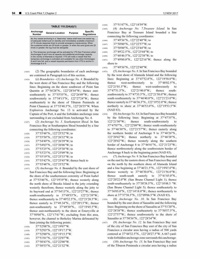
94 ¢ U.S. Coast Pilot 7, Chapter 2 12 NOV 2017
TABLE 110.224(d)(1)
Anchorage Number General Location Purpose Specific
Regulations
m. Any vessel anchoring in a “dead-ship” status shall have one assist tug of adequate bollard pull on standby and immediately available (maximum of 15 minute response time) to provide emergency maneuvering. When the sustained winds are 20 knots or greater, or when the wind gusts are 25 knots or greater, the tug must be alongside.
n. This temporary anchorage will be activated by VTS San Francisco when Anchorages 8 and 9 are at capacity and additional anchorage capacity in the vicinity of Alameda is required. VTS will notify a vessel that this temporary anchorage is activated and available for use when Anchorages 8 and 9 are full, and a vessel requests permission from VTS to anchor in Anchorage 8 or 9.
(1425) (2) The geographic boundaries of each anchorage are contained in Paragraph (e) of this section.
(1426) (e) Boundaries—(1) Anchorage No. 4. Bounded by the west shore of San Francisco Bay and the following lines: Beginning on the shore southwest of Point San Quentin at 37°56'28"N., 122°28'54"W.; thence east-southeasterly to 37°55'55"N., 122°26'49"W.; thence southwesterly to 37°54'13"N., 122°27'24"W.; thence southeasterly to the shore of Tiburon Peninsula at Point Chauncey at 37°53'40.5"N., 122°26'55"W. When Explosives Anchorage No. 13 is activated by the Captain of the Port, it and the forbidden anchorage zone surrounding it are excluded from Anchorage No. 4.
(1427) (2) Anchorage No. 5, Southampton Shoal. In San Francisco Bay at Southampton Shoal bounded by a line connecting the following coordinates:
(1428) 37°55'48"N., 122°25'52"W; to(1429) 37°55'50"N., 122°26'32"W; to(1430) 37°54'49"N., 122°26'39"W; to(1431) 37°54'03"N., 122°26'06"W; to(1432) 37°53'25"N., 122°25'30"W; to(1433) 37°53'23"N., 122°25'09"W; to(1434) 37°55'19"N., 122°25'33"W; to(1435) 37°55'42"N., 122°25'45"W; thence back to(1436) 37°55'48"N., 122°25'52"W.(1437) (3) Anchorage No. 6. Bounded by the east shore of
San Francisco Bay and the following lines: Beginning at the shore of the southernmost extremity of Point Isabel at 37°53'46"N., 122°19'19"W.; thence westerly along the north shore of Brooks Island to the jetty extending westerly therefrom; thence westerly along the jetty to its bayward end at 37°54'13"N., 122°23'27"W.; thence south-southeasterly to 37°49'53"N., 122°21'39"W.; thence southeasterly to 37°49'32.5"N., 122°21'20.5"W.; thence easterly to 37°49.34"N., 122°20'13"W.; thence east-southeasterly to 37°49'30"N., 122°19'45.5"W.; thence east-northeasterly to the shore at Emeryville at 37°50'04"N., 122°17'41"W.; excluding from this area, however, the channel to Berkeley Marina delineated by lines joining the following points:
(1438) 37°52'08"N., 122°19'07"W.(1439) 37°52'03"N., 122°19'17.5"W.(1440) 37°52'00"N., 122°19'15.5"W.(1441) 37°51'01"N., 122°22'07"W.(1442) 37°50'43"N., 122°22'00"W.(1443) 37°50'53"N., 122°21'32"W.
(1444) 37°51'47"N., 122°18'59"W.(1445) (4) Anchorage No. 7,Treasure Island. In San
Francisco Bay at Treasure Island bounded a line connecting the following coordinates:
(1446) 37°49'36"N., 122°22'40"W; to(1447) 37°50'00"N., 122°22'57"W; to(1448) 37°50'00"N., 122°23'44"W; to(1449) 37°49'22.5"N., 122°23'44"W; to(1450) 37°48'40.5"N., 122°22'38"W; to(1451) 37°49'00.0"N., 122°22'16"W; thence along the
shore to(1452) 37°49'36"N., 122°22'40"W.(1453) (5) Anchorage No. 8. In San Francisco Bay bounded
by the west shore of Alameda Island and the following lines: Beginning at 37°47'52.0"N., 122°19'58.0"W.; thence west-northwesterly to 37°48'02.5"N., 122°21'01.5"W.; thence west-southwesterly to 37°47'51.5"N., 122°21'40.0"W.; thence south-southwesterly to 37°47'35.5"N., 122°21'50.0"W.; thence south-southeasterly to 37°46'40.0"N., 122°21'23.0"W.; thence easterly to 37°46'36.5"N., 122°19'52.0"W.; thence northerly to shore at 37°46'53.0"N., 122°19'53.5"W. (NAD 83).
(1454) (6) Anchorage No. 8A. In San Francisco Bay bounded by the following lines: Beginning at 37°47'35"N., 122°21'50"W.; thence south-southwesterly to 37°47'07"N., 122°22'09"W.; thence south-southeasterly to 37°46'30"N., 122°21'57"W.; thence easterly along the northern border of Anchorage 9 to 37°46'26"N., 122°20'42"W.; thence northerly to 37°46'38"N., 122°20'42"W.; thence westerly along the southern border of Anchorage 8 to 37°46'41"N., 122°21'23"W.; thence northwesterly along the southwestern border of Anchorage 8 back to the beginning point (NAD 83).
(1455) (7) Anchorage No. 9. In San Francisco Bay bounded on the east by the eastern shore of San Francisco Bay and on the north by the southern shore of Alameda Island and a line beginning at 37°46'21.5"N., 122°19'07.0"W.; thence westerly to 37°46'30.0"N., 122°21'56.0"W.; thence south-south easterly to 37°41'45.0"N., 122°20'22.0"W. (San Bruno Channel Light 1); thence south-southeasterly to 37°38'38.5"N., 122°18'48.5 "W. (San Bruno Channel Light 5); thence southeasterly to 37°36'05.0"N., 122°14'18.0"W.; thence northeasterly to shore at 37°37'38.5"N., 122°09'06.5"W. (NAD 83).
(1456) (8) Anchorage No. 10. In San Francisco Bay bounded by the east shore of Sausalito and the following lines: Beginning on the shore of Sausalito at 37°51'20"N., 122°28'38"W.; thence southeasterly to 37°50'57.5"N., 122°27'57"W.; thence southwesterly to the shore of Sausalito at 37°50'36"N., 122°28'34"W.
(1457) (9) Anchorage No. 12. In San Francisco Bay east of the city of San Francisco Bay east of the city of San Francisco a circular area having a radius of 500 yards centered at 37°44'32.5"N., 122°20'27.5"W. A 667-yard-wide forbidden anchorage zone surrounds this anchorage.
(1458) (10) Anchorage No. 13. In San Francisco Bay east of the Tiburon Peninsula a circular area having a radius

12 NOV 2017 U.S. Coast Pilot 7, Chapter 2 ¢ 95
of 333 yards centered at 37°55'26"N., 122°27'27"W. A 667-yard-wide forbidden anchorage zone surrounds this anchorage except where such zone would extend beyond the limits of Anchorage No. 4.
(1459) NOTE: see §110.224(e)(2) for a description of Anchorage No. 4.
(1460) (11) Anchorage No. 14. In San Francisco Bay east of Hunters Point an area 1,000 yards wide and 2,760 yards long, the end boundaries of which are semicircles, with a radii of 500 yards and center, respectively at 37°42'37"N., 122°19'48"W. and 37°43'29"N., 122°19'48"W. (NAD 83); and the side boundaries of which are parallel tangents joining the semicircles. A forbidden anchorage zone extends 667 yards out from the perimeter on each side.
(1461) (12) Anchorage No. 18. In San Pablo Bay bounded by the west shore of San Pablo Bay and the following lines: Beginning at the shore at Point San Pedro at 37°59'16"N., 122°26'47"W.; thence easterly to 37°59'16"N., 122°26'26"W.; thence northerly to 38°03'46"N., 122°25'52.5"W.; thence northwesterly to the shore south of the entrance to Novato Creek at 38°05'13.5"N., 122°29'04"W.; excluding from this area, however, the channel to Hamilton Field and the extension of this channel easterly to the boundary of the anchorage, and the pipeline area therein.
(1462) (13) Anchorage No. 19. In San Pablo Bay bounded by the northeast shore of San Pablo Bay and the following lines: Beginning at the shore of Tubbs Island at 38°07'39"N., 122°25'18"W.; thence southerly to 38°00'36"N., 122°25'20"W.; thence northeasterly to 38°03'13"N., 122°19'46"W.; thence east-northeasterly to 38°03'37"N., 122°17'13"W.; thence northerly to the long dike extending southwesterly from Mare Island at 38°03'52.5"N., 122°17'10"W.; thence along the long dike to the shore at Mare Island.
(1463) (14) Anchorage No. 20. In San Pablo Bay bounded by the southeast shore of San Pablo Bay and the following lines: Beginning at the northeast corner of Parr Terminal No. 4 at Point San Pablo at 37°57'59"N., 122°25'35"W.; thence northeasterly to 38°01'27.5"W., 122°21'33"W.; thence east-northeasterly to the Union Oil Co. pier at Oleum at 38°03'18"N., 122°15'37"W.; and thence along this pier to the shore.
(1464) (15) Anchorage No. 21. In San Pablo Bay south of Mare Island a rectangular area beginning at 38°03'56"N., 122°15'56"W.; thence easterly to 38°04'02"N., 122°15'20"W.; thence southerly to 38°03'48"N., 122°15'16"W.; thence westerly to 38°03'42"N., 122°15'52"W.; thence northerly to the point of beginning.
(1465) (16) Anchorage No. 22, Carquinez Strait. In Carquinez Strait an area bounded by a line connecting the following coordinates:
(1466) 38°02'36.8"N., 122°09'59"W.; to(1467) 38°02'06.6"N., 122°09'46.7"W.; to(1468) 38°01'53.8"N., 122°09'00"W.; to(1469) 38°02'33.9"N., 122°09'00"W.; thence back to(1470) 38°02'36.8"N., 122°09'59"W.
(1471) (17) Anchorage No. 23, Benicia. In Carquinez Strait an area bounded by a line connecting the following coordinates:
(1472) 38°02'33.9"N., 122°09'00"W.; to(1473) 38°01'53.8"N., 122°09'00"W.; to(1474) 38°01'57.4"N., 122°08'19.3"W.; to(1475) 38°02'33.0"N., 122°08'18.6"W.; thence back to(1476) 38°02'33.9"N., 122°09'00"W.(1477) (18) Anchorage No. 24. Bounded by the north shore
of Carquinez Strait and the following points:(1478) Beginning on the shore at Dillon Point at(1479) 38°03'44"N., 122°11'34"W.; thence southeasterly to(1480) 38°03'21"N., 122°10'43"W.; thence southeasterly to(1481) 38°02'36"N., 122°10'03"W. (Carquinez Strait Light
23); thence to the shore at the Benicia City Wharf at (1482) 38°02'40"N., 122°09'55"W. (NAD 83).(1483) (19) Anchorage No. 26. On the west side of Suisun
Bay, adjacent to and northeast of the city of Benicia within the following boundaries: Beginning on the shore northeast of Army Point at 38°02'54"N., 122°07'37"W.; thence south-southeasterly along the Southern Pacific bridge to 38°02'38"N., 122°07'24"W.; thence easterly to 38°02'42"N., 122°07'07.5"W.; thence northeasterly to 38°05'42"N., 122°04'06"W.; thence northwesterly to the shore at 38°05'58"N., 122°04'28"W.; thence along the shore to the point of beginning.
(1484) (20) Anchorage No. 27. In the northeast portion of Suisun Bay bounded by the north shore and the following lines: Beginning on the shore of Grizzly Island at 38°08'13"N., 122°02'42.5"W.; thence southerly to tripod at Preston Point on Roe Island at 38°04'16"N., 122°02'42"W.; thence along the south shore of Roe Island to 38°04'05"N., 122°01'35"W; thence east-southeasterly to 38°03'42.5"N., 121°58'54"W.; thence easterly to the shore of Chipps Island at 38°03'42.5"N., 121°55'05"W.
(1485) (21) Anchorage No. 28. The area bounded on the east by the shore of Lower Sherman Island and the following lines: Beginning at Point Sacramento on Lower Sherman Island at 38°03'45"N., 121°50'17.5"W.; thence southwesterly to 38°03'37.5"N., 121°50'31"W.; thence south-southeasterly to 38°02'11"N., 121°49'58"W.; thence to the shore of Lower Sherman Island at 38°02'23"N., 121°49'49"W.
(1486) (22) Anchorage No. 30. The portion of the Old San Joaquin River Channel bounded on the west by the shore of Mandeville Point and the following lines: Beginning on the shore of Mandeville Point at 38°04'01"N., 121°32'05"W.; thence northeasterly to 38°04'07.5"N., 121°31'58"W.; thence southeasterly to 38°03'47"N., 121°31'42.5"W.; thence westerly to the shore of Mandeville Point at 38°03'47.5"N., 121°31'56"W.
(1487) §110.228 Columbia River, Oregon and Washington.
(1488) (a) Anchorage grounds—(1) Astoria North Anchorage. An area enclosed by a line beginning northeast of Astoria, Oregon, at 46°12'00.79"N., 123°49'55.40"W.; thence continuing easterly to

96 ¢ U.S. Coast Pilot 7, Chapter 2 12 NOV 2017
46°12'02.00"N., 123°49'40.09"W.; thence continuing east-northeasterly to 46°13'14.85"N., 123°46'27.89"W.; thence continuing south-southeasterly to 46°13'00.56"N., 123°46'16.65"W.; thence continuing southwesterly to 46°11'51.79"N., 123°49'18.08"W.; thence continuing west-southwesterly to 46°11'46.27"N, 123°49'43.48"W.; thence continuing west-southwesterly to 46°11'44.98"N, 123°49'49.44"W.; thence continuing westerly to 46°11'44.32"N., 123°49'58.88"W.; thence continuing northeasterly to the point of the beginning.
(1489) (2) Astoria South Anchorage. An area enclosed by a point beginning east-northeast of Astoria, Oregon, at 46°11'46.95"N., 123°49'13.04"W.; thence continuing northeasterly to 46°13'02.18"N., 123°45'54.55"W.; thence continuing easterly to 46°13'05.90"N., 123°45'41.55"W; thence continuing southeasterly to 46°12'55.16"N., 123°45'34.31"W; thence continuing southwesterly to 46°12'24.32"N., 123°46'34.70"W.; thence continuing west-southwesterly 46°11'37.32"N., 123°49'03.46"W.; thence continuing north-northwesterly to the point of the beginning.
(1490) (3) Longview Anchorage. An area enclosed by a line beginning southeast of Longview, Washington, at 46°06'28.69"N., 122°57'38.33"W.; thence continuing northwesterly to 46°06'41.71"N., 122°58'01.25"W.; thence continuing westerly to 46°07'22.55"N., 122°59'00.81"W; thence continuing westerly to 46°07'36.21"N., 122°59'19.29"W.; thence continuing southwesterly to 46°07'28.44"N., 122°59'31.18"W.; thence continuing easterly to 46°07'14.77"N., 122°59'12.70"W.; thence continuing easterly to 46°06'42.01"N., 122°58'28.41"W.; thence continuing northeasterly to 46°06'34.27"N., 122°58'14.21"W.; thence continuing northeasterly to 46°06'32.19"N., 122°58'08.77"W.; thence continuing northeasterly to 46°06'22.44"N., 122°57'43.27"W.; thence continuing northeasterly to the point of the beginning.
(1491) (4) Kalama Anchorage. An area to be enclosed by a line beginning north-northwesterly of Sandy Island at 46°01'20.48"N., 122°52'04.32"W.; thence continuing east-southeasterly to 46°00'57.73"N., 122°51'35.14"W.; thence continuing east-southeasterly to 46°00'53.95"N., 122°51'30.29"W.; thence continuing southeasterly to 46°00'35.10"N., 122°51'15.37"W.; thence continuing south-southeasterly to 45°59'41.48"N., 122°50'52.40"W; thence continuing southwesterly to 45°59'38.65"N., 122°51'05.97"W.; thence continuing north-northwesterly to 46°00'36.82"N., 122°51'30.90"W.; thence continuing west-northwesterly to 46°00'51.32"N., 122°51'45.44"W.; thence continuing west-northwesterly to 46°01'24.38"N., 122°52'21.20"W.; thence continuing northeasterly to the beginning.
(1492) (5) Woodland Anchorage. An area enclosed by a line beginning northeast of Columbia City, Oregon, at 45°53'55.31"N., 122°48'17.35"W.; thence continuing easterly to 45°53'57.11"N., 122°48'02.16"W.; thence continuing south-southeasterly to 45°53'27.16"N., 122°47'44.28"W.; thence continuing westerly to
45°53'20.16"N., 122°48'02.37"W.; thence continuing northwesterly to 45°53'41.50"N., 122°48'13.53"W.; thence continuing northerly to the point of beginning.
(1493) (6) Henrici Bar Anchorage. An area enclosed by a line beginning west-southwesterly of Bachelor Slough, Washington, at 45°47'24.68"N., 122°46'49.14"W.; thence continuing east-southeasterly to 45°46'44.95"N., 122°46'13.23W., thence continuing southeasterly to 45°46'25.67"N., 122°46'00.54"W.; thence continuing south-southeasterly to 45°46'02.69"N., 122°45'50.32"W; thence continuing southerly to 45°45'43.66"N., 122°45'45.33"W; thence continuing southerly to 45°45'37.52"N., 122°45'44.99"W; thence continuing westerly to 45°45'37.29"N., 122°45'53.06"W.; thence continuing north-northwesterly to 45°46'15.94"N., 122°46'10.25"W.; thence continuing west-northwesterly to 45°47'20.20"N., 122°46'59.28"W; thence continuing easterly to the point of beginning.
(1494) (7) Lower Vancouver Anchorage. An area enclosed by a line beginning north-northeast of Reeder Point at 45°43'39.18"N, 122°45'27.54"W; thence continuing south-southwesterly to 45°41'26.95"N., 122°46'13.83"W.; thence continuing southerly to 45°40'35.72"N, 122°46'09.98"W; thence continuing south-southeasterly to 45°40'23.95"N, 122°46'04.26"W; thence continuing west-southwesterly to 45°40'20.68"N., 122°46'16.07"W.; thence continuing northwesterly to 45°40'32.85"N., 122°46'21.98"W.; thence continuing north-northwesterly to 45°41'01.03"N, 122°46'26.85"W; thence continuing northerly to 45°41'29.07"N., 122°46'26.15"W; thence continuing north-northeasterly to 45°43'41.27"N., 122°45'39.87"W.; thence continuing easterly to the point of the beginning. The Vancouver lower anchorage will then resume slightly further upstream at an area north of Kelly point and will be enclosed by a line starting at 45°40'10.09"N., 122°45'57.53"W.; thence continuing southeasterly to 45°39'42.94"N., 122°45'44.34"W.; thence continuing west-southwesterly to 45°39'40.07"N., 122°45'56.34"W.; thence continuing northwesterly to 45°40'06.75"N., 122°46'09.30"W.; thence continuing east-northeasterly to the point of the beginning.
(1495) (8) Kelly Point Anchorage. An area enclosed by a line beginning northeast of Kelly Point, Oregon, at 45°39'10.32"N., 122°45'36.45"W.; thence continuing east-southeasterly to 45°39'02.10"N., 122°45'21.67"W.; thence continuing east-southeasterly to 45°38'59.15"N., 122°45'16.38"W.; thence continuing southwesterly to 45°38'51.03"N., 122°45'25.57"W; thence continuing westerly to 45°38'51.54"N., 122°45'26.35"W.; thence continuing northwesterly to 45°39'06.27"N., 122°45'40.50"W.; thence continuing north-northeasterly to the beginning point.
(1496) (9) Upper Vancouver Anchorage. An area enclosed by a line beginning north-northeast of Hayden Island at 45°38'43.44"N., 122°44'39.50"W.; thence continuing northeasterly to 45°38'26.98"N, 122°43'25.87"W.; thence continuing east-northeasterly to 45°38'17.31"N., 122°42'54.69"W.; thence continuing easterly to

12 NOV 2017 U.S. Coast Pilot 7, Chapter 2 ¢ 97
45°38'12.40"N., 122°42'43.93"W.; thence continuing east-southeasterly to 45°37'40.53"N., 122°41'44.08"W.; thence south-southeasterly to 45°37'36.11"N., 122°41'48.86"W.; thence continuing west-southwesterly to 45°37'52.20"N., 122°42'19.50"W.; thence continuing west-southwesterly to 45°38'10.75"N, 122°43'08.89"W.; thence continuing southwesterly to 45°38'18.79"N., 122°43'44.83"W.; thence continuing westerly to 45°38'41.37"N, 122°44'40.44"W.; thence continuing northeasterly to the point of beginning.
(1497) (10) Cottonwood Island Anchorage. The waters of the Columbia River bounded by a line connecting the following points:
(1498) 46°05'56.88"N., 122°56'53.19"W.(1499) 46°05'14.06"N., 122°54'45.71"W.(1500) 46°04'57.12"N., 122°54'12.41"W.(1501) 46°04'37.55"N, 122°53'45.80"W.(1502) 46°04'13.72"N., 122°53'23.66"W.(1503) 46°03'54.94"N., 122°53'11.81"W.(1504) 46°03'34.96"N., 122°53'03.17"W.(1505) 46°03′11.61″N., 122°52′56.29″W.(1506) 46°03′10.94″N., 122°53′10.55″W.(1507) 46°03'32.06"N., 122°53'19.69"W.(1508) 46°03'50.84"N., 122°53'27.81"W.(1509) 46°04'08.10"N., 122°53'38.70"W.(1510) 46°04'29.41"N., 122°53'58.17"W.(1511) 46°04'49.89"N., 122°54'21.57"W.(1512) 46°05'06.95"N., 122°54'50.65"W.(1513) 46°05'49.77"N., 122°56' 58.12"W.(1514) (11) Prescott Anchorage. The waters of the Columbia
River bounded by a line connecting the following points:(1515) 46°02′47.01″N., 122°52′53.90″W.(1516) 46°02′26.32″N., 122°52′51.89″W.(1517) 46°02′25.92″N., 122°53′00.38″W.(1518) 46°02′46.54″N., 122°53′03.87″W.(1519) (b) Regulations.(1520) (1) All designated anchorages are intended for the
primary use of deep-draft vessels over 200 feet in length.(1521) (2) If a vessel under 200 feet in length is anchored
in a designated anchorage, the master or person in charge of the vessel shall:
(1522) (i) Ensure that the vessel is anchored so as to minimize conflict with large, deep-draft vessels utilizing or seeking to utilize the anchorage; and
(1523) (ii) Move the vessel out of the area if requested by the master of a large, deep-draft vessel seeking to enter or depart the area or if directed by the Captain of the Port.
(1524) (3) Vessels desiring to anchor in designated anchorages shall contact the pilot office that manages that anchorage to request an appropriate position to anchor. Columbia River Bar Pilots manage Astoria North Anchorage and Astoria South Anchorage. Columbia River Pilots manage all designated anchorages upriver from Astoria.
(1525) (4) No vessel may occupy a designated anchorage for more than 30 consecutive days without permission from the Captain of the Port.
(1526) (5) No vessel being laid-up or dismantled or undergoing major alterations or repairs may occupy a designated anchorage without permission from the Captain of the Port.
(1527) (6) No vessel carrying a Cargo of Particular Hazard listed in § 126.10 of this chapter may occupy a designated anchorage without permission from the Captain of the Port.
(1528) (7) No vessel in a condition such that it is likely to sink or otherwise become a hazard to the operation of other vessels shall occupy a designated anchorage except in an emergency and then only for such periods as may be authorized by the Captain of the Port.
(1529) (8) Vessels anchoring in Astoria North Anchorage should avoid placing their anchor in the charted cable area.
(1530) §110.230 Anchorages, Captain of the Port Puget Sound Zone, WA.
(1531) (a) Anchorage grounds. All coordinates are expressed in North American Datum 1983.
(1532) (1) Freshwater Bay Emergency Anchorage. All waters of Freshwater Bay and adjacent waters shoreward of a line beginning at Observatory Point,
(1533) 48°09′03″N, 123°38′12″W; thence 000°T to(1534) 48°09′36″N, 123°38′12″W; thence 090°T to(1535) 48°09′36″N, 123°33′27″W; thence 180°T ending at
Angeles Point, 48°09′00″N, 123°33′27″W.(1536) (i) This anchorage may only be assigned to vessels
experiencing an emergency that requires anchoring. Vessel emergencies include equipment failures, cargo securing, etc. Vessels requiring a customs inspection will not be allowed to anchor in this area.
(1537) (ii) [Reserved.](1538) (2) Bellingham Bay Anchorages—(i) General
Anchorage. The waters of Bellingham Bay within a circular area with a radius of 2,000 yards, having its center at 48°44′14.39″N, 122°32′26.62″W.
(1539) (ii) Explosives Anchorage. The waters of Bellingham Bay within a circular area with a radius of 1,000 yards, having its center at 48°42′47.39″N, 122°33′41.62″W.
(1540) (3) Port Townsend Anchorages. (i) Fair weather explosives anchorage area. A circular area having a radius of 300 yards, whose center is at 48°06′25.30″N, 122°43′50.60″W.
(1541) (ii) Foul weather explosives anchorage area. A circular area having a radius of 300 yards, whose center is at 48°04′04.33″N, 122°44′56.60″W.
(1542) (4) Holmes Harbor General Anchorage. All waters of Holmes Harbor lying south of a line between 48°05′50″N, 122°31′24″W; thence 311°T to 48°07′03″N, 122°33′31″W.
(1543) (5) Port Gardner General Anchorage. All waters in a quadrilateral area bounded as follows: Beginning at
(1544) 47°58′57″N, 122°14′05″W; thence 302°T to(1545) 47°59′21.5″N, 122°15′02″W; thence 229°T to(1546) 47°58′57″N, 122°15′44″W; thence 122°T to

98 ¢ U.S. Coast Pilot 7, Chapter 2 12 NOV 2017
(1547) 47°58′32.5″N, 122°14′47″W; thence 048°T to point of origin.
(1548) (6) Thorndike Bay Emergency Explosives Anchorage. All waters in a quadrilateral area bounded as follows: Beginning at
(1549) 47°47′59″N, 122°43′30″W; thence 270°T to(1550) 47°47′59″N, 122°44′30″W; thence 180°T to(1551) 47°47′30″N, 122°44′30″W; thence 090°T to(1552) 47°47′30″N, 122°43′30″W, thence 000°T to point of
origin.(1553) (7) Elliott Bay Anchorages—(i) Smith Cove West
General Anchorage. All waters inside the area beginning at
(1554) 47°38′20.44″N, 122°24′48.56″W; thence 207T to(1555) 47°37′51.6″N, 122°25′10.5″W; thence 124°T to(1556) 47°36′56.2″N, 122°23′07″W; thence 000°T to(1557) 47°37′59.5″N, 122°23′07″W; thence northwest
along the shoreline to the point of origin.(1558) (ii) Smith Cove East General Anchorage. All waters
inside the area beginning at(1559) 47°37′36.2″N, 122°22′43″W; thence 180°T to(1560) 47°36′56.2″N, 122°22′43″W; thence 090°T to(1561) 47°36′56.2″N, 122°21′22.5″W, thence northwest
along the shoreline to the point of origin.(1562) (iii) Elliott Bay East General Anchorage. All waters
inside the area beginning at(1563) 47°35′25.8″N, 122°20′45.5″W; thence 000°T to(1564) 47°35′55.85″N, 122°20′45.5″W; thence 270°T to(1565) 47°35′55.85″N, 122°21′30″W; thence 180°T to(1566) 47°35′19.2″N, 122°21′30″W; thence east along the
shoreline to the point of origin.(1567) (iv) Elliott Bay West General Anchorage. All waters
inside the area beginning at(1568) 47°35′30″N, 122°21′41″W, thence 000°T to(1569) 47°35′45.5″N, 122°21′41″W; thence 336°T to(1570) 47°35′55.85″N, 122°21′48.5″W; thence 270°T to(1571) 47°35′55.85″N, 122°23′16.46″W, thence 180°T
to Duwamish Head thence southeast following the shoreline to 47°35′30″N, 122°22′54.5″W; thence 090°T to the point of origin.
(1572) (8) Yukon Harbor General Anchorage. All waters inside the area beginning at
(1573) 47°33′54.66″N, 122°31′54.68″W; thence 106°T to(1574) 47°33′23″N, 122°29′05″W; thence 180°T to(1575) 47°32′39.5″N, 122°29′05″W; thence south along the
eastern shoreline of Blake Island to(1576) 47°31′48″N, 122°29′21″W; thence 250°T to(1577) 47°31′20.5″N, 122°31′10″W; thence west and north
along the Kitsap Peninsula shoreline to the point of origin.(1578) (9) Cherry Point General Anchorage. The waters
within a circular area with a radius of 1600 yards, having its center at 48°48′29.39″N, 122°46’04.66″W.
(1579) (10) Anacortes General Anchorages. (i) Anacortes East (ANE) Anchorage. The waters within a circular area with a radius of 600 yards, having its center at 48°31′27″N., 122°33′45″W.
(1580) (ii) Anacortes Center (ANC) Anchorage. The waters within a circular area with a radius of 600 yards, having its center at 48°30′54″N, 122°34′06″W.
(1581) (iii) Anacortes West (ANW) Anchorage. The waters within a circular area with a radius of 600 yards, having its center at 48°31′09″N, 122°34′55″W.
(1582) (11) Cap Sante Tug and Barge General Anchorage. The Cap Sante Tug and Barge General Anchorage includes all waters enclosed by a line connecting the following points:
(1583) 48°31′16″N, 122°36′00″W, which is approximately the northeast tip of Cap Sante; then southeast to
(1584) 48°30′53″N, 122°35′28″W; then west southwest to(1585) 48°30′45″N, 122°35′52″W, approximately the south
tip of Cap Sante; then north along the shoreline to the point of origin.
(1586) (12) Hat Island Tug and Barge General Anchorage. The Hat Island Tug and Barge General Anchorage includes all waters enclosed by a line connecting the following points:
(1587) 48°31′19″N, 122°33′04″W, near the west side of Hat Island; then southwest to
(1588) 48°30′37″N, 122°33′38″W; then east to(1589) 48°30′37″N, 122°32′00″W; then northwest to the
point of origin.(1590) (13) Commencement Bay General Anchorage.
A quadrilateral area bounded as follows: Beginning at 47°17′36.36″N, 122°26′04.45″W; thence due south to 47°17′18.36″N, 122°26′04.45″W; thence due east to 47°17′18.36″N, 122°25′04.45″W; thence due north to 47°17′32.36″N, 122°25′04.45″W; thence west northwest to the point of origin.
(1591) (14) Non-anchorage area Port Angeles Harbor. Beginning at a point on the shore at
(1592) 48°07′03.83″N, 123°24′20.67″W; thence to(1593) 48°07′38.43″N, 123°24′04.67″W; thence to(1594) 48°07′36.03″N, 123°23′50.67″W; thence to a point
on the shoreline at 48°06′56.73″N, 123°24′08.67″W.(1595) (i) No vessel may anchor in this nonanchorage area
at any time.(1596) (ii) Dragging, seining, fishing, or other activities
which may foul underwater installations within this non-anchorage area are prohibited.
(1597) (iii) Vessels may transit this nonanchorage area, but must proceed by the most direct route and without unnecessary delay.
(1598) Note to paragraph (a)(14): The city of Port Angeles will mark this area with signs on the shoreline visible (during normal daylight) 1 mile to seaward reading, ‘‘Do not Anchor in This Area.’’
(1599) (b) Regulations. (1) No vessel shall anchor in any general anchorage described in paragraph (a) of this section without prior permission from the Captain of the Port (COTP), or his authorized representative. Vessel Traffic Service Puget Sound is designated as the COTP’s authorized representative. All vessels should seek permission at least 48 hours prior to arrival at the anchorage area in order to avoid unnecessary delays.

12 NOV 2017 U.S. Coast Pilot 7, Chapter 2 ¢ 99
(1600) (i) Except for the Anacortes General Anchorages, a berth in a general anchorage, if available, may be assigned to any vessel by the Captain of the Port or his authorized representative upon application and he may grant revocable permits for the continuous use of the same berth. For the Anacortes General Anchorages, the following hierarchy will be applied for assignment of a berth; tankers conducting lightering operations, then loaded tankers, and then all other vessels.
(1601) (ii) Tugs and oil barges using the Cap Sante and Hat Island General Anchorages are exempt from the requirement to obtain the COTP’s permission.
(1602) (2) Except for the Anacortes General Anchorages, no vessel shall occupy any general anchorage for a period longer than 30 days unless a permit is obtained from the Captain of the Port for that purpose. There is a 10 days maximum stay at the Anacortes East and Anacortes Center general anchorages, and 6 day maximum stay at the Anacortes West general anchorage.
(1603) (3) The COTP or his authorized representative may require vessels to depart from the Anacortes General Anchorage before the expiration of the authorized or maximum stay. The COTP or his authorized representative will provide at least 24-hour notice to a vessel required to depart the Anacortes General Anchorage.
(1604) (4) No vessel in a condition such that it is likely to sink or otherwise become a menace or obstruction to the navigation or anchorage of other vessels shall occupy any general anchorage except in an emergency and then only for such period as may be permitted by the Captain of the Port.
(1605) (5) Within the Anacortes General Anchorages, lightering operations shall only be conducted in the Anacortes West and Anacortes Center anchorages.
(1606) (6) Tugs and barges using the Cap Sante and Hat Island Barge General Anchorages are required to ensure their vessels and barges do not project beyond the holding area’s boundaries. The tug must be manned, remain in attendance with the barge and maintain a communications guard with VTS on an appropriate VTS VHF radio working frequency, which is currently channel 5A.
(1607) (7) No vessel shall anchor in any general anchorage described in paragraph (a) of this section without prior permission from the Captain of the Port, or his authorized representative. No vessel shall occupy any general anchorage for a period longer than 30 days unless a permit is obtained from the Captain of the Port for that purpose. No vessel in a condition such that it is likely to sink or otherwise become a menace or obstruction to the navigation or anchorage of other vessels shall occupy a general anchorage except in an emergency and then only for such period as may be permitted by the Captain of the Port. A berth in a general anchorage, if available, may be assigned to any vessel by the Captain of the Port upon application and he may grant revocable permits for the continuous use of the same berth.
(1608) (8) Explosive anchorages are reserved for vessels carrying explosives. All vessels carrying explosives shall be within these areas when anchored.
(1609) (9) Whenever any vessel not fitted with mechanical power, anchors in an explosive anchorage, the Captain of the Port may require the attendance of a tug upon such vessel, when, in his judgment, such action is necessary.
(1610) (10) Vessels carrying explosives shall comply with the general regulations in paragraph (b)(1) of this section, when applicable.
(1611) (11) Every vessel at anchor in an explosives anchorage shall display by day a red flag at least 16 square feet in area at its mast head or at least 10 feet above the upper deck if the vessel has no mast, and by night a red light in the same position specified for the flag. These signals shall be in addition to day signals and lights required to be shown by all vessels when at anchor.
(1612) (12) Every vessel constructed of wood shall, unless there are steel bulwarks or metallic cases or cargo on board, be fitted with radar reflector screens of metal of sufficient size to permit target indication on the radar screen of commercial type radars.
(1613) (13) Fishing and navigation by pleasure and commercial craft are prohibited within the area at all times when vessels which are anchored in the area for the purpose of loading or unloading explosives display a red flag by day and a red light by night, unless special permission is granted by the Captain of the Port.
(1614) (14) No explosives handling in any explosive anchorage will be undertaken by any vessel unless personnel from the Captain of the Port are on board to supervise the handling of explosives.
(1615) (15) No vessel shall remain at anchor in any explosive anchorage unless there is on board such vessel a competent watchman or a tug in attendance.
(1616) §110.235 Pacific Ocean (Mamala Bay), Honolulu Harbor, Hawaii (Datum: NAD 83).
(1617) (a) The anchorage grounds–(1) Anchorage A. The waters bounded by the arc of a circle with a radius of 350 yards with the center located at 21°16'57"N., 157°53'12"W.
(1618) (2) Anchorage B. The waters bounded by a line connecting the following coordinates:
(1619) 21°17'06"N., 157°54'40"W.; to(1620) 21°17'22"N., 157°54'40"W.; to(1621) 21°17'22"N., 157°54'19"W., to(1622) 21°17'06"N., 157°54'19"W., and thence to(1623) 21°17'06"N., 157°54'40"W.(1624) (3) Anchorage C. The waters bounded by the arc of
a circle with a radius of 450 yards with the center located at 21°17'09"N., 157°54'55"W.
(1625) (4) Anchorage D. The waters bounded by the arc of a circle with a radius of 450 yards with the center located at 21°17'21"N., 157°55'20"W.
(1626) (b) The regulations. (1) Anchors must be placed inside the anchorage areas.

100 ¢ U.S. Coast Pilot 7, Chapter 2 12 NOV 2017
(1627) (2) The anchorages are general anchorages for commercial vessels. Anchorage A should be used only if Anchorages B, C, and D are full.
(1628) (3) No bunkering operations or vessel to vessel transfer of oil in bulk of any kind is permitted within Anchorage A.
(1629) (4) Nothing in this section shall be construed as relieving the owner or person in charge of any vessel from complying with the rules of navigation and with safe navigation practice.
(1630) (c) Before entering into the anchorage grounds in this section you must first obtain permission from the Captain of the Port Honolulu.
(1631) §110.236 Pacific Ocean Off Barbers Point, Island of Oahu, Hawaii: Offshore pipeline terminal anchor-ages.
(1632) (a) The anchorage ground–(1) Anchorage A. The waters within an area described as follows: A circle of 1,000 feet radius centered at 21°17'43.6"N., 158°07'36.1"W. (Datum NAD 83)
(1633) (2) Nonanchorage area A. The waters extending 300 feet on either side of a line bearing 059° from anchorage A to the shoreline at 21°18'10.6"N., 158°06'47.1"W. (Datum NAD 83)
(1634) (3) Anchorage B. The waters enclosed by a line beginning at
(1635) 21°16'20.1"N., 158°04'59.1"W.; thence to (1636) 21°15'52.5"N., 158°05'07.0"W.; thence to(1637) 21°15'59.7"N., 158°05'35.9"W.; thence to(1638) 21°16'27.4"N., 158°05'28.0"W.; thence to the point
of beginning. (Datum NAD 83)(1639) (4) Nonanchorage area B. The waters extending 300
feet on either side of a line bearing 334.5° from anchorage B to the shoreline at 21°17'39.1"N., 158°06'03.2"W. (Datum NAD 83)
(1640) (5) Anchorage C. The waters enclosed by a line beginning at
(1641) 21°16'46.6"N., 158°04'29.1"W.; thence to (1642) 21°16'46.6"N., 158°04'02.1"W.; thence to(1643) 21°16'32.6"N., 158°04'02.1"W.; thence to(1644) 21°16'32.6"N., 158°04'29.1"W.; thence to the point
of beginning. (Datum NAD 83)(1645) (6) Nonanchorage area C. The waters extending 300
feet on either side of a line bearing 306° from anchorage C to the shoreline at 21°17'42.6"N., 158°05'57.9"W. (Datum NAD 83)
(1646) (7) Anchorage D. The waters enclosed by a line beginning at
(1647) 21°17'48.6"N., 158°07'10.1"W.; thence to(1648) 21°17'44.6"N., 158°07'06.1"W.; thence to(1649) 21°17'37.6"N., 158°07'14.1"W.; thence to(1650) 21°17'41.6"N., 158°07'18.1"W.; thence to the point
of beginning. (Datum NAD 83)(1651) (b) The regulations.–(1) No vessels may anchor,
moor, or navigate in anchorages A, B, C, or D except–
(1652) (i) Vessels using the anchorages and their related pipelines for loading or unloading;
(1653) (ii) Commercial tugs, lighters, barges, launches, or other vessels engaged in servicing the anchorage facilities or vessels using them.
(1654) (iii) Public vessels of the United States.(1655) (2) When vessels are conducting loading or
unloading operations as indicated by the display of a red flag (international code flag B) at the masthead, passing vessels of over 100 gross tons shall not approach within 1,000 yards at a speed in excess of 6 knots.
(1656) (3) The owner of any vessel wanting to use an anchorage ground and use of the related pipeline facilities shall notify the captain of the port, Honolulu, Hawaii, and the Commanding Officer, U.S. Naval Air Station, Barbers Point, Hawaii, at least 24 hours in advance of desired occupancy of the anchorage ground by the vessel. Such notification must include the maximum height above the waterline of the uppermost portion of the vessel’s mast and a description of the masts’ lighting including height of the highest anchor light and any aircraft warning lights to be displayed by the vessel at night.
(1657) (4) When, in the opinion of the Captain of the Port, or his authorized representative, oil transfer operations within these anchorages could jeopardize the safety of vessels or facilities in the area, or cause an undue risk of oil pollution, such oil transfer operations shall be immediately terminated until such time as the cognizant Coast Guard officer determines that the danger has subsided.
(1658) (5) Nonanchorage areas A, B, and C are established for the protection of submerged pipelines. Except for vessels servicing pipeline facilities, no anchoring, dragging, seining or other potential pipeline fouling activities are permitted within these areas.
(1659) (6) Nothing in this section shall be construed as relieving the owner or person in charge of any vessel from complying with the rules of the road and safe navigation practice.
(1660) (7) The regulations of this section are enforced by the captain of the port or his duly authorized representative.
(1661) §110.237 Pacific Ocean at Waimea, Hawaii, Naval Anchorage.
(1662) (a) The anchorage grounds. All the waters within a circle having a radius of 300 yards centered at 21°56'50.7"N., 159°41'22.9"W. (Datum NAD 83).
(1663) (b) The regulation. Except in an emergency, no vessel except a Naval vessel may anchor or moor in this anchorage without permission of the Captain of the Port, Honolulu, HI.
(1664) §110.238 Apra Harbor, Guam.
(1665) (a) The anchorage grounds (Datum WGS 84). (1) General Anchorage. The waters bounded by a line connecting the following points:
(1666) 13°27'32.0"N., 144°39'36.8"E.

12 NOV 2017 U.S. Coast Pilot 7, Chapter 2 ¢ 101
(1667) 13°27'21.0"N., 144°39'22.8"E.(1668) 13°27'12.5"N., 144°37'25.4"E.(1669) and thence along the shoreline to(1670) 13°27'45.5"N., 144°39'34.8"E.(1671) and thence to the point of beginning.(1672) (2) Explosives Anchorage 701. The water in Naval
Anchorage A bounded by the arc of a circle with a radius of 350 yards and located at 13°26'54.0"N., 144°37'53.5"E.
(1673) (3) Naval Explosives Anchorage 702. The waters in the General Anchorage bounded by the arc of a circle with a radius of 350 yards and with the center located at 13°27'29.9"N., 144°38'13.0"E.
(1674) (4) Naval Anchorage A. The waters bounded by a line connecting the following points:
(1675) 13°26'47.3"N., 144°37'42.6"E.(1676) 13°27'02.0"N., 144°37'42.6"E.(1677) 13°27'10.6"N., 144°39'00.8"E.(1678) 13°26'59.6"N., 144°39'00.8"E.(1679) 13°26'59.6"N., 144°39'08.6"E.(1680) 13°26'54.3"N., 144°39'08.6"E.(1681) 13°26'54.3"N., 144°39'24.2"E.(1682) 13°26'42.2"N., 144°39'24.2"E.(1683) 13°26'40.4"N., 144°38'01.8"E.(1684) and thence to the point of beginning.(1685) (5) Naval Anchorage B. The waters bounded by a
line connecting the following points:(1686) 13°26'43.7"N., 144°39'53.3"E.(1687) 13°26'53.6"N., 144°40'03.8"E.(1688) 13°26'51.0"N., 144°40'06.0"E.(1689) 13°26'41.0"N., 144°39'56.0"E.(1690) and thence along the shoreline to the point of
beginning.(1691) (b) The regulations–(1) General Anchorage. Any
vessel may anchor in the General Anchorage except vessels carrying more than 25 tons of high explosives.
(1692) (2) Explosives Anchorage 701. Vessels carrying more than 25 tons of high explosives must use Anchorage 701, unless otherwise directed by the Captain of the Port.
(1693) (3) Explosives Anchorage 702. Except Naval vessels using the anchorage as directed by local Naval authorities, no vessel may anchor so that any part of the hull or rigging, or the anchor tackle may extend into Anchorage 702 at any time.
(1694) (4) Naval Anchorages A and B. (i) Except as provided in paragraph (b)(3)(ii) of this section, non-naval vessels may not anchor within these anchorages or use the mooring buoys therein without permission of the local Naval authorities obtained through the Captain of the Port. (There is a user charge for the use of these mooring buoys.)
(1695) (ii) Small craft that are continuously manned and capable of getting underway may anchor within these anchorages during daylight hours without prior approval of the Captain of the Port.
(1696) (5) General regulations. (i) Vessels may use the Naval mooring buoys in the General Anchorage without charge for a period up to 72 hours if authorized by the
Captain of the Port. Vessels so moored shall promptly move at their own expense upon notification from the Captain of the Port.
(1697) (ii) Except for vessels not more than 65 feet in length, all vessels shall anchor in an anchorage ground.
(1698) (iii) Vessels anchored in an anchorage ground shall place their anchors within the anchorage ground so that no portion of the hull or rigging at any time extends outside the anchorage ground.
(1699) (iv) No vessel may anchor in the harbor for more than 30 consecutive days without permission of the Captain of the Port.
(1700) §110.239 Island of Tinian, CNMI.
(1701) (a) The anchorage grounds (based on 1944 Saipan Datum):
(1702) (1) Explosives Anchorage A. A circular area intersecting the shoreline having a radius of 1,900 yards centered at 14°58'57.0"N., 145°35'40.8"E.
(1703) (2) Explosives Anchorage B. A circular area intersecting the shoreline having radius of 1,900 yards centered at 14°58'15.9"N., 145°35'54.8"E.
(1704) (b) The regulations: Explosives Anchorages A and B; with the exception of explosives laden naval vessels at explosives anchorage A and B, no vessel may anchor within these areas without permission of the Captain of the Port. No vessel of more than 500 gross tons displacement may enter these areas except for the purpose of anchoring in accordance with this section.
(1705) Part 117–Drawbridge Operation Regulations
(1706) Subpart A–General Requirements
(1707) §117.1 Purpose.
(1708) (a) This part prescribes the general and special drawbridge operating regulations that apply to the drawbridges across the navigable waters of the United States and its territories. The authority to regulate drawbridges across the navigable waters of the United States is vested in the Secretary of Homeland Security.
(1709) (b) Subpart A contains the general operation requirements that apply to all drawbridges.
(1710) (c) Subpart B contains specific requirements for operation of individual drawbridges. These requirements are in addition to or vary from the general requirements in Subpart A. Specific sections in subpart B that vary from a general requirement in Subpart A supersede the general requirement. All other general requirements in Subpart A, that are not at variance, apply to the drawbridges and removable span bridges listed in Subpart B.
(1711) §117.4 Definitions.
(1712) The following definitions apply to this part:

102 ¢ U.S. Coast Pilot 7, Chapter 2 12 NOV 2017
(1713) Appurtenance means an attachment or accessory extending beyond the hull or superstructure that is not an integral part of the vessel and is not needed for a vessel's piloting, propelling, controlling, or collision avoidance capabilities.
(1714) Automated drawbridge means a drawbridge that is operated by an automated mechanism, not a drawtender. An automated drawbridge is normally kept in the open to navigation position and closes when the mechanism is activated.
(1715) Deviation means a District Commander's action authorizing a drawbridge owner to temporarily not comply with the drawbridge opening requirements in this part.
(1716) Drawbridge means a bridge with an operational span that is intended to be opened for the passage of waterway traffic.
(1717) Drawspan means the operational span of a drawbridge.
(1718) Lowerable means a non-structural vessel appurtenance that is or can be made flexible, hinged, collapsible, or telescopic so that it can be mechanically or manually lowered.
(1719) Nonstructural means that the item is not rigidly fixed to the vessel and can be relocated or altered.
(1720) Not essential to navigation means that a nonstructural vessel appurtenance, when in the lowered position, would not adversely affect the vessel's piloting, propulsion, control, or collision-avoidance capabilities.
(1721) Public vessel means a vessel that is owned and operated by the United States Government and is not engaged in commercial service, as defined in 46 U.S.C. 2101.
(1722) Remotely operated drawbridge means a drawbridge that is operated by remote control from a location away from the drawbridge.
(1723) Removable span bridge means a bridge that requires the complete removal of a span by means other than machinery installed on the bridge to open the bridge to navigation.
(1724) Untended means that there is no drawtender at the drawbridge.
(1725) §117.5 When the drawbridge must open.
(1726) Except as otherwise authorized or required by this part, drawbridges must open promptly and fully for the passage of vessels when a request or signal to open is given in accordance with this subpart.
(1727) §117.7 General requirements of drawbridge own-ers.
(1728) Except for drawbridges that have been authorized, before January 3, 2007, to remain closed to navigation or as otherwise specified in subpart B, drawbridge owners must:
(1729) (a) Provide the necessary drawtender(s) for the safe and prompt opening of the drawbridge.
(1730) (b) Maintain the working machinery of the drawbridge in good operating condition.
(1731) (c) Cycle the drawspan(s) periodically to ensure operation of the drawbridge.
(1732) (d) Ensure that the drawbridge operates in accordance with the requirements of this part.
(1733) (e) Any drawbridge allowed to remain closed to navigation prior to January 3, 2007, when necessary, must be returned to operable condition within the designated time set forth by the District Commander and will become subject to the requirements of this part.
(1734) §117.8 Permanent changes to drawbridge opera-tion.
(1735) (a) Anyone may submit a written request to the District Commander for a permanent change to a drawbridge operating requirement. The request must include documentation supporting or justifying the requested change.
(1736) (b) If after evaluating the request, the District Commander determines that the requested change is not needed, he or she will respond to the request in writing and provide the reasons for denial of the requested change.
(1737) (c) If the District Commander decides that a change may be needed, he or she will begin a rulemaking to implement the change.
(1738) §117.9 Delaying opening of a draw.
(1739) No person shall unreasonably delay the opening of a draw after the signals required by §117.15 have been given.
(1740) NOTE: Trains are usually controlled by the block method. That is, the track is divided into blocks or segments of a mile or more in length. When a train is in a block with a drawbridge, the draw may not be able to open until the train has passed out of the block and the yardmaster or other manager has “unlocked” the drawbridge controls. The maximum time permitted for delay is defined in Subpart B for each affected bridge. Land and water traffic should pass over or through the draw as soon as possible in order to prevent unnecessary delays in the opening and closure of the draw.
(1741) §117.11 Unnecessary opening of the draw.
(1742) No vessel owner or operator shall –(1743) (a) Signal a drawbridge to open if the vertical
clearance is sufficient to allow the vessel, after all lowerable nonstructural vessel appurtenances that are not essential to navigation have been lowered, to safely pass under the drawbridge in the closed position; or
(1744) (b) Signal a drawbridge to open for any purpose other than to pass through the drawbridge opening.
(1745) §117.15 Signals.
(1746) (a) General. (1) The operator of each vessel requesting a drawbridge to open shall signal the drawtender and the drawtender shall acknowledge that signal. The signal

12 NOV 2017 U.S. Coast Pilot 7, Chapter 2 ¢ 103
shall be repeated until acknowledged in some manner by the drawtender before proceeding.
(1747) (2) The signals used to request the opening of the draw and to acknowledge that request shall be sound signals, visual signals, or radiotelephone communications described in this subpart.
(1748) (3) Any of the means of signaling described in this subpart sufficient to alert the party being signaled may be used.
(1749) (b) Sound signals. (1) Sound signals shall be made by whistle, horn, megaphone, hailer, or other device capable of producing the described signals loud enough to be heard by the drawtender.
(1750) (2) As used in this section, “prolonged blast” means a blast of four to six seconds duration and “short blast” means a blast of approximately one second duration.
(1751) (3) The sound signal to request the opening of a draw is one prolonged blast followed by one short blast sounded not more than three seconds after the prolonged blast. For vessels authorized to be passed through a draw during a scheduled closure period, the sound signal to request the opening of the draw during that period is five short blasts sounded in rapid succession.
(1752) (4) When the draw can be opened immediately, the sound signal to acknowledge a request to open the draw is one prolonged blast followed by one short blast sounded not more than 30 seconds after the requesting signal.
(1753) (5) When the draw cannot be opened immediately, or is open and shall be closed promptly, the sound signal to acknowledge a request to open the draw is five short blasts sounded in rapid succession not more than 30 seconds after the vessel’s opening signal. The signal shall be repeated until acknowledged in some manner by the requesting vessel.
(1754) (c) Visual signals. (1) The visual signal to request the opening of a draw is–
(1755) (i) A white flag raised and lowered vertically; or(1756) (ii) A white, amber, or green light raised and lowered
vertically.(1757) (2) When the draw can be opened immediately, the
visual signal to acknowledge a request to open the draw, given not more than 30 seconds after the vessel’s opening signal, is–
(1758) (i) A white flag raised and lowered vertically;(1759) (ii) A white, amber, or green light raised and lowered
vertically, or(1760) (iii) A fixed or flashing white, amber, or green light
or lights.(1761) (3) When the draw cannot be opened immediately,
or is open and must be closed promptly, the visual signal to acknowledge a request to open the draw is–
(1762) (i) A red flag or red light swung back and forth horizontally in full sight of the vessel given not more than 30 seconds after the vessel’s opening signal; or
(1763) (ii) A fixed or flashing red light or lights given not more than 30 seconds after the vessel’s opening signal.
(1764) (4) The acknowledging signal when the draw cannot open immediately or is open and must be closed promptly shall be repeated until acknowledged in some manner by the requesting vessel.
(1765) (d) Radiotelephone communications. (1) Radiotelephones may be used to communicate the same information provided by sound and visual signals.
(1766) (2) The vessel and the drawtender shall monitor the frequency used until the vessel has cleared the draw.
(1767) (3) When radiotelephone contact cannot be initiated or maintained, sound or visual signals under this section shall be used.
(1768) §117.17 Signaling for contiguous drawbridges.
(1769) When a vessel must pass two or more drawbridges close together, the opening signal is given for the first bridge. After acknowledgment from the first bridge that it will promptly open, the opening signal is given for the second bridge, and so on until all bridges that the vessel must pass have been given the opening signal and have acknowledged that they will open promptly.
(1770) §117.19 Signaling when two or more vessels are approaching a drawbridge.
(1771) When two or more vessels are approaching the same drawbridge at the same time, or nearly the same time, whether from the same or opposite directions, each vessel shall signal independently for the opening of the draw and the drawtender shall reply in turn to the signal of each vessel. The drawtender need not reply to signals by vessels accumulated at the bridge for passage during a scheduled open period.
(1772) §117.21 Signaling for an opened drawbridge.
(1773) When a vessel approaches a drawbridge with the draw in the open position, the vessel shall give the opening signal. If no acknowledgment is received within 30 seconds, the vessel may proceed, with caution, through the open draw.
(1774) §117.23 Installation of radiotelephones.
(1775) (a) When the District Commander deems it necessary for reasons of safety of navigation, the District Commander may require the installation and operation of a radiotelephone on or near a drawbridge.
(1776) (b) The District Commander gives written notice of the proposed requirement to the bridge owner.
(1777) (c) All comments the owner wishes to submit shall be submitted to the District Commander within 30 days of receipt of the notice under Paragraph (b) of this section.
(1778) (d) If, upon consideration of the comments received, the District Commander determines that a radiotelephone is necessary, the District Commander notifies the bridge owner that a radiotelephone shall be installed and gives a reasonable time, not to exceed six months, to install the radiotelephone and commence operation.

104 ¢ U.S. Coast Pilot 7, Chapter 2 12 NOV 2017
(1779) §117.24 Radiotelephone installation identification.
(1780) (a) The Coast Guard authorizes, and the District Commander may require the installation of a sign on drawbridges, on the upstream and downstream sides, indicating that the bridge is equipped with and operates a VHF radiotelephone in accordance with §117.23.
(1781) (b) The sign shall give notice of the radiotelephone and its calling and working channels–
(1782) (1) In plain language; or(1783) (2) By a sign consisting of the outline of a telephone
handset with the long axis placed horizontally and a vertical three-legged lightning slash superimposed over the handset. The slash shall be as long vertically as the handset is wide horizontally and normally not less than 27 inches and no more than 36 inches long. The preferred calling channel should be shown in the lower left quadrant and the preferred working channel should be shown in the lower right quadrant.
(1784) §117.31 Drawbridge operations for emergency vehicles and emergency vessels.
(1785) (a) Upon receiving notification that an emergency vehicle is responding to an emergency situation, a drawtender must make all reasonable efforts to have the drawspan closed at the time the emergency vehicle arrives.
(1786) (b) When a drawtender receives notice, or a proper signal as provided in §117.15 of this part, the drawtender shall take all reasonable measures to have the draw opened, regardless of the operating schedule of the draw, for passage of the following, provided this opening does not conflict with local emergency management procedures which have been approved by the cognizant Coast Guard Captain of the Port:
(1787) (1) Federal, State, and local government vessels used for public safety;
(1788) (2) vessels in distress where a delay would endanger life or property;
(1789) (3) commercial vessels engaged in rescue or emergency salvage operations; and
(1790) (4) vessels seeking shelter from severe weather.(1791)
§117.33 Closure of draw for natural disasters or civil disorders.
(1792) Drawbridges need not open for the passage of vessels during periods of natural disasters or civil disorders declared by the appropriate authorities unless otherwise provided for in Subpart B or directed to do so by the District Commander.
(1793) §117.35 Temporary change to a drawbridge operat-ing schedule.
(1794) (a) For any temporary change to the operating schedule of a drawbridge, lasting less than or equal to 180 days, the District Commander may issue a deviation
approval letter to the bridge owner and publish a “Notice of temporary deviation from regulations” in the Federal Register.
(1795) (b) If the time period for a temporary change to the operating schedule of a drawbridge will be greater then 180 days, the District Commander will follow appropriate rulemaking procedures and publish a temporary rule in the Federal Register prior to the start of the action.
(1796) (c) Request for change. (1) To temporarily change the drawbridge-operating requirements the bridge owner must submit a written request to the District Commander for approval of the change.
(1797) (2) The request must describe the reason for the deviation and the dates and times scheduled for the start and end of the change.
(1798) (3) Requests should be submitted as early as possible, preferably 90 days before the start of the action. District Commanders have discretion to accept requests submitted less than 90 days before a needed change if those requests can be processed before the date of the needed change.
(1799) (d) Determination. The District Commander's determination to allow the schedule change is normally forwarded to the bridge owner within ten working days after receipt of the request. If the request is denied, the reasons for the denial will be set out in the District Commander's decision letter.
(1800) (e) The drawbridge must return to its regular operating schedule immediately at the end of the designated time period.
(1801) (f) If the authorized deviation period for an event is broken into separate time periods on the same day or on consecutive days, the drawbridge must provide openings for navigation between authorized schedule changes.
(1802) (g) The District Commander will also announce the change to the operating schedule in the Local Notice to Mariners and other appropriate local media.
(1803) §117.36 Closure of drawbridge for emergency repair.
(1804) (a) When a drawbridge unexpectedly becomes inoperable, or should be immediately rendered inoperable because of mechanical failure or structural defect, the drawbridge owner must notify the District Commander of the closure without delay and give the reason for the emergency closure of the drawbridge and an estimated time when the drawbridge will be returned to operating condition.
(1805) (b) The District Commander will notify mariners about the drawbridge status through Broadcast Notices to Mariners, Local Notice to Mariners and any other appropriate local media.
(1806) (c) Repair work under this section must be performed with all due speed in order to return the drawbridge to operation as soon as possible.

12 NOV 2017 U.S. Coast Pilot 7, Chapter 2 ¢ 105
(1807) §117.39 Authorized closure of drawbridge due to infrequent requests for openings.
(1808) (a) When there have been no requests for drawbridge openings for at least two years, a bridge owner may request in writing that the District Commander authorize the drawbridge to remain closed to navigation and to be untended.
(1809) (b) The District Commander may:(1810) (1) Authorize the closure of the drawbridge;(1811) (2) Set out any conditions in addition to the
requirement in paragraph (d): and(1812) (3) Revoke an authorization and order the drawbridge
returned to operation when necessary.(1813) (c) All drawbridges authorized to remain closed to
navigation, under this section, must be maintained in operable condition.
(1814) (d) Authorization under this section does not:(1815) (1) Authorize physical changes to the drawbridge
structure, or(1816) (2) Authorize removal of the operating machinery.(1817) (e) Drawbridges authorized under this section
to remain closed to navigation and to be untended are identified in subpart B of this part.
(1818) §117.40 Advance notice for drawbridge opening.
(1819) (a) Upon written request by the owner of a drawbridge, the District Commander may authorize a drawbridge to operate under an advance notice for opening. The drawbridge tender, after receiving the advance notice, must open the drawbridge at the requested time and allow for a reasonable delay in arrival of the vessel giving the advance notice.
(1820) (b) If the request is approved, a description of the advanced notice for the drawbridge will be added to subpart B of this part.
(1821) §117.41 Maintaining drawbridges in the fully open position.
(1822) (a) Drawbridges permanently maintained in the fully open to navigation position may discontinue drawtender service as long as the drawbridge remains fully open to navigation. The drawbridge must remain in the fully open position until drawtender service is restored.
(1823) (b) If a drawbridge is normally maintained in the fully open to navigation position, but closes to navigation for the passage of pedestrian, vehicular, rail, or other traffic, the drawbridge must be tended unless:
(1824) (1) Special operating requirements are established in subpart B of this part for that drawbridge; or
(1825) (2) The drawbridge is remotely operated or automated.
(1826) §117.42 Remotely operated and automated draw-bridges.
(1827) (a) Upon written request by the owner of a drawbridge, the District Commander may authorize a
drawbridge to operate under an automated system or from a remote location.
(1828) (b) If the request is approved, a description of the full operation of the remotely operated or automated drawbridge will be added to subpart B of this part.
(1829) §117.47 Clearance gauges.
(1830) (a) Clearance gauges are required for drawbridges across navigable waters of the United States discharging into the Atlantic Ocean south of Delaware Bay (including the Lewes and Rehoboth Canal, DE) or into the Gulf of Mexico (including coastal waterways contiguous thereto and tributaries to such waterways and the Lower Atchafalaya River, LA), except the Mississippi River and its tributaries and outlets.
(1831) (b) Except for provisions in this part which specify otherwise for particular drawbridges, clearance gauges shall be designed, installed, and maintained according to the provisions of 33 CFR 118.160 (not carried in this Coast Pilot).
(1832) NOTE: Clearance gauge requirements, if any, for drawbridges other than those referred to in this section are listed in Subpart B under the appropriate bridge.
(1833) §117.49 Process of violations.
(1834) (a) Complaints of alleged violations under this part are submitted to the District Commander of the Coast Guard District in which the drawbridge is located.
(1835) (b) Penalties for violations under this part are assessed and collected under Subpart 1.07 of Part 1 of this chapter (not published in this Coast Pilot; see 33 CFR 1.07).
(1836) Subpart B–Specific Requirements
(1837) §117.51 General.
(1838) The drawbridges in this subpart are listed by the state in which they are located and by the waterway they cross. Waterways are arranged alphabetically by state. The drawbridges listed under a waterway are generally arranged in order from the mouth of the waterway moving upstream. The drawbridges on the Atlantic Intracoastal Waterway are listed from north to south and on the Gulf Intracoastal Waterway from east to west.
(1839) §117.55 Posting of requirements.
(1840) (a) The owner of each drawbridge under this subpart, other than removable span bridges, must ensure that a sign summarizing the requirements in this subpart applicable to the drawbridge is posted both upstream and downstream of the drawbridge. The requirements to be posted need not include those in Subpart A of this part or §§117.51 through 117.59.

106 ¢ U.S. Coast Pilot 7, Chapter 2 12 NOV 2017
(1841) (b) The signs shall be of sufficient size and so located as to be easily read at any time from an approaching vessel.
(1842) (c) If advance notice is required to open the draw, the signs shall also state the name, address, and telephone number of the person to be notified.
(1843) §117.59 Special requirements due to hazards.
(1844) For the duration of occurrences hazardous to safety or navigation, such as floods, freshets, and damage to the bridge or fender system, the District Commander may require the owner of an operational drawbridge listed in this subpart to have the bridge attended full time and open on signal.
(1845) California
(1846) §117.140 General.
(1847) In California, when fog prevails by day or night, the drawtender, after sounding the opening signal, shall toll a bell continuously during the approach and passage of a vessel.
(1848) §117.143 Bishop Cut.
(1849) The draw of the San Joaquin County (Eight Mile Road) Highway Bridge, mile 1.0 between King Island and Bishop Tract, must open on signal if at least 12 hours notice is given to the San Joaquin County Department of Public Works at Stockton.
(1850) §117.147 Cerritos Channel.
(1851) <Deleted Paragraph>(1852) The draw of the Henry Ford Avenue railroad bridge,
mile 4.8 at Long Beach, shall be maintained in the fully open position except when a train is crossing or for maintenance. If the draw is in the closed position, the opening signal is two short blasts followed by one prolonged blast. The acknowledging signal is two prolonged blasts followed by one short blast when the draw will open immediately and five short blasts when the draw will not open immediately. Channel 13 (156.65 MHz) or other assigned frequencies may be used.
(1853) §117.149 China Basin, Mission Creek.
(1854) The draws of the 3rd Street bridge, mile 0.0, and the 4th Street bridge, mile 0.2, both at San Francisco, shall open on signal if at least one hour notice is given.
(1855) §117.150 Connection Slough.
(1856) The draw of the Reclamation District No. 2027 bridge between Mandeville and Bacon Islands, mile 2.5 near Stockton, from May 15 through September 15, shall open on signal between the hours of 9 a.m. and 5 p.m., and it shall open upon 12 hours advance notice between the hours of 5 p.m. and 9 a.m.; and from September 16 through May 14 the draw shall open upon 12 hours
advance notice between the hours of 9 a.m. and 5 p.m., and it shall open upon 24 hours advance notice between the hours of 5 p.m. and 9 a.m. Advance notice shall be given to the drawbridge operator by telephone at (209) 464–2959 or (209) 464–7928 weekdays between 8 a.m. and 5 p.m., and (209) 993–8878 all other times.
(1857) §117.151 Cordelia Slough (a tributary of Suisun Bay).
(1858) The draw of the Union Pacific railroad bridge, mile 1.5 at Suisun, shall open on signal if at least 24 hours notice is given.
(1859) §117.153 Corte Madera Creek.
(1860) The draw of the Golden Gate Bridge, Highway and Transportation District bridge, mile 0.5 near Greenbrae, shall be maintained in the fully open position, except for the crossing of trains or for maintenance.
(1861) §117.157 Georgiana Slough.
(1862) The draws of the Sacramento County highway bridges, mile 4.5 near Isleton, and mile 12.4 near Walnut Grove, shall open on signal from 6 a.m. to 10 p.m. from May 1 through October 31. The draws shall open on signal from November 1 through April 30 from 9 a.m. to 5 p.m. At all other times, the draws of these bridges shall open on signal if at least four hours notice is given to the drawtender at the Rio Vista bridge across the Sacramento River, mile 12.8.
(1863) §117.159 Grant Line Canal.
(1864) The draw of the San Joaquin County highway bridge, mile 5.5 at Tracy, shall open on signal if at least 12 hours notice is given to the San Joaquin County Department of Public Works at Stockton.
(1865) §117.161 Honker Cut.
(1866) The draw of the San Joaquin County (Eightmile Road) bridge, mile 0.3 between Empire Tract and King Island at Stockton, shall open on signal if at least 12 hours notice is given to the San Joaquin County Department of Public Works at Stockton.
(1867) §117.163 Islais Creek (Channel).
(1868) (a) The draw of the Illinois Street drawbridge, mile 0.3 at San Francisco, shall open on signal if least 72 hours advance notice is given to the Port of San Francisco.
(1869) (b) The draw of the 3rd Street drawbridge, mile 0.4 at San Francisco, shall open on signal if at least 72 hours advance notice is given to the San Francisco Department of Public Works.
(1870) §117.165 Lindsey Slough.
(1871) The center drawspan of the Hastings Farms Highway Bridge, mile 2.0 between Egbert and Lower Hastings Tracts, must be removed for the passage of vessels if at

12 NOV 2017 U.S. Coast Pilot 7, Chapter 2 ¢ 107
least 72 hours notice is given to the Hastings Island Land Company office at Rio Vista.
(1872) §117.167 Little Potato Slough.
(1873) The draw of the California Department of Transportation highway bridge, mile 0.1 at Terminus, shall open on signal if at least 4 hours notice is given to the drawtender at the Rio Vista bridge across the Sacramento River, mile 12.8.
(1874) §117.169 Mare Island Strait and the Napa River.
(1875) (a) The draw of the Mare Island Drawbridge, mile 2.8, at Vallejo shall open on signal between the hours of 9 a.m. and 7 p.m. daily, and upon two hours advance notice all other times. When the drawbridge operator is present, mariners may contact the drawbridge via marine radio or telephone at 707–648–4313 for drawspan operation. When the drawbridge operator is not present, mariners may contact the City of Vallejo via the same telephone number to schedule drawspan operation.
(1876) (b) The draw of the Northwestern Pacific railroad bridge, mile 10.6 at Brazos, shall be maintained in the fully open position, except for the crossing of trains or for maintenance. When the draw is closed and visibility at the drawtender’s station is less than one mile, up or down the channel, the drawtender shall sound two prolonged blasts every minute. When the draw is opened, the drawtender shall sound three short blasts.
(1877) §117.171 Middle River.
(1878) (a) The draw of the San Joaquin County (Bacon Island Road) highway bridge, mile 8.6 between Bacon Island and Lower Jones Tract, shall open on signal from May 15 through September 15 from 9 a.m. to 5 p.m. From September 16 through May 14, the draw shall open on signal from 9 a.m. to 5 p.m. from Thursday through Monday. At all other times, the draw shall open on signal if at least 12 hours notice is given to the San Joaquin County Department of Public Works at Stockton.
(1879) (b) The draw of the Burlington Northern Santa Fe railroad bridge, mile 9.8 near Middle River Station, shall open on signal if at least 12 hours notice is given to the Atchison, Topeka and Santa Fe Railway Manager of Structures at San Bernardino.
(1880) (c) The California Route 4 Bridge, mile 15.1, between Victoria Island and Drexler Tract need not open for the passage of vessels.
(1881) §117.173 Miner Slough.
(1882) The draw of the California Department of Transportation highway bridge, mile 5.5 between the northerly end of Ryer Island and Holland Tract, shall open on signal if at least 12 hours notice is given to the drawtender at the Rio Vista bridge across the Sacramento River, mile 12.8.
(1883) §117.175 Mokelumne River.
(1884) (a) The draw of the California Department of Transportation highway bridge, the Mokelumne River Bridge, mile 3.0, at East Isleton shall open upon signal as follows:
(1885) (1) From November 1 through April 30 from 9 a.m. to 5 p.m.
(1886) (2) From May 1 through October 31 from 6 a.m. to 10 p.m., except that during the following periods the draw need only open for recreational vessels on the hour, 20 minutes past the hour, and 40 minutes past the hour:
(1887) Saturdays 10 a.m. until 2 p.m.(1888) Sundays 11 a.m. until 6 p.m.(1889) Memorial Day; 4th of July and(1890) Labor Day 11 a.m. until 6 p.m.(1891) (3) At all other times the draw shall open on signal
if at least 4 hours notice is given to the drawtender at Rio Vista bridge over the Sacramento River, mile 12.8.
(1892) (4) Emergency vessels of the United States, state or commercial vessels engaged in rescue or emergency salvage operations, and vessels in distress shall be passed as soon as possible but no later than one hour after notice is given.
(1893) (b) The draw of the Sacramento and San Joaquin Counties (Millers Ferry) highway bridge, mile 12.1 over the North Fork of the Mokelumne River near Walnut Grove, shall open on signal from May 1 through October 31 from 9 a.m. to 5 p.m. At all other times, the draw shall open on signal if at least 12 hours notice is given to the San Joaquin County Department of Public Works at Stockton.
(1894) (c) The removable span of the San Joaquin County highway bridge over the South Fork of the Mokelumne River, mile 18.0 at New Hope Landing, shall be removed as soon as possible upon notification by the District Commander that an emergency exists which requires the removal.
(1895) (d) The draws of the bridges above New Hope Landing need not be opened for the passage of vessels.
(1896) §117.177 Mud Slough.
(1897) The draw of the Union Pacific railroad bridge, mile 0.7 near Alviso, shall open on signal if at least 24 hours notice is given.
(1898) §117.179 Newark Slough.
(1899) The draw of the San Mateo County Transportation Department railroad bridge, mile 0.5 near Newark, shall open on signal if at least 24 hours notice is given to the San Mateo Transportation Department, at San Carlos.
(1900) §117.181 Oakland Inner Harbor Tidal Canal.
(1901) The draws of the Alameda County highway drawbridges at Park Street, mile 5.2; Fruitvale Avenue, mile 5.6; and High Street, mile 6.0; and the U.S. Army Corps of Engineers railroad drawbridge, mile 5.6 at
108 ¢ U.S. Coast Pilot 7, Chapter 2 12 NOV 2017
Fruitvale Avenue, shall open on signal; except that, from 8 a.m. to 9 a.m. and 4:30 p.m. to 6:30 p.m. Monday through Friday except Federal holidays, the draws need not be opened for the passage of vessels. However, the draws shall open during the above closed periods for vessels which must, for reasons of safety, move on a tide or slack water, if at least two hours notice is given.
(1902) §117.183 Old River.
(1903) The draw of the California Department of Transportation (Route 4) highway bridge, mile 14.8 between Victoria Island and Byron Tract, shall open on signal from May 1 through October 31 from 6 a.m. to 10 p.m. and from November 1 through April 30 from 9 a.m. to 5 p.m. At all other times, the draw shall open on signal if at least four hours notice is given to the drawtender at the Rio Vista bridge across the Sacramento River, mile 12.8.
(1904) §117.185 Pacheco Creek.
(1905) The draw of the Contra Costa County highway bridge, mile 1.0, and Union Pacific railroad bridge, mile 1.1, both near Martinez, shall open on signal if at least 24 hours notice is given.
(1906) §117.187 Petaluma River.
(1907) (a) The draws of the Northwestern Pacific railroad bridges, mile 0.8 at Blackpoint and mile 12.4 at Haystack Landing, shall be maintained in the fully open position, except for the crossing of trains or for maintenance. When the draw is closed and visibility from the drawtender’s station is less than one mile up or down the channel, the drawtender shall sound two long blasts every minute. When the draw is reopened, the drawtender shall sound three short blasts.
(1908) (b) The draw of the Petaluma highway bridge at “D” Street, mile 13.7 at Petaluma, shall open on signal if at least four hours notice is given for openings from 6 a.m. to 6 p.m., and if at least 24 hours notice is given for openings from 6 p.m. to 6 a.m.
(1909) §117.189 Sacramento River.
(1910) (a) The draws of each bridge from Isleton to the American River junction except for the Sacramento County highway bridge across the Sacramento River, mile 46.0 at Freeport, shall open on signal from May 1 through October 31 from 6 a.m. to 10 p.m. and from November 1 through April 30 from 9 a.m. to 5 p.m. At all other times, the draws shall open on signal if at least four hours notice is given to the drawtender at the Rio Vista bridge across the Sacramento River, mile 12.8.
(1911) (b) The draw of the Sacramento County highway bridge, mile 46.0 at Freeport, shall open on signal from May 1 through September 30 from 9 a.m. to 5 p.m. At all other times, the draw shall open on signal if at least four hours notice is given to the drawtender at the Rio Vista Bridge across the Sacramento River, mile 12.8.
(1912) (c) The draws of the California Department of Transportation bridges, mile 90.1 at Knights Landing, and mile 135.5 at Meridian, shall open on signal if at least 12 hours notice is given to the California Department of Transportation at Marysville.
(1913) (d) The draws of the bridges above Meridian need not be opened for the passage of vessels.
(1914) §117.191 San Joaquin River.
(1915) (a) The draw of the Port of Stockton railroad bridge, mile 39.7 at Stockton, shall open on signal if at least 12 hours notice is given to the Port Director.
(1916) (b) The draws of the U.S. Navy drawbridge, mile 39.8, Burlington Northern Santa Fe railroad bridge, mile 40.6, and California Highway 4 bridge (Garwood Bridge), mile 41.6, need not be opened for the passage of vessels. The owners or agencies controlling the bridges shall restore the draws to full operation within six months of notification to take such action from the District Commander.
(1917) (c) Drawbridges above the Old River junction need not open for the passage of vessels.
(1918) §117.193 San Leandro Bay.
(1919) The drawspans of the California Department of Transportation Highway and Bicycle drawbridges, mile 0.0 and mile 0.1, between Alameda and Bay Farm Island, must open on signal; except that, from 5 a.m. to 8 a.m. and 5 p.m. to 9 p.m, the drawspans must open on signal if at least 12 hours notice is given. Notice must be given to the drawtender of the Bay Farm Island drawbridges from 8 a.m. to 5 p.m. and to the drawtender of the Park Street Drawbridge at Alameda at all other times. The drawspans need not be opened for the passage of vessels from 9 p.m. to 5 a.m.
(1920) §117.195 Snodgrass Slough.
(1921) The draw of the Sacramento County bridge, mile 4.4 at Walnut Grove, shall open on signal if at least 72 hours notice is given to Sacramento County Transportation Operations and Maintenance office at Sacramento.
(1922) §117.197 Sonoma Creek.
(1923) The draw of the Northwestern Pacific railroad bridge, mile 5.4 at Wingo, shall open on signal if at least 24 hours notice is given.
(1924) §117.199 Steamboat Slough.
(1925) The draw of the California Department of Transportation highway bridge, mile 11.2 at the head of Grand Island, shall open on signal from May 1 through October 31 from 6 a.m. to 10 p.m. At all other times, the draw shall open on signal if at least four hours notice is given to the drawtender at the Rio Vista bridge across the Sacramento River, mile 12.8.

12 NOV 2017 U.S. Coast Pilot 7, Chapter 2 ¢ 109
(1926) §117.201 Sutter Slough.
(1927) The draw of the Sacramento County highway bridge, mile 6.4 near Courtland, need not be opened for the passage of vessels. However, the draw shall be returned to operable condition within six months after notification by the District Commander to do so.
(1928) Idaho
(1929) §117.381 Clearwater River.
(1930) The draws of the Camas Prairie railroad bridge, mile 0.6 at Lewiston, shall open on signal if at least three hours notice is given to the Camas Prairie Railroad in Lewiston.
(1931) §117.383 Pend Oreille River.
(1932) The draw of the Burlington Northern railroad bridge, mile 111.3 near Sandpoint, need not be opened for the passage of vessels.
(1933) §117.385 Snake River.
(1934) The drawspan of the U.S. 12 bridge, mile 140.0, between Lewiston, Idaho, and Clarkston, Washington, operates as follows:
(1935) (a) The draw need not open for the passage of vessels except at these hours:
(1936) (1) From March 15 through November 15 at 6 a.m., 10 a.m., 3 p.m., 7 p.m., and 9 p.m.
(1937) (2) From November 16 through March 14 at 9 a.m., 10 a.m., 2 p.m., and 3 p.m.
(1938) (b) Requests for openings shall be given to the Washington State Department of Transportation.
(1939) (1) Monday through Thursday of every week, except holidays, the draw shall open if at least two hours notice is given.
(1940) (2) Friday through Sunday of every week, except holidays, the draw shall open if notice is given by 5 p.m. of the preceding Wednesday.
(1941) (3) The draw shall open on holidays if notice is given by 5 p.m. two workdays, excluding Friday, preceding the holiday.
(1942) (4) The draw shall open at any time for the passage of vessels engaged in an emergency.
(1943) Oregon
(1944) §117.861 Blind Slough.
(1945) The draws of the Portland and Western railroad bridge, mile 1.1 at Knappa, shall open on signal if at least one hour notice is given. However, the draw shall open promptly on signal from four hours before to four hours after each day’s authorized commercial fishing period established by the Columbia River Compact (Washington State Department of Fisheries and the Fish Commission of Oregon) for the Columbia River Fishery below Bonneville Dam.
(1946) §117.865 Clatskanie River.
(1947) The draw of the Portland and Western railroad bridge, mile 0.7 at Clatskanie, shall open on signal if at least one hours notice is given. However, the draw shall open promptly on signal from four hours before to four hours after each day’s authorized commercial fishing period established by the Columbia River Compact (Washington State Department of Fisheries and the Fish Commission of Oregon) for the Columbia River Fishery below Bonneville Dam.
(1948) §117.869 Columbia River.
(1949) (a) The draws of the Interstate 5 Bridges, mile 106.5, between Portland, OR, and Vancouver, WA, shall open on signal except that the draws need not be opened for the passage of vessels from 6:30 a.m. to 9 a.m. and from 2:30 p.m. to 6 p.m. Monday through Friday except federal holidays.
(1950) (b) The draw of the Port of Hood River bridge, mile 169.8 at Hood River, shall open on signal if at least 12 hours notice is given.
(1951) (c) The draw of the Burlington Northern Santa Fe railroad bridge, mile 201.2, between Celilo, Oregon, and Wishram, Washington, is automated and is normally maintained in the fully open-to-navigation position.
(1952) (1) Lights. All lights required for automated operation shall be visible to marine traffic for a distance of at least 2 miles and shall be displayed at all times, day and night.
(1953) (i) When the draw is fully open, a steady green light shall be displayed at the center of the drawspan on both upstream and downstream sides.
(1954) (ii) When the draw is not fully open, a steady red light shall be displayed at the center of the drawspan on both upstream and downstream sides.
(1955) (iii) When the draw is about to close, flashing yellow lights in the form of a down-pointing arrow shall be displayed at the center of the drawspan on both upstream and downstream sides.
(1956) (2) Operation. When a train approaches the bridge, the yellow lights shall start flashing. After an 8-minute delay, the green lights shall change to red, the drawspan shall lower and lock, and the yellow lights shall be extinguished. Red lights shall continue to be displayed until the train has crossed and the drawspan is again in the fully open position. At that time, the red lights shall change to green.
(1957) (3) Vessels equipped with radiotelephones may contact Burlington Northern Santa Fe to obtain information on the status of the bridge. Bridge status information also may be obtained by calling the commercial telephone number posted at the drawspan of the bridge.
(1958) §117.871 Coos Bay.
(1959) The draw of the Port of Coos Bay railroad bridge, mile 9.0 at North Bend, shall be maintained in the

110 ¢ U.S. Coast Pilot 7, Chapter 2 12 NOV 2017
fully open position, except for the crossing of trains or maintenance.
(1960) §117.873 Coos River.
(1961) The draw of the Oregon State secondary highway bridge, mile 2.2 near Eastside, shall open on signal if at least 12 hours notice is given.
(1962) §117.875 Coquille River.
(1963) The draws of the US 101 highway bridge, mile 3.5 at Bandon, Oregon, need not be opened for the passage of vessels; however, the draws shall be restored to operable condition within 6 months after notification by the District Commander to do so.
(1964) §117.879 Isthmus Slough.
(1965) The draw of the Oregon State secondary highway bridge, mile 1.0 at Coos Bay, shall open on signal if at least 24 hours notice is given.
(1966) §117.881 John Day River.
(1967) The draw of the Portland and Western railroad bridge, mile 0.0 near Astoria, shall open on signal if at least one hour notice is given. However, the draw shall open promptly on signal from four hours before to four hours after each day’s authorized commercial fishing period established by the Columbia River Compact (Washington State Department of Fisheries and the Fish Commission of Oregon) for the Columbia River Fishery below Bonneville Dam.
(1968) §117.887 North Portland Harbor (Oregon Slough).
(1969) The draw of the Burlington Northern Santa Fe railroad bridge, mile 3.2 at Portland, shall open on signal if at least one half hours notice is given.
(1970) §117.889 Siuslaw River.
(1971) (a) The draw of the US 101 bridge, mile 5.0 at Florence, shall open on signal if at least two hours notice is given.
(1972) (b) The draw of the Central Oregon and Pacific railroad bridge, mile 8.0 near Cushman, shall open on signal if at least 24 hours notice is given.
(1973) §117.892 South Slough.
(1974) The drawspan for the Oregon State Highway Drawbridge across South Slough at Charleston must open on signal for the passage of vessels, except that between the hours of 7 a.m. and 7 p.m., from June 1 through September 30, the drawspan need be opened only on the hour and half-hour. This exception does not apply to commercial tugs and/or tows or public vessels of the United States.
(1975) §117.893 Umpqua River.
(1976) (a) Suspended.
(1977) (b) The draw of the Central Oregon and Pacific railroad bridge, mile 11.5 at Reedsport, shall be maintained in the fully open position, except for the crossing of trains or other railroad equipment or for maintenance. During foggy weather when the draw is closed and the channel is not clear for the passage of vessels, a fog horn with an audible range of one-half mile from the draw shall be sounded. Two clear signals of approximately six seconds duration each, repeated at intervals of 60 seconds from completion of the second signal to commencement of the next signal, shall be sounded and repeated from commencement of closure to full opening of the draw. When the draw is again in the open position, the fog horn shall be stopped, indicating that the channel is clear for the passage of vessels.
(1978) (c) The draw of the US 101 bridge across the side channel of the Umpqua River, mile 11.1 near Reedsport, need not be opened for the passage of vessels.
(1979) (d) From 7 a.m. on December 1, 2013 to 11:59 p.m. on September 30, 2015, the draw of the US 101 Bridge, mile 11.1, at Reedsport, Oregon, shall open at 7 a.m. and 6 p.m. when at least 6 hours of advance notice is given.
(1980) §117.895 Wallooskee River.
(1981) The draw of the Oregon State secondary highway bridge, mile 1.0 near Astoria, shall open on signal if at least 48 hours notice is given.
(1982) §117.897 Willamette River.
(1983) (a) The draws of the Union Pacific railroad bridge, mile 119.6 at Albany; and mile 164.3 near Harrisburg, need not open for the passage of vessels. However the draws shall be returned to operable condition within six months after notification by the District Commander to do so.
(1984) (b) The draw of the Oregon State highway bridge, mile 132.1 at Corvallis, shall open on signal if at least seven days notice is given. However, the draw need not be opened on Saturdays, Sundays, and Federal Holidays.
(1985) (c) The draws of the bridges listed in paragraph (c)(3) of this section shall open on signal if appropriate advance notice is given to the drawtender of the Hawthorne Bridge subject to the following requirements and exceptions:
(1986) (1) The draws need not open for the passage of vessels from 7 a.m. to 9 a.m. and 4 p.m. to 6 p.m. every Monday through Friday; except that on New Year's Day, Memorial Day, Fourth of July, Labor Day, Thanksgiving Day, and Christmas Day, the draws shall open in accordance with the notice requirements of paragraph (c)(3) below.
(1987) (2) During Rose Festival Week or when the water elevation reaches and remains above +12 feet, no advance notice is required to request opening, except during the normal closed periods in (c)(1) above.
(1988) (3)(i) Broadway Bridge, mile 11.7, from 8 a.m. to 5 p.m. Monday through Friday, one hour's notice shall be given for draw openings. At all other times, notice of at least two hours in advance is required.

12 NOV 2017 U.S. Coast Pilot 7, Chapter 2 ¢ 111
(1989) (ii) Steel Bridge (upper deck only), Portland, mile 12.1. From 8 a.m. to 5 p.m. Monday through Friday, one hour's notice shall be given for draw openings. At all other times, two hours notice is required.
(1990) (iii) Burnside Bridge, 12.4, from 8 a.m to 5 p.m. Monday through Friday, one hour's notice shall be given for draw openings. At the times, two hours notice is required.
(1991) (iv) Morrison Bridge, Portland, mile 12.8, from 8 a.m. to 5 p.m. Monday through Friday, one hour's notice shall be given for draw openings. At all other times, two hours notice is required.
(1992) (v) Hawthorne Bridge, Portland, mile 13.1, no advance notice required.
(1993) §117.899 Youngs Bay and Lewis and Clark River.
(1994) (a) The draw of the US101 (New Youngs Bay) highway bridge, mile 0.7, across Youngs Bay at Smith Point, shall open on signal for the passage of vessels if at least one half-hour notice is given to the drawtender at the Lewis and Clark River Bridge by marine radio, telephone, or other suitable means from 7 a.m. to 5 p.m. Monday through Friday and from 8 a.m. to 4 p.m. on Saturday and Sunday. At all other times, including all Federal holidays but Columbus Day, at least a two-hour notice by telephone is required. The opening signal shall be two prolonged blasts followed by one short blast.
(1995) (b) [Suspended](1996) (c) The draw of the Oregon State (Lewis and Clark
River) highway bridge, mile 1.0, across the Lewis and Clark River, shall open on signal for the passage of vessels if at least one half-hour notice is given by marine radio, telephone, or other suitable means from 7 a.m. to 5 p.m. Monday through Friday and from 8 a.m. to 4 p.m. on Saturday and Sunday. At all other times, including all Federal holidays but Columbus Day, at least a two-hour notice by telephone is required. The opening signal is one prolonged blast followed by four short blasts.
(1997) (d) The draw of the Oregon State (Old Youngs Bay) Highway Bridge, mile 2.4, across Youngs Bay foot of Fifth Street, shall open the south half of the double bascule span on signal for the passage of vessels, if at least one half-hour notice is given to the drawtender, at the Lewis and Clark River Bridge by marine radio, telephone, or other suitable means from 7 a.m. to 5 p.m. Monday through Friday and from 8 a.m. to 4 p.m. Saturday and Sunday from March 1, 2017 to October 31, 2017. At all other times, including all Federal holidays, but Columbus Day, at least a two-hour notice by telephone is required. The opening signal is two prolonged blasts followed by one short blast.
(1998) Washington
(1999) §117.1031 Chehalis River.
(2000) The draw of the U.S. 101 highway bridge, mile 0.1, at Aberdeen shall open on signal if at least one-hour
notice is given at all times by telephone to the Washington State Department of Transportation.
(2001) §117.1035 Columbia River.
(2002) (a) The term drawtender, as used in this section means the operator of the drawspan, whether that person may be a train crew member, maintenance person, or an officially designated drawtender.
(2003) (b) The draw of the semi-automated Union Pacific railroad bridge (Kalan Bridge), mile 323.4, near Kennewick, Washington, is normally maintained in the fully open position with no drawtender in attendance. A radar beacon (RACON) is located at the center of the drawspan. The RACON operates only when the drawspan is fully open, by responding with the Morse letter “K” to X-band radar signals. When necessary to close the drawspan for the passage of a train or for maintenance, a drawtender shall be dispatched to operate the draw from either of the remote control stations located at the ends of the bridge. Operation of the bridge shall be as follows:
(2004) (1) The drawtender shall broadcast a radio message over Channel 16-VHF to all vessels in the vicinity that the Kalan Bridge will be closing in two minutes. If after two minutes no response is received, the drawtender shall broadcast a message over Channel 13-VHF that the Kalan Bridge is closing. Both messages shall be broadcast twice.
(2005) (2) Prior to activating the closing sequence the drawtender shall visually inspect the waterway for marine traffic approaching the bridge. The closing sequence shall not be activated until after marine traffic has cleared the bridge.
(2006) (3) When the closing sequence is activated, the following functions occur automatically: The RACON is deactivated, red strobe lights on the lift towers and on the channel piers start flashing, a downward pointing arrow consisting of amber colored lights is displayed from the center of the drawspan and a recorded message is broadcast over Channel 13-VHF advising that the Kalan Bridge is closed to river traffic. The radio message is repeated every five minutes, the red lights continue to flash and the downward pointing arrow is displayed, until the lift span returns to the up and locked position. At the end of the ten minutes, a horn sounds for 30 seconds, the span begins closing and the centerspan navigation lights turn from green to red. The horn sounds for 30 seconds at 10 minute intervals, until the lift span returns to the up and locked position.
(2007) (4) If for any reason during the closing sequence a danger is posed to marine traffic, the closing sequence shall be stopped and the bridge reopened until the threat of danger has passed.
(2008) (5) If the bridge is to be temporarily closed for maintenance or for purposes other than the passage of a train, the drawtender shall continually monitor Channels 13 and 16 for calls from approaching vessels, and respond to inquiries from vessels about the closure.

112 ¢ U.S. Coast Pilot 7, Chapter 2 12 NOV 2017
(2009) (6) After a train has cleared the bridge, the following functions occur automatically: The drawspan returns to the fully open and locked position, the RACON is reactivated, the arrow display and the red strobe lights are extinguished, the red centerspan navigation lights return to green and a recorded message is broadcast over Channel 13-VHF that the Kalan Bridge is open for marine traffic.
(2010) (7) Bridge status information may be obtained by calling the commercial telephone number posted at the drawspan of the bridge.
(2011) (c) The draw of the Burlington Northern Santa Fe railroad bridge at mile 328.0, between Pasco and Kennewick, shall open on signal from 8 a.m. to 4 p.m. At all other times the draw shall open on signal if at least 2 hour’s notice is given through the General Yardmaster, Pasco, Washington.
(2012) §117.1037 Cowlitz River.
(2013) (a) The draw of the Burlington Northern Santa Fe railroad bridge, mile 1.5, shall operate as follows:
(2014) (1) The draw shall open on signal if at least 24 hours notice is given.
(2015) (2) In the event of an emergency declared by the Cowlitz County Department of Emergency Services, the bridge shall be capable of opening upon two hours notice. Notification of emergencies and requests for openings during emergencies are initiated through the Cowlitz County Department of Emergency Services.
(2016) (3) The operating machinery of the draw shall be maintained in a serviceable condition and the draw shall be opened and closed at intervals frequent enough to make certain that the machinery is in proper order for satisfactory operation.
(2017) (4) During periods of fog or similar periods of reduced visibility, the drawtender, after acknowledging the signal to open, shall toll a bell continuously during the approach and passage of the vessel.
(2018) (b) The draw of the Allen Street Bridge, mile 5.5, need not open for the passage of vessels.
(2019) §117.1041 Duwamish Waterway.
(2020) (a) The draws of each bridge across the Duwamish Waterway shall open on signal, except as follows:
(2021) (1) From Monday through Friday, except all Federal holidays but Columbus Day, the draws of the First Avenue South Bridges, mile 2.5, need not be opened for the passage of vessels from 6 a.m. to 9 p.m. and 3 p.m. to 6 p.m., except: The draws shall be open at any time for a vessel of 5,000 gross tons and over, a vessel towing a vessel of 5,000 gross tons and over, and a vessel proceeding to pick up for towing a vessel of 5,000 gross tons and over.
(2022) (2) The draw of the South Park Bridge, mile 3.8, need not be opened for the passage of vessels from 6:30 a.m. to 8:30 a.m. and from 3:30 p.m. to 5:30 p.m.,
Monday through Friday except, Federal holidays, other than Columbus Day.
(2023) (b) The following bridges shall open on the specified signals:
(2024) (1) Burlington Northern Santa Fe railroad bridge, mile 0.4, and Southwest Spokane Street bridge, mile 0.3, one prolonged blast followed quickly by three short blasts.
(2025) (2) Burlington Northern Santa Fe railroad bridge, mile 0.4, one prolonged blast followed quickly by one short blast.
(2026) (3) First Avenue South bridge, mile 2.5, three prolonged blasts.
(2027) (4) South Park highway bridge, mile 3.8, one prolonged blast followed quickly by one short blast and one prolonged blast.
(2028) (c) When fog prevails by day or by night, the drawtender of bridges listed in this section, after giving the acknowledging signal to open, shall toll a bell continuously during the approach and passage of vessels.
(2029) §117.1045 Hood Canal.
(2030) The draw of the Washington State pontoon highway bridge near Port Gamble operates as follows:
(2031) (a) The draw shall open on signal if at least one hour’s notice is given. The draw shall be opened horizontally for 300 feet unless the maximum opening of 600 feet is requested.
(2032) (b) The draw of the Hood Canal Bridge, mile 5.0, need not open for vessel traffic from 3 p.m. to 6:15 p.m. daily from 3 p.m. May 22 to 6:16 p.m. September 30, except for commercial tug and tow vessels and vessels of the U.S. Navy or vessels attending the missions of the U.S. Navy and other public vessels of the United States. At all other times the bridge will operate in accordance with paragraph (a) of this section.
(2033) (c) Telephone requests for bridge openings may be directed as collect calls to the Toll Office at the bridge site. The call may also be made by direct telephone communication through the Seattle Marine Operator, Station KOH, or through other marine wire or radio telephone service.
(2034) (d) During unusual or emergency periods, the authorized representative of the owner of or agency controlling the bridge shall open the draw on a demand basis for specified periods of time, normally not exceeding 48 hours, when requested by the Department of the Navy. While on a demand basis, a drawtender shall be in attendance on the bridge with radio communication equipment in operation.
(2035) §117.1047 Hoquiam River.
(2036) (a) When fog prevails by day or night, the drawtender of each bridge listed in this section, after giving the acknowledging signal to open, shall toll a bell continuously during the approach and passage of vessels.

12 NOV 2017 U.S. Coast Pilot 7, Chapter 2 ¢ 113
(2037) (b) The draw of the Puget Sound and Pacific railroad bridge, mile 0.3 at Hoquiam, shall be maintained in the fully open position except for the passage of trains or for maintenance. When the draw of the bridge is closed and the visibility at the drawtender’s station is less than one mile up or down the channel, the drawtender shall sound two long blasts every minute. When the draw is reopened, the drawtender shall sound one long blast followed by one short blast.
(2038) (c) The draw of the Simpson Avenue bridge, mile 0.5 at Hoquiam, shall open on signal if at least a one hour notice is given by telephone to the Washington State Department of Transportation. The opening signal is two prolonged blasts followed by one short blast.
(2039) (d) The draw of the Riverside Avenue Bridge, mile 0.9, Hoquiam, shall open on signal if at least one hour notice is given by telephone to the Washington State Department of Transportation. The opening signal is two prolonged blasts followed by two short blasts.
(2040) §117.1049 Lake Washington.
(2041) The draw of the Evergreen Point Floating Bridge between Seattle and Bellevue shall operate as follows:
(2042) (a) The draw shall open on signal if at least two hours notice is given.
(2043) (b) Telephone requests for bridge opening may be directed as collect calls to the Highway Radio or made by direct telephone communication through the Seattle Marine Operator, Station KOH, or through other marine wire or radiotelephone service.
(2044) (c) The draw need not be opened from 5 a.m. to 9 p.m. Monday through Friday, except for all Federal holidays other than Columbus Day.
(2045) §117.1051 Lake Washington Ship Canal.
(2046) (a) When fog prevails by day or by night, the drawtender of each bridge listed in this section, after giving the acknowledging signal to open, shall toll a bell continuously during the approach and passage of vessels.
(2047) (b) All non-self-propelled vessels, craft, or rafts navigating this waterway for which the opening of any draw is necessary shall be towed by a suitable self-propelled vessel while passing the draw.
(2048) (c) The draw of the Burlington Northern Santa Fe railroad bridge, mile 0.1, shall open on signal.
(2049) (d) The draws of the Ballard Bridge, mile 1.1, Fremont Bridge, mile 2.6, and University Bridge, mile 4.3, shall open on signal, except that:
(2050) (1) The draws need not be opened for a period of up to 10 minutes after receiving an opening request, if needed to pass accumulated vehicular traffic. However, the draws shall open without delay, when requested by vessels engaged in towing operations.
(2051) (2) The draws need not open from 7 a.m. to 9 a.m. and from 4 p.m. to 6 p.m. Monday through Friday, except all Federal holidays but Columbus Day for any vessel of
less than 1000 tons, unless the vessel has in tow a vessel of 1000 gross tons or over.
(2052) (3) Between the hours of 11 p.m. and 7 a.m. the draws shall open if at least one hour notice is given by telephone, radiotelephone, or otherwise to the drawtender at the Fremont Avenue Bridge.
(2053) (4) The draws of the Ballard and Fremont Bridges need not open from 7 a.m. to 10 a.m. and from 3:30 p.m. to 6:30 p.m., Monday through Friday, except on all Federal holidays, but Columbus Day, Martin Luther King Day, President's Day, and Veteran's Day. The draw of the University Bridge need not open from 7 a.m. to 9 a.m. and from 4 p.m. to 6 p.m., Monday through Friday, except Federal holidays. A vessel of any size towing another vessel of 1000 gross tons or more shall receive an opening on signal at any of these draws at any time.
(2054) (e) The draw of the Montlake Bridge, mile 5.2 shall open on signal, except that:
(2055) (1) The draw need not open for a period of up to 10 minutes after receiving an opening request, if needed to pass accumulated vehicular traffic. However, the draw shall open without delay, when requested by vessels engaged in towing operations.
(2056) (2) For any vessel or watercraft of less than 1,000 gross tons, unless the vessel has in tow a vessel of 1,000 gross tons or over, from Monday through Friday, except Federal Holidays:
(2057) (i) The draw need not open from 7 a.m. to 9 a.m. and from 3:30 p.m. to 6:30 p.m. from April 30 to September 1 and from 7 a.m. to 10 a.m. and from 3:30 p.m. to 7 p.m. from September 1 to April 30.
(2058) (ii) The draw need open only on the hour and half hour from 12:30 to 3:30 p.m. and from 6 p.m. to 6:30 p.m.
(2059) §117.1053 Lewis River.
(2060) The draw of the Burlington Northern Santa Fe railroad bridge, 2.0 at Woodland, need not be opened for the passage of vessels.
(2061) §117.1055 Skagit River.
(2062) The draws of all bridges across the Skagit river need not be opened for the passage of vessels. However, the draws shall be returned to operable condition within one year after notification by the District Commander to do so.
(2063) §117.1057 Skamokawa Creek.
(2064) The draw of the Washington State highway bridge at Skamokawa need not be opened for the passage of vessels.
(2065) §117.1058 Snake River.
(2066) (a) The draw of the Burlington Northern Santa Fe railroad bridge across the Snake River at mile 1.5 between Pasco and Burbank is automated and is normally maintained in the fully open to navigation position.

114 ¢ U.S. Coast Pilot 7, Chapter 2 12 NOV 2017
(2067) (b) Lights. All lights required for automated operation shall be visible for a distance of at least 2 miles and shall be displayed at all times, day and night.
(2068) (1) When the draw is fully open, a steady green light shall be displayed at the center of the drawspan on both upstream and downstream sides.
(2069) (2) When the draw is not fully open, a steady red light shall be displayed at the center of the drawspan on both upstream and downstream sides.
(2070) (3) When the draw is about to close, flashing yellow lights in the form of a down-pointing arrow shall be displayed at the center of the drawspan on both upstream and downstream sides.
(2071) (4) A similar set of red, green, and yellow lights shall be displayed on a remote lighting panel located near the north end, upstream side, of the Washington State highway bridge at mile 2.2. These lights shall be synchronized with the lights on the railroad bridge and shall be visible to vessels traveling downstream throughout the passage of the channel adjacent to Strawberry Island.
(2072) (c) Operation. When a train approaches the bridge, the yellow lights shall start flashing. After an eight-minute delay, the green lights shall change to red, the drawspan shall lower and lock, and the yellow lights shall be extinguished. Red lights shall continue to be displayed until the train has crossed and the drawspan is again in the fully open position. At that time, the red lights shall change green.
(2073) (d) Vessels equipped with radiotelephones may contact Burlington Northern Santa Fe to obtain information on the status of the bridge. Bridge status information also may be obtained by calling the commercial telephone number posted at the drawspan of the bridge.
(2074) §117.1059 Snohomish River, Steamboat Slough, and Ebey Slough.
(2075) (a) Drawtenders of bridges listed in this section shall acknowledge sound signals as follows:
(2076) (1) When draw can be opened immediately, two prolonged blasts followed by one short blast or three loud and distinct strokes of a bell.
(2077) (2) When draw cannot be opened immediately, or when it is open and must be closed promptly, two prolonged blasts or two loud and distinct strokes of a bell. This signal may also be used by a vessel to countermand its call signal.
(2078) (b) When fog prevails by day or by night, the drawtender of each bridge listed in this section, after giving the acknowledging signal to open, shall toll a bell continuously during the approach and passage of vessels.
(2079) (c) The draws of the twin, SR529, highway bridges across the Snohomish River, mile 3.6, at Everett, shall open on signal if at least one hour notice is given. On weekdays Monday through Friday, notice for openings shall be given by marine radio, telephone, or other means to the drawtender at the SR529 highway bridge across Ebey Slough, at Marysville, and at all other times to the
drawtender at the twin SR529 bridges at Everett. One signal opens both draws. During freshets, a drawtender shall be in constant attendance and the draws shall open on signal when so ordered by the District Commander.
(2080) (d) The draw of the SR2 highway bridge across the Snohomish River, mile 6.9, at Everett, shall open on signal if at least four hours notice is given. During freshets, a drawtender shall be in constant attendance and the draw shall open on signal when so ordered by the District Commander.
(2081) (e) The draw of the Burlington Northern Santa Fe railroad bridge across the Snohomish River, mile 15.5, at Snohomish, need not be opened for the passage of vessels.
(2082) (f) The draw of the Burlington Northern Santa Fe railroad bridge across Steamboat Slough, mile 1.0, near Marysville, shall open on signal if at least four hours notice is given. The opening signal is one prolonged blast followed by one short blast and one prolonged blast.
(2083) (g) The draws of the twin, SR529, highway bridges across Steamboat Slough, miles 1.1 and 1.2, near Marysville, shall open on signal if at least four-hours notice is given. On weekdays, Monday through Friday, notice for openings shall be given by marine radio, telephone, or other means to the drawtender at the SR529 highway bridge across Ebey Slough, at Marysville, and at all other times to the drawtender at the twin SR529 bridges at Everett. One signal opens both draws. During freshets, a drawtender shall be in constant attendance and the draws shall open on signal when so ordered by the District Commander.
(2084) (h) The draws of the SR529 highway bridge across Ebey Slough, mile 1.6, at Marysville, shall open on signal if at least one-hour notice is given. On weekdays, Monday through Friday, notice for openings shall be given by marine radio, telephone, or other means to the drawtender at this bridge, and at all other times to the drawtender at the SR529 bridges across the Snohomish River at Everett. During freshets, a drawtender shall be in constant attendance and the draws shall open on signal when so ordered by the District Commander.
(2085) §117.1061 Tacoma Harbor.
(2086) (a) When fog prevails by day or night, the drawtender of each bridge listed in this section, after giving the acknowledging signal to open, shall toll a bell continuously during the approach and passage of vessels.
(2087) (b) The draw of the Murray Morgan Bridge, also known as the South 11th Street Bridge, across Thea Foss Waterway, previously known as City Waterway, mile 0.6, at Tacoma, shall open on signal if at least two hours notice is given. However, to obtain a bridge opening between 10 p.m. and 8 a.m. notification must be made to the City of Tacoma by 8 p.m. In emergencies, openings shall be made as soon as possible upon notification to the City of Tacoma.

12 NOV 2017 U.S. Coast Pilot 7, Chapter 2 ¢ 115
(2088) §117.1063 Willapa River South Fork.
(2089) The draw of the Washington State Parks and Recreation Commission bridge across the South Fork Willapa River, mile 0.3, at Raymond, shall open on signal if at least 24 hours notice is given.
(2090) §117.1065 Wishkah River.
(2091) (a) When fog prevails by day or by night, the drawtender of each bridge listed in this section, after giving the acknowledging signal to open, shall toll a bell continuously during the approach and passage of vessels.
(2092) (b) The draw of the Puget Sound and Pacific railroad bridge, mile 0.1 at Aberdeen, shall be maintained in the fully open position, except for the passage of trains or for maintenance. When the draw of the bridge is closed and the visibility at the drawtender’s station is less than one mile up or down the channel, the drawtender shall sound two prolonged blasts every minute. When the draw is reopened, the drawtender shall sound one prolonged blast followed by one short blast.
(2093) (c) The draws of the Heron Street Bridge, mile 0.2, and the Wishkah Street Bridge, mile 0.4, at Aberdeen, shall open on signal if at least one hour notice is given by telephone to the Washington State Department of Transportation. The opening signal for both bridges is one prolonged blast followed by two short blasts.
(2094) Part 147–Safety Zones
(2095) §147.1 Purpose of safety zones.
(2096) Safety zones may be established around OCS facilities being constructed, maintained, or operated on the Outer Continental Shelf to promote the safety of life and property on the facilities, their appurtenances and attending vessels, and on the adjacent waters within the safety zones. Regulations adopted for safety zones may extend to the prevention or control of specific activities and access by vessels or persons, and include measures to protect the living resources of the sea from harmful agents. The regulations do not encompass the operating equipment or procedures used in the drilling for and production of oil, gas, or other minerals, or the transportation of oil, gas, or other minerals by pipeline except as they relate to the safety of life and property on OCS facilities and on the waters adjacent to OCS facilities or to the protection of the living resources of the sea within a safety zone from harmful agents.
(2097) §147.5 Delegation of authority.
(2098) The authority to establish safety zones and to issue and enforce safety zone regulations in accordance with the provisions of this part is delegated to District Commanders
(2099) §147.10 Establishment of safety zones.
(2100) (a) Whenever it comes to the attention of the District Commander that a safety zone and regulations may be required concerning any OCS facility being constructed, maintained, or operated on the Outer Continental Shelf or its appurtenances and attending vessels, or the adjacent waters, the District Commander may initiate appropriate inquiry to determine whether a safety zone and regulations should be established. In making this determination, the District Commander considers all relevant safety factors, including existing or reasonably foreseeable congestion of vessels, the presence of unusually harmful or hazardous substances, and any obstructions within 500 meters of the OCS facility. If the District Commander determines that the circumstances warrant the establishment of a safety zone and regulations the District Commander takes action as necessary consistent with the provisions of this part.
(2101) (b) Except as provided in Paragraph (c) of this section, a safety zone and necessary regulations may be established concerning any OCS facility being constructed, maintained or operated on the Outer Continental Shelf, following publication of a notice of proposed rule making in the FEDERAL REGISTER and after interested parties have been given the opportunity to submit comments. A zone and necessary regulations may be in effect during any period when construction equipment and materials are within 500 meters of the construction site until the removal of all portions of the facility.
(2102) (c) A safety zone and necessary regulations may be established without public rule making procedures when the District Commander determined that imminent danger exists with respect to the safety of life and property of an OCS facility constructed, maintained, or operated on the Outer Continental Shelf, its appurtenances and attending vessels or adjacent waters. A safety zone and regulations may be made effective on the date the rule is published in the FEDERAL REGISTER. However, if circumstances require, they may be placed into effect immediately, followed promptly by publication in the FEDERAL REGISTER. The District Commander may utilize, in addition to broadcast Notices to Mariners, Local Notices to Mariners, and Notices to Mariners, newspapers, and broadcasting stations to disseminate information concerning a safety zone and regulations pertaining thereto. The public may comment concerning the establishment of a safety zone or regulations under this Paragraph. A safety zone or regulations may be modified or withdrawn, as appropriate, based on the comments received.
(2103) (d) Geographic coordinates expressed in terms of latitude or longitude, or both, are not intended for plotting on maps or charts whose referenced horizontal datum is the North American Datum of 1983 (NAD 83), unless such geographic coordinates are expressly labeled NAD 83. Geographic coordinates without the NAD 83 reference

116 ¢ U.S. Coast Pilot 7, Chapter 2 12 NOV 2017
may be plotted on maps or charts reference to NAD 83 only after application of the appropriate corrections that are published on the particular map or chart being used.
(2104) §147.15 Extent of safety zones.
(2105) A safety zone establishment under this part may extend to a maximum distance of 500 meters around the OCS facility measured from each point on its outer edge or from its construction site, but may not interfere with the use of recognized sea lanes essential to navigation.
(2106) §147.20 Definitions.
(2107) Unless otherwise stated, the term “attending vessel” refers to any vessel which is operated by the owner or operator of an OCS facility located in the safety zone, which is used for the purpose of carrying supplies, equipment or personnel to or from the facility, which is engaged in construction, maintenance, alteration, or repair of the facility, or which is used for further exploration, production, transfer or storage of natural resources from the seabed beneath the safety zone.
(2108) §147.1102 Platform GRACE safety zone.
(2109) (a) Description: The area within a line 500 meters from each point on the structure’s outer edge. The position of the center of the structure is 34°10'47"N., 119°28'05"W.
(2110) (b) Regulations: No vessel may enter or remain in this safety zone except the following: (1) An attending vessel, (2) a vessel under 100 feet in length overall not engaged in towing, or (3) a vessel authorized by the Commander, Eleventh Coast Guard District.
(2111) §147.1103 Platform GINA safety zone.
(2112) (a) Description: The area within a line 500 meters from each point on the structure’s outer edge. The position of the center of the structure is 34°07'02"N., 119°16'35"W.
(2113) (b) Regulations:No vessel may enter or remain in this safety zone except the following: (1) An attending vessel, (2) a vessel under 100 feet in length overall not engaged in towing, or (3) a vessel authorized by the Commander, Eleventh Coast Guard District.
(2114) §147.1104 Platform ELLEN and ELLY safety zone.
(2115) (a) Description: The areas within a line 500 meters from each point on the outer edge of each structure. The structures are approximately 120 meters apart. The position of the center of each structure is: Platform Ellen, 33°34'57"N., 118°07'42"W.; and Platform Elly, 33°35'00"N., 118°07'40"W.
(2116) (b) Regulations: No vessel may enter or remain in this safety zone except the following: (1) An attending vessel serving either structure, (2) a vessel under 100 feet in length overall not engaged in towing, or (3) a vessel
authorized by the Commander, Eleventh Coast Guard District.
(2117) §147.1105 Platform HONDO safety zone.
(2118) (a) Description: The area within a line 500 meters from each point on the structure’s outer edge. The position of the center of the structure is 34°23'27"N., 120°07'14"W.
(2119) (b) Regulations: No vessel may enter or remain in this safety zone except for the following: (1) An attending vessel, (2) a vessel under 100 feet in length overall not engaged in towing, or (3) a vessel authorized by the Commander, Eleventh Coast Guard District.
(2120) §147.1106 Exxon Santa Ynez offshore storage and treatment vessel mooring safety zone.
(2121) (a) Description: The area within a line 1108 meters from the center of the mooring. The position of the center of the mooring is 34°24'19"N., 120°06'00"W.
(2122) (b) Regulations: No vessel may enter or remain in this safety zone except the following: (1) An attending vessel, (2) a vessel under 100 feet in length overall not engaged in towing, or (3) a vessel authorized by the Commander, Eleventh Coast Guard District.
(2123) §147.1107 Platform GILDA safety zone.
(2124) (a) Description: The area within a line 500 meters from each point on the structure’s outer edge. The position of the center of the structure is 34°10'56"N., 119°25'07"W.
(2125) (b) Regulations: No vessel may enter or remain in this safety zone except for the following: (1) An attending vessel, (2) a vessel under 100 feet in length overall not engaged in towing, or (3) a vessel authorized by the Commander, Eleventh Coast Guard District.
(2126) §147.1108 Platform EDITH safety zone.
(2127) (a) Description: The area within a line 500 meters from each point on the structure’s outer edge. The position of the center of the structure is 33°35'45"N., 118°08'27"W.
(2128) (b) Regulations: No vessel may enter or remain in this safety zone except for the following: (1) An attending vessel, (2) a vessel under 100 feet in length overall not engaged in towing, or (3) a vessel authorized by the Commander, Eleventh Coast Guard District.
(2129) §147.1109 Platform HERMOSA Safety Zone.
(2130) (a) Description: The area within a line 500 meters from each point on the structure’s outer edge. The position of the center of the structure is 34°27'19"N., 120°38'47"W.
(2131) (b) Regulations: No vessel may enter or remain in this safety zone except the following: (1) An attending vessel, (2) a vessel under 100 feet in length overall not

12 NOV 2017 U.S. Coast Pilot 7, Chapter 2 ¢ 117
engaged in towing or (3) a vessel authorized by the Commander, Eleventh Coast Guard District.
(2132) §147.1110 Platform HARVEST Safety Zone.
(2133) (a) Description: The area within a line 500 meters from each point on the structure’s outer edge. The position of the center of the structure is 34°28'09.5"N., 120°40'46.1"W.
(2134) (b) Regulations: No vessel may enter or remain in this safety zone except for the following: (1) An attending vessel, (2) a vessel under 100 feet in length overall not engaged in towing or (3) a vessel authorized by the Commander, Eleventh Coast Guard District.
(2135) §147.1111 Platform EUREKA Safety Zone.
(2136) (a) Description: The area within a line 500 meters from each point on the structure’s outer edge. The position of the center of the structure is 33°33'50"N., 118°07'00"W.
(2137) (b) Regulations: No vessel may enter or remain in this safety zone except the following: remain in this safety zone except the following: (1) An attending vessel, (2) a vessel under 100 feet in length overall not engaged in towing or (3) a vessel authorized by the Commander, Eleventh Coast Guard District.
(2138) §147.1112 Platform HIDALGO Safety Zone.
(2139) (a) Description: The area within a line 500 meters from each point on the structure’s outer edge. The position of the center of the structure is 34°29'42"N, 120°42'08"W.
(2140) (b) Regulations: No vessel may enter or remain in this safety zone except the following: (1) An attending vessel, (2) a vessel under 100 feet in length overall not engaged in towing or (3) a vessel authorized by the Commander, Eleventh Coast Guard District.
(2141) §147.1113 Platform GAIL Safety Zone.
(2142) (a) Description: The area within a line 500 meters from each point on the structure’s outer edge. The position of the center of the structure is 34°07'30"N., 119°24'01"W.
(2143) (b) Regulations: No vessel may enter or remain in this safety zone except the following (1) An attending vessel, (2) a vessel under 100 feet in length overall not engaged in towing, or (3) a vessel authorized by the Commander, Eleventh Coast Guard District.
(2144) §147.1114 Platform HARMONY Safety Zone.
(2145) (a) Description: The area within a line 500 meters from each point on the structure’s outer edge. The position of the center of the structure is 34°22'36"N., 120°10'03"W.
(2146) (b) Regulation: No vessel may enter or remain in this safety zone except the following: (1) an attending vessel; (2) a vessel under 100 feet in length overall not engaged
in towing; or (3) a vessel authorized by the Commander, Eleventh Coast Guard District.
(2147) §147.1115 Platform HERITAGE Safety Zone.
(2148) (a) Description: The area within a line 500 meters from each point on the structure’s outer edge. The position of the center of the structure is 34°21'01"N., 120°16'45"W.
(2149) (b) Regulation: No vessel may enter or remain in this safety zone except the following: (1) An attending vessel; (2) a vessel under 100 feet in length overall not engaged in towing; or (3) a vessel authorized by the Commander, Eleventh Coast Guard District.
(2150) §147.1116 Platform IRENE Safety Zone.
(2151) (a) Description: The area within a line 500 meters from each point on the structure’s outer edge. The position of the center of the structure is 34°36'37.5"N., 120°43'46"W.
(2152) (b) Regulation: No vessel may enter or remain in this safety zone except the following: (1) An attending vessel; (2) a vessel under 100 feet in length overall not engaged in towing; or (3) a vessel authorized by the Commander, Eleventh Coast Guard District.
(2153) Part 157–Rules for the Protection of the Marine Environment relating to Tank Vessels Carrying Oil in Bulk
(2154) Subpart A–General
(2155) §157.01 Applicability.
(2156) (a) Unless otherwise indicated, this part applies to each vessel that carries oil in bulk as cargo and that is:
(2157) (1) Documented under the laws of the United States (a U.S. vessel); or
(2158) (2) Any other vessel that enters or operates in the navigable waters of the United States, or that operates, conducts lightering under 46 U.S.C. 3715, or receives cargo from or transfers cargo to a deepwater port under 33 U.S.C. 1501 et seq., in the United States Exclusive Economic Zone, as defined in 33 U.S.C. 2701(8).
(2159) (b) This part does not apply to a vessel exempted under 46 U.S.C. 2109 or 46 U.S.C. 3702.
(2160) §157.02 Incorporation by reference: Where can I get a copy of the publications mentioned in this part?
(2161) (a) Certain material is incorporated by reference into this part with the approval of the Director of the Federal Register under 5 U.S.C. 552(a) and 1 CFR part 51. To enforce any edition other than that specified in this section, the Coast Guard must publish notice of change in the Federal Register and the material must

118 ¢ U.S. Coast Pilot 7, Chapter 2 12 NOV 2017
be available to the public. All approved material is available for inspection at the National Archives and Records Administration (NARA). For information on the availability of this material at NARA, call 202–741–6030 or go to http://www.archives.gov/federal_register/code_of_federal_regulations/ibr_locations.html. Also, it is available for inspection at the Coast Guard Headquarters. Contact Commandant (CG–ENG), Attn: Office of Design and Engineering Standards, U.S. Coast Guard Stop 7509, 2703 Martin Luther King Jr. Avenue SE., Washington, DC 20593–7509; telephone 202–372–1375. The material is also available from the sources indicated in this section.
(2162) (b) International Maritime Organization (IMO)—4 Albert Embankment, London SE1 7SR, United Kingdom.
(2163) (1) IMCO Assembly Resolution A.393(X), adopted on 14 November 1977, Recommendation on International Performance and Test Specifications For Oily Water Separating Equipment and Oil Content Meters (“A.393(x)”), incorporation by reference approved for §157.12.
(2164) (2) IMO Assembly Resolution A.496(XII), Adopted on 19 November 1981, Agenda Item 11, Guidelines and Specifications for Oil Discharge Monitoring and Control Systems for Oil Tankers (“A.496(XII)”), incorporation by reference approved for §157.12.
(2165) (3) IMO Assembly Resolution A.586(14), Adopted on 20 November 1985, Agenda item 12, Revised Guidelines and Specifications for Oil Discharge Monitoring and Control Systems for Oil Tankers (“A.586(14)”), incorporation by reference approved for §157.12.
(2166) (4) IMO Marine Environment Protection Committee Resolution MEPC.13 (19), adopted on 9 December 1983, Guidelines for Plan Approval and Installation Survey of Oil Discharge Monitoring and Control Systems for Oil Tankers and Environmental Testing of Control Sections Thereof (“MEPC.13(19)”), incorporation by reference approved for §157.12.
(2167) (5) IMO Marine Environment Protection Committee Resolution MEPC.108(49), Adopted on 18 July 2003, Revised Guidelines and Specifications for Oil Discharge Monitoring and Control Systems for Oil Tankers (“MEPC.108(49)”), incorporation by reference approved for §157.12.
(2168) (6) IMO Assembly Resolution A.601(15), Provision and Display of Manoeuvring Information on Board Ships, Annex sections 1.1, 2.3, 3.1, and 3.2 with appendices, adopted on 19 November 1987 (“A.601(15)”), incorporation by reference approved for §157.450.
(2169) (7) IMO Assembly Resolution A.744(18), Guidelines on the Enhanced Programme of Inspections During Surveys of Bulk Carriers and Oil Tankers, Annex B sections 1.1.3-1.1.4, 1.2-1.3, 2.1, 2.3-2.6, 3-8, and Annexes 1-10 with appendices, adopted 4 November 1993 (“A.744(18)”), incorporation by reference approved for §157.430.
(2170) (8) IMO Assembly Resolution A.751(18), Interim Standards for Ship Manoeuvrability, Annex sections 1.2,
2.3-2.4, 3-4.2, and 5, adopted 4 November 1993 with Explanatory Notes in MSC/Circ. 644 dated 6 June 1994 (“A.751(18)”), incorporation by reference approved for §157.445.
(2171) (9) MARPOL Consolidated Edition 2011, Annex I, Regulations for the prevention of pollution by oil, Chapter 4—Requirements for the cargo area of oil tankers, Part A—Construction, Regulation 22, “Pump-room bottom protection,” (Annex I, Regulation 22) incorporation by reference approved for §157.14.
(2172) (10) MARPOL Consolidated Edition 2011, Annex I, Regulations for the prevention of pollution by oil, Chapter 4—Requirements for the cargo area of oil tankers, Part A—Construction, Regulation 23, “Accidental oil outflow performance,” (Annex I, Regulation 23) incorporation by reference approved for §157.20.
(2173) (c) Oil Companies International Marine Forum (OCIMF) 27 Queen Anne's Gate, London, SW1H 9BU, England].
(2174) (1) International Safety Guide for Oil Tankers and Terminals, Fourth Edition, Chapters 6, 7, and 10, 1996, incorporation by reference approved for §157.435.
(2175) (2) [Reserved](2176)
§157.03 Definitions.(2177) Except as otherwise stated in a subpart:(2178) Amidships means the middle of the length.(2179) Animal fat means a non-petroleum oil, fat, or grease
derived from animals and not specifically identified elsewhere in this part.
(2180) Ballast voyage means the voyage that a tank vessel engages in after it leaves the port of final cargo discharge.
(2181) Breadth or B means the maximum molded breadth of a vessel in meters.
(2182) Cargo tank length means the length from the forward bulkhead of the forwardmost cargo tanks, to the after bulkhead of the aftermost cargo tanks.
(2183) Center tank means any tank inboard of a longitudinal bulkhead.
(2184) Clean ballast means ballast which:(2185) (1) If discharged from a vessel that is stationary into
clean, calm water on a clear day, would not–(2186) (i) Produce visible traces of oil on the surface of the
water or on adjoining shore lines; or(2187) (ii) Cause a sludge or emulsion to be deposited
beneath the surface of the water or upon adjoining shore lines; or
(2188) (2) If verified by an approved oil discharge monitoring and control system, has an oil content that does not exceed 15 p.m.
(2189) Combination carrier means a vessel designed to carry oil or solid cargoes in bulk.
(2190) Crude oil means any liquid hydrocarbon mixture occurring naturally in the earth, whether or not treated to render it suitable for transportation, and includes crude oil from which certain distillate fractions may have

12 NOV 2017 U.S. Coast Pilot 7, Chapter 2 ¢ 119
been removed, and crude oil to which certain distillate fractions may have been added.
(2191) Deadweight or DWT means the difference in metric tons between the lightweight displacement and the total displacement of a vessel measured in water of specific gravity 1.025 at the load waterline corresponding to the assigned summer freeboard.
(2192) Dedicated clean ballast tank means a cargo tank that is allocated solely for the carriage of clean ballast.
(2193) Domestic trade means trade between ports or places within the United States, its territories and possessions, either directly or via a foreign port including trade on the navigable rivers, lakes, and inland waters.
(2194) Double bottom means watertight protective spaces that do not carry any oil and which separate the bottom of tanks that hold any oil within the cargo tank length from the outer skin of the vessel.
(2195) Double hull means watertight protective spaces that do not carry any oil and which separate the sides, bottom, forward end, and aft end of tanks that hold any oil within the cargo tank length from the outer skin of the vessel as prescribed in §157.10d.
(2196) Doubles sides means watertight protective spaces that do not carry any oil and which separate the sides of tanks that hold any oil within the cargo tank length from the outer skin of the vessel.
(2197) Existing vessel means any vessel that is not a new vessel.
(2198) Fleeting or assist towing vessel means any commercial vessel engaged in towing astern, alongside, or pushing ahead, used solely within a limited geographic area, such as a particular barge fleeting area or commercial facility, and used solely for restricted service, such as making up or breaking up larger tows.
(2199) Foreign trade means any trade that is not domestic trade.
(2200) From the nearest land means from the baseline from which the territorial sea of the United States is established in accordance with international law.
(2201) Fuel oil means any oil used as fuel for machinery in the vessel in which it is carried.
(2202) Inland vessel means a vessel that is not oceangoing and that does not operate on the Great Lakes.
(2203) Instantaneous rate of discharge of oil content means the rate of discharge of oil in liters per hour at any instant, divided by the speed of the vessel in knots at the same instant.
(2204) Integrated tug barge means a tug and a tank barge with a mechanical system that allows the connection of the propulsion unit (the tug) to the stern of the cargo carrying unit (the tank barge) so that the two vessels function as a single self-propelled vessel.
(2205) Large primary structural member includes any of the following:
(2206) (1) Web frames.(2207) (2) Girders.(2208) (3) Webs.(2209) (4) Main brackets.
(2210) (5) Transverses.(2211) (6) Stringers.(2212) (7) Struts in transverse web frames when there are 3
or more struts and the depth of each is more than 1/15 of the total depth of the tank.
(2213) Length or L means the distance in meters from the fore side of the stem to the axis of the rudder stock on a waterline at 85 percent of the least molded depth measured from the molded baseline, or 96 percent of the total length on that waterline, whichever is greater. In vessels designed with drag, the waterline is measured parallel to the designed waterline.
(2214) Lightweight means the displacement of a vessel in metric tons without cargo, fuel oil, lubricating oil, ballast water, fresh water, and feedwater in tanks, consumable stores, and any persons and their effects.
(2215) Major conversion means a conversion of an existing vessel that:
(2216) (1) Substantially alters the dimensions or carrying capacity of the vessel, except a conversion that includes only the installation of segregated ballast tanks, dedicated clean ballast tanks, a crude oil washing system, double sides, a double bottom, or a double hull;
(2217) (2) Changes the type of vessel;(2218) (3) Substantially prolongs the vessel’s service life;
or(2219) (4) Otherwise so changes the vessel that it is essentially
a new vessel, as determined by the Commandant (CG–CVC).
(2220) MARPOL 73/78 means the International Convention for the Prevention of Pollution from Ships, 1973, as modified by the Protocol of 1978 relating to that Convention. A copy of MARPOL 73/78 is available from the International Maritime Organization, 4 Albert Embankment, London, SE1, 7SR, England.
(2221) New vessel means:(2222) (1) A U.S. vessel in domestic trade that:(2223) (i) Is constructed under a contract awarded after
December 31, 1974;(2224) (ii) In the absence of a building contract, has the keel
laid or is at a similar stage of construction after June 30, 1975;
(2225) (iii) Is delivered after December 31, 1977; or(2226) (iv) Has undergone a major conversion for which:(2227) (A) The contract is awarded after December 31,
1974; (2228) (B) In the absence of a contract, conversion is begun
after June 30, 1975; or (2229) (C) Conversion is completed after December 31,
1977; and(2230) (2) A foreign vessel or a U.S. vessel in foreign trade
that;(2231) (i) Is constructed under a contract awarded after
December 31, 1975;(2232) (ii) In the absence of a building contract, has the keel
laid or is at a similar stage of construction after June 30, 1976;
(2233) (iii) Is delivered after December 31, 1979; or

120 ¢ U.S. Coast Pilot 7, Chapter 2 12 NOV 2017
(2234) (iv) Has undergone a major conversion for which:(2235) (A) The contract is awarded after December 31,
1975; (2236) (B) In the absence of a contract, conversion is begun
after June 30, 1976; or (2237) (C) Conversion is completed after December 31,
1979.(2238) Non-petroleum oil means oil of any kind that is not
petroleum-based. It includes, but is not limited to, animal fat and vegetable oil.
(2239) Oceangoing has the same meaning as defined in §151.05 of this chapter.
(2240) Officer in charge of a navigational watch means any officer employed or engaged to be responsible for navigating or maneuvering the vessel and for maintaining a continuous vigilant watch during his or her periods of duty and following guidance set out by the master, international or national regulations, and company policies.
(2241) Oil means oil of any kind or in any form including, but not limited to, petroleum, fuel oil, sludge, oil refuse, and oil mixed with wastes other than dredged spoil. This includes liquid hydrocarbons as well as animal and vegetable oils.
(2242) Oil cargo residue means any residue of oil cargo whether in solid, semi-solid, emulsified, or liquid form from cargo tanks and cargo pump room bilges, including but not limited to, drainages, leakages, exhausted oil, muck, clingage, sludge, bottoms, paraffin (wax), and any constituent component of oil. The term “oil cargo residue” is also known as “cargo oil residue.”
(2243) Oil residue means—(2244) (1) Oil cargo residue; and(2245) (2) Other residue of oil whether in solid, semi-solid,
emulsified, or liquid form, resulting from drainages, leakages, exhausted oil, and other similar occurrences from machinery spaces.
(2246) Oil spill response vessel means a vessel that is exclusively dedicated to operations to prevent or mitigate environmental damage due to an actual or impending accidental oil spill. This includes a vessel that performs routine service as an escort for a tank vessel, but excludes a vessel that engages in any other commercial activity, such as the carriage of any type of cargo.
(2247) Oil tanker means a vessel that is constructed or adapted primarily to carry crude oil or products in bulk as cargo. This includes a tank barge, a tankship, and a combination carrier, as well as a vessel that is constructed or adapted primarily to carry noxious liquid substances in bulk as cargo and which also carries crude oil or products in bulk as cargo.
(2248) Oily mixture means a mixture, in any form, with any oil content. “Oily mixture” includes, but is not limited to–
(2249) (1) Slops from bilges;(2250) (2) Slops from oil cargoes (such as cargo tank
washings, oily waste, and oily refuse);(2251) (3) Oil residue; and
(2252) (4) Oily ballast water from cargo or fuel oil tanks, including any oil cargo residue.
(2253) Oil residue means–(2254) (1) Oil cargo residue; and(2255) (2) Other residue of oil whether in solid, semi-solid,
emulsified, or liquid form resulting from drainages, leakages, exhausted oil and other similar occurrences from machinery spaces.
(2256) Other non-petroleum oil means an oil of any kind that is not petroleum oil, an animal fat, or a vegetable oil.
(2257) Permeability of a space means the ratio of volume within a space that is assumed to be occupied by water to the total volume of that space.
(2258) Petroleum oil means petroleum in any form, including but not limited to, crude oil, fuel oil, sludge, oil residue, and refined products.
(2259) Primary towing vessel means any vessel engaged in towing astern, alongside, or pushing ahead and includes the tug in an integrated tug barge. It does not include fleeting or assist towing vessels.
(2260) Product means any liquid hydrocarbon mixture in any form, except crude oil, petrochemicals, and liquefied gases.
(2261) Segregated ballast means the ballast water introduced into a tank that is completely separated from the cargo oil and fuel oil system and that is permanently allocated to the carriage of ballast.
(2262) Slop tank means a tank specifically designated for the collection of cargo drainings, washings, and other oily mixtures.
(2263) Tank means an enclosed space that is formed by the permanent structure of a vessel, and designed for the carriage of liquid in bulk.
(2264) Tank barge means a tank vessel not equipped with a means of self-propulsion.
(2265) Tank vessel means a vessel that is constructed or adapted primarily to carry, or that carries, oil or hazardous material in bulk as cargo or cargo residue, and that–
(2266) (1) Is a vessel of the United States; (2267) (2) Operates on the navigable waters of the United
States; or(2268) (3) Transfers oil or hazardous material in a port or
place subject to the jurisdiction of the United States. This does not include an offshore supply vessel, or a fishing vessel or fish tender vessel of not more than 750 gross tons when engaged only in the fishing industry.
(2269) Tankship means a tank vessel propelled by mechanical power or sail.
(2270) Vegetable oil means a non-petroleum oil or fat not specifically identified elsewhere in this part that is derived from plant seeds, nuts, kernels, or fruits.
(2271) Wing tank means a tank that is located adjacent to the side shell plating.
(2272) §157.04 Authorization of classification societies.
(2273) (a) The Coast Guard may authorize any classification society (CS) to perform certain plan reviews, certifications,

12 NOV 2017 U.S. Coast Pilot 7, Chapter 2 ¢ 121
and inspections required by this part on vessels classed by that CS except that only U.S. classification societies may be authorized to perform those plan reviews, inspections, and certifications for U.S. vessels.
(2274) (b) If a CS desires authorization to perform the plan reviews, certifications, and inspections required under this part, it must submit to the Commandant (CG-CVC), Attn: Office of Commercial Vessel Compliance, U.S. Coast Guard Stop 7501, 2703 Martin Luther King Jr. Avenue SE., Washington, DC 20593-7501, evidence from the governments concerned showing that they have authorized the CS to inspect and certify vessels on their behalf under the MARPOL 73/78.
(2275) (c) The Coast Guard notifies the CS in writing whether or not it is accepted as an authorized CS. If authorization is refused, reasons for the refusal are included.
(2276) (d) Acceptance as an authorized CS terminates unless the following are met:
(2277) (1) The authorized CS must have each Coast Guard regulation that is applicable to foreign vessels on the navigable waters of the United States.
(2278) (2) Each issue concerning equivalents to the regulations in this part must be referred to the Coast Guard for determination.
(2279) (3) Copies of any plans, calculations, records of inspections, or other documents relating to any plan review, inspection, or certification performed to meet this part must be made available to the Coast Guard.
(2280) (4) Each document certified under §§157.116(a)(2), 157.118(b)(1)(ii), and 157.216(b)(1)(11) must be marked with the name or seal of the authorized CS.
(2281) (5) A copy of the final documentation that is issued to each vessel that is certified under this part must be referred to the Commandant (CG-CVC), Attn: Office of Commercial Vessel Compliance, U.S. Coast Guard Stop 7501, 2703 Martin Luther King Jr. Avenue SE., Washington, DC 20593-7501.
(2282) Subpart B–Design, Equipment, and Installation
(2283) §157.08 Applicability of Subpart B.
(2284) NOTE: An “oil tanker” as defined in §157.03 includes barges as well as self-propelled vessels.
(2285) (a) Sections 157.10d and 157.11(g) apply to each vessel to which this part applies.
(2286) (b) Sections 157.11 (a) through (f), 157.12, 157.15, 157.19(b)(3), 157.33, and 157.37 apply to each vessel to which this part applies that carries 200 cubic meters or more of crude oil or products in bulk as cargo, as well as to each oceangoing oil tanker to which this part applies of 150 gross tons or more. These sections do not apply to a foreign vessel which remains beyond the navigable waters of the United States and does not transfer oil cargo at a port or place subject to the jurisdiction of the United States.
(2287) (c) Section 157.21 applies to each oil tanker to which this part applies of 150 gross tons or more that is oceangoing or that operates on the Great Lakes. This section does not apply to a foreign vessel which remains beyond the navigable waters of the United States and does not transfer oil cargo at a port or place subject to the jurisdiction of the United States.
(2288) (d) Sections in subpart B of 33 CFR part 157 that are not specified in paragraphs (a) through (c) of this section apply to each oceangoing oil tanker to which this part applies of 150 gross tons or more, unless otherwise indicated in paragraphs (e) through (m) of this section. These sections do not apply to a foreign vessel which remains beyond the navigable waters of the United States and does not transfer oil cargo at a port or place subject to the jurisdiction of the United States.
(2289) (e) Sections 157.11 (a) through (f), 157.12, and 157.15 do not apply to a vessel, except an oil tanker, that carries less than 1,000 cubic meters of crude oil or products in bulk as cargo and which retains oil mixtures on board and discharges them to a reception facility.
(2290) (f) Sections 157.11 (a) through (f), 157.12, 157.13, and 157.15 do not apply to a tank vessel that carries only asphalt, carbon black feedstock, or other products with similar physical properties, such as specific gravity and cohesive and adhesive characteristics, that inhibit effective product/water separation and monitoring.
(2291) (g) Sections 157.11 (a) through (f), 157.12, 157.13, 157.15, and 157.23 do not apply to a tank barge that cannot ballast cargo tanks or wash cargo tanks while underway.
(2292) (h) Sections 157.19 and 157.21 do not apply to a tank barge that is certificated by the Coast Guard for limited short protected coastwise routes if the barge is otherwise constructed and certificated for service exclusively on inland routes.
(2293) (i) Section 157.09(d) does not apply to any:(2294) (1) U.S. vessel in domestic trade that is constructed
under a contract awarded before January 8, 1976;(2295) (2) U.S. vessel in foreign trade that is constructed
under a contract awarded before April 1, 1977; or(2296) (3) Foreign vessel that is constructed under a contract
awarded before April 1, 1977.(2297) (j) Sections 157.09 and 157.10a do not apply to a
new vessel that:(2298) (1) Is constructed under a building contract awarded
after June 1, 1979;(2299) (2) In the absence of a building contract, has the keel
laid or is at a similar stage of construction after January 1, 1980;
(2300) (3) Is delivered after June 1, 1982; or(2301) (4) Has undergone a major conversion for which:(2302) (i) The contract is awarded after June 1, 1979;(2303) (ii) In the absence of a contract, conversion is begun
after January 1, 1980; or(2304) (iii) Conversion is completed after June 1, 1982.(2305) (k) Sections 157.09(b)(3), 157.10(c)(3), 157.10a(d)
(3), and 157.10b(b)(3) do not apply to tank barges.
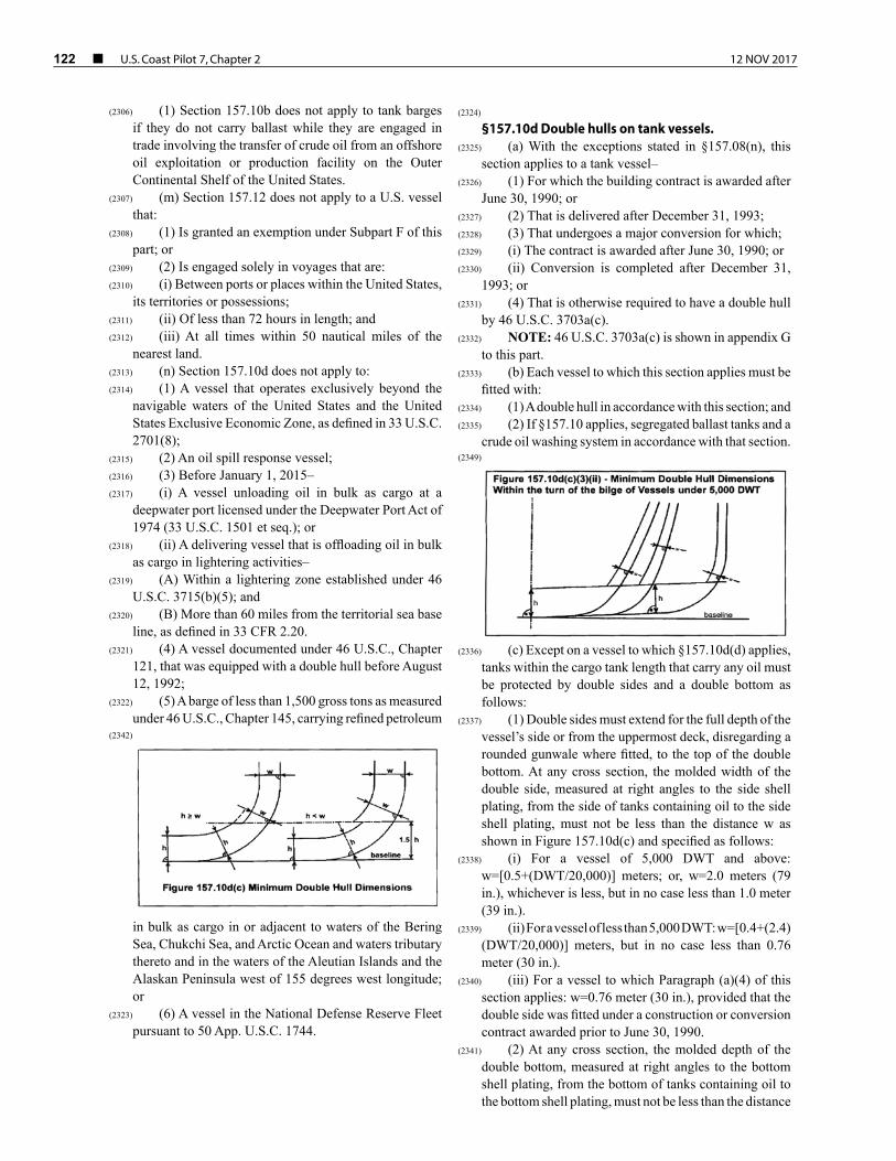
122 ¢ U.S. Coast Pilot 7, Chapter 2 12 NOV 2017
(2306) (1) Section 157.10b does not apply to tank barges if they do not carry ballast while they are engaged in trade involving the transfer of crude oil from an offshore oil exploitation or production facility on the Outer Continental Shelf of the United States.
(2307) (m) Section 157.12 does not apply to a U.S. vessel that:
(2308) (1) Is granted an exemption under Subpart F of this part; or
(2309) (2) Is engaged solely in voyages that are:(2310) (i) Between ports or places within the United States,
its territories or possessions;(2311) (ii) Of less than 72 hours in length; and(2312) (iii) At all times within 50 nautical miles of the
nearest land.(2313) (n) Section 157.10d does not apply to:(2314) (1) A vessel that operates exclusively beyond the
navigable waters of the United States and the United States Exclusive Economic Zone, as defined in 33 U.S.C. 2701(8);
(2315) (2) An oil spill response vessel;(2316) (3) Before January 1, 2015–(2317) (i) A vessel unloading oil in bulk as cargo at a
deepwater port licensed under the Deepwater Port Act of 1974 (33 U.S.C. 1501 et seq.); or
(2318) (ii) A delivering vessel that is offloading oil in bulk as cargo in lightering activities–
(2319) (A) Within a lightering zone established under 46 U.S.C. 3715(b)(5); and
(2320) (B) More than 60 miles from the territorial sea base line, as defined in 33 CFR 2.20.
(2321) (4) A vessel documented under 46 U.S.C., Chapter 121, that was equipped with a double hull before August 12, 1992;
(2322) (5) A barge of less than 1,500 gross tons as measured under 46 U.S.C., Chapter 145, carrying refined petroleum
in bulk as cargo in or adjacent to waters of the Bering Sea, Chukchi Sea, and Arctic Ocean and waters tributary thereto and in the waters of the Aleutian Islands and the Alaskan Peninsula west of 155 degrees west longitude; or
(2323) (6) A vessel in the National Defense Reserve Fleet pursuant to 50 App. U.S.C. 1744.
(2324) §157.10d Double hulls on tank vessels.
(2325) (a) With the exceptions stated in §157.08(n), this section applies to a tank vessel–
(2326) (1) For which the building contract is awarded after June 30, 1990; or
(2327) (2) That is delivered after December 31, 1993;(2328) (3) That undergoes a major conversion for which;(2329) (i) The contract is awarded after June 30, 1990; or(2330) (ii) Conversion is completed after December 31,
1993; or(2331) (4) That is otherwise required to have a double hull
by 46 U.S.C. 3703a(c).(2332) NOTE: 46 U.S.C. 3703a(c) is shown in appendix G
to this part.(2333) (b) Each vessel to which this section applies must be
fitted with:(2334) (1) A double hull in accordance with this section; and(2335) (2) If §157.10 applies, segregated ballast tanks and a
crude oil washing system in accordance with that section.
(2336) (c) Except on a vessel to which §157.10d(d) applies, tanks within the cargo tank length that carry any oil must be protected by double sides and a double bottom as follows:
(2337) (1) Double sides must extend for the full depth of the vessel’s side or from the uppermost deck, disregarding a rounded gunwale where fitted, to the top of the double bottom. At any cross section, the molded width of the double side, measured at right angles to the side shell plating, from the side of tanks containing oil to the side shell plating, must not be less than the distance w as shown in Figure 157.10d(c) and specified as follows:
(2338) (i) For a vessel of 5,000 DWT and above: w=[0.5+(DWT/20,000)] meters; or, w=2.0 meters (79 in.), whichever is less, but in no case less than 1.0 meter (39 in.).
(2339) (ii) For a vessel of less than 5,000 DWT: w=[0.4+(2.4)(DWT/20,000)] meters, but in no case less than 0.76 meter (30 in.).
(2340) (iii) For a vessel to which Paragraph (a)(4) of this section applies: w=0.76 meter (30 in.), provided that the double side was fitted under a construction or conversion contract awarded prior to June 30, 1990.
(2341) (2) At any cross section, the molded depth of the double bottom, measured at right angles to the bottom shell plating, from the bottom of tanks containing oil to the bottom shell plating, must not be less than the distance
(2342)
(2349)

12 NOV 2017 U.S. Coast Pilot 7, Chapter 2 ¢ 123
h as shown in Figure 157.10d(c) and specified as follows:
(2343) (i) For a vessel of 5,000 DWT and above: h=B/15; or, h=2.0 meters (79 in.), whichever is less, but in no case less than 1.0 meter (39 in.).
(2344) (ii) For a vessel of less than 5,000 DWT: h=B/15, but in no case less than 0.76 meter (30 in.).
(2345) (iii) For a vessel to which Paragraph (a)(4) of this section applies: h=B/15; or, h=2.0 meters (79 in.), whichever is the lesser, but in no case less than 0.76 meter (30 in.), provided that the double bottom was fitted under a construction or conversion contract awarded prior to June 30, 1990.
(2346) (3) For a vessel built under a contract awarded after September 11, 1992, within the turn of the bilge or at cross sections where the turn of the bilge is not clearly defined, tanks containing oil must be located inboard of the outer shell–
(2347) (i) For a vessel of 5,000 DWT and above: At levels up to 1.5h above the base line, not less than the distance h, as shown in Figure 157.10d(c) and specified in Paragraph (c)(2) of this section. At levels greater than 1.5h above the base line, not less than the distance w, as shown in Figure 157.10d(c) and specified in Paragraph (c)(1) of this section.
(2348) (ii) For a vessel of less than 5,000 DWT: Not less the distance h above the line of the mid-ship flat bottom, as shown in Figure 157.10d(c)(3)(ii) and specified in Paragraph (c)(2) of this section. At levels greater than h above the line of the mid-ship flat bottom, not less than the distance w, as shown in Figure 157.10d(c)(3)(ii) and specified in Paragraph (c)(1) of this section.
(2350) (4) For a vessel to which §157.10(b) applies that is built under a contract awarded after September 11, 1992.
(2351) (i) The aggregate volume of the double sides, double bottom, forepeak tanks, and afterpeak tanks must not be less than the capacity of segregated ballast tanks required under §157.10(b). Segregated ballast tanks that may be provided in addition to those required under §157.10(b) may be located anywhere within the vessel.
(2352) (ii) Double side and double bottom tanks used to meet the requirements of §157.10(b) must be located as uniformly as practicable along the cargo tank length. Large inboard extensions of individual double side and double bottom tanks, which result in a reduction of overall side or bottom protection, must be avoided.
(2353) (d) A vessel of less than 10,000 DWT that is constructed and certificated for service exclusively on inland or limited short protected coastwise routes must be fitted with double sides and a double bottom as follows:
(2354) (1) A minimum of 61 cm. (2 ft.) from the inboard side of the side shell plate, extending the full depth of the side or from the main deck to the top of the double bottom, measured at right angles to the side shell; and
(2355) (2) A minimum of 61 cm. (2 ft.) from the top of the bottom shell plating, along the full breadth of the vessel’s bottom, measured at right angles to the bottom shell.
(2356) (3) For a vessel to which Paragraph (a)(4) of this section applies, the width of the double sides and the depth of the double bottom may be 38 cm. (15 in.), in lieu of the dimensions specified in paragraphs (d)(1) and (d)(2) of this section, provided that the double side and double bottom tanks were fitted under a construction or conversion contract awarded prior to June 30, 1990.
(2357) (4) For a vessel built under a contract awarded after September 11, 1992, a minimum 46 cm. (18 in.) clearance for passage between framing must be maintained throughout the double sides and double bottom.
(2358) (e) Except as provided in Paragraph (e)(3) of this section, a vessel must not carry any oil in any tank extending forward of:
(2359) (1) The collision bulkhead; or(2360) (2) In the absence of a collision bulkhead, the
transverse plane perpendicular to the centerline through a point located:
(2361) (i) The lesser of 10 meters (32.8 ft.) or 5 percent of the vessel length, but in no case less than 1 meter (39 in.), aft of the forwarded perpendicular;
(2362) (ii) On a vessel of less than 10,000 DWT tons that is constructed and certificated for service exclusively on inland or limited short protected coastwise routes, the lesser of 7.62 meters (25 ft.) or 5 percent of the vessel length, but in no case less than 61 cm. (2 ft.), aft of the headlog or stem at the freeboard deck; or
(2363) (iii) On each vessel which operates exclusively as a box or trail barge, 61 cm. (2 ft.) aft of the headlog.
(2364) (3) This Paragraph does not apply to independent fuel oil tanks that must be located on or above the main deck within the areas described in paragraphs (e)(1) and (e)(2) of this section to serve adjacent deck equipment that cannot be located further aft. Such tanks must be as small and as far aft as is practicable.
(2365) (f) On each vessel, the cargo tank length must not extend aft to any point closer to the stern than the distance equal to the required width of the double side, as prescribed in §157.10d(c)(1) or §157.10d(d)(1).
(2366) Subpart G–Interim Measures for Certain Tank Ves-sels Without Double Hulls Carrying Petroleum Oils
(2367) §157.400 Purpose and applicability.
(2368) (a) The purpose of this subpart is to establish mandatory safety and operational requirements to reduce environmental damage resulting from petroleum oil spills.
(2369) (b) This subpart applies to each tank vessels specified in §157.01 of this part that–
(2370) (1) Is 5,000 gross tons or more;(2371) (2) Carries petroleum oil in bulk as cargo or oil cargo
residue; and(2372) (3) Is not equipped with a double hull meeting
§157.10d of this part, or an equivalent to the requirements of §157.10d, but required to be equipped with a double

124 ¢ U.S. Coast Pilot 7, Chapter 2 12 NOV 2017
hull at a date set forth in 46 U.S.C. 3703a (b)(3) and (c)(3).
(2373) §157.445 Maneuvering performance capability.
(2374) (a) A tankship owner or operator shall ensure that maneuvering tests in accordance with IMO Resolution A.751(18), sections 1.2, 2.3-2.4, 3-4.2, and 5 (with Explanatory Notes in MSC/Circ. 644) have been conducted by July 29, 1997. Completion of maneuvering performance tests must be shown by–
(2375) (1) For a foreign flag tankship, a letter from the flag administration or an authorized classification society, as described in §157.04 of this part, stating the requirements in Paragraph (a) of this section have been met; or
(2376) (2) For a U.S. flag tankship, results from the vessel owner confirming the completion of the tests or a letter from an authorized classification society, as described in §157.04 of this part, stating the requirements in Paragraph (a) of this section have been met.
(2377) (b) If a tankship undergoes a major conversion or alteration affecting the control systems, control surfaces, propulsion system, or other areas which may be expected to alter maneuvering performance, the tankship owner or operator shall ensure that new maneuvering tests are conducted as required by Paragraph (a) of this section.
(2378) (c) If a tankship is one of a class of vessels with identical propulsion, steering, hydrodynamic, and other relevant design characteristics, maneuvering performance test results for any tankship in the class may be used to satisfy the requirements of Paragraph (a) of this section.
(2379) (d) The tankship owner or operator shall ensure that the performance test results, recorded in the format of Appendix 6 of the Explanatory Notes in MSC/Circ. 644., are prominently displayed in the wheelhouse.
(2380) (e) Prior to entering the port or place of destination and prior to getting underway, the tankship master shall discuss the results of the performance tests with the pilot while reviewing the anticipated transit and the possible impact of the tankship’s maneuvering capability on the transit.
(2381) Part 160–Ports and Waterways Safety-General
(2382) Subpart A–General
(2383) §160.1 Purpose.
(2384) (a) This subchapter contains regulations implementing the Ports and Waterways Safety Act (33 U.S.C. 1221) and related statutes.
(2385) §160.3 Definitions.
(2386) For the purposes of this subchapter:(2387) Bulk means material in any quantity that is shipped,
stored, or handled without the benefit of package, label,
mark or count and carried in integral or fixed independent tanks.
(2388) Captain of the Port means the Coast Guard officer designated by the Commandant to command a Captain of the Port Zone as described in part 3 of this chapter.
(2389) Commandant means the Commandant of the United States Coast Guard.
(2390) Deviation means any departure from any rule in this subchapter.
(2391) Director, Vessel Traffic Services means the Coast Guard officer designated by the Commandant to command a Vessel Traffic Service (VTS) as described in part 161 of this chapter.
(2392) District Commander means the Coast Guard officer designated by the Commandant to command a Coast Guard District as described in part 3 of this chapter.
(2393) ETA means estimated time of arrival.(2394) Length of Tow means, when towing with a hawser,
the length in feet from the stern of the towing vessel to the stern of the last vessel in tow. When pushing ahead or towing alongside, length of tow means the tandem length in feet of the vessels in tow excluding the length of the towing vessel.
(2395) Person means an individual, firm, corporation, association, partnership, or governmental entity.
(2396) State means each of the several States of the United States, the District of Columbia, the Commonwealth of Puerto Rico, Guam, American Samoa, the United States Virgin Islands, the Trust Territories of the Pacific Islands, the Commonwealth of the Northern Marianas Islands, and any other commonwealth, territory, or possession of the United States.
(2397) Tanker means a self-propelled tank vessel constructed or adapted primarily to carry oil or hazardous materials in bulk in the cargo spaces.
(2398) Tank Vessel means a vessel that is constructed or adapted to carry, or that carries, oil or hazardous material in bulk as cargo or cargo residue.
(2399) Vehicle means every type of conveyance capable of being used as a means of transportation on land.
(2400) Vessel means every description of watercraft or other artificial contrivance used, or capable of being used, as a means of transportation on water.
(2401) Vessel Traffic Services (VTS) means a service implemented under Part 161 of this chapter by the United States Coast Guard designed to improve the safety and efficiency of vessel traffic and to protect the environment. The VTS has the capability to interact with marine traffic and respond to traffic situations developing in the VTS area.
(2402) Vessel Traffic Service Area or VTS Area means the geographical area encompassing a specific VTS area of service as described in Part 161 of this chapter. This area of service may be subdivided into sectors for the purpose of allocating responsibility to individual Vessel Traffic Centers or to identify different operating requirements.
(2403) Note: Although regulatory jurisdiction is limited to the navigable waters of the United States, certain vessels

12 NOV 2017 U.S. Coast Pilot 7, Chapter 2 ¢ 125
will be encouraged or may be required, as a condition of port entry, to report beyond this area to facilitate traffic management within the VTS area.
(2404) VTS Special Area means a waterway within a VTS area in which special operating requirements apply.
(2405) §160.5 Delegations.
(2406) (a) District Commanders and Captains of the Ports are delegated the authority to establish safety zones.
(2407) (b) Under the provisions of 33 CFR 6.04–1 and 6.04–6, District Commanders and Captains of the Ports have been delegated authority to establish security zones.
(2408) (c) Under the provisions 33 CFR §1.05–1, District Commanders have been delegated authority to establish regulated navigation areas.
(2409) (d) Subject to the supervision of the cognizant Captain of the Port and District Commander, Directors, Vessel Traffic Services are delegated authority under 33 CFR 1.01-30 to discharge the duties of the Captain of the Port that involve directing the operation, movement and anchorage of vessels within a Vessel Traffic Service area including management of vessel traffic within anchorages, regulated navigation areas and safety zones, and to enforce Vessel Traffic Service and ports and waterways safety regulations. This authority may be exercised by Vessel Traffic Center personnel. The Vessel Traffic Center may, within the Vessel Traffic Service area, provide information, make recommendations, or to a vessel required under Part 161 of this chapter to participate in a Vessel Traffic Service, issue an order, including an order to operate or anchor as directed; require the vessel to comply with orders issued; specify times of entry, movement or departure; restrict operations as necessary for safe operation under the circumstances; or take other action necessary for control of the vessel and the safety of the port or of the marine environment.
(2410) §160.7 Appeals.
(2411) (a) Any person directly affected by a safety zone or an order or direction issued under this subchapter (33 CFR Subchapter P) may request reconsideration by the official who issued it or in whose name it was issued. This request may be made orally or in writing, and the decision of the official receiving the request may be rendered orally or in writing.
(2412) (b) Any person directly affected by the establishment of a safety zone or by an order or direction issued by, or on behalf of, a Captain of the Port may appeal to the District Commander through the Captain of the Port. The appeal must be in writing, except as allowed under paragraph (e) of this section, and shall contain complete supporting documentation and evidence which the appellant wishes to have considered. Upon receipt of the appeal, the District Commander may direct a representative to gather and submit documentation or other evidence which would be necessary or helpful to a resolution of the appeal. A copy of this documentation and evidence is made available
to the appellant. The appellant is afforded five working days from the date of receipt to submit rebuttal materials. Following submission of all materials, the District Commander issues a ruling, in writing, on the appeal. Prior to issuing the ruling, the District Commander may, as a matter of discretion, allow oral presentation on the issues.
(2413) (c) Any person directly affected by the establishment of a safety zone or by an order or direction issued by, or on behalf of, a District Commander, or who receives an unfavorable ruling on an appeal taken under paragraph (b) of this section may appeal to the Area Commander through the District Commander. The appeal must be in writing, except as allowed under paragraph (e) of this section, and shall contain complete supporting documentation and evidence which the appellant wishes to have considered. Upon receipt of the appeal, the Area Commander may direct a representative to gather and submit documentation or other evidence which would be necessary or helpful to a resolution of the appeal. A copy of this documentation and evidence is made available to the appellant. The appellant is afforded five working days from the date of receipt to submit rebuttal materials. Following submission of all materials, the Area Commander issues a ruling, in writing, on the appeal. Prior to issuing the ruling, the Area Commander may, as a matter of discretion, allow oral presentation on the issues.
(2414) (d) Any person who receives an unfavorable ruling on an appeal taken under paragraph (c) of this section, may appeal to the Commandant (CG–5P), Attn: Assistant Commandant for Prevention, U.S. Coast Guard Stop 7501, 2703 Martin Luther King Jr. Avenue SE., Washington, DC 20593–7501. The appeal must be in writing, except as allowed under paragraph (e) of this section. The Area Commander forwards the appeal, all the documents and evidence which formed the record upon which the order or direction was issued or the ruling under paragraph (c) of this section was made, and any comments which might be relevant, to the Assistant Commandant for Prevention. A copy of this documentation and evidence is made available to the appellant. The appellant is afforded 5 working days from the date of receipt to submit rebuttal materials to the Assistant Commandant for Prevention. The decision of the Assistant Commandant for Prevention is based upon the materials submitted, without oral argument or presentation. The decision of the Assistant Commandant for Prevention is issued in writing and constitutes final agency action.
(2415) (e) If the delay in presenting a written appeal would have significant adverse impact on the appellant, the appeal under paragraphs (b) and (c) of this section may initially be presented orally. If an initial presentation of the appeal is made orally, the appellant must submit the appeal in writing within five days of the oral presentation to the Coast Guard official to whom the presentation was made. The written appeal must contain, at a minimum, the basis for the appeal and a summary of the material

126 ¢ U.S. Coast Pilot 7, Chapter 2 12 NOV 2017
presented orally. If requested, the official to whom the appeal is directed may stay the effect of the action while the ruling is being appealed.
(2416) Subpart B–Control of Vessel and Facility Opera-tions
(2417) §160.101 Purpose.
(2418) This subpart describes the authority exercised by District Commanders and Captains of the Ports to insure the safety of vessels and waterfront facilities, and the protection of the navigable waters and the resources therein. The controls described in this subpart are directed to specific situations and hazards.
(2419) §160.103 Applicability.
(2420) (a) This subpart applies to any–(2421) (1) Vessel on the navigable waters of the United
States, except as provided in paragraphs (b) and (c) of this section;
(2422) (2) Bridge or other structure on or in the navigable waters of the United States; and
(2423) (3) Land structure or shore area immediately adjacent to the navigable waters of the United States.
(2424) (b) This subpart does not apply to any vessel on the Saint Lawrence Seaway.
(2425) (c) Except pursuant to international treaty, convention, or agreement, to which the United States is a party, this subpart does not apply to any foreign vessel that is not destined for, or departing from, a port or place subject to the jurisdiction of the United States and that is in:
(2426) (1) Innocent passage through the territorial sea of the United States;
(2427) (2) Transit through the navigable waters of the United States which form a part of an international strait.
(2428) §160.105 Compliance with orders.
(2429) Each person who has notice of the terms of an order issued under this subpart must comply with that order.
(2430) §160.107 Denial of entry.
(2431) Each District Commander or Captain of the Port, subject to recognized principles of international law, may deny entry into the navigable waters of the United States or to any port or place under the jurisdiction of the United States, and within the district or zone of that District Commander or Captain of the Port, to any vessel not in compliance with the provisions of the Port and Tanker Safety Act (33 U.S.C. 1221–1232) or the regulations issued thereunder.
(2432) §160.109 Waterfront facility safety.
(2433) (a) To prevent damage to, or destruction of, any bridge or other structure on or in the navigable waters
of the United States, or any land structure or shore area immediately adjacent to those waters, and to protect the navigable waters and the resources therein from harm resulting from vessel or structure damage, destruction, or loss, each District Commander or Captain of the Port may–
(2434) (1) Direct the handling, loading, unloading, storage, stowage, and movement (including the emergency removal, control, and disposition) of explosives or other dangerous articles and substances, including oil or hazardous material as those terms are defined in 46 U.S.C. 2101 on any structure on or in the navigable waters of the United States, or any land structure or shore area immediately adjacent to those waters; and
(2435) (2) Conduct examinations to assure compliance with the safety equipment requirements for structures.
(2436) §160.111 Special orders applying to vessel opera-tions.
(2437) Each District Commander or Captain of the Port may order a vessel to operate or anchor in the manner directed when–
(2438) (a) The District Commander or Captain of the Port has reasonable cause to believe that the vessel is not in compliance with any regulation, law or treaty;
(2439) (b) The District Commander or Captain of the Port determines that the vessel does not satisfy the conditions for vessel operation and cargo transfers specified in §160.113; or
(2440) (c) The District Commander or Captain of the Port has determined that such order is justified in the interest of safety by reason of weather, visibility, sea conditions, temporary port congestion, other temporary hazardous circumstances, or the condition of the vessel.
(2441) §160.113 Prohibition of vessel operation and cargo transfers.
(2442) (a) Each District Commander or Captain of the Port may prohibit any vessel, subject to the provisions of chapter 37 of Title 46, U.S. Code, from operating in the navigable waters of the United States, or from transferring cargo or residue in any port or place under the jurisdiction of the United States, and within the district or zone of that District Commander or Captain of the Port, if the District Commander or the Captain of the Port determines that the vessel’s history of accidents, pollution incidents, or serious repair problems creates reason to believe that the vessel may be unsafe or pose a threat to the marine environment.
(2443) (b) The authority to issue orders prohibiting operation of the vessels or transfer of cargo or residue under Paragraph (a) of this section also applies if the vessel:
(2444) (1) Fails to comply with any applicable regulation;(2445) (2) Discharges oil or hazardous material in violation
of any law or treaty of the United States;

12 NOV 2017 U.S. Coast Pilot 7, Chapter 2 ¢ 127
(2446) (3) Does not comply with applicable vessel traffic service requirements;
(2447) (4) While underway, does not have at least one deck officer on the navigation bridge who is capable of communicating in the English language.
(2448) (c) When a vessel has been prohibited from operating in the navigable waters of the United States under paragraphs (a) or (b) of this section, the District Commander or Captain of the Port may allow provisional entry into the navigable waters of the United States, or into any port or place under the jurisdiction of the United States and within the district or zone of that District Commander or Captain of the Port, if the owner or operator of such vessel proves to the satisfaction of the District Commander or Captain of the Port, that the vessel is not unsafe or does not pose a threat to the marine environment, and that such entry is necessary for the safety of the vessel or the persons on board.
(2449) (d) A vessel which has been prohibited from operating in the navigable waters of the United States, or from transferring cargo or residue in a port or place under the jurisdiction of the United States under the provisions of Paragraph (a) or (b)(1), (2) or (3) of this section, may be allowed provisional entry if the owner or operator proves, to the satisfaction of the District Commander or Captain of the Port that has jurisdiction, that the vessel is no longer unsafe or a threat to the environment, and that the condition which gave rise to the prohibition no longer exists.
(2450) §160.115 Withholding of clearance.
(2451) (a) Each District Commander or Captain of the Port may request the Secretary of the Treasury, or the authorized representative thereof, to withhold or revoke the clearance required by 46 U.S.C. App. 91 of any vessel, the owner or operator of which is subject to any penalties under 33 U.S.C. 1232.
(2452) Subpart C–Notification of Arrival, Hazardous Conditions, and Certain Dangerous Cargoes
(2453) §160.201 General.
(2454) This subpart contains requirements and procedures for submitting a notice of arrival (NOA), and a notice of hazardous condition. The sections in this subpart describe:
(2455) (a) Applicability and exemptions from requirements in this subpart;
(2456) (b) Required information in an NOA;(2457) (c) Required updates to an NOA;(2458) (d) Methods and times for submission of an NOA,
and updates to an NOA;(2459) (e) How to obtain a waiver; and(2460) (f) Requirements for submission of the notice of
hazardous condition.
(2461) Note to §160.201. For notice-of-arrival requirements for the U.S. Outer Continental Shelf, see 33 CFR part 146.
(2462) §160.202 Definitions.
(2463) Terms in this subpart that are not defined in this section or in §160.3 have the same meaning as those terms in 46 U.S.C. 2101. As used in this subpart—
(2464) Agent means any person, partnership, firm, company or corporation engaged by the owner or charterer of a vessel to act in their behalf in matters concerning the vessel.
(2465) Barge means a non-self propelled vessel engaged in commerce.
(2466) Boundary waters mean the waters from main shore to main shore of the lakes and rivers and connecting waterways, or the portions thereof, along which the international boundary between the United States and the Dominion of Canada passes, including all bays, arms, and inlets thereof, but not including tributary waters which in their natural channels would flow into such lakes, rivers, and waterways, or waters flowing from such lakes, rivers, and waterways, or the waters of rivers flowing across the boundary.
(2467) Carried in bulk means a commodity that is loaded or carried on board a vessel without containers or labels and received and handled without mark or count.
(2468) Certain dangerous cargo (CDC) includes any of the following:
(2469) (1) Division 1.1 or 1.2 explosives as defined in 49 CFR 173.50.
(2470) (2) Division 1.5D blasting agents for which a permit is required under 49 CFR 176.415 or, for which a permit is required as a condition of a Research and Special Programs Administration exemption.
(2471) (3) Division 2.3 “poisonous gas”, as listed in 49 CFR 172.101 that is also a “material poisonous by inhalation” as defined in 49 CFR 171.8, and that is in a quantity in excess of 1 metric ton per vessel.
(2472) (4) Division 5.1 oxidizing materials for which a permit is required under 49 CFR 176.415 or for which a permit is required as a condition of a Research and Special Programs Administration exemption.
(2473) (5) A liquid material that has a primary or subsidiary classification of Division 6.1 “poisonous material” as listed 49 CFR 172.101 that is also a “material poisonous by inhalation,” as defined in 49 CFR 171.8 and that is in a bulk packaging, or that is in a quantity in excess of 20 metric tons per vessel when not in a bulk packaging.
(2474) (6) Class 7, “highway route controlled quantity” radioactive material or “fissile material, controlled shipment,” as defined in 49 CFR 173.403.
(2475) (7) All bulk liquefied gas cargo carried under 46 CFR 151.50-31 or listed in 46 CFR 154.7 that is flammable and/or toxic and that is not carried as certain dangerous cargo residue (CDC residue).
(2476) (8) The following bulk liquids except when carried as CDC residue:

128 ¢ U.S. Coast Pilot 7, Chapter 2 12 NOV 2017
(2477) (i) Acetone cyanohydrin;(2478) (ii) Allyl alcohol;(2479) (iii) Chlorosulfonic acid; (2480) (iv) Crotonaldehyde; (2481) (v) Ethylene chlorohydrin;(2482) (vi) Ethylene dibromide;(2483) (vii) Methacrylonitrile; (2484) (viii) Oleum (fuming sulfuric acid); and(2485) (ix) Propylene oxide, alone or mixed with ethylene
oxide.(2486) (9) The following bulk solids:(2487) (i) Ammonium nitrate listed as Division 5.1
(oxidizing) material in 49 CFR 172.101 except when carried as CDC residue; and
(2488) (ii) Ammonium nitrate based fertilizer listed as a Division 5.1 (oxidizing) material in 49 CFR 172.101 except when carried as CDC residue.
(2489) Certain dangerous cargo residue (CDC residue) includes any of the following:
(2490) (1) Ammonium nitrate in bulk or ammonium nitrate based fertilizer in bulk remaining after all saleable cargo is discharged, not exceeding 1,000 pounds in total and not individually accumulated in quantities exceeding two cubic feet.
(2491) (2) For bulk liquids and liquefied gases, the cargo that remains onboard in a cargo system after discharge that is not accessible through normal transfer procedures, with the exception of the following bulk liquefied gas cargoes carried under 46 CFR 151.50-31 or listed in 46 CFR 154.7:
(2492) (i) Ammonia, anhydrous;(2493) (ii) Chlorine;(2494) (iii) Ethane;(2495) (iv) Ethylene oxide;(2496) (v) Methane (LNG);(2497) (vi) Methyl bromide;(2498) (vii) Sulfur dioxide; and(2499) (viii) Vinyl chloride.(2500) Charterer means the person or organization that
contracts for the majority of the carrying capacity of a ship for the transportation of cargo to a stated port for a specified period. This includes “time charterers” and “voyage charterers.”
(2501) Crewmember means all persons carried on board the vessel to provide navigation and maintenance of the vessel, its machinery, systems, and arrangements essential for propulsion and safe navigation or to provide services for other persons on board.
(2502) Embark means when a crewmember or a person in addition to the crew joins the vessel.
(2503) Ferry schedule means a published document that:(2504) (1) Identifies locations a ferry travels to and from;(2505) (2) Lists the times of departures and arrivals; and(2506) (3) Identifies the portion of the year in which the
ferry maintains this schedule.
(2507) Foreign vessel means a vessel of foreign registry or operated under the authority of a country except the United States.
(2508) Great Lakes means Lakes Superior, Michigan, Huron, Erie, and Ontario, their connecting and tributary waters, the Saint Lawrence River as far as Saint Regis, and adjacent port areas.
(2509) Gross tons means the tonnage determined by the tonnage authorities of a vessel’s flag state in accordance with the national tonnage rules in force before the entry into force of the International Convention on Tonnage Measurement of Ships, 1969 (“Convention”). For a vessel measured only under Annex I of the Convention, gross tons means that tonnage. For a vessel measured under both systems, the higher gross tonnage is the tonnage used for the purposes of the 300-gross-ton threshold.
(2510) Hazardous condition means any condition that may adversely affect the safety of any vessel, bridge, structure, or shore area or the environmental quality of any port, harbor, or navigable waterway of the United States. It may, but need not, involve collision, allision, fire, explosion, grounding, leaking, damage, injury or illness of a person aboard, or manning-shortage.
(2511) Nationality means the state (nation) in which a person is a citizen or to which a person owes permanent allegiance.
(2512) Operating exclusively within a single Captain of the Port zone refers to vessel movements within the boundaries of a single COTP zone, e.g., from one dock to another, one berth to another, one anchorage to another, or any combination of such transits. Once a vessel has arrived in a port in a COPT zone, it would not be considered as departing from a port or place simply because of its movements within that specific port.
(2513) Operator means any person including, but not limited to, an owner, a charterer, or another contractor who conducts, or is responsible for, the operation of a vessel.
(2514) Persons in addition to crewmembers mean any person onboard the vessel, including passengers, who are not included on the list of crewmembers.
(2515) Port or place of departure means any port or place in which a vessel is anchored or moored.
(2516) Port or place of destination means any port or place in which a vessel is bound to anchor or moor.
(2517) Public vessel means a vessel that is owned or demise-(bareboat) chartered by the government of the United States, by a State or local government, or by the government of a foreign country and that is not engaged in commercial service.
(2518) Time charterer means the party who hires a vessel for a specific amount of time. The owner and his crew manage the vessel, but the charterer selects the ports of destination.
(2519) Voyage charterer means the party who hires a vessel for a single voyage. The owner and his crew manage the vessel, but the charterer selects the ports of destination.

12 NOV 2017 U.S. Coast Pilot 7, Chapter 2 ¢ 129
Table 160.206 – NOA Information Items
Required Information
Vessels neither carrying CDC nor
controlling another vessel carrying CDC
Vessels carrying CDC or controlling
another vessel carrying CDC
(1) Vessel Information
(i) Name X X
(ii) Name of the registered owner X X
(iii) Country of registry X X
(iv) Call sign X X
(v) International Maritime Organization (IMO) international number or, if vessel does not have anassigned IMO international number, substitute with offi cial number X X
(vi) Name of the operator X X
(vii) Name of the charterer X X
(viii) Name of classifi cation society or recognized organization X X
(ix) Maritime Mobile Service Identity (MMSI) number, if applicable X X
(x) Whether the vessel is 300 gross tons or less (yes or no) X X
(xi) USCG Vessel Response Plan Control Number, if applicable X X
(2) Voyage Information
(i) Names of last fi ve foreign ports or places visited X X
(ii) Dates of arrival and departure for last fi ve foreign ports or places visited X X
(iii) For the port or place of the United States to be visited, list the names of the receiving facility, the port or place, the city, and the state X X
(iv) For the port or place in the United States to be visited, the estimated date and time of arrival X X
(v) For the port or place in the United States to be visited, the estimated date and time of departure X X
(vi) The location (port or place and country) or position (latitude and longitude or waterway and mile marker) of the vessel at the time of reporting X X
(vii) The name and telephone number of a 24-hour point of contact X X
(viii) Whether the vessel’s voyage time is less than 24 hours (yes or no) X X
(ix) Last port or place of departure X X
(x) Dates of arrival and departure for last port or place of departure X X
(3) Cargo Information
(i) A general description of cargo, other than CDC, on board the vessel (e.g. grain, container, oil, etc.) X X
(ii) Name of each CDC carried, including cargo UN number, if applicable – X
(iii) Amount of each CDC carried – X
(4) Information for each Crewmember On Board
(i) Full name X X
(ii) Date of birth X X
(iii) Nationalitiy X X
(iv) Passport* or mariners document number (type of identifi cation and number) X X
(v) Position or duties on the vessel X X
(vi) Where the crewmembers embarked (list port or place and country) X X
(5) Information for each Person On Board in Addition to Crew
(i) Full name X X
(ii) Date of birth X X
(iii) Nationality X X
(iv) Passport number* X X
(v) Where the person embarked (list port or place and country) X X
(6) Operational condition of equipment required by 33 CFR part 164 of this chapter (see note to table) X X
(7) International Safety Management (ISM) Code Notice
(i) The date of expiration for the company’s Document of Compliance certifi cate that covers the vessel X X
(ii) The date of expiration for the vessel’s Safety Management Certifi cate X X
(iii) The name of the Flag Administration, or the recognized organization(s) representing the vessel Flag Administration, that issued those certifi cates X X
(8) International Ship and Port Facility Code (ISPS) Notice
(i) The date of issuance for the vessel’s International Ship Security Certifi cate (ISSC), if any X X
(ii) Whether the ISSC, if any, is an initial Interim ISSC, subsequent and consecutive Interim ISSC, or fi nal ISSC X X
(iii) Declaration that the approved ship security plan, if any, is being implemented X X
(iv) If a subsequent and consecutive Interim ISSC, the reasons therefore X X
(v) The name and 24-hour contact information for the Company Security Offi cer X X
(vi) The name of the Flag Administration, or the recognized security organization(s) representing the vessel Flag Administration that issued the ISSC X X
Note to Table 160.206. For items with an asterisk (*), see paragraph (b) of this section. Submitting a response for item 6 indicating that navigation equipment is not operating properly does not serve as notice to the District Commander, Captain of the Port, or Vessel Traffi c Center, under 33 CFR 164.53.
(2558)

130 ¢ U.S. Coast Pilot 7, Chapter 2 12 NOV 2017
(2520) §160.203 Applicability.
(2521) (a) This subpart applies to the following vessels that are bound for or departing from ports or places within the navigable waters of the United States, as defined in 33 CFR 2.36(a), which includes internal waters and the territorial seas of the United States, and any deepwater port as defined in 33 CFR 148.5:
(2522) (1) U.S. vessels in commercial service, and(2523) (2) All foreign vessels.(2524) (b) Unless otherwise specified in this subpart, the
owner, agent, master, operator, or person in charge of a vessel regulated by this subpart is responsible for compliance with the requirements in this subpart.
(2525) (c) Towing vessels controlling a barge or barges required to submit an NOA under this subpart must submit only one NOA containing the information required for the towing vessel and each barge under its control.
(2526) §160.204 Exemptions and exceptions.
(2527) (a) Except for reporting notice of hazardous conditions, the following vessels are exempt from requirements in this subpart:
(2528) (1) A passenger or offshore supply vessel when employed in the exploration for or in the removal of oil, gas, or mineral resources on the continental shelf.
(2529) (2) An oil spill response vessel (OSRV) when engaged in actual spill response operations or during spill response exercises.
(2530) (3) After December 31, 2015, a vessel required by 33 CFR 165.830 or 165.921 to report its movements, its cargo, or the cargo in barges it is towing.
(2531) (4) A United States or Canadian vessel engaged in the salving operations of any property wrecked, or rendering aid and assistance to any vessels wrecked, disabled, or in distress, in waters specified in Article II of the 1908 Treaty of Extradition, Wrecking and Salvage (35 Stat. 2035; Treaty Series 502).
(2532) (5) The following vessels neither carrying certain dangerous cargo nor controlling another vessel carrying certain dangerous cargo:
(2533) (i) A foreign vessel 300 gross tons or less not engaged in commercial service.
(2534) (ii) A vessel operating exclusively within a single Captain of the Port zone. Captain of the Port zones are defined in 33 CFR part 3.
(2535) (iii) A U.S. towing vessel and a U.S. barge operating solely between ports or places of the contiguous 48 states, Alaska, and the District of Columbia.
(2536) (iv) A public vessel.(2537) (v) Except for a tank vessel, a U.S. vessel operating
solely between ports or places of the United States on the Great Lakes.
(2538) (vi) A U.S. vessel 300 gross tons or less, engaged in commercial service not coming from a foreign port or place.
(2539) (vii) Each ferry on a fixed route that is described in an accurate schedule that is submitted by the ferry operator, along with information in paragraphs (a)(5)(vii)(A) through (J) of this section, to the Captain of the Port for each port or place of destination listed in the schedule at least 24 hours in advance of the first date and time of arrival listed on the schedule. At least 24 hours before the first date and time of arrival listed on the ferry schedule, each ferry operator who submits a schedule under paragraph (a)(5)(vii) of this section must also provide the following information to the Captain of the Port for each port or place of destination listed in the schedule for the ferry, and if the schedule or the following submitted information changes, the ferry operator must submit an updated schedule at least 24 hours in advance of the first date and time of arrival listed on the new schedule and updates on the following items whenever the submitted information is no longer accurate:
(2540) (A) Name of the vessel;(2541) (B) Country of registry of the vessel;(2542) (C) Call sign of the vessel;(2543) (D) International Maritime Organization (IMO)
international number or, if the vessel does not have an assigned IMO international number, the official number of the vessel;
(2544) (E) Name of the registered owner of the vessel;(2545) (F) Name of the operator of the vessel;(2546) (G) Name of the vessel’s classification society or
recognized organization, if applicable;(2547) (H) Each port or place of destination;(2548) (I) Estimated dates and times of arrivals at and
departures from these ports or places; and(2549) (J) Name and telephone number of a 24-hour point
of contact.(2550) (6) From April 30, 2015 through December 31, 2015,
vessels identified as being subject to 33 CFR 165.830 or 165.921.
(2551) (b) A vessel less than 500 gross tons is not required to submit the International Safety Management (ISM) Code Notice (Entry 7 in Table 160.206 of §160.206).
(2552) (c) A U.S. vessel is not required to submit the International Ship and Port Facility Security (ISPS) Code Notice information (Entry 8 in Table 160.206 of §160.206).
(2553) §160.205 Notices of arrival.
(2554) The owner, agent, Master, operator, or person in charge of a vessel must submit notices of arrival consistent with the requirements in this subpart.
(2555) §160.206 Information required in an NOA.
(2556) (a) Information required. With the exceptions noted in paragraph (b) of this section, each NOA must contain all of the information items specified in Table 160.206. Vessel owners and operators should protect any personal information they gather in preparing notices for transmittal to the National Vessel Movement Center

12 NOV 2017 U.S. Coast Pilot 7, Chapter 2 ¢ 131
(NVMC) to prevent unauthorized disclosure of that information.
(2557) (b) Exceptions. If a crewmember or person on board other than a crewmember is not required to carry a passport for travel, then passport information required in Table 160.206 by items (4)(iv) and (5)(iv) need not be provided for that person.
(2559) §160.208 Updates to a submitted NOA.
(2560) (a) Unless otherwise specified in this section, whenever events cause NOA information submitted for a vessel to become inaccurate, or the submitter to realize that data submitted was inaccurate, the owner, agent, Master, operator, or person in charge of that vessel must submit an update within the times required in §160.212.
(2561) (b) Changes in the following information need not be reported:
(2562) (1) Changes in arrival or departure times that are less than six (6) hours;
(2563) (2) Changes in vessel location or position of the vessel at the time of reporting (entry (2)(vi) to Table 160.206); and
(2564) (3) Changes to crewmembers’ position or duties on the vessel (entry (4)(vii) to Table 160.206).
(2565) (c) When reporting updates, revise and resubmit the NOA.
(2566) §160.210 Methods for submitting an NOA.
(2567) (a) National Vessel Movement Center (NVMC). Except as otherwise provided in this paragraph or paragraph (b) of this section, vessels must submit NOA information required by §160.206 to the NVMC using methods currently specified at www.nvmc.uscg.gov, which includes submission through the NVMC electronic Notice of Arrival and Departure (eNOAD) World Wide Web site, and XML, which includes the Excel Workbook format. These data may also be submitted using other methods that may be added as future options on www.nvmc.uscg.gov. XML spreadsheets may be submitted via email to [email protected]. If a vessel operator must submit an NOA or an update, for a vessel in an area without internet access or when experiencing technical difficulties with an onboard computer, and he or she has no shore-side support available, the vessel operator may fax or phone the submission to the NVMC. Fax at 1–800–547–8724 or 304–264–2684. Workbook available at www.nvmc.uscg.gov; or, telephone at 1–800–708–9823 or 304–264–2502.
(2568) (b) Saint Lawrence Seaway. Those vessels transiting the Saint Lawrence Seaway inbound, bound for a port or place in the United States, may meet the submission requirements of paragraph (a) of this section by submitting the required information to the Saint Lawrence Seaway Development Corporation and the Saint Lawrence Seaway Management Corporation of Canada using methods specified at www.nvmc.uscg.gov.
(2569) §160.212 When to submit an NOA.
(2570) (a) Submission of an NOA. (1) Except as set out in paragraphs (a)(2) and (a)(3) of this section, all vessels must submit NOAs within the times required in paragraph (a)(4) of this section.
(2571) (2) Towing vessels, when in control of a vessel carrying CDC and operating solely between ports or places of the contiguous 48 states, Alaska, and the District of Columbia, must submit an NOA before departure but at least 12 hours before arriving at the port or place of destination.
(2572) (3) U.S. vessels 300 gross tons or less, arriving from a foreign port or place, and whose voyage time is less than 24 hours must submit an NOA at least 60 minutes before departure from the foreign port or place. Also, Canadian vessels 300 gross tons or less, arriving directly from Canada, via boundary waters, to a United States port or place on the Great Lakes, whose voyage time is less than 24 hours must submit an NOA at least 60 minutes before departure from the Canadian port or place.
(2573) (4) Times for submitting NOAs are as follows:(2574)
If your voyage time is – Then you must submit an NOA –
(i) 96 hours or more; or At least 96 hours before arriving at the port or place of destination; or
(ii) Less than 96 hours Before departure but at least 24 hours before arriving at the port or place of destination.
(2575) (b) Submission of updates to an NOA. (1) Except as set out in paragraphs (b)(2) and (b)(3) of this section, vessels must submit updates in NOA information within the times required in paragraph (b)(4) of this section.
(2576) (2) Towing vessels, when in control of a vessel carrying CDC and operating solely between ports or places in the contiguous 48 states, Alaska, and the District of Columbia, must submit changes to an NOA as soon as practicable but at least 6 hours before entering the port or place of destination.
(2577) (3) U.S. vessels 300 gross tons or less, arriving from a foreign port or place, whose voyage time is—
(2578) (i) Less than 24 hours but greater than 6 hours, must submit updates to an NOA as soon as practicable, but at least 6 hours before entering the port or place of destination.
(2579) (ii) Less than or equal to 6 hours, must submit updates to an NOA as soon as practicable, but at least 60 minutes before departure from the foreign port or place.
(2580) (4) Times for submitting updates to NOAs are as follows:
(2581)
If your remaining voyage time is – Then you must submit updates to an NOA –
(i) 96 hours or more; As soon as practicable, but at least 24 hours before arriving at the port or place of destination;
(ii) Less than 96 hours but not less than 24 hours; or
As soon as practicable, but at least 24 hours before arriving at the port or place of destination; or

132 ¢ U.S. Coast Pilot 7, Chapter 2 12 NOV 2017
If your remaining voyage time is – Then you must submit updates to an NOA –
(iii) Less than 24 hours As soon as practicable, but at least 12 hours before arriving at the port or place of destination.
(2582) §160.214 Waivers.
(2583) The Captain of the Port may waive, within that Captain of the Port’s designated zone, any of the requirements of this subpart for any vessel or class of vessels upon finding that the vessel, route area of operations, conditions of the voyage, or other circumstances are such that application of this subpart is unnecessary or impractical for purposes of safety, environmental protection, or national security.
(2584) §160.215 Force majeure.
(2585) When a vessel is bound for a port or place of the United States under force majeure, it must comply with the requirements in this section, but not other sections of this subpart. The vessel must report the following information to the nearest Captain of the Port as soon as practicable:
(2586) (a) The vessel Master's intentions;(2587) (b) Any hazardous conditions as defined in §160.202;
and(2588) (c) If the vessel is carrying certain dangerous cargo
or controlling a vessel carrying certain dangerous cargo, the amount and name of each CDC carried, including cargo UN number if applicable.
(2589) §160.216 Notice of hazardous conditions.
(2590) (a) Whenever there is a hazardous condition either on board a vessel or caused by a vessel or its operation, the owner, agent, master, operator, or person in charge must immediately notify the nearest Coast Guard Sector Office or Group Office, and in addition submit any report required by 46 CFR 4.05-10.
(2591) (b) When the hazardous condition involves cargo loss or jettisoning as described in 33 CFR 97.115, the notification required by paragraph (a) of this section must include—
(2592) (1) What was lost, including a description of cargo, substances involved, and types of packages;
(2593) (2) How many were lost, including the number of packages and quantity of substances they represent;
(2594) (3) When the incident occurred, including the time of the incident or period of time over which the incident occurred;
(2595) (4) Where the incident occurred, including the exact or estimated location of the incident, the route the ship was taking, and the weather (wind and sea) conditions at the time or approximate time of the incident; and
(2596) (5) How the incident occurred, including the circumstances of the incident, the type of securing equipment that was used, and any other material failures that may have contributed to the incident.
(2597) Part 161–Vessel Traffic Management
(2598) Subpart A–Vessel Traffic Services
(2599) <Deleted Chart Header>
(2600) §161.1 Purpose and Intent.
(2601) (a) The purpose of this part is to promulgate regulations implementing and enforcing certain sections of the Ports and Waterways Safety Act (PWSA) setting up a national system of Vessel Traffic Services that will enhance navigation, vessel safety, and marine environmental protection and promote safe vessel movement by reducing the potential for collisions, rammings, and groundings, and the loss of lives and property associated with these incidents within VTS areas established hereunder.
(2602) (b) Vessel Traffic Services provide the mariner with information related to the safe navigation of a waterway. This information, coupled with the mariner’s compliance with the provisions set forth in this part, enhances the safe routing of vessels through congested waterways or waterways of particular hazard. Under certain circumstances, a VTS may issue directions to control the movement of vessels in order to minimize the risk of collision between vessels, or damage to property or the environment.
(2603) (c) The owner, operator, charterer, master, or person directing the movement of a vessel remains at all times responsible for the manner in which the vessel is operated and maneuvered, and is responsible for the safe navigation of the vessel under all circumstances. Compliance with these rules or with a direction of the VTS is at all times contingent upon the exigencies of safe navigation.
(2604) (d) Nothing in this part is intended to relieve any vessel, owner, operator, charterer, master, or person directing the movement of a vessel from the consequences of any neglect to comply with this part or any other applicable law or regulations (e.g., the International Regulations for Prevention of Collisions at Sea, 1972 (72 COLREGS) or the Inland Navigation Rules) or of the neglect of any precaution which may be required by the ordinary practice of seamen, or by the special circumstances of the case.
(2605) §161.2 Definitions.
(2606) For the purposes of this part:(2607) Cooperative Vessel Traffic Services (CVTS) means
the system of vessel traffic management established and jointly operated by the United States and Canada within adjoining waters. In addition, CVTS facilitates traffic movement and anchorages, avoids jurisdictional

12 NOV 2017 U.S. Coast Pilot 7, Chapter 2 ¢ 133
disputes, and renders assistance in emergencies in adjoining United States and Canadian waters.
(2608) Hazardous Vessel Operating Condition means any condition related to a vessel’s ability to safely navigate or maneuver, and includes, but is not limited to:
(2609) (1) The absence or malfunction of vessel operating equipment, such as propulsion machinery, steering gear, radar system, gyrocompass, depth sounding device, automatic radar plotting aid (ARPA), radiotelephone, automated dependent surveillance equipment, navigational lighting, sound signaling devices or similar equipment.
(2610) (2) Any condition on board the vessel likely to impair navigation, such as lack of current nautical charts and publications, personnel shortage, or similar condition.
(2611) (3) Vessel characteristics that affect or restrict maneuverability, such as cargo or tow arrangement, trim, loaded condition, underkeel or overhead clearance, speed capabilities, power availability, or similar characteristics, which may affect the positive control or safe handling of the vessel or the tow.
(2612) Precautionary Area means a routing measure comprising an area within defined limits where vessels must navigate with particular caution and within which the direction of traffic may be recommended.
(2613) Navigable waters means all navigable waters of the United States including the territorial sea of the United States, extending to 12 nautical miles from United States baselines, as described in Presidential Proclamation No. 5928 of December 27, 1988.
(2614) Towing Vessel means any commercial vessel engaged in towing another vessel astern, alongside, or by pushing ahead.
(2615) Vessel Movement Center (VMC) means the shore-based facility that operates the vessel tracking system for a Vessel Movement Reporting System (VMRS) area or sector within such an area. The VMC does not necessarily have the capability or qualified personnel to interact with marine traffic, nor does it necessarily respond to traffic situations developing in the area, as does a Vessel Traffic Service (VTS).
(2616) Vessel Movement Reporting System (VMRS) means a mandatory reporting system used to monitor and track vessel movements. This is accomplished by a vessel providing information under established procedures as set forth in this part in the areas defined in Table 161.12(c) (VTS and VMRS Centers, Call Signs/MMSI, Designated Frequencies, and Monitoring Areas).
(2617) Vessel Movement Reporting System (VMRS) User means a vessel, or an owner, operator, charterer, Master, or person directing the movement of a vessel that is required to participate in a VMRS.
(2618) Vessel Traffic Center (VTC) means the shore-based facility that operates the vessel traffic service for the Vessel Traffic Service area or sector within such an area.
(2619) Vessel Traffic Services (VTS) means a service implemented by the United States Coast Guard designed to improve the safety and efficiency of vessel traffic and
to protect the environment. The VTS has the capability to interact with marine traffic and respond to traffic situations developing in the VTS area.
(2620) Vessel Traffic Service Area or VTS Area means the geographical area encompassing a specific VTS area of service. This area of service may be subdivided into sectors for the purpose of allocating responsibility to individual Vessel Traffic Centers or to identify different operating requirements.
(2621) Note: Although regulatory jurisdiction is limited to the navigable waters of the United States, certain vessels will be encouraged or may be required, as a condition of port entry, to report beyond this area to facilitate traffic management within the VTS area.
(2622) VTS Special Area means a waterway within a VTS area in which special operating requirements apply.
(2623) VTS User means a vessel or an owner, operator, charterer, Master, or person directing the movement of a vessel within a VTS area that is:
(2624) (1) Subject to the Vessel Bridge-to-Bridge Radiotelephone Act;
(2625) (2) Required to participate in a VMRS; or(2626) (3) Equipped with a required Coast Guard type-
approved Automatic Identification System (AIS).(2627) VTS User’s Manual means the manual established
and distributed by the VTS to provide the mariner with a description of the services offered and rules in force for that VTS. Additionally, the manual may include chartlets showing the area and sector boundaries, general navigational information about the area, and procedures, radio frequencies, reporting provisions and other information which may assist the mariner while in the VTS area.
(2628) §161.3 Applicability.
(2629) The provisions of this subpart shall apply to each VTS User and may also apply to any vessel while underway or at anchor on the navigable waters of the United States within a VTS area, to the extent the VTS considers necessary.
(2630) §161.4 Requirement to carry the rules.
(2631) Each VTS User shall carry on board and maintain for ready reference a copy of these rules.
(2632) Note: These rules are contained in the applicable U.S. Coast Pilot, the VTS User’s Manual which may be obtained by contacting the appropriate VTS, and periodically published in the Local Notice to Mariners. The VTS User’s Manual and the World VTS Guide, an International Maritime Organization (IMO) recognized publication, contain additional information which may assist the prudent mariner while in the appropriate VTS area.
(2633) §161.5 Deviations from the rules.
(2634) (a) Requests to deviate from any provision in this part, either for an extended period of time or if anticipated

134 ¢ U.S. Coast Pilot 7, Chapter 2 12 NOV 2017
TABLE to §161.12(c)-VTS and VMRS Centers, Call Signs/MMSI, Designated Frequencies, and Monitoring Areas
Center MMSI1 Call SignDesignated frequency
(Channel designation)—purpose2
Monitoring Area 3, 4
Berwick Bay 003669950Berwick Traffi c
156.550 MHz (Ch. 11) The waters south of 29°45'N, west of 91°10'W, north of 29°37'N, and east of 91°18'W.
Buzzards BayBuzzards Bay Control5
156.600 MHz (Ch. 12) The waters east and north of a line drawn from the southern tangent of Sakonnet Point, Rhode Island, in approximate position latitude 41°27.20′ N., longitude 71°11.70′ W., to the Buzzards Bay Entrance Light in approximate position latitude 41°23.8′ N., longitude 71°02.00′ W., and then to the southwestern tangent of Cuttyhunk Island, Massachusetts, at approximate position latitude 41°24.60′ N., longitude 70°57.00′ W., and including all of the Cape Cod Canal to its eastern entrance, except that the area of New Bedford harbor within the confi nes (north of) the hurricane barrier, and the passages through the Elizabeth Islands, is not considered to be ‘‘Buzzards Bay’’.
Houston-Galveston 003669954 The navigable waters north of 29°00.00′ N., west of 94°20.00′ W., south of 29°49.00′ N., and east of 95°20.00′ W.
Houston Traffi c 156.550 MHz (Ch. 11)156.250 MHz (Ch. 5A)—For sailing plans only
The navigable waters north of a line extending due west from the southern most end of Exxon Dock #1 (20°43.37' N, 95°01.27' W.)
Houston Traffi c 156.600 MHz (Ch. 12)156.250 MHz (Ch. 5A)—For sailing plans only
The navigable waters south of a line extending due west from the southern most end of Exxon Dock #1 (29°43.37' N, 95°01.27' W.).
Los Angeles/Long Beach 03660465San Pedro Traffi c
156.700 MHz (Ch. 14) Vessel Movement Reporting System Area: The navigable waters within a 25 nautical mile radius of Point Fermin Light (33°42.30' N, 118°17.60' W.).
Louisville 003669732Louisville Traffi c
156.650 MHz (Ch. 13) The waters of the Ohio River between McAlpine Locks (Mile 606) and Twelve Mile Island (Mile 593), only when the McAlpine upper pool gauge is at approximately 13.0 feet or above.
Lower Mississippi River 0036699952New Orleans Traffi c
156.550 MHz (Ch. 11) The navigable waters of the Lower Mississippi River below 29°55.30' N, 89°55.60' W (Saxonholm Light) at 86.0 miles Above Head of Passes (AHP), extending down river to Southwest Pass, and, within a 12 nautical mile radius around 28°54.30' N, 89°25.70' W (Southwest Pass Entrance Light) at 20.1 miles Below Head of Passes.
New Orleans Traffi c 156.600 MHz (Ch. 12) The navigable waters of the Lower Mississippi River bounded on the north by a line drawn perpendicular on the river at 29°55.50′ N., 90°12.77′ W. (Upper Twelve Mile Point) at 109.0 miles AHP and on the south by a line drawn perpendicularly at 29°55.30′ N., 89°55.60′ W. (Saxonholm Light) at 86.0 miles AHP.
New Orleans Traffi c 156.250 MHz (Ch. 05A) The navigable waters of the Lower Mississippi River below 30°38.70′ N., 91°17.50′ W. (Port Hudson Light) at 254.5 miles AHP bounded on the south by a line drawn perpendicular on the river at 29°55.50′ N., 90°12.77′ W. (Upper Twelve Mile Point) at 109.0 miles AHP.
New York 003669951New York Traffi c
156.550 MHz (Ch. 11)—For sailing plans only156.600 MHz (Ch. 12)—For vessels at anchor
The area consists of the navigable waters of the Lower New York Bay bounded on the east by a line drawn from Norton Point to Breezy Point; on the south by a line connecting the entrance buoys at the Ambrose Channel, Swash Channel, and Sandy Hook Channel to Sandy Hook Point; and on the southeast including the waters of Sandy Hook Bay south to a line drawn at latitude 40°25.00′ N.; then west in the Raritan Bay to the Raritan River Railroad Bridge, then north into waters of the Arthur Kill and Newark Bay to the Lehigh Valley Draw Bridge at latitude 40°41.90′ N.; and then east including the waters of the Kill Van Kull and the Upper New York Bay north to a line drawn east-west from the Holland Tunnel ventilator shaft at latitude 40°43.70′ N., longitude 74°01.60′ W., in the Hudson River; and then continuing east including the waters of the East River to the Throgs Neck Bridge, excluding the Harlem River.
New York Traffi c 156.700 MHz (Ch. 14) The navigable waters of the Lower New York Bay west of a line drawn from Norton Point to Breezy Point; and north of a line connecting the entrance buoys of Ambrose Channel, Swash Channel, and Sandy Hook Channel, to Sandy Hook Point; on the southeast including the waters of the Sandy Hook Bay south to a line drawn at latitude 40°25.00′ N.; then west into the waters of Raritan Bay East Reach to a line drawn from Great Kills Light south through Raritan Bay East Reach LGB #14 to Comfort PT, NJ; then north including the waters of the Upper New York Bay south of 40°42.40′ N. (Brooklyn Bridge) and 40°43.70′ N. (Holland Tunnel Ventilator Shaft); west through the KVK into the Arthur Kill north of 40°38.25′ N. (Arthur Kill Railroad Bridge); then north into the waters of the Newark Bay, south of 40°41.95′ N. (Lehigh Valley Draw Bridge).
New York Traffi c 156.600 MHz (Ch. 12) The navigable waters of the Raritan Bay south to a line drawn at latitude 40°26.00′ N.; then west of a line drawn from Great Kills Light south through the Raritan Bay East Reach LGB #14 to Point Comfort, NJ; then west to the Raritan River Railroad Bridge; and north including the waters of the Arthur Kill to 40°28.25′ N. (Arthur Kill Railroad Bridge); including the waters of the East River north of 40°42.40′ N. (Brooklyn Bridge) to the Throgs Neck Bridge, excluding the Harlem River.
(2679)

12 NOV 2017 U.S. Coast Pilot 7, Chapter 2 ¢ 135
TABLE to §161.12(c)-VTS and VMRS Centers, Call Signs/MMSI, Designated Frequencies, and Monitoring Areas
Center MMSI1 Call SignDesignated frequency
(Channel designation)—purpose2
Monitoring Area 3, 4
Port Arthur 003669955Port Arthur Traffi c
156.050 MHz (Ch. 01A) The navigable waters of the Sabine-Neches Canal south of 29°52.70′ N.; Port Arthur Canal; Sabine Pass Channel; Sabine Bank Channel; Sabine Outer Bar Channel; the off shore safety fairway; and the ICW from High Island to its intersection with the Sabine-Neches Canal.
Port Arthur Traffi c 156.275 MHz (Ch. 65A) The navigable waters of the Neches River; Sabine River; and Sabine-Neches Waterway north of 29°52.70′ N.; and the ICW from its intersection with the Sabine River to MM 260.
Port Arthur Traffi c 156.675 MHz (Ch. 73)6 The navigable waters of the Calcasieu Channel; Calcasieu River Channel; and the ICW from MM 260 to MM 191.
Prince William Sound 003669958Valdez Traffi c
156.650 MHz (Ch. 13) The navigable waters south of 61°05.00′ N., east of 147°20.00′ W., north of 60°00.00′ N., and west of 146°30.00′ W.; and, all navigable waters in Port Valdez.
Puget Sound7
Seattle Traffi c 003669957156.700 MHz (Ch. 14) The waters of Puget Sound, Hood Canal and adjacent waters south of a line
connecting Nodule Point and Bush Point in Admiralty Inlet and south of a line drawn due east from the southernmost tip of Possession Point on Whidbey Island to the shoreline.
Seattle Traffi c 003669957 156.250 MHz (Ch. 5A) The waters of the Strait of Juan de Fuca east of 124°40.00′ W. excluding the waters in the central portion of the Strait of Juan de Fuca north and east of Race Rocks; the navigable waters of the Strait of Georgia east of 122°52.00′ W.; the San Juan Island Archipelago, Rosario Strait, Bellingham Bay; Admiralty Inlet north of a line connecting Nodule Point and Bush Point and all waters east of Whidbey Island north of a line drawn due east from the southernmost tip of Possession Point on Whidbey Island to the shoreline.
Tofi no Traffi c 003160012 156.725 MHz (Ch. 74) The waters west of 124°40.00′ W. within 50 nautical miles of the coast of Vancouver Island including the waters north of 48°00.00′ N., and east of 127°00.00′ W.
Victoria Traffi c 003160010 156.550 MHz (Ch. 11) The waters of the Strait of Georgia west of 122°52.00′ W., the navigable waters of the central Strait of Juan de Fuca north and east of Race Rocks, including the Gulf Island Archipelago, Boundary Pass and Haro Strait.
San Francisco 003669956San Francisco Traffi c
156.700 MHz (Ch. 14) The navigable waters of the San Francisco Off shore Precautionary Area, the navigable waters shoreward of the San Francisco Off shore Precautionary Area east of 122°42.00′ W. and north of 37°40.00′ N. extending eastward through the Golden Gate, and the navigable waters of San Francisco Bay and as far east as the port of Stockton on the San Joaquin River, as far north as the port of Sacramento on the Sacramento River.
San Francisco Traffi c 156.600 MHz (Ch. 12) The navigable waters within a 38 nautical mile radius of Mount Tamalpais (37°55.80′ N., 122°34.60′ W.) west of 122°42.00′ W. and south of 37°40.00′ N. and excluding the San Francisco Off shore Precautionary Area.
St. Marys River 003669953Soo Traffi c
156.600 MHz (Ch. 12) The waters of the St. Mary’s River and lower Whitefi sh Bay from 45°57.00′ N. (De Tour Reef Light) to the south, to 46°38.70′ N. (Ile Parisienne Light) to the north, except the waters of the St. Mary’s Falls Canal and to the east along a line from La Pointe to Sims Point, within Potagannissing Bay and Worsley Bay.
Notes:1 Maritime Mobile Service Identifi er (MMSI) is a unique nine-digit number assigned that identifi es ship stations, ship earth stations, coast stations, coast earth stations, and group calls for use by a digital selective calling (DSC) radio, an INMARSAT ship earth station or AIS. AIS requirements are set forth in §§161.21 and 164.46 of this subchapter. The requirements set forth in §161.21 of this subchapter apply in those areas denoted with an MMSI number, except for Louisville and Los Angeles/Long Beach.2 In the event of a communication failure, diffi culties or other safety factors, the Center may direct or permit a user to monitor and report on any other designated monitoring frequency or the bridge-to-bridge navigational frequency, 156.650 MHz (Channel 13) or 156.375 MHz (Ch. 67), to the extent that doing so provides a level of safety beyond that provided by other means. The bridge-to-bridge navigational frequency, 156.650 MHz (Ch. 13), is used in certain monitoring areas where the level of reporting does not warrant a designated frequency.3 All geographic coordinates (latitude and longitude) are expressed in North American Datum of 1983 (NAD 83).4 Some monitoring areas extend beyond navigable waters. Although not required, users are strongly encouraged to maintain a listening watch on the designated monitoring frequency in these areas. Otherwise, they are required to maintain watch as stated in 47 CFR 80.148.5 In addition to the vessels denoted in Section 161.16 of this chapter, requirements set forth in subpart B of 33 CFR part 161 also apply to any vessel transiting VMRS Buzzards Bay required to carry a bridge-to-bridge radiotelephone by part 26 of this chapter.6 Until otherwise directed, full VTS services will not be available in the Calcasieu Channel, Calcasieu River Channel, and the ICW from MM 260 to MM 191. Vessels may contact Port Arthur Traffi c on the designated VTS frequency to request advisories, but are not required to monitor the VTS frequency in this sector.7 A Cooperative Vessel Traffi c Service was established by the United States and Canada within adjoining waters. The appropriate Center administers the rules issued by both nations; however, enforces only its own set of rules within its jurisdiction. Note, the bridge-to-bridge navigational frequency, 156.650 MHz (Ch. 13), is not so designated in Canadian waters, therefore users are encouraged and permitted to make passing arrangements on the designated monitoring frequencies.
(2680)

136 ¢ U.S. Coast Pilot 7, Chapter 2 12 NOV 2017
before the start of a transit, must be submitted in writing to the appropriate District Commander. Upon receipt of the written request, the District Commander may authorize a deviation if it is determined that such a deviation provides a level of safety equivalent to that provided by the required measure or is a maneuver considered necessary for safe navigation under the circumstances. An application for an authorized deviation must state the need and fully describe the proposed alternative to the required measure.
(2635) (b) Requests to deviate from any provision in this part due to circumstances that develop during a transit or immediately preceding a transit may be made to the appropriate Vessel Traffic Center (VTC). Requests to deviate must be made as far in advance as practicable. Upon receipt of the request, the VTC may authorize a deviation if it is determined that, based on vessel handling characteristics, traffic density, radar contacts, environmental conditions and other relevant information, such a deviation provides a level of safety equivalent to that provided by the required measure or is a maneuver
considered necessary for safe navigation under the circumstances.
(2636) §161.6 Preemption.
(2637) The regulations in this part have preemptive impact over State laws or regulations on the same subject matter. The Coast Guard has determined, after considering the factors developed by the Supreme Court in U.S. v. Locke, 529 U.S. 89 (2000), that by enacting Chapter 25 of the Ports and Waterways Safety Act (33 U.S.C. 1221 et seq.), Congress intended that Coast Guard regulations preempt State laws or regulations regarding vessel traffic services in United States ports and waterways.
(2696)
TABLE 161.18(a) – The IMO Standard Ship Reporting System
A ALPHA Ship Name, call sign or ship station identity, and flag.
B BRAVO Dates and time of events A 6 digit group giving day of month (first two digits), hours and minutes (last four digits). If other than UTC state time zone used.
C CHARLIE Position A 4 digit group giving latitude in degrees and minutes suffixed with N (north) or S (south) and a 5 digit group giving longitude in degrees and minutes suffixed with E (east) or W (west); or
D DELTA Position True bearing (first 3 digits) and distance (state distance) in nautical miles from a clearly identified landmark (state landmark).
E ECHO True course A 3 digit group.
F FOXTROT Speed in knots and tenths of knots A 3 digit group.
G GOLF Port of Departure Name of last port of call.
H HOTEL Date, time and point of entry system Entry time expressed as in (B) and into the entry position expressed as in (C) or (D).
I INDIA Destination and expected time of arrival Name of port and date time group expressed as in (B).
J JULIET Pilot State whether a deep sea or local pilot is on board.
K KILO Date, time and point of exit from system Exit time expressed as in (B) and exit position expressed as in (C) or (D).
L LIMA Route information Intended track.
M MIKE Radio State in full names of communications stations/frequencies guarded.
N NOVEM-BER
Time of next report Date time group expressed as in (B).
O OSCAR Maximum present static draught in meters 4 digit group giving meters and centimeters.
P PAPA Cargo on board Cargo and brief details of any dangerous cargoes as well as harmful substances and gases that could endanger persons or the environment.
Q QUEBEC Defects, damage, deficiencies or limitations Brief detail of defects, damage, deficiencies or other limitations.
R ROMEO Description of pollution or dangerous goods lost
Brief details of type of pollution (oil, chemicals, etc.) or dangerous goods lost overboard; position expressed as in (C) or (D).
S SIERRA Weather conditions Brief details of weather and sea conditions prevailing.
T TANGO Ship's representative and/or owner Details of name and particulars of ship’s representative and/or owner for provision of information.
U UNIFORM Ship size and type Details of length, breadth, tonnage, and type, etc., as required.
V VICTOR Medical personnel Doctor, physician’s assistant, nurse, no medic.
W WHISKEY Total number of persons on board State number.
X XRAY Miscellaneous Any other information as appropriate. [i.e., a detailed description of a planned operation, which may include: its duration; effective area; any restrictions to navigation; notification procedures for approaching vessels; in addition, for a towing operation: configuration, length of the tow, available horsepower, etc.; for a dredge or floating plant: configuration of pipeline, mooring configuration, number of assist vessels, etc.].

12 NOV 2017 U.S. Coast Pilot 7, Chapter 2 ¢ 137
(2638) Services, VTS Measures, and Operating Re-quirements
(2639) §161.10 Services.
(2640) To enhance navigation and vessel safety, and to protect the marine environment, a VTS may issue advisories, or respond to vessel requests for information, on reported conditions within the VTS area, such as:
(2641) (a) Hazardous conditions or circumstances;(2642) (b) Vessel congestion;(2643) (c) Traffic density;(2644) (d) Environmental conditions;(2645) (e) Aids to navigation status;(2646) (f) Anticipated vessel encounters;(2647) (g) Another vessel’s name, type, position, hazardous
vessel operating conditions, if applicable, and intended navigation movements, as reported;
(2648) (h) Temporary measures in effect;(2649) (i) A description of local harbor operations and
conditions, such as ferry routes, dredging, and so forth;(2650) (j) Anchorage availability; or(2651) (k) Other information or special circumstances.(2652)
§161.11 VTS measures.(2653) (a) A VTS may issue measures or directions to
enhance navigation and vessel safety and to protect the marine environment, such as, but not limited to:
(2654) (1) Designating temporary reporting points and procedures;
(2655) (2) Imposing vessel operating requirements; or(2656) (3) Establishing vessel traffic routing schemes.(2657) (b) During conditions of vessel congestion,
restricted visibility, adverse weather, or other hazardous circumstances, a VTS may control, supervise, or otherwise manage traffic, by specifying times of entry, movement, or departure to, from, or within a VTS area.
(2658) §161.12 Vessel operating requirements.
(2659) (a) Subject to the exigencies of safe navigation, a VTS User shall comply with all measures established or directions issued by a VTS.
(2660) (b) If, in a specific circumstance, a VTS User is unable to safely comply with a measure or direction issued by the VTS, the VTS User may deviate only to the extent necessary to avoid endangering persons, property or the environment. The deviation shall be reported to the VTS as soon as is practicable.
(2661) (c) When not exchanging communications, a VTS User must maintain a listening watch as required by §26.04(e) of this chapter on the VTS frequency designated in Table 161.12(c) (VTS and VMRS Centers, Call Signs/MMSI, Designated Frequencies, and Monitoring Areas). In addition, the VTS User must respond promptly when hailed and communicate in the English language.
(2662) Note to §161.12(c): As stated in 47 CFR 80.148(b), a very high frequency watch on Channel 16 (156.800 MHz) is not required on vessels subject to the Vessel Bridge-to-Bridge Radiotelephone Act and participating in a Vessel Traffic Service (VTS) system when the watch is maintained on both the vessel bridge-to-bridge frequency and a designated VTS frequency.
(2663) (d) As soon as practicable, a VTS User shall notify the VTS of any of the following:
(2664) (1) A marine casualty as defined in 46 CFR 4.05-1;(2665) (2) Involvement in the ramming of a fixed or floating
object;(2666) (3) A pollution incident as defined in §151.15 of this
chapter:(2667) (4) A defect or discrepancy in an aid to navigation;(2668) (5) A hazardous condition as defined in §160.202 of
this chapter;(2669) (6) Improper operation of vessel equipment required
by Part 164 of this chapter;(2670) (7) A situation involving hazardous materials for
which a report is required by 49 CFR 176.48; and(2671) (8) A hazardous vessel operating condition as defined
in §161.2.(2672)
§161.13 VTS Special Area Operating Requirements.(2673) The following operating requirements apply within
a VTS Special Area:(2674) (a) A VTS User shall, if towing astern, do so with as
short a hawser as safety and good seamanship permits.(2675) (b) A VMRS User shall: (1) Not enter or get underway
in the area without prior approval of the VTS;(2676) (2) Not enter a VTS Special Area if a hazardous
vessel operating condition or circumstance exists;(2677) (3) Not meet, cross, or overtake any other VMRS
User in the area without prior approval of the VTS; and(2678) (4) Before meeting, crossing, or overtaking any
other VMRS User in the area, communicate on the designated vessel bridge-to-bridge radiotelephone frequency, intended navigation movements, and any other information necessary in order to make safe passing arrangements. This requirement does not relieve a vessel of any duty prescribed by the International Regulations for Prevention of Collisions at Sea, 1972 (72 COLREGS) or the Inland Navigation Rules.
(2681) Subpart B–Vessel Movement Reporting System
(2682) §161.15 Purpose and Intent.
(2683) (a) A Vessel Movement Reporting System (VMRS) is a system used to monitor and track vessel movements within a VTS or VMRS area. This is accomplished by requiring that vessels provide information under established procedures as set forth in this part, or as directed by the Center.

138 ¢ U.S. Coast Pilot 7, Chapter 2 12 NOV 2017
(2684) (b) To avoid imposing an undue reporting burden or unduly congesting radiotelephone frequencies, reports shall be limited to information which is essential to achieve the objectives of the VMRS. These reports are consolidated into three reports (sailing plan, position, and final).
(2685) §161.16 Applicability.
(2686) Unless otherwise stated, the provisions of this subpart apply to the following vessels and VMRS Users:
(2687) (a) Every power-driven vessel of 40 meters (approximately 131 feet) or more in length, while navigating;
(2688) (b) Every towing vessel of 8 meters (approximately 26 feet) or more in length, while navigating; or
(2689) (c) Every vessel certificated to carry 50 or more passengers for hire, when engaged in trade.
(2690) §161.17 Definitions.
(2691) As used in the subpart:(2692) Center means a Vessel Traffic Center or Vessel
Movement Center.(2693) Published means available in a widely-distributed
and publicly available medium (e.g., VTS User’s Manual, ferry schedule, Notice to Mariners).
(2694) §161.18 Reporting requirements.
(2695) (a) A Center may: (1) Direct a vessel to provide any of the information set forth in Table 161.18(a) (IMO Standard Ship Reporting System);
(2697) (2) Establish other means of reporting for those vessels unable to report on the designated frequency; or
(2698) (3) Require reports from a vessel in sufficient time to allow advance vessel traffic planning.
(2699) (b) All reports required by this part shall be made as soon as is practicable on the frequency designated in Table 161.12(c) (VTS and VMRS Centers, Call Signs/MMSI, Designated Frequencies, and Monitoring Areas).
(2700) (c) When not exchanging communications, a VMRS User must maintain a listening watch as described in §26.04(e) of this chapter on the frequency designated in Table 161.12(c) (VTS and VMRS Centers, Call Signs/MMSI, Designated Frequencies, and Monitoring Areas). In addition, the VMRS User must respond promptly when hailed and communicate in the English language.
(2701) Note: As stated in 47 CFR 80.148(b), a VHF watch on Channel 16 (156.800 MHz) is not required on vessels subject to the Vessel Bridge-to-Bridge Radiotelephone Act and participating in a Vessel Traffic Service (VTS) system when the watch is maintained on both the vessel bridge-to-bridge frequency and a designated VTS frequency.
(2702) (d) A vessel must report:(2703) (1) Any significant deviation from its Sailing Plan,
as defined in §161.19, or from previously reported information; or
(2704) (2) Any intention to deviate from a VTS issued measure or vessel traffic routing system.
(2705) (e) When reports required by this part include time information, such information shall be given using the local time zone in effect and the 24-hour military clock system.
(2706) §161.19 Sailing Plan (SP).
(2707) Unless otherwise stated, at least 15 minutes before navigating a VTS area, a vessel must report the:
(2708) (a) Vessel name and type;(2709) (b) Position;(2710) (c) Destination and ETA;(2711) (d) Intended route;(2712) (e) Time and point of entry; and(2713) (f) Certain dangerous cargo on board or in its tow,
as defined in §160.204 of this subchapter.(2714)
§161.20 Position Report (PR).(2715) A vessel must report its name and position:(2716) (a) Upon point of entry into a VMRS area;(2717) (b) At designated points as set forth in Subpart C; or(2718) (c) When directed by the Center.(2719)
§161.21 Automated reporting.(2720) (a) Unless otherwise directed, vessels equipped with
an Automatic Identification System (AIS) are required to make continuous, all stations, AIS broadcasts, in lieu of voice Position Reports, to those Centers denoted in Table 161.12(c) of this part.
(2721) (b) Should an AIS become non-operational, while or prior to navigating a VMRS area, it should be restored to operating condition as soon as possible, and, until restored a vessel must:
(2722) (1) Notify the Center;(2723) (2) Make voice radio Position Reports at designated
reporting points as required by §161.20(b) of this part; and
(2724) (3) Make any other reports as directed by the Center.(2725)
§161.22 Final Report (FR).(2726) A vessel must report its name and position:(2727) (a) On arrival at its destination; or(2728) (b) When leaving a VTS area.(2729)
§161.23 Reporting exemptions.(2730) (a) Unless otherwise directed, the following vessels
are exempted from providing Position and Final Reports due to the nature of their operation:
(2731) (1) Vessels on a published schedule and route;(2732) (2) Vessels operating within an area of a radius of
three nautical miles or less; or(2733) (3) Vessels escorting another vessel or assisting
another vessel in maneuvering procedures.(2734) (b) A vessel described in Paragraph (a) of this section
must:

12 NOV 2017 U.S. Coast Pilot 7, Chapter 2 ¢ 139
(2735) (1) Provide a Sailing Plan at least 5 minutes but not more than 15 minutes before navigating within the VMRS area; and
(2736) (2) If it departs from its promulgated schedule by more than 15 minutes or changes its limited operating area, make the established VMRS reports, or report as directed.
(2737) Subpart C–Vessel Traffic Service and Vessel Movement Reporting System Areas and Re-porting Points
(2738) Note: All geographic coordinates contained in part 161 (latitude and longitude) are expressed in North American Datum of 1983 (NAD 83).
(2739) §161.50 Vessel Traffic Service San Francisco.
(2740) The VTS area consists of all the navigable waters of San Francisco Bay Region south of the Mare Island Causeway Bridge and the Petaluma River Entrance Channel Daybeacon 19 and Petaluma River Entrance Channel Light 20 and north of the Dunbarton Bridge; its seaward approaches within a 38 nautical mile radius of Mount Tamalpais (37°55.8'N., 122°34.6'W.); and its navigable tributaries as far east as the port of Stockton on the San Joaquin River, as far north as the port of Sacramento on the Sacramento River.
(2741) §161.55 Vessel Traffic Service Puget Sound and the Cooperative Vessel Traffic Service for the Juan de Fuca Region.
(2742) The Vessel Traffic Service Puget Sound area consists of the U.S. navigable waters of the Salish Sea from a line drawn from the Washington State coastline at 48°23.133′N., 124°43.616′W. on Cape Flattery to the Cape Flattery Light at 48°23.5′N., 124°44.2′W. on Tatoosh Island, due west to the U.S. Territorial Sea Boundary; thence northward along the U.S. Territorial Sea Boundary to its intersection with the U.S./Canada International Boundary; thence east along the U.S./Canada International Boundary to 49°00.1′N., 122°45.3′W. (International Boundary Range C Rear Light).
(2743) (a) Vessel Traffic Service Puget Sound participates in a U.S./Canadian Cooperative Vessel Traffic Service (CVTS) to jointly manage vessel traffic in the Juan de Fuca Region. The CVTS for the Juan de Fuca Region consists of all navigable waters of the Salish Sea, bounded on the northwest by 48°35.749′N.; and on the southwest by 48°23.5′N.; and on the west by the rhumb line joining 48°35.749′N., 124°47.5′W. with 48°23.5′N., 124°48.616′W.; and on the northeast by a line drawn along 49°N. from Vancouver Island to Semiahmoo Bay; and on the southeast, by a line drawn from McCurdy Point on the Quimper Peninsula to Point Partridge on Whidbey Island. Canadian and United States Vessel Traffic Centers (Prince Rupert, B.C., Canada; Vancouver, B.C., Canada;
and Seattle, WA) manage traffic within the CVTS area irrespective of the International Boundary.
(2744) (b) VTS Special Area: The Eastern San Juan Island Archipelago VTS Special Area consists of all waters of the eastern San Juan Island Archipelago including: Rosario Strait bounded to the south by 48°26.40′N. (the center of the Precautionary Area ‘‘RB’’) extending from Lopez Island to Fidalgo Island, and to the north by 48°40.57′N. (the center of the Precautionary Area “C”) extending from Orcas Island to Lummi Island; Guemes Channel; Bellingham Channel; Padilla Bay and southern Bellingham Bay (Samish Bay) south of 48°38.42′N.
(2745) Note: The center of precautionary area “RB” is not marked by a buoy. All precautionary areas are depicted on National Oceanic and Atmospheric Administration (NOAA) nautical charts.
(2746) (c) Additional VTS Special Area Operating Requirements. The following additional requirements are applicable in the Eastern San Juan Island Archipelago VTS Special Area:
(2747) (1) A vessel engaged in towing shall not impede the passage of a vessel of 40,000 dead weight tons or more.
(2748) (2) A vessel of less than 40,000 dead weight tons is exempt from the provision set forth in §161.13(b)(1) of this part.
(2749) (3) A vessel of 100 meters or more in length is exempt from the provisions set forth in § 161.13(b)(3) of this part.
(2750) (4) Approval will not be granted for:(2751) (i) A vessel of 100 meters or more in length to meet
or overtake a vessel of 40,000 dead weight tons or more;(2752) (ii) A vessel of 40,000 dead weight tons or more to
meet or overtake a vessel of 100 meters or more in length;(2753) (iii) A vessel of 100 meters or more in length to cross
or operate within 2,000 yards (except when crossing astern) of a vessel of 40,000 deadweight tons or more; or
(2754) (iv) A vessel of 40,000 dead weight tons or more to cross or operate within 2,000 yards (except when crossing astern) of a vessel of 100 meters or more in length.
(2755) (d) Reporting Point. Inbound vessels in the Strait of Juan de Fuca upon crossing 124°W.
(2756) Part 162–Inland Waterways Navigation Regula-tions
(2757) §162.1 General.
(2758) Geographic coordinates expressed in terms of latitude or longitude, or both, are not intended for plotting on maps or charts whose referenced horizontal datum is the North American Datum of 1983 (NAD 83), unless such geographic coordinates are expressly labeled NAD 83. Geographic coordinates without the NAD 83 reference may be plotted on maps or charts referenced to NAD 83 only after application of the appropriate corrections that are published on the particular map or chart being used.

140 ¢ U.S. Coast Pilot 7, Chapter 2 12 NOV 2017
(2759) §162.5 Definitions.
(2760) The following definitions apply to this part:(2761) Merchant mariner credential or MMC means the
credential issued by the Coast Guard under 46 CFR part 10. It combines the individual merchant mariner's document, license, and certificate of registry enumerated in 46 U.S.C. subtitle II part E as well as the STCW endorsement into a single credential that serves as the mariner's qualification document, certificate of identification, and certificate of service.
(2762) §162.195 Santa Monica Bay, CA; restricted area.
(2763) (a) The area. The waters of the Pacific Ocean, Santa Monica Bay, in an area extending seaward from the shoreline a distance of about 5 nautical miles (normal to the shoreline) and basically outlined as follows:
(2764)
Station Latitude North Longitude West
A 33°54'59" 118°25'41"
B 33°54'59" 118°28'00"
C 33°53'59.5" 118°31'37"
D 33°56'19.5" 118°34'05"
E 33°56'25" 118°26'29"
(2765) (b) The regulations. (1) Vessels shall not anchor within the area at any time without permission.
(2766) (2) Dredging, dragging, seining, or other fishing operations which might foul underwater installations within the area are prohibited.
(2767) (3) All vessels entering the area, other than vessels operated by or for the United States, the State of California, the county of Los Angeles, or the city of Los Angeles, shall proceed across the area by the most direct route and without unnecessary delay. The area will be open and unrestricted to small recreational craft for recreational activities at all times.
(2768) (4) The placing of buoys, markers, or other devices requiring anchors will not be permitted.
(2769) (5) The city of Los Angeles will maintain a patrol of the area as needed.
(2770) §162.200 Marina del Rey, CA; restricted area.
(2771) (a) The area. That portion of the Pacific Ocean lying shoreward of the offshore breakwater and the most seaward 1,000 feet of the entrance channel between the north and south jetties, and basically outlined as follows:
(2772)
Station Latitude North Longitude West
A 33°57'46.0" 118°27'39.5"
B 33°57'52.3" 118°27'43.6"
C 33°57'48.6" 118°27'48.8"
D 33°57'29.8" 118°27'34.7"
E 33°57'30.9" 118°27'29.1"
Station Latitude North Longitude West
F 33°57'37.4" 118°27'33.8"
G 33°57'42.4" 118°27'23.0"
H 33°57'50.6" 118°27'28.3"
(2773) (b) The regulations. (1) Vessels shall not anchor within the area at any time without permission except in an emergency.
(2774) (2) Dredging, dragging, seining, or other fishing operations which might foul underwater installations within the area are prohibited.
(2775) NOTE: Corps of Engineers also has regulations dealing with this section in 33 CFR 207.
(2776) §162.205 Suisun Bay, San Joaquin River, and con-necting waters, CA.
(2777) (a) San Joaquin River Deep Water Channel between Suisun Bay and the easterly end of the channel at Stockton; use, administration, and navigation–
(2778) (1) Maximum speed. The maximum speed for all ocean-going craft shall not exceed 10 miles per hour above the lower end of New York Slough, seven miles per hour above Criminal Point, or five miles per hour while passing any wharf, dock, or moored craft. As used in this Paragraph, the speed of a vessel when navigating with the current shall be its rate of movement in excess of the velocity of the current.
(2779) (2) Passing. All craft passing other boats, barges, scows, etc., in motion, moored or anchored, shall slow down and take every necessary precaution to avoid damage.
(2780) (3) Right of way. (i) United States dredges, tugs, launches, derrick boats, and similar plant of contractors executing river and harbor improvement work for the United States, and displaying the signals prescribed by the regulations contained in 33 CFR part 83, shall have the right of way and other craft shall exercise special caution to avoid interference with the work on which the plant is engaged. Dredges, whether Federal or contractors’ plant, working the channel must, however, take special care to give ocean-going vessels sufficient room for passing, and must lift both spuds and the ladder, and pull clear, if an adequate width of clear channelway cannot otherwise be provided. Ocean-going vessels may show at the masthead a black ball not more than 20 inches in diameter as a signal to the dredge, and may also blow five long blasts of the whistle when within reasonable hearing distance of the dredge, such signal to be followed at the proper time by the passing signal described in the local pilot rules. The dredge shall promptly acknowledge both signals in the usual manner.
(2781) (ii) Light-draft vessels when meeting or being overtaken by ocean-going vessels, shall give the right of way to such vessels by making use of the shallower portions of the waterway.

12 NOV 2017 U.S. Coast Pilot 7, Chapter 2 ¢ 141
(2782) (iii) Rafts and tows must promptly give the channel side demanded upon proper signal by a vessel, and must be handled in such a manner as not to obstruct or interfere with the free use of the waterway by other craft.
(2783) (4) Collisions. (i) Ocean-going vessels in collision in the channel or turning basin must, if still afloat and in a condition making anchorage necessary, be immediately removed to an approved anchorage ground, or if in such condition that beaching is necessary, they shall be temporarily beached on the northwest side of Mandeville Island or in the Old River.
(2784) (ii) Light-draft vessels suffering collision shall be disposed of as directed by the District Commander or his authorized representative.
(2785) (5) Wrecks. In no case following accidents of fire or collision will a vessel be allowed to remain either anchored or grounded in the channel, or beached at any place where it endangers other vessels, while settlement is pending with the underwriters.
(2786) (6) Other laws and regulations. In all other respects, the existing Federal laws and rules and regulations affecting navigable waters of the United States will govern in this channel.
(2787) (b) Sacramento Deep Water Ship Channel between Suisun Bay and easterly end of Turning Basin at West Sacramento; use, administration, and navigation–(1) Maximum speed for all ocean-going craft–(i) Between Tolands Landing (Mile 6.2) and Rio Vista Bridge. When going against a current of two knots or more, the maximum speed over the bottom shall not exceed 8 knots. When going with the current, in slack water, or against a current of two knots or less, the maximum speed through the water shall not exceed 10 knots.
(2788) (ii) Between Rio Vista Bridge and Port of Sacramento. When going against a current of two knots or more, the maximum speed over the bottom shall not exceed 5 knots. When going with the current, in slack water, or against a current of two knots or less, the maximum speed through the water shall not exceed 7 knots.
(2789) (iii) Speed past docks or moored craft. Within 550 feet of the centerline of the channel the speed shall be the minimum required to maintain steerageway; wind, tide, current, etc., being taken into consideration.
(2790) (iv) Passing. All craft passing other boats, barges, scows, etc., underway, moored or anchored, shall take every necessary precaution to avoid damage.
(2791) (v) Speed, high-water precautions. When passing another vessel (underway, anchored, or tied up); a wharf or other structure; work under construction; plant engaged in river and harbor improvement; levees withstanding flood waters; buildings partially or wholly submerged by high water; or any other structure liable to damage by collision, suction or wave action; vessels shall give as much leeway as circumstances permit and reduce their speed sufficiently to preclude causing damage to the vessel or structure being passed. As deemed necessary for public safety during high river stages, floods, or other emergencies, the District Commander may prescribe, by
navigation bulletins or other means, the limiting speed in knots or temporarily close the waterway or any reach of it to traffic. Since this subparagraph pertains directly to the manner in which vessels are operated, masters of vessels shall be held responsible for strict observance and full compliance herewith.
(2792) (2) Right of way. (i) Dredges, tugs, launches, derrick boats and other similar equipment, executing river and harbor improvement work for the United States, and displaying the signals prescribed by the regulations contained in 33 CFR part 83, shall have the right-of-way and other craft shall exercise special caution to avoid interference with the work on which the plant is engaged. Dredges, whether Federal or contractor’s plant, working the channel must however, take special care to give ocean-going vessels sufficient room for passing, and must lift both spuds and the ladder, and pull clear, if an adequate width of clear channelway cannot otherwise be provided.
(2793) (ii) Vessels intending to pass dredges or other types of floating plant working in navigable channels, when within a reasonable distance therefrom and not in any case over a mile, shall indicate such intention by one long blast of the whistle, and shall be directed to the proper side for passage by the sounding, by the dredge or other floating plant, of the signal prescribed in the inland pilot rules for vessels underway and approaching each other from opposite directions, which shall be answered in the usual manner by the approaching vessel. If the channel is not clear, the floating plant shall sound the alarm or danger signal and the approaching vessel shall slow down or stop and await further signal from the plant.
(2794) (iii) When the pipeline from a dredge crosses the channel in such a way that an approaching vessel cannot pass safely around the pipeline or dredge, there shall be sounded immediately from the dredge the alarm or danger signal and the approaching vessel shall slow down or stop and await further signal from the dredge. The pipeline shall then be opened and the channel cleared as soon as practicable; when the channel is clear for passage the dredge shall so indicate by sounding the usual passing signal as prescribed in Paragraph (c)(2)(ii) of this section. The approaching vessel shall answer with a corresponding signal and pass promptly.
(2795) (iv) When any pipeline or swinging dredge shall have given an approaching vessel or tow the signal that the channel is clear, the dredge shall straighten out within the cut for the passage of the vessel or tow.
(2796) (v) Shallow draft vessels when meeting or being overtaken by ocean-going vessels, shall give the right-of-way to such vessels by making use of the shallower portions of the waterway, wherever possible.
(2797) (vi) Tows should promptly give the channel side requested by proper signal from a vessel, and should be handled in such a manner as not to obstruct or interfere with the free use of the waterway by other craft.
(2798) (3) Obstruction of traffic. (i) Except as provided in Paragraph (c)(2) of this section no person shall willfully

142 ¢ U.S. Coast Pilot 7, Chapter 2 12 NOV 2017
or carelessly obstruct the free navigation of the waterway, or delay any vessel having the right to use the waterway.
(2799) (ii) No vessel shall anchor within the channel except in distress or under stress of weather. Any vessel so anchored shall be moved as quickly as possible to such anchorage as will leave the channel clear for the passage of vessels.
(2800) (iii) Motorboats, sailboats, rowboats, and other small craft shall not anchor or drift in the regular ship channel except under stress of weather or in case of breakdown. Such craft shall be so operated that they will not interfere with or endanger the movement of commercial or public vessels.
(2801) (4) Collisions. (i) Ocean-going vessels in collision in the channel or turning basin, must if still afloat and in a condition making anchorage necessary, be immediately removed to an approved anchorage ground, or if in such condition that beaching is necessary, they shall be temporarily beached on the southwest side of Ryer Island from Mile 15.0 to Mile 16.3 or in the Harbor and Turning Basin at West Sacramento.
(2802) (ii) Light-draft vessels suffering collision shall be disposed of as directed by the District Commander or his authorized representative.
(2803) (5) Marine accidents. Masters, mates, pilots, owners, or other persons using the waterway to which this Paragraph applies shall notify the District Commander, and in the case of undocumented vessels, the State Division of Small Craft Harbors also, by the most expeditious means available of all marine accidents, such as fire, collision, sinking or stranding, where there is possible obstruction of the channel or interference with navigation or where damage to Government property is involved, furnishing a clear statement as to the name, address, and ownership of the vessel or vessels involved, the time and place, and the action taken. In all cases, the owner of the sunken vessel shall take immediate steps to mark the wreck properly.
(2804) (6) Other laws and regulations. In all other respects, existing Federal laws and rules and regulations affecting navigable waters of the United States will govern in this channel.
(2805) NOTE: The Corps of Engineers also has regulations dealing with this section in 33 CFR 207.
(2806) §162.210 Lake Tahoe, CA; restricted areas along south shore.
(2807) (a) The areas—(1) Baldwin Beach, under the control of the Forest Service, Department of Agriculture. The waters of Lake Tahoe shoreward of a line described as follows: Beginning at the intersection of the high waterline with the west boundary line of Lot 2, Section 26, Township 13 North (Mount Diablo Base Line), Range 17 East (Mount Diablo Meridian); thence north 300 feet; thence southeasterly about 2,850 feet to the east line of Section 26 at a point 300 feet north of the high waterline; thence northeasterly 1,740 feet to a point 300 feet north of the high waterline; thence southeasterly about 1,810 feet
to the projected east line of the former Baldwin property at a point 300 feet north of the high waterline; and thence south 300 feet to the high waterline.
(2808) (2) Camp Richardson, under the control of the Forest Service, Department of Agriculture. The waters of Lake Tahoe shoreward of a line described as follows: Beginning at the southeasterly corner of sec. 25, T. 13 N., R. 17 E., Mount Diablo Base and Meridan; thence north 410 feet along the east line of sec. 25; thence northwesterly 95 feet to the high waterline which is the true point of beginning; thence north 130 feet; thence southeasterly 565 feet; and thence south 130 feet to the high waterline.
(2809) (3) Pope Beach, under the control of the Forest Service, Department of Agriculture. The waters of Lake Tahoe shoreward of a line described as follows: Beginning at the intersection of the high waterline with the west line of the former Pope property, about 750 feet westerly of the west boundary line of Lot 2, Section 6, Township 12 North (Mount Diablo Base Line), Range 18 East (Mount Diablo Meridian); thence north 300 feet; thence southeasterly 4,200 feet to a point 300 feet north of the high waterline; and thence south 300 feet to the high waterline.
(2810) (4) El Dorado County Beach. The waters of Lake Tahoe shoreward of a line described as follows: Beginning at the intersection of the high waterline with the west boundary line of Lot 1, Section 32, Township 13 North (Mount Diablo Base Line), Range 18 East (Mount Diablo Meridian); thence north 500 feet; thence northeasterly about 1,350 feet to the projected east line of Lot 1 at a point 500 feet north of the high waterline; and thence south 500 feet to the high waterline.
(2811) (b) The regulations. No sail or machine-propelled watercraft, except vessels owned or controlled by the U.S. Coast Guard, shall navigate or anchor in the restricted area.
(2812) §162.215 Lake Tahoe, Nev.; restricted area adjacent to Nevada Beach.
(2813) (a) The restricted area. The waters of Lake Tahoe shoreward of a line described as follows: Beginning at the intersection of the high waterline with a line projected in a general southerly direction 200 feet from a point lying 310 feet west of section corner common to section 15, 16, 21, and 22, Township 13 North (Mt. Diablo Base Line), Range 18 East (Mt. Diablo Meridian); thence 300 feet lakeward at right angles to the high waterline; thence southeasterly approximately 2,170 feet to the projected south boundary line of the Forest Service property at a point 300 feet west of the high waterline; and thence east 300 feet to the high waterline.
(2814) (b) The regulations. No sail or motor propelled water craft, except vessels owned or controlled by the United States Government and vessels duly authorized by the United States Coast Guard shall navigate or anchor in the restricted area.

12 NOV 2017 U.S. Coast Pilot 7, Chapter 2 ¢ 143
(2815) §162.220 Hoover Dam, Lake Mead, and Lake Mo-have (Colorado River), Ariz.-Nev.
(2816) (a) Lake Mead and Lake Mohave; restricted areas–(1) The areas. That portion of Lake Mead extending 700 feet upstream of the axis of Hoover Dam and that portion of Lake Mohave (Colorado River) extending 4,500 feet downstream of the axis of Hoover Dam.
(2817) (2) The regulations. The restricted areas shall be closed to navigation and other use by the general public. Only vessels owned by or controlled by the U.S. Government and the States of Arizona and Nevada shall navigate or anchor in the restricted areas: Provided, however, The Regional Director, Region 3, U.S. Bureau of Reclamation, Boulder City, Nev., may authorize, by written permit, individuals or groups to navigate or anchor in the restricted areas when it is deemed in the public interest. Copies of said permits shall be furnished to the enforcing agencies.
(2818) (b) Lake Mead; speed regulation. In that portion of Lake Mead extending 300 feet upstream of the restricted area described in Paragraph (a) of this section, a maximum speed of 5 miles per hour shall not be exceeded.
(2819) (c) Supervision. The regulations in this section shall be supervised by the District Commander, Eleventh Coast Guard District.
(2820) §162.225 Columbia and Willamette Rivers, Wash-ington and Oregon; administration and navigation.
(2821) (a) Supervision. The District Commander, Thirteenth Coast Guard District, has certain administrative supervision over the Columbia and Willamette Rivers, and is charged with the enforcement under his direction of emergency regulations to govern navigation of these streams.
(2822) (b) Speed. During very high water stages (usually 25 feet or more on the Vancouver, Washington, gage) when lives, floating plant or major shore installations are endangered, the District Commander shall have authority to prescribe such temporary speed regulations as he may deem necessary for the public safety. During critical periods of freshets under 25 feet on the Vancouver, Washington, gage when construction is in progress, rehabilitation, or other unusual emergency makes a major shore installation susceptible to loss or major damage from wave action, the District Commander shall have authority to prescribe for a particular limited reach of the river as appropriate such temporary speed regulations as he may deem necessary to protect the integrity of such structure. All speed regulations prescribed by the District Commander shall be obeyed for the duration of the emergency and shall be terminated at the earliest practicable time that improved stream conditions permit.
(2823) §162.230 Columbia River, WA.
(2824) (a) Grand Coulee Dam discharge channel; restricted area–(1) The area. That portion of the Columbia River
between Grand Coulee Dam (situated at river mile 596.6) and river mile 593.7.
(2825) (2) The regulations. (i) No vessel shall enter or navigate within the area without permission from the enforcing agency.
(2826) (ii) The regulation in this section shall be enforced by the Chief, Power Field Division, Columbia Basin Project, U.S. Department of the Interior, Coulee Dam, Washington.
(2827) §162.235 Puget Sound Area, WA.
(2828) (a) Waterway connecting Port Townsend and Oak Bay; use, administration, and navigation—(1) Works to which regulations apply. The “canal grounds” when used in this Paragraph shall mean that area between the south end of the jetties in Oak Bay and the northerly end of the dredge channel approximately 400 yards northwest of Port Townsend Canal Light. The “canal” is the water lying between these limits and the banks containing the same.
(2829) (2) Speed. The speed limit within the canal grounds shall not exceed five miles per hour.
(2830) (3) Signals. All boats desiring to use the canal shall give one long and one short whistle. Southbound boats shall sound the signal within 600 yards of Port Townsend Canal Light. Northbound boats shall sound this signal at least 500 feet south from the end of the jetties in Oak Bay. If no other boat answers the signal the first boat shall have the right of way through the canal. Any approaching boat that is in the canal shall answer by giving the same signal and the first boat shall not enter the canal until the second boat shall have passed through the canal. In the case of boats going in the same direction the boat which is in the canal shall not answer the signal of the boat desiring to enter.
(2831) (4) Passing. Steamers shall not under any circumstances attempt to pass each other in the canal, either when going in the same or opposite directions.
(2832) (5) Anchoring. No steamers or boats shall anchor or tie up within the canal grounds unless they are well over on the tide flats to the west of the dredged channel, and off the right of way belonging to the United States.
(2833) (6) Tows. No tow shall enter or pass through the canal with a towline more than 200 feet in length.
(2834) (7) Delaying traffic. No person shall cause or permit any vessel or boat of which he is in charge, or on which he is employed, to obstruct the canal in any way or delay in passing through it.
(2835) (b) West Waterway, Seattle Harbor; navigation. (1) The movement of vessels of 250 gross tons or over and all vessels with tows of any kind through the narrow section of West Waterway between the bend at Fisher’s Flour Mill dock and the bend at the junction of East Waterway with Duwamish Waterway, and through the draws of the City of Seattle and Northern Pacific Railway Company bridges crossing this narrow section, shall be governed by red and green traffic signal lights mounted on the north

144 ¢ U.S. Coast Pilot 7, Chapter 2 12 NOV 2017
and south sides of the west tower of the City Light power crossing at West Spokane Street.
(2836) (2) Two green lights, one vertically above the other, displayed ahead of a vessel, shall indicate that the waterway is clear. Two red lights, one vertically above the other, displayed ahead of a vessel, shall indicate that the waterway is not clear.
(2837) (3) A vessel approaching the narrow section and drawbridges from either end of the waterway shall give one long blast of a whistle and shall not enter the narrow section until green lights are displayed.
(2838) (4) One vessel may follow another vessel in either direction, but the channel shall not be kept open in the same direction for an unreasonable time if a vessel is waiting at the other end.
(2839) (5) Tugs, launches, and small craft shall keep close to one side of the channel when vessels or boats with tows are passing.
(2840) (6) All craft shall proceed with caution. The display of a green light is not a guarantee that the channel is clear of traffic, and neither the United States nor the City of Seattle will be responsible for any damage to vessels or other property which may be chargeable to mistakes in the operation of the signal lights or to their failure to operate.
(2841) NOTE: The U.S. Army Corps of Engineers also has regulations dealing with this section in 33 CFR 207.
(2842) §162.270 Restricted areas in vicinity of Maritime Administration Reserve Fleets.
(2843) (a) The regulations in this section shall govern the use and navigation of waters in the vicinity of the following National Defense Reserve Fleets of the Maritime Administration, Department of Transportation.
(2844) (1) James River Reserve Fleet, Fort Eustis, Virginia.(2845) (2) Beaumont Reserve Fleet, Neches River near
Beaumont, Texas.(2846) (3) Suisun Bay Reserve Fleet near Benicia,
California.(2847) (b) No vessels or other watercraft, except those
owned or controlled by the United States Government, shall cruise or anchor between Reserve Fleet units within 500 feet of the end vessels in each Reserve Fleet unit, or within 500 feet of the extreme units of the fleets, unless specific permission to do so has first been granted in each case by the enforcing agency.
(2848) (c) The regulations in this section shall be enforced by the respective Fleet Superintendents and such agencies as they may designate.
(2849) Part 164–Navigation Safety Regulations (in part)
(2850) §164.01 Applicability.
(2851) (a) This part (except as specifically limited by this section) applies to each self-propelled vessel of 1600 or
more gross tons (except as provided in Paragraph (c) and (d) of this section, or for foreign vessels described in §164.02) when it is operating in the navigable waters of the United States except the St. Lawrence Seaway.
(2852) (b) Sections 164.70 through 164.82 of this part apply to each towing vessel of 12 meters (39.4 feet) or more in length operating in the navigable waters of the United States other than the St. Lawrence Seaway; except that a towing vessel is exempt from the requirements of §164.72 if it is–
(2853) (1) Used solely within a limited geographic area, such as a fleeting-area for barges or a commercial facility, and used solely for restricted service, such as making up or breaking up larger tows;
(2854) (2) Used solely for assistance towing as defined by 46 CFR 10.103;
(2855) (3) Used solely for pollution response; or(2856) (4) Any other vessel exempted by the Captain of
the Port (COTP). The COTP, upon written request, may, in writing, exempt a vessel from §164.72 for a specified route if he or she decides that exempting it would not allow its unsafe navigation under anticipated conditions.
(2857) (c) Provisions of §164.11(a)(2) and (c), 164.30, 164.33, and 164.46 do not apply to warships or other vessels owned, leased, or operated by the United States Government and used only in government noncommercial service when these vessels are equipped with electronic navigation systems that have met the applicable agency regulations regarding navigation safety.
(2858) (d) Provisions of §164.46 apply to some self-propelled vessels of less 1600 gross tonnage.
(2859) §164.02 Applicability exception for foreign vessels.
(2860) (a) Except for §164.46(c), none of the requirements of this part apply to foreign vessels that:
(2861) (1) Are not destined for, or departing from, a port or place subject to the jurisdiction of the United States; and
(2862) (2) Are in:(2863) (i) Innocent passage through the territorial sea of the
United States; or(2864) (ii) Transit through navigable waters of the United
States which form a part of an international strait.(2865)
§164.03 Incorporation by reference.(2866) (a) Certain material is incorporated by reference
into this part with the approval of the Director of the Federal Register under 5 U.S.C. 552(a) and 1 CFR part 51. To enforce any edition other than that specified in this section, the Coast Guard must publish notice of the change in the Federal Register and the material must be available to the public. All approved material is available for inspection at the National Archives and Records Administration (NARA). For more information on the availability of this material at NARA, call 202–741–6030, or go to: www.archives.gov/federal-register/cfr/ibr-locations.html. Also, it is available for inspection at the Commandant (CG-NAV), U.S. Coast Guard Stop

12 NOV 2017 U.S. Coast Pilot 7, Chapter 2 ¢ 145
7418, Attn: Office of Navigation Systems, 2703 Martin Luther King Jr. Ave. SE., Washington, DC 20593-7418, and is available from the sources listed below.
(2867) (b) American Petroleum Institute (API), 1220 L Street NW., Washington, DC 20005-4070, 202–682–8000, www.api.org:
(2868) (1) API Specification 9A, Specification for Wire Rope, Section 3, Properties and Tests for Wire and Wire Rope, May 28, 1984, IBR approved for §164.74.
(2869) (2) [Reserved](2870) (c) ASTM International, 100 Barr Harbor Drive,
West Conshohocken, PA 19428-2959, 610–832–9585, www.astm.org:
(2871) (1) ASTM D4268-93, Standard Test Method for Testing Fiber Rope, IBR approved for §164.74.
(2872) (2) [Reserved](2873) (d) Cordage Institute, 350 Lincoln Street, Hingham,
MA 02043.(2874) (1) CIA-3, Standard Test Methods for Fiber Rope
Including Standard Terminations, Revised, June 1980, IBR approved for §164.74.
(2875) (2) [Reserved](2876) (e) International Maritime Organization (IMO), 4
Albert Embankment, London SE1 7SR, United Kingdom, www.imo.org:
(2877) (1) IMO Resolution A342(IX), Recommendation on Performance Standards for Automatic Pilots, November 12, 1975, IBR approved for §164.13.
(2878) (2) IMO Resolution A.917(22), Guidelines for the Onboard Operational Use of Shipborne Automatic Identification System (AIS), January 25, 2002, IBR approved for §164.46.
(2879) (3) SN/Circ.227, Guidelines for the Installation of a Shipborne Automatic Identification System (AIS), January 6, 2003, IBR approved for §164.46.
(2880) (4) SN/Circ.244, Guidance on the Use of the UN/LOCODE in the Destination Field in AIS Messages, December 15, 2004, IBR approved for §164.46.
(2881) (5) SN/Circ.245, Amendments to the Guidelines for the Installation of a Shipborne Automatic Identification System (AIS)(SN/Circ.227), December 15, 2004, IBR approved for §164.46.
(2882) (6) SOLAS, International Convention for the Safety of Life at Sea, 1974, and 1988 Protocol relating thereto, 2000 Amendments, effective January and July 2002, (SOLAS 2000 Amendments), IBR approved for §164.46.
(2883) (7) Conference resolution 1, Adoption of amendments to the Annex to the International Convention for the Safety of Life at Sea, 1974, and amendments to Chapter V of SOLAS 1974, adopted on December 12, 2002, IBR approved for §164.46.
(2884) (8) SN.1/Circ.289, Guidance on the Use of AIS Application-Specific Messages, June 2, 2010, IBR approved for §164.46.
(2885) (f) National Marine Electronics Association (NMEA), 7 Riggs Avenue, Severna Park, MD 21146, 800–808–6632, www.nmea.org:
(2886) (1) NMEA 0400, Installation Standard for Marine Electronic Equipment used on Moderate-Sized Vessels, Version 3.10, February 2012, IBR approved for §164.46.
(2887) (2) [Reserved](2888) (g) Radio Technical Commission for Maritime
Services (RTCM), 1611 N. Kent St., Suite 605, Arlington, VA 22209, 703–527–2000, www.rtcm.org:
(2889) (1) RTCM Paper 12-78/DO-100, Minimum Performance Standards, Loran C Receiving Equipment, 1977, IBR approved for §164.41.
(2890) (2) RTCM Paper 71-95/SC112-STD, RTCM Recommended Standards for Marine Radar Equipment Installed on Ships of Less Than 300 Tons Gross Tonnage, Version 1.1, October 10, 1995, IBR approved for §164.72.
(2891) (3) RTCM Paper 191-93/SC112-X, RTCM Recommended Standards for Maritime Radar Equipment Installed on Ships of 300 Tons Gross Tonnage and Upwards, Version 1.2, December 20, 1993, IBR approved for §164.72.
(2892) §164.11 Navigation underway: General.
(2893) The owner, master, or person in charge of each vessel underway shall ensure that:
(2894) (a) The wheelhouse is constantly manned by persons who:
(2895) (1) Direct and control the movement of the vessel; and
(2896) (2) Fix the vessel’s position;(2897) (b) Each person performing a duty described in
Paragraph (a) of this section is competent to perform that duty;
(2898) (c) The position of the vessel at each fix is plotted on a chart of the area and the person directing the movement of the vessel is informed of the vessel’s position;
(2899) (d) Electronic and other navigational equipment, external fixed aids to navigation, geographic reference points, and hydrographic contours are used when fixing the vessel’s position;
(2900) (e) Buoys alone are not used to fix the vessel’s position;
(2901) Note: Buoys are aids to navigation placed in approximate positions to alert the mariner to hazards to navigation or to indicate the orientation of a channel. Buoys may not maintain an exact position because strong or varying currents, heavy seas, ice, and collisions with vessels can move or sink them or set them adrift. Although buoys may corroborate a position fixed by other means, buoys cannot be used to fix a position: however, if no other aids are available, buoys alone may be used to establish an estimated position.
(2902) (f) The danger of each closing visual or each closing radar contact is evaluated and the person directing the movement of the vessel knows the evaluation;
(2903) (g) Rudder orders are executed as given;(2904) (h) Engine speed and direction orders are executed
as given;

146 ¢ U.S. Coast Pilot 7, Chapter 2 12 NOV 2017
(2905) (i) Magnetic variation and deviation and gyrocompass errors are known and correctly applied by the person directing the movement of the vessel;
(2906) (j) A person whom he has determined is competent to steer the vessel is in the wheelhouse at all times (See also 46 U.S.C. 8702(d), which requires an able seaman at the wheel on U.S. vessels of 100 gross tons or more in narrow or crowded waters during low visibility);
(2907) (k) If a pilot other than a member of the vessel’s crew is employed, the pilot is informed of the draft, maneuvering characteristics, and peculiarities of the vessel and of any abnormal circumstances on the vessel that may affect its safe navigation.
(2908) (1) Current velocity and direction for the area to be transited are known by the person directing the movement of the vessel;
(2909) (m) Predicted set and drift are known by the person directing movement of the vessel;
(2910) (n) Tidal state for the area to be transited is known by the person directing movement of the vessel;
(2911) (o) The vessel’s anchors are ready for letting go;(2912) (p) The person directing the movement of the vessel
sets the vessel’s speed with consideration for–(2913) (1) The prevailing visibility and weather conditions;(2914) (2) The proximity of the vessel to fixed shore and
marine structures;(2915) (3) The tendency of the vessel underway to squat and
suffer impairment of maneuverability when there is small underkeel clearance;
(2916) (4) The comparative proportions of the vessel and the channel;
(2917) (5) The density of marine traffic;(2918) (6) The damage that might be caused by the vessel’s
wake;(2919) (7) The strength and direction of the current; and(2920) (8) Any local vessel speed limit;(2921) (q) The tests required by §164.25 are made and
recorded in the vessel’s log; and(2922) (r) The equipment required by this part is maintained
in operable condition.(2923) (s) Upon entering U.S. waters, the steering wheel or
lever on the navigating bridge is operated to determine if the steering equipment is operating properly under manual control, unless the vessel has been steered under manual control from the navigating bridge within the preceding 2 hours, except when operating on the Great Lakes and their connecting and tributary waters.
(2924) (t) At least two of the steering-gear power units on the vessel are in operation when such units are capable of simultaneous operation, except when the vessel is sailing on the Great Lakes and their connecting and tributary waters, and except as required by Paragraph (u) of this section.
(2925) (u) On each passenger vessel meeting the requirements of the International Convention for the Safety of Life at Sea, 1960 (SOLAS 60) and on each cargo vessel meeting the requirements of SOLAS 74 as amended in 1981, the number of steering-gear power units necessary to move
the rudder from 35° on either side to 30° on the other in not more than 28 seconds must be in simultaneous operation.
(2926) §164.13 Navigation underway: tankers.
(2927) (a) As used in this section, “tanker” means a self-propelled tank vessel, including integrated tug barge combinations, constructed or adapted primarily to carry oil or hazardous material in bulk in the cargo spaces and inspected and certificated as a tanker.
(2928) (b) Each tanker must have an engineering watch capable of monitoring the propulsion system, communicating with the bridge, and implementing manual control measures immediately when necessary. The watch must be physically present in the machinery spaces or in the main control space and must consist of at least an engineer with an appropriately endorsed license or merchant mariner credential.
(2929) (c) Each tanker must navigate with at least two deck officers with an appropriately endoresed license or merchant mariner credential on watch on the bridge, one of whom may be a pilot. In waters where a pilot is required, the second officer, must be an individual holding an appropriately endorsed license or merchant mariner credential and assigned to the vessel as master, mate, or officer in charge of a navigational watch, who is separate and distinct from the pilot.
(2930) (d) Except as specified in Paragraph (e) of this section, a tanker may operate with an auto pilot engaged only if all of the following conditions exist:
(2931) (1) The operation and performance of the automatic pilot conforms with the standards recommended by the International Maritime Organization in IMO Resolution A.342(IX).
(2932) (2) A qualified helmsman is present at the helm and prepared at all times to assume manual control.
(2933) (3) The tanker is not operating in any of the following areas:
(2934) (i) The areas of the traffic separation schemes specified in subchapter P of this chapter.
(2935) (ii) The portions of a shipping safety fairway specified in part 166 of this chapter.
(2936) (iii) An anchorage ground specified in part 110 of this chapter.
(2937) (iv) An area within one-half nautical mile of any U.S. shore.
(2938) §164.15 Navigation bridge visibility.
(2939) (a) The arrangement of cargo, cargo gear, and trim of all vessels entering or departing from U.S. ports must be such that the field of vision from the navigation bridge conforms as closely as possible to the following requirements:
(2940) (1) From the conning position, the view of the sea surface must not be obscured by more than the lesser of two ship lengths or 500 meters (1640 feet) from dead ahead to 10 degrees on either side of the vessel. Within

12 NOV 2017 U.S. Coast Pilot 7, Chapter 2 ¢ 147
this arc of visibility any blind sector caused by cargo, cargo gear, or other permanent obstruction must not exceed 5 degrees.
(2941) (2) From the conning position, the horizontal field of vision must extend over an arc from at least 22.5 degrees abaft the beam on one side of the vessel, through dead ahead, to at least 22.5 degrees abaft the beam on the other side of the vessel. Blind sectors forward of the beam caused by cargo, cargo gear, or other permanent obstruction must not exceed 10 degrees each, nor total more than 20 degrees, including any blind sector within the arc of visibility described in Paragraph (a)(1) of this section.
(2942) (3) From each bridge wing, the field of vision must extend over an arc from at least 45 degrees on the opposite bow, through dead ahead, to at least dead astern.
(2943) (4) From the main steering position, the field of vision must extend over an arc from dead ahead to at least 60 degrees on either side of the vessel.
(2944) (b) Clear view must be provided through at least two front windows at all times regardless of weather condition.
(2945) §164.19 Requirements for vessels at anchor.
(2946) The master or person in charge of each vessel that is anchored shall ensure that–
(2947) (a) A proper anchor watch is maintained;(2948) (b) Procedures are followed to detect a dragging
anchor; and(2949) (c) Whenever weather, tide, or current conditions
are likely to cause the vessel’s anchor to drag, action is taken to ensure the safety of the vessel, structures, and other vessels, such as being ready to veer chain, let go a second anchor, or get underway using the vessel’s own propulsion or tug assistance.
(2950) §164.25 Tests before entering or getting underway.
(2951) (a) Except as provided in paragraphs (b) and (c) of this section no person may cause a vessel to enter into or get underway on the navigable waters of the United States unless no more than 12 hours before entering or getting underway, the following equipment has been tested:
(2952) (1) Primary and secondary steering gear. The test procedure includes a visual inspection of the steering gear and its connecting linkage, and where applicable, the operation of the following:
(2953) (i) Each remote steering gear control system.(2954) (ii) Each steering position located on the navigating
bridge.(2955) (iii) The main steering gear from the alternative
power supply, if installed.(2956) (iv) Each rudder angle indicator in relation to the
actual position of the rudder.(2957) (v) Each remote steering gear control system power
failure alarm.(2958) (vi) Each remote steering gear power unit failure
alarm.
(2959) (vii) The full movement of the rudder to the required capabilities of the steering gear.
(2960) (2) All internal vessel control communications and vessel control alarms.
(2961) (3) Standby or emergency generator, for as long as necessary to show proper functioning, including steady state temperature and pressure readings.
(2962) (4) Storage batteries for emergency lighting and power systems in vessel control and propulsion machinery spaces.
(2963) (5) Main propulsion machinery, ahead and astern.(2964) (b) Vessels navigating on the Great Lakes and their
connecting and tributary waters, having once completed the test requirements of this sub-part, are considered to remain in compliance until arriving at the next port of call on the Great Lakes.
(2965) (c) Vessels entering the Great Lakes from the St. Lawrence Seaway are considered to be in compliance with this sub-part if the required tests are conducted preparatory to or during the passage of the St. Lawrence Seaway or within one hour of passing Wolfe Island.
(2966) (d) No vessel may enter, or be operated on the navigable waters of the United States unless the emergency steering drill described below has been conducted within 48 hours prior to entry and logged in the vessel logbook, unless the drill is conducted and logged on a regular basis at least once every three months. This drill must include at a minimum the following:
(2967) (1) Operation of the main steering gear from within the steering gear compartment.
(2968) (2) Operation of the means of communications between the navigating bridge and the steering compartment.
(2969) (3) Operation of the alternative power supply for the steering gear if the vessel is so equipped.
(2970) §164.30 Charts, publications, and equipment: General.
(2971) No person may operate or cause the operation of a vessel unless the vessel has the marine charts, publications, and equipment as required by §§164.33 through 164.41 of this part.
(2972) §164.33 Charts and publications.
(2973) (a) Each vessel must have the following:(2974) (1) Marine charts of the area to be transited,
published by the National Ocean Service, U.S. Army Corps of Engineers, or a river authority that–
(2975) (i) Are of a large enough scale and have enough detail to make safe navigation of the area possible; and
(2976) (ii) Are currently corrected.(2977) (2) For the area to be transited, a currently corrected
copy of, or applicable currently corrected extract from, each of the following publications:
(2978) (i) U.S. Coast Pilot.(2979) (ii) Coast Guard Light List.

148 ¢ U.S. Coast Pilot 7, Chapter 2 12 NOV 2017
(2980) (3) For the area to be transited, the current edition of, or applicable current extract from:
(2981) (i) Tide tables published by private entities using data provided by the National Ocean Service.
(2982) (ii) Tidal current tables published by private entities using data provided by the National Ocean Service, or river current publication issued by a river authority.
(2983) (b) As an alternative to the requirements for Paragraph (a) of this section, a marine chart or publication, or applicable extract, published by a foreign government may be substituted for a U.S. chart and publication required by this section. The chart must be of large enough scale and have enough detail to make safe navigation of the area possible, and must be currently corrected. The publication, or applicable extract, must singly or in combination contain similar information to the U.S. Government publication to make safe navigation of the area possible. The publication, or applicable extract must be currently corrected, with the exceptions of tide and tidal current tables, which must be the current editions.
(2984) (c) As used in this section, “currently corrected” means corrected with changes contained in all Notices to Mariners published by the National Geospatial-Intelligence Agency, or an equivalent foreign government publication, reasonably available to the vessel, and that is applicable to the vessel’s transit.
(2985) §164.35 Equipment: All vessels.
(2986) Each vessel must have the following:(2987) (a) A marine radar system for surface navigation.(2988) (b) An illuminated magnetic steering compass,
mounted in a binnacle, that can be read at the vessel’s main steering stand.
(2989) (c) A current magnetic compass deviation table or graph or compass comparison record for the steering compass, in the wheelhouse.
(2990) (d) A gyrocompass.(2991) (e) An illuminated repeater for the gyrocompass
required by Paragraph (d) of this section that is at the main steering stand, unless that gyrocompass is illuminated and is at the main steering stand.
(2992) (f) An illuminated rudder angle indicator in the wheelhouse.
(2993) (g) The following maneuvering information prominently displayed on a fact sheet in the wheelhouse:
(2994) (1) A turning circle diagram to port and starboard that shows the time and distance and advance and transfer required to alter course 90 degrees with maximum rudder angle and constant power settings, for either full or half speeds, or for full and slow speeds. For vessels whose turning circles are essentially the same for both directions, a diagram showing a turning circle in one direction, with a note on the diagram stating that turns to port and starboard are essentially the same, may be substituted.
(2995) (2) The time and distance to stop the vessel from either full and half speeds, or from full and slow speeds,
while maintaining approximately the initial heading with minimum application of rudder.
(2996) (3) For each vessel with a fixed propeller, a table of shaft revolutions per minute for a representative range of speeds.
(2997) (4) For each vessel with a controllable pitch propeller, a table of control settings for a representative range of speeds.
(2998) (5) For each vessel that is fitted with an auxiliary device to assist in maneuvering, such as a bow thruster, a table of vessel speeds at which the auxiliary device is effective in maneuvering the vessel.
(2999) (6) The maneuvering information for the normal load and normal ballast condition for–
(3000) (i) Calm weather-wind 10 knots or less, calm sea;(3001) (ii) No current;(3002) (iii) Deep water conditions-water depth twice the
vessel’s draft or greater; and(3003) (iv) Clean hull.(3004) (7) At the bottom of the fact sheet, the following
statement:(3005)
WARNING
The response of the (name of the vessel) may be different from that listed above if any of the following conditions, upon which the maneuvering information is based, are varied:(1) Calm weather—wind 10 knots or less, calm sea; (2) No current; (3) Water depth twice the vessel’s draft or greater; (4) Clean hull; and (5) Intermediate drafts or unusual trim.
(3006) (h) An echo depth sounding device.(3007) (i) A device that can continuously record the depth
readings of the vessel’s echo depth sounding device, except when operating on the Great Lakes and their connecting and tributary waters.
(3008) (j) Equipment on the bridge for plotting relative motion.
(3009) (k) Simple operating instructions with a block diagram, showing the changeover procedures for remote steering gear control systems and steering gear power units, permanently displayed on the navigating bridge and in the steering gear compartment.
(3010) (1) An indicator readable from the centerline conning position showing the rate of revolution of each propeller, except when operating on the Great Lakes and their connecting and tributary waters.
(3011) (m) If fitted with controllable pitch propellers, an indicator readable from the centerline conning position showing the pitch and operational mode of such propellers, except when operating on the Great Lakes and their connecting and tributary waters.
(3012) (n) If fitted with lateral thrust propellers, an indicator readable from the centerline conning position showing the direction and amount of thrust of such propellers, except when operating on the Great Lakes and their connecting and tributary waters.
(3013) (o) A telephone or other means of communication for relaying headings to the emergency steering station. Also,

12 NOV 2017 U.S. Coast Pilot 7, Chapter 2 ¢ 149
each vessel of 500 gross tons and over and constructed on or after June 9, 1995 must be provided with arrangements for supplying visual compass-readings to the emergency steering station.
(3014) §164.37 Equipment: Vessels of 10,000 gross tons or more.
(3015) (a) Each vessel of 10,000 gross tons or more must have, in addition to the radar system under §164.35(a), a second marine radar system that operates independently of the first.
(3016) NOTE: Independent operation means two completely separate systems, from separate branch power supply circuits or distribution panels to antennas, so that failure of any component of one system will not render the other system inoperative.
(3017) (b) On each tanker of 10,000 gross tons or more that is subject to 46 U.S.C. 3708, the dual radar system required by this part must have a short range capability and a long range capability; and each radar must have true north features consisting of a display that is stabilized in azimuth.
(3018) §164.38 Automatic radar plotting aids (ARPA). (See 33 CFR 164.)
(3019) §164.39 Steering gear; Foreign tankers.
(3020) (a) This section applies to each foreign tanker of 10,000 gross tons or more, except a public vessel, that–
(3021) (1) Transfers oil at a port or place subject to the jurisdiction of the United States; or
(3022) (2) Otherwise enters or operates in the navigable waters of the United States, except a vessel described by §164.02 of this part.
(3023) (b) Definitions. The terms used in this section are as follows:
(3024) Constructed means the same as in Chapter II-1, Regulationsn1.1.2 and 1.1.3.1, of SOLAS 74.
(3025) Existing tanker means a tanker–(3026) (1) For which the building contract is placed on or
after June 1, 1979;(3027) (2) In the absence of a building contract, the keel of
which is laid or which is at a similar stage of construction on or after January 1, 1980;
(3028) (3) The delivery of which occurs on or after June 1, 1982; or
(3029) (4) That has undergone a major conversion contracted for on or after June 1, 1979; or construction of which was begun on or after January 1, 1980, or completed on or after June 1, 1982.
(3030) Public vessel, oil hazardous materials, and foreign vessel mean the same as in 46 U.S.C. 2101.
(3031) SOLAS 74 means the International Convention for the Safety of Life at Sea, 1974, as amended.
(3032) Tanker means a self-propelled vessel defined as a tanker by 46 U.S.C. 2101(38) or as a tank vessel by 46 U.S.C. 2101(39).
(3033) (c) Each tanker constructed on or after September 1, 1984, must meet the applicable requirements of Chapter II-1, Regulations 29 and 30, of SOLAS 74.
(3034) (d) Each tanker constructed before September 1, 1984, must meet the requirements of Chapter II-1, Regulation 29.19, of SOLAS 74.
(3035) (e) Each tanker of 40,000 gross tons or more, constructed before September 1, 1984, that does not meet the single-failure criterion of Chapter II-1, Regulation 29.16, of SOLAS 74, must meet the requirements of Chapter II-1, Regulation 29.20, of SOLAS 74.
(3036) (f) Each tanker constructed before September 1, 1984, must meet the applicable requirements of Chapter II-1, Regulations 29.14 and 29.15, of SOLAS 74.
(3037) §164.40 Devices to indicate speed and distance.
(3038) (a) Each vessel required to be fitted with an Automatic Radar Plotting Aid (ARPA) under §164.38 of this part must be fitted with a device to indicate speed and distance of the vessel either through the water or over the ground.
(3039) (b) The device must meet the following specifications:(3040) (1) The display must be easily readable on the bridge
by day or night.(3041) (2) Errors in the indicated speed, when the vessel is
operating free from shallow water effect, and from the effects of wind, current, and tide, should not exceed 5 percent of the speed of the vessel, or 0.5 knot, whichever is greater.
(3042) (3) Errors in the indicated distance run, when the vessel is operating free from shallow water effect, and from the effects of wind, current, and tide, should not exceed 5 percent of the distance run of the vessel in one hour or 0.5 nautical mile in each hour, whichever is greater.
(3043) §164.41 Electronic position fixing devices.
(3044) (a) Each vessel calling at a port in the continental United States, including Alaska south of Cape Prince of Wales, except each vessel owned or bareboat chartered and operated by the United States, or by a state or its political subdivision, or by a foreign nation, and not engaged in commerce, must have a satellite navigation receiver with—
(3045) (1) Automatic acquisition of satellite signals after initial operator settings have been entered; and
(3046) (2) Position updates derived from satellite information during each usable satellite pass.
(3047) (b) A system that is found by the Commandant to meet the intent of the statements of availability, coverage, and accuracy for the U.S. Coastal Confluence Zone (CCZ) contained in the U.S. “Federal Radionavigation Plan” (Report No. DOD-NO 4650.4-P, I or No. DOT-TSC-RSPA-80-16, I). A person desiring a finding by the Commandant under this subparagraph must submit a written application describing the device to the Commandant (CG-DCO-D), Attn: Deputy for Operations Policy and Capabilities, U.S. Coast Guard Stop 7318,

150 ¢ U.S. Coast Pilot 7, Chapter 2 12 NOV 2017
2703 Martin Luther King Jr. Avenue SE., Washington, DC 20593-7318. After reviewing the application, the Commandant may request additional information to establish whether or not the device meets the intent of the Federal Radionavigation Plan. Note: The Federal Radionavigation Plan is available from the National Technical Information Service, Springfield, Va. 22161, with the following Government Accession Numbers:
(3048) Vol 1, ADA 116468(3049) Vol 2, ADA 116469(3050) Vol 3, ADA 116470(3051) Vol 4, ADA 116471(3052)
§164.42 Rate of turn indicator.(3053) Each vessel of 100,000 gross tons or more constructed
on or after September 1, 1984, shall be fitted with a rate of turn indicator.
(3054) §164.43 [Removed]
(3055) §164.46 Automatic Identification System.
(3056) (a) Definitions. As used in this section—Automatic Identification Systems or AIS means a maritime navigation safety communications system standardized by the International Telecommunication Union (ITU), adopted by the International Maritime Organization (IMO), that—
(3057) (1) Provides vessel information, including the vessel's identity, type, position, course, speed, navigational status and other safety-related information automatically to appropriately equipped shore stations, other ships, and aircraft;
(3058) (2) Receives automatically such information from similarly fitted ships, monitors and tracks ships; and
(3059) (3) Exchanges data with shore-based facilities.(3060) Gross tonnage means tonnage as defined under the
International Convention on Tonnage Measurement of Ships, 1969.
(3061) International voyage means a voyage from a country to which the present International Convention for the Safety of Life at Sea applies to a port outside such country, or conversely.
(3062) Properly installed, operational means an Automatic Identification System (AIS) that is installed and operated using the guidelines set forth by the International Maritime Organization (IMO) Resolution A.917(22) and Safety of Navigation Circulars (SN/Circ.) 227, 244, 245, and SN.1/Circ.289; or National Marine Electronics Association (NMEA) Installation Standard 0400-3.10 in lieu of SN/Circ.227 and 245 (incorporated by reference, see §164.03).
(3063) (b) AIS carriage—(1) AIS Class A device. The following vessels must have on board a properly installed, operational Coast Guard type-approved AIS Class A device:
(3064) (i) A self-propelled vessel of 65 feet or more in length, engaged in commercial service.
(3065) (ii) A towing vessel of 26 feet or more in length and more than 600 horsepower, engaged in commercial service.
(3066) (iii) A self-propelled vessel that is certificated to carry more than 150 passengers.
(3067) (iv) A self-propelled vessel engaged in dredging operations in or near a commercial channel or shipping fairway in a manner likely to restrict or affect navigation of other vessels.
(3068) (v) A self-propelled vessel engaged in the movement of—
(3069) (A) Certain dangerous cargo as defined in subpart C of part 160 of this chapter, or
(3070) (B) Flammable or combustible liquid cargo in bulk that is listed in 46 CFR 30.25-1, Table 30.25-1.
(3071) (2) AIS Class B device. Use of a Coast Guard type-approved AIS Class B device in lieu of an AIS Class A device is permissible on the following vessels if they are not subject to pilotage by other than the vessel Master or crew:
(3072) (i) Fishing industry vessels;(3073) (ii) Vessels identified in paragraph (b)(1)(i) of
this section that are certificated to carry less than 150 passengers and that—
(3074) (A) Do not operate in a Vessel Traffic Service (VTS) or Vessel Movement Reporting System (VMRS) area defined in Table 161.12(c) of §161.12 of this chapter, and
(3075) (B) Do not operate at speeds in excess of 14 knots; and
(3076) (iii) Vessels identified in paragraph (b)(1)(iv) of this section engaged in dredging operations.
(3077) Note to paragraph (b): Under 33 U.S.C. 1223(b)(3) and 33 CFR 160.111, a Coast Guard Captain of the Port (COTP) may restrict the operation of a vessel if he or she determines that by reason of weather, visibility, sea conditions, port congestion, other hazardous circumstances, or the condition of such vessel, the restriction is justified in the interest of safety. In certain circumstances, if a COTP is concerned that the operation of a vessel not subject to §164.46 would be unsafe, the COTP may determine that voluntary installation of AIS by the operator would mitigate that concern. Fishing industry vessels include fishing vessels, fish processing vessels, and fish tender vessels as defined in 46 U.S.C. 2101.
(3078) (c) SOLAS provisions. The following self-propelled vessels must comply with International Convention for Safety of Life at Sea (SOLAS), as amended, Chapter V, regulation 19.2.1.6 (Positioning System), 19.2.4 (AIS Class A), and 19.2.3.5 (Transmitting Heading Device) or 19.2.5.1 (Gyro Compass) as applicable (Incorporated by reference, see §164.03):
(3079) (1) A vessel of 300 gross tonnage or more, on an international voyage.
(3080) (2) A vessel of 150 gross tonnage or more, when carrying more than 12 passengers on an international voyage.

12 NOV 2017 U.S. Coast Pilot 7, Chapter 2 ¢ 151
(3081) (d) Operations. The requirements in this paragraph are applicable to any vessel equipped with AIS.
(3082) (1) Use of AIS does not relieve the vessel of the requirements to sound whistle signals or display lights or shapes in accordance with the International Regulations for Preventing Collisions at Sea,1972 (72 COLREGS), 28 U.S.T. 3459, T.I.A.S. 8587, or Inland Navigation Rules, 33 CFR part 83; nor of the radio requirements of the Vessel Bridge-to-Bridge Radiotelephone Act, 33 U.S.C. 1201-1208, part 26 of this chapter, and 47 CFR part 80.
(3083) (2) AIS must be maintained in effective operating condition, which includes—
(3084) (i) The ability to reinitialize the AIS, which requires access to and knowledge of the AIS power source and password;
(3085) (ii) The ability to access AIS information from the primary conning position of the vessel;
(3086) (iii) The accurate broadcast of a properly assigned Maritime Mobile Service Identity (MMSI) number;
(3087) (iv) The accurate input and upkeep of all AIS data fields and system updates; and
(3088) (v) For those vessels denoted in paragraph (b) of this section, the continual operation of AIS and its associated devices (e.g., positioning system, gyro, converters, displays) at all times while the vessel is underway or at anchor, and, if moored, at least 15 minutes prior to getting underway; except when its operation would compromise the safety or security of the vessel or a security incident is imminent. The AIS should be returned to continuous operation as soon as the compromise has been mitigated or the security incident has passed. The time and reason for the silent period should be recorded in the ship's official log and reported to the nearest Captain of the Port or Vessel Traffic Center (VTC).
(3089) (3) AIS safety-related text messaging must be conducted in English and solely to exchange or communicate pertinent navigation safety information (analogous to a SECURITE broadcast). Although not prohibited, AIS text messaging should not be relied upon as the primary means for broadcasting distress (MAYDAY) or urgent (PAN PAN) communications. (47 CFR 80.1109, Distress, urgency, and safety communications).
(3090) (4) AIS application-specific messaging (ASM) is permissible, but is limited to applications adopted by the International Maritime Organization (such as IMO SN.1/Circ.289) or those denoted in the International Association of Marine Aids to Navigation and Lighthouse Authorities' (IALA) ASM Collection for use in the United States or Canada, and to no more than one ASM per minute.
(3091) Note to paragraph (d): The Coast Guard has developed the “U.S. AIS Encoding Guide” to help ensure consistent and accurate data encoding (input) by AIS users. This Guide is available at our “AIS Frequently Asked Questions” (FAQ #2) World Wide Web page at www.navcen.uscg.gov. Although of great benefit, the interfacing or installation of other external devices or displays (e.g., transmitting heading device, gyro, rate of
turn indicator, electronic charting systems, and radar), is not currently required except as denoted in §164.46(c). Most application-specific messages require interfacing to an external system that is capable of their portrayal, such as equipment certified to meet Radio Technical Commission for Maritime Services (RTCM) electronic chart system (ECS) standard 10900 series.
(3092) (e) Watchkeeping. AIS is primarily intended for use by the Master or person in charge of the vessel, or by the person designated by the Master or person in charge to pilot or direct the movement of the vessel, who must maintain a periodic watch for AIS information.
(3093) (f) Portable AIS. The use of a portable AIS is permissible only to the extent that electromagnetic interference does not affect the proper function of existing navigation and communication equipment on board and such that only one AIS device may be transmitting on board a vessel at any one time.
(3094) (g) AIS Pilot Plug. The AIS Pilot Plug on any vessel subject to pilotage by other than the vessel Master or crew must be readily available and easily accessible from the primary conning position of the vessel and permanently affixed (not an extension cord) and adjacent (within 3 feet) to a 120-volt 50/60 Hz AC power receptacle (NEMA 5-15).
(3095) (h) Exceptions. The following vessels may seek up to a 5-year deviation from the AIS requirements of this section by requesting a deviation under §164.55.
(3096) (1) Vessels that operate solely within a very confined area (e.g., less than a 1 nautical-mile radius, shipyard, or barge fleeting facility);
(3097) (2) Vessels that conduct only short voyages (less than 1 nautical mile) on a fixed schedule (e.g., a bank-to-bank river ferry service or a tender vessel);
(3098) (3) Vessels that are not likely to encounter other AIS-equipped vessels;
(3099) (4) Vessels whose design or construction makes it impracticable to operate an AIS device (e.g., those that lack electrical power, have an exposed or open cabin, or are submersible); or
(3100) (5) Vessels denoted in paragraph (b)(2) that seek a deviation from requirements in paragraphs (d)(2)(ii) and (e) of this section because their AIS Class B device lacks a display.
(3101) (i) Prohibition. Except for maritime support stations (see 47 CFR 80.5) licensed by the Federal Communications Commission (FCC), broadcasts from AIS Class A or B devices on aircraft, non-self propelled vessels or from land are prohibited.
(3102) (j) Implementation date. Those vessels identified in paragraphs (b) and (c) of this section that were not previously subject to AIS carriage must install AIS no later than March 1, 2016.
(3103) §164.51 Deviations from rules: Emergency.
(3104) Except for the requirements of §164.53(b), in an emergency, any person may deviate from any rule in this

152 ¢ U.S. Coast Pilot 7, Chapter 2 12 NOV 2017
part to the extent necessary to avoid endangering persons, property, or the environment.
(3105) §164.53 Deviations from rules and reporting: Non-operating equipment.
(3106) (a) If during a voyage any equipment required by this part stops operating properly, the person directing the movement of the vessel may continue to the next port of call, subject to the directions of the District Commander or the Captain of the Port, as provided by 33 CFR 160.
(3107) (b) If the vessel’s automatic identification system (AIS), radar, radio navigation receivers, gyrocompass, echo depth sounding device, or primary steering gear stops operating properly, the person directing the movement of the vessel must report or cause to be reported that it is not operating properly to the nearest Captain of the Port, District Commander, or, if participating in a Vessel Traffic Service, to the Vessel Traffic Center, as soon as possible.
(3108) §164.55 Deviations from rules: Continuing opera-tion or period of time.
(3109) The Captain of the Port, upon written application, may authorize a deviation from any rule in this part if he determines that the deviation does not impair the safe navigation of the vessel under anticipated conditions and will not result in a violation of the rules for preventing collisions at sea. The authorization may be issued for vessels operating in the waters under the jurisdiction of the Captain of the Port for any continuing operation or period of time the Captain of the Port specifies.
(3110) §164.61 Marine casualty reporting and record retention.
(3111) When a vessel is involved in a marine casualty as defined in 46 CFR 4.03-1, the master or person in charge of the vessel shall:
(3112) (a) Ensure compliance with 46 CFR 4.05, “Notice of Marine Casualty and Voyage Records,” and
(3113) (b) Ensure that the voyage records required by 46 CFR 4.05-15 are retained for:
(3114) (1) 30 days after the casualty if the vessel remains in the navigable waters of the United States; or
(3115) (2) 30 days after the return of the vessel to a United States port if the vessel departs the navigable waters of the United States within 30 days after the marine casualty.
(3116) §164.70 Definitions.
(3117) For purposes of §§164.72 through 164.82, the term–(3118) Current edition means the most recent published
version of a publication, chart, or map required by §164.72.
(3119) Currently corrected edition means a current or previous edition of a publication required by §164.72, corrected with changes that come from Notice to Mariners (NTMs) or Notices to Navigation reasonably available and that apply to the vessel’s transit. Hand-annotated river
maps from U.S. Army Corps of Engineers (ACOE) are currently corrected editions if issued within the previous 5 years.
(3120) Great Lakes means the Great Lakes and their connecting and tributary waters including the Calumet River as far as the Thomas J. O’Brien Lock and Controlling Works (between miles 326 and 327), the Chicago River as far as the east side of the Ashland Avenue Bridge (between miles 321 and 322), and the Saint Lawrence River as far east as the lower exit of Saint Lambert Lock.
(3121) Merchant mariner credential or MMC means the credential issued by the Coast Guard under 46 CFR part 10. It combines the individual merchant mariner's document, license, and certificate of registry enumerated in 46 U.S.C. subtitle II part E as well as the STCW endorsement into a single credential that serves as the mariner's qualification document, certificate of identification, and certificate of service.
(3122) Swing-meter means an electronic or electric device that indicates that rate of turn of the vessel on board which it is installed.
(3123) Towing vessel means a commercial vessel engaged in or intending to engage in pulling, pushing or hauling alongside, or any combination of pulling, pushing, or hauling alongside.
(3124) Western Rivers means the Mississippi River, its tributaries, South Pass, and Southwest Pass, to the navigational-demarcation lines dividing the high seas from harbors, rivers, and other inland waters of the United States, and the Port Allen-Morgan City Alternative Route, and that part of the Atchafalaya River above its junction with the Port Allen-Morgan City Alternative Route including the Old River and the Red River and those waters specified by §§89.25 and 89.27 of this chapter, and such other, similar waters as are designated by the COTP.
(3125) §164.72 Navigational-safety equipment, charts or maps, and publications required on towing vessels.
(3126) (a) Except as provided by §164.01(b), each towing vessel must be equipped with the following navigational-safety equipment:
(3127) (1) Marine Radar. By August 2, 1997, a marine radar that meets the following applicable requirements:
(3128) (i) For a vessel of less than 300 tons gross tonnage that engages in towing on navigable waters of the U.S., including Western Rivers, the radar must meet–
(3129) (A) The requirements of the Federal Communications Commission (FCC) specified by 47 CFR part 80; and
(3130) (B) RTCM Standard for Marine Radar Equipment Installed on Ships of Less Than 300 Tons Gross Tonnage, RTCM Paper-71-95/SC112-STD, Version 1.1, display Category II and stabilization Category Bravo.
(3131) (ii) For a vessel of less than 300 tons gross tonnage that engages in towing seaward of navigable waters of the U.S. or more than three nautical miles from shore on the Great Lakes, the radar must meet–

12 NOV 2017 U.S. Coast Pilot 7, Chapter 2 ¢ 153
(3132) (A) The requirements of the FCC specified by 47 CFR part 80; and
(3133) (B) RTCM Standard for Marine Radar Equipment Installed on Ships of Less Than 300 Tons Gross Tonnage, RTCM Paper 71-95/SC112-STD, Version 1.1, display Category I and stabilization Category Alpha.
(3134) (iii) For a vessel of 300 tons gross tonnage or more that engages in towing on navigable waters of the U.S., including Western rivers, the radar must meet–
(3135) (A) The requirements of the Federal Communications Commission (FCC) specified by 47 CFR part 80; and
(3136) (B) RTCM Recommended Standards for Marine Radar Equipment Installed on Ships of 300 Tons Gross Tonnage and Upwards, RTCM Paper 191–93/SC112–X, Version 1.2 except the requirements for azimuth stabilization in Paragraph 3.10.
(3137) (iv) For a vessel of 300 tons gross tonnage or more that engages in towing seaward of navigable waters of the U.S. or more than three nautical miles from shore on the Great Lakes, the radar must meet–
(3138) (A) The requirements of the FCC specified by 47 CFR Part 80; and
(3139) (B) RTCM Recommended Standards for Marine Radar Equipment Installed on Ships of 300 Tons Gross Tonnage and Upwards, RTCM Paper 191–93/SC112–X, Version 1.2.
(3140) (v) A towing vessel with an existing radar must meet the applicable requirements of paragraphs (a)(1)(i) through (iv) of this section by August 2, 1998; except that a towing vessel with an existing radar must meet the
display and stabilization requirements of Paragraph (a)(1)(ii)(B) of this section by August 2, 2001.
(3141) (2) Searchlight. A searchlight, directable from the vessel’s main steering station and capable of illuminating objects at a distance of at least two times the length of the tow.
(3142) (3) VHF-FM Radio. An installation or multiple installations of VHF-FM radios as prescribed by part 26 of this chapter and 47 CFR part 80, to maintain a continuous listening watch on the designated calling channel, VHF-FM Channel 13 (except on portions of the Lower Mississippi River, where VHF-FM Channel 67 is the designated calling channel), and to separately monitor the International Distress and Calling Channel, VHF-FM Channel 16, except when transmitting or receiving traffic on other VHF-FM channels or when participating in a Vessel Traffic Service (VTS) or monitoring a channel of a VTS. (Each U.S. towing vessel of 26 feet (about 8 meters) or more in length, except a public vessel, must hold a ship-radio-station license for radio transmitters (including radar and EPIRBs), and each operator must hold a restricted operator’s license or higher. To get an application for either license, call (800) 418-FORM or (202) 418-FORM, or write to the FCC; Wireless Bureau, Licensing Division; 1270 Fairfield Road; Gettysburg, PA 17325-7245.)
(3143) (4) Magnetic Compass. Either–(3144) (i) An illuminated swing-meter or an illuminated
card-type magnetic steering compass readable from the
(3167)
TABLE 164.72 – Equipment, Charts or Maps, and Publications of Towing Vessels for 12 Meters or More in Length
Western Rivers U.S. Navigable Waters(other than Western Rivers)
Waters seaward of Navigable Waters and 3 NM or more from shore on the
Great Lakes
Marine Radar:Towing Vessels of less than 300 GT
RTCM Paper 71-95/SC112-STD Version 1.1Display Category II1
Stabilization Category BRAVO
RTCM Paper 71-95/SC112-STD Version 1.1Display Category II1
Stabilization Category BRAVO
RTCM Paper 71-95/SC112-STD Version 1.1Display Category I2
Stabilization Category ALPHA
Towing Vessels of 300 GT or more
RTCM Paper 191-93/SC112-X Version 1.2(except the Azimuth stabilizationrequirement in paragraph 3.10)1
RTCM Paper 191-93/SC112-X Version 1.2(except the Azimuth stabilizationrequirement in paragraph 3.10)1
RTCM Paper 191-93/SC112-X Version 1.21
Searchlight X X X
VHF-FM Radio X X X
Magnetic Compass X3 X X
Swing Meter X3
Echo Depth-sounding Device X X
Electronic Position Fixing Device X
Charts or Maps (1) Large enough scale(2) Current edition or currently corrected edition
(1) Large enough scale(2) Current edition or currently corrected edition
(1) Large enough scale(2) Currently corrected edition
General Publications (1) U.S. Coast Guard Light List(2) Notices to Navigation or Local Notices to Mariners(3) River-current Tables
(1) U.S. Coast Guard Light List(2) Local Notices to Mariners(3) Tidal-current Tables(4) Tide Tables(5) U.S. Coast Pilot
(1) U.S. Coast Guard Light List(2) Local Notices to Mariners(3) Tidal-current Tables(4) Tide Tables(5) U.S. Coast Pilot
Notes:1 Towing vessels with existing radar must meet this requirement by August 2, 1998.2 Towing vessels with existing radar must meet this requirement by August 2, 1998 but do not need to meet the display and stabilization requirements until August 2, 2001.3 A towing vessel may carry either a swing-meter or a magnetic compass.

154 ¢ U.S. Coast Pilot 7, Chapter 2 12 NOV 2017
vessel’s main steering station, if the vessel engages in towing exclusively on Western Rivers; or
(3145) (ii) An illuminated card-type magnetic steering compass readable from the vessel’s main steering station.
(3146) (5) Echo Depth-Sounding Device. By August 2, 2001, an echo depth-sounding device readable from the vessel’s main steering station, unless the vessel engages in towing exclusively on Western Rivers.
(3147) (6) Electronic Position-Fixing Device. An electronic position-fixing device, satellite navigational system such as the Global Positioning System (GPS) as required by §164.41, if the vessel engages in towing seaward of navigable waters of the U.S. or more than three nautical miles from shore on the Great Lakes.
(3148) (b) Each towing vessel must carry on board and maintain the following:
(3149) (1) Charts or maps. Marine charts or maps of the areas to be transited, published by the National Ocean Service (NOS), the ACOE, or a river authority that satisfy the following requirements.
(3150) (i) The charts or maps must be of a large enough scale and have enough detail to make safe navigation of the areas possible.
(3151) (ii) The charts or maps must be either–(3152) (A) Current editions or currently corrected editions,
if the vessel engages in towing exclusively on navigable waters of the U.S., including Western Rivers; or
(3153) (B) Currently corrected editions, if the vessel engages in towing seaward of navigable waters of the U.S. or more than three nautical miles from shore on the Great Lakes.
(3154) (iii) The charts or maps may be, instead of charts or maps required by paragraphs (b)(1) (i) and (ii) of this section, currently corrected marine charts or maps, or applicable extracts, published by a foreign government. These charts or maps, or applicable extracts, must contain information similar to that on the charts or maps required by paragraphs (b)(1) (i) and (ii) of the section, be of large enough scale, and have enough detail to make safe navigation of the areas possible, and must be currently corrected.
(3155) (2) General publications. A currently corrected edition of, or an applicable currently corrected extract from, each of the following publications for the area to be transited:
(3156) (i) If the vessel is engaged in towing exclusively on Western Rivers–
(3157) (A) U.S. Coast Guard Light List;(3158) (B) Applicable Notices to Navigation published
by the ACOE, or Local Notices to Marines (LNMs) published by the Coast Guard, for the area to be transited, when available; and
(3159) (C) River-current tables published by a river authority, if available.
(3160) (ii) if the vessel is engaged other than in towing exclusively on Western Rivers–
(3161) (A) Coast Guard Light List;
(3162) (B) Notices to Mariners published by the National Geospatial-Intelligence Agency, or LNMs published by the Coast Guard;
(3163) (C) Tidal-current tables published by private entities using data provided by the NOS, or river-current tables published by the ACOE or a river authority;
(3164) (D) Tide tables published by private entities using data provided by the NOS; and
(3165) (E) U.S. Coast Pilot.(3166) (c) Table 164.72, following, summarizes the
navigational-safety equipment, charts or maps, and publications required for towing vessels of 12 meters or more in length:
(3168) §164.74 Towline and terminal gear for towing astern.
(3169) (a) Towline. The owner, master, or operator of each vessel towing astern shall ensure that the strength of each towline is adequate for its intended service, considering at least the following factors:
(3170) (1) The size and material of each towline must be–(3171) (i) Appropriate for the horsepower or bollard pull of
the vessel;(3172) (ii) Appropriate for the static loads and dynamic
loads expected during the intended service;(3173) (iii) Appropriate for the sea conditions expected
during the intended service;(3174) (iv) Appropriate for exposure to the marine
environment and to any chemicals used or carried on board the vessel;
(3175) (v) Appropriate for the temperatures of normal stowage and service on board the vessel;
(3176) (vi) Compatible with associated navigational-safety equipment; and
(3177) (vii) Appropriate for the likelihood of mechanical damage.
(3178) (2) Each towline as rigged must be–(3179) (i) Free of knots;(3180) (ii) Spliced with a thimble, or have a poured socket
at its end; and(3181) (iii) Free of wire clips except for temporary repair,
for which the towline must have a thimble and either five wire clips or as many wire clips as the manufacturer specifies for the nominal diameter and construction of the towline, whichever is more.
(3182) (3) The condition of each towline must be monitored through the–
(3183) (i) Keeping on board the towing vessel or in company files of a record of the towline’s initial minimum breaking strength as determined by the manufacturer, by a classification (“class”) society authorized in §157.04 of this chapter, or by a tensile test that meets API Specifications 9A, Specification for Wire Rope, Section 3; ASTM D 4268 (incorporated by reference, see §164.03), Standard Test Method for Testing Fiber Ropes; or Cordage Institute CIA 3, Standard Test Methods for Fiber Rope Including Standard Terminations;

12 NOV 2017 U.S. Coast Pilot 7, Chapter 2 ¢ 155
(3184) (ii) If the towline is purchased from another owner, master, or operator of a vessel with the intent to use it as a towline or if it is retested for any reason, keeping on board the towing vessel or in company files of a record of each retest of the towline’s minimum breaking strength as determined by a class society authorized in §157.04 of this chapter or by a tensile test that meets API Specification 9A, Section 3; ASTM D 4268 (incorporated by reference, see §164.03); or Cordage Institute CIA 3, Standard Test Methods;
(3185) (iii) Conducting visual inspections of the towline in accordance with the manufacturer’s recommendations, or at least monthly, and whenever the serviceability of the towline is in doubt (the inspections being conducted by the owner, master, or operator, or by a person on whom the owner, master, or operator confers the responsibility to take corrective measures appropriate for the use of the towline);
(3186) (iv) Evaluating the serviceability of the whole towline or any part of the towline, and removing the whole or part from service either as recommended by the manufacturer or a class society authorized in §157.04 of this chapter or in accordance with a replacement schedule developed by the owner, master, or operator that accounts for at least the–
(3187) (A) Nautical miles on, or time in service of, the towline;
(3188) (B) Operating conditions experienced by the towline;(3189) (C) History of loading of the towline;(3190) (D) Surface condition, including corrosion and
discoloration, of the towline;(3191) (E) Amount of visible damage to the towline;(3192) (F) Amount of material deterioration indicated
by measurements of diameter and, if applicable, measurements of lay extension of the towline; and
(3193) (G) Point at which a tensile test proves the minimum breaking strength of the towline inadequate by the standards of Paragraph (a)(1) of this section, if necessary; and
(3194) (v) Keeping on board the towing vessel or in company files of a record of the material condition of the towline when inspected under paragraphs (a)(3)(iii) and (iv) of this section. Once this record lapses for three months or more, except when a vessel is laid up or out of service or has not deployed its towline, the owner, master, or operator shall retest the towline or remove it from service.
(3195) (b) Terminal gear. The owner, master, or operator of each vessel towing astern shall ensure that the gear used to control, protect, and connect each towline meets the following criteria:
(3196) (1) The material and size of the terminal gear are appropriate for the strength and anticipated loading of the towline and for the environment;
(3197) (2) Each connection is secured by at least one nut with at least one cotter pin or other means of preventing its failure;
(3198) (3) The lead of the towline is appropriate to prevent sharp bends in the towline from fairlead blocks, chocks, or tackle;
(3199) (4) There is provided a method, whether mechanical or non-mechanical, that does not endanger operating personnel but that easily releases the towline;
(3200) (5) The towline is protected from abrasion or chafing by chafing gear, lagging, or other means;
(3201) (6) Except on board a vessel towing in ice on Western Rivers or one using a towline of synthetic or natural fiber, there is fitted a winch that evenly spools and tightly winds the towline; and
(3202) (7) If a winch is fitted, there is attached to the main drum a brake that has holding power appropriate for the horsepower or bollard pull of the vessel and can be operated without power to the winch.
(3203) §164.76 Towline and terminal gear for towing alongside and pushing ahead.
(3204) The owner, master, or operator of each vessel towing alongside or pushing ahead shall ensure the face wires, spring lines, and push gear used–
(3205) (a) Are appropriate for the vessel’s horsepower;(3206) (b) Are appropriate for the arrangement of the tow;(3207) (c) Are frequently inspected; and(3208) (d) Remain serviceable.(3209)
§164.78 Navigation under way: Towing vessels.(3210) (a) The owner, master, or operator of each vessel
towing shall ensure that each person directing and controlling the movement of the vessel–
(3211) (1) Understands the arrangement of the tow and the effects of maneuvering on the vessel towing and on the vessel, barge, or object being towed;
(3212) (2) Can fix the position of the vessel using installed navigational equipment, aids to navigation, geographic reference-points, and hydrographic contours;
(3213) (3) Does not fix the position of the vessel using buoys alone (Buoys are aids to navigation placed in approximate positions either to alert mariners to hazards to navigation or to indicate the orientation of a channel. They may not maintain exact charted positions, because strong or varying currents, heavy seas, ice and collisions with vessels can move or sink them or set them adrift. Although they may corroborate a position fixed by other means, they cannot fix a position; however, if no other aids are available, buoys alone may establish an estimated position.);
(3214) (4) Evaluates the danger of each closing visual or radar contact;
(3215) (5) Knows and applies the variation and deviation, where a magnetic compass is fitted and where charts or maps have enough detail to enable this type of correction;
(3216) (6) Knows the speed and direction of the current, and the set, drift, and tidal state for the area to be transited;
(3217) (7) Proceeds at a safe speed taking into account the weather, visibility, density of traffic, draft of tow,

156 ¢ U.S. Coast Pilot 7, Chapter 2 12 NOV 2017
possibility of wake damage, speed and direction of the current, and local speed-limits; and
(3218) (8) Monitors the voyage plan required by §164.80.(3219) (b) The owner, master, or operator of each vessel
towing shall ensure that the tests and inspections required by §164.80 are conducted and that the results are entered in the log or other record carried on board.
(3220) §164.80 Tests inspections, and voyage planning.
(3221) (a) The owner, master, or operator of each towing vessel of less than 1,600 GT shall ensure that the following tests and inspections of gear occur before the vessel embarks on a voyage of more than 24 hours or when each new master or operator assumes command:
(3222) (1) Steering-systems. A test of the steering-gear-control system; a test of the main steering gear from the alternative power supply, if installed; a verification of the rudder-angle indicator relative to the actual position of the rudder; and a visual inspection of the steering gear and its linkage.
(3223) (2) Navigational equipment. A test of all installed navigational equipment.
(3224) (3) Communications. Operation of all internal vessel control communications and vessel-control alarms, if installed.
(3225) (4) Lights. Operation of all navigational lights and all searchlights.
(3226) (5) Terminal gear. Visual inspection of tackle; of connections of bridle and towing pendant, if applicable; of chafing gear; and the winch brake, if installed.
(3227) (6) Propulsion systems. Visual inspection of the spaces for main propulsion machinery, of machinery, and of devices for monitoring machinery.
(3228) (b) The owner, master, or operator of each towing vessel of 1,600 GT or more shall ensure that the following tests of equipment occur at the frequency required by §164.25 and that the following inspections of gear occur before the vessel embarks on a voyage of more than 24 hours or when each new master or operator assumes command:
(3229) (1) Navigational equipment. Tests of onboard equipment as required by §164.25.
(3230) (2) Terminal gear. Visual inspection of tackle; of connections of bridle and towing pendant, if applicable; of chafing gear; and of the winch brake, if installed.
(3231) (c)(1) The voyage-planning requirements outlined in this section do not apply to you if your towing vessel is–
(3232) (i) Used solely for any of the following services or any combination of these services–
(3233) (A) Within a limited geographic area, such as fleeting-area for barges or a commercial facility, and used for restricted service, such as making up or breaking up larger tows:
(3234) (B) For harbor assist;(3235) (C) For assistance towing as defined by 46 CFR
10.103;
(3236) (D) For response to emergency or pollution;(3237) (ii) A public vessel that is both owned, or demise
chartered, and operated by the United States Government or by a government of a foreign country; and that is not engaged in commercial service;
(3238) (iii) A foreign vessel engaged in innocent passage; or
(3239) (iv) Exempted by the Captain of the Port (COTP).(3240) (2) If you think your towing vessel should be
exempt from these voyage planning requirements for a specified route, you should submit a written request to the appropriate COTP. The COTP will provide you with a written response granting or denying your request.
(3241) (3) If any part of a towing vessel’s intended voyage is seaward of the baseline (i.e. the shoreward boundary) of the territorial sea of the U.S.,then the owner, master, or operator of the vessel, employed to tow a barge or barges, must ensure that the voyage with the barge or barges is planned, taking into account all pertinent information before the vessel embarks on the voyage. The master must check the planned route for proximity to hazards before the voyage begins. During a voyage, if a decision is made to deviate substantially from the planned route, then the master or mate must plan the new route before deviating from the planned route. The voyage plan must follow company policy and consider the following (related requirements noted in parentheses):
(3242) (i) Applicable information from nautical charts and publication (also see paragraph (b) of section 164.72), including Coast Pilot, Coast Guard Light List, and Coast Guard Local Notice to Mariners for the port of departures, all ports of call, and the destination;
(3243) (ii) Current and forecast weather, including visibility, wind, and sea state for the port of departure, all ports of call, and the destination (also see paragraphs (a)(7) of section 164.78 and (b) of section 164.82);
(3244) (iii) Data on tides and currents for the port of departure, all ports of call, and the destination, and the river staged and forecast, if appropriate;
(3245) (iv) Forward and after drafts of the barge or barges and under-keel and vertical clearances (air-gaps) for all bridges, ports, and berthing areas;
(3246) (v) Pre-departure checklists;(3247) (vi) Calculated speed and estimated time of arrival
at proposed waypoints;(3248) (vii) Communication contacts at any Vessel Traffic
Services, bridges, and facilities, and any port specific requirements for VHF radio;
(3249) (viii) Any master’s or operator’s standings orders detailing closest points of approach, special conditions, and critical maneuvers; and
(3250) (ix) Whether the towing vessel has sufficient power to control the tow under all foreseeable circumstances.

12 NOV 2017 U.S. Coast Pilot 7, Chapter 2 ¢ 157
(3251) §164.82 Maintenance, failure, and reporting.
(3252) (a) Maintenance. The owner, master, or operator or each towing vessel shall maintain operative the navigational-safety equipment required by §164.72.
(3253) (b) Failure. If any of the navigational-safety equipment required by §164.72 fails during a voyage, the owner, master, or operator of the towing vessel shall exercise due diligence to repair it at the earliest practicable time. He or she shall enter its failure in the log or other record carried on board. The failure of equipment, in itself, does not constitute a violation of this rule; nor does it constitute unseaworthiness; nor does it obligate an owner, master, or operator to moor or anchor the vessel. However, the owner, master, or operator shall consider the state of the equipment-along with such factors as weather, visibility, traffic, and the dictates of good seamanship-in deciding whether it is safe for the vessel to proceed.
(3254) (c) Reporting. The owner, master, or operator of each towing vessel whose equipment is inoperative or otherwise impaired while the vessel is operating within a Vessel Traffic Service (VTS) Area shall report the fact as required by 33 CFR 161.124. (33 CFR 161.124 requires that each user of a VTS report to the Vessel Traffic Center as soon as practicable:
(3255) (1) Any absence or malfunction of vessel-operating equipment for navigational safety, such as propulsion machinery, steering gear, radar, gyrocompass, echo depth-sounding or other sounding device, automatic dependent surveillance equipment, or navigational lighting;
(3256) (2) Any condition on board the vessel likely to impair navigation, such as shortage of personnel or lack of current nautical charts or maps, or publications; and
(3257) (3) Any characteristics of the vessel that affect or restrict the maneuverability of the vessel, such as arrangement of cargo, trim, loaded condition, under-keel clearance, and speed.)
(3258) (d) Deviation and authorization. The owner, master, or operator of each towing vessel unable to repair within 96 hours an inoperative marine radar required by §164.72(a) shall so notify the Captain of the Port (COTP) and shall seek from the COTP both a deviation from the requirements of this section and an authorization for continued operation in the area to be transited. Failure of redundant navigational-safety equipment, including but not limited to failure of one of two installed radars, where each satisfies §164.72(a), does not necessitate either a deviation or an authorization.
(3259) (1) The initial notice and request for a deviation and an authorization may be spoken, but the request must also be written. The written request must explain why immediate repair is impracticable, and state when and by whom the repair will be made.
(3260) (2) The COTP, upon receiving even a spoken request, may grant a deviation and an authorization from any of the provisions of §§164.70 through 164.82 for a specified time if he or she decides that they would not
impair the safe navigation of the vessel under anticipated conditions.
(3261) Part 165–Regulated Navigation Areas and Lim-ited Access Areas
(3262) Subpart A–General
(3263) §165.1 Purpose of part.
(3264) The purpose of this part is to–(3265) (a) Prescribe procedures for establishing different
types of limited or controlled access areas and regulated navigation areas;
(3266) (b) Prescribe general regulations for different types of limited or controlled access areas and regulated navigation areas;
(3267) (c) Prescribe specific requirements for established areas; and
(3268) (d) List specific areas and their boundaries.(3269)
§165.3 Definitions.(3270) The following definitions apply to this part:(3271) Credential means any or all of the following:(3272) (1) Merchant mariner's document.(3273) (2) Merchant mariner's license.(3274) (3) STCW endorsement.(3275) (4) Certificate of registry.(3276) (5) Merchant mariner credential.(3277) Merchant mariner credential or MMC means the
credential issued by the Coast Guard under 46 CFR part 10. It combines the individual merchant mariner's document, license, and certificate of registry enumerated in 46 U.S.C. subtitle II part E as well as the STCW endorsement into a single credential that serves as the mariner's qualification document, certificate of identification, and certificate of service.
(3278) §165.5 Establishment procedures.
(3279) (a) A safety zone, security zone, or regulated navigation area may be established on the initiative of any authorized Coast Guard official.
(3280) (b) Any person may request that a safety zone, security zone, or regulated navigation area be established. Except as provided in Paragraph (c) of this section, each request must be submitted in writing to either the Captain of the Port or District Commander having jurisdiction over the location as described in 33 CFR 3, and include the following:
(3281) (1) The name of the person submitting the request;(3282) (2) The location and boundaries of the safety zone,
security zone, or regulated navigation area;(3283) (3) The date, time, and duration that the safety zone,
security zone, or regulated navigation area should be established;

158 ¢ U.S. Coast Pilot 7, Chapter 2 12 NOV 2017
(3284) (4) A description of the activities planned for the safety zone, security zone, or regulated navigation area;
(3285) (5) The nature of the restrictions or conditions desired; and
(3286) (6) The reason why the safety zone, security zone, or regulated navigation area is necessary.
(3287) (Requests for safety zones, security zones, and regulated navigation areas are approved by the Office of Management and Budget under control number 1625-0020.)
(3288) (c) Safety Zones and Security Zones. If, for good cause, the request for a safety zone or security zone is made less than 5 working days before the zone is to be established, the request may be made orally, but it must be followed by a written request within 24 hours.
(3289) §165.7 Notification.
(3290) (a) The establishment of these limited access areas and regulated navigation areas is considered rulemaking. The procedures used to notify persons of the establishment of these areas vary depending upon the circumstances and emergency conditions. Notification may be made by marine broadcasts, local notice to mariners, local news media, distribution in leaflet form, and on-scene oral notice, as well as publication in the Federal Register.
(3291) (b) Notification normally contains the physical boundaries of the area, the reasons for the rule, its estimated duration, and the method of obtaining authorization to enter the area, if applicable, and special navigational rules, if applicable.
(3292) (c) Notification of the termination of the rule is usually made in the same form as the notification of its establishment.
(3293) §165.8 Geographic coordinates.
(3294) Geographic coordinates expressed in terms of latitude or longitude, or both, are not intended for plotting on maps or charts whose referenced horizontal datum is the North American Datum of 1983 (NAD 83), unless such geographic coordinates are expressly labeled NAD 83. Geographic coordinates without the NAD 83 reference may be plotted on maps or charts referenced to NAD 83 only after application of the appropriate corrections that are published on the particular map or chart being used.
(3295) §165.9 Geographic application of limited and con-trolled access areas and regulated navigation areas.
(3296) (a) General. The geographic application of the limited and controlled access areas and regulated navigation areas in this part are determined based on the statutory authority under which each is created.
(3297) (b) Safety zones and regulated navigation areas. These zones and areas are created under the authority of the Ports and Waterways Safety Act, 33 U.S.C. 1221–1232. Safety zones established under 33 U.S.C. 1226 and
regulated navigation areas may be established in waters subject to the jurisdiction of the United States as defined in §2.38 of this chapter, including the territorial sea to a seaward limit of 12 nautical miles from the baseline.
(3298) (c) Security zones. These zones have two sources of authority–the Ports and Waterways Safety Act, 33 U.S.C. 1221–1232, and the Act of June 15, 1917, as emended by both the Magnuson Act of August 9, 1950 (“Magnuson Act”), 50 U.S.C. 191–195, and sec. 104 the Maritime Transportation Security Act of 2002 (Pub. L. 107-295, 116 Stat. 2064). Security zones established under either 33 U.S.C. 1226 or 50 U.S.C. 191 may be established in waters subject to the jurisdiction of the United States as defined in §2.38 of this chapter, including the territorial sea to a seaward limit of 12 nautical miles from the baseline.
(3299) (d) Naval vessel protection zones. These zones are issued under the authority of 14 U.S.C. 91 and 633 and may be established in waters subject to the jurisdiction of the United States as defined in §2.38 of this chapter, including the territorial sea to a seaward limit of 12 nautical miles from the baseline.
(3300) Subpart B–Regulated Navigation Areas
(3301) §165.10 Regulated navigation area.
(3302) A regulated navigation area is a water area within a defined boundary for which regulations for vessels navigating within the area have been established under this part.
(3303) §165.11 Vessel operating requirements (regula-tions).
(3304) Each District Commander may control vessel traffic in an area which is determined to have hazardous conditions, by issuing regulations:
(3305) (a) Specifying times of vessel entry, movement, or departure to, from, within, or through ports, harbors, or other waters;
(3306) (b) Establishing vessel size, speed, draft limitations, and operating conditions; and
(3307) (c) Restricting vessel operation, in a hazardous area or under hazardous conditions, to vessels which have particular operating characteristics or capabilities which are considered necessary for safe operation under the circumstances.
(3308) §165.13 General regulations.
(3309) (a) The master of a vessel in a regulated navigation area shall operate the vessel in accordance with the regulations contained in Subpart F.
(3310) (b) No person may cause or authorize the operation of a vessel in a regulated navigation area contrary to the regulations in this part.

12 NOV 2017 U.S. Coast Pilot 7, Chapter 2 ¢ 159
(3311) Subpart C–Safety Zones
(3312) §165.20 Safety zones.
(3313) A Safety Zone is a water area, shore area, or water and shore area to which, for safety or environmental purposes, access is limited to authorized persons, vehicles, or vessels. It may be stationary and described by fixed limits or it may be described as a zone around a vessel in motion.
(3314) §165.23 General regulations.
(3315) Unless otherwise provided in this part:(3316) (a) No person may enter a safety zone unless
authorized by the COTP or the District Commander.(3317) (b) No person may bring or cause to be brought
into a safety zone any vehicle, vessel, or object unless authorized by the COTP or the District Commander.
(3318) (c) No person may remain in a safety zone or allow any vehicle, vessel, or object to remain in a safety zone unless authorized by the COTP or the District Commander; and
(3319) (d) Each person in a safety zone who has notice of a lawful order or direction shall obey the order or direction of the COTP or District Commander issued to carry out the purposes of this subpart.
(3320) Subpart D–Security Zones
(3321) §165.30 Security Zones.
(3322) (a) A security zone is an area of land, water, or land and water which is so designated by the Captain of the Port or District Commander for such time as is necessary to prevent damage or injury to any vessel or waterfront facility, to safeguard ports, harbors, territories, or waters of the United States or to secure the observance of the rights and obligations of the United States.
(3323) (b) The purpose of a security zone is to safeguard from destruction, loss, or injury from sabotage or other subversive acts, accidents, or other causes of a similar nature:
(3324) (1) Vessels,(3325) (2) Harbors,(3326) (3) Ports and(3327) (4) Waterfront facilities:(3328) in the United States and all territory and water,
continental or insular, that is subject to the jurisdiction of the United States.
(3329) §165.33 General regulations.
(3330) Unless otherwise provided in the special regulations in Subpart F of this part:
(3331) (a) No person or vessel may enter or remain in a security zone without the permission of the Captain of the Port;
(3332) (b) Each person and vessel in a security zone shall obey any direction or order of the Captain of the Port;
(3333) (c) The Captain of the Port may take possession and control of any vessel in the security zone;
(3334) (d) The Captain of the Port may remove any person, vessel, article, or thing from a security zone;
(3335) (e) No person may board, or take or place any article or thing on board, any vessel in a security zone without the permission of the Captain of the Port; and
(3336) (f) No person may take or place any article or thing upon any waterfront facility in a security zone without the permission of the Captain of the Port.
(3337) Subpart E–Restricted Waterfront Areas
(3338) §165.40 Restricted waterfront areas.
(3339) The Commandant, may direct the COTP to prevent access to waterfront facilities, and port and harbor areas, including vessels and harbor craft therein. This section may apply to persons who do not possess the credentials outlined in §125.09 of this chapter when certain shipping activities are conducted that are outlined in §125.15 of this chapter.
(3340) Subpart F–Specific Regulated Navigation Areas and Limited Access Areas
(3341) §165.1101 Security Zone: San Diego Bay, CA.
(3342) (a) Location. The following area is a security zone: the water area within Naval Station, San Diego enclosed by the following points: Beginning at
(3343) 32°41'16.5"N., 117°08'01"W (Point A); thence running southwesterly to
(3344) 32°40'58.3"N., 117°08'11.0"W. (Point B); to(3345) 32°40'36.0"N., 117°07'49.1"W. (Point C); to(3346) 32°40'17.0"N., 117°07'34.6"W. (Point D); to(3347) 32°39'36.4"N., 117°07'24.8"W. (Point E); to (3348) 32°39'38.5"N., 117°07'06.5"W. (Point F); thence
running generally northwesterly along the shoreline of the Naval Station to the place of the beginning. All coordinates referenced use datum: NAD 1983.
(3349) (b) Regulations. (1) In accordance with the general regulations in §165.33 of this part, entry into the area of this zone is prohibited unless authorized by the Captain of the Port San Diego; Commander, Naval Base San Diego; Commander, Navy Region Southwest; or the Commanding Officer, Naval Station, San Diego.
(3350) (2) Persons desiring to transit the area of the security zone may contact the Captain of the Port at telephone number 619–683–6495 or on VHF channel 16 (156.8 MHz) to seek permission to transit the area. If permission

160 ¢ U.S. Coast Pilot 7, Chapter 2 12 NOV 2017
is granted, all persons and vessels must comply with the instructions of the Captain of the Port or his or her designated representative.
(3351) (c) Authority. In addition to 33 U.S.C. 1231 and 50 U.S.C. 191, the authority for this section includes 33 U.S.C. 1226.
(3352) (d) Enforcement. The U.S. Coast Guard may be assisted in the patrol and enforcement of this security zone by the U.S. Navy.
(3353) §165.1102 Security Zone: Naval Base Point Loma; San Diego Bay, CA.
(3354) (a) Location. The following area is a security zone: The water adjacent to the Naval Base Point Loma, San Diego, CA, enclosed by the following coordinates:
(3355) 32°42'28.8"N, 117°14'13.2"W (Point A)(3356) 32°42'28.8"N, 117°14'12.6"W (Point B)(3357) 32°42'10.2"″N, 117°14'03.0"W (Point C)(3358) 32°42'06.2"N, 117°14'01.5"W (Point D)(3359) 32°41'49.5"N, 117°14'07.0"W (Point E)(3360) 32°41'47.4"N, 117°14'11.4"W (Point F)(3361) 32°41'43.8"N, 117°14'12.6"W (Point G)(3362) 32°41'31.8"N, 117°14'13.8"W (Point H)(3363) 32°41'33.0"N, 117°14'01.2"W (Point I)(3364) 32°41'10.2"N, 117°13'57.0"W (Point J)(3365) 32°41'10.2"N, 117°13'58.2"W (Point K)(3366) Thence running generally north along the shoreline
to Point A.(3367) (b) Regulations. (1) The general regulations
governing security zones found in 33 CFR 165.33 apply to the security zone described in paragraph (a) of this section.
(3368) (2) Entry into, or remaining in, the areas of either zone is prohibited unless authorized by the Captain of the Port San Diego; Commanding Officer, Naval Base Point Loma; or Commander, Naval Region Southwest.
(3369) (3) Persons desiring to transit the area of the security zone may request permission from the Captain of the Port San Diego at telephone number 619–278–7033 or on VHF channel 16 (156.8 MHz) or from either the Commanding Officer, Naval Base Point Loma or the Commanding Officer Navy Region Southwest by calling the Navy Port Operation Dispatch at telephone number 619–556–1433 or on VHF–FM channels 16 or 12. If permission is granted, all persons and vessels must comply with the instructions of the Captain of the Port San Diego or his or her designated representative.
(3370) (c) Definitions. For purposes of this section: Captain of the Port San Diego, means the Commanding Officer of the Coast Guard Sector San Diego; Commander, Navy Region Southwest, means Navy Region Commander responsible for the Southwest Region; Commanding Officer, Naval Base Point Loma, means the Installation Commander of the naval base located on Point Loma, San Diego, California; Designated Representative, means any U.S. Coast Guard commissioned, warrant, or petty officer who has been designated by the Captain of the
Port San Diego to assist in the enforcement of the security zone described in paragraph (a) of this section.
(3371) (d) Enforcement. The U.S. Coast Guard may be assisted in the patrol and enforcement of the security zone described in paragraph (a) of this section by the U.S. Navy and local law enforcement agencies.
(3372) §165.1103 Security Zone; Naval Mine Anti Subma-rine Warfare Command; San Diego Bay, San Diego, CA.
(3373) (a) Location. (1) The following area is a security zone: The water adjacent to the Naval Mine Anti Submarine Warfare Command, bound by the following coordinates:
(3374) 32°43'40.9"N, 117°12'54.9"W (A)(3375) 32°43'40.6"N, 117°12'52.3"W (B)(3376) 32°43'22.5"N, 117°12'57.8"W (C)(3377) 32°43'23.4"N, 117°13'01.3"W (D)(3378) Thence running generally northwest along the
shoreline to Point A.(3379) (2) The proposed security zone at the Naval Mine
Anti Submarine Warfare Command would be established to provide for the 100 feet of standoff distance.
(3380) (b) Regulations. (1) The general regulations governing security zones found in 33 CFR 165.33 apply to the security zone described in paragraph (a) of this section.
(3381) (2) Entry into, or remaining in, the areas of either zone is prohibited unless authorized by the Captain of the Port San Diego; Commanding Officer, Naval Mine Anti Submarine Warfare Command; or Commander, Naval Region Southwest.
(3382) (3) Persons desiring to transit the area of the security zone may request permission from the Captain of the Port San Diego at telephone number 619–278–7033 or on VHF channel 16 (156.8 MHz) or from either the Commanding Officer, Naval Mine Anti Submarine Warfare Command or the Commander, Navy Region Southwest by calling the Navy Port Operation Dispatch at telephone number 619–556–1433 or on VHF–FM channels 16 or 12. If permission is granted, all persons and vessels must comply with the instructions of the Captain of the Port San Diego or his or her designated representative.
(3383) (c) Definitions. For purposes of this section: Captain of the Port San Diego, means the Commanding Officer of the Coast Guard Sector San Diego; Commander, Navy Region Southwest, means Navy Region Commander responsible for the Southwest Region; Commanding Officer, Naval Mine Anti Submarine Warfare Command, means the Installation Commander of the naval base located on Point Loma, San Diego, California; Designated Representative, means any U.S. Coast Guard commissioned, warrant, or petty officer who has been designated by the Captain of the Port San Diego to assist in the enforcement of the security zone described in paragraph (a) of this section.

12 NOV 2017 U.S. Coast Pilot 7, Chapter 2 ¢ 161
(3384) (d) Enforcement. The U.S. Coast Guard may be assisted in the patrol and enforcement of the security zone described in paragraph (a) of this section by the U.S. Navy and local law enforcement agencies.
(3385) §165.1104 Security Zone: San Diego Bay, CA.
(3386) (a) Location. The following area is a security zone: on the waters along the northern shoreline of Naval Base Coronado, the area enclosed by the following points: Beginning at
(3387) 32°42'53.0"N., 117°11'45.0 W. (Point A); thence running northerly to
(3388) 32°42'55.5"N., 117°11'45.0"W., (Point B); thence running easterly to
(3389) 32°42'57.0"N., 117°11'31.0"W., (Point C); thence southeasterly to
(3390) 32°42'42.0"N., 117°11'04.0"W. (Point D); thence southeasterly to
(3391) 32°42'21.0"N., 117°10'47.0"W. (Point E) thence running southerly to
(3392) 32°42'13.0"N., 117°10'51.0"W. (Point F); thence running generally northwesterly along the shoreline of Naval Base Coronado to the place of beginning. All coordinates referenced use datum: NAD 1983.
(3393) (b) Regulations. (1) In accordance with the general regulations in Sec. 165.33 of this part, entry into the area of this zone is prohibited unless authorized by the Captain of the Port San Diego; Commander, Naval Base Coronado, or Commander, Navy Region Southwest.
(3394) (2) Persons desiring to transit the area of the security zone may contact the Captain of the Port at telephone number 619–683–6495 or on VHF channel 16 (156.8 MHz) to seek permission to transit the area. If permission is granted, all persons and vessels must comply with the instructions of the Captain of the Port or his or her designated representative.
(3395) (c) Authority. In addition to 33 U.S.C. 1231 and 50 U.S.C. 191, the authority for this section includes 33 U.S.C. 1226.
(3396) (d) Enforcement. The U.S. Coast Guard may be assisted in the patrol and enforcement of this security zone by the U.S. Navy.
(3397) §165.1105 Security Zone: San Diego Bay, CA.
(3398) (a) Location: (1) The following area is a security zone: The water area adjacent to Naval Air Station North Island, Coronado, California, and within 100 yards (91 meters) of Bravo Pier, and vessels moored thereto, bounded by the following points (when no vessel is moored at the pier):
(3399) (i) 32°41'53.0"N., 117°13'33.6"W.;(3400) (ii) 32°41'53.0"N., 117°13'40.6"W.;(3401) (iii) 32°41'34.0"N., 117°13'40.6"W.;(3402) (iv) 32°41'34.0"N., 117°13'34.1"W.(3403) (2) Because the area of this security zone is measured
from the pier and from vessels moored thereto, the actual
area of this security zone will be larger when a vessel is moored at Bravo Pier.
(3404) (b) Regulations: In accordance with the general regulations in §165.33 of this part, entry into the area of this zone is prohibited unless authorized by the Captain of the Port or the Commanding Officer, Naval Air Station North Island. Section 165.33 also contains other general requirements.
(3405) §165.1106 San Diego Bay, CA–safety zone.
(3406) (a) The waters of San Diego Bay enclosed by the following boundaries are a safety zone:
(3407) From a point located on the boundary of Coast Guard Air Station San Diego, California at latitude 32°43'37.2"N., longitude 117°10'45.0"W. (point A), for a point of beginning; thence southeasterly to latitude 32°43'36.2"N., longitude 117°10'41.5"W. (point B); thence southwesterly to latitude 32°43'20.2"N., longitude 117°10'49.5"W. (point C); thence northwesterly to latitude 32°43'25.7"N., longitude 117°11'04.6"W. (point D); thence northeasterly to latitude 32°43'35.7"N., longitude 117°10'59.5"W. (point E); thence generally easterly along the air station boundary to the point of beginning (point A).
(3408) (b)(1) In accordance with the general regulations in §165.23 of this Part, entry into the area of this zone is prohibited unless authorized by the Captain of the Port, except as provided for below.
(3409) (2) Vessels may transit the area of this safety zone without permission, but may not anchor, stop, remain within the zone, or approach within 100 yards (92 meters) of the land area of Coast Guard Air Station San Diego or structures attached thereto.
(3410) §165.1107 San Diego Bay, CA.
(3411) (a) Location. The area encompassed by the following geographic coordinates is a regulated navigation area:
(3412) 32°41'24.6"N., 117°14'21.9"W.(3413) 32°41'34.2"N., 117°13'58.5"W.(3414) 32°41'34.2"N., 117°13'37.2"W., thence south along
the shoreline to(3415) 32°41'11.2"N., 117°13'31.3"W.(3416) 32°41'11.2"N., 117°13'58.5"W., thence north along
the shoreline to the point of origin.(3417) Datum: NAD 1983.(3418) (b) Regulations. (1) During submarine docking/
undocking operations at the U.S. Naval Submarine Base on Ballast Point, San Diego Bay, California, mariners transiting within the regulated navigation area shall proceed at a speed that generates no wake from their vessel.
(3419) (2) The Coast Guard will issue a Broadcast Notice to Mariners, and if time permits a Local Notice to Mariners, to inform the maritime community of the dates and times of the submarine docking/undocking operations covered by paragraph (b)(1).

162 ¢ U.S. Coast Pilot 7, Chapter 2 12 NOV 2017
(3420) (3) The master and/or operator of a vessel within the regulated navigation area shall comply with any other orders or directions issued by the Coast Guard as required for the safety of the submarine docking/undocking operations covered by paragraph (b)(1).
(3421) §165.1108 Security Zones; Cruise Ships, Port of San Diego, CA.
(3422) (a) Definition. “Cruise Ship” as used in this section means a passenger vessel, except for a ferry, 100 gross tons or more, authorized to carry more than 12 passengers for hire; capable of making international voyages lasting more than 24 hours, any part of which is on the high seas; and for which passengers are embarked, disembarked or at a port of call in the San Diego port.
(3423) (b) Location. The following areas are security zones: All navigable water, extending from the surface to the sea floor, within a 100-yard radius around any cruise ship that is located within the San Diego port area landward of the sea buoys bounding the Port of San Diego.
(3424) (c) Regulations. Under regulations in 33 CFR part 165, subpart D, a person or vessel may not enter into or remain in the security zones created by this section unless authorized by the Coast Guard Captain of the Port, San Diego (COTP) or a COTP designated representative. Persons desiring to transit these security zones may contact the COTP at telephone number 619–278–7033 or on VHF-FM channel 16 (156.8 MHz) to seek permission to transit the area. If permission is granted, all persons and vessels must comply with the instructions of the Captain of the Port or his or her designated representative.
(3425) (d) Authority. In addition to 33 U.S.C. 1231 and 50 U.S.C. 191, the authority for this section includes 33 U.S.C. 1226.
(3426) (e) Enforcement. The U.S. Coast Guard may be assisted in the patrol and enforcement of the security zones by the San Diego Harbor Police.
(3427) §165.1110 Security Zone: Coronado Bay Bridge, San Diego, CA.
(3428) (a) Location. All navigable waters of San Diego Bay, from the surface to the sea floor, within 25 yards of all piers, abutments, fenders and pilings of the Coronado Bay Bridge. These security zones will not restrict the main navigational channel nor will it restrict vessels from transiting through the channel.
(3429) (b) Regulations. (1) Under §165.33, entry into, transit through, loitering, or anchoring within any of these security zones by all persons and vessels is prohibited, unless authorized by the Captain of the Port, or his designated representative. Mariners seeking permission to transit through a security zone may request authorization to do so from Captain of the Port or his designated representative. The Coast Guard can be contacted on San Diego Bay via VHF-FM channel 16.
(3430) (2) Vessels may enter a security zone if it is necessary for safe navigation and circumstances do not allow
sufficient time to obtain permission from the Captain of the Port.
(3431) §165.1120 Security Zone; Naval Amphibious Base, San Diego, CA.
(3432) (a) Location. The following area is a security zone: the waters of San Diego Bay, enclosed by lines connecting the following points: Beginning at
(3433) 32°40'30.0"N., 117°10'03.0"W. (Point A): thence running northeasterly to
(3434) 32°40'54.0"N., 117°09'35.5"W. (Point B); thence running northeasterly to
(3435) 32°40'55.0"N., 117°09'27.0"W. (Point C); thence running southeasterly to
(3436) 32°40'43.0"N., 117°09'09.0"W. (Point D); thence running southerly to
(3437) 32°40'39.0"N., 117°09'08.0"W. (Point E); thence running southwesterly to
(3438) 32°40'30.0"N., 117°09'12.9"W. (Point F); thence running a short distance to
(3439) 32°40'29.0"N., 117°09'14.0"W. (Point G); thence running southwesterly to
(3440) 32°40'26.0"N., 117°09'17.0"W. (Point H); thence running northwesterly to the shoreline to
(3441) 32°40'31.0"N., 117°09'22.5"W. (Point I), thence running along the shoreline to the beginning point.
(3442) (b) Regulations. In accordance with the general regulations in §165.33 of this part, entry into the area of this zone is prohibited unless authorized by the Captain of the Port or the Commander, Navy Region Southwest.
(3443) (c) Enforcement. The U.S. Coast Guard may be assisted in the patrol and enforcement of this security zone by the U.S. Navy.
(3444) §165.1121 [Removed and Reserved]
(3445) §165.1122 San Diego Bay, Mission Bay and their Approaches–Regulated navigation area.
(3446) (a) Regulated navigation area. The following area is a regulated navigation area (RNA): All waters of San Diego Bay, Mission Bay, and their approaches encompassed by a line commencing at Point La Jolla (32°51'06"N., 117°16'42"W.); thence proceeding seaward on a line bearing 255°T to the outermost extent of the territorial seas; thence proceeding southerly along the outermost extent of the territorial seas to the intersection of the maritime boundary with Mexico; thence proceeding easterly, along the maritime boundary with Mexico to its intersection with the California coast; thence proceeding northerly, along the shoreline of the California coast–and including the inland waters of San Diego Bay and Mission Bay, California, shoreward of the COLREGS Demarcation Line–back to the point of origin. All coordinates reference 1983 North American Datum (NAD 83).
(3447) (b) Definitions. As used in this section–

12 NOV 2017 U.S. Coast Pilot 7, Chapter 2 ¢ 163
(3448) COLREGS Demarcation Line means the line described at 33 CFR 80.1104 or 80.1106.
(3449) Public vessel means a vessel that is owned or demise–(bareboat) chartered by the government of the United States, by a State or local government, or by the government of a foreign country and that is not engaged in commercial service.
(3450) Vessel means every description of watercraft or other artificial contrivance used, or capable of being used, as a means of transportation on water other than a public vessel.
(3451) (c) Applicability. This section applies to all vessels of 100 gross tons (GT) or more, including tug and barge combinations of 100 GT or more (combined), operating within the RNA, with the exception of public vessels, vessels not intending to cross the COLREGS Demarcation Line and enter San Diego Bay or Mission Bay, and any vessels exercising rights under principles of international law, including innocent passage or force majeure, within the area of the RNA. Vessels operating properly installed, operational, type approved automatic identification system (AIS) as denoted in 33 CFR 164.46 are exempted from making requests as required in this regulation.
(3452) (d) Regulations (1) No vessel to which this rule applies may enter, depart or move within San Diego Bay or Mission Bay unless it complies with the following requirements:
(3453) (i) Obtain permission to enter San Diego Bay or Mission Bay from the Captain of the Port or designated representative immediately upon entering the RNA. However, to avoid potential delays, we recommend seeking permission 30 minutes prior to entering the RNA.
(3454) (ii) Follow all instructions issued by the Captain of
the Port or designated representative.(3455) (iii) Obtain permission for any departure from or
movement within the RNA from the Captain of the Port or designated representative prior to getting underway.
(3456) (iv) Follow all instructions issued by the Captain of the Port or designated representative.
(3457) (v) Requests may be made by telephone at 619–278–7033 (select option 2) or via VHF-FM radiotelephone on channel 16 (156.800 Mhz). The call sign for radiotelephone requests to the Captain of the Port or designated representative is “Coast Guard Sector San Diego.”
(3458) (2) For purposes of the requirements in paragraph (d)(1) of this section, the Captain of the Port or designated representative means any official designated by the Captain of the Port, including but not limited to commissioned, warrant, and petty officers of the U.S. Coast Guard, and any U.S. Coast Guard patrol vessel. Upon being hailed by a U.S. Coast Guard vessel by siren, radio, flashing light, or other means, the operator of a vessel shall proceed as directed.
(3459) (e) Waivers. The Captain of the Port or designated representative may, upon request, waive any regulation in this section.
(3460) §165.1131 Security Zone: Wilson Cove, San Clem-ente Island, CA.
(3461) (a) Location. The following area is a security zone: The water area adjacent to San Clemente Island, California within 1.5 nautical miles (1.73 statute miles, 2.8 kilometers) of the shoreline of San Clemente Island from Wilson Cove North End Light (LLNR 2565) to Spruce Pier, approximately 4.1 nautical miles (4.7 statute miles, 7.65 kilometers) southeast of Wilson Cove North End Light, described as follows: Starting at a point on the shoreline of San Clemente Island, California, in position
(3462) 33°01'25.0"N., 118°33'43.0"W. for a place of beginning (point A), thence northeasterly to
(3463) 33°02'11.0"N., 118°32'13.5"W. (point B), thence southeasterly to
(3464) 32°58'40.5"N., 118°29'15.5"W. (point C), thence southwesterly to
(3465) 32°57'54.0"N., 118°31'17.2"W. (point D), thence northwesterly along the shoreline of San Clemente Island to the place of beginning.
(3466) (b) Regulations. In accordance with the general regulations in §165.33 of this part, entry into the area of this zone is prohibited unless authorized by the Captain of the Port, San Diego, California. Section 165.33 also contains other general requirements.
(3467) §165.1141 Safety Zone; San Clemente 3 NM Safety Zone, San Clemente Island, CA.
(3468) (a) Location. The following area is a safety zone: All waters of the Pacific Ocean surrounding San Clemente Island, from surface to bottom, extending from the high tide line on the island seaward 3 NM. The zone consists of the following sections (see Figure 1):
(3470) (1) Section A(3471) Beginning at 33°02'03.0"N., 118°35'51.0"W.;
thence to 33°04'55.8"N., 118°37'04.2"W.; thence running
N
0 2mi
GA
F
E
D
C
B
Wilson Cove
San Clemente IslandCalifornia
For Offi cial Use OnlyNot for Navigational Use
Figure 1. San Clemente Island Safety Zone Configuration
(3469)

164 ¢ U.S. Coast Pilot 7, Chapter 2 12 NOV 2017
parallel to the shore at a distance of approximately 3 NM from the high tide line to 33°02'49.2"N., 118°30'39.0"W.; thence 33°01'17.4"N., 118°33'52.8"W.; thence along the shoreline returning to 33°02'03.0"N., 118°35'51.0"W.
(3472) (2) Section B(3473) Beginning at 32°57'18.0"N., 118°30'52.8"W.;
thence to 32°59'36.0"N., 118°28'19.8"W.; thence running parallel to the shore at a distance of approximately 3 NM from the high tide line to 32°55'49.8"N., 118°24'13.2"W.; thence to 32°53'31.8"N., 118°26'31.2"W.; thence along the shoreline returning to 32°57'18.0"N., 118°30'52.8"W.
(3474) (3) Section C(3475) Beginning at 32°53'31.8"N., 118°26'31.2"W.;
thence to 32°55'49.8"N., 118°24'13.2"W.; thence running parallel to the shore at a distance of approximately 3 NM from the high tide line to 32°47'16.2"N., 118°18'13.8"W.; thence to 32°49'06.0"N., 118°21'03.0"W.; thence along the shoreline returning to 32°53'31.8"N., 118°26'31.2"W.
(3476) (4) Section D(3477) Beginning at 32°49'06.0"N., 118°21'03.0"W.;
thence to 32°47'16.2"N., 118°18'13.8"W.; thence running parallel to the shore at a distance of approximately 3 NM from the high tide line to 32°48'22.8"N., 118°31'41.4"W.; thence to 32°50'42.0"N., 118°29'22.2"W.; thence along the shoreline returning to 32°49'06.0"N., 118°21'03.0"W.
(3478) (5) Section E(3479) Beginning at 32°50'42.0"N., 118°29'22.2"W.;
thence to 32°48'03.0"N., 118°31'40.8"W.; thence running parallel to the shore at a distance of approximately 3 NM from the high tide line to 32°53'37.2"N., 118°35'55.8"W.; thence to 32°56'07.8"N., 118°32'57.0"W.; thence along the shoreline returning to 32°50'42.0"N., 118°29'22.2"W.
(3480) (6) Section F(3481) Beginning at 32°56'07.8"N., 118°32'57.0"W.;
thence to 32°53'37.2"N., 118°35'55.8"W.; thence running parallel to the shore at a distance of approximately 3 NM from the high tide line to 32°59'57.0"N., 118°39'46.2"W.; thence to 33°01'04.8"N., 118°36'19.8"W.; thence along the shoreline returning to 32°56'07.8"N., 118°32'57.0"W.
(3482) (7) Section G(3483) Beginning at 33°01'04.8"N., 118°36'20.0"W.;
thence to 32°59'57.0"N., 118°39'46.2"W.; thence running parallel to the shore at a distance of approximately 3 NM from the high tide line to 33°04'55.8"N., 118°37'04.2"W.; thence to 33°02'03.0"N., 118°35'51.0"W.; along the shoreline returning to 33°01'04.8"N., 118°36'19.8"W.
(3484) (8) Wilson Cove(3485) Beginning at 33°01'16.8"N., 118°33'52.8"W.;
thence to 33°02'49.2"N., 118°30'39.0"W.; thence running parallel to the shore at a distance of approximately 3 NM from the high tide line to 32°59'36.0"N., 118°28'19.8"W.; thence to 32°57'18.0"N., 118°30'52.8"W.; thence along the shoreline returning to 33°01'16.8"N., 118°33'52.8"W.
(3486) (b) Definitions. The following definition applies to this section: designated representative, means any commissioned, warrant, and petty officers of the Coast Guard on board Coast Guard, Coast Guard Auxiliary, and
local, state, and Federal law enforcement vessels who have been authorized to act on the behalf of the Captain of the Port (COTP).
(3487) (c) Enforcement. (1) This regulation will be enforced at all times in Section G and the Wilson Cove section of the safety zone described in paragraph (a) of this section. Mariners must obtain permission in accordance with the procedure described in paragraph (d)(2) of this section before entering either of those sections (paragraphs (a)(7) and (8)).
(3488) (2) This regulation will be enforced in Sections A through F of the safety zone described in paragraphs (a)(1) through (6) of this section except when the Coast Guard notifies the public that enforcement of the zone in specified sections is temporarily suspended. Mariners need not obtain permission in accordance with the procedure described in paragraph (d)(2) of this section to enter a zone section in which enforcement is temporarily suspended. At all other times, mariners must obtain permission in accordance with the procedure described in paragraph (d)(2) before entering any of those sections.
(3489) (3) The COTP will provide notice of suspended enforcement by means appropriate to affect the widest publicity, including broadcast notice to mariners, publication in the local notice to mariners, and posting the schedule of restricted access periods by date, location and duration at http://www.scisland.org.
(3490) (d) Regulations. (1) The general regulations governing safety zones found in 33 CFR 165.23 apply to the safety zone described in paragraph (a) of this section.
(3491) (2) Mariners requesting permission to transit through any section of the zone may request authorization to do so from the Fleet Area Control and Surveillance Facility (FACSFAC) San Diego by either calling 619–545–4742 or establishing a VHF bridge to bridge radio connection on Channel 16. Immediately upon completing transit, the vessel operator must promptly notify the FACSFAC of safe passage through the safety zone. Failure to expeditiously notify FACSFAC of passage through the safety zone will result in a determination by the Navy that the vessel is still in the safety zone, thereby restricting the use of the area for naval operations. If the Navy determines that facilitating safe transit through the zone negatively impacts range operations, the Navy will cease this practice and enforce the safety zones in these two areas without exception.
(3492) (3) All persons and vessels must comply with the instructions of the U.S. Navy, Coast Guard Captain of the Port or the designated representative.
(3493) (4) Upon being hailed by U.S. Navy or U.S. Coast Guard patrol personnel by siren, radio, flashing light, or other means, the operator of a vessel must proceed as directed.
(3494) (5) The U.S. Coast Guard may be assisted in the patrol and enforcement of the safety zone described in paragraph (a) of this section by the U.S. Navy and local law enforcement agencies.
12 NOV 2017 U.S. Coast Pilot 7, Chapter 2 ¢ 165
(3495) §165.1151 Security Zones; Liquefied Hazardous Gas Tank Vessels, San Pedro Bay, CA.
(3496) (a) Definition.“Liquefied Hazardous Gas” as used in this section means a liquid containing one or more of the products listed in Table 127.005 of this part that is carried in bulk on board a tank vessel as liquefied petroleum gas, liquefied natural gas, or similar liquefied gas products.
(3497) (b) Location. The following areas are security zones:(3498) (1) All waters, extending from the surface of the
sea floor, within a 500 yard radius around any liquefied hazardous gas (LHG) tank vessel that is anchored at a designated anchorage either inside the Federal breakwaters bounding San Pedro Bay or outside at designated anchorages within three nautical miles of the breakwater;
(3499) (2) The shore area and all waters, extending from the surface to the sea floor, within a 500 yard radius around any LHG tank vessel that is moored, or in the process of mooring, at any berth within the Los Angeles or Long Beach port areas inside the Federal breakwaters bounding San Pedro Bay;
(3500) (3) All waters, extending from the surface to the sea floor, within 1000 yards ahead and 500 yards on each side and astern of any LHG tank vessel that is underway either on the waters inside the Federal breakwaters bounding San Pedro Bay or on the waters within three nautical miles seaward of the Federal breakwaters.
(3501) (c) Regulations. (1) In accordance with the general regulations in §165.33 of this part, entry into or remaining in these zones is prohibited unless authorized by the Coast Guard Captain of the Port Los Angeles-Long Beach, or his or her designated representative.
(3502) (2) Persons desiring to transit the area of the security zone may contact the Captain of the Port at telephone number (800) 221-USCG (8724) or on VHF-FM channel 16 (156.8 MHz) to seek permission to transit the area. If permission is granted, all persons and vessels shall comply with the instructions of the Captain of the Port or his or her designated representative.
(3503) (3) When any LHG tank vessels approach within 500 yards of a vessel that is moored or anchored, the stationary vessel must stay moored or anchored while it remains within the LHG tank vessel’s security zone unless it is either ordered by or given permission from the Captain of the Port Los Angeles-Long Beach to do otherwise.
(3504) (d) Authority. In addition to 33 U.S.C. 1231 and 50 U.S.C. 191, the authority for this section includes 33 U.S.C. 1226.
(3505) (e) Enforcement. The U.S. Coast Guard may be assisted in the patrol and enforcement of these security zones by the Los Angeles Port Police and the Long Beach Police Department.
(3506) §165.1152 San Pedro Bay, CA–Regulated naviga-tion area.
(3507) (a) Applicability: This section applies to all vessels unless otherwise specified. (Note: All geographic coordinates are defined using North American Datum 1983 (NAD 83)).
(3508) (b) Deviations. The Captain of the Port of Los Angeles-Long Beach or his or her designated representative may authorize a deviation from the requirements of this regulation when it is deemed necessary in the interests of safety.
(3509) (c) Location. (1) The San Pedro Bay Regulated Navigation Area (RNA) consists of the water area enclosed by the Los Angeles-Long Beach breakwater and a line connecting Point Fermin Light at 33°42.30'N., 118°17.60'W., with the following geographical positions:
(3510) 33°35.50'N., 118°17.60'W.(3511) 33°35.50'N., 118°09.00'W.(3512) 33°37.70'N., 118°06.50'W.(3513) 33°43.40'N., 118°10.80'W.(3514) (2) The San Pedro Bay RNA consists of the
following named sub-areas, defined by lines connecting their respective geographic coordinates:
(3515) (i) The Los Angeles Pilot Area:(3516) 33°42.50'N., 118°15.10'W. (Los Angeles Light)(3517) 33°42.62'N., 118°14.70'W.(3518) 33°41.30'N., 118°13.50'W.(3519) 33°40.85'N., 118°14.90'W.(3520) 33°42.50'N., 118°15.10'W.(3521) (ii) The Long Beach Pilot Area:(3522) 33°43.40'N., 118°11.20'W. (Long Beach Light)(3523) 33°43.40'N., 118°10.80'W.(3524) 33°41.50'N., 118°10.22'W.(3525) 33°40.52'N., 118°10.22'W.(3526) 33°40.52'N., 118°11.82'W.(3527) 33°41.50'N., 118°11.82'W.(3528) 33°43.40'N., 118°11.20'W.(3529) (iii) The Los Angeles Deep Water Traffic Lane:(3530) 33°42.47'N., 118°14.95'W.(3531) 33°42.56'N., 118°14.75'W.(3532) 33°39.48'N., 118°13.32'W.(3533) 33°39.42'N., 118°13.55'W.(3534) 33°42.47'N., 118°14.95'W.(3535) (iv) The Long Beach Deep Water Traffic Lane:(3536) 33°43.43'N., 118°11.15'W.(3537) 33°43.39'N., 118°10.90'W.(3538) 33°41.51'N., 118°10.71'W.(3539) 33°41.50'N., 118°10.95'W.(3540) 33°43.43'N., 118°11.15'W.(3541) (v) Los Angeles Deep Water Pilot Area: A 0.5 nm
radius around 33°39.00'N., 118°13.19'W.(3542) (d) General Regulations. The following regulations
contained in paragraphs (d)(1) through (d)(3) of this section apply to power driven vessels of 1,600 or more gross tons, a towing vessel of 8 meters (approximately 26 feet) or over in length engaged in towing, or vessels

166 ¢ U.S. Coast Pilot 7, Chapter 2 12 NOV 2017
of 100 gross tons and upward carrying one or more passengers for hire.
(3543) (1) A vessel shall not exceed a speed of 12 knots through the water within the RNA.
(3544) (2) A vessel navigating within the RNA, shall have its engine(s) ready for immediate maneuver and shall operate its engine(s) in a control mode and on fuel that will allow for an immediate response to any engine order, ahead or astern, including stopping its engine(s) for an extended period of time.
(3545) (3) A vessel navigating within the RNA shall maintain a minimum separation from other vessels of at least 0.25 nm.
(3546) (e) Specific Regulations–(1) Los Angeles Pilot Area. (i) No vessel may enter the Los Angeles Pilot Area unless it is entering or departing Los Angeles Harbor entrance (Angels Gate).
(3547) (ii) Vessels entering the Los Angeles Pilot Area shall pass directly through without stopping or loitering except as necessary to embark or disembark a pilot.
(3548) (2) Long Beach Pilot Area. (i) No vessel may enter the Long Beach Pilot Area unless it is entering or departing Long Beach Harbor entrance (Queens Gate).
(3549) (ii) Vessels entering the Long Beach Pilot Area shall pass directly through without stopping or loitering except as necessary to embark or disembark a pilot.
(3550) (iii) Every vessel shall leave Long Beach Approach Lighted Whistle Buoy “LB” to port when entering and departing Long Beach Channel and departing vessels shall pass across the southern boundary of the Long Beach Pilot Area.
(3551) (3) Los Angeles and Long Beach Deep Water Traffic Lanes. When a vessel of 50 foot draft or greater is using the Los Angeles or Long Beach Deep Water Traffic Lane no other vessel shall enter the Deep Water Traffic Lane if it will result in a meeting, crossing or overtaking situation.
(3552) (4) Los Angeles Deep Water Pilot Area. When a vessel of 50 foot draft or greater is embarking or disembarking a pilot in the Los Angeles Deep Water Pilot Area no other vessel shall enter the Deep Water Pilot Area.
(3553) (5) Vessels described in Paragraph (d) of this section may not enter the waters between Commercial Anchorage G and the Middle Breakwater as defined by an area enclosed by the line beginning at Los Angeles Main Channel Entrance Light 8 (33°42.70'N., 118°14.70'W.), thence east along the Middle Breakwater to Long Beach Light (33°43.40'N., 118°11.20'W.), thence south to (33°43.08'N., 118°11.26'W.), thence westerly to (33°43.08'N., 118°12.26'W.), thence southwesterly parallel to the breakwater to (33°42.43'N., 118°14.30'W.), thence to the point of origin, unless such vessel is:
(3554) (i) In an emergency;(3555) (ii) Proceeding to anchor in or departing Commercial
Anchorage G;(3556) (iii) Standing by with confirmed pilot boarding
arrangements; or,
(3557) (iv) Engaged in towing vessels to or from Commercial Anchorage G, or to or from the waters between Commercial Anchorage G and the Middle Breakwater.
(3558) §165.1154 Security Zones; Moored Cruise Ships, San Pedro Bay, CA.
(3559) (a) Definition. “Cruise ship” as used in this section means a passenger vessel, except for a ferry, over 100 feet in length, authorized to carry more than 12 passengers for hire; making voyages lasting more than 24 hours, any part of which is on the high seas; and for which passengers are embarked or disembarked in the Port of Los Angeles or Port of Long Beach.
(3560) (b) Location. The following areas are security zones: All navigable waters, extending from the surface to the sea floor, within a 100-yard radius around any cruise ship that is located within the San Pedro Bay area landward of the sea buoys bounding the port of Los Angeles or Port of Long Beach or designated anchorages within 3 nautical miles seaward of the Federal Breakwaters.
(3561) (c) Regulations. Under regulations in 33 CFR part 165, subpart D, a person or vessel may not entry into or remain in the security zones created by this section unless authorized by the Coast Guard Captain of the Port, Los Angeles—Long Beach (COTP) or a COTP designated representative.
(3562) (1) Persons desiring to transit these security zones may contact the COTP at telephone number 310–521–3801 or on VHF–FM channel 16 (156.8 MHz) to seek permission to transit the area. If permission is granted, all persons and vessels must comply with the instructions of the Captain of the Port or his or her designated representative.
(3563) (2) When a cruise ship approaches within 100 yards of a vessel that is moored, or anchored, the stationary vessel must stay moored or anchored while it remains within the cruise ship’s security zone unless it is either ordered by, or given permission from, the COTP Los Angeles-Long Beach to do otherwise.
(3564) (d) Authority. In addition to 33 U.S.C. 1231 and 50 U.S.C. 191, the authority for this section includes 33 U.S.C. 1226.
(3565) (e) Enforcement. The U.S. Coast Guard may be assisted in the patrol and enforcement of the security zone by the Los Angeles Port Police and the Long Beach Police Department.
(3566) §165.1155 Security Zone; Diablo Canyon Nuclear Power Plant, Avila Beach, CA.
(3567) (a) Location. The following area is a security zone: all waters of the Pacific Ocean, from surface to bottom, within a 2,000 yard radius of Diablo Canyon Nuclear Power Plant centered at position 35°12'23"N., 120°51'23"W. [Datum: NAD 83].
(3568) (b) Regulations. (1) In accordance with the general regulations in §165.33 of this part, entry into or remaining

12 NOV 2017 U.S. Coast Pilot 7, Chapter 2 ¢ 167
in this zone is prohibited unless authorized by the Coast Guard Captain of the Port, Los Angeles-Long Beach, or his or her designated representative.
(3569) (2) Persons desiring to transit the area of the security zone may contact the Captain of the Port at telephone number 800–221–8724 or on VHF-FM channel 16 (156.8 MHz). If permission is granted, all persons and vessels must comply with the instructions of the Captain of the Port or his or her designated representative.
(3570) (c) Authority. In addition to 33 U.S.C. 1231, the authority for this section includes 33 U.S.C. 1226.
(3571) §165.1156 Safety Zone; Offshore Marine Terminal, El Segundo, CA.
(3572) (a) Location. The following area is a safety zone: All waters of Santa Monica Bay, from surface to bottom, enclosed by a line beginning at
(3573) 33°54'59"N., 118°26'50"W.; then to (3574) 33°54'59"N., 118°27'34"W.; then to (3575) 33°54'00"N., 118°27'34"W.; then to (3576) 33°54'00"N., 118°26'50"W; then to the point of
beginning (NAD 1983).(3577) (b) Regulations. (1) In accordance with the general
regulations in §165.23 of this part, entry into or movement within this zone is prohibited except for:
(3578) (i) Commercial vessels authorized to use the offshore marine terminal for loading or unloading;
(3579) (ii) Commercial tugs, lighters, barges, launches, or other vessels authorized to engage in servicing the offshore marine terminal or vessels therein;
(3580) (iii) Public vessels of the United States.(3581) (2) Persons desiring to transit the area of the safety
zone may contact the Captain of the Port at telephone number 800–221–8724 or on VHF-FM channel 16 (156.8 MHz). If permission is granted, all persons and vessels must comply with the instructions of the Captain of the Port or his or her designated representative.
(3582) (3) Nothing in this section shall be construed as relieving the owner or person in charge of any vessel from complying with the Navigation Rules (COLREGS and their associated Annexes and Inland Navigation Rules (33 CFR subchapter E)) and safe navigation practice.
(3583) §165.1157 Security Zone; Cruise Ships, Santa Bar-bara, CA.
(3584) (a)Location. The following areas are security zones: All navigable waters, from the surface to the sea floor within a 100-yard radius of any cruise ship located within 3 nautical miles of the Santa Barbara Harbor Breakwater Light (Light List Number 3750; 34–24–17.364N, 119–41–16.260W).
(3585) (b) Definition. “Cruise ship” as used in this section means any vessel, except for a ferry, over 100 feet in length, authorized to carry more than 12 passengers for hire; making voyages lasting more than 24 hours, any part of which is on the high seas; and for which passengers are embarked or disembarked in the U.S. or its territories.
(3586) (c) Regulations. (1) Under general security zone regulations in subpart D, entry into or remaining in the zones described in paragraph (a) of this section is prohibited unless authorized by the Coast Guard Captain of the Port (COTP) Los Angeles—Long Beach (LA–LB), or a designated representative of COTP LA–LB.
(3587) (2) Persons desiring to transit the area of the security zone may contact the COTP LA–LB at telephone number 1–310–521–3801 or on VHF–FM channel 16 (156.800 MHz) to seek permission to transit the area. If permission is granted, all persons and vessels must comply with the instructions of the Captain of the Port, or his designated representative.
(3588) §165.T11–750 Safety Zone; Morro Bay Breaking Bar; Morro Bay Harbor Entrance; Morro Bay, CA.
(3589) (a) Location. The following area is a safety zone: All navigable waters of the Morro Bay Harbor Entrance in approximate coordinates: from a point on the shoreline at 35°22.181′ N., 120°52.207′ W., thence westward to 35°22.181′ N., 120°52.538′ W., thence southward to 35°21.367′ N., 120°52.538′ W., thence eastward to a point on the shoreline at 35°21.366′ N., 120°51.717′ W., thence northward along the shoreline to a point inside the Morro Bay Harbor to 35°22.153′ N., 120°51.698′ W., thence northwestward to a point on land at 35°22.233′ N., 120°51.847′ W., thence southward along the shoreline to the beginning. These coordinates are based on North American Datum of 1983.
(3590) (b) Definitions. For the purposes of this section:(3591) Designated representative means a Coast Guard
Patrol Commander, including a Coast Guard coxswain, petty officer, or other officer operating a Coast Guard vessel and a Federal, State, and local officer designated by or assisting the Captain of the Port Los Angeles-Long Beach (COTP) in the enforcement of the safety zone.
(3592) Rough Bar means any swell, breaking surf, or wind conditions that create safety hazards. This includes but is not limited to, breaking surf 8 feet of greater or extreme steep or confused swell in the main channel or in the judgment of the COTP or the COTP’s designated representative rough conditions exist.
(3593) (c) Regulations. (1) Under the general safety zone regulations in subpart C of this part, you may not enter the safety zone described in paragraph (a) of this section unless authorized by the COTP or the COTP’s designated representative.
(3594) (2) To seek permission to enter, hail Coast Guard Station Morro Bay on VHF-FM Channel 16 or call at (805) 772–2167. Those in the safety zone must comply with all lawful orders or directions given to them by the COTP or the COTP’s designated representative.
(3595) (d) Enforcement period. This rule is effective from 12:01 a.m. December 9, 2015 until February 29, 2016 11:59 p.m. The safety zone will only be enforced when the COTP or her designated representative deems it necessary because of the rough bar conditions, and

168 ¢ U.S. Coast Pilot 7, Chapter 2 12 NOV 2017
enforcement will cease immediately upon conditions returning to safe levels.
(3596) §165.1181 San Francisco Bay Region, CA–Regulated navigation area.
(3597) (a) Applicability. This section applies to all vessels unless otherwise specified.
(3598) (b) Deviations. The Captain of the Port, San Francisco Bay, or the Commanding Officer, Vessel Traffic Service San Francisco, as a representative of the Captain of the Port, may authorize a deviation from the requirements of this regulation when it is deemed necessary in the interests of safety.
(3599) (c) Regulated Navigation Areas—(1) San Francisco Bay RNA. (i) The following is a regulated navigation area—The waters bounded by a line connecting the following coordinates, beginning at:
(3600) 37°47'18"N., 122°30'22"W.; thence to(3601) 37°48'55"N., 122°31'41"W.; thence along the
shoreline to(3602) 37°50'38"N., 122°28'37"W.; thence to(3603) 37°50'59"N., 122°28'00"W.; thence to(3604) 37°51'45"N., 122°27'28"W.; thence to(3605) 37°52'58"N., 122°26'06"W.; thence to(3606) 37°51'53"N., 122°24'58"W.; thence to(3607) 37°51'53"N., 122°24'00"W.; thence to(3608) 37°51'40"N., 122°23'48"W.; thence to(3609) 37°49'22"N., 122°23'48"W.; thence to(3610) 37°48'20"N., 122°22'12"W.; thence to(3611) 37°47'02"N., 122°21'33"W.; thence to(3612) 37°47'02"N., 122°23'04"W.; thence along the
shoreline to the point of beginning. Datum: NAD 83(3613) (ii) The San Francisco Bay RNA consists of the
following defined sub-areas:(3614) (A) Golden Gate Traffic Lanes—(1) Westbound
traffic lane: Bounded by the Golden Gate precautionary area and the COLREGS Demarcation Line (33 CFR 80.1142), between the separation zone and a line connecting the following coordinates:
(3615) 37°48'30"N., 122°31'22"W.; thence to(3616) 37°49'03"N., 122°29'52"W. Datum: NAD 83(3617) (2) Eastbound traffic lane. Bounded by the
COLREGS Demarcation Line (33 CFR 80.1142) and the Golden Gate precautionary area, between the separation zone and a line connecting the following coordinates:
(3618) 37°47'50"N., 122°30'48"W.; thence to(3619) 37°48'30"N., 122°29'29"W.; Datum: NAD 83(3620) (3) Golden Gate Separation Zone: The area 75 yards
each side of a line connecting the following coordinates:(3621) 37°48'08"N., 122°31'05"W.; thence to(3622) 37°48'46"N., 122°29'40"W. Datum: NAD 83(3623) (B) Golden Gate Precautionary Area: An area
bounded by a line connecting the following coordinates beginning at:
(3624) 37°48'30"N., 122°29'29"W.; thence to(3625) 37°48'52"N., 122°28'41"W.; thence to(3626) 37°48'52"N., 122°27'49"W.; thence to
(3627) 37°49'36"N., 122°27'46"W.; thence to(3628) 37°49'55"N., 122°28'09"W.; thence to(3629) 37°49'28"N., 122°28'45"W.; thence to(3630) 37°49'03"N., 122°29'52"W.; thence returning to the
point of beginning. Datum: NAD 83(3631) (C) Central Bay Traffic Lanes—(1) Westbound
traffic lane: Bounded by the Central Bay precautionary area and the Golden Gate precautionary area, between the Central Bay and the Deep Water Traffic Lane separation zones.
(3632) (2) Eastbound traffic lane: Bounded by the Golden Gate precautionary area and the Central Bay precautionary area, between the Central Bay Separation Zone and a line connecting the following coordinates, beginning at:
(3633) 37°48'41"N., 122°25'17"W.; thence to(3634) 37°48'50"N., 122°26'14"W.; thence to(3635) 37°48'52"N.; 122°27'49"W. Datum: NAD 83(3636) (3) Deep Water (two-way) Traffic Lane: Bounded
by the Central Bay precautionary area and the Golden Gate precautionary area, between the Deep Water Traffic Lane separation zone and a line connecting the following coordinates, beginning at:
(3637) 37°49'55"N., 122°28'9"W.; thence to(3638) 37°50'36"N., 122°27'12"W.; thence to(3639) 37°50'47"N., 122°26'26"W. Datum: NAD 83(3640) (D) Central Bay Separation Zone: The area 75 yards
each side of a line connecting the following coordinates, beginning at:
(3641) 37°49'17"N., 122°27'47"W.; thence to(3642) 37°49'35"N., 122°25'25"W. Datum: NAD 83(3643) (E) Deep Water Traffic Lane Separation Zone: The
area 75 yards each side of a line connecting the following coordinates beginning at:
(3644) 37°49'36"N., 122°27'46"W.; thence to(3645) 37°50'22"N., 122°26'49"W.; thence to(3646) 37°50'25"N., 122°26'22"W.; Datum: NAD 83(3647) (F) Central Bay Precautionary Area: An area
bounded by a line connecting the following coordinates, beginning at:
(3648) 37°48'41"N., 122°25'17"W.; thence to(3649) 37°49'32"N., 122°25'13"W.; thence to(3650) 37°50'25"N., 122°26'22"W.; thence to(3651) 37°50'47"N., 122°26'26"W.; thence to(3652) 37°51'04"N., 122°24'58"W.; thence to(3653) 37°51'53"N., 122°24'58"W.; thence to(3654) 37°51'53"N., 122°24'00"W.; thence to(3655) 37°51'40"N., 122°23'48"W.; thence to(3656) 37°49'22"N., 122°23'48"W.; thence to(3657) 37°48'20"N., 122°22'12"W.; thence to(3658) 37°47'02"N., 122°21'33"W.; thence to(3659) 37°47'02"N., 122°23'04"W.; thence returning along
the shoreline to the point of beginning. Datum: NAD 83(3660) (2) North Ship Channel RNA. The following is a
regulated navigation area—The waters bounded by a line connecting the following coordinates, beginning at:
(3661) 37°51'53"N., 122°24'58"W.; thence to(3662) 37°54'15"N., 122°27'27"W.; thence to(3663) 37°56'06"N., 122°26'49"W.; thence to

12 NOV 2017 U.S. Coast Pilot 7, Chapter 2 ¢ 169
(3664) 37°56'06"N., 122°26'34"W.; thence to(3665) 37°54'48"N., 122°26'42"W.; thence to(3666) 37°54'02"N., 122°26'10"W.; thence to(3667) 37°51'53"N., 122°24'00"W.; thence returning to the
point of beginning. Datum: NAD 83(3668) (3) San Pablo Strait Channel RNA. The following
is a regulated navigation area—The waters bounded by a line connecting the following coordinates, beginning at:
(3669) 37°56'06"N., 122°26'49"W.; thence to(3670) 37°57'26"N., 122°27'21"W.; thence to(3671) 38°00'48"N., 122°24'45"W.; thence to(3672) 38°01'54"N., 122°22'24"W.; thence to(3673) 38°01'44"N., 122°22'18"W.; thence to(3674) 37°57'37"N., 122°26'23"W.; thence to(3675) 37°56'06"N., 122°26'34"W.; thence returning to the
point of beginning. Datum NAD 83(3676) (4) Pinole Shoal Channel RNA. The following is a
regulated navigation area—The waters bounded by a line connecting the following coordinates, beginning at:
(3677) 38°01'54"N., 122°22'25"W.; thence to(3678) 38°03'13"N., 122°19'50"W.; thence to(3679) 38°03'23"N., 122°18'31"W.; thence to(3680) 38°03'13"N., 122°18'29"W.; thence to(3681) 38°03'05"N., 122°19'28"W.; thence to(3682) 38°01'44"N., 122°22'18"W.; thence returning to the
point of beginning. Datum: NAD 83(3683) (5) Benicia-Martinez Railroad Drawbridge
Regulated Navigation Area (RNA): The following is a regulated navigation area—The waters bounded by the following longitude lines:
(3684) (i) 122°13'31"W. (coinciding with the charted location of the Carquinez Bridge)
(3685) (ii) 121°53'17"W. (coinciding with the charted location of New York Point) Datum: NAD 83
(3686) (6) Southampton Shoal Channel/Richmond Harbor RNA: The following, consisting of two distinct areas, is a regulated navigation area—
(3687) (i) The waters bounded by a line connecting the following coordinates, beginning at:
(3688) 37°54'17"N., 122°22'00"W.; thence to(3689) 37°54'08"N., 122°22'00"W.; thence to(3690) 37°54'15"N., 122°23'12"W.; thence to(3691) 37°54'30"N., 122°23'09"W.; thence along the
shoreline to the point of beginning. Datum: NAD 83(3692) (ii) The waters bounded by a line connecting the
following coordinates, beginning at:(3693) 37°54'28"N., 122°23'36"W.; thence to(3694) 37°54'20"N., 122°23'38"W.; thence to(3695) 37°54'23"N., 122°24'02"W.; thence to(3696) 37°54'57"N., 122°24'51"W.; thence to(3697) 37°55'05"N., 122°25'02"W.; thence to(3698) 37°54'57"N., 122°25'22"W.; thence to(3699) 37°53'26"N., 122°25'03"W.; thence to(3700) 37°53'24"N., 122°25'13"W.; thence to(3701) 37°55'30"N., 122°25'35"W.; thence to(3702) 37°55'40"N., 122°25'10"W.; thence to(3703) 37°54'54"N., 122°24'30"W.; thence to
(3704) 37°54'30"N., 122°24'00"W.; thence returning to the point of beginning. Datum: NAD 83
(3705) (7) Oakland Harbor RNA. The following is a regulated navigation area—The waters bounded by a line connecting the following coordinates, beginning at:
(3706) 37°48'40"N., 122°19'58"W.; thence to(3707) 37°48'50"N., 122°20'02"W.; thence to(3708) 37°48'29"N., 122°20'39"W.; thence to(3709) 37°48'13"N., 122°21'26"W.; thence to(3710) 37°48'10"N., 122°21'39"W.; thence to(3711) 37°48'20"N., 122°22'12"W.; thence to(3712) 37°47'36"N., 122°21'50"W.; thence to(3713) 37°47'52"N., 122°21'40"W.; thence to(3714) 37°48'03"N., 122°21'00"W.; thence to(3715) 37°47'48"N., 122°19'46"W.; thence to(3716) 37°47'55"N., 122°19'43"W.; thence returning along
the shoreline to the point of the beginning. Datum: NAD 83
(3717) (d) General regulations. (1) A power-driven vessel of 1600 or more gross tons, or a tug with a tow of 1600 or more gross tons, navigating within the RNAs defined in Paragraph (c) of this section, shall not exceed a speed of 15 knots through the water.
(3718) (2) A power-driven vessel of 1600 or more gross tons, or a tug with a tow of 1600 or more gross tons, navigating within the RNAs defined in Paragraph (c) of this section, shall have its engine(s) ready for immediate maneuver and shall operate its engine(s) in a control mode and on fuel that will allow for an immediate response to any engine order, ahead or astern, including stopping its engine(s) for an extended period of time.
(3719) (3) The master, pilot or person directing the movement of a vessel within the RNAs defined in Paragraph (c) of this regulation shall comply with Rule 9 of the Inland Navigation Rules (INRs) (33 CFR subchapter E) in conjunction with the provisions of the associated INRs.
(3720) (e) Specific Regulations—(1) San Francisco Bay RNA: (i) A vessel shall navigate with particular caution in a precautionary area, or in areas near the terminations of traffic lanes or channels, as described in this regulation.
(3721) (ii) A power-driven vessel of 1600 or more gross tons, or a tug with a tow of 1600 or more gross tons, shall:
(3722) (A) Use the appropriate traffic lane and proceed in the general direction of traffic flow for that lane;
(3723) (B) Use the Central Bay Deep Water Traffic Lane if eastbound with a draft of 45 feet or greater or westbound with a draft of 28 feet or greater;
(3724) (C) Not enter the Central Bay Deep Water Traffic Lane when another power-driven vessel of 1600 or more gross tons or tug with a tow of 1600 or more gross tons is navigating therein when either vessel is:
(3725) (1) Carrying certain dangerous cargoes (as denoted in section 160.202 of this subchapter);
(3726) (2) Carrying bulk petroleum products; or(3727) (3) A tank vessel in ballast if such entry would result
in meeting, crossing, or overtaking the other vessel.(3728) (D) Normally join or leave a traffic lane at the
termination of the lane, but when joining or leaving from

170 ¢ U.S. Coast Pilot 7, Chapter 2 12 NOV 2017
either side, shall do so at as small an angle to the general direction of traffic flow as practicable;
(3729) (E) So far as practicable keep clear of the Central Bay Separation Zone and the Deep Water Traffic Lane Separation Zone;
(3730) (F) Not cross a traffic lane separation zone unless crossing, joining, or leaving a traffic lane.
(3731) (2) Pinole Shoal Channel RNA:(3732) (i) A vessel less than 1600 gross tons or a tug with a
tow of less than 1600 gross tons is not permitted within this RNA.
(3733) (ii) A power-driven vessel of 1600 or more gross tons or a tug with a tow of 1600 or more gross tons shall not enter Pinole Shoal Channel RNA when another power-driven vessel of 1600 or more gross tons or tug with a tow of 1600 or more gross tons is navigating therein if such entry would result in meeting, crossing, or overtaking the other vessel, when either vessel is:
(3734) (A) Carrying certain dangerous cargoes (as denoted in §160.203 of this subchapter);
(3735) (B) Carrying bulk petroleum products; or(3736) (C) A tank vessel in ballast.(3737) (iii) Vessels permitted to use this channel shall
proceed at a reasonable speed so as not to endanger other vessels or interfere with any work which may become necessary in maintaining, surveying, or buoying the channel, and they shall not anchor in the channel except in case of a deviation authorized under Paragraph (b) of this section.
(3738) (iv) This Paragraph shall not be construed as prohibiting any necessary use of the channel by any public vessels while engaged in official duties, or in emergencies by pilot boats.
(3739) (3) Benicia-Martinez Railroad Drawbridge Regulated Navigation Area (RNA)—
(3740) (i) Eastbound vessels:(3741) (A) The master, pilot, or person directing the
movement of a power-driven vessel of 1600 or more gross tons or a tug with a tow of 1600 or more gross tons traveling eastbound and intending to transit under the lift span (centered at coordinates 38°02'18"N., 122°07'17"W.) of the railroad bridge across Carquinez Strait at mile 7.0 shall, immediately after entering, the RNA, determine whether the visibility around the lift span is ½ nautical mile or greater.
(3742) (B) If the visibility is less than ½ nautical mile, or subsequently becomes less than ½ nautical mile, the vessel shall not transit under the lift span.
(3743) (ii) Westbound vessels:(3744) (A) The master, pilot, or person directing the
movement of a power-driven vessel of 1600 or more gross tons or a tug with a tow of 1600 or more gross tons traveling westbound and intending to transit under the lift span (centered at coordinates 38°02'18"N., 122°07'17"W.) of the railroad bridge across Carquinez Strait at mile 7.0 shall, immediately after entering the RNA determine whether the visibility around the lift span is ½ nautical mile or greater.
(3745) (B) If the visibility is less than ½ nautical mile, the vessel shall not pass beyond longitude line 121°55'19"W. (coinciding with the charted position of the westernmost end of Mallard Island) until the visibility improves to greater than ½ nautical mile around the lift span.
(3746) (C) If after entering the RNA visibility around the lift span subsequently becomes less than ½ nautical mile, the master, pilot, or person directing the movement of the vessel either shall not transit under the lift span or shall request a deviation from the requirements of the RNA as prescribed in paragraph (b) of this section.
(3747) (D) Vessels that are moored or anchored within the RNA with the intent to transit under the lift span shall remain moored or anchored until visibility around the lift span becomes greater than ½ nautical mile.
(3748) (4) Southampton Shoal/Richmond Harbor RNA: A power-driven vessel of 1600 or more gross tons, or a tug with a tow of 1600 or more gross tons, shall not enter Southampton Shoal/Richmond Harbor RNA when another power-driven vessel of 1600 or more gross tons, or a tug with a tow of 1600 or more gross tons, is navigating therein, if such entry would result in meeting, crossing or overtaking the other vessel.
(3749) (5) Oakland Harbor RNA: A power-driven vessel of 1600 or more gross tons or a tug with a tow of 1600 or more gross tons shall not enter the Oakland Harbor RNA when another power-driven vessel of 1600 or more gross tons, or a tug with a tow of 1600 or more gross tons, is navigating therein, if such entry would result in meeting, crossing, or overtaking the other vessel.
(3750) §165.1182 Safety/Security Zone: San Francisco Bay, San Pablo Bay, Carquinez Strait, and Suisun Bay, CA.
(3751) (a) Regulated area. The following area is established as a moving safety/security zone:
(3752) (1) All waters 200 yards ahead and astern and 100 yards to each side of every vessel transporting nuclear materials on behalf of the United States Department of Energy while such vessels transit from a line drawn between San Francisco Main Ship Channel Lighted Bell Buoy 7 and San Francisco Main Ship Channel Lighted Whistle Buoy 8 (LLNR 4190 & 4195, positions 37°46.9'N, 122°35.4'W & 37°46.5'N, 122°35.2'W, respectively) until safely moored at the Weapons Support Facility Seal Beach Detachment Concord on Suisun Bay (position 38°03.3'N, 122°02.5'W). All coordinates referenced use datum: NAD 1983.
(3753) (2) All waters within 100 yards of such vessels described in Paragraph (a)(1) of this section while such vessels are conducting cargo operations at the Weapons Support Facility Seal Beach Detachment Concord.
(3754) (b) Notification. Commander, Eleventh Coast Guard District, will cause notice of the activation of this safety/security zone to be made by all appropriate means to effect the widest publicity among the affected segments of the public, including publication in the Federal Register as practicable, in accordance with the provisions of 33 CFR

12 NOV 2017 U.S. Coast Pilot 7, Chapter 2 ¢ 171
165.7(a); such means of announcement may include, but are not limited to, Broadcast Notice to Mariners. The Coast Guard will issue a Broadcast Notice to Mariners notifying the public when nuclear materials cargo handling has been completed.
(3755) (c) Effective Period. The safety/security zone will be effective commencing at the time any vessel described in Paragraph (a)(1) of this section enters the zone described in Paragraph (a)(1) of this section and will remain in effect until all spent nuclear materials cargo handling operations have been completed at Weapons Support Facility Seal Beach Detachment Concord.
(3756) (d) Regulations. The general regulations governing safety and security zones contained in both 33 CFR 165.23 in 33 CFR 165.33 apply. Entry into, transit through, or anchoring within this moving safety/security zone is prohibited unless authorized by Commander, Eleventh Coast Guard District, or his designated representative.
(3757) §165.1183 Security Zones; tankers, cruise ships, and High Value Assets, San Francisco Bay and Delta Ports, Monterey Bay and Humboldt Bay, CA
(3758) (a) Definitions. The following definitions apply to these sections–
(3759) (1) Cruise ship means any vessel over 100 gross register tons, carrying more than 500 passengers for hire which makes voyages lasting more than 24 hours, of which any part is on the high seas. Passengers from cruise ships are embarked or disembarked in the U.S. or its territories. Cruise ships do not include ferries that hold Coast Guard Certificates of Inspection endorsed for “Lakes, Bays and Sounds” that transit international waters for only short periods of time on frequent schedules.
(3760) (2) High Value Asset means any waterside asset of high value including military and commercial vessels, or commercial vessels carrying CDC as defined in 33 CFR 160.202, deemed by the Captain of Port, or higher authority, as requiring protection based upon risk assessment analysis and is therefore escorted by the Coast Guard or other law enforcement vessel with an embarked Coast Guard commissioned, warrant, or petty officer.
(3761) (3) Tanker means any self-propelled tank vessel constructed or adapted primarily to carry oil or hazardous materials in bulk in the cargo spaces.
(3762) (4) Designated representative means any commissioned, warrant, and petty officers of the Coast Guard on board Coast Guard, Coast Guard Auxiliary, and local, State and Federal law enforcement vessels who have been authorized to act on the behalf of the Captain of the Port.
(3763) (b) Locations. (1) San Francisco Bay. All waters, extending from the surface to the sea floor, within 500 yards (457 meters) ahead, astern and extending along either side of a tanker, cruise ship, or HVA underway (100 yards when anchored or moored) within the San Francisco Bay and areas shoreward of the line drawn between San Francisco Main Ship Channel Lighted Bell
Buoy 7 and San Francisco Main Ship Channel Lighted Whistle Buoy 8 (LLNR 4190 & 4195) in positions 37°46.9'N., 122°35.4'W. and 37°46.5'N., 122°35.2'W., respectively.
(3764) (2) Monterey Bay. All waters, extending from the surface to the sea floor, within 500 yards (457 meters) ahead, astern and extending along either side of a tanker, cruise ship, or HVA underway (100 yards when anchored or moored) within the Monterey Bay area shoreward of a line drawn between Santa Cruz Light (LLNR 305) to the north in position 36°57.10'N., 122°01.60'W., and Cypress Point, Monterey to the south, in position 36°34.90'N., 121°58.70'W.
(3765) (3) Humboldt Bay. All waters, extending from the surface to the sea floor, within 500 yards (457 meters) ahead, astern and extending along either side of a tanker, cruise ship, or HVA underway (100 yards when anchored or moored) within the Humboldt Bay area shoreward of a 4 nautical mile radius line drawn to the west of the Humboldt Bay Entrance Lighted Whistle Buoy HB (LLNR 8130) in position 40°46.25'N., 124°16.13'W.
(3766) (c) Regulations. (1) In accordance with the general regulations in §165.33 of this part, entry into or remaining in this zone is prohibited unless authorized by the Coast Guard Captain of the Port, San Francisco Bay, or a designated representative.
(3767) (2) Mariners requesting permission to transit through the security zone may request authorization to do so from the Patrol Commander (PATCOM). The PATCOM may be contacted on VHF-FM Channel 16.
(3768) (3) All persons and vessels shall comply with the instructions of the Captain of the Port or the designated representative.
(3769) (4) Upon being hailed by U.S. Coast Guard patrol personnel by siren, radio, flashing light, or other means, the operator of a vessel shall proceed as directed.
(3770) (5) The Coast Guard may be assisted by other Federal, State, or local agencies.
(3771) §165.1184 Safety Zone; Coast Guard Use of Force Training Exercises, San Pablo Bay, CA
(3772) (a) Location. This safety zone will apply to the navigable waters in the San Pablo Bay, and will encompass an area beginning at position
(3773) 38°01'44"N., 122°27'06"W.; (3774) 38°04'36"N., 122°22'06"W.; (3775) 38°00'35"N., 122°26'07"W.; (3776) 38°03'00"N., 122°20'20"W. (NAD 83) and back to
the starting point.(3777) (b) Enforcement. The Coast Guard will notify the
public via a Broadcast Notice to Mariners prior to the activation of this safety zone. The safety zone will be activated on average two times per month, but could be activated up to six times per month. It will be in effect for approximately three hours from 9 a.m. to 11:59 p.m. If the exercises conclude prior to the scheduled termination time, the Coast Guard will cease enforcement of this

172 ¢ U.S. Coast Pilot 7, Chapter 2 12 NOV 2017
safety zone and will announce that fact via Broadcast Notice to Mariners. Persons and vessels may also contact the Coast Guard to determine the status of the safety zone on VHF-16 or the 24-hour Command Center via telephone at (415) 399–3547.
(3778) (c) Definitions. As used in this section, designated representative means a Coast Guard Patrol Commander, including a Coast Guard coxswain, petty officer, or other officer operating a Coast Guard vessel and a Federal, State, and local officer designated by or assisting the Captain of the Port San Francisco (COTP) in the enforcement of the safety zone.
(3779) (d) Regulations. (1) Under the general regulations in § 165.23, entry into, transiting, or anchoring within the safety zone is prohibited unless authorized by the COTP or the COTP's designated representative.
(3780) (2) The safety zone is closed to all vessel traffic, except as may be permitted by the COTP or the COTP's designated representative.
(3781) (3) Vessel operators desiring to enter or operate within the safety zone must contact the COTP or the COTP's representative to obtain permission to do so. Vessel operators given permission to enter or operate in the safety zone must comply with all directions given to them by the COTP or the COTP's designated representative. Persons and vessels may request permission to enter the safety zone on VHF-16 or the 24-hour Command Center via telephone at (415) 399–3547.
(3782) §165.1185 Regulated Navigation Area; San Francis-co Bay, San Pablo Bay, Carquinez Strait, Suisun Bay, Sacramento River, San Joaquin River, and connect-ing waters in CA.
(3783) (a) Location. All waters of San Francisco Bay, San Pablo Bay, Carquinez Strait, Suisun Bay, Sacramento River, San Joaquin River, and connecting waters in California are a Regulated Navigation Area.
(3784) (b) Definitions.“Liquefied hazardous gas (LHG)” is a liquid containing one or more of the products listed in Table 127.005 of 33 CFR 127.005 that is carried in bulk on board a tank vessel as a liquefied gas product. The hazards normally associated with these products include toxic or flammable properties or a combination of both.
(3785) (c) Regulations. All vessels loaded with a cargo of liquefied hazardous gas (LHG) within this Regulated Navigation Area must proceed directly to their intended cargo reception facility to discharge their LHG cargo, unless:
(3786) (1) The vessel is otherwise directed or permitted by the Captain of the Port. The Captain of the Port can be reached at telephone number 415–399–3547 or on VHF-FM channel 16 (156.8 MHz). If permission is granted, all persons and vessels must comply with the instructions of the Captain of the Port or his or her designated representative.
(3787) (2) The vessel is in an emergency situation and unable to proceed as directed in paragraph (a) of this section
without endangering the safety of persons, property, or the environment.
(3788) §165.T11-589 Safety zone; SFOBB Demolition Safety Zone, San Francisco, CA.
(3789) (a) Location. This temporary safety zone is established in the navigable waters of the San Francisco Bay near Yerba Buena Island, California as depicted in National Oceanic and Atmospheric Administration (NOAA) Chart 18650. The safety zone will encompass the navigable waters around the SFOBB within 100 yards beginning at Yerba Buena Island and ending at the ‘‘I’’ Pier.
(3790) (b) Enforcement period. The zone described in paragraph (a) of this section will be in effect from 6 a.m. to 7 p.m. daily from December 31, 2014 until December 30, 2015. The Captain of the Port San Francisco (COTP) will notify the maritime community of periods during which this zone will be enforced via Broadcast Notice to Mariners in accordance with 33 CFR 165.7.
(3791) (c) Definitions. As used in this section, ‘‘designated representative’’ means a Coast Guard Patrol Commander, including a Coast Guard coxswain, petty officer, or other officer on a Coast Guard vessel or a Federal, State, or local officer designated by or assisting the COTP in the enforcement of the safety zone.
(3792) (d) Regulations. (1) Under the general regulations in 33 CFR Part 165, Subpart C, entry into, transiting or anchoring within this safety zone is prohibited unless authorized by the COTP or a designated representative.
(3793) (2) The safety zone is closed to all vessel traffic, except as may be permitted by the COTP or a designated representative.
(3794) (3) Vessel operators desiring to enter or operate within the safety zone must contact the COTP or a designated representative to obtain permission to do so. Vessel operators given permission to enter or operate in the safety zone must comply with all directions given to them by the COTP or a designated representative. Persons and vessels may request permission to enter the safety zone on VHF–23A or through the 24-hour Command Center at telephone 415–399–3547.
(3795) §165.1187 Security Zones; Golden Gate Bridge and the San Francisco-Oakland Bay Bridge, San Fran-cisco Bay, CA.
(3796) (a) Location. All waters extending from the surface to the sea floor, within 25 yards of all piers, abutments, fenders and pilings of the Golden Gate Bridge and the San Francisco-Oakland Bay Bridge, in San Francisco Bay, California.
(3797) (b) Regulations. (1) In accordance with the general regulations in §165.33 of this part, entry into these security zones is prohibited, unless doing so is necessary for safe navigation, to conduct official business such as scheduled maintenance or retrofit operations, or unless

12 NOV 2017 U.S. Coast Pilot 7, Chapter 2 ¢ 173
specifically authorized by the Captain of the Port San Francisco Bay or his designated representative.
(3798) (2) Persons desiring to transit the area of the security zone may contact the Captain of the Port at telephone number 415–399–3547 or on VHF-FM channel 16 (156.8 MHz) to seek permission to transit the area. If permission is granted, all persons and vessels must comply with the instructions of the Captain of the Port or his or her designated representative.
(3799) (c) Enforcement. All persons and vessels shall comply with the instructions of the Coast Guard Captain of the Port or the designated on-scene patrol personnel. Patrol personnel comprise commissioned, warrant, and petty officers of the Coast Guard onboard Coast Guard, Coast Guard Auxiliary, local, state, and federal law enforcement vessels. Upon being hailed by U.S. Coast Guard patrol personnel by siren, radio, flashing light, or other means, the operator of a vessel shall proceed as directed.
(3800) §165.1190 Security Zone; San Francisco Bay, Oak-land Estuary, Alameda, CA.
(3801) (a) Location. The following area is a security zone: All navigable waters of the Oakland Estuary, California, from the surface to the sea floor, approximately 50 yards into the Oakland Estuary surrounding the Coast Guard Island Pier. The perimeter of the security zone follows the same perimeter as the floating security barrier installed around the Coast Guard Island pier. The perimeter of the security barrier is located along the following coordinates: commencing at a point on land approximately 50 yards northwest of the northwestern end of the Coast Guard Island Pier at latitude 37°46'53.60"N and longitude 122°15'06.10"W; thence to the edge of the navigable channel at latitude 37°46'51.83"N and longitude 122°15'07.47"W; thence to a position approximately 10 yards into the charted navigation channel at latitude 37°46'51.27"N and longitude 122°15'07.22"W; thence closely paralleling the edge of the charted navigation channel to latitude 37°46'46.75"N and longitude 122°15'00.21"W; thence closely paralleling the edge of the charted navigation channel to a point approximately 20 yards into the charted navigation channel at latitude 37°46'42.36"N and longitude 122°14'51.55"W; thence to a point on land approximately 50 yards southeast of the southeastern end of the Coast Guard Island Pier at latitude 37°46'44.80"N and longitude 122°14'48.80"W; thence northwest along the shoreline back to the beginning point.
(3802) (b) Regulations. (1) Under §165.33, entry into or remaining in this zone is prohibited unless authorized by the Coast Guard Captain of the Port, San Francisco Bay, or his designated representative.
(3803) (2) Persons desiring to transit the area of the security zone may contact the Captain of the Port at telephone number 415–399–3547 or on VHF-FM channel 16 (156.8 MHz) to seek permission to transit the area. If permission is granted, all persons and vessels must comply with the
instructions of the Captain of the Port or his designated representative.
(3804) (c) Enforcement. The Captain of the Port will enforce this security zone and may be assisted in the patrol and enforcement of this security zone by any Federal, State, county, municipal, or private agency.
(3805) §165.1192 Security Zones; Waters surrounding San Francisco International Airport and Oakland Inter-national Airport, San Francisco Bay, CA.
(3806) (a) Locations. The following areas are security zones:
(3807) (1) San Francisco International Airport Security Zone. This security zone includes all waters extending from the surface to the sea floor within approximately 200 yards seaward from the shoreline of the San Francisco International Airport and encompasses all waters in San Francisco Bay within a line connecting the following geographical positions–
(3808) 37°36'19"N., 122°22'36"W.(3809) 37°36'45"N., 122°22'18"W.(3810) 37°36'26"N., 122°21'30"W.(3811) 37°36'31"N., 122°21'21"W.(3812) 37°36'17"N., 122°20'45"W.(3813) 37°36'37"N., 122°20'40"W.(3814) 37°36'50"N., 122°21'08"W.(3815) 37°37'00"N., 122°21'12"W.(3816) 37°37'21"N., 122°21'53"W.(3817) 37°37'39"N., 122°21'44"W.(3818) 37°37'56"N., 122°21'51"W.(3819) 37°37'50"N., 122°22'20"W.(3820) 37°38'25"N., 122°22'54"W.(3821) 37°38'23"N., 122°23'01"W.(3822) and along the shoreline back to the beginning point.(3823) (2) Oakland International Airport Security Zone.
This security zone includes all waters extending from the surface to the sea floor within approximately 200 yards seaward from the shoreline of the Oakland International Airport and encompasses all waters in San Francisco Bay within a line connecting the following geographical positions–
(3824) 37°43'35"N., 122°15'00"W.(3825) 37°43'40"N., 122°15'05"W.(3826) 37°43'34"N., 122°15'12"W.(3827) 37°43'24"N., 122°15'11"W.(3828) 37°41'54"N., 122°13'05"W.(3829) 37°41'51"N., 122°12'48"W.(3830) 37°41'53"N., 122°12'44"W.(3831) 37°41'35"N., 122°12'18"W.(3832) 37°41'46"N., 122°12'08"W.(3833) 37°42'03"N., 122°12'34"W.(3834) 37°42'08"N., 122°12'32"W.(3835) 37°42'35"N., 122°12'30"W.(3836) 37°42'40"N., 122°12'06"W.(3837) and along the shoreline back to the beginning point.(3838) (b) Regulations. (1) Under §165.33, entering,
transiting through, or anchoring in this zone is prohibited

174 ¢ U.S. Coast Pilot 7, Chapter 2 12 NOV 2017
unless authorized by the Coast Guard Captain of the Port, San Francisco Bay, or his designated representative.
(3839) (2) Persons desiring to transit the area of a security zone may contact the Captain of the Port at telephone number 415–399–3547 or on VHF-FM channel 16 (156.8 MHz) to seek permission to transit the area. If permission is granted, all persons and vessels must comply with the instructions of the Captain of the Port or his or her designated representative.
(3840) (c) Enforcement. All persons and vessels shall comply with the instructions of the Coast Guard Captain of the Port or the designated on-scene patrol personnel. Patrol personnel comprise commissioned, warrant, and petty officers of the Coast Guard onboard Coast Guard, Coast Guard Auxiliary, local, State, and Federal law enforcement vessels. Upon being hailed by U.S. Coast Guard patrol personnel by siren, radio, flashing light, or other means, the operator of a vessel shall proceed as directed.
(3841) §165.1195 Regulated Navigation Area; Humboldt Bay Bar Channel and Humboldt Bay Entrance Chan-nel, Humboldt Bay, CA.
(3842) (a) Location. The Regulated Navigation Area (RNA) includes all navigable waters of the Humboldt Bay Bar Channel and the Humboldt Bay Entrance Channel, Humboldt Bay, California.
(3843) (b) Definitions. As used in this section–(3844) COTP means the Captain of the Port as defined in
Title 33, Code of Federal Regulations, Section 1.01–30 and 3.55–20.
(3845) Sector means Coast Guard Sector/Air Station Humboldt Bay.
(3846) Sector Commander means the Commanding Officer of Coast Guard Sector/Air Station Humboldt Bay.
(3847) Hazardous material means any of the materials or substances listed in 46 CFR 153.40.
(3848) Humboldt Bay Area means the area described in the location section of this regulation.
(3849) Oil means oil of any kind or in any form, including but not limited to, petroleum, fuel oil, sludge, oil refuse, and oil mixed with wastes other than dredged spoil.
(3850) Station means Coast Guard Station Humboldt Bay.(3851) Tank Vessel means any vessel that is constructed or
adapted to carry, or that carries, oil or hazardous material in bulk as cargo or cargo residue.
(3852) (c) Applicability. These regulations apply to the owners and operators of tank vessels transporting oil or hazardous material as cargo within the Humboldt Bay Area.
(3853) (d) Regulations. (1) In addition to the arrival and departure notification requirements listed in title 33 CFR, part 160, Ports and Waterways Safety–General, subpart C–Notifications of “Arrivals, Departures, Hazardous Conditions, and Certain Dangerous Cargoes”, the owner, master, agent or person in charge of a vessel to which this notice applies shall obtain permission to cross within four
hours of crossing the Humboldt Bay Bar. Between 6:30 a.m. and 10 p.m., notification/requests for permission can be made to Station Humboldt Bay on VHF–FM Channel 16, or at 707–443–2213. If between 10 p.m. and 6:30 a.m., or if unable to reach the Station, notification/requests for permission can be made directly to Sector/Air Station Humboldt Bay on VHF–FM Channel 16 or at 707–839–6113.
(3854) (2) Permission for a bar crossing by vessels or towing vessels and their tows to which this regulation applies is dependent on environmental and safety factors, including but not limited to: Sea state, winds, visibility, size and type of vessel or tow, wave period, time of day/night, and tidal currents. The final decision to close the bar rests with Humboldt Bay Sector Commander or his designated representative. At a minimum, Humboldt Bay Bar Channel crossings by vessels subject to this advisory will generally not be permitted unless all of the following conditions exist: Proper permission to cross has been received, sea conditions at the bar are less than 6 feet, winds at the bar are less than 30 knots, the transit will take place during daylight hours, the vessel has only a single tow or no tow, the visibility at the bar is greater than 1,000 yards, and the vessel and tow are in proper operating condition.
(3855) (3) If the bar is closed to vessels to which this regulation applies, waiver requests will be accepted within four hours of crossing the entrance channel. If the waiver request is made between 6:30 a.m. and 10 p.m., the request should be made to Station Humboldt Bay on VHF–FM Channel 16, or at 707–443–2213. If between 10 p.m. and 6:30 a.m., or if unable to reach the Station, the request can be made directly to Sector/Air Station Humboldt Bay on VHF–FM Channel 16 or at 707–839–6113. Waiver requests must be made by the vessel master and must provide the following: A description of the proposed operation, the conditions for which the waiver is requested, the reasons for requesting the waiver, the reasons that the requester believes the proposed operation can be accomplished safely, and a callback phone number. The Station or Sector Watchstander receiving the request will brief the Officer in Charge of the Station who will then brief the Sector Commander. The authority to grant waivers rests with the Sector Commander or his designated representative.
(3856) (4) In addition to the requirements in paragraphs (d)(1)–(3) of this section, vessels transporting liquefied hazardous gases or compressed hazardous gases in bulk as cargo into or out of Humboldt Bay are required to be aided by two assist tugs. If the vessel carrying the gases is towed, the assist tug requirement is in addition to the towing tug. The assist tugs shall escort the vessel through its transit and must be stationed so as to provide immediate assistance in response to the loss of power or steering of the cargo vessel, its towing tug, or loss of control over the tow.
(3857) (5) Vessels to which this regulation applies may be required by the Sector Commander or his designated

12 NOV 2017 U.S. Coast Pilot 7, Chapter 2 ¢ 175
representative to be escorted by a Coast Guard vessel during their transit. In addition, if a vessel master, agent, or pilot has concerns about the safety of a vessel's transit through the Humboldt Bay Entrance Channel, a Coast Guard escort may be requested. Requests for an escort should be directed to Station on VHF–FM channel 16 or at 707–443–2213 between 6:30 a.m. and 10 p.m., or to Sector on VHF–FM channel 16 or at 707–839–6113 if between 10 p.m. and 6:30 a.m.
(3858) (e) Enforcement. Acting as a representative of the Captain of the Port, the Humboldt Bay Sector Commander will enforce this regulation and has the authority to take steps necessary to ensure the safe transit of vessels in Humboldt Bay. The Sector Commander can enlist the aid and cooperation of any Federal, State, county, and municipal agency to assist in the enforcement of the regulation. All persons and vessels shall comply with the instructions of the Sector Commander or the designated on-scene patrol personnel. Patrol personnel comprise commissioned, warrant, and petty officers of the Coast Guard onboard Coast Guard, Coast Guard Auxiliary, local, State, and Federal law enforcement vessels.
(3859) Upon being hailed by U.S. Coast Guard patrol personnel by siren, radio, flashing light, or other means, the operator of a vessel shall proceed as directed.
(3860) §165.1197 Security Zones; San Francisco Bay, San Pablo Bay, Carquinez Strait, Suisun Bay, CA.
(3861) (a) Locations. The following areas are security zones:
(3862) (1) Chevron Long Wharf, San Francisco Bay. This security zone includes all waters extending from the surface to the sea floor within approximately 100 yards of the Chevron Long Wharf, Richmond, CA, and encompasses all waters in San Francisco Bay within a line connecting the following geographical positions–
(3863) 37°55'52.2"N., 122°24'04.7"W.(3864) 37°55'41.8"N., 122°24'07.1"W.(3865) 37°55'26.8"N., 122°24'35.9"W.(3866) 37°55'47.1"N., 122°24'55.5"W.(3867) 37°55'42.9"N., 122°25'03.5"W.(3868) 37°55'11.2"N., 122°24'32.8"W.(3869) 37°55'14.4"N., 122°24'27.5"W.(3870) 37°55'19.7"N., 122°24'23.7"W.(3871) 37°55'22.2"N., 122°24'26.2"W.(3872) 37°55'38.5"N., 122°23'56.9"W.(3873) 37°55'47.8"N., 122°23'53.3"W.(3874) and along the shoreline back to the beginning point.(3875) (2) Conoco-Phillips, San Pablo Bay. This security
zone includes all waters extending from the surface to the sea floor within approximately 100 yards of the Conoco-Phillips Wharf, Rodeo, CA, and encompasses all waters in San Pablo Bay within a line connecting the following geographical positions–
(3876) 38°03'06.0"N., 122°15'32.4"W.(3877) 38°03'20.7"N., 122°15'35.8"W.(3878) 38°03'21.8"N., 122°15'29.8"W.
(3879) 38°03'29.1"N., 122°15'31.8"W.(3880) 38°03'23.8"N., 122°15'55.8"W.(3881) 38°03'16.8"N., 122°15'53.2"W.(3882) 38°03'18.6"N., 122°15'45.2"W.(3883) 38°03'04.0"N., 122°15'42.0"W.(3884) and along the shoreline back to the beginning point.(3885) (3) Shell Terminal, Carquinez Strait. This security
zone includes all waters extending from the surface to the sea floor within approximately 100 yards of the Shell Terminal, Martinez, CA, and encompasses all waters in San Pablo Bay within a line connecting the following geographical positions–
(3886) 38°01'39.8"N., 122°07'40.3"W.(3887) 38°01'54.0"N., 122°07'43.0"W.(3888) 38°01'56.9"N., 122°07'37.9"W.(3889) 38°02'02.7"N., 122°07'42.6"W.(3890) 38°01'49.5"N., 122°08'08.7"W.(3891) 38°01'43.7"N., 122°08'04.2"W.(3892) 38°01'50.1"N., 122°07'50.5"W.(3893) 38°01'36.3"N., 122°07'47.6"W.(3894) and along the shoreline back to the beginning point.(3895) (4) Amorco Pier, Carquinez Strait. This security
zone includes all waters extending from the surface to the sea floor within approximately 100 yards of the Amorco Pier, Martinez, CA, and encompasses all waters in the Carquinez Strait within a line connecting the following geographical positions–
(3896) 38°02'03.1"N., 122°07'11.9"W.(3897) 38°02'05.6"N., 122°07'18.9"W.(3898) 38°02'07.9"N., 122°07'14.9"W.(3899) 38°02'13.0"N., 122°07'19.4"W.(3900) 38°02'05.7"N., 122°07'35.9"W.(3901) 38°02'00.5"N., 122°07'31.1"W.(3902) 38°02'01.8"N., 122°07'27.3"W.(3903) 38°01'55.0"N., 122°07'11.0"W.(3904) and along the shoreline back to the beginning point.(3905) (5) Valero, Carquinez Strait. This security zone
includes all waters extending from the surface to the sea floor within approximately 100 yards of the Valero Pier, Benicia, CA, and encompasses all waters in the Carquinez Strait within a line connecting the following geographical positions–
(3906) 38°02'37.6"N., 122°07'51.5"W.(3907) 38°02'34.7"N., 122°07'48.9"W.(3908) 38°02'44.1"N., 122°07'34.9"W.(3909) 38°02'48.0"N., 122°07'37.9"W.(3910) 38°02'47.7"N., 122°07'42.1"W.(3911) and along the shoreline back to the beginning point.(3912) (6) Avon Pier, Suisun Bay. This security zone
includes all waters extending from the surface to the sea floor within approximately 100 yards of the Avon Pier, Martinez, CA, and encompasses all waters in Suisun Bay within a line connecting the following geographical positions–
(3913) 38°02'24.6"N., 122°04'52.9"W.(3914) 38°02'54.0"N., 122°05'19.5"W.(3915) 38°02'55.8"N., 122°05'16.1"W.(3916) 38°03'02.1"N., 122°05'19.4"W.

176 ¢ U.S. Coast Pilot 7, Chapter 2 12 NOV 2017
(3917) 38°02'55.1"N., 122°05'42.6"W.(3918) 38°02'48.8"N., 122°05'39.2"W.(3919) 38°02'52.4"N., 122°05'27.7"W.(3920) 38°02'46.5"N., 122°05'22.4"W.(3921) and along the shoreline back to the beginning point.(3922) (b) Regulations. (1) In accordance with the general
regulations in §165.33, entry into the security zones described in paragraph (a) of this section is prohibited, unless specifically authorized by the Captain of the Port San Francisco Bay, or his designated representative.
(3923) (2) Persons desiring to transit the area of a security zone may contact the Captain of the Port at telephone number 415–399–3547 or on VHF-FM channel 16 (156.8 MHz) to seek permission to transit the area. If permission is granted, all persons and vessels must comply with the instructions of the Captain of the Port or his designated representative.
(3924) (c) Enforcement. The U.S. Coast Guard may be assisted in the patrol and enforcement of these security zones by federal, state and local law enforcement as necessary.
(3925) §165.1198 Safety zone; Military Ocean Terminal Concord Safety Zone, Suisun Bay, Military Ocean Terminal Concord, CA.
(3926) (a) Location. This safety zone is established in the navigable waters of Suisun Bay near Military Ocean Terminal Concord, CA (MOTCO) as depicted in National Oceanic and Atmospheric Administration (NOAA) Chart 18656. Upon commencement of military onloads and offloads, the safety zone will encompass the navigable waters in the area between 500 yards of MOTCO Pier 2 in position 38°03′30"N, 122°01′14"W (NAD 83) as depicted in National Oceanic and Atmospheric Administration (NOAA) Chart 18656 (the perimeter of the existing security zone) and 3,000 yards of the pier.
(3927) (b) Enforcement period. The zone described in paragraph (a) of this section will be enforced during all military onload and offload operations. The Captain of the Port San Francisco (COTP) will notify the maritime community of periods during which this zone will be enforced via actual notice on-scene during military onloads and offloads.
(3928) (c) Regulations. (1) The safety zone is open to all persons and vessels for transitory use.
(3929) (2) Persons and vessels operating within the safety zone may not anchor or otherwise loiter within the safety zone.
(3930) (3) Vessel operators desiring to anchor or otherwise loiter within the safety zone must contact Sector San Francisco Vessel Traffic Service at 415–556–2760 or VHF Channel 14 to obtain permission.
(3931) (4) All persons and vessels transiting through or operating within the safety zone must comply with all directions given to them by the COTP or a designated representative.
(3932) (5) The public can contact Sector San Francisco Bay at 415–399–3530 to obtain information concerning enforcement of this rule.
(3933) (d) Enforcement. All persons and vessels must comply with the instructions of the COTP or the designated on-scene patrol personnel. Patrol personnel comprise commissioned, warrant, and petty officers of the Coast Guard onboard Coast Guard, Coast Guard Auxiliary, local, state, and federal law enforcement vessels. The U.S. Coast Guard may be assisted in the patrol and enforcement of the safety zone by local law enforcement and the MOTCO police as necessary. Upon being hailed by U.S. Coast Guard patrol personnel by siren, radio, flashing light, or other means, the operator of a vessel must proceed as directed.
(3934) § 165.1199 Security Zones; Military Ocean Terminal Concord (MOTCO), Concord, California.
(3935) (a) Location. The security zone(s) reside(s) within the navigable waters of Suisun Bay, California, extending from the surface to the sea floor, within 500 yards of the three Military Ocean Terminal Concord (MOTCO) piers in Concord, California.
(3936) (b) Definitions. As used in this section, ‘‘designated representative’’ means any Coast Guard commissioned, warrant, or petty officer or any Federal, state, or local law enforcement officer who has been designated by the Captain of the Port San Francisco (COTP) to act on the COTP’s behalf. The COTP’s representative may be on a Coast Guard vessel, a Coast Guard Auxiliary vessel, a Federal, state, or local law enforcement vessel, or a location on shore.
(3937) (c) Regulations. (1) The security zone(s) described in paragraph (a) of this section will be in force during active military onloading and/or offloading operations and at any time a vessel loaded with munitions is present at a pier.
(3938) (2) When one or more piers are involved in onload or offload operations at the same time, there will be a 500-yard security zone for each involved pier.
(3939) (3) Under the general regulations in subpart D of this part, entry into, transiting or anchoring within the security zone(s) described in paragraph (a) of this section is prohibited during times of enforcement unless authorized by the COTP or a designated representative.
(3940) (4) Vessel operators desiring to enter or operate within the security zone(s) during times of enforcement must contact the COTP or a designated representative on VHF-16 or through the 24-hour Command Center at telephone (415) 399–3547 to obtain permission to do so. Vessel operators given permission to enter or operate in the security zone(s) must comply with all directions given to them by the COTP or a designated representative.
(3941) (5) Upon being hailed by the COTP or designated representative by siren, radio, flashing light, or other means, the operator of a vessel approaching the security

12 NOV 2017 U.S. Coast Pilot 7, Chapter 2 ¢ 177
zone(s) must proceed as directed to avoid entering the security zone(s).
(3942) (d) Notice of enforcement or suspension of enforcement of security zone(s). During periods that one or more security zones are enforced, the COTP or a designated representative will issue a Broadcast Notice to Mariners and/or notify mariners via actual notice onscene. In addition, COTP maintains a telephone line that is maintained 24 hours a day, 7 days a week. The public can contact COTP at (415) 399–3547 to obtain information concerning enforcement of this section. When the security zones are no longer needed, the COTP or designated representative will cease enforcement of the security zones. Upon suspension of enforcement, all persons and vessels are granted general permissions to enter, move within, and exit the security zones, but should remain cognizant of the applicable restricted area designated in 33 CFR 334.1110.
(3943) §165.1301 Puget Sound and Adjacent Waters in Northwestern Washington–Regulated Navigation Area.
(3944) The following is a regulated navigation area–All of the following northwestern Washington waters under the jurisdiction of the Captain of the Port, Puget Sound: Puget Sound, Hood Canal, Possession Sound, Elliott Bay, Commencement Bay, the San Juan Archipelago, Rosario Strait, Guemes Channel, Bellingham Bay, U.S. waters of the Strait of the Strait of Juan de Fuca, Haro Strait, Boundary Pass, and Georgia Strait, and all lesser bays and harbors adjacent to the above.
(3945) (a) Definitions as used in this section: (3946) (1) Vessels engaged in fishing are as identified
in the definition found in Rule 3 of the International Regulations for Prevention of Collisions at Sea, 1972, (72 COLREGS), found in Appendix A, Part 81 of this chapter.
(3947) (2) Hazardous levels of vessel traffic congestion are as defined at the time by Puget Sound Vessel Traffic Service.
(3948) (b) Nothing in this section shall be construed as relieving any party from their responsibility to comply with applicable rules set forth in the 72 COLREGS.
(3949) (c) General Regulations: The provisions of this Paragraph apply at all times.
(3950) (1) Vessels engaged in fishing or other operations–that are distinct from vessels following a TSS or a connecting precautionary area east of New Dungeness and which are not required by the Bridge to Bridge Radiotelephone Regulations to maintain a listening watch, are highly encouraged to maintain a listening watch on the Puget Sound Vessel Traffic Service (PSVTS) VHF-FM radio frequency for the area in which the vessel is operating. A safe alternative to the radio listening watch is to stay clear of the TSS and connecting precautionary area.
(3951) (2) Vessels engaged in gill net fishing at any time between sunset and sunrise in any of the waters defining
the regulated navigation area of this section shall, in addition to the navigation lights and shapes required by Part 81 of this title (72 COLREGS), display at the end of the net most distant from the vessel on all-round (32-point) white light visible for a minimum of two nautical miles and displayed from at least three feet above the surface of the water.
(3952) (3) Vessels engaged in fishing, including gill net and purse seine fishing, are prohibited in the following Prohibited Fishing Area: The Hood Canal Bridge, to include the waters within a one-half nautical mile radius of the center of the main ship channel draw span during the immediate approach and transit of the draw by public vessels of the United States.
(3953) (4) East of New Dungeness, vessels engaged in fishing in a traffic lane or connecting precautionary area shall tend nets or other gear placed in the water so as to facilitate the movement of the vessel or gear from the traffic lane or precautionary area upon the approach of a vessel following the TSS.
(3954) (d) Congested Regulations: The provisions under this Paragraph apply only when imposed in specific locations by Puget Sound Vessel Traffic Service. They are intended to enhance vessel traffic safety during periods and in locations where hazardous levels of vessel traffic congestion are deemed to exist by Puget Sound Vessel Traffic Service. Operations potentially creating vessel traffic congestion include, but are not limited to, vessels engaged in fishing, including gill net, or purse seine, recreational fishing derbies, regattas, or permitted marine events.
(3955) (1) Vessels engaged in fishing or other operations—that are distinct from vessels following a Traffic Separation Scheme (TSS) or a connecting precautionary area east of New Dungeness, may not remain in, nor their gear remain in, a traffic lane or a connecting precautionary area east of New Dungeness when a vessel following a TSS approaches. Such vessels not following a TSS or a connecting precautionary area shall draw in their gear, maneuver, or otherwise clear these areas so that their action is complete at least fifteen minutes before the arrival of a vessel following the TSS. Vessels which are required by this Paragraph to remain clear of a connecting precautionary area east of New Dungeness or a traffic lane must also remain clear of the adjacent separation zone when in a TSS east of New Dungeness.
(3956) (2) A vessel following the TSS may not exceed a speed of 11 knots through the water.
(3957) (3) Vessels engaged in fishing, including gill net and purse seine fishing, are prohibited in the following Prohibited Fishing Area: Edmonds/Kingston ferry crossing lanes, to include the waters within one-quarter nautical mile on either side of a straight line connecting the Edmonds and Kingston ferry landings during the hours that the ferry is operating.
(3958) (e) Authorization to deviate from this section.(3959) (1) Commander, Thirteenth Coast Guard District
may, upon written request, issue an authorization to

178 ¢ U.S. Coast Pilot 7, Chapter 2 12 NOV 2017
deviate from this section if the proposed deviation provides a level of safety equivalent to or beyond that provided by the required procedure. An application for authorization must state the need for the deviation and describe the proposed alternative operation.
(3960) (2) PSVTS may, upon verbal request, authorize a deviation from this section for a voyage, or part of a voyage, if the proposed deviation provides a level of safety equivalent to or beyond that provided by the required procedure. The deviation request must be made well in advance to allow the requesting vessel and the Vessel Traffic Center (VTC) sufficient time to assess the safety of the proposed deviation. Discussions between the requesting vessel and the VTC should include, but are not limited to, information on vessel handling characteristics, traffic density, radar contracts and environmental conditions.
(3961) (3) In an emergency, the master, pilot, or person directing the movement of the vessel following the TSS may deviate from this section to the extent necessary to avoid endangering persons, property, or the environment, and shall report the deviation to the VTC as soon as possible.
(3962) §165.1302 Bangor Naval Submarine Base, Bangor, WA.
(3963) (a) Location. The following is a security zone: The waters of the Hood Canal encompassed by a line commencing on the east shore of Hood Canal at
(3964) 47°43'17"N., 122°44'44"W., thence to(3965) 47°43'32"N., 122°44'40"W.; thence to(3966) 47°43'50"N., 122°44'40"W.; thence to(3967) 47°44'24"N., 122°44'22"W.; thence to(3968) 47°45'47"N., 122°43'22"W.; thence to(3969) 47°46'23"N., 122°42'42"W.; thence to(3970) 47°46'23"N., 122°42'20"W.; thence to(3971) 47°46'20"N., 122°42'12"W.; thence southerly along
the shoreline to the point of beginning.(3972) (b) Security zone anchorage. The following is a
security zone anchorage: Area No. 2. Waters of Hood Canal within a circle of 1,000 yards diameter centered on a point located at
(3973) 47°46'26"N., 122°42'49"W.(3974) (c) Special Regulations. (1) Section 165.33
paragraphs, (a), (e), and (f) do not apply to the following vessels or individuals on board those vessels:
(3975) (i) Public vessels of the United States, other than United States Naval vessels.
(3976) (ii) Vessels that are performing work at Naval Submarine Base Bangor pursuant to a contract with the United States Navy which requires their presence in the security zone.
(3977) (iii) Any other vessels or class of vessels mutually agreed upon in advance by the Captain of the Port and Commanding Officer, Naval Submarine Base Bangor. Vessels operating in the security zone under this exemption must have previously obtained a copy of a certificate of
exemption permitting their operation in the security zone from the Security Office, Naval Submarine Base Bangor. This written exemption shall state the date(s) on which it is effective and may contain any further restrictions on vessel operations within the security zone as have been previously agreed upon by the Captain of the Port and Commanding Officer, Naval Submarine Base Bangor. The certificate of exemption shall be maintained on board the exempted vessel so long as such vessel is operating in the security zone.
(3978) (2) Any vessel authorized to enter or remain in the security zone may anchor in the security zone anchorage.
(3979) (3) Other vessels desiring access to this zone shall secure permission from the Captain of the Port through the Security Office of the Naval Submarine Base Bangor. The request shall be forwarded in a timely manner to the Captain of the Port by the appropriate Navy official.
(3980) (d) Enforcement. The U.S. Coast Guard may be assisted in the patrol and monitoring of this security zone by the U.S. Navy.
(3981) §165.1303 Puget Sound and adjacent waters, Wash-ington—regulated navigation areas.
(3982) (a) The following is a regulated navigation area: the waters of the United States east of a line extending from Discovery Island Light to New Dungeness Light and all points in the Puget Sound area north and south of these lights.
(3983) (b) Regulations. (1) Tank vessel navigation restrictions: Tank vessels larger than 125,000 deadweight tons bound for a port or place in the United States may not operate in the regulated navigation area.
(3984) (2) Commander, Thirteenth Coast Guard District may, upon written request, issue an authorization to deviate from paragraph (b)(1) of this section if it is determined that such deviation provides an adequate level of safety. Any application for authorization must state the need and fully describe the proposed procedure.
(3985) (c) Precautionary Area Regulations. (1) A vessel in a precautionary area which is depicted on National Oceanic and Atmospheric Administration (NOAA) nautical charts, except precautionary “RB” (a circular area of 2,500 yards radius centered at 48°26'24"N., 122°45'12"W.), must keep the center of the precautionary area to port.
(3986) Note: The center of precautionary area “RB” is not marked by a buoy.
(3987) (2) The Puget Sound Vessel Traffic Service (PSVTS) may, upon verbal request, authorize a onetime deviation from paragraph (c)(1) of this section for a voyage, or part of a voyage, if the proposed deviation provides a level of safety equivalent to or beyond that provided by the required procedure. The deviation request must be made well in advance to allow the requesting vessel and the Vessel Traffic Center (VTC) sufficient time to assess the safety of the proposed deviation. Discussions between the requesting vessel and the VTC should

12 NOV 2017 U.S. Coast Pilot 7, Chapter 2 ¢ 179
include, but are not limited to, information on the vessel handling characteristics, traffic density, radar contacts, and environmental conditions.
(3988) (3) In an emergency, the master, pilot, or person directing the movement of the vessel may deviate from paragraph (c)(1) of this section to the extent necessary to avoid endangering persons, property, or the environment, and shall report the deviation to the VTC as soon as possible.
(3989) §165.1309 Eagle Harbor, Bainbridge Island, WA.
(3990) (a) Regulated area. A regulated navigation area is established on that portion of Eagle Harbor bounded by a line beginning at:
(3991) 47°36'56"N., 122°30'36"W.; thence to(3992) 47°37'11"N., 122°30'36"W.; thence to(3993) 47°37'25"N., 122°30'17"W.; thence to(3994) 47°37'24"N., 122°30'02"W.; thence to(3995) 47°37'16"N., 122°29'55"W.; thence to(3996) 47°37'03"N., 122°30'02"W.; thence returning along
the shoreline to point of origin. [Datum NAD 1983].(3997) (b) Regulations. All vessels and persons are
prohibited from anchoring, dredging, laying cable, dragging, seining, bottom fishing, conducting salvage operations, or any other activity which could potentially disturb the seabed in the designated area. Vessels may otherwise transit or navigate within this area without reservation.
(3998) (c) Waiver. The Captain of the Port, Puget Sound, upon advice from the U.S. EPA Project Manager and the Washington State Department of Natural Resources, may, upon written request, authorize a waiver from this section if it is determined that the proposed operation supports USEPA remedial objectives, or can be performed in a manner that ensures the integrity of the sediment cap. A written request must describe the intended operation, state the need, and describe the proposed precautionary measures. Requests should be submitted in triplicate, to facilitate review by U.S. EPA, Coast Guard, and Washington State Agencies. USEPA managed remedial design, remedial action, habitat mitigation, or monitoring activities associated with the Wyckoff/Eagle Harbor Superfund Site are excluded from the waiver requirement. USEPA is required, however, to alert the Coast Guard in advance concerning any of the above mentioned activities that may, or will, take place in the Regulated Area.
(3999) §165.1310 Strait of Juan de Fuca and Adjacent Coastal Waters of Northwest Washington; Makah Whale Hunting—Regulated Navigation Area.
(4000) (a) The following area is a Regulated Navigation Area (RNA): From 48°02.25'N., 124°42.1'W. northward along the mainland shoreline of Washington State to Cape Flattery and thence eastward along the mainland shoreline of Washington State to
(4001) 48°22'N., 124°34'W.; thence due north to (4002) 48°24.55'N., 124°34'W.; thence northwesterly to
(4003) 48°27.1'N., 124°41.7'W.; thence due west to (4004) 48°27.1'N., 124°45.5'W.; thence southwesterly to (4005) 48°20.55'N., 124°51.05'W., thence west-southwest
to(4006) 48°18.0'N., 124°59.0'W., thence due south to (4007) 48°02.25'N., 124°59.0'W.; thence due east back to
the shoreline of Washington at (4008) 48°02.25'N., 124°42.1'W. Datum: NAD 1983.(4009) (b) During a whale hunt, while the international
numeral pennant five (5) is flown by a Makah whale hunt vessel, the following area within the RNA is a Moving Exclusion Zone: The column of water from the surface to the seabed with a radius of 500 yards centered on the Makah whale hunt vessel displaying international numeral pennant five (5). This Moving Exclusionary Zone is activated only when surface visibility exceeds one nautical mile, between sunrise and sunset, and the Makah whale hunt vessel displays the international numeral pennant five (5). The Moving Exclusionary Zone is deactivated upon sunset, visibility is reduced to less than one nautical mile, or when the Makah hunt vessel strikes international numeral pennant five (5).
(4010) (c) Unless otherwise authorized by the Commander, Thirteenth Coast Guard District or his or her representative, no person or vessel may enter the active Moving Exclusionary Zone except for:
(4011) (1) Authorized Makah whale hunt vessel actively engaged in hunting operations under direction to the master of the Makah vessel flying international numeral pennant five (5), and
(4012) (2) A single authorized media pool vessel operating in accordance with Paragraph (f) of this section.
(4013) (d) The international numeral pennant five (5) is only authorized to be displayed from one Makah whale hunt vessel during actual whale hunt operations. No other vessels may display this pennant within the RNA at any time. Whale hunt operations commence when a whale hunt vessel is underway and its master intends to have a whale killed during the voyage. Whale hunt operations cease once this intent is abandoned, a whale is landed, or when the international numeral pennant five (5) is struck.
(4014) (e) The Makah Tribe shall make SECURITE Broadcasts beginning one hour before the commencement of a hunt and every half hour thereafter until hunting activities are concluded. This broadcast shall be made on channel 16 VHF-FM and state:
(4015) A whale hunt is proceeding today within the Regulated Navigation Area established for Makah whaling activities. The (name of vessel) is a (color and description of vessel) and will be flying international numeral pennant five (5) while engaged in whaling operations. This pennant is yellow and blue in color. Mariners are required by federal regulations to stay 500 yards away from (name of vessel), and are strongly urged to remain even further away from whale hunt activities as an additional safety measure.
(4016) (f)(1) Credentialed members of the media interested in entering the Moving Exclusionary Zone may request

180 ¢ U.S. Coast Pilot 7, Chapter 2 12 NOV 2017
permission to operate a single media vessel in the Moving Exclusionary Zone by telephoning Coast Guard Public Affairs, as soon as practicable at (206) 220–7237 during normal working hours, and (206) 220–7001 after hours. Coast Guard preauthorization is required prior to entry into the Moving Exclusionary Zone by a single media pool vessel.
(4017) (2) The media pool vessel must be a U.S. documented vessel. The media pool vessel must be under command at all times within the Moving Exclusionary Zone by a master holding a license or merchant mariner credential issued in the U.S. to carry passenger for hire. All expenses, liabilities and risks associated with operation of the media pool vessel lie with members of the pool and the pool vessel owners and operators.
(4018) (3) The master of the media pool vessel shall maneuver to avoid positioning the pool vessel between whales and hunt vessel(s), out of the line of fire, at a prudent distance and location relative to whale hunt operations, and in a manner that avoids hindering the hunt or path of the whale in any way.
(4019) (4) Although permitted to maneuver within the Moving Exclusionary Zone, personnel aboard the media pool vessel are still required to follow safety and law enforcement related instructions of Coast Guard personnel.
(4020) §165.1311 Olympic View Resource Area, Tacoma, WA.
(4021) (a) Regulated area. A regulated navigation area is established on that portion of Commencement Bay bounded by a line beginning at:
(4022) 47°15'40.20"N., 122°26'09.28"W; thence to(4023) 47°15'42.21"N., 122°26'10.65"W.; thence to(4024) 47°15'41.85"N., 122°26'11.80"W.; thence to(4025) 47°15'45.58"N., 122°26'14.35" W.; thence to(4026) 47°15'53.06"N., 122°26'06.61"W.; thence to(4027) 47°15'46.74"N., 122°26'02.50"W.; thence returning
along the shoreline to the point of origin. [Datum NAD 1983].
(4028) (b) Regulations. All vessels and persons are prohibited from anchoring, dredging, laying cable, dragging, seining, bottom fishing, conducting salvage operations, or any other activity which could potentially disturb the seabed in the designated area. Vessels may otherwise transit or navigate within this area without reservation.
(4029) (c) Waiver. The Captain of the Port, Puget Sound, upon advice from the United States Environmental Protection Agency (USEPA) Project Manager and the Washington State Department of Natural Resources, may, upon written request, authorize a waiver from this section if it is determined that the proposed operation supports USEPA remedial objectives, or can be performed in a manner that ensures the integrity of the sediment cap. A written request must describe the intended operation, state the need, and describe the proposed precautionary
measures. Requests shall be submitted in triplicate, to facilitate review by USEPA, Coast Guard, and Washington State Agencies. USEPA managed remedial design, remedial action, habitat mitigation, or monitoring activities associated with the Olympic View Resource Area Superfund Site are excluded from the waiver requirement. USEPA is required, however, to alert the Coast Guard in advance concerning any of the above-mentioned activities that may, or will, take place in the Regulated Area.
(4030) §165.1313 Security Zone Regulations, Tank Ship Protection, Puget Sound and adjacent waters, Washington.
(4031) (a) Notice of enforcement or suspension of enforcement. The tank ship security zone established by this section will be enforced only upon notice by the Captain of the Port Puget Sound. Captain of the Port Puget Sound will cause notice of the enforcement of the tank ship security zone to be made by all appropriate means to effect the widest publicity among the affected segments of the public including publication in the Federal Register as practicable, in accordance with 33 CFR 165.7(a). Such means of notification may also include but are not limited to, Broadcast Notice to Mariners or Local Notice to Mariners. The Captain of the Port Puget Sound will issue a Broadcast Notice to Mariners and Local Notice to Mariners notifying the public when enforcement of the tank ship security zone is suspended.
(4032) (b) The following definitions apply to this section:(4033) (1) Federal Law Enforcement Officer means any
employee or agent of the United States government who has the authority to carry firearms and make warrantless arrests and whose duties involve the enforcement of criminal laws of the United States.
(4034) (2) Navigable waters of the United States means those waters defined as such in 33 CFR part 2.
(4035) (3) Navigation Rules means the Navigation Rules, International-Inland.
(4036) (4) Official patrol means those persons designated by the Captain of the Port to monitor a tank ship security zone, permit entry into the zone, give legally enforceable orders to persons or vessels with in the zone and take other actions authorized by the Captain of the Port. Persons authorized in paragraph (k) to enforce this section are designated as the official patrol.
(4037) (5) Public vessel means vessels owned, chartered, or operated by the United States, or by a State or political subdivision thereof.
(4038) (6) Tank ship security zone is a regulated area of water, established by this section, surrounding tank ships for a 500-yard radius that is necessary to provide for the security of these vessels.
(4039) (7) Tank ship means a self-propelled tank vessel that is constructed or adapted primarily to carry oil or hazardous material in bulk as cargo or cargo residue in the

12 NOV 2017 U.S. Coast Pilot 7, Chapter 2 ¢ 181
cargo spaces. The definition of tank ship does not include tank barges.
(4040) (8) Washington Law Enforcement Officer means any General Authority Washington Peace Officer, Limited Authority Washington Peace Officer, or Specially Commissioned Washington Peace Officer as defined in Revised Code of Washington section 10.93.020.
(4041) (c) Security zone: There is established a tank ship security zone extending for a 500-yard radius around all tank ships located in the navigable waters of the United States in Puget Sound, WA, east of 123 degrees, 30 minutes West Longitude. [Datum: NAD 1983]
(4042) (d) Compliance: The tank ship security zone established by this section remains in effect around tank ships at all times, whether the tank ship is underway, anchored, or moored. Upon notice of enforcement by the Captain of the Port Puget Sound, the Coast Guard will enforce the tank ship security zone in accordance with rules set out in this section. Upon notice of suspension of enforcement by the Captain of the Port Puget Sound, all persons and vessels are authorized to enter, transit, and exit the tank ship security zone, consistent with the Navigation Rules.
(4043) (e) The Navigation Rules shall apply at all times within a tank ship security zone.
(4044) (f) When within a tank ship security zone all vessels shall operate at the minimum speed necessary to maintain a safe course and shall proceed as directed by the on-scene official patrol or tank ship master. No vessel or person is allowed within 100 yards of a tank ship, unless authorized by the on-scene official patrol or tank ship master.
(4045) (g) To request authorization to operate within 100 yards of a tank ship, contact the on-scene official patrol or tank ship master on VHF–FM channel 16 or 13.
(4046) (h) When conditions permit, the on-scene official patrol or tank ship master should:
(4047) (1) Permit vessels constrained by their navigational draft or restricted in their ability to maneuver to pass within 100 yards of a tank ship in order to ensure a safe passage in accordance with the Navigation Rules;
(4048) (2) Permit commercial vessels anchored in a designated anchorage area to remain at anchor when within 100 yards of a passing tank ship; and
(4049) (3) Permit vessels that must transit via a navigable channel or waterway to pass within 100 yards of a moored or anchored tank ship with minimal delay consistent with security.
(4050) (i) Exemption. Public vessels as defined in paragraph (b) of this section are exempt from complying with paragraphs (c), (d), (f), (g), (h), (j), and (k) of this section.
(4051) (j) Exception. 33 CFR Part 161 promulgates Vessel Traffic Service regulations. Measures or directions issued by Vessel Traffic Service Puget Sound pursuant to 33 CFR Part 161 shall take precedence over the regulations in this section.
(4052) (k) Enforcement. Any Coast Guard commissioned, warrant or petty officer may enforce the rules in this
section. In the navigable waters of the United States to which this section applies, when immediate action is required and representatives of the Coast Guard are not present or not present in sufficient force to provide effective enforcement of this section in the vicinity of a tank ship, any Federal Law Enforcement Officer or Washington Law Enforcement Officer may enforce the rules contained in this section pursuant to 33 CFR §6.04–11. In addition, the Captain of the Port may be assisted by other federal, state or local agencies in enforcing this section.
(4053) §165.1317 Security and Safety Zone; Large Passen-ger Vessel Protection, Puget Sound and adjacent waters, Washington.
(4054) (a) Notice of enforcement or suspension of enforcement. The large passenger vessel security and safety zone established by this section will be enforced only upon notice by the Captain of the Port Puget Sound. Captain of the Port Puget Sound will cause notice of the enforcement of the large passenger vessel security and safety zone to be made by all appropriate means to effect the widest publicity among the affected segments of the public including publication in the Federal Register as practicable, in accordance with 33 CFR 165.7(a). Such means of notification may also include but are not limited to, Broadcast Notice to Mariners or Local Notice to Mariners. The Captain of the Port Puget Sound will issue a Broadcast Notice to Mariners and Local Notice to Mariners notifying the public when enforcement of the large passenger vessel security and safety zone is suspended.
(4055) (b) Definitions. The following definitions apply to this section:
(4056) Federal Law Enforcement Officer means any employee or agent of the United States government who has the authority to carry firearms and make warrantless arrests and whose duties involve the enforcement of criminal laws of the United States.
(4057) Large Passenger Vessel means any cruise ship over 100 feet in length carrying passengers for hire, and any auto ferries and passenger ferries over 100 feet in length carrying passengers for hire such as the Washington State Ferries, M/V COHO and Alaskan Marine Highway Ferries. Large Passenger Vessel does not include vessels inspected and certificated under 46 CFR, Chapter I, Subchapter T such as excursion vessels, sight seeing vessels, dinner cruise vessels, and whale watching vessels.
(4058) Large Passenger Vessel Security and Safety Zone is a regulated area of water established by this section, surrounding large passenger vessels for a 500-yard radius to provide for the security and safety of these vessels.
(4059) Navigable waters of the United States means those waters defined as such in 33 CFR part 2.
(4060) Navigation Rules means the Navigation Rules, International–Inland.

182 ¢ U.S. Coast Pilot 7, Chapter 2 12 NOV 2017
(4061) Official Patrol means those persons designated by the Captain of the Port to monitor a large passenger vessel security and safety zone, permit entry into the zone, give legally enforceable orders to persons or vessels within the zone and take other actions authorized by the Captain of the Port. Persons authorized in paragraph (l) to enforce this section are designated as the Official Patrol.
(4062) Public vessel means vessels owned, chartered, or operated by the United States, or by a State or political subdivision thereof.
(4063) Washington Law Enforcement Officer means any General Authority Washington Peace Officer, Limited Authority Washington Peace Officer, or Specially Commissioned Washington Peace Officer as defined in Revised Code of Washington section 10.93.020.
(4064) (c) Security and safety zone. There is established a large passenger vessel security and safety zone extending for a 500-yard radius around all large passenger vessels located in the navigable waters of the United States in Puget Sound, WA, east of 123°30' West Longitude. [Datum: NAD 1983].
(4065) (d) Compliance. The large passenger vessel security and safety zone established by this section remains in effect around large passenger vessels at all times, whether the large passenger vessel is underway, anchored, or moored. Upon notice of enforcement by the Captain of the Port Puget Sound, the Coast Guard will enforce the large passenger vessel security and safety zone in accordance with rules set out in this section. Upon notice of suspension of enforcement by the Captain of the Port Puget Sound, all persons and vessels are authorized to enter, transit, and exit the large passenger vessel security and safety zone, consistent with the Navigation Rules.
(4066) (e) The Navigation Rules shall apply at all times within a large passenger vessel security and safety zone.
(4067) (f) When within a large passenger vessel security and safety zone all vessels must operate at the minimum speed necessary to maintain a safe course and must proceed as directed by the on-scene official patrol or large passenger vessel master. No vessel or person is allowed within 100 yards of a large passenger vessel that is underway or at anchor, unless authorized by the on-scene official patrol or large passenger vessel master. No vessel or person is allowed within 25 yards of a large passenger vessel that is moored.
(4068) (g) To request authorization to operate within 100 yards of a large passenger vessel that is underway or at anchor, contact the on-scene official patrol or large passenger vessel master on VHF-FM channel 16 or 13.
(4069) (h) When conditions permit, the on-scene official patrol or large passenger vessel master should:
(4070) (1) Permit vessels constrained by their navigational draft or restricted in their ability to maneuver to pass within 100 yards of a large passenger vessel in order to ensure a safe passage in accordance with the Navigation Rules; and
(4071) (2) Permit vessels that must transit via a navigable channel or waterway to pass within 100 yards of an
anchored large passenger vessel or within 25 yards of a moored large passenger vessel with minimal delay consistent with security.
(4072) (i) When a large passenger vessel approaches within 100 yards of any vessel that is moored or anchored, the stationary vessel must stay moored or anchored while it remains within the large passenger vessel’s security and safety zone unless it is either ordered by, or given permission by the Captain of the Port Puget Sound, his designated representative or the on-scene official patrol to do otherwise.
(4073) (j) Exemption. Public vessels as defined in paragraph (b) of this section are exempt from complying with paragraphs (c), (d), (f), (g), (h), and (i), of this section.
(4074) (k) Exception. 33 CFR part 161 contains Vessel Traffic Service regulations. When measures or directions issued by Vessel Traffic Service Puget Sound pursuant to 33 CFR part 161 also apply, the measures or directions govern rather than the regulations in this section.
(4075) (l) Enforcement. Any Coast Guard commissioned, warrant or petty officer may enforce the rules in this section. In the navigable waters of the United States to which this section applies, when immediate action is required and representatives of the Coast Guard are not present or not present in sufficient force to provide effective enforcement of this section in the vicinity of a large passenger vessel, any Federal Law Enforcement Officer or Washington Law Enforcement Officer may enforce the rules contained in this section pursuant to 33 CFR 6.04-11. In addition, the Captain of the Port may be assisted by other federal, state or local agencies in enforcing this section.
(4076) (m) Waiver. The Captain of the Port Puget Sound may waive any of the requirements of this section for any vessel or class of vessels upon finding that a vessel or class of vessels, operational conditions or other circumstances are such that application of this section is unnecessary or impractical for the purpose of port security, safety or environmental safety.
(4077) §165.1318 Security and Safety Zone Regulations, Large Passenger Vessel Protection, Captain of the Port Columbia River Zone.
(4078) (a) Notice of enforcement or suspension of enforcement. The large passenger vessel security and safety zone established by this section will be enforced only upon notice by the Captain of the Port Columbia River. Captain of the Port Columbia River will cause notice of the enforcement of the large passenger vessel security and safety zone to be made by all appropriate means to effect the widest publicity among the affected segments of the public including publication in the Federal Register as practicable, in accordance with 33 CFR 165.7(a). Such means of notification may also include but are not limited to, Broadcast Notice to Mariners or Local Notice to Mariners. The Captain of the Port Columbia River will issue a Broadcast Notice

12 NOV 2017 U.S. Coast Pilot 7, Chapter 2 ¢ 183
to Mariners and Local Notice to Mariners notifying the public when enforcement of the large passenger vessel security and safety zone is suspended.
(4079) (b) Definitions. As used in this section-(4080) Federal Law Enforcement Officer means any
employee or agent of the United States government who has the authority to carry firearms and make warrantless arrests and whose duties involve the enforcement of criminal laws of the United States.
(4081) Large Passenger vessel means any vessel over 100 feet in length (33 meters) carrying passengers for hire including, but not limited to, cruise ships, auto ferries, passenger ferries, and excursion vessels.
(4082) Large passenger vessel security and safety zone is a regulated area of water, established by this section, surrounding large passenger vessels for a 500 yard radius that is necessary to provide for the security and safety of these vessels.
(4083) Navigable waters of the United States means those waters defined as such in 33 CFR part 2.
(4084) Navigation Rules means the Navigation Rules, International-Inland.
(4085) Official Patrol means those persons designated by the Captain by the Port to monitor a large passenger vessel security and safety zone, permit entry into the zone, give legally enforceable orders to persons or vessels with in the zone and take other actions authorized by the Captain of the Port. Persons authorized as Federal Law Enforcement Officers to enforce this section are designated as the Official Patrol.
(4086) Oregon Law Enforcement Officer means any Oregon Peace Officer as defined in Oregon Revised Statutes section 161.015.
(4087) Public vessel means vessels owned, chartered, or operated by the United States, or by a State or political subdivision thereof.
(4088) Washington Law Enforcement Officer means any General Authority Washington Peace Officer, Limited Authority Washington Peace Officer, or Specially Commissioned Washington Peace Officer as defined in Revised Code of Washington section 10.93.020.
(4089) (c) Security and safety zone. There is established a large passenger vessel security and safety zone extending for a 500 yard radius around all large passenger vessels in the navigable waters of the United States, in Portland, OR at the Columbia River Bar “C” buoy and extending eastward on the Columbia River to Kennewick, WA and upriver through Lewiston, ID on the Snake River.
(4090) (d) Compliance. The large passenger vessel security and safety zone established by this section remains in effect around large passenger vessels at all times, whether the large passenger vessel is underway, anchored, or moored. Upon notice of enforcement by the Captain of the Port Columbia River, the Coast Guard will enforce the large passenger vessel security and safety zone in accordance with rules set out in this section. Upon notice of suspension of enforcement by the Captain of the Port Columbia River, all persons and vessels are authorized to
enter, transit, and exit the large passenger vessel security and safety zone, consistent with the Navigation Rules.
(4091) (e) Navigation Rules. The Navigation Rules shall apply at all times within a large passenger vessel security and safety zone.
(4092) (f) Restrictions based on distance from large passenger vessel. When within a large passenger security and safety zone, all vessels shall operate at the minimum speed necessary to maintain a safe course and shall proceed as directed by the on-scene official patrol or large passenger vessel master. No vessel or person is allowed within 100 yards of a large passenger vessel that is underway or at anchor, unless authorized by the on-scene official patrol or large passenger vessel master.
(4093) (g) Requesting authorization to operate within 100 yards of large passenger vessel. To request authorization to operate with 100 yards of a large passenger vessel that is underway or at anchor, contact the on-scene official patrol or large passenger vessel master on VHF-FM channel 16 or 13.
(4094) (h) Maneuver-restricted vessels. When conditions permit, the on-scene official patrol or large passenger vessel master should:
(4095) (1) Permit vessels constrained by their navigational draft or restricted in their ability to maneuver to pass within 100 yards of a large passenger vessel in order to ensure a safe passage in accordance with the Navigation Rules; and
(4096) (2) Permit commercial vessels anchored in a designated anchorage area to remain at anchor with 100 yards of a passing large passenger vessel; and
(4097) (3) Permit vessels that must transit via a navigable channel or waterway to pass within 100 yards of an anchored large passenger vessel.
(4098) (i) Stationary vessels. When a large passenger vessel approaches within 100 yards of any vessel that is moored or anchored, the stationary vessel must stay moored or anchored while it remains with in the large passenger vessel's security and safety zone unless it is either ordered by, or given permission by the Captain of the Port Columbia River, his designated representative or the on-scene official patrol to do otherwise.
(4099) (j) Exemption. Public vessels as defined in paragraph (b) of this section are exempt from complying with paragraphs (c), (d), (f), (g), (h), and (i), of this section.
(4100) (k) Enforcement. Any Coast Guard commissioned, warrant or petty officer may enforce the rules in this section. In the navigable waters of the United States to which this section applies, when immediate action is required and representatives of the Coast Guard are not present or not present in sufficient force to provide effective enforcement of this section in the vicinity of a large passenger vessel, any Federal Law Enforcement Officer, Oregon Law Enforcement Officer or Washington Law Enforcement Officer may enforce the rules contained in this section pursuant to 33 CFR 6.04-11. In addition, the Captain of the Port may be assisted by other federal, state or local agencies in enforcing this section.

184 ¢ U.S. Coast Pilot 7, Chapter 2 12 NOV 2017
(4101) (1) Waiver. The Captain of the Port Columbia River may waive any of the requirements of this section for any vessel or class of vessels upon finding that a vessel or class of vessels, operational conditions or other circumstances are such that application of this section is unnecessary or impractical for the purpose of port security, safety or environmental safety.
(4102) §165.1321 Security Zone; Protection of Military Cargo, Captain of the Port Zone Puget Sound, WA.
(4103) (a) Notice of enforcement or suspension of enforcement. The Captain of the Port Puget Sound will enforce the security zones established by this section only upon notice. Captain of the Port Puget Sound will cause notice of the enforcement of these security zone to be made by all appropriate means to effect the widest publicity among the affected segments of the public including publication in the Federal Register as practicable, in accordance with 33 CFR 165.7(a). Such means of notification may also include but are not limited to, Broadcast Notice to Mariners or Local Notice to Mariners. The Captain of the Port Puget Sound will issue a Broadcast Notice to Mariners and Local Notice to Mariners notifying the public when enforcement of these security zones is suspended.
(4104) (b) Definitions. The following definitions apply to this section:
(4105) Designated Representative means those persons designated by the Captain of the Port to monitor these security zones, permit entry into these zones, give legally enforceable orders to persons or vessels with in these zones and take other actions authorized by the Captain of the Port. Persons authorized in paragraph (g) to enforce this section and Vessel Traffic Service Puget Sound (VTS) are Designated Representatives.
(4106) Federal Law Enforcement Officer means any employee or agent of the United States government who has the authority to carry firearms and make warrantless arrests and whose duties involve the enforcement of criminal laws of the United States.
(4107) Navigable waters of the United States means those waters defined as such in 33 CFR Part 2.
(4108) Public vessel means vessels owned, chartered, operated by the United States, or by a State or political subdivision thereof.
(4109) Washington Law Enforcement Officer means any General Authority Washington Peace Officer, Limited Authority Washington Peace Officer, or Specially Commissioned Washington Peace Officer as defined in Revised Code of Washington section 10.93.020.
(4110) (c) Security zone. The following areas are security zones:
(4111) (1) Blair Waterway Security Zone: The Security Zone in the Blair Waterway, Commencement Bay, WA, includes all waters enclosed by a line connecting the following points: 47°16'57"N., 122°24'39"W., which is approximately the beginning of Pier No. 23 (also known
as the Army pier); then northwesterly to 47°17'05"N., 122°24'52"W., which is the end of the Pier No. 23 (Army pier); then southwesterly to 47°16'42"N., 122°25'18"W., which is the approximate location of a private buoy on the end of the sewage outfall; then southeasterly to 47°16'33"N., 122°25'04"W., which is approximately the northwestern end of Pier 5; then northeasterly to the northwestern end of Pier No. 1; then southeasterly along the shoreline of the Blair Waterway to the Blair Waterway turning basin; then along the shoreline around the Blair Waterway turning basin; then northwesterly along the shoreline of the Blair Waterway to approximate position 47°16'49"N., 122°24'52"W.; then northeasterly along the shoreline to the point of origin [Datum: NAD 1983].
(4112) (2) Sitcum Waterway Security Zone: The Security Zone in the Sitcum Waterway, Commencement Bay, WA, includes all waters enclosed by a line connecting the following points: 47°16'33"N., 122°25'04"W., which is approximately the northwestern end of Pier No. 5; then northwesterly to 47°16'42"N., 122°25'18"W., which is the approximate location of a private buoy on the end of the sewage outfall; then southwesterly to 47°16'23"N., 122°25'36"W.; then southeasterly to 47°16'10"N., 122°25'27"W., which is the northwestern corner of Pier No. 2; then extending northeasterly to 47°16'13"N., 122°25'13"W.; then extending southeasterly along the shoreline of the Sitcum Waterway; then northeasterly along the shoreline at the terminus of the Sitcum Waterway and then northwesterly along the shoreline of the Sitcum Waterway; then northeasterly along the shoreline of Pier No. 5 to the point of origin [Datum: NAD 1983]
(4113) (3) Budd Inlet Security Zone: The Security Zone in Budd Inlet, West Bay, Olympia WA includes all waters enclosed by a line connecting the following points: 47°03'12"N., 122°54'21"W., which is approximately the northwestern end of the fence line enclosing Berth 1 at Port of Olympia; then northerly to 47°03'15"N., 122°54'21"W., which is the approximate 300 feet north along the shoreline; then westerly to 47°03'15"N., 122°54'26"W., then southerly to 47°03'06"N., 122°54'26"W.; then southeasterly to 47°03'03"N., 122°54'20"W., which is approximately the end of the T-shaped pier; then north to 47°03'04"N., 122°54'19.5"W., which is approximately the southwestern corner of Berth 1; then northerly along the shoreline to the point of origin.[Datum NAD 1983]
(4114) (d) Obtaining permission to enter, move within, or exit the security zones. All vessels must obtain permission from the COTP or a Designated Representative to enter, move within, or exit the security zones established in this section when these security zones are enforced. Vessels 20 meters or greater in length should seek permission from the COTP or a Designated Representative at least 4 hours in advance. Vessels less than 20 meters in length should seek permission at least 1 hour in advance. VTS Puget Sound may be reached on VHF channel 14.
(4115) (e) Compliance. Upon notice of enforcement by the Captain of the Port Puget Sound, the Coast Guard will enforce these security zones in accordance with rules

12 NOV 2017 U.S. Coast Pilot 7, Chapter 2 ¢ 185
set out in this section. Upon notice of suspension of enforcement by the Captain of the Port Puget Sound, all persons and vessels are authorized to enter, transit, and exit these security zones.
(4116) (f) Regulations. Under the general regulations in 33 CFR part 165 subpart D, this section applies to any vessel or person in the navigable waters of the United States to which this section applies. No person or vessel may enter the security zones established in this section unless authorized by the Captain of the Port or his designated representatives. Vessels and persons granted permission to enter the security zone shall obey all lawful orders or directions of the Captain of the Port or his designated representatives. All vessels shall operate at the minimum speed necessary to maintain a safe course.
(4117) (g) Enforcement. Any Coast Guard commissioned, warrant or petty officer may enforce the rules in this section. In the navigable waters of the United States to which this section applies, when immediate action is required and representatives of the Coast Guard are not present or not present in sufficient force to provide effective enforcement of this section, any Federal Law Enforcement Officer or Washington Law Enforcement Officer may enforce the rules contained in this section pursuant to 33 CFR 6.04-11. In addition, the Captain of the Port may be assisted by other federal, state or local agencies in enforcing this section pursuant to 33 CFR 6.04-11.
(4118) (h) Exemption. Public vessels as defined in paragraph (b) of this section are exempt from the requirements in this section.
(4119) (i) Waiver. For any vessel, the Captain of the Port Puget Sound may waive any of the requirements of this section, upon finding that operational conditions or other circumstances are such that application of this section is unnecessary or impractical for the purpose of port security, safety or environmental safety.
(4120) §165.1322 Regulated Navigation Area: Willamette River Portland, Captain of the Port Columbia River Zone.
(4121) (a) Location. The following is a regulated navigation area (RNA): All waters of the Willamette River encompassed by a line commencing at
(4122) 45°34'47"N., 122°45'28"W. along the shoreline to (4123) 45°34'47"N., 122°45'30"W., thence to (4124) 45°34'47"N., 122°45'30"W., thence to (4125) 45°34'48"N., 122°45'30"W., thence to(4126) 45°34'48"N., 122°45'30"W., thence to(4127) 45°34'48"N., 122°45'28"W., thence to(4128) 45°34'47"N., 122°45'28"W. and back to the point of
origin. All coordinates reference 1983 North American Datum (NAD 83).
(4129) (b) Regulations. (1) Motoring, anchoring, dragging, dredging, or trawling are prohibited in the regulated area.
(4130) (2) All vessels transiting or accessing the regulated area shall do so at a no wake speed or at the minimum speed to maintain steerage.
(4131) §165.1323 Regulated Navigation Area: Willamette River Captain of the Port Columbia River Zone.
(4132) (a) Location. The following is a regulated navigation area (RNA): All waters of the Willamette River encompassed by a line commencing at
(4133) 45°34'33"N., 122°44'17"W to(4134) 45°34'32"N., 122°44'18"W., thence to(4135) 45°34'35"N., 122°44'24"W., thence to(4136) 45°34'35"N., 122°44'27"W., thence to(4137) 45°34'35"N., 122°44'36"W., thence to(4138) 45°34'35"N., 122°44'37"W., thence to(4139) 45°34'38"N., 122°44'42"W. to(4140) 45°34'39"N., 122°44'43"W., thence to(4141) 45°34'44"N., 122°44'51"W., thence to(4142) 45°34'45"N., 122°44'53"W., thence to(4143) 45°34'47"N., 122°44'51"W., thence to(4144) 45°34'45"N., 122°44'46"W. to(4145) 45°34'45"N., 122°44'45"W., thence to(4146) 45°34'47"N., 122°44'43"W., thence to(4147) 45°34'46"N., 122°44'42"W., thence to(4148) 45°34'48"N., 122°44'40"W. thence to(4149) 45°34'48"N., 122°44'38"W. and along the shoreline
to(4150) 45°34'46"N., 122°44'39"W and back to the point of
origin. All coordinates reference 1983 North American Datum (NAD 83).
(4151) (b) Regulations. (1) Anchoring, spudding, dredging, laying cable, dragging, trawling, conducting salvage operations, operating commercial vessels of any size, and operating recreational vessels greater than 30 feet in length are prohibited in the regulated area.
(4152) (2) All vessels transiting or accessing the regulated area shall do so at no wake speed or at the minimum speed necessary to maintain steerage.
(4153) §165.1324 Safety and Security Zone; Cruise Ship Protection, Elliot Bay and Pier 91, Seattle, WA.
(4154) (a) Safety and Security Zones. (1) The following area is a safety and security zone: All waters within the following points: a rectangle, starting at
(4155) 47°37'53"N., 122°23'07"W., thence south to position (4156) 47°37'06"N., 122°23'07"W., thence east to position(4157) 47°37'06"N., 122°22'43"W., thence north to position(4158) 47°37'58"N., 122°22'43"W. This zone will be
enforced only during the arrival and departure of Large Passenger Cruise Vessels at Pier 91, Seattle, Washington.
(4159) (2) The following area is a safety and security zone: All waters within 100 yards of Pier 91, Seattle, Washington, at approximate position 47°37'35"N., 122°23'00"W. This zone will be enforced only when a Large Passenger Cruise Vessel is moored at Pier 91.
(4160) (b) Regulations. In accordance with the general regulations in 33 CFR Part 165, Subpart D, no person or

186 ¢ U.S. Coast Pilot 7, Chapter 2 12 NOV 2017
vessel may enter or remain in either Safety and Security Zone except for vessels authorized by the Captain of the Port or Designated Representatives.
(4161) (c) Definitions. The following definitions apply to this section;
(4162) Facility Security Officer means the person designated as responsible for the development, implementation, revision and maintenance of the facility security plan and for liaison with the COTP and Company and Vessel Security Officers.
(4163) Large Passenger Cruise Vessel means any cruise ship over 100 feet in length carrying passengers for hire. Large Passenger Cruise Vessel does not include vessels inspected and certificated under 46 CFR, Chapter I, Subchapter T such as excursion vessels, sight seeing vessels, dinner cruise vessels, and whale watching vessels.
(4164) Official Patrol means those persons designated by the Captain of the Port to monitor a Large Passenger Cruise Vessel security and safety zone, permit entry into the zone, give legally enforceable orders to persons or vessels within the zone and take other actions authorized by the Captain of the Port. Persons authorized in paragraph (e) to enforce this section are designated as the Official Patrol.
(4165) (d) Authorization. To request authorization to operate within 100 yards of a Large Passenger Cruise Vessel that is moored at Pier 91, contact the onscene Official Patrol on VHF-FM channel 16 or 13 or the Facility Security Officer at 206–728–3688.
(4166) (e) Enforcement. Any Coast Guard commissioned warrant or petty officer may enforce the rules in this section. In the navigable waters of the United States to which this section applies, when immediate action is required and representatives of the Coast Guard are not present or not present in sufficient force to provide effective enforcement of this section in the vicinity of a Large Passenger Cruise Vessel, any Federal or Washington Law Enforcement Officer may enforce the rules contained in this section pursuant to 33 CFR 6.04-11. In addition, the Captain of the Port may be assisted by other Federal, state or local agencies in enforcing this section.
(4167) (f) Waiver. The Captain of the Port Puget Sound may waive any of the requirements of this section for any vessel or class of vessels upon finding that a vessel or class of vessels, operational conditions or other circumstances are such that application of this section is unnecessary or impractical for the purpose of port security, safety or environmental safety.
(4168) §165.1325 Regulated Navigation Areas; Bars Along the Coasts of Oregon and Washington
(4169) (a) Regulated navigation areas. Each of the following areas is a regulated navigation area:
(4170) (1) Quillayute River Entrance, WA: From the west end of James Island
(4171) 47°54'23"N., 124°39'05"W. southward to buoy No. 2 at
(4172) 47°53'42"N., 124°38'42"W. eastward to the shoreline at
(4173) 47°53'42"N., 124°37'51"W., thence northward along the shoreline to
(4174) 47°54'29"N., 124°38'20"W. thence northward to(4175) 47°54'36"N., 124°38'22"W. thence westward to the
beginning.(4176) (2) Grays Harbor Entrance, WA. From a point on
the shoreline at(4177) 46°59'00"N., 124°10'10"W. westward to(4178) 46°59'00"N., 124°15'30"W. thence southward to(4179) 46°51'00"N., 124°15'30"W. thence eastward to a
point on the shoreline at(4180) 46°51'00"N., 124°06'40"W. thence northward along
the shoreline to a point at the south jetty(4181) 46°54'20"N., 124°08'07"W. thence eastward to (4182) 46°54'10"N., 124°05'00"W. thence northward to (4183) 46°55'00"N., 124°03'30"W. thence northwestward
to Damon Point at (4184) 46°56'50"N., 124°06'30"W. thence westward along
the north shoreline of the harbor to the north jetty at(4185) 46°55'40"N., 124°10'27"W. thence northward along
the shoreline to the beginning.(4186) (3) Willapa Bay, WA: From a point on the shoreline
at(4187) 46°46'00"N., 124°05'40"W. westward to(4188) 46°44'00"N., 124°10'45"W. thence eastward to a
point on the shoreline at(4189) 46°35'00"N., 124°03'45"W. thence northward along
the shoreline around the north end of Leadbetter Point thence southward along the east shoreline of Leadbetter Point to
(4190) 46°36'00"N., 124°02'15"W. thence eastward to (4191) 46°36'00"N., 124°00'00"W. thence northward to
Toke point at (4192) 46°42'15"N., 123°58'00"W. thence westward along
the north shoreline of the harbor and northward along the seaward shoreline to the beginning.
(4193) (4) Columbia River Bar, WA-OR: From a point on the shoreline at
(4194) 46°18'00"N., 124°04'39"W. thence westward to (4195) 46°18'00"N., 124°09'30"W. thence southward to (4196) 46°12'00"N., 124°09'30"W. thence eastward to a
point on the shoreline at(4197) 46°12'00"N., 123°59'33"W. thence eastward to
Tansy Point Range Front Light at (4198) 46°11'16"N., 123°55'05"W.; thence northward to
Chinook Point at (4199) 46°15'08"N., 123°55'25"W. thence northwestward
to the north end of Sand Island at(4200) 46°17'29"N., 124°01'25"W. thence southwestward
to a point on the north shoreline of the harbor at(4201) 46°16'25"N., 124°02'28"W. thence northwestward
and southwestward along the north shoreline of the harbor and northward along the seaward shoreline to the beginning.

12 NOV 2017 U.S. Coast Pilot 7, Chapter 2 ¢ 187
(4202) (5) Nehalem River Bar, OR: From a point on the shoreline
(4203) 45°41'25"N., 123°56'16"W. thence westward(4204) 45°41'25"N., 123°59'00"W. thence southward to(4205) 45°37'25"N., 123°59'00"W. thence eastward to a
point on the shoreline at(4206) 45°37'25"N., 123°56'38"W. thence northward along
the shoreline to the north end of the south jetty at(4207) 45°39'40"N., 123°55'45"W. thence westward to a
point on the shoreline at(4208) 45°39'45"N., 123°56'19"W. thence northward along
the shoreline to the beginning.(4209) (6) Tillamook Bay Bar, OR: From a point on the
shoreline at(4210) 45°35'15"N., 123°57'05"W. thence westward(4211) 45°35'15"N., 124°00'00"W. thence southward to(4212) 45°30'00"N., 124°00'00"W. thence eastward to a
point on the shoreline at(4213) 45°30'00"N., 123°57'40"W. thence northward along
the shoreline to the north end of Kincheloe Point at(4214) 45°33'30"N., 123°56'05"W. thence northward to a
point on the north shoreline of the harbor at(4215) 45°33'40"N., 123°55'59"W. thence westward along
the north shoreline of the harbor then northward along the seaward shoreline to the beginning.
(4216) (7) Netarts Bay Bar, OR: From a point on the shoreline at
(4217) 45°28'05"N. thence westward to(4218) 45°28'05"N., 124°00'00"W. thence southward to(4219) 45°24'00"N., 124°00'00"W. thence eastward to a
point on the shoreline at (4220) 45°24'00"N., 123°57'45"W. thence northward along
the shoreline to (4221) 45°26'03"N., 123°57'15"W. thence eastward to a
point on the north shoreline of the harbor at(4222) 45°26'00"N., 123°56'57"W. thence northward along
the shoreline to the beginning.(4223) (8) Siletz Bay Bar, OR: From a point on the shoreline
at(4224) 44°56'32"N., 124°01'29"W. thence westward to(4225) 44°56'32"N., 124°03'00"W. thence southward to(4226) 44°54'40"N., 124°03'15"W. thence eastward to a
point on the shoreline at(4227) 44°54'40"N., 124°01'55"W. thence northward along
the shoreline to(4228) 44°55'35"N., 124°01'25"W. thence northward to a
point on the north shoreline of the harbor at(4229) 44°55'45"N., 124°01'20"W. thence westward and
northward along the shoreline to the beginning.(4230) (9) Depoe Bay Bar, OR: From a point on the shoreline
at(4231) 44°49'15"N., 124°04'00"W. thence westward to(4232) 44°49'15"N., 124°04'35"W. thence southward to(4233) 44°47'55"N., 124°04'55"W. thence eastward to a
point on the shoreline at (4234) 44°47'53"N., 124°04'25"W. thence northward along
the shoreline and eastward along the south bank of the entrance channel to the highway bridge thence northward
to the north bank at the bridge thence westward along the north bank of the entrance channel and northward along the seaward shoreline to the beginning.
(4235) (10) Yaquina Bay Bar, OR: From a point on the shoreline at
(4236) 44°38'11"N., 124°03'47"W. thence westward to(4237) 44°38'11"N., 124°05'55"W. thence southward to(4238) 44°35'15"N., 124°06'05"W. thence eastward to a
point on the shoreline at(4239) 44°35'15"N., 124°04'02"W. thence northward along
the shoreline and eastward along the south bank of the entrance channel to the highway bridge thence northward to the north bank of the entrance channel at the bridge thence westward along the north bank of the entrance channel and northward along the seaway shoreline to the beginning.
(4240) (11) Siuslaw River Bar, OR: From a point on the shoreline at
(4241) 44°02'00"N., 124°08'00"W. thence westward to(4242) 44°02'00"N., 124°09'30"W. thence southward to(4243) 44°00'00"N., 124°09'30"W. thence eastward to a
point on the shoreline at(4244) 44°00'00"N., 124°08'12"W. thence northward along
the shoreline and southward along the west bank of the entrance channel to
(4245) 44°00'35"N., 124°07'48"W. thence southeastward to a point on the east bank of the entrance channel at
(4246) 44°00'20"N., 124°07'31"W. thence northward along the east bank of the entrance channel and northward along the seaward shoreline to the beginning.
(4247) (12) Umpqua River Bar, OR: From a point on the shoreline at
(4248) 43°41'20"N., 124°11'58"W. thence westward to(4249) 43°41'20"N., 124°13'32"W. thence southward to(4250) 43°38'35"N., 124°14'25"W. thence eastward to a
point on the shoreline at(4251) 43°38'35"N., 124°12'35"W. thence northward along
the shoreline to Light "6" located on the jetty at(4252) 43°40'11"N., 124°11'56"W. thence northward to a
point on the north bank of the entrance channel at(4253) 43°40'33"N., 124°11'56"W. thence southwestward
along the north bank of the entrance channel thence northward along the seaward shoreline to the beginning.
(4254) (13) Coos Bay Bar, OR: From a point on the shoreline at
(4255) 43°22'15"N., 124°19'34"W. thence westward to(4256) 43°22'20"N., 124°22'28"W. thence southwestward
to(4257) 43°21'00"N., 124°23'35"W. thence southeastward to
a point on the shoreline at(4258) 43°20'25"N., 124°22'28"W. thence northward along
the shoreline and eastward along the south shore of the entrance channel to a point on the shoreline at
(4259) 43°20'52"N., 124°19'12"W. thence eastward to a point on the east shoreline of the harbor at
(4260) 43°21'00"N., 124°18'50"W. thence northward to a point on the west shoreline of the harbor at

188 ¢ U.S. Coast Pilot 7, Chapter 2 12 NOV 2017
(4261) 43°21'45"N., 124°19'10"W. thence south and west along the west shoreline of the harbor thence northward along the seaward shoreline to the beginning.
(4262) (14) Coquille River Bar, OR: From a point on the shoreline at
(4263) 43°08'25"N., 124°25'04"W. thence southwestward to
(4264) 43°07'50"N., 124°27'05"W. thence southwestward to
(4265) 43°07'03"N., 124°28'25"W. thence eastward to a point on the shoreline at
(4266) 43°06'00"N., 124°25'55"W. thence northward along the shoreline and eastward along the south shoreline of the channel entrance to
(4267) 43°07'17"N., 124°25'00"W. thence northward to the east end of the north jetty at
(4268) 43°07'24"N., 124°24'59"W. thence westward along the north shoreline of the entrance channel and northward along the seaward shoreline to the beginning.
(4269) (15) Rogue River Bar, OR: From a point on the shoreline at
(4270) 42°26'25"N., 124°26'03"W. thence westward to(4271) 42°26'10"N., 124°27'05"W. thence southward to(4272) 42°24'15"N., 124°27'05"W. thence eastward to a
point on the shoreline at(4273) 42°24'15"N., 124°25'30"W. thence northward along
the shoreline and eastward along the south shoreline of the entrance channel to the highway bridge thence northward across the inner harbor jetty to a point on the north shoreline of the entrance channel at the highway bridge thence westward along the north shoreline of the entrance channel thence northward along the seaward shoreline to the beginning.
(4274) (16) Chetco River Bar, OR: From a point on the shoreline at
(4275) 42°02'35"N., 124°17'20"W. thence southeastward to(4276) 42°01'45"N., 124°16'30"W. thence northwestward
to a point on the shoreline at(4277) 42°02'10"N., 124°15'35"W. thence northwestward
along the shoreline thence northward along the east shoreline of the channel entrance to
(4278) 42°02'47"N., 124°16'03"W. thence northward along the west face of the inner jetty and east shoreline of the channel entrance to the highway bridge thence westward to the west shoreline of the channel at the highway bridge thence southward along the west shoreline of the channel thence westward along the seaward shoreline to the beginning.
(4279) (b) Definitions. For the purposes of this section:(4280) (1) Bar closure means that the operation of any
vessel within a regulated navigation area established in paragraph (a) of this section has been prohibited by the Coast Guard.
(4281) (2) Bar crossing plan (also known as a Go/No-Go plan) means a plan developed by local industry professionals, in coordination with the Coast Guard, for a bar within a regulated navigation area established in paragraph (a) of this section and adopted by the master or
operator of a small passenger vessel to guide his vessel's operations on and in the vicinity of that bar.
(4282) (3) Bar restriction means that operation of a recreational or uninspected passenger vessel within a regulated navigation area established in paragraph (a) of this section has been prohibited by the Coast Guard.
(4283) (4) Commercial fishing industry vessel means a fishing vessel, fish tender vessel, or a fish processing vessel.
(4284) (5) Designated representative means any Coast Guard commissioned, warrant, or petty officer that has been authorized by the Captain of the Port to act on his behalf.
(4285) (6) Fish processing vessel means a vessel that commercially prepares fish or fish products other than by gutting, decapitating, gilling, skinning, shucking, icing, freezing, or brine chilling.
(4286) (7) Fish tender vessel means a vessel that commercially supplies, stores, refrigerates, or transports fish, fish products, or materials directly related to fishing or the preparation of fish to or from a fishing, fish processing, or fish tender vessel or a fish processing facility.
(4287) (8) Fishing vessel means a vessel that commercially engages in the catching, taking, or harvesting of fish or an activity that can reasonably be expected to result in the catching, taking, or harvesting of fish.
(4288) (9) Readily accessible means equipment that is taken out of stowage and is available within the same space as any person for immediate use during an emergency.
(4289) (10) Recreational vessel is any vessel manufactured or used primarily for non-commercial use or leased, rented, or chartered to another for the latter's non-commercial use. It does not include a vessel engaged in carrying paying passengers.
(4290) (11) Small passenger vessel means a vessel inspected under 46 CFR subchapter T or 46 CFR subchapter K.
(4291) (12) Uninspected passenger vessel means an uninspected vessel–
(4292) (i) Of at least 100 gross tons;(4293) (A) Carrying not more than 12 passengers, including
at least one passenger-for-hire; or(4294) (B) That is chartered with the crew provided or
specified by the owner or the owner's representative and carrying not more than 12 passengers; or
(4295) (ii) Of less than 100 gross tons;(4296) (A) Carrying not more than six passengers, including
at least one passenger-for-hire; or(4297) (B) That is chartered with the crew provided or
specified by the owner or the owner's representative and carrying not more than six passengers.
(4298) (13) Unsafe condition exists when the wave height within a regulated navigation area identified in paragraph (a) of this section is equal to or greater than the maximum wave height determined by the formula L/10 + F = W where:
(4299) L = Overall length of a vessel measured in feet in a straight horizontal line along and parallel with the

12 NOV 2017 U.S. Coast Pilot 7, Chapter 2 ¢ 189
centerline between the intersections of this line with the vertical planes of the stem and stern profiles excluding deckhouses and equipment.
(4300) F = The minimum freeboard when measured in feet from the lowest point along the upper strake edge to the surface of the water.
(4301) W = Maximum wave height in feet to the nearest highest whole number.
(4302) (c) Regulations–(1) (i) Bar restriction. Passage across the bars located in the regulated navigation areas established in paragraph (a) of this section will be restricted for recreational and uninspected passenger vessels as determined by the Captain of the Port (COTP) or his designated representative. In making this determination, the COTP or his designated representative will determine whether an unsafe condition exists for such vessels as defined in paragraph (b) of this section. Additionally, the COTP or his designated representative will use their professional maritime experience and knowledge of local environmental conditions in making their determination. Factors that will be considered include, but are not limited to: size and type of vessel, sea state, winds, wave period, and tidal currents. When a bar is restricted, the operation of recreational and uninspected passenger vessels in the regulated navigation area established in paragraph (a) of this section in which the restricted bar is located is prohibited unless specifically authorized by the COTP or his designated representative.
(4303) (ii) Bar closure. The bars located in the regulated navigation areas established in paragraph (a) of this section will be closed to all vessels whenever environmental conditions exceed the operational limitations of the relevant Coast Guard search and rescue resources as determined by the COTP. When a bar is closed, the operation of any vessel in the regulated navigation area established in paragraph (a) of this section in which the closed bar is located is prohibited unless specifically authorized by the COTP or his designated representative. For bars having deep draft vessel access, the COTP will consult with the local pilots association, when practicable, prior to closing the affected bar.
(4304) (iii) The Coast Guard will notify the public of bar restrictions and bar closures via a Broadcast Notice to Mariners on VHF-FM Channel 16 and 22A.
(4305) (2) Safety Requirements for Recreational Vessels. The operator of any recreational vessel operating in a regulated navigation area established in paragraph (a) of this section shall ensure that whenever their vessel is being towed or escorted across a bar by the Coast Guard all persons located in any unenclosed areas of their vessel are wearing lifejackets and that lifejackets are readily accessible for/to all persons located in any enclosed areas of their vessel.
(4306) (3) Safety Requirements for Uninspected Passenger Vessels (UPV).
(4307) (i) The master or operator of any uninspected passenger vessel operating in a regulated navigation area established in paragraph (a) of this section shall
ensure that all persons located in any unenclosed areas of their vessel are wearing lifejackets and that lifejackets are readily accessible for/to all persons located in any enclosed areas of their vessel:
(4308) (A) When crossing the bar and a bar restriction exists for recreational vessels of the same length or
(4309) (B) Whenever their vessel is being towed or escorted across the bar by the Coast Guard.
(4310) (ii) The master or operator of any uninspected passenger vessel operating in a regulated navigation area established in paragraph (a) of this section during the conditions described in paragraph (c)(3)(i)(A) of this section shall contact the Coast Guard on VHF-FM Channel 16 or 22A prior to crossing the bar between sunset and sunrise.
(4311) (4) Safety Requirements for Small Passenger Vessels (SPV).
(4312) (i) The master or operator of any small passenger vessel operating in a regulated navigation area established in paragraph (a) of this section shall ensure that all persons located in any unenclosed areas of their vessel are wearing lifejackets and that lifejackets are readily accessible for/to all persons located in any enclosed areas of their vessel:
(4313) (A) When crossing the bar and a bar restriction exists for recreational vessels or uninspected passenger vessels of the same length or
(4314) (B) Whenever their vessel is being towed or escorted across the bar by the Coast Guard.
(4315) (ii) Small passenger vessels with bar crossing plans that have been reviewed by and accepted by the Officer in Charge, Marine Inspection (OCMI) are exempt from the safety requirements provided in paragraph(c)(4)(i) of this section during the conditions described in paragraph (c)(4)(i)(A) of this section so long as when crossing the bar the master or operator ensures that all persons on their vessel wear lifejackets in accordance with their bar crossing plan. If the vessel's bar crossing plan does not specify the conditions when the persons on their vessel must wear lifejackets, however, then the master or operator must comply with the safety requirements provided in paragraph (c)(4)(i) of this section in their entirety.
(4316) (iii) The master or operator of any small passenger vessel operating in a regulated navigation area established in paragraph (a) of this section during the conditions described in paragraph (c)(4)(i)(A) of this section shall contact the Coast Guard on VHF-FM Channel 16 or 22A prior to crossing the bar between sunset and sunrise.
(4317) (5) Safety Requirements for Commercial Fishing Vessels (CFV). (i) The master or operator of any commercial fishing vessel operating in a regulated navigation area established in paragraph (a) of this section shall ensure that all persons located in any unenclosed areas of their vessel are wearing lifejackets or immersion suits and that lifejackets or immersion suits are readily accessible for/to all persons located in any enclosed spaces of their vessel:

190 ¢ U.S. Coast Pilot 7, Chapter 2 12 NOV 2017
(4318) (A) When crossing the bar and a bar restriction exists for recreational vessels or uninspected passenger vessels of the same length or
(4319) (B) Whenever their vessel is being towed or escorted across the bar by the Coast Guard.
(4320) (ii) The master or operator of any commercial fishing vessel operating in a regulated navigation area established in paragraph (a) of this section during the conditions described in paragraph (c)(5)(i)(A) of this section shall contact the Coast Guard on VHF-FM Channel 16 or 22A prior to crossing the bar between sunset and sunrise
(4321) (6) All persons and vessels within the regulated navigation areas established in paragraph (a) of this section must comply with the orders of Coast Guard personnel. Coast Guard personnel include commissioned, warrant, and petty officers of the United States Coast Guard.
(4322) §165.1326 Regulated Navigation Areas; Port of Portland Terminal 4, Willamette River, Portland, OR.
(4323) (a) Regulated navigation areas. Each of the following areas is a regulated navigation area:
(4324) (1) All waters of the Willamette River in the head of the Port of Portland's Terminal 4 Slip 3, encompassed by a line commencing at
(4325) 45°36'01.861"N., 122°46'20.995"W.; thence to(4326) 45°36'01.455"N., 122°46'20.887"W.; thence to(4327) 45°36'00.993"N., 122°46'20.714"W.; thence to(4328) 45°36'00.725"N., 122°46'20.923"W.; thence to(4329) 45°36'00.731"N., 122°46'21.262"W.; thence to(4330) 45°36'00.712"N., 122°46'21.823"W.; thence to(4331) 45°36'01.230"N., 122°46'22.048"W.; thence to(4332) 45°36'01.651"N., 122°46'22.168"W.; thence to(4333) 45°36'01.684"N., 122°46'22.372"W.; thence to(4334) 45°36'01.873"N., 122°46'22.303"W.; thence to(4335) 45°36'02.065"N., 122°46'21.799"W.; thence to(4336) 45°36'01.989"N., 122°46'21.574"W.; thence to(4337) 45°36'01.675"N., 122°46'21.483"W.; thence to(4338) 45°36'01.795"N., 122°46'21.442"W.; thence to(4339) 45°36'01.861"N., 122°46'20.995"W.(4340) (2) All waters of the Willamette River in Wheeler
Bay between Slip 1 and Slip 3 in the Port of Portland's Terminal 4, encompassed by a line commencing at
(4341) 45°36'10.634"N., 122°46'39.056"W.; thence to(4342) 45°36'10.269"N., 122°46'37.140"W.; thence to(4343) 45°36'10.027"N., 122°46'36.050"W.; thence to(4344) 45°36'09.722"N., 122°46'34.181"W.; thence to(4345) 45°36'09.425"N., 122°46'33.118"W.; thence to(4346) 45°36'08.960"N., 122°46'32.150"W.; thence to(4347) 45°36'08.653"N., 122°46'31.681"W.; thence to(4348) 45°36'08.191"N., 122°46'31.341"W.; thence to(4349) 45°36'07.886"N., 122°46'31.269"W.; thence to(4350) 45°36'07.517"N., 122°46'31.038"W.; thence to(4351) 45°36'07.235"N., 122°46'31.066"W.; thence to(4352) 45°36'07.040"N., 122°46'30.941"W.; thence to(4353) 45°36'06.697"N., 122°46'30.987"W.; thence to(4354) 45°36'06.509"N., 122°46'31.251"W.; thence to(4355) 45°36'06.201"N., 122°46'31.517"W.; thence to
(4356) 45°36'06.081"N., 122°46'01.812"W.; thence to(4357) 45°36'06.550"N., 122°46'32.124"W.; thence to(4358) 45°36'06.970"N., 122°46'31.895"W.; thence to(4359) 45°36'07.172"N., 122°46'31.868"W.; thence to (4360) 45°36'07.883"N., 122°46'32.316"W.; thence to (4361) 45°36'08.370"N., 122°46'32.927"W.; thence to (4362) 45°36'08.775"N., 122°46'33.888"W.; thence to (4363) 45°36'09.121"N., 122°46'35.337"W.; thence to (4364) 45°36'09.230"N., 122°46'36.166"W.; thence to (4365) 45°36'09.442"N., 122°46'37.759"W.; thence to (4366) 45°36'09.865"N., 122°46'39.511"W.; thence to (4367) 45°36'10.421"N., 122°46'39.469"W.; thence to (4368) 45°36'10.634"N., 122°46'39.056"W.(4369) (b) Regulations. All vessels are prohibited from
anchoring, dragging, dredging, or trawling in the regulated navigation areas established in paragraph (a) of this section.
(4370) §165.1327 Security Zone; Escorted U.S. Navy Sub-marines in Sector Seattle Captain of the Port.
(4371) (a) Location. The following area is a security zone: All waters within 1,000 yards of any U.S. Navy submarine that is operating in the Sector Puget Sound Captain of the Port Zone, as defined in 33 CFR Section 3.65-10, and that is being escorted by the Coast Guard.
(4372) (b) Regulations. In accordance with the general regulations in 33 CFR Section 165, Subpart D, no person or vessel may enter or remain in the security zone created by paragraph (a) of this section unless authorized by the Coast Guard patrol commander. The Coast Guard patrol commander will coordinate with Vessel Traffic System users on a case-by-case basis to make appropriate passing arrangements under the circumstances. 33 CFR Section 165, Subpart D, contains additional provisions applicable to the security zone created in paragraph (a) of this section.
(4373) (c) Notification. The Coast Guard security escort will attempt, when necessary and practicable, to notify any persons or vessels inside or in the vicinity of the security zone created in paragraph (a) of this section of its existence via VHF Channel 16 and/or any other means reasonably available.
(4374) §165.1328 Regulated Navigation Area; U.S. Navy Submarines, Hood Canal, WA.
(4375) (a) Location. The following area is a regulated navigation area (RNA): All waters of the Hood Canal in the State of Washington whenever any U.S. Navy submarine is operating in the Hood Canal and is being escorted by the Coast Guard. For purposes of this section, “Hood Canal” means all waters of Hood Canal, including Dabob Bay, located between two lines with the first line connecting positions 47°37'54"N., 122°57'06"W. and 47°37'54"N., 122°52'54"W. and the second line connecting positions 48°00'42"N., 122°41'00"W. and 47°56'24"N., 122°36'54"W.

12 NOV 2017 U.S. Coast Pilot 7, Chapter 2 ¢ 191
(4376) (b) Regulations. All persons and vessels located within the RNA created by paragraph (a) of this section shall follow all lawful orders and/or directions given to them by Coast Guard security escort personnel. 33 CFR Section 165, Subpart B, contains additional provisions applicable to the RNA created in paragraph (a) of this section.
(4377) (c) Notification. The Coast Guard security escort will attempt, when necessary and practicable, to notify any persons or vessels in the RNA created in paragraph (a) of this section of its existence via VHF Channel 16 and/or any other means reasonably available.
(4378) §165.1329 Regulated Navigation Area; Thea Foss and Wheeler-Osgood Waterways EPA Superfund Cleanup Site, Commencement Bay, Tacoma, WA.
(4379) (a) Regulated Areas. The following areas are regulated navigation areas:
(4380) (1) All waters of the Thea Foss Waterway bounded by a line connecting the following points:
(4381) 47°15'43.49"N., 122°26'23.29"W.(4382) 47°15'44.59"N., 122°26'19.89"W.(4383) 47°15'39.01"N., 122°26'15.99"W.(4384) 47°15'37.91"N., 122°26'19.39"W. [Datum: NAD
1983].(4385) (2) All waters of the Thea Foss Waterway bounded
by a line connecting the following points:(4386) 47°15'22.74"N., 122°25'57.15"W.(4387) 47°15'22.52"N., 122°26'00.18"W.(4388) 47°15'18.05"N., 122°25'59.48"W.(4389) 47°15'18.26"N., 122°25'56.45"W. [Datum: NAD
1983].(4390) (3) All waters of the Thea Foss and Wheeler-Osgood
Waterways south of a line bounded by connecting the following points:
(4391) 47°15'13.94"N., 122°26'05.56"W.(4392) 47°15'15.01"N., 122°25'55.14"W. [Datum: NAD
1983].(4393) (b) Regulations. (1) All vessels and person are
prohibited from activities that would disturb the seabed, such as anchoring, dragging, trawling, spudding, or other activities that involve disrupting the integrity of the sediment caps installed in the designated regulated navigation area, pursuant to the remediation efforts of the U.S. Environmental Protection Agency (EPA) and others in the Thea Foss and Wheeler-Osgood Waterways EPA superfund cleanup site. Vessels may otherwise transit or navigate within this area without reservation.
(4394) (2) The prohibition described in paragraph (b)(1) of this section does not apply to vessels or persons engaged in activities associated with remediation efforts in the Thea Foss or Wheeler-Osgood Waterways superfund sites, provided that the Captain of the Port, Puget Sound (COTP), is given advance notice of those activities by the EPA.
(4395) (c) Waiver. Upon written request stating the need and proposed conditions of the waiver, and any proposed
precautionary measures, the COTP may authorize a waiver from this section if the COTP determines that the activity for which the waiver is sought can take place without undue risk to the remediation efforts described in paragraph (b)(1) of this section. The COTP will consult with EPA in making this determination when necessary and practicable.
(4396) §165.1334 Security Zone; U.S. Coast Guard BSU Seattle, Pier 36, Elliot Bay, Seattle, WA.
(4397) (a) Location: The following area is a security zone: All waters in Elliot Bay east of a line from
(4398) 47°35'26.67"N., 122°20'34.84"W. to(4399) 47°35'23.69"N., 122°20'34.77"W. at Pier 36, Elliot
Bay, Seattle, WA(4400) (b) Regulations: Under 33 CFR part 165, subpart D,
no vessel may enter, transit, moor, or anchor within this security zone located at Pier 36, Elliot Bay, WA, except for vessel authorized by the Captain of the Port Puget Sound or Designated Representative.
(4401) (c) Authorization: To request authorization to operate within this security zone, contact United States Coast Guard Sector Puget Sound Joint Harbor Operations Center at 206–217–6001.
(4402) §165.1335 Security Zone; Vessels Carrying Hazard-ous Cargo, Sector Columbia River Captain of the Port Zone.
(4403) (a) Location. The following area is a security zone: All waters within 500 yards. In all directions, of any vessel carrying hazardous cargo, as determined by the Captain of the Port (COTP) Columbia River, while such a vessel is located in the Sector Columbia River COTP Zone as defined in 33 CFR 3.65-15 and the COTP Columbia River determines that a security zone is necessary and enforcement of the security zone is practicable.
(4404) (b) Regulations. (1) In accordance with the general regulations in 33 CFR part 165, Subpart D, no person or vessel may enter or remain in a security zone created by this section without the permission of the COTP Columbia River or his/her designated representative. Designated representatives are Coast Guard personnel authorized by the COTP Columbia River to grant persons or vessels permission to enter or remain in a security zone created by this section. Subpart D of 33 CFR part 165 contains additional provisions applicable to a security zone created by this section.
(4405) (2) To request permission to enter a security zone created by this section, contact Coast Guard Sector Columbia River at telephone number 503–861–6212 or via VHF channel 16 (156.8 MHz) or VHF channel 22 (157.1 MHz).
(4406) (c) Notification. When a security zone is created by this section, one or more Coast Guard vessels will be present to enforce the security zone and the COTP Columbia River will issue a local broadcast notice to mariners.

192 ¢ U.S. Coast Pilot 7, Chapter 2 12 NOV 2017
(4407) §165.1336 Regulated Navigation Area; Pacific Sound Resources and Lockheed Shipyard Super-fund Sites, Elliott Bay, Seattle, WA.
(4408) (a) Regulated Areas. The following areas are regulated navigation areas:
(4409) (1) All waters inside an area beginning at a point on the shore at
(4410) 47°35'02.7"N, 122°22'23.00"W; thence north to(4411) 47°35'26.00"N, 122°22'23.00"W; thence east to(4412) 47°35'26.00"N, 122°21'52.50"W; thence south to(4413) 47°35'10.80"N, 122°21'52.50"W; thence southwest
to a point on the shoreline at(4414) 47°35'05.9"N, 122°21'58.00"W. [Datum: NAD
1983].(4415) (2) All waters inside an area beginning at(4416) 47°34'52.16"N, 122°21'27.11"W; thence to(4417) 47°34' 53.46"N, 122°21'30.42"W; thence to(4418) 47°34'37.92"N, 122°21'30.51"W; thence to(4419) 47°34'37.92"N, 122°21'27.65"W. [Datum: NAD
1983].(4420) (b) Regulations. (1) All vessels and persons are
prohibited from activities that would disturb the seabed, such as anchoring, dragging, trawling, spudding, or other activities that involve disrupting the integrity of the sediment caps installed in the designated regulated navigation area, pursuant to the remediation efforts of the U.S. Environmental Protection Agency (EPA) and others in the Pacific Sound Resources and Lockheed Shipyard EPA superfund sites. Vessels may otherwise transit or navigate within this area without reservation.
(4421) (2) The prohibition described in paragraph (b)(1) of this section does not apply to vessels or persons engaged in activities associated with remediation efforts in the superfund sites, provided that the Captain of the Port, Puget Sound (COTP), is given advance notice of those activities by the EPA.
(4422) (3) Nothing in this section is intended to conflict with treaty fishing rights of the Muckleshoot and Suquamish tribes, and they are not restricted from any type of fishing in the described area.
(4423) (c) Waivers. Upon written request stating the need and proposed conditions of the waiver, and any proposed precautionary measures, the COTP may authorize a waiver from this section if the COTP determines that the activity for which the waiver is sought can take place without undue risk to the remediation efforts described in paragraph (b)(1) of this section. The COTP will consult with EPA in making this determination when necessary and practicable.
(4424) §165.1337 Regulated Navigation Area, Zidell Wa-terfront Property, Willamette River, OR.
(4425) (a) Regulated Navigation Area. The following area is a regulated navigation area: All waters within the area bounded by the following points:
(4426) 45°29'55.12"N, 122°40'02.19"W; thence to(4427) 45°29'55.14"N, 122°39'59.36"W; thence to(4428) 45°29'56.30"N, 122°39'59.09"W; thence to(4429) 45°29'57.51"N, 122°39'59.64"W; thence to(4430) 45°29'58.72"N, 122°39'59.64"W; thence to(4431) 45°30'00.52"N, 122°39'59.94"W; thence to(4432) 45°30'01.95"N, 122°40'00.46"W; thence to(4433) 45°30'03.44"N, 122°40'00.78"W; thence to(4434) 45°30'04.87"N, 122°40'00.95"W; thence to(4435) 45°30'07.33"N, 122°40'01.80"W; thence to(4436) 45°30'08.11"N, 122°40'02.69"W; thence to(4437) 45°30'08.83"N, 122°40'03.81"W; thence to(4438) 45°30'13.06"N, 122°40'05.39"W; thence to(4439) 45°30'15.30"N, 122°40'06.93"W; thence to(4440) 45°30'17.78"N, 122°40'08.16"W; thence to(4441) 45°30'20.53"N, 122°40'09.07"W; thence to(4442) 45°30'20.90"N, 122°40'11.52"W; thence to(4443) 45°30'24.04"N, 122°40'12.53"W; thence to(4444) 45°30'23.79"N, 122°40'14.87"W; thence continuing
along the shoreline to(4445) 45°29'55.12"N, 122°40'02.19"W;(4446) Geographically the regulated navigation area covers
all waters adjacent to the Zidell Waterfront Property on the Willamette River extending from the west bank of the river out 200 to 400 feet into the river depending on the exact location between approximate river mile 14.2 near the Ross Island Bridge and approximate river mile 13.5 near the Marquam Bridge.
(4447) (b) Regulations. All vessels are prohibited from anchoring, dragging, dredging, or trawling in the regulated navigation area established by this section. See 33 CFR part 165, subpart B, for additional information and requirements.
(4448) §165.1338 Regulated Navigation Area; Slip 4 Early Action Area Superfund Site, Lower Duwamish Wa-terway, Seattle, WA.
(4449) (a) Regulated Areas. The following areas are regulated navigation areas: All waters within the northern portion of Slip 4 bounded by the shoreline and the southern boundary of the Early Action Area defined as the line beginning at a point on the shore at 47°32′08.47″N, 122°19′12.00″W; thence southeast to a point on the shoreline at 47°32′07.02″N, 122°19′09.23″W (Datum: NAD 1983/ 91).
(4450) (b) Regulations. (1) All vessels and persons are prohibited from grounding, anchoring, dragging, trawling, spudding, or otherwise contacting the riverbed within the designated regulated navigation area. Vessels may otherwise transit or navigate within this area in accordance with the Navigation Rules.
(4451) (2) The prohibition described in paragraph (b)(1) of this section does not apply to vessels or persons engaged in activities associated with remediation efforts in the superfund sites, provided that the Captain of the Port, Puget Sound (COTP), is given advance notice of those activities by the Environmental Protection Agency.

12 NOV 2017 U.S. Coast Pilot 7, Chapter 2 ¢ 193
(4452) (3) The prohibition described in paragraph (b)(1) of this section does not apply to vessels or person engaged in fishing activities pursuant to fishing rights held by treaty with the United States.
(4453) (c) Waivers. Upon written request stating the need and proposed conditions of the waiver, and any proposed precautionary measures, the COTP may authorize a waiver from this section if the COTP determines that the activity for which the waiver is sought can take place without undue risk to the remediation efforts described in paragraph (b)(1) of this section. The COTP will consult with EPA in making this determination when necessary and practicable.
(4454) §165.1339 Safety Zone; Coast Guard Exercise Area, Hood Canal, Washington.
(4455) (a) Location. The following area is a safety zone: All waters encompassed within 500 yards of any vessel that is involved in a Coast Guard training exercise while such vessel is transiting Hood Canal, WA between Foul Weather Bluff and the entrance to Dabob Bay. Vessels involved will be various sizes and can be identified as those flying the Coast Guard Ensign.
(4456) (b) Regulations. In accordance with the general regulations in 33 CFR Part 165, Subpart C, no person may enter or remain in the safety zone created in this rule unless authorized by the Captain of the Port or a Designated Representative. See 33 CFR Part 165, Subpart C, for additional information and requirements. Vessel operators wishing to enter the zone during the enforcement period must request permission for entry by contacting the on-scene patrol commander on VHF channel 13 or 16, or the Sector Puget Sound Joint Harbor Operations Center at 206–217–6001.
(4457) (c) Definition. Training exercises are defined as full scale exercises that are significant in nature and involve multiple units and vessels. This safety zone will not be utilized by operations and training which is conducted daily or is routine in nature.
(4458) (d) Enforcement period. The safety zone described in paragraph (a) of this section would be enforced by the Captain of the Port only upon notice. Notice of enforcement by the Captain of the Port will be provided 45 days prior to execution of the exercise by all appropriate means, in accordance with 33 CFR 165.7(a). Such means will include publication in the Federal Register, and may also include Broadcast Notice to Mariners, Local Notice to Mariners, or both.
(4459) §165.1401 Apra Harbor, Guam—safety zones.
(4460) (a) Location. (1) The following is designated Safety Zone A: The waters of Apra Outer Harbor encompassed within an arc of 1,000 yards radius centered at the center of Naval Wharf Kilo, located at 13°26′44.5″N and 144°37′50.7″E. (Based on World Geodetic System 1984 Datum).
(4461) (2) The following is designated Safety Zone B: The waters of Apra Outer Harbor encompassed within an arc of 1,400 yards radius centered at the center of Naval Wharf Kilo, located at 13°26′44.5″N and 144°37′50.7″E. (Based on World Geodetic System 1984 Datum).
(4462) (b) Special regulations. (1) Safety Zone A, described in paragraph (a) of this section, will only be enforced when Naval Wharf Kilo, or a vessel berthed at Naval Wharf Kilo, is displaying a red (BRAVO) flag by day or a red light by night, accompanied by a “SAFETY ZONE A” sign.
(4463) (2) Safety Zone B, described in paragraph (a) of this section, will only be enforced when Naval Wharf Kilo, or a vessel berthed at Naval Wharf Kilo, is displaying a red (BRAVO) flag by day or a red light by night, accompanied by a “SAFETY ZONE B” sign.
(4464) (3) Under general regulations in §165.23, entry into the zones described in paragraph (a) of this section is prohibited unless authorized by the Captain of the Port, Guam.
(4465) §165.1402 [Removed]
(4466) §165.1403 Security Zones; Tinian, Commonwealth of the Northern Mariana Islands.
(4467) (a) Location. The following areas are security zones:(4468) (1) The waters of the Pacific Ocean off Tinian
between(4469) 14°59'04.9"N., 145°34'58.6"E to(4470) 14°59'20.1"N., 145°35'41.5"E to(4471) 14°59'09.8"N., 145°36'02.1"E to(4472) 14°57'49.3"N., 145°36'28.7"E to(4473) 14°57'29.1"N., 145°35'31.1"E and back to(4474) 14°59'04.9"N., 145°34'58.6"E. This zone will be
enforced when one, or more, of the Maritime Preposition Ships is in the zone or moored at Mooring A located at
(4475) 14°58'57.0"N., 145°35'40.8"E or Mooring B located at
(4476) 14°58'15.9"N., 145°35'54.8"E (4477) (2) Additionally, a 50-yard security zone in all
directions around Moorings A and B will be enforced when no vessels are moored thereto but mooring balls are anchored and on station.
(4478) Note to §165.1403(a): All positions of latitude and longitude are from International Spheroid, Astro Pier 1944 (Saipan) Datum (NOAA Chart 81071).
(4479) (b) Regulations. (1) In accordance with general regulations in §165.33 of this part, entry into this security zone is prohibited unless authorized by the Captain of the Port.
(4480) §165.1404 Apra Harbor, Guam—Security Zone.
(4481) (a) The following is designated as Security Zone C–The waters of Apra Outer Harbor, Guam surrounding Naval Mooring Buoy No. 702 (Located at 13°27'30.1"N. and 144°38'12.9"E. Based on World Geodetic System 1984 Datum) and the Maritime Propositioning ships

194 ¢ U.S. Coast Pilot 7, Chapter 2 12 NOV 2017
moored thereto. The security zone will extend 100 yards in all directions around the vessel and its mooring. Additionally, a 50 yard security zone will remain in effect in all directions around buoy No. 702 when no vessel is moored thereto.
(4482) (b) In accordance with the general regulations in §165.33 of this part, entry into Security Zone C is prohibited unless authorized by the Captain of the Port, Guam.
(4483) §165.1405 Regulated Navigation Areas and Secu-rity Zones: Designated Escorted Vessels–Philippine Sea and Apra Harbor Guam, and Tanapag Harbor, Saipan, Commonwealth of the Northern Mariana Islands (CNMI).
(4484) (a) Regulated navigation area. The following areas, designated by coordinates referencing World Geodetic Datum (1984), are regulated navigation areas (RNAs).
(4485) (1) Philippine Sea, Guam–All waters from the surface to the bottom of the Philippine Sea, Guam, encompassed by lines connecting the following points, beginning at
(4486) 13°27'10"N., 144°35'05"E., thence easterly to(4487) 13°27'17"N., 144°37'27"E., thence south westerly to(4488) 13°26'52"N., 144°37'05"E., thence westerly to(4489) 13°26'37"N., 144°35'05"E., thence due north back
to point of origin.(4490) (2) Apra Outer Harbor, Guam–All waters from
surface to bottom of Apra Outer Harbor, Guam, shoreward of the COLREGS Demarcation line as described in 33 CFR part 80.
(4491) (3) Tanapag Harbor, Saipan–The waters from surface to bottom of Tanapag Harbor, Saipan (CNMI), encompassed by lines connecting the following points, beginning at
(4492) 15°12'10"N., 145°40'28"E., thence north easterly to(4493) 15°14'08"N., 145°42'00"E., thence due east to(4494) 15°14'08"N., 145°44'02"E., thence south easterly to(4495) 15°13'54"N., 144°44'20"E., thence south westerly
along the shoreline to (4496) 15°13'11"N., 145°43'01"E., thence south westerly to(4497) 15°12'10"N., 145°40'28"E.(4498) (b) Security zones. A 100-yard radius security zone
is established around, and is centered on, each escorted vessel within the regulated navigation areas in paragraph (a) of this section. A security zone is activated when an escorted vessel enters an RNA and remains active until the escorted vessel leaves the RNA. This is a moving security zone when the escorted vessel is in transit and becomes a fixed zone when the escorted vessel is anchored or moored. A security zone will not extend beyond the boundary of the RNA in this section.
(4499) (c) Definitions. As used in this section:(4500) (1) Designated representative means any Coast
Guard commissioned, warrant, or petty officer that has been authorized to act on behalf of the COTP.
(4501) (2) Escorted Vessel means any vessel operating in the RNA deemed by the COTP to be in need of escort protection for security reasons or under other circumstances. A designated representative aboard a Coast Guard cutter or patrol boat will accompany vessels deemed in need of escort protection into the RNA.
(4502) (3) Navigation rules mean international and inland navigation rules in 33 CFR chapter I, subchapters D and E.
(4503) (4) Vessel means every description of watercraft or other artificial contrivance used, or capable of being used, as a means of transportation on water, except U.S. Coast Guard or U.S. naval vessels.
(4504) (d) Regulations. (1) No person or vessel may enter into the security zones under this section unless authorized by the COTP Guam or a designated representative.
(4505) (2) A vessel in the RNA established under paragraph (a) of this section operating within 500 yards of an escorted vessel must proceed at a minimum speed necessary to maintain a safe course, unless required to maintain speed by the navigation rules.
(4506) (3) When an escorted vessel in the RNA approaches within 100 yards of a vessel that is moored, or anchored in a designated anchorage area, the stationary vessel must stay moored or anchored while it remains within the escorted vessel’s security zone unless it is either ordered by, or given permission from the COTP Guam or a designated representative to do otherwise.
(4507) (4) The COTP will inform the public of the existence or status of the security zones around escorted vessels in the RNA periodically by Broadcast Notice to Mariners.
(4508) (5) Persons or vessels that must enter a security zone or exceed speed limits established in this section may contact the COTP at command center telephone number (671) 339–6100 or on VHF channel 16 (156.8 Mhz) to request permission.
(4509) (6) All persons and vessels within 500 yards of an escorted vessel in the RNA must comply with the orders of the COTP Guam or his designated representatives.
(4510) (e) Authority. In addition to 33 U.S.C. 1231 and 50 U.S.C. 191, the authority for this section includes 33 U.S.C. 1226.
(4511) §165.1406 Safety Zone: Pacific Missile Range Facil-ity (PMRF), Barking Sands, Island of Kauai, HI.
(4512) (a) Location. The following area is established as a safety zone during launch operations at PMRF, Kauai, Hawaii: The waters bounded by the following coordinates:
(4513) (22°01.2'N., 159°47.3'W.),(4514) (22°01.2'N., 159°50.7'W.),(4515) (22°06.3'N., 159°50.7'W.),(4516) (22°06.3'N, 159°44.8'W.).(4517) (b) Activation. The above safety zone will be activated
during launch operations at PMRF, Kauai, Hawaii. The Coast Guard will provide notice that the safety zone will

12 NOV 2017 U.S. Coast Pilot 7, Chapter 2 ¢ 195
be activated through published and broadcast local notice to mariners prior to scheduled launch dates.
(4518) (c) Regulation. The area described in Paragraph (a) of this section will be closed to all vessels and persons, except those vessels and persons authorized by the Commander, Fourteenth Coast Guard District, or the Captain of the Port (COTP) Honolulu, Hawaii, whenever Strategic Target System (STARS) vehicles are to be launched by the United States Government from the PMRF, Barking Sands, Kauai, Hawaii.
(4519) (d) The general regulations governing safety zones contained in 33 CFR 165.23 apply.
(4520) §165.1407 Security Zones; Oahu, HI.
(4521) (a) Location. The following areas, from the surface of the water to the ocean floor, are security zones that are activated and enforced subject to the provisions of paragraphs (c) and (d). All coordinates below are expressed in degrees, minutes, and tenths or hundredths of minutes.
(4522) (1) Honolulu Harbor. All waters of Honolulu Harbor and Honolulu entrance channel commencing at a line between Honolulu Harbor Entrance Channel Lighted Buoys 1 and 2, to a line between Kalihi Channel Lights 14 and 15 west of Sand Island Bridge.
(4523) (2) Honolulu Harbor Anchorages B, C, and D. All waters extending 100 yards in all directions from each vessel in excess of 300 gross tons anchored in Honolulu Harbor Anchorage B, C, or D, as defined in 33 CFR 110.235(a).
(4524) (3) Kalihi Channel and Keehi Lagoon, Oahu. All waters of Kalihi Channel and Keehi Lagoon beginning at Kalihi Channel Entrance Lighted Buoy 1 and continuing along the general trend of Kalihi Channel to Light 13, thence continuing on a bearing of 332.5°T to shore, thence east and south along the general trend of the shoreline to Light 15, thence southeast to Light 14, thence southeast along the general trend of the shoreline of Sand Island, to the southwest tip of Sand Island at 21°18.0'N., 157°53.05'W., thence southwest on a bearing of 233°T to Kalihi Channel Entrance Lighted Buoy 1.
(4525) (4) Honolulu International Airport.(4526) (4) Honolulu International Airport— (i) Honolulu
International Airport, North Section. All waters surrounding Honolulu International Airport from 21°18.25'N., 157°55.58'W., thence south to 21°18.0'N., 157°55.58'W., thence east to the western edge of Kalihi Channel, thence north along the western edge of the channel to Light 13, thence northwest at a bearing of 332.5°T to shore.
(4527) (ii) Honolulu International Airport, South Section. All waters near Honolulu International Airport from
(4528) 21°18.0'N.; 157°55.58'W., thence south to(4529) 21°16.5'N.; 157°55.58'W., thence east to(4530) 21°16.5'N.; 157°54.0'W. (the extension of the
western edge of Kalihi Channel), thence north along the
western edge of the channel to Kalihi Channel buoy “5”, thence west to
(4531) 21°18.0'N.; 157°55.58'W.(4532) (5) Barbers Point Offshore Moorings. All waters
around the Tesoro Single Point and the Chevron Conventional Buoy Moorings beginning at
(4533) 21°16.43'N.; 158°06.03'W., thence northeast to(4534) 21°17.35'N.; 158°3.95'W., thence southeast to(4535) 21°16.47'N.; 158°03.5'W., thence southwest to(4536) 21°15.53'N.; 158°05.56'W., thence north to the
beginning point.(4537) (6) Barbers Point Harbor, Oahu. All waters contained
within the Barbers Point Harbor, Oahu, enclosed by a line drawn between Harbor Entrance Channel Light 6 and the jetty point daybeacon at 21°19.5'N.; 158°07.26'W.
(4538) (7) Kahe Point, Oahu. All waters adjacent to the Hawaiian Electric Company power plant at Kahe Point within 500 yards of 21°21.30'N., 158°07.7'W. (lighted tower)
(4539) (b) Definitions. As used in this section, MARSEC Level 2 or Maritime Security Level 2 means, as defined in 33 CFR 101.105, the level for which appropriate additional protective security measures shall be maintained for a period of time as a result of heightened risk of a transportation security incident.
(4540) (c) Regulations. (1) Under 33 CFR 165.33, entry into the security zones described in this section is prohibited unless authorized by the Coast Guard Captain of the Port, Honolulu or his or her designated representatives.
(4541) (2) Persons desiring to transit the areas of the security zones may contact the Captain of the Port at Command Center telephone number (808) 842–2600 and (808) 842–2601, fax (808) 842–2624 or on VHF channel 16 (156.8 MHz) to seek permission to transit the area. Written requests may be submitted to the Captain of Port, U.S. Coast Guard Sector Honolulu, Sand Island Access Road, Honolulu, HI 96819, or faxed to (808) 842–2622. If permission is granted, all persons and vessels must comply with the instructions of the Captain of the Port or his or her designated representatives. For all seaplane traffic entering or transiting the security zones, a seaplane's compliance with all Federal Aviation Administration regulations (14 CFR parts 91 and 99) regarding flight-plan approval is deemed adequate permission to transit the waterway security zones described in this section.
(4542) (d) Notice of enforcement or suspension of enforcement of security zones.
(4543) (1) The security zones described in paragraphs (a)(3) (Kalihi Channel and Keehi Lagoon, Oahu), (a)(4)(i) (Honolulu International Airport, North Section), (a)(4)(ii) (Honolulu International Airport, South Section), (a)(6) (Barbers Point Harbor, Oahu), and (a)(7) (Kahe Point, Oahu) of this section, will be enforced only upon the occurrence of one of the following events–
(4544) (i) Whenever the Maritime Security (MARSEC) level, as defined in 33 CFR part 101, is raised to 2 or higher; or

196 ¢ U.S. Coast Pilot 7, Chapter 2 12 NOV 2017
(4545) (ii) Whenever the Captain of the Port, after considering all available facts, determines that there is a heightened risk of a transportation security incident or other serious maritime incident, including but not limited to any incident that may cause a significant loss of life, environmental damage, transportation system disruption, or economic disruption in a particular area.
(4546) (2) A notice will be published in the Federal Register reporting when events in paragraph (d)(1)(i) or (d)(1)(ii) have occurred.
(4547) (3) The Captain of the Port of Honolulu will cause notice of the enforcement of the security zones listed in paragraph (d)(1) of this section and notice of suspension of enforcement to be made by appropriate means to affect the widest publicity, including the use of broadcast notice to mariners and publication in the local notice to mariners.
(4548) (e) Informational notices. The Captain of the Port will cause notice of the presence of the security zones established in paragraph (a)(2) of this section, Honolulu Harbor Anchorages B, C, and D, to be made by appropriate means to affect the widest publicity, including the use of broadcast notice to mariners and publication in the local notice to mariners.
(4549) (f) Enforcement. Any Coast Guard commissioned, warrant, or petty officer, and any other Captain of the Port representative permitted by law, may enforce the rules in this section.
(4550) (g) Waiver. The Captain of the Port, Honolulu may waive any of the requirements of this section for any vessel or class of vessels upon his or her determination that application of this section is unnecessary or impractical for the purpose of port and maritime security.
(4551) (h) Penalties. Vessels or persons violating this section are subject to the penalties set forth in 33 U.S.C. 1232 and 50 U.S.C. 192.
(4552) §165.1408 Security Zones; Maui, HI.
(4553) (a) Location. The following areas, from the surface of the water to the ocean floor, are security zones that are activated and enforced subject to the provisions in paragraph (c):
(4554) (1) Kahului Harbor, Maui. All waters extending 100 yards in all directions from each large passenger vessel in Kahului Harbor, Maui, HI or within 3 nautical miles seaward of the Kahului Harbor COLREGS DEMARCATION (See 33 CFR 80.1460). This is a moving security zone when the LPV is in transit and becomes a fixed zone when the LPV is anchored, position-keeping, or moored.
(4555) (2) Lahaina, Maui. All waters extending 100 yards in all directions from each large passenger vessel in Lahaina, Maui, whenever the LPV is within 3 nautical miles of Lahaina Light (LLNR 28460). The security zone around each LPV is activated and enforced whether the LPV is underway, moored, position-keeping, or anchored, and will continue in effect until such time as the LPV departs Lahaina and the 3-mile enforcement area.
(4556) (b) Definitions. As used in this section, large passenger vessel or LPV means a cruise ship more than 300 feet in length that carries passengers for hire, and any passenger ferry more than 300 feet in length that carries passengers for hire.
(4557) (c) Regulations. (1) Under 33 CFR 165.33, entry into the security zones created by this section is prohibited unless authorized by the Coast Guard Captain of the Port, Honolulu or his or her designated representatives. When authorized passage through a large passenger vessel security zone, all vessels must operate at the minimum speed necessary to maintain a safe course and must proceed as directed by the Captain of the Port or his or her designated representatives. No person is allowed within 100 yards of an LPV that is underway, moored, position-keeping, or at anchor, unless authorized by the Captain of the Port or his or her designated representative.
(4558) (2) When conditions permit, the Captain of the Port, or his or her designated representative, may permit vessels that are at anchor, restricted in their ability to maneuver, or constrained by draft to remain within an LPV security zone in order to ensure navigational safety.
(4559) (3) Persons desiring to transit the areas of the security zones in this section may contact the Captain of the Port at Command Center telephone number (808) 842-2600 or on VHF channel 16 (156.8 MHz) to seek permission to transit the area. Written requests may be submitted to the Captain of Port, U.S. Coast Guard Sector Honolulu, Sand Island Access Road, Honolulu, HI 96819, or faxed to (808) 842–2622. If permission is granted, all persons and vessels must comply with the instructions of the Captain of the Port or his or her designated representatives. For all seaplane traffic entering or transiting the security zones, compliance with all Federal Aviation Administration regulations (14 CFR parts 91 and 99) regarding flight-plan approval is deemed adequate permission to transit the waterway security zones described in this section.
(4560) (d) Enforcement. Any Coast Guard commissioned, warrant, or petty officer, and any other Captain of the Port representative permitted by law, may enforce the rules in this section.
(4561) (e) Waiver. The Captain of the Port, Honolulu may waive any of the requirements of this section for any vessel or class of vessels upon his or her determination that application of this section is unnecessary or impractical for the purpose of port and maritime security.
(4562) (f) Penalties. Vessels or persons violating this section are subject to the penalties set forth in 33 U.S.C. 1232 and 50 U.S.C. 192.
(4563) §165.1409 Security Zones; Hawaii, HI.
(4564) (a) Location. The following areas, from the surface of the water to the ocean floor, are security zones that are activated and enforced subject to the provisions in paragraph (c);
(4565) (1) Hilo Harbor, Hawaii. All waters extending 100 yards in all directions from each large passenger vessel in

12 NOV 2017 U.S. Coast Pilot 7, Chapter 2 ¢ 197
Hilo Harbor, Hawaii, HI or within 3 nautical miles seaward of the Hilo Harbor COLREGS DEMARCATION (See 33 CFR 80.1480). This is a moving security zone when the LPV is in transit and becomes a fixed zone when the LPV is anchored, position-keeping, or moored.
(4566) (2) Kailua-Kona, Hawaii. All waters extending 100 yards in all directions from each large passenger vessel in Kailua-Kona, Hawaii, whenever the LPV is within 3 nautical miles of Kukailimoku point. The 100-yard security zone around each LPV is activated and enforced whether the LPV is underway, moored, position-keeping, or anchored and will continue in effect until such time as the LPV departs Kailua-Kona and the 3-mile enforcement area.
(4567) (3) Kawaihae Harbor, Hawaii. All waters extending 100 yards in all directions from each large passenger vessel in Kawaihae Harbor, Hawaii, or within 3 nautical miles seaward of the Kawaihae Harbor COLREGS DEMARCATION (See 33 CFR 80.1470). The 100-yard security zone around each LPV is activated and enforced whether the LPV is underway, moored, position-keeping, or anchored.
(4568) (b) Definitions. As used in this section, large passenger vessel or LPV means a cruise ship more than 300 feet in length that carries passengers for hire, and any passenger ferry more than 300 feet in length that carries passengers for hire.
(4569) (c) Regulations. (1) Under 33 CFR 165.33, entry into the security zones created by this section is prohibited unless authorized by the Coast Guard Captain of the Port, Honolulu or his or her designated representative. When authorized passage through a large passenger vessel security zone, all vessels must operate at the minimum speed necessary to maintain a safe course and must proceed as directed by the Captain of the Port or his or her designated representatives. No person is allowed within 100 yards of a large passenger vessel that is underway, moored, position-keeping, or at anchor, unless authorized by the Captain of the Port or his or her designated representatives.
(4570) (2) When conditions permit, the Captain of the Port, or his or her designated representatives, may permit vessels that are at anchor, restricted in their ability to maneuver, or constrained by draft to remain within an LPV security zone in order to ensure navigational safety.
(4571) (3) Persons desiring to transit the areas of the security zones in this section may contact the Captain of the Port at Command Center telephone number (808) 842–2600 or on VHF channel 16 (156.8 MHz) to seek permission to transit the area. Written requests may be submitted to the Captain of Port, U.S. Coast Guard Sector Honolulu, Sand Island Access Road, Honolulu, HI 96819, or faxed to (808) 842–2622. If permission is granted, all persons and vessels must comply with the instructions of the Captain of the Port or his or her designated representatives. For all seaplane traffic entering or transiting the security zones, compliance with all Federal Aviation Administration regulations (14 CFR parts 91 and 99) regarding flight-plan
approval is deemed adequate permission to transit the waterway security zones described in this section.
(4572) (d) Enforcement. Any Coast Guard commissioned, warrant, or petty officer, and any other Captain of the Port representative permitted by law, may enforce the rules in this section.
(4573) (e) Waiver. The Captain of the Port, Honolulu may waive any of the requirements of this section for any vessel or class of vessels upon his or her determination that application of this section is unnecessary or impractical for the purpose of port and maritime security.
(4574) (f) Penalties. Vessels or persons violating this section are subject to the penalties set forth in 33 U.S.C. 1232 and 50 U.S.C. 192.
(4575) §165.1410 Security Zones; Kauai, HI.
(4576) (a) Location. The following areas, from the surface of the water to the ocean floor, are security zones that are activated and enforced subject to the provisions in paragraph (c);
(4577) (1) Nawiliwili Harbor, Lihue, Kauai. All waters extending 100 yards in all directions from each large passenger vessel in Nawiliwili Harbor, Kauai, HI or within 3 nautical miles seaward of the Nawiliwili Harbor COLREGS DEMARCATION (See 33 CFR 80.1480). This is a moving security zone when the LPV is in transit and becomes a fixed zone when the LPV is anchored, position-keeping, or moored.
(4578) (2) Port Allen, Kauai. All waters extending 100 yards in all directions from each large passenger vessel in Port Allen, Kauai, HI or within 3 nautical miles seaward of the Port Allen COLREGS DEMARCATION (See 33 CFR 80.1440). This is a moving security zone when the LPV is in transit and becomes a fixed zone when the LPV is anchored, position-keeping, or moored.
(4579) (b) Definitions. As used in this section, large passenger vessel or LPV means a cruise ship more than 300 feet in length that carries passengers for hire, and any passenger ferry more than 300 feet in length that carries passengers for hire.
(4580) (c) Regulations. (1) Under 33 CFR 165.33, entry into the security zones created by this section is prohibited unless authorized by the Coast Guard Captain of the Port, Honolulu or his or her designated representative. When authorized passage through an LPV security zone, all vessels must operate at the minimum speed necessary to maintain a safe course and must proceed as directed by the Captain of the Port or his or her designated representative. No person is allowed within 100 yards of a large passenger vessel that is underway, moored, position-keeping, or at anchor, unless authorized by the Captain of the Port or his or her designated representative.
(4581) (2) When conditions permit, the Captain of the Port, or his or her designated representative, may permit vessels that are at anchor, restricted in their ability to maneuver, or constrained by draft to remain within an LPV security zone in order to ensure navigational safety.

198 ¢ U.S. Coast Pilot 7, Chapter 2 12 NOV 2017
(4582) (3) Persons desiring to transit the areas of the security zones may contact the Captain of the Port at Command Center telephone number (808) 842–2600 or on VHF channel 16 (156.8 MHz) to seek permission to transit the area. Written requests may be submitted to the Captain of Port, U.S. Coast Guard Sector Honolulu, Sand Island Access Road, Honolulu, HI 96819, or faxed to (808) 842–2622. If permission is granted, all persons and vessels must comply with the instructions of the Captain of the Port or his or her designated representatives. For all seaplane traffic entering or transiting the security zones, compliance with all Federal Aviation Administration regulations (14 CFR parts 91 and 99) regarding flight-plan approval is deemed adequate permission to transit the waterway security zones described in this section.
(4583) (d) Enforcement. Any Coast Guard commissioned, warrant, or petty officer, and any other Captain of the Port representative permitted by law, may enforce the rules in this section.
(4584) (e) Waiver. The Captain of the Port, Honolulu may waive any of the requirements of this section for any vessel or class of vessels upon his or her determination that application of this section is unnecessary or impractical for the purpose of port and maritime security.
(4585) (f) Penalties. Vessels or persons violating this section are subject to the penalties set forth in 33 U.S.C. 1232 and 50 U.S.C. 192.
(4586) §165.1411 Security zone; waters surrounding U.S. Forces vessel SBX-1, Hawaii.
(4587) (a) Location. The following area, in U.S. navigable waters within the Honolulu Captain of the Port Zone (see 33 CFR 3.70–10), from the surface of the water to the ocean floor, is a security zone: All waters extending 500 yards in all directions from U.S. Forces vessel SBX–1. The security zone moves with the SBX–1 while it is in transit and becomes fixed when the SBX–1 is anchored, position-keeping, or moored.
(4588) (b) Regulations. The general regulations governing security zones contained in 33 CFR 165.33 apply. Entry into, transit through, or anchoring within this zone while it is activated, and thus subject to enforcement, is prohibited unless authorized by the Captain of the Port or a designated representative thereof.
(4589) (c) Suspension of enforcement. The Coast Guard will suspend enforcement of the security zone described in this section whenever the SBX–1 is within the Honolulu Defensive Sea Area (see 6 FR 6675).
(4590) (d) Information notice. The Captain of the Port of Honolulu will cause notice of the enforcement of the security zone described in this section to be made by broadcast notice to mariners. The SBX–1 is easy to recognize because it contains a large white object shaped like an egg supported by a platform that is larger than a football field. The platform in turn is supported by six pillars similar to those on large oil-drilling platforms.
(4591) (e) Authority to enforce. Any Coast Guard commissioned, warrant, or petty officer, and any other Captain of the Port representative permitted by law, may enforce the security zone described in this section.
(4592) (f) Waiver. The Captain of the Port may waive any of the requirements of this rule for any person, vessel, or class of vessel upon finding that application of the security zone is unnecessary or impractical for the purpose of maritime security.
(4593) (g) Penalties. Vessels or persons violating this rule are subject to the penalties set forth in 33 U.S.C. 1232 and 50 U.S.C. 192.
(4594) §165.1412 Security Zone; Escorted U.S. Navy Submarines in Sector Honolulu Captain of the Port Zone.
(4595) (a) Location. The following area is a security zone: all waters, from the surface to the ocean floor, within 1,000 yards of any U.S. Navy submarine that is (1) operating in the Sector Honolulu Captain of the Port Zone, as defined in 33 CFR 3.70-10, and that (2) is being escorted by the U.S. Coast Guard.
(4596) (b) Regulations. In accordance with the general regulations in 33 CFR 165, Subpart D, no person or vessel may enter or remain in the security zone created by paragraph (a) of this section unless authorized by the Coast Guard patrol commander. The Coast Guard patrol commander may be contacted via VHF Channel 16 or other means reasonably available. 33 CFR part 165.30 and 165.33 contain additional provisions applicable to the security zone created in paragraph (a) of this section.
(4597) (c) Effective period. This rule is effective from 6:00 a.m. on June 12, 2010 Hawaiian Standard Time (HST).
(4598) (d) Notification. The Coast Guard security escort will attempt, when necessary and practicable, to notify any persons or vessels inside or in the vicinity of the security one created in paragraph (a) of this section of the zone's existence via VHF Channel 16 or other means reasonably available.
(4599) (e) Penalties. Vessels or persons violating this rule are subject to the penalties set forth in 33 U.S.C. 1232 and 50 U.S.C. 192.
(4600) §165.1413 Regulated navigation area; Southern Oahu Tsunami Evacuation; Honolulu, Hawaii.
(4601) (a) Location. The following area is a regulated navigation area (RNA): All waters of the Pacific Ocean south of the southern side of Oahu, HI extending from the surface of the water to the ocean floor, and is bound by a line connecting the following points: 21°17′14″N, 157°55′34″W; 21°13′30″N, 157°55′34″W; 21°13′30″N, 157°48′20″W; 21°14′14″N, 157°48′20″W thence westward along the 50-fathom line to the beginning point. These coordinates are based upon the National Oceanic and Atmospheric Administration Coast Survey, Pacific Ocean, Oahu, Hawaii, chart 19357.

12 NOV 2017 U.S. Coast Pilot 7, Chapter 2 ¢ 199
(4602) (b) Regulations. You may contact the Coast Guard on VHF Channel 16 (156.800 MHz) or at telephone number 808–842–2600, to obtain clarification on RNA transits and locations. Operations permitting, the Coast Guard plans to provide on-scene direction using Coast Guard patrol boats and assets. During the enforcement period persons and vessels wishing to remain inside the RNA must abide by the following stipulations:
(4603) (1) No person or vessel may enter into an exclusionary area 3.7 nautical miles long by 1 nautical mile wide, centered lengthwise and along a line running seaward at 208 degrees southwest of Honolulu Harbor Front Range Light, except to transit to or from the staging areas or other areas outside the zone. Loitering or lingering in the exclusionary zone is prohibited.
(4604) (2) The Western Recreational Vessel Staging area is bound by the following points: 21°17′14″N, 157°55′34″W; 21°13′30″N, 157°55′34″W; 21°13′30″N, 157°55′17″W; 21°16′46″N, 157°53′23″W and then along the 50-fathom line to the beginning point. This staging area is intended for recreational vessels departing from and returning to the Keehi Lagoon area.
(4605) (3) The Commercial Vessel Staging Area is bound by a line connecting the following points: 21°16′48″N, 157°52′10″W; 21°13′30″N, 157°54′05″W; 21°13′30″N, 157°51′36″W; 21°15′55″N, 157°50′58″W and then along the 50-fathom line to the beginning point. This staging area is intended for use by all commercial vessels intended to remain in the RNA during a tsunami treat.
(4606) (4) The Eastern Recreational Vessel Staging Area is bound by the following points: 21°15′55″N, 157°50′58″W; 21°13′30″N, 157°51′36″W; 21°13′30″N, 157°48′20″W; 21°14′14″N, 157°48′20″ W and then along the 50-fathom line to the beginning point. The Commercial Vessel Staging Area borders this staging area’s western edge. The dividing line between the Commercial Vessel Staging Area and the Eastern Recreational Vessel Staging Area can be determined visually. The private dayboards located in the Ala Wai Small Boat Harbor and the La Ronde Rotating Restaurant roof top restaurant form a natural range that mariners can use in daylight hours to gauge the eastern boundary of the Commercial Vessel Staging Area and the western boundary of the Eastern Recreational Vessel Staging Area. This eastern recreational staging area is intended for use by recreational vessels departing from and returning to the Ala Wai Small Boat harbor and Kewalo Basin.
(4607) (5) Located between the Western Recreational Vessel Staging Area and the Commercial Vessel Staging Area is an Exclusion Area. This area is bound by the following points: 21°16′46″N, 157°53′23″W; 21°13′30″N, 157°55′17″W; 21°13′30″N, 157°54′05″W; 21°16′48″N, 157°52′10″W and then along the 50-fathom line to the beginning point.
(4608) (6) All vessels staging in the RNA must be seaward of the 50-fathom (300 foot) line.
(4609) (c) Enforcement period. Paragraph (b) of this section will be enforced when a tsunami warning has been
issued for the Hawaiian Islands by the Pacific Tsunami Warning Center. The COTP will notify the public of any enforcement, suspension of enforcement, or termination of enforcement through appropriate means to ensure the widest publicity, including the use of broadcast notice to mariners, notices of enforcement and press releases.
(4610) (d) Penalties. Vessels or persons violating this rule are subject to the penalties set forth in 33 U.S.C. 1232.
(4611) §165.14-1414 Safety Zones; Hawaiian Islands Com-mercial Harbors; HI.
(4612) (a) Location. The following commercial harbors are safety zones:
(4613) (1) All waters of Nawiliwili Harbor, Kauai inland from a line drawn between 21°56'58"N, 159°21'28"W and 21°57'11"N, 159°21'10"W;
(4614) (2) All waters of Port Allen, Kauai immediately adjacent to the Department of Transportation commercial pier (located at 21°53'59"N, 159°35'21"W) extending out to 100 yards from the piers faces;
(4615) (3) All waters of Barber’s Point Harbor, Oahu inland from a line drawn between 21°19'30"N, 158°07'14"W and 21°19'18"N, 158°07'18"W;
(4616) (4) All waters of Honolulu Harbor, Oahu inland from a line drawn between 21°17'56"N, 157°52'15"W and 21°17'45"N, 157°52'10"W;
(4617) (5) All waters of Kaunakakai Harbor, immediately adjacent to the Interisland Cargo Terminal or Ferry Terminal Pier out to 100 yards of the west face of the pier;
(4618) (6) All waters of Kaumalapau Harbor, Lanai inland from a line drawn between 20°47'10"N, 156°59'32"W and 20°47'01"N, 156°59'31"W;
(4619) (7) All waters of Kahului Harbor, Maui inland from a line drawn between 20°54'01"N, 156°28'26"W and 20°54'02"N, 156°28'18"W;
(4620) (8) All waters of Kawaihae Harbor, Hawaii immediately adjacent to commercial piers 1 and 2 extending out to 100 yards from the piers faces.
(4621) (9) All waters of Hilo Harbor, Hawaii immediately adjacent to commercial piers 1 and 2 extending out to 100 yards from the piers faces.
(4622) (10) The activation of these safety zones may include any combination of these harbors, or all of these harbors, dependent upon details in the tsunami warning. These safety zones extend from the surface of the water to the ocean floor.
(4623) (b) Regulations. When the safety zones are activated and, therefore, subject to enforcement, no person or vessel may enter or remain in the safety zone except for support vessels, support personnel, and other vessels authorized by the Captain of the Port, Sector Honolulu (COTP), or a designated representative of the COTP. All commercial vessels must evacuate the harbor and transit seaward beyond the 50 fathom (300 foot) curve. These commercial harbors will remain closed to all transiting vessels until the Captain of the Port Honolulu lifts the evacuation order. All other applicable regulations in 33

200 ¢ U.S. Coast Pilot 7, Chapter 2 12 NOV 2017
CFR 165 remain in effect and subject to enforcement. You may contact the Coast Guard on VHF Channel 16 (156.800 MHz) or at telephone number 808–842–2600 to obtain clarification on safety zone transits and locations. Coast Guard patrol boats will be enforcing the safety zones and providing on-scene direction. Any vessel not capable of evacuating must contact the Coast Guard Sector Command Center at 808–842–2601 to request a waiver from evacuating the harbor.
(4624) (c) Enforcement period. Paragraph (b) of this section will be enforced when a tsunami warning has been issued for the Hawaiian Islands. The COTP will notify the public of any enforcement through the following means to ensure the widest publicity: Broadcast notice to mariners, notices of enforcement, press releases and the Coast Guard’s Homeport Web site. Following the passage of the tsunami or tsunami threat and harbor assessments as required, deactivation of these safety zones will be conducted through radio broadcast by the U.S. Coast Guard.
(4625) (d) Penalties. Vessels or persons violating this rule would be subject to the penalties set forth in 33 U.S.C. 1232.
(4626) Subpart G–Protection of Naval Vessels
(4627) §165.2010 Purpose.
(4628) This subpart establishes the geographic parameters of naval vessel protection zones surrounding U.S. naval vessels in the navigable waters of the United States. This subpart also establishes when the U.S. Navy will take enforcement action in accordance with the statutory guideline of 14 U.S.C. 91. Nothing in the rules and regulations contained in this subpart shall relieve any vessel, including U.S. naval vessels, from the observance of the Navigation Rules. The rules and regulations contained in this subpart supplement, but do not replace or supercede, any other regulation pertaining to the safety or security of U.S. naval vessels.
(4629) §165.2015 Definitions.
(4630) The following definitions apply to this subpart:(4631) Atlantic Area means that area described in 33 CFR
3.04–1 Atlantic Area.(4632) Large U.S. naval vessel means any U.S. naval vessel
greater than 100 feet in length overall.(4633) Naval defensive sea area means those areas described
in 32 CFR part 761.(4634) Naval vessel protection zone is a 500-yard regulated
area of water surrounding large U.S. naval vessels that is necessary to provide for the safety or security of these U.S. naval vessels.
(4635) Navigable waters of the United States means those waters defined as such in 33 CFR part 2.
(4636) Navigation rules means the Navigation Rules, International-Inland.
(4637) Official patrol means those personnel designated and supervised by a senior naval officer present in command and tasked to monitor a naval vessel protection zone, permit entry into the zone, give legally enforceable orders to persons or vessels within the zone, and take other actions authorized by the U.S. Navy.
(4638) Pacific Area means that area described in 33 CFR 3.04–3 Pacific Area.
(4639) Restricted area means those areas established by the Army Corps of Engineers and set out in 33 CFR part 334.
(4640) Senior naval officer present in command is, unless otherwise designated by competent authority, the senior line officer of the U.S. Navy on active duty, eligible for command at sea, who is present and in command of any part of the Department of Navy in the area.
(4641) U.S. naval vessel means any vessel owned, operated, chartered, or leased by the U.S. Navy; any pre-commissioned vessel under construction for the U.S. Navy, once launched into the water; and any vessel under the operational control of the U.S. Navy or a Combatant Command.
(4642) Vessel means every description of watercraft or other artificial contrivance used, or capable of being used, as a means of transportation on water, except U.S. Coast Guard or U.S. naval vessels.
(4643) §165.2020 Enforcement authority.
(4644) (a) Coast Guard. Any Coast Guard commissioned, warrant or petty officer may enforce the rules and regulations contained in this subpart.
(4645) (b) Senior naval officer present in command. In the navigable waters of the United States, when immediate action is required and representatives of the Coast Guard are not present or not present in sufficient force to exercise effective control in the vicinity of large U.S. naval vessels, the senior naval officer present in command is responsible for the enforcement of the rules and regulations contained in this subpart to ensure the safety and security of all large naval vessels present. In meeting this responsibility, the senior naval officer present in command may directly assist any Coast Guard enforcement personnel who are present.
(4646) §165.2030 Pacific Area.
(4647) (a) This section applies to any vessel or person in the navigable waters of the United States within the boundaries of the U.S. Coast Guard Pacific Area, which includes the Eleventh, Thirteenth, Fourteenth, and Seventeenth U.S. Coast Guard Districts.
(4648) Note to paragraph (a): The boundaries of the U.S. Coast Guard Pacific Area and the Eleventh, Thirteenth, Fourteenth, and Seventeenth U.S. Coast Guard Districts are set out in 33 CFR part 3.
(4649) (b) A naval vessel protection zone exists around U.S. naval vessels greater than 100 feet in length overall at all times in the navigable waters of the United States, whether the large U.S. naval vessel is underway,

12 NOV 2017 U.S. Coast Pilot 7, Chapter 2 ¢ 201
anchored, moored, or within a floating dry dock, except when the large naval vessel is moored or anchored within a restricted area or within a naval defensive sea area.
(4650) (c) The Navigation Rules shall apply at all times within a naval vessel protection zone.
(4651) (d) When within a naval vessel protection zone, all vessels shall operate at the minimum speed necessary to maintain a safe course, unless required to maintain speed by the Navigation Rules, and shall proceed as directed by the Coast Guard, the senior naval officer present in command, or the official patrol. When within a naval vessel protection zone, no vessel or person is allowed within 100 yards of a large U.S. naval vessel unless authorized by the Coast Guard, the senior naval officer present in command, or official patrol.
(4652) (e) To request authorization to operate within 100 yards of a large U.S. naval vessel, contact the Coast Guard, the senior naval officer present in command, or the official patrol on VHF-FM channel 16.
(4653) (f) When conditions permit, the Coast Guard, senior naval officer present in command, or the official patrol should:
(4654) (1) Give advance notice on VHF-FM channel 16 of all large U.S. naval vessel movements;
(4655) (2) Permit vessels constrained by their navigational draft or restricted in their ability to maneuver to pass within 100 yards of a large U.S. naval vessel in order to ensure a safe passage in accordance with the Navigation Rules; and
(4656) (3) Permit commercial vessels anchored in a designated anchorage area to remain at anchor when within 100 yards of passing large U.S. naval vessels; and
(4657) (4) Permit vessels that must transit via a navigable channel or waterway to pass within 100 yards of a moored or anchored large U.S. naval vessel with minimal delay consistent with security.
(4658) Note to paragraph (f): The listed actions are discretionary and do not create any additional right to appeal or otherwise dispute a decision of the Coast Guard, the senior naval officer present in command, or the official patrol.
(4659) Part 166–Shipping Safety Fairways
(4660) Subpart A–General
(4661) §166.100 Purpose.
(4662) The purpose of these regulations is to establish and designate shipping safety fairways and fairway anchorages to provide unobstructed approaches for vessels using U.S. ports.
(4663) §166.103 Geographic coordinates.
(4664) Geographic coordinates expressed in terms of latitude or longitude, or both, are not intended for plotting on maps or charts whose referenced horizontal datum is the North American Datum of 1983 (NAD 83), unless such geographic coordinates are expressly labeled NAD 83. Geographic coordinates without the NAD 83 reference may be plotted on maps or charts reference to NAD 83 only after application of the appropriate corrections that are published on the particular map or chart being used.
(4665) §166.105 Definitions.
(4666) (a) Shipping safety fairway or fairway means a lane or corridor in which no artificial island or fixed structure, whether temporary or permanent, will be permitted. Temporary underwater obstacles may be permitted under certain conditions described for specific areas in Subpart B. Aids to navigation approved by the U.S. Coast Guard may be established in a fairway.
(4667) (b) Fairway anchorage means an anchorage area contiguous to and associated with a fairway, in which fixed structures may be permitted within certain spacing limitations, as described for specific areas in Subpart B.
(4668) §166.110 Modification of areas.
(4669) Fairways and fairway anchorages are subject to modification in accordance with 33 U.S.C. 1223(c); 92 Stat. 1473.
(4670) Subpart B–Designations of Fairways and Fair-way Anchorages
(4671) §166.300 Areas along the coast of California.
(4672) (a) Purpose. Fairways as described in this section are established to control the erection of structures therein to provide safe vessel routes along the coast of California.
(4673) (b) Designated Areas—(1) Port Hueneme Safety Fairway. An area one nautical mile in width centered on the alinement of Port Hueneme Entrance Channel and extending seaward from the 30-foot-depth curve for a distance of 1.5 nautical miles, thence turning southerly and widening to 1.5 nautical miles at the 3-mile limit, all between lines joining the following points:
(4674) 34°06'30"N., 119°15'00"W.(4675) 34°07'37"N., 119°14'25"W.(4676) 34°08'49"N., 119°13'21"W. thence generally along
the 30-foot-depth curve to the seaward end of the west entrance jetty; seaward end of the east entrance jetty, thence generally along the 30-foot-depth curve to:
(4677) 34°08'21"N., 119°12'15"W.(4678) 34°07'10"N., 119°13'20"W.(4679) 34°05'48"N., 119°13'23"W.(4680) (2) [Reserved]

202 ¢ U.S. Coast Pilot 7, Chapter 2 12 NOV 2017
(4681) Part 167–Offshore Traffic Separation Schemes
(4682) Subpart A–General
(4683) §167.1 Purpose.
(4684) The purpose of the regulations in this part is to establish and designate traffic separation schemes and precautionary areas to provide access routes for vessels proceeding to and from U.S. ports.
(4685) §167.3 Geographic coordinates.
(4686) Geographic coordinates are defined using North American 1927 Datum (NAD 27) unless indicated otherwise.
(4687) §167.5 Definitions.
(4688) (a) Area to be avoided means a routing measure comprising an area within defined limits in which either navigation is particularly hazardous or it is exceptionally important to avoid casualties and which should be avoided by all ships or certain classes of ships.
(4689) (b) Traffic separation Scheme (TSS) means a designated routing measure which is aimed at the separation of opposing streams of traffic by appropriate means and by the establishment of traffic lanes.
(4690) (c) Traffic lane means an area within defined limits in which one-way traffic is established. Natural obstacles, including those forming separation zones, may constitute a boundary.
(4691) (d) Separation zone or line means a zone or line separating the traffic lanes in which ships are proceeding in opposite or nearly opposite directions; or separating a traffic lane from the adjacent sea area; or separating traffic lanes designated for particular classes of ships proceeding in the same direction.
(4692) (e) Precautionary area means a routing measure comprising an area within defined limits where ships must navigate with particular caution and within which the direction of traffic flow may be recommended.
(4693) (f) Deep-water route means an internationally recognized routing measure primarily intended for use by ships that, because of their draft in relation to the available depth of water in the area concerned, require the use of such a route.
(4694) (g) Two-way route means a route within defined limits inside which two-way traffic is established, aimed at providing safe passage of ships through waters where navigation is difficult or dangerous.
(4695) §167.10 Operating rules.
(4696) The operator of a vessel in a TSS shall comply with Rule 10 of the International Regulations for Preventing Collision at Sea, 1972, as amended.
(4697) §167.15 Modification of schemes.
(4698) (a) A traffic separation scheme or precautionary area described in this Part may be permanently amended in accordance with 33 U.S.C. 1223 (92 Stat. 1473), and with international agreements.
(4699) (b) A traffic separation scheme or precautionary area in this Part may be temporarily adjusted by the Commandant of the Coast Guard in an emergency, or to accommodate operations which would create an undue hazard for vessels using the scheme or which would contravene Rule 10 of the International Regulations for Preventing Collisions at Sea, 1972. Adjustment may be in the form of a temporary traffic lane shift, a temporary suspension of a section of the scheme, a temporary precautionary area overlaying a lane, or other appropriate measure. Adjustments will only be made where, in the judgment of the Coast Guard, there is no reasonable alternative means of conducting an operation and navigation safety will not be jeopardized by the adjustment. Notice of adjustments will be made in the appropriate Notice to Mariners and in the FEDERAL REGISTER. Requests by members of the public for temporary adjustments to traffic separation schemes must be submitted 150 days prior to the time the adjustment is desired. Such Requests, describing the interference that would otherwise occur to a TSS, should be submitted to the District Commander of the Coast Guard District in which the TSS is located.
(4700) Subpart B—Description of Traffic Separation Schemes and Precautionary Areas
(4701) §167.1300 In the approaches to the Strait of Juan de Fuca: General.
(4702) The traffic separation scheme for the approaches to the Strait of Juan de Fuca consists of three parts: the western approach, the southwestern approach, and precautionary area “JF.” These parts are described in §§167.1301 through 167.1303. The geographic coordinates in §§167.1301 through 167.1303 are defined using North American Datum (NAD 83).
(4703) §167.1301 In the approaches to the Strait of Juan de Fuca: Western approach.
(4704) In the western approach to the Strait of Juan de Fuca, the following are established:
(4705) (a) A separation zone bounded by a line connecting the following geographical positions:
(4706) 48°30.10'N., 125°09.00'W.(4707) 48°30.10'N., 125°04.67'W.(4708) 48°29.11'N., 125°04.67'W.(4709) 48°29.11'N., 125°09.00'W.

12 NOV 2017 U.S. Coast Pilot 7, Chapter 2 ¢ 203
(4710) (b) A traffic lane for westbound traffic between the separation zone and a line connecting the following geographical positions:
(4711) 48°32.09'N., 125°04.67'W.(4712) 48°32.09'N., 125°08.98'W.(4713) (c) A traffic lane for eastbound traffic between the
separation zone and a line connecting the following geographical positions:
(4714) 48°27.31'N., 125°09.00'W.(4715) 48°28.13'N., 125°04.67'W.(4716)
§167.1302 In the approaches to the Strait of Juan de Fuca: Southwestern approach.
(4717) In the southwestern approach to the Strait of Juan de Fuca, the following are established:
(4718) (a) A separation zone bounded by a line connecting the following geographical positions:
(4719) 48°23.99'N., 125°06.54'W.(4720) 48°27.63'N., 125°03.38'W.(4721) 48°27.14'N., 125°02.08'W.(4722) 48°23.50'N., 125°05.26'W.(4723) (b) A traffic lane for north-eastbound traffic between
the separation zone and a line connecting the following geographical positions:
(4724) 48°22.55'N., 125°02.80'W.(4725) 48°26.64'N., 125°00.81'W.(4726) (c) A traffic lane for south-westbound traffic between
the separation zone and a line connecting the following geographical positions:
(4727) 48°28.13'N., 125°04.67'W.(4728) 48°24.94'N., 125°09.00'W.(4729)
§167.1303 In the approaches to the Strait of Juan de Fuca: Precautionary area “JF.”
(4730) In the approaches to the Strait of Juan de Fuca, precautionary area “JF” is established and is bounded by a line connecting the following geographical positions:
(4731) 48°32.09'N., 125°04.67'W.(4732) 48°30.10'N., 125°04.67'W.(4733) 48°29.11'N., 125°04.67'W.(4734) 48°28.13'N., 125°04.67'W.(4735) 48°27.63'N., 125°03.38'W.(4736) 48°27.14'N., 125°02.08'W.(4737) 48°26.64'N., 125°00.81'W.(4738) 48°28.13'N., 124°57.90'W.(4739) 48°29.11'N., 125°00.00'W.(4740) 48°30.10'N., 125°00.00'W.(4741) 48°32.09'N., 125°00.00'W.(4742) 48°32.09'N., 125°04.67'W.(4743)
§167.1310 In the Strait of Juan de Fuca: General.(4744) The traffic separation scheme in the Strait of Juan
de Fuca consists of five parts: the western lanes, southern lanes, northern lanes, eastern lanes, and precautionary area “PA.” These parts are described in §§167.1311 through 167.1315. The geographic coordinates in
§§167.1311 through 167.1315 are defined using North American Datum (NAD 83).
(4745) §167.1311 In the Strait of Juan de Fuca: Western lanes.
(4746) In the western lanes of the Strait of Juan de Fuca, the following are established:
(4747) (a) A separation zone bounded by a line connecting the following geographical positions:
(4748) 48°29.11'N., 125°00.00'W.(4749) 48°29.11'N., 124°43.78'W.(4750) 48°13.89'N., 123°54.84'W.(4751) 48°13.89'N., 123°31.98'W.(4752) 48°14.49'N., 123°31.98'W.(4753) 48°17.02'N., 123°56.46'W.(4754) 48°30.10'N., 124°43.50'W.(4755) 48°30.10'N., 125°00.00'W.(4756) (b) A traffic lane for north-westbound traffic.(4757) (1) The traffic lane is established between the
separation zone and a line connecting the following geographical positions:
(4758) 48°16.45'N., 123°30.42'W.(4759) 48°15.97'N., 123°33.54'W.(4760) 48°18.00'N., 123°56.07'W.(4761) 48°32.00'N., 124°46.57'W.(4762) 48°32.09'N., 124°49.90'W.(4763) 48°32.09'N., 125°00.00'W.(4764) (2) An exit from this lane between points 48°32.00'N.,
124°46.57'W. and 48°32.09'N., 124°49.90'W. Vessel traffic may exit this lane at this location or may remain in the lane between points 48°32.09'N., 124°49.90'W. and 48°32.09'N., 125°00.00'W. en route to precautionary area “JF,” as described in §167.1315.
(4765) (c) A traffic lane for south-eastbound traffic between the separation zone and a line connecting the following geographical positions:
(4766) 48°28.13'N., 124°57.90'W.(4767) 48°28.13'N., 124°44.07'W.(4768) 48°12.90'N., 123°55.24'W.(4769) 48°12.94'N., 123°32.89'W.(4770)
§167.1312 In the Strait of Juan de Fuca: Southern lanes.
(4771) In the southern lanes of the Strait of Juan de Fuca, the following are established:
(4772) (a) A separation zone bounded by a line connecting the following geographical positions:
(4773) 48°10.82'N., 123°25.44'W.(4774) 48°12.38'N., 123°28.68'W.(4775) 48°12.90'N., 123°28.68'W.(4776) 48°12.84'N., 123°27.46'W.(4777) 48°10.99'N., 123°24.84'W.(4778) (b) A traffic lane for northbound traffic between
the separation zone and a line connecting the following geographical positions:
(4779) 48°11.24'N., 123°23.82'W.(4780) 48°12.72'N., 123°25.34'W.

204 ¢ U.S. Coast Pilot 7, Chapter 2 12 NOV 2017
(4781) (c) A traffic lane for southbound traffic between the separation zone and a line connecting the following geographical positions:
(4782) 48°12.94'N., 123°32.89'W.(4783) 48°09.42'N., 123°24.24'W.(4784)
§167.1313 In the Strait of Juan de Fuca: Northern lanes.
(4785) In the northern lanes of the Strait of Juan de Fuca, the following are established:
(4786) (a) A separation zone bounded by a line connecting the following geographical positions:
(4787) 48°21.15'N., 123°24.83'W.(4788) 48°16.16'N., 123°28.50'W.(4789) 48°15.77'N., 123°27.18'W.(4790) 48°20.93'N., 123°24.26'W.(4791) (b) A traffic lane for southbound traffic between
the separation zone and a line connecting the following geographical positions:
(4792) 48°21.83'N., 123°25.56'W.(4793) 48°16.45'N., 123°30.42'W.(4794) (c) A traffic lane for northbound traffic between
the separation zone and a line connecting the following geographical positions:
(4795) 48°20.93'N., 123°23.22'W.(4796) 48°15.13'N., 123°25.62'W.(4797)
§167.1314 In the Strait of Juan de Fuca: Eastern lanes.
(4798) In the eastern lanes of the Strait of Juan de Fuca, the following are established:
(4799) (a) A separation zone bounded by a line connecting the following geographical positions:
(4800) 48°13.22'N., 123°15.91'W.(4801) 48°14.03'N., 123°25.98'W.(4802) 48°13.54'N., 123°25.86'W.(4803) 48°12.89'N., 123°16.69'W.(4804) (b) A traffic lane for westbound traffic between
the separation zone and a line connecting the following geographical positions:
(4805) 48°14.27'N., 123°13.41'W.(4806) 48°14.05'N., 123°16.08'W.(4807) 48°15.13'N., 123°25.62'W.(4808) (c) A traffic lane for eastbound traffic between the
separation zone and a line connecting the following geographical positions:
(4809) 48°12.72'N., 123°25.34'W.(4810) 48°12.34'N., 123°18.01'W.(4811)
§167.1315 In the Strait of Juan de Fuca: Precaution-ary area “PA.”
(4812) In the Strait of Juan de Fuca, precautionary area “PA” is established and is bounded by a line connecting the following geographical positions:
(4813) 48°12.94'N., 123°32.89'W.(4814) 48°13.89'N., 123°31.98'W.(4815) 48°14.49'N., 123°31.98'W.
(4816) 48°16.45'N., 123°30.42'W.(4817) 48°16.16'N., 123°28.50'W.(4818) 48°15.77'N., 123°27.18'W.(4819) 48°15.13'N., 123°25.62'W.(4820) 48°14.03'N., 123°25.98'W.(4821) 48°13.54'N., 123°25.86'W.(4822) 48°12.72'N., 123°25.34'W.(4823) 48°12.84'N., 123°27.46'W.(4824) 48°12.90'N., 123°28.68'W.(4825) 48°12.94'N., 123°32.89'W.(4826)
§167.1320 In Puget Sound and its approaches: General.
(4827) The traffic separation scheme in Puget Sound and its approaches consists of three parts: Rosario Strait, approaches to Puget Sound other than Rosario Strait, and Puget Sound. These parts are described in §§167.1321 through 167.1323. The North American Datum (NAD 83) defines the geographic coordinates in §§167.1321 through 167.1323.
(4828) §167.1321 In Puget Sound and its approaches: Rosario Strait.
(4829) In Rosario Strait, the following are established:(4830) (a) A separation zone bounded by a line connecting
the following geographical positions:(4831) 48°48.98'N., 122°55.20'W.(4832) 48°46.76'N., 122°50.43'W.(4833) 48°45.56'N., 122°48.36'W.(4834) 48°45.97'N., 122°48.12'W.(4835) 48°46.39'N., 122°50.76'W.(4836) 48°48.73'N., 122°55.68'W.(4837) (b) A traffic lane for northbound traffic located within
the separation zone described in paragraph (a) of this section and a line connecting the following geographical positions:
(4838) 48°49.49'N., 122°54.24'W.(4839) 48°47.14'N., 122°50.10'W.(4840) 48°46.35'N., 122°47.50'W.(4841) (c) A traffic lane for southbound traffic located within
the separation zone described in paragraph (a) of this section and a line connecting the following geographical positions:
(4842) 48°44.95'N., 122°48.28'W.(4843) 48°46.76'N., 122°53.10'W.(4844) 48°47.93'N., 122°57.12'W.(4845) (d) Precautionary area “CA” contained within a
circle of radius 1.24 miles centered at geographical position 48°45.30'N., 122°46.50'W.
(4846) (e) A separation zone bounded by a line connecting the following geographical positions:
(4847) 48°44.27'N., 122°45.53'W.(4848) 48°41.72'N., 122°43.50'W.(4849) 48°41.60'N., 122°43.82'W.(4850) 48°44.17'N., 122°45.87'W.(4851) (f) A traffic lane for northbound traffic located within
the separation zone described in paragraph (e) of this

12 NOV 2017 U.S. Coast Pilot 7, Chapter 2 ¢ 205
section and a line connecting the following geographical positions:
(4852) 48°44.62'N., 122°44.96'W.(4853) 48°41.80'N., 122°42.70'W.(4854) (g) A traffic lane for southbound traffic located within
the separation zone described in paragraph (e) of this section and a line connecting the following geographical positions:
(4855) 48°44.08'N., 122°46.65'W.(4856) 48°41.25'N., 122°44.37'W.(4857) (h) Precautionary area “C” contained within a circle
of radius 1.24 miles centered at geographical position 48°40.55'N., 122°42.80'W.
(4858) (i) A two-way route between the following geographical positions:
(4859) 48°39.33'N., 122°42.73'W.(4860) 48°36.08'N., 122°45.00'W.(4861) 48°26.82'N., 122°43.53'W.(4862) 48°27.62'N., 122°45.53'W.(4863) 48°29.48'N., 122°44.77'W.(4864) 48°36.13'N., 122°45.80'W.(4865) 48°38.38'N., 122°44.20'W.(4866) 48°39.63'N., 122°44.03'W.(4867) (j) Precautionary area “RB” bounded as follows:(4868) (1) To the north by the arc of a circle of radius 1.24
miles centered on geographical position 48°26.38'N., 122°45.27'W. and connecting the following geographical positions:
(4869) 48°25.97'N., 122°47.03'W.(4870) 48°25.55'N., 122°43.93'W.(4871) (2) To the south by a line connecting the following
geographical positions:(4872) 48°25.97'N., 122°47.03'W.(4873) 48°24.62'N., 122°48.68'W.(4874) 48°23.75'N., 122°47.47'W.(4875) 48°25.20'N., 122°45.73“W.(4876) 48°25.17'N., 122°45.62'W.(4877) 48°24.15'N., 122°45.27'W.(4878) 48°24.08'N., 122°43.38'W.(4879) 48°25.55'N., 122°43.93'W.(4880)
§167.1322 In Puget Sound and its approaches: Ap-proaches to Puget Sound other than Rosario Strait.
(4881) (a) The traffic separation scheme in the approaches to Puget Sound other than Rosario Strait consists of a northeast/southwest approach, a northwest/southeast approach, a north/south approach, and an east/west approach and connecting precautionary areas.
(4882) (b) In the northeast/southwest approach consisting of two separation zones, two precautionary areas (“RA” and “ND”), and four traffic lanes, the following are established:
(4883) (1) A separation zone that connects with precautionary area “RA,” as described in paragraph (b)(2) of this section, and is bounded by a line connecting the following geographical positions:
(4884) 48°24.13'N., 122°47.97'W.
(4885) 48°20.32'N., 122°57.02'W.(4886) 48°20.53'N., 122°57.22'W.(4887) 48°24.32'N., 122°48.22'W.(4888) (2) Precautionary area “RA,” which is contained
within a circle of radius 1.24 miles centered at 48°19.77'N., 122°58.57'W.
(4889) (3) A separation zone that connects with precautionary area “RA,” as described in paragraph (b)(2) of this section, and is bounded by a line connecting the following geographical positions:
(4890) 48°16.25'N., 123°06.58'W.(4891) 48°16.57N., 123°06.58'W.(4892) 48°19.20N., 123°00.35'W.(4893) 48°19.00'N., 123°00.17'W.(4894) (4) A traffic lane for northbound traffic that connects
with precautionary area “RA,” as described in paragraph (b)(2) of this section, and is located between the separation zone described in paragraph (b)(1) of this section and a line connecting the following geographical positions:
(4895) 48°23.75'N., 122°47.47'W.(4896) 48°19.80'N., 122°56.83'W.(4897) (5) A traffic lane for northbound traffic that connects
with precautionary area “RA,” as described in paragraph (b)(2) of this section, and is located between the separation zone described in paragraph (b)(3) of this section and a line connecting the following geographical positions:
(4898) 48°15.70'N., 123°06.58'W.(4899) 48°18.67'N., 122°59.57'W.(4900) (6) A traffic lane for southbound traffic that connects
with precautionary area “RA,” as described in paragraph (b)(2) of this section, and is located between the separation zone described in paragraph (b)(1) of this section and a line connecting the following geographical positions:
(4901) 48°24.62'N., 122°48.68'W.(4902) 48°20.85'N., 122°57.80'W.(4903) (7) A traffic lane for southbound traffic that connects
with precautionary area “RA,” as described in paragraph (b)(2) of this section, and is located between the separation zone described in paragraph (b)(3) of this section and a line connecting the following geographical positions:
(4904) 48°19.70'N., 123°00.53'W.(4905) 48°17.15'N., 123°06.57'W.(4906) (8) Precautionary area “ND,” which is bounded by
a line connecting the following geographical positions:(4907) 48°11.00'N., 123°06.58'W.(4908) 48°17.15'N., 123°06.57'W.(4909) 48°14.27'N., 123°13.41'W.(4910) 48°12.34'N., 123°18.01'W.(4911) 48°12.72'N., 123°25.34'W.(4912) 48°11.24'N., 123°23.82'W.(4913) 48°10.82'N., 123°25.44'W.(4914) 48°09.42'N., 123°24.24'W.(4915) 48°08.39'N., 123°24.24'W.(4916) Thence along the shoreline to the point of beginning
(48°11.00'N.; 123°06.58'W.).(4917) (c) In the northwest/southeast approach consisting
of two separation zones, two precautionary areas (“RA”

206 ¢ U.S. Coast Pilot 7, Chapter 2 12 NOV 2017
and “SA”), and four traffic lanes, the following are established:
(4918) (1) A separation zone that connects with precautionary area “RA,” as described in paragraph (b)(2) of this section, and is bounded by a line connecting the following geographical positions:
(4919) 48°28.72N., 123°08.53'W.(4920) 48°25.43'N., 123°03.88'W.(4921) 48°22.88'N., 123°00.82'W.(4922) 48°20.93'N., 122°59.30'W.(4923) 48°20.82'N., 122°59.62'W.(4924) 48°22.72'N., 123°01.12'W.(4925) 48°25.32'N., 123°04.30'W.(4926) 48°28.39'N., 123°08.64'W.(4927) (2) A separation zone that connects with
precautionary area “RA,” as described in paragraph (b)(2) of this section, and is bounded by a line connecting the following geographical positions:
(4928) 48°18.83'N., 122°57.48'W.(4929) 48°13.15'N., 122°51.33'W.(4930) 48°13.00'N., 122°51.62'W.(4931) 48°18.70'N., 122°57.77'W.(4932) (3) A traffic lane for northbound traffic that connects
with precautionary “RA,” as described in paragraph (b)(2) of this section, and is located between the separation zone described in paragraph (c)(1) of this section and a line connecting the following geographical positions:
(4933) 48°29.28'N., 123°08.35'W.(4934) 48°25.60'N., 123°03.13'W.(4935) 48°23.20'N., 123°00.20'W.(4936) 48°21.00'N., 122°58.50'W.(4937) (4) A traffic lane for northbound traffic that connects
with precautionary area “RA,” as described in paragraph (b)(2) of this section, and is located between the separation zone described in paragraph (c)(2) of this section and a line connecting the following geographical positions:
(4938) 48°19.20'N., 122°57.03'W.(4939) 48°13.35'N., 122°50.63'W.(4940) (5) A traffic lane for southbound traffic that connects
with precautionary “RA,” as described in paragraph (b)(2) of this section, and is located between the separation zone described in paragraph (c)(1) of this section and a line connecting the following geographical positions:
(4941) 48°27.86'N., 123°08.81'W.(4942) 48°25.17'N., 123°04.98'W.(4943) 48°22.48'N., 123°01.73'W.(4944) 48°20.47'N., 123°00.20'W.(4945) (6) A traffic lane for southbound traffic connecting
with precautionary area “RA,” as described in paragraphs (b)(2) of this section, and is located between the separation zone described in paragraph (c)(2) of this section and a line connecting the following geographical positions:
(4946) 48°18.52'N., 122°58.50'W.(4947) 48°12.63'N., 122°52.15'W.(4948) (7) Precautionary area “SA,” which is contained
within a circle of radius 2 miles centered at geographical position 48°11.45'N., 122°49.78'W.
(4949) (d) In the north/south approach between precautionary areas “RB” and “SA,” as described in paragraph (b)(2) and (c)(7) of this section, respectively, the following are established:
(4950) (1) A separation zone bounded by a line connecting the following geographical positions:
(4951) 48°24.15'N., 122°44.08'W.(4952) 48°13.33'N., 122°48.78'W.(4953) 48°13.38'N., 122°49.15'W.(4954) 48°24.17'N., 122°44.48'W.(4955) (2) A traffic lane for northbound traffic located
between the separation zone described in paragraph (d)(1) of this section and a line connecting the following geographical positions:
(4956) 48°24.08'N., 122°43.38'W.(4957) 48°13.10'N., 122°48.12'W.(4958) (3) A traffic lane for southbound traffic located
between the separation zone described in paragraph (d)(1) of this section and a line connecting the following geographical positions:
(4959) 48°24.15'N., 122°45.27'W.(4960) 48°13.43'N., 122°49.90'W.(4961) (e) In the east/west approach between precautionary
areas “ND” and “SA,” as described in paragraphs (b)(8) and (c)(7) of this section, respectively, the following are established:
(4962) (1) A separation zone bounded by a line connecting the following geographical positions:
(4963) 48°11.50'N., 122°52.73'W.(4964) 48°11.73'N., 122°52.70'W.(4965) 48°12.48'N., 123°06.58'W.(4966) 48°12.23'N., 123°06.58'W.(4967) (2) A traffic lane for northbound traffic between
the separation zone described in paragraph (e)(1) of this section and a line connecting the following geographical positions:
(4968) 48°12.22'N., 122°52.52'W.(4969) 48°12.98'N., 123°06.58'W.(4970) (3) A traffic lane for southbound traffic between
the separation zone described in paragraph (e)(1) of this section and a line connecting the following geographical positions:
(4971) 48°11.73'N., 123°06.58'W.(4972) 48°10.98'N., 122°52.65'W.(4973)
§167.1323 In Puget Sound and its approaches: Puget Sound.
(4974) The traffic separation scheme in Puget Sound consists of six separation zones and two traffic lanes connected by six precautionary areas. The following are established:
(4975) (a) A separation zone bounded by a line connecting the following geographical positions:
(4976) 48°11.08'N., 122°46.88'W.(4977) 48°06.85'N., 122°39.52'W.(4978) 48°02.48'N., 122°38.17'W.(4979) 48°02.43'N., 122°38.52'W.

12 NOV 2017 U.S. Coast Pilot 7, Chapter 2 ¢ 207
(4980) 48°06.72'N., 122°39.83'W.(4981) 48°10.82'N., 122°46.98'W.(4982) (b) Precautionary area “SC,” which is contained
within a circle of radius 0.62 miles, centered at 48°01.85'N., 122°38.15'W.
(4983) (c) A separation zone bounded by a line connecting the following geographical positions:
(4984) 48°01.40'N., 122°37.57'W.(4985) 47°57.95'N., 122°34.67'W.(4986) 47°55.85'N., 122°30.22'W.(4987) 47°55.67'N., 122°30.40'W.(4988) 47°57.78'N., 122°34.92'W.(4989) 48°01.28'N., 122°37.87'W.(4990) (d) Precautionary area “SE,” which is contained
within a circle of radius 0.62 miles, centered at 47°55.40'N., 122°29.55'W.
(4991) (e) A separation zone bounded by a line connecting the following geographical positions:
(4992) 47°54.85'N., 122°29.18'W.(4993) 47°46.52'N., 122°26.30'W.(4994) 47°46.47'N., 122°26.62'W.(4995) 47°54.80'N., 122°29.53'W.(4996) (f) Precautionary area “SF,” which is contained within
a circle of radius 0.62 miles, centered at 47°45.90'N., 122°26.25'W.
(4997) (g) A separation zone bounded by a line connecting the following geographical positions:
(4998) 47°45.20'N., 122°26.25'W.(4999) 47°40.27'N., 122°27.55'W.(5000) 47°40.30'N., 122°27.88'W.(5001) 47°45.33'N., 122°26.60'W.(5002) (h) Precautionary area “SG,” which is contained
within a circle of radius 0.62 miles, centered at 47°39.68'N., 122°27.87'W.
(5003) (i) A separation zone bounded by a line connecting the following geographical positions:
(5004) 47°39.12'N., 122°27.62'W.(5005) 47°35.18'N., 122°27.08'W.(5006) 47°35.17'N., 122°27.35'W.(5007) 47°39.08'N., 122°27.97'W.(5008) (j) Precautionary area “T,” which is contained within
a circle of radius 0.62 miles, centered at 47°34.55'N., 122°27.07'W.
(5009) (k) A separation zone bounded by a line connecting the following geographical positions:
(5010) 47°34.02'N., 122°26.70'W.(5011) 47°26.92'N., 122°24.10'W.(5012) 47°23.07'N., 122°20.98'W.(5013) 47°19.78'N., 122°26.58'W.(5014) 47°19.98'N., 122°26.83'W.(5015) 47°23.15'N., 122°21.45'W.(5016) 47°26.85'N., 122°24.45'W.(5017) 47°33.95'N., 122°27.03'W.(5018) (l) Precautionary area “TC,” which is contained
within a circle of radius 0.62 miles, centered at 47°19.48'N., 122°27.38'W.
(5019) (m) A traffic lane for northbound traffic that connects with precautionary areas “SC,”“SE,”“SF,”“SG,”“T,” and
“TC,” as described in paragraphs (b), (d), (f), (h), (j), and (k) of this section, respectively, and is located between the separation zones described in paragraphs (a), (c), (e), (g), (i), and (k) of this section, respectively, and a line connecting the following geographical positions:
(5020) 48°11.72'N., 122°46.83'W.(5021) 48°07.13'N., 122°38.83'W.(5022) 48°02.10'N., 122°37.32'W.(5023) 47°58.23'N., 122°34.07'W.(5024) 47°55.83'N., 122°28.80'W.(5025) 47°45.92'N., 122°25.33'W.(5026) 47°39.68'N., 122°26.95'W.(5027) 47°34.65'N., 122°26.18'W.(5028) 47°27.13'N., 122°23.40'W.(5029) 47°23.33'N., 122°20.37'W.(5030) 47°22.67'N., 122°20.53'W.(5031) 47°19.07'N., 122°26.75'W.(5032) (n) A traffic lane for southbound traffic that connects
with precautionary areas “SC,”“SE,”“SF,”“SG,”“T,” and “TC,” as described in paragraphs (b), (d), (f), (h), (j), and (k) of this section, respectively, and is located between the separation zones described in paragraphs (a), (c), (e), (g), (i), and (k) of this section, respectively, and a line connecting the following geographical positions:
(5033) 48°10.15'N., 122°47.58'W.(5034) 48°09.35'N., 122°45.55'W.(5035) 48°06.45'N., 122°40.52'W.(5036) 48°01.65'N., 122°30.03'W.(5037) 47°57.47'N., 122°35.45'W.(5038) 47°55.07'N., 122°30.35'W.(5039) 47°45.90'N., 122°27.18'W.(5040) 47°39.70'N., 122°28.78'W.(5041) 47°34.47'N., 122°27.98'W.(5042) 47°26.63'N., 122°25.12'W.(5043) 47°23.25'N., 122°22.42'W.(5044) 47°20.00'N., 122°27.90'W.(5045)
§167.1330 In Haro Strait, Boundary Pass, and the Strait of Georgia: General.
(5046) The traffic separation scheme in Haro Strait, Boundary Pass, and the Strait of Georgia consists of a series of traffic separation schemes, two-way routes, and five precautionary areas. These parts are described in §§ 167.1331 and 167.1332. The geographic coordinates in §§ 167.1331 and 167.1332 are defined using North American Datum (NAD 83).
(5047) §167.1331 In Haro Strait and Boundary Pass.
(5048) In Haro Strait and Boundary Pass, the following are established:
(5049) (a) Precautionary area “V,” which is bounded by a line connecting the following geographical positions:
(5050) 48°23.15'N., 123°21.12'W.(5051) 48°23.71'N., 123°23.88'W.(5052) 48°21.83'N., 123°25.56'W.(5053) 48°21.15'N., 123°24.83'W.(5054) 48°20.93'N., 123°24.26'W.

208 ¢ U.S. Coast Pilot 7, Chapter 2 12 NOV 2017
(5055) 48°20.93'N., 123°23.22'W.(5056) 48°21.67'N., 123°21.12'W.(5057) 48°23.15'N., 123°21.12'W.(5058) (b) A separation zone that connects with
precautionary area “V,” as described in paragraph (a) of this section, and is bounded by a line connecting the following geographical positions:
(5059) 48°22.25'N., 123°21.12'W.(5060) 48°22.25'N., 123°17.95'W.(5061) 48°23.88'N., 123°13.18'W.(5062) 48°24.30'N., 123°13.00'W.(5063) 48°22.55'N., 123°18.05'W.(5064) 48°22.55'N., 123°21.12'W.(5065) (c) A traffic lane for eastbound traffic located
between the separation zone described in paragraph (b) of this section and a line connecting the following geographical positions:
(5066) 48°21.67'N., 123°21.12'W.(5067) 48°21.67'N., 123°17.70'W.(5068) 48°23.10'N., 123°13.50'W.(5069) (d) A traffic lane for westbound traffic located
between the separation zone described in paragraph (b) of this section and a line connecting the following geographical positions:
(5070) 48°25.10'N., 123°12.67'W.(5071) 48°23.15'N., 123°18.30'W.(5072) 48°23.15'N., 123°21.12'W.(5073) (e) Precautionary area “DI,” which is bounded by a
line connecting the following geographical positions:(5074) 48°23.10'N., 123°13.50'W.(5075) 48°24.30'N., 123°09.95'W. (5076) 48°26.57'N., 123°09.22'W.(5077) 48°25.10'N., 123°12.67'W.(5078) 48°23.10'N., 123°13.50'W.(5079) (f) A separation zone bounded by a line connecting
the following geographical positions:(5080) 48°25.96'N., 123°10.65'W.(5081) 48°27.16'N., 123°10.25'W.(5082) 48°28.77'N., 123°10.84'W.(5083) 48°29.10'N., 123°11.59'W.(5084) 48°25.69'N., 123°11.28'W.(5085) (g) A traffic lane for northbound traffic located
between the separation zone described in paragraph (f) of this section and a line connecting the following geographical positions:
(5086) 48°26.57'N., 123°09.22'W.(5087) 48°27.86'N., 123°08.81'W.(5088) (h) A traffic lane for southbound traffic located
between the separation zone described in paragraph (e) of this section and a line connecting the following geographical positions:
(5089) 48°29.80'N., 123°13.15'W.(5090) 48°25.10'N., 123°12.67'W.(5091) (i) Precautionary area “HS,” which is bounded by a
line connecting the following geographical positions:(5092) 48°27.86'N., 123°08.81'W.(5093) 48°29.28'N., 123°08.35'W.(5094) 48°30.55'N., 123°10.12'W.
(5095) 48°31.60'N., 123°10.65'W.(5096) 48°32.83'N., 123°13.45'W.(5097) 48°29.80'N., 123°13.15'W.(5098) 48°27.86'N., 123°08.81'W.(5099) (j) A two-way route between the following
geographical positions:(5100) 48°31.60'N., 123°10.65'W.(5101) 48°35.21'N., 123°12.61'W.(5102) 48°38.37'N., 123°12.36'W.(5103) 48°39.41'N., 123°13.14'W.(5104) 48°39.41'N., 123°16.06'W.(5105) 48°32.83'N., 123°13.45'W.(5106) (k) Precautionary area “TP,” which is bounded by a
line connecting the following geographical positions:(5107) 48°41.06'N., 123°11.04'W.(5108) 48°42.23'N., 123°11.35'W.(5109) 48°43.80'N., 123°10.77'W.(5110) 48°43.20'N., 123°16.06'W.(5111) 48°39.41'N., 123°16.06'W.(5112) 48°39.32'N., 123°13.14'W.(5113) 48°39.76'N., 123°11.84'W.(5114) (l) A two-way route between the following
geographical positions:(5115) 48°42.23'N., 123°11.35'W.(5116) 48°45.51'N., 123°01.82'W.(5117) 48°47.78'N., 122°59.12'W.(5118) 48°48.19'N., 123°00.84'W.(5119) 48°46.43'N., 123°03.12'W.(5120) 48°43.80'N., 123°10.77'W.(5121)
§167.1332 In the Strait of Georgia.(5122) In the Strait of Georgia, the following are established:(5123) (a) Precautionary area “GS,” which is bounded by a
line connecting the following geographical positions:(5124) 48°52.30'N., 123°07.44'W.(5125) 48°54.81'N., 123°03.66'W.(5126) 48°49.49'N., 122°54.24'W.(5127) 48°47.93'N., 122°57.12'W.(5128) 48°47.78'N., 122°59.12'W.(5129) 48°48.19'N., 123°00.84'W.(5130) 48°52.30'N., 123°07.44'W.(5131) (b) A separation zone bounded by a line connecting
the following geographical positions:(5132) 48°53.89'N., 123°05.04'W.(5133) 48°56.82'N., 123°10.08'W.(5134) 48°56.30'N., 123°10.80'W.(5135) 48°53.39'N., 123°05.70'W.(5136) (c) A traffic lane for north-westbound traffic located
between the separation zone described in paragraph (b) of this section and a line connecting the following geographical positions:
(5137) 48°54.81'N., 123°03.66'W.(5138) 48°57.68'N., 123°08.76'W.(5139) (d) A traffic lane for south-eastbound traffic between
the separation zone described in paragraph (b) of this section and a line connecting the following geographical positions:

12 NOV 2017 U.S. Coast Pilot 7, Chapter 2 ¢ 209
(5140) 48°55.34'N., 123°12.30'W.(5141) 48°52.30'N., 123°07.44'W.(5142) (e) Precautionary area “PR,” which is bounded by a
line connecting the following geographical positions:(5143) 48°55.34'N., 123°12.30'W.(5144) 48°57.68'N., 123°08.76'W.(5145) 49°02.20'N., 123°16.28'W.(5146) 49°00.00'N., 123°19.69'W.(5147) (f) A separation zone bounded by a line connecting
the following geographical positions:(5148) 49°01.39'N., 123°17.53'W.(5149) 49°03.84'N., 123°21.30'W.(5150) 49°03.24'N., 123°22.41'W.(5151) 49°00.75'N., 123°18.52'W.(5152) (g) A traffic lane for north-westbound traffic located
between the separation zone described in paragraph (f) of this section and a line connecting the following geographical positions:
(5153) 49°02.20'N., 123°16.28'W.(5154) 49°04.52'N., 123°20.04'W.(5155) (h) A traffic lane for south-eastbound traffic between
the separation zone described in paragraph (f) of this section and a line connecting the following geographical positions:
(5156) 49°02.51'N., 123°23.76'W.(5157) 49°00.00'N., 123°19.69'W.
(5158) Part 168–Escort Requirements for Certain Tank-ers
(5159) §168.01 Purpose.
(5160) (a) This part prescribes regulations in accordance with section 4116(c) of the Oil Pollution Act of 1990 (OPA 90) (Pub. L. 101-380), as amended by section 711 of the Coast Guard Authorization Act of 2010 (Pub. L. 111–281). The regulations will reduce the risk of oil spills from laden, single hull and double hull tankers over 5,000 GT by requiring that these tankers be escorted by at least two suitable escort vessels in applicable waters, as defined in §168.40. The escort vessels will be immediately available to influence the tankers’ speed and course in the event of a steering or propulsion equipment failure, thereby reducing the possibility of groundings or collisions.
(5161) (b) The regulations in this part establish minimum escort vessel requirements. Nothing in these regulations should be construed as relieving the master of a tanker from the duty to operate the vessel in a safe and prudent manner, taking into account the navigational constraints of the waterways to be traversed, other vessel traffic, and anticipated weather, tide, and sea conditions, which may require reduced speeds, greater assistance from escort vessels, or other operational precautions.
(5162) §168.05 Definitions.
(5163) As used in this part–(5164) Disabled tanker means a tanker experiencing a loss
of propulsion or steering control.(5165) Double hull tanker means any self-propelled tank
vessel that is constructed with both double bottom and double sides in accordance with the provisions of 33 CFR 157.10d.
(5166) Escort transit means that portion of the tanker’s voyage through waters where escort vessels are required.
(5167) Escort vessel means any vessel that is assigned and dedicated to a tanker during the escort transit, and that is fendered and outfitted with towing gear as appropriate for its role in an emergency response to a disabled tanker.
(5168) Laden means transporting in bulk any quantity of applicable cargo, except for clingage and residue in otherwise empty cargo tanks.
(5169) Single hull tanker means any self-propelled tank vessel that is not constructed with both double bottom and double sides in accordance with the provisions of 33 CFR 157.10d.
(5170) Tanker master means the licensed onboard person in charge of the tanker.
(5171) Tanker owner or operator means the owner or shoreside organization (individual, corporation, partnership, or association), including a demise charterer, responsible for the overall management and operation of the tanker.
(5172) §168.10 Responsibilities.
(5173) (a) The tanker owner or operator shall:(5174) (1) select escort vessels that can meet the performance
requirements of this part; and(5175) (2) inform the tanker master of the performance
capabilities of the selected escort vessels. This information must be provided to the master before beginning the escort transit.
(5176) (b) The tanker master shall operate the tanker within the performance capabilities of the escort vessels, taking into account speed, sea and weather conditions, navigational considerations, and other factors that may change or arise during the escort transit.
(5177) (c) In an emergency, the tanker master may deviate from the requirements of this part to the extent necessary to avoid endangering persons, property, or the environment, but shall immediately report the deviation to the cognizant Coast Guard Captain of the Port (COTP).
(5178) §168.20 Applicable vessels.
(5179) The requirements of this part apply to the following laden tankers of 5,000 gross tons or more:
(5180) (a) All single hull tankers on the waters listed in §168.40(a) and (b); and
(5181) (b) All double hull tankers on the waters listed in §168.40(a).

210 ¢ U.S. Coast Pilot 7, Chapter 2 12 NOV 2017
(5182) §168.30 Applicable cargoes.
(5183) The requirements of this part apply to any petroleum oil listed in 46 CFR Table 30.25–1 as a pollution category I cargo.
(5184) §168.40 Applicable waters and number of escort vessels.
(5185) The requirements of this part apply to the following waters:
(5186) (a) Prince William Sound: Each tanker to which this part applies must be escorted by at least two escort vessels in those navigable waters of the United States within Prince William Sound, Alaska, and the adjoining tributaries, bays, harbors, and ports, including the navigable waters of the United States within a line drawn from Cape Hinchinbrook Light, to Seal Rocks Light, to a point on Montague Island at 60°14.6'N., 146°59'W., and the waters of Montague Strait east of a line between Cape Puget and Cape Cleare.
(5187) (b) Puget Sound and certain associated waters: Each tanker to which this part applies must be escorted by at least two escort vessels in those navigable waters of the United States and Washington State east of a line connecting New Dungeness Light with Discovery Island Light and all points in the Puget Sound area north and south of these lights. This area includes all the navigable waters of the United States within Haro Strait, Rosario Strait, the Strait of Georgia, Puget Sound, and Hood Canal, as well as those portions of the Strait of Juan de Fuca east of the New Dungeness-Discovery Island line.
(5188) §168.50 Performance and operational require-ments.
(5189) (a) Except as provided in Paragraph (c) of §168.10, at all times during the escort transit each tanker to which this part applies:
(5190) (1) Must be accompanied by escort vessels that meet the performance requirements of Paragraph (b) of this section (but not less than the number of escorts required by §168.40).
(5191) (2) Must have the escort vessels positioned relative to the tanker such that timely response to a propulsion or steering failure can be effected.
(5192) (3) Must not exceed a speed beyond which the escort vessels can reasonably be expected to safely bring the tanker under control within the navigational limits of the waterway, taking into consideration ambient sea and weather conditions, surrounding vessel traffic, hazards, and other factors that may reduce the available sea room.
(5193) (b) The escort vessels, acting singly or jointly in any combination as needed, and considering their applied force vectors on the tanker’s hull, must be capable of–
(5194) (1) Towing the tanker at 4 knots in calm conditions, and holding it in steady position against a 45-knot headwind;
(5195) (2) [Reserved](5196) (3) Holding the tanker on a steady course against a
35-degree locked rudder at a speed of 6 knots; and(5197) (4) Turning the tanker 90 degrees, assuming a free-
swinging rudder and a speed of 6 knots, within the same distance (advance and transfer) that it could turn itself with a hard-over rudder.
(5198) §168.60 Pre-escort conference.
(5199) (a) Before commencing an escort transit, the tanker master shall confer, by radio or in person, with the tanker pilot and the masters of the escort vessels regarding the escort operation.
(5200) (b) The purpose of the pre-escort conference is for all parties to plan and discuss particulars of the escort transit.
(5201) (c) At a minimum, the following topics must be addressed during the pre-escort conference:
(5202) (1) The destination, route, planned speed, other vessel traffic, anticipated weather, tide, and sea conditions, and other navigational considerations;
(5203) (2) The type and operational status of communication, towing, steering, and propulsion equipment on the tanker and escort vessels;
(5204) (3) The relative positioning and reaction time for the escort vessels to move into assist positions, including, if appropriate, pre-tethering the escort vessels at crucial points along the route;
(5205) (4) The preparations required on the tanker and escort vessels, and the methods employed in making an emergency towline connection, including stationing of deck crews, preparation of messenger lines, bridles, and other towing gear, and energizing appropriate deck equipment;
(5206) (5) The manner in which an emergency towline connection would be made (which escort vessel will respond, how messengers and towlines will be passed, etc.);
(5207) (6) Other relevant information provided by the tanker master, pilot or escort vessel masters.
(5208) Part 169–Ship Reporting Systems
(5209) Subpart A–General
(5210) §169.1 What is the purpose of this part?
(5211) This subpart prescribes the requirements for mandatory ship reporting systems. Ship reporting systems are used to provide, gather, or exchange information through radio reports. The information is used to provide data for many purposes including, but not limited to: navigation safety, maritime security and domain awareness, environmental protection, vessel traffic services, search and rescue, weather forecasting and prevention of marine pollution.

12 NOV 2017 U.S. Coast Pilot 7, Chapter 2 ¢ 211
(5212) Note to §169.1: For ship reporting system requirements not established by the Coast Guard, see 50 CFR Part 404.
(5213) §169.5 How are terms used in this part defined?
(5214) As used in this part–(5215) Administration means the Government of the State
whose flag the ship is entitled to fly.(5216) Cargo ship means any ship which is not a passenger
ship.(5217) Flag Administration means the Government of a
State whose flag the ship is entitled to fly.(5218) Gross tonnage means tonnage as defined under the
International Convention on Tonnage Measurement of Ships, 1969 (Incorporated by reference, see §169.15).
(5219) Gross tons means vessel tonnage measured in accordance with the method utilized by the flag state administration of that vessel.
(5220) High speed craft means a craft that is operable on or above the water and is capable of a maximum speed equal to or exceeding V=3.7×displ.1667, where “V” is the maximum speed and “displ” is the vessel displacement corresponding to the design waterline in cubic meters.
(5221) High speed passenger craft means a high speed craft carrying more than 12 passengers.
(5222) International voyage means a voyage from a country to which the present International Convention for the Safety of Life at Sea (SOLAS), 1974 applies to a port outside such country, or conversely. For U.S. ships, such voyages will be considered to originate at a port in the United States, regardless of when the voyage actually began. Such voyages for U.S. ships will continue until the ship returns to the United States from its last foreign port.
(5223) Long range identification and tracking (LRIT) information or position report means report containing the following information:
(5224) (1) The identity of the ship;(5225) (2) The position of the ship (latitude and longitude);
and(5226) (3) The date and time of the position provided.(5227) LRIT Data Center means a center established
by a SOLAS Contracting Government or a group of Contracting Governments, or in the case of International Data Center, by IMO, to request, receive, process, and archive LRIT information. An LRIT Data Center may be National, Regional, Co-operative or International.
(5228) Mandatory ship reporting system means a ship reporting system that requires the participation of specified vessels or classes of vessels, and that is established by a government or governments after adoption of a proposed system by the International Maritime Organization (IMO) as complying with all requirements of regulation V/8-1 of the International Convention for the Safety of Life at Sea, 1974, as amended (SOLAS), except paragraph (e) thereof.
(5229) Mobile offshore drilling unit means a self-propelled vessel capable of engaging in drilling operations for the exploration or exploitation of subsea resources.
(5230) Passenger ship means a ship that carries more than 12 passengers.
(5231) Self-propelled ships means ships propelled by mechanical means.
(5232) Shore-based authority means the government appointed office or offices that will receive the reports made by ships entering each of the mandatary ship reporting systems. The office or offices will be responsible for the management and coordination of the system, interaction with participating ships, and the safe and effective operation of the system. Such an authority may or may not be an authority in charge of a vessel traffic service.
(5233) United States means the States of the United States, the District of Columbia, Guam, Puerto Rico, the Virgin Islands, American Samoa, the Northern Mariana Islands, and any other territory or possession of the United States.
(5234) §169.10 What geographic coordinates are used?
(5235) Geographic coordinates expressed in terms of latitude or longitude, or both, are not intended for plotting on maps or charts where the referenced horizontal datum is the North American Datum of 1983 (NAD 83), unless such geographic coordinates are expressly labeled NAD 83. Geographic coordinates without the NAD 83 reference may be plotted on maps or charts referenced to NAD 83 only after application of the appropriate corrections that are published on the particular map or chart being used.
(5236) §169.15 Incorporation by reference: Where can I get a copy of the publications mentioned in this part?
(5237) (a) Certain material is incorporated by reference into this part with the approval of the Director of the Federal Register under 5 U.S.C. 552(a) and 1 CFR part 51. To enforce any edition other than that specified in this section, the Coast Guard must publish notice of change in the Federal Register and the material must be available to the public. All approved material is available for inspection at the National Archives and Records Administration (NARA). For information on the availability of this material at NARA, call 202–741–6030 or go to http://www.archives.gov/federal_register/code_of_federal_regulations/ibr_locations.html. Also, it is available for inspection at Coast Guard Headquarters. Contact Commandant (CG–NAV), Attn: Office of Navigation Systems, 2703 Martin Luther King Jr. Avenue SE., Stop 7418, Washington, DC 20593–7418, and is available from the sources indicated in this section.
(5238) (b) International Electrotechnical Commission (IEC) Bureau Central de la Commission Electrotechnique Internationale, 3 rue de Varembé, P.O. Box 131, 1211 Geneva 20, Switzerland.
(5239) (1) IEC 60945, Fourth edition 2002-08, Maritime navigation and radiocommunication equipment and
212 ¢ U.S. Coast Pilot 7, Chapter 2 12 NOV 2017
systems–General requirements–Methods of testing and required test results, incorporation by reference approved for §169.215.
(5240) (2) [Reserved](5241) (c) International Maritime Organization (IMO), 4
Albert Embankment, London SE1 7SR, U.K.(5242) (1) IMO Resolution MSC.202(81), adopted on May
19, 2006, Adoption of Amendments to the International Convention for the Safety of Life at Sea, 1974, as Amended, incorporation by reference approved for §160.240.
(5243) (2) IMO Resolution MSC. 210(81), adopted on May 19, 2006, Performance Standards and Functional Requirements for the Long-Range Identification and Tracking of Ships, incorporation by reference approved for §§169.215 and 169.240.
(5244) (3) IMO Resolution MSC.254(83), adopted on October 12, 2007, Adoption of Amendments to the Performance Standards and Functional Requirements for the Long-Range Identification and Tracking of Ships, incorporation by reference approved for §§169.215 and 169.240.
(5245) (4) IMO Resolution A.694(17), adopted on November 6, 1991, General Requirements for Shipborne Radio Equipment Forming Part of the Global Maritime Distress and Safety System (GMDSS) and for Electronic Navigational Aids, incorporation by reference approved for §165.215.
(5246) (5) International Convention on Tonnage Measurement of Ships, 1969, incorporation by reference approved for §169.5.
(5247) Subpart C—Transmission of Long Range Identi-fication and Tracking Information
(5248) §169.200 What is the purpose of this subpart?
(5249) This subpart implements Regulation 19-1 of SOLAS Chapter V (SOLAS V/19-1) and requires certain ships engaged on an international voyage to transmit vessel identification and position information electronically. This requirement enables the Coast Guard to obtain long range identification and tracking (LRIT) information and thus heightens our overall maritime domain awareness, enhances our search and rescue operations, and increases our ability to detect anomalies and deter transportation security incidents.
(5250) §169.205 What types of ships are required to trans-mit LRIT information (position reports)?
(5251) The following ships, while engaged on an international voyage, are required to transmit position reports:
(5252) (a) A passenger ship, including high speed passenger craft.
(5253) (b) A cargo ship, including high speed craft, of 300 gross tonnage or more.
(5254) (c) A mobile offshore drilling unit while underway and not engaged in drilling operations.
(5255) §169.210 Where during its international voyage must a ship transmit position reports?
(5256) The requirements for the transmission of position reports, imposed by the United States, vary depending on the relationship of the United States to a ship identified in §169.205.
(5257) (a) Flag State relationship. A U.S. flag ship engaged on an international voyage must transmit position reports wherever they are located.
(5258) (b) Port State relationship. A foreign flag ship engaged on an international voyage must transmit position reports after the ship has announced its intention to enter a U.S. port or place under requirements in 33 CFR part 160, subpart C.
(5259) (c) Coastal State relationship. A foreign flag ship engaged on an international voyage must transmit position reports when the ship is within 1,000 nautical miles of the baseline of the United States, unless their Flag Administration, under authority of SOLAS V/19-1.9.1, has directed them not to do so.
(5260) §169.215 How must a ship transmit position re-ports?
(5261) A ship must transmit position reports using Long Range Identification and Tracking (LRIT) equipment that has been type-approved by their Administration. To be type-approved by the Coast Guard, LRIT equipment must meet the requirements of IMO Resolutions A.694(17), MSC.210(81), and MSC.254(83), and IEC standard IEC 60945 (Incorporated by reference, see §169.15).
(5262) §169.220 When must a ship be fitted with LRIT equipment?
(5263) A ship identified in §169.205 must be equipped with LRIT equipment–
(5264) (a) Before getting underway, if the ship is constructed on or after December 31, 2008.
(5265) (b) By the first survey of the radio installation after December 31, 2008, if the ship is–
(5266) (1) Constructed before December 31, 2008, and(5267) (2) Operates within–(5268) (i) One hundred (100) nautical miles of the United
States baseline, or(5269) (ii) Range of an Inmarsat geostationary satellite, or
other Application Service Provider recognized by the Administration, with continuous alerting is available.
(5270) (c) By the first survey of the radio installation after July 1, 2009, if the ship is–
(5271) (1) Constructed before December 31, 2008, and(5272) (2) Operates within the area or range specified in
paragraph (b)(2) of this section as well as outside the range of an Inmarsat geostationary satellite with which continuous alerting is available. While operating in the area or range specified in paragraph (b)(2) of this section,

12 NOV 2017 U.S. Coast Pilot 7, Chapter 2 ¢ 213
however, a ship must install LRIT equipment by the first survey of the radio installation after December 31, 2008.
(5273) §169.225 Which Application Service Providers may a ship use?
(5274) A ship may use an application Service Provider (ASP) recognized by its administration. Some Communication Service Providers may also serve as an ASP.
(5275) §169.230 How often must a ship transmit position reports?
(5276) A ship's LRIT equipment must transmit position reports at 6-hour intervals unless a more frequent interval is requested remotely by an LRIT Data Center.
(5277) §169.235 What exemptions are there from report-ing?
(5278) A ship is exempt from this subpart if it is–(5279) (a) Fitted with an operating automatic identification
system (AIS), under 33 CFR 164.46, and operates only within 20 nautical miles of the United States baseline,
(5280) (b) A warship, naval auxiliaries or other ship owned or operated by a SOLAS Contracting Government and used only on Government non-commercial service, or
(5281) (c) A ship solely navigating the Great Lakes of North America and their connecting and tributary waters as far east as the lower exit of the St. Lambert Lock at Montreal in the Province of Quebec, Canada.
(5282) §169.240 When may LRIT equipment be switched off?
(5283) A ship engaged on an international voyage may switch off its LRIT equipment only when it is permitted by its Flag Administration, in circumstances detailed in SOLAS V/19-1.7, or in paragraph 4.4.1, of resolution MSC.210(81), as amended by resolution MSC.254(83) (Incorporated by reference, see §169.15).
(5284) §169.245 What must a ship master do if LRIT equip-ment is switched off or fails to operate?
(5285) (a) If a ship's LRIT equipment is switched off or fails to operate, the ship's master must inform his or her Flag Administration without undue delay.
(5286) (b) The master must also make an entry in the ship's logbook that states–
(5287) (1) His or her reason for switching the LRIT equipment off, or an entry that the equipment has failed to operate, and
(5288) (2) The period during which the LRIT equipment was switched off or non-operational.
(5289) Note to §169.245: for U.S. vessels, the U.S. Coast Guard serves as the Flag Administration for purposes of this section. All LRIT notifications for the U.S. Flag administration, in addition to requests or questions about LRIT, should be communicated to the U.S. Coast Guard by e-mail addressed to [email protected].
(5290) Part 207—Navigation Regulations
(5291) §207.680 Willamette River, OR; use, administration, and navigation of canal and locks at Willamette Falls, OR.
(5292) (a) Administration–(1) Administrative jurisdiction. The canal and locks and all appurtenances shall be in charge of the District Engineer, Portland District, Corps of Engineers, Department of the Army, 319 S.W. Pine Street, Portland, OR 97208. The representative of the District Engineer at the locality shall be the lockmaster, who shall receive his orders and instructions from the District Engineer. In case of emergency, however, the lockmaster shall have authority to take such steps as may be immediately necessary without waiting for instruction from the District Engineer.
(5293) (2) Operational jurisdiction. The lock master shall be charged with the immediate control and management of the canal and locks and the grounds and public property pertaining thereto. He shall see that all laws, rules and regulations, for the use of the canal and grounds are duly complied with, to which end he is authorized to give all necessary orders and directions in accordance therewith, both to employees of the Government and to any and every person within the limits of the canal and locks or grounds pertaining thereto, whether navigating the canal or not. In case of the absence or disability of the lock master, his duty shall be performed by an assistant or other employee to be designated by the District Engineer.
(5294) (b) Use and navigation–(1) Authority of lock master. The lock master or his assistants shall direct the movement, operation, and moorage and all vessels, boats, rafts, barges, or other floating things using the locks, while they are in the locks, the canal basin, or in either the upstream or downstream lock approaches. Crews of vessels, boats, rafts, barges, or other floating things seeking lockage shall render such assistance as the lock master or his assistants may require.
(5295) (2) Signals. All vessels desiring lockage shall signal the same by one long and one short blast of the whistle, delivered at a distance of approximately 1,000 feet from the locks. Requests for lockage may also be made by contacting the lockmaster on VHF-FM radio on channel 14, at WUJ 363, Willamette Falls Locks or by telephone or otherwise notifying the lockmaster’s office. Notice to vessels desiring lockage will be given by red and green traffic lights. Vessels may enter locks on green lights, but must await green signal when lights are red. Permission to leave the lock will be given in the same manner. In the event a failure occurs and the referenced lights cannot be operated, the lockmaster will indicate by voice or by hand or lantern signals when vessels may enter or leave the locks.
(5296) (3) Controlling dimensions. For lockage purposes the maximum length of space available is 175 feet and

214 ¢ U.S. Coast Pilot 7, Chapter 2 12 NOV 2017
the maximum clear width available is 37 feet. All vessels, boats, rafts, barges, or other floating things of less size than the foregoing dimensions can pass through the locks. The controlling water depth over the intermediate miter sills throughout the locks is 6.5 feet. However, the depth on the sill of the upstream gate at low water is 7.5 feet and over the downstream sill is 8.4 feet. The elevation of the upstream sill is 43.7 feet and of the downstream sill is –6.4 feet, corresponding to the elevations shown on the gages provided at both the downstream and upstream approaches to the locks. All vessels, boats, rafts, barges, and other floating things of which the dimensions or draft are greater than will permit clearing any of the above indicated elevations shall be prohibited from entering the locks. All vessels, boats, rafts, barges or other floating things entering the locks in violation of the above shall be responsible for all resulting damages.
(5297) (4) Precedence at locks. Ordinarily the vessel, boat, raft, barge, or other floating thing arriving first at the lock will be locked through first. In the event of a simultaneous approach from opposite directions ascending craft will ordinarily be locked through first. When several boats are to be passed through the locks, the order of precedence shall be as follows:
(5298) (i) To boats owned by the United States or employed upon river and harbor improvement work.
(5299) (ii) To passenger boats.(5300) (iii) To freight and tow boats.(5301) (iv) To rafts.(5302) (v) To small vessels and pleasure craft.(5303) The lock master shall have authority to digress from
the above precedence in order to eliminate reversing the flow of traffic through the locks when both upbound and downbound lockages are in waiting.
(5304) (5) Entrance to locks. The lock master shall decide whether one or more vessels may be locked through at the same time. No one shall attempt to enter the locks with a vessel or attempt to cause a vessel to enter the locks until he is authorized by the lock master to do so. No one shall take a vessel, or cause a vessel to be taken, within the limits of 500 feet above the upper gate and 300 feet below the lower gate, except for the purpose of entering the locks; and not for this purpose until it has been indicated to him by a proper person by signal that the lock is ready to receive the vessel. All vessels within the foregoing limits must be operated under “slow bell” and be kept constantly under control.
(5305) (6) Lockage of small boats. Pleasure boats, skiffs, fishing boats, and other small craft may be passed through the locks singularly, in groups, or as part of a lockage of other than pleasure craft. A continual flow of traffic in one direction will not be interrupted or reversed to accommodate these small pleasure boats. However, any such small boat will be accommodated at such time as the lock master upon receipt of a request for lockage deems such action will not interfere with other traffic. The decision of the lock master shall be final as to whether craft requesting lockage is defined as a pleasure boat.
(5306) (7) Use of canal locks. No person, unless authorized by the lockmaster or his assistants, shall open or close any bridge, lock gate, wicket gate, or operate any lock machinery, or in any way interfere with any mechanism or appliance connected with the operation of the locks, nor shall anyone interfere with the employees in the discharge of their duties. The lockmaster or his assistants may call for aid from the persons in charge of any craft, vessel, or raft using the lock, should such aid be necessary. Persons rendering such assistance shall be strictly under the orders of the lockmaster. The Government reserves the right to refuse lockage to any vessel, craft or raft when the persons in charge thereof refuse to give such assistance when it is requested. The persons in charge of vessels with tows or rafts, barges and other craft must provide sufficient personnel, lines and towing equipment of sufficient power to insure at all times full control of such tows, rafts, barges and other craft while moving into and through the locks, unless otherwise prearranged with the lockmaster. A copy of these regulations shall be kept on board each vessel regularly engaged in navigating the locks. Copies may be obtained without charge from the lockmaster or from the District Engineer, Corps of Engineers, Department of the Army, 319 S.W. Pine Street, Post Office Box 2946, Portland, OR 97208.
(5307) (8) Petroleum vessels. All tankers, barges, and other floating equipment, used for transporting inflammable liquids, either with or without cargo, shall be equipped with fixed timber fenders and, if not so equipped, shall have aboard an adequate number of suitable fenders of timber, rubber, or rope which are to be placed between the vessel and unfendered lock structures. All such barges or other vessels navigating without power within the canal or locks must be assisted by one or more tugs of sufficient power to insure full control at all times whether passing upstream or downstream through the locks with or without cargo.
(5308) (9) Mooring in locks. All boats, barges, rafts, and other craft when in the locks shall be moored by head and spring lines and such other lines as may be necessary to the fastenings provided for that purpose; and the line shall not be unloosed until the signal is given for the vessel to leave the lock.
(5309) (10) Mooring while waiting for lockage. The mooring of boats, tows or other craft in the approaches to the locks where such mooring will interfere with navigation or other vessels to or from the locks is prohibited.
(5310) (11) Delays. Boats, barges, rafts, or other craft must not obstruct navigation by unnecessary delay in entering or leaving the locks. Vessels failing to enter the locks with reasonable promptness, when signaled to do so, and vessels arriving at the locks with their tows in such shape so as to impede lockage shall forfeit their turn.
(5311) (12) Landing of freight. No freight or baggage shall be unloaded on or over the walls of the canal or locks. Freight and baggage consigned to the Willamette Falls locks shall be unloaded only at such places as may be

12 NOV 2017 U.S. Coast Pilot 7, Chapter 2 ¢ 215
provided for this purpose or as directed by the lock master.
(5312) (13) Refuse in canal or locks. No refuse or other material shall be thrown or dumped from vessels into the canal and locks, or deposited in the lock area, or placed on the berm of the canal so that it is liable to be thrown or washed into the waterway. Violations of this Paragraph (b)(13) shall be subject to sections 13 and 16 of the River and Harbor Act of March 3, 1899 (33 U.S.C. 407, 411).
(5313) (14) Damage to locks or other structures. The regulations contained in this section shall not affect the liability of the owners and operators of vessels for any damage caused by their operations to the locks or other structures. Persons in charge of vessels and log rafts passing through the locks must use great care to prevent the vessels or log rafts from striking any gate or appurtenance thereto. All boats or barges with metal nosings, or projecting irons, or rough surfaces, and log rafts with dragging cables that may damage any part of the lock structures will not be permitted to enter the locks unless said craft are provided with suitable protective buffers and fenders and log rafts are free of loose, dragging cables.
(5314) (c) [Reserved](5315) (d) Trespass. No one shall trespass on the grounds
or buildings, and everyone shall be deemed guilty of trespass within the meaning of this Paragraph who shall willfully or carelessly damage or disfigure the canal and locks or any part thereof, or any building or appliance on the grounds, or who shall carry on business or trading of any sort, or shall build any fishing stand or lead, or set any fish net within the limits of the reservation, or do any act to or on the grounds or buildings which would be recognized by law as a trespass.
(5316) (e) Definitions. Except as otherwise provided in Paragraph (b)(6) of this section, whenever such a word as “vessel”, “boat”, “barge”, “raft”, or the like is used in this section, it shall include all types of floating things which may be subject to lockage. Failure to refer specifically to a type of floating thing by its name shall not mean exclusion thereof from applicability of this section.
(5317) §207.718 Navigation locks and approach channels, Columbia and Snake Rivers, Oregon and Washing-ton.
(5318) (a) General. All locks, approach channels, and all lock appurtenances, shall be under the jurisdiction of the District Engineer, Corps of Engineers, U.S. Army, in charge of the locality. The district engineer may, after issuing a public notice and providing a 30-day opportunity for public comment, set (issue) a schedule for the daily lockage of recreational vessels. Recreational vessels are pleasure boats such a row, sail, or motor boats used for recreational purposes. Commercial vessels include licensed commercial passenger vessels operating on a published schedule or regularly operating in the “for hire” trade. Any recreational schedule shall provide
for a minimum of one scheduled recreation lockage upstream and downstream (two lockages) each day. At the discretion of the district engineer, additional lockages may be scheduled. Each schedule and any changes to the schedule will be issued at least 30 days prior to implementation. Prior to issuing any schedule or any change to the schedule, the district engineer will consider all public comments and will evaluate the expected energy situation, water supply, and recreation use of the lock to determine the seasonal need for the schedule or change in schedule. The district engineer’s representative at the locks shall be the project engineer, who shall issue orders and instructions to the lockmaster in charge of the lock. Hereinafter, the term “lockmaster” shall be used to designate the person in immediate charge of the lock at any given time. In case of emergency and on all routine work in connection with the operation of the lock, the lockmaster shall have authority to take action without waiting for instructions from the project engineer.
(5319) (b) Lockage control. The Lock Master shall be charged with immediate control and management of the lock, and of the area set aside as the lock area, including the lock approach channels. Upstream and downstream approach channels extend to the end of the wing or the guide wall, whichever is longer. At Bonneville lock the upstream approach channel extends to the mooring tie offs at Fort Rains and the downstream approach channel extends to the downstream tip of Robins Island. The Lock Master shall demand compliance with all laws, rules and regulations for the use of the lock and lock area and is authorized to issue necessary orders and directions, both to employees of the Government or to other persons within the limits of the lock or lock area, whether navigating the lock or not. Use of lock facilities is contingent upon compliance with regulations, Lock Master instructions and the safety of people and property.
(5320) (c) Authority of Lock Master. No one shall initiate any movement of any vessel in the lock or approaches except by or under the direction of the Lock Master. (“Vessel” as used herein includes all connected units, tugs, barges, tows, boats or other floating objects.)
(5321) (d) Signals–(1) Radio. All locks are equipped with two-way FM radio operating on channel 14, frequency of 156.700 MHz, for both the calling channel and the working channel. Vessels equipped with two-way radio desiring a lockage shall call WUJ 33 Bonneville, WUJ 34 The Dalles, WUJ 35 John Day, WUJ 41 McNary, WUJ 42 Ice Harbor, WUJ 43 Lower Monumental, WUJ 44 Little Goose, or WUJ 45 Lower Granite, at least one-half hour in advance of arrival since the Lock Master is not in constant attendance of the locks. Channel 14 shall be monitored constantly in the vessel pilot house from the time the vessel enters the approach channel until its completion of exit. Prior to entering the lock chamber, the commercial freight or log-tow vessel operator shall report the nature of any cargo, the maximum length, width and draft of the vessel and whether the vessel is in any way

216 ¢ U.S. Coast Pilot 7, Chapter 2 12 NOV 2017
hazardous because of its condition or the cargo it carries or has carried.
(5322) (2) Pull-cord signal stations. Pull-cord signal stations marked by large instructional signs and located near the end of the upstream and downstream lock entrance walls may be used in place of radios to signal the Lock Master for a lockage.
(5323) (3) Entering and exit signals. Signal lights are located outside each lock gate. When the green (go) light is on, all vessels will enter in the sequence prescribed by the Lock Master. When the red (stop) light is on, the lock is not ready for entrance and vessels shall stand clear. In addition to the above visual signals, the Lock Master will signal that the lock is ready for entrance by sounding one long blast on the lock air horn. The Lock Master will signal that the lock is ready for exit by lighting the green exit light and sounding one short blast on the air horn.
(5324) (4) Craft lockage-readiness signal. Upon query from Lock Master, a vessel operator will signal when he is properly moored and ready for the lockage to begin.
(5325) (e) Permissible dimensions of vessels. Nominal overall dimensions of vessels allowed in the lock chamber are 84 feet wide and 650 feet long. Depth of water in the lock depends upon river levels which may vary from day to day. Staff gauges showing the minimum water level depth over gate sills are located inside the lock chamber near each lock gate and outside the lock chamber near the end of both upstream and downstream guide walls, except at Bonneville where the staff gauges show water levels in feet above MSL and are located on the southern guide walls at the upstream and downstream miter gates. Bonneville's upstream sill elevation is 51 feet MSL and the downstream sill elevation is -12 feet MSL. Depth over sill at Bonneville is determined by subtracting the sill elevation from the gauge reading. Vessels shall not enter the navigation lock unless the vessel draft is at least one foot less than the water depth over the sill. Information concerning allowable draft for vessel passage through the locks may be obtained from the Lock Master. Minimum lock chamber water level depth is 15 feet except at Ice Harbor where it is 14 feet and at Bonneville where it is 19 feet. When the river flow at Lower Granite exceeds 330,000 cubic feet per second the normal minimum 15-foot depth may be decreased to as little as eight feet.
(5326) (f) Precedence at lock. Subject to the order of precedence, the vessel or tow arriving first; at the lock will be locked through first, however, this precedence may be modified at the discretion of the lockmaster. If immediate passage is required, lockage of vessels owned or operated by the United States shall take precedence. The precedence of all other vessels shall be as follows:
(5327) (1) When a recreational vessel lockage schedule is in effect, at the appointed time for lockage of recreation craft, recreation craft shall take precedence; however, commercial vessels may be locked through with recreation craft if safety and space permit. At other than the appointed time, the lockage of commercial and tow vessels shall take precedence and recreational craft may
(only) lock through with commercial vessels only as provided in Paragraph (h) of this section.
(5328) (2) If a recreational vessel lockage schedule is not in effect, commercial and tow vessels shall take precedence. Recreational craft may be locked through with commercial craft. If no commercial vessels are scheduled to be locked through within a reasonable time, not to exceed one hour after the arrival of the recreational vessels at the lock, the recreational vessel may be locked through separately. If a combined lockage cannot be arranged, the recreational craft shall be locked through after waiting three commercial lockages.
(5329) (g) Loss of turn. Vessels that fail to enter the lock with reasonable promptness, after being authorized to do so, shall lose their turn.
(5330) (h) Lockage—(1) Multiple lockage. The Lock Master shall decide whether one or more vessels or tows may be locked through at the same time. Vessels with flammable or highly hazardous cargo will be passed separately from all other vessels. Hazardous materials are described in Part 171, Title 49, Code of Federal Regulations. Flammable materials are defined in the National Fire Code of the National Fire Protection Association.
(5331) (2) Recreational craft. By mutual agreement of (all parties,) the lockmaster and captains of the vessels involved, recreational vessels may be locked through with commercial vessels. Under the recreational vessel schedule, separate lockage will not be made by recreational vessels except in accordance with the recreational lockage schedule or when circumstances warrant, such as in an emergency. When recreational craft are locked simultaneously with commercial vessels, the recreational vessel will enter the lock chamber after the commercial vessel is secured in the chamber and when practicable will depart while the commercial vessel remains secured.
(5332) (3) Special schedules. Recreational boating groups may request special schedules by contacting the district engineer. The schedule for the daily lockage of recreational vessels will indicate the number of boats required for a special schedule and how many days’ notice is required in order to arrange a special schedule.
(5333) (i) Mooring in approaches prohibited. Mooring or anchoring in the approaches to the lock is prohibited where such mooring will interfere with navigation.
(5334) (j) Waiting for lockage. Vessels waiting for lockage shall wait in the clear outside of the lock approach channel, or contingent upon permission by the Lock Master, may at their own risk, lie inside the approach channel at a place specified by the Lock Master. At Bonneville, vessels may at their own risk, lay-to at the downstream moorage facility on the north shore downstream from the north guide wall provided a 100-foot-wide open channel is maintained.
(5335) (k) Mooring in lock. All vessels must be moored within the lock chamber so that no portion of any vessel extends beyond the lines painted on the lock walls. Moorage within the lock chamber will be to floating mooring bits only and will be accomplished in a proper

12 NOV 2017 U.S. Coast Pilot 7, Chapter 2 ¢ 217
no-slip manner. Small vessels will not be locked with a large vessel unless the large vessel is so moored (two mooring bits) that no lateral movement is possible. The vessel operator will constantly monitor the position of his vessel and his mooring bit ties to assure that there is no fore or aft movement of his vessel and lateral movement is minimized. Propulsion by vessels within the lock chamber will not be permitted during closure operation of a lock chamber gate or as otherwise directed by the Lock Master.
(5336) (l) Crew to move craft. During the entire lockage, the vessel operator shall constantly attend the wheelhouse, be aware of the vessel’s position, and monitor radio channel 14 on frequency 156.700 MHz, or otherwise be constantly able to communicate with the Lock Master. At a minimum, vessels shall be as vigilantly manned as if underway.
(5337) (m) Speed. Vessels shall be adequately powered to maintain a safe speed and be under control at all times. Vessels shall not be raced or crowded alongside another in the approach channels. When entering the lock, speed shall be reduced to a minimum consistent with safe navigation. As a general rule, when a number of vessels are entering the lock, the following vessel shall remain at least 200 feet astern of the vessel ahead.
(5338) (n) Delay in lock. Vessels shall not unnecessarily delay any operation of the locks.
(5339) (o) Landing of freight. No freight, baggage, personnel, or passengers shall be landed on or over the walls of the lock, except by permission and direction of the Lock Master.
(5340) (p) Damage to lock or other structures. The regulations in this section shall not relieve owners and/or operators of vessels from liability for any damage to the lock or other structures or for the immediate removal of any obstruction. No vessel in less than stable floating condition or having unusual sinking potential shall enter the locks or its approaches. Vessels must use great care not to strike any part of the lock, any gate or appurtenance thereto, or machinery for operating the gates, or the walls protecting the banks of the approach channels. All vessels with projecting irons, or rough surfaces which may damage the gates or lock walls, shall not enter the lock unless provided with suitable buffers and fenders. Vessels having chains, lines, or drags either hanging over the sides or ends or dragging on the bottom for steering or other purposes will not be permitted to pass.
(5341) (q) Tows. Prior to a lockage, the person in charge of a vessel towing a second vessel by lines shall, at a safe distance outside of the incoming approach channel, secure the second vessel to the towing vessel and keep it secured during the entire course of a lockage and until safely clear of the outgoing approach channel.
(5342) (r) Violation of regulations. Any violation of these regulations may subject the owner or master of any vessel to any or all of the following: (1) Penalties prescribed by law of the United States Government (33 U.S.C. 1); (2) Report of violation to the titled owner of the vessel; (3)
Report of violation to the U.S. Coast Guard; (4) Refusal of lockage at the time of violation.
(5343) (s) Refuse in locks. No material of any kind shall be thrown or discharged into the lock, or be deposited in the lock area. Vessels leaking or spilling cargo will be refused lockage and suitable reports will be made to the U.S. Coast Guard. Deck cargo will be so positioned so as not to be subject to falling overboard.
(5344) (t) Handling valves, gates, bridges, and machinery. No person, unless authorized by the Lock Master, shall open or close any bridge, gate, valve, or operate any machinery in connection with the lock. However, the Lock Master may call for assistance from the master of any vessel using the lock, should such aid be necessary; and when rendering such assistance, the person so employed shall be directly under the orders of the Lock Master. Masters of vessels refusing to provide such assistance when it is requested of them may be denied the use of the lock by the Lock Master.
(5345) (u) [Reserved](5346) (v) [Reserved](5347) (w) Restricted areas. No vessel shall enter or remain
in any restricted area at any time without first obtaining permission from the District Engineer, Corps of Engineers, U.S. Army, or his duly authorized representative.
(5348) (1) At Bonneville Lock and Dam. The water restricted to all vessels, except Government vessels, are described as all waters of the Columbia River and Bradford Slough within 1,000 feet above the first powerhouse, spillway, and second powerhouse (excluding the new navigation lock channel) and all waters below the first powerhouse, spillway, second powerhouse, and old navigation lock. This is bounded by a line commencing from the westernmost tip of Robins Island on the Oregon side of the river and running in a South 65 degrees West direction a distance of approximately 2,100 feet to a point 50 feet upstream of the Hamilton Island Boat Ramp on the Washington shore. Signs designate the restricted areas. The approach channel to the new navigation lock is outside the restricted area.
(5349) (2) At the Dalles Dam. The waters restricted to only Government vessels are described as all downstream waters other than those of the navigation lock downstream approach channel which lie between the Wasco County Bridge and the project axis including those waters between the powerhouse and the Oregon shore and all upstream waters other than those of the navigation lock upstream approach channel which lie between the project axis and a line projected from the upstream end of the navigation lock guide wall to the junction of the concrete structure with the earth fill section of the dam near the upstream end of the powerhouse.
(5350) (3) At the John Day Dam. The waters restricted to only Government vessels are described as all of the waters within a distance of about 1,000 yards above the dam lying south of the navigation channel leading to the lock and bounded by a line commencing at the upstream end of the guide wall, and running in a direction 54°01'37"

218 ¢ U.S. Coast Pilot 7, Chapter 2 12 NOV 2017
true for a distance of 771 yards, thence 144°01'37" true across the river to the south shoreline. The downstream limit is marked by orange and white striped monuments on the north and south shores.
(5351) (4) At McNary Lock and Dam. The waters restricted to all vessels, except to Government vessels, are described as all waters commencing at the upstream end of the Oregon fish ladder thence running in the direction of 39°28' true for a distance of 540 yards; thence 7°49' true for a distance of 1,078 yards; thence 227° 10' for a distance of 468 yards to the upstream end of the navigation lock guidewall. The downstream limits commence at the downstream end of the navigation lock guidewall thence to the south (Oregon) shore at right angles and parallel to the axis of the dam. Signs designate the restricted areas.
(5352) (5) At Ice Harbor Lock and Dam. The waters restricted to all vessels, except Government vessels, are described as all waters within a distance of about 800 yards upstream of the dam lying south of the navigation lock and bound by the line commencing at the upstream end of the guidewall, and running a direction of 91°10' true for a distance of 575 yards; thence 162° 45' to the south shore, a distance of about 385 yards. The downstream limits commencing at the downstream end of the guidewall; thence to the south shore, at right angles and parallel to the axis of the dam. Signs designate the restricted areas.
(5353) (6) At Lower Monumental Lock and Dam. The waters restricted to all vessels, except Government vessels, are described as all waters commencing at the upstream of the navigation lock guidewall and running in a direction of 46°25' true for a distance of 344 yards; thence 326°19' true for a distance of 362 yards; thence 243°19' true for a distance of 218 yards; thence 275°59' true to the north shore a distance of about 290 yards. The downstream limits commence at the downstream end of the navigation lock guidewall; thence to the north shore, at right angles and parallel to the axis of the dam. Signs designate the restricted areas.
(5354) (7) At Little Goose Lock and Dam. The waters restricted to all vessels, except Government vessels, are described as all waters commencing at the upstream of the navigation lock guidewall and running in a direction of 60°37' true for a distance of 676 yards; thence 345°26' true for a distance of 494 yards; thence 262°37'47" true to the dam embankment shoreline. The downstream limits commence 512 yards downstream and at right angles to the axis of the dam of the south shore; thence parallel to the axis of the dam to the north shore. Signs designate the restricted areas.
(5355) (8) At Lower Granite Lock and Dam. The waters restricted to all vessels, except Government vessels, are described as all waters commencing at the upstream of the navigation lock guidewall thence running in the direction of 131°31' true for a distance of 608 yards; thence 210° 46' true to the south shore, a distance of about 259 yards. The downstream limits commence at the downstream end of navigation lock guidewall; thence to the south shore,
at right angles and parallel to the axis of the dam. Signs designate the restricted areas.
(5356) §207.750 Puget Sound Area, Washington.
(5357) (a) Waterway connecting Port Townsend and Oak Bay; use, administration and navigation–
(5358) (1) Works to which the regulations apply. The “canal grounds” when used in this Paragraph shall mean that area between the south end of the jetties in Oak Bay and the northern end of the dredge channel approximately 400 yards northwest of Port Townsend Canal Light. The “canal” is the water lying between these limits and the banks containing the same.
(5359) (2) [Reserved](5360) (3) Trading, landing, etc. No business, loading, or
landing of freight or baggage will be allowed on or over the canal piers or bulkheads.
(5361) (4) Refuse. No person shall throw material of any kind into the canal.
(5362) (5) [Reserved](5363) (6) Obstructions. On the canal’s being obstructed
by a vessel, raft, or other craft, by sinking, grounding or otherwise, the District Engineer, Seattle, shall be notified by telephone or telegraph as soon as possible by the person in charge of the obstructing vessel, raft, or craft.
(5364) (b) Lake Washington Ship Canal; use, administration and navigation–
(5365) (1) Definitions. The term “canal” as used in the regulations in this Paragraph shall include the water area in the locks and the channel and adjacent waters from a point 5,500 feet northwest of the Burlington Northern, Inc. railway bridge to the east end of the channel opposite Webster Point, Lake Washington. The term “canal grounds” shall include all grounds set aside for the use of the canal or occupied in its construction.
(5366) (2) Supervision. The canal and all its appurtenances shall be under the supervision of the District Engineer, Corps of Engineers, Seattle. The District Engineer will detail as many assistants as may be necessary for the efficient operation of the canal and the enforcement of the regulations in this Paragraph. The movement of all vessels and other floating things in the canal and approaches thereto shall be under the direction of the District Engineer and his authorized assistants. All orders given under the regulations to any master or person in charge of any vessel, raft, or other watercraft by the District Engineer or his authorized assistants, either in person or through any canal operative, shall be acknowledged and obeyed. Failure to see, understand, or comply with signals or instructions shall constitute a violation of the regulations. Any person refusing to comply with the regulations or any orders given in pursuance thereof may be denied the privileges of the canal or canal grounds.
(5367) (3) Speed. To avoid damage to other vessels and to property along the shores, all vessels shall proceed at reduced speed in the canal as follows:

12 NOV 2017 U.S. Coast Pilot 7, Chapter 2 ¢ 219
(5368) (i) From the west entrance of the Lake Washington Ship Canal to the western end of the west guide pier of the Hiram M. Chittenden Locks, and from the east end of the easternmost guide pier of said Locks to the white flashing dolphin located south of Webster Point on Lake Washington, including all of Salmon Bay, Lake Union, Portage Bay, and Union Bay, it shall be unlawful for any person to operate any watercraft or vessel at a speed in excess of 7 nautical miles per hour within 200 feet of any shoreline, pier, restricted area or shore installation.
(5369) (ii) From the western end of the aforesaid west guide pier to the eastern end of the aforesaid east guide pier at said Locks, it shall be unlawful for any person to operate any watercraft or vessel at a speed in excess of 4 nautical miles per hour.
(5370) NOTE. Signs are located along the canal to indicate permissible speeds.
(5371) (4) Traffic signal lights. In addition to the lock signal lights described in Paragraph (g)(5)(ii) of this section, a red light, and a green light are installed on the west side of the Ballard Bridge, on the east side of the Fremont Bridge, 1,000 feet west of the Montlake Bridge, and 1,000 feet east of the Montlake Bridge, for the guidance of vessels approaching the sections of the canal between Salmon Bay and Lake Union and between Lake Union and Lake Washington, respectively. Vessels of 300 gross tons and over and all vessels with tows, except as hereinafter provided, shall not pass the red lights. The green lights will indicate that vessels may proceed. Vessels of less than 300 gross tons without tows may disregard these signals, but they shall travel at very slow speed when passing other vessels. Vessels of 300 gross tons and over and vessels with tows, except logs, whose destination is easterly between the Ballard Bridge and a point 2,500 feet east of the Ballard Bridge, may pass the red signals on the Ballard Bridge, provided, such passage will not interfere with approaching traffic.
(5372) (5) Approaching and passing through locks–(5373) (i) Signals for locks. Vessels with tows desiring
to use the locks shall so indicate by two long and three short blasts of a whistle, horn or megaphone. All other vessels desiring to use the locks shall so indicate by two long and two short blasts. NOTE: The term “long blasts” means blasts of four seconds duration, and the term “short blasts” means blasts of one second duration.
(5374) (ii) Lock signal lights. Red and green signal lights are installed on the guide pier west of the Burlington Northern, Inc. railway bridge below the locks. The green light will indicate to vessels bound for the large lock that the lock has been made ready. If the red light is burning, vessels bound for the large lock shall moor at the pier. Vessels bound for the small lock shall be guided into the small lock by traffic signals thereon. The masters of all vessels approaching the locks from Puget Sound shall be alert to receive and shall immediately comply with instructions by voice or signal from the employee on the west pier.
(5375) (iii) Precedence at locks. All vessels approaching the locks shall stop at the points indicated by signs placed on the canal piers or as directed by a lockman until ordered to proceed into the lock. Unless otherwise directed by the District Engineer or his authorized assistants, vessels owned or operated by the United States or the City of Seattle and passenger vessels operating on a regular schedule shall have precedence over all others in passing through the locks. Registered merchant vessels shall have precedence over pleasure craft, which shall pass through in the order of their arrival at the locks, and both shall have precedence over vessels towing floated timber or logs. Tows of floated timber and logs may be denied the use of the locks during certain hours when both locks are busy passing other traffic. However, advance notice will be given towboat companies as to the periods when log tows will be denied lockage.
(5376) (iv) Entering locks. Masters of vessels shall exercise the greatest care when entering either lock. The forward movement of vessels while taking position in the locks shall be very slow, and boats entering the small lock shall reduce their speed to not more than two and one-half miles per hour when within 200 feet of the outer gate and come to practically a full stop before entering the lock so that in case the engine mechanism fails to operate properly the momentum of the boat may be stopped easily by its lines. The masters of vessels entering either lock from either direction shall be alert to receive and shall immediately comply with instructions by voice or signal from the lock attendants.
(5377) (v) Mooring in locks. Vessels entering the locks shall be equipped with adequate lines, at least 50 feet in length being required fore and aft. While in the large lock vessels and rafts will be moored at the top of the lock wall. While in the small lock vessels shall be moored to the floating mooring wall. Lines shall not be released until the signal has been given by the lock force to leave the lock, after which there shall be no delay in leaving. All vessels not equipped to handle tie-up lines with power winches shall be equipped with suitable mooring lines of manila, or other suitable fiber, of sufficient size and strength to hold the vessel against the currents to be met within the lock chamber. The use of wire rope for tie-up by vessels not equipped to handle such lines with power winches is prohibited. Vessels may be denied the use of the locks if their lines are not in good condition, or if the mooring bits on barges are not accessible or are not equipped to prevent lines from slipping off when the water is lowered in the lock. All vessels entering the locks should have, in addition to the master, at least one person on deck to handle lines. Mates and deckhands, when preparing to moor within the lock chambers, should not throw heavy mooring lines at the lockmen on the walls, but should wait for a heaving line to be passed to them unless otherwise directed. All towboat crews, while locking or moving a tow out of the lock chamber, should station themselves so as to preclude the possibility of being injured by the parting of cable or lines under strain.

220 ¢ U.S. Coast Pilot 7, Chapter 2 12 NOV 2017
Persons attempting to take vessels through the locks without assistance on deck may be required to wait until the lock is clear of other traffic before passing through. All operators of vessels are especially cautioned to use extreme care while crowded in the locks to avoid accident or fire on their boats. Under no circumstances will small craft, such as rowboats, launches and houseboats, or any other type of pleasure boats, be locked through with barges used for carrying any type of petroleum product or other hazardous material. At the discretion of the lockmaster, small craft as described above may be locked through with barge tows containing other than dangerous material. Operators of small vessels and larger vessels operating in the proximity of each other shall be alert to the danger arising from the limited maneuverability of the larger vessels, and shall exercise all precautions to prevent accident.
(5378) (6) Damage to locks or other structures.(5379) (i) The regulations in this Paragraph shall not affect
the liability of the owners and operators of vessels for any damage caused by their operations to the locks or other structures. The sides and corners of all vessels and rafts passing through the locks should be free from spikes or projections of any kind which might damage the locks or other structures. Vessels with appurtenances or projections which might damage the locks or other structures shall be fitted with adequate fenders. Lockage of leaking vessels or vessels with overhanging loads may be refused. Such barge or craft shall be moored in a location outside of the channel approach to the lock so as to not interfere with passing navigation. Vessels of unusual dimensions, or other characteristics which, in the opinion of the lockmaster, pose a threat to the integrity or safety of the locks or canal will be refused passage until written permission to pass is provided by the District Engineer. Sufficient written data and drawings shall be provided the District Engineer that an engineering determination can be made as to the safety of the vessel. The District Engineer shall have the right to inspect any such vessels prior to passage. The operators of all vessels shall use care to avoid striking the guide walls or other structures pertaining to the canal.
(5380) (ii) In the interest of safety and fire prevention, all woven rope fenders used with barges carrying flammable cargo should be water-soaked or otherwise fireproofed prior to entering the lock approaches.
(5381) (iii) Burning fenders should be dropped overboard immediately rather than being placed on the deck of a barge or towboat.
(5382) (iv) A minimum of one man with a portable fender shall be stationed at the head end of every tow of hazardous cargo and at the aft end if the lockmaster so directs so as to protect the lock and guide walls from damage while entering or departing the lock structures.
(5383) (v) All cylinders or containers holding gases under pressure, or any other chemical or substance, shall be securely fastened to the hull of the vessel to prevent their
rolling overboard into the lock chamber and becoming a hazard.
(5384) (vi) All containers holding paint, gasoline or other volatile materials shall be securely fastened with tight-fitting covers. To preclude a concentration of potentially explosive vapors, no paint will be allowed to be applied to the exterior of vessel hulls, houses, machinery or other equipment while the vessels are in the lock chamber.
(5385) (vii) All hatches of tank barges must be closed prior to entering lock. Tank barges with open hatch or hatches will be denied lockage.
(5386) (viii) No smoking will be permitted aboard vessels with cargoes of fuel or explosives.
(5387) (ix) All vessels carrying hazardous cargoes shall so be identified with the lockmaster. They shall be in compliance with Department of Transportation (U.S. Coast Guard) regulations (46 CFR 30-40, 146-154 and 49 CFR 171-179) and shall accordingly carry required markings. All DOT safety regulations for transit of hazardous cargoes shall be adhered to, whether or not specifically cited or duplicated herein.
(5388) (7) [Reserved](5389) (8) Rafts. (i) No log raft exceeding 700 feet in length
or 76 feet in width shall pass through the canal. Boom sticks shall be smooth, with rounded ends, and securely tied together with cables, chains, or log swifters to prevent the raft from spreading while in the lock. Rafts containing logs that do not float above water for their entire length, or are in danger of being submerged when they enter fresh water, shall not be towed in the canal until such logs are securely fastened so as to prevent their escape from the raft.
(5390) (ii) Whenever required, log rafts passing in through the lock will be given a number that shall be fastened on one of the logs in the raft. This number will identify the raft and shall not be removed until the logs are used.
(5391) (iii) Two floats are maintained in Shilshole Bay near the entrance of the canal channel to facilitate the handling of logs in the canal. Rafts bound for the canal may be moored at one of these floats, only the portion of the raft that is to be taken through at a single lockage being brought into the canal. The remainder of the raft may be left at the float until the first portion has been towed to its destination above the lock.
(5392) (9) Tows. All vessels engaged in towing shall use tow lines of the least practicable length and shall have full control of their tows at all times. Towing more than one craft abreast is forbidden if the total width of the tow, including the towboat, exceeds 70 feet.
(5393) (10) Obstructing navigation. (i) All vessels and tows passing through the canal shall be kept as close as practicable to the center or, when safer, to the right side of the waterway, except when passing other craft or preparing to moor at a pier or wharf. Slowly moving log rafts, tows, or vessels shall, whenever practicable, pull out of the way when meeting other vessels or when other traffic proceeding in the same direction desires to pass. Vessels are forbidden to obstruct the canal in any way or

12 NOV 2017 U.S. Coast Pilot 7, Chapter 2 ¢ 221
to delay by slow passage through the canal the progress of other vessels. Small and readily maneuverable vessels operating in the vicinity of larger, less maneuverable vessels shall, in all cases, keep clear and operate with caution in order that the large vessels may maintain safe steerage way and that hazards to all vessels may be reduced. All vessels shall operate with extreme caution and movements shall be made only when adequate precautions for the safety of other vessels and property are being effectively employed.
(5394) (ii) The placing of logs, vessels, or other floating objects within the limits of the dredged channels or anywhere in the canal where they may interfere with navigation to or from piers or industrial plants is prohibited.
(5395) (11) Turning. Vessels exceeding 100 feet in length shall not turn around, or attempt to turn around, in the concrete revetted portions of the canal at the Fremont Cut or Portage Cut sections of the canal.
(5396) (12) Excessive working of propellers or engines. Excessive working of the propellers of a vessel for purposes of testing or for other purposes when this creates objectionable or dangerous currents in the canal is forbidden. In case of grounding, the rapid or strong working of the vessel’s engines is forbidden.
(5397) (13) Landing or mooring. No business, trading, or landing of passengers, freight, or baggage will be allowed on or over the canal piers or lock walls, or over the piers or grounds forming a part of the canal or its appurtenances. All persons in charge of or employed on any boat are prohibited from landing or mooring such boat at any of the canal piers, unless in transit through the canal or specially permitted to do so by the District Engineer or his authorized assistants.
(5398) (14) Deposit of refuse. The deposit, either from watercraft or from the shore, of any oil or refuse matter in the canal or upon the canal grounds is prohibited, nor shall water discharged from the side of a vessel be allowed to spill on the lock wall.
(5399) (15) Aids to navigation. Persons in charge of log rafts or other tows, and the masters of vessels and boats using the canal, shall keep a careful watch when passing buoys or other aids to navigation and promptly report to the District Engineer or his authorized assistants any displacement or damage to such aids.
(5400) Note: Aids to navigation and other related data are shown on Nautical Chart No. 18447 published by the National Ocean Service.
(5401) (16) Operation of salt water barrier in the large lock of the Hiram M. Chittenden Locks.
(5402) (i) A salt water barrier is installed across the east end of the large lock. This barrier, while in the depressed position, reduces the depth of the water available at the east end of this chamber from 36 feet to 33.75 feet at low lake elevation (20 feet above MLLW). In the raised position, the depth of water will be reduced to 16 feet. In comparison, the depth of water available for navigation at the west end of the large lock chamber is 29 feet at
mean lower low water. The purpose of this barrier is to reduce salt water intrusion into Lake Washington through normal operations of the locks.
(5403) (ii) The least depth of water available over the barrier when raised will be shown on signs placed near the ends of the guide piers to the large lock. A yellow light mounted on these signs will be lighted only while the barrier is in a raised position.
(5404) (iii) Vessels transiting the lock from east to west having draft requirements that exceed the water depth available over the barrier will advise the lockmaster by sounding one long and two short blasts of a horn or whistle. When the yellow light is extinguished on the signboard, the operator of the vessel may assume the barrier has been lowered.
(5405) (iv) Vessels transiting the lock from west to east having draft requirements that exceed the depth available over the intrusion barrier will advise the lockmaster by sounding one long and two short blasts of a horn or whistle. A yellow light mounted on a standard on the south lock wall and opposite the intrusion barrier will be lighted only when the barrier is in the raised position.
(5406) (v) It shall be the responsibility of the vessel operator to satisfy himself of the position of this barrier prior to passing over it.
(5407) (c) West Waterway, Seattle Harbor; navigation.(5408) (1) The movement of vessels of 250 gross tons or
over and all vessels with tows of any kind through the narrow section of West Waterway between the bend at Fisher’s Flour Mill dock and the bend at the junction of East Waterway with Duwamish Waterway, and through the draws of the City of Seattle and Northern Pacific Railway Company bridges crossing this narrow section, shall be governed by red and green traffic signal lights mounted on the north and south sides of the west tower of the City Light power crossing at West Spokane Street.
(5409) (2) Two green lights, one vertically above the other, displayed ahead of a vessel, shall indicate that the waterway is clear. Two red lights, one vertically above the other, displayed ahead of a vessel, shall indicate that the waterway is not clear.
(5410) (3) A vessel approaching the narrow section and drawbridges from either end of the waterway shall give one long blast of a whistle and shall not enter the narrow section until green lights are displayed.
(5411) (4) One vessel may follow another vessel in either direction, but the channel shall not be kept open in the same direction for an unreasonable time if a vessel is waiting at the other end.
(5412) (5) Tugs, launches, and small craft shall keep close to one side of the channel when vessels or boats with tows are passing.
(5413) (6) All craft shall proceed with caution. The display of a green light is not a guarantee that the channel is clear of traffic, and neither the United States nor the City of Seattle will be responsible for any damage to vessels or other property which may be chargeable to mistakes

222 ¢ U.S. Coast Pilot 7, Chapter 2 12 NOV 2017
in the operation of the signal lights or to their failure to operate.
(5414) §207.800 Collection of navigation statistics.
(5415) (a) Definitions. For the purpose of this regulation the following terms are defined:
(5416) (1) Navigable waters of the United States means those waters of the United States that are subject to the ebb and flow of the tide shoreward to the mean high water mark, and/or are presently used, or have been used in the past, or may be susceptible to use to transport interstate or foreign commerce. (See 33 CFR part 329 for a more complete definition of this term.)
(5417) (2) Offenses and Violations mean:(5418) (i) Failure to submit a required report.(5419) (ii) Failure to provide a timely, accurate, and
complete report.(5420) (iii) Failure to submit monthly listings of idle vessels
or vessels in transit.(5421) (iv) Failure to submit a report required by the
lockmaster or canal operator.(5422) (3) Leased or chartered vessel means a vessel that is
leased or chartered when the owner relinquishes control of the vessel through a contractual agreement with a second party for a specified period of time and/or for a specified remuneration from the lessee. Commercial movements on an affreightment basis are not considered a lease or charter of a particular vessel.
(5423) (4) Person or entity means an individual, corporation, partnership, or company.
(5424) (5) Timely means vessel and commodity movement data must be received by the Waterborne Commerce Statistics Center within 30 days after the close of the month in which the vessel movement or nonmovement takes place.
(5425) (6) Commercial vessel means a vessel used in transporting by water, either merchandise or passengers for compensation or hire, or in the course of business of the owner, lessee, or operator of the vessel.
(5426) (7) Reporting situation means a vessel movement by an operator that is required to be reported. Typical examples are listed in the instructions on the various ENG Forms. Five typical movements that are required to be reported by vessel operating companies included the following examples: Company A is the barge owner, and the barge transports corn from Minneapolis, MN to New Orleans, LA, with fleeting at Cairo, IL.
(5427) (i) Lease/Charter: If Company A leases or charters the barge to Company B, then Company B is responsible for reporting the movements of the barge until the lease/charter expires.
(5428) (ii) Interline Movement: A barge is towed from Minneapolis to Cairo by Company A, and from Cairo to New Orleans by Company B. Since Company A is the barge owner, and the barge is not leased. Company A reports the entire movement of the barge with an origin of Minneapolis and a destination of New Orleans.
(5429) (iii) Vessel Swap/Trade: Company A swaps barge with Company B to allow Company B to meet a delivery commitment to New Orleans. Since Company A has not leased/chartered the barge, Company A is responsible for filing the report. Company B is responsible for filing the report on the barge which is traded to Company A. The swap or trade will not affect the primary responsibility for reporting the individual vessel movements.
(5430) (iv) Re-Consignment: Barge is reconsigned to Mobile, AL. Company A reports the movements as originating in Minneapolis and terminating in Mobile. The point from which barge is reconsigned is not reported, only points of loading and unloading.
(5431) (v) Fleeting: Barge is deposited at a New Orleans fleeting area by Company A and towed by Company B from fleeting area to New Orleans area dock for unloading. Company A, as barge owner, reports entire movements from Minneapolis to the unloading dock in New Orleans. Company B does not report any barge movement.
(5432) (b) Implementation of the waterborne commerce statistics provisions of the River and Harbor Act of 1922, as amended by the Water Resources Development Act of 1986 (Pub. L. 99-662), mandates the following.
(5433) (1) Filing Requirements. Except as provided in Paragraph (b)(2) of this section, the person or entity receiving remuneration for the movement of vessels or for the transportation of goods or passengers on the navigable waters is responsible for assuring that the activity report of commercial vessels is timely filed.
(5434) (i) For vessels under lease/charter agreements, the lessee or chartered of any commercial vessel engaged in commercial transportation will be responsible for the filing of said reports until the lease/charter expires.
(5435) (ii) The vessel owner, or his designated agent, is always the responsible party for ensuring that all commercial activity of the vessel is timely reported.
(5436) (2) The following Vessel Information Reports are to be filed with the Army Corps of Engineers, at the address specified on the ENG Form, and are to include:
(5437) (i) Monthly Reports. These reports shall be made on ENG Forms furnished upon written request of the vessel operating companies to the Army Corps of Engineers. The forms are available at the following address: U.S. Army Corps of Engineers, Waterborne Commerce Statistics Center, P.O. Box 61280, New Orleans, LA 70161-1280.
(5438) (A) All movements of domestic waterborne commercial vessels shall be reported, including but not limited to: Dry cargo ship and tanker moves, loaded and empty barge moves, towboat moves, with or without barges in tow, fishing vessels, movements of crew boats and supply boats to offshore locations, tugboat moves and movements of newly constructed vessels from the shipyard to the point of delivery.
(5439) (B) Vessels idle during the month must also be reported.
(5440) (C) Notwithstanding the above requirements, the following waterborne vessel movements need not be reported:

12 NOV 2017 U.S. Coast Pilot 7, Chapter 2 ¢ 223
(5441) (1) Movements of recreational vessels.(5442) (2) Movements of fire, police, and patrol vessels.(5443) (3) Movements of vessels exclusively engaged in
construction (e.g., piledrivers and crane barges). Note: however, that movements of supplies, materials, and crews to or from the construction site must be timely reported.
(5444) (4) Movements of dredges to or from the dredging site. However, vessel movements of dredge material from the dredging site to the disposal site must be reported.
(5445) (5) Specific movements granted exemption in writing by the Waterborne Commerce Statistics Center.
(5446) (D) ENG Forms 3925 and 3925b shall be completed and filed by vessel operating companies each month for all voyages or vessel movements completed during the month. Vessels that did not complete a move during the month shall be reported as idle or in transit.
(5447) (E) The vessel operating company may request a waiver from the Army Corp of Engineers, and upon written approval by the Waterborne Commerce Center, the company may be allowed to provide the requisite information of the above Paragraph (D), on computer printouts, magnetic tape, diskettes, or alternate medium approved by the Center.
(5448) (F) Harbor Maintenance Tax information is required on ENG Form 3925 for cargo movements into or out of ports that are subject to the provisions of section 1402 of the Water Resources Development Act of 1986 (Pub. L. 99-662).
(5449) (1) The name of the shipper of the commodity, and the shipper’s Internal Revenue Service number or Social Security number, must be reported on the form.
(5450) (2) If a specific exemption applies to the shipper, the shipper should list the appropriate exemption code. The specific exemption codes are listed in the directions for ENG Form 3925.
(5451) (3) Refer to 19 CFR part 24 for detailed information on exemptions and ports subject to the Harbor Maintenance Tax.
(5452) (ii) Annual Reports. Annually an inventory of vessels available for commercial carriage of domestic commerce and vessel characteristics must be filed on ENG Forms 3931 and 3932.
(5453) (iii) Transaction Reports. The sale, charter, or lease of vessels to other companies must also be reported to assure that proper decisions are made regarding each company’s duty for reporting vessel movements during the year. In the absence of notification of the transaction, the former company of record remains responsible until proper notice is received by the Corps.
(5454) (iv) Reports to Lockmasters and Canal Operators. Masters of self-propelled non-recreational vessels which pass through locks and canals operated by the Army Corps of Engineers will provide the data specified on ENG Forms 3102b, 3102c, and/or 3102d to the lockmaster, canal operator, or his designated representative in the manner and detail dictated.
(5455) (c) Penalties for Noncompliance. The following penalties for noncompliance can be assessed for offenses and violations.
(5456) (1) Criminal Penalties. Every person or persons violating the provisions of this regulation shall, for each and very offenses, be liable to a fine of not more than $5,000, or imprisonment not exceeding two months, to be enforced in any district court in the United States within whose territorial jurisdiction such offense may have been committed.
(5457) (2) Civil Penalties. In addition, any person or entity that fails to provide timely, accurate, and complete statements or reports required to be submitted by this regulation may also be assessed a civil penalty of up to $2,500 per violation under 33 U.S.C. 555, as amended.
(5458) (3) Denial of Passage. In addition to these fines, penalties, and imprisonments, the lockmaster or canal operator can refuse to allow vessel passage.
(5459) (d) Enforcement Policy. Every means at the disposal of the Army Corps of Engineers will be utilized to monitor and enforce these regulations.
(5460) (1) To identify vessel operating companies that should be reporting waterborne commerce data, the Corps will make use of, but is not limited to, the following sources.
(5461) (i) Data on purchase and sale of vessels.(5462) (ii) U.S. Coast Guard vessel documentation and
reports.(5463) (iii) Data collected at Locks, Canals, and other
facilities operated by the Corps.(5464) (iv) Data provided by terminals on ENG Form 3926.(5465) (v) Data provided by the other Federal agencies
including the Internal Revenue Service, Customs Service, Maritime Administration, Department of Transportation, and Department of Commerce.
(5466) (vi) Data provided by ports, local facilities, and State or local governments.
(5467) (vii) Data from trade journals and publications.(5468) (viii) Site visits and inspections.(5469) (2) Notice of Violation. Once a reporting violation is
determined to have occurred, the Chief of the Waterborne Commerce Statistics Center will notify the responsibility party and allow 30 days for the reports to be filed after the fact. If the reports are not filed within this 30-day notice period, then appropriate civil or criminal actions will be undertaken by the Army Corps of Engineers, including the proposal of civil or criminal penalties for noncompliance. Typical cases for criminal or civil action include, but not limited to, those violations which are willful, repeated, or have a substantial impact in the opinion of the Chief of the Waterborne Commerce Statistics Center.
(5470) (3) Administrative Assessment of Civil Penalties. Civil penalties may be assessed in the following manner.
(5471) (i) Authorization. If the Chief of the Waterborne Commerce Statistics Center finds that a person or entity has failed to comply with any of the provisions specified herein, he is authorized to assess a civil penalty in accordance with the Class I penalty provisions of 33 CFR

224 ¢ U.S. Coast Pilot 7, Chapter 2 12 NOV 2017
part 326. Provided, however, that the procedures in 33 CFR part 326 specifically implementing the Clean Water Act (33 U.S.C. 1319(g)(4)), public notice, comment period, and state coordination, shall not apply.
(5472) (ii) Initiation. The Chief of the Waterborne Commerce Statistics Center will prepare and process a proposed civil penalty order which shall state the amount of the penalty to be assessed, describe by reasonable specificity the nature of the violation and indicate the applicable provisions of 33 CFR part 326.
(5473) (iii) Hearing Requests. Recipients of a proposed civil penalty order may file a written request for a hearing or other proceeding. This request shall be as specified in 33 CFR part 326 and shall be addressed to the Director of the Water Resources Support Center, Casey Building, Fort Belvoir, Virginia 22060-5586, who will provide the requesting person or entity with a reasonable opportunity to present evidence regarding the issuance modification, or revocation of the proposed order. Thereafter, the Director of the Water Resources Center shall issue a final order.
(5474) (4) Additional Remedies. Appropriate cases may also be referred to the local U.S. Attorney for prosecution, penalty collection, injunctive, and other relief by the Chief of the Waterborne Commerce Statistics Center.
(5475) Part 334–Danger Zones and Restricted Area Regulations
(5476) §334.1 Purpose.
(5477) The purpose of this part is to:(5478) (a) Prescribe procedures for establishing, amending
and disestablishing danger zones and restricted areas;(5479) (b) List the specific danger zones and restricted areas
and their boundaries; and(5480) (c) Prescribe specific requirements, access
limitations and controlled activities within the danger zones and restricted areas.
(5481) §334.2 Definitions.
(5482) (a) Danger zone. A defined water area (or areas) used for target practice, bombing, rocket firing or other especially hazardous operations, normally for the armed forces. The danger zones may be closed to the public on a full-time or intermittent basis, as stated in the regulations.
(5483) (b) Restricted area. A defined water area for the purpose of prohibiting or limiting public access to the area. Restricted areas generally provide security for Government property and/or protection to the public from the risks of damage or injury arising from the Government’s use of that area.
(5484) §334.3 Special policies.
(5485) (a) General. The general regulatory policies stated in 33 CFR part 320 will be followed as appropriate. In
addition, danger zone and restricted area regulations shall provide for public access to the area to the maximum extent practicable.
(5486) (b) Food fishing industry. The authority to prescribe danger zone and restricted area regulations must be exercised so as not to unreasonably interfere with or restrict the food fishing industry. Whenever the proposed establishment of a danger zone or restricted area may affect fishing operations, the District Engineer will consult with the Regional Director, U.S. Fish and Wildlife Service, Department of the Interior and the Regional Director, National Marine Fisheries Service, National Oceanic & Atmospheric Administration (NOAA),
(5487) (c) Temporary, occasional or intermittent use. If the use of the water area is desired for a short period of time, not to exceed thirty days in duration, and that planned operations can be conducted safely without imposing unreasonable restrictions on navigation, and without promulgating restricted area regulations in accordance with the regulations in this section, applicants may be informed that formal regulations are not required. Activities of this type shall not reoccur more often than biennially (every other year), unless danger zone/restricted area rules are promulgated under this Part. Proper notices for mariners requesting that vessels avoid the area will be issued by the Agency requesting such use of the water area, or if appropriate, by the District Engineer, to all known interested persons. Copies will also be sent to appropriate State agencies, the Commandant, U.S. Coast Guard, Washington, DC 20590, and Director, National Geospatial-Intelligence Agency, Hydrographic Center, Washington, DC 20390, ATTN: Code NS 12. Notification to all parties and Agencies shall be made at least two weeks prior to the planned event, or earlier, if required for distribution of Local Notice to Mariners by the Coast Guard.
(5488) §334.4 Establishment and amendment procedures.
(5489) (a) Application. Any request for the establishment, amendment or revocation of a danger zone or restricted area must contain sufficient information for the District Engineer to issue a public notice, and as a minimum must contain the following:
(5490) (1) Name, address and telephone number of requestor including the identity of the command and DoD facility and the identity of a point of contact with phone number.
(5491) (2) Name of waterway and if a small tributary, the name of a larger connecting waterbody.
(5492) (3) Name of closest city or town, county/parish and state.
(5493) (4) Location of proposed or existing danger zone or restricted area with a map showing the location, if possible.
(5494) (5) A brief statement of the need for the area, its intended use and detailed description of the times, dates and extent of restriction.

12 NOV 2017 U.S. Coast Pilot 7, Chapter 2 ¢ 225
(5495) (b) Public notice. (1) The Corps will normally publish public notices and Federal Register documents concurrently. Upon receipt of a request for the establishment, amendment or revocation of a danger zone or restricted area, the District Engineer should forward a copy of the request with his/her recommendation, a copy of the draft public notice and a draft Federal Register document to the Office of the Chief of Engineers, ATTN: CECW-OR. The Chief of Engineers will publish the proposal in the Federal Register concurrent with the public notice issued by the District Engineer.
(5496) (2) Content. The public notice and Federal Register documents must include sufficient information to give a clear understanding of the proposed action and should include the following items of information:
(5497) (i) Applicable statutory authority or authorities; (40 Stat. 266; 33 U.S.C. 1) and (40 Stat. 892; 33 U.S.C. 3).
(5498) (ii) A reasonable comment period. The public notice should fix a limiting date within which comments will be received, normally a period not less than 30 days after publication of the notice.
(5499) (iii) The address of the District Engineer as the recipient of any comments received.
(5500) (iv) The identity of the applicant/proponent;(5501) (v) The name or title, address and telephone number
of the Corps employee from whom additional information concerning the proposal may be obtained;
(5502) (vi) The location of the proposed activity accompanied by a map of sufficient detail to show the boundaries of the area(s) and its relationship to the surrounding area.
(5503) (3) Distribution. Public notice will be distributed in accordance with 33 CFR 325.3(d)(1). In addition to this general distribution, public notices will be sent to the following Agencies:
(5504) (i) The Federal Aviation Administration (FAA) where the use of airspace is involved.
(5505) (ii) The Commander, Service Force, U.S. Atlantic Fleet, if a proposed action involves a danger zone off the U.S. Atlantic coast.
(5506) (iii) Proposed danger zones on the U.S. Pacific coast must be coordinated with the applicable commands as follows:
(5507) Alaska, Oregon and Washington:(5508) Commander, Naval Base, Seattle(5509) California:(5510) Commander, Naval Base, San Diego(5511) Hawaii and Trust Territories:(5512) Commander, Naval Base, Pearl Harbor(5513) (c) Public hearing. The District Engineer may
conduct a public hearing in accordance with 33 CFR part 327.
(5514) (d) Environmental documentation. The District Engineer shall prepare environmental documentation in accordance with appendix B to 33 CFR part 325.
(5515) (e) District Engineer’s recommendation. After closure of the comment period, and upon completion of the District Engineer’s review he/she shall forward the case through channels to the Office of the Chief of
Engineers, ATTN: CECW-OR with a recommendation of whether or not the danger zone or restricted area regulation should be promulgated. The District Engineer shall include a copy of environmental documentation prepared in accordance with appendix B to 33 CFR part 325, the record of any public hearings, if held, a summary of any comments received and a response thereto, and a draft of the regulation as it is to appear in the Federal Register.
(5516) (f) Final decision. The Chief of Engineers will notify the District Engineer of the final decision to either approve or disapprove the regulations. The District Engineer will notify the applicant/proponent and publish a public notice of the final decision. Concurrent with issuance of the public notice the Office of the Chief of Engineers will publish the final decision in the Federal Register and either withdraw the proposed regulation or issue the final regulation as appropriate. The final rule shall become effective no sooner than 30 days after publication in the Federal Register unless the Chief of Engineers finds that sufficient cause exists and publishes that rationale with the regulations.
(5517) §334.5 Disestablishment of a danger zone.
(5518) (a) Upon receipt of a request from any agency for the disestablishment of a danger zone, the District Engineer shall notify that agency of its responsibility for returning the area to a condition suitable for use by the public. The agency must either certify that it has not used the area for a purpose that requires cleanup or that it has removed all hazardous materials and munitions, before the Corps will disestablish the area. The agency will remain responsible for the enforcement of the danger zone regulations to prevent unauthorized entry into the area until the area is deemed safe for use by the public and the area is disestablished by the Corps.
(5519) (b) Upon receipt of the certification required in Paragraph (a) of this section, the District shall forward the request for disestablishment of the danger zone through channels to CECW-OR, with its recommendations. Notice of proposed rulemaking and public procedures as outlined in §334.4 are not normally required before publication of the final rule revoking a restricted area or danger zone regulation. The disestablishment/revocation of the danger zone or restricted area regulation removes a restriction on a waterway.
(5520) §334.6 Datum.
(5521) (a) Geographic coordinates expressed in terms of latitude or longitude, or both, are not intended for plotting on maps or charts whose reference horizontal datum is the North American Datum of 1983 (NAD 83), unless such geographic coordinates are expressly labeled NAD 83. Geographic coordinates without the NAD 83 reference may be plotted on maps or charts referenced to NAD 83 only after application of the appropriate corrections that are published on the particular map or chart being used.

226 ¢ U.S. Coast Pilot 7, Chapter 2 12 NOV 2017
(5522) (b) For further information on NAD 83 and National Service nautical charts please contact: Director, Coast Survey (N/CG2), National Ocean Service, NOAA, 1315 East-West Highway, Station 6147, Silver Spring, MD 20910-3282.
(5523) §334.860 San Diego Bay, CA: Naval restricted area.
(5524) (a) The Area. The water of the Pacific Ocean in Middle San Diego Bay in an area extending from the northern and eastern boundary of the Naval Amphibious Base about 0.1 nautical miles and 0.6 nautical miles from the southern shoreline and basically outlined as follows:
(5525) Station(5526) 1–32°40'33.0"N., 117°10'02.4"W.(5527) 2–32°40'34.7"N., 117°09'54.0"W.(5528) 3–32°40'46.0"N., 117°09'44.2"W.(5529) 4–32°41'00.0"N., 117°09'24.6"W.(5530) 5–32°40'20.0"N., 117°08'36.7"W.(5531) 6–32°40'00.0"N., 117°09'00.0"W.(5532) 7–32°39'18.0"N., 117°08'45.0"W.(5533) 8–32°39'16.0"N., 117°08'48.5"W.(5534) (b) The regulations. (1) Swimming, fishing,
waterskiing, mooring or anchoring shall not be allowed within the restricted area.
(5535) (2) A portion of the restricted area extending 120 feet from pierheads and from the low water mark on shore where piers do not exist is closed to all persons and vessels except those owned by, under hire to, or performing work for, the Naval Amphibious Base.
(5536) (3) All vessels entering the restricted area shall proceed across the area by the most direct route and without unnecessary delay. For vessels under sail, necessary tacking shall constitute a direct route.
(5537) (4) The regulations in this section shall be enforced by the Commanding Officer, Naval Amphibious Base, Coronado, California, and such agencies as he/she shall designate. Organized activities (such as sail races and regattas) within the restricted area may be allowed providing that a request has been made to the Commanding Officer, Naval Amphibious Base, Coronado, San Diego, California 92155 or by calling, telephone number (619) 522–4833 at least 10 days prior to the event.
(5538) §334.865 Naval Air Station North Island, San Diego, CA, Restricted Area.
(5539) (a) The area. The waters within an area beginning at(5540) 32°42'55.0"N., 117°11'30.5"W.; to(5541) 32°42'57.0"N., 117°11'22.5"W.; to(5542) 32°42'56.0"N., 117°11'19.0"W.; to(5543) 32°42'49.0"N., 117°11'08.5"W.; to(5544) 32°42'44.5"N., 117°11'06.5"W.; and thence to(5545) 32°42'40.0"N., 117°11'06.5"W.(5546) (b) The regulation. (1) The restricted area shall not
be open to swimming, fishing, water-skiing, mooring or anchorage.
(5547) (2) Dragging, seining, other fishing operations, and other activities not under the direction of the United
States, which might foul underwater installations within the restricted area, are prohibited.
(5548) (3) All tows entering the restricted area shall be streamed and shortened to the seaward of the area and towing appendages and catenaries shall not be dragged along the bottom while proceeding through the area.
(5549) (4) All vessels entering the restricted area shall proceed across the area by the most direct route and without unnecessary delay.
(5550) (5) No vessel or craft of any size shall lie-to or anchor in the restricted area at any time other than a vessel operated by or for components, or other vessels authorized by Commander, Navy Region Southwest, or his/her designee.
(5551) (6) When security conditions dictate, Naval security forces may impose strict enforcement of stand-off distances within the restricted area. This enforcement will not prevent utilization of navigable channels, but will serve to control its use in order to protect vital National interests.
(5552) (c) Enforcement. The regulation in this section, promulgated by the United States Army Corps of Engineers, shall be enforced by the Commander, Navy Region Southwest, and such agencies or persons as he/she may designate.
(5553) §334.866 Pacific Ocean at Naval Base Coronado, in the City of Coronado, San Diego County, CA; Naval Danger Zone.
(5554) (a) The area. A fan-shaped area extending westerly into the waters of the Pacific Ocean from a point on the beach of Naval Base Coronado, Coronado, California beginning at
(5555) 32°41'13"N., 117°12'45"W.; thence easterly, along the mean high water mark, to
(5556) 32°41'14"N., 117°12'32"W.; thence southerly to(5557) 32°40'31"N., 117°12'12"W.; thence westerly to(5558) 32°40'25"N., 117°12'43"W.; thence northerly,
landward, to the point of origin.(5559) (b) The regulations. (1) Range live firing on the
Naval Base Coronado, Coronado, California small arms range may occur at any time. Information on live firing schedules and coordination for community concerns can be obtained by calling the Naval Base Coronado Small Arms Range Safety Officer at 619–545–8413 during normal working hours. Assistance is also available via the Naval Base Coronado Hotline at 619–545–7190 or the Naval Base Coronado operator at 619–545–1011. If the phone numbers are changed, they will be updated on the Naval Base Coronado Web site http://www.cnic.navy.mil/Coronado.
(5560) (2) The danger zone will be open to fishing and general navigation when no weapons firing is scheduled, which will be indicated by the absence of any warning flags or flashing lights on land in the locations specified in paragraphs (b)(3) and (b)(4) of this section.

12 NOV 2017 U.S. Coast Pilot 7, Chapter 2 ¢ 227
(5561) (3) When live firing is about to be undertaken or is in progress during daylight hours, three (3) large red warning flags will be displayed at the top of the flag poles on the southern berm of the small arms range, so as to be clearly visible from all points of entry into the danger zone. The west flag pole is located on the southern berm at 32°41'21.5"N., 117°12'42.8"W., the middle flag pole is located at 32°41'21.7"N., 117°12'40.9"W., and the east flag pole is located at 32°41'22.4"N., 117°12'38.7"W.
(5562) (4) When live firing is about to be undertaken or is in progress during periods of darkness, three (3) red flashing warning lights will be displayed at the top of the flag poles on the southern berm of the small arms range at the locations described in paragraph (b)(3) of this section, so as to be clearly visible from all points of entry into the danger zone.
(5563) (5) The danger zone is not considered safe for vessels or individuals when live firing is in progress. When live firing is about to begin or is scheduled as indicated by the warning flags or flashing warning lights described in paragraphs (b)(3) and (b)(4) of this section, all vessels will be required to expeditiously vacate the danger zone.
(5564) (6) Anchoring by any vessel within the danger zone is prohibited.
(5565) (7) Prior to conducting live firing, Navy personnel will visually scan the danger zone to ensure that no vessels or individuals are located within it. Any vessels or individuals in the danger zone will be notified by the Navy Range Safety Officer using a marine VHF-FM marine radio and by other means as necessary, to exit the danger zone and remain outside the area until conclusion of live firing. As new technology becomes available, the VHF-FM marine radio communications system may be updated.
(5566) (8) Safety observers will be posted in accordance with range standard operating procedures at all times when the warning flags or flashing lights described in paragraphs (b)(3) and (b)(4) of this section are displayed. Operation of the small arms range will only occur when visibility is sufficient to maintain visual surveillance of the danger zone and vicinity. In the event of limited visibility due to rain, fog or other conditions, live firing will be postponed until the danger zone can be confirmed clear of all vessels and individuals.
(5567) (9) Naval Base Coronado will maintain a schedule of live firing at the small arms range on its Web site, http://www.cnic.navy.mil/Coronado, which will be accessible to the public, mariners, and recreationists. The Navy will maintain the Web site on a year round basis and update information as needed for public safety.
(5568) (c) Enforcement. The regulation in this section will be enforced by the Commanding Officer, Naval Base Coronado, and such agencies and persons as he/she may designate.
(5569) §334.870 San Diego Harbor, CA; restricted areas.
(5570) (a) Restricted area at Bravo Pier, Naval Air Station.
(5571) (1) The area. The water of the Pacific Ocean in North San Diego Bay in an area extending from the western boundary of North Island about 0.2 nautical miles bayward and basically outlined as follows:
(5572) 32°41'51.3"N., 117°13'34.0"W.;(5573) 32°41'51.3"N., 117°13'46.6"W.;(5574) 32°41'43.3"N., 117°13'50.0"W.;(5575) 32°41'35.8"N., 117°13'48.0"W.;(5576) 32°41'35.8"N., 117°13'35.0"W.(5577) (2) The regulations. (i) The restricted area shall not
be open to swimming, fishing, mooring or anchorage.(5578) (ii) Transit will be allowed through the restricted area
except that no transit will be allowed within 100 feet of the ammunition pier (Bravo Pier). All unauthorized vessels entering the restricted area shall proceed across the area by the most direct route and without unnecessary delay. Only vessels owned by, under hire to, or performing work for the Naval Air Station or the Naval Weapons Station may operate within 100 feet of the ammunition pier.
(5579) (b) Restricted area at U.S. Naval Degaussing Station. (1) The area. That portion of San Diego Bay near Point Loma, inclosed by lines connecting the following points, which are rectangular coordinates and are referred to U.S. Coast and Geodetic Survey station “Old Town” as their origin:
(5580) “a” S. 18,738.80, W. 16,299.50.(5581) “b” S. 18,817.60, W. 15,791.30.(5582) “c” S. 19,376.09, W. 14,270.73.(5583) “d” S. 20,023.15, W. 14,462.94.(5584) “e” S. 21,080.24, W. 14,333.14.(5585) “f” S. 22,074.40, W. 16,371.48.(5586) (2) The regulations. (i) There shall be no introduction
of external magnetic field sources within the area.(5587) (ii) Craft of any size shall not be excluded from
transiting the area. However, they shall proceed through the area by the most direct route without delay or loitering. On occasion, access to the bait barges may be delayed for intermittent periods not exceeding 30 minutes.
(5588) (iii) No craft of any size shall lay-to or anchor within the area except on prior permission granted by the Officer in Charge, U.S. Naval Degaussing Station.
(5589) (c) Restricted area between Ballast Point and Zuniga Point–(1) The area. An area in San Diego Bay between Ballast Point and Zuniga Point inclosed by lines connecting the following stations:
(5590) Station(5591) A–32°41'17"N., 117°13'58"W.(5592) B–32°41'19"N., 117°13'36.5"W.(5593) C–32°41'01"N., 117°13'34"W.(5594) D–32°40'59"N., 117°13'55"W.(5595) E–32°41'03"N., 117°13'56"W.(5596) A–32°41'17"N., 117°13'58"W.(5597) (2) The regulations. (i) No vessel shall anchor within
the restricted area at any time.(5598) (ii) Dredging, dragging, seining, other fishing
operations, and other activities not under the direction of the United States, which might foul underwater installations within the restricted area, are prohibited.

228 ¢ U.S. Coast Pilot 7, Chapter 2 12 NOV 2017
(5599) (iii) All tows entering the restricted area shall be streamed and shortened to the seaward of the area and towing appendages and catenaries shall not be dragged along the bottom while proceeding through the area.
(5600) (iv) All vessels entering the restricted area shall proceed across the area by the most direct route and without unnecessary delay.
(5601) (d) Restricted area at the Naval Supply Center Pier-(1) The area. The waters of San Diego Bay extending approximately 100 feet out from the north, west and south sides of the Naval Supply Center Pier enclosed by lines connecting the following stations: Station
(5602) A–32°42'50"N., 117°10'25"W.(5603) B–32°42'50"N., 117°10'38"W.(5604) C–32°42'54"N., 117°10'38"W.(5605) D–32°42'54"N., 117°10'25"W.(5606) (2) The regulations. (i) No vessel or craft of any size
shall lie-to or anchor in the restricted area at any time or than a vessel operated by or for the U.S. Navy, U.S. Coast Guard, other authorized military components, or other vessels authorized by Commander Naval Base, San Diego or his designee.
(5607) (ii) Loitering, dredging, dragging, seining, fishing and similar activities within the restricted area are prohibited.
(5608) (e) Enforcement. The regulations in this section shall be enforced by the Commander, Naval Base, San Diego, California, and such agencies as he/she may designate.
(5609) §334.880 San Diego Harbor, CA; naval restricted area adjacent to Point Loma.
(5610) (a) The area. That portion of San Diego Bay southerly of Ballast Point, exclusive of the southwesterly portion of the restricted area described in §334.870(b) located westerly of the entrance channel, bounded on the west by the shoreline at Point Loma, on the east by the entrance channel west project line, and on the south by latitude 32°40'.
(5611) (b) The regulations. (1) The area is reserved for anchorage of vessels of the U.S. Government and authorized harbor pilot and patrol boats. All other craft may navigate and operate through the area, and temporary mooring of vessels (not to exceed 24 hours) is permissible.
(5612) (2) No other vessels shall anchor or moor permanently in the area except by special permission obtained in advance from the Commander, Naval Base, San Diego, CA.
(5613) (3) The regulations in this section shall be enforced by the Commandant, 11th Naval District, San Diego, CA, and such agencies as he may designate.
(5614) §334.890 Pacific Ocean off Point Loma, CA; naval restricted area.
(5615) (a) The area. The waters of the Pacific Ocean within an area extending southerly from Point Loma, California, described as follows: Beginning at latitude
32°39'54", longitude 117°13'18"; thence southeasterly to latitude 32°34'31", longitude 117°09'41"; thence 270° true to longitude 117°16'40"; thence due north to latitude 32°39'54"; and thence 90° true to the point of beginning.
(5616) (b) The regulations. (1) No vessel shall anchor within the restricted area at any time without specific permission of the enforcing agency.
(5617) (2) Dredging, dragging, seining, and other similar operations within the restricted area are prohibited.
(5618) (3) The regulations in this section shall be enforced by the Commandant, Eleventh Naval District, San Diego, California, and such agencies as he may designate.
(5619) §334.900 Pacific Ocean, U.S. Marine Corps Base, Camp Pendleton, CA; restricted area.
(5620) (a) The area. Beginning at the shoreline north of the boat basin,
(5621) 33°13'10"N., 117°24'19"W.; thence westward to(5622) 33°12'48"N., 117°24'56"W.; thence southward to(5623) 33°12'32"N., 117°24'44"W.; thence eastward to(5624) 33°12'47"N., 117°24'17"W. (a point on the
breakwater); thence northeastward along breakwater to(5625) 33°12'58"N., 117°24'09"W.; thence northward
along shoreline to point of beginning.(5626) (b) The regulations. (1) No vessels shall anchor
within the restricted area at any time.(5627) (2) Dredging, dragging, seining, fishing operations,
and other activities, which might foul underwater installations within the restricted area, are prohibited.
(5628) (3) All vessels entering the restricted area shall proceed across the area by the most direct route and without unnecessary delay.
(5629) (4) The regulations in this section shall be enforced by the Commanding General, U.S. Marine Corps Base, Camp Pendleton, California, and such agencies as he may designate.
(5630) §334.905 Pacific Ocean, Offshore of Camp Pendle-ton, CA; Fallbrook restricted area.
(5631) (a) The area. The waters of the Gulf of Santa Catalina, offshore of Camp Pendleton in the Pacific Ocean, San Diego County, California. The center of the restricted area is located at 33°18.6'N. latitude, 117°32.0'W. longitude, with a radius of 9,000 feet.
(5632) (b) The regulations. (1) No vessel or craft of any size shall lie-to or anchor in the restricted area at any time other than a vessel operated by or for the U.S. Coast Guard, local, State or Federal law enforcement agencies.
(5633) (2) Loitering, dredging, dragging, anchoring, seining, fishing, and similar activities within the restricted area during vertical replacement operations use is prohibited.
(5634) (c) Enforcement. The regulations in this section shall be enforced by the U.S. Coast Guard, local, State, or Federal law enforcement agencies.
(5635) §334.910 Pacific Ocean, Camp Pendleton Boat

12 NOV 2017 U.S. Coast Pilot 7, Chapter 2 ¢ 229
Basin, U.S. Marine Corps Base, Camp Pendleton, CA; restricted area.
(5636) (a) The area. All of the waters of Camp Pendleton Boat Basin entrance channel lying northerly of a line between a light on the north Camp Pendleton jetty at
(5637) 33°12'22", 117°24'07", and a light on the north Oceanside Harbor groin at
(5638) 33°12'29", 117°23'55".(5639) (b) The regulations. (1) The area is reserved
exclusively for use by vessels owned or operated by the Federal Government. Permission to enter the area must be obtained from the enforcing agency.
(5640) (2) The regulations in this section shall be enforced by the Commanding General, U.S. Marine Corps Base, Camp Pendleton, California, or such agencies as he may designate.
(5641) §334.920 Pacific Ocean off the east coast of San Clemente Island, CA; naval restricted area.
(5642) (a) The area. The waters of the Pacific Ocean within an area extending easterly from the east coast of San Clemente Island, California, described as follows: The northerly boundary to be a continuation, to seaward of the existing southerly boundary of the restricted anchorage area, as described in 33 CFR 110.218, of this chapter, to
(5643) 33°00.3'N., 118°31.3'W.; thence to(5644) 32°58.6'N., 118°30.0'W.; thence to(5645) 32°57.9'N., 118°31.3'W. on the shoreline; thence
northerly along the shoreline to point of beginning.(5646) (b) The regulations. (1) No person or vessels, other
than Naval Ordnance Test Station craft, and those cleared for entry by the Naval Ordnance Test Station, shall enter the area at any time except in an emergency, proceeding with extreme caution.
(5647) (2) Dredging, dragging, seining or other fishing operations within these boundaries are prohibited.
(5648) (3) No seaplanes, other than those approved for entry by Naval Ordnance Test Station, may enter the area.
(5649) (4) The regulations in this section shall be enforced by security personnel attached to the U.S. Naval Ordnance Test Station, China Lake, California, and by such agencies as may be designated by the Commandant, Eleventh Naval District, San Diego, California.
(5650) §334.921 Pacific Ocean at San Clemente Island, CA; naval restricted area.
(5651) (a) The area. All waters between the northern and southern boundaries of the area known as West Cove seaward approximately four miles.
(5652) The northern boundary is defined by the coordinates:(5653) 33°00'52"N., 118°36'18"W.(5654) 32°59'30"N., 118°37'30"W.(5655) 32°59'20"N., 118°38'38"W.(5656) The southern boundary is defined by the coordinates:(5657) 33°00'40"N., 118°35'27"W.(5658) 32°58'30"N., 118°36'40"W.
(5659) 32°57'45"N., 118°38'38"W.(5660) (b) The regulation. (1) The use of this area for
anchorage is prohibited to all craft at all times.(5661) (2) The regulations in this section shall be enforced
by the Commander, Naval Base, San Diego, and such agencies as he/she shall designate.
(5662) §334.930 Anaheim Bay Harbor, CA; Naval Weapons Station, Seal Beach.
(5663) (a) The restricted area. The water of Anaheim Bay Harbor between the east and west jetties at the United States Naval Weapons Station, Seal Beach, California, and the contiguous tidal channel and basin as far east as the Anaheim Bay bridge.
(5664) (b) The regulation. (1) The authority of the Naval Weapons Station Commanding Officer in this area extends to restricting and disallowing the navigating or anchorage of craft during such times as the Commanding Officer determines that considerations of national security or safety warrant such action(s).
(5665) (2) All craft authorized transit of this area shall stay within the limits of the entrance channel in the Outer Harbor, and confine their movement to within the limits of the marked small craft channel at the southern portion of the Inner Harbor.
(5666) (3) Recreational craft, such as water skis, jet skis (personal water craft), row boats, canoes, kayaks, wind surfers, sail boards, surf boards, etc, and any activity involving persons in the water, are specifically prohibited within the restricted area.
(5667) (4) Boats unable to throttle down or to maintain steerage way at 5 miles per hour speed shall proceed at the minimum speed consistent with seamanship in an area regularly subject to waterborne explosive handling operations. In case of doubt, boat operators of inbound boats will remain in the west end of the basin and outbound boats in the east end of the basin until informed by a representative of the Naval Weapons Station or U.S. Coast Guard of the completion of the waterborne explosive handling hazard.
(5668) (5) Smoking, open flames and barbecues in boats are prohibited during the transit of this area.
(5669) (6) Nothing in the regulations in this section shall be construed as relieving the owner or persons in command of any vessels or plant from the penalties of the law for obstructing navigation or for not complying with the navigation laws in regard to lights or signals or for otherwise violating law.
(5670) (7) All vessel operators shall heed and obey all posted signs and/or instructions issued by security personnel of the U.S. Naval Weapons Station.
(5671) (8) The regulations in this section shall be enforced by the Commanding Officer, U.S. Naval Weapons Station, Seal Beach, California, and such agencies as he/she may designate. For clarification or other information, the U.S. Naval Weapons Station Command Duty Officer should be contacted at 213–594–7101.

230 ¢ U.S. Coast Pilot 7, Chapter 2 12 NOV 2017
(5672) §334.938 Federal Correctional Institution, Terminal Island, San Pedro Bay, California; restricted area.
(5673) (a) The area. The waters of San Pedro Bay on the east side of Reservation Point extending 150 feet (50 yards), from the Federal Correctional Institution fence along the shore to the following stations:
(5674) Station(5675) 1–33°43'45.5"N., 118°16'02.0"W.(5676) 2–33°43'37.0"N., 118°15'58.0"W.(5677) 3–33°43'27.5"N., 118°15'54.5"W.(5678) The stations will be marked by three special purpose
buoys (white with an orange diamond in the center).(5679) (b) The regulations. No person or vessel of any kind
shall enter, navigate, anchor or moor within the restricted area without first obtaining the permission of the Warden, Federal Correctional Institution, Terminal Island. The regulations in this section shall be enforced by the U.S. Coast Guard, the Warden of the Federal Correctional Institution, Terminal Island, and such agencies and he/she may designate.
(5680) §334.940 Pacific Ocean in vicinity of San Pedro, CA; practice firing range for United States Army Reserve, National Guard, and Coast Guard units.
(5681) (a) The danger zone. (1) [Reserved](5682) (2) Zone B. An area extending southwest and
northwest from Point Vicente, described as follows: Beginning at Point Vicente Light,
(5683) 33°44'30"N., 118°24'36"W.; thence southwesterly to
(5684) 33°43'42"N., 118°25'24"W.; thence northwesterly to(5685) 33°46'30"N., 118°27'06"W.; thence southeasterly to
the shore,(5686) 33°44'54"N., 118°24'42"W.; and thence southerly
along the shore to the point of beginning.(5687) (b) The regulations. (1) Intermittent firing may take
place in the danger zone on any day from sunrise to sunset.
(5688) (2) Except as otherwise provided in this Paragraph, the danger zone will be open to fishing and general navigation. When firing is not scheduled the danger zone may be occupied without restriction. When firing is in progress safety observers will be maintained to warn all vessels. Notice to vacate the area, or to stop at the boundaries, will be given by siren, patrol vessel, or other effective means, and such notice shall be promptly obeyed. All vessels permitted to enter the danger zone during a firing period, other than those owned by and operated by or under the direction of the United States Government, shall proceed across the area by the most direct route and clear the area with the greatest possible dispatch. No person shall enter the water and no vessel, fishing boat, or recreational craft shall anchor in the danger zone during an actual firing period.
(5689) (3) Nothing in this section shall be construed as relieving the owner or person in charge of a vessel from
any penalties for obstructing navigation, or for obstructing or interfering with range lights, or for not complying with the navigation laws in regard to lights and fog signals, or for otherwise violating any law or regulations.
(5690) (4) The regulations in this section shall be enforced by the Commanding Officer, Fort MacArthur, California, and such agencies as he may designate.
(5691) §334.950 Pacific Ocean at San Clemente Island, CA; Navy shore bombardment areas.
(5692) (a) The danger zones. (1) The waters of the Pacific Ocean within an area beginning at China Point Light; extending in a direction of 181 degrees true, 2.0 nautical miles; thence 072.5 degrees true, 5.375 nautical miles; thence 313 degrees true to Pyramid Head Light.
(5693) (2) The waters of the Pacific Ocean within an area beginning at China Point Light; extending in a direction of 181 degrees true, 2.0 nautical miles; thence 303 degrees true, 5.35 nautical miles; thence 040.4 degrees true to the beach.
(5694) (3) The waters of the Pacific Ocean within an area beginning at Pyramid Head Light; extending in a direction of 133 degrees true, 2.0 nautical miles; thence 024 degrees true, 2.14 nautical miles, thence 313 degrees true, 7.6 nautical miles; thence 220 degrees true to the beach.
(5695) (b) The regulations. (1) All persons and all vessels shall promptly vacate the areas when ordered to do so by the Navy or the Coast Guard. Persons and vessels shall not enter the areas during periods scheduled for firing. These areas are used for various surface and air gunnery and aerial bombing exercises by the United States Navy, Coast Guard and Marine Corps. Hazardous conditions exist during shore bombardment by naval ships in the area seaward of that described in paragraphs (a)(1) and (a)(2) of this section between the firing vessel and the shore. The area described in Paragraph (a)(3) of this section is hazardous due to the possibility of rounds landing in the waters east of San Clemente Island.
(5696) (2) All persons in the area are warned that unexploded ordinance exists within the shore bombardment area on San Clemente Island and in the surrounding waters. All persons should exercise extreme caution when operating in the area.
(5697) (3) Information about scheduled exercises will be published in the Local Notice to Mariners and also may be obtained by calling the shore bombardment area scheduler at (619) 437–2844. Vessels in the vicinity of San Clemente Island may obtain information on the status of the range by contacting the Navy Observation Post by marine radio on channel 16. However, the Navy Observation Post is normally manned only during firing exercises. In addition, since the Navy Observation Post may not be able to receive radio transmissions or answer a vessel calling from the area described in Paragraph (A)(3) of this section due to interference from the land mass, it is recommended that callers position their craft

12 NOV 2017 U.S. Coast Pilot 7, Chapter 2 ¢ 231
for line-of-sight transmission with the Navy Observation Posts near Pyramid Cove prior to assuming that the range is not in use.
(5698) (4) Except in an emergency, no vessel shall anchor in these areas without first obtaining permission from the Commander, Naval Base, San Diego or from the senior officer present in the area who may grant permission to anchor not exceeding the period of time that he, himself, is authorized to remain there. The senior officer present shall advise the Commander, Naval Base, San Diego when and to whom a berth is assigned.
(5699) (5) The regulations in this section shall be enforced by the Commander, Naval Base, San Diego, and such agencies as he/she shall designate.
(5700) §334.960 Pacific Ocean, San Clemente Island, CA; naval danger zone off West Cove.
(5701) (a) The danger zone. The waters of the Pacific Ocean in an area about one-half mile off the west coast of San Clemente Island basically outlined as follows:
(5702) 33°00'40"N., 118°35'45"W.(5703) 32°57'40"N., 118°34'25"W.(5704) 32°57'10"N., 118°35'40"W.(5705) 33°00'10"N., 118°37'00"W.(5706) 33°00'40"N., 118°35'45"W.(5707) (b) The regulations. (1) Intermittent firing may take
place in the danger zone on any day from 8:00 a.m. until 1:00 p.m.
(5708) (2) Except as otherwise provided in this section, the danger zone will be open to fishing and general navigation.
(5709) (3) The operations officer, Naval Ordnance Test Station, Pasadena Annex, Pasadena, California, will announce firing schedules. Each week, public notices will be issued giving advance firing schedules. Such notices will appear in the local newspapers and in local “Notice to Mariners” and “Notice to Airmen.” For the benefit of the fishermen and small-craft operators, announcements will be made on the marine radio.
(5710) (4) When a scheduled firing is about to be undertaken, fishing boats and other small craft will be contacted by surface patrol boats or aircraft equipped with loudspeaker system. When so notified, all persons and vessels shall leave the area immediately by the shortest route. Upon completion of firing or if the scheduled firing is canceled for any reason, fishermen and small-boat operators will be notified as far in advance as possible by Marine Radio Broadcast.
(5711) (5) The regulations in this section shall be enforced by security personnel attached to the Naval Ordnance Test Station, Pasadena Annex, and by such agencies as may be designated by the Commandant, Eleventh Naval District, San Diego.
(5712) §334.961 Pacific Ocean, San Clemente Island, Cali-fornia; naval danger zone off northwest shore.
(5713) (a) The danger zone: The waters of the Pacific Ocean adjacent to San Clemente Island, California, bounded by the following coordinates and San Clemente Island:
(5714) Point A–33°01'38.0"N., 118°36'20"W.(5715) Point B–33°01'11.0"N., 118°37'25"W.(5716) Point C–33°00'11.0"N., 118°37'00"W.(5717) Point D–33°00'05.0"N., 118°38'53"W.(5718) Point E–33°02'55.0"N., 118°39'05"W.(5719) Point F–33°04'25.0"N., 118°37'41"W.(5720) Point G–33°02'02.5"N., 118°35'53"W.(5721) (b) The regulations: (1) No person shall enter this
area during closure periods unless authorized to do so by the enforcing agency. No vessel or other craft, except vessels of the U.S. Government or vessels duly authorized by the enforcing agency shall enter this area during closure periods.
(5722) (2) The regulations in this section shall be enforced by the Commander, Naval Base, San Diego, California and such agencies as he/she shall designate.
(5723) §334.980 Pacific Ocean, around San Nicholas Island, CA, naval restricted area.
(5724) (a) The area. (1) Perimeter (restricted).The waters of the Pacific Ocean around San Nicholas Island, CA, extending about 3 miles seaward from the shoreline, described as follows:
(5725) Point A—33°10′10″N, 119°24′20″W(5726) Point C—33°10′10″N, 119°31′10″W(5727) Point D—33°12′00″N, 119°35′30″W(5728) Point E—33°14′20″N, 119°37′40″W(5729) Point F—33°16′40″N, 119°38′10″W(5730) Point G—33°19′10″N, 119°37′10″W(5731) Point I—33°20′10″N, 119°31′10″W(5732) Point K—33°17′40″N, 119°24′50″W(5733) Point L—33°13′50″N, 119°21′50″W(5734) (2) Sections of area.(5735) (i) ALPHA section is the northerly section of the
area, and is described as follows:(5736) Point H—33°20′01″N, 119°32′02″W(5737) Point I—33°20′10″N, 119°31′10″W(5738) Point K—33°17′40″N, 119°24′50″W(5739) Point L—33°13′50″N, 119°21′50″W(5740) Point O—33°13′50″N, 119°26′02″W(5741) Thence northwesterly along shoreline to Point N(5742) Point N—33°17′04″N, 119°32′02″W(5743) Point H—33°20′01″N, 119°32′02″W(5744) (ii) BRAVO section is the westerly section of the
area, and is described as follows:(5745) Point N—33°17′04″N, 119°32′02″W(5746) Thence westerly, southerly and easterly along the
shoreline to Point M(5747) Point M—33°13′10″N, 119°29′40″W(5748) Point B—33°10′10″N, 119°29′40″W(5749) Point C—33°10′10″N, 119°31′10″W

232 ¢ U.S. Coast Pilot 7, Chapter 2 12 NOV 2017
(5750) Point D—33°12′00″N, 119°35′30″W(5751) Point E—33°14′20″N, 119°37′40″W(5752) Point F—33°16′40″N, 119°38′10″W(5753) Point G—33°19′10″N, 119°37′10″W(5754) Point H—33°20′01″N, 119°32′02″W(5755) Point N—33°17′04″N, 119°32′02″W(5756) (iii) CHARLIE section is the southerly section of the
area, and is described as follows:(5757) Point L—33°13′50″N, 119°21′50″W(5758) Point O—33°13′50″N, 119°26′02″W(5759) Thence southerly and westerly along the shoreline
to Point M(5760) Point M—33°13′10″N, 119°29′40″W(5761) Point B—33°10′10″N, 119°29′40″W(5762) Point A—33°10′10″N, 119°24′20″W(5763) Point L—33°13′50″N, 119°21′50″W(5764) (b) The regulations. (1) Except during closure
periods or as otherwise provided in this section, the restricted area will be open to all vessels.
(5765) (2) Boats must remain at least 300 yards from the shoreline of San Nicolas Island at all times. Nothing in this provision shall be construed as authorization to anchor within 300 yards or to land on San Nicolas Island, except in an emergency.
(5766) (3) No person, vessel or other craft shall enter the restricted area or designated section(s) during closure periods unless authorized to do so by the Commanding Officer, Naval Base Ventura County or the Officer in Charge, San Nicolas Island.
(5767) (4) Submarine cables within the restricted area post a risk to the equipment of vessels engaged in dredging, dragging, seining, anchoring and other bottom contact operations. Appropriate care must be taken to avoid damage.
(5768) (5) Closure Periods. Notice that the restricted area or section(s) ALPHA, BRAVO, or CHARLIE are closed to entry shall be given by radio broadcast Monday through Friday at 0900 and 1200 on 2638 kHz and 2738 kHz or by contacting “PLEAD CONTROL” on VHF–FM radio channel 11 or 16. Closure information may also be requested by telephone between 0600 and 1800 Monday through Friday at 805–989–8841 or via recorded message at 805–989–1470.
(5769) (6) The regulations in this section shall be enforced by personnel attached to Naval Base Ventura County, Point Mugu, CA, and by such agencies as may be designated by the Commandant, 11th Naval District, San Diego, CA.
(5770) §334.990 Long Beach Harbor, California; naval restricted area.
(5771) (a) The area. All the waters between the Navy mole and Terminal Island to the westward of longitude 118°13'10".
(5772) (b) The regulations. (1) The area is reserved exclusively for use by naval vessels. Permission for any person or vessel to enter the area must be obtained from the enforcing agency.
(5773) (2) The regulations in this section shall be enforced by the Commander, U.S. Naval Base Los Angeles, Long Beach, California, and such agencies as he may designate.
(5774) §334.1010 San Francisco Bay in vicinity of Hunters Point; naval restricted area.
(5775) (a) The area. Bounded by the shore of the San Francisco Naval Shipyard and the following lines: Beginning at a point on the northerly shore of the Shipyard bearing 292°40', 950 yards, from Hunters Point Light; thence 035°27', 730 yards to the U.S. Pierhead Line; thence 142°55', 1,300 yards, along the Pierhead Line; thence 180°, 2,450 yards, to the San Francisco-San Mateo County Line; thence 270°, 430 yards, along the County Line; thence 305°27', 1,313 yards, to and along the southwesterly side of South Basin; and thence due north, 413 yards, to the southwesterly shore of the Shipyard.
(5776) Note: All bearings in this section are referred to true meridian.
(5777) (b) The regulations. No person may enter the area and no vessel or other craft, except vessels of the U.S. Government or vessels duly authorized by the Commander, San Francisco Naval Shipyard, shall navigate, anchor or moor in this area.
(5778) §334.1020 San Francisco Bay and Oakland Inner Harbor; restricted areas in vicinity of Naval Air Sta-tion, Alameda.
(5779) (a) The areas. (1) The waters of San Francisco Bay bounded by the shore of Naval Air Station, Alameda, and a line beginning at a point on the north side of Oakland Inner Harbor Entrance Channel at approximately:
(5780) 37°47'57"N., 122°19'43"W; WSW to(5781) 37°47'53"N., 122°19'57"W; SE to(5782) 37°47'46"N., 122°20'00"W; SE to(5783) 37°47'41"N., 122°19'52"W; S to(5784) 37°46'49"N., 122°19'52"W; E to(5785) 37°46'49"N., 122°19'28"W; SE to(5786) 37°46'46"N., 122°19'21"W; E to(5787) 37°46'45"N., 122°19'05"W; SE to(5788) 37°46'38"N., 122°18'59"W; SSW to(5789) 37°46'18"N., 122°19'05"W, SE to(5790) 37°46'00"N., 122°18'28"W; E to(5791) 37°46'00"N., 122°18'22"W; N to(5792) 37°46'03"N., 122°18'22"W; E to(5793) 37°46'00"N., 122°17'28"W; NE to(5794) 37°46'03"N., 122°17'26"W; where it joins the naval
air station breakwater.(5795) (2) The waters of the entrance channel to Oakland
Inner Harbor (San Antonio Estuary) between the westerly end of the rock wall on the south side of the channel and the easterly boundary of the Naval Air Station.
(5796) (b) The regulations. (1) No person shall enter this area and no vessel or other craft, except vessels of the U.S. Government or vessels duly authorized by the Commanding Officer, U.S. Naval Air Station, Alameda,

12 NOV 2017 U.S. Coast Pilot 7, Chapter 2 ¢ 233
California, shall navigate, anchor or moor in the area described in Paragraph (a)(1) of this section.
(5797) (2) No person shall enter this area and no vessel without special authorization of the Commander, Twelfth Coast Guard District, shall lie, anchor or moor in the area described in Paragraph (a)(2) of this section. Vessels may proceed through the entrance channel in process of ordinary navigation or may moor alongside wharves on the Oakland side of the channel.
(5798) §334.1030 Oakland Inner Harbor adjacent to Alameda Facility, Naval Supply Center, Oakland; restricted area.
(5799) (a) The area. Within 100 feet of the Alameda Facility wharf.
(5800) (b) The regulations. No persons and no vessels or other craft, except vessels of the United States Government or vessels duly authorized by the Commanding Officer, Naval Supply Center, Oakland, shall enter this area.
(5801) §334.1040 Oakland Harbor in vicinity of Naval Sup-ply Center, Oakland; restricted area and navigation.
(5802) (a) The area. Bounded by the shore of the Naval Supply Center and the following lines: Beginning at a point on the north shore located at about 37°48'26"N., 122°19'34"W.; thence 225°12', 290 yards; and thence 173°10', 620 yards to a point on the south shore at about 37°48'02"N., 122°19'39"W.
(5803) (b) The regulations. (1) No persons and no vessels or other craft, except vessels of the U.S. Government or vessels duly authorized by the Commanding Officer, Naval Supply Center, Oakland, shall enter this area.
(5804) (2) All vessels over 1,000 tons displacement, bound for the Naval Supply Center, Oakland, shall use a qualified pilot regularly licensed for the waters of Oakland Harbor.
(5805) §334.1050 Oakland Outer Harbor adjacent to the Military Ocean Terminal, Bay Area, Pier No. 8 (Port of Oakland Berth No. 10); restricted area.
(5806) (a) The area. Within 100 feet of the pier.(5807) (b) The regulations. No persons and no vessels or
other craft, except vessels of the U.S. Government or vessels duly authorized by the Commander, Oakland Army Base, shall enter this area.
(5808) §334.1060 Oakland Outer Harbor adjacent to the Oakland Army Base; restricted area.
(5809) (a) The area. Within 100 feet of the pier.(5810) (b) The regulations. No persons and no vessels or
other craft, except vessels of the U.S. Government or vessels duly authorized by the Commander, Oakland Army Base, shall enter this area.
(5811) §334.1065 U.S. Coast Guard Station, San Francisco
Bay, Yerba Buena Island, San Francisco Bay, Califor-nia; Restricted Area.
(5812) (a) The area. San Francisco Bay on the east side of Yerba Buena Island: From a point along the southeastern shore of Yerba Buena Island at
(5813) 37°48'27"N., 122°21'44"W.; east to(5814) 37°48'27"N., 122°21'35"W.; north to(5815) 37°48'49"N., 122°21'35"W., a point on the
northeastern side of Yerba Buena Island.(5816) (b) The regulation. (1) All persons and vessels are
prohibited from entering the waters within the Restricted Area for any reason without prior written permission from the Commanding Officer of the Coast Guard Group San Francisco on Yerba Buena Island.
(5817) (2) Mooring, anchoring, fishing, transit and/or swimming shall not be allowed within the Restricted Area without prior written permission from the Commanding Officer of the Coast Guard Group San Francisco on Yerba Buena Island.
(5818) (c) Enforcement. The regulation in this section shall be enforced by the Commanding Officer of the Coast Guard Group San Francisco on Yerba Buena Island, and such agencies and persons as he/she shall designate.
(5819) §334.1070 San Francisco Bay between Treasure Is-land and Yerba Buena Island; naval restricted area.
(5820) (a) The area. All the water of the cove bounded by the south shore of Treasure Island, the north shore of Yerba Buena Island, and the connecting causeway, west of a line extending from the southeast corner of the most southerly of the four finger piers along the east side of Treasure Island, at about 37°49'11"N., 122°21'40"W., approximately 153°20' to the northeasterly point of Yerba Buena Island, at about 37°48'55"N., 122°21'30"W.
(5821) (b) The regulations. No person and no vessel or other craft, except vessels owned and operated by the U.S. Government or vessels duly authorized by the Commanding Officer, Naval Station, Treasure Island, shall enter the restricted area.
(5822) §334.1080 San Francisco Bay adjacent to northeast corner of Treasure Island; naval restricted area.
(5823) (a) The area. Beginning at the intersection of Pier 21 and the bulkhead line, thence northwesterly along the bulkhead to the northernmost point of Treasure Island; thence 288° true, 290 yards; thence 26° true, 475 yards; thence 115°30' true, 520 yards; thence 152° true, 500 yards to Pier 21; thence along the pier to the point of beginning.
(5824) (b) The regulations. No person shall enter the restricted area. No vessels, except those engaged in naval operations, shall lie, anchor, moor or unnecessarily delay in the area. Vessels may pass through the area in the process of ordinary navigation except as directed by patrol boats. The regulations in this Paragraph shall be enforced by the Commandant, Twelfth Naval District, and such agencies as he may designate.
234 ¢ U.S. Coast Pilot 7, Chapter 2 12 NOV 2017
(5825) §334.1090 San Francisco Bay in vicinity of NSC Fuel Department, Molate Point; restricted area.
(5826) (a) The area. Bounded by the easterly shore of upper San Francisco Bay and the following lines: Beginning at a point on shore bearing 017° 800 yards, from “Tree” at Molate Point thence 270°, 870 yards; thence 189° 1,100 yards; and thence 123° to the shore.
(5827) (b) The regulations. Persons and vessels not operating under supervision of the local military or naval authority or public vessels of the United States, shall not enter this area except by specific permission of the Commanding Officer, Naval Supply Center.
(5828) §334.1100 San Pablo Bay, Carquinez Strait and Mare Island Strait in vicinity of U.S. Naval Shipyard, Mare Island; restricted area.
(5829) (a) The area. The waters of San Pablo Bay, Carquinez Strait, and Mare Island Strait, within 100 yards of the shore of that part of the Navy Yard, Mare Island, south of the causeway between the City of Vallejo and Mare Island and extending continuously therefrom southeasterly, southwesterly, and northwesterly around the Navy Yard to its northwesterly limit on the waters of San Pablo Bay, and the waters within 50 yards of any part of the berthing piers at the Navy Yard.
(5830) (b) The regulations. No persons shall enter this area and no vessels or other craft, except vessels of the U.S. Government or vessels duly authorized by the Commander, Mare Island Naval Shipyard, Vallejo, California, shall navigate, anchor or moor in this area.
(5831) §334.1110 Suisun Bay at Naval Weapons Station, Concord; restricted area.
(5832) (a) The area. Beginning at a point on the shore and on the easterly side of the mouth of a small slough (known as Hastings Slough) bearing 189°, 2,412 yards from Tripon at Preston Point on Roe Island; thence 340°30', 400 yards to the shoreline of the westerly of the two Seal Islands; thence 060°30', 940 yards; thence 75°, 1,650 yards; thence 102°, 1,850 yards; thence 99°, 1,880 yards; thence 180°, 435 yards, to the shoreline; thence following the high water shoreline in a general westerly direction to the point of beginning.
(5833) (b) The regulations. (1) No person, vessel, watercraft, conveyance or device shall enter or cause to enter or remain in this area. No person shall refuse or fail to remove any person or property in his custody or under his control from this area upon the request of the Commanding Officer of the Naval Weapons Station Concord or his/her authorized representative.
(5834) (2) The regulations in this section shall be enforced by the Commanding Officer, Naval Weapons Station Concord, and such agencies as he/she shall designate.
(5835) §334.1120 Pacific Ocean in the vicinity of Point Mugu, CA; naval small arms firing range.
(5836) (a) The danger zone. A triangular area extending westerly into the waters of the Pacific Ocean from a point on the beach north of Point Mugu, California, described as follows: Beginning at
(5837) 34°05'32", 119°03'57"; thence southwesterly approximately 4,000 yards to
(5838) 34°04'22", 119°05'55"; thence northwesterly approximately 1,500 yards to
(5839) 34°05'01", 119°06'17"; thence northeasterly to the point of beginning.
(5840) (b) The regulations. (1) Range firing will normally take place between 6 a.m. and 6 p.m., Thursday through Monday, and between 6 a.m. and 11:30 p.m., Tuesday and Wednesday of each week. Within the above periods, firing will be conducted as determined by the Commanding Officer, U.S. Naval Construction Battalion Center, Port Hueneme, CA.
(5841) (2) Except as otherwise provided in this section, the danger zone will be open to fishing and general navigation.
(5842) (3) The Commanding Officer, U.S. Naval Construction Battalion Center, Port Hueneme, California, will announce firing schedules. Each week, public notices will be issued giving advance firing schedules. Such notices will appear in the local newspapers and in local “Notice to Mariners,” and “Notice to Airmen.” For the benefit of fishermen and small-craft operators, announcements will be made on the marine radio.
(5843) (4) When a scheduled firing is about to be undertaken or is in progress, a large red flag will be displayed from the control tower situated at latitude 34°05'32", longitude 119°03'57", so as to be clearly visible for a distance of at least three (3) miles offshore. Safety observers will be on duty at all times when the warning flag is being displayed from the tower. Upon completion of firing, or if the scheduled firing is canceled for any reason, fishermen and small-boat operators will be notified as far in advance as possible by Marine Radio Broadcast.
(5844) (5) Persons, vessels or other craft shall not enter or remain in the danger zone when the warning flag is being displayed unless authorized to do so by the range officer in the control tower.
(5845) (6) The regulations in this section shall be enforced by the Commandant, Eleventh Naval District, San Diego, California, and such agencies as he may designate.
(5846) §334.1125 Pacific Ocean Naval Air Weapons Station, Point Mugu Small Arms Range, Ventura County, California; danger zone.
(5847) (a) The area. A triangular area extending southerly into the waters of the Pacific Ocean from a point on the beach north of Point Mugu, California, as follows:
(5848) Station(5849) 1–34°05'48"N.,119°07'03"W.

12 NOV 2017 U.S. Coast Pilot 7, Chapter 2 ¢ 235
(5850) 2–34°03'20"N., 119°08'16"W.(5851) 3–34°03'11"N., 119°07'39"W.(5852) 4–34°05'42"N., 119°06'59"W.(5853) 5–34°05'41"N., 119°06'51"W.(5854) 6–34°05'45"N., 119°06'52"W.(5855) (b) The regulations. (1) Range firing will normally
take place between 7 a.m. and 5 p.m. Monday through Friday.
(5856) (2) The danger zone may be used at all times for navigation and fishing, except when advance notice of intention to use this area has been given by the enforcing agency by one or more of the following means:
(5857) (i) Notice published in Ventura County daily newspaper, at least two days in advance of the date of said use and in the local “Notice to Mariners.”
(5858) (ii) Display of red flag from the tower at 34°05'53"N., 119°06'59"W.; or display of red flashing beacons in the case of night firing.
(5859) (iii) Radio broadcast on VHF-FM channel 16.(5860) (iv) Notice to individual craft by visit of United
States vessel.(5861) (v) Telephone advice to such fisherman's
organizations as may request, in writing, that such advice be given.
(5862) (3) Safety observers will be on duty at all times when the range is in use. Upon completion of firings, or if the scheduled firing is canceled for any reason, fishermen and small boat operators will be notified as far in advance as possible by Marine Radio Broadcast.
(5863) (4) Persons, vessels or other craft shall not enter or remain in the danger zone when the warning flag or beacon is being displayed unless authorized to do so by the range officer in the control tower.
(5864) (5) The regulations in this section shall be enforced by personnel attached to the Naval Air Weapons Station, Point Mugu, California, and by such other agencies as the Commandant, Eleventh Naval District, San Diego, California, may designate.
(5865) §334.1126 Naval Base Ventura County, Point Mugu, California; Restricted Area.
(5866) (a) The area. The restricted area at Naval Base Ventura County Point Mugu incorporates its shorelines and connects the following points:
(5867) 34°7'9.9"N., 119°9'35.6"W. (up-coast shoreline point);
(5868) 34°7'00.0"N., 119°9'46.7"W.;(5869) 34°6'44.9"N., 119°9'22.5"W.;(5870) 34°6'30.2"N., 119°8'59.0"W.;(5871) 34°6'20.5"N., 119°8'46.7"W.;(5872) 34°6'08.4"N., 119°8'25.2"W.;(5873) 34°5'53.7"N., 119°7'59.5"W.;(5874) 34°5'45.9"N., 119°7'41.5"W.;(5875) 34°5'40.1"N., 119°7'21.0"W.;(5876) 34°5'33.6"N., 119°6'58.1"W.;(5877) 34°5'31.2"N., 119°6'37.9"W.;(5878) 34°5'31.0"N., 119°6'22.2"W.;
(5879) 34°5'32.9"N., 119°6'14.4"W.;(5880) 34°5'44.7"N., 119°5'54.0"W.;(5881) 34°5'45.2"N., 119°5'43.5"W.;(5882) 34°5'41.0"N., 119°5'21.2"W.;(5883) 34°5'42.2"N., 119°5'13.3"W.;(5884) 34°5'27.8"N., 119°4'49.5"W.;(5885) 34°5'17.9"N., 119°4'27.9"W.;(5886) 34°5'05.7"N., 119°3'59.9"W.;(5887) 34°5'17.9"N., 119°3'55.4"W. (down-coast shoreline
point).(5888) (b) The regulation. No vessels may enter the
restricted area unless permission is obtained in advance from the Commanding Officer of Naval Base Ventura County, Contact Naval Base Ventura County Security at 805–989–7907.
(5889) (c) Enforcement. The regulation in this section, promulgated by the United States Army Corps of Engineers, shall be enforced by the Commanding Officer of Naval Base Ventura County, and such agencies or persons as he/she may designate.
(5890) §334.1127 Naval Base Ventura County, Port Huen-eme, California; Restricted Area.
(5891) (a) The area. The waters within Port Hueneme Harbor, beginning at the seaward ends of the two Port Hueneme Harbor entrance jetties, with the northwestern entrance jetty end occurring at 34°8'37.0"N., 119°12'58.8"W., and the southeastern entrance jetty occurring at 34°8'34.8"N, 119°12'43.2"W., and extending northeasterly to the shoreline.
(5892) (b) The regulation. No vessels or persons may enter the restricted area unless permission is obtained in advance from the Commanding Officer of Naval Base Ventura County. Commercial vessels that are required to make Advanced Notifications of Arrival shall continue to do so. All vessels must obtain clearance from “Control 1” over marine radio channel 06 VHF-FM prior to crossing the COLREGS (Collision Regulations) demarcation line. Vessels without marine radio capability must obtain clearance in advance by contacting “Control 1” via telephone at 805–982–3938 prior to crossing the COLREGS demarcation line. The COLREGS demarcation line is defined as a line approximately 1,500 feet in length connecting the seaward limits or ends of the two Port Hueneme Harbor entrance jetties, with the northwestern jetty end occurring at 34°8'37.0"N., 119°12'58.8"W., and the southeastern entrance jetty occurring at 34°8'34.8"N., 119°12'43.2"W. (NAD 83).
(5893) (c) Enforcement. The regulation in this section, promulgated by the United States Army Corps of Engineers, shall be enforced by the Commanding Officer of Naval Base Ventura County, and such agencies or persons as he/she may designate.
(5894) §334.1130 Pacific Ocean, Western Space and Missile

236 ¢ U.S. Coast Pilot 7, Chapter 2 12 NOV 2017
Center (WSMC), Vandenberg AFB, California; danger zones.
(5895) (a) The area. (1) The waters of the Pacific Ocean in an area extending seaward from the shoreline a distance of about three nautical miles and basically outlined as follows:
(5896) Station(5897) Point Sal–34°54'08"N., 120°40'15"W.(5898) 1–34°54'08"N., 120°44'00"W.(5899) 2–34°52'48"N., 120°44'00"W.(5900) 3–34°50'00"N., 120°40'30"W.(5901) 4–34°44'50"N., 120°42'15"W.(5902) 5–34°41'50"N., 120°40'12"W.(5903) 6–34°35'12"N., 120°42'45"W.(5904) 7–34°33'00"N., 120°41'05"W.(5905) 8–34°30'40"N., 120°37'29"W.(5906) 9–34°24'18"N., 129°30'00"W.(5907) 10–34°23'34"N., 120°27'05"W.(5908) 11–34°24'21"N., 120°24'40"W.(5909) 12–34°27'20"N., 120°24'40"W.(5910) Point Sal–34°54'08"N., 120°40'15"W.(5911) (2) The danger area described in Paragraph (a) (1) of
this section will be divided into zones in order that certain firing tests and operations, whose characteristics as to range and reliability permit, may be conducted without requiring complete evacuation of the entire area. These zones are described as follows:
(5912) (i) Zone 1. An area extending seaward about three nautical miles from the shoreline beginning at Point Sal,
(5913) 34°54'08", 120°40'15"; thence due west to(5914) 34°54'08", 120°44'00"; thence to(5915) 34°52'48", 120°44'00"; thence to(5916) 34°50'00", 120°40'30"; thence due east to the
shoreline at(5917) 34°50'00", 120°36'30".(5918) (ii) Zone 2. An area extending seaward about three
nautical miles from the shoreline beginning at(5919) 34°50'00", 120°36'30"; thence due west to(5920) 34°50'00", 120°40'30", thence to(5921) 34°45'28", 120°42'05"; thence due east to the
shoreline at Purisima Point,(5922) 34°45'28", 120°38'15".(5923) (iii) Zone 3. An area extending seaward about three
nautical miles from the shoreline beginning at Purisima Point
(5924) 34°45'28", 120°38'15"; thence due west to(5925) 34°45'28", 120°42'05"; thence to(5926) 34°44'50", 120°42'15"; thence to(5927) 34°41'50", 120°40'12"; thence due east to the
shoreline at the mouth of the Santa Ynez River,(5928) 34°41'50", 120°36'20".(5929) (iv) Zone 4. An area extending seaward about three
nautical miles from the shoreline beginning at the mouth of the Santa Ynez River
(5930) 34°41'50", 120°36'20"; thence due west to(5931) 34°41'50", 120°40'12"; thence to(5932) 34°35'12", 120°42'45"; thence
(5933) 34°34'32", 120°42'15"; thence due east to the shoreline at Point Arguello,
(5934) 34°34'32", 120°39'03".(5935) (v) Zone 5. An area extending seaward about three
nautical miles from the shoreline beginning at Point Arguello,
(5936) 34°34'32", 120°39'03"; thence due west to(5937) 34°34'32", 120°42'15"; thence to(5938) 34°33'00", 120°41'05"; thence to(5939) 34°30'40", 120°37'29"; thence due north to the
shoreline at(5940) 34°33'15", 120°37'29".(5941) (vi) Zone 6. An area extending seaward about three
nautical miles from the shoreline beginning at(5942) 34°33'15", 120°37'29"; thence due south to(5943) 34°30'40", 120°37'29"; thence due east to the
shoreline at(5944) 34°30'40", 120°30'10".(5945) (vii) Zone 7. An area extending seaward about three
nautical miles from the shoreline beginning at(5946) 34°30'40", 120°30'10"; thence due west to(5947) 34°30'40", 120°37'29"; thence to(5948) 34°26'56", 120°33'06"; thence due east to the
shoreline at Point Conception,(5949) 34°26'56", 120°28'10".(5950) (viii) Zone 8. An area extending seaward about three
nautical miles from the shoreline beginning at Point Conception,
(5951) 34°26'56", 120°28'10"; thence due west to(5952) 34°26'56", 120°33'06"; thence to(5953) 34°24'18", 120°30'00"; thence to(5954) 34°23'34", 120°27'05"; thence shoreward to Point
Conception,(5955) 34°26'56", 120°28'10".(5956) (ix) Zone 9. An area extending seaward about three
nautical miles from the shoreline beginning at Point Conception,
(5957) 34°26'56", 120°28'10"; thence seaward to(5958) 34°23'34", 120°27'05"; thence to(5959) 34°24'21", 120°24'40"; thence due north to the
shoreline at(5960) 34°27'20", 120°24'40".(5961) (b) The regulations. (1) Except as prescribed in
this section or in other regulations, danger zones will be open to fishing, location of fixed or movable oil drilling platforms and general navigation without restrictions.
(5962) (2) The stopping or loitering by any person or vessel is expressly prohibited within Danger Zone 4, between the mouth of the Santa Ynez River and Point Arguello, unless prior permission is obtained from the Commander, Western Space and Missile Center (WSMC) at Vandenberg AFB, California.
(5963) (3) The impacting or missile debris from launch operations will take place in any one or any group of zones in the danger areas at frequent and irregular intervals throughout the year. The Commander, WSMC, will announce in advance, the closure of zones hazarded by missile debris impact. Such advance announcements

12 NOV 2017 U.S. Coast Pilot 7, Chapter 2 ¢ 237
will appear in the weekly “Notice to Mariners.” For the benefit of fishermen, small craft operators and drilling platform operators, announcements will also be made on radio frequency 2182 kc, 2638 kc, VHF channel 6 (156.30 MHz), VHF channel 12 (156.60 MHz), and VHF channel 16 (156.80 MHz) for daily announcements. Additionally, information will be posted on notice boards located outside Port Control Offices (Harbormasters) at Morro Bay, Port San Luis, Santa Barbara, Ventura, Channel Islands, and Port Hueneme Harbors, and any established harbor of refuge between Santa Barbara and Morro Bay.
(5964) (4) All fishing boats, other small craft, drilling platforms and shipping vessels with radios are requested to monitor radio frequency 2182 kc, 2638 kc, VHF channel 6 (156.30 MHz), channel 12 (156.60 MHz), or channel 16 (156.80 MHz) while in these zones for daily announcements of zone closures.
(5965) (5) When a scheduled launch operation is about to begin, radio broadcast notifications will be made periodically, starting at least 24 hours in advance. Additional contact may be made by surface patrol boats or aircraft equipped with a loudspeaker system. When so notified, all persons and all vessels shall leave the specified zone or zones immediately by the shortest route.
(5966) (6) The Commander, WSMC, will extend full cooperation relating to the public use of the danger area and will fully consider every reasonable request for its use in light of requirements for national security and safety of persons and property.
(5967) (7) Where an established harbor of refuge exists, small craft may take shelter for the duration of zone closure.
(5968) (8) Fixed or movable oil drilling platforms located in zones identified as hazardous and closed in accordance with this regulation shall cease operations for the duration of the zone closure. The zones shall be closed continuously no longer than 72 hours at any one time. Such notice to evacuate personnel shall be accomplished in accordance with procedures as established by the Commander, WSMC, the U.S. Department of the Interior, Minerals Management Service and the oil industry in the adjacent waters of the outer continental shelf.
(5969) (9) No seaplanes, other than those approved by the Commander, WSMC, may enter the danger zones during launch closure periods.
(5970) (10) The regulations in this section shall be enforced by personnel attached to WSMC and by such other agencies as may be designated by the Commander, WSMC.
(5971) (11) The regulations in this section shall be in effect until further notice. They shall be reviewed again during August 1994.
(5972) §334.1140 Pacific Ocean at San Miguel Island, Cali-fornia; naval danger zone.
(5973) (a) The area. The waters around San Miguel Island, extending about 3 miles seaward from the shoreline within the following points:
(5974) A–34°01'32"N., 120°23'17"W.(5975) B–33°58'48"N., 120°23'17"W.(5976) C–33°58'48"N., 120°15'00"W.(5977) D–34°02'50"N., 120°15'00"W.(5978) E–34°05'45"N., 120°17'25"W.(5979) F–34°07'00"N., 120°20'05"W.(5980) G–34°09'18"N., 120°23'17"W.(5981) H–34°03'09"N., 120°23'17"W.(5982) (b) Markers. Range markers, as delineated below,
are installed at points A and H for navigational purposes for both surface vessels and aircraft:
(5983) (1) At point A two triangular markers are installed facing southward, 10 feet in length on each side, with red and white diagonal stripes, each marker mounted atop 80-foot poles spaced 100 yards apart, each pole being placed on the line of longitude 120°23'17"W. and near the southerly shoreline at latitude 34°01'32"N. The southernmost marker is 20 feet below the other.
(5984) (2) At point H two triangular markers are installed facing true north 10 feet in length on each side, with red and white diagonal stripes, each marker mounted atop 80-foot poles spaced 100 yards apart, each pole being placed on the line of longitude 120°23'17"W. and near the northwesterly shoreline at latitude 34°03'09"N. The northernmost marker is 20 feet below the other.
(5985) (c) The regulations. (1) Except as prescribed in this section or in other regulations, the danger zone will be open to fishing and general navigation. Bomb drops between designated hours are expected to be intermittent, and when safe to do so, commercial fishing boats and other small craft will be granted permission to proceed through the danger zone. All vessels permitted to enter the zone during a scheduled bomb drop period, other than those owned or operated by the U.S. Government, shall proceed across the zone by the most direct route and clear the area as soon as possible. When bomb drops are not scheduled, the zone may be occupied without restriction.
(5986) (2) The anchoring, stopping or loitering by any person, vessel, fishing boat or recreational craft within the danger zone during scheduled firing/drop hours is expressly prohibited.
(5987) (3) The bomb drops will take place in the danger zone at frequent and irregular intervals throughout the year. Danger zone usage demands are identified in the Eleventh Coast Guard District, “Local Notice to Mariners”. Announcements will also be made on marine radio channel 16, at 0800 local time, 1200 local time and/or 1 hour prior to bomb drop operations. Status of the zone and/or permission to enter, may be requested by calling “Plead Control” on marine channel 16 or by calling the Pacific Missile Test Center (PMTC) on telephone number (805) 982–8280 or 982–8841.

238 ¢ U.S. Coast Pilot 7, Chapter 2 12 NOV 2017
(5988) (4) The Commander, PMTC will extend full cooperation relating to the public use of the danger zone area and will fully consider every reasonable request for its use in light of requirements for national security and safety of persons and property.
(5989) (5) No seaplanes, other than those approved for entry by the Commander, PMTC, may enter the danger zone during firing periods.
(5990) (6) Landing by any vessel or going ashore by any person on San Miguel Island is specifically prohibited without prior permission of the Superintendent, Channel Islands National Park. Applications for such permission should be made to: Superintendent, Channel Islands National Park, 1699 Anchors Way Drive, Ventura, California 93003.
(5991) (7) The regulations in this section shall be enforced by personnel attached to the Pacific Missile Test Center, Point Mugu, California, and by such other agencies as the Commandant, 11th Naval District, San Diego, CA, may designate.
(5992) (8) The regulations in this section shall be in effect until further notice. They shall be reviewed in 1986.
(5993) §334.1150 Monterey Bay, CA.
(5994) (a) Firing range, Fort Ord, CA–(5995) (1) The danger zone. (i) A rectangular area in
Monterey Bay, the southerly limit of which is an extension seaward of the southerly line of the Fort Ord Military Reservation boundary and bears 307° true, 8,000 yards from a point on the shore at latitude 36°37'47", longitude 121°50'28", and the northerly limit of which is a line bearing 307° true, 8,000 yards, from a point on the shore at latitude 36°41'57", longitude 121°48'30", opposite Marina, Monterey County, CA. The seaward boundary is a straight line joining the outer ends of the southerly and the northerly boundaries at the 8,000 yard range and is approximately parallel to the shore.
(5996) (ii) The danger zone is divided into a short range area, extending seaward from the shore a distance of 5,000 yards measured along the southerly and northerly boundaries, and a long range area embracing the entire danger zone.
(5997) (2) The regulations. (i) The 5,000 yard shore range is prohibited to all persons, vessels and craft, except those authorized by the enforcing agency, each week, between dawn and midnight from Monday through Friday and between dawn and dusk on Saturday and Sunday.
(5998) (ii) The area between the 5,000 yard short range and the 8,000 yard seaward boundary of the danger zone may be used at all times for navigation and fishing, except when advance notice of intention to use this area has been given by the enforcing agency by one or more of the following means.
(5999) (a) Notice published in Monterey County and Santa Cruz County daily newspapers, at least two days in advance of the date of said use.
(6000) (b) Display of red flags at Indian Head Beach and near the Point Pinos Lighthouse.
(6001) (c) Radio Broadcast.(6002) (d) Notice to individual craft by a visit of a United
States vessel.(6003) (e) Telephone advice to such fishermen’s
organizations as may request, in writing, that such advice be given.
(6004) (iii) The regulations in this Paragraph will be enforced by the Commanding General, Fort Ord, California.
(6005) (b) Navy mining operations area–(1) The danger zone. Shoreward of a line beginning at the stack at about latitude 36°58'06", longitude 121°54'06"; thence 230° true, 6.0 miles; thence 140° true, 7.5 miles; thence 50° true to the shore.
(6006) (2) The regulations. The danger zone will be used for training in various phases of mine warfare operations. During the period from August 1 to February 15, inclusive, each year, no operations will be carried on which will involve placing any obstructions in the water nor will any operations be carried on at night. During the period from February 16 to July 31, inclusive, each year, operations may be carried on which will involve laying exercise mines and other moored or bottom obstructions. In each case when moored or bottom obstructions are laid a notice to mariners will be issued giving notice of their approximate location within the danger zone and all persons and vessels shall keep clear.
(6007) §334.1160 San Pablo Bay, California; target practice area, Mare Island Naval Shipyard, Vallejo.
(6008) (a) The danger zone. A sector in San Pablo Bay adjacent to the westerly shore of Mare Island with a radius of 4,700 yards, centered at a point bearing 316° true, 3,605 yards, from Mare Island Strait Light 1, with limiting true bearings from that center of 266°30' and 222°.
(6009) (b) The regulations. The Commander, Mare Island Naval Shipyard, Vallejo, California, will conduct target practice in the area at intervals of which the public will be duly notified. At such times all persons and vessels shall stay clear.
(6010) §334.1170 San Pablo Bay, California: gunnery range, Naval Inshore Operations Training Center, Mare Island, Vallejo.
(6011) (a) The danger zone. A sector in San Pablo Bay delineated by lines joining the following points:
(6012) 38°02'08"N., 122°25'17"W.(6013) 38°02'21"N., 122°22'55"W.(6014) 38°05'48"N., 122°19'34"W.(6015) 38°07'46"N., 122°23'23"W.(6016) NOTE: The danger zone will be used until
September 30, 1982, after which it shall be subject to review to determine the further need thereof.
(6017) (b) The Regulations. The Commanding Officer, Coastal River Division Eleven, Department of the Navy,

12 NOV 2017 U.S. Coast Pilot 7, Chapter 2 ¢ 239
Mare Island, Vallejo, California, will conduct gunnery practice in the area during the period April 1 through September 30, between the hours of 10 a.m. and 3 p.m. on the first Wednesday of each month and the third full weekend (Saturday and Sunday) of June. No persons or vessels shall enter or remain in the danger zone during the above stated periods except those persons and vessels connected with the gunnery practice operations. All firing will be from the southerly portion of the danger zone in a northerly direction, and only during good visibility. The public will be notified prior to each firing by a Notice to Mariners issued by the U.S. Coast Guard and the area will be patrolled by boat and searched by radar to insure a clear range. A safety officer will always be aboard the firing boat to guarantee that all safety precautions are observed. The regulations in this section will be enforced by the Commandant, 12th Naval District and such agencies as he may designate.
(6018) §334.1175 Pacific Ocean, at Camp Rilea, Clatsop County, Oregon; Danger Zone.
(6019) (a) The danger zone. The danger zone shall encompass all navigable waters of the United States, as defined at 33 CFR part 329, within an area bounded as follows: Beginning at
(6020) 46°09′00.32″N, 123°57′52.57″W; thence to(6021) 46°09′00.32″N, 124°01′03.92″W; thence to(6022) 46°05′25.38″N, 124°01′03.92″W; thence to(6023) 46°05′25.38″N, 123°56′23.19″W. The datum for
these coordinates is WGS84.(6024) (b) The regulations. (1) No person or vessel shall
enter or remain in the danger zone when restrictions are in force during weapons range training activities. At all other times, nothing in this regulation prohibits any lawful uses of this area.
(6025) (2) A schedule for proposed closures of the danger zone will be furnished to the Coast Guard, Astoria Command Center one week in advance of range training activities to provide local notice to mariners. Changes to the schedule made less than one week in advance of the event will be transmitted to the Command Center on the day the change is made.
(6026) (3) At least 30 minutes prior to restricting navigation in the danger zone, red flags will be raised on wooden poles immediately next to the beach at the north and south boundaries of Camp Rilea. The red flags will remain flying while the ranges are in use. During night weapons training activities, red lights will be substituted for the flags. Closure announcements will be broadcast over marine VHF Channel 16/19. When range training activities are completed, the red flags will be removed and an announcement made over marine VHF Channel 16/19 that restrictions are lifted.
(6027) (4) When restrictions are in force, Camp Rilea will visually monitor the danger zone using radar and guards, equipped with binoculars and two-way radios, posted on the beach near the north and south boundaries of the
Camp. If a vessel is detected in the danger zone, a cease fire will be called on all active weapons ranges and Camp Rilea will attempt to contact the vessel using marine VHF radio. Cease fire will be maintained until the vessel leaves the danger zone.
(6028) (c) Enforcement. The regulations in this section shall be enforced by the Commanding Officer, Camp Rilea, Oregon and such agencies as he/she may designate.
(6029) §334.1180 Strait of Juan de Fuca, Washington; air-to-surface weapon range, restricted area.
(6030) (a) The restricted area. A circular area immediately west of Smith Island with a radius of 1.25 nautical miles having its center at latitude 48°19'11" North and longitude 122°54'12" West. In the center of the area will be located a lighted and radar reflective buoy to serve as a navigational aid to mariners. The area will be used for air-to-surface target practice using non-explosive training devices.
(6031) (b) The regulations. (1) No person, vessel or other watercraft shall enter or remain within the designated restricted area between 0700 and 1200 hours daily, local time except as authorized by the enforcing agency and as follows: The area will be open to commercial gill net fishing during scheduled fishing periods from June 15 to October 15, annually. The October 15 closure date will be extended by the enforcing agency if determined as advantageous to the commercial gill net fishing by the Washington State Department of Fisheries.
(6032) (2) Prior to each target practice operation the restricted area will be patrolled by naval aircraft. Those persons and vessels found within the restricted area will be overflown by the aircraft at an altitude of not less than 300' in the direction in which the unauthorized person and vessel are to proceed to clear the area.
(6033) (c) The regulations in this section shall be enforced by the Commandant, Thirteenth Naval District, Seattle, Washington, and such agencies as he may designate.
(6034) §334.1190 Hood Canal and Dabob Bay, WA; naval non-explosive torpedo testing areas.
(6035) (a) Hood Canal in vicinity of Bangor–(1) The area. All waters of Hood Canal between latitude 47°46'00" and latitude 47°42'00", exclusive of navigation lanes one-fourth nautical mile wide along the west shore and along the east shore south from the town of Bangor (latitude 47°43'28").
(6036) (2) The regulations. (i) The area will be used intermittently by the Navy for non-explosive torpedo ranging. Launching will be conducted only between 8 a.m., and sunset on days other than Saturdays, Sundays, and holidays. At no time will the navigation lanes generally paralleling the shore be closed to navigation.
(6037) (ii) Navigation will be permitted within the area at all times except when naval exercises are in progress. No vessel shall enter or remain in the area when such exercises are in progress. Prior to commencement of

240 ¢ U.S. Coast Pilot 7, Chapter 2 12 NOV 2017
an exercise, the Navy will make an aerial or surface reconnaissance of the area. Vessels underway and laying a course through the area will not be interfered with, but they shall not delay their progress. Vessels anchored or cruising in the area and vessels unobserved by the Navy reconnaissance which enter or are about to enter the area while a torpedo is in the water will be contacted by a Navy patrol boat and advised to steer clear. Torpedoes will be tested only when all vessels or other craft have cleared the area.
(6038) (iii) When operations are in progress, use of the area will be indicated by the presence of Naval vessels flying a “Baker” (red) flag.
(6039) (iv) Notices of temporary suspension and revival of operations will be published in local newspapers and in Notice to Mariners published by the United States Coast Guard.
(6040) (b) Dabob Bay in the vicinity of Quilcene–(1) The area. All waters of Dabob Bay beginning at latitude 47°39'27", longitude 122°52'22"; thence northeasterly to latitude 47°40'19", longitude 122°50'10"; thence northeasterly to a point on the mean high water line at Takutsko Pt.; thence northerly along the mean high water line to latitude 47°48'00"; thence west on latitude 47°48'00" to the mean high water line on the Bolton Peninsula; thence southwesterly along the mean high water line of the Bolton Peninsula to a point on longitude 122°51'06"; thence south on longitude 122°51'06" to the mean high water line at Whitney Pt.; thence along the mean high water line to a point on longitude 122°51'15"; thence southwesterly to the point of beginning.
(6041) (2) The regulations. (i) Propeller-driven or other noise- generating craft shall not work their screws or otherwise generate other than incidental noise in the area during periods of actual testing, which will be indicated by flashing red beacons at strategic locations, and all craft shall keep well clear of vessels engaged in such testing.
(6042) (ii) No vessel shall trawl or drag in the area.(6043) (iii) No vessel shall anchor in the area except between
the shore and the 10-fathom depth line.(6044) (iv) Operations will normally be confined to the
period from 9:30 a.m., to 2:30 p.m., on Mondays through Fridays, and will normally consist of intermittent tests of less than 30 minutes duration, with boat passage permitted between tests. Transits of log-tows and other slow-moving traffic will be arranged on a mutually satisfactory individual basis as appropriate. Emergencies or high-priority projects may occasionally cause operations outside the periods specified above. No operations will be conducted on Sundays.
(6045) (c) The regulations in this section shall be enforced by the Commandant, Thirteenth Naval District, and such agencies as he may designate.
(6046) §334.1200 Strait of Juan de Fuca, eastern end;
off the westerly shore of Whidbey Island; naval restricted areas.
(6047) (a) Area No. 1. Bounded by a line commencing at(6048) 48°20'57"N., 122°40'39"W.; thence to(6049) 48°20'40"N., 122°42'59"W.; thence to(6050) 48°21'19"N., 122°43'02"W.; thence to(6051) 48°21'13"N., 122°40'26"W.; and thence along the
shore line to the point of beginning.(6052) (b) Area No. 2. Bounded by a line commencing at(6053) 48°21'53"N.; 122°40'00"W.; thence to(6054) 48°23'12"N., 122°41'17"W.; thence to(6055) 48°23'29"N., 122°40'22"W.; thence to(6056) 48°22'21"N., 122°39'50"W.; and thence along the
shore line to the point of beginning.(6057) (c) The regulations. (1) Persons and vessels shall not
enter these areas except at their own risk.(6058) (2) All persons and vessels entering these areas shall
be obliged to comply with orders received from naval sources pertaining to their movements while in the areas.
(6059) (3) The regulations in this Paragraph shall be enforced by the Commander, Naval Base, Seattle, and such agencies as he/she may designate.
(6060) §334.1210 Admiralty Inlet, entrance; naval restrict-ed area.
(6061) (1) The area. Beginning at Point Wilson Light thence southwesterly along the coast line to latitude 48°07'N.; thence northwesterly to a point at latitude 48°15'N., longitude 123°00'W.; thence due east to Whidbey Island; thence southerly along the coast line to latitude 48°12.5'N.; thence southerly to the point of beginning.
(6062) (2) The regulations. (i) Use of any equipment such as anchors, fishing gear, grapnels, etc., which may foul underwater installations within the restricted area, is prohibited. Dumping of any non-buoyant objects in this area is prohibited.
(6063) (ii) The regulations of this Paragraph shall be enforced by the Commander, Naval Base, Seattle, and such agencies as he/she may designate.
(6064) §334.1215 Port Gardner, Everett Naval Base, Naval Restricted Area, Everett, Washington.
(6065) (a) The area. The waters of Port Gardner and East Waterway surrounding Naval Station Everett beginning at Point 1, a point near the northwest corner of Naval Station Everett at
(6066) 47°59'40"N., 122°13'23.5"W.; thence to(6067) 47°59'40"N., 122°13'30"W. (Point 2); thence to(6068) 47°59'20"N., 122°13'33"W. (Point 3); thence to(6069) 47°59'13"N., 122°13'38"W. (Point 4); thence to(6070) 47°59'05.5"N., 122°13'48.5"W. (Point 5); thence to(6071) 47°58'51"N., 122°14'04"W. (Point 6); thence to(6072) 47°58'45.5"N., 122°13'53"W. (Point 7); thence to(6073) 47°58'45.5"N., 122°13'44"W. (Point 8); thence to(6074) 47°58'48"N., 122°13'40"W. (Point 9); thence to(6075) 47°58'59"N., 122°13'30"W. (Point 10); thence to(6076) 47°59'14"N., 122°13'18"W. (Point 11); thence to

12 NOV 2017 U.S. Coast Pilot 7, Chapter 2 ¢ 241
(6077) 47°59'13"N., 122°13'12"W. (Point 12); thence to(6078) 47°59'20"N., 122°13'08"W. (Point 13); thence to(6079) 47°59'20"N., 122°13'02.5"W. (Point 14), a point
upon the Naval Station’s shore in the northeast corner of East Waterway.
(6080) (b) The regulation. (1) All persons and vessels are prohibited from entering the waters within the restricted area for any reason without prior written permission from the Commanding Officer of the Naval Station Everett.
(6081) (2) Mooring, anchoring, fishing and/or recreational boating shall not be allowed within the restricted area without prior written permission from the Commanding Officer, Naval Station Everett.
(6082) (c) Enforcement. The regulation in this section, promulgated by the United States Army Corps of Engineers, shall be enforced by the Commanding Officer, Naval Station Everett and such agencies and persons as he/she shall designate.
(6083) §334.1220 Hood Canal, Bangor, naval restricted areas.
(6084) (a) Hood Canal, Bangor; Naval restricted areas–(1) Area No. 1. That area bounded by a line commencing on the east shore of Hood Canal at
(6085) 47°46'18"N, 122°42'18"W; thence(6086) 47°46'32"N, 122°42'20"W; thence to(6087) 47°46'38"N, 122°42'52"W; thence to(6088) 47°44'15"N, 122°44'50"W; thence to(6089) 47°43'53"N, 122°44'58"W; thence to(6090) 47°43'17"N, 122°44'49"W.(6091) (2) Area No. 2. Waters of Hood Canal within a circle
of 1,000 yards diameter centered on a point located at(6092) 47°46'26"N, 122°42'49"W.(6093) (3) The regulations–(i) Area No. 1. No person or
vessel shall enter this area without permission from the Commander, Naval Submarine Base Bangor, or his/her authorized representative.
(6094) (ii) Area No. 2. (A) The area will be used intermittently by the navy for magnetic silencing operations.
(6095) (B) Use of any equipment such as anchors, grapnels, etc., which may foul underwater installations within the restricted area, is prohibited at all times.
(6096) (C) Dumping of any nonbuoyant objects in this area is prohibited.
(6097) (D) Navigation will be permitted within that portion of this circular area not lying within Area No. 1 at all times except when magnetic silencing operations are in progress.
(6098) (E) When magnetic silencing operations are in progress, use of the area will be indicated by display of quick flashing red beacons on the pier located in the southwest quadrant of the area.
(6099) (4) Enforcement. The regulations in this subsection shall be enforced by the Commander, Naval Submarine Base Bangor, or his/her authorized representative.
(6100) §334.1230 Port Orchard; naval restricted area.
(6101) (1) The area. Shoreward of a line beginning at a point on the west shoreline of Port Orchard bearing 90° from stack (at latitude 47°42'01", longitude 122°36'54"); thence 90°, approximately 190 yards, to a point 350 yards from stack; thence 165°, 6,000 yards, to a point bearing 179°, 1,280 yards, from Battle Point Light; thence westerly to the shoreline at latitude 47°39'08" (approximate location of the Brownsville Pier).
(6102) (2) The regulations. (i) No vessel shall, at any time, anchor or tow a drag of any kind in this area.
(6103) (ii) The regulations in this Paragraph shall be enforced by the Commander, Naval Base, Seattle, and such agencies as he/she may designate.
(6104) §334.1240 Sinclair Inlet; naval restricted areas.
(6105) (a) Sinclair Inlet; naval restricted areas.(6106) (1) Area No. 1. All the waters of Sinclair Inlet
westerly of a line drawn from the Bremerton Ferry Landing at 47°33'48"N., 122°37'23" W., on the north shore of Sinclair Inlet; and 47°32'52"N., 122°36'58"W., on the south shore of Sinclair Inlet.
(6107) (2) Area No. 2. That area of Sinclair Inlet to the north and west of an area bounded by a line commencing at
(6108) 47°33'40"N., 122°37'32"W.; thence south to (6109) 47°33'36"N., 122°37'30"W.; thence southwest to (6110) 47°33'23"N., 122°37'45"W.; thence southwest to (6111) 47°33'19"N., 122°38'12"W.; thence southwest to (6112) 47°33'10"N., 122°38'19"W.; thence southwest to (6113) 47°33'07"N., 122°38'29"W.; thence southwest to(6114) 47°33'04"N., 122°39'07"W.; thence west to the north
shore of Sinclair Inlet at(6115) 47°33'04"N., 122°39'42"W.(6116) (3) The regulations. (i) Area No. 1. No vessel of more
than, or equal to, 100 gross tons shall enter the area or navigate therein without permission from the enforcing agency, except Washington State Ferries on established routes.
(6117) (ii) Area No. 2. This area is for the exclusive use of the United States Navy. No person, vessel, craft, article or thing, except those under supervision of military or naval authority shall enter this area without permission from the enforcing agency.
(6118) (b) Enforcement. The regulation in this section shall be enforced by the Commander, Navy Region Northwest, and such agencies and persons as he/she shall designate.
(6119) §334.1244 Puget Sound, Manchester Fuel Depot, Manchester, Washington; naval restricted areas.
(6120) (a) The area. The waters of Puget Sound surrounding the Manchester Fuel Depot Point A, a point along the northern shoreline of the Manchester Fuel Depot at
(6121) 47°33'55"N., 122°31'55"W.; thence to(6122) 47°33'37"N., 122°31'50"W. (Point B); thence to(6123) 47°33'32"N., 122°32'06"W. (Point C); thence to

242 ¢ U.S. Coast Pilot 7, Chapter 2 12 NOV 2017
(6124) 47°33'45.9"N., 122°32'16.04"W.(Point D), a point in Puget Sound on the southern shoreline of the Manchester Fuel Depot.
(6125) (b) The regulations. No person, vessel, craft, article or thing except those under the supervision of the military or naval authority shall enter the area without the permission of the enforcing agency or his/her designees. The restriction shall apply during periods when a ship is loading and/or pier operations preclude safe entry. The restricted periods will be identified by the use of quick flashing beacon lights, which are mounted on poles at the end of the main fuel pier on the south side of Orchard Point at the entrance of Rich Passage. Entry into the area is prohibited when the quick-flashing beacons are in a flashing mode.
(6126) (c) Enforcement. The regulation in this section shall be enforced by the Commander, Navy Region Northwest, and such agencies and persons as he/she shall designate.
(6127) §334.1250 Carr Inlet, Naval Restricted Areas.–
(6128) (1) The Area. The Waters of Carr Inlet bounded on the southeast by a line running from Gibson Point on Fox Island to Hyde Point on McNeil Island, on the northwest by a line running from Green Point (at latitude 47°16'54"N., longitude 122°41'33"W.) to Penrose Point; plus that portion of Pitt Passage extending from Carr Inlet to Pitt Island, and that portion of Hale Passage extending from Carr Inlet southeasterly to a line drawn perpendicular to the channel 500 yards northwesterly of the Fox Island Bridge.
(6129) (2) The Regulations. (i) The area shall be used as an acoustic range for research studies and special noise trials. No explosives shall be used.
(6130) (ii) No marine craft of any type shall at any time approach or remain within one hundred yards of the hydrophone buoys. The hydrophone buoys will be anchored in Carr Inlet on a line perpendicular to the course line opposite Ketner’s Point, and about one mile from the Fox Island shore. The course line, or range, will bear 134°38'21" (314°38'21") true, and will be marked by range beacons erected near the shoreline approximately one mile north-northeast of Steilacoom and approximately two miles north-northeast of Home.
(6131) (iii) Buoy Testing Area. No vessel shall, at anytime, anchor or tow a drag of any kind within 1,000 yards of the buoy testing area.
(6132) (iv) The remainder of the area shall be open to navigation at all times except when the range is in use or when hydrophones are being calibrated. When the range is in use or hydrophones are being calibrated, quick flashing beacon lights will be displayed on signal towers located at Gibson Point, Green Point, Penrose Point, Pitt Island and Hyde Point. These beacon lights will be either red or green. The beacon lights will show quick flashing every two seconds. The ranging of vessels or calibration of hydrophones requiring restrictions will be conducted 24 hours per day for up to 5 days consecutively, and will
total approximately 150 days spread throughout the year. Shutting off of beacon lights will indicate termination of use of the range. Insofar as possible, the schedule of operations giving the days the range will be in use for each forthcoming month will be published in local newspapers and in the local U.S. Coast Guard Notice to Mariners.
(6133) (v) When the red beacon lights are displayed, indicating that the range is in use or hydrophones are being calibrated, navigation within the area will be restricted as follows:
(6134) (a) As used in this section, the words “operate, power vessel, and non-power vessel” are defined as follows:
(6135) (1) “Operate”: To be physically present in the designated area.
(6136) (2) “Power vessel”: A vessel propelled principally by a mechanical propulsion system (i.e., gasoline, diesel, steam or electric drive to a propeller, pump jet, paddle wheel or other device), and being propelled by that means.
(6137) (3) “Non-power vessel”: A vessel not equipped with a mechanical propulsion system, such as a rowboat, canoe, or sailboat propelled by oars, paddles, or sails, respectively.
(6138) (b) Power vessels shall not operate within the area, except that traffic in either direction between Hale Passage and upper Carr Inlet, within 200 yards of the low water mark off Green Point, will be cleared by signal for approximately 15 minutes total time within this area at the termination of individual ranging runs, while the vessel being ranged takes position for the next run. Clearance to traverse the area around Green Point will be indicated by extinguishing the red flashing beacon lights and displaying the green flashing beacon lights on all signal towers.
(6139) (c) Non-powered marine craft shall not operate within one mile of the course line bearing 134°38'21" (314°38'21") true, and within two miles to the southeast and two miles to the northwest of the hydrophone buoys situated in Carr Inlet opposite Ketner’s Point; provided, however, non-powered craft may operate within four hundred yards of the low water mark on the northeast side of McNeil Island, within two hundred yards of the low water mark at Green Point, and within two hundred yards of the low water mark on the southwest shore of Fox Island.
(6140) (d) Towboats shall have free access and egress to designated tow havens within Carr Inlet, as follows: The Navy will establish and maintain suitable mooring buoys for the use of tugs and their tows at the following points: (1) approximately 1,500 yards northwest of Gibson Point Light and approximately 400 yards offshore from the low water mark on the Fox Island shore; (2) approximately 1,500 yards northwest of Hyde Point and approximately 400 yards offshore from the low water mark on McNeil Island shore; and (3) approximately 1,500 yards east of Wyckoff Shoal. Towboats will signal by radio (Marine Band Channel 14, 13, 12, or 6) or telephone as far in

12 NOV 2017 U.S. Coast Pilot 7, Chapter 2 ¢ 243
advance as possible of the time they enter the tow haven, such signals to be directed to “Carr Inlet Range Control” at the range instrument laboratory building located on Fox Island. The Navy shall promptly suspend operations when necessary to permit the access and egress of such tow traffic, and Carr Inlet Range Control shall signal the tows when the area is clear.
(6141) (e) Through commercial traffic, including tows, to points within Carr Inlet, and through Carr Inlet, Pitt Passage and Hale Passage to adjacent waters will be permitted free access and egress, as follows: Such traffic will signal by radio (Marine Band Channel 14, 13, 12, or 6) or telephone as far in advance as possible of the time they enter the area, such signals to be directed to “Carr Inlet Range Control” at the range instrument laboratory located on Fox Island. The Navy shall promptly suspend operations when necessary to permit the passage of such traffic, and Carr Inlet Range Control shall signal when the area is clear for passage.
(6142) (f) The warden of the McNeil Island penitentiary and his authorized representatives shall be permitted to operate within the area at any time, as may be necessary, for the patrol and search for escaped convicts.
(6143) (g) Red or green signal flags will be displayed on the signal towers in case of failure of the red or green beacon lights. The display of the signal flags at the top of the flag masts will have the same significance as the beacon lights.
(6144) (3) The regulations in this Paragraph shall be enforced by the Commander, Naval Base, Seattle, and such agencies as he may designate.
(6145) §334.1260 Dabob Bay, Whitney Point, Naval Re-stricted Area.
(6146) (1) The area. Beginning at the high water line along the westerly shore of Dabob Bay, 100 yards northerly of the Naval control building located at approximately N. latitude 47°45'36" and W. longitude 122°51'00", thence S. 89°59'E. 2000 yards, thence to S. 00°01'W. 200 yards thence N. 89°59'W. approximately 2000 yards to the high water line 100 yards southerly of the control building.
(6147) (2) The regulations. (i) No vessel shall, at any time, anchor or tow a drag of any kind in this area.
(6148) (ii) The regulations in this Paragraph shall be enforced by the Commander, Naval Base, Seattle, or his/her authorized representative.
(6149) §334.1270 Port Townsend, Indian Island, Walan Point; naval restricted area.
(6150) (a) The area. The waters of Port Townsend Bay bounded by a line commencing on the north shore of Walen Point at
(6151) 48°04'42"N., 122°44'30"W.; thence to(6152) 48°04'50"N., 122°44'38"W.; thence to(6153) 48°04'52"N., 122°44'57"W.; thence to(6154) 48°04'44"N., 122°45'12"W.; thence to(6155) 48°04'26"N., 122°45'21"W.; thence to
(6156) 48°04'10"N., 122°45'15"W.; thence to(6157) 48°04'07"N., 122°44'49"W.; thence to a point on the
Walen Point shoreline at(6158) 48°04'16"N., 122°44'37"W.(6159) (b) The regulations. This area is for the exclusive use
of the U.S. Navy. No person, vessel, craft, article or thing shall enter the area without permission of the enforcing agency. The restrictions shall apply during periods when ship loading and/or pier operations preclude safe entry. The periods will be identified by flying a red flag from the ship and/or pier.
(6160) (c) Enforcement. The regulation in this section shall be enforced by Commander, Navy Region Northwest and such agencies and persons as he/she shall designate.
(6161) §334.1340 Pacific Ocean, Hawaii; danger zones.
(6162) (a) Danger zones–(6163) (1) Aerial bombing and strafing target surrounding
Kaula Rock, Hawaii. The waters within a circular area with a radius of three (3) miles having its center on Kaula Rock at 21°39'30"N., 160°32'30"W.
(6164) (2) Submerged unexploded ordnance danger zone, Kahoolawe Island, Hawaii. The waters adjacent to Kahoolawe Island within the area encompassed by the following coordinates beginning at
(6165) 20°37'30"N., 156°32'48"W.; thence to(6166) 20°34'48"N., 156°30'24"W.; thence to(6167) 20°28'54"N., 156°30'30"W.; thence to(6168) 20°28'06"N., 156°41'48"W.; thence to(6169) 20°30'30"N., 156°44'12"W.; thence to(6170) 20°33'12"N., 156°44'30"W.; thence to(6171) 20°37'30"N., 156°36'24"W.; thence to the beginning
coordinates.(6172) (b) The regulations. No person, vessel or other craft
shall enter or remain in any of the areas at any time except as authorized by the enforcing agency.
(6173) (c) Enforcing agency. The regulations in this section shall be enforced by the Commander, Naval Base Pear Harbor, HI 96860-5020 and such agencies as he/she may designated.
(6174) §334.1350 Pacific Ocean, Island of Oahu, Hawaii; danger zone.
(6175) (a) The danger zone. Beginning at point of origin at Kaena Point Light in
(6176) 21°34'42"N., 158°16'54"W.; thence on a bearing of 282°30' True to
(6177) 21°38'N., 158°33'W.; thence along the arc of a circle centered at Kaena Point Light to
(6178) 21°42'30"N., 158°03'W.; thence on a bearing of 228° True to
(6179) 21°35'33"N., 158°11'30"W.; thence to point of origin.
(6180) (b) The regulations. (1) The area will be closed to the public and all shipping on specific dates to be designated for actual firing and no person, vessel or other craft shall enter or remain in the area during the times designated

244 ¢ U.S. Coast Pilot 7, Chapter 2 12 NOV 2017
for firing except as may be authorized by the enforcing agency. Notification to maritime interests of specific dates of firing will be disseminated through the U.S. Coast Guard media of the Local Notice to Mariners and the NOTAMS published by the Corps of Engineers. On dates not specified for firing, the area will be open to normal maritime traffic.
(6181) (2) The regulations of this section shall be enforced by the Commanding General, United States Army, Hawaii/25th Infantry Division, APO 957, and such agencies as he may designate.
(6182) §334.1360 Pacific Ocean at Barber’s Point, Island of Oahu, Hawaii; danger zone.
(6183) (a) The danger zone. The waters within a rectangular area beginning at a point in
(6184) 21°17'56"N., 158°05'21"W.; thence to(6185) 21°17'30"N., 158°05'21"W.; thence to(6186) 21°17'58"N., 158°02'49"W.; thence to(6187) 21°18'24"N., 158°02'49"W.; thence along the
shoreline at the highwater mark along the southerly boundary of Naval Air Station, Barbers Point, to the point of beginning.
(6188) (b) The regulations. (1) The area is closed to all surface craft, swimmers, divers and fishermen except to craft and personnel authorized by the enforcing agency.
(6189) (2) The regulations in this section shall be enforced by the Commanding Officer, Naval Air Station, Barber’s Point, HI 96862, and such agencies as he/she may designate.
(6190) §334.1370 Pacific Ocean at Keahi Point, Island of Oahu, Hawaii; danger zone.
(6191) (a) The danger zone. The waters within an area beginning at a point in
(6192) 21°18'21.4"N., 157°59'14.2"W.; thence to(6193) 21°18'11.0"N., 158°00'17.5"W.; thence to(6194) 21°17'11.8"N., 158°00'06.5"W.; and thence to(6195) 21°17'22.5"N., 157°59'03.1"W.(6196) (b) The regulations. (1) The area is closed to all
surface craft, swimmers, divers, and fishermen except to craft and personnel authorized by the enforcing agency.
(6197) (2) The regulations in this section shall be enforced by the Commanding Officer, Explosive Ordnance Disposal Training and Evaluation Unit One, Barbers Point, HI 96862-5600.
(6198) §334.1380 Marine Corps Base Hawaii, (MCBH) Kaneohe Bay, Island of Oahu, Hawaii-Ulupau Crater Weapons Training Range; danger zone.
(6199) (a) The danger zone. The area within a sector extending seaward a distance of 3.8 nautical miles between radial lines bearing 357.1° true and 124.9° true, respectively, from a starting point on Mokapu Peninsula at 21°27'11.84"N., 157°43'53.83"W., and overlapping the existing 500-yard wide prohibited area. The danger zone is defined as a pie-shaped area bounded by the landward
starting point on Mokapu Peninsula and the three seaward points forming an arc with a 3.8 nautical-mile radius at its center (Point B) with a radial line bearing 56.9° true. The three seaward points have the following coordinates:
(6200) Point A: 21°30'59.66"N., 157°44'05.97"W.(6201) Point B: 21°29'16.58"N., 157°40'30.19"W.(6202) Point C: 21°25'01.79"N., 157°40'33.70"W.(6203) (b) The regulations. (1) Weapons firing at Ulupau
Crater Weapons Training Range may occur at any time between 6 a.m. and 11 p.m., Monday through Sunday. Specific dates and hours for weapons firing, along with information regarding onshore warning signals, will be promulgated by the U.S. Coast Guard's Local Notice to Mariners. Information on weapons firing schedules may also be obtained by calling the MCBH Range Manager, AC/S G-3 (telephone number 808 257–8816/17).
(6204) (2) Whenever live firing is in progress during daylight hours, two large red triangular warning pennants will be flown at each of two highly visible and widely separated locations on the shore at Ulupau Crater.
(6205) (3) Whenever any weapons firing is scheduled and in progress during periods of darkness, flashing red warning beacons will be displayed on the shore of Ulupau Crater.
(6206) (4) Boaters will have complete access to the danger zone whenever there is no weapons firing scheduled, which will be indicated by the absence of any warning flags, pennants or beacons displayed ashore.
(6207) (5) The danger zone is not considered safe for boaters whenever weapons firing is in progress. Boaters shall expeditiously vacate the danger zone at best speed and by the most direct route whenever weapons firing is scheduled. Passage of vessels through the danger zone when weapons firing is in progress will be permitted, but boaters shall proceed directly through the area at best speed. Weapons firing will be suspended as long as there is a vessel in the danger zone. Whenever a boater disregards the publicized warning signals that hazardous weapons firing is scheduled, the boater will be personally requested to expeditiously vacate the danger zone by MCBH Kaneohe Bay military personnel utilizing by hailing the vessel on VHF channel 16 or contacting directly by U.S. Navy surface craft.
(6208) (6) Observation posts will be manned whenever any weapons firing is scheduled and in progress. Visibility will be sufficient to maintain visual surveillance of the entire danger zone and for an additional distance of 5 miles in all directions whenever weapons firing is in progress.
(6209) (c) The enforcing agency. The regulations shall be enforced by the Commanding Officer, MCB Hawaii, Kaneohe Bay and such agencies as he/she may designate.
(6210) §334.1390 Pacific Ocean off the Pacific Missile Range Facility at Barking Sands, Island of Kauai, Hawaii; danger zone.
(6211) (a) The danger zone. All navigable waters within an area beginning at a point on the shore at

12 NOV 2017 U.S. Coast Pilot 7, Chapter 2 ¢ 245
(6212) 22°04′13.65″N, 159°46′30.76″W; and continue south along the shoreline to
(6213) 21°58′42.77″N, 159°45′26.35″W. Thence extending southwest to
(6214) 21°56′6.00″N, 159°46′55.91″W extending northwest to
(6215) 21°58′59.81″N, 159°50′51.42″W, continuing north to
(6216) 22°02′28.09″N, 159°51′28.15″W, and continuing northeast to
(6217) 22°06′30.71″N, 159°49′20.43″W; and thence to point of beginning. All coordinates reference 1983 North American Datum (NAD 83).
(6218) (b) The regulations. (1) Dredging, dragging, seining, and other similar operations within the danger zone are prohibited.
(6219) (2) All persons, boats, vessels, or other craft are prohibited from entering, transiting, or remaining within the danger zone during range operations, test and training activities, or increases in force protection that pose a hazard to the general public, as determined by the enforcing agency. The enforcing agency’s determination of the necessity of closing the danger zone due to increases in force protection will be based on the Department of Defense Force Protection Condition (FPCON) System. From the lowest security level to the highest, FPCON levels are titled Normal, Alpha, Bravo, Charlie and Delta.
(6220) (3) Closure of the danger zone will be indicated by Notice to Mariners, the presence of Pacific Missile Range Facility range boats, beach markings including beach signs along the north and south beach borders alerting shoreline foot traffic, security patrols, and radio transmissions on common ocean frequencies to include Marine band channel 6 (156.300 MHz), Marine band channel 16 (156.800 MHz), and CB channel 22. The enforcing agency will post the danger zone closure schedule on its official Navy Web site, http://www.cnic.navy.mil/PMRF/, and Facebook page, http://www.facebook.com/PacificMissileRangeFacility. The danger zone closure schedule may also be obtained by calling the following phone numbers: 808–335–4301, 808–335–4388, and 808–335–4523.
(6221) (4) Consistent with paragraph (b)(2) of this section, the enforcing agency is authorized to prohibit access into the danger zone by anyone, and all willful violations of the enforcing agency’s prohibitions are punishable under 33 U.S.C. 3.
(6222) (c) The enforcing agency. The regulations in this section shall be enforced by the Commanding Officer, Pacific Missile Range Facility, Hawaii and such agencies or persons as he or she may designate.
(6223) §334.1400 Pacific Ocean, at Barbers Point, Island of Oahu, Hawaii; restricted area.
(6224) (a) The area. That portion of the Pacific Ocean lying offshore of Oahu between Ewa Beach and Barbers Point, basically outlined as follows:
(6225) Station(6226) A (shoreline)–21°18'06"N., 158°04'24"W.(6227) B–21°17'00"N., 158°03'30"W.(6228) C–21°15'00"N., 158°03'18"W.(6229) D–21°15'36"N., 158°01'06"W.(6230) E (shoreline)–21°18'30"N., 158°02'00"W.(6231) (b) The regulations. (1) Vessels shall not anchor
within the area at any time.(6232) (2) Dredging, dragging, seining, or other fishing
operations which might foul underwater installations within the area are prohibited.
(6233) (3) Use of the restricted area for boating, fishing (except as prohibited in Paragraph (b)(2) of this section) and other surface activities is authorized.
(6234) (4) The regulations in this section shall be enforced by the Officer in Charge, Fleet Area Control and Surveillance Facility, Pearl Harbor, Hawaii 96860-7625, and such agencies as he/she may designate.
(6235) §334.1410 Pacific Ocean, at Makapuu Point, Waimanalo, Island of Oahu, Hawaii, Makai Undersea Test Range.
(6236) (a) The restricted area. The waters within an area beginning at a point in
(6237) 21°18'50"N., 157°39'07"W.; thence to(6238) 21°20'33"N., 157°38'00"W.; thence to(6239) 21°22'02"N., 157°39'07"W.; and thence to(6240) 21°19'35"N., 157°40'46"W.(6241) (b) The regulations. (1) During critical testing phases
of surface and submerged units, the operating officials of the Makai Test Range will mark in a conspicuous manner the location of the equipment which might be subject to damage from navigation and fishing activities or might represent a hazard to persons or property in the vicinity. During the display of signals in the restricted area, all persons and surface craft will remain away from the area until such time as the signals are withdrawn. At all other times the area is open to unrestricted fishing, boating and general navigation.
(6242) (2) Operating officers and personnel of the Makai Test Range will be responsible for marking in a conspicuous manner the location of surface and underwater equipment which is subject to damage from navigation and fishing activities in the vicinity or represents a hazard to persons or property in the vicinity, and the location of the work area during critical testing phases. Surface communication by boat will be provided by the Makai Test Range during testing phases.
(6243) §334.1420 Pacific Ocean off Orote Point, Apra Har-bor, Island of Guam, Marianas Islands; small arms firing range.
(6244) (a) The danger zone. The waters within an area delineated by a line joining the following positions:
(6245) 13°26'03.9"N., 144°37'38.3"E.(6246) 13°25'26.0"N., 144°36'14.2"E.(6247) 13°24'51.2"N., 144°36'31.9"E.

246 ¢ U.S. Coast Pilot 7, Chapter 2 12 NOV 2017
(6248) 13°25'28.7"N., 144°37'59.1"E.(6249) 13°25'43.2"N., 144°38'09.5"E.(6250) (b) The regulations.(6251) (1) The danger zone shall be closed to the public
and shipping on specific dates to be designated for actual firing and no person, vessel or other craft shall enter or remain in the danger zone designated for firing except as may be authorized by the enforcing agency. Notification to maritime interests of specific dates of firing will be disseminated by the enforcing agency. On dates not specified for firing, the danger zone shall be open to normal maritime traffic.
(6252) (2) The regulations in this section shall be enforced by the Commanding Officer, U.S. Naval Station, Guam, Marianas Islands and such agencies as he may designate.
(6253) §334.1430 Apra Inner Harbor, Island of Guam; restricted area.
(6254) (a) The restricted area. The waters within Apra Inner Harbor and adjacent waters of Apra Outer Harbor inclosed by a line beginning at the northeast corner of a pier at
(6255) 13°26'32.1"N., 144°39'02.8"E., and thence to the northern tip of a small island at
(6256) 13°26'40.2"N., 144°39'28.1"E., and thence to the northwest corner of the point of land at
(6257) 13°26'28.1"N., 144°39'52.5"E.(6258) (b) The regulations.(6259) (1) All swimmers and all vessels and craft except
public vessels of the United States are prohibited from entering this area without prior permission of the enforcing agency.
(6260) (2) The regulations in this section shall be enforced by Commander Naval Forces Marianas and such agencies as he may designate.
(6261) (3) The water areas of the outer boundaries of the restricted area will not be marked but signs will be posted at the designated boundary coordinates to warn against trespassing in the restricted area.
(6262) TITLE 40–PROTECTION OF ENVIRONMENT
(6263) Part 140–Marine Sanitation Device Standard
(6264) §140.1 Definitions.
(6265) For the purpose of these standards the following definitions shall apply:
(6266) (a) Sewage means human body wastes and the wastes from toilets and other receptacles intended to receive or retain body wastes;
(6267) (b) Discharge includes, but is not limited to, any spilling, leaking, pumping, pouring, emitting, emptying, or dumping;
(6268) (c) Marine sanitation device includes any equipment for installation onboard a vessel and which is designed to receive, retain, treat, or discharge sewage and any process to treat such sewage;
(6269) (d) Vessel includes every description of watercraft or other artificial contrivance used, or capable of being used, as a means of transportation on waters of the United States;
(6270) (e) New vessel refers to any vessel on which construction was initiated on or after January 30, 1975;
(6271) (f) Existing vessel refers to any vessel on which construction was initiated before January 30, 1975;
(6272) (g) Fecal coliform bacteria are those organisms associated with the intestines of warm-blooded animals that are commonly used to indicate the presence of fecal material and the potential presence of organisms capable of causing human disease.
(6273) §140.2 Scope of standard.
(6274) The standard adopted herein applies only to vessels on which a marine sanitation device has been installed. The standard does not require the installation of a marine sanitation device on any vessel that is not so equipped. The standard applies to vessels owned and operated by the United States unless the Secretary of Defense finds that compliance would not be in the interest of national security.
(6275) §140.3 Standard.
(6276) (a) (1) In freshwater lakes, freshwater reservoirs or other freshwater impoundments whose inlets or outlets are such as to prevent the ingress or egress by vessel traffic subject to this regulation, or in rivers not capable of navigation by interstate vessel traffic subject to this regulation, marine sanitation devices certified by the U.S. Coast Guard (see 33 CFR part 159, published in 40 FR 4622, January 30, 1975), installed on all vessels shall be designed and operated to prevent the overboard discharge of sewage, treated or untreated, or of any waste derived from sewage. This shall not be construed to prohibit the carriage of Coast Guard-certified flow-through treatment devices which have been secured so as to prevent such discharges.
(6277) (2) In all other waters, Coast Guard-certified marine sanitation devices installed on all vessels shall be designed and operated to either retain, dispose of, or discharge sewage. If the device has a discharge, subject to paragraph (d) of this section, the effluent shall not have a fecal coliform bacterial count of greater than 1,000 per 100 milliliters nor visible floating solids. Waters where a Coast Guard-certified marine sanitation device permitting discharge is allowed include coastal waters and estuaries, the Great Lakes and inter-connected waterways, fresh-water lakes and impoundments accessible through locks, and other flowing waters that are navigable interstate by vessels subject to this regulation.

12 NOV 2017 U.S. Coast Pilot 7, Chapter 2 ¢ 247
(6278) (b) This standard shall become effective on January 30, 1977 for new vessels and on January 30, 1980 for existing vessels (or, in the case of vessels owned and operated by the Department of Defense, two years and five years, for new and existing vessels, respectively, after promulgation of implementing regulations by the Secretary of Defense under section 312(d) of the Act).
(6279) (c) Any vessel which is equipped as of the date of promulgation of this regulation with a Coast Guard-certified flow-through marine sanitation device meeting the requirements of paragraph (a)(2) of this section, shall not be required to comply with the provisions designed to prevent the overboard discharge of sewage, treated or untreated, in paragraph (a)(1) of this section, for the operable life of that device.
(6280) (d) After January 30, 1980, subject to paragraphs (e) and (f) of this section, marine sanitation devices on all vessels on waters that are not subject to a prohibition of the overboard discharge of sewage, treated or untreated, as specified in paragraph (a)(1) of this section, shall be designed and operated to either retain, dispose of, or discharge sewage, and shall be certified by the U.S. Coast Guard. If the device has a discharge, the effluent shall not have a fecal coliform bacterial count of greater than 200 per 100 milliliters, nor suspended solids greater than 150 mg/1.
(6281) (e) Any existing vessel on waters not subject to a prohibition of the overboard discharge of sewage in paragraph (a)(1) of this section, and which is equipped with a certified device on or before January 30, 1978, shall not be required to comply with paragraph (d) of this section, for the operable life of that device.
(6282) (f) Any new vessel on waters not subject to the prohibition of the overboard discharge of sewage in paragraph (a)(1) of this section, and on which construction is initiated before January 31, 1980, which is equipped with a marine sanitation device before January 31, 1980, certified under paragraph (a)(2) of this section, shall not be required to comply with paragraph (d) of this section, for the operable life of that device.
(6283) (g) The degrees of treatment described in paragraphs (a) and (d) of this section are “appropriate standards” for purposes of Coast Guard and Department of Defense certification pursuant to section 312(g)(2) of the Act.
(6284) §140.4 Complete prohibition.
(6285) (a) Prohibition pursuant to CWA section 312(f)(3): a State may completely prohibit the discharge from all vessels of any sewage, whether treated or not, into some or all of the waters within such State by making a written application to the Administrator, Environmental Protection Agency, and by receiving the Administrator’s affirmative determination pursuant to section 312(f)(3) of the Act. [...]
(6286) (b) Prohibition pursuant to CWA section 312(f)(4)(A): a State may make a written application to the Administrator, Environmental Protection Agency, under
section 312(f)(4)(A) of the Act, for the issuance of a regulation completely prohibiting discharge from a vessel of any sewage, whether treated or not, into particular waters of the United States or specified portions thereof, which waters are located within the boundaries of such State. Such application shall specify with particularly the waters, or portions thereof, for which a complete prohibition is desired. The application shall include identification of water recreational areas, drinking water intakes, aquatic sanctuaries, identifiable fish-spawning and nursery areas, and areas of intensive boating activities. If, on the basis of the State’s application and any other information available to him, the Administrator is unable to make a finding that the waters listed in the application require a complete prohibition of any discharge in the waters or portions thereof covered by the application, he shall state the reasons why he cannot make such a finding, and shall deny the application. If the Administrator makes a finding that the waters listed in the application require a complete prohibition of any discharge in all or any part of the waters or portions thereof covered by the State’s application, he shall publish notice of such findings together with a notice of proposed rule making, and then shall proceed in accordance with 5 U.S.C. 553. If the Administrator’s finding is that applicable water quality standards require a complete prohibition covering a more restricted or more expanded area than that applied for by the State, he shall state the reasons why his finding differs in scope from that requested in the State’s application.
(6287) (1) For the following waters the discharge from a vessel of any sewage (whether treated or not) is completely prohibited pursuant to CWA section 312(f)(4)(A):
(6288) (i) Boundary Waters Canoe Area, formerly designated as the Superior, Little Indian Sioux, and Caribou Roadless Areas, in the Superior National Forest, Minnesota, as described in 16 U.S.C. 577–577d1.
(6289) (ii) Waters of the State of Florida within the boundaries of the Florida Keys National Marine Sanctuary as delineated on a map of the Sanctuary at http://www.fknms.nos.noaa.gov/.
(6290) (2)(i) For the marine waters of the State of California, the following vessels are completely prohibited from discharging any sewage (whether treated or not):
(6291) (A) A large passenger vessel;(6292) (B) A large oceangoing vessel equipped with a
holding tank which has not fully used the holding tank's capacity, or which contains more than de minimis amounts of sewage generated while the vessel was outside of the marine waters of the State of California.
(6293) (ii) For purposes of paragraph (b)(2) of this section:(6294) (A) “Marine waters of the State of California”
means the territorial sea measured from the baseline as determined in accordance with the Convention on the Territorial Sea and the Contiguous Zone and extending seaward a distance of three miles, and all enclosed bays and estuaries subject to tidal influences from the Oregon border (41.999325 North Latitude, 124.212110 West Longitude, decimal degrees, NAD 1983) to the

248 ¢ U.S. Coast Pilot 7, Chapter 2 12 NOV 2017
Mexican border (32.471231 North Latitude, 117.137814 West Longitude, decimal degrees, NAD 1983). A map illustrating these waters can be obtained from EPA or viewed at http://www.epa.gov/region9/water/no-discharge/overview.html.
(6295) (B) A “large passenger vessel” means a passenger vessel, as defined in section 2101(22) of title 46, United States Code, of 300 gross tons or more, as measured under the International Convention on Tonnage Measurement of Ships, 1969, measurement system in 46 U.S.C. 14302, or the regulatory measurement system of 46 U.S.C. 14502 for vessels not measured under 46 U.S.C. 14302, that has berths or overnight accommodations for passengers.
(6296) (C) A “large oceangoing vessel” means a private, commercial, government, or military vessel of 300 gross tons or more, as measured under the International Convention on Tonnage Measurement of Ships, 1969, measurement system in 46 U.S.C. 14302, or the regulatory measurement system of 46 U.S.C. 14502 for vessels not measured under 46 U.S.C.14302, that is not a large passenger vessel.
(6297) (D) A “holding tank” means a tank specifically designed, constructed, and fitted for the retention of treated or untreated sewage, that has been designated and approved by the ship's flag Administration on the ship's stability plan; a designated ballast tank is not a holding tank for this purpose.
(6298) (c)(1) Prohibition pursuant to CWA section 312(f)(4)(B): A State may make written application to the Administrator of the Environmental Protection Agency under section 312(f)(4)(B) of the Act for the issuance of a regulation establishing a drinking water intake no-discharge zone which completely prohibits discharge from a vessel of any sewage, whether treated or untreated, into that zone in particular waters, or portions thereof, within such State. Such application shall:
(6299) (i) Identify and describe exactly and in detail the location of the drinking water supply intake(s) and the community served by the intake(s), including average and maximum expected amounts of inflow;
(6300) (ii) Specify and describe exactly and in detail, the waters, or portions thereof, for which a complete prohibition is desired, and where appropriate, average, maximum and low flows in million gallons per day (MGD) or the metric equivalent;
(6301) (iii) Include a map, either a USGS topographic quadrant map or a NOAA nautical chart, as applicable, clearly marking by latitude and longitude the waters or portions thereof to be designated a drinking water intake zone; and
(6302) (iv) Include a statement of basis justifying the size of the requested drinking water intake zone, for example, identifying areas of intensive boating activities.
(6303) (2) If the Administrator finds that a complete prohibition is appropriate under this paragraph, he or she shall publish notice of such finding together with a notice of proposed rulemaking, and then shall proceed in accordance with 5 U.S.C. 553. If the Administrator’s
finding is that a complete prohibition covering a more restricted or more expanded area than that applied for by the State is appropriate, he or she shall also include a statement of the reasons why the finding differs in scope from that requested in the State’s application.
(6304) (3) If the Administrator finds that a complete prohibition is inappropriate under this paragraph, he or she shall deny the application and state the reasons for such denial.
(6305) (4) For the following waters the discharge from a vessel of any sewage, whether treated or not, is completely prohibited pursuant to CWA section 312(f)(4)(B):
(6306) (i) Two portions of the Hudson River in New York State, the first is bounded by an east-west line through the most northern confluence of the Mohawk River which will be designated by the Troy-Waterford Bridge (126th Street Bridge) on the south and Lock 2 on the north, and the second of which is bounded on the north by the southern end of Houghtaling Island and on the south by a line between the Village of Roseton on the western shore and Low Point on the eastern shore in the vicinity of Chelsea, as described in Items 2 and 3 of 6 NYCRR Part 858.4.
(6307) (ii) [Reserved](6308)
§140.5 Analytical procedures.(6309) In determining the composition and quality of effluent
discharge from marine sanitation devices, the procedures contained in 40 CFR part 136, “Guidelines Establishing Test Procedures for the Analysis of Pollutants,” or subsequent revisions or amendments thereto, shall be employed.
(6310) TITLE 46–SHIPPING
(6311) Part 15–Manning Requirements (in part)
(6312) Subpart J–Vessels in Foreign Trade
(6313) §15.1001 General.
(6314) Self-propelled vessels engaged in foreign commerce are required to use a pilot holding a valid MMC or license with appropriate endorsement as a first-class pilot when operating in the navigable waters of the United States specified in this subpart.
(6315) §15.1010 California.
(6316) The following offshore marine oil terminals located within U.S. navigable waters of the State of California:
(6317) (a) Carlsbad, CA. The waters including the San Diego Gas and Electric, Encina Power Plant, lying within an area bounded by a line beginning at

12 NOV 2017 U.S. Coast Pilot 7, Chapter 2 ¢ 249
(6318) 33°10'06"N., 117°21'42"W.; thence southwesterly to
(6319) 33°08'54"N., 117°24'36"W.; thence southwesterly to
(6320) 33°04'30"N., 117°21'42"W.; thence northeasterly to(6321) 33°05'36"N., 117°18'54"W.; thence northwesterly
along the shoreline to(6322) 33°10'06"N., 117°21'42"W.(6323) (b) Huntington Beach, CA. The waters including
the Golden West Refining Company, Huntington Beach Marine Terminal, lying within an area bounded by a line beginning at
(6324) 33°39'06"N., 118°00'00"W.; thence westerly to(6325) 33°39'18"N., 118°05'12"W.; thence southeasterly
along a line drawn three nautical miles from the baseline to
(6326) 33°35'30"N., 118°00'00"W.; thence easterly to(6327) 33°35'30"N., 117°52'30"W.; thence northwesterly
along the shoreline to(6328) 33°39'06"N., 118°00'00"W.(6329) (c) El Segundo, CA. The waters including the
Chevron USA, El Segundo Marine Terminal, lying within an area bounded by a line beginning at
(6330) 33°56'18"N., 118°26'18"W.; thence westerly to(6331) 33°56'18"N., 118°30'48"W.; thence southeasterly
along a line drawn three nautical miles from the baseline to
(6332) 33°51'48"N., 118°27'54"W.; thence easterly to(6333) 33°51'48"N., 118°24'00"W.; thence northwesterly
along the shoreline to(6334) 33°56'18"N., 118°26'18"W.(6335) (d) Oxnard, CA. The waters including the Southern
California Edison Company, Mandalay Generating Station, lying within an area bounded by a line beginning at
(6336) 34°14'12"N., 119°16'00"W.; thence westerly to(6337) 34°14'12"N., 119°19'36"W., thence southeasterly
along a line drawn three nautical miles from the baseline to
(6338) 34°09'24"N., 119°17'20"W.; thence easterly to(6339) 34°09'24"N., 119°13'24"W.; thence northwesterly
along the shoreline to(6340) 34°14'24"N., 119°16'00"W.(6341) (e) Goleta, CA. The waters including the ARCO,
Ellwood Marine Terminal, lying within an area bounded by a line beginning at
(6342) 34°26'12"N., 119°57'00"W.; thence southerly to(6343) 34°22'48"N., 119°57'00"W.; thence southeasterly
along a line drawn three nautical miles from the baseline to
(6344) 34°21'06"N., 119°50'30.5"W.; thence northerly to(6345) 34°24'18"N., 119°50'30"W.; thence northwesterly
along the shoreline to(6346) 34°26'12"N., 119°57'00"W.
(6347) (f) Gaviota, CA. The waters including the Texaco Trading and Transportation, Gaviota Marine Terminal, lying within an area bounded by a line beginning at
(6348) 34°28'06"N., 120°16'00"W.; thence southerly to(6349) 34°25'06"N., 120°16'00"W.; thence easterly along a
line drawn three nautical miles from the baseline to(6350) 34°25'24"N., 120°08'30"W.; thence northerly to(6351) 34°28'24"N., 120°08'30"W.; thence westerly along
the shoreline to(6352) 34°28'06"N., 120°16'00"W.(6353) (g) Moss Landing, CA. The waters including the
Pacific Gas and Electric Company Power Plant, lying within an area bounded by a line beginning at
(6354) 36°49'00"N., 121°47'42"W.; thence westerly to(6355) 36°49'00"N., 121°51'00"W.; thence southerly to(6356) 36°47'00"N., 121°51'00"W.; thence easterly to(6357) 36°47'00"N., 121°47'54"W.; thence northerly along
the shoreline to(6358) 36°49'00"N., 121°47'42"W.(6359) (h) Estero Bay, CA. The waters including various
moorings, including the Pacific Gas and Electric Company mooring and the two Chevron Oil Company Terminals lying within an area bounded by a line beginning at
(6360) 36°25'00"N., 120°52'30"W.; thence westerly to(6361) 36°25'00"N., 120°56'00"W.; thence southerly to(6362) 36°22'00"N., 120°56'00"W.; thence easterly to(6363) 36°22'00"N., 120°52'12"W.; thence northerly along
the shoreline to(6364) 36°25'00"N., 120°52'30"W.(6365) (i) San Luis Obispo Bay, CA. The waters including the
Unocal Corporation Avila Terminal and the approaches thereto, lying in an area bounded by a line beginning at
(6366) 35°09'42"N., 120°46'00"W.; thence southerly to(6367) 35°07'00"N., 120°46'00"W.; thence easterly to(6368) 35°07'00"N., 120°43'00"W.; thence northerly to(6369) 35°10'24"N.,120°43'00"W.; thence westerly along
the shoreline to(6370) 35°09'42"N., 120°46'00"W.(6371)
§15.1020 Hawaii.(6372) The following offshore marine oil terminals located
within U.S. navigable waters of the State of Hawaii: Barbers Point, Island of Oahu. The waters including the Hawai‘ian Independent Refinery, Inc. and the Chevron moorings lying within an area bounded by a line bearing 180 degrees true from Barbers Point Light to
(6373) 21°14.8'N., 158°06.4'W.; thence easterly to(6374) 21°14.8'N., 158°03.3'W.; thence northeasterly to(6375) 21°15.6'N., 158°01.1'W.; thence northwesterly to(6376) 21°18.5'N., 158°02.0'W.; thence westerly along the
shoreline to(6377) 21°17.8'N., 158°06.4"W.

250 ¢ U.S. Coast Pilot 7, Chapter 2 12 NOV 2017
(6378) TITLE 50–Wildlife and Fisheries
(6379) Part 224–Endangered Marine and Anadromous Species
(6380) §224.103 Special prohibitions for endangered marine mammals.
(6381) (a) Approaching humpback whales in Hawaii. Except as provided in part 222, subpart C, of the chapter (General Permit Procedures), it is unlawful for any person subject to the jurisdiction of the United States to commit, to attempt to commit, to solicit another to commit, or to cause to be committed, within 200 nautical miles (370.4 km) of the Islands of Hawaii, any of the following acts with respect to humpback whales (Megaptera novaeangliae):
(6382) (1) Operate any aircraft within 1,000 feet (300 m) of any humpback whale;
(6383) (2) Approach, by any means, within 100 yards (90 m) of any humpback whale;
(6384) (3) Cause a vessel or other object to approach within 100 yd (90 m) of a humpback whale; or
(6385) (4) Disrupt the normal behavior or prior activity of a whale by any other act or omission. A disruption of normal behavior may be manifested by, among other actions on the part of the whale, a rapid change in direction or speed; escape tactics such as prolonged diving, underwater course changes, underwater exhalation, or evasive swimming patterns; interruptions of breeding, nursing, or resting activities, attempts by a whale to shield a calf from a vessel or human observer by tail swishing or by other protective movement; or the abandonment of a previously frequented area.
(6386) Part 404–Papahanaumokuakea Marine Nation-al Monument
(6387) §404.1 Scope and purpose.
(6388) The regulations in this part codify the provisions of Presidential Proclamation 8031, and govern the administration of the Northwestern Hawaiian Islands Marine National Monument. These regulations are jointly implemented by the Secretaries of the Interior, through the U.S. Fish and Wildlife Service (USFWS), and Commerce, through the National Oceanic and Atmospheric Administration (NOAA). Nothing in these regulations shall be deemed to diminish or enlarge the jurisdiction of the State of Hawaii.
(6389) §404.2 Boundary.
(6390) The Northwestern Hawaiian Islands Marine National Monument consists of all lands and interest
in lands owned or controlled by the Government of the United States within the boundaries of the Monument, including emergent and submerged lands and waters of the Northwestern Hawaiian Islands. The map in Appendix A to this part 404 depicts the outer boundary of the Monument, which consists of the geodetic lines connecting the coordinates specified in the Proclamation.
(6391) §404.3 Definitions.
(6392) The following definitions are applicable only to this Part.
(6393) Areas to be avoided means the four designated areas that should be avoided by vessels that are conducting passage through the Monument without interruption.
(6394) Attract or Attracting means luring or attempting to lure a living resource by any means, except the mere presence of human beings (e.g., swimmers, divers, boaters).
(6395) Bottomfish Species means Bottomfish management unit species as defined at 50 CFR 665.12.
(6396) Categories of hazardous cargoes means goods classified in the International Maritime Dangerous Goods (IMDG) Code; substances classified in chapter 17 of the International Code for the Construction and Equipment of Ships Carrying Dangerous Chemicals in Bulk (IBC Code); and chapter 19 of the International Code for the Construction and Equipment of Ships Carrying Liquefied Gases in Bulk (IGC Code); oils as defined in MARPOL Annex I; noxious liquid substances as defined in MARPOL Annex II; harmful substances as defined by MARPOL Annex III; and radioactive materials specified in the Code for the Safe Carriage of the Irradiated Nuclear Fuel, Plutonium and High-Level Radioactive Wastes in Flasks on Board Ships (INF Code).
(6397) Commercial Bottomfishing means commercial fishing for bottomfish species.
(6398) Commercial passenger vessel means a vessel that carries individuals who have paid for such carriage.
(6399) Commercial pelagic trolling means commercial fishing for pelagic species.
(6400) Deserting a vessel means:(6401) (1) Leaving a vessel aground or adrift:(6402) (i) Without notifying the Secretaries of the vessel
going aground or adrift within 12 hours of its discovery and developing and presenting to the Secretaries a preliminary salvage plan within 24 hours of such notification;
(6403) (ii) After expressing or manifesting intention to not undertake or to cease salvage efforts; or
(6404) (iii) When the Secretaries are unable, after reasonable efforts, to reach the owner/operator within 12 hours of the vessel's condition being reported to authorities.
(6405) (2) Leaving a vessel at anchor when its condition creates potential for a grounding, discharge, or deposit and the owner/operator fails to secure the vessel in a timely manner.
12 NOV 2017 U.S. Coast Pilot 7, Chapter 2 ¢ 251
(6406) Ecological Reserve means the areas of the Monument, identified in the Proclamation, consisting of contiguous, diverse habitats that provide natural spawning, nursery, and permanent residence areas for the replenishment and genetic protection of marine life, and also to protect and preserve natural assemblages of habitats and species within areas representing a broad diversity of resources and habitats found within the Monument. Specific coordinates for Ecological Reserves within the Monument are found in the Proclamation, and the Ecological Reserves consist of the areas within the geodetic lines connecting these coordinates. The Ecological Reserves are depicted on the map in Appendix A to part 404.
(6407) Ecological integrity means a condition determined to be characteristic of an ecosystem that has the ability to maintain the function, structure, and abundance of natural biological communities, including rates of change in response to natural environmental variation.
(6408) Fishing year means the year beginning at 0001 local time on January 1 and ending at 2400 local time on December 31.
(6409) IMO means the International Maritime Organization.(6410) Introduced Species means:(6411) (1) A species (including, but not limited to, any of
its biological matter capable of propagation) that is non-native to the ecosystem(s) protected by the Monument; or
(6412) (2) Any organism into which genetic matter from another species has been transferred in order that the host organism acquires the genetic traits of the transferred genes.
(6413) Landing means offloading fish from a fishing vessel or causing fish to be offloaded from a fishing vessel.
(6414) Midway Atoll Special Management Area means the area of the Monument surrounding Midway Atoll out to a distance of 12 nautical miles, established for the enhanced management, protection, and preservation of Monument wildlife and historical resources. The geographic coordinates of this area, which consists of the area within the geodetic lines connecting these coordinates, are found in the Proclamation. The Midway Atoll Special Management Area is depicted on the map in Appendix A to part 404.
(6415) Mobile transceiver unit means a vessel monitoring system or VMS device, as described in Appendix E to this Part, installed on board a vessel that is used for vessel monitoring and transmitting the vessel's position as required by this Part.
(6416) Monument means the Northwestern Hawaiian Islands Marine National Monument.
(6417) Native Hawaiian Practices means cultural activities conducted for the purposes of perpetuating traditional knowledge, caring for and protecting the environment and strengthening cultural and spiritual connections to the Northwestern Hawaiian Islands that have demonstrable benefits to the Native Hawaiian community. This may include, but is not limited to, the non-commercial use
of Monument resources for direct personal consumption while in the Monument.
(6418) Ocean-based ecotourism means a class of fee-for-service activities that involves visiting the Monument for study, enjoyment, or volunteer assistance for purposes of conservation and management.
(6419) Office for Law Enforcement (OLE) refers to NOAA, National Marine Fisheries Service, Office for Law Enforcement.
(6420) Pelagic Species means Pacific Pelagic Management Unit Species as defined at 50 CFR 665.12.
(6421) Pono means appropriate, correct, and deemed necessary by traditional standards in the Hawaiian culture.
(6422) Proclamation means Presidential Proclamation 8031, dated June 15, 2006 (71 FR 36443).
(6423) Recreational activity means an activity conducted for personal enjoyment that does not result in the extraction of Monument resources and that does not involve a fee-for-service transaction. This includes, but is not limited to, wildlife viewing, SCUBA diving, snorkeling, and boating.
(6424) Secretaries means the Secretary of Commerce and the Secretary of the Interior or their designees.
(6425) Special Preservation Area (SPA) means discrete, biologically important areas of the Monument, identified in the Proclamation, within which uses are subject to conditions, restrictions, and prohibitions, including but not limited to access restrictions. SPAs are used to avoid concentrations of uses that could result in declines in species populations or habitat, to reduce conflicts between uses, to protect areas that are critical for sustaining important marine species or habitats, or to provide opportunities for scientific research. Specific coordinates for Special Preservation Areas within the Monument are found in the Proclamation, and the Special Preservation Areas consist of the areas within the geodetic lines connecting these coordinates. The Special Preservation Areas are depicted on the map in Appendix A to part 404.
(6426) Special ocean use means an activity or use of the Monument that is engaged in to generate revenue or profits for one or more of the persons associated with the activity or use, and does not destroy, cause the loss of, or injure Monument resources. This includes ocean-based ecotourism and other activities such as educational and research activities that are engaged in to generate revenue, but does not include commercial fishing for bottomfish or pelagic species conducted pursuant to a valid permit issued by NOAA.
(6427) Stowed and not available for immediate use means not readily accessible for immediate use, e.g., by being securely covered and lashed to a deck or bulkhead, tied down, unbaited, unloaded, or partially disassembled (such as spear shafts being kept separate from spear guns).
(6428) Sustenance fishing means fishing for bottomfish or pelagic species in which all catch is consumed within the

252 ¢ U.S. Coast Pilot 7, Chapter 2 12 NOV 2017
Monument, and that is incidental to an activity permitted under this part.
(6429) Vessel monitoring system or VMS means a vessel monitoring system or mobile transceiver unit as described in §404.5 and approved by Office for Law Enforcement for use on vessels permitted to access the Monument, as required by this Part.
(6430)
§404.4 Access to the Monument.(6431) (a) Entering the Monument is prohibited and thus
unlawful except:(6432) (1) As provided in §§ 404.8 and 404.9;(6433) (2) Pursuant to a permit issued under §§ 404.10 or
404.11; or(6434) (3) When conducting passage without interruption
in accordance with paragraphs (b) through (f) of this section.
(6435) (b) Any person passing through the Monument without interruption is subject to the prohibitions in §§ 404.5, 404.6, and 404.7.
(6436) (c) The following vessels, except vessels entitled to sovereign immunity under international law, passing through the Monument without interruption must participate in the ship reporting system as provided in paragraphs (d) and (e) of this section:
(6437) (1) Vessels of the United States, except as provided in paragraph (f) of this section;
(6438) (2) All other ships of 300 gross tonnage or greater, entering or departing a United States port or place; and
(6439) (3) All other ships in the event of an emergency, entering or departing a United States port or place.
(6440) (d) Immediately upon entering the reporting area, the vessels described in paragraph (c) of this section must provide the following information by e-mail sent to [email protected] in the IMO standard reporting format and data syntax shown in Appendix E:
(6441) (1) Vessel name, call sign or ship station identity, flag, and IMO identification number if applicable.
(6442) (2) Date, time (UTC) and month of entry.(6443) (3) Position.(6444) (4) True course.(6445) (5) Speed in knots and tenths.(6446) (6) Destination and estimated time of arrival.(6447) (7) Intended route through the Monument and the
reporting area.(6448) (8) Vessel draft (in meters).(6449) (9) Categories of hazardous cargoes on board.(6450) (10) Any vessel defects or deficiencies that restrict
maneuverability or impair normal navigation.(6451) (11) Any pollution incident or goods lost overboard
within the Monument, the reporting area, or the U.S. EEZ.
(6452) (12) Contact information for the vessel's agent or owner.
(6453) (13) Vessel size (length overall, gross tonnage) and type.
(6454) (14) Total number of persons on board. (6455) (e) Immediately upon leaving the reporting area,
the vessels described in paragraph (c) must provide the following information by e-mail sent to [email protected] in the IMO standard reporting format and data syntax shown in Appendix E:
(6456) (1) Vessel name, call sign or ship station identity, flag, and IMO identification number if applicable, and either Federal documentation or State registration number if applicable.
(6457) (2) Date, time (UTC) and month of exit.(6458) (3) Position.(6459) (4) Any pollution incident or goods lost overboard
within the Monument, the reporting area, or the U.S. EEZ.
(6460) (f)(1) Vessels of the United States less than 300 gross tonnage that are not equipped with onboard e-mail capability must provide notification of entry and the information described in paragraphs (d)(1), (2), (3) as applicable, (6), (7), (8), (9) as applicable, (10), (12), (13), and (14) of this section at least 72 hours, but no longer than 1 month, prior to the entry date. Notification of departure from the Monument and the information described in paragraph (e) of this section must be provided within 12 hours of leaving. Notification under this paragraph may be made by e-mail, telephone, or fax, by contacting:
(6461) (i) E-mail: [email protected];(6462) (ii) Telephone: 866–478–NWHI (6944);(6463) (iii) Fax: 1–808–455–3093.(6464) (2) The information must be provided in the IMO
standard reporting format and data syntax shown in Appendix E.
(6465) (g) All vessels passing through the Monument without interruption other than those described in paragraphs (c)(1) through (3) of this section should participate in the ship reporting system set forth in paragraphs (d) and (e) of this section.
(6466)
§404.5 Requirements for a vessel monitoring system.
(6467) (a) Requirement for use. Effective August 28, 2006, an owner or operator of a vessel that has been issued a permit for accessing the Monument must ensure that such vessel has an OLE-approved, operating VMS on board when voyaging within the Monument. An operating VMS includes an operating mobile transmitting unit on the vessel and a functioning communication link between the unit and OLE as provided by an OLE-approved communication service provider. Appendix B to this part 404 provides information regarding OLE-approved transmitting units.
(6468) (b) Installing and activating the VMS. Only a VMS that has been approved by OLE may be used. When installing and activating the OLE-approved VMS, or when reinstalling and reactivating such VMS, the vessel owner or operator must:

12 NOV 2017 U.S. Coast Pilot 7, Chapter 2 ¢ 253
(6469) (1) Follow procedures indicated on an installation and activation checklist, which is available from OLE; and
(6470) (2) Submit to OLE a statement certifying compliance with the checklist, as prescribed on the checklist.
(6471) (c) Interference with the VMS. No person may interfere with, tamper with, alter, damage, disable, or impede the operation of the VMS, or attempt any of the same.
(6472) (d) Interruption of operation of the VMS. When a vessel's VMS is not operating properly, the owner or operator must immediately contact OLE, and follow instructions from that office. If notified by OLE that a vessel's VMS is not operating properly, the owner and operator must follow instructions from that office. In either event, such instructions may include, but are not limited to, manually communicating to a location designated by OLE the vessel's positions or returning to port until the VMS is operable.
(6473) (e) Access to position data. As a condition of authorized access to the Monument, a vessel owner or operator subject to the requirements for a VMS in this section must allow OLE, the USCG, and their authorized officers and designees access to the vessel's position data obtained from the VMS. Consistent with other applicable laws, including the limitations on access to, and use of, VMS data collected under the Magnuson-Stevens Fishery Conservation and Management Act, the Secretaries may have access to, and use of, collected data for scientific, statistical, and management purposes.
(6474) (f) Authority for installation and operation. OLE has authority over the installation and operation of the VMS unit. OLE may authorize the connection or order the disconnection of additional equipment, including a computer, to any VMS unit when deemed appropriate by OLE.
(6475) (g) Activities Regarding Vessel Monitoring Systems. Effective August 28, 2006, the following activities regarding vessel monitoring systems are prohibited and thus unlawful for any person to conduct or cause to be conducted:
(6476) (1) Operating any vessel within the Monument without an OLE type-approved mobile transceiver unit described in this section;
(6477) (2) Failing to install, activate, repair, or replace a mobile transceiver unit prior to leaving port;
(6478) (3) Failing to operate and maintain a mobile transceiver unit on board the vessel at all times as specified in this section;
(6479) (4) Tampering with, damaging, destroying, altering, or in any way distorting, rendering useless, inoperative, ineffective, or inaccurate the VMS, mobile transceiver unit, or VMS signal required to be installed on or transmitted by a vessel as specified in this section;
(6480) (5) Failing to contact OLE or follow OLE instructions when automatic position reporting has been interrupted as specified in this section;
(6481) (6) Registering a VMS or mobile transceiver unit to more than one vessel at the same time;
(6482) (7) Connecting or leaving connected additional equipment to a VMS unit or mobile transceiver unit without the prior approval of OLE; and
(6483) (8) Making a false statement, oral or written, to an authorized officer regarding the installation, use, operation, or maintenance of a VMS unit or mobile transceiver unit or communication service provider.
(6484) §404.6 Prohibited activities.
(6485) The following activities are prohibited and thus unlawful for any person to conduct or cause to be conducted:
(6486) (a) Exploring for, developing, or producing oil, gas, or minerals within the Monument;
(6487) (b) Using or attempting to use poisons, electrical charges, or explosives in the collection or harvest of a Monument resource;
(6488) (c) Introducing or otherwise releasing an introduced species from within or into the Monument; and
(6489) (d) Anchoring on or having a vessel anchored on any living or dead coral with an anchor, anchor chain, or anchor rope.
(6490) §404.7 Regulated activities.
(6491) Except as provided in §§404.8, 404.9 and 404.10, the following activities are prohibited and thus unlawful for any person to conduct or cause to be conducted within the Monument without a valid permit as provided for in §404.11:
(6492) (a) Removing, moving, taking, harvesting, possessing, injuring, disturbing, or damaging; or attempting to remove, move, take, harvest, possess, injure, disturb, or damage any living or nonliving Monument resource;
(6493) (b) Drilling into, dredging, or otherwise altering the submerged lands other than by anchoring a vessel; or constructing, placing, or abandoning any structure, material, or other matter on the submerged lands;
(6494) (c) Anchoring a vessel;(6495) (d) Deserting a vessel aground, at anchor, or adrift;(6496) (e) Discharging or depositing any material or other
matter into Special Preservation Areas or the Midway Atoll Special Management Area except vessel engine cooling water, weather deck runoff, and vessel engine exhaust;
(6497) (f) Discharging or depositing any material or other matter into the Monument, or discharging or depositing any material or other matter outside the Monument that subsequently enters the Monument and injures any resources of the Monument, except fish parts (i.e., chumming material or bait) used in and during authorized fishing operations, or discharges incidental to vessel use such as deck wash, approved marine sanitation device effluent, cooling water, and engine exhaust;
(6498) (g) Touching coral, living or dead;

254 ¢ U.S. Coast Pilot 7, Chapter 2 12 NOV 2017
(6499) (h) Possessing fishing gear except when stowed and not available for immediate use during passage without interruption through the Monument;
(6500) (i) Swimming, snorkeling, or closed or open circuit SCUBA diving within any Special Preservation Area or the Midway Atoll Special Management Area; and
(6501) (j) Attracting any living Monument resource.(6502)
§404.8 Emergencies and law enforcement activities.(6503) The prohibitions in this part do not apply to activities
necessary to respond to emergencies threatening life, property, or the environment, or to activities necessary for law enforcement purposes.
(6504) §404.9 Armed Forces actions.
(6505) (a) The prohibitions in this part do not apply to activities and exercises of the Armed Forces (including those carried out by the United States Coast Guard) that are consistent with applicable laws.
(6506) (b) These regulations shall not limit agency actions to respond to emergencies posing an unacceptable threat to human health or safety or to the marine environment and admitting of no other feasible solution.
(6507) (c) All activities and exercises of the Armed Forces shall be carried out in a manner that avoids, to the extent practicable and consistent with operational requirements, adverse impacts on Monument resources and qualities.
(6508) (d) In the event of threatened or actual destruction of, loss of, or injury to a Monument resource or quality resulting from an incident, including but not limited to spills and groundings, caused by a component of the Department of Defense or the United States Coast Guard, the cognizant component shall promptly coordinate with the Secretaries for the purpose of taking appropriate actions to respond to and mitigate the harm and, if possible, restore or replace the Monument resource or quality.
(6509) §404.10 Commercial fishing.
(6510) (a) Lobster fishing. Any commercial lobster fishing permit is subject to a zero annual harvest limit condition.
(6511) (b) Fishing and bottomfish and pelagic species.(6512) (1) Notwithstanding the prohibitions in §404.7(a)
and (h), commercial fishing for bottomfish and associated pelagic species may continue within the Monument subject to paragraph (c) of this section, until June 15, 2011, provided that:
(6513) (i) The fishing is conducted in accordance with a valid commercial bottomfish permit issued by NOAA; and
(6514) (ii) Such permit was in effect on June 15, 2006, and is subsequently renewed pursuant to NOAA regulations at 50 CFR part 665, subpart E as necessary.
(6515) (2) Total landings for each fishing year from fishing allowed under paragraph (b)(1) of this section may not exceed the following amounts:
(6516) (i) 350,000 pounds for bottomfish species; and
(6517) (ii) 180,000 pounds for pelagic species.(6518) (3) Commercial fishing for bottomfish and associated
pelagic species is prohibited in the Monument after June 15, 2011.
(6519) (c) General requirements. Any commercial fishing within the Monument shall be conducted in accordance with the following restrictions and conditions:
(6520) (1) A valid permit or facsimile of a valid permit shall be on board the fishing vessel and available for inspection by an authorized officer;
(6521) (2) No attempt is made to falsify or fail to make, keep, maintain, or submit any logbook or logbook form or other required record or report.
(6522) (3) Only gear specifically authorized by the relevant permit issued under the Magnuson-Stevens Fishery Conservation and Management Act is allowed to be in the possession of a person conducting commercial fishing under this section;
(6523) (4) Any person conducting commercial fishing notifies the Secretaries by telephone, facsimile, or electronic mail at least 72 hours before entering the Monument and within 12 hours after leaving the Monument in accordance with §404.4(b) and (c);
(6524) (5) All fishing vessels must carry an activated and functioning VMS unit on board at all times whenever the vessel is in the Monument;
(6525) (6) All fishing vessels must carry an observer when requested to do so by the Secretaries;
(6526) (7) The activity does not take place within any Ecological Reserve, any Special Preservation Area, or the Midway Atoll Special Management Area.
(6527) §404.11 Permitting procedures and criteria.
(6528) (a) Issuance. Subject to such terms and conditions as the Secretaries deem appropriate, a person may conduct an activity prohibited by §404.7 if such activity is specifically authorized by a permit issued under this section.
(6529) (b) Application requirements. Applicants for permits under this section shall submit applications to: NOAA/Inouye Regional Center; NOS/ONMS/PMNM/Attn: Permit Coordinator; 1845 Wasp Blvd., Building 176; Honolulu, HI 96818.
(6530) (c) Permit Types. A permit under this subpart may be issued if the Secretaries find that the activity:
(6531) (1) Is research designed to further understanding of Monument resources and qualities;
(6532) (2) Will further the educational value of the Monument;
(6533) (3) Will assist in the conservation and management of the Monument;
(6534) (4) Will allow Native Hawaiian practices subject to paragraph (e) of this section;
(6535) (5) Will allow a special ocean use subject to paragraph (f) of this section; or
(6536) (6) Will allow recreational activities subject to paragraph (g) of this section.

12 NOV 2017 U.S. Coast Pilot 7, Chapter 2 ¢ 255
(6537) (d) Findings. A permit may not be issued under this section unless the Secretaries find:
(6538) (1) The activity can be conducted with adequate safeguards for the resources and ecological integrity of the Monument;
(6539) (2) The activity will be conducted in a manner compatible with the purposes of the Proclamation, considering the extent to which the conduct of the activity may diminish or enhance Monument resources, qualities, and ecological integrity, any indirect, secondary or cumulative effects of the activity, and the duration of such effects;
(6540) (3) There is no practicable alternative to conducting the activity within the Monument;
(6541) (4) The end value of the activity outweighs its adverse impacts on Monument resources, qualities, and ecological integrity;
(6542) (5) The duration of the activity is no longer than necessary to achieve its stated purpose;
(6543) (6) The applicant is qualified to conduct and complete the activity and mitigate any potential impacts resulting from its conduct;
(6544) (7) The applicant has adequate financial resources available to conduct and complete the activity and mitigate any potential impacts resulting from its conduct;
(6545) (8) The methods and procedures proposed by the applicant are appropriate to achieve the proposed
activity's goals in relation to their impacts to Monument resources, qualities, and ecological integrity;
(6546) (9) The applicant's vessel has been outfitted with a mobile transceiver unit approved by OLE and complies with the requirements of §404.5; and
(6547) (10) There are no other factors that would make the issuance of a permit for the activity inappropriate.
(6548) (e) Additional findings for Native Hawaiian practice permits. In addition to the findings listed in paragraph (d) of this section, a permit to allow Native Hawaiian practices under paragraph (c)(4) of this section, may not be issued unless:
(6549) (1) The activity is non-commercial and will not involve the sale of any organism or material collected;
(6550) (2) The purpose and intent of the activity are appropriate and deemed necessary by traditional standards in the Native Hawaiian culture (pono), and demonstrate an understanding of, and background in, the traditional practice, and its associated values and protocols;
(6551) (3) The activity benefits the resources of the Northwestern Hawaiian Islands and the Native Hawaiian community;
(6552) (4) The activity supports or advances the perpetuation of traditional knowledge and ancestral connections of Native Hawaiians to the Northwestern Hawaiian Islands; and
(6553) (5) Any Monument resource harvested from the Monument will be consumed in the Monument.
Hilo Harbor, Hawaii2004
NAppendix A to Part 404–Map of the Monument Outer Boundary and Ecological Reserves,
Special Preservation Areas and Midway Atoll Special Management Area
(6581)

256 ¢ U.S. Coast Pilot 7, Chapter 2 12 NOV 2017
(6554) (f) Additional findings, criteria, and requirements for special ocean use permits. (1) In addition to the findings listed in paragraph (d) of this section, the following requirements apply to the issuance of a permit for a special ocean use under paragraph (c)(5) of this section:
(6555) (i) Any permit for a special ocean use issued under this section:
(6556) (A) Shall authorize the conduct of an activity only if that activity is compatible with the purposes for which the Monument is designated and with protection of Monument resources;
(6557) (B) Shall not authorize the conduct of any activity for a period of more than 5 years unless renewed;
(6558) (C) Shall require that activities carried out under the permit be conducted in a manner that does not destroy, cause the loss of, or injure Monument resources; and
(6559) (D) Shall require the permittee to purchase and maintain comprehensive general liability insurance, or post an equivalent bond, against claims arising out of activities conducted under the permit and to agree to hold the United States harmless against such claims;
(6560) (ii) Each person issued a permit for a special ocean use under this section shall submit an annual report to the Secretaries not later than December 31 of each year which describes activities conducted under that permit and revenues derived from such activities during the year.
(6561) (2) In addition to the findings listed in paragraph (d) of this section, a permit may not be issued for a special
(6592)
TABLE E.1–Information Required for Entry Notification
Telegraphy Function Information required Example field text
System identifier CORAL SHIPREP // CORAL SHIPREP //
A Ship Vessel name/call sign/flag/IMO number/Federal documentation or State registration number if applicable//
A/OCEAN VOYAGER/C5FU8/BAHAMAS/IMO 9359165//
B Date, time (UTC), and month of entry
A 6-digit group giving day of month (first two digits), hours and minutes (last four digits) in coordinated universal time, suffixed by the letter Z (indicating time in UTC), and three letters indicating month //
B/271107Z DEC//
C Position A 4-digit group giving latitude in degrees and minutes, suffixed with the letter N (indicating north), followed by a single /, and a five digit group giving longitude in degrees and minutes, suffixed with the letter W (indicating west)// [Report in the World Geodetic System 1984 Datum (WGS-84)]
C/2728N/17356W//
E True course 3-digit number indicating true course// E/180//
F Speed in knots and tenths 3-digit group indicating knots decimal tenths// F/20.5//
I Destination and estimated time of arrival
Name of port city/country/estimated arrival date and time group expressed as in (B)//
I/SEATTLE/USA/311230Z DEC//
L Intended route through the reporting area
Route information should be reported as a direct rhumbline (RL) course through the reporting area and intended speed (expressed as in E and F) or a series of way points (WP). Each waypoint entry should be reported as latitude and longitude, expressed as in (C), and intended speed between waypoints (as in F)//(Note: As many “L” lines as needed may be used to describe the vessel’s intended route.)
L/RL/215/20.5// -OR- L/WP/2734N/17352W/20.5//L/WP/2641N/17413W/20.5//L/WP/2605N/17530W/20.5//
O Vessel draft in meters Maximum present static draft reported in meters decimal centimeters// O/11.50//
P Categories of Hazardous Cargoes*
Classification Code (e.g. IMDG, IBC, IGC, INF)/and all corresponding Categories of Hazardous Cargoes (delimited by commas)//Note: If necessary, use a separate “P” line for each type of Classification Code.
P/IMDG/1.4G,2.1,2.2,2.3,3,4.1,6.1,8,9//
Q Defects ordeficiencies**
Brief details of defects, damage, deficiencies or limitations that restrict maneuverability or impair normal navigation// (If none, enter the number zero.)
Q/Include details as required//
R Pollution incident or goods lost overboard**
Description of pollution incident or goods lost overboard within the Monument, the Reporting Area, or the U.S. Exclusive Economic Zone// (If none, enter the number zero.)
R/0//
T Contact information of ship’s agent or owner
Name/address/and phone number of ship’s agent or owner//
U Ship size (length overall and gross tonnage)
and type
Length overall reported in meters decimal centimeters/number of gross tons/type of ship (e.g. bulk carrier, chemical tanker, oil tanker, gas tanker, container, general cargo, fishing vessel, research, passenger, OBO, RORO)//
U/294.14/54592/CONTAINER SHIP//
W Persons Total number of persons on board// W/15//
TABLE E.1 Notes * Categories of hazardous cargoes means goods classified in the International Maritime Dangerous Goods (IMDG) Code; substances classified in chapter 17 of the International Code for the Construction and Equipment of Ships Carrying Dangerous Chemicals in Bulk (IBC Code) and chapter 19 of the International Code for the Construction and Equipment of Ships Carrying Liquefied Gases in Bulk (IGC Code); oils as defined in MARPOL Annex I; noxious liquid substances as defined in MARPOL Annex II; harmful substances as defined in MARPOL Annex III; and radioactive materials specified in the Code for the Safe Carriage of the Irradiated Nuclear Fuel, Plutonium and High-Level Radioactive Wastes in Flasks on Board Ships (INF Code).
** In accordance with the provisions of the MARPOL Convention, ships must report information relating to defects, damage, deficiencies or other limitations as well as, if necessary, information relating to pollution incidents or loss of cargo. Safety related reports must be provided to CORAL SHIPREP without delay should a ship suffer damage, failure or breakdown affecting the safety of the ship (Item Q), or if a ship makes a marked deviation from a route, course or speed previously advised (Item L). Pollution or cargo lost overboard must be reported without delay (Item R).

12 NOV 2017 U.S. Coast Pilot 7, Chapter 2 ¢ 257
ocean use unless the activity has been determined to be consistent with the findings made pursuant to paragraph (f) of this section.
(6562) (3) Categories of special ocean use being permitted for the first time under this section will be restricted in duration and permitted as a special ocean use pilot project. Subsequent permits for any category of special ocean use may only be issued if a special ocean use pilot project for that category meets the requirements of this section, and any terms and conditions placed on the permit for the pilot project.
(6563) (4) Public notice shall be provided prior to requiring a special ocean use permit for any category of activity not previously identified as a special ocean use.
(6564) (5) The following requirements apply to permits for a special ocean use for an activity within the Midway Atoll Special Management Area.
(6565) (i) A permit for a special ocean use for activities within the Midway Atoll Special Management Area may be issued provided:
(6566) (A) The activity furthers the conservation and management of the Monument; and
(6567) (B) The Director of the United States Fish and Wildlife Service or his or her designee has determined that the activity is compatible with the purposes for which the Midway Atoll National Wildlife Refuge was designated.
(6568) (ii) As part of a permit issued pursuant to this paragraph (f)(5), vessels may be allowed to transit the Monument as necessary to enter the Midway Atoll Special Management Area.
(6569) (6) A permit for a special ocean use for activities outside the Midway Atoll Special Management Area may be issued provided:
(6570) (i) The activity will directly benefit the conservation and management of the Monument;
(6571) (ii) The purpose of the activity is for research or education related to the resources or qualities of the Monument;
(6572) (iii) Public notice of the application and an opportunity to provide comments is given at least 30 days prior to issuing the permit; and
(6573) (iv) The activity does not involve the use of a commercial passenger vessel.
(6574) (g) Additional findings for recreation permits. A permit for recreational activities under paragraph (c)(6) of this section may be issued for activities to be conducted within the Midway Atoll Special Management area if, in addition to the findings listed in paragraph (d) of this section:
(6575) (1) The activity is for the purpose of recreation as defined in section 404.3;
(6576) (2) The activity is not associated with any for-hire operation; and
(6577) (3) The activity does not involve any extractive use.(6578) (h) Sustenance fishing. Sustenance fishing, as
defined in 404.3, may be allowed outside of any Special Preservation Area as a term or condition of any
permit issued under this part. Sustenance fishing in the Midway Atoll Special Management Area shall not be allowed unless the activity has been determined by the Director of the U.S. Fish and Wildlife Service or his or her designee to be compatible with the purposes for which the Midway Atoll National Wildlife Refuge was established. Sustenance fishing must be conducted in a manner compatible with the Proclamation and this part, including considering the extent to which the conduct of the activity may diminish Monument resources, qualities, and ecological integrity, as well as any indirect, secondary, or cumulative effects of the activity and the duration of such effects. Sustenance fishing is subject to systematic reporting requirements when developed by the Secretaries.
(6579) §404.12 International law.
(6580) These regulations shall be applied in accordance with international law. No restrictions shall apply to or be enforced against a person who is not a citizen, national, or resident alien of the United States (including foreign flag vessels) unless in accordance with international law.
(6582) E.1 Entry Notification Format
(6583) Immediately upon entering the Reporting Area, vessels required to participate must provide the information in Table E.1.
(6584) E.2 Prior Notification of Entry Format
(6585) Vessels of the United States less than 300 gross tonnage that are not equipped with onboard email capability must provide the following notification of entry at least 72 hrs, but no longer than 1 month, prior to entry date, utilizing the data syntax described above. Notification may be made via the following communication methods, listed in order of preference: Email [[email protected]]; fax [1–808–455–3093]; telephone [1–866–478–NWHI (6944)].
(6586) Table E.2–Information Required for Prior Notification
System identifier PRIOR NOTICE//.
Items A, B, C (as applicable), I, L, O, P (as applicable), Q, T, U, W.
(6587) E.3 Exit Notification Format
(6588) Immediately upon leaving the Reporting Area, vessels required to participate must provide the following information. Vessels of the United States less than 300 gross tonnage that are not equipped with onboard email capability must provide the following Exit Notification information within 12 hrs of leaving the Reporting Area. Notification may be made via the following communication methods, listed in order of preference: Email [[email protected]]; fax [1–808–455–3093]; telephone [1–866–478–NWHI (6944)].

258 ¢ U.S. Coast Pilot 7, Chapter 2 12 NOV 2017