12 application for block plan approval status update …
TRANSCRIPT

CITY OF VAUGHAN
EXTRACT FROM COUNCIL MEETING MINUTES OF SEPTEMBER 9, 2014
Item 12, Report No. 36, of the Committee the Whole, which was adopted, as amended, by the Council of the City of Vaughan on September 9, 2014, as follows: By receiving Communication C3 from Mr. David Toyne, dated September 2, 2014. 12 APPLICATION FOR BLOCK PLAN APPROVAL STATUS UPDATE FILE BL.40/47.2003 BLOCK 40/47 DEVELOPERS GROUP INC. WARD 3, VICINITY OF PINE VALLEY DRIVE AND TESTON ROAD The Committee of the Whole recommends: 1) That the recommendation contained in the following report of the Commissioner of
Planning and Acting Director of Policy Planning, dated September 2, 2014, be approved; and
2) That the following Communications be received:
C16 Mr. Peter Jeffery, Ontario Federation of Agriculture, Stone Road West, Guelph, dated August 29, 2014; and
C17 Mr. Paul Reesor, York Region Federation of Agriculture, Kennedy Road, Stouffville, dated August 28, 2014.
Recommendation
The Commissioner of Planning and Acting Director of Policy Planning recommend: 1. THAT the status report on the progress to-date of the Application for Block Plan Approval for
Block 40/47, File BL.40/47.2003 (Block 40/47 Developers Group Inc.), BE RECEIVED for information purposes.
Contribution to Sustainability The proposed Block Plan is consistent with Green Directions Vaughan through the following:
Goal 2: To ensure sustainable development and redevelopment.
Goal 3: To ensure that Vaughan is a City that is easy to get around with low environmental impact.
Economic Impact There is no direct impact arising from this report provided the recommendation to receive the report for information purposes is approved by Council. The Block Plan is a major step in the City’s development approval process, providing for the completion of the residential component of the Vellore Community Area, as defined in OPA 600. The Plan will provide for additional lands for ground related residential development and supporting commercial uses.
Communications Plan On January 31, 2014, a notice of Public Hearing was circulated to all property owners within 200 metres of the subject lands including the property owners within the boundary of the Block Plan, other interested individuals, and groups such as the Kleinburg and Area Ratepayers Association …/2

CITY OF VAUGHAN
EXTRACT FROM COUNCIL MEETING MINUTES OF SEPTEMBER 9, 2014
Item 12, CW Report No. 36 – Page 2
and the Millwood Woodend Ratepayers Association notifying them of the February 25, 2014 Public Hearing respecting the Block 40/47 Plan. On February 3, 2014, the Notice of Public Hearing was also posted on the Policy Planning webpage, which is accessible through the City of Vaughan’s official website www.vaughan.ca. The notice was also advertised on the “City Page Online”, which is also accessible through the City’s official website, posted on the City Update E-Newsletter and on the City’s Twitter and Facebook accounts. As a result of the notification, a number of responses were received. For the most part, the responses were requesting clarification of the distribution of the land uses. These requests were addressed by e-mailing a colour copy of the Proposed Block 40/47 Plan to those requesting the information. However, two letters were received detailing concerns respecting the proposed block plan from neighbouring property owners and a non-participating landowner. Further detail respecting these letters is provided in Attachment 5 to this report (Council Extract June 24, 2014), in the section titled Comments Received from the Public. Committee of the Whole recommended that the Public Hearing report of February 25, 2014, be received and staff was directed to prepare a comprehensive Technical Report for a future Committee of the Whole meeting. The recommendation was ratified by Vaughan Council on March 18, 2014. Subsequent to the Public Hearing meeting on February 25, 2014 the Technical Report recommending the approval of the Block Plan application proceeded to the June 17, 2014 Committee of the Whole Meeting. Those individuals who requested notification on the progress of the Block Plan were provided with a Courtesy Notice advising of the June 17, 2014 meeting. Those previously notified have also been provided an additional courtesy notification respecting the September 2, 2014 Committee of the Whole Meeting.
Purpose
The purpose of this report is to provide members of Council and other interested parties with a status update on the progress of the Block 40/47 Block Plan application. At the June 17, 2014 Committee of the Whole meeting the Block 40/47 Developers Group Inc. provided written correspondence and a deputation that included a request to add a recommendation directing staff to report back to Council in September. In response, staff prepared a Communications Item (see Attachment 6) for the June 24, 2014 Council meeting addressing this, among other items that emerged from the June 17, 2014 Committee of the Whole meeting. The June 23, 2014 Communication Memorandum included the following recommendation, which was approved by Council.
“THAT staff report back to the September 2, 2014 Committee of the Whole meeting with a status update on the clearance of the Conditions contained in Attachment 1 and further adjustments to conditions of the Block Plan approval, if warranted, by changing circumstances or the availability of new information.”
This recommendation was approved by Council and this report was prepared in response to that direction.
Background - Analysis and Options
Location The subject lands as shown on Attachment 2 are located in Ward 3 on the south side of Teston Road, east and west of Pine Valley Drive, north of Cold Creek, in Part of Lots 23, 24, and 25, Concessions 6 and 7, City of Vaughan.
…/3

CITY OF VAUGHAN
EXTRACT FROM COUNCIL MEETING MINUTES OF SEPTEMBER 9, 2014
Item 12, CW Report No. 36 – Page 3 Submission of the Block Plan Application The Block Plan application (File BL.40/47.2003 Block 40/47 Developers Group Inc.) was originally submitted on February 7, 2003. This plan designated lands for residential, commercial, parks/parkettes, stormwater management ponds, valley lands and landscape buffer uses. The Block Plan application was originally taken to the Committee of the Whole Public Hearing on June 21, 2004. However, in the absence of an approved secondary plan it did not proceed to approval. The Block Plan has evolved concurrent with a number of requested modifications to the Official Plan Amendment application, which culminated in the February 2014 Council adoption of OPA 744 (File OP.03.008). As a result of the changes to the Block Plan application to ensure its compliance with OPA 744 and the Council policy that requires a second public hearing if an application has not been brought forward to Committee of the Whole for approval within 2 years of the first public hearing, the Block 40/47 Plan application went to a new Public Hearing on February 25, 2014. Subsequently, the Block Plan was revised to reflect the comments and discussions between staff and the Block 40/47 Developers Group. On June 17, 2014 the revised Block Plan submission (dated May 25, 2014) was the basis of a report brought forward by staff to Committee of the Whole (Attachment 5) recommending approval of the Block Plan application subject to the fulfillment of conditions listed in Attachment 1 of the Technical Report prepared by staff. At the June 17, 2014 Committee of the Whole meeting written correspondence and verbal deputations respecting the Block 40/47 Plan resulted in Committee requesting that staff provide additional information to the following Council meeting addressing the deputation and responding to questions raised by Committee of the Whole. Staff in response prepared a Communication Memorandum (see Attachment 6) for the June 24, 2014 Council meeting, which resulted in the modification of the Conditions and Recommendations of Block Plan Approval for Block 40/47. On June 24, 2014, Council approved the staff recommendations subject to a number of amendments. Council’s action is reflected in the extract forming Attachment 5 to this report. Policy and Planning Context
a. Status of Official Plan Amendment No.744
OPA 744 is the site-specific official plan amendment to OPA 600 resulting from the Official Plan Amendment application submitted by the Block 40/47 Developers Group Inc. (File OP.03.008). Official Plan Amendment Application OP.03.008 was approved by Vaughan Council on December 10, 2013. The implementing amendment (OPA 744) was adopted by Council on February 18, 2014 and is now subject to the York Region approval process. Originally OPA 744 redesignated the subject lands from “Urban Area” and “Valley Lands” to “Low Density Residential”, “Valley Lands”, “Medium Density Residential-Commercial”, “Stormwater Management Ponds”, “Neighbourhood Commercial Centre”, “Parks”, “Elementary School”, “Institutional”, “Greenway System” and “Urban Area”. It fulfills the requirement for a Secondary Plan as required by OPA 600. OPA 744 also provided for an increase to the gross density, ranging from 5 to 11 units per hectare, calculated on the basis of the developable area. Other notable policies in OPA 744 include:
• A minimum net residential density on any site shall be 11 units per net residential hectare.
…/4

CITY OF VAUGHAN
EXTRACT FROM COUNCIL MEETING MINUTES OF SEPTEMBER 9, 2014
Item 12, CW Report No. 36 – Page 4
• The maximum net residential density on any site shall be 40 units per hectare, with the exception of lands at the southeast corner of Pine Valley Drive, and Teston Road where a maximum net density of 80 units per hectare and stacked townhouses and low rise apartment buildings to a maximum building height of 5 storeys shall be permitted.
Furthermore, it provided for a number of environmental policies which were required to be addressed as conditions of approval through the Block Plan or development application processes. As a result of the continuing evolution of the Block Plan through the Block Plan approval process and in response to comments made at the Committee of the Whole meeting, additional modifications were directed at the June 24, 2014 Committee of the Whole meeting. The following points summarize the modifications to OPA 744:
• Redesignation of the Peninsula Lands to “Municipal Park”, along with development
criteria
• Deleting the reference to “Medium Density Residential Commercial” and replacing it with “Low Density” subject to additional provisions for the area located at the southwest corner of Pine Valley Drive and the southerly primary road access
• Amending paragraph 6, Section IV by adding a clause respecting compatibility with
adjacent rural uses
• Amending the existing paragraph 5, section IV, by deleting clauses v.b. and substituting the clause with the language provided. (See Attachment 5, Recommendation 5 a)ii)
• Deleting Section IV, paragraph 7, clause d.ii in OPA 744
The above noted modifications were approved by Council on June 24, 2014 and are subject to Region of York approval. It is expected that the Region of York’s consideration of the approval of the amended OPA 744 will be addressed through the Region’s Committee and Council process in September of 2014.
b. Vaughan Official Plan 2010 (VOP 2010)
Official Plan Amendment File OP.03.008 was submitted prior to Vaughan Council’s adoption of VOP 2010. Therefore, the Official Plan Review was conducted under the policies of OPA 600 and is being processed as an amendment to OPA 600. Upon Regional approval of the proposed amendment (OPA 744), the approved Secondary Plan/Official Plan Amendment will be incorporated into Chapter 12 of VOP 2010, Volume 2 as an “Area Subject to an Area Specific Plan”.
The landowners have appealed the Vaughan Official Plan specific to this Block Plan and upon Regional approval of the proposed amendment (OPA 744) it is expected that the appeals will be withdrawn.
c. Draft Plans of Subdivision and Zoning By-law Amendment Applications All the participating landowners within the block have submitted applications for the approval of the implementing draft plan of subdivisions and zoning by-law amendments. The Draft Plan of Subdivision and Zoning By-law Amendment applications are scheduled to be heard at the September 2, 2014 City of Vaughan Committee of the Whole Public Hearing. …/5

CITY OF VAUGHAN
EXTRACT FROM COUNCIL MEETING MINUTES OF SEPTEMBER 9, 2014
Item 12, CW Report No. 36 – Page 5 d. Block Plan Development Statistics The original Block Plan development statistics, setting out the distribution of land uses are shown on Table 1 and 2 of Attachment 5 (the June 17, 2014 Committee of the Whole report). The development statistics will be updated to reflect the Council directed changes and the results of fulfilling the conditions of approval. This will be confirmed in the plan prepared for Council’s final approval. The Block Plan Process, Review, Status Up-date Since Council’s approval on June 24, 2014, additional work has been conducted by the Block 40/47 Developer’s Group to clear the conditions. Staff of the Policy Planning Division met with members of the Development Group on July 18, 2014 and established a course of action/work plan to address the conditions of Block Plan approval. Policy Planning staff in consultation with the Developers Group has provided the City departments and external agencies with a list of the Conditions of Block Plan Approval indicating which conditions each department/agency is responsible for clearing. The City departments and external agencies were also provided with a matrix outlining the status of each condition. As part of the work plan, meetings with the Developers Group, the City departments and/or external agencies have taken place and will be scheduled with a focus on resolving issues the outstanding issues. Once the Developers Group is ready to discuss or provide the required information to satisfy any of the Block Plan Conditions a meeting will be scheduled (if necessary) and the conditions to be discussed will form the agenda for each meeting. Only those departments and/or agencies required to clear the conditions to be discussed are needed to attend. Meeting in smaller groups with only the key departments and agencies was preferred to ensure that the focus remains on the agenda items/conditions. As of August 1, 2014, staff from the Development/Transportation Engineering, Parks Development, Development Planning, and Policy Planning departments had met with the Developers Group to address the conditions of approval and advance discussions on related matters respecting the Block 40/47 Plan. The following three issues have been discussed
i. Parks Development (Conditions 16, 51–55 inclusive) On July 15, 2014, Policy Planning and Parks Development staff met with the Developers Group, to discuss Conditions 16, and 51 – 55 inclusive. The City provided the Developer’s Group with direction on what was required to clear the conditions and arrangements were made to conduct a site visit as required in Condition 16 to determine the feasibility of a future pedestrian trail system through the valley lands linking the residential communities within the Block 40/47 Plan area. The Developers Group along with staff from the Parks Development Department, the Toronto and Region Conservation Authority (TRCA), and Ministry of Natural Resources (MNR) conducted the site visit on July 22, 2014. The City is currently in discussions with the MNR respecting the potential trail system. MNR has expressed concerns over the provision of a trail in the Valley. This is discussed later in the report. The Developers Group is preparing to submit additional information including but not limited the required facility fit plans for all the proposed parks in the Block Plan area in order to address conditions 51, 52, 54, and 55. ii. Alternative Servicing Measures Due to cost considerations and the potential environmental impacts of putting the services in the Valley system, the Developers Group is assessing alternative means of providing the
…/6

CITY OF VAUGHAN
EXTRACT FROM COUNCIL MEETING MINUTES OF SEPTEMBER 9, 2014
Item 12, CW Report No. 36 – Page 6 required servicing (sanitary sewers and water). On July 7, 2014 a number of City departments and the TRCA were invited to a presentation provided by the Developers Group on the topic. The Developers Group in consultation with the Development/Transportation Engineering Department, Parks Development, Policy and Development Planning, and TRCA is exploring the option of constructing a pedestrian bridge system to link the east and west sides of the Block 40 portion of the Block Plans across the valley. The proposed option involves installing two pedestrian bridges over the creek within the valley lands. Gravity sewers (pipes) will be hung on the bridges and will allow the pumping station to be accessed from a higher elevation. Therefore the pumping station itself would not be buried as deep as is currently being proposed. Proceeding with this plan would reduce construction costs, potentially reduce maintenance costs, and reduce risk as the pumping station would be located outside of the areas of soil concern. No final decisions have been made respecting the potential for constructing the bridges, the Developers Group has further work to do and the proposal is subject to the approval of the City, the TRCA and the MNR.
iii. Cultural Heritage (Conditions 18-25 inclusive) On July 21, 2014 the Developers Group provided a written response to the Conditions of Block Plan approval, numbers 18 to 25 inclusive. The Cultural Heritage Division is currently reviewing the submission to determine if it satisfies the conditions and is arranging the necessary site visits in order to satisfy conditions 23 and 25. iv. Matters Relating to the Master Environmental/Servicing Plan (Conditions 4-15, 17 and
26-50)
Meetings to discuss Conditions 4 to 15 inclusive, 17 to 19 inclusive and 26 to 50 inclusive are being arranged for mid-August with Development/Transportation Engineering Department, Policy Planning, the TRCA and the MNR. The intention is to resolve the remaining issues relating to the Master Environmental/Servicing Plan and transportation matters. It is noted that some of these conditions will be influenced by the ultimate servicing solution. Finalizing the servicing issues relating to the choice between the alternatives will allow for the finalization and approval of the plans relating to the conditions.
Agency Comments a. Ministry of Natural Resources Throughout the Block Plan review process, the Ministry of Natural Resources (MNR) was circulated information for comment and continues to take part in the process as an external agency with a role in clearing the conditions of Block Plan approval. The MNR has been in attendance at a number of meetings and most recently attended a site walk through the valley lands in order to determine the feasibility of a future trail system. Taking into consideration the outcome of the site walk and the information submitted throughout the Block Plan review process, the MNR has provided the following comments with respect to the trail system, the wetlands; the peninsula; future zoning; and the Teston Road jog re-alignment.
i. Trail System
The MNR is of the opinion that any development of trails in the valley lands should be avoided to protect the valley system, including Provincially Significant Wetlands, and the
…/7

CITY OF VAUGHAN
EXTRACT FROM COUNCIL MEETING MINUTES OF SEPTEMBER 9, 2014
Item 12, CW Report No. 36 – Page 7
Redside Dace habitat. If the City requires a trail system between the residential communities within the Block 40/47 Plan, the use of the existing bridge should be considered as an alternative to the development of a trail system. ii. Wetlands The wetlands referenced in the provided documentation as 13a, 13b, 15, and 39 have been reviewed and it has been determined by the MNR that these wetlands are not Provincially Significant Wetlands (PSWs). MNR also notes that the Developers Group has agreed to construct a number of new wetlands to offset the loss of ecological function that will occur due to development in the surrounding area. MNR further notes that Condition 4 of the conditions of Block Plan approval reflects a commitment to the development of additional wetlands. MNR through its comments is requiring that the ecological function of the existing Provincially Significant Wetlands (PSWs) within the subject lands be maintained. MNR is of the opinion that a minimum 30m buffer from all PSWs is required, and notes that the 30m buffer has been reflected for wetland #168 in the May 25, 2014 Block Plan which originally showed a setback of 8m. However, the appropriateness of the 30m buffer needs to be addressed in the revised documentation/reports to be submitted by the Developers Group. Furthermore, MNR has also noted that there has been no information reflecting the stormwater discharge for wetland #168 which also needs to be provided with the resubmission of revised reports and studies for review.
Other outstanding information includes an analysis of the seasonal pre and post-wetland hydrology. Without this information, the findings provided in the submitted documentation demonstrating that discharge from Stormwater Management Pond #1 will result in no adverse effect of wetlands is not founded and requires further analysis. MNR is of the opinion that this issue should be explored further in the revised MESP. MNR also recommends that a monitoring and contingency program be developed that addresses significant changes to the wetland plant communities, which should take place within 5 years of the completion of the subdivision development. iii. Peninsula Lands MNR continues to support retaining the Peninsula lands as part of the natural heritage system, as was set out in OPA 600. Notwithstanding the MNR is of the view that, the use of the lands as approved by Council for a Municipal Park will have less of an impact on the natural heritage features than the previously proposed residential use. MNR recommends that the Peninsula lands be developed for recreational uses; passive activities that minimize disturbance such as unlit fields. Walking trails are ideal and can be supported over the more intensive uses such as lit sports fields. Whenever possible opportunities to naturalize the Peninsula lands should be encouraged to minimize impacts on the adjacent valley land features. Impervious surfaces should be avoided to ensure the impacts to groundwater flows are minimized. iv. Zoning Given the sensitivity of the valley land feature and the presence of endangered species such as the Redside Dace a more restrictive zoning, taking into consideration the environmental protection needed, should be applied to valley lands than the City’s standard OS1 Open Space Conservation Zone. This will be noted and addressed through the Zoning and Draft Plan of Subdivision application processes.
…/8

CITY OF VAUGHAN
EXTRACT FROM COUNCIL MEETING MINUTES OF SEPTEMBER 9, 2014
Item 12, CW Report No. 36 – Page 8 v. Teston Road Jog Re-alignment In consideration of the Environmental Assessment (EA) for the Teston Road re-alignment being conducted by York Region, it may be premature to consider development at the corner of Pine Valley Drive and Teston Road until the ultimate alignment of Teston Road is determined through the EA process. MNR has significantly scoped the issues it remains concerned with regarding the possibility of a trail system in the sensitive Valleyland areas. This will be discussed with the Parks Development Department and the TRCA. The issue may also be influenced by the resolution of the servicing options, which may provide for pedestrian connections by way of the bridges.
b. Toronto and Region Conservation Authority As a result of the July 7, 2014 meeting respecting the pedestrian bridge, the TRCA was asked by the Developers Group’s consulting team to provide feedback on the alternative servicing proposal. On July 22, 2014 the TRCA issued a memo providing technical guidance respecting the proposal in the event that the City prefers the pedestrian bridge solution as a means of servicing Block 40/47 and surrounding area. The TRCA was clear that the memo was not to be construed as support for the proposal. It was intended to provide the Developers Group and its consultants information that the TRCA would require in order to consider the pedestrian bridge proposal. The memo outlines in detail the design objectives for the pedestrian bridge, taking into consideration the following:
i. Design The TRCA’s expectation when constructing a watercourse crossing (pedestrian bridge) is that the impact of construction on the ecological functions of the valley lands and watercourse be minimized as much as possible. Construction shall also avoid forests, wetlands, seepage areas, and other sensitive habitats whenever possible. Crossings should also be situated at appropriate locations to avoid natural hazards. The protection of important natural features is required during and after construction by implementing effective mitigation measures and providing restoration and/or compensation as required.
ii. Hydrogeology
The provision of hydrogeology information such as an evaluation of the type of pier construction given the site specific soil and groundwater conditions is required. The impact on the ecology respecting the concerns related to habitat, the ecological integrity of the forests, wetlands and aquatic features and functions needs to be addressed along with the proposed mitigation measures during construction.
iii. Planning
A comprehensive construction plan is required describing the phasing and staging of construction. There is a need for a comprehensive and integrated design taking into consideration the infrastructure proposed in the valley lands. A management agreement and easement between the City and the TRCA would be required in the event that the TRCA takes ownership of the valley lands. It should also be noted that the MNR will also need to be consulted in respect to endangered species and the Endangered Species Act.
The Developers Group will be meeting with MNR to this discuss this proposal.
…/9

CITY OF VAUGHAN
EXTRACT FROM COUNCIL MEETING MINUTES OF SEPTEMBER 9, 2014
Item 12, CW Report No. 36 – Page 9
Relationship to Vaughan Vision 2020/Strategic Plan This report is consistent with Vaughan Vision 2020 by supporting the following goals and objectives: Service excellence:
• Promote Community Safety, Health and Wellness – To promote healthy lifestyles and encourage a high quality of life, well-being and the safety of residents.
• Lead and Promote Environmental Sustainability – to preserve, protect and enhance Vaughan’s natural and built environment through responsible leadership and innovative policies, practices and education.
• Preserve our Heritage and Support Diversity, Arts and Culture – To support Vaughan’s
diverse heritage through community and cultural initiatives. Regional Implications The Block Plan has been prepared in consultation with York Region. Regional implications may include additional refinements to the municipal water and wastewater servicing networks. A future revision to the Block Plan may also be required as a result of the Regional Class Environmental Assessment currently underway for this segment of Teston Road. One outcome of the EA may be the realignment of Teston Road at Pine Valley Drive. A condition of approval has been included to address this matter. Upon Regional approval of OPA 744, which will involve further review and input involving agencies and the Province’s consideration and clearance of the conditions of Block Plan approval, the City will be able to proceed to consider approval implementing draft plans of subdivision. The public hearings are scheduled for September 2, 2014.
Conclusion
Progress has been made with a number of agencies and with the general processing of the applications related to the Block 40/47 Plan area. The Conditions of Block Plan approval are being currently addressed by the Developers Group and City, in consultation with external agencies. At the time of preparation of this report, the Developers Group had met with Policy Planning and developed a work plan to clear the conditions of Block Plan Approval. The Developers Group continues to meet with city departments and external agencies to address the various conditions. As such, the processing of the Block 40/47 Block Plan and the related measures required to effect the development of the subject lands have been substantially advanced since the Council meeting of June 24, 2014. This includes:
• The Region’s consideration of OPA 744, for the purposes issuing a Notice of Decision has been scheduled for September 2014.
• The draft plan of subdivision and zoning amendment applications are proceeding to Public Hearing on September 2, 2014.
• Meetings are on-going with City staff, external agencies and the Developers Group to
focus on any outstanding issues holding up the clearance of Block Plan conditions. …/10
CITY OF VAUGHAN
EXTRACT FROM COUNCIL MEETING MINUTES OF SEPTEMBER 9, 2014
Item 12, CW Report No. 36 – Page 10
• Priority will be given to the consideration of the servicing alternative involving the potential pedestrian bridge as it will influence the resolution of a number of conditions.
If information is forthcoming from the Developers Groups and issues are resolved to the satisfaction of agencies, it is expected that a report from Policy Planning , clearing the conditions of Block Plan approval can be available prior to or concurrent with the consideration of the Technical Reports regarding the draft plans of subdivision. Staff will be concentrating on resolving the issues that may cause further delays. It is recommended that this report be received for information purposes.
Attachments
1. Conditions of Approval 2. Context Location Map 3. Location Map 4. Council Approved Block 40/47 Plan 5. Council Extract from June 24, 2014) for Committee of the Whole Report for File
BL.40/47.2003 (June 17, 2014) 6. Memorandum: Communication Report No. 30, Item 57 Committee of the Whole, June 17,
2014 Report prepared by: Arminé Hassakourians, Planner, ext. 8368
(A copy of the attachments referred to in the foregoing have been forwarded to each Member of Council and a copy thereof is also on file in the office of the City Clerk.)


COMMITTEE OF THE WHOLE SEPTEMBER 2, 2014
APPLICATION FOR BLOCK PLAN APPROVAL STATUS UPDATE FILE BL.40/47.2003 BLOCK 40/47 DEVELOPERS GROUP INC. WARD 3, VICINITY OF PINE VALLEY DRIVE AND TESTON ROAD
Recommendation
The Commissioner of Planning and Acting Director of Policy Planning recommend:
1. THAT the status report on the progress to-date of the Application for Block Plan Approval for Block 40/47, File BL.40/47.2003 (Block 40/47 Developers Group Inc.), BE RECEIVED for information purposes.
Contribution to Sustainability The proposed Block Plan is consistent with Green Directions Vaughan through the following:
Goal 2: To ensure sustainable development and redevelopment.
Goal 3: To ensure that Vaughan is a City that is easy to get around with low environmental impact.
Economic Impact There is no direct impact arising from this report provided the recommendation to receive the report for information purposes is approved by Council. The Block Plan is a major step in the City’s development approval process, providing for the completion of the residential component of the Vellore Community Area, as defined in OPA 600. The Plan will provide for additional lands for ground related residential development and supporting commercial uses.
Communications Plan On January 31, 2014, a notice of Public Hearing was circulated to all property owners within 200 metres of the subject lands including the property owners within the boundary of the Block Plan, other interested individuals, and groups such as the Kleinburg and Area Ratepayers Association and the Millwood Woodend Ratepayers Association notifying them of the February 25, 2014 Public Hearing respecting the Block 40/47 Plan. On February 3, 2014, the Notice of Public Hearing was also posted on the Policy Planning webpage, which is accessible through the City of Vaughan’s official website www.vaughan.ca. The notice was also advertised on the “City Page Online”, which is also accessible through the City’s official website, posted on the City Update E-Newsletter and on the City’s Twitter and Facebook accounts. As a result of the notification, a number of responses were received. For the most part, the responses were requesting clarification of the distribution of the land uses. These requests were addressed by e-mailing a colour copy of the Proposed Block 40/47 Plan to those requesting the information. However, two letters were received detailing concerns respecting the proposed block plan from neighbouring property owners and a non-participating landowner. Further detail respecting these letters is provided in Attachment 5 to this report (Council Extract June 24, 2014), in the section titled Comments Received from the Public.

Committee of the Whole recommended that the Public Hearing report of February 25, 2014, be received and staff was directed to prepare a comprehensive Technical Report for a future Committee of the Whole meeting. The recommendation was ratified by Vaughan Council on March 18, 2014. Subsequent to the Public Hearing meeting on February 25, 2014 the Technical Report recommending the approval of the Block Plan application proceeded to the June 17, 2014 Committee of the Whole Meeting. Those individuals who requested notification on the progress of the Block Plan were provided with a Courtesy Notice advising of the June 17, 2014 meeting. Those previously notified have also been provided an additional courtesy notification respecting the September 2, 2014 Committee of the Whole Meeting.
Purpose
The purpose of this report is to provide members of Council and other interested parties with a status update on the progress of the Block 40/47 Block Plan application. At the June 17, 2014 Committee of the Whole meeting the Block 40/47 Developers Group Inc. provided written correspondence and a deputation that included a request to add a recommendation directing staff to report back to Council in September. In response, staff prepared a Communications Item (see Attachment 6) for the June 24, 2014 Council meeting addressing this, among other items that emerged from the June 17, 2014 Committee of the Whole meeting. The June 23, 2014 Communication Memorandum included the following recommendation, which was approved by Council.
“THAT staff report back to the September 2, 2014 Committee of the Whole meeting with a status update on the clearance of the Conditions contained in Attachment 1 and further adjustments to conditions of the Block Plan approval, if warranted, by changing circumstances or the availability of new information.”
This recommendation was approved by Council and this report was prepared in response to that direction.
Background - Analysis and Options
Location The subject lands as shown on Attachment 2 are located in Ward 3 on the south side of Teston Road, east and west of Pine Valley Drive, north of Cold Creek, in Part of Lots 23, 24, and 25, Concessions 6 and 7, City of Vaughan. Submission of the Block Plan Application
The Block Plan application (File BL.40/47.2003 Block 40/47 Developers Group Inc.) was originally submitted on February 7, 2003. This plan designated lands for residential, commercial, parks/parkettes, stormwater management ponds, valley lands and landscape buffer uses. The Block Plan application was originally taken to the Committee of the Whole Public Hearing on June 21, 2004. However, in the absence of an approved secondary plan it did not proceed to approval. The Block Plan has evolved concurrent with a number of requested modifications to the Official Plan Amendment application, which culminated in the February 2014 Council adoption of OPA 744 (File OP.03.008). As a result of the changes to the Block Plan application to ensure its compliance with OPA 744 and the Council policy that requires a second public hearing if an application has not been brought forward to Committee of the Whole for approval within 2 years of the first public hearing, the Block 40/47 Plan application went to a new Public Hearing on February 25, 2014.

Subsequently, the Block Plan was revised to reflect the comments and discussions between staff and the Block 40/47 Developers Group. On June 17, 2014 the revised Block Plan submission (dated May 25, 2014) was the basis of a report brought forward by staff to Committee of the Whole (Attachment 5) recommending approval of the Block Plan application subject to the fulfillment of conditions listed in Attachment 1 of the Technical Report prepared by staff. At the June 17, 2014 Committee of the Whole meeting written correspondence and verbal deputations respecting the Block 40/47 Plan resulted in Committee requesting that staff provide additional information to the following Council meeting addressing the deputation and responding to questions raised by Committee of the Whole. Staff in response prepared a Communication Memorandum (see Attachment 6) for the June 24, 2014 Council meeting, which resulted in the modification of the Conditions and Recommendations of Block Plan Approval for Block 40/47. On June 24, 2014, Council approved the staff recommendations subject to a number of amendments. Council’s action is reflected in the extract forming Attachment 5 to this report. Policy and Planning Context
a. Status of Official Plan Amendment No.744
OPA 744 is the site-specific official plan amendment to OPA 600 resulting from the Official Plan Amendment application submitted by the Block 40/47 Developers Group Inc. (File OP.03.008). Official Plan Amendment Application OP.03.008 was approved by Vaughan Council on December 10, 2013. The implementing amendment (OPA 744) was adopted by Council on February 18, 2014 and is now subject to the York Region approval process. Originally OPA 744 redesignated the subject lands from “Urban Area” and “Valley Lands” to “Low Density Residential”, “Valley Lands”, “Medium Density Residential-Commercial”, “Stormwater Management Ponds”, “Neighbourhood Commercial Centre”, “Parks”, “Elementary School”, “Institutional”, “Greenway System” and “Urban Area”. It fulfills the requirement for a Secondary Plan as required by OPA 600. OPA 744 also provided for an increase to the gross density, ranging from 5 to 11 units per hectare, calculated on the basis of the developable area. Other notable policies in OPA 744 include:
• A minimum net residential density on any site shall be 11 units per net residential
hectare.
• The maximum net residential density on any site shall be 40 units per hectare, with the exception of lands at the southeast corner of Pine Valley Drive, and Teston Road where a maximum net density of 80 units per hectare and stacked townhouses and low rise apartment buildings to a maximum building height of 5 storeys shall be permitted.
Furthermore, it provided for a number of environmental policies which were required to be addressed as conditions of approval through the Block Plan or development application processes. As a result of the continuing evolution of the Block Plan through the Block Plan approval process and in response to comments made at the Committee of the Whole meeting, additional modifications were directed at the June 24, 2014 Committee of the Whole meeting. The following points summarize the modifications to OPA 744:
• Redesignation of the Peninsula Lands to “Municipal Park”, along with development criteria
• Deleting the reference to “Medium Density Residential Commercial” and replacing it with “Low Density” subject to additional provisions for the area located at the southwest corner of Pine Valley Drive and the southerly primary road access
• Amending paragraph 6, Section IV by adding a clause respecting compatibility with
adjacent rural uses
• Amending the existing paragraph 5, section IV, by deleting clauses v.b. and substituting the clause with the language provided. (See Attachment 5, Recommendation 5 a)ii)
• Deleting Section IV, paragraph 7, clause d.ii in OPA 744
The above noted modifications were approved by Council on June 24, 2014 and are subject to Region of York approval. It is expected that the Region of York’s consideration of the approval of the amended OPA 744 will be addressed through the Region’s Committee and Council process in September of 2014.
b. Vaughan Official Plan 2010 (VOP 2010)
Official Plan Amendment File OP.03.008 was submitted prior to Vaughan Council’s adoption of VOP 2010. Therefore, the Official Plan Review was conducted under the policies of OPA 600 and is being processed as an amendment to OPA 600. Upon Regional approval of the proposed amendment (OPA 744), the approved Secondary Plan/Official Plan Amendment will be incorporated into Chapter 12 of VOP 2010, Volume 2 as an “Area Subject to an Area Specific Plan”.
The landowners have appealed the Vaughan Official Plan specific to this Block Plan and upon Regional approval of the proposed amendment (OPA 744) it is expected that the appeals will be withdrawn.
c. Draft Plans of Subdivision and Zoning By-law Amendment Applications All the participating landowners within the block have submitted applications for the approval of the implementing draft plan of subdivisions and zoning by-law amendments. The Draft Plan of Subdivision and Zoning By-law Amendment applications are scheduled to be heard at the September 2, 2014 City of Vaughan Committee of the Whole Public Hearing. d. Block Plan Development Statistics The original Block Plan development statistics, setting out the distribution of land uses are shown on Table 1 and 2 of Attachment 5 (the June 17, 2014 Committee of the Whole report). The development statistics will be updated to reflect the Council directed changes and the results of fulfilling the conditions of approval. This will be confirmed in the plan prepared for Council’s final approval. The Block Plan Process, Review, Status Up-date Since Council’s approval on June 24, 2014, additional work has been conducted by the Block 40/47 Developer’s Group to clear the conditions. Staff of the Policy Planning Division met with members of the Development Group on July 18, 2014 and established a course of action/work plan to address the conditions of Block Plan approval. Policy Planning staff in consultation with

the Developers Group has provided the City departments and external agencies with a list of the Conditions of Block Plan Approval indicating which conditions each department/agency is responsible for clearing. The City departments and external agencies were also provided with a matrix outlining the status of each condition. As part of the work plan, meetings with the Developers Group, the City departments and/or external agencies have taken place and will be scheduled with a focus on resolving issues the outstanding issues. Once the Developers Group is ready to discuss or provide the required information to satisfy any of the Block Plan Conditions a meeting will be scheduled (if necessary) and the conditions to be discussed will form the agenda for each meeting. Only those departments and/or agencies required to clear the conditions to be discussed are needed to attend. Meeting in smaller groups with only the key departments and agencies was preferred to ensure that the focus remains on the agenda items/conditions. As of August 1, 2014, staff from the Development/Transportation Engineering, Parks Development, Development Planning, and Policy Planning departments had met with the Developers Group to address the conditions of approval and advance discussions on related matters respecting the Block 40/47 Plan. The following three issues have been discussed
i. Parks Development (Conditions 16, 51–55 inclusive) On July 15, 2014, Policy Planning and Parks Development staff met with the Developers Group, to discuss Conditions 16, and 51 – 55 inclusive. The City provided the Developer’s Group with direction on what was required to clear the conditions and arrangements were made to conduct a site visit as required in Condition 16 to determine the feasibility of a future pedestrian trail system through the valley lands linking the residential communities within the Block 40/47 Plan area. The Developers Group along with staff from the Parks Development Department, the Toronto and Region Conservation Authority (TRCA), and Ministry of Natural Resources (MNR) conducted the site visit on July 22, 2014. The City is currently in discussions with the MNR respecting the potential trail system. MNR has expressed concerns over the provision of a trail in the Valley. This is discussed later in the report. The Developers Group is preparing to submit additional information including but not limited the required facility fit plans for all the proposed parks in the Block Plan area in order to address conditions 51, 52, 54, and 55. ii. Alternative Servicing Measures Due to cost considerations and the potential environmental impacts of putting the services in the Valley system, the Developers Group is assessing alternative means of providing the required servicing (sanitary sewers and water). On July 7, 2014 a number of City departments and the TRCA were invited to a presentation provided by the Developers Group on the topic. The Developers Group in consultation with the Development/Transportation Engineering Department, Parks Development, Policy and Development Planning, and TRCA is exploring the option of constructing a pedestrian bridge system to link the east and west sides of the Block 40 portion of the Block Plans across the valley. The proposed option involves installing two pedestrian bridges over the creek within the valley lands. Gravity sewers (pipes) will be hung on the bridges and will allow the pumping station to be accessed from a higher elevation. Therefore the pumping station itself would not be buried as deep as is currently being proposed. Proceeding with this plan would reduce construction costs, potentially reduce maintenance costs, and reduce risk as the pumping station would be located outside of the areas of soil concern.

No final decisions have been made respecting the potential for constructing the bridges, the Developers Group has further work to do and the proposal is subject to the approval of the City, the TRCA and the MNR.
iii. Cultural Heritage (Conditions 18-25 inclusive) On July 21, 2014 the Developers Group provided a written response to the Conditions of Block Plan approval, numbers 18 to 25 inclusive. The Cultural Heritage Division is currently reviewing the submission to determine if it satisfies the conditions and is arranging the necessary site visits in order to satisfy conditions 23 and 25. iv. Matters Relating to the Master Environmental/Servicing Plan (Conditions 4-15, 17 and
26-50)
Meetings to discuss Conditions 4 to 15 inclusive, 17 to 19 inclusive and 26 to 50 inclusive are being arranged for mid-August with Development/Transportation Engineering Department, Policy Planning, the TRCA and the MNR. The intention is to resolve the remaining issues relating to the Master Environmental/Servicing Plan and transportation matters. It is noted that some of these conditions will be influenced by the ultimate servicing solution. Finalizing the servicing issues relating to the choice between the alternatives will allow for the finalization and approval of the plans relating to the conditions.
Agency Comments a. Ministry of Natural Resources Throughout the Block Plan review process, the Ministry of Natural Resources (MNR) was circulated information for comment and continues to take part in the process as an external agency with a role in clearing the conditions of Block Plan approval. The MNR has been in attendance at a number of meetings and most recently attended a site walk through the valley lands in order to determine the feasibility of a future trail system. Taking into consideration the outcome of the site walk and the information submitted throughout the Block Plan review process, the MNR has provided the following comments with respect to the trail system, the wetlands; the peninsula; future zoning; and the Teston Road jog re-alignment.
i. Trail System
The MNR is of the opinion that any development of trails in the valley lands should be avoided to protect the valley system, including Provincially Significant Wetlands, and the Redside Dace habitat. If the City requires a trail system between the residential communities within the Block 40/47 Plan, the use of the existing bridge should be considered as an alternative to the development of a trail system. ii. Wetlands The wetlands referenced in the provided documentation as 13a, 13b, 15, and 39 have been reviewed and it has been determined by the MNR that these wetlands are not Provincially Significant Wetlands (PSWs). MNR also notes that the Developers Group has agreed to construct a number of new wetlands to offset the loss of ecological function that will occur due to development in the surrounding area. MNR further notes that Condition 4 of the conditions of Block Plan approval reflects a commitment to the development of additional wetlands.

MNR through its comments is requiring that the ecological function of the existing Provincially Significant Wetlands (PSWs) within the subject lands be maintained. MNR is of the opinion that a minimum 30m buffer from all PSWs is required, and notes that the 30m buffer has been reflected for wetland #168 in the May 25, 2014 Block Plan which originally showed a setback of 8m. However, the appropriateness of the 30m buffer needs to be addressed in the revised documentation/reports to be submitted by the Developers Group. Furthermore, MNR has also noted that there has been no information reflecting the stormwater discharge for wetland #168 which also needs to be provided with the resubmission of revised reports and studies for review.
Other outstanding information includes an analysis of the seasonal pre and post-wetland hydrology. Without this information, the findings provided in the submitted documentation demonstrating that discharge from Stormwater Management Pond #1 will result in no adverse effect of wetlands is not founded and requires further analysis. MNR is of the opinion that this issue should be explored further in the revised MESP. MNR also recommends that a monitoring and contingency program be developed that addresses significant changes to the wetland plant communities, which should take place within 5 years of the completion of the subdivision development. iii. Peninsula Lands MNR continues to support retaining the Peninsula lands as part of the natural heritage system, as was set out in OPA 600. Notwithstanding the MNR is of the view that, the use of the lands as approved by Council for a Municipal Park will have less of an impact on the natural heritage features than the previously proposed residential use. MNR recommends that the Peninsula lands be developed for recreational uses; passive activities that minimize disturbance such as unlit fields. Walking trails are ideal and can be supported over the more intensive uses such as lit sports fields. Whenever possible opportunities to naturalize the Peninsula lands should be encouraged to minimize impacts on the adjacent valley land features. Impervious surfaces should be avoided to ensure the impacts to groundwater flows are minimized. iv. Zoning Given the sensitivity of the valley land feature and the presence of endangered species such as the Redside Dace a more restrictive zoning, taking into consideration the environmental protection needed, should be applied to valley lands than the City’s standard OS1 Open Space Conservation Zone. This will be noted and addressed through the Zoning and Draft Plan of Subdivision application processes. v. Teston Road Jog Re-alignment In consideration of the Environmental Assessment (EA) for the Teston Road re-alignment being conducted by York Region, it may be premature to consider development at the corner of Pine Valley Drive and Teston Road until the ultimate alignment of Teston Road is determined through the EA process. MNR has significantly scoped the issues it remains concerned with regarding the possibility of a trail system in the sensitive Valleyland areas. This will be discussed with the Parks Development Department and the TRCA. The issue may also be influenced by the resolution of the servicing options, which may provide for pedestrian connections by way of the bridges.

b. Toronto and Region Conservation Authority As a result of the July 7, 2014 meeting respecting the pedestrian bridge, the TRCA was asked by the Developers Group’s consulting team to provide feedback on the alternative servicing proposal. On July 22, 2014 the TRCA issued a memo providing technical guidance respecting the proposal in the event that the City prefers the pedestrian bridge solution as a means of servicing Block 40/47 and surrounding area. The TRCA was clear that the memo was not to be construed as support for the proposal. It was intended to provide the Developers Group and its consultants information that the TRCA would require in order to consider the pedestrian bridge proposal. The memo outlines in detail the design objectives for the pedestrian bridge, taking into consideration the following:
i. Design The TRCA’s expectation when constructing a watercourse crossing (pedestrian bridge) is that the impact of construction on the ecological functions of the valley lands and watercourse be minimized as much as possible. Construction shall also avoid forests, wetlands, seepage areas, and other sensitive habitats whenever possible. Crossings should also be situated at appropriate locations to avoid natural hazards. The protection of important natural features is required during and after construction by implementing effective mitigation measures and providing restoration and/or compensation as required.
ii. Hydrogeology
The provision of hydrogeology information such as an evaluation of the type of pier construction given the site specific soil and groundwater conditions is required. The impact on the ecology respecting the concerns related to habitat, the ecological integrity of the forests, wetlands and aquatic features and functions needs to be addressed along with the proposed mitigation measures during construction.
iii. Planning
A comprehensive construction plan is required describing the phasing and staging of construction. There is a need for a comprehensive and integrated design taking into consideration the infrastructure proposed in the valley lands. A management agreement and easement between the City and the TRCA would be required in the event that the TRCA takes ownership of the valley lands. It should also be noted that the MNR will also need to be consulted in respect to endangered species and the Endangered Species Act.
The Developers Group will be meeting with MNR to this discuss this proposal.
Relationship to Vaughan Vision 2020/Strategic Plan This report is consistent with Vaughan Vision 2020 by supporting the following goals and objectives: Service excellence:
• Promote Community Safety, Health and Wellness – To promote healthy lifestyles and encourage a high quality of life, well-being and the safety of residents.
• Lead and Promote Environmental Sustainability – to preserve, protect and enhance Vaughan’s natural and built environment through responsible leadership and innovative policies, practices and education.

• Preserve our Heritage and Support Diversity, Arts and Culture – To support Vaughan’s
diverse heritage through community and cultural initiatives. Regional Implications The Block Plan has been prepared in consultation with York Region. Regional implications may include additional refinements to the municipal water and wastewater servicing networks. A future revision to the Block Plan may also be required as a result of the Regional Class Environmental Assessment currently underway for this segment of Teston Road. One outcome of the EA may be the realignment of Teston Road at Pine Valley Drive. A condition of approval has been included to address this matter. Upon Regional approval of OPA 744, which will involve further review and input involving agencies and the Province’s consideration and clearance of the conditions of Block Plan approval, the City will be able to proceed to consider approval implementing draft plans of subdivision. The public hearings are scheduled for September 2, 2014.
Conclusion
Progress has been made with a number of agencies and with the general processing of the applications related to the Block 40/47 Plan area. The Conditions of Block Plan approval are being currently addressed by the Developers Group and City, in consultation with external agencies. At the time of preparation of this report, the Developers Group had met with Policy Planning and developed a work plan to clear the conditions of Block Plan Approval. The Developers Group continues to meet with city departments and external agencies to address the various conditions. As such, the processing of the Block 40/47 Block Plan and the related measures required to effect the development of the subject lands have been substantially advanced since the Council meeting of June 24, 2014. This includes:
• The Region’s consideration of OPA 744, for the purposes issuing a Notice of Decision has been scheduled for September 2014.
• The draft plan of subdivision and zoning amendment applications are proceeding to Public Hearing on September 2, 2014.
• Meetings are on-going with City staff, external agencies and the Developers Group to
focus on any outstanding issues holding up the clearance of Block Plan conditions.
• Priority will be given to the consideration of the servicing alternative involving the potential pedestrian bridge as it will influence the resolution of a number of conditions.
If information is forthcoming from the Developers Groups and issues are resolved to the satisfaction of agencies, it is expected that a report from Policy Planning , clearing the conditions of Block Plan approval can be available prior to or concurrent with the consideration of the Technical Reports regarding the draft plans of subdivision. Staff will be concentrating on resolving the issues that may cause further delays. It is recommended that this report be received for information purposes.

Attachments
1. Conditions of Approval 2. Context Location Map 3. Location Map 4. Council Approved Block 40/47 Plan 5. Council Extract from June 24, 2014) for Committee of the Whole Report for File
BL.40/47.2003 (June 17, 2014) 6. Memorandum: Communication Report No. 30, Item 57 Committee of the Whole, June 17,
2014 Report prepared by: Arminé Hassakourians, Planner, ext. 8368 Respectfully submitted, JOHN MACKENZIE ROY MCQUILLIN Commissioner of Planning Acting Director of Policy Planning /lm

ATTACHMENT NO. 1
STANDARD CONDITIONS OF BLOCK PLAN APPROVAL
APPROVAL OF BLOCK PLAN BL.40/47.2003 BLOCK 40/47 DEVELOPERS GROUP INC.
PART OF LOTS 8 AND 9, CONCESSION 8, CITY OF VAUGHAN THE CONDITIONS OF THE COUNCIL OF THE CITY OF VAUGHAN THAT SHALL BE SATISFIED PRIOR TO THE FINAL APPROVAL OF THE BLOCK 40/47 PLAN, ARE AS FOLLOWS: 1. The Plan shall relate to the draft block plan, prepared by KLM Planning Partners Inc.,
dated May 25, 2014. 2. The lands within this Plan shall be appropriately designated by OPA 744 once it has
come into effect in accordance with the provisions of The Planning Act. Particular land use designations applied to the subject block plan are as follows:
“Low Density Residential”, “Medium Density Residential/Commercial, “Stormwater
Management Ponds”, “Neighbourhood Commercial Centre”, “Parks”, “Elementary Schools”, “Institutional”, “Valley Lands”, “Greenway System”, “Urban Area” and “Municipal Park”.
3. The Owner shall pay any and all outstanding application fees to the Vaughan Planning
Department, Policy Planning Division, in accordance with the applicable and in-effect Tariff of Fees By-law.
4. Prior to final approval of the Block Plan and MESP, the Owner shall submit and have
approved an Environmental Impact Study containing sufficient data and site-specific observations in the determination of the development limits, and addressing potential impacts of the proposed development and potential mitigation techniques, to the satisfaction of the Vaughan Planning Department, Policy Planning Division, the Toronto and Region Conservation Authority and the Ministry of Natural Resources.
5. Prior to final approval of the Block Plan, the Owner shall submit and have approved by
the Vaughan Planning Department, Policy Planning Division, and the Toronto and Region Conservation Authority the following with respect to Water Quality and Quantity:
a. An assessment that confirms pre-development ground and surface water flows will
be maintained post-development from the headwater drainage features which may be proposed to be removed or realigned.
b. An approximate post-development water balance calculation as approved by the Vaughan Planning Department, Policy Planning Division and the Toronto and Region Conservation Authority demonstrating any infiltration deficit will be mitigated to protect the features and functions.
c. An exploration of any proposed mitigation measures as approved by the Vaughan Planning Department, Policy Planning Division and the Toronto and Region Conservation Authority demonstrating that there will not be a negative impact on the features and functions and the hydroperiod of the natural features.
d. A feature based Water Balance for all woodlands, wetlands and watercourses, and
ATTACHMENT 1

2
demonstrated maintenance of the hydroperiod for natural features to be retained. 6. Prior to final approval of the Block Plan, the Owner shall submit a hydrological study to
be approved as part of the MESP, which can be used to define the local pre-development water balance and establish site-specific criteria that maintains the ecological functions, to the satisfaction of the Vaughan Planning Department, Policy Planning Division and the Toronto and Region Conservation Authority.
The Hydrogeological Report shall be based on the analysis of the results of an
integrated monitoring program including discharge/recharge and surface water and shall match flows and features. It shall map all monitoring location and features. A description of the monitors, the program and the results of all past and current monitoring programs shall be included.
7. Prior to final approval of the Block Plan, Vaughan and the Owner shall ensure that all
proposed development conforms to the Toronto and Region Conservation Authority’s stormwater management criteria for water quantity, water quality, erosion and water balance for groundwater recharge and for natural features, to the satisfaction of the Toronto and Region Conservation Authority.
8. Prior to final approval of the Block Plan, the Vaughan Planning Department, Policy
Planning Division, the Toronto and Region Conservation Authority and the Ministry of Natural Resources shall be satisfied with the required buffers proposed around all sensitive land features.
9. Prior to final approval of the Block Plan an adjacent lands analysis for lands within 120
metres of all wetlands in the Block 40/47 area and those determined to be Provincially Significant Wetlands must be completed to the satisfaction of the Vaughan Planning Department, Policy Planning Division, the Toronto and Region Conservation Authority and the Ministry of Natural Resources.
10. The precise limits of the “Municipal Park” in the Peninsula lands, will be established to the satisfaction of the Vaughan Planning Department’s Policy Planning Division in consultation with the Toronto and Region Conservation Authority through the Draft Plan of Subdivision process.
11. Prior to final approval of the Block Plan, the size and location of Stormwater
Management Pond No.1 and the surrounding lotting pattern shall be finalized to the satisfaction of the Vaughan Planning Department, Policy Planning Division and the Toronto and Region Conservation Authority.
12. Prior to the final approval of the Block Plan and the Master Environmental Servicing Plan (MESP), the limit of the valleyland located in the northwest corner of the Block Plan boundary shall be determined to the satisfaction of the Vaughan Planning Department’s Policy Planning Division and the Toronto and Region Conservation Authority.
13. Prior to final approval of the Block Plan and the MESP, Stormwater Management Pond No.2 shall be relocated adjacent to Pine Valley Drive, and conceptual designs shall be

3
provided to the satisfaction of the Vaughan Planning Department, Policy Planning Division, the Toronto and Region Conservation Authority, and the Ministry of Natural Resources.
14. Prior to final approval of the Block Plan and MESP, the Open Space Wetland Habitat shall be relocated between the valleyland and Stormwater Management Pond No. 2 and conceptual designs be provided to the satisfaction of the Vaughan Planning Department Policy Planning Division, the Toronto and Region Conservation Authority, and the Ministry of Natural Resources.
15. Prior to final approval of the Block Plan and MESP, grading and geotechnical details are required to confirm the location and size of the stormwater management pond facilities subject to the satisfaction of the Vaughan Planning Department, Policy Planning Division Policy Planning Division and the Toronto and Region Conservation Authority.
16. Prior to approval of any draft plan of subdivision within the Block Plan area, an assessment of the valley lands where trails and infrastructure are proposed including but not limited to the location of any proposed trails shall be conducted, and reviewed to confirm feasibility to the satisfaction of the Vaughan Planning Department, Policy Planning Division, Park’s Development Department, and the Ministry of Natural Resources.
17. Prior to the approval of the MESP, a concluding section shall be added to the MESP to outline site specific requirements by the land owners to ensure they are carried forward into the development process to the satisfaction of the Toronto and Region Conservation Authority.
18. Prior to final approval of the Block Plan, the Owner shall provide in one comprehensive submission, all archaeological assessments and the corresponding Ministry of Tourism, Culture and Sport compliance letters associated with the subject properties.
The submission review and clearance of the required archaeological assessments are subject to the satisfaction of the Vaughan Planning Department, Cultural Heritage Division and the Ministry of Tourism, Culture and Sport.
19. Prior to final approval of the Block Plan, a site visit will be required for staff of Vaughan Cultural Heritage to assess the cultural value and possible future requirements of future development applications.
The Owner is responsible for contacting the City and making arrangements for the required site visit(s).
20. Prior to final approval of the Block Plan, the Owner shall submit and obtain approval of Cultural Heritage Resource Impact Assessment report for 10699 Pine Valley Drive to the satisfaction of the Vaughan Planning Department, Cultural Heritage Division. Should the Environmental Assessment for the elimination of the Teston Road/Pine Valley Drive jog not be completed before the time of final Block Plan approval, the approval of the

4
Cultural Heritage Resource Impact Assessment will be deferred and be dealt with as a condition of draft plan approval.
21. Prior to final approval of the Block Plan, the Owner shall include in the Cultural Heritage Resource Impact Assessment for 10733 Pine Valley Drive a comprehensive review of Avoidance Mitigation options, including the feasibility of retention in situ and adaptive reuse options, to the satisfaction of the Vaughan Planning Department, Cultural Heritage Division. Should the Environmental Assessment for the elimination of the Teston Road/Pine Valley Drive jog not be completed before the time of final Block Plan approval, the approval of the Cultural Heritage Resource Impact Assessment will be deferred and be dealt with as a condition of draft plan approval.
22. Prior to final approval of the Block Plan, the Owner shall include in the Cultural Heritage Resource Impact Assessment for 10733 Pine Valley Drive options for relocation within the existing site or to another location within the subject development, to the satisfaction of the Vaughan Planning Department, Cultural Heritage Division. Should the Environmental Assessment for the elimination of the Teston Road/Pine Valley Drive jog not be completed before the time of final Block Plan approval, the approval of the Cultural Heritage Resource Impact Assessment will be deferred and be dealt with as a condition of draft plan approval.
23. Prior to final approval of the Block Plan, the Owner shall contact City staff to arrange for a site visit to provide the Planning Department’s Cultural Heritage staff an opportunity to document and complete a Built Heritage Evaluation.
24. Prior to final draft plan of subdivision approval on lands west of Pine Valley Drive, a Heritage Impact Assessment for the area of the East Humber River Tributary shall be conducted, submitted, reviewed and approved to determine if the area constitutes a Cultural Heritage Landscape, to the satisfaction of the Vaughan Planning Department, Cultural Heritage Division.
25. Prior to final approval of the Block Plan, the Owner shall contact City staff to arrange for a site visit to provide the Planning Department’s Cultural Heritage staff an opportunity to document and complete a Cultural Heritage Evaluation to further identify the cultural value of the area east of the Humber River and any structure(s) contained within the area.
26. Prior to final approval of the Block Plan and MESP, the Owner shall relocate Stormwater Management Ponds No.1 and No.3 to a location outside of the environmental features or to an agreed upon location based on established criteria to the satisfaction of the Vaughan Planning Department’s Policy Planning Division, the Toronto and Region Conservation Authority, and the Ministry of Natural Resources.
27. Prior to final approval of the Block Plan and MESP, the Owner shall provide additional detail such as an overlay on aerial images of the Open Space (Wetland Habitat) between the valleyland and Stormwater Management Pond No.2 for review and

5
approval by the Vaughan Planning Department’s Policy Planning Division, and the Toronto and Region Conservation Authority.
28. Prior to final approval of the Block Plan and MESP, the Owner shall submit a revised slope stability report prepared by a soil engineer clearly detailing the cross-section location plans in order to assess how the grades are being matched at the development limits. This report shall include details respecting the location of filling, grading and the proposed retaining wall(s). The revised slope stability report shall be to the satisfaction of the Vaughan Planning Department’s Policy Planning Division and the Toronto and Region Conservation Authority.
29. Prior to final approval of the Block Plan and MESP, the Owner shall submit a Headwater Drainage Feature Assessment for headwater drainage features to the west of the Block to assist in determining an appropriate location for Stormwater Management Pond No.1, input to the overall stormwater management approach and input in determining the developable limits to the satisfaction of the Vaughan Planning Department, Policy Planning Division and the Toronto and Region Conservation Authority.
30. Prior to final approval of the Block Plan and the MESP, the Owner shall provide an analysis of lands adjacent to the Provincially Significant Wetland units to the satisfaction of the Vaughan Planning Department, Policy Planning Division and the Ministry of Natural Resources.
31. Prior to final approval of the Block Plan and the MESP, and should any part of the Peninsula lands be proposed for a designation other than Valley Land, Park or Open Space, the Owner shall provide information on the Peninsula lands based on the studies and criteria developed by the City and the Toronto and Region Conservation Authority. The information provided shall be to the satisfaction of the Vaughan Planning Department, Policy Planning Division and the Toronto and Region Conservation Authority.
32. Prior to final approval of the Block Plan and the MESP, the Owner shall provide an outline of a systematic treatment of potential impacts of the proposed development and possible mitigation to the satisfaction of the City and the Toronto and Region Conservation Authority.
33. Prior to final approval of the Block Plan and MESP and before the first draft plan of subdivision within Block 40/47 goes to Council for approval, all stormwater management ponds shall be sized to accommodate the drainage from the potential widening/urbanization of Teston Road and Pine Valley Drive, to the satisfaction of the Vaughan’s Development/Transportation Engineering Department.
34. Prior to final approval of the Block Plan and MESP, the stormwater management pond blocks shall be sized to accommodate the required infiltration galleries, to the satisfaction of the Vaughan Development/Transportation Engineering Department and the Toronto and Region Conservation Authority.
6
35. Prior to final approval of the Block Plan, the Owner shall address maintenance access to the proposed services within the peninsula to the satisfaction of the Vaughan’s Development/Transportation Engineering Department and the Toronto and Region Conservation Authority.
36. Prior to the final approval of the Block Plan, the Owner shall provide additional grading detail respecting the updated development limits as established by the TRCA including any information on the proposed retaining walls along the southern limits of the “Omega” lands, to the satisfaction of the Vaughan Development/Transportation Engineering Department, subject to finalization of the retaining wall design for the “Omega” lands through the draft plan of subdivision process.
37. Prior to the approval of Block Plan and MESP, the Owner shall revise the Environmental
Noise Feasibility Analysis to reflect the changes to the Block Plan to the satisfaction of the Vaughan Development/Transportation Engineering Department.
38. Prior to final approval of the Block Plan and MESP, the Owner shall provide an updated water supply analysis which takes into account external developable lands immediately north of Teston Road to the satisfaction of the Vaughan’s Development/Transportation Engineering Department.
39. Prior to the final approval of the Block Plan and MESP, the Owner shall revise the servicing sections of the MESP to reflect the extension of a proposed PD7 400mm diameter watermain through Block 47 to Teston Road in accordance with the recommendations of the City’s Water/Wastewater Master Plan, to the satisfaction of the Vaughan Development/Transportation Engineering Department.
40. Prior to the final approval of the Block Plan and MESP, the Owner shall revise the Servicing Report prepared by EMC Consultants dated April 2013 to reflect the current sanitary servicing scheme for Block 40S, to the satisfaction of the Vaughan Development/Transportation Engineering Department.
41. Prior to final approval of the Block Plan and MESP, the Owner shall update the MESP to reflect the ultimate external sanitary drainage areas (Block 55 and 41) tributary to the proposed Pine Valley North Pumping Station to the satisfaction of the Vaughan Development/Transportation Engineering Department.
42. Prior to final approval of the Block Plan and MESP, a development and infrastructure phasing plan including and traffic assessment shall be provided and approved for each phase. The phasing plan shall identify the required skeleton servicing for each phase including road improvements (Teston Road and Pine Valley Drive) and the extension of trunk services and spine services, to the satisfaction of the Vaughan Development/Transportation Engineering Department.
43. Prior to final approval of the Block Plan and MESP, the MESP shall be amended to include a sanitary drainage plan with all relevant external drainage areas and preliminary

7
plan together with profile drawings for skeleton works with inverts shall be to the satisfaction of the Vaughan Development/Transportation Engineering Department.
44. Prior to final approval of the Block Plan and MESP, the sanitary servicing system is to be revised as per the latest external drainage concept and approved subject to the satisfaction of the Vaughan Development/Transportation Engineering Department.
45. Prior to final approval of the Block Plan and MESP, the Owner shall revise the post-development storm drainage area plans to the satisfaction of the Vaughan Development/Transportation Engineering Department.
46. Prior to final approval of the Block Plan, the Owner is required to identify any potential development charge projects associated with the servicing of the Block Plan area including estimated costs and benefitting areas, to the satisfaction of the Vaughan Development/Transportation Engineering Department.
47. Prior to final approval of the Block Plan and MESP, the Owner shall contact the pertinent utility and telecommunication companies to coordinate the location of any major utility plant facility block including buried and surface vaults and cellular towers. The necessary lands for this infrastructure shall be identified on the final approved Block Plan.
48. Prior to final approval of the Block Plan and MESP, the Owner shall identify on the final Block Plan and in the MESP, all Regional infrastructure work including Teston Road and Pine Valley Drive road widening, intersection ‘jog’ elimination at Teston Road and Pine Valley Drive (to be noted as being subject to the outcome of the York Region Class Environmental Assessment) and other system improvements that are necessary to support the development of the Block Plan area to the satisfaction of Vaughan Development/Transportation Engineering Department.
49. Prior to final approval of the Block Plan, the Owner shall submit Transportation Demand Management Plan Guidelines to the satisfaction of the Vaughan Development/Transportation Engineering Department and York Region.
If required, the Transportation Demand Management and Sidewalk Plan shall be
modified to the satisfaction of the Vaughan Development/Transportation Engineering Department, to reflect the revised and approved Block Plan.
50. The Transportation Demand Management Plan Guidelines shall provide a draft
framework for the full Transportation Demand Management Plan, listing potential transportation demand management measures for the development and an outline budget to the satisfaction of the Vaughan Development/Transportation Engineering Department.
51. Prior to the final approval of the Block Plan, the Peninsula lands shall be shown as
“Municipal Park” on the Block Plan to the satisfaction of the Vaughan Parks Development Department.

8
52. Prior to approval of the Block Plan, the Owner shall prepare a facility fit plan for all the proposed park blocks, including the “Municipal Park”, to the satisfaction of the Vaughan Parks Development Department. All facility fit plans are to be prepared by a Landscape Architect. The concept design should be prepared to take into consideration basic park design and park planning practices, which shall include, but is not limited to:
a. Identify existing vegetation; b. Include setbacks to residential properties, streets and natural buffers; c. Assess slopes, storm water run-off, drainage patterns and servicing
requirements; d. Includes park program requirements based on the City’s Active Together Master
Plan and as determined by the City etc.; e. Comply with the principles of Crime Prevention Through Environmental design
(CPTED) safety, active visual surveillance, etc.; f. Allowing for a minimum road frontage; g. Free of encumbrances that would include utilities, service easement, natural
heritage features, etc. These encumbered lands are not eligible for parkland dedication.
53. Prior to approval of the Block Plan, the limits of the approved long-term stable slope line
will need to be confirmed regarding the developable limits and the buffer requirements, to the satisfaction of the Vaughan Parks Development Department, the Toronto and Region Conservation Authority, and the Ministry of Natural Services.
54. Prior to final approval of the Block Plan, the Owner shall prepare a final land use
distribution and land owner participation chart, to the satisfaction of the Vaughan Parks Development Department. The chart shall include updated land area values for park blocks that satisfy the policies of the OPA 600, which shall include, but not be limited to the following:
a. Sites should be a minimum of 0.8 to 2.5 ha; b. Should be a shape that supports the intended use (predominately square or
rectangular; c. Intended predominately for the close to home needs of residents, especially
children, older adults and for less organized recreational activities; d. To be located within a five minute walking distance; e. Tableland required and adjacent to local schools where possible; f. Sites should be highly visible and have good street frontage (50%of park
perimeter); g. Where possible and practical, be linked into an overall open space and
community greenway system; h. All parks shall be located and oriented to be:
i. In a central location or in the community to be served in order to act as a focal point for the community;
ii. Uninterrupted by major physical barriers, such as rail lines, arterial and collector streets and other physical barriers that restrict access;
iii. Accessible by transit, bicycle, on foot and by car; iv. Highly visible with prominent public street frontage (50% of the park
perimeter) to enhance passive surveillance; and, v. Connected to other parks, open spaces and natural cultural features to
create an interconnected network of parks and open spaces.

9
55. Prior to final approval of the Block Plan, the Owner shall prepare a plan that identifies
the proposed network of pedestrian and bicycle paths located within the open space system incorporated into the Block Plan, with linkages between neighbourhoods (Both existing and proposed) to ultimately create a continuous pedestrian system throughout the block, to the satisfaction of the Vaughan Parks Development Department.


AttachmentProposed Block 40/47 Plan
4LOCATION:Part of Lots 23, 24, 25, Concessions 6 & 7
APPLICANT:Block 40/47 Developers Group Inc.
FILE: BL.40/47.2003RELATED FILE: OP.03.008 (OPA 744)
DATE:September 2, 2014
TESTON ROAD
WE
STO
N R
OA
D
PIN
E V
ALL
EY
DR
IVE
TESTON ROAD
Policy PlanningDepartment
SPECIAL PROVISION AREA 1
SPECIALPROVISIONAREA 2
NOTE: "THE PRECISE LIMITS AND THE GRADING DETAILS
ASSOCIATED WITH THE EDGES OF THE VALLEY LANDS
ARE SUBJECT TO FINAL DETERMINATION THROUGH
FUTURE DEVELOPMENT PROCESSES"
2.18ha.NEIGHBOURHOODPARK IN BLOCK 47
1.31ha. PARKETTEIN BLOCK 47
INTERSECTIONOF STREET "1"& STREET "16"
0.68ha. PARKETTEIN BLOCK 40
1.40ha.NEIGHBOURHOODPARK IN BLOCK 40
PENINSULA LANDS PROPOSED3.04ha. NEIGHBOURHOODPARK IN BLOCK 40
HATCHED AREA MAY BE SUBJECT TO HOLDING SYMBOL
PROVISIONS UNDER THE PLANNING ACT, IMPLEMENTED
THROUGH SUBSEQUENT DEVELOPMENT APPLICATIONS
PURSUANT TO SECTION 8.2.3 OF AMENDMENT NUMBER 744
TO THE OFFICIAL PLAN OF THE VAUGHAN PLANNING AREA.

CITY OF VAUGHAN
EXTRACT FROM COUNCIL MEETING MINUTES OF JUNE 24, 2014
Item 57, Report No. 30, of the Committee of the Whole, which was adopted, as amended, by the Council of the City of Vaughan on June 24, 2014, as follows: By approving the recommendation contained in the report of the Commissioner of Planning, Interim Director of Planning/Director of Development Planning, and Manager of Policy Planning, dated June 17, 2014, subject to the following amendments:
1. That Recommendation 3 be revised to read as follows: 3. THAT prior to the draft plan approval of the first draft plan of subdivision in the Block 40/47 area, Council shall have given final approval to the Block 40/47 Block Plan with any required revisions to reflect changes thereto resulting from the fulfillment of the conditions of approval provided herein and any changes resulting from the Regional review and approval of the modified OPA 744. Such approval can be granted concurrently with the approval of the first draft plan of subdivision in the Block 40/47 area, either as a separate report or a section within the report for draft plan of subdivision approval;
2. That Recommendation 5 not be revised as requested by the Developers Group but
shall be modified as follows: v. Amending Paragraph 6, Section IV, by deleting clause x. and xi. and by
further amending Schedule "1" being Schedule "A" "Land Use" to OPA 600 by redesignating the Peninsula lands to "Municipal Park" and adding the following clause:
x. With respect to the land feature identified as the Peninsula lands
within the Block 40 proposed Block Plan, the precise limits of the "Municipal Park" designation for the Peninsula lands as shown on Schedule "1" of this Plan will be established in consultation with the Toronto and Region Conservation Authority. Such determination will be made through the Draft Plan of Subdivision process for the subject lands and will be reflected in the implementing Zoning By-Law subject to the following:
(New Policy V.X.A) That subject to the final determination of the Municipal Park limits, those lands will be considered creditable park area under the Planning Act. The final determination of the park area will be based on the limits of the greater of the staked top-of-bank, stable top-of-slope and limit of significant vegetation, excluding any land encumbered by easements and any residual areas that are constrained for park use by virtue of the irregular configuration that is not usable for park purposes, to the satisfaction of the City of Vaughan; and That any access to the Peninsula lands be designed and located to minimize alteration of, and intrusion into the valley lands to the satisfaction of the City, the TRCA and Province; That notwithstanding the above, the park shall be provided in accordance with the standard terms and conditions of the City’s subdivision agreement;
3. That the following recommendation be added to the Recommendation Section: …/2
ATTACHMENT 5

CITY OF VAUGHAN
EXTRACT FROM COUNCIL MEETING MINUTES OF JUNE 24, 2014
Item 57, CW Report No. 30 – Page 2
8. That staff report back to the September 2, 2014 Committee of the Whole meeting with a status update on the clearance of the Conditions contained in Attachment 1 and further adjustments to conditions of Block Plan approval, if warranted, by changing circumstances or the availability of new information;
4. That the revised "Standard Conditions of Block Plan Approval" attached hereto as Attachment 1 BE APPROVED, with the recommended changes discussed herein, as the Conditions of Approval for the Block 40/47 Block Plan;
5. That Recommendation 5 a) iii., be replaced by the following:
iii. Amending Paragraph 6, Section IV by adding the following clause xv: xv. Compatibility with Adjacent Rural Uses Residential Uses, as provided for in this Plan, shall be developed in a manner that is compatible with adjacent Rural/Agricultural Uses. Measures to ensure compatibility will be considered and implemented through the draft plan of subdivision/zoning approval processes. Such measures may include: the provision of buffer areas, landscaping and screening, setbacks, building massing and grading measures that minimize the use of retaining structures;
By receiving Communication C27 from the Commissioner of Planning, dated June 23, 2014; and By receiving the following Communications:
C3. Mr. David Toyne, on behalf of Gillian Evans, dated June 17, 2014; and C26. Mr. Joe Pandolfo, Pine Valley Drive, Woodbridge. 57 APPLICATION FOR BLOCK PLAN APPROVAL FILE BL.40/47.2003 BLOCK 40/47 DEVELOPERS GROUP INC. WARD 3, VICINITY OF PINE VALLEY DRIVE AND TESTON ROAD The Committee of the Whole recommends: 1) That consideration of this matter be deferred to the Council meeting of June 24, 2014, for a
report addressing options for a park on the peninsula lands; and 2) That the following deputations and Communication be received:
1. Mr. Mark Yarranton, KLM Planning Partners Inc., and Communication C13; 2. Mr. Francesco Di Sarra, Wilson Avenue, Toronto; and 3. Ms. Gillian Evans, Pine Valley Drive, Woodbridge.
Recommendation
The Commissioner of Planning, Interim Director of Planning/Director of Development Planning, and Manager of Policy Planning recommend: 1. THAT the Block 40/47 Plan, dated May 25, 2014 and forming Attachment 4 to this report, BE
APPROVED, subject to the fulfillment of the conditions contained in Attachment 1 to this report.
…/3

CITY OF VAUGHAN
EXTRACT FROM COUNCIL MEETING MINUTES OF JUNE 24, 2014
Item 57, CW Report No. 30 – Page 3 2. THAT the Block Plan forming Attachment 4, as modified through the resolution of the
conditions identified herein and based on Regional consideration of OPA 744 as modified, be the basis for the review and consideration of the implementing draft plans of subdivision and zoning by-law amendment applications for the Block 40/47 area (BL.40/47.2003).
3. THAT prior to the draft approval of the first draft plan of subdivision in the Block 40/47 area,
Council shall have given final approval to the Block 40/47 Block Plan with any required revisions to reflect changes thereto resulting from the fulfillment of the conditions of approval provided herein and any changes resulting from the Regional review and approval of the modified OPA 744.
4. THAT the Block Plan application technical submissions and supporting studies be updated in
response to changes resulting from the fulfillment of the aforementioned conditions to the satisfaction of the affected agency, and that such changes be made prior to the draft approval of the first draft plan of subdivision in the Block 40/47 area.
5. THAT the Region of York be requested to:
a) Modify Amendment No. 744 to Vaughan Official Plan 600 by:
i. Amending Schedule 1, being Schedule A “Land Use” to OPA No. 600, by redesignating the lands located at the southeast corner of Pine Valley Drive and the southerly Primary Road access (Street I on Appendix 4) from “Medium Density Residential/Commercial” to “Low Density Residential”, as shown on Attachment 7.
ii. Amending Paragraph 5, Section IV, by deleting clause v.b. and substituting therefor
the following:
b. Street Townhouses shall also be permitted in the Low Density Residential Area, within the above noted lands, provided that they are located adjacent to Pine Valley Drive and/or south of Street 1, as shown on Schedule 1, provided that no Townhouse lots shall abut the southerly residential boundary of Block 47. The maximum permitted density within the areas specified above shall not exceed 18 units per net residential hectare.
iii. Amending Paragraph 6, Section IV by adding the following clause xv:
xv. Compatibility with adjacent Rural Uses
Residential Uses, as provided for in this Plan, shall be developed in a manner that is compatible with adjacent Rural/Agricultural Uses. Measures to ensure compatibility will be considered and implemented through the draft plan of subdivision/zoning approval processes. Such measures may include: the provision of buffer areas, landscaping and screening, increased building setbacks, sympathetic massing and architectural treatments and grading measures that minimize the use of retaining structures.
iv. Amending Section iv, Paragraph 7, by deleting clause d.ii.
6. THAT at the time of consideration of the implementing draft plans of subdivision the following condition of approval shall be applied to all draft plans of subdivision in the Block 40/47 area:
Prior to final approval of the Plan, the Owner shall enter into a Developers’ Group Agreement with the other participating landowners within Block 40/47 to the satisfaction
…/4

CITY OF VAUGHAN
EXTRACT FROM COUNCIL MEETING MINUTES OF JUNE 24, 2014
Item 57, CW Report No. 30 – Page 4 of the City. The agreement shall be regarding but not limited to all cost sharing for the provisions of parks, cash-in-lieu of parkland, road and municipal services within Block 40/47. This agreement shall also provide a provision for additional developers to participate with the Developers’ Group Agreement when they wish to develop their lands. The Owner acknowledges that cash-in-lieu of parkland shall be paid in accordance with Section 42 of the Planning Act and conform to the City’s “Cash-In-Lieu of Parkland Policy”. If required, non-participating Owners shall pay additional cash-in-lieu to the City.
7. THAT the Block 40/47 Transportation Management and Sidewalk Plan, dated May 2014, forming Attachment 6 to this report be APPROVED, subject to the Conditions attached hereto as Attachment 1 of this report.
Contribution to Sustainability The proposed Block Plan is consistent with Green Directions Vaughan through the following: Goal 2: To ensure sustainable development and redevelopment. Goal 3: To ensure that Vaughan is a City that is easy to get around with low environmental impact. Economic Impact There is no direct financial impact arising from this report provided the recommendations and conditions are endorsed by Council. The Block Plan is a major step in the City’s development approval process providing for the completion of the residential component of the Vellore Community area, as defined in OPA 600. The plan will provide for additional lands for ground related residential development and supporting commercial uses. The services referenced in this report will be constructed by the developer in accordance with City standards and requirements. Communications Plan On January 31, 2014, a notice of Public Hearing was circulated to all property owners within 200 metres of the subject lands including the property owners within the boundary of the Block Plan notifying them and other interested individuals and groups such as the Kleinburg and Area Ratepayers Association and the Millwood Woodend Ratepayers Association of the February 25, 2014 Public Hearing respecting the Block 40/47 Plan. On February 3, 2014, the Notice of Public Hearing was also posted on the Policy Planning webpage, which is accessible through the City of Vaughan’s official website www.vaughan.ca. The notice was also advertised on the “City Page Online”, which is also accessible through the City’s official website and posted on the City Update E-Newsletter and on the City’s Twitter and Facebook accounts. As a result of the notification, a number of responses were received. For the most part, the majority of responses were requesting clarification of the distribution of the land uses. These requests were addressed by e-mailing a colour copy of the Proposed Block 40/47 Plan to those requesting the information. However, two letters were received detailing concerns respecting the proposed block plan from neighbouring property owners and a non-participating landowner. These letters will be discussed in further detail, in a separate section titled Comments Received from the Public, later in this report. …/5

CITY OF VAUGHAN
EXTRACT FROM COUNCIL MEETING MINUTES OF JUNE 24, 2014
Item 57, CW Report No. 30 – Page 5 The recommendation of the Committee of the Whole to receive the Public Hearing report of February 25, 2014, and to prepare a comprehensive technical report for a future Committee of the Whole meeting was ratified by Vaughan Council on March 18, 2014.
Purpose
The purpose of this report is to obtain Block Plan approval for the Block 40/47 Plan (Attachment 4), subject to the conditions identified in Attachment 1. The Block 40/47 Plan has an area of approximately 239.78 ha in size and proposes the following uses:
• A total of 1,405 residential units; • 1,242 residential lots for single detached residential dwellings with lot frontages ranging
between 11.8 m to 23 m in width; • 14 freehold residential townhouse blocks containing 59 street townhouse units having a
minimum lot frontage 6 m and 17 street townhouses with a minimum lot frontage of 7.5 m;
• 1 medium density residential/commercial block potentially for use as a block townhouse development containing 87 block townhouse units;
• A 2.43 ha elementary school block; • 5 parks (2 parkettes and 3 neighbourhood parks) having a combined area of 8.62 ha; • 1 neighbourhood commercial block; • 3 stormwater management ponds; • An internal road network consisting of collector and local streets; • Vista blocks (Valley edge viewing areas); • Open space; and, • Valley lands and buffers
Background - Analysis and Options
1. Location The subject lands as shown on Attachment 2 are located in Ward 3 on the south side of Teston Road, east and west of Pine Valley Drive, north of Cold Creek, in Part of Lots 23, 24, and 25, Concessions 6 and 7, City of Vaughan. 2. Comments Received from the Public As a result of the Public Notification process, the Policy Planning Division received 2 e-mails requiring follow-up responses as opposed to those discussed in the Communications section. The first response to the Public Hearing Notice was dated February 20, 2013 from a non-participating landowner representing the Teskey and Finley properties as shown on Attachment 5. The e-mail was a request for additional notification and information on a number of matters relating to the Block Plan approval process. Staff prepared and provided a written response addressing all the inquiries outlined in the February 20, 2014 correspondence and has included this landowner on the Block 40/47 notification list. The second correspondence was sent to the City on February 24, 2014 on behalf of the landowners who live along the southeast boundary of the Block 40/47 area with lands fronting onto Pine Valley Drive. The residents noted concerns relating to 3 primary issues:
• The location of the “Medium Density Residential/Commercial” designation along the
south boundary of Block 47 (the Omega Lands Draft Plan of Subdivision 19T-06V12) …/6

CITY OF VAUGHAN
EXTRACT FROM COUNCIL MEETING MINUTES OF JUNE 24, 2014
Item 57, CW Report No. 30 – Page 6 • The location of Stormwater Management Pond #2 • The proposed development limits as it relates to erosion mitigation
As the listed issues also related to the adoption of Official Plan Amendment 744, staff met with representatives from the Region and the residents on May 5, 2014 to discuss their concerns. Subsequent meetings were held in an effort to address the neighbouring residents concerns. Compatibility issues associated with these lands are discussed later in this report in sub-section 6 a.ii. “Official Plan Amendment No. 744”. 3. Land Ownership
There are 13 private landowners in the Block 40/47 Plan area. Including the City of Vaughan, there are a total of 14 properties, having a total area of approximately 239.78 ha. Of the 13 private land holdings 6 are participating in the preparation of the Block Plan, and represent 87% of the total area of the Block Plan.
4. Non-Participating Landowners
There are 8 non-participating landowners, including the City of Vaughan totaling 13% (31.75 ha) of the total block plan area. Section 10.2 (xi) of OPA 600 references the role of the non-participating landowners by stating: “Where landowners within a concession block choose not to participate in seeking development approval for their lands at the time of preparation of the Block Plan by other land owners in the concession block, their lands shall be shown conceptually as in the schedules of this Plan. Subsequent amendments to the Block Plan may be required before such lands are considered for development.” For this reason, the non-participating landowner’s properties have been shown on the Block Plan, as shown on Attachments 4 and 5. However, the non-participating lands have not been subject to review. As such, the limits of development cannot be determined at this time without the necessary technical submissions and a site walk involving City staff, TRCA and an Ontario Land Surveyor to stake the development limits. Although the non-participating landowners are not obligated to prepare a plan of their lands for development at this time, it should be noted that Subsection 10.2 policy (x) of OPA 600 provides the following guidance with respect to future cost-sharing matters: “The City encourages property owners to contribute their proportionate share towards provision of major community and infrastructure facilities such as schools, parks, greenways, roads and road improvements, external services, and stormwater management facilities. Property owners will be required to enter into one or more agreements as a condition of development approval, providing for the equitable distribution of the costs of the local and community facilities.” The initial version of the Block 40/47 Plan proposed a conceptual road and lotting pattern on the non-participating lands in respect to the eastern portion of the Block Plan area (Block 40). At the request of the City, the current plan depicts these lands as “Valley Lands” and “Low Density Residential” in keeping with OPA 600 as amended by OPA 744, the latter of which is currently subject to approval by the Region of York. This was done in order to limit the confusion respecting the role of the non-participating landowners under the Block Plan process. The development limits cannot be determined until the non-participating properties have been walked and staked with the TRCA and an Ontario Land Surveyor, and the stable top-of-bank has been determined and confirmed by the TRCA. Showing a road and lotting pattern, however conceptual, may be misleading. …/7
CITY OF VAUGHAN
EXTRACT FROM COUNCIL MEETING MINUTES OF JUNE 24, 2014
Item 57, CW Report No. 30 – Page 7 It should be noted that the previously discussed sections of OPA 600 as amended by OPA 744 still apply regardless of the fact that conceptual development has been eliminated from the plan. Assumptions respecting the residential yield and the densities for non-participating lands have been considered when necessary to allow for long range planning. Should any of the non-participating landowners choose to develop their lands, a subsequent amendment to the Block Plan will be required before or coincident with the consideration of the implementing draft plan of subdivision and zoning amendment applications.
5. Developers’ Group Agreements
Developers’ Group Agreements are integral parts of the Block Plan process. They provide a mechanism to ensure that developers share the costs and benefits of developing in accordance with the approved Block Plan. As discussed above and in OPA 600 it is the policy of the City to encourage property owners to contribute their proportionate share to the provision of major community and servicing infrastructure facilities such as schools, parks, greenways, roads and road improvements, external services and stormwater management facilities. Participating property owners through the Block Plan process and later as a condition of draft plan of subdivision approval will be required to enter into one or more agreements, providing for the equitable distribution of the costs of the land and community facilities and infrastructure. This also applies to landowners who were not originally participating, who choose to develop at a later date.
6. Policy and Planning Context
a. Official Plan
i. Official Plan Amendment No.600
OPA 600 was adopted by Vaughan Council on September 25, 2000 and was approved by the Region of York on June 29, 2001. OPA 600 designates the subject lands “Urban Area” and “Valley Lands” forming part of Vellore Urban Village 1. The following site-specific policies pertained to the subject lands:
• The lands shall be the subject of a comprehensive plan providing the technical
basis to support secondary plan land use designations consistent with the planning approach of OPA 600;
• The lands will be planned for predominately ‘executive housing’ on large lots with
full municipal services;
• The gross density within the designated area shall be between 5 and 7.5 units per hectare; and,
• The projected housing unit yield is 1,000 low density units to accommodate a
population of 3,490.
OPA 600 further requires that the secondary plan area be developed by way of Block Plan approval and provides policies on what is to be included in the Block Plan review process.
ii. Official Plan Amendment No.744
…/8

CITY OF VAUGHAN
EXTRACT FROM COUNCIL MEETING MINUTES OF JUNE 24, 2014
Item 57, CW Report No. 30 – Page 8
OPA 744 is the site-specific official plan amendment to OPA 600 resulting from the Official Plan Amendment application submitted by the Block 40/47 Developers Group Inc. (File OP.03.008). Official Plan Amendment Application OP.03.008 was approved by Vaughan Council on December 10, 2013. The implementing amendment (OPA 744) was adopted by Council on February 18, 2014 and is now subject to York Region approval. OPA 744 redesignates the subject lands from “Urban Area” and “Valley Lands” to “Low Density Residential”, “Valley Lands”, “Medium Density Residential-Commercial”, “Stormwater Management Ponds”, “Neighbourhood Commercial Centre”, “Parks”, “Elementary School”, “Institutional”, “Greenway System” and “Urban Area”. It fulfills the requirement for a Secondary Plan as required by OPA 600. OPA 744 provides for an increase to the gross density, ranging from 5 to 11 units per hectare, calculated on the basis of the developable area. Other notable policies in OPA 744 include:
• A minimum net residential density on any site shall be 11 units per net residential
hectare.
• The maximum net residential density on any site shall be 40 units per hectare, with the exception of lands at the southeast corner of Pine Valley Drive, and Teston Road where a maximum net density of 80 units per hectare and stacked townhouses and low rise apartment buildings to a maximum building height of 5 storeys shall be permitted.
A number of environmental policies were also included in OPA 744 which are required to be addressed as conditions of approval through the Block Plan or development application processes. Special Provision Area 1 As a result of discussions with the landowners to the south of the Block 40 Block Plan boundary, modifications to OPA 744 are being recommended to address compatibility issues raised by nearby landowners. One such measure is providing for the relocation of the townhouses by eliminating the “Medium Density Residential/Commercial” designation from the southern property line of the Omega Developments draft plan of subdivision (File 19T-06V12) and boundary of the Block Plan area. The policy has been amended to permit Townhouses south of Street 1, as shown on Attachment 7 (Schedule 1 to OPA 744), provided that no Townhouse lots are permitted abutting the lands to the south. Therefore, Schedule 1 to OPA 744 requires modification to permit the relocation of the street Townhouse units by way of elimination of the Medium Density Residential/Commercial designation and permitting townhouses south of Street 1, but not abutting the rural/agricultural lands to the south. The following revisions to the text of OPA 744 will provide the flexibility to address the relocation of the Street Townhouses by:
“Amending Paragraph 5, Section IV, by deleting clause v.b. and substituting therefor the following:
b. Street Townhouses shall also be permitted in the Low Density
Residential Area, within the above noted lands, provided that they are located adjacent to Pine Valley Drive and/or south of Street 1, as shown on Schedule 1, provided that no Townhouse lots shall abut the southerly residential boundary of Block 47. The maximum permitted density within the areas specified above shall not exceed 18 units per net residential hectare.”
…/9

CITY OF VAUGHAN
EXTRACT FROM COUNCIL MEETING MINUTES OF JUNE 24, 2014
Item 57, CW Report No. 30 – Page 9
As a result of deleting the “Medium Density Residential/Commercial” designation from the lands located on the west side of Pine Valley Drive and south of the Primary Road, an additional policy respecting these lands no longer applies. Paragraph 7 which amends Section 4.2.1.3.1 can be modified to delete “d.ii. Notwithstanding Policy 4.2.1.3, commercial uses shall not be permitted within the “Medium Density Residential-Commercial designation located on the west side of Pine Valley Drive south of the Primary Road.” In addition, a policy has been added to OPA 744 to address the issue of transition and compatibility between the existing rural residential land uses and the proposed residential development to the north. Including the following clause in OPA 744 addresses this concern:
“Amending Paragraph 6, Section IV by adding the following clause xv;
xv. Compatibility with Adjacent Rural Uses Residential Uses, as provided for in this Plan, shall be developed in a manner that is compatible with adjacent Rural/Agricultural Uses. Measures to ensure compatibility will be considered and implemented through the draft plan of subdivision/zoning approval processes. Such measures may include: the provision of buffer areas, landscaping and screening, increased building setbacks, sympathetic massing and architectural treatments and grading measures that minimize the use of retaining structures.”
The above noted modifications have been included in the Recommendation section of this report. Should Council concur with this modification, the revision to OPA 744 will be addressed through York Region’s approval process for the site-specific Official Plan Amendment as a requested modification to the adopted OPA 744 by the City of Vaughan. iii. Vaughan Official Plan 2010 (VOP 2010)
Official Plan Amendment File OP.03.008 was submitted prior to Vaughan Council’s adoption of VOP 2010. Therefore, the Official Plan Review was conducted under the policies of OPA 600 and is being processed as an amendment to OPA 600. Upon Regional approval of the proposed amendment (OPA 744), the approved Secondary Plan/Official Plan Amendment will be incorporated into Chapter 12 of VOP 2010, Volume 2 as an “Area Subject to an Area Specific Plan”. The landowners have appealed the Vaughan Official Plan specific to this Block Plan and upon Regional approval of the proposed amendment (OPA 744) it is expected that the appeals will be withdrawn.
iv. Provincial Policies
The subject Official Plan amendment and Block Plan approval applications were submitted in advance of the Provincial Growth Plan for the Greater Golden Horseshoe – Places to Grow, the Greenbelt Plan and the Provincial Policy Statement of 2005 and 2014. As such, the processing of this Plan continues under the Provincial Policies in effect at the time of the originating application.
b. Zoning
The subject lands (including both the participating and non-participating landowners land holdings) are currently zoned A Agricultural Zone, OS1 Open Space Conservation Zone, OS2 Open Space Park Zone, and RR Rural Residential Zone. Each of the six participating landowners …/10

CITY OF VAUGHAN
EXTRACT FROM COUNCIL MEETING MINUTES OF JUNE 24, 2014
Item 57, CW Report No. 30 – Page 10 within the Block collectively referred to as the Block 40/47 Developers Group Inc. have submitted zoning by-law amendment applications to rezone their respective lands in keeping with the proposed draft plans of subdivision and the policies of OPA 744. Lands owned by the non-participating landowners will maintain their existing zoning and are not being considered for rezoning at this time. The existing zoning is shown on Attachment 3. The lands located at the southeast corner of Teston Road and Pine Valley Drive may be the subject of a Holding Provision as a result of the impending Environmental Assessment (EA) for Teston Road upgrades to be conducted by the Region (see Attachments 4 through 6). Should this be the case the Holding Provision can be addressed through the zoning application file Z.03.024 for Prima Vista Estates/840999 Ontario Inc.
c. Draft Plans of Subdivision and Zoning By-law Amendment Applications
All the participating landowners within the block have submitted applications for draft plan of subdivision and zoning by-law amendment. The following Table 1 outlines the information and status to date.
TABLE 1: Draft Plan of Subdivision and Zoning By-law Amendment Applications
Owner
Draft Plan of Subdivision Application
File #
Zoning By-law Amendment Application
File #
Block
Location
1.
Maple Estates Inc. (Mosaik Pinewest Inc.)
19T-96V10
Z.06.058
Block 40 (east of Pine Valley Dr.)
2.
2097500 Ont. Ltd.
19T-07V01 Z.07.002
Block 40
(east of Pine Valley Dr.)
3.
Prima Vista Estates 840999 Ont. Inc.
19T-03V05 Z.03.024
Block 40
(east of Pine Valley Dr.)
4.
Liliana Damiani
19T-96V10 Z.14.010
Block 47
(west of Pine Valley Dr.)
5.
Omega Dev. (formerly known as Maria & Guiseppe Pandolfo)
19T-06V12 Z.06.064
Block 47 (west of Pine Valley Dr.)
6.
1387700 Ont. Inc. Roybridge Holdings Inc. Lindvest Properties (Pinevalley)
19T-03V25
Z.03.017
Block 47 (west of Pine Valley Dr.)
…/11

CITY OF VAUGHAN
EXTRACT FROM COUNCIL MEETING MINUTES OF JUNE 24, 2014
Item 57, CW Report No. 30 – Page 11
The property ownerships are shown on Attachment 5, and reflect the boundaries of each draft plan of subdivision. Although the draft plans of subdivision and associated applications for zoning by-law amendment have been circulated to internal departments and external public agencies for comment, the applications will not move forward with technical reports to Committee of the Whole until such time as Council has had an opportunity to consider any changes to the Block Plan resulting from the fulfillment of the conditions of approval. In addition, it is important to note that draft plans of subdivision could not be considered for approval until the review and approval of OPA 744 by the Region of York.
d. Existing Site Description
The Block Plan has a total area including the participating and non-participating landowner’s holdings of approximately 239.78 ha. The current land uses reflect a mix of agricultural and open space uses. The site is bisected by Pine Valley Drive, running north/south through the subject lands, which divides the limits of Block 40 and 47. The lands on the west side of Pine Valley Drive (Block 47) have a total area of 98.59 ha (97.05 owned by the participating landowners and 1.54 ha owned by non-participating landowners) and the lands to the east of Pine Valley Drive (Block 40) has a total area of 141.19 ha (110.98 ha owned by participating landowners and 30.21 ha owned by non-participating landowners).
The area surrounding the subject lands consists primarily of lands zoned A Agricultural Zone having existing agricultural and open space uses as well as open space conservation lands. On the east side of Pine Valley Drive, south of the subject lands, the adjacent lands are zoned OS2 Open Space Park. Existing residential uses are found directly south of the OS2 zoning, (See Attachment 3).
7. The Block Plan Review a. Block Plan Process Block Plan approval is a City initiated process established in the Official Plan, to coordinate the development of large blocks of land, with multiple owners. This review provides a level of certainty as to the form of development which will ultimately inform the subsequent draft plan of subdivision and zoning by-law amendment submissions. The main components of the review in a Block Plan process include a technical review of the Master Environmental and Servicing Plan which contains all the supporting documentation along with the review of the Block Plan drawing which provides a visual concept depicting the location of the future road pattern and approved land uses, which will be the basis for the draft plans of subdivision. This information and additional supplemental information required by agencies to satisfy their requirements is subject to further review by the City and external Public agencies. In most instances, the process allows for the majority of issues to be resolved in advance of moving on to the implementation phase. In this case, there remain a number of unresolved matters primarily related to land use policy, natural heritage, engineering and park issues. For example, the land use policy framework for these lands has not been confirmed by the Region as the landowners have modified their plan and further modifications to the Official Plan are required. Furthermore, the Region has not yet received comment on the official plan amendment from numerous agencies who have requested updated technical information to allow them to complete their review. All of these matters will need to be addressed prior to the approval of the draft plans of subdivision. However, with the exception of certain areas, the City is comfortable with the general land use and proposed built form on the Block Plan, as shown on Attachment 4. This has resulted in a number of conditions of Block Plan approval being recommended by the City in consultation with agencies. …/12

CITY OF VAUGHAN
EXTRACT FROM COUNCIL MEETING MINUTES OF JUNE 24, 2014
Item 57, CW Report No. 30 – Page 12 As the Block Plan application is subject to the approval of Council it will be important for Council to be aware of the outstanding matters, the resulting conditions of approval and how those conditions are ultimately satisfied. Satisfaction of the conditions may result in changes to the plan. The changes in the Block Plan arising from the fulfillment of the conditions may result in more than one technical report being brought forward. In this instance an initial report describing staffs’ satisfaction with the Block Plan concept subject to certain exception noted in this report and the required conditions being satisfied has been prepared for Council. A subsequent report is then brought forward describing how the various Conditions of Approval have been satisfied and the implications for the Block Plan. This will be the case with the processing of Block 40/47 application. The Developers Group is required to satisfy the Conditions of Approval outlined in Attachment 1 to this report and by doing so provide the required level of certainty necessary to move forward with the draft plan of subdivision applications. It is recommended in this report that prior to the draft approval of the first draft plan of subdivision in the Block 40/47 area, Council shall give final approval to the Block Plan, reflecting any changes resulting from the fulfillment of the conditions. b. Background
The Block Plan application (File BL.40/47.2003 Block 40/47 Developers Group Inc.) was originally submitted on February 7, 2003. Since that time, the Block Plan has evolved concurrent with numerous requested modifications to the Official Plan amendment application that culminated in the February 2014 City of Vaughan Council adoption of OPA 744 (File OP.03.008). The Block Plan application was originally taken to Committee of the Whole Public Hearing on June 21, 2004. However, in the absence of an approved secondary plan it did not proceed to approval. As a result of the changes to the application and Council’s policy that requires a second public hearing if an application has not been brought forward to Committee of the Whole for approval within 2 years of the first public hearing, the Block 40/47 Plan application went back to Public Hearing on February 25, 2014. The revised Block Plan submission is in response to the policies of OPA 600, as amended by OPA 744, which was adopted by Council on February 18, 2014 and is awaiting final approval by York Region. The policies of OPA 744 provide the necessary guidance in such matters as land use, density, the environment, heritage, and servicing. The current plan will be assessed against policies in OPA 744 and the comments provided by both internal and external Public agencies. The current plan dated May 25, 2014 was submitted to the Policy Planning Division on May 26, 2014 and was circulated to internal departments and external Public agencies on May 27, 2014. Notable changes to the plan as opposed to the version that was presented at the Public Hearing on February 25, 2014 are as follows:
i. The removal of the conceptual road pattern on the non-participating lands in Block 40; ii. Various revisions were made to address the City’s Transportation Department
comments; iii. Location and limits of the overland flow route and open space associated with
Stormwater Management Pond #2; iv. Removal of the Medium Density Residential/Commercial designation at the southeast
corner of the Block 40 area and relocation of the medium density townhomes at the south-end on Block 47 (in the Omega Draft Plan of Subdivision), subject to modifications to OPA 744 recommended in this report;
v. Low Density Residential, Open Space and valley buffer land uses have been eliminated from the Peninsula lands;
vi. Neighbourhood parks previously located in Block 47 have been reduced in size and low density residential has been added;
…/13

CITY OF VAUGHAN
EXTRACT FROM COUNCIL MEETING MINUTES OF JUNE 24, 2014
Item 57, CW Report No. 30 – Page 13
vii. A conceptual trail alignment has been added to the Block Plan; viii. The potential location of a block for walkway purposes linking the non-participating and
participating lands added at the eastern limit of the Block Plan; ix. A Holding provision note added to the southeast corner of Teston Road and Pine
Valley Drive; x. Conceptual Teston Road jog re-alignment has been removed; and, xi. Lands in the Humber River Valley have been relabeled from “Valley Feature” to “Valley
Land”.
c. The Supporting Submission
The original Block 40/47 Plan application was supported by a number of technical reports and studies that formed the basis for the Block Plan. The following is a list of the documentation contained in the Master Environmental/Servicing Plan Volumes 1, 2, and 3:
i. Environmental Condition Report ii. Geotechnical Investigation & Slope Stability Review iii. Stormwater Management Report iv. Servicing Report v. Environmental Impact Report vi. Planning Basis Report vii. Traffic Impact Study viii. Environmental Noise Feasibility Analysis ix. Urban Design and Architectural Guidelines x. Meander Belt Analysis for Redside Dace Habitat setbacks xi. Block 40/47 Block Plan xii. Block 40/47 Block Plan (proposed lotting pattern)
The above submission was circulated to the required City departments and Public agencies for review and comment in April of 2013. A number of issues and comments were raised through the circulation process, resulting in the original submission requiring amendment and requests from reviews for the provision of additional information. Further information was subsequently provided for review. Recommendation 4 of this report requires that the Block 40/47 Developers Group update the MESP (technical submissions and supporting studies) in their entirety including but not limited to the above mentioned supporting studies as may be necessary to reflect any requirements necessary to finalize the Block Plan as a result of the conditions of approval. This requirement to update the MESP and associated technical submissions will ensure that the changes resulting from the City departments and Public agency consultation process are properly documented and addressed. The work completed through the Block Plan approval process will help to shape the forthcoming draft plan conditions and advance the clearance of such conditions by the pertinent departments and agencies. Therefore, a recommended condition of Block Plan approval requires that the updates of the supporting studies be provided to the satisfaction of the affected internal departments and external agencies prior to Council’s approval of the first draft plan of subdivision.
d. Development Statistics
The current Block Plan proposes 1,405 residential units consisting of 163 townhouse units, 13 part lots and 1,242 single detached units. A population of approximately 5,311 persons is proposed for the area. The Block Plan proposes 3 stormwater management ponds, 3 neighbourhhod parks and 2 parkettes (with a potential parkland use on the Peninsula lands), 1 …/14
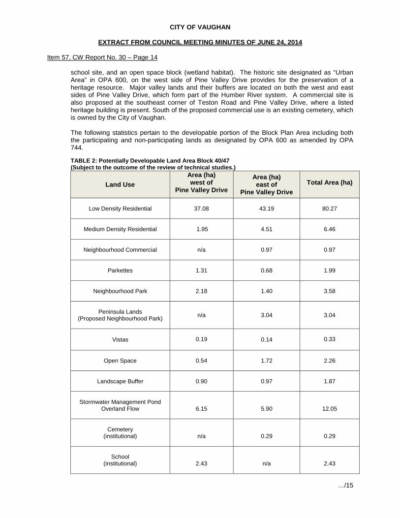
CITY OF VAUGHAN
EXTRACT FROM COUNCIL MEETING MINUTES OF JUNE 24, 2014
Item 57, CW Report No. 30 – Page 14 school site, and an open space block (wetland habitat). The historic site designated as “Urban Area” in OPA 600, on the west side of Pine Valley Drive provides for the preservation of a heritage resource. Major valley lands and their buffers are located on both the west and east sides of Pine Valley Drive, which form part of the Humber River system. A commercial site is also proposed at the southeast corner of Teston Road and Pine Valley Drive, where a listed heritage building is present. South of the proposed commercial use is an existing cemetery, which is owned by the City of Vaughan. The following statistics pertain to the developable portion of the Block Plan Area including both the participating and non-participating lands as designated by OPA 600 as amended by OPA 744.
TABLE 2: Potentially Developable Land Area Block 40/47 (Subject to the outcome of the review of technical studies.)
Land Use Area (ha) west of
Pine Valley Drive
Area (ha) east of
Pine Valley Drive
Total Area (ha)
Low Density Residential
37.08
43.19
80.27
Medium Density Residential
1.95 4.51
6.46
Neighbourhood Commercial
n/a 0.97
0.97
Parkettes
1.31
0.68
1.99
Neighbourhood Park
2.18
1.40
3.58
Peninsula Lands
(Proposed Neighbourhood Park)
n/a 3.04 3.04
Vistas
0.19
0.14
0.33
Open Space
0.54 1.72
2.26
Landscape Buffer
0.90 0.97
1.87
Stormwater Management Pond
Overland Flow
6.15
5.90
12.05
Cemetery
(institutional)
n/a
0.29
0.29
School
(institutional)
2.43
n/a
2.43
…/15

CITY OF VAUGHAN
EXTRACT FROM COUNCIL MEETING MINUTES OF JUNE 24, 2014
Item 57, CW Report No. 30 – Page 15
Land Use Area (ha) west of
Pine Valley Drive
Area (ha) east of
Pine Valley Drive
Total Area (ha)
Roads and
Road Widening(s)
15.26 12.96
28.22*
Total 67.99 75.77 143.76 * It should be noted that the amounts dedicated to land uses for the non-participating owners is an
estimate and conceptual.
The following chart outlines the proposed non-developable lands within the Block Plan owned by the Block 40/47 Developers Group Inc. The extent of the buffers and valley land is still under discussion with agencies and the Developers Group at this time.
TABLE 3: Non-Developable Land Area Block 40/47
Land Use Area (ha) west of
Pine Valley Drive
Area (ha) east of
Pine Valley Drive
Total Area (ha)
Valley Land
27.44
62.39
89.83
Valley Buffers
0.65 2.29
2.94
Wetland
n/a 0.73
0.73
Total
28.09 65.41
93.05
Although the site has been walked, in some areas the development limits are still subject to agency review and confirmation, which may impact the areas dedicated to each land use as shown in TABLE 2 and TABLE 3 above.
e. Land Use Distribution and Densities
The proposed Block Plan as shown on Attachment 4 – Proposed Block 40/47 Plan (dated May 25, 2014) was submitted to the City on May 26, 2014 and circulated on May 27, 2014. This version of the Block Plan shows the location of the residential, commercial, institutional, park and open space uses. It also depicts the proposed road pattern, stormwater management pond locations, landscape buffers, valley lands and valley land buffers as well as the location of the historic site, designated as “Urban Area” as per OPA 600 and a proposed park and infrastructure use for the Peninsula lands within the Humber River Valley. (See Special Provision Area 2 on Attachment 4.) The proposed residential uses have a combined area of 80.27 ha comprising approximately 33.47% of the participating and non-participating lands. The majority of residential development consists of single detached lots. The lots proposed for single detached dwellings have frontages ranging from 11.8m to 23 m in width. The townhouses have frontages of 6 m or 7.5m in width. The proposed overall density for the Block Plan area for the participating and non-participating landowners based on developable land is 6.45 units per hectare based on the total Block Plan Area of 239.78 ha. …/16

CITY OF VAUGHAN
EXTRACT FROM COUNCIL MEETING MINUTES OF JUNE 24, 2014
Item 57, CW Report No. 30 – Page 16 Open space areas, parks, parkettes, landscape buffers, and vistas comprise 13.07 ha (inclusive of the 3.04 ha of park proposed on the Peninsula lands) of the participating and non-participating landowner’s land holdings, and stormwater management pond/facilities comprise 12.05 ha for a total of 25.13 ha equivalent to 10.49% of the area. The non-developable valley lands, valley buffers, wetlands and the historic site designated as “Urban Area” in OPA 600 buffered by park uses, comprise a total of 96.03 ha (approximately 40%) of the subject lands as shown on Attachment 4 (not including the non-participating landowners properties).
f. Real Estate Division
The Vaughan Real Estate Division has had an opportunity to review the application and advises that the following condition will be imposed at the time of Draft Plan of Subdivision approval of the individual subdivision applications.
“Prior to final approval of the Plan, the Owner shall enter into a Developers’ Group Agreement with the other participating landowners within Block 40/47 to the satisfaction of the City. The agreement shall be regarding but not limited to all cost sharing for the provisions of parks, cash-in-lieu of parkland, road and municipal services within Block 40/47. This agreement shall also provide a provision for additional developers to participate with the developers’ Group Agreement when they wish to develop their lands. The Owner acknowledges that cash-in-lieu of parkland shall be paid in accordance with Section 42 of the Planning Act and conform to the City’s “Cash-In-Lieu of Parkland Policy”. If required, non-participating Owners shall pay additional cash-in-lieu to the City.
The requirement for this condition has been included in the Recommendation section of this report. g. Outstanding Issues, Agency Comments, Related Conditions
As a result of the circulation process, including the latest submission, issues have been identified that will require resolution. The following provides the background and basis for the recommended conditions as set out in Attachment 1.
i. Environmental Issues That Remain Outstanding
Over 70 specific comments related to environmental policies have been noted by the Policy Planning Division in consultation with the Toronto and Region Conservation Authority in the review of the Block Plan and MESP package submitted in 2013. Most of the comments relate to the need for more information to support the conclusions stated in the submitted documents. Other comments identify specific areas of concern with respect to the information provided in the submitted documentation. Below is a high-level summary of the remaining outstanding items.
• Stormwater management facilities (SWM Ponds #1 and #3) shall be kept outside of the
environmental features, unless the City, MNR and TRCA agree to a location and established criteria for permitting the pond within the feature.
• The limits of SWM Pond #2 and the wetland compensation area require additional detail,
such as an overlay on aerial images, to assess the ecological characteristics of the wetland habitat area.
…/17
CITY OF VAUGHAN
EXTRACT FROM COUNCIL MEETING MINUTES OF JUNE 24, 2014
Item 57, CW Report No. 30 – Page 17
• On May 14, 2014, a meeting took place with City staff, MNR, and TRCA and representatives of the Block 40/47 Group to discuss the overall stormwater management approach now that specific stormwater management measures have been discussed with the City Engineering Department. Follow-up discussions will be required.
• A revised slope stability report from Soil Engineers dated February 26, 2014 was
provided. The cross-section location plans provided in the report cannot be examined in detail to assess how grades are being matched at the development limits. More detail is required respecting the location of filling, grading and proposed retaining walls. These issues are more prevalent to the west side of the Block Plan area.
• A feature-based water balance for the headwater drainage features (HDFs) is provided
as part of the Stormwater Management Report (Volume 2 – Appendix C of the Block Plan/MESP submission). However, the results are not conclusive as the assessment was completed in the Spring of 2012 and at a time of insufficient rainfall to draw conclusions regarding flow regimes. The applicants did not provide access to the lands by the City’s consulting team on the NHN Study in 2013 to assess HDFs. The HDF assessment is required for HDFs to the west of the Block to assist in determining an appropriate location for SWM Pond #1, input to the overall stormwater management approach (such as providing clean roof runoff to HDFs), and input to determine development limits.
• An analysis of the lands adjacent to the Provincially Significant Wetland (PSW) units,
including data regarding the hydroperiod, has not been provided. The City has provided a framework for analysis of lands adjacent to wetlands in the latest detailed comments on the 2013 Block Plan/MESP submission. The analysis of the adjacent lands will provide input into the appropriate location for SWM Pond #1 to avoid impacts to the nearby PSW.
• The Studies and Criteria for the Peninsula lands, developed by the City and TRCA in
response to the Council resolution, is not specifically addressed in the revised EIS for the Peninsula lands. This information is required prior to the final approval of the Block Plan.
• The applicants rely on a buffer to the staked limits to mitigate impacts of the proposed
development and general statement that mitigation will be addressed at the detailed design stage, rather than providing a systematic treatment of potential impacts and possible mitigation measures as outlined in Appendix C of the Natural Heritage Reference Manual (OMNR 2010). Such an appendix is also provided in the 1999 version of the Natural Heritage Reference Manual.
The above referenced concerns, among others, have been refined and are now reflected as conditions in Attachment 1. Such conditions are required to be addressed prior to the final approval of the Block Plan, to the satisfaction of the City, the Toronto and Region Conservation Authority or other authority as may be specified.
ii. Development/Transportation Engineering
The Development/Transportation Engineering Department is satisfied with some elements of the Block 40/47 Block Plan and MESP. However, a number of comments remain outstanding and are required to be addressed as conditions of final Block Plan approval. The following issues remain outstanding and are required to be addressed through the Block Plan Approval process.
• General Comments: Based on the information provided to date, the following general comments must also be addressed prior to final Block Plan approval.
Maintenance access to the Peninsula lands is not currently shown on the Block Plan and shall be provided to the Peninsula lands;
…/18
CITY OF VAUGHAN
EXTRACT FROM COUNCIL MEETING MINUTES OF JUNE 24, 2014
Item 57, CW Report No. 30 – Page 18
A development and infrastructure phasing plan is required and shall identify infrastructure required to adequately service all phases of the Block Plan area;
The MESP shall identify any potential development charge projects associated with the servicing of the Block Plan;
The Developers Group shall contact the pertinent utility and telecommunications companies to coordinate the location of any major utility plant facility block (buried and/or surface);
All Regional works and infrastructure necessary to support the Block Plan area development shall be identified in the MESP;
Additional grading detail required on the south limit of the Omega Lands Draft Plan of Subdivision File 19T-06V12; and,
A final complete MESP document (including a digital copy) shall be submitted for Engineering staff review and record. This is required as a condition of Block Plan Approval and prior to approval of the first plan of subdivision in Block 40/47;
• Water Distribution: Future external areas such as Block 41 should be identified
and accommodated in the water analysis/design for the subject lands. The Developers Group is required to update the water analysis/design to take into account external developable lands immediately north of Teston Road.
Additional detailed information respecting infrastructure phasing shall be provided. The Developers Group, through the required submission, must demonstrate that adequate supply and proper looping (two feeds) are available and provided for through all phases of development, and that City design criteria will be achieved. A phasing plan is required identifying the skeleton servicing for each phase. It should be noted that infrastructure phasing shall take into account non-participating landowners and external benefitting lands. Furthermore, the proposed Water Distribution system shall be revised to provide for the extension of a watermain through Block 47 to Teston Road in accordance with the City’s Water/Wastewater Master Plan. It should be noted that, segments of this watermain, external to the plan and at the proposed valley crossing within Block 40 North may be eligible for City Development Charge Credits.
• Sanitary Servicing: The Revised Servicing Report prepared by EMC Group LTD. dated
April 2013 requires revision to reflect the latest amendment to the sanitary system for Block 40S. Additional information respecting sanitary servicing for the subject lands is also required. The information required includes but is not limited to, an outline of the future external drainage areas for Blocks 55 and 41 tributary to the Pine Valley North Pumping Station should be identified and accommodated in the proposed Sanitary Sewer and Pumping Station design for the Block. A phasing plan identifying the required skeleton servicing for each phase is required and shall take into account the non-participating landowners and external benefitting lands. A sanitary drainage plan, and profile drawings are all required prior to final Block Plan approval, and to the satisfaction of the City of Vaughan Development/Transportation Engineering Department.
• Stormwater Management: A number of Stormwater Management comments were addressed through the MESP. However, the issue of road drainage remains outstanding and requires resolution prior the final Block Plan Approval. Road drainage from Teston Road and Pine Valley Drive should be accommodated in the Block 40/47 stormwater management pond design. Clarification is also required respecting the post –development drainage areas for each pond. A condition has been included in Attachment 1 of this report requiring all stormwater management ponds to be sized to accommodate the drainage from the potential widening/urbanization of Teston Road and Pine Valley Drive to the satisfaction of the City.
…/19

CITY OF VAUGHAN
EXTRACT FROM COUNCIL MEETING MINUTES OF JUNE 24, 2014
Item 57, CW Report No. 30 – Page 19
iii. Traffic and Transportation
Development/Transportation Engineering staff had an opportunity to meet with representatives of the Block 40/47 Developers Group to discuss comments respecting traffic and transportation. It is imperative that a good pedestrian system be in place to support safe pedestrian connectivity within the neighbourhoods. Sidewalks shall be designed and provided to meet the minimum requirements of the City’s sidewalk policy. Development/Transportation Engineering staff have reviewed the Transportation Management and Sidewalk Plan, dated May 2014, and are satisfied that it addresses all outstanding issues. The Plan includes sidewalks on at least one side of the majority of roads, and several bike lanes providing connections to destinations, such as to the school and parks; and exceeds the minimum requirements of the City’s policy. The Transportation Management and Sidewalk Plan has been attached to this report (see Attachment 6) and Recommendation 7 referencing the Plan has been included for Council’s approval.
iv. Cultural Heritage
A number of properties in the Block 40/47 Plan area are considered culturally significant in respect of their archaeological, built heritage and heritage value.
• Archaeological Assessments: Prior to Block Plan approval, the Owners are required
to satisfy archaeological concerns raised by the Ministry of Tourism, Culture and Sport and the City. Currently, the Ministry is waiting for information respecting 6 sites situated within the Block 40/47 Plan area. Final reports for 2 sites are outstanding; Stage 4 investigations for three sites in addition to the historic site designated as “Urban Area” are also outstanding. As a result of the outstanding information respecting Archaeological Resources, a number of conditions have been included in Attachment 1 to this report which are required to be satisfied prior to final Block Plan Approval.
• Built Heritage Assessments: The Developers Group has submitted Cultural Impact
Assessment reports for the following properties:
4333 Teston Road, 10460 Pine Valley Drive, 10640 Pine Valley Drive: The Cultural Resource Impact Assessment reports for the above noted properties were submitted through the Block Plan review process for the 3 properties being noted and were found to be satisfactory. Further recommendations included commemorating the family names of Stump and Witherspoon respecting 10460 and 10640 Pine Valley Drive, respectively, as well as, the Purpleville hamlet name. These matters will be addressed through the Draft Plan of Subdivision or Site Plan processes.
10733 Pine Valley Drive: The former Purpleville Post Office located at 10733
Pine Valley Drive is registered under Part IV Section 27 of the Ontario Heritage Act. In order to fulfill the minimum requirements of the Cultural Heritage Resource Impact Assessment report the Developers Group shall include in the report a comprehensive review of Avoidance Mitigation options, the feasibility of retention in situ, adaptive reuse options and a determination respecting the future use of the subject heritage resource. Furthermore, the report shall also include a comprehensive review if the Salvage Mitigation options, including the feasibility
…/20

CITY OF VAUGHAN
EXTRACT FROM COUNCIL MEETING MINUTES OF JUNE 24, 2014
Item 57, CW Report No. 30 – Page 20 of relocation within the existing site or to another location within the subject development. The report should also investigate and consider the context of the existing structure as it relates to the Purpleville cemetery, any potential cultural value of or within adjacent lands that once formed the area of Purpleville.
10699 Pine Valley Drive: It should be noted that a Cultural Heritage Resource
Impact Assessment report is also required for 10699 Pine Valley Drive. The required report shall be submitted, reviewed and approved prior to final Block Plan approval.
3911 Teston Road: Is the property of a non-participating landowner. This
property will require a Cultural Heritage Resource Impact Assessment, should it ever be proposed for development. It cannot however, be required through the current process as the landowner is not subject to the application.
Heritage Impact: The Developers Group is required to submit a revised Heritage Impact
Assessment for the area east of the Humber River tributary prior to consideration of any draft plans of subdivision for approval in order to assess the area to determine if it constitutes a cultural heritage landscape.
Conditions for final approval of the Block 40/47 Plan respecting the outstanding Cultural Heritage requirements have been included in Attachment 1 to this report.
v. Urban Design
The Vaughan Planning Department – Urban Design/Cultural Heritage Division has reviewed the supporting documents for Block 40/47. Staff is satisfied with the general land uses and design of the subdivisions as reflected in the revised Block 40/47 Plan as shown on Attachment 4, with the exception of the Peninsula lands. This is subject to the following conditions which can be addressed through further studies and through the Draft Plan of Subdivision process for the 6 active draft plans now under review. The following documents will need to be submitted, reviewed and approved to the satisfaction of the Urban Design/Cultural Heritage Division.
• Urban Design & Sustainable Development Guidelines; • Architectural Control Design Guidelines; and • Landscape Master Plan
The required documents noted above shall address but not be limited to the following issues:
• Sustainable development features; • Community edge treatments and landscape buffers; • Community gateways, entry features, enhanced intersections and interpretive signage
related to heritage site designated as “Urban Area” in OPA 600 and the Humber River; • Community areas and preliminary park block designs and facility fits; • Storm water management pond landscaping; • Open space lands & woodlots edge restoration and management; • Open space lands trail network systems, connections, and trailheads/vistas/staging
areas; • Coordination of the pedestrian network with the transportation management plan; and • Coordination of streetscape elements including fencing treatments and street tree
planting.
…/21

CITY OF VAUGHAN
EXTRACT FROM COUNCIL MEETING MINUTES OF JUNE 24, 2014
Item 57, CW Report No. 30 – Page 21
vi. Parks Development
The proposed Block 40/47 Plan as shown on Attachment 4 shows 3 Neighbourhood Parks within the block plan boundary, including the proposed park on the Peninsula lands, and 2 parkettes. The two Neighbourhood Parks (including the Peninsula lands) located in Block 40, east of Pine Valley Drive, have a total area of 4.44 ha. The Neighbourhood Park located west of Pine Valley Drive in Block 47 directly to the south of the elementary school site, has an area of 2.18 ha. Also located in Block 40/47 are 2 proposed parkettes. In Block 47, the 1.31 ha parkette is positioned adjacent to the historic site designated as “Urban Area” in OPA 600 and the parkette in Block 40 is located between the Valley lands and Street 19 with an area of 0.68 ha.
The proposed Block 40/47 Block Plan (Attachment 4) was reviewed by the Parks Development Department, in consideration of OPA 600 as amended by OPA 744 and the Active Together Master Plan, 2013 (ATMP), which outlines the City’s vision for the provision of parkland. The ATMP identifies current needs and future facility provision strategies that are consistent with the City’s commitment to providing safe, accessible and community-responsive parks and facilities.
One of the key themes identified in the ATMP is to maximize the provision of parkland in new developments in order to achieve the per capita target of 2.2 ha of active parkland per 1000 population. The ATMP also identifies the need to secure appropriate park sites to allow development of new facilities including but not limited to soccer fields (an additional 38 fields are required City-wide), multi-use fields, tennis courts (an additional 25 are required), basketball courts (an additional 15 are required) skate parks (an additional 3 are required), skate zones (a minimum of an additional 5 are required) and water-play facilities (an additional 13 are required) for the City overall. Furthermore, with respect to play areas, the ATMP also recommends that playgrounds be provided within 500 m of all residences and be unobstructed by major pedestrian impediments such as highways, major arterial roads, waterways, valleys etc.
• Proposed Neighbourhood Park in Block 47: Based on the ATMP and other criteria for
the planning of parkland, staff has conducted a review of the proposed Block 40/47 Plan and concluded that the park situated west of Pine Valley Drive (Block 47) and south of the proposed elementary school site is satisfactory. The proposed 2.18 ha Neighbourhood Park satisfies the requirements for a programmable park that it is situated within walking distance of residential areas and provides the opportunity to achieve a balance of active and passive uses as a result of its location and size. However, upon further review minor changes to the size of the park may be required subject to the outcome of the facility fit plans and technical reviews.
• Proposed Parkette in Block 47: The 1.31 ha parkette that is located adjacent to the
historic site designated as “Urban Area” in OPA 600, is not considered suitable for development as an active park. This parcel is best suited for passive uses and essentially acts as a buffer/transition between the residential development and the historic site designated as “Urban Area” in OPA 600. The proposed parkette block will require further design development through a Landscape Master Plan in order to determine an appropriate interface with the Urban Area and to determine the extent of the creditable parkland.
• Proposed Neighbourhood Parks and Parkettes in Block 40: Additional information
from the Developers Group is required respecting the proposed neighbourhood parks on the east side of Pine Valley Drive (Block 40), with the exception of the proposed approximately 3.04 ha park on the Peninsula lands which will be discussed in the following section. Further review is needed before the proposed park and parkette can be considered as active parkland and eligible for parkland credit. Staff has provided conditions of approval for the Neighbourhood Parks and Parkette in Block
…/22

CITY OF VAUGHAN
EXTRACT FROM COUNCIL MEETING MINUTES OF JUNE 24, 2014
Item 57, CW Report No. 30 – Page 22 40. The conditions contained in Attachment 1 outline requirements for the neighbourhood parks in question including facility fit plans and conceptual designs for each location. Changes to the size of the parks may be required subject to the outcome of the review of the facility fit plans and outcome of technical reviews. The additional information will assist in assessing the feasibility and most appropriate type of programming for each park. Final approval of the parks in Block 40 shall be to the satisfaction of the Parks Development Department.
• The Peninsula Lands: The proposed 3.04 ha park located on the lands referred to as
the Peninsula lands is not considered functional or suitable as active parkland and should not be considered for parkland dedication credit. Furthermore, developing the Peninsula lands as a Neighbourhood Park does not comply with the existing policies of OPA 600 as amended by OPA 744. General concerns include:
For a Neighbourhood Park it is not central to the neighbouhood it serves. The proposed park has no street frontage or community visibility which raises
safety and security issues (CPTED), as required by City policy. The proposed park will be encumbered by a sanitary sewer easement. The shape of the proposed park may limit the ability to program the site. Access to the proposed park is very limited and a significant amount of
infrastructure will need to be built and maintained (bridge and access road) to provide the sole access to the site.
The surrounding valley lands are environmentally sensitive and access for human use, including trail development, is prohibited.
Section 4.2.5 of OPA 600 identifies Open Spaces as lands designated within valley and stream corridors, natural areas including woodlots, environmentally significant areas (ESAs), areas of natural and scientific interest (ANSIs), wetlands etc., and areas designated for environmental protection and enhancement, which is a more suitable description of the Peninsula lands. In keeping with this description, the Peninsula lands are identified on Schedule “A” of OPA 600 as major open space and valley lands. However, on April 17, 2012, Council approved a modification to VOP 2010 allowing changes to lands designated “Major Open Space and Valleyland” in OPA 600 subject to the determination that potential for developable land has been identified through the submission of a required set of studies based on a developed criteria and subject to the review of the Toronto and Region Conservation Authority (TRCA) and the City. This language has been replicated in OPA 744. The study and criteria requirement apply to the potential development of the Peninsula lands and have not been fulfilled. As a result of the outstanding information, a determination of the appropriate use, or if development of any kind is possible, cannot be made at this time. As any proposed use or development on the peninsula depends so heavily on the submission and review of the studies and criteria, a condition has been included in Attachment 1 of this report requiring the work to be completed, submitted, reviewed and approved prior to any additional consideration of the Peninsula lands for park purposes. If determined through the review of the studies and criteria that the Peninsula lands are not appropriate for development of any kind they will remain a part of the valley lands. It should be noted that the ATMP recommends that undevelopable open space lands, such as valley lands, hazard lands and areas encumbered by underground servicing, not be accepted as parkland. An alternative to developing the lands would be leaving them in their semi-natural state. Should they choose to do so, the Developer’s Group can bring forward a proposal for the consideration of the City, TRCA, or Region of York, or other conservation organization such as a land trust to purchase the Peninsula lands as passive open space.
…/23

CITY OF VAUGHAN
EXTRACT FROM COUNCIL MEETING MINUTES OF JUNE 24, 2014
Item 57, CW Report No. 30 – Page 23
In light of the various issues related to the Peninsula lands, staff have referenced these lands on the Block 40/47 Plan as “Special Provisions Area 2”, which will require further review in relation to outstanding and unknown information included but not limited to the studies and criteria, the determination of an appropriate land use, the finalization and consensus on development limits, and feasibility and potential consideration of the City, other agencies or bodies purchasing the lands.
vii. Institutional
The proposed 2.43 ha school site is slated for use by the York Catholic District School Board (YCDSB). The YCDSB has reviewed the Block Plan and is satisfied with the size and location of the site and will be providing conditions of approval through the Draft Plan of Subdivision Process, for the 1387700 Ontario Inc., Roybridge Holdings Inc., Lindvest ZZen Properties (Pinevalley) Draft Plan of Subdivision (File 19T-03V25). Relationship to Vaughan Vision 2020/Strategic Plan The recommendations in this report are consistent with Vaughan Vision 2020 by demonstrating the following goals and objective: Service excellence:
Promote Community Safety, Health and Wellness – To promote healthy lifestyles and encourage a high quality of life, well-being and the safety of residents.
Lead and Promote Environmental Sustainability – to preserve, protect and enhance
Vaughan’s natural and built environment through responsible leadership and innovative policies, practices and education.
Preserve our Heritage and Support Diversity, Arts and Culture – To support Vaughan’s
diverse heritage through community and cultural initiatives.
Regional Implications The Block Plan has been prepared in consultation with York Region. Regional implications may include additional refinement to the municipal water and wastewater servicing networks. A future revision to the Block Plan may be required as a result of the Regional Class Environmental Assessment currently underway for this segment of Teston Road. One outcome of the EA may be the realignment of Teston Road at Pine Valley Drive. A condition of approval has been included to address this matter. Upon Regional approval of OPA 744, the City will be able to proceed to consider for approval the implementing draft plans of subdivision. Upon Regional approval of OPA 744 and clearance of conditions of Block Plan approval, the City will be able to proceed with the implementing draft plans of subdivision. However, Public Hearings and government and agency review are necessary for the six implementing draft plans of subdivision.
Conclusion
This conditional approval is part of a series of steps that are required to effect the development of this Block Plan. In this instance an intermediate step has been added which will result in a conditional approval of the Block Plan. For the planning of this block to continue a further report to Council explaining how the conditions have been fulfilled and any resulting changes to the Block Plan will need to occur prior to the consideration of the draft plans of subdivision. Much of this work can be done concurrently with the review of the already submitted draft plans of subdivision and zoning amendment applications. …/24

CITY OF VAUGHAN
EXTRACT FROM COUNCIL MEETING MINUTES OF JUNE 24, 2014
Item 57, CW Report No. 30 – Page 24 Staff is of the opinion that the proposed Block Plan (Attachment 4) provides a basis for proceeding, subject to the landowners fulfilling the recommended conditions of approval for the Block Plan, as set out in Attachment 1. This report also recommends modifications to OPA 744 which is currently at York Region for approval. The purpose of the modification is to assist in resolving potential land use compatibility issues that have been identified at the southern boundary of the Block 47 portion of the Block Plan. This area has been specifically identified on Attachment 4 as “Special Provision Area 1”. A second area will be the focus of further work. The Peninsula Lands have been identified as “Special Provision Area 2”. More detailed examination will be required for this parcel to determine its ultimate land use. The outcome of this work may require modifications to the Block Plan which may need to be reflected in the draft plans of subdivision. On this basis it is recommended that the City proceed with the conditional approval of the Block Plan in the manner set out in the “Recommendation” section of this report.
Attachments
1. Conditions of Approval 2. Context Location Map 3. Location Map 4. Proposed Block 40/47 Plan 5. Land Ownership Plan 6. Transportation Management Plan 7. Revised Schedule 1 to OPA 744
Report prepared by: Arminé Hassakourians, Planner, ext. 8368
(A copy of the attachments referred to in the foregoing have been forwarded to each Member of Council and a copy thereof is also on file in the office of the City Clerk.)


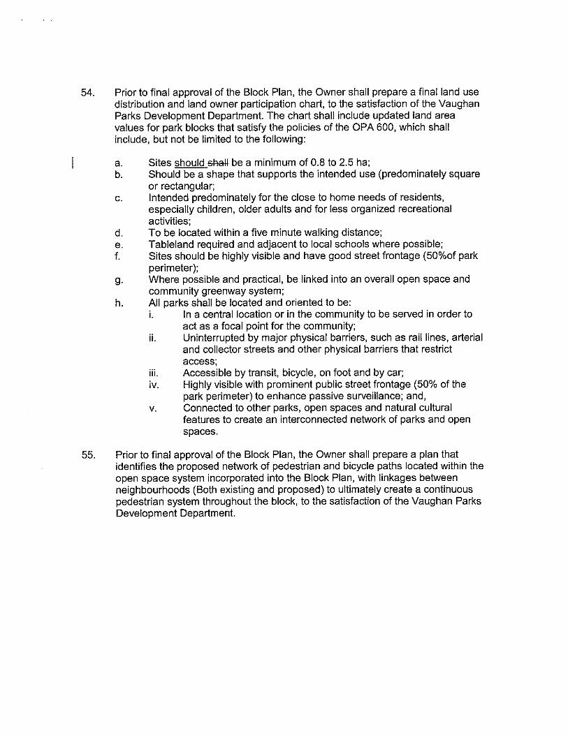
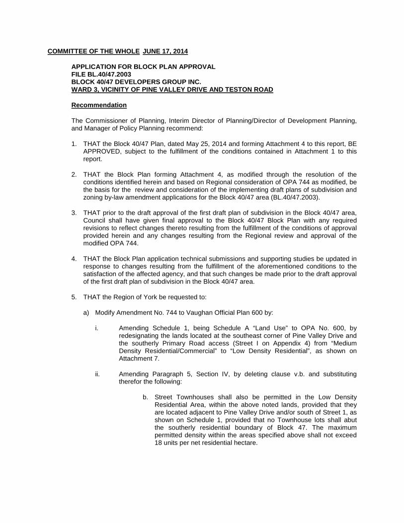
COMMITTEE OF THE WHOLE JUNE 17, 2014
APPLICATION FOR BLOCK PLAN APPROVAL FILE BL.40/47.2003 BLOCK 40/47 DEVELOPERS GROUP INC. WARD 3, VICINITY OF PINE VALLEY DRIVE AND TESTON ROAD
Recommendation
The Commissioner of Planning, Interim Director of Planning/Director of Development Planning, and Manager of Policy Planning recommend:
1. THAT the Block 40/47 Plan, dated May 25, 2014 and forming Attachment 4 to this report, BE APPROVED, subject to the fulfillment of the conditions contained in Attachment 1 to this report.
2. THAT the Block Plan forming Attachment 4, as modified through the resolution of the conditions identified herein and based on Regional consideration of OPA 744 as modified, be the basis for the review and consideration of the implementing draft plans of subdivision and zoning by-law amendment applications for the Block 40/47 area (BL.40/47.2003).
3. THAT prior to the draft approval of the first draft plan of subdivision in the Block 40/47 area, Council shall have given final approval to the Block 40/47 Block Plan with any required revisions to reflect changes thereto resulting from the fulfillment of the conditions of approval provided herein and any changes resulting from the Regional review and approval of the modified OPA 744.
4. THAT the Block Plan application technical submissions and supporting studies be updated in response to changes resulting from the fulfillment of the aforementioned conditions to the satisfaction of the affected agency, and that such changes be made prior to the draft approval of the first draft plan of subdivision in the Block 40/47 area.
5. THAT the Region of York be requested to:
a) Modify Amendment No. 744 to Vaughan Official Plan 600 by:
i. Amending Schedule 1, being Schedule A “Land Use” to OPA No. 600, by redesignating the lands located at the southeast corner of Pine Valley Drive and the southerly Primary Road access (Street I on Appendix 4) from “Medium Density Residential/Commercial” to “Low Density Residential”, as shown on Attachment 7.
ii. Amending Paragraph 5, Section IV, by deleting clause v.b. and substituting therefor the following:
b. Street Townhouses shall also be permitted in the Low Density Residential Area, within the above noted lands, provided that they are located adjacent to Pine Valley Drive and/or south of Street 1, as shown on Schedule 1, provided that no Townhouse lots shall abut the southerly residential boundary of Block 47. The maximum permitted density within the areas specified above shall not exceed 18 units per net residential hectare.

iii. Amending Paragraph 6, Section IV by adding the following clause xv:
xv. Compatibility with adjacent Rural Uses
Residential Uses, as provided for in this Plan, shall be developed in a manner that is compatible with adjacent Rural/Agricultural Uses. Measures to ensure compatibility will be considered and implemented through the draft plan of subdivision/zoning approval processes. Such measures may include: the provision of buffer areas, landscaping and screening, increased building setbacks, sympathetic massing and architectural treatments and grading measures that minimize the use of retaining structures.
iv. Amending Section iv, Paragraph 7, by deleting clause d.ii.
6. THAT at the time of consideration of the implementing draft plans of subdivision the following condition of approval shall be applied to all draft plans of subdivision in the Block 40/47 area:
Prior to final approval of the Plan, the Owner shall enter into a Developers’ Group Agreement with the other participating landowners within Block 40/47 to the satisfaction of the City. The agreement shall be regarding but not limited to all cost sharing for the provisions of parks, cash-in-lieu of parkland, road and municipal services within Block 40/47. This agreement shall also provide a provision for additional developers to participate with the Developers’ Group Agreement when they wish to develop their lands.
The Owner acknowledges that cash-in-lieu of parkland shall be paid in accordance with Section 42 of the Planning Act and conform to the City’s “Cash-In-Lieu of Parkland Policy”. If required, non-participating Owners shall pay additional cash-in-lieu to the City.
7. THAT the Block 40/47 Transportation Management and Sidewalk Plan, dated May 2014, forming Attachment 6 to this report be APPROVED, subject to the Conditions attached hereto as Attachment 1 of this report.
Contribution to Sustainability The proposed Block Plan is consistent with Green Directions Vaughan through the following:
Goal 2: To ensure sustainable development and redevelopment.
Goal 3: To ensure that Vaughan is a City that is easy to get around with low environmental impact.
Economic Impact There is no direct financial impact arising from this report provided the recommendations and conditions are endorsed by Council. The Block Plan is a major step in the City’s development approval process providing for the completion of the residential component of the Vellore Community area, as defined in OPA 600. The plan will provide for additional lands for ground related residential development and supporting commercial uses. The services referenced in this report will be constructed by the developer in accordance with City standards and requirements.
Communications Plan On January 31, 2014, a notice of Public Hearing was circulated to all property owners within 200 metres of the subject lands including the property owners within the boundary of the Block Plan notifying them and other interested individuals and groups such as the Kleinburg and Area

Ratepayers Association and the Millwood Woodend Ratepayers Association of the February 25, 2014 Public Hearing respecting the Block 40/47 Plan. On February 3, 2014, the Notice of Public Hearing was also posted on the Policy Planning webpage, which is accessible through the City of Vaughan’s official website www.vaughan.ca. The notice was also advertised on the “City Page Online”, which is also accessible through the City’s official website and posted on the City Update E-Newsletter and on the City’s Twitter and Facebook accounts. As a result of the notification, a number of responses were received. For the most part, the majority of responses were requesting clarification of the distribution of the land uses. These requests were addressed by e-mailing a colour copy of the Proposed Block 40/47 Plan to those requesting the information. However, two letters were received detailing concerns respecting the proposed block plan from neighbouring property owners and a non-participating landowner. These letters will be discussed in further detail, in a separate section titled Comments Received from the Public, later in this report. The recommendation of the Committee of the Whole to receive the Public Hearing report of February 25, 2014, and to prepare a comprehensive technical report for a future Committee of the Whole meeting was ratified by Vaughan Council on March 18, 2014.
Purpose
The purpose of this report is to obtain Block Plan approval for the Block 40/47 Plan (Attachment 4), subject to the conditions identified in Attachment 1. The Block 40/47 Plan has an area of approximately 239.78 ha in size and proposes the following uses:
• A total of 1,405 residential units; • 1,242 residential lots for single detached residential dwellings with lot frontages ranging
between 11.8 m to 23 m in width; • 14 freehold residential townhouse blocks containing 59 street townhouse units having a
minimum lot frontage 6 m and 17 street townhouses with a minimum lot frontage of 7.5 m; • 1 medium density residential/commercial block potentially for use as a block townhouse
development containing 87 block townhouse units; • A 2.43 ha elementary school block; • 5 parks (2 parkettes and 3 neighbourhood parks) having a combined area of 8.62 ha; • 1 neighbourhood commercial block; • 3 stormwater management ponds; • An internal road network consisting of collector and local streets; • Vista blocks (Valley edge viewing areas); • Open space; and, • Valley lands and buffers
Background - Analysis and Options
1. Location The subject lands as shown on Attachment 2 are located in Ward 3 on the south side of Teston Road, east and west of Pine Valley Drive, north of Cold Creek, in Part of Lots 23, 24, and 25, Concessions 6 and 7, City of Vaughan.
2. Comments Received from the Public
As a result of the Public Notification process, the Policy Planning Division received 2 e-mails requiring follow-up responses as opposed to those discussed in the Communications section.

The first response to the Public Hearing Notice was dated February 20, 2013 from a non-participating landowner representing the Teskey and Finley properties as shown on Attachment 5. The e-mail was a request for additional notification and information on a number of matters relating to the Block Plan approval process. Staff prepared and provided a written response addressing all the inquiries outlined in the February 20, 2014 correspondence and has included this landowner on the Block 40/47 notification list. The second correspondence was sent to the City on February 24, 2014 on behalf of the landowners who live along the southeast boundary of the Block 40/47 area with lands fronting onto Pine Valley Drive. The residents noted concerns relating to 3 primary issues:
• The location of the “Medium Density Residential/Commercial” designation along the
south boundary of Block 47 (the Omega Lands Draft Plan of Subdivision 19T-06V12) • The location of Stormwater Management Pond #2 • The proposed development limits as it relates to erosion mitigation
As the listed issues also related to the adoption of Official Plan Amendment 744, staff met with representatives from the Region and the residents on May 5, 2014 to discuss their concerns. Subsequent meetings were held in an effort to address the neighbouring residents concerns. Compatibility issues associated with these lands are discussed later in this report in sub-section 6 a.ii. “Official Plan Amendment No. 744”. 3. Land Ownership There are 13 private landowners in the Block 40/47 Plan area. Including the City of Vaughan, there are a total of 14 properties, having a total area of approximately 239.78 ha. Of the 13 private land holdings 6 are participating in the preparation of the Block Plan, and represent 87% of the total area of the Block Plan. 4. Non-Participating Landowners
There are 8 non-participating landowners, including the City of Vaughan totaling 13% (31.75 ha) of the total block plan area. Section 10.2 (xi) of OPA 600 references the role of the non-participating landowners by stating:
“Where landowners within a concession block choose not to participate in seeking development approval for their lands at the time of preparation of the Block Plan by other land owners in the concession block, their lands shall be shown conceptually as in the schedules of this Plan. Subsequent amendments to the Block Plan may be required before such lands are considered for development.”
For this reason, the non-participating landowner’s properties have been shown on the Block Plan, as shown on Attachments 4 and 5. However, the non-participating lands have not been subject to review. As such, the limits of development cannot be determined at this time without the necessary technical submissions and a site walk involving City staff, TRCA and an Ontario Land Surveyor to stake the development limits. Although the non-participating landowners are not obligated to prepare a plan of their lands for development at this time, it should be noted that Subsection 10.2 policy (x) of OPA 600 provides the following guidance with respect to future cost-sharing matters:
“The City encourages property owners to contribute their proportionate share towards provision of major community and infrastructure facilities such as schools, parks, greenways, roads and road improvements, external services, and stormwater management facilities. Property owners will be required to enter into one or more

agreements as a condition of development approval, providing for the equitable distribution of the costs of the local and community facilities.”
The initial version of the Block 40/47 Plan proposed a conceptual road and lotting pattern on the non-participating lands in respect to the eastern portion of the Block Plan area (Block 40). At the request of the City, the current plan depicts these lands as “Valley Lands” and “Low Density Residential” in keeping with OPA 600 as amended by OPA 744, the latter of which is currently subject to approval by the Region of York. This was done in order to limit the confusion respecting the role of the non-participating landowners under the Block Plan process. The development limits cannot be determined until the non-participating properties have been walked and staked with the TRCA and an Ontario Land Surveyor, and the stable top-of-bank has been determined and confirmed by the TRCA. Showing a road and lotting pattern, however conceptual, may be misleading. It should be noted that the previously discussed sections of OPA 600 as amended by OPA 744 still apply regardless of the fact that conceptual development has been eliminated from the plan. Assumptions respecting the residential yield and the densities for non-participating lands have been considered when necessary to allow for long range planning. Should any of the non-participating landowners choose to develop their lands, a subsequent amendment to the Block Plan will be required before or coincident with the consideration of the implementing draft plan of subdivision and zoning amendment applications.
5. Developers’ Group Agreements Developers’ Group Agreements are integral parts of the Block Plan process. They provide a mechanism to ensure that developers share the costs and benefits of developing in accordance with the approved Block Plan. As discussed above and in OPA 600 it is the policy of the City to encourage property owners to contribute their proportionate share to the provision of major community and servicing infrastructure facilities such as schools, parks, greenways, roads and road improvements, external services and stormwater management facilities. Participating property owners through the Block Plan process and later as a condition of draft plan of subdivision approval will be required to enter into one or more agreements, providing for the equitable distribution of the costs of the land and community facilities and infrastructure. This also applies to landowners who were not originally participating, who choose to develop at a later date. 6. Policy and Planning Context
a. Official Plan
i. Official Plan Amendment No.600 OPA 600 was adopted by Vaughan Council on September 25, 2000 and was approved by the Region of York on June 29, 2001. OPA 600 designates the subject lands “Urban Area” and “Valley Lands” forming part of Vellore Urban Village 1. The following site-specific policies pertained to the subject lands:
• The lands shall be the subject of a comprehensive plan providing the technical basis to support secondary plan land use designations consistent with the planning approach of OPA 600;
• The lands will be planned for predominately ‘executive housing’ on large lots with
full municipal services; • The gross density within the designated area shall be between 5 and 7.5 units per
hectare; and,

• The projected housing unit yield is 1,000 low density units to accommodate a
population of 3,490.
OPA 600 further requires that the secondary plan area be developed by way of Block Plan approval and provides policies on what is to be included in the Block Plan review process. ii. Official Plan Amendment No.744
OPA 744 is the site-specific official plan amendment to OPA 600 resulting from the Official Plan Amendment application submitted by the Block 40/47 Developers Group Inc. (File OP.03.008). Official Plan Amendment Application OP.03.008 was approved by Vaughan Council on December 10, 2013. The implementing amendment (OPA 744) was adopted by Council on February 18, 2014 and is now subject to York Region approval.
OPA 744 redesignates the subject lands from “Urban Area” and “Valley Lands” to “Low Density Residential”, “Valley Lands”, “Medium Density Residential-Commercial”, “Stormwater Management Ponds”, “Neighbourhood Commercial Centre”, “Parks”, “Elementary School”, “Institutional”, “Greenway System” and “Urban Area”. It fulfills the requirement for a Secondary Plan as required by OPA 600.
OPA 744 provides for an increase to the gross density, ranging from 5 to 11 units per hectare, calculated on the basis of the developable area. Other notable policies in OPA 744 include:
• A minimum net residential density on any site shall be 11 units per net residential hectare.
• The maximum net residential density on any site shall be 40 units per hectare, with
the exception of lands at the southeast corner of Pine Valley Drive, and Teston Road where a maximum net density of 80 units per hectare and stacked townhouses and low rise apartment buildings to a maximum building height of 5 storeys shall be permitted.
A number of environmental policies were also included in OPA 744 which are required to be addressed as conditions of approval through the Block Plan or development application processes. Special Provision Area 1 As a result of discussions with the landowners to the south of the Block 40 Block Plan boundary, modifications to OPA 744 are being recommended to address compatibility issues raised by nearby landowners. One such measure is providing for the relocation of the townhouses by eliminating the “Medium Density Residential/Commercial” designation from the southern property line of the Omega Developments draft plan of subdivision (File 19T-06V12) and boundary of the Block Plan area. The policy has been amended to permit Townhouses south of Street 1, as shown on Attachment 7 (Schedule 1 to OPA 744), provided that no Townhouse lots are permitted abutting the lands to the south. Therefore, Schedule 1 to OPA 744 requires modification to permit the relocation of the street Townhouse units by way of elimination of the Medium Density Residential/Commercial designation and permitting townhouses south of Street 1, but not abutting the rural/agricultural lands to the south. The following revisions to the text of OPA 744 will provide the flexibility to address the relocation of the Street Townhouses by:
“Amending Paragraph 5, Section IV, by deleting clause v.b. and substituting therefor the following:

b. Street Townhouses shall also be permitted in the Low Density
Residential Area, within the above noted lands, provided that they are located adjacent to Pine Valley Drive and/or south of Street 1, as shown on Schedule 1, provided that no Townhouse lots shall abut the southerly residential boundary of Block 47. The maximum permitted density within the areas specified above shall not exceed 18 units per net residential hectare.”
As a result of deleting the “Medium Density Residential/Commercial” designation from the lands located on the west side of Pine Valley Drive and south of the Primary Road, an additional policy respecting these lands no longer applies. Paragraph 7 which amends Section 4.2.1.3.1 can be modified to delete “d.ii. Notwithstanding Policy 4.2.1.3, commercial uses shall not be permitted within the “Medium Density Residential-Commercial designation located on the west side of Pine Valley Drive south of the Primary Road.” In addition, a policy has been added to OPA 744 to address the issue of transition and compatibility between the existing rural residential land uses and the proposed residential development to the north. Including the following clause in OPA 744 addresses this concern: “Amending Paragraph 6, Section IV by adding the following clause xv;
xv. Compatibility with Adjacent Rural Uses Residential Uses, as provided for in this Plan, shall be developed in a manner that is compatible with adjacent Rural/Agricultural Uses. Measures to ensure compatibility will be considered and implemented through the draft plan of subdivision/zoning approval processes. Such measures may include: the provision of buffer areas, landscaping and screening, increased building setbacks, sympathetic massing and architectural treatments and grading measures that minimize the use of retaining structures.”
The above noted modifications have been included in the Recommendation section of this report. Should Council concur with this modification, the revision to OPA 744 will be addressed through York Region’s approval process for the site-specific Official Plan Amendment as a requested modification to the adopted OPA 744 by the City of Vaughan. iii. Vaughan Official Plan 2010 (VOP 2010)
Official Plan Amendment File OP.03.008 was submitted prior to Vaughan Council’s adoption of VOP 2010. Therefore, the Official Plan Review was conducted under the policies of OPA 600 and is being processed as an amendment to OPA 600. Upon Regional approval of the proposed amendment (OPA 744), the approved Secondary Plan/Official Plan Amendment will be incorporated into Chapter 12 of VOP 2010, Volume 2 as an “Area Subject to an Area Specific Plan”. The landowners have appealed the Vaughan Official Plan specific to this Block Plan and upon Regional approval of the proposed amendment (OPA 744) it is expected that the appeals will be withdrawn.
iv. Provincial Policies The subject Official Plan amendment and Block Plan approval applications were submitted in advance of the Provincial Growth Plan for the Greater Golden Horseshoe – Places to Grow,

the Greenbelt Plan and the Provincial Policy Statement of 2005 and 2014. As such, the processing of this Plan continues under the Provincial Policies in effect at the time of the originating application.
b. Zoning The subject lands (including both the participating and non-participating landowners land holdings) are currently zoned A Agricultural Zone, OS1 Open Space Conservation Zone, OS2 Open Space Park Zone, and RR Rural Residential Zone. Each of the six participating landowners within the Block collectively referred to as the Block 40/47 Developers Group Inc. have submitted zoning by-law amendment applications to rezone their respective lands in keeping with the proposed draft plans of subdivision and the policies of OPA 744. Lands owned by the non-participating landowners will maintain their existing zoning and are not being considered for rezoning at this time. The existing zoning is shown on Attachment 3. The lands located at the southeast corner of Teston Road and Pine Valley Drive may be the subject of a Holding Provision as a result of the impending Environmental Assessment (EA) for Teston Road upgrades to be conducted by the Region (see Attachments 4 through 6). Should this be the case the Holding Provision can be addressed through the zoning application file Z.03.024 for Prima Vista Estates/840999 Ontario Inc. c. Draft Plans of Subdivision and Zoning By-law Amendment Applications All the participating landowners within the block have submitted applications for draft plan of subdivision and zoning by-law amendment. The following Table 1 outlines the information and status to date. TABLE 1: Draft Plan of Subdivision and Zoning By-law Amendment Applications
Owner
Draft Plan of Subdivision Application
File #
Zoning By-law Amendment Application
File #
Block
Location
1.
Maple Estates Inc. (Mosaik Pinewest Inc.)
19T-96V10
Z.06.058
Block 40 (east of Pine Valley Dr.)
2.
2097500 Ont. Ltd.
19T-07V01 Z.07.002
Block 40
(east of Pine Valley Dr.)
3.
Prima Vista Estates 840999 Ont. Inc.
19T-03V05 Z.03.024
Block 40
(east of Pine Valley Dr.)
4.
Liliana Damiani
19T-96V10 Z.14.010
Block 47
(west of Pine Valley Dr.)
5.
Omega Dev. (formerly known as Maria & Guiseppe Pandolfo)
19T-06V12 Z.06.064
Block 47 (west of Pine Valley Dr.)

Owner
Draft Plan of Subdivision Application
File #
Zoning By-law Amendment Application
File #
Block
Location
6.
1387700 Ont. Inc. Roybridge Holdings Inc. Lindvest Properties (Pinevalley)
19T-03V25
Z.03.017
Block 47 (west of Pine Valley Dr.)
The property ownerships are shown on Attachment 5, and reflect the boundaries of each draft plan of subdivision. Although the draft plans of subdivision and associated applications for zoning by-law amendment have been circulated to internal departments and external public agencies for comment, the applications will not move forward with technical reports to Committee of the Whole until such time as Council has had an opportunity to consider any changes to the Block Plan resulting from the fulfillment of the conditions of approval. In addition, it is important to note that draft plans of subdivision could not be considered for approval until the review and approval of OPA 744 by the Region of York. d. Existing Site Description
The Block Plan has a total area including the participating and non-participating landowner’s holdings of approximately 239.78 ha. The current land uses reflect a mix of agricultural and open space uses. The site is bisected by Pine Valley Drive, running north/south through the subject lands, which divides the limits of Block 40 and 47. The lands on the west side of Pine Valley Drive (Block 47) have a total area of 98.59 ha (97.05 owned by the participating landowners and 1.54 ha owned by non-participating landowners) and the lands to the east of Pine Valley Drive (Block 40) has a total area of 141.19 ha (110.98 ha owned by participating landowners and 30.21 ha owned by non-participating landowners). The area surrounding the subject lands consists primarily of lands zoned A Agricultural Zone having existing agricultural and open space uses as well as open space conservation lands. On the east side of Pine Valley Drive, south of the subject lands, the adjacent lands are zoned OS2 Open Space Park. Existing residential uses are found directly south of the OS2 zoning, (See Attachment 3). 7. The Block Plan Review a. Block Plan Process
Block Plan approval is a City initiated process established in the Official Plan, to coordinate the development of large blocks of land, with multiple owners. This review provides a level of certainty as to the form of development which will ultimately inform the subsequent draft plan of subdivision and zoning by-law amendment submissions. The main components of the review in a Block Plan process include a technical review of the Master Environmental and Servicing Plan which contains all the supporting documentation along with the review of the Block Plan drawing which provides a visual concept depicting the location of the future road pattern and approved land uses, which will be the basis for the draft plans of subdivision. This information and additional supplemental information required by agencies to satisfy their requirements is subject to further review by the City and external Public agencies. In most instances, the process allows for the majority of issues to be resolved in advance of moving on to the implementation phase. In this case, there remain a number of unresolved matters primarily related to land use policy, natural heritage, engineering and park issues. For

example, the land use policy framework for these lands has not been confirmed by the Region as the landowners have modified their plan and further modifications to the Official Plan are required. Furthermore, the Region has not yet received comment on the official plan amendment from numerous agencies who have requested updated technical information to allow them to complete their review. All of these matters will need to be addressed prior to the approval of the draft plans of subdivision. However, with the exception of certain areas, the City is comfortable with the general land use and proposed built form on the Block Plan, as shown on Attachment 4. This has resulted in a number of conditions of Block Plan approval being recommended by the City in consultation with agencies. As the Block Plan application is subject to the approval of Council it will be important for Council to be aware of the outstanding matters, the resulting conditions of approval and how those conditions are ultimately satisfied. Satisfaction of the conditions may result in changes to the plan. The changes in the Block Plan arising from the fulfillment of the conditions may result in more than one technical report being brought forward. In this instance an initial report describing staffs’ satisfaction with the Block Plan concept subject to certain exception noted in this report and the required conditions being satisfied has been prepared for Council. A subsequent report is then brought forward describing how the various Conditions of Approval have been satisfied and the implications for the Block Plan. This will be the case with the processing of Block 40/47 application. The Developers Group is required to satisfy the Conditions of Approval outlined in Attachment 1 to this report and by doing so provide the required level of certainty necessary to move forward with the draft plan of subdivision applications. It is recommended in this report that prior to the draft approval of the first draft plan of subdivision in the Block 40/47 area, Council shall give final approval to the Block Plan, reflecting any changes resulting from the fulfillment of the conditions.
b. Background The Block Plan application (File BL.40/47.2003 Block 40/47 Developers Group Inc.) was originally submitted on February 7, 2003. Since that time, the Block Plan has evolved concurrent with numerous requested modifications to the Official Plan amendment application that culminated in the February 2014 City of Vaughan Council adoption of OPA 744 (File OP.03.008). The Block Plan application was originally taken to Committee of the Whole Public Hearing on June 21, 2004. However, in the absence of an approved secondary plan it did not proceed to approval. As a result of the changes to the application and Council’s policy that requires a second public hearing if an application has not been brought forward to Committee of the Whole for approval within 2 years of the first public hearing, the Block 40/47 Plan application went back to Public Hearing on February 25, 2014. The revised Block Plan submission is in response to the policies of OPA 600, as amended by OPA 744, which was adopted by Council on February 18, 2014 and is awaiting final approval by York Region. The policies of OPA 744 provide the necessary guidance in such matters as land use, density, the environment, heritage, and servicing. The current plan will be assessed against policies in OPA 744 and the comments provided by both internal and external Public agencies.
The current plan dated May 25, 2014 was submitted to the Policy Planning Division on May 26, 2014 and was circulated to internal departments and external Public agencies on May 27, 2014. Notable changes to the plan as opposed to the version that was presented at the Public Hearing on February 25, 2014 are as follows:
i. The removal of the conceptual road pattern on the non-participating lands in Block 40; ii. Various revisions were made to address the City’s Transportation Department
comments; iii. Location and limits of the overland flow route and open space associated with
Stormwater Management Pond #2;

iv. Removal of the Medium Density Residential/Commercial designation at the southeast corner of the Block 40 area and relocation of the medium density townhomes at the south-end on Block 47 (in the Omega Draft Plan of Subdivision), subject to modifications to OPA 744 recommended in this report;
v. Low Density Residential, Open Space and valley buffer land uses have been eliminated from the Peninsula lands;
vi. Neighbourhood parks previously located in Block 47 have been reduced in size and low density residential has been added;
vii. A conceptual trail alignment has been added to the Block Plan; viii. The potential location of a block for walkway purposes linking the non-participating and
participating lands added at the eastern limit of the Block Plan; ix. A Holding provision note added to the southeast corner of Teston Road and Pine
Valley Drive; x. Conceptual Teston Road jog re-alignment has been removed; and, xi. Lands in the Humber River Valley have been relabeled from “Valley Feature” to “Valley
Land”.
c. The Supporting Submission The original Block 40/47 Plan application was supported by a number of technical reports and studies that formed the basis for the Block Plan. The following is a list of the documentation contained in the Master Environmental/Servicing Plan Volumes 1, 2, and 3:
i. Environmental Condition Report ii. Geotechnical Investigation & Slope Stability Review iii. Stormwater Management Report iv. Servicing Report v. Environmental Impact Report vi. Planning Basis Report vii. Traffic Impact Study viii. Environmental Noise Feasibility Analysis ix. Urban Design and Architectural Guidelines x. Meander Belt Analysis for Redside Dace Habitat setbacks xi. Block 40/47 Block Plan xii. Block 40/47 Block Plan (proposed lotting pattern)
The above submission was circulated to the required City departments and Public agencies for review and comment in April of 2013. A number of issues and comments were raised through the circulation process, resulting in the original submission requiring amendment and requests from reviews for the provision of additional information. Further information was subsequently provided for review. Recommendation 4 of this report requires that the Block 40/47 Developers Group update the MESP (technical submissions and supporting studies) in their entirety including but not limited to the above mentioned supporting studies as may be necessary to reflect any requirements necessary to finalize the Block Plan as a result of the conditions of approval. This requirement to update the MESP and associated technical submissions will ensure that the changes resulting from the City departments and Public agency consultation process are properly documented and addressed. The work completed through the Block Plan approval process will help to shape the forthcoming draft plan conditions and advance the clearance of such conditions by the pertinent departments and agencies. Therefore, a recommended condition of Block Plan approval requires that the updates of the supporting studies be provided to the satisfaction of the affected internal departments and external agencies prior to Council’s approval of the first draft plan of subdivision.

d. Development Statistics
The current Block Plan proposes 1,405 residential units consisting of 163 townhouse units, 13 part lots and 1,242 single detached units. A population of approximately 5,311 persons is proposed for the area. The Block Plan proposes 3 stormwater management ponds, 3 neighbourhhod parks and 2 parkettes (with a potential parkland use on the Peninsula lands), 1 school site, and an open space block (wetland habitat). The historic site designated as “Urban Area” in OPA 600, on the west side of Pine Valley Drive provides for the preservation of a heritage resource. Major valley lands and their buffers are located on both the west and east sides of Pine Valley Drive, which form part of the Humber River system. A commercial site is also proposed at the southeast corner of Teston Road and Pine Valley Drive, where a listed heritage building is present. South of the proposed commercial use is an existing cemetery, which is owned by the City of Vaughan. The following statistics pertain to the developable portion of the Block Plan Area including both the participating and non-participating lands as designated by OPA 600 as amended by OPA 744. TABLE 2: Potentially Developable Land Area Block 40/47 (Subject to the outcome of the review of technical studies.)
Land Use Area (ha) west of
Pine Valley Drive
Area (ha) east of
Pine Valley Drive
Total Area (ha)
Low Density Residential
37.08
43.19
80.27
Medium Density Residential
1.95 4.51
6.46
Neighbourhood Commercial
n/a 0.97
0.97
Parkettes
1.31
0.68
1.99
Neighbourhood Park
2.18
1.40
3.58
Peninsula Lands
(Proposed Neighbourhood Park)
n/a 3.04 3.04
Vistas
0.19
0.14
0.33
Open Space
0.54 1.72
2.26
Landscape Buffer
0.90 0.97
1.87
Stormwater Management Pond
Overland Flow
6.15
5.90
12.05
Cemetery
(institutional)
n/a
0.29
0.29
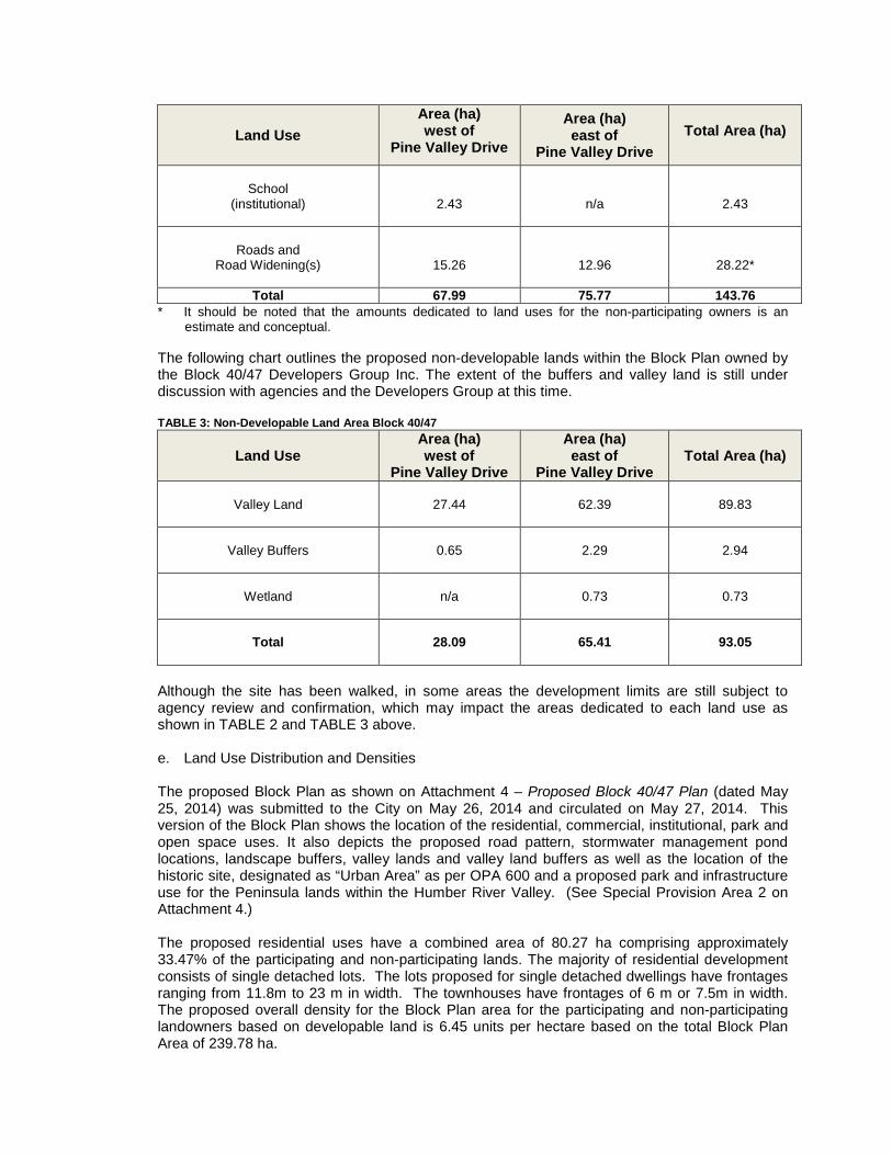
Land Use Area (ha) west of
Pine Valley Drive
Area (ha) east of
Pine Valley Drive
Total Area (ha)
School
(institutional)
2.43
n/a
2.43
Roads and
Road Widening(s)
15.26
12.96
28.22*
Total 67.99 75.77 143.76 * It should be noted that the amounts dedicated to land uses for the non-participating owners is an
estimate and conceptual. The following chart outlines the proposed non-developable lands within the Block Plan owned by the Block 40/47 Developers Group Inc. The extent of the buffers and valley land is still under discussion with agencies and the Developers Group at this time. TABLE 3: Non-Developable Land Area Block 40/47
Land Use Area (ha) west of
Pine Valley Drive
Area (ha) east of
Pine Valley Drive
Total Area (ha)
Valley Land
27.44
62.39
89.83
Valley Buffers
0.65 2.29
2.94
Wetland
n/a 0.73
0.73
Total
28.09 65.41
93.05
Although the site has been walked, in some areas the development limits are still subject to agency review and confirmation, which may impact the areas dedicated to each land use as shown in TABLE 2 and TABLE 3 above.
e. Land Use Distribution and Densities
The proposed Block Plan as shown on Attachment 4 – Proposed Block 40/47 Plan (dated May 25, 2014) was submitted to the City on May 26, 2014 and circulated on May 27, 2014. This version of the Block Plan shows the location of the residential, commercial, institutional, park and open space uses. It also depicts the proposed road pattern, stormwater management pond locations, landscape buffers, valley lands and valley land buffers as well as the location of the historic site, designated as “Urban Area” as per OPA 600 and a proposed park and infrastructure use for the Peninsula lands within the Humber River Valley. (See Special Provision Area 2 on Attachment 4.) The proposed residential uses have a combined area of 80.27 ha comprising approximately 33.47% of the participating and non-participating lands. The majority of residential development consists of single detached lots. The lots proposed for single detached dwellings have frontages ranging from 11.8m to 23 m in width. The townhouses have frontages of 6 m or 7.5m in width. The proposed overall density for the Block Plan area for the participating and non-participating landowners based on developable land is 6.45 units per hectare based on the total Block Plan Area of 239.78 ha.

Open space areas, parks, parkettes, landscape buffers, and vistas comprise 13.07 ha (inclusive of the 3.04 ha of park proposed on the Peninsula lands) of the participating and non-participating landowner’s land holdings, and stormwater management pond/facilities comprise 12.05 ha for a total of 25.13 ha equivalent to 10.49% of the area. The non-developable valley lands, valley buffers, wetlands and the historic site designated as “Urban Area” in OPA 600 buffered by park uses, comprise a total of 96.03 ha (approximately 40%) of the subject lands as shown on Attachment 4 (not including the non-participating landowners properties).
f. Real Estate Division The Vaughan Real Estate Division has had an opportunity to review the application and advises that the following condition will be imposed at the time of Draft Plan of Subdivision approval of the individual subdivision applications.
“Prior to final approval of the Plan, the Owner shall enter into a Developers’ Group Agreement with the other participating landowners within Block 40/47 to the satisfaction of the City. The agreement shall be regarding but not limited to all cost sharing for the provisions of parks, cash-in-lieu of parkland, road and municipal services within Block 40/47. This agreement shall also provide a provision for additional developers to participate with the developers’ Group Agreement when they wish to develop their lands.
The Owner acknowledges that cash-in-lieu of parkland shall be paid in accordance with Section 42 of the Planning Act and conform to the City’s “Cash-In-Lieu of Parkland Policy”. If required, non-participating Owners shall pay additional cash-in-lieu to the City.
The requirement for this condition has been included in the Recommendation section of this report.
g. Outstanding Issues, Agency Comments, Related Conditions As a result of the circulation process, including the latest submission, issues have been identified that will require resolution. The following provides the background and basis for the recommended conditions as set out in Attachment 1.
i. Environmental Issues That Remain Outstanding
Over 70 specific comments related to environmental policies have been noted by the Policy Planning Division in consultation with the Toronto and Region Conservation Authority in the review of the Block Plan and MESP package submitted in 2013. Most of the comments relate to the need for more information to support the conclusions stated in the submitted documents. Other comments identify specific areas of concern with respect to the information provided in the submitted documentation. Below is a high-level summary of the remaining outstanding items.
• Stormwater management facilities (SWM Ponds #1 and #3) shall be kept outside of the
environmental features, unless the City, MNR and TRCA agree to a location and established criteria for permitting the pond within the feature.
• The limits of SWM Pond #2 and the wetland compensation area require additional detail,
such as an overlay on aerial images, to assess the ecological characteristics of the wetland habitat area.
• On May 14, 2014, a meeting took place with City staff, MNR, and TRCA and
representatives of the Block 40/47 Group to discuss the overall stormwater management
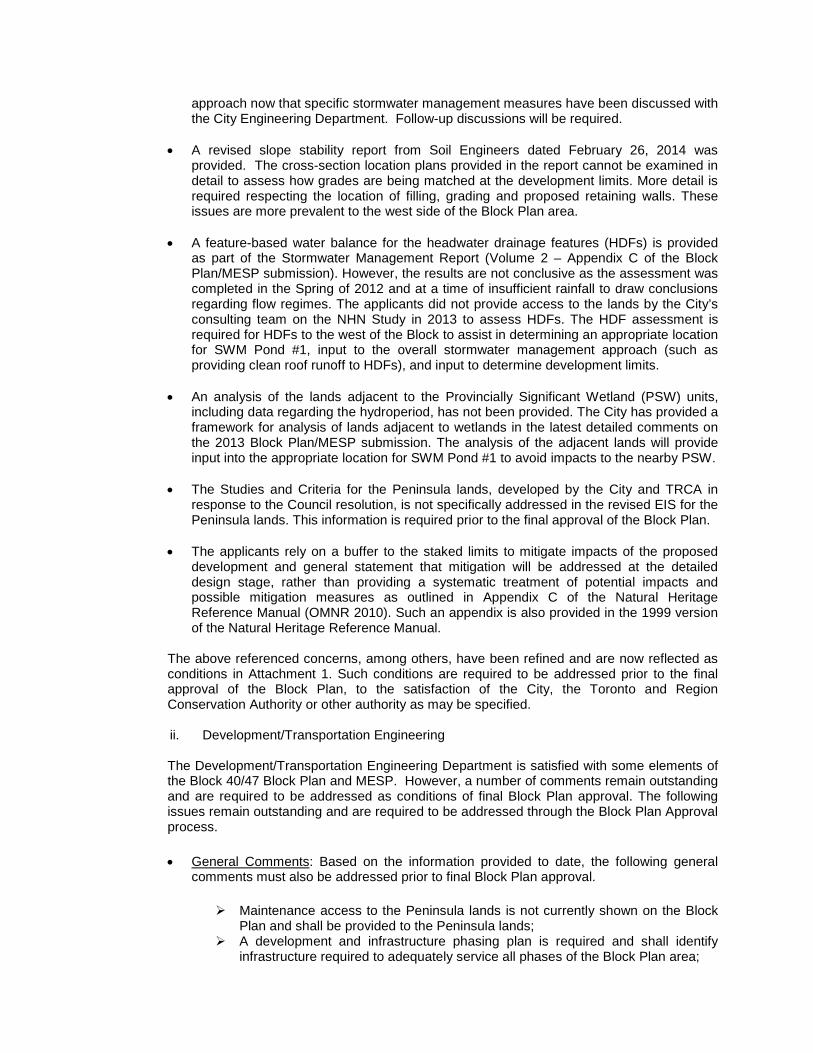
approach now that specific stormwater management measures have been discussed with the City Engineering Department. Follow-up discussions will be required.
• A revised slope stability report from Soil Engineers dated February 26, 2014 was
provided. The cross-section location plans provided in the report cannot be examined in detail to assess how grades are being matched at the development limits. More detail is required respecting the location of filling, grading and proposed retaining walls. These issues are more prevalent to the west side of the Block Plan area.
• A feature-based water balance for the headwater drainage features (HDFs) is provided
as part of the Stormwater Management Report (Volume 2 – Appendix C of the Block Plan/MESP submission). However, the results are not conclusive as the assessment was completed in the Spring of 2012 and at a time of insufficient rainfall to draw conclusions regarding flow regimes. The applicants did not provide access to the lands by the City’s consulting team on the NHN Study in 2013 to assess HDFs. The HDF assessment is required for HDFs to the west of the Block to assist in determining an appropriate location for SWM Pond #1, input to the overall stormwater management approach (such as providing clean roof runoff to HDFs), and input to determine development limits.
• An analysis of the lands adjacent to the Provincially Significant Wetland (PSW) units,
including data regarding the hydroperiod, has not been provided. The City has provided a framework for analysis of lands adjacent to wetlands in the latest detailed comments on the 2013 Block Plan/MESP submission. The analysis of the adjacent lands will provide input into the appropriate location for SWM Pond #1 to avoid impacts to the nearby PSW.
• The Studies and Criteria for the Peninsula lands, developed by the City and TRCA in
response to the Council resolution, is not specifically addressed in the revised EIS for the Peninsula lands. This information is required prior to the final approval of the Block Plan.
• The applicants rely on a buffer to the staked limits to mitigate impacts of the proposed
development and general statement that mitigation will be addressed at the detailed design stage, rather than providing a systematic treatment of potential impacts and possible mitigation measures as outlined in Appendix C of the Natural Heritage Reference Manual (OMNR 2010). Such an appendix is also provided in the 1999 version of the Natural Heritage Reference Manual.
The above referenced concerns, among others, have been refined and are now reflected as conditions in Attachment 1. Such conditions are required to be addressed prior to the final approval of the Block Plan, to the satisfaction of the City, the Toronto and Region Conservation Authority or other authority as may be specified.
ii. Development/Transportation Engineering
The Development/Transportation Engineering Department is satisfied with some elements of the Block 40/47 Block Plan and MESP. However, a number of comments remain outstanding and are required to be addressed as conditions of final Block Plan approval. The following issues remain outstanding and are required to be addressed through the Block Plan Approval process.
• General Comments: Based on the information provided to date, the following general comments must also be addressed prior to final Block Plan approval.
Maintenance access to the Peninsula lands is not currently shown on the Block Plan and shall be provided to the Peninsula lands;
A development and infrastructure phasing plan is required and shall identify infrastructure required to adequately service all phases of the Block Plan area;
The MESP shall identify any potential development charge projects associated with the servicing of the Block Plan;
The Developers Group shall contact the pertinent utility and telecommunications companies to coordinate the location of any major utility plant facility block (buried and/or surface);
All Regional works and infrastructure necessary to support the Block Plan area development shall be identified in the MESP;
Additional grading detail required on the south limit of the Omega Lands Draft Plan of Subdivision File 19T-06V12; and,
A final complete MESP document (including a digital copy) shall be submitted for Engineering staff review and record. This is required as a condition of Block Plan Approval and prior to approval of the first plan of subdivision in Block 40/47;
• Water Distribution: Future external areas such as Block 41 should be identified and accommodated in the water analysis/design for the subject lands. The Developers Group is required to update the water analysis/design to take into account external developable lands immediately north of Teston Road.
Additional detailed information respecting infrastructure phasing shall be provided. The
Developers Group, through the required submission, must demonstrate that adequate supply and proper looping (two feeds) are available and provided for through all phases of development, and that City design criteria will be achieved. A phasing plan is required identifying the skeleton servicing for each phase. It should be noted that infrastructure phasing shall take into account non-participating landowners and external benefitting lands.
Furthermore, the proposed Water Distribution system shall be revised to provide for the
extension of a watermain through Block 47 to Teston Road in accordance with the City’s Water/Wastewater Master Plan. It should be noted that, segments of this watermain, external to the plan and at the proposed valley crossing within Block 40 North may be eligible for City Development Charge Credits.
• Sanitary Servicing: The Revised Servicing Report prepared by EMC Group LTD. dated
April 2013 requires revision to reflect the latest amendment to the sanitary system for Block 40S. Additional information respecting sanitary servicing for the subject lands is also required. The information required includes but is not limited to, an outline of the future external drainage areas for Blocks 55 and 41 tributary to the Pine Valley North Pumping Station should be identified and accommodated in the proposed Sanitary Sewer and Pumping Station design for the Block. A phasing plan identifying the required skeleton servicing for each phase is required and shall take into account the non-participating landowners and external benefitting lands. A sanitary drainage plan, and profile drawings are all required prior to final Block Plan approval, and to the satisfaction of the City of Vaughan Development/Transportation Engineering Department.
• Stormwater Management: A number of Stormwater Management comments were addressed through the MESP. However, the issue of road drainage remains outstanding and requires resolution prior the final Block Plan Approval. Road drainage from Teston Road and Pine Valley Drive should be accommodated in the Block 40/47 stormwater management pond design. Clarification is also required respecting the post –development drainage areas for each pond. A condition has been included in Attachment 1 of this report requiring all stormwater management ponds to be sized to accommodate the drainage from the potential widening/urbanization of Teston Road and Pine Valley Drive to the satisfaction of the City.
iii. Traffic and Transportation
Development/Transportation Engineering staff had an opportunity to meet with representatives of the Block 40/47 Developers Group to discuss comments respecting traffic and transportation. It is imperative that a good pedestrian system be in place to support safe pedestrian connectivity within the neighbourhoods. Sidewalks shall be designed and provided to meet the minimum requirements of the City’s sidewalk policy. Development/Transportation Engineering staff have reviewed the Transportation Management and Sidewalk Plan, dated May 2014, and are satisfied that it addresses all outstanding issues. The Plan includes sidewalks on at least one side of the majority of roads, and several bike lanes providing connections to destinations, such as to the school and parks; and exceeds the minimum requirements of the City’s policy. The Transportation Management and Sidewalk Plan has been attached to this report (see Attachment 6) and Recommendation 7 referencing the Plan has been included for Council’s approval. iv. Cultural Heritage A number of properties in the Block 40/47 Plan area are considered culturally significant in respect of their archaeological, built heritage and heritage value. • Archaeological Assessments: Prior to Block Plan approval, the Owners are required to
satisfy archaeological concerns raised by the Ministry of Tourism, Culture and Sport and the City. Currently, the Ministry is waiting for information respecting 6 sites situated within the Block 40/47 Plan area. Final reports for 2 sites are outstanding; Stage 4 investigations for three sites in addition to the historic site designated as “Urban Area” are also outstanding. As a result of the outstanding information respecting Archaeological Resources, a number of conditions have been included in Attachment 1 to this report which are required to be satisfied prior to final Block Plan Approval.
• Built Heritage Assessments: The Developers Group has submitted Cultural Impact Assessment reports for the following properties:
4333 Teston Road, 10460 Pine Valley Drive, 10640 Pine Valley Drive: The
Cultural Resource Impact Assessment reports for the above noted properties were submitted through the Block Plan review process for the 3 properties being noted and were found to be satisfactory. Further recommendations included commemorating the family names of Stump and Witherspoon respecting 10460 and 10640 Pine Valley Drive, respectively, as well as, the Purpleville hamlet name. These matters will be addressed through the Draft Plan of Subdivision or Site Plan processes.
10733 Pine Valley Drive: The former Purpleville Post Office located at 10733 Pine Valley Drive is registered under Part IV Section 27 of the Ontario Heritage Act. In order to fulfill the minimum requirements of the Cultural Heritage Resource Impact Assessment report the Developers Group shall include in the report a comprehensive review of Avoidance Mitigation options, the feasibility of retention in situ, adaptive reuse options and a determination respecting the future use of the subject heritage resource. Furthermore, the report shall also include a comprehensive review if the Salvage Mitigation options, including the feasibility of relocation within the existing site or to another location within the subject development. The report should also investigate and consider the context of the existing structure as it relates to the Purpleville cemetery, any potential cultural value of or within adjacent lands that once formed the area of Purpleville.

10699 Pine Valley Drive: It should be noted that a Cultural Heritage Resource Impact Assessment report is also required for 10699 Pine Valley Drive. The required report shall be submitted, reviewed and approved prior to final Block Plan approval.
3911 Teston Road: Is the property of a non-participating landowner. This
property will require a Cultural Heritage Resource Impact Assessment, should it ever be proposed for development. It cannot however, be required through the current process as the landowner is not subject to the application.
Heritage Impact: The Developers Group is required to submit a revised Heritage Impact
Assessment for the area east of the Humber River tributary prior to consideration of any draft plans of subdivision for approval in order to assess the area to determine if it constitutes a cultural heritage landscape.
Conditions for final approval of the Block 40/47 Plan respecting the outstanding Cultural Heritage requirements have been included in Attachment 1 to this report. v. Urban Design
The Vaughan Planning Department – Urban Design/Cultural Heritage Division has reviewed the supporting documents for Block 40/47. Staff is satisfied with the general land uses and design of the subdivisions as reflected in the revised Block 40/47 Plan as shown on Attachment 4, with the exception of the Peninsula lands. This is subject to the following conditions which can be addressed through further studies and through the Draft Plan of Subdivision process for the 6 active draft plans now under review. The following documents will need to be submitted, reviewed and approved to the satisfaction of the Urban Design/Cultural Heritage Division. • Urban Design & Sustainable Development Guidelines; • Architectural Control Design Guidelines; and • Landscape Master Plan The required documents noted above shall address but not be limited to the following issues: • Sustainable development features; • Community edge treatments and landscape buffers; • Community gateways, entry features, enhanced intersections and interpretive signage
related to heritage site designated as “Urban Area” in OPA 600 and the Humber River; • Community areas and preliminary park block designs and facility fits; • Storm water management pond landscaping; • Open space lands & woodlots edge restoration and management; • Open space lands trail network systems, connections, and trailheads/vistas/staging
areas; • Coordination of the pedestrian network with the transportation management plan; and • Coordination of streetscape elements including fencing treatments and street tree
planting.
vi. Parks Development
The proposed Block 40/47 Plan as shown on Attachment 4 shows 3 Neighbourhood Parks within the block plan boundary, including the proposed park on the Peninsula lands, and 2 parkettes. The two Neighbourhood Parks (including the Peninsula lands) located in Block 40, east of Pine Valley Drive, have a total area of 4.44 ha. The Neighbourhood Park located west of Pine Valley Drive in Block 47 directly to the south of the elementary school site, has an area of 2.18 ha. Also located in Block 40/47 are 2 proposed parkettes. In Block 47, the
1.31 ha parkette is positioned adjacent to the historic site designated as “Urban Area” in OPA 600 and the parkette in Block 40 is located between the Valley lands and Street 19 with an area of 0.68 ha. The proposed Block 40/47 Block Plan (Attachment 4) was reviewed by the Parks Development Department, in consideration of OPA 600 as amended by OPA 744 and the Active Together Master Plan, 2013 (ATMP), which outlines the City’s vision for the provision of parkland. The ATMP identifies current needs and future facility provision strategies that are consistent with the City’s commitment to providing safe, accessible and community-responsive parks and facilities. One of the key themes identified in the ATMP is to maximize the provision of parkland in new developments in order to achieve the per capita target of 2.2 ha of active parkland per 1000 population. The ATMP also identifies the need to secure appropriate park sites to allow development of new facilities including but not limited to soccer fields (an additional 38 fields are required City-wide), multi-use fields, tennis courts (an additional 25 are required), basketball courts (an additional 15 are required) skate parks (an additional 3 are required), skate zones (a minimum of an additional 5 are required) and water-play facilities (an additional 13 are required) for the City overall. Furthermore, with respect to play areas, the ATMP also recommends that playgrounds be provided within 500 m of all residences and be unobstructed by major pedestrian impediments such as highways, major arterial roads, waterways, valleys etc.
• Proposed Neighbourhood Park in Block 47: Based on the ATMP and other criteria for
the planning of parkland, staff has conducted a review of the proposed Block 40/47 Plan and concluded that the park situated west of Pine Valley Drive (Block 47) and south of the proposed elementary school site is satisfactory. The proposed 2.18 ha Neighbourhood Park satisfies the requirements for a programmable park that it is situated within walking distance of residential areas and provides the opportunity to achieve a balance of active and passive uses as a result of its location and size. However, upon further review minor changes to the size of the park may be required subject to the outcome of the facility fit plans and technical reviews.
• Proposed Parkette in Block 47: The 1.31 ha parkette that is located adjacent to the
historic site designated as “Urban Area” in OPA 600, is not considered suitable for development as an active park. This parcel is best suited for passive uses and essentially acts as a buffer/transition between the residential development and the historic site designated as “Urban Area” in OPA 600. The proposed parkette block will require further design development through a Landscape Master Plan in order to determine an appropriate interface with the Urban Area and to determine the extent of the creditable parkland.
• Proposed Neighbourhood Parks and Parkettes in Block 40: Additional information
from the Developers Group is required respecting the proposed neighbourhood parks on the east side of Pine Valley Drive (Block 40), with the exception of the proposed approximately 3.04 ha park on the Peninsula lands which will be discussed in the following section. Further review is needed before the proposed park and parkette can be considered as active parkland and eligible for parkland credit. Staff has provided conditions of approval for the Neighbourhood Parks and Parkette in Block 40. The conditions contained in Attachment 1 outline requirements for the neighbourhood parks in question including facility fit plans and conceptual designs for each location. Changes to the size of the parks may be required subject to the outcome of the review of the facility fit plans and outcome of technical reviews. The additional information will assist in assessing the feasibility and most appropriate type of programming for each park. Final approval of the parks in Block 40 shall be to the satisfaction of the Parks Development Department.
• The Peninsula Lands: The proposed 3.04 ha park located on the lands referred to as the Peninsula lands is not considered functional or suitable as active parkland and should not be considered for parkland dedication credit. Furthermore, developing the Peninsula lands as a Neighbourhood Park does not comply with the existing policies of OPA 600 as amended by OPA 744. General concerns include:
For a Neighbourhood Park it is not central to the neighbouhood it serves. The proposed park has no street frontage or community visibility which raises
safety and security issues (CPTED), as required by City policy. The proposed park will be encumbered by a sanitary sewer easement. The shape of the proposed park may limit the ability to program the site. Access to the proposed park is very limited and a significant amount of
infrastructure will need to be built and maintained (bridge and access road) to provide the sole access to the site.
The surrounding valley lands are environmentally sensitive and access for human use, including trail development, is prohibited.
Section 4.2.5 of OPA 600 identifies Open Spaces as lands designated within valley and stream corridors, natural areas including woodlots, environmentally significant areas (ESAs), areas of natural and scientific interest (ANSIs), wetlands etc., and areas designated for environmental protection and enhancement, which is a more suitable description of the Peninsula lands.
In keeping with this description, the Peninsula lands are identified on Schedule “A” of OPA 600 as major open space and valley lands. However, on April 17, 2012, Council approved a modification to VOP 2010 allowing changes to lands designated “Major Open Space and Valleyland” in OPA 600 subject to the determination that potential for developable land has been identified through the submission of a required set of studies based on a developed criteria and subject to the review of the Toronto and Region Conservation Authority (TRCA) and the City. This language has been replicated in OPA 744. The study and criteria requirement apply to the potential development of the Peninsula lands and have not been fulfilled. As a result of the outstanding information, a determination of the appropriate use, or if development of any kind is possible, cannot be made at this time. As any proposed use or development on the peninsula depends so heavily on the submission and review of the studies and criteria, a condition has been included in Attachment 1 of this report requiring the work to be completed, submitted, reviewed and approved prior to any additional consideration of the Peninsula lands for park purposes. If determined through the review of the studies and criteria that the Peninsula lands are not appropriate for development of any kind they will remain a part of the valley lands. It should be noted that the ATMP recommends that undevelopable open space lands, such as valley lands, hazard lands and areas encumbered by underground servicing, not be accepted as parkland. An alternative to developing the lands would be leaving them in their semi-natural state. Should they choose to do so, the Developer’s Group can bring forward a proposal for the consideration of the City, TRCA, or Region of York, or other conservation organization such as a land trust to purchase the Peninsula lands as passive open space. In light of the various issues related to the Peninsula lands, staff have referenced these lands on the Block 40/47 Plan as “Special Provisions Area 2”, which will require further review in relation to outstanding and unknown information included but not limited to the studies and criteria, the determination of an appropriate land use, the finalization and

consensus on development limits, and feasibility and potential consideration of the City, other agencies or bodies purchasing the lands.
vii. Institutional
The proposed 2.43 ha school site is slated for use by the York Catholic District School Board (YCDSB). The YCDSB has reviewed the Block Plan and is satisfied with the size and location of the site and will be providing conditions of approval through the Draft Plan of Subdivision Process, for the 1387700 Ontario Inc., Roybridge Holdings Inc., Lindvest ZZen Properties (Pinevalley) Draft Plan of Subdivision (File 19T-03V25).
Relationship to Vaughan Vision 2020/Strategic Plan The recommendations in this report are consistent with Vaughan Vision 2020 by demonstrating the following goals and objective: Service excellence:
Promote Community Safety, Health and Wellness – To promote healthy lifestyles and encourage a high quality of life, well-being and the safety of residents.
Lead and Promote Environmental Sustainability – to preserve, protect and enhance Vaughan’s natural and built environment through responsible leadership and innovative policies, practices and education.
Preserve our Heritage and Support Diversity, Arts and Culture – To support Vaughan’s
diverse heritage through community and cultural initiatives. Regional Implications The Block Plan has been prepared in consultation with York Region. Regional implications may include additional refinement to the municipal water and wastewater servicing networks. A future revision to the Block Plan may be required as a result of the Regional Class Environmental Assessment currently underway for this segment of Teston Road. One outcome of the EA may be the realignment of Teston Road at Pine Valley Drive. A condition of approval has been included to address this matter. Upon Regional approval of OPA 744, the City will be able to proceed to consider for approval the implementing draft plans of subdivision. Upon Regional approval of OPA 744 and clearance of conditions of Block Plan approval, the City will be able to proceed with the implementing draft plans of subdivision. However, Public Hearings and government and agency review are necessary for the six implementing draft plans of subdivision.
Conclusion
This conditional approval is part of a series of steps that are required to effect the development of this Block Plan. In this instance an intermediate step has been added which will result in a conditional approval of the Block Plan. For the planning of this block to continue a further report to Council explaining how the conditions have been fulfilled and any resulting changes to the Block Plan will need to occur prior to the consideration of the draft plans of subdivision. Much of this work can be done concurrently with the review of the already submitted draft plans of subdivision and zoning amendment applications. Staff is of the opinion that the proposed Block Plan (Attachment 4) provides a basis for proceeding, subject to the landowners fulfilling the recommended conditions of approval for the Block Plan, as set out in Attachment 1. This report also recommends modifications to OPA 744 which is currently at York Region for approval. The purpose of the modification is to assist in resolving potential land use compatibility issues that have been identified at the southern boundary of the Block 47 portion of the Block Plan. This area has been specifically identified on

Attachment 4 as “Special Provision Area 1”. A second area will be the focus of further work. The Peninsula Lands have been identified as “Special Provision Area 2”. More detailed examination will be required for this parcel to determine its ultimate land use. The outcome of this work may require modifications to the Block Plan which may need to be reflected in the draft plans of subdivision. On this basis it is recommended that the City proceed with the conditional approval of the Block Plan in the manner set out in the “Recommendation” section of this report.
Attachments
1. Conditions of Approval 2. Context Location Map 3. Location Map 4. Proposed Block 40/47 Plan 5. Land Ownership Plan 6. Transportation Management Plan 7. Revised Schedule 1 to OPA 744
Report prepared by: Arminé Hassakourians, Planner, ext. 8368 Respectfully submitted, JOHN MACKENZIE GRANT UYEYAMA Commissioner of Planning Interim Director of Planning, and
Director of Development Planning ROY MCQUILLIN Manager of Policy Planning /lm
ATTACHMENT NO. 1
STANDARD CONDITIONS OF BLOCK PLAN APPROVAL
APPROVAL OF BLOCK PLAN BL.40/47.2003 BLOCK 40/47 DEVELOPERS GROUP INC.
PART OF LOTS 8 AND 9, CONCESSION 8, CITY OF VAUGHAN THE CONDITIONS OF THE COUNCIL OF THE CITY OF VAUGHAN THAT SHALL BE SATISFIED PRIOR TO THE FINAL APPROVAL OF THE BLOCK 40/47 PLAN, ARE AS FOLLOWS: 1. The Plan shall relate to the draft block plan, prepared by KLM Planning Partners Inc.,
dated May 25, 2014. 2. The lands within this Plan shall be appropriately designated by OPA 744 once it has
come into effect in accordance with the provisions of The Planning Act. Particular land use designations applied to the subject block plan are as follows:
“Low Density Residential”, “Medium Density Residential/Commercial, “Stormwater
Management Ponds”, “Neighbourhood Commercial Centre”, “Parks”, “Elementary Schools”, “Institutional”, “Valley Lands”, “Greenway System”, and “Urban Area”.
3. The Owner shall pay any and all outstanding application fees to the Vaughan Planning
Department, Policy Planning Division, in accordance with the applicable and in-effect Tariff of Fees By-law.
4. Prior to final approval of the Block Plan and MESP, the Owner shall submit and have
approved an Environmental Impact Study containing sufficient data and site-specific observations in the determination of the development limits, and addressing potential impacts of the proposed development and potential mitigation techniques, to the satisfaction of the Vaughan Planning Department, Policy Planning Division, the Toronto and Region Conservation Authority and the Ministry of Natural Resources.
5. Prior to final approval of the Block Plan, the Owner shall submit and have approved by
the Vaughan Planning Department, Policy Planning Division, and the Toronto and Region Conservation Authority the following with respect to Water Quality and Quantity:
a. An assessment that confirms pre-development ground and surface water flows will
be maintained post-development from the headwater drainage features which may be proposed to be removed or realigned.
b. An approximate post-development water balance calculation as approved by the Vaughan Planning Department, Policy Planning Division and the Toronto and Region Conservation Authority demonstrating any infiltration deficit will be mitigated to protect the features and functions.
c. An exploration of any proposed mitigation measures as approved by the Vaughan Planning Department, Policy Planning Division and the Toronto and Region Conservation Authority demonstrating that there will not be a negative impact on the features and functions and the hydroperiod of the natural features.
d. A feature based Water Balance for all woodlands, wetlands and watercourses, and demonstrated maintenance of the hydroperiod for natural features to be retained.

2
6. Prior to final approval of the Block Plan, the Owner shall submit a hydrological study to
be approved as part of the MESP, which can be used to define the local pre-development water balance and establish site-specific criteria that maintains the ecological functions, to the satisfaction of the Vaughan Planning Department, Policy Planning Division and the Toronto and Region Conservation Authority.
The Hydrogeological Report shall be based on the analysis of the results of an
integrated monitoring program including discharge/recharge and surface water and shall match flows and features. It shall map all monitoring location and features. A description of the monitors, the program and the results of all past and current monitoring programs shall be included.
7. Prior to final approval of the Block Plan, Vaughan and the Owner shall ensure that all
proposed development conforms to the Toronto and Region Conservation Authority’s stormwater management criteria for water quantity, water quality, erosion and water balance for groundwater recharge and for natural features, to the satisfaction of the Toronto and Region Conservation Authority.
8. Prior to final approval of the Block Plan, the Vaughan Planning Department, Policy
Planning Division, the Toronto and Region Conservation Authority and the Ministry of Natural Resources shall be satisfied with the required buffers proposed around all sensitive land features.
9. Prior to final approval of the Block Plan an adjacent lands analysis for lands within 120
metres of all wetlands in the Block 40/47 area and those determined to be Provincially Significant Wetlands must be completed to the satisfaction of the Vaughan Planning Department, Policy Planning Division, the Toronto and Region Conservation Authority and the Ministry of Natural Resources.
10. Prior to final approval of the Block Plan, the precise limits of the valleyland and developable land in proximity and inclusive of the “Peninsula Lands” (located in Block 40) based on the Studies and Criteria established by the Vaughan Planning Department, Policy Planning Division and the Toronto and Region Conservation Authority will be established to the satisfaction of the Vaughan Planning Department, Policy Planning Division and the Toronto and Region Conservation Authority. Should it be determined that development of any kind is appropriate on the “Peninsula Lands”, prior to the approval of any development applications associated with this area, the impact on the features adjacent to the “Peninsula Lands”, including valleylands and seeps shall be assessed to the satisfaction of the Vaughan Planning Department, Policy Planning Division, Toronto and Region Conservation Authority and the Ministry of Natural Resources.
11. Prior to final approval of the Block Plan, the size and location of Stormwater Management Pond No.1 and the surrounding lotting pattern shall be finalized to the satisfaction of the Vaughan Planning Department, Policy Planning Division and the Toronto and Region Conservation Authority.

3
12. Prior to the final approval of the Block Plan and the Master Environmental Servicing Plan (MESP), the limit of the valleyland located in the northwest corner of the Block Plan boundary shall be determined to the satisfaction of the Vaughan Planning Department’s Policy Planning Division and the Toronto and Region Conservation Authority.
13. Prior to final approval of the Block Plan and the MESP, Stormwater Management Pond No.2 shall be relocated adjacent to Pine Valley Drive, and conceptual designs shall be provided to the satisfaction of the Vaughan Planning Department, Policy Planning Division, the Toronto and Region Conservation Authority, and the Ministry of Natural Resources.
14. Prior to final approval of the Block Plan and MESP, the Open Space Wetland Habitat shall be relocated between the valleyland and Stormwater Management Pond No. 2 and conceptual designs be provided to the satisfaction of the Vaughan Planning Department Policy Planning Division, the Toronto and Region Conservation Authority, and the Ministry of Natural Resources.
15. Prior to final approval of the Block Plan and MESP, grading and geotechnical details are required to confirm the location and size of the stormwater management pond facilities subject to the satisfaction of the Vaughan Planning Department, Policy Planning Division Policy Planning Division and the Toronto and Region Conservation Authority.
16. Prior to approval of any draft plan of subdivision within the Block Plan area, an assessment of the valley lands where trails and infrastructure are proposed including but not limited to the location of any proposed trails shall be conducted, and reviewed to confirm feasibility to the satisfaction of the Vaughan Planning Department, Policy Planning Division, Park’s Development Department, and the Ministry of Natural Resources.
17. Prior to the approval of the MESP, a concluding section shall be added to the MESP to outline site specific requirements by the land owners to ensure they are carried forward into the development process to the satisfaction of the Toronto and Region Conservation Authority.
18. Prior to final approval of the Block Plan, the Owner shall provide in one comprehensive submission, all archaeological assessments and the corresponding Ministry of Tourism, Culture and Sport compliance letters associated with the subject properties.
The submission review and clearance of the required archaeological assessments are subject to the satisfaction of the Vaughan Planning Department, Cultural Heritage Division and the Ministry of Tourism, Culture and Sport.
19. Prior to final approval of the Block Plan, a site visit will be required for staff of Vaughan Cultural Heritage to assess the cultural value and possible future requirements of future development applications.

4
The Owner is responsible for contacting the City and making arrangements for the required site visit(s).
20. Prior to final approval of the Block Plan, the Owner shall submit and obtain approval of Cultural Heritage Resource Impact Assessment report for 10699 Pine Valley Drive to the satisfaction of the Vaughan Planning Department, Cultural Heritage Division.
21. Prior to final approval of the Block Plan, the Owner shall include in the Cultural Heritage Resource Impact Assessment for 10733 Pine Valley Drive a comprehensive review of Avoidance Mitigation options, including the feasibility of retention in situ and adaptive reuse options, to the satisfaction of the Vaughan Planning Department Cultural Heritage Division.
22. Prior to final approval of the Block Plan, the Owner shall include in the Cultural Heritage Resource Impact Assessment for 10733 Pine Valley Drive options for relocation within the existing site or to another location within the subject development, to the satisfaction of the Vaughan Planning Department, Cultural Heritage Division.
23. Prior to final approval of the Block Plan, the Owner shall contact City staff to arrange for a site visit to provide the Planning Department’s Cultural Heritage staff an opportunity to document and complete a Built Heritage Evaluation.
24. Prior to final approval of the Block Plan, the Owner shall submit a Heritage Impact Assessment for the area east of the Humber River tributary for review and approval to the satisfaction of the Vaughan Planning Department, Cultural Heritage Division.
25. Prior to final approval of the Block Plan, the Owner shall contact City staff to arrange for a site visit to provide the Planning Department’s Cultural Heritage staff an opportunity to document and complete a Cultural Heritage Evaluation to further identify the cultural value of the area east of the Humber River and any structure(s) contained within the area.
26. Prior to final approval of the Block Plan and MESP, the Owner shall relocate Stormwater Management Ponds No.1 and No.3 to a location outside of the environmental features or to an agreed upon location based on established criteria to the satisfaction of the Vaughan Planning Department’s Policy Planning Division, the Toronto and Region Conservation Authority, and the Ministry of Natural Resources.
27. Prior to final approval of the Block Plan and MESP, the Owner shall provide additional detail such as an overlay on aerial images of the Open Space (Wetland Habitat) between the valleyland and Stormwater Management Pond No.2 for review and approval by the Vaughan Planning Department’s Policy Planning Division, and the Toronto and Region Conservation Authority.
28. Prior to final approval of the Block Plan and MESP, the Owner shall submit a revised slope stability report prepared by a soil engineer clearly detailing the cross-section location plans in order to assess how the grades are being matched at the development

5
limits. This report shall include details respecting the location of filling, grading and the proposed retaining wall(s). The revised slope stability report shall be to the satisfaction of the Vaughan Planning Department’s Policy Planning Division and the Toronto and Region Conservation Authority.
29. Prior to final approval of the Block Plan and MESP, the Owner shall submit a Headwater Drainage Feature Assessment for headwater drainage features to the west of the Block to assist in determining an appropriate location for Stormwater Management Pond No.1, input to the overall stormwater management approach and input in determining the developable limits to the satisfaction of the Vaughan Planning Department, Policy Planning Division and the Toronto and Region Conservation Authority.
30. Prior to final approval of the Block Plan and the MESP, the Owner shall provide an analysis of lands adjacent to the Provincially Significant Wetland units to the satisfaction of the Vaughan Planning Department, Policy Planning Division and the Ministry of Natural Resources.
31. Prior to final approval of the Block Plan and the MESP, and should any part of the Peninsula lands be proposed for a designation other than Valley Land, Park or Open Space, the Owner shall provide information on the Peninsula lands based on the studies and criteria developed by the City and the Toronto and Region Conservation Authority. The information provided shall be to the satisfaction of the Vaughan Planning Department, Policy Planning Division and the Toronto and Region Conservation Authority.
32. Prior to final approval of the Block Plan and the MESP, the Owner shall provide an outline of a systematic treatment of potential impacts of the proposed development and possible mitigation to the satisfaction of the City and the Toronto and Region Conservation Authority.
33. Prior to final approval of the Block Plan and MESP and before the first draft plan of subdivision within Block 40/47 goes to Council for approval, all stormwater management ponds shall be sized to accommodate the drainage from the potential widening/urbanization of Teston Road and Pine Valley Drive, to the satisfaction of the Vaughan’s Development/Transportation Engineering Department.
34. Prior to final approval of the Block Plan and MESP, the stormwater management pond blocks shall be sized to accommodate the required infiltration galleries, to the satisfaction of the Vaughan Development/Transportation Engineering Department and the Toronto and Region Conservation Authority.
35. Prior to final approval of the Block Plan, the Owner shall address maintenance access to the proposed services within the peninsula to the satisfaction of the Vaughan’s Development/Transportation Engineering Department and the Toronto and Region Conservation Authority.

6
36. Prior to final approval of the Block Plan, the Owner shall provide additional grading detail respecting the updated development limits as established by the TRCA, including any information on proposed retaining walls along the southern limits of the Omega lands to the satisfaction of the Vaughan Development/Transportation Engineering Department.
37. Prior to the approval of Block Plan and MESP, the Owner shall revise the Environmental Noise Feasibility Analysis to reflect the changes to the Block Plan to the satisfaction of the Vaughan Development/Transportation Engineering Department.
38. Prior to final approval of the Block Plan and MESP, the Owner shall provide an updated water supply analysis which takes into account external developable lands immediately north of Teston Road to the satisfaction of the Vaughan’s Development/Transportation Engineering Department.
39. Prior to the final approval of the Block Plan and MESP, the Owner shall revise the servicing sections of the MESP to reflect the extension of a proposed PD7 400mm diameter watermain through Block 47 to Teston Road in accordance with the recommendations of the City’s Water/Wastewater Master Plan, to the satisfaction of the Vaughan Development/Transportation Engineering Department.
40. Prior to the final approval of the Block Plan and MESP, the Owner shall revise the Servicing Report prepared by EMC Consultants dated April 2013 to reflect the current sanitary servicing scheme for Block 40S, to the satisfaction of the Vaughan Development/Transportation Engineering Department.
41. Prior to final approval of the Block Plan and MESP, the Owner shall update the MESP to reflect the ultimate external sanitary drainage areas (Block 55 and 41) tributary to the proposed Pine Valley North Pumping Station to the satisfaction of the Vaughan Development/Transportation Engineering Department.
42. Prior to final approval of the Block Plan and MESP, a development and infrastructure phasing plan including and traffic assessment shall be provided and approved for each phase. The phasing plan shall identify the required skeleton servicing for each phase including road improvements (Teston Road and Pine Valley Drive) and the extension of trunk services and spine services, to the satisfaction of the Vaughan Development/Transportation Engineering Department.
43. Prior to final approval of the Block Plan and MESP, the MESP shall be amended to include a sanitary drainage plan with all relevant external drainage areas and preliminary plan together with profile drawings for skeleton works with inverts shall be to the satisfaction of the Vaughan Development/Transportation Engineering Department.
44. Prior to final approval of the Block Plan and MESP, the sanitary servicing system is to be revised as per the latest external drainage concept and approved subject to the satisfaction of the Vaughan Development/Transportation Engineering Department.

7
45. Prior to final approval of the Block Plan and MESP, the Owner shall revise the post-development storm drainage area plans to the satisfaction of the Vaughan Development/Transportation Engineering Department.
46. Prior to final approval of the Block Plan, the Owner is required to identify any potential development charge projects associated with the servicing of the Block Plan area including estimated costs and benefitting areas, to the satisfaction of the Vaughan Development/Transportation Engineering Department.
47. Prior to final approval of the Block Plan and MESP, the Owner shall contact the pertinent utility and telecommunication companies to coordinate the location of any major utility plant facility block including buried and surface vaults and cellular towers. The necessary lands for this infrastructure shall be identified on the final approved Block Plan.
48. Prior to final approval of the Block Plan and MESP, the Owner shall identify on the final Block Plan and in the MESP, all Regional infrastructure work including Teston Road and Pine Valley Drive road widening, intersection ‘jog’ elimination at Teston Road and Pine Valley Drive and other system improvements that are necessary to support the development of the Block Plan area to the satisfaction of Vaughan Development/Transportation Engineering Department.
49. Prior to final approval of the Block Plan, the Owner shall submit Transportation Demand Management Plan Guidelines to the satisfaction of the Vaughan Development/Transportation Engineering Department and York Region.
If required, the Transportation Demand Management and Sidewalk Plan shall be
modified to the satisfaction of the Vaughan Development/Transportation Engineering Department, to reflect the revised and approved Block Plan.
50. The Transportation Demand Management Plan Guidelines shall provide a draft
framework for the full Transportation Demand Management Plan, listing potential transportation demand management measures for the development and an outline budget to the satisfaction of the Vaughan Development/Transportation Engineering Department.
51. Prior to approval of the final Block Plan, reference to the Peninsula lands as “Park” shall
be removed to the satisfaction of the Vaughan Parks Development Department. All lands associated with the Peninsula Lands shall not be eligible for parkland
dedication and shall not be identified as a park block on the Block Plan. These lands are not suitable for use as an active park block and do not comply with the policies approved by Council for parkland under Official Plan Amendment 600.
52. Prior to approval of the Block Plan, the Owner shall prepare a facility fit plan for all the
proposed park blocks, to the satisfaction of the Vaughan Parks Development Department. All facility fit plans are to be prepared by a Landscape Architect. The concept design should be prepared to take into consideration basic park design and park planning practices, which shall include, but is not limited to:

8
a. Identify existing vegetation; b. Include setbacks to residential properties, streets and natural buffers; c. Assess slopes, storm water run-off, drainage patterns and servicing
requirements; d. Includes park program requirements based on the City’s Active Together Master
Plan and as determined by the City etc.; e. Comply with the principles of Crime Prevention Through Environmental design
(CPTED) safety, active visual surveillance, etc.; f. Allowing for a minimum road frontage, which is not in keeping with OPA 600 i. As per OPA 600, Section 4.2.5 Parks and Open Space designations i.,
Neighbourhood Parks: “Sites should be highly visible and have good street frontage (50% of the park perimeter).
g. Ensure that parks are uninterrupted by the valley system which is a major physical barriers and will restrict the necessary pedestrian and vehicular access.
h. Free of encumbrances that would include utilities, service easement, natural heritage features, buffers, etc. These encumbered lands are not eligible for parkland dedication.
53. Prior to approval of the Block Plan, the limits of the approved long-term stable slope line
will need to be confirmed regarding the developable limits and the buffer requirements, to the satisfaction of the Vaughan Parks Development Department, the Toronto and Region Conservation Authority, and the Ministry of Natural Services.
54. Prior to final approval of the Block Plan, the Owner shall prepare a final land use
distribution and land owner participation chart, to the satisfaction of the Vaughan Parks Development Department. The chart shall include updated land area values for park blocks that satisfy the policies of the OPA 600, which shall include, but not be limited to the following:
a. Sites shall be a minimum of 0.8 to 2.5 ha; b. Should be a shape that supports the intended use (predominately square or
rectangular; c. Intended predominately for the close to home needs of residents, especially
children, older adults and for less organized recreational activities; d. To be located within a five minute walking distance; e. Tableland required and adjacent to local schools where possible; f. Sites should be highly visible and have good street frontage (50%of park
perimeter); g. Where possible and practical, be linked into an overall open space and
community greenway system; h. All parks shall be located and oriented to be:
i. In a central location or in the community to be served in order to act as a focal point for the community;
ii. Uninterrupted by major physical barriers, such as rail lines, arterial and collector streets and other physical barriers that restrict access;
iii. Accessible by transit, bicycle, on foot and by car; iv. Highly visible with prominent public street frontage (50% of the park
perimeter) to enhance passive surveillance; and, v. Connected to other parks, open spaces and natural cultural features to
create an interconnected network of parks and open spaces.

9
55. Prior to final approval of the Block Plan, the Owner shall prepare a plan that identifies
the proposed network of pedestrian and bicycle paths located within the open space system incorporated into the Block Plan, with linkages between neighbourhoods (Both existing and proposed) to ultimately create a continuous pedestrian system throughout the block, to the satisfaction of the Vaughan Parks Development Department.


AttachmentProposed Block 40/47 Plan
4LOCATION:Part of Lots 23, 24, 25, Concessions 6 & 7
APPLICANT:Block 40/47 Developers Group Inc.
FILE: BL.40/47.2003RELATED FILE: OP.03.008 (OPA 744)
DATE:June 17, 2014
TESTON ROAD
WE
STO
N R
OA
D
PIN
E V
ALL
EY
DR
IVE
TESTON ROAD
Policy PlanningDepartment
SPECIAL PROVISION AREA 1
SPECIALPROVISIONAREA 2
NOTE: "THE PRECISE LIMITS AND THE GRADING DETAILS
ASSOCIATED WITH THE EDGES OF THE VALLEY LANDS
ARE SUBJECT TO FINAL DETERMINATION THROUGH
FUTURE DEVELOPMENT PROCESSES"
2.18ha.NEIGHBOURHOODPARK IN BLOCK 47
1.31ha. PARKETTEIN BLOCK 47
INTERSECTIONOF STREET "1"& STREET "16"
0.68ha. PARKETTEIN BLOCK 40
1.40ha.NEIGHBOURHOODPARK IN BLOCK 40
PENINSULA LANDS PROPOSED3.04ha. NEIGHBOURHOODPARK IN BLOCK 40
HATCHED AREA MAY BE SUBJECT TO HOLDING SYMBOL
PROVISIONS UNDER THE PLANNING ACT, IMPLEMENTED
THROUGH SUBSEQUENT DEVELOPMENT APPLICATIONS
PURSUANT TO SECTION 8.2.3 OF AMENDMENT NUMBER 744
TO THE OFFICIAL PLAN OF THE VAUGHAN PLANNING AREA.

AttachmentLand Ownership Plan
5LOCATION:Part of Lots 23, 24, 25, Concessions 6 & 7
APPLICANT:Block 40/47 Developers Group Inc.
FILE: BL.40/47.2003RELATED FILE: OP.03.008 (OPA 744)
DATE:June 17, 2014
Policy PlanningDepartment
SHADED AREA MAY BE SUBJECT TO HOLDING SYMBOL
PROVISIONS UNDER THE PLANNING ACT, IMPLEMENTED
THROUGH SUBSEQUENT DEVELOPMENT APPLICATIONS
PURSUANT TO SECTION 8.2.3 OF AMENDMENT NUMBER 744
TO THE OFFICIAL PLAN OF THE VAUGHAN PLANNING AREA.

Attachment
6APPLICANT:Block 40/47 Developers Group Inc.
FILE: BL.40/47.2003RELATED FILE: OP.03.008 (OPA 744)
DATE:June 17, 2014
Policy PlanningDepartment
LOCATION: Part of Lots 23,24, 25, Concessions 6 & 7
SHADED AREA MAY BE SUBJECT TO HOLDING SYMBOL
PROVISIONS UNDER THE PLANNING ACT, IMPLEMENTED
THROUGH SUBSEQUENT DEVELOPMENT APPLICATIONS
PURSUANT TO SECTION 8.2.3 OF AMENDMENT NUMBER 744
TO THE OFFICIAL PLAN OF THE VAUGHAN PLANNING AREA.

Attachment
7LOCATION:Part of Lots 23, 24, 25, Concessions 6 & 7
APPLICANT:Block 40/47 Developers Group Inc.
FILE: BL.40/47.2003RELATED FILE: OP.03.008 (OPA 744)
DATE:June 17, 2014
Policy PlanningDepartment
STREET "1"

ATTACHMENT 6