119187120 dryland farming and watershed managemen
DESCRIPTION
sdTRANSCRIPT


AGRO 102 (New) Dryland Farming and WatershedManagement
Lecture Notes
Preface
This book is meant for undergraduate level students of agriculture for
dryland farming and watershed mana gement course. It will be useful for post
graduate students of agronomy and soil science. This book is also useful for officials
of agriculture and horticulture departments, who deal with the implementat ion of
dryland and watershed technology at village level.
This book covers all the topics related to dryland farming and
watershed mana gement in a simple form. The topics were dealt along with tables,
formulae, figures and illustrations for easy understanding of the subject.
The suggestions from the readers are welcome to improve the text book.
Authors

CONTENTS
S. No. Topic Page No.
1. Syllabus 5
2. Lecture outlines 6
3. Dryland farming-introduction and definition and importance 8
4. Dry climates and their classification- objectives and activities ofCRIDA
12
5. Problems of crop production in drylands 21
6. Drought and drought management strategies 26
7. Tillage and seeding practices in drylands 34
8. Soil erosion- types of soil erosion and factors affecting soilerosion
45
9. Soil conservation measures – agronomic measures of soilconservation
52
10. Fertilizer use in drylands 56
11. Choice of crops and varieties – cropping systems in drylands 63
12. Contingent crop planning for aberrant weather conditions 70
13. Evapotranspiration and measures to reduce evapotranspiration 71
14. Watershed management, objectives and approaches ofwatershed management
81
15. Components of watershed mana gement programme and landcapability classification
87
16. Soil and water conservation measures in watershed areas 91
17. Water harvesting and life saving irrigation 101
18. Alternate land use systems – agroforestry systems 111
Abbreviations
References

Syllabus
Dryland Farming and Watershed Management
Theory
2(1+1)
Dryland farming – introduction and definition. Management of land and water, the
basic resources. Dry climates and their classification. Activities of research centres of
dryland agriculture. Problems of crop production in dryland agriculture. Existing
pattern of land use in low rainfall areas.. Rainfall patterns in dry regions. Drought-
occurrence, types and management strategies for drought. Soil erosion- types, factors
affecting erosion, agronomic soil conservation measures. Fertilizer use in dryland
agriculture, inorganic, organic and biofertilizers. Efficient crops and
varieties, cropping systems, normal and contingency crop planning under aberrant
weather conditions. Evapotranspiration – measures to reduce evaporation and
transpiration. Watershed mana gement – objectives and approaches, steps in
watershed planning. Land use capability and classification. Soil and water
conservation measures in watershed areas. Water harvesting and life saving
irrigation. Problems and prospects
Practicals
1.
2.
3.
4.
5.
6.
7.
8.
9.
Allotment of plots and preparation of seed bed
Fertilizer application and sowing
Rainfall analysis and interpretation
Study of dry farming implements
Study of agronomic measures of soil and moisture conservation
Study of mulches and antitranspirants
Demonst ration of land treatments for moisture conservation
Visit to watershed areas
Study of drought effects on crops
10. Study of efficiency of land treatments for moisture conservation
11. Collection of biometric data on crop and its interpretation
12. Study of soil erosion problems in the field
13. Collection of data on temperature and evaporation
14, 15 & 16. Harvesting, post harvesting operations and recording of yield.

Lecture Outlines
Lecture No. 1 Dryland farming - introduction and definition - dimensions ofthe problem -area and production from drylands in India andAndhra Pradesh
Lecture No. 2 Dry climates and their classifications - moisture index - semi-arid and arid climates -objectives and activities of CRIDA - its main and coordinating centers.
Lecture No. 3 Problems of crop production in drylands - climate - rainfallpattern -distribution - variabilities in rainfall - short rainy season - high intensity rainfall - soil characteristics - soil fertility status - soil moisture storage and retention capacity - heavy weed infestation and economic conditions of the farmer - outlines of mana gement of land and water, the basic resources.
Lecture No. 4 Existing pattern of land use in low rainfall areas - drought -definition - types and occurrence of drought - mana gement strategies for drought - mid season correction - soil mulch - adjusting plant population to limited moisture supply - increasing inter row distance - thinning plant population.
Lecture No. 5 Tillage for dryland crops - deep ploughing - setline cultivation -year round tillage - minimum tillage and zero tillage - seeding practices - soil crusts and their effect on crop and soils - avoiding crust problems.
Lecture No. 6 Soil erosion - definition - losses due to erosion - types of soilerosion – nature and extent of wind and water erosion - factors affecting erosion -universal soil loss equation
Lecture No. 7 Agronomic measures of soil conservation -contour cultivation -strip cropping - cover cropping.
Lecture No. 8 Fertilizer use in dry lands - use of organic manures - introductionof legumes in crop rotation - organic recycling and bio-fertilizer use in dry land agriculture- time and method of fertilizer application - fertilizer use in relation to moisture
Lecture No. 9. Cropping systems in drylands - inter cropping advantages -efficient inter cropping systems in different dry farming regions of Andhra Pradesh - choice of crops and varieties.
Lecture No. 10. Contingent crop planning for aberrant weather conditions inred and black soils under normal monsoon - delayed onset of monsoon - normal monsoon followed by long dry spells and early cessation of monsoon.

Lecture No. 11. Evapotranspiration - measures to reduce evapotranspiration –weeding - use of mulches - chemicals, windbreaks, shelterbelts.
Lecture No. 12. Watershed mana gement - definition of watershed - area ofoperation of watersheds in A.P. Objectives and approaches of watershed management
Lecture No. 13. Components of watershed development programme – land usecapability and classification.
Lecture No. 14. Soil and water conservation measures in watershed areas -Agronomic measures - bund former - bunding, dead furrow -ridge and furrow system -interplot water harvestingmechanical measures - gully control, level bench terraces contour terracing - graded bunds
--
Lecture No. 15. Water harvesting structures - farm ponds, check dams -percolat ion tank - life saving irrigation - problems andprospects under watersheds.
Lecture No. 16 Alternate land use systems - advantages - agro-forestrysystems - alley cropping - silvi - pastoral systems - agri - silvi - pastoral system - agri-horticultural system - silvi horticultural system - multi purpose forest tree production system.

Lecture No. 1 Dryland farming-introduction and def inition andimportance
1.1 Introduction
Agriculture is the single largest livelihood sources in India with nearly two
thirds of people depend on it. Rainfed agriculture is as old as agriculture it self.
Growing of crops entirely under rainfed conditions is known as dryland agriculture.
Depending on the amount of rainfall received, dryland agriculture can be grouped
into three categories:
1.2 Definitions
a) Dry farming: is cultivation of crops in regions with annual rainfall less than 750
mm. Crop failure is most common due to prolonged dry spells during the crop period.
These are arid regions with a growing season (period of adequate soil moisture) less
than 75 days. Moisture conservation practices are necessary for crop production.
b) Dryland farming: is cultivation of crops in regions with annual rainfall more than
750 mm. In spite of prolonged dry spells crop failure is relatively less frequent. These
are semi arid tracts with a growing period between 75 and 120 days. Moisture
conservation practices are necessary for crop production. However, adequate
drainage is required especially for vertisols or black soils.
C) Rainfed farming: is crop production in regions with annual rainfall more than
1150 mm. Crops are not subjected to soil moisture stress during the crop period.
Emphasis is often on disposal of excess water. These are humid regions with growing
period more than 120 days.
United Nations Economic and Social Commission for Asia and the Pacific
distinguished dryland agriculture mainly into two categories: dryland and rainfed
farming. The distinguishing features of these two types of farming are given below.

Dryland vs. rainfed farming
1.3 Importance of Dry farming in Indian Agriculture
1. About 70% of rural population lives in dry farming areas and their
livelihood depend on success or failure of the crops
2. Dryland Agriculture plays a distinct role in Indian Agriculture occupying
60% of cultivated area and supports 40% of human population and 60 % livestock
population.
3. The cont ribution (production) of rainfed agriculture in India is about 42 per
cent of the total food grain, 75 per cent of oilseeds, 90 per cent of pulses and about 70
per cent of cotton.
4. By the end of the 20th century the cont ribution of drylands will have to be
60 per cent if India is to provide adequate food to 1000 million people. Hence
tremendous efforts both in the development and research fronts are essential to
achieve this target.
5. More than 90 per cent of the area under sorghum, groundnut, and pulses is
rainfed. In case of maize and chickpea, 82 to 85 per cent area is rainfed. Even 78
percent of cotton area is rainfed. In case of rapeseed/mustard, about 65.8 per cent of
the area is rainfed. Interestingly, but not surprisingly, 61.7, 44.0, and 35.0 per cent
area under rice, barley and wheat, respectively, is rainfed.
Constituent Dryland farming Rainfed farming
Rainfall (mm) <800 >800
Moisture availability to the crop
Shortage Enough
Growing season (days) <200 >200
Growing regions Arid and semiarid as well as uplands of sub-humid and humid regions
Humid and sub- humid regions
Cropping system Single crop or intercropping Intercropping or double cropping
Constraints Wind and water erosion Water erosion

6. At present, 3 ha of dryland crop produce cereal grain equivalent to that
produced in one ha irrigated crop. With limited scope for increasing the area under
plough, only option left is to increase the productivity with the modern technology
and inputs, since the per capita land availability which was 0.28 ha in 1990 is
expected to decline 0.19 ha in 2010.
7. The productivity of grains already showed a plateau in irrigated agriculture
due to problems related to nutrient exhaustion, salinity build up and raising water
table. Therefore, the challenges of the present millennium would be to produce more
from drylands while ensuring conservation of existing resources. Hence, new
strategies would have to be evolved which would make the fragile dryland
ecosystems more productive as well as sustainable. In order to achieve evergreen
revolution, we shall have to make grey areas (drylands) as green through latest
technological innovations.
8. Drylands offer good scope for development of agroforestry, social forestry,
horti-sylvi-pasture and such other similar systems which will not only supply food,
fuel to the village people and fodder to the cattle but forms a suitable vegetative
cover for ecological maintenance.
1.4 Dimensions of the problem:
Majority of the districts in India are dry farming districts and covers 60 per
cent of the total cultivated area. Most of this area is covered by crops like millets,
pulses, oilseeds, cotton etc.,.These areas spread throughout the country i.e.
Tamilnadu, Karnataka, Andhra Pradesh, Madhya Pradesh, Maharastra, Gujarat,
Rajasthan, Punjab, Haryana and Uttar Pradesh. In south India the Deccan plateau
which is rain shadow area consisting of parts of Karnataka, (Bellary, Raichur, Kolar,
Tumkur, Dharwad, Belgam, Gulberga) and Maharastra (Sholapur, Parbani, Puna,
Aurangabad). The dry farming areas in Andhra Pradesh are found in Kurnool,
Anantapur, Kadapa, Mahaboobnagar, Chittoor, and Nalgonda districts.
a) The area under dryland agriculture is more in India ( 60 per cent of total
cultivable area)
b) Areas of low rainfall ( below 750 mm) const itute more than 30 per cent of
total geographical area

c) About 84 districts in India fall in the category of low rainfall area
d) Providing irrigation to all the drylands is expensive and takes long time
e) Even after providing all the irrigation potential in India 55 per cent area
remains as rainfed
1.5 Area under dry lands
Globally the area under drylands is about 6150 m.ha. In India out of the total
cultivated area of 143 m.ha the area under drylands is about 85 m.ha, which comes to
60% . It is estimated that even after creating entire irrigation potential for irrigation
about 55% of total cultivated area remain as rainfed. Except in the states of Punjab,
Haryana and Pondichery the percentage of area under drylands is high in all other
states. In Andhra Pradesh the area under drylands is about 6.576 m.ha (60 %).
Dry land area in different reg ions of India
rainfed areaRegion States
Per cent of
Cold and northern region Jammu and Kashmir,Uttaranchal and Himachal Pradesh,
60 to 81
Arid western Region Rajasthan and Gujarat 66 to 88
Semi arid to arid central and southern region
Madhya Pradesh, Maharastra, Andhra Pradesh, Andhra Pradesh, Karnataka ,Tamilnadu
76 to 82
Sub humid to humid eastern region
Eastern Uttar Pradesh, Bihar, Jharkhand, Orissa, West Bengal
33 to 73
Humid to per humid north eastern region
Assam and north eastern hill states Up to 90
Lecture No. 2 Dry clim ates and their classification- objectives andactivi ties of CRIDA
2.1 Indices of Aridity
Aridity refers to a condition of deficiency of water due to either insufficient
precipitation or excess water loss over supply. The term “arid” is derived from a
Latin word, “arere” which means ‘dry’.
Assessment of the degree of aridity of a place is necessary to serve as a base
for the application of technology, for the interpretat ion of resource assessment and
for transfer of technology. It also useful to analyse the climatic resources and to
identify specific climatic const raints for planning agricultural development.
The degree of aridity can be assessed from climatic parameters and plant
criteria. More than 50 classifications of agro-climate was made by many scientists.
Some of the important classifications are discussed below.
2.2 Classification of dry climates
2.2.1 Thornthwaite and Mather (1955 )
They have taken the Moisture Index (Im) as the criteria for classification of dry
climates
Im = [(P-PE)/PE] 100
where, P = Precipitation, PE = Potential Evapo-transpiration
Im Quantity
100 and above
20 to 100
0 to 20
-33.3 to 0
-66.7 to -33.3
-100 to -66.7
Climate classification
Per humid
Humid
Moist sub humid
Dry sub humid
Semi arid
Arid
2.2.2 Troll (1965)
Based on thermal and hygric variables and number of humid months, climate
is classified and said to be of agricultural use. Humid month is one having mean
rainfall exceeding the mean potential evapotranspiration.ICRISAT classified the
Semi-arid tropics (SAT areas) in India by adopting this classification. According to
this classification, a climate which has 5 to 10 arid months(a month where
precipitation is less than PET) or 2 to 7 humid months is called semi arid tract (SAT ),
where as humid climate will have 7 to 12 humid months and arid climate has less
than 2 humid months.
H u m i d m o n t h s C l i m a t e c l a ss i f i c a t i o n
12.0 to 9.5
9.5 to 7.0
7.0 to 4.5
4.5 to 2.0
2.0 to 1.0
1.0 to 0.0
Tropical rainforest
Humid Savannah
Dry Savannah (Wet – dry SAT)
Thorn Savannah (Dry SAT)
Semi desert (Arid)
Desert (Arid)
2.2.3. Papada kis (1961 )
Moisture Index (H) based on precipitation, soil moisture storage and PET was
developed.
H = [P + W] / E
where,
P = Monthly precipitation
E = Monthly PET
W = Water stored from previous rainfall
H v a l u e C l i m a t e
Arid Dry
Intermediate
Intermediate humid
Humid
Wet
Less than 0.25
0.25 to 0.50
0.50 to 0.75
0.75 to 1.00
1.00 to 2.00
More than 2.00

2.2.4 Hargre aves (1971)
Moisture Availability Index (MAI) is used for the classification. It is the ratio of
dependable precipitation to potential evapotranspiration. It is a measure of adequacy
of precipitation in supplying crop water demand.
Depandable precipita tion (75% probable rainfall)MAI =
Potential evapo transpira tion
M A I C l i m a t e c l a ss i f i c a t i o n
0.0 to 0.33 during all months Very arid
More than 0.34 for 1-2 months Arid
More than 0.34 for 3-4 consecutive months Semi arid
2.2.5 Steiner et al., (1988)
After careful cons ideration of several definitions, Steiner et al. (1988)
consider aridity index concept of the United Nations Conference on Desertification
based on the balance between precipitation (P) and evapotranspiration (ETP) to be
appropriate for wide scale adoption. According to this definition the areas with
P/ETP ratio between 0.03 and 0.20 are arid and areas with the ratio between 0.2 and
0.5 are semi-arid.
2.2.6 FAO classification
This classification is based on 'growing period concept' of the FAO. Areas
having a growing period between 1 and 74 days are classified as arid and those with
a growing period between 75 and 119 days are semiarid. (Growing period is the
number of days during a year when precipitation exceeds half the potential
evapotranspiration, plus a period to use an assumed 100 mm of water from excess
precipitation (or less, if not available) stored in the soil profile).
2.2.7 ICAR classification of agro- climatic zones
ICAR while establishing the dryland centers in different agro -climatic zones
of the country in 1970, used the simple formula of Thornthwaite (1955) for
estimating the moisture index.

Moisture Index = 100 [(P-PE)/PE]
Thornthwaite and Mather (1955) gave only six classifications while the ICAR
(Krishnan and Mukhtar Singh (1968) had eight moisture indices with eight moisture
belts indicating eight zones in India. The scale adopted in defining climatic zones in
terms of moisture indices are
All India coordinated Research Project on dryland Agriculture of ICAR has
divided climate into three types based on moisture deficit index (MDI)
MDI = [(P-PET)/PET]
where, PET is estimated
temperature in °C .
based on temperature as PET= 2T where T is average
C l i m a t e M D I
Sub humid 0 to 33.3
Semi arid - 33.3 to 66.6
Arid > - 66.6
Zone Moisture Index Moisture belt
1 < -80 Extremely dry
2 -60 to -80 Semi dry
3 -40 to -60 Dry
4 -20 to -40 Slightly dry
5 0 to -20 Slightly moist
6 0 to +50 Moist
7 +50 to +100 Wet
8 > +100 Extremely wet

2.3Arid and semi arid zones
a) Arid regions: The arid zones will have moisture index between –66.7 to –100.
Precipitation is less than potential evaporation for the grater part of the year. Arable
crop production is not possible without irrigation. Growing period is between 1 to 74
days.
b) Semi arid zones: They have moisture index values between –33.3 to –66.7. Crop
production is possibly by adopting moisture conservation practices. Growing period
is between 75 to 119 days.
A semi arid climate is essentially a mixed climate in which a fairly moist or
rainy season alternates with a completely dry season. Hence, the climate is described
as alternating wet and dry climate. Rainfall occurs during 2 to 7 months of the year.
When number of wet months is 2.0 to 4.5, it is described as dry SAT and when rainy
months ranges from 4.5 to 7.0 it is called as wet SAT. Rainfall quantity ranges from
400 to 750 mm per year, with a variability of 20 to 30%. But, the onset, closure and
duration of rainy season exhibits wide variability between years. Distribution of
rainfall within the season also exhibits wide fluctuations between years. Mean annual
temperature is more than 18 °C.
Arid and Semi arid regions of India
Total area under arid and semiarid regions in India extends over 135.8 million
hectares
Climate Area (m ha) Regions
Arid Tropics 31.7 Rajasthan, Gujarat, Punjab, Haryana, Parts ofKarnataka and Andhra
Arid Temperate 7.0 Jammu and Kashmir
Semiarid Tropics 95.7 Maharastra, Karnataka, Andhra, Rajasthan, Tamilnadu, Gujarat, Punjab, Haryana, Uttar Pradesh, Madhya Pradesh
SemiaridTemperate
1.4 Jammu and Kashmir

Temperature in arid and semiarid temperate region is maximum at 32°C in
July and minimum at -14°C in January – February. Temperature in arid and semiarid
tropics is maximum at 40-42°C in May and minimum varies from 3-5°C in Punjab and
Haryana and 18-24°C in Tamilnadu.
Distribution of arid and Semi arid regions of India
total area in
The words “Arid” and “Semiarid” must be understood differentially from dry
farming. All the dry farming areas are located in arid and semi arid regions only. But
not all the arid and semiarid regions come under dry farming areas. When irrigation
facilities are available, irrigated farming is practiced extensively in arid and semiarid
regions also. Eg. Punjab, Haryana.
2.3 Progress of dryland Agricultural Res earch in India
Though dryland farming is as old as agriculture, the systematic research work
was started only from 1923 with the start of Research Centre at Manjri near Pune, in
State
Arid Semiarid
Area (Sq km)Per cent to
total area in India
Area(Sq km)
Per cent to
India
A. Tropics
Rajasthan 196150 61 121020 13
Gujarat 62180 20 90520 9
Punjab 14510 5 31770 3
Haryana 12840 4 26880 3
Uttar Pradesh - - 64230 7
Madhya Pradesh - - 59470 6
Maharastra 1290 0.4 189580 19
Karnataka 8570 3 139360 15
Andhra Pradesh 21550 7 138670 15
Tamilnadu - - 95250 10
All India 317090 - 956750 -
B. Temperate
Jammu & Kashmir 70300 - 13780 -

Bombay province by V.A. Tamhane. Later Imperial Council of Agricultural Research
(presently Indian Council Agricultural Research) started research schemes at
Bombay, Madras, Hyderabad and Punjab provinces. Around 1933 , systematic work
was started on different aspects of crop production under rainfed conditions. The
findings of the period were related to rainfall analysis. It was found that rainfall was
not only scarce but also erratic. The dry spells during the crop period ranged from 20
to 55 days. Therefore, the emphasis on research was given to conserve soil moisture
and to reduce evaporation. Based on the studies conducted between 1933 and 1943,
package was developed for better crop production under rainfed conditions. The
important practices are:
1. Formation of conto ur bunds.
2. Repeated harrowing in black soils to conserve moisture.
3. Addition of farm yard manure to maintain the soil fertility.
4. Wider spacing for crops grown on residual moisture.
The package of practices were named after the province from which they
were developed as Bombay dry farming practices, Madras dry farming practices,
Hyderabad dry farming practices and Punjab dry farming practices. The adoption of
these practices was low due to marginal increase in yield. Government programmes
mainly concentrated on conto ur bunding which provided employment during
drought periods. During 1954, the soil conservation training and demonst ration
centres were established by Indian Council of Agriculture Research at eight locations.
These centres concentrated on soil conservation techniques and training of officers
on soil conservation, while crop production received low importance. During 1970,
ICAR started All India Coordinated Research Project on Dryland Agriculture at 23
locations spread all over India. Under the scheme, an integrated approach was
adopted to solve the problems of dryland agriculture, by including the disciplines of
agronomy, soil science, plant breeding and agricultural engineering. The important
practices developed under the scheme are cont ingent cropping, efficient crops and
cropping systems, water harvesting and supplemental irrigation, drought resistant
varieties, fertilizer recomm endation and agricultural implements. Watershed
approach was fallowed to popularise these technology by including soil conservation

practices with improved dryland practices, alternate crops and other ancillary
enterprises. In 1983 , 47 model watersheds were developed. Based on the success of
this approach in increasing the productivity of drylands, the national watershed
development programme for dryland agriculture was started through out the
country.
The chronology of events in dryland agricultural research in India is as
follows.
1920 Scarcity tract development given importance by the Royal Commission on
Agriculture
1923 Establishing Dryland Research Station at Manjri (Pune) by Tamhane
1933 Research Stations established at Bijapur and Solapur
1934 Research Stations established at Hagari and Raichur
1935 Research Station established at Rohtak (Punjab)
1942 Bombay Land Development act passed
1944 Monograph on dry farming in India by N.V. Kanitkar (Bombay, Hyderabad,
Madras Dry Farming Practices)
1953 Establishing Central Soil Conservation Board
1954 Establishing Central Soil Conservation Centres
1970 Research Centres established under AICRPDA in 23 locations
1972 Establishment of ICRISAT
1976 Establishment of Dryland Operational Research Projects
1983 Starting of 47 model watersheds under ICAR
1984 Initiation of World Bank assisted Watershed Development Programmes in
four states. Establishing Dryland Development Board in Karnataka
1985 Birth of Central Research Institute for Dryland Agriculture at Hyderabad
1986 Launching of NWDPRA programmes by Government of India in 15 states.
Recognizing the importance of rainfed agriculture, the ICAR gave a new
impetus by launching the All India Coordinated Research Project for Dryland
Agriculture (AICRPDA) in 1970 , based at Hyderabad with 23 cooperating centres

spread across the country. Pooling of expertise and leveraging the strengths of
AICRPDA net work eventually resulted in the establishment of Central Research
Institute for Dryland Agriculture (CRIDA) at Hyderabad, on April 12, 1985 to provide
leadership in basic strategic research in dryland agriculture while continuing
research on location specific ORP‘ s at AICRPDA centres. At present the
AICRPDA
Mandate/objectives of CRIDA
a) To conduct basic and applied researches that will cont ribute to the
development strategies for sustainable faming systems in the rainfed areas.
b) To conduct basic and applied researches that will cont ribute to the
development strategies for sustainable faming systems in the rainfed areas.
c) To act as a repository of information on rainfed agriculture in the country
d) To provide leadership and co ordinate network with state agricultural
universities for generating location specific technologies for rainfed areas
e) To act as a centre for training in research methodologies in the fields basic to
mana gement of rainfed farming systems
f) To collaborate with relevant national and international agencies in achieving
the above objectives , and
g) To provide consultancy
Lecture No.3 Problems of crop production in drylands
3.1 Problems or constraints for crop production in dry farming regions
Most of the cropping in the arid and semi arid regions continues to be under
rainfed conditions. A majority of the farmers are small farmers with meagre
resources. The poor resource base permits only low input subsistence farming with
low and unstable crop yields. The low productivity of agriculture in dry farming
regions is due to the cumulative effect of many const raints for crop production. The
const raints can be broadly grouped in to
a) Climatic constraints,
b) Soil related constraints,
c) Traditional cultivation practices
d) Heavy weed problem
e) Lack of suitable varieties and
f) Socio economic constraints.
3.1.1 Climatic constraints
A) Rainfall characteristics: Among the different climatic parameters rainfall is an
important factor influencing the crop production in dry regions
(i) Variable rainfall: Rain fall varies both in time and space dimension. Annual
rainfall varies greatly from year to year and naturally its coefficient of variation is
very high. Generally, higher the rainfall less is the coefficient of variation. In other
words, crop failures due to uncertain rains are more frequent in regions with lesser
rainfall. The average annual rainfall of India is 1192 mm where as in Andhra Pradesh it
is 890 mm. Based on the average annual rainfall, the India can be divided into four
zones. More than one third of total geographical area in India receive rainfall less
than 750 mm ( Table.3.1)

Table 3.1 Classification of India into different zones based on rainfall
area
(ii) Intensity and distribution: In general, more than 50 per cent of total rainfall is
usually received in 3 to 5 rainy days. Such intensive rainfall results in substant ial loss
of water due to surface runoff. This process also accelerates soil erosion. Distribution
of rainfall during the crop growing season is more important than total rainfall in
dryland agriculture.
iii) Aberrations or variations in monsoon behaviour
(a) Late onset of monsoon: If the onset of monsoon is delayed, crops/varieties
recommended to the region cannot be sown in time. Delayed sowing lead to
uneconomical crop yields.
(b)Early withdrawal of monsoon: This situation is equally or more dangerous than
late onset of monsoon. Rainy season crops will be subjected to terminal stress
leading to poor yields. Similarly, post-rainy season crops fail due to inadequate
available soil moisture, especially during reproductive and maturity phases.
(c) Prolo nged dry spells: Breaks of monsoon for 7-10 days may not be a serious
concern. Breaks of more than 15 days duration especially at critical stages for soil
moisture stress leads to reduction in yield. Drought due to break in monsoon may
adversely affect the crops in shallow soils than in deep soils.
ZoneAverage annual rainfall
(mm)Per cent of geographical
Zone I(very low rainfall area)
< 350 13
Zone II(low rainfall area)
350 to 750 22
Zone III(Medium rainfall area)
750 to 1125 36
Zone IV(High rainfall area)
> 1125 29

B) High atmos pheric temperature: Because of high atmos pheric temperature the
atmos pheric demand for moisture increases causing high evapotranspiration losses
resulting in moisture stress.
C) Low relative humidity: Low relative humidity results in high ET losses causing
moisture stress whenever moisture is limiting.
D) Hot dry winds: Hot dry winds causes decicassion of leaves resulting in moisture
stress. High turbulent winds especially during summer months cause soil erosion
resulting in dust storms and loss of fertile soil.
E) High atmospheric water demand: Due to high atmos pheric water demand the
potential evapotranspiration (PET) exceed the precipitation during most part of the
year.
3.1.2 Soil Constraints
The different soil groups encountered in dryland areas are black soils, red
soils and alluvial soils. The const raints for crop production are different in different
soil groups. The predominant soil group is alluvial where the problems for crop
production are not so acute as in red and black soils .The different soil const raints for
crop production are
a) Inadequate soil moisture availability: The moisture holding capacity of soils in
dry regions is low due to shallow depth especially in alfisols (red soils), low rainfall
and low organic matt er content.
b) Poor organic matter content: The organic matt er cont ent in most of the soils
under dryland conditions is very low (< 1 %) due to high temperature and low
addition of organic manures. Poor organic matt er cont ent adversely affects soil
physical properties related to moisture storage.
c) Poor soil fertility: Due to low accumulation of organic matt er and loss of fertile
top soil by soil erosion the dry land soils are poor in fertility status. Most of the dry
land soils are deficient in nitrogen and zinc.
d) Soil deterioration due to eros ion (wind, water): In India nearly 175 m.ha of
land is subjected to different land degradations, among them the soil erosion is very

predominant. The erosion causes loss of top fertile soil leaving poor sub soil for crop
cultivation.
e) Soil crust problem: In case of red soils, the formation of hard surface soil layers
hinders the emergence of seedlings which ultimately affect the plant population.
Crusting of soil surface after rainfall reduces infiltration and storage of rainfall, due to
high run off.
f) Prese nce of hard layers and deep cracks: Presence of hard layers (pans) in soil
and deep cracks affect the crop production especially in case of black soils.
3.1.3 Cultivation practices
The existing mana gement practices adopted by the farmers are evolved based
on long term experience by the farmers.
The traditional mana gement practices are
Ploughing along the slope
Broadcasting seeds/ sowing behind the country plough leading to poor as
well as uneven plant stand
Monsoon sowing
Choice of crops based on rainfall
Application FYM in limited quantity
Hand weeding
Mixed cropping
Use of conventional system of harvesting
Traditional storage system
3.1.4 Heavy weed infestat ion: This is the most serious problem in dryland areas.
Unfortunately the environment congenial for crop growth is also congenial for weed
growth. Weed seeds germinate earlier than crop seeds and try to suppress the crop
growth. The weed problem is high in rainfed areas because of continuous rains and

acute shortage of labour. The weed suppression in the early stage of crop growth is
required to reduce the decrease in crop yields.
3.1.5 Lack of suitable varieties: Most of the crop varieties available for cultivation
in dry lands are meant for irrigated agriculture. There are no any special varieties
exclusively meant for dryland areas. Hence still more efforts are required to develop
varieties in different crops exclusively meant for dryland agriculture.
3.1.6 Socio-economic constraints: The economic condition of the dryland farmers
is very poor because
a) Less access to inputs
b) Non availability of credit in time
c) The risk bearing capacity of dryland farmer is very low
Hence the dryland farmers resort to low input agriculture which results in
poor yields.
3.2 Manageme nt of Natural Resources
The national resources that are to be managed on susta inable basis are soil,
water, vegetation and climate .India is blessed with vast natural resources of land,
water, vegetation and climate but with poor quality of life. They can be managed by
a) Characterization and development of sustainable land use plans for each
agro ecological region in the country
b) Soil and moisture conservation
c) Integrated soil fertility management
d) Interbasin transfer of surface flow which is otherwise going as waste for
seas and oceans
e) Creation of live storage of water by const ructing reservoirs
f) Integrated water management of surface and ground water sources
g) On farm irrigation water mana gement to enhance water use efficiency

Lecture No. 4 Drought and drought management strategies
4.1 Introduction
Low rainfall or failure of monsoon rain is a recurring feature in India. This has
been responsible for droughts and famines. The word drought generally denotes
scarcity of water in a region. Though, aridity and drought are due to insufficient
water, aridity is a permanent climatic feature and is the culmination of a number of
long term processes. However, drought is a temporary condition that occurs for a
short period due to deficient precipitation for vegetation, river flow, water supply
and human consumption. Drought is due to anomaly in atmos pheric circulation.
Aridity Vs. Drought
4.2 Definition of drought
There is no universally accepted definition for drought.
a) Early workers defined drought as prolonged period without rainfall.
b) According to Ramdas (1960) drought is a situation when the actual
rainfall is deficient by more than twice the mean deviation.
seasonal
c) American Meteorological Society defined drought as a period of abnormally dry
weather sufficiently prolonged for lack of water to cause a severe hydrological
imbalance in the area affected.
d) Prolonged deficiencies of soil moisture adversely affect crop growth indicating
incidence of agricultural drought. It is the result of imbalance between soil
Particulars Aridity Drought
Duration Permanent feature Temporary condition of scarcity of varying duration
Factors Culmination of many long term processes , considers all climatic features
Caused by deficient rainfall
Aspect described Description of Climate Description of Water availability
moisture and evapo-transpiration needs of an area over a fairly long period so as
to cause damage to standing crops and to reduce the yields.
e) The irrigation commission of India defines drought as a situation occurring in any
area where the annual rainfall is less than 75% of normal rainfall.
4.3 Classification of drought
Drought can be classified based on duration, nature of users, time of
occurrence and using some specific terms.
4.3.1 Based on duration
a. Permanent drought: This is characteristic of the desert climate where sparse
vegetation growing is adapted to drought and agriculture is possible only by
irrigation during entire crop season.
b. Seasonal drought: This is found in climates with well defined rainy and dry
seasons. Most of the arid and semiarid zones fall in this category. Duration of the crop
varieties and planting dates should be such that the growing season should fall
within rainy season.
c. Contingent drought: This involves an abnormal failure of rainfall. It may occur
almost anywhere especially in most parts of humid or sub humid climates. It is
usually brief, irregular and generally affects only a small area.
d. Invisible drought: This can occur even when there is frequent rain in an area.
When rainfall is inadequate to meet the evapo-transpiration losses, the result is
borderline water deficiency in soil resulting in less than optimum yield. This occurs
usually in humid regions.
4.3.2 Based on relev ance to the users (National Commission on Agriculture,1976 )
a) Meteorolog ical drought: It is defined as a condition, where the annual
precipitation is less than the normal over an area for prolonged period (month,
season or year).
b) Atmospheric drought: It is due to low air humidity, frequently accompanied by
hot dry winds. It may occur even under conditions of adequate available soil

moisture. It refers to a condition when plants show wilting symptoms during the hot
part of the day when transpiration exceeds absorption temporarily for a short period.
When absorption keeps pace with transpiration the plants revive. (Mid day wilt).
c) Hydrolog ical drought: Meteorological drought, when prolonged results in
hydrological drought with depletion of surface water and consequent drying of
reservoirs, tanks etc. It results in deficiency of water for all sectors using water. This
is based on water balance and how it affects irrigation as a whole for bringing crops
to maturity.
d) Agricultural drought (soil drought): It is the result of soil moisture stress due to
imbalance between available soil moisture and evapotranspiration of a crop. It is
usually gradual and progressive. Plants can therefore, adjust at least partly, to the
increased soil moisture stress. This situation arises as a consequence of scanty
precipitation or its uneven distribution both in space and time.
Relevant definition of agricultural drought appears to be a period of dryness
during the crop season, sufficiently prolonged to adversely affect the yield. The
extent of yield loss depends on the crop growth stage and the degree of stress. It does
not begin when the rain ceases, but actually commences only when the plant roots
are not able to obtain the soil moisture rapidly enough to replace evapo-
transpiration losses.
4.3.3 Based on time of occurrence
a) Early season drought: It occurs due to delay in onset of monsoon or due to long
dry spells after early sowing
b) Mid season drought: Occurs due to long gaps between two successive rains and
stored moisture becoming insufficient during the long dry spell.
c) Late season drought: Occurs due to early cessation of rainfall and crop water
stress at maturity stage.
4.3.4. Oth er terms to descr ibe drought
a) Rel ative drought: The drought for one crop may not be a drought situation for
anoth er crop. This is due to mismatch between soil moisture condition and crop

selection. For Eg. A condition may be a drought situation for growing rice, but the
same situation may not be a drought for growing groundnut.
b) Physiolog ical drought: Refers to a condition where crops are unable to absorb
water from soil even when water is available, due to the high osmotic pressure of soil
solution due to increased soil concentration, as in saline and alkaline soils. It is not
due to deficit of water supply.
4.4 Important causes for agricultural drought are
•
•
•
•
•
•
Inadequate precipitation
Erratic distribution
Long dry spells in the monsoon
Late onset of monsoon
Early withdrawal of monsoon
Lack of proper soil and crop management
4.5 Periodicity of drought
The Indian Meteorological Department examined the incidence of drought for
the period from 1871 to 1967 , utilizing the monthly rainfall of 306 stat ions in the
country. It was seen that during 1877, 1899, 1918 and 1972 more than 40 per cent of
the total area experienced drought. General observation on the periodicity of drought
in respect of different meteorological sub divisions of India is given below.
Meteorolog ical sub divisions Period of rec urrence of drought
Assam Very rare, once in 15 years
West Bengal, MP, Konkan, Coastal AP, Kerala, Bihar, Orissa
Once in 5 years
South interior Karnataka, Eastern UP, Gujarat, Vidharbha, Rajasthan, Western UP, TN, Kashmir, Rayalaseema and Telangana
Once in 3 years
Western Rajasthan Once in 2.5 years

4.6 Effect of drought on crop production
a) Water relations: Alters the water status by its influence on absorption,
translocat ion and transpiration. The lag in absorption behind transpiration results in
loss of turgor as a result of increase in the atmospheric dryness.
b) Photosynthesis: Photosynthesis is reduced by moisture stress due to reduction in
Photosynthetic rate, chlorophyll content, leaf area and increase in assimilates
saturation in leaves (due to lack of translocation).
c) Res piration: Increase with mild drought but more serve drought lowers water
content and respiration.
d) Anatomical changes: Decrease in size of the cells and inter cellular spaces,
thicker cell wall , greater development of mechanical tissue. Stomata per unit leaf
tend to increase.
e) Metabol ic reaction: All most all metabolic reactions are affected by water deficits.
f) Hormo nal Rel ationships: The activity of growth promot ing hormones like
cytokinin, gibberlic acid and indole acetic acid decreases and growth regulating
hormone like abscisic acid, ethylene, etc., increases.
g) Nutrition: The fixation, uptake and assimilation of nitrogen is affected. Since dry
matt er production is considerably reduced the uptake of NPK is reduced.
h) Growth and Develo pment: Decrease in growth of leaves, stems and fruits.
Maturity is delayed if drought occurs before flowering while it advances if drought
occurs after flowering.
i) Reproduction and grain grow th: Drought at flowering and grain development
determines the number of fruits and individual grain weight, respectively. Panicle
initiation in cereals is critical while drought at anthesis may lead to drying of pollen.
Drought at grain development reduces yield while vegetative and grain filling stages
are less sensitive to moisture stress.
j) Yield: The effect on yield depends hugely on what proportion of the total dry
matt er is considered as useful material to be harvested. If it is aerial and
underground parts, effect of drought is as sensitive as total growth. When the yield
consists of seeds as in cereals, moisture stress at flowering is detrimental. When the
yield is fibre or chemicals where economic product is a small fraction of total dry
matter moderate stress on growth does not have adverse effect on yields.
4.7 Crop Adaptations
The ability of crop to grow satisfactorily under water stress is called drought
adaptation. Adaptation is structural or functional modification in plants to survive
and reproduce in a particular environment.
Crops survive and grow under moisture stress conditions mainly by two
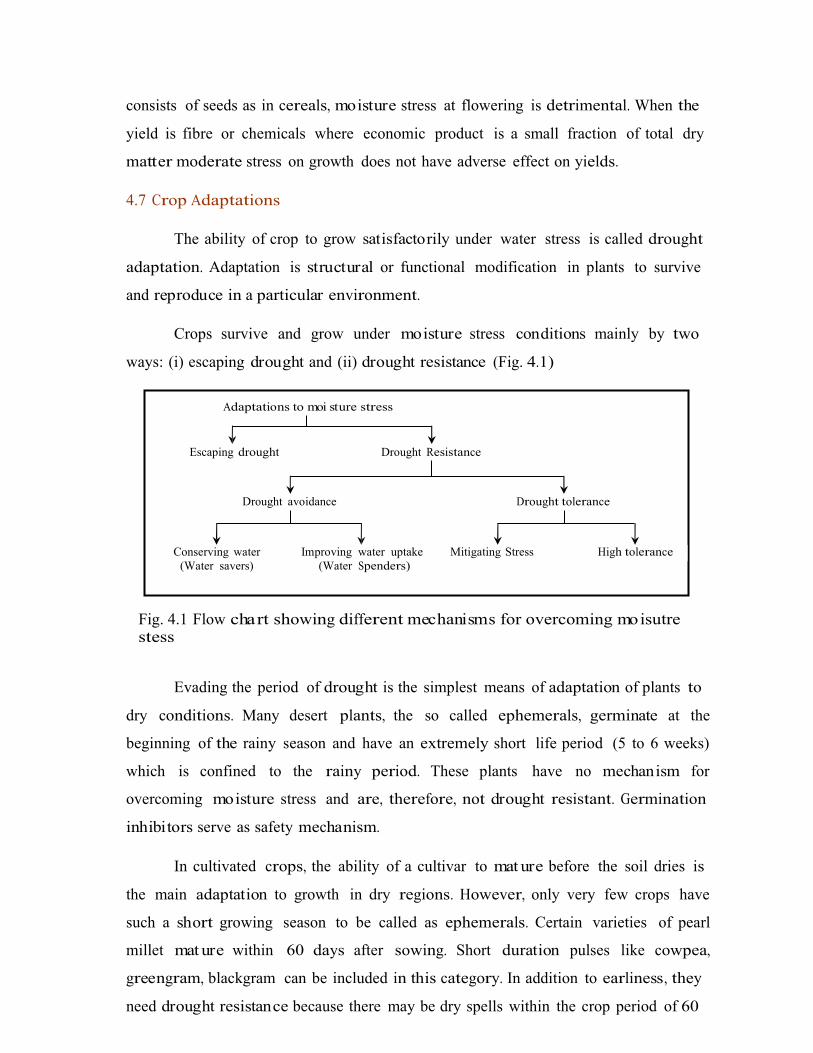
ways: (i) escaping drought and (ii) drought resistance (Fig. 4.1)
Fig. 4.1 Flow chart showing different mechanisms for overcoming moisutre stess
4.7.1 Escaping DroughtEvading the period of drought is the simplest means of adaptation of plants to
dry conditions. Many desert plants, the so called ephemerals, germinate at the
beginning of the rainy season and have an extremely short life period (5 to 6 weeks)
which is confined to the rainy period. These plants have no mechanism for
overcoming moisture stress and are, therefore, not drought resistant. Germination
inhibitors serve as safety mechanism.
In cultivated crops, the ability of a cultivar to mat ure before the soil dries is
the main adaptation to growth in dry regions. However, only very few crops have
such a short growing season to be called as ephemerals. Certain varieties of pearl
millet mat ure within 60 days after sowing. Short duration pulses like cowpea,
greengram, blackgram can be included in this category. In addition to earliness, they
need drought resistance because there may be dry spells within the crop period of 60
Adaptations to moi sture stress
Escaping drought Drought Resistance
Drought avoidance Drought tolerance
Conserving water Improving water uptake Mitigating Stress High tolerance(Water savers) (Water Spenders)

days. The disadvantage about breeding early varieties is that yield is reduced with
reduction in duration.
4.7.2 Drought Resistance
Plants can adopt to drought either by avoiding stress or by tolerating stress
due to different mechanisms. These mechanisms provide drought resistance.
4.7.3 Avoiding Stress
Stress avoidance is the ability to maintain a favourable water balance, and
turgidity even when exposed to drought conditions, thereby avoiding stress and its
consequences. A favourable water balance under drought conditions can be achieved
either by: (i) conserving water by restricting transpiration before or as soon as stress
is experienced; or (ii) accelerating water uptake sufficiently so as to replenish the
lost water.
4.8 Strategies for drought management
The different strategies for drought mana gement are discussed under the
following heads.
4.8.1 Adjusting the plant population: The plant population should be lesser in
dryland conditions than under irrigated conditions. The rectangular type of planting
pattern should always be followed under dryland conditions. Under dryland
conditions whenever moisture stress occurs due to prolonged dry spells, under
limited moisture supply the adjustment of plant population can be done by
a) Increasing the inter row distance: By adjusting more number of plants within
the row and increasing the distance between the rows reduces the competition
during any part of the growing period of the crop. Hence it is more suitable for
limited moisture supply conditions.
b) Increasing the intra row distance: Here the distance between plants is
increased by which plants grow luxuriantly from the beginning. There will be
competition for moisture during the reproductive period of the crop. Hence it is less
advantageous as compared to above under limited moisture supply.
4.8.2 Mid season cor rections: The cont ingent mana gement practices done in the
standing crop to overcome the unfavourable soil moisture conditions due to
prolonged dry spells are known as mid season conditions.
a) Thinnin g: This ca be done by removing every alternate row or every third row
which will save the crop from failure by reducing the competition
b) Spraying: In crops like groundnut, castor, redgram, etc., during prolonged dry
spells the crop can saved by spraying water at weekly intervals or 2 per cent urea at
week to 10 days interval.
c) Ratooning: In crops like sorghum and bajra, ratoon ing can practiced as mid
season correction measure after break of dry spell.
4.8.3 Mulching: It is a practice of spreading any covering material on soil surface to
reduce evaporation losses. The mulches will prolong the moisture availability in the
soil and save the crop during drought conditions.
4.8.4 Weed control: Weeds compete with crop for different growth resources ore
seriously under dryland conditions. The water requirement of most of the weeds is
more than the crop plants. Hence they compete more for soil moisture. Therefore the
weed control especially during early stages of crop growth reduce the impact of dry
spell by soil moisture conservation.
4.8.5 Water harves ting and life saving irrigation: The collection of run off water
during peak periods of rainfall and storing in different structures is known as water
harvesting. The stored water can be used for giving the life saving irrigation during
prolonged dry spells.
Lecture No. 5 Tillage and seeding practices in drylands
5.1 Tillage
The mechanical manipulation of soil with tools and implements for obtaining
conditions ideal for seed germination, seedling establishment and growth of crops is
known as tillage. Tillage may be described as the practice of modifying the state of
the soil in order to provide conditions favourable to crop growth, (Cuplin, 1986 ). The
objectives of tillage in drylands are
(1) Develop desired soil structure for a seed bed which allows rapid
infiltration and good retention of rainfall.
(2) Minimize soil erosion by following practices such as conto ur tillage,
tillage across the slope etc.
(3) Control weeds and remove unwanted crop plants.
(4) Manage crop residues
(5) Obtain specific land configurations for in- situ moisture conservation,
drainage, planting etc.
(6) Incorporate and mix manures, fertilizers, pesticides or soil amendments
into the soil.
(7) Accomplish segregation by moving soil from one layer to another,
removal of rocks or root harvesting.
Hence, attention must be paid to the depth of tillage, time of tillage, direction
of tillage and intensity of tillage.
5.1.1 Depth of tillage – It depends on soil type, crop and time of tillage
a) Deep tillage: of 25-30 cm is beneficial for deep heavy clay soils to improve
permeability and to close cracks formed while drying. In soils with hard pans, deep
tillage once in 2-3 years with chisel plough up to 35-45 cm depth at 60-120 cm
interval will increase effective depth for rooting and moisture storage. Deep tillage is
preferable for cotton, redgram and other deep rooted crops.
recommended for shallow, gravelly, light textured soils.
It is not to be
b) Medium deep tillage: of 15-20 cm depth is generally sufficient for most soils and
crops. It is recommended for medium deep soils, shallow rooted crops, soils with
pan free horizon and for stubble incorporation.
c) Shallow tillage: up to 10 cm is followed in light textured soils, and shallow soils
and in soils highly susceptible to erosion. In soils prone for surface crusting, shallow
surface stirring or shallow harrowing is useful.
As depth of tillage increases, soil moisture storage from rainfall also increases
from about 7-8 % with shallow tillage to 9-10% with medium deep tillage and 11-
12% with deep tillage.
5.1.2 Time of tillage
Early completion of tillage is often helpful to enable sowing immediately after
rainfall and before the soil dries up. Summer tillage or off-season tillage done with
pre season rainfall causes more conservation of moist ure and also enables early and
timely sowing. It is particularly useful for pre-monsoon sowing.
a) Year round tillage: Here the tillage operations are carried out throughout the
year in dry farming areas. The tillage operations are started immediately after the
receipt of summer showers and continued till sowing of the crops. After harvest of
the crop, by taking the advantage of the residual soil moisture the soil is ploughed
once or twice to retain the soil moisture in the lower layers. The advantages of year
round tillage are reduced weed growth, better tilth, adequate soil moisture, and
timely sowing.
5.1.3 Direction of tillage
For moisture conservation, ploughing across the slope or along the contour is
very effective. Plough furrows check the velocity of runoff, promote more infiltration
and improve soil moisture storage.
5.1.4 Intensity of tillage
It refers to the number of times tillage is done. Frequent ploughing in shallow
light textured soils will pulverize the soils into fine dust and increase the

susceptibility to erosion. In heavy soils, leaving the land in a rough and cloddy stage
prior to sowing is useful for more depression storage.
The concept of minimal tillage is also practiced in dry lands. Here tillage is
confined to seeding zone only and the inter-space is not tilled. It not only saves time,
energy and cost but also helps in moisture conservation. The practice of "set line
cultivation" adopted in some dry regions is an example of minimum tillage. Here the
seed row space is fixed and season after season, tillage is done only in this seeding
strip. The intervening strip is not tilled.
5.2 Modern concepts of Tillage
In dry lands, rainfall is received simultaneously over a large area. In order to
ensure timely sowing before soil dries up, the interval between land preparations
and sowing must be narrowed down. This calls for completion of tillage over a large
area in quick time. Dependence on bullock power and traditional wooden plough
may not help in this regard. Use of more efficient tillage implements and
mechanization of tillage operations are warranted.
Tillage in drylands also encompasses land shaping for in situ soil moisture
conservation. Implements that can carryout tillage and land shaping in one single
operation will help in saving time and cost. If land preparation, land shaping and
sowing can be done in one single operation it can save considerable time. This is
termed as once over tillage, plough planting or conservation tillage. Suitable tractor
drawn machinery like a broad bed former cum seeder, Basin lister cum seeder which
can complete the land shaping and sowing simultaneously can be used.
a) Minimum/optimum/reduced tillage: It is the tillage system aimed at reducing
the number of tillage operations to the minimum level i.e. necessary for better seed
bed preparation, rapid germination for maintenance of optimum plant stand. It not
only saves time, energy and cost but also helps in moisture conservation. The
objectives of these systems include (1) reducing energy input and labour
requirement for crop production (2) conserving soil moisture and reducing erosion
(3) providing optimum seedbed rather than homogenizing the entire soil surface,
and (4) keeping field compaction to minimum .The advantages are:
i) Reduction of soil compaction
ii) Reduction of soil erosion
iii) Increases infiltration of water
iv) Increased soil fertility due to decomposition of crop residues
v) Less cost of production because less number of tillage operations
Disadvantages are
i) Reduced seed germination
ii) Root nodulation is affected in certain crops
iii) More nitrogen is required to enhance mineralization process
iv) Require specially designed equipment
Forms of minimum tillage
i) Row zone tillage: After the primary tillage with plough, the harrowing is done
only in crop row zone
ii) Plough plant tillage: After primary tillage special planter is used for pulverising
the soil, sowing the seed and covering the seed
iii) Wheel track planting: After primary tillage the tracto rs are used by their
wheels, for pulverisation, sowing and covering of seed.
b) Conservation/mulch tillage: The objectives are to achieve soil and water
conservation and energy conservation through reduced tillage operations. Both
systems usually leave crop residue on the surface and each operation is planned to
maintain continuous soil coverage by residue or growing plants. The conservation
tillage practices may advance some of the goals of alternative farming such as
increasing organic matt er in soil and reducing soil erosion, but some conservation
tillage practices may increase the need for pesticides. Conservation tillage changes
soil properties in ways that affect plant growth, and reduce water runoff from fields.
The mulched soil is cooler and soil surface under the residue is moist, as a result
many conservation tillage systems have been successful.

c) Zero tillage or no-till sys tem It is an extreme form of minimum tillage where
primary tillage is completely avoided and secondary tillage is is resricted to crop
zone.In this method use of mechinery and hebicides with relatively low or no
residual effect on the crop to be established will play a major role.The mechinery
should have attachm ents for four operations namely, cleaning the narrow strip over
crop row,open the soil for seed insertion,placing the seed and covering the seed.
Advantages are
i) Increases the biological activity in the soil
ii) Organic matt er cont ent of the soil is increase due to decomposition of crop
residues
iii) reduction of suface runoff
Diadavantages are
i) poor seed germination
ii) High dose of N required for mineralisation
iii) Some perennial weeds and voluntary plants predominate
iv) More disease and pest incidence
5.3 Seeding practices
5.3.1 Establishment of optimum population
Poor or suboptimal population is a major reason for low yields
crops. Establishment of an optimum population depends on
in rainfed
a) Seed treatment
b) Sowing at optimum soil moisture
c) Time of sowing
d) Depth of sowing
e) Method of sowing
f) Crop geometry

a) Seed treatment
Seed treatment is done for many purposes such as protection against pests
and diseases, inoculation of bio-fertilizers and inducing drought tolerance.
i) Seed hardening
It is done to induce drought tolerance in emerging seedlings. It is the process
of soaking seeds in chemical solution and drying to induce tolerance to drought. Soil
moisture stress immediately after sowing affects germination and establishment.
Seed hardening enables seedlings to survive this early moisture stress.
During seed hardening, seeds are subjected to partial hydration followed by
dehydration before sowing. Seeds are soaked for specified time in chemical solutions
of prescribed concentration. Soaked seeds are then dried in shade back to original
moisture content. During soaking, seeds imbibe water and germination process is
started but not completed. The hardened seeds are thus in a ready state for
germination. When sown in moist soils, seeds germinate immediately. Such early
germination helps in seedling emergence before surface soil dries up.
b) Sowing at optimum soil moisture
An effective rainfall of 20-25 mm which can wet a depth of 10-15 cm is needed
for sowing. Moisture stress at or immediately after sowing adversely affects
germination and establishment of seedlings. To ensure adequate soil moisture at
sowing, sowing has to be done as early as possible after soaking rainfall is received.
Sowing methods and implements play a crucial rile in this regard.
c) Time of sowing
Optimum time of sowing is indicated by adequate rainfall to wet seeding
depth and cont inuity of rainfall after sowing. The probable sowing time in a rainfed
area is the week which has a rainfall of not less than 20 mm with coefficient of
variability less than 100% and the probability of a wet week following wet week.
Timely sowing ensures optimal yield besides it may also help pest avoidance. In
Maharastra kharif sorghum cultivated in 30 lakh hectares and more than 70% under
hybrid prone to shoot fly. If sown at early July, the pest incidence can be avoided.
Pre-monsoon dry seeding
In some regions, where heavy clay soils dominate, sowing after rains is
impossible due to high stickiness of soil. Here sowing is done in dry soil, 2-3 weeks
before the onset of monsoon (pre-monsoon). Seeds will remain in soil and germinate
only on receipt of optimum rainfall.
The advantages of pre-monsoon dry seeding are
i) Early sowing
ii) Uniform germination and good establishment
iii) Utilization of first rainfall itself for germination instead of for land
preparation in post monsoon sowing
iv) Early maturity before closure of monsoon and avoidance of stress at
maturity.
The success of pre-monsoon dry seeding depends on the following
i) It is recommended for bold seeds like cotton and sorghum only and not for
all crops.
ii) Time of advance sowing must be fixed based on rainfall analysis for date of
onset of monsoon and continuity of rainfall after sowing.
iii) Seeds must be hardened to ensure quick germination and drought
tolerance
iv) Seeding depth must be such that seeds will germinate only after receipt of
rainfall to wet that depth is received. Surface sowing may lead to
germination with less rainfall and death due to subsequent soil drying.
v) Off season tillage is necessary to enable sowing in dry soil before monsoon
vi) Seed damage by soil insects has to be prevented

Examples of pre-monsoon sowing
1. For sorghum in black soils, pre-monsoon dry seeding is recommended 1-2
weeks before onset of monsoon with depth of sowing at 5 cm and seed hardening
with 2 per cent potass ium di-hydrogen phosphate or potass ium chloride.
2. For cotton in black soils, pre-monsoon dry seeding is recommended at 2-4
weeks before commencement of monsoon, with a sowing depth of 5 cm and seed
hardening with CCC (500 ppm) or potass ium chloride or DAP at 2% level.
d) Optimum depth of sowing
When seeds are sown on surface or at very shallow depth, germination and
seedling growth are affected when surface soil moisture dries up. Sowing at a depth
where soil moisture availability is adequate, ensure early and uniform germination
and seedling establishment. Optimum depth of' sowing varies with crop, especially
seed size and penetration power of plumule.
Sesamum 1-2 cm
Pearl millet and minor millets 2-3 cm
Pulses, sorghum, sunflower 3-5 cm
Cotton, maize 5 cm
Coriander 7 cm
e) Method of sowing: In dry lands, it is important to sow the seeds in moist soil
layer to ensure proper germination and seedling emergence. It is therefore
necessary to sow immediately after rainfall to avoid sowing in dry soil. It is also
important to sow the seeds at correct depth, neither on the surface nor too deep.
Establishment of an optimum population also depends on proper spacing between
plants. The density, geometry, and depth of sowing are dependent on method of
sowing. The sowing methods usually adopted in dry lands include broadcasting,
sowing behind plough and sowing by seed drills. Dibbling of seeds and planting of
seedlings are also adopted for some crops (Cotton, tobacco, chillies). Each method
has advantages as well as limitations. The choice of sowing method depends on seed
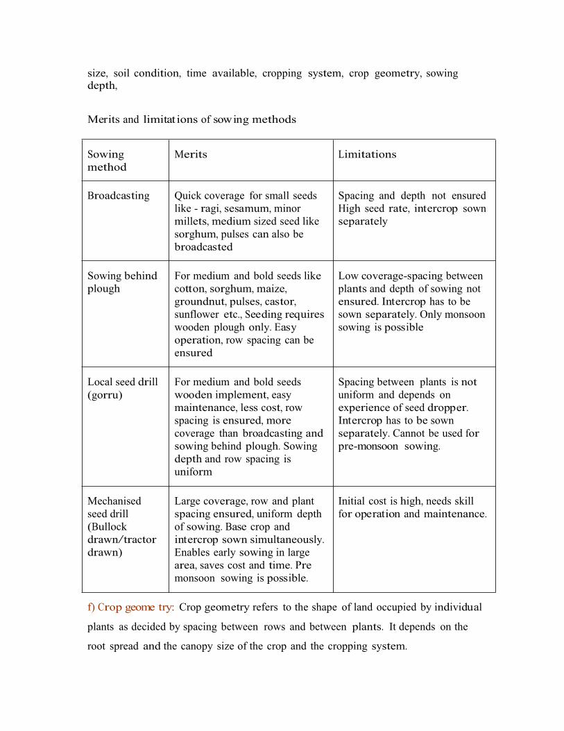
size, soil condition, time available, cropping system, crop geometry, sowing depth,
source of power, cost of sowing, etc.Merits and limitat ions of sowing methods
f) Crop geome try: Crop geometry refers to the shape of land occupied by individual
plants as decided by spacing between rows and between plants. It depends on the
root spread and the canopy size of the crop and the cropping system.
Sowing method
Merits Limitations
Broadcasting Quick coverage for small seeds like - ragi, sesamum, minor millets, medium sized seed like sorghum, pulses can also be broadcasted
Spacing and depth not ensured High seed rate, intercrop sown separately
Sowing behind plough
For medium and bold seeds like cotton, sorghum, maize, groundnut, pulses, castor, sunflower etc., Seeding requires wooden plough only. Easy operation, row spacing can be ensured
Low coverage-spacing between plants and depth of sowing not ensured. Intercrop has to be sown separately. Only monsoon sowing is possible
Local seed drill(gorru)
For medium and bold seeds wooden implement, easy maintenance, less cost, row spacing is ensured, more coverage than broadcasting and sowing behind plough. Sowing depth and row spacing is uniform
Spacing between plants is not uniform and depends on experience of seed dropper. Intercrop has to be sown separately. Cannot be used for pre-monsoon sowing.
Mechanised seed drill (Bullock drawn/tractor drawn)
Large coverage, row and plant spacing ensured, uniform depth of sowing. Base crop and intercrop sown simultaneously. Enables early sowing in large area, saves cost and time. Pre monsoon sowing is possible.
Initial cost is high, needs skill for operation and maintenance.

5.4 Setline cultivation: It is a form of minimum tillage practice predominant in
saurastra region of India where farmers are adopting the practice of continuously
cultivating, manuring and sowing wide spaced crops in the same line or row year
after year. In between the rows the soil is worked with blade or harrowed only for
weed control. The crops like sorghum, bajra, cotton, and groundnut are cultivated by
this method. The advantages are
Crop Crop geome try (cm)
Sole crop in solid row Intercropping
Sorghum 45 x 15 (60+30) x 15 paired row
Pearl millet 30 x 15
Ragi 30 x 10
Small millets 30 x 10
Black gram, green gram, Soybean, horsegram
30 x 10
Redgram 60 x 30
Cowpea 30 x 15
Cotton 45 x 30 (60+30) x 15 in paired row
Cotton (Arboreum) 45 x 15
Groundnut 30 x 10
Sesamum 30 x 30
Sunflower 45 x 15
Sunflower hybrids 45 x 20
Sunflower varieties 30 x 15
Coriander 30 x 15
bengalgram 45 x 15
Maize 45 x 30

i) Reduced cost of cultivation
ii) As the crops are raised in the same row, the rhizosphere is loose with good
aeration and permeability without development of hard pans in the sub
soil
5.5 Soil crusts: Soil crusts are hard layers that develop at the soil surface due to
action of rain drop or irrigation water and subsequent drying. Soil crusts often
hinder the emergence of seedlings and hence establishment of crop stand.
Crust formation: The impact of rain and or irrigation disrupts the soil aggregates,
reduces the mean size of the structural units and causes resorting and repacking by
water movement in splash flow and sedimentation process. On subsequent drying it
results in the development of continuous layer of closely packed soil particles. The
crust has high bulk density, lower macro porosity and higher mechanical strength
than below.
Effects of crust on soil and crop
i) Reduce infiltration rate
ii) Increase runoff and erosion
iii) Impede emerging seedling
iv) Injure the young seedling by movement of large blocks of crusts during
cultivation
Manageme nt practices to avoid crust problem
i) Shallow and dense sowing
ii) Use of thorny bush harrowing
iii) Mulching
iv) Light harrowing after rain
v) Planting on shallow furrows and on sides of ridges

Lecture No. 6 Soil erosion- types of soil erosion and factorsaffec ting soil erosion
6.1 Definition
Soil erosion is the process of detachm ent of soil particles from the top soil and
transportation of the detached soil particles by wind and / or water.
The agents causing erosion are wind and water. The detaching agents are
falling raindrop, channel flow and wind. The transporting agents are flowing water,
rain splash and wind.
6.2 Nature and extent of erosion
The problem of soil erosion exists all over the country. Out of the 329 m.ha of
India’s geographical area about 175 m.ha (53.3%) is subjected to soil erosion and
some kind of land degradation (Druvanarayana, 1993 ). About 150 m.ha is subjected
to wind and water erosion. It is estimated that about 5333 Mt of soil is detached
annually by soil annually. Out of this 29 % is carried away by rivers to seas and about
10% is deposited in reservoirs resulting in 1-2 % of loss of storage capacity annually.
The estimated annual soil loss is 16.35 tones/ha/year.
Physiographically India is divided into three regions as follows:
a) Himalayan region: Geologic immat urity made this region more vulnerable to
erosion. High degree of seismicity of the area, very steep slopes, weak geological
formation and improper land use practices accelerate erosion losses. Gullying, land
slides and slips are most common.
b) Gangetic plains: Major problems in the region are riverine erosion, drainage,
saline and alkali soil conditions.
c) Peninsular region: Main problems of this region are rill and gully erosion.
Arid regions have severe wind erosion. Semi arid regions are subjected to
sheet and gully erosion and ravines are serious problem in Yamuna and Chambal
region. Floods and stream bank cutting and sand deposition have degraded lands of
north east region with heavy rainfall. South and south east are characterized by
undulating terrain with severe erosion in black and red laterite soils.
6.3 Losses due to erosion:
i) Loss of fertile top soil
ii) Loss of rain water
iii) Loss of nutrients
iv) Silting up of reservoirs
v) Damage to forests
vi) Reduction in soil depth
vii) Floods
viii) Adverse effect on public health
ix) Loss of fertile land
x) Economic losses
6.4 Types of erosion:
There are two major types of soil erosion
a) Geological eros ion (Natural or normal erosion): is said to be in equilibrium with
soil forming process. It takes place under natural vegetative cover completely
undisturbed by biotic factors. This is very slow process.
b) Accelerated eros ion: is due to disturbance in natural equilibrium by the activities
of man and animals through land mismanagement, destructing of forests over
grazing etc., Soil loss through erosion is more than the soil formed due to soil forming
process.
Based on the agents causing erosion, erosion is divided into
a. Water erosion b. Wind erosion c. Wave erosion
6.4.1 Water erosion
Loss of soil from land surface by water including run off from melted snow
and ice is usually referred to as water erosion.

Major erosive agents in water erosion are impacting/ falling raindrops and
runoff water flowing over soil surface.
6.4.1.1 Process of water erosion
Detachment of soil particles is by either raindrop impact or flowing water.
Individual raindrops strike the soil surface at velocities up to 9 m/s creating very
intensive hydrodynamic force at the point of impact leading to soil particle
detachment. Over land flow detaches soil particles when their erosive hydrodynamic
force exceeds the resistance of soil to erosion. Detached soil particles are transported
by raindrop splash and runoff. The amount of soil transported by runoff is more than
due to raindrop splash. Thus the falling raindrops break the soil aggregates and
detach soil particles from each other. The finer particles (silt and clay) block the soil
pores and increase the rate of runoff and hence loss of water and soil.
6.4.1.2 Forms of water erosion
Water erosion occurs in stages identified as sheet erosion, rills, gullies,
ravines, landslides and stream bank erosion.
a) Sheet eros ion: It is the uniform removal of surface soil in thin layers by rainfall
and runoff water. The breaking action of raindrop combined with surface flow is the
major cause of sheet erosion. It is the first stage of erosion and is least conspicuous,
but the most extensive.
b) Rill eros ion: When runoff starts, channelisation begins and erosion is no longer
uniform. Raindrop impact does not directly detach any particles below flow line in
rills but increases the detachm ent and transportation capacity of the flow. Rill
erosion starts when the runoff exceeds 0.3 to 0.7 mm/s. Incisions are formed on the
ground due to runoff and erosion is more apparent than sheet erosion. This is the
second stage of erosion. Rills are small channels, which can be removed by timely
normal tillage operations.
c) Gully eros ion: It is the advanced stage of water erosion. Size of the unchecked rills
increase due to runoff. Gullies are formed when channelised runoff form vast sloping
land is sufficient in volume and velocity to cut deep and wide channels. Gullies are

the spectacular symptoms of erosion. If unchecked in time no scope for arable crop
production.
d) Ravines: They are the manifestations of a prolonged process of gully erosion.
They are typically found in deep alluvial soils. They are deep and wide gullies
indicating advanced stage of gully erosion.
e) Landslides: Landslides occur in mountain slopes, when the slope exceeds 20%
and width is 6m. Generally land slides cause blockage of traffic in ghat roads.
f) Stream bank erosion: Small streams, rivulets, torrents (hill streams) are
subjected to stream bank erosion due to obstruction of their flow. Vegetation sprouts
when streams dry up and obstructs the flow causing cutting of bank or changing of
flow course.
6.4.1.3 Factors affecting water erosion
a) Climate: Water erosion is directly a function of rainfall and runoff. Amount,
duration and distribution of rainfall influences runoff and erosion. High intensity
rains of longer duration causes severe erosion. Greater the intensity, larger the size
of the raindrop. Rainfall intensity more than 5 cm/hr is considered as severe. Total
energy of raindrops falling over a hectare land with rainfall intensity of 5 cm /hr is
equal to 625 H.P. This energy can lift 89 times the surface 17.5 cm of soil from one ha
to a height of 3 ft. Two- thirds of the above energy is used for sealing soil pores.
Runoff may occur without erosion but there is no water erosion without runoff. The
raindrop thus breaks down soil aggregates, detaches soil particles and leads the
rainwater with the fine particles. These fine particles seal the pores of the surface soil
and increases runoff causing erosion.
b) Topography: The degree, length and curvature of slope determine the amount of
runoff and extent of erosion. Water flows slowly over a gentle slope where as at a
faster rate over a steepe r one. As water flows down the slope, it accelerates under the
forces of gravity. When runoff atta ins a velocity of about 1 m/s it is capable of
eroding the soil. If the percent of slope is increased by 4 times the velocity of water
flowing down is doubled. Doubling the velocity quadruples the erosive power and
increases the quantity of soil that can be transported by about 32 times and size of
the particles that can be transported by about 64 times.

c) Vegetation: Vegetation intercepts the rainfall and reduces the impact of
raindrops. It also decreases the velocity of runoff by obstructing the flow of water.
The fibrous roots are also effective in forming stable soil aggregates, which increases
infiltration and reduces erosion.
d) Soil Properties: Soil properties that influence soil erodability by water may be
grouped into two types.
i. Those properties that influence the infiltration rate and permeability
ii. Those properties that resist the dispersion, splashing, abrasion and
transporting forces of rainfall and runoff.
The structure, texture, organic matt er and moisture cont ent of upper layers
determine the extent of erosion. Sandy soils are readily detachable but not readily
transportable. Soils of medium to high clay cont ent have low infiltration capacities
and they are readily transported by water after they are dispersed, but their
detachability is generally low.
e) Man and beast
Man and beast accelerates erosion by extensive farming and excessive
grazing. Faulty practices like cultivation on steep slopes, cultivation up and down the
slope, felling and burning of forests etc., leads to heavy erosion. Excessive grazing
destroys all vegetation and increases the erosion.
6.4.1.4 Estimation of soil loss by water erosion
Based on the mechanism and factors influencing soil erosion, a universal soil
loss equation (USLE) developed by Wischmeier (1959) is most useful for predicting
soil loss due to water erosion. It is an empirical equation and estimates average
annual soil loss per unit area as a function of major factors affecting sheet and rill
erosion. It enables determination of land management erosion rate relationsh ips for
a wide range of rainfall, soil slope and crop and management conditions and to select
alternative cropping and management combinations that limit erosion rates to
acceptable limits.

A= R x K x L x S x C x P
where, A= predicted soil loss in t/ha/year
R= rainfall erosivity factor or index
K= soil erodibility factor
L= length of slope factor
S= slope steepness factor
C= soil cover and mana gement factor and
P= erosion control factor
6.5 Wind erosion
Erosion of soil by the action of wind is known as wind erosion. It is a serious
problem on lands devoid of vegetation. It is more common in arid and semi arid
regions. It is essentially a dry weather phenomenon stimulated by the soil moisture
deficiency. The process of wind erosion consists of three phases: initiation of
movement, transportation and deposition. About 33 m.ha in India is affected by wind
erosion. This includes 23.49 m.ha of desert and about 6.5 m.ha of coastal sands. The
Thar Desert is formed mainly by blow in sand.
6.5 Mechanism of wind erosion
Lifting and abrasive action of wind results in detachment of tiny soil particles
from the granules or clods. The impact of these rapidly moving particles dislodge
other particles from clods and aggregates. These dislodged particles are ready for
movement. Movement of soil particles in wind erosion is initiated when the pressure
by the wind against the surface soil grains overcomes the force of gravity on the
grains. Minimum wind velocity necessary for initiating the movement of most
erodable soil particles (about 0.1 mm diameter) is about 16 km /hr at a height of 30.5
cm. Most practical limit under field conditions, where a mixture of sizes of single
grained material present is about 21 km/hr at a height of 30.5 cm.
In general movement of soil particles by wind takes place in three stages:
saltation, surface creep and suspension.

a. Saltation: It is the first stage of movement of soil particles in a short series of
bounces or jumps along the ground surface. After being rolled by the wind, soil
particles suddenly leap almost vertically to form the initial stage of movement in
saltation. The size of soil particles moved by saltation is between 0.1 to 0.5 mm in
diameter. This process may account for 50 to 70% of the total movement by wind
erosion.
b. Surface cree p: Rolling and sliding of soil particles along the ground surface due to
impact of particles descending and hitting during saltat ion is called surface creep.
Movement of particles by surface creep causes an abrasive action of soil surface
leading to break down of non-erodable soil aggregates. Coarse particles longer than
0.5 to 2.0 mm diameter are moved by surface creep. This process may account for 5
to 25% of the total movement.
c. Suspension: Movement of fine dust particles smaller than 0.1 mm diameter by
floating in the air is known as suspension. Soil particles carried in suspension are
deposited when the sedimentation force is greater than the force holding the
particles in suspension. This occurs with decrease in wind velocity. Suspension
usually may not account for more than 15% of total movement.

Lecture No. 7 Soil conservation me asures – agronomic measuresof soil conservation
7.1 Definition of soil conservation
Soil conservation is using and managing the land based on the capabilities of
the land itself involving application of the best mana gement practices leading to
profitable crop production without land degradation.
7.2 Control of water erosion
Water erosion occurs simultaneously in two steps: detachm ent of soil
particles by falling raindrops and transportation of detached particles by flowing
water. Hence preventing the detachm ent of soil particles and their transportation can
minimize water erosion. Principles of water erosion control are
-
-
-
-
Maintenance of soil infiltration capacity
Soil protection from rainfall
Control of surface runoff and
Safe disposal of surface runoff
For a sound soil conservation programme every piece of land must be used in
accordance with the land capability classification.
7.2.1 Measures of water eros ion control
1. Agronomic measures
2. Mechanical measures (Engineering measures)
3. Forestry measures
4. Agrostological measures
7.2.2 Agronomic me asures of soil conservation
In soil and water conservation programmes agronomic measures have to be
considered in co-ordination with others for their effectiveness. These measures are
effective in low rainfall areas particularly in fairly erosion resistant soils having
gentle slope (< 2 %).
The different agronomic measures include

1. Land preparation
2. Contour cultivation
3. Choice of crops
4. Strip cropping
5. Crop rotat ion / cropping systems
6. Cover crops
7. Mulching
8. Application of manures and fertilizers
9. Application of chemicals
a) Land preparation: Land preparation including post harvest tillage influence
intake of water, obstruction to surface flow and consequently the rate of erosion.
Deep ploughing or chiseling has been found effective in reducing erosion. Rough
cloddy surface is also effective in reducing erosion.
b) Contour cultivation (Contour farming): A line joining the points of equal
elevation is called contour. All the cultural practices such as ploughing, sowing,
intercultivation etc. done across the slope reduce soil and water loss. By ploughing
and sowing across the slope, each ridge of plough furrow and each row of the crop
act as obstruction to the runoff and provide more time for water to enter into the soil
leading to reduced soil and water loss (Fig 7.1).
Fig 7.1 Contour Cultivation

c) Choice of crops :Row crops or tall growing crops such as sorghum, maize, pearl
millet etc.,are not effective in conserving soil as they expose majority of the soil and
hence they are known as eros ion permitting crops. Where as close growing crops
such as cowpea, groundnut, green gram, black gram etc., which protect soil are
known as eros ion res isting crops as they are very effective in reducing soil loss by
minimizing the impact of rain drop and acting as obstruction to runoff.
d) Strip cropping: It is a system of growing of few rows of erosion resisting crops
and erosion permitting crops in alternate strips on conto ur (across the slope) with
the objective of breaking long slopes to prevent soil loss and runoff. Close growing
erosion resisting crops reduce the transporting and eroding power of water by
obstructing runoff and filtering sediment from runoff to retain in the field. The width
of the erosion permitting and erosion resisting crops vary as per the slope of the
field. The strip cropping resembles the intercropping.
With increase in per cent slope of the soil, the width of erosion permitting and
erosion resisting crops decreases. The normal ratio between the erosion resisting
crops and erosion permitting crops is 1: 3. Among the different crops the anti-
erosion value of pillipesara is highest, where as cotton crop recorded the lowest
value .The strip cropping is divided into four types as follows
i) Contour strip cropping: The erosion permitting crops and erosion resisting crops
are grown in alternate strips along the contours.
ii) Field strip cropping: Alternate strips of erosion permitting crops and erosion
resisting crops are raised across the general slope not necessarily on exact contour
iii) Wind strip cropping: Strip cropping of erosion permitting and erosion resisting
crops across the direction of the most prevailing wind irrespective of the contour.
Slope (%)Width of crops (m)
Erosion resisting Erosion permitting
Up to 1% 9.0 45.0
1 to 2% 6.0 24.0
2 to 3% 4.0 12.0
iv) Buffer strip cropping: this type of strip cropping is practiced in areas having
steep slopes and badly eroded soils where strips of perman ent cover crops or
perennial legumes or grasses or shrubs are alternated with field crops.
The strip cropping is simple, cheap and effective soil conservation practice
and can be adopted by the farmers.
e) Crop rotation / cropping sys tem: Monocropping of erosion permitting crops
accelerates soil and water loss year after year. Intercropping of erosion permitting
crops and erosion resisting crops or their rotat ion has been found effective for
reducing soil and water loss. Inclusion of legumes like lucerne in crop rotat ion
reduces soil loss even in soils having 13% slope.
f) Cover crops: Good ground cover by canopy gives the protection to the land like an
umbrella and minimize soil erosion. Besides conserving soil and moisture, the cover
crops hold those soluble nutrients, which are lost by leaching. The third advantage of
the cover crops is the addition of organic matter. The legumes provide better cover
and better protection. Among the legumes cowpea has been found to produce
maximum canopy followed by horsegram, green gram, black gram and dhaincha.
g) Mulching: Mulching of soil with available plant residues reduce soil loss
considerably by protecting the soil from direct impact of raindrop and reducing the
sediment carried with runoff .A minimum plant residue cover of 30 per cent is
necessary to keep runoff and soil loss within the acceptable limits. Vertical mulching
also reduce soil loss particularly in vertisols by increasing infiltration.
h) Application of manures and fertilizers : Organic manures besides supplying
nutrients improve soil physical conditions thereby reduce soil loss. Fertilizers
improve vegetative canopy, which aid in erosion control.
i) Use of chemicals: Breakdown of aggregates by the falling raindrops is the main
cause of detachm ent of soil particles. Soils with stable aggregates resist breakdown
and thus resist erosion. Aggregate stability can be increased by spraying chemicals
like poly vinyl alcohol @ 480 kg/ha (rate will depend on the type of soil). Soils
treated with bitumen increase water stable aggregates and infiltration capacity of the
soil.

Lecture No. 8 Fertilizer use in drylands
8.1 Introduction
No Agricultural system can persist, if it fails to maintain soil fertility. In
dryland soils or SAT soils Nitrogen is universally deficient, ‘P’ is low, and ‘K ’ status is
medium to high. The organic matt er cont ent of SAT soils is usually less than one per
cent and hence is of low fertility status.
8.2 Low rates of fertilizer application
Vagaries of rainfall and consequent uncertainty of crop performance make
farmers of dryland agriculture to avoid fertilizer application. However, results of
experiments demonst rated yield advantage due to fertilizer use in dry land crop
production.
If the fertilizers are applied to meet the needs of the dryland crops, there may
be prolonged breaks in the monsoon in kharif or limited available moisture in the
root zone of rabi crops may be exhausted before the plants reach reproductive stage
resulting in poor yields. On the other hand, if fertilizers are applied at rates below the
optimum, the yields will be poor. This has to be avoided by assessing the yield
potential of different regions and regulating the soil fertility levels by adding only
such quantities of fertilizers as required for realizing the potential to the maximum
extent possible. Hence fertilizer usage is more in irrigated agriculture than dryland
agriculture.
8.3 Res ponse to Nitrogen
Fertilizer use and loss will be more sensitive in shallow soils; hence response
to applied fertilizer will be less stable on shallow soils. Response to ‘N’ was low and
influence of rainfall was incons istent among shallow vertisols and alfisols. With
decreasing rainfall, vertisols produced more response to applied fertilizer.
Results indicated that with 40 kg N/ha many crops responded to ‘N’ in
dryland areas by giving about 20 kg extra grain or yield for every kg of N applied.
However, magnitude of response decreased with higher rates except maize crop.
Results of experiments for five years indicated that response of rabi sorghum to 25

kg N/ha on soils with low moisture storage, where as on soil depth up to 60 cm
sorghum grain yield increased up to 75 kg N/ha.
8.4 Res ponse to Phosphorus
Deficiency of phosphorus is less extensive than that of nitrogen. Though
several crops respond to ‘P’ the response is not conspicuous and universal as that of
‘N’. Dry land vertisols possess high phosphorus fixation capacity, ranging from 300 to
450 mg /kg of soil, hence there will be less amount of ‘P’ in soil solution to be
available for the crop plants. This explains the lack of response to ‘P’ in vertisols since
the amount of the ‘P’ added seldom exceed 25-35 kg P2O5/ha which is inadequate to
meet the ‘P’ fixing capacity of the soil and crop requirement. Response of dryland
crops to ‘P’ will continue to remain small and marginal as long as the poor yields of
crops are not increased through efficient soil and moisture conservation measures
and balanced crop nutrition.
8.5 Res ponse to Potassium
On a large scale, potass ium has failed to produce distinct response in dryland
cereals and millets as is common with irrigated crops. Dryland soils particularly, the
sandy loam and red soils which are deficient in ‘K ’ may respond to moderate levels of
‘K ’ when monsoon is normal. The recommended dose of NPK for different crops of
Andhra Pradesh in furnished in table 8.1
Table 8.1 : Recomme nded dose of fertilizers for rainfed crops of AndhraPradesh
CropDose (kg/ha)
N P2O5 K2O
Groundnut 20 40 40
Sorghum 40-80 40 0
Pearl millet 40-80 40 0
Setaria 40 40 0
Redgram 20 40 0
Greengram 20 40 0
Horsegram 10 30 0
Sunflower 30-40 30-40 0
8.6 Res ponse to seco ndary and micronutrients
Among secondary nutrients oilseeds and pulses respond to sulphur and
calcium. Response to ‘Ca’ and ‘S’ is of typical of rainfed groundnut. Among the
micronutrients deficiency of ‘Fe’ and response to its application have been observed
in crops like chickpea and groundnut. Zinc is deficient in many areas and many crops
respond to Zinc Eg: groundnut, maize, pearl millet etc.
8.7 Res ponse to NPK (Balanced fertilization)
Balanced fertilizer application increases the efficiency of added fertilizers.
Response to universally deficient ‘N’ could be low if other nutrients are limiting.
More frequently ‘P’ limits the response of ‘N’. If N+P is applied the yield response is
increased.
In dryland areas receiving less than 750 mm annual rainfall where prolonged
dry spells are common during the crop period, economical responses were obtained
with low levels of ‘N’ only.
8.8 Alternate sources of Nitrogen
There are several alternate sources of ‘N’, which include organic manures,
biofertilizers, green manuring, introduction of legumes in cropping system etc.,
8.9 Green manuring
This is considered normally uneconomical in drylands. In Khammam district
of A.P, farmers raise green gram with June-July rains and after picking the pods,
plough back the residue and take the sorghum by September (Maghi sorghum). It can
be practiced in vertisols with dependable rainfall. Horsegram can be raised after
sorghum or sunflower during October / November where there is dependable
rainfall. The leaves of Soobabul, Glyricidia etc, can be used as green leaf manure.
8.10 Introduction of legumes in cropping systems
Legume, being a biological ‘N’ fixing crop, should become a part of the
cropping system. Legumes in a cropping system cont ribute to the extent of 25 kg
N/ha.
8.11 Organic recycling

Vast potential for organic wastes like stubbles of millets and other crops,
sugarcane trash, weeds and other farm residues exist in many areas, which can put to
agricultural use by composting. Conjunctive use of FYM and these organic wastes
improve the productivity of soils especially sandy loam soils by improving their
moisture retentive capacity.
8.12 Rhizobium culture
Inoculating legumes with Rhizobium could not met with success for increasing
‘N ’ fixation under dryland conditions probably due to unfavourable environment,
especially prolonged soil moisture stress periods during crop season, high
temperature stress and deficiency of other nutrients.
8.13 Integrated nutrient manageme nt system
It envisages the conjunctive use of organic manures, crop residues,
biofertilizers, legumes in crop rotation, green manuring and need based chemical
fertilizers for sustained crop production.
Mean yield of finger millet over a period of 9 years was similar with
recommended NPK rates or with 50% NPK fertilizers along with FYM 10 t/ha. At
Akola (Maharastra) and Kovilpatti (Tamilnadu) incorporation of organic residues
increased sorghum yield by 120 and 75 kg/ha as against 75 and 38 kg / ha with
fertilizers.
Biofertilizers like Azospirillum commonly found in assoc iation with roots of
cereals and grasses. High N fixation capacity, low energy requirement and abundant
establishment in the roots of cereals and tolerance to high temperature (30-40° C)
are responsible for its suitability to dry land conditions. It has been largely tested in
sorghum and bajra and can substitute up to 20 kg N/ha.
VAM: Vesicular Arbuscular Mycorrhizae has found to influence yield of
several crops like bajra, finger millet, sorghum, groundnut, pegionpea, cowpea etc. by
increasing ‘P’ uptake.
Phosphate Solubulising Bacteria (PSB) also recieved considerable
attention. Eg: Bacillus sps.
8.14 Salient findings of fertilizer use rese arch in dry land agriculture
The results of fertilizer use research in dry farming areas indicated that
fertilizer dose should be low. Improved cultivars are responsive than local varieties.
The following are the salient findings of research on fertilizer use under
rainfed conditions:
1. Response of crops to fertilizers varied with available soil moisture. Higher
the rainfall, greater the response in shallow soils.
2. Responses to ‘N’ are universal, responses to ‘P’ are obtained on alfisols, and
responses to ‘K ’ are limited.
3. Response of post-rainy season crops i.e. rabi crops to fertilizers will depend
on stored moisture in the profile. Most of the nutrients have to be band
placed in the soil at sowing as basal application.
4. For kharif crops, nitrogen can be applied in splits depending on rainfall.
Second split may be avoided if the soil moisture is not adequate for top
dressing in time.
5. Zinc deficiency is indicated in some areas.
6. Balanced fertilizer use resulted in yield advantage during normal rainfall
years.
7. Legumes are more responsive to ‘P’ fertilization.
8. Foliar application of nutrients was not beneficial at several places.
9. Most economical responses were with low rates of 25-30 kg N/ha.
10. On heavy black soils, crops respond to about 30 kg P2O5/ha.
11. Legumes in cropping system cont ribute to the extent of about 25 kg N/ha
and
12. Integrated nutrient mana gement system appears to be more remunerative.

8.15 Fer tilizer use efficiency (FUE) in dryland agriculture
It refers to kg of produce per kg of plant nutrient fertilizer applied.
8.15.1 Factors affecting fertilizer use efficiency
o Choice of cultivars or varieties or varietal selection
o Timely sowing
o Establishment of adequate crop stand
o Time and method of fertilizer application
o Moisture conservation practices and
o Timely weed management
a. Choice of varieties: Choice of varieties will depend on length of the growing
season. The traditional varieties are of long duration and their productivity is low.
High yielding and short duration varieties give more yields and increase the fertilizer
use efficiency.
b. Timely seeding: Timely sowing of a crop is an important agronomic factor
influencing crop yield and therefore the response to fertilizer application. Early
seeding gives good seedling vigour and longer growing season thereby leading to
efficient use of applied fertilizers resulting in higher yields. Delayed sowings in
drylands drastically reduce the yields due to terminal soil moisture stress both in
rainy season and post rainy season crops. Optimum sowing time for rainy season
crops in South India is from June to mid July and post rainy season crops is early
September. Prasad et al., (1988) reported that there is more than 50% reduction in
wheat yields in all the Agro climatic zones of the country when sowings were delayed
from mid November to first fortnight of January. To make up the yield loss due to
delay in sowing, the usual recomm endations are higher rate of fertilizer application
leading to low fertilizer use efficiency.
c. Adequate crop stand :One of the major factors for low yields in most of the crops
is inadequate plant population, which is due to inadequate available soil moisture
and soil crusting. The genetical potential of a cultivar is achieved only when optimum
plant population is provided for efficient use of the applied fertilizer. Plant

population of 67,000 plants/ha (in winter maize) application of 200 kg N /ha gave
the same yield as obtained with only 100 kg N/ha at the population of 83000
plants/ha.
d. Time of fertilizer application: Entire phosphorus and potass ium requirements of
both kharif and rabi crops are generally applied as basal dose. Split application of N
has been proved to be effective for kharif on light soils. If rains are not received in
time, fertilizer intended for top dressing can be saved. However for rabi crops grown
on stored soil moisture entire N has to be applied at sowing as the chances of
receiving rains after sowing are limited. Fertilizer rates based on the amount of
stored moisture will be more effective than blanket rates.
e. Method of fertilizer application: Placement of P fertilizer near the plant row
proved to be better than the broadcasting in increasing FUE. It is of greater
importance in crops grown on receding soil moisture during post rainy season. This
placement is normally done by seed cum ferti drills.
f. Moisture conserv ation: Soil moisture is the most limiting factor in dryland
agriculture. Fertilizer use efficiency and water use efficiency are mutually
complementary. Several moisture conservation methods like setline cultivation,
vertical mulch, BBF, recycling of runoff has been recommended for increasing the
FUE.
g. Timely weed control: Weed control has a major impact on crop yield in dry lands.
Weeds compete with crop plants for moisture and nutrients and reduce the crop
yields by 30 to 60%. Keeping the fields weed free especially at early stage of the crop
growth, has given maximum benefits by way of efficient use of scarce soil moisture
leading to higher fertilizer use efficiency and higher yields.
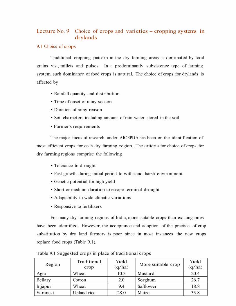
Lecture No. 9 Choice of crops and varieties – cropping systems indrylands
9.1 Choice of crops
Traditional cropping pattern in the dry farming areas is dominated by food
grains viz., millets and pulses. In a predominantly subsistence type of farming
system, such dominance of food crops is natural. The choice of crops for drylands is
affected by
• Rainfall quantity and distribution
• Time of onset of rainy season
• Duration of rainy reason
• Soil characters including amount of rain water stored in the soil
• Farmer's requirements
The major focus of research under AICRPDA has been on the identification of
most efficient crops for each dry farming region. The criteria for choice of crops for
dry farming regions comprise the following
• Tolerance to drought
• Fast growth during initial period to withstand harsh environment
• Genetic potential for high yield
• Short or medium duration to escape terminal drought
• Adaptability to wide climatic variations
• Responsive to fertilizers
For many dry farming regions of India, more suitable crops than existing ones
have been identified. However, the acceptance and adoption of the practice of crop
substitution by dry land farmers is poor since in most instances the new crops
replace food crops (Table 9.1).
Table 9.1 Suggested crops in place of traditional crops
(q/ha)Region
Traditional crop
Yield(q/ha)
More suitable cropYield
Agra Wheat 10.3 Mustard 20.4Bellary Cotton 2.0 Sorghum 26.7Bijapur Wheat 9.4 Safflower 18.8Varanasi Upland rice 28.0 Maize 33.8
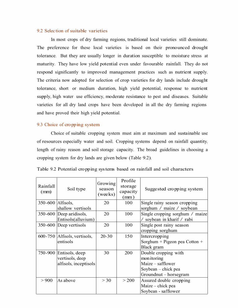
9.2 Selec tion of suitable varieties
In most crops of dry farming regions, traditional local varieties still dominate.
The preference for these local varieties is based on their pronounced drought
tolerance. But they are usually longer in duration susceptible to moisture stress at
maturity. They have low yield potential even under favourable rainfall. They do not
respond significantly to improved management practices such as nutrient supply.
The criteria now adopted for selection of crop varieties for dry lands include drought
tolerance, short or medium duration, high yield potential, response to nutrient
supply, high water use efficiency, moderate resistance to pest and diseases. Suitable
varieties for all dry land crops have been developed in all the dry farming regions
and have proved their high yield potential.
9.3 Choice of cropping system
Choice of suitable cropping system must aim at maximum and sustainable use
of resources especially water and soil. Cropping systems depend on rainfall quantity,
length of rainy reason and soil storage capacity. The broad guidelines in choosing a
cropping system for dry lands are given below (Table 9.2).
Table 9.2 Potential cropping sys tems based on rainfall and soil characters
storage
(mm)
Rainfall(mm)
Soil typeGrowing season (weeks)
Profile
capacity Suggested cropping system
350-600 Alfisols,shallow vertisols
20 100 Single rainy season cropping sorghum / maize / soybean
350-600 Deep aridisols, Entisols(alluvium)
20 100 Single cropping sorghum / maize/ soybean in kharif / rabi
350-600 Deep vertisols 20 100 Single post rainy season cropping sorghum
600-750 Alfisols, vertisols, entisols
20-30 150 IntercroppingSorghum + Pigeon pea Cotton + Black gram
750-900 Entisols, deep vertisols, deep alfisols, inceptisols
30 200 Double cropping with monitoringMaize – safflower Soybean – chick pea Groundnut – horsegram
> 900 As above > 30 > 200 Assured double cropping Maize – chick pea Soybean - safflower

Crops and cropping systems selected should match the length of growing
season during which they are not subjected to soil moisture stress. Climatalogical
analysis helps to identify suitable cropping systems for different regions. Feasibility
for intercropping, sequence cropping and double cropping can also be known from
such analysis (Table 9.3).
Table 9.3 : Length of effective cropping season in different areas (Randhawaand Venkateswarulu, 1979 )
cropping
9.3.1 Monocropping
In general a single crop is being taken in dry farming areas where the annual
rainfall is below 500 mm. Rainy season crop is taken in light soils like alfisols,
inceptisols and oxisols. Crops are being grown on residual moisture in vertisols in the
post rainy season in winter season. The most common monoc ropping systems are
groundnut in alfisols and associated soils in Rayalaseema region of Andhra Pradesh,
sorghum or chickpea or wheat in black soils of Madhya Pradesh, Andhra Pradesh,
and Karnataka.
9.3.2 Intercropping
Intercropping refers to growing two or more crops in the same field with
specific row arrangement during the same season. In areas where the annual rainfall
is in the range of 600-850 mm, intercropping is being recommended and practiced.
In such areas, at least one of the component crops succeeds in drought years and
there is every chance to get two crops in good rainfall years. The different
intercropping systems are followed in different regions of the country based on soil,
CategoryEffective cropping season(weeks) in different
areas
Potential
system
< 20 weeks Bellary (8) Hissar (17)
Jodhpur(11) Rajkot (17)
Anantapur (13) Bijapur (17)
Sole cropping
20-30 weeks
Jhansi (21) Udaipur (22) Anand (25)
Kovilpatti (21) Sholapur (23) Akola (27)
Hyderabad (22) Agra (24)
Intercropping
> 30 weeks Bhubaneswar (32) Bangalore (36) Rewa (36)Samba (44)
Varanasi (32) Hoshiarpur (35) Ranchi (45)
Indore (36) Dehradun (44)
Sequence cropping

rainfall, market price and marketing facilities. Intercropping systems are subject to
change due to change in market price of component crops. Intercropping is widely
practiced in dry farming since it offers many advantages as outlined below.
• Intercropping is a risk minimization strategy and provides an insurance
against complete crop failure due to rainfall abnormalities.
• It provides more yield and income per unit area per unit time than sole
cropping
• Stability in production is achieved
• Multiple products for home consumption as well as for marketing
made available
are
• When legumes are included in intercropping, soil fertility is enriched
• Intercrop canopy suppresses weed growth
• Resource use efficiency is increased viz., light, water and nutrients
efficiently used
are
• One crop provide physical support to other crop.
Disadvantages are
• Yield may be decreased due to competition effect
• Allelopathy effect
• Build up of certain diseases and pests
• May not be suitable for large farms with adequate resources
The different intercropping systems suitable for drylands are furnished in
table 9.4 and 9.5.
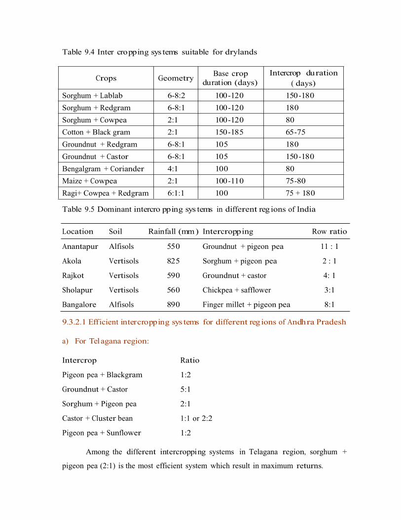
Table 9.4 Inter cropping sys tems suitable for drylands
( days)
Table 9.5 Dominant intercro pping sys tems in different reg ions of India
Location Soil Rainfall (mm) Intercropping Row ratio
Anantapur
Akola
Rajkot
Sholapur
Bangalore
Alfisols
Vertisols
Vertisols
Vertisols
Alfisols
550
825
590
560
890
Groundnut + pigeon pea
Sorghum + pigeon pea
Groundnut + castor
Chickpea + safflower
Finger millet + pigeon pea
11 : 1
2 : 1
4: 1
3:1
8:1
9.3.2.1 Efficient intercropping sys tems for different reg ions of Andhra Pradesh
a) For Telagana region:
Intercrop
Pigeon pea + Blackgram
Groundnut + Castor
Sorghum + Pigeon pea
Castor + Cluster bean
Pigeon pea + Sunflower
Ratio
1:2
5:1
2:1
1:1 or 2:2
1:2
Among the different intercropping systems in Telagana region, sorghum +
pigeon pea (2:1) is the most efficient system which result in maximum returns.
Crops GeometryBase crop
duration (days)Intercrop duration
Sorghum + Lablab 6-8:2 100-120 150-180
Sorghum + Redgram 6-8:1 100-120 180
Sorghum + Cowpea 2:1 100-120 80
Cotton + Black gram 2:1 150-185 65-75
Groundnut + Redgram 6-8:1 105 180
Groundnut + Castor 6-8:1 105 150-180
Bengalgram + Coriander 4:1 100 80
Maize + Cowpea 2:1 100-110 75-80
Ragi+ Cowpea + Redgram 6:1:1 100 75 + 180

b) Rayalaseema region:
Intercrop
Groundnut + Blackgram
Groundnut + Castor
Groundnut + Pearl millet
Pearl millet + Pigeon pea
Pigeon pea + Sunflower
Ratio
7:1
5:1 or 7:1
2:1
1:1 or 2:2
1:2
Among the different intercropping systems in Rayalaseema region, groundnut
+ pigeon pea (7:1) or groundnut + castor (5:1 or 7:1) was found to be the most
efficient system which result in maximum returns.
9.3.3 Double cropping in drylands
Double cropping either by sequential cropping or relay cropping is possible in
places with high rainfall (> 900 mm), extended rainy season and high soil moisture
storage capacity. Double cropping is also possible with rain water harvested in farm
ponds which is used for establishing winter crop. Some of the important double
cropping systems of different regions are presented in Table 9.6 and 9.7.
Table 9.6 Important double cropping sys tems of different location
Location Rainfall (mm) Soils Double cropping
Ranchi 1,370 Oxisols Rice-linseed or chickpea
Indore 960 Vertisols Soybean-Wheat
Pune 1,050 Vertisols Rice-Chickpea
Bangalore 890 Alfisols Cowpea-finger millet

Table 9.7 Eff icient double cropping systems for drylands of India
system
Double cropping by relay cropping
Groundnut / Ragi
(Jun-Sep)
+ Redgram
(Jun-Jan)
- Horsegram
(Sep-Jan)
Groundnut or ragi is sown with redgram as intercrop in 6:1 proportion in
June. After harvest of groundnut in September, horsegram is relay sown in the space
between redgram rows.
Double cropping by sequential cropping
Pearl millet / ragi ( finger millet )/ sama
( little millet) (May – Sep)
Horsegram (Sep – Jan)
Groundnut / sesamum (May – Sep) Horsegram (Sep – Jan)
Cowpea / greengram (Jun – Sep) Sorghum (Oct – Jan)
Sorghum (Jul – Oct) Chickpea (Oct – Feb)
Soil type RegionWater availability
(days)Double cropping
Vertisols MP 210-230 Maize – chickpea
Soybean – wheat
Maharastra 190-210 Sorghum – safflower
Karnataka 130-150 Cowpea – sorghum
Greengram – safflower
Inceptisols UP 200-230
180-200
Rice – Chickpea
Pearl millet – chickpea
Blackgram – mustard
Oxisols Bihar 160-180 Maize – chickpea
Groundnut – barley
Alfisols Karnataka 190-220 Cowpea – ragi
Soybean – ragi
Alfisols and aridisols < 120 No double cropping

Lecture No. 10 Contingent crop planning for aberrant weatherconditions
10.1 Effect of aberrant weather co nditions on crops
Rainfall behaviour in dry farming areas is erratic and uncertain. The
deviations in rainfall behaviour commonly met with in dry areas include delayed
onset, early withdrawal and intermediary dry spells during rainy season. The
adverse effect of these rainfall aberrations on crop growth vary with the degree of
deviation and the crop growth stage at which such deviations occur (Table 10.1).
Suitable manipulations in crop mana gement practices are needed to minimize such
adverse effects of abnormal rainfall behaviour. These mana gement decision,
const itute contingency planning. Such mana gement practices done after crop
establishment and in the middle of crop growth are called mid season or mid term
corrections.
Table 10.1 Effect of rainfall aberr ations on crops
10.2 Contingency cropping
Contingency cropping is growing of a suitable crop in place of normally sown
highly profitable crop of the region due to aberrant weather conditions. In dryland
agriculture, contingency of growing anoth er crop in place of normally grown crop
arises due to delay in the onset of monsoon. Depending upon the date of receipt of
rainfall, crops are selected. It is assumed that the rainfall for the subsequent period is
Rainfall aberration Effect on crops
Delay in onset of rainfall Length of cropping season or cropping duration is reduced - crop sowing is delayed
Early withdrawal or cessation of rainfall
Moisture stress at maturity grain filling is affected (terminal stress)
Intermediate dry spells
a. Immediately after sowing Germination will be affected, plant population will be reduced
b. At vegetative phase Affects stem elongation, leaf area expansion, branching or tillering
c. At flowering Affects anthesis and pollination, grain / pod number is reduced
d. At ripening Grain filling and grain size reduced
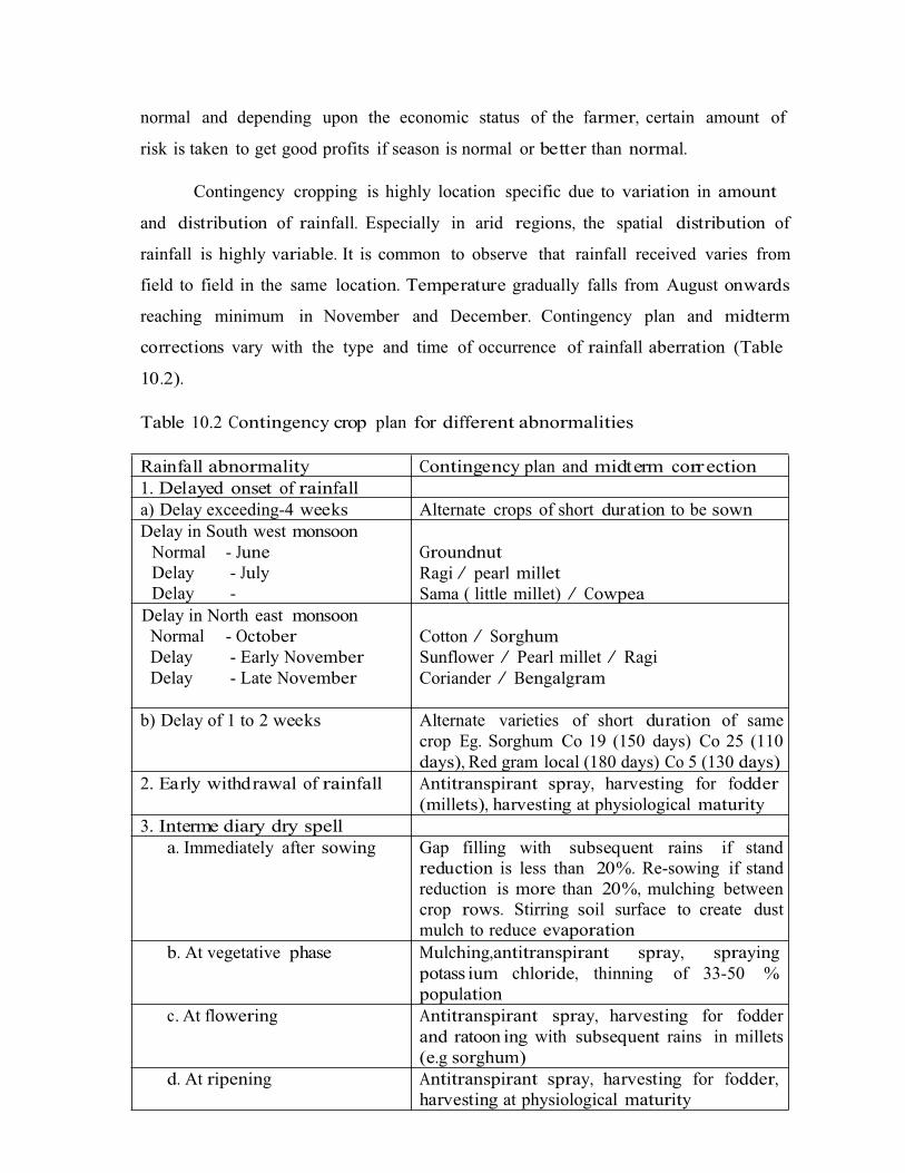
normal and depending upon the economic status of the farmer, certain amount of
risk is taken to get good profits if season is normal or better than normal.
Contingency cropping is highly location specific due to variation in amount
and distribution of rainfall. Especially in arid regions, the spatial distribution of
rainfall is highly variable. It is common to observe that rainfall received varies from
field to field in the same location. Temperature gradually falls from August onwards
reaching minimum in November and December. Contingency plan and midterm
corrections vary with the type and time of occurrence of rainfall aberration (Table
10.2).
Table 10.2 Contingency crop plan for different abnormalities
Rainfall abnormality Contingency plan and midterm correction1. Delayed onset of rainfalla) Delay exceeding-4 weeks Alternate crops of short duration to be sownDelay in South west monsoon
Normal - June Delay - July Delay - August
GroundnutRagi / pearl milletSama ( little millet) / Cowpea
Delay in North east monsoonNormal - OctoberDelay - Early NovemberDelay - Late November
Cotton / SorghumSunflower / Pearl millet / RagiCoriander / Bengalgram
b) Delay of 1 to 2 weeks Alternate varieties of short duration of same crop Eg. Sorghum Co 19 (150 days) Co 25 (110 days), Red gram local (180 days) Co 5 (130 days)
2. Early withdrawal of rainfall Antitranspirant spray, harvesting for fodder(millets), harvesting at physiological maturity
3. Interme diary dry spella. Immediately after sowing Gap filling with subsequent rains if stand
reduction is less than 20%. Re-sowing if stand reduction is more than 20%, mulching between crop rows. Stirring soil surface to create dust mulch to reduce evaporation
b. At vegetative phase Mulching,antitranspirant spray, spraying potass ium chloride, thinning of 33-50 % population
c. At flowering Antitranspirant spray, harvesting for fodder and ratoon ing with subsequent rains in millets (e.g sorghum)
d. At ripening Antitranspirant spray, harvesting for fodder, harvesting at physiological maturity

Crops have to be selected with suitable crop duration to coincide with the
length of the growing season. Generally short duration pulses like greengram,
blackgram and cowpea may suit the situation. However if the monsoon turns to be
extraordinarily good, opportunity is lost if only short duration crops are sown.
Farmers with economic strength and motivation for high profits with some amount
of risk can go for crops of long duration. The long duration crops with flexibility or
elasticity in yield are more suitable. For example, pearlmillet, and sorghum can be
ratoon ed if monsoon extends. Sunflower can be introduced for higher profits with
certain amount of risk. Crops like sorghum, pearlmillet, can be grown for grain if
monsoon extends and if not, fodder can be obtained.
Contingency crops for different situations and regions of Andhra Pradesh and
other states are suggested in Tables 10.3 and 10.4.
Table 10.3 Suggested contingency cro pping for different
Pradesh
situations in Andhra
Time of onsetof sowing rains
Crop Varieties Regions/situation
May Sesamum Madhavi, Gowri Medium black soils,medium and deep red soils
Red soils, light black soils.June Sorghum CSH-5, CSH-9, CSH-10, CSH-11, CSV-1.1,CSV-12, SPV-462, SPV-475
Kranthi, Haritha
TMV. 2, Tirupati-1, Vemana,
Mahanandi, NHH-4, Jayadhar, MCU-
5
Castor
Groundnut
Cotton
Groundnut
Telengana region
Scarce rainfall zone of A.P.
July
August
First fortnight of August,Arid
Regions of Anantapur
Red soils.
Red soils and black soils
Black soils, deep red soils
Black soils .
Pearl millet
Sunflower
Setaria
Sunflower
ICTP 8203 WCC-75
MFSH-1, MFSH-8, MFSH-17, APSH-
1L Lepakshi, Prasad, Srilakshmi
MFSH-1, MFSH-8, MFSH-17,
APSH-1J, Adarsha
LRG-30, LRG-41
September
Redgram Red soils in regionsreceiving North- EastMonsoon rainfall
Red and Black soils
Black soils, deep red soils
Black soils
Sorghum
Tobacco
Sorghum
NTJ-1, NTJ-2, M-35-1, CSH-5
Natu special, Sun cured natu
M-35-1, CSH-7R, CSH-6R, CSH-13R, NTJ-1, NTJ-2, N-13, N-14
CS-4, CS-6
October
Coriander Black soils
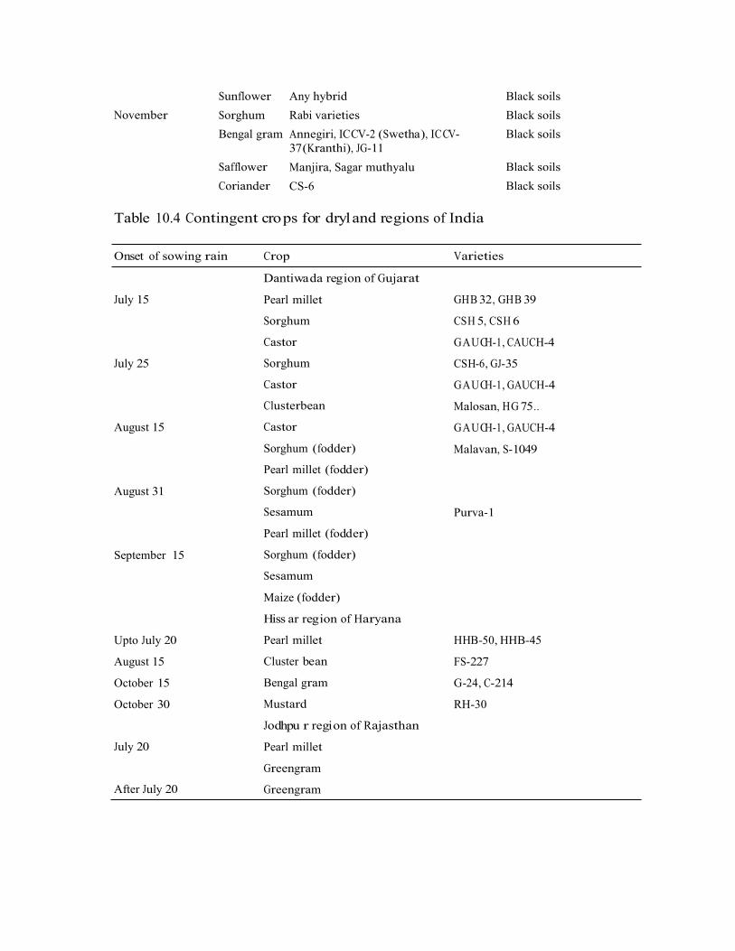
Sunflower
Sorghum
Bengal gram
Any hybrid
Rabi varieties
Annegiri, ICCV-2 (Swetha), ICCV-37(Kranthi), JG-11
Manjira, Sagar muthyalu
CS-6
Black soils
Black soils
Black soils
November
Safflower
Coriander
Black soils
Black soils
Table 10.4 Contingent crops for dryland regions of India
Onset of sowing rain Crop Varieties
Dantiwada region of Gujarat
Pearl millet
Sorghum
Castor
Sorghum
Castor
Clusterbean
Castor
Sorghum (fodder)
Pearl millet (fodder)
Sorghum (fodder)
Sesamum
Pearl millet (fodder)
Sorghum (fodder)
Sesamum
Maize (fodder)
Hiss ar region of Haryana
Pearl millet
Cluster bean
Bengal gram
Mustard
Jodhpu r region of Rajasthan
Pearl millet
Greengram
Greengram
July 15 GHB 32, GHB 39
CSH 5, CSH 6
GAUCH-1, CAUCH-4
CSH-6, GJ-35
GAUCH-1, GAUCH-4
Malosan, HG 75..
GAUCH-1, GAUCH-4
Malavan, S-1049
July 25
August 15
August 31
Purva-1
September 15
Upto July 20
August 15
October 15
October 30
HHB-50, HHB-45
FS-227
G-24, C-214
RH-30
July 20
After July 20
Lecture No. 11 Evapotranspirationevapotranspiration
11.1 Definition
and measures to reduce
Under dry land conditions soil moisture is the most limiting factor for crop
production. It is lost as evaporation from soil surface and as transpiration from the
plant surfaces. The combined loss of moisture through these two processes is known
as evapotranspiration.
11.2 Methods to reduce evaporation
There are three principles of evaporation control under field conditions.
a. Decreasing the turbulent transfer of water vapour to the atmos phere by
growing plants, raising wind breaks, straw mulches etc.,
b. Decreasing capillary conductivity by rapid drying of the surface soil layers.
c. Decreasing the capillary flow and moisture holding capacity of the surface
soil layers.
For evaporation control, mostly mulches are used.
11.2.1 Mulches
Mulch is any covering material applied on the soil surface to reduce
evaporation losses. This material may be grown and maintained in place, or any
material grown and modified before placement or any material processed or
manufactured and transported before placement.
Types of mulches
a. Soil mulch or dust mulch: soil mulch is a thin layer of loose soil surface that can
be created by frequently stirring the soil with surface tillage implements like danthis,
guntakas (blade harrows) etc., Soil mulch of surface 5-8 cm dry soil effectively
reduces the evaporation losses by obstructing the raise of soil moisture through
capillary action. The soil mulch also prevents deep cracks in soils (especially black
soils) by reducing the direct action of atmo sphere and hence evaporation is also
reduced. The repeated intercultivations done in rabi crops even in the absence of

weeds help in reducing evaporation losses. Among the different mulches soil mulch is
the cheapest.
b. Straw and stubble mulch: Straw and other crop residues like stubbles, groundnut
shells, cotton stalks etc; can be used as mulches on soil surface for moisture
conservation. Straw mulches reduce both the amount of energy absorbed by the soil
and its movement above the soil and hence reduce evaporation (Fig. 11.1) However,
the availability of adequate crop residues is a problem for use as mulches.
c. Plastic mulches: Plastic mulches are very effective as mulches for evaporation
control provided cost is not a limiting factor. The plastic mulches may be either white
or black. Black plastic mulches will absorb the solar radiation and enhance the soil
temperature for hastening the germination of winter crops like wheat; barley etc.,
White plastic mulches will reflect the incident radiation and reduce evaporation of
soil moisture.
d. Chemical mulches: Chemicals like hexadeconol, a long chain alcohol when mixed
with surface 5 mm of soil can reduce evaporation by about 40%. The surface layer of
a treated soil dries out more rapidly than that of untreated soil, creating a diffusional
layer to evaporation.

e. Vertical mulching: It is a technique wherein trenches of 40 cm wide, 15 cm deep
are dug at 2 to 4 m interval across slope and filled with stubbles or organic wastes to a
height of 10 cm above soil surface. Runoff is checked, collected in the shallow
trenches and redistributed to adjoining soil layers and infiltration is increased in
black soils.
f. Live mulching: Is the term used to describe the covering of soil surface through
the plant canopy in intercropping system.
Eg. Sorghum + forage cowpea, sorghum + sword bean
g. Pebble mulch: Where small pebbles like stone are placed on the soil surface
(Fig. 11.2). This mulching will be successful in dryland fruit tree culture. The pebbles
placed on the basins of trees not only
infiltration of rain water into the basin.
reduce evaporation but also facilitate
Mulching is more advantageous during rabi/summer months than in kharif
season. Organic mulches particularly under receding soil moisture conditions
increase crop growth by conserving soil moisture.

11.2.2 Effect of mulches on soil properties
1. Soil structure: Surface mulches reduce the impact of falling raindrops, thus
reducing dispersion and sealing of soil pores leading to crust formation. Hence the
soil structure is protected. The mulches also improve soil structure due to
decomposition of mulch.
2. Soil salini ty: Under dry land conditions due to limited precipitation, soluble salts
move only to a limited depth and readily return to the surface as the soil water
evaporates. Due to salt accumulation in surface layers the germination and seedling
establishment may be adversely affected. Hence, mulches will reduce soil salinity
problem by increasing infiltration and reducing evaporation.
3. Soil water: The soil moisture cont ent is improved by induced infiltration, reduced
evaporation and reduced transpiration by weeds. Surface mulches also obstruct the
free exchange of water vapour from soil surface into the atmos phere and hence
increase soil water content.
4. Soil temperature: The effects of mulches on soil temperature are highly variable
and depend up on the type of mulch material. White or reflective type of plastic
mulches generally decrease soil temperature, while black plastic mulches may
increase soil temperature. Crop residues moderate temperature by decreasing it in
summer and by increasing in winter season. This is due to combined effect of
radiation interception and evaporative cooling. The sugarcane trash mulch will
enhance the germination of sugarcane setts during summer by temperature
reduction.
5. Soil erosion: The ease by which soil particles are moved by wind and water is
related to size of soil particles and wind and water velocity. The particles of size
greater than 0.84 mm in diameter are generally not eroded by wind but they are
easily eroded by water. The mulches reduce the direct impact of falling raindrops on
soil, there by preventing soil dispersion and conse quent sealing of soil pores leading
to reduced soil erosion.

11.3 Reducing losses due to transpiration
Nearly 99% of water absorbed by the plant is lost in transpiration. Hence
transpiration reduction is needed for maintaining favorable water balance in the
plants. Transpiration has become unavoidable evil as the stomata, which allow CO2
exchange also allows water vapour transfer into the atmosphere.
There are four principles of transpiration control
a. By increasing leaf resistance to water vapour transfer by application of
materials, which tend to close or cover stomata (ex: both stomatal closing
and film forming type of antitranspirants).
b. By reducing amount of energy absorbed by leaf surface (Eg: leaf
reflectants)
c. By reducing top growth of plants ( Eg: Growth retardants )
d. By increasing air resistance to water vapour transfer by shelter belts/
wind breaks
The transpiration losses can be controlled by use of antitranspirants, use of
wind breaks/shelter belts and efficient weed control
11.3.1. Anti-transpirants: Any material that is applied on transpiring plant surface
for reducing water loss is called antitranspirants. The ant itranspirants are also
known as transpiration suppressants. The best anti transpirants reduce transpiration
losses up to 30-40%. There are four types of anti transpirants.
a. Stomatal closing type: Transpiration mostly occurs through stomata on the leaf
surface. Some fungicides like PMA (phenyl mercuric acetate) and herbicides like
atrazine in low concentrations serve as anti transpirants by closing of stomata. PMA
is known to inhibit mesophyll photosynthesis. Though the success was reported from
glasshouse studies, their effectiveness under field conditions is limited.
b. Film forming type: The plastic and waxy materials, which form a thin film on the
leaf surface, retard the escape of water due to formation of physical barrier. The
success of these chemicals is limited since they also reduce photosynthesis. The
desirable characteristics of film forming type of ant itranspirants are: they should

form a thin layer, they should be more resistant to the passage of water vapour than
carbon dioxide and the film should maintain continuity and should not break. These
film forming anti transpirants may be of either thin film or thick film.
Thin film forming type: Hexadeconol
Thick film forming type: Mobileaf, Polythene S-60
c. Leaf reflectant type: These are the white materials, which form a coating on the
leaves and increase leaf reflectance (albedo). By reflecting the radiation they reduce
leaf temperatures and vapour pressure gradient from leaf to atmos phere and hence
reduces transpiration. About 5% of kaolin spray reduces the leaf temperature by 3-
4°C and decrease in transpiration by 22 to 28 per cent. Celite and hydrated lime are
also used as reflectant type of anti transpirants.
d. Growth retardant type: These chemicals reduce shoot growth and increase root
growth and thus enable the plants to reduce transpiring surface and resist drought
conditions. They increase root/shoot ratio.
Eg : Cycocel – (2-chloroethyl) Trimethyl ammonium chloride (CCC), Phosphon–D,
Maleic Hydrazide (MH)
Antitranspirants generally reduce photosynthesis. Therefore, their use is
limited to save the crop from death under severe moisture stress. If crop survives, it
can utilise the rainfall that is received subsequently. Antitranspirants are also useful
for reducing the transplantat ion shock of nursery plants. They have some practical
use in nurseries and horticultural crops. Waxy materials are used for reducing post
harvest shrinkage of fruits.11.3.2. Use of wind bre aks and shelterbelts: Wind breaks are any structures that
obstruct wind flow and reduce wind speed while shelterbelts are rows of trees
planted for protection of crops against wind. The direction from which wind is
blowing is called windward side and direction to which wind is blowing is called
leeward side. Shelterbelts are planted across the direction of wind. They do not
obstruct the wind flow completely. Depending upon their porosity, certain amount of
wind passes through the shelterbelts while the rest deflects and crosses over the
shelterbelts (Fig. 11.4). It thus reduces wind speed without causing turbulence. The
protection offered by the shelterbelts is dependent on the height of central tree roww
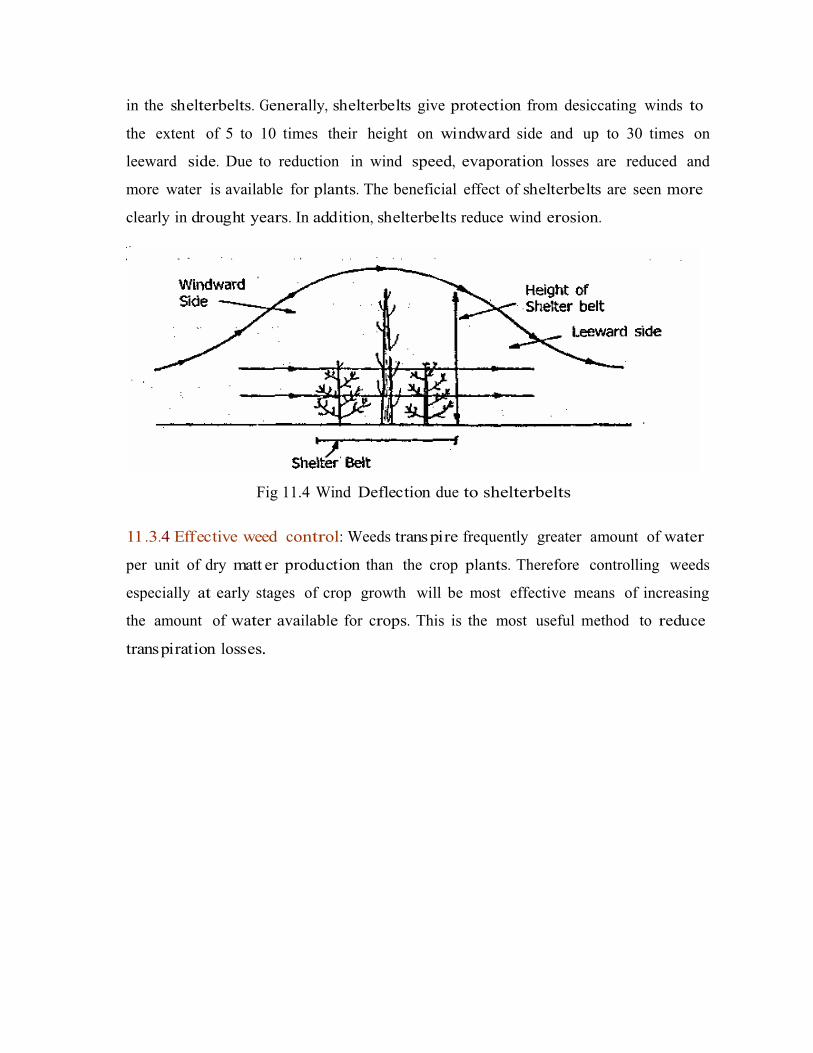
in the shelterbelts. Generally, shelterbelts give protection from desiccating winds to
the extent of 5 to 10 times their height on windward side and up to 30 times on
leeward side. Due to reduction in wind speed, evaporation losses are reduced and
more water is available for plants. The beneficial effect of shelterbelts are seen more
clearly in drought years. In addition, shelterbelts reduce wind erosion.
Fig 11.4 Wind Deflection due to shelterbelts
11.3.4 Effective weed control: Weeds transpire frequently greater amount of water
per unit of dry matt er production than the crop plants. Therefore controlling weeds
especially at early stages of crop growth will be most effective means of increasing
the amount of water available for crops. This is the most useful method to reduce
transpiration losses..

ª
Lecture No. 12 Watershed management – objectives and approachesof watershed management
12.1 Introduction
Soil, water and vegetation are the three important natural resources. As these
resources are interdependent there is a need to have a unit of mana gement for most
effective and useful management of these resources. In this context, watershed is an
important unit for the mana gement of the natural resources
12.2 Concept of watershed management
A watershed is defined as any spatial area from which runoff from
precipitation is collected and drained through a common point or outlet. In other
words, it is a land surface bounded by a divide, which cont ributes runoff to a
common point (Fig.12.1). It is defined as unit of area, which covers all the land, which
cont ributes runoff to a common point. It is synonymous with a drainage basin or
catchm ent area. The basic unit of development is a watershed, which is a manageable
hydrological unit. The watershed is also known as ridgeline in U.K.
Fig. 12.1 watershed with main and sub drains
As the entire process of Agricultural development depends on status of water
resources, watershed with distinct hydrological boundary is considered ideal for
planning developmental programmes. It is essential to have various developmental
programmes on watershed basis in conjunction with basic soil and water

conservation measures. The developmental activities need to be taken up from
ridgeline to outlet point (ridge to valley). Watershed mana gement programme in
drylands aimed at optimizing the integrated use of land, water and vegetation in an
area for providing an answer to alleviate drought, moderate floods, prevent soil
erosion, improve water availability and increase food, fodder, fuel and fibre on
sustained basis.
Watershed management implies the wise use of soil and water resources
within a given geographical area so as to enable susta inable production and to
minimize floods.
Watershed management is the rational utilization of land and water
resources for optimum production with minimum hazard to natural resources.
Watershed mana gement has been taken up under different programmes
launched by Government of India .The Drought Prone Area Development Programme
(DPAP) and the Desert Development Programme (DDP) adopted watershed
development approach in 1987 . The Integrated Watershed Development Project
(IWDP) taken up by the National Wasteland Development Board (NWDB) in 1989
also aimed at development of wastelands on watershed basis. The fourth major
programme based on watershed concept is the National Watershed Development
Programme for Rainfed Areas (NWDPRA) under the ministry of Agriculture .The
ministry of Rural development funds watershed development schemes under DDP,
DPAP and IWDP.
Based on the size the watersheds may be classified as
Micro watersheds: The size of the watershed range from few hectares to hundreds
of hectares. These can be designed within the crop fields.
Small watersheds: The watershed has few thousands of hectares as drainage area.
Large watersheds: The river basins are considered as large watersheds.
12.3 Principles of watershed management
- Utilizing the land based on its capability
- Protecting the fertile top soil

- Minimizing the silting up of the reservoirs and lower fertile lands
- Protecting vegetative cover throughout the year
- Insitu conservation of rain water
- Safe diversion of surface runoff to storage structures through grassed
water ways
- Stabilization of gullies and const ruction of check dams for increasing
ground water recharge.
- Increasing cropping intensity through inter and sequence cropping.
- Alternate land use systems for efficient use of marginal lands
- Water harvesting for supplemental irrigation
- Ensuring sustainability of the ecosystem
- Maximizing farm income through agricultural related activities such
dairy poultry, sheep, and goat farming
as
- Improving infrastructural facilities for storage transport and agricultural
marketing
- Setting up of small scale agro industries and
- Improving socio-economic status of farmers.
12.4 Objectives of watershed management
The term watershed mana gement is synonymous with soil and water
conservation with the difference that emphasis is on flood protection and sediment
control besides maximizing crop production. The watershed aims ultimately at
improving standards of living of common people in the basin by increasing their
earning capacity, by offering facilities such as electricity, drinking water, irrigation
water, freedom from fear of floods, drought etc.,
The objectives are
- Recognition of watershed as a unit for development and efficient use ofland according to land capabilities
Flood control through small multipurpose reservoirs and other water storage structures at the headwater of streams and problem areas.
Adequate water supply for domestic, agricultural and industrial needs
-
-

-
-
Reduction of organic, inorganic and soil pollution
Efficient use of natural resources for improving agriculture and allied occupations so as to improve socio- economic conditions of the local residents and
Expansion of recreation facilities such as picnic and camping sites.-
The objectives of watershed mana gement programme can also be described in
symbolic form by the expression: POWER. Here the lett ers symbolize the following:
P = Production of food-fodder-fuel-fruit-fibre-fish-milk combined onsustained basis
- Pollution control
- Prevention of floods
Over exploitation of resources to be minimized by controlling excessive biotic interferences like over grazing
- Operational practicability of all on farm operations and follow up programmes including easy approachability to different locations in watershed
O=
W = Water storage at convenient locations for different purposes
- Wild animal and indigenous plant life conservation at selected places
E = Erosion control
- Ecosystem safety
- Economic stability
- Employment generation
R = Recharge of ground water
- Reduction of drought hazards
- Reduction of siltation in multipurpose reservoirs
- Recreation
12.5 Action plan for watershed development (steps in watershedmanagement)
1. Identification and selec tion of watershed: The boundary of the watershed has
to be marked by field survey starting from the lowest point of the water course and
proceeding upwards to the ridge line. The area may vary as low as 100 ha to as high
as 10000 ha.

2. Descr iption of watershed.
Basic information has to be collected on
Location
Area, shape and slope
Climate
Soil - geology, hydrology, physical, chemical and biological properties, erosion level
Vegetation-native and cultivated species
Land capability
Present land use pattern
Crop pattern, cropping system and management
Farming system adopted
Economics of farming
Man power resource
Socio economic data
Infrastructural and institutional facilities3. Analysis of problems and identification of available solutions
4. Designing the technology components
a. Soil and moisture conservation measures
b. Run off collection, storage and recycling
c. Optimal land use and cropping system
d. Alternate land use system and farming system
e. Other land treatment measures
f. Development of livestock and other allied activities
g. Ground water recharge and augmentation
5. Preparation of base maps of watershed incorporating all features of geology,
hydrology, physiography, soil and proposed development measures for each part of
watershed.
6. Cost-benefit analysis to indicate estimated cost of each component activity, total
cost of project and expected benefit.

7. Fixing the time frame to show time of start, duration of project, time frame for
completion of each component activity along with the department / agency to be
involved in each component activity
8. Monitoring and evaluation to assess the progress of the project and to suggest
modification if any
9. On-farm rese arch to identify solutions for site-specific problems.
10. Organizational requireme nt: Crucial component of watershed development
project is the organization. Land use problems can only be tackled in close
association with owners. As such local people should be involved in the project. To
promote such an interaction the size of watershed should be 300-500 ha at micro
level and a cluster of about 10 such watersheds could be managed by a single
organizational unit. Watershed development agency at unit level may be an ideal
organization for implementing the project. Since no project can be successful without
people’s participation, the watershed development agency should incorporate
selected representat ives of the local people. The organizational requirement include
a. Water shed development agency with multidisciplinary staff
b. Training to personnel
c. Training to farmers
d. Credit institution
e. Farmers forum /village association
f. Non governmental organization
Lecture No. 13 Components of watershed manag eme nt programmeand land capability classification
13.1 Components of watershed manageme nt programme
The main components of watershed programme are:
1. Soil and water conservation
2. Water harvesting
3. Crop mana gement and
4. Alternate land use systems
13.1.1. Soil and water conserv ation measures
These measures coupled with water harvesting help to improve the moisture
availability in the soil profile and surface water availability for supplemental
irrigation. Based on the nature and type of hydraulic barriers and their cost the
conservation measures in arable lands can be divided into three categories:
Permanent treatments (Hardware treatments)
Semi perman ent treatments (medium software treatments) and
Temporary treatments (software treatments).
a. Permanent measures: These measures are provided for improvement of relief,
physiography and drainage features of watershed, aimed at controlling soil erosion,
regulating surface runoff and reducing peak flow rates. Bunds, terraces and
waterways are the permanent measures in watershed mana gement project.
Waterways: both with and without vegetation- grassed waterways for safe
disposal of runoff water.
Bunds: contour bunds –Suitable for low rainfall areas (< 600 mm) and in
permeable soils having slope up to 6%.
Graded bunds – Suitable for high rainfall areas (> 600 mm) and for poor
permeable soils having 2-6% slope and for soils having crust like ,chalka soils of
Telangana region of A.P.
Terr aces: Bench terracing: suitable for soils having slopes 16 to 33%. Bench
terraces reduce both slope length and degree of slope. At Ootacam und erosion
rate decreased from 39 t/ha to less than 1.0 t/ha on 25% sloping land by bench
terracing.
b. Semi permanent measures: These are usually interbund treatments where field
sizes are large in conventionally bunded area. They are adopted to minimize the
velocity of overland flow. These measures may lost for 2 to 5 years.
i. Small section / key line bunds: A small section bund may be created
across the slope at half of the vertical bund spacing, which needs to be renovated at
an interval of 2-3 years.
ii. Strip Levell ing: Levelling of about 4 to 5 m strips of land above the bund
across the major land slope help in reducing the velocity of surface flow. Strip
levelling can be done by running blade harrow at an interval of 2 to 4 years.
iii. Live beds: One or two live beds of 2-3 m width on conto ur or on grade
also serve the purpose. The vegetation on the beds may be annual or perennial or
both.
iv. Vegetative or live barr iers: One or two barriers of close growing grasses
or legumes along the bund and at mid length of slope can filter the runoff water or
slow down over land flow. Khus grass is widely recommended as vegetative barrier.
c. Tem porary measures (Software treatments): These are simple treatments for
in situ moisture conservation and needs to be remade or renovation every year.
Simple practices like conto ur farming, compartmental bunding, broad bed and
furrows, dead furrows, tillage and mulching have gained wide acceptance in the
recent past.
13.2. Water harvesting: The water harvesting structures and the use of harvested
water for life saving irrigation in watershed areas is discussed in detail in lecture No .13.3 Crop management
Location specific package of practices for dryland crops have been developed
by dryland research centres and state agricultural universities for all the crops and
cropping systems which include.
a)
b)
c)
Selection of crops and cropping systems to suit length of growing season
Optimum sowing time
Fertilizer schedules and balanced use of plant nutrients for crops and cropping systems
Weed mana gement and package of practices for aberrant weather
Contingent cropping
d)
e)
13.4 Alternate land use sys tems: Alternate land use systems are discussed
separately in lecture No.16
13.5 Land use classification (land capa bility classification)
Land capability classification is grouping of soils into different classes
according to their capability for intensive use and treatments required for sustained
use. It emphasizes the need for using the land only for what it is suited best to realize
optimum returns, without land degradation. Land capability classification system
developed by USDA is useful for Agriculture. Eight land capability classes are
recognized and designated by Roman numericals from I to VIII. The Roman
numericals indicates increasing limitations and fewer choices for practical field crop
use.
Land capability classes from I to IV are suitable for arable crop production
Land capability classes from V to VIII are suitable for alternate land use systems
CLASS I: This group of soils has few limitations on their use. They are deep (> 90cm),
well drained and nearly levelled. They are fertile or responsive to fertilizer
application. There is no limitation on the type of crops grown. A variety of crops can
be grown intensively with recommended management practices. They are suitable
for intensive cultivation. This group of soils is represented by light green colour in
land use maps
CLASS II: Soils have moderate limitations such as gentle slope, moderate erosion
problem, inadequate depth (22.5–45cm), slight salinity and alkalinity and relatively
restricted drainage. Less intensive cropping systems must be followed. Simple
mana gement practices such as conto ur cultivation will maintain the soil for crop
production. They are represented by yellow colour in land use maps.
CLASS III: Soils have moderate to severe limitations. The soil erosion, shallow water
permeability, low moisture retentively, moderate salinity and low fertility are the
limitations for their use. Soils can be used for crop production with special
conservation practices like terracing. Smothering crops such as legumes are more
ideal than row crops. They are represented by red colour in land capability maps.
CLASS IV: These soils will have very severe limitations that reduce the choice of
crops. Steep slope, severe erosion, shallow soil depth, salinity or alkalinity restricts
their use for profitable crop production. These lands should be used for close
growing crops or grasses with special soil conservation practices.
CLASS V: These soils generally not suitable for grain crops due to limitations such as
rocky soil, faded areas with no drainage facilities. Pastures can be improved on this
class of land.
CLASS VI: These soils are suitable for growing grasses and forest trees. Limitations
are same as those for class V but they are more rigid. Their use may be restricted to
woodland or wild life.
CLASS VII: These have severe limitations even for growing grass and forest trees.
They are steep soils of extremely shallow depth, used for woodlands and wild life.
CLASS VIII: Not suitable for forest trees and grasslan ds as they are steep, rough
stony mountains. Land use is restricted to recreation, wild life etc.,
Capability classes can be sub divided into sub classes with in each class based
on special limitations. They are designated by adding small letter c, e, s or w to roman
numerical.
c : shows that chief limitation is climate, low rainfall, too cold or too dry(very high or very low temperature)
chief limitation is soil erosion
main limitation is soil character like depth (shallow depth, stony, salinity, rocky)
soil wetness, excess water in or on soil interferes the plant growth
e
s
:
:
w ::
Lecture No. 14 Soil and water cons erv atio n me asures in watershedareas
14.1 In situ soil mo isture conserv ation practices
Storage of rainfall or rain water at the place where rainfall occurs for its
effective usage is known as in situ moisture conservation. This can be achieved by
different measures. Improving the soil surface conditions to increase infiltration of
rainfall and reduction of runoff are the two basic requirements in dry lands. Hence
land configuration determines the ease with which water can enter the soil. The
different in situ moisture conservation practices which result in changed land
configuration are as follows.
14.1.1 Ridges and furrows: The field must be formed into ridges and furrows.
Furrows of 30-45 cm width and 15-20 cm height are formed across the slope. The
furrows guide runoff water safely when rainfall intensity is high and avoid water
stagnation. They collect and store water when rainfall intensity is less. It is suitable
for medium deep to deep black soils and deep red soils. It can be practiced in wide
row spaced crops like cotton, maize, chillies, tomato etc. It is not suitable for shallow
red soils, shallow black soils and sandy/ gravelly soils. It is not suitable for broadcast
sown crops and for crops sown at closer row spacing less than 30 cm. Since furrows
are formed usually before sowing, sowing by dibbling or planting alone is possible.
14.1.2 Tied ridging: It is a modification of the above system of ridges and furrows
wherein the ridges are connected or tied by a small bund at 2-3 m interval along the
furrows to allow the rain water collection in the furrows which slowly percolat ed in
to the soil profile
14.1.3 Broad bed furrows (BBF): This practice has been recommended by ICRISAT
for vertisols or black soils in high rainfall areas (> 750 mm). Here beds of 90-120cm
width, 15 cm height and convenient length are formed, separated by furrows of 60
cm width and 15 cm depth. When runoff occurs, its velocity will be reduced by beds
and infiltration opportunity time is increased. The furrows have a gradient of 0.6%.
Crops are sown on the broad beds and excess water is drained through number of
small furrows which may be connected to farm ponds. It can be formed by bullock
drawn or tractor drawn implements. Bed former cum seed drill enables BBFB

ª
formation and sowing simultaneously, thus reducing the delay between receipt
rainfall and sowing (Fig 14.1). Broad bed furrow has many advantages over other
methods.
• It helps in moisture storage
• Safely dispose off surplus surface runoff without causing erosion
• Provide better drainage facilities
• Facilitate dry seeding
• It can accommo date a wide range of crop geometry i.e. close as well as
wide row spacing.
• It is suitable for both sole cropping and intercropping systems.
• Sowing can be done with seed drills.
Fig. 14.1 Alternate crop and row arrangem ent on bro ad beds
14.1.4 Dead furrows
At the time of sowing or immediately after sowing, deep furrows of 20 cm
depth are formed at intervals of 6 to 8 rows of crops. No crop is raised in the furrow.
The dead furrows can also be formed between two rows of the crop, before the start
of heavy rains (Sep – Oct). It can be done with wooden plough mostly in red soils. The
dead furrows increase the infiltration opportunity time
14.1.5 Compartmental bunding
Small bunds of 15 cm width and 15 cm height are formed in both directions to
divide the field into small basins or compartments of square or rectangular shape of
6 x 6 m to 10 x 10 m size using bund former .They are useful for temporary
impounding of rain water which facilitates high infiltration resulting in high moisture
storage in the soil. Recommended for black soils with a slope of 0.5 to 1%.
sunflower, sorghum perform well in this type of bunding (Fig 14.2).
Maize,
14.1.6 Scooping
Scooping the soil surface to form small depressions or basins help in retaining
rain water on the surface for longer periods (Fig 14.3). They also reduce erosion by
trapping eroding sediment. Studies have shown that runoff under this practice can be
reduced by 50 % and soil loss by 3 to 8 t /ha.

14.1.7 Inter plot water harvesting
Water is drawn from part of a small catchm ent and used in lower portion for
crop production. There may be 1: 1 cropped: catchment area or 1:2 catchment:
cropped area.
14.1.8 Zingg terracing or conserv ation bench terracing
These are developed by A.W.Zingg, in USA. Zingg terracing is practiced in low
to medium rainfall areas in black soils with contour bunds. It is a method of land
shaping where lower one third portion of the land adjacent to the contour is leveled
to spread to the runoff water coming from the remaining two third portion of the
field .This rainfall multiplication technique ensures at least one good crop in one
third area even in low rainfall years. Usually during medium rainfall years water
intensive crops (like paddy) are cultivated in the levelled portion (receiving area)
while dry crops are cultivated in the unlevelled (donor) area.
14.2 Mechanical / Engineering me asures of soil conservation
When Agronomic measures alone are not adequate, mechanical measures are
to be adopted to supplement the agronomic measures. Mechanical measures usually
involve const ruction of mechanical barriers across the direction of flow of rainwater
to retard or retain runoff and thereby reduce soil and water loss. The mechanical
measures include:
-
-
-
-
-
Contour bunding
Graded bunding
Bench terracing
Gully control / plugging
Vegetative barriers etc.
A bund or terrace is an earthen embankment or a depression or a combination
of both const ructed across the land slope to control runoff and minimize soil erosion
by reducing the length of slope. By reducing the slope, the velocity of runoff is not
allowed to attain critical value, which initiates scouring....

14.2.1 Contour bunding
It is most popular in the country. Contour bunding consists of narrow based
trapezoidal bunds on contours to impound runoff water behind them so that it can
gradually infiltrate into the soil for crop use. Contour bunding is generally
recommended for areas receiving <600 mm rainfall (low rainfall areas) and for
permeable soils up to slopes of about 6%.Spacing between two bunds is commonly
expressed in terms of the V.I.(vertical interval) which is the difference in elevation
between two similar points on two consecutive bunds. The following formula is used
for determining spacing of bunds.
V.I..= S/a + b
where,
V.I.= vertical interval (m) between consecutive bunds
S = % slope of land
‘a’ and ‘b’ constants depends on soil and rainfall characteristics
The height of the contour bunds depends on slope of land, spacing of bunds
and maximum intensity expected. In deep black soils, conto ur bunds have been a
failure due to cracking of bunds during dry months and water stagnation above the
bunds for prolonged periods during rainy season (Fig. 14.4).
14.2.2 Graded bunding:
Graded bunds or channel terraces are constructed in high rainfall areas of
>600 mm where excess water has to be removed safely of the field to avoid waterrrrr
ªªª
stagnation. In case of highly impermeable soils like deep black soils graded bunds are
recommended even in lesser rainfall area (500 mm) as in case of Bellary region of
Karnataka. Water flows in graded channels const ructed on upstream side of bunds at
non-erosive velocities and is led to safe outlets or grassed waterways. Channel
portion of the graded bunds is put under cultivation and the grassed waterways are
permanently kept under grass.
14.2.3 Bench terracing:
Bench terracing is practiced in steep hill slopes, where mere reduction of
slope length is not adequate for reducing the intensity of scouring action of runoff
flowing down. In addition to slope length reduction, the degree of slope is also
reduced. Bench terracing consists of transforming relatively steep land into a series
of level strips or platforms across the slope to reduce the slope length and
consequently erosion. The field is made into a series of benches by excavating soil
from upper part and filling in the lower part of terrace. It is normally practiced on
slopes > 14% i.e. from 16 to 33%.
Depending on soil, climate and crop requirements bench
table top or level, sloping outwards or sloping inwards (Fig. 14.5).
terraces may be
Fig 14.5 Types of bench terraces
Type of bench terrace SuitabilityTable top or level terraces Suitable for medium rainfall areas
(750mm) with even distribution and highly permeable deep soils.
Sloping outwards terraces Constructed in low rainfall areas (<750 mm) with permeable soils of medium depth.
Sloping inwards terraces Constructed in heavy rainfall areas (>750 mm) and soils with poor infiltration rate..

�
14.2.4 Gully control:
Gullies the result of sheet and rill erosion left unchecked. The basic approach
to gully control involves reduction of peak flow rates through the gully and provision
of channel for the runoff water. Agronomic measures of soil conservation like
conto ur cultivation, strip cropping, cover crops, mulching etc., aid in reducing the
peak flow rates through gullies. The provision of the stable channel for the flow that
must be handled is accomplished by stabilizing the gully sides and bed by
establishing vegetation. Temporary structures such as brush check wood dams, loose
rock dams, rock fill dams and woven wire dams, and perman ent structures such as
chute spill ways, drop spill ways, concrete check dams and pipe spill ways are
practiced for reducing channel gradient to maintain velocities below erosive level
(Fig. 14.6 and 14.7).

14.2.5 Vegetative barr iers:
These are the rows of closely planted grass or shrub along the conto urs for
erosion control in Agricultural lands. They check the velocity of runoff and retain the
sediment by acting as barrier to runoff. Khus Khus (Vetiveria zyzynoides) is the most
recommended plant for this purpose.
Grassed waterways: These are drainage channels either developed by shaping the
existing drainage ways or const ructed separately for effecting drainage of
agricultural lands. They are used to handle runoff, discharge from graded bunds,
broad base terraces and bench terraces. Objectives of grassed waterways
1. To provide drainage to agricultural lands
2. To convert unstable channels or gullies into stable channels by providing
grass cover
3. For leading water at non erosive velocity into farm ponds
Grassed water ways are normally dug to a shallow depth of 0.15 to 0.5 m.
They are const ructed one or two seasons ahead of the const ruction of channel
terraces.
14.3 Fores try Measures:
Forest lands are usually found at higher elevations where the slopes are
steepest, soils are less stable and easily eroded and precipitation is heavy. The
leaves and branches of trees and shrubs intercept the rain and reduce the impact of
raindrops. Contour trenching and aforestation is recomm ended for improving the
productivity of forests. Contour trenching is done by excavating a trench along the
conto ur and forming soil bank. Rain water thus held up in these trenches for some
time and facilitate the growth of vegetation. Plants are sown in trenches taking
advantage of water (Fig. 14.8 and 14.9 ). Tree species suitable are Pinus patula, Pinus
kesia, Acacia nilotica, Eucalyptus camaldulensis etc.

14.4 Agrostological Measures:
Grasses prevent erosion by intercepting rainfall and by their binding power of
the soil particles. A grass-legume association is ideal for soil conservation. Legumes
build 67up soil fertility by fixing atmos pheric N in root nodules. Grasses have several
uses in soil conservation like:

- Stabilizing the surfaces of water ways, conto ur bunds and front faces of
bench terraces
- Stabilizing the gully slopes and sides
- Preventing wind erosion
The desirable characters of grasses for soil conservation are:
o Should be perennial
o Drought resistant
o Rhizomniferous
o Develop good canopy
o Deep root system
o Prostate growth habit
o
o
Less palatable to cattle
Useful for cottage industries
Useful grasses:
Cenchrus ciliaris, Chloris guyana, Cynodon dactylon, Dicanthium annulatum,
Heteropogan contortus, Iseilema laxum, Panicum antidotale
Legumes:
Atylosia scarbaceoides, Centrosema pubescence, Stylosanthus hamata,
Grass + legume
Cenchrus ciliaris + Stylosanthus hamata, is best for A.P.
Lecture No. 15 Water harvesting and life saving irrigation
15.1 Introduction
Rainwater is the key input in dryland agriculture. In a tropical country such as
India which experiences extreme variation in rainfall both in space and time, rain
water mana gement assumes vital importance in cutting down risks and stabilizing
crop production in dry areas. When rains are received with an intensity far reaching
infiltration rate, runoff is inevitable. It varies from 10 to 40% of total rainfall. Of this
at least 30% can be harvested into water storage structures.
15.2 Water Harvesting
The process of runoff collection during periods of peak rainfall in storage
tanks, ponds etc., is known as water harvesting. It is a process of collection of runoff
water from treated or untreated land surfaces/ catchm ents or roof tops and storing it
in an open farm pond or closed water tanks/reservoirs or in the soil itself (in situ
moisture storage) for irrigation or drinking purposes.
Runoff farming and rainwater harvesting agriculture are synonymous terms,
which imply that farming is done in dry areas by means of runoff from a catchment.
Runoff farming is basically a water harvesting system specially designed to provide
supplemental or life saving irrigation to crops, especially during periods of soil
moisture stress.
Collecting and storing water for subsequent use is known as water harvesting.
It is a method to induce, collect, store and conserve local surface runoff for
agriculture in arid and semiarid regions. All water harvesting systems have three
components viz., the catchment area, the storage facility and the command area. The
catchm ent area is the part of the land that contributes the rain water. The storage
facility is a place where the runoff water is stored from the time it is collected until it
is used. The command area is where water is used.
Water harvesting is done both in arid and semi-arid regions with certain
differences. In arid regions, the collecting area or catchm ent area is substant ially in
higher proportion compared to command area. Actually, the runoff is induced in
catchm ent area in arid lands whereas in semi-arid regions, runoff is not induced in

catchm ent area, only the excess rainfall is collected and stored. However, several
methods of water harvesting are used both in arid and semiarid regions.
15.2.1 Inducing Runoff
Rain water harvesting is possible even in areas with as little as 50 to 80 mm
average annual rainfall. Ancient desert dwellers harvested rain by redirecting the
water running down the slopes into fields or cisterns. This small amount of runoff
collected over large area may be useful for supplying water to small villages, house-
holds, cattle etc., For collection of higher amount of rainfall, runoff is induced either
by land alteration or by chemical treatment.
a) Land Alterations: Clearing away rocks and vegetation and compacting the soil
surface can increase runoff. However, land alteration may lead to soil erosion except
where slope is reduced. When erosion is not excessive and low cost hill side land is
available, land alteration can be very economical way to harvest rain water in arid
lands.
b) Chemical Tre atment: A promising method for harvesting rain water is to treat
soils with chemicals that fill pores or make soil repellant to water. Some materials
used for this purpose are sodium salts of silicon, latexes, asphalt and wax.
15.2.3 Methods of Water Harvesting
The different methods of water harvesting that are followed in arid and
semiarid regions are discussed separately.
15.2.3.1 Arid Regions
The catchm ent area should provide enough water to mat ure the crop, and the
type of farming practiced must make the best use of water. In general, perennial
crops are suitable as they have deep root systems that can use runoff water stored
deep in the soil which is not lost through evaporation.
a) Water Spreading: In arid areas, the limited rainfall is received as short intense
storms. Water swiftly drains into gullies and then flows towards the sea. Water is lost
to the region and floods caused by this sudden runoff can be devastating often to
areas otherwise untouched by the storm. Water spreading is a simple irrigation

method for use in such a situation. Flood waters are deliberately diverted from their
natural courses and spread over adjacent plains. The water is diverted or retarded by
ditches, dikes, small dams or brush fences. The wet flood plains or valley floods are
used to grow crops.
b) Microc atchments: A plant can grow in a region with too little rainfall for its
survival if a rain water catchm ent basin is built around it. At the lowest point within
each microcatchment, a basin is dug about 40 cm deep and a tree is planted in it. The
basin stores the runoff from microcatchment.
c) Traditional water harves ting sys tems: Tanka, nadi, khadin are the important
traditional water harvesting systems of Rajasthan. Tanka is an underground tank or
cistern const ructed for collection and storage of runoff water from natural catchm ent
or artificially prepared catchm ent or from a roof top.
The vertical walls are lined with stone masona ry or cement conc rete and the
base with 10 cm thick concrete. The capacity of the tank ranges from 1000 to
6,00,000 l, Nadi or village pond is const ructed for storing water from natural
catchments. The capacity of nadis ranges from 1200 m3 to 15000 m3- .Khadin is
unique land use system where in run off water from rocky catchm ents are collected
in valley plains during rainy season. Crops are grown in the winter season after
water is receded in shallow pond on the residual moisture.
15.2.3.2 Semiarid Regions
Water harvesting techniques followed in semi-arid areas are numerous and
also ancient.
a) Dug Wells: Hand dug wells have been used to collect and store underground
water and this water is lifted for irrigation. The quality of water is generally poor due
to dissolved salts.
b) Tanks: Runoff water from hill sides and forests is collected on the plains in tanks.
The traditional tank system has following components viz., catchm ent area, storage
tank, tank bund, sluice, spill way and command area. The runoff water from
catchm ent area is collected and stored in storage tank on the plains with the help of a
bund. To avoid the breaching of tank bund, spillways are provided at one or both theh

ends of the tank bund to dispose of excess water. The sluice is provided in the central
area of the tank bund to allow controlled flow of water into the command area.
c) Percol ation Tanks: Flowing rivulets or big gullies are obstructed and water is
ponded. Water from the ponds percolat es into the soil and raises the water table of
the region. The improved water level in the wells lower down the percolat ion tanks
are used for supplemental irrigation (Fig.15.1)
d) Farm Ponds: These are small storage structures for collection and storage of
runoff water. Depending upon their cons truction and suitability to different
topographic conditions farm ponds are classified as
Excavated farm ponds suitable for flat topography
Embankment ponds for hilly terrains and
Excavated cum Embankment ponds
There are three types of excavated farm ponds – square, rectangular and
circular. Circular ponds have high water storage capacity. Farm ponds of size 100 to
300 m3 may be dug to store 30 per cent of runoff. The problem associated with farm
ponds in red soils is high seepage loss. This can be reduced by lining walls. Some of
the traditional methods for seepage control are the use of bentonite, soil dispersants
and soil-cement mixture. Bentonite has excellent sealing properties if keptttt
ª
continuously wet, but cracks develop when dried. Soil-cement mixture can be used. A
soil-cement lining of 100 mm thickness reduces seepage losses up to 100 per cent.
The pit lined continuously develops cracks but no cracks develop when applied in
blocks. The other alternative sealant for alfisols is a mixture of red soil and black soil
in the ratio of 1: 2.
In arid and semi-arid regions, rains are sometimes received in heavy down
pours resulting in runoff. The runoff event ranges from 4 to 8 during the rain season
in arid and semi-arid region. The percentage of runoff ranges from 10 to 30% of total
rainfall. The size of the farm pond depends on the rainfall, slope of the soil and
catchm ent area. The dimensions may be in the range of 10 m x 10 m x 2.5 m to 15 m x
15 m x 3.5 m. The side slope 1.5: 1 is considered sufficient. A silt trap is const ructed
with a width of slightly higher than the water course and depth of 0.5 to 1 m and with
side slope of 1.5: 1.
The different types of lining materials are soil-cement, red and black soils,
cement-concrete, bricks, Kadapa slabs, stone pitching, polythene sheet etc.,( Fig.15.2
to 15.4) In alluvial sandy loam to loamy sand soils of Gujarat and red sandy loams
soils of Bangalore, a soil + cement (8 : 1) mixture is" the best lining material. Attt

ªª
Fig .15.3 Farm Pond lined with Cement Bricks
Fig. 15.4 Farm Pond Lined with Fire Bricks
Anantapur (A.P.), soil without sieving and cement in 6:1 ratio (Fig. 15.5) is
very effective and cheap lining material for red sandy loam soils. In laterite silty clay
loam soils of Ooty, medium black soils of Kota, bitumen was effective. Water can be
stored for two months in deep heavy soils with out lining at Nandyal (AP). Clay soils
linings are generally the most economical. Evaporation losses can be reduced in farm
ponds especially in arid regions by rubber or plastic floats. White plastic sheet is
economical and easily available. Farm pond technology is economically viable.
Studies undertaken in the Jhanwar model watershed in Rajasthan showed that water
harvesting in a farm pond of size 271 m3 and utilizing the water for supplemental
irrigation is economically viable.
15.3 Supp lemental irrigation / life saving irr igation:
The runoff collected from different water storage structures is of immense use
for protecting the dryland crops from soil moisture stress during prolonged dry
spells. Supplemental or life saving or protective irrigation is given to sustain the dry
land crop during the drought periods and take the advantage of subsequent rains. In
dry areas, water, not land is the most limiting resource for crop production.
Maximizing the water productivity but not the yield per unit land is the better
strategy for dry farming areas. Supplemental irrigation is a highly efficient practice
for increasing productively of crops in arid regions. The response to supplemental
irrigation varies with crops, time of irrigation, depth of irrigation, method of water
application and fertilizer application.

a) Quantity of irrigation water: Crops differ in responding to amount of irrigation
water by supplemented irrigation during dry spell. Groundnut responds to 10 mm of
irrigation through sprinkler on affisols during pod development stage. The benefit of
supplemental irrigation lost for one week. Cotton needs a minimum of 30 mm of
water to respond to irrigation applied either by sprinkler or drip irrigation system on
vertisols. Chickpea similarly need 30 to 40 mm of supplemental irrigation applied as
drip or sprinkler irrigation during flowering. Pigeonpea responds to 20 mm
irrigation water applied at pod development stage with drip irrigation. Irrigation can
be provided near the row, covering about 20% of the cropped area, leaving 80% of
interrow zone. Pot watering, applying small quantity of water (around 250 ml)
manually to each hill, is highly useful either for sowing or for transplant ing in widely
spaced crops like cotton, Redgram, castor, tomato, tobacco etc. Similarly, pot
watering to protect the seedlings during early crop growth stage is highly useful. The
amount of water, if calculated over the entire area, works out less than 5 mm. For
example, pot watering cotton seedlings at 250 ml/ hill works out 5,000 1/ha which
works out to 5 mm. Productivity of harvested water can be increased by applying
small quantity of water to large areas than heavy irrigation to small area. If rains
occur immediately after irrigation, there will be no impact of irrigation and in black
soil, it may reduce yield.
b) Time of irrigation: Unlike in irrigated agriculture, the critical stage concept does
not suit well, as dry spell may reduce the growth and yield of crop at any stage.
Vegetative stage is considered as, non-critical stage in irrigated agriculture but in
arid regions, dry spell during vegetative stage prolongs the crop duration which may
ultimately result in crop failure due to end season drought. Death of seedlings also
cause reduction in yield due to dry spell in vegetative stage, therefore, the strategy
for getting successful crop is providing small quality of water, if available, at any
stage if the dry spell is more than 10 days in light soils and 15 days in heavy soils.
c) Method of irrigation: Surface methods of irrigation like check basin, basin, and
furrow methods are not suitable for supplemental irrigation, mainly for three
reasons : the rainfed lands are uneven, conveyance losses may go up to 30% and
limited amount of water available for irrigation. Drip and sprinkler irrigations are
more suitable because small amount of water can be delivered, even on uneven soils
with out conveyances losses (Fig15.6). Subsurface drip irrigation is very efficient for
providing supplemental irrigation. The main drawback of micro-irrigation system is
high initial cost of the system. Pot watering is another efficient method being used by
the farmers for transplanting crops like tobacco, chilly, tomato etc.,
d) Economics of water harves ting: Water harvesting and use of water for sowing
and supplemental irrigation increase the productivity of wheat and onion in
mountainous watershed in Himachal Pradesh. The benefit-cost ratio ranges from
0.41 to 1.33 for water harvesting structures of different sizes with an estimated life of
25 and 40 years respectively.
15.4 watershed Problems
a) Physical problems: Steep slopes, bad lands, weak geological formations etc., can
be found by observation of the existing maps. Problems such as heavy and intense
rainfall, excessive runoff and strong winds can be identified from the weather and
hydrological data.
b) Reso urce use problems: Problems such as shifting cultivation, forest destruction,
fire, over grazing, poor road const ruction and uncontrolled mining should be
identified.
c) End problems: The final effects of watershed degradation i.e. soil erosion, land
slides, heavy sedimentation, water pollution, floods and droughts must be identified
as quickly as possible. By analyzing the information like history, frequency and
extent of these problems can be determined.
d) Socio economic and other problems: Serious sicio economic problems can be
major obstacles in carrying out watershed work. Any serious problem should be
identified at the beginning of the stage. These may include land tenure, poverty, lack
of education, low acceptance of innovations, seasonal shortage of labour etc.,
Lecture No. 16 Alternate land use systems – agroforestry systems
16.1 Introduction
Land use planning is a scientific evaluation of land area in question, study of
existing land use and their capabilities, suggesting alternative uses and predict the
possible impact to arrive at sound decisions for sustained land use. Land use is the
application of human control of natural ecosystems in a relatively systematic mann er
in order to derive benefits from it.
Soils of the SAT regions are poor in fertility, structurally degraded, undulating
in topography and mostly shallow in depth. Since land resources vary spatially, all
drylands are not suitable for arable farming. Soils belonging to land capability classes
IV and above are not very suitable to arable farming due to certain inherent
limitations. Sustainable dryland agriculture demands land capability based alternate
land use technologies and mana gement strategies.
16.2 Alternate land use sys tems
A pattern of land use that is different from the existing or the conventional can
be described as an alternative land use system. The term alternate land use is
applicable to all classes of land to generate assured income with minimum risk
through efficient use of available resources. The advantages of alternative land use
systems are
• Optimising resource use by enhancing biological productivity and
profitability,
• Conserving and enhancing the quality of resource base,
• Integrating crops (arable and pasto ral) and livestock,
• Making agriculture less dependent on off-farm inputs,
• Generating employment potential, and
• Improving overall quality of farm life.
Commonly known alternate land use systems are agroforestry
(agrisilviculture, silvipasture, agrihorticulture and alley cropping), tree farming and

ley farming. The possible alternate land uses as per land capability classification and
rainfall is furnished in Fig.16.1
Fig. 16.1 Poss ible alternate land uses as influenced by resource(LCC and mean annual rainfall) capability (Katyal et al., 1994 ).
16.3 Agroforestry
Agroforestry may be defined as an integrated self sustained land management
system, which involves deliberate introduction/retention of woody components with
agricultural crops including pasture/livestock, simultaneously or sequentially on the
same unit of land, meeting the ecological and socio-economic needs of people. It is
also defined as a collective name of land use systems and technologies where woody
perennials are deliberately used from the same land mana gement units as
agricultural crops and/or animals in some form of special arrangement of temporal
sequence.
In agroforestry systems, there is both ecological and economic interaction
between different components. An agroforestry system is more acceptable than tree
farming alone, since the intercropped annuals regulate income when the trees are
too young to yield beneficial produce.
The different agroforestry systems are:

16.3.1 Agri-silviculture
This alternate land use system combines perennial arboreals with annual
arable crops. It integrate crops and trees. Tree component gives fodder, fuel or
timber, including green leaf manure. It is ideal for class IV soils of drylands with
annual rainfall around 750 mm.
Eg: Leucaena leucocephala + Sorghum
Sesbania aegyptica + Pulses
16.3.2 Silvi-pastoral system
This system is primarily meant for augmenting the scarce fodder supply. This
system integrate pasture and/or animals with trees (Fig.16.2).
Eg: Acacia + Cenchrus + Stylosanthus
Sissoo + Cenchrus + Stylosanthus
16.3.3 Agri-silvi-pastoral system
This system integrate crop, pasture and/or animals with trees. Woody
perennials, preferably of fodder value, are introduced deliberately. Such systems can
be used for food production and soil conservation besides providing fodder and fuel.
16.3.4 Agri - horticultural system
It is one form of agroforestry in which the tree component is fruit tree. It is
also called as food-cum-fruit system in which short duration arable crops are raised

in the interspaces of fruit trees. Some of the fruit trees that can be considered are
guava, pomogranate, custard apple, sapota and mango. Pulses are the important
arable crops for this system (Fig.16.3). However, depending on the requirements,
crops like sorghum and pearl millet can be grown in the interspaces of fruit trees.
16.3.5 Hor ti - pastoral system
Horti-pastoral system is an agroforestry system involving integration of fruit
trees with pasture. Guava, custard apple and ber suits well in an horti pastural
system with grasses like Cenchrus ciliaris (anjan), Panicum antidotale (blue panic),
Dicanthicum annulatum (marvel) and Chloris gayana
scarba
(rhodes) and legumes like
MacroptilumStylosanthus hamata (stylo) Stylosanthus (stylo) and
atropurpureum (siratro) ( Fig.16.4).

16.3.6 Alley cropping
Food crops are grown in alleys formed by hedge rows of trees or shrubs in
arable lands. It is also known as hedgerow intercro pping or avenue cropping.
Hedgerows are cut back at about one meter height at planting and kept pruned
during cropping to prevent shading and to reduce competition with food crops. It is
recommended for humid tropics, primarily as an alternative to shifting cultivation. In
semiarid regions of India, alley cropping provide fodder during dry period since
mulching the crop with hedgerow prunings usually does not cont ribute to increased
crop production. Advantages of alley cropping are:
•
•
•
•
•
Provision of green fodder during lean period of the year
Higher total biomass production per unit area than arable crops alone
Efficient use of off-season precipitation in the absence of a crop
Additional employment during off-season
It serves as a barrier to surface runoff leading to soil and water
conservation.
Based on the objectives, three types of alley systems are recognised.
•
•
•
Forage-alley cropping,
Forage-cum-mulch system, and
Forage-cum-pole system.
a) For age alley cropping sys tem: In this system, both yield of crop and forage
assume importance. The tree species suitable for hedge rows are Leucaena
leucocephala, Colliendra and Sesbania. .Pigeon pea or castor crops are suitable for
growing in the alleys of Leucaena.
b) Forage-cum-mulch sys tem: In this system, hedgerows are used for both forage
and mulch. Loppings are used for mulching during the crop season and used as
fodder during off season. Substantial increase in crop yields of sorghum, groundnut,
greengram and blackgram have been observed at several places.
c) Forage-cum-pole system: Leucaena alleys are established at 5 m intervals along
the contours. Hedgerows are established by direct seeding and topped every two
months at 1.0 m height during crop season and every four months during the off

season. A Leucaena plant for every 2 m along hedgerows is allowed to grow into a
pole.
16.3.7 Tree farming
Trees can flourish and yield abundantly where arable crops are not profitable.
Farmers of drylands are inclined to tree farming because of labour cost, scarcity at
peak periods of farm operations and frequent crop failure due to drought. A number
of multipurpose tree systems (MPTS) have been tested for their suitability and
profitability under different situations.
Trees for areas where annual rainfall less than 500 mm: Acacia nilotica,
Acacia aneura, Acacia tortilis, Acacia albida, Prosopis cineraria, Prosopis juliflora,
Pithecallobium dulce, Leucaena leucocephala,. Tamarindus indica etc.,
Trees for areas where annual rainfall less than 500 mm: Acacia nilotica,
Acacia ferruginea, Albizzia lebbek, Azadirachta indica, Casuarina equisetifolia, Cassia
sturti, Dalbergia sissoo etc.,
16.3.8 Timber -cum-fibre sys tem (TIMFIB)
It involves growing trees and perennial fibre crops together on the same piece
of land.Subabul intercropping with agave appears to be more remunerative at
Bijapur area of Karnataka..
16.4 Ley farming
This system involves rotat ion of legume forages with cereals. A rotation
system which includes pasture (ley) for grazing and conservation is called alternate
husbandry or mixed farming. It is a low risk system for drylands. Inclusion of
Stylosanthes hamata (legume fodder) in rotat ion improved soil fertility besides
increasing sorghum yield.
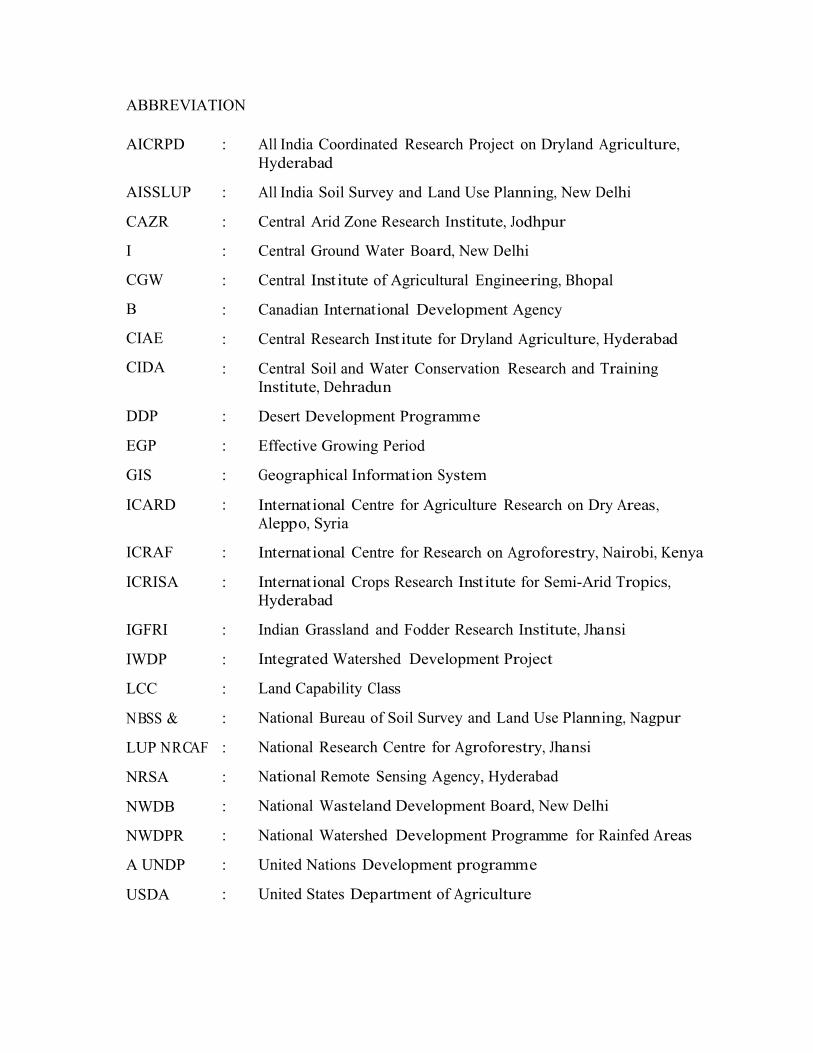
ABBREVIATIONSAICRPDA
: All India Coordinated Research Project on Dryland Agriculture,Hyderabad
All India Soil Survey and Land Use Planning, New Delhi
Central Arid Zone Research Institute, Jodhpur
Central Ground Water Board, New Delhi
Central Institute of Agricultural Engineering, Bhopal
Canadian International Development Agency
Central Research Institute for Dryland Agriculture, Hyderabad
Central Soil and Water Conservation Research and TrainingInstitute, Dehradun
Desert Development Programme
Effective Growing Period
Geographical Information System
International Centre for Agriculture Research on Dry Areas, Aleppo, Syria
International Centre for Research on Agroforestry, Nairobi, Kenya
International Crops Research Institute for Semi-Arid Tropics, Hyderabad
Indian Grassland and Fodder Research Institute, Jhansi
Integrated Watershed Development Project
Land Capability Class
National Bureau of Soil Survey and Land Use Planning, Nagpur
National Research Centre for Agroforestry, Jhansi
National Remote Sensing Agency, Hyderabad
National Wasteland Development Board, New Delhi
National Watershed Development Programme for Rainfed Areas
United Nations Development programme
United States Department of Agriculture
AISSLUP
CAZR
I
CGW
B
CIAE
CIDA
CRID
:
:
:
:
:
:
:
DDP
EGP
GIS
ICARDA
:
:
:
:
ICRAF
ICRISAT
:
:
IGFRI
IWDP
LCC
NBSS &
LUP NRCAF
NRSA
NWDB
NWDPR
A UNDP
USDA
:
:
:
:
:
:
:
:
:
:
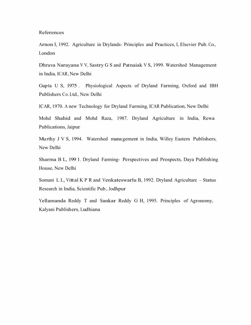
References
Arnon I, 1992. Agriculture in Drylands- Principles and Practices, I, Elsevier Pub. Co.,
London
Dhruva Narayana V V, Sastry G S and Patnaiak V S, 1999. Watershed Management
in India, ICAR, New Delhi
Gupta U S, 1975 . Physiological Aspects of Dryland Farming, Oxford and IBH
Publishers Co. Ltd., New Delhi
ICAR, 1970. A new Technology for Dryland Farming, ICAR Publication, New Delhi
Mohd Shahid and Mohd Raza, 1987. Dryland Agriculture in India, Rewa
Publications, Jaipur
Murthy J V S, 1994. Watershed mana gement in India, Willey Eastern Publishers,
New Delhi
Sharma B L, 199 1. Dryland Farming- Perspectives and Prospects, Daya Publishing
House, New Delhi
Somani L L, Vittal K P R and Venkateswarlu B, 1992. Dryland Agriculture – Status
Research in India, Scientific Pub., Jodhpur
Yellamanda Reddy T and Sankar Reddy G H, 1995. Principles of Agronomy,
Kalyani Publishers, Ludhiana