11. plans and programs 11.1 environmental …
TRANSCRIPT

ENVIRONMENTAL ASSESSMENT FOR THE RUMICHACA-PASTO DIVIDED HIGHWAY PROJECT, SAN JUAN-PEDREGAL
SEGMENT, CONCESSION AGREEMENT UNDER APP SCHEME N° 15 OF 2015
GEO-002-17-114-EAM Version 0. May 2017
CSH-1-AM-AM-EIA-0001-0
11. PLANS AND PROGRAMS
CONTENT
11. PLANS AND PROGRAMS
11.1 ENVIRONMENTAL MANAGEMENT PLAN
11.1.1 ENVIRONMENTAL MANAGEMENT STRUCTURE AND PROGRAMS
11.1.2 FOLLOW UP AND MONITORING PLAN
The Followup and Monitoring Plan is intended to verify compliance with the environmental management measures set out in each program of the Environmental Management Plan (Chapter 11.1.1), to monitor and confirm the effectiveness of said projects, and identify potential improvement opportunities for the proposed actions.
The plan's structure includes monitoring programs for management measures related to the file cards:
Table 11.1 Structure of the Followup and Monitoring Plan
PROGRAM FOLLOW UP AND MONITORING PLAN FILE
CARD No.
ABIOTIC ENVIRONMENT
FOLLOWUP AND MONITORING
PROGRAM
Water intake, occupation and domestic and industrial waste water
1
Solid waste management, treatment and disposal of solid waste
2
Atmospheric emissions, air quality and noise 3
BIOTIC ENVIRONMENT
FOLLOWUP AND MONITORING
PROGRAM
Topsoil stripping and Vegetation Cover 4
Wildlife fauna 5
Flora 6
Protection of Sensitive Ecoystems 7
Revegetation of intervened areas. 8

ENVIRONMENTAL ASSESSMENT FOR THE RUMICHACA-PASTO DIVIDED HIGHWAY PROJECT, SAN JUAN-PEDREGAL
SEGMENT, CONCESSION AGREEMENT UNDER APP SCHEME N° 15 OF 2015
GEO-002-17-114-EAM Version 0. May 2017
CSH-1-AM-AM-EIA-0001-0
11. PLANS AND PROGRAMS
CONTENT
PROGRAM FOLLOW UP AND MONITORING PLAN FILE
CARD No.
Compensation for impact on vegetation cover and wildlife species.
9
Follow-up of 1% investment plan 10
SOCIOECONOMIC ENVIRONMENT
FOLLOWUP AND MONITORING
PROGRAM
Management of project's social impact 11
Management and Impact Indicators of each EMP program on the socioeconomic environment
12
Effectiveness of socioeconomic and environmental programs
13
Management of concerns, requests or claims from the communities
14
Participation and timely information to the communities 15
The content and description of each follow up and monitoring file cards proposed are shown below in Table 11.2.
Table 11.2 content only follow up and monitoring file cards
ITEM DESCRIPTION
PURPOSE It shows in a specific, precise manner the objective of actions aimed at accomplishing the purposes and goals established.
TARGET It shows the targets to be achieved through follow-up and monitoring actions, stating the intended purpose of the environmental management strategy.
TYPE OF MEASURE It defines the nature of the measure, namely: prevention, mitigation, correction and compensation.
ACTIONS TO BE DEVELOPED
It corresponds to the description of measures to be developed for adequate impact management.

ENVIRONMENTAL ASSESSMENT FOR THE RUMICHACA-PASTO DIVIDED HIGHWAY PROJECT, SAN JUAN-PEDREGAL
SEGMENT, CONCESSION AGREEMENT UNDER APP SCHEME N° 15 OF 2015
GEO-002-17-114-EAM Version 0. May 2017
CSH-1-AM-AM-EIA-0001-0
11. PLANS AND PROGRAMS
CONTENT
ITEM DESCRIPTION
LOCATION OF THE FOLLOW-UP FOR
MONITORING SITE
Site, area or route where the follow up and monitoring measures will be implemented
INDICATORS It corresponds to the setting of indicators that will show the effectiveness, efficiency and/or success of the measure.
Source: GEOCOL CONSULTORES S.A., 2017.
11.1.2.1 ABIOTIC ENVIRONMENT FOLLOWUP AND MONITORING PROGRAM
ABIOTIC ENVIRONMENT ABIOTIC ENVIRONMENT FOLLOWUP AND MONITORING PROGRAM
FILE CARD No. 1 INTAKE, OCCUPATION, AND DOMESTIC AND INDUSTRIAL WASTE WATER 1. PURPOSE
· Carry out follow up of the actions proposed for adequate management of the water resource of the sources involved in the project.
· Review and assess potential change of physicochemical conditions of waterways within the area of influence of the project.
2. TARGET · Conduct final disposal within permissible limits of 100% of domestic and industrial waste water. · Secure implementation of 100% of the management measures.
3. TYPE OF MEASURE FOLLOWUP MONITORING
Actions intended to verify the efficiency of the implementation of prevention, mitigation, correction and compensation measures set out in the project's environmental management plan.
X
Definition of parameters of the physical, biotic and socioeconomic environment that must be periodically tested to verify the behavior of environmental components.
X
4. ACTIONS TO BE DEVELOPED
Throughout project's performance, there will be permanent verification of the compliance and effectiveness of the measures set forth for management of waste water (domestic and industrial) as well as the water catchment system, in order to prevent and/or mitigate the potential impact of the project on the biotic and abiotic environment (water component). The monitoring of waste water will be performed every time it is to be disposed of, complying with the parameters set forth in resolution 631 of March 17, 2015 on specific discharge into surface water bodies and Decree 1594 of 1984 for water to be disposed of into the soil, given that the environmental legislation has not provided for minimum quality standards (Paragraph of article 1 in resolution 631 of 2015).
The monitoring carried out during performance of the project will be compared with those performed prior to commencement of the activity in order to assess the behavior of each current that can be potentially affected by project operations, as well as the strips for water intake and discharge.

ENVIRONMENTAL ASSESSMENT FOR THE RUMICHACA-PASTO DIVIDED HIGHWAY PROJECT, SAN JUAN-PEDREGAL
SEGMENT, CONCESSION AGREEMENT UNDER APP SCHEME N° 15 OF 2015
GEO-002-17-114-EAM Version 0. May 2017
CSH-1-AM-AM-EIA-0001-0
11. PLANS AND PROGRAMS
CONTENT
ABIOTIC ENVIRONMENT ABIOTIC ENVIRONMENT FOLLOWUP AND MONITORING PROGRAM
FILE CARD No. 1 INTAKE, OCCUPATION, AND DOMESTIC AND INDUSTRIAL WASTE WATER
Follow-up of domestic and industrial waste water management.
· During construction of civil works, there will be monitoring of personnel in charge (outsourced) of the functioning, maintenance and disposal of waste generated by portable restrooms to meet the sanitary requirements of the workers. This will comply with adequate treatment and final disposal of waste water, having in place the permits and authorizations granted by the competent environmental authority for such activity{ut2.}
· The environmental inspectorship will secure that the physicochemical and bacteriological analyses are performed on effluents from the domestic and industrial waste water treatment systems (treatment plants) before carrying out their final disposal. Similarly, the effectiveness of the waste water treatment will be assessed, monitoring the system entry and exit points. There will be monitoring carried out at least every three (3) months.
· After each monitoring, reports will be prepared listing the analyzed parameters, results obtained, recommendations and other aspects of interest.
· There will be weekly verification of the treatment unit and, if required, preventive maintenance will be conducted, which is established through inspection of valves, connections and or insulators of the treatment units used, added to the pumps or motors used in the mechanical processes of the treatment.
Monitoring of the water ways receiving the discharges
· It is necessary to ensure the monitoring at least every three (3) months during performance of discharges, upstream, at the points, and downstream of the discharge points, taking into account the coordinates where the base line and modeling monitoring took place. Likewise, the parameters considered in the baseline of this study will be analyzed.
· A result of the parameters analyzed will be compared with those obtained in the respective EIA Report for the Pasto-Rumichaca Divided Highway Project, San Juan Pedregal Segment, as well as with Decree 1594/84 or any other that amends it, establish if it complies with the current environmental regulations; the water quality index (WQI) and the contamination indices (ICOS) will also be established: Contamination Index for Mineralization (ICOMI), Organic Matter (ICOMO), Suspended Solids (ICOSUS) and Eutrophy (ICOTRO).
· Records will be maintained of discharges, which must be signed by the environmental supervisor and inspector, which must be attached to the environmental compliance report.
The sites proposed for discharge are listed inTable 1.
Table 1 Maximum term grades and discharge strips Rumichaca-Pasto divided highway project, San Juan - Pedregal segment.
ID SOURCE
WEST ORIGIN MAGNAS SIRGAS
COORDINATES
FLOW RATE (L/s)
MOBILITY RANGE
EAST NORTH
1 Boquerón River 948589 590972 0.44 A mobility range of up to 200 m is requested, 100 m upstream and 100 m downstream of the proposed points.
2 La Humeadora Stream 955074 597201 0.44
3 Guáitara River 956508 600552 0.44
4 Sapuyes river 954844 605090 0.44 Source: GEOCOL CONSULTORES S.A., 2017.

ENVIRONMENTAL ASSESSMENT FOR THE RUMICHACA-PASTO DIVIDED HIGHWAY PROJECT, SAN JUAN-PEDREGAL
SEGMENT, CONCESSION AGREEMENT UNDER APP SCHEME N° 15 OF 2015
GEO-002-17-114-EAM Version 0. May 2017
CSH-1-AM-AM-EIA-0001-0
11. PLANS AND PROGRAMS
CONTENT
ABIOTIC ENVIRONMENT ABIOTIC ENVIRONMENT FOLLOWUP AND MONITORING PROGRAM
FILE CARD No. 1 INTAKE, OCCUPATION, AND DOMESTIC AND INDUSTRIAL WASTE WATER
Follow-up of Water Intake Sites
· To inspect and confirm the hydrological stability of water sources under concession for intake, monitoring and measurements will be performed twice a year at the point being used, taking into account the two weather periods (dry season and rainy season) for as long as the granted concession is valid. The registers taken will be presented to CORPONARIÑO and ANLA as part of the respective Environmental Compliance Reports - ICA.
· Such monitoring will include measurement and analysis of the parameters set out in the base lines of thid study, keeping in mind the coordinates used.
Follow-up of river occupation sites
· There will be monitoring all the construction processes of hydraulic works. · In areas where the construction of works is authorized over water bodies or areas with sensitive waterways to be
affected by the construction activities, water quality monitoring will be performed in advance, during construction and after ending activities at a given point. This will take into account the monitoring sites included in the base line of this study.
5. LOCATION OF THE FOLLOW-UP OR MONITORING SITE Camps (waste water treatment systems), catchment sites, discharge sites on surface water sources and riverbed occupation sites.
6. INDICATORS 6.1 METHODS AND LEVEL OF COMPLIANCE
NAME OF INDICATOR EVALUATION FORM COMPLIANCE LEVEL
Quality of discharge
(Number of Parameters with results that comply with the current legal
regulations/number of Parameters analyzed with established limit)
100%
Discharge flow control ((l/s) Discharged flow/ (l/s) Authorized Flow) x 100 100%
Water intake flow control ((l/s) Discharged flow/ (l/s) Authorized Flow) x 100 100%
Quality control /Number of performed monitoring /number of scheduled monitoring) *100 100%
6.2 FREQUENCY AND REGISTERS NAME OF INDICATOR FREQUENCY REGISTER
Quality of discharge Monitoring in situ
before carrying out discharges
Effectiveness of the quarterly
treatment system Laboratory reports
Discharge flow control Daily Discharge flow registers
Water intake flow control Daily Water intake flow records
Quality control According to the activity carried out at the source Laboratory reports
ABIOTIC ENVIRONMENT

ENVIRONMENTAL ASSESSMENT FOR THE RUMICHACA-PASTO DIVIDED HIGHWAY PROJECT, SAN JUAN-PEDREGAL
SEGMENT, CONCESSION AGREEMENT UNDER APP SCHEME N° 15 OF 2015
GEO-002-17-114-EAM Version 0. May 2017
CSH-1-AM-AM-EIA-0001-0
11. PLANS AND PROGRAMS
CONTENT
ABIOTIC ENVIRONMENT FOLLOWUP AND MONITORING PROGRAM FILE CARD No. 2 SOLID WASTE MANAGEMENT, SOLID WASTE TREATMENT AND DISPOSAL
1. PURPOSE
Control management, treatment and adequate disposal of solid waste produced during performance of the project.
2. TARGET Treat, dispose of and/or deliver adequately 100% of the solid waste generated during the various project stages, in accordance with the current regulations and that set out in this regard in the environmental management plan
3. TYPE OF MEASURE FOLLOWUP MONITORING
Actions intended to verify the efficiency of the implementation of prevention, mitigation, correction and compensation measures set out in the project's environmental management plan.
X
Definition of parameters of the physical, biotic and socioeconomic environment that must be periodically tested to verify the behavior of environmental components.
4. ACTIONS TO BE DEVELOPED
Throughout the various project stages, compliance with and measures set out for management of domestic and industrial solid waste will be verified, as well as the proper filling out of control records and the respective final disposal records.
- There will be weekly control performed on solid waste, considering that these are separated as per their classification, registered in the solid and special waste management filecard; should classification faults be found, personnel will be trained again on waste comprehensive management.
- It will be verified that the temporary classification systems (garbage cans) have the adequate color coding, in accordance with he management plan, a description that is easy to understand, and location in nearby areas where the greatest waste generation is identified (camps, casinos, etc.).
- It will be verified that there is proper storage and final disposal of industrial waste, such as metal waste, unused pipe and general scrap (spares, filters, oil change containers, chemical products packing, wood, etc.).
- There will be follow up on the amount and type of special waste generated during each stage, registering their weight and confirming adequate disposal, through delivery record from the contractor company.
- There will be a periodical review of storage systems, ecological points and waste transport, in order to confirm compliance with safety measures and their adequate functioning; should faults in these structures be identified, these must be repaired or replaced, as applicable.
5. LOCATION OF THE FOLLOW-UP OR MONITORING SITE
Camps and work sites.
6. INDICATORS 6.1 METHODS AND LEVEL OF COMPLIANCE
NAME OF INDICATOR EVALUATION FORM COMPLIANCE LEVEL
Classified solid waste (Kg of properly classified waste / kg of produced waste) x 100. >80%
Environmental training (Number of workers with environmental
training/Number of people employed by the project)* 100
100%
Special waste (Kg of special waste delivered and supported with record/kg of special waste produced)*
100 100%
Gathering or temporary storage systems (Number of faulty gathering or temporary storage systems /Number of gathering or
temporary storage systems) >1
6.2 FREQUENCY AND REGISTERS

ENVIRONMENTAL ASSESSMENT FOR THE RUMICHACA-PASTO DIVIDED HIGHWAY PROJECT, SAN JUAN-PEDREGAL
SEGMENT, CONCESSION AGREEMENT UNDER APP SCHEME N° 15 OF 2015
GEO-002-17-114-EAM Version 0. May 2017
CSH-1-AM-AM-EIA-0001-0
11. PLANS AND PROGRAMS
CONTENT
ABIOTIC ENVIRONMENT ABIOTIC ENVIRONMENT FOLLOWUP AND MONITORING PROGRAM
FILE CARD No. 2 SOLID WASTE MANAGEMENT, SOLID WASTE TREATMENT AND DISPOSAL NAME OF INDICATOR FREQUENCY REGISTER
Solid waste produced Weekly Inspectorship Records /
Environmental Manager Records / Photos
Environmental training Monthly ( according to contracting processes) Maintenance of attendance to environmental training sessions
Special waste Weekly Records of delivery by contracting company
Gathering or temporary storage systems Weekly Inspectorship and Environmental Manager Records / Photos
Source: GEOCOL CONSULTORES S.A, 2017.
ENVIRONMENTAL ASSESSMENT FOR THE RUMICHACA-PASTO DIVIDED HIGHWAY PROJECT, SAN JUAN-PEDREGAL
SEGMENT, CONCESSION AGREEMENT UNDER APP SCHEME N° 15 OF 2015
GEO-002-17-114-EAM Version 0. May 2017
CSH-1-AM-AM-EIA-0001-0
11. PLANS AND PROGRAMS
CONTENT
ABIOTIC ENVIRONMENT ABIOTIC ENVIRONMENT FOLLOWUP AND MONITORING PROGRAM
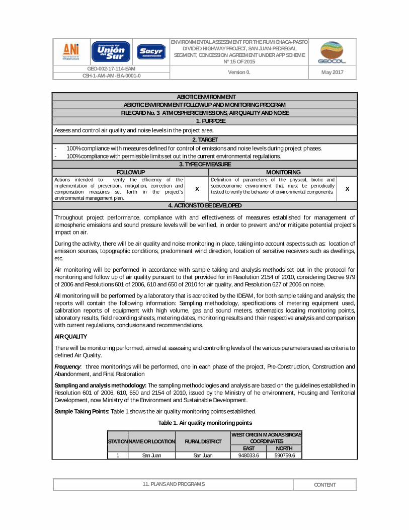
FILE CARD No. 3 ATMOSPHERIC EMISSIONS, AIR QUALITY AND NOISE 1. PURPOSE
Assess and control air quality and noise levels in the project area. 2. TARGET
- 100% compliance with measures defined for control of emissions and noise levels during project phases. - 100% compliance with permissible limits set out in the current environmental regulations.
3. TYPE OF MEASURE FOLLOWUP MONITORING
Actions intended to verify the efficiency of the implementation of prevention, mitigation, correction and compensation measures set forth in the project's environmental management plan.
X
Definition of parameters of the physical, biotic and socioeconomic environment that must be periodically tested to verify the behavior of environmental components. X
4. ACTIONS TO BE DEVELOPED
Throughout project performance, compliance with and effectiveness of measures established for management of atmospheric emissions and sound pressure levels will be verified, in order to prevent and/or mitigate potential project's impact on air.
During the activity, there will be air quality and noise monitoring in place, taking into account aspects such as: location of emission sources, topographic conditions, predominant wind direction, location of sensitive receivers such as dwellings, etc.
Air monitoring will be performed in accordance with sample taking and analysis methods set out in the protocol for monitoring and follow up of air quality pursuant to that provided for in Resolution 2154 of 2010, considering Decree 979 of 2006 and Resolutions 601 of 2006, 610 and 650 of 2010 for air quality, and Resolution 627 of 2006 on noise.
All monitoring will be performed by a laboratory that is accredited by the IDEAM, for both sample taking and analysis; the reports will contain the following information: Sampling methodology, specifications of metering equipment used, calibration reports of equipment with high volume, gas and sound meters, schematics locating monitoring points, laboratory results, field recording sheets, metering dates, monitoring results and their respective analysis and comparison with current regulations, conclusions and recommendations.
AIR QUALITY
There will be monitoring performed, aimed at assessing and controlling levels of the various parameters used as criteria to defined Air Quality.
Frequency: three monitorings will be performed, one in each phase of the project, Pre-Construction, Construction and Abandonment, and Final Restoration
Sampling and analysis methodology: The sampling methodologies and analysis are based on the guidelines established in Resolution 601 of 2006, 610, 650 and 2154 of 2010, issued by the Ministry of he environment, Housing and Territorial Development, now Ministry of the Environment and Sustainable Development.
Sample Taking Points: Table 1 shows the air quality monitoring points established.
Table 1. Air quality monitoring points
STATION NAME OR LOCATION RURAL DISTRICT WEST ORIGIN MAGNAS SIRGAS
COORDINATES EAST NORTH
1 San Juan San Juan 948033.6 590759.6

ENVIRONMENTAL ASSESSMENT FOR THE RUMICHACA-PASTO DIVIDED HIGHWAY PROJECT, SAN JUAN-PEDREGAL
SEGMENT, CONCESSION AGREEMENT UNDER APP SCHEME N° 15 OF 2015
GEO-002-17-114-EAM Version 0. May 2017
CSH-1-AM-AM-EIA-0001-0
11. PLANS AND PROGRAMS
CONTENT
ABIOTIC ENVIRONMENT ABIOTIC ENVIRONMENT FOLLOWUP AND MONITORING PROGRAM
FILE CARD No. 3 ATMOSPHERIC EMISSIONS, AIR QUALITY AND NOISE 2 Contadero Contadero town center 947761.9 592132.9 3 Camp 31 + 100 Iles urban center 955537.9 598054.0 4 Picapiedra Camp La Esperanza 956411.5 600246.9 5 Mikel Camp El Porvenir 955244.4 604753.0 6 Pilcuán Pilcuán 956709.4 605294.5
Parameters to be analyzed: Total suspended particles (PST), particulate matter equal to or lower than 10 microns (PM10), particulate matter equal to or lower than 2.5 microns (PM2.5), nitrogen dioxide (NO2), sulphur dioxide (SO2), carbon monoxide (CO) and total hydrocarbons (HCT).
Regulation: Compliance with norms set forth in Resolution 610 of March 2010, amended by Resolution 2154 of November 2, 2010, issued by the then MAVDT, currently MADS. All the monitoring information will be contained in the environmental compliance reports - ICA.
Maximum permissible levels for contaminants: Shown in Table 2
Table 2. Maximum permissible levels for contaminants
CONTAMINANT UNIT MAXIMUM
PERMISSIBLE LEVEL
TIME OF EXPOSURE
PST µg/m3 100 Annual 300 24 hours
PM10 µg/m3 50 Annual
100 24 hours
PM2.5 µg/m3 25 Annual 50 24 hours
SO2 (µg/m3) 80 Annual
250 24 hours 750 3 hours
NO2 (µg/m3) 100 Annual 150 24 hours 200 1 hour
CO (µg/m3) 10000 8 hours 40000 1 hour
Resolution 610 of 2010 has not defined the regulation or the maximum emission level for the HCT contaminant.
Fixed Source Monitoring: monitoring of fixed sources of emissions will follow the provisions of Resolution 909 of 2008 issued by the then Ministry of the Environment, Housing and Territorial Development and its amending resolutions.
NOISE MONITORING
There will be monitoring performed, aimed at assessing and controlling levels used as criteria to define sound pressure.
Frequency: Noise monitoring will be performed for day and night periods in business days and holidays; in each phase of the project, Pre-Construction, Construction and Abandonment, and Final Restoration, to verify noise levels and compare with Resolution 627 of April 7, 2006.
Sampling and analysis methodology: Noise level monitoring will be performed in accordance with the parameters and procedures set out in the current legislation. According to the local regulations on Noise Emissions and Environmental

ENVIRONMENTAL ASSESSMENT FOR THE RUMICHACA-PASTO DIVIDED HIGHWAY PROJECT, SAN JUAN-PEDREGAL
SEGMENT, CONCESSION AGREEMENT UNDER APP SCHEME N° 15 OF 2015
GEO-002-17-114-EAM Version 0. May 2017
CSH-1-AM-AM-EIA-0001-0
11. PLANS AND PROGRAMS
CONTENT
ABIOTIC ENVIRONMENT ABIOTIC ENVIRONMENT FOLLOWUP AND MONITORING PROGRAM
FILE CARD No. 3 ATMOSPHERIC EMISSIONS, AIR QUALITY AND NOISE Noise issued by the MAVDT, through Resolution 627/2006,
Sample Taking Points: Table 3 shows the noise monitoring points set out, which must be the same always to generate isophonic line maps, which are essential for followup and monitoring purposes.
Table 3. Noise monitoring points
STATION NAME OR LOCATION RURAL DISTRICT WEST ORIGIN MAGNAS SIRGAS
COORDINATES EAST NORTH
1 San Juan San Juan 948033.6 590759.6 2 Contadero Contadero town center 947761.9 592132.9 3 Camp 31 + 100 Iles urban center 955537.9 598054.0 4 Picapiedra Camp La Esperanza 956411.5 600246.9 5 Mikel Camp El Porvenir 955244.4 604753.0 6 Pilcuán Pilcuán 956709.4 605294.5
Regulations: The following environmental indicators for this type of activities corresponding to Segment C will govern: Intermediate restricted noise: Zones with permitted industrial use, such as general industry, port zones, industry parks, free trade zones, which levels must not exceed the following:
Noise level during the day (7:01 AM – 9:00 PM): 75 (dB)
Noise level during the night (9:01 PM-7:0 AM): 70 (dB)
The results of noise sampling will be analyzed by defining the noise generating source, that is, if the levels are associated with environmental noise or noise caused by motors and equipment. If the noise is associated to work activities, mitigation measures must be implemented to reduce sound pressure levels to those set forth in the resolution.
5. LOCATION OF THE FOLLOW-UP OR MONITORING SITE
Monitoring points established
6. INDICATORS 6.1 METHODS AND LEVEL OF COMPLIANCE
NAME OF INDICATOR EVALUATION FORM COMPLIANCE LEVEL
Monitoring performed (Air quality and noise monitoring performed/Air quality and noise
monitoring scheduled) x 100 100%
Compliance with current air regulations
(Number of parameters that comply with the quality regulatory limits / Number of parameters that have
regulatory limits) x 100
100%
Compliance with current noise regulations
(Monitoring points that comply with regulatory limits relative to Noise /
Monitored Points) 100%
6.2 FREQUENCY AND REGISTERS NAME OF INDICATOR FREQUENCY REGISTER
Monitoring performed Three moments (Phase: Pre-
construction, Construction and Abandonment, and Final Restoration)
Monitoring laboratory results

ENVIRONMENTAL ASSESSMENT FOR THE RUMICHACA-PASTO DIVIDED HIGHWAY PROJECT, SAN JUAN-PEDREGAL
SEGMENT, CONCESSION AGREEMENT UNDER APP SCHEME N° 15 OF 2015
GEO-002-17-114-EAM Version 0. May 2017
CSH-1-AM-AM-EIA-0001-0
11. PLANS AND PROGRAMS
CONTENT
ABIOTIC ENVIRONMENT ABIOTIC ENVIRONMENT FOLLOWUP AND MONITORING PROGRAM
FILE CARD No. 3 ATMOSPHERIC EMISSIONS, AIR QUALITY AND NOISE
Compliance with current air regulations Three moments (Phase: Pre-
construction, Construction and Abandonment, and Final Restoration)
Monitoring laboratory results
Compliance with current noise regulations
Three moments (Phase: Pre-construction, Construction and
Abandonment, and Final Restoration) Monitoring laboratory results
Source: GEOCOL CONSULTORES S.A, 2017.
11.1.2.2 BIOTIC ENVIRONMENT FOLLOWUP AND MONITORING PROGRAM

ENVIRONMENTAL ASSESSMENT FOR THE RUMICHACA-PASTO DIVIDED HIGHWAY PROJECT, SAN JUAN-PEDREGAL
SEGMENT, CONCESSION AGREEMENT UNDER APP SCHEME N° 15 OF 2015
GEO-002-17-114-EAM Version 0. May 2017
CSH-1-AM-AM-EIA-0001-0
11. PLANS AND PROGRAMS
CONTENT
BIOTIC ENVIRONMENT BIOTIC ENVIRONMENT FOLLOWUP AND MONITORING PROGRAM
FILE CARD No. 4 TOPSOIL STRIPPING AND VEGETATION COVER 1. PURPOSE
Perform monitoring of topsoil stripping and removal of vegetation cover to verify its compliance and effectiveness.
2. TARGET Compliance with protection of vegetation out of the felling line, authorized forest use and preservation and re-utilization of topsoil stripping material derived from project activities.
3. TYPE OF MEASURE FOLLOWUP MONITORING
Actions intended to verify the efficiency of the implementation of prevention, mitigation, correction and compensation measures set forth in the project's environmental management plan.
Definition of parameters of the physical, biotic and socioeconomic environment that must be periodically tested to verify the behavior of environmental components. X
4. ACTIONS TO BE DEVELOPED
Vegetation monitoring will be performed taking the following activities into account:
• There will be monitoring of proper signallig an sectorizing of work fronts.
• It is necessary to secure persistence and proper use of vegetation cover as a result of topsoil stripping activities
• There will be verification of proper execution of procedures for disposal of waste derived from work, for example branches, leaves, wood, roots.
• There will be verification of number of trees and volume of forest use not exceeding the numbers authorized in the environmental license.
• Assessment of vegetation cover removal and topsoil stripping requirements
• Records of stripped areas, removed vegetation and storage of soil that will be re-utilized, for subsequent revegetation activities.
• Verification and adequate control of the trimmed vegetation, felled or removed from the work front.
• Monitoring of adequate maintenance and disposal of soil stock piles.
5. LOCATION OF THE FOLLOW-UP OR MONITORING THE SITE
The sampling sites will be governed by the various management activities; however, it will be possible to establish some necessary monitoring points, on:
• Felling corridors established, which are shown as individuals for felling in the forest control sheets or portfolios, according to the environmental license.
• The sites for temporary storage of topsoil stripping and felling material
• At the work fronts established by the concessionaire
• Areas adjacent to the works, where the tree individuals to be preserved are found and in the specific case of reaching the riverbed of a current 130 m downstream and 80 m upstream of the works, seeking to preserve the species around the work sites. In general, all the sites and areas defined in the file cards of the environmental management plan for the Biotic environment.

ENVIRONMENTAL ASSESSMENT FOR THE RUMICHACA-PASTO DIVIDED HIGHWAY PROJECT, SAN JUAN-PEDREGAL
SEGMENT, CONCESSION AGREEMENT UNDER APP SCHEME N° 15 OF 2015
GEO-002-17-114-EAM Version 0. May 2017
CSH-1-AM-AM-EIA-0001-0
11. PLANS AND PROGRAMS
CONTENT
BIOTIC ENVIRONMENT BIOTIC ENVIRONMENT FOLLOWUP AND MONITORING PROGRAM
FILE CARD No. 4 TOPSOIL STRIPPING AND VEGETATION COVER 6. INDICATORS
6.1 METHODS AND LEVEL OF COMPLIANCE NAME OF INDICATOR EVALUATION FORM COMPLIANCE LEVEL
Indicator 1: Demarcation of works for protection of vegetation cover.
Delimited and marked length/ perimeter of the required works) x 100 100%
Indicator 2: Individual isolation for protection.
(Number of trees preserved by perimeter isolation/ number of trainees
identified that must be isolated for project performance purposes) x 100
100%
Indicator 3: Compliance with forest exploitation permit.
(Total number of felled trees/Total number of trees to be felled as
authorized by the environmental license) x 100
≤100%
Indicator 4: Total volume of non-timber material handled.
(Total volume of non-timber material handled/total volume of non-timber
material generated) x 100 >70%
Indicator 5: Use of timber generated by forest exploitation.
(Timber volume obtained and used in civil works + timber volume delivered to
the community)/timber volume generated during forest exploitation) x
100
100%
Indicator 6: Volume of soil stored and preserved derived from topsoil stripping.
(Volume of soil stored and preserved derived from topsoil stripping/volume of
soil from topsoil stripping) x 100 >70%
Indicator 7: Volume of topsoil stripping re-utilized.
(Volume of topsoil stripping re-utilized for final reconfiguration of
works/volume of topsoil stripping generated) x 100
>70%
6.2 FREQUENCY AND REGISTERS NAME OF INDICATOR FREQUENCY REGISTER
Indicator 1: Demarcation of works for protection of vegetation cover. Monthly Photo records, field portfolios
Indicator 2: Individual isolation for protection. Monthly Photo records, field portfolios
Indicator 3: Compliance with forest exploitation permit. At the end of each work Photo records, field portfolios
Indicator 4: Total volume of non-timber material handled. At the end of each work Photo records, field portfolios
Indicator 5: Use of timber generated by forest exploitation. At the end of each work Photo records, field portfolios and
delivery minutes

ENVIRONMENTAL ASSESSMENT FOR THE RUMICHACA-PASTO DIVIDED HIGHWAY PROJECT, SAN JUAN-PEDREGAL
SEGMENT, CONCESSION AGREEMENT UNDER APP SCHEME N° 15 OF 2015
GEO-002-17-114-EAM Version 0. May 2017
CSH-1-AM-AM-EIA-0001-0
11. PLANS AND PROGRAMS
CONTENT
BIOTIC ENVIRONMENT BIOTIC ENVIRONMENT FOLLOWUP AND MONITORING PROGRAM
FILE CARD No. 4 TOPSOIL STRIPPING AND VEGETATION COVER
Indicator 6: Volume of soil stored and preserved derived from topsoil stripping. At the end of each work Photo records, field portfolios
Indicator 7: Volume of topsoil stripping re-utilized. At the end of each work Photo records, field portfolios
Source: GEOCOL CONSULTORES S.A., 2017.
BIOTIC ENVIRONMENT BIOTIC ENVIRONMENT FOLLOWUP AND MONITORING PROGRAM
FILE CARD No. 5 WILDLIFE FAUNA 1. PURPOSE
· Verify compliance with the norms and activities to secure fauna protection and conservation, preventing disturbance, hunting and commercialization of wildlife species and the effectiveness of measures related to the protection of habitats located in the area of influence of the road project.
· Verify that personnel engaged in the various project activities have the necessary knowledge to recognize and act in accordance with the wildlife scenario and environment of the area where the project is performed.
· Guarantee compliance with the measures set out to prevent impact of endemic and endangered species throughout the various project phases.
· Establish guidelines for monitoring of flora and fauna species, mainly those that are classified as species under the category of vulnerable to extinction.
2. TARGET · 100% fulfillment of the measures set out to prevent impact on fauna species during project activities. · 100% Fulfillment of follow up and monitoring activities related to fauna in the area of influence of the project.
3. TYPE OF MEASURE FOLLOWUP MONITORING
Actions intended to verify the efficiency of the implementation of prevention, mitigation, correction and compensation measures set forth in the project's environmental management plan.
X
Definition of parameters of the physical, biotic and socioeconomic environment that must be periodically tested to verify the behavior of environmental components.
X
4. ACTIONS TO BE DEVELOPED
Action 1: Workshops and training
1. Performance of four (4) socialization and training workshops will be verified (sessions focused on: environmental awareness, hunting and illegal commercialization of species, accidents related to wildlife and socialization of fauna monitoring programs) intended for personnel and community in the area of influence of the road project relative to the diverse city of local and regional fauna, their ecological, economic and cultural value, added to the relevance and need for their conservation and sustainable use.
Action 2: Measures for signaling and mobilization of vehicles and machinery
1. Verify that prior to commencing the work, the sites where cutting and excavation will take place are isolated with construction safety mesh to prevent mortality among fauna individuals.
2. Verify that speed control is in place for all project vehicles, and that it has been communicated to all direct

ENVIRONMENTAL ASSESSMENT FOR THE RUMICHACA-PASTO DIVIDED HIGHWAY PROJECT, SAN JUAN-PEDREGAL
SEGMENT, CONCESSION AGREEMENT UNDER APP SCHEME N° 15 OF 2015
GEO-002-17-114-EAM Version 0. May 2017
CSH-1-AM-AM-EIA-0001-0
11. PLANS AND PROGRAMS
CONTENT
BIOTIC ENVIRONMENT BIOTIC ENVIRONMENT FOLLOWUP AND MONITORING PROGRAM
FILE CARD No. 5 WILDLIFE FAUNA personnel and contractors regarding speed limits in both internal and external roads.
3. Verify that in case of accident and/or death of animals that are knocked down, it is reported to the competent environmental authority, documenting the event with photos and filling out the event reporting form.
4. Verify the location of information signals alerting about presence of animals in the area and environmentally relevant habitats, in order to prevent and reduce human impact, for example vehicle collision.
Action 3: Measures for scaring away, rescuing and relocating fauna;
1. Verification of relocation of the fauna receiving sites authorized by CORPONARIÑO for nests, individuals in dens and others will be performed using fauna recording formats designed for such purpose.
2. System verification of individuals identity that can be classified as endemic for the area or that are included in any endangered species list before commencement of civil works and in areas marked for intervention.
3. Verification of scaring away activities by professionals (biologists) trained for such purpose. Also, presence of professionals in topsoil stripping and vegetation material removal activities aimed at avoiding incidents with wildlife fauna not responding to scaring away actions, or that have returned to the construction area.
4. Verification with professionals in charge of scaring away activities to make sure that they have the necessary personal protection elements.
5. It will be verified that for moving and rescuing injured fauna individuals that cannot move by themselves the protocols established in the Fauna Protection Filecard proposed in the EMP are complied with.
Action 4: Fauna passages:
1. It will be verified that the construction and location of fauna passages meet the specifications, factors and protocols proposed in the Fauna Protection Filecard included in the EMP.
Follow up and monitoring of fauna and its habitats:
1. There will be monitoring to show the condition of fauna communities, particularly of one of the endemic species ( amphibians, reptiles, birds and mammals), the danger of extinction or vulnerability, For performance thereof, the following criteria will be considered: § Frequency: Monitoring will be performed in accordance with the fauna group § Fauna groups to be monitored: It will depend on the specie or endangered species, closure times,
endemic or migratory species selected for the monitoring. § Sampling method: According to the group to be studied, the following techniques will be used:
- Birds: mist nets and observation transect lines - Mammals: mist nets (Chiropeters), camera traps, sherman traps, observation transect lines - Amphibians and reptiles: Transect lines for detection from visual encounters (day and night)
§ Sampling intensity: it is possible to use as reference the sampling efforts proposed by Villareal et al., (2006) or specialized scientific publications. The efforts made must secure the representativeness of the sampling.
§ Sample taking points: A minimum of four sites will be established, which are distributed along the area of influence of the project, with contrasting features related to vegetation cover and presence of oil industry infrastructure and sites that are preserved better, or not intervened (greenfields). The number of sites can increase, depending on the infrastructure that is gradually incorporated.
2. The periodical monitoring reports will be presented with the ICAs and will contain the results and their analysis, comparing them with the EIA baseline, photo records and registration forms, added to analysis of possible changes related to fauna communities and habitats arising as a consequence of oil industry activities, and effectiveness of management measures.

ENVIRONMENTAL ASSESSMENT FOR THE RUMICHACA-PASTO DIVIDED HIGHWAY PROJECT, SAN JUAN-PEDREGAL
SEGMENT, CONCESSION AGREEMENT UNDER APP SCHEME N° 15 OF 2015
GEO-002-17-114-EAM Version 0. May 2017
CSH-1-AM-AM-EIA-0001-0
11. PLANS AND PROGRAMS
CONTENT
BIOTIC ENVIRONMENT BIOTIC ENVIRONMENT FOLLOWUP AND MONITORING PROGRAM
FILE CARD No. 5 WILDLIFE FAUNA 5. LOCATION OF THE FOLLOW-UP OR MONITORING SITE
A minimum of four sites will be established, which are distributed along the area of influence of the project, with contrasting features related to vegetation cover and presence of oil industry infrastructure, and sites that are preserved better, or not intervened (greenfields). The number of sites can increase, depending on the infrastructure that is gradually incorporated.
6. INDICATORS 6.1 METHODS AND LEVEL OF COMPLIANCE
NAME OF INDICATOR EVALUATION FORM COMPLIANCE LEVEL
Indicator 1: Workers trained: (Number of registers completed of training talks/Number of training talks performed) *100
Excellent 100% Good: 90% Fair:> 80%
Poor: < 80%
Indicator 2: Socialization conducted with the community
(Number of records of socialization completed/number of socialization performed) * 100
Excellent 100% Good: 90% Fair:> 80%
Poor: < 80%
Indicator 3: Isolation
(Number of sites where isolated cutting and excavation were performed using
safety mesh/Total number of sites where cutting and excavation works will
be performed) * 100
Excellent 100% Poor: < 100%
Indicator 4: Record of accident and/or death of animals belonging to Wildlife Fauna
(Number of accidents of animals documented in the register forms/Total
number of accidents and/or death of animals) *100
Excellent 100% Good: 90% Fair:> 80%
Poor: < 80%
Indicator 5: Signaling (Number of information signals
installed/number of information signals proposed for installation) *100
Excellent 100% Good: 90% Fair:> 80%
Poor: < 80%
Indicator 6: Relocated individuals (Relocated individuals at the fauna
receiving sites/Individuals found in the area of influence)*100
Excellent 100% Poor: < 100%
Indicator 7: Fauna passages (Fauna passages performed/Fauna passages proposed)*100
Excellent 100% Good: 90% Fair:> 80%
Poor: < 80%
Indicator 8: Fauna Rescues
(Number of individuals with mobilization limitations rescued before scaring them
away/Number of individuals with mobilization limitations found it during
inspection prior to scaring them away)*100
Excellent 100% Good: 90% Fair:> 80%
Poor: < 80%
Indicator 9: Monitoring (Number of monitorings performed to
characterize endangered wildlife fauna, closure times, endemic or
Excellent 100% Good: 90% Fair:> 80%

ENVIRONMENTAL ASSESSMENT FOR THE RUMICHACA-PASTO DIVIDED HIGHWAY PROJECT, SAN JUAN-PEDREGAL
SEGMENT, CONCESSION AGREEMENT UNDER APP SCHEME N° 15 OF 2015
GEO-002-17-114-EAM Version 0. May 2017
CSH-1-AM-AM-EIA-0001-0
11. PLANS AND PROGRAMS
CONTENT
BIOTIC ENVIRONMENT BIOTIC ENVIRONMENT FOLLOWUP AND MONITORING PROGRAM
FILE CARD No. 5 WILDLIFE FAUNA migratory/Number of monitoring
scheduled to characterize endangered wildlife fauna, closure times, endemic or
migratory)*100
Poor: < 80%
Indicator 8: Environmental Compliance Reports
(Reports on characterization of endangered wildlife fauna, closure times,
endemic or migratory/Reports on scheduled characterization of endangered wildlife fauna, closure times, endemic or
migratory)*100
Excellent 100% Good: 90% Fair:> 80%
Poor: < 80%
6.2 FREQUENCY AND REGISTERS NAME OF INDICATOR FREQUENCY REGISTER
Indicator 1: Workers trained: Four days
report of activities performed, specifying the topics discussed,
photo records, attendance records
Indicator 2: Socialization conducted with the community Four days
report of activities performed, specifying the topics discussed,
photo records, attendance records
Indicator 3: Isolation At commencement of activity Photographic records
Indicator 4: Record of accident and/or death of animals belonging to Wildlife Fauna
At the time of event occurrence
Accident record minutes and/or animal death, photo records,
Environmental Compliance Reports (ICA for the Spanish acronym)
Indicator 5: Signaling At commencement of works and when these start operating
Report of activities performed, photo records, Environmental
Compliance Reports (ICA for the Spanish acronym)
Indicator 6: Relocated individuals At commencement of activities associated with the project
Report of activities performed, photo records, Environmental
Compliance Reports (ICA for the Spanish acronym)
Indicator 7: Fauna passages During low work construction phase Report of activities performed, photo records
Indicator 8: Fauna Rescues Prior to commencement of activities associated with the project
Report of activities performed, photo records, Environmental
Compliance Reports (ICA for the Spanish acronym)
Indicator 9: Monitoring Monitoring wants the activities
associated with the project have concluded
Report of activities performed, photo records, Environmental
Compliance Reports (ICA for the Spanish acronym)
Indicator 8: Environmental Compliance Reports At the end of each work Environmental Compliance Report
ENVIRONMENTAL ASSESSMENT FOR THE RUMICHACA-PASTO DIVIDED HIGHWAY PROJECT, SAN JUAN-PEDREGAL
SEGMENT, CONCESSION AGREEMENT UNDER APP SCHEME N° 15 OF 2015
GEO-002-17-114-EAM Version 0. May 2017
CSH-1-AM-AM-EIA-0001-0
11. PLANS AND PROGRAMS
CONTENT
BIOTIC ENVIRONMENT BIOTIC ENVIRONMENT FOLLOWUP AND MONITORING PROGRAM
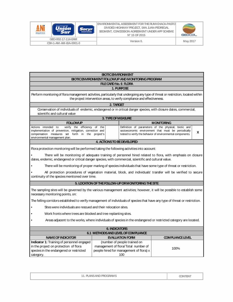
FILE CARD No. 6 FLORA 1. PURPOSE
Perform monitoring of flora management activities, particularly that undergoing any type of threat or restriction, located within the project intervention areas, to verify compliance and effectiveness.
2. TARGET Conservation of individuals of endemic, endangered or in critical danger species, with closure dates, commercial, scientific and cultural value
3. TYPE OF MEASURE FOLLOWUP MONITORING
Actions intended to verify the efficiency of the implementation of prevention, mitigation, correction and compensation measures set forth in the project's environmental management plan.
Definition of parameters of the physical, biotic and socioeconomic environment that must be periodically tested to verify the behavior of environmental components. X
4. ACTIONS TO BE DEVELOPED
Flora protection monitoring will be performed taking the following activities into account:
• There will be monitoring of adequate training of personnel hired related to flora, with emphasis on closure dates, endemic, endangered or critical danger species, with commercial, scientific and cultural value.
• There will be monitoring of proper markng of species individuals that have some type of threat or restriction.
• All protection procedures of vegetation material, block, and individuals' transfer will be verified to secure continuity of the species mentioned over time.
5. LOCATION OF THE FOLLOW-UP OR MONITORING THE SITE
The sampling sites will be governed by the various management activities; however, it will be possible to establish some necessary monitoring points, on:
The felling corridors established to verify management of individuals of species that have any type of threat or restriction.
• Sites were individuals are rescued and their relocation sites.
• Work fronts where trees are blocked and tree replanting sites.
• Areas adjacent to the works, where individuals of species in the endangered or restricted category are located.
6. INDICATORS 6.1 METHODS AND LEVEL OF COMPLIANCE
NAME OF INDICATOR EVALUATION FORM COMPLIANCE LEVEL Indicator 1: Training of personnel engaged in the project on protection of flora species in the endangered or restricted category.
(number of people trained on management of flora/Total number of
people hired for management of flora) x 100
100%

ENVIRONMENTAL ASSESSMENT FOR THE RUMICHACA-PASTO DIVIDED HIGHWAY PROJECT, SAN JUAN-PEDREGAL
SEGMENT, CONCESSION AGREEMENT UNDER APP SCHEME N° 15 OF 2015
GEO-002-17-114-EAM Version 0. May 2017
CSH-1-AM-AM-EIA-0001-0
11. PLANS AND PROGRAMS
CONTENT
BIOTIC ENVIRONMENT BIOTIC ENVIRONMENT FOLLOWUP AND MONITORING PROGRAM
FILE CARD No. 6 FLORA
Indicator 2: Training of personnel engaged in the project on protection of flora species in the endangered or restricted category.
(Number of workshops held on flora management/number of scheduled
workshops on flora management) x 100 100%
Indicator 3: Identification and marking of individuals pertaining to endangered or restricted species.
(Totalnumber of trees pertaining to marked endangered species /
Totalnumber of reported trees pertaining to endangered species) x 100
100%
Indicator 4: Rescue of flora individuals pertaining to endangered or restricted species.
(Total number of seedlings recovered pertaining to endangered species / Total
number reported of seedlings pertaining to endangered species) x 100
>70%
Indicator 5: Blocking and transferring of individuals pertaining to endangered or restricted species.
(Totalnumber of trees transplanted pertaining to endangered species / Totalnumber of tress reported for
transplant pertaining to endangered species) x 100
100%
6.2 FREQUENCY AND REGISTERS NAME OF INDICATOR FREQUENCY REGISTER
Indicator 1: Training of personnel engaged in the project on protection of flora species in the endangered or restricted category.
At the beginning of each work front Photographic records, training records.
Indicator 2: Training of personnel engaged in the project on protection of flora species in the endangered or restricted category.
At the beginning of each work front Photographic records, training records.
Indicator 3: Identification and marking of individuals pertaining to endangered or restricted species.
Before commencing each work Photo records, field portfolios
Indicator 4: Rescue of flora individuals pertaining to endangered or restricted species.
Before commencing each work Photo records, field portfolios
Indicator 5: Blocking and transferring of individuals pertaining to endangered or restricted species.
Before commencing each work Photo records, field portfolios and delivery minutes
BIOTIC ENVIRONMENT BIOTIC ENVIRONMENT FOLLOWUP AND MONITORING PROGRAM

ENVIRONMENTAL ASSESSMENT FOR THE RUMICHACA-PASTO DIVIDED HIGHWAY PROJECT, SAN JUAN-PEDREGAL
SEGMENT, CONCESSION AGREEMENT UNDER APP SCHEME N° 15 OF 2015
GEO-002-17-114-EAM Version 0. May 2017
CSH-1-AM-AM-EIA-0001-0
11. PLANS AND PROGRAMS
CONTENT
FILE CARD No. Protection of Sensitive Ecosystems 1. PURPOSE
· Performing the monitoring of activities to protect sensitive ecosystems located within and adjacent to project's intervention areas to verify their compliance and effectiveness.
· Follow-up the condition of strategic, sensitive ecosystems and/or protected areas close to the sites that are subjected two intervention.
2. TARGET · Ensure protection and conservation of sensitive ecosystems located within and adjacent to the project's
intervention areas. · 100% compliance with follow-up, assessment and control of strategic, sensitive ecosystems and/or protected
areas included in the environmental management measures. 3. TYPE OF MEASURE
FOLLOWUP MONITORING Actions intended to verify the efficiency of the implementation of prevention, mitigation, correction and compensation measures set forth in the project's environmental management plan.
Definition of parameters of the physical, biotic and socioeconomic environment that must be periodically tested to verify the behavior of environmental components.
X
4. ACTIONS TO BE DEVELOPED
Verification of management measures for conservation of sensitive ecosystems:
1. There will be verification of the generation and implementation of training for the community and personnel engaged in the project, as proposed in the Sensitive Ecosystems Protection filecard, which also corresponds to the training proposed in the Fauna Protection Filecard. The topic to be addressed will be protection of sensitive ecosystems, with emphasis on vegetation associated to water bodies and their significance in the natural balance and influence on each of the productive activities carried out in the region.
2. There will be verification to ensure that the intervention performed and derived from the project complies with regulations on protection of gallery forests and water bodies as defined by the environmental agencies in order to preserve River banks and reduce impact on biological diversity.
3. There will be verification of proper science and protection of zones adjacent to the construction area (natural vegetation, forest zones and water bodies), which will be isolated with perimeter closing.
4. There will be verification and monitoring of reforestation measures for the protection and conservation of water bodies rounds, which will be carried out to increase their ecological representativeness and significance for fauna species.
Follow up and monitoring of sensitive ecosystems:
1. There will be hydro- biological monitoring as proposed in the Sensitive Ecosystems Filecard of the EMP, which includes follow-up of the ecological flow and sediment monitoring.
2. There will be control of water discharges close to the Guaítara River and its tributaries at the hydraulic works construction site, pursuant to that set out in the domestic and industrial Liquid Waste Management Filecards.
3. Perform characterization of hydro-biological resources, with special emphasis on bio-indicator groups of environmental changes, aimed at securing maintenance of adequate conditions for the existence of all benthos groups and initial icthyofauna (the latter for the Sapuyes and Guaítara river). This Monitoring will take place at the beginning, during and at the end of the construction of each functional unit.
Contingency measures:
The following contingency measures are proposed for implementation in the event of an incident that could affect the hydro-biological communities of the water bodies that are the object of this file cards until impact thereon has ceased:
1. Records should be kept of rescued species, which must include scientific name,abundance and record of final

ENVIRONMENTAL ASSESSMENT FOR THE RUMICHACA-PASTO DIVIDED HIGHWAY PROJECT, SAN JUAN-PEDREGAL
SEGMENT, CONCESSION AGREEMENT UNDER APP SCHEME N° 15 OF 2015
GEO-002-17-114-EAM Version 0. May 2017
CSH-1-AM-AM-EIA-0001-0
11. PLANS AND PROGRAMS
CONTENT
BIOTIC ENVIRONMENT BIOTIC ENVIRONMENT FOLLOWUP AND MONITORING PROGRAM
FILE CARD No. Protection of Sensitive Ecosystems management of individuals.
2. At least three sampling points will be established for monitoring of water quality and hydro-biological communities: one at 50 m upstream of the contingency site and finally one at 50 m downstream of the contingency site.
3. The hydro-biological communities that will be subjected to monitoring will be at least: Benthos, aquatic macrophites, water-land interface vegetation in a 10 m transect and fish (where applicable).
4. The monitoring and rescue actions proposed in this file card will be valid until it is technically proofed that the impact on the water body has ceased.
5. LOCATION OF THE FOLLOW-UP OR MONITORING SITE
The sampling sites will be governed by the various management activities; however, it will be possible to establish some necessary monitoring points, on:
§ The established intervention corridors to verify management of sensitive ecosystems, particularly vegetation associated with water bodies.
§ The areas adjacent to the works, where sensitive ecosystems have been identified and where protection and recovery processes are performed by means of reforestation.
6. INDICATORS 6.1 METHODS AND LEVEL OF COMPLIANCE
NAME OF INDICATOR EVALUATION FORM COMPLIANCE LEVEL Indicator 1: Training and raising awareness among personnel engaged in the project
(Number of people trained on ecosystem protection/Total number of
people hired) x 100 100%
Indicator 2: Training and raising awareness among the community in the rural district.
(Number of Workshops on protection of ecosystems held with the
communities/Number of scheduled workshops on protection of ecosystems
x 100
100%
Indicator 3: Compliance with environmental regulations
(Intervened area with verification of environmental regulations/Area intervened by the project) x 100
100%
Indicator 4: Isolation of areas (Area with protection isolation / area with sensitive ecosystems identified) x
100 100%
Indicator 5: Reforestation of sensitive ecosystems
(Reforested area in rounds/Sensitive ecosystem area identified) x 100 >50%
Indicator 6: Monitoring of hydro- biological communities
(Number of monitorings performed/Number of scheduled
monitorings) *100 90%
Indicator 7: Contingency measures (Contingencies occurred/Monitored contingencies) 100%
6.2 FREQUENCY AND REGISTERS NAME OF INDICATOR FREQUENCY REGISTER
Indicator 1: Training and raising At the beginning of each work front Photographic records, training

ENVIRONMENTAL ASSESSMENT FOR THE RUMICHACA-PASTO DIVIDED HIGHWAY PROJECT, SAN JUAN-PEDREGAL
SEGMENT, CONCESSION AGREEMENT UNDER APP SCHEME N° 15 OF 2015
GEO-002-17-114-EAM Version 0. May 2017
CSH-1-AM-AM-EIA-0001-0
11. PLANS AND PROGRAMS
CONTENT
BIOTIC ENVIRONMENT BIOTIC ENVIRONMENT FOLLOWUP AND MONITORING PROGRAM
FILE CARD No. Protection of Sensitive Ecosystems awareness among personnel engaged in the project
records.
Indicator 2: Training and raising awareness among the community in the rural district.
At the beginning of each work front Photographic records, training records.
Indicator 3: Compliance with environmental regulations
At the beginning of each work front and monthly during performance thereof. Photo records, field portfolios
Indicator 4: Isolation of areas Before commencing each work Photo records, field portfolios
Indicator 5: Reforestation of sensitive ecosystems Quarterly during project execution Photo records, field portfolios and
delivery minutes
Indicator 6: Monitoring of hydro- biological communities
Before commencing works and at the end of works
Hydro-biological resources report, photo records
Indicator 7: Contingency measures Should any occur, as it is described Photo record, environmental report
BIOTIC ENVIRONMENT BIOTIC ENVIRONMENT FOLLOWUP AND MONITORING PROGRAM
FILE CARD No. REVEGETATION OF INTERVENED AREAS 1. PURPOSE
Perform monitoring of revegetation management activities in the project's intervened areas in order to verify its compliance and effectiveness.
2. TARGET
Guarantee protection and conservation of the vegetation cover in the project's areas of intervention.
3. TYPE OF MEASURE FOLLOWUP MONITORING
Actions intended to verify the efficiency of the implementation of prevention, mitigation, correction and compensation measures set forth in the project's environmental management plan.
Definition of parameters of the physical, biotic and socioeconomic environment that must be periodically tested to verify the behavior of environmental components. X
4. ACTIONS TO BE DEVELOPED
Vegetation monitoring will be performed taking the following activities into account:
•
There will be verification of compliance with the number of free individuals and non-timber plants established for revegetation, as well as their growth and conservation.

ENVIRONMENTAL ASSESSMENT FOR THE RUMICHACA-PASTO DIVIDED HIGHWAY PROJECT, SAN JUAN-PEDREGAL
SEGMENT, CONCESSION AGREEMENT UNDER APP SCHEME N° 15 OF 2015
GEO-002-17-114-EAM Version 0. May 2017
CSH-1-AM-AM-EIA-0001-0
11. PLANS AND PROGRAMS
CONTENT
BIOTIC ENVIRONMENT BIOTIC ENVIRONMENT FOLLOWUP AND MONITORING PROGRAM
FILE CARD No. REVEGETATION OF INTERVENED AREAS
5. LOCATION OF THE FOLLOW-UP OR MONITORING SITE
The sampling sites for monitoring revegetation of the intervened areas correspond to each work front where this activity takes place.
6. INDICATORS
6.1 METHODS AND LEVEL OF COMPLIANCE NAME OF INDICATOR EVALUATION FORM COMPLIANCE LEVEL
Indicator 1: Revegetation of intervened areaseach
(Revegetated area / Area intervened by the project) x 100 100%
Indicator 2: Revegetation of intervened areas.
Number of trainees, non-timber plans planted /Number trees, non-timber plants scheduled for the plan) x 100
100%
Indicator 3: Effectiveness of therevegetation of the intervened areas.
(Area with established vegetation cover / Revegetated area) x 100 >80%
6.2 FREQUENCY AND REGISTERS NAME OF INDICATOR FREQUENCY REGISTER
Indicator 1: Revegetation of intervened areaseach
Once the measures have been implemented upon completion of each
work Photo records, field portfolios
Indicator 2: Revegetation of intervened areas.
Once the measures have been implemented upon completion of each
work Photo records, field portfolios
Indicator 3: Effectiveness of therevegetation of the intervened areas.
Quarterly upon implementation of measures Photo records, field portfolios
BIOTIC ENVIRONMENT BIOTIC ENVIRONMENT FOLLOWUP AND MONITORING PROGRAM
FILE CARD No. 9 COMPENSATION FOUR IMPACT ON VEGETATION COVER AND WILDLIFE FAUNA 1. PURPOSE
· Perform monitoring and follow-up on compensation implemented in the area of influence in relation with forest exploitation and change of land use within the framework of the Rumichaca-Pasto divided highway project, San Juan-Pedregal segment .
· Verify compliance with compensation activities in the areas that have been projected and agreed on with the Environmental Authority.
2. TARGET

ENVIRONMENTAL ASSESSMENT FOR THE RUMICHACA-PASTO DIVIDED HIGHWAY PROJECT, SAN JUAN-PEDREGAL
SEGMENT, CONCESSION AGREEMENT UNDER APP SCHEME N° 15 OF 2015
GEO-002-17-114-EAM Version 0. May 2017
CSH-1-AM-AM-EIA-0001-0
11. PLANS AND PROGRAMS
CONTENT
BIOTIC ENVIRONMENT BIOTIC ENVIRONMENT FOLLOWUP AND MONITORING PROGRAM
FILE CARD No. 9 COMPENSATION FOUR IMPACT ON VEGETATION COVER AND WILDLIFE FAUNA
· 100% compliance with the compensation programs set forth by the environmental authority.
3. TYPE OF MEASURE FOLLOWUP MONITORING
Actions intended to verify the efficiency of the implementation of prevention, mitigation, correction and compensation measures set forth in the project's environmental management plan.
X
Definition of parameters of the physical, biotic and socioeconomic environment that must be periodically tested to verify the behavior of environmental components.
x
4. ACTIONS TO BE DEVELOPED Compensation program for impact on Fauna:
1. Participation and/or support of the project will be verified, with respect to the biology of species within the area of influence of the road project that could be somewhat endangered, at national/international level, or which are classified as endemic.
2. As regards compensation due to impact on fauna, after choosing the projects in which the company participates and that meet the purpose of the management file card for compensation for impact on vegetation cover and sensitive fauna, follow up and monitoring should be conducted (qualitative and quantitative) for temporary assessment of results. With respect to Fauna, monitoring will be performed yearly.
3. The qualitative monitoring referred to direct observation of precedence of species in different areas, while quantitative monitoring corresponds to species groups of mammals, birds, amphibians, and reptiles. Such monitoring must follow the guidelines established by the then Ministry of the Environment, Housing and Territorial Development (MAVDT), currently MADS, in its document "Manual of Methods for development of biodiversity inventories" ( 2006) and/or those determined by the environmental authority.
4. Verify performance of socialization to show the results obtained with the compensation project for Fauna. Compensation program for impact on vegetation cover:
1. Speaking and agreeing with the environmental authority (CORPONARIÑO) areas that meet the environmental requirements for establishing the compensation for forest exploitation and change of land use. These properties must be acquired by the Concesionaria Vial Unión del Sur or entering into a commodatum agreement or the appropriate legal mechanism between the owner and the Concesionaria Vial Unión del Sur in other to ensure that compensations can be performed in such property.
2. Establishment of protection forest plantations that will serve as a compensation for forest exploitation and change of land use, which includes: § Supervision of adequate isolation activities in areas identified for the plantation to increase the rate of
success. § Supervision of tree planting activities in accordance with technical parameters. It will be verified that the
planted species correspond to those proposed in the management plan. § Supervision of tree maintenance activities according to technical parameters; there will be establishment
control in place (roles, conditions of individuals) for the planted species; periodical monitoring is proposed (according to the eco-physiological needs of the species) to thus verify the mortality and the fitosanitary conditions of the seedlings.
§ The follow-up of forest plantations must keep in mind the implementation of native species, properties agreed on with the environmental authority, survival percentage (above 80%), fitosanitary conditions (number of healthy trees and number of trees requiring treatment), planted area, planting density and verification that maintenance works are performed entirely and with the required frequency.
3. Finally, the delivery of compensations to the environmental authority (CORPONARIÑO) will take place at least three

ENVIRONMENTAL ASSESSMENT FOR THE RUMICHACA-PASTO DIVIDED HIGHWAY PROJECT, SAN JUAN-PEDREGAL
SEGMENT, CONCESSION AGREEMENT UNDER APP SCHEME N° 15 OF 2015
GEO-002-17-114-EAM Version 0. May 2017
CSH-1-AM-AM-EIA-0001-0
11. PLANS AND PROGRAMS
CONTENT
BIOTIC ENVIRONMENT BIOTIC ENVIRONMENT FOLLOWUP AND MONITORING PROGRAM
FILE CARD No. 9 COMPENSATION FOUR IMPACT ON VEGETATION COVER AND WILDLIFE FAUNA years after establishing the plantation, in compliance with a survival percentage above 80% of the planted individuals, with prior approval from the environmental authority.
5. LOCATION OF THE FOLLOW-UP OR MONITORING THE SITE This compensation will be done in the properties proposed by Concesionaria Vial unión del Sur I must be approved by the environmental authority (CORPONARIÑO).
6. INDICATORS 6.1 METHODS AND LEVEL OF COMPLIANCE
NAME OF INDICATOR EVALUATION FORM COMPLIANCE LEVEL Indicator 1: Compensation of areas projected and agreed with the environmental authority
(Number of hectares compensated/Number of hectares
agreed for compensation) * 100 100%
Indicator 2: Survival percentage (Number of individuals planted and
surviving in good condition/Number of planted individuals)* 100%
>80%
Indicator 3: Monitoring performed (Monitoring performed for follow up of research projects/scheduled monitoring for follow-up of research projects) * 100
100%
Indicator 4: Focal species studied Increasing number of focal species individuals studied 70%
6.2 FREQUENCY AND REGISTERS NAME OF INDICATOR FREQUENCY REGISTER
Indicator 1: Compensation of areas projected and agreed with the environmental authority
In each environmental compliance report (ICA).
Record through follow-up minutes of the agreements.
Photo and film record.
Indicator 2: Survival percentage In each environmental compliance report (ICA).
Report on status of compensation including photo
and fill record.
Indicator 3: Monitoring performed Annual Photo records, Environmental Compliance Report (ICA)
Indicator 4: Focal species studied Yearly, together with the monitoring performed
Photo records, Environmental Compliance Report (ICA)
BIOTIC ENVIRONMENT BIOTIC ENVIRONMENT FOLLOWUP AND MONITORING PROGRAM
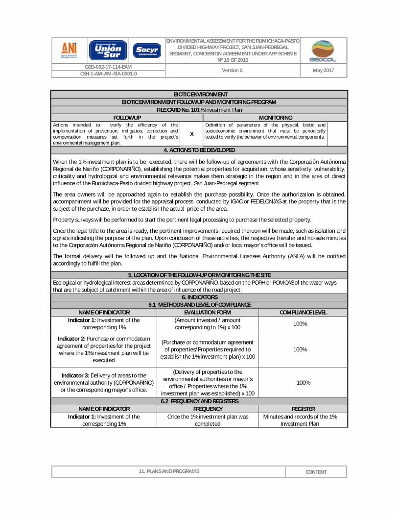
FILE CARD No. 101% Investment Plan 1. PURPOSE
Ensure acquisition of properties derived from the 1% investment in areas identified as sensitive and strategic of the water bodies were the catchment will take place. These will be classified by zones and established by the Corporación Autónoma de Nariño (CORPONARIÑO), taking into account the PORH or POMCAS of the water bodies that are the object of catchment.
2. TARGET
100% compliance with acquisition, isolation and delivery to CORPONARIÑO and/or local mayors' offices.
3. TYPE OF MEASURE
ENVIRONMENTAL ASSESSMENT FOR THE RUMICHACA-PASTO DIVIDED HIGHWAY PROJECT, SAN JUAN-PEDREGAL
SEGMENT, CONCESSION AGREEMENT UNDER APP SCHEME N° 15 OF 2015
GEO-002-17-114-EAM Version 0. May 2017
CSH-1-AM-AM-EIA-0001-0
11. PLANS AND PROGRAMS
CONTENT
BIOTIC ENVIRONMENT BIOTIC ENVIRONMENT FOLLOWUP AND MONITORING PROGRAM
FILE CARD No. 101% Investment Plan FOLLOWUP MONITORING
Actions intended to verify the efficiency of the implementation of prevention, mitigation, correction and compensation measures set forth in the project's environmental management plan.
X
Definition of parameters of the physical, biotic and socioeconomic environment that must be periodically tested to verify the behavior of environmental components.
4. ACTIONS TO BE DEVELOPED
When the 1% investment plan is to be executed, there will be follow-up of agreements with the Corporación Autónoma Regional de Nariño (CORPONARIÑO), establishing the potential properties for acquisition, whose sensitivity, vulnerability, criticality and hydrological and environmental relevance makes them strategic in the region and in the area of direct influence of the Rumichaca-Pasto divided highway project, San Juan-Pedregal segment.
The area owners will be approached again to establish the purchase possibility. Once the authorization is obtained, accompaniment will be provided for the appraisal process conducted by IGAC or FEDELONJAS at the property that is the subject of the purchase, in order to establish the actual price of the area.
Property surveys will be performed to start the pertinent legal processing to purchase the selected property.
Once the legal title to the area is ready, the pertinent improvements required thereon will be made, such as isolation and signals indicating the purpose of the plan. Upon conclusion of these activities, the respective transfer and no-sale minutes to the Corporación Autónoma Regional de Nariño (CORPONARIÑO) and/or local mayor's office will be issued.
The formal delivery will be followed up and the National Environmental Licenses Authority (ANLA) will be notified accordingly to fulfill the plan.
5. LOCATION OF THE FOLLOW-UP OR MONITORING THE SITE Ecological or hydrological interest areas determined by CORPONARIÑO, based on the PORH or POMCAS of the water ways that are the subject of catchment within the area of influence of the road project.
6. INDICATORS 6.1 METHODS AND LEVEL OF COMPLIANCE
NAME OF INDICATOR EVALUATION FORM COMPLIANCE LEVEL Indicator 1: Investment of the
corresponding 1% (Amount invested / amount corresponding to 1%) x 100 100%
Indicator 2: Purchase or commodatum agreement of properties for the project where the 1% investment plan will be
executed
(Purchase or commodatum agreement of properties/Properties required to
establish the 1% investment plan) x 100 100%
Indicator 3: Delivery of areas to the environmental authority (CORPONARIÑO)
or the corresponding mayor's office.
(Delivery of properties to the environmental authorities or mayor's
office / Properties where the 1% investment plan was established) x 100
100%
6.2 FREQUENCY AND REGISTERS NAME OF INDICATOR FREQUENCY REGISTER
Indicator 1: Investment of the corresponding 1%
Once the 1% investment plan was completed
Minutes and records of the 1% Investment Plan

ENVIRONMENTAL ASSESSMENT FOR THE RUMICHACA-PASTO DIVIDED HIGHWAY PROJECT, SAN JUAN-PEDREGAL
SEGMENT, CONCESSION AGREEMENT UNDER APP SCHEME N° 15 OF 2015
GEO-002-17-114-EAM Version 0. May 2017
CSH-1-AM-AM-EIA-0001-0
11. PLANS AND PROGRAMS
CONTENT
BIOTIC ENVIRONMENT BIOTIC ENVIRONMENT FOLLOWUP AND MONITORING PROGRAM
FILE CARD No. 101% Investment Plan
Indicator 2: Purchase or commodatum agreement of properties for the project where the 1% investment plan will be
executed
Every time a property is purchased for the 1% investment, 6 month after
completing the project's construction stage at the most.
Minutes where the purchase is formalized and copy of the
public deeds.
Indicator 3: Delivery of areas to the environmental authority (CORPONARIÑO)
or the corresponding mayor's office.
Once the environmental conditions required by the environmental authority
(CORPONARIÑO) have been fulfilled.
Minutes formalizing the delivery and signed by the Consorcio Vial
Unión del Sur and the environmental authority or
respective mayor's office receiving the area.
11.1.2.3 SOCIOECONOMIC ENVIRONMENT FOLLOWUP AND MONITORING PROGRAM
SOCIOECONOMIC ENVIRONMENT SOCIOECONOMIC ENVIRONMENT FOLLOWUP AND MONITORING PROGRAM
FILE CARD No. Management of project's social impact 1. PURPOSE
To identify and analyze the results obtained as of the execution of the socioeconomic management programs in order to address the impacts derived from the project's operation. To build and maintain trust relationships with the communities located in major and minor territorial units where the project is developed.
2. TARGET
Periodical review of 100% implementation of the Social Management programs.
3. TYPE OF MEASURE FOLLOWUP MONITORING
Actions intended to verify the efficiency of the implementation of prevention, mitigation, correction and compensation measures set forth in the project's environmental management plan.
X
Definition of parameters of the physical, biotic and socioeconomic environment that must be periodically test to verify the behavior of environmental components. X
4. ACTIONS TO BE DEVELOPED · Identification of impacts derived from the project so that once they have been located and qualified, they can be
subjected to permanent monitoring, determining whether the measures set out in the EMP are or not adequate for management thereof.
· If the EMP responds to the impact, determine its possible application; if not, analyze the situation and establish an impact management plan to reach an adequate solution.
· Tracking the impact and its solution until it is confirmed that the measures taken have solved it. · Performance of meetings with the affected communities so that solutions can be proposed to manage or overcome the
impact, trying to agree on the measure(s) to be taken. Minutes of each meeting will be prepared. · The concessionaire shall verify and monitor the agreements reached with the affected community. · If the impact cannot be overcome, a third party or element must be sought to help settle and resolve the conflict.

ENVIRONMENTAL ASSESSMENT FOR THE RUMICHACA-PASTO DIVIDED HIGHWAY PROJECT, SAN JUAN-PEDREGAL
SEGMENT, CONCESSION AGREEMENT UNDER APP SCHEME N° 15 OF 2015
GEO-002-17-114-EAM Version 0. May 2017
CSH-1-AM-AM-EIA-0001-0
11. PLANS AND PROGRAMS
CONTENT
SOCIOECONOMIC ENVIRONMENT SOCIOECONOMIC ENVIRONMENT FOLLOWUP AND MONITORING PROGRAM
FILE CARD No. Management of project's social impact
Implementation of the necessary mechanisms to determine the efficiency of the EMP by personnel engaged in the project, the local authorities and the community nearby the project.
5. LOCATION OF THE FOLLOW-UP OR MONITORING SITE Facilities of the Concessionaire or monitoring points Area where the project is performed and where the impact occurred.
6. INDICATORS 6.1 METHODS AND LEVEL OF COMPLIANCE
NAME OF INDICATOR EVALUATION FORM COMPLIANCE LEVEL Indicator 1: Performance of the agreements
Agreements Performed/Agreements agreed x 100 100%
Indicator 2: Residual Impacts Generated by the project
Impacts occurred and analyzed through the EMP + New impacts (not considered in the EMP)
0%
Indicator 3: Monitoring of impacts derived from the project
Effective implementation of measures for each impact generated by the
project/Total impacts generated by the project
>=100
6.2 FREQUENCY AND REGISTERS NAME OF INDICATOR FREQUENCY REGISTER
Indicator 1: Performance of the agreements Every 3 months
Minutes of the Agreements Clearance certificates. List of
engaged parties.
Indicator 2: Residual Impacts Generated by the project Every 6 months
Followup and monitoring of the EMP, tracking of Claims and
Grievances
Indicator 3: Monitoring of impacts derived from the project Every 6 months
Minutes of the Agreements Clearance certificates. Followup
and monitoring of the EMP, tracking of Claims and Grievances
Source: GEOCOL CONSULTORES S.A., 2017.
SOCIOECONOMIC ENVIRONMENT SOCIOECONOMIC ENVIRONMENT FOLLOWUP AND MONITORING PROGRAM
FILECARD NO. 12 MANAGEMENT AND IMPACT INDICATORS OF EACH EMP PROGRAM ON THE SOCIOECONOMIC ENVIRONMENT
1. PURPOSE
Ensure performance of the social management programs proposed to prevent, mitigate, correct and/or compensate the impacts derived from the project.

ENVIRONMENTAL ASSESSMENT FOR THE RUMICHACA-PASTO DIVIDED HIGHWAY PROJECT, SAN JUAN-PEDREGAL
SEGMENT, CONCESSION AGREEMENT UNDER APP SCHEME N° 15 OF 2015
GEO-002-17-114-EAM Version 0. May 2017
CSH-1-AM-AM-EIA-0001-0
11. PLANS AND PROGRAMS
CONTENT
SOCIOECONOMIC ENVIRONMENT SOCIOECONOMIC ENVIRONMENT FOLLOWUP AND MONITORING PROGRAM
FILECARD NO. 12 MANAGEMENT AND IMPACT INDICATORS OF EACH EMP PROGRAM ON THE SOCIOECONOMIC ENVIRONMENT
2. TARGET 100% compliance with the programs that make up the social management plan proposed for performance of project activities.
3. MEASURES FOLLOWUP MONITORING
Actions intended to verify the efficiency of the implementation of prevention, mitigation, correction and compensation measures set forth in the project's environmental management plan.
X
Definition of parameters of the physical, biotic and socioeconomic environment that must be periodically tested to verify the behavior of environmental components.
4. ACTIONS TO BE DEVELOPED
For each project stage, the party responsible for the followup and monitoring of the socioeconomic environment must carry out permanent review of the implementation of each EMP program according to the established schedule, determining the level of compliance with management and impact indicators, according to the objectives, targets and indicators established for each of the EMP programs.
5. LOCATION OF THE FOLLOW-UP OR MONITORING THE SITE
Population dynamics in the smaller territorial units of the area of influence. 6. INDICATORS
6.1 METHODS AND LEVEL OF COMPLIANCE NAME OF INDICATOR EVALUATION FORM COMPLIANCE LEVEL
Indicator 1: Level of conformity with the environmental and social management in each stage of the project.
This will be assessed based on the indicators contained in the Program for Assistance to the Communities of the EMP.
100%
Indicator 2: Coverage of impacts in the Social Management Plan.
Number of impacts of the PGS applied / Number of impacts of the PGS incorporated to the EMP) x 100
100%
6.2 FREQUENCY AND REGISTERS NAME OF INDICATOR FREQUENCY REGISTER
Indicator 1: Level of conformity with the environmental and social management in each stage of the project.
Annual During performance of the activities, useful life of the project: form to be completed of the IPQR, digital file of the list of IPQR and Clearance Certificates.
Indicator 2 Coverage of impacts in the Social Management Plan. Half-yearly

ENVIRONMENTAL ASSESSMENT FOR THE RUMICHACA-PASTO DIVIDED HIGHWAY PROJECT, SAN JUAN-PEDREGAL
SEGMENT, CONCESSION AGREEMENT UNDER APP SCHEME N° 15 OF 2015
GEO-002-17-114-EAM Version 0. May 2017
CSH-1-AM-AM-EIA-0001-0
11. PLANS AND PROGRAMS
CONTENT
SOCIOECONOMIC ENVIRONMENT SOCIOECONOMIC ENVIRONMENT FOLLOWUP AND MONITORING PROGRAM
FILE CARD NO. 14 Effectiveness of the EMP programs for the socioeconomic environment
1. PURPOSE Assess the effectiveness of the EMP programs for the socioeconomic environment and its level of compliance at the places of execution of the project in order to adopt any applicable corrective measure, thus securing a favorable environment for project performance.
2. TARGET
100% compliance with the EMP programs performed for the socioeconomic environment.
3. TYPE OF MEASURE FOLLOWUP MONITORING
Actions intended to verify the efficiency of the implementation of prevention, mitigation, correction and compensation measures set forth in the project's environmental management plan.
X
Definition of parameters of the physical, biotic and socioeconomic environment that must be periodically test to verify the behavior of environmental components.
4. ACTIONS TO BE DEVELOPED The concessionaire will perform the analysis of execution of the programs included in the EMP, seeking to determine their effectiveness in managing impacts generated in the socioeconomic area by the various project activities. For this purpose, the following strategies may be implemented:
Evidence review: In order to examine the results obtained and the fulfillment of the indicators defined int he EMP, a process will be carried out to review the supports and evidences obtained within the framework of execution of the EMP programs (social compensation, eduction and training of the communities nearby the project, etc.) Thus, changes occurred, whether of minor or major severity, will be assessed.
Verification process. To know the current conditions of the project performance area, observation visits will be coordinated with the social area professional to verify the implementation of EMP programs for the Socioeconomic Environment. Furthermore, it will be possible to summon meetings and conduct interviews by social professionals in order to validate the information collected and learn about the strategy implemented during execution of the EMP programs.
his verification process must be carried out also with the personnel engaged in the project, the project neighboring communities and the territorial activities, to assess and supplement the results obtained up to that moment.
Should any deficiency be evidenced in the implementation or design of the EMP socioeconomic environment, the applicable corrective measures will be analyzed and agreed, the redesigning of the program will be studied in order to fulfill its original objectives. Subsequently, the new design - with its revisions and changes - will be implemented at the field, with the respective monitoring to determine its effectiveness in managing project impacts.
5. LOCATION OF THE FOLLOW-UP OR MONITORING THE SITE
Concessionaire facilities, field assistance points and areas where the project is performed.

ENVIRONMENTAL ASSESSMENT FOR THE RUMICHACA-PASTO DIVIDED HIGHWAY PROJECT, SAN JUAN-PEDREGAL
SEGMENT, CONCESSION AGREEMENT UNDER APP SCHEME N° 15 OF 2015
GEO-002-17-114-EAM Version 0. May 2017
CSH-1-AM-AM-EIA-0001-0
11. PLANS AND PROGRAMS
CONTENT
SOCIOECONOMIC ENVIRONMENT SOCIOECONOMIC ENVIRONMENT FOLLOWUP AND MONITORING PROGRAM
FILE CARD NO. 14 Effectiveness of the EMP programs for the socioeconomic environment
6. INDICATORS 6.1 METHODS AND LEVEL OF COMPLIANCE
NAME OF INDICATOR EVALUATION FORM COMPLIANCE LEVEL Indicator 2: Invitation process for informative meetings with minor territorial units in the project's area of influence.
Number of minor territorial units invited/Total number of minor territorial units existing in the area of influence of the project x 100
100%
Indicator 2: Invitation process for informative meetings with minor territorial units in the project's area of influence
Number of major territorial units invited/Total number of major territorial units existing in the project area of influence x 100
100%
Indicator 3: Information and communication of project activities to the project's minor territorial units.
Number of territorial units informed of the project's scope/Number of minor territorial units invited in the Area of Influence x 100
100%
Indicator 1: Information and communication of project activities to the project's minor territorial units.
Number of major territorial units informed of the project's scope/Number of minor territorial units invited in the Area of Influence x 100
100%
Indicator 1: Training provided to members of the Community Participation Committee and the community at large, with accompaniment of members of the local administration
Number of scheduled trainings/Number of trainings performed with respect to the project's area of influence.
100%
Indicator 1: Installing and conditioning of the fixed office for assistance to the user for project's major and minor territorial units.
Number of fixed user assistance offices implemented/fixed user assistance office planned x 100
Fixed office installed and conditioned to provide the PQRS service in the area of influence of the project.
Indicator 1: Viability of PQRS received
Number of PQRS addressed/Number of communications received - PQRS
Assistance, processing and response to PQRS. During performance of the activities, useful life of the project, form to be completed of the IQR, digital file of the list of IPQR and Clearance Certificates. Photo records, if applicable.
Indicator 9: Diagnosis performance of social and productive units in the area of influence of the project.
Number of units with diagnosis/Number of units identified and susceptible of being diagnosed x 100
100%
ENVIRONMENTAL ASSESSMENT FOR THE RUMICHACA-PASTO DIVIDED HIGHWAY PROJECT, SAN JUAN-PEDREGAL
SEGMENT, CONCESSION AGREEMENT UNDER APP SCHEME N° 15 OF 2015
GEO-002-17-114-EAM Version 0. May 2017
CSH-1-AM-AM-EIA-0001-0
11. PLANS AND PROGRAMS
CONTENT
SOCIOECONOMIC ENVIRONMENT SOCIOECONOMIC ENVIRONMENT FOLLOWUP AND MONITORING PROGRAM
FILE CARD NO. 14 Effectiveness of the EMP programs for the socioeconomic environment
Indicator 8: Accompaniment process with inhabitants of social and productive units in the area of influence of the project.
Number of units with accompaniment plan/Number of diagnosed units x 100 100%
Indicator 11: Closing of the social accompaniment to property management of the social and productive units in the area of influence of the project.
Number of units with closing minutes/Number of managed units x 100
Social and productive units with closing minutes as verifier of accompaniment to property social management.
Indicator 23: Induction process of workers engaged in the project.
Number of induction activities performed/Number of scheduled activities x 100
100%
Indicator 13: Training in project activities
Number of workers trained/Number of workers x 100
100%
Indicator 14: Conduct periodical talks related to project activities with inhabitants of minor territorial units in the area of influence.
Number of periodical talks performed/Number of scheduled periodical talks x 100
100%
Indicator 15: Evaluation of workers who have been trained in project activities.
Number of workers evaluated/Number of trained workers x 100
100%
Indicator 16: Performance of training workshops, education and awareness building to the project's neighboring community
Number of workshops provided/Number of scheduled workshops x 100
100%
Indicator 17: Raise awareness of project neighboring communities with respect to project activities
Number of communities made aware/Number of communities in the project's direct influence area x 100
G
Indicator 18: Performance of road minutes for development of project activities
Number of road minutes completed/Number of road used for project execution x 100
100%
Indicator 19: Post signs on the roads to be used for project execution.
Number of signs installed on the roads used for execution of the project/Number of post signs required x 100
100%
Indicator 20: Invitation process for informative meetings with minor territorial units in the project's area of influence.
Number of officials and community leaders attending/Number of officials and leaders invited x 100
100%

ENVIRONMENTAL ASSESSMENT FOR THE RUMICHACA-PASTO DIVIDED HIGHWAY PROJECT, SAN JUAN-PEDREGAL
SEGMENT, CONCESSION AGREEMENT UNDER APP SCHEME N° 15 OF 2015
GEO-002-17-114-EAM Version 0. May 2017
CSH-1-AM-AM-EIA-0001-0
11. PLANS AND PROGRAMS
CONTENT
SOCIOECONOMIC ENVIRONMENT SOCIOECONOMIC ENVIRONMENT FOLLOWUP AND MONITORING PROGRAM
FILE CARD NO. 14 Effectiveness of the EMP programs for the socioeconomic environment
Indicator 21: Identification of municipal and local needs in the project's area of influence
Number of prioritized needs/Number of prioritized needs executed x 100
100%
Indicator 22: Training of delegates from municipal and local administrations in the area of influence on themes related to institutional management
Number of delegates from municipal administrations and community leaders trained/Number of delegates from municipal administrations and community leaders invited to the trainings x 100
100%
Indicator 23: Evaluations applied to the members of municipal and local administrations in the area of influence of the project on institutional management themes
Number of evaluations approved/Number of evaluations performed x 100
100%
Indicator 23: Road culture trainings performed
Number of trainings performed with the group of minor territorial units and students of educational centers/Number of trainings scheduled with the group of minor territorial units and students of educational centers.
80%
6.2 FREQUENCY AND REGISTERS NAME OF INDICATOR FREQUENCY REGISTER
Indicator 1: Invitation process for informative meetings with minor territorial units in the project's area of influence.
Quarterly Invitation support in writing
Indicator 2: Invitation process for informative meetings with minor territorial units in the project's area of influence
Quarterly Invitation support in writing
Indicator 3: Information and communication of project activities to the project's minor territorial units.
Half-yearly Meeting Minutes, attendance
lists, photograph records, training minutes.
Indicator 4: Information and communication of project activities to the project's minor territorial units.
Half-yearly Meeting Minutes, attendance
lists, photograph records, training minutes.

ENVIRONMENTAL ASSESSMENT FOR THE RUMICHACA-PASTO DIVIDED HIGHWAY PROJECT, SAN JUAN-PEDREGAL
SEGMENT, CONCESSION AGREEMENT UNDER APP SCHEME N° 15 OF 2015
GEO-002-17-114-EAM Version 0. May 2017
CSH-1-AM-AM-EIA-0001-0
11. PLANS AND PROGRAMS
CONTENT
SOCIOECONOMIC ENVIRONMENT SOCIOECONOMIC ENVIRONMENT FOLLOWUP AND MONITORING PROGRAM
FILE CARD NO. 14 Effectiveness of the EMP programs for the socioeconomic environment
Indicator 5: Training provided to members of the Community Participation Committee and the community at large, with accompaniment of members of the local administration
Annual Meeting Minutes, attendance
lists, photograph records, training minutes.
Indicator 6: Installing and conditioning of the fixed office for assistance to the user for project's major and minor territorial units.
Half-yearly Photographic records
Indicator 7: Installing and conditioning of the fixed office for assistance to the user for project's major and minor territorial units.
Half-yearly Photographic records
Indicator 8: Viability of PQRS received Quarterly
Historical record of claims and grievances throughout the life of the project, photos, minutes of delivery of compensations, clearance certificates.
Indicator 9: Diagnosis performance of social and productive units in the area of influence of the project.
Half-yearly Diagnosis performed, photo records
Indicator 10: Accompaniment process with inhabitants of social and productive units in the area of influence of the project.
Quarterly Records of accompaniment visit, photo record, meeting minutes.
Indicator 11: Closing of the social accompaniment to property management of the social and productive units in the area of influence of the project.
Half-yearly Minutes of accompaniment process closing, photo records.
Indicator 23: Induction process of workers engaged in the project. Half-yearly Photo records, attendance
records, workshop memories.
Indicator 13: Training in project activities Half-yearly Photo records, attendance records, workshop memories.

ENVIRONMENTAL ASSESSMENT FOR THE RUMICHACA-PASTO DIVIDED HIGHWAY PROJECT, SAN JUAN-PEDREGAL
SEGMENT, CONCESSION AGREEMENT UNDER APP SCHEME N° 15 OF 2015
GEO-002-17-114-EAM Version 0. May 2017
CSH-1-AM-AM-EIA-0001-0
11. PLANS AND PROGRAMS
CONTENT
SOCIOECONOMIC ENVIRONMENT SOCIOECONOMIC ENVIRONMENT FOLLOWUP AND MONITORING PROGRAM
FILE CARD NO. 14 Effectiveness of the EMP programs for the socioeconomic environment
Indicator 14: Conduct periodical talks related to project activities with inhabitants of minor territorial units in the area of influence.
Half-yearly Record of talks performed, attendance records and photo records
Indicator 15: Evaluation of workers who have been trained in project activities. Quarterly
Evaluations performed of workers, attendance records and photo records
Indicator 16: Performance of training workshops, education and awareness building to the project's neighboring community
Half-yearly Lists of attendance, training memories, photo records.
Indicator 17: Raise awareness of project neighboring communities with respect to project activities
Half-yearly Memories of talks, attendance records and photo records
Indicator 18: Performance of road minutes for development of project activities
Quarterly Road minutes, photo and film records, memories.
Indicator 19: Post signs on the roads to be used for project execution. Quarterly Photographic records
Indicator 20: Invitation process for informative meetings with minor territorial units in the project's area of influence.
Quarterly Written invitations, photo records
Indicator 21: Identification of municipal and local needs in the project's area of influence
Half-yearly Meeting minutes, lists of identified needs, photo records
Indicator 22: Training of delegates from municipal and local administrations in the area of influence on themes related to institutional management
Half-yearly Lists of attendance, training memories, photo records.
Indicator 23: Evaluations applied to the members of municipal and local administrations in the area of influence of the project on institutional management themes
Half-yearly Evaluations performed, attendance lists and photo records.

ENVIRONMENTAL ASSESSMENT FOR THE RUMICHACA-PASTO DIVIDED HIGHWAY PROJECT, SAN JUAN-PEDREGAL
SEGMENT, CONCESSION AGREEMENT UNDER APP SCHEME N° 15 OF 2015
GEO-002-17-114-EAM Version 0. May 2017
CSH-1-AM-AM-EIA-0001-0
11. PLANS AND PROGRAMS
CONTENT
SOCIOECONOMIC ENVIRONMENT SOCIOECONOMIC ENVIRONMENT FOLLOWUP AND MONITORING PROGRAM
FILE CARD NO. 14 Effectiveness of the EMP programs for the socioeconomic environment
Indicator 23: Road culture trainings performed Annual Lists of attendance, training
memories, photo records.
SOCIOECONOMIC ENVIRONMENT SOCIOECONOMIC ENVIRONMENT FOLLOWUP AND MONITORING PROGRAM
FILE CARD NO. MANAGEMENT OF CONCERNS, REQUESTS OR CLAIMS FROM THE COMMUNITIES
1. PURPOSE Verify timely solution of concerns, requests, claims or grievances made by the communities in the area of influence, related to the various activities of the project throughout its execution. Attention will be focused not only on social and community aspects, but also technical and operational.
2. TARGET Review 100% of the concerns, requests and claims raised by the community with the concessionaire and its contractors, relative to project execution and its implications.
3. TYPE OF MEASURE FOLLOWUP MONITORING
Actions intended to verify the efficiency of the implementation of prevention, mitigation, correction and compensation measures set forth in the project's environmental management plan.
X
Definition of parameters of the physical, biotic and socioeconomic environment that must be periodically test to verify the behavior of environmental components. X
4. ACTIONS TO BE DEVELOPED To resolve the various types of community requests, the following actions will be undertaken: · Confirm the appointment for the project of a social management representative who will address the concerns,
requests and claims from the community, seeking, to the extent possible, to solve them. In the event that no suitable solution exists, whether for not being applicable or if caused by factors unrelated to the project, the petitioner will be advised in writing, stating clearly the respective reasons. The official will travel through the various villages in the area of influence of the block, addressing, as applicable, the concerns of the population.
· Confirm the response provided to the various requesters, sending copies to environmental and social managements. · The maximum response time for a claim or grievance shall not exceed 15 business days, time at which the interested
parties should be advised of the solution to the problem.
There should be physical evidence of the implementation of this procedure to demonstrate how it was managed.
5. LOCATION OF THE FOLLOW-UP OR MONITORING THE SITE Company and/or contractor facilities on site. Area where the project is performed and where the intervention occurred.
6.1 METHODS AND LEVEL OF COMPLIANCE
NAME OF INDICATOR EVALUATION FORM COMPLIANCE LEVEL Indicator 1: Response to Claims and Grievances
Claims and Grievances Addressed/Claims and Grievances Received x 100 100%

ENVIRONMENTAL ASSESSMENT FOR THE RUMICHACA-PASTO DIVIDED HIGHWAY PROJECT, SAN JUAN-PEDREGAL
SEGMENT, CONCESSION AGREEMENT UNDER APP SCHEME N° 15 OF 2015
GEO-002-17-114-EAM Version 0. May 2017
CSH-1-AM-AM-EIA-0001-0
11. PLANS AND PROGRAMS
CONTENT
SOCIOECONOMIC ENVIRONMENT SOCIOECONOMIC ENVIRONMENT FOLLOWUP AND MONITORING PROGRAM
FILE CARD NO. MANAGEMENT OF CONCERNS, REQUESTS OR CLAIMS FROM THE COMMUNITIES
6.2 FREQUENCY AND REGISTERS NAME OF INDICATOR FREQUENCY REGISTER
Indicator 1: Response to Claims and Grievances Quarterly
List of petitions, claims and grievances with their respective supports and clearance certificates.
SOCIOECONOMIC ENVIRONMENT SOCIOECONOMIC ENVIRONMENT FOLLOWUP AND MONITORING PROGRAM
FILECARD NO. 15 PARTICIPATION AND TIMELY INFORMATION TO THE COMMUNITIES
1. PURPOSE
Verify compliance with the objectives proposed in the Community Information and Participation Program, as well as control of the respective impact.
2. TARGET Timely information to at least 70% of the population over 18 years of age in the area of influence of project activities, by scheduling community participation opportunities.
3. TYPE OF MEASURE FOLLOWUP MONITORING
Actions intended to verify the efficiency of the implementation of prevention, mitigation, correction and compensation measures set forth in the project's environmental management plan.
X
Definition of parameters of the physical, biotic and socioeconomic environment that must be periodically test to verify the behavior of environmental components.
4. ACTIONS TO BE DEVELOPED · Implementation of mechanisms required that enable knowing the opinion of personnel engaged in the project, of
project neighboring population, and of local authorities regarding the execution of the Community Information and Participation Program, as well as accepting suggestions to optimize its scope. Interviews and informative sessions are included.
· Review fulfillment of indicators defined for the Community Information and Participation Program. · Community assistance points will be implemented and socialized, which are intended to provide reliable, timely
information about the project and its development. Forms will be completed relative to assistance provided to the community, evidencing such activity.
The social official of the concessionaire who will manage the concerns, requests and claims of the people will be responsible for keeping the community located in the project execution area informed, through the JAC (Community Action Boards) and/or the community leaders.
5. LOCATION OF THE FOLLOW-UP OR MONITORING SITE Company and/or contractor facilities on site. Area in which the project is developed.
6.1 METHODS AND LEVEL OF COMPLIANCE

ENVIRONMENTAL ASSESSMENT FOR THE RUMICHACA-PASTO DIVIDED HIGHWAY PROJECT, SAN JUAN-PEDREGAL
SEGMENT, CONCESSION AGREEMENT UNDER APP SCHEME N° 15 OF 2015
GEO-002-17-114-EAM Version 0. May 2017
CSH-1-AM-AM-EIA-0001-0
11. PLANS AND PROGRAMS
CONTENT
SOCIOECONOMIC ENVIRONMENT SOCIOECONOMIC ENVIRONMENT FOLLOWUP AND MONITORING PROGRAM
FILECARD NO. 15 PARTICIPATION AND TIMELY INFORMATION TO THE COMMUNITIES
NAME OF INDICATOR EVALUATION FORM COMPLIANCE LEVEL
Indicator 1: Followup on information and communication indicators
Number of minor territorial units invited/Total number of minor territorial units existing in the area of influence of the project x 100
100%
Number of major territorial units invited/Total number of major territorial units existing in the project area of influence x 100
100%
Number of territorial units informed of the project's scope/Number of minor territorial units invited in the Area of Influence x 100
100%
Number of major territorial units informed of the project's scope/Number of minor territorial units invited in the Area of Influence x 100
100%
Number of scheduled trainings/Number of trainings performed with respect to the project's area of influence.
100%
6.2 FREQUENCY AND REGISTERS NAME OF INDICATOR FREQUENCY REGISTER
Indicator 1: Followup on information and communication indicators Half-yearly
Forms will be completed relative to attention provided to the community. Service hours. Social professional in charge. Meeting Minutes, attendance lists, photograph records, training memories.