10modified ch06 transport - ncrpb.nic.in
TRANSCRIPT

61
TTRRAANNSSPPOORRTT 6.1 BACKGROUND The Regional Plan-2001 for NCR notified in January 1989 formulated a set of policies for the control of land uses and development of infrastructure in the region. The Functional Plan on Transport prepared and approved by the NCR Planning Board in 1995 envisaged an organized transport network to improve accessibility and the movement of goods and passengers within the region. The Functional Plan on Transport suggested construction of road and rail linkages along the high-density routes, in and around the Capital and also in the National Capital Region. 6.2 EXISTING CHARACTERISTICS 6.2.1 Transport Network
The transport system of NCR as of today consists of well-knit road network and radial rail corridors catering to inter-city and intra-city commuters and long-distance traffic. The freight traffic is also substantial in the region and this is mostly carried by road. Delhi acts as collection and distribution centre for the northern region. i) Road Network
Existing road network in the region shows convergence of five national highways i.e., NH-1, 2, 8,10 and 24 on Delhi and two National Highways namely NH58 and NH91 meet NH24 at Ghaziabad [Map 6.1 National Capital Region: Existing Transport Network (Roads) 2002]. These national highways have four lane divided carriageway on most of the stretches of NCR. The Delhi-Rohtak (NH10), from Delhi to Delhi-Haryana border is four to six lane divided carriageway, Ghaziabad-Meerut (NH58) is four lane divided carriageway up to Meerut excluding Meerut bypass, which is two lane, and Ghaziabad-Bulandshahar (NH91) which is two lane highway. In addition to this, NH71, NH71A and NH71B also pass through the region. Ten state highways also serve in strengthening the regional road network. Most of the state highways are of single lane or intermediate lane. ii) Rail Network
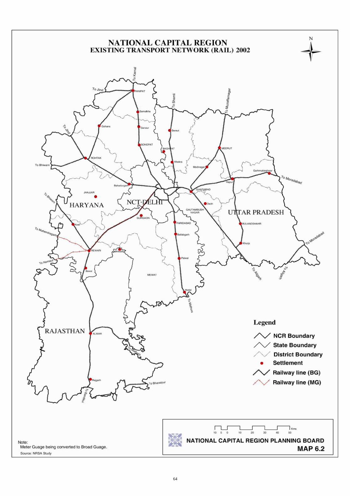
The NCR rail network covers three zonal railways (northern, western and central) zones and five divisions. The rail network in the region consists of both broad and metre gauges. Five broad gauge railway lines converge at Delhi [Map 6.2 National Capital Region: Existing Transport Network (Rail) 2002]. The rail network has two specially identified lines known as the Goods Avoiding lines (GAL) and Delhi Avoiding Lines (DAL). The GAL provides a direct entry from Ghaziabad to New Delhi bypassing the

62

63
congested Delhi Railway Station Complex. The DAL provides a direct passage from the major yards-Tughlakabad and Ghaziabad directly into the Delhi-Ambala-Kalka section and through Lajpat Nagar, Patel Nagar, Daya Basti and Azadpur link. iii) Airport
At present two airports are located at Delhi-Indira Gandhi Airport is for international flights and Palam Airport for domestic flights. 6.2.2 Traffic Volume (2001)
i) Traffic Counts
On the boundary of NCT-Delhi, the highest traffic volume is at NH24 (Delhi–Ghaziabad) followed by NH8 (Delhi-Gurgaon) (refer Annexure 6/Ia). The lowest traffic volume is at SH57 (Delhi-Loni). The maximum traffic volume crossing-over on river Yamuna is at ITO bridge followed by Nizamuddin bridge while the lowest is at Okhla barrage bridge (The figures are for February 1999 when improvements at the ITO and Nizamuddin bridges had been completed but the Delhi-Noida Toll bridge had not been opened).
ii) Directional Flow
The directional split of passenger trips by purpose as given in Annexure 6/Ib clearly demonstrates that people are commuting to Delhi for work in the morning and returning in evening. The commuter behaviour is extremely pronounced at the Nizamuddin bridge where nearly 80% of the traffic in the morning is towards NCT-Delhi. In the evening peak hour, ITO bridge shows the highest directional split in favour of movement from NCT-Delhi (approximately 75%). 6.2.3 Pattern of Movement
The destination of the vehicles surveyed at the outer cordon of NCT-Delhi is given in the following table: Table 6.1: Vehicle Destination at Outer Cordon of NCT-Delhi
Location NCT-Delhi Haryana Uttar Pradesh Others 1 2 3 4 5
% of vehicles 16 71 08 05 Source: JICA Study Team The figures also take care of the double counting factor i.e., to account for a vehicle passing through more than one Origin Destination (OD) interview site. The OD characteristics indicate that out of a total of 34.21 lakhs trips, about 78.5% are carried out within NCR with overall internal-external trips (NCT-Delhi to NCR) as 36.67% and external-internal trips (NCR to Delhi) as 41.86%. External-external trips (outside NCT-Delhi) are 21.27% of the total trips. Details of daily passenger trips, which have been calculated from the traffic volume and vehicle occupancies of respective modes are presented in the Annexure 6/IIa. The Origin-Destination characteristics by mode indicate that public transport commands a total share of 71.54% whereas private mode constitutes 28.46%. Details of Trip Characteristics by Mode are tabulated in the Annexure 6/IIb. 6.3 OBJECTIVES OF TRANSPORT PLAN The objective of the Transport Plan is to promote and support the economic development of the region and relieve the Capital of excessive pressure on the infrastructure including traffic congestion. It is to
64

65
provide accessibility to all the parts of the region and discourage the transit of passengers and goods through the core area of NCT-Delhi by providing bypasses and thereby opening areas for economic development of the rest of the region. 6.4 TRANSPORTATION DEMAND FORECASTING The data for transport sector has been collected and collated from various existing studies. Transport demand forecast for the year 2005, 2011 and 2025 for Delhi Urban Area is given in Annexure 6/IIIa. The total intra-city trips within NCT-Delhi, are projected to increase from 160.4 lakhs in 2005 to 260.6 lakhs in 2025. The modal split in favour of public transport system is proposed to increase to 82% due to the introduction of Mass Rapid Transit System (MRTS) for Delhi. Thus, total Public Transport system trips are projected to increase from 131.5 lakhs trips per day in 2005 to 213.7 lakhs trips per day in the year 2025. Transport demand forecast for the year 2005, 2011 and 2025 for Delhi and NCR is given in Annexure 6/IIIb. It is projected that by the year 2025 more than 80 lakhs trips will be performed from Delhi to NCR. Around 40% trips will be carried by rail and bus modes each and remaining 20% will be carried by other private modes. 6.5 POLICIES AND STRATEGIES Based on the observations and findings in the analysis as above, the following policy actions are to be provided to achieve the overall objectives of the Regional Plan-2021: (a) To decongest NCT-Delhi roads, rail and rail terminals by diverting the bypassable traffic from Delhi. (b) To provide linkages amongst Metro/Regional Urban Settlements in the outlying areas of NCR. (c) To connect Metro/Regional Centres with the Capital by an efficient and effective transport network
for facilitating faster movement of traffic among such centres and NCT-Delhi. (d) To link the Sub-regional Centres with effective and efficient transport network for facilitating the
faster movement of traffic among such centers and higher order settlements. (e) To directly link other urban nodes having maximum attracting and generating characteristics. (f) To create the Unified Metropolitan Transport Authority for NCR. 6.6 TRANSPORT PLAN 2021 It is recognised and reaffirmed that the solution of the increasing transportation problem lies in development of settlements outside the NCT-Delhi metropolis at appropriate distance and providing inter-connection between Delhi and settlements thus reducing pressure on Delhi's transport infrastructure. Accordingly it is proposed to: • Develop activities keeping in view rail and road linkages in Central NCR having better accessibility
and at the same time relieving pressure on the existing transport routes converging at NCT-Delhi. • Unrestricted movement of buses, taxis, and auto-rickshaws within NCR.

66
• Focus on certain inter-state issues (e.g. land acquisition) for workable coordination and evolve an institutional mechanism on priority basis to encourage private participation.
• Execution without further delays of the Regional Plan-2001 proposals of Integrated Mass Rapid Transport System (MRTS), Regional Rapid Transport System (RRTS), Expressways and Bypasses.
6.6.1 Road Network
It is proposed to develop following hierarchical road network in order to encourage, guide and sustain the envisaged development in the region and to cater to higher traffic interaction among NCT-Delhi and Regional towns: i) Primary Road Network ii) Secondary Road Network iii) Tertiary Road Network i) Primary Road Network
a) Primary roads are radial roads connecting Regional/Priority Towns with NCT-Delhi. Seven radial roads have already been declared as National Highways [refer Map 6.3 National Capital Region: Proposed Transport Network (Roads) 2021]. Out of the seven national highways NH1 (Delhi to Panipat), NH2 (Delhi to Palwal) and NH8 (Delhi to Behror) are already having four lane divided carriageway, whereas NH10 (Delhi to Rohtak) and NH24 (Delhi to Hapur) are partially four lane. Besides, NH71 (Rewari to Rohtak), NH71A (Rohtak to Panipat), NH71B (Rewari-Sohna-Palwal), NH58 (Ghaziabad-Meerut-Muzaffarnagar) and NH91 (Ghaziabad-Khurja-Aligarh) needs upgradation. It is proposed to develop the existing ring road, outer ring road and the five radial roads (national highways) upto CNCR towns (i.e., NH1 Delhi to Kundli, NH2 Delhi to Ballabhgarh, NH8 Delhi to Gurgaon, NH10 Delhi to Bahadurgarh and NH24 Delhi to Ghaziabad) to expressways standards. It may be necessary in some places that a complete elevated expressway is required if no land is available for upgradation. Inter-state junctions and approaches to Delhi should be improved to remove the bottlenecks.
b) It is further proposed that Loni-Baghpat-Shamli State Highway Corridor be upgraded to that of
four lane divided carriageway. Existing road connecting Jhajjar with Delhi via Badli is to be upgraded. All these be upgraded from time to time through widening techniques for capacity augmentation to cater the future traffic in an efficient manner. They may be developed at NH standard by 2021.
c) Alwar, a Regional Centre in Rajasthan should be connected to Delhi or Gurgaon through
upgraded radial corridor. d) Grid Roads: These consists strengthening and widening of existing alignments along the
following stretches:
• Sonepat-Bahalgarh-Baghpat-Meerut • Meerut-Hapur-Bulandshahr-Khurja-Palwal • Palwal-Sohana-Rewari • Rewari-Jhajjar-Rohtak-Sonepat • Rohtak-Gohana-Panipat
e) Peripheral Expressways: All the CNCR towns should be connected with each other through
Peripheral Expressway consisting of Kundli-Manesar-Palwal (KMP) Western Peripheral
67
Expressway and Kundli-Ghaziabad-Palwal (KGP) Eastern Peripheral Expressway (Faridabad-Noida-Ghaziabad Corridor and Ghaziabad-Kundli Corridor). These are to be implemented on priority in the first phase. The Expressway between Ghaziabad to Meerut, for which the feasibility study has been carried out, is to be taken up in the subsequent phase.
f) Access to above expressways is to be provided through interchanges with major arterial roads
from NCT-Delhi. Major arterial roads should also have partial access control within NCT-Delhi. These arterials will act as feeder roads to expressways from major district centres and employment/business centre etc. in NCT-Delhi. All the arterial roads connecting NCT-Delhi with CNCR towns should be strengthened to improve the connectivity with NCT-Delhi.
g) Sub-arterial roads emerging from arterial roads will provide access to small business,
employment centres, residential areas etc. and arterial roads will provide access to expressway through major arterial roads.
h) Perimeter/Ring Roads: All the Metro and Regional Centres to be connected with perimeter roads
of expressway standard to act as bypass for through traffic. An appropriate hierarchical road system for the regional towns to cater to the intra-urban traffic in an efficient manner is proposed to be developed for all the priority towns.
ii) Secondary Road Network
Secondary road network consists of Major District Roads connecting smaller towns with the priority towns of the region and with the primary road network of the region. Priority has to be established through Sub-regional Plans and all the towns in the Sub-region have to be connected with regional towns and with the primary road network by 2021. These roads are proposed to be two/intermediate/single lane depending upon the envisaged traffic and interaction with the adjoining areas. Roads connecting expressways with international airport should be upgraded. Action Plan for their upgradation is to be prioritised in the Sub-regional Plan. iii) Tertiary Road Network
All the villages, work places, small business, employment centres, residential areas and agriculture/forest areas are to be provided access through tertiary road network. It will consist of a single/intermediate/double lane metalled roads connecting to Sub-regional towns and secondary road system of the region for efficient movement of traffic and to boost balanced development in the region. 6.6.2 Rail Network
Development of road network alone will not be able to meet the transport demand in NCR. Hence, a supportive rail network will have to be developed for meeting the gap in demand and supply. The system of these networks needs to act in an integrated manner as shown in Map 6.4 National Capital Region: Proposed Transport Network (Rail) 2021. i) Regional Rapid Transit System
Primary regional rail network should connect the regional towns among each other and with Delhi, through dedicated lines to meet the demand on specific corridors as identified in the Report "Identification of Rail Projects for Commuter Travel in NCR and Delhi " prepared by RITES in 1999 should be developed as Regional Rapid Transit System (RRTS). These corridors are specified in Annexure 6/IV.

68

69
ii) Regional Rail Network
Rail network is required to be extended to the Sub-regional centres so as to act as feeder system to RRT System and accelerate development process in the region. In this connection, it is proposed that rail link between Rewari to Bhiwadi be taken on priority. The rail link between Rohtak to Hansi may also be taken up to facilitate the movement between Delhi and Hissar (a Counter-magnet town). The rail link between Rewari and Rohtak via Jhajjar may also be taken up on priority. iii) Orbital Rail Corridor
Orbital rail corridor connecting radial rail corridor of Indian Railway at CNCR towns and directional terminals to bypass the regional traffic around Delhi is proposed. This will be parallel to the proposed peripheral expressways. iv) MRTS for Delhi and CNCR Towns
MRT system be extended to CNCR towns and integrated with upgraded ring railway in Delhi and integrated with the proposed RRTS. It is proposed that the MRTS and RRTS are to be planned with appropriate integrated feeder rail/road services. 6.6.3 Intra-city Urban Transport In order to cater to increasing demand of intra-urban traffic in towns, mass transport system for commuters such as Light Rail Transit System (LRTS), High Speed Tram System (HSTS), High Capacity Bus system (HCBS), Metro Rail, Trolley Buses, Sky Tram System or any other such system, wherever is feasible, with a provision for feeder system should be provided in the towns having population more than five lakhs. 6.6.4 Airways
With the growing air traffic, it is suggested to develop an international airport at a suitable location within the region to act as an alternative to the existing international airport in Delhi. In addition, it is also suggested to develop domestic air terminals within the region. 6.6.5 Action Plan
The problem of Regional Transport in NCR area is of a varied nature. At present, various transport authorities/agencies are responsible for planning, development and management of the transport facilities and services. They operate, in large parts of this region independent of each other. This results in avoidable long travel time and more expenditure. The responsibilities for providing transport facilities and enforcement of rules and regulations are often fragmented and vague. The agencies charged with such responsibilities need to be strengthened and a coordinating agency needs to be constituted with representatives from various transport authorities, which would coordinate and take an overall and integrated view of the total transportation system in the region. This agency will be for the entire region, having a long-term goal of planning and development of a coordinated network of transport services. An authority for the region could, therefore, be set up either through fresh legislation under Clause (i) of Article 252 of the Constitution with the consent of the participating States or through a Resolution of the Board itself, which obviously would be of a non-statutory nature. Policy and Planning Group: A Policy and Planning Group (PPG) should be established to function specifically at the State level to plan and coordinate with agencies at the State level. This group should also take into consideration the policies for overall spatial planning for the region. This group should also

70

71
ensure community participation. To be more effective this group should be chaired by the Transport Minister of the State. The main functions of this group would be: • To spell out goals and formulate policy guidelines to facilitate preparation of a Strategic Transport
Plan (STP) for the State and a multi-modal plan for linkages with NCR. • To coordinate activities of various groups/agencies at the plan formulation stage. • To regulate allocation of funds to different agencies for coordinated development. • To ensure provision of land with focus on identification, reservation and protection for development
of transport related projects. Traffic Management Group: The Traffic Management Group (TMG) will prepare traffic management strategic action plans with emphasis on movement of people and goods. Area level traffic management schemes with active participation from peoples' group should be prepared for implementation according to time bound programmes. Enforcement Group: The proposed Enforcement Group (EG) will have professional advisors, concerned officers from local bodies in addition to the traffic police and local residents and will evolve strategic action plans to ensure smooth and safe flow of all modes of traffic. 6.7 PHASING OF PROJECTS The Plan is divided in two phases i.e., Ist Phase 2001-2011 and IInd Phase 2011-2021. In the first phase of the Plan, following projects would be taken up for implementation: a) Western Peripheral Expressway
b) Eastern Peripheral Expressway
c) Rapid Rail Transit System
§ Shahdara-Ghaziabad § Sahibabad-Minto Bridge § Dayabasti-Gurgaon § Naya Azadpur-Narela-Sonepat § Patel Nagar-Nangloi-Bahadurgarh § New Tilak Bridge-Tughlakabad-Ballabhgarh § New Tilak Bridge-Noida-Greater Noida
d) Present ring road, outer ring road, and five national highways (radial roads) up to CNCR towns to be developed as per expressway standards.
e) Four laning of the following road sections
§ Bahadurgarh-Rohtak-NCR Border (NH10) § Rohtak-NCR Border (NH71) § Ghaziabad-Meerut-NCR Boundary (NH58) § Ghaziabad-Bulandshahr-Khurja-NCR Boundary (NH91) § Gurgaon-Alwar (Old NH8) § Panipat-Gohana-Rohtak § Jhajjar-Rewari Road (NH71 and NH71A) § Elevated Road connecting Delhi with Faridabad near Badarpur § All other roads connecting CNCR towns with Delhi
72
f) Rewari-Bhiwadi Rail Link
g) Rohtak-Hansi Corridor In the second phase of the plan, following projects would be taken up for implementation: a) Ghaziabad-Meerut Expressway
b) Rapid Rail Transit System
§ Ghaziabad-Meerut § Ghaziabad-Hapur § Ghaziabad-Khurja § Shahdara-Shamli § Sonepat-Panipat § Gurgaon-Rewari § Brar Square-Delhi Cantonment § Ballabhgarh-Palwal
c) Orbital Rail Corridor
§ Ghaziabad-Noida-Faridabad-Gurgaon-Bahadurgarh-Kundli-Ghaziabad
d) Upgradation of Grid Roads
§ Bhiwadi-Rewari § Rohtak-Sonepat § Sonepat-Baghpat § Baghpat-Meerut § Meerut-Hapur § Hapur-Bulandshahar § Bulandshahar-Khurja § Khurja-Palwal § Palwal-Bhiwadi
6.8 INVESTMENT REQUIREMENT The total investment requirements for the implementation of the Ist Phase of Plan proposals would be Rs.19,141 crores at the 2001 prices.