1.0 project report cover page - simcoe county 1-2 archaeological... · culture and sport (mtcs) on...
TRANSCRIPT

1.0 PROJECT REPORT COVER PAGE
LICENSEE INFORMATION: Contact Information: Michael B. Henry CD BA FRAI FRSA Managing Partner
Lakelands District Office 380 Talbot Street, P.O. Box 29 Port McNicoll, ON L0K 1R0 Phone: (705) 534-1546 Fax: (705) 534-7855 Email: [email protected] www.amick.ca
Licensee: Sarah MacKinnon MSc Ontario Archaeology Licence: P1024 PROJECT INFORMATION: Corporate Project Number: 15832 MTCS Project Number: P1024-0102-2015 Investigation Type: Stage 1-2 Archaeological Assessment Project Name: 3600 Narrows Road. Project Location: 3600 Narrows Road, Part of Lot 19, Concession 14 (Geographic Township of
Tay) Township of Severn, County of Simcoe APPROVAL AUTHORITY INFORMATION: File Designation Number: Not Currently Available REPORTING INFORMATION: Site Record/Update Forms: N/A Date of Report Filing: 18 December 2015 Type of Report: ORIGINAL
2015 Stage 1-2 Archaeological Assessment of 3600 Narrows Road, Part of Lot 19, Concession 14 (Geographic Township of Tay) Township of Severn, County of Simcoe
(AMICK File #15832/MTCS File #P1024-0102-2015)
AMICK Consultants Limited Page 2
2.0 EXECUTIVE SUMMARY This report describes the results of the 2015 Stage 1-2 Archaeological Assessment of 3600 Narrows Road, Part of Lot 19, Concession 14 (Geographic Township of Tay) Township of Severn, County of Simcoe, conducted by AMICK Consultants Limited. This study was conducted under Professional Archaeologist License #P1024 issued to Sarah MacKinnon by the Minister of Tourism, Culture and Sport for the Province of Ontario. This assessment was undertaken as a requirement under the Planning Act (RSO 1990b) and the Provincial Policy Statement (2014) in order to support a Draft Plan of Subdivision application and companion Zoning By-law Amendment application as part of the pre-submission process. For plans of subdivision, Ontario Regulation 544/06 under the Planning Act (1990b) requires an evaluation of archaeological potential and, where applicable, an archaeological assessment report completed by an archaeologist licensed by the Ministry of Tourism, Culture and Sport (MTCS). Policy 2.6 of the Provincial Policy Statement (PPS 2014) addresses archaeological resources. All work was conducted in conformity with Ontario Ministry of Tourism and Culture (MTC) Standards and Guidelines for Consultant Archaeologists (MTC 2011), the Ontario Heritage Act (RSO 1990a). AMICK Consultants Limited was engaged by the proponent to undertake a Stage 1-2 Archaeological Assessment of lands potentially affected by the proposed undertaking and was granted permission to carry out archaeological fieldwork. The entirety of the study area was subject to property inspection and photographic documentation concurrently with the Stage 2 Property Assessment on 21, 27, 30 October, 9-12, 16-20, 30 November, 1 December 2015, consisting of high-intensity test pit survey at an interval of five metres between individual test pits. All records, documentation, field notes, photographs and artifacts (as applicable) related to the conduct and findings of these investigations are held at the Lakelands District corporate offices of AMICK Consultants Limited until such time that they can be transferred to an agency or institution approved by the Ontario Ministry of Tourism, Culture and Sport (MTCS) on behalf of the government and citizens of Ontario. As a result of the property Assessment of the study area, no archaeological resources were encountered. Consequently, the following recommendations are made:
- No further archaeological assessment of the study area is warranted; - The Provincial interest in archaeological resources with respect to the proposed
undertaking has been addressed; - The proposed undertaking is clear of any archaeological concern.

2015 Stage 1-2 Archaeological Assessment of 3600 Narrows Road, Part of Lot 19, Concession 14 (Geographic Township of Tay) Township of Severn, County of Simcoe
(AMICK File #15832/MTCS File #P1024-0102-2015)
AMICK Consultants Limited Page 3
3.0 TABLE OF CONTENTS 1.0 PROJECT REPORT COVER PAGE 1 2.0 EXECUTIVE SUMMARY 2 3.0 TABLE OF CONTENTS 3 4.0 PROJECT PERSONNEL 3 5.0 PROJECT BACKGROUND 4 6.0 FIELD WORK METHODS AND WEATHER CONDITIONS 15 7.0 RECORD OF FINDS 18 8.0 ANALYSIS AND CONCLUSIONS 19 9.0 RECOMMENDATIONS 26 10.0 ADVICE ON COMPLIANCE WITH LEGISLATION 28 11.0 BIBLIOGRAPHY AND SOURCES 29 12.0 MAPS 31 13.0 IMAGES 36 4.0 PROJECT PERSONNEL AMICK CONSULTANTS LIMITED PARTNERS Michael Henry (MTCS Professional Archaeologist Licence #P058) Marilyn Cornies (MTCS Professional Archaeologist Licence #P038) AMICK CONSULTANTS LIMITED BUSINESS MANAGER Melissa Maclean BBA email [email protected] PROJECT CONSULTANT ARCHAEOLOGIST Sarah MacKinnon (MTCS Professional Archaeologist Licence #P1024) PROJECT FIELD DIRECTORS Kayleigh MacKinnon (MTCS Licence #P384) Sarah MacKinnon (MTCS Professional Archaeologist Licence #P1024) PROJECT FIELD ASSISTANTS Jacob Leeuwenburg Nicholas Nauffts Adam Wilson PROJECT REPORT PREPARATION Elizabeth Grant PROJECT DRAUGHTING Elizabeth Grant PROJECT PHOTOGRAPHY Kayleigh MacKinnon (MTCS Professional Archaeologist Licence #P384) Sarah MacKinnon (MTCS Professional Archaeologist Licence #P1024)

2015 Stage 1-2 Archaeological Assessment of 3600 Narrows Road, Part of Lot 19, Concession 14 (Geographic Township of Tay) Township of Severn, County of Simcoe
(AMICK File #15832/MTCS File #P1024-0102-2015)
AMICK Consultants Limited Page 4
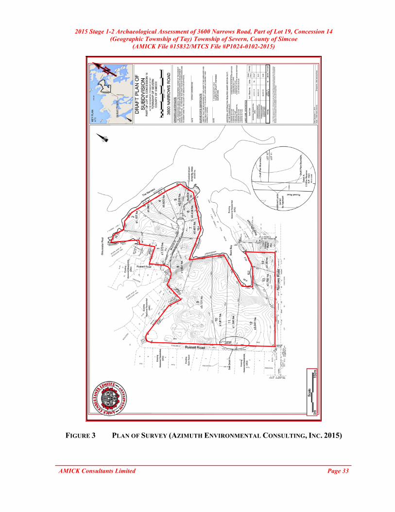
5.0 PROJECT BACKGROUND 5.1 DEVELOPMENT CONTEXT This report describes the results of the 2015 Stage 1-2 Archaeological Assessment of 3600 Narrows Road, Part of Lot 19, Concession 14 (Geographic Township of Tay) Township of Severn, County of Simcoe, conducted by AMICK Consultants Limited. This study was conducted under Professional Archaeologist License #P1024 issued to Sarah MacKinnon by the Minister of Tourism, Culture and Sport for the Province of Ontario. This assessment was undertaken as a requirement under the Planning Act (RSO 1990b) and the Provincial Policy Statement (2014) in order to support a Draft Plan of Subdivision application and companion Zoning By-law Amendment application as part of the pre-submission process. For plans of subdivision, Ontario Regulation 544/06 under the Planning Act (1990b) requires an evaluation of archaeological potential and, where applicable, an archaeological assessment report completed by an archaeologist licensed by the Ministry of Tourism, Culture and Sport (MTCS). Policy 2.6 of the Provincial Policy Statement (PPS 2014) addresses archaeological resources. All work was conducted in conformity with Ontario Ministry of Tourism and Culture (MTC) Standards and Guidelines for Consultant Archaeologists (MTC 2011), the Ontario Heritage Act (RSO 1990a). AMICK Consultants Limited was engaged by the proponent to undertake a Stage 1-2 Archaeological Assessment of lands potentially affected by the proposed undertaking and was granted permission to carry out archaeological fieldwork. The entirety of the study area was subject to property inspection and photographic documentation concurrently with the Stage 2 Property Assessment on 21, 27, 30 October, 9-12, 16-20, 30 November, 1 December 2015, consisting of high-intensity test pit survey at an interval of five metres between individual test pits. All records, documentation, field notes, photographs and artifacts (as applicable) related to the conduct and findings of these investigations are held at the Lakelands District corporate offices of AMICK Consultants Limited until such time that they can be transferred to an agency or institution approved by the Ontario Ministry of Tourism, Culture and Sport (MTCS) on behalf of the government and citizens of Ontario. The proposed development of the study area includes 14 residential lots with associated services and landscape modifications. A preliminary plan of the proposed development has been submitted together with this report to MTCS for review and reproduced within this report as Figure 3. 5.2 HISTORICAL CONTEXT As part of the present study, background research was conducted in order to determine the archaeological potential of the proposed project area. “A Stage 1 background study provides the consulting archaeologist and Ministry report reviewer with information about the known and potential cultural heritage resources within a particular study area, prior to the start of the field assessment.” (OMCzCR 1993)
2015 Stage 1-2 Archaeological Assessment of 3600 Narrows Road, Part of Lot 19, Concession 14 (Geographic Township of Tay) Township of Severn, County of Simcoe
(AMICK File #15832/MTCS File #P1024-0102-2015)
AMICK Consultants Limited Page 5
The evaluation of potential is further elaborated Section 1.3 of the Standards and Guidelines for Consultant Archaeologist (2011) prepared by the Ontario Ministry of Tourism and Culture: “ The Stage 1 background study (and, where undertaken, property inspection) leads to an evaluation of the property’s archaeological potential. If the evaluation indicates that there is archaeological potential anywhere on the property, the next step is a Stage 2 assessment.”
(MTC 2011: 17) Features or characteristics that indicate archaeological potential when documented within the study area, or within close proximity to the study area (as applicable), include: “ - previously identified archaeological sites
- water sources (It is important to distinguish types of water and shoreline, and to distinguish natural from artificial water sources, as these features affect site locations and types to varying degrees.):
o primary water sources (lakes, rivers, streams, creeks) o secondary water sources (intermittent streams and creeks, springs, marshes,
swamps) o features indicating past water sources (e.g., glacial lake shorelines indicated
by the presence of raised sand or gravel beach ridges, relic river or stream channels indicated by clear dip or swale in the topography, shorelines of drained lakes or marshes, cobble beaches)
o accessible or inaccessible shoreline (e.g., high bluffs, swamp or marsh fields by the edge of a lake, sandbars stretching into marsh)
- elevated topography (e.g., eskers, drumlins, large knolls, plateaux) - pockets of well-drained sandy soil, especially near areas of heavy soil or rocky
ground - distinctive land formations that might have been special or spiritual places, such as
waterfalls, rock outcrops, caverns, mounds, and promontories and their bases. There may be physical indicators of their use, such as burials, structures, offerings, rock paintings or carvings.
- resource areas, including: o food or medicinal plants (e.g., migratory routes, spawning areas, prairie) o scarce raw materials (e.g., quartz, copper, ochre or outcrops of chert) o early Euro-Canadian industry (e.g., fur trade, logging, prospecting, mining)
- areas of early Euro-Canadian settlement. These include places of early military or pioneer settlement (e.g., pioneer homesteads, isolated cabins, farmstead complexes), early wharf or dock complexes, pioneer churches and early cemeteries. There may be commemorative markers of their history, such as local, provincial, or federal monuments or heritage parks.
- Early historical transportation routes (e.g., trails, passes, roads, railways, portage routes)

2015 Stage 1-2 Archaeological Assessment of 3600 Narrows Road, Part of Lot 19, Concession 14 (Geographic Township of Tay) Township of Severn, County of Simcoe
(AMICK File #15832/MTCS File #P1024-0102-2015)
AMICK Consultants Limited Page 6
- property listed on a municipal register or designated under the Ontario Heritage Actor that is a federal, provincial or municipal historic landmark or site
- property that local histories or informants have identified with possible archaeological sties, historical events, activities, or occupations”
(MTC 2011: 17-18) The evaluation of potential does not indicate that sites are present within areas affected by proposed development. Evaluation of potential considers the possibility for as yet undocumented sites to be found in areas that have not been subject to systematic archaeological investigation in the past. Potential for archaeological resources is used to determine if property assessment of a study area or portions of a study area is required.
“Archaeological resources not previously documented may also be present in the affected area. If the alternative areas being considered, or the preferred alternative selected, exhibit either high or medium potential for the discovery of archaeological remains an archaeological assessment will be required.”
(MCC & MOE 1992: 6-7) “The Stage 1 background study (and, where undertaken, property inspection) leads to an evaluation of the property’s archaeological potential. If the evaluation indicates that there is archaeological potential anywhere on the property, the next step is a Stage 2 assessment.”
(MTC 2011: 17)
In addition, archaeological sites data is also used to determine if any archaeological resources had been formerly documented within or in close proximity to the study area and if these same resources might be subject to impacts from the proposed undertaking. This data was also collected in order to establish the relative significance of any resources that might be encountered during the conduct of the present study. For example, the relative rarity of a site can be used to assign an elevated level of significance to a site that is atypical for the immediate vicinity. The requisite archaeological sites data of previously registered archaeological sites was collected from the Programs and Services Branch, Culture Programs Unit, MTCS and the corporate research library of AMICK Consultants Limited. The Stage 1 Background Research methodology also includes a review of the most detailed available topographic maps, historical settlement maps, archaeological management plans (where applicable) and commemorative plaques or monuments. When previous archaeological research documents lands to be impacted by the proposed undertaking or archaeological sites within 50 metres of the study area, the reports documenting this earlier work are reviewed for pertinent information. AMICK Consultants Limited will often modify this basic methodology based on professional judgment to include additional research (such as, local historical works or documents and knowledgeable informants).

2015 Stage 1-2 Archaeological Assessment of 3600 Narrows Road, Part of Lot 19, Concession 14 (Geographic Township of Tay) Township of Severn, County of Simcoe
(AMICK File #15832/MTCS File #P1024-0102-2015)
AMICK Consultants Limited Page 7
5.2.1 CURRENT CONDITIONS The present use of the study area is as vacant woodlot. The study area is roughly 20 hectares in area. The study area includes within it mostly wooded lands. A seasonal low-lying and wet stream is located in the south of the study area. Two additional low-lying and wet areas are located in the west and north of the study area. Featured throughout the study area are five areas of exposed bedrock outcroppings. These outcroppings along the north boundary of the study area are also steep slope features. The study area is bounded on the north by residential and The Narrows, on the east by Black Bay, on the south by Narrows Road, and on the west by Russell Road. The study area is north adjacent of the intersection of the Narrows Road and Russell Road. A plan of the study area is included within this report as Figure 3. Current conditions encountered during the Stage 1-2 Property Assessment are illustrated in Figures 4 & 5. 5.2.2 GENERAL HISTORICAL OUTLINE In the seventeenth century Simcoe County was home to the Huron. With the arrival of French priests and Jesuits, missions were established near Georgian Bay. After the destruction of the missions by the Iroquois and the British, Algonquin speaking peoples occupied the area. After the war of 1812, the government began to invest in the military defences of Upper Canada, through the extension of Simcoe’s Yonge Street from Lake Simcoe to Penetanguishene on Georgian Bay (Garbutt 2010). The township of Severn was created on January 1, 1994 through a restructuring of Simcoe County. The new township now encompasses the Village of Coldwater and parts of the Townships of Orillia, Tay, and Medonte. (Township of Severn 2013) Figure 2 is a facsimile segment of the Township of Tay map reproduced from Simcoe Supplement in Illustrated Atlas of the Dominion of Canada (H. Belden & Co. 1881). Figure 2 illustrates the location of the study area and environs as of 1881. The study area is not shown to belong to anyone and no structures are shown to be within the study area. In addition, this map illustrates the shore of The Narrows as adjacent to the study area to the north. It must be borne in mind that inclusion of names of property owners and depictions of structures within properties on these maps were sold by subscription. While information included within these maps may provide information about occupation of the property at a specific point in time, the absence of such information does not indicate that the property was not occupied. 5.2.3 SUMMARY OF HISTORICAL CONTEXT Background research indicates the property has potential for significant archaeological resources of Native origins based on proximity to a natural source of potable water in the past.

2015 Stage 1-2 Archaeological Assessment of 3600 Narrows Road, Part of Lot 19, Concession 14 (Geographic Township of Tay) Township of Severn, County of Simcoe
(AMICK File #15832/MTCS File #P1024-0102-2015)
AMICK Consultants Limited Page 8
5.3 ARCHAEOLOGICAL CONTEXT The Archaeological Sites Database administered by the Ministry of Tourism, Culture and Sport (MTCS) indicates that there are no (0) previously documented sites within 1 kilometre of the study area. However, it must be noted that this is based on the assumption of the accuracy of information compiled from numerous researchers using different methodologies over many years. AMICK Consultants Limited assumes no responsibility for the accuracy of site descriptions, interpretations such as cultural affiliation, or location information derived from the Archaeological Sites Database administered by MTCS. In addition, it must also be noted that a lack of formerly documented sites does not indicate that there are no sites present as the documentation of any archaeological site is contingent upon prior research having been conducted within the study area. On the basis of information supplied by MTCS, no archaeological assessments have been conducted within 50 metres of the study area. AMICK Consultants Limited assumes no responsibility for the accuracy of previous assessments, interpretations such as cultural affiliation, or location information derived from the Archaeological Sites Database administered by MTCS. In addition, it must also be noted that the lack of formerly documented previous assessments does not indicate that no assessments have been conducted. Data contained in previous archaeological reports in close proximity to the study area that is relevant to Stage 1 Background Study is defined within the Standards and Guidelines for Consultant Archaeologists in Section 7.5.8 Standard 4 as follows:
“Provide descriptions of previous archaeological fieldwork carried out within the limits of, or immediately adjacent to the project area, as documented by all available reports that include archaeological fieldwork carried out on the lands to be impacted by this project, or where reports document archaeological sites immediately adjacent (i.e., within 50 m) to those lands.”
(MTCS 2011: 126 Emphasis Added) There are no previous reports detailing, “archaeological fieldwork carried out on the lands to be impacted by this project”, nor do any previous reports document known archaeological sites within 50 metres of the study area.
The Standards and Guidelines for Consultant Archaeologists stipulates that the necessity to summarize the results of previous archaeological assessment reports, or to cite MTCS File Numbers in references to other archaeological reports, is reserved for reports that are directly relevant to the fieldwork and recommendations for the study area (S & Gs 7.5.7, Standard 2, MTC 2011: 125). This is further refined and elaborated upon in Section 7.5.8, Standards 4 & 5, MTC 2011:
2015 Stage 1-2 Archaeological Assessment of 3600 Narrows Road, Part of Lot 19, Concession 14 (Geographic Township of Tay) Township of Severn, County of Simcoe
(AMICK File #15832/MTCS File #P1024-0102-2015)
AMICK Consultants Limited Page 9
“4. Provide descriptions of previous archaeological fieldwork carried out within the limits of, or immediately adjacent to the project area, as documented by all available reports that include archaeological fieldwork carried out on the lands to be impacted by this project, or where reports document archaeological sites immediately adjacent (i.e., within 50m) to those lands.”
“5. If previous findings and recommendations are relevant to the current stage of work, provide the following:
a. a brief summary of previous findings and recommendations b. documentation of any differences in the current work from the previously
recommended work c. rationale for the differences from the previously recommended work”
(Emphasis Added)
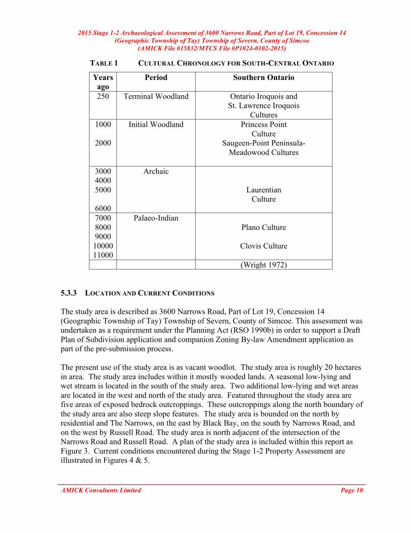
5.3.1 FIRST NATIONS REGISTERED SITES A summary of registered and/or known archaeological sites within a 1-kilometre radius of the study area was gathered from the Archaeological Sites Database, administered by MTCS. As a result it was determined that no (0) archaeological sites relating directly to First Nations habitation/activity had been formally registered within the immediate vicinity of the study area. However, the lack of formally documented archaeological sites does not mean that First Nations people did not use the area; it more likely reflects a lack of systematic archaeological research in the immediate vicinity. The distance to water criteria used to establish potential for archaeological sites suggests potential for First Nations occupation and land use in the area in the past. This consideration establishes archaeological potential within the study area. Table 1 illustrates the chronological development of cultures within southern Ontario prior to the arrival of European cultures to the area at the beginning of the 17th century. This general cultural outline is based on archaeological data and represents a synthesis and summary of research over a long period of time. It is necessarily generalizing and is not necessarily representative of the point of view of all researchers or stakeholders. It is offered here as a rough guideline and outline to illustrate the relationships of broad cultural groups and time periods. 5.3.2 EURO-CANADIAN REGISTERED SITES A summary of registered and/or known archaeological sites within a 1-kilometre radius of the study area was gathered from the Archaeological Sites Database, administered by MTCS. As a result it was determined that no (0) archaeological sites relating directly to Euro-Canadian habitation/activity had been formally registered within the immediate vicinity of the study area.
2015 Stage 1-2 Archaeological Assessment of 3600 Narrows Road, Part of Lot 19, Concession 14 (Geographic Township of Tay) Township of Severn, County of Simcoe
(AMICK File #15832/MTCS File #P1024-0102-2015)
AMICK Consultants Limited Page 10
TABLE 1 CULTURAL CHRONOLOGY FOR SOUTH-CENTRAL ONTARIO
Years ago
Period Southern Ontario
250 Terminal Woodland Ontario Iroquois and St. Lawrence Iroquois
Cultures 1000
2000
Initial Woodland Princess Point Culture
Saugeen-Point Peninsula- Meadowood Cultures
3000 4000 5000
6000
Archaic
Laurentian Culture
7000 8000 9000 10000 11000
Palaeo-Indian Plano Culture
Clovis Culture
(Wright 1972)
5.3.3 LOCATION AND CURRENT CONDITIONS The study area is described as 3600 Narrows Road, Part of Lot 19, Concession 14 (Geographic Township of Tay) Township of Severn, County of Simcoe. This assessment was undertaken as a requirement under the Planning Act (RSO 1990b) in order to support a Draft Plan of Subdivision application and companion Zoning By-law Amendment application as part of the pre-submission process. The present use of the study area is as vacant woodlot. The study area is roughly 20 hectares in area. The study area includes within it mostly wooded lands. A seasonal low-lying and wet stream is located in the south of the study area. Two additional low-lying and wet areas are located in the west and north of the study area. Featured throughout the study area are five areas of exposed bedrock outcroppings. These outcroppings along the north boundary of the study area are also steep slope features. The study area is bounded on the north by residential and The Narrows, on the east by Black Bay, on the south by Narrows Road, and on the west by Russell Road. The study area is north adjacent of the intersection of the Narrows Road and Russell Road. A plan of the study area is included within this report as Figure 3. Current conditions encountered during the Stage 1-2 Property Assessment are illustrated in Figures 4 & 5.

2015 Stage 1-2 Archaeological Assessment of 3600 Narrows Road, Part of Lot 19, Concession 14 (Geographic Township of Tay) Township of Severn, County of Simcoe
(AMICK File #15832/MTCS File #P1024-0102-2015)
AMICK Consultants Limited Page 11
5.3.4 PHYSIOGRAPHIC REGION The study area is situated within the Georgian Bay fringe, a broad belt bordering Georgian Bay characterised by bae rock ridges and shallow soil. The bare rock ridges are due partly to wave actions from glacial lake Algonquin. The proximity to Toronto has made this area very popular for recreational use, just as the generally poor soil development has made it relatively agriculture free except for narrow strips of sand, silt and clay loams in valleys. (Chapman and Putnam 1984: 214). 5.3.5 SURFACE WATER Sources of potable water, access to waterborne transportation routes, and resources associated with watersheds are each considered, both individually and collectively to be the highest criteria for determination of the potential of any location to support extended human activity, land use, or occupation. Accordingly, proximity to water is regarded as the primary indicator of archaeological site potential. The Standards and Guidelines for Consultant Archaeologists stipulates that undisturbed lands within 300 metres of a water source are considered to have archaeological potential (MTC 2011: 21). The Narrows and Black Bay are located adjacent the study area to north and east. 5.3.6 CURRENT PROPERTY CONDITIONS CONTEXT Current characteristics encountered within an archaeological research study area determine if property Assessment of specific portions of the study area will be necessary and in what manner a Stage 2 Property Assessment should be conducted, if necessary. Conventional assessment methodologies include pedestrian survey on ploughable lands and test pit methodology within areas that cannot be ploughed. For the purpose of determining where property Assessment is necessary and feasible, general categories of current landscape conditions have been established as archaeological conventions. These include: 5.3.6.1 BUILDINGS AND STRUCTURAL FOOTPRINTS A building, in archaeological terms, is a structure that exists currently or has existed in the past in a given location. The footprint of a building is the area of the building formed by the perimeter of the foundation. Although the interior area of building foundations would often be subject to property Assessment when the foundation may represent a potentially significant historic archaeological site, the footprints of existing structures are not typically assessed. Existing structures commonly encountered during archaeological assessments are often residential-associated buildings (houses, garages, sheds), and/or component buildings of farm complexes (barns, silos, greenhouses). In many cases, even though the disturbance to the land may be relatively shallow and archaeological resources may be situated below the disturbed layer (e.g. a concrete garage pad), there is no practical means of assessing the area beneath the disturbed layer. However, if there were evidence to suggest that there are likely
2015 Stage 1-2 Archaeological Assessment of 3600 Narrows Road, Part of Lot 19, Concession 14 (Geographic Township of Tay) Township of Severn, County of Simcoe
(AMICK File #15832/MTCS File #P1024-0102-2015)
AMICK Consultants Limited Page 12
archaeological resources situated beneath the disturbance, alternative methodologies may be recommended to study such areas. The study area contains no buildings or structural footprints. 5.3.6.2 DISTURBANCE Areas that have been subjected to extensive and deep land alteration that has severely damaged the integrity of archaeological resources are known as land disturbances. Examples of land disturbances are areas of “past quarrying, major landscaping, recent built and industrial uses, sewage and infrastructure development, etc.” (MCL 2005: 15), as well as driveways made of gravel or asphalt or concrete, in-ground pools, and wells or cisterns. Surfaces paved with interlocking brick, concrete, asphalt, gravel and other surfaces meant to support heavy loads or to be long wearing hard surfaces in high traffic areas, must be prepared by the excavation and removal of topsoil, grading, and the addition of aggregate material to ensure appropriate engineering values for the supporting matrix and also to ensure that the installations shed water to avoid flooding or moisture damage. All hard surfaced areas are prepared in this fashion and therefore have no or low archaeological potential. Major utility lines are conduits that provide services such as water, natural gas, hydro, communications, sewage, and others. These major installations should not be confused with minor below ground service installations not considered to represent significant disturbances removing archaeological potential, such as services leading to individual structures which tend to be comparatively very shallow and vary narrow corridors. Areas containing substantial and deeply buried services or clusters of below ground utilities are considered areas of disturbance, and may be excluded from Stage 2 Property Assessment. Disturbed areas are excluded from Stage 2 Property Assessment due to no or low archaeological potential and often because they are also not viable to assess using conventional methodology.
“Earthwork is one of the major works involved in road construction. This process includes excavation, material removal, filling, compaction, and construction. Moisture content is controlled, and compaction is done according to standard design procedures. Normally, rock explosion at the road bed is not encouraged. While filling a depression to reach the road level, the original bed is flattened after the removal of the topsoil. The fill layer is distributed and compacted to the designed specifications. This procedure is repeated until the compaction desired is reached. The fill material should not contain organic elements, and possess a low index of plasticity. Fill material can include gravel and decomposed rocks of a particular size, but should not consist of huge clay lumps. Sand clay can be used. The area is considered to be adequately compacted when the roller movement does not create a noticeable deformation. The road surface finish is reliant on the economic aspects, and the estimated usage.” [Emphasis Added]
(Goel 2013) The supporting matrix of a hard paved surface cannot contain organic material, which is
2015 Stage 1-2 Archaeological Assessment of 3600 Narrows Road, Part of Lot 19, Concession 14 (Geographic Township of Tay) Township of Severn, County of Simcoe
(AMICK File #15832/MTCS File #P1024-0102-2015)
AMICK Consultants Limited Page 13
subject to significant compression, decay and moisture retention. Topsoil has no engineering value and must be removed in any construction application where the surface finish at grade requires underlying support. Installation of sewer lines and other below ground services associated with infrastructure development often involves deep excavation that can remove archaeological potential. This consideration does not apply to relatively minor below ground services that connect structures and facilities to services that support their operation and use. Major servicing corridors will be situated within adjacent road allowances with only minor, narrow and relatively shallow underground services entering into the study area to connect existing structures to servicing mainlines. The relatively minor, narrow and shallow services buried within a residential property do not require such extensive ground disturbance to remove or minimize archaeological potential within affected areas. The study area does not contain previous disturbances. 5.3.6.3 LOW-LYING AND WET AREAS Landscape features that are covered by permanently wet areas, such as marshes, swamps, or bodies of water like streams or lakes, are known as low-lying and wet areas. Low-lying and wet areas are excluded from Stage 2 Property Assessment due to inaccessibility. The study area does contain low-lying and wet areas. Two low-lying and wet areas are located in the west and north of the study area. The western area was subject to test pit survey where possible due to the wet conditions. The northern area was not subject to test pit survey due to the low potential assessment as a result of presence of consistent surface water. A seasonal tributary stream of The Narrows in the south of the study area was dry at the time of assessment and was subject to test pit survey at an interval of 5 metres. 5.3.6.4 STEEP SLOPE Landscape which slopes at a greater than (>) 20 degree change in elevation, is known as steep slope. Areas of steep slope are considered uninhabitable, and are excluded from Stage 2 Property Assessment. Although some portions of the study area that were subject to test pit survey may qualify as steep slope under the Standards and Guideline for Consultant Archaeologists (MTC 2011), AMICK Consultants Limited corporate policy is that slopes are to be test pit surveyed on any occasion where it is safe to do so. This exceeds the requirements of the Standards and Guidelines and offers greater surety of total coverage of viable assessment areas. Slopes are not assessed because steep slopes are interpreted to have low potential, not due to viability to assess, except in cases where the slope is severe enough to become a safety concern for archaeological field crews. In such cases, the Occupational Health and Safety Act takes precedence as indicated in the introduction to the Standards and Guidelines. Assessment of slopes, except where safety concerns arise, eliminates the invariably subjective interpretation
2015 Stage 1-2 Archaeological Assessment of 3600 Narrows Road, Part of Lot 19, Concession 14 (Geographic Township of Tay) Township of Severn, County of Simcoe
(AMICK File #15832/MTCS File #P1024-0102-2015)
AMICK Consultants Limited Page 14
of photographs that generates disputes between reviewers and consultant archaeologists. This is done to minimize delays due to conflicts in such interpretations and to increase the efficiency of review. The study area does contain areas of steep slope. The exposed rock outcrops along the north boundary of the study area feature steep slope. 5.3.6.5 WOODED AREAS Areas of the property that cannot be ploughed, such as natural forest or woodlot, are known as wooded areas. These wooded areas qualify for Stage 2 Property Assessment, and are required to be assessed using test pit survey methodology. The study area features entirely wooded area. 5.3.6.6 PLOUGHABLE AGRICULTURAL LANDS Areas of current or former agricultural lands that have been ploughed in the past are considered ploughable agricultural lands. Ploughing these lands regularly turns the soil, which in turn brings previously buried artifacts to the surface, which are then easily identified during visual inspection. Furthermore, by allowing the ploughed area to weather sufficiently through rainfall, soil is washed off of exposed artifacts at the surface and the visibility of artifacts at the surface of recently worked field areas is enhanced markedly. Pedestrian survey of ploughed agricultural lands is the preferred method of physical assessment because of the greater potential for finding evidence of archaeological resources if present. The study area does not contain any ploughable lands. 5.3.6.7 LAWN, PASTURE, MEADOW Landscape features consisting of former agricultural land covered in low growth, such as lawns, pastures, meadows, shrubbery, and immature trees. These are areas that may be considered too small to warrant ploughing, (i.e. less than one hectare in area), such as yard areas surrounding existing structures, and land-locked open areas that are technically workable by a plough but inaccessible to agricultural machinery. These areas may also include open area within urban contexts that do not allow agricultural tillage within municipal or city limits or the use of urban roadways by agricultural machinery. These areas are required to be assessed using test pit survey methodology. The study area does not contain any areas of lawn, pasture or meadow.

2015 Stage 1-2 Archaeological Assessment of 3600 Narrows Road, Part of Lot 19, Concession 14 (Geographic Township of Tay) Township of Severn, County of Simcoe
(AMICK File #15832/MTCS File #P1024-0102-2015)
AMICK Consultants Limited Page 15
5.3.7 SUMMARY Background research indicates the vicinity of the study area has potential for archaeological resources of Native origins based on proximity to a source of potable water in the past. Current conditions within the study area indicate that some areas of the property may have no or low archaeological potential and do not require Stage 2 Property Assessment or should be excluded from Stage 2 Property Assessment. A significant proportion of the study area does exhibit archaeological potential and therefore a Stage 2 Property Assessment is required. Archaeological potential does not indicate that there are necessarily sites present, but that environmental and historical factors suggest that there may be as yet undocumented archaeological sites within lands that have not been subject to systematic archaeological research in the past. 6.0 FIELD WORK METHODS AND WEATHER CONDITIONS This report confirms that the entirety of the study area was subject to visual inspection on 21, 27, 30 October, 9-12, 16-20, 30 November, 1 December 2015, and that the fieldwork was conducted according to the archaeological fieldwork standards and guidelines, including weather and lighting conditions. Weather conditions were appropriate for the fieldwork required to complete the necessary fieldwork and documentation appropriate to this study. The locations from which photographs were taken and the directions toward which the camera was aimed for each photograph are illustrated in Figures 4 & 5 of this report. Upon completion of the property inspection of the study area, it was determined that select areas would require Stage 2 archaeological assessment consisting of test pit survey methodology. 6.1 PROPERTY INSPECTION A detailed examination and photo documentation was carried out on the study area in order to document the existing conditions of the study area to facilitate the Stage 2 Property Assessment. All areas of the study area were visually inspected and photographed. This component of the study was completed concurrently with the Stage 2 Property Assessment. The locations from which photographs were taken and the directions toward which the camera was aimed for each photograph are illustrated in Figures 4 & 5 of this report. 6.2 TEST PIT SURVEY In accordance with the Standards and Guidelines for Consultant Archaeologists, test pit survey is required to be undertaken for those portions of the study area where deep prior disturbance had not occurred prior to assessment or which were accessible to survey. Test pit survey is only used in areas that cannot be subject to ploughing or cultivation. This report confirms that the conduct of test pit survey within the study area conformed to the following standards:
2015 Stage 1-2 Archaeological Assessment of 3600 Narrows Road, Part of Lot 19, Concession 14 (Geographic Township of Tay) Township of Severn, County of Simcoe
(AMICK File #15832/MTCS File #P1024-0102-2015)
AMICK Consultants Limited Page 16
1. Test pit survey only on terrain where ploughing is not possible or viable, as in the following examples:
a. wooded areas [All wooded areas were test pit surveyed at an interval of 5 m between individual test pits]
b. pasture with high rock content [Not Applicable - The study area does not contain any pastures with high rock content] c. abandoned farmland with heavy brush and weed growth [Not Applicable - The study area does not contain any abandoned farmland with heavy brush and weed growth] d. orchards and vineyards that cannot be strip ploughed (planted in rows 5 m apart or less), gardens, parkland or lawns, any of which will remain in use for several years after the survey [Not Applicable - The study area does not contain any of the above-mentioned circumstances] e. properties where existing landscaping or infrastructure would be damaged. The presence of such obstacles must be documented in sufficient detail to demonstrate that ploughing or cultivation is not viable. [Not Applicable - The study area does not contain the above-mentioned circumstances] f. narrow (10 m or less) linear survey corridors (e.g., water or gas pipelines, road widening). This includes situations where there are planned impacts 10 m or less beyond the previously impacted limits on both sides of an existing linear corridor (e.g., two linear survey corridors on either side of an existing roadway). Where at the time of fieldwork the lands within the linear corridor meet the standards as stated under the above section on pedestrian survey land preparation, pedestrian survey must be carried out. Space test pits at maximum intervals of 5 m (400 test pits per hectare) in areas less than 300 m from any feature of archaeological potential. [Not Applicable – The study area does not contain any linear corridors]
2. Space test pits at maximum intervals of 5 m (400 test pits per hectare) in areas less than 300 m from any feature of archaeological potential. [All test pits were spaced at an interval of 5m between individual test pits]
3. Space test pits at maximum intervals of 10 m (100 test pits per hectare) in areas more than 300 m from any feature of archaeological potential.

2015 Stage 1-2 Archaeological Assessment of 3600 Narrows Road, Part of Lot 19, Concession 14 (Geographic Township of Tay) Township of Severn, County of Simcoe
(AMICK File #15832/MTCS File #P1024-0102-2015)
AMICK Consultants Limited Page 17
[The entirety of the test pitted areas of the study area were assessed using high intensity test pit methodology at an interval of 5 metres between individual test pits]
4. Test pit to within 1 m of built structures (both intact and ruins), or until test pits show evidence of recent ground disturbance. [Not Applicable]
5. Ensure that test pits are at least 30 cm in diameter. [All test pits were at least 30 cm in diameter]
6. Excavate each test pit, by hand, into the first 5 cm of subsoil and examine the pit for
stratigraphy, cultural features, or evidence of fill. [All test pits were excavated by hand into the first 5 cm of subsoil and examined for stratigraphy, cultural features, or evidence of fill]
7. Screen soil through mesh no greater than 6 mm. [All soil was screened through mesh no greater than 6 mm]
8. Collect all artifacts according to their associated test pit. [Not Applicable - No archaeological resources were encountered]
9. Backfill all test pits unless instructed not to by the landowner.
[All test pits were backfilled] (MTC 2011: 31-32)
“A combination of property inspection and test pitting may be used when initial Stage 2 results determine that all or part of the project area may in fact be disturbed. The Stage 2 survey may then consists of a detailed inspection (equivalent to Stage 1), combined with test pitting.” 1. If it was not done as part of Stage 1, inspect and document the disturbed areas
according to the standards described for Stage 1 property inspections. [The disturbed areas of the study area were inspected and documented as per the standards described for Stage 1 property inspections. Apparent areas of disturbance where Stage 2 Property Assessment survey was not viable were mapped and documented photographically but excluded from the Stage 2 survey. Surfaces paved with interlocking brick, concrete, asphalt, gravel and other surfaces meant to support heavy loads or to be long wearing hard surfaces in high traffic areas, must be prepared by the excavation and removal of topsoil, grading, and the addition of aggregate material to ensure appropriate engineering values for the supporting matrix and also to ensure that the installations shed water to avoid flooding or moisture damage. All hard surfaced areas are prepared in this fashion and therefore have no or low archaeological potential. Major utility lines are conduits that provide services such as water, natural gas, hydro, communications, sewage, and others. These major installations should not be confused with minor

2015 Stage 1-2 Archaeological Assessment of 3600 Narrows Road, Part of Lot 19, Concession 14 (Geographic Township of Tay) Township of Severn, County of Simcoe
(AMICK File #15832/MTCS File #P1024-0102-2015)
AMICK Consultants Limited Page 18
below ground service installations not considered to represent significant disturbances removing archaeological potential, such as services leading to individual structures which tend to be comparatively very shallow and vary narrow corridors. Areas containing substantial and deeply buried services or clusters of below ground utilities are considered areas of disturbance, and may be excluded from Stage 2 Property Assessment. Disturbed areas are excluded from Stage 2 Property Assessment due to no or low archaeological potential and often because they are also not viable to assess using conventional methodology. Areas of exclusion include the areas of exposed bedrock outcrops.]
Approximately 80% of the study area consisted of wooded area that was test pit surveyed at an interval of 5 metres between individual test pits. Approximately 20% of the study area was not assessable due to the presence of exposed rock outcrops and low-lying and wet areas. 7.0 RECORD OF FINDS Section 7.8.2 of the Standards and Guidelines for Consultant Archaeologists (MTC 2011: 137-138) outlines the requirements of the Record of Finds component of a Stage 2 report:
1. For all archaeological resources and sites that are identified in Stage 2, provide the following:
a. a general description of the types of artifacts and features that were identified
b. a general description of the area within which artifacts and features were identified, including the spatial extent of the area and any relative variations in density
c. a catalogue and description of all artifacts retained d. a description of the artifacts and features left in the field (nature of
material, frequency, other notable traits). 2. Provide an inventory of the documentary record generated in the field (e.g.
photographs, maps, field notes). 3. Submit information detailing exact site locations on the property separately from
the project report, as specified in section 7.6. Information on exact site locations includes the following:
a. table of GPS readings for locations of all archaeological sites b. maps showing detailed site location information.
7.1 ARCHAEOLOGICAL RESOURCES No archaeological resources of any description were encountered anywhere within the study area.

2015 Stage 1-2 Archaeological Assessment of 3600 Narrows Road, Part of Lot 19, Concession 14 (Geographic Township of Tay) Township of Severn, County of Simcoe
(AMICK File #15832/MTCS File #P1024-0102-2015)
AMICK Consultants Limited Page 19
7.2 ARCHAEOLOGICAL FIELDWORK DOCUMENTATION The documentation produced during the field investigation conducted in support of this report includes: nine sketch maps, five pages of photo log, sixteen pages of field notes, and 102 digital photographs. 8.0 ANALYSIS AND CONCLUSIONS AMICK Consultants Limited was engaged by the proponent to undertake a Stage 1-2 Archaeological Assessment of lands potentially affected by the proposed undertaking and was granted permission to carry out archaeological fieldwork. The entirety of the study area was subject to property inspection and photographic documentation concurrently with the Stage 2 Property Assessment on 21, 27, 30 October, 9-12, 16-20, 30 November, 1 December 2015, consisting of high-intensity test pit survey at an interval of five metres between individual test pits. All records, documentation, field notes, photographs and artifacts (as applicable) related to the conduct and findings of these investigations are held at the Lakelands District corporate offices of AMICK Consultants Limited until such time that they can be transferred to an agency or institution approved by the Ontario Ministry of Tourism, Culture and Sport (MTCS) on behalf of the government and citizens of Ontario. Section 7.7.3 of the Standards and Guidelines for Consultant Archaeologists (MTC 2011: 132) outlines the requirements of the Analysis and Conclusions component of a Stage 1 Background Study. 1) “Identify and describe areas of archaeological potential within the project area. 2) Identify and describe areas that have been subject to extensive and deep land
alterations. Describe the nature of alterations (e.g., development or other activity) that have severely damaged the integrity of archaeological resources and have removed archaeological potential.”
8.1 CHARACTERISTICS INDICATING ARCHAEOLOGICAL POTENTIAL Section 1.3.1 of the Standards and Guidelines for Consultant Archaeologists specifies the property characteristics that indicate archaeological potential (MTC 2011: 17-18). Factors that indicate archaeological potential are features of the local landscape and environment that may have attracted people to either occupy the land or to conduct activities within the study area. One or more of these characteristics found to apply to a study area would necessitate a Stage 2 Property Assessment to determine if archaeological resources are present. These characteristics are listed below together with considerations derived from the conduct of this study.
1) Previously Identified Archaeological Sites Previously registered archaeological sites have not been documented within 300 metres of the study area.

2015 Stage 1-2 Archaeological Assessment of 3600 Narrows Road, Part of Lot 19, Concession 14 (Geographic Township of Tay) Township of Severn, County of Simcoe
(AMICK File #15832/MTCS File #P1024-0102-2015)
AMICK Consultants Limited Page 20
2) Water Sources
Primary water sources are described as including lakes, rivers streams and creeks. Close proximity to primary water sources (300 metres) indicates that people had access to readily available sources of potable water and routes of waterborne trade and communication should the study area have been used or occupied in the past. There are identified primary water sources within 300 metres of the study area. The Narrows and Black Bay are located north adjacent the study area. Secondary water sources are described as including intermittent streams and creeks, springs, marshes, and swamps. Close proximity (300 metres) to secondary water sources indicates that people had access to readily available sources of potable water, at least on a seasonal basis, and in some cases seasonal access to routes of waterborne trade and communication should the study area have been used or occupied in the past. There are identified secondary water sources within 300 metres of the study area. A tributary stream of Black Bay flows through the south of the study area.
3) Features Indicating Past Water Sources
Features indicating past water resources are described as including glacial lake shorelines indicated by the presence of raised sand or gravel beach ridges, relic river or stream channels indicated by clear dip or swale in the topography, shorelines of drained lakes or marshes, and cobble beaches. Close proximity (300 metres) to features indicating past water sources indicates that people had access to readily available sources of potable water, at least on a seasonal basis, and in some cases seasonal access to routes of waterborne trade and communication should the study area have been used or occupied in the past.
There are no identified features indicating past water sources within 300 metres of the study area.
4) Accessible or Inaccessible Shoreline
This form of landscape feature would include high bluffs, swamp or marsh fields by the edge of a lake, sandbars stretching into marsh, etc.
There are shorelines within 300 metres of the study area. The shorelines of The Narrows and Black Bay are the north and east boundaries of the study area.
5) Elevated Topography
Features of elevated topography that indicate archaeological potential include eskers, drumlins, large knolls, and plateaux.
There are no identified features of elevated topography within the study area.
2015 Stage 1-2 Archaeological Assessment of 3600 Narrows Road, Part of Lot 19, Concession 14 (Geographic Township of Tay) Township of Severn, County of Simcoe
(AMICK File #15832/MTCS File #P1024-0102-2015)
AMICK Consultants Limited Page 21
6) Pockets of Well-drained Sandy Soil
Pockets of sandy soil are considered to be especially important near areas of heavy soil or rocky ground.
The soil throughout the study area is light to dark brown sand, which is consistent with the wider area surrounding the property. Therefore, the presence of this soil has no impact on potential within the study area, as the wider area is not known for clay soils or exposed bedrock.
7) Distinctive Land Formations
These are landscape features that might have been special or spiritual places, such as waterfalls, rock outcrops, caverns, mounds, and promontories and their bases. There may be physical indicators of their use, such as burials, structures, offerings, rock paintings or carvings.
There are no identified distinctive land formations within the study area.
8) Resource Areas
Resource areas that indicate archaeological potential include food or medicinal plants (e.g., migratory routes, spawning areas, and prairie), scarce raw materials (e.g., quartz, copper, ochre or outcrops of chert) and resources of importance to early Euro-Canadian industry (e.g., logging, prospecting, and mining).
There are no identified resource areas within the study area.
9) Areas of Early Euro-Canadian Settlement
These include places of early military or pioneer settlement (e.g., pioneer homesteads, isolated cabins, and farmstead complexes), early wharf or dock complexes, pioneer churches and early cemeteries. There may be commemorative markers of their history, such as local, provincial, or federal monuments or heritage parks.
The study area is not situated in close proximity to a historic identified on the historic atlas map.
10) Early Historical Transportation Routes
This includes evidence of trails, passes, roads, railways, portage routes.
The study area is not situated within 100 metres of an early settlement road that appears on the Historic Atlas Map of 1881. The property is situated within 300 metres of a body of water that was used for waterborne trade and communication.
11) Heritage Property
Property listed on a municipal register or designated under the Ontario Heritage Act or is a federal, provincial or municipal historic landmark or site.
2015 Stage 1-2 Archaeological Assessment of 3600 Narrows Road, Part of Lot 19, Concession 14 (Geographic Township of Tay) Township of Severn, County of Simcoe
(AMICK File #15832/MTCS File #P1024-0102-2015)
AMICK Consultants Limited Page 22
There are no listed or designated heritage buildings or properties that form a part of the study area. There are no listed or designated heritage buildings or properties that are adjacent to the study area.
12) Documented Historical or Archaeological Sites This includes property that local histories or informants have identified with possible archaeological sites, historical events, activities, or occupations. These are properties which have not necessarily been formally recognized or for which there is additional evidence identifying possible archaeological resources associated with historic properties in addition to the rationale for formal recognition.
There are no known heritage features, or known historic sites, or known archaeological sites within the study area in addition to those formally documented with the appropriate agencies or previously noted under a different criterion.
8.2 CHARACTERISTICS INDICATING REMOVAL OF ARCHAEOLOGICAL
POTENTIAL Section 1.3.2 of the Standards and Guidelines for Consultant Archaeologists specifies the property characteristics which indicate no archaeological potential or for which archaeological potential has been removed (MTC 2011: 18-19). These characteristics are listed below together with considerations derived from the conduct of this study. The introduction of Section 1.3.2 (MTC 2011: 18) notes that “Archaeological potential can be determined not to be present for either the entire property or a part(s) of it when the area under consideration has been subject to extensive and deep land alterations that have severely damaged the integrity of any archaeological resources. This is commonly referred to as ‘disturbed’ or ‘disturbance’, and may include:”
1) Quarrying There is no evidence to suggest that quarrying operations were ever carried out within the study area.
2) Major Landscaping Involving Grading Below Topsoil Unless there is evidence to suggest the presence of buried archaeological deposits, such deeply disturbed areas are considered to have lost their archaeological potential. Properties that do not have a long history of Euro-Canadian occupation can have archaeological potential removed through extensive landscape alterations that penetrate below the topsoil layer. This is because most archaeological sites originate at grade with relatively shallow associated excavations into the soil. First Nations sites and early historic sites are vulnerable to extensive damage and complete removal due to landscape modification activities. In urban contexts where a lengthy history of occupation has occurred, properties may have deeply buried archaeological deposits covered over and sealed through redevelopment activities that do not include the deep excavation of the entire property for subsequent uses. Buildings are often erected
2015 Stage 1-2 Archaeological Assessment of 3600 Narrows Road, Part of Lot 19, Concession 14 (Geographic Township of Tay) Township of Severn, County of Simcoe
(AMICK File #15832/MTCS File #P1024-0102-2015)
AMICK Consultants Limited Page 23
directly over older foundations preserving archaeological deposits associated with the earlier occupation.
There is no evidence to suggest that major landscaping operations involving grading below topsoil were ever carried out within the study area. Surfaces paved with interlocking brick, concrete, asphalt, gravel and other surfaces meant to support heavy loads or to be long wearing hard surfaces in high traffic areas, must be prepared by the excavation and removal of topsoil, grading, and the addition of aggregate material to ensure appropriate engineering values for the supporting matrix and also to ensure that the installations shed water to avoid flooding or moisture damage. All hard surfaced areas are prepared in this fashion and therefore have no or low archaeological potential. Disturbed areas are excluded from Stage 2 Property Assessment due to no or low archaeological potential and often because they are also not viable to assess using conventional methodology.
3) Building Footprints
Typically, the construction of buildings involves the deep excavation of foundations, footings and cellars that often obliterate archaeological deposits situated close to the surface.
There are no buildings within the study area.
4) Sewage and Infrastructure Development
Installation of sewer lines and other below ground services associated with infrastructure development often involves deep excavation that can remove archaeological potential.
There is no evidence to suggest that substantial below ground services of any kind have resulted in significant impacts to any significant portion of the study area. Major utility lines are conduits that provide services such as water, natural gas, hydro, communications, sewage, and others. These major installations should not be confused with minor below ground service installations not considered to represent significant disturbances removing archaeological potential, such as services leading to individual structures which tend to be comparatively very shallow and vary narrow corridors. Areas containing substantial and deeply buried services or clusters of below ground utilities are considered areas of disturbance, and may be excluded from Stage 2 Property Assessment.
“Activities such as agricultural cultivation, gardening, minor grading and landscaping do not necessarily affect archaeological potential.”
(MTC 2011: 18) “Archaeological potential is not removed where there is documented potential for deeply buried intact archaeological resources beneath land alterations, or where it cannot be clearly demonstrated through background research and property inspection that there has

2015 Stage 1-2 Archaeological Assessment of 3600 Narrows Road, Part of Lot 19, Concession 14 (Geographic Township of Tay) Township of Severn, County of Simcoe
(AMICK File #15832/MTCS File #P1024-0102-2015)
AMICK Consultants Limited Page 24
been complete and intensive disturbance of an area. Where complete disturbance cannot be demonstrated in Stage 1, it will be necessary to undertake Stage 2 assessment.”
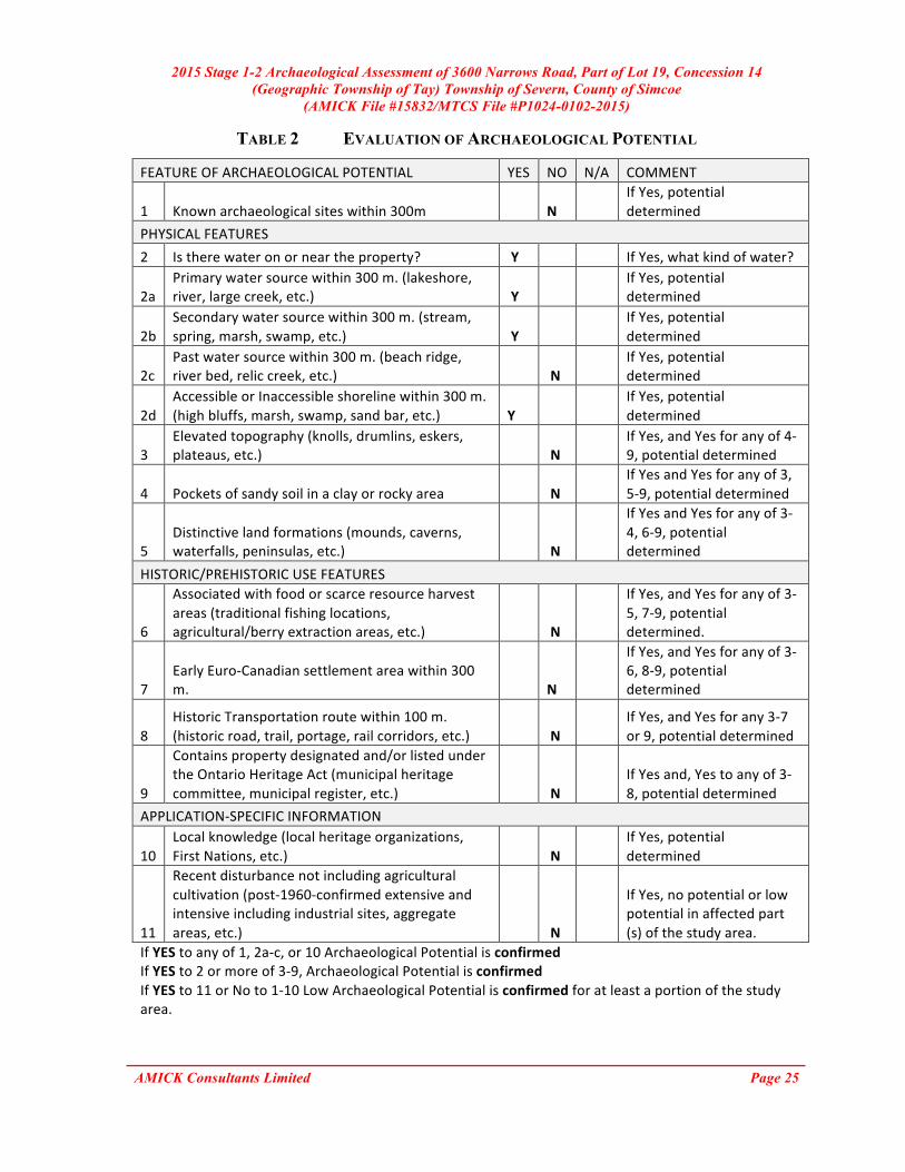
(MTC 2011: 18) Table 2 below summarizes the evaluation criteria of the Ministry of Tourism and Culture together with the results of the Stage 1 Background Study for the proposed undertaking. Based on the criteria, the property is deemed to have archaeological potential on the basis of proximity to water.
2015 Stage 1-2 Archaeological Assessment of 3600 Narrows Road, Part of Lot 19, Concession 14 (Geographic Township of Tay) Township of Severn, County of Simcoe
(AMICK File #15832/MTCS File #P1024-0102-2015)
AMICK Consultants Limited Page 25
TABLE 2 EVALUATION OF ARCHAEOLOGICAL POTENTIAL
FEATURE OF ARCHAEOLOGICAL POTENTIAL YES NO N/A COMMENT
1 Known archaeological sites within 300m N
If Yes, potential determined
PHYSICAL FEATURES 2 Is there water on or near the property? Y If Yes, what kind of water?
2a Primary water source within 300 m. (lakeshore, river, large creek, etc.) Y
If Yes, potential determined
2b Secondary water source within 300 m. (stream, spring, marsh, swamp, etc.) Y
If Yes, potential determined
2c Past water source within 300 m. (beach ridge, river bed, relic creek, etc.) N
If Yes, potential determined
2d Accessible or Inaccessible shoreline within 300 m. (high bluffs, marsh, swamp, sand bar, etc.) Y
If Yes, potential determined
3 Elevated topography (knolls, drumlins, eskers, plateaus, etc.) N
If Yes, and Yes for any of 4-‐9, potential determined
4 Pockets of sandy soil in a clay or rocky area N If Yes and Yes for any of 3, 5-‐9, potential determined
5 Distinctive land formations (mounds, caverns, waterfalls, peninsulas, etc.) N
If Yes and Yes for any of 3-‐4, 6-‐9, potential determined
HISTORIC/PREHISTORIC USE FEATURES
6
Associated with food or scarce resource harvest areas (traditional fishing locations, agricultural/berry extraction areas, etc.) N
If Yes, and Yes for any of 3-‐5, 7-‐9, potential determined.
7 Early Euro-‐Canadian settlement area within 300 m. N
If Yes, and Yes for any of 3-‐6, 8-‐9, potential determined
8 Historic Transportation route within 100 m. (historic road, trail, portage, rail corridors, etc.) N
If Yes, and Yes for any 3-‐7 or 9, potential determined
9
Contains property designated and/or listed under the Ontario Heritage Act (municipal heritage committee, municipal register, etc.) N
If Yes and, Yes to any of 3-‐8, potential determined
APPLICATION-‐SPECIFIC INFORMATION
10 Local knowledge (local heritage organizations, First Nations, etc.) N
If Yes, potential determined
11
Recent disturbance not including agricultural cultivation (post-‐1960-‐confirmed extensive and intensive including industrial sites, aggregate areas, etc.) N
If Yes, no potential or low potential in affected part (s) of the study area.
If YES to any of 1, 2a-‐c, or 10 Archaeological Potential is confirmed If YES to 2 or more of 3-‐9, Archaeological Potential is confirmed
If YES to 11 or No to 1-‐10 Low Archaeological Potential is confirmed for at least a portion of the study area.

2015 Stage 1-2 Archaeological Assessment of 3600 Narrows Road, Part of Lot 19, Concession 14 (Geographic Township of Tay) Township of Severn, County of Simcoe
(AMICK File #15832/MTCS File #P1024-0102-2015)
AMICK Consultants Limited Page 26
8.3 STAGE 1 ANALYSIS AND CONCLUSIONS As a result of the Stage 1 portion of the study it was determined that the study area has archaeological potential on the basis of proximity to water. 8.4 STAGE 2 ANALYSIS AND CONCLUSIONS
Section 7.8.3 of the Standards and Guidelines for Consultant Archaeologists (MTC 2011: 138-139) outlines the requirements of the Analysis and Conclusions component of a Stage 2 Property Assessment.
1. Summarize all finding from the Stage 2 survey, or state that no archaeological sites were identified.
2. For each archaeological site, provide the following analysis and conclusions: a. A preliminary determination, to the degree possible, of the age and cultural
affiliation of any archaeological sites identified. b. A comparison against the criteria in 2 Stage 2: Property Assessment to determine
whether further assessment is required c. A preliminary determination regarding whether any archaeological sites identified
in Stage 2 show evidence of a high level cultural heritage value or interest and will thus require Stage 4 mitigation.
No archaeological sites or resources were found during the Stage 2 survey of the study area. 9.0 RECOMMENDATIONS 9.1 STAGE 1 RECOMMENDATIONS Under Section 7.7.4 of the Standards and Guidelines for Consultant Archaeologists (MTC 2011: 133) the recommendations to be made as a result of a Stage 1 Background Study are described.
1) Make recommendations regarding the potential for the property, as follows: a. if some or all of the property has archaeological potential, identify areas recommended for further assessment (Stage 2) and areas not recommended for further assessment. Any exemptions from further assessment must be consistent with the archaeological fieldwork standards and guidelines. b. if no part of the property has archaeological potential, recommend that the property does not require further archaeological assessment.
2) Recommend appropriate Stage 2 assessment strategies.
The study area has been identified as an area of archaeological potential.

2015 Stage 1-2 Archaeological Assessment of 3600 Narrows Road, Part of Lot 19, Concession 14 (Geographic Township of Tay) Township of Severn, County of Simcoe
(AMICK File #15832/MTCS File #P1024-0102-2015)
AMICK Consultants Limited Page 27
The study area is roughly 20 hectares in size consists of mostly wooded lands, low-lying and wet stream areas, and exposed rock outcroppings. The low-lying and wet areas and exposed bedrock were determined to have low or no potential and therefore it is recommended that there is no further archaeological concern for these areas. Portions of the study area excluded from theses noted areas of low potential, were determined to have potential and Stage 2 assessment was therefore conducted using test pit survey methodology in accordance with the Standards governing the use of this method. Any areas that were viable to assess were subject to assessment using the test pit methodology. Test pits were dug at a fixed interval of 5 metres across the surface area. Test pits measured a minimum of 30 centimeters in diameter and were dug at least 5 centimeters into the subsoil beneath the topsoil layer. All excavated earth was screened through 6 mm wire mesh to ensure that any artifacts contained within the soil matrix are recovered. All test pits were back filled and restored as much as was reasonably possible to the level of the surrounding grade. 9.2 STAGE 2 RECOMMENDATIONS Under Section 7.8.4 of the Standards and Guidelines for Consultant Archaeologists (MTC 2011: 139) the recommendations to be made as a result o f a Stage 2 Property Assessment are described.
1) For each archaeological site, provide a statement of the following: a. Borden number or other identifying number b. Whether or not it is of further cultural heritage value or interest c. Where it is of further cultural heritage value or interest, appropriate Stage 3 assessment strategies
2) Make recommendations only regarding archaeological matters. Recommendations regarding built heritage or cultural heritage landscapes should not be included.
3) If the Stage 2 survey did not identify any archaeological sites requiring further assessment or mitigation of impacts, recommend that no further archaeological assessment of the property be required.
As a result of the property Assessment of the study area, no archaeological resources were encountered. Consequently, the following recommendations are made:
- No further archaeological assessment of the study area is warranted; - The Provincial interest in archaeological resources with respect to the proposed
undertaking has been addressed; - The proposed undertaking is clear of any archaeological concern.

2015 Stage 1-2 Archaeological Assessment of 3600 Narrows Road, Part of Lot 19, Concession 14 (Geographic Township of Tay) Township of Severn, County of Simcoe
(AMICK File #15832/MTCS File #P1024-0102-2015)
AMICK Consultants Limited Page 28
10.0 ADVICE ON COMPLIANCE WITH LEGISLATION While not part of the archaeological record, this report must include the following standard advisory statements for the benefit of the proponent and the approval authority in the land use planning and development process:
a. This report is submitted to the Minister of Tourism and Culture as a condition of licensing in accordance with Part VI of the Ontario Heritage Act, R.S.O. 1990, c. 0.18. The report is reviewed to ensure that it complies with the standards and guidelines issued by the Minister, and that the archaeological fieldwork and report recommendations ensure the conservation, protection and preservation of the cultural heritage of Ontario. When all matters relating to archaeological sites within the project area of a development proposal have been addressed to the satisfaction of the Ministry of Tourism and Culture, a letter will be issued by the ministry stating that there are no further concerns with regard to alterations to archaeological sites by the proposed development.
b. It is an offence under Sections 48 and 69 of the Ontario Heritage Act for any party other than a licensed archaeologist to make any alteration to a known archaeological site or to remove any artifact or other physical evidence of past human use or activity from the site, until such time as a licensed archaeologist has completed archaeological fieldwork on the site, submitted a report to the Minister stating that the site has no further cultural heritage value or interest, and the report has been filed in the Ontario Public Register of Archaeological Reports referred to in Section 65.1 of the Ontario Heritage Act.
c. Should previously undocumented archaeological resources be discovered, they may
be a new archaeological site and therefore subject to Section 48 (1) of the Ontario Heritage Act. The proponent or person discovering the archaeological resources must cease alteration of the site immediately and engage a licensed archaeologist to carry out archaeological fieldwork, in compliance with sec. 48 (1) of the Ontario Heritage Act.
d. The Cemeteries Act, R.S.O. 1990, c. C.4 and the Funeral, Burial and Cremation
Services Act, 2002, S.O. 2002, c.33 (when proclaimed in force) require that any person discovering human remains must notify the police or coroner and the Registrar of Cemeteries at the Ministry of Consumer Services.
e. Archaeological sites recommended for further archaeological fieldwork or protection
remain subject to Section 48 (1) of the Ontario Heritage Act and may not be altered, or have artifacts removed from them, except by a person holding an archaeological licence.

2015 Stage 1-2 Archaeological Assessment of 3600 Narrows Road, Part of Lot 19, Concession 14 (Geographic Township of Tay) Township of Severn, County of Simcoe
(AMICK File #15832/MTCS File #P1024-0102-2015)
AMICK Consultants Limited Page 29
11.0 BIBLIOGRAPHY AND SOURCES Azimuth Environmental Consulting, Inc. (2015). Draft Plan of Subdivision, Part of Lot 19,
Concession 14, in the Geographic Township of Tay, Township of Severn, County of Simcoe, 3600 Narrows Road. Azimuth Environmental Consulting, Inc., Barrie.
Chapman, L.J. & D.F. Putnam. (1984). The Physiography of Southern Ontario (Third Edition).
Ontario Geological Survey, Special Report #2. Ontario Ministry of Natural Resources, Toronto.
Garbutt, Mary. (2010). About Simcoe County. Simcoe County Branch- Ontario Genealogical Society.
Retrieved 12 May 2010, from URL: http://www.simcoebogs.com/About/ab_simcoe.html Goel, Tarun (2013). Road Construction: History and Procedure. Bright Hub Engineering.
Retrieved 24 May 2015 from URL: http://www.brighthubengineering.com/structural-engineering/59665-road-construction-history-and-procedure/
Google Earth (Version 6.0.3.2197) [Software]. (2009). Available from
http://www.google.com/earth/index.html. Google Maps. (2012). Available from: http://maps.google.ca/?utm_campaign =en&utm_source=en-
ha-na-ca-bk-gm&utm_medium=ha&utm_term =google%20maps. H. Belden & Co. (1881). Simcoe Supplement in Illustrated Atlas of the Dominion of Canada. H. Belden & Co., Toronto. Ontario Heritage Act, RSO 1990a, Government of Ontario. (Queen’s Printer, Toronto). Ontario Heritage Amendment Act, SO 2005, Government of Ontario. (Queen’s Printer, Toronto). Ontario Ministry of Citizenship, Culture and Recreation (OMCzCR). (1993). Archaeological
Assessment Technical Guidelines, Stages 1-3 and Reporting Format. (Queen’s Printer for Ontario 1993)
Ontario Ministry of Culture (MCL). (2005). Conserving a Future for Our Past: Archaeology, Land
Use Planning & Development in Ontario (An Educational Primer and Comprehensive Guide for Non-Specialists). (Heritage & Libraries Branch, Heritage Operations Unit: Toronto).
Ontario Ministry of Culture and Communications (MCC) & Ministry of Environment (MOE). (1992).
Guideline for Preparing the Cultural Heritage Resource Component of Environmental Assessments. (Cultural Programs Branch, Archaeology and Heritage Planning: Toronto).
Ontario Ministry of Tourism and Culture (MTC). (2011). Standards and Guidelines for Consultant
Archaeologist. (Programs and Services Branch: Culture Programs Unit, Toronto). Ontario Planning Act, RSO 1990b, Government of Ontario. (Queen’s Printer, Toronto). Provincial Policy Statement (2014). Government of Ontario. (Queen’s Printer, Toronto).

2015 Stage 1-2 Archaeological Assessment of 3600 Narrows Road, Part of Lot 19, Concession 14 (Geographic Township of Tay) Township of Severn, County of Simcoe
(AMICK File #15832/MTCS File #P1024-0102-2015)
AMICK Consultants Limited Page 30
Township of Severn (2013). Township of Severn Mission Statement. Retrieved 12 June 2013 from http://www.townshipofsevern.com/about.asp
Wright, J.V. (1972). Ontario Prehistory: an Eleven-thousand-year Archaeological Outline. Archaeological Survey of Canada. National Museum of Man, Ottawa.

2015 Stage 1-2 Archaeological Assessment of 3600 Narrows Road, Part of Lot 19, Concession 14 (Geographic Township of Tay) Township of Severn, County of Simcoe
(AMICK File #15832/MTCS File #P1024-0102-2015)
AMICK Consultants Limited Page 31
12.0 MAPS
FIGURE 1 LOCATION OF THE STUDY AREA (GOOGLE MAPS 2012)

2015 Stage 1-2 Archaeological Assessment of 3600 Narrows Road, Part of Lot 19, Concession 14 (Geographic Township of Tay) Township of Severn, County of Simcoe
(AMICK File #15832/MTCS File #P1024-0102-2015)
AMICK Consultants Limited Page 32
FIGURE 2 FACSIMILE SEGMENT OF THE HISTORIC ATLAS MAP OF THE TOWNSHIP OF
TAY (H. Belden & Co. 1881)
2015 Stage 1-2 Archaeological Assessment of 3600 Narrows Road, Part of Lot 19, Concession 14 (Geographic Township of Tay) Township of Severn, County of Simcoe
(AMICK File #15832/MTCS File #P1024-0102-2015)
AMICK Consultants Limited Page 33
FIGURE 3 PLAN OF SURVEY (AZIMUTH ENVIRONMENTAL CONSULTING, INC. 2015)

2015 Stage 1-2 Archaeological Assessment of 3600 Narrows Road, Part of Lot 19, Concession 14 (Geographic Township of Tay) Township of Severn, County of Simcoe
(AMICK File #15832/MTCS File #P1024-0102-2015)
AMICK Consultants Limited Page 34
FIGURE 4 AERIAL PHOTO OF THE STUDY AREA (GOOGLE EARTH 2011)

2015 Stage 1-2 Archaeological Assessment of 3600 Narrows Road, Part of Lot 19, Concession 14 (Geographic Township of Tay) Township of Severn, County of Simcoe
(AMICK File #15832/MTCS File #P1024-0102-2015)
AMICK Consultants Limited Page 35
FIGURE 5 DETAILED PLAN OF THE STUDY AREA
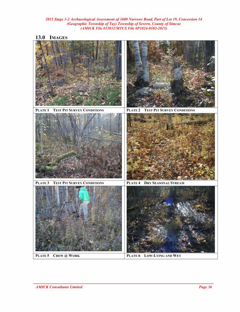
2015 Stage 1-2 Archaeological Assessment of 3600 Narrows Road, Part of Lot 19, Concession 14 (Geographic Township of Tay) Township of Severn, County of Simcoe
(AMICK File #15832/MTCS File #P1024-0102-2015)
AMICK Consultants Limited Page 36
13.0 IMAGES
PLATE 1 TEST PIT SURVEY CONDITIONS PLATE 2 TEST PIT SURVEY CONDITIONS
PLATE 3 TEST PIT SURVEY CONDITIONS PLATE 4 DRY SEASONAL STREAM
PLATE 5 CREW @ WORK PLATE 6 LOW-LYING AND WET

2015 Stage 1-2 Archaeological Assessment of 3600 Narrows Road, Part of Lot 19, Concession 14 (Geographic Township of Tay) Township of Severn, County of Simcoe
(AMICK File #15832/MTCS File #P1024-0102-2015)
AMICK Consultants Limited Page 37
PLATE 7 LOW-LYING AND WET PLATE 8 ROCK OUTCROP
PLATE 9 TEST PIT SURVEY CONDITIONS PLATE 10 TEST PIT SURVEY CONDITIONS