-1- - tcp haryana · faridabad came on the map of haryana on 2nd august, 1979 as the 12th district...
TRANSCRIPT
-1-
HARYANA GOVERNMENT
TOWN AND COUNTRY PLANNING DEPARTMENT
Notification
The 14th
July, 2014.
No. CCP(NCR)/FBC(DDP-31)/2014/1312.- In exercise of the powers conferred by sub-section (4) of section 5 of the
Punjab Scheduled Roads and Controlled Areas Restriction of Unregulated Development Act, 1963 (Punjab Act 41 of
1963), the Governor of Haryana hereby publishes the following Draft Development Plan 2031 A.D. for controlled
areas outside Municipal Corporation, Faridabad alongwith restrictions and conditions, given in Annexure „A‟ and „B‟
proposed to be made applicable to the controlled areas specified in Annexure „B‟ and falling outside the limits of
Municipal Corporation, Faridabad, as on date;
Notice is hereby given that the draft development Plan shall be taken into consideration by the
Government on or after the expiry of period of thirty days from the date of publication of this notification in the
Official Gazette together with objections or suggestions, if any, relating to the area falling outside the limits of the
Municipal Corporation, Faridabad, which may be received by the Director, Town and Country Planning, Haryana,
Second Floor, S.C.O. No. 71-75, Sector 17-C, Chandigarh from any person in writing in respect of Draft
Development Plan-2031 AD, before the expiry of the period so specified.
DRAWINGS (A) (i) Existing land use plan already published:-
vide Punjab Government, Gazette notification No. 1845-2TCP-65/17532, dated the 5th
June, 1965.
Vide Punjab Government, Gazette notification No. 1576-2TCP-66/17892, dated the 23rd
June, 1966 published in gazette dated 28th
July, 1966.
Vide Haryana Government, Gazette notification No. 1627-TCP-67/1277, dated the 4th
April, 1967 published in Gazette dated the 25th
April, 1967.
Vide Haryana Government, Gazette notification no. 4299-ICI-75/17829, dated the 11th
June, 1975 published in Haryana Government Gazette dated the 12th
June, 1975.
Existing land use plan bearing drawing no. DTP (F)/ 1421/91, dated the 3rd
August, 1991
published in the Haryana Government Gazette (Extraordinary) vide No.
FCA/STP/91/1354, on the 14th
October, 1991 read with the corrigendum dated the 28th
October, 1991.
(ii) Existing land use plan drawing No. DTP(F)2635/10 dated 16th
September, 2010/18th
July, 2012
(iii) Existing land use plan drawing No. DTP(F)2706/14 dated 18th
February, 2014 for controlled areas
of villages Makanpur and Walipur.
(iv) Existing land use plan drawing No. DTP(F)2707/14 dated 18th
February, 2014 for controlled areas
of village Kirawali.
(B) Draft Development Plan for the Controlled Areas outside Municipal Corporation, Faridabad 2031 A.D.
bearing drawing no. DTP (F) 2687/12 dated the 20th
July, 2012/17th June, 2013/30
th October, 2013.
ANNEXURE – A
EXPLANATORY NOTE ON THE DRAFT DEVELOPMENT PLAN FOR THE CONTROLLED AREAS
OUTSIDE MUNICIPAL CORPORATION, FARIDABAD - 2031 A.D.
(I) Introduction
Faridabad was founded in A.D. 1607 by Shaikh Farid, Treasurer of Jahangir, with the objective of protecting
the highway, which passed through the town. Shaikh Farid built a fort, a tank and a mosque which are in
ruins. Later, it became the headquarters of a pargana which was held in Jagir by the Ballabgarh ruler. District
Faridabad came on the map of Haryana on 2nd
August, 1979 as the 12th
District of the State. The new district
was carved out from erstwhile Gurgaon district. Faridabad is one of the most populated and industrialized
cities of Haryana. The city is famous for Henna production in agriculture sector while tractors, motor cycles,
switch gears, Refrigerators, shoes & tyres are other famous industrial products of the city.
(II) Location and Regional Setting
Faridabad is situated at 28° 25' 16'' North Latitude and 77° 18' 28'' East Longitude. Faridabad-Ballabgarh
Complex is situated on Delhi-Mathura road (NH-44) at a distance of 32 KM from Delhi. It is one of the
-2-
largest agglomerations consisting of three towns, namely Faridabad Old, Ballabgarh and N.I.T. Faridabad.
This complex, being within 32/40 KM radius of Delhi, is one of the recommended Metro town of N.C.R.
(III) Physiography
Faridabad town is bounded by National Capital Territory (NCT) Delhi on its North, Gurgaon District and
Aravalli Hills on the West and South. The river Yamuna separates the district boundary on eastern side with
Uttar Pradesh State. Delhi-Agra National Highway No. 44 (Sher Shah Suri Marg) passes through the centre
of the district. It has a Railway station on the Delhi-Mathura double track broad-gauge Railway line of
Indian Railway.
(IV) Availability of Infrastructure
Faridabad is well connected by a network of road and electricity. All the villages of the district are connected
by metalled roads and have electricity since 1970. Faridabad is well connected with other parts of the
country by Rail and Road. The broad gauge Railway line of Northern and North-Central Railway pass
through the district and most of the trains going to South and West of India pass through the District. Also
Delhi-Mathura-Agra road (NH-44) passes almost through the middle of the district. Faridabad and
Ballabgarh are the main towns of the district.
(V) Economic base of the town/functional status
Faridabad is home to one of the largest industrial estates of Asia, which houses a large number of
manufacturing industries. Economy of Faridabad is largely dependent on industry.
The total number of small, medium and large industries in district Faridabad is about 15,000 which
provide direct and indirect employment to nearly half a million people and ranks as the 9th
largest industrial
estate in Asia. The place is home to many international/multinational companies namely; Whirlpool,
Goodyear, Larsen & Toubro, Escorts, Eicher, Cutler Hammer, Hyderabad Asbestos and Nuchem etc.
Within NCR, Gurgaon and Noida have been in the forefront in attracting investments, which have
been primarily in the information technology (IT) and bio-technology (BT) sectors. Faridabad has lagged
behind in these sectors and is now gearing up to catch up with Gurgaon and Noida. More and more
investments are flowing into various sectors of industry, commerce and real estate.
Keeping in view the above, land use proposals have been formulated on the consideration that
industrial activities and trade and commerce will continue to remain the major economic base of the town.
The town is growing as a major industrial centre of the State as well as of the region. The Haryana State
Industrial and Infrastructure Development Corporation has already acquired land and developed an Industrial
Modal Township (IMT) on the eastern side of the Agra Canal. A lot of industrial activities have already
come up in the controlled areas after obtaining the change of land use permissions from the competent
authority.
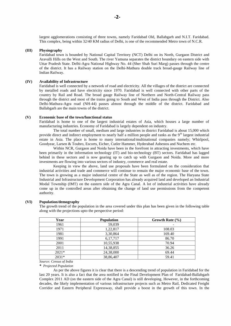
(VI) Population/demography
The growth trend of the population in the area covered under this plan has been given in the following table
along with the projections upto the perspective period:
Year Population Growth Rate (%)
1961 59,039 -
1971 1,22,817 108.03
1981 3,30,864 169.40
1991 6,17,717 86.70
2001 10,55,938 70.94
2011 14,38,855 36.26
2021* 24,38,000 69.44
2031* 38,86,407 59.41 Source: Census of India
* Projected Population
As per the above figures it is clear that there is a descending trend of population in Faridabad for the
last 20 years. It is also a fact that the area notified in the Final Development Plan of Faridabad-Ballabgarh
Complex 2011 AD (on the eastern side of the Agra Canal) is still developing. However, in the forthcoming
decades, the likely implementation of various infrastructure projects such as Metro Rail, Dedicated Freight
Corridor and Eastern Peripheral Expressway, shall provide a boost in the growth of this town. In the
-3-
Regional Plan 2021 AD of NCR, the population of Faridabad town has been projected as 25 lacs (approx.)
by 2021 AD with a variation of +2.5%.
(VII) Extension of Urbanizable Proposals For a projected population of 10 lacs for the year 2001, a draft development plan was published-
vide Gazette notification No. 3431-10DP-82/6194 dated the 26th
April, 1982. Thereafter, the Final
Development Plan of Faridabad-Ballabgarh Controlled Areas 2011 A.D. was published vide Haryana
Government Gazette notification No. 13/29/91-3CII dated 11th
December, 1991 for a projected population of
17.5 lacs by 2011. This Plan had proposals for urbanization from Delhi border in the North, up to Foothills
of Aravalli ranges in the West, beyond Gurgaon-Agra Canal in the East and upto the revenue estate of
village Jharsently in the South.
The length of the urbanizable area in the Final Development Plan of 2011 is about 24 Kms. and
width 12 Kms. Towards western side of the above urbanizable area, there is a rocky undulating area, wherein
urbanization is not feasible. Similarly, this town cannot be expanded towards its north due to the constraint
of Haryana-Delhi border. Therefore, the additional area beyond east of Agra Canal, south and South-West of
the town is being proposed for the development of additional urbanizable area for additional population.
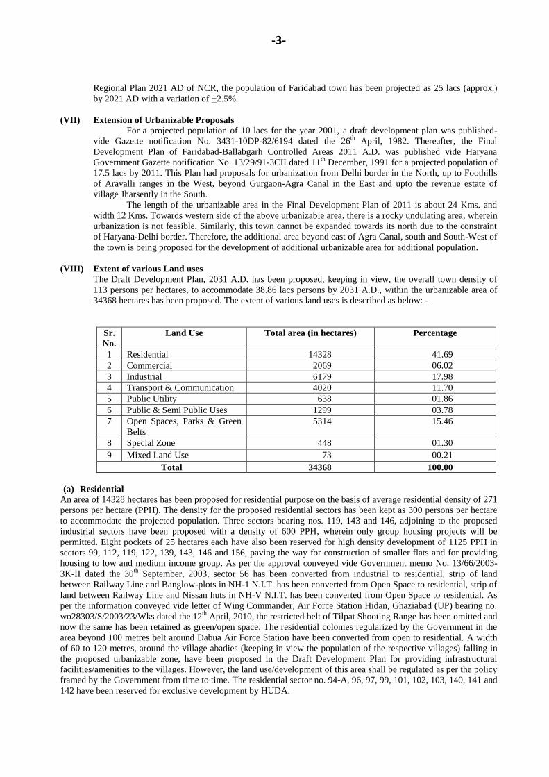
(VIII) Extent of various Land uses
The Draft Development Plan, 2031 A.D. has been proposed, keeping in view, the overall town density of
113 persons per hectares, to accommodate 38.86 lacs persons by 2031 A.D., within the urbanizable area of
34368 hectares has been proposed. The extent of various land uses is described as below: -
Sr.
No.
Land Use Total area (in hectares) Percentage
1 Residential 14328 41.69
2 Commercial 2069 06.02
3 Industrial 6179 17.98
4 Transport & Communication 4020 11.70
5 Public Utility 638 01.86
6 Public & Semi Public Uses 1299 03.78
7 Open Spaces, Parks & Green
Belts
5314 15.46
8 Special Zone 448 01.30
9 Mixed Land Use 73 00.21
Total 34368 100.00
(a) Residential
An area of 14328 hectares has been proposed for residential purpose on the basis of average residential density of 271
persons per hectare (PPH). The density for the proposed residential sectors has been kept as 300 persons per hectare
to accommodate the projected population. Three sectors bearing nos. 119, 143 and 146, adjoining to the proposed
industrial sectors have been proposed with a density of 600 PPH, wherein only group housing projects will be
permitted. Eight pockets of 25 hectares each have also been reserved for high density development of 1125 PPH in
sectors 99, 112, 119, 122, 139, 143, 146 and 156, paving the way for construction of smaller flats and for providing
housing to low and medium income group. As per the approval conveyed vide Government memo No. 13/66/2003-
3K-II dated the 30th
September, 2003, sector 56 has been converted from industrial to residential, strip of land
between Railway Line and Banglow-plots in NH-1 N.I.T. has been converted from Open Space to residential, strip of
land between Railway Line and Nissan huts in NH-V N.I.T. has been converted from Open Space to residential. As
per the information conveyed vide letter of Wing Commander, Air Force Station Hidan, Ghaziabad (UP) bearing no.
wo28303/S/2003/23/Wks dated the 12th
April, 2010, the restricted belt of Tilpat Shooting Range has been omitted and
now the same has been retained as green/open space. The residential colonies regularized by the Government in the
area beyond 100 metres belt around Dabua Air Force Station have been converted from open to residential. A width
of 60 to 120 metres, around the village abadies (keeping in view the population of the respective villages) falling in
the proposed urbanizable zone, have been proposed in the Draft Development Plan for providing infrastructural
facilities/amenities to the villages. However, the land use/development of this area shall be regulated as per the policy
framed by the Government from time to time. The residential sector no. 94-A, 96, 97, 99, 101, 102, 103, 140, 141 and
142 have been reserved for exclusive development by HUDA.
-4-
The Government decision regarding increase in the sector density has been incorporated in the plan with the
following provisions: -
a- The additional area for infrastructure shall be provided in the already planned/developed residential sectors
to meet out the requirement of the additional population.
b- The minimum width of the roads in a residential colony/sector shall not be less than 12 metres.
c- The minimum area for parks/open spaces in a residential colony/sector shall be planned in such a manner
that it shall meet the minimum norm of 2.5 sq. metres per person.
(b) Commercial
An area of 2069 hectares, has been proposed for commercial purpose. There is a tendency of converting existing
residential areas into commercial areas along the major roads. Therefore, in the present plan, commercial land uses
have been proposed along major roads in a linear pattern along sector roads between various sectors so that tendency
of converting residential areas into commercial use can be curbed. In addition sector 100, 120 and 154 have been
proposed as city centre. As per the approval conveyed vide Govt. memo no. 13/66/03-3KII dated the 30th September,
2003, a 70 metre wide strip of land in sector 20A and 20-B facing Delhi-Mathura road has been converted from
Public and Semi Public use to Commercial. The land use of sectors 27A, 27B, 27C and 27D and the existing
industrial belt along Delhi-Mathura Road (NH-44) upto a depth of 200 metre in sector 32, 35 and 36, after leaving 50
metres wide restricted belt along NH-44, has been converted into commercial land use. However, the land use of
industrial plots, already allotted by any government agency in this area, shall be retained and shall only be changed
with prior permission of competent authority. The commercial sector 100 and 117-A have been reserved for exclusive
development by HUDA.
(c) Industrial
Since, Faridabad is primarily an industrial agglomeration; an area of 6179 hectares has been proposed for industrial
development in the present plan. The existing Gas based Thermal Plant has already been accommodated in the
Development Plan as special zone. HSIIDC has already developed an Industrial Model Township (IMT) in sectors 66,
67, 68 and 69 situated in the east of Agra Canal. Due to the existence of industries in sector 13, the land use of sector-
13 has been changed from institutional to industrial-cum-institutional. A width of 60 metre to 120 metre, around the
village abadies falling in the proposed urbanizable zone has been reserved in the Development Plan for the future
development of this area which shall be regulated as per the policy framed by the Government from time to time.
Provision of multi-level parking for each 100 acres urbanizable area and other small town level infrastructure
facilities such as site for Telephone Exchange, site for Transit Station for Solid Waste Disposal, site for Rein Basera
etc. will be provided at the time of preparation of the circulation plans of the respective sectors.
(d) Transport & Communication
Circulation Pattern
For smooth channelization of inter-city traffic, the circulation pattern proposed in the Development plan is as under: -
(i) Delhi-Mathura Road (National Highway No. 44): This road continues to be the central axis for the Inter-
State traffic to Delhi and Uttar Pradesh. It also carries the major portion of Intra-city volume of traffic, resulting in lot
of congestion on this road. To relieve this road from the external traffic, a 60 metre wide bypass road has been
constructed by HUDA, as per the provisions of published Final Development Plan-2011 A.D. On the western side
traffic from south Delhi via Mehrauli road and from Gurgaon will bypass the city through proposed 75 metres and 90
metres wide roads proposed parallel to National Highway, which links the existing Suraj kund/Sohna road to National
Highway near village Sikri. In addition to the already proposed 75 metre wide eastern peripheral road in the Final
Development Plan 2011 A.D, 75 metre wide roads and 90 metre wide road have been proposed for the additional
urbanizable area proposed in the eastern side of Agra Canal, which will connect the existing roads and also to the
proposed urbanizable area of Prithla, Noida and Greater Noida.
For the Traffic generated by to-and-fro movement for the cities situated on the east of Yamuna River like;
NOIDA, Ghaziabad, Meerut, which is unnecessarily creating congestion in Delhi, an Express Highway has been
constructed, which after passing over the newly constructed barrage-cum-Bridge over the Yamuna River enters
Haryana near Badarpur Thermal Power Plant, along the eastern flank of Agra Canal. In Haryana, it comes along the
east of Agra Canal towards the north of sector 87, from there onwards; it will be linked with the proposed roads in the
proposed urbanization on the east of Agra Canal to meet Delhi-Mathura Road.
(ii) Eastern Peripheral Expressway: A 100 metre wide road, known as Eastern Peripheral Expressway, has
been proposed alongwith 100 metre wide green belt on both sides in the development plan. Two links with 75 metre
width have been proposed to connect this expressway near sector 121 and sector 132. The connectivity proposed near
-5-
sector 131 and 132 has been proposed to facilitate the industrial sectors which shall be developed by HSIIDC and the
same shall not be included in the External Development charges to be fixed by HUDA.
(iii) Intra-city Road Network: For intra-city traffic a network of 60 metres wide roads, alongwith 12 metre wide
service roads, spread at a distance of about1 kilometre to 1.5 kilometres apart on the gridiron pattern have been
proposed. These roads are the sector dividing roads, which have been shown as V-2 on the present Plan. Within each
sector, road network of 24 metres and 12 metres width shall be adopted while preparing the detailed layout plan of
each sector.
(iv) Over Bridge/Under pass on Railway Line: For proper linkages of urbanizable proposals on eastern and
western side of the Railway line, it is necessary to have Railway Bridges. In addition to the already proposed Railway
Over Bridges, over the level crossing on Mewla-Maharajpur and Sarai Khawaja-Suraj Kund Road, one Railway over
bridge has been proposed on the crossing of 75 metre wide eastern peripheral road with the Delhi-Mathura Railway
line near village Malerna.
(v) Bridge over Gurgaon and Agra Canals: The present bridges on Agra Canal are very old and weak which
were designed to carry the rural traffic. To integrate the urbanizable proposals on either side of Agra and Gurgaon
Canals, bridges on sector dividing roads have been proposed. The existing bridges near old Faridabad, Tigaon road,
Palla road and Ballabgarh-Mohna Road require widening and strengthening.
(vi) Dedicated Freight Corridor: The Dedicated Freight Corridor from Mumbai to Dadri will be passing
through the proposed urbanizable area. A 50 metre wide green belt has been proposed on both sides of the Dedicated
Freight Corridor and in this 50 metre wide green belt, 12 metre wide service road has been proposed on both sides.
(vii) Connectivity to Noida and Greater Noida: Two linkages from the outer peripheral road, near sector 92 and
near sector 95 have been proposed for providing connectivity to Noida and Greater Noida respectively.
(viii) Metro Connectivity: The Metro rail has also been proposed along Delhi-Mathura road, up to Ballabgarh
which is presently being implemented by Delhi Metro Rail Corporation. Apart from it, extension of this link upto
village Sikri has been proposed as well as along the bypass road along Gurgaon/Agra Canal and along 75 metre wide
road along sectors 87, 88, 89, 84, 83, 78, 77, 72, 71, 68, 67 and 66, which however shall be subject to change as per
feasibility and other studies to be conducted subsequently.
(ix) Regional Rail Network: In accordance with the proposals of Regional Plan 2021 A.D. of NCRPB, the
provision of Regional Rapid Transit System along the existing Delhi-Mathura Railway line has also been made.
Further, Regional Plan provides for Inner Regional Orbital Rail Corridor (IRORC) to connect Sonepat-Jhajjar-
Gurgaon-Faridabad-Dadri-Meerut-Baghpat-Sonepat. However, since the alignment of said corridor is not finalized,
hence the same shall be implemented in the present Development Plan area as per alignment finalized in the
feasibility study/Detailed Project Report prepared for the same. Apart from it, the Orbital Rail Corridor has also been
proposed along Eastern Peripheral Expressway with 50 metres width.
As described above, the circulation system of the town shall have Gridiron System. In addition to the already
proposed Transport Zone of the Final Development Plan-2011 A.D, Transport Nagars/sites have been proposed near
proposed industrial sectors along main roads. An area of 4020 hectares has been proposed for Transport and
Communication.
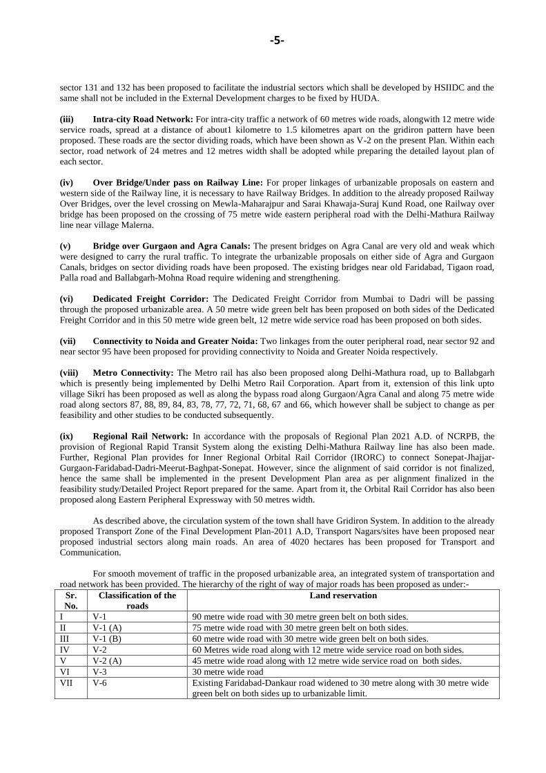
For smooth movement of traffic in the proposed urbanizable area, an integrated system of transportation and
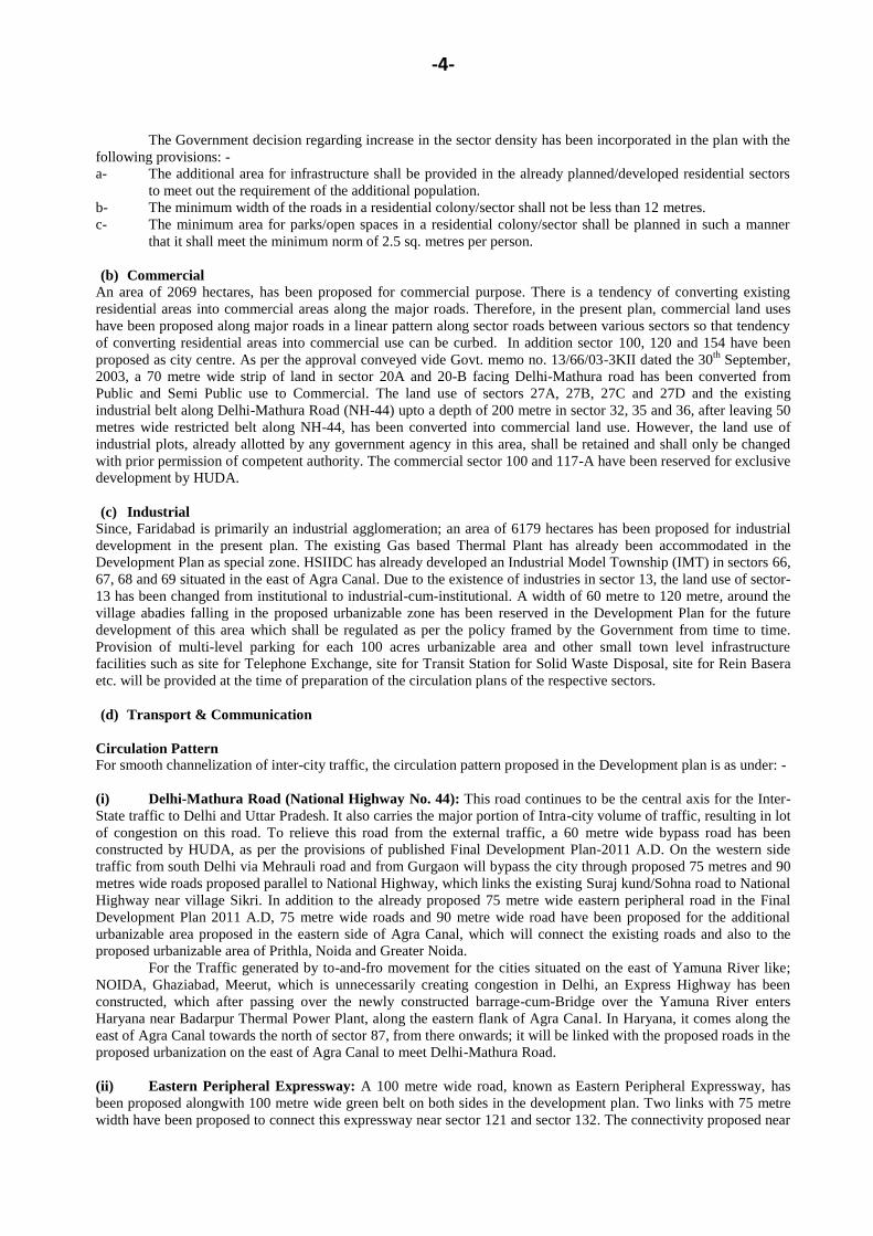
road network has been provided. The hierarchy of the right of way of major roads has been proposed as under:-
Sr.
No.
Classification of the
roads
Land reservation
I V-1 90 metre wide road with 30 metre green belt on both sides.
II V-1 (A) 75 metre wide road with 30 metre green belt on both sides.
III V-1 (B) 60 metre wide road with 30 metre wide green belt on both sides.
IV V-2 60 Metres wide road along with 12 metre wide service road on both sides.
V V-2 (A) 45 metre wide road along with 12 metre wide service road on both sides.
VI V-3 30 metre wide road
VII V-6 Existing Faridabad-Dankaur road widened to 30 metre along with 30 metre wide
green belt on both sides up to urbanizable limit.
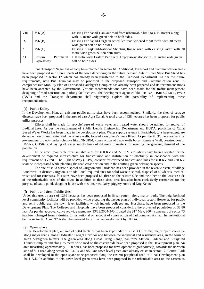
-6-
VIII V-6 (A) Existing Faridabad-Dankaur road from urbanizable limit to U.P. Border along
with 30 metre wide green belt on both sides.
IX V-6 (B) Existing Faridabad-Gurgaon scheduled road widened to 90 metre with 30 metre
wide green belt on both sides.
X V-6 (C) Existing Surajkund-National Shooting Range road with existing width with 30
metre wide green belt on both sides.
XI Eastern Peripheral
Expressway
100 metre wide Eastern Peripheral Expressway alongwith 100 metre wide green
belt on both sides.
One Transport Nagar has already been planned in sector 61. Additional, Transport and Communication areas
have been proposed in different parts of the town depending on the future demand. Site of Inter State Bus Stand has
been proposed in sector 12 which has already been transferred to the Transport Department. As per the future
requirements, new Bus Terminal may be proposed in the proposed Transport and Communication zone. A
comprehensive Mobility Plan of Faridabad-Ballabgarh Complex has already been prepared and its recommendations
have been accepted by the Government. Various recommendations have been made for the traffic management
designing of road construction, parking facilities etc. The development agencies like; HUDA, HSIIDC, MCF, PWD
(B&R) and the Transport department shall vigorously explore the possibility of implementing these
recommendations.
(e) Public Utility
In the Development Plan, all existing public utility sites have been accommodated. Similarly, the sites of sewage
disposal have been proposed in the area of east Agra Canal. A total area of 638 hectares has been proposed for public
utility purposes. Efforts shall be made for recycle/reuse of waste water and treated water should be utilized for revival of
Badkhal lake. As per the requirement of Public Health Engineering Department and HUDA, provision of Canal
Based Water Works has been made in the development plan. Water supply systems in Faridabad, to a large extent, are
dependent on ground water and the ranney wells, located along the Yamuna River. As per the MCF, there are various
government projects under schemes like JNNURM, construction of Tube wells bores, Renneys Well, construction of
UGSRs, OHSRs and laying of water supply lines of different diameters for meeting the growing demand of the
population.
In the new urbanizable area, suitable sites for 400 KV and 220 KV substations have been allocated for the
development of required infrastructure for transmission and distribution of electricity in consonance with the
requirement of HVPNL. The Right of Way (ROW) corridor for overhead transmission lines for 400 KV and 220 KV
shall be incorporated while planning the road cross section and in the abutting green belts/open spaces.
The site of solid waste disposal of Gurgaon and Faridabad has been provided in the revenue estate of village
Bandhwari in district Gurgaon. For additional required sites for solid waste disposal, disposal of silt/debris, medical
waste and for carcasses, four sites have been proposed i.e. three on the eastern side and the other on the western side
of the urbanizable area of the town. In addition to these sites, area has also been exclusively earmarked for the
purpose of cattle pond, slaughter house with meat market, dairy, piggery zone and Dog Kennel.
(f) Public and Semi Public Uses
Under this use, an area of 1299 hectares has been proposed in linear pattern along major roads. The neighborhood
level community facilities will be provided while preparing the layout plan of individual sector. However, for public
and semi public use, the town level facilities, which include colleges and Hospitals, have been proposed in the
Development Plan. The Colleges and Hospitals have been proposed considering the projected population of 38.86
lacs. As per the approval conveyed vide memo no. 13/23/2004-3/C-II dated the 31st May, 2004, some part of sector 73
has been changed from industrial to institutional on account of construction of Jail complex at site. The institutional
belt in sector 96 A and 97 A shall be reserved for exclusive development by HUDA.
(g) Open Space In the Development plan, an area of 5314 hectares has been kept under this use. Out of this, major open spaces lie
along major roads, along Dedicated Freight Corridor and between the industrial and residential area, in the form of
green belts/green buffers. The green area along Tilpat Firing Range, Air force Station, Badkhal and Surajkund
Tourist Complex and along 75 metre wide road on the eastern side have been proposed in the Development plan. An
area measuring approximately 1000 acres, has been proposed for development of golf course(s) towards the northern
side of V-1 road along sector 92, 93, 94 and 95. One town level green area already exists in sector 12. Central Park
shall be developed in the open space zone proposed along the eastern peripheral road of Final Development plan
2011 A.D. In addition to this, town level green areas have been proposed in the urbanizable area on the eastern as
-7-
well as western side of Agra Canal for the use of the residents. Sector 54A, open area near sector 105, 125, 128, 147
and open area around Tilpat Firing Range has been proposed for the creation of Rain Water Harvesting Systems,
lakes and other water bodies for the purpose of ground water recharge.
(h) Special Zone:
Special Zone-1
This zone already exists in the published Final Development Plan 2011 A.D. As already provided in the
published Final Development Plan, this zone shall include institutions, offices, recreational building and areas
with residential, commercial and other uses ancillary to the main uses mentioned above, provided that the gross
area under each main use shall not be less than 10 acres. However, most of this area is presently under the area
notified under section 4 & 5 of the Punjab Land Preservation Act, 1900.
Special Zone-2
In addition to special zone-1, another special zone i.e. special zone-2, has been proposed in the Draft
Development plan 2031 A.D. for residential and commercial uses, which was basically the land of HPGCL near
village Mujessar.
(i) Mixed land use
The commercial belt proposed in Final Development Plan (FDP) Faridabad-Ballabgarh Complex 2011 AD, along
railway line in sector 45 and 46 has been proposed under mixed land use wherein residential and commercial
activities will be permitted. The industrial belt in sector 15A proposed in FDP Faridabad-Ballabgarh Complex 2011
AD along National Highway has now been proposed as Mixed land use wherein residential, commercial and
industrial activities shall be permissible. Also, some area which has already been acquired by HSIIDC, in the 500
metre open space zone along eastern peripheral road of Final Development Plan Faridabad-Ballabgarh-2011, has been
earmarked as area under mixed land use (for rehabilitation and re-settlement policy).
NATURAL CONSERVATION ZONE
The area on the western side of western peripheral road of published FDP Faridabad-Ballabgarh Complex 2011 A.D.
falling mostly under the Aravalli ranges have been designated as Natural Conservation Zone in the plan. A 500 metre
wide belt on both sides along Yamuna River has also been proposed under Natural Conservation Zone. In this zone,
the activities like; agriculture, horticulture, pisiculture, social forestry/plantation including afforestation and regional
recreational activities with no construction exceeding 0.5% of the area with the permission of the competent authority
shall be permitted.
ENVIONMENTAL CONCERNS
For execution of any project, the project proponent will have to obtain environmental clearance in terms of
notification dated the 14th
September, 2006, which is mandatory in nature. In addition, the areas notified under section
4 and/or 5 of Punjab Land Preservation Act, 1900 and areas covered under Aravalli Plantation are also shown as
„such‟ on the Plan, wherein development activities shall be allowed only in accordance to the orders of the Hon‟ble
Supreme Court. Similarly, the restrictions applicable to eco-sensitive zones or for protection of environment, in any
manner shall also be followed and implemented. Further, pumping of ground water in and from an area upto 5
kilometres from Delhi-Haryana Border in the Haryana side of the ridge and also in the Aravalli hills shall be
prohibited in accordance with the orders of the Hon‟ble Supreme Court. Notifications issued by MOEF, Government
of India, from time to time shall be applicable and binding.
CONSERVATION OF HERITAGE SITES
The monuments, heritage sites, special areas of aesthetic, sentimental or historic value which require
protection shall be protected.
Zoning Regulations
The legal sanctity to the proposals regarding land use is being given effect by a set of zoning regulations
(Annexure B) which form part of this development plan. These regulations will govern the change of land use and
standards of development. This also very elaborately detail out allied and ancillary uses, which will be permitted in
the various major land uses and stipulate that all the change of land use and development shall be in accordance with
the details shown in the sector plan thereby ensuring the preparation of detailed sector plans for each sector to guide
the development and enforce control.
-8-
ANNEXURE-B
Zoning Regulations:
Governing use and development of land in the controlled areas outside Municipal Corporation, Faridabad as
shown in drawing No. DTP (F) 2687/12 dated the 20th
July, 2012/17th
June, 2013/30th
October, 2013.
I. General:
1. These Zoning regulations, forming part of the draft development plan for the controlled areas and
additional controlled areas outside Municipal Corporation, Faridabad, shall be called zoning regulations
of draft development plan for Controlled Areas outside Municipal Corporation, Faridabad.
2. The requirement of these regulations shall extend to the whole of the area covered by the draft
development plan and shall be in addition to the requirements of the Punjab Scheduled Roads and
Controlled Areas Restriction of Unregulated Development Act, 1963 (41 of 1963) and the rules framed
there under.
II. Definitions;
In these regulations;
(i) „Agro based industries‟ means an industrial unit, which uses food grains, fruits or agro waste as a
material;
(ii) „Approved‟ means approved under the Rules;
(iii) „Building Rules‟ means the rules contained in part VII of the Rules;
(iv) „Cyber City‟ means self contained intelligent city with high quality of infrastructure, attractive
surrounding and high speed communication access to be developed for nucleating the Information
Technology concept and germination of medium and large software companies/Information Technology
Enabled Services wherein no manufacturing units may be allowed;
(v) „Cyber Park‟/‟Information Technology Park‟ means an area developed exclusively for locating software
development activities and Information Technology Enabled Services wherein no manufacturing of any
kind (including assembling activities) shall be permitted;
(vi) „Drawing‟ means Drawing No. DTP(F) 2687/12 dated the 20th
July, 2012/17th
June, 2013/30th
October,
2013.
(vii) „Extensive Industry‟ means an industry set up with the permission of the Government and in extensive
employing more than 100 workers and may use any kind of captive power of fuel provided they do not
have any obnoxious features;
(viii) "Floor Area Ratio" (FAR) means the ratio expressed in percentage between the total floor area of a
building on all floors and the total area of the site;
(ix) „Green Belt‟ shall mean a strip of land along sector/arterial road or as a buffer between incompatible
uses shown in the development plan and is primarily meant for widening of the sector/arterial roads,
laying of essential services or as a buffer to check pollution like noise, smoke, dust harmful particles etc.
(x) „Group Housing‟ shall be the buildings designated in the form of flatted development for residential
purpose or any ancillary or appurtenant building including community facilities, public amenities, public
utility and shopping area as may be prescribed and approved by the Director, Town and Country
Planning, Haryana;
(xi) „Heavy Industry‟ means an industry to be set up in public or semi-public or private sector with the
permission of the Government (the cost of plant, machinery etc. as defined in the industrial policy of the
Government).
(xii) „Information Technology Industrial Units‟ means the categories of industries included in the Annexure
to the Government of Haryana Information Technology Policy, 2000 and in Appendix-1 to this
notification and/or, as may be defined by the Government of Haryana from time to time;
(xiii) "Ledge or Tand" means a shelf-like projection, supported in any manner whatsoever, except by means
of vertical supports within a room itself but not having projection wider than one metre;
(xiv) „Light Industry‟ means an industry not likely to cause injurious or obnoxious noise, smoke, gas, fumes,
odours, dust, effluent and any other nuisance to an excessive degree and motivated by electric power;
(xv) „Local Service Industry‟ means an industry, the manufacture and product of which is generally
consumed within the local area, for example bakeries, ice-cream manufacturing, aerated water, Atta
Chakkies with power, laundry, dry-cleaning and dyeing, repair and service of automobile, scooters and
cycles, repair of house hold utensils, shoe-making and repairing, fuel depot etc. provided no solid fuel is
used by them;
-9-
(xvi) "Loft" an intermediary floor on a residual space in a pitched roofs, above normal floor level with a
maximum height of 1.5 metres and which is constructed or adopted for storage purposes;
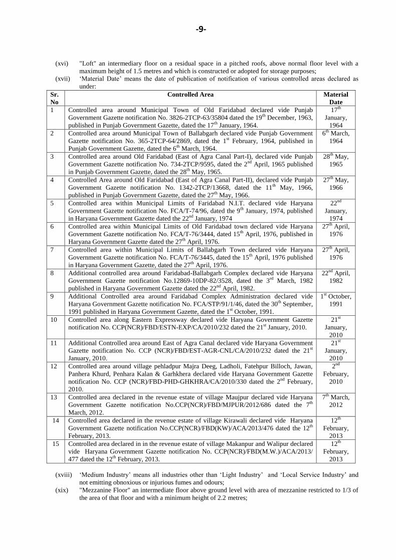
(xvii) „Material Date‟ means the date of publication of notification of various controlled areas declared as
under:
Sr.
No
Controlled Area Material
Date
1 Controlled area around Municipal Town of Old Faridabad declared vide Punjab
Government Gazette notification No. 3826-2TCP-63/35804 dated the 19th
December, 1963,
published in Punjab Government Gazette, dated the 17th
January, 1964.
17th
January,
1964
2 Controlled area around Municipal Town of Ballabgarh declared vide Punjab Government
Gazette notification No. 365-2TCP-64/2869, dated the 1st February, 1964, published in
Punjab Government Gazette, dated the 6th
March, 1964.
6th
March,
1964
3 Controlled area around Old Faridabad (East of Agra Canal Part-I), declared vide Punjab
Government Gazette notification No. 734-2TCP/9595, dated the 2nd
April, 1965 published
in Punjab Government Gazette, dated the 28th
May, 1965.
28th
May,
1965
4 Controlled Area around Old Faridabad (East of Agra Canal Part-II), declared vide Punjab
Government Gazette notification No. 1342-2TCP/13668, dated the 11th
May, 1966,
published in Punjab Government Gazette, dated the 27th
May, 1966.
27th
May,
1966
5 Controlled area within Municipal Limits of Faridabad N.I.T. declared vide Haryana
Government Gazette notification No. FCA/T-74/96, dated the 9th
January, 1974, published
in Haryana Government Gazette dated the 22nd
January, 1974
22nd
January,
1974
6 Controlled area within Municipal Limits of Old Faridabad town declared vide Haryana
Government Gazette notification No. FCA/T-76/3444, dated 15th
April, 1976, published in
Haryana Government Gazette dated the 27th
April, 1976.
27th
April,
1976
7 Controlled area within Municipal Limits of Ballabgarh Town declared vide Haryana
Government Gazette notification No. FCA/T-76/3445, dated the 15th
April, 1976 published
in Haryana Government Gazette, dated the 27th
April, 1976.
27th
April,
1976
8 Additional controlled area around Faridabad-Ballabgarh Complex declared vide Haryana
Government Gazette notification No.12869-10DP-82/3528, dated the 3rd
March, 1982
published in Haryana Government Gazette dated the 22nd
April, 1982.
22nd
April,
1982
9 Additional Controlled area around Faridabad Complex Administration declared vide
Haryana Government Gazette notification No. FCA/STP/91/1/46, dated the 30th
September,
1991 published in Haryana Government Gazette, dated the 1st October, 1991.
1st October,
1991
10 Controlled area along Eastern Expressway declared vide Haryana Government Gazette
notification No. CCP(NCR)/FBD/ESTN-EXP/CA/2010/232 dated the 21st January, 2010.
21st
January,
2010
11 Additional Controlled area around East of Agra Canal declared vide Haryana Government
Gazette notification No. CCP (NCR)/FBD/EST-AGR-CNL/CA/2010/232 dated the 21st
January, 2010.
21st
January,
2010
12 Controlled area around village pehladpur Majra Deeg, Ladholi, Fatehpur Billoch, Jawan,
Panhera Khurd, Penhara Kalan & Garhkhera declared vide Haryana Government Gazette
notification No. CCP (NCR)/FBD-PHD-GHKHRA/CA/2010/330 dated the 2nd
February,
2010.
2nd
February,
2010
13 Controlled area declared in the revenue estate of village Maujpur declared vide Haryana
Government Gazette notification No.CCP(NCR)/FBD/MJPUR/2012/686 dated the 7th
March, 2012.
7th
March,
2012
14 Controlled area declared in the revenue estate of village Kirawali declared vide Haryana
Government Gazette notification No.CCP(NCR)/FBD(KW)/ACA/2013/476 dated the 12th
February, 2013.
12th
February,
2013
15 Controlled area declared in in the revenue estate of village Makanpur and Walipur declared
vide Haryana Government Gazette notification No. CCP(NCR)/FBD(M.W.)/ACA/2013/
477 dated the 12th
February, 2013.
12th
February,
2013
(xviii) „Medium Industry‟ means all industries other than „Light Industry‟ and „Local Service Industry‟ and
not emitting obnoxious or injurious fumes and odours;
(xix) "Mezzanine Floor" an intermediate floor above ground level with area of mezzanine restricted to 1/3 of
the area of that floor and with a minimum height of 2.2 metres;
-10-
(xx) „Non-conforming use‟ in respect of any land or building in a controlled area means the existing or
proposed use of such land or building which is contrary to the major land use specified for that part of
the area in the development plan;
(xxi) „Obnoxious or hazardous Industry‟ means an industry set up with the permission of the Government and
is highly capital intensive associated with such features as excessive smoke, noise, vibration, stench,
unpleasant or injurious effluent, explosive inflammable material etc. and other hazards to the health and
safety of the community;
(xxii) „Public Utility Service Building‟ means any building required for running of public utility services such
as water-supply, drainage, electricity, telephone, post and telegraph and transport and for any municipal
services including a fire station;
(xxiii) „Rules‟ means the Punjab Scheduled Roads and Controlled Areas Restriction of Unregulated
Development Rules, 1965;
(xxiv) „Sector Area‟ and „Colony Area‟ means the area of the sector or of the colony as shown in the
Development Plan drawing and/or as shown in the approved layout plan of the sector/colony;
Explanation:-
(1) In this definition the „Sector Area‟ or „Colony Area‟ shall mean the area of the Sector or of
Colony as shown on the drawing or on the approved layout plan of the Colony/sector which
will be excluding the area unfit for building development within the sector or the colony as the
case may be;
(2) In the layout plan of colony or sector, other than industrial colony/sector, the land reserved for
roads, open space, schools, public and community building and other common uses shall not be
less than 45% of the gross area of the land under the colony/sector;
(xxv) „Sector Density‟ and „Colony Density‟ shall mean the number of persons per hectare in sector area
or colony area, as the case may be;
Explanation:
For the purpose of calculation of sector density or colony density, it shall be assumed that 55
percent of the sector area or colony area will be available for residential plots including the area
under Group Housing and that every building plot shall on the average contain three dwelling units
each with a population of 4.5 persons per dwelling unit or 13.5 persons building plot or as
incorporated in the Zoning Plan of the colony/group housing complex. In the case of shop-cum-
residential plot, however, only one dwelling unit shall be assumed.
(xxvi) „Site Coverage‟ means ratio expressed in percentage between the area covered by the ground floor
of building and the area of the site;
(xxvii) „Subservient to Agriculture‟ shall mean development and activities, which are required to assist in
carrying out the process of agriculture such as tubewells, pump chambers, wind mills, irrigation‟s
drains, pucca platforms, fencing and boundary walls not more than 4 feet high and maximum 3 feet
high fencing, water hydrants etc.;
(xxviii) The terms “Act”, “Colony”, “Coloniser”, “Development Plan”, “Sector” and “Sector Plan” shall
have the same meaning as assigned to them in the Punjab Scheduled Roads and Controlled Areas
Restriction of Unregulated Development Act, 1963 (41 of 1963) and Rules, 1965;
(xxix) „Town Density‟ means number of persons per hectare in the town.
(xxx) „Urbanizable Limit‟ means the limit covering the urbanisable area proposed for development by
defining the land uses of sector and which includes the periphery roads and the green belts;
(xxxi) Any other terms shall have the same meaning as assigned to it in the Punjab Scheduled Roads and
Controlled Areas Restriction of Unregulated Development Act, 1963 (Punjab Act 41 of 1963) and
Rules 1965.
III. Major Land Uses/Zone
(i) Residential Zone
(ii) Commercial Zone
(iii) Industrial Zone
(iv) Transport and Communication Zone
(v) Public Utility Zone
(vi) Public and Semi Public Zone
(vii) Parks and Open Spaces Zone
(viii) Special Zone
(ix) Mix Land Use Zone
(x) Agriculture Zone
(xi) Natural Conservation Zone.
(1)
-11-
(2) Classification of major land uses is according to Appendix A.
IV. Division into Sectors
Major land uses mentioned at serial Nos.(i) to (ix) in zoning regulation-III above, which are land uses for
building purposes, have been divided into sectors as shown on the concerned development plan drawing and each
sector shall be designated by the number as indicated on the drawing.
V. Detailed land uses within major uses
Main, ancillary and allied uses, which are subject to the other requirements of these regulations and of the
rules may be permitted in the respective major land use zones are listed in Appendix B sub-joined to these zoning
regulations.
VI. Sectors not ripe for development
Notwithstanding the reservation of various sectors for respective land uses for building purposes, the
Director may not permit any changes in their land use or allow construction of building thereon from consideration of
compact and economical development of the controlled area till such time as availability of water supply, drainage
arrangement and other facilities for these sectors are ensured to his satisfaction.
VII Sectors to be developed exclusively through Government Enterprises
(1) For the development of sectors/belts reserved for commercial use, private developers shall be permitted
to develop to the extent of 30% of the commercial sector area / belt as per the layout plan approved by competent
authority, after obtaining license under Act No. 8 of 1975. Balance 70% area shall be developed exclusively by the
Government or a Government undertaking or by a public authority approved by the Government.
However, it shall be open to government or its agencies to acquire more than 70% of the area at any time
excluding the area for which license applications had been received till then.
(2) Residential sector nos. 94-A, 96, 97, 99, 101, 102, 103, 140, 141 and 142, commercial sector Nos. 100
and 117-A and public and semi-public sector Nos. 96-A and 97-A, shall be developed exclusively by HUDA.
(3) Notwithstanding the provision of clause (1) and (2) above, the government may reserve at any time, any
other sector for development exclusively by Government or a Government undertaking or by a public authority
approved by the Government.
VIII. Land Reservations for Major Roads: -
(1) Land reservation for major roads marked in the drawing shall be as under:-
Sr.
No.
Classification of the
roads
Land reservation
I V-1 90 metre wide road with 30 metre green belt on both sides.
II V-1 (A) 75 metre wide road with 30 metre green belt on both sides.
III V-1 (B) 60 metre wide road with 30 metre wide green belt on both sides.
IV V-2 60 Metres wide road along with 12 metre wide service road on both sides.
V V-2 (A) 45 metre wide road along with 12 metre wide service road on both sides.
VI V-3 30 metre wide road
VII V-6 Existing Faridabad-Dankaur road widened to 30 metre along with 30 metre wide
green belt on both sides up to urbanizable limit.
VIII V-6 (A) Existing Faridabad-Dankaur road from urbanizable limit to U.P. Border along
with 30 metre wide green belt on both sides.
IX V-6 (B) Existing Faridabad-Gurgaon scheduled road widened to 90 metre with 30 metre
wide green belt on both sides.
X V-6 (C) Existing Surajkund-National Shooting Range road with existing width with 30
metre wide green belt on both sides.
XI Eastern Peripheral
Expressway
100 metre wide Eastern Peripheral Expressway alongwith 100 metre wide green
belt on both sides.
(2) Width and alignment of other roads shall be as per sector plans or as per approved layout plans of
colonies.
(3) Benefit of only 50% of the area falling under major roads and adjoining green belts, if any, shall be
allowed towards plotable area/FAR in the plotted/group housing colony while approving the layout
plans for the sector/colony to be developed by Haryana Urban Development Authority and private
colonizers. However, in respect of roads falling within the net planned area indicated in the sectoral
-12-
plan, full FAR shall be allowed. In case of commercial colony and IT Park/Cyber City, the benefit of
10% of FAR of the total area of the site or area falling under green belt and sector roads whichever is
less shall be allowed.
IX. Facilities for Non-Motorized Traffic & Pedestrians:
While developing the Sectors and carrying out Development works, conscious efforts will be made to
facilitate increasing use of non-motorized traffic and efforts will be made to create adequate spaces for pedestrians‟
movement also. The Comprehensive Mobility Plan for Faridabad Ballabgarh Complex already stands prepared and its
recommendations shall be vigorously implemented by the development agencies like; HUDA, HSIIDC, Municipal
Corporation, Faridabad and PWD(B&R).
X. Non confirming use either existing or having valid CLU permission:-
(1) With regard to the existing projects located in the zones other than conforming-use zone in the Development
Plan, such non-conforming uses shall be allowed to continue for a fixed period to be determined by the Director,
but not exceeding ten years from the date of publication of the Development Plan; provided that the owner of the
building concerned:
(a) undertakes to pay to the Director, as determined by him the proportionate charges towards the external
development of the site as and when called upon by the Director to do so in this behalf;
(b) during the interim period makes satisfactory arrangements for the discharge of effluent to the satisfaction
of the Director; and
(c) shall not be allowed to expand the existing project within the area of non conforming use.
(2) With regard to the projects having valid Change of Land Use permissions, and located in the zones other than
conforming-use zone in the Development Plan, such non-conforming uses shall be allowed to continue, provided
that the owner of the building concerned:
(a) undertakes to pay to the Director, as determined by him the proportionate charges towards the external
development of the site as and when called upon by the Director to do so in this behalf; and,
(b) during the interim period makes satisfactory arrangements for the discharge of effluent to the satisfaction
of the Director.
XI. Discontinuance of non conforming uses.
(1) If a non-conforming use of land has remained discontinued continuously for a period of two years or more,
it shall be deemed to have been terminated and the land shall be allowed to be re-used or re-developed only
according to the conforming use.
(2) If a non-conforming use building is damaged to the extent of 50 percent or more of its re-production value
by fire, flood, explosion, earthquake, war, riot or any other natural calamity, it shall be allowed to be re-
developed only for a conforming use.
(3) After the discontinuance of projects included under clause X, the land shall be allowed to be redeveloped or
used only for conforming use.
(4) After a lapse of period fixed under clause X(1), the land shall be allowed to be redeveloped or used only for
conforming use.
XII. Brick Kilns in Controlled Areas
Siting of the brick kilns in the controlled areas shall be governed by the respective policy/guidelines issued
by the competent authority from time to time.
XIII. The development to conform to sector plan and zoning plan.
Except as provided in regulation X, no land within major land use shall be allowed to be used and developed
for building purposes unless the proposed use and development is according to the details indicated in the sector plan
and zoning plan or the approved colony plan in which the land is situated.
XIV. Individual site to form part of approved layout or zoning plan.
No permission for erection or re-erection of building on a plot shall be given unless-
(i) the plot forms a part of an approved colony or the plot is in such area for which relaxation has been granted
as provided in regulation XIX; and
(ii) the plot is accessible through roads laid out and constructed upto the situation of the plot to the satisfaction
of the Director.
-13-
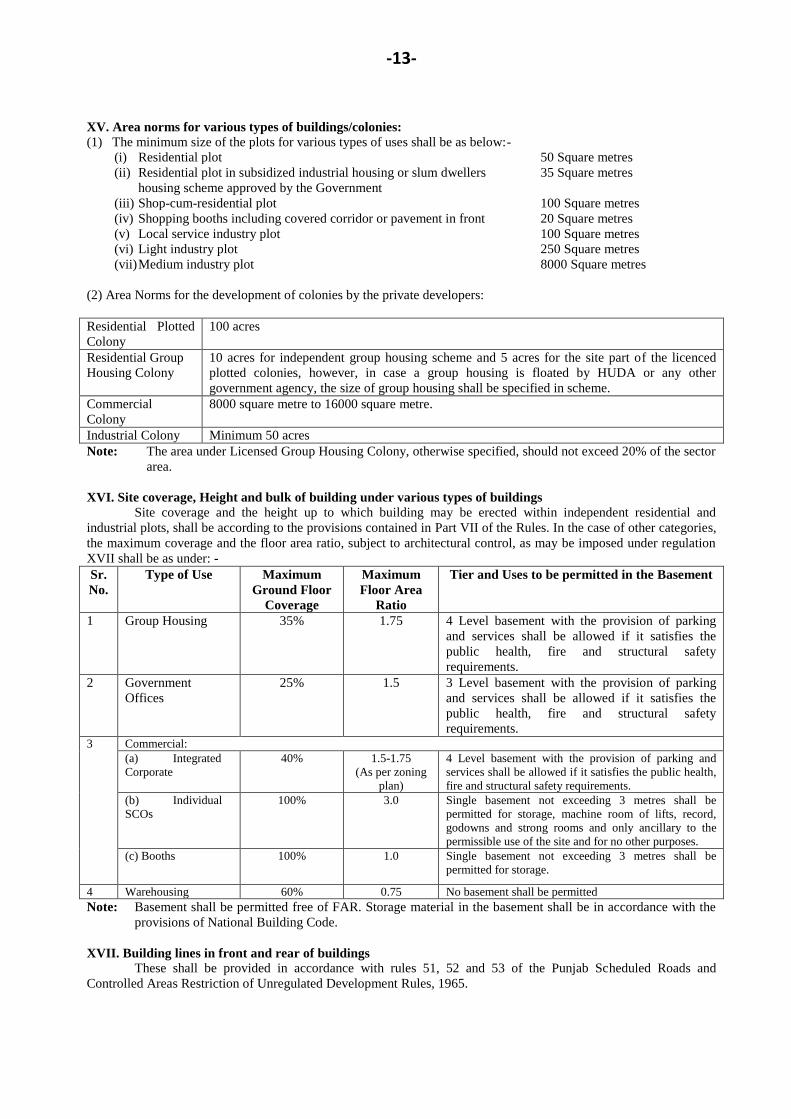
XV. Area norms for various types of buildings/colonies:
(1) The minimum size of the plots for various types of uses shall be as below:-
(i) Residential plot 50 Square metres
(ii) Residential plot in subsidized industrial housing or slum dwellers
housing scheme approved by the Government
35 Square metres
(iii) Shop-cum-residential plot 100 Square metres
(iv) Shopping booths including covered corridor or pavement in front 20 Square metres
(v) Local service industry plot 100 Square metres
(vi) Light industry plot 250 Square metres
(vii) Medium industry plot 8000 Square metres
(2) Area Norms for the development of colonies by the private developers:
Residential Plotted
Colony
100 acres
Residential Group
Housing Colony
10 acres for independent group housing scheme and 5 acres for the site part of the licenced
plotted colonies, however, in case a group housing is floated by HUDA or any other
government agency, the size of group housing shall be specified in scheme.
Commercial
Colony
8000 square metre to 16000 square metre.
Industrial Colony Minimum 50 acres
Note: The area under Licensed Group Housing Colony, otherwise specified, should not exceed 20% of the sector
area.
XVI. Site coverage, Height and bulk of building under various types of buildings
Site coverage and the height up to which building may be erected within independent residential and
industrial plots, shall be according to the provisions contained in Part VII of the Rules. In the case of other categories,
the maximum coverage and the floor area ratio, subject to architectural control, as may be imposed under regulation
XVII shall be as under: -
Sr.
No.
Type of Use Maximum
Ground Floor
Coverage
Maximum
Floor Area
Ratio
Tier and Uses to be permitted in the Basement
1 Group Housing 35% 1.75 4 Level basement with the provision of parking
and services shall be allowed if it satisfies the
public health, fire and structural safety
requirements.
2 Government
Offices
25% 1.5 3 Level basement with the provision of parking
and services shall be allowed if it satisfies the
public health, fire and structural safety
requirements. 3 Commercial:
(a) Integrated
Corporate
40% 1.5-1.75
(As per zoning
plan)
4 Level basement with the provision of parking and
services shall be allowed if it satisfies the public health,
fire and structural safety requirements.
(b) Individual
SCOs
100% 3.0 Single basement not exceeding 3 metres shall be
permitted for storage, machine room of lifts, record,
godowns and strong rooms and only ancillary to the
permissible use of the site and for no other purposes.
(c) Booths 100% 1.0 Single basement not exceeding 3 metres shall be
permitted for storage.
4 Warehousing 60% 0.75 No basement shall be permitted
Note: Basement shall be permitted free of FAR. Storage material in the basement shall be in accordance with the
provisions of National Building Code.
XVII. Building lines in front and rear of buildings
These shall be provided in accordance with rules 51, 52 and 53 of the Punjab Scheduled Roads and
Controlled Areas Restriction of Unregulated Development Rules, 1965.
-14-
XVIII. Architectural control
Every building shall conform to architectural control prepared under rule 50 of the Punjab Scheduled Roads
and Controlled Areas Restriction of Unregulated Development Rules, 1965.
XIX Relaxation of agricultural zone.- In the case of any land lying in Agriculture zone, Government may relax the provisions of this development
plan-
(a) For use and development of the land into a residential or industrial colony provided the coloniser has
purchased the land for the said use and developed prior to the material date and the coloniser secures
permission for this purpose as per Rules.
Explanation: The word 'purchase' in the regulation shall mean acquisition of full proprietary rights and
no lesser title, such as agreement to purchase etc.
(b) The site should not fall within restricted belt notified under „the Works of Defence Act, 1903‟ around
Defence installations, if any.
XX. Density: -
Every residential sector shall be developed to the sector density indicated as prescribed for it in the drawing
subject to a maximum of 20 percent variation allowed on either side of the prescribed sector density.
XXI. Provisions of Information Technology Units and Cyber Parks/Cyber Cities
(i) Location
(a) Information Technology Industrial Units will be located in Industrial Areas/Industrial
Zones only;
(b) Cyber Parks/ Information Technology Parks will be located either in Industrial Areas or
Industrial Zones abutting on sector roads in the form of integrated development. However,
no manufacturing units will be permitted in such parks;
(c) Cyber Cities:- The location of such a facility will be decided by the Government;
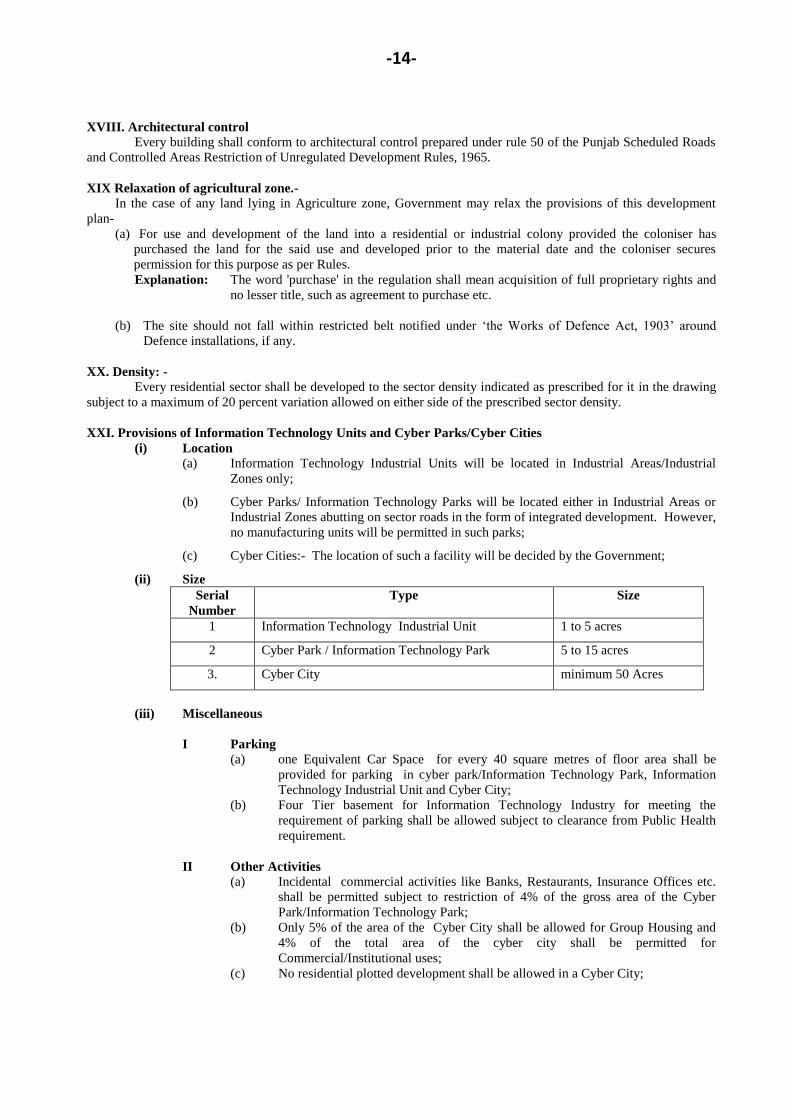
(ii) Size
Serial
Number
Type Size
1 Information Technology Industrial Unit 1 to 5 acres
2 Cyber Park / Information Technology Park 5 to 15 acres
3. Cyber City minimum 50 Acres
(iii) Miscellaneous
I Parking
(a) one Equivalent Car Space for every 40 square metres of floor area shall be
provided for parking in cyber park/Information Technology Park, Information
Technology Industrial Unit and Cyber City;
(b) Four Tier basement for Information Technology Industry for meeting the
requirement of parking shall be allowed subject to clearance from Public Health
requirement.
II Other Activities
(a) Incidental commercial activities like Banks, Restaurants, Insurance Offices etc.
shall be permitted subject to restriction of 4% of the gross area of the Cyber
Park/Information Technology Park;
(b) Only 5% of the area of the Cyber City shall be allowed for Group Housing and
4% of the total area of the cyber city shall be permitted for
Commercial/Institutional uses;
(c) No residential plotted development shall be allowed in a Cyber City;
-15-
(d) For a Cyber City Project if allowed in Agricultural Zone, the entrepreneur shall
make the arrangement of water supply and other facilities like sewerage
disposal/drainage etc;
III The Government may impose any other condition as deemed necessary from time to time.
XXII- Setting up of communication towers:
Permission of Mobile Towers within the Controlled area shall be granted as per the policy dated 13th
January, 2012 as amended from time to time;
XXIII Affordable Group Housing:
The permission for affordable group housing projects within the Residential Zones of the Development Plans
shall be granted as per the policy dated 19th
August, 2013 as amended from time to time;
XXIV. Safety against Seismic Hazards:
All the developments/building activities in the Development Plan area shall be carried out keeping in view
the intensity of the seismic activity in development plan area, as per Seismic zone map of Indian Standard IS 1893. In
order to take care of the same the whole urban development shall be checked for safety against said intensity
probability of occurrence, and upgraded for required seismic resistance in buildings and infrastructure as found
necessary.
XXV. Provision of Zero Discharge System in the Sectors/colonies:
Endeavour shall be made to develop all the sectors/colonies on zero discharge concept to encourage the use
of recycled water.
XXVI. Relaxation of development plan
Government may in case of hardship or with a view to save any structure constructed before the material
date, relax any of the provisions of the Development Plan on principles of equity and justice on payment of such
development charges and on such other conditions as it may deem fit to impose.
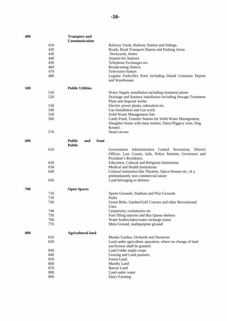
APPENDIX A
CLASSIFICATION OF LAND USES
Main
code
Sub code Main group Sub group
100 Residential Residential Sector on neighborhood pattern
200 Commercial
210 Retail Trade
220 Wholesale Trade
230 Warehousing and Storage
240 Office and Banks including Government Office
250 Restaurants, Hotels and Transient Boarding Houses including
public assistance institutions providing residential
accommodation like Dharamshala, Tourist House etc.
260 Cinema and other places of public assembly on a commercial
basis.
270 Professional Establishments
300 Industrial
310 Service Industry
320 Light Industry
330 Extensive Industry
340 Heavy Industry.
-16-
400 Transport and
Communication
410 Railway Yards, Railway Station and Sidings.
420 Roads, Road Transport Depots and Parking Areas
430 Dockyards, Jetties
440 Airport/Air Stations
450 Telephone Exchanges etc.
460 Broadcasting Station
470 Television Station
480 Logistic Parks/Dry Ports including Inland Container Depots
and Warehouses
500 Public Utilities
510 Water Supply installation including treatment plants
520 Drainage and Sanitary installation including Sewage Treatment
Plant and disposal works
530 Electric power plants, substation etc.
540 Gas Installation and Gas work.
550
560
570
Solid Waste Management Site
Cattle Pond, Transfer Station for Solid Waste Management,
Slaughter house with meat market, Dairy/Piggery zone, Dog
Kennel.
Dead carcass
600 Public and Semi
Public
610 Government Administrative Central Secretariat, District
Offices, Law Courts, Jails, Police Stations, Governors and
President‟s Residence.
620 Education, Cultural and Religious Institutions
630 Medical and Health Institutions
640 Cultural institution like Theatres, Opera Houses etc. of a
predominantly non commercial nature
650 Land belonging to defence
700 Open Spaces
710 Sports Grounds, Stadium and Play Grounds
720 Parks
730 Green Belts, Garden/Golf Courses and other Recreational
Uses.
740 Cemetreies, crematories etc
750
760
Fuel filling stations and Bus Queue shelters
Water bodies/lakes/water recharge zones
770 Mela Ground, multipurpose ground
800 Agricultural land
810 Market Garden, Orchards and Nurseries
820 Land under agriculture operation, where no change of land
use/license shall be granted.
830 Land Under staple crops
840 Grazing and Land pastures
850 Forest Land.
860 Marshy Land
870 Barren Land
880 Land under water
890 Dairy Farming
-17-
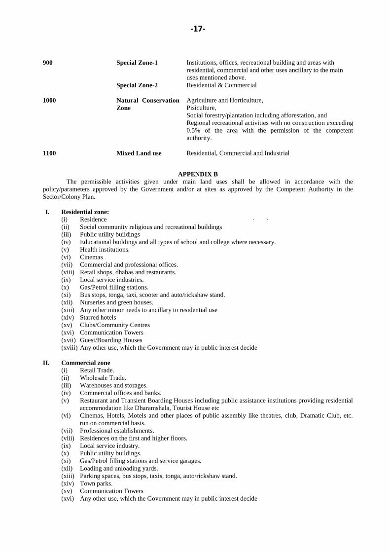
900 Special Zone-1
Special Zone-2
Institutions, offices, recreational building and areas with
residential, commercial and other uses ancillary to the main
uses mentioned above.
Residential & Commercial
1000 Natural Conservation
Zone
Agriculture and Horticulture,
Pisiculture,
Social forestry/plantation including afforestation, and
Regional recreational activities with no construction exceeding
0.5% of the area with the permission of the competent
authority.
1100 Mixed Land use
Residential, Commercial and Industrial
APPENDIX B
The permissible activities given under main land uses shall be allowed in accordance with the
policy/parameters approved by the Government and/or at sites as approved by the Competent Authority in the
Sector/Colony Plan.
I. Residential zone:
(i) Residence
(ii) Social community religious and recreational buildings
(iii) Public utility buildings
(iv) Educational buildings and all types of school and college where necessary.
(v) Health institutions.
(vi) Cinemas
(vii) Commercial and professional offices.
(viii) Retail shops, dhabas and restaurants.
(ix) Local service industries.
(x) Gas/Petrol filling stations.
(xi) Bus stops, tonga, taxi, scooter and auto/rickshaw stand.
(xii) Nurseries and green houses.
(xiii) Any other minor needs to ancillary to residential use
(xiv) Starred hotels
(xv) Clubs/Community Centres
(xvi) Communication Towers
(xvii) Guest/Boarding Houses
(xviii) Any other use, which the Government may in public interest decide
II. Commercial zone
(i) Retail Trade.
(ii) Wholesale Trade.
(iii) Warehouses and storages.
(iv) Commercial offices and banks.
(v) Restaurant and Transient Boarding Houses including public assistance institutions providing residential
accommodation like Dharamshala, Tourist House etc
(vi) Cinemas, Hotels, Motels and other places of public assembly like theatres, club, Dramatic Club, etc.
run on commercial basis.
(vii) Professional establishments.
(viii) Residences on the first and higher floors.
(ix) Local service industry.
(x) Public utility buildings.
(xi) Gas/Petrol filling stations and service garages.
(xii) Loading and unloading yards.
(xiii) Parking spaces, bus stops, taxis, tonga, auto/rickshaw stand.
(xiv) Town parks.
(xv) Communication Towers
(xvi) Any other use, which the Government may in public interest decide
-18-
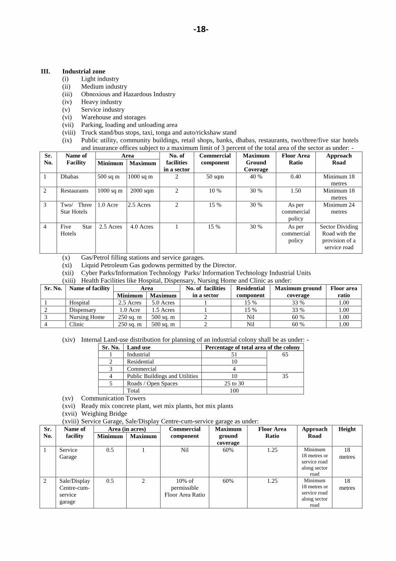
III. Industrial zone
(i) Light industry
(ii) Medium industry
(iii) Obnoxious and Hazardous Industry
(iv) Heavy industry
(v) Service industry
(vi) Warehouse and storages
(vii) Parking, loading and unloading area
(viii) Truck stand/bus stops, taxi, tonga and auto/rickshaw stand
(ix) Public utility, community buildings, retail shops, banks, dhabas, restaurants, two/three/five star hotels
and insurance offices subject to a maximum limit of 3 percent of the total area of the sector as under: -
Sr.
No.
Name of
Facility
Area No. of
facilities
in a sector
Commercial
component
Maximum
Ground
Coverage
Floor Area
Ratio
Approach
Road Minimum Maximum
1 Dhabas 500 sq m 1000 sq m 2 50 sqm 40 % 0.40 Minimum 18
metres
2 Restaurants 1000 sq m 2000 sqm 2 10 % 30 % 1.50 Minimum 18
metres
3 Two/ Three
Star Hotels
1.0 Acre 2.5 Acres 2 15 % 30 % As per
commercial
policy
Minimum 24
metres
4 Five Star
Hotels
2.5 Acres 4.0 Acres 1 15 % 30 % As per
commercial
policy
Sector Dividing
Road with the
provision of a
service road
(x) Gas/Petrol filling stations and service garages.
(xi) Liquid Petroleum Gas godowns permitted by the Director.
(xii) Cyber Parks/Information Technology Parks/ Information Technology Industrial Units
(xiii) Health Facilities like Hospital, Dispensary, Nursing Home and Clinic as under:
Sr. No. Name of facility Area No. of facilities
in a sector
Residential
component
Maximum ground
coverage
Floor area
ratio Minimum Maximum
1 Hospital 2.5 Acres 5.0 Acres 1 15 % 33 % 1.00
2 Dispensary 1.0 Acre 1.5 Acres 1 15 % 33 % 1.00
3 Nursing Home 250 sq. m 500 sq. m 2 Nil 60 % 1.00
4 Clinic 250 sq. m 500 sq. m 2 Nil 60 % 1.00
(xiv) Internal Land-use distribution for planning of an industrial colony shall be as under: -
Sr. No. Land use Percentage of total area of the colony
1 Industrial 51 65
2 Residential 10
3 Commercial 4
4 Public Buildings and Utilities 10 35
5 Roads / Open Spaces 25 to 30
Total 100
(xv) Communication Towers
(xvi) Ready mix concrete plant, wet mix plants, hot mix plants
(xvii) Weighing Bridge
(xviii) Service Garage, Sale/Display Centre-cum-service garage as under:
Sr.
No.
Name of
facility
Area (in acres) Commercial
component
Maximum
ground
coverage
Floor Area
Ratio
Approach
Road
Height
Minimum Maximum
1 Service
Garage
0.5 1 Nil 60% 1.25 Minimum 18 metres or
service road
along sector road
18
metres
2 Sale/Display
Centre-cum-
service
garage
0.5 2 10% of
permissible
Floor Area Ratio
60% 1.25 Minimum
18 metres or
service road along sector
road
18
metres
-19-
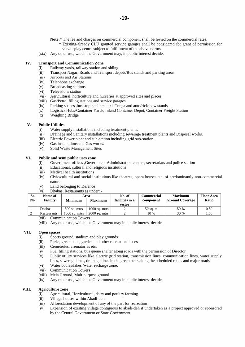
Note:* The fee and charges on commercial component shall be levied on the commercial rates;
* Existing/already CLU granted service garages shall be considered for grant of permission for
sale/display centre subject to fulfillment of the above norms.
(xix) Any other use, which the Government may, in public interest decide.
IV. Transport and Communication Zone
(i) Railway yards, railway station and siding
(ii) Transport Nagar, Roads and Transport depots/Bus stands and parking areas
(iii) Airports and Air Stations
(iv) Telephone exchange
(v) Broadcasting stations
(vi) Televisions station
(vii) Agricultural, horticulture and nurseries at approved sites and places
(viii) Gas/Petrol filling stations and service garages
(ix) Parking spaces ,bus stop-shelters, taxi, Tonga and auto/rickshaw stands
(x) Logistics Hubs/Container Yards, Inland Container Depot, Container Freight Station
(xi) Weighing Bridge
V. Public Utilities
(i) Water supply installations including treatment plants.
(ii) Drainage and Sanitary installations including sewerage treatment plants and Disposal works.
(iii) Electric Power plant and sub-station including grid sub-station.
(iv) Gas installations and Gas works.
(v) Solid Waste Management Sites
VI. Public and semi public uses zone
(i) Government offices ,Government Administration centers, secretariats and police station
(ii) Educational, cultural and religious institutions
(iii) Medical health institutions
(iv) Civic/cultural and social institutions like theatres, opera houses etc. of predominantly non-commercial
nature
(v) Land belonging to Defence
(vi) Dhabas, Restaurants as under: -
Sr.
No.
Name of
Facility
Area No. of
facilities in a
sector
Commercial
component
Maximum
Ground Coverage
Floor Area
Ratio Minimum Maximum
1 Dhabas 500 sq. mtrs 1000 sq. mtrs 2 50 sq. m 50 % 0.50
2 Restaurants 1000 sq. mtrs 2000 sq. mtrs 2 10 % 30 % 1.50
(vii) Communication Towers
(viii) Any other use, which the Government may in public interest decide
VII. Open spaces
(i) Sports ground, stadium and play grounds
(ii) Parks, green belts, garden and other recreational uses
(iii) Cemeteries, crematories etc.
(iv) Fuel filling stations, bus queue shelter along roads with the permission of Director
(v) Public utility services like electric grid station, transmission lines, communication lines, water supply
lines, sewerage lines, drainage lines in the green belts along the scheduled roads and major roads.
(vi) Water bodies/lakes /water recharge zone.
(vii) Communication Towers
(viii) Mela Ground, Multipurpose ground
(ix) Any other use, which the Government may in public interest decide.
VIII. Agriculture zone
(i) Agricultural, Horticultural, dairy and poultry farming.
(ii) Village houses within Abadi-deh
(iii) Afforestation development of any of the part for recreation
(iv) Expansion of existing village contiguous to abadi-deh if undertaken as a project approved or sponsored
by the Central Government or State Government.
-20-
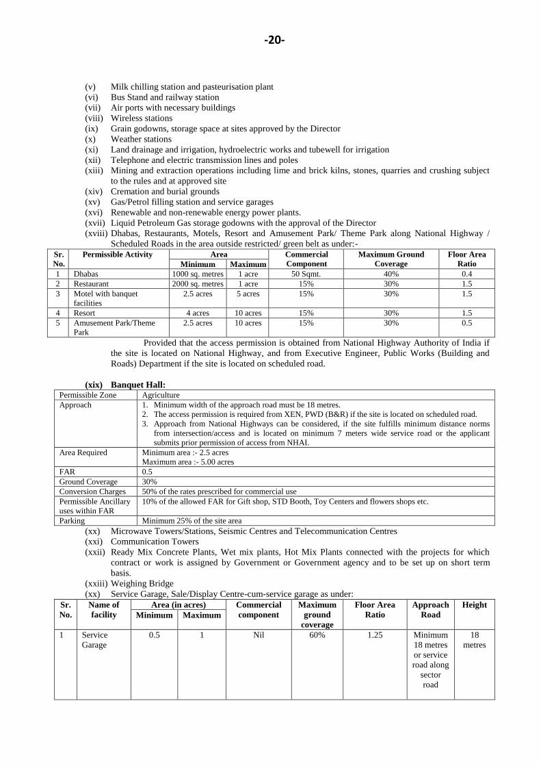
(v) Milk chilling station and pasteurisation plant
(vi) Bus Stand and railway station
(vii) Air ports with necessary buildings
(viii) Wireless stations
(ix) Grain godowns, storage space at sites approved by the Director
(x) Weather stations
(xi) Land drainage and irrigation, hydroelectric works and tubewell for irrigation
(xii) Telephone and electric transmission lines and poles
(xiii) Mining and extraction operations including lime and brick kilns, stones, quarries and crushing subject
to the rules and at approved site
(xiv) Cremation and burial grounds
(xv) Gas/Petrol filling station and service garages
(xvi) Renewable and non-renewable energy power plants.
(xvii) Liquid Petroleum Gas storage godowns with the approval of the Director
(xviii) Dhabas, Restaurants, Motels, Resort and Amusement Park/ Theme Park along National Highway /
Scheduled Roads in the area outside restricted/ green belt as under:-
Sr.
No.
Permissible Activity Area Commercial
Component
Maximum Ground
Coverage
Floor Area
Ratio Minimum Maximum
1 Dhabas 1000 sq. metres 1 acre 50 Sqmt. 40% 0.4
2 Restaurant 2000 sq. metres 1 acre 15% 30% 1.5
3 Motel with banquet
facilities
2.5 acres 5 acres 15% 30% 1.5
4 Resort 4 acres 10 acres 15% 30% 1.5
5 Amusement Park/Theme
Park
2.5 acres 10 acres 15% 30% 0.5
Provided that the access permission is obtained from National Highway Authority of India if
the site is located on National Highway, and from Executive Engineer, Public Works (Building and
Roads) Department if the site is located on scheduled road.
(xix) Banquet Hall: Permissible Zone Agriculture
Approach 1. Minimum width of the approach road must be 18 metres.
2. The access permission is required from XEN, PWD (B&R) if the site is located on scheduled road.
3. Approach from National Highways can be considered, if the site fulfills minimum distance norms
from intersection/access and is located on minimum 7 meters wide service road or the applicant
submits prior permission of access from NHAI.
Area Required Minimum area :- 2.5 acres
Maximum area :- 5.00 acres
FAR 0.5
Ground Coverage 30%
Conversion Charges 50% of the rates prescribed for commercial use
Permissible Ancillary
uses within FAR
10% of the allowed FAR for Gift shop, STD Booth, Toy Centers and flowers shops etc.
Parking Minimum 25% of the site area
(xx) Microwave Towers/Stations, Seismic Centres and Telecommunication Centres
(xxi) Communication Towers
(xxii) Ready Mix Concrete Plants, Wet mix plants, Hot Mix Plants connected with the projects for which
contract or work is assigned by Government or Government agency and to be set up on short term
basis.
(xxiii) Weighing Bridge
(xx) Service Garage, Sale/Display Centre-cum-service garage as under:
Sr.
No.
Name of
facility
Area (in acres) Commercial
component
Maximum
ground
coverage
Floor Area
Ratio
Approach
Road
Height
Minimum Maximum
1 Service
Garage
0.5 1 Nil 60% 1.25 Minimum
18 metres
or service
road along
sector
road
18
metres
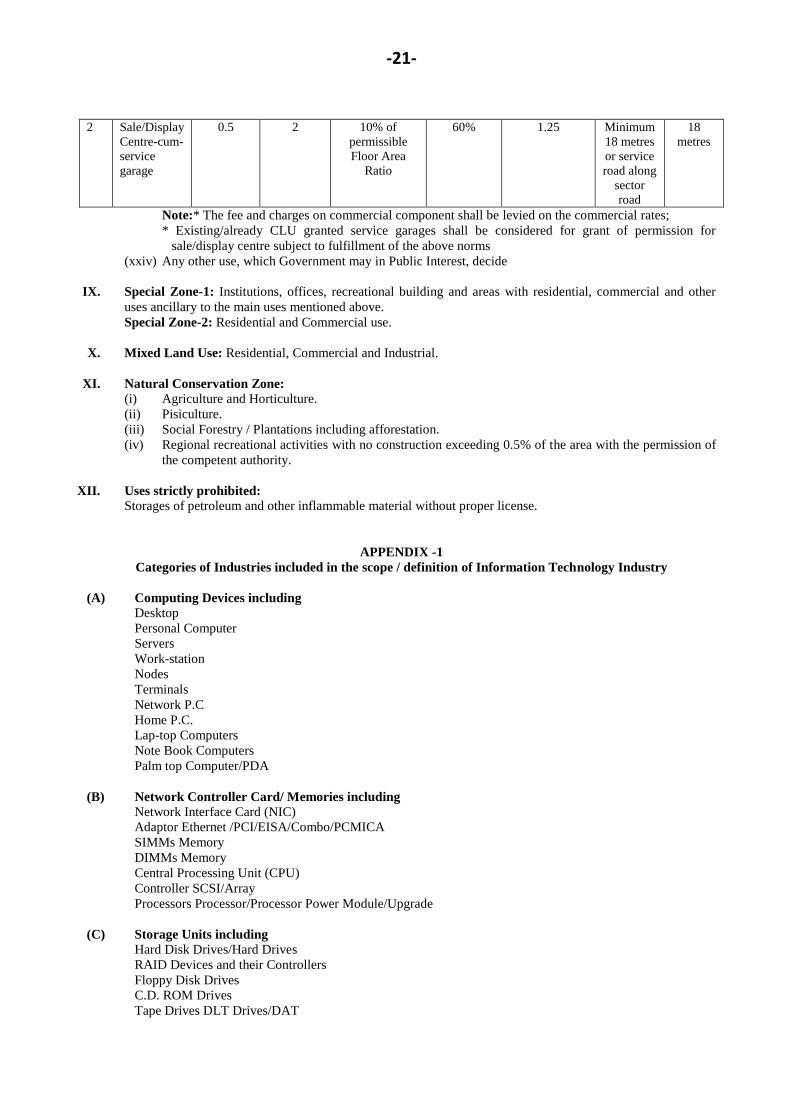
-21-
2 Sale/Display
Centre-cum-
service
garage
0.5 2 10% of
permissible
Floor Area
Ratio
60% 1.25 Minimum
18 metres
or service
road along
sector
road
18
metres
Note:* The fee and charges on commercial component shall be levied on the commercial rates;
* Existing/already CLU granted service garages shall be considered for grant of permission for
sale/display centre subject to fulfillment of the above norms
(xxiv) Any other use, which Government may in Public Interest, decide
IX. Special Zone-1: Institutions, offices, recreational building and areas with residential, commercial and other
uses ancillary to the main uses mentioned above.
Special Zone-2: Residential and Commercial use.
X. Mixed Land Use: Residential, Commercial and Industrial.
XI. Natural Conservation Zone:
(i) Agriculture and Horticulture.
(ii) Pisiculture.
(iii) Social Forestry / Plantations including afforestation.
(iv) Regional recreational activities with no construction exceeding 0.5% of the area with the permission of
the competent authority.
XII. Uses strictly prohibited:
Storages of petroleum and other inflammable material without proper license.
APPENDIX -1
Categories of Industries included in the scope / definition of Information Technology Industry
(A) Computing Devices including
Desktop
Personal Computer
Servers
Work-station
Nodes
Terminals
Network P.C
Home P.C.
Lap-top Computers
Note Book Computers
Palm top Computer/PDA
(B) Network Controller Card/ Memories including
Network Interface Card (NIC)
Adaptor Ethernet /PCI/EISA/Combo/PCMICA
SIMMs Memory
DIMMs Memory
Central Processing Unit (CPU)
Controller SCSI/Array
Processors Processor/Processor Power Module/Upgrade
(C) Storage Units including
Hard Disk Drives/Hard Drives
RAID Devices and their Controllers
Floppy Disk Drives
C.D. ROM Drives
Tape Drives DLT Drives/DAT
-22-
Optical Disk Drives
Other Digital Storage Devices
(D) Other
Key Board
Monitor
Mouse
Multi-media Kits
(E) Printers and Output Devices including
Dot matrix
Laserjet
Inkjet
Deskjet
LED Printers
Line Printers
Plotters
Pass-book Printers
(F) Networking products including
Hubs
Routers
Switches
Concentrators
Trans-receivers
(G) Software including
Application Software
Operating system
Middleware/Firmware
(H) Power supplies to Computer Systems including
Switch Mode Power Supplies
Uninterrupted Power supplies
(I) Networking/Cabling and related accessories
(related to IT Industry)
Fibre Cable
Copper Cable
Cables
Connectors, Terminal Blocks
Jack Panels, Patch Cord
Mounting Cord/Wiring Blocks
Surface Mount Boxes
(J) Consumables including
C.D.ROM /Compact Disk
Floppy Disk
Tapes DAT/DLT
Ribbons
Toners
Inkjet Cartridges
Inks for Output devices
(K) Electronic Components
Printed Circuit Board/Populated PCB
Printed Circuit Board/PCB
Transistors
Integrated Circuits/ICs
-23-
Diodes/Thyristor/LED
Resistors
Capacitors
Switches(On/Off, Push button, Rocker, etc.)
Plugs/sockets/relays
Magnetic heads, Print heads
Connectors
Microphones/Speakers
Fuses
(L) Telecommunication Equipment including:
Telephones
Videophones
Fascimile machines/Fax cards
Tele-Printers/Telex machine
PABX/EPABX/ RAX/MAX Telephone Exchange
Multiplexers/Muxes
Modems
Telephone answering machines
Telecommunication Switching Apparatus
Anetna and Mast
Wireless datacom equipment
Receiving equipments like Pagers, mobile/Cellular Phones, etc.
VSATs
Video Conferencing Equipments
* Including Set Top Boxes for both Video and Digital Signaling.
(M) IT Enabled Services are business processes and services, the end products/services of which are:-
Delivered outside India.
Delivered over communication network., and
Either externally contracted (out-sourced) or provided by a remote subsidiary of
the same company (out-located).
Note: Services which would not be included are:-
1. Remote production/manufacturing units
2. The Corporate offices of companies or their local branches
3. Virtual business on Internet.
The following services which meet the above criteria would be included:-
(i) Back-Office Operations
(ii) Call Centres
(iii) Content Development or Animation
(iv) Data Processing
(v) Engineering and Design
(vi) Geographic Information System Services
(vii) Human Resource Services
(viii) Insurance Claim Processing
(ix) Legal Database
(x) Medical Transcription
(xi) Payroll
(xii) Remote Maintenance
(xiii) Revenue Accounting
(xiv) Supports Centres and
(xv) Web-site Services.
(T. C. GUPTA),
Principal Secretary to Government, Haryana,
Town and Country Planning Department.