1. site description and previous investigations
TRANSCRIPT

TABLE OF CONTENTS – CHAPTER 1
1. SITE DESCRIPTION AND PREVIOUS INVESTIGATIONS Stanley A. Ahler...........................
Site Setting and Description ................................................................................................................
Nearby Recorded Sites and Discoveries..............................................................................................
Previous Investigations and Impacts at Scattered Village.................................................................
Traditional Mandan and Hidatsa Information ...................................................................................
1

1. SITE DESCRIPTION AND PREVIOUS INVESTIGATIONS
Stanley A. Ahler
Site Setting and Description
The Scattered Village archaeological site is a large prehistoric settlement occupied for a long period of time by ancestors of historic Mandan and/or Hidatsa peoples. The village lies on the north side of the Heart River, directly where the Heart River valley joins the trench of the Missouri River in western Morton County, North Dakota (Figure 1.1). Despite (and because of) its location within and beneath the present city of Mandan, Scattered Village has never been accurately identified or described as a distinct archaeological site. Several years ago, the village was assigned site number 32MO31 in official state site files, but without benefit of an accurate field survey. Regardless of this lack of information in “official” or scholarly records, the presence of the settlement has been known to local residents in the east end of Mandan and to local historians for many decades. Alfred Bowers, an early archaeologist who studied many village sites in North Dakota beginning as early as 1929, stated that:
“The precise limits of this site or sites are not known since the City of Mandan has been built on part of the site. … The Mandan call the village built at this point MitoxtE (Village Large and Scattered) and informants state that lodges formerly extended for several miles along the north bank of the Heart River, reaching from the central part of the City of Mandan eastward to the banks of the Missouri” (1949:80, note 2).
George Will and Thad Hecker, in the first systematic inventory of village sites in North Dakota, provide the following:
“Scattered Village … SE ¼, Sec. 27, Twp. 139, R. 81. This large site is built over by the present city of Mandan, North Dakota. The approximate size of the Indian village or villages would be hard to determine but occupation over 30 acres would be a conservative estimate. It is unlikely that the 30 or more acres covered by this site was all occupied during the long occupation in the area, but probably occasional small villages were added as population increased” (1944:101,102).
We can provide more precise information about the small portion of the Scattered Village site that we investigated as part of this study. We can first describe the layout of the city where it covers the village. The older part of the City of Mandan, which covers Scattered Village, is laid out parallel to the railroad tracks that run approximately east-west in direction and lie north of and roughly parallel to the course of the Heart River (Figure 1.2). The tracks, built along a higher terrace edge on the north side of the Heart River, mark the southern margin of the older part of the city. The city was laid out on a grid between the tracks and a low range of hills that form the north side of the Heart River valley. These hills rise, in some places steeply, 100 to 150 feet (ca. 30-45 meters) above the elevation of the higher Heart River terraces. The older city runs for about 27 city blocks east-west (nearly two miles or ca. 3120 meters); sandwiched
1
2
North Dakota
0 50 100Miles
Map Area
32MO11Huff
N
Mandan
Bismarck
Oahe Reservoir
32MO44Square Butte Creek
32BL9Larson
32BL8Double Ditch
32BL4Sperry
32MO37Boley
32MO5132MO4232MO40
Otter Creek
32MO3432MO3332MO32
32MO30
32MO50
32MO29Motsiff
32MO26On-A-Slant
32MO291
32MO15Eagle Nose Butte
32BL3Ward
32MO31Scattered Village
Kilometers
Miles
0
0
8
5
Upland Margin
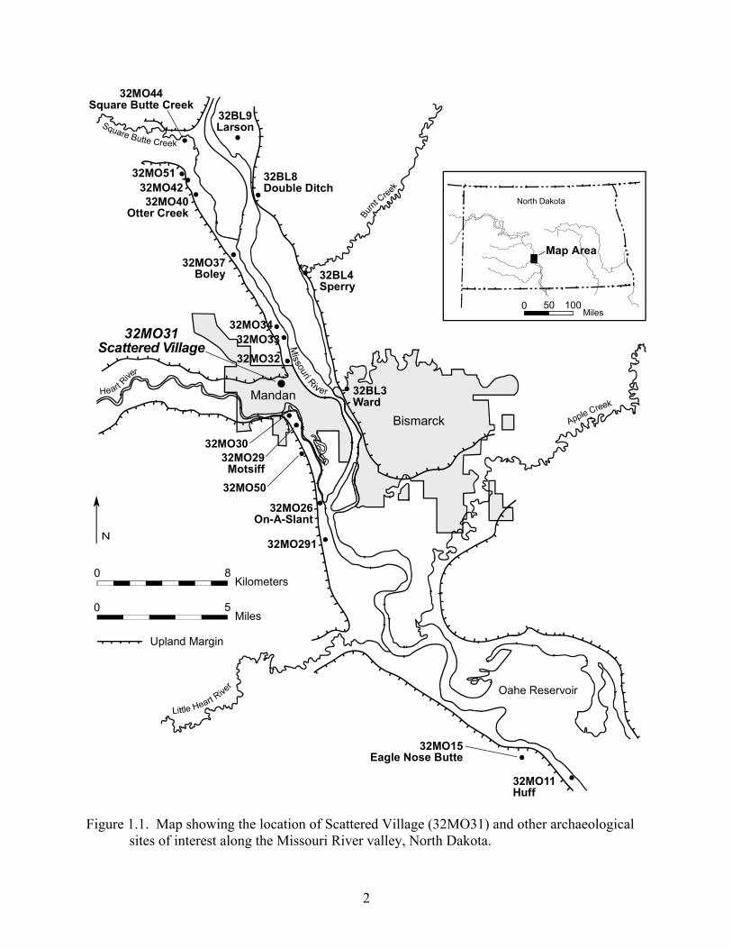
Figure 1.1. g the location of Scattered Village (32MO31) and other archaeological
sites of interest along the Missouri River valley, North Dakota. Map showin

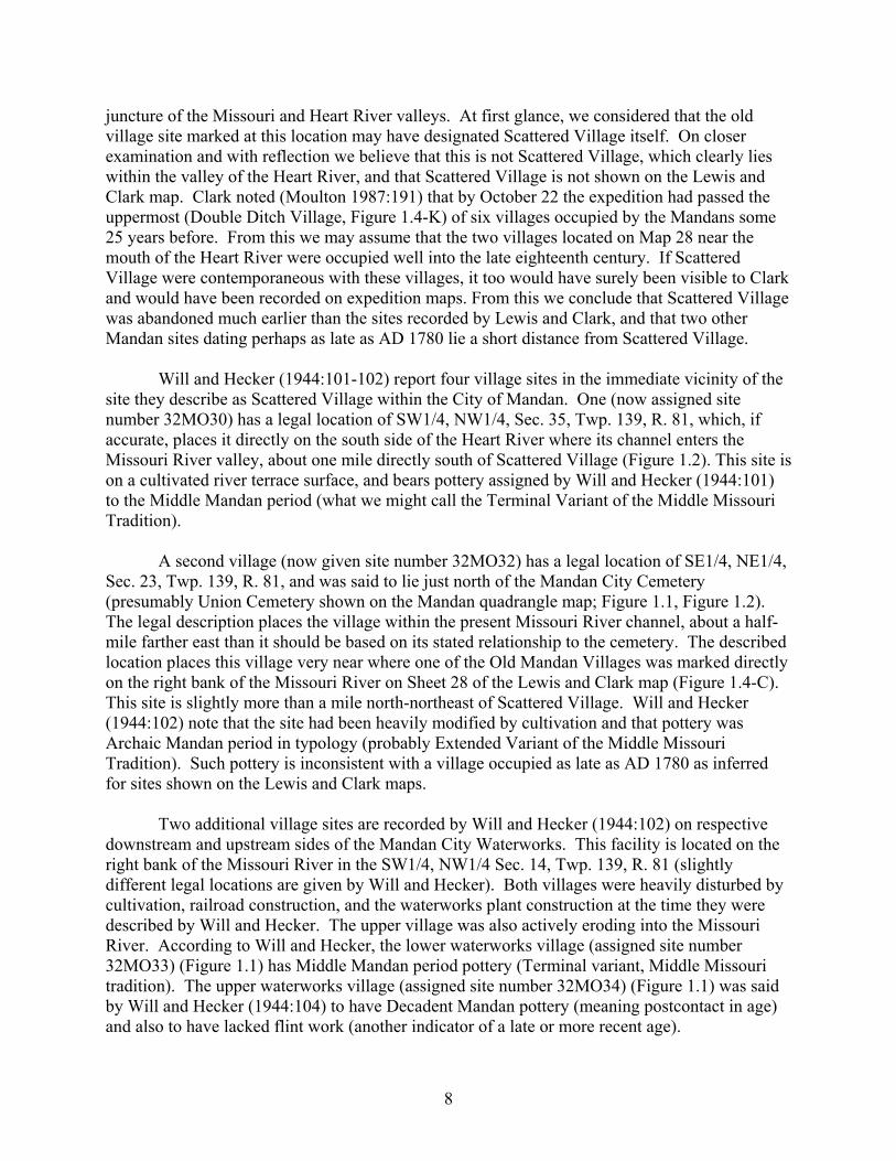
Figure 1.2. A portion of the Mandan and Bismarck USGS 7.5 minute quadrangles showing the location of First Street, Scattered Village 32MO31, and other nearby archaeological sites.
3

between the hills and railroad tracks, the city varies from two to 10 city blocks in width (760 to 3800 feet, or ca. 230 to 1150 meters) north-south.
Present knowledge of Scattered Village is confined primarily to that part intersected by First St NE (see Figure 1.2). Main Street runs the length of the older part of the city and lies just north of the tracks, while First St NE is parallel to and one block north of Main Street. Cross streets (avenues) are numbered outward from the center of town (Collins Ave.) to the east (1st
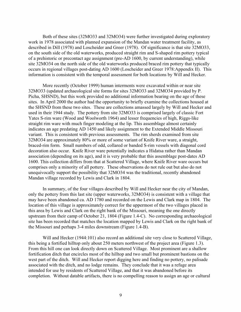
Ave NE, 2nd Ave NE, etc.) and to the west (1st Ave NW, 2nd Ave NW, etc.). Very dense village archaeological deposits occur along both sides of First St NE between 8th Ave NE and 10th Ave NE, a distance of about 760 ft or 230 m (Figure 1.3). Our studies indicate that the village has a very abrupt margin along First St NE at about the present location of 10th Ave NE, with only very sparse artifactual remains extending farther east. Based on surface artifact exposures, an equally abrupt village margin appears to occur to the west, at about 8th Ave NE, although we did not systematically examine subsurface exposures west of that cross street.
In the current project we did not systematically explore the north-south extent of the village, away from First St NE in either direction, but we can use observations on the lay of the land, local landforms, and local geology to offer some guesses about the probable extent of the village. The most concentrated part of the village that we encountered lies on a clearly elevated land surface that dips perceptibly to the east, south, and west. Hand excavations and geologic coring east of 10th Ave NE and on the south side of First St NE between 8th Ave NE and 9th Ave NE indicate that sediments just off the village margin to the east and probably southwest are massive, clayey alluvial units laid down by flooding from the Heart River (Timpson 1999). In contrast, sediments directly under the village are coarser textured and have a different origin, being part of an alluvial fan that developed at the mouth of a small drainage emanating from the uplands directly north of the site.
It appears that the 1650 ft contour line on the local quadrangle map fairly accurately marks the margin of this alluvial fan landform, and effectively demarcates the southern margin of the village (Figure 1.3). It is probable that the village extends from the 1650 ft contour upslope to the 1670 or the 1680 ft contour line that marks the toe of the slope from the hills to the north. In the apparent heart of the village, where our project occurred, this alluvial fan landform is widest (directly at the mouth of the drainage from the hills), and it pinches out in width both to the east and the west. Based on topography and the extent of this landform feature, we would expect the village to extend from west of Custer School at 6th Ave NE on the west, eastward at least as far as 11th Ave NE and perhaps as far as 12th Ave NE (Figure 1.3). In this configuration, the village might be as much as 500 ft (150 m) wide (north-south) at the mouth of the fan drainage, and perhaps a little as 200 ft (60 m) wide at its eastern and western ends. The landform on which the village appears to have been centered, as shown in Figure 1.3, encompassed between four and five city blocks, or about 14.8 acres or 6.0 hectares.
Most of these estimates are based on our observations along the narrow transect of First St NE. Determination of the actual extent of the village could be fairly readily established by conventional surface archaeological survey in gardens and other exposures in this part of the city, as well as by interviews with local residents. Local residents did report to us previous discoveries of human burials, presumably from a part of Scattered Village, during past
4

5
Hilltop withDitch, Bastions
N
0 500 1000 ft
0 100 200 300 m
32MO31Scattered Village
in East MandanMain Project Area
Possible Site Area
Figure 1.3. ap showing the location of the project area along First St NE and the
possible extent of Scattered Village (32MO31).
Detailed m

earth moving work at Custer School about one block east and slightly north of our project area (Figure 1.3).
Scattered Village thus abuts against the base of the south-facing range of hills that form the margin of the Heart River valley. Topographic maps and aerial photos show old meander scars of the Heart River as near as 750 ft or about 230 meters south of the project area and the apparent village margin (Figure 1.2 and Figure 1.3). It is possible that the Heart may have at times flowed within 100 m or closer to the site. The project area lies about 1900 ft or about 580 m inside the mouth of the Heart River valley, or due west and upstream of the rather abrupt juncture between the east-west trending Heart River valley and the north-south trending Missouri River Valley just to the east. Directly at Scattered Village, the mouth of the Heart River valley (floodplain and terraces) is slightly less than one mile or 1500 m wide (Figure 1.2). Upon entering the Missouri Valley, the Heart River turns abruptly south and flows in that direction for several thousand meters before joining the Missouri River. The conjoined Missouri River and Heart River floodplain just south and east of the village is much broader, being ca. two miles or 3,200 m in width. Thus, residents of Scattered Village would have had a substantial area of Heart River floodplain, with cropland and timber stands, available in close proximity along the Heart, and an even much larger expanse of similar terrain available just to the east and south in the Missouri Valley. Bedrock crops out on the face of the steep hills immediately north of the site, here consisting of poorly consolidated siltstone and sandstones of the Paleocene age Cannonball formation.
Nearby Recorded Sites and Discoveries
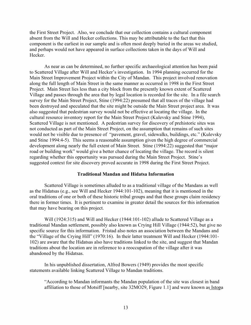
Several archaeological sites have been reported or recorded in the immediate vicinity of Scattered Village, but few are well understood in terms of age or specific cultural association. The Lewis and Clark expedition passed through this area in October 1804, camping on the right bank of the Missouri River just below the mouth of the Heart River on October 20, 1804, and again on October 21 on the right bank of the Missouri River at a point even with the eastern end of the upland rim that lies north of Scattered Village. Several sites are marked on Map 28 of the Atlas of the Lewis and Clark Expedition (Moulton 1983; Figure 1.4) and designated as “Old Mandan Village”, and two in particular are very near Scattered Village. During the two days travel through this area (October 20 and 21, 1804), William Clark walked some of the ground along the west side of the Missouri River and near the mouth of the Heart River (Moulton 1987:184-188), directly visiting or observing from an elevated viewpoint some or all of the “Old Mandan Villages” marked on Atlas Map 28. Thus, we think it is reasonable to believe that most landmarks, landforms, stream courses, and abandoned villages are accurately located relative to one another on Map 28, although the map lacks a precise scale.
One “Old Mandan Village” (Figure 1.4-B) is located directly on the west bank of the Missouri River, above the mouth and east of the channel of the lower Heart River that flows within the Missouri River valley at this point. This village lies perhaps two or three miles southeast of the current project area at Scattered Village. A second “Old Mandan Village” (Figure 1.4-C) is much closer to Scattered Village, but is apparently distinct from Scattered Village, this lying just upstream from the party’s camp of October 21, 1804, also directly on the right bank of the Missouri and due east of the corner of the clearly defined upland that marks the
6

Figure 1.4. A portion of Lewis and Clark Atlas Map 28 emphasizing the probable location of Scattered Village (32MO31) relative to other features recorded on the map (from Moulton 1983).
7
juncture of the Missouri and Heart River valleys. At first glance, we considered that the old village site marked at this location may have designated Scattered Village itself. On closer examination and with reflection we believe that this is not Scattered Village, which clearly lies within the valley of the Heart River, and that Scattered Village is not shown on the Lewis and Clark map. Clark noted (Moulton 1987:191) that by October 22 the expedition had passed the uppermost (Double Ditch Village, Figure 1.4-K) of six villages occupied by the Mandans some 25 years before. From this we may assume that the two villages located on Map 28 near the mouth of the Heart River were occupied well into the late eighteenth century. If Scattered Village were contemporaneous with these villages, it too would have surely been visible to Clark and would have been recorded on expedition maps. From this we conclude that Scattered Village was abandoned much earlier than the sites recorded by Lewis and Clark, and that two other Mandan sites dating perhaps as late as AD 1780 lie a short distance from Scattered Village.
Will and Hecker (1944:101-102) report four village sites in the immediate vicinity of the site they describe as Scattered Village within the City of Mandan. One (now assigned site number 32MO30) has a legal location of SW1/4, NW1/4, Sec. 35, Twp. 139, R. 81, which, if accurate, places it directly on the south side of the Heart River where its channel enters the Missouri River valley, about one mile directly south of Scattered Village (Figure 1.2). This site is on a cultivated river terrace surface, and bears pottery assigned by Will and Hecker (1944:101) to the Middle Mandan period (what we might call the Terminal Variant of the Middle Missouri Tradition).
A second village (now given site number 32MO32) has a legal location of SE1/4, NE1/4, Sec. 23, Twp. 139, R. 81, and was said to lie just north of the Mandan City Cemetery (presumably Union Cemetery shown on the Mandan quadrangle map; Figure 1.1, Figure 1.2). The legal description places the village within the present Missouri River channel, about a half-mile farther east than it should be based on its stated relationship to the cemetery. The described location places this village very near where one of the Old Mandan Villages was marked directly on the right bank of the Missouri River on Sheet 28 of the Lewis and Clark map (Figure 1.4-C). This site is slightly more than a mile north-northeast of Scattered Village. Will and Hecker (1944:102) note that the site had been heavily modified by cultivation and that pottery was Archaic Mandan period in typology (probably Extended Variant of the Middle Missouri Tradition). Such pottery is inconsistent with a village occupied as late as AD 1780 as inferred for sites shown on the Lewis and Clark maps.
Two additional village sites are recorded by Will and Hecker (1944:102) on respective downstream and upstream sides of the Mandan City Waterworks. This facility is located on the right bank of the Missouri River in the SW1/4, NW1/4 Sec. 14, Twp. 139, R. 81 (slightly different legal locations are given by Will and Hecker). Both villages were heavily disturbed by cultivation, railroad construction, and the waterworks plant construction at the time they were described by Will and Hecker. The upper village was also actively eroding into the Missouri River. According to Will and Hecker, the lower waterworks village (assigned site number 32MO33) (Figure 1.1) has Middle Mandan period pottery (Terminal variant, Middle Missouri tradition). The upper waterworks village (assigned site number 32MO34) (Figure 1.1) was said by Will and Hecker (1944:104) to have Decadent Mandan pottery (meaning postcontact in age) and also to have lacked flint work (another indicator of a late or more recent age).
8
Both of these sites (32MO33 and 32MO34) were further investigated during exploratory work in 1978 associated with planned expansion of the Mandan water treatment facility, as described in Dill (1978) and Loscheider and Greer (1978). Of significance is that site 32MO33, on the south side of the old waterworks, produced straight rim and S-shaped rim pottery typical of a prehistoric or precontact age assignment (pre-AD 1600, by current understanding), while site 32MO34 on the north side of the old waterworks produced braced rim pottery that typically occurs in regional villages post-dating AD 1600 (Loscheider and Greer 1978:Appendix II). This information is consistent with the temporal assessment for both locations by Will and Hecker.
More recently (October 1999) human interments were excavated within or near site 32MO33 (updated archaeological site forms for sites 32MO33 and 32MO34 provided by P. Picha, SHSND), but this work provided no additional information bearing on the age of these sites. In April 2000 the author had the opportunity to briefly examine the collections housed at the SHSND from these two sites. These are collections amassed largely by Will and Hecker and used in their 1944 study. The pottery from site 32MO33 is comprised largely of classic Fort Yates S-rim ware (Wood and Woolworth 1964) and lesser frequencies of high, Riggs-like straight rim ware with much finger modeling at the lip. This assemblage almost certainly indicates an age predating AD 1450 and likely assignment to the Extended Middle Missouri variant. This is consistent with previous assessments. The rim sherds examined from site 32MO34 are approximately 80% or more of some variant of Knife River ware, a straight, braced-rim form. Small numbers of odd, collared or banded S-rim vessels with diagonal cord decoration also occur. Knife River ware potentially indicates a Hidatsa rather than Mandan association (depending on its age), and it is very probable that this assemblage post-dates AD 1600. This collection differs from that at Scattered Village, where Knife River ware occurs but comprises only a minority of all pottery. These observations do not rule out but also do not unequivocally support the possibility that 32MO34 was the traditional, recently abandoned Mandan village recorded by Lewis and Clark in 1804.
In summary, of the four villages described by Will and Hecker near the city of Mandan, only the pottery from this last site (upper waterworks, 32MO34) is consistent with a village that may have been abandoned ca. AD 1780 and recorded on the Lewis and Clark map in 1804. The location of this village is approximately correct for the uppermost of the two villages placed in this area by Lewis and Clark on the right bank of the Missouri, meaning the one directly upstream from their camp of October 21, 1804 (Figure 1.4-C). No corresponding archaeological site has been recorded that matches the location mapped by Lewis and Clark on the right bank of the Missouri and perhaps 3-4 miles downstream (Figure 1.4-B).
Will and Hecker (1944:101) also record an additional site very close to Scattered Village, this being a fortified hilltop only about 250 meters northwest of the project area (Figure 1.3). From this hill one can look directly down on Scattered Village. Most prominent are a shallow fortification ditch that encircles most of the hilltop and two small but prominent bastions on the west part of the ditch. Will and Hecker report digging here and finding no pottery, no palisade associated with the ditch, and no lodge remains. They conclude that it was a refuge area intended for use by residents of Scattered Village, and that it was abandoned before its completion. Without datable artifacts, there is no compelling reason to assign an age or cultural
9

affiliation to this site. The ditch, bastions, and remains of Will and Hecker’s excavations, still not backfilled (as was their habit), were readily visible at this location in 1998, and this site shows prominently on several aerial photographs of the area.
During the last few decades a few additional archaeological finds in the immediate vicinity of Scattered Village have found their way into official state records. Two apparently aboriginal graves containing remains of three individuals are designated as site 32MO55, recorded in July 1979. The graves were disturbed by construction on the steep, northeast facing slope of the prominent hill on the north side of the juncture of the Heart River and Missouri River valleys (Figure 1.2) The site recorder (Nick Franke) designated this as Crying Hill. This burial location lies across the hill that borders Scattered Village and is about 700 meters northeast of the project area.
Another human burial disturbed by earthmoving activities was recorded as site 32MO81 in September 1981. This burial was eroding from an artificial cut in a borrow area on the west face of another part of the high hill that borders Scattered Village (Figure 1.2). The burial spot was near the intersection of 4th St NE and 3rd Ave NE, about 600-700 meters west-northwest of the project area.
A site lead, designated as 32MOX274, is recorded about 300 meters southwest of the project area, directly south of the railroad tracks, just east of the underpass on 6th Ave NE, and just north of an old meander channel of the Heart River (Figure 1.2). A refuse and artifact filled depression was reported as exposed by construction in this spot. Pottery, projectile points, other chipped stone tools, mussel shells, and animal bones were observed.
Previous Investigations and Impacts at Scattered Village
E. R. Steinbrueck (in Brower 1904:139) provides an early but brief description of the Scattered Village site. At the time of Steinbrueck’s writing, the City of Mandan had been in existence barely more than two decades (Fristad 1970 [1956]; Chase 1975:2). He describes the village as being at the east end of the City of Mandan, protected by a high ridge to the north and with open country to the west and south. He says that “lodge places in the alleys of the city are distinct and bountiful,” clearly suggesting that in 1904 the historic city has not yet obliterated surface evidence of the village. While Steinbrueck carried on excavations in several nearby villages, he provides no clear indication that he dug at Scattered Village or developed a collection from the site.
In his 1924 discussion of village sites in the Missouri River valley, George Will (1924:315) mentions the existence of Scattered Village in the eastern part of the present city of Mandan. He describes the village as “built-over, but nevertheless distinguishable” and notes that according to tradition (source unstated), the village was occupied in the summer by persons attending fields in nearby fertile bottomlands.
Writing in 1956, local Mandan city historian Palma Fristad (1970) describes some historical information about a village at or near Scattered Village which she attributes, without specific citation, to the “late Major A. B. Welch of Mandan” (1970:16). A. B. (Alfred Burton)
10

Welch was a local resident known in the community for his extensive artifact collection and close association with Native Americans (Susan Dingle, personal communication to S. Ahler Dec. 12, 1999); he was adopted as a member of the Sioux tribe at Standing Rock Reservation (Minneapolis Sunday Journal, June 22, 1913). What Fristad recounts (1970:16-17) appears to be a mixture of historical information about the Vérendrye expedition of 1738 (Smith 1980), possibly oral traditions recounted by individual Mandans, and local neighborhood folklore. She reports that the main Vérendrye expedition stopped at a Mandan village on the east side of the Missouri River, and that one of Vérendrye’s sons led a group of eight men and crossed the Missouri (this occurred on December 6-7, 1738, according to Vérendrye’s account [Smith 1980:68,70]) to visit several other Mandan villages. The younger Vérendrye stopped first at “The Mortar” Mandan village on the Boley farm four miles north of the City of Mandan (Fristad 1970:17) (presumably the Boley site, 32MO37), and then proceeded to meet a Mandan chief from a second village who was named “Good Fur Blanket”. They met at a location north of the City of Mandan on the present site of the Union Cemetery, but it is unclear if a Mandan village was at this location. (This would have been near site 32MO32, Figure 1.2 and 1.3, and perhaps the “Old Mandan Village”, Figure 1.4C, that is possibly site 32MO34.) Good Fur Blanket was said to be from a village of 250 lodges fortified by ditches and palisade. His village was known as the “Village of the Crying Hill” and was said by Fristad (1970:16) to be located in the east end of Mandan (at our Scattered Village). Fristad further states (1970:17) that Welch reported the remains of the earthlodge used by Good Fur Blanket as visible as recently as 1924 at the intersection of First St NE and 6th Ave NE within the city (only one block west of our project area; Figure 1.3). The younger Vérendrye party also was reported to have visited a Mandan village called “The Young Man’s Village” (apparently the present Motsiff site, 32MO29, Figure 1.1) and visited or recorded two other active settlements, “The Village of the Lopsided Lodges” (presumably On-A-Slant Village, 32MO26, Figure 1.1), and “Bird’s Bill Hill” (presumably Eagle Nose Butte, 32MO15, Figure 1.1).
This information seems to bear on Scattered Village, but, as noted before, it unfortunately appears to be a tangled mixture of historical fact, oral traditions that may be based in part on individual elements of fact, and recent unverified folklore. Smith’s (1980) discussion of the 1738-1739 Vérendrye expedition is generally accepted as the most accurate, scholarly accounting from the expedition, and it is silent on details such as the specific names of Mandan villages visited by the younger Vérendrye. Even so, village names noted in the previous paragraph seem credible, and probably derive from Mandan traditions. The proposition that Scattered Village, as we know it from our 1998 investigations in east Mandan, was occupied in 1738 is an idea open to question. As we will see, archaeological data suggest that the site was abandoned somewhat before that date. The possibility that remains of an earthlodge may once have existed at the intersection of First St NE and 6th Ave NE is not unrealistic, although by the time of our fieldwork in 1998 there were no observable intact archaeological remains at this location. By 1998 this area had been heavily impacted by repeated street construction as well as landscaping related to nearby Custer School (see Figure 1.3). The statement that a Mandan chief named Good Fur Blanket lived in this lodge is less likely. Alfred Bowers, the foremost authority on Mandan ethnography, identified (1950: 156-163,183ff) “Good Furred Robe” as a mythological culture hero of the Mandans who was involved in origins of many sacred ceremonies that came into being long before the Mandans migrated into the Heart River area. Thus, the Fristad/Welch reference to “Good Fur Blanket” probably reflects conflation and
11

confusion of information derived from Mandan informants that may relate both to previous use of the Crying Hill site as well as events much deeper in the mythological past of the Mandans. [Note references to both Mandan and Hidatsa leaders named Good Furred Robe in discussion below.]
One element in the Fristad story is of particular interest, this being mentioned of the meeting between the younger Vérendrye and a Mandan leader at a spot near the present Mandan City cemetery. Again, this is approximately the location of an abandoned Mandan village recorded on a Lewis and Clark Expedition Map (Figure 1.4-C), and is not far from site 32MO34, just upstream, that has produced pottery consistent with dates in the eighteenth century. In addition, the Mandan City Cemetery lies just at the foot of the prominent high point of land known generally as “Crying Hill”. If an eighteenth century Mandan village existed in this vicinity, it could readily have been known as “Crying Hill Village”, an ascription that some archaeologists have assigned to the location we now study as the Scattered Village site (see discussion in the following section).
It is clear that Will and Hecker (1944), in their synthesis of Mandan and Hidatsa archaeology in North Dakota, studied pottery samples from Scattered Village. They reported (1944:52,101,122,123) that the site was one of only a few that showed the entire ceramic sequence for Mandan archaeology, ranging from “archaic” (our Middle Missouri tradition) to “decadent” (Postcontact or Disorganized Coalescent variant). They noted that the site may have actually consisted of several villages occupied at different times, that it may have been primarily an early Hidatsa site established by people migrating from the east, and that Mandan peoples may have reused it after the Hidatsas left the Heart River area and moved to Knife River (p. 101-102).
In April 2000 the author had an opportunity to briefly examine the pottery collections from site 32MO31 housed at the SHSND, which are probably the same materials studied by Will and Hecker. The pottery samples occur in two accession lots that bear discontinuous accession numbers. It is inferred but not confirmed that these samples were collected from different locations at different times. One accession lot contains a number of S-rim vessels classifiable as variants of Le Beau ware and fewer numbers of braced, straight rim vessels classifiable as Knife River and Knife River Fine ware. Collectively, this accession lot could be lost amongst pottery in our excavated sample we have assigned to Periods 1, 2 and 3. Pottery in the second accession lot was very different from this sample and unlike anything from Scattered Village or elsewhere seen by the author. It consisted of a mixture of S-rim vessels resembling Fort Yates ware and straight rim pottery resembling Riggs ware, but in every piece distinguished by extreme thickness and overall robustness. Every single vessel appeared grossly over-thickened, and some of the lips were perhaps one inch wide (no measurements were taken during this brief examination).
No pottery similar to the latter aggregate has been observed in any of the materials we excavated from Scattered Village in this project. In addition, absent from the SHSND collections is what we would call classic recurved Le Beau S-rim ware that comprises a significant part of our excavated sample. From this we conclude that a portion of the SHSND collection (second accession lot) is clearly from a location where we did not excavate as part of
12
the First Street Project. Also, we conclude that our collection contains a cultural component absent from the Will and Hecker collections. This may be attributable to the fact that this component is the earliest in our sample and is often most deeply buried in the areas we studied, and perhaps would not have appeared in surface collections taken in the days of Will and Hecker.
As near as can be determined, no further specific archaeological attention has been paid to Scattered Village after Will and Hecker’s investigation. In 1994 planning occurred for the Main Street Improvement Project within the City of Mandan. This project involved renovation along the full length of Main Street in the same manner as occurred in 1998 in the First Street Project. Main Street lies less than a city block from the presently known extent of Scattered Village and passes through the area that by legal location is recorded for the site. In a file search survey for the Main Street Project, Stine (1994:22) presumed that all traces of the village had been destroyed and speculated that the site might be outside the Main Street project area. It was also suggested that pedestrian survey would not be effective at locating the village. In the cultural resource inventory report for the Main Street Project (Kulevsky and Stine 1994), Scattered Village is not mentioned. A pedestrian survey for discovery of prehistoric sites was not conducted as part of the Main Street Project, on the assumption that remains of such sites would not be visible due to presence of “pavement, gravel, sidewalks, buildings, etc.” (Kulevsky and Stine 1994:4-5). This seems a reasonable assumption given the high degree of commercial development along nearly the full extent of Main Street. Stine (1994:22) suggested that “major road or building work” would give a better chance of locating the village. The record is silent regarding whether this opportunity was pursued during the Main Street Project. Stine’s suggested context for site discovery proved accurate in 1998 during the First Street Project.
Traditional Mandan and Hidatsa Information
Scattered Village is sometimes alluded to as a traditional village of the Mandans as well as the Hidatsas (e.g., see Will and Hecker 1944:101-102), meaning that it is mentioned in the oral traditions of one or both of these historic tribal groups and that these groups claim residency there in former times. It is pertinent to examine in greater detail the sources for this information that may have bearing on this project.
Will (1924:315) and Will and Hecker (1944:101-102) allude to Scattered Village as a traditional Mandan settlement, possibly also known as Crying Hill Village (1944:52), but give no specific source for this information. Fristad also notes an association between the Mandans and the “Village of the Crying Hill” (1970:16). In their latter treatment Will and Hecker (1944:101-102) are aware that the Hidatsas also have traditions linked to the site, and suggest that Mandan traditions about the location are in reference to a reoccupation of the village after it was abandoned by the Hidatsas.
In his unpublished dissertation, Alfred Bowers (1949) provides the most specific statements available linking Scattered Village to Mandan traditions.
“According to Mandan informants the Mandan population of the site was closest in band affiliation to those of Motsiff [nearby, site 32MO29, Figure 1.1] and were known as Istopa
13

(Those Who Tattoo Themselves). The Mandan called the village built at this point MitoxtE (Village Large and Scattered) and informants state that lodges formerly extended for several miles along the north bank of the Heart River, reaching from the central part of the City of Mandan eastward to the banks of the Missouri. It is within this large site at the mouth of Heart River that most Mandan and Hidatsa traditions of Hidatsa [-proper] and Awatixa residence at this point are concerned. Traditionally the site had a parallel history with Motsiff which was reasonable in view of their position near each other [Figure 1.1].” (Bowers 1949:80, footnote 2).
It is clear from comments offered elsewhere that Bowers (1949:139,161), considered Scattered Village to be one of several traditional Mandan settlements near the Heart River occupied well into the AD 1700s. Bowers further (1949:80-81) reports that according to traditions none of the large and fortified Mandan villages on the west side of the Missouri (Boley, Scattered, Motsiff, and On-A-Slant) was occupied continuously because the occupants were obliged to move periodically because of depletion of local timber supplies. It was customary for part of the village group to remain in the old village while other residents built a new village nearby. From this we can infer a possible discontinuous history of occupation at Scattered Village, as well as at other large villages mentioned by Bowers. In none of his writings did Bowers (1949, 1950, 1965) use the term Crying Hill or Crying Hill Village to refer to any village site in the vicinity of the Heart River.
Bowers also has much to say about Hidatsa traditions related to Scattered Village. In this regard it is important to understand that three subgroups of Hidatsas occupied separate villages in the late eighteenth and early nineteenth centuries, and that these three subgroups had very distinct origin and migrations traditions (Bowers 1949; 1965:12-24). The Awatixa subgroup had origins in the Painted Woods district (between Heart and Knife Rivers) and residence only in the Missouri Valley between these two rivers. The Awaxawi subgroup were horticulturalists who migrated into the Missouri valley from the headwaters of the Red River in Minnesota and developed close ties with the Mandans. The Hidatsa-proper subgroup were non-horticulturalists who migrated last into the Missouri valley from a northeastern source area. They settled among the Mandans and learned horticulture from them, and eventually moved upstream to the mouth of the Knife River. It is important to keep these subgroup distinctions in mind when discussing any Hidatsa tradition about Scattered Village or occupation near the Heart River.
Bowers (1949:18; 1965:21) states that Awatixa subgroup traditions claim residence prior to Scattered Village in the Painted Woods area (upstream) where they were “created”, then residence at an early time at Scattered Village on the north bank of the Heart River, and then a move to the mouth of the Knife River. The Wolf ceremonies were said to have originated among the Awatixa while at Scattered Village. Interestingly, Bowers (1949:17, footnote 3) states that pottery he observed from Scattered Village, in his opinion, did not reflect the purported Awatixa presence there but only a long period of Mandan residence.
Bowers (1949:109-110) also notes that Mandan traditions confirm an Awatixa Hidatsa subgroup association with the site at the mouth of Heart River where the City of Mandan stands, or Scattered Village. Thus, both Mandan and Hidatsa accounts recorded by Bowers are in apparent agreement on this point. He notes further that while living at the Heart River, the
14

Mountain Crow split from the Awatixa subgroup and moved westward to pursue a nomadic lifeway. He places the time of this split “not later than AD 1600” (1949:110)(an estimate made without benefit of radiocarbon dating). Interestingly, the Hidatsa word Awatixa means “Village of the Scattered Lodges”. When interviewed by Lewis and Clark, the Mandans used the term Metaharta to refer to this specific Hidatsa subgroup, and in Mandan, Metaharta has the same meaning (Bowers 1949:109, footnote 1). The present author has presumed that this “Village of the Scattered Lodges” reference might relate to the fact that the Awatixas eventually coalesced at Knife River after living in numerous unfortified settlements north of Square Buttes, but this term may have yet a different meaning and one linking the Awatixa to the Scattered Village site proper at the Heart River.
In a brief summary of Hidatsa-proper origin and migration traditions, Bowers (1949:19) identifies the Hidatsas-proper as the subgroup who originated to the east and migrated to the Missouri valley where they met the Mandans and set up temporary settlements before moving northward to Knife River and above along the Missouri. Thus, Bowers would associate the oft-repeated Hidatsa migration tradition of having crossed the Missouri below the Heart River to the Hidatsas-proper subgroup. He notes (1949:109, footnote 1) that the term Minnetaree or Minitari (1965:302) was used by the Mandans specifically for the Hidatsa-proper. It derives from “water” and “to cross”, used in reference to the Hidatsa-proper subgroup having arrived on the east bank of the Missouri River near the mouth of the Heart and calling out to the Mandans on the west bank that they wished to cross.
Ray Wood (1980) has provided very useful documentation of several specific Hidatsa origin and migration accounts, and several of these appear to have bearing on the Scattered Village archaeological site.
An origin tradition told by the Hidatsa Wolf-Chief to Gilbert Wilson in 1909 is informative. He described the Hidatsa (presumably Hidatsa-proper) migration from the east:
“After four years the Gros Ventre [Hidatsas] came and met the Mandan on the side opposite Bird’s Beak Hill [Eagle Nose Butte; Figure 1.1]. … The Gros Ventre made a camp about five miles down the Missouri from the mouth of the Heart River. The Mandan [in their village at Bird’s Beak Hill] and Gros Ventre got acquainted, but after a time they quarreled and said unkind things to each other and some of the young men fought and lives were lost.
“The Mandan said, “We had better remove your camp farther away.” So they moved to the mouth of Heart River.
“There the Gros Ventre built a village of houses like those of the Mandans. This village stood just where the town of Mandan now stands. They stayed there a long time.
“After a time the Gros Ventre moved about twenty miles up the river, staying there one year. … A third removal brought them to the mouth of the Knife River.” (Wilson 1909:17-18, cited in Wood 1980:93).
15
In 1913 Wilson recorded a second telling of the Hidatsa migration account by Wolf Chief, and it also provides interesting details. Wolf Chief noted that the group crossing the Missouri River received corn and corn-balls from the Mandans. He noted that the Hidatsa chiefs at the time were Big Sharp Horn, Tattooed Face, and Good Furred Robe. The Mandan leader at the village where the Hidatsa crossed the Missouri was also named Good Furred Robe (Wilson 1913:195-198; cited in Wood 1980:111-112). Regarding the migration and relocation on the Missouri, Wolf Chief stated:
“The tribe crossed at the mouth of the Heart River [perhaps 1-4 miles below present Scattered Village; Figure 1.1]. A little north of the crossing place the Mandan helped the Hidatsa build a village. … A Mandan village was about four miles below that of the Hidatsa. The two tribes visited one another and were very friendly. [Following some potential conflict and a suggestion for a move from the Mandan chief…] The Hidatsa moved to the mouth of the Heart River and built a village on both sides of the river. The south side was the larger of the two. [Following additional conflict …] The Hidatsa [next] moved up the river about fifteen miles from the Heart River and stayed there but a short time...”(Wilson 1913:199-200; cited in Wood 1980:112-113).
Another account told by Butterfly, an Hidatsa, records that the Hidatsa-proper and Awaxawi subgroups migrated together from the east, crossed the Missouri just opposite the mouth of the Heart and joined the Mandans in a single village at an unspecified location. The Mandan chief was said to be called Good Furred Robe. After a time it was decided that the village was too crowded and the Hidatsas-proper and Awaxawis agreed to move upstream closer to the Knife River (Wilson 1910:76-77; cited in Wood 1980:97). Wilson recorded a similar tradition told by Wounded Face, a Mandan, who noted the Mandan chief as Good Furred Robe and that the Hidatsa crossed the Missouri and camped on a level plain a short distance below On-A-Slant Village (Wilson 1910:92-94; cited in Wood 1980:102-103).
Buffalo-Bird-Woman, an Hidatsa, provides an account of Hidatsa migration from the Devils Lake area (presumably referring to the Hidatsa-proper subgroup), but one with few details that can be directly tied to the Scattered Village location. This account does contain interesting information about horticulture and subsistence. The informant noted that near their villages at Devils Lake the Hidatsas raised “wild potatoes – a kind of artichoke” and also a kind of wild bean that bore its fruit or seeds an inch or two under the soil rather than above ground. She noted that “[w]e do not cultivate them now, but we do gather these wild potatoes and ground beans and eat them”. When the Hidatsas lived at Devils Lake they did not grow corn. When they met the Mandans at the Missouri River, they were given corn that they described as “a strange kind of new grain which we ate and it was good”. After migrating and joining the Mandans near Heart River, the Hidatsas were given yellow seed corn by the Mandans. Buffalo Bird Woman believed that they received seed for regular beans, squash, sunflowers, and other varieties of corn at a yet later date. She noted that the Hidatsas had ceased planting the ground beans because they were so difficult to dig, and the villagers liked the new beans much better (Wilson 1913:189-194; cited in Wood 1980:108-110).
In summary, traditional information indicates several possibilities regarding the origins and associations of former occupants of Scattered Village – none mutually exclusive. Bowers
16

documents the site as a traditional Mandan settlement used by the subgroup called Those Who Tattoo Themselves during the AD 1700s. He also notes that the Mandans recognized that some part of the Hidatsas had resided at this location at an earlier time. According to Hidatsa traditions, Bowers interprets the Awatixa subgroup as having lived at Scattered Village, following their residence in the Painted Woods district and prior to their move toward consolidation at Knife River which took place before AD 1600.
The Hidatsa origin traditions recorded by Wilson are remarkably consistent in several elements: migration from the east; a memorable crossing of the Missouri river; residency for a period of time with the Mandans at or near Heart River; then a move upriver to the mouth of the Knife. While Bowers does not himself link the Hidatsa-proper subgroup to Scattered Village, he does indicate that the specific account of the river crossing relates to the Hidatsa-proper subgroup, particularly in regard to absence of corn horticulture prior to the group’s arrival on the Missouri and Mandan reference to this subgroup as the Minnetaree (“to cross the water”). The two accounts by Wolf Chief are internally consistent and state or strongly infer that the Hidatsas (Hidatsas-proper) resided at the site we are now investigating as Scattered Village. It seems improbable that both the Awatixa subgroup and the Hidatsa-proper subgroup occupied Scattered Village, but this is what the traditional information recorded or interpreted respectively by Bowers and Wilson indicates. Most significant for our study of the archaeological record is the fact that all sources agree that the Hidatsas-proper arrived on the Missouri River with little knowledge or lengthy practice of corn/bean/squash horticulture.
17