1 paul gorecki - anu presspress-files.anu.edu.au/downloads/press/n2540/pdf/ch23.pdf · 23 kuk phase...
TRANSCRIPT
23Kuk Phase 7, 1969–1990, the Kuk Research Station: A Colonial Interlude1
Paul Gorecki
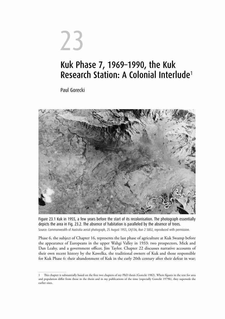
Figure 23.1 Kuk in 1955, a few years before the start of its recolonisation. The photograph essentially depicts the area in Fig. 23.2. The absence of habitation is paralleled by the absence of trees. Source: Commonwealth of Australia aerial photograph, 25 August 1955, CAJ136, Run 2 5002, reproduced with permission.
Phase 6, the subject of Chapter 16, represents the last phase of agriculture at Kuk Swamp before the appearance of Europeans in the upper Wahgi Valley in 1933: two prospectors, Mick and Dan Leahy, and a government officer, Jim Taylor. Chapter 22 discusses narrative accounts of their own recent history by the Kawelka, the traditional owners of Kuk and those responsible for Kuk Phase 6: their abandonment of Kuk in the early 20th century after their defeat in war;
1 This chapter is substantially based on the first two chapters of my PhD thesis (Gorecki 1982). Where figures in the text for area and population differ from those in the thesis and in my publications of the time (especially Gorecki 1979b), they supersede the earlier ones.
438 Ten Thousand Years of Cultivation at Kuk Swamp in the Highlands of Papua New Guinea
terra australis 46
their retreat for the most part to Buk2 in the hills of the Sepik-Wahgi Divide to the north of the Wahgi Valley; and their recolonisation of Kuk more than a generation later, some years after the arrival of the first Europeans. The present chapter deals with the story of those Kawelka whose gradual move back to Kuk from Buk and elsewhere from about 1960 is part of the documented history of the upper Wahgi Valley under Australian administration, their return made possible by the suppression of tribal warfare and encouraged by developments in the region that followed.
The preludeMick Leahy told me (on 26 October 1977) that in 1933 he, his brother Dan and Jim Taylor crossed Kuk Swamp from Ep Ridge in the north and saw the stone pillar that stands on Kawelka land at the southern margin of the swamp (Gorecki 1979a; Stewart and Strathern 1998; see Fig. 22.2 here). But there were no people (Dan Leahy, pers. comm., 30 September 1978). Nobody, it seems, had moved to occupy the Kawelka territory at Kuk after it was abandoned (Fig. 23.1). Indeed, according to the stories recorded from Ru Kundil (Stewart and Strathern 1998: 96) and from Goimba (Ketan 1998: 15), the stone pillar seen by the Leahys and Taylor had been deliberately set up by the Kawelka before they left, as a sign of their ownership of the land, just like the concrete boundary markers later used by surveyors in the period of Australian administration.
The circumstances that led Kawelka back to this essentially vacant land were, as already mentioned, the result of Australian administrative activity following the end of World War II: the suppression of tribal warfare, which allowed for freer movement; and developments in the Wahgi Valley, for which the end of tribal warfare was a precondition. These consisted of the drainage of extensive tracts of unused swampland for coffee and tea plantations and for resettlement blocks to relieve population pressures in the other parts of the highlands; the growth of Mount Hagen township as an administrative and commercial centre; and the introduction of the local population to a market economy through wage labour and cash cropping, especially of coffee.
The traditional Kawelka lands at Kuk, on the valley floor just below 1600 m altitude and less than 20 km from Mount Hagen by road, were in every way better placed to participate in the new economy than the area at Buk at around 1800 m in the mountains north of the Wahgi Valley (see Fig. 22.1). Other factors in the move back may have been the perception of a developing land shortage at Buk, as suggested by Strathern (1972: 156–157; see Chapter 22, section ‘Reasons for the return to Kuk’), and government interest in the purchase of swampland in the Wahgi Valley for drainage and development (Gorecki 1979b: 99).
The resettlement of KukThe evidence in reports and censuses by government patrol officers allows us to identify the beginning of the Kawelka return to Kuk (Gorecki 1979b: 97–98). A report of 1958 indicates that no movement had yet taken place, though there was a rumour that it would. A population decrease of 7.2 per cent between censuses of 1958 and 1962 at Buk, from 791 to 734, indicates that it had occurred. A census of 1965 by the anthropologist Andrew Strathern (1972: Table 1d) reports a Kawelka population of 161 in the Wahgi settlement area at Kuk (cf. Gorecki 1979b: Table 2).
2 On the spelling of placenames see footnote on Melpa orthography in Chapter 22.
23. Kuk Phase 7, 1969–1990, the Kuk Research Station: A Colonial Interlude 439
terra australis 46
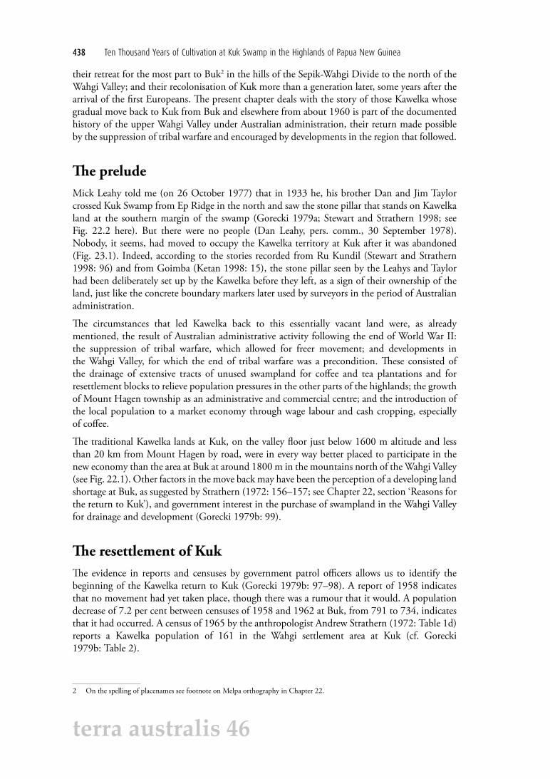
The first Kawelka to return established themselves around the swamp at Kuk, except at its western boundary, where another tribal group, the Jika3, had claim (Gorecki 1979b: 100 and 1982: Map 2, where the spelling used in both citations is Djiga). From 1964 to 1968, the administration undertook complex negotiations for the purchase of blocks of the larger swamp, of which Kuk was part, with the groups claiming title to them (Gorecki 1982: 3, 7; see Fig. 23.2 here) These began with the block that became Tibi Tea Plantation and ended, on 13 June 1968, with the block on which in 1969 the (then) Department of Agriculture, Stock and Fisheries set up the Kuk Tea Research Station. Although it was common knowledge among surrounding tribes that this block was theirs, the Kawelka did not receive major compensation for the Kuk purchase, since, according to an anonymous and undated patrol report, the sale involved no less than seven groups. Citing the original deed of sale, Andrew Moutu (1998: 20–21) reports the purchase as involving the payment of A$7771 to 63 persons, of whom 11 were chosen as agents. Moutu says that from the list of 63 it is impossible to tell clan or tribal affiliation. Ian Hughes, who saw the deed of sale in the early 1970s, told Golson (pers. comm., 1976) that the A$25 paid per hectare was a considerably higher rate than in other Wahgi Valley transactions with which he was familiar.
Figure 23.2 Kawelka territory at Kuk after the alienation of the swampland in 1969. Specific mention is made in the text of movement into the swampland west of the Station access road.Source: Jennifer Sheehan, CartoGIS Services, College of Asia and the Pacific, ANU.
3 On the spelling of tribal names see ‘Note on Melpa orthography’ in Chapter 22.
440 Ten Thousand Years of Cultivation at Kuk Swamp in the Highlands of Papua New Guinea
terra australis 46
From the ownership of a territory estimated at somewhat in excess of 12 km2, the Kawelka were left with two blocks covering just over 9 km2 after the sale (Fig. 23.2). These two blocks were separated by Station land, one of some 5.65 km2 to its north on and below Ep Ridge and the other of some 3.4 km2 to its south, which I shall call South Kuk. The northern block, dominated by the steep slopes of Ep Ridge rising above the swamp, had only one extensive flat area, a wet tract of land to the east. The southern block, with low hills in swampland and some of this swamp in small patches easy to drain, was the preferred area for Kawelka settlement even before the sale of the intervening swamp, and it became increasingly the focus of activity afterwards.
For the most part, the few available records treat the two blocks together, revealing a marked rise in population over the period following the sale of the swamp. Some of this resulted from continued Kawelka immigration from Buk. Between 1965, when Strathern’s census (1972: Table 1d) recorded the presence of 161 Kawelka men and dependents in the Kuk settlements, and 1977/78, their numbers increased by 19.5 per cent, using the figure of 553 from my census (by household) of 1977, and 17.3 per cent, using the lower number of 535 counted in the government census (probably at assembly) of July 1978 (Gorecki 1979b: 99, Table 2). The July 1978 census at Buk (Gorecki 1979b: Table 1) reveals a drop there of 198 from the 698 counted by Strathern (1972: Table 1d) in February 1965, a decrease of 28.4 per cent, or just over 2 per cent annually. By this time, Kuk had overtaken Buk in tribal numbers, 535 to 500, using the figures of the 1978 census.
In addition, my 1977 census recorded 191 ‘foreigners’ at Kuk, people from other tribes who seem to have settled down among the Kawelka, most of them permanently (Gorecki 1979b: 98; cf. Strathern 1979: 110, note 6, 111, note 7). This made a total population of 744. It is evident from Strathern (1972: 65, note to Table 1) that there were ‘foreigners’ living with the 161 Kawelka clansmen and their families at Kuk in 1965, but their number is unknown and they appear to have been few. Of the total population of 744 at Kuk in 1977, 571 lived at South Kuk (Gorecki 1982: Table 1), and 173 at Ep Ridge. The population density at South Kuk was 168 per km2
compared to 30–31 at Ep Ridge.
Of the estimated 3.4 km2, or 340 ha, at South Kuk, 109 ha (32 per cent) can be broadly categorised as dryland, the lower-lying parts of which might become a sort of wetland during long spells of rain, and 231 ha (68 per cent) as swampland that might become wetland during dry spells. The intensive use of South Kuk that supported its growing population was made possible by the drainage work associated with the Kuk Station and its access roads, which affected a large section of the South Kuk area and gave the Kawelka control over all the South Kuk swampland (Figs 6.6, 6.7; cf. Fig. 23.2). Of primary importance was the southern boundary drain of the Station, which diverted the incident water coming in from Kuk Swamp’s southern catchment. Added to this were the major ditches along both sides of the two roads that provided access to the Station from the south. One in the east ran along the western boundary of Tibi Plantation, the other in the west ran largely through garden land. Like the southern boundary drain, these ditches not only drained extensive areas themselves, but also allowed Kawelka ditches to be connected with them. Thus, the processes seen at Kuk during Phase 7, the period of the Kuk Research Station, from 1969 to 1990, were substantially allowed or accelerated by infrastructure provided by government for the Station itself.

23. Kuk Phase 7, 1969–1990, the Kuk Research Station: A Colonial Interlude 441
terra australis 46
South KukI did two spells of fieldwork at Kuk in 1977 and 1978 as a PhD student of the University of Sydney, observing the agricultural and domestic activities of the Kuk community. My fieldwork was designed to see what sort of archaeological evidence such activities might leave in the ground over time and how this might help in the interpretation of the archaeological evidence being uncovered in the excavations taking place just across the Station boundary. I concentrated on South Kuk because it was the area that had been most intensively occupied and modified over the previous 20 or so years of Kawelka reoccupation and also the one most relevant to the archaeological work being carried out on Station land. A series of photographs had been taken in connection with the establishment of the Research Station and other development projects in the locality. These proved invaluable for ground survey and mapping of present and past activities, as well as for cross-examining informants.
I was able to draw on aerial photographs of 1969, 1970 and 1973 for my fieldwork in 1977 and 1978. I used them, in association with census information from 1958, 1965, 1977 and 1978 and informant testimony, to estimate the course of population growth through associated change in settlement and landuse. There was an aerial photograph of January 1980, which I could not make use of in my dissertation, but which confirmed the general trends that I had noted for the period between 1960 and 1977/78. Below, I look at South Kuk in greater detail in terms of four periods of activity (cf. Gorecki 1985: 331–337).
Period 1: 1960–1969Earlier in this chapter, I suggested that the recolonisation of Kuk began between a patrol report of 1958 and a census of 1962; consequently I take 1960 as my starting point. Strathern’s census of 1965 (1972: Table 1d) recorded 161 Kawelka clansmen and their families at the Kuk settlements as a whole. If the distribution of the population then in relation to Kuk Swamp was what it was 12 years later when I did my census, that is, 3.3 persons south of the swamp for every one north of it, there would have been 124 people in South Kuk. By 1969, this number might have risen to 170, or 50 people per km2, in the light of the scale of population growth that took place between Strathern’s census of 1965 and mine of 1977, representing continuing recolonisation and the subsequent establishment of families, accompanied by house building, gardening and pig raising.
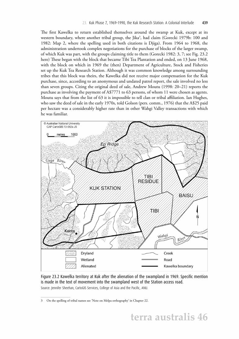
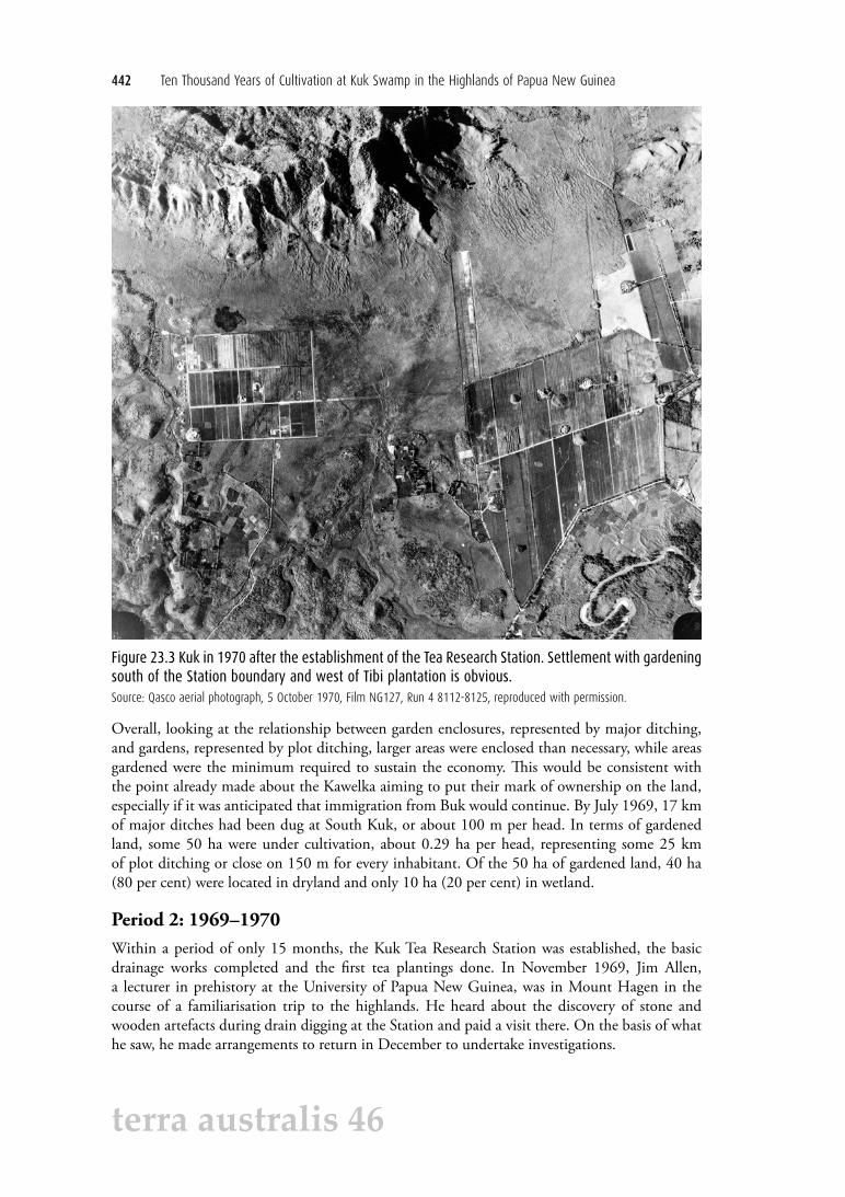
While the first cultivations were restricted to the drylands, it seems that within three years gardens were being made in swampland as well, indicating both an affirmation of Kawelka ownership and a recognition of this by surrounding tribes (Fig. 23.3). In the case of both drylands and wetlands, there were two kinds of ditching. Major ditches, wide and deep, formed an enclosure, with the spoil from their digging heaped on the inner side and a fence built on top. Within such enclosures was a grid of smaller ditches marking the gardens themselves, narrow and shallow and about 3 or 4 m apart, with the spoil from their digging thrown on to the plot surface to form a raised garden bed. Thus, one might say that for one hectare being opened for gardening, a minimum of 400 m of major ditching and 5000 m of plot ditching was required.
442 Ten Thousand Years of Cultivation at Kuk Swamp in the Highlands of Papua New Guinea
terra australis 46
Figure 23.3 Kuk in 1970 after the establishment of the Tea Research Station. Settlement with gardening south of the Station boundary and west of Tibi plantation is obvious.Source: Qasco aerial photograph, 5 October 1970, Film NG127, Run 4 8112-8125, reproduced with permission.
Overall, looking at the relationship between garden enclosures, represented by major ditching, and gardens, represented by plot ditching, larger areas were enclosed than necessary, while areas gardened were the minimum required to sustain the economy. This would be consistent with the point already made about the Kawelka aiming to put their mark of ownership on the land, especially if it was anticipated that immigration from Buk would continue. By July 1969, 17 km of major ditches had been dug at South Kuk, or about 100 m per head. In terms of gardened land, some 50 ha were under cultivation, about 0.29 ha per head, representing some 25 km of plot ditching or close on 150 m for every inhabitant. Of the 50 ha of gardened land, 40 ha (80 per cent) were located in dryland and only 10 ha (20 per cent) in wetland.
Period 2: 1969–1970Within a period of only 15 months, the Kuk Tea Research Station was established, the basic drainage works completed and the first tea plantings done. In November 1969, Jim Allen, a lecturer in prehistory at the University of Papua New Guinea, was in Mount Hagen in the course of a familiarisation trip to the highlands. He heard about the discovery of stone and wooden artefacts during drain digging at the Station and paid a visit there. On the basis of what he saw, he made arrangements to return in December to undertake investigations.

23. Kuk Phase 7, 1969–1990, the Kuk Research Station: A Colonial Interlude 443
terra australis 46
Allen (1970: 177–178) reported that 25 miles (just over 40 km) of drains had been dug on the Station by late 1969 and that the profiles of prehistoric ditches could be seen in the walls of these drains across the whole of the drained area. Fifteen blocks had been drained, each 265 m north–south and 180 m east–west (A2–6, B2–6 and C2–6 in the Station code; see Figure 25.T2.1). Allen investigated in detail 17 drain walls within two blocks in the northwest, C2 and C3.
He also wrote to Jack Golson about his findings, because Golson had been a member of a small Australian National University team that had investigated a similar situation in the upper Wahgi swamplands, at Warrawau Tea Estate, in 1966. As a result, Golson and another member of the 1966 team, Ron Lampert, paid a visit to Kuk in mid-1970 (see Chapter 1). Station workmen were at this stage digging the drains along either side of the line of the future E–W Rd 1 in the stretch between N–S Rd 3 at the west and the eastern boundary of the Station at Tibi Tea Estate. Encouraged by their work on the old ditches visible in the walls of these newly dug drains, they sought the agreement of the Station management to begin planning for a longer-term project at Kuk.
Meanwhile in South Kuk, the Kawelka had dug more major ditches than were required for planting, just as in Period 1, but more areas were now gardened within the enclosures. There is evidence of a shift in emphasis from dryland to swampland, made possible by the drainage work undertaken by the Research Station. This was particularly the case for Kawelka Membo clan, which moved right into the swamplands bordering the Guga River to the west of the western access road to the Station (Gorecki 1985: Fig. 4; for location see Fig. 23.2 here).
I estimate the Kawelka population in the Kuk vicinity to have been around 190 persons by the end of the period, a density of 56 per km2. Nine kilometres of major ditching were dug (450 m for every new arrival), making a total of 26 km. New gardens occupied 21 ha (1.05 ha for every new arrival), making a total of 71 ha (0.37 ha per head). Of the new 21 ha, 14 ha (66.7 per cent) were in wetland and 7 ha (33.3 per cent) in dryland, while of the total of 71 ha the respective areas were 24 ha (33.8 per cent) and 47 ha (66.2 per cent).
These figures, particularly the 450 m of major ditching for every new arrival, point to a planned extension of activities into the swamp, rather than a stabilised agricultural system. Two-thirds of the new land brought into cultivation was in wetland, so it would appear that most of the 9 km of new major ditching would have been for the drainage of swamp. This coincides with the establishment of the Research Station, whose own drainage, as we have seen, helped the drainage effort of the local population in South Kuk (see Fig. 6.6). In the light of this evidence, I suggest that the planned extension of activities into the swamp was because of an increasing demand for land to plant coffee, which was becoming an increasingly important cash crop. In these circumstances, new arrivals would have tended to be allocated the more difficult wetlands to drain and cultivate.
Period 3: 1970–1973The archaeological project (the Project) discussed with the Station management in 1970 was authorised by the Department of Agriculture, Stock and Fisheries and began in July 1972. By agreement, work was to take place in the eastern half of the Station, which was unused and where there were no immediate plans for development. Management undertook to provide the major drainage lines to make this possible, and during the dry season of 1972 labour was hired. It involved digging a drain along the eastern boundary of the Station from its northern boundary to the drainage easement at the northwest corner of Tibi Tea Estate, as well as flanking ditches to articulate with this boundary drain along the line of E–W Rds 2–4 eastwards from N–S Rd 3. Project members took advantage of the lengthy exposures provided to record the swamp stratigraphy and the evidence of former ditches.

444 Ten Thousand Years of Cultivation at Kuk Swamp in the Highlands of Papua New Guinea
terra australis 46
The Project itself undertook the digging of the N–S ditches that were necessary for the archaeological investigations. These were dug in conformity with the Station drainage plan. Initially the Project focused on block A9, where hired workmen, most of them initially not Kawelka, dug minor N–S drains that subdivided the block at 22.5 m intervals. In South Kuk, the trends noted in the previous two periods continued. There were decisive moves into swampland, but also substantial new activity on dryland.
The population had risen to an estimated 310 by the end of the period, representing a density of 91 per km2. There was an increase of 16 km of major ditching (to a total of 42 km), or 133 m per new arrival, a marked decrease when compared with the previous period. This might indicate an increase in the relative importance of actual gardening as against the preparation of new garden areas by major ditching. Reasons for this may have been that new gardens could be established using existing major drains as a boundary or that population had caught up with the planning of the previous period, or a combination of the two.
Some 65 ha of new gardens were made, divided between 37 ha (57 per cent) in wetland and 28 ha (43 per cent) on dryland, bringing the total of gardened land to 136 ha, 61 ha (45 per cent) wetland and 75 ha (55 per cent) dryland. The areas of wetland and dryland cultivation per head of population for the total gardened land were 0.20 ha and 0.24 ha, respectively.
Period 4: 1973–1977/78This period saw Papua New Guinea’s transition to independence on 16 September 1975. Over the years 1973 to 1975, the Project extended its investigations on Station land northwards by the digging of selective drains, always according to the Station plan, in some B blocks and a few C, D and E blocks. These investigations provided archaeological and stratigraphic information on the deeper parts of the swamp and its northern margins. From 1975 to 1977, the focus was on the excavation of prehistoric agricultural systems in the southeast part of the Station, blocks A11 and A12. Over these years, the workforce was almost exclusively Kawelka. In 1977, due to the sheer accumulation of data, as well as other commitments of Project personnel, a halt, though not necessarily an end, was called to fieldwork at Kuk, which had gone on longer than originally anticipated. The first spell of my own fieldwork took place during the final season of the Project, my second spell followed in the course of 1978.
By this time, the Station’s own agronomic research was no longer restricted to tea. The expanded range of its activities had been accompanied by a change of name to Kuk Agricultural Research Station and by the use of land in its hitherto barely exploited eastern half, where the Project had done all its work up to date and would focus in the future. In these circumstances Jack Golson, who visited me at Kuk late in my second season, had a discussion with Batley Rowson, then Officer-in-Charge of the Station, about future prospects for archaeological research there. Golson indicated 19 Station blocks as being of archaeological interest (see Fig. 25.T2.1), the seven most important of these being in the southeastern part of the property (A8–12, B11–12), three of lesser importance being on the margin of these (A7, B8, C9) and the remaining nine lying to the north (C, D and E10–12). These three categories were marked on a Station plan and the plan filed in the Station office (cf. Mandui 1998: Figs 1A and B). The understanding was that efforts would be made to safeguard the more important blocks and give notice if future developments at the Station were to affect any of the indicated areas. All 19 blocks were included among the 24 that constituted the core area of the site nominated to UNESCO for World Heritage status in early 2007 (see Fig. 25.T2.1).
23. Kuk Phase 7, 1969–1990, the Kuk Research Station: A Colonial Interlude 445
terra australis 46
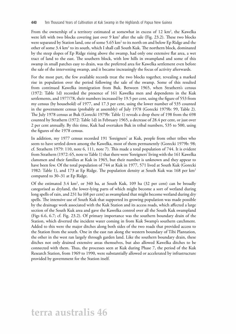
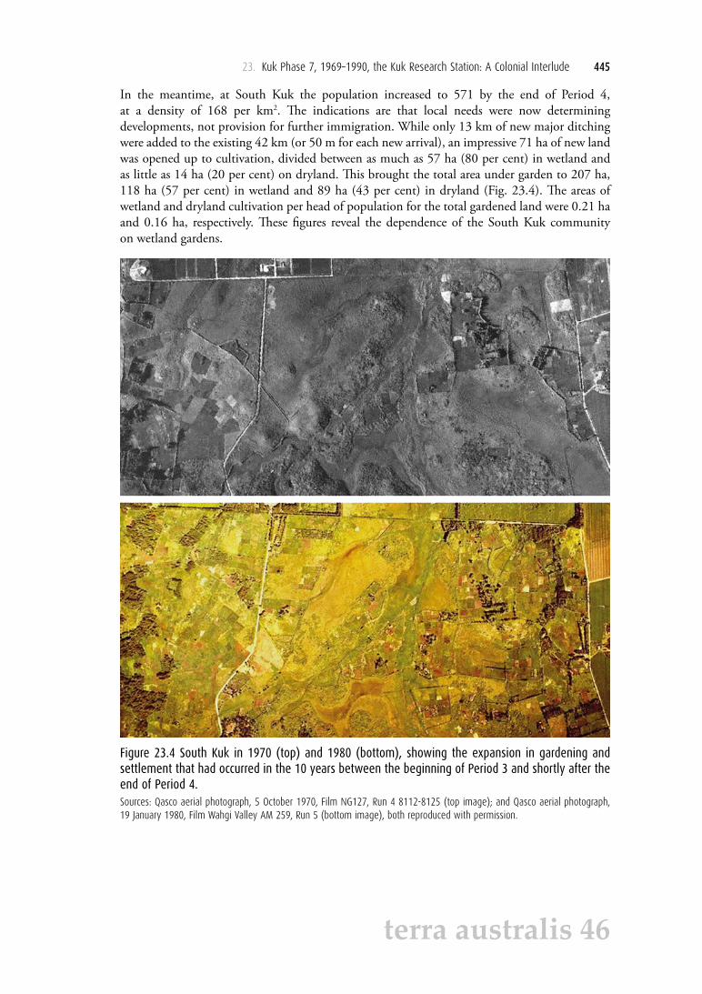
In the meantime, at South Kuk the population increased to 571 by the end of Period 4, at a density of 168 per km2. The indications are that local needs were now determining developments, not provision for further immigration. While only 13 km of new major ditching were added to the existing 42 km (or 50 m for each new arrival), an impressive 71 ha of new land was opened up to cultivation, divided between as much as 57 ha (80 per cent) in wetland and as little as 14 ha (20 per cent) on dryland. This brought the total area under garden to 207 ha, 118 ha (57 per cent) in wetland and 89 ha (43 per cent) in dryland (Fig. 23.4). The areas of wetland and dryland cultivation per head of population for the total gardened land were 0.21 ha and 0.16 ha, respectively. These figures reveal the dependence of the South Kuk community on wetland gardens.
Figure 23.4 South Kuk in 1970 (top) and 1980 (bottom), showing the expansion in gardening and settlement that had occurred in the 10 years between the beginning of Period 3 and shortly after the end of Period 4.Sources: Qasco aerial photograph, 5 October 1970, Film NG127, Run 4 8112-8125 (top image); and Qasco aerial photograph, 19 January 1980, Film Wahgi Valley AM 259, Run 5 (bottom image), both reproduced with permission.
446 Ten Thousand Years of Cultivation at Kuk Swamp in the Highlands of Papua New Guinea
terra australis 46
DiscussionThe recolonisation of Kuk from about 1960 represented the movement of Kawelka back to their traditional land in the Wahgi Valley from their settlements in the mountains north of the Wahgi, and in some cases from elsewhere, where they had retreated after their defeat in war a couple of generations before. It was made possible by the suppression of tribal warfare by the Australian administration and subsequently influenced by the proximity of Mount Hagen township and the ability to market cash crops there. I tried to quantify the extent of cash cropping at Kuk in terms of the area of arable land occupied by it, but reached only approximate figures because it promised to be a time-consuming investigation and one that fell outside my primary research project.
The data that I collected suggest that at the time of my work at South Kuk in 1977/78 there was a minimum of 40 ha and possibly up to 70 ha of cultivated land reserved for the market-oriented economy. This indicates that 20–34 per cent of cultivated land was being used for cash crops, primarily coffee. Other crops for market included sweet potatoes, corn, peanuts and beans. Cash cropping competed with subsistence plantings for fertile land. The money earned from cash cropping was not spent on food so much as on consumer goods like clothing, cooking pots, radios, tape recorders and especially beer. Under a more traditional economy, South Kuk could easily have sustained a more populous community than existed in the late 1970s and without the stresses apparent then, which arose directly from decisions about landuse. Two of the three Kawelka clans were running short of land, with little of it in fallow, while pigs were agisted where possible outside the territory.
Such stresses in South Kuk are likely to have continued and increased in the years following my work at Kuk. Stewart and Strathern (1998) point to the growing need for money, with a marked increase in the consumption of store-bought food since the 1970s and regular calls for contributions to ever larger compensation and bridewealth payments that strained individual means and fuelled tensions over inequalities, real or perceived, in land resources. Strathern and Stewart (1998: 95) observe that ‘[b]y 1994, the Tok Pisin term jelas (“jealous”) had entered into local discourse as a way of describing the ordinary tenor of intra-clan as well as inter-clan relationships’.
The context for these developments was the growth of population beyond the rate of natural increase. This was now less the result of immigration from Buk, which is likely to have virtually ceased, than the sponsorship of incomers by big-men as a source of labour in production, support in ceremonial exchange and strength in fighting (Strathern 1979: 100; Ketan 1998: 20; 2004: 133–134, 164–165). Such recruitment continued despite the pressure it exerted on available land, leading to unsuccessful efforts to negotiate access to Station land for sharecropping in the largely undeveloped eastern half of the property (Strathern and Stewart 1998: 91) and equally unsuccessful applications to the Land Board for adjacent land for cash cropping and resettlement (Ketan 1998: 21–22).
For a number of reasons it is not possible to give population numbers to support these statements. Up to 1978 there are figures for the number of Kawelka living at Kuk and the number living at Buk, while after that date the figures tend to be for the Kawelka as a whole. In the census of 1979, they were numbered at 1631 (Ketan 2004: Table 3.3), 578 or 596 more than in 1977/78, depending on the slightly different counts in those years produced by myself and the local administration. However, I counted 191 ‘foreigners’ at Kuk in 1977, bringing my population total for Kuk that year to 744. Ketan (2004: Appendix II, Table 2.2) reports that there were no returns from Kawelka census units at Kuk in the 1979 census. In the national census of 1990, the Kawelka are numbered at 4168, an apparent increase of 156 per cent in 11 years

23. Kuk Phase 7, 1969–1990, the Kuk Research Station: A Colonial Interlude 447
terra australis 46
(Ketan 2004: Table 3.3), leading Ketan (2004: 109) to comment that the tribe may have been enumerated twice, at both Kuk and Buk, in addition to the 500 or more migrants who were counted at the Kuk census point.
There are some relevant figures in the document produced for the nomination of Kuk for World Heritage listing (PNG Government 2007: 60; see Chapter 25 here). The document says that in 2000 an estimated 150 people were living in the core area of the nominated property, which consists of 116 ha in the southeastern part of the old Agricultural Research Station, with an estimated 350 people in the buffer zone, which consists of 195 ha to the north and west of the core area (Fig. 25.T2.1). The nomination document goes on to cite the national census of 2000 as recording 1928 Kawelka and 186 Jika Kilampi as living on or in the immediate vicinity of Kuk Swamp. National Statistical Office sources conceded prior to the 2000 census that the 1990 figures were unusable (John Burton, pers. comm., 2007).
The last paragraph has brought me well beyond the end of my brief. This was to tell the story of the Kawelka community and its relationship with the government Research Station set up on traditional Kawelka land at Kuk, in the course of which the Kuk archaeological project began and developed. At the beginning of the 1990s, as we shall see in the next chapter, Kuk Agricultural Research Station ceased to exist and the Kuk community, and especially its leaders, was faced with a new and uncertain situation. The same was true for the Project and its personnel, a few of whom had done limited investigations of short duration every year between the end of major fieldwork in 1978 and 1990.
AcknowledgementsThe 1980 aerial photographs of Kuk, held in the Ken Logan collection (Accession 110822), Fryer Library, University of Queensland Library, were located by John Burton. Permission to use some of these by was kindly given by Lois Logan and Qasco. Laurie McNeice and Darren Williams of the Fryer Library made high-quality prints of them. I am grateful to these institutions and individuals for their assistance. I am indebted to Paul Brugman, then GIS manager, College of Asia and the Pacific, ANU, for checking the areas of the three blocks of Kawelka land that I am dealing with at Kuk—Ep Ridge, the former Research Station and what I have called South Kuk—and for the illustrations that he prepared in the process. I am also indebted to Martin Gunther, the last and longest-serving Officer-in-Charge of the Research Station at Kuk, for commenting on my text in the light of the knowledge and experience that he acquired there. It has been improved as a result.
This text is taken from Ten Thousand Years of Cultivation at Kuk Swamp in the Highlands of Papua New Guinea, edited by Jack Golson, Tim Denham, Philip Hughes, Pamela Swadling and John Muke,
published 2017 by ANU Press, The Australian National University, Canberra, Australia.