1. introduction, principal results—leg 35 deep · pdf fileintroduction, principal...
TRANSCRIPT

1. INTRODUCTION, PRINCIPAL RESULTS—LEG 35 DEEP SEA DRILLING PROJECT1
Charles D. Hollister, Woods Hole Oceanographic Institution, Woods Hole, Massachusettsand
Campbell Craddock, University of Wisconsin, Madison, Wisconsin
Leg 35 was the third DSDP cruise to undertake drill-ing in Antarctic waters and the first in the SoutheastPacific Basin; the others were Legs 28 and 29 in theSouthwest Pacific which took place during the australsummer of 1972/1973.
Glomar Challenger departed Callao, Peru, on 13February 1974 and sailed to Valparaiso, Chile, to takeon additional personnel, equipment, and supplies priorto departing for Antarctic waters. The cruise ended on30 March 1974 at Ushuaia, Argentina, after steamingapproximately 5239 n. mi. at an average speed of 7.7knots.
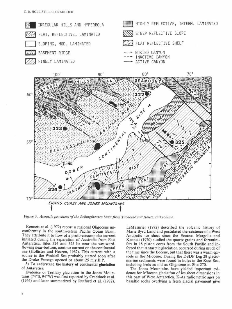
During this unusually short leg a variety of mechani-cal and weather problems severely limited our drillingprogram and only 8 days were spent with pipe in the seafloor. Drilling operations were carried out at four sitesin water depths between 3745 and 5026 meters. Twosites (322 and 323) lie on the Bellingshausen AbyssalPlain, and two (324 and 325) lie on the continental riseof Antarctica (Figures 1 and 2). Figure 3 shows locationof the sites with relation to the acoustic provinces recog-nized in the region. A single hole was drilled at each site.A total of 193 meters of sediment was recovered whichrepresents only 37% of the stratigraphic sections pene-trated. Basalt was reached at two sites and 13.43 meterswere recovered. A summary of coring operations isgiven in Table 1 and results are summarized graphicallyon Figure 4.
BACKGROUND AND OBJECTIVES
Regional Geology
Present knowledge of the sediments beneath the basinand the history of physical and biological events whichthey record are summarized by Goodell et al. (1973).The geology of Antarctica has been compiled in ageologic map (Craddock, 1972) and that of the Antarc-tic Peninsula is shown on two larger scale maps by Adie(1970).
The Andes Mountains of South America and thecoastal zone of West Antarctica mark segments of thePacific continental margin of Gondwanaland (Crad-dock, 1975), and recurrent orogenic cycles from the ear-ly Paleozoic through the latest Mesozoic have beenrecognized. The modern Andean chain, at 9000 km thelongest on earth, serves as an ideal model for a"cordilleran-type" range (Gansser, 1973b); it is com-monly explained as the result of oceanic plate subduc-tion beneath an active continental margin. However,
'With Operations Summary by Lamar Hayes, Western Oceanics,Inc., Houston, Texas.
Gansser (1973a) argues that block-faulting rather thancompression has predominated in the Andes during theCenozoic.
The intersection of the Chile Ridge separates the ac-tive central Andes from the relatively quiescent southernAndes. The central Andes are marked by many activevolcanoes and earthquakes, but the southern Andescontain only two active volcanoes and the infrequentearthquakes are widely spaced (Gonzalez-Ferran, 1972).
The rocks of coastal West Antarctica record a com-plex history of Phanerozoic sedimentation, volcanism,plutonism, metamorphism, and orogenic deformation.However, no rocks of certain Precambrian age arepresently known. Several orogenic cycles have beenidentified; the youngest is the Andean of Cretaceous toearly Tertiary age. Cenozoic volcanic rocks arewidespread in coastal West Antarctica; for example,Peter I Island (see Craddock, this volume), within thesouthern part of our area (Figure 2), is a basalticvolcano of probable Miocene age, and other seamountsare known to occur here. Thurston Island, south of ourSite 324, consists of Paleozoic and Mesozoic igneousand metamorphic rocks. Upper Tertiary basaltic ex-trusives rest upon a glaciated unconformity in the JonesMountains, just inland from Thurston Island.
The geologic history of the Antarctic Peninsula andits relation to the evolution of the Scotia Arc have beentreated by Dalziel and Elliot (1973). They suggest thatthe Scotia Arc probably formed by Cenozoic disruptionof an earlier, nearly linear, belt which connected SouthAmerica and the Antarctic Peninsula during theMesozoic. Paleozoic and Mesozoic orogenic cycles haveformed widespread igneous plutons and deformed meta-sedimentary and metavolcanic rocks in the AntarcticPeninsula and westward along the Antarctic coast(Adie, 1970; Craddock, 1972). Although there has beenextensive Cenozoic volcanic activity in this part of Ant-arctica, there is very little evidence for Cenozoic com-pression and folding. Except for a few earthquakes inthe western Drake Passage, the Antarctic plate appearsto be aseismic at present.
Objectives of Leg 35 DrillingThe sites drilled on Leg 35 were selected to study a
number of particular regional problems as well as to addto general knowledge of the area. Some specific objec-tives of the cruise and reasons for selecting the sitesfollow:
1) To study the nature and age of oceanic basement inan attempt to learn more about the pre-breakup con-figurations of Gondwanaland
The tectonic relationships and interactions betweenthe Antarctic plate and the Antarctic Peninsula, the

C. D. HOLLISTER, C. CRADDOCK
THURSTONISLANDRIDGE
FLANK
(after HeezenTharp, 1972)
Figure 1. Generalized physiography of the Southeast Pacific Basin and location of Leg 35 Sites (after Heezen and Tharp,1972).
Scotia Arc, the southern Andes, and the Chile Ridge arepoorly understood. Prior to this cruise, no directevidence was available on the age of the sea floor in theSoutheast Pacific Basin.
For the vicinity of Sites 322 and 325 three modelswere considered, based on the limited magnetic dataavailable: (1) Pitman et al. (1968) show the knownmagnetic anomalies which parallel the East PacificRidge, and projection of their data suggests a Mesozoicbasement, probably Early Cretaceous in age, for theeastern margin of the basin; (2) Herron (1971) interpretsthe Chile Ridge as a spreading axis and if the crust atSites 322 and 325 is formed by southwestward spreadingaway from the axis, an early Tertiary age is probable;and (3) Griffiths and Barker (1972) describe a northeast-trending spreading axis in the Drake Passage and if Site322 and 325 crust came from this source, a late Cenozoicage is possible.
2) To determine deep and surface patterns of paleocir-culation which cause changes of productivity patterns andsedimentation events that in turn determine regionalacoustic stratigraphy
Global patterns of abyssal circulation appear to beclosely connected to spreading patterns of Antarctic
deep waters. Changes in the production of Antarcticbottom waters together with changes in sea-floorbathymetry, due to sea-floor-spreading processes, haveplayed a major role in determining patterns of deep-seasedimentation and in producing variations in sedimentcharacteristics that are responsible for the acousticreflectors. Seismic profiles in the basin reveal manydifferent acoustic provinces (Figure 3) and reflectinghorizons; we hoped to establish the basic acousticstratigraphy of the area in an attempt to infer patterns ofpaleocirculation and variations in processes of ac-cumulation.
The Antarctic Circumpolar Current flows eastward atmore than 200 million m3/sec (Gordon, 1967, 1972;Reid and Nowlin, 1971). Site 321 lies near the westernentrance to the Scotia Sea and close to the present axisof this current; Site 323 lies about 250 miles south of theaxis. Both sites are situated to provide data on the earlyhistory of this massive current system. The earliest timethat the circumpolar current, as we know it now, couldhave existed was about 55 m.y.B.P. determined frommagnetic interpretation of ocean crust production be-tween Antarctica and Australia (Weissel and Hayes,1972).

BATHYMETRY OF THEBELLINGSHAUSEN BASIN
105° 100° 95° 90° 85°
Figure 2. Detailed bathymetric map of the Bellingshausen basin by B.E. Tucholke. Contours in uncorrected fathoms (1 fm = 1/400 sec).
C. D. HOLLISTER, C. CRADDOCK
IRREGULAR HILLS AND HYPERBOLA
FLAT, REFLECTIVE, LAMINATED
SLOPING, MOD. LAMINATED
BASEMENT RIDGE
FINELY LAMINATED
| HIGHLY REFLECTIVE, INTERM. LAMINATED
STEEP REFLECTIVE SLOPE
FLAT REFLECTIVE SHELF
* BURIED CANYONINACTIVE CANYON
- ACTIVE CANYON
TOO0
EIGHTS COAST AND JONES MOUNTAINS
Figure 3. Acoustic provinces of the Bellingshausen basin from Tucholke and Houtz. this volume.
Kennett et al. (1972) report a regional Oligocene un-conformity in the southwestern Pacific Ocean Basin.They attribute it to flow of a proto-circumpolar currentinitiated during the separation of Australia from EastAntarctica. Sites 324 and 325 lie near the westward-flowing near-bottom, contour current on the continentalrise (Hollister and Heezen, 1967). This current with asource in the Weddell Sea probably started soon afterthe Drake Passage opened or about 25 m.y.B.P.
3) To understand the history of continental glaciationof Antarctica
Evidence of Tertiary glaciation in the Jones Moun-tains (74°S, 94° W) was first reported by Craddock et al.(1964) and later summarized by Rutford et al. (1972).
LeMasurier (1972) described the volcanic history ofMarie Byrd Land and postulated the existence of a WestAntarctic ice sheet since the Eocene. Margolis andKennett (1970) studied the quartz grains and foramini-fers in 18 piston cores from the South Pacific and in-ferred that Antarctic glaciation occurred during much ofthe time since the Eocene, but that there was a warm epi-sode in the Miocene. During the DSDP Leg 28 glacio-marine sediments were found in holes in the Ross Sea,including beds as old as Oligocene at Site 270.
The Jones Mountains have yielded important evi-dence for Miocene glaciation of ice sheet dimensions inthis part of West Antarctica. K-Ar radiometric ages onbasaltic rocks overlying a fresh glacial pavement give

INTRODUCTION
TABLE 1Coring Summary, DSDP Leg 35
Site
322
323
324
325
Total
DatesOccupied
Feb. 27-Mar. 3
Mar. 6-Mar. 11
Mar. 13-Mar. 15
Mar. 21-Mar. 25
Hourson Site
84
113
552
103
352
LatitudeLongitude
60°01.45'S79°25.49' W
63°40.84'S97°59.69'W
69°03.21'S98°47.20'W
65°02.79'S73°40.40'W
WaterDepth
(m)
5026
4993
4449
3745
Penetra-tion(m)
544
731
218
718
2221
No.of
Cores
14
21
10
10
55
Cored(m)
125.5
199.5
95.0
95.0
515.0
Recovered(m)
34.2
76.7
48.1
34.4
193.2
Recovered(%)
27.3
38.4
50.6
36.2
37.5
Age ofOldest
Sediment
Oligocene-early Miocene
LateCretaceousPliocene
Oligocene-early Miocene
DeepestUnit
Basalt
Basalt
Sand
Claystone
discordant results, probably due to incomplete degas-sing of mantle-derived Ar40 during subglacial eruptions.The calculated ages, however, cluster in the 7-10 m.y.range. Site 324 is strategically located to test the ex-istence of the postulated Miocene ice sheet in the regionof the Jones Mountains. Such an ice sheet should havecalved many bergs, which would have drifted bothnorthward and westward; at least some should havereached the vicinity of Site 324 and dropped their en-trained rock debris to the sea floor. The AntarcticPeninsula lies further north than the rest of the conti-nent. It may have had a different history of glaciationduring the Cenozoic and Site 325 is favorably located topreserve this glacial record.
4) To investigate the geochemistry of pore waters andrelated sediments in order to understand postdepositionaldiagenetic processes in sediments, particularly as relatedto the alteration of underlying basalts
The Leg 35 geochemistry program was planned tocoordinate chemical studies of the interstitial waterswith those of the solid phases and with the physicalaspects of the sediments. We intended to carry out astudy that emphasized the interrelationships of thechemical composition of the interstitial waters and thechemistry and mineralogy of the solid phases. In par-ticular, we wished to study those chemical gradients, inthe interstitial waters, that may be related to upwardmigration of elements during crustal alteration.
5) To recover sediments containing high-latitude fossilforms to establish an Antarctic biostratigraphic andpaleogeographic framework
The objectives of the paleontological program were to(1) establish and refine high-latitude Antarctic bio-stratigraphy, (2) increase our understanding of thepaleobiogeography of all microfossil groups, and (3) in-vestigate changes in the paleooceans and paleoclimatesof the Antarctic during the late Mesozoic and Ceno-zoic.
SUMMARY OF DRILLING RESULTS
Bellingshausen Abyssal Plain
Site 322Site 322 was drilled on the eastern end of the Bellings-
hausen Abyssal Plain where it is bounded by the HeroFracture Zone to the northeast and the continental rise
of Antarctica to the south (Figure 3). Seismic profilesshow a nearly horizontal sediment accumulation (0.5sec) resting on very irregular "basement" topography.
A single hole was drilled in a water depth of 5026meters and reached a subbottom depth of 544 meters,penetrating 30 meters into basaltic rocks at the bottom.The upper 514 meters consists of Neogene sediments. Ofa total 125.5 meters cored, 34.2 meters (27.3%) of corematerial were recovered.
Four sedimentary units and one igneous unit arerecognized from the surface downward. Unit 1 is 295meters thick and consists of unconsolidated, well-sortedsands and silts interbedded with clays. Unit 2 is 171meters thick and consists of consolidated dark greenish-gray claystone. Unit 3 is 43 meters thick and consists ofinterbedded, mainly dark gray sandstones and clay-stones, and this is underlain by Unit 4 which consists of4.3 meters of brown pelagic claystone. Unit 5 is at least30 meters thick and consists of aphanitic, variolitic, andglassy basalt and minor hyaloclastite.
Seismic profiles at the site show a series of gently un-dulating reflectors which become less coherent down-ward, and no definite correlations could be establishedbetween individual reflectors and the above lithologicunits.
The sedimentary sequence is impoverished in fossilswith diatoms being the most abundant biogenicremains. A few diatoms found in claystone 2.5 metersabove the basalt contact appear to be Miocene in age.Pliocene radiolarians occur in the first core, but theybecome rare and less diagnostic deeper in the hole. Afew silicoflagellates found in Unit 1 and the upper halfof Unit 2 yielded ages increasing downward from latePliocene to late Miocene. Several benthonic arenaceousforaminiferal genera {Bathysiphon, Ammodiscus, andCyclammina) were found in the claystone of Unit 3within a few meters of the basalt contact. Some speciesof these genera range down into the Oligocene.
The oldest rock penetrated at Site 322 is the basalt inthe lowest 30 meters of the hole. On the basis of thepresence of glassy veins and hyaloclastite breccia, thisrock is interpreted as a submarine lava flow.
The apparent age of the basaltic extrusive rocks fromK-Ar dates vary from 10-15 m.y.B.P. (late Miocene).However, microfossils from the overlying sedimentarysequence indicate that the basaltic rock can be noyounger than middle Tertiary (i.e., about 25 m.y.B.P.).

C. D. HOLLISTER, C. CRADDOCK
BELLINGSHAUSEN ABYSSAL PLAIN
SITE 322
6 0 ° 0 1 . 4 ' S , 7 9 ° 2 5 . 5 ' W
SITE 323
6 3 ° 4 0 . 8 r S , 9 7 ° 5 9 . 7 ' W
ANTARCTIC CONTINENTAL RISE
SITE 324
6 9 ° 0 3 . 2 ' S , 9 8 ° 4 7 . 2 ' W
SITE 325
6 5 ° 0 2 . 8 ' S 7 3 ° 4 0 . 4 ' W
WATER DEPTH 5026 (m) WATER DEPTH 4993 (m) WATER DEPTH 4449 (m) WATER DEPTH 3745 (m)
>•
O
O
DESCRIPTION DESCRIPTION DESCRIPTION DESCRIPTION
J_100 —
Gray clay withinterbedded siltsand sands, locallydiatomaceous
200 —
300 H
4 0 0 -
500 —
Diatomaceousclay
Gray claystone
Gray sandstone
Z "-"- Green-graysilty claystone
Alternating bedsof claystone andsandstone
i Claystone
Sandstones andclaystones
π *-V/•Basalt
600 —
TD: 544 m
? OLIGOCENE-EARLY MIOCENE
700 — MAESTRICHTIAN.OR OLDER
Gray clay withinterbedded siltsand sands, locallydiatomaceous
Gray clay withinterbeddedlayers of well-sorted quartzsilt, locallydiatomaceous,scattered ice-rafted debris
I~==•
Diatom ooze,diatomaceousclay and clay
Gray c laystoneC .•V •VV Λ Unconsol I dated sand
SA •
Green-grayclaystone
Unconsolidatedsand
TD: 218 m
EXPLANATION
Claystones anddiatomaceousclaystones,
Silicified clay-stone (chert)
π yZ
π :- _-J
Silty claystone
Brown, Fe-richclaystone
Nanno claystone
Brown claystone andzeolitic claystone
20»-_**>*; I Basalt
Clay and siltyclay, locallydiatomaceous,with scatteredlayers poorly-sorted quartzsilt, scatteredice-rafted debris
z=ö=r
InterbeddedClaystones andsiltstones withice-rafteddebris
Claystonewith layers ofnannofossil chalk,silicified clay-stone
Interbeddedsandstones,siltstones andclaystones;laminated andcrossbedded
TD: 718 mTD: 731 m
Figure 4. Stratigraphic columns of the four holes drilled during Leg 35.
The position of the site on the abyssal plain and thesouthward continuity of stratigraphic units in theseismic profiles indicate that most of the detritus camefrom Antarctica. A small amount of ice-rafted materialoccurs in the upper Miocene sediments. The scarcity ofturbidite features in the sediment suggests that bottomcurrents may be responsible for final deposition. Cal-culation of exact accumulation rates is complicated bythe uncertainty about the true age of most beds in thesequence. Most of the sediment, however, seems to be
Neogene in age. All of the sediment appears to havebeen deposited under bathyal to abyssal conditions wellbelow the carbonate compensation depth.
Site 323
Site 323 is centrally located on the abyssal plain,about 30 miles west of the Eltanin Fracture Zone andabout 150 miles north of the Antarctic continental rise.This site, like 322, lies on the deep oceanic part of theAntarctic plate. Seismic profiler records in this region
10

INTRODUCTION
show smooth horizontal reflecting surfaces within theupper 1/4 sec that are underlain by a variety of acousticunits to the deepest observed reflector at 3/4 sec subbot-tom.
The single hole drilled at Site 323 (4993 m waterdepth) reached a total depth of 731 meters below the seafloor. Drilling penetrated 701 meters of Cenozoic andCretaceous sedimentary deposits, and 30 meters ofbasalt. A total of 199.5 meters was cored and 76.7meters (38%) of core, including about 10 meters ofbasalt, was recovered.
Six lithologic units are recognized: five sedimentaryand one igneous, which are numbered in descendingorder. Unit 1 is 266 meters thick and consists of gray un-consolidated sandy silt, diatom clay, and diatom ooze.Unit 2 is 241 meters thick and is comprised of relativelyindurated gray diatomitic claystone and cherts. Unit 3 isabout 130 meters of gray claystone devoid of biogenicsilica. Unit 4 is 28 meters thick and contains yellow-brown iron-rich claystone and nanno-claystone overly-ing 34 meters of brown zeolitic claystone (Unit 5). Thebase of this unit rests upon basalt, and there is no sign ofcontact metamorphism. Unit 6 is at least 30 meters thickand consists of aphanitic aphyric basalt having a rangeof textures but with no evidence of glass, palagonite, orhyaloclastite.
Seismic profiles near Site 323 have revealed thefollowing acoustic units in descending order: (I) flat-lying reverberant reflectors, (II) acoustically transparentlayer, (III) reverberant, gently undulating reflectors,(IV) acoustically transparent layer, (V) acousticallyopaque, undulating reflectors. A good correlation existsbetween these seismic units and the lithologic unitsdescribed above.
Each of the first 18 cores taken yielded fossils fromthe five major microfossil groups. Diatoms are the mostabundant fossil and are present in all 18 cores. They are,however, pyritized or recrystallized in the material olderthan early Miocene. A continuous stratigraphic se-quence may exist downward through early Miocene orOligocene. Danian (early Paleocene) foraminifers andnannofossils occur below 650 meters.
The 10 meters of aphanitic aphyric basalt recoveredprobably corresponds to the deepest observed seismicreflector. The Cretaceous age determined from nan-noplankton in the sedimentary unit overlying the basaltindicates an age of at least 65 m.y.B.P. which is close tothe predicted crustal age inferred from the closest mag-netic anomaly (32), approximately 76 m.y.B.P.
The brown iron-rich pelagic clay just above the basaltwas probably deposited in a tranquil environment most-ly below the carbonate compensation depth. Either anunconformity, or alternatively, a complete sequencewith very low accumulation rates is inferred from thepresence of Oligocene or Miocene gray silty claystone 21meters above Danian nannofossil claystone. A subse-quent abrupt increase in terrigenous detritus with nobiogenic component suggests rapid deposition ofcontinental-rise hemipelagic silt and clays which wasprobably originally transported downslope from Ant-arctica by turbidity currents, and penecontemporane-ously entrained and redeposited by contour currentsflowing as part of the newly developed abyssal circu-lation.
One ice-rafted granite cobble was found in sedimentof middle Miocene age.
Antarctic Continental Rise
Site 324Site 324 is located on the gently sloping lower con-
tinental rise of Antarctica about 160 miles north ofThurston Island, the closest exposed land. This site, likeall those drilled on Leg 35, lies on the oceanic part of therelatively stable Antarctic plate. Seismic profiler recordsover this site reveal a thick (at least 2 sec) total sedimentaccumulation.
The main purpose for drilling at this site was to gain abetter understanding of the paleoenvironments of theAntarctic continental margin from at least the onset ofglaciation. However, the single hole drilled at this site, ina water depth of 4449 meters, reached only 218 meterssubbottom before hole cavings of sand forced its aban-donment. The sequence penetrated consists of Plioceneand Quaternary sediments. Of total of 95.0 meters cored48.1 meters (51%) were recovered. Nearly all of the sedi-ment recovered consists of silty clays containing thinlayers of well-sorted silt. Ice-rafted detritus is commonin the upper part of the sequence, but decreases withdepth.
Seismic profiles over this site show a near-surfaceacoustically transparent layer overlain by a thin rever-berant layer and underlain by a very thick acousticallyreverberant layer. These three seismic units have beenidentified in the sequence penetrated and they are num-bered in descending order. Unit I is the surficial (top 50m) reverberant layer consisting of soft, watery Pleisto-cene clay interbedded with diatomaceous ooze. Unit IIis the acoustically transparent layer about 120 metersthick comprised of gray unconsolidated clay with thinsilty layers. Unit III is the lower reverberant layer (atleast 48 m thick) which is composed of lower Pliocenesilty clay and sand beds.
Site 325Site 325 lies within a well-developed submarine can-
yon system on the central portion of the Antarctic con-tinental rise, about 100 miles off the coast of the Ant-arctic Peninsula. It is in a region of finely laminated andlens-shaped acoustic intervals (about 1 sec thick) abovea relatively smooth basement (deepest observed re-flector). This smooth basement zone is about 50 mileswide and lies between the upper continental rise and thebase of the continental slope.
Unfortunately, the single hole drilled at this sitereached only to a depth of 718 meters subbottom, orabout 3/4 of the subbottom distance to basement. Theentire sequence penetrated consists of Cenozoic terrig-enous deposits. The oldest fossiliferous beds are earlyMiocene to Oligocene in age. Ninety-five meters of theinterval were cored and 34.4 meters (36.2%) of core wererecovered.
The sequence was divided into two lithologic units.The upper unit, about 570 meters thick, consists of siltyclay, silty claystone, and claystone. Ice-rafted pebblesand coarse sand grains are abundant at the top. Thelower unit is 148 meters thick and consists of induratedsandstone, siltstone, conglomerate, and claystone.
11

C. D. HOLLISTER, C. CRADDOCK
All 10 cores from Site 325 contain fossils of whichdiatoms are the most abundant. The uppermost 500meters contains a diverse Antarctic floral assemblageranging in age from late Pliocene to middle Miocene.Radiolarians in the uppermost 400 meters are Pliocenein age, and below this level calcareous and arenaceousbenthonic foraminifers of Oligocene to early Mioceneage occur. Early to middle Oligocene nannoplanktonare common in a few thin calcareous beds below 500meters.
The deepest observed seismic reflector probablyrepresents a thin sequence (less than 100 m) of Oligoceneand possibly older clastic sediments which, by valley-filling may have effectively smoothed the rough underly-ing igneous basement.
The percentage of quartz embedded within the clayand claystone varies inversely with the frequency of siltlaminae. The quantity of quartz silt supplied to thisregion has apparently been constant, and variations inmode of occurrence are probably directly related to thecompetence of the depositing currents. An unusuallyhigh accumulation rate of 20 cm/1000 yr calculated forearly to middle Pliocene suggests vigorous continentalerosion during this time. The oldest ice-rafted debris oc-curs in lower Miocene or upper Oligocene claystones.This agrees well with the age of the first occurrence ofice-rafted sediment in a similar deep-sea environmentencountered during Leg 28 off Antarctica.
SUMMARY OF PRINCIPAL RESULTS
Igneous RocksFresh basaltic rock was recovered from the bottom of
the hole at two sites on the Bellingshausen AbyssalPlain. Rocks from both sites are essentially bimineralic,with intermediate plagioclase somewhat more abundantthan augitic pyroxene. The lack of olivine in both rockssuggests a tholeiitic composition. The rock at Site 322 isconsidered to be a submarine extrusive, possibly con-siderably older than the overlying Miocene sediments.The rock at Site 323 occurs below sediments of LateCretaceous age and may be a sill.
Age of the Crust
The most probable ages for the igneous basement areCretaceous at one of the western sites (323) and earlyand middle Tertiary, respectively, at the two easternsites (322, 325). Magnetic anomaly patterns, depthbelow sea level, and degrees of alteration suggest thatthe Site 322 basalt is considerably older than the overly-ing early Miocene sediments. Although the basalt at Site323 may be intrusive, seismic data suggest that itprobably represents the igneous rocks of Layer 2. Site324 was a shallow hole, but its tectonic position and thegreat thickness of sedimentary deposits suggest that thebasement may be lower Tertiary or Cretaceous. Site 325bottomed in Oligocene sedimentary rocks at least 100meters above igneous rocks and probable basement.
Sedimentary ProcessesMost of the sedimentary deposits penetrated at the
four sites consist of terrigenous debris derived from Ant-arctica. This detritus was transported to the deposition
site by bottom currents, turbidity currents, and ice-rafting. At the two abyssal plain sites, pelagic clay-stones of Miocene (Site 322) and Cretaceous (Site 323)age lie just above basalt at the bottom of each hole; afew thin calcareous beds also occur within theCretaceous pelagic deposits.
Antarctic GlaciationA record of continental glaciation in Antarctica dur-
ing the Cenozoic is present in cores taken close to thatcontinent in the form of dropstones and other ice-rafteddebris. Site 325 on the upper continental rise off theAntarctic Peninsula yielded ice-rafted debris from manyhorizons in the uppermost 500 meters of the sequence;the oldest beds with such debris are of early or middleMiocene age.
BiostratigraphyModerately well preserved middle Miocene to Pleisto-
cene siliceous microfossil assemblages were recovered atall four sites and the established Southern Ocean bio-stratigraphic zonal schemes were found to be applicablethroughout the region. All siliceous microfossils instrata older than middle Miocene are so altered or re-crystallized that precise identification and age assign-ments are impossible. Moderately to well preserved cal-careous planktonic foraminifers were found in Plio-cene-Pleistocene beds at Sites 324 and 325, and in Paleo-cene beds at Site 323. Oligocene or early Miocenebathyal to abyssal arenaceous foraminifers occur atSites 322, 323, and 325.
Interstitial WatersAlkalinity and ammonia values from all four sites
show maxima at depths of 100 to 300 meters. Theseprofiles suggest increased sulfate reduction in the upperfew hundred meters of the sedimentary sequence. Allsites showed large downhole increases in dissolvedcalcium and decreases in dissolved magnesium; gradi-ents are especially steep in the deeper parts of holeswhich penetrate basalt. Submarine alteration or hal-myrolysis of basalt is considered an important factor increating these calcium and magnesium gradients.
SUMMARY OF OPERATIONS
Leg 35 (including the Callao port call) was carried outduring 56.3 days of which 16.5 days were spent on sta-tion and 28.2 days cruising. The sites drilled on this legwere all south of 60°S. While on site the ship lost 2.2days because of mechanical breakdown and another 0.8days because of bad weather. A more complete sum-mary of operations is contained in Table 2.
DrillingA standard bottom-hole assembly was used at two of
the four sites. This assembly consisted of a bit, bit sub(with float valve), core barrel, three 814" drill collars,two 5' stroke bumper subs, three S1Á" drill collars, two5' stroke bumper subs, two %VA" drill collars, one IVΛ"drill collar, and a joint of heavy wall drill pipe. Thestandard nonrotating inner core barrel was used at allsites.
12

INTRODUCTION
TABLE 2Summary of Operations, Leg 35
Total days Leg 35Total days in PortTotal days cruising (survey time included)Total days on site
Trip timeDrilling timeCoring timeMechanical downtimeWaiting on weatherOther (includes running logging unit)
Total distance traveled (nautical miles)Average speed (knots)Sites investigatedHoles drilledNumber of cores attemptedNumber of cores with recoveryPercent of cores with recoveryTotal meters coredTotal meters recoveredPercent of core intervalTotal meters drilledTotal meters of penetrationPercent of penetration coredMaximum penetration (meters)Minimum penetration (m)Maximum water depth (m)Minimum water depth (m)
56.311.628.216.54.82.94.92.2
.8
.95239
7.744
555294
515193.2
37.51696.52212
23731219
50363755
Recovery was not as good as expected which was at-tributed to several factors. Primarily, very little coringwas attempted in the soft clays and oozes near the mudline where recovery is usually high. Secondly, at three ofthe four sites, silt and sand interbeds were encounteredwhich required more circulation than is normally usedwhen coring soft formations. Reduced circulation re-sulted in a tendency of the bit to plug and the drill stringto stick. Thirdly, coarse ice-rafted debris lodged in thecore catcher and prevented entry of sediment into thecore barrel thereby hampering the coring of the softsediments. Also, the extended port call in Callao sub-stantially reduced the time available for actual drilling.Only 8 days were spent with pipe in the sea floor.Consequently, time was not available for continuouscoring and only 18% of the total penetration was cored.
Basement was penetrated at Sites 322 and 323 anddrilling was terminated when Site 324 was abandonedbecause of unstable hole conditions at 218 meters belowthe mud line. In addition, the drill string was subjectedto excessive torque when, despite attempts to wash itout, the bit became plugged. However, the poor holecondition was the primary reason drilling was ter-minated at Site 324. There was no recovery on thelast core attempted.
Drilling at Site 325 was terminated after we en-countered 20-ft swells and 60-mph gusty wind.
Positioning
Difficulties with the positioning system were ex-perienced at three of the four sites. At Site 322, amalfunction in the Number 1 hydrophone receiver tim-ing signal resulted in erratic computer signals and it wasnecessary to position in semi-automatic mode for muchof the time at that site.
At Site 324, positioning became difficult as the windvelocities increased and seas became choppy. Theproblem was ultimately found to be caused by excessivedrive current to the stern thruster static exciter whichresulted in erratic maximum thrust in both semi-automatic and manual modes.
At Site 325, in 60-mph winds and 16 ft to 18 ft swells,positioning was again erratic. A second beacon wasdropped and the ship maintained position satisfactorilyuntil the wind shifted so that both current and windwere coming from the same direction. Unfortunately,the ship was unable to maintain heading against bothwind and current with only one operable stern thruster,and it was necessary to abandon the site. At the time Site325 was abandoned, it was necessary to position inautomatic mode with winds up to 60 mph and 22-ftswells which caused the ship to pitch 10°.
UnderwayEn route to the first site (322) the ship cruised at full
speed (210 turns) when weather would permit. Winds upto 75 mph required a reduction of speed to prevent theship from taking severe rolls. In some cases, the ship ex-perienced rolls of up to 35°.
On 1 March 1974 the NSF R/V Hero rendezvousedwith the Challenger at 60°S and 79°W. The Hero accom-panied the Challenger during the remainder of the legsouth of 60°S, and cruised approximately 5 to 15 milesahead to scout for ice.
First ice, a bergy bit, was reported by the bow lookouton 15 March at 67°S and 96°W. Later the same day, amedium-sized iceberg was spotted 4 miles on the star-board side. Although this was the only ice observed, forreasons of safety the ship's speed was reduced to 5 knotsat night or during heavy snow squalls until after we hadmoved north of 60°S.
While steaming between Sites 324 and 325, theNumber 6 propulsion motor became inoperative. Dur-ing the remainder of the voyage the ship's speed wasreduced by 10%. However, because of sea conditions,poor visibility, and/or ice hazard during approximately80% of the cruising time, the vessel was not operated attop cruising speed. Because the ship was constantly roll-ing 10° to 20° or pitching 5° to 10°, repairs were ex-tremely difficult to effect throughout the leg.
Heave CompensatorThe heave compensator system was not used at Site
322 because a suction hose on the hydraulic pumps burstcausing the loss of approximately 390 gallons of pydraulleaving insufficient fluid to operate the system. Follow-ing delivery of 300 gallons of pydraul by the Hero, thesystem was utilized at Site 323 in 4993 meters of water.Here the drill string weight was approximately 375,000pounds. The system operated in both active and passivemodes and instrumented recordings of the performancemade during 22-hr test indicated that it operated withinthe designed specifications. In soft sediments the heavecompensator apparently does not improve core recoveryor result in less core disturbance. In firm or hard forma-tions, however, bit life is extended and core recovery isimproved.
13

C. D. HOLLISTER, C. CRADDOCK
REFERENCESAdie, R.J., 1970. Antarctic Peninsula. In Geologic maps of
Antarctica, Folio 12, Antarctic Map Folio Series: NewYork (Am. Geogr. Soc.)
Craddock, C, 1972. Geologic map of Antarctica, scale1:5,000,000: New York (Am. Geogr. Soc).
, 1975. Tectonic evolution of the Pacific margin ofGondwanaland. In Campbell, K.S.W. (Ed.), GondwanaGeology: Canberra (Australian National University Press),p. 609-618.
Craddock, C, Bastien, T.W., and Rutford, R.H., 1964.Geology of the Jones Mountains. In Adie, R. J. (Ed.), Ant-arctic geology: Amsterdam (North Holland Pub. Co.),p. 171-187.
Dalziel, I.W.D. and Elliot, D.H., 1973. Scotia Arc and Ant-arctic margin. In Nairn, A.E.M. and Stehli, F.G. (Eds.),The ocean basins and margins, vol. 1: New York (PlenumPub. Corp.), p. 171-246.
Gansser, A., 1973a. Facts and theories on the Andes: J. Geol.Soc. London, v. 129, p. 93-131.
, 1973b. Orogene Entwicklung in den Anden, imHimalaja und den Alpen, ein Vergleich: Ecolog. Geol.Helv., v. 66, p. 23-40.
Gonzalez-Ferran, O., 1972. Distribucion del volcanismo ac-tivo de Chile y la reciente erupcion del volcán Villarrica: InEl Primer Symposium Cartográfico Nacional, Santiago,p. 191-207.
Goodell, H.G., Houtz, R., Ewing, M., Hayes, D., Naini, B.,Echols, R.J., Kennett, J.P., and Donahue, J.G., 1973.Marine sediments of the Southern oceans, Folio 17, Ant-arctic Map Folio Series: New York (Am. Geogr. Soc).
Gordon, A.L., 1967. Structure of Antarctic waters between20°W and 170°W, Folio 6, Antarctic Map Folio Series:New York (Am. Geogr. Soc).
, 1972. On the interaction of the Antarctic circum-polar current and the Macquarie Ridge. In AntarcticOceanology II, Antarctic Res. Ser.: Am. Geophys. Union,p. 71-78.
Griffiths, D.H. and Barker, P.F., 1972. Review of marinegeophysical investigations in the Scotia Sea. In Adie, R.J.
(Ed.), Antarctic geology and geophysics: Oslo (Univer-sitetsforlaget), p. 3-11.
Hayes, D.E, Frakes, L.H., et al., 1975. Initial Reports of theDeep Sea Drilling Project, Volume 28: Washington (U.S.Government Printing Office).
Heezen, B.C. and Tharp, M., 1972. Morphology of the seafloor. In Folio 16, Antarctic Map Folio Series: New York(Am. Geogr. Soc).
Hollister, CD. and Heezen, B.C., 1967. The floor of theBellingshausen Sea. In Hersey, J.B. (Ed.), Deep seaphotography: Baltimore (Johns Hopkins Univ. Press).
Herron, E.M., 1971. Crustal plates and sea floor spreading inthe southeastern Pacific. In Antarctic Oceanology I, Ant-arctic Res. Ser.: Am. Geophys. Union, p. 229-237.
Kennett, J.P., Burns, R.E., Andrews, J.E., Churkin, M., Jr.,Davies, T.A., Dumitrica, P., Edwards, A.R., Galehouse,J.S., Packham, G.H., and van der Lingen, G.J., 1972.Australian-Antarctic continental drift, paleocirculationchanges and Oligocene deep sea erosion: Nature, v. 239,p. 51-55.
Krumbein, W.C., and Pettijohn, F.J., 1938. Manual of sedi-mentary petrology: New York (D. Appleton-Century Co.).
LeMasurier, W.E., 1972. Volcanic record of Cenozoic glacialhistory of Marie Byrd Land. In Adie, R.J. (Ed.), Antarcticgeology and geophysics: Oslo (Universitetsforlaget),p. 251-259.
Margolis, S.V. and Kennett, J.P., 1970. Antarctic deep seacores: Science, v. 170, p. 1085-1087.
Pitman, W.C., Herron, E.M., Heirtzler, J.R., 1968. Magneticanomalies in the Pacific and sea floor spreading: J. Geo-phys. Res., v. 73, p. 2069-2085.
Reid, J.L. and Nowlin, W,, 1971. Transport of water throughthe Drake Passage: Deep-Sea Res., v. 18, p. 51-64.
Rutford, R.H., Craddock, C, White, CM., and Armstrong,R.L., 1972. Tertiary glaciation in the Jones Mountains. InAdie, R.J. (Ed.), Antarctic geology and geophysics: Oslo(Universitetsforlaget), p. 239-243.
Weissel, J.K. and Hayes, D.E., 1972. Magnetic anomalies inthe southeast Indian Ocean. In Antarctic Oceanology II,Antarctic Res. Ser., Am. Geophys. Union, p. 165-196.
14