1 evaluation of land utilization and circulation system …
TRANSCRIPT

EVALUATION OF LAND UTILIZATION AND CIRCULATION SYSTEM
IN AN URBAN LAYOUT
Case Study: New Town of Gandhinagar, India
by
NAVROZ N. DABU
Dipl. Arch. Center for Environmental Planning andTechnology, Ahmedabad, India
1979
SUBMITTED TO THE DEPARTMENT OF ARCHITECTURE IN PARTIAL FULFILLMENT OF THEREQUIREMENTS OF THE DEGREE OF MASTER OF SCIENCE IN ARCHITECTURE STUDIES
AT THE MASSACHUSETTS INSTITUTE OF TECHNOLOGY.
June 1983
Copyright @ Navroz N. Dabu 1983
The Author hereby grants to M.I.T. the permission to reproduce and to distributecopies of this thesis document in whole or in part.
Signature of Author
Navroz N. Dabu,4 epartment of Architecture, May 1983
Certified by
Horacio Caminos, P of. of Architecture, Thesis SupervisorAccepted by
N. John Habraken, Chairman, Departlental CommitteeKotCff
on Graduate Students. MASSACHUSETTS INSTITUTEOF TECHNOLOGY
MAY 26 1983
1
I InDAniCe

2

ABSTRACT 7
EVALUATION OF LAND UTILIZATION AND CIRCULATION SYSTEM
IN AN URBAN LAYOUTCase Study: New Town of Gandhinagar, India
by
NAVROZ N. DABU
SUBMITTED TO THE DEPARTMENT OF ARCHITECTURE ON MAY 6,1983
IN PARTIAL FULFILLMENT OF THE RECQUIREMENTS FOR THE DEGREE
OF MASTER OF SCIENCE IN ARCHITECTURE STUDIES
ABSTRACT
The study evaluates the issues of an Urban Layout
in an existing situation of a new town in India
and a model is prepared based on the observations.
The comparison is made between the existing case
and the proposed model.
The main issues of the evaluation are Land Subdi-
vision, adequate Land Utilization and Efficient
Circulation System.
The study of the -existing situation is carried
out for the "Sector 21" in Gandhinagar - the new
capital of Gujarat State and the proposed model
is for the same site.
Thesis Supervisor: Horacio Caminos
Title: Professor of Architecture
__ -WIMMML
4 EVALUATION: URBAN LAYOUT ACKNOWLEDGEMENTS
ACKNOWLEDGEMENT S
I gratefully acknowledge the support, guidance and advice
of professor Horacio Caminos during the entire study
period at M.I.T. Next, I express my gratitude to Reinhard
Goethert for the criticism, personal assistance and moral
support throughout.
I am indebted to the Deputy Town Planner and the Senior
Architect of the Government of Gujrat State-Mr.Deepak
Mewada and Mr. Soli Unwala and numerous officials of the
offices of the Chief Architect and Town Planner for their
co-operation in my field work in Ahmedabad during the
summer of 1982.
I am thankful to my professor Sharad N.Sheth and my
colleagues Sudhir Shah and Ismet Khambatta in India,
for their assistance in collection of additional
data and photographs.
I also acknowledge the J.N. Tata Endowment, R.D. Sethna
Scholarship fund, Parsi Panchayat of Surat and Zorastrian
Association of Hong Kong, Mrs. Minnie Cama, my friend
Mahiyar Gandevia, uncle - "Minoo Masa" and cousin Burjor
for the partial financial assistance without which, the
higher studies at M.I.T. would have been impossible.
Lastly, I thank my wife Binaifer for her encouragement,
support and assistance in typing and debt to my parents
for their love, sacrifice and encouraging support, is
beyond the means of expression.

EVALUATION: URBAN LAYOUT
CONTENTS
PREFACE .................
GANDHINAGAR
- Urban Context..............
EVALUATIONS
- Existing and Proposed Plans
1. Land Utilization Plan.....
2. Land Utilization Plan.....
3. Circulation Plan..........
- Comments:
1. Land Subdivision..........
2. Land Utilization..........
3. Circulation...............
4. Blocks, Lots and Clusters.
CONCLUSION..................
APPENDIX
INDIA
- National Context...........
Existing Project Program.....
Existing Dwellings Program...
.......................................... 6
...... .................................... 7
........................... ..........................12
........................... ..........................16
........................... ..........................18
........................... ..........................20
........................... ..........................22
........................... ..........................24
............................ ........................-25
Design Stages: Proposed project......................
*-28..34-35*-36
GLOSSARY.................................................38
REFERENCES/EXPLANATORY NOTES...........................40
I- -AIWAWW

__ _AaPAWW
6 EVALUATION: URBAN LAYOUT PREFACE
PREFACE
BACKGROUND - NEW TOWNS:
In the past two or more decades of rapid urban growth in
India there has been attempts to plan completely new towns
for specific purposes in chosen locations.
Though these new towns are diverse in their planning
objectives, all share situation characterised by scarcity
of financial, technical and managerial resources. These
new towns vary in planned populations of 10,000 to 500,000
and include refugee townships, state capitals, steel and
fertilizer towns.
OBJECTIVES:
The focus of this study is on urban dwelling environment
in one of the new towns in India. The selected town is
GANDHINAGAR planned as a capital city of the state of Guj-
rat. The major intent of the study is the evaluation of
the various important issues of the urban layout and prep-
are a model based on the observations to improve upon the
studied issues.
CONTENT:
The study is carried out at two levels. First, the Identi-
fication and Evaluation of theselected planned portion of
the town. Second, keeping the basic outline of the program
constant as in the existing situation a Model is developed.
The proposed Model is compared to the existing primary
emphasis on the issue of land utilization and the circula-
tion which would be the major guidelines for the evaluat--
ion and the preliminary design of the urban environments
and the point of reference for the policy makers for the
new planned environments.
As the city is planned with a regular patterns of main
roads dividing the city into rectangular "Sectors" measur-
ing 1000m by 750m. One of these Sectors is selected for
this study.
GANDHINAGAR: URBAN CONTEXT 7
GANDHINAGARURBAN CONTEXT
Primary Information
GANDHINAGAR, the new capital city of the state of Gujrat
is situated approx. 24 km. to the North of the previous
capital city - Ahemdabad; in western India.
The city is located 73m above sea level on 23 4' North
latitude and 72 38' East longitude.
The site for the whole city occupies an area of approx.
5738 hectares, and is situated on the banks of river Saba-
rmati. The ground of the site is level and well drained
with a gentle slope from North east to South west. The
soil is mostly loam sandy, and therefore suitable for the
building construction work. The exciting feature of the
site is it's Mango groves.
The max. average temperature is 40 c in May-June, and a
minimum average of 29 c in Dec- Jan. Mean relative humid-
ity is highest in August (86%) and lowest in Jamiaru (47%).
Average yearly rainfall is about 825 mm. The prevailing
wind direction varies from Southwest to West. Gandhinagar
is conveniently located from the point of view of transp-
ort. The existing Ahmedabad Airport is midway between Ahm-
edabad and Gandhinagar. The major highways (Ahmedabad - Mt.
Abu), and (Bombay - Ahmedabad - New Delhi) bypass the site
5 km. to the west and 5 km. to the East respectively. The
extension work of the existing, Broad-guage railway line
is finished, and the railway station is designed on the
west boundary on of the township.
History:
After the bifurcation of the Bombay state a seperate state
of Gujrat came into existance on lst of May 1960. The
Chief Minister declared that the State will have a new
1500 1700 1900 1970
URBAN POPULATION GROWTH
horizontal: dates vertical, population
25% 20 15 10 5 0 5 10 15 20
URBAN POPULATION DISTRIBUTION
horizontal: percentages vertical: agesmales: M females: F
.!
2000
TEMPERATURE
45C SUMMER MONSOON WINTER
21C ------0C
18c
MAR JUN NOV MAR
HUMIDITY
1001.
501.
0%
RAIN
400mN300m
200mm
100mm
0mm
SNOW
400mm
300..
200mm
100mm
0mm
25000
10000
5000
1000
50% 40 30 20 10URBAN ANNUAL INCOME DISTRIBUTION
horizontal: percentages vertical: dollars
Source: Discussions; town
planning office (Approximate)
NORTH400,000
300 000
200,000WIND
100,000
NORTH
PLAN
50,000
25,000
0
EVALUATION: URBAN LAYOUT
0 EVALUATION: URBAN LAYOUT
Capital to be named Gandhinagar. However no progress could
be made towards the execution of the project for the new
city, as the Oil and Natural Gas Commission was exploring
the area for oil. In 1964, the commission declared the
proposed site, to be free of oil and the project was star-
ted.
Masterplan for the township was then prepared by the team
led by the Dept. of P.W.D. and was approved by the Govt.
in 1966. The construction progressed with hectic speed
till 1971. Due to some political changes of the ministry
the program was suspended, though the next ministry in
power started the development again.
Gandhinagar today is a full fledged city and in the last
thirteen years, the population has grown from 25,000 to
100,000. All the sectors are not yet finished and the new
Capital complex had it's opening, in the summer of 1982.
City Planning Concept:
Functionally Gandhinagar is the capital city and there-
fore is predominantly the administrative centre of the
state, though gradually it is acquiring important civic
and cultural functions,
Initially the principal employer in the city would be
the state government and the design population is based
on the government employment structure. The city is
planned for the population of 300,000.
Conceptually, the major work areas are provided in the
centre and other work areas are distributed along the
major town roads.
On the leeward side of the city is located the industr-
ial areas having small scale and light industries.
Capital complex forms the major activity centre of the
city and is placed in the central sector of the city.
The railway station located at the perephery just faces
GANDHINAGAR:URBAN CONTEXT
the capital complex - together forms the central axis
of the city which is to be developed into a major park.
The total area of the site is app. 5738 hectares which
includes the area under the river (800 hectares).
The New city is planned on the Western bank of the riv-
er. Out of which 700 hectares along the river (which is
eroded land) are left out for the river front development.
The area on the eastern bank of the river is not propo-
sed for immediate use.
__ -Adatifiow-

GANDHINAGAR:URBAN CONTEXT 9
10km
KEY
Built-up Area
major town roads
-'- - city boundary
KEY
Residential
Commercial
Wa Work Area
(govt. offices)
URBAN TOPOGRAPHY AND CIRCULATION URBAN LAND USE PATTERN
6 U is iSK.
1:250000
Residential Area:
The main roads of the city divide it into rectangular
areas called "SECTORS" which measure 1 ki. in length
and 3/4 km. width enclosing an area of 75 hectares.
Each of the sectors accomodates on the average resid-
ential community of the density ranging from 7000 to
17000 people. Each sector has the necessary facilities
like schools, shopping centres, playgrounds, parks etc,
Mostly 50% of the total population of the city will be
constituted by the government employees, most of the
Residential Sectors are proposed to have the population
dependent on other occupations of professions also.The
aim was to avoid developing isolated government colonies.
Different types and categories of home types have been
used in the planning. Government employees are accomoda-
ted in five different categories of houses built by the
government.
Ten categories of residential plots ranging from a mini-
mum of 50 sq. meters to a maximum of 1600 sq. meters are
made available to the people.
In each sector there is an attempt to have a balanced
combination of four categories each of private plots and
government quarters.
EVALUATION: URBAN LAYOUT
GANDHINAGAR: URBAN CONTEXT10 EVALUATION: URBAN LAYOUT
KEY
High
Medium
VMO1,Low
a 1 IsURBAN DENSITY PATTERN
1:250000
WORK AREAS:
CAPITOL COMPLEX AND GOVERNMENT OFFICES
The most important work place in the city is the Capital
Complex and Government Offices. The Capital Complex, comp-
rising of Secretariate, Legislative Assembly, the High
Court and Offices of Heads of Departments are located cen-
trally in one 'Sector', with an area of 75 hectares.
It has been so planned as to merge gradually with the
river front landscape to the south-east. Other Offices of
the State Government have been located to the north of the
Capital Complex covers an area of about 150 hectares. The
area is so located as to be within easy reach of the resi-
dences of most of the Government employees.
Mu
LIGHT INDUSTRIES AREA:
Though Gandhinagar is primarily to be an administrativecentre, it must have a diversified economic base to makeit a living city. It is therefore desirable that lightindustries which will not-basically alter the character ofthe city be established.
It is estimated that about 20000 workers will be engagedin such industries. An area of about 120 hectares has beenearmarked for this purpose to the north of the city andabout 160 hectares on the north-west of city. It includes
provision for establishment of industrial training schoolsor such other technical institutions requiring close prox-
imity with the "workshop".
PUBLIC INSTITUTIONS AREA:
To the south of the city an area of about 50 hectares has
been earmarked for public institutions of State-wide impo-rtance.
SHOPPING, COMMERCIAL AND WAREHOUSING AREA:
At the intersection of the two central roads in the city
is located the main shopping centre for the city. Though
it will spread to some extent along these two roads, it
has been so planned as not to cause any hindrance to traf-
fic on them. This area will accomodate retail shopping
facilities as well as other commercial premises.
Along the central avenue, connection the City Centre with
the Capital Complex to the south-east and the warehousing
area to the north-west there is a strip of land reserved
for special buildings requiring larger plots. At the north
western tip of this strip is located the wholesale and
warehousing area to which will flow goods from the surrou-
nding region without any hindrance to the traffic within
the city.
10km

EVALUATIONS 11
4 ME .n no W= No.... .on MM N8 No a Wa Wu me nam 51.11mum=
-. 0 mm m mA~~ 4 . a* #n Nelo
a Egg4.#
41 --
be I A **$
e .N.
4gWnam
3a
Pr.e au ensumn
This section evaluates the issues of an urban layout by comparision of the
existing and the proposed Land subdivision,Land utilization and Circulation,
with the help of plans and comments.
MR
EVALUATION: URBAN LAYOUT

0-
1MAJOR TOWN ROAD -"CH"
I 4W KEYPo Post-office
Ir"irMi ; SS Secondary School
ma n# T Temple
Hf mwetwt Mq Mosque
Ch church
-Z Ps Primary School
0 Ps L Library
0z P Police station
E- F1, M Market
A D Playground
Ci Cinema
E~ R Reserve
Mq D DispensaryRC Recreation
Re Gs Gas station
Ss Pw
TOWN ROAD -"CHH" V 50
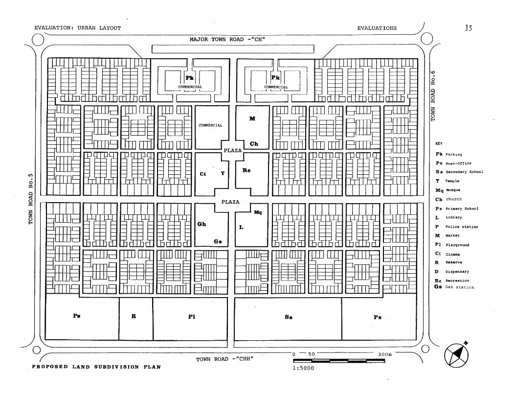
EXISTING LAND SUBDIVISION PLAN 1:5000
EVALUATION: URBAN LAYOUT
0EVALUATIONS
MAJOR TOWN ROAD -"CH"
KEY
Pk Parking
Po Post-Office
Ss Secondary School
T Temple
Mq Mosque
Ch church
Ps Primary School
L Library
P Police station
M Market
PI Playground
Ci Cinema
R Reserve
D Dispensary
Re Recreation
Gs Gas station
0TOWN ROAD -"CHH"
~~50 300m
.........
01~~
- -. 0mmimw
PROPOSED LAND SUBDIVISION PLAN1: 000

10.\\
\i.
vm
low
mom
RN
MR
MO
Rim
m
A
~
v\S
""
a
I...
**
...... ....
............
..........
1\411
lot,
I
~\\
\\mm
)
* e
Se 0 I
I0
-
old
0
-0 rg
11
0
-1
m
E
r6
no~
ti
0r
U
0e
-
In*
Ino
0 z 0
QW
)
0
I
\xA
x N,
110111
N m OR
E
no

Lr)
o0
~.0
0
0- 4
o .
4)0 406
44 54
1"
4
m
M
-4
to4 >
0
to 41 4
)4.
11 4
) -
, ,
ON
44
64 to
0 0
6 6
.4
$4 4)
4)1
4
> r.
66
6)
0a -4V
0 0
0 0
14to
V.
A
@4
04
Q
IA
d
0
0 rq
4
0
4
A
*6-
to 0
A
0 .
P
cnP 0. ) lL
r
F:04.
Nn
0N
NIS
----------
NX
*~IN
.******'
.................
C0r... ............
.....
........
....-0
--...
....
.....
.. ...
...
z\
2 ...
.....0
a 00
:0o
0 o
0 .. .....
0 0
0 0
0,00
v o ..
....
....
....

EXISTING CIRCULATION
KEY
major townroadssecondarytown roads
0e000 forbicycles
only
TOWN ROAD -"CHH"1:5000

EVALUATION: URBAN LAYOUT
PROPOSED CIRCULATION
EVALUATIONS 17MAJOR TOWN ROAD -"CH"
O
0
TOWN ROAD -"CHH" 0 50 300m
1:5000

18 EVALUATION: URBAN LAYOUT
LAND SUBDIVISION
Land Subdivision for the project determines the overall
layout of the streets dividing the "Site" in smaller por-
tions of the Land viz. Blocks, Lots and Clusters. The
placement of different activities of semipublic nature and
commercial areas is also covered in Land Subdivision.
EXISTING
In the existing situation, there are no clearly marked
property lines and accesses into the "Sector 21" not bei-
ng well planned, it can be penetrated all along the peri-
pherial roads.
The existing layout of the "Sector2l" has it's streets
marked out in geometrically, arbitrary pattern. This cre-
ates closed loops, dead ends forming an open space and
unplanned open areas prcviding an access to the dwellings
around it.
Semi detached houses are common factor and the large por-
tion of the land remains unutilized or under utilized.
It represents a layout with a very elaborate circulation
pattern. Community facilities are provided on open spaces
scattered throughout the site.
The public domain of the streets and the private domain
of shopping or residential, do not have any physical bar-
riers. Same is the case with the boundaries between publ-
1 Hectare
{* 20 persons
ic and semi-public activities. The lots around the houses
are property lines shown only on the drawings and are
missing in the existing situation.Few users have built in-
formal hedges out of plants and cactii,as the built physi-
cal barriers are economically not affordable.
PROPOSED
The proposed plan for "Sector 21" has four clearly defined
accesses into it. These are the centres of the major roads
surrounding the site. The primary circulation, in turn
gets derived as a central cross joining these access poin-
ts. Thus, all the residential and the semipublic areas are
approached inwardly and not from the main roads as in the
existing situation.
The new layout is based on grid pattern unlike the tradit-
ional geometrically arbitrary pattern. This minimizes the
circulation length per area served and allows more private
land for residential purpose. The residences are planned
in private lots which are arranged in clusters forming a
shared court. The effeciency and a primary achievement of
the new layout is seen in the proposed density keeping the
adequate percentage of open areas. It allows approx. itimes more people and still has 10,350 sq.m area reserved
for future development.
l Hectare
* 20 persons
EVALUATIONS

EVALUATIONS 19
41
COMMENTS: l.Unmarked property lines;hedges on one side;missing on the other
2.Streets merge into unused open spaces.3. Access public land
4.Conmnunity spaces lacking maintenance.
Photos:Ismet Khambatta & Sudhir Shah
EVALUATIONS20 EVALUATION: URBAN LAYOUT
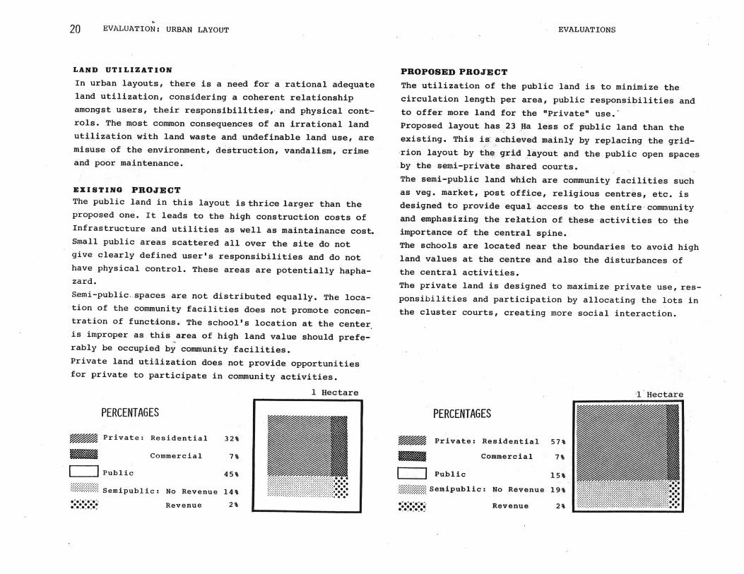
LAND UTILIZATION
In urban layouts, there is a need for a rational adequate
land utilization, considering a coherent relationship
amongst users, their responsibilities,, and physical cont-
rols. The most common consequences of an irrational land
utilization with land waste and undefinable land use, are
misuse of the environment, destruction, vandalism, crime
and poor maintenance.
EXISTING PROJECT
The public land in this layout is thrice larger than theproposed one. It leads to the high construction costs of
Infrastructure and utilities as well as maintainance cost.
Small public areas scattered all over the site do not
give clearly defined user's responsibilities and do not
have physical control. These areas are potentially hapha-
zard.
Semi-public.spaces are not distributed equally. The loca-
tion of the community facilities does not promote concen-
tration of functions. The school's location at the center
is improper as this area of high land value should prefe-
rably be occupied by community facilities.
Private land utilization does not provide opportunities
for private to participate in community activities.
PROPOSED PROJECT
The utilization of the public land is to minimize the
circulation length per area, public responsibilities and
to offer more land for the "Private" use.'
Proposed layout has 23 Ha less of pIublic land than theexisting. This is achieved mainly by replacing the grid-
-rion layout by the grid layout and the public open spaces
by the semi-private shared courts.
The semi-public land which are community facilities such
as veg. market, post office, religious centres, etc. is
designed to provide equal access to the entire-community
and emphasizing the relation of these -activities to the
importance of the central spine.
The schools are located near the boundaries to avoid high
land values at the centre and also the disturbances of
the central activities.
The private land is designed to maximize private use, res-
ponsibilities and participation by allocating the lots in
the cluster courts, creating more social interaction.
PERCENTAGES
Private: Residential
Commercial
Public
....... Semipublic: No Revenue
**, ','', 00.Revenue
32%
7%
45%
14%2%
1 Hectare
........
PERCENTAGES
Private: Residential
Commercial
Public
Semipublic: No Revenue
Revenue
1 Hectare
57%
7%
15%
19% M *
2%

EVALUATIONS 21
I 'I.
COMMENTS: 1.No physical barriers between public,private and semiprivate
land. 2. Street and "wasteland"around.3. Unused wide open
spaces in the "Shopping" area.4. Informal shoppimg area.
Photos: Ismet Khambatta & Sudhir Shah
EVALUATION: URBAN LAYOUT
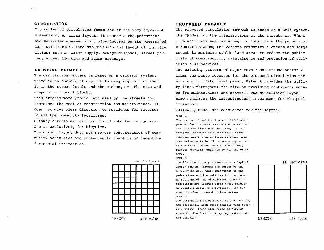
CIRCULATION
The system of circulation forms one of the very important
elements of an urban layout. It channels the pedestrian
and vehicular movements and also determines the pattern of
land utilization, land sub-division and layout of the uti-
lities; such as water supply, sewage disposal, street pav-
ing, street lighting and storm drainage.
EXISTING PROJECT
The circulation pattern is based on a Gridiron system.
There, is no obvious attempt at forming regular interva-
ls in the street levels and these change to the size and
shape of different blocks.
This creates more public land used by the streets and
increases the cost of construction and maintainance. It
does not give clear direction to residents for accesses
to all the community facilities.
Primary streets are differentiated into two categories.
One is exclusively for bicycles.
The street layout does not promote concentration of com-
munity activities and consequently there is no incentive
for social interaction.
16 Hectares
LENGTH 400 m/Ha
PROPOSED PROJECT
The proposed circulation network is based on a Grid system.
The "Nodes" or the intersections of the streets are 90m &
ll5m which are smaller enough to facilitate the pedestrian
circulation among the various community elements and large
enough to minimize public land areas to reduce the public
costs of construction, maintainence and operation of util-
ities plus services.
The existing pattern of major town roads around Sector 21
forms the basic accesses for the proposed circulation net-
work and the Site development. Network provides the utili-
ty lines throughout the site by providing continuous acce-
ss for maintainance and control. The circulation layout
also minimizes the infrastructure investment for the publ-
ic sector.
Following modes are considered for the layout.
MODE 1:
Cluster courts and the 10m wide streets are
planned for the major use by the pedestri-
ans, but the light vehicles (Bicycles and
scooters) are made an exception as these
vehicles are the major forms of owned tran-
sportation in India. These secondary stree-
ts are in both directions to the primary
streets providing entrance to all the clus-
ters.
MODE 2:
The 20m wide primary streets form a "Spinal 16 HectaresCross" running through the center of the
site. These give equal importance to the
pedestrians and the vehicles but the later
do not control the circulation. Community
facilities are located along these streets
to create a focus of activities. Main bus
route is also proposed on this spine.
MODE 3:
The peripherial streets will be dominated by
the relatively high speed traffic with mode-.
rate volume. These also serve as service
roads for the district shopping center and
the schools. T L'M17MU 1 /

EVALUATION: URBAN LAYOUT
-- pr
COMMENTS: l.Access into "Sector 21"-too wide a street.2. Street junctions
are unclear and merge with unidentified land.3. Wide unused
open areas along the street. 4. Poor maintenance of public lanc
Photos:Ismet Khambatta & Sudhir Shah
I';
EVALUATIONS
it 3
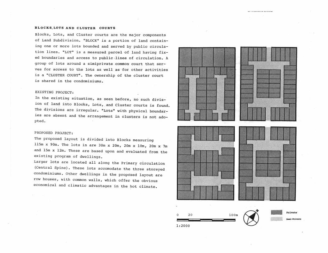
BLOCKSLOTS AND CLUSTER COURTS
Blocks, Lots, and Cluster courts are the major components
of Land Subdivision. "BLOCK" is a portion of land contain-
ing one or more lots bounded and served by public circula-
tion lines. "LOT" is a measured parcel of land having fix-
ed boundaries and access to public .lines of circulation. A
group of lots around a simiprivate common. court that ser-
ves for access to the lots as well. as for other activities
is a "CLUSTER COURT". The ownership of the cluster court
is shared in the condominiums.
EXISTING PROJECT:
In the existing situation, as seen before, no such divis-
ion of land into Blocks, Lots,.and Cluster courts is found.
The divisions are irregular. "Lots" with physical boundar-
ies are absent and the arrangement in clusters is not ado-
pted.
PROPOSED PROJECT:
The proposed layout is divided into Blocks measuring
115m x 90m. The lots in are 30m x 20m, 20m x 10m, 20m x 7m
and 15m x 12m. These are based upon and evaluated from the
existing program of dwellings.
Larger lots are located all along the Primary circulation
(Central Spine). These lots accomodate the three storeyed
condominiums. Other dwellings in the proposed layout are
row houses, with common walls, which offer the obvious
economical and climatic advantages in the hot climate.
0 20 loom PiaeSri-private
1: 2000

CONCLUSION 25
CONCLUSION
The following observations are based on the comparative
analysis/evaluation of the proposed and existing layouts
for land utilization and circulatAon.
GOAL ACHTEVED BY
1. Maximization of privately A grid layout and a cluster
owned land and minimizat- court design with "Condomi-
ion of publicly owned nium" ownership.
land.
2. Positive social effects Defining clearly the extent
which encourage the indi- of user's territory and
vidual to participate and providing semi-private are-
understand the responsib- as with condominium owners-
ilities. hip in shared courts.
3. Positive economic effec- A grid layout and a cluster
ts by the reduction costs court design minimizes len-
of construction, operat- gth and areas of public
ion and maintenance. streets and utilities, bas-
ic networks and service
connections.
4. Positive effects of less The cluster subdivision
administ rative costs, makes it unnecessary for
the public institution to
deal with individuals but
the groups of people's co-
operatives are formed.
The proposed land utilization introduces a coherent rel-
ationship between user's responsibilities and physical
controls. This is one of the basics for an effective use
of the land which is ignored in the existing layout.
Land utilization percentages are optimised. Public areas
devoted to the circulation, which are costly to begin
with and also maintained by the Public Sector are kept
to a minimum. This helps to stretch the resources to
benefit more people lowering the ratio of circulation
length per area served results in utility network becom-
ing accessible to all the blocks.
The proposed project illustrates a more efficient layout
with clear distinction between the lines of access and
lines of circulation and in terms of circulation lengths
per area served.
The existing situation fails in terms of forming cohes-
ive social groups because of its large undivided size of
blocks as opposed to the proposed layout which allows a
choice of having residential units in a well contained
cluster.
Total dwelling areas are divided into 30 sections making
small socially and physically manageable clusters. The
cluster courts are well controlled having one entrance
each.
As seen clearly in the revised layout and land subdivis-
ion plan, undefined land is eliminated and private/semi-
private land parcels are well controlled.
EVALUATION: URBAN LAYOUT

EXISTING
LAND UTILIZATION
PRIVATE: RESIDENTIAL
COMMERCIAL
SEMIPRIVATE
PUBLIC-STREETS
UNDEFINED
SEMIPUBLIC-NO REVENUE
REVENUE
SQ.M.
2,20,288
54 , 912
5,600
1,66,570
1,72,246
1,07,616
2,768
29%
7%
3%
22%
23%
14%
2%
LAND UTILIZATION
PRIVATE: RESIDENTIAL
COMMERCIAL
SEMIPRIVATE
PUBLIC STREETS
PLAZA
SEMIPUBLIC-NO REVENUE
REVENUE
1 Hectare
LIII
*... ......
CIRCULATION.
Tota.Legth: 30,00.Lengh/...ae..00.n/H
DENSITY
Persons/Hectare:
16 Hectares
160
LIZMR... .. ..
.. .. . .. .
CIRCULATION
Total Length:
Length/Hectare:
1 Hectare
8790 M
117 m/Ha
16 Hectares
20 pcrsons
1 Hectare
DENSITY
Persons/Hectare: 253
1 Hectare
* 0
20 persons
SQ.M. %
3,39,710
52,310
86,300
1,04,800
4,680
1,41,090
14,540
45%
7%
12%
14%
1%
19%
2%
- I - U -
PROPOSED

EVALUATION: URBAN LAYOUT
APPENDIX
INDIA: National Context
EXISTING PROJECT PROGRAM
EXISTING DWELLINGS PROGRAM
DESIGN STAGES: Proposed Project
-- --mmosaw
APPENDIX

28 EVALUATION: URBAN LAYOUT
INDIANATIONAL CONTEXT
PRIMARY INFORMATION
Country:
Capital:
Population:
Population growth:
Area:
Languages:
Currency:
Per Capita Income:
Religion:
Government:
Major Cities:
Republic of India
New Delhi
659.2 million (1981)22% urban, 78%
rural
2.1% per year
3,280, 483 sq. km.
Hindi, English, there are 14 other
official languages
Rupee (9.34 Rupees = U.S. $1, 1982)
U.S. $190
84% Hindu, 11% Muslim
Democracy
Calcutta 7,005,362*
Bombay 5,968,546
Delhi 3,629,842
Madras 2,470,288
Hyderabad 1,798,910
Bangalore 1,648,232
Ahmedabad 2,515,195
Kanpur 1,273,016
INDIA:NATIONAL CONTEXT

EVALUATION: URBAN LAYOUT
800
700
600
500
400
300
a I 1 1200
.1901 '21 '41 '61 '81
NATIONAL POPULATION GROWTH
horizantal: dates vertical: population in millions
Source: INDIA, A Reference Annual, 1974
Government of India
N
8
is
26% 2N 5 if I MI F 6 si 8n
NATIONAL POPULATION DISTRIBUTION
horizontal: percentage vertical: agesSource: INDIA, A Reference Annual, 1974
Government of India
80% 60
2,000-5,000
1,000-2,000
500-1,000
LESS THAN 500
40 20 0
horizontal: percentage vertical: village population
Source: INDIA, A Reference Accual, 1974
Government of India
(2) . GEOGRAPHY:
India, situated between 8 4' and 37 6' latitudes, dominates
the south Asian subcontinent geographically. It is bounded
on the east by Bangla Desh, Burma and the Bay of Bengal; on
the west by Pakistan and the Arabian Sea; and on the north
by the People's Republic of China, Nepal and Bhutan. It
measures 3,214 km. north to south and 2,933 km. east to west
has a land frontier of 15,200 km. and a coastline of 6,083
km. Its diversified topography has three major regions:
(1) sparsely populated Himalaya Mountains which extend along
the whole of the north border; (2) heavily populated, well
watered and fertile area in the north, on the Indo-Gangetic
Plains; and (3) southern peninsula including the tabeland of
the Deccan Plateau. The major river systems are associated
with each of the main regions. Chains of low mountains and
hills lie roughly west to east across central India andnorth to south along the peninsular coasts. Deserts and
arid regions of west-central India contrast with the heavyforestration in the eastern area.
The climate varies from tropical in the south to temperate
in the north. Four seasons are recognized south of the
Himalayas: a relatively cool, dry period from December
through February; a dry, hot season from March through May
and a rainy season or southwest monsoon period from June
through September as well as a northeast or retreating
monsoon period of October and November. The temperatures
seldom lower below freezing anywhere south of the Himalayas
but often reach as high as 110 F during summer months.
Precipitation ranges from over 1,000 cm. annually in the
northeast (Assam Hills) to less than 12 cm. in the north-
west (Rajasthan Dessert).
(3). PEOPLE:
Two major ethnic groups predominate in India: Indo-Aryan
in the north and Dravidian in the South. The aboriginal
tribal people live in the central forests and mountains,
and some Mongoloid people live in the far northern regions
84% of the people are Hindus, 11% Muslims, and the rest are
- aftwhow-_49044, - _ - - __ I - - - - -
INDIA:NATIONAL CONTEXT

30 . EVALUATION: URBAN LAYOUT
PRIVATE,
PUBLIC
TOTAL
- -4-
40% 30 20 10
FIFTH FIVE YEAR PLAN INVESTMENT
AGRICULTURE
INDUSTRY
TRANSPORTATION
SOCIAL
SERVICES
HOUSING
OTHER
horizontal: percentage vertical: sector
Source: INDIA, A Reference Annual, 1974
Government of India
'dWA4MI'ig 8 lST PLAN
4WA1 UUU 2ND PLAN
3RD PLAN
4TH PLAN
TRANSPORT AGRICULTURE
:NERVICE T.5TH PLAN
100% 75 50 25 0
PUBLIC SECTOR INVESTMENT
horizontal: percentage vertical: development plans
Source: INDIA, A Reference Annual, 1974
Government of India
I I I I I
1963 '65 '67
IMPORTS AND EXPORTS
'69 '71'
horizontal: year vertical: million Rupees
Source: Area Handbook for India,
Nyrop R.F., 1975
Christians, Sikhs, Jains, Parsis Buddhists, etc. The caste
system, based on employment/occupation related categories
ranked on a theoretically defined hierarchy, is gradually
down under the impact of urbanization,industrialization,
wider communication and educational opportunities.
According to the 1961 census 1,652 languages were reported
as mothertongues. However, the 14 principal languages desc-
ribed in the Indian Constitution are collectively spoken by
about 87% of the people. The Indo-Aryan languages are spoken
by 73% of the population in the northern regions whereas
24.5% speak the Dravidian languages in the south. English is
widely used in government, business and education throughout
the country.
(4). HISTORY:
The known history of the Indian people spans some five mill-
ennia. Between 3000 and 1500 B.C. a number of settlements
developed in the Indus River Valley (now in Pakistan) into
complex urban centres based on commerce, trade and agricul-
ture.Aryan tribes originating in Central Asia absorbed parts
of this culture as they spread out over the South Asian sub-
continent. During the next few centuries India flourished
under several successive empires. The Muslim Arabs came to
Western India in the seventh and the eighth centuries, A.D.
The Mughals reigned from 1526 to 1707, A.D. and were const-
antly challanged by the Rajputs, the Sikhs and the Marathas.
The first British outpost in South Asia was established in
1619. Later in that century, permanent trading stations were
opened by the East India Company at Madras, Bombay and Cal-
cutta; the British gradually expanded their influence from
these footholds. Following the first war of independence in
1857, the East India Company was withdrawn and a direct rule
of the British Crown was established.
The Indian National Congress, formed for the purposes
of promoting political reforms, was transformed into a
mass movement for independence by Mahatma Gandhi in
1920, adopting parliamentary and extra-parliamentary
means: non-violent resistance and non-cooperation.After
partition of the Indian subcontinent into India and
=I
EMq
INDIA: NATIONAL CONTEXT

INDIA: NATIONAL CONTEXT 31
Pakistan, India became independent on August 15, 1947,with Jawaharlal Nehru as the Prime-Minister. India's
Constitution was promulgated on January 26, 1950 and
the country was declared to be a Democratic Republic.
India is a member of the United Nations, the Commonwea-
lth of Nations, the Asian Development Bank, the Intern-
ational Atomic Energy Agency, the International Bank
for Reconstruction and Development, the Colombo Plan
and the International Monetary fund.
(5). GOVERNMENT:
India is a Sovereign Democratic Republic with a parliament-
ary form of government. The President, elected by an indir-
ect electoral college, is the executive head of the Indian
Union. His term of office is five years and is eligible for
re-election. He also acts as the Supreme Commander of the
armed forces and appoints the Prime Minister, the Attorney
General, Governors of the States of the Union, the Chief
Justice andother Justices of the Supreme Court as well as
the High Courts, and appoints and receives diplomatic rep-
resentations. The President is aided and advised by a Cabi-
net of Ministers, headed by the Prime Minister. Members ofthe Cabinet are chosen from among the two houses of theParliament and are responsible to it.
The Parliament consists of the President and the two housesthe Rajya Sabha, or the Council of States, and the Lok Sabhaor the House of the People. The Parliament usually holdsthree sessions a year. One of the principal functions of theParliament is to make laws on the matters the Constitution
specifies to be within its domain. Amongits constitutional
powers are the fixing or changing of the state boundaries,making amendments to the Constitution, controlling the nat-ion's finances, and removing the Cabinet by a vote of non-confidence. The Rajya Sabha consists of a maximum of 250
representatives, 13 of whom are nominated by the President
and the rest are related indirectly by the members of the
state and territorial legislatures. One-third of the members
retire every two years, with each member completing a six
year term. Members of the Lok Sabha are elected directly bythe people, all for a five-year term. Lok Sabha seats are
allocated to states in proportion to their population. In
1973 there were 523 members of the Lok Sabha, including 3nominated by the President.
By early 1974 there were 21 States and 9 Union Territories.
The governmental structure at the state level is similar to
that of the Central government. The President appoints a
Governor for a five-year term, who is aided and advised by aCabinet of Ministers headed by a Chief Minister.Subject to
legislation by the Parliament, the President governs the
Union territories through appointed administrators. The
District is the major geographical and administrative
subdivision within the state, and usually has 4 to 5
million people, with the District Collector as the chief
administrator. The "Panchayat Raj" system, as a means of
decentralizing administration at the very local levels,
involves a three-tier structure of self-governing bodies
at the village, block and district levels which are
known as the 'Gram Panchayat', 'Block Panchayat' or 'Pan-
chayat Samiti' and 'Zila Parishad' respectively. In largetowns and cities, the local self-governing bodies are the
Municipality, or the Municipal Corporation, Committee or
Board.
The Judiciary is a single, integrated, hierarchical sys-
tem, with the Supreme Court at the top, the High Courts
at the state level and lower courts at the district and
local levels. The Supreme Court is the ultimate interpr-
etor of the Constitution and of the laws of the land. Its
jurisdiction is divided into three categories - Original,
EVALUATION: URBAN LAYOUT

32 EVALUATION: URBAN LAYOUT
Apellate and Advisory, and its decisions are binding on
all the courts. The Chief Justice and a maximum of 13
other Judges of the Supreme Court are appointed by the
President. At the village level, judicial bodies called
the 'Nyaya Panchayat' try cases of minor offenses in many
states. However, they have limited powers and may only
impose moderate fines as punishments.
(6). ECONOMY:
India has a mixed economy having a small but important
and growing public sector and a large private sector
which contributes nearly 75% of the national income. The
public sector owns the country's infrastructure, strate-
gic resources, and basic heavy industry. The private
sector includes a large small-scale industrial sector and
the traditional sector which accounts for 75 to 80% of
the population and 50 to 60% of the national product
consisting mainly of a subsistence level agriculture
and the household and village handicraft production.
Surplus labour results in high rates of unemployment
and under-employment. Vocational and training progr-
ammes are encouraged by the government to produce
skilled manpower in order to support the growing ind-
ustrial sector. Complete information on India's natu-
ral resource base is not available. Relatively large
quantities of water for irrigation and hydro-electric
power generation are potentially available. The annual
growth of the Gross National Product at constant prices
between 1961 and 1972 showed an average rate of about
4%. For the same period, Per Capita Income rose at an
average rate of 3.7% annually.
(7). DEVELOPMENT PLANNING:
Two major objectives of the Fifth Five-Year Plan (1974-
1979) are; removal of poverty and destitution - by
raising the consumption standards of the lowest 30% of
the population from Rupees 25 per capita per month to
Rupees 40 per capita per month - and attainment of eco-
nomic self-reliance. The plan aims at an accelerated
growth of agricultural (4%) and industrial (10%) output
with an overall average rate of growth of 5.5% in the
national product. The plan's proposals, on a priority
basis, are:
- speedy completion of the projects and programmes alre-
ady underway and spilling over from the Fourth Plan; the
fullest and the most rapid utilization of the capacity
already created.
- achieve as soon as possible the minimum targets in the
main sectors of the economy upon which development or
utilization of capacity in other sectors is dependent.
- provide for the minimum level of: elementary education
for children upto the age of 14, public health facilities
including preventive medicines, adequate nutrition and
family planning devices; safe drinking water for all vil-
lages; all-weather roads to villages with population of
1,500 and more; homesites for landless farmers; electri-
fication for 30 to 40% of the rural population; and slum
improvement.
(8). EDUCATION:
Under the provisions of the Constitution, education is
primarily the responsibility of individual states, with
some specific powers and responsibilities reserved for
the Central government. This accounts for the lack of
uniformity in the country's educational system. The pre-
dominant pattern of education is comprised of eight years
of secondary education which is in turn followed by three
years of univirsity education leading to the first prof-
essional degree. A uniform pattern of ten years of prim-
aryand elementary education followed by two years of
INDIA: NATIONAL CONTEXT

INDIA: NATIONAL CONTEXT 33
secondary or, as it is sometimes called, 'higher second-
ary' - education, and three years of university educat-
ion is being adopted in many states. Regional languages
are the common media of instruction upto secondary edu-
cation whereas English replaces them, for the most part,
at the university level.In 1971, 2945% of the total
population, 39.45% of the males, and 18.70% of the fema-
les - including the Oto 4 years age group - were literate.
A number of measures have been adopted by the Central and
state governments to encourage education to adults and
women. Vocational and training programmes have been intr-
oduced to lower the currently unsatisfactorily high ratio
of libral arts graduates to technically trained personnel.
(9). LIVING CONDITIONS:
Consumer goods and preferences vary widely throughout the
country. For a large sector of the population,particular-
ly rural and urban poor, little money is left after
expenditures for food,clothing and shelter,which are most-
ly obtained from what is locally produced and available.
However,with increasing communication and extensive trans-
portation networks,wider distribution of consumer goods
has been possible. Housing continues to be inadequate in
all India.In ]969, government estimates showed a shortage
of 84 million housing units;]2 million in urban areas,and
72million in rural areas. Basic services;water supply,
Electricity and Sewage disposal are inadequate in both
rural and urban areas.Poor environmental conditions alloverhave created serious health hazards. The main objective
of the national health programme is the control and erad-
iction of communicable diseases. The overall medical eco-
nomy is a mixed one, having a general system of private
practice and an extensive national and state support of
medical facilities, training and specialized programmes.
The ratios of doctors to population were 1:5, 150 in 1968
1:4, 550 in 1972, and 1:4, 300 estimated by the end of
1974. In addition to several medical facilities following
the western pattern, several highly developed indigenous
systems of medicine exist and serve an unknown but proba-
bly substantial number of tradition-oriented Indians.
EVALUATION: URBAN LAYOUT

311 EVALUATION: URBAN LAYOUT
EXISTING PROJECT PROGRAM
EXISTING PROJECT PROGRAM
EXISTING DWEL LINGS
City Population:
Designer:
Selected Site:
Total Area:
Site Conditions:
Soil:
Income Groups:
Project Cost:
Development:
Level of Services:
Population:
Density:
Areas of Land Utilization:
Length of public circulation:
100,00 persons
dovto of Gujrat StateThe 4ffice of the Chief
Architect and the Chief
Town Planner.
Sector 21
86 Hectares
Level, well drained, gen-
tle slope.
Sandy loam - suitable for
construction.
Upto $15 per month to
$200 per month.
Not available
Progressive
Standard
12,000
Gross: 160 persons/Hect-
are
Private and Semipri-
vate 39%
Public 45%
Semipublic 16%
400m/hectare
The dwellings in the existing situation are divided into
various categories -.for different levels of govt. employ-
ees, based on the income and social status differences.
These categories for the govt. employees are- named J, CHH,
CH, GH and Categgrie 3. They are quarters and 6% of the
b asic salary isirecover-ed as the Tenure. They do not get
converted into "Owner'ship" even after a long span of time.
The retired or transfered employee has to vacate the house.
The other categories of Private Housing are named A, B, C,
D and few others. These plots are auctioned in public. The
owner is given the freedom to disign, within the general
framework of byelaws and the approval.
In the shopping area, either the owners reside on the upp-
er floors, or the owner lets out the upper floors for
other commercial activities..These shops are privately
owned.
r~u1 ~ j p
=4

EXISTING PROGRAM:DWELLINGS 3S
GOVT. HOUSING PRIVATE HOUSING
C--- - ---------
TYPE AREA AREA NO. NO. NO. TYPE AREA AREA NO. NO. NO.PLOT UNIT FLOORS UNITS PEOPLE PLOT UNIT FLOORS UNITS PEOPLE
to M 2t2m 2 180 900
$15 1 81 m2 23 m2 2 240 1200
2 42 m 2 3 108 540
2$15 > 1 52 m2 2 195 975 1 162m 2 35 m2 2 168 840
to 2 52 m2 2 35 175
$303 52 m 3 140 700 2 105 m2 50m2 1 224 1120
2$30 1 70m2 2 64 320
to 2 70 m2 3 56 280
$602 23 396 m 35 m 3 120 600
$60 1 90 in2 1 16 80 2 2to 135m 50 m 3 111 555
$852 90 2 2 32 160
$85 - 1 200 m2 84 m 2 1 42 210
to 92 m2 2 168 840 2 22 75 m 60 m 3 96 480
$140
3 1120 m2 60 mr2 3 156 1080
$140
to 2 2
$20 330 m 108 m 1 173 865
Total Total Total Total1114 5570
1210 6350
PROGRAM OF EXISTING DWELLINGS
EVALUATION: URBAN LAYOUT

DESIGN STAGES
This is a brief description of the stages through the des-
ign process, for the proposed layout. Each stage with
clear objective and policies would lead to another to arr-
ive at the final result. Though the "overlaps" cannot be
ignored.
INITIAL STAGES:
These three stages are mainly the collecting and tabulat-
ing the data.
1. Determining the Tentative Program of Project:
Written information regarding the location, areas, site
condition, numerical information of population, lots,
costs, the designer and the existing areas of Land Uti-
lization.
2. Identifying the Urban Parameters:
Written information and a layout plan at the urabn
scale. The urban circulation network, existing and pro-
posed roads are shown. Approaches and Accesses are ide-
ntified.
3. Identifying the Site Parameters:
The written information together with a layout plan at
the "Site Scale".
After these initial stages, the next stages are a gradual
progress towards a design solution explained as stages A
to F with schematic illustrations on page 36.
STAGE A:
IDENTIFYING MAIN URBAN CIRCULATION NETWORK AND ACCESSES
AFFECTING THE SITE.
Using the output from three initial stages the priorities
are established. Existing and projected main urban circul-
ation network is identified and the accesses are marked on
the plan.
Major Policy: Frequency of main urban circulation network:
1000 to 2000m approx.
STAGE B:
DETERMINING PRIMARY SITE CIRCULATION..
The accesses from the previous stage are linked in theconvenient manner.
Major Policy: Coverage from primary circulation. Keepingminimum distance 100m and maximum distance 100m. Arrivingat the shortest distance.
STAGE C:
IDENTIFYING AREAS OF THE,,MAJOR COMMERCIAL POTENTIAL/LANDVALUES.
Priorities are established to identify the areas of high,medium and low values of commercial potential.
Major Policy: High commercial potential/land value areasare adjacent to the primary circulation/public transporta-
tion. Lower commercial potential areas are farther from
the primary site circulation.
STAGE D:
IDENTIFYING AREAS FOR SCHOOLS AND PLAYGROUNDS.
Major Policy: As the plaza, markets and commercial areasare located on the higher land values, schools and play-grounds are placed on low value land. The land utilizationof private, semiprivate, public, and semipublic are consi-dered.
STAGE E:
IDENTIFYING THE DIRECTION OF SECONDARY CIRCULATION
Secondary circulation network lines link residential areas
with the primary circulation. The schematic direction are
marked on the plan. One of the important implications of
this stage is to determine the directions of drainage. In
the present case, the drainage follows the circulation
network.
STAGE F: COMPLETE PROJECT.
Considering adequate land utilization and circulation .land
complete project layout is developed.This divides the site
into blocks.
__ _."Wkdaw

EVALUATION: URBAN LAYOUT
DESIGN STAGES
E
STAGE
A MAJOR ACCESSES AFFECTING THE SITE
Semipublic
No Revenue
STAGE
D AREAS FOR SCHOOLS. PLAYGROUNDS
.. . . . . -- - - - -
i -iSTAGB PIAYST C IRCLTO
-- - - - - - -- - -- - -
I40.
L .I
STAGE
E DIRECTIONS OF SECONDARY CIRCULATION
0 200
STAGE
C AREAS OF MAJOR COMMERCIAL POTENTIAL
AND HIGHER LAND VALUE
Semipublic
STAGE
F
10m
4 COMPLETE PROJECT
1:20000
DESIGN STAGES

38 EVALUATION: URBAN LAYOUT
GLOSSARY
The criteria for the preparation of the defini-tions have been as follows:-FIRST PREFERENCE: definitions from "Webster's ThirdNew International Dictionary", Merriam-Webster,1971.-SECOND PREFERENCE: definitions from technical dic-tionaries, text books, or reference manuals.-THIRD PREFERENCE: definitions from the UrbanSettlement Design Program (U.S.D.P.) Files. They areused when existing sources were not quite appropriatelsatisfactory.
Words included for specificity and to focus ona particular context are indicated in parenthesis.
Sources of definitions are indicated in paren-thesis. (See also: REFERENCES).
ACCESSES. The pedestrian/vehicular linkages from/tothe site to/from existing or planned approaches (ur-ban streets, limited access highways, public trans-portation systems, and other systems such as: water-ways, airlines, etc.) (U.S.D.P.)
AMENITY. Something that conduces to physical or ma-terial comfort or convenience, or which contributessatisfaction rather than money income to its owner.(Merriam-Webster, 1971)
APPROACHES. The main routes external to the site(pedestrian/vehicular) by which the site can bereached from other parts of the urban context.(U.S.D.P.)
BARRIER. (A boundary) as a topographic feature or aphysical or psychological quality that tends to sep-arate or restrict the free movement (to and from thesite). (Merriam-Webster, 1971)
BLOCK. A block is a portion of land bounded andserved by lines of public streets. (U.S.D.P.)
BOUNDARY. Something (a line or area) that fixes orindicates a limit or extent (of the site). (Merriam-Webster, 1971)
CIRCULATION. System(s) of movement/passage of people,goods from place to place; streets, walkways, parkingareas. (U.S.D.P.)
CLIMATE. The average condition of the weather at aparticular place over a period of years as exhibitedby temperature, wind, precipitation, sun energy,humidity, etc. (Merriam-Webster, 1971)
COLLECTION SYSTEM. The system of pipes in a sewagenetwork, comprised of house service, collection lines,manholes, laterals, mains. (U.S.D.P.)
COMMUNITY. The people living in a particular placeor region and usually linked by common interests: theregion itself; any population cluster. (U.S.D.P.)
COMMUNITY FACILITIES/SERVICES. Facilities/servicesused in common by a number of people. I may includeschools, health, recreation, police, fire, publictransportation, community center, etc. (U.S.D.P.)
GLOSSARY
COMMUNITY RECREATION FACILITIES. Facilities for ac-
tivities voluntarily undertaken for pleasure, fun,
relaxation, exercise, self-expression, or release
from boredom, worry, or tension. (U.S.D.P.)
COMPONENT. A constituent part of the utility network.
(U.S.D.P.)
CONDOMINIUM. Condominium is a system of direct own-
ership of a single unit in a multi-unit whole. The
individual owns the unit in much the same manner asif it were a single family dwelling: he holds directlegal title to the unit and a proportionate interest
in the common land and areas. Two types of condomi-niums are recognized: HORIZONTAL: detached, semi-
detached, row/grouped dwelling types; VERTICAL: walk-
up, high-use dwelling types. (U.S.D.P.)
COSTS OF URBANIZATION. Include the following: CAPI-TAL: cost of land and infrastructure, OPERATING: costof administration, maintenance, etc.; DIRECT: includecapital and operating costs, INDIRECT: include envi-ronmental and personal effects. (U.S.D.P.)
DESIGN. 1) The arrangement of elements that make upa work of art, a machine or other man-made object.2) The process of selecting the means and contrivingthe elements, steps, and procedures for producingwhat will adequately satisfy some need. (Merriam-Webster, 1971)
DETACHED DWELLING. Individual dwelling unit, sepa-rated from others. (U.S.D.P.)
DEVELOPMENT. Gradual advance or growth through pro-gressive changes; a developed tract of land (U.S.D.P.)
DISTANCE. The degree or amount of separation betweentwo points (the site and each other element of theurban context) measured along the shortest path ad-
joining them (paths of travel). (Merriam-Webster,1971)
DRAINAGE. Interception and removal of ground wateror surface water, by artificial or natural means.
(De Pina, 1972)
DUST/DIRT. Fine dry pulverized particles of earth,grit, refuse, waste, litter, etc. (Merriam-Webster,1971)
EXTERIOR CIRCULATION/ACCESSES (SITE PLANNING). Theexisting and proposed circulation system/accesses out-side but affecting the site. These include limitedaccess highways as well as meshing access to the sur-rounding area. Exterior circulation/accesses aregenerally given conditions. (U.S.D.P.)
GRID BLOCKS. The block determined by a convenient
public circulation and not by dimensions of lots. In
grid blocks some lots have indirect access to publicstreets. (U.S.D.P.)
GRIDIRON BLOCXS. The blocks detetbined by the dimen-sions of the lots. In gridiron blocks all the lotshave direct access to public streets. 1D.S.D.P.)
GRID LAYOUTS. The urban layouts with grid'blocks.(U.S.D.P.) '
GRIDIRON LAYOUTS. The urban layouts with 4rIdlronblocks. (U.S.D.P.)
ILLEGAL. That which is contrary to iolating arule or regulation or something having the force oflaw. (Merriam-Webster, 1971)
INCOME. The amount (measured in money) of gains fromcapital or labor. The amount of such gain received bya family per year may be used as an indicator ofincome groups. (U.S.D.P.)
INCOME GROUPS. A group of people or families withinthe same range of incomes. (U.S.D.P.)
INFRASTRUCTURE. The underlying foundation or basicframework for utilities and services: streets; sewage,water network; storm drainage, electrical network;
INTERIOR CIRCULATION NETWORK (SITE PLANNING). Thepedestrian/vehicular circulation system inside thesite. It should be designed based upon the exteriorcirculation/accesses and land development require-menits. (U.S.D.P.)
INTERVAL. A space of time (or distance) between therecurrences of similar conditions or states. (Merriam-Webster, 1971)
LAND COST. Price: the amount of money given or set asthe amount to be given as a consideration for thesale of a specific thing (the site). (Merriam-Webster, 1971)
LAND DEVELOPMENT COSTS. The costs of making raw landDWELLING. The general, global designation of a build- ready for development through the provision of utili-ing/shelter in which people live. A dwelling contains ties, services, accesses, etc. (U.I.D.P.)one or more dwelling units! (U.S.D.P.)
DWELLING DENSITY. The number of dwellings, dwellingunits, people or families per unit hectare. Grossdensity is the density of an overall area (ex. in-cluding lots, streets). Net density is the densityof selected, discrete portions of an area (ex. in-cluding only lots). (U.S.D.P.)
DWELLING UNIT. A self-contained unit in a dwellingfor an individual, a family, or a group. (U.S.D.P.)
DWELLING UNIT AREA. The dwelling unit area (i2
) isthe built-up, covered area of a dwelling unit.(U.S.D.P.)
EFFICIENCY. Capacity to produce desired results witha minimum expenditure of energy, time, money or mate-rials. (Merriam-Webster, 1971)
LAND SUBDIVISION. The division of the land in blocks,lots and laying out streets. (U.S.D.P.)
LAND TENANCY. The temporary holding or mode of hold-ing a parcel of land of another. (U.S.D.P.)
LAND UTILIZATION. A qualification of the land arounda dwelling in relation to user, physical controls andresponsiblity. PUBLIC (streets, walkways, openspaces): user -anyone/unlimited; physical controls-minimum; responsibility -public sector. SENIPUBLIC(open spaces, playgrounds, schools): user -limitedgroup of people; physical controls -partial or com-plete; responsibility -public sector and user. PRI-VATE (dwellings, lots): user -owner or tenant orsquatter; physical controls -complete responsibility-user. SEMI-PRIVATE (cluster courts): user -group ofowners and/or tenants; physical controls -partial or
complete; responsibility -user. (U.S.D.P.)
LAND UTILIZATION: PHYSICAL CONTROLS. The physical/legal means or methods of directing, regulating, andcoordinating the use and maintenance of land by theowners/users. (U.S.D.P.)
LAND UTILIZATION: RESPONSIBILITY. The quality/stateof being morally/legally responsible for the use andmaintenance of land by the owners/users. (U.S.D.P.)
LEVELS OF SERVICES. TWo levels are considered: MINI-MUM, are admissible or possible levels below thestandard; STANDARD, are levels set up and established
by authority, custom of general consent, as a model,example or rule for the'measure of quantity, weightextent, value or quality. (U.S.D.P.)
LOCATION. Situation: the way in which something (thesite) is placed in relation to its surroundings (theurban context). (Merriam-Webster, 1971)
LOT. A measured parcel of land having fixed bounda-ries and access to public circulation. (U.S.D.P.)
LOT CLUSTER. A group of lots (owned individually)around a semipublic common court (owned in condomi-nium). (U.S.D.P.)
LOT COVERAGE. The ratio of building area to the totallot area. (U.S.D.P.)
LOT PROPORTION. The ratio of lot width to lot depth.(U.S.D.P.)
MASTER PLAN. A comprehensive, long range plan intend-ed to guide the growth and development of a city, townor region, expressing official contemplations on thecourse its transportation, housing and community faci-lities should take, and making proposals for indus-trial settlement, commerce, population distributionand other aspects of growth and development. (Abrams,1972).
MODEL (OF URBAN LAYOUT). A representation of an urbanresidential area illustrating circulation, land utili-zation, land subdivision, and utility network of a
specific layout and lot. (U.S.D.P.)
PLANNING. The establishment of goals, policies, andprocedures for a social or economic unit, i.e. city.(U.S.D.P.)
PLOT/LOT. A measured parcel of land having fixedboundaries and access to public circulation. (U.S.D.P.)
POPULATION DENSITY. It is the ratio between the popu-lation of a given area and the area. It is expressed
in people per hectare. It can be: GROSS DENSITY: in-cludes any kind of land utilization, residential, cir-culation, public facilities, etc. NET DENSITY: in-cludes only the residential land and does not includeland for other uses. (U.S.D.P.)
POSITION. The point or area in space actually occu-pied by a physical object (the site). (Merriam-Webster, 1971)
PRIMER. A small introductory book on a specific sub-
ject. (U.S.D.P.)
PRIVATE LAND OWNERSHIP. The absolute tenure of landto a person and his heirs without restriction of time.(U.S.D.P.)
PROJECT. A plan undertaken; a specific plan or de-sign. (U.S.D.P.)
PUBLIC CIRCULATION. The circulation network which isowned, controlled, and maintained by public agenciesand is accessible to all members of a community.(U.S.D.P.)
PUBLIC FACILITIES. Facilities such as schools, play-grounds, parks, other facilities accessible to allmembers of a comunity which are owned, controlled,and maintained by public agencies. (U.S.D.P.)

EVALUATION: URBAN LAYOUT
PUBLIC SERVICES AND COMUNITY FACILITES. Includes:public transportation, police protection, fire pro-tection, refuse collection, health, schools, andplaygrounds, recreation and open spaces, other com-munity facilities, business, comnercial, small indus-tries, markets. (U.S.D.P.)
PUBLIC SYSTEM (general). A system which is owned andoperated by a local governmental authority or by anestablished public utility company which is con-trolled and regulated by a governmental authority.(HUD/AID, Minimis Standards, 1966)
PUBLIC UTILITIES. Includes: water supply, sanitarysewerage, storm drainage, electricity, street light-ing, telephone, circulation networks. (U.S.D.P.)
RESIDENTIAL AREA. An area containing the basicneeds/requirements for daily life activities: hous-ing, education, recreation, shopping, work. (U.S.D.P.)
RIGHT-OF-WAY. A legal right of passage over anotherperson's ground (land), the area or way over which aright-of-way exists such as: a path or thorough-farewhich one may lawfully use, the strip of land devotedto or over which is built a public road, the land
ROADWAY (HIGHWAY). Portion of the highway includedbetween the outside lines of gutter or side ditches,including all slopes, ditches, channels, and appurte-nances necessary to proper drainage, protection, anduse. (DePina, 1972)
EOW/GROUPED HOUSING. Dwelling units grouped togetherlinearly or in clusters. (U.S.D.P.)
SETTLEMENT. Occupation by settlers to establish aresidence or colony. (U.S.D.P.)
SHAPE. Form/configuration of the site surface asdefined by its perimeter/boundaries. (U.S.D.P.)
SHOPPING. (Facilities for) searching for, inspecting,or buying available goods or services. (U.S.D.P.)
SITE. Land (that could be) made suitable for buildingpurposes by dividing into lots, laying out streets andproviding facilities. (Merriam-Webster, 1971)
SITE AREAS. Two types are considered: GROSS AREA: in-cludes the whole site or the bounded piece of ground.USABLE AREA: includes only the portion of the sitethat can be fully utilized for buildings, streets,playgrounds, recreation facilities, gardens, or otherstructures. (U.S.D.P.)
SIZE. Physical magnitude or extent (of the site),relative or proportionate dimensions (of the site).(Merriam-Webster, 1971)
SLOPE. Degree or extent of deviation (of the landsurface) from the horizontal. (Merriam-Webster, 1971)
SOIL. Soil structure: the arrangement of soil parti-cles in various aggregates differring in shape, size,stability, and degree of adhesion to one another.(Merriam-Webster, 1971)
TENURE. Two situations of tenure of the dwellingunits and/or the lot/land are considered: LEGAL:having formal status derived from law, EXTRALEGAL:not regulated or sanctioned by law. Four types oftenure are considered: RENTAL: where the users pay afee (daily, weekly, monthly) for the use of the dwell-ing unit and/or the lot/land, LEASE: where the userspay a fee for long-term use (generally for a year)for a dwelling unit and/or the lot/land from the owner(an individual, a public agency, or a private organi-zation); OWNERSHIP: where the users hold in freeholdthe dwelling unit and/or the lot/land which the unitoccupies, EMPLOYER-PROVIDED: where the users are
provided a dwelling unit by an employer in exchangefor services, i.e. domestic live-in servant. (U.S.D.P.)
TOPOGRAPHY. The configuration of a (land) surfaceincluding its relief and the position of its naturaland man-made features. (Merriam-Webster, 1971)
TRANSPORTATION. Means of conveyance or travel fromone place (the site) to another (other parts of theurban context). (Merriam-Webster, 1971)
UNIT. ,A determinate quantity adopted aa a standardof measurement for other quantities of the same kind.(Merriam-Webster, 1971)
URBAN TRANSOjtTATION. Means of conveyance of passen-gers or goods from one place to another along ways,routes of circulation in a metropolitan context.(U,,P.)d
URBANIZATION. The quality or state of being or be-coming urbanized; to cause to take on urban character-istics. (U.S.D.P.)
USE TAX. The tax on land aimed primarily at enforcingits use or improvement. (U.S.D.P.)
USER INCOME GROUPS. Based upon the subsistence (min-imun wage) income per year, five income groups aredistinguished: VERY LOW (below subsistence level):the income group with no household income availablefor housing, services, or transportation; LOW (1 xsubsistence level): the income group that can affordno or very limited subsidized housing; MODERATE (3x subsistence level): the income group that canafford limited housing and rent only with governmentassistance; HIGH (5 x subsistence level): the income
UTILITIES. Include: water supply, sanitary sewerage,storm drainage, electricity, street lighting, gas,telephone. (U.S.D.P.)
UTILITY/SERVICE. The organization and/or infrastruc-ture for meeting the general need (as for water sup-ply, wastewater removal, electricity, etc.) in thepublic interest. (U.S.D.P.)
VIEWS. That which is revealed to the vision or can beseen (from the site). (Merriam-Webster, 1971)
WALK-UP. Dwelling units grouped in two to five sto-ries with stairs for vertical circulation. (U.S.D.P.)
WASTE PIPE. A pipe (in a dwelling) which carrieswater from wash basins, sinks, and similar fixtures.(RTC ST 45-7, 1953)
WATER SUPPLY. Source, means, or process of supplyingwater, (as for a community) usually involving reser-voirs, pipelines, and often the watershed from whichthe water is ultimately drawn. (Merriam-Webster,1971)
GLOSSARY
-j

REFFERENCES
Baldwin, J. GUIDE FOR SURVEY EVALUATION OF URBAN DWELLING
ENVIRONMENTS. M.I.T. Thesis, Cambridge, Massachusetts,
1974.
Building and Communication Department Govt. of Gujarat -
"GANDHINAGAR" 1981.
Caminos, H. and Goethert, R. URBANIZATION PRIMER. Urban
Project Department, World Bank. Washington, D.C., 1976.
Chavda, Alka and Vidyadhar, RURAL/URBAN DWELLING ENVIRON-
MENTS: Gujrat State, India, M.I.T. Thesis, Cambridge,
1977.
Palmadai Rajagopalan, "EVALUATING ALTERNATIVES FOR HOUSING
INDIA'S URBAN POOR: DESIGN STUDIES, MODEL AND APPLICATION
IN AHMEDABAD." M.I.T. Thesis, Cambridge, 1982.
Patel, Nimish. URBAN DWELLING ENVIRONMENTS: AHMEDABAD,
INDIA. M.I.T. Thesis, Cambridge, Massachusetts, 1976.
EXPLANATORYNOTES
QUALITY OF INFORMATION
The quality of information given in drawings, charts and
descriptions has been qualified in the following manner:
Approximate: when deduced from different and/or not
completely reliable sources.
Accurate: when taken from reliable or actual sources.
Tentative: when based upon rough estimates of limited
sources.
QUALITY OF SERVICES, FACILITIES AND UTILITIES
None: when the existence of services, facilities
and utilities are unavailable to a locality.
Limited: when the existence of services, facilities
and utilities are available to a locality in
a limit limited manner due to proximity.
Adequate: when the existence of services, facilities
and utilities are available to a locality.
METRIC SYSTEM EQUIVALENTS
Linear Measures
1 centimeter =
1 meter
(= 100 centimeters)
1 kilometer =
(= 1,000 meters)
1 inch
1 foot
1 mile
Square Measures
1 square meter =
1 hectare
1 square foot =
1 acre
DOLLAR EQUIVALENTS
1 U.S. Dollar = 9.30 Indi
0.3937 inches
39.37 inches or
3.28 feet
3,280.83 feet or
0.62137 miles
2.54 centimeters
0.3048 meters
1.60935 kilometers
1,550 square inches or 10.7639
square feet
2.4771 acres
0.0929 square meters
0.4087 hectares
an Rupees (1976)
5%J
- -0NW