nowasecedu.files.wordpress.com · web viewafrica lies between lat. 370n and 350s and log. 170w...
TRANSCRIPT

REGIONAL GEOGRAPHY OF AFRICA WITH PARTICULAR REFERENCE TO WEST AFRICA: REGIONAL GEOGRAPHY OF AFRICA Africa is one of the continents of the world and it is the second largest. It is the only continent, which is crossed by both the equator and the Greenwich Meridian. Africa is the most tropical of all the continents as ¾ of the continent or over 24 million square kilometres of her landmass lies within the tropics. LOCATION, SIZE AND POSITION OF AFRICA Africa lies between lat. 370N and 350S and Log. 170W and 51.50E. It has an area of about 30.3 million km2 or 30,335,000 and it has ¼ of the total land area of the world. The continent is about 2/3 the size of Asia and has an East to West distance of 7000km at its widest point along lat. 100 N. It stretches about 8000km from North to South along longitude 200E. Africa is surrounded by the Atlantic Ocean to the west, the Indian Ocean to the East, the Mediterranean Sea to the North-East and the Red Sea to the North. The continent is joined to the Middle East at the Suez Canal in Egypt and separated from Spain by the straight of Gibraltar. POLITCIAL DIVISIONS OF AFRICA Africa is made up of forty-Eight independent countries including Madagascar as well as individual island countries. The countries in each region are close neighbours and often unite to form unions for better understanding and development of human resources within the region. The independent countries are grouped into seven regions namely North Africa, South Africa, West Africa, East Africa, South Central Africa, Central Africa and North East Africa. NORTH AFRICA includes Western Sahara, Morocco, Tunisia, Libya, Canary Islands. ii. SOUTH AFRICA includes Republic of South Africa, Lesotho, Swaziland, Namibia and Botswana. iii. WEST Kenya, Rwanda, Burundi and Tanzania. v. SOUTH AFRICA includes Angola, Zambia, Zimbabwe, Malawi, Mozambique, Madagascar and Comoros Island. vi. NORTH EAST AFRICA includes Egypt, Sudan, Eritrea, Djibouti, Ethiopia and Somali republic. AFRICA includes Mauritania, Mali, Senegal, Gambia, Liberia, Nigeria, Ghana, Guinea Bissau,
Sierra – Leone, Ivory Coast, Sao – Tome and Principe. iv. EAST AFRICA includes Uganda, vii. CENTRAL AFRICA includes Cameroon, Chad, Central Africa Republic, Equatorial Guinea, Gabon and DRC (Zaire). ISLANDS IN THE INDIAN OCEAN include Zanzibar and Pemba, Comoros islands, Reunion, Mauritius and Seychelles and also Madagascar. ISLANDS IN THE ATLANTIC OCEAN include Cape Verde, Canary Island, Equatorial Guinea, Principe and Sao Tome. The largest of the islands is Madagascar, which is about 59,000km2 MATERIALS FOR DISCUSSION IN THE CLASS WEST AFRICA: Location, position, size.
PHYSICAL FEATURES: Africa sits on ancient rocks known as BASEMENT COMPLEX ROCKS. These rocks are hard and very resistant to weathering. Volcanic rocks are also found in various parts of the continent where volcanic activities have taken place. The continent has an elevated interior while the coast is made up of narrow coastal plains. The average height of the land is about 425m in the North and over 900m in the South. It is characterized by isolated highlands (mountains), coastal lowlands, plateaus, river valleys, continental plains and the Great Rift Valley of East Africa. Physical setting of Africa; Relief and Drainage
Mountains are elevated highlands. In Africa, there are 3 categories of mountains

i. Block Mountains: These are mountains formed along faults. Such mountains usually have steep sides and flat tops in the form of a block. The block is called the HORST while the flat valley is called the GRABEN. Examples of Block Mountains in Africa include the Fouta Djallon (about 900m) in Guinea and Mt. Ruwenzori (5120m). (Where is it found?)ii. Fold Mountains: These are mountains formed as a result of the earth movements that bring about bending and folding of rocks. The up folds are called ANTICLINES while the down folds (troughs) are called SYNCLINES. Examples of Fold Mountains in Africa include the Atlas, Olifant, and Lange Bergen Zwarte Bergen. (using your atlas, state where is found)iii.Volcanic Mountains: These are mountains formed as a result of volcanic activities e.g. Cameroon mountain (4070m) Drakensberg (Dragon mountain) (3000m) in South Africa and Mountain Kilimanjaro (5898m) in Tanzania, Elgon (4320m), Meru (4570m). Some outstanding plateaus of Africa include the Jos plateau and Fouta Djallon in West Africa as well as the Ahaggar, Tibest, Tasilli and Darfur in the North Africa. HIGHLANDS: East African highlands stretch across Kenya, Rwanda and Burundi. The highlands of Southern Africa stretch from Angola, Namibia, Zambia, to Botswana and Zimbabwe. Also, the Ethiopian highlands, (3500m) stretch across Ethiopia and Somalia. LOWLANDS These are places of low elevation. There are four categories of lowlands in Africa, they include i. Continental plains: These plains occupy the mainland of Africa and are surrounded by highlands. The Continental Plains have height of 150m to 165m above sea level. These plains extend across Mali, Mauritania, Senegal and Burkina Faso. They also include the Chad basin, Sudan basin, Zaire basin and Kalahari basin. ii. River Valleys: These are lowlands through which the major rivers flow. They often lie between 100m to about 300 meters above sea level and are mostly covered by alluvial deposits. The presence of alluvial deposits makes river valleys of Africa favourable for agriculture. Examples of river valleys include the Congo basin, Niger Benue Trough, Orange River valley, Senegal River basin etc. iii. Coastal lowlands: These are lowlands found along the shorelines of Africa. They are widespread around Senegal, Gambia and the Niger Delta and are narrow in other places as a result of the presence of mountains and highlands along the shores iv. The Great Rift Valley of Africa: This is considered to be a continuation of the Great Rift Valley of China, which passes through the River Jordan and the Red Sea into Africa. It extends over 7200km from Lake Nyasa to the Red Sea. It passes through the middle of Ethiopia into Tanzania and another part of the Rift valley called the western rift crosses Uganda and goes through Rwanda and Burundi as well as the border area of Zaire and Zambia. Some portion of it extends across the length of Malawi. IMPORTANCE OF RELIEF IN AFRICA i. Highlands are associated with the presence of minerals such as Tin in Jos, Coal in Udi hill and copper in Zaire ii. Plains often contain minerals such as petroleum, bitumen e.g. The Niger delta. iii. Landforms such as mountains plateaus and hills help to beautify the environment e.g. Mt. Kilimanjaro. iv. Highlands provide watershed for several African rivers e.g. the Fouta Djallon Mountain for the River Niger and the East African highlands for the River Nile. v. Extensive alluvial plain provide good soil for agriculture. vi. Level plains provide a terrain for establishment of settlements. vii. Waterfalls that plunge down the steep slopes of highlands provide great potentials for the construction of hydro power stations.AFRICAN DRAINAGE There are 7 major rivers in Africa. They include Rivers Nile, Niger, Senegal, Congo, Orange, Limpopo and Zambezi

RIVER NILE: It is the longest river in Africa. It measures about 6600km. It rises from the highlands of central Africa as well as Ethiopian highlands and flows northwards from the equatorial region to the Mediterranean Sea passing through Sudan and Egypt. The River Nile is made up of the Blue and the White Nile. The White Nile is made up of two tiny branches Bahr al Ghazal and Bahr al Jabal. White Nile flows from southern Sudan across the Sudd swamp and eventually joins the Blue Nile. The two then flow through northern Sudan into Egypt. From the White and Blue Nile point where they both join, they flow across several dykes and cataracts. In Egypt, a dam has been constructed on the Nile giving rise to the Lake Nasser. RIVER NIGER: This is the most important river in West Africa and the 3rd longest river in Africa. Its length is about 4200km. It rises from the Fouta Djallon highlands in Guinea and flows northeast into the Sahara desert. As it passes through Djenne basin - a low lying semi-desert plain, it breaks into several channels in the form of braiding and at Timbuktu, the braided stream reunites into one river and flows southeast through the border between Benin and Niger Republic. The Niger eventually enters Niger State and flows southwards to Lokoja and at Jebba it is joined by its largest tributary the River Benue. From here the Niger flows southwards until it enters the Atlantic Ocean through the Niger Delta. Following the construction of the Kainji Dam at Old Bussa, the channel of the Niger was enlarged upstream to form the Lake Kainji. RIVER SENEGAL: The Senegal River rises from Fouta Djallon highlands just like the Niger and flows north-westward through southern Mali. The river continues to flows further north-west along the Senegal Mauritania border and eventually enters the Atlantic Ocean through St. Louis in Senegal. RIVER CONGO: The Congo also known as the Zaire River is the largest river in Africa and is the 2nd longest with a length of about 5500km. It rises from Central African highlands and flows north-east, north and then south-west. It has the largest number of tributaries as compared to other African rivers and flows across several rapids or dykes, which limits its usefulness for transportation. It also flows through most of the equatorial rainforest of Central Africa, thus making its exploration even more difficult. RIVER ORANGE: The Orange River got its name from the appearance of its waters. It rises from the high elevation of the South African plateau and flows west through the border between South Africa and Namibia. It eventually enters the Atlantic Ocean at Alexandra bay along the west coast of South Africa. The river has a higher velocity and flows across several waterfalls along its course. The Orange River has a length of about 1600km and its largest tributary is River Vaal. RIVER LIMPOPO: The Limpopo rises from the South Africa plateau like the Orange River and flows north-east through the border between Botswana and South Africa as well as the border between Zimbabwe and South Africa and it enters Mozambique flowing south-east until it enters the Indian Ocean. RIVER ZAMBEZI: The Zambezi like the Orange and Limpopo Rivers rises from the South African highlands. It is about 3000km long and is the 4th longest river in Africa. It covers most of the drainage basins of Zambia, Mozambique, and Zimbabwe. AFRICAN RIVERS CHARACTERISTICS

Most African rivers rise from very highlands and flow very rapidly to where they terminate. They are often very short. Due their high velocity, most African rivers are active agents of erosion as a result of which they appear brown in colour due to the high mud content. Most African rivers are seasonal in their flow due to the changing seasons (rainy and dry season). During the rainy season their volume increases and in the dry season, they dry up almost entirely. Some of the rivers develop wide flood plains as a result of overflowing water. Most African rivers are usually silted towards the end as a result of the inflow of run-off that comes with sediments. Some African rivers flow through deserts, and as such, they lose a lot of water e.g. River Niger which flows through the Sahara desert as it enters Mali Most African rivers flow over obstacles such as cataracts. This limits their use for transportation but provides potentials for the construction of dams to generate hydro electricity. PROLEMS OF AFRICAN RIVERS They are difficult to navigate due to the numerous rapids that occur along their courses. They are seasonal and as such, have limited use during the dry season. Most African rivers are prone to siltation which further hinders their usefulness for transportation. Most African rivers are comparatively short and do not provide a good link between many places. Due to the fast flowing nature of most rivers in Africa, they are active agents of erosion which is a serious ecological problem in several countries of Africa. Some rivers in Africa are prone to flooding which sometimes affects farmlands and settlements. SOLUTION TO THESE PROBLEMS i. Dredge the river. ii. Control of flood e.g. by building reservoirs. LAKES There are three major types of lakes;i. Lakes that occupy natural depressions e.g. Chad, Okavango, Kiga and Etosha. ii. Lakes that occupy rifts e.g. Edward, Albert, Turkana, Malawi, Kivu, Rukwa and Tanganyika and that occupy craters of extinct volcanoes such as Lake Victoria and Lake Tana. iii. Man-made or Artificial lakes e.g. Nasser (R. Nile); Lake Kainji (R. Niger); Lake Volta (R Volta); Lake Kariba (R. Zambezi) Artificial Lakes are lakes that are formed as a result from the construction of a dam across the channel of a river. The water piles up behind the dam to form a lake. lakes have various uses including fishing, transportation, recreation and irrigation. They have major problems, if such the dam collapses it eventually leads to flooding, which destroys lives and property. The largest lake is Lake Victoria. It is about 83000km 2. It lies on the East African plateau partly in Kenya, partly in Uganda and partly in Tanzania. IMPORTANCE OF RIVERS AND LAKES IN AFRICA i. They provide water for domestic and industrial use. ii. They provide water for irrigation agriculture. iii. They are means of generating hydro-electricity. iv. They are venues for fishing activities. v. They can also be used as a means of transportation. COASTLINES OF AFRICA LAGOONS: These are formed as a result of ocean currents and wave action. The land encloses the water to form a lake e.g. Lagos Lagoon, Port Novo Lagoon in the Republic of Benin etc. These lagoons form natural inland waterways for light crafts but are often shallow for big ship.

DELTA COAST: This is where a river enters the ocean as a result of the accumulation of mud or silt such that the main channel of the river is blocked causing the stream to break into several distributaries through which the river filters into the ocean or lake e.g. Niger delta. RIA COAST: This is formed around a submerged valley where water enters the valley and fills up the area e.g. in Senegal. Ria coastlines form natural harbours which are often utilized as ports. CLIFF COAST: This is formed where waves hit against the hard rocks near the sea especially at the base thereby breaking them to form steep cliffs along the coast. Examples are found in Ghana and Liberia. CORAL REEF: This is formed by small marine organisms, which have shells that contain calcium. When they die, the flesh decays after some time, but the shells are deposited as sediments in form of a pavement or hard rock e.g. in Somalia and Kenya. SPITS AND SAND BARS COAST: A spit is an extension of sand along the coastline as a result of the movement of ocean currents and waves. It is found in Namibia as a result of Benguela current. TRADE WIND COAST: Winds bring sand and deposit them along the coast to form the trade wind coast e.g. the northeast trade wind. CLIMATE OF AFRICAAfrica has several climatic types which include the Equatorial Climate, Tropical Continental Climate, Mediterranean Climate, Highland or Alpine Climate, Desert Climate and humid sub- tropical climate. CLIMATE AND VEGETATION Types, Location, Description and Economic Activities 1. EQUATORIAL CLIMATE LOCATION: The Equatorial climate is also called the Wet Tropical climate. It is located between latitudes 40 S and 80 N of the equator. AREAS: This climate is found around the Congo basin as well as the coastal areas of West Africa and East Africa. CHARACTERISTICS OF THE EQUATORIAL CLIMATETEMPERATURE: It is usually hot throughout the year with a mean annual temperature of about 250C. The daily range of temperature is about 80C while the mean annual range is about 30C. RAINFALL: It has heavy rainfall of about 1500-3000mm and this is fairly distributed throughout the year. It has up to 8 to 10 months of rainfall with no real dry season. Some places have double maxima of rainfall and the common type of rainfall is conventional rainfall. WIND: The prevailing wind is south – west trade wind (Tropical Maritime Air Mass). RELATIVE HUMIDITY: The humidity is usually high throughout the year between 60 – 80% The equatorial climate is associated with evergreen equatorial or tropical rainforest. 2. TROPICAL CONTINENTAL CLIMATE: LOCATION: The Dry Tropical Climate (also called the Sudan climate) is the most extensive climatic belt in Africa. It is a transition belt between Equatorial climate and desert climate. This climate occurs between 50- 18o N and S of the equator. The areas under this climatic region are the interior of West Africa, East Africa and Central Africa. CHARACTERISTICS OF THE TROPICAL CONTINENTAL CLIMATE TEMPERATURE: Temperature is high throughout the year (200C –300C). The daily range of temperature is 140C - 170C while the mean annual range is about 80C and there is plenty of sunshine. RAINFALL: Annual rainfall decreases from 200cm at the equatorial border to less than 38cm at the desert border. Rainfall is highly seasonal, as such; it rains mostly in the rainy season and little or no rain falls in the dry season. The rainfall is usually convectional. WIND: The prevailing wind is north – east trade wind. RELATIVE HUMIDITY: The relative humidity is high during rainy season and could be as high as 90% but in the dry season it is low and could be as low as 20% The typical vegetation in this zone is the savanna or tropical grassland.
3. MEDITERANEAN CLIMATE LOCATION: It is found in the extreme north and extreme south of the continent. AREAS: It occurs along the Mediterranean coast-lands of North Africa and in the cape area of South Africa CHARACTERISTICS OF THE MEDITERANEAN CLIMATE: TEMPERATURE: It has hot and dry summers with temperatures of about 250C and mild wet winters with temperatures below 120C. The Average annual temperature is about 180C. The annual range of temperature is about 14.10C in the north and 8.70C in the south. In summer and winter, there is usually abundant sunshine. RAINFALL: Annual rainfall is about 700mm and the maximum rainfall is in winter; the rainfall is brought about by eastwards moving depression which follows the southward shift of pressure belts around the months of November, December and January. WIND: The prevailing winds are the local sirocco and mistral. RELATIVE HUMIDITY: The Mediterranean climate has a moderate humidity of about 45% - 60% The typical vegetation associated with this climate is the Mediterranean woodland. 4. DESERT CLIMATELOCATION: LOCATION: The desert climate covers the whole of the Sahara, which is the largest area of hot desert climate in the world. AREAS: This climate occurs in North Africa where we have the Sahara desert as well as the southwest of South Africa i.e. Namibia and Botswana where we have Namib and Kalahari deserts. CHARACTERISTICS OF THE DESERT CLIMATE: TEMPERATURE: High temperatures are experienced throughout the year. It is extremely hot during the day with temperatures of about 400C and extremely cold at night with temperatures of about 404.They have very high daily range of temperature between 200C and 250C. RAINFALL: The annual rainfall is low and often less than 200mm. The absence of rain is partly as a result of the influence of the cold ocean currents that flow along the shores of desert regions. The cold onshore winds discourage the formation of moisture and clouds which bring about rainfall. However, occasional thunderstorms are experienced in desert regions and they often lead to widespread floods, erosion and damage to the environment.WIND: The common wind in the north is the dry North East Trade wind and in the south is offshore South East Trade wind. RELATIVE HUMIDITY: Relative humidity is usually very low. The typical vegetation in this zone is desert vegetation 5. HUMID SUB-TROPICAL CLIMATE a. AREAS: This is found in the east coast of Southern Africa (Natal Province). It is sometimes called the warm temperate climate (Eastern Margin) or simply, the natal type. CHARACTERISTICS OF SUB-TROPICAL CLIMATE: i. TEMPERATURE: The temperature is fairly high throughout the year. Summer is temperatures rise up to 260C and in winter the temperature drops to about 130C. ii. RAINFALL: Annual rainfall is about 900mm in the interior and increases to 1150mm along the coast. Most of the months have rainfall with the heaviest in summer. iii. WIND: The common wind is the south easterly winds that blow onshore from the Indian Ocean. iv. RELATIVE HUMIDITY: The relative humidity of this climate is considerably high between 50 – 65% The predominant vegetation is the sub - tropical evergreen forest. 6. WARM TEMPERATE (INTERIOR) CLIMATE: This is similar to the warm temperate eastern margin climate. It occurs in the interior plateau of South Africa and is also called temperate grassland climate. The climate consists of hot summers and cold dry winters. Frost is a common occurrence in winter and in higher elevations towards the Drakensberg, snowfall is experienced. The annual rainfall is about 508mm while the average annual temperature is also low. Climatic map of Africa

HIGHLAND CLIMATE (ALPINE) This climate occurs within the highland regions of Africa such as the Adamawa highlands as well as the Ethiopian and Kenyan highlands. The major characteristic of this climate is the moderating effect of high altitude. Due to their high altitude, highlands experience a reduction in temperature as temperature reduces with increase in altitude. Africa‟s highlands also experience considerable rainfall especially on their wind ward slopes. The common type of rainfall is relief or orographic rainfall.
FACTORS AFFECTING THE CLIMATE OF AFRICA:The factors affecting the climate of Africa include the following: ii. LATITUDE: Africa extends from latitude 370N to about 350S with the equator cutting across the continent mid-way. Around the equator, tropical climates are found. But further away from the equator, temperate climates (e.g. the Mediterranean climate) are found. Most parts of the continent of Africa experience warm or hot climates.
iii. ALTITUDE: Temperature decreases with increasing altitude. High altitude areas generally receive more rainfall than their surrounding lowlands areas due to orographic activity; also the major high altitude areas of Africa have their mean temperatures considerably modified. For example Jos (Nigeria) and Tamale (Ghana) are nearly on the same latitude but Jos is on a higher altitude (1290m) compared to Tamale (194m) Jos mean annual temperatures are therefore considerably lower (210C) compared to Tamale (260 C). In West Africa, the heaviest rainfall occurs at the foot of Mt. Cameroon as a result of the orographic effect created by altitude. 3. CONTINENTALITY: Distance from the sea has a significant effect on the climate of various places in Africa. The areas close to the sea enjoy maritime influence whereby land and sea breezes help to modify the temperatures at all times. The coastlands are generally humid while interior locations are usually dry. The driest and hottest part of Africa lies in the heart of the Sahara, which is also the farthest part of the continent from the sea. Generally, the nearer a place is to the sea, the lower temperature range. For example, Lagos close to the sea has an annual temperature range of 30C while Kano further inland has a temperature range of 120C. Generally coastal locations have heavier rainfall and a longer rainy season. 4. OCEAN CURRENTS: The climate of places close to the coast can be greatly influenced by ocean currents. The nature of the influence will depend on weather it is cold or warm current. Coasts washed by warm currents (such as the coast of West Africa and South-East Africa) generally experience heavier rainfall due to the increased moisture generated by the North Equatorial warm current. Deserts by nature are continental climate but along the coast of Mauritania and Western Sahara and South-West Africa (Namibia), deserts are found right at the coast because of the influence of the cold canary and cold Benguela current respectively.

5. PRESSURE AND AIR MASSES: Pressure is the weight of the air above the ground. Air mass is a large body of air with uniform temperature, moisture content and density. When in motion, it is called wind. There are two major air masses affecting the climate of Africa they are The Tropical Maritime Air Mass (MT) and The Tropical Continental Air Mass (CT) DECEMBER/JANUARY CONDITION: In January the sun is overhead at the tropic of Capricorn in the southern hemisphere. During this period, the Sahara desert in the northern hemisphere experiences cold temperatures which make it a high pressure belt from which the winds blow towards the low pressure belt formed at the equator. These winds known as the North-East Trade Winds are dry, dusty and windy. Coming from the desert, it brings cold and dryness that causes the harmattan in most parts of West Africa with the exception of few places along the coast.
JULY CONDITION: The reverse of what takes place in January becomes the case in July. During this period the sun is overhead at the tropic of cancer. The Sahara region now becomes very hot, and a low-pressure belt develops over it. This low-pressure belt attracts air masses from the high-pressure belt, which now lies in Southern Africa. The air (S.E. trade winds) streams drawn from the high pressure belt passing over the Atlantic Ocean before reaching the coast of West Africa. The warm, moisture laden air brings much rainfall to West Africa. On reaching West Africa, these winds having crossed the equator into the northern hemisphere change direction and are deflected to the right as the S.W. trade winds. These winds are sometimes called monsoon winds because they blow from the sea to the land. The meeting point of Topical Continental (CT) and Tropical Maritime (MT) air masses is called the INTER TROPICAL FRONT OR INTER TROPICAL CONVERGENCE ZONE (ITCZ). It is a zone of weather instability where the two major air masses with contrasting characteristics are constantly trying to overcome each other. It is associated with occasional rainstorms and cold dry weather occurring interchangeably.
VEGETATION OF AFRICA The word vegetation is used to mean plant community and it comprises of trees (woody plants) and grasses (non woody plants). Forest by their nature are covered with trees and often with under growth of herbs and grasses. In Africa, there are several vegetation belts, they include: a. Equatorial/Tropical rainforest b. Warm temperate forest c. Tropical grassland d. Temperate grassland e. Mediterranean woodland

f. Montane (Alpine) g. Desert/ Semi desert EQUATORIAL /RAIN FOREST DISTRIBUTION: This is found around the equator. The area includes the Zaire basin as well as the Guinea coast of West Africa. CLIMATIC CONDITIONS AFFECTING THE VEGETATION: i. Abundant rainfall of 2500-3000mm well distributed throughout the year. ii. Favourable mean temperature of 260C with an annual range of 20C-30C iii. Abundant sunshine and fertile soil. CHARACTERISTICS: i. The vegetation is made of evergreen trees. ii. The tree population is large and is made up of several species most of which are hard wood. iii. The trees are separated into layers, which include the top layer made up of trees about 60m in height. The middle layer is made up of trees about 30m-60m in height. The middle layer usually forms a canopy whereby the tree branches interlock and prevent the sunlight from reaching the forest floor. This accounts for the dark and damp nature of the rainforest floor. The lower layer consists of trees about 30m in height and they are predominantly young trees that regenerate to replace the dead ones. iv. The rainforest trees are heterogeneous and compact in arrangement. This is one of the reasons why tree felling could become a very challenging task. When a tree is cut, it does not fall to the ground but is obstructed by other trees standing very close to it. Eventually, several trees have to be cut down to gain access to one valuable tree. v. The rainforest has little under growth because the leaves of the tall trees form a continuous canopy, which stops light from reaching the ground level. ECONOMIC TREES: The rainforest provides tropical hardwood, which includes Iroko, Obeche, Mahogany, Ebony, African Walnut, Opepe, Limba etc. ECONOMIC IMPORTANCE: i. Hard wood like Obeche, Mahogany is very valuable as timber. ii. Rainforest trees also provide wood that is used as fuel for cooking. iii. The wood can be used to make furniture iv. Lumbering is provides employment for members of those communities located within the rainforest. v. Some trees and plants in the rainforest yield fruits that are taken as food. HUMAN ACTIVITIES: Human activities carried out in the rainforest include lumbering, fishing, hunting and plantation agriculture etc. B. WARM TEMPERATE FOREST DISTRIBUTION: This forest is situated in Southern Africa. It is found in the Natal province of South Africa. CLIMATIC CONDITIONS AFFECTING THE VEGETATION: i. It has a warm wet summer and a cool dry winter. ii. Mean monthly temperatures are between 40C and 260C iii. The annual temperature range is 250C iv. Annual rainfall is between 600-1500mm CHARACTERISTICS: i. The forest has plant like conifers, walnut, mulberry, wattle, maples and the eucalyptus, which was introduced from Australia to provide an alternative breeding ground for Koalas, which are being considered as endangered species. ii. The trees are usually tall. iii. The atmosphere is usually warm. ECONOMIC IMPORTANCE: i. It produces conifers, which are valuable soft wood.

ii. Maples produce syrup, which is used as a sweetener. iii. The Warm Temperate Forest is also a habitat for wildlife especially the endangered Koala. ECONOMIC TREES: Economic trees of the Warm Temperate Forest include Eucalyptus, Walnuts, Mulberry, Wattle, Maples etc C. MEDITERRANEAN WOODLAND DISTRIBUTION: This vegetation zone is found in the northern fringes of Africa, stretching across Algeria, Egypt, and Tunisia as well as the South Africa (Cape Town) CLIMATIC CONDITIONS AFFECTING THE DISTRIBUTION: i. The summers are warm and dry with temperatures between 210C-270C ii. There is abundance of rainfall in winter with a mean annual rainfall of between 600 – 800mm iii. There is also bright sunny weather with hot, dry summer and wet mild winter iv. Local winds such as the sirocco and mistral are prominent around the Mediterranean Sea CHARACTERISTICS: i. The vegetation consists of short trees with long racks. ii. Trees have waxy leaves, which help them to minimize transpiration. iii. Some trees have bulbous roots, which are able to store water. iv. It has shrubs and grasses like esparto grass used in making paper. v. Mountains occupy the interior parts of the vegetation, which has taller trees like pine, oak etc. vi. Marquis is a secondary vegetation derived when the tall trees are cut down and the plants include laurel, myrtles etc. Thyme, lavender, warm woods also form what is known as gurrigue. ECONOMIC IMPORTANCE: i. Cultivation of Curtis, olive and vines is predominant within this vegetation zone. ii. Spices like thyme are got from this area. iii. Esparto grass provides a valuable material for papermaking. iv. Livestock farming is practiced in this area. v. Cultivation of vegetables takes place here, and they are sold fresh. ECONOMIC TREES: The Mediterranean vegetation provides economic trees such as oak, pines, firs and cedars, which are valuable timber. HUMAN ACTIVITIES: Human activities within this zone include market gardening, orchard farming, viticulture, livestock farming, wine production and crop production. D.TROPICAL GRASSLAND DISTRIBUTION: This is the largest vegetative zone in Africa. It extends northwards and southwards around the outer fringes of the rainforest. It is found in Kano, Harare etc.CLIMATIC CONDITIONS AFFECTING THE DISTRIBUTION: i. The summers are warm and dry with temperatures between 210C-270C ii. There is abundance of rainfall in winter with a mean annual rainfall of between 600 – 800mm iii. There is also bright sunny weather with hot, dry summer and wet mild winter iv. Local winds such as the sirocco and mistral are prominent around the Mediterranean Sea. CHARACTERISTICS: i. The vegetation consists of short trees with long racks. ii. Trees have waxy leaves, which help them to minimize transpiration. iii. Some trees have bulbous roots, which are able to store water. iv. It has shrubs and grasses like esparto grass used in making paper. v. Mountains occupy the interior parts of the vegetation, which has taller trees like pine, oak etc. vi. Marquis is a secondary vegetation derived when the tall trees are cut down and the plants include laurel, myrtles etc. Thyme, lavender, warm woods also form what is known as gurrigue. ECONOMIC IMPORTANCE: i. Cultivation of Curtis, olive and vines is predominant within this vegetation zone.
ii. Spices like thyme are got from this area. iii. Esparto grass provides a valuable material for papermaking. iv. Livestock farming is practiced in this area. v. Cultivation of vegetables takes place here, and they are sold fresh. ECONOMIC TREES: The Mediterranean vegetation provides economic trees such as oak, pines, firs and cedars, which are valuable timber. HUMAN ACTIVITIES: Human activities within this zone include market gardening, orchard farming, viticulture, livestock farming, wine production and crop production.
D. ROPICAL GRASSLAND DISTRIBUTION: This is the largest vegetative zone in Africa. It extends northwards and southwards around the outer fringes of the rainforest. It is found in Kano, Harare etc. CLIMATIC CONDITIONS AFFECTING THE DISTRIBUTION: i. There are extreme temperatures, which vary between 210C and 320C ii. Annual rainfall is between 600 – 1500mm iii. Rainfall is seasonal and mainly in summer. iv. Rainfall is mainly convectional with a single maximum. CHARACTERISTICS: i. The vegetation mainly consists of deciduous trees, shrubs and grasses e.g. elephant grass. ii. The deciduous trees include Acacia, Baobab, Locust Bean, Shea Butter, Date Palm, Silk Cotton etc. iii. The trees have thick barks; long roots and their trunks store water. iv. There is also the presence of tall grasses and short scattered trees. v. The Tropical grassland has different names in different places e.g. Campos and Llanos (Brazil), Savanna (Africa and Australia). ECONOMIC IMPORTANCE: i. The vegetation zone favours extensive grain cultivation. ii. Grazing and livestock farming is also common here. iii. It is prominent for wild life (park – life) iv. Due to the abundance of wild life, game reserves and wild life parks have been established and these are an attraction for tourism. v. Nomadic herding is also carried out by the local people within this zone including the Massai of East Africa and the Fulani of West Africa. ECONOMIC TREES: The economic trees within vegetation zone include acacia, baobab and shea butter, etc. HUMAN ACTIVITIES: The human activities include livestock grazing, arable crop cultivation, hunting and development of game reserves.E. TEMPERATE GRASSLAND DISTRIBUTION: This is also referred to as veldt. It is found mainly in the Orange Free State (Southern Transvaal) in South Africa and Lesotho. CLIMATIC CONDITIONS AFFECTING THE DISTRIBUTION: i. The temperate grassland vegetation has an annual precipitation of about 508mm. ii. The maximum rainfall occurs in summer and the common type of rainfall is convectional. iii. The mean annual temperature is about 160C iv. The prevailing wind is north – east trade. CHARACTERISTICS: i. There is a predominance of short grasses that tend to grow in the form of turf and can grow up to 1m. ii. In the wetter areas there are tall grasses that become fibrous when old. iii. The veldt also has a few short trees that are scattered across the terrain. iv. The trees are deciduous i.e. they shed their leaves during the dry season to reduce transpiration.
ECONOMIC IMPORTANCE: i. It provides a good place for animal grazing ii. It is good for grape and vine cultivation. ECONOMIC TREES: The vegetation species include acacia, baobab and shea - butter HUMAN ACTIVITIES: Human activities are animal grazing, fruit farming and grain cultivation. F. MONTANE VEGETATION. DISTRIBUTION: This vegetation zone is well developed in mountainous areas around Ethiopia, Cameroon highlands, Jos plateau, and parts of East Africa etc. CHARACTERISTICS: i. The valley side provides a fertile soil ii. The valley has tall trees iii. The lower part of the mountain consist of grasses and shrubs iv. Temperate grasslands are found here ECONOMIC IMPORTANCE: i. The plateau tops are used for cultivation ii. It encourages animal grazing HUMAN ACTIVITIES: Specialized cultivation of grapes and apples as well as animal grazing G. DESERT/SEMI DESERT VEGETATION. DISTRIBUTION: It occurs in the north central Africa and South – West Africa from Namibia to Botswana.CLIMATIC CONDITIONS AFFECTING DISTRIBUTION: i. High temperatures between 300 C and 600 C ii. Annual rainfall is about 250mm iii. High rate of evaporation iv. Low relative humidity v. Deserts are associated with cold currents CHARACTERISTICS: i. Plants like cactus and baobab grow here ii. They have a number of thorn bushes like acacia iii. They have no trees iv. Grasses are tiny and few.

POPULATION DISTRIBUTION OF AFRICA Population refers to the number of people living in a given geographical area at a particular time. PEOPLE OF AFRICA Africa is inhabited by a large number of different peoples who speak different languages and have different religions and customs. The main groups of people include: THE HAMITES AND THE SEMITES They are mainly found in North Africa. The Hamites include the Berbers, Egyptians and Tuaregs. The Egyptians and Berbers are land cultivators while the Tuaregs are the warlike and nomadic people of the Sahara desert. The Semites are made up of Arabs who came from Asia. They are found along the Northeast coastlands of North Africa except the Bedouin who live in the Sahara. The Bedouin are nomadic Arabs. THE SUDANESE NEGROES These occupy the southern parts of the Sahara and they include the Yorubas, Igbo, Hausas, Mandingo, Akan of Ghana and the Bantus (Zulu and Kikuyu). The Sudanese Negroes constitute the typical black race with dark skin, woolly hair, thick lips and broad noses. The men are usually stout while the women are often plump with broad hips. The Sudanese Negroes engage in a variety of occupations, which include cultivation, livestock rearing, fishing, sculpture and trading. THE SAN (‘Bushmen’) They are found in the Kalahari Desert stretching across western Botswana and Eastern Namibia. They are short in stature with dry yellowish - brown skin and narrow eyes. Their hair is kinky and grows in small tufts. Their faces are flat with high cheekbones and their women have very pronounced hips. They live by hunting and they show ingenuity in their search for water by sucking up water from the hole in the ground using hollow reeds. THE KHOI – KHOI (HOTTENTATES) These probably emerged from the mixture of the San and the Hamites. They are found in the Southwest coastal area of the Namib Desert. They are a little taller than the San with reddish yellow skin and prominent check bones. They are more advanced than the San and they practice agriculture and herding. THE PYGMIES They are found in the dense Ituri forest of the Democratic Republic of Congo (DRC) especially around Lake Mai- Ndombe. They are also found in the forest of Gabon and Southern Cameroon within the Ubangui and

Sangha valleys. They hunt with poisonous arrows and catch small animals and insects for food. In recent times there have been concerns about the diminishing numbers of the Pygmies and it is feared that they might eventually become extinct of the trend continueAttempts have been made by several organizations to modernize the Pygmies but their attachment to a primitive lifestyle has kept them from accepting a modern lifestylTHE MASAI They are found in East Africa. Their primary occupation is pastoral nomadism. Their food consists of on milk and fresh blood, which they suck with a hollow reed from the veins of their cattle. They are tall and dark skinned. They keep large herds and seize the herds of those they conquer in inter-tribal wars. They also take part in Nomadic migration, which is seasonal. THE FULANI Like the Masai, the Fulani are primarily pastoralists. They roam across the entire landmass of West Africa and are particularly concentrated in the Uplands and plateau including the Fouta Djallon, Jos, and Adamawa mountains. Their food consists of on milk and grains. They are tall; light skinned and have straight dark hair and narrow noses. They keep large herds cattle and a host of other livestock such as goats, sheep and chickens. They also take part in seasonal nomadic migration. THE EUROPEANS AND OTHER FOREIGNERS They are settled in places with cool climate e.g. the Mediterranean region of northwest and southwest Africa and the highland areas of East Africa and central Africa. They include the French, Italians, British and the Dutch found in Southern Africa. While the Europeans came to colonize the land, the Asians from India and South East Asia came to work in the plantation farms. Others engaged in the construction of railway lines and many flocked the mines of South Africa to provide cheap labour. Like most parts of the world, Africa‟s population is unevenly distributed. Some parts of Africa are densely populated while others have moderate or sparse population
DENSELY POPULATED AREAS: There are about 9 densely populated areas in Africa with 100 persons and above per km2. These areas include the North African (Mediterranean) coast, the Nile valley, Central Burkina Faso, North Central Nigeria, the Plateau of East Africa, the South Eastern coast and South Western tip of South Africa, the high veldt of South Africa, the copper belt of Zambia and Congo as well as the coastal region of West Africa. b. SPARSELY POPULATED AREAS: We also have 6 major areas of low population density with less than 25 persons / km2. They include the Sahara desert, the Namib and Kalahari deserts, the semi-desert lands of Somalia and equatorial areas of Congo as well as the mountain areas of Ethiopia and the Atlas. In general, Nigeria has the highest population aggregate while Western Sahara has the least population density. Burundi has the highest population density of 500 persons / km2 due to the limited landmass of the country. FACTORS THAT DETERMINE POPULATION DISTRIBUTON IN AFRICA: i. RELIEF: Highlands and mountainous areas have a predominance of low temperatures, which are unfavourable for human comfort. On the other hand cultivation is often difficult as a result of the rugged nature of mountains as well as the presence of skeletal soils, which present challenges for extensive cultivation. The East Africa highlands are an exception because it has adequate rainfall for cultivation and the volcanic soil is fertile. However, some people settle on highlands for security reasons e.g. the Birom are said to have settled on Jos Plateau to avoid slave raiders. The Fulani herdsmen also settle on the Fouta Djallon highlands to avoid tsetse flies that attack their animals. Plains on the other hand are densely populated because their level terrain which encourage construction and present little challenges for cultivation.

ii. CLIMATE: Temperature is not a major factor in determining population distribution in Africa because Africa lies within the tropics where temperatures are considerably high all year round. However, areas of high extreme high temperature such as deserts and semi-deserts are sparsely populated. Examples include Somalia and the Nyika regions of central and southern Kenya (semi- desert). Areas with conducive climate often attract people and encourage population concentration. This is due to the fact that reliable rainfall is favourable for the practice of agriculture. For this reason, places that surround oasis and the Nile valley in Sudan and Egypt have a dense population. In the Nile valley, the population density is about 200 persons /km2 while places along the Mediterranean coastlines, the coast of East Africa, South Africa and West Africa coastlines have dense populations of over 600 persons / km2. The exception to this is the equatorial forest region of Congo and the Democratic Republic of Congo (DRC) where the forest is difficult to inhabit. iii. DRAINAGE AND SOIL: Most swampy areas are unfavourable for farming. As such population is less concentrated in these areas e.g. include the Niger Delta, the coastal areas of sierra-Leone, Gambia, Liberia etc. This also explains why the middle Belt of Nigeria especially around the Niger-Benue trough is sparsely populated. iv. MINERAL DEPOSITS: Population growth in some areas is associated with the exploitation of valuable mineral resources e.g. of such places include the copper belt of the Democratic Republic of Congo (DRC) and Zambia, the coal city of Enugu and Port Harcourt in the Niger Delta. v. SLAVE TRADE: The middle belt of Africa and the Nyika region of Tanzania are sparsely populated because slave raiders from Arabia and Europe attacked these areas and took away large numbers of people as slaves. vi. SECURITY REASONS: Ancient political regions form the nucleus of population concentration, as people tend to cluster in these areas for security reasons. This is common with the Yoruba and Hausa communities of Nigeria. The reverse is the case in the middle belt of Nigeria where there were dispersed settlements, which became the target of slave raiders. In addition, the separated communities were prone to tribal wars, which further reduced the population concentration within the region. vii. STABILITY OF GOVERNMENT: When there is political stability, there will be peace, which is the prerequisite for economic growth. This in turn attracts population concentration because it provides a peaceful atmosphere for economic growth. A good example is the Kano and Yoruba regions of Nigeria, which have maintained stable traditional governments for centuries. POPULATION GROWTH The population of Africa was had grown steadily until the advent of slave trade. Following slavery, a large number of persons were taken away as slaves to Brazil, the southern parts of USA as well as parts of Asia. It is estimated that, 3 centuries ago, about 40-100 million of Africans were lost to the Arab world and Europe. Also, a great number of people were lost during the numerous inter-tribal wars as well as the persistent occurrence of epidemics. As from the 90‟s, the population has increased steadily to the present day and the growth rate is about 2.32%, which is the highest in the world. Africa‟s death rate is about 45 persons per 1000 and it is also the highest in the world. The growth of Africa‟s population is expected to stabilize when the high birth rate is controlled. The birth rate in Africa is still very high while the death rate has decreased as a result of the improved living conditions. They eat better food, have better medical services and live in cleaner environments. PROBLEMS OF POPULATION IN AFRICA The major problem of Africa‟s population is her high dependency ratio. Africa‟s population is largely made up of very young (55 –60% under 20years of age). Only about 5% of Africa‟s population is over 60 years of age and 35% are between 20-60 years. The remaining 65% of the population depend on the working population. The working population is left to cater for the feeding, clothing, and education the dependents. The high population growth rate in Africa without corresponding growth in the industrialization and food supply has resulted in;
i. High rate of importation: All sorts of goods such as food items machinery, clothing and electronics are imported from developed countries to meet the ever-increasing needs of the African continent. This trend has accounted for the huge drain of foreign exchange from Africa and has also hindered the development of indigenous industries within the continent. ii. Unemployment: Due to the low level of industrialization in Africa, there is a high level of unemployment. This situation also creates room for an increase in the rate of crime as idle persons often engage in criminal activities and vices such as theft, drugs or prostitution in an attempt to make ends meet. iii. Food shortage: As a result of the rapid increase in the population of Africa, there has been insufficient food supply to this teeming population. This has led to problems such as malnutrition, starvation, and other associated diseases. A high percentage of Africa‟s population is impoverished and economically unproductive. This is the reason for the low level of manpower in the continent despite her ever-increasing population. iv. Inadequate housing: This is more common in urban centres where there is excessive on housing and other infrastructure has led to development of slumps and ghettoes. Other problems that accompany the development of slums and ghettos include environmental pollution, deterioration in sanitary conditions and frequent cases of epidemics. SOLUTION TO AFRICA’S POPULATION PROBLEMS a. The most important solution to the problems of Africa‟s increasing population is the limitation of the family size through birth control. b. The development of the economies of African countries through industrialization to create employment, which will bring about increased productivity within the continent. c. The expansion of agricultural lands to increase food supply. MIGRATION IN AFRICA The movement of large numbers of people in and out of Africa has led to a fluctuation in the population of the continent over time. During the colonial era, Africa witnessed inward movement of people from Europe and Asian. These immigrants settled in various parts of the continent and established their colonial governments. Others flocked to places such as Zimbabwe, Uganda, Kenya and the Republic of South Africa in search of mineral resources and fertile lands for cultivation. Following the independence of African countries, the Europeans began to return to their homes except in the case of South Africa where the Europeans and Asians have remained behind as permanent settlers and co owners of the land. Other factors that have led to the migration of large numbers of people across the continent include political instability, religious crisis and warfare. PROBLEMS OF MIGRATION WITH SPECIAL REFERENCE TO WEST AFRICAIn Africa, population migration can be classified according to its scope, whether it involves the movement of people within a locality or movement from one region to another. Thus there are seven types of migration in West Africa namely 1. Labour Migration: This is the movement of people from one place to another in search of jobs. In West Africa, people move from the savannah margins of Mali and the Mossi territory of Burkina Faso and Niger to different places along the coast including. The groundnut producing, commercial and industrial region of Western Senegal. The commercial and plantation areas of Ivory Coast. The Cocoa lands and mines of southern Ghana the Cocoa lands and industrial zones of western Nigeria. The Groundnut, cotton and industrial zones of north central Nigeria. The Tin mining district of Jos Plateau. The industrial and commercial zone of the south eastern Nigeria.

In the past, people usually moved from the southeastern parts of Nigeria to the Cocoa and Banana plantations of Bioko Island (Fernando Po). This sort of movement may be seasonal or fairly permanent when remain for several years before returning to their original homes. PROBLEMS: The problem of this type of migration is that it leads to breaking down in the social and traditional ties of the people in the sources regions while in their destination areas, the migrants do not quite fit in and are sometimes discriminated against. 2. DISASTER MIGRATION: This is movement caused by war and environmental hazards such as drought, flooding, earthquakes etc. War and environmental hazards have forced Africans to migrate from the troubled areas to places of safety. During the Franco-Algerian war of the 1950s over 250,000 Arab refugees left North Africa to other parts of the continent and beyond. Between 1966 and 1970, the Nigeria civil war resulted in the movement of large populations from one part of the country to the other. The Liberian civil war (1989-1991) sent 300,000 refugees fleeing from the guns of Samuel Doe and his warlords. Many of these migrants ended up in Nigeria. Economic pressure caused by drought between 1972-74 and 1982-83 drove away many Sahel dwellers of West Africa to the wetter lands of Nigeria, Ghana and Ivory Coast. A similar pressure made Ghanaians leave their country by the hundreds of thousands to Nigeria in the 1970s, though many have gone back now. PROBLEMS: Refugees suffer from hunger because they are unprepared for conditions that force them to move. Refugees also suffer due to lack of shelter, clothing and healthcare. Countries into which refugees flee also suffer because of the sudden increase in their population. The commonest problems caused include the shortage of food and social amenities while beggars and criminals increase on the streets of major cities in the receiving areas. 3. NOMADIC MIGRATION: This type of migration is common with herdsmen such as the Fulani of West Africa and Masai of East Africa. These herdsmen move according to the changing seasons. During the dry season, they move southwards to the river valleys in search of water and richer pasture and in the wet season, they move northwards and up to the plateau to evade the wetter tsetse fly infested river valleys of the south. PROBLEMS: Such seasonal migration makes economic planning difficult as the population hardly settles for a period of one year in a particular place. There is also the problem of frequent clashes between the settled farmers and the herdsmen because farmers‟ are sometimes eaten or trampled upon by the animals. 4. RELIGIOUS MIGRATION: This is a form of migration, which takes place annually. It involves the movement of persons for religious purposes such as pilgrimages and conventions. Each year, hundreds of thousands of Muslims pilgrims make their way to Mecca in Saudi Arabia to perform the Hajj. This is also true of Christian pilgrims who proceed to the Jerusalem, the holy land. PROBLEMS: The pilgrims suffer from hardship arising from inadequacy of facilities at the pilgrim camps. Some die of exhaustion, some abscond and remain in their host country as illegal citizens while others sometimes engage in smuggling of goods, which they bring back to their country of origin to make brisk business. 5. RURAL-URBAN DRIFT: The movement of people from the rural to urban centres is prevalent in most countries of Africa. In West Africa for example, the most attractive destinations are the coastal cities such as Dakar, Freetown, Abidjan, Accra, Lagos and Port Harcourt. PROBLEM: One of the reasons for rural – urban drift is the search for greener pastures by rural migrants. This search often turns out to be futile when the migrants on reaching the urban centres find that they are not equipped with the necessary skills or training required by job providers in the urban centres. Rural – urban migration also leads to an increase in the population of the cities, which contributes to the problems of traffic congestion, housing congestion and pressure of social amenities. It also hinders development in the urban areas as able bodies men and women who ought to remain in the rural areas and contribute towards development drift to the urban centres where the often become redundant; contributing little or nothing to the development of the urban centres.

6. BRAIN DRAIN: This is a type of movement involves the movement of skilled persons from their country of origin to other countries in search of greener pastures. This is particularly serious in Africa as the continent in comparison to the developed world is considerably backwards. As such, young and very talented persons often make every effort to relocate to the developed continents such as Europe and the United States to seek for a better life. PROBLEMS: This kind of migration leads to the depletion of the already insufficient skilled manpower in the source region. To solve this problem, government should use high-level manpower appropriately and enhance their working condition. 7. TOURISM MIGRATION: This is the movement of the people just for pleasure. It involves travelling to places of attraction and historical sites. In Africa, tourism is well developed in around Mediterranean North Africa, East Africa and South Africa and recently in the coastal regions of Senegal and Gambia in West Africa. Tourists in Africa are mostly Europeans or Americans who have sufficient funds spend. They often reside in expensive hotels and spend lavishly on transportation, food and souvenirs. PROBLEMS: Although tourism brings wealth to the tourist areas, it sometimes leads to the depletion of cultural and traditional values of the tourist areas whereby young people often tend to imitate the visitors‟ dressing, speech and lifestyle. It is also alleged that tourist through their lavish spending sometimes lure the locals into sexual promiscuity thereby promoting prostitution and the spread of sexually transmitted diseases (STDs) in the tourist areas. OTHER POPULATION PROBLEMS: High Growth Rate of the Population: The growth rate of Africa about 28%. This high growth rate is leading to a population explosion and most African countries are increasingly becoming unable to provide adequate food and social amenities for their excess population. High Dependency Ratio: West Africa has a high dependency ratio. The people in the working class are small compared to those who are not working. The dependent population looks up to the working population to cater for their needs. This increases expenditure on welfare and discourages investment by breadwinners as well as governments thereby slowing down economic growth and development. MATERIALS FOR CLASS DISCUSSION WEST AFRICA: Population of West Africa: physical, economic and historical factors responsible for the nature of population distribution in West Africa. Ways of solving problems arising from various forms of migration. LUMBERING: LUMBERING IN AFRICA: Meaning and procedure of lumbering; Factors influencing lumbering; lumbering in Zaire and Nigeria Lumbering is an activity that involves the selection, felling, transportation and processing of wood into timber. It includes the movement of logs from the forest to saw mills or ports where timber is produced for local or foreign consumption. Lumbering is an important economic activity in the forest areas of Africa. THE PROCEDURE OF LUMBERING: The procedure of lumbering begins with the identification of valuable trees in the forest. This is followed by felling with the use of saws such as the diesel powered chain saw. In some cases where the trees have buttress roots, felling may be preceded by the construction of a platform to give the lumbermen better access to the trunk of the tree. After felling, the tree branches are pruned and the trunk cut into logs of uniform length (usually 12ft). The logs are then transported by road, rail or floated along a river to the saw mills. At the saw mills, the logs are split into timber or planks and seasoned. From the sawmills, timber may be sold to local consumers or exported to other countries. FACTORS THAT INFLUENCE LUMBERING: Lumbering in Africa is influenced by three main factors namely physical factors, human factors and economic factors.

PHYSICAL FACTORS: These include climate, soil and relief. Forests develop best where annual rainfall exceeds 1,250mm, but forests may also develop where it is less due to other intervening factors such as the presence of a river, the temperature, and the nature of the trees. E.g. temperate forests develop in places with considerably low rainfall and temperature. The presence of good soil is another factor that favours the growth of forests. Forests grow best where the soil is rich in plant food and is capable of retaining moisture for tree growth throughout the year. Another important physical factor that influences the development of forests is relief. Forests are best developed in lowland areas where the soil is deep. Forests may also develop along the slopes and valleys of highlands, which have sufficient water supply and good soils. On the other hand, rocky mountainous terrain with skeletal soils, hardly have any trees besides grasses and shrubs. HUMAN FACTORS: Human activities may have a negative or positive influence on the development of forests. Activities such as forests conservation, forests reservation, aforestation, and reforestation encourage the development of forests whereas deforestation, mining, extensive construction in forest regions and bush burning all discourage the development and sustenance of forests and their resources. . ECONOMIC FACTORS: Lumbering requires sufficient capital for the procurement of lumbering equipment, transport facilities etc. Lumbering needs a good transport system for the haulage of the logs from the forest to the sawmills or ports. The transport system may constitute good roads, railway or rivers, which can be used to float the logs. Furthermore, capital is required to pay for the services of lumbermen and others who engage in lumbering. As such lumbering may not necessarily thrive despite the abundance of forests. In addition to the presence of forests, the availability of capital is essential for lumbering activities to take place. In Africa, lumbering is most prominent in two regions of the continent. These include the rainforest belt of West Africa and the equatorial forest region of the Democratic Republic of Congo. LUMBERING IN NIGERIA The major lumbering area in the rainforest belt of West Africa is Nigeria. Prominent places of lumbering in Nigeria include the high forest of Delta State around Sapele, which produces over 80% of Nigeria‟s timber as well as the forests of Ondo, Edo, Ekiti, Ogun and Cross River States. In general, lumbering is carried out in the whole of the forest regions of Nigeria and in the Southern part of the Guinea Savanna. The common trees lumbered include Obeche, Mahogany, Iroko, Sapele wood, Afara (hard woods) and foreign softwood species like the Gmelina, Teak and Pine. CONDITIONS WHICH FAVOUR LUMBERING IN NIGERIA i. There is abundance of rainforest with valuable timber in the Southern part of Nigeria. ii. Rivers like the Niger are used in floating logs down to the coast or factory sites. iii. There are ready markets for the timber both at home and outside the country. iv. There is high demand for timber as fuel. METHODS OF LUMBERING
i. In Nigeria, lumbering is carried out by Large private companies undertake the activity. Individuals either act as agent or provide hired facilities like timber hauling vehicles and labour. ii. The lumbermen first identify the economically valuable species. Then access roads are created to the sites. iii. To fell the trees with buttress roots, a wooden platform of about 3-5m high is made where the lumberjacks can stand to reach the trunk of the trees. The trees are then felled, using axes or handsaws, but in recent times, diesel powered chain saws are increasingly being used. The same implement is used to lob off the branches, and then the trunks are cut into logs of convenient lengths. iv. The logs are carried to nearby rivers or roads by tractors and special cranes, from where the logs are transported to the ports, sawmills or factories. In Nigeria, the logs are sent to either Warri or Calabar port or to the saw mills in Warri, Sapele, Ondo or Calabar. PROBLEMS OF LUMBERING IN NIGERIA
i. The rainforest in Nigeria and other parts of Africa has a wide variety of trees, which grow together, unlike the temperate forests that have pure stands. As such, the economic species are scattered all over the forest and are often difficult to locate or exploit. This also leads to time wastage. ii. Felling trees in the rainforest is not easy because many trees stand very close together and it is usually difficult for the felled trees to fall to the ground. They get entangled with the branches of other trees and hang in mid air. This results in the destruction of many other trees for the sake of getting wood from one tree. Also, most trees in the rainforest develop buttress roots and as such, platforms have to be built around them and this is very risky for the lumberjacks. iii. The jungle nature of the forest and the swampy nature of the soils make construction of roads difficult. This makes the process of dragging logs to the riverbanks or stand by trucks extremely difficult. iv. Floating the logs down the rivers is also a problem because of the presence of many rapids and waterfalls, which interrupt the floating. Rocks or other obstacles in the river may also create obstacles for free movement the logs. In some cases, logs that are too heavy sink to the bottom of the river rather than float. v. Limited knowledge of valuable species also reduces their chances of being exploited as timber thereby limiting the volume of timber that can be produced. vi. It is difficult these days to get people who take lumbering as an occupation because most able-bodied men rush to the cities in search of white-collar jobs. This makes it difficult to find good lumbermen to undertake lumbering. MATERIAL FOR CLASS WORK [Draw a map showing River Congo and its tributaries and lumbering areas] vii. The most serious problem is the consequent depletion of forest resources as well as the growing problem of deforestation. This problem is created by the failure of communities and governments to effectively regulate lumbering as an activity and to encourage the culture of tree planting and reforestation. POSSIBLE SOLUTIONS TO THE LUMBERING PROBLEMS IN NIGERIA i. The technology of tree felling could be improved to eliminate the stress associated with cutting down trees e.g. the use of special tractors fitted with engine-operated saws. ii. The problem of transportation could be solved by the construction of more permanent roads to link the forests and the ports or the saw mills. iii. The problem of skilled labour can be solved by training people to operate the modern machines, which are used in lumbering. iv. To avoid steady depletion of the forest resources, felling of the trees should be controlled through government permit and the culture of planting two trees where one is cut should be promoted and encouraged LUMBERING IN CONGO (ZAIRE) The major lumbering areas of Zaire are the equatorial forest of the northern interior in the Equator Province and the Ituri District. The tree species of this region include Mahogany, which is a hardwood and the Okoume and the Limba, which are softwoods. The major timber port in the Zaire is Matadi and the main sawmills are Karwa, Bomangor and Bambasa The factors that favour lumbering, the methods of lumbering and problems of lumbering in Zaire are similar to those discussed under lumbering in Nigeria. ECONOMIC VALUE OF TIMBER i. Timber could be exported to earn foreign exchange. ii. It is used for the manufacture of plywood and Veneer, which are very useful in furniture making. iii. It is used in construction work such as building of boats, house roofs, pit props and railway slippers, etc. iv. Lumbering provides employment for many people. v. Timber is used as raw materials for making paper, toothpick and match sticks etc. v. It is a source of revenue to the government because lumbering firms pay taxes on their income. DIFFERENCES BETWEEN LUMBERING IN NIGERIA AND ZAIRE

i. Zaire has a wider lumbering area than Nigeria because of the vast nature of the Congo forest. ii. Lumbering in Zaire mostly takes place in the interior thereby making transportation of logs cumbersome. In Nigeria, lumbering activities take place closer to the coast and the edges of the forest. iii. Nigeria produces and exports more timber than Zaire because the forest areas of Nigeria are easier to access. iv. The most important timber in Zaire is Okoume while in Nigeria Obeche accounts for more than half the total volume of highly valued wood that is sawn. v. Nigeria manufactures more plywood than Zaire. IRRIGATION AGRICULTURE IN AFRICA: Irrigation Agriculture in the Nile Basin and West Africa and Bush Fallowing in West Africa IRRIGATION AGRICULTURE IN THE NILE BASIN The Nile basin can be defined as the area drain by the river Nile and its tributaries. Irrigation a system by which water is supplied through artificial means to farmlands to enable farmers grow their crops. Irrigation is practiced in areas where natural sources of water for agriculture are insufficient. In places such as deserts and semi-deserts where aridity is predominant, farmers resort to the practice of irrigation to enable them cultivate crops. REASONS FOR IRRIGATION IN THE NILE BASIN i. The basic reason for the practice of irrigation in the Nile basin is the fact that most areas along the basin have shortage of water supply due to scanty rainfall. This is due to the presence of desert climate in the area
ii. The availability of irrigation water provided by the River Nile and its tributaries. iii. The Nile River and its tributaries especially the Blue Nile provide large quantities of alluvial soils, which are good for the cultivation of crops.. iv. In addition to the provision of alluvial soils by the River Nile and its tributaries, there are other soils deposited by winds and these have high agricultural value. iv. The level of River Nile is higher than the surrounding plains which makes it possible for canals to be cut from the riverbanks and the water to flows down easily to the farms. v. The soil profile of the Nile basin has a clay layer over which centuries of Nile flooding has deposited fine silt carried down from the volcanic soils of the Ethiopian and Ugandan highlands. The silt enriches the soil while the clay underneath ensures that the valuable irrigation water is not quickly lost by percolation. vi. The need for development in agriculture and an increase in crops production also accounts for the various types of irrigation techniques used in the area. IRRIGATION METHODS USED There are three major methods of irrigation practiced in the Nile valley. They include the Basin or Floodwater irrigation, the Lift method and the Canal or Perennial irrigation method. 1. The Basin or Flood Water Irrigation This is an age-old traditional irrigation method. In this method, the river overflows its banks when in flood, carrying silt along with it. As the flood retreats, some water and the silt are trapped behind reservoirs, which are eventually used to irrigate the soil. The floodwater then percolates into the soil and the silt carried by the floodwater settles down as alluvial soil, which promotes the soil fertility, making it more favourable for cultivation. The major disadvantage of this method is that since the Nile flood occurs once a year, crops can only be grown during the given period of the year.
2. The Lift Method This involves the lifting of water from the river on to the farmlands. There are four means by which water can thus be lifted. They include the Shaduf, Water Wheel or Saqia, Archimedes Screw and Diesel Pump.
(i) The Shaduf: This is one of the oldest traditional methods of irrigation used by the peasant farmer. It involves collecting water with a bucket or any water vessel tied with a rope to one end of a long stick. The stick is operated like a seesaw with a counter-balancing weight at the other end.
The vessel is lowered into the river to collect water and the water is lifted and poured onto the nearby farms. Shaduf is usually practiced in sloppy and hilly areas, as such, the slopes transport the water collected down to all areas of the farm. The main disadvantages of this method are, (a) The areas to be cultivated must be close to the banks of the rivers (b) The amount of land to be cultivated is limited by the amount of labour available. (ii) The Water Wheel or Saqia Method: This is a device powered by an animal usually oxen which are used to turn the water wheel. As the animals moves in a circle and turns the waterwheel, the waterwheel lifts a chain of buckets that are fixed to the rim of another wheel. Each bucket, on turning over, empties the water it is carrying into a canal from where the water flows onto the adjacent farmland. Each bucket returns in the chain to dip in and collect more water.
(iii) The Archimedes Screw: This is a big baggy tube with a long spiral screw in it. One end of the tube is dipped in the river and when the screw is turned with a handle at the other end, the tube sucks up the water that in turn pours over the farm nearby. Diesel or Electric Pumps: Like the Shaduf method, pump irrigation involves the lifting of water from the river to the farmland. Here, sprinklers are mostly used.
3. THE CANAL OR PERENNIAL IRRIGATION This is the most modern method of irrigation and is mostly used in large-scale cultivation. It involves the damming of rivers to create artificial reservoirs that provide irrigation water to farmlands all the year round. It encourages the growth of perennial crops. This method is used to irrigate the largest area of farmland in the Nile valley and practically every farmland along the Nile valley in Egypt and Sudan. The extensive irrigated areas in the Nile basin include (i) The lower Nile valley from the Aswan Dam to the Nile Delta in Egypt, an area of about 800km long and 25-30km wide, broadening to 150km in the Delta area (ii) The middle Nile valley in Sudan about 200km by 30km (iii) The Kasm-el-Girba area along the river Atbara in the eastern Sudan. (iv) The 80,000sqkm Gezira district between the White and Blue Nile in Sudan.
AGRICULTURAL PRODUCTS OF THE NILE BASIN AND THEIR USES The agricultural products of the Nile Basin include rice, cotton, maize, sugarcane, wheat, vegetables, millet, groundnuts, sesame, citrus fruits, barley, coffee, tea and tobacco. Animals such as sheep, goat, cattle and camel are also reared. Most of these products are used in the following ways: i. As source of food e.g. maize, rice, meat, milk etc.

ii. As source of income: the farmers earn some income from the sale of their products. iii. As raw materials for industries e.g. wheat is turned into flour, which is used in the baking industry. IMPORTANCE OF THE NILE TO EGYPT AND SUDAN i. Through irrigation, farmers living in these dry lands often gather rich harvest of maize, rice, cottons, vegetables and fodder crops for these fields. ii. The Nile River supports irrigation of farmlands in times of rainfall scarcity. iii. The Nile produces fish and other aquatic animals for consumption. iv. The Nile River is a tourist attraction and is used for recreational activities as well. v. The Nile provides employment for most people who are engaged in farming, fishing or transportation. vi. The Nile provides water for domestic and industrial use. vii. Irrigation along the Nile valley has led to large number of person‟s clustering and settling in the Nile basin. This accounts for the growth of towns in the area, e.g. Cairo in Egypt and Khartoum in Sudan. viii. Production of different crops in the Nile basin has led to the establishment of various industries that make use of the product in the area. Such industries include cotton ginneries, textile factories, rice mills, canning factories etc. PROBLEMS OF IRRIGATION IN THE NILE VALLEY The Nile valley irrigation encounters some problems and creates others as well. i. Construction of dams and canals costs money and much of it has to be borrowed. ii. The volume of the river, particularly the Atbara diminishes considerably in the dry season, thus reducing the water available for irrigation. iii. Irrigation uses up the water of the Nile, which could have been used for other things like production of hydroelectric power and transportation. iv. The constructions of dams such as the Aswan high dam lead to the displacement of people. Over 50,000 persons were resettled in the Kasm-el-Girba area in Sudan as their original settlements were submerged by the widening Aswan reservoir. v. The lakes and dams also hold back silt and other sediments from reaching the lower Nile valley in Egypt. This makes the soil in the lower Nile valley less fertile. vi. The reduction in the sediment load of lower Nile has decreased the rate at which sand banks are being built up in the delta. As a result, about 400,000 hectares of the fertile farmlands in the delta region has been flooded by the Mediterranean Sea. vii. The construction of dams along the Nile has also led to a reduction in the quantity of fish caught in the Nile Delta coast. This is due to the fact that some low plants and animals originally carried down the Nile delta to form fish food are held back by the irrigation lakes and dams. IRRIGATION AGRICULTURE IN WEST AFRICA Unlike the Nile basin, West Africa has mostly modern irrigation schemes, which are established, in the drier areas of the region where rainfall is insufficient and unreliable for farming. These areas include: The most important irrigation area in West Africa is the Inland Niger Delta Scheme in Mali: Here, the water is obtained mainly from the River Niger. Crops cultivated in this area include groundnuts, fruits, rice and tobacco. The Richard Toll Scheme: Water for this irrigation scheme is obtained from the artificial Lake Guiers, which is formed at a dammed tributary of River Senegal. The major crop of this project is rice.
The four-irrigation scheme in Nigeria: The Sokoto-Rima valley, the Chad basin, the Hadeja – Jamaare basin and the Mid- Niger or Middle Belt area. The crops produces include a variety of crops such as cotton, ground nuts, sugar cane, tobacco, rice, maize, guinea corn, millet and vegetables such as tomatoes, pepper, carrots, spinach, cabbage, onions, lettuce, ginger etc. The lower Volta and Accra plains scheme. The water is obtained from the Lake Volta in Ghana behind the Akosombo dam. The crops cultivated in this area include sugarcane, rice, tobacco and maize.

The major difference between irrigation in West Africa and the Nile basin is that in the Nile valley irrigation, only the River Nile and its tributaries supply water for irrigation. In West Africa, the schemes are spread over several river basins. ROTATIONAL BUSH FALLOWING IN WEST AFRICA. Rotational bush fallowing is a technique in which farmlands are rotated rather than the crops. The change in the farmland is made when it is observed that the fertility of the land has reduced and crop production is poor. This is usually after two years of cultivation. The land is then left to fallow for about 5-10 years. Bush fallowing is an important traditional system of farming in West Africa till date. FEATURES OF BUSH FALLOWING: It involves short fallow periods of cultivation (1-3) years followed by long fallow periods of (5-10) years during which the soil regains its fertility. It involves the use of simple farm tools such as hoe, cutlasses, axes, etc. Labour is supplied by the farmer and his family. The farm size is usually small about 2 – 4 acres and is characterized by mixed farming. It depends upon a low level of technology; farmer is usually resistant to innovations such as the use of fertilizers, improved seedlings and irrigation system.
ADVANTAGES OF ROTATIONAL BUSH FALLOWING MATERIAL FOR CLASS WORK: Study the maps of the Nile Basin and West Africa showing major areas of agricultural production. i. It is relatively cheap and non-sophisticated because simple tools are used and there is no expenditure on fertilizers, tractors and machineries. No knowledge of highly technical farm operation is required. ii. The system allows the farmers to grow many crops on a piece of land. Yam, cassava, maize, melon, vegetables etc can be grown together in a single cultivated plot. iii. The land is allowed to regain its fertility naturally. iv. During the fallow period, animals graze on the farm and leaving their dung behind to enrich the soil. v. It helps to check some plant disease because when farms are left fallow, disease organisms lose their hosts and die. DISADVANTAGES OF BUSH FALLOWING i. Large areas of land, which could be put into productive use, are left to fallow. This leads to underutilization of available farmland. Again, valuable forest areas are usually destroyed by repeated land clearance. ii. Since the land is fixed and the population grows, this system leads to repeated fragmentation of the land into smallholding as a result of competition for land by the farmers and settlers. iii. A lot of time, energy and money is usually spent on preparing the land for a very little agricultural return. iv. Only annual crops, which can be grown and harvested in a year before the farmer moves on to the next plot are cultivated. v. As the population grows, the demand for farmland increases and as such, the fallow period becomes short. This reduces fertility of the soil have less time to regain their fertility. Today, in most parts of West Africa, rotational bush fallowing has been replaced by permanent mixed cultivation as a result of the following reasons: 1. Change in the land ownership system. Individuals rather than Communities now own lands. This gives farmers the opportunity to undertake permanent cultivation of crops. This is also made possible by the use of fertilizers to improve the soil fertility. 2. Wealthy persons are taking to farming and can afford to purchase modern time saving equipment such as tractors and ploughs instead of relying on simple farm tools. PLANTATION AGRICULTURE IN EAST AND WEST AFRICA

Plantation agriculture refers to the cultivation of crops on large area of land or plantation. It involves the planting of one permanent or perennial crop such as cocoa, rubber or oil palm or shrubs like cotton, coffee, tea etc. It is a commercial form of farming and it requires an intensive use of labour and capital. FEATURES OF PLANTATION AGRICULTURE 1. It is a scientifically planned and well-organized farming involving the cultivation on a large scale of 50 – 60 hectares and above. The main purpose is to produce crops for marketing. 2. One crop is usually grown over a large area, although some vegetables and livestock may be raised as supplement. 3. Modern labour-saving machines such as ploughs, ridgers, harvesters, harrowers etc. are used. 4. Crops grown are mainly perennial such as cocoa, coffee, oil palm etc, though some annual crops like cotton or sugarcane are also grown. 5. The labour force is usually large and is made up of paid labourers that live in camps built on the farms. 6. The crops grown are processed in factories located on the farms or very close bye and they are mainly for export or large-scale domestic consumption. 7. Plantation agriculture is capital intensive, as a result of this; only wealthy individuals, big companies and governments undertake this type of farming. REQUIREMENTS FOR THE ESTABLISHMENT OF PLANTATIONS Several conditions are necessary for a plantation to be established. These include 1. The availability of a large area of fertile and suitable land. 2. Availability of cheap unskilled labour either from the area where the plantation is located or other places in close proximity to the plantation farm. 3. Sufficient capital for the provision of infrastructural facilities such as roads, schools, housing etc. for the workers. Capital is also needed for the maintenance of the farms. 4. Availability of skilled manpower for the proper management of the farm. 5. Availability of water either in the form of regular and steady rains or modern irrigation facilities. 6. Special physical conditions of climate, soil, and relief, which favour the production of the particular crop. THE ORIGIN AND GROWTH OF PLANTATION AGRICULTURE IN AFRICA Plantation agriculture was introduced in Africa during the colonial period. During this period, the Europeans sought to produce the raw materials for the manufacturing industries in their respective homelands. The French and Belgians, especially, encouraged the setting up of plantation farms in their colonies, which included Guinea, Cote d „Ivoire, Togo and Zaire. In East Africa, plantation agriculture also got a boost from the presence of Europeans. The British however did not encourage the establishment of plantation in their colonies such as Ghana, Nigeria and Sierra Leone. In the 60s, following independence of several West African countries, the indigenous governments of encouraged the establishment of plantations to improve its agricultural production. This was more so because these countries‟ economies were largely dependent on agriculture. Some of the plantations set up at this time include rubber plantations in Ijebu land and Calabar, the Opobo coconut plantation and the Oshe cashew estates. Today, local and multinational companies have joined in the business. Example, Unilever Plc has large tea estates on the Mambilla plateau, Nigeria Breweries has large maize plantation in Niger State.
DIFFERENCES BETWEEN PLANTATION AGRICULTURE IN EAST AND WEST AFRICA WEST AFRICA
EAST AFRICA
1.Plantation agriculture is less predominant and wide spread 2. Farms are generally on a small
1.Plantation agriculture is more predominant and wide spread 2. Farms are generally large and

scale 3. Europeans are less involvement. More Africans are involved. 4. Major crops are cocoa, rubber, coffee, tea and oil palm. 5. Livestock rearing as a supplement on the plantation is not common in West Africa. 6. Crops are grown mostly on lower altitudes and plains. *Govt *%of economy
extensive. 3. There is much European involvement. Few Africans are involved. 4. Major crops are coffee, tea, sisal, wattle and sugar cane. 5. Plantation cultivation is supplemented by livestock rearing. 6. Crops are grown more on higher altitudes partly because this is where past volcanic activities have enriched the soil, but mainly because the cool highland climate favours the European farmers.
IMPORTANCE OF PLANTATION AGRICULTURE i. Plantation farmers usually transmit farming new skills to the local people who and transmit these skills to the other individuals of the communities in which they live. ii. The farm gives employment opportunity for the rural people and this helps to reduce rate of unemployment and migration from the rural to urban areas. iii. Plantation farms also lead to general development of the areas where they are located. This results from the building of houses for workers, the provision of roads, water, electricity, schools and medical services. iv. The proprietors of such farms are assured of high yield per hectare and a steady supply of products for sale and financial returns for their investment. v. Plantations bring about the production of good quality produce in line with modern production methods. The importing countries are also sure of the source of consumable goods or raw materials for their industries. PROBLEMS OF PLANTATION AGRICULTURE i. The system is very rigid and cannot adapt itself to market price fluctuations. ii. It is subjected to large-scale destruction by the unpredictable climate changes and attack by pest and diseases. iii. They are prone to strikes and other forms of labour unrest. This problem reduces the production and profit. iv. As plantations cover large areas of land, the local farmers and settlers sometimes become displaced as a result. v. The ownership of plantations by foreign firms is not usually beneficial to the country in which the plantations are situated as most of the money which would have been used for the development in the country will be remitted to overseas countries as profit. vi. Sometimes in order to increase production and therefore profit, the owners make their labourers work under near slave labour conditions. FRUIT FARMING IN THE MEDITERRANEAN REGION Lands which have climates similar to those of the Mediterranean region are famous for the sub-tropical or warm temperate fruits like citrus (oranges, grape fruits, lemon), grapes (fruits of the vine) and olives. In Africa, these lands include the coastlands of Morocco, Algeria, Tunisia and the Nile Delta, all of which form the Mediterranean lands as well as the southwest tips of South Africa. CONDITIONS FAVOURING FRUIT FARMING IN THE MEDITERRANEAN LANDS OF AFRICA Some of these conditions are purely geographical, while others are economic. 1. The winters are mild and wet, with temperatures of about 10o C and rainfall in showers. These favour the growth of fruits.

2 The summers are dry, warm, bright, sunny and almost cloudless. Temperatures in the region are about 28o C and sunshine in some parts of the region is up to 11 hours. This condition is good for the ripening and harvesting of the fruits. 3. The lands have several fertile sheltered valleys where alluvial soils exist. Fruits can grow well in these areas and because the valley is sheltered, the fruits are relatively free from the constant menace of strong winds. Places noted for fruit farming in Africa include the Olifants valley in South Africa and the Madjerda valley in North Africa. 4. There are also opportunities for irrigation where the level of water supply is low e.g. the Orange River valley (South Africa) and the Ouargla (Algeria). 5. The nearness of Mediterranean North Africa to the ready European markets makes it easy for the fruits to reach the market fresh. 6. The Mediterranean regions are located north and south of the equator. As such, fruits are grown and harvested at different seasons and sold at different seasons to their main markets in Europe. This removes competition among the producing regions in Africa. 7. There is high demand of fruits whether fresh, canned or made into wine. 8. The governments of the fruit growing countries give incentives like loans and favourable selling prices to the fruit farmers in order to meet the high demand and to promote the provision of raw materials for industries. 9. Commercial fruit farming in North Africa was started by the French, Indians, and the Dutch. These farmers not only introduced the expertise from their countries but also attracted foreign aid to finance the industry in Africa. TYPES OF FRUITS AND WHERE THEY ARE PRODUCED In the South western tip of South Africa, fruit growing areas include the hinterland of Cape town (grape), the valley of Rivers Olifants, Sundays and Fish (citrus) and in the Hex River valley (grapes). North of this region, the valley of the Orange River and its tributaries are famous for their citrus. In North Africa (North West), there are two major areas that are famous for fruit growing. They include the flat strip of coastland between the Tell Atlas ranges and the Mediterranean coastland, a region called the Tell, and the lower valley of the rivers which encroach in finger like extensions from the Tell region in the lower reaches of the Atlas Mountains. The fruits grown in these regions include grapes, citrus, figs and apricots. In areas such as the Sahel Region where the condition is drier, Dates and Olives are raised around the oases. IMPORTANCE OF FRUITS Fruits are used in many ways such as 1. Food: They can be eaten locally either fresh or processed into juice such as Marmalade and jam which is taken with bread. 2. They are sources of foreign exchange to the Mediterranean countries as the fruits are mainly sold to European markets. 3. The cultivation and processing of fruits provides employment for the local people. 4. Fruits serve as raw materials for canning and processing industries. 5. Wine is obtained from the processing fruits (grapes) PROBLEMS OF FRUIT FARMING Fruit farming in the Mediterranean regions of Africa faces a variety of problems, which include: 1. Unreliable rainfall and unexpected winter frost which often destroys the fruits before they are mature for harvest. To solve this problem, a lot of money and needs to be spent and money is lacking in Africa. 2. Sometimes, the local winds (Sirocco) are very strong that they blow down unripe fruits and may even uproot the plants themselves. This results in huge economic losses for the farmers. 3. Pests and diseases sometimes attack and destroy the fruits. 4. As a result of human interference with the environment, soil erosion sometimes results and consequently destroys the farmlands.

5. The fruit farmers in North Africa compete with fruit farmers of Europe for markets since they harvest and sell their fruits in the same season
MINERAL EXPLOITATION IN AFRICA: Copper mining in the Copper Belt of the DRC and Zambia; Petroleum mining in Nigeria; Gold mining in South Africa Africa is richly blessed with different minerals, which are located in commercial quantity in different parts of the continent. Some of the most important ones are: MAJOR MINERAL PRODUCING AREAS 1. COPPER (Zambia, Zaire, Uganda, Zimbabwe, and South Africa). 2. GOLD (South Africa, Ghana, Zimbabwe, Zaire, Tanzania, Madagascar and Malawi). 3. IRON ORE (Liberia, South Africa, Angola, Swaziland, Guinea). 4. MANGANESE (South Africa, Gabon, Ghana, and Zaire). 5. DIAMOND (Zaire, South Africa, Angola, Tanzania, Namibia, and Sierra Leone). 6. COAL (South Africa, Zimbabwe, Mozambique, Zaire, Tanzania, Malagasy, Malawi, Zambia, Morocco, Algeria, and Nigeria). 7. TIN ORE (Zaire, Namibia, and Nigeria). 8. PETROLUEM AND NATURAL GAS (Libya, Algeria, Nigeria, Gabon, Egypt, Central Africa Republic, Angola and Tunisia). 9. PHOSPHATE (Morocco, Algeria and Tanzania) COPPER MINIG IN AFRICA The most important copper production areas in Africa are the copper belts of Northern Zambia and the Shaba province of the Democratic Republic of Congo (Zaire). Other areas are Umkondo in Zimbabwe, Tsumeb in Namibia, Akjoujt in Mauritania, Kilember in Ugandan, Ain Barber in Algeria, El Kalaa and Bouskoura in Morocco. As at 1996, Zambia is the largest producer in Africa and the third largest in the world. The major producing centres include Roan Antelope, Nkana, Nuturra, Nchaga, Bencroft, Chambizhi and Mimbula. Zaire is the second largest producing country in Africa. The major area of production is Shaba, where it extends from Lubumbashi northwestwards to Kolwezi. METHOD OF PRODUCTION Copper is mined using open cast method or shaft or underground method depending on the depth of the ore. The ore is sent to the concentrator for smelting. The copper produced is then used locally or exported to other countries. TRANSPORTATION AND MARKETING Zambia‟s copper is transported to their ports by rail and road. By rail, the copper is transported through Zimbabwe to the port of Beira in Mozambique. By road, the coppers are transported to port of Dar-es-salaam in Tanzania and Mombassa in Kenya. With the completion of Tazara railway in 1975, most of the copper is transported to Dar-es-salam port through this means. By road and rail, some are transported through Malawi to the port of Nacala in Mozambique. Some through Benguela railway to the port of Lobito in Angola. Zaire copper is transported by rail and river to Matadi port. By rail through Zimbabwe, they are transported to port Beira. Also, through Benguela railway, most of the copper is transported to Lobito. The consumers of the copper include U.S.A, Western Germany, Great Britain, Japan etc.PROBLEMS OF THE COPPER INDUSTRY IN AFRICA 1. Zambia is a landlocked country; this makes the cost of transportation very high. They depend on the other countries for means of the transport.

2. The cost of setting up the mining gear and processing facilities was extremely high. The countries (Zaire and Zambia) had to depend on foreign sources for this capital. 3. Hydroelectric power, coal and oil needed for refining copper in Zaire are imported and they cost a lot of money. 4. Underground mining is very expensive and involves risk to human lives. Miners are often prone to lung diseases. 5. The over-dependence of Zambia on this lone product exposes the country‟s economy to great risks associated with fluctuating world prices. 6. Insufficient local labour necessitates the employment of workers form surrounding areas. This makes the production more expensive as workers have to be given good living and working conditions. 7. Copper mining causes deforestation in the mining areas and this contributes to the problem of erosion. ECONOMIC IMPORTANCE OF COPPER 1. Copper is the most reliable material for conducting electricity; therefore it is used in making electric wires. It is also non-corrosive and can be used for such things as water pipes and decorative coatings. 2. It is the greatest foreign exchange earners for Zambia and Zaire. 3. It provides employment for many people in different ways e.g. miners, workers in the wire manufacturing industries 4. Copper has a number of useful by-products like cobalt, which is used in making magnets and turbines, and other metals like lead and zinc used for alloys. 5. Copper is used as raw material in the metallurgical industries near Likasi and Kolwezi
PETROLEUM MINING IN NIGERIA AREAS OF PRODUCTION 1. Rivers State – Bomu, Oloibiri, Afam, Obibo, Port Harcourt and a refinery built at Elesa- Eleme area. 2. Edo and Delta States – Ughelli, Sapele and a refinery at Warri.
3. Imo State – Egbema. 4. Cross- River State. The first commercial oil well in Nigeria was struck at Oloibiri. METHOD OF PRODUCTION Oil mining begins with the exploration, which helps to determine the layer of rocks in which the oil is trapped, and then drilling is carried out. The oil is extracted as crude oil, which has little or no use. The crude oil is refined by the process known as fractional distillation. This involves the separation of the different hydrocarbon components that occur naturally in crude oil into a number of different fractions by heating. The crude oil is separated out in a distillation column into streams which are then purified, transformed, adapted and treated in a number of highly complex refining processes into products with low boiling point are the first to be separated. Products of crude oil include gas, gasoline, naphtha, lubricating oil or asphalt, kerosene, gas oil, light diesel etc. TRANSPORTATION AND MARKETING The oil is transported through pipelines from the field to the refineries towns such as Elesa-Eleme near Port Harcourt, Warri and Kaduna or to the big tankers at the oil terminals at Bonny and Escravos. The oil is then transported to their major consumers such as U.S.A., Netherlands, and Europe. Locally, the oil is transported by road; long tankers are used in the distribution of petroleum from the refineries to the consumers. Also, through sea tankers, the oil is exported as crude oil. USES AND IMPORTANCE OF PETROLEUM 1. Exportation of petroleum (crude oil) provides foreign exchange for Nigeria. About 90% of Nigeria‟s foreign exchange earning is got from petroleum. 2. Petroleum is a source of power for industries, automobiles and thermal power generation. 3. Petroleum by-products such as asphalt are used for road surfacing, kerosene for domestic uses; grease for lubrication; paraffin and wax for candle manufacturing etc. 4. Petroleum production, processing and distribution provide employment for many people both skilled and unskilled labour. 5. Petroleum provides raw materials for associated industries, such as petrochemical industries. 6. The income from oil products has been used to develop cities, ports, road, schools and other amenities in the country. 7. Some of the oil companies award scholarships to young Nigerians. This has enabled many individuals to acquire various levels of training and skills useful for working in the petroleum industry.PROBLEMS OF MINING IN NIGERIA 1. In Nigeria, petroleum is mined in the swampy areas with tangled mass of vegetation. This makes transportation of the oil difficult although the problem has been overcome with the building of good roads in the area. 2. Oil exploration is very intricate and expensive, so the country depends on foreign capital and expertise. Most of the mining companies are foreign-owned and this has led to alleged falsification and inaccuracy of production figures. 3. Oil exploration causes environmental pollution as oil fields and refineries sometimes allow oil to spill over and contaminate land and water. Gas flaring also contributes towards atmospheric pollution and much talked about global warming. These problems are the basis for the unending Niger Delta crisis in Nigeria. 4. In Nigeria, oil accounts for overt 90% of her foreign earning. Thus the country depends on this single mineral for her sustenance. This puts the country in a vulnerable situation with regards to fluctuating oil prices.
GOLD MINING IN SOUTH AFRICA Gold was first discovered in South Africa in 1886 in the North of the Vaal River in Johannesburg (East Rand), others gold producing areas include Werksdorp in West Rand; the East Rand and West Rand area stretching over 300km and together called the Witswatersrand of Johannesburg.

In 1947, another centre was opened south of the Vaal River around Welkom in the Orange Free State
ECONOMIC IMPORTANCE 1. South Africa exports her gold for considerable foreign exchange earnings. A bar of gold about the size of half a bar of soap cost about N 20 million. The unit of money in South Africa is “rand” which was named after the area where gold is produced. 2. Gold does not rust nor does it deteriorate in quality or colour. As a result of this, it is used as an international money security or a means of buying and selling internationally. 3. For the same reason, it is in large demand for the making of jewellery. 4. It forms the raw material for other industries. 5. The industry provides employment for people of South Africa and their neighbours. 6. Gold mining has led to growth and development of many towns. E.g. Welkom, which was a hamlet, is now a big town as a result of gold mining. PROBLEMS OF GOLD MINING 1. The mines are very deep and hot inside and often flooded. This creates problems of letting in air, cooling the mines and pumping the water out. 2. The mines sometimes collapse and bury miners alive. 3. Production costs rise as the mines get deeper and deeper. Some of the mines are over 300km deep and require considerable investments in machinery, power and labour. 4. With the system of apartheid in South Africa and poor condition of service for the blacks, there were countless labour crises, which often led to the death of several miners. 5. Black workers in the gold mines were employed on short contract terms and were separated from their families. This situation led to frequent labour unrests.MINING AND PROCESSING METHODS Gold is mined using underground or shaft method. Gold is not mined in its pure state. The Gold rock contains very tiny particles of the real gold, hard to see with the naked eye. To recover the gold, the gold rocks are crushed and ground into fine power Chemicals are then added to this powered rock to extract the gold particles. The waste is piled in huge mounds called spoil heaps. The gold particles are subsequently smelted, refined and the molten gold is poured into moulds to cool and solidify into small bars about 2cm x 10cm x 8cm. Sometimes, Uranium occurs together and gold ore and is separated during the smelting of gold. TRANSPORTATION AND MARKETING The gold from South Africa goes by rail either eastward to Maputo port in Mozambique or southeastwards to Durban, East London, or Port Elizabeth in South Africa. The principal buyers of South Africa‟s gold are the United Kingdom, U.S.A, West Germany and Japan. ECONOMIC IMPORTANCE 1. South Africa exports her gold for considerable foreign exchange earnings. A bar of gold about the size of half a bar of soap cost about N 20 million. The unit of money in South Africa is “rand” which was named after the area where gold is produced. 2. Gold does not rust nor does it deteriorate in quality or colour. As a result of this, it is used as an international money security or a means of buying and selling internationally. 3. For the same reason, it is in large demand for the making of jewellery. 4. It forms the raw material for other industries. 5. The industry provides employment for people of South Africa and their neighbours. 6. Gold mining has led to growth and development of many towns. E.g. Welkom, which was a hamlet, is now a big town as a result of gold mining. PROBLEMS OF GOLD MINING 1. The mines are very deep and hot inside and often flooded. This creates problems of letting in air, cooling the mines and pumping the water out. 2. The mines sometimes collapse and bury miners alive. 3. Production costs rise as the mines get deeper and deeper. Some of the mines are over 300km deep and require considerable investments in machinery, power and labour.
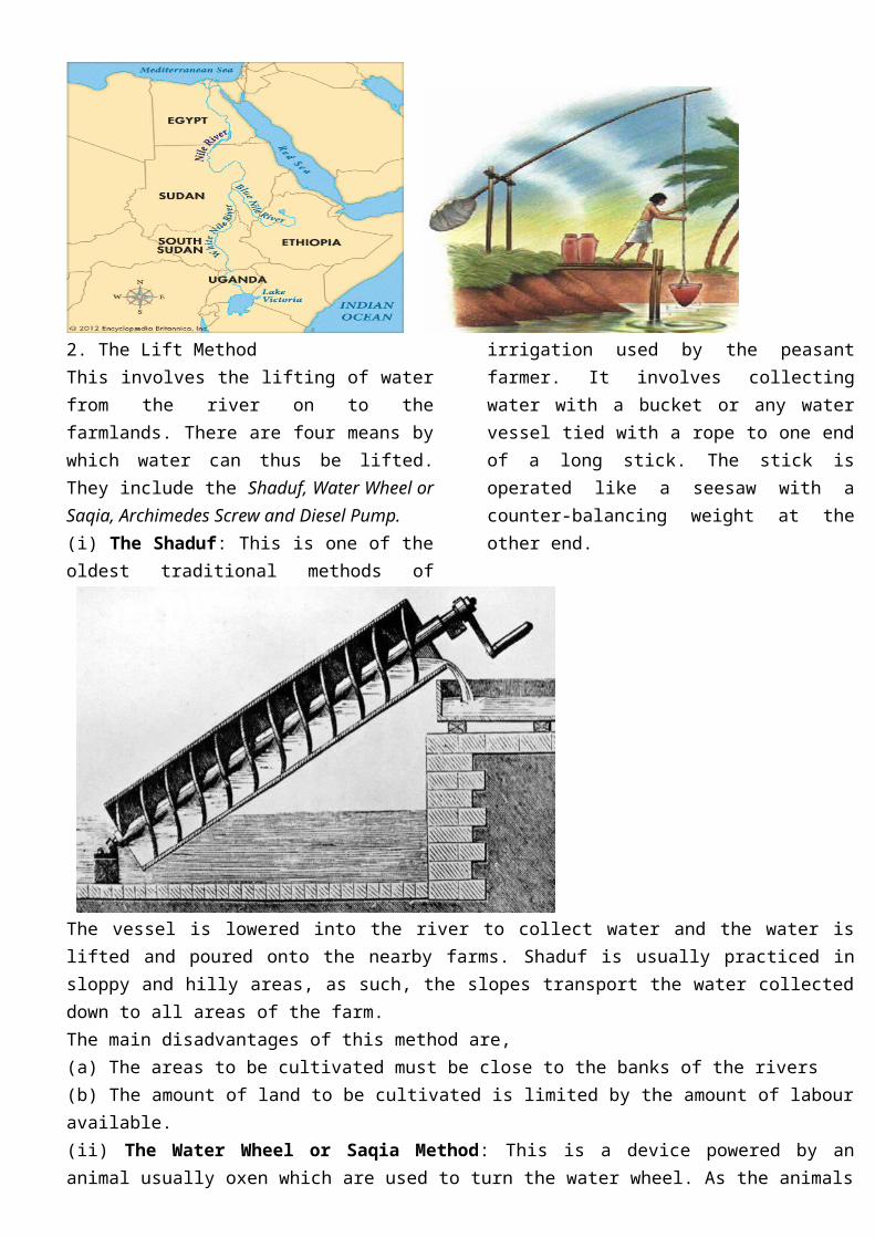
4. With the system of apartheid in South Africa and poor condition of service for the blacks, there were countless labour crises, which often led to the death of several miners. 5. Black workers in the gold mines were employed on short contract terms and were separated from their families. This situation led to frequent labour unrests.
MAJOR HYDRO-ELECTRICITY POWER PROJECTS IN AFRICA: The Seven Giant Hep Projects of Africa MAJOR HYDRO-ELECTRICITY POWER PROJECTS IN AFRICA Hydroelectric power (H.E.P.) is energy produced by the force of running water. When running water flows fast enough it has the required force to produce the power with the help of appropriate mechanisms. In the cases of H.E.P. a concrete or earth dam is built across the river at a point where the river flows across a gorge or narrow rocky channel. This is equally complemented by the presence of a steep slope to provide the natural force of falling water. The force of the water is channelled through a penstock to move huge turbines, which then generate high-tension electricity. The high-tension electricity is subsequently stepped down and distributed to the consumers. There are about forty hydroelectricity power projects in Africa; all are located along the major rivers. The eighteen most important ones include Aswan high, Sennar, Roseires, Kola, Kainji, Akosombo, Kossou, Edea, Inga, Kolwesi, Ruacana falls, Kafue, Seven Forks, Hendrik Verwoerd, Kariba, Victoria fall, Cabora Basa Jinga (Owen falls). ESSENTIAL CONDITIONS FOR PRODUCING HYDROELECTRIC ENERGY The conditions include: 1. A site must be on a river, which maintains a steady flow and huge volume of water all year round; otherwise the powerhouse would be lying idle for some months of the year. 2. The river should be fast flowing. If is not and other conditions are satisfied, a dam could still be built to provide the fast flow. 3. A place in the river valley must be chosen where is deep enough so that a large volume of water can be ponded back without its flowing away in other directions. 4. A site in the river valley where it narrows such as a gorge is preferable for the dam construction. This is to prevent it from being too long and therefore, expensive to build. 5. A firm rock base is needed to provide a solid foundation for the dam itself, which is often a very massive construction. 6. The country must have money, or be able to borrow for the project. 7. The country must have the population and industries, which can pay for and use the power or the prospects of exporting power to neighbouring countries. Africa’s Major H.E.P Projects 8. Government must be able to decision on whether to build a H.E.P. station and where to should be located. 9. Most parts of Africa lie within the tropics and experience heavy rainfall during a major part of the year. The climate of Africa is free from winter and this is advantageous for the construction of H.E.P. stations. THE SEVEN GIANT HEP PROJECTS OF AFRICA The seven giant H.E.P projects of Africa in descending order of their installed capacity are Carbora Bassa, High Aswan Dam, Kariba Dam, Akosombo Dam, Kainji Dam, Victoria falls and Kafue Dam projects. KAINJI DAM PROJECT This is in Nigeria and is sited on the River Niger where it flows fast over the Bussa rapids and where the valley narrows into a gorge with hard rocks at the bed and sides. These provided the favourable conditions for siting a dam and powerhouse. The project was started in 1962, completed in 1968 and commissioned in 1969. It is the 5th largest installed capacity in Africa. The cost of construction was $ 15000000 but Nigeria paid only #175 million and the rest was borrowed from World Bank. From the river bed the dam is 145m high. The lake Kainji reservoir is 136km long and at its widest point is 2km. it has an area of 1270km2. The construction of the dam displaced 44,000

people who were said to be living in 38 communities. These people were resettled into two towns New Bussa and Yelwa. The power is produced and transmitted from here to the highly populated north central, Western and Southern industrial zones of Nigeria. It is also exported to Niger and Benin Republic. The Kainji Lake provides water not only for running the powerhouse, but also for fishing, transportation, irrigation and tourism. THE AKOSOMBO DAM PROJECT The Akosombo (Volta) dam is constructed on the River Volta gorge in south east of Ghana. The gorge is floored and flanked with hard rocks on which the dam is safely anchored. The project built with Italian technical aid was commenced in 1962, completed in 1965 and commissioned in 1966. It is the 4th largest installed capacity in the continent. The cost of the project was $70million, which was provided partially by Ghana, Britain, America, the World Bank and Valco Aluminium Company. The project provides power for the industrial and municipal uses in the Accra-Tema metropolis and for export to Togo. The lake also provides water for irrigating the tobacco and vegetable farms of the Tema plains, fishing and tourism. From the river bed the dam is about 130m high and about 620m long. The man-made lake is the 2nd largest man –made lake in Africa after Lake Nasser in Egypt. Following its construction, the Volta Dam displaced over 40,000 persons settled along the banks of the Volta River. JINGA (OWEN FALLS) POWER PROJECT It is located where the River Nile leaves Lake Victoria in Uganda. Though it is relatively smaller than the seven named projects above the Jinga Dam is one of the best sites for H.E.P projects in the world. The reasons include: 1. Lake Victoria provides a large volume of water all year round, thereby assuring a steady and perennial supply of water. This reduces the cost of building a high storage dam. 2. The channel of the river here narrows down considerably and therefore shortens the length of the dam to only 900 metres. 3. The outcrop of hard rocks on the riverbed, which gave rise to the falls in the first instance provide a solid foundation for the dam. 4. Finally, it is located near the most densely populated and industrialized zones of Uganda where the power is optimally utilized. Part of the power is also sold to Kenya. IMPORTANCE OR BENEFITS OF H.E.P IN THE CONTINENT Hydroelectricity in Africa contributes to the social and economic development of the countries where they are generated. The benefits include: 1. It is used locally in the producing countries for domestic and industrial consumption. 2. It provides foreign exchange for the exporting countries. 3. It has special advantage over other sources of power. Its running cost is cheap. Its production does not cause air pollution as thermal stations do. Water used to generate the power is not used up but recycled and power produced from it is best used for aluminum works. 4. At all the sites, the artificial lakes promote fishing, irrigation, transportation and tourism, and ponding the lake helps to regulate the flow of the river downstream. 5. Its construction and maintenance offer employment to thousands of workers. H.E.P consumption in some African countries: Nigeria - 90%, Ghana - 99%, Malawi - 97%, Zaire - 97%. PROBLEMS AND PROSPECTS OF H.E.P IN AFRICA Where one river is used upstream for other purposes such as irrigation, as is the case with the in-land Delta of the Niger, the river‟s potential for H.E.P. is lower downstream. This accounts for shortage of power generated at Kainji. Rivers may dry up unexpectedly in the Sahel regions of Africa. This causes shortage of water at the dam site. The construction of a H.E.P. station is very expensive and most Africa countries do not have sufficient capital to do so.
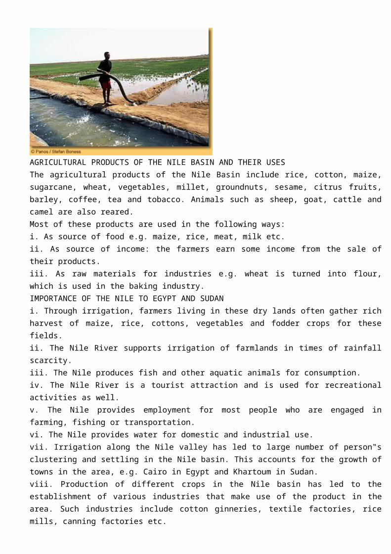
It also involves the use of skilled manpower, which is in short supply in most Africa countries. There is a limit to the distance that H.E.P can be transported (1500km) unlike other sources that can be stored and transported over much longer distance. The ponded lakes often drown farmlands, grazing grounds and settlements thereby displacing many persons. The Aswan High Dam holds back the waters and sediments of the River Nile in Lake Nasser, making it imperative to undertake expensive dredging from time to time. The artificial lakes are breeding grounds for pests and diseases like mosquitoes, guinea worm, tsetse flies, and other water borne diseases.
POSSIBLE SOLUTIONS TO THE PROBLEMS 1. The problems of seasonality in the flow of the river cannot be solved easily. However, the building of a high reservoir, which can hold large volumes of water during the rainy season, could help. 2. Pesticides can be used to solve the problem of pest and disease. 3. Raising loans from banks and encouraging a lot of saving for H.E.P projects could help to make scarce funds available for the establishment of H.E.P. projects. 4. Educating and training the indigenous personnel, ether in higher institutions of learning or giving them on-the job training could be a solution to the lack of skilled personnel. 5. Building of H.E.P substations, which will act as booster stations to the main stations. This could help to solve the problem of under capacity generation of power e.g. the Kainji dam in Nigeria has substations in Jebba, Oshogbo, Lagos, Benin and Kaduna.
THE ECONOMIC COMMUNITY IN WEST AFRICAINTERNATIONAL ECONOMIC CO-OPERATION IN WEST AFRICA Apart from ECOWAS, other forms of cooperation between West African nations include: The River Senegal Union, The Niger Basin Authority, the Lake Chad Basin Commission, Economic Community of Francophone West Africa, Permanent Inter-State Committee on Drought Control in the Sahel. ECOWAS: Economic Committee of West African States. The Heads of State of Nigeria, General Yakubu Gowon and Togo Gnassingbe Eyadema thought out the idea to form this union in 1973. The Two heads of state convinced other West African Heads of State and on 28th May 1975, 15 West African Heads of State signed a treaty establishing ECOWAS in Lagos. Guinea Bissau joined later after her independence making it 16 member countries. Today, Mauritania has pulled out to join a union in North African. The secretariat or administrative headquarters of ECOWAS was in previously in Lagos but is now in Abuja, Nigeria while the financial headquarters is in Lome, Togo. The Ecowas states comprise of 1.Nigeria 2. Ghana 3. Mali 4. Sierra – Leone 5.Gambia 6. Liberia 7. Niger 8.Benin 9. Burkina Faso 10. Guinea Bissau 11. Togo 12. Cote d‟Ivoire 13. Guinea 14.Sao – Tome Principe Map of West Africa Showing ECOWAS country. AIMS AND OBJECTIVES OF ECOWAS 1. To increase trade between member countries by removing all barriers to trade, travel and communication. 2. To promote cooperation and development in economic activities such as industry, transport, telecommunication, energy and agriculture. 3. To cooperate and mutually develop their cultural areas such as education, art and music. 4. To contribute to a common fund, which could be used to compensate countries that lose economically as a result of the organization and develop foreign investments? 5. Finally, to establish a common currency. To achieve these objectives, the treaty demands the community to ensure free movement of goods and services for a period of fifteen years.
ADVANTAGES OF ECOWAS 1. It has led to the development of roads. It is now possible to drive from Lagos through Benin and Togo to Accra in a matter of hours. 2. At the 1979 summit meeting in Dakar, it abolished travel visas for visits not lasting more than three months to member states thereby encouraging free movement. 3. The border dispute that had existed between Benin and Togo was resolved in the spirit of ECOWAS in 1975. 4. The ECOWAS cultural festival of 1977 in Lagos (FESTAC‟77) was an exercise in cultural cooperation. 5 It has helped in providing an immediate solution to economic crisis. Example, in the mid 1070s when Nigeria had the problem of port congestion, Ghana allowed Nigeria to use Tema port and thus provided employment for some Ghanaians. 6. There has been increased economic cooperation between the ECOWAS member countries e.g. (i) Sugar and cement ventures between Nigeria and Benin Republic, (ii) the exchange of oil for Togo’s iron ore 7. There has been an increase in trade volume between the states e.g. (i) the pact between Nigeria and Cote d‟ Ivoire for the supply of 2.5 million tones of petroleum to Cote d‟ Ivoire refining at special price, (ii) the movement of cattle from Niger to Nigeria and from Mali to Ghana. 8. It continues to strive to restore peace to troubled areas in the sub-region. Hence ECOMOG forces sent to Liberia in 1990 succeeded in ending not only the war but also ensuring the return of democracy to that country. The same troops helped to remove the military rulers who staged a coup in Sierra Leone, thereby restoring the democratic government that had been overthrown. Recently, in 2013, the Nigerian government deployed troops and jet fighters to help restore peace in the war torn country of Mali. 9. Presently, it has introduced the ECOWAS Brown Card, which is a type of third-party insurance. With this card, an individual is ensured of payment by ECOWAS for damages that may arise in case of an accident along the road in any member state. 10. To encourage sports, ECOWAS football and handball competitions were initiated in 1982 along with traditional wrestling in 1986 and these have become regular events. 11. ECOWAS has currently established several institutions, a computer center in Lome for collecting and processing data, an Eco-bank in 1984 with branches all over the member states, and a Health Organization in 1987. DISADVANTAGES OF ECOWAS 1. The richer countries such as Nigeria, Cote d‟ Ivoire and Ghana often sponsor most of financial responsibilities. 2. It leads to scarcity of food items in the producing countries due to uncontrolled movement of food items.

3. The free movement of persons leads to over flooding of some countries like Nigeria with illegal migrants who refuse to go back to their countries. Some of them engage in begging and other vices. 4. Some relatively powerful countries such as Nigeria tend to dominate the less powerful countries and influence the shaping of policies of the community. PROBLEMS OF ECOWAS The union has some problems, which confront its operation; there are others, which it has created itself. The problems include: 1. The member states are so many fifteen in all. This makes reconciling views at meetings rather difficult. 2. The states background and orientation are varied and complex different colonial histories, at least three different official languages, ten different currencies and almost as many diverse political and economic orientations as there are nations. These make reaching agreement at meeting become more remote. 3. Many of the states are unable to pay their annual dues. This makes the running of the Secretariat difficulty. 4. Some of the richer countries are also suspicious that their resources might be tapped to enrich the poorer ones. 5. The smaller and poorer countries fear that the bigger and richer ones will dominate them economically and politically. 6. Apart from the Abidjan- Ouagadougou and Dakar-Bamako railway lines there are no international railways, which will encourage free movement of goods. There is no railway linking any Francophone country with the Anglophone countries, and other transport links are inadequate. 7. The colonial ties and post independence nationalism of the member sates have made it difficulty for the community to function smoothly. Example, the four ex-British colonies (Nigeria, Ghana, Sierra Leone and Gambia) still maintain strong economic ties with Britain. The ex-French colonies also maintain ties with France. 8. The primary products as well as the industries in the member states are broadly similar. Their economies are therefore competitive rather than complementary. So, there is a limit to the exchange of goods that a situation of this nature can generate. This reduces the volume of trade between statesCLASS WORKOutline the Organs of ECOWAS and state their functions. FUTURE PROSPECTS AND POSSIBILITIES Despite the problems and disadvantages, ECOWAS, has bright prospects and possibilities, which include: 1. Acting in unison to promote the bargaining power of member states when negotiating for trade or other forms of economic bargain with foreign nations. 2. Institution of a common currency is an idea that has been conceived by member states of ECOWAS for some time. It is hoped that when this comes into effect, it will help to harmonize transactions between ECOWAS member states and facilitate economic growth within the sub-region. A good example of a common currency among countries belonging to an economic union is the European Union’s Euro.
TOURISM IN AFRICA Tourism in East Africa; Tourism in West Africa Tourism is an industry, which involves all aspects of travel and the provision of facilities to travelers for sight seeing, holiday and pleasure. Tourists are the people who do the travel, while tourist centres or resorts are the places where the attraction and facilities, which make the travelers or tourist happy and comfortable, exist. Tourism is not yet developed in Africa as in richer or developed regions of the world like Europe. This is because most Africans cannot afford to travel long distances for pleasure though they travel for employment. In the last twenty years however, some parts of Africa and North West Africa have shown considerable growth in the area of tourism. TOURISM IN EAST AFRICA:
CONDITIONS THAT FAVOUR TOURISM IN EAST AFRICA There are many factors, which makes tourism thrive in East Africa. Some are physical and others are human. PHYSICAL FACTORS 1. The abundance of wildlife: In East Africa there is large area of land reserved for wildlife. Most of these reserves are noted for animals like the elephant, hippopotamus, rhino, leopard, lion, cheetah, zebra, giraffe, buffalo, antelope, and gazelle. Some other reserves like the Lake Nakuru National Park are noted for birds such as beautifully coloured flamingos. Along the coast, the Malindi and Watamu Marine National Parks are famous for their beautiful coral reefs. Here over 200 species of fish can been seen in the clear waters. Watching these animals in their natural habitats offers one a most fascinating and exciting experience. 2. The scenery of hinterland East Africa: this is one of the most fascinating in the continent. There are high volcanic peaks in Mount Kenya, Kilimanjaro and others; some are even snow clad although close to the equator. The block mountain of Ruwenzori, the forest carpeted lava plateau of Aberdare highlands in Kenya; the steep elongated scarps of the Great East African rift valley. Some tourists go there for mountain climbing. The region also has placid lakes such as Lake Victoria, Turkana and others, and the Umbrella-shaped trees of the rolling East African Savannah land. 3. The coastline is also a piece of attraction, with its wide open sandy beaches protected by coral reefs. The water is calm and very good for sports such as swimming, diving, water skiing and sailing. An endless line of tall coconut palms back the coastline itself, with their fluttering emerald green and golden fronds glittering in the tropical sunshine. 4. Varied Climate: the varied climate of East Africa holds some attraction for the tourists. The coastlands are hot throughout the year with temperatures between 25oc and 28oc and it is always sunny, warm and dry. The highlands have their climate moderated by altitude; so temperatures are between 16oc and 19oc and it usually sunny and bright but cool. Also, East Africa has a lot of sunlight throughout the year and this interest’s people from colder lands. HUMAN FACTORS 5. The people themselves are very kind and hospitable. The guides and transporters, who lead the tourists round are very helpful to visitors. The people also keep their cities spotlessly clean, e.g. Kenyatta Avenue in is the widest and one of the neatest places in Nairobi. It is a dual carriageway with several lines and a median beautifully decorated with a line of flowers. Also Uhuru Highway is famous and beautiful. 6. Until recently, the governments of Kenya and Tanzania have had a reputation for political stability since independence, there have been no civil wars or coups, which would discourage visitors who would like to come for pleasure. 7. The hotels, lodges and other accommodation facilities are adequate and excellent. There are well-designed hotels of international standards in the cities and functional lodges in the game reserves. The Kenyatta conference center in Nairobi is a tall cylindrical building with a rotating restaurant on top. From this restaurant you can see the whole of Nairobi while dining. 8. These countries have laid out good transportation facilities which link the tourist resorts to important cities. The Wilson Airport (Nairobi) and the Kilimanjoro Airport (Tanzania) provide landing and taking off facilities for tourists aircrafts. Country-side route ways, maps, travel guides and Safari Kombi buses painted in zebra colours all provide access and transportation to the tourist centres. 9. Effective Publicity: the Kenyan government set up the Kenya Tourists Development Corporation (KTDC), which has offices in London, Frankfurt (West Germany), Stockholm (Sweden), Zurich (Switzerland), Paris and New York. It spends a lot of money every year in publicizing the industry. This attracts more visitors. 10. Tourist Seasons: It is an all year business but December to March is the most popular because that is the period when the weather in Europe and North America is most unpleasant. IMPORTANCE OR BENEFITS OF TOURISM
1. It provides East Africa with considerable foreign exchange earnings. Kenya gets almost as much foreign exchange from tourism as she gets from coffee. In 1976, Kenya earned about 41.1 million Kenya pounds from tourism. 2. It provides employment for many people in different ways e.g. hotel workers, guides, gamekeepers and transporters. 3. It has led to improvement in such facilities as hotels, roads, airports, communication, hotel services etc. 4. It has helped to conserve wildlife in East Africa. 5. Tourism has encouraged local craft industries and postcards printing as the visitors buy large quantities of these items as gifts or souvenirs. 6. It has brought about positive change in people’s way of life: as the visitors come from more advanced societies the people of East Africa learn from them. 7. It has helped East Africa to utilize areas of low and unreliable rainfall, which are not attractive to farmers. 8. It advertises the countries to the outside world and improves their relations with those other countries. 9. It helps people to ease their tension after a long period of work and thus prolong their lives. 10. The location of some tourist centres in very remote places has made it possible for these hitherto neglected places to be of economic importance. 11. Tourism improves the wealth of people's knowledge of other people and places. DISAVANTAGES OF TOURISM 1. The over dependence of a country on the tourist industry for foreign exchange earnings is risky as the tourism industry is very sensitive. Simple epidemics, a military coup, war or any other natural disaster can ruin the industry overnight. 2. Tourists are from different parts of the world with different cultures and as they mix with East Africans, there is a breakdown in the traditional values and ways of life of the people around the tourist centres. 3. It has led to easy spread of diseases such as AIDS and other sexually transmitted diseases. TOURISM IN WEST AFRICA The tourism industry is not significant in West Africa, although countries such as Gambia, Cote d‟ Ivoire, Senegal and Nigeria are trying to build their tourist industries. The major source of attraction to Cote d‟ Ivoire, Senegal and Gambia is largely the presence of exotic beaches. People go there for swimming, water skiing, surf riding and sailing.