© southern regional water pipeline company pty ltd trading
TRANSCRIPT


© Southern Regional Water Pipeline Company Pty Ltd trading as LinkWater Projects 2010 This Environmental Impact Statement (EIS) Change Report for the Northern Pipeline Interconnector Project Stage 2 has been prepared by Northern Network Alliance on behalf of Southern Regional Water Pipeline Company Pty Ltd trading as LinkWater Projects. In preparing this EIS Change Report, Northern Network Alliance has relied upon and presumed accurate certain information provided by specialist subconsultants, certain State and Commonwealth government agencies and others identified herein. Except as otherwise stated in this EIS Change Report, Northern Network Alliance has not attempted to verify the accuracy or completeness of any such information. No warranty or guarantee, whether express or implied, is made with respect to the information reported or the findings, observations or conclusions expressed in this EIS Change Report. Further, such information, findings, observations and conclusions are based solely on information in existence at the time of the investigation. Printed on 100% recycled paper
EIS Change Report, March 2010 Page 2 of 75
CONTENTS
ABBREVIATIONS 6
EXECUTIVE SUMMARY 7
1 INTRODUCTION 8
1.1 Project Overview 8
1.2 Project Proponent 9
2 LEGISLATIVE FRAMEWORK 11
2.1 Environmental Impact Statement 11
2.2 Change Report Provisions 12
2.3 Approvals Requirements 12
2.4 Public Consultation Process 13 2.4.1 Native Title 13 2.4.2 Cultural Heritage 13
3 WATERWAY CROSSING METHODOLOGY 15
3.1 Coordinator-General’s Conditions 15 3.1.1 Waterway Crossings 16
3.2 Waterway Working Group 18 3.2.1 Representatives 18 3.2.2 Assumptions of the WWG 18 3.2.3 Multi-Criteria Analysis 19
3.3 WWG Outcomes 20
4 ASSUMPTIONS 21
4.1 Schedule Implications 23
4.2 Financial Estimates 23
5 DESCRIPTION OF CHANGES 25
5.1 Paynter Creek Northern 25 5.1.1 Current State of Environment 25
EIS Change Report, April 2010 Page 3 of 75
5.1.2 Consultation 28 5.1.3 Justification for Proposed Change 28 5.1.4 Disturbance Footprints 31 5.1.5 Benefits and Opportunities 31
5.2 Petrie Creek 34 5.2.1 Current State of Environment 34 5.2.2 Consultation 39 5.2.3 Justification for Proposed Change 39 5.2.4 Disturbance Footprints 41 5.2.5 Benefits and Opportunities 41
5.3 Tuckers Creek 44 5.3.1 Current State of Environment 44 5.3.2 Consultation 47 5.3.3 Justification for Proposed Change 47 5.3.4 Disturbance Footprints 50 5.3.5 Benefits and Opportunities 50
5.4 North Maroochy River 53 5.4.1 Current State of Environment 53 5.4.2 Consultation 58 5.4.3 Justification for Proposed Change 58 5.4.4 Disturbance Footprints 61 5.4.5 Benefits and Opportunities 61
6 TRENCHING METHODOLOGY 64
7 MITIGATION STRATEGIES 65
7.1 Water Quality 65 7.1.1 Surface Water Management 65 7.1.2 Groundwater Management 65
7.2 Flora and Fauna 66
7.3 Revegetation and Rehabilitation 67 7.3.1 General 67 7.3.2 Riparian Habitat Rehabilitation 67 7.3.3 Revegetation Acceptance Criteria and Maintenance 67 7.3.4 Potential Participation for Local Land Care Groups 68
7.4 Erosion and Sediment Control 68
8 CONCLUSIONS AND RECOMMENDATIONS 69
EIS Change Report, April 2010 Page 4 of 75

EIS Change Report, April 2010 Page 5 of 75
APPENDIX A MINUTES OF DIP / NNA MEETING 11/02/10 70
APPENDIX B WATERWAY WORKING GROUP DOCUMENTS 71
APPENDIX C PROGRAM JUSTIFICATION 72
APPENDIX D SENSITIVE AREA PLANS 73
APPENDIX E DESIGN DRAWINGS 74
APPENDIX F CONSTRUCTION EXECUTION PROCEDURE 75
TABLES Table 1: WWG Outcomes.....................................................................................................20
Table 2: Assumptions ..........................................................................................................21
Table 3: Financial Cost Estimates ......................................................................................24
Table 4: Reasons for Proposed Change at Paynter Creek Northern...............................29
Table 5: Reasons for Proposed Change at Petrie Creek ..................................................39
Table 6: Reasons for Proposed Change at Tuckers Creek ..............................................48
Table 7: Reasons for Proposed Change at North Maroochy River..................................59
FIGURES Figure 1: NPI STAGE 2 PREFERRED CORRIDOR .............................................................10
Figure 2: OVERVIEW OF WATERWAY LOCATIONS .........................................................17
Figure 3: PAYNTER CREEK NORTHERN SAP...................................................................27
Figure 4: DISTURBANCE FOOTPRINT - TRENCHED CROSSING ....................................32
Figure 5: DISTURBANCE FOOTPRINT - PILED CROSSING .............................................33
Figure 6: PETRIE CREEK SAP ............................................................................................36
Figure 7: DISTURBANCE FOOTPRINT - TRENCHED CROSSING ....................................42
Figure 8: DISTURBANCE FOOTPRINT - TUNNEL BORED CROSSING ...........................43
Figure 9: TUCKERS CREEK SAP ........................................................................................46
Figure 10: DISTURBANCE FOOTPRINT - TRENCHED CROSSING ..................................51
Figure 11: DISTURBANCE FOOTPRINT - TUNNEL BORED CROSSING .........................52
Figure 12: NORTH MAROOCHY RIVER SAP......................................................................55
Figure 13: DISTURBANCE FOOTPRINT - TRENCHED CROSSING ..................................62
Figure 14: DISTURBANCE FOOTPRINT - PILED CROSSING ...........................................63

ABBREVIATIONS
CEP Construction Execution Procedure
CHMP Cultural Heritage Management Plan
CG Coordinator-General
DERM Department of Environment and Resource Management
DET Department of Education and Training
DEWHA Department of the Environment, Water, Heritage and the Arts
DIP Department of Infrastructure and Planning
DTMR Department of Transport and Main Roads
EIS Environmental Impact Statement
EMP Environmental Management Plan
EPBC Environment Protection and Biodiversity Conservation Act 1999 (Cwlth)
MNES Matters of National Environmental Significance
NCA Nature Conservation Act 1992
NPI Northern Pipeline Interconnector
RE remnant ecosystem
SAP sensitive area plan
SDPWOA State Development and Public Works Organisation Act 1971 (Qld)
SEQ South-east Queensland
WQBS Water Quality Boosting Station
WQMF Water Quality Management Facility
WTP Water Treatment Plant
EIS Change Report, April 2010 Page 6 of 75

EXECUTIVE SUMMARY
This report requests a change to the Coordinator General’s Evaluation Report (specifically Condition 5) to include trenching as the construction method for four waterway crossings on the basis of improved environmental outcomes. This report also provides a basis for the selection of the trenching method against five agreed criteria and an assessment of the current status of these affected waterway crossings, to enable the Coordinator General to evaluate the merits of the request.
The four subject waterways are:
• Paynter Creek Northern
• Petrie Creek
• Tuckers Creek
• North Maroochy River
You will note that there are significant commitments to procurement (refer to Appendix C for Justification of Program) that need to be made as the assessment and evaluation process follows through. By mid-May 2010, significant financial commitments will need to be made for the piling and tunnelling options.
For this reason, LinkWater Projects requests an interim decision by mid-May 2010 that will allow the proponent to direct the Northern Network Alliance, as the pipeline constructors, to proceed with trenching as the preferred crossing methodology.
Trenching as the preferred crossing method has significant advantage over other crossing methods. The key merits of trenching as opposed to either tunnel boring or piling are:
• Reduced vegetation clearing footprint, including reduced impact on important riparian vegetation;
• Smaller construction footprint and therefore less impact on the environment and affected landowners;
• Significantly lower cost compared to piling or tunnel boring;
• Reduced construction duration and reduced risk of significant rainfall/flood events during construction;
• No long-term impacts on visual amenity as pipeline is underground;
In order to minimise potential impacts throughout the construction period, sensitive area plans have been developed for the four waterways to guide and manage the works. Further, the Northern Network Alliance have developed a range of management plans and mitigation and monitoring plans to ensure no undue environmental harm occurs.
EIS Change Report, April 2010 Page 7 of 75

1 INTRODUCTION This report requests a change to the Coordinator General’s (CG) conditions of approval for constructing the Northern Pipeline Interconnector (NPI) Stage 2, specifically, Condition 5 regarding the method of crossing four waterways on the project. The change to the condition is seeking to include trenching as the construction method for the affected waterway crossings of Paynter Creek Northern, Petrie Creek, Tuckers Creek and North Maroochy River. This report provides a basis for the selection of the trenching method and an assessment of the current status of these affected waterway crossings, to enable the CG to evaluate the merits of the request.
Stage 2 of the NPI was declared a ‘significant project’ under Section 26 of the State Development and Public Works Organisation Act 1971 (SDPWOA) on 13 September 2007. An EIS was prepared for the project and assessed and subsequently approved, with conditions, by the CG on 6 November 2009. Changes to some aspects of the project assessed in the EIS, due to conditions outlined in the CG’s Evaluation Report, have resulted in the need to alter the proposed methodology.
Under s.35C of the SDPWOA, the CG may evaluate the environmental effects of a proposed change to an approved project, the effects of the change of a project and any other related matters.
1.1 Project Overview The south-east Queensland (SEQ) region is one of the fastest growing areas in Australia. However, rapid population growth over the last decade has coincided with the worst drought on record. This has placed increasing pressure on the management and use of regional water sources and highlighted the vulnerability of the region’s water supplies. In response, the Queensland Government is implementing an integrated water infrastructure network—the SEQ water grid. The water grid is made up of a group of water supply sources joined by a series of large interconnected water pipelines which will allow water to be transferred to where it is most needed and ultimately, to provide water security for the region.
As outlined in the NPI Stage 2 EIS, the Project, being delivered by the Northern Network Alliance (NNA) will link Noosa Water Treatment Plant (WTP) to the northern end of the Stage 1 pipeline. It involves the construction of approximately 44km of mainline pipeline plus approximately 4.3km for the Noosa branch main. The NPI is designed to be a bi-directional pipeline, hence along with construction of Stage 2 of the pipeline, additional facilities will be constructed to allow the transfer of drought flows in both a southern and northern direction between North Pine WTP and Noosa WTP.
These facilities include four new pump stations, a pump station control system migration, two Water Quality Boosting Stations (WQBS), a pressure sustaining valve, the augmentation of a water quality management facility (WQMF), a low flow chemical injection point and one balance tank which are all required to operate the NPI under southern and northern drought contingency operation. The respective preliminary on corridor and off corridor facilities are:
Corridor facilities:
• Noosa WTP pump station and WQBS
EIS Change Report, April 2010 Page 8 of 75
• Hardstand for a North Arm low flow injection point
• Ferntree balance tank and WQBS
• Eudlo booster pump station
• Pigging pits
Off corridor facilities:
• Caloundra Street WQMF augmentation
• Morayfield pump station
• Narangba pump station
• Pressure Sustaining Valve at North Pine WTP
• North Pine Pump Station Control System upgrade
Figure 1 outlines the NPI Stage 2 preferred corridor.
1.2 Project Proponent The proponent for the NPI Stage 2 is the Southern Regional Water Pipeline Company Pty Ltd, (trading as LinkWater Projects). LinkWater Projects is responsible for a number of major water infrastructure projects in the SEQ region, including the Southern Regional Water Pipeline, NPI Stage 1, the Eastern Pipeline Interconnector and the Toowoomba Pipeline Project.
LinkWater Projects is a division of the Queensland’s Bulk Water Transport Authority (LinkWater), which was established under the South East Queensland Water (Restructuring) Act 2007. LinkWater will retain ultimate ownership of the NPI Stage 2 asset.
LinkWater Projects has a commitment to effective environmental management and lists environment as a key component of its overall vision ‘to become an effective partner in delivering water security to SEQ’, with an underlying principle of ‘Sustainability and positive environmental outcomes’.
For further information regarding LinkWater and LinkWater Projects, please contact:
LinkWater Projects Level 4 200 Creek Street Brisbane Qld 4000 Phone: (07) 3270 4000 www.linkwater.com.au
EIS Change Report, April 2010 Page 9 of 75

Figure 1: NPI STAGE 2 PREFERRED CORRIDOR
EIS Change Report, April 2010 Page 10 of 75

2 LEGISLATIVE FRAMEWORK NPI Stage 2 is part of the SEQ drought emergency strategy. On 8 August 2006, a water supply emergency regulation (the Water Regulation 2002) pursuant to s.25B of the Water Act 2000 directed that works be undertaken to complete the NPI Stage 2 by the statutory date of 31 December 2011.
Under s.87 of the Water Regulation 2002, the nominated service provider (LinkWater Projects) is directed to take all necessary steps to prepare for, and construct, the NPI Stage 2. The project is defined, for the purposes of the Water Regulation 2002, as that project summarised in the Report on Drought Contingency Projects (January 2009), held by the Department of Infrastructure and Planning (DIP).
In addition to the direction under the Water Act 2000, the nominated service provider is authorised to undertake works under s.100 of the State Development and Public Works Organisation Act 1971 (SDPWOA). This authorisation is described under s.12C (3) of the State Development and Public Works Organisation Regulation 1999 (SDPWO Regulation).
NPI Stage 2 has been identified as a vital piece of regional infrastructure required to meet the immediate and future water needs of South-East Queensland. The NPI Stage 2 project also has been declared a ‘Prescribed Project’ and ‘Critical Infrastructure Project’, pursuant to s.76E of the SDPWOA, on 15 May 2009. Further, the project was included in the Water Security Program published by the Department of Environment and Resource Management (DERM) on 5 March 2010. The Water Security Program establishes the policy basis for the State Government response to delivering water security in the region.
2.1 Environmental Impact Statement On 13 September 2007, NPI Stage 2 was gazetted as a ‘significant project’ for which an EIS is required under the SDPWOA. The EIS process for significant projects is overseen by the CG. It provides for a co-ordinated assessment of the potential economic, social and environmental effects of the project by various government agencies and other relevant bodies, including the community and affected stakeholders.
On behalf of LinkWater Projects, the Northern Network Alliance, prepared a response to the comments received on the EIS and submitted a supplementary report to the EIS in July 2009. The CG assessed the EIS and supplementary report and issued an Evaluation Report to the NNA outlining key recommendations and conditions for construction of the NPI Stage 2 in November 2009.
On 24 October 2007, the then Commonwealth Minister for the Department of the Environment and Water Resources (now known as the Department of Environment, Water, Heritage and the Arts [DEWHA]) determined that the project was a ‘controlled action’ under the Environment Protection and Biodiversity Act 1999 (EPBC Act) due to the likely impact on Matters of National Environmental Significance (MNES). The project received approval to proceed from DEWHA on 12 February 2010.
EIS Change Report, April 2010 Page 11 of 75

2.2 Change Report Provisions Section 35C of the SDPWOA states:
“The proponent may apply to the Coordinator General to evaluate, under this division, the environmental effects of the proposed change, its effect on the project and any other related matters.”
A meeting was held with representatives from the Department of Infrastructure and Planning (DIP) on 11 February 2010, where it was confirmed that for the purposes of the intended approach for the affected waterway crossings to allow trenching, a change report process would be required to amend the CG’s Evaluation Report. Minutes of this meeting are attached at Appendix A.
Under this provision of the Act, the proponent seeks, through this report, for the CG to evaluate proposed changes to the Waterway Crossing Methodology for the four affected waterway crossings.
2.3 Approvals Requirements The works required for the purpose of installing the pipeline may trigger approval for:
• constructing temporary waterway barriers under the Fisheries Act 1994
• disturbing the bed and banks of waterways under the Water Act 2000.
In accordance with section 4(2) of the Water Act 2000, the operation of the SDPWOA and the powers of the CG are not bound by the Water Act 2000. Notwithstanding this general exemption that can be invoked for the project, a self assessment of the proposed works has been undertaken to ensure appropriate due diligence is applied for the project.
The works associated with construction of the waterway crossings are deemed to comply with guidelines set out by the relevant State Government Agencies, and as such are deemed to be self-assessable activities. These guidelines are:
• Guideline for Activities in a watercourse, lake or spring carried out by an entity (Riverine Protection Guideline), published by the former Department of Natural Resources and Water
• Code for self-assessable development - Temporary waterway barrier works in freshwater (WWBW02 code) published by the former Department of Primary Industries and Fisheries.
Compliance with the Riverine Protection Guideline and the WWBW02 code in freshwater is considered compulsory for this project, and meeting the requirements set out in the guidelines will ensure best practice environmental management.
All other approvals required by Federal and State legislation will be sought as required.
EIS Change Report, April 2010 Page 12 of 75

2.4 Public Consultation Process The NNA has consulted with directly affected landowners and other relevant stakeholders prior to completion of this report. Details of the issues raised and responses are provided later in this report for each respective waterway crossing area.
The need for further public consultation for this change report before it is determined will be at the discretion of the CG.
Directly Affected Landholders
The proposed changes to the waterway crossing methodology affect several landholders, whose properties adjoin the affected waterways, including state government agencies the Department of Transport and Main Road (DTMR), Sunshine Coast Regional Council (SCRC) and the Department of Education and Training (DET).
The engagement of these landholders has been, and will continue to be, an integral part of the project. Face-to-face discussions have been held with the affected landholders regarding the proposed changes to establish the viability and perception of the changes, as well as to reduce the time required for public notification of the Change Report.
Every effort will continue to be made to ensure the affected landholders are briefed on the change report outcomes on a regular basis.
2.4.1 Native Title
For the sections of the sites that are State land, resource entitlements have been sourced and obtained for these locations from DERM. As part of this assessment by DERM, consideration of Native Title matters was undertaken.
In addition, earlier corridor wide Native Title assessments were undertaken as part of the approvals process by the NNA including searches and public notification of the future acts under the provisions of Section 24KA of the Native Title Act 1993 (Cwlth). No Native Title issues were triggered and the proponent through the NNA decided to proceed with the future acts. The works proposed for the areas the subject of the change report are accordingly not expected to trigger Native Title issues.
2.4.2 Cultural Heritage
Indigenous cultural heritage is defined in accordance with the Aboriginal Cultural Heritage Act 2003 as:
• a significant Aboriginal or Torres Strait islander area in Queensland;
• a significant Aboriginal or Torres Strait Islander object; and
• archaeological or historic evidence of Aboriginal or Torres Strait Islander occupation of an area.
A Cultural Heritage Management Plan (CHMP) has been prepared and approved under the Aboriginal Cultural Heritage Act 2003. The approved CHMP covers the works and activities proposed in this EIS Change Report.
EIS Change Report, April 2010 Page 13 of 75

The primary mechanism for mitigating impacts to indigenous cultural heritage and demonstrating ‘duty of care’ will be the implementation of the approved CHMP for the NPI Stage 2 Project.
Potential cultural heritage impacts of the project are largely associated with the construction phase. These include burial of or damage to shallow artefacts, subsurface material and significant vegetation as a result of construction activities. Where possible, cultural heritage items will be managed in situ (left in place). However, where impacts are unavoidable, items will be relocated or removed in compliance with the approved CHMP.
EIS Change Report, April 2010 Page 14 of 75
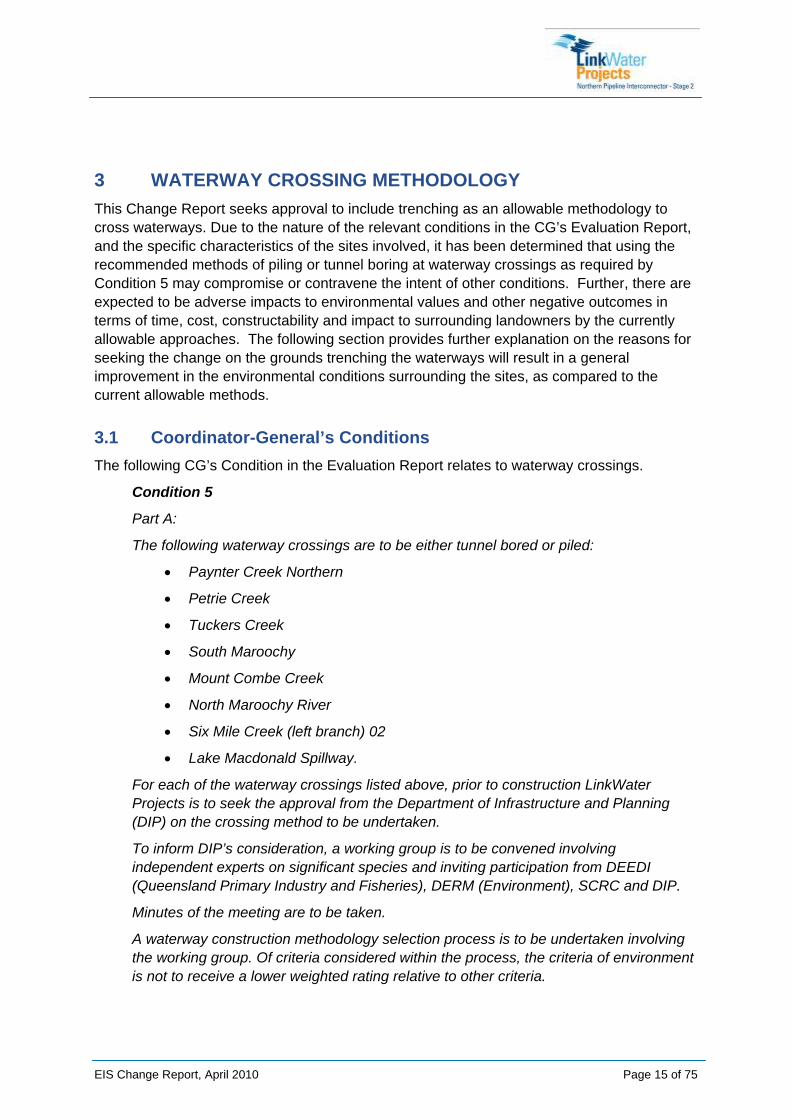
3 WATERWAY CROSSING METHODOLOGY This Change Report seeks approval to include trenching as an allowable methodology to cross waterways. Due to the nature of the relevant conditions in the CG’s Evaluation Report, and the specific characteristics of the sites involved, it has been determined that using the recommended methods of piling or tunnel boring at waterway crossings as required by Condition 5 may compromise or contravene the intent of other conditions. Further, there are expected to be adverse impacts to environmental values and other negative outcomes in terms of time, cost, constructability and impact to surrounding landowners by the currently allowable approaches. The following section provides further explanation on the reasons for seeking the change on the grounds trenching the waterways will result in a general improvement in the environmental conditions surrounding the sites, as compared to the current allowable methods.
3.1 Coordinator-General’s Conditions The following CG’s Condition in the Evaluation Report relates to waterway crossings.
Condition 5
Part A:
The following waterway crossings are to be either tunnel bored or piled:
• Paynter Creek Northern
• Petrie Creek
• Tuckers Creek
• South Maroochy
• Mount Combe Creek
• North Maroochy River
• Six Mile Creek (left branch) 02
• Lake Macdonald Spillway.
For each of the waterway crossings listed above, prior to construction LinkWater Projects is to seek the approval from the Department of Infrastructure and Planning (DIP) on the crossing method to be undertaken.
To inform DIP’s consideration, a working group is to be convened involving independent experts on significant species and inviting participation from DEEDI (Queensland Primary Industry and Fisheries), DERM (Environment), SCRC and DIP.
Minutes of the meeting are to be taken.
A waterway construction methodology selection process is to be undertaken involving the working group. Of criteria considered within the process, the criteria of environment is not to receive a lower weighted rating relative to other criteria.
EIS Change Report, April 2010 Page 15 of 75
Following the process, a sensitive area plan (SAP) for each of the crossings indicated in the first list above is to be produced that will detail how the recommended construction method will be undertaken to minimise environmental impacts.
For each of the crossings, the results of the process, a copy of minutes of all working group meetings on the crossing and a copy of the proposed SAP is to be provided to DIP at least one month prior to construction at the waterway crossing.
Part B:
To understand the overall schedule of the listed waterway crossings, a program of consideration for each of the crossings, proposed construction timeframes and timeframes for the above assessment process is to be provided to DIP within two months of the release of this report.
3.1.1 Waterway Crossings
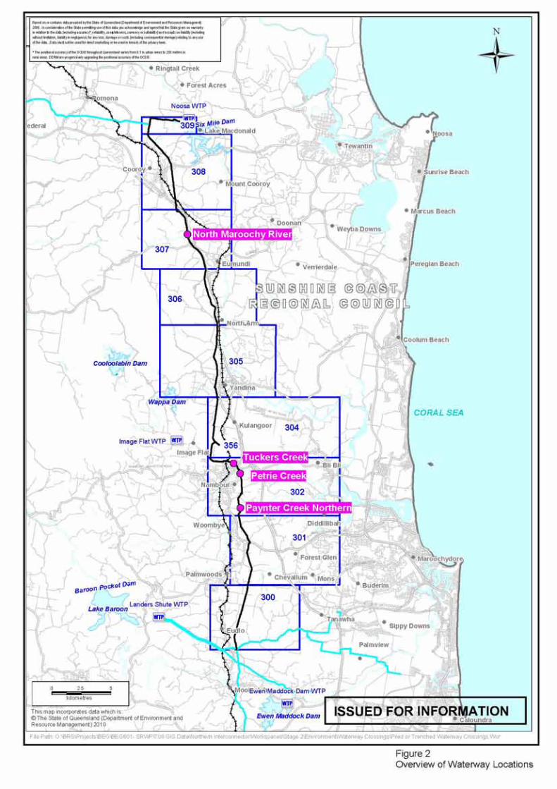
The waterway crossings for which LinkWater Projects are specifically requesting assessment are listed below:
1. Paynter Creek Northern
2. Petrie Creek
3. Tuckers Creek
4. North Maroochy River
Refer to Figure 2 for an overview of the waterway locations.
EIS Change Report, April 2010 Page 16 of 75
3.2 Waterway Working Group
3.2.1 Representatives
As per the CG's Condition 5, a Waterway Working Group (WWG) was convened in November 2009 through to January 2010 to undertake the waterway assessments necessary to recommend the most appropriate crossing methodology (either tunnel bored or piled as per Condition 5) for 14 waterway crossings.
The WWG consisted of representatives from Fisheries Queensland, DIP, DERM, SCRC, LinkWater Projects, the NNA and other specialist flora and fauna representatives. The WWG representatives are listed in Appendix B.
3.2.2 Assumptions of the WWG
Crossing methods were assessed in terms of impacts to the bed, banks, and immediate riparian zone of these waterways. Consideration was given to the area or footprint required for construction (i.e. shafts for boring, pads for piling equipment). However, it is to be noted that detailed information on the access requirements for piling/boring equipment was not available at the time of the workshops and the assessment of impacts associated with these access requirements was agreed to be omitted from the multi-criteria analysis process.
Since the completion of these workshops, detailed information of the access requirements has been prepared and has been included as part of the assessment undertaken for this report.
Other assumptions used during scoring/rating of the waterway crossing methods during the WWG workshops included:
• Ratings were based on professional judgment using whatever factual information was available and best estimate for circumstances where insufficient information was available.
• Ratings only consider impacts to the waterway and riparian vegetation immediately adjacent the waterway potentially affected during construction and operation phases. They do not consider impacts associated with laying the pipe to connect with crossing point.
• Ratings only consider impacts that could reasonably be expected to occur within the construction and operation phases based on the level of risk accommodated by the program design (e.g. use of Q5 flood levels as a basis for managing crossing construction). They do not take into account potentially catastrophic impacts associated with events with a low likelihood of occurrence.
• Ratings do not consider the cumulative impact of multiple crossing constructions on the status of particular catchments. They only consider individual crossing points and receiving waters that could potentially be affected.
EIS Change Report, April 2010 Page 18 of 75

EIS Change Report, April 2010 Page 19 of 75
• Ratings do not take into account the cumulative risk associated with delays to the program caused by having to adopt time consuming crossing construction methods for most or all sites.
• Ratings for trenching assume that individual erosion control plans and rehabilitation measures will be applied at each site based on site conditions and that, based on evidence provided by NNA engineers at the workshop, these measures have a high chance of success.
3.2.3 Multi-Criteria Analysis
The WWG collectively defined the criteria and sub-criteria for the multi-criteria analysis (MCA) through several different methods. It was essential to obtain agreement of the criteria as they were weighted and used to score each of the waterway crossings. The full explanation of the criteria and weightings is found at Appendix B.
The five criteria and weightings agreed upon were:
• Value - value for money - 13%
• Program - impacts on the construction schedule and project deadlines - 21%
• Stakeholders - impacts to directly affected and other relevant stakeholders - 21%
• Constructability - consideration of constructability factors - 17%
• Environment - perceived and actual impacts to environmental values of the site - 28%

EIS Change Report, April 2010 Page 20 of 75
3.3 WWG Outcomes Table 1 below outlines the key recommendations and agreed outcomes for the four subject waterways as assessed by the WWG.
Table 1: WWG Outcomes
Waterway Crossing WWG scoring1
Recommendation based on WWG
outcomes and CG’s conditions2
DIP Agreed Outcomes3 Proponent Proposed Method
Paynter Creek Northern Trenching Piling At the discretion of the Proponent
Change report process where trenching is chosen
Trenching subject to Change Report
Petrie Creek Trenching Boring At the discretion of the Proponent
Change report process where trenching is chosen
Trenching subject to Change Report
Tuckers Creek Trenching Boring At the discretion of the Proponent
Change report process where trenching is chosen
Trenching subject to Change Report
North Maroochy River Trenching Piling Strapped to the existing road bridge if approval is received from SCRC,
and bridge is structurally sound
Structural condition survey found the bridge to be structurally unsound.
Trenching subject to Change Report
1 WWG Scoring – this indicates the crossing methodology which scored the highest from the Multi-Criteria Analysis process. 2 Recommended crossing methodology based on applicable condition 5 of the CG’s Evaluation Report (stipulating that crossings to be either piled or bored - trenching is not an available option under Condition 5). 3 DIP agreed outcomes from discussions between NNA and DIP on 11/02/2010.

4 ASSUMPTIONS The following assumptions have been derived from information relevant to the four subject waterways, and pertinent to the justification for including trenching as an allowable waterway crossing methodology.
Table 2 below outlines the assumptions that apply to all waterway crossings, and should be taken into account in the justification of the four subject waterways having regard to the criteria for assessment.
Table 2: Assumptions
Criteria Assumptions
Value Refer to Section 4.2 for detailed financial estimates of the four subject waterways.
Better operational outcome desired for trenched crossings - less valves and maintenance required for trenched method.
Program Refer to Section 4.1 for detailed schedule information and implications.
Approximate timing of construction methodologies (from site set up to bulk reinstatement)
Trenching - from 3 weeks to 5 weeks (dependent on site characteristics) Piling - from 15 weeks to 18 weeks (dependent on site characteristics) Tunnel Boring - from 16 weeks and 17 weeks (dependent on site characteristics)
Timings and program implications assume parallel construction for piled and tunnel bored crossings.
Assumptions for trenched crossings are:
- trenching activities are driven by approval from CG
Assumptions for tunnel bored and piled crossings are:
- site preparation is not affected by procurement
- piling and tunnelling activities are driven by procurement
The timings provided in Appendix C outline design, procurement and construction timeframes.
Stakeholders All stakeholders will be consulted and all the required consents and approvals will be obtained prior to construction.
Constructability Modern construction techniques and methods will be used.
The disturbance footprints identified for the each waterway crossings method assume the following:
- 15m disturbance footprint allowed up to top of bank of waterway for piling and tunnelling, 15m through the waterway for trenching.
EIS Change Report, April 2010 Page 21 of 75

EIS Change Report, April 2010 Page 22 of 75
Criteria Assumptions
- 20m setback from waterway - no works to be undertaken within 20m of the waterway (except in the 15m allowed)
For tunnelling and piling, where access for cranes/piling rigs cannot be obtained in the disturbance footprint, a larger crane would be required - this would increase the cost of the waterway crossing and has not been accounted for in the estimates.
Safety and risk will be paramount in constructing and installing the pipeline.
Environment Trenching entails smaller construction footprint than piling or tunnel boring.
Sensitive Area Plans have been developed for each of the waterways, and construction will be informed and led by them.
Erosion and Sediment Control Plans have been developed for each of the waterways and will be in place from the start of construction.
Rehabilitation and revegetation work on site will ensure the site is left in as good as or better condition than when it was disturbed.
LinkWater Projects are currently working with Ecofund to deliver watercourse offsets under the VMA for the clearing of approx 7ha of vegetation along watercourses of various stream orders. Ecofund is currently identifying strategically located properties on the Sunshine Coast which contain watercourses and then will develop an offset proposal that entails the restoration and management of riparian vegetation along these watercourses as well as their protection on title. The total area of watercourse offsets are likely to be in the vicinity of 14ha (using a 1:2 ratio as a guide) and result in the improvement of water quality and riparian corridors within the same subregion of impacts from NPI Stage 2.
LinkWater in partnership with Ecofund will liaise with the Sunshine Coast Regional Council and SEQ Catchments to develop an additional and complimentary program for watercourse restoration. The program will be located within the same catchments as NPI Stage 2 and there is potential to undertake complimentary actions on the offset properties to enhance watercourses and water quality. The program will also consider potential to fund the implementation of indirect offset measures (such as removing waterway barriers, in-stream restoration, land use management etc) to improve water quality and fish habitat values. The program will be developed over the next 3 months and implementation commenced within 12 months of the revised Coordinator-General's approval.

EIS Change Report, April 2010 Page 23 of 75
4.1 Schedule Implications LinkWater Projects, and the NNA, are conscious of project timeframes and the associated procurement deadlines and construction durations.
Information was provided to LinkWater Projects by the CG that the sequence of events required to finalise the assessment and evaluation of this change report is in the order of eleven (11) weeks. As such, it is requested the CG provide an assessment and response to this report by 5 July 2010 so as not to jeopardise the delivery of the NPI Stage 2 Project.
You will note that there are significant commitments to procurement (refer to Appendix C for Program Justification documents) that need to be made as the assessment and evaluation process follows through. By mid-May 2010, significant financial commitments will need to be made for the piling and tunnelling options.
For this reason, LinkWater Projects requests an interim decision by mid-May 2010 that will allow the proponent to direct the NNA, as the pipeline constructors, to proceed with trenching as the preferred crossing methodology.
4.2 Financial Estimates The following financial costings, provided in Table 3 below, are derived from previous construction estimates undertaken for NPI Stage 2. The costs provided include all materials, establishment of equipment on site, construction of access roads to the sites, construction, pipe tie in, removal and backfill of shafts (where required) and revegetation and rehabilitation.
Considerations for Table 3 - Financial Cost Estimates:
- Design has commenced and monies committed - no design cost incorporated
- Hardstand costs for tunnel bored crossings are included in direct costs
- No escalation applicable to tunnel bored crossings by subcontractors.

EIS Change Report, April 2010 Page 24 of 75
Table 3: Financial Cost Estimates
Waterway Paynter Creek
Northern piled crossing
Petrie Creek tunnel bored
crossing
Tuckers Creek tunnel bored
crossing
North Maroochy River
piled crossing SUB TOTAL
Direct Costs $215,537 $2,672,890 $1,814,672 $527,796 $5,230,895 Design Costs $0.00 $0.00 $0.00 $0.00 $0.00
Hardstand Costs $75,911 $0.00 $0.00 $75,911 $151,822 Lateral
Access Costs $149,170 $54,742 $63,348 $0.00 $267,260 Land Access
Costs $5,390 $5,390 $5,390 $5,390 $21,560
Hydrotest Costs $0.00 $46,300 $46,300 $0.00 $92,600
Tie In Costs $67,952 $96,112 $96,112 $67,952 $328,128 Additional Overheads
(15%) $77,094 $431,315 $303,873 $101,557 $913,840
Survey Costs $29,375 $29,375 $29,375 $29,375 $117,500
Opportunity and Risk $40,328 $216,848 $153,340 $52,519 $463,034
Escalation (1%) $5,911 $0.00 $0.00 $7,786 $13,697
SUBTOTAL $666,667 $3,552,972 $2,512,410 $868,286 $7,600,336
Fee $80,000 $426,357 $301,489 $104,194 $912,040
Tunnel Bored / Piled
Method
TOTAL $746,668 $3,979,329 $2,813,899 $972,481 $8,512,376 Trenched Method $52,252 $149,996 $44,794 $87,411 $334,453
Difference $694,416 $3,829,333 $2,769,105 $885,070 $8,177,923

5 DESCRIPTION OF CHANGES Based on the findings of the WWG, and the specific characteristics of each of the four subject waterways, this report aims to justify the rationale for trenching as opposed to piling or tunnel boring.
It is recognised that in meeting the recommendations and requirements of one condition in the CG’s Evaluation Report, the intent or outcomes of another condition may be compromised, through increased environmental harm or habitat destruction. As such, it is necessary to find a suitable balance for the project that can meet the spirit and intent of the conditions.
5.1 Paynter Creek Northern Paynter Creek Northern is located on the boundaries of properties described as Lot 4 on RP195810 and Lot 6 on RP28178.
This section describes the proposed changes to the waterway crossing methodology for Paynter Creek Northern. It also provides justification for the changes, based on the criteria defined in the WWG.
5.1.1 Current State of Environment
Paynter Creek Northern is described as a 1st order stream by DERM. It has mapped significant vegetation (Endangered (RE 12.3.1)) adjacent to and within the NPI Stage 2 pipeline corridor. Refer to Appendix D for the complete SAP for Paynter Creek Northern. Figure 3 provides the SAP map outlining the environmental values of the site.
The vegetation within the corridor is remnant and is dominated by Picabeen Palms (Archontophoenix cunninghamiana) (Refer to Plate 1). The vegetation on the southern side of the waterway at the crossing location has been cleared previously (former sugar cane farm), and the riparian vegetation on the southern side of the crossing is narrow (less than 10m wide) and has been impacted by weeds.
In designing the crossing, the NNA avoided using the existing cleared easement due to the confirmed presence of the EPBC listed Swamp Orchid (Phaius tancarvilleae) (Endangered), and to minimise the number of crossings of Paynter Creek.
Tusked Frog (Adelotus brevis) has been confirmed at this site during fauna surveys conducted for the EIS. This site is potential suboptimal habitat for Giant Barred Frog (Mixophyes iteratus), Elf Skink (Eroticoscincus gracilloides) and Platypus (Ornithorhynchus anatinus), however no significant species have been confirmed during fauna surveys. Two pre-construction surveys targeting the Giant Barred Frog have been conducted at this site since the release of the EIS. Surveys were conducted in March 2009 and September 2009 by NNA (using relevant technical experts), and the Giant Barred Frog was not confirmed during these surveys.
There are no significant aquatic species located within this waterway.
This site contains potential habitat for the following species:
EIS Change Report, April 2010 Page 25 of 75

• Tusked Frog (Adelotus brevis) - Vulnerable (Nature Conservation Act 1992 [NCA]), confirmed at this site
• Giant Barred Frog (Mixophyes iteratus) - Endangered (MNES and NCA), not confirmed at this site
• Elf Skink (Eroticoscincus gracilloides) - Rare (NCA), not confirmed at this site
• Platypus (Ornithorhynchus anatinus) - Culturally Significant (NCA), not confirmed at this site.
Potential impacts to habitat for both construction methods to be managed by:
• Stabilize banks and revegetate immediately after completion of construction;
• Revegetate with species able to achieve canopy cover as quickly as possible;
• Remove instream woody debris prior to construction and replace immediately after construction; and
• Check banks for Platypus burrows prior to construction.
EIS Change Report, April 2010 Page 26 of 75

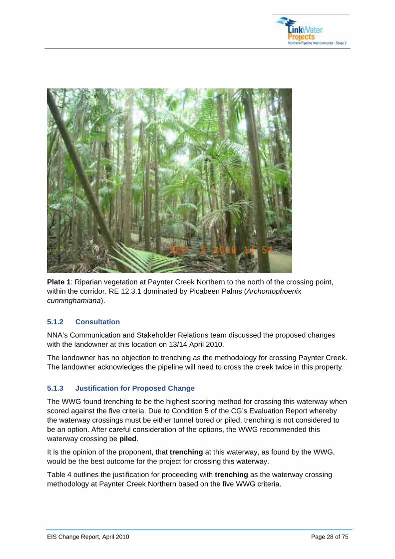
Plate 1: Riparian vegetation at Paynter Creek Northern to the north of the crossing point, within the corridor. RE 12.3.1 dominated by Picabeen Palms (Archontophoenix cunninghamiana).
5.1.2 Consultation
NNA’s Communication and Stakeholder Relations team discussed the proposed changes with the landowner at this location on 13/14 April 2010.
The landowner has no objection to trenching as the methodology for crossing Paynter Creek. The landowner acknowledges the pipeline will need to cross the creek twice in this property.
5.1.3 Justification for Proposed Change
The WWG found trenching to be the highest scoring method for crossing this waterway when scored against the five criteria. Due to Condition 5 of the CG’s Evaluation Report whereby the waterway crossings must be either tunnel bored or piled, trenching is not considered to be an option. After careful consideration of the options, the WWG recommended this waterway crossing be piled.
It is the opinion of the proponent, that trenching at this waterway, as found by the WWG, would be the best outcome for the project for crossing this waterway.
Table 4 outlines the justification for proceeding with trenching as the waterway crossing methodology at Paynter Creek Northern based on the five WWG criteria.
EIS Change Report, April 2010 Page 28 of 75

Table 4: Reasons for Proposed Change at Paynter Creek Northern
Criteria Justification Potential Impacts
Value Trenching through this waterway is at base cost - costed as trenching in TOC
Trenching at $55,252 vs. piling at $746,668
Costs increase with piling to more than 13 times the cost of trenching.
Cost include construction of access tracks and hardstand areas required to pile - very steep access track required on northern side of crossing (from Pringle Road). (Refer to Section 4.2 for further cost information)
Increased cost of construction for piling - additional costs for gaining access for northern pile
Program Further geotechnical investigations would be required for piling to determine depth of piles and footings.
Trenching: 3 weeks to construct including bulk reinstatement Piling: 15 weeks from site set up to bulk reinstatement.
Procurement lead time approx 11 weeks due to manufacture and delivery of special bends.
Time required to undertake geotechnical investigations prior to design of piling option
Reduced timeframe for construction using trenching
Reduced risk of delay due to exposure to variable weather patterns or rain events
Increased risk of project delay due to sourcing and procurement of materials, piling machinery and equipment.
Stakeholders Impacts on directly affected stakeholders are increased with piling due to the increased number of machines required for accessing the site.
Crane pads / extensive lay down areas would need to be established
Piling would require a significant amount of remnant vegetation to be cleared in order to access the northern pile site.
Impact on stakeholders increased with length of construction period for piling.
More land required for piling option for handstand areas and access roads.
Constructability Piling would present a significantly greater safety risk at this site due to restricted access to the north of the
No additional valves are required to trench. This presents a superior operational
EIS Change Report, April 2010 Page 29 of 75

EIS Change Report, April 2010 Page 30 of 75
Criteria Justification Potential Impacts site.
Piling would require a temporary use area and machinery access right to the top of banks to allow for machinery to drill the piles and install the headstock. A crane or excavator would then be required to lower the pipe onto the piles.
These areas would be required outside the 15m corridor and within the 20m setback.
Refer to the construction footprint for layout of site.
outcome
No additional access tracks / temporary use areas required to trench.
Environment The additional construction duration for piling poses a greater risk to the environmental at this site as there is an increased risk of a significant rainfall event which may result in impacts to both the riparian and in stream habitat via erosion and movement of sediment downstream (impacts on bed/banks and downstream habitat).
Greater amounts of vegetation would be required to be cleared for piling due to the need to create an access down the steep slope from Pringle Road, to access the northern bank to construct the pile and headstock.
Trenching would require only the constrained corridor of 15m to be cleared.
Trenching has less impact on vegetation communities – less clearing required for access – but greater impact on the bed of the waterway. Impacts on the waterway bed will be minimised through the use of dam bags and the corridor width will be constrained (15 m wide).
Including reinstatement and revegetation, the trenching option can be completed in less than one month, whereas piling will take up to two to three months to complete.

5.1.4 Disturbance Footprints
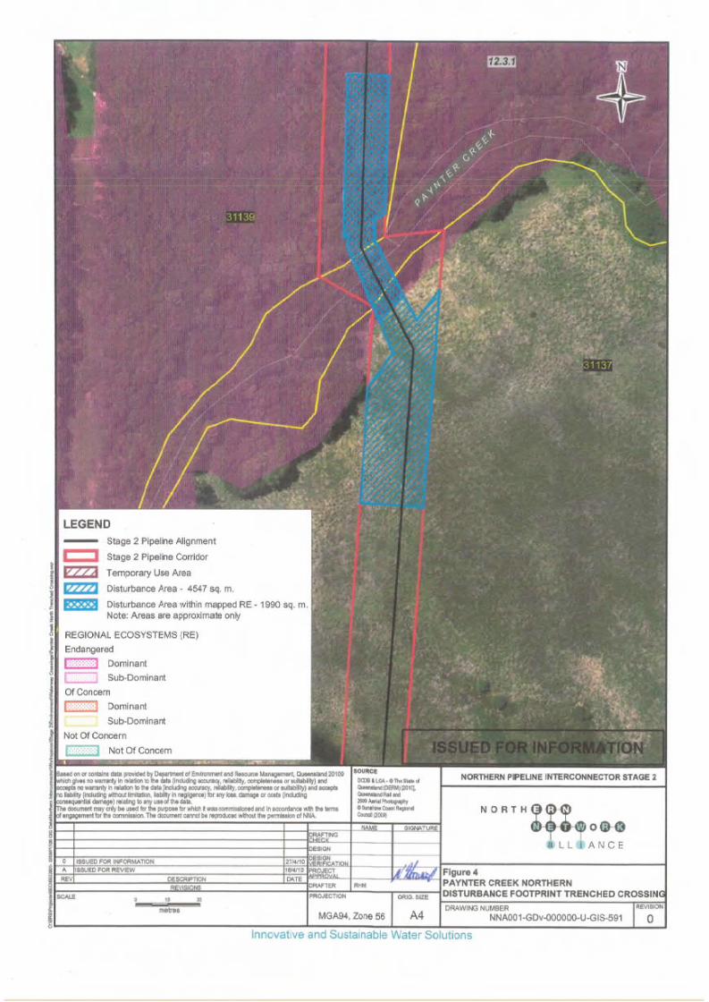
The disturbance footprints are outlined below.
TRENCHED:
Total disturbed 4547 m²
RE vegetation disturbed 1990 m²
PILED:
Total disturbed 5020 m²
RE vegetation disturbed 1835 m²
Figures 4 and 5 below depict the anticipated construction footprints for both trenching and piling at Paynter Creek Northern.
Refer to Appendix D for design drawings depicting the disturbance footprints and areas for both crossing methods.
5.1.5 Benefits and Opportunities
The benefits and opportunities identified for using trenching at this crossing are:
• Trenching requires less disturbance area (4385 m² less) for access for equipment, and reduces safety risks associated with difficult access from Pringle Road (north of crossing point) – steep hills.
• Less cost associated with trenched crossing construction and ongoing maintenance. LinkWater can invest in revegetation works at the crossing point.
• Opportunities to revegetation along the southern bank of the waterway crossing if landowner agreement, or to tie in with other revegetation projects in the area. LinkWater in partnership with Ecofund will liaise with the SCRC and SEQ Catchments to develop a program for watercourse restoration. The program will be located within the same catchments as NPI Stage 2. The program will also consider potential to fund the implementation of indirect offset measures (such as removing waterway barriers, in-stream restoration, land use management etc) to improve water quality and fish habitat values.
EIS Change Report, April 2010 Page 31 of 75


5.2 Petrie Creek Petrie Creek is located on the boundary of properties described as Lot 447 on CG2489 and Lot 6 on RP220222.
This section describes the proposed changes to the waterway crossing methodology for Petrie Creek. It also provides justification for the changes, based on the criteria defined in the WWG.
5.2.1 Current State of Environment
Petrie Creek is described as a 1st order stream by DERM. This site has degraded riparian vegetation (Of Concern (RE 12.3.2)) within the pipeline corridor, and is heavily weed impacted at the crossing point and adjacent areas. Refer to Appendix D for the complete SAP for Petrie Creek. Figure 6 provides the SAP map outlining the environmental values of the site.
The banks of Petrie Creek are moderately degraded due to the presence of weeds within the riparian zone and existing bank erosion on the southern bank at the crossing location (Refer to Plates 2 - 4). In stream habitat at the crossing point is also degraded due to an in stream sand slug colonised by weed species.
Adjacent to and upstream of the crossing point, there have been some efforts to remove weed species from the banks, including the removal of a number of mature Camphor laurel trees (Cinnamomum camphora) (Refer to Plate 5). Camphor laurel aggressively invades riparian areas and replaces native species, a Class 3 declared plant under Queensland legislation.
Elf Skink (Eroticoscincus gracilloides) has been confirmed at this site during fauna surveys conducted for the EIS. This site is potential habitat for Giant Barred Frog (Mixophyes iteratus) and Tusked Frog (Adelotus brevis), however these species have not been confirmed during fauna surveys. A pre-construction survey targeting the Giant Barred Frog was conducted at this site in March 2009 by NNA (using relevant technical experts), and the Giant Barred Frog was not confirmed at this location.
There are no significant aquatic species located within this waterway.
This site contains potential habitat for the following significant species:
• Giant Barred Frog (Mixophyes iteratus) - Endangered (MNES and NCA), not confirmed at the site
• Tusked Frog (Adelotus brevis) - Vulnerable (NCA), not confirmed at this site
• Elf Skink (Eroticoscincus gracilloides) – Rare (NCA), confirmed at this site
Important habitat features at this site include continual canopy cover extending over aquatic margins, significant leaf litter and woody debris on banks, variable bank structure with undercuts and exposed roots. These habitat features will be managed via the SAP (Refer to SAP in Appendix D).
EIS Change Report, April 2010 Page 34 of 75

Potential impacts on habitat at this site, associated with trenching will be managed by:
• Constraining the construction corridor to 15 m wide (Refer to SAP in Appendix D) to retain canopy cover;
• Replacement of woody debris and leaf litter to banks immediately after completion of construction;
• Stabilisation of banks and commencement of revegetation immediately after completion of construction; and
• Construction of crossing during low-flow periods and outside of peak breeding for significant frog species (peak breeding period is October to March).
EIS Change Report, April 2010 Page 35 of 75


Plate 2: Petrie Creek crossing point, northern bank (Nambour Showgrounds) looking south. Weed impacted, riparian vegetation within corridor.
Plate 3: Petrie Creek crossing point, from northern bank (within riparian vegetation) looking toward weed impacted southern bank.
EIS Change Report, April 2010 Page 37 of 75
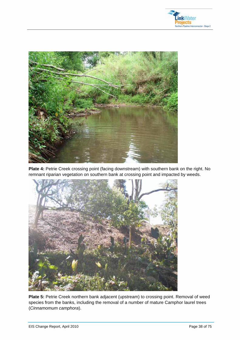
Plate 4: Petrie Creek crossing point (facing downstream) with southern bank on the right. No remnant riparian vegetation on southern bank at crossing point and impacted by weeds.
Plate 5: Petrie Creek northern bank adjacent (upstream) to crossing point. Removal of weed species from the banks, including the removal of a number of mature Camphor laurel trees (Cinnamomum camphora).
EIS Change Report, April 2010 Page 38 of 75

5.2.2 Consultation
NNA’s Communication and Stakeholder Relations team discussed the proposed changes with the landowners at this location on 13/14 April 2010.
The adjoining landowners in this location are the Department of Education and Training and Sunshine Coast Regional Council.
The landowners in this location have no objection to trenching as the methodology for crossing Petrie Creek.
5.2.3 Justification for Proposed Change
The WWG found trenching to be the highest scoring method for crossing this waterway when scored against the five criteria. Due to Condition 5 of the CG’s Evaluation Report whereby the waterway crossings must be either tunnel bored or piled, trenching is not considered to be an option. After careful consideration of the options, the WWG recommended this waterway crossing be tunnel bored.
It is the opinion of the proponent, that trenching at this waterway, as found by the WWG, would be the best outcome for the project for crossing this waterway.
Table 5 outlines the justification for proceeding with trenching as the waterway crossing methodology at Petrie Creek.
Table 5: Reasons for Proposed Change at Petrie Creek
Criteria Justification Potential Impacts
Value Trenching through this waterway is at base cost - costed as trenching in TOC
Trenching at $149,996 vs. tunnel boring at $3,979,329
Costs increase with tunnelling to more than 26 times the cost of trenching due to the depth of shafts required to tunnel. The shaft on the northern side will be approx 16m deep, while the shaft on the southern side will be 19m deep due to the depth of the waterway.
Increased cost of construction for tunnel bore due to depth of shafts, and increased cost of materials due to vertical pipe and bends required.
Program Further flood modelling would be required for tunnelling option.
Trenching: 3.5 weeks to construct including bulk reinstatement Tunnelling: 16 weeks from site set up to bulk reinstatement
Reduced timeframe for construction using trenching
Reduced risk of delay due to exposure to variable weather patterns or rain events
Increased risk of project delay due
EIS Change Report, April 2010 Page 39 of 75
EIS Change Report, April 2010 Page 40 of 75
Criteria Justification Potential Impacts
Procurement lead time is 13 weeks - consists of 4 weeks to award the tunnelling contract and 9 weeks for fabrication and delivery of materials.
to sourcing and procurement materials and tunnelling machinery and equipment
Stakeholders Impacts on stakeholders are expected for each option, however trenching has the shortest duration (least impact).
In this location, construction will disrupt farm access for the agricultural school.
Any long term access restrictions will impact on the school and compensation will be required.
Constructability The shaft on the northern side will be approx 16m deep, while the shaft on the southern side will be 19m deep due to the depth of the waterway and steepness of banks.
Tunnelling would require an extensive temporary use area for machinery access right to the top of banks to lower the tunnel boring machine into the shafts.
These areas would be required outside the 15m corridor and within the 20m setback.
Increased safety risk due to terrain and geology.
Depth of shafts (16m and 19m) - risk of inundation.
Ongoing maintenance and operation may be impacted due to sediment settling at the bottom bends in the pipe.
Environment Trenching at this waterway will result in a smaller construction and disturbance footprint.
It is recognised trenching could compromise improvements undertaken by local environmental groups to remove weeds and rubbish, and revegetate the site. Trenching would disturb the upper and lower banks and the channel bed. However, the construction period is significantly shorter than piling or tunnelling, and there is more control over timing compared to other methods.
Trenching would be restricted to the constrained corridor of 15m.
Tunnel boring less impact on bed and banks, however would not provide the opportunity to improve the degraded riparian zone at this crossing.
Tunnel boring increases the risk of exposure to variable weather patterns or rain events due to the construction timeframe
Impacts on the waterway bed will be minimised through the use of dam bags and the corridor width will be constrained (15m wide).
Opportunity to remove weeds and revegetate at this site post construction.

5.2.4 Disturbance Footprints
The disturbance footprints are outlined below.
TRENCHED:
Total disturbed 5423 m²
RE vegetation disturbed 1280 m²
TUNNEL BORED:
Total disturbed 8585 m²
RE vegetation disturbed 1450 m²
Figures 7 and 8 below depict the anticipated construction footprints for both trenching and tunnelling at Petrie Creek.
Refer to Appendix E for design drawings depicting the disturbance footprints and areas for both crossing methods.
5.2.5 Benefits and Opportunities
The benefits and opportunities identified for using trenching at this crossing are:
• Cost associated with trenched crossing construction and ongoing maintenance is far less than for tunnel boring.
• Opportunities to invest some savings in revegetation works at the crossing point.
• Opportunities to improve stabilisation of southern bank with revegetation, and to assist with the removal of weeds from riparian zone and revegetation with native species.
• Revegetation would improve habitat values for Elf Skink, Giant Barred Frog and Tusked Frog. Stabilisation of southern bank would benefit in stream habitat values.
• Opportunities to revegetation along the southern bank of the waterway crossing if landowner agreement, or to tie in with other revegetation projects in the area. LinkWater in partnership with Ecofund will liaise with the SCRC and SEQ Catchments to develop a program for watercourse restoration. The program will be located within the same catchments as NPI Stage 2. The program will also consider potential to fund the implementation of indirect offset measures (such as removing waterway barriers, in-stream restoration, land use management etc) to improve water quality and fish habitat values.
EIS Change Report, April 2010 Page 41 of 75


5.3 Tuckers Creek Tuckers Creek is located within the property described as Lot 2 on SP107939.
This section describes the proposed changes to the waterway crossing methodologies for Tuckers Creek. It also provides justification for the changes, based on the criteria defined in the WWG.
5.3.1 Current State of Environment
Tuckers Creek is described as a 1st order stream by DERM. It has regrowth vegetation (Endangered (RE 12.3.1)) within the pipeline corridor to the north of the crossing. This site also contains vegetation mapped on SCRC Protected Vegetation mapping, protected under Local Law No. 19 - Protection of Vegetation 1997. Refer to Appendix D for the complete SAP for Tuckers Creek. Figure 9 provides the SAP map outlining the environmental values of the site.
The northern bank of Tuckers Creek at the crossing point has been cleared previously and the riparian vegetation on this bank is narrow and heavily weed impacted (Refer to Plate 6). There is also evidence of erosion on the northern bank at the crossing point.
This site contains potential habitat for Giant Barred Frog (Mixophyes iteratus), Tusked Frog (Adelotus brevis) and Elf Skink (Eroticoscincus gracilloides), however no significant species have been confirmed at this site during fauna surveys. Three pre-construction surveys targeting the Giant Barred Frog have been conducted at this site since the release of the EIS. Surveys were conducted in March 2009, September 2009, and February 2010 by NNA (using relevant technical experts), and the presence of Giant Barred Frog was not confirmed during these surveys.
There are no significant aquatic species located within this waterway.
This site contains potential habitat for the following significant species:
• Giant Barred Frog (Mixophyes iteratus) - Endangered (MNES and NCA), but not confirmed at this site
• Tusked Frog (Adelotus brevis) - Vulnerable (NCA), but not confirmed at this site
• Elf Skink (Eroticoscincus gracilloides) - Rare (NCA), but not confirmed at this site
Important habitat features at this site include continual canopy cover extending over aquatic margins providing cover and connectivity along the riparian zone, significant leaf litter and woody debris on banks, variable bank structure with undercuts and exposed roots. These habitat features will be managed via the SAP (Refer to SAP in Appendix D).
Potential impacts on habitat at this site, associated with trenching will be managed by:
• Constraining the construction corridor to 15 m wide (Refer to SAP in Appendix D) to retain canopy cover;
• Replacement of woody debris and leaf litter to banks immediately after completion of construction;
EIS Change Report, April 2010 Page 44 of 75

• Stabilisation of banks and commencement of revegetation immediately after completion of construction; and
• Construction of crossing during low-flow periods and outside of peak breeding for significant frog species (peak breeding period is October to March).
EIS Change Report, April 2010 Page 45 of 75

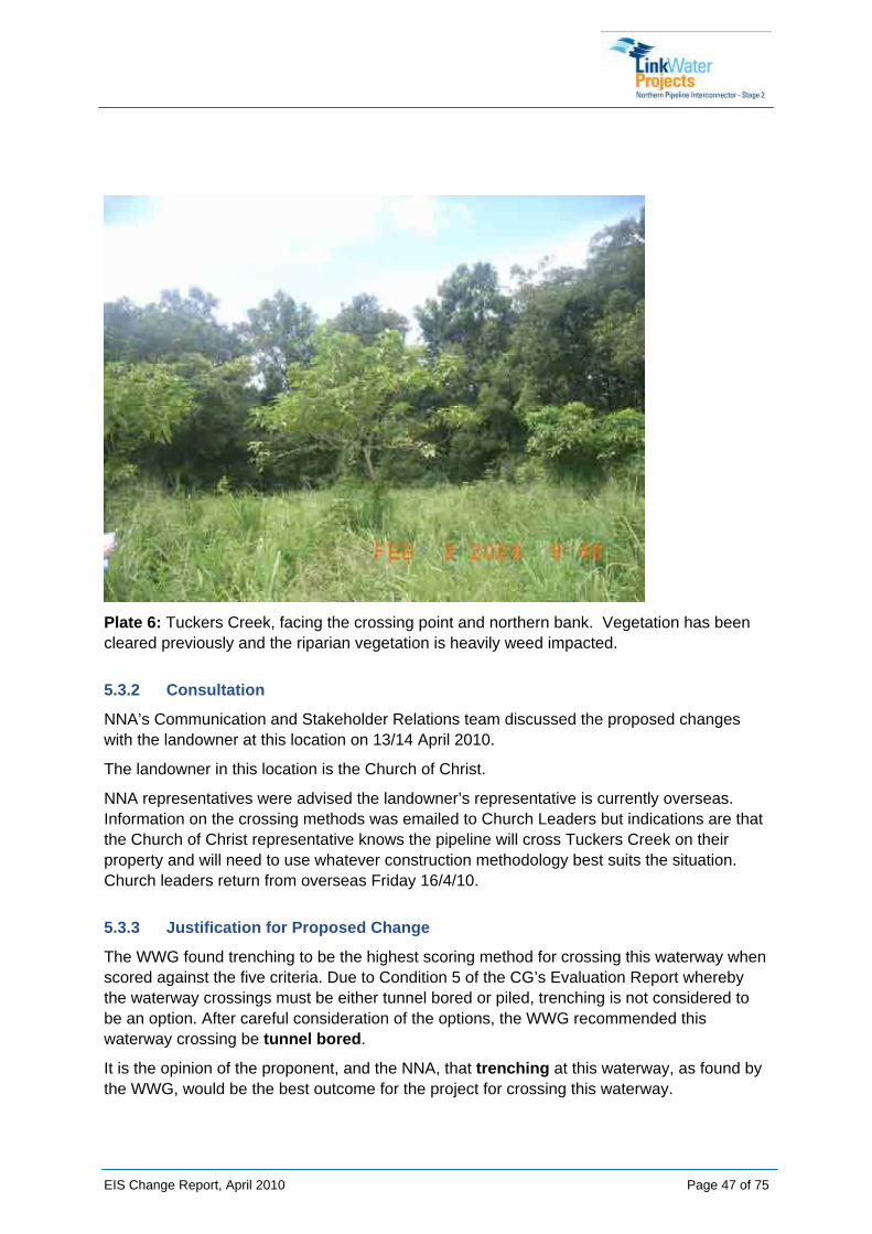
Plate 6: Tuckers Creek, facing the crossing point and northern bank. Vegetation has been cleared previously and the riparian vegetation is heavily weed impacted.
5.3.2 Consultation
NNA’s Communication and Stakeholder Relations team discussed the proposed changes with the landowner at this location on 13/14 April 2010.
The landowner in this location is the Church of Christ.
NNA representatives were advised the landowner’s representative is currently overseas. Information on the crossing methods was emailed to Church Leaders but indications are that the Church of Christ representative knows the pipeline will cross Tuckers Creek on their property and will need to use whatever construction methodology best suits the situation. Church leaders return from overseas Friday 16/4/10.
5.3.3 Justification for Proposed Change
The WWG found trenching to be the highest scoring method for crossing this waterway when scored against the five criteria. Due to Condition 5 of the CG’s Evaluation Report whereby the waterway crossings must be either tunnel bored or piled, trenching is not considered to be an option. After careful consideration of the options, the WWG recommended this waterway crossing be tunnel bored.
It is the opinion of the proponent, and the NNA, that trenching at this waterway, as found by the WWG, would be the best outcome for the project for crossing this waterway.
EIS Change Report, April 2010 Page 47 of 75

Table 6 outlines the justification for proceeding with trenching as the waterway crossing methodology at Tuckers Creek.
Table 6: Reasons for Proposed Change at Tuckers Creek
Criteria Justification Potential Impacts
Value Trenching through this waterway is at base cost - costed as trenching in TOC.
Trenching at $44,794 vs. tunnel boring at $2,813,899
Costs increase with tunnelling to more than 60 times the cost of trenching due to the depth of shafts required to tunnel. The tunnels will require shafts approx 9-10m deep.
Increased cost of tunnel boring at this location,
Program Further flood modelling would be required for both the tunnelling option.
Trenching: 3 weeks to construct including bulk reinstatement Tunnelling: 17 weeks from site set up to bulk reinstatement
Procurement lead time is 13 weeks - consists of 4 weeks to award the tunnelling contract and 9 weeks for fabrication and delivery of materials.
Further, the timeframe to construct is approximately one week, which reduces the time exposed to variable weather conditions and rain events
Reduced timeframe for construction using trenching
Reduced risk of delay due to exposure to variable weather patterns or rain events
Increased risk of project delay due to sourcing and procurement of materials and tunnelling machinery and equipment
Stakeholders Trenching would have the least impact on directly affected stakeholders, due to construction duration and reduced disturbance footprints.
Tunnelling operations in this location would require a significant area of land for machinery and lay down requirements, adjacent to the Church. Major impact on owner / landholder.
Trenching and tunnel boring would require Local Law approval from SCRC for clearing Local Law No. 19 Protected Vegetation.
Constructability Tunnelling would require an extensive temporary use area for machinery
Operationally, trenching this crossing reduces the need for
EIS Change Report, April 2010 Page 48 of 75

EIS Change Report, April 2010 Page 49 of 75
Criteria Justification Potential Impacts access right to the top of banks to lower the tunnel boring machine into the shafts.
These areas would be required outside the 15m corridor and within the 20m setback.
additional valves to be installed.
Environment Trenching at this waterway will result in a smaller construction and disturbance footprint.
The northern bank of the waterway is eroded and non-vegetated. There is an opportunity for bank stabilisation at this site as part of site rehabilitation and revegetation subsequent to trench construction.
Trenching would be restricted to the constrained corridor of 15m.
The crossing point has been located at the point where the riparian vegetation is narrowest, and within existing disturbed areas (i.e. disturbed northern bank). This will assist in avoiding and minimising impacts to intact riparian areas along Tuckers Creek, including impacts on important habitat for significant species.
Construction of a tunnel bored crossing would take more than four months, due to the depth of the shafts (9 to 10m deep), and to construct access for tunnelling machinery / equipment.
Construction of a trenched waterway crossing would take approximately one month to construct, including bulk reinstatement and revegetation works.
Moderate impact from trenching as it will disturb the stream bed and increase the risk of erosion and sediment mobilisation - erosion and sediment control plans will be in place to reduce this risk.
While trenching will directly impact on the bed and banks of the waterway, its shorter construction timeframe and smaller footprint reduces the impact on the environment.
Trenching requires the least amount of SCRC Local law No. 19 mapped vegetation to be cleared.
5.3.4 Disturbance Footprints
The disturbance footprints are outlined below.
TRENCHED:
Total disturbed 4312 m²
RE vegetation disturbed 950 m²
Local Law No. 19 vegetation disturbed 1343 m²
TUNNEL BORED:
Total disturbed 5925 m²
RE vegetation disturbed 955 m²
Local Law No. 19 vegetation disturbed 1560 m²
Figures 10 and 11 below depict the anticipated construction footprints for both trenching and tunnelling at Tuckers Creek.
Refer to Appendix D for design drawings depicting the disturbance footprints and areas for both crossing methods.
5.3.5 Benefits and Opportunities
The benefits and opportunities identified for using trenching at this crossing are:
• Less cost associated with trenched crossing construction and ongoing maintenance - can invest in revegetation works at the crossing point, particularly on the northern bank to improve stability and to avoid further weed intrusion.
• There are currently revegetation works occurring along Tuckers Creek. There is the opportunity to tie in with these revegetation works and expand the area of rehabilitation.
• Opportunities to revegetation along the southern bank of the waterway crossing if landowner agreement, or to tie in with other revegetation projects in the area. LinkWater in partnership with Ecofund will liaise with the SCRC and SEQ Catchments to develop a program for watercourse restoration. The program will be located within the same catchments as NPI Stage 2. The program will also consider potential to fund the implementation of indirect offset measures (such as removing waterway barriers, in-stream restoration, land use management etc) to improve water quality and fish habitat values.
EIS Change Report, April 2010 Page 50 of 75


5.4 North Maroochy River North Maroochy River transects Strong Lane, a Local Government road reserve under the control of SCRC.
This section describes the proposed changes to the waterway crossing methodologies for North Maroochy River. It also provides justification for the changes, based on the criteria defined in the WWG.
5.4.1 Current State of Environment
North Maroochy River is described as a 1st order stream by DERM. The riparian vegetation at this site is highly degraded within the corridor, with intact vegetation upstream and downstream of the crossing point (Endangered (RE 12.3.1)). Vegetation at the crossing point has been cleared previously and is dominated by weed species (Refer to Plates 7 and 8). The weeds at the crossing point create a physical barrier to movement of fauna species, such as the Giant Barred Frog (Bryan Robinson (QFC) pers. comms., 2010). Refer to Appendix D for the complete SAP for North Maroochy River. Figure 12 provides the SAP map outlining the environmental values of the site.
This site has three existing piled bridge crossings directly adjacent and downstream of the crossing point. As a result, there is little or no riparian vegetation under the road bridges (Refer to Plates 9 and 10) and some evidence of bank instability.
Construction of the road bridges has resulted in the fragmentation of riparian habitat at this site. There is relatively intact riparian vegetation upstream and downstream of the crossing point, although the riparian corridor is typically narrow and recent disturbance is evident (e.g. cattle tracks, weeds).
This site is potential suboptimal habitat for Giant Barred Frog (Mixophyes iteratus) and Elf Skink (Eroticoscincus gracilloides), as the weeds within the corridor act as a physical barrier to movement for these species. Platypus (Ornithorhynchus anatinus) is likely to utilise this reach as the bank profiles are suitable burrow habitat. This site is also potential habitat for the Tusked Frog (Adelotus brevis). No significant species were confirmed at this site during fauna surveys for the EIS. Two pre-construction surveys targeting the Giant Barred Frog have been conducted at this site since the release of the EIS. Surveys were conducted in March 2009 and March 2010, by NNA (using relevant technical experts), and the Giant Barred Frog was not confirmed during these surveys.
There are no significant aquatic species located within this waterway.
This site contains potential habitat for the following significant species:
• Giant Barred Frog (Mixophyes iteratus) - Endangered (MNES and NCA), not confirmed at this site
• Tusked Frog (Adelotus brevis) - Vulnerable (NCA), not confirmed at this site
• Elf Skink (Eroticoscincus gracilloides) - Rare (NCA), not confirmed at this site
EIS Change Report, April 2010 Page 53 of 75

• Platypus (Ornithorhynchus anatinus) - Culturally Significant (NCA), likely but not confirmed at this site.
Potential impacts on habitat at this site associated with trenching will be managed by:
• Constraining the construction corridor to 15 m wide (Refer to SAP in Appendix D) to retain canopy cover;
• Replacement of woody debris and leaf litter to banks immediately after completion of construction;
• Removal of weeds within corridor and revegetation with native species;
• Stabilisation of banks and commencement of revegetation immediately after completion of construction; and
• Construction of crossing during low-flow periods and outside of peak breeding for significant frog species (peak breeding period is October to March).
EIS Change Report, April 2010 Page 54 of 75
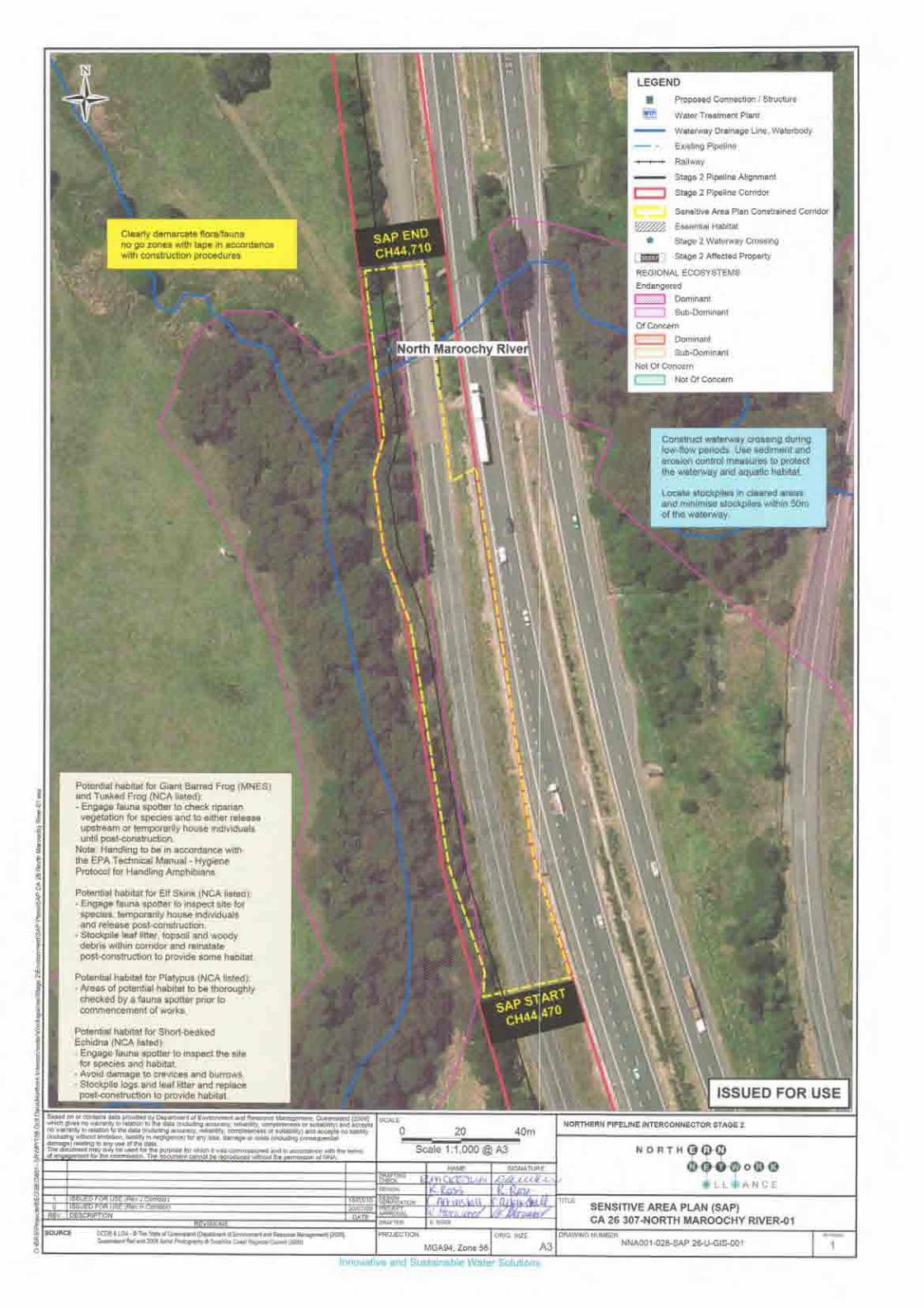

Plate 7: North Maroochy River crossing point (from the road bridge facing south-west). Weeds on the banks at the crossing point create a physical barrier to movement of fauna species, such as the Giant Barred Frog.
EIS Change Report, April 2010 Page 56 of 75

Plate 8: North Maroochy River crossing point (facing north from southern bank). Heavily weed impacted northern bank.
Plate 9: North Maroochy River directly adjacent and downstream of the crossing point (facing south). Southern bank with little or no riparian vegetation under road bridge.
EIS Change Report, April 2010 Page 57 of 75
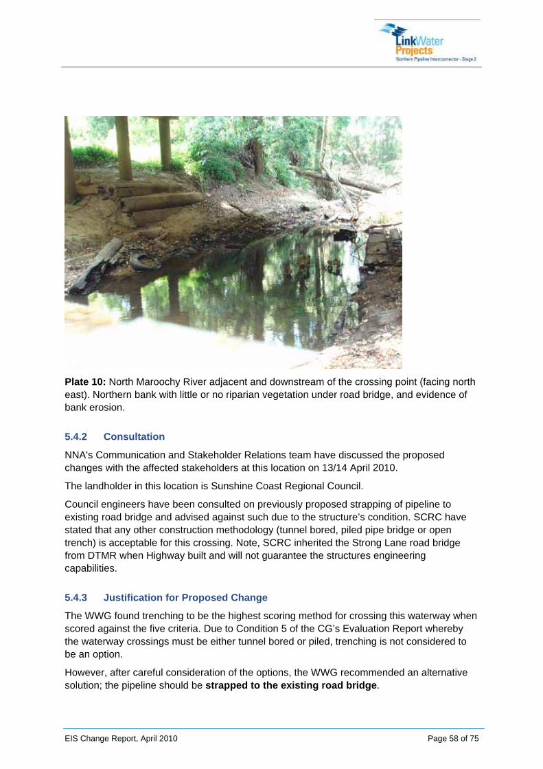
Plate 10: North Maroochy River adjacent and downstream of the crossing point (facing north east). Northern bank with little or no riparian vegetation under road bridge, and evidence of bank erosion.
5.4.2 Consultation
NNA's Communication and Stakeholder Relations team have discussed the proposed changes with the affected stakeholders at this location on 13/14 April 2010.
The landholder in this location is Sunshine Coast Regional Council.
Council engineers have been consulted on previously proposed strapping of pipeline to existing road bridge and advised against such due to the structure’s condition. SCRC have stated that any other construction methodology (tunnel bored, piled pipe bridge or open trench) is acceptable for this crossing. Note, SCRC inherited the Strong Lane road bridge from DTMR when Highway built and will not guarantee the structures engineering capabilities.
5.4.3 Justification for Proposed Change
The WWG found trenching to be the highest scoring method for crossing this waterway when scored against the five criteria. Due to Condition 5 of the CG’s Evaluation Report whereby the waterway crossings must be either tunnel bored or piled, trenching is not considered to be an option.
However, after careful consideration of the options, the WWG recommended an alternative solution; the pipeline should be strapped to the existing road bridge.
EIS Change Report, April 2010 Page 58 of 75

A structural condition survey of the bridge was undertaken to inspect the integrity of the bridge. The bridge was found to have hairline cracks throughout the concrete base, which presents a significant safety and operational risk to LinkWater Projects and the NNA. Due to this, and the conditions presented in the CG’s Evaluation Report, the method for this crossing moving forward is piling.
It is the opinion of the proponent that, based on the structural integrity, or lack thereof, of the existing bridge, and due to the environmental impacts on the waterway of a piled crossing, trenching at this waterway would be the best method for crossing this waterway.
Table 7 outlines the justification for proceeding with trenching as the waterway crossing methodology at North Maroochy River, as opposed to piling or tunnelling this crossing.
Table 7: Reasons for Proposed Change at North Maroochy River
Criteria Justification Potential Impacts
Value Trenching through this waterway is at base cost - costed as trenching in TOC.
Trenching at $87,411 vs. piling at $972,481
Costs increase with piling to more than 11 times the cost of trenching. Maintenance costs would be incurred to remove debris due to the piles being within the Q5 flood zone.
Hardstand areas (at a cost of $75,911) have been included, although methodology may allow for piles to be driven from existing road.
Increased cost of construction and maintenance for piling
Program Trenching: 5.5 weeks to construct including bulk reinstatement Piling: 18 weeks from site set up to bulk reinstatement
Procurement lead time is 9 weeks due to manufacture and delivery of special bends.
Reduced timeframe for construction using trenching
Reduced risk of delay due to exposure to variable weather patterns or rain events
Increased risk of project delay due to sourcing and procurement of materials and piling machinery and equipment
Stakeholders Works are in road reserve.
Trenching would have the least impact on stakeholders, predominantly due to shortest construction duration.
Potential for traffic delays to users of Strong Lane.
EIS Change Report, April 2010 Page 59 of 75
EIS Change Report, April 2010 Page 60 of 75
Criteria Justification Potential Impacts
Piling operations in this location increase timeframes for construction - potential for traffic delays along the road.
Access and mobility in and around the site may also restrict traffic flow.
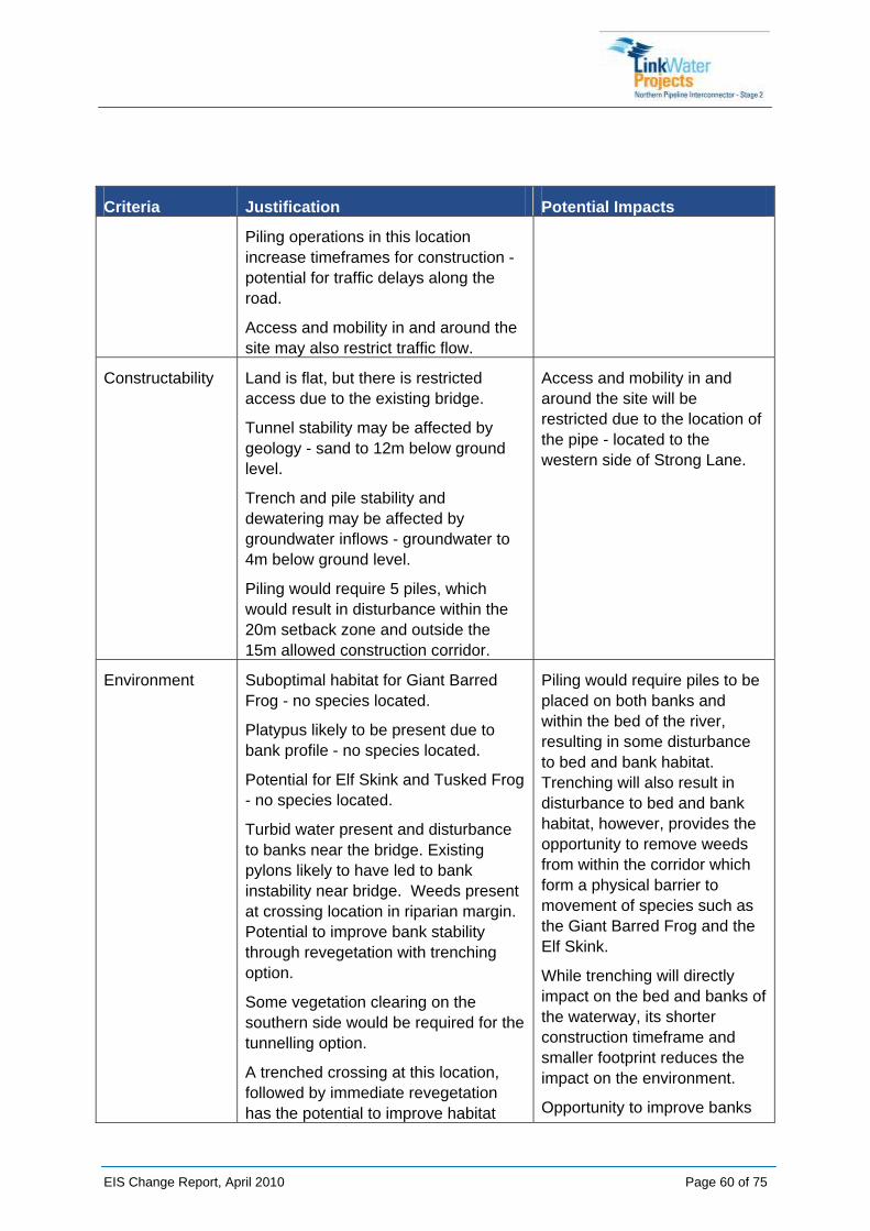
Constructability Land is flat, but there is restricted access due to the existing bridge.
Tunnel stability may be affected by geology - sand to 12m below ground level.
Trench and pile stability and dewatering may be affected by groundwater inflows - groundwater to 4m below ground level.
Piling would require 5 piles, which would result in disturbance within the 20m setback zone and outside the 15m allowed construction corridor.
Access and mobility in and around the site will be restricted due to the location of the pipe - located to the western side of Strong Lane.
Environment Suboptimal habitat for Giant Barred Frog - no species located.
Platypus likely to be present due to bank profile - no species located.
Potential for Elf Skink and Tusked Frog - no species located.
Turbid water present and disturbance to banks near the bridge. Existing pylons likely to have led to bank instability near bridge. Weeds present at crossing location in riparian margin. Potential to improve bank stability through revegetation with trenching option.
Some vegetation clearing on the southern side would be required for the tunnelling option.
A trenched crossing at this location, followed by immediate revegetation has the potential to improve habitat
Piling would require piles to be placed on both banks and within the bed of the river, resulting in some disturbance to bed and bank habitat. Trenching will also result in disturbance to bed and bank habitat, however, provides the opportunity to remove weeds from within the corridor which form a physical barrier to movement of species such as the Giant Barred Frog and the Elf Skink.
While trenching will directly impact on the bed and banks of the waterway, its shorter construction timeframe and smaller footprint reduces the impact on the environment.
Opportunity to improve banks

EIS Change Report, April 2010 Page 61 of 75
Criteria Justification Potential Impacts connectivity and will provide more stability for banks, particularly for the banks near the road bridges.
through revegetation
Impacts on the waterway bed associated with trenching will be minimised by constraining the construction corridor width to 15 m and installing dam bags during construction.
5.4.4 Disturbance Footprints
The disturbance footprints are outlined below.
TRENCHED:
Total disturbed 4910 m²
RE vegetation disturbed 1020 m²
PILED:
Total disturbed 5490 m²
RE vegetation disturbed 1110 m²
Figures 13 and 14 below depict the anticipated construction footprints for both trenching and piling at North Maroochy River.
Refer to Appendix E for design drawings depicting the disturbance footprints and areas for both crossing methods.
5.4.5 Benefits and Opportunities
The benefits and opportunities identified for using trenching at this crossing are:
• Opportunity to clear weeds from crossing point and to revegetate with native species to reinstate connectivity as weeds currently act as a barrier to movement for the Giant Barred Frog and Elf Skink.
• Extend revegetation works to include area directly adjacent to the corridor, under the existing road bridges with suitable (low-growing) species. This would provide connectivity between upstream and downstream habitat areas and would improve bank stability.
• Opportunities to revegetation along the southern bank of the waterway crossing if landowner agreement, or to tie in with other revegetation projects in the area. LinkWater in partnership with Ecofund will liaise with the SCRC and SEQ Catchments to develop a program for watercourse restoration. The program will be located within the same catchments as NPI Stage 2. The program will also consider potential to fund the implementation of indirect offset measures (such as removing waterway barriers, in-stream restoration, land use management etc) to improve water quality and fish habitat values.

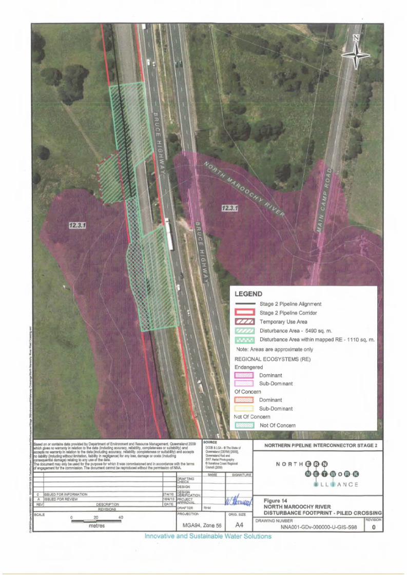
6 TRENCHING METHODOLOGY
As the pipeline constructor, the NNA have developed a Construction Execution Plan (CEP) for Open Trenching of Waterway Crossings (NNA Document number NNA001-A-PRO-113)
The purpose of the CEP is to define specific instruction for the construction of pressure pipelines in a safe, professional, timely and controlled manner across a waterway using an open trenching technique. The CEP addresses requirements from site establishment through to revegetation and rehabilitation.
The CEP is located at Appendix F.
Please note, the CEP included at Appendix F was produced in early December 2009 and does not include or reflect the conditions required by the CG's Evaluation Report. The document is currently being reviewed and updated to include the relevant conditions and construction constraints. A copy can be provided to the CG upon completion.
Trenched waterway crossings will be constructed within the constrained corridor as depicted in the drawings and figures within this report.
EIS Change Report, April 2010 Page 64 of 75

7 MITIGATION STRATEGIES LinkWater Projects, and the NNA, are committed to achieving a high standard of care for the natural environment in all of the activities that are undertaken. In order to achieve this, the NNA has developed a suite of Environmental Management Plans (EMP’s) and Monitoring Programs to ensure all the works are undertaken in an approved and regulated manner.
These EMP’s outline mitigation strategies to ensure no undue interference or damage is caused to the natural environment.
The NNA have previously provided copies of the EMP’s to DIP as part of the Supplementary EIS.
7.1 Water Quality Water quality mitigation measures relate to effects on surface water and groundwater.
7.1.1 Surface Water Management
There are significant and varying surface water impacts which have the potential to occur throughout the construction period. The effective control of surface water will be achieved through the use of erosion and sediment control (including use of bunding and/or barriers around the construction work site when working within floodplains). Where possible, water will be diverted around the construction site to minimise the amount of water to be captured and managed. Erosion and sediment controls will be designed and operated to ensure they do not exacerbate existing flood conditions. Permanent drainage systems will be developed where required to ensure that permanent construction features do not cause an adverse flooding effect.
7.1.2 Groundwater Management
Works associated with the Project are not anticipated to adversely impact groundwater quality or levels, although trenching, piling and micro-tunnelling may result in a collective need to dispose of groundwater. If groundwater accumulates in construction features (e.g. excavation of shafts, or piling) it will be pumped and appropriately treated or run through existing controls to ensure it does not pose a pollution hazard to any waterways before discharge.
In addition to groundwater being encountered during construction, and although the use of recycled water is the preferred option (due to the drought conditions in Queensland), there is a potential that groundwater (amongst other alternatives) may be sourced for dust suppression provided that it is considered sustainable. Any relevant licences and approvals required for groundwater extraction will be considered and sought prior to potential use of groundwater.
The following mitigation measures relate to construction activities around waterways:
• Where temporary construction roads and site access points cross channels, sediment control structures should be placed in channels, as appropriate, to capture suspended sediments.
EIS Change Report, April 2010 Page 65 of 75

• Consider meteorological conditions prior to commencement of excavation or trenching works. Where possible works should not be undertaken during inclement weather as it will increase the potential for sediment laden runoff
• Conduct weekly inspections of all ESC measures to ensure they are in place and operating efficiently. Additional inspections should be conducted after storm events.
• Discharge of fluid must be at least 25m from any water course, held in a storage pit and regularly monitored to ensure it does not enter watercourse.
• Spoil stockpiling and laydown areas will be clearly defined. Crews will be instructed to be mindful of a drop in pressure and the risk of a resultant leak (‘frac-out’) into the environment.
• Construction works will be delayed as long as possible in sensitive areas to reduce the risk of bank erosion and sediment release.
• Monitor water quality at intervals to ensure that the existing water quality does not significantly decrease as a result of construction activities.
• Where appropriate, a geotextile underlay will be used in riparian zones under work areas such as piling platforms and access tracks.
7.2 Flora and Fauna Potential impacts to fauna are to be managed by:
• Erect exclusion fencing on either side of open trenches during times when trenches are unattended overnight or for periods greater than 24 hours. Fencing should be suitable for keeping out large herbivores as well as smaller mammals.
• Placing structures such as trench plugs and ramps within open trenches to encourage trapped animals to leave of their own accord.
• Where practical and appropriate, provide shade cloth over open trenches to protect trapped animals from extreme temperature and stress until they can be removed.
• Monitoring of open trenches and using trained fauna monitors to remove all trapped animals into nearby areas of native vegetation.
Potential impacts to habitat for both construction methods to be managed by:
• Stabilize banks and revegetate immediately after completion of construction;
• Revegetate with species able to achieve canopy cover as quickly as possible;
• Remove in stream woody debris prior to construction and replace immediately after construction; and
• Check banks for Platypus burrows prior to construction.
EIS Change Report, April 2010 Page 66 of 75

7.3 Revegetation and Rehabilitation
7.3.1 General
In high risk areas (waterways) rehabilitation and revegetation will occur immediately following completion of backfilling works. This will reduce potential for significant impacts to the waterway by stabilising the embankment.
Once rehabilitation works have been completed within an area, revegetation (grass seeding) will occur immediately. In areas where remnant vegetation is to be cleared within the corridor, revegetation works will include the use of locally occurring plant species (as tubestock) which are representative of the species type and density of the pre-disturbance remnant vegetation. Where planting of this nature is excluded (due to infrastructure constraints), vegetation offsets will be provided in accordance with the Policy for Vegetation Management Offsets (2008). Exclusion zones may include:
• 10m exclusion zone from the centre of the pipeline (to maintain pipe integrity); in close proximity to existing subsurface structures or services (i.e. existing water or gas pipelines); and
• in close proximity to overhead powerlines and associated electrical infrastructure.
7.3.2 Riparian Habitat Rehabilitation
A qualified botanist will be engaged to determine the most appropriate species for replanting in riparian habitats, taking into account planting restrictions within the pipeline and/or Energex easement (e.g. reduced canopy height and root depth). A fauna specialist will also be consulted to ensure habitat requirements for protected species are met. These requirements are detailed in the SAPs.
7.3.3 Revegetation Acceptance Criteria and Maintenance
All planted areas will be inspected for acceptance at the end of the revegetation establishment period. The following is an example of acceptance criteria for revegetation works:
• plants exhibit signs of healthy active growth;
• plants are well formed;
• plants are free from disease and insect pests;
• plants have healthy root systems and are not root bound;
• the ground surface around the plant does not allowing pooling or ponding of water; and
• the plants are free of physiological disease symptoms (yellowing, wilting).
Plants which do not achieve the acceptance criteria will be replaced with plants of the same species, size and quality and/or the revegetation establishment period will be extended.
EIS Change Report, April 2010 Page 67 of 75

7.3.4 Potential Participation for Local Land Care Groups
Where possible, local land care groups will be invited to contribute to rehabilitation and revegetation efforts on the project.
Discussions have been held with Ecofund, who are able to assist LinkWater Projects with a project or projects to improve local waterways around the Sunshine Coast in the area of NPI Stage 2. Ecofund are interested in exploring potential opportunities and come up with project proposals for NPI Stage 2 to be involved in.
Ecofund advised they are meeting with Sunshine Coast Regional Council to discuss environmental offset opportunities, with several particular properties proposed. Ecofund suggested a joint project between the Ecofund, LinkWater Projects and SCRC for waterway revegetation and improvement programs that Ecofund can assist to deliver.
Ecofund required further information from LinkWater Projects with regard to particular scope or budget available for rehabilitation or legacy projects.
7.4 Erosion and Sediment Control Erosion will be reduced through the minimisation of the cleared footprint and progressive clearance of vegetation. Progressive revegetation will occur to minimise the area of exposed surfaces following completion of works. Revegetation and/or rehabilitation of work areas will be undertaken in accordance with the Rehabilitation and Revegetation Management Plan (NNA001-A-PLN-010).
Watercourses requiring works will be left undisturbed until construction has commenced to maximise stream bank stability and to prevent sediment loading in stormwater passing through the watercourse.
Individual Erosion and Sediment Control Plans have been developed for each of the four subject waterways.
EIS Change Report, April 2010 Page 68 of 75

EIS Change Report, April 2010 Page 69 of 75
8 CONCLUSIONS AND RECOMMENDATIONS This report has demonstrated the value in trenching the four subject waterways, and has described how any environmental impacts will be mitigated and managed. Further, trenching will reduce the construction timeframes (and thus impacts on landholders and the environment) and help to ensure the project is completed within the regulatory timeframe of 31 December 2011.
Based on this, LinkWater Projects recommends the following:
• the Coordinator-General evaluates and considers the implications of changing the proposed crossing method to trenching on Value for Money, Construction Schedule and Project Deadlines, Constructability and impacts to the environment;
• the Coordinator-General takes into account the Environmental Management System LinkWater Projects (and the NNA) have committed to, to ensure impacts to the environment and project stakeholders are minimised and mitigated where possible;
• the Coordinator-General evaluate and approve the proposed changes to crossing methodology of Paynter Creek Northern, Petrie Creek, Tuckers Creek and North Maroochy River to trenching.