:. ooser osiasieeog resources, inc 3a. address 1060 east highway 40 3b. phone no. (include area...
TRANSCRIPT

O OForn3160-3 FORMAPPROVED(February2005) OMBNo.1004-0137
ExpiresMarch31, 2007UNITEDSTATES
DEPARTMENT OF THE INTERIOR 5. LeaseSerialNo.UTU-64911
BUREAU OF LAND MANAGEMENT
APPLICATIONFOR PERMIT TO DRILLOR REENTER6. IfIndian,AlloteeorTribeName
la. Typeof work: DRILL REENTER:. 2 IfUnitor CAAgreement,NameandNo.
8. LeaseNameand WellNo.Ib. Typeof Well: OilW11 GasWell Ooser Osiasiezon OMultiple Zone Big Wash 62-15GR
NameofOperator 9. API W 11No.EOG RESOURCES, INC
3a. Address 1060 EAST HIGHWAY 40 3b. PhoneNo.(includearea co±) 10. Fieldand Pool,orE loratoryVERNAL, UT 84078 435-781-9111 Green River
4. Locationof Well(Report location clearly and in accorance withany Staterequiremena.*) 11.Sec.,T.R.M. or lk.andSurveyVrAreaAtsurface 1823' FNL & 1990' FEL (SWNE) 39.946139LAT 110.103144LON
> 9 f.¢ff I./g jŸ g Sec.15-T10S-R16EAt proposedprod.zone Same ()|
14. Distanceinmiles and directionfromnearesttownor y 12.CountyorParish 13. State23.9 mBesfrom Myton, Utah Duchesne County UT
15. Distancefromproposed*1980 Lease 16. No.of acres inlease 17. SpacingUnitdedicatedto thiswelllocation10nearest
propertyor leaseline,ft.(Alsotonearest drig.unit line,if any) 660 Drilling Unit 2280 40 acres
18. Distancefromproposedlocation* 19.ProposedDepth 20. BLM/BIABondNo.on filetonearestwell, drilling,completed,applied for,on thislease,ft. 5600 NM2308
21. Elevations(Showwhether DF,KDB,RT,GL,etc.) 21 Approximate datework will start* 23. Estimatedduration6334 GL 45 days
24. AttachmentsThefollowing,completedinaccordancewiththerequirements of OnshoreOilandGasOrderNo.1,mustbeattached to thisforat
1. We11platcertified bya registered surveyor. 4. Bondto coverthe operationsunless coveredby anexistingbondon file (see1 A DrillingPlan. Item20 above).3. A SurfaceUse Plan (if the locationis on NationalForestSystemLands,the 5. Operatorcertification
SUPO must be filedwith theappropriate ForestServiceOffice). 6. Suchother sitespecific informationand/or plansas may be required bytheBLM.
25. Signature Name(Printed/Typed) DateMary A. Maestas 01/22/2007
Title 'REGUL ISTANT
prov (St n r Name n(Ñ$EY G. HILL 44Title officeENVIRONMENtALMANAC
Applicationapprovaldoesnot warrant or certifythat theapplicantholdslegalorequitabletitletothoserightsinthesubjectleasewhichwouldentitletheapplicanttoconduct operationsthereon.Conditionsof approval,if any,areattached.
Title18U.S.C.Section1001andTitle43 U.S.C.Section1212,make it a crimeforany personknowinglyand willfully tomake toanydepartmentor agency ofthe UnitedStatesanyfalse,fictitiousor fraudulentstatementsor representations as toany matterwithinitsjurisdiction.*(Instructions on page 2)
AlderalApprovalof th¾
Action is Necessary RECEIVEDJAN2 3 2007
DIVOFOILGAS&
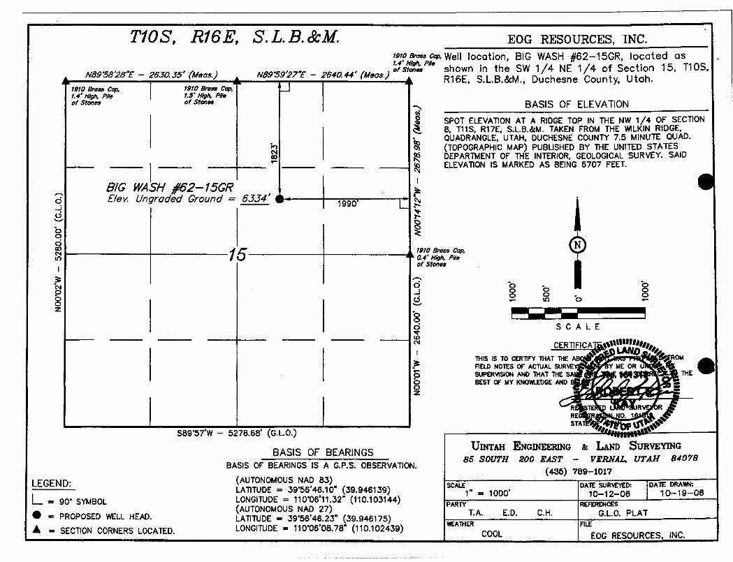
TiOS, Ri6E, S.L.B.&M. EOG RESOURCES, INC.raro e ,, cm Well locotion, BIG WASH #62-15GR, located asrs
"" shown in the SW 1/4 NE 1/4 of Section 15, T10S,NB9°58'28Y- 26JO.35' (Meas.) N89 39'27Y - 2640.44' (Meas.) R16E, S.L.B.&M., Duchesne County, Utah.
toro sma, cap, reto ar... ce,_\
1.4' H/gh, P//e 1.5' H/ph, PReorstme, ora"" BASIS OF ELEVATION
SPOT ELEVATIONAT A RIDGE TOP IN THE NW 1/4 OF SECTION8, T11S, R17E, S.L.B.&M. TAKEN FROM THE WILKINRIDGE,QUADRANGLE,UTAH, DUCHESNE COUNTY 7.5 MINUTE QUAD.(TOPOGRAPHIC MAP) PUBLISHED BY THE UNITED STATESDEPARTMENTOF THE INTERIOR,GEOLOGICALSURVEY. SAID
----- ELEVATIONIS MARKEDAS BEING 6707 FEET.
B/G WASH f62--15GRE/ev. Ungraded Ground = 6JJ4' i 1990°
1910 &ass ¢g Ni 5 A4' H¢, PRe
of Stmas
o o - o
o. --- -o -- um -oà SCA LE
THIS IS TO CERTIFYTHAT THEAB OMFIELD NOTES OF ACTUALSURVE Y ME ORSUPERVISON AND THAT THES THE
o BEST OF MY KNOWLEDGEAND .o
S89 57'W - 5,78.68' (G.L.O.)
UINTAH ENGINEERING & IaAND SURVEYINGBASIS OF BEARINGS
85 SOUTH 200 EAST - V£RNAL, UTAH 84078BASIS OF BEARINGS IS A G.P.S. OBSERVATION.
(435) 789-1017
LEGEND: (AUTONOMOUSNAD 83)SCALE DATE SURVEYED: DATE DRAWN:
LATITUDE= 39 56'46.10" (39.946139) 1" = 1000' 10-12-06 10-19-06=
90° SYMBOL LONGITUDE= 110°06'11.32" (110.103144) PARTY REFERENCES
= PROPOSED WELLHEAD·LAAUTONDEMU3S95A6462723"
(39.946175)T.A. E.D. C.H. G.L.O. PLAT
A - SECTION CORNERS LOCATED. LONGITUDE= 110'06'08.78" (110.102439)WEATHER FILEEOG
RESOURCES,

EIGHT POINT PLAN
BIG WASH 62-15GRSWINE, SEC. 15, T10S, R16E, S.L.B.&M.
DUCHESNE COUNTY, UTAH
1. & 2. ESTIMATED TOPS & ANTICIPATED OIL, GAS, & WATER ZONES:
FORMATION TVD-RKB (ft) Objective LithologyUinta FM 18
Green River FM 1,048Mahogany Oil Shale Bed 2,238 Oil
Garden Gulch MBR 2,288 Secondary Oil / GasMiddle Carb Bed 3,188
Douglas Creek MBR 3,928 Secondary Oil / GasCastle Peak MBR 4,788 Primary Oil / Gas
Uteland Butte MBR 5,218 Secondary Oil / GasWasatch 5,438
TD 5,600
EST. TD: 5,600' or 200' ± below Wasatch Top Anticipated BHP: 2,765 Psig
1. Fresh Waters may exist in the upper, approximately 1,000 ft ± of the Green River Formation,with top at about 2,000 ft ±.
2. Cement isolation is installed to surface of the well isolating all zones by cement.
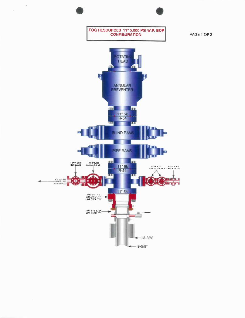
3. PRESSURE CONTROL EQUIPMENT: Production Hole - 5,000 PsigBOP Schematic Diagram attached.
4. CASING PROGRAM:
Hole Lenath Size WEIGHT Grade Thread Rating FactorCASING Size _C_ollapse Burst Tensile
Conductor 17 ½" O - 45' 13 ¾" 48.0# H-40 STC 770 PSI 1730 PSI 322,000#45'-500'
Surface 12 ¼" KB± 9-¾" 36.0# J-55 STC 2020 PSI 3520 Psi 394,000#Production 7-7/8" 500'±- TD 4-½" 11.6# J-55 LTC 4960 PSI 5350 Psi 162,000#
All casing will be new or inspected.
8 point plan-EOG 1
EIGHT POINT PLAN
BIG WASH 62-15GRSWINE, SEC. 15, T10S, R16E, S.L.B.&M.
DUCHESNE COUNTY, UTAH
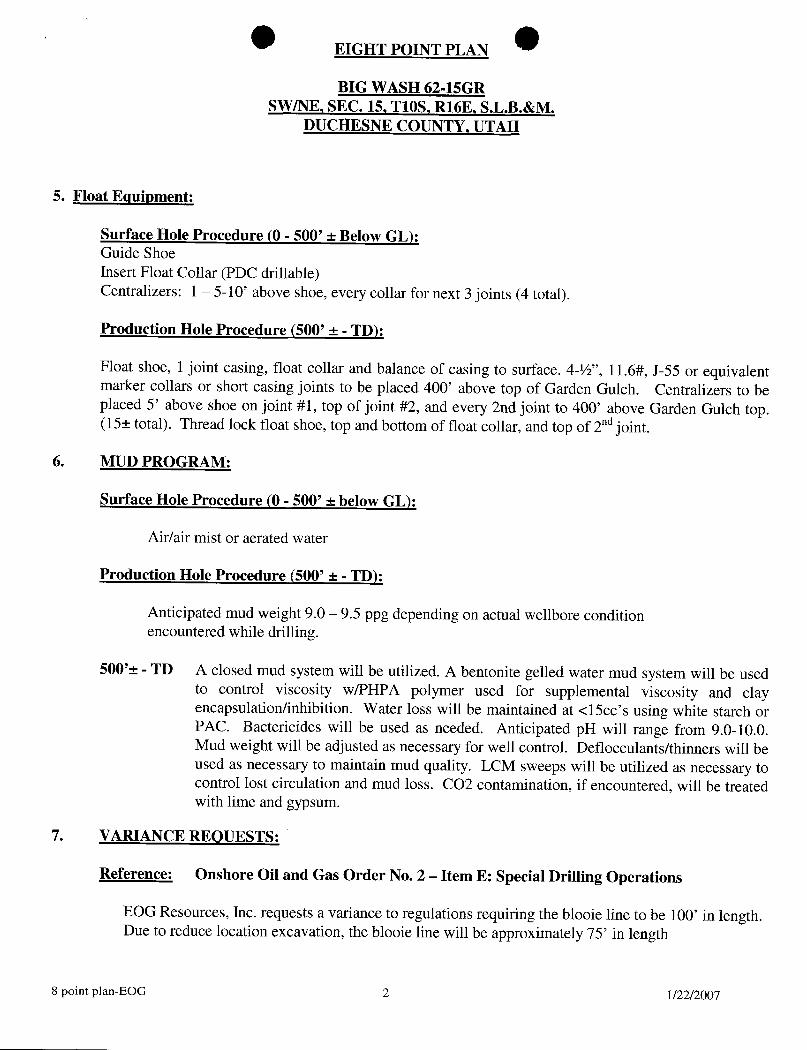
5. Float Equipment:
Surface Hole Procedure (0 - 500' ± Below GL):Guide ShoeInsert Float Collar (PDC drillable)Centralizers: 1 - 5-10' above shoe, every collar for next 3 joints (4 total).
Production Hole Procedure (500' ± - TD):
Float shoe, 1 joint casing, float collar and balance of casing to surface. 4-½", 11.6#, J-55 or equivalentmarker collars or short casing joints to be placed 400' above top of Garden Gulch. Centralizers to beplaced 5' above shoe on joint #1, top of joint #2, and every 2nd joint to 400' above Garden Gulch top.(15± total). Thread lock float shoe, top and bottom of float collar, and top of 2nd
jOÎRt.
6. MUD PROGRAM:
Surface Hole Procedure (0 - 500' ± below GL):
Air/air mist or aerated water
Production Hole Procedure (500' ± - TD):
Anticipated mud weight 9.0 - 9.5 ppg depending on actual wellbore conditionencountered while drilling.
500'± - TD A closed mud system will be utilized. A bentonite gelled water mud system will be usedto control viscosity w/PHPA polymer used for supplemental viscosity and clayencapsulationlinhibition. Water loss will be maintained at <15cc's using white starch orPAC. Bactericides will be used as needed. Anticipated pH will range from 9.0-10.0.Mud weight will be adjusted as necessary for well control. Deflocculants/thinners will beused as necessary to maintain mud quality. LCM sweeps will be utilized as necessary tocontrol lost circulation and mud loss. CO2 contamination, if encountered, will be treatedwith lime and gypsum.
7. VARIANCE REQUESTS:
Reference: Onshore Oil and Gas Order No. 2 - Item E: Special Drilling Operations
EOG Resources, Inc. requests a variance to regulations requiring the blooie line to be 100' in length.Due to reduce location excavation, the blooie line will be approximately 75' in length
8 point plan-EOG 2

EIGHT POINT PLAN
BIG WASH 62-15GRSWINE, SEC. 15, T10S, R16E, S.L.B.&M.
DUCHESNE COUNTY, UTAH
8. EVALUATION PROGRAM:
Logs: Mud log from base of surface casing to TD.Open Hole Logs: Open Hole Logs will be run consisting of the following:
Schlumberger Platform Express: Open Hole Gamma Ray, Resistively, andNeutron Porosity
9. CEMENT PROGRAM:
Surface Hole Procedure (0-500' ± Below GL)
Lead: 185 sks Class 'G' cement with 2% S1 (CaCl2) & 0.25 ppsD29 (cellophane flakes), mixed at 15.8 ppg, 1.16 ft3./sk., 4.95 gps water.
Top Out: 207 sks Top out with Class 'G' cement with 2% S1 (CaCl2) in mix water,15.8 ppg, 1.16ft3./sk., 4.95 gps via 1" tubing set at 25' if needed.
Install 6' x 4' cellar ring, drill rat and mouse holes with spud rig.
Note: Cement volumes will be calculated to bring cement to surface.
Production Hole Procedure (500' ± to TD)
Lead: 195 sks: 35:65 Poz "G" w/4% D20 (Bentonite), 2% DI74 (Extender), 0.2% D65(Dispersant),0.2% D46 (Antifoam), 0.75% Dll2 (Fluid Loss Additive), 0.200%Dl3 (Retarder), 0.25 pps D29 (cello flakes) mixed at 13.0 ppg, 1.75 ft3/sk., 9.19gps water.
Tail: 540 sks: 50:50 Poz "G" w/ 2% D20 (Bentonite), 0.1% D46 (Antifoam), 0.075% D13(Retarder), 0.2% Dl67 (Fluid Loss Additive), 0.2% D65 (Dispersant), mixed at14.1 ppg, 1.28 ft'Isk., 5.9gps water.
Note: The above number of sacks is based on gauge-hole calculation.Lead volume to be calculated to bring cement to 200'± above 9-5/8" casing shoe.Tail volume to be calculated to bring cement to 400'± above top of Garden Gulch MBR.Final Cement volumes will be based upon gauge-hole plus 45% excess.
8 point plan-EOG 3
EIGHT POINT PLAN
BIG WASH 62-15GRSWINE, SEC. 15, T10S, R16E, S.L.B.&M.
DUCHESNE COUNTY, UTAH
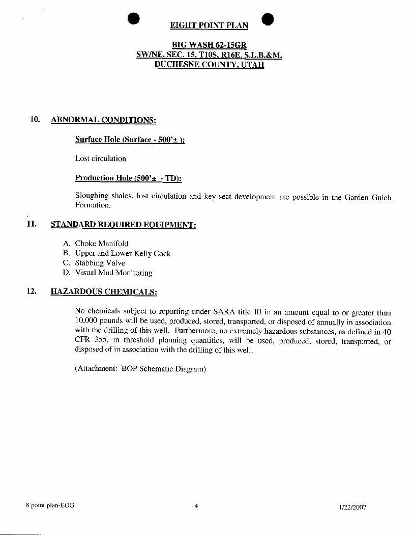
10. ABNORMAL CONDITIONS:
Surface Hole (Surface - 500'±):
Lost circulation
Production Hole (500'± - TD):
Sloughing shales, lost circulation and key seat development are possible in the Garden GulchFormation.
11. STANDARD REQUIRED EQUIPMENT:
A. Choke ManifoldB. Upper and Lower Kelly CockC. Stabbing ValveD. Visual Mud Monitoring
12. HAZARDOUS CHEMICALS:
No chemicals subject to reporting under SARA title III in an amount equal to or greater than10,000 pounds will be used, produced, stored, transported, or disposed of annually in associationwith the drilling of this well. Furthermore, no extremely hazardous substances, as defined in 40CFR 355, in threshold planning quantities, will be used, produced, stored, transported, ordisposed of in association with the drilling of this well.
(Attachment: BOP Schematic Diagram)
8 point plan-EOG 4
O O
IEOG RESOURCES 11" 5,000 PSI W.P. BOPCONFIGURATlON PAGE 1 OF 2
TA
NUE :
R-5
D
ER
4-1116" 5,000 4-1l16" E,000HCR VALVE MANUALVALVE u 2 1/16"5.000 2-1/16'5,000
MANUALVALVES CHECKVALVE
y IL I
e 5.000 PSINOKE LLNE
TOMAMFDLD
1" 5FMCDRILLING
CCNNECTOR 115,000XDTOPREP
FMCTTCY9¾8'SCRM X 5.000 WP
13-3/8"
|
O O
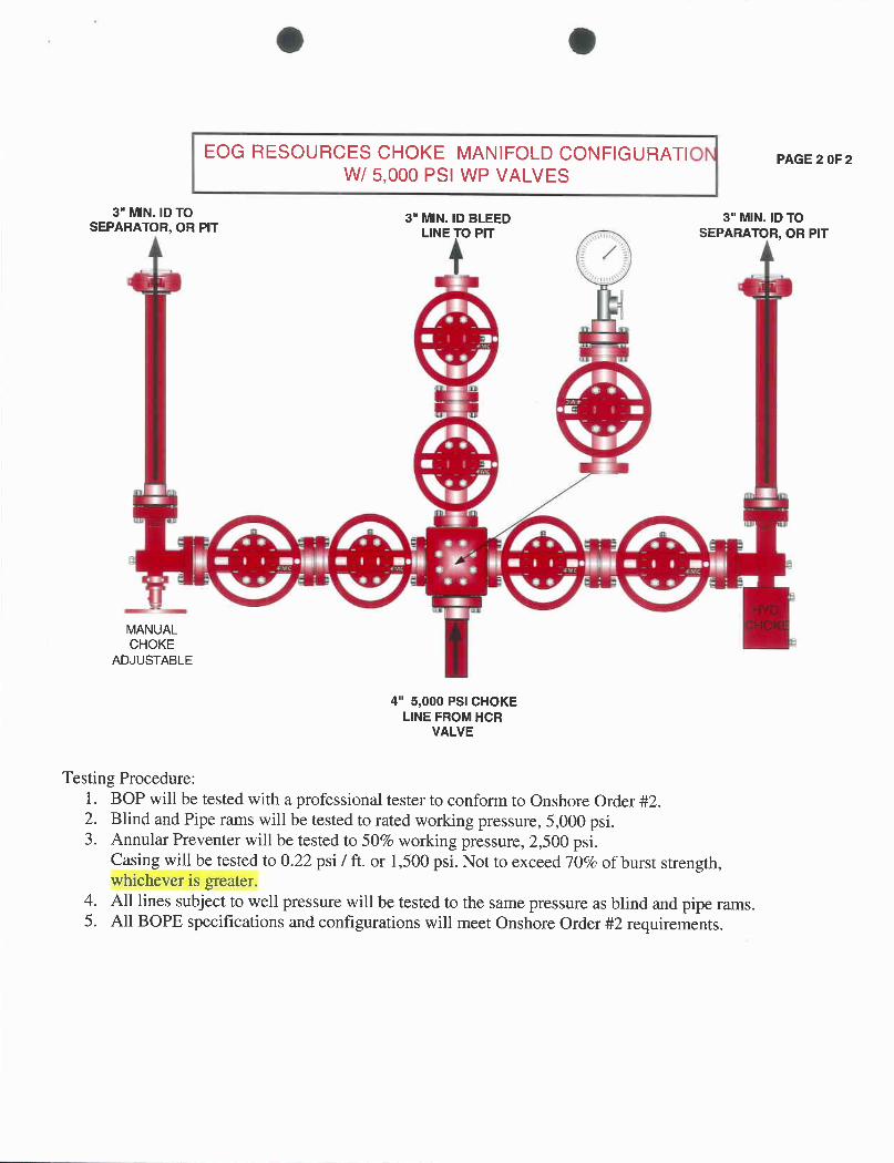
EOG RESOURCES CHOKE MANIFOLDCONFIGURATIO PAGE20F2W/ 5,000 PSI WP VALVES
3" MIN.IDTO 3" MIN.ID BLEED 3" MIN.ID TOSEPARATOR, OR PIT LINE PIT SEPARATOR, OR PIT
MANUALCHOKE
ADJUSTABLE
4" 5,000 PSI CHOKELINE FROM HCR
VALVE
Testing Procedure:1. BOP will be tested with a professional tester to conform to Onshore Order #2.2. Blind and Pipe rams will be tested to rated working pressure, 5,000 psi.3. Annular Preventer will be tested to 50% working pressure, 2,500 psi.
Casing will be tested to 0.22 psi / ft. or 1,500 psi. Not to exceed 70% of burst strength,whichever is greater.
4. All lines subject to well pressure will be tested to the same pressure as blind and pipe rams.5. All BOPE specifications and configurations will meet Onshore Order #2
O O
eog resources
BIG WASH 62-15GRSWNE, Section 15, T10S, R16E
Duchesne County, Utah
SURFAcE USE PLAN
NOTIFICATION REQUIREMENTS
Location Construction: Forty-eight (48) hours prior to construction of location and accessroads.
Location Completion: Prior to moving on the drilling rig.
Spud Notice: At least twenty-four (24) hours prior to spudding the well.
Casing String and Twenty-four (24) hours prior to running casing and cementingCementing: all casing strings.
BOP and related Twenty-four (24) hours prior to running casing and tests.Equipment Tests:
First Production Notice: Within five (5) business days after new well begins or productionresumes after well has been off production for more than ninety (90)

O OBIG WASH 62-15GRSurface Use Plan Page 2
EOG Resources, Inc., hereby applies under Section 28 of the Act of I¯ebruary 25, 1920 (41state. 449), (30 U.S.C. Section 185) as amended by the Act of November 16, 1973, (87 Stat.576) and requests that this APD serve as the construction, operations and maintenanceplan for the right-of-way application for the pipeline on federal lands. A 30-year right-of-way term is requested.
The requested pipeline right-of-way on Federal acreage necessary is approximately 2600' x40', with 2000' Iocated within Federal Lease # U-74830 and 600' located within Federal Lease# UTU-79824 containing 2.39 acres more or less (see attached survey plats and maps). TheRight-of-Way application for the Big Wash 62-15GR will also be utilized for the Big Wash 39-12GR pipeline tie-in point.
The well access road is approximately 528' x 30', tying into the existing Wilken Ridge Road inDuchesne county located in the SWNE of Section 15, T10S, R16E.
The well pad is approximately 275 feet long with a 204-foot width, containing 1.29 acresmore or less. The well access road is approximately 528 feet long with a 30-foot right-of-way, disturbing approximately 0.36 acre. New surface disturbance associated withaccess road and the well pad is estimated to be approximately 1.65 acres. The pipeline isapproximately 12,800 feet long with a 40-foot right-of-way, disturbing approximately 11.75acres.
1. EXISTING ROADS:
A. See attached Wellsite Plats showing directional reference stakes on location, andattached TOPO Map "B"showing access to location from existing roads.
B. The proposed well site is located approximately 23.9 miles south of Myton, Utah -
See attached TOPO Map "A".
C. Refer to attached Topographic Map "A"showing labeled access route to location.
D. Existing roads willbe maintained and repaired as necessary.
2. PLANNED ACCESS ROAD:
A. The access road willbe approximately528' in length.
B. The access road has a 30 foot ROW w/18 foot running surface.
C. Maximum grade of the new access road willbe 8 percent.
D. No turnouts willbe required.
E. Road drainage crossings shall be of the typicaldry creek drainage crossing type.
F. No bridges, or major cuts and fills willbe

O OBIG WASH 62-15GRSurface Use Plan Page 3
G. The access road willbe dirt surface.H. No gates, cattlèguards, or fences willbe required or encountered.
l. No permanent road right-of-wayon Federal acreage is required.
AIItravel willbe confined to existing access road right-of-way.
New or reconstructed roads willbe centerlined -- flagged at time of location staking.
The road shall be constructedlupgraded to meet the standards to the anticipated trafficflowand all-weather road requirements. Construction/upgrading shall include ditching, draining,graveling, crowning,and capping the roadbed as necessary to provide a well-constructed,safe road. Prior to upgrading the road shall be cleared of any snow cover and allowed to drycompletely. Traveling offthe 30 foot right-of-way will not be allowed.Road drainagecrossings shall be of the typicaldry creek drainage crossing type.Crossings shall bedesigned so they willnot cause siltationor accumulation or debris in the drainage crossingsnor shall the drainages be blocked by the roadbed. Erosion of drainage ditches by run offwater shall be prevented by diverting water offat frequent intervals by means of cutouts.Upgrading shall not be allowed during muddy conditions. Should mud holes develop, theyshall be filled in and detours around then avoided
As operator, EOG Resources, Inc. shall be responsible for all maintenance on cattleguards,or gates associated with this oiland/or gas operation.
The access road and associated drainage structures willbe constructed and maintained inaccordance with road guidelines contained in the joint BLM/USFS publication: SurfaceOperating Standards for Oil and Gas Exploration and Development, Third Edition, and/orBLM Manual Section 9113 concerning road construction standards on projects subject tofederal jurisdiction. During the drilling and production phase of operations, the road surfaceand shoulders willbe kept in a safe and useable condition and drainage ditches and culvertswillbe kept clear and free flowing.
3. LOCATION OF EXISTING WELLS WITHIN A ONE-MILE RADIUS:
See attached TOPO map "C"for the location of wells within a one-mile radius.
4. LOCATION OF EXISTING AND/OR PROPOSED PRODUCTION FACILITIES:
A. On Well Pad
1. Production facilities will be set on location if the well is successfully completed forproduction. Facilities willconsist of wellhead valves, combo separator-dehy unitwith meter, two (2) 400 BBL vertical tanks and/or one (1) 300 BBL vertical tankand attaching piping.
2. Gas gathering lines -- A 4" gathering line willbe buried from dehy to the edge ofthe
© 0BIG WASH 62-15GRSurface Use Plan Page 4
B. Off Well Pad
1. Proposed location of attendant offpad flowlines shall be flagged prior toarchaeological clearance.
2. The length of the new proposed pipeline is 12,800' x 40'. The proposed pipelineleaves the eastern edge of the well pad SWNE of Section 15, T10S, R16E(Federal Lease UTU-64911) proceeding in a southerly direction for anapproximate distance of 3000' to the NWSW of Section 14, T10S, R16E (FederalLease UTU-64911) proceeding easterly for an approximate distance of 7200' tothe NENE of Section 23, T10S, R16E (Federal Lease UTU 74830), proceedingsouth for an approximate distance of2000' to the SWNW of Section 24, T10S,R16E (Federal Lease UTU 79824), proceeding for an approximatedistance of600' tieing into an existing pipeline located in the SWNW of Section 24, T10S,R16E. Pipe willbe 4" NOM, 0.156 wall,Grade X42, Zap-Lok, electricweld with a35 milX-Tru coating.
An off lease pipeline right-of-wayis required, approximately2600' x 40', with 2000'located within Federal Lease # U-74830 and 600' located within Federal Lease #UTU-79824 containing 2.39 acres more or less (see attached survey plats andmaps). The Right-of-Way application for the Big Wash 62-15GR willalso be utilizedfor the Big Wash 39-12GR pipeline tie-in point.
3. Proposed pipeline will be a 4" OD steel, Zap-Lok line laid on the surface.
4. Protective measures and devices for livestock and wildlife willbe taken and lorinstalled where required.
Ifstorage facilities/tank batteries are constructed on this lease, the facility/battery or the wellpad shall be surrounded by a containment dike of sufficientcapacity to contain, at aminimum,the entire contents of the largest tank withinthe facility/battery, unless morestringent protective requirements are deemed necessary by the authorized officer.
Allpermanent (on site for six months or longer) structures constructed or installed (includingpumping units) willbe painted a flat, non-reflective,earthtone color to match one of thestandard environmental colors, as determined by the Rocky Mountain Five State InteragencyCommittee. Allfacilities will be painted within 6 months of installation. The productionfacilities and tanks will be painted with olive black. Facilities required to complywithO.S.H.A. (Occupational Safety and Health Act) will be excluded.
5. LOCATION AND TYPE OF WATER SUPPLY:
A. Water supply willbe from Ouray Municipal Water Plant at Ouray, Utah, and/ orTarget Trucking Inc.'s water source in the SWISW. Sec 35, T9S, R22E UintahCounty, Utah (State Water Right # 49-1501, and/or Bonanza Power Plant watersource in Sec 26, T8S, R23E Uintah County, UT (State Water Right # 49-

O OBIG WASH 62-15GRSurface Use Plan Page 5
B. Water willbe hauled by a licensed trucking company.
C. No water wellwillbe drilled on lease.
6. SOURCE OF ÛONSTRUCTION MATERIALS:
A. Allconstruction material for this location and access road will be of native borrowand soil accumulated during the construction of the location.
B. No mineral materials will be required.
7. METHODS OF HANDLING WASTE DISPOSAL:
A. METHODS AND LOCATION
1. Cuttings will be confined in the reserve pit.
2. A portable toiletwillbe provided for human waste during the drilling andcompletion of the well. Disposal willbe at the Vernal sewage disposal plant.
3. Burning will not be allowed. Trash and other waste material willbe contained in awire mesh cage and disposed of at the Uintah County Landfill.
4. Produced wastewater willbe confined to a lined pit or storage tank for a periodnot to exceed 90 days after initial production. After the 90 day period, theproduced water will be contained in a tank on location and then disposed of atone of the following three locations: Natural Buttes Unit 21-20B SWD, AceDisposal, or EOG Resources, Inc. drilling operations (Chapita Wells Unit, NaturalButtes Unit & Stagecoach Unit).
5. Allchemicals willbe disposed of at an authorized disposal site. Drip pans andabsorbent pads willbe used on the drilling rig to avoid leakage of oil to the pit.
B. Water from drilling fluids and recovered during testing operations will be disposed ofby either evaporating in the reserve pit or by removed and disposed of at anauthorized disposal site. Introduction of well bore hydrocarbons to the reserve pit willbe avoided by flaring them off in the flare pit at the time of recovery.
The reserve pit willbe constructed so as not to leak, break, or allow discharge. Ifthereserve pit requires padding prior to lining (due to rocky conditions) felt padding willbeused.The reserve pit shall be lined with felt and a 16-millimeter plastic liner.
EOG Resources, Inc. maintains a file, per 29 CFR 1910.1200 (g)containing currentMaterial Safety Data Sheets (MSDS) for all chemicals, compounds, and/or substanceswhich are used during the course of construction, drilling, completion, and productionoperations for this project. Hazardous materials (substances) which may be found atthe site may include drilling mudand cementing products which are prirnarily inhalationhazards, fuels (flammable and/or combustible), materials that may be necessary
O OBIG WASH 62-15GRSurface Use Plan Page 6
well completion/stimulationactivities such as flammable or combustible substancesand acids/gels(corrosives). The opportunityfor Superfund Amendments andReauthorization Act (SARA) listed Extremely Hazardous Substances (EHS) at the siteis generally limited to proprietary treating chemicals. All hazardous and EHS andcommercial preparations willbe handled in an appropriate manner to minimizethepotential for feaks or spills to the environment.
8. ANCILLARY FACILITIES:
None anticipated.
9. WELL SITE LAYOUT:
A. Refer to attached well site plat for related topography cuts and fills and crosssections.
B. Refer to attached well site plat for rig layout and soil material stockpile location asapproved on On-site.
C. Refer to attached well site plat for rig orientation, parking areas, and access road.
The reserve pit willbe located between corners #4 and #5 on the north side of the location.The flare pit will be located downwind of the prevailing wind direction on the north side of thelocation, a minimumof 100 feet from the well head and 30 feet from the reserve pit fence.
The stockpiled pit topsoilwillbe stored separate from the location topsoil between corners#3 and #4 on the west side of the location and between corners #6 and #7 on the east sideof the location. Upon completion of construction, the stockpiled topsoil from the location willbe broadcast seeded with the approved seed mixture from this location and then walkeddown with a Caterpiller tractor.
Access to the well pad will be from the west.
FENCING REQUIREMENTS:
All pits willbe fenced according to the following minimumstandards:
A. Thirty-nine inch net wire shall be used with at least one strand of barbed wire on topof the net wire. (Barbed wire is not necessary if pipe or some type of reinforcementrod is attached to the top of the entire fence.)
B. The net wire shall be no more than 2 inches above the ground. The barbed wirestrand shall be 3 inches above the net wire. Total height of the fence shall be at least42 inches.
C. Corner posts shall be cemented and/or braced in such a manner as to keep thefence tight at all

O OBIG WASH 62-15GRSurface Use Plan Page 7
D. Standard steel, wood, or pipe posts shall be used between the corner braces.Maximum distances between anytwoposts shall be no greater than 16 feet.
E. AIIwire shall be stretched by using a stretching device before it is attached to thecorner posts.
The reserve pit fencing willbe on the three sides during drilling operations and on thefourth side when the rig moves off location. Pits willbe fenced and maintained untilclean-up.
Each existing fence to be crossed by the access road shall be braced and tied off beforecutting so as to prevent slacking of the wire. The opening shall be closed temporarilyasnecessary during construction to prevent the escape of livestock, and, upon completionofconstruction, the fence shallbe repaired to BLMor SMA specifications. A cattleguardwithan adjacent 16 foot gate shall be installed in any fence where a road is regularlytraveled.If the well is a producer, the cattleguards (shall/shall not) be permanentlycountedon concrete bases. Prior to crossing any fence located on Federal land, or anyfence between Federal land and private land, the operator willcontact the BLM,who willin turncontact the grazing permittee or owner of said fence and offer him/her theopportunityto be present when the fence is cut in order to satisfy himself/herself that thefence is adequately braced and tiedoff.
10. PLANS FOR RECLAMATION OF THE SURFACE:
A. Producing Location
Immediately upon well completion, the location and surrounding area willbe clearedof all unused tubing, equipment, debris, materials, trash, and junk not required forproduction.
Immediately upon well completion, any hydrocarbons on the pit shall be removed inaccordance withCFR 3162.7-1.
Ifa plastic nylon reinforced liner is used, it shall be torn and perforated beforebackfilling of the reserve pit.
The reserve pit and that portion of the location not needed for productionfacilitiesloperations will be recontoured to the approximate natural contours. Thestockpiled pit topsoil willthen be spread over the pit area and broadcast seeded withthe prescribed seed mixturefor this location. The seeded area willthen be walkeddown with a
OBIG WASH 62-15GRSurface Use Plan Page 8
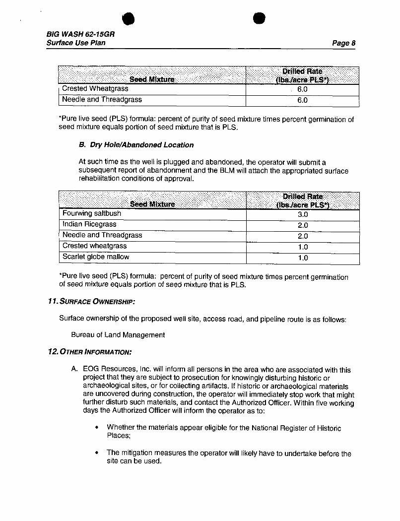
Drilled RateSeed Mixture (Ibslacre PLS*)
Crested Wheatgrass 6.0Needle and Threadgrass 6.0
*Pure live seed (PLS) formula: percent of purityof seed mixturetimes percent germination ofseed mixtureequals portion of seed mixturethat is PLS.
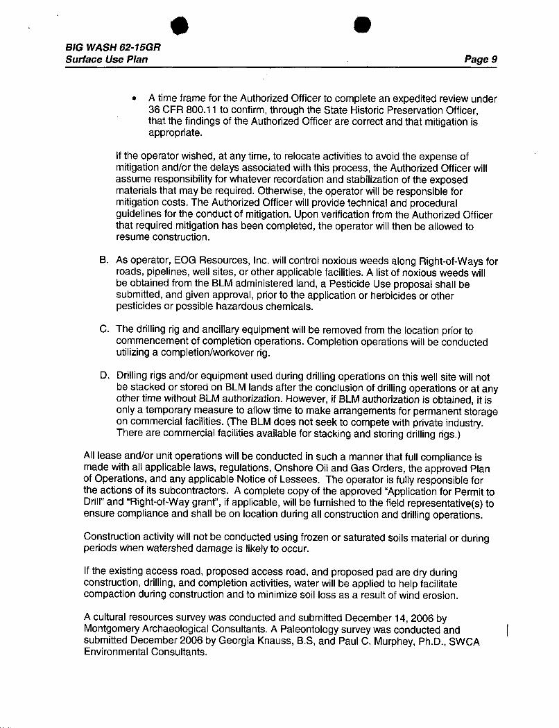
B. Dry Hole/Abandoned Location
At such timeas the well is plugged and abandoned, the operator willsubmitasubsequent report of abandonment and the BLMwillattach the appropriated surfacerehabilitationconditionsof approval.
Drilled RateSeed Mixture (Ibslacre PLS*)
Fourwing saltbush 3.0Indian Ricegrass 2.0Needle and Threadgrass 2.0Crested wheatgrass 1.0Scarlet globe mallow 1.0
*Pure live seed (PLS) formula: percent of purity of seed mixturetimes percent germinationof seed mixtureequals portion of seed mixture that is PLS.
11.SURFACE OWNERSHIP:
Surface ownership of the proposed well site, access road, and pipeline route is as follows:
Bureau of Land Management
12.OTHER INFORMATION:
A. EOG Resources, Inc. will inform all persons in the area who are associated with thisproject that theyare subject to prosecution for knowingly disturbing historic orarchaeological sites, or for collectingartifacts. If historic or archaeological materialsare uncovered during construction, the operator will immediately stop work that mightfurther disturb such materials, and contact the Authorized Officer. Within five workingdays the Authorized Officerwillinform the operator as to:
• Whether the materials appear eligiblefor the National Register of HistoricPlaces;
• The mitigationmeasures the operator will likely have to undertake before thesite can be
O &BIG WASH 62-15GRSurface Use Plan Page 9
• A time frame for the Authorized Officerto complete an expeditedreviewunder36 CFR 800.11 to confirm,through the State Historic Preservation Officer,that the findings of the Authorized Officerare correct and that mitigationisappropriate.
If the operator wished, at any time, to relocate activitiesto avoid the expense ofmitigationand/or the delays associated with this process, the Authorized Officer willassume responsibility for whatever recordation and stabilizationof the exposedmaterials that may be required. Otherwise, the operator willbe responsible formitigationcosts. The Authorized Officerwillprovide technicaland proceduralguidelines for the conduct of mitigation.Upon verification from the Authorized Officerthat required mitigation has been completed, the operator willthen be allowed toresume construction.
B. As operator, EOG Resources, Inc. willcontrol noxious weeds along Right-of-Ways forroads, pipelines, well sites, or other applicable facilities. A list of noxious weeds willbe obtained from the BLMadministered land, a Pesticide Use proposal shall besubmitted, and given approval, prior to the application or herbicides or otherpesticides or possible hazardous chemicals.
C. The drilling rig and ancillaryequipment willbe removed from the location prior tocommencement ofcompletion operations. Completion operations willbe conductedutilizing a completion/workoverrig.
D. Drilling rigs and/or equipment used during drilling operations on this well site willnotbe stacked or stored on BLM lands after the conclusion of drilling operations or at anyother time without BLMauthorization. However, if BLMauthorizationis obtained, it isonlya temporary measure to allowtime to make arrangements for permanent storageon commercial facilities. (The BLMdoes not seek to compete with private industry.There are commercial facilities available for stacking and storing drilling rigs.)
AIIlease and/or unit operations willbe conducted in such a manner that full compliance ismade with all applicable laws, regulations, Onshore Oil and Gas Orders, the approved Planof Operations, and any applicable Notice of Lessees. The operator is fully responsible forthe actions of its subcontractors. A complete copy of the approved "Application for Permit toDrill"and "Right-of-Way grant", if applicable,willbe furnished to the field representative(s) toensure compliance and shallbe on location during all construction and drilling operations.
Construction activitywill not be conducted using frozen or saturated soils material or duringperiods when watershed damage is likely to occur.
Ifthe existing access road, proposed access road, and proposed pad are dry duringconstruction, drilling, and completion activities,water willbe applied to help facilitatecompaction during construction and to minimize soil loss as a result ofwind erosion.
A cultural resources survey was conducted and submitted December 14, 2006 byMontgomery Archaeological Consultants. A Paleontology survey was conductedandsubmitted December 2006 by Georgia Knauss, B.S, and Paul C. Murphey, Ph.D., SWCAEnvironmental
O OBIG WASH 62-15GRSurface Use Plan Page 10
ADDITIONAL SURFACE STIPULATIONS:
No construction or drilling willbe allowed during the Redtail Hawk nesting season of April 16'to July 15thUnleSs a waiver is received from the BLMwildlife biologist.
No construction or drilling willbe allowed during the crucial deer and elk wintering season ofDecember 1°*to April 30'" unless a waiver is received from the BLMwildlife

BIG WASH 62-15GRSurface Use Plan Page 11
LESSEE OR ÛPERATOR'S REPRESENTATIVE AND ÛERTIFICATION:
PERMITTING AGENT DRILLING OPERATIONSMary A. Maestas Donald PresenkowskiEOG Resources, Inc. EOG Resources, Inc.P.O. Box 1815 P.O. Box 250Vernal, Ut 84078 Big Piney, WY 83113(435) 781-9111 307-276-4865
\ hereby certifythat I, or persons under my direct supervision,have inspected the proposeddrill site and access route; that I am familiar with the conditions which currently exist; that thestatements made in this plan are, to the best of my knowledge, true and correct; and that thework associated withthe operations proposed herein willbe performed by EOG Resources,Inc. and its contractors and subcontractors in conformitywith this plan and the terms andconditions under which it is approved. This statement is subject to the provisions of 18U.S.C. 1001 for the filing ofa false statement.
Please be advised that EOG Resources, Inc. is considered to be the operator of the BigWash 62-15GR well, located in SWNE, of Section 15, T10S, R16E, Duchesne County, Utah;Federal land and minerals; and is responsible under the terms and conditions of the leasefor the operations conducted upon the leased lands. Bond Coverage is under Bond # NM2308.
.lannary ??, 2007 - $/4Date Mary estas, Regulat ry
O OBIG WASH 62-15GRSurface Use Plan Page 12
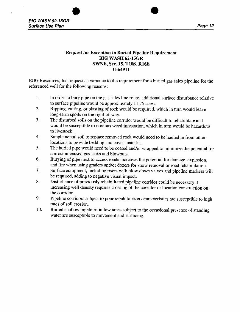
Request for Exception to Buried Pipeline RequirementBIG WASH 62-15GR
SWNE, Sec. 15, T10S, R16EU-64911
EOG Resources, Inc. requests a variance to the requirement for a buried gas sales pipeline for thereferenced well for the following reasons:
1. In order to bury pipe on the gas sales line route, additional surface disturbance relativeto surface pipeline would be approximately 11.75 acres.
2. Ripping, cutting, or blasting of rock would be required, which in turn would leavelong-term spoils on the right-of-way.
3. The disturbed soils on the pipeline corridor would be difficult to rehabilitate andwould be susceptible to noxious weed infestation, which in turn would be hazardousto livestock.
4. Supplemental soil to replace removed rock would need to be hauled in from otherlocations to provide bedding and cover material.
5. The buried pipe would need to be coated and/or wrapped to minimize the potential forcorrosion-caused gas leaks and blowouts.
6. Burying of pipe next to access roads increases the potential for damage, explosion,and fire when using graders and/or dozers for snow removal or road rehabilitation.
7. Surface equipment, including risers with blow down valves and pipeline markers willbe required, adding to negative visual impact.
8. Disturbance of previously rehabilitated pipeline corridor could be necessary ifincreasing well density requires crossing of the corridor or location construction onthe corridor.
9. Pipeline corridors subject to poor rehabilitation characteristics are susceptible to highrates of soil erosion.
10. Buried shallow pipelines in low areas subject to the occasional presence of standingwater are susceptible to movement and

EOG RESOURCES, INC· FIGURE #iLOCATIONLAYOUTFOR
BIG WASH #62-15GRUlli
SECTION 15, T10S, R16E, S.L.B.&M.1823' FNL 1990° FEL
CONSTRUCTDIVERSIONDITCH
---------- Approx. L.
Toe of
Ar -Oe
84'
Round Corneras Needed
I
/ <o
--r N PIPE RACKS
NOTO Û- / f. ]F/are Pit is to B. 42.7' _4 g' »
be /ocated a min (bim. p/t)•', F-53'
of 100' from the C-1J.5' E/. 315 ,
Well Head. s. 44.9' DOG HOUSE.E/. 25.5
10 24 I 120° Sta. 1+50RESERVEPI75(12' Deep) 50
¯. 1
Totd Pit Capoc/tyW/2' of Frasboard - ---
== 4470 ab/s.± .....
Totd P/t Vdume=. 1,290 as. Yds
·¯ o - Approx.--- - g - PUMP TOp Of-o- - -- -- Cut Slope
MUDSHED TOILET
Sta 0+75HOPPER -- ----
POWER
C-21.2' ASHORAGE F-5.2'
\ E/. 40.6' E/. 26.2'
C-8.
sta. osoo
E/. 40.1' CONSTRUCT Proposed AccessDIVERSION / RoadDITCH
Bev. Ungraded Ground at Location Stoke = 6JJJ.5', UINTAN ENGINEERING & ÍsAND SURvEYINGBex Graded Ground at Location Stake = 6]Jf.4 86 So. ß00 Best * Vernal, Utah 84078 * (436)

EOG RESOURCES, INC. FIGURE #2TYPICAL CROSS SECTIONSFOR
×-sectionBIG WASH #62-15GR till
ScaleSECTION 15, T10S, R16E, S.L.B.&M.
1" = 50 1823' FNL 1990' FELDATE: 10-19--06
..
Drawn By C.H.
84' 120'
S TA. 2+ 75
-- X, 84' 120'
LOCAT/0N STARE- CUT
STA. 1+50PreconstructionGrad
50' 24' 120
inished Grade Slope= 1 1/2: 1
STA. 0+75CUT
84' 120
STA. 0+00* NOTE: NOTE:
EILL QUANT/TY/NCLUDES Topsoil should not be5% FOR COMPACTION Stripped Befow Finished i
APPROXIMATEYARDAGES Grade on Substructure Area.
EXCESS MATERIAL = 2,090 Cu. Yds.(6") Topsoil Stripping = 1,450 Cu. Yds. Topsoil & Pit Bockfill = 2,090 Cu. Yds.Rernaining Location = 8,760 Cu. Yds. (1/2 Pit Vol.)
EXCESS UNBALANCE = 0 Cu. Yds.TOTAL CUT = 10,210 CU.YDS. (After Interim Rehobilitation)
FILL = 8,120 CU.YDS. UINTAH ENGINEERING & LAND SURVEYING86 So. 200 East * Vernal, Utah 64078 * (436)
EOG RESOURCES, INC.BIG WASH #62-15GR
I OCATED IN DUCHESNE COUNTY, UTAHSECTION 15. TIOS, R16E, S.! .B.& M.
LOCATION 3TAKE
CORNER 5 -
PHOTO: VI FROM C RNER 5 TO LOCATION STAKE CAMERA A E: SO THEASTERLY
PHOTO: VIEW FROM REGINNING OF PROPOSED ACCESS CAMERA ANGLE:NORTHEASTERLY
Uintah Engineering & Land Surveying LOCATioN PHOTos 10 I6 0 6 eso soM Sou 100 East Vemat l'tah 84078 Moon oc wmso, 435-789-10) uelsi ucisine.com TAKE%BETA. DRAMNBY:A.A.
31 -
--.
- 1)$ 4
0 7 ML
T10 S
PROPOSED LOCATION
LEGEND: EOG RESOURCES, INC.() PROPOSED Lot ATION N BIG WASH #62-15GR
SECTION 15, T10S, R16E, S.LB.& M.1823' FNI 1990' FEL
Uintah Engineering & Land Surveying TOPOGR A PH I clO I 0685 Noasth 2 Fast Vem-imal. I inte 8-1078(-435) 789-1017 ^ E,AX (435) 789-1813 10%Ill I)O \l tR
SCALE:1:100.000 DRAMNBi:A.A.

R - -
16E
4.4+
1
PROPOSED LOCATIONBIG WASH #62-15GR +
1 21 y
T10SEOG RESOURCES, INC.
uismo noso N BIG WASH #62-15GR- ----------- PNOPOSED ACCESS ROADSECTION 15, T105, R16E, S.L.B.&M.
1823' FNL 1990' FEL
- Uintah Engineering & Land surveying TO¯P
OGR A PH I C 10 1 0685 Nouth 200 E¢smst Vea•rnmi, IJeah 8.8078 M A P omril nav ytan(-435)789-8017* FAX (-535) TRO-iBIJSCALE:1"-2000' DRAWNDY:A.A.
R16E
11
6 PROPOSED LO TlON 14BIG WASH#62-15GR
1 21 "
. T10SLEGEND: EOG RESOURCES, INC.f msros.u wEu s gf WATERwEi.Ls N BIG WASH #62-15GRPRODL CING WEI.I.s AßANDONED WELI.S SECTION 15. T10S, R16E, S.L.B.&M.# sm T is WEi.us * TEMPonAntis ABANooNED 1823' FNL 1990' FEL
- Uintah Engineering & Land surveying TOPOGR A PH I C ) ) gg85 Nouth 200 East Vernak & Jamh 8407* M A P mosti um staa(.535) 789-1017 = RAX (435) 789-1853SCALE:P = 2000' DRAWNBE A.A.
R
PROPOSED LOCATIONBIG WASH #62-15GR
-
24
T10SAPPROX1MATETOTAL PIPELINE DISTANCE = 12,800'+/-
LEGEND: EOG RESOURCES, INC.PROPOS£D AC( ESS ROAD N sic wAsu #62-isca----------- E istisc rivaise
SECTION 15, TIOS, RI6E, S.I..B.&M.----------- PROPOSED PIPEI.1%E1823' FNL 1990' FEL
- Uintah Engineering & Land Surveying TOPOGR A PHlc 1 06 0685 Noutte 200 Esest %'ernni. I inia 84078 gg gg aggy EtR(•635) 789-E017 * israX (435) 7149-1833
CALE:1" = 2000' DRAW'NBYAA REY:_II-11-%

WORKSHEET
APPLICATION FOR PERMIT TO DR L
APD RECEIVED: 01/23/2007 API NO. ASSIGNED: 43-013-33523
WELL NAME: BIG WASH 62-15GR
OPERATOR: EOG RESOURCES INC ( N9550 ) PHONE NUMBER: 435-781-9111
CONTACT: MARY MAESTAS
PROPOSED LOCATION: INSPECT LOCATN BY: / /SWNE 15 100S 160E
Tech Review Initials DateSURFACE: 1823 FNL 1990 FELBOTTOM: 1823 FNL 1990 FEL Engineering
COUNTY: DUCHESNEGeology
LATITUDE: 39.94619 LONGITUDE: -110.1024
UTM SURF EASTINGS:576681 NORTHINGS:4421961 Surface
FIELD NAME: UNDESIGNATED ( 2 )
LEASE TYPE: 1 - Federal
LEASE NUMBER: UTU-64911 PROPOSED FORMATION: GRRVSURFACE OWNER: 1 - Federal COALBED METHANE WELL? NO
RECEIVED AND/OR REVIEWED: LOCATION AND SITING:
Plat R649-2-3.
Bond: Fed[1] Ind[] Sta[] Fee[].
Unit:(No. NM2308 )
Potash (Y/N) ,,/'k649-3-2. General
Oil Shale 190-5 (B) or 190-3 or 190-13 Siting:460 From Qtr/Qtr & 920' Between Wells
Water Permit R649-3-3. Exception(No. 49-1501 )
Drilling UnitRDCC Review (Y/N)
(Date: ) Board Cause No:Eff Date:
(JÑ Fee Surf Agreement (Y/N) Siting:
AlË Intent to Commingle (Y/N) R649-3-11. Directional Drill
COMMENTS:
STIPULATIONS:
O OES Ri6E
T10S R168 "l6 " ""30-02GR
I
I)RA½l
ßlG H ASHSO-09GR
IO
IT
BIG H ASH6H6GR g
HIG H ASH62 156R g
1 16 15
WELLS DRAWUNif 3 4
EIGHT MILE
OPERATOR: EOG RESOURCES INC (N9550)
SEC:15 T.10S R.16E
FIELD:UNDESIGNATED (002)
COUNTY: DUCHESNE
Wells StatusSPACING:R649->2/GENERAL SITING GAS ISNEnCTIOEN Utah 00 Gas and Maagx LOCATION ABANDONEDe NEW LOCATION
Field Status Unit Status * PLUGGED &cABANDONEDABANDONED EXPLORATORY X PRODUCING GASACTIVE GASSTORAGE e PRODUCINGOILNF PP OIL & SHUT·IN GASCOMBINED NF SECONDARY
. SHUT-IN OILIN VE NODI5NG ):( TEnMP AEBANDONED
B NA TED PP GEOTHERMI. A WATER INJECTIONPP OIL WATER SUPPLY PREPARED BY: DIANA MASONSECONDARY WATER DISPOSAL DATE: 22-JANUARY-2007TERMINATID

B ©JON M. HUNTSMAN, JR.
Governor
GARY R. HERBERTaa•• Deutenant Governor
State of Utah January 23, 2007Department of
Natural ResourcesMICHAEL R. STYLER
ExecutiveDirector EOG Resources, Inc.Division of 1060 East Highway 40
Oil, Gas & R Vernal, UT 84078
JOHN R. BAZADivision Director
Re: Big Wash 62-15GR Well, 1823'FNL, 1990' FEL, SW NE, Sec. 15,T. 10 South, R. 16 East, Duchesne County, Utah
Gentlemen:
Pursuant to the provisions and requirements of Utah Code Ann.§ 40-6-1 etseq., Utah Administrative Code R649-3-1 et seq., and the attached Conditions ofApproval, approval to drill the referenced well is granted.
This approval shall expire one year from the above date unless substantial andcontinuous operation is underway, or a request for extension is made prior to theexpiration date. The API identification number assigned to this well is 43-013-33523.
Sincerely,
Gil HuntAssociate Director
pabEnclosures
cc: Duchesne County AssessorBureau of Land Management, Vernal District Office
1594 West North Temple, Suite 1210, PO Box 145801, Salt Lake City,UT 84114-5801telephone (801)538-5340• facsimile (801)359-3940 •TTY (801) 538-7458 •
Operator: EOGResources, Inc.Well Name & Number ' Big Wash 62-15GRAPI Number: 43-013-33523Lease: UTU-64911
Location: SW NE Sec. 15 T. 10 South R. 16 East
Conditions of Approval
1. GeneralCompliance with the requirements of Utah Admin. R. 649-1 et seq., the Oil and GasConservation General Rules, and the applicable terms and provisions of the approvedApplication for permit to drill.
2. Notification RequirementsNotify the Division within 24 hours of spudding the well.• Contact Carol Daniels at (801) 538-5284.
Notify the Division prior to commencing operations to plug and abandon the well.• Contact Dan Jarvis at (801) 538-5338
3. Reporting RequirementsAll required reports, forms and submittals will be promptly filed with the Division,including but not limited to the Entity Action Form (Form 6), Report of WaterEncountered During Drilling (Form 7), Weekly Progress Reports for drilling andcompletion operations, and Sundry Notices and Reports on Wells requesting approval ofchange of plans or other operational actions.
4. State approval of this well does not supersede the required federal approval, which must beobtained prior to drilling.
5. This proposed well is located in an area for which drilling units (well spacing patterns) havenot been established through an order of the Board of Oil, Gas and Mining (the "Board").In order to avoid the possibility of waste or injury to correlative rights, the operator isrequested, once the well has been drilled, completed, and has produced, to analyzegeological and engineering data generated therefrom, as well as any similar data fromsurrounding areas if available. As soon as is practicable after completion of its analysis,and if the analysis suggests an area larger than the quarter-quarter section upon which thewell is located is being drained, the operator is requested to seek an appropriate orderfrom the Board establishing drilling and spacing units in conformance with such analysisby filing a Request for Agency Action with the

Femt3160-3 FORMAPPROVED
(February2005) OMBNo.1004-0137ExpiresMarct:31, 2007
UNITED STATESDEPARTMENT OF THE 5. LeaseserialNo.
UTU-64911BUREAU OF LAND M
APPLICATION FOR PERMIT T OR REENTER6 If Indian,Allotee or TribeName
la. Typeof work: DRILL REENTER2 IfUnitor CA Agreement, Nameand No.
Ib. Typeof Well: Oil an Gas Well Other u oneme 6n2d- RNo.
2. Name of Operator 9. API Well No.EOG RESOURCES, INC
3a. Address 1060 EAST HIGHWAY 40 3b. PhoneNo.(inchale area odel 10. Fieldand Pool,or ExploratoryVERNAL, UT 84078 435-781-9111 Green River
4. Locationof Well(Report location clearly and in accordance with any Stateœquiremens.*) 11.Sec.,T. R.M. or Blk.andSurveyor Area
At surface 1823' FNL & 1990' FEL (SWNE) 39.946139 LAT 110.103144 LONSec. 15-T10S-R16E
At proposedprod.zone Same
14. Distanceinmiles and directionfromnearest town or post odice* 12.Countyor Parish 13. State
23.9 miles from Myton, Utah Duchesne County UT
15. Distancefromproposed*1980 Lease 16. No.of acres inlease 17. SpacingUnitdedicatedto this well
locationto nearestpropertyor leaseline,ft.(Alsotonearest drig.unit line,if any) 660 Drilling Unit 2280 40 acres
LS. Distancefromproposedlocation* 19. ProposedDepth 20. BLM/BIABond No.on fileto nearest well, drilling,completed,applied for,on this lease,ft. 5600 NM2308
21. Elevations(Showwhether DF,KDB, RT,GL, etc.) 21 Approximate datework will start* 23. Estimatedduration6334 GL 45 days
24. Attachments
Thefollowing,completed inaccordance with the requirements of OnshoreOiland GasOrderNo.I, mustbe attached to this form:
1. Wellplatcertifiedbya registered surveyor. 4. Bondto cover the operations unless coveredby an existingbondon file (see
2. A DrillingPlan. Item20 above).
3. A SurfaceUse Plan(if the locationis on NationalForestSystemLands,the 5. OperatorcertificationSUPO must be filedwith the appropriate ForestServiceOffice). 6. Suchother site specific informationand/or plans as may be required by the
BLM.
25. Signature Name(Printed/Typed) DateMary A. Maestas 01/22/2007
TitleREGUL ASSISTANT
Approvedby natu Name(Primed/Tvped) Date
Title Office
AMineralROSOUTCOS VEMM.RELDOFRCEApphcation approvaldoesnotwarrant or certifythat the applicant holds legalorequitable titletothoserights inthe subjectleasewhich would entitle theapplicanttoconductoperations thereon.Conditionsof approval,ifany,are attached.
Title 18U.S.C.Section1001andTitle43 U.S.C.Section1212,make it a crime forany personknowinglyand willfully to make to any departmentor agency of the UnitedStatesany false.fictitiousor fraudulentstatements or representanons as to any matter within itsjurisliction.
*(Instructions on page 2)RECE1VEDJULO2 2007
DN.0FOIL,GAS&MINING
NOTICEOFAPPROVALCONDITIONSOFAPPROVAL

UNITED STATES DEPARTMENT OF THE INTERIORBUREAU OF LAND MANAGEMENT
VERNAL FIELD OFFICE170 South 500 East VERNAL,UT 84078 (435) 781-4400
CONDITIONS OF APPROVAL FOR APPLICATION FOR PERMIT TO DRILL
Company: Kerr-McGee Oil & Gas Onshore, LP Location: SWNE, Sec. 15, T10S, R16EWell No: Big Wash 62-15GR Lease No: UTU-64911API No: 43-013-33523 Agreement: Natural Buttes Unit
Title Name Office Phone Number Cell Phone NumberPetroleum Engineer: Matt Baker (435) 781-4490 (435) 828-4470Petroleum Engineer: Michael Lee (435) 781-4432 (435) 828-7875Petroleum Engineer: James Ashley (435) 781-4470 (435) 828-7874Petroleum Engineer: Ryan Angus (435) 781-4430 (435) 828-7368Supervisory Petroleum Technician: Jamie Sparger (435) 781-4502 (435) 828-3913NRS/Enviro Scientist: Paul Buhler (435) 781-4475 (435) 828-4029NRS/Enviro Scientist: Karl Wright (435) 781-4484NRS/Enviro Scientist: Holly Villa (435) 781-4404NRS/Enviro Scientist: Melissa Hawk (435) 781-4476 (435) 828-7381NRS/Enviro Scientist: Chuck MacDonald (435) 781-4441 (435) 828-7481NRS/Enviro Scientist: Jannice Cutler (435) 781-3400NRS/Enviro Scientist: Michael Cutler (435) 781-3401NRS/Enviro Scientist: Anna Figueroa (435) 781-3407NRS/Enviro Scientist: Verlyn Pindell (435) 781-3402NRS/Enviro Scientist: Darren Williams (435) 781-4447NRS/Enviro Scientist: Nathan Packer (435) 781-3405
Fax: (435) 781-4410
A COPY OF THESE CONDITIONS SHALL BE FURNISHED TO YOURFIELD REPRESENTATIVE TO INSURE COMPLIANCE
All lease and/or unit operations are to be conducted in such a manner that full compliance is made with theapplicable laws, regulations (43 CFR Part 3160), and this approved Application for Permit to Drill includingSurface and Downhole Conditions of Approval. The operator is considered fully responsible for the actions of hissubcontractors. A copy of the approved APD must be on location during construction, drilling, and completionoperations. This permit is approved for a two (2) year period, or until lease expiration, whichever occursfirst. An additional extension, up to two (2) years, may be applied for by sundry notice prior to expiration.
NOTIFICATION REQUIREMENTS
Location Construction - Forty-Eight (48) hours prior to construction of location and(NotifyÆgyironmentglSpigatist} access roads.Location Completion - Prior to moving on the drilling rig.(Notify Envirogmental ScientisilSpud Notice - Twenty-Four (24) hours prior to spudding the well.(Notify Petroleum Engineer)Casing String & Cementing - Twenty-Four (24) hours prior to running casing and(Notify Supv. Petroleum Tech.) œmenting all casing strings.BOP & Related Equipment Tests - Twenty-Four (24) hours prior to initiating pressure tests.(Notify Supv. Petroleum Tech.)First Production Notice - Within Five (5) business days after new well begins or(Notify Petroleum Engineer) production resumes after well has been off production for
more than ninety (90)
Page 2 of 7Well: Big Wash 62-15GR
6/14/2007
SURFACE USE PROGRAMCONDITIONS OF APPROVAL (COAs)
Site Specific Conditions of Approval:
• During operations, if any vertebrate paleontological resources are discovered, all operationsaffecting such sites shall be immediately suspended, and all discoveries shall be left intact untilauthorized to proceed by the Authorized Officer. The appropriate Authorized Officer of theVernal BLMoffice shall be notifiedwithin 48 hrs of the discovery, and a decision as to thepreferred alternativelcourse of action will be rendered.
• The lesseeloperator is given notice that lands in the lease have been identified as containingRed-Talled Hawk nesting habitat. It is requested that the lesseeloperator not initiate surfacedisturbing activities or drilling from April 1" through July 15th. A survey may be conducted by aqualified biologist or a BLMrepresentative during this timingperiod to determine if hawks are inthe area.
• The lessee/operator is given notice that lands in the lease have been identified as containingcrucial deer and elk winter range. It is requested that the lesseeloperator not initiate surfacedisturbing activities or drilling from December 1" throughApril 30 h. A Survey may be conductedby a qualified biologist or a BLM representative during this timingperiod to determine if deer orelk are in the area.
• As discussed on the onsite conducted on December 12, 2006 the pit will be double felted andpolyswell applied.
• As discussed on the onsite conducted on December 12, 2006 if the well becomes an oilwellthen a muffler will be added to the pump-jack.
• As discussed on the onsite conducted on December 12, 2006 corners 4 and 6 of the locationshall be rounded.
• 4 to6 inches of topsoilshould be stripped from the location and windrowed as shown on the cutsheet. The topsoilshall then be broadcast seeded with the recommended seed miximmediately after it has been windrowed and the seed walked into the soil with a dozer.
• The topsoil from the reserve pit should be stripped and piled separately near the reserve pit.When the reserve pit is closed, it shall be recontoured and the topsoilrespread, and the areashall be seeded in the same manner as the location topsoil.
• Once the location is plugged and abandoned, it shall be recontoured to natural contours, topsoilrespread where appropriate, and the entire location seeded with the recommended seed mix.Seeding should take place by broadcasting the seed and walking it into the soil with a dozerimmediately after the dirt work is completed.
• The best method to avoid entrainment is to pump from an off-channel location-one that does notconnect to the river during high spring flows. An infiltration gallery constructed in a BLM andService approved location is best.
• If the pump head is located in the river channel where larval fish are known to occur, thefollowing measures

Page 3 of 7Well: Big Wash 62-15GR
6/14/2007
a. do not situate the pump in a low-flow or no-flow area as these habitats tend to concentratelarval fishes;
b. limit the amount of pumping, to the greatest extent possible, during that period of the yearwhen larval fish may be present (see above); and
c. limit the amount of pumping, to the greatest extent possible, during the pre-dawn hours aslarval drift studies indicate that this is a period of greatest daily activity.
• Screen all pump intakes with ¼" mesh material.
• Report any fish impinged on the intake screen to the Service (801.975.3330) and the UtahDivision of Wildlife Resources:
Northeastern Region152 East 100 North, Vernal, UT 84078Phone: (435) 781-9453
Surface COAs:
• If there is an active Gilsonite miningoperation within 2 miles of the well location, operator shallnotifythe Gilsonite operator at least 48 hours prior to any blasting during construction.
• If paleontological materials are uncovered during construction, the operator is to immediatelystop work and contact the Authorized Officer (AO). A determination willbe made by the AO asto what mitigationmay be necessary for the discovered paleontologic material beforeconstruction can

Page 4 of 7Well: Big Wash 62-15GR
6/14/2007
DOWNHOLE COAs:
SITE SPECIFIC DOWNHOLE COAs:• The top of the production casing cement shall extend a minimum of 200 feet above the surface
casing shoe.
• Variance Granted:o 75 foot long blooie line approved.
• AII provisions outlined in Onshore Oil & Gas Order #2 Drilling Operations shall be strictlyadhered to. The following items are emphasized:
DRILLINGICOMPLETIONIPRODUCING OPERATING STANDARDS
• The spud date and timeshall be reported orally to Vernal Field Office within 24 hours ofspudding.
• Notify Vernal Field OfficeSupervisory Petroleum Engineerinq Technician at least 24 hours inadvance of casinq cementinq operations and BOPE & casinq pressure tests.
• Blowout prevention equipment (BOPE) shall remain in use untilthe well is completed orabandoned. Closing unit controls shall remain unobstructed and readily accessible at all times.Choke manifolds shall be located outside of the rig substructure.
• All BOPE components shall be inspected daily and those inspections shall be recorded in thedaily drilling report. Components shall be operated and tested as required by Onshore Oil &Gas Order No. 2 to insure good mechanical working order. All BOPE pressure tests shall beperformed by a test pump with a chart recorder and by the rig pumps. Test shall bereported in the driller's log.
• BOP drills shall be initially conducted by each drilling crew within 24 hours of drilling out fromunder the surface casing and weekly thereafteras specified in Onshore Oil & Gas Order No. 2.
• Casing pressure tests are required before drilling out from under all casing strings set andcemented in place.
• No aggressivelfresh hard-banded drill pipe shall be used within casing.
• Cement baskets shall not be run on surface casing.
• The operator must report all shows of water or water-bearing sands to the BLM. Ifflowing wateris encountered it must be sampled, analyzed, and a copy of the analyses submitted to the BLMVernal Field Office.
• The operator must report encounters of all non oil & gas mineral resources (such as Gilsonite,tar sands, oil shale, trona, etc.) to the Vernal Field Office, in writing, within 5 working days ofeach encounter. Each report shall include the well namelnumber, well location, date and depth(from KB or GL) of encounter, vertical footage of the encounter and, the name of the personmaking the report (along with a telephone number) should the BLM need to obtain additional
Page 5 of 7Well: Big Wash 62-15GR
6/14/2007
• A complete set of angular deviation and directional surveys of a directional well will besubmitted to the Vernal BLMoffice engineer within 30 days of the completion of the well.
• Chronologic drilling progress reports shall be filed directly with the BLM, Vernal Field Office on aweekly basis in sundry, letter format or e-mail to the Petroleum Engineers until the well iscompleted.
• A cement bond log (CBL) will be run from the production casing shoe to the top of cement andshall be utilized to determine the bond quality for the production casing. Submit a field copy ofthe CBL to thisoffice.
• Please submit an electronic copy of all other logs run on this well in LAS format [email protected]. This submission will supersede the requirement forsubmittal of paper logs to the BLM.
• There shall be no deviation from the proposed drilling, completion, and/or workover program asapproved. Safe drilling and operating practices must be observed. Any changes in operationmust have prior approval from the BLMVernal Field
Page 6 of 7Well: Big Wash 62-15GR
6/14/2007
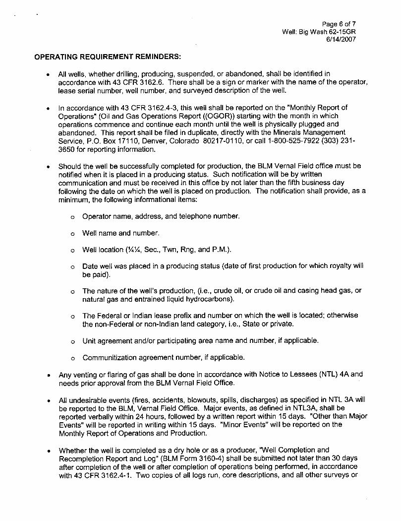
OPERATING REQUIREMENT REMINDERS:
• All wells, whether drilling, producing, suspended, or abandoned, shall be identified inaccordance with 43 CFR 3162.6. There shall be a sign or marker with the name of the operator,lease serial number, well number, and surveyed description of the well.
• In accordance with 43 CFR 3162.4-3, thiswell shall be reported on the "Monthly Report ofOperations" (Oil and Gas Operations Report ((OGOR)) starting with the month in whichoperations commence and continue each month until the well is physically plugged andabandoned. This report shall be filed in duplicate, directly with the Minerals ManagementService, P.O. Box 17110, Denver, Colorado 80217-0110, or call 1-800-525-7922 (303) 231-3650 for reporting information.
• Should the well be successfully completed for production, the BLMVernal Field office must benotifiedwhen it is placed in a producing status. Such notificationwill be by writtencommunication and must be received in thisoffice by not later than the fifth business dayfollowing the date on which the well is placed on production. The notification shall provide, as aminimum, the following informational items:
o Operator name, address, and telephonenumber.
o Well name and number.
o Well location (¼¼,Sec., Twn, Rng, and P.M.).
o Date well was placed in a producing status (date of first production for which royalty willbe paid).
o The nature of the well's production, (i.e., crude oil,or crude oil and casing head gas, ornatural gas and entrained liquid hydrocarbons).
o The Federal or Indian lease prefix and number on which the well is located; otherwisethe non-Federal or non-Indian land category, i.e., State or private.
o Unitagreement and/or participating area name and number, if applicable.
o Communitization agreement number, if applicable.
• Any venting or flaring of gas shall be done in accordance with Notice to Lessees (NTL) 4A andneeds prior approval from the BLMVernal Field Office.
• All undesirable events (fires, accidents, blowouts, spills, discharges) as specified in NTL 3A willbe reported to the BLM, Vernal Field Office. Major events, as defined in NTL3A, shall bereported verbally within 24 hours, followed by a written report within 15 days. "Other than MajorEvents" will be reported in writing within 15 days. "Minor Events" will be reported on theMonthly Report of Operations and Production.
• Whether the well is completed as a dry hole or as a producer, "Well Completion andRecompletion Report and Log" (BLM Form 3160-4) shall be submitted not later than 30 daysafter completion of the well or after completion of operations being performed, in accordancewith 43 CFR 3162.4-1. Two copies of all logs run, core descriptions, and all other surveys
Page 7 of 7Well: Big Wash 62-15GR
6/14/2007
data obtained and compiled during the drilling, workover, and/or completion operations, shall befiled on BLM Form 3160-4. Submit with the wellcompletion report a geologic report including,at a minimum, formation tops, and a summary and conclusions. Also include deviation surveys,sample descriptions, strip logs, core data, drill stem test data, and results of production tests ifperformed. Samples (cuttings, fluid, and/or gas) shall be submitted only when requested by theBLM, Vernal Field Office.
• All off-lease storage, off-lease measurement, or commingling on-lease or off-lease, shall haveprior written approval from the BLMVernal Field Office.
• Oil and gas meters shall be calibrated in place prior to any deliveries. The BLMVernal FieldOffice Petroleum Engineers will be provided witha date and timefor the initial meter calibrationand all future meter proving schedules. A copy of the meter calibration reports shall besubmitted to the BLMVernal Field Office. All measurement facilities willconform to the APIstandards for liquid hydrocarbons and the AGA standards for natural gas measurement. Allmeasurement points shall be identified as the point of sale or allocation for royalty purposes.
• A schematic facilities diagram as required by Onshore Oil&Gas Order No. 3 shall be submittedto the BLMVernal Field Office within 30 days of installation or first production, whichever occursfirst. Allsite security regulations as specified in Onshore Oil & Gas Order No. 3 shall beadhered to. All product lines entering and leaving hydrocarbon storage tanks will be effectivelysealed in accordance with Onshore Oil & Gas Order No. 3.
• Any additional construction, reconstruction, or alterations of facilities, including roads, gatheringlines, batteries, etc., which willresult in the disturbance of new ground, shall require the filing ofa suitable plan and need prior approval of the BLMVernal Field Office. Emergency approvalmay be obtained orally, but such approval does not waive the written report requirement.
• No location shall be constructed or moved, no well shall be plugged, and no drilling or workoverequipment shall be removed from a well to be placed in a suspended status without priorapproval of the BLMVernal Field Office. Ifoperations are to be suspended for more than 30days, prior approval of the BLMVernal Field Office shall be obtained and notification givenbefore resumption of operations.
• Pursuant to Onshore Oil & Gas Order No. 7, this is authorization for pit disposal of waterproduced from thiswell for a period of 90 days from the date of initial production. A permanentdisposal method must be approved by thisofficeand in operation prior to the end of this 90-dayperiod. In order to meet this deadline, an application for the proposed permanent disposalmethod shall be submitted along with any necessary water analyses, as soon as possible, butno later than 45 days after the date of first production. Any method of disposal which has notbeen approved prior to the end of the authorized 90-day period will be considered as an Incidentof Noncompliance and will be grounds for issuing a shut-in order until an acceptable manner fordisposing of said water is provided and approved by thisoffice.
• Unless the plugging is to take place immediately upon receipt of oral approval, the Field OfficePetroleum Engineers must be notifiedat least 24 hours in advance of the plugging of the well, inorder that a representative may witness plugging operations. If a well is suspended orabandoned, all pits must be fenced immediately until theyare backfilled. The "SubsequentReport of Abandonment" (Form BLM 3160-5) must be submitted within 30 days after the actualplugging of the well bore, showing location of plugs, amount of cement in each, and amount ofcasing left in hole, and the current status of the surface

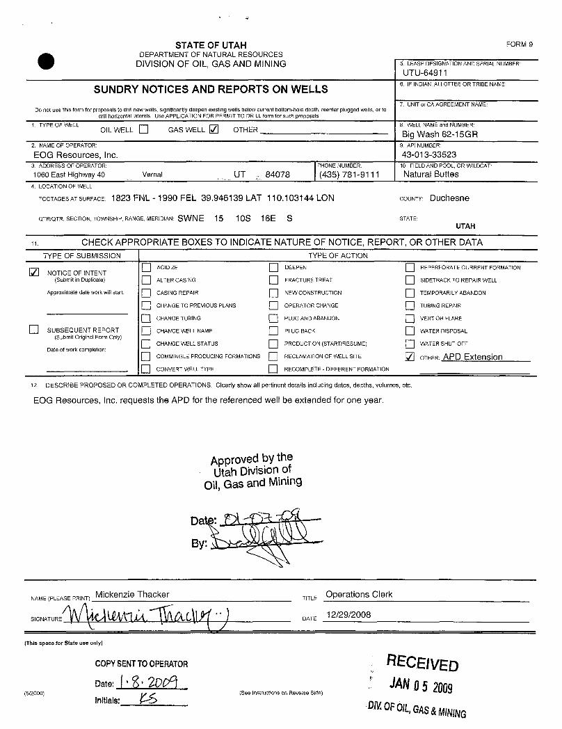
STATE OF UTAH FORM 9DEPARTMENT OF NATURALRESOURCES
DIVISIONOF OIL, GAS AND MINING 5. LEASEDESIGNATIONANDSERIALNUMBER:
UTU64911
SUNDRY NOTICES AND REPORTS ON WELLS6. IFINDIAN,ALLOTTEEORTRIBENAME:
7. UNIT or CA AGREEMENT NAME:Do not use thisform for proposals to drill new wells, significantly deepen existing wells below current bottom-hole depth, reenter plugged wells, or to
drill horizontal laterals. Use APPLICATION FOR PERMIT TO DRILL form for such proposals.
1. TYPE OF WELL 8. WELL NAME and NUMBER:OIL WELL GAS WELL Q OTHER Big Wash 62-15GR
2. NAMEOFOPERATOR: 9. API NUMBER:
EOG Resources, Inc. 43-013-335233 ADDRESS OF OPERATOR: PHONE NUMBER: 10. FIELD AND POOL, OR WILDCAT:
1060 East Highway 40 ciTY Vernal STATE UT 84078 (435) 781-9111 Natural Buttes4 LOCATION OF WELL
FOOTAGESATSURFACE: 1823 FNL±1990 FEU$9 940139 LAT 110 1ÒŠt44LON COUNTY Duchesne
QTR/QTR, SECTION, TOWNSHIP, RANGE, MERIDIAN: 108 16E S STATE:UTAH
CHECK APPROPRIATE BOXES TO INDICATE NATURE OF NOTICE, REPORT, OR OTHER DATA
TYPE OF SUBMISSION TYPE OF ACTION
AC1D1ZE DEEPEN REPERFORATE CURRENT FORMATIONNOTICE OF INTENT
(Submit in Duplicate) ALTER CASING FRACTURE TREAT S1DETRACKTO REPAIR WELL
Approximate date work willstart: CASING REPAIR NEW CONSTRUCTION TEMPORARILY ABANDON
CHANGE TO PREVIOUS PLANS OPERATOR CHANGE TUBING REPAlR
O CHANGE TUBING PLUG AND ABANDON VENT OR FLARE
SUBSEQUENT REPORT CHANGE WELL NAME PLUG BACK WATER DISPOSAL(Submit Original Form Only)
O CHANGE WELL STATUS PRODUCTION (START/RESUME) WATER SHUT-OFFDate of work completion:
O COMM1NGLEPRODUCING FORMATIONS RECLAMATIONOF WELL SITE OTHER: APD ExtensionO CONVERT WELL TYPE RECOMPLETE -DIFFERENT FORMATION
12 DESCRIBE PROPOSED OR COMPLETED OPERATIONS. Clearly show all pertinent details including dates, depths, volumes, etc
EOG Resources, Inc. requests the APD for the referenced well be extended for one year.
Approved by theUtah Divisionof
Oil,Gas and Mining
COPYSENTTOOPEMTOli
NAME(PLEASEPRINT) K . Gardner TITLE Lead Regulatory Assistant
SK' T ÛQfL(A y DATE 1/15/2008
(This space for State se only)
RECEIVEDJAN2 2 2005
(5/2000) (See Instructions on Reverse Side)DIV.OFOIL,GAS&

Application for Permit to DrillRequest for Permit Extension
Validation(thisform should accompany the Sundry Notice requesting permit extension)
API: 43-613-33523Well Name: Big Wash 62-15GR
Location: 1823 FNL - 1990 FEL (SWNE), SECTION 15, T10S, R16E S.L.B.&MCompany Permit Issued to: EOGRESOURCES, INC.Date Original Permit Issued: 1/23/2007
The undersigned as owner with legal rights to drill on the property as permittedabove, hereby verifies that the information as submitted in the previouslyapproved application to drill, remains valid and does not require revision.
Followinq is a checklistof some items related to the application, which should beverified.
If located on private land, has the ownershipchanged, if so, has the surfaceagreement been updated? Yes O NoO
Have any wells been drilled in the vicinityof the proposed well which would affectthe spacing or siting requirements for this location? YesO NolZI
Has there been any unit or other agreements put in place that could affect thepermitting or operation of thisproposed well? YesO NoO
Have there been any changes to the access route including ownership,or right-of-way, which could affect the proposed location? YesO No O
Has the approved source of water for drillingchanged? YesO NoO
Have there been any physical changes to the surface location or access routewhich willrequire a change in plans from what was discussed at the onsiteevaluation? YesO NoO
Is bonding stillin place, which covers this proposed well? YesŒNoO
. x< >1/15/2668
i n ure Date
Title: Lead Regulatory Assistant
Representing: EOG Resources, Inc.
RECEIVED
JAN2 2 2008
DN.OFO\L,GAS&
STATE OF UTAH FORM 9
O DEPARTMENT OF NATURALRESOURCESDIVISIONOF OIL, GAS AND MINING 5. LEASEDESIGNATIONANDSERiALNUMBER:
UTU-649116. IF INDIAN,ALLOTTEEOR TRIBE NAME
SUNDRY NOTICES AND REPORTS ON WELLS7. UNITor CA AGREEMENT NAME:
Do not use this form for proposals to drill new wells, significantly deepen existing wells below current bottom-hole depth, reenterplugged wells, or todrill horizontal laterais. Use APPLICATION FOR PERMIT TO DRILLform for such proposals.
1. TYPE OF WELL 8. WELL NAMEand NUMBER:OIL WELL GAS WELL / OTHER Big Wash 62-15GR
2.NAMEOFOPERATOR: 9.AP1NUMBER:
EOG Resources, Inc. 43-013-335233. ADDRESS OF OPERATOR: PHONE NUMBER: 10. FIELDAND POOL, OR WLDCAT
1060 East Highway 40 Vernal UT 84078 (435) 781-9111 Natural Buttes4. LOCATION OF WELL
FOOTAGESATSURFACE: 1823 FNL - 1990 FEL 39.946139 LAT 110.103144 LON COUNTY: DUchesne
QTR/QTR, SECTION, TOWNSHIP, RANGE, MERIDIAN: SWNE 15 10S 16E S STATE:UTAH
CHECK APPROPRIATE BOXES TO INDICATENATURE OF NOTICE, REPORT, OR OTHER DATATYPE OF SUBMISSION TYPE OF ACTtON
ACIDIZE DEEPEN REPERFORATE CURRENT FORMATIONNOTICE OF INTENT
(Submit in Duplicate) ALTER CASING FRACTURE TREAT SlDETRACK TO REPAlR WELL
Approximate date work willstart: CASING REPAIR NEW CONSTRUCTION TEMPORARILYABANDON
CHANGE TO PREVIOUS PLANS OPERATOR CHANGE TUBINGREPAIR
CHANGE TUBING PLUG AND ABANDON VENT OR FLARE
SUBSEQUENT REPORT CHANGE WELL NAME PLUG BACK WATER DISPOSAL(Submit Original Form Only)
CHANGE WELL STATUS PRODUCTION (STARTIRESUME) WATER SHUT-OFFDate of work completion:
COMMINGLEPRODUClNG FORMATIONS RECLAMATIONOF WELL SITE OTHER: APD ExtensionCONVERT WELL TYPE RECOMPLETE -OlFFERENT FORMATION
12 DESCRIBE PROPOSED OR COMPLETED OPERATIONS. Clearly show all pertinent details including dates, depths, volumes, etc.
EOG Resources, Inc. requests the APD for the referenced well be extended for one year.
Approved by theUtah Divisionof
Oil,Gas and Mining
Da e: '
By:
NA E (PLEA Ckenzie ac TTE OperaÍiODS Clerk
(This space for State use only)
COPYSENTTOOPERATOR RECEIVEDJANO5 2009See gestsucßoas on Reverse O
DMOFOlL,GAS&MINING
ry2ooo)

Application for Permit to DrillRequest for Permit Extension
Validation(thisform should accompany the Sundry Notice requesting permit e×tension)
API: 43-013-33523Well Name: Big Wash 62-15GR
Location: 1823 FNL - 1990 FEL (SWNE), SECTION 15, T10S, R16E S.L.B.&MCompany Permit Issued to: EOG RESOURCES, INC.Date Original Permit Issued: 1/23/2007
The undersigned as owner with legal rights to drill on the property as permittedabove, hereby verifies that the information as submitted in the previouslyapproved application to drill, remains valid and does not require revision.
Followinq is a checklist of some items related to the application, which should beverified.
If located on private land, has the ownership changed, if so, has the surfaceagreement been updated? YesO NoO
Have any wells been drilled in the vicinity of the proposed well which would affectthe spacing or siting requirements for this location? YesO Nom
Has there been any unit or other agreements put in place that could affect thepermitting or operation of this proposed well? YesO NoO
Have there been any changes to the access route including ownership, or right-of-way, which could affect the proposed location? YesO NoO
Has the approved source of water for drilling changed? YesO NoO
Have there been any physical changes to the surface location or access routewhich will require a change in plans from what was discussed at the onsiteevaluation? YesONoO
Is bonding still in place, which covers this proposed well? YesŒNoO
Title: Operations Clerk
Representing: EOG Resources, Inc.
RECEIVED
UNOFOIL,GAS&
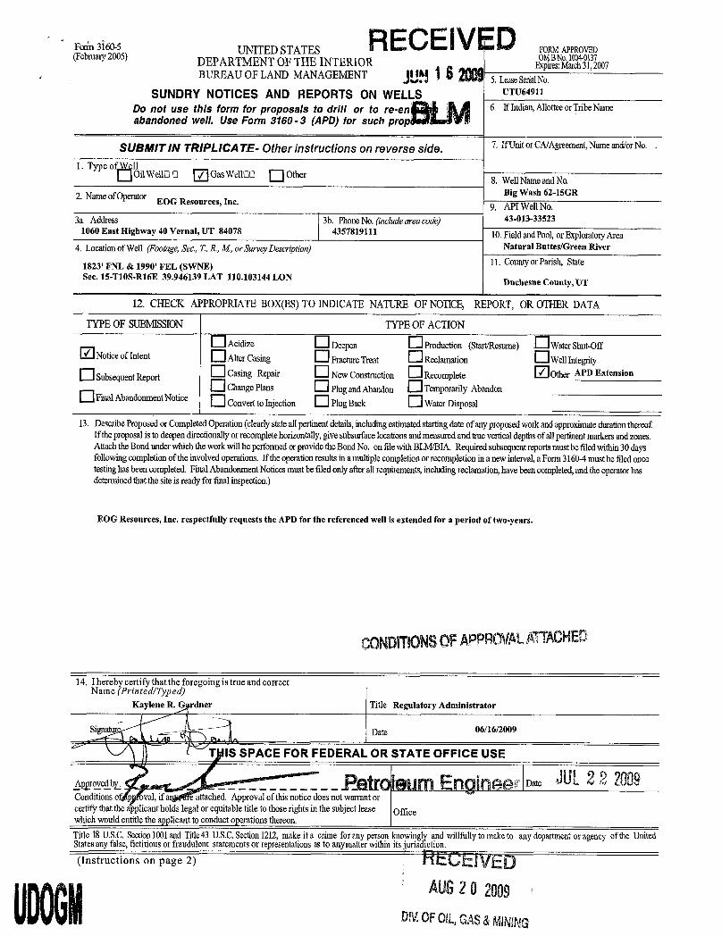
Fon'n3160-5 UNITED STATES RECEIVED URM APPROVED(February2005) DEPARTMENTOFTHE INTERIOR E r c 31 007
BUREAU OF LAND MANAGEMENT 5. LeaseSerialNo.SUNDRY NOTICES AND REPORTS ON WELLS UTU64911
Do not use this form for proposals to drill or to re-en 6. If Indian,AllotteeorTribeNameabandoned we/I. Use Form 3160 - 3 (APD) for such prop >
SUBMITIN TRIPLICATE- Other instructions on reverse side. 7. IfUnitorCA/Agreement,Nameand/orNo. .
1. Type o 11OilWellO O / GasWellOO Other 8. WellNameand No.
2. NameofOperator Big Wash 62-15GREOG Resources, Inc. 9. API WellNo.
3a. Address 3b. PhoneNo. (include area code) 43-013-335231060 East Highway 40 Vernal, UT 84078 4357819111 10.Fieldand Pool,or ExploratoryArea
4. Locationof Well (Footage,Sec.,7, R.,M, or SurveyDescnption) Natural Buttes/Green River
1823' FNL & 1990' FEL (SWNE) 11. Countyor Parish, StateSec. 15-T108-R16E 39.946139 LAT 110.103144 LON Duchesne County, UT
12. CHECK APPROPRIATEBOX(ES)TO INDICATENATURE OF NOTICE, REPORT, OR OTHERDATA
TYPE OF SUBMISSION TYPE OF ACTION
Acidize Deepen Produodon (StarVResume) WaterShut-OffNoticeof Intent AlterCasing FractureTreat Reclamation WellIntegrity
OSubsequentReport Casing Repair NewConstruction Recomplete Other APD Extension
ChangePlans Plugand Abandon TemporarilyAbandonO FinalAbandonmentNotice ConvernoInjecdon PlugBack WaterDisposal
13. DescribeProposedor CompletedOperation(clearly state all perlinentdetails,includingestimated starting dateof any proposedwork and approximate durationthereofIf theproposalisto deependirectionallyor recomplete horizontally,givesubsurface locationsand measured and truevertical depthsof allpertinentmarkers and zones.AttachtheBondunder which thework will beperformedor providetheBondNo. onfilewithBLM/BIA.Requiredsubsequent reportsmust befiledwithin 30daysfollowingcompletion of theinvolvedoperations. If theoperation results ina multiple completion or recompletion ina new interval,a Form31604 must befiledoncetestinghasbeencompleted. Final Abandonment Notices must be filedonly after all requirements, including reclamation, havebeencompleted, and theoperator hasdeterminedthatthesite is ready forfmalinspection.)
EOG Resources, Inc. respectfully requests the APD for the referenced well is extended for a period of two-years.
00NDITIONSOFAPPROVALATTACHED
14. Ihereby certifythattheforegoingistrueandcorrectName (Printed/Typed)
Kaylene R. duer Title Regulatory Administrator
Signa Date 06/16/2009
T IS SPACE FOR FEDERAL OR STATE OFFICE USE
sarom_ _ _ _ _ _ _ _ _ _ _ _ _ _ _ Patmieum Enaineer os2 JUL2 2 2009
Conditionso p oval, if a e attached. Approvalof thisnotice doesnot warrant orcertify thatthe applicant holdslegalor equitable title to thoserights in the subject lease Officewhich would entitle the applicant to conduct operations thereon.Title 18U.S.C.Section1001and Title43 U.S.C.Section1212,make it a crime forany person knowinglyand willfully to make to any departmentor agency of the UnitedStatesany false,fictitiousor fraudulent statements or representations as to anymatter within itsjurisdiction.(Instructions on page 2) RECEIVED
AUS2O2009DIV.0FOIL,GAS&

CONDITIONS OF APPROVAL
EOG Resources, Inc.
Notice of IntentAPD Extension
Lease: UTU-64911Well: Big Wash 62-15GRLocation: SWNE Sec 15-T10S-R16E
An extension for the referenced APD is granted with the following conditions:
1. The extension and APD shall expire on 6/19/2011.
2. No other extension shall be granted.
If you have any other questions concerning this matter, please contact Ryan Angus of this officeat (435)

API Well No: 43013335230000
STATE OF UTAHDEPARTMENT OF NATURAL RESOURCES
DIVISION OF OIL, GAS, AND MINING
FORM 9
5.LEASE DESIGNATION AND SERIAL NUMBER: UTU-64911
SUNDRY NOTICES AND REPORTS ON WELLSDo not use this form for proposals to drill new wells, significantly deepen existing wells below currentbottom-hole depth, reenter plugged wells, or to drill horizontal laterals. Use APPLICATION FOR PERMIT TODRILL form for such proposals.
6. IF INDIAN, ALLOTTEE OR TRIBE NAME:
7.UNIT or CA AGREEMENT NAME:
1. TYPE OF WELL Gas Well
8. WELL NAME and NUMBER: BIG WASH 62-15GR
2. NAME OF OPERATOR: EOG Resources, Inc.
9. API NUMBER: 43013335230000
3. ADDRESS OF OPERATOR: 1060 East Highway 40 , Vernal, UT, 84078
9. FIELD and POOL or WILDCAT: UNDESIGNATED
4. LOCATION OF WELL FOOTAGES AT SURFACE: 1823 FNL 1990 FEL QTR/QTR, SECTION, TOWNSHIP, RANGE, MERIDIAN: Qtr/Qtr: SWNE Section: 15 Township: 10.0S Range: 16.0E Meridian: S
COUNTY: DUCHESNE
STATE: UTAH
11.
CHECK APPROPRIATE BOXES TO INDICATE NATURE OF NOTICE, REPORT, OR OTHER DATA
TYPE OF SUBMISSION TYPE OF ACTION
NOTICE OF INTENTApproximate date work will start:
1/4/2010
SUBSEQUENT REPORTDate of Work Completion:
SPUD REPORTDate of Spud:
DRILLING REPORTReport Date:
ACIDIZE ALTER CASING CASING REPAIR
CHANGE TO PREVIOUS PLANS CHANGE TUBING CHANGE WELL NAME
CHANGE WELL STATUS COMMINGLE PRODUCING FORMATIONS CONVERT WELL TYPE
DEEPEN FRACTURE TREAT NEW CONSTRUCTION
OPERATOR CHANGE PLUG AND ABANDON PLUG BACK
PRODUCTION START OR RESUME RECLAMATION OF WELL SITE RECOMPLETE DIFFERENT FORMATION
REPERFORATE CURRENT FORMATION SIDETRACK TO REPAIR WELL TEMPORARY ABANDON
TUBING REPAIR VENT OR FLARE WATER DISPOSAL
WATER SHUTOFF SI TA STATUS EXTENSION APD EXTENSION
WILDCAT WELL DETERMINATION OTHER OTHER:
12. DESCRIBE PROPOSED OR COMPLETED OPERATIONS. Clearly show all pertinent details including dates, depths, volumes, etc.
EOG Resources, Inc. respectfully requests the APD for the referenced well beextended for one year.
NAME (PLEASE PRINT) Mickenzie Gates
TITLE Operations Clerk
SIGNATURE N/A
DATE 1/4/2010
PHONE NUMBER:435 781-9111 Ext
PHONE NUMBER435 781-9145
January 04, 2010
January 11, 2010
iPI Well No: 43013335230000
FORM 9
STATE OF UTAHDEPARTMENT OF NATURAL RESOURCES
DIVISION OF OIL, GAS, AND MINING LEAS6E49D1ESIGNATION AND SERIAL NUMBER:
SUNDRY NOTICES AND REPORTS ON WELLS 6. IF INDIAN, ALLOTTEE OR TRIBE NAME:
Do not use this form for proposals to drill new wells, significantly deepen existing wells below currentbottom-hole depth, reenter plugged wells, or to drill horizontal laterals. Use APPLICATION FOR PERMIT TO 7.UNIT or CA AGREEMENT NAME:
DRILL form for such proposals.
1. TYPE OF WELL 8. WELL NAME and NUMBER:Gas Well BIG WASH 62-15GR
2. NAME OF OPERATOR: 9. API NUMBER:EOG Resources,Inc. 43013335230000
3. ADDRESS OF OPERATOR: PHONE NUMBER: 9. FIELD and POOL or WILDCAT:1060 East Highway 40 , Vernal, UT, 84078 435 781-9111 Ext UNDESIGNATED
4.LOCATIONOFWELL COUNTY:FOOTAGES AT SURFACE: DUCHESNE
1823 FNL 1990 FELQTR/QTR, SECTION, TOWNSHIP, RANGE, MERIDIAN: STATE:
Qtr/Qtr: SWNE Section: 15 Township: 10.05 Range: 16.0E Meridian: S UTAH
11.CHECK APPROPRIATE BOXES TO INDICATE NATURE OF NOTICE, REPORT, OR OTHER DATA
TYPE OF SUBMISSION TYPE OF ACTION
ACIDIZE ALTER CASING CASING REPAIR
/ NOTICE OF INTENTApproximate date work will start: CHANGE TO PREVIOUS PLANS CHANGE TUBING CHANGE WELL NAME
1/4/2010CHANGE WELL STATUS COMMINGLE PRODUCING FORMATIONS CONVERT WELL TYPE
SUBSEQUENT REPORT DEEPEN FRACTURE TREAT NEW CONSTRUCTIONDate of Work Completion:
OPERATOR CHANGE PLUG AND ABANDON PLUG BACK
PRODUCTION START OR RESUME RECLAMATION OF WELL SITE RECOMPLETE DIFFERENT FORMATION
SPUD REPORTDate of Spud: REPERFORATE CURRENT FORMATION SIDETRACK TO REPAIR WELL TEMPORARY ABANDON
TUBING REPAIR VENT OR FLARE WATER DISPOSAL
DRILLING REPORT WATER SHUTOFF SI TA STATUS EXTENSION APD EXTENSIONReport Date:
WILDCAT WELL DETERMINATION OTHER OTHER:
12. DESCRIBE PROPOSED OR CC MPLETED OPERATIONS. Clearly show all pertinent details including dates, depths, volumes, etc.
EOG Resources, Inc. respectfully requests the APD for the referenced well beextended for one year. Approved by the
Utah Division ofOil, Gas and Mining
Date: Janua l1, 2010
By:
NAME (PLEASE PRINT) PHONE NUMBER TITLEMickenzie Gates 435 781-9145 Operations Clerk
SIGNATURE DATEN/A 1/4/2010
RECEIVED January 04,

The Utah Division of Oil, Gas, and Mining
- State of Utah- Department of Natural Resources
Electronic Permitting System - Sundry Notices
Request for Permit Extension Validation Well Number 43013335230000
API: 43013335230000Well Name: BIG WASH 62-15GR
Location: 1823 FNL 1990 FEL QTR SWNE SEC 15 TWNP 100S RNG 160E MER SCompany Permit Issued to: EOG RESOURCES, INC.
Date Original Permit Issued: 1/23/2007
The undersigned as owner with legal rights to drill on the property as permitted above, hereby verifies thatthe information as submitted in the previously approved application to drill, remains valid and does notrequire revision. Following is a checklist of some items related to the application, which should be verified.
If located on private land, has the ownership changed, if so, has the surface agreement beenupdated? Yes No
Have any wells been drilled in the vicinity of the proposed well which would affect the spacing orsiting requirements for this location? Yes No
Has there been any unit or other agreements put in place that could affect the permitting or operationof this proposed well? Yes No
Have there been any changes to the access route including ownership, or rightof- way, which couldaffect the proposed location? Yes No
Has the approved source of water for drilling changed? Yes No
Have there been any physical changes to the surface location or access route which will require achange in plans from what was discussed at the onsite evaluation? Yes No
Is bonding still in place, which covers this proposed well? Yes No
Signature: Mickenzie Gates Date: 1/4/2010
Title: Operations Clerk Representing: EOG RESOURCES, INC.
January 04, 2010
January 11, 2010
UTAH
DNR The Utah Division of Oil, Gas, and Mining'
- State of Utah- Department of Natural ResourcesElectronic Permitting System - Sundry Notices
OTI GAS MlNTNG
Request for Permit Extension Validation Well Number 43013335230000
API: 43013335230000Well Name: BIG WASH 62-15GR
Location: 1823 FNL 1990 FEL QTR SWNE SEC 15 TWNP 1005 RNG 160E MER SCompany Permit Issued to: EOG RESOURCES, INC.
Date Original Permit Issued: 1/23/2007
The undersigned as owner with legal rights to drill on the property as permitted above, hereby verifies thatthe information as submitted in the previously approved application to drill, remains valid and does notrequire revision. Following is a checklist of some items related to the application, which should be verified.
•If located on private_land, has the ownership changed, if so, has the surface agreement beenupdated? I___|I Yes I_Ð_I No
• Have any wells been drilled in the vicinity of the_proposed well which would affect the spacing orsiting requirements for this location? I:___) Yes _®_) No
• Has there been any unit or other agreements put in place that could affect the permitting or operationof this proposed well? I i Yes i i No
• Have there been any changes to the access route including ownership, or rightof- way, which couldaffect the proposed location? I___) Yes I _I No
• Has the approved source of water for drilling changed? I __I Yes i i No
• Have there been any physical changes to the surface location or access route which will require achange in plans from what was discussed at the onsite evaluation? I___I Yes I®I No
Approved by the•Is bonding still in place, which covers this proposed well? I§|I Yes i i No Utah Division of
Oil, Gas and MiningSignature: Mickenzie Gates Date: 1/4/2010
Title: Operations Clerk Representing: EOG RESOURCES, INC. Date: January 11, 2010
By:
RECEIVED January 04,

API Well No: 43013335230000
STATE OF UTAHDEPARTMENT OF NATURAL RESOURCES
DIVISION OF OIL, GAS, AND MINING
FORM 9
5.LEASE DESIGNATION AND SERIAL NUMBER: UTU-64911
SUNDRY NOTICES AND REPORTS ON WELLSDo not use this form for proposals to drill new wells, significantly deepen existing wells below currentbottom-hole depth, reenter plugged wells, or to drill horizontal laterals. Use APPLICATION FOR PERMIT TODRILL form for such proposals.
6. IF INDIAN, ALLOTTEE OR TRIBE NAME:
7.UNIT or CA AGREEMENT NAME:
1. TYPE OF WELL Gas Well
8. WELL NAME and NUMBER: BIG WASH 62-15GR
2. NAME OF OPERATOR: EOG Resources, Inc.
9. API NUMBER: 43013335230000
3. ADDRESS OF OPERATOR: PHONE NUMBER: 1060 East Highway 40 , Vernal, UT, 84078 435 781-9111 Ext
9. FIELD and POOL or WILDCAT: UNDESIGNATED
4. LOCATION OF WELL FOOTAGES AT SURFACE: 1823 FNL 1990 FEL QTR/QTR, SECTION, TOWNSHIP, RANGE, MERIDIAN: Qtr/Qtr: SWNE Section: 15 Township: 10.0S Range: 16.0E Meridian: S
COUNTY: DUCHESNE
STATE: UTAH
11.
CHECK APPROPRIATE BOXES TO INDICATE NATURE OF NOTICE, REPORT, OR OTHER DATA
TYPE OF SUBMISSION TYPE OF ACTION
NOTICE OF INTENTApproximate date work will start:
12/29/2010
SUBSEQUENT REPORTDate of Work Completion:
SPUD REPORTDate of Spud:
DRILLING REPORTReport Date:
ACIDIZE ALTER CASING CASING REPAIR
CHANGE TO PREVIOUS PLANS CHANGE TUBING CHANGE WELL NAME
CHANGE WELL STATUS COMMINGLE PRODUCING FORMATIONS CONVERT WELL TYPE
DEEPEN FRACTURE TREAT NEW CONSTRUCTION
OPERATOR CHANGE PLUG AND ABANDON PLUG BACK
PRODUCTION START OR RESUME RECLAMATION OF WELL SITE RECOMPLETE DIFFERENT FORMATION
REPERFORATE CURRENT FORMATION SIDETRACK TO REPAIR WELL TEMPORARY ABANDON
TUBING REPAIR VENT OR FLARE WATER DISPOSAL
WATER SHUTOFF SI TA STATUS EXTENSION APD EXTENSION
WILDCAT WELL DETERMINATION OTHER OTHER:
12. DESCRIBE PROPOSED OR COMPLETED OPERATIONS. Clearly show all pertinent details including dates, depths, volumes, etc.
EOG Resources, Inc. respectfully requests the APD for the referenced well beextended for one year.
NAME (PLEASE PRINT) PHONE NUMBER Michelle Robles 307 276-4842
TITLE Regulatory Assistant
SIGNATURE N/A
DATE 12/29/2010
December 29, 2010
12/30/2010
iPI Well No: 43013335230000
FORM 9
STATE OF UTAHDEPARTMENT OF NATURAL RESOURCES
DIVISION OF OIL, GAS, AND MINING EAS6E49D1ESIGNATION AND SERIAL NUMBER:
SUNDRY NOTICES AND REPORTS ON WELLS 6. IF INDIAN, ALLOTTEE OR TRIBE NAME:
Do not use this form for proposals to drill new wells, significantly deepen e×isting wells below currentbottom-hole depth, reenter plugged wells, or to drill horizontal laterals. Use APPLICATION FOR PERMIT TO 7.UNIT or CA AGREEMENT NAME:
DRILL form for such proposals.
1. TYPE OF WELL 8. WELL NAME and NUMBER:Gas Well BIG WASH 62-15GR
2. NAME OF OPERATOR: 9. API NUMBER:EOG Resources,Inc. 43013335230000
3. ADDRESS OF OPERATOR: PHONE NUMBER: 9. FIELD and POOL or WILDCAT:1060 East Highway 40 , Vernal, UT, 84078 435 781-9111 Ext UNDESIGNATED
4.LOCATIONOFWELL COUNTY:FooTAGES AT SURFACE: DUCHESNE
1823 FNL 1990 FELQTR/QTR, SECTION, TOWNSHIP, RANGE, MERIDIAN: STATE:
Qtr/Qtr: SWNE Section: 15 Township: 10.05 Range: 16.0E Meridian: S UTAH
11.CHECK APPROPRIATE BOXES TO INDICATE NATURE OF NOTICE, REPORT, OR OTHER DATA
TYPE OF SUBMISSION TYPE OF ACTION
ACIDIZE ALTER CASING CASING REPAIR
NOTICE OF INTENTApproximate date work will start: CHANGE TO PREVIOUS PLANS CHANGE TUBING CHANGE WELL NAME
12/29/2010CHANGE WELL STATUS COMMINGLE PRODUCING FORMATIONS CONVERT WELL TYPE
SUBSEQUENT REPORT DEEPEN FRACTURE TREAT NEW CONSTRUCTIONDate of Work Completion:
OPERATOR CHANGE PLUG AND ABANDON PLUG BACK
PRODUCTION START OR RESUME RECLAMATION OF WELL SITE RECOMPLETE DIFFERENT FORMATION
O SPUD REPORTDate of Spud: REPERFORATE CURRENT FORMATION SIDETRACK TO REPAIR WELL TEMPORARY ABANDON
TUBING REPAIR VENT OR FLARE WATER DISPOSAL
DRILLING REPORT WATER SHUTOFF SI TA STATUS EXTENSION APD EXTENSIONReport Date:
WILDCAT WELL DETERMINATION OTHER OTHER:
12. DESCRIBE PROPOSED OR CC MPLETED OPERATIONS. Clearly show all pertinent details including dates, depths, volumes, etc.
EOG Resources, Inc. respectfully requests the APD for the referenced well beextended for one year. Approved by the
Utah Division ofOil, Gas and Mining
Date: 12/30/2010
By:
NAME (PLEASE PRINT) PHONE NUMBER TITLEMichelle Robles 307 276-4842 Regulatory Assistant
SIGNATURE DATEN/A 12/29/2010
RECEIVED December 29,
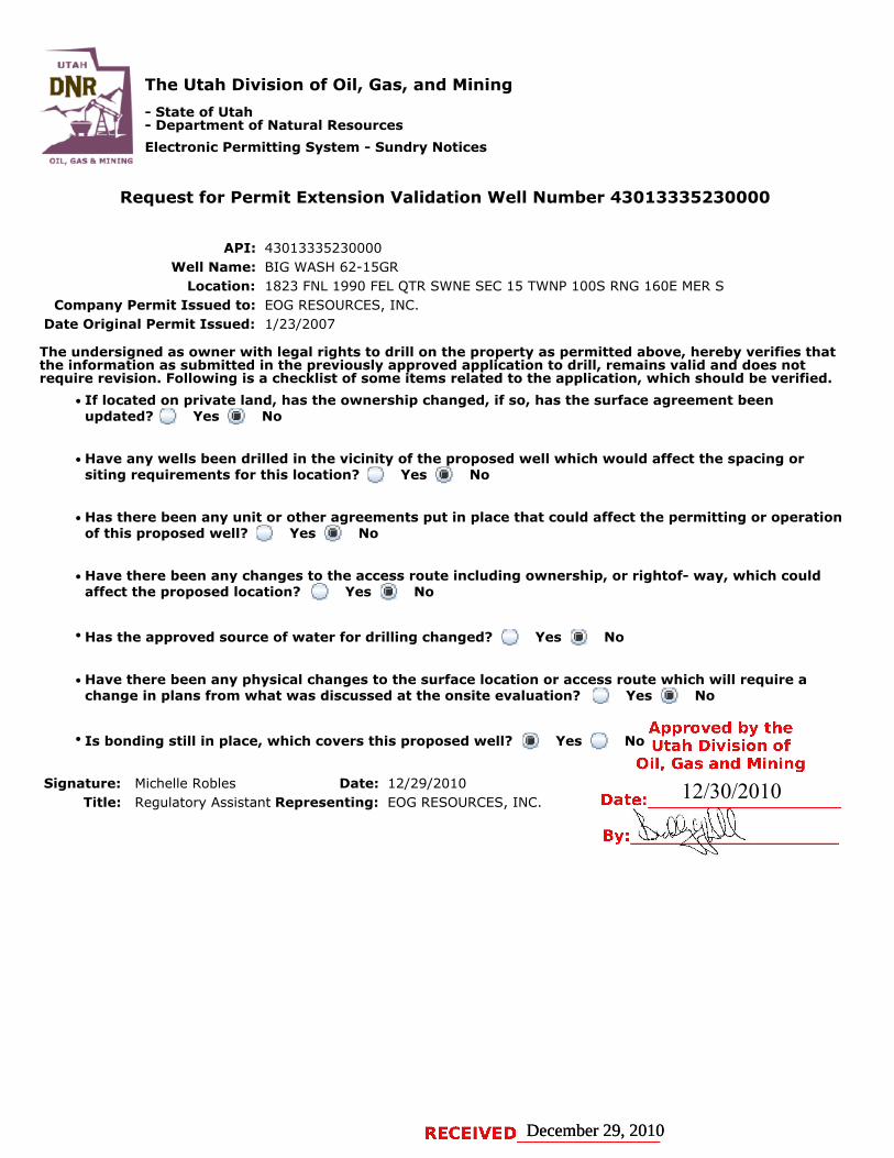
The Utah Division of Oil, Gas, and Mining
- State of Utah- Department of Natural Resources
Electronic Permitting System - Sundry Notices
Request for Permit Extension Validation Well Number 43013335230000
API: 43013335230000Well Name: BIG WASH 62-15GR
Location: 1823 FNL 1990 FEL QTR SWNE SEC 15 TWNP 100S RNG 160E MER SCompany Permit Issued to: EOG RESOURCES, INC.
Date Original Permit Issued: 1/23/2007
The undersigned as owner with legal rights to drill on the property as permitted above, hereby verifies thatthe information as submitted in the previously approved application to drill, remains valid and does notrequire revision. Following is a checklist of some items related to the application, which should be verified.
If located on private land, has the ownership changed, if so, has the surface agreement beenupdated? Yes No
Have any wells been drilled in the vicinity of the proposed well which would affect the spacing orsiting requirements for this location? Yes No
Has there been any unit or other agreements put in place that could affect the permitting or operationof this proposed well? Yes No
Have there been any changes to the access route including ownership, or rightof- way, which couldaffect the proposed location? Yes No
Has the approved source of water for drilling changed? Yes No
Have there been any physical changes to the surface location or access route which will require achange in plans from what was discussed at the onsite evaluation? Yes No
Is bonding still in place, which covers this proposed well? Yes No
Signature: Michelle Robles Date: 12/29/2010
Title: Regulatory Assistant Representing: EOG RESOURCES, INC.
December 29, 2010December 29, 2010
12/30/2010
UTAH
DNR The Utah Division of Oil, Gas, and Mining'
- State of Utah- Department of Natural Resources
Electronic Permitting System - Sundry NoticesOTI GAS MlNTNG
Request for Permit Extension Validation Well Number 43013335230000
API: 43013335230000Well Name: BIG WASH 62-15GR
Location: 1823 FNL 1990 FEL QTR SWNE SEC 15 TWNP 1005 RNG 160E MER SCompany Permit Issued to: EOG RESOURCES, INC.
Date Original Permit Issued: 1/23/2007
The undersigned as owner with legal rights to drill on the property as permitted above, hereby verifies thatthe information as submitted in the previously approved application to drill, remains valid and does notrequire revision. Following is a checklist of some items related to the application, which should be verified.
•If located on private_land, has the ownership changed, if so, has the surface agreement beenupdated? I
_
i Yes igi No
• Have any wells been drilled in the vicinity of the_proposed well which would affect the spacing orsiting requirements for this location? :__I Yes g:I No
• Has there been any unit or other agreements put in place that could affect the permitting or operationof this proposed well? I:_:I Yes IÏiÏ:I No
• Have there been any changes to the access route including ownership, or rightof- way, which couldaffect the proposed location? I___I Yes igi No
• Has the approved source of water for drilling changed? I_
I Yes IÎiÏI No
• Have there been any physical changes to the surface location or access route which will require achange in plans from what was discussed at the onsite evaluation? I i Yes i i No
Approved by the•Is bonding still in place, which covers this proposed well? i§i Yes i i No Utah Division ofOil, Gas and Mining
Signature: Michelle Robles Date: 12/29/2010 12/30/2010Title: Regulatory Assistant Representing: EOG RESOURCES, INC. Date:
RECEIVED December 29,

OState of UtahDEPARTMENT OF NATURAL RESOURCES
MICHAEL R. STYLER
GARY R. HERBERTExecutive Director
Governor Division of Oil, Gas and MiningGREG BELL JOHN R. BAZA
Lieutenant Governor Division Director
January 26, 2012
Nanette LupchoEOG Resources, Inc.600 17thStreet, Suite 1000 NDenver, CO 80202
Re: APDs Rescinded for EOG Resources, Inc., Uintah and Dushesne County
Dear Ms. Lupcho:
Enclosed find the list of APDs that you requested to be rescinded. No drillingactivity at these locations has been reported to the division. Therefore,approval to drill these wells is hereby rescinded, effective January 25, 2012.
A new APD must be filed with this office for approval prior to thecommencement of any future work on the subject location.
If any previously unreported operations have been performed on this welllocation, it is imperative that you notify the Division immediately.
Sinçerely,
Diana MasonEnvironmental Scientist
ec: Well FileBureau of Land Management, Vernal
UTAH
DNR
1594 West North Temple, Suite 1210, PO Box 145801, Salt Lake City, UT 84114-5801
telephone(801) 538-5340 • facsimile (801) 359-3940 . TTY (801) 538-7458 • www.ogm.utah.gov¤IL, G^5 &

O O
Big TVash47-10(3Ft 43-013-33533BigYVash44-11(lFL 43-013-33534Big Wash 51-09GR 43-013-33545Big Wash 50-09GR 43-013-33513Big Wash 62-15GR 43-013-33523Big Wash 27-03GR 43-013-33524Big Wash 25-04GR 43-013-33525Wilkin Ridge 36-08GR 43-013-33486OSCTJII 129-34 43-047-50082DSCTJII 127-27

United States Department of the Interior
BUREAU OF LAND MANAGEMENTGreen River District-Vernal Field Office
170 South 500 East TAKE PRIDE'oN Vernal, UT 84078 INAMERICA
(435) 781-4400 Fax: (435) 781-4410http://www.blm.cov/ut/st/en/fo/vernal.html
APR3 0 2012IN REPLY REFER TO:3160 (UTGO11)
Kaylene R. GardnerEOG Resources, Inc.1060 East Highway 40Vernal, UT 84078
Re: Notice of ExpirationWell No. Big Wash 62-15GR pa ySWNE, Sec. 15, T10S, R16E ŸÑ~Duchesne County, UtahLease No. UTU-64911
Dear Ms. Gardner:
The Application for Permit to Drill (APD) for the above-referenced well was approved on June19, 2007. A two (2) year extension request of the original APD was received on June 16, 2009.On July 22, 2009 the request was reviewed and the extension request was approved to June19, 2011. According to our records, Federal Lease UTU-64911 expired by its own terms andconditions on November 16, 2010 with the invalidation of the Kraken Unit Agreement onSeptember 12, 2011. The case was closed at the BLM Utah State Office on October 28, 2011.In view of the foregoing, this office is notifying you that the approval of the referencedapplication and lease has expired.
This office requires a letter confirmingthat no surface disturbance has been made for this drillsite. Any surface disturbance associated with the approved location of thiswell is to berehabilitated. A schedule for this rehabilitation must be submitted to this office. Yourcooperation in this matter is appreciated.
Ifyou have any questions regarding this matter, please contact Cindy Severson at (435) 781-4455.
Sincerely,
erry K nczkaAssistant Field ManagerLands & Mineral Resources
RECEIVEDcc: UDOGM
V 1O2012DIV.OFOIL,GAS&