images3.loopnet.comimages3.loopnet.com/d2/prml2wj3yntdqlkayp3... · created date: 1/20/2009...
TRANSCRIPT
PEASE In DRAINAGE REPORTFOR
MURITTA.Y'S SEOESLOT 3A9 HILLGATE WEST FILING NO. 1, EXEMPTION I
JEFFERSON COUNTY. COLORADOAIJC. t7.m07
PREPAREDFOR ENTASISGROUI4952 WARD ROAD.WHEAT RIDGE, CO 80033(303) 420-7242
PREPAREDBY| MARTINMARTIN,INC,12499 \{rST COLFAX AVENiI,'EI-AKEWOOD, COLORADO 80215(303) 4316100
PRNCIPAI-IN-CHARGE: ROGER SMADES, P.E.PROJECT ENGINEER: JOE E. RAUSCE P.E.
n.
T,
IV-
CERTIFICATION
"This reporl fbr the &ainage design of Loi 3A, Hillgate West liling No. l, Exemptioll 1, was prepared by
me (or under my direct supervision) in accordance with the prc\.isions of Jeffe$on County Storm Drainage
Design and Tecbnical Criteria, and was designed to compiy with the pruvisions thereof. I unde$taod that
Jefferson County does not and will not assume liability for &ainage facilities design."
Roger Smades, P.E.
tr.
INTRODUCT]ON
Ruoff fiom lot 3A of Hillgaie West Filing No. I flows to a detcntioD pond that serves sev€ml lots
jn the Hiugate West Filing No. 1 subdi\,ision. Known as "Pond C", design fo! the pond was part of
the "Fjnal Drainage Reporr for Hillgate Filing No. l" writlen by Rocky Mountain Consultants, lnc.,
Ap.il 1996. The pond was designed and b\rilt v/ithout consideration for water quality control
voll)me, and in the 10 years since constuction, it is apparent that sigrificaDt amounts of sediment
have been dcposit€d in the pond. ,4.dditionally, somc small uees arc no!r, gowing in tbe pond- This
d-rainage study is unde aken to size the pond according to curent Jefferson County standards,
includitrg water quality capture volume, The outl€t struclure will be modified and thc pond re-
shaped.
w}lilc the aforcmentioned &ainage study sized det€ntion Pond C to include runoff from lot 3A,
only aboui 0,23 acrcs ofthe site's 1.37 acres aciually contnbuies runoff io &e pond, Runoff fioltr
the other i.I4 acles d.rains directly to the bonow ditch of Highway C470. Tle proposed
development ofthe lot will divert mnoff from approxim.tely 1.03 acres oflhe lot to the pon4 thus
greatly improving the conhol ofruno .
Pond C also receives storrnwater from Pond "8" as noted in the above rel€rcnced report by Rocky
Mountain Consultan6. Pond B has bem recently constructcd and its rel€se struchue releases for
water quality, the 1o-year event, and the 100-year event. This study \\'i11 size Pond C for runoff
ldbutary io lhe pond, but will jncrease the release rates so that flows fromPondB can plss drrough.
GENEL{L LOCATION A}D DESCfuPTION
A. Location
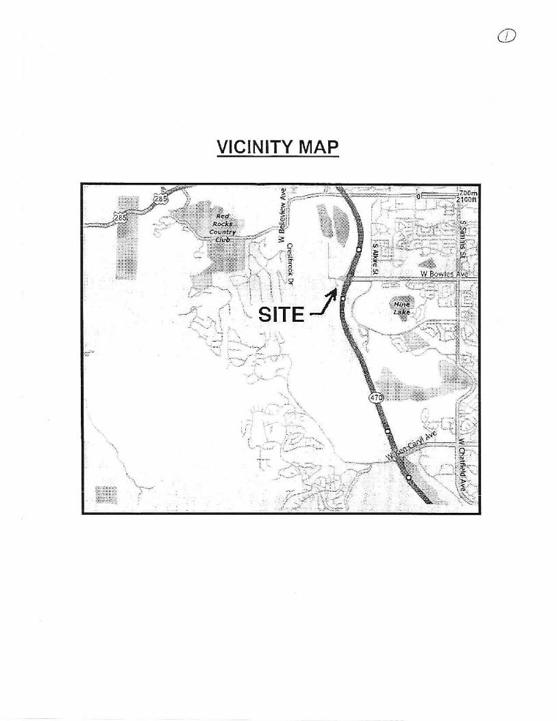
The site is locolcd in lhe east one-half ol Section 19, To*nship 5 South, Range 69 west of
the 6" Principal Meridian, County of Jefferson, State of Colorado. Lot 3.4 is bordered by
Lot 2, Block I to tbe north, Colorado Stat€ Highrlay C470 to the east, Lot 4A, Block I to
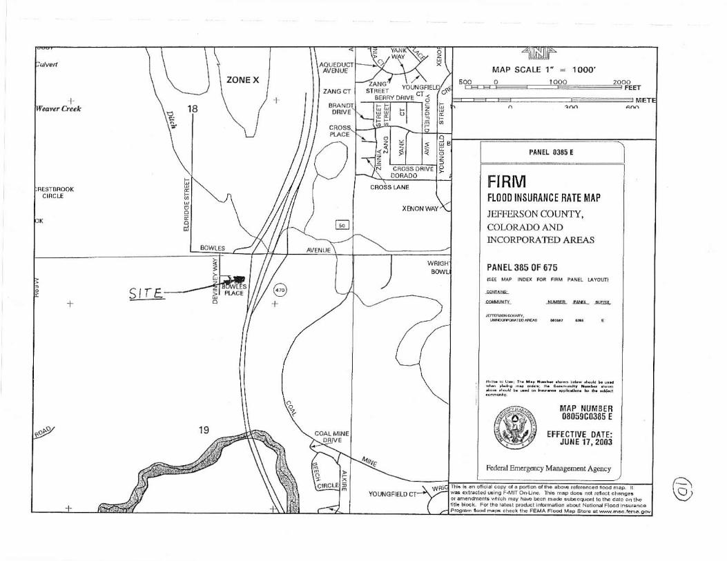
the west and Lot 8, Block 1 to dre south. (See Vicjnity NIap, Figure I - Appondix).
B. Description of Property
Thc property coDtairs approximately 1 .37 acres and is undeveloped except for underground
utiljties (\.iatcr, sa,.ritary sewer and storm) that faverse lhe propelry. The presence ofthese
utilitics impacts tle rmount ol gading that can reasonably be expocted on the property

DI,
IV.
GroMd cover consisls of native grasses and bare ground. Eristing slopes generally range
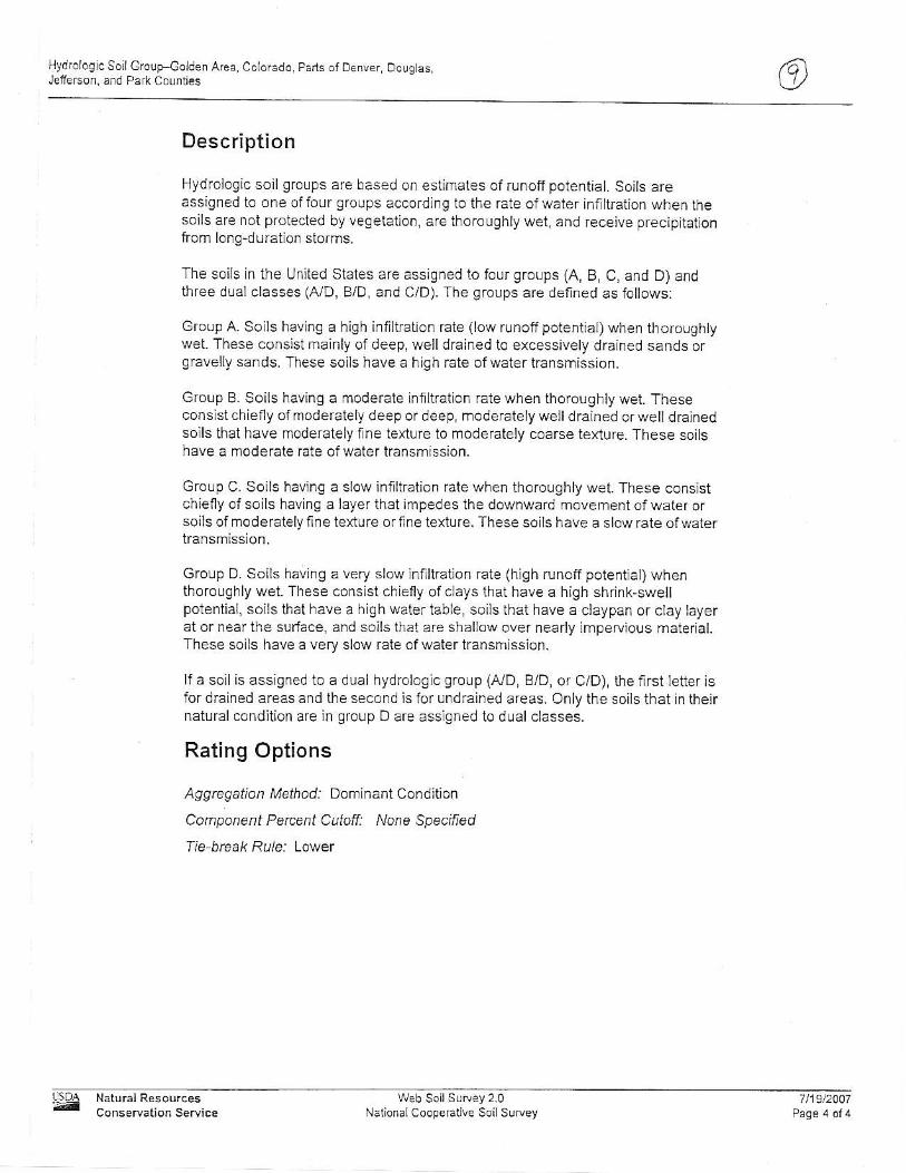
fro 0% to i 0% for most of the property. Steeper slopes are found on the east side of theproperiy near C470. The existing soils on the sit€ are NCRS fpe C. The site does nor lie
within a FEMA I 00-year floodplah.
Tle proposed development consists of the Murray's Shoes bui]ding, 2 retafting walls, a
parking lot, and landscaping. fhe aforementioned Pond "C" is proposed to handle rhe
region sderenion r d \arerqualiry -equiremenr5.
DRAINAGE BASIIIS
A. B asin Descriptions
Pond C has 12 hibutary sub basins. No major drainageways or irrigation facilities run
tbrough tle basin.
B. Sub Basin Descriptions
Existing &ainage pattems show that area tributary to Pond C generally siope east
northeastward. A significant portion ofthe existing Munay's Shoes property nnoffis noi
captwed by Pond C, although the Drainage Plan for Hillgate West liling No. 1 shows
caphre of runoff ftom most of this area. Thc proposed Murray's Shoes development will
captue a significant podion ofthis rmdetained runoffand restorc conditions to the origiml
design of the "Iinal Drainage Report for Hillgate West liling No. 1." In addition, Pond C
will be regaded to accommodate water quality requircments of the rcgion as well as
detention volunes.
DRA]NAGE DESIGN CR]TERL{
A. Regulations
"J€fferson County Storm Drainag€ Design & Technical Criteda (Revised March 1996)"
was used in the developmeni of this Drainage Report.
B. Development C teria Relerence and ConstGints
Backgound infoniation ftom "Phase m Drainage Repoft Stormwater Management Plan
for the Dakota fudge Corrlmons (Ju1y 1, 2003)" and "Final Drainage Report for llillgate
West Filing No. l" was obtained to ensure pioper drainage ofexisting facilities and the
C.
proposed Mrfi ay's Shoes development.
Hy&o1ogica1 Cdteria
Desjgn storms are the lo-year (minor event) and 100-year (major event) storms. Runoff
estimates are based on the Rational method. Reinlall intensities are taken fronr Jeffersor
Counfy criteria. Desigll storm criteria and percent impervious values were detemined
fiom iables in the Jefferson County criteria manual. Detention volume was calculated usmg
fte V=k{ method fiom the Jefferson County Stonn Drainage Design and Technical
Crite.ia. Allowable release rates were developed bascd on soil tl'pe irnd methods prorided
in the Jeffenon County criteda. Release rates are inueased to a1low the pass-through of
runoffreleased ftom Pond B.
Hy&au1ic Cdteria
Hydraulic calculations were calculated according to methods prescribed in the Jefferson
Counry cri terra .nJ u i thin rbe 'Lh bar Storm Dm.rlgc Cr i ter d Mrnu"l '
Storm Water Quality Citeia
Although the odginal design for Pond C did not include Waier Quality Capture Volume
(WQCV), ihe proposed development will included a re design ofPond C which includes
WQCV for its 1]ibulary are3. The oudet sirLrcture wiil be retro-fitted wittr a restrictor
plate sized for a 4o-hour release time.
D
E.
DRA]NAGE FACILITY DESIGN
A. G€neral Concept
l0 years ago, Pond C was desjgned according to the same ftffenon Courty det€ntion
c.iteria used today- Survey of the pond shows tlere is adequate storage of the basin.
However, in the 10 years since construction, ii is apparent that sjgnificant ainoults of
sedinent have been depositcd and some snall tees are now growing in the pond. Gnding
of the pond to accommodate ihe new water quality requirements will remove these tees
and sediment.
Pond C has been designed to accomnodete lhe region's (including the Mu ay's Shoes
development) requirements for both detention and water quality. To ihe furthest extent

B.
pmcticable, runoff from the proposed Munay's Shoes will be captrued and routed to
Pond C.
Specific Details:
Sizing of Pond C used the following assurnptions. FiBt, previously approved drainage
repofts were used to get various iuloff coefficients and flows from the Dakota fudge
Colnmons development. Second, both runoff coefficjents and percent impeffious numberc
were taken diectly offofTable 3-t of*re Jefferson County citeria for Lots l, 2, and 4A of
Hillgate Filing 1. These nu bers assumed a developed "Business: Neighborhood Are^s"
classification. Third, a composite percent imperYiousness was developed for besins found
within the Mutray's Shoes development usmg a stte plan
The tributary area for Pond C js divided inlo twelve sub-basins The Murray's Shoes
development also includes two additjonel tmdetained basins not tributary to Pond C
Basin A is located in the $'esterly portion of the properr)_, wcst of the proposed btt dlng.
Runoff fiom this basin originatcs from landscaped arcas sroruld the westerly retaining \vall
and Aom the sidewalk abuiting the westerly side of the proposed buildiag- Runofi is
collected in a drainage pan and routed around the proposed building Runoff ftom thls
basin terminales at an hlet (Desigl Point 1) before it is released to a ripmp-lined channel in
Basin E.
Basin B is located in the southerly portion of the property, south and easi ol the proposed
building. Rrmoff from this basin conslsts of overland flow over landscaping and parking
areas. Curb and gutter collects lhis flow and routes the runoffto a proposed concreie_iined
drainage chase (Design Point 2) located in the no(heasterly comer of the basin before
eniering Bash E.
Besin C is located in the nofherly portion of the site, north of the proposed building
Runoff ftom this basin consi$s of overland flow over landscaping and parkrng areas Curb
and guiter collects this flow and routes the mnofl to a proposed alrainage chase (DP 3)
\\.hich empties into an existing drainage chase formd in Basil P

Basin D consists of the rooftop runofl ftom the proposed building. Collected runolf isrouted tlrrough dowrspouts (Design Point4) and rcleased to Basin B.
Basin E is located in the northerly portion of the property, north of Basin B and Basin C.Rrnolf fom this basin is gencrally characterized by the pass through flows ofBasin A and
Basin C. It also includes a small amount ofcaptured overland flow. Runoff from tlis basin
is conveyed to Pond C via ar existing concrete chase (Design point 5) lound in Basin p.
Basin ()1 is equivalent' to the OSB1 drainage basin found within the Dakota Ridge
Commons Phase III Drainage Report. The overland lLuloff from this basin is collected xr
curb and guttcr foruld in Basin T.
Basin 02 is equivalent to the OSB2 drainage basin formd within the Dakota fudge
Commons Phase Ill Drainage Report. The runoff lrom ihis basin is collected in curb andgutter found in Basin T.
Basin P consisls oflot I and Lot 2 loceted nofth olthe \,{u]ray's Shoes property. Runoffis
either overland runoff directly to Pond C, or overland ruloffcollected by a swale located in
the norlherly podion ofthe basin. Pond C js located wiihin $is basin so all basins tibutdry
to the Pond are routed though this basin. An outlet skuctue (Design point 11) regxlates
tributary flows out ofthe Pond aDd into C,17u srom sewer.
Basin O consists ofl-ot 4A (a daycare cenier) which is locatcd west ofthe properl,. Rmoff
is collectsd by this development, routed to a siorm sewer inlet (Design Point 12) and piped
to Pond C.
Basin R consists ofthe West Bowles Ave. cul-de-sac and eastcrly half of the Dcvi r€)
Way south of West Bo*4es Ave. All runoff originates from one of these roads and is
collected by a storm sewer inler (Design Point 13) located at the eastem edge ofthe cul-de-
sac. Runoff entedng fiis inlei is piped to Pond C.
Basin S consists olthe easterly half ol lhe Devin]ley Way north ol Wesi Bowles Ave. Al1
runoff originates from this road and is collected by a stonn sewer inlet @esign Point i4)
vL
located in tie norlhem podion of the basin. Runoff enterhg this idet is pipeci to a draimge
swale before entedng Pond C.
Brsin T consists of the \esterly h.r1f of the Devimey Way. Runoff originates ftom this
road and ftom Basins Ol and 02. This runoff is collected by a storm sewer inlet (Design
Point 15) located in the northem porlion ofthe basin. Runoff entedng this inlet is piped to a
drairage swale before entering Pond C.
Basin Y is loceted in the southernnosi porlion of the property. Overlerd mnoff from
landscaping is allo*,ed to runoff undetained lDesign Point 31) off $e property. {To ihe
south Into Pond B as descdbed by the "Hillgate Drainage Report for H;llgate West Filing
No. 1.)
Basin Z runs offundetained (Design Point 32) east towards C470. It consists ofthe eestem
mo t ponion ofthe properry and an a-ea e.r . t of the deren.ion pond.
CONCLUSION
A. Compliance with Standards:
All calculations lor n-rnoff and detention were compiled using the "Jefferson County Stonn
Drainage Design and Tcchnical Cdieria" Jeffe$on County, Colorade- May 1987 and
'tLban Storm Dftinage Criteria Manual," by the Urban Drainage and Flood Control
Distnct.
B. Drainage Concept:
The Murray's Shoes dev€lopment will restore ihe intent of "Iinal Drainage Report for
Hillgate West Filing No. 1 ." Ir addiiion, water qualitJ capture volume for the region will be
provided. Thus both water quality and flooding conditions to the C4?0 bonow ditch will be
improved.
This Phase m Drainage Report is submitted for review.
\,'II. RXFERENCES
1. "Jeffenon County Storm Drainage Design and Teclnical Cdteria', - Jefferson Connty,
Colomdo- May 1987.
2. "Urban Storm Drainage Cliteda Manual" - Urban Drailage and Flood Contol District June 200i
and subsequent rc\.isions.
3. "Final Drainage Report for Hillgate West Filing No. 1," April, 1996, Roclcy Mountain Consultants,
Inc. Englewood, Colorado.
4. "Phase m Drainage Report Stolmwater Management Plan for the Dakota Ridge Commons" - July
I , 2003 Revisioq JR Engineedng, LLC. Englevr'ood, Colorado.

APPENDIX
o
VICINITY MAP
DRAINAGE CRITERIA MANUAT (V )
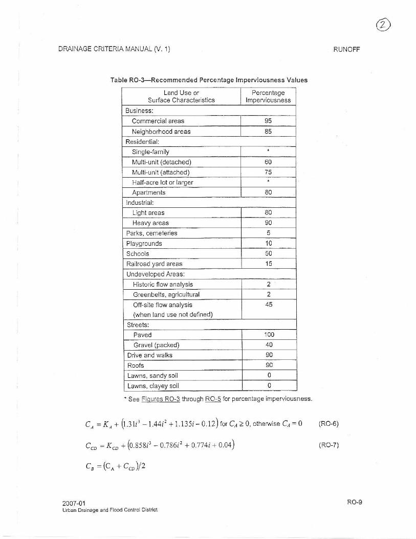
Table RO-3-Recommended Percentage lmperviousness Values
Land Use orSudace Characier stics
Buslness:Commercialareas 95
Neighborhood areas 85Residenlial:
Singlejanrily
Nlulti-unit (detached) 60
[1ulti unit (atiached) 75
Half acre lot of lafgef
80
lndustrial:
L lghlareas 80
90
5
Playgro!nds 10Schools
Railroad yard afeas 15
Undeveloped Areas:
Hisloric flow analysis 2
creenbells, agricultural 2
Off-site flow analysis(when land use not defned)
Streets:100
Gravel (packed) 40
Drive and walks 90
90
Lawns, sandy soi l 0
Lawns, clayey soil 0
'Se€ Fla!res Ro-3 through BQ:5lor percentage imperviousness.
C, =f , * (1. : t l - t .+4t : +1.1351-0.12)rorC;)0,otherwiseC;=0 (Ro-6)
C., = .(t, + (0.858rr - 0.786/'? + 0.774i + 0.04) tao-z)
c" =(c^+c,")12
2007-01u.lran DElnage and Flood control oistrict
RUNOFF
RO-9

STORM DRAINAGE DESIGN AND TECHNICAL CRTTEHIAFIGUF€ 5OI
RAINFALL ZONES
ZONE I IB ZONE
1
Scslo
A
D AT€R€V
REFERENCE:

STOFI '4 DRAINAGE DESIGN AND TECHNICAL CRITERIA
:+:::.in::=l::
TIME - INTENSITY- FREOUENCY CURVES' t 0_0
-s
tz
=
t
E
i OO-YEAFi
5O-YEAR
1O-YEAR5_Y EA B
2-YEAR
o 10
S TORM DURA'I ION OR
20
TIME OF CONGENTRATION,
50
(minules)
REFERENCE:OATE: JULY 1985R EV:
. (u l
I
I
I
I
iI
I
p)
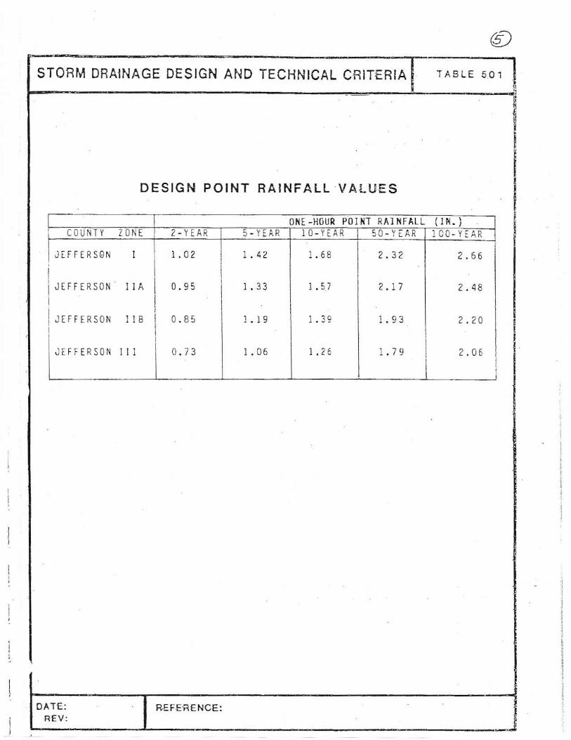
STOB[1 DBAINAGE DESIGN AND TECHNICAL CR|TERIA TASLE 5O1
DESIGN POINT RAINFALL VALUES
! t i l l l '? '661iJ IFFERSoN I IA I o.-os i 1.33
I 1.5,
I , . r?
I , . , ,
IlJrFFrRsoN u8 I0.85
j r .1 '
I r .3 ' I 1.r3
| r fuI
[ : rFrERsoN
r i l I
0.?3
I r .06
| 1. '6
I f . i , I 2.06 i
OAT€R€V
R€F€fiENCE:

q
@E
=; iE €.
l l- l l -!l l l l2i l t li l t l
l'l't lil"i l t lt -
l lg{Ef;
=< 23
-e
!
=,t
Hydrdloglo SollGbuP€old€n Arc., Colorsdo, PEds olDsnver, Dougles, Jefforson, and Psrk Counlieg
wob SoilSuey 2.0Nalional CoooeEliw Soil Suwcy
7/|9t2007
MAP LEGEND MAP INFORMATION
OrigiElsoi lsuryeymEpsheclsweeprepgredslpubl icai ionsc€16.Vbwing scale and p nling scsle, how3v6r, may varyirom lh6orlginal. Plea* rcly on lte bar s€le on .rch rup sheel lor p.oper
Sourca ot M.D: Nalulal Resour@s Conserralion SeruiceWlb Soil Sudey URL hltpr\@b$ib!ry.y.nB.cda.govCoodlnale svslem: UTM Zone 13N
Thls prod ucl is se n€ralsd lrcm the USDA-NRCS ceriified drts a! othe verslon dale(s) lkt6d b.low.
Soil Su&ey A€.: Gold€n Area, Colorado, Pads of OeNe.,Dougla6, Jeflerson, and P.d< countb5SuNoyAEaDat: VeBktn 4, Dec 21, 2006
D.ta(s) aeral tnEg.rw!f3 phologEph€dr 1999
Th6 onhopholo orolhsrbsso map ont{hlch lh€ Bo llines w6r€@mplled anddigiti4d pobabiydifieB f.om th. backg@undimagery displayed on lhe.€ maps. As a r6sult, some minor 3hltlngot mao unit bounda e! mav be eviteit.
Are ol InleEbr (AOl)
i .l sot rrap udE
mAE A/o
@B
[f 3/o
Ec!M cro
EEDllol 6ied or mr .vibbl€
,l: Lo-rRosds
ll:" o0'.. R@d.
m !d.nAreas
6{oeeSlr.lE and C.Dk
.a l.t ..r.ie HighEy!
sE i;'#.*nH"ji*
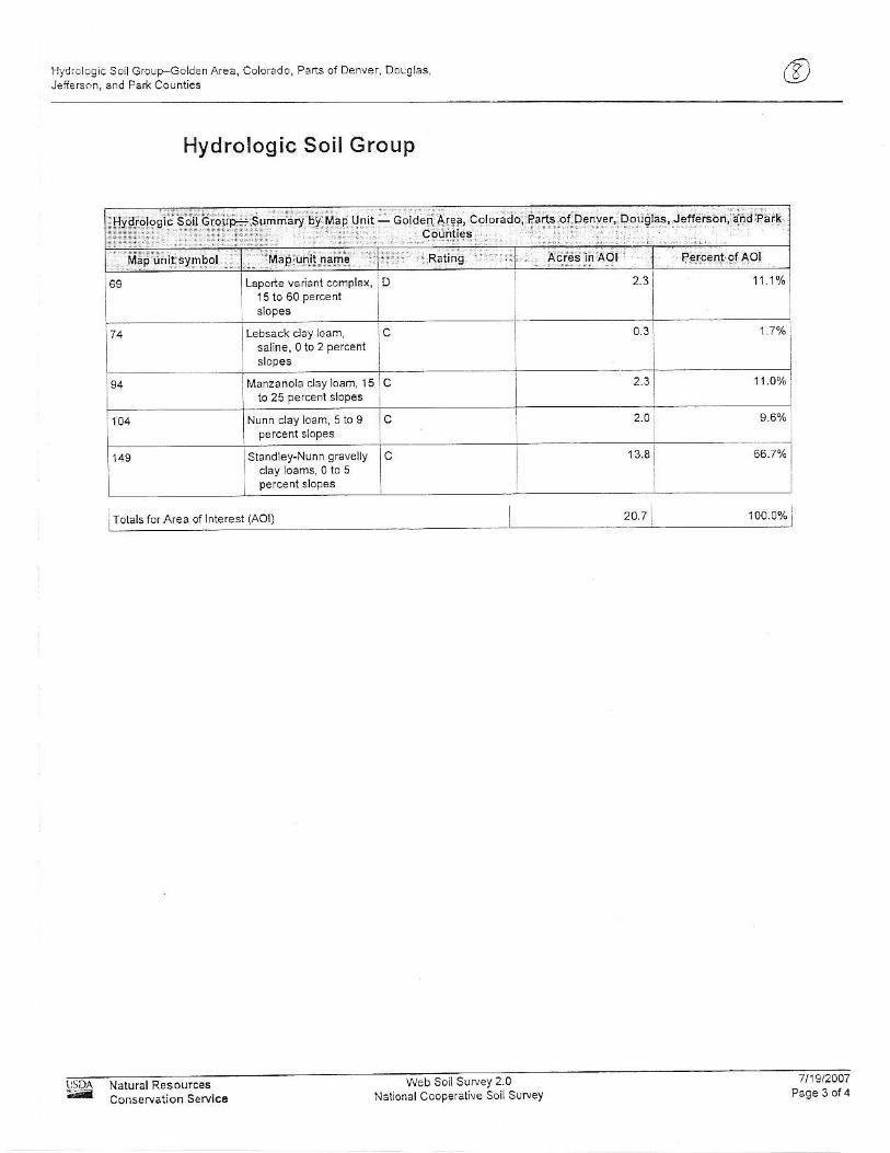
l'l.ydrologlcSoil Grolp-GoLden Area, Coorado, ParG or Denve., Douglas,Jelierc.n, and Park Counties
Hydrologic Soi l Group
Lapone vaiani comple!,
saine,0to 2 perceni
Marzanola clay loa6, l5
Nurn clayloam, 5 to 9percenr eopes
Standley-Nuf n gravelly 66.7e/.
207 1ocr.0%Totals ior Area of lnterest (AOl)
I sD^
-Conseruation Sewice
Web soiiS!rvey 2.0Naf onal Cooperative soiL suwey
1t19t2AD7
ZONE Xj'ii;; YorNGFrl
SEBRY DRwE " 6
tllfiL 0385 [
FIRMFT(}OD II{SURANCE BATE MAPJEF-I,'ERSON COUNTY,COLORADO ANDINCORPORATED AREAS
PAr'ltL 385 0F 675
MAP NUIl I8EB08059C0385 t
EFFTCTIVE DATE:JU E 17,2003
R&dlEmrSmy Mal|as!|Mt As@y
f t 'Lanof idcco4d.tsd6d|
Nydroloq ic Soil C rolrp Goldei Area, Colorado Pairs ofDenver Dous asJ€fierson, afd Park coufiies
Description
Hydrologic soi l grolrps are based on estimates of runoff potential. Soils areassigned to one offour groLips according to the rate ofwater inflltrafion when ihesoils are not protected by vegetation, are thoroughly wet, and feceive precipitaUonfrom long-duratjon storms.
The soils in the Unjted Stales are assigned to four groups (A, B, C, and D) andihree d!al classes (A/D, B/D, and C/D). The groups are deflned as fol lows:
Group A. Soils having a high infiltration rale (low runoff potentiai) when thoroughly!vet. These consist nrainly of deep, well drained to excessively drained sands orgravelly sands. These soils have a high rate ofwater transmission,
Group B. Soils having a moderate infrltration rale when thoroughly wet. Theseconsisichiefly ofmoderately deepor deep, nroderately welldrained orwelldfalnedsoils that have moderalely fne texture to moderately coarse textufe. These soilsLave a nodefale rate ofwaler kansrn,5<ion
GroLrp C. Soils havjng a slow infltfation rate when thoroughly wet. These consistchiefly of soils having a layer that impedes lhe downward movement ofwater orsoils ofmoderatelyf ine terture orf ine lexture. These soils have a slow rate ofwatertransrnission,
Group D. Soils having a very slow inf l l trat ion rate (high runoff potentjal) whenthoroughly wel. These consist chiefly of clays that have a high shrink-swellpotential, soi ls that have a high water table, soi ls that have a claypan or clay layerat oi near the surface, and soils ihat are shallow ovef nearly jmpervious mateial.These sorls ha\e a very slow rate ofw:ter rransn.ss on.
lf a soil is assigned to a dual hydrologic group (,AJD, B/D, or C/D), the first Ieiter lsfor drained areas and the second is for undrained areas- Only the soils that in theirnaturalcondit ion are in group D are assigned to dualclasses.
Rating Options
Aggregatian Methad: Dominant Conditjon
Campanent Percent Cutoff: Nane Specified
Tie break Rule: La\\er
Conservation ServiceWeb Soi lSuNey 2.0
NalionaL Cooperatile Soi Suruey7119l2AA7

(tMurray's thoesl/1ay 5. 2AC7
Develo?ed Prnofr Caefrr€fte D€term r;tio. (USDCM VOL. l)
Pet.ent \n?e\aE I AO
Gftvel A.4O Gt,et : a.AO
Itt j,1:ea Roe-iF falerler\ eialel eE99 Cler\ %-l!tp,.
Rrrrotf Rrn.tt Ernall
IO! yL:
a. 29 o ooo A.a'J9 o.aaa o.o30 OK 73-67 a.5c a.6a 4.70D 0.5 5 o.000 4.344 o.ooo a.67 OK c4.47 4.54c a. )57 o.ooo o.? a aaa a.445 OK 64.44 4.52 a.e7D a. ?c o.196 o.ooo o ooo o.ooo o( 9A.AA 4.75 477 oa3E o.o29 a.aaa \ a.aa4 o oo3 4.422 o|:. t 7.38 o.25 4.33 o55
) .426 o96 4.5c3 o.oo3 o.2€4 OK o.53 o.a7 oca
o) a.?7o iar ' . t . -nt ra D. lota ?\dqe 9.e n AaB) o.oo a.47 4.25a2 4.254 E4uqlent to D:Lt , Rrdqe ea.. A3A2 o.oo o. 4 o.3 |
2.304 R!.ofi Cocffi.'e.t ba5€.1 on TrbL€ 3 7A.AA 4.65 a.7a o.aao ) ?t? tunatr Caetl .rert bated an l2bte 3 70.AO O,7O a.ao
a 579 Runoff Coeffceit br5ed on Table 3- I oo.oo oaE o.90 o.93I a.?39 Runotf Co€ffr.Lent brsed on rrble 3- | ao.ao a.46 490 o.93T o.342 Rlnolf Coetfrcrent br5ea on Trble 3- i oo oo o.aa o90 493
Tr L,ufrD Are, fo E r .naea Detenttan fana a.6a a.3a 4.33
a o43 o.ooo o.ooo o.ooo o.443 OK o.oo o. r5 425 o50Z o.7 37 o.ooo o.ooo o.oo9 4.724 OK 4.49 o.5 o25 o.50
" 5ee Dalata Fraqe Cannorc: Pha.e Dnnaqe Aaen Ma? (atta.hed)
" Caef+ .\eft aetefl.ea oen Avne..: Ne thbofiood Areae' from Jefi€r5on Co. Storm Drariaqe q tut a lrlartua
'"' Caetrcteot dete\ea renq '5ieet : Pered from Jeffer5on Co Stofm Dn naqe CnteM M2nnl
Basic eo!aiion for NRCS SoilTvoe B:
CB=(CcD+C)/2
Basic eouat ion for NRCS Soi lTvpes C & D:
*Cco:Ka + (0.858*ir 0.786*t? + 0.??4*i + 0.04)
Basic e,rual ion for NRCS Soi lTvpe A:
C,a=Ka+ (1.31*i3 - 1.41*i? + 1.135*i- 0.12) in which use values {or C,a >0
ln which: t = 1./100, imperviousness rat ioI" = walershed imperulousness ln pe.cent
C/ = Runoff Coefficjenr for NRCS Soil Type AK: - Corecdon factor for C, vhen tbe stom rebrm peiod is grealer than 2 veadC@ = Runoffcoefficienl for NRCS Soil Tyles C aDd DK@ :Coreciion lsctor for CcD wheb the stom retum period is greater than 2_years
NRCS
vtuc olCotrc.r;dn Fscron -(.rr d;
[-0.13ir+0.?l][,023iir{:3 t0.r91i+0.461
[-0.14.i+0.r?]
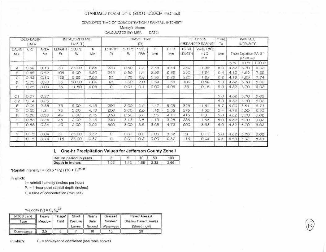
sTANDARD rORM 5F-2 (zao I USDCU nethad)
DEVETOFED TIME OF CONCENTPNT]ON/ RA]NFALI. INTENsITY
Muray's sh@eCALCULATED 6Y: lrRK DATE:
sUD FAgINt]Ai A
IN TAVOVERLANOTilEtt)
TR/\VEL TIME(1r )
T. CfiECK(I]RNAN ZEP DA9 N5) NIEN5 ry
BA5 NNO_
LENGTF SLOFE TL LENGTN 5LOFE VELrF5
TOTALLENGIH
k=ll l ao)
(u5DCMl
5Yr JOYr IOO Yro7c a t3 3A 25.OO 224 o.50 249 2aa | .39 5.O 4.82 510 9.O2
o 4.49 a.a2 )45 900 5.50 245 o.50 2.03 4.39 354 | .94 4. O 4b5 7.69c a.a2 5.25 7.ea 55 .75 ?.6 435 8.2i 224 t22 4.2 A6?o 4.75 o.20 35 50 00 1 .44 oo 2.O 454 .59 roo 5.0 4.42 5;O 9.O2E o25 a.o3 35 r r .50 o o.ol o.) ooo 4.49 35 a_)9 5.O 4.42 570 9.42
ol o.o7 o.27 50 46? 5. io 9.O?a2 o.?5 5a 4C2 5.70 LA2
2.14 75 5.OO 254 ?.oo 2.8 324 .a 57 466 5.4 6.73a o.65 .2 75 50.) 2AA 2.AO 2.8 IE 275 .53 4.7 3 5.5 9
a.6a a5a 2.q) 2 5 374 2.5O 3.2 95 4. A 15 2,3 5.Q 4.42 5. i o 9425 o.no 4.24 45 2.9) 2 5 24Q 3.1 3 35 l3 i2a 245 1 .54 50 442 5.10 LA2I o.a6 o34 40 2.<\) 2.O2 560 3.@ 2.69 4.72 6@ 3.33 5.O 4.42 5.10 9.O2
o.t : i o.)4 3 2s.oo QA) 4.2 a.oa 332 3l a )7 a.n 4d2 t -a 9.42Z o i : i 4.74 5 25.AO o a a) 4.2 o.oo 6.37 o.64 64 4.50 53? 4.43
l . One.hr Precipitat ion Values for Jefferson County Zone I
Return o€raocl in vears 2 5 10 50 1001.O2 1.42 1.64 2.32 2.66
'Rajnfal l Intensi ty l= (28.5'Pl) / (10 + T")o'z36
l= ralnfaLl intensi ly ( lnches per hour)P1 = l{)orrrpoinl rainfalldeplh (inches)T. = time of concenlralion (minules)
'Ve ocity (V) = cv swor
ShallN Paved SMles
2.5 5 7 10 l5 20
in whichr Ca = conveyanco coeflicient (see tabb above)

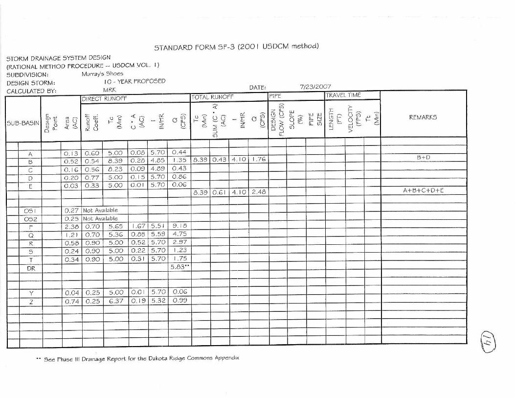
5TI\NDARD FORM 5F-3 (zAa I USDCM nethod)
STORM DRA|NAGE sYSTEM DEsIGN(MT]ONAL METHOD PROCEDURE USDCM VOL' ])
5UtsDIVI5ION:DE91GN STOR]IA; 5 , YEAR PROPO5ED
7l23t2OA7
A'"\v
CALCULATTD DY:TRAVEL T METOTAL RUNOFFD RECT RUNOTF
- t>!- Qt i F>ai oo" L!
or l 'v i
** ue <- g ^65,9 -= l= >"V
A+B+' ID+E
'DR: TnL,lt2ry Iows a5 deLetnned bv Dalor2 Pldqe Connons Thaee ll Dtaiaae Re?arL
5IANDARD TORN,4 5F'3 (2OO
sTORM DRAINAGE 5Y5TEM DE5IGN(RATIONAL N, lEI I IOD iROCEDURE - ' USDCM VOL, I )
9UEDIVISION:DTSIGN STORM:
I USDCM nethad)
IO . YEAR PROPOSEI]
CALCULATED DY:TRAVTL T T4ETOTAL RL]NOTTD RECT RUNOFT
5UE BA5 N
_o9\ l k- ; ' l 'k
?
= >vt t :g 1q - i oFj3 3 o3 z o,
A+E+C+D+E
7/2312047
B" 1ee rhaee lll Dz\naqe FePott tar the Dakota ?laqe Connar. AP?ena\^

STANDARD FORN.4 5f-3 (2oO USDCM ft\ethod)
5TOF.M DRAINAGE gY9TEM DEg]GN(RAT ONAL METHOD TR.OCE9URE USOCM VOL' IJ
9UEDIVI5ION:DTSIGN 5TORM:
7123/2447OO YTAR FROFOSED
a'ee
Oalata Ptdae Contnonst Phase
5ee Phase ltt Dtanaqe PePott tot the
Dtatraae Basn Ma? (attachea)
DabLa Rtd4e Connon A?Penat
CALCULATED DY,T&AVEL TlIIETOTAL RUNOFFOiRECT RUNOTT
a..
- : ^ ol ;i
t r : \ t9 = o--d
3b H^..i i ] : " - .oc)9,33 *s ie -5 "g
A+D+C + D+E
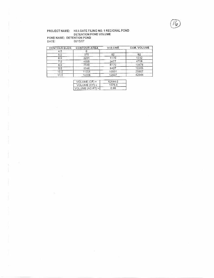
PROJECT NAME: HTLLGATE FILING NO. 1 REGIONAL PONDDETENTION PONDVOLIJME
POND NAME: DETENIION PONDDATE: 08l15lOT
VOLIJME (CY]: 1579.40.93
CONIOURELEV. CoNTOURAREA VOLUME CUI ' I -VOLUI,E0
5.0 62 622231 1170 1232
7.0 4895 47044.0 6170 t0€78
9146 a427 1930510.0 1r701 10501 293071l0 12431

Stage Storage Curve
LL
LIJ
8.0
A\.J
20,000 25,000 30,000
Volume (CF)
@
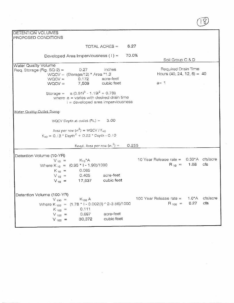
Soil Grolro C & D
DETENTION VOLUMESPROPOSED CONDITIONS
TOTAL ACRES = 6,27
Developed Area lmperviousness ( l) = 70 AV"
Water Qual iv VolumeReq. Storage (Fig. SQ 2) = A.27 inches Required Drain Tlme
WQCV: (Storase/12) * Area "1 2 Hours (40 24 12'6) = 4AWQCV : O.1/2 acre- leeiWQCV : 7,509 cubic feet a= 1
storage = a (0.91i3 1191'?+o78i)where a = varies ',!ilh des red drain trme
i = cleveloped area imperviousness
WOCV Depth rt oltet (Ft.) = 3 OO
Are, pef row (i'?) : wocv / reo
Koo=O 3 ' Depthz + o.22 ' Depth - O. lO
?e4a. A'ea pet rcd nn'z) : O.?!t
Detention Volume (1o-YR)V,o: K,o*A 1 O Year Release rate = O.30*A cfs/acre
WhereKio = (0.95 . | - 1 .90)/1 OOO Rro: 188 cfs
Kro - 0065V ro = 0 405 acre feet
V,o = 17 '637 cLrbic feet
Detent ion Volume (100 YR)V ,oo = K,oo A 100 Year Release rate = 1'0'A cfs/acre
WhereKroo : 0.78t - O.oo2{ l } ̂ 2-3 56)/1 0oo Rroo = 627 cfs
K ,o,r = 0.1 11V roo = 0.697 acre-leetV,oo = 30,372 cubic feet
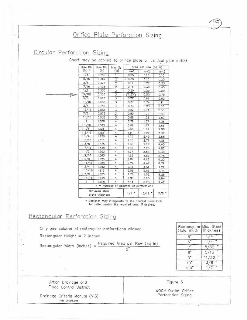
0.:r 'ce Piore p.r !o.or 'o- s iz rc
Circ u lc r Perforc Lion Siz ingCfo- l -oy:e opoled io o- ' , - o lo ie o. \e cot !pe olr i - t .
- - ->
(ir") (i")
0,250 0.10 0,15
t/a o.22 0.J30.45
tsA6) 0.565 J5/8 d.Jr- 0.92
J/4 1351.56
0.375 J r .8015/r6 2.A1
2.J5266
125I t /16 L22 1.32
2.15 J.6A.31 2.11
1l /a 4_45r.25
1/2 5,50
t a/a ar5
3/4 7,22
a.2a9Ja 2.95
-1.14n
- Nunb.. of c6llans ot pcr.drotions
a/16 3/8
' Design.r moy inlerpolot. 10 the n.or€t J2^d in.hto betlc. match the r.quned or€., if de5ir.d,
Only one colLrrnn of r€ciongular perforat ions ol lcwed.
Rectoeg..rlcr l.leight : 2 inches
Recior lg! lor wldth ( inches) = -- : : : : : : :Areo per Row (sq in)
2-
Urbcn Drai fage ondFiood Contrcl District
Drolncee C.iterio Mon!ol (V.3)
Ho e WiilthMin. Steel
51/4
7" 5/32's/1611 /32
10 3/A ">10 1/2'
Fig!re 5
WQCV Outlet Orifice

' , . - - , - - , - , '
- . ] ' * , , ' - . . " - - l I - ' ' , , . - r - . . . , . , , -1,- , , ,1. - -- . l -
- - ; - : - - - - r . . . - . - - - r : - - - ' : -
- . 1--- I : " : : - - - -
' . . . . . .
(*1e,:!
: l
, . ' : ,
. l ' . , :
.8-5 :eti>TJ 25
{uza*z-t //n wv€.zz)l =2(A r'o'Ln- "|' ' '4i.7;;,o / --' - -o -' . o \
*
N l-LllV i..l / N l-LdVh.]
,2.a/6 /J z€/ g c"Fs,/Dt -q/C lld
C - o.Ls-. - se oz. =zt ( otrt ,tzo.)
- - 59og, tzt (.EN'rtu2tt)
- - - s'?az; s'.,
27 k1
I

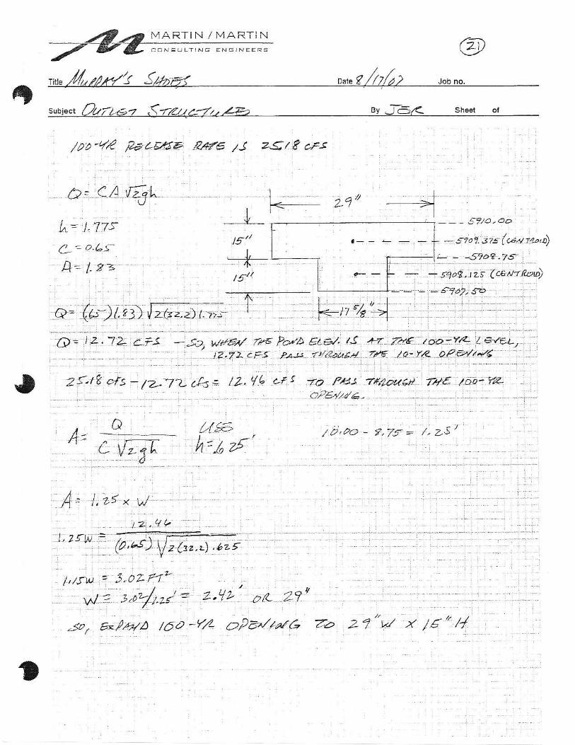
MARTIN I MARTIN
subiect /t //7/E7 <(ft////a 7//Z€ Bv fE/2 sh@t ol
,.,,..4,/P_8!-P.!/'1412€.8
I
. : I
R6:re<r.?- ?1a76 28"y,! x 36"4 :
BoOtA 10 tn76Aro4-. ; Bol\.// i .oLL'a'1 o-r. i-4t'prt, *-Lq.cs?le.GD ,t" 4?4a-7..
4't q,x/' ZdJ.'?Ez€ PAAr l
I
,t'/ abtF/ f47/a,^/.s ro't:/ls7t*/6 0,/a-/ ae7
s-t/?./r C-/'Lt 26
*

MARTiN / 'MARTIN
' r;>? * 'ox