© crown copyright met office gps water vapour in the uk and the e-gvap project jonathan jones,...
TRANSCRIPT

© Crown copyright Met Office
GPS Water Vapour in the UK and the E-GVAP Project Jonathan Jones, Upper Air Team, Observations R&D, UK Met [email protected]

© Crown copyright Met Office
Contents
• How and Why
• Operational Processing System
• Collaborative Networks
• Monitoring and Validation
• Forecaster Case Studies
• E-GVAP
• Future GPSWV Developments

© Crown copyright Met Office
GNSS Constellations
Signal is ‘delayed’ by atmosphere. May remove ionospheric contribution due to dispersive nature of medium- GPS operates at dual frequency.
Signal is ‘delayed’ by atmosphere. Can remove ionospheric contribution due to dispersive nature of medium - GPS operates at dual frequency.

© Crown copyright Met Office
Technique
• Too much error in individual slant delay to resolve so we can use mapping function to we can convert into a Zenith Total Delay (ZTD)
• ZTD a combination of dry and wet delays
• From knowledge of surface pressure and temperature we can calculate dry component and resolve vertical Integrated Water Vapour quantity
• 1kg/m2 IWV = ~3-5% RH
•Dispersive, use dual GPS frequencies to resolve
Neutral Atmosphere
Non-dispersive (troposphere + stratosphere)
Non-Neutral Atmosphere (Ionosphere)

© Crown copyright Met Office
Customers
• NWP
• Shown up to 4% reduction of StdDev by assimilation of GPS ZTD data
• Forecasters
• Produce IWV field plots to assist forecasters in identifying atmospheric features/phenomena
• Climate
• Also GPS is potentially a useful tool for climate monitoring but reprocessing is necessary to ensure common processing models/standards
• Validation
• Very useful tool for validation of other remote sensing instruments (radiosonde, WVR, satellite WV etc)

© Crown copyright Met Office
Cost-Effective GPS Processing
• IESSG, Nottingham University contracted to develop and deliver operational processing servers
• Intergovernmental resource sharing agreements with mapping agencies in UK
• Agreement in place between EUREF and EUMETNET guaranteeing long term future GPS data access to Met community. Also providing positioning community with meteorological parameters
© Crown copyright Met Office
GPS Processing at METO
• 4 Servers
• 2 operational in Met Office IT halls, 1 mirror semi-operational server at IESSG, 1 development server at IESSG
• Hourly Processing Solution
• Bernese v5.0 processing software
• Double Difference Network Approach
• 30-Day sliding window PPP a-priori coordinate
• Absolute Antenna Phase Centres, IGS05 and FES2004
• Process network of ~250 stations in NRT in ~30mins
• ZTD/IWV estimates at 00, 15, 30, 45 and 59 mins

© Crown copyright Met Office
Data Providers
• 162 EUREF Sites
• 104 OSGB sites
• 86 64 RGP sites
• 20 UK scientific sites (incl. 11 Met Office)
• 19 OSi and OSNI sites
• 2 Icelandic sites
• Attempted hourly ~ 400
• Downloaded hourly ~ 275
© Crown copyright Met Office
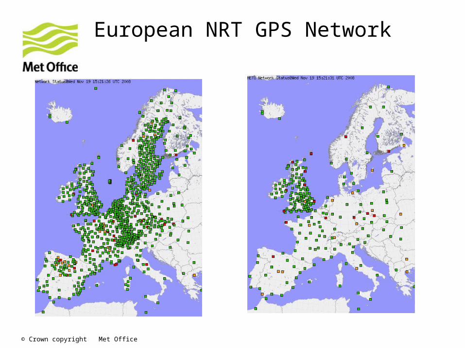
European NRT GPS Network

© Crown copyright Met Office
• ASCII files copied to E-GVAP server for dissemination and conversion to BUFR
• BUFR files then put on GTS for assimilation by National Met Services
• Plots also copied to E-GVAP server for dissemination
• Plots downloaded by E-GVAP and displayed on E-GVAP website
METO Products

© Crown copyright Met Office
RS vs. GPS Validation
IWV Comparison Camborne Feb 2008
-10
-5
0
5
10
15
20
25
30
35
31-Jan 05-Feb 10-Feb 15-Feb 20-Feb 25-Feb 01-Mar
Time (Days)
IWV
(kgm
-2) RS92 TWE
GPS IWV
Diff

© Crown copyright Met Office
WVR vs. GPS Validation

© Crown copyright Met Office
NWP Monitoring
• Data QC’d by AC and gross error check vs. model
• Site specific bias corrections also applied

© Crown copyright Met Office
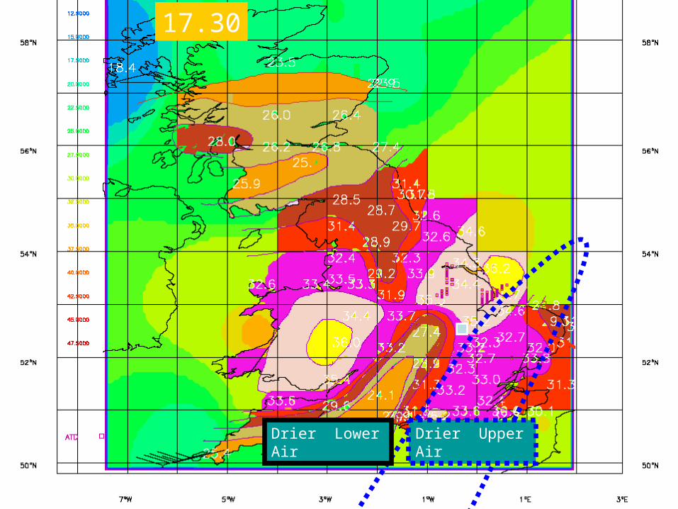
Case Studies
• 28th July 2005 – Offset Dry Tongue
• Dry tongue over south west not corresponding with satellite WV
• By combination of satellite and GPS WV you can infer vertical structure
• 24th June 2005 – Cold Pool Identification
• Trough progressing over southern UK from westerly direction with associated high IWV and convective thunderstorm cells
• GPS IWV identified cold pool behind front which perpetuated instability and convection
© Crown copyright Met Office
17.30
Drier Upper AirDrier Lower Air

© Crown copyright Met Office

© Crown copyright Met Office
E-GVAP and E-GVAP II
• E-GVAP I – EUMETNET programme to take GPSWV to operations in Europe
• Ensure common standards and formats in GNSS data processing
• European network expansion
• Assist ‘developing’ countries with GPS processing and assimilation techniques
• Ensure close collaboration with geodetic community (experts)
• E-GVAP II – continuation of E-GVAP I
• Connect to EUCOS and WIS
• Continued network expansion
• Improve homogeneity and quality of GNSS products

© Crown copyright Met Office
E-GVAP Website and Server
• Website v. useful tool for analysing data/biases etc
• Compiling table of all AC’s GPS processing techniques,
• Recently added Nordic and French regional plots
• E-GVAP Server to be transitioned to more operational (backed-up) server by end of E-GVAP 1
• Server now hosting met data for EUREF community
• Server soon to be hosting other data (microwave radiometer, NWP etc)

© Crown copyright Met Office
QC via the E-GVAP Website

© Crown copyright Met Office
E-GVAP ‘Supersites’
• 14 sites identified for validation of GPS IWV
• All sites have collocated instruments, geodetically stable, same model layer etc
• Probably will include EKOFISK site in near future
• Access to data from site at Inaza Observatory, Tenerife (GPS, RS, MWR, Infrared Spectrometer)

© Crown copyright Met Office
Future GPSWV Developments
• Improved NRT Plots
• Use NWP IWV over data sparse areas (Sea)
• Produce O-B plots
• Add satellite WV to plots to give some vertical structure
• Real-Time GPS Processing (15min/5min)
• Slants/Tomography
• NWP ZTD forecasts
