sir20205104.pdf - conceptual framework and approach for
TRANSCRIPT

U.S. Department of the InteriorU.S. Geological Survey
Scientific Investigations Report 2018–5104
Conceptual Framework and Approach for Conducting a Geoenvironmental Assessment of Undiscovered Uranium Resources


Conceptual Framework and Approach for Conducting a Geoenvironmental Assessment of Undiscovered Uranium Resources
By Tanya J. Gallegos, Katherine Walton-Day, and Robert R. Seal II
Scientific Investigations Report 2018–5104
U.S. Department of the InteriorU.S. Geological Survey
U.S. Geological Survey, Reston, Virginia: 2020
For more information on the USGS—the Federal source for science about the Earth, its natural and living resources, natural hazards, and the environment—visit https://www.usgs.gov or call 1–888–ASK–USGS.
For an overview of USGS information products, including maps, imagery, and publications, visit https://store.usgs.gov.
Any use of trade, firm, or product names is for descriptive purposes only and does not imply endorsement by the U.S. Government.
Although this information product, for the most part, is in the public domain, it also may contain copyrighted materials as noted in the text. Permission to reproduce copyrighted items must be secured from the copyright owner.
Suggested citation:Gallegos, T.J., Walton-Day, K., and Seal, R.R., II, 2020, Conceptual framework and approach for conducting a geoen-vironmental assessment of undiscovered uranium resources: U.S. Geological Survey Scientific Investigations Report 2018–5104, 28 p., https://doi.org/10.3133/sir20185104.
ISSN 2331-1258 (online)
U.S. Department of the InteriorDAVID BERNHARDT, Secretary
U.S. Geological SurveyJames F. Reilly II, Director

iii
ContentsAbstract ...........................................................................................................................................................1Introduction.....................................................................................................................................................1
Environmental Health Impacts of Historical Uranium Mining and Milling .................................2Assessing the Potential Environmental Aspects Related to an Undiscovered
Uranium Resource Assessment ...........................................................................................2Purpose and Scope ..............................................................................................................................2
Background.....................................................................................................................................................3Existing Environmental Assessment Approaches ...........................................................................3Challenges to Conducting an Environmental Assessment of an
Undiscovered Resource .........................................................................................................3The Proposed Geoenvironmental Assessment Framework for Undiscovered
Uranium Resources..........................................................................................................................4Conceptual Uranium Source-to-Receptor Model ...........................................................................4Uranium Geoenvironmental Assessment Goals, Objectives, and Scope ....................................6Geoenvironmental Assessment Scope .............................................................................................6
Priority Mining and Milling Methods Considered ..................................................................7Priority Near-Surface Potential Contaminant Sources (Wastes) ........................................7Priority Contaminants of Concern ............................................................................................9
Elements Associated With Uranium Mining and Milling .............................................9Contaminants Formed by Weathering by Wind .............................................................9Contaminants Formed by Weathering by Precipitation ................................................9Factors To Consider in Determining the Contaminants of Concern ...........................9
Priority Erosion, Dispersion, and Transport Processes for Assessment ..........................10Runoff of Sediments, Leachates, and Wastewater .....................................................11Seepage of Contaminants Into Groundwater and Transport.....................................11Dispersion of Dust in Air ..................................................................................................11Accumulation of Radon Into Air .....................................................................................12
Priority Geochemical Processes Affecting Contaminant Availability ...............................13Priority Factors Controlling Availability of Dust Contaminants in Lungs .................13Priority Factors Controlling Availability of Contaminants in Waters ........................13
Establishing the Geoenvironmental Assessment Approach ................................................................13Proposed Geoenvironmental Assessment Approach ..................................................................13Geoenvironmental Assessment Input Equals Uranium Resource Assessment Output ..........15Geoenvironmental Assessment Steps ............................................................................................16
Developing a Geoenvironmental Model ................................................................................16Applying the Geoenvironmental Data Within Permissive Tracts .......................................16Geoenvironmental Assessment ..............................................................................................16
Indicators of Quantities of Waste ..................................................................................16Assessing Constituents of Concern ...............................................................................17Assessing Potential for Occurrence and Persistence of Contaminants
of Concern ............................................................................................................17Uranium Geoenvironmental Assessment Products ......................................................................18Uranium Geoenvironmental Assessment Output Equals Uranium Biological
Resource Assessment Input ...............................................................................................18

iv
Geoenvironmental Assessment Outcomes .............................................................................................18Limitations and Science Needs .................................................................................................................18Summary........................................................................................................................................................19Acknowledgments .......................................................................................................................................21References Cited .........................................................................................................................................21Glossary ........................................................................................................................................................27
Figures
1. Flow chart showing the conceptual source-to-receptor model for development of undiscovered uranium deposits ....................................................................5
2. Schematic diagram of tailings; waste rock, that is, protore or subeconomic ore; overburden; and wastewater for three uranium mining methods: in situ recovery, underground, and, open pit mining...................................................................8
3. Air stagnation index map for the conterminous United States during August 2017, created by calculating the number of stagnation days in the month for each grid point of a 0.25- by 0.25-degree grid ........................................................................12
4. Flow chart of information for a uranium life cycle assessment, consisting of a mineral resource assessment, geoenvironmental assessment, and biological resource assessment ..............................................................................................15
5. Diagram showing a framework for an integrated assessment of mineral resources consisting of an accessibility screening assessment, a life cycle assessment, and an impact analysis .......................................................................................20
Tables
1. Potential contaminant sources and pathways at uranium mines and mills as a function of mining method .....................................................................................................10
2. Threshold concentrations for identifying redox processes in groundwater ....................14 3. Generalized relative mobility of elements under different
environmental conditions ..........................................................................................................14

v
U.S. customary units to International System of Units
Multiply By To obtain
Length
foot (ft) 0.3048 meter (m)mile (mi) 1.609 kilometer (km)
Mass
pound, avoirdupois (lb) 0.4536 kilogram (kg) ton, short (2,000 lb) 0.9072 megagram (Mg) ton, long (2,240 lb) 1.016 megagram (Mg) ton per day (ton/d) 0.9072 metric ton per dayton per day (ton/d) 0.9072 megagram per day (Mg/d)ton per year (ton/yr) 0.9072 metric ton per year
Radioactivity
picocurie per liter (pCi/L) 0.037 becquerel per liter (Bq/L)
Conversion Factors
Supplemental InformationConcentrations of chemical constituents in water are given either in milligrams per liter (mg/L) or micrograms per liter (µg/L).
AbbreviationsAMD acid mine drainage
CO2 carbon dioxide
EA environmental assessment
EIS environmental impact statement
EPA U.S. Environmental Protection Agency
GEM geoenvironmental model
H2O water
H2SO4 sulfuric acid
IAEA International Atomic Energy Agency
ISR in situ recovery
mg/L milligram per liter
NaCO3 sodium carbonate
NaHCO3 sodium bicarbonate
NOAA National Oceanic and Atmospheric Administration
NPDES National Pollutant Discharge Elimination System

vi
NWIS National Water Information System
O2 oxygen gas
pH negative logarithm of hydrogen ion concentration, a measure of acidity
PM2.5 particulate matter 2.5 micrometers or less in diameter
PM10 particulate matter 10 micrometers or less in diameter
R-factor rainfall erosivity factor
redox reduction-oxidation potential
STORET STOrage and RETrieval Data Warehouse
U3O8 uranium oxide or “yellowcake”
USGS U.S. Geological Survey
Conceptual Framework and Approach for Conducting a Geoenvironmental Assessment of Undiscovered Uranium Resources
By Tanya J. Gallegos, Katherine Walton-Day, and Robert R. Seal II
AbstractThis report presents a novel conceptual framework and
approach for conducting a geologically based environmental assessment, or geoenvironmental assessment, of undiscovered uranium resources within an area likely to contain uranium deposits. The framework is based on a source-to-receptor model that prioritizes the most likely contaminant sources, contaminant pathways, and affected environmental media for three common uranium extraction methods—open pit or underground mining with milling and in situ recovery (ISR). Data on regional geology, hydrology, and climate, as well as historical uranium mining and milling records are used to esti-mate the probable amounts of waste rock, tailings, wastewater, surface land disturbance, and subsurface aquifer disturbance for likely mining methods. Constituents of concern that might take the form of leachates, dust, radon, and sediments formed by chemical and physical weathering are also identified in the geoenvironmental assessment. Finally, areas where constitu-ents of concern are likely to occur and persist in air, land, surface water, and groundwater are indicated by the potential for dispersion of dust by wind, accumulation of radon because of air stagnation, dispersion of sediments and wastewater by runoff, and infiltration of wastewater or leachates with consideration of the likely mobility of contaminants in surface water and groundwater. The geoenvironmental assessment output can be summarized in the following primary products: (1) a descriptive geoenvironmental model; (2) maps and statistics of variables that indicate the potential for constituents of concern to occur and persist in air, land, surface water, and groundwater within a tract that is geologically permissive for the occurrence of uranium; and (3) tables providing estimated or indicated quantities of waste rock, tailings, wastewater, dust, and radon emissions that could be associated with undiscovered uranium resources, if extracted, for each permissive tract. The uranium geoenvironmental assessment could help natural resource managers to prioritize and (or) identify (1) important potential contaminant pathways, (2) management practices required depending on the types of constituents that could be of concern, (3) areas for response
in the event of accidental release, and (4) future directions for study. Furthermore, indicators of rock and water volumes potentially associated with an undiscovered uranium deposit may be evaluated to make quantitative comparisons of water required for uranium production or potential waste products generated during uranium extraction from areas permissive for uranium resource occurrence throughout the United States.
IntroductionNuclear power remains an important option for domestic
energy production and is expected to generate approximately 16 percent of energy in the United States in 2040 with a consid-erably lower carbon footprint than fossil fuels (U.S. Energy Information Administration, 2015). Uranium is used to make the fuel for nuclear power generation. Uranium resources in North America occur as unconformity-related, quartz-pebble conglomerate, sandstone, volcanic, and phosphorite types of uranium deposits. Most of these uranium deposit types are concentrated in separate well-defined metallogenic provinces including the Colorado Plateau, Rocky Mountain and Inter-montane Basins, Gulf Coast, Basin and Range, and Florida Phosphorite Uranium Provinces (Finch, 1996). Uranium has been mined in the United States since the late 1800s. Two major uranium booms took place in the United States. The first uranium boom was in the early 1960s, and the second was in the 1970s. In 1981, production was approximately 14,800 metric tons of uranium oxide (U3O8) equivalent with an average price of more than $34 per pound (U.S. Environmental Protection Agency, 1995). Most of the uranium extraction took place using open pit and underground mining followed by milling, as well as in situ recovery (ISR) operations. In the early 1980s, production of uranium abruptly declined owing to lessening demand and a fall in price. As a result, many of the uranium mining and milling companies that were operating at the time shut down operations. The uranium mining and milling operations, in some cases, resulted in adverse environmental effects.

2 Conceptual Framework and Approach for Conducting a Geoenvironmental Assessment of Undiscovered Uranium Resources
Environmental Health Impacts of Historical Uranium Mining and Milling
Environmental effects can result from any step of the uranium resource development life cycle and are mainly derived from two sources: (1) active mining and processing activities and (2) wastes from those activities (U.S. Environ-mental Protection Agency, 1995). Documented effects include contamination of groundwater or surface water (for example, elevated concentrations of trace elements and radionuclides above background levels), acid mine drainage, localized reduction of groundwater levels, offsite dust transport, and impaired populations of aquatic and terrestrial biota (National Research Council, 2012).
Environmental effects vary according to mining method. Open pit mining activities create surface disturbance and may result in increased erosion of contaminants by wind and water. Dewatering operations conducted for open pit and underground mining may create groundwater depressions that may persist after mining ceases (Younger and others, 2002; Younger, 2006). Environmental effects owing to ISR operations are primarily related to bringing toxic contaminants to the surface or mobilizing them in groundwater (National Research Council, 2002). Mill tailings and associated radionuclides are thought to be a major contributor to the environmental effects on air, land, surface water, and groundwater (U.S. Environmental Protection Agency, 1995). The environmental effects and waste from historical uranium mining and milling are often referred to as legacy environmental impacts. The effects of these activities, however, depend on site-specific conditions, contaminant migration, and the effectiveness of efforts to mitigate and control potential chronic or acute effects (National Research Council, 2012).
Note that in the past, some of the environmental hazards resulted from uranium mining and milling standard practices that generally are not acceptable today (U.S. Environmental Protection Agency, 1975, 1983; Abdelouas, 2006; National Research Council, 2012; Agency for Toxic Substances and Disease Registry, 2013). When uranium mining, processing, and reclamation methods are designed, constructed, operated, and monitored according to modern international best prac-tices, near- to moderate-term environmental effects specific to uranium mining and processing could be substantially reduced (U.S. Environmental Protection Agency, 1995; National Research Council, 2012). In many cases, however, the long-term efficacy of restoration and remediation practices is not fully understood. For example, predictive modeling demonstrated that the released radon and deposition of contaminated dust on land surfaces remained as long-term pathways for inhalation and ingestion exposures (Camus and others, 1999; Abdelouas, 2006). Some studies have shown that uranium mining has affected water quality and quantity in the Grants Mineral Belt (U.S. Environmental Protection Agency, 1975). Other studies have shown that even if water quantities available in the aquifer return to pre-mining levels, water quality would not be fully restored to pre-mining
levels for long periods of time (Younger and others, 2002; Younger, 2006). These studies indicate that assessing the future potential effects of multiple combined uranium mining and milling activities may be challenging. The potential offsite (non-occupational) adverse health effects related to modern uranium mining practices remain an area of great uncertainty (National Research Council, 2012).
Assessing the Potential Environmental Aspects Related to an Undiscovered Uranium Resource Assessment
Typical environmental assessment approaches are chal-lenging to apply to an undiscovered mineral resource because it is an undeveloped, unexplored mineral resource or ore body whose location is unknown. The U.S. Geological Survey (USGS) has developed a three-part mineral resource assess-ment methodology to assess the number of likely deposits, the amounts of undiscovered mineral resources (such as uranium), and the areas geologically permissive for the mineral occur-rence (Singer, 1993); however, there is no existing method for assessing the associated potential environmental effects of developing an undiscovered mineral resource. Although uranium deposits may be technically accessible, the actual availability of these undiscovered deposits for development depends on economic feasibility as well as societal evaluations of likely changes to air, land, surface water, and groundwater associated with the extraction and consumption of uranium resources (National Research Council, 2002; U.S. Geological Survey, 2007). Toward that goal, an approach is needed to assess how the complex life cycle of occurrence, formation processes, extraction methods, and waste products of an undiscovered uranium resource could affect or be affected by geology, landscape, hydrology, and climate. An assessment of the environmental aspects of an undiscovered uranium resource could be used in planning for evolving and unantici-pated future uranium resource requirements within the broader environmental perspective of sustainability (U.S. Geological Survey, 2007).
Purpose and Scope
The purpose of this report is to discuss the development of a conceptual framework and approach for conducting a geologically based environmental assessment (geoenvi-ronmental assessment) of undiscovered uranium resources. The rationale for and the approach, steps, and outcomes of a geoenvironmental assessment are presented. A glossary is also included.
Background 3
Background
Existing Environmental Assessment Approaches
Few, if any, environmental assessment approaches are directly applicable to an undiscovered uranium resource. Many of the existing approaches are either (1) retrospective and used to delineate the effects from historical mining or milling; (2) site-specific, where local characteristics are known and one or more mining or milling configurations are well defined; or (3) probabilistic, without necessarily accounting for all site-specific factors that influence effects. National-scale, retrospective investigations are often aimed at understanding the quantities of waste associated with historical mining and milling (Younger, 2006; Mudd and Diesendorf, 2008; Mudd, 2014) and (or) predicting future scenarios of waste production (Schneider and others, 2010, 2013). Site-specific, retrospective studies are often focused on characterizing contamination from legacy uranium mining and locating the sources of contamination through sampling of water, sediment, soil, and air (U.S. Environmental Protection Agency, 1975, 1995, 2000, 2008b; International Atomic Energy Agency, 2005). Often-times, these site-specific, retrospective studies are conducted to prioritize remedial actions on the basis of a given criterion, such as human health (U.S. Environmental Protection Agency, 2000; Batista and others, 2005). Yet, other times, site-specific environmental assessments are performed prior to develop-ment to identify potential impacts given a specific scenario or set of scenarios of development at a given location or set of locations (Organisation for Economic Co-operation and Development, Nuclear Energy Agency, 2000; International Organization for Standardization, 2006a,b).
Many of the pre-development uranium environmental assessments are part of site-specific environmental assess-ments (EAs) or environmental impact statements (EISs) prescribed by the National Environmental Policy Act to meet regulatory requirements for mitigating future environmental effects as part of the mining permitting process (U.S. Nuclear Regulatory Commission, 1997, 2009, 2010, 2011a,b, 2014a,b). EAs or EISs are applied to a known “discovered” deposit to describe how one or more alternative uranium production methods (including mine and reclamation design and opera-tion) may affect the specific environmental features of the site. Some of these features include land disturbance, air emissions, wastes, water use, noise, endangered species, and critical habitats. The local (site-specific or mine-scale) environmental assessment is performed prior to the mine-design phase and typically involves the acquisition of new data.
Retrospective and mine-scale environmental assessments are performed in an area in which the location of the deposit is known and the environmental attributes are delineated on a local scale. Methods for assessing the retrospective effects of historical mining operations and predicting future envi-ronmental effects at a specific site (local scale) are relatively
well established in comparison to predicting environmental effects of future mining and milling of undiscovered uranium resources, where the locations of the deposit and the mine (and, therefore, the distance between the potential contaminant sources and the air, land, water, and biological receptors) are not known.
Challenges to Conducting an Environmental Assessment of an Undiscovered Resource
Conducting an environmental assessment of undiscovered mineral deposits is challenging for several reasons: (1) the site-specific location of a future mine or mill is unknown, (2) the environmental effects change throughout the life cycle of development, (3) management practices may differ in response to regulations that may vary by political boundary and jurisdiction and may change over time, and (4) the specific mine design and management practices are unknown. By definition, the actual locations of the undiscovered uranium deposits, and therefore the mine and mill locations (where the deposit will become productive), within permissive uranium resource tracts (areas in which the geologic features are favorable for the formation of a uranium deposit) are unknown, and the estimated number of deposits is probabilistic (Singer and Menzie, 2010). Although some assessment approaches such as stochastic or Monte Carlo simulations could randomly locate a potential mine site and the probability distribution of all the potential environmental effects could be summed within an area defined by a polygon (Haines and others, 2014), this method does not take into account all site-specific or local attributes that are critical to assessing potential environmental effects or the causes of the potential contamination. Because extent and magnitude of contamination depend on highly variable site-specific factors (U.S. Environmental Protection Agency, 1995), a Monte Carlo based approach is difficult to apply for the assessment of potential future environmental effects.
Because the locations of undiscovered uranium deposits (and thus, mines) are unknown at the time of assessment, the key variables (such as the extent of deposit, proximity to environmental media [air, land, and water], local topography, and hydrologic characteristics) that contribute to the potential for environmental effects are also somewhat uncertain (U.S. Environmental Protection Agency, 1995). The areas geologically permissive for the formation of undiscovered uranium resources are known at a regional scale, yet the poten-tial environmental effects often are linked to a local source, thereby making the assessment of future environmental effects less certain at a regional scale.
Regardless of location, predicting the potential environ-mental effects of future mining is challenging because the effects tend to vary throughout the life cycle (from pre-mining to mining and milling to remediation and closure). Naturally occurring elevated concentrations of some contaminants may be present in water, land, and possibly air prior to mining, and some contaminants may be released to these media because

4 Conceptual Framework and Approach for Conducting a Geoenvironmental Assessment of Undiscovered Uranium Resources
of mining and milling. Some changes to the environment as a result of mining and milling may be remediated and reclaimed promptly to near baseline conditions, whereas others may persist for longer periods.
In addition, knowledge of the legacy environmental effects derived from studying the consequences of historical uranium mining and milling may not always be applicable to future operations because most historical uranium mining predated many environmental regulations. Future mining of uranium may likely use different technologies and management practices than those used in the past and may be conducted under an evolving environmental regulatory framework; both possibilities may result in environmental effects that differ from those resulting from historical mining. Limited information is available regarding the long-term environmental effects of modern uranium mining, milling, and reclamation practices (National Research Council, 2012). Furthermore, environmental regulations may change and may vary by location, depending on national, State, and local regulations, as well as waste disposal practices and the availability of disposal sites.
Finally, many adverse environmental effects resulting from historical mining were due to design flaws, improper construction, mismanagement, or catastrophic events (International Atomic Energy Agency, 2004; National Research Council, 2012), which are difficult to predict. In fact, the mine management plan, mine configuration, amount of water recycled during mining, and reclamation and restoration practices are virtually unknown at the time of an assessment of undiscovered uranium resources. Common environmental effects could potentially be mitigated through engineering controls or best management practices prompted by environmental regulations imposed by national, State, and sometimes local governments (U.S. Environmental Protection Agency, 1995). Looking beyond the reliance on such mine system design and controls, best practices, or management schemes, which are often implemented for a relatively short term (<100 years), the perpetual time scale of the disturbed site needs to be considered in the environmental assessment of undiscovered uranium resources. These above considerations favor a geologically based environmental assessment, termed here a geoenvironmental assessment, based not on the planned mine design and management aspects but the natural geologic, hydrogeologic, and climatic settings.
The Proposed Geoenvironmental Assessment Framework for Undiscovered Uranium Resources
The geoenvironmental assessment framework for undiscovered uranium resources was developed by (1) creating a conceptual model of potential environmental effects from uranium extraction that can be consistently
applied to various deposit types and mining methods across the United States; (2) establishing the geoenvironmental assessment goals; (3) establishing the geoenvironmental assessment scope by prioritizing exposure pathways, contaminant transport pathways, and wastes that contribute to the occurrence and persistence of contaminants of concern; and (4) proposing an assessment approach that links the geoenvironmental assessment to a uranium resource assessment and a biological resource assessment, which are outside the scope of this study.
Conceptual Uranium Source-to-Receptor Model
The conceptual model for the uranium geoenvironmental assessment is a source-to-receptor model (fig. 1) that is based on consideration of potential environmental health aspects. Several summaries were reviewed to provide a synopsis of the attributes of a uranium extraction life cycle that could poten-tially lead to environmental health effects (U.S. Environmental Protection Agency, 1975, 1983, 1985, 1995; Abdelouas, 2006; National Research Council, 2012; Agency for Toxic Substances and Disease Registry, 2013). According to the U.S. Environmental Protection Agency (EPA; 1983), priority exposure pathways to human populations living at some distance away from individual mines include the following:
• Inhaling windblown dust;
• Inhaling radon;
• Drinking water containing arsenic, molybdenum, radium, selenium, uranium, and other regulated con-taminants of concern; and
• Eating food exposed to airborne or waterborne con-taminants (possibly irrigated with contaminated water or exposed to windborne contaminated dusts).
Entry of soluble forms of uranium through a cut or other skin disruption could also occur; however, dermal absorption through intact skin is not considered as significant (National Research Council, 2012). Additional environments in which humans could be at risk to these exposure pathways reported by the EPA not considered here include homes built on land covered by mine wastes and the use of uranium mill tailings in offsite construction (U.S. Environmental Protection Agency, 1983, 2008a).
The exposure pathways of potential contaminants are the same for humans and animals, but some pathways are more dominant than others. The exposures can occur onsite at a mine or mill or offsite. Biological receptors can be exposed to any of the surface onsite contaminant sources (disturbed land surface, waste rock and tailings, wastewater) or disturbed subsurface aquifers (tapped by a drinking water well or spring). The onsite exposures of greatest importance from a human health perspective are occupational exposures within mines and enclosed processing facilities, primarily involving inhalation of radon or dust (National Research Council, 2012). Onsite dermal and ingestion exposures can also occur for

The Proposed Geoenvironmental Assessment Framework for Undiscovered Uranium Resources 5
Figure 1. Flow chart showing the conceptual source-to-receptor model for development (that is, mining and milling) of undiscovered uranium deposits. Modified from Agency for Toxic Substances and Disease Registry (2013). The processes and components within the dashed box form the basis of the conceptual model for the geoenvironmental assessment. Unshaded rectangles are components in the geoenvironmental assessment. Orange trapezoids indicate the mining methods. Pink ovals indicate potential contaminant sources. Brown stadium shapes indicate the weathering processes. Green parallelograms indicate potential contaminant forms. Light blue rectangles indicate the potential for erosion and movement of contaminants. Gray rounded rectangular shapes are the environmental media that may be affected (air, land, and water). Yellow and unshaded hexagons indicate components that are outside of the scope of the geoenvironmental assessment. (AMD, acid mine drainage; H2O, water; O2, oxygen gas; CO2, carbon dioxide gas; ISR, in situ recovery).
Sour
cePa
thw
ays
Rece
ptor
s
Mining methods
Near-surface onsitecontaminant sources
Weathering
Contaminant
Erosion
Partitioning in offsiteenvironmental media
Biological exposurepathways that couldlead to health effects
Open pit Underground ISR
Disturbed deposit atthe land surface Tailings*
Waste rock*Disturbed subsurface aquifer
Wind
Radon
Precipitation (H2O, O2, CO2)
Wastewater
Dust/particles Sediments AMD/leachatesMine influencedrock and water
Winddispersion
Air stagnation Runoff Infiltration
AirSurface water
Mobile Immobile Mobile Immobile Groundwater
Irrigation and (or) drainage
Deposition onland surfaces
and soil
Bioaccumulationin food products
UraniumResource
Usage rates forindividuals
Uptake rates inindividuals
Dose rate factors Health effects
InhalationFood ingestion
Water ingestion
Uptake by plants/animals
animals (such as birds, small mammals, amphibians, or reptiles) that could enter the mine or mill sites where wastewater and rock are stored. Onsite exposure pathways for wildlife include ingestion of contaminated water from surface ponds and inci-dental ingestion of soils and sediments (Hinck and others, 2010; National Research Council, 2012). Exposures to contaminants can occur at some distance away from the mine and mill sites if the contaminant migrates away from the contaminant sources through weathering and erosion. Important exposure pathways within offsite ecological resources are anticipated to occur by means of surface water because of the potential for the entry of wastewater and waste rock into streams (National Research
Council, 2012). Offsite exposure for humans and animals can occur through (1) the transport of dust and radon, (2) consumption of contaminated water or food, (3) incidental ingestion of soil or sediment that contains contaminants including radionuclides, or (4) gamma radiation given off by the radionuclides in the contaminated materials (National Research Council, 2012).
These documented historical environmental effects suggest that uranium mining, processing, milling, and reclamation have the potential to affect surface-water quality and quantity, groundwater quality and quantity, land quality, air quality, and biota. Although the health and environmental effects of
6 Conceptual Framework and Approach for Conducting a Geoenvironmental Assessment of Undiscovered Uranium Resources
3. Where do climatic, hydrologic, and geochemical factors of a potential offsite environmental medium (land, surface water, groundwater, air) indicate the potential for a contaminant to persist and be available for biological ingestion, inhalation, or dermal exposure?
4. Who lives in the places where exposures may occur?Questions 1 through 3 may be answered by the geoen-
vironmental assessment (outlined in fig. 1) and feed into a biological resource assessment that can be used to answer question 4.
Uranium Geoenvironmental Assessment Goals, Objectives, and Scope
The goal of the uranium geoenvironmental assessment is to evaluate the inherent attributes of the undiscovered uranium resources, mining history of known resources within a region and their probable geologic, hydrologic, and climatic settings to identify areas in the environment where contaminants of concern are more likely occur and persist and where biological exposures are possible. Specifically, the objectives are to understand (1) the range of indicators of the quantities of waste rock, wastewater, dust, radon, disturbed land surface, and disturbed subsurface aquifer associated with a an undis-covered resource; (2) the intrinsic geologic, hydrologic, and climatic characteristics in the region that increase the relative potential for particle and contaminant release on the basis of the expected properties of wastes (composition and solubility) and erosional agents (wind and precipitation); and (3) the attributes of the air, land, surface water, and groundwater that increase the availability and mobility of contaminants. This information may yield insight into potential exposure path-ways to humans and wildlife because the exposure to chemical and radiation hazards is affected by the surrounding environ-ment (Hinck and others, 2010). This information may be used to identify areas where additional design and management practices may better safeguard the environment and identify opportunities for beneficial reuse and recycling of waste.
Geoenvironmental Assessment Scope
The scope of the geoenvironmental assessment is part of the source-to-receptor model within the dashed box in figure 1. The scope includes these priority parameters: (1) mining and milling methods; (2) near-surface contaminant sources; (3) weathering processes and their likelihood to release contaminants of concern; (4) erosion, dispersion, and transport processes; and (5) geochemical factors that contribute to the partitioning of contaminants to bioavailable fractions in environmental media (air, land, and water). Other parameters may also be important, but are not considered in the scope described herein.
mining are not well understood despite the existence of more than 3,000 active and inactive mines (U.S. Environmental Protection Agency, 1983), reviews of historical studies indicate that biological receptors could be affected by development of an undiscovered uranium resource when the following events occur:1. discovery of a uranium deposit that is accessible and
economic to develop;
2. extraction of uranium from the deposit through mining and milling or ISR methods that results in creation of contaminant sources (waste rock, tailings, wastewater, leachates, disturbed land surface, disturbed aquifer in the subsurface, radon, and dust), depending on the extraction method employed;
3. contaminant release and transport through weathering—physical and (or) chemical—and erosion from the onsite source(s) to the onsite and offsite environmental media (surface water, groundwater, land, and air);
4. partitioning or persistence of the contaminant in an available fraction of the environmental media (surface water, groundwater, land, and air);
5. exposure of the biological receptor to a bioavailable fraction of the contaminant in the environmental media;
6. biological uptake of the bioavailable fractions of the contaminant(s); and
7. occurrence of health effects if the usage rate, uptake rate, and dose are beyond thresholds.
Event 1 is the basis of a uranium resource evaluation; events 2 through 4 form the basis for the uranium geoenvi-ronmental assessment approach (within the dashed box in fig. 1), which is a portion of the simplified process-oriented source-to-receptor model. The potential for events 2 through 4 to proceed will provide insight into the ultimate likelihood of some environmental changes, which vary by site and region, as a result of uranium extraction. Events 5 through 7 are components of the biological resource assessment, which is outside the scope of the geoenvironmental assessment; however, by using the entire source-to-receptor model, salient questions may be formulated that facilitate identifying critical factors that may ultimately contribute to human and animal exposures.
For each tract that is permissive for uranium resource occurrence, answers to four questions may be explored.1. What contaminant sources or wastes, including their
quantities and compositions, are likely to form as a result of uranium mining and milling?
2. Where do factors related to climate, hydrology, and geology indicate the potential for offsite migration (by means of weathering, aqueous transport, and erosion) of contaminants?
The Proposed Geoenvironmental Assessment Framework for Undiscovered Uranium Resources 7
Priority Mining and Milling Methods ConsideredHistorically, uranium has been mined using several
methods (Nicholas, 1992) that can be broadly categorized as surface mining, underground mining, and ISR. The spatial characteristics of the deposit (size, shape, attitude, and depth) and the physical properties of the mineral deposit and surrounding rock limit the method that can be employed to mine a deposit (Morrison and Russel, 1973). Generally, surface mining methods (such as open pit) have been used to extract near-surface deposits (less than 500 feet deep) (Morrison and Russel, 1973). If the depth of a deposit is such that removal of overburden makes surface mining unprofitable, underground methods may be considered. ISR methods were developed to exploit groundwater-saturated, sandstone-hosted deposits (Abzalov, 2012). In order to employ ISR, the deposit should be in a confined aquifer with permeability sufficient to support reasonable rates of injection and withdrawal of fluid, and the associated minerals should be soluble. ISR-amenable uranium deposits are often characterized by (1) an underlying imperme-able confining layer; (2) typical grade of U3O8, ranging from 0.01 to 0.05 percent; and (3) a ratio of vertical to horizontal permeability of about 10 to 1 (International Atomic Energy Agency, 1989). For the purposes of this assessment, only the following three broad, general classifications of mining will be considered:
• ISR: Depths between 200 and 1,000 feet for saturated, sandstone-hosted deposits only;
• Open pit: Depths less than 500 feet;
• Underground: Depth of deposit greater than or equal to 500 feet.
Priority Near-Surface Potential Contaminant Sources (Wastes)
Only a small portion of the water and rock extracted during mining is valuable; the remainder is considered waste. Depending on the mining method, the potential contaminant sources are the near-surface expressions of the extracted water and rock along with surface and subsurface disturbances. Within and above the host formation, the undisturbed uranium deposit naturally contains rocks consisting of uranium minerals surrounded by host gangue minerals and usually water (if it is a water-saturated deposit). During open pit and underground mining, the overburden and waste rock (low-grade ore) is removed from the host deposit to access the uranium ore. The waste rock and overburden represent the greatest amount of waste generated during mining (U.S. Environmental Protection Agency, 1985). The amount of water associated with a deposit and (or) mine that must be removed to facilitate mining varies from mine to mine (U.S. Environmental Protection Agency, 1985). During ISR, the uranium is dissolved in place in the aquifer without removing the uneconomic rock in the ore zone; the
water enriched in dissolved uranium is then extracted to the surface. Underground and open pit mining may also require dewatering, whereby groundwater in contact with the uranium deposit may be pumped out and stored at the surface in ponds or used in the mill (U.S. Environmental Protection Agency, 1985). Likewise, during ISR, water is often pumped out of the aquifer to maintain an inward hydraulic gradient (“aquifer bleed”) and stored in ponds at the surface. Subsequently, during groundwater restoration, several pore volumes of water may be removed, some of which is stored and ultimately disposed in deep wells or recirculated in the aquifer until groundwater restoration ceases (International Atomic Energy Agency, 2005; U.S. Nuclear Regulatory Commission, 2009). In saturated deposits, the subsurface aquifer may be disturbed both physically and geochemically for open pit, underground, and ISR mining methods.
Uranium ore from an open pit or underground mine is sent to a mill. Milling of ores from a conventional underground or open pit mine includes the following steps: crushing, grinding, tank leaching, solid-liquid separation, solution purification, and precipitation of a concentrate (U.S. Nuclear Regulatory Commission, 1980). The uranium recovery or milling process chemistry is primarily determined by the deposit type and host-rock mineralogy, specifically the presence or absence of appreciable amounts of carbonate minerals (National Research Council, 2012). If carbonate minerals are sufficient to cause acid consumption of greater than 75 to 100 kilograms per metric ton of ore, then carbonate leaching (using sodium carbonate [NaCO3] or sodium bicar-bonate [NaHCO3]) is used instead of acid leaching (usually using sulfuric acid [H2SO4]). In other words, the host rock has the greatest effect on process choice, except in the case of very high-grade deposits (>5 percent U3O8) (National Research Council, 2012). The primary waste generated during milling is a sediment slurry containing combined solid and liquid wastes also referred to as mill tailings. Within the mill tailings, radon-222 is generated from the uranium-238 decay chain. In contrast, the ISR process does not extract rock that is sent to a mill to be ground and leached; rather, the uranium extraction takes place within the aquifer and leaves the leached rock in place within the aquifer following mining (International Atomic Energy Agency, 2005; U.S. Nuclear Regulatory Commission, 2009).
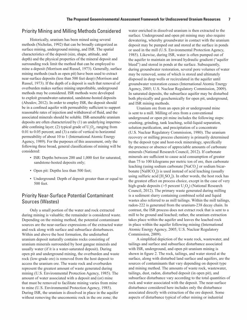
A simplified depiction of the waste rock, wastewater, and tailings and surface and subsurface disturbance associated with ISR, underground, and open pit uranium mining is shown in figure 2. The rock, tailings, and water stored at the surface, along with disturbed land surface and aquifers, are the sources of contaminants that vary depending on deposit type and mining method. The amounts of waste rock, wastewater, tailings, dust, radon, disturbed deposit (in open pit), and subsurface disturbance vary according to the total quantities of rock and water associated with the deposit. The near-surface disturbance considered here includes only the disturbance associated directly with extraction of the ore deposit. Some aspects of disturbance typical of other mining or industrial
8 Conceptual Framework and Approach for Conducting a Geoenvironmental Assessment of Undiscovered Uranium Resources
Figure 2. Schematic diagram of tailings; waste rock, that is, protore or subeconomic ore; overburden; and wastewater for three uranium mining methods: A, in situ recovery (ISR), B, underground, and C, open pit (surface) mining.
EXPLANATION
Wastewater
Overburden
Tailings
Waste rock
Uranium deposit
Disturbance
Equipotential lines
Water surface
Wastewater Mine profile Tailings Waste rock Subsurface-water disturbance(plan view)
Land-surface disturbance(plan view)
A. ISR
B. Underground
C. Open pit
The Proposed Geoenvironmental Assessment Framework for Undiscovered Uranium Resources 9
facilities (such as operation and maintenance, administrative or processing facilities, domestic or industrial water use and disposal of associated wastewaters, solid waste and wastewater management, infrastructure, or roads) are not considered here.
Priority Contaminants of Concern The priority contaminants of concern are assessed by
considering (1) the composition and near-surface expression (or form) of the rock and water associated with the deposit and (2) the surficial weathering environment. The term “potential geoavailability” refers to the relative likelihood of a release of constituents from their original mineral form by weathering and is based on how easily that weathering may occur. Specifically, geoavailability “is that portion of a chemical element’s or a compound’s total content in an earth material that can be liberated to the surficial or near-surface environment (or biosphere) through mechanical, chemical, or biological processes” (Smith, 2007). Geoavail-able contaminants are essentially those that may lead to biological exposures within the mine or mill site or may be transported offsite. The actual contaminants of concern and their concentrations may vary as a function of deposit type, mineralogy, solubility, grade, and weathering. Constituents could be released in the form of wastewater, leachate (drainage), dust, sediment, or radon from a potential uranium mine or mill site. The likely constituents of concern vary by region and deposit type. The total amount of rock and water associated with the undiscovered uranium deposit that forms the basis of these waste sources is assessed as part of the geoenvironmental assessment.
Elements Associated With Uranium Mining and MillingUranium is the primary element associated with uranium
deposits. Because uranium is a radioactive element, however, the other elements formed from its radioactive decay must also be considered. Naturally occurring uranium is composed of three major isotopes: uranium-238 (99.2739–99.2752 percent natural abundance), uranium-235 (0.7198–0.7202 percent), and uranium-234 (0.0050–0.0059 percent). The most prominent decay products result from the uranium-238 decay chain because uranium-238 is the most abundant isotope. Radium-226 (half-life of 1,600 years) and thorium-230 (half-life of 77,000 years) are the most persistent of the elements in the uranium-238 (half-life of 4.5 billion years) decay chain (U.S. Department of Energy, 2001). Radium-226 is of special interest for inhalation exposure because it decays to radon-222 (half-life of 3.8 days), which is an inert gas. At times, lead and polonium (additional uranium-238 decay products) have also been measured in mine- and mill-related waters (U.S. Environ-mental Protection Agency, 1983). The release of radon from waste materials depends on radium activity, moisture content, porosity, and density of waste rock and tailings (Mudd, 2008). The amount of radon is generally proportional to quantities of
wastewater ponds, mill tailings ponds, disturbed land, ore piles, protore (that is, subeconomic ore) piles, and mill tailings piles.
In addition to the radioactive elements, uranium deposits are often associated with ancillary minerals that contain trace elements and metalloids such as antimony, arsenic, bismuth, cadmium, cobalt, lead, molybdenum, nickel, selenium, thallium, and vanadium (U.S. Environmental Protection Agency, 1983). Consideration must also be given to the chemicals added during milling, such as strong acids, bases, salts, or organics.
Contaminants Formed by Weathering by WindWaste rock or mill tailings stored on the land surface or
deposits exposed at the surface during open pit mining could be sources of radon and dust-sized particles, which are subject to physical transport by wind. The amount of dust formed depends on the areal extent of the disturbed deposit area, the rock type, and the amount of waste rock exposed at the surface as well as climatological factors. Much of the dust caused by an open pit mining operation consists of fine particles that are generated from the mechanical disturbance of the deposit from bulldozing, blasting, and vehicles traveling on dirt roads within the open pit. The mass of dust emitted may be expected to be proportional to the area of exposed deposit surface and waste-rock (overburden, protore, and tailings) piles, and is also dependent upon wind erosion and dispersion.
Contaminants Formed by Weathering by PrecipitationChemical weathering by precipitation of waste rock and
mill tailings stored at land surface and deposits exposed at land surface may produce metal- and radionuclide-enriched leachates, depending on the mineralogy of the deposit and the expected mineral solubility upon exposure to oxygen and precipitation. In cases where sulfides are an important constituent of the waste rock or tailings, precipitation and oxygen may cause the leaching of uranium and other trace elements. Weathering could also produce acid mine drainage (AMD) in the absence of acid-neutralizing minerals (such as carbonates) if sulfides such as pyrite are associated with the deposit. AMD may form upon oxidation of sulfides, creating low pH of leachates and a greater potential for mobilization of radium (and to a lesser extent thorium) and other trace elements. The potential for AMD depends on the presence of sulfides and the overall acid-neutralizing capacity of the waste rock.
Factors To Consider in Determining the Contaminants of Concern
The contaminants of concern that might leach from waste rock depend on the expected mineral solubility in precipitation. Contaminants of concern are also present in groundwater that is in contact with the deposit or in pit lakes that form during open pit mining. This “mine” water is often pumped out of the formation during mining and becomes wastewater that is often stored at the surface. Dust, wastewater, and sediment may be transported by wind or stormwater runoff, depending on the

10 Conceptual Framework and Approach for Conducting a Geoenvironmental Assessment of Undiscovered Uranium Resources
expected particle-size distribution in the stored waste rock and disturbed lands. Leachable fractions of contaminants in dust and sediments may persist in surface waters or organisms once ingested or inhaled, depending on the contaminant’s solubility. Therefore, an assessment of the expected contaminants of concern could be influenced by (1) the solubility of expected waste rock in precipitation and (or) groundwater, (2) expected particle size, and (3) acid-generating potential.
Priority Erosion, Dispersion, and Transport Processes for Assessment
The contaminants of concern released from (1) wastewater, (2) waste rock, (3) the disturbed deposit exposed at the surface, or (4) the disturbed deposit within the subsurface aquifer may be transported and redistributed offsite in the near-surface environment (including groundwater) if they are subjected to further erosion, transport, and dispersion processes. Erosion and dispersion processes that lead to (1) surface runoff of sediments, leachates, and wastewaters to nearby land and surface waters; (2) infiltration of leachates (including AMD) and contaminated water into aquifers; (3) wind dispersion of dust; (4) accumula-tion of radon in air; and (5) transport via groundwater move-ment need to be assessed to better understand the potential for the occurrence and persistence of contaminants of concern in
air, land, and water, and thus for the possibility of exposure to those contaminants. These contaminant pathways are outlined in table 1.
The transport of constituents to the air, land, surface water, and groundwater may be affected by the following regional attributes: geology, climate, and hydrology. Specifically, the regional geology plays a role in understanding gangue and ancillary minerals that may affect mine drainage chemistry and geologic structures that may enhance and limit porosity and permeability (and thus the subsurface migration of contaminants). The climate may affect erosion and the evapora-tive concentration or dilution of the dissolved constituents. Hydrology may provide an understanding of runoff potential, depth to aquifers, groundwater movement, and the locations of recharge zones, aquifers, and surface waters. The priority indicators of transport of contaminants offsite to surface water, groundwater, and air likely depend on a combination of these attributes.
The information in table 1 is based on previous studies on environmental effects of uranium mining and milling (U.S. Environmental Protection Agency, 1983, 1985, 1995). Surface facilities, near surface infrastructure, or activities related to operation and maintenance, administration, processing (laboratories, chemical handling), domestic uses (domestic solid waste generation, domestic wastewater generation, potable
Table 1. Potential contaminant sources and pathways at uranium mines and mills as a function of mining method.
[Based on previous studies by the U.S. Environmental Protection Agency (1983, 1985, 1995). ISR, in situ recovery]
Contaminant sources
Contaminant pathwayApplicable
mining method*Wind suspended particles
Radon emanation
RunoffInfiltration of
contaminants or leachates
Groundwater transport of
contaminants
Disturbed deposit at surface
Mine pits at surface x x x x x OOpen shafts, tunnels x x UWell bores, injection and extraction wells x x O, U, I
Waste rock and other solids
Overburden x x O, UOre stockpiles x x x x O, UMineralized waste rock x x x x O, USubeconomic ore x x x x O, UMill tailings x x x x O, UPond sludges x x x x O, U, IYellowcake (U3O8) releases x x O, U, I
Disturbed subsurface aquifer
Pit lake x x x x OWastewater (from dewatering and ground-
water restoration), mill- and mine-impact-ed water stored in ponds on surface or discharged to surface waters
x x x x O, U, I
*O, open pit mining; U, underground mining; I, in-situ recovery.
The Proposed Geoenvironmental Assessment Framework for Undiscovered Uranium Resources 11
water use, sanitary sewer treatment, parking facilities), and transportation are not considered.
Runoff of Sediments, Leachates, and WastewaterContaminants derived from waste rock (that is,
overburden, protore, or low-grade ore) and tailings from underground and (or) open pit mining operations and milling may degrade surface-water quality if the contaminated (mine or mill) sediments, leachates, and (or) wastewater enter the surface waters of the surrounding environment through either indirect runoff or direct discharge into streams, rivers, and lakes (National Research Council, 2012). Increases in the amount of surface runoff may contribute to increases in sediment loads, which are the products of concentration and discharge (National Research Council, 2012). Onsite and downstream surface-runoff effects may be expected to vary, depending on the type of mining (underground, open pit, or ISR). Because underground mining results in a smaller area of deposit surface disturbance than open pit mining, it may cause a smaller effect on surface water from sediments (both offsite and downstream) than open pit mining (National Research Council, 2012). Contaminants most likely are transported offsite in areas where runoff is likely to occur; that is, where the potential for erosion resulting from precipitation is probable. The potential for erosion resulting from precipitation can be quantitatively evaluated using the rainfall erosivity factor, or R-factor, which is the product of total storm energy and the maximum 30-minute intensity (Renard and others, 1997). The U.S. Department of Agriculture established estimates of annual erosivity values (R-factors) for sites throughout the country. Those estimates may be used as surrogate measures of the effect that precipitation has on erosion at a particular site (U.S. Environmental Protection Agency, 2012). The average annual total values of the storm energy and intensity in a given location constitute the rainfall erosion index (EI) for the location (U.S. Department of Agriculture, 2002). The EI represents the R-factor for an extended period of record.
Seepage of Contaminants Into Groundwater and TransportGroundwater may become contaminated by the
infiltration of (1) contaminants leached by precipitation from waste rock or waste tailings stored at the surface, (2) spilled wastewater, or (3) leaked wastewater from surface storage ponds. In addition, groundwater interactions with subsurface mineralized rock in saturated deposits can result in elevated concentrations of contaminants. This latter mechanism is expected to be important when the ore deposit is exposed to oxygen in the subsurface either during excavation or when the deposit is solubilized by ISR lixiviants (leaching solutions), possibly resulting in the contamination of groundwater outside the mining zone. On the other hand, leachates or wastewaters derived from wastes from open pit or underground mining and milling that are stored at the land surface can enter aquifers through recharge. Recharge is a complicated process that may occur in areas where the depth to groundwater is shallow and
where there are no intervening geologic barriers preventing downgradient contaminant migration. Recharge may also occur in parts of an aquifer that are characterized by a high hydraulic conductivity. Groundwater flow through preferential flow paths, such as karst features (sinkholes, conduits, and cavernous zones), fractured bedrock, or highly permeable unconsolidated sediments, also may be become recharge. The potential for contaminants to reach groundwater increases in areas where the recharge rates are high. Groundwater recharge is important for determining the rate at which surface contaminants can be transported into the aquifer (Scanlon and others, 2003). State- (Scanlon and others, 2003) and national-scale (Reitz and others, 2017) datasets have been developed to better understand areas of groundwater recharge. This information coupled with the potential for groundwater flow (indicated by groundwater transmissivity or hydraulic conductivity) can shed light on the potential for contaminant transport. Although contaminant transport processes and factors (for example, retardation factors, available sites for adsorption, preferential flow paths, full delineation of subsur-face mineralogy, aqueous species, and presence of microbial or abiotic reductants) specific to each contaminant of concern are important factors, the data available to make this assess-ment are not at a scale appropriate for the regional scale of an undiscovered uranium geoenvironmental assessment. In any case, the aqueous contaminants more likely are transported to groundwater in areas where infiltration is likely to occur and will be influenced by the flow of groundwater.
Dispersion of Dust in AirEnvironmental and human health effects from airborne
particulate exposures depend on several factors, including chemical composition, concentration, size and shape, and exposure time. Grain sizes of 2.5 micrometers (PM2.5) or less and 10 micrometers (PM10) or less are considered an inhalation risk (U.S. Environmental Protection Agency, 2013). Dust particles containing constituents of concern can be mobilized by wind blowing over disturbed deposits exposed at the surface, ore stockpiles, waste rock, or crusts formed by evaporation of water from the surfaces surrounding wastewater storage areas (National Research Council, 2012). Large particles greater than 10 micrometers (>PM10) settle out quickly from the air. The distance that dust might travel from the source depends on meteorological factors, particle size, and site conditions, including climate. Meteorological modeling has been used to estimate the extent of particle transport under typical wind speeds and directions, as well as under weather conditions that are both dry and windy, as indicated by wind speed and rainfall frequency (National Research Council, 2012). The potential for offsite transport of dust can be indicated by the atmospheric dispersion potential of PM2.5 or PM10, defined by the air quality index (National Oceanic and Atmospheric Administration, 2017b).

12 Conceptual Framework and Approach for Conducting a Geoenvironmental Assessment of Undiscovered Uranium Resources
Accumulation of Radon Into AirRadon (mainly as radon-222) is emitted from waste
rock (protore, low-grade ore, and mill tailings), wastewater surfaces, and exposed deposit surfaces that contain uranium-238 and daughter products such as radium-226. Radon may quickly dissipate outside an enclosed facility (National Research Council, 2012, U.S. Environmental Protection Agency, 1983). In contrast, air circulation that is insufficient to disperse accumulated contaminants may lead to hazardous conditions for the inhabitants of an area because airborne contaminants, such as radon, may accumulate in large amounts in areas where air stagnates (Wang and Angell, 1999). An example of these contrasting scenarios was provided in a recent study that documented an inverse relation between wind speed and radon concentrations measured in air near
an ore storage pile at an active underground uranium mine (Naftz and others, 2020). Therefore, the potential for the offsite accumulation of radon is higher in areas where the air stagnation index is higher. Air stagnation occurs in areas where winds are light so that horizontal dispersion is minimal, the lower atmosphere is stable, and there is no precipitation. Air stagnation index maps are created by the National Oceanic and Atmospheric Administration (NOAA) by calculating the number of stagnation days in a given month for each grid point of a 0.25- by 0.25-degree grid across the conterminous United States; for example, the August 2017 map is shown in figure 3. The median annual stagnation index can be used in a geoenvironmental assessment to determine the potential for radon accumulation.
Figure 3. Air stagnation index map for the conterminous United States during August 2017, created by calculating the number of stagnation days in the month for each grid point of a 0.25- by 0.25-degree grid. From National Oceanic and Atmospheric Administration (2017a).

Establishing the Geoenvironmental Assessment Approach 13
Priority Geochemical Processes Affecting Contaminant Availability
Even if a waterborne or sediment-borne contaminant travels away from the mine or mill or from the mining zone into an offsite environmental medium (air, land, surface water, or groundwater) or if an airborne contaminant is inhaled, the entire quantity of that contaminant may not be available for uptake by a biotic receptor. The available fraction of a contaminant is determined by its physical and geochemical attributes in air, land, or water, which in turn may indicate the potential for its mobility and persistence (Smith, 2007; Eberts and others, 2013). The factors that increase availability vary depending on the constituent of concern and the geochemical and physical attributes of the environmental media.
Priority Factors Controlling Availability of Dust Contaminants in Lungs
The rate of inhalation of airborne contaminants by humans depends on the particle size of the suspended dust particle and the solubility of the contaminant of interest (National Research Council, 2012). Most (>60 percent) uranium in the blood is filtered in the kidneys and excreted in urine within 24 hours. Uranium compounds that are moderately soluble (for example, uranium dioxide and U3O8) and are likely to be associated with the mining waste and mill tailings tend to be retained in the lungs and tracheobronchial lymph nodes for many months or years, thereby increasing the risk of cancer from alpha-particle exposure (Agency for Toxic Substances and Disease Registry, 2013). Inhaled dust particles less than or equal to 10 micrometers (PM10) can reach breathing airways, and particles smaller than 5 micrometers can penetrate deeply into the lungs. Therefore, because long- and short-term exposures to radiation and chemicals are associated with the dust-particle inhalation, the range in size of respirable dust particles may be the most important exposure metric; health protection standards for airborne contaminants recommended by the National Institute for Occupational Safety and Health are based on size attributes (National Research Council, 2012). Therefore, the available fraction of contaminants associated with the dust includes the particle size of the dust that is inhalable, PM10 or smaller.
Priority Factors Controlling Availability of Contaminants in Waters
The most important radionuclides and chemicals for biological uptake are those that are water soluble or are adsorbed to particles that can be suspended and transported by moving groundwater and flowing rivers and streams (National Research Council, 2012). It is difficult to quantitatively predict element mobility in near-surface environments (Smith and Huyck, 1999). At a regional scale, however, generalizations may be made on the basis of the presence of geochemical factors that control geochemical behavior (ligand
concentrations, dissolution, precipitation, adsorption). The constituents of concern may dissolve in waters under a given set of geochemical conditions controlled by master variables that are likely to be reported in water-quality investigations, such as pH, reduction-oxidation (redox) potential, and selected ligand concentrations. Because the available data may be too sparse to make such an assessment and because disequilibrium is likely to occur among redox couples in groundwater and surface water (Lindberg and Runnells, 1984), a quantitative assessment may be difficult to conduct at a regional level. The redox condition from either surface water or groundwater, however, may be classified according to the framework shown in table 2 (McMahon and Chapelle, 2008; McMahon and others, 2009) and table 3 (Smith, 2007) in conjunction with pH, which may be the most likely characteristic reported from water-quality analysis. The constituents in table 2 plus pH are commonly recorded in water-quality databases such as the EPA’s STOrage and RETrieval Data Warehouse (STORET) water-quality exchange or the USGS’s National Water Information System (NWIS). The persistence of the contaminants of concern in surface water and groundwater may be qualitatively assessed in areas where contaminants are expected to be mobile or immobile (according to tables 2 and 3), based on estimated redox potential (Eh) and pH and the presence or absence of iron substrates and hydrogen sulfide.
Establishing the Geoenvironmental Assessment Approach
The geoenvironmental assessment receives initial input from the uranium resource assessment, and the output from the geoenvironmental assessment forms the basis for the input into a biological resource assessment; both of these resource assessments are outside the scope of this study. This section briefly describes the input from the uranium resource assess-ment, the steps of the geoenvironmental assessment, and the possible use of the geoenvironmental assessment in a potential followup biological resource assessment.
Proposed Geoenvironmental Assessment Approach
For each deposit type and permissive tract, the assess-ment of the priority mining methods, waste sources, and the priority weathering and erosion indicators form the basis of the geoenvironmental assessment framework. The overall approach and flow of information from the uranium resource assessment to the geoenvironmental assessment then to the biological resource assessment are shown in figure 4.

14 Conceptual Framework and Approach for Conducting a Geoenvironmental Assessment of Undiscovered Uranium Resources
Table 2. Threshold concentrations for identifying redox processes in groundwater (modified from McMahon and Chapelle, 2008; Chapelle and others, 2009).
[From McMahon and others (2009). O2, dissolved oxygen; NO3–-N, dissolved nitrate as nitrogen; Mn2+, dissolved manganese; Fe2+, dissolved ferrous iron;
SO42–, dissolved sulfate; H2S, hydrogen sulfide; Mn(IV), oxidized manganese; Fe(III), ferric iron; mg/L, milligram per liter; —, not applicable; ≥, greater
than or equal to; >, greater than; ≤, less than or equal to; <, less than]
Redox category
Predominant redox process
Distinguishing Fe(III) from SO4
2− reduction
Water-chemistry criteria (mg/L)Fe2+/H2S mass
ratioO2 NO3−-N Mn2+ Fe2+ SO4
2−
Oxic O2 reduction — ≥0.5 — <0.05 <0.1 — —Suboxic1 — — <0.5 <0.5 <0.05 <0.1 — —Anoxic NO3 reduction — <0.5 ≥0.5 <0.05 <0.1 — —
Mn(IV) reduction — <0.5 <0.5 ≥0.05 <0.1 — —Fe(III)/SO4
2− reduction
— <0.5 <0.5 — ≥0.1 ≥0.5 —
— Fe(III) reduction <0.5 <0.5 — ≥0.1 ≥0.5 >10— Mix Fe(III)/ SO4
2−
reduction<0.5 <0.5 — ≥0.1 ≥0.5 ≥0.3 and ≤10
— SO42− reduction <0.5 <0.5 — ≥0.1 ≥0.5 <0.3
Methanogenesis — <0.5 <0.5 — ≥0.1 <0.5 —Mixed2 — — — — — — — —
1Further definition of redox processes not feasible.2Criteria for more than one redox process are met.
Table 3. Generalized relative mobility of elements under different environmental conditions.
[From Smith (2007), used with permission. Information from Smith and Huyck (1999). >, greater than; <, less than; Ag, silver; Al, aluminum; As, arsenic; Ba, barium; Be, beryllium; Bi, bismuth; Br, bromine; Ca, calcium; Cd, cadmium; Cl, chlorine; Co, cobalt; Cr, chromium; Cs, cesium; Cu, copper; F, fluorine; Fe, iron; Ga, gallium; Ge, germanium; Hg, mercury; I, iodine; K, potassium; Li, lithium; Mg, magnesium; Mn, manganese; Mo, molybdenum; Na, sodium; Ni, nickel; P, phosphorus; Pb, lead; Ra, radium; Rb, rubidium; REE, rare earth elements (treated as a group but individually may have somewhat different mobility behaviors); Rn, radon; S, sulfur; Sb, antimony; Sc, scandium; Se, selenium; Si, silicon; Sn, tin; Sr, strontium; Th, thorium; Ti, titanium; Tl, thallium; U, uranium; V, vanadium; W, tungsten; Y, yttrium; Zn, zinc; Zr, zircon]
Environmental condition Very mobile Mobile Somewhat mobileScarcely mobile to
immobile
Oxidizing with pH <3 Br, Cd, Cl, Co, Cu, F, I, Ni, Rn, S, Zn
Al, As, Ca, Fe, Hg, K, Mg, Mn, Na, P, Ra, REE, Se, Si, Sr, U, V
Ag, Ba, Be, Bi, Cr, Cs, Ga, Ge, Li, Mo, Pb, Rb, Sb, Th, Ti, Tl, W
Sc, Sn, Y, Zr
Oxidizing with pH >5 to circumneutral, no iron substrates
Br, Cd, Cl, F, I, Rn, S, Zn Ca, Mg, Mo, Na, Se, Sr, U, V
As, Ba, Bi, Co, Cr, Cs, Cu, Ge, Hg, K, Li, Mn, Ni, P, Ra, Rb, REE, Sb, Si, Tl
Ag, Al, Be, Fe, Ga, Sc, Sn, Th, Ti, W, Y, Zr
Oxidizing with pH >5 to circumneutral, with abundant iron substrates
Br, Cl, F, I, Rn, S Ca, Cd, Mg, Na, Sr, Zn Ba, Bi, Co, Cs, Ge, Hg, K, Li, Mn, Ni, Rb, Sb, Se, Si, Tl
Ag, Al, As, Be, Cr, Cu, Fe, Ga, Mo, P, Pb, Ra, REE, Sc, Sn, Th, Ti, U, V, W, Y, Zr
Reducing with pH >5 to circumneutral, no hydrogen sulfide
Br, Cl, F, I, Rn Ca, Cd, Cu, Fe, Mg, Mn, Na, Ni, Pb, S, Sr, Zn
As, Ba, Co, Cr, Cs, Hg, K, Li, P, Ra, Rb, Si, Tl
Ag, Al, Be, Bi, Ga, Ge, Mo, REE, Sb, Sc, Se, Sn, Th, Ti, U, V, W, Y, Zr
Reducing with pH >5 to circumneutral, with hydrogen sulfide
Br, Cl, F, I, Rn Ca, Mg, Mn, Na, Sr Ba, Cs, K, Li, P, Ra, Rb, Si, Tl
Ag, Al, As, Be, Bi, Cd, Co, Cr, Cu, Fe, Ga, Ge, Hg, Mo, Ni, Pb, REE, S, Sb, Sc, Se, Sn, Th, Ti, U, V, W, Y, Zn, Zr

Establishing the Geoenvironmental Assessment Approach 15M
iner
alre
sour
ceG
eoen
viro
nmen
tal
Bio
logi
cal r
esou
rce
Uranium resource assessment output
Undiscovered uranium resource: deposit type, mass U3O8, number of deposits Permissive tract location
Geologic formation(s)
Range of depthsto deposit
Range of depthsto water
Mineralogy (ore and gangue) Contaminants of concernSolubility in water (O2, CO2)
Mining method, contaminant sourcesSurface expressionsQuantities of disturbance, waste rock, and wastewater
LandscapeClimateGeologyHydrology
Environmental mediaAirLand (Soil)Water (Surface or groundwater)
Geoavailableconstituents of concern
(forms, elements)
Transport potentials:wind, recharge, runoff,
stagnation, transmissivity
Relative mobilitybased on pH, redox, Fe mineral, H2S
Maps reflecting areas where occurrence and persistence of constituentsof concern are likely in air, land, surface water, and groundwater
Biological receptor locations Habitats Sensitive species + humans Drinking water sources
Environmental health sensitivity maps
Figure 4. Flow chart of information for a uranium life cycle assessment, consisting of a mineral resource assessment, geoenvironmental assessment, and biological resource assessment. Unshaded areas within the dashed box are included in the geoenvironmental assessment. Shaded areas indicate factors that are outside of the scope of the geoenvironmental assessment. (O2, oxygen gas; CO2, carbon dioxide gas; U3O8, uranium oxide or “yellowcake;” H2S, hydrogen sulfide; Fe, iron).
Geoenvironmental Assessment Input Equals Uranium Resource Assessment Output
Given that the geoenvironmental assessment is intended to evaluate the geoenvironmental aspects of future mining in an area of potential undiscovered uranium deposits, once the uranium resource assessment is complete within an assessment unit, the geoenvironmental assessment can be initiated. The uranium resource assessment is performed using a three-part uranium resource assessment methodology (Singer and Menzie, 2010), and the products are expected to provide some of the key inputs into the geoenvironmental assessment of an undiscovered uranium deposit, including the following:
• Uranium resource permissive tract boundary or bound-aries, or assessment units;
• Tables showing the probabilistic estimates of numbers of undiscovered deposits; and
• Estimated probabilities (median, 5th and 95th percen-tile) of the pounds of uranium oxide (as U3O8) within each assessment unit constrained to some selected, practical depth on the basis of technical accessibility.
Other information that may be available for use includes the following:
• Mineral-deposit model information, including ranges of expected grades and depths to host formation;
• Lists of significant known deposits of that type;
• Rationales for selecting the mineral deposit model, delineating tracts, and making numerical estimates of numbers of undiscovered deposits; and
• Histograms, statistics, and (or) cumulative distribution graphs of historical uranium grades and tonnages of ore.
Other key data required as input for the geoenvironmental assessment are developed as part of the geoenvironmental assessment, as described in the next section.

16 Conceptual Framework and Approach for Conducting a Geoenvironmental Assessment of Undiscovered Uranium Resources
5. Groundwater transmissivity: indicates the potential of contaminants to be transported away from the mining zone, and
6. Environmental condition of the surface water and groundwater geochemistry (based on tables 2 and 3): indicates the potential for contaminant mobility.
Data types may include geospatial information about groundwater aquifers, available water-quality data from public and regulatory sources, and data on the distribution of historical mining operations. Other input data may be derived from literature review of historical uranium mining and uranium geology and regional climate and hydrology records, as well as State and local regulatory records such as National Pollutant Discharge Elimination System (NPDES) permits, Class I deep-injection-well permits, Class III ISR uranium mining permits, aquifer exemption permits, environmental impact statements, and environmental assessments.
Geoenvironmental AssessmentThe information and data gathered as part of the GEMs
will be used to conduct the geoenvironmental assessment. The geoenvironmental assessment will (1) assess the likely indicators of rock and water quantities, and thus the relative amounts of the indicators of waste sources; (2) project the likely constituents of concern; and (3) identify where the contaminants are most likely to occur and persist.
Indicators of Quantities of WasteThe indicators of the quantities of rock and water associ-
ated with a deposit within the permissive uranium resource tract that reflect the relative likely quantities of waste rock, wastewater, tailings, dust, and radon are assessed. The deposit size estimated for the 5th percentile, median, and 95th percentile probabilities of the amount of uranium as U3O8 provided in the three-part uranium resource assessment, and the expected range of grades, along with reviews of historical mine records and reports, may be used to assess the following indicators of the quantity of waste sources:
• The likely surface area of the exposed disturbed deposit (for open pit mining),
• The likely volume of disturbed subsurface (open pit, underground, and ISR mining),
• The likely quantity of rock associated with the deposit and potentially exposed in the near-surface environment (open pit and underground mining), and
• The likely volume of water associated with the deposit and potentially stored in the near surface environment (open pit, underground, and ISR mining).
Geoenvironmental Assessment Steps
The specific objectives of the geoenvironmental assessment are accomplished in three steps: (1) developing a geoenvironmental model (GEM), (2) enhancing the GEM with information specific to the permissive tract, and (3) conducting the geoenvironmental assessment by applying the GEM to the permissive tract(s) in which the deposit type is present to better understand the potential for the occurrence and persistence of uranium and other elements in air, land, and water within the permissive tract.
Developing a Geoenvironmental ModelA descriptive GEM is developed for each uranium
deposit type. The GEM will (1) characterize the important features of the likely deposit, wall rocks, and surrounding geology and (2) summarize primary mineralogy, gangue minerals, and associated trace elements and provide an overview of expected mining and ore-processing methods (du Bray, 1995). To date, the only GEM for uranium deposits is for solution-collapse breccia-pipe uranium deposits (Wenrich and others, 1995).
Applying the Geoenvironmental Data Within Permissive Tracts
The GEM should then be applied to the specific geographic region within the uranium resource assessment boundary (permissive tract). The GEM may contain a summary of historical mining methods for the deposit type within the permissive tract, including (1) the likely mining and ore processing approaches that were used, (2) the weathering and erosion of the ore and solid mine waste rock and mine water under various climatic and hydrogeological regimes, and (3) the geochemical characteristics of the surface-water and groundwater resources. The associated trace elements may be evaluated to determine which elements are likely constituents of concern. Data regarding climate, hydrology, and geology within the permissive tract may be gathered to evaluate the indicators for the potential for transport including:
1. Runoff: indicates the potential for physical disper-sion of sediment resulting from water erosion or inadvertent drainage of wastewater,
2. Air stagnation of airborne contaminants in air: indi-cates the potential for accumulation of radon gas,
3. Wind erosion: indicates the potential for dispersion of dust (particulate matter),
4. Aquifer recharge: indicates the potential of mine-related water (that may be enriched in dissolved contaminants) to infiltrate into groundwater,

Establishing the Geoenvironmental Assessment Approach 17
Assessing Constituents of ConcernThe constituent(s) of concern may be assessed as
follows:• The likely composition of wastewater and waste rock,
including constituents and their form, may be assessed by reviewing the quality of water and rock associated with the deposit type within the permissive tract, as well as historical wastes as reported in the literature.
• The composition of leachates likely to be liberated to the near-surface environment through weathering may be assessed by determining the likely solubility of contaminant source(s) based on a review of mine and mill wastewater data from similar deposit types within the permissive tracts and (or) leaching of solid mine and mill waste in simulated rainwater.
• The likely composition of dusts may be assessed by determining the likely composition of dust-sized particles (PM10) generally associated with mine and mill wastes based on a review of data from similar deposit types within the permissive tracts.
• The likely composition of sediments may be assessed by determining the composition of particle sizes generally associated with mine and mill wastes, through a review of data from similar deposit types within the permissive tracts and (or) a review of data on leaching of sediment-sized particles of solid mine and mill waste in simulated river water.
• The constituents of concern may be qualitatively assessed by comparing the likely composition of waste rock, wastewater, dust, sediments, radon emissions, and leachates and their forms (aqueous, solid, dust, radon) to regulatory standards in order to determine which elements are likely to exceed the allowable concentrations. If the ratio of expected concentration to accepted concentration is greater than unity, this indicates that concentrations likely exceed the regulatory standards, and the element is deemed a constituent of concern.
Assessing Potential for Occurrence and Persistence of Contaminants of Concern
The potential for occurrence and persistence of contaminants of concern in air, land, and water within permissive tracts may be assessed by creating maps with a series of overlays. These maps need not be merged, but can be displayed in a manner that preserves the original data and maintains the transparency of the data, as follows:
1. Radon is likely to occur in areas where uranium mineralized rock may be exposed (open pit or underground mining) or disturbed deposit surfaces
may be exposed (open pit), and it may persist in areas where the air stagnation index is high.
2. Dust is likely to occur in areas where uranium mineralized rock (open pit or underground mining) or disturbed deposit surfaces (open pit mining) may be exposed, and it may persist in areas of high wind erosion potential.
3. Sediments are likely to occur in areas where mineralized rock might be exposed (open pit or underground mining) or disturbed deposit surfaces might be exposed (open pit) and where there is a potential for runoff.
4. Subsurface leachates are likely to occur in saturated, disturbed subsurface aquifers during open pit, ISR, and underground mining and may persist in groundwater in areas with a high potential for physical transport (for example, transmissivity) and chemical mobility, based on the information in tables 2 and 3.
5. Surface leachates are likely to occur in areas where mineralized rock might be exposed (open pit or underground mining) or disturbed deposit surfaces might be exposed (open pit) and where there is a potential for rainfall, and may persist in the following:
a. groundwater in areas of recharge potential if there is a high potential for physical and chemical mobility, based on the information in tables 2 and 3;
b. surface water in areas of runoff potential if there is a high potential for chemical mobility, based on the information in tables 2 and 3.
6. Wastewater discharges are likely to occur in areas where water produced during mining and milling is potentially stored in the near-surface environment (open pit, underground, and ISR mining) and in the following:
a. groundwater in areas with recharge poten-tial, persisting if there is a high potential for physical and chemical mobility, based on the information in tables 2 and 3;
b. surface water in areas of runoff potential, if there is a high potential for chemical mobility, based on the information in tables 2 and 3.
18 Conceptual Framework and Approach for Conducting a Geoenvironmental Assessment of Undiscovered Uranium Resources
Uranium Geoenvironmental Assessment Products
The geoenvironmental assessment output will consist of supporting documentation in addition to the formal assessment products. The formal uranium geoenvironmental assessment products include: (1) a descriptive report or multiple reports about the GEM; (2) maps showing areas where constituents of concern are likely to occur and persist in groundwater, surface water, land, and air; and (3) tables providing probabilistic estimates of the indicators of the relative quantities of rock and water associated with the deposit in each assessment unit that can indicate the likely quantities of waste rock, tailings, wastewater, dust, and radon emissions for each permissive tract.
Uranium Geoenvironmental Assessment Output Equals Uranium Biological Resource Assessment Input
Although outside the scope of this study, the output from a geoenvironmental assessment could be used in a future biological resource assessment. For example, maps of the areas where contaminants of concern are likely to occur and persist if an undiscovered uranium resource was discovered and developed may be compared to maps of biological indica-tors (such as animal habitats, sensitive species, human popula-tion centers, or drinking-water sources) to identify potential areas of exposure by inhalation, absorption, or ingestion. The concept for these maps is based on Environmental Sensitivity Index maps for coastal resources developed by NOAA (2014). The geoenvironmental assessment framework described herein could potentially serve as input into a multi-resource assess-ment that would include physical and biological models of natural resource interrelationships as part of its analysis (Jenni and others, 2018).
Geoenvironmental Assessment Outcomes
In the absence of site-specific information, a geoenviron-mental assessment may serve as an alternative to predicting the potential environmental effects of future mining. A geoenvironmental assessment may provide information about the inherent attributes of undiscovered uranium resources and the manner in which those attributes may affect or be affected by the landscape, if and when uranium extraction occurs. This type of information can be used to reduce the scale of adverse environmental effects of mining and minimize the time, cost, and effort expended on control, monitoring, and containment of potential environmental contaminants (Anastas and Zimmerman, 2003). For example, deposits designated for development may include those with no acid-generating
capacity (National Research Council, 2002) or those with gangue minerals that have a high potential for acid neutraliza-tion or a natural attenuation of trace-element contaminants (such as uranium or arsenic) and radionuclides (such as radium and radon). Because the costs of mine closure and reclamation constitute a significant portion of overall mining costs, deposits that can be mined in a manner that produces less waste, uses less water, or disturbs as little of the land as possible can have distinct economic and environmental advan-tages over deposits that yield large amounts of waste, use large amounts of water, or disturb large areas of land (National Research Council, 2002). This premise is an example of an optimal sustainable design plan that draws information from, and ultimately “fits” within, the local natural system (McDonough and others, 2003). When a process (for example, mineral resource extraction) is designed for a specific locality, materials and energy are expended as needed. However, a process designed for the worst-case scenario may require materials and energy that are never used (McDonough and others, 2003).
The products of a geoenvironmental assessment of undiscovered uranium resources may facilitate principles of sustainability by identifying opportunities for minimizing waste, preventing pollution, and minimizing exposures. Additionally, the data may be used to identify (1) deposits (once locations are identified) that have the potential for little effect on the environment or (2) deposits where environmental protection during and after mining will be more challenging. Finally, estimates of the quantity of wastewater and mine waste may help identify potential sources of wastes that present opportunities for recycling and beneficial reuse. The uranium geoenvironmental assessment conceptual framework and approach described herein can complement traditional uranium resource assessments to achieve a better understanding of how the complex life cycle of occurrence, extraction methods, and waste products of uranium affect or are affected by landscape, hydrology, and climate with impli-cations for ecosystems and human health (U.S. Geological Survey, 2007).
Limitations and Science NeedsThere are several inherent limitations of the uranium
geoenvironmental assessment framework and approach presented in this report. The proposed assessment will use existing data, wherever available, rather than conduct studies to fill data gaps. The assessment likely will identify data gaps that may limit the robustness of the geoenvironmental assess-ment. Future research into identified data gaps may be used to refine the methodology.
The geoenvironmental assessments generally may be limited to the geographic extent of the permissive tracts (that is, areas permissive for uranium occurrence) outlined during the uranium resource assessment. When judged appropriate,

Summary 19
necessary, and scientifically defensible, the geographic boundaries of the geoenvironmental assessment may be extended slightly beyond the permissive tract boundaries. For example, an extension of the assessment area may be consistent with transport pathways extending beyond the area considered favorable to host ore deposits, such as downstream or downgradient environmental media (water, land, air) that could be affected by uranium resource development in upgradient areas.
The ability of the geoenvironmental assessment approach to assess areas where contaminants are most likely to occur and persist will have scale-dependent limitations. Because the locations of specific deposits or mines have not been identified, an assessment of specific pathways and site-specific outcomes may be limited. Aspects of disturbance typical of other mining or industrial facilities (such as operation and maintenance, administrative or processing facilities, domestic or industrial water, solid waste and wastewater management, infrastructure, and roads) will not be considered.
The geoenvironmental assessment will prioritize the use of primary data related to a specific region and deposit type rather than extrapolate from similar analog sites. If no perti-nent data are available for a permissive tract, some data may be generalized from one study to another; for example, data from another location with similar geology, climate, or mining technique may be used to inform an assessment in a different location. However, if such “analog” data are employed, confidence limits about the developed relation may be used to address the limitations of the estimated data.
SummaryThis report presents the rationale and background
concepts for developing the novel approach and framework for conducting a geologically based environmental assessment, or “geoenvironmental assessment,” of undiscovered uranium resources. This approach to conducting a geoenvironmental assessment can also be applied to any other type of undis-covered mineral resource. Until now, there have been few, if any, quantitative approaches for conducting an environmental assessment of undiscovered uranium resources. Predicting quantitative environmental impacts (the change to air, land, water, and biota quality) on a regional scale owing to the extraction of undiscovered uranium resources is difficult because the location of the undiscovered uranium resource is not precisely known. Furthermore, environmental impacts depend on several site-specific factors related to mine and mill design and management practices, which are unknown and not provided in an undiscovered uranium resource assessment. Existing methods for conducting environmental assessments were reviewed and found not to be applicable to undiscovered resources because they are generally (1) retrospective and used to delineate impacts from historical mining or milling, (2) site-specific, where characteristics are known and one
or more mining or milling configurations well defined, or (3) probabilistic without necessarily accounting for all site-specific factors that influence effects. To overcome these impediments to conducting a local-scale, site-specific envi-ronmental assessment of an undiscovered uranium resource, a geoenvironmental assessment approach is proposed that is based on a process-oriented source-to-receptor model. This simplified source-to-receptor model does not address the site-specific, local-scale mine and mill characteristics or management scenarios, which cannot be determined without knowledge of specific uranium deposit or mine and mill loca-tion. Rather, it focuses on identifying processes and attributes of the abiotic environment that could influence ecosystem exposures (inhalation, ingestion, and dermal absorption). The potential waste sources, contaminant pathways, and weathering and erosional attributes are prioritized for three likely mining methods (open pit and underground mining with milling and ISR), based on the source-to-receptor model. The process-oriented geoenvironmental assessment approach is based on the hydrologic, geochemical, climatic, and geologic factors of the source, landscape, and abiotic receptors (air, land, surface water, and groundwater) that influence exposure susceptibility of bioreceptors to uranium mining in areas of favorable resource development.
The approach begins with the use of the uranium resource assessment output that includes the grade and tonnage of the expected uranium deposit, the location of tracts favorable for uranium deposition and occurrence, the likely deposit type, and the geologic formation. From this information, critical parameters are estimated, including the depth to the deposit, thickness of deposit, and the depth to water. These parameters, along with reviews of historical uranium mining and milling records, can be used to estimate the quantities of waste rock, tailings, wastewater, land disturbance, dust, and radon emis-sions. The likelihood of contaminant migration is based on several factors: (1) deposit type and mining methods; (2) the intrinsic regional geology, hydrology, and climate, including weathering and erosion and deposit characteristics identified in the geoenvironmental model; and (3) the potential of air, land, and water to concentrate or mobilize contaminants. Together, these data are used to produce maps of the potential for dust dispersion, sediment and water runoff, element mobility, infiltration, groundwater transport, and radon accumulation. These maps are then combined to produce final maps indi-cating vulnerable areas in the landscape where contaminants are most likely to occur and persist.
The geoenvironmental assessment products described herein are endpoints in themselves, providing maps and information that may be used to identify areas where uranium deposits, if discovered and developed, might have a lower environmental footprint and identify areas or locations with characteristics that can inherently mitigate potential environ-mental contamination. This geoenvironmental assessment also can link the undiscovered uranium resource assessment to a biological resource assessment for an integrated mineral resource life cycle assessment, which is central to the
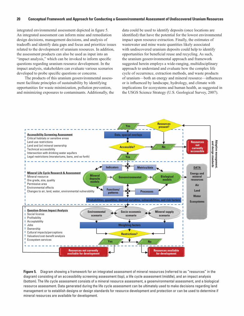
20 Conceptual Framework and Approach for Conducting a Geoenvironmental Assessment of Undiscovered Uranium Resources
integrated environmental assessment depicted in figure 5. An integrated assessment can inform mine and remediation design decisions, management decisions, and analysis of tradeoffs and identify data gaps and focus and prioritize issues related to the development of uranium resources. In addition, the assessment products can also be used as input into an “impact analysis,” which can be invoked to inform specific questions regarding uranium resource development. In the impact analysis, stakeholders can evaluate various scenarios developed to probe specific questions or concerns.
The products of this uranium geoenvironmental assess-ment facilitate principles of sustainability by identifying opportunities for waste minimization, pollution prevention, and minimizing exposures to contaminants. Additionally, the
data could be used to identify deposits (once locations are identified) that have the potential for the lowest environmental impact upon resource extraction. Finally, the estimates of wastewater and mine waste quantities likely associated with undiscovered uranium deposits could help to identify opportunities for beneficial reuse and recycling. As such, the uranium geoenvironmental approach and framework suggested herein employs a wide-ranging, multidisciplinary approach to understand and evaluate how the complex life cycle of occurrence, extraction methods, and waste products of uranium—both an energy and mineral resource—influences or is influenced by landscape, hydrology, and climate with implications for ecosystems and human health, as suggested in the USGS Science Strategy (U.S. Geological Survey, 2007).
Yes
Yes
Yes
Resourcespresent?
Data, spacial overlays
Probabilities, quantities, derived variables, vulnerabilities, and risk factors
Weighting factors
No
No
Adaptive m
anagement,
and design standards
DATA
Energy andmineral
resources
Air
Land
Water
Ecosystems
Accessible?
Environmentalscenario
Socio-economicscenario
Mineral supplyscenario
Restrictions?
Biologicalmodels
Indicators Metrics/data
Geoenvironmental
Processes
Mineraldepositsmodels
Functions/patterns
Resourcesnot
currentlyaccessible
Resources availablefor development
Resources not currentlyavailable for development
Question-Driven Impact AnalysisSocial licenseProfitabilityAcceptabilityJobsOwnershipCultural impacts/perceptionsValuation/cost-benefit analysisEcosystem services
Mineral Life Cycle Research & AssessmentMineral resource Ore grade, size, qualityPermissive areaEnvironmental effectsChanges to air, land, water, environmental vulnerability
Accessibility Screening AssessmentCritical habitats or sensitive areasLand use restrictionsLand and (or) mineral ownershipTechnical accessibilityIntersection with drinking water aquifersLegal restrictions (moratoriums, bans, and so forth)
Figure 5. Diagram showing a framework for an integrated assessment of mineral resources (referred to as “resources” in the diagram) consisting of an accessibility screening assessment (top), a life cycle assessment (middle), and an impact analysis (bottom). The life cycle assessment consists of a mineral resource assessment, a geoenvironmental assessment, and a biological resource assessment. Data generated during the life cycle assessment can be ultimately used to make decisions regarding land management or to establish designs or design standards for resource development and protection or can be used to determine if mineral resources are available for development.

References Cited 21
AcknowledgmentsSpecial thanks go to the USGS scientists who have
contributed to the ideas expressed in this report and have provided thoughtful review, including George Breit, Briant Kimball, Robert Zielinski, Jo Ellen Hinck, Michael Focazio, Christopher Fuller, Jay Diffendorfer, Seth Haines, Christopher Potter, Leslie “Jingle” Ruppert, Martin Goldhaber, Jane Hammarstrom, Paul Pierce, and George Ozuna. Finally, we gratefully acknowledge the valuable discussions with Johanna Blake, Delbert Humberson, Linzy Foster, Victoria Stengel, Andrew Teeple, Doug Yager, and Kent Becher.
References Cited
Abdelouas, A., 2006, Uranium mill tailings—Geochemistry, mineralogy, and environmental impact: Elements, v. 2, no. 6, p. 335–341. [Also available at https://doi.org/10.2113/gselements.2.6.335.]
Abzalov, M.Z., 2012, Sandstone-hosted uranium deposits amenable for exploitation by in situ leaching technologies: Applied Earth Science (Transactions of the Institutions of Mining and Metallurgy: Section B), v. 121, no. 2, p. 55–64. [Also available at https://doi.org/10.1179/1743275812Y.0000000021.]
Agency for Toxic Substances and Disease Registry, 2013, Toxicological profile for uranium: Atlanta, Ga., Agency for Toxic Substances and Disease Registry, Division of Health Assessment and Consultation, 448 p.
Anastas, P.T., and Zimmerman, J.B., 2003, Design through the 12 principles of green engineering: Environmental Science & Technology, v. 37, no. 5, p. 94A–101A. [Also available at https://doi.org/10.1021/es032373g.]
Batista, M.J., Martins, L., Costa, C., Relvão, A.M., Schmidt-Thomé, P., Greiving, S., Fleischhauer, M., and Peltonen, L., 2005, Preliminary results of a risk assessment study for uranium contamination in central Portugal, in Environmental contamination from uranium production facilities and their remediation—Proceedings of an international workshop on environmental contamination from uranium production facilities and their remediation organized by the International Atomic Energy Agency and held in Lisbon, 11–13 February 2004: Vienna, Austria, International Atomic Energy Agency, p. 17–28.
Bright, P.R., Buxton, H.T., Balistrieri, L.S., Barber, L.B., Chapelle, F.H., Cross, P.C., Krabbenhoft, D.P., Plumlee, G.S., Sleeman, J.M., Tillitt, D.E., Toccalino, P.L., and Winton, J.R., 2012, USGS Environmental health science strategy—Providing environmental health science for a changing world—Public review release: U.S. Geological Survey Open-File Report 2012–1069, 37 p. [Also available at https://doi.org/10.3133/ofr20121069.]
Camus, H., Little, R., Acton, D., Agüero, A., Chambers, D., Chamney, L., Daroussin, J.L., Droppo, J., Ferry, C., Gnanapragasam, E., Hallam, C., Horyna, J., Lush, D., Stammose, D., Takahashi, T., Toro, L., and Yu, C., 1999, Long-term contaminant migration and impacts from uranium mill tailings: Journal of Environmental Radioactivity, v. 42, nos. 2–3, p. 289–304.
Chapelle, F.H., Bradley, P.M., Thomas, M.A., and McMahon, P.B., 2009, Distinguishing iron-reducing from sulfate-reducing conditions: Ground Water, v. 47, no. 2, p. 300–305. [Also available at https://doi.org/10.1111/j.1745-6584.2008.00536.x.]
du Bray, E.A., 1995, Preliminary Compilation of Descriptive Geoenvironmental Mineral Deposit Models: U.S. Geological Survey Open-File Report 95–831, 272 p. [Also available at https://doi.org/10.3133/ofr95831.]
Eberts, S.M., Thomas, M.A., and Jagucki, M.L., 2013, The quality of our Nation’s waters—Factors affecting public-supply-well vulnerability to contamination—Understanding observed water quality and anticipating future water quality: U.S. Geological Survey Circular 1385, 120 p. [Also available at https://doi.org/10.3133/cir1385.]
Finch, W.I., 1996, Uranium provinces of North America—Their definition, distribution, and models: U.S. Geological Survey Bulletin 2141, 18 p., 2 pls. [Also available at https://doi.org/10.3133/b2141.]
Frank, D., Galloway, J., and Assmus, K., 2005, The life cycle of a mineral deposit—A teacher’s guide for hands-on mineral education activities: U.S. Geological Survey General Information Product 17, 34 p. [Also available at https://doi.org/10.3133/gip17.]
Haines, S.S., Diffendorfer, J.E., Balistrieri, L., Berger, B., Cook, T., DeAngelis, D., Doremus, H., Gautier, D.L., Gallegos, T., Gerritsen, M., Graffy, E., Hawkins, S., John-son, K.M., Macknick, J., McMahon, P., Modde, T., Pierce, B., Schuenemeyer, J.H., Semmens, D., Simon, B., Taylor, J., and Walton-Day, K., 2014, A framework for quantita-tive assessment of impacts related to energy and mineral resource development: Natural Resources Research, v. 23, no. 1, p. 3–17. [Also available at https://doi.org/10.1007/s11053-013-9208-6.]

22 Conceptual Framework and Approach for Conducting a Geoenvironmental Assessment of Undiscovered Uranium Resources
Hinck, J.E., Linder, G.L, Finger, S.E., Little, E.E., Tillitt, D.E., and Kuhne, W., 2010, Biological pathways of exposure and ecotoxicity values for uranium and associated radionuclides, chap. D of Alpine, A.E., ed., Hydrological, geological, and biological site characterization of breccia pipe uranium deposits in northern Arizona: U.S. Geological Survey Scientific Investigations Report 2010–5025–D, p. 283–351.[Also available at https://doi.org/10.3133/sir20105025D.]
International Atomic Energy Agency, 1989, In situ leaching of uranium—Technical, environmental and economic aspects, Proceedings of a technical committee meeting organized by the International Atomic Energy Agency and held in Vienna, 3–6 November 1987: Vienna, Austria, International Atomic Energy Agency Technical Document IAEA-TECDOC-492, 168 p. [Also available at https://www-pub.iaea.org/MTCD/Publications/PDF/te_0492.pdf.]
International Atomic Energy Agency, 1996, Steps for preparing uranium production feasibility studies—A guidebook: Vienna, Austria, International Atomic Energy Agency Technical Document IAEA-TECDOC-885, 131 p. [Also available at https://www-pub.iaea.org/MTCD/Publications/PDF/te_885_web.pdf.]
International Atomic Energy Agency, 2004, The long term stabilization of uranium mill tailings—Final report of a co-ordinated research project 2000–2004: Vienna, Austria, International Atomic Energy Agency Technical Document IAEA-TECDOC-1403, 311 p. [Also available at https://www-pub.iaea.org/MTCD/Publications/PDF/te_1403_web.pdf.]
International Atomic Energy Agency, 2005, Guidebook on environmental impact assessment for in situ leach mining projects: Vienna, Austria, International Atomic Energy Agency Technical Document IAEA-TECDOC-1428, 163 p. [Also available at https://www-pub.iaea.org/MTCD/Publi-cations/PDF/TE_1428_web.pdf.]
International Organization for Standardization (ISO), 2006a, ISO 14040, Environmental management—Life cycle assessment—Principles and framework (2d ed.): Geneva, Switzerland, International Organization for Standardization, 20 p. [Also available at https://www.iso.org/obp/ui/#iso:std:iso:14040:ed-2:v1:en.]
International Organization for Standardization (ISO), 2006b, ISO 14044, Environmental management—Life cycle assessment—Requirements and guidelines: Geneva, Switzerland, International Organization for Standardiza-tion, 46 p. [Also available at https://www.iso.org/obp/ui/#iso:std:iso:14044:ed-1:v1:en.]
Jenni, K.E., Pindilli, E., Bernknopf, R., Mieman, T.L., and Shapiro, C., 2018, Multi-Resource Analysis—Methodology and synthesis: U.S. Geological Survey Circular 1442, 81 p. [Also available at https://doi.org/10.3133/cir1442.]
Jurgens, B.C., McMahon, P.B., Chapelle, F.H., and Eberts, S.M., 2009, An Excel® workbook for identifying redox processes in ground water: U.S. Geological Survey Open-File Report 2009–1004, 8 p. [Also available at https://doi.org/10.3133/ofr20091004.]
Lindberg, R.D., and Runnells, D.D., 1984, Ground water redox reactions—An analysis of equilibrium state applied to Eh measurements and geochemical modeling: Science, v. 225, no. 4665, p. 925–927. [Also available at https://doi.org/10.1126/science.225.4665.925.]
McDonough, W., Braungart, M., Anastas, P.T., and Zimmerman, J.B., 2003, Applying the principles of green engineering to cradle-to-cradle design: Environmental Science & Technol-ogy, v. 37, no. 23, p. 434A–441A. [Also available at https://doi.org/10.1021/es0326322.]
McMahon, P.B., and Chapelle, F.H., 2008, Redox processes and water quality of selected principal aquifer systems: Groundwater, v. 46, no. 2, p. 259–271. [Also available at https://doi.org/10.1111/j.1745-6584.2007.00385.x.]
McMahon, P.B., Cowdery, T.K., Chapelle, F.H., and Jurgens, B.C., 2009, Redox conditions in selected principal aquifers of the United States: U.S. Geological Survey Fact Sheet 2009–3041, 6 p. [Also available at https://doi.org/10.3133/fs20093041.]
Morrison, R.G.K., and Russell, P.L., 1973, Selecting a mining method—Rock mechanics, other factors, section 9 of Given, I.A., ed., SME mining engineering handbook: New York, Society of Mining Engineers of the American Institute of Mining, Metallurgical, and Petroleum Engineers, Inc., v. 1, p. 9–2 to 9–22.
Mudd, G.M., 2008, Radon sources and impacts—A review of mining and non-mining issues: Reviews in Environmental Science and Bio/Technology, v. 7, no. 4, p. 325–353. [Also available at https://doi.org/10.1007/s11157-008-9141-z.]
Mudd, G.M., 2014, The future of yellowcake—A global assessment of uranium resources and mining: Science of the Total Environment, v. 472, p. 590–607. [Also available at https://doi.org/10.1016/j.scitotenv.2013.11.070.]
Mudd, G.M., and Diesendorf, M., 2008, Sustainability of uranium mining and milling—Toward quantifying resources and eco-efficiency: Environmental Science & Technology, v. 42, no. 7, p. 2624–2630. [Also available at https://doi.org/10.1021/es702249v.]
Naftz, D.L., Walton-Day, K., Gardner, W.P., Duniway, M.C., and Bills, D., 2020, Natural and anthropogenic processes affecting radon releases during mining and early stage reclamation activities, Pinenut uranium mine, Arizona, USA: Journal of Environmental Radioactivity, v. 220–221, article 106266. [Also available at https://doi.org/10.1016/j.jenvrad.2020.106266.]
References Cited 23
National Research Council, 2002, Evolutionary and revo-lutionary technologies for mining: Washington, D.C., The National Academies Press, 102 p. [Also available at https://doi.org/10.17226/10318.]
National Research Council, 2012, Uranium mining in Virginia—Scientific, technical, environmental, human health and safety, and regulatory aspects of uranium mining and processing in Virginia: Washington, D.C., The National Academies Press, 359 p. [Also available at https://doi.org/10.17226/13266.]
National Oceanic and Atmospheric Administration (NOAA), [variously dated], Environmental Sensitivity Index (ESI) maps: National Oceanic and Atmospheric Administration, accessed November 7, 2014, at https://response.restoration.noaa.gov/maps-and-spatial-data/environmental-sensitivity-index-esi-maps.html.
National Oceanic and Atmospheric Administration, 2017a, Air stagnation index—Maps: National Oceanic and Atmospheric Administration, accessed June 7, 2017, at https://www.ncdc.noaa.gov/societal-impacts/air-stagna-tion/201704.
National Oceanic and Atmospheric Administration, 2017b, Initial implementation of PM2.5 predictions nationwide: National Oceanic and Atmospheric Administration, accessed July 6, 2017, at http://www.emc.ncep.noaa.gov/mmb/aq/cmaqbc/web/html/index.html.
Nicholas, D.E., 1992, Selection procedure, chap. 23.4 of Hartman, H.L., ed., SME mining engineering handbook, volume 2 (2d ed.): Littleton, Colo., Society of Mining Engineering.
Organisation for Economic Co-operation and Development, Nuclear Energy Agency (OECD-NEA), 2000, Features, events and processes (FEPs) for geologic disposal of radioactive waste: an international database: Paris, France, OECD Publications, 88 p. [Also available at https://doi.org/10.1787/9789264187511-en.]
Plumlee, G.S., and Nash, J.T., 1995, Geoenvironmental models of mineral deposits—Fundamentals and applications, chap. 1 of du Bray, E.A., ed., Preliminary compilation of descriptive geoenvironmental mineral deposit models: U.S. Geological Survey Open-File Report 95–831, 9 p. [Also available at https://doi.org/10.3133/ofr95831.]
Reitz, M., Sanford, W.E., Senay, G.B., and Cazenas, J., 2017, Annual estimates of recharge, quick‐flow runoff, and evapotranspiration for the contiguous U.S. using empirical regression equations: Journal of the American Water Resources Association, v. 53, no. 4, p. 961–983. [Also available at https://doi.org/10.1111/1752-1688.12546.]
Renard, K.G., Foster, G.R., Weesies, G.A., McCool, D.K., and Yoder, D.C., 1997, Predicting soil erosion by water—A guide to conservation planning with the revised universal soil loss equation (RUSLE): U.S. Department of Agriculture, Agriculture Research Service, Agriculture Handbook 703, 384 p. [Also available at https://www.ars.usda.gov/ARSUser-Files/64080530/rusle/ah_703.pdf.]
Scanlon, B.R., Reedy, R.C., and Kesse, K.E., 2003, Estimation of groundwater recharge in Texas related to aquifer vulnera-bility to contamination: Texas Bureau of Economic Geology, 127 p. [Also available at http://www.beg.utexas.edu/files/content/beg/research/swr/scan_tceqr_rept.pdf.]
Schneider, E., Carlsen, B., Tavrides, E., van der Hoeven, C., and Phathanapirom, U., 2013, A top-down assessment of energy, water and land use in uranium mining, milling, and refining: Energy Economics, v. 40, p. 911–926. [Also available at https://doi.org/10.1016/j.eneco.2013.08.006.]
Schneider, E., Carlsen, B.W., and Tavrides, E., 2010, Measures of the environmental footprint of the front end of the nuclear fuel cycle: Idaho Falls, Idaho, Idaho National Laboratory, 131 p. [Also available at https://inldigitallibrary.inl.gov/sites/STI/STI/4731816.pdf.]
Singer, D.A., 1993, Basic concepts in three-part quantitative assessments of undiscovered mineral resources: Nonrenew-able Resources, v. 2, no. 2, p. 69–81. [Also available at https://doi.org/10.1007/BF02272804.]
Singer, D.A., and Menzie, W.D., 2010, Quantitative mineral resource assessments—An integrated approach: New York, Oxford University Press, 219 p.
Smith, K.S., 2007, Strategies to predict metal mobility in surficial mining environments, chap. 3 of DeGraff, J.V., ed., Understanding and responding to hazardous substances at mine sites in the western United States: Geological Society of America, Reviews in Engineering Geology, v. 17, p. 25–45. [Also available at https://doi.org/10.1130/2007.4017(03).]
Smith, K.S., and Huyck, H.L.O., 1999, An overview of the abundance, relative mobility, bioavailability, and human toxicity of metals, chap. 2 of Plumlee, G.S., and Logsdon, M.J., eds., The environmental geochemistry of mineral deposits, Part A—Processes, techniques, and health issues: Society of Economic Geologists, Reviews in Economic Geology, v. 6A, p. 29–70. [Also available at https://doi.org/10.5382/Rev.06.02.]
Thrush, P.W., comp., 1968, A dictionary of mining, mineral, and related terms: Washington, D.C., U.S. Department of the Interior, Bureau of Mines, 1,275 p.
U.S. Department of Agriculture, 2002, National agronomy manual: U.S. Department of Agriculture, 227 p.
24 Conceptual Framework and Approach for Conducting a Geoenvironmental Assessment of Undiscovered Uranium Resources
U.S. Department of Energy, 2001, Characteristics of uranium and its compounds: U.S. Department of Energy, Office of Environmental Management, Depleted Uranium Hexafluo-ride Management Program Fact Sheet, 4 p. [Also available at http://web.ead.anl.gov/uranium/pdf/UraniumCharacteris-ticsFS.PDF.]
U.S. Energy Information Administration, 2015, Annual energy outlook 2015 with projections to 2040: Washington, D.C., U.S. Energy Information Administration, 33 p. [Also avail-able at https://www.eia.gov/outlooks/aeo/pdf/0383(2015).pdf.]
U.S. Environmental Protection Agency, 1975, Impact of uranium mining and milling on water quality in the Grants Mineral Belt, New Mexico: U.S. Environmental Protection Agency, EPA 402-R-08-005, 188 p.
U.S. Environmental Protection Agency, 1983, Potential health and environmental hazards of uranium mine wastes: U.S. Environmental Protection Agency, Office of Radiation Programs, Report to the Congress of the United States, EPA 520/1-6-83-007, [variously paged].
U.S. Environmental Protection Agency, 1985, Wastes from the extraction and beneficiation of metallic ores, phosphate rock, asbestos, overburden from uranium mining, and oil shale: U.S. Environmental Protection Agency, Office of Solid Waste, Report to Congress, EPA 530-SW-85-0933, 295 p.
U.S. Environmental Protection Agency, 1995, Extraction and beneficiation of ores and minerals, volume 5, Uranium: U.S. Environmental Protection Agency, Office of Solid Waste, Technical Resource Document, EPA 530-R-94-032, 74 p.
U.S. Environmental Protection Agency, 2000, Abandoned uranium mines project, Arizona, New Mexico, Utah—Navajo lands, 1994–2000, Project atlas: U.S. Environmental Protection Agency and U.S. Army Corps of Engineers.
U.S. Environmental Protection Agency, 2008a, Technical report on technologically enhanced naturally occurring radioactive materials from uranium mining, volume 2—Investigation of potential health, geographic, and environmental issues of abandoned uranium mines: Washington, D.C., U.S. Environmental Protection Agency, EPA 402-R-05-007 [variously paged].
U.S. Environmental Protection Agency, 2008b, Technical report on technologically enhanced naturally occurring radioactive materials from uranium mining, volume 1—Mining and reclamation background: Washington, D.C., U.S. Environmental Protection Agency, EPA-402-R-05-007 [variously paged].
U.S. Environmental Protection Agency, 2012, Stormwater Phase II Final Rule—Construction rainfall erosivity waiver: U.S. Environmental Protection Agency, Office of Water, Fact Sheet 3.1, EPA 833-F-00-014, 12 p.
U.S. Environmental Protection Agency, 2013, National ambient air quality standards for particulate matter; Final rule: Federal Register, v. 78, no. 10, p. 3086–3287.
U.S. Geological Survey, 2007, Facing tomorrow’s challenges—U.S. Geological Survey science in the decade 2007–2017: U.S. Geological Survey Circular 1309, 67 p. [Also available at https://doi.org/10.3133/cir1309.]
U.S. Nuclear Regulatory Commission, 1980, Final generic environmental impact statement on uranium milling: U.S. Nuclear Regulatory Commission NUREG-0706, v. 1, [vari-ously paged]. [Also available at https://www.nrc.gov/docs/ML0327/ML032751663.pdf.]
U.S. Nuclear Regulatory Commission, 1997, Final envi-ronmental impact statement to construct and operate the Crownpoint Uranium Solution Mining Project, Crownpoint, New Mexico: U.S. Nuclear Regulatory Commission, Bureau of Land Management, Bureau of Indian Affairs, NUREG-1508/BLM NM-010-93-02/BIA EIS-92-001, [variously paged].
U.S. Nuclear Regulatory Commission, 2009, Generic environ-mental impact statement for in-situ leach uranium milling facilities—Final Report: U.S. Nuclear Regulatory Commis-sion NUREG-1910, v. 1–2, Washington, D.C., [1,295] p.
U.S. Nuclear Regulatory Commission, 2010, Environmen-tal impact statement for the Moore Ranch ISR Project in Campbell County, Wyoming—Supplement to the generic environmental impact statement for in-situ leach uranium milling facilities—Final Report: U.S. Nuclear Regulatory Commission NUREG-1910, Supplement 1, [570] p.
U.S. Nuclear Regulatory Commission, 2011a, Environmental impact statement for the Lost Creek ISR Project in Sweetwater County, Wyoming—Supplement to the generic environmental impact statement for in-situ leach uranium milling facilities—Final report: U.S. Nuclear Regulatory Commission NUREG-1910, Supplement 3, [735] p.
U.S. Nuclear Regulatory Commission, 2011b, Environmen-tal impact statement for the Nichols Ranch ISR Project in Campbell and Johnson Counties, Wyoming—Supplement to the generic environmental impact statement for in-situ leach uranium milling facilities—Final report: U.S. Nuclear Regulatory Commission NUREG-1910, Supplement 2, [749] p.

References Cited 25
U.S. Nuclear Regulatory Commission, 2014a, Environmental impact statement for the Dewey-Burdock Project in Custer and Fall River Counties, South Dakota—Supplement to the generic environmental impact statement for in-situ leach uranium milling facilities—Final Report—Chapters 1 to 5: U.S. Nuclear Regulatory Commission NUREG-1910, Supplement 4, v. 1, [641] p.
U.S. Nuclear Regulatory Commission, 2014b, Environmental impact statement for the Ross ISR Project in Crook County, Wyoming—Supplement to the generic environmental impact statement for in-situ leach uranium milling facilities—Final Report: U.S. Nuclear Regulatory Commission NUREG-1910, Supplement 5, [805] p.
Wang, J.X.L., and Angell, J.K., 1999, Air stagnation climatology for the United States (1948–1998): National Oceanic and Atmospheric Administration Air Resources Laboratory Atlas, no. 1, 76 p.
Wenrich, K.J., Van Gosen, B.S., and Finch, W.I., 1995, Solution-collapse breccia pipe U deposits, chap. 31 of du Bray, E.A., ed., Preliminary compilation of descriptive geoenvironmental mineral deposit models: U.S. Geological Survey Open-File Report 95–831, p. 244–251. [Also avail-able at https://doi.org/10.3133/ofr95831.]
Younger, P.L., 2006, The water footprint of mining opera-tions in space and time—A new paradigm for sustainability assessments?, in Water in mining 2006, 14–16 November 2006, Brisbane, Queensland: The Australasian Institute of Mining and Metallurgy Publication Series, v. 10/2006, p. 13–22.
Younger, P.L., Banwart, S.A., and Hedin, R.S., 2002, Mine water—Hydrology, pollution, remediation: Dordrecht, Netherlands, Kluwer Academic Publishers, 442 p.


Glossary 27
Glossary
B
beneficiation Recovering the economically valuable portion of the mined ore (Frank and others, 2005). See mining and milling life cycle.bioavailable The degree to which a con-taminant in a potential source is available for movement into or onto an organism (Smith and Huyck, 1999).
E
environmental health The “interdisciplinary study of relations among the quality of the physical environment, the health of the living environment, and human health” (Bright and others, 2012).erosion Movement of soil, rock, or dis-solved material through surface processes (such as water flow or wind).exposure pathway The way humans, animals, and plants come into contact with a hazardous substance. There are three basic exposure pathways: inhalation, ingestion, and absorption through the skin or gamma radiation (National Research Council, 2012).
G
gangue “Undesired minerals associated with ore, mostly nonmetallic” (Thrush, 1968).geoavailability The portion of a chemical element’s or a compound’s total content in an earth material that can be transferred to the surficial or near-surficial environment (or biosphere) through mechanical, chemical, or biological processes (Smith and Huyck, 1999).geoenvironmental model A compilation of geologic, geochemical, geophysical, hydro-logic, and engineering information pertaining to the environmental behavior of geologically similar mineral deposits (1) prior to mining and (2) resulting from mining, mineral processing, and smelting (Plumlee and Nash, 1995).geoenvironmental assessment Also known as a geologically based environmental assess-ment. An evaluation of the inherent attributes
of the undiscovered mineral resources and their probable geologic, hydrologic, geochemical, and climatic settings to estimate volumes of waste rock, wastewater, emissions, dust, and land disturbance; identify contaminants of concern; and map areas in the environment where contaminants of concern are more likely occur and persist upon extraction (developed in this document).
I
indicator Scaled value of physical, biological, and chemical measures that reflect or quantify the state of environmental health.in situ recovery (ISR) A solution mining technique whereby extraction is conducted by injecting a suitable leach solution into the ore zone below the water table; oxidizing, complexing, and mobilizing the uranium; recovering the pregnant solutions through production wells; and, finally, pumping the uranium bearing solution to the surface for further processing (International Atomic Energy Agency, 2005).
L
leachate A solution obtained by leaching; for example, water that has percolated through land or solid mine waste containing soluble substances and that contain certain amounts of dissolved elements or substances in solution (U.S. Environmental Protection Agency, 2008b).
M
metric A quantity that can be measured to reflect the amount of change.mill tailings “The gangue and other refuse material resulting from the washing, concen-tration, or treatment of ground ore” (Thrush, 1968). Residue of solid raw material or solid waste separated out during the processing of uranium mineral ores. Byproduct material in accordance with the U.S. Environmental Protection Agency (U.S. Environmental Protection Agency, 2008b).
28 Conceptual Framework and Approach for Conducting a Geoenvironmental Assessment of Undiscovered Uranium Resources
mining and milling life cycle The “process of finding or exploring for a mineral deposit, extracting or mining the resource, recover-ing the economically valuable resources also known as beneficiation, and reclaiming the land mined” (Frank and others, 2005).mine waste “Mine waste is the soil or rock that mining operations generate during the process of gaining access to an ore or mineral body, and includes the overburden consoli-dated or unconsolidated material overlying the mined area, including the rock interbedded with the ore or mineral body” (U.S. Environ-mental Protection Agency, 1985).
P
permissive tract The area of land that exhibits geologic, geochemical, and hydrologic features or settings that permit the formation of a mineral resource (Singer, 1993).protore The subeconomic portion of the orebody.
U
undiscovered resources Prognosticated and speculative resources, which “refer to resources that are expected to exist based on geological knowledge of previously discovered deposits and regional geological mapping. Prognosticated resources refer to
those expected to exist in known uranium provinces, generally supported by some direct evidence. Speculative resources refer to those expected to exist in geological prov-inces that may host uranium deposits. Both prognosticated and speculative resources require significant amounts of exploration before their existence can be confirmed and grades and tonnages can be defined” (International Atomic Energy Agency, 1996).
W
waste rock Overburden and protore (sub-economic ore) excavated during mining.wastewater Water from mining operations extracted from the subsurface that contains dissolved minerals. It may include water from the uranium-bearing formation, water that has been injected into the formation, and any chemicals added during the production and (or) treatment process or the spent or used water from a mine or mill that contains dissolved or suspended matter (U.S. Environ-mental Protection Agency, 2008b).weathering Processes that occur in place to decompose rocks, soil, and minerals. No move-ment is involved in weathering.


Gallegos and others—Conceptual Fram
ework and A
pproach for Conducting a Geoenvironm
ental Assessm
ent of Undiscovered U
ranium Resources—
SIR 2018–5104
ISSN 2331-1258 (online)https://doi.org/10.3133/sir20185104