logainm.ie | bunachar logainmneacha na hÉireann
TRANSCRIPT

TUAM �
TuamissituatedonthecarboniferouslimestoneplainofnorthGalway,awestwardextensionofthecentralplain.IttakesitsnamefromaBronzeAgeburialmoundoriginallyknownasTuaim dá Gualann. Thenametranslatesas‘theburialmoundoftwoshoulders’or‘theburialmoundwithtwoshoulders’,leavingitequallypossiblethatthe‘shoulders’werephysicalfeaturesofthevicinityorattributesofthemounditself.Notraceofthismoundoroftheclayurnextractedfromitinthe�880shassurvived,butthereissubstantialevidenceoftheirexistence.�Themoundsurmountedanaturalgravelridgeeast of Shop Street that ran in an east–west direction.A small river, theNanny,channelleditswaywestwardalongthenorthernbaseoftheridgeandreacheditsclosestpointtothemoundwhereShopStreetbridgenowstands(Fig. �).TheNanny apparently is called after the eanaigh ormarshlandsthat flanked its course before the river merges with the south-flowing River Clare2kmwestofTuam.OccasionallytheNannyhastakenthenameofitstributary,theCurragh,whichissimilarinmeaning.Overlookingthemoundon the opposite or north bank of the Nanny, Tullinadaly Road rises to c.�6mabove the river. But neither it nor any other neighbouring hill is sufficiently high to offer a comprehensive view of the low-lying town. The undulating landscape makes its descent south-eastwards from the crest of Tullinadaly Road to the flat precincts of Toberjarlath, all within a modest 30 to 60 m abovesealevel(Map�).
PrehistoricTuamwaslocatedatacrossroads.Thesouthernapproachwasa bog-strewn route relieved by eskers and, at some subsequent time, by a causewayor‘togher’fromwhichneighbouringToghermorederivesitsname.As suggested above, the fording point northwards across the Nanny wasprobablyneartheburialmound.Priortotherailwayagethiswastheshortestand most convenient route from the south and south-east of Ireland to north-westConnacht.2TheeasternexitisrepresentedbythepresentBishopStreet.OncrossingtheNannyinthatdirectionthetravellerencounteredextensivemarshland. Thereafter eskers determined the way into the north-east of the province.3 Using this esker trail in the opposite direction the Anglo-Normans reached Tuam on their first incursion into Connacht in 1177. Finally there was the western exit. It crossed the River Clare at Claretuam, some 4 km south-west of Tuam. In medieval times the crossing was equipped with a bridgeandacastle(Map9).
SirWilliamPetty’satlasof Ireland (�685) illustrateshow turloughsorlake-like sheets of water could in winter extend the River Clare beyond recognition (Map 5). Surviving archaeological evidence suggests that thefertile expanse between the Clare and Lough Corrib farther west had acomparativelynumerousBronzeAgepopulation.Inhistorictimesthisareawas known as Mag Seóla. From the fifth to the thirteenth century northern Mag Seóla was occupied by the Muintir Murchadha, later known as theO’Flahertys.4OntheadventofChristianitythesiteofTuambelongedtotheConmaicneCinéilDubáin,apeoplesettledimmediatelyeastofMagSeólainterritorysaidtoapproximatetothebaronyofDunmoreoflatertimes.Jarlath,oneoftheConmaicnenobility,wassaidtohaveembracedthenewreligionagenerationorsoafterStPatrick.ItisclaimedhefoundedamonasteryatCloonfush beside the River Clare on the Mag Seóla border, but ended his daysatTuamasbishopandabbot.
There are three sites in Tuam associated with Jarlath, namely Toberjarlath, Temple Jarlath and Templenascreen. Toberjarlath, situated about 1 km south-eastoftheancientburialmound,wasaholywell‘frequentedonhisfestiveday’5 prior to its concealmentunder the railway line around�859. In thenineteenthcenturythepatternheldthereinvolvedgoingoncearoundalargestationandninetimesaroundasmallerstationwithninepebblesinhand,oneofwhichwasthrownawayoncompletionofeachcircuit.6Thereisevidenceof a church and an early ecclesiastical enclosure at Toberjarlath,7butnothingby way of documentary evidence to confirm their existence. Indeed little is knownofJarlathhimself.Nobiographyofthesaintsurvives,andhisnameisnotmentionedinanyoftheannals.Thismayhavebeenaconsequenceof
theturbulentVikingAge8andlendscredencetothelocaltraditionthat‘theDanes’plunderedTuam.9Althoughthewellhasdisappeared,thesiteispartlysurrounded by grassland, a potential repository for material objects that may evengoback toStJarlath’s time.Minor rivers in thevicinitysuchas theSruffánBrídehavealsodisappearedinthewakeofurbandevelopment.Thesestreamswereonceprominentonthelocallandscape.Indeedtheyformedtheinfrastructure of the earlyChristian era, providingmonasticTuamwith adomestic water supply and sufficient power for whatever horizontal mills it mighthavepossessed.�0
The distribution of ringforts and early ecclesiastical remains in northGalway indicates a concentration of settlements in the territory of theConmaicneCinéilDubáin,especiallynearTuam.��OccasionalobituariesofTuamabbotsintheninthandtenthcenturiesattesttothesurvivalofStJarlath’smonastery.Early in the eleventh centuryÁedUaConchobair, nicknamed‘Áedofthegappedspear’,becamechieftainofUíBriúinAíwhoseancientcapital was at Cruachu in Mag nAí (north Roscommon). His first great rival was Ua Ruairc of Uí Briúin Bréifne. One of their encounters was at Turloughvohan some 4 km east of Tuam (Map 9).�2Thisextensiveturloughor marshland bounded medieval Tuam to the south-east and was strategically located at the end of a long chain of eskers in north-east Connacht. Nearby was the wetland site known to the archaeologists who excavated it in 1913 as ‘theLoughparkcrannóg’.13DomesticandmilitaryartefactsrecoveredfromthesiteimplythatitwasaGaelicstrongholdinÁedUaConchobair’stime.Obviouslyitspurposewastoguardtheeskerterminus.
Áed’s defeat of Ua Ruairc in 1039 earned him recognition in the annals as lord of east Connacht. Then in 1048 he marched against Ua Flaithbertaig ofUíBriúinSeóla,thelordofIar(west)Connacht.InthiscampaignTuamheld a frontier position, Mag Seóla being Ua Flaithbertaig territory andConmaicneCinéilDubáinanUaConchobairacquisition.AftertheoverthrowofUaFlaithbertaigin�05�ÁedUaConchobaircouldclaimkingshipoftheprovinceand,accordingtotheAnnals of Tigernach,he‘tookuphisabodeinthewestofConnacht’.SomehavetakenthistomeanthatTuamwasnowtobecomeÁed’s‘chiefresidenceofthewest’,14butthisconclusionhasnosupporting evidence. However, his conquest of Mag Seóla added to the status of Tuam in that it was no longer a border outpost but a bridgehead joining twosubstantialpartsoftheenlargedkingdom.
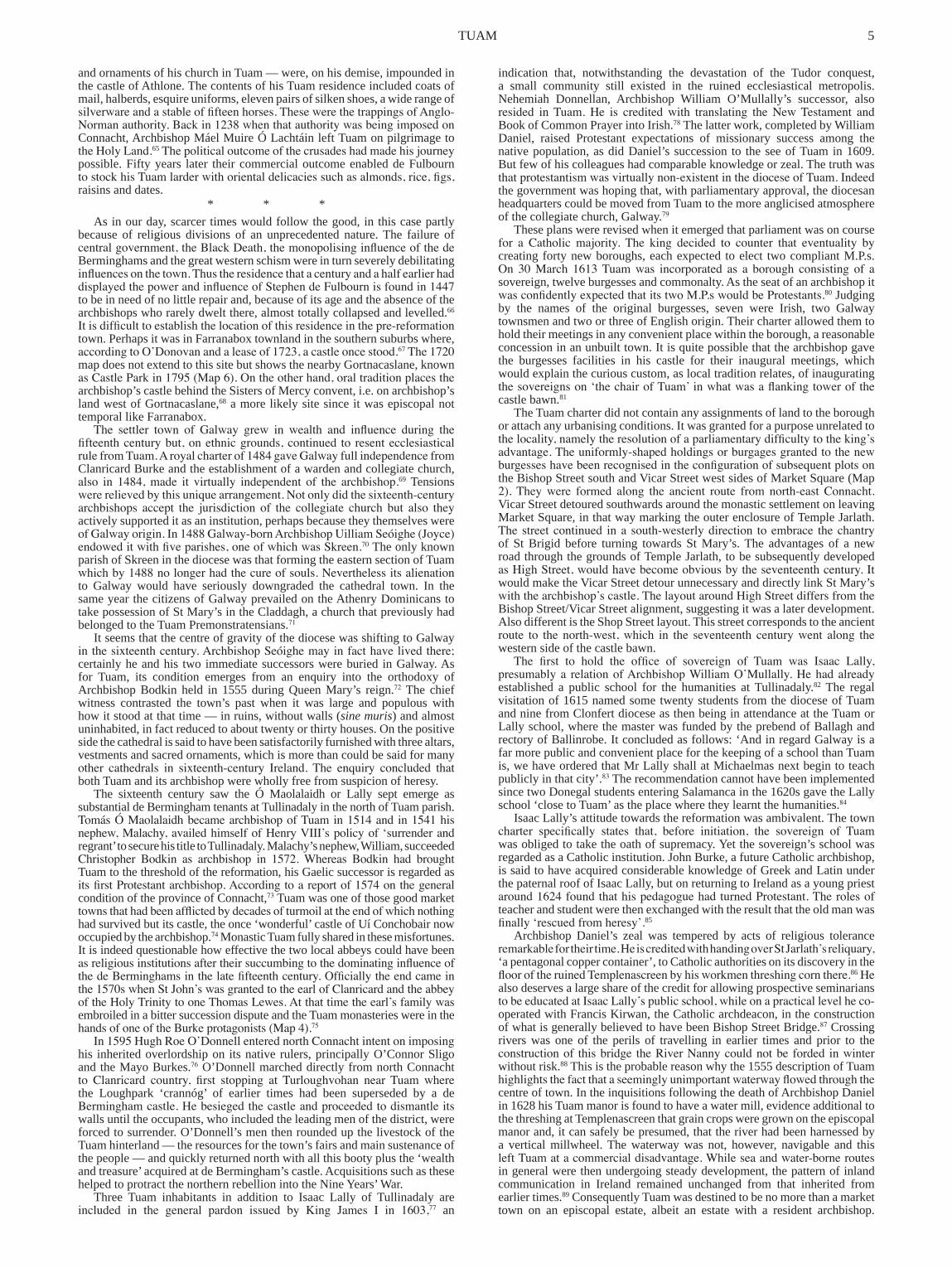
In theepiscopal successionbeginningwithSt Jarlath,ÁedUahOissínwas the first archbishop of Tuam to be invested with the pall in 1152. But according to Sir James Ware and others the six ‘coarbs’ of JarlathimmediatelyprecedingUahOissínwereforreasonsnotstatedplacedinaspecialcategoryandsometimescalledarchbishops.�5 The first of the six was probably another Áed Ua hOissín. His death is recorded in 1058,�6meaninghe was a contemporary of Áed of the gapped spear. It seems reasonableto conclude that monastic Tuam was re-established under this king in the eleventhcenturyandwouldberuledbyasuccessionofsix‘coarbs’uptoÁed Ua hOissín who became archbishop in 1152. Here may also be found an explanation for the six ‘mini ecclesiastics’ that surround a crozier-bearing figure on the ringed head of the twelfth-century market cross.17TheTempleJarlath site was probably newly chosen for the re-established settlement. It hasmedievalruinsbutisdevoidofanythingtosuggestthatitgoesbacktoStJarlath’stime.ThereisnoholywelltherenoranyinscriptionorworkmanshipinstonetolinkittotheearlyChristianera.Theword‘temple’initsnamemay suggest a connection with the twelfth-century reform movement, but the curvingnatureoftheinnerenclosurefossilisedinChurchLaneandSawpitLaneindicatesthatthefoundationpredatesthatreform.ThesignsarethatanimportantGaelicsettlementoriginatedatTempleJarlathintheeleventhcentury,eventuallytobesurroundedbyanouteraswellasaninnermonasticenclosure(Fig.�).
***
TUAMView of R.C. cathedral, looking west, 1843 (Hall, iii, p. 413)

2 IRISH HISTORIC TOWNS ATLAS
TheUaConchobairkingsofConnachtleftadecisivemarkonTuaminboth the ecclesiastical and the secular spheres. Flannacán Ruadh Ua Dubthaig, who died in 1097, is described as fer léiginn (lector)ofTuam,anindicationthat a monastic school had been established there under Ua Conchobairpatronage, for Uí Dubthaig were a clerical branch of that dynasty. It islikelythattheschoolalsohadascriptorium andthattherichlyornamented‘Corpusmissal’nowatCorpusChristiCollege,Oxford,wasproducedatthatinstitution.�8ThefortunesofTuamwerefurtherpromotedwhenToirrdelbachMór Ua Conchobair became high-king of Ireland in 1119, an unprecedented achievementforaConnachtruler.ToirrdelbachenvisagedTuamasaroyaland an ecclesiastical showpiece. At the outset of his high-kingship he acquired custody of part of a reputed fragment of theTrueCrosswhich had beenbrought to Ireland for veneration. This he had encased at Roscommon in a reliquaryoriginallyknownasthebachall buíandnowadayscalledtheCrossofCong.Ittooktheformofaprocessionalcrossandwasinscribedwiththenames of the high-king Toirrdelbach, of Bishop Domnall mac Flannacáin Ua Dubthaig,presumablyasonofthefer léiginn ofTuamalreadymentioned,andofMuiredachUaDubthaig, bishopofTuam.�9Apart fromenhancingToirrdelbach’s standing as high-king, this splendid reliquary would upgrade Tuamasapilgrimageandanecclesiasticalcentre.ShortlybeforethistimeSamuelUahAingliu,bishopofDublin,provokedcontroversybycausinghiscrosstobecarriedbeforehim‘asifhewereametropolitanarchbishop’.20Thecasearousesastrongsuspicionthatthebachall buíwasToirrdelbach’swayofraisingasimilarclaimforthecoarbofJarlath.
AsoftenhappenedinmedievalIrelandtheprovisionofanewreliquarycoincided with the building of a new church.2� In 1127 the high-king,
accompaniedbythecoarbofJarlath,laidouttheenclosureforwhateventuallywouldbeknownasStMary’sCathedral.The land inquestionapparentlywasacommonage(coitchend)andborderedtheoutermonasticenclosuretothe south-west (Fig. 1). According to the annals the new enclosure extended ‘fromthesouthernendofclad in rendatofindmag’.Clad in renda,meaningthecornerdykeor trench,wouldhavebeena featureof theearlier,outermonastic enclosure. A segment of that enclosure can be detected in thecoursetakenbyVicarStreetasitturnssouthwardsfromMarketSquare.TheconvergenceofstreetandenclosureendedatorbeforetheentrancetoTheMall with the boundary turning sharply westward or north-westward, thus givingrisetoclad in renda.Thecathedralenclosurepresumablybeganatthatpointandextendedwestwardtofindmagor‘thewhiteplain’,anamedescriptive of the marl-based marshland west of St Mary’s.
Since Toirrdelbach Ua Conchobair was high-king ‘with opposition’, anything he patronised was in danger of attack from his enemies. In 1132 Cormac Mac Carthaig in Munster openly aspired to the high-kingship and, in an attempt to win ecclesiastical endorsement, built a magnificent church on the Rock of Cashel. The Connacht clergy who attended the consecration of Cormac’s chapel in 1134 came home ‘in displeasure’, presumably because of MacCarthaig’suseoftheceremonialstopromotehispoliticalambitions.22LaterthatyearMunsterforcesdescendedonConnachtandplunderedTuam’snew cathedral. If, as was probably the case, the same foundations wereusedinthecathedral’sreconstruction,23themotivesforitsbuilding—anddesecration — become manifest. The dimensions of the surviving twelfth-centurychancelarenotonlygreaterthanthoseofCormac’schapelbutgreaterthan those of any surviving chancel from twelfth-century Ireland.24
SH
OP
ST
RE
ET B I S H O P
S T R E E T
D U B L I NR O A D
C I R C U L A R
RO
AD
VI C
AR
ST
RE
ET
MA
LL
H I G H S T R E E T
G A L WA Y
R O A D
StMary’sCathedral
AbbeyoftheHolyTrinity
TempleJarlath
Market
StJohn’sPriory
StBrigid’sHospital
Burialmound
WonderfulCastle
Templenascreen
Toberjarlath0.5km
Marketcross
Archbishop’shouse
R i v e r N a n n y
S r u f f á nB r í d e
‘Cashel-likewall’
‘Cladinrenda’
42
4545
39
36
36
39
39
39
42
42
33
33
39
42
Fig. 1 Medieval Tuam
0 100Metres
IHTA 2009
N
Religious house,site known/uncertain
Other buildings,site known/uncertain
Streets, street names and plot boundariesbased on OS (1839)
Conjectural enclosure
Cathedral
Contours in metres39
Church
Barony boundary
Conjectural cathedralenclosure, c. 1127

TUAM 3
ThecathedralenclosurefailedtoprotectthebuildingfromtheMunsteronslaught of 1134. What seems to have been a robbed-out section of that enclosure was discovered in 1992 and referred to as ‘a thick cashel-like wall’ withanouterfacingoflargestones,acoreofearthandsmallstonesandaninnerfaceofsmallstonesembeddedinaslopingembankment.25Apparentlyit remained a visible feature of the landscape even as late as 1499 when a papalletterdescribeditaspartof‘thewallsofTuam’.Anotherpapalletterof 1499 mentions town walls close to Templenascreen. It is, however, quite unlikely that these walls could have served their original purpose in thevery different circumstances of the late fifteenth century. By the seventeenth century they were but a memory. Writing in 1672 John Lynch, archdeacon of Tuam,says:‘Thatit[Tuam]wasoncesurroundedbywallsisshownbythefoundations,quitefrequentlydiscoveredbyditchersandbythewritingsofold.Theincessantmadnessofwarhaslevelledthemtotheground’.26
Having founded the cathedral in 1127 the king made provision for its maintenance, more specifically for the maintenance of the Uí Dubthaig clergywhoshoulddwellinTuam.27Takingapartoftheneighbouringlandsknown as ‘Cluain’ he divided it in two and donated the south-western half as specified above. The other half he gave to the monastery. The monastic donation apparently stretched north-eastwards from the guesthouse. This arrangementimpliedthatthemonasteryhadtotakesecondplacetothenewepiscopal establishment.There are signs thatMurgiusÓNíoc, hereditarycoarbofJarlathanderenachoradministratorofthemonasticproperty,didnot take kindly to this arrangement. He died on Inchagoill, Lough Corrib, in ��28,hisobitrecallingthathehadbeencoarbofJarlath‘foratime’,aphraseidenticalwiththatusedforNiall,coarbofPatrick,whoforfeitedhispositionto the reforming St Malachy in 1139.28
KingToirrdelbachthenhadanumberofhighcrosseserectedinTuam.InscriptionsonthebaseofthemarketcrossandonthecrossshaftinStMary’sCathedralrequestprayersforthekingandtheabbot,laterarchbishop,ÁedUahOissín,anindicationthattheywereconstructedinthesecondquarterof the twelfth century.Oneof these crosseswas originally located in themarketplace,anareathatinthetwelfthcenturylayattheeasternentrancetotheoutermonasticenclosure.Theinnerenclosurehasleftitsimpressioninthe semicircular or D-shaped curve of Temple Jarlath graveyard (Map 11). It seems that it originally extended beyond High Street to the north-west and measured approximately 130 m x 110 m.29Itwouldhaveencompassedthechurch,burialgroundanddomesticbuildingsofthemonasticcommunity.Thepresentruinouschurchisofalaterera,althoughthemassivestonesinits lower courses may belong to its eleventh-century predecessor.
Asmentionedabove,VicarStreetonleavingMarketSquaredelimitstheouterenclosureofTempleJarlathprobablyasfarastheentrancetoTheMallwheretheenclosureturnssharplywestwardatclad in renda.ContinuingfromTheMallentrance,VicarStreetrunseastofanotherecclesiasticalenclosureassociatedwithStBrigidandbisectedbytheTuamtoClaremorrisrailwayline. Housing and other developments have obliterated all visible traces of the westernsegmentofthisenclosurebutthecurveofVicarStreet/ChurchViewapparently delimits part of the bounds. The O’Donovan letters, obviouslyreferringtothissite,recallthatachapelandcemeteryweresituatedashortdistancesouthofStMary’sCathedral in thevicinityofChurchView.Thesamesourceaddsthataccordingtoaninquisitionof�586thechapel,theninruins,wasthoughttohavebeenfoundedasachantrydedicatedtoStBrigid.Locallyithasbeenassociatedwiththevicarschoral.30SruffánBríde,thenameofanearbystream,corroboratesthechapel’sassociationwiththesaint.
Around 1140 a house for Augustinian canons known as St John’s Priory, later to becomeSt John’sAbbey,was established under the patronage ofToirrdelbach Ua Conchobair. The priory lay east of the outer monasticenclosureor‘inthesuburbsofTuam’,accordingtothepapaltaxationdatedto about 1306, and within the present-day bounds of Vicar Street, Dublin Road and Circular Road. The Augustinians were endowed with lands in the localityandinCo.Mayo.31TheirlocalpropertywasacquiredbytheearlofClanricardatthedissolution.Itstretchedeastwardfromthemonasteryandis shown as ‘temporal lands’ on the 1720 map of Tuam (Map 6). Apparently this land had been donated to the monastery by King Toirrdelbach in 1127 andwassubsequentlyreallocatedtotheAugustinians.
Twelfth-century Tuam was an important ecclesiastical centre vested in episcopalandmonastichands.Incompositionandlayoutitresembledotherecclesiastical centres such asArmagh or Kells.32While not neglecting theearlymonasticsettlement,ToirrdelbachUaConchobairgenerouslyendoweditscathedralclergyandAugustinianpriory, therebyineffectpromotingthechurch reform movement that reached its climax in Ireland towards themiddleofthecentury.ToirrdelbachhadhischieffortressatDunmorewhere,accordingtolocaltradition,hediedin��56.33 However, he probably turned toTuam’s ecclesiastical facilities forpurposesof state ceremonial, therebymakingitaroyal‘city’andprovidingreasonswhyitshouldbechosenasthemetropolisofConnachtatthesynodofKellsin��52.Connachtwasarguablythemostremoteoftheprovincesatthattime.Itlackedtheexternalconnectionsenjoyed by Toirrdelbach’s predecessor in the high-kingship, Muirchertach Ua Briain, who adopted the Hiberno-Norse seaport of Limerick as his capital. NeverthelessthewestwasnowinvolvedinchurchreformandToirrdelbachas high-king had direct political contact with Hiberno-Norse Dublin. His ambitionwas to distinguish his own capitalwith the largest cathedral, thetallesthighcross34 and the most magnificent reliquary in all of Ireland. As a pre-Anglo-Norman monastic town, Tuam had achieved pre-eminence.
Toirrdelbach’s son Ruaidrí, who was Ireland’s last native high-king, built a ‘wonderful’ castle at Tuam in 1164. This fortress gave an important civic dimensiontothesettlement,nowofmetropolitanstatus.Thecastlesitewasstrategic, probably the locationof an earlierUaConchobair fortress, east
ofthemonasticenclosureandbesidetheancientburialmound.Becauseitsfoundations were greatly disturbed by eighteenth-century episcopal buildings itisimpossibletoknowwhetheritwassize,designorstoneconstructionthatgave rise to its impressive title. Reflecting his father’s attitude Ruaidrí wanted hiscastletobethebestofitskind,asignofroyalsupremacy.ThedeathofÁed Ua hOissín also occurred in 1164. His now lost tombstone was, in the seventeenth century, described as weather-beaten, curved, delicately carved, depictinghiscloakandsituatedonthenorthernsideofhiscathedral.35
Tuam’s importance as a place of pilgrimage is casually illustrated in 1170 bythedeathofthelordofClannCosgraigh‘onhispilgrimageatTuam’.36TheCross ofCong, the relics ofSt Jarlath andSt Jarlath’swellwere alllikelypilgrimdestinations.Jarlath’sfeastdaywascelebratedon6June,nottheanniversaryofhisdeathbutthedaycommemoratingthetranslationofhisenshrinedrelicstothechurchcalledTemplenascreen.37Thetranslationprobably occurred in King Ruaidrí’s time since he was also associated with enshrining the relics of St Monchan in 1166 and St Comman in 1170. The building of this church east of Ruaidrí’s castle indicates that Tuam, an entirely Gaelic settlement, had acquired an urban dimension by the late twelfthcentury.IndeedtheeasternsuburbbecametheseparateparishofSkreenwithTemplenascreenasitsparishchurch.38
The synod held in Tuam in 1172 was the occasion on which the archbishop consecratedno fewer than threechurches,allofwhichmayhavebeen inTuamitself.39Theyarenotnamedintheannalsbutcircumstantialevidencedesignates them as, firstly, the cathedral that had been plundered by Munster forces in 1134 and, according to Ware, rebuilt by Áed Ua hOissín about 1152; secondly, the priory church of St John founded about 1140 and, according to the taxation of about 1306, situated ‘in the suburbs’; thirdly, the church of the relics of St Jarlath known as Templenascreen and said in 1499 to be ‘just outside the walls of Tuam’. Considering the valuable shrine it housed, Templenascreen probably had its own enclosing wall represented by theadjacent curve of the barony boundary. Thus the consecration ceremonies of 1172 celebrated the building achievements and grandeur of royal Tuam and itssuburbs.
***
For the inhabitants of Tuam the first coming of the Anglo-Normans was not a remote or an irrelevant event. King Ruaidrí’s unsuccessful attempt to prevent the forces of Miles de Cogan from capturing Dublin in 1170 attracted theinvaders’unwelcomeattentiontohisownkingdom.Threeyearslaterinresponse to the gibbeting in Dublin of his executed ally, Tigernán Ua Ruairc, he had the severed hand of Domnall Ua Ruairc, a collaborator in the treachery, broughttoTuamandnailedtothetopofhiscastle.40 However, by now it was clear that the contest was unequal and Ruaidrí, despairing of military victory, gave allegiance to the English king in the 1175 treaty of Windsor.
The treaty did not bring peace to Connacht. In 1177 de Cogan, with the connivance of Ruaidrí’s son, Muirchertach, led a force of 40 knights and 500soldiersacrosstheShannon.41TheyplunderedMagnAí,thentookthe‘highway’ (slí mór) byTempletogher and Dunmore toTuam and, duringRuaidrí’s absence in western Connacht, used the town as a base to plunder Mag Seóla and beyond. The people took their own defensive measures.Having burnt the churches where food was stored and hidden the rest in local souterrains,anotedfeatureofthearea,42theyretreatedwiththeircattleandbelongings into fastnesses where armed Anglo-Normans could not follow. TheTuamhinterlandhadmanysuchfastnesses.OnewasCloonfois,43anotherCloonascragh, used as a refuge by the townspeople in 1798. Consequently the invaders found the town ‘emptied’ and in the end left ‘without food,without profit’ hotly pursued by Ruaidrí’s army.
ThedeCoganonslaughtprefacedadarkchapterinTuam’shistory.Thetragedywasnotsomuchthattheplacewasdestroyed—monasticcentresinmedieval Irelandexperiencedmanysuchcalamities—but thaton thisoccasion it did not have the capacity to recover. Ruaidrí Ua Conchobair had already lost his high-kingship and dynastic conflict would lead to his prolongeddetentionatCongAbbeywherehediedin��98.44Thearchbishop,CadlaUaDubthaig,alsorepairedtoConganddiedtherein�20�,45leavingacontroversialsuccessionissue.Cadla’sfatherandgrandfatherhadearlierheldtheseeofTuamandhehimselfhaduncanonicallyconsecratedhisnephewinordertocontinuethesuccession.46Theirregularitywasresolvedwiththeappointment of an Ulster Cistercian, Felix Ua Ruanada, as archbishop, much tothedismayoftheUíConchobairestablishmentwhotherebylosttheirsay,atleastinthisepiscopalappointment,totheEnglishking.
The cathedral had its own misfortune. In 1184 it ‘fell in one day, both roof and stone’, one suspects because of its over-ambitious design. Roger Stalley holds the view that the twelfth-century chancel represents a rebuilding of around 1184–90.47 Considering the difficulties then being experienced bybothking and archbishop, rebuildingon such agrand scale is hard toimagine.Moreover, therearenophysicalsignsofarebuiltcathedral.It ismuchmorelikelythatthechancelwastheonepartofthecathedralthatdidnot collapse in 1184. According to Ware, the abbey of the Holy Trinity was usedasTuam’scathedral.48ThiswasaPremonstratensianfoundationoftheearlythirteenthcenturysituatedonthewesternoutskirtsofthetown.Laterit was described as being ‘just outside the walls of Tuam’, i.e. the walls or cathedral enclosure constructed by Toirrdelbach Ua Conchobair in 1127.
In order to make good his title to the lordship of Connacht, the Anglo-Norman Richard de Burgh undertook the widespread occupation of the province in 1237. The operation involved the building of castles for his barons.ItalsoinvolvedrestrictingUaConchobairtotheKing’sCantreds,essentially north Co. Roscommon. Tuam was left in ecclesiastical hands underitsarchbishop,whountillateinthecenturywasofnativeIrishstock.

4 IRISH HISTORIC TOWNS ATLAS
Presumably because it remained a Gaelic settlement, it was not givenborough status like the Anglo-Norman towns of Athenry and Galway. Nor was it likely that thenewrulerswouldallowitswallseitherbymeansofmaintenanceor repairs toserveamilitarypurpose. Itshinterland innorthMagSeólaandConmaicneCinéilDubáinbecamethebaroniesofClareandDunmore, respectively.Tuam’smostpowerfulneighbourwouldbe thedeBerminghambaronofDunmorewhoseeminglygarrisonedtheLoughpark‘crannóg’atanearlystageoftheoccupation.49AsinmostofConnachtthenativepopulationformedthetenantryofthesetwobaronies.
In 1244 a disastrous fire, perhaps deliberate, consumed Tuam, including fourchurchesandallthehousesofthetown.50Thereisevidencethatthesechurches — namely the church of the Holy Trinity (then acting as Tuam’s cathedral),StJohn’s,TempleJarlathandTemplenascreen—wererebuilt,buttheruinsofonlyone,TempleJarlath,stillsurvive.Itsthreeeastwindowsarein the transitional style, indicating that they were built soon after the fire. Five carved heads, Romanesque in design, are incorporated into the wall beside thesewindows.Theyobviouslybelongedtoanearlierbuilding,perhapstheportalofthecollapsedcathedral.5�Theintentionmayhavebeentousethisrestored parish church as a pro-cathedral. In fact the seventeenth-century ArchdeaconLynchstatedthatTempleJarlathwas‘onceacathedral’.
The first official record of fairs in Tuam is a royal charter of 1260 granting an annual eight-day fair to Archbishop Tommaltach Ó Conchobair at his vill ofTuamfrom29Decemberto5January.Thecharterprobablymarksthecontinuation rather than thebeginningof local fairs.Typically themarketplacewouldhavedevelopedattheeasternentrancetothemonasticenclosure.Thereis,however,adistinctpossibilitythatthevenuechangedinthemedievalperiod.The�992excavationsdiscoveredseveralhundredsquaremetresofcobbledsurfacelyingbetweenVicarStreetandStMary’sCathedral,whichmaywellhavebeenthefairgreenatthearchbishop’svill.52
Archbishop William de Bermingham had ambitious plans for a newcathedral. The choir would be 24 m x 10.5 m in area, the transepts a combined span of 41 m. De Bermingham’s Anglo-Norman background gave hope for the success of the undertaking. However, by the time of his death in 1312 only the choir of the cathedral, ‘the last great achievement of the [IrishGothic]period’,53wasbuiltandevenagrantofpapalindulgencesfailedtoeffect its completion.54ThedeBerminghamepiscopatewas impoverishedbycivilunrest.55Thearchbishopwasaccusedoftakingthelawintohisownhandsandhehimselfadmittedtohavingagallows, trebuchet,pilloryand
tumbrelathisdisposal,possiblyinTuam.56Theerosionofcentralauthorityhadbegun inhis lifetimeandwas accelerated immediately afterwardsbythe Bruce invasion. The abjuration of English rule by the Connacht de Burghs in 1333 meant that the town of Tuam would be thereafter in the Mac William Uachter or Clanricard sphere of influence in the southern part of thedioceseandtheappointmentofitsarchbishopswouldbemadewithoutfeudalobligationstotheEnglishking.57 Except for the Anglo-Norman towns ofAthenryandGalway,thediocesewasecclesia inter Hibernicos.BeingfarbeyondthereachesofthelaterPaleoritsparliament,Tuamwasunconcernedthatitsarchbishopwasanabsenteefromthelords58orthathischarterleftitunrepresentedinthecommons.
In the process of finding a successor to Archbishop Máel Sechlainn Mac Áeda, a reputed victim of the Black Death, the diocesan chapter electedits chancellor, Robert de Bermingham, as dignissimus, but Tomás MacCearbhaill of Cashel was eventually the papal choice.59 In 1356, during MacCearbhaill’sepiscopate,thetownwasonceagainputtothetorch,theculpritsthistimebeingCathalÓg,sonofO’ConnorSligo,andMacWilliamÍochtar, i.e.MayoBurke.60 While the influence of the de Berminghams in the archdiocese was not sufficient to gain episcopal positions for family members in the fifteenth century, they seldom if ever failed to ring-fence one or more of the lesser diocesan offices of deanery, archdeaconry or provostship throughoutthatperiod.6� For instance, in the 1490s Meiler de Bermingham wasabbotofStJohn’sandArchdeaconWilliamdeBerminghamwasinillegalpossession of the monastery of the Holy Trinity.62 The dominating influence ofthedeBerminghamsinTuammayexplaintheapparenttendencyofitsarchbishopstodwellelsewherefromtheearlyfourteenthcenturyonwards.It hasbeen contended that after thedeathofArchbishopdeBerminghamhis unfinished cathedral was sequestered by his relations and used as a fortressandstablingforanimals.63ButWarewithmorecredibilitymaintainsthatthedeBerminghamchoirwas‘convertedintothenaveorbodyofthecathedral’.64 Thus pre-reformation Tuam had a succession of four cathedrals or pro-cathedrals — St Mary’s until 1184, the church of the Holy Trinity until 1244, then Temple Jarlath for approximately half a century and finally thedeBerminghamcathedralofStMary.
TheearliestreferencetoanepiscopalresidenceinTuamisfoundinaninventoryofthegoodsandchattelsofArchbishopStephendeFulbourn,whoat the time of his death in 1288 also held the position of justiciar of Ireland. Items relating to his ecclesiastical office — his vestments, religious books
Knockanhagardor Hill Parke
Lisadyra
AA
A
A
A
A A
A
A
A
A
A AA
AAA
A
AA
A
AA
AA
A
A
AA
AA
A
AA
A
AAA
A
A
T
TT
T
T
TT
T
T
A
A
T
A
Gortalogh
Part ofGortalogh
CalfePark
A meadowpart of Gortacaslane
Chambers
Curraghskreen50 acres
The other part ofGortnacuslane
Chambers
Vicars GleabParks
A parke belongingto Chambers
Old abbybelonging to Mr Edward
Wilson formerly Earlof Clanricard
GurtnecungeA field set Mr John Veseyalong with his house plot
Shruane bride
Deans plotand gardens
Deans meadow
Killaluntee
Gorlarance
Tyreboyand another large
park 30 acresDean and Provost land
Old abby
A
A
Archdeacon’s meadow
The abby park
ShramoreA
Provost
Parish
Churchyard
Commonor peat
Mill
Mill
Foarde B
ridge
Common orwaste land
Trassysplott
Millpond
Mill pond
Millpond
Mill
Millpond
IHTA 2009
N
Property units
Archbishop’s lands
Temporal lands
A
T
0 100Metres
Fig. 2 Archbishop’s and temporal lands in Tuam, 1720 (Morris), overlaid on 1839 (OS)Fig. 2 Archbishop’s and temporal lands in Tuam, 1720 (Morris), overlaid on 1838 (OS)
TUAM 5
andornamentsofhischurchinTuam—were,onhisdemise,impoundedinthecastleofAthlone.ThecontentsofhisTuamresidenceincludedcoatsofmail,halberds,esquireuniforms,elevenpairsofsilkenshoes,awiderangeofsilverware and a stable of fifteen horses. These were the trappings of Anglo-Norman authority. Back in 1238 when that authority was being imposed on Connacht,ArchbishopMáelMuireÓLachtáinleftTuamonpilgrimagetothe Holy Land.65 The political outcome of the crusades had made his journey possible.Fiftyyears later their commercialoutcomeenableddeFulbournto stock his Tuam larder with oriental delicacies such as almonds, rice, figs, raisinsanddates.
***Asinourday,scarcertimeswouldfollowthegood,inthiscasepartly
because of religious divisions of an unprecedented nature.The failure ofcentral government, the Black Death, the monopolising influence of the de Berminghamsandthegreatwesternschismwereinturnseverelydebilitatinginfluences on the town. Thus the residence that a century and a half earlier had displayed the power and influence of Stephen de Fulbourn is found in 1447 tobeinneedofnolittlerepairand,becauseofitsageandtheabsenceofthearchbishopswhorarelydweltthere,almosttotallycollapsedandlevelled.66It is difficult to establish the location of this residence in the pre-reformation town.PerhapsitwasinFarranaboxtownlandinthesouthernsuburbswhere,according to O’Donovan and a lease of 1723, a castle once stood.67 The 1720 mapdoesnotextendtothissitebutshowsthenearbyGortnacaslane,knownas Castle Park in 1795 (Map 6). On the other hand, oral tradition places the archbishop’scastlebehindtheSistersofMercyconvent,i.e.onarchbishop’slandwestofGortnacaslane,68amorelikelysitesinceitwasepiscopalnottemporallikeFarranabox.
The settler town of Galway grew in wealth and influence during the fifteenth century but, on ethnic grounds, continued to resent ecclesiastical rule from Tuam. A royal charter of 1484 gave Galway full independence from ClanricardBurkeandtheestablishmentofawardenandcollegiatechurch,also in 1484, made it virtually independent of the archbishop.69Tensionswere relieved by this unique arrangement. Not only did the sixteenth-century archbishops accept the jurisdiction of the collegiate church but also they activelysupporteditasaninstitution,perhapsbecausetheythemselveswereof Galway origin. In 1488 Galway-born Archbishop Uilliam Seóighe (Joyce) endowed it with five parishes, one of which was Skreen.70TheonlyknownparishofSkreeninthediocesewasthatformingtheeasternsectionofTuamwhich by 1488 no longer had the cure of souls. Nevertheless its alienation to Galway would have seriously downgraded the cathedral town. In thesameyearthecitizensofGalwayprevailedontheAthenryDominicanstotakepossessionofStMary’sintheCladdagh,achurchthatpreviouslyhadbelongedtotheTuamPremonstratensians.71
ItseemsthatthecentreofgravityofthediocesewasshiftingtoGalwayin the sixteenth century. Archbishop Seóighe may in fact have lived there; certainlyheandhis two immediatesuccessorswereburied inGalway.Asfor Tuam, its condition emerges from an enquiry into the orthodoxy ofArchbishop Bodkin held in �555 during Queen Mary’s reign.72The chiefwitness contrasted the town’s past when it was large and populous withhowitstoodatthattime—inruins,withoutwalls(sine muris) andalmostuninhabited,infactreducedtoabouttwentyorthirtyhouses.Onthepositivesidethecathedralissaidtohavebeensatisfactorilyfurnishedwiththreealtars,vestmentsandsacredornaments,whichismorethancouldbesaidformanyother cathedrals in sixteenth-century Ireland. The enquiry concluded that bothTuamanditsarchbishopwerewhollyfreefromsuspicionofheresy.
The sixteenth century saw the Ó Maolalaidh or Lally sept emerge assubstantialdeBerminghamtenantsatTullinadalyinthenorthofTuamparish.Tomás Ó Maolalaidh became archbishop of Tuam in 1514 and in 1541 his nephew, Malachy, availed himself of Henry VIII’s policy of ‘surrender and regrant’tosecurehistitletoTullinadaly.Malachy’snephew,William,succeededChristopher Bodkin as archbishop in 1572. Whereas Bodkin had brought Tuamtothethresholdofthereformation,hisGaelicsuccessorisregardedasits first Protestant archbishop. According to a report of 1574 on the general conditionoftheprovinceofConnacht,73Tuamwasoneofthosegoodmarkettowns that had been afflicted by decades of turmoil at the end of which nothing hadsurvivedbutitscastle,theonce‘wonderful’castleofUíConchobairnowoccupiedbythearchbishop.74MonasticTuamfullysharedinthesemisfortunes.Itisindeedquestionablehoweffectivethetwolocalabbeyscouldhavebeenas religious institutions after their succumbing to the dominating influence of the de Berminghams in the late fifteenth century. Officially the end came in the 1570s when St John’s was granted to the earl of Clanricard and the abbey of the Holy Trinity to one Thomas Lewes. At that time the earl’s family was embroiledinabittersuccessiondisputeandtheTuammonasterieswereinthehands of one of the Burke protagonists (Map 4).75
In 1595 Hugh Roe O’Donnell entered north Connacht intent on imposing his inheritedoverlordshipon itsnative rulers,principallyO’ConnorSligoandtheMayoBurkes.76O’DonnellmarcheddirectlyfromnorthConnachtto Clanricard country, first stopping at Turloughvohan near Tuam where the Loughpark ‘crannóg’ of earlier times had been superseded by a deBermingham castle. He besieged the castle and proceeded to dismantle its wallsuntiltheoccupants,whoincludedtheleadingmenofthedistrict,wereforcedtosurrender.O’Donnell’smenthenroundedupthelivestockoftheTuamhinterland—theresourcesforthetown’sfairsandmainsustenanceofthepeople—andquicklyreturnednorthwithallthisbootyplusthe‘wealthandtreasure’acquiredatdeBermingham’scastle.AcquisitionssuchasthesehelpedtoprotractthenorthernrebellionintotheNineYears’War.
Three Tuam inhabitants in addition to Isaac Lally of Tullinadaly areincluded in the general pardon issued by King James I in 1603,77 an
indication that, notwithstanding the devastation of the Tudor conquest,a small community still existed in the ruined ecclesiastical metropolis.Nehemiah Donnellan, Archbishop William O’Mullally’s successor, alsoresided in Tuam. He is credited with translating the New Testament and BookofCommonPrayerintoIrish.78Thelatterwork,completedbyWilliamDaniel, raised Protestant expectations of missionary success among thenativepopulation,asdidDaniel’ssuccession to theseeofTuamin�609.Butfewofhiscolleagueshadcomparableknowledgeorzeal.Thetruthwasthat protestantism was virtually non-existent in the diocese of Tuam. Indeed thegovernmentwashopingthat,withparliamentaryapproval,thediocesanheadquarterscouldbemovedfromTuamtothemoreanglicisedatmosphereofthecollegiatechurch,Galway.79
Theseplanswererevisedwhenitemergedthatparliamentwasoncoursefor a Catholic majority. The king decided to counter that eventuality by creating fortynewboroughs,eachexpected toelect twocompliantM.P.s.On 30 March 1613 Tuam was incorporated as a borough consisting of a sovereign,twelveburgessesandcommonalty.Astheseatofanarchbishopitwas confidently expected that its two M.P.s would be Protestants.80Judgingby the names of the original burgesses, seven were Irish, two GalwaytownsmenandtwoorthreeofEnglishorigin.Theircharterallowedthemtoholdtheirmeetingsinanyconvenientplacewithintheborough,areasonableconcessioninanunbuilttown.Itisquitepossiblethatthearchbishopgavethe burgesses facilities in his castle for their inaugural meetings, whichwouldexplainthecuriouscustom,aslocaltraditionrelates,ofinauguratingthe sovereigns on ‘the chair of Tuam’ in what was a flanking tower of the castlebawn.8�
TheTuamcharterdidnotcontainanyassignmentsoflandtotheboroughorattachanyurbanisingconditions.Itwasgrantedforapurposeunrelatedtothe locality, namely the resolution of a parliamentary difficulty to the king’s advantage. The uniformly-shaped holdings or burgages granted to the new burgesses have been recognised in the configuration of subsequent plots on theBishopStreetsouthandVicarStreetwestsidesofMarketSquare(Map2). They were formed along the ancient route from north-east Connacht. VicarStreetdetouredsouthwardsaroundthemonasticsettlementonleavingMarketSquare,inthatwaymarkingtheouterenclosureofTempleJarlath.The street continued in a south-westerly direction to embrace the chantry of St Brigid before turning towards St Mary’s.The advantages of a newroadthroughthegroundsofTempleJarlath,tobesubsequentlydevelopedas High Street, would have become obvious by the seventeenth century. It wouldmaketheVicarStreetdetourunnecessaryanddirectlylinkStMary’swith the archbishop’s castle. The layout around High Street differs from the BishopStreet/VicarStreetalignment,suggestingitwasalaterdevelopment.AlsodifferentistheShopStreetlayout.Thisstreetcorrespondstotheancientroute to the north-west, which in the seventeenth century went along the westernsideofthecastlebawn.
The first to hold the office of sovereign of Tuam was Isaac Lally, presumably a relation of Archbishop William O’Mullally. He had already established a public school for the humanities atTullinadaly.82The regalvisitationof�6�5namedsometwentystudentsfromthedioceseofTuamandninefromClonfertdioceseasthenbeinginattendanceattheTuamorLallyschool,wherethemasterwasfundedbytheprebendofBallaghandrectoryofBallinrobe.Itconcludedasfollows:‘AndinregardGalwayisafarmorepublicandconvenientplaceforthekeepingofaschoolthanTuamis,wehaveorderedthatMrLallyshallatMichaelmasnextbegintoteachpubliclyinthatcity’.83TherecommendationcannothavebeenimplementedsincetwoDonegalstudentsenteringSalamancainthe�620sgavetheLallyschool‘closetoTuam’astheplacewheretheylearntthehumanities.84
IsaacLally’sattitudetowardsthereformationwasambivalent.Thetowncharter specifically states that, before initiation, the sovereign of Tuam wasobligedtotaketheoathofsupremacy.Yetthesovereign’sschoolwasregardedasaCatholicinstitution.JohnBurke,afutureCatholicarchbishop,issaidtohaveacquiredconsiderableknowledgeofGreekandLatinunderthepaternalroofofIsaacLally,butonreturningtoIrelandasayoungpriestaround 1624 found that his pedagogue had turned Protestant. The roles of teacherandstudentwerethenexchangedwiththeresultthattheoldmanwasfinally ‘rescued from heresy’.85
Archbishop Daniel’s zeal was tempered by acts of religious toleranceremarkable for their time. He is credited with handing over St Jarlath’s reliquary, ‘apentagonalcoppercontainer’,toCatholicauthoritiesonitsdiscoveryinthefloor of the ruined Templenascreen by his workmen threshing corn there.86 He alsodeservesalargeshareofthecreditforallowingprospectiveseminariansto be educated at Isaac Lally’s public school, while on a practical level he co-operatedwithFrancisKirwan,theCatholicarchdeacon,intheconstructionofwhatisgenerallybelievedtohavebeenBishopStreetBridge.87Crossingrivers was one of the perils of travelling in earlier times and prior to theconstruction of this bridge the River Nanny could not be forded in winter withoutrisk.88Thisistheprobablereasonwhythe�555descriptionofTuamhighlights the fact that a seemingly unimportant waterway flowed through the centreoftown.IntheinquisitionsfollowingthedeathofArchbishopDanielin�628hisTuammanorisfoundtohaveawatermill,evidenceadditionaltothethreshingatTemplenascreenthatgraincropsweregrownontheepiscopalmanorand,itcansafelybepresumed,thattheriverhadbeenharnessedbya vertical millwheel.The waterway was not, however, navigable and thisleft Tuam at a commercial disadvantage. While sea and water-borne routes ingeneralwerethenundergoingsteadydevelopment,thepatternofinlandcommunication in Ireland remained unchanged from that inherited fromearliertimes.89ConsequentlyTuamwasdestinedtobenomorethanamarkettown on an episcopal estate, albeit an estate with a resident archbishop.

6 IRISH HISTORIC TOWNS ATLAS
Municipal records do not survive for the fledgling borough and so the details ofitsearlycorporatelifearebeyondrecovery.
***The civil unrest of the 1640s discloses more about the borough of
Tuam thando the earlier decades of comparative peace.On the outbreakof rebellion in November 1641 the archbishop left his castle in Tuam for the protection of Galway fort. There was no justification for this retreat accordingtotheearlofClanricard,whovisitedTuamlaterinthemonthandfoundthearchbishop’sresidencetobe‘afairandstrongcastle’.Duringhisvisithereceivedcomplaintsfromthesovereignandcorporationagainstthearchbishop for deserting the place and leaving themwithout protection.90The vacuum created by the archbishop’s departure was soon filled by rebels whoburnt the townandcaused theProtestant inhabitants to leaveand induecourseclaimcompensationforthelossesthussustained.9�Amongtheapplicants for compensation were Thomas Bagworth, an innholder andfarmer,WilliamDavis,gent.,whoclaimedhelostanimalsandcrops,sevenmerchants,aclergymanwhosestudywas‘pillaged’andbooksdestroyedanda clergyman’s widow, Mary Hammond. In her depositions Hammond alleged that the goods she had forwarded to Galway were impounded at Richard Burke’scastleofBallinderrysome6kmsouthofTuamandthatherownflight to Galway ran into difficulties after passing Claretuam approximately 5 km south-west of the town where another Burke fortress, Belclare Castle, guarded the crossing of the River Clare. Thus in the seventeenth century the unwalledtownwassurroundedbyfourcastlesorpotentialouterdefences—thoseofTullinadaly,Turloughvohan,92BallinderryandBelclare.
TheProtestantclergywhowithdrewfromTuamatthistimewerereplacedby their Catholic counterparts who prepared St Mary’s Cathedral for thecelebrationofmassandcontinuedtousethecastleasanepiscopalresidence.The non-survival of pre-1641 diocesan records confirms that this was not a smooth transition. Structural improvements came in the course of thedecade.Altarswereerected,newfurnishingswereinstalledinthecathedralandanepiscopallibraryfounded.Thecastlewasimpressivelyrestored,towhich was added a three-storey building supported by strong beams, the hall androomsbeingofelegantproportions.93LoughlinO’ConnorofO’ConnorSligo ancestrywas a prominent supporter of theCatholic clergy in theseactivities. He was a Tuam merchant with a house and plot in town94 andnumerouslandholdingsinthelocality.95Itisnotclearwhethertherecoveredrelics of St Jarlathwere intended for veneration atTemplenascreen, theiroriginal location, or in an oratory adjoining the north wall of the cathedral. In anyeventthequestionwouldsoonbecomeirrelevantsince,withthecollapseof the rebellion, the town reverted to Protestant hands. In 1653 Cromwellian soldierspulleddownthehighcrossandthestatuesofthefourevangelistsatStMary’sCathedral.96BeforehisdeportationtoFranceJohndeBurgo,theCatholicarchbishop,entrustedastatueoftheBlessedVirginandthereliquaryofStJarlathtoLoughlinO’Connorandhissuccessors,anarrangementthatunfortunatelydidnotensuretheirpreservation.97
In the Connacht transplantation of 1654–6 the greater part of the parish ofTuam was allocated to existing Connacht landholders, mostly Galwaytownsmentransplantedtoholdingsofreducedsize.TheBerminghamsandLallys were also in receipt of reduced allotments. Remarkably Loughlin O’Connor survived as a landholder and, despite his Catholic and Gaelicbackground, retainedhouses inTuam98and land in the locality. Infacthewas one of the few remaining local landholders of native Irish stock. His family, later known as the O’Connor-Donelans, were identified with the oldreligiontotheextentthattheyallowedtheirmortuarychapelatTempleJarlath tobe aplaceof interment for theCatholicparochial clergy in thepenaltimesthatweretofollow.99Churchlandsintheurbanpartoftheparishwere estimated at 46 acres in extent, temporal lands at 8 acres.�00ApparentlytheirboundarieswerenotindisputesinceArchbishopSamuelPullen,whohad theoutlineofhisdioceseand itsparishescharted in�660,deemedatownmapunnecessary.
The trade tokens issued by James Treacy in 1670 represent an unidentified localinitiative.�0�TheparticularbusinessinwhichthisTuammerchantwasengaged is likely to have been located on Treacy’s plot, which is shownon the 1720 map as lying between the Tullinadaly and Ballygaddy roads (Fig.2).ApremisesnowadaysknownasTheThatchiscentrallysituatedonthisplot.ItissaidtobetheoldestpublichouseinTuamandmayindeedgobacktoJamesTreacy’stime.FurtherhintsofanimprovingeconomyarefoundintherecollectionsofWilliamKing,afuturearchbishopofDublin,whocametoStMary’s as a young cleric in 1673. He was endowed with a number of benefices in the diocese and decided to live in Tuam where he had taken a house. He enjoyed the privilege of dining at the archbishop’s table that was ‘daily laden withsixteendishesfordinnerandtwelveforsupperwithaverylargevarietyofwinesandaprofusionofothergenerousliquors’.�02Thepeopleamongstwhom he dwelt for five years were, he declared, entirely ‘given to drinking partiesandfeasts’.ItisnotclearwhetherheintendedtoincludetheConnachtgentryintheseexcesses,butinanyeventtheywouldacquireareputationforgoodeatingratherthangoodhousinginthefollowingcentury.103
***Thelasttwodecadesoftheseventeenthcenturyshowsignsofeconomic
recovery at Tuam. John Vesey’s succession to the see of Tuam in 1679 at first seemed to enhance the economic prospects of the town as a Protestant settlement.Traditioncreditshimwithbuildinganepiscopalpalaceon thesite of the later Grove House in Vicar Street,104whichwouldprovidehimwithalibrarythatheprizedhighlyandprovetobeacomfortableresidenceforhismanychildren,hisnumerousrelativesandhisretainers.�05 However,
bytheendof�680hefounditnecessarytopleadwiththelordlieutenantthatacompanyoffootbequarteredinthetownwhere,inhisownwords,theEnglishwere‘verythinlyandinsecurelyplanted’.�06 His anxiety was shared byProtestantIrelandingeneralandturnedtoalarmwiththeaccessionofKing James II in �685.Two years later the town received a new charterproviding for a corporation of twenty burgesses.107 The corporation wascomposedmainlyofOldEnglish,i.e.Galwaytownsmen,whowereCatholicin religious persuasion. But Catholic moves to recover church propertywere firmly resisted by Archbishop Vesey, who chose this time to have the cathedral’smedievaltowerrepairedandasteepleadded.Oncompletionoftheworkin�688VeseyhadhisnameandthatofKingJamesIIembossedin unique juxtaposition on a commemorative plaque. The native population was highly suspicious of the archbishop’s motives, especially his plan toinstall six bells in the cathedral tower which, according to rumour, wasintended to welcome the Williamite army to town.�08 Then in �69�, asBalldeargO’Donnell’ssoldiersoffortunemadetheirmenacingpresencefeltaround Tuam, Archbishop Vesey was compelled to take flight. The battle of Aughrim followed on 12 July and while the fighting raged O’Donnell’s men occupiedandburntTuam.�09
Even though Protestant supremacy was firmly re-established in 1691, VeseyrefusedtoresideinTuamagainandpetitionedparliamenttohavethearchiepiscopalseetranslatedtoGalway.Therequiredbillwasintroduced��0and would have been enacted were it not for objections to the cost of building a new cathedral and palace.���This was the last attempted removal of thesee fromTuam.ThereafterArchbishopVesey resided on his own estate atHollymount, Co. Mayo. His alienation from Tuam had adverse consequences for the town.LikeArmagh,Tuamwasanecclesiasticalboroughunder theimmediate influence of its archbishop who reputedly held its charter.��2 In1708 Archbishop Vesey divested himself of that honour when his daughter Susanna married Henry Bingham of Newbrook, Co. Mayo, and, to quote an eighteenth-century commentator, ‘his Grace, by a very unclerical breach of trust, transferred the property of the borough [of Tuam] from the see to his son-in-law’.113The‘property’hereinquestionwastheright,vestedinthesovereignand burgesses, to return two members to the Dublin parliament. Henceforth untiltheUniontheconstituencywouldbecontrolledbytheBinghams.
Vesey’ssuccessor,EdwardSynge,lostnotimeinrestoringgoodrelationswith his cathedral city. In the opinion of William King, contemporaryarchbishopofDublin,Tuamhadbeenneglectedbyitsformerarchbishops,but with Synge ‘it begins to change its face’.114An act of parliament of1717 facilitated the application of improving principles to the archbishop’s demesnewhich,beingover500Irishacresinextent,wasdeemedexcessiveforhisdomesticuse.��5Theactlefthimfreetoleaseroughlyhalfoftheselandsforaneconomicallyfeasibletermofyearsandtoenclosetheremainderasdemesneland.Aperiodofthreeyearswasallowedtosurveyandmaptheland for letting. The map, produced in 1720, outlined the town’s ecclesiastical and temporal landsandall theplotson lease to tenants (Map6).By thenArchbishopSyngehadembarkedonbuildinganewpalaceonasitepartlyoccupyingthatoftheWonderfulCastleofearliertimes.Thepalacewasaseven-bay three-storey-over-basement structure built in early Georgian style. Itwasnotmeanttostandinisolationbutrathertobepartofacomprehensivescheme that included out-offices, gardens, high enclosing walls and grounds laidoutinnaturallandscapefashion.Successivearchbishopscontinuedthework of improvement and maintenance. The well-tended ‘palace grounds’ would remainanadmired featureof the town foralmost twocenturies tofollow.ItispossiblethatWinifredProven,aTuamseedmerchant,sourcedher merchandise from the palace gardens. By 1756 she was retailing a wide range of vegetable and salad seeds and enjoying the custom of gentry from Co.Mayo.��6
Archbishop’s Synge’s accounts for 1717–22 show that many people, fromtownfatherstolabourers,activelyparticipatedinthebuildingofthepalace.117ImportantmunicipaldevelopmentswerealsotakingplaceinTuamatthistime.TheconstructionofthemarkethouseinMarketSquare,begunin 1700, and the subsequent installation of a public crane enabled a weigh master to take up market duties in 1706. In the same decade the paving of Shop Street was undertaken (Plate 3). There are signs that all these activities wereinspiredbyanintegrateddevelopmentplanfortownanddemesne.ShopStreet,orNorthStreetasitwasthencalled,wasparalleledtotheeastbytheboundary of the archbishop’s demesne and to thewest by the embryonicChapel Lane, the latter being in 1734 no more than ‘a small lane leading downto thewater’.At thesametimeapropertyknownasMorgan’splotisdescribedasborderingShopStreettothewestandhavingonitseasternborder ‘thewall thatencloses theoldbawnbelonging to thearchbishop’scastle’.��8 Evidently this section of bawn wall ran in a north-south direction. ItwouldhavebeenprogressivelydemolishedasShopStreeteastwastakingshape and being furnished with out-offices and back gardens. The most important of these buildings was the Mitre Inn, newly built in 1754 with stables,coachhouseandgardenbehind.AccordingtotheO’Donovanlettersand 1839 Ordnance Survey town plan, part of the bawn wall survived in thefrontwalloftwopublichousesonShopStreet(Map2),��9butsincethisstructurewasonthewestsideofthestreetitismorelikelytohavebeenpartofamedievalwall.
In 1722 Archbishop Synge leased a number of town properties to Edward WilsonincludingtwogigmillssituatedbelowShopStreetbridge,twobiggristmillsandatuckingmillbetweenShopStreetandBishopStreetbridges,amalthousethatreplacedwhathadbeenknownastheuppermillnearBishopStreetbridge,plustheaccompanyingmillhouses,millpondsandmilldams(Map�0).�20Clearlymillinghadbecomeanimportantelementinthelocaleconomybythistime.AconcentrationofmillsatTuamwasmadepossible

TUAM 7
by a drop of 3.7 m in the river level between Bishop Street and Chapel Lane bridges.�2� Moreover the Tuam hinterland had excellent corn-producing soil, enablingthetowntogainareputationintheearlynineteenthcenturyforthequalityofitsbread.�22Apartfrommilling,EdwardWilsonwasprominentlyinvolvedinthebuildingofthearchbishop’spalace,aswasTimothyDunnewho was sovereign of Tuam in 1735 and had superintended the construction of a new bridge at Bishop Street. He commemorated its completion with an inscribed stone weighing twenty-seven hundredweight, unwrought and drawnforawagerfromTempleJarlathtothebridgeonacommonwheelcar by a thirty-year old mule.123Butthemarketcrosswasthetown’sfocalpoint. A deed of 1734, drawn up before the streets acquired their present names,describesBishopStreetasthestreetleadingfromthemarketcrossto Turloughvohan, High Street as the high street leading from the market crosstotheparishchurch,andShopStreetasthehighstreetleadingfromthemarket cross to the north bridge (Map 3, Plate 5).124
Daniel Beaufort, who visited Tuam in 1787,�25 regarded the palace as old-fashioned, an indication of how rapidly architectural style had developedintheeighteenthcentury.Buthewasimpressedbythepalacegardenwithits very fine canal made by Archbishop Hort in the 1740s. The newly-built Mall House he described as ‘very pretty’ with a good garden opposite. He dined in ‘an excellent house’ at the diocesan school, Dublin Road, no doubt themaster’shouse,butmadenocommentonthespaciousresidenceofMrDavis,laterknownasStJohn’s,VicarStreet,whichhealsovisited.GroveHouse, Vicar Street, and Mr Cheevers’ residence opposite the palace were ‘large, well-looking houses’. These, however, were exceptions in an ‘ill-paved’townthat,inhisopinion,wasnotsowellbuiltasLoughrea.WhileBeaufortwasinTuam,preparationswereafootforthelordlieutenant’svisitto Bermingham House. A new exploration of Connacht had begun. The Taylor and Skinner road maps, first published in 1778 (Map 7), facilitated a growing number of gentry given to travel and cross-country visits. The maps included routes from Tuam to Galway, Headford, Moylough and Sligo, plus housesofthegentrywhereinmanycasestheracingcalendarwouldhaveprovided thehighlightsof theyear.After their transfer toGarrauns,some4 km north-east of Tuam, in 1741 the Galway races grew in popularity and brought vitality to the town (Map 1). The Mitre Hotel, with its experience of the races, hosted major functions such as divisional meetings of Volunteers in 1783 and 1784. Similarly ‘the saddle, cap and whip manufactory’ of John Morris that began by serving ‘nobility, gentry and public’ went on to fulfil army orders in 1791.�26BythenthelinenmarketfornorthGalwaywasheldinTuam.127 Thus in many respects Tuam was extending its influence well beyonditslimitsasamarkettown.
***
Thenineteenthcenturywasbothkindandunkind to the inhabitantsofTuam,astheyenteredaneraofmixedfortunes.Thetown’slongassociationwiththedeBerminghamscametoanendwhenThomas,baronofAthenryandearl of Louth, died without male heir in 1799. Seán Rua or John Birmingham ofDalginwasoneofthosewhounsuccessfullyclaimedsuccessiontothetitleand,toadvancehiscase,builtanimpressivetownhouseinBishopStreet.In 1804 the house, then nicknamed Birmingham’s Fancy or Folly, became headquarters of Tuam Bank, a private banking firm launched by Sir Thomas Ffrench.�28 Soon its notes were gaining preference throughout Connachtand its Dublin branch, opened in 1807, was foremost among the city banks. Theomens forTuamwerepositive.TheNapoleonicwars had stimulatedtheeconomy, inparticular the local fairsandmarkets, the linen tradeandthe demand for fighting men. But all of this would change with the scaling down of hostilities. The collapse of Ffrench’s Bank in 1814 was the first in acatalogueofdisasters.AfterWaterloothearmywasdemobilisedandthetownleftwithoutasinglemilitarydetachment.Poorharvests in�8�6and1817 brought famine, fever and typhus.
Thefailureofthe�82�harvestledtowidespreadfamineinConnacht.InanticipationofthatdisasterProtestantArchbishopTrenchpurchasedavaststockofmeal,tookpersonalresponsibilityforTuamanditsneighbourhood,andusedthelocaldispensaryandatemporaryfeverhospitalwhichhehadsetupc. 2 km north-west of the town in Ballygaddy House as important instruments of relief.�29 In May 1822 he estimated that there were 2,027 entirely destitute people living within 2 miles of the town and a further2,047 who could afford provisions only at a reduced price. Oliver Kelly, the Catholicarchbishopwhoalsowasdoingeverythingpossibletocounteractthe impending disaster, joined his Protestant counterpart on the Tuam Relief Committee. When harvest time arrived, a grateful multitude voluntarilyassembledtocut,bindandstackArchbishopTrench’scornwhileacoupleofhundredcartsbroughtallhisturftothepalacefarmyard.130
Athirddestitutegroupin�822consistedoflargefamiliesmainlyfromCo.Mayo, some of whom were staying, others passing and re-passing through Tuam.Apparentlythemendicantcircuitwaswellestablishedbythen,sincethe Tuam select vestry had to take measures in 1814 and again in 1817 to keep‘strangebeggars’outoftownandin�8�8thesovereignhadtopurchasebadges for townbeggars.131Migrants such as thesehelped to increase theurban population by 26% in the decade preceding 1831 and made nineteenth-centuryTuamremarkablefortheextentandpovertyofitssuburbs.132In�825therewereanestimatedtwohundredsuburbanhouses133 typified by a group of cabins originally thrown up against the demesne wall at Tullinadaly Road andlater,withtheencouragementofArchbishopTrench,transferred—thatchandall—totheothersideoftheroad.134 By 1841 the number of such cabins had increased to 825, located around Tierboy Barracks, along a 300-yard stretch of Tierboy Road, Chapel Lane, a 950-yard stretch of Galway Road and a 1,000-yard stretch of Bishop Street beyond St Jarlath’s ‘Old’ College.135
Conversely, the compact town centre was ‘well edificed’ and considerably improvedbythepartialwideningofthestreets,theestablishmentofFahy’sdrapery (or The Scotch Emporium) in 1830136 and Daly’s Hotel in 1832. The nearby Mall had handsome dwellings, Circular Road was newly built, while Dublin Road beyond the compact centre was overlooked only by the gaol, the courthouse, the glebe-house and, eventually, the Union Workhouse (Fig. 3).
In times of distress Archbishop Trench had generously helped thepopulacewithoutdistinctionofcreed,despitethefactthatin�8�6hehadconverted to militant evangelism and thereafter actively promoted ‘thesecondreformation’.137 He was implacably opposed to the establishment of aCatholiccathedralinTuam,somethinghemadeverycleartothetenantsonhisdemesne.138 But his writ did not extend to the Handcock estate, which included the once monastic lands on the eastern outskirts of the town.Here Archbishop Kelly found it possible to establish a diocesan college, an episcopal residence and, in 1827, to lay the foundation stone for a new cathedral.139ThelatterwasthesecondCatholiccathedralfoundedinIrelandsincethereformation,afoolishventuretosomebutoncompletionregardedas ‘perhaps the most sumptuous ecclesiastical structure the Roman Catholics possess in thecountry’.140 Itwasbuiltof local limestonebyTuam labouron a greenfield site, ornamented by Connacht craftsmen and funded in part byProtestantdonations.TheCathedraloftheAssumptiongavethetownanewdimension.Conventsandschoolsencircleditwithremarkablespatialregularityas ifCatholicemancipationhadbeenaccompaniedbyanurbandevelopment plan (Map 13). The town’s charitable and educational facilities were greatly promoted by William Burke of Tuam who died in 1834. He bequeathed£�0,000towardstheerectionandendowmentofaconvent,theestablishment of an orphanage, the relief of distressed housekeepers andwidows,andtheapprenticingofdutifulchildren.141Infurtheranceoftheseobjectives the Presentation Sisters came to town in 1835 and the Sisters of Mercy in 1846. An orphanage and schools for girls soon followed.
TheAct of Union deprived the borough ofTuam of its parliamentaryfranchise,whichwasitsraison d’être. A government enquiry found in 1833 that it was not ‘lighted, flagged or watched’.142 YetCharlesBlakeproudlymarkedhisyearassovereignin�820byrestoringandaddingacupolaandclock to the market house. Blake was the foremost industrialist in town. He had acquired Keary’s brewery and adjoining corn mills and added Bridge House, a five-bay three-storey residence, to the site.143 By 1837 the Tuam Brewery wasproducingsome5,000barrelsofmaltliquorannuallyandthemalthouseabout600quartersofmalt.144Blake’sbrewerywithitsassociatedmillingandmalting establishments were the main industries in early nineteenth-century Tuam. Many of the 481 families, chiefly employed in manufactures and trade in 1831,145wouldhavebeeninthelinenbusiness.Theextensivemanufactureof coarse linen in the town and its neighbourhood can be traced back to1761 when Boetius Egan of Dunblaney was Co. Galway’s largest supplier oftheproducttotheDublinmarket.146 In 1775 a great deal of sheeting was beingsold‘attheinn’atTuam.147Atownsman,JohnCharlesMiller,soughtto improve its quality. He described himself in 1790 as a Swiss Protestant engagedforoverelevenyearsintheextensivemanufactureoflinenonthe
SH
OP
ST
RE
ET
B I S H O PS T R E E T
D U B L INR O
AD
C I R C U L A R
RO
AD
VI C
AR
ST
RE
ET
MA
LL
H I G H S T R E E T
G A L WA Y
R O A D
R i v e r N a n n y
0 100Metres
N
Base map 1839 (OS);street names 1855 (Val. 2).
Valuation
> £40
£20.0.0 to £39.19.0
£15.0.0 to £19.19.0
£10.0.0 to £14.19.0
£5.0.0 to £9.19.0
Fig. 3 Valuation of residential buildings, 1854
IHTA 2009
Fig. 3 Valuation of residential buildings, 1855

8 IRISH HISTORIC TOWNS ATLAS
nearbyBerminghamestate,keepingeightyloomsconstantlyatwork.148Butthelocalindustrycontinuedtoproducecoarselinenforthelowerendofthemarket.Withstrongdemandforsailclothduring theNapoleonicwar, ‘theshuttlewas tobeheard ineveryquarterof the town’.149Thereaftercoarsecanvasfromtheareawasusedforpackingbaconexports.�50Weaversbecameredundant,andsincetheywereunemployableinthetown’sothertradestheyworkedasbuildinglabourersonthenewcathedral.�5� Finally, in 1846, the town’s 139 linen weavers declared that the potato rot had ended the spade-work towhich theyhad turned, leaving themand theirdependants facingstarvation.�52
John Bernard Trotter visited Tuam in 1817 when the October cattle fair was in full swing, probably inMarketSquare, and fever hadgripped thesurrounding countryside.153 He found the town filled with ‘a vast crowd ofpeople,well dressed and respectable’—a reminder that theConnachtpopulation was predominantly rural and that the town contained bothprosperousandpoor,thewellfedandthestarving(Plate6).Tuamfairsweregrowing at that time. A record 40,000 sheep were said to be on offer at the October fair of 1838, and they sold briskly.154 Regrettably this resource did not bring a woollen industry to the area but attracted Yorkshire wool-buyers instead. The first of these, Messrs Townsend and Thompson, erected a store for their purchases at Foster Place, Ballygaddy Road in the mid 1840s.�55
Improvedroadconditionshadabearingonthesedevelopments.Thetown’slocationatthegatewaytoMayoontheBallinasloetoWestportmailcoachroadwascommerciallyadvantageous(Map8).ThelinktoBallinasloewasdescribed in 1831 as one of the best presentment roads in Ireland.�56Itwasthe route by which local linen had been taken to Dublin since the 1760s and Tuam flour since 1785.157Thisregularconnectionwiththecapitalenabledthetown’sshopkeeperstostockanattractivevarietyofgoodsandthusenhancetheirbusinesswhich,itwasclaimed,rankednexttothatofGalwaywithintheprovinceofConnacht.With thedevelopmentofroadtransportation intheearlynineteenthcenturyTuambecamethehubofdailycarservicestoDublin, Ballinasloe, Dunmore, Galway, Headford and Westport.�58
IntheearlynineteenthcenturyattendanceofCatholicsattheTuamdiocesanschoolwastakenasasignthatthetown’sreputationforreligioustolerancestillheld,although thearchbishop’s leasesgaverise tobickeringbetweenlandlordandtenant.�59The Church Temporalities Act of 1833 reduced Tuam toabishopricbutofferedtheprospectofbettertenures.Ultimatelynothingchanged and in 1852 the bishop’s tenures were regarded as a major obstacle totownimprovementsincenobodywaspreparedtobuildonlandwithonlya 21-year lease.�60WilliamGannon,aprominenttowncommissioner,ventedhis frustrationbynoting theabsenceofanyendowmentby theProtestantbishoporhispredecessors–‘notasinglemonumenttoattesttheircharityforthepoorortheirzealforeducationofthepeople’.�6�The‘secondreformation’wasapparentlytheunderlyingcauseofthissectariantension,theworstofwhichcamewiththerenewalofthebishop’sleasesin�858–9.TheChristianBrothers were then evicted, which led to riots and the burning down ofthe abandoned schoolhouse.�62 Through testy correspondence with DeanSeymour the town commissioners eventually, in 1874, negotiated the reassembly of the market cross in Market Square (Plate 4). By then the Church of Ireland had been disestablished and ecumenical relationshipswereonthemend.ThebuildingofanewcathedraldesignedbySirThomasDeane was begun in 1863 and completed fifteen years later. Following George Petrie’s advice the twelfth-century chancel was incorporated into themodernbuilding,designedwithanAnglicancongregationofover sixhundredworshippersinmind.163
During the �850s the congregation at StMary’s includedEnglish andScottishpeoplewhohadpurchasedlandinthelocalitythroughtheencumberedestates court. The resentment aroused by such acquisitions elsewhere inConnacht164isnotfoundinTuam.Memoriesoftheseimmigrantsrecordedbyatownsmanin�9�8describethemasindustriousandcharitablepeoplelivingonthebestoftermswiththeirIrishneighboursandgreatlycontributingtothelocality’scommercialandsociallife.�65Inadditiontofarmingontheeastern outskirts of town, the Rishworths and Strouts succeeded Messrs Thompson and Townsend as agents who sent thousands of tons of woolfromTuam toYorkshire, especiallyBradford.Their success inpromotingcricket in the 1860s and 1870s was such that the Tuam Cricket Club was thenratedas thebest inConnacht.�66 The Rishworths also promoted local industry.Theyfoundadequatewaterpowerandtimberontheirownpropertyat Curraghcreen to manufacture fittings such as bobbins, reels and spools for cotton and woollen mills. The business grew and diversified over some twenty years until 1887 when the company opened a match factory known astheCurraghMills.Itsuccumbedtoapricewarin�890,alsotheyearofclosureforthelocalbrewery.ConsequentlytheareawasfurtherdrainedbyemigrationandindustrialprospectswerenottoreturnuntiltheTuamsugarfactory opened in 1934.
The 1835 report on the municipal corporations did not exonerate the inhabitantsofTuamfromthenepotismandnegligenceoftheirmunicipality,sincetheycouldhaveadoptedtheprovisionsofthepavingandlightingactof 1828 to effect town improvement. This eventually happened when in 1843 thedefunctcorporationwassucceededbyaboardoftowncommissionerswhostrengthenedtheirpowersbyadoptingthetownsimprovementactof1854. During their initial decade in office the commissioners established a fairgreen,upgradedorrelocatedthemarketplaces,attendedtowaterandsewage requirements, laid footpathsandpavedstreets—very impressiveworkintheshadowoftheGreatFamine(Map�2).ConstructionoftheDublinRoad footpath began in 1846 with the intention of giving employment to the poor,perhapsalsotofacilitatetheTuamUnionWorkhouse,whichopenedin that year with accommodation for 800 paupers.A fever hospital was
later added to the site. The succession of John S. Handcock to the temporal landsofTuamin�855signalledthedawnofbettertimes.Withoutdelayheleasedseveralplotsinthecentreoftown,includingaprimesiteatnominalrentforatownhall.167 The contractor was Andrew Egan, whose many fine structureshastenedthetown’stransitionfromthatchtoslate.�68Gaslightingwas another development and, for the first time, a rate was struck to meet the expensesinvolved.Theimpositionofratesmetwithstrongresistance,whicheventuallyprevailedatthetownboardelectionof�860.�69Tollsatfairsandmarkets remained the board’s only source of revenue. However, fairs grew steadily from 21,006 sheep and 5,790 cattle on offer at the October fairs of 1854 to 36,424 sheep and 8,613 cattle in October 1870.170 In 1875 the board hadtoseeka largerfairgreen, ‘orelse’,declaredCommissionerGannon,‘weshallhavetodoasothertowns,levyarateformunicipalpurposes’.171Thisunfortunatemindsetledtheboardin�885toavoidbecominganurbansanitaryauthority,172incontrasttoBallinasloewhichbythenhadachievedbothurbansanitaryandurbandistrictcouncilstatus.173
TheDublintoGalwayrailwaylinewascompletedin�85�.Itwaslocallyassumed that its extension to Mayo would follow the traditional routethrough Tuam. However, landed influences directed it north-westwards from Athlone to Westport, leaving Tuam to fight for a spur line, the Athenry and Tuam Railway, opened in 1860.174Initiallytherailwaypromotedthetown’sfairsbutdisadvantagedlocalindustry,particularlybrewing.Therefusalofthe Midland Great Western Railway to book passengers, goods and livestock directly to Tuam in 1870 meant that the transport of seaweed from Galway for soil cultivation reverted to the carters, a severe loss to the strugglingcompany.175Althoughthetownwasconnectedtotherailwaynetworkitwasmerely a branch line. Even when the extension to Claremorris came in 1894 passengerscouldonlytravelinstagesfromEnnistoSligoviaTuam.
***Twentieth-century Tuam renewed its ancient standing as an important
educationalcentrewitheightprimaryandsecondaryschools,threeofwhichaccommodatedboarders.ApartfromTheMallProtestantschool,closedin1960, these institutions flourished and were supplemented by a technical school in 1938. By 1986 St Jarlath’s College had completed its fourth enlargement of the century. Retrenchment soon followed and all boarding ceasedby2005.The town’shousingproblemremainedunsolved in�9�9when most of its 262 thatched houses were deemed unfit for human habitation (Plates 1, 2). By 1942 the unsanitary houses were gone and their occupants re-housed. Moreover new housing schemes at Tubberjarlath and Athenry Road accommodated an influx of sugar factory workers, newcomers who invigoratedthetown.Theclosingofthatfactoryin�986severelydamagedthelocaleconomy.ItsslowrecoveryshowedamarkedorientationtowardsGalwaycityandTuamhousingestatesprovideddormitoryfacilitiesformanyof its workforce. The twentieth-century town lost one public building, the workhouse; another, the Town Hall, was destroyed in 1920 but subsequently restored. At the turn of the twenty-first century the courthouse was deemed dispensable but the synod hall and the Town Hall were commendably restored.Neverthelessthelatterrestorationisincompletewithoutarestored,re-inhabited and pedestrianised town centre adorned with a replica of the market cross. The present century also finds relevance in the ancient route to northConnachtuponwhichTuamwasfounded.Itisplannedtotransformthat route into the Atlantic Road Corridor from Letterkenny to Waterford alongsidewhichwillrunthereconstructedrailwayfromSligotoLimerick(Plate 7). The fortunes of Tuam hinge on these developments.
Notes 1. Dr Thomas B. Costello (1864–1956), a noted antiquarian with a special interest in the Bronze Age,
attestedtotheexistenceoftheTuammoundanditscontents(TH 16.6.1973). 2. Coulter, p. 132. 3. Atlas of Ireland (Dublin, 1979), p. 21. 4. FormaterialevidenceontheprehistoricpeopleoftheareaseeAlcocket al., pp 1–31. The Muintir
Murchadha period is summarised in O’Flaherty, pp 147–9. 5. O’Donovan,p.25. 6. Glynn notes, NLI, MS 7912, p. 15. 7. Alcocket al., p. 330. 8. Gwynn and Hadcock, p. 25. 9. O’Donovan, p. 27. 10. A.T.Lucas,‘ThehorizontalmillinIreland’,inRSAI Jn., lxxxiii (1953), pp 1–36. The River Nanny
itselfwasunsuitableforhorizontalmills. 11. Guerin, figs 3 and 4. See also Alcock et al., sub‘ringforts’and‘ecclesiasticalremains’. 12. Hy Many, p. 170. 13. Lyttleton,p.�5�. 14. Knox, H.T., p. 77. 15. Ware, p. 603; John Colgan, Acta sanctorum veteris et maioris Scotiae, seu Hiberniae sanctorum
insulae …, 2 vols (Louvain, 1645); reprinted with introd. by Brendan Jennings as The ‘Acta sanctorum Hiberniae’ of John Colgan … (IMC, Dublin, 1948), p. 310, n. 2; O’Donovan, p. 21.
16. AFM, ii, p. 923. 17. Stalley, p. 183. 18. Claffey, 2003, p. 9. 19. Murray, G.J., i, pp 316–20. 20. AubreyGwynn,The twelfth century reform (Dublin, 1968), p. 35. 21. Raghnall Ó Floinn, Irish shrines and reliquaries in the middle ages (Dublin, 1994), p. 13. 22. Ann. Tig., ii, p. 365 attributes these events to 1131, fours years earlier than AFM. 23. TuamCathedralwassaidtohavebeenrebuiltabout��52. 24. Peter Harbison, The golden age of Irish art, 600–1200 (London, 1999), p. 346. 25. Excavations, 1992, p. 33. 26. Lynch,De praesulibus, ii, p. 213. 27. Ann. Tig.,ii, p. 355. 28. AFM, ii, pp 1029, 1063. 29. Swan,p.89. 30. TH 3.10.1970. Lynch, De praesulibus, ii, p. 213 notes this as an infirmary. Alternatively it may have
been a dependency of Kilcreevanty convent, an Uí Conchobair foundation about 5 km north-west of Tuam (Gwynn and Hadcock, pp 318–19).
31. Knox, H.T., pp 264–5. 32. Swan, p. 98; Anngret Simms with Katharine Simm, Kells (IHTA, no. 4, Dublin, 1990), p. 3; Catherine
McCullough and W.H. Crawford, Armagh (IHTA, no. 18, Dublin, 2007), p. 2. 33. Neary,p.98. 34. Thecrosswas‘raisedtoanunusualheight’(Lynch,De praesulibus, ii, p. 214). 35. Ibid., p. 213. 36. AFM, ii, p. 1179. 37. Ware, p. 601; John O’Hanlon, Lives of the Irish saints (9 vols, Dublin, 1875–c.�90�),vi,p.208. 38. Cal. papal letters, 1417–31, p.95.

TUAM 9
39. Ann. Tig., ii, p. 432. 40. Ibid.,p.288. 41. For de Cogan’s expedition to Connacht see ibid., pp 444–5; J.F. Dimock (ed.), Geraldi Cambrensis
opera, v (London, 1867), p. 346. 42. Costello, 1902–4, pp 1–10. 43. O’Connor,G.,p.69. 44. ALC, i, p. 203. 45. Ware, p. 604. 46. JohnWatt,The church in medieval Ireland (Dublin, 1972), p. 97. 47. Stalley,p.�8�. 48. Gwynn and Hadcock, p. 206. 49. Lyttleton, pp 156–71. 50. ALC, i, p. 367. 51. Andersen,p.98. 52. Excavations, 1992, p. 33. 53. Geoffrey Hand, The church in the English lordship, 1216–1307 (Dublin, 1968), p. 34. 54. Cal. papal letters, 1305–42, p.�09. 55. Burke, pp 31–8. 56. Cal. justic. rolls Ire., 1295–1303, pp 316–17. 57. Burke, pp 43–5. 58. H.G. Richardson and G.O. Sayles, Parliaments and councils of mediaeval Ireland (Dublin, 1974), pp
xxvii,xxix. 59. ALC, ii, p. 13. 60. Lynch,De praesulibus,ii, p. 224. 61. Edwards, pp 93–5. 62. J.F.O’Doherty(ed.),‘ObligationesproannatisprovinciaeTuamensis’,inArchivium Hibernicum, xxvi
(1963), p. 103; Cal. papal letters, 1495–1503, p. 107. 63. Burke, pp 86–7. 64. Ware,p.602. 65. Burke, p. 23. 66. Cal. papal letters, 1447–55, pp 333–4. 67. TuamsubCaisleána’Bhosca,OrdnanceSurveynamebooks,Tuam,Co.Galway(GalwayCityand
County Library); RD 38/191/23927. 68. TH 24.8.1974. 69. Mac Niocaill, 1984, p. 8. 70. Burke,p.6�. 71. Ó Héideáin, p. 13. 72. Moran, pp 52–4, 413–14. 73. Cal. Carew MSS, 1601–03, p. 476. 74. Nolan, p. 117. 75. Cal. Carew MSS, 1601–03, p. 473. 76. The life of Aodha Ruaidh Ó Domhnaill transcribed from the book of Lughaidh Ó Cléirigh,xlviii,ed.
Paul Walsh and Colm Ó Lochlainn (Dublin, 1948), pp 97, 99. 77. Cal. pat. rolls Ire., Jas. 1,p.�9. 78. Knox, H.T., p. 126. 79. Cal. S.P. Ire., 1611–14, pp8�,�89. 80. Cal. Carew MSS, 1603–24, p. 146. 81. TH 25.8.1979; O’Donovan, pp 18, 31. 82. Egan,�960,p.69. 83. Royal visitation; NAI, RLFC/15/4. 84. O’Doherty, pp 94–5. 85. C.P.Meehan,The rise and fall of the Irish Franciscan monasteries (Dublin, 1872), p. 121. 86. Lynch,De praesulibus,ii, p. 213. 87. TH 23.11.1918; Lynch, Pii ant. icon, pp 43–4. 88. Lynch,Pii ant. icon, p. 43. 89. NHI, iii, p. 163. 90. Memoirs and letters of Ulick, marquis of Clanricard (London, 1757), pp 20–21. 91. G.W.Story,An impartial history of the wars of Ireland: with a continuation thereof (London, 1693),
p. 152; Depositions 830, ff 136, 144, 148, 172, 175. 92. LaterknownasBerminghamCastle. 93. Lynch,De praesulibus, ii,p.256. 94. RD 76/465/55424. 95. Simington, 1962, pp 286–7, 291, 299, 304, 307. 96. Costello, 1936, p. 23. 97. Kelly,�90�,pp�0�–02. 98. O’Connor Donelan papers, James Hardiman Library, National University of Ireland, Galway, LE10/36. 99. ÓMurchú,p.�2.100.Simington,�962,p.290.101.R.A.S. Macalister, ‘A catalogue of Irish traders’ tokens’, in RIA Proc., xl, C (1931–2), p. 112.102.C.S.King,A great archishop of Dublin, William King, D.D., 1650–1729 (London, 1908), pp 13–17.103.Simms,p.�2�.104.Ó Murchú, p. 42.105.Richard Mant, The history of the Church of Ireland (2 vols, London, 1840), i, pp 747–50.106.Calendar of the manuscripts of the marquess of Ormonde, preserved at Kilkenny Castle(newseries,8
vols,London,�902–20),v,p.562.107.Mun. corp. Ire. rept, p. 432.108.Robert Dunlop, ‘John Vesey, 1638–1716’, in Dictionary of National Biography (69vols,London,
�885–�9�2),lviii,pp290–9�.109.Story,An impartial history,p.�52.110. Commons’ jn. Ire., 1662–96, p.886.111. Hardiman, p. 249.112. Claffey,2005,p.5.113. Falkland, p. 39.114. Mant,History of the Church of Ireland, ii, pp 380–81.115. Stat. Ire., 1310–1768, iv, pp 480–83.116. TobyBarnard,Making the grand figure: lives and possessions in Ireland, 1641–1770 (Yale, 2004), pp
2�5–�6.117. Syngeaccounts.118. RD 76/465/55424.119. O’Donovan, p. 31. The premises in question — Savage’s and Cloonan’s — are now known as Grogan’s
andMcDonagh’s(TH 23.6.1973).120.RD 66/75/45185. To these can be added two windmills on the eastern outskirts of the town, said to have
been built by Archbishop Hort (1741–51), probably to complement the water mill at Bohernagreana.121.This figure, kindly supplied by the Office of Public Works, refers to the level of the Nanny prior to the
Corribdrainageschemeofthe�950s.122.Dutton, pp 12, 17.123.Ó Murchú, p. 33. The inscribed stone still stands at the bridge.124.RD 76/465/55424.125.Beaufort�.126.CJ 20.8.1783, 7.1.1784, 27.9.1791.127.LBM, 1787–1805, show Co. Galway bleachers regularly meeting at Tuam and the county’s linen
marketsbeingheldatTuamandLoughrea.128.C.M.Tenison,‘TheoldDublinbankers’,inJournal of the Cork Historical and Archaeological Society,
i (1895), pp 227–8.129.Archbishop Trench’s exertions during the 1822 famine are detailed in Sirr, pp 99, 142–5.130. Ibid., pp 46–7.131.Comerford,p.��0.132.Coulter, p. 135.133.Second report from select committee on the state of Ireland, HC 1825 (viii), p. 254.134.TH 28.3.1857.135.Parl. gaz., iii, p. 400.136. ‘Harp sheds crown’, NLI, MS 25,530, p. 126.137.DesmondBowen,The Protestant crusade in Ireland, 1800–70 (Dublin, 1978), p. 71.138.Archbishop Kelly correspondence, dated 9.2.1824 in TH 1.4.1916.139.Burke, p. 237.140.Slater, 1846.141.TH 17.8.1974.142.Mun. corp. Ire. rept, p. 435.143.TH 1.12.1917.144.Lewis, ii, p. 646.145.Parl. gaz., iii, p. 403.146.Cronin, p. 31.147. John Horner, The linen trade of Europe during the spinning wheel period(Oxford,�920),p.���.148.LBM, 16.2.1790.149.Galway Free Press 29.2.1832.150.Dutton, p. 427.151.Galway Free Press 29.2.1832.152.British parliamentary papers, famine, Ireland(8vols,Dublin,�968–70), v, p. 276.153. J.B.Trotter,Walks through Ireland in the years 1812, 1814 and 1817 described in a series of letters to
an English gentleman (London,�8�9),p.525.
154.TH 20.10.1838.155.TH 2.7.1977.156.Minutes of evidence before select committee on turnpike roads, HC 1831–2 (xvii), p. 91.157.Commons’ jn. Ire., xii, app., p. cci; xiii, app., p. cclviii.158.Slater, 1846.159.Dutton, pp 152, 327, 409.160.Fairs and markets rept,p.69.161.TH 25.6.1853.162.Nation 25.6.1859; TH 2–30.7.1859.163. Irish Times 24.1.1862.164.NHI, v, p. 341.165.TH�8.5.�9�8.166. Ibid.167.TH 17.2.1855.168.DeirdreGoggin,‘Themarkofaman,thelifeofAndrewEgan’,inJOTS, i (2004), pp 39–46.169.Laheen, 2002, chapters 12 and 13.170.TCM 1.11.1856, 7.11.1870.171.TH 6.3.1875.172.TCM 2.3.1885.173.Egan, 1953, p. 99.174.The fortunes of the Athenry and Tuam Railway are outlined in O’Meara.175.TH 24.4.1858.
TopographicalInformationThefollowing informationrelatesnot toanysingleadministrativedivisionor thesheet
lines of any particular map, but to the built-up area of Tuam at each of the dates referred to.AllgridreferencesusedarederivedfromtheIrishNationalGrid.Thisgridappearsat�00
m intervals on Map 3. In the Topographical Information grid references are included where possible for features not named on either Map 2 or Map 3: they are given in eight figures (the last four figures respectively of the eastings and northings shown on Map 3) and indicate the approximatecentreofthefeatureinquestion.
Theentriesundereachheading,exceptforStreets,arearrangedinchronologicalorderbycategories:forexample,alllimekilnsarelistedbeforeallmills,becausetheoldestlimekilnpre-dates the oldest mill.
In general, dates of initiation and cessation are specified as such. Where these are unknown, the first and last recorded dates are given, and references of intermediate date are omitted except where corroborative evidence appears necessary. Features originating after �900 are listedonly in exceptional cases. In source-citations, a pair of years joined by a hyphen includes all intervening years for which that source is available: thus 1838–1927 (OS) means all Ordnance Survey maps from 1838 to 1927 inclusive.
The list of early spellings in section 1 is confined to the earliest and latest examples noted of the variants deemed to be the most significant. Where necessary the earliest noted attestation ofthecommonestspellingineachofthesecategoriesisalsogiven.
Street names are listed in alphabetical order. The first entry for each street gives its present-day name according to the most authoritative source, followed by its first identifiable appearance, namedorunnamed,inamaporotherrecordandthevariousnamessubsequentlyappliedtoitinchronologicalorderofoccurrence.FornamesremainingunchangedonsuccessiveOrdnanceSurvey maps, only the first occurrence of the Ordnance Survey spelling is cited.
The section on residence is not intended to embracemore than a small fraction of thetown’sdwellinghouses.Themaincriteriaforinclusionare(�)contributiontothetownscape,past or present; (2) significance in defining critical stages in the history of urban or suburban housing; (3) abundance of documentation, especially for houses representative of a large class ofdwellings.Biographicalassociationsarenotinthemselvesagroundforinclusion.
Abbreviated source-references are explained in the bibliography on pages 18–20 or in the generallistinsidethebackcover.
1 Name earlyspellings
Tuaim da Ólann A.D. 781 (AU (2), 237). Tuaim dá Ualann; Tuama da hUalann; Tuama dá Ualann early 17th cent. (Mart. Don., 167, 348; AFM, iii, 128; i, 560; ii, 660).
Tuaim da Gualann A.D. 949 (AU (2), 395), c. ��60 (Bk Leinster, v, 1697), 1247 (Ann.Conn., 88), 1407 (ALC, ii, 122). Túaim da gualand 1164 (Ann. Tig., ii, 409). Tuaim dá Ghualann 1201, 1407 (ALC, i, 221; ii, 123). Tuaym da Gualand 14th cent. (Plummer, i, 102). Tuaim da Ghualann 1328 (Ann. Conn., 264). Tuaim dá Ghualann, Tuaim dá Ghuálann early 17th cent. (AFM, ii, 1056, 1114; iii, 50; vi, 1974).
Tuaim 1127, 1177 (Ann. Tig., ii, 354, 444), early 17th cent. (AFM, ii, 961; iii, 354). Túaim �20�(ALC,i,220).
Thuemia 1177 (Giraldus, 183).Tuaym 1223 (Sheehy, i, 239). Tuayn 1441 (Cal. papal letters, 1431–47, 175). Tuaym 1447
(Cal. papal letters, 1447–55, 294).Tuamensis 1233 (Sheehy, ii, 46), 1487 (O’Flaherty, 217).Twem’�260(Cal. doc. Ire., 1252–84,�09).Tuamia 1312 (Cal. papal letters, 1305–42,�08).Toame mid-16th cent. (Cal. Carew MSS, 1601–03, 476). Tome 1570; Toam 1577 (Fiants,
Eliz., 1581, 3117).Thombe 1553 (O’Flaherty, 212).Tuam 1560, 1578 (Fiants, Eliz., 287, 3419), 1613 (Comerford, 99) to present. ‘Tuam,
antiently called Tuaim da Gualand’ 1739 (Ware, 601).Thomec. 1566 (Nicholls, 1970, 150), 1574 (Fiants, Eliz., 2575).Tweme 1570 (Fiants, Eliz.,�58�).Tuamen’ 1585 (Galway inquisitions, 138).Tuame�590(Fiants, Eliz., 5451), 1620 (Galway inquisitions, 302, 308).Touam�59�(Browne).Tomma Daolann early 17th cent. (AFM, i, 380).Twaime, Twayme, Twayne early 17th cent. (Ann. Clon., 217, 241, 220, 230, 286, 299).
Currentspellings Tuam Tuaim Derivation (1) Tuaim dá Ghualann: burial mound of the two shoulders (Room, 122). (2) TuaimdáUalann:burialmoundofthetwoaltartombs(Bourke,208).Theshoulders
or altar tombs were perhaps features of the burial mound (see 21 Entertainment,memorialsandsocieties).
2 LegalstatusMetropolis��89(Giraldus,�82),c. 1211 (Kirkfleet, 261–2).‘VillofTuam’�260(Cal. doc. Ire., 1252–84, �06).Civitas 1290 (Sayles, 36), 1555; city, in ruins 1555 (Moran, 414, 52).‘Good market town’ mid-16th cent. (Cal. Carew MSS, 1601–03, 476).Charter establishing corporation with 1 sovereign, 12 free burgesses, 2 sergeants-at-mace
and commonalty granted by King James I in 1613 (Mun. corp. Ire. rept, 431).Charter of King James II with 1 sovereign and 19 burgesses granted in 1687 (Harris, app.
8,ix).‘Notactedon’after�69�(Mun. corp. Ire. rept, 431).Ecclesiastical borough early 18th cent. (Falkland, 39).City�8thcent.(Mun. corp. Ire. rept, 432).Corporation dissolved in 1840 (3 & 4 Vict., c.�08).Town commissioners appointed under Lighting of Towns Act (9 Geo. IV, c. 82) in 1843
(TCM 27.11.1843).Towns Improvement (Ireland) Act (17 & 18 Vict., c. 103) adopted by town commissioners
in�855(Boundary com. rept, 27; TCM 20.4.1855).

�0 IRISH HISTORIC TOWNS ATLAS
3 ParliamentarystatusParliamentary borough (2 members) 1613–1800 (NHI, ix, 47, 113).PartofCo.Galwayconstituency�80�–85(NHI, ix, 58, 113).PartofNorthGalwayconstituencyfrom�885(NHI, ix, 58, 113).
4 ProprietorialstatusArchbishop’svill�260(Cal. doc. Ire., 1252–84,�06).Manortownpriortoestablishment
of corporation in 1613 (Sarsfield-Vesey). Tuam town, church land 1641 (Simington, 1970, 120). Archbishop empowered to lease part of demesne lands in 1717 (Commons’ jn. Ire., 1715–23, 447). Archbishop’s land, temporal land 1720 (Morris).
Lands of St John’s Abbey granted to earl of Clanricard in 1570 (Fiants, Eliz., 1581); ‘temporal lands’ 1720 (Morris). 15 holdings, Handcock estate 1894 (TH 4.8.1894); purchased by Lopez and Dick, Dick estate in 1897 (Greaney, 58).
Abbey Trinity leased to Thomas Lewes in 1574; granted to burgesses and commonalty of Athenry in 1578 (Archdall, 800, 298); granted to William Dongan in 1621 (Cal. pat. rolls Ire., Jas 1, 502).AbbeyTrinityplotheldbydeanandchapterofStMary’sCathedral(see11 Religion) 1778 (RD 359/36/240780).
5 MunicipalboundaryBorough limits not defined but considered to extend c. 2 miles around town 1835 (Mun.
corp. Ire. rept, 431). Boundary proposed in 1837 (Mun. boundary repts, 153); adopted by town commission in 1844 (TCM 8.2.1844); passed ‘in straight lines from point to point at the extremes of the outskirts’ 1846 (Parl. gaz., iii, 402). Boundary enclosing 604 acres redefined in 1855 (TCM 2.7.1855). New boundary proposed, butapparentlynotadopted�88�(Boundary com. rept, 109). Town boundary 1927–2007 (OS).
6 AdministrativelocationPresidentialprovince:Connacht�569(Cunningham,B.,�0�).County: Connacht 1247 (Otway-Ruthven, 174); Galway 1570 (Cunningham, B., 97; NHI,
ix, 43).Barony: Dunmore 1636 (Simington, 1962, 286–90). Clare and Dunmore 1855 (Val. 2). Civil parish: Tuam 1636 (Simington, 1962, 286–90); 1855 (Val. 2).Townlands:Archbishop’sdemesne,Curraghskreen,Farnbox,Glebe,Parkmore,Townparks
1st, 2nd, 3rd, 4th divisions 1839 (OS); Corralea West, Glebe, Townparks 1st, 2nd, 3rd, 4th divisions, part of Curraghcreen, Demesne, Farrannamartin, Halfstraddle, Killaloonty, Parkmore, Tirboy �88� (Boundary com. rept, �09). Blackacre,Cloontooa,CorraleaWest,Curraghcreen,Demesne,Farrannabox,Glebe,Parkmore,Townparks 1st, 2nd, 3rd, 4th divisions 1927, 2003 (OS).
Poor law union: Tuam, formed in 1839 (Poor law com. returns, 46).Poor law electoral division: Tuam, formed in 1839 (1 & 2 Vict., c. 56).District electoral division: Tuam urban, formed in 1898 (HC 1899 [C.948], xxxix, 181).
7 Administrativedivisions None.
8 Population 1787 c. 3,000� 1926 3,293 1991 3,448 1821 5,480 1936 4,181 1996 3,487 1831 6,883 1946 3,868 2002 3,104 1841 6,034 1951 4,010 2006 2,997 1851 4,9292 1956 3,612 1861 4,5633 1961 3,566 1871 4,223 1966 3,624 1881 3,567 1971 3,808 1891 3,012 1979 4,507 �90� 2,8964 1981 4,366 1911 2,980 1986 4,109 �Beaufort2,20. 2Excluding2,88�inworkhouse(outsidetownlimits)and2inbridewell. 3Excluding208inworkhouse(outsidetownlimits)and2inbridewell. 4Includesbridewellinmates.
(Source:Census,unlesswhereotherwisestated.)
9 HousingNUMBER OF HOUSES
Inhabited Uninhabited Building Total 1821 809 85 0 894 1831 1,127 61 9 1,197 1841 1,056 91 11 1,158 1851 893 74 0 96 1861 874 27 5 906 1871 864 34 1 899 1881 715 65 0 780 1891 620 67 0 687 1901 576 32 2 610 1911 576 39 3 618
1st-class 2nd-class 3rd-class 4th-class Unoccupied Total 1841 55 176 314 511 102 1,158 1851 65 174 584 70 74 967 1861 60 204 505 105 32 906
Classes as defined in Census: 4th: predominantly mud cabins with one room and window only. 3rd: better, with 2–4 rooms and windows. 2nd:good,with5–9roomsandwindows. 1st: all houses of a better description than classes 2–4. (Source:Census)
10 streetsAthenry Road/Bóthar (40001450). Road under construction 1850 (TH 3.8.1850). Baile Átha an Unnamed 1863 (Bourke map), 1892; Athenry Road 2007 (OS). Ríogh Athenry Road/Bóthar Baile Átha an Ríogh 2009 (nameplate).AvenuetoStMary’s SeeStableLane. CathedralBack Lane (37702235). Possibly medieval (Gosling, 123–4). Back Lane
�8thcent.(TH 6.7.1889). Unnamed 1839–2007 (OS).Ballygaddy New Road See Ballygaddy Road.Ballygaddy Old Road See Old Road.Ballygaddy Road/ Road from county of Mayo 1720 (Morris). Castlebar Road 1777 BealachanGhadaí (Taylor and Skinner, 2��). Unnamed �808, �8�9 (Larkin �,
2), 1838, 1839 (OS). Ballygaddy (New) Road 1855 (Val.
2). Ballygaddy Road 1863 (Bourke map). Ballygaddy New Road 1877 (Val. 3), 1892–1927; Ballygaddy Road 2007 (OS). Ballygaddy Road/Bealach an Ghadaí 2009 (nameplate). For another Ballygaddy Road, see Old Road.
Ballymote Road/ 0.5 km E. of town. Unnamed 1839–1927; Ballymote Road 2003 Bhaile an Mhóta (OS). Ballymote Road/Bóthar Bhaile an Mhóta 2009
(nameplate).BarrackStreet SeeLiamMellowsStreet.Bermingham Road/ 0.75 km E. of town. Road to Torloughan 1720 (Morris). Bóthar Mhic Unnamed 1777 (Taylor and Skinner, 211), 1819 (Larkin 2), c. Fheorais 1839 (Val. 1), 1839–1927; Birmingham Road 2003 (OS).
Bermingham Road/Bóthar Mhic Fheorais 2009 (nameplate).Bishop Street/Sráid Unnamed 1720 (Morris). Street leading from market cross to an Easpaig Turloughvohan 1734 (RD 76/465/55424). Unnamed 1777 (Taylor
and Skinner, 211). Bishop Street 1789 (RD 491/472/319976). Unnamed 1808, 1819 (Larkin 1, 2). Bishop Street 1824 (Pigot),1838 (OS), c. 1839 (Val. 1), 1839 (OS), 1846 (Slater),�855(Val.2), 1863 (Bourke map), 1877 (Val. 3), 1892–2007 (OS). Bishop Street/Sráid anEaspaig2009 (nameplate).For anotherBishopStreet,seeBohernagreanaorSunStreet[west].
Bohernagreana or Road to Turloughan 1720 (Morris). Unnamed 1808, 1819 (Larkin Bohernagreanagh 1, 2), 1838 (OS). Bohernagreana or Sun Street 1855 (Val. 2). or Sun Street [east] Bohernasgrine 1863 (Bourke map). Shrine Street 1864 (TCM
8.7.1864). Bohernagreanagh or Sun Street 1877 (Val. 3). Bohernagreana or Sun Street 1892–2007 (OS). Traditionally knownasBótharnaScrínelate�9thcent.(TH 10.11.1877).
Bohernagreana or Bridge Road 1720 (Morris). Bishop Street c. 1722 (TH Bohernagreanagh 10.11.1877). Unnamed 1808, 1819 (Larkin 1, 2). Bohernagreana or Sun Street [west] or Sun Street 1838 (OS). Bishop Street c. 1839 (Val. 1).
Bohernagreana or Sun Street �855 (Val. 2). Bohernasgrine1863 (Bourke map). Shrine Street 1864 (TCM 8.7.1864). Bohernagreanagh or Sun Street 1877 (Val. 3). Bohernagreana or Sun Street 1892–2007 (OS). Traditionally known as Bóthar na Scrínelate�9thcent.(TH 10.11.1877).
Bohernasgrine Seepreviousentries.Bohreen Clancy (33502960). Bohreen Clancy late �9th cent. (TH 13.4.1918).
Unnamed 1927, 2007 (OS).Borheen See Weir Road.BótharnaScríne SeeBohernagreanaorSunStreet.Brewery Yard Shop Street E., site unknown. Brewery Yard 1870 (TH
9.7.1870).Bridge Road See Bohernagreana or Sun Street [west].Byrne’sLane Near Chapel Lane (q.v.), site unknown. Byrne’s Lane 1848
(TCM 16.6.1848).Castlebar Road See Ballygaddy Road.Chapel Lane/Lána (35051980). Back lane that leads down to river 1734; lane to an tSéipéil little mill 1776; Chapel Lane 1794 (RD 76/465/55242,
311/55/206259, 486/163/306750). Unnamed 1808 (Larkin 1). Chapel Lane 1819 (Comerford, 115), 1824 (Pigot). Unnamed1838 (OS). Chapel Lane c. 1839 (Val. 1). Unnamed 1839 (OS). Chapel Lane 1855 (Val. 2). Old Chapel Lane 1863 (Bourke map). Chapel Lane 1877 (Val. 3), 1892–2007 (OS). Chapel Lane/Lána antSéipéil2009(nameplate).
Chapel Road See St Jarlath’s Road.Church Lane/Lána na Unnamed 1720 (Morris). Church Lane 1824 (Pigot), c. 1839 hEaglaise (Val. 1), 1839 (OS), 1846 (Slater), 1855 (Val. 2), 1863 (Bourke
map), 1877 (Val. 3), 1892–2007 (OS). Church Lane/Lána na hEaglaise2009(nameplate).
Church View/Radharc (32001640). Unnamed 1720 (Morris). Galway Road 1777 na hEaglaise (Taylor and Skinner, 214). Unnamed 1808, 1819 (Larkin 1, 2),
1838 (OS), c. 1839 (Val. 1), 1839 (OS). Galway Road (Vicar Street) 1855 (Val. 2). Galway Road 1863 (Bourke map). Church View�88�(Slater), 1892–2007 (OS). Church View/Radharc na hEaglaise2009(nameplate).
Circular Road or Row/ Unnamed 1808 (Larkin 1). Circular Road ‘or new extended An Cuarbhóthar street’ 1809 (RD 632/266/433071). Circular Row 1824 (Pigot).
Circular Road c. 1839 (Val. 1), 1839 (OS), 1846 (Slater),�855(Val. 2), 1863 (Bourke map), 1877 (Val. 3), 1892–2007 (OS). Circular Road/An Cuarbhóthar 2009 (nameplate).
Cloontooa Road/ Unnamed 1819 (Larkin 2). Unnamed 1838 (OS), c. 1839 (Val. 1). Bóthar Cluáinn Tua Teerboy Road 1839 (O’Donovan, 37). Unnamed 1839 (OS).
Tirboy Road 1855 (TCM 7.2.1855; Val. 2). Unnamed 1863 (Bourke map). Tirboy Road 1877 (Val. 3). Cloontooa Road 1882 (TCM 25.9.1882), 1892–2007 (OS). Cloontooa Road/Bóthar CluáinnTua2009(nameplate).
Corcoran’s Lane Location unknown. Corcoran’s Lane 1880 (TCM 4.10.1880).Culkin’s Lane Location unknown. Culkin’s Lane 1875 (TCM 1.2.1875).Dr Dwyer’s Lane Location unknown. Dr Dwyer’s Lane 1875 (TCM 1.2.1875).Dublin Road/Bóthar Road to Dublin 1720 (Morris), 1734 (RD 76/465/55424). Dublin Bhaile Átha Cliath Road 1766 (RD 267/13/168321). Unnamed 1777 (Taylor and
Skinner, 214), 1808, 1819 (Larkin 1, 2). Dublin Road 1824 (Pigot), 1838 (OS), c. 1839 (Val. 1), 1839 (OS), 1846 (Slater),
Circular Road, early 20th cent. (postcard)

TUAM ��
1855 (Val. 2), 1863 (Bourke map), 1877 (Val. 3), 1892–2007 (OS). Dublin Road/Bóthar Bhaile Átha Cliath 2009 (nameplate).
Dunmacreene Road See Tullinadaly Road.Dunmore or Dunmore ‘Dunmore’ 1720 (Morris). Dunmore Road 1777 (Taylor and Road Skinner, 214). Unnamed 1819 (Larkin 2), c. 1839 (Val. 1), 1839
(OS). Dunmore Road 1855 (Val. 2). To Dunmore 1863 (Bourke map). Unnamed 1892–1927; Dunmore Road 2007 (OS).
Egan or Egan’s Lane/ Unnamed 1720 (Morris), 1808 (Larkin 1), 1838 (OS), c. 1839 Lána Mhic Aogáin (Val. 1), 1839 (OS). Lane at Mr Egan’s 1851 (TCM 1.8.1851).
Egan’s Lane 1855 (Val. 2). Egan Lane 1863 (Bourke map). Egan’s Lane 1877 (Val. 3), 1892–2007 (OS). Egan’s Lane/Lána Mhic Aogáin 2009 (nameplate). Also known as Herring Lane 20thcent.(TH 6.4.1968).
Fraser’s Lane (36401970).Fraser’sLane�826(Ir. educ. rept 2,�206).Waldron’sLane 1873 (TH 19.7.1873). Fraser’s Lane 1877 (Local govt inq., 168). Unnamed 1892–2007 (OS).
Galway Road Road to Galway 1720 (Morris). Unnamed 1808, 1819 (Larkin 1, 2). Galway Road c. 1839 (Val. 1), 1839 (OS), 1846, 1856 (Slater).To Galway 1863 (Bourke map). Galway Road 1877 (Val. 3), 1892–2007 (OS). For another Galway Road, see Church View.
Herring Lane See Egan’s Lane.Hession’s Lane See Stable Lane.High Street/An Unnamed 1720 (Morris). High Street 1734 (RD 76/465/55424). tSráid Ard Unnamed 1777 (Taylor and Skinner, 211). High street 1787
(RD 393/11/259623). Unnamed 1808, 1819 (Larkin 1, 2). High Street 1824 (Pigot), 1838 (OS), c. 1839 (Val. 1), 1839 (OS), 1846 (Slater), 1855 (Val. 2), 1863 (Bourke map), 1877 (Val. 3), 1892–2007 (OS). High Street/An tSráid Ard 2009 (nameplate). For another High street, see Shop Street.
Killaloonty Road 0.5 km S. of town.Unnamed 1839, 1927;Killaloonty Road 2003 (OS).
LaneatMrEgan’s SeeEgan’sLane.LiamMellowsStreet/ Unnamed�808(Larkin�),c. 1839 (Val. 1), 1839 (OS). Barrack Sr. Liam Mac Street 1855 (Val. 2), 1863 (Bourke map), 1877 (Val. 3), 1892, Maoil Íosa 1927; Liam Mellows Street 2007 (OS). Liam Mellows Street/
Sr.LiamMacMaoilÍosa2009(nameplate).MallLane SeeSawpitLane.Mall, The/An Meal Unnamed 1720 (Morris), 1808 (Larkin 1). Mall 1824 (Pigot),
c. 1839 (Val. 1), 1839 (OS), 1846 (Slater).TheMall�855(Val.2). Mall 1863 (Bourke map). The Mall 1877 (Val. 3), 1892–2007 (OS).TheMall/AnMeal2009(nameplate).
Market Place or Unnamed 1720 (Morris), 1808, 1819 (Larkin 1, 2), 1839 (OS), Square/Cearnóg 1855 (Val. 2). Market Place 1858, 1874 (TCM 4.5.1858, an Mhargaidh 20.1.1874); The Square 1861, 1874; Market Square 1880 (TCM
20.5.1861, 9.3.1874, 4.10.1880). The Square 1881 (Slater),�889(TN 29.7.1889). Market Square 1892 (OS), 1894 (Slater), 1927–2007 (OS). The Square/Log an Mhargaidh, Market Square/CearnóganMhargaidh2009(nameplates).
Market Street Possibly same as previous entry. Market Street 1784 (Mulveen, 59).
Mary’s Walk (33752190). Unnamed 1839–1927 (OS). Mary’s Walk 1970 (Ó Murchú, 25). Unnamed 2007 (OS).
NewtownMorrisor 0.25kmE.oftown.Newtown Morris 1838; unnamed 1839 (OS). Newtown Morris Newtown Morris Street 1855 (Val. 2), 1877 (Val. 3). Unnamed Street/Baile Nua 1892; Newtown Morris 1927, 2003 (OS). Newtown-morris/ MacMuiris BaileNuaMacMuiris2009(nameplate).NorthStreet SeeShopStreet.Old Ballygaddy Road See Old Road.OldChapelLane SeeChapelLane.Old Road/An Road from Co. Mayo to Tuam 1720 (Morris). Great road from Seanbhóthar Tuam to Bellagaddy 1738 (RD 94/94/65491). Unnamed
1808, 1819 (Larkin 1, 2). Old Ballygaddy Road 1824 (RD 800/551/540486). Ballygaddy Road 1824 (Pigot). Unnamed1838, 1839 (OS). Road to Ballingaddy 1846 (Parl. gaz., iii, 400). Ballygaddy Road 1846 (Slater). Ballygaddy (Old) Road 1855 (Val. 2). Ballygaddy Road 1863 (Bourke map). Ballygaddy Old Road 1877 (Val. 3). Old Ballygaddy Road 1892–2007 (OS). Old Road/An Seanbhóthar 2009 (nameplate).
St Jarlath’s Road (37602020). Unnamed c. 1839 (Val. 1), 1839 (OS), 1863 (Bourke map). Chapel Road 1892; St Jarlath’s Road 1927; unnamed, widened by 2007 (OS).
Sawpit Lane/Lána Unnamed 1720 (Morris), 1808 (Larkin 1), 1839 (OS). Mall Lane na Claise 1855 (Val. 2). Unnamed 1863 (Bourke map). Sawpit Lane 1870
(TCM 4.4.1870), 1892–2007 (OS). Sawpit Lane/Lána na Claise 2009(nameplate).
Shop Street/Sráid North Street 1702 (Mun. corp. Ire. rept, 435). Unnamed 1720 na Siopaí (Morris). High street 1734 (RD 76/465/55424). Unnamed 1777
(Taylor and Skinner, 211). Shop Street 1784 (Mulveen, 59). Unnamed 1808, 1819 (Larkin 1, 2). Shop Street 1779 (RD 317/522/218671), 1824 (Pigot), 1838 (OS), c. 1839 (Val. 1), 1839 (OS), 1846 (Slater), 1855 (Val. 2), 1863 (Bourke map), 1877 (Val. 3), 1892–2007 (OS). Shop Street/Sráid na Siopaí 2009(nameplate).
ShrineStreet SeeBohernagreanaorSunStreet.Square,The SeeMarketSquare.StableLane AvenuetoStMary’sCathedral(see11 Religion) 17th cent. (TH
6.4.1968). Unnamed 1720 (Morris), 1808 (Larkin 1), c. 1839 (Val. 1), 1839 (OS). Stable Lane 1855 (Val. 2), 1863 (Bourke map), 1877 (Val. 3), 1892–2007 (OS). Also known as Hession’s Lane20thcent.(TH 6.4.1968).
SunStreet SeeBohernagreanaorSunStreet.Tallynadaly Road See Tullinadaly Road.Teerboy or Tirboy See Cloontooa Road. RoadTullinadaly, Tullindaly Road from Tullindaly 1720 (Morris). Dunmacreene Road 1777 or Tullynadaly (Taylor and Skinner, 214). Tullinadaly Road 1793 (RD Road/Br Thulach 465/476/298973). Unnamed 1808, 1819 (Larkin 1, 2). Tullindaly na Dála Road 1819 (Comerford, 115). Unnamed 1838 (OS), c. 1839 (Val.
1), 1839 (OS). Tallynadaly Road 1846 (Slater). Tullynadaly Road 1855 (Val. 2), 1863 (Bourke map), 1877 (Val. 3). Tullinadaly Road 1892–2007 (OS). Tullinadaly Road/Br Thulach na Dála 2009(nameplate).
Vicar or Vicars Street/ Unnamed 1720 (Morris), 1777 (Taylor and Skinner, 214). Vicars Sráid an Bhiocáire Street 1780 (RD 334/150/222389). Vicar Street 1796 (RD
501/549/327003). Unnamed 1808, 1819 (Larkin 1, 2). Vicar Street 1824 (Pigot).VicarsStreetc. 1839 (Val. 1). Vicar Street 1839 (OS), 1846 (Slater), 1855 (Val. 2), 1863 (Bourke map), 1877 (Val. 3), 1892–2007 (OS). Vicar Street/Sráid an Bhiocáire 2009(nameplate).
Waldron’sLane SeeFraser’sLane.Weir Road/Bóthar Unnamed 1720 (Morris). To Headford 1839 (OS). Borheen 1855 na Cura (Val. 2). Unnamed 1863 (Bourke map), 1892–1927; Weir Road
2007 (OS). Weir Road/Bóthar na Cura 2009 (nameplate).Widow Berry’s Lane Location unknown. Widow Berry’s Lane 1796 (RD
496/446/319978).
11 ReligionEarly Christian monastery (Toberjarlath), Athenry Rd W. Reputedly founded by St Jarlath
in early 6th cent. (Ware, 601; Gwynn and Hadcock, 98). Abbot A.D. 781, 879, 900; erenagh A.D. 947 (AFM, i, 381, 529, 561; ii, 661). Re-established on new site by 1032 (see next entry).
Monastery (Temple Jarlath), High St N., S. and surrounding area with inner and outer enclosure, transferred from Toberjarlath (see previous entry). Abbot 1032 (AFM,ii,824). Outer enclosure extended to include St Mary’s Cathedral in 1127 (see below). Erenagh 1237 (Ann. Conn., 67). Probably burnt in 1244 (ALC, i, 367). Burnt, plundered in�262 (AFM, iii, 387). Burnt in 1355 (ALC, ii, 13). See also below, market cross, crosses; 12Defence:townwall.
Church (Temple Jarlath), High St S.: land granted by King Toirrdelbach Ua Conchobair in 1127 (Ann. Tig., ii, 355); probably among 3 churches consecrated in 1172 (AFM,iii, 9); probably among 4 churches burnt in 1244 (ALC, i, 367); parish church 1302–06 (Cal doc. Ire., 1302–07, 226); church of St Jarlath, ‘once a cathedral’, in ruins 1672 (Lynch, De praesulibus, ii, 213); unnamed c. 1685 (Petty); unnamed 1808 (Larkin 1); Teampul-Jarlath 1837 (Lewis, ii, 646); Temple Jarlath 1838 (OS); TempleJarlath,churchruinsc. 1839 (Val. 1), 1839 (OS); Temple Jarlath Church (in ruins) 1855 (Val. 2); in ruins 1863 (Bourke map); greater part of N. wall fell in c. 1870 (Costello, 1902, 414); Temple Jarlath Church (in ruins) 1877 (Val. 3); S. wallcollapsedinc. 1890 (Costello, 1934, 13); Temple Jarlath (in ruins) 1892–1927 (OS); E. gable, adjoining sections of N. and S. sidewalls, fragment at N.W. corner extant�985(Alcocket al., 332); Temple Jarlath (in ruins) 2007 (OS), 2009.
School:see20Education:school.Guest-house: ‘teach n-aighed’ 1127 (Ann. Tig., ii, 354–5).Graveyard: earliest dated gravestone 1634 (Higgins and Parsons, 88); churchyard, stile
1720 (Morris); graveyard 1838 (OS), c. 1839 (Val. 1), 1839 (OS); ‘overcrowded withfaminedead’�852(TH 2.10.1852); 1855 (Val. 2), 1863 (Bourke map), 1877 (Val. 3); closed in 1885 (Costello, 1934, 13); graveyard 1892, 1927; cemetery 2007 (OS),2009.
St Mary’s Cathedral (C. of I.), Galway Rd S. Diocese of Tuam established in 1111 (Gwynn and Hadcock, 98). Cathedral, plundered in 1134 (Ann. Tig., ii, 366). Archdiocese of Tuam established in 1152 (Gwynn and Hadcock, 99). Rebuilt in c.��52(Ware,60�).Cathedralchurch��6�(Lynch,De praesulibus, ii, 218). Probably among 3 churches consecrated in 1172 (AFM, iii, 9). Nave collapsed, ‘both roof and stone’, in 1184 (ALC, i, 167). Large choir begun at E. end of old chancel in 1289; still incomplete 1312 (Cal. papal letters, 1305–42,�09).StMary’sChurch,nowacathedralc. 1308; cathedral church of the Blessed Mary 1348 (Lynch, De praesulibus, ii, 222, 224). Oblong tower or belfry, W. end, built probably in 15th cent. (Grose, 70; Gosling, 129). Church of Tuam 1499 (Cal. papal letters, 1495–1503, 107). High altar, 2 minor altars, baptistery, sacristy, adequate furniture, belfry in ruins 1555 (Moran, 53, 414). Oratory added for St Jarlath’s relics at N.E. end in 1641 (Burke, 150). Tower repaired in 1688 (inscription). St Mary’s Arch, old church 1720 (Morris). Unnamed 1777 (Taylor and Skinner, 214). Church saved from fire in 1783 (Beaufort 1, 46). Church 1819 (Larkin 2). Renovated in 1822 (Sirr, 124). St Mary’s Cathedral 1837 (Lewis, ii, 648), c. 1839 (Val. 1), 1839 (OS). Renovated in 1855 (GE 20.�0.�855).StMary’s Cathedral 1855 (Val. 2). Rebuilt, incorporating 12th-cent. chancel at E. end, in 1863 (Claffey, 1997a, 81, 87). St Mary’s Cathedral 1871 (OS). Tower dismantled in 1871; W. end of building declared synod hall in 1876 (Claffey, 1997a, 85). St Mary’s Cathedral 1877 (Val. 3). New cathedral (St Mary’s) 1881 (Slater).StMary’sCathedral 1892 (OS), 1894 (Slater), 1927 (OS). Renovated in c. 1988 (Higgins and Parsons, 143–6). St Mary’s Cathedral 2007 (OS), 2009.Junction Ballygaddy Road/Tullinadaly Road, early 20th cent. (postcard)
Temple Jarlath church. Identified as Abbey of the Holy Trinity, 1792 (Grose)

�8 IRISH HISTORIC TOWNS ATLAS
(Lynch,De praesulibus, ii, 256). Implied by Gortnecaslane 1720 (Morris). Ruinous castle 1723 (RD 38/191/23927).
Archbishop’spalace,VicarStE.,siteunknown,traditionallybelievedtobeonsiteoflaterGrove House (see below). Archbishop’s palace, built in 1678 (Ó Murchú, 42). Burnt in 1691 (Bagwell and Mulloy, 514–15).
Archbishop’s palace, Bishop St N. Built, partly on site of Wonderful Castle (see 12Defence)byArchbishopSyngeinc. 1720 (Synge accounts). Unnamed 1777 (Taylor and Skinner, 78). ‘Old-fashioned’ 1787 (Beaufort 2, 20). Unnamed 1808 (Larkin 1). Palace 1824 (Pigot). Palace, aviary, pigeon house, pump 1838; palace, pump 1839 (OS). Archbishop’s palace 1846, 1856 (Slater). Bishop’s palace 1863 (Bourke map). Palace�88�(Slater), 1892 (OS), 1894 (Slater), 1927 (OS). Acquired by Galway CountyCouncilin�95�(TH 7.7.1951). In commercial use 2009.
Demesne grounds: episcopal demesne laid out on former Knockanhagard or Hill Park (see14 Primary production) in 18th cent. (Bowe); gardens 1787 (Beaufort 2, 20); first opened to public in c. 1819 (Sirr, 97); archbishop’s demesne 1819 (Larkin 2); ‘handsome demesne, excellent gardens’ 1824 (Dutton, 327); archbishop’s demesne, aviary, milestone, waterfall 1839 (OS); episcopal demesne 1846 (Parl. gaz., iii,401); demesne, bridge, 2 footbridges, summer house, sun dial 1863 (Bourke map); milestone, rockeries, sun dial, summerhouse 1892 (OS); ‘a beautiful and finely wooded demesne’ 1881, 1894 (Slater); acquired by Galway County Council in 1951 (TH 7.7.1951).
Domestic quarters: 1 of 2 squares of offices (see also next sub-entry) completed by 1808 (Beresford cert.); unnamed 1892–1927 (OS); converted to community centre in �956(TH 11.2.1956); unnamed 2007 (OS).
Stables: 1 of 2 squares of offices (see also previous sub-entry) completed by 1808 (Beresford cert.); stable yard c. 1839 (Val. 1), 1839 (OS); farm yard 1863 (Bourke map); unnamed 1892 (OS); demolished by 2001 (local information).
Icehouse:demolishedin�869(TH 30.1.1869).
Grove House, Vicar St E. Traditionally believed to have been built on site of earlier archbishop’s palace (see above). The Grove, built in 1782 (RD 347/70/231093). ‘Large well looking house’ 1787 (Beaufort 2, 20). The Grove 1819 (TH 8.6.�968).Grove 1819 (Larkin 2). Grove House 1838 (OS). Unnamed c. 1839 (Val. 1). Grove House 1839 (OS), 1846, 1856 (Slater).Newlybuilt�860(TH �2.5.�860).Inuseasdiocesanschool�860–82(see20Education:Tuam,KillalaandAchonrydiocesanschool). Grove House 1863 (Bourke map), 1892 (OS), 1899 (Slater), 1927 (OS). Bon Secours Hospital, opened in 1945 (Ó Murchú, 43). Hospital 2007 (OS). Vacant 2009.Seealso13 Administration: stamp office; 21Entertainment,memorialsandsocieties: Tuam Cricket Club field.
Gardens: Mrs Cheevers’ garden wall 1809 (RD 632/266/433071); gardens 1829 (CJ 9.3.1829), 1860 (TH �2.5.�860).
Mall House, The Mall E. (34651850). Built by Archdeacon Burton in 1782 (Claffey, 2004, 24). Unnamed c. 1839 (Val. 1). Section of market cross (see 11 Religion) removed from kitchen fireplace in 1853 (Claffey, 2004, 24). Unnamed 1863 (Bourke map), �892(OS).Incommercialuse2009.
Archbishop’s house, Bishop St S. ‘Lately erected handsome house’ 1824 (Dutton, 327). R.C. bishop’s house 1837 (Lewis, ii, 646), 1838 (OS), c. 1839 (Val. 1), 1839 (OS), 1846 (Parl. gaz., iii, 401). Archbishop’s palace 1863 (Bourke map). R.C. bishop’s house�892(OS).IncorporatedinPresentationconventboardingschoolasdormitoryin�905(see20Education). Repository of diocesan archives 2009.
Palace View, Bishop St S. ‘Large well looking house’ 1787 (Beaufort 2, 20). Converted to hotelby�885(see16 Trades and services: Palace View Hotel).
Glebe House, Dublin Rd W. Built in 1792 (Lewis, ii, 648). Unnamed 1808 (Larkin 1). Improved in 1813 (Lewis, ii, 648). Glebe House 1824 (Pigot),c. 1839 (Val. 1), 1839 (OS). Glebe house 1846 (Parl. gaz., iii, 400), 1871; rockery 1892; 1927 (OS). Glebe House or deanery, demolished in c. 1965 (Ó Murchú, 14). See also 14 Primaryproduction: Revd Robert Warren’s Glebe.
Lodge: 1892, 1927 (OS); demolished in 1976 (local information).Birmingham’s Fancy, Bishop St S., on site of later Old College (see 20 Education).
Birmingham’sFancy,builtinc. 1797 (Ó Murchú, 18). Converted to Ffrench’s Bank in 1804 (see 16Tradesandservices).
St John’s, Circular Rd S. (36701750). St John’s Abbey 1813 (TH 1.6.1968), 1824 (Pigot).Unnamed 1839 (OS). St John’s Abbey 1846–81 (Slater), 1892, 1927 (OS). St John’s 1970 (Ó Murchú, 15). Rebuilt in 1990 (local information).
Bridge House, Shop St E. (35602105). Unnamed c.�8�9(TH 8.6.1968; RD 718/554/491289), c. 1839 (Val. 1), 1839; Bridge House 1892 (OS), 1894 (Slater). Unnamed 2007 (OS).Inresidentialuse2009.
Ardgannon, Tullinadaly Rd E. (35252280). Mount Potter 1819 (TH 8.6.1968), 1824 (Pigot),1834 (CJ 20.3.1834). Unnamed 1839 (OS). Ardmullen 1875 (TH 10.4.1875). Ardgannon 1892, 1927; unnamed 2007 (OS). In residential use 2009.
Presbytery, Ballygaddy Rd N. Slated house, built by parishioners in 1825 (State of Ir. rept, 327). Presbytery 1838, 1839 (OS), 1863 (Bourke map), 1877 (Val. 3), 1892, 1927 (OS). Closed in 1971 (local information). Unnamed 2007 (OS). In residential use 2009.
Waterslade House, Tullinadaly Rd E. Waterslade House 1827 (CJ 31.5.1827), 1838, 1839 (OS), 1846, 1856 (Slater), 1863 (Bourke map), 1877 (Val. 3), 1892, 1927 (OS). In commercialuse2009.
Lodge:unnamedc. 1839 (Val. 1); lodge 1892–2007 (OS); demolished by 2007 (local information).
Rosanna Lodge, The Mall, site unknown. Rosina Lodge 1829 (CJ 13.8.1829). Rosanna Lodge, converted to boarding school in 1832 (see 20Education:TuamBoardingSchool).
Beech House, Dublin Rd W. (36901825). Beech House 1835 (Publ. instr. rept 2, 72d), 1892 (OS).Incommercialuse2009.Seealso20Education:BeechandAliceSandford’spayschool.
Church View House, Church View S. (33601595). Church View (House) 1835 (CJ31.12.1835). Unnamed c. 1839 (Val. 1), 1839 (OS). Church View 1846 (Slater).Unnamed 1855 (Val. 2), 1892 (OS). Church View House 1894 (TN 23.11.1894). Unnamed 1927, 2008 (OS). Egan House, European Centre for Travellers 2009.
GoldCaveCottage,locationunknown,possiblysameasGoldCaveLodge(seebelow).1835 (CJ 15.1.1835).
Cornfield House, Dublin Rd E. Cornfield House 1838, 1839 (OS). Converted to Sisters of Mercy convent in 1846 (see 11Religion).
Eastland House, Dublin Rd E. (37151835). Unnamed 1839 (OS). Dr Bodkin’s new house 1839 (TH 12.1.1839). Unnamed 1863 (Bourke map). Eastland House 1892; unnamed 2007 (OS). Named to commemorate Dr Bodkin’s earlier years in the East (TH 27.9.1969).
Fair View, Ballygaddy Rd S. (32502390). Unnamed 1839; Fair View 1892, 1927; demolished by 2007 (OS).
St John’s, Vicar St E. (35651870). Unnamed 1839 (OS). St John’s 1846 (Slater), �892(OS).Convertedtoconstabularybarrackbyc.�898(see13Administration).
Mall Cottage, location unknown. 1846 (Slater).Protestant orphan house, Galway Rd S. (33451900). 1855 (Val. 2).St Joseph’s Alms House, Bishop St S. Opened by Presentation Sisters ‘for poor aged
females’ in �862 (Presentation archives). Closed, reopened as St Joseph’sAlmsHouse, accommodation for c. �5 orphan girls by c. 1882 (Scully, 114); closed, convertedtoPresentationconventboardingschoolby�892(see20Education).
Hermitage, Dublin Rd W. (37401760). Hermitage 1892, 1927; unnamed 2007 (OS). In commercialuse2009.
Gold Cave Lodge, Bermingham Rd N., 3 km E. of town. Gold Cave Lodge 1894 (Slater).Demolishedin�980(localinformation).Seealsoabove,GoldCaveCottage.
RowsandterracesWaterslade Place, Tullinadaly Rd E. (35152165). Waterslade Place, row of 4 3-storey slated
houses 1846–94 (Slater); 1892–2007 (OS). Waterslade Place/Plás Waterslade 2009 (nameplate).
Eastland Row, Dublin Rd E. (36901850). Row of 4 3-storey slated houses, built in 1850s (Claffey,Glimpses, 91). Eastland Row 1856 (Slater), �892 (OS).Demolished in�950s(localinformation).NamedtocommemorateDrBodkin’searlieryearsintheEast(TH 27.9.1969).
Fosters Place, Ballygaddy Rd S. (34902145). New row of 6 2-storey slated houses 1859 (CP 17.3.1860). Foster Row 1889 (TCM 1.7.1889). Foster Place 1892–2007 (OS). FostersPlace/PlásFoster2009(nameplate).NamedbyBishopPlunketafterJohnFoster,lastspeakerofIrishhouseofcommons(TH 24.11.1928).
seLeCteDBIBLIoGRAPHYANDKeYtoABBReVIAtIoNs(Otherabbreviationsareexplainedonthebackcover.)
Agency books Agency books, 1856–67. Society of Irish Church Missions Archive, Dublin.
ALC The Annals of Loch Cé: a chronicle of Irish affairs from A.D. 1014 to A.D. 1590. Ed. W.M. Hennessy. 2 vols. London, 1871.
Alcocket al. Alcock,Olive,dehÓra,Kathy,andGoslingPaul(eds).Archaeological inventory of County Galway,ii.Dublin,�999.
Andersen Andersen, Jorgen. ‘Romanesque heads in Teampall Jarlath, Tuam’. In GAHS, xxxiv (1974–5), pp 98–100.
Ann. Clon. The Annals of Clonmacnoise, being annals of Ireland from the earliest period to A.D. 1408, translated into English, A.D. 1627, by Conell Mageoghagan. Ed.DenisMurphy.Dublin,�896.
Ann.Conn. Annála Connacht: the Annals of Connacht (A.D. 1224–1544). Ed.A.M.Freeman. Dublin, 1944.
Ann.Inisf. The Annals of Inisfallen (MS Rawlinson B 503). Ed. SeánMacAirt.Dublin,�95�.
Ann.Tig. The Annals of Tigernach.Ed.WhitleyStokes.Facsimile reprint fromRevue Celtique, xvi–xviii (1895–7). 2 vols. Lampeter, 1993.
Arch. Survey Record files of the Archaeological Survey of Ireland. National Monument ServiceArchive,ElyPlace,Dublin2.
Bagwell and Mulloy Bagwell, Richard and Mulloy, Sheila. ‘Hugh Balldearg O’Donnell’. In ODNB, xli, pp 514–15.
Bank returns Returns of all banking establishments in Ireland, with all branch banks and places where established, in the years ending January 1826 and 1836, respectively; with the amount of notes in circulation. HC 1836, xxxvii.
Banner The Banner of truth.London,�955–.Beaufort� Beaufort,Daniel.‘JournalofatourthroughpartofIrelandbegunAugust
26th, 1789’. TCD, MS 4026, ff 44–50.Beaufort2 ‘DanielBeaufort’.InCorneliusKelly,The grand tour of Galway. Cork,
2002,pp�9–22.Belton Belton, William. The angler in Ireland or An Englishman’s ramble
through Connaught and Munster during the summer of 1833. London,1834.
Beresford cert. ‘A certificate made to Archbishop Beresford by the lord lieutenant re various improvements, 1808’. TCD MS 4797/3.
Berry Berry, H.F. ‘The records of the feltmakers’ company of Dublin, 1687–1841: their loss and recovery’. In RSAI Jn., xli (1911), pp 26–45.
Bk Leinster The Book of Leinster, formerly Lebar na Núachongbála. Ed. R.I. Best, OsbornBergin,M.A.O’Brien, andAnneO’Sullivan.6vols.Dublin,1954–83.
Bourke Bourke,U.J.The life and times of the Most Rev. John Mac Hale. Dublin,�882.
Bourkemap Bourke,John.Map of the city of Tuam.Scale5feettoonestatutemile.Dublin, 1863.
Bowe Bowe,Patrick.‘TheparkofthepalaceofTuam,Co.Galway—designandconservation’.Unpublishedtypescript,�988.
Browne Browne, John. Map of ‘Conaught and Thomond’, �59�. TCD, MS1209 (68). Reproduced in J.H. Andrews, ‘Sir Richard Bingham and the mappingofwesternIreland’,inRIA Proc., ciii C (2003), plate V.
Burke Burke,O.J.The history of the Catholic archbishops of Tuam. Dublin,�882.
Cal. pat. rolls Ire., Irish patent rolls of James I: facsimile of the Irish record commissioners’ Jas 1 calendar prepared prior to 1830. IMC,Dublin,�966.
C.B. archives Christian Brothers’ general archives. Via della Maglianella, Rome.C.B. house annals House annals of the Christian Brothers, Tuam. CBS Provincial
Residence, Griffith Ave, Dublin 9.CJ Connaught Journal.Galway, 1791–1840.Claffey,�980 Claffey,J.A.Five generations of milling. Tuam,�980.Claffey,�986 Claffey,J.A.The Cathedral of the Assumption, Tuam. Tuam,�986.Claffey,Glimpses Claffey,J.A.(ed.).Glimpses of Tuam since the famine. Tuam, 1997.Claffey, 1997a Claffey, J.A. ‘The restoration of St Mary’s Cathedral, 1863–78’. In
Claffey,Glimpses, pp 79–88.Claffey, 1997b Claffey, J.A. ‘The Tuam diocesan school’. In Claffey, Glimpses, pp
89–97.
Archbishop’spalace,BishopStN., c. 1870
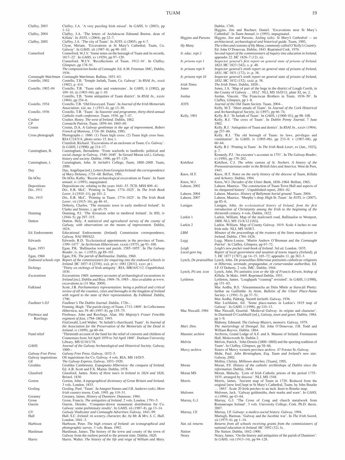
TUAM �9
Claffey, 2003 Claffey, J.A. ‘A very puzzling Irish missal’. In GAHS, lv (2003), pp �–�2.
Claffey, 2004 Claffey, J.A. ‘The letters of Archdeacon Edmund Burton, dean of Killala’.InJOTS, i (2004), pp 22–7.
Claffey,2005 Claffey,J.A.‘ThecityofTuam’.InJOTS, ii (2005), pp 4–7. Clyne, Miriam. ‘Excavations at St Mary’s Cathedral, Tuam, Co.
Galway’.InGAHS, xli (1987–8), pp 90–103.Comerford Comerford,W.J.V.‘SomenotesontheboroughofTuamanditsrecords,
1817–22’. In GAHS, xv (1929), pp 97–120. Comerford, W.J.V. ‘Recollections of Tuam, 1912–16’. In Claffey,
Glimpses, pp 178–91. The compossicion booke of Conought. Ed.A.M.Freeman.IMC,Dublin,
1936.Connaught Watchman Connaught Watchman. Ballina, 1851–63.Costello,�902 Costello,T.B.‘TempleJarlath,Tuam,Co.Galway’.InRSAI Jn.,xxxii
(1902), p. 414.Costello, 1902–04 Costello, T.B. ‘Tuam raths and souterrains’. In GAHS, ii (�902), pp
109–16; iii (1903–04), pp 1–10. Costello,T.B.‘SomeantiquitiesofTuamdistrict’.InRSAI Jn., xxxiv
(1904), pp 254–6.Costello, 1934 Costello, T.B. ‘Old Graveyard, Tuam’. In Journal of the Irish Memorials
Association, xiii, no. 1 (1933–4), pp 13–30.Costello, 1936 Costello, T.B. ‘Tuam’. In Souvenir and programme, thirty-third annual
Catholic truth conference. Tuam, 1936, pp 7–47.Coulter Coulter, Henry. The west of Ireland. Dublin,�862.CP Connacht Patriot. Tuam, 1859–64; 1865–69. Cronin Cronin,D.A.A Galway gentleman in the age of improvement, Robert
French of Monivea, 1716–90.Dublin,�995.Crossphotograph Photographsc. 1860. (1) Tuam high cross; (2) Tuam high cross base.
RIA C/24/5/A, photo series 15, box 1. Crumlish, Richard. ‘Excavations of an enclosure at Tuam, Co. Galway’.
InGAHS,l (�998), pp 214–17.Cunningham,B. Cunningham, Bernadette. ‘From warlords to landlords: political and
social change in Galway, 1540–1640’. In Gerard Moran (ed.), Galway, history and society. Dublin, 1996, pp 97–129.
Cunningham,J. Cunningham, John. St Jarlath’s College, Tuam, 1800–2000. Tuam,�999.
Day Day,Angélique(ed.).Letters from Georgian Ireland: the correspondence of Mary Delaney, 1731–68.Belfast,�99�.
De hÓra De hÓra, Kathy. ‘Recent archaeological excavations in Tuam’. In Tuam annual, iv (1993), unpaginated.
Depositions Depositions etc. relating to the years 1641–53. TCD, MSS 809–41.Dix, 1911 Dix, E.R. McC. ‘Printing in Tuam, 1774–1825’. In The Irish Book
Lover,ii(�9�0–��),pp�0�–2.Dix, 1915 Dix, E.R. McC. ‘Printing in Tuam, 1774–1825’. In The Irish Book
Lover, vii (1915–16), pp 40–41. Doherty, Charles. ‘The monastic town in early medieval Ireland’. In
Clarke and Simms, i, pp 45–75.Dunning Dunning, P.J. ‘TheArroasian order in medieval Ireland’. In IHS, iv
(1944–5), pp 297–315.Dutton Dutton, Hely. A statistical and agricultural survey of the county of
Galway, with observations on the means of improvement. Dublin,1824.
Ed.Endowments Educational Endowments (Ireland) Commission correspondence,Galway.NAI999/622.
Edwards Edwards, R.D. ‘Ecclesiastical appointments in the province of Tuam, 1399–1477’. In Archivium Hibernicum, xxxiii (1975), pp 91–100.
Egan, 1953 Egan, P.K. ‘Ballinasloe town and parish, 1585–1855’. In The Galway Reader, iv, no. 1 (1953), pp 89–101.
Egan,�960 Egan,P.K.The parish of Ballinasloe.Dublin,�960.Endowed schools rept Report of the commissioners for enquiring into the endowed schools in
Ireland. HC 1857–8 [2336], xxii, pt iv; 1881 [2831], xxxv, pt i.Etchings ‘Thirty six etchings of Irish antiquity’. RIA, MR16/C/12. Unpublished,
1830.Excavations Excavations 1969: summary accounts of archaeological excavations in
Ireland [etc]. Dublin and Bray, 1969–76, 1985–. Also available at www.excavations.ie (31 Mar. 2009).
Falkland Scott, J.R. Parliamentary representation: being a political and critical review of all the counties, cities and boroughs in the kingdom of Ireland with regard to the state of their representation. ByFalkland. Dublin,1790.
Faulkner’s DJ Faulkner’s The Dublin Journal. Dublin, 1726–. Fenning, Hugh. ‘The parish clergy of Tuam, 1712–1809’. In Collectanea
Hibernica, nos 39–40 (1997–8), pp 155–75.Firebrace and Firebrace, John and Rawlings, Alan. His Majesty’s Fraser Fencible
Rawlings regiment of foot, 1794–1802. 1993. FitzGerald,LordWalter.‘StJarlath’schurchyard,Tuam’.InJournal of
the Association for the Preservation of the Memorials of the Dead in Ireland, iv (1899), pp 60–64.
Fundrelief ‘ThirteenthaccountofthefundforthereliefofconvertsandchildrenofConnemara from 3rd April 1859 to 3rd April 1860’. Durham University Library, MS G/18/1/76.
GAHS Journal of the Galway Archaeological and Historical Society.Galway,�900–.
Galway Free Press Galway Free Press. Galway, 1832–5.Galway inquisitions OS inquisitions for Co. Galway. 4 vols. RIA, MS 14/D/5.GE The Galway Express. Galway, 1853–1920.Giraldus GiraldusCambrensis.Expugnatio Hibernica: the conquest of Ireland.
Ed. A.B. Scott and F.X. Martin. Dublin, 1978.Glassford Glassford, James. Notes of three tours in Ireland in 1824 and 1826.
Bristol, 1830.Gorton Gorton,John.A topographical dictionary of Great Britain and Ireland.
3 vols. London, 1833.Gosling Gosling, Paul. ‘Tuam’. In Anngret Simms and J.H. Andrews (eds), More
Irish country towns. Cork, 1995, pp 119–31.Greaney Greaney,James.History of Dunmore. Dunmore, 1984.Grose Grose,Francis.The antiquities of Ireland. 2 vols, London, 1791–5.Guerin Guerin, Deirdre. ‘Computer-drawn monument distribution for Co.
Galway:somepreliminaryresults’.InGAHS, xli (1987–8), pp 13–14.GV Galway Vindicator and Connaught Advertiser. Galway, 1841–99.Hall Hall, S.C. Ireland: its scenery, character, &c.by Mr. & Mrs. S. C. Hall.
London, 1841–3.Harbison Harbison, Peter. The high crosses of Ireland: an iconographical and
photographic survey. 3 vols. Bonn, 1992.Hardiman Hardiman, James. The history of the town and county of the town of
Galwayfromtheearliestperiodtothepresenttime.Dublin,�820.Harris Harris, Walter. The history of the life and reign of William and Mary.
Dublin, 1749. Higgins, Jim and Buchner, Daniel. ‘Excavations near St Mary’s
Cathedral’.InTuam Annual, iv (1993), unpaginated.Higgins and Parsons Higgins, Jim and Parsons, Aisling (eds). St Mary’s Cathedral — an
architectural, archaeological and historical guide. Tuam,�995.Hy Many The tribes and customs of Hy Many, commonly called O’Kelly’s Country.
Ed. John O’Donovan. Dublin, 1843. Reprinted Cork, 1976.Ir. educ. rept 2 Second report of the commissioners of inquiry into education in Ireland,
appendix 22. HC 1826–7 (12), xii.Ir. prisons rept 1 Inspector general’s first report on general state of prisons of Ireland,
1823. HC 1823 (342), x, p. 48.Ir. prisons rept 9 Inspector general’s ninth report on general state of prisons of Ireland,
1831. HC 1831 (172), iv, p. 38.Ir. prisons rept 10 Inspector general’s tenth report on general state of prisons of Ireland,
1832. HC 1832 (152), xxiii, p. 38.Irish Times The Irish Times.Dublin,�859–.Jones Jones,J.A.‘MapofpartofthebogsinthedistrictofLoughCorrib,in
theCountyofGalway…�8�2’.NLI,MS�6/D/��,plateXI,no.2.Jordan Jordan, Vincent. ‘The Franciscan Brothers in Tuam, 1836–50’. In
Claffey,Glimpses, pp�–8.JOTS Journal of the Old Tuam Society. Tuam, 2004–. Kelly,M.T.‘ShortannalsofTuam’.InJournal of the Cork Historical
and Archaeological Society, iii (1897), pp 66–74.Kelly, 1901 Kelly, R.J. ‘St Jarlath of Tuam’. In GAHS,i(�900–0�),pp98–�08. Kelly, R.J. ‘The cross of Tuam’. In Dublin Penny Journal, 7 June
�902. Kelly, R.J. ‘Antiquities of Tuam and district’. In RSAI Jn., xxxiv (1904),
pp 257–60. Kelly, R.J. ‘The old borough of Tuam: its laws, privileges and
constitution’. In GAHS, iv (1905–06), pp 233–9; v (1907–08), pp 60–64.
Kelly, R.J. ‘Printing in Tuam’. In The Irish Book Lover,xv(Jan.,�925),p. 7.
Kennedy, P.J. ‘An executor’s accounts in 1751’. In The Galway Reader, ii (1950), pp 179–202.
Kirkfleet Kirkfleet, C.J. The white canons of St. Norbert. A history of the Premonstratensian order in the British Isles and America.WestdePere,1943.
Knox, H.T. Knox, H.T. Notes on the early history of the diocese of Tuam, Killala and Achonry. Dublin, 1904.
Knox,W.J. Knox,W.J.Decades of the Ulster Bank, 1836–1964.Belfast,�965.Laheen, 2002 Laheen, Maurice. ‘The construction of Tuam Town Hall and aspects of
itschequeredhistory’.Unpublishedreport,200�–02.Laheen, 2004 Laheen, Maurice. History of Ballymote burial ground. Tuam, 2004.Laheen, 2007 Laheen, Maurice. ‘Murphy’s shop, High St, Tuam’. In JOTS, iv (2007),
pp85–6.Lanigan Lanigan, John. An ecclesiastical history of Ireland, from the first
introduction of Christianity among the Irish to the beginning of the thirteenth century. 4 vols. Dublin, 1822.
Larkin� Larkin,William.Mapofthemailcoachroad,BallinasloetoWestport,�808.NLI,MS�5/A/�2(�65).
Larkin 2 Larkin, William. Map of County Galway. 1819. Scale 4 inches to one Irish mile. NLI, MS 16/H/3.
LBM Minutes of the proceedings of the trustees of the linen manufacture in Ireland. Dublin, 1784–1826.
Legg Legg, Marie-Louise. ‘Martin Andrew O’Brennan and the Connaught Patriot’.InClaffey,Glimpses, pp 67–72.
Leigh Leigh’s new pocket road-book of Ireland. 3rd ed. London, 1835.Local govt inq. Report of local government and taxation of towns inquiry (Ireland), pt
3, HC 1877 [1787], pp 14–15, 165–72; appendix 11, pp 362–3.Lynch, De praesulibus Lynch,John.De praesulibus Hiberniae potissimis catholicae religionis
in Hibernia, serenade, propagandae, et conservandae authoribus. Ed.J.F. O’Doherty. 2 vols. IMC, Dublin, 1944.
Lynch,Pii ant. icon Lynch,John.Pii antistitis icon or the life of Francis Kirwin, bishop of Killala. St Malo, 1669. Reprinted Dublin, 1951.
Lyttleton Lyttleton,James.‘Loughpark“crannog”revisited’.InGAHS, l(�998),pp 151–83.
MacAodha,B.S. ‘ÁiteanmneachaanDúinMhóirar léarscáilPhetty:Iarthar na Gaillimhe. In Ainm, Bulletin of the Ulster Place-Name Society, v (1991–3), pp 37–51.
MacAodha,Pádraig.Naomh Iarlaith. Galway, 1936. Mac Lochlainn, Alf. ‘Some place-names in Larkin’s 1819 map of
Galway’.In GAHS, l (1998), pp 210–13.Mac Niocaill, 1984 Mac Niocaill, Gearóid. ‘Medieval Galway: its origins and character’.
InDiarmuidÓCearbhaill(ed.), Galway, town and gown. Dublin, 1984, pp�–9.
Mahony,Edmund.The Galway Blazers, memoirs. Galway, 1979.Mart. Don. The martyrology of Donegal. Ed. John O’Donovan, J.H. Todd and
William Reeves. Dublin, 1864.Masonicarchive Archives,GrandLodgeofA.F.andA.MasonsofIreland.Freemasons
Hall, Molesworth St, Dublin 2.Melvin Melvin,Patrick.‘JohnDennis(�800–�869)andthesportingtraditionof
Tuam’.InClaffey,Glimpses,pp59–66.Mercy archive Sisters of Mercy western province archive. 47 Forster St, Galway. Mohr, Paul. John Birmingham, Esq. Tuam and Ireland’s new star.
Galway,2002. Molloy,Christy.Milltown sketches.[Tuam],�995.Moran Moran, P.F. History of the catholic archbishops of Dublin since the
reformation. Dublin, 1864.Moran MS Moran, Malachy. ‘Lists of Irish Catholic priests of the period 1735–
1835, arranged by diocese’. NLI, MS 1548.Morris Morris, James. ‘Ancient map of Tuam in 1720. Reduced from the
original[nowlost]keptinStMary’sCathedral,Tuam,byJohnBourke… 1863’. Scale 20 Irish perches to an inch. Inset to Bourke map.
Mulveen Mulveen,Jack.‘Galwaygoldsmiths,theirmarksandware’.InGAHS,vi (1994), pp 43–64.
Murray,G.J. Murray, G.J. ‘The Cross of Cong and church metalwork fromRomanesque Ireland’. 3 vols. University College, Cork, Ph.D. thesis, 2007.
Murray,J.P. Murray,J.P.Galway: a medico-social history. Galway, 1994. Murtagh, Harman. ‘Galway and the Jacobite war’. In The Irish Sword,
xii (1975–6), pp 1–14.Nat. ed. returns Returns from all schools receiving grants from the commissioners of
national education in Ireland. HC 1892 (32), lx.Nation The Nation. Dublin, 1842–1900.Neary Neary,James.‘OnthehistoryandantiquitiesoftheparishofDunmore’.
InGAHS, viii (1913–14), pp 94–128.

20 IRISH HISTORIC TOWNS ATLAS
Nicholls Nicholls, K.W. ‘Visitations of the dioceses of Clonfert, Tuam andKilmacduagh, c. 1565–67’. In Analecta Hibernica, xxvi (1970), pp 144–57.
Nicholls, K.W. ‘A list of monasteries in Connacht, 1577’. In GAHS, xxxii (1973), pp 28–43.
Ní Mhuiríosa, Máirín. ‘Seán Mag Fhlainn agus an Tuam News’. InClaffey,Glimpses, pp 154–61.
Nolan Nolan, J.P. ‘Galway castles and owners in 1574’. In GAHS,i(�90�),pp109–23.
NS Registers Registers, National Schools, Co. Galway, vol. i. NAI D 2/17, f. 3. NAI ED/2, Registers, 1832–1963.
O’Brien,G. O’Brien,George.The Bank of Ireland, 1783–1946. Dublin, 1949.O’Brien,P.V. O’Brien,P.V.‘PagesfromthehistoryofStJarlath’sCollege’.InIarlaith
(St Jarlath’s College Past Pupils Union magazine) (1955), pp 83–91.O’Connell O’Connell,J.A.‘SomenotesonTuaminoldendays’.InThe Galway
Reader, i, no. 3 (1948), pp 23–9; i, no. 4 (1949), pp 46–51; ii, nos 1 and 2 (1949) pp 50–60; ii, nos 3 and 4 (1950), pp 171–9; iii, nos 1 and 2 (1950), pp 82–9; iii, no. 3 (1951), pp 92–8; iv, no. 1 (1953), pp 82–5; iv, nos 3 and 4 (1954), pp 140–43.
O’Connor,Gabriel.‘ThedevelopmentoflocalgovernmentinthetownofTuamfromearliesttimestotheGovernmentofIrelandActof�920’.National University of Ireland Maynooth, M.A. thesis, 1994.
O’Connor,G. O’Connor,Gabriel.‘Cloonfois,Co.Galway’.InBrianÓDálaigh,DenisCroninandPaulConnell(eds),Irish townlands.Dublin,�998,pp69–92.
O’Connor,Gabriel.‘AcomparativestudyoflocalgovernmentinTuamand Armagh’ 1840–1940’. National University of Ireland Maynooth, Ph.D. thesis, 2004.
O’Connor, J. O’Connor, Jimmy. ‘Aspects of Galway postal history, 1638–1984’. In GAHS, xliv (1992), pp 119–94.
ODNB Oxford Dictionary of National Biography. Ed. H.C.G. Matthew and B.H. Harrison. 61 vols. Oxford, 2004. Also available at www.oxforddnb.com (31 Mar. 2009).
O’Doherty O’Doherty, D.J. ‘Students of the Irish College Salamanca (1619–1700)’. InArchivium Hibernicum, ii (1913), pp 1–36; iii (1914), pp 87–112.
O’Donoghue O’Donoghue,Noel.Proud and upright men. Tuam, [1987].O’Donovan O’Donovan, John. Letters containing information relative to the
antiquities of the county of Galway, collected during the progress of the Ordnance Survey in 1839. Dublin,�928.
O’Flaherty O’Flaherty, Roderic. A chorographical description of West or H-Iar Connaught, 1684. Ed. James Hardiman. Dublin, 1846.
Ó Héideáin Ó Héideáin, Eustás. The Dominicans in Galway, 1241–1991.Galway,�99�.
O’Meara O’Meara,John.‘TheAthenryandTuamrailway’.InJournal of the Irish Railway Record Society, xvii (1989), pp 22–37.
ÓMurchú ÓMurchú,D.S.Tuam. Tuam, 1970.O’Neill O’Neill, Henry. Illustrations of the most interesting of the sculptured
crosses of ancient Ireland. London, 1857. O’Neill, Marie. ‘The Republican courts in Tuam’. In Claffey, Glimpses,
pp 204–9. O’Sullivan,M.D.Old Galway. Cambridge, 1942.OS Ordnance Survey. Maps of Co. Galway, scale �:�0,560, manuscript
‘fair plan’ 1838 (NAI, OS 105/B269); sheets 29, 43, printed 1840 (surveyed 1838). Large-scale maps of Tuam: scale 1:1056, manuscript, 1839 (NAI, OS 140); printed, 1892. Maps of Co. Galway: scale 1:2500, sheets XXIX.15, 16; XXIII. 3, 4, printed 1892, revised 1930 (surveyed 1927); scale 1:2500, 1:1000, revised 1926–2003 (unpublished 2003).
Otway,Caesar.A tour of Connaught. Dublin, 1839.Petrie papers Petrie papers. RIA, MS 12/N/4.Petty Petty,William.Hiberniae delineatio quoad hactenus licuit perfectissima
… . [London], 1685; 2nd ed., [Dublin],2nded.,[Dublin],c. 1730–34.Pigot The commercial directory of Ireland, Scotland and the four most
northern counties of England for 1820–21 & 22.Manchester,�820.Plummer Plummer,Charles(ed.).Vitae sanctorum Hiberniae ….2vols.Oxford,
�9�0.Poor law com. returns Returns respecting the poor law commission, Ireland. HC 1843 (275)
xlvi.Presentationarchive PresentationConventarchive,Tuam.Qualification rolls Catholic qualification rolls, 1778–90. NAI, 2/446/23.Refaussé Refaussé, Raymond. Church of Ireland records. Dublin,2000.Rept select ed. comm. Report … from the select committee on the new plan of education in
Ireland; together with the minutes of evidence, an appendix and index.HC 1837 (543–I), viii, p. 75.
Room Room, Adrian. A dictionary of Irish placenames. Belfast,�986.Royal visitation Royal visitation, Tuam diocese, 1615. RIA, MS 23/F/1.Rules TAS Rules, proceedings and report of the Tuam Agricultural Society.Tuam,
1841. Ryan, John. Toirdelbach Ó Conchubair, 1088–1156.Dublin,�966.Rynne Rynne, Etienne. ‘A fourth high cross at Tuam’. In GAHS, xl(�985–6),
pp�25–9.Sarsfield-Vesey Documents relating to Sarsfield-Vesey family and their estates in Dublin,
Kildare,Wicklow andCarlow: court testamentary andmiscellaneousincluding maps, surveys, charters, inquisitions and correspondence,17–19th cents: correspondence, no. 149. NAI.
Sayles Sayles,G.O.(ed.).Documents on the affairs of Ireland before the king’s council. IMC, Dublin, 1979.
Scully Scully, M.C. ‘Galway schooling and the Presentation Sisters, �8�5–1973’. University College, Cork, M.Ed. thesis, 1973.
Sheehy Sheehy, M.P. (ed.). Pontificia Hibernica: medieval papal chancery documents concerning Ireland, 640–1261.2vols.Dublin,�962–5.
Simington, 1962 Simington, R.C. (ed.). Books of survey and distribution: being abstracts of various surveys and instruments of title. iii, County of Galway.Dublin,�962.
Simington, 1970 Simington, R.C. (ed.). The transplantation to Connacht, 1654–58. Dublin, 1970.
Simms Simms,J.G.‘Connachtintheeighteenthcentury’.InIHS,xi(�95�),pp116–33.
Sirr Sirr, J.D.A memoir of the Honourable and Most Reverend Power le Poer Trench, last archbishop of Tuam. Dublin, 1845.
Stalley Stalley, Roger. ‘The Romanesque sculpture of Tuam’. In Alan Borg and AndrewMartindale(eds),The vanishing past. Oxford, 1981, pp 179–95.
State of Ir. rept Second report from select committee on state of Ireland. HC 1825, viii.Swan Swan, Leo. ‘Monastic proto-towns in early medieval Ireland: the
evidence of aerial photography, plan analysis and survey’. In Clarkeand Simms, i, pp 77–102.
Synge accounts Personal and household accounts of Archbishop Synge, 1717–22. NLI, MS 2173.
TCM Tuam Town Commissioners’ minute books, 1843–. Town Hall, Tuam.Tuam Diocesan and Parish Magazine. [Dublin], 1877.
TG Tuam Gazette. Tuam, 1824.TH Tuam Herald.Tuam, 1837–78, 1883–1923, 1927–.TN Tuam News.Tuam, 1871–73, 1884–96.Tuam Annual Great Tuam Annual. Tuam, 1990–94.Val. 1, 2, 3 Records of the General Valuation Office relating to Tuam. (1) Manuscript
town plan, c. 1839. (2) Printed tenement valuation, Tuam, 1855. Manuscript town plans, scale �:�056, �856 (with later annotations).(3) Manuscript revision books and related maps, 1877–96. Valuation Office, Dublin.
Waldron, J.J. ‘The re-establishment of Tuam C.B.S’. In Claffey, Glimpses, pp 23–8.
Waldron, J.J. ‘Tuam and the Irish Volunteers, 1914–15’. In Claffey, Glimpses, pp 192–203.
Waldron Waldron,Kieran.Out of the shadows: emerging secondary schools in the archdiocese. Tuam,2002.
Ware Harris, Walter (ed.). The whole works of Sir James Ware concerning Ireland, revised and improved, i, Dublin, 1739.
Watson Watson,John.The gentleman’s and citizen’s almanac. Dublin, 1761.
NoteoNMAP2
Map 2, Tuam in 1839, is derived from the Ordnance Survey 1:1056 manuscript plan of Tuam (1839), the published 1:10,560 Ordnance Survey maps of Co. Galway, first edition, sheets 29, 43 (surveyed 1838) and the 1:1056 manuscript valuation plan of c. 1839. The reconstruction has been adjusted to the planimetry of the published 1:1056 plan (surveyed in 1892). Solid lines representfeaturesstillextantin�892,whiledottedlinesindicatethat,sincethefeaturehadbythendisappeared,itsexactpositioncannotbedetermined.
ACKNowLeDGeMeNts
Since welcomed into the ‘atlas family’ by Anngret Simms in August 2003 I have been assisted bymanypersonsandinstitutionsintheproductionofthisessayandtopographicalinformation.A large corpus of relevant knowledge was at my disposal in the files of the Tuam Herald,which included numerous articles on Tuam by the late J.J. Waldron; likewise in the Journal of the Galway Archaeological and Historical Societywhere the lateT.B.CostellodepositedsomeofhisgreatstoreofknowledgeonancientTuam.TheOldTuamSocietyhasgivenmeencouragementandhelp,inparticularGabrielO’ConnorandDavidBurke,theoutgoingandcurrentpresidents,alsoMauriceLaheenwhomIfrequentlyconsultedondetailsoflocalhistoryandAnnTierneywhodigitallyaccessedrelevantarchivesandphotographs.Iamdeeplyindebtedto Ann Mohr for her expertise in deciphering medieval Latin, to Riana O’Dwyer for glossarial help,totheSistersofthePresentationandMercyconventsforarchivalandotherinformation,to Very Revd A. Grimason, dean of Tuam, for the use of the Bourke map, to Jarlath Canney forprovidingphotographsofthetownandtoMaitiasÓGormailefortopographicalinsights.Gerarda McHugh and Ray Ryan also helped with illustrative material. The National Archives of Ireland, National Library of Ireland, Registry of Deeds, Trinity College Library and Map Library and the Valuation Office have all been indispensable sources of information. Special thanksmustgototheveryhelpfulstaffofTuambranchlibrary,ofSpecialCollections,JamesHardiman Library, NUI Galway, of the Representative Church Body Library and of the Royal Irish Academy Library. Peter Harbison, RIA, generously shared his extensive knowledge with me and the others involved in the project on many occasions; the observations of Keith Lilley, QUB,onthemorphologyofTuamwereexceptionallyuseful.BernadetteCunningham,MiriamMoffitt, Nollaig Ó Muraíle and Roger Stalley gave helpful advice on particular sections of the topographicalinformation,andMaryDaviesprovidededitorialcommentsonthetext.Sincerethanks must also go to Marie Mannion, Heritage Officer, for facilitating a grant from Galway CountyCounciltowardsthepublicationofthisfascicle.
Boroughseal Archbishoprickseal