zarch 5.indb
TRANSCRIPT

Raimundo Bambó Naya received his degree in Architecture (2000) from the School of Architecture of the University of Navarra. He has complemented these studies with courses and seminars at the University of Navarra, the London Architectural Association or the Architecture School of the Universitá degli Studi di Palermo. Among other awards and honors, he has received the Second Prize in Architecture Studies (Spanish Ministry of Education, 2001) or the Extraordinary End of Studies Award (ETSAUN, 2001). From 2009 to 2015 he has been Adjunct Professor of History and Theory of Architecture at the University of Zaragoza and since 2015 he is Adjunct Professor of Urban Design and Planning at the same university. Between 2000 and 2013 he has carried out his professional practice at IDOM ACXT as a Partner Senior Architect of the firm. Amongst his works, the most relevant are the Lineal Urban Park on the Ebro riverside in Zaragoza, the Participants’ Pavilions Building and General Urbanization for the Zaragoza Expo 200, the Vehicle Research Institute in Alcañiz (Teruel), the refurbishment of the West Tower in Huesca City Hall or the Certest I+D laboratories in San Mateo de Gállego (Zaragoza). His work as an architect has been awarded and published numerous times.
Ricardo Sánchez Lampreave. Architect from the Universidad Politécnica of Madrid (ETSAM) in 1983. Ph.D. Architect from the same university (2007) having developed a dissertation focused on the architecture of Madrid in the 50´s. He has been professor of History of Graphic Design in the Universidad Complutense of Madrid (Facultad de Bellas Artes, 1987-1989) and of Architectural Design in the Schools of Architecture of Madrid, Alcalá de Henares and the Facoltà di Architettura di Alghero in the Università di Sassari (Sardinia). In 1990-1991 he received a fellowship to study at the Spanish Academy in Rome, and the year after a grant from the Spanish Ministerio de Obras Públicas y Transportes to develop his doctoral research. He has been the director of the Fundación Miguel Fisac since its creation (2007-2009). He has been curator of different exhibitions (El suelo en renuncio, lápices ratones brújulas, Círculos imperfectos, Las otras Grandes Vías), and editor of several magazines such as BAU, Transfer y Formas, serving also in several Editorial Boards. He publishes regularly writings and projects in specialised media. Some of his projects have been awarded in national and international competitions, and some of his works distinctions and awards from Madrid´s Comunidad, Ayuntamiento and Colegio de Arquitectos. He publishes the collection of books on the Premios Nacionales de Arquitectura of the Spanish Ministerio de Fomento, as well as several books of Architecture, Theory and Criticism with his own publishing house.
A Bridge and a Large Port, Two Unpublished Projects for the Bay of CádizRAIMUNDO BAMBÓ NAYA
RICARDO SÁNCHEZ LAMPREAVE
Abstract
Bay of Cádiz, a natural harbor of highly unique geographic profiles as is the rest of a wide estuary where the ancient Phoenician city settled, has been the scene of some of the most important episodes in the modern history of Spain. Its water level, an inner sea of changing profiles with marshes and salt lakes, has always been a strategic location relative to historical sea routes between the Mediterranean and the Atlantic, between Europe and America.
Following his studies in Civil Engineering, in 1923 Eduardo Torroja began working at the Hydraulic and Civil Construction Company Hidrocivil of his teacher Eugenio Ribera. In 1927 he decided to start his own company, having started his relationship with Cádiz in 1926 calculating the foundation piles of Sancti Petri Bridge.
Between 1927 and 1929, responding to two separate commissions from the mayor Ramón de Carranza, Torroja presented to the City of Cádiz the projects of a bridge that would link Puerto Real and Cádiz, thus avoiding having to go around the whole bay to access the city, and a large port that would sprawl over that bay, transforming it into a large area of port activities. None of them ended up being built, but they were the direct antecedents of the existing bridge and the current free zone that complements the current port.
Keywords
Eduardo Torroja, Bay of Cádiz, bridge, port.

1 Javier de Navascués y de Palacio, Cádiz a través de 1513. Apuntes para su arquitectura y urbanismo desde el siglo XIII (Cádiz: Demarca-ción de Cádiz, Colegio Oficial de Arquitectos de Andalucía Occidental, 1996).
2 AA. VV., Agua, territorio y ciudad. Cádiz de la Constitución. 1812 (Sevilla: Agencia Andaluza del Agua, Consejería de Medio Ambiente, Junta de Andalucía, 2009).
Cádiz and its bay
The city of Cádiz is located on the south-western coast of Andalusia between the mouth of the Guadalquivir River, which flows down from Seville, and the Strait of Gibraltar. It stands at the entrance to the bay with the same name, the estuary of the Guadalete River, which waters the hinterland and divides the coastal plate at this point forming a complex area of sands, marshes and shallow water. Biological-ly rich with a stunning landscape, it also has the particular value of being a historic port in a strategic location along the historic sea routes between the Mediterranean and the Atlantic and later with America1. Consequently, the waters of the bay are surrounded by a constellation of cities founded on the rocky promontories that mark out the sands and the sea [Fig. 1].
To understand this city, we need to understand its settlement and its relationship with the land surrounding it2. Juxtaposed between land and sea, with geographical limits blurred by the tides, the historic character of Cádiz as the last, final desti-nation and not a place you can pass through, is less obvious today as a result of current transport links [Fig. 2]. How the city can be reached has not always been the same. In the past, it was an insular territory, and arriving and departing by sea was the natural method of transport and the most convenient until the age of the railway began. Consolidation of its link to the mainland only began in the eighteenth century with the construction of the reef, which made it possible to access the road surrounding the bay from Puerta de Tierra, the land gate of its fortifications. This spot marking the exit of the former city is today the focus of the city’s mod-ern development. The bridge placed in the centre of the bay to avoid having to go around it has divided it into two since 1969: the outer bay is used as a port, and the inner bay, which is quite shallow, is for pleasure and fishing boats, although it is still subject to the water rights of the dredged access to the historic shipyards in La Carraca. It is this bridge and port that the Spanish engineer Eduardo Torroja proposed ideas and designs for in the first third of the last century.
[Fig. 1] José Cárdano, “Topographic map of Cádiz surroundings between S. Lucar de Barrameda, Conyl, Medina. Xerez and close countryside…” ca.1813. Source: BNE (Biblio-teca Nacional de España).

ZARCH No. 5 | 2015
El legado de la vivienda masiva moderna Modernist Mass Housing Legacy
RAIMUNDO BAMBÓ NAYARICARDO SÁNCHEZ LAMPREAVEA Bridge and a Large Port, Two Unpublished Projects for the Bay of Cádiz
232
Obviously we should consider ports as the primary coastal infrastructure. They are the technical embodiment of a place to exchange goods, passengers and servic-es. They are the point where land and sea transport functionally integrate. And in countries such as Greece and Spain, the impacts of their locations are the reason why it is essential to delve into port phenomena in any study on the organisation, planning and management of coastal space.
From an urban point of view, the example of the Bay of Cádiz allows us to study how a singular physical medium generates special socio-economic links between the cities integrating it, links present in the port facilities of a sheltered natural mari-time space from its very beginnings [Fig. 3]. Just a fourth of the coastal river space is still in its natural state today, a sign that maritime cultures— including ours, which is also so linked to tourism, leisure and entertainment —have subjected nature to their will and tried to adapt the environment to their economic and social require-ments.
The bay, the natural port
The features of this inlet that lend themselves to the logistical aspects of maritime commerce have always formed a fundamental basis for measuring the suitability of the location of settlements in its area. Equally important are the possibilities the bay provides as a strategic point where shipping in vast Euro-African coastal expanses can be controlled. This functional pairing served as the prosperous basis for the consolidation in this area, as a result of trade and maritime initiatives, of the majority of ancient Mediterranean cultures: Tartessian, Phoenicio-punic, Greek and Roman.
After suffering inevitable cycles of rises and falls, the natural port of the bay was reborn in the fifteenth century when it played an important role in the American adventure. This is corroborated by the fact that the Crown wished to create its own royal port, Puerto Real, at the end of the century in a bay dominated by nobility at
[Fig. 2] Alfred Guedson, View from Cádiz taken from the lighthouse, 1854.
[Fig. 3] Anton van den Wyngaerde, Aerial view from Cádiz, 1567. Source: AGS (Archivo General de Simancas).
that time; that the shipping business, as it was becoming increasing difficult to sail along the Guadalquivir River, was descending from Seville to Cádiz to favour its powerful bourgeoisie; and that finally, in 1717, the Casa de Contratación (House of Trade) was sited here as the official control point of trade with America.
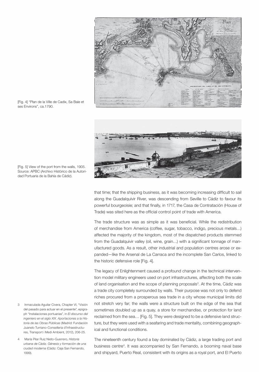
The trade structure was as simple as it was beneficial. While the redistribution of merchandise from America (coffee, sugar, tobacco, indigo, precious metals…) affected the majority of the kingdom, most of the dispatched products stemmed from the Guadalquivir valley (oil, wine, grain…) with a significant tonnage of man-ufactured goods. As a result, other industrial and population centres arose or ex-panded—like the Arsenal de La Carraca and the incomplete San Carlos, linked to the historic defensive role [Fig. 4].
The legacy of Enlightenment caused a profound change in the technical interven-tion model military engineers used on port infrastructures, affecting both the scale of land organisation and the scope of planning proposals3. At the time, Cádiz was a trade city completely surrounded by walls. Their purpose was not only to defend riches procured from a prosperous sea trade in a city whose municipal limits did not stretch very far; the walls were a structure built on the edge of the sea that sometimes doubled up as a quay, a store for merchandise, or protection for land reclaimed from the sea… [Fig. 5]. They were designed to be a defensive land struc-ture, but they were used with a seafaring and trade mentality, combining geograph-ical and functional conditions.
The nineteenth century found a bay dominated by Cádiz, a large trading port and business centre4. It was accompanied by San Fernando, a booming naval base and shipyard, Puerto Real, consistent with its origins as a royal port, and El Puerto
3 Inmaculada Aguilar Civera, Chapter VI, “Visión del pasado para actuar en el presente”, epigra-ph “Instalaciones portuarias”, in El discurso del ingeniero en el siglo XIX. Aportaciones a la His-toria de las Obras Públicas (Madrid: Fundación Juanelo Turriano-Conselleria d’Infraestructu-res, Transport i Medi Ambient, 2012), 206-25.
4 María Pilar Ruiz Nieto-Guerrero, Historia urbana de Cádiz. Génesis y formación de una ciudad moderna (Cádiz: Caja San Fernando, 1999).
[Fig. 4] “Plan de la Ville de Cadix, Sa Baie et ses Environs”, ca.1790.
[Fig. 5] View of the port from the walls, 1905. Source: APBC (Archivo Histórico de la Autori-dad Portuaria de la Bahía de Cádiz).

ZARCH No. 5 | 2015
El legado de la vivienda masiva moderna Modernist Mass Housing Legacy
RAIMUNDO BAMBÓ NAYARICARDO SÁNCHEZ LAMPREAVEA Bridge and a Large Port, Two Unpublished Projects for the Bay of Cádiz
234
de Santa María, a port and agricultural city. The rail line also ended up incorporat-ing Jerez de la Frontera into this particular social and economic microcosms. Yet, this physically and economically differentiated area, whose ports all fully identified with their surrounding geographical features, was, by the end of the nineteenth century, inexplicably lacking in essential port facilities, and, therefore unable to con-tinue an organised and necessarily harmonious development, given that the port’s prosperity was intrinsically linked to the prosperity of the port cities in the bay.
New technological advances leading to new industrial production systems began a radical transformation of the parameters of people’s relationship with their natural and cultural surroundings. Steam power and engineering structures as important as the Suez Canal, which strengthened the British colonial phenomenon, signifi-cantly increased the size and specialisation of ships, consolidated large shipping oligopolies and regular merchant and passenger shipping lines, resulted in mari-time and port activities that required ports to adapt rapidly so as not to be excluded from the main shipping business circuits. Until the middle of the century, for exam-ple, the usual disembarking system was to transfer into small boats that then sailed to the beach or esplanade, which acted as an urban quay. This was certainly not an economic, effective or fast means of loading and unloading [Fig. 6]. It was not until the second half of the nineteenth century that laws and decrees were passed in Spain to regulate new roles and functions associated with ports. They stand-ardised the administration of facilities, promoted public investment to build new infrastructures or improve existing ones, transferred the operation of ports from the Ministry of the Navy to the Ministry of Development, and created port authorities as administrative bodies with relatively independent management. Logically, the city and port of Cádiz were also affected by these intense changes, despite the para-doxical fact that it was one of the leading Spanish ports as far as trade volume was concerned, yet it was just a sheet of water with no physical infrastructure.
The debate, lasting a dozen years, on where the port should be constructed amassed all kinds of different arguments: the formation and coastal dynamics of the bay, the nature of its beds, the relevance of its integration in the city, its con-nection to an emerging means of transport like the railway, and so on. The idea was not only to adapt the construction of a commercial port to a specific volume of goods, since the railway and the land and sea dimensions of the port required were, for all intents and purposes, what the Industrial Revolution had caused in
[Fig. 6] Juan Bautista Coli, “Cadix. Vue prise du Port, des murs d’enceinte à la Cathédral / Cádiz. Seen from its bay from the royal walls to the Cathedral”, ca. 1850. Source: ICC (Institut Cartogràfic de Catalunya).

the traditional production structures. Furthermore, given its economic importance, mere technical reasons were overthrown by the social scope of strictly political reasons, which were heavily conditioned by the military nature of Cádiz and its bay. Finally, compared with the alternatives of the Trocadero in Puerto Real and Puntales, where the current free-trade zone was finally situated, the decision was made to “broaden” the city of Cádiz to make it more economical and profitable. The defenders of this idea argued that replacing the front of the wall facing the sea with another front strictly for port purposes, but still clearly capable of providing defence, would expand the existing port, even if this was rather precarious. The entire east water’s edge of the inner bay would be occupied by a port that would expand gradually over the sea in successive phases5. The city and port would start to merge into one functional unit as a result.
The first designs were drafted after a Royal Order of the central government’s port authority established the definitive location on 31 May 1865 [Fig. 7]. These were the first civil manifestations of the need for a port, and they were based on a system-atic knowledge of the physical and natural medium of the bay; they were drawn up taking into consideration all the quays, docks, warehouses and roads forming the entirety of the port as they were not partial proposals; and they were produced at the same time as or immediately after the discussions on its location. All of them elaborate on the relationship of the port with its urban environment and the land surrounding it. The need for physical space, at odds with the typical servitudes of a stronghold, and knowledge of the natural conditions of the site dominated the majority of the various technical proposals6. However, at the end of the nineteenth century, achievements had been modest at best: the extension of the end points of the urban port—San Felipe breakwater and Capitanía quay—and the construction of some quay stretches in front of the walls [Fig. 8]; almost all the work was paid for by private capital.
The loss of Cuba and the Philippines, Spain’s political instability, the crisis in the navy and the merchant navy, the emphasis placed on other public structures, such
5 See, for instance, María Pilar Ruiz Nieto-Gue-rrero, Urbanismo gaditano en tiempos de Carlos III: formación del barrio de San Carlos (Cádiz: Universidad de Cádiz, 1994).
6 Juan Manuel Barragán Muñoz, Puerto, ciudad y espacio litoral en la Bahía de Cádiz (Cádiz: Puerto de la Bahía de Cádiz, 1995), 131-54.
[Fig. 7] Several proposals: Juan Manuel Mu-ñoz, 1851; Juan Martínez Villa, 1862; Carlos María Cortés, 1863; and Rafael Cerero, 1869. Source: AHPC (Archivo Histórico Provincial de Cádiz).

as irrigation channels and roads, and so on, had left the port in a critical situation, and it was highly unlikely that the State would allocate the sums needed to mod-ernise port facilities. Nevertheless, almost all the relatively important works were performed last century, since the autonomy gained by creating the independent port authority of Cádiz (Junta de Obras del Puerto de Cádiz) in 1901 led to a stream of projects. As in so many other port cities, the history of exemption from customs duties, the free-trade zone or the port warehouse became another important factor from the beginning for understanding most of the process whereby this type of infrastructure occupied the coast. It was also difficult to differentiate between the supposedly industrial slant and the strictly commercial side. In 1829, for example, King Ferdinand VII signed a Royal Decree declaring the port of Cádiz to be free from customs duties. However, controversy surrounding the location of the port and its construction works delayed interest in the free-trade port until the beginning of the twentieth century [Fig. 9].
When the main European ports closed and sailing the Atlantic became increasing-ly difficult due to the 1914–1918 Great War, Havana’s Chamber of Commerce and other financial entities in the American continent asked Spain, a neutral country, to open one or several free-trade zones. Just a few weeks after the war started, one, and only one, free-trade warehouse was authorised in the city of Cádiz7—inevitably displeasing several other ports, such as Bilbao, Santander, Vigo, and especially Barcelona, which had proposed a general project for the entire coun-try—to replace the ports and large warehouses in both Germany and the United Kingdom that had serviced transatlantic shipping up until that point. This led to an uninterrupted succession of political and economic upheavals criss-crossing the century and, most of the time, the city was unable to take advantage of any oppor-tunities generated. The boom resulting from the Great War and the subsequent building of a shed near the former customs were followed by years of depression
7 José Antonio Hidalgo Viaña, Zona Franca de Cádiz. 80 años de historia (Cádiz: Zona Franca de Cádiz, 2011).
[Fig. 8] Dock of the port before the tearing down of the city walls, ca. 1890, and the Customs House beneath it, ca.1905.
[Fig. 9] Paseo de Canalejas, after the tearing down of the city walls in 1918, ca.1920.

[Fig. 10] Algeciras Marketplace, (1933-35), Recoletos Fronton Building (1935-39) and the grandstand at Zarzuela racecourse (1934-41), building Works of Eduardo Torroja.
causing a deep industrial crisis and an extremely severe reduction in international trade. Expectations aroused by the 1929 Free-Trade Zone Act, which should in-clude Torroja’s projects, were rapidly thwarted by the Spanish Civil War. The drive to expand the issue granted in 1948 by the signing of the Franco-Peron protocol, which allowed Argentina to install and manage a free-trade zone for 50 years to distribute part of their agricultural and livestock production in Europe8, barely lasted a year and a half because of Argentina’s criticism arising from the instability of Peronist governments. It was only later, after the 1953 Free-Trade Zone Pro-ject and its undoubtedly industrial focus, the 1973 expansion of the zone’s limits, the 1994 redevelopment project of the inner area, and so on, that the free-trade zone could be considered a trade tool and useful infrastructure for the economic development of the bay, even though there is still room for more exploitation as a potential fiscal resource.
For our purposes, the end of the twentieth century brought a correction of an issue as relevant as the gradual identification of the port with the city during the ongoing expansion process, to the detriment of the previous age-old concept of the bay as a shared natural port. In the last two decades, gradual port integration has re-gained the spatial scale of the bay that was present for centuries.
Torroja: his bridge and his large port
Eduardo Torroja, who was born and died in Madrid (1899–1961), was one of the few engineers whose artistic sensitivity and technical genius made it possible for strong forms to merge with the architectural concept and become an essential part of the latter. He is internationally renowned for his activity as a design engi-neer, his teaching work, his research activity and as the driver of modern regu-lations for prestressed reinforced concrete structures. In fact, alongside Robert Maillart, Eugène Freyssinet and Pier Luigi Nervi, he is considered one of the four most influential engineers in the technical and aesthetic development of concrete in the first half of the twentieth century. Some of his main works are Algeciras marketplace, the Recoletos fronton building and the grandstand at Zarzuela race-course [Fig. 10]. Prior to the Spanish Civil War he also founded the Hormigón y Acero (Concrete and Steel) journal, and, together with a small group of engineers and architects, he created the ITCE (the Technical Institute of Construction and Building) to foster research, promote and spread awareness of all kinds of sub-jects related to both civil and architectural construction. This was the origin of the current Eduardo Torroja Institute of Construction Sciences, which had received a series of other titles before it was named in his honour after his death. When the Spanish Civil War was over, he was appointed a lecturer in structure calculation at the School of Civil Engineering, where he remained until he died. Afterwards, in 1948, he also created the Informes de la Construcción (Construction Reports) journal, which collated both national and international scientific, technical and ar-chitectural advances, and which spread awareness in Spain of the works of Le Corbusier, Lloyd Wright, Van der Rohe, Aalto, Saarinen, Neutra, Nervi, Salvadori, Hossdorf and Candela, among others. Finally, three years before he died, in 1959, he was the co-founder and first president of the International Association for Shell and Spatial Structures (IASS); he also published his famous book entitled Philos-ophy of Structures.
Torroja’s first work as a design engineer was for Hidrocivil. This construction com-pany was founded and managed by his lecturer, José Eugenio Ribera, who hired him when he completed his studies in 1923. Hidrocivil won a tender in 1925 to build the Sancti Petri Bridge to link La Carraca in the Bay of Cádiz. Work started the fol-lowing year and Torroja changed the initial drafts. It is easy to imagine, confirmed
8 Breve noticia sobre el pasado, presente y futuro del puerto de Cádiz (Cádiz: Escelicer, 1946).

by the photographs of these works stored in the Torroja Archive [Fig. 11], that his frequent trips to Cádiz familiarised him with the area, so that after two years of continuous toing and froing from Madrid, he came up with the idea of not having to travel around the entire perimeter of the bay to reach Cádiz, and proposed a design for a bridge to cross it.
On his own initiative9, with no commission from a client, Torroja submitted to the city council, on 1 December 1927, a design for a bridge linking the Castle of San Lorenzo del Puntal and the island of Trocadero in Puerto Real [Fig. 12]. It was the first proposal of an achievement that would take over 30 years to realise. As time would eventually prove, once the current movable bridge was completed in 1969, the solution considerably shortened the journey time between Cádiz and its port with Jerez, as it was no longer necessary to go around the bay through San Fer-nando.
The main feature of the first bridge design Torroja submitted for rail and vehicular traffic linking the extreme points of Puntales and Trocadero was a central rotating section to allow passage to the back of the bay [Fig. 13]. It comprised 40 sec-tions of reinforced concrete spanning 20 m, supported on concrete piers with pile foundations made of the same material. The central, and most important part comprised six metal sections, three on each side, with a concrete deck, and one central rotating section located on a vertical axis above the deepest water. This central section had two leafs, both 57 metres between axes, designed to rotate on a central support so they could free the channel for navigation from one side of the bay to the other leaving enough room for any boat to pass. The proposed bridge would have provided only one Iberian gauge train track and two roads with a width of six metres with footways measuring one and a half metres at the sides for pedestrians. This was an economical and strong solution that was already being used for rail bridges over the river Rhône in Lyon and La Voulte, and which could be built in four years10. Torroja undertook to draft the final design within a timeframe of three months for the sum of 25,000 pesetas, just 0.197 per cent of the budget he had put forward of 12,647,252.93 pesetas. This amount included all the costs for surveying, measuring depths in the site area, soil studies and auxiliary tasks11.
The design was openly disapproved by the City Council of San Fernando—which, due to the considerable loss of trade that would arise from bypassing the city to enter or leave Cádiz, expressed their concern to the President of the Council of Ministers—and also by the Chamber of Commerce at the request of the Ministry of Development; this inevitably slowed down the process. The intense political events that occurred in the final years of the dictatorship of Primo de Rivera and the dec-laration of the Second Republic pushed the process to one side. Five years later, in 1933, when the new mayor showed an interest in the bridge, he received an official letter notifying him that it had been sent to Madrid on the date mentioned and was “no doubt still there”12. The uprising against the Republican government and the subsequent Spanish Civil War consigned the project to oblivion
In the afternoon of 23 August 1927, only five weeks after the new City Council had been formed, and three months before Torroja submitted the bridge design, at an event organised to pay tribute to Ramón de Carranza, attended by 20,000 people, according to the press of the time13, the recently appointed mayor publicly announced the location of the facilities of the free-trade zone that technicians were working on: “from Puntales quay to the back and front of the bay, with all the nec-essary quays and docks; there will be sufficient space for the large companies that will set up there in the large expanse of land reclaimed from the sea”. Given that
9 Torroja Archive, CEHOPU-CEDEX, ETM-008-001, 9.301 (1927-12-01), 9.
10 Brief introduction to the Project for the bridge over the bay of Cádiz (Torroja archive, CE-HOPU-CEDEX, ETM-008-001).
11 Fernando Guilloto, El puente José León de Carranza, primero sobre la bahía de Cádiz (Cádiz: Absalón, 2010).
12 Guilloto, El puente, 25.
13 See Diario de Cádiz, wednesday august 24 1927. See also Joaquín Piñeiro Blanca, Ramón de Carranza. Un oligarca gaditano en la crisis de la Restauración (Cádiz: Universidad de Cádiz-Diputación de Cádiz, 1997).
[Fig. 11] “Sancti-Petri bridge. Support reinfor-cement 23.12.1926”. Source: Torroja archive, CEHOPU-CEDEX, I-ETM-018-01_01.

the free-trade warehouse and port were insufficient, Carranza mentioned the need to make a strong commitment to establishing a free-trade zone next to the port that was denationalised for tax purposes, where goods could enter exempt from customs duties and where processing industries could set up with no restrictions and help reactivate the city’s economy.
In February 1928, when the bridge design was now on the table, given that it had been submitted and accepted by the City Council the month before, Carranza commissioned Torroja with the draft of a design for the future free-trade zone in Cádiz14. While he was preparing the design, relationships with Madrid intensified. Carranza invited the Minister of Development to visit Cádiz after an interview in Madrid in which Torroja was also present so that the minister could see the site of the future industrial area for himself. In April, the President of the Council of Minis-ters, Miguel Primo de Rivera, also visited the city15. At the same time, on 18 April, King Alfonso XIII, who made three trips to Cádiz when Carranza was mayor16, and who supported the free-trade zone every time, first visited on the occasion of the launching of the training ship Juan Sebastián Elcano, built at the city’s shipyards. On 10 May 1928, Torroja submitted his large port design [Fig. 14]. Although he was prudent enough to establish and emphatically define what the initial phase would be17, the design confirmed the enormity of the project that Carranza had announced some months previously. It also included the design of the proposed bridge for crossing the bay. Logically, the press published this proposal18.
The design took advantage of the vast expanse of water and the large area availa-ble to provide long mooring lines without the need to divide the site into small jetties or docks, and also that hardly any protection structures would be necessary, that the dredging would be easy, that the foundations would be strong… The design specifications described the work as follows:
“In general, the designed layout comprises a quay that stretches from Puntales along the same alignment as the designed bridge and up to the latter’s main section, in other words it stretches around 600 m from land. Then a broken line of three alignments forms a river quay joining the points of Puntales and Canter-as. To make better use of the land, there is an inland dock with a shallow draught and long mooring lines. The entire embankment between this mooring line and the current line forms the proposed free-trade zone. Consequently, no compulsory purchases are necessary, and all the land can be easily reclaimed from the sea as the water here is not very deep”.
14 AMC [Municipal Archive of Cádiz] Chapter Acts, nº 35, special session, 27 february 1928, volume III, point 4.
15 Hidalgo, Zona Franca de Cádiz, 26.
16 Piñeiro Blanca, Ramón de Carranza, 219.
17 Far from presenting it as a definite option, after the “Map of the region” and “General Map”, the third plan of the project defines the “First Con-struction Plan” (Doc. 14.203) similar in position and size to the project for Free-trade zone that Romero Carrasco will finally design.
18 Diario de Cádiz, Saturday may 12 1928.
[Fig. 12] Project of bridge over bay of Cádiz. Variant plan. 9.203. 1927-12-01. Source: Torroja archive, CEHOPU-CEDEX, ETM-008-001.
[Fig. 13] Project of bridge over bay of Cádiz. Fixed sections. 9.207. 1927-12-01. Source: Torroja archive, CEHOPU-CEDEX, ETM-008-001.

ZARCH No. 5 | 2015
El legado de la vivienda masiva moderna Modernist Mass Housing Legacy
RAIMUNDO BAMBÓ NAYARICARDO SÁNCHEZ LAMPREAVEA Bridge and a Large Port, Two Unpublished Projects for the Bay of Cádiz
240
Although he proposed construction in three phases [Fig. 15], the magnitude of the design made it impossible to define with any precision how the industries that would arise in the wake of exemption from customs duties would develop and be distributed without any knowledge of the plans of the Consortium created to man-age it. Torroja’s idea was that as it would have to expand gradually, the works would increase at the same rate.
One month later, as a result of the Royal Order of 9 June, a technical committee was formed “to balance the aspirations of the city of Cádiz in relation to the free-trade port with the projects and services entrusted to this city’s port authority”. This was the emphatic beginning of the end for an excessive project by any reckoning. On 4 August, the President of the Port Authority notified the result of this commit-tee’s report, highlighting that it would be best to “cancel bids for the port works”, produce a more suitable second design, and that the designer would have to be the engineer Juan Romero Carrasco, the works manager at the port. Six months after receiving the commission, three after submitting his idea, Eduardo Torroja’s design for the large port of Cádiz had been rejected.
Bibliography
1946. Breve noticia sobre el pasado, presente y futuro del puerto de Cádiz. Cádiz: Escelicer.
AGUILAR CIVERA, Inmaculada. 2012. “Visión del pasado para actuar en el presente”, in El discur-so del ingeniero en el siglo XIX. Aportaciones a la Historia de las Obras Públicas. Madrid: Funda-ción Juanelo Turriano-Conselleria d’Infraestructures, Transport i Medi Ambient, 206-225.
BARRAGÁN MUÑOZ, Juan Manuel. 1995. Puerto, ciudad y espacio litoral en la Bahía de Cádiz. Puerto de la Bahía de Cádiz, Cádiz, 131-154.
HIDALGO VIAÑA, José Antonio. 2011. Zona Franca de Cádiz. 80 años de historia. Cádiz: Zona Franca de Cádiz.
GUILLOTO, FERNANDO. 2010. El puente José León de Carranza, primero sobre la bahía de Cádiz. Cádiz: Absalón.
[Fig. 14] Project of free-trade zone of Port of Cádiz. General plan. 14.202. 1928-05-10. Source: APBC (Archivo Histórico de la Autori-dad Portuaria de la Bahía de Cádiz) box 1790.

NAVASCUÉS Y DE PALACIO, Javier de. 1996. Cádiz a través de 1513. Apuntes para su arquitec-tura y urbanismo desde el siglo XIII. Cádiz: Demarcación de Cádiz, Colegio Oficial de Arquitectos de Andalucía Occidental.
PIÑEIRO BLANCA, Joaquín. 1997. Ramón de Carranza. Un oligarca gaditano en la crisis de la Restauración. Cádiz: Universidad de Cádiz-Diputación de Cádiz.
RUIZ NIETO-GUERRERO, María Pilar. 1994. Urbanismo gaditano en tiempos de Carlos III: forma-ción del barrio de San Carlos. Cádiz: Universidad de Cádiz.
_____. 1999. Historia urbana de Cádiz. Génesis y formación de una ciudad moderna. Cádiz: Caja San Fernando.
VV AA. 2009. Agua, territorio y ciudad. Cádiz de la Constitución. 1812. Sevilla: Agencia Andaluza del Agua, Consejería de Medio Ambiente, Junta de Andalucía.
[Fig. 15] Project of free-trade zone of Port of Cádiz. First construction plan. 14.203. 1928-05-10. Source: APBC (Archivo Histórico de la Autoridad Portuaria de la Bahía de Cádiz) box 1790.