zambezi river basin - uni-jena.de · the zambezi river basin covers an area of almost 1.4 million...
TRANSCRIPT
Swiss Federal Institute for Environmental Science and Technology
ETH Seminar: Science and Politics of International Freshwater Management 2003/04 Professors Thomas Bernauer, Center for Comparative and International Studies, ETH Bernhard Wehrli, Department of Surface Waters, EAWAG Alfred Wüest, Department of Applied Aquatic Ecology, EAWAG
case study
Zambezi River Basin
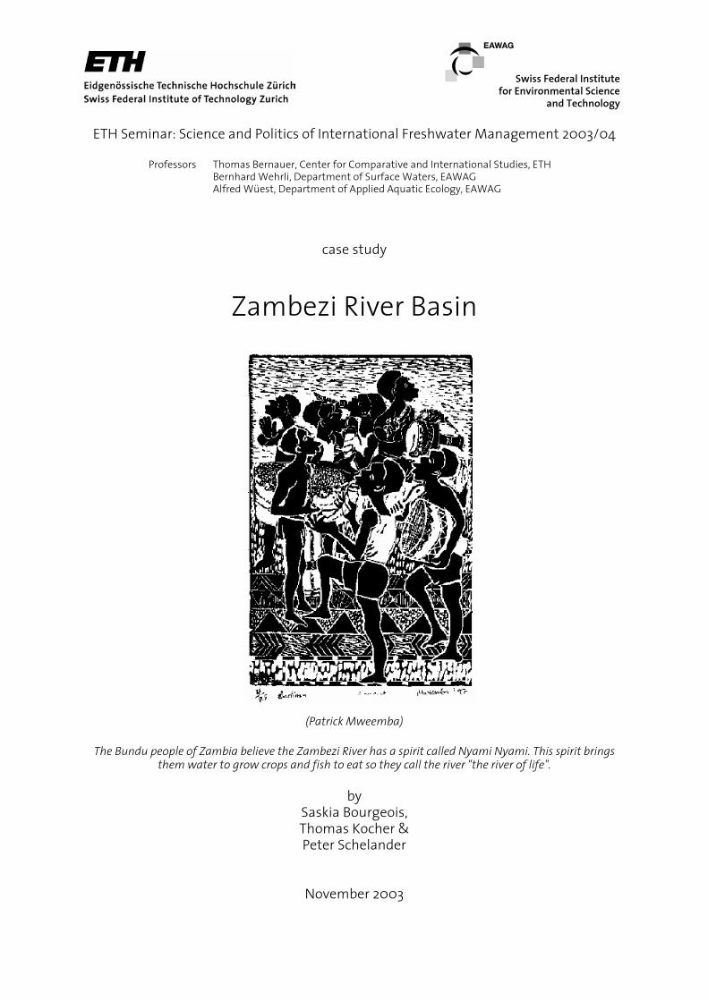
(Patrick Mweemba)
The Bundu people of Zambia believe the Zambezi River has a spirit called Nyami Nyami. This spirit brings them water to grow crops and fish to eat so they call the river "the river of life".
by
Saskia Bourgeois, Thomas Kocher & Peter Schelander
November 2003

Introduction The following case study has been elaborated within the ETH seminar “Science and Politics of International Freshwater Management”. This seminar addresses mainly PhD students with the goal to extend their knowledge on a) water resources management, b) international water resources conflicts and c) international relations and conflict resolution. Background & Organisation Freshwater is crucial to all societies and ecosystems. Most of the world’s large rivers and lakes, which are the principal sources of freshwater, are shared by two or several countries. Consequently, sustainable use of freshwater often hinges on successful international cooperation that integrates scientific knowledge into political action. In the first part of this research seminar the participants familiarized themselves with key issues in international freshwater management and the research methodology to be used. In the second part they analyzed specific transboundary river and lake management cases in a comparative perspective. Topic and General Goals This seminar addresses the following questions: What strategies can be or are in fact used to reduce or avoid chemical contamination of rivers and lakes, to protect, in an ecologically sensible manner, against flooding, and to use hydropower without damaging the environment? Under what conditions are riparian countries able to initiate cooperative processes for preserving or sustainably managing vital water resources? Under what conditions is international cooperation effective, efficient or successful in terms to be defined? In teams of two to three students ecological, social and policy data on specific international river and lake management cases were collected. Based on this data process-oriented case studies were written. In addition the river management was coded according to a more formal scheme. The case studies were developed along the following structure:
• general background information to the river/lake basin; • identification of conflict issues for which an international management effort
exists; • assessment of success/failure of this effort in reducing the conflict situation; • explaining the outcome of the international effort along a set of non-regime
and regime variables. Information on the seminar and further case studies can be found under: http://www.eawag.ch/research_e/apec/seminars.
Organized by: Prof. B. Wehrli; Dep. Surface Waters; EAWAG; Seestrasse; 6047 Kastanienbaum
Prof. T. Bernauer; Center for International Studies; ETH-Zentrum / SEI; 8092 Zürich Prof. A. Wüest; Dep. Applied Aquatic Ecology; EAWAG; Seestrasse; 6047 Kastanienbaum

2
Contents 1 Introduction ........................................................................................................................ 4
1.1 Physical geography..................................................................................................... 4 1.2 Socio-Economic facts ................................................................................................. 5 1.3 History........................................................................................................................ 5 1.4 Historical disasters...................................................................................................... 6
2 Conflict situations ............................................................................................................... 7 2.1 Kariba dam and reservoir ........................................................................................... 7 2.2 Cahora Bassa dam, Mozambique ............................................................................... 8 2.3 ZACPLAN................................................................................................................ 10
3 River Management Efforts ............................................................................................... 11 3.1 Major uses of Zambezi River and Lake Kariba........................................................ 11 3.2 ZRA (Zambezi River Authority) .............................................................................. 11
3.2.1 Historical background ...................................................................................... 11 3.2.2 Formation and funding of the ZRA.................................................................. 11 3.2.3 Primary functions of the ZRA .......................................................................... 12
3.3 PROJECTS ............................................................................................................... 12 3.3.1 KLDC: Kariba Lake Development Company .................................................. 12 3.3.1 The Gwembe Tonga Development Project ...................................................... 12 3.3.3 EMP (Environmental Monitoring Programme)................................................ 12 3.3.4 ZACPLAN (Zambezi River System Action Plan) and ZACPRO 6, II (Zambezi River Action Project 6 phase II) ....................................................................................... 13 3.3.5 Protocol on shared Water Course System ........................................................ 14 3.3.6 FGEF/FFEM Project (French Global Environmental Facility Project) ........... 14 3.3.7 NGO’s............................................................................................................... 15
4 Non-regime variables ....................................................................................................... 16 4.1 Flooding / Droughts.................................................................................................. 16 4.2 Pollution ................................................................................................................... 16
5 Regime variables .............................................................................................................. 18 5.1 Flooding.................................................................................................................... 18 5.2 Pollution ................................................................................................................... 18
6 Conclusions ...................................................................................................................... 19 Appendix .................................................................................................................................. 20
A Abbreviations ....................................................................................................... 20 B References ............................................................................................................ 21 C Coding Table .......................................................................................................... 23

3
4
1 Introduction
1.1 Physical geography
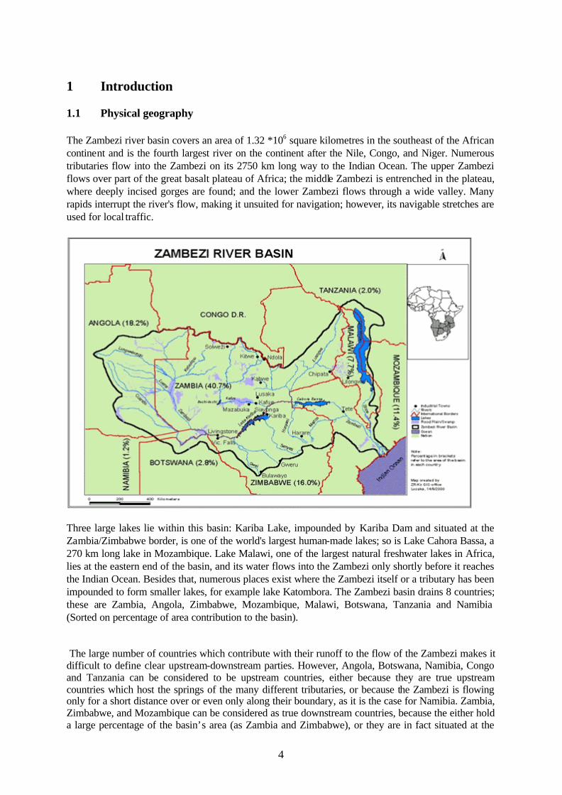
The Zambezi river basin covers an area of 1.32 *106 square kilometres in the southeast of the African continent and is the fourth largest river on the continent after the Nile, Congo, and Niger. Numerous tributaries flow into the Zambezi on its 2750 km long way to the Indian Ocean. The upper Zambezi flows over part of the great basalt plateau of Africa; the middle Zambezi is entrenched in the plateau, where deeply incised gorges are found; and the lower Zambezi flows through a wide valley. Many rapids interrupt the river's flow, making it unsuited for navigation; however, its navigable stretches are used for local traffic.
Three large lakes lie within this basin: Kariba Lake, impounded by Kariba Dam and situated at the Zambia/Zimbabwe border, is one of the world's largest human-made lakes; so is Lake Cahora Bassa, a 270 km long lake in Mozambique. Lake Malawi, one of the largest natural freshwater lakes in Africa, lies at the eastern end of the basin, and its water flows into the Zambezi only shortly before it reaches the Indian Ocean. Besides that, numerous places exist where the Zambezi itself or a tributary has been impounded to form smaller lakes, for example lake Katombora. The Zambezi basin drains 8 countries; these are Zambia, Angola, Zimbabwe, Mozambique, Malawi, Botswana, Tanzania and Namibia (Sorted on percentage of area contribution to the basin). The large number of countries which contribute with their runoff to the flow of the Zambezi makes it difficult to define clear upstream-downstream parties. However, Angola, Botswana, Namibia, Congo and Tanzania can be considered to be upstream countries, either because they are true upstream countries which host the springs of the many different tributaries, or because the Zambezi is flowing only for a short distance over or even only along their boundary, as it is the case for Namibia. Zambia, Zimbabwe, and Mozambique can be considered as true downstream countries, because the either hold a large percentage of the basin’s area (as Zambia and Zimbabwe), or they are in fact situated at the

5
very end of the river before it flows into the sea, as Mozambique (for further discussion on this see chapter 4). Table 1. Country: Area within basin (sq.
km): Part of basin area(%):
Zambia 576900 41.64 Angola 254600 18.38 Zimbabwe 215500 15.55 Mozambique 163500 11.81 Malawi 110400 7.97 Tanzania 27200 1.97 Botswana 18900 1.37 Namibia 17200 1.24
The mean total rainfall map shows maxima of above 500 mm over much of Malawi, Zambia, Angola, southern half of DRC and central and northern Mozambique. The remainder of the region receives rainfall less than 400 mm gradually decreasing southwestwards up to southwest South Africa and Namibia where the mean rainfall is below 100 mm . The precipitation in the area focuses on a short but pronounced rain season, which extends from October to April. The vegetation distribution follows the precipitation distribution; It is dominated by deciduous forests and woodland savanna in the upstream countries, which changes into savanna grassland in a generally southwards direction. The coast of Mozambique is dominated by costal forest.
1.2 Socio-Economic facts
The total number of people living within the Zambezi river basin is estimated to be around 32 Million. The river basin is rich in natural resources; main activities focus on fishery, mining, agriculture, tourism and manufacturing. Despite these favourable preconditions, the economies of the riparian countries are generally characterized by low levels of industrial development and economic growth. The existing industries strongly depend on the electricity produced at the local hydropower plants, as well as on organic sources of energy (coal, oil). In fact, a large number of people in the region profit directly or indirectly from the dams, be it as employee in industry or in tourism, which developed around the newly formed lakes, and which is one of the main sources of income in the region. However, a considerable part of the people living in the river basin area are very poor, only little educated, and have limited to no access to education and health facilities, which is mainly a consequence of the history of these countries. Some of the riparian countries such as Zambia and Mozambique are among the poorest of the world (lowest per capita income). AIDS is a tremendous problem in the region and some countries, as for example Tanzania, have life expectance below 40 years, which has a dramatic impact on the already weakened economy of these countries. Population growth rates are high in all countries, and averaging these rates leads to the conclusion that the population of the basin will double within the next 25 years. The population density is highly inhomogeneous; People gather around large cities and main traffic routes, while rural areas are only sparsely populated. Therefore stress exerted on the natural environment strongly varies locally.
1.3 History
Most of the riparian countries have been confronted with colonialism during the last century. Zambia, Zimbabwe and Malawi were united in the federation of Rhodesia, a British protectorate, and so was Botswana. Mozambique was a Portuguese protectorate until 1974, Tanzania and Namibia (formerly known as South West Africa) were first colonized by the Germans but fell to the British and the South Africans respectively after World War two. Most of the countries became independent in the sixties and seventies, but political stability was not within reach; for most of the countries, the protectorate forces had not made any efforts to provide the indigenous people with education and in many
6
countries, the gain of independence was equal to the start of riots or civil war. Some of the countries had to endure cruel dictatorship for many years, and only a few of them, for example Botswana, were able to keep up stability during the past few years. The two largest dams in the basin, Kariba and Cahora Bassa, were built in the fifties and seventies respectively, mainly for hydropower production. Today the dam of lake Cahora Bassa is running far below its capacity due to the damage it has suffered during a cruel civil war, which lasted more than a decade and destroyed a vast part of Mozambique’s infrastructure.
1.4 Historical disasters
Heavy floods were first recorded during the time of the protectorates, although they generally brought destruction and damage to limited areas and the effects of it where locally limited. Two huge flooding events in 1957 and 1958 nearly stopped the construction of the Kariba dam. Despite the existing dams along the Zambezi, floods still occur nowadays; Namibia experienced severe flooding along its border in the 2003 rain season, and parts of Zimbabwe and Mozambique were flooded in 2001. Sources of information: http://travel.yahoo.com/p-travelguide-191500003-africa_vacations-i (historical data) http://www.zaraho.org.zm/: Zambezi River Authority official homepage http://www.dmc.co.zw/SeasonalForecasts/seasonal_forecast_November2002_January2003_harare.htm (climate data) http://exploringafrica.matrix.msu.edu/curriculum/lm6/activitythree2.htm (vegetation information) http://www.encyclopedia.com/html/Z/Zambezi.asp Reference: [2]

7
2 Conflict situations
2.1 Kariba dam and reservoir
The wall of the Kariba dam as seen from the Zimbabwean side The Zambezi river basin covers an area of almost 1.4 million square kilometres within the territory of eight nations (table 1), and a long stretch of the river itself constitutes the border between Zambia and Zimbabwe. Conflicts over the use of water resources in a river basin may arise between riparian states or other interest organisations, and one way to reduce the threat of conflict and promote equitable water sharing is to establish international commissions. So far, the water supplies from the Zambezi river basin has been sufficient to cover the needs for agriculture, industry and domestic use, but in the future, supplies may not meet the needs from a developing industry and growing populations. To minimise the risk of potential conflicts, a Water Sector was created within the existing Southern African Development Community (SADC). Initiatives are being carried out in conjunction with the Zambezi River Authority (ZRA) to monitor the use of shared water resources and to promote integrated water resource management around the Kariba reservoir. Before and under the construction of the Kariba complex (dam constructed 1955-59) many major decisions were taken through commissions to avoid conflicts between the owners Zambia and Zimbabwe (at that time; North and South Rhodesia, respectively). Less consideration was taken to the possible effects the construction would have on the environment and population along the river. One of the major conflicts around the Kariba dam in the fifties arose since no plan was undertaken for the resettling of some 57,000 people from the valley during the time the reservoir was filled. People were abruptly forced from their villages and essentially no preparations where done to the new areas before the movement of the people took place. This led for instance to a severe shortage of water in the first period of establishment in the new designated area. Hostilities grew, between police executing the government orders and the landowners, which culminated with a riot on the Zambian side where eight men where shot dead [3].

8
2.2 Cahora Bassa dam, Mozambique
The 160 m high wall of the Cahora Bassa dam At the time when the construction work began at the Kariba reservoir, plans for another dam further downstream, in Cahora Bassa (Mozambique), evolved (see figure). The first hydrological excavations took place in 1956 but it was not until 1974 that the construction work at the dam could be finished. The Cahora Bassa project became early a source for conflict since the FRELIMO (the Front for the Liberation of Mozambique) claimed the whole project was a way for the Portuguese colonial power to secure their influence of the region. Despite attacks from the guerrilla movement the power production began in 1975. The year before, in 1974, the Lower Zambezi was surveyed in order to assess the potential effects of Cahora Bassa on the already regulated Lower Zambezi (Regulated upstream by Lake Chiveru, Kariba dam and Kafue Gorge). The recommendations included that the filling of the reservoir should be done over a minimum of two years, and that a certain minimum compensation flow should be kept. Predictions made ove r future ecological changes, if the recommendations were to be ignored, consisted of effects for fisheries and shrimp industry, loss of valuable wetlands, spread of human disease due to lack of river “flushings” etc [9]. The Cahora Bassa reservoir was filled in one single flood season (approximately five months) and no compensation flow was let out from the dam during this time. No further consideration was taken for the people living downstream of the dam during the time of filling, causing great suffer as the river was left completely dry. Investigations done after the completion of the dam showed that most of the predictions were correct [10].
9
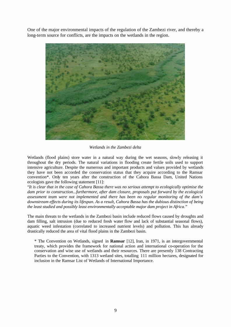
One of the major environmental impacts of the regulation of the Zambezi river, and thereby a long-term source for conflicts, are the impacts on the wetlands in the region.
Wetlands in the Zambezi delta Wetlands (flood plains) store water in a natural way during the wet seasons, slowly releasing it throughout the dry periods. The natural variations in flooding create fertile soils used to support intensive agriculture. Despite the numerous and important products and values provided by wetlands they have not been accorded the conservation status that they acquire according to the Ramsar convention*. Only ten years after the construction of the Cahora Bassa Dam, United Nations ecologists gave the following statement [11]: “It is clear that in the case of Cahora Bassa there was no serious attempt to ecologically optimise the dam prior to construction...furthermore, after dam closure, proposals put forward by the ecological assessment team were not implemented and there has been no regular monitoring of the dam’s downstream effects during its lifespan. As a result, Cahora Bassa has the dubious distinction of being the least studied and possibly least environmentally acceptable major dam project in Africa.” The main threats to the wetlands in the Zambezi basin include reduced flows caused by droughts and dam filling, salt intrusion (due to reduced fresh water flow and lack of substantial seasonal flows), aquatic weed infestation (correlated to increased nutrient levels) and pollution. This has already drastically reduced the area of vital flood plains in the Zambezi basin.
* The Convention on Wetlands, signed in Ramsar [12], Iran, in 1971, is an intergovernmental treaty, which provides the framework for national action and international co-operation for the conservation and wise use of wetlands and their resources. There are presently 138 Contracting Parties to the Convention, with 1313 wetland sites, totalling 111 million hectares, designated for inclusion in the Ramsar List of Wetlands of International Importance.
10
2.3 ZACPLAN
All eight riparian countries in the Zambezi River Basin are members of the Southern African Development Community (SADC), which in 1995 set up a protocol for Shared Watercourse Systems. The purpose of this protocol, which became operational in 1998, is primarily to give the framework for the establishment of river basin institutions in Southern Africa. Secondly, it provides a framework for settlement of disputes and conflicts that may arise during the development of various usages of the water systems in the region. Already in 1987, SADC adopted an action plan for the Zambezi River Basin (ZACPLAN), for environmentally sound planning and management of the water and related resources [13]. The original form of the plan contains 19 projects (see table chapter 3.3.4) and currently has five projects been finished with a varying degree of success. The formation of a commission for the Zambezi River Basin (ZAMCOM) as by the Watercourse protocol has now become a part of the ongoing Project 6 of the ZACPLAN. The sixth project is considered as a key part of the ZACPLAN (see chapter 3.3.4) since it should formulate a development strategy and simulate various development scenarios for the Zambezi River Basin. The first phase of Project 6 was completed in 1998 and dealt with the establishment of a common database for the basin. Phase 2 started in 2001 and includes also the formation of ZAMCOM to utilize the models and scenarios developed. This part of the ZACPLAN is aimed at adopting development policies and management procedures, which can allow a development of the basin but still preserve the environment and minimizing conflicts over water use.
-200
-120 -40
40
120
200
280
360
440
520
600
680
760
840
920
1000
1080
1160
1240
1320
1400
1480
0
100
200
300
400
500
600
700
800
900
1000
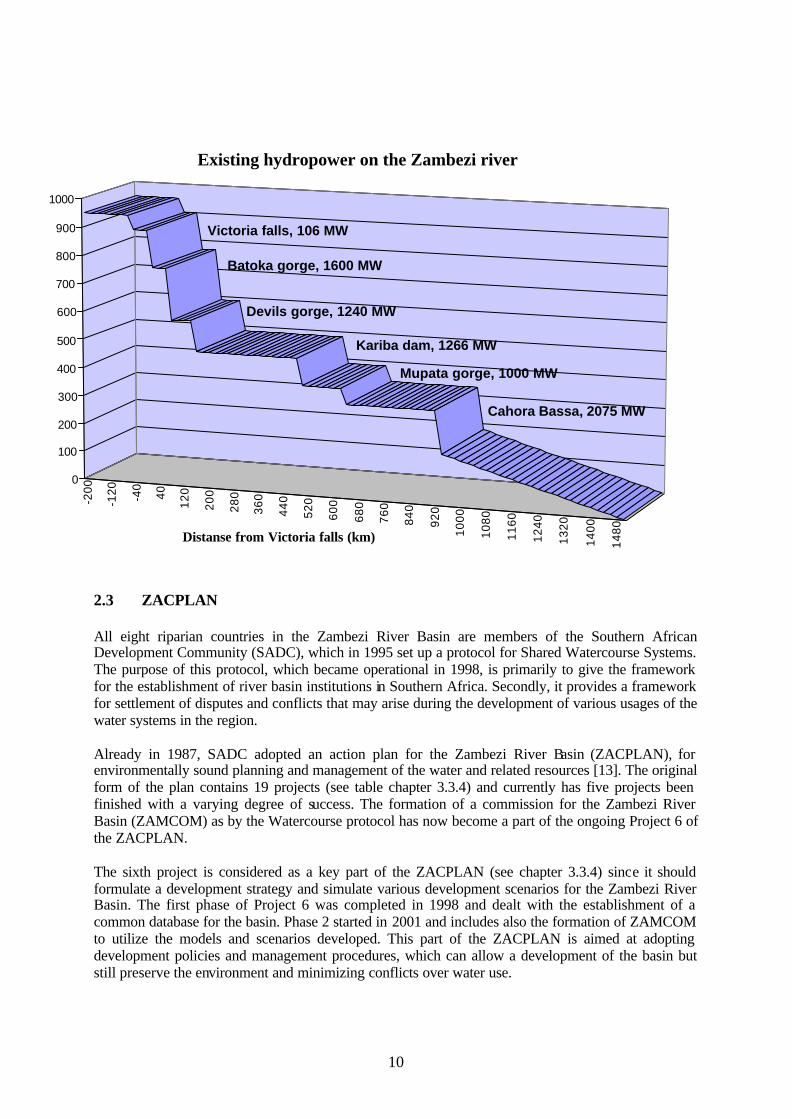
Distanse from Victoria falls (km)
Existing hydropower on the Zambezi river
Cahora Bassa, 2075 MW
Kariba dam, 1266 MW
Victoria falls, 106 MW
Batoka gorge, 1600 MW
Mupata gorge, 1000 MW
Devils gorge, 1240 MW
11
3 River Management Efforts
3.1 Major uses of Zambezi River and Lake Kariba
The current major uses of the waters of Zambezi River and Lake Kariba are: Power generation Commercial fishing Hotel and tourist industry Charter Vessels for tourists Irrigation Domestic and industrial use Most of these activities arose from the construction of the Kariba Dam Complex. The prime purpose of the Kariba Dam was for power generation. The Kariba Dam houses two power stations, one on the North Bank (Zambia) and one on the South Bank (Zimbabwe). Over the years the commercial activities mentioned above have developed on and around the lake. The divergent interests of these multiple activities obviously contain potential conflicts in the utilisation of the water resources of Zambezi River. Institutions that manage Lake Kariba [3]: Hydropower -Zambezi River Authority Fishing -Department of National Parks and Wildlife (Zim) -Department of Fisheries (Zam) Hotel Industry -Department of National Parks and Wildlife (Zim) -Department of Tourism (Zam) Charter vessels -Department of Transport (Zim) -Department of Transport (Zam) Irrigation -Zambezi River Authority (Zim/Zam) -Department of Water Development (Zim) -Department of Water Affairs Domestic and industrial use -Zambezi River Authority (Zim/Zam) -Local Government (Zim) -Local Government (Zam)
3.2 ZRA (Zambezi River Authority)
3.2.1 Historical background [5, 14] In May 1956 the Federal Power Board was established. The new Board was vested with the construction of new dams and power stations along the Zambezi River. At the same time a hydrological data collection organisation was founded. In 1963, the Federal Power Board was dissolved and the Central African Power Corporation (CAPCO) as a single system under joint ownership of the two Governments of Northern and Southern Rhodesia was established. The CAPCO took over the liabilities of the Federal Power Board. Four ministers, two of each Government, regulated the conduct of the CAPCO. In 1963, Zambia became independent and in 1980 also Zimbabwe became independent. On the first day of October in 1987 the Zambezi River Authority was founded, replacing the CAPCO.
3.2.2 Formation and funding of the ZRA [6,15] The governments of Zambia and Zimbabwe jointly own the ZRA in equal proportions and a Council of four Ministers, two of each State head the ZRA. The Ministers are holding the portfolios of Energy on the one hand and Finance on the other hand. Currently the ZRA is financed through direct disbursement from the two countries. However, with the prevailing privatisation, the ZRA is working out a mechanism to raise finances through tariffs and fees

12
for services provided [7]. For example the Electricity Utilities have to pay for the water used in power generation. The concept of water banking is in discussion, and how this can be applied at Kariba with the two national Electricity Utilities. A financial autonomy of the ZRA would be the final goal.
3.2.3 Primary functions of the ZRA The functions of ZRA cover a broad field [3,15]: − Operate, monitor and maintain the Kariba Dam Complex, − Investigate the desirability of constructing new dams on the Zambezi River and make
recommendations thereon, − Construct, operate, monitor and maintain any other dams of the Zambezi River, − Collect, accumulate and process hydrological and environmental data of the Zambezi River for the
better performance of the functions and for any other purpose beneficial to the contracting States, − Regulate the water level in the Kariba reservoir and in any other reservoir owned by the Authoriy, − Make recommendations, which will ensure the effective and efficient use of the waters and other
resources of the Zambezi River. The ZRA is a binational organization managing an international shared water resource. It operates a total of 12 telemetry and hydrographical stations where water levels are monitored daily. Flow measurements are carried out at seven of these stations. The hydrometric network is used for day-to-day operations of the Kariba reservoir, the management of power generation, and the flood control and drought analysis. Since 1994, the ZRA has been aggressively addressing environmental concerns in the Zambezi River and Kariba Lake, focused on monitoring water quality and water resources for hydropower.
3.3 PROJECTS
3.3.1 KLDC: Kariba Lake Development Company [16] The KLDC was formed in 1957. The Company took over the responsibilities for the environmental protection and management on behalf of the Kariba Dam Project. Their duty list covered a wide range of subjects: transport, industries, fisheries, national parks, tourism, irrigation, and forestry. KLDC commissioned a fish survey, carried out studies on water diseases and was involved in setting up wildlife sanctuaries.
3.3.1 The Gwembe Tonga Development Project [4,17,18] The new Government of the Republic of Zambia inaugurated the Gwembe Tonga Development Project in 1994. The objective was to identify and mitigate some of the negative impacts of the Kariba construction project. The study was undertaken by a multi-disciplinary team comprising demographers, health experts, water experts, transport experts, economists, anthropologists, social scientist, community participation experts, environmentalists, etc and was concluded in 1997.
3.3.3 EMP (Environmental Monitoring Programme) [19] Since 1998, the ZRA has been implementing an Environmental Monitoring Programme. The Programme was funded by the Swedish International Development Co-operation Agency (Sida). The EMP is a comprehensive programme, sub-regional in coverage including the Lake Kariba and the Zambezi Basin upstream of the Lake. The fundamental objectives of the EMP are: − To maintain the water resources of Kariba and the Zambezi River in an acceptable condition,
suitable for sustainable utilisation by power utilities, domestic, industrial, agricultural and environmental users,
− To provide timely and accurate information on the environmental status of the Zambezi River and Lake Kariba to stakeholders and interested parties.
An important outcome of the EMP was the establishment of an Environmental Policy and Strategy, which should guide environmental activities and responsibilities of the ZRA. The ZRA Board accepted this Policy and Strategy in March 2000.

13
The EMP has enabled much interaction between the different stakeholders in the region. It has created increased engagement in environmental issues and it also enhanced co-operation and co-ordination between stakeholders in Zambia and Zimbabwe.
3.3.4 ZACPLAN (Zambezi River System Action Plan) and ZACPRO 6, II (Zambezi River Action Project 6 phase II) [20] The ZACPLAN has been developed and implemented by the SADC-WD (Southern African Development Community Water Division). One of the outputs of ZACPLAN is the Protocol on Shared Water Course Systems. In short form, the Protocol states that water management has to include all uses including the conservation and sustainable use of living resources (see next paragraph). The core project of ZACPLAN is the ZACPRO (Zambezi River Action Project), financially supported by the Sida, Norad and Danida. The project started in October 2001 and will run for a period of three years. The project aims at developing a strategy for an integrated water resource management for a basin-wide collaboration of the Zambezi River. Based on the strategies and the outcomes of the EMP a resolution was made for the ZACPRO at the Stakeholder Workshop in Victoria Falls Town, Zimbabwe in December 2002. The next paragraph lists the three main projects of the resolution: − The ‘Environmental Policy and Strategy’, an outcome of the EMP, guides the ZRA in
environmental activities and responsibilities. − A physical-chemical Water Quality Monitoring Programme and a biological Monitoring
Programme provides data of the water quality status of the lake and the river and should allow for the identification of sources and impacts of pollution. The programme is established and currently under implementation. However, continuous data collection has proven to be problematic due to capacity and logistical problems.
− A Water Hyacinth Control and Management Plan for Lake Kariba has to be carried out. This Program has been developed and implemented.
Short summary of the individual projects in the ZACPLAN [13] ZACPRO 1: Inventory of completed, ongoing and planned projects. ZACPRO 2: Development of regional legislation. ZACPRO 3/4: Development of human resources ZACPRO 5: Development of a basin-wide unified monitoring system related
water quality. ZACPRO 6: Development of an integrated water management plan ZACPRO 7: Environmental education and public participation in ZACPLAN ZACPRO 8: Establish minimum water quality standards. ZACPRO 9: Methodologies for water resources management and apply on selected
projects. ZACPRO 10: Develop and strengthen national capabilities for carrying out
environmental impact assessments. ZACPRO 11: Promote increased support for environmentally sound management
practices. ZACPRO 12: Management plan for major energy sources. ZACPRO 13: Adopt basin-wide environmentally sound watershed management
guidelines. ZACPRO 14: Prevent and control water related diseases. ZACPRO 15: Limnological studies of major basin lakes. ZACPRO 16: Develop ecological control program against Tsetsefly and mosquitoes. ZACPRO 17: Study impacts of intern-basin water transfers. ZACPRO 18: Establish living resource conservation programs. ZACPRO 19: Research on aquatic plants and prevent spread of harmful flora.
14
3.3.5 Protocol on shared Water Course System [21,22] The Protocol was signed in August 1995 by all members of the SADC except of the Republic of Angola. − The 'Protocol on shared Water Course System' is a work done under ZACPLAN. It considers the
Helsinki Rules, 'International Law Commission on non-navigational use of international water courses' and 'Agenda 21 of the UN conference on Environment and Development'. It gives the framework for the establishment of the River Basin Commission (ZRBC) and the River Basin Authority (ZRBA). The ZRBC is responsible for the control and the management of the ZRBA and the commission is also bridge to other institutions. The functions of the ZRBA are to collect, accumulate and process hydrological, water quality, environmental and any other water related data and maintain a data-base on the utilisations of the resources of the Zambezi River. Furthermore the ZRBA should prepare and make recommendations for river basin related aspects.
The objectives of the protocol are: − To maintain a balance between a higher standard of living for the basin population and the
conservation of the environment. − To establish close corporation of all the basin projects that have an effect on the regime of the
watercourse system including the mitigation of floods and droughts. − To enhance the exchange of all available information and data among riparian basin States
(hydrological, water quality, meteorological and ecological conditions of the basin). − To utilise the river basin resources in an equitable manner, taking into account the social and
economic needs of the individual riparian States, considering the upstream and downstream effects of the utilisation according to guidelines and standards.
− To regulate the use of water for all uses through issuing permits and water rights. Such a permit should only be granted if the project does not have a detrimental effect for the river regime.
− To ensure that all related installations, facilities and other works are used exclusively for peaceful purposes and should be inviolable in times of international and internal conflicts.
The goals of the protocol are: − Harmonisation of national water plans in order to develop a basin-wide master plan. − Standardisation of water pricing policies to enable the implementation that water is an economic
good. − Standardisation of water related legislation throughout the basin (water rights/permit issues,
environmental protection, pollution and water quality standards according to the Helsinki Rules, the SADC Treaty and Protocols).
− Establishing procedures for the resolution of conflicts between riparian States. − Establishment of an inventory and database on the basin's resources and water utilisation patterns
from national databases. − Basin-wide unified monitoring and data collection system for the basin's database. − Reviewing strategies for the development of shared watercourse systems. − Stimulating public awareness and participation in the development of the environment.
3.3.6 FGEF/FFEM Project (French Global Environmental Facility Project) [23] Support for Pollution Monitoring and Management on the Zambezi River is the objective of this project. In February 2001the AFD (Agence Francaise de Development) contributed 1’500’000 Euros for the project. The ZRA contributes 427’500 Euros and additionally staff and local expenses. Implementation was planed to start in January 2003. The various actions making up the project are as follows: − Carrying out a programme for measuring the water quality in the Zambezi River,
including training ZRA personnel, − Supply and installation of telemetric equipment for the water quality surveillance network
as well as hydrological measures, which will be used as a warning system for pollution and floods,

15
− Development of an environmental database and implementation of a system for pollution and floods.
− Supplying satellite images for the assessment of the propagation of water hyacinths in Lake Kariba.
− Supply of equipment for biological analysis and training of ZRA personnel. The Project will run for a period of three years – including six months of tendering and contracting. ZRA is the contracting authority and recipient of the Project.
Zambezi River Authority
3.3.7 NGO’s [24] Several Non-Governmental Organisations (Water Aid, Care International, Irish Aid, Africare, World Vision International, Development Aid from People to People DAPP) are involved in the water sector for over 10 years. NGO are predominately active in regional and local small projects directly beneficial to the population. Initially the NGOs dictated where they would work and how they would be involved but after all it was realised that there was need to bring the operations of the NGOs and Government into line. However divergent priorities between the governments and the NGOs slow down the projects.

16
4 Non-regime variables
The large number of countries involved (see chapter 1, Introduction) makes it difficult to address an upstream or downstream status to each state; it is more suitable to address a status to each country depending on the issue looked at. For the issue of flooding, Angola is considered to be a true upstream country, while Mozambique is a true downstream country. The other six countries lie in between and therefore no status is addressed to them.
4.1 Flooding / Droughts
The Zambezi Basin falls within three climate zones: semi-arid, dry sub-humid and moist sub-humid. Climate in the Zambezi Basin is variable and so is rainfall, making planning a challenge. Flooding in Namibia and Botswana in 2003 was caused by heavy rainfalls in Angola. Although deforestation is a presumably major problem in rural areas in the basin, one does not observe an increase in frequency of flooding events until now. In 2001 severe flooding stroke Mozambique, but according to http://www.dna.mz/floods2001/muller.htm, careful water management and continuous monitoring of the dam levels even helped to reduce the extend of this flooding event. Drought, which periodically interchange with floods, increase soil degradation problems, while soil degradation magnifies the effects of drought. As a result of drought during the 1994-95 season, cereal harvests in southern Africa declined by 35 percent compared to harvests of 1993-94, with maize harvests alone falling by 42 percent. With about 80 percent of the people in the Zambezi Basin dependent on agriculture and the region's food security worsening, the basin states are always facing a serious challenge to achieve food self-sufficiency. Since some parts of the basin are arid or semi-arid, drought will continue to be a factor, limiting economic performance and exerting pressure on the environment. Despite the fact that severe floods and droughts occur periodically, and the effect of these could be reduced by appropriate water management measures, this topic is almost never discussed on and it get almost no attention in water-related contracts and policies in the Zambezi basin.
4.2 Pollution
For the issue of pollution, it is even more difficult to address a status of upstream or downstream country to a state. Therefore we focus more on the various sources of pollution and the actions taken to reduce the pollution level. Although the severity, impacts and physics of some of the pollution is not well researched and documented, it is believed that the quality of vegetation, soils and water is adversely being affected by pollution. Different types of pollution can be identified which contribute to the degradation of water quality in the Zambezi river basin. One can split the various types into localized and diffuse source problems: Point source pollution Sewage effluent is the major cause for water pollution in urban areas. All of the major cities in the Zambezi basin have inadequate sewage treatment facilities, which force them to spill part of the sewage directly and untreated into the rivers. The consequences of these actions are a severe eutrophication of the river water, and the pollution with faecal bacteria, which cause gastro-enteric diseases such as cholera, typhus, and dysentery. Pollution effects of industry focus on urbanized catchment areas Industrial activities include mining, chemical, fertiliser and textile manufacturing. More than 93,000 tonnes of industrial waste are produced annually, and most of it eventually finds its way into the Zambezi River. The sources of pollution are actually point sources, but due to the large number of sources, they might be looked at on a larger scale as being a diffuse source in industry-rich areas.
17
Mining is separated from the industrial pollution since it isn’t concentrated in urbanized areas; however, it is one of the main water polluters in the Zambezi Basin, causing water acidification and discharging a variety of highly toxic metals such as arsenic, mercury, cadmium and lead. The disposal of solid mine waste also presents serious problems, since the solid mining waste, e.g. melting slag, is highly enriched in toxic metals, and the metals are washed out of the solid over time since most of the waste disposal sites are leaking. Pollutants from agricultural and forestry activities include nitrogen, phosphorous, insecticides, herbicides, as well as poisonous residues contained in irrigation seepage water and livestock feedlots. Such sources of pollution are difficult to control due to their diffuse nature. Furthermore, large amounts of DDT were used in the ’60-’90 to extinct the Tsetse -fly along the river. However, the toxic effect of DDT is not restricted to the flies, and various changes in population density of different animals were attributed to the use of DDT. There are several points, which hamper the existence of a working pollution management in the Zambezi basin. Among others, these are the fact that the there is a general lack of awareness regarding the impact of waste on the environment and human health. For the reasons of poverty and unemployment, the management of waste is not a priority by both local and central governments of the basin when compared to issues of economic development, housing and employment. Legislation and regulations relevant to pollution and waste management are in most cases inappropriate, incomplete or diffuse. And there is inadequate enforcement of existing regulations, which is worsened by limited monitoring capacity. To start with this last point mentioned above, the Zambezi River Authority has been implementing an “Environmental Monitoring Program (EMP)” since November 1998 on behalf of the two Contracting States, Zambia and Zimbabwe. The program was funded by the Swedish International Development Co-operation Agency (Sida) and supported with technical assistance from the Stockholm Environment Institute (SEI). However the actual sampling and analysis of the physical-chemical parameters in the monitor ing system suffers from a lower level of activity than what was originally targeted for. Continuous data collection has proven to be problematic due to capacity and logistical problems. It is planned to extend the EMP project to all countries joining the Zambezi basin.

18
5 Regime variables
5.1 Flooding
The Zambezi River plays a vital role in central Mozambique, both for wild life and for humans. The valley floodplain has seasonally been nourished by annual floods of the river and thereby provided the region with fertile land for agriculture, hunting and fishing. Because of its rich biological diversity and national economic importance is the Zambezi Delta a candidate for designation as a Wetland of International Importance according to the Ramsar convention (see chapter 2.2). Despite the internationally acknowledged importance of the Zambezi Delta, the ecosystems and habitants there have suffered a great deal in the past four decades by the management of the river flow further upstream. By eliminating the natural flooding and greatly increasing the dry season flows in the lower Zambezi, the flow regulations cause hardship for people whose livelihood to a great extent depends on the natural flow of the Zambezi River. Although the hydropower dam at Cahora Bassa generates important revenue for Mozambique, it is operated to maximise the hydropower output, partly on the expense of water users further downstream. The water is heavily regulated even upstream from the Cahora Bassa dam, mainly at the Kariba dam, shared by Zimbabwe and Zambia. But the problems with flood regulations in the lower Zambezi becomes to a great extent a domestic problem for Mozambique, since the last regulation along the river is done at Cahora Bassa.
5.2 Pollution
The EMP, the FGEF and the ZACPRO6 have as their main objective the monitoring of pollution of water and environment of the Zambezi River. With the EMP, very general policies and strategies were defined. The main project was the inauguration of a Water Quality Monitoring Programme. Such a programme is very demanding in logistics and financing. Once the monitoring stations are set up they need a lot of maintenance and the data of all stations has to be collected and processed. With such a programme only the actual state of the environment can be shown but what really is needed, is a plan to react on the situation. The challenge ahead lies now in the operationalisation of the policy. FGEF is the succeeding project of the EMP. The establishment of the quality control of the water of Zambezi River and the implementation of a surveillance network as a long-term project is aimed at. The FGEF contains more aspects than the EMP. Telemetric stations should be supplied and also installed. Furthermore it is planned to train personnel of the ZRA for the monitoring programmes. The goals of the EGEF are set very high and only the implementation in 2003 will show if they can be realized. The EMP and the FGEF are funded by foreign institutions. There is no legal binding of the States to follow the Environmental Policies and Strategies. Furthermore, some States do not have the means to maintain monitoring stations; financially they are completely dependent on international organisations. ZACPRO6 is a project evoked by the SADC with financial assistance of Sida, Norad and Danida. It has also adopted the outcomes of the EMP. The Project started in October 2001, and will run for three years. ZRA is the implementing agency on behalf of SADC. The aim of ZACPRO6 is to set up legal instruments, for example Project Steering Committees (PSC) and National Steering Committees (NSC). A crucial point of the arrangement is the fact, that on one hand the ZRA is responsible for the coordination of the multinational project but on the other hand ZRA was originally founded by only two states, Zambia and Zimbabwe, which also chair the ZRA.

19
6 Conclusions The development of the Zambezi River Basin has gone through drastic changes in the past fifty years as hydropower production was introduced. This has increased the need for agreements between the riparian states on the use of the natural resources in the basin. As shown in this study, it has so far been hard to implement the few agreements reached on an international level in the area, and where transboundary projects have had some progress, it has been very slow. The ZACPLAN, introduced by thy Southern African Development Community, was the first major agreement between all riparian states around the Zambezi. One general problem with the ZACPLAN is it’s ‘top-to-bottom’ approach, following a similar structure as for river basins in other parts of the world with completely different underlying conditions. This has proven to be not as successful for the Zambezi River Basin, which is situated in one of the poorest parts of Africa. A common problem for the implementation of major projects is that the level of activity becomes drastically lower with time. Resources seem to easily ‘dissipate’ when going down the chain from decision taking level to end-user. In the current situation of the countries around the Zambezi, it seems easier to reach a successful implementation when projects are small and preferably on a regional level. The lack of a higher authority with executive power covering the complete basin makes it hard to create an overview and co-ordinate these projects. Currently, the main authority working on implementing new transboundary projects in the basin is the Zambezi River Authority (ZRA). One problem with the ZRA is that it is not representing all governments in the Zambezi River Basin but only Zimbabwe and Zambia. As long as the ZRA is in reality the only working platform for larger projects around the Zambezi it is hard to see that there will be much benefit from it for, for instance, the downstream nation of Mozambique. The ZRA has proven to be fairly efficient in solving some of the problems related to the Kariba dam, yet there are major problems left unsolved from the start of the Kariba dam project five decades ago. Both Zimbabwe and Zambia haven’t dealt with the issue of displaced people and loss of land in a satisfying way.
20
Appendix
A Abbreviations AFD Agence Francaise de Development EMP Environmental Monitoring Programme Danida Danish Agency for Development Assistance FGEF/FFEM Project French Global Environmental Facility Project IUCN The World Conservation Union KLDC Kariba Lake Development Company KNBC Kariba North Bank Company Limited Norad Norwegian Agency for Development Cooperation NSC National Steering Committees PSC Project Steering Committees SADC-WD Southern African Development Community Water Division SAPP Southern African Power Pool Agreement SARDC Southern African Research and Documentation Centre SEI Stockholm Environment Institute Sida Swedish International Development Co-operation ZACBASE regional network of hydrometric stations ZAMCOM Zambezi Basin Commission ZACPLAN Zambezi River System Action Plan ZACPRO 6, II Zambezi Action Project (Core Project of the ZACPLAN) ZESA Zimbabwe Electricity Supply Authority ZESCO Limited Zambia Electricity Supply Corporation ZRA Zambezi River Authority ZRBA Zambezi River Basin Authority ZRBC Zambezi River Basin Commission ZRBNC Zambezi River Basin National Committees
21
B References
[1] Tumbare, M.J. 2000. Management of River Basins and Dams: The Zambezi River Basin. A.A. Balkema, Rotterdam The following papers can be found in [1]:
[2] M.J. Tumbare, C.F.G. Mukosa 2000: The Zambezi River Basin – A case study in Management of River Basins and Dams. [3] Tumbare, M.J. 2000. The management of the multiple uses of Lake Kariba’s water resources. [4] Kaluba, K. and Mukupe, H. (2000). Impacts of the Kariba dam on the displaced community. [5] Tumbare M.J. and C.F.G. Mukosa 2000. A brief history of the creation of the Zambezi River Authority. [6] Mulendema, B.C. 2000. Multinational organizations as avenues of research and cooperation – The Zambezi River Authority. [7] Mukosa, C.F.G. 2000. Water tariffs and water banking operating rules and guidelines for Lake Kariba. [8] Tumbare, M.J. 2000. A strategic action Plan for the sustainable development of the water resources of the Zambezi River basin.
[9] Hall, A., Davies, B.R. and Valente, I.C.B.M. (1976): Cahora Bassa. Some preliminary physico-chemical and zooplankton pre-impoundment survey results. Hydrobiologia 50, 17-25. [10] Davies, B.R., Beilfuss, R.D and Thoms, M.C. (2000): Cahora Bassa retrospective, 1974-1997: effects of flow regulation on the lower Zambezi River. Verh. Internat. Verein. Limnol. 27, 1-9 [11] http://www.ramsar.org [12] http://www.savingcranes.org [13] Tumbare, M.J. (2001): Management of shared watercourse systems in the Southern African development community region. Presented at the NELSAP River Basin Project Preparatory Workshop, Stockholm, 11-12 December 2001. [14] http://www.zaraho.org.zm/history.html [15] http://www.zaraho.org.zm/functions.html [16] http://www.dams.org/docs/kbase/studies/cszzmain.pdf [17] http://www.dams.org/kbase/submissions/showsub.php?rec=ins210 [18] http://www.dams.org/kbase/submissions/showsub.php?rec=soc119 [19] http://www.zaraho.org.zm/sida-project.html [20] http://www.zaraho.org.zm/zacpro.html [21] http://www.africanwater.org/SADCprotocol.PDF [22] http://www.sadc.int/ [23] http://www.ffem.net/news_eauxintern.html [24] http://www.zambia-water.org.zm/ngos.htm) [25]http://www.sardc.net/index.htm [26]http://www.zaraho.org.zm/: Zambezi River Authority official homepage [27] http://www.sardc.net/imercsa/Zambezi/zambezi2000/summary/pollution.html [28] http://www.sardc.net/imercsa/Zambezi/zambezi2000/summary/climatendrought.html [29] http://www.cia.gov/cia/publications/factbook/ [30] http://www.sardc.net/imercsa/zambezi/Zambezi/v5n3/zacpro.htm [31] http://www.sardc.net/imercsa/Zambezi/zambezi2000/summary/poverty.html [32] http://www.sardc.net/imercsa/Zambezi/zambezi2000/summary/water.html [33]http://www.sida.se/Sida/jsp/Crosslink.jsp?d=107; [34]http://www.iwsd.co.zw/Papers%5CGranit.pdf; [35]http://www.sarpn.org.za/documents/d0000329/Regional_Integration_attachment4.pdf Other sources of information:
22
Southern African Development Community (SADC) official homepage. http://www.sadc.int/index.php?lang=english&path=&page=index Ammon Mutembwa, 1998.Water and the Potential for Resource Conflicts in Southern Africa http://www.dartmouth.edu/~gsfi/gsfiweb/htmls/papers/text3.htm Lenard Milich and Robert G. Varady 1998.Openness, sustainability, and public participation in transboundary river-basin institutions, Part II: Regulatory, closed and top -down paradigms of river basin management. http://ag.arizona.edu/OALS/ALN/aln44/varady-milich2.html Mikiyasu Nakayama, Role of International Organizations for Integrated Management of International Water Bodies, The World Bank. http://www.unep.or.jp/ietc/Publications/techpublications/TechPub-4/role1-5.asp Protocol on shared watercourse systems in the southern African development community (SADC) Region. http://www.africanwater.org/SADCprotocol.PDF Syantami Syankusule, David and Lungu, Bazak Zakeyo, Impacts of the Construction of Lake Kariba on Gwembe Tonga People. http://www.dams.org/kbase/submissions/showsub.php?rec=soc119 The revised international law association rules on equitable and sustainable use in the management of the waters, Preliminary Seventh Draft, March 2002. http://www.ila -hq.org/pdf/Water%20Resources/Draft%20Rules%20March%202002.pdf Nakayama, M. 1999: Politics behind Zambezi Action Plan, Water Policy, 1, 397-409. http://www.tuat.ac.jp/~mikiyasu/abs1999-4.html Limbwambwa, C. 1999. Mitigating Impacts of Large Dam Construction ex-post: the Case of the Gwembe-Tonga Development Project. http://www.dams.org/kbase/consultations/afrme/programme.htm WCD Case Study, Kariba Dam Zambia and Zimbabwe, Final Report: November 2000. http://www.dams.org/docs/kbase/studies/cszzmain.pdf

23
C Coding Table
OUTCOMES-SUCCESS-FAILURE VARIABLE DEFINITION Explanation (short, more detailed in text)Source of information (references)
REGULATORY OUTPUT
International treaty
yes
yes, no
ZACPLAN: The treaty includes several goals including environmental protection, regulation of water uses, resolution procedures in case of conflicts between riparian states
[19]
Are treaty provisions specific in terms of goals and implementation?
3 1 (vague) - 5 (very specific) scale
Very specific in terms of goals but not very specific in terms of the implementation
[21]
Is there a dedicated international organizationyes
yes, noSADC [8,22,25]
IMPLEMENTATION
To what extent have riparian governments enacted legislation or other domestic measures to implement international commitments?
2
1 (none) - 5 (very much) scale
ZRBA is in charge of accumulating and processing hydrological, water quality, environmental and any other water related data and maintain a data-base on the utilisations of the resources of the Zambesi River. Hydrometeorological stations were are maintained.
[26]
PROBLEM SOLVINGWhat is the collective optimum (CO)? 10 by definition
What would the outcome have been in the absence of international efforts (NR)?
2
1-10 scale
In absence of any efforts, monitoring programs were probably only evoked to improve the production of hydroelectric power.
What is the present situation (actual performance, AP)?
41-10 scale
Water quality monitoring and environmental protection programs are established.
20
Effectiveness score = (AP-NR)/(CO-NR) 0.25Sensitivity score = 1/(CO-NR) = d(effectiveness score)/dAP
0.125
EXPLANATORY VARIABLES
NON-REGIME INFLUENCESGeographical/hydrological:
Number of countries involved8
1-?? Scale
Angola, Botswana, Malawi, Mozambique, Namibia, Tanzania, Zambia, Zimbabwe.
Area of river/lake basin 1.32*106 km2
Asymmetry in terms of riparian land area in river/lake basin
34% of largest riparian country in river basin / % of smallest riparian country in river basin
largest: Zambia smallest: Namibia
Issue-characteristics:Extent to which damage caused by individual riparian countries is exported to other riparians (average)
41-5 scale
Flooding and diverging water causes major damages in riparian countries.
Is the problem an upstream-downstream negative externality problem?
41-5 scale
Dam constructions typically result in upstream-downstream problems.
[27]
Is the environmental problem scientifically well-understood?
31-5 scale
The reason for the decrease in precipitation is not clear.
[28]
How easy/hard is monitoring of compliance with international commitments?
5
1-5 scale
Monitoring of compliance with international commitments is hard. A cross national control organ is missing.
Is the environmental problem predominantly a point-source or a diffused-sources problem?
-yes, no
Environmental problems are both point-source and diffused-source problems.
[27]
Zambesi River Basin
24
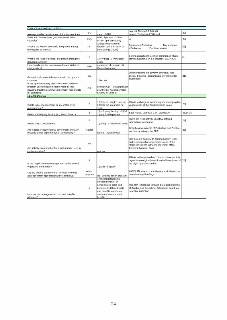
Economic and political conditions:
Average level of development of riparian countries16
mean of GDPpoorest: Malawi 7.2 Billion$ richest: Zimbabwe 27 Billion$
[29]
Economic development gap between riparian countries
0.26GDP of poorest / GDP of richest riparian country
29 [29]
What is the level of economic integration among the riparian countries?
4average trade among riparian countries as % of their GDP (1-100%)
Botswana->Zimbabwe Mozambique->Zimbabwe Zambia->Malawi
[29]
What is the level of political integration among the riparian countries?
21(very bad) - 5 (very good) scale
Setting up national steering committees which provide data for ZRA is a project of ZACPRO6.
30
How closely are the riparian countries affiliated in foreign policy?
NaNcorrelation of voting in UN General Assembly
-
General environmental awareness in the riparian countries
2.5
1-5 scale
Other problems like poverty, civil wars, food crises, droughts predominate environmental awareness.
[31]
Is the riparian country that suffers most from the problem economically/militarily more or less powerful than the country(ies) primarily responsible for damages?
0.3average GDP+MilExp polluter country(ies) / average victim country (0-1 scale)
REGIME DESIGN
Single-issue management or integrated river management?
51 (clear-cut single issue m.) - 5 (clear-cut integrated m.) scale
ZRA is in charge of monitoring and managing the various uses of the Zambesi River Basin.
[32]
Extent of third party funding (e.g. World Bank...)3
1 (no 3.party funding) - 5 (full 3.party funding) scale
Sida, Norad, Danida, FGEF, Worldbank [33,34,35]
Extent of NGO involvement2
1 (none) - 5 (extensive) scale
There are NGO activities but few detailed information was found.
[24]
Are federal or local/regional government primarily responsible for implementation and funding?
federalfederal, regional/local
Only the governments of Zimbabwe and Zambia are directly sitting in the ZRA.
[26]
Are liability rules or other legal instruments used in implementation?
no
yes, no
The lack of a basin wide common policy, legal and institutional arrangements is one of the major constraints in the management of the Common Zambezi River
Is the respective river management authority well organized and funded?
3
1 (bad) - 5 (good)
ZRA is well organized and funded. However, this organisation originally was founded by only two of the eight riparian counties.
[26]
Legally binding agreement or politically binding action program approach (hard vs. soft law)?
action program
leg. Binding, action program
ZACPLAN sets up committees and strategies not based on legal bindings.
How are the management costs and benefits allocated?
1
1=concentrated costs, diffused benefits; 2= concentrated costs and benefits; 3=diffused costs and benefits; 4=diffused costs and concentrated benefits
The ZRA is financed through direct disbursement of Zambia and Zimbabwe. All riparian countries benefit of ZACPLAN.