world prehistory and archaeology: … ecording maya glyphs. urban states outline 11.1 mesopotamia...
TRANSCRIPT
ALLYN & BACON/LONGMANwww.ablongman.com
WORLD PREHISTORY AND ARCHAEOLOGY: Pathways through Time©2008
Michael Chazan
ISBN-10: 0-205-40621-1ISBN-13: 978-0-205-40621-0
S A M P L E C H A P T E R 1 1Urban StatesThe pages of this Sample Chapter may have slight variations in final published form.
Visit www.ablongman.com/replocator to contact your local Allyn & Bacon/Longman representative.

C H A P T E R
11

Recording Maya glyphs.
Urban States
O U T L I N E
11.1 MESOPOTAMIAThe Physical Setting
ARCHAEOLOGY IN THE WORLD:The Fate of Iraq’s Antiquities
ChronologyUrukGovernmentSurplus and SpecializationInequalityThe Development of WritingWarfare and ExpansionSumming Up the Evidence
11.2 THE MAYAChronology
DISCOVERING THE PAST: RíoAzul, by Fred Valdez
The Setting
DISCOVERING THE PAST:Ancient Maya and theMedicinal Trail Site, by DavidHyde
The CityGovernmentInequalityMayan Hieroglyphics
TOOLBOX: Geophysical Methods
Ritual, Violence, and Warfare
The Mayan Collapse
TOOLBOX: Deciphering theMayan Hieroglyphs
Summing Up the Evidence
11.3 SHANG CHINA
11.4 THE URBAN STATE
IN MESOPOTAMIA,
MESOAMERICA, AND
CHINA, the emergence
of the state and urban
centers are closely
linked. After reading
this chapter, you should
understand:
�The characteristics of
the urban centers of
the three civilizations
studied.
�The nature of the
social organizations
of these three early
states.
�The development of
Mesopotamian
cuneiform, Mayan
hieroglyphs, and
early Chinese writing.
322 PART FOUR: The Development of Social Complexity www.ablongman.com/chazan
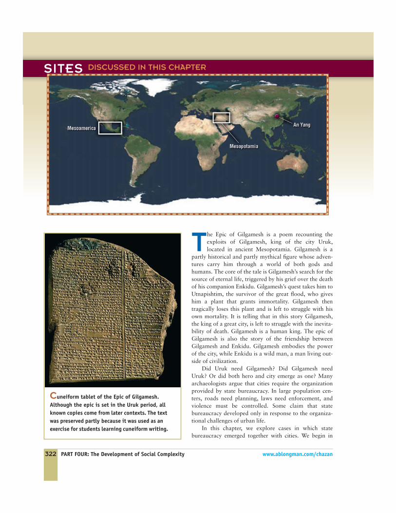
The Epic of Gilgamesh is a poem recounting theexploits of Gilgamesh, king of the city Uruk,located in ancient Mesopotamia. Gilgamesh is a
partly historical and partly mythical figure whose adven-tures carry him through a world of both gods andhumans. The core of the tale is Gilgamesh’s search for thesource of eternal life, triggered by his grief over the deathof his companion Enkidu. Gilgamesh’s quest takes him toUtnapishtim, the survivor of the great flood, who giveshim a plant that grants immortality. Gilgamesh thentragically loses this plant and is left to struggle with hisown mortality. It is telling that in this story Gilgamesh,the king of a great city, is left to struggle with the inevita-bility of death. Gilgamesh is a human king. The epic ofGilgamesh is also the story of the friendship betweenGilgamesh and Enkidu. Gilgamesh embodies the powerof the city, while Enkidu is a wild man, a man living out-side of civilization.
Did Uruk need Gilgamesh? Did Gilgamesh needUruk? Or did both hero and city emerge as one? Manyarchaeologists argue that cities require the organizationprovided by state bureaucracy. In large population cen-ters, roads need planning, laws need enforcement, andviolence must be controlled. Some claim that statebureaucracy developed only in response to the organiza-tional challenges of urban life.
In this chapter, we explore cases in which statebureaucracy emerged together with cities. We begin in
Cuneiform tablet of the Epic of Gilgamesh.Although the epic is set in the Uruk period, allknown copies come from later contexts. The textwas preserved partly because it was used as anexercise for students learning cuneiform writing.
SITES DISCUSSED IN THIS CHAPTER
CHAPTER 11: Urban States 323
Gilgamesh’s homeland, Mesopotamia,which saw the emergence of the first statesocieties in the world. We then move toMesoamerica, focusing on the Mayan civi-lization. In the last section, we briefly con-sider the archaeological evidence for stateformation in China.
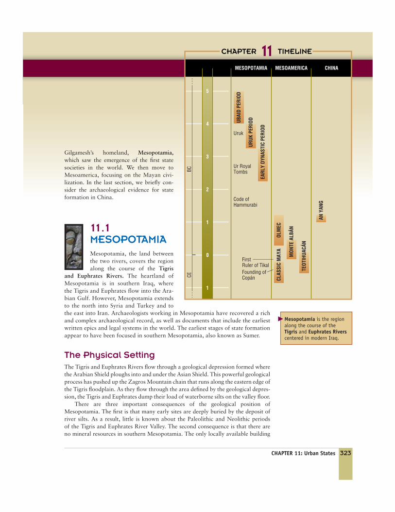
1 1 . 1MESOPOTAMIAMesopotamia, the land betweenthe two rivers, covers the regionalong the course of the Tigris
and Euphrates Rivers. The heartland ofMesopotamia is in southern Iraq, wherethe Tigris and Euphrates flow into the Ara-bian Gulf. However, Mesopotamia extendsto the north into Syria and Turkey and tothe east into Iran. Archaeologists working in Mesopotamia have recovered a richand complex archaeological record, as well as documents that include the earliestwritten epics and legal systems in the world. The earliest stages of state formationappear to have been focused in southern Mesopotamia, also known as Sumer.
The Physical SettingThe Tigris and Euphrates Rivers flow through a geological depression formed wherethe Arabian Shield ploughs into and under the Asian Shield. This powerful geologicalprocess has pushed up the Zagros Mountain chain that runs along the eastern edge ofthe Tigris floodplain. As they flow through the area defined by the geological depres-sion, the Tigris and Euphrates dump their load of waterborne silts on the valley floor.
There are three important consequences of the geological position ofMesopotamia. The first is that many early sites are deeply buried by the deposit ofriver silts. As a result, little is known about the Paleolithic and Neolithic periodsof the Tigris and Euphrates River Valley. The second consequence is that there areno mineral resources in southern Mesopotamia. The only locally available building
Mesopotamia is the regionalong the course of theTigris and Euphrates Riverscentered in modern Iraq.
�
MESOPOTAMIA CHINAMESOAMERICA
FirstRuler of TikalFounding ofCopán
Uruk
Ur RoyalTombsBCCE
Code ofHammurabi
CHAPTER TIMELINE11
UBAI
D PE
RIOD
AN Y
ANG
OLM
ECCL
ASSI
C M
AYA
MON
TE A
LBÁN
TEOT
IHUA
CÁN
EARL
Y DY
NAST
IC P
ERIO
D
URUK
PER
IOD
5
4
3
2
1
0
1
324 PART FOUR: The Development of Social Complexity www.ablongman.com/chazan
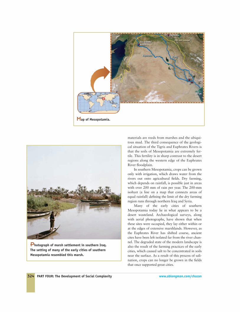
Map of Mesopotamia.
materials are reeds from marshes and the ubiqui-tous mud. The third consequence of the geologi-cal situation of the Tigris and Euphrates Rivers isthat the soils of Mesopotamia are extremely fer-tile. This fertility is in sharp contrast to the desertregions along the western edge of the EuphratesRiver floodplain.
In southern Mesopotamia, crops can be grownonly with irrigation, which draws water from therivers out onto agricultural fields. Dry farming,which depends on rainfall, is possible just in areaswith over 200 mm of rain per year. The 200-mmisohyet (a line on a map that connects areas ofequal rainfall) defining the limit of the dry farmingregion runs through northern Iraq and Syria.
Many of the early cities of southernMesopotamia today lie in what appears to be adesert wasteland. Archaeological surveys, alongwith aerial photographs, have shown that whenthese sites were occupied, they lay either within orat the edges of extensive marshlands. However, asthe Euphrates River has shifted course, ancientcites have been left isolated far from the river chan-nel. The degraded state of the modern landscape isalso the result of the farming practices of the earlycities, which caused salt to be concentrated in soilsnear the surface. As a result of this process of sali-nation, crops can no longer be grown in the fieldsthat once supported great cities.
Photograph of marsh settlement in southern Iraq.The setting of many of the early cities of southernMesopotamia resembled this marsh.
CHAPTER 11: Urban States 325
ARCHAEOLOGY
The Fate of Iraq’s AntiquitiesThe devastation of the Iraq Museum in the days following theU.S.-led invasion of Iraq was a traumatic event. Pictures oflooted storerooms and display cases provoked fears that thecultural heritage of Iraq had been irreparably damaged. Theexact extent of the loss and the precise sequence of events isstill being determined years after the event. It is likely thatthe repercussions of this event will shape the field of archae-ology for decades to come.
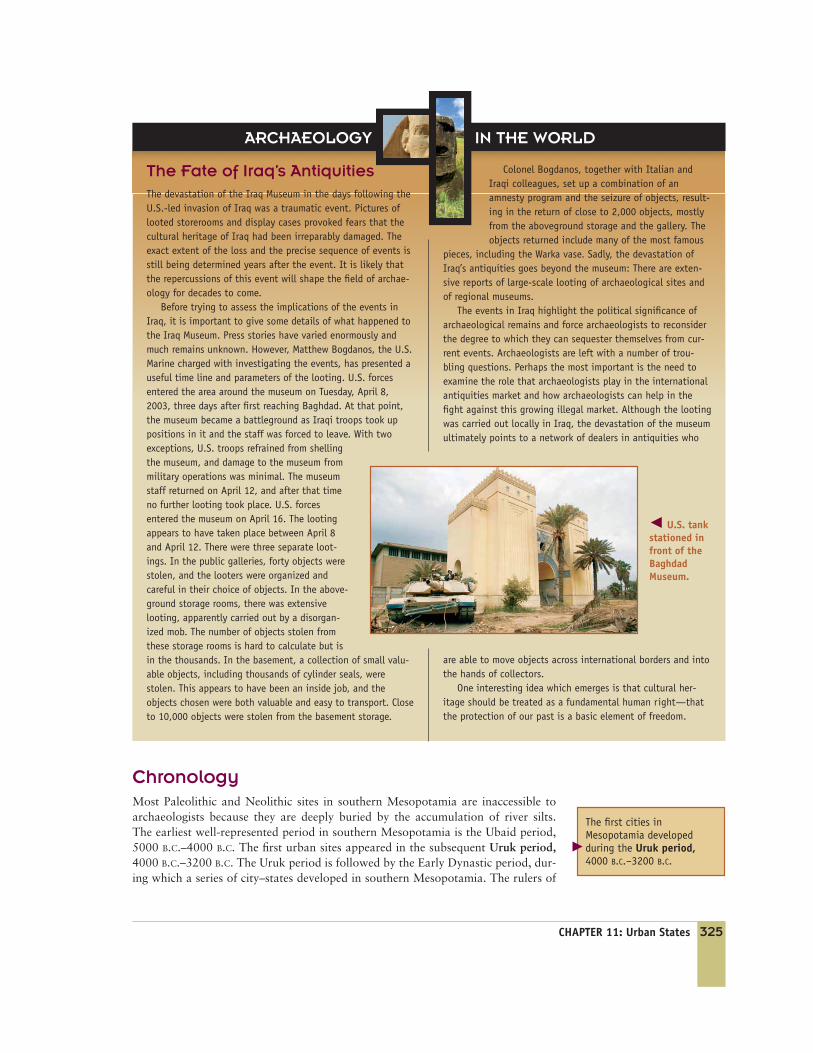
Before trying to assess the implications of the events inIraq, it is important to give some details of what happened tothe Iraq Museum. Press stories have varied enormously andmuch remains unknown. However, Matthew Bogdanos, the U.S.Marine charged with investigating the events, has presented auseful time line and parameters of the looting. U.S. forcesentered the area around the museum on Tuesday, April 8,2003, three days after first reaching Baghdad. At that point,the museum became a battleground as Iraqi troops took uppositions in it and the staff was forced to leave. With twoexceptions, U.S. troops refrained from shellingthe museum, and damage to the museum frommilitary operations was minimal. The museumstaff returned on April 12, and after that timeno further looting took place. U.S. forcesentered the museum on April 16. The lootingappears to have taken place between April 8and April 12. There were three separate loot-ings. In the public galleries, forty objects werestolen, and the looters were organized andcareful in their choice of objects. In the above-ground storage rooms, there was extensivelooting, apparently carried out by a disorgan-ized mob. The number of objects stolen fromthese storage rooms is hard to calculate but isin the thousands. In the basement, a collection of small valu-able objects, including thousands of cylinder seals, werestolen. This appears to have been an inside job, and theobjects chosen were both valuable and easy to transport. Closeto 10,000 objects were stolen from the basement storage.
Colonel Bogdanos, together with Italian andIraqi colleagues, set up a combination of anamnesty program and the seizure of objects, result-ing in the return of close to 2,000 objects, mostlyfrom the aboveground storage and the gallery. Theobjects returned include many of the most famous
pieces, including the Warka vase. Sadly, the devastation ofIraq’s antiquities goes beyond the museum: There are exten-sive reports of large-scale looting of archaeological sites andof regional museums.
The events in Iraq highlight the political significance ofarchaeological remains and force archaeologists to reconsiderthe degree to which they can sequester themselves from cur-rent events. Archaeologists are left with a number of trou-bling questions. Perhaps the most important is the need toexamine the role that archaeologists play in the internationalantiquities market and how archaeologists can help in thefight against this growing illegal market. Although the lootingwas carried out locally in Iraq, the devastation of the museumultimately points to a network of dealers in antiquities who
are able to move objects across international borders and intothe hands of collectors.
One interesting idea which emerges is that cultural her-itage should be treated as a fundamental human right—thatthe protection of our past is a basic element of freedom.
� U.S. tankstationed infront of theBaghdadMuseum.
IN THE WORLD
ChronologyMost Paleolithic and Neolithic sites in southern Mesopotamia are inaccessible toarchaeologists because they are deeply buried by the accumulation of river silts.The earliest well-represented period in southern Mesopotamia is the Ubaid period,5000 B.C.–4000 B.C. The first urban sites appeared in the subsequent Uruk period,4000 B.C.–3200 B.C. The Uruk period is followed by the Early Dynastic period, dur-ing which a series of city–states developed in southern Mesopotamia. The rulers of
The first cities inMesopotamia developedduring the Uruk period,4000 B.C.–3200 B.C.
�

326 PART FOUR: The Development of Social Complexity www.ablongman.com/chazan
The site of Uruk is the old-est known city in the world.
�
Ziggurats are stepped pyra-mids found at the center ofmany Mesopotamian templeprecincts.
�
these city–states are known from written documents recovered on archaeologicalsites. The Early Dynastic period drew to a close when Sargon of Akkad unifiedsouthern Mesopotamia under his rule in 2350 B.C.
UrukThe site of Uruk in southern Iraq is the oldest known city in the world. The citygrew from the unification of two towns dating to the Ubaid period built alongopposite banks of a channel of the Euphrates River. During the Uruk period, thecity grew to cover an area of 2.5 square kilometers with an estimated populationbetween 20,000 and 40,000 (Nissen 2002). Surveys in the area around Uruk showthat the city was by far the largest site in a landscape densely settled with smallertowns and villages.
Excavations at Uruk have focused on the two massive temple precincts located inthe center of the city, where a sequence of temple structures stretching back to theUbaid period has been uncovered. The city of Uruk grew around this central templeprecinct. Among the materials the temples were built of were limestone and bitumen,both of which had to have been imported from outside of southern Mesopotamia.Many of the temple structures were built on platforms, evidently the precursor of thestepped pyramid or ziggurat that is at the center of Mesopotamian temple precinctsfrom later periods. The temples were often elaborately decorated. One method of dec-oration was the use of colored cones inserted into mud brick walls to form a mosaic.
Unfortunately, we know little about the organization of the city of Uruk out-side of the temple area. From excavations at other sites, we know that houses wereusually built around a central courtyard and were sometimes grouped together intolarge enclosures (Postgate 1994: 91). It is likely that they were the houses ofextended families. Surprisingly, few palace structures have been found from earlycities in southern Mesopotamia. Extensive surveys around Uruk have providedsome information about the regional setting of this city. On the basis of these sur-veys, it appears that the growth of the urban center took place at the expense ofrural villages. By the Early Dynastic period, there was a sharp drop-off in the num-ber of village sites, suggesting that a migration occurred from rural villages to theurban center.
GovernmentMesopotamian society revolvedaround three sources of authority:the temple, the palace, and thecity council. The temple was apermanent installation at theheart of the city, and the deity towhich the temple was dedicatedwas a basic element of the identityof the city. The temple compoundswere quite large, and the templesowned land and fulfilled eco-nomic functions. Excavations oftemple complexes have uncoveredthe remains of both workshopsand storage rooms.
The ziggurat at Ur, Iraq. This massive brick structure acted as the supportfor a temple.
CHAPTER 11: Urban States 327
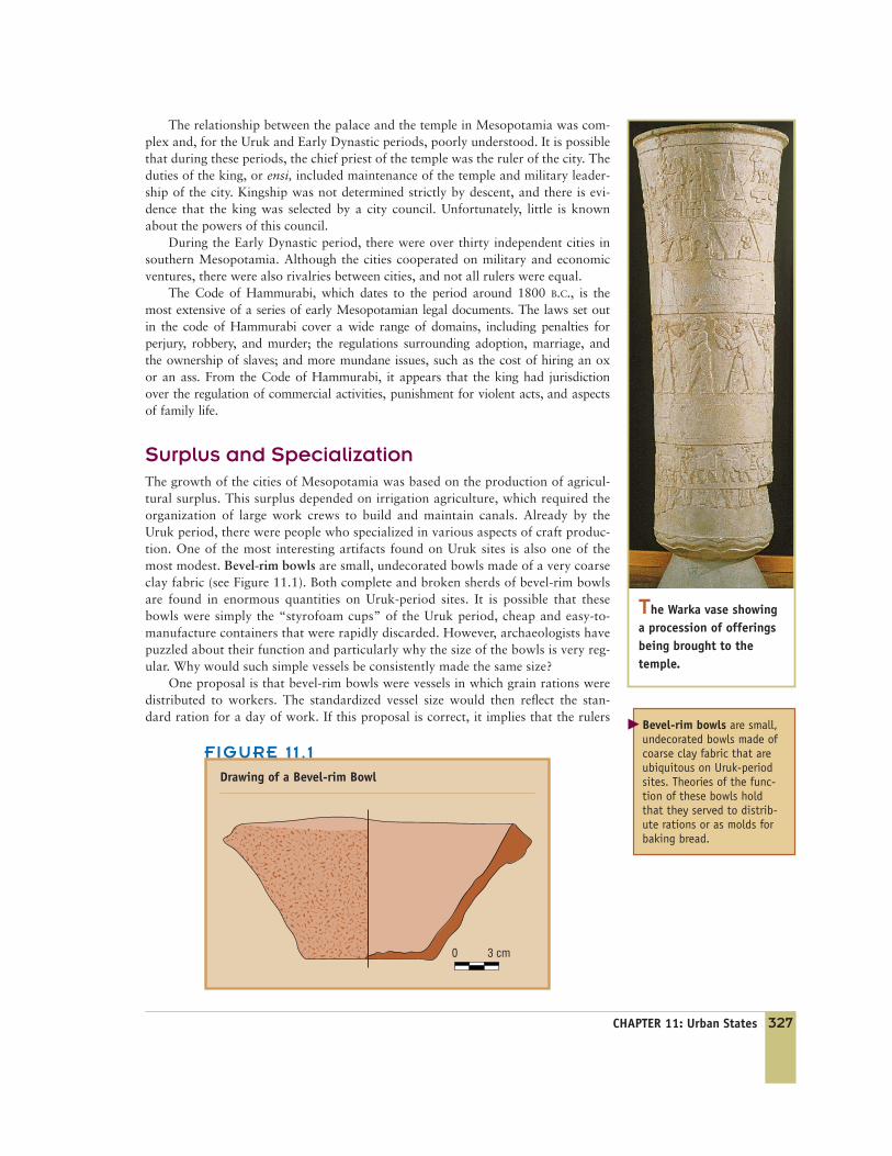
The Warka vase showinga procession of offeringsbeing brought to thetemple.
0 3 cm
FIGURE 11 . 1
Drawing of a Bevel-rim Bowl
Bevel-rim bowls are small,undecorated bowls made ofcoarse clay fabric that areubiquitous on Uruk-periodsites. Theories of the func-tion of these bowls holdthat they served to distrib-ute rations or as molds forbaking bread.
�
The relationship between the palace and the temple in Mesopotamia was com-plex and, for the Uruk and Early Dynastic periods, poorly understood. It is possiblethat during these periods, the chief priest of the temple was the ruler of the city. Theduties of the king, or ensi, included maintenance of the temple and military leader-ship of the city. Kingship was not determined strictly by descent, and there is evi-dence that the king was selected by a city council. Unfortunately, little is knownabout the powers of this council.
During the Early Dynastic period, there were over thirty independent cities insouthern Mesopotamia. Although the cities cooperated on military and economicventures, there were also rivalries between cities, and not all rulers were equal.
The Code of Hammurabi, which dates to the period around 1800 B.C., is themost extensive of a series of early Mesopotamian legal documents. The laws set outin the code of Hammurabi cover a wide range of domains, including penalties forperjury, robbery, and murder; the regulations surrounding adoption, marriage, andthe ownership of slaves; and more mundane issues, such as the cost of hiring an oxor an ass. From the Code of Hammurabi, it appears that the king had jurisdictionover the regulation of commercial activities, punishment for violent acts, and aspectsof family life.
Surplus and SpecializationThe growth of the cities of Mesopotamia was based on the production of agricul-tural surplus. This surplus depended on irrigation agriculture, which required theorganization of large work crews to build and maintain canals. Already by theUruk period, there were people who specialized in various aspects of craft produc-tion. One of the most interesting artifacts found on Uruk sites is also one of themost modest. Bevel-rim bowls are small, undecorated bowls made of a very coarseclay fabric (see Figure 11.1). Both complete and broken sherds of bevel-rim bowlsare found in enormous quantities on Uruk-period sites. It is possible that thesebowls were simply the “styrofoam cups” of the Uruk period, cheap and easy-to-manufacture containers that were rapidly discarded. However, archaeologists havepuzzled about their function and particularly why the size of the bowls is very reg-ular. Why would such simple vessels be consistently made the same size?
One proposal is that bevel-rim bowls were vessels in which grain rations weredistributed to workers. The standardized vessel size would then reflect the stan-dard ration for a day of work. If this proposal is correct, it implies that the rulers
328 PART FOUR: The Development of Social Complexity www.ablongman.com/chazan
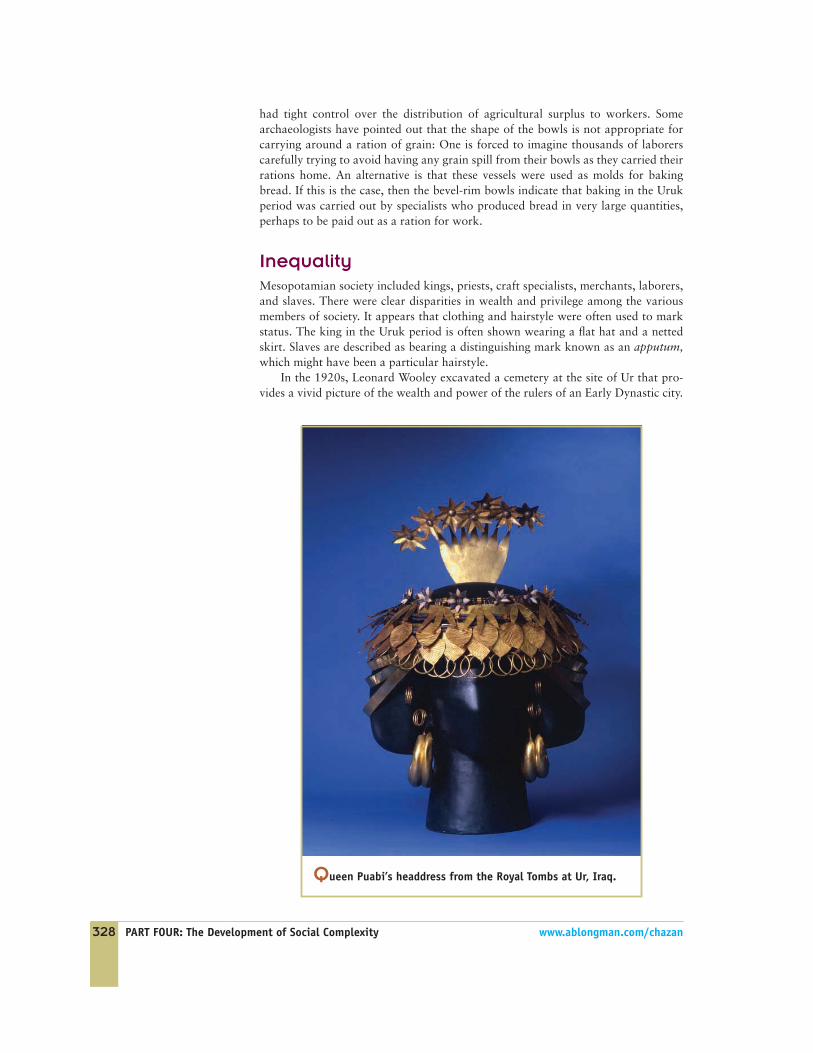
Queen Puabi’s headdress from the Royal Tombs at Ur, Iraq.
had tight control over the distribution of agricultural surplus to workers. Somearchaeologists have pointed out that the shape of the bowls is not appropriate forcarrying around a ration of grain: One is forced to imagine thousands of laborerscarefully trying to avoid having any grain spill from their bowls as they carried theirrations home. An alternative is that these vessels were used as molds for bakingbread. If this is the case, then the bevel-rim bowls indicate that baking in the Urukperiod was carried out by specialists who produced bread in very large quantities,perhaps to be paid out as a ration for work.
InequalityMesopotamian society included kings, priests, craft specialists, merchants, laborers,and slaves. There were clear disparities in wealth and privilege among the variousmembers of society. It appears that clothing and hairstyle were often used to markstatus. The king in the Uruk period is often shown wearing a flat hat and a nettedskirt. Slaves are described as bearing a distinguishing mark known as an apputum,which might have been a particular hairstyle.
In the 1920s, Leonard Wooley excavated a cemetery at the site of Ur that pro-vides a vivid picture of the wealth and power of the rulers of an Early Dynastic city.

In the Royal Tombs at Ur,dated to the Early Dynasticperiod, the dead wereburied with a spectaculararray of precious artifactsand sacrificial victims.
CHAPTER 11: Urban States 329
�
Reconstruction of a death pit at Ur just before the attendants and animals werekilled.
The cemetery includes hundreds of burials, most of which are simple interments ofindividuals with a few pottery vessels. The chambers known as the Royal Tombspresent a startling contrast. These tombs contain staggering deposits of wealth,including tools, jewelry, musical instruments, and vessels made from a wide rangeof metals (gold, silver, copper, and electrum) and precious stones (lapis lazuli, car-nelian, steatite, and calcite). These materials were brought to Ur from considerabledistances: Lapis lazuli comes from Afghanistan, carnelian from Pakistan. The RoyalTombs are associated with chambers Wooley called death pits that contained theskeletons of men and women together with the remains of oxen attached to carts.These people and animals appear to have been slaughtered as part of the burial rit-ual. Many of the skeletons are still adorned with lavish jewelry and ornaments;many clutch weapons in their hands. Among the most famous objects is the head-dress of one of the main figures buried, which consists of leaves made of thinly ham-mered gold. Other impressive artifacts include a series of lyres inlayed withelaborate scenes and a sculpture of a ram peering out from behind some branches.
It is probable that the rich burial goods found in the Royal Tombs and the sac-rificial victim were meant to accompany the deceased to the afterlife; perhaps thegoods were used to provide offerings to the gods. The woman buried with an elabo-rate headdress appears to be a queen by the name of Puabi. Another tomb isthought to have been the burial chamber of a king.
The Royal Tombs illustrate the wealth concentrated in the hands of the kingand his close family. This wealth included access to large quantities of preciousmaterials imported from a wide geographical region outside of the areas directlycontrolled by the Mesopotamian state. How did the king come to be the focal pointof such an extensive trade network? One possibility is that the king controlled theproduction of textiles in Mesopotamia and that the surplus textiles produced weretraded for the precious material that the king used as the expression of his power.
The cuneiform writing sys-tem, in which signs wereimpressed in clay, wereused to write a range oflanguages, including Sumer-ian and Akkadian.
330 PART FOUR: The Development of Social Complexity www.ablongman.com/chazan
�
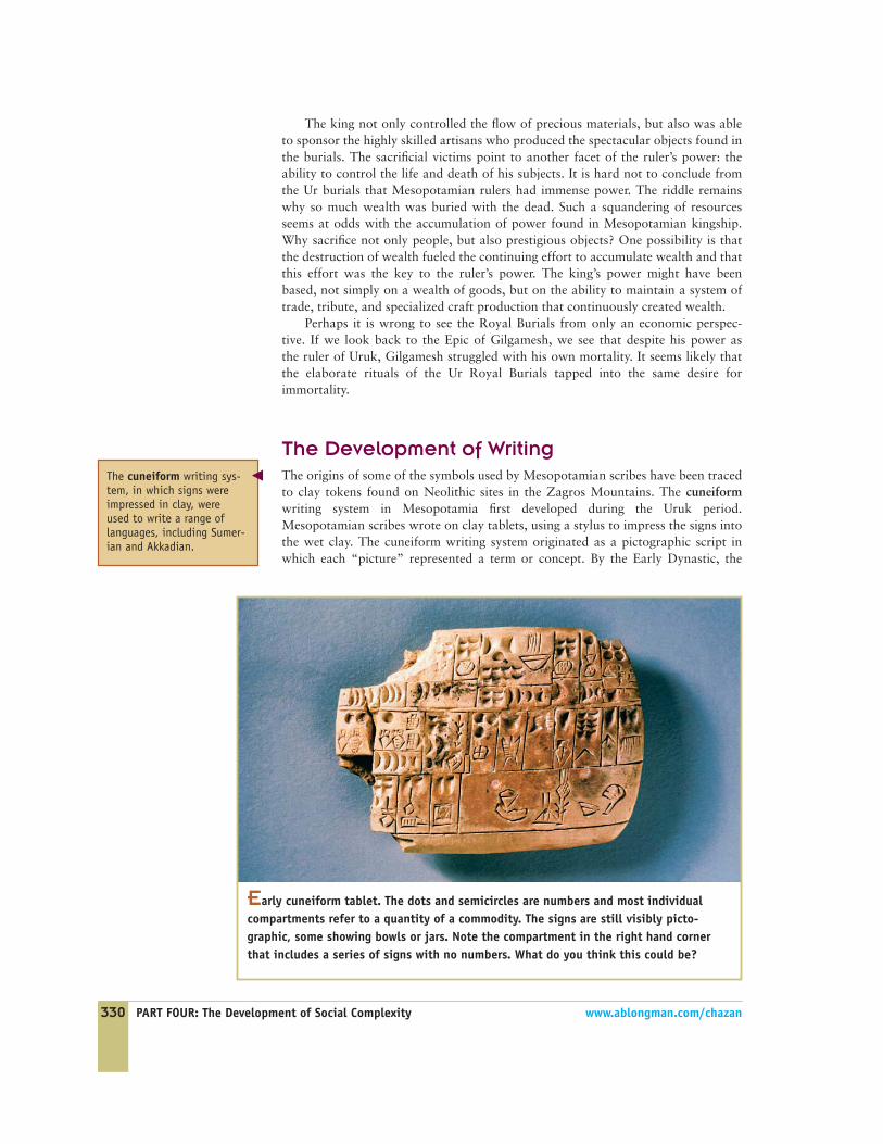
Early cuneiform tablet. The dots and semicircles are numbers and most individualcompartments refer to a quantity of a commodity. The signs are still visibly picto-graphic, some showing bowls or jars. Note the compartment in the right hand cornerthat includes a series of signs with no numbers. What do you think this could be?
The king not only controlled the flow of precious materials, but also was ableto sponsor the highly skilled artisans who produced the spectacular objects found inthe burials. The sacrificial victims point to another facet of the ruler’s power: theability to control the life and death of his subjects. It is hard not to conclude fromthe Ur burials that Mesopotamian rulers had immense power. The riddle remainswhy so much wealth was buried with the dead. Such a squandering of resourcesseems at odds with the accumulation of power found in Mesopotamian kingship.Why sacrifice not only people, but also prestigious objects? One possibility is thatthe destruction of wealth fueled the continuing effort to accumulate wealth and thatthis effort was the key to the ruler’s power. The king’s power might have beenbased, not simply on a wealth of goods, but on the ability to maintain a system oftrade, tribute, and specialized craft production that continuously created wealth.
Perhaps it is wrong to see the Royal Burials from only an economic perspec-tive. If we look back to the Epic of Gilgamesh, we see that despite his power asthe ruler of Uruk, Gilgamesh struggled with his own mortality. It seems likely thatthe elaborate rituals of the Ur Royal Burials tapped into the same desire forimmortality.
The Development of WritingThe origins of some of the symbols used by Mesopotamian scribes have been tracedto clay tokens found on Neolithic sites in the Zagros Mountains. The cuneiformwriting system in Mesopotamia first developed during the Uruk period.Mesopotamian scribes wrote on clay tablets, using a stylus to impress the signs intothe wet clay. The cuneiform writing system originated as a pictographic script inwhich each “picture” represented a term or concept. By the Early Dynastic, the
CHAPTER 11: Urban States 331
Cylinder seals were one ofthe methods developed byMesopotamian scribes tomark ownership.
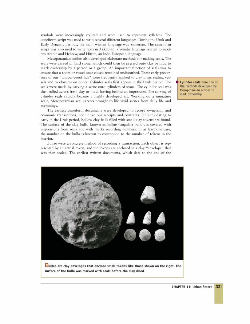
Bullae are clay envelopes that enclose small tokens like those shown on the right. Thesurface of the bulla was marked with seals before the clay dried.
�
symbols were increasingly stylized and were used to represent syllables. Thecuneiform script was used to write several different languages. During the Uruk andEarly Dynastic periods, the main written language was Sumerian. The cuneiformscript was also used to write texts in Akkadian, a Semitic language related to mod-ern Arabic and Hebrew, and Hittite, an Indo-European language.
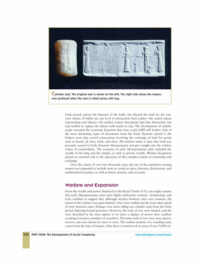
Mesopotamian scribes also developed elaborate methods for making seals. Theseals were carved in hard stone, which could then be pressed onto clay or mud tomark ownership by a person or a group. An important function of seals was toensure that a room or vessel once closed remained undisturbed. These early precur-sors of our “tamper-proof lids” were frequently applied to clay plugs sealing ves-sels and to closures on doors. Cylinder seals first appear in the Uruk period. Theseals were made by carving a scene onto cylinders of stone. The cylinder seal wasthen rolled across fresh clay or mud, leaving behind an impression. The carving ofcylinder seals rapidly became a highly developed art. Working on a miniaturescale, Mesopotamian seal carvers brought to life vivid scenes from daily life andmythology.
The earliest cuneiform documents were developed to record ownership andeconomic transactions, not unlike our receipts and contracts. On sites dating toearly in the Uruk period, hollow clay balls filled with small clay tokens are found.The surface of the clay balls, known as bullae (singular: bulla), is covered withimpressions from seals and with marks recording numbers. In at least one case,the number on the bulla is known to correspond to the number of tokens in theinterior.
Bullae were a concrete method of recording a transaction. Each object is rep-resented by an actual token, and the tokens are enclosed in a clay “envelope” thatwas then sealed. The earliest written documents, which date to the end of the
332 PART FOUR: The Development of Social Complexity www.ablongman.com/chazan
Cylinder seal. The original seal is shown on the left. The right side shows the impres-sion produced when the seal is rolled across soft clay.
Uruk period, mirror the function of the bulla, but discard the need for the con-crete tokens. If bullae are one level of abstraction from reality—the sealed tokensrepresenting real objects—the earliest written documents take this abstraction onestep further to replace the tokens with marks in clay. The development of syllabicscript extended the economic functions that texts could fulfill still further. One ofthe most interesting types of documents from the Early Dynastic period is thekuduru texts that record transactions involving the exchange of land for goodssuch as bread, oil, beer, cloth, and silver. The kuduru make it clear that land wasprivately owned in Early Dynastic Mesopotamia and give insight into the relativevalues of commodities. The economy of early Mesopotamian cities included thewealth of the king and the temple, as well as private wealth. Written documentsplayed an essential role in the operation of this complex system of ownership andexchange.
Over the course of over two thousand years, the use of the cuneiform writingsystem was expanded to include texts as varied as epics, histories, dictionaries, andmathematical treatises, as well as letters, treaties, and accounts.
Warfare and ExpansionFrom the wealth and power displayed in the Royal Tombs of Ur, one might assumethat early Mesopotamian cities were highly militaristic societies. Archaeology andtexts combine to suggest that, although warfare between cities was common, theextent of the violence was quite limited. Cities were walled and the texts often speakof wars between cities. Perhaps even more telling are cylinder seals from the Urukperiod depicting bound prisoners. However, the tools of war were limited, and thewars described in the texts appear to be more a display of power than conflictsresulting in massive numbers of casualties. The main tools of war were axes, spears,arrows, and carts drawn by asses or oxen. The earliest mention of a standing armycomes from the time of Sargon, when there is mention of an army of over 5,000 sol-
diers. In later periods, the power of the Mesopotamian military expanded signifi-cantly, allowing for far-ranging campaigns of conquest in foreign lands.
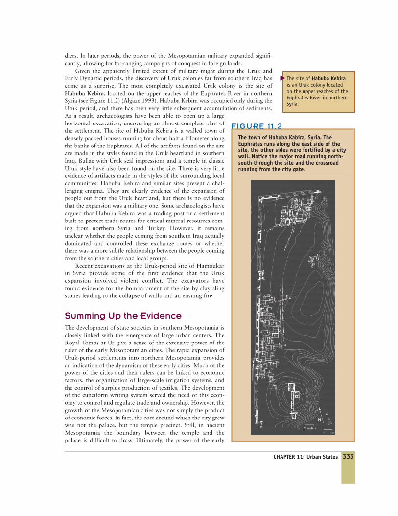
Given the apparently limited extent of military might during the Uruk andEarly Dynastic periods, the discovery of Uruk colonies far from southern Iraq hascome as a surprise. The most completely excavated Uruk colony is the site ofHabuba Kebira, located on the upper reaches of the Euphrates River in northernSyria (see Figure 11.2) (Algaze 1993). Habuba Kebira was occupied only during theUruk period, and there has been very little subsequent accumulation of sediments.As a result, archaeologists have been able to open up a largehorizontal excavation, uncovering an almost complete plan ofthe settlement. The site of Habuba Kebira is a walled town ofdensely packed houses running for about half a kilometer alongthe banks of the Euphrates. All of the artifacts found on the siteare made in the styles found in the Uruk heartland in southernIraq. Bullae with Uruk seal impressions and a temple in classicUruk style have also been found on the site. There is very littleevidence of artifacts made in the styles of the surrounding localcommunities. Habuba Kebira and similar sites present a chal-lenging enigma. They are clearly evidence of the expansion ofpeople out from the Uruk heartland, but there is no evidencethat the expansion was a military one. Some archaeologists haveargued that Habuba Kebira was a trading post or a settlementbuilt to protect trade routes for critical mineral resources com-ing from northern Syria and Turkey. However, it remainsunclear whether the people coming from southern Iraq actuallydominated and controlled these exchange routes or whetherthere was a more subtle relationship between the people comingfrom the southern cities and local groups.
Recent excavations at the Uruk-period site of Hamoukarin Syria provide some of the first evidence that the Urukexpansion involved violent conflict. The excavators havefound evidence for the bombardment of the site by clay slingstones leading to the collapse of walls and an ensuing fire.
Summing Up the EvidenceThe development of state societies in southern Mesopotamia isclosely linked with the emergence of large urban centers. TheRoyal Tombs at Ur give a sense of the extensive power of theruler of the early Mesopotamian cities. The rapid expansion ofUruk-period settlements into northern Mesopotamia providesan indication of the dynamism of these early cities. Much of thepower of the cities and their rulers can be linked to economicfactors, the organization of large-scale irrigation systems, andthe control of surplus production of textiles. The developmentof the cuneiform writing system served the need of this econ-omy to control and regulate trade and ownership. However, thegrowth of the Mesopotamian cities was not simply the productof economic forces. In fact, the core around which the city grewwas not the palace, but the temple precinct. Still, in ancientMesopotamia the boundary between the temple and thepalace is difficult to draw. Ultimately, the power of the early
CHAPTER 11: Urban States 333
The site of Habuba Kebirais an Uruk colony locatedon the upper reaches of theEuphrates River in northernSyria.
�
FIGURE 11 .2
The town of Habuba Kabira, Syria. TheEuphrates runs along the east side of thesite, the other sides were fortified by a citywall. Notice the major road running north-south through the site and the crossroadrunning from the city gate.

334 PART FOUR: The Development of Social Complexity www.ablongman.com/chazan
Mesopotamian state seems to flow from a blending of the power of the temple andthe power of the palace.
1 1 .2 THE MAYAThe modern Maya live in an area stretching from southern Mexico throughGuatemala and Belize, as well as parts of Honduras and El Salvador.Beginning around 2,000 years ago, the Maya developed a state society
with a complex writing system and large urban centers. Much of the rich history ofthe Maya was lost under Spanish rule, which brought with it devastating diseaseand the systematic imposition of European culture, including the burning of mostMayan books (Coe 1999). However, archaeology has made major strides in recon-structing the Mayan past. The decipherment of Mayan hieroglyphics has afforded aspectacular insight into the detailed history of the early Mayan cities. The study ofmodern Mayan oral traditions and cultural practices also plays a significant role inunderstanding the remains of the Mayan past.
The Mayan region is part of Mesoamerica, which covers the area from north-ern Mexico through Honduras. Mesoamerica is not a geographically definedregion, but rather a region whose indigenous inhabitants share a number of culturaltraits, including a complex calendar, a ball game played on a special court with arubber ball, and an emphasis on bloodletting (Coe 1993).
ChronologyThe Maya were not the first state society in Mesoamerica. The earliest evidence ofemerging political complexity in Mesoamerica is found on Olmec sites along theGulf Coast of Mexico (Benson et al. 1996). Between 1200 B.C. and 300 B.C., the
Map of Mesoamerica.
The earliest evidence ofemerging political complex-ity in Mesoamerica is foundon Olmec sites along theGulf Coast of Mexico.
�
CHAPTER 11: Urban States 335
DISCOVERING THE PAST
Río Azulby Fred Valdez, University of Texas, Austin
I am Fred Valdez, an archaeologist with aresearch focus on Mesoamerican/Mayan civi-lizations. My current status is professor ofanthropology at the University of Texas at
Austin. Between 1983 and 1991, Dr. R.E.W. Adams of theUniversity of Texas at San Antonio was directing the Río AzulProject in northeastern Guatemala and invited me to partici-pate. At the time, I was a graduate student and saw the proj-ect as a way to contribute tooriginal research and expandmy archaeological experiences.
The Río Azul project waslocated in an isolated area inGuatemala that required travel-ing a very long, rough roadthat passes the great sites ofTikal and Uaxactún. The projectwas studying the site in partbecause of extreme lootingthere in the early 1980s thatexposed significant architec-ture and painted tombs ofthe Classic Maya.
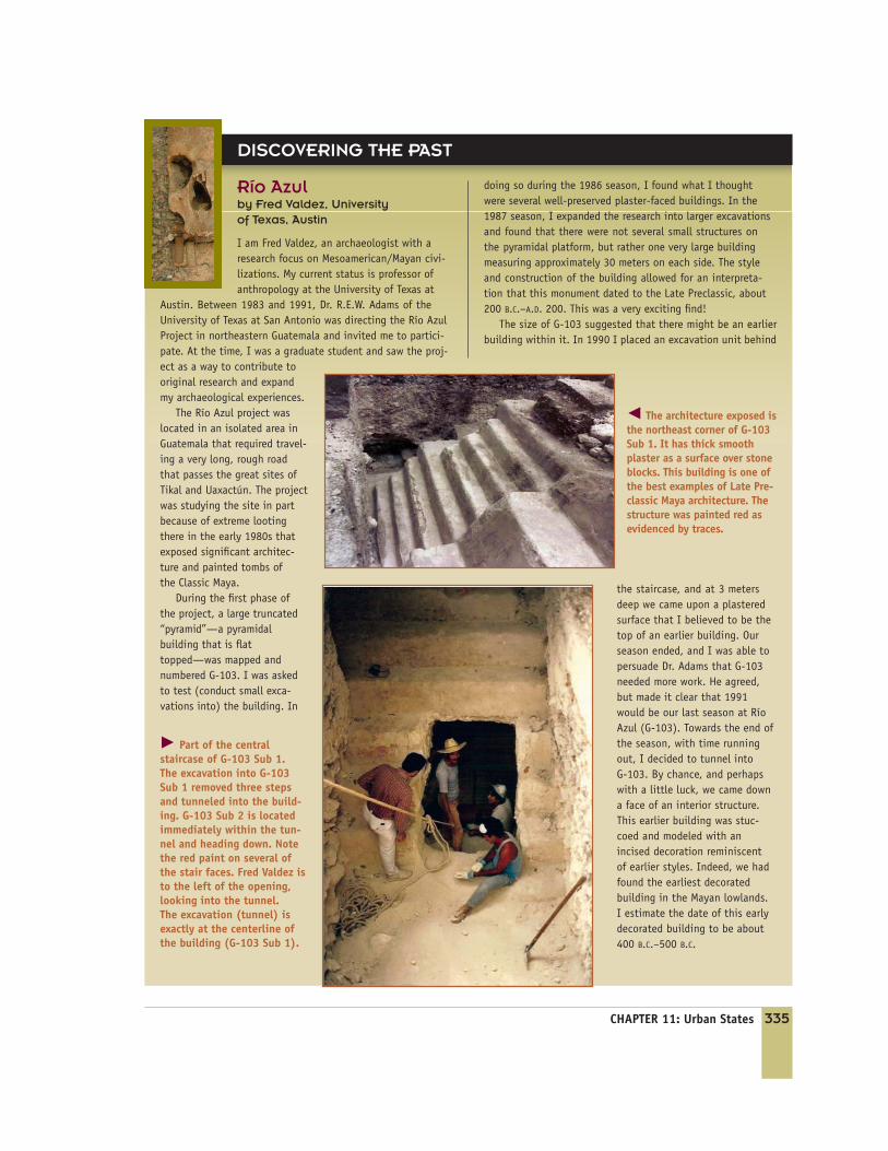
During the first phase ofthe project, a large truncated“pyramid”—a pyramidalbuilding that is flattopped—was mapped andnumbered G-103. I was askedto test (conduct small exca-vations into) the building. In
doing so during the 1986 season, I found what I thoughtwere several well-preserved plaster-faced buildings. In the1987 season, I expanded the research into larger excavationsand found that there were not several small structures onthe pyramidal platform, but rather one very large buildingmeasuring approximately 30 meters on each side. The styleand construction of the building allowed for an interpreta-tion that this monument dated to the Late Preclassic, about200 B.C.–A.D. 200. This was a very exciting find!
The size of G-103 suggested that there might be an earlierbuilding within it. In 1990 I placed an excavation unit behind
the staircase, and at 3 metersdeep we came upon a plasteredsurface that I believed to be thetop of an earlier building. Ourseason ended, and I was able topersuade Dr. Adams that G-103needed more work. He agreed,but made it clear that 1991would be our last season at RíoAzul (G-103). Towards the end ofthe season, with time runningout, I decided to tunnel into G-103. By chance, and perhapswith a little luck, we came downa face of an interior structure.This earlier building was stuc-coed and modeled with anincised decoration reminiscent of earlier styles. Indeed, we hadfound the earliest decoratedbuilding in the Mayan lowlands. I estimate the date of this earlydecorated building to be about400 B.C.–500 B.C.
� Part of the centralstaircase of G-103 Sub 1. The excavation into G-103Sub 1 removed three stepsand tunneled into the build-ing. G-103 Sub 2 is locatedimmediately within the tun-nel and heading down. Notethe red paint on several ofthe stair faces. Fred Valdez isto the left of the opening,looking into the tunnel.The excavation (tunnel) isexactly at the centerline ofthe building (G-103 Sub 1).
� The architecture exposed isthe northeast corner of G-103Sub 1. It has thick smoothplaster as a surface over stoneblocks. This building is one ofthe best examples of Late Pre-classic Maya architecture. Thestructure was painted red asevidenced by traces.

336 PART FOUR: The Development of Social Complexity www.ablongman.com/chazan
Teotihuacán was an enor-mous city with a populationof over 80,000 people.
Monte Albán, located inthe Oaxaca Valley, is theoldest city in Mesoamerica.
Olmec constructed a series of major ceremonial centers in towns with populationsnumbering in the thousands. The Olmec developed a highly sophisticated artistictradition that included monumental sculptures of human heads carved out of vol-canic rock. These sculptures give a vivid sense of the power of the leaders of Olmecsociety. Particularly significant is the headgear found on the sculptures, possiblyrelated to competition in a ball game. Hollow clay sculptures of infants with whatappear to be adult heads are often found on Olmec sites. These disconcerting figuresstand in sharp contrast to the raw power expressed in the monumental stone sculp-ture, raising the question of whether they depict leaders or divinities. The Olmecalso produced spectacular sculptures from jade and other hard stones. At the site ofLa Venta, a cache was found of sixteen male figures carved from jade and serpen-tine, standing in front of a series of polished stone axes (Lauck 1996). It is possiblethat this scene represents a town council, a balance to the power of the rulersdepicted on the monumental sculptures.
The first city in Mesoamerica was located at the site of Monte Albán in theOaxaca Valley in the Mexican highlands. Between 500 B.C. and 350 B.C., thepopulation of Monte Albán grew first to 5,000 and then 17,000 people living inneighborhoods built around a central plaza (Blanton et al. 1993). In the periodbetween 350 B.C. and 250 B.C., Monte Albán was surrounded by a defensivewall. The central plaza became the focus of monumental construction, includinga ball court.
Beginning around two thousand years ago (A.D. 1–A.D. 100), Teotihuacán,in the highland Valley of Mexico, grew into an enormous city covering an areaof twenty square kilometers with a population of more than 80,000 people(Sugiyama 2004). Teotihuacán was built along a north–south orientation andhoused up to twenty temple complexes. Extensive fieldwork at the site has
Monumental Olmec sculp-ture from San Lorenzo,Mexico.
�
�
CHAPTER 11: Urban States 337
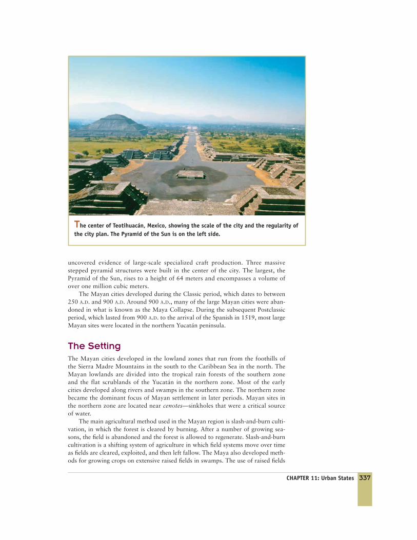
uncovered evidence of large-scale specialized craft production. Three massivestepped pyramid structures were built in the center of the city. The largest, thePyramid of the Sun, rises to a height of 64 meters and encompasses a volume ofover one million cubic meters.
The Mayan cities developed during the Classic period, which dates to between250 A.D. and 900 A.D. Around 900 A.D., many of the large Mayan cities were aban-doned in what is known as the Maya Collapse. During the subsequent Postclassicperiod, which lasted from 900 A.D. to the arrival of the Spanish in 1519, most largeMayan sites were located in the northern Yucatán peninsula.
The SettingThe Mayan cities developed in the lowland zones that run from the foothills ofthe Sierra Madre Mountains in the south to the Caribbean Sea in the north. TheMayan lowlands are divided into the tropical rain forests of the southern zoneand the flat scrublands of the Yucatán in the northern zone. Most of the earlycities developed along rivers and swamps in the southern zone. The northern zonebecame the dominant focus of Mayan settlement in later periods. Mayan sites inthe northern zone are located near cenotes—sinkholes that were a critical sourceof water.
The main agricultural method used in the Mayan region is slash-and-burn culti-vation, in which the forest is cleared by burning. After a number of growing sea-sons, the field is abandoned and the forest is allowed to regenerate. Slash-and-burncultivation is a shifting system of agriculture in which field systems move over timeas fields are cleared, exploited, and then left fallow. The Maya also developed meth-ods for growing crops on extensive raised fields in swamps. The use of raised fields
The center of Teotihuacán, Mexico, showing the scale of the city and the regularity ofthe city plan. The Pyramid of the Sun is on the left side.

338 PART FOUR: The Development of Social Complexity www.ablongman.com/chazan
DISCOVERING THE PAST
Ancient Maya and theMedicinal Trail Siteby David Hyde
I started college in my midtwenties at a com-munity college in Seattle and then trans-ferred to the University of Texas at Austin tocomplete my B.A. During my first semester at
UT, Austin, I enrolled in “Introduction to Archaeology.” Arequirement of the course was to complete a certain numberof hours excavating at a prehistoric hunter–gatherer site. Iloved the work and was invited to help process artifacts. Atthe laboratory, I noticed a long table covered with hundredsof stone tools, grouped into various clusters. The clusters, Iwas informed, represented change through time, reflectingthe different people that had moved through the area, adapt-ing their tools to changes in the resources they were utiliz-ing. I was amazed by the depth of information that could bederived from stone tools, and that experience led me to pur-sue that type of material as a focus of my future research.
That summer, I enrolled in a Mayan archaeology field school.Mayan archaeology was completely different from everything Ihad done before, and I knew immediately that the subject wasfor me. For the first time, I was excavating the ruins of a com-plex society. I was struck by the fact that constructing themasonry architecture, modifying the landscape, cutting stoneout of the bedrock, shaping stone, digging the fields, fellingtrees, and more were all accomplished with stones, as the Mayalacked metal tools. I have returned every year since my firstvisit as an undergraduate ten years ago. For the past few years,I have been the field director for the field school, teaching thestudents who come in as I did years before.
� David Hyde examines an excavation profile.
Having worked so many years at a number of large ceremo-nial centers in the same area, I became interested in the hin-terland settlement.
was a critical component of the intensified agriculture needed to support large pop-ulation centers. There is little evidence that Mayan agriculture rested on the kind oflarge-scale irrigation projects essential to the cities of southern Mesopotamia. How-ever, some evidence exists for large-scale projects, particularly poorly understoodcanal systems found around some cities (Demarest 2004).
The CityThe ruins of Classic-period Mayan cities are covered by dense forest undergrowth.On many excavations, machetes are as important as trowels. Steep pyramids, theirapexes often visible above the forest canopy, are the defining feature of Mayancities. These pyramids sit in the central area of the city together with royal resi-dences, ball courts, and open plazas. Extensive survey work and excavation onMayan sites has demonstrated that these cities stretched far beyond the central area
CHAPTER 11: Urban States 339
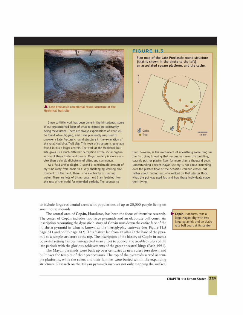
Since so little work has been done in the hinterlands, someof our preconceived ideas of what to expect are constantlybeing reevaluated. There are always expectations of what willbe found when digging, and I was pleasantly surprised touncover a Late Preclassic round structure in the excavation ofthe rural Medicinal Trail site. This type of structure is generallyfound in much larger centers. The work at the Medicinal Trailsite gives us a much different perception of the social organi-zation of these hinterland groups. Mayan society is more com-plex than a simple dichotomy of elites and commoners.
As a field archaeologist, I spend a considerable amount ofmy time away from home in a very challenging working envi-ronment. In the field, there is no electricity or runningwater. There are lots of biting bugs, and I am isolated fromthe rest of the world for extended periods. The counter to
that, however, is the excitement of unearthing something forthe first time, knowing that no one has seen this building,ceramic pot, or plaster floor for more than a thousand years.Understanding ancient Mayan society is not about marvelingover the plaster floor or the beautiful ceramic vessel, butrather about finding out who walked on that plaster floor,what the pot was used for, and how those individuals madetheir living.
� Late Preclassic ceremonial round structure at the Medicinal Trail site.
N
1 meterCacheTree
FIGURE 11 .3
Plan map of the Late Preclassic round structure(that is shown in the photo to the left),an associated square platform, and the cache.
to include large residential areas with populations of up to 20,000 people living onsmall house mounds.
The central area of Copán, Honduras, has been the focus of intensive research.The center of Copán includes two large pyramids and an elaborate ball court. Aninscription recounting the dynastic history of Copán runs down the entire face of thenorthern pyramid in what is known as the hieroglyphic stairway (see Figure 11.5page 341 and photo page 342). This feature led from an altar at the base of the pyra-mid to a temple structure at the top. The inscription of the history of Copán in such apowerful setting has been interpreted as an effort to connect the troubled rulers of thelate periods with the glorious achievements of the great ancestral kings (Fash 1991).
The Mayan pyramids were built up over centuries as new rulers tore down andbuilt over the temples of their predecessors. The top of the pyramids served as tem-ple platforms, while the rulers and their families were buried within the expandingstructures. Research on the Mayan pyramids involves not only mapping the surface,
Copán, Honduras, was alarge Mayan city with twolarge pyramids and an elabo-rate ball court at its center.
�
The first true king of Tikalappears to have had linksto Teotihuacán. He estab-lished his rule in A.D. 378.
340 PART FOUR: The Development of Social Complexity www.ablongman.com/chazan
FIGURE 11 .4
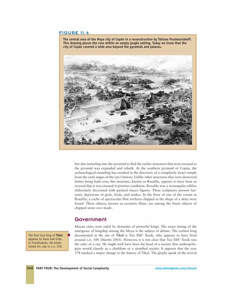
The central area of the Maya city of Copán in a reconstruction by Tatiana Proskouriakoff.This drawing places the core within an empty jungle setting. Today we know that thecity of Copán covered a wide area beyond the pyramids and palaces.
but also tunneling into the pyramid to find the earlier structures that were encased asthe pyramid was expanded and rebuilt. At the southern pyramid of Copán, thearchaeological tunneling has resulted in the discovery of a completely intact templefrom the early stages of the city’s history. Unlike other structures that were destroyedbefore being built over, this structure, known as Rosalila, appears to have been sorevered that it was encased in pristine condition. Rosalila was a rectangular edificeelaborately decorated with painted stucco figures. These sculptures present fan-tastic depictions of gods, birds, and snakes. In the floor of one of the rooms inRosalila, a cache of spectacular flint artifacts chipped in the shape of a deity werefound. These objects, known as eccentric flints, are among the finest objects ofchipped stone ever made.
GovernmentMayan cities were ruled by dynasties of powerful kings. The exact timing of theemergence of kingship among the Maya is the subject of debate. The earliest kingdocumented at the site of Tikal is Yax Ehb’ Xook, who appears to have livedaround A.D. 100 (Martin 2003). However, it is not clear that Yax Ehb’ Xook wasthe ruler of a city. He might well have been the head of a society that anthropolo-gists would classify as a chiefdom or a stratified society. It appears that the year378 marked a major change in the history of Tikal. The glyphs speak of the arrival
�

of a new ruler coming from outside and ending the dynastic line.This new ruler either came from the highland Mexican city ofTeotihuacán or was in some way heavily influenced by Teoti-huacán. This break in the history of Tikal also appears to markthe emergence of e state.
The foundation of the royal dynasty at the city of Copándates to A.D. 426. The first king of Copán, named Yax K’uk’Mo’, came from outside of Copán, possibly with links to Teoti-huacán. One of the burials at Copán appears to be the remainsof Yax K’uk’ Mo’. Skeletal analysis has shown that this individ-ual had suffered several traumas during his life, perhaps as theresult of warfare or participating in ball games (Buikstra et al.2004).
On the basis of the evidence from Tikal and Copán, thefounding of the Mayan cities was linked in some cases with thearrival of a ruler connected to Teotihuacán. Once established,the ruling dynasties maintained their power for generations,often hundreds of years. Monuments were frequently used toconnect the ruler with the prestige of the dynasty. The hiero-glyphic staircase at Copán is the most spectacular example ofsuch monuments. The rulers of the Mayan cities only rarelyclaimed to be gods themselves; however, they were viewed asuniquely sacred individuals (Houston 2000). There is no sense ofa strong distinction between the palace and the temple. Thedynasty was closely identified with the temple complexes at thecore of the Mayan city.
Hieroglyphic Stairway
Structure 10L-26-1
Structure 10L-26-2
Structure 10L-26-3Esmeralda
Esmeralda Additions
ChoraStructure
Mascarones Structurewith Additions
Papagayo and Mascarones StructureMotmot StructureYax Structure0 10 M
Tomb
E
610 M
600 M
590 M
FIGURE 11 .5
Cross section of Pyramid 10L-26 at Copán. In the final stage of construction the hieroglyphicstairway was built on the western face of the pyramid, but the cross section shows that there wereseveral earlier phases that included burials, each encased within a later construction.
Eccentric flint from Rosalila, Copán.
CHAPTER 11: Urban States 341

342 PART FOUR: The Development of Social Complexity www.ablongman.com/chazan
Although the rulers of Mayan cities were able to drawon the prestige of their dynastic lineage and the sacred aspectof their office, their power was not absolute or unchallenged.There is evidence that, particularly during the later part of theClassic period, a broader aristocracy came to challenge thepower of the ruler. A particularly intriguing discovery made atCopán was a building known as Popol Na, literally a mathouse, which appears to have been the locale for meetings of acouncil of aristocrats. The tension between the power of thearistocracy and the royal lineage appears to have been a criticaldynamic in the history of Mayan cities.
InequalityThe burials of Mayan royalty do not contain large quantities ofelaborate goods. The tomb of Yax K’uk Mo’, the founder ofthe Copán dynasty, included jade and shell ornaments, theremains of a headdress made of shells, a number of pottery ves-sels, and a cache of eccentric flints. These are clearly high-statusobjects, but they are not an overwhelming display of wealth. Itis possible that much greater wealth, including textiles andfeathers that have not survived, were originally buried withYax K’uk Mo’.
The development of household archaeology has begun tomake an important contribution to understanding thestructure of Mayan society. By moving away from the monu-ments of the center, household archaeologists cast light on
The Hieroglyphic Stairway at Copán.
FIGURE 11 .6
Plan of the scribe’s house at Aguateca. The symbols show where different artifact types were found.
Halved Shell Ink PotsMortars for Pigment PreparationPestles for Pigment Preparation
Bone NeedlesSpindle Whorls
0 2mN
CHAPTER 11: Urban States 343
the lives of ordinary peopleand of diversity among house-holds (Robin 2003). Exca-vations of Mayan houseshave found that not all peo-ple had equal access to high-status objects. Particularly asone moves out to small agri-cultural hamlets, the rangeof artifacts becomes limitedmostly to locally producedobjects used in daily life.However, household archae-ologists have also found evi-dence that high-status tradeitems were not restricted toelite residences.
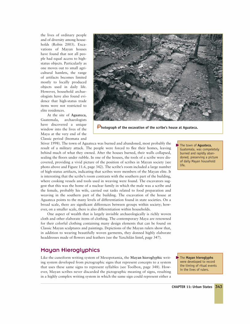
At the site of Aguateca,Guatemala, archaeologistshave discovered a uniquewindow into the lives of theMaya at the very end of theClassic period (Inomata andStiver 1998). The town of Aguateca was burned and abandoned, most probably theresult of a military attack. The people were forced to flee their homes, leavingbehind much of what they owned. After the houses burned, their walls collapsed,sealing the floors under rubble. In one of the houses, the tools of a scribe were dis-covered, providing a vivid picture of the position of scribes in Mayan society (seephoto above and Figure 11.6, page 342). The scribe’s room included a large numberof high-status artifacts, indicating that scribes were members of the Mayan elite. Itis interesting that the scribe’s room contrasts with the southern part of the building,where cooking vessels and tools used in weaving were found. The excavators sug-gest that this was the home of a nuclear family in which the male was a scribe andthe female, probably his wife, carried out tasks related to food preparation andweaving in the southern part of the building. The excavation of the house atAguateca points to the many levels of differentiation found in state societies. On abroad scale, there are significant differences between groups within society; how-ever, on a smaller scale, there is also differentiation within households.
One aspect of wealth that is largely invisible archaeologically is richly wovencloth and other elaborate items of clothing. The contemporary Maya are renownedfor their colorful clothing containing many design elements that can be found onClassic Mayan sculptures and paintings. Depictions of the Mayan rulers show that,in addition to wearing beautifully woven garments, they donned highly elaborateheaddresses made of flowers and feathers (see the Yaxchilán lintel, page 347).
Mayan HieroglyphicsLike the cuneiform writing system of Mesopotamia, the Mayan hieroglyphic writ-ing system developed from pictographic signs that represent concepts to a systemthat uses these same signs to represent syllables (see Toolbox, page 348). How-ever, Mayan scribes never discarded the pictographic meaning of signs, resultingin a highly complex writing system in which the same sign could represent either a
The town of Aguateca,Guatemala, was compeletelyburned and rapidly aban-doned, preserving a pictureof daily Mayan householdlife.
�
Photograph of the excavation of the scribe’s house at Aguateca.
The Mayan hieroglyphswere developed to recordthe timing of ritual eventsin the lives of rulers.
�
344 PART FOUR: The Development of Social Complexity www.ablongman.com/chazan
concept or a syllable. The development of Mayan script was not purely the out-growth of economic functions. The major drive behind the development of writ-ten script was recording the timing of ritual events in the lives of rulers. Whereascuneiform developed out of the economic needs of the ruling elite of the cities ofMesopotamia, the Mayan hieroglyphic writing developed out of the connectionbetween rulers and ritual.
Mayan script first appeared during the Early Classic period through the coales-cence of three distinct traditions dating back to the end of the Olmec period (Hous-ton 2000). The first tradition was the use of a segment of an image to represent thewhole. An example found in Olmec art is the use of the eye of a jaguar to representthe animal. The progressive abstraction of these forms lies behind many of theMayan hieroglyphs.
The second tradition was the recording of a complex calendar (Fash 1991). Theearliest-recorded calendar date comes from Stela C from the Olmec site of TresZapotes, dated to 300 B.C. The Mayan calendar was an extraordinarily complexsystem of multiple overlapping systems. The Long Count records time from a zerodate (August 13, 3114 B.C. according to our calendar). In place of days, weeks, andyears, the Maya used a series of four units for measuring time:
1 kin = 1 day
20 kins = 1 uinal = 20 days
18 uinals = 1 tun = 360 days
20 tuns = 1 katun = 7,200 days
20 katuns = 1 baktun = 144,000 days
The Maya also used a 260-day ritual calendar with 23 numbers and 20 named days,a 365-day solar calendar, and at least two other systems. The complexity of the
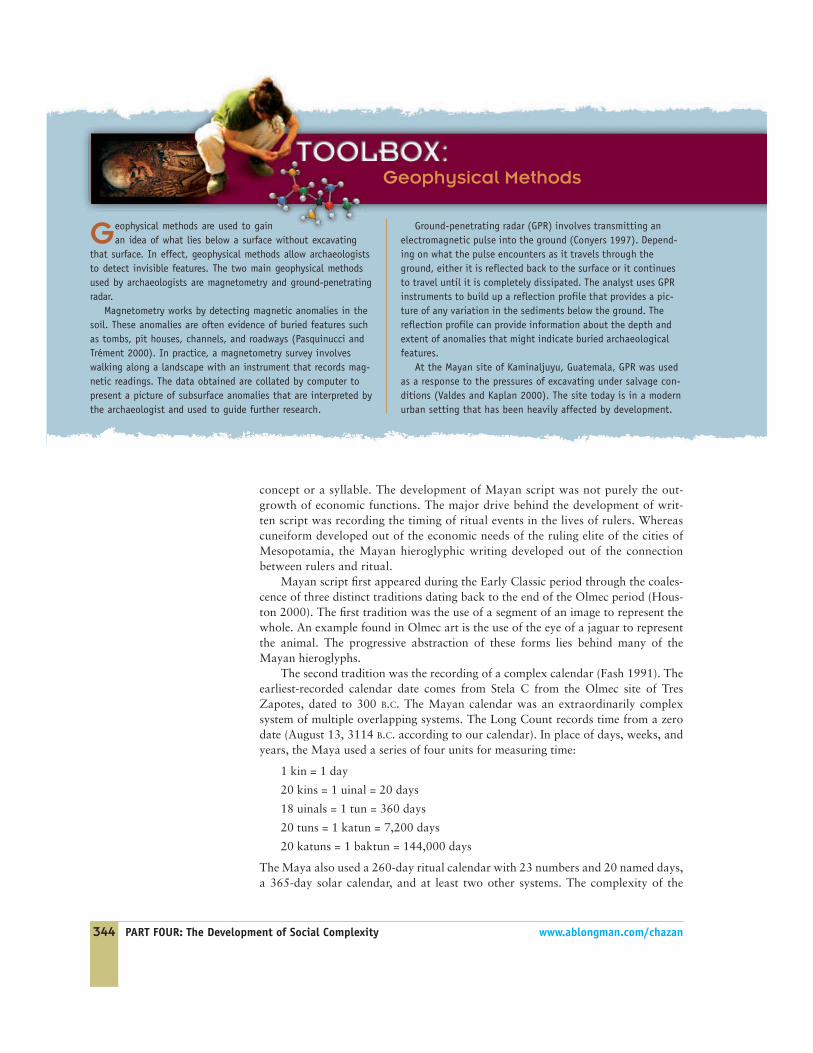
Geophysical Methods
Geophysical methods are used to gainan idea of what lies below a surface without excavating
that surface. In effect, geophysical methods allow archaeologiststo detect invisible features. The two main geophysical methodsused by archaeologists are magnetometry and ground-penetratingradar.
Magnetometry works by detecting magnetic anomalies in thesoil. These anomalies are often evidence of buried features suchas tombs, pit houses, channels, and roadways (Pasquinucci andTrément 2000). In practice, a magnetometry survey involveswalking along a landscape with an instrument that records mag-netic readings. The data obtained are collated by computer topresent a picture of subsurface anomalies that are interpreted bythe archaeologist and used to guide further research.
Ground-penetrating radar (GPR) involves transmitting anelectromagnetic pulse into the ground (Conyers 1997). Depend-ing on what the pulse encounters as it travels through theground, either it is reflected back to the surface or it continuesto travel until it is completely dissipated. The analyst uses GPRinstruments to build up a reflection profile that provides a pic-ture of any variation in the sediments below the ground. Thereflection profile can provide information about the depth andextent of anomalies that might indicate buried archaeologicalfeatures.
At the Mayan site of Kaminaljuyu, Guatemala, GPR was usedas a response to the pressures of excavating under salvage con-ditions (Valdes and Kaplan 2000). The site today is in a modernurban setting that has been heavily affected by development.

CHAPTER 11: Urban States 345
The Popol Vuh is a Mayanmyth written after theSpanish conquests. It tellsthe epic tale of the herotwins and their battle withthe lords of the underworld.
Mayan calendar reflects the centrality and significance the Maya attached to meas-uring time, matched by an intense interest in recording astronomical events.
There is very slight evidence that Mayan script might also have developed outof a tradition of using written records in economic transactions. If such recordsexisted, they must have been written on perishable materials that have not survived.One of the main sources of evidence for the use of writing to record transactionscomes from drawings of a deity writing numbers on leaves.
The Mayan documents that survive deal largely with the recording of events inthe lives of the rulers of cities, particularly the dates when the rulers performedsignificant rituals. Most of the texts that have survived are monuments carved instone or inscriptions on clay vessels. More complex religious and historical docu-ments were probably written in books known as codices, only a small number ofwhich have survived. A unique expression of the wealth of Mayan mythology isfound in the Popol Vuh, which was transcribed following the Spanish conquest(Coe 1993). The Popol Vuh tells the epic tale of the hero twins Hunahpu andXbalnque and their battle with the lords of the underworld, known as Xibalbá. Thetale hinges on the skill and trickery of the twins, which together allow them to van-quish the lords of the underworld before rising up through the surface of the earthand into the sky, where they became the sun and moon. A ball game played to thedeath is central to the story of the Popol Vuh.
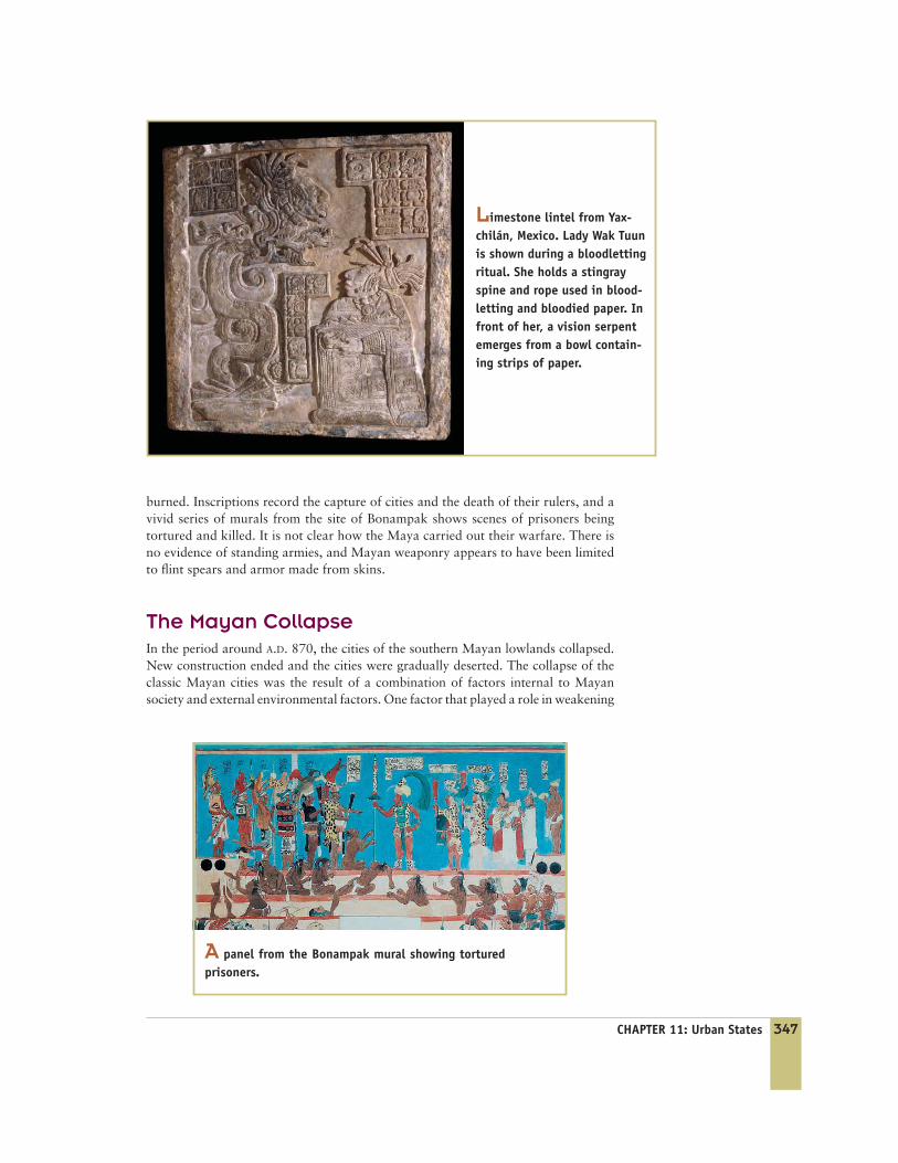
Ritual, Violence, and WarfareRituals of bloodletting and sacrifice were central to Mayan kingship (Schele andMiller 1986). Some of the most vivid scenes of bloodletting are found on a series ofcarvings from the site of Yaxchilán. In these scenes, the ruler and his wife are seen
�
Plans to build a shopping complexand a hotel in the area led tourgent salvage excavations. The GPRsurvey allowed archaeologists torapidly survey areas that they wouldnot have had time to test by exca-vation. The survey succeeded inlocating a series of buried objects,ranging from a car muffler to signif-icant archaeological features,including the floor of a house andtwo ritual caches.
FIGURE 11 .7
GPR thermal printout from Kaminaljuyu showing the location of buriedfeatures.
Dep. 6BDep. 6B Dep. 6ADep. 6A
Meters 1 2 3 4 5 6 7 8
346 PART FOUR: The Development of Social Complexity www.ablongman.com/chazan
drawing blood from their tongues and collecting the dripping blood on specialpaper (see photo on page 347). The bloodletting brings on spectacular visions ofenormous snakes with the heads of gods.
The ball game also played a central role in Mayan society. The epic battlebetween the hero twins of the Popul Vuh and the lords of the underworld appearsto be at the heart of much of Mayan ritual practice. Echoing the centrality of theball game to Mayan ritual is the position of the ball court at the core of the Mayancity. The ball courts consist of a bare patch of ground, flanked on either side by abanked structure. The game was played with a heavy rubber ball that, apparently,had to be shot through a ring without the use of the hands. Some archaeologistshave argued that, as it was in the myth of the Popol Vuh, in real life the ball gamewas played to the death.
However, violence in the Mayan world went beyond ritual and sport. Fromsites such as Aguateca, there is clear evidence that cities were conquered and
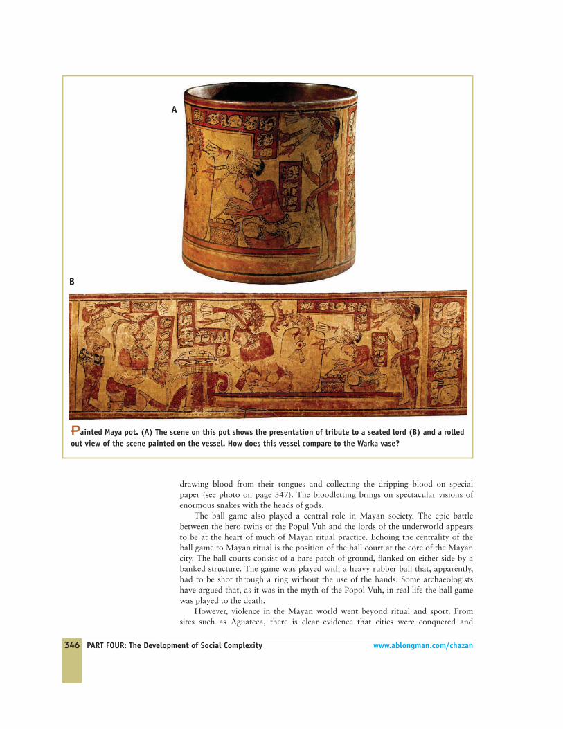
Painted Maya pot. (A) The scene on this pot shows the presentation of tribute to a seated lord (B) and a rolledout view of the scene painted on the vessel. How does this vessel compare to the Warka vase?
A
B
CHAPTER 11: Urban States 347
burned. Inscriptions record the capture of cities and the death of their rulers, and avivid series of murals from the site of Bonampak shows scenes of prisoners beingtortured and killed. It is not clear how the Maya carried out their warfare. There isno evidence of standing armies, and Mayan weaponry appears to have been limitedto flint spears and armor made from skins.
The Mayan CollapseIn the period around A.D. 870, the cities of the southern Mayan lowlands collapsed.New construction ended and the cities were gradually deserted. The collapse of theclassic Mayan cities was the result of a combination of factors internal to Mayansociety and external environmental factors. One factor that played a role in weakening
Limestone lintel from Yax-chilán, Mexico. Lady Wak Tuunis shown during a bloodlettingritual. She holds a stingrayspine and rope used in blood-letting and bloodied paper. Infront of her, a vision serpentemerges from a bowl contain-ing strips of paper.
A panel from the Bonampak mural showing torturedprisoners.

348 PART FOUR: The Development of Social Complexity www.ablongman.com/chazan
the power of the Mayan rulers was the ratcheting up of cycles of violence and warfare.By the end of the Classic period, warfare was widespread and its consequences oftencatastrophic. The burned town at Aguateca shows these consequences. Excavations atthe large urban center of Dos Pilas have uncovered a radical transformation of the sitebeginning in A.D. 761, when a defensive palisade was built around the central areawith stones ripped from the temples and pyramids (see Figure 11.9 on page 350). Theresidents built a tightly packed siege village in the open plazas and began living in the
Deciphering the MayanHieroglyphs
The decipherment of the Mayan hieroglyphsis a triumph of modern scholarship. As with many such
ventures, breaking the Mayan code was the result of thecombined efforts of numerous scholars. Ironically, one ofthe most despised figures in colonial history provided theessential key. Bishop Landa is known for the brutality ofhis term in the Yucatán in the mid-sixteenth century, aterm that featured the notorious burning of many Mayanbooks and codices. However, Bishop Landa also recordedthe history of the Maya, including a list of signs and theirphonetic readings that turned out to be the key to unlock-ing the Mayan script.
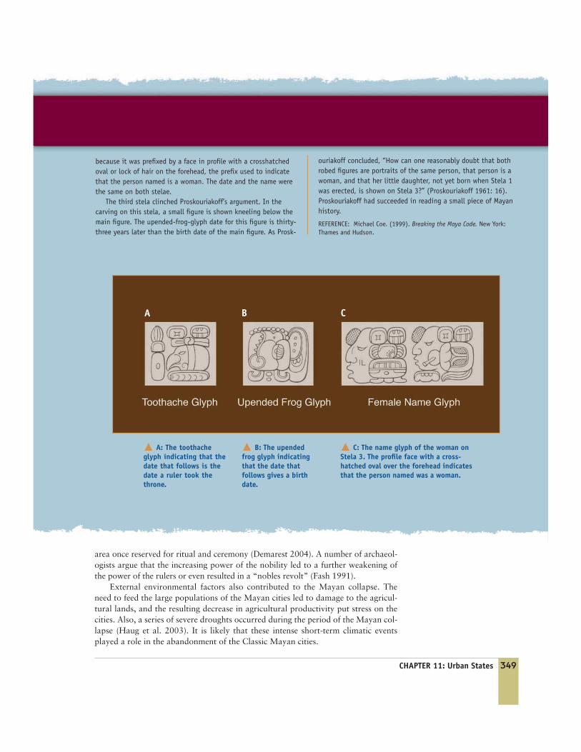
The discovery that Mayan inscriptions recorded histori-cal events was a major breakthrough in the path to deci-phering Mayan hieroglyphs. In an article published in1961, Tatiana Proskouriakoff presented a reading of stelaefrom the site of Piedras Negras. Proskouriakoff noticedthat a series of stelae had one sign, known as the“toothache sign,” associated with a particular date, andanother sign, the “upended frog,” associated with a datetwenty to thirty years earlier. On the basis of this obser-vation, she came to the conclusion that the toothachesign actually indicated that the date which followed wasthe date a ruler ascended to the throne and that theupended frog indicated that the date which followed wasthe ruler’s birth date. Using this principle, she was able tofind the glyphs that were the names of the rulers ofPiedras Negras.
Proskouriakoff then turned to three stelae, known asstelae 1–3. On the front of these stelae the inscription isbadly eroded, but on the back there is the well-preservedcarving of a figure wearing a robe. Proskouriakoff foundthat stelae 1 and 2 showed the upended-frog glyph(indicating the date of birth), followed by the name of awoman. It was clear that the name was a woman’s name
FIGURE 11 .8
The back of Stela 3 from Piedras Negras showing a womansitting on a throne with a child beside her.
CHAPTER 11: Urban States 349
area once reserved for ritual and ceremony (Demarest 2004). A number of archaeol-ogists argue that the increasing power of the nobility led to a further weakening ofthe power of the rulers or even resulted in a “nobles revolt” (Fash 1991).
External environmental factors also contributed to the Mayan collapse. Theneed to feed the large populations of the Mayan cities led to damage to the agricul-tural lands, and the resulting decrease in agricultural productivity put stress on thecities. Also, a series of severe droughts occurred during the period of the Mayan col-lapse (Haug et al. 2003). It is likely that these intense short-term climatic eventsplayed a role in the abandonment of the Classic Mayan cities.
� A: The toothacheglyph indicating that thedate that follows is thedate a ruler took thethrone.
� B: The upendedfrog glyph indicatingthat the date thatfollows gives a birthdate.
� C: The name glyph of the woman onStela 3. The profile face with a cross-hatched oval over the forehead indicatesthat the person named was a woman.
ouriakoff concluded, “How can one reasonably doubt that bothrobed figures are portraits of the same person, that person is awoman, and that her little daughter, not yet born when Stela 1was erected, is shown on Stela 3?” (Proskouriakoff 1961: 16).Proskouriakoff had succeeded in reading a small piece of Mayanhistory.
REFERENCE: Michael Coe. (1999). Breaking the Maya Code. New York:Thames and Hudson.
because it was prefixed by a face in profile with a crosshatchedoval or lock of hair on the forehead, the prefix used to indicatethat the person named is a woman. The date and the name werethe same on both stelae.
The third stela clinched Proskouriakoff’s argument. In thecarving on this stela, a small figure is shown kneeling below themain figure. The upended-frog-glyph date for this figure is thirty-three years later than the birth date of the main figure. As Prosk-
A B C
350 PART FOUR: The Development of Social Complexity www.ablongman.com/chazan
Summing Up the EvidenceMayan kings ruled over large urban centers. The emergence of both cities and statesociety among the Maya is closely linked with external influences, particularly fromthe highland city of Teotihuacán. The power of the Mayan kings was based on theprestige of the royal lineage and was reinforced by the critical ceremonial role of theking. The prestige of the royal lineage was literally built into the city in the form ofmonumental inscriptions and the pyramids that encased the burials of the kings.The hieroglyphic writing system was developed as a central tool in recording thetiming of ritual events in the lives of rulers. The eventual collapse of the Mayancities appears to have been the result of a number of factors, including warfare, eco-logical degradation, and external climatic events. Of these factors, the emergence ofwarfare between cities seems to have played a decisive role.
1 1 .3 SHANG CHINAAccording to Chinese historical texts, three powerful dynasties—the Hsia,the Shang, and the Zhou—emerged in northern China during the periodbetween 2000 B.C. and 500 B.C. Unfortunately, it is difficult to trace the
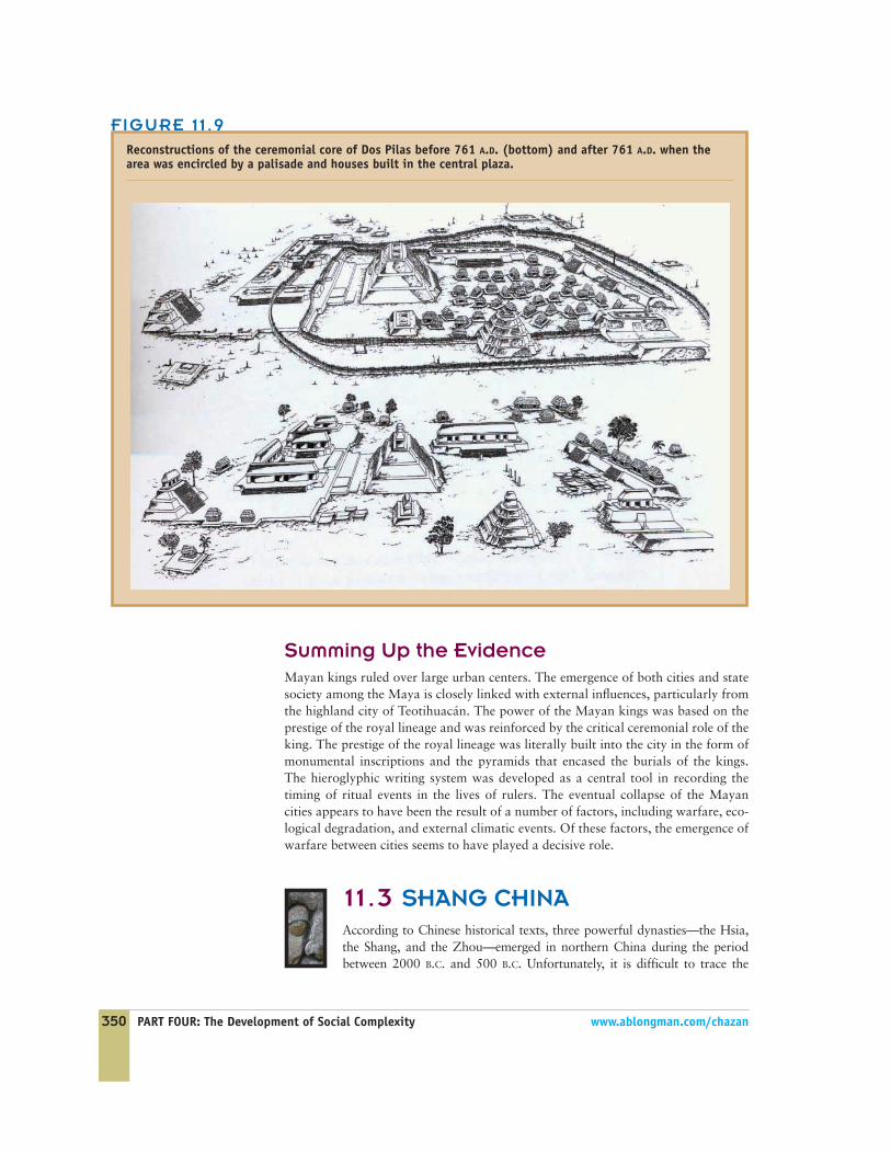
FIGURE 11 .9
Reconstructions of the ceremonial core of Dos Pilas before 761 A.D. (bottom) and after 761 A.D. when thearea was encircled by a palisade and houses built in the central plaza.
CHAPTER 11: Urban States 351
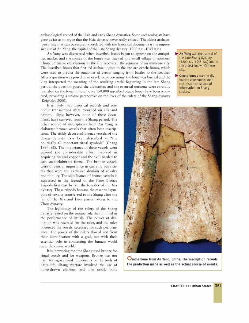
archaeological record of the Hsia and early Shang dynasties. Some archaeologists havegone as far as to argue that the Hsia dynasty never really existed. The oldest archaeo-logical site that can be securely correlated with the historical documents is the impres-sive site of An Yang, the capital of the Late Shang dynasty (1200 B.C.–1045 B.C.).
An Yang was discovered when inscribed bones began to appear on the antiqui-ties market and the source of the bones was tracked to a small village in northernChina. Intensive excavations at the site recovered the remains of an immense city.The inscribed bones that first led archaeologists to the site are oracle bones, whichwere used to predict the outcomes of events ranging from battles to the weather.After a question was posed in an oracle bone ceremony, the bone was burned and theking interpreted the meaning of the resulting crack. Beginning in the late Shangperiod, the question posed, the divination, and the eventual outcome were carefullyinscribed on the bone. In total, over 150,000 inscribed oracle bones have been recov-ered, providing a unique perspective on the lives of the rulers of the Shang dynasty(Keightley 2000).
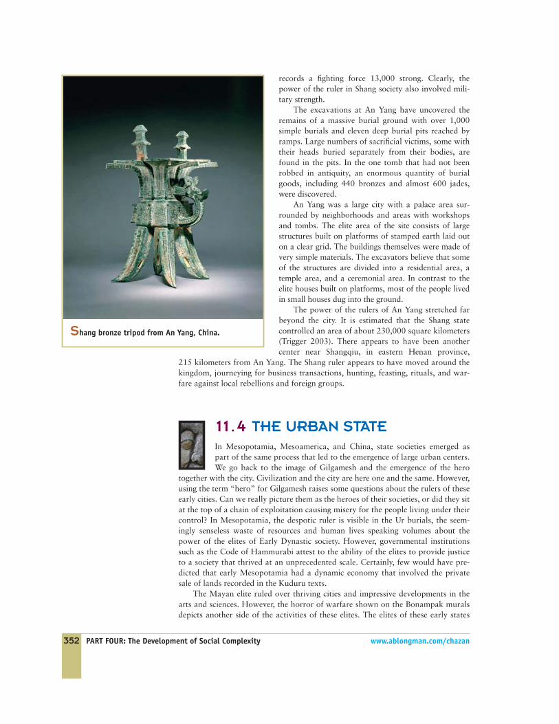
It is likely that historical records and eco-nomic transactions were recorded on silk andbamboo slips; however, none of these docu-ments have survived from the Shang period. Theother source of inscriptions from An Yang iselaborate bronze vessels that often bear inscrip-tions. The richly decorated bronze vessels of theShang dynasty have been described as “thepolitically all-important ritual symbols” (Chang1994: 68). The importance of these vessels wentbeyond the considerable effort involved inacquiring tin and copper and the skill needed tocast such elaborate forms. The bronze vesselswere of central importance in carrying out ritu-als that were the exclusive domain of royaltyand nobility. The significance of bronze vessels isexpressed in the legend of the Nine BronzeTripods first cast by Yu, the founder of the Xiadynasty. These tripods became the essential sym-bols of royalty transferred to the Shang after thefall of the Xia and later passed along to theZhou dynasty.
The legitimacy of the rulers of the Shangdynasty rested on the unique role they fulfilled inthe performance of rituals. The power of div-ination was reserved for the ruler, and the rulerpossessed the vessels necessary for such perform-ance. The power of the rulers flowed not fromtheir identification with a god, but with theiressential role in connecting the human worldwith the divine world.
It is interesting that the Shang used bronze forritual vessels and for weapons. Bronze was notused for agricultural implements or the tools ofdaily life. Shang warfare involved the use ofhorse-drawn chariots, and one oracle bone
Oracle bone from An Yang, China. The inscription recordsthe prediction made as well as the actual course of events.
An Yang was the capital ofthe Late Shang dynasty(1200 B.C.–1045 B.C.) and isthe oldest-known Chinesecity.
Oracle bones used in div-ination ceremonies are arich historical source ofinformation on Shang society.
�
�
352 PART FOUR: The Development of Social Complexity www.ablongman.com/chazan
records a fighting force 13,000 strong. Clearly, thepower of the ruler in Shang society also involved mili-tary strength.
The excavations at An Yang have uncovered theremains of a massive burial ground with over 1,000simple burials and eleven deep burial pits reached byramps. Large numbers of sacrificial victims, some withtheir heads buried separately from their bodies, arefound in the pits. In the one tomb that had not beenrobbed in antiquity, an enormous quantity of burialgoods, including 440 bronzes and almost 600 jades,were discovered.
An Yang was a large city with a palace area sur-rounded by neighborhoods and areas with workshopsand tombs. The elite area of the site consists of largestructures built on platforms of stamped earth laid outon a clear grid. The buildings themselves were made ofvery simple materials. The excavators believe that someof the structures are divided into a residential area, atemple area, and a ceremonial area. In contrast to theelite houses built on platforms, most of the people livedin small houses dug into the ground.
The power of the rulers of An Yang stretched farbeyond the city. It is estimated that the Shang statecontrolled an area of about 230,000 square kilometers(Trigger 2003). There appears to have been anothercenter near Shangqiu, in eastern Henan province,
215 kilometers from An Yang. The Shang ruler appears to have moved around thekingdom, journeying for business transactions, hunting, feasting, rituals, and war-fare against local rebellions and foreign groups.
1 1 .4 THE URBAN STATEIn Mesopotamia, Mesoamerica, and China, state societies emerged aspart of the same process that led to the emergence of large urban centers.We go back to the image of Gilgamesh and the emergence of the hero
together with the city. Civilization and the city are here one and the same. However,using the term “hero” for Gilgamesh raises some questions about the rulers of theseearly cities. Can we really picture them as the heroes of their societies, or did they sitat the top of a chain of exploitation causing misery for the people living under theircontrol? In Mesopotamia, the despotic ruler is visible in the Ur burials, the seem-ingly senseless waste of resources and human lives speaking volumes about thepower of the elites of Early Dynastic society. However, governmental institutionssuch as the Code of Hammurabi attest to the ability of the elites to provide justiceto a society that thrived at an unprecedented scale. Certainly, few would have pre-dicted that early Mesopotamia had a dynamic economy that involved the privatesale of lands recorded in the Kuduru texts.
The Mayan elite ruled over thriving cities and impressive developments in thearts and sciences. However, the horror of warfare shown on the Bonampak muralsdepicts another side of the activities of these elites. The elites of these early states
Shang bronze tripod from An Yang, China.
CHAPTER 11: Urban States 353
made possible a degree of social complexity and concentrations of populations thatwere unprecedented. Yet they did so through a system that involved the control ofviolence and through the exploitation of the labor of those over whom they ruled.
Mesopotamian and Mayan cities developed around a sacred core. However, therewas a significant difference between the sacred cores of the cities in those two areas.The Mesopotamian temple was identified with a deity, who was the source of identityand power for the city. The relationship between the palace and the temple was oftenambiguous. In the Mayan cities, the sacred core was closely associated with the rulingdynasty and included the physical remains of rulers buried within the accreting levelsof pyramids, as well as their deeds, recorded in carved stone monuments.
In all three civilizations, writing played a critical role in society. On the basis ofthe available evidence, it appears that, for the Maya and in Shang China, writingwas used primarily in a ritual context and to record the actions of the rulers. Bycontrast, in Mesopotamia, writing was essential to the economy. It is likely thatsome economic texts were kept by the Maya on organic materials that have not sur-vived. Similar documents written on fragile organic material might have also existedin Shang China.
A critical distinction emerges in comparing the Maya and Mesopotamia withShang China. For the Maya and in Mesopotamia, each city was an individual polity,a state in and of itself. We refer to cases in which the state is identical to the individ-ual city as city–states. The rivalry between the Mayan city–states evidently con-tributed to the Mayan collapse. In Mesopotamia, warfare between cities existedbut appears to have never reached the magnitude found among the Maya. The ten-sions between Mesopotamian cities were balanced by a loose confederacy withparamount rule circulating between cities. It is possible that the differences betweenthe Maya and Mesopotamia can be traced back to the sacred spaces at the core oftheir cities. Among the Maya, the prestige of the city was the expression of thepower of the ruling dynasty. It was perhaps inevitable that competition wouldemerge between dynasties and, as a result, between the cities that were in a sense theincarnation of the dynasty. In Mesopotamia, the temple was dedicated to a divinityrather than a lineage. The city in Mesopotamia was the incarnation of the powerand benevolence of a god, and the gods of each city–state made up a part of theMesopotamian pantheon, providing a divine model for the rulers to follow in devel-oping a system of confederation.
Shang China appears to have been starkly different from the Mayan andMesopotamian civilizations. An Yang was not one among several city–states, butrather one of perhaps two cities at the core of a large area controlled by a singleruler who traveled frequently across the kingdom. Shang China is an example of aterritorial state, a state in which the ruler controls a large territory through provin-cial and local administrators. It is interesting that the picture in Shang China of theruler was as the intermediary between the divine and the earthly realms. Throughdivination rights and the possession of sacred symbols such as bronze tripods, theruler took the position as the connection between heaven and earth. The power ofthe ruler flowed not from a place in the city, but from his place in the cosmos.
In all three cases considered in this chapter, states, cities, and clearly marked andpowerful elites are closely connected. All of these societies fit well with V. GordonChilde’s (1942) definition of the “Urban Revolution.” However, taking up the ques-tions posed by Bruce Trigger about the regularity of the transition to urban statesocieties, we find significant variation among the cases despite some very generalsimilarities. In the next chapter, we consider three cases that do not fit in easily withthe idea of an “Urban Revolution.” By casting our net more broadly, we find aneven wider diversity of pathways taken in the transition to state society.
354 PART FOUR: The Development of Social Complexity www.ablongman.com/chazan
CHAPTERSUMMARY
■ Mesopotamia covers the region along the course ofthe Tigris and Euphrates Rivers, a region where large-scale agriculture is possible only with irrigation.
■ Urban sites appear in Mesopotamia during the UrukPeriod, 4000 B.C.–3200 B.C. These cities were devel-oped around temple precincts dating back to theearlier Ubaid period.
■ The cuneiform writing system developed inMesopotamia to record economic information.Cuneiform came to be used for a wide variety oftexts, including epics and legal codes.
■ The Royal Tombs at Ur demonstrate the power andwealth of early Mesopotamian kings.
■ There is little evidence of extensive warfare in earlyMesopotamia; however, Uruk sites such as HabubaKebira, did develop far to the north on theEuphrates River.
■ The Olmec sites of 1200 B.C.–300 B.C. on the GulfCoast of Mexico are the earliest evidence of politicalcomplexity in Mesoamerica.
■ By 500 B.C., the site of Monte Albán in the OaxacaValley had grown into a large city with a populationof 5,000 people. Beginning around two thousandyears ago, Teotihuacán, in the Valley of Mexico, had
grown into a city with a population of more than80,000 people.
■ The Mayan hieroglyphic writing system developedout of the connection between rulers and rituals.
■ The core of the Mayan city included royal resi-dences, open plazas, pyramids, and ball courts.
■ Mayan cities were ruled by powerful dynasties. Thepower of the king derived from the prestige of thedynasty and the sacred aspect of kingship.
■ Violence and warfare in Mayan society were closelylinked to rituals of bloodletting. There is clear evi-dence of warfare between Mayan cities.
■ Around 870 A.D., cities in the southern Mayan low-lands collapsed.
■ The emergence of state societies in China is linked tothree dynasties known from historical texts: theHsia, the Shang, and the Zhou.
■ The site of An Yang was the Shang capital. Excava-tions at An Yang have uncovered a large city laidout on a grid. The royal tombs at An Yang includeevidence of human sacrifice and a great wealth ofburial goods.
■ The power of the rulers of the Shang dynasty restedon their role in performing rituals.
KEY TERMS
Aguateca, 343An Yang, 351Bevel-Rim Bowls, 327Copán, 339Cuneiform, 330Cylinder Seals, 331Habuba Kebira, 333
Mayan Hieroglyphs, 343Mesopotamia, 323Monte Albán, 336Olmec, 334Oracle Bones, 351Popol Vuh, 345Royal Tombs, 329
Teotihuacán, 336Tigris and Euphrates Rivers, 323Tikal, 340Uruk, 326Uruk Period, 325Ziggurat, 326
REVIEW QUESTIONS
1. What are the reasons for the development of writ-ing systems in the three civilizations studied? Arethere similarities between the civilizations, or iseach unique?
2. How does the role of violence in Mayan societycompare with that in Early Mesopotamia?
3. Is the association of the Shang ruler with the per-formance of rituals unique, or are there similaritiesto the roles of the rulers of Mesopotamian andMayan cities?
CHAPTER 11: Urban States 355
FOR FURTHER READING
G.L. Barnes. (1993). China, Korea, and Japan: The Rise ofCivilization in East Asia. London: Thames and Hudson.
K.C. Chang. (1980). Shang Civilization. New Haven,Connecticut: Yale University Press.
Arthur Demarest. (2004). Ancient Maya: The Rise and Fall ofa Rainforest Civilization. Cambridge, U.K.: CambridgeUniversity Press.
William Fash. (1991). Scribes, Warriors and Kings: The Cityof Copán and the Ancient Maya. London: Thames andHudson.
Susan Pollock. (1999). Ancient Mesopotamia: The Eden ThatNever Was. Cambridge, U.K.: Cambridge University Press.
J.N. Postgate. (1992). Early Mesopotamia: Economy andSociety at the Dawn of History. London: Routledge.
Linda Schele and M.E. Miller. (1986). The Blood of Kings:Dynasty and Ritual in Maya Art. New York: Braziller.
Norman Yoffee. (2005). Myths of the Archaic State. Cam-bridge, U.K.: Cambridge University Press.