work hikes hike reports 3 · simply said she was going on a walk. she was worried they would try to...
TRANSCRIPT
Fall 2014
The Roanoke Appalachian Trail Club is a recreational hiking association of volunteers who preserve and improve the Appalachian Trail as the nation’s premier, continuous, long-distance footpath.
CALENDAR OF CLUB ACTIVITIES
Holiday Potluck Saturday, December 6 – 6:00 PM
____________
WORK HIKES
Monday, October 6 - 8:30 AM
Monday, October 20 - 8:30 AM
Monday, November 3 - 8:30 AM
Monday, November 17 - 8:30 AM
Monday, December 1 - 8:30 AM
Monday, December 15 - 8:30 AM
____________
Hike Scheduling
Contact Edward Wilson 540-904-8904 – [email protected]
____________
BOARD MEETINGS (All members are always welcome.
Please let the host know you plan to attend.)
Monday, Ocrober 20, 7:00 p.m. Hosted by Bruce Davidson& Guy
Brooks - Salem Library
Monday, November 17, 7:00 p.m. Hosted by Therese & Homer Witcher
Salem Library
Missing a Canvas Bag? A large white and navy canvas bag was left at the corn-boil this summer; call Linda Akers at 400-8117 to claim it.
What’s Inside...
President’s Report ................... 2
Hikemaster’s Report................. 3
New Members ........................... 3
Hike Reports ............................. 3
Hike Schedule ........................... 7
Holiday Potluck....................... 10
Membership Renewal............. 11
Contacting the RATC ......... Back
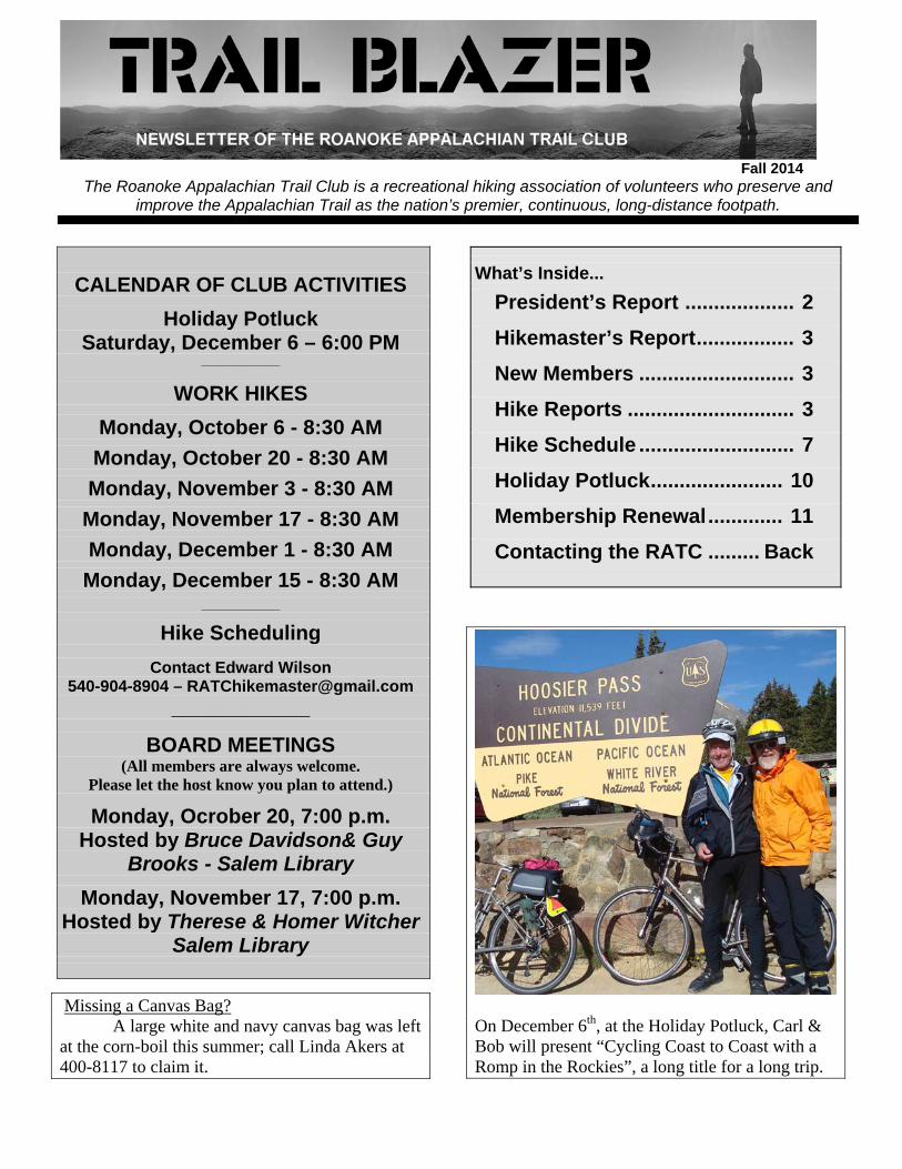
On December 6th, at the Holiday Potluck, Carl & Bob will present “Cycling Coast to Coast with a Romp in the Rockies”, a long title for a long trip.
Roanoke Appalachian Trail Club www.ratc.org RATC TRAIL BLAZER - 2
President’s Report
It is well known that this year marks the 50th anniversary of the passage of the Wilderness Act. The act has had a huge impact on the care of forests in this country as well as on the A. T. specifically. Next year marks another significant anniversary date for the A.T. It marks the 60th year since the first woman thru-hiked the A.T. The woman who accomplished the hike, Emma Gatewood, was truly remarkable. The story of her life and her thru-hike is described in a recently published book “Grandma Gatewood’s Walk: The Inspiring Story of the Woman Who Saved the Appalachian Trail” by Ben Montgomery. As can be seen in the book’s title, Emma’s trail name was Grandma. She lived most of her life on a farm in Ohio and was 67 years old and the mother of 11 children and had 23 grandchildren when she started her hike. She didn’t tell any of them that she was going to attempt a thru-hike, but simply said she was going on a walk. She was worried they would try to talk her out of it. By 1955 the A.T. had only been thru-hiked six times, the first time by the legendary Earl Shaffer in 1948. Grandma Gatewood was inspired to hike the trail by an article about the A.T. that appeared in the August 1949 issue of the National Geographic magazine. At a time when the pack of a typical long-distance hiker weighed about 50 pounds, on her thru-hike she carried a home-made sack over her shoulder that weighed just 15 pounds. She was an ultra-light backpacker long before it became popular. She did not carry a stove, sleeping bag, or tent. Instead her sack had a coat, shower curtain for rain protection, food, a flashlight, and a few other small items. She started on the trail in May in Georgia. She had been an avid hiker all of her life back in Ohio. Even though the trail was poorly marked and maintained back then she was typically able to put in 20 miles each day. She made rapid progress on the trail and eventually sent her children a postcard letting them know where she was. While she started her hike in obscurity, eventually the story of a 67-year-old grandmother attempting to hike a 2,000 mile long trail became a national sensation. Interestingly, the first press report of her trip was in the Roanoke Times. She was interviewed at Black Horse Gap by Frank Callahan, a reporter for
the Times and a RATC member. After she completed her hike Emma became a lifetime member of the RATC. The story of her hike brought a lot of publicity for the A.T. and inspired many other hikers to get out on the trail. Her comments to the press about the poor shape of the A.T. got many clubs motivated to better maintain the trail and put up more shelters and signage. Despite severe knee problems while hiking in Maine she completed her thru-hike on September 24, 1955. Amazingly she went on to thru-hike the trail again in 1960 and section-hiked it in 1963 at the age of 75. She was the first person to hike the A.T. three times. She was once quoted as saying “I get faster as I get older”. It wasn’t until 2007 that a woman older than her completed the trail. Eventually Emma bought a small farm back in Ohio. She did all of the work around the farm herself. On her own she blazed and constructed some 30 miles of trail in her county. Her trail building work inspired others in Ohio and around the country to advocate for more foot trails. A trail in Ohio is named after her. She died in 1973 at the age of 85. Even today, most thru-hikers know about her and her remarkable determination. On another subject, the RATC is always looking for volunteers. Here are the major areas we need help in: Trail Maintenance – We need people to help maintain the 120 miles of the A.T. as well as the side trails we maintain. Maintainers typically do repairs on the treadway, clip overhanging branches, and reblaze the trail. Boundary Monitors – Once a year check the National Park Service boundaries on either side of the trail to ensure that no encroachments have occurred. Encroachments include such things as tree cutting, hunting stands, and ATV trails. Shelter Maintenance – Through our Adopt-a-Shelter program, go out and visit one of the 16 shelters on our section and do routine cleaning and maintenance. Hike Leaders – Lead or assist on our recreational hikes. Please contact me if you are interested in helping out in any of these areas.
Mike Vaughn
Roanoke Appalachian Trail Club www.ratc.org RATC TRAIL BLAZER - 3
Hikemaster’s Report
Wow, can you believe these temperatures? It’s almost like fall is already here. Hard to believe as it seems we didn’t really have a summer. Although the weather didn’t know it was summer the RATC definitely did! We’ve been out and about in the community and on the trails. It’s been great to meet those of you I have been able to. Unfortunately I started chemo treatments this summer so I am unable to hit the trails; however, it’s been great meeting all the hikers out at events like Troutville Trail Days and Hiker Happy Hours. These have been great opportunities for people,
like me, who are injured or unable to get out on the trail to still stay in touch with the trail community. For those of you still able to get out on the trail, don’t worry we still have plenty of hikes for you! It may not seems as though we have as many hikes planned as usual but be sure to check out the RATC Meetup group as many hikes are posted after this schedule is printed. As always if you ever have questions or concerns please feel free to contact me.
Edward Wilson
Welcome New Members The Roanoke Appalachian Trail Club thanks the following donors:
Kathryn Arrington Liz Belcher Karen Coon Christopher D. Lynch
Philip & Susan Moldenhauer Bonnie Pulliam Michael "Tabasco" Smith Tommy Stroupe
Martha Thomas Virginia Waters
We look forward to meeting you soon: hiking on the trail, at work, social event, or a board meeting.
Brendle Wolfe
Hike Reports
Monday, June 02 Workhike - Trout Creek
Dave Horst, John Miller, Gary Bible, Larry Austin, Lois Coche-Smith and Jim Webb We finished removing the rotten cribbing on a steep uphill section of the trail from Rte 620 South, and redug the side hill trail.
Thursday, June 12 Monday, June 16
Thursday, June 25 Workhike - Rte 42 Cumberland Gap Rd.
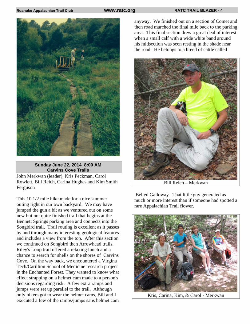
Dave Horst, Mike Vaughn, Ron Sloan & Jim Webb After removing a beaver dam three times, only to see them repair it overnight three times, we split some cedar logs and built 140 ft of a bog bridge over the flooded area around the dam.
Why the Beavers are busy - Webb
Roanoke Appalachian Trail Club www.ratc.org RATC TRAIL BLAZER - 4
Sunday June 22, 2014 8:00 AM Carvins Cove Trails
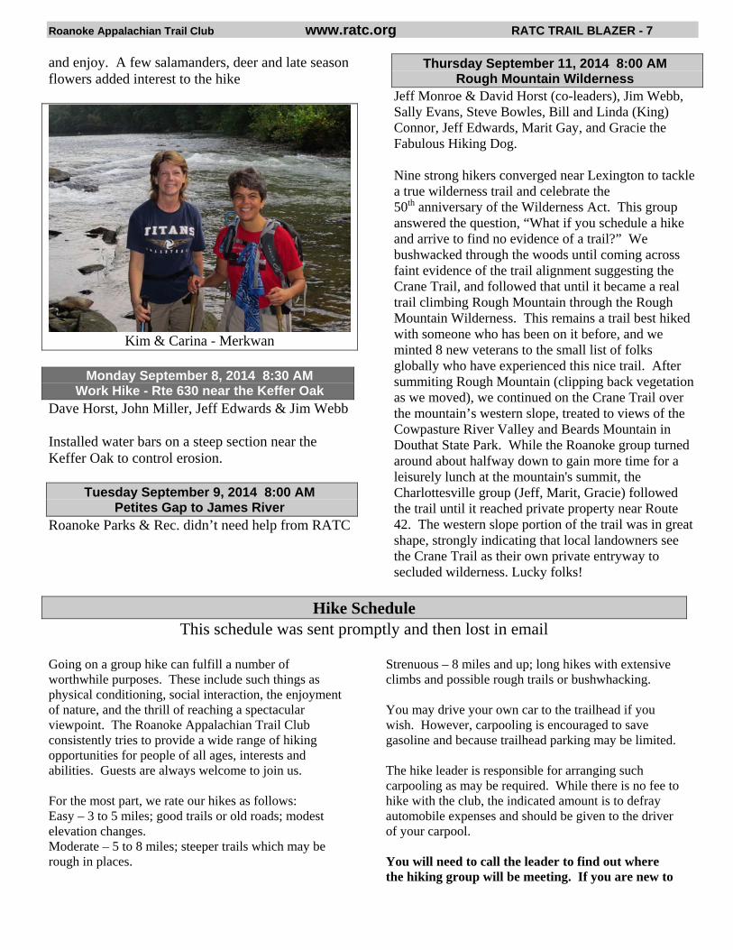
John Merkwan (leader), Kris Peckman, Carol Rowlett, Bill Reich, Carina Hughes and Kim Smith Ferguson This 10 1/2 mile hike made for a nice summer outing right in our own backyard. We may have jumped the gun a bit as we ventured out on some new but not quite finished trail that begins at the Bennett Springs parking area and connects into the Songbird trail. Trail routing is excellent as it passes by and through many interesting geological features and includes a view from the top. After this section we continued on Songbird then Arrowhead trails. Riley's Loop trail offered a relaxing lunch and a chance to search for shells on the shores of Carvins Cove. On the way back, we encountered a Virgina Tech/Carillion School of Medicine research project in the Enchanted Forest. They wanted to know what effect strapping on a helmet cam made to a person's decisions regarding risk. A few extra ramps and jumps were set up parallel to the trail. Although only bikers got to wear the helmet cams, Bill and I executed a few of the ramps/jumps sans helmet cam
anyway. We finished out on a section of Comet and then road marched the final mile back to the parking area. This final section drew a great deal of interest when a small calf with a wide white band around his midsection was seen resting in the shade near the road. He belongs to a breed of cattle called
Bill Reich – Merkwan
Belted Galloway. That little guy generated as much or more interest than if someone had spotted a rare Appalachian Trail flower.
Kris, Carina, Kim, & Carol - Merkwan
Roanoke Appalachian Trail Club www.ratc.org RATC TRAIL BLAZER - 5
Monday, June 30 , 2014 Workhike - Mountain Pass Rd.
Dave Horst, John Miller, Ken Myers, Fred Meyer & Jim Webb
Removed rotting railroad ties used as steps on a steep downhill section and installed log steps.
Tuesday, July 1, 2014 Meetup Hike – Rock Castle Gorge
Dave Horst (leader) Fred Meyer, Mike Vaughn, Carina Hughes, Madeleine Taylor (with Sassy), Doris Mercado, Mark Milberger, and Emily Chaffin
All met at the Cave Springs Kroger except for Doris and Emily who both live in the Floyd area and met us at the trail head on CC Camp Rd. We had an absolutely beautiful, relatively cool day for July. Rock Castle Gorge is a great hike to do in the hot summer months as it provides lots of shade and the cool water of Rock Castle Creek to dip your feet in near the end of the hike. It was Emily Chaffin's first RATC hike and she could not have picked a better group of veteran hikers to start out with. An experienced hiker herself, she fit right in and ended the hike near the front of the group.
We decided to start the hike at CC Camp Rd to take advantage of the cool morning temperatures and get the steep climb of the hike out of the way first. After climbing steeply for the first mile or so, the rest of the 11 mile hike consists of mostly rolling terrain with alternately wooded and bald top pastures. After taking some pictures at the top of one of the pastures, we all met up at the old AT shelter for lunch. Continuing on, we passed the remnants of an old homestead chimney, the Austin house and dipped our feet in the Rock Castle Creek near the end of the hike. Madeleine and Doris acted as the group photographers and posted over 40 pictures on the Meetup page!
Sunday July 13, 2014 8:00 AM Ferrier-Lick Branch Trails
John Merkwan (leader), Kris Peckman, Fred Meyer, and Karen Callahan.
It seems I'm developing a reputation for underestimating trail length. Advertised at 10 miles we logged in 11 3/4 miles of fun this Sunday. Located in Craig County east of New Castle on the border of Botetourt County, this lollypop hike began at the far end of the Ferrier Trail (where the
North Mountain Trail ends) and ascended Broad Run Mountain. From there we went southeast going down the Lick Branch Trail and continued on a gravel road connecting to Ferrier Trail returning us back to Broad Run Mountain to complete the hike.
The forecast of warm temperatures may have reduced the total number of hikers but that didn't hamper the experience of those that made the journey. Being a summer hike we enjoyed blueberries and blackberries along the hike. It was apparent the bears did also as numerous piles of bear scat were left on the trail. In fact we did see a bear (maybe two) as I saw a BIG bear and Karen saw a little bear. This was on a section where Fred was out front scaring them up for us - or maybe they were circling back? In addition to the bears, also noted on the trail was a galloping wooly bear streaking for cover under a leaf, a box turtle traveling up the trail and a woodcock taking flight. Unfortunately woodcocks are very skittish so I was the only one who had the opportunity to see this guy. Lastly, during the Lick Branch portion of the hike we experienced a downpour for about 20 minutes of moderate rainfall. By the time we finished the hike we had nearly dried off so all-in-all it wasn't so bad.
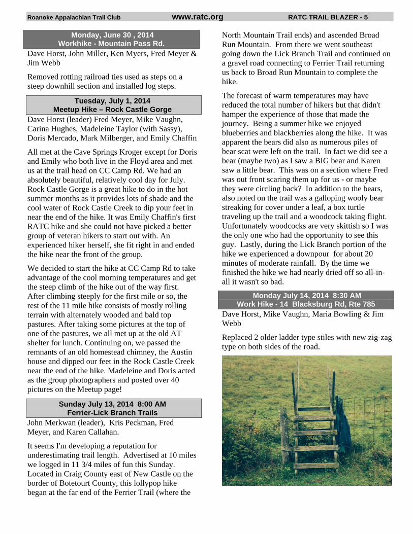
Monday July 14, 2014 8:30 AM Work Hike - 14 Blacksburg Rd, Rte 785
Dave Horst, Mike Vaughn, Maria Bowling & Jim Webb
Replaced 2 older ladder type stiles with new zig-zag type on both sides of the road.
Roanoke Appalachian Trail Club www.ratc.org RATC TRAIL BLAZER - 6
Saturday, Sunday July 12-13, 2014 Beginner Backpacking Trip
Cancelled
Sunday July 27, 2014 8:00 AM Devil’s Marbleyard-Hickory Stand
Fred Meyer (leader), Susan Terwilliger, Cynthia Munley, Karen Callahan
We started the hike on the Belfast trail and it was only one mile to Devil’s Marbleyard. The approximate 8 acres of boulders is impressive and we could see Thunder Ridge Wilderness in the distance. We continued on the Gunter Ridge trail and then turned right at the Appalachian trail where we had more nice views. We continued on the Sulphur Spring trail where we encountered a rain shower and USFS 35 where we found several impressive swimming holes. It was a hike of approximately 9.5 miles.
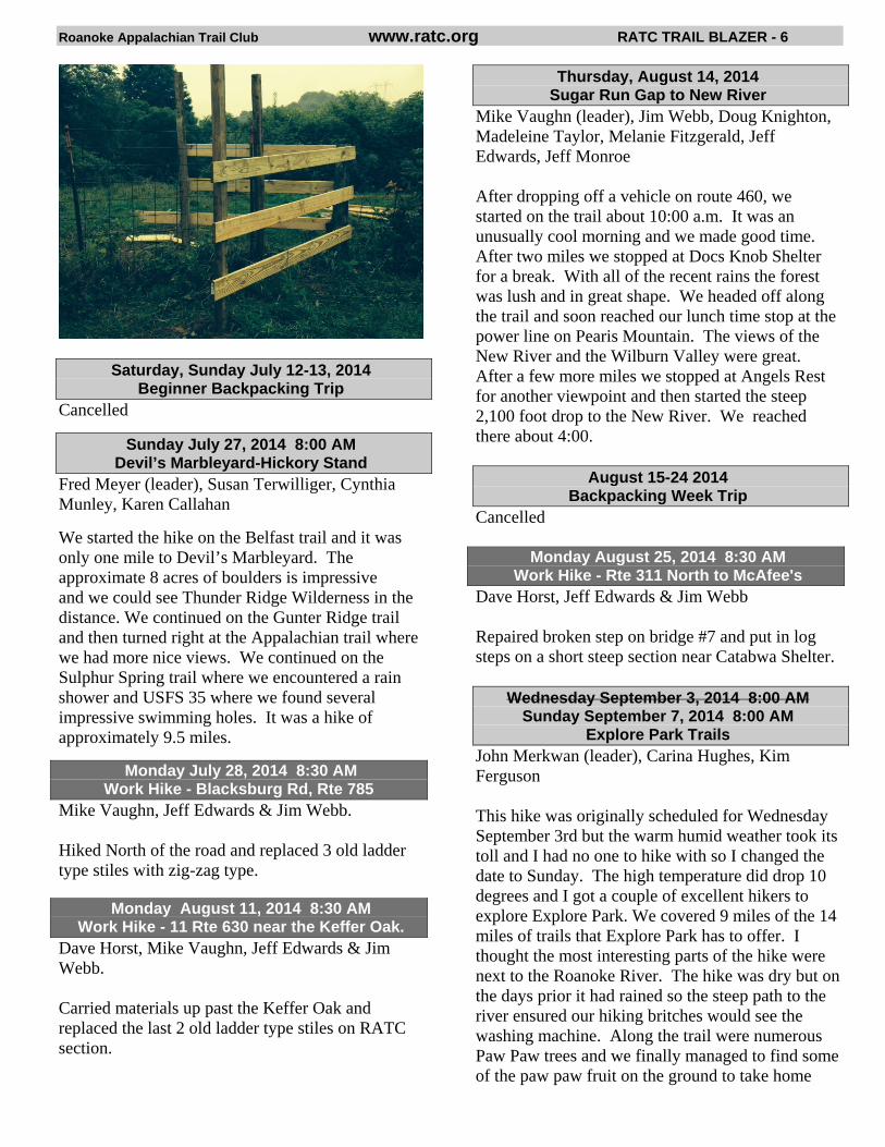
Monday July 28, 2014 8:30 AM Work Hike - Blacksburg Rd, Rte 785
Mike Vaughn, Jeff Edwards & Jim Webb. Hiked North of the road and replaced 3 old ladder type stiles with zig-zag type.
Monday August 11, 2014 8:30 AM Work Hike - 11 Rte 630 near the Keffer Oak.
Dave Horst, Mike Vaughn, Jeff Edwards & Jim Webb. Carried materials up past the Keffer Oak and replaced the last 2 old ladder type stiles on RATC section.
Thursday, August 14, 2014 Sugar Run Gap to New River
Mike Vaughn (leader), Jim Webb, Doug Knighton, Madeleine Taylor, Melanie Fitzgerald, Jeff Edwards, Jeff Monroe After dropping off a vehicle on route 460, we started on the trail about 10:00 a.m. It was an unusually cool morning and we made good time. After two miles we stopped at Docs Knob Shelter for a break. With all of the recent rains the forest was lush and in great shape. We headed off along the trail and soon reached our lunch time stop at the power line on Pearis Mountain. The views of the New River and the Wilburn Valley were great. After a few more miles we stopped at Angels Rest for another viewpoint and then started the steep 2,100 foot drop to the New River. We reached there about 4:00.
August 15-24 2014 Backpacking Week Trip
Cancelled
Monday August 25, 2014 8:30 AM Work Hike - Rte 311 North to McAfee's
Dave Horst, Jeff Edwards & Jim Webb Repaired broken step on bridge #7 and put in log steps on a short steep section near Catabwa Shelter.
Wednesday September 3, 2014 8:00 AM Sunday September 7, 2014 8:00 AM
Explore Park Trails John Merkwan (leader), Carina Hughes, Kim Ferguson This hike was originally scheduled for Wednesday September 3rd but the warm humid weather took its toll and I had no one to hike with so I changed the date to Sunday. The high temperature did drop 10 degrees and I got a couple of excellent hikers to explore Explore Park. We covered 9 miles of the 14 miles of trails that Explore Park has to offer. I thought the most interesting parts of the hike were next to the Roanoke River. The hike was dry but on the days prior it had rained so the steep path to the river ensured our hiking britches would see the washing machine. Along the trail were numerous Paw Paw trees and we finally managed to find some of the paw paw fruit on the ground to take home
Roanoke Appalachian Trail Club www.ratc.org RATC TRAIL BLAZER - 7
and enjoy. A few salamanders, deer and late season flowers added interest to the hike
Kim & Carina - Merkwan
Monday September 8, 2014 8:30 AM
Work Hike - Rte 630 near the Keffer Oak Dave Horst, John Miller, Jeff Edwards & Jim Webb Installed water bars on a steep section near the Keffer Oak to control erosion.
Tuesday September 9, 2014 8:00 AM Petites Gap to James River
Roanoke Parks & Rec. didn’t need help from RATC
Thursday September 11, 2014 8:00 AM Rough Mountain Wilderness
Jeff Monroe & David Horst (co-leaders), Jim Webb, Sally Evans, Steve Bowles, Bill and Linda (King) Connor, Jeff Edwards, Marit Gay, and Gracie the Fabulous Hiking Dog. Nine strong hikers converged near Lexington to tackle a true wilderness trail and celebrate the 50th anniversary of the Wilderness Act. This group answered the question, “What if you schedule a hike and arrive to find no evidence of a trail?” We bushwacked through the woods until coming across faint evidence of the trail alignment suggesting the Crane Trail, and followed that until it became a real trail climbing Rough Mountain through the Rough Mountain Wilderness. This remains a trail best hiked with someone who has been on it before, and we minted 8 new veterans to the small list of folks globally who have experienced this nice trail. After summiting Rough Mountain (clipping back vegetation as we moved), we continued on the Crane Trail over the mountain’s western slope, treated to views of the Cowpasture River Valley and Beards Mountain in Douthat State Park. While the Roanoke group turned around about halfway down to gain more time for a leisurely lunch at the mountain's summit, the Charlottesville group (Jeff, Marit, Gracie) followed the trail until it reached private property near Route 42. The western slope portion of the trail was in great shape, strongly indicating that local landowners see the Crane Trail as their own private entryway to secluded wilderness. Lucky folks!
Hike Schedule This schedule was sent promptly and then lost in email
Going on a group hike can fulfill a number of worthwhile purposes. These include such things as physical conditioning, social interaction, the enjoyment of nature, and the thrill of reaching a spectacular viewpoint. The Roanoke Appalachian Trail Club consistently tries to provide a wide range of hiking opportunities for people of all ages, interests and abilities. Guests are always welcome to join us. For the most part, we rate our hikes as follows: Easy – 3 to 5 miles; good trails or old roads; modest elevation changes. Moderate – 5 to 8 miles; steeper trails which may be rough in places.
Strenuous – 8 miles and up; long hikes with extensive climbs and possible rough trails or bushwhacking. You may drive your own car to the trailhead if you wish. However, carpooling is encouraged to save gasoline and because trailhead parking may be limited. The hike leader is responsible for arranging such carpooling as may be required. While there is no fee to hike with the club, the indicated amount is to defray automobile expenses and should be given to the driver of your carpool. You will need to call the leader to find out where the hiking group will be meeting. If you are new to

Roanoke Appalachian Trail Club www.ratc.org RATC TRAIL BLAZER - 8
hiking, the leader can also give advice about clothing, footwear, and equipment. If you are unfamiliar with the hike, the leader will be glad to answer your questions and help you evaluate whether or not it is suitable for you.
The club is always looking for experienced hikers to help lead club hikes. If you know of someone that you think would be a good hike leader, or wish to nominate yourself, please contact Edward Wilson at 540-904-8904 or [email protected].
___________________________
Sunday, October 05, 2014 8:00 AM House Mountains, Big and Little
9.1 miles, Strenuous $5.75 carpool fee; 48 miles from Roanoke Located in Rockbridge County west of Lexington. Purchased for preservation by the Rockbridge Area Conservation Council (RACC) in 1989, the 800+ acres including the tops of Big House and Little House Mountain, and the saddle between them, contain numerous species of plants and provide views of the Rockbridge County countryside. We will follow the 2-mile woods road to the saddle, hike another mile to the cliffs of Big House Mountain, then return to the saddle and take the Little House Mountain trail which involves a climb followed by a lovely ridge walk. Kris Peckman.................................... 540-366-7780
Monday, October 06, 2014 8:30 AM Workhike
Please contact the hike leader or check the Meetup event for exact information of this hike. We will complete the most "urgent" trailwork that needs to be done for our sections of the trail. Jim Webb .......................................... 540-562-8896 .................................... [email protected]
Sunday, October 12, 2014 8:00 AM Andy Layne Trail to Daleville
113 Mile Hike #3 13.0 miles, Strenuous $1.00 carpool fee; 8 miles from Roanoke The hike is just north of Roanoke, starting in the Catawba Valley and ending in Daleville. The hike is a stiff uphill on the relocated Andy Layne Trail and then a scenic ridge walk overlooking Carvins Cove, before descending Tinker Mountain. Brendle Wolfe ................................... 540-968-2750 ....................................... [email protected]
Saturday, October 18, 2014 11:00 AM Huckleberry Trail
Roughly 6 miles; Easy No Carpool We will be meeting at the trailhead. The hike leader lives near the trail and so there will be no carpool from Roanoke. Use Meetup event to coordinate with other Roanoke hikers. We will do an out and back hike along the Huckleberry trail with a stop at a local restaurant for lunch. Exact location will be posted on Meetup closer to the event and will depend on the progress of the construction of the trail. Chris Wilson ..................................... 757-202-3331 .......................... [email protected] Leigh Stover ...................................... 540-392-2026 ....................................... [email protected]
Sunday, October 19, 2014 8:00 AM Harveys Knob-Bearwallow Gap
10 miles; Strenuous $3.25 carpool fee; 27 miles from Roanoke We will probably view some fall foliage and get some nice views at Mills Gap, Sharptop Overlook, Montvale Overlook, and Harveys Knob. Fred Meyer...................................... 304-744-92919 ....................................... [email protected]
Monday, October 20, 2014 8:30 AM Workhike
Please contact the hike leader or check the Meetup event for exact information of this hike. We will complete the most "urgent" trailwork that needs to be done for our sections of the trail. Jim Webb .......................................... 540-562-8896 .................................... [email protected]
Wednesday, October 22, 2014 8:30 AM McAfee Parking to Andy Layne Trail (Rt. 779)
113-Mile Hike # 4 12.8 miles; Strenuous $1.00 carpool fee; 6 miles from Roanoke This hike offers the opportunity to see two of the prime vistas on the Appalachian Trail, McAfee
Roanoke Appalachian Trail Club www.ratc.org RATC TRAIL BLAZER - 9
Knob and Tinker Cliffs, in one day. The hike starts across from the large gravel A.T. crossing parking lot on Route 311. Be extremely careful crossing route 311, visibility for cars is limited and they are moving very fast. The trail climbs gradually to McAfee’s Knob, passing John’s Spring Shelter at 1.0 mile and Catawba Mountain shelter at 3.0 miles. At 3.7 miles reach short blue-blazed trail on left to McAfee Knob. The cliffs there offer magnificent views of the Catawba Valley and the city of Roanoke. The trail then follows the the ridge line to Tinker Cliffs at 8.6 miles, with views of McAfee Knob and North Mountain. Continue north on the A.T. for another half mile to Scorched Earth Gap. Go left on the Andy Layne Trail for descent to Rt. 779. Mike Vaughn..................................... 540-992-1350 .......................................... [email protected]
Saturday, October 25, 2014 8:30 AM Sharp Top and Flat Top (Peaks of Otter)
8.0 miles; Moderate-Strenuous $3.25 carpool fee; 27 miles from Roanoke Flat Top: Located at the very scenic Peaks of Otter along the Blue Ridge Parkway in Botetourt County. At one point a side trail descends a short distance to an unusual formation known as Cross Rock. At the summit of Flat Top nice views may be obtained by easy scrambles onto projecting rocks. Sharp Top: We will be hiking to the top of Sharp Top, at the Peaks of Otter on the Blue Ridge Parkway in Bedford County. The first half of hike is a steep ascent with many stone steps. There is a spectacular 360-degree view from the summit. Brendle Wolfe ................................... 540-968-2750 ....................................... [email protected]
Sunday, November 02, 2014 8:00 AM Rich Valley (Rt. 42) to Great Valley (Rt. 11)
8.9 miles, Strenuous $11.50 carpool fee; 95 miles from Roanoke This hike will be on the A.T. To avoid a long car switch, it will be run with a key switch, so a minimum of 4 hikers and 2 cars will be required. One group will start on Route 42 in Bland County. Going south they will go up and over Big Walker Mountain, with a 900-foot elevation gain. They will continue on to Route 11, passing the Davis Path shelter along the way. The other group will do the same hike in reverse. Kris Peckman.................................... 540-366-7780
Monday, November 03, 2014 8:30 AM Workhike
Please contact the hike leader or check the Meetup event for exact information of this hike. We will complete the most "urgent" trailwork that needs to be done for our sections of the trail. Jim Webb .......................................... 540-562-8896 .................................... [email protected]
Sunday, November 09, 2014 8:00 AM Patterson Creek
11 miles; Strenuous $3.50 carpool fee; 30 miles from Roanoke This is a loop hike in Botetourt and Craig Counties. We will be hiking in Patterson Creek area. It will be an 11-mile loop hike assembled from pieces of the Elmore, Price Mountain, Kelly, Tucker, Patterson Mountain, Helms and Loop trails along both sides of the northern section of Patterson Creek. The trails are mostly faint in this section but should have some nice views from both Patterson and Price mountains. John Merkwan.................................. 540-904-2299
Wednesday, November 12, 2014 8:30 AM Tar Jacket Ridge, Cole Mtn-Old Hotel Trail Loop 11.0 miles; Strenuous $7.00 carpool fee; 57 miles from Roanoke Located in Amherst County some 20 miles northeast of Buena Vista, this loop hike offers some of the most outstanding views anywhere in the area. The trailhead is on the Appalachian Trail at Salt Log Gap roughly 8 miles from route 60 on a dirt and gravel road. Following the A.T. south, the route climbs Tar Jacket Ridge and then Cole (a.k.a. Cold) Mountain. Both of these summits are open and offer extraordinary views in all directions – Cole Mountain especially. Less than a mile south of Cole, the route turns left onto the Old Hotel Trail at Cow Camp Gap (during the stagecoach days there was an inn in this area, but nothing remains of it today). After passing a shelter, the trail climbs a hill and then passes some old rock fences on its way to a beautiful, open park-like area (a great camp site). The last part of the hike is along a Forest Service road back to Salt Log Gap. Mike Vaughn..................................... 540-992-1350 .......................................... [email protected]
Roanoke Appalachian Trail Club www.ratc.org RATC TRAIL BLAZER - 10
Saturday, November 15, 2014 11:00 AM Roanoke River Greenway-Eastern End
6.0 miles; Easy No carpool fee; in Roanoke Walk the popular Roanoke River Greenway from its eastern Roanoke City terminus to Rivers Edge Park, with a side trip for lunch at Fork in the Alley, then return to the starting point (parking area near Brownlee & Bennington). Chris Wilson......................................... 757-202-3331 ............................. [email protected] Leigh Stover.......................................... 540-392-2026 .......................................... [email protected]
Sunday, November 16, 2014 8:30 AM Mill Creek Trail to Angel's Rest via AT
8.4 miles; Strenuous $8.00 carpool fee; 66 miles from Roanoke This hike begins near the town of Narrows in Giles County. It starts by following Mill Creek to a scenic waterfall. It then follows a fire road to the intersection with the A.T. It will then head north on the A.T. to Angel’s Rest, then descend to Pearisburg. Brendle Wolfe....................................... 540-968-2750 ........................................ [email protected] Maria Bowling...................................... 540-239-2583 [email protected]
Monday, November 17, 2014 8:30 AM Workhike
Please contact the hike leader or check the Meetup event for exact information of this hike. We will complete the most "urgent" trailwork that needs to be done for our sections of the trail. Jim Webb.............................................. 540-562-8896 [email protected]
Monday, December 01, 2014 8:30 AM Workhike
Please contact the hike leader or check the Meetup event for exact information of this hike. We will complete the most "urgent" trailwork that needs to be done for our sections of the trail. Jim Webb.............................................. 540-562-8896 [email protected]
Saturday, December 6, 2014 6:00 PM Holiday Pot-Luck
Our annual Holiday Fellowship event will be held as usual at Christ Lutheran, corner of Grandin & Brandon. Bring a large dish to share—there’s always a wonderful array of food! Program: Carl Cornett & Bob Peckman, Cycling Coast to Coast with a Romp in the Rockies. Questions, Contact Linda Akers at 400-8117.
Sunday, December 07, 2014 7:00 AM Rich Hole Wilderness North
A hard and long 13.8 miles; Very Strenuous $5.50 carpool fee, 45 miles from Roanoke This hike is in the Rich Hole Wilderness Area which burned in April, 2012. The fire burned away the brush but left the canopy intact. Part of the hike includes 3.5 miles of a ridge bushwhack which will require some rock scrambling and brush busting. The return leg is along North Branch Simpson Creek so we have varied terrain on this lollipop-shaped hike. This is a tough hike and the brush regrows a bit every year. If you want a challenge, please join me. Distance: A hard and long 13.8 miles which has taken as long as 9 hours, which could be less depending on fitness. Group size is limited to the first 15 people to rsvp. John Merkwan ..................................... 540-904-2299
Saturday, December 13, 2014 12:00 PM Cascades National Scenic Trail
4.0 miles; Easy $6.50 carpool fee; 54 miles from Roanoke Located in Giles County near Pembroke, the hike uses trails which run along both sides of Little Stony Creek, which ends near the Cascades – an impressive waterfall. Usually the hike will go up one side of the creek and come back on the other. The Forest Service charges a nominal fee ($3.00) to park at the trailhead. Chris Wilson......................................... 757-202-3331 ............................. [email protected] Leigh Stover.......................................... 540-392-2026 .......................................... [email protected]
Monday, December 15, 2014 8:30 AM Workhike
Please contact the hike leader or check the Meetup event for exact information of this hike. We will complete the most "urgent" trailwork that needs to be done for our sections of the trail. Jim Webb.............................................. 540-562-8896 [email protected]
Roanoke Appalachian Trail Club www.ratc.org RATC TRAIL BLAZER - 11
Editor’s Notes The Blazer is delivered the first of January, April, July and October. In order to compose, edit, print & mail it, material should be submitted the first of December, March, June, and September. If it is interesting to hikers, please send it in. We also need more photos.
Notice the option on this form to read your Blazer in the online version. The eBlazer has three advatages: 1. Our major expense is printing and mailing the Blazer.
2. Trees are cut to produce the paper. 3. The pictures in the eBlazer are in living color.
The printed Blazer will always be available. But if the eBlazer would work for you, just give Brendle the word and she will set that up. And, if you change your mind, she can change you back.
The membership list is maintained by our membership coordinator, Brendle Wolfe. Please send any address, phone, spelling, etc., corrections to Brendle. Also be aware of the year after your name on mailings. If it is less than the current year, you need to pay your dues. http://www.meetup.com/Roanoke-Appalachian-Trail-Club/ is the link to our Meetup site. I just signed up and I love it. It’s easy to do at ratc.org. Special thanks to Therese Witcher for doing the summer Blazer and to Kris Peckman our proofreader.
TRAIL BLAZER Roanoke Appalachian Trail Club PO BOX 12282 ROANOKE VA 24024-2282
CHANGE SERVICE REQUESTED
NON-PROFIT
ORGANIZATION
U.S. POSTAGE
P A I D
ROANOKE, VA
PERMIT 509
BOARD OF DIRECTORS
President, Michael Vaughn 992-1350 ........................................... [email protected]
Vice President, Chris Wilson 757-202-3331.................... [email protected]
Secretary, Leigh Stover 540-392-2026................................. [email protected]
Treasurer, Blanche Brower 387-9732 .................................. [email protected]
Conservation Supervisor, Roger Holnback 556-2919 [email protected]
Land Management Supervisor, Bruce Davidson 384-6760 ........................................ [email protected]
Trail Supervisor, David Jones 540-552-3058....................................... [email protected]
Assistant Trail Supervisor, Jim Webb 562-8896 ..................................... [email protected]
Shelter Supervisors, Homer & Therese Witcher 992-3932 ................................................witchers4@juno.com
Hikemaster, Edward Wilson 540-904-8904......................... [email protected]
Newsletter Editor, Bob Peckman 366-7780 ........................................... [email protected]
Membership Coordinator, Brendle Wolfe 540-968-2750 [email protected]
Counselor, Diana Christopulos 387-0930 .......................................... [email protected]
Counselor, Guy Brooks 581-2023 [email protected]
Counselor, Dick Clark 989-7053 ................................................. [email protected]
Counselor, Mervin Brower 540-387-9732.............................mervin.brower@verizon.net
ANCILLARIES
Social Chairman, Linda Akers 400-8117.............................................. [email protected]
Webmaster, Chris Wilson 757-202-3331.................... [email protected]
Week-day Workhikes, Bill Gordge, Jim Webb 774-3016...................................................... [email protected] 562-8896......................................startover14@peoplepc.com OTHER Southwest & Central VA Regional Director, Andrew Downs 540-904-4354......................... [email protected]
ATC Regional Representative, Open ...................................................................................................
Regional Partnership Committee Rep., John Miller 375-3250................................... [email protected]
Alternate Regional Partnership Committee Rep., Mike Vaughn 992-1350............................................mikeva999@yahoo.com
Roanoke Valley Greenways Liaison, Roger Holnback Regional Partnership Committee Alternate, Roger Holnback ATC-LT Coord. James to New River, Roger Holnback 556-2919............................................. [email protected]
ATC-LT Coord. New River to Damascus, Steve Reisinger 540-951-7580.......................................... [email protected]
Sir Speedy Printer 344-8550...................................................... [email protected]
The Roanoke Appalachian Trail Club is an affiliate of The Appalachian Trail Conservancy
and a member of The Nature Conservancy and the Blue Ridge Land Conservancy