wind power geoplanner™ microwave...
TRANSCRIPT

Prepared on Behalf of Eight Point Wind, LLC
April 4, 2017
Wind Power GeoPlanner™
Microwave Study
Eight Point Wind Energy Center

Eight Point Wind, LLC
Wind Power GeoPlanner™ Microwave Study
Eight Point Wind Energy Center
Comsearch Proprietary April 4, 2017 - 0 -
Table of Contents
1. Introduction - 1 -
2. Project Overview - 1 -
3. Two-Dimensional Fresnel Zone Analysis - 2 -
4. Conclusion - 7 -
5. Contact - 7 -
Eight Point Wind, LLC
Wind Power GeoPlanner™ Microwave Study
Eight Point Wind Energy Center
Comsearch Proprietary April 4, 2017 - 1 -
1. Introduction Microwave bands that may be affected by the installation of wind turbine facilities operate over a wide frequency range (900 MHz – 23 GHz). Comsearch has developed and maintains comprehensive technical databases containing information on licensed microwave networks throughout the United States. These systems are the telecommunication backbone of the country, providing long-distance and local telephone service, backhaul for cellular and personal communication service, data interconnects for mainframe computers and the Internet, network controls for utilities and railroads, and various video services. This report focuses on the potential impact of wind turbines on licensed, proposed and applied non-federal government microwave systems.
2. Project Overview
Project Information
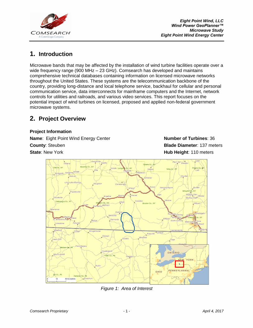
Name: Eight Point Wind Energy Center Number of Turbines: 36
County: Steuben Blade Diameter: 137 meters
State: New York Hub Height: 110 meters
Figure 1: Area of Interest
Eight Point Wind, LLC
Wind Power GeoPlanner™ Microwave Study
Eight Point Wind Energy Center
Comsearch Proprietary April 4, 2017 - 2 -
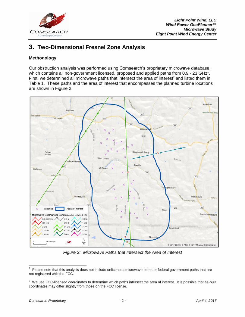
3. Two-Dimensional Fresnel Zone Analysis Methodology Our obstruction analysis was performed using Comsearch’s proprietary microwave database, which contains all non-government licensed, proposed and applied paths from 0.9 - 23 GHz1. First, we determined all microwave paths that intersect the area of interest2 and listed them in Table 1. These paths and the area of interest that encompasses the planned turbine locations are shown in Figure 2.
Figure 2: Microwave Paths that Intersect the Area of Interest
1 Please note that this analysis does not include unlicensed microwave paths or federal government paths that are
not registered with the FCC. 2 We use FCC-licensed coordinates to determine which paths intersect the area of interest. It is possible that as-built
coordinates may differ slightly from those on the FCC license.
Eight Point Wind, LLC
Wind Power GeoPlanner™ Microwave Study
Eight Point Wind Energy Center
Comsearch Proprietary April 4, 2017 - 3 -
ID Status Callsign 1 Callsign 2 Band Path Length
(km) Licensee
1 Licensed KDT80 WAT700 Upper 6 GHz 34.94 CNG Transmission Corporation
2 Licensed KGM77 KDT80 Upper 6 GHz 38.27 CNG Transmission Corporation
3 Licensed KGM77P WAT701 Upper 6 GHz 7.60 CNG Transmission Corporation
4 Licensed WQJM351 WNEY546 11 GHz 13.27 Potter County of (PA)
5 Licensed WQSX436 WQSX437 11 GHz 8.85 Uniti Fiber PEG, LLC
Table 1: Summary of Microwave Paths that Intersect the Area of Interest
(See enclosed mw_geopl.xlsx for more information and
GP_dict_matrix_description.xls for detailed field descriptions)
Verification of Coordinate Accuracy It is possible that as-built coordinates may differ from those on the FCC license. For this project, path ID 2 crosses within close proximity of the proposed turbines and the tower locations for this path will have a critical impact on the result. Therefore, we verified these locations using aerial photography. Both towers were found to be slightly off and were moved to their locations based on the aerial photos3.
Next, we calculated a Fresnel Zone for each path based on the following formula:
21
2117.3
dd
dd
F
nr
GHz
Where, r = Fresnel Zone radius at a specific point in the microwave path, meters n = Fresnel Zone number, 1 FGHz = Frequency of microwave system, GHz d1 = Distance from antenna 1 to a specific point in the microwave path, kilometers d2 = Distance from antenna 2 to a specific point in the microwave path, kilometers
3 See enclosed mw_geopl.shp and mw_geopl_fcc.shp for details.

Eight Point Wind, LLC
Wind Power GeoPlanner™ Microwave Study
Eight Point Wind Energy Center
Comsearch Proprietary April 4, 2017 - 4 -
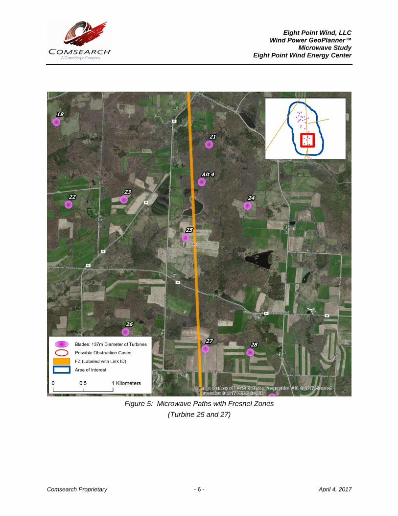
In general, this is the area where the planned wind turbines should be avoided, if possible. A depiction of the Fresnel Zones for each microwave path listed can be found in Figure 3 through Figure 5, and is also included in the enclosed shapefiles4,5.
Figure 3: Microwave Paths with Fresnel Zones
4 The ESRI® shapefiles enclosed are in NAD 83 UTM Zone 18 projected coordinate system.
5 Comsearch makes no warranty as to the accuracy of the data included in this report beyond the date of the report.
The data provided in this report is governed by Comsearch’s data license notification and agreement located at http://www.comsearch.com/files/data_license.pdf.

Eight Point Wind, LLC
Wind Power GeoPlanner™ Microwave Study
Eight Point Wind Energy Center
Comsearch Proprietary April 4, 2017 - 5 -
Figure 4: Microwave Paths with Fresnel Zones
(Turbine 13 and 15)
Eight Point Wind, LLC
Wind Power GeoPlanner™ Microwave Study
Eight Point Wind Energy Center
Comsearch Proprietary April 4, 2017 - 6 -
Figure 5: Microwave Paths with Fresnel Zones
(Turbine 25 and 27)

Eight Point Wind, LLC
Wind Power GeoPlanner™ Microwave Study
Eight Point Wind Energy Center
Comsearch Proprietary April 4, 2017 - 7 -
4. Conclusion
Total Microwave Paths
Paths with Affected Fresnel Zones
Total Turbines Turbines intersecting
the Fresnel Zones
5 0 36 0
Table 2: Fresnel Zone Analysis Result
Our study identified five microwave paths intersecting the Eight Point Wind Energy Center area of interest. The Fresnel Zones for these microwave paths were calculated and mapped in order to assess the potential impact from the turbines. A total of 36 turbines were considered in the analysis, each with a blade diameter of 137 meters and a hub height of 110 meters. Of those turbines, none were found to have potential obstruction with the microwave systems in the area.
5. Contact For questions or information regarding the Microwave Study, please contact:
Contact person: Denise Finney Title: Account Manager Company: Comsearch Address: 19700 Janelia Farm Blvd., Ashburn, VA 20147 Telephone: 703-726-5650 Fax: 703-726-5595 Email: [email protected] Web site: www.comsearch.com