winchester / paradise land use plan - clark county...winchester/paradise land use plan 2017 iii...
TRANSCRIPT
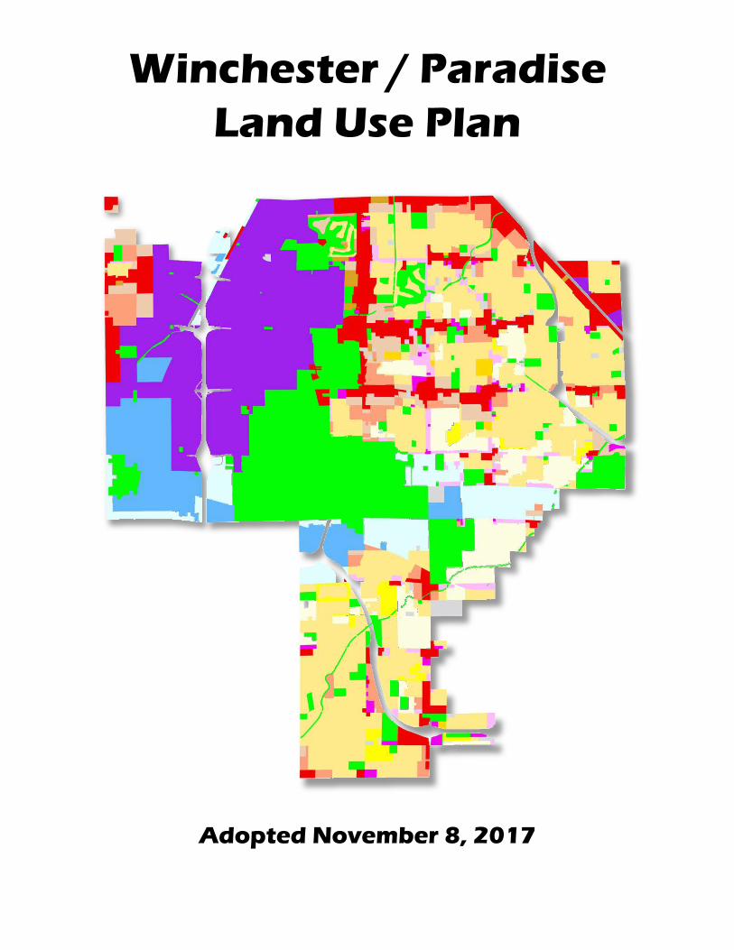
Winchester / Paradise Land Use Plan
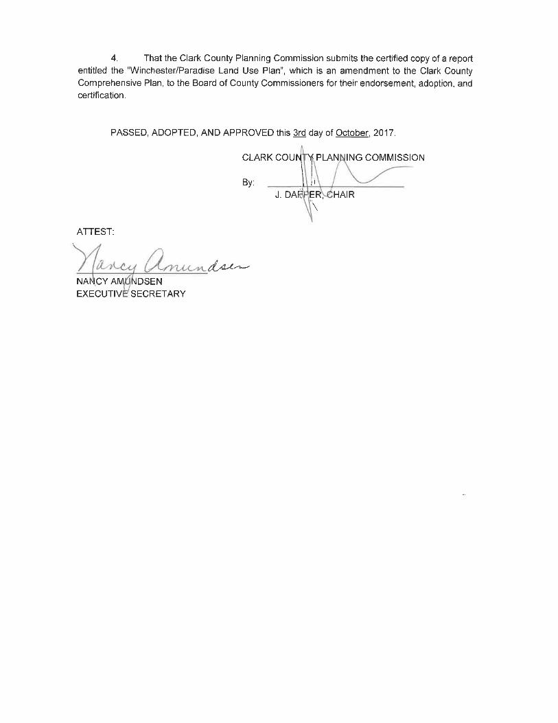
Adopted November 8, 2017

Winchester/Paradise Land Use Plan 2017 iii
Paradise Town Advisory Board: Susan Philipp, Chair Robert Orgill, Vice-Chair Bart Donovan Jon Wardlaw John Williams Maureen Helm, Secretary Blanca Vasquez, County Liaison Winchester Town Advisory Board: Kenneth Dayton, Chair Judith Perez, Vice-Chair John Delibos Michelle Fenwick Robert O. Mikes, Jr. Stephanie Hicks, Secretary Tamara Williams, County Liaison Office of County Manager: Yolanda King, Manager Randy Tarr, Assistant Manager Jeff Wells, Assistant Manager Kevin Schiller, Assistant Manager Department of Comprehensive Planning: Nancy Amundsen, Director Community Planning Team: Mario Bermudez, Planning Manager Shane Ammerman, Assistant Planning Manager Kevin Smedley, Principal Planner & Project Lead Paul Doerr, Senior Planner Chris LaMay, GIS Analyst Garrett TerBerg, Principal Planner Michael Popp, Sr. Management Analyst Ron Gregory, Trails Assistant Planning Manager Scott Hagen, Senior Planner
ACKNOWLEDGEMENTS
Clark County Board of Commissioners: Steve Sisolak, Chair Susan Brager, Vice-Chair Larry Brown Chris Giunchigliani Marilyn Kirkpatrick Mary Beth Scow Lawrence Weekly Planning Commission: J. Dapper, Chair Edward Frasier III, Vice-Chair Vivian Kilarski Steve Kirk Tom Morley Nelson Stone Donna Tagliaferrri

ii Winchester/Paradise Land Use Plan
Winchester/Paradise Land Use Plan 2017 v
TABLE OF CONTENTS Chapter 1 ....................................................................................................................... 1 State Law ................................................................................................................. 1 Background ............................................................................................................. 1 Purpose of the Plan ................................................................................................ 2 Planning Process .................................................................................................... 2 Chapter 2 – Existing Conditions ................................................................................. 3 Demographics ......................................................................................................... 4 Natural Conditions .................................................................................................. 8 Geologic Hazards .................................................................................................... 8 Natural Environment ............................................................................................... 9 Surface Hydology / Flood Control ...................................................................... 10 Utilities ..................................................................................................................... 11 Electric Service ..................................................................................................... 11 Solid Waste & Recycling ...................................................................................... 11 Natural Gas Service .............................................................................................. 11 Water Service ........................................................................................................ 12 Water Reclamation Service .................................................................................. 12 Facilities ..................................................................................................................... 14 Police - Metro ........................................................................................................ 14 Fire ..................................................................................................................... 14 Parks, Recreation and Open Space ..................................................................... 15 Libraries ................................................................................................................. 17 Public Schools ...................................................................................................... 18 Transportation ............................................................................................................ 19 Air Transportation ................................................................................................. 19 Surface Transportation ........................................................................................ 19 Mass Transit .......................................................................................................... 19 Monorail ................................................................................................................. 20 Other Land Use Considerations................................................................................ 21 Zoning .................................................................................................................... 21 Cooperative Management Area (CMA) ................................................................ 21 Overlay Districts & Redevelopment .................................................................... 22 District Plans ......................................................................................................... 24 Chapter 3 – Issues and Challenges .......................................................................... 27 Chapter 4 – Land Use ................................................................................................. 31 Land Use Categories ............................................................................................ 32 LAND USE MAP ............................................................... separate from document Glossary ..................................................................................................................... 40

vi Winchester/Paradise Land Use Plan
Winchester/Paradise Land Use Plan 2017 1
CHAPTER 1
STATE LAW The Nevada Revised Statutes (NRS) requires that all counties in Nevada, including Clark County, prepare and adopt a comprehensive, long-term master plan (comprehensive plan), that states, in part, “for the physical development of the city, county or region” (NRS §278.150). In order to fulfill this law, the Clark County Comprehensive Plan was adopted in December 1983. The Clark County Comprehensive Plan (the plan) may include a variety of subject matter ranging from community design and land uses to transportation. The Plan also established a policy for the creation of separate planning areas for unincorporated towns having Town Advisory Boards (TAB’s). This document is the land use plan for the Winchester/Paradise planning area. Although Winchester and Paradise function as separate towns, they are combined into one planning area having a single land use plan. The land use plan consists of goals, policies and maps, identifying general development patterns. This document is also in compliance with NRS §278.160(1)(g) and fulfills the land use plan element of the Comprehensive Plan.
BACKGROUND
The Winchester/Paradise planning area consists of approximately 30,233 acres or 47.2 square miles. The Winchester/Paradise planning area is generally bounded on the north by Sahara Avenue; on the south by Sunset Road and Silverado Ranch Road; and on the east by Nellis Boulevard and Eastern Avenue and on the west by Decatur Boulevard and Bermuda Road. This planning area contains some of the most urbanized and completely developed areas in the Las Vegas Valley, without having any areas designated as open space. Data from 2016 shows the majority of the population is concentrated east of Las Vegas Boulevard. Land uses consist of a combination of single and multi-family residences, commercial and industrial development, as well as a concentration of hotels and casinos along Las Vegas Boulevard. In December 1950, the unincorporated town of Paradise was created. In 1951 the town of Paradise (A) was created, followed by Paradise (B) in January 1952. In October 1953 Paradise (A) was renamed Winchester, and Paradise (B) became Paradise. In August 1973 a Citizens Advisory Council was created. Adjustments were made to the town boundaries in January of 1973, January 1976, and March 1976. In November 1979, the Winchester Town Advisory Board
2 Winchester/Paradise Land Use Plan 2017
was created followed by the establishment of the Paradise Town Advisory Board in December 1979.
PURPOSE OF THE PLAN The Winchester/Paradise Land Use Plan provides a guide for decisions by the Winchester and Paradise Town Advisory Boards (TABs), Planning Commission (PC), and Board of County Commissioners (BCC) concerning growth and development. While it is to be used by policy makers to guide their decisions, it also serves as a reference for the private sector in making informed decisions. The land use plan map provides for the development of compatible land uses within a general development pattern and is intended to be used with the guidance of the goals and policies in the land Use Element of the Comprehensive Plan.
PLANNING PROCESS The planning process for the creation of a land use plan consists of four important steps. These steps are: 1) Development of a Draft Plan; 2) Adoption of the Plan; and 3) Monitoring and Evaluation of the Adopted Plan. There is a strong emphasis on public involvement throughout the planning process. Development of a Draft Plan Following initial open house workshops, County staff prepared a concept plan. This concept plan is a conceptual representation of appropriate land use patterns in the planning areas and functions as a base map/starting point from which staff may work to develop a more refined plan. It consists of adjustments to the land use map. Next, meetings with the service providers (Technical Advisory Group or TAG) were conducted to discuss the concept plan. After consideration and refinement of the concept plan by the communities, and TAG, additional Open Houses were held for property owners and interested citizens to review and provide additional input on the draft and adoption of the Plan. Adoption During the adoption step, the draft plan was presented through the public hearing process for final refinements. The public hearing process consisted of a review and a recommendation by the Winchester and Paradise TABs. The Draft Plan was then presented to the PC for recommendation and the Certified Draft was then presented to the BCC for adoption. Evaluation and Monitoring The final step is the on-going evaluation and monitoring of the plan by county staff with input from the Winchester and Paradise TABs, PC and BCC.
Winchester/Paradise Land Use Plan 2017 3
CHAPTER 2
EXISTING CONDITIONS The Existing Conditions were analyzed to provide development potential and constraints in Winchester and Paradise. This includes information on the natural and built environments, public facilities service conditions, and population. A summary of the material evaluated is included in this chapter. Information was collected in 2016 and early 2017. Individually, each known topic may not significantly limit community development. However, when combined with other factors, critical areas of opportunity or concern will appear. This information has been used to determine the development constraints and opportunities within the Winchester/Paradise Land Use Plan and constitutes a rational process in the identification of issues and the development opportunities for the community. The natural conditions existing in the developable areas of Winchester and Paradise present few constraints that cannot be mitigated through engineering. Several conditions such as the severe slope areas in and along flood plains, the subsidence faults in the planning area, as well as the flood zones directly adjacent to the washes that traverse Winchester/Paradise may constrain certain types of development. Clark County is divided into six Community Districts in order to establish alternative development standards particularly suited for different geographic areas. Winchester/Paradise is within Community Districts One and Two. District One is defined as a “regional economic base and employment center” and District Two is defined as “the urban growth area.” These District designations indicate that there are sufficient services for development. The Winchester and Paradise planning areas consist of approximately 30,233 developable acres or 47.2 square miles. As of June 2017, Winchester and Paradise have approximately 27,842 developed acres or approximately 92% of the planning area.
4 Winchester/Paradise Land Use Plan 2017
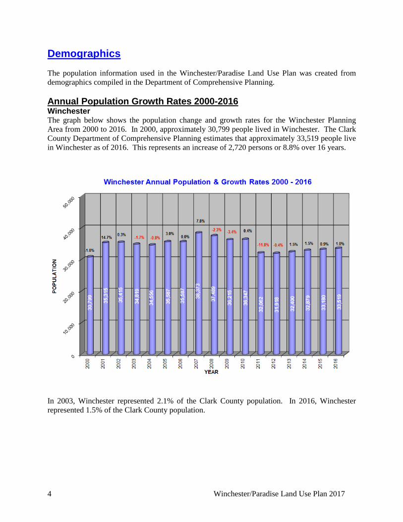
Demographics The population information used in the Winchester/Paradise Land Use Plan was created from demographics compiled in the Department of Comprehensive Planning. Annual Population Growth Rates 2000-2016 Winchester The graph below shows the population change and growth rates for the Winchester Planning Area from 2000 to 2016. In 2000, approximately 30,799 people lived in Winchester. The Clark County Department of Comprehensive Planning estimates that approximately 33,519 people live in Winchester as of 2016. This represents an increase of 2,720 persons or 8.8% over 16 years.
In 2003, Winchester represented 2.1% of the Clark County population. In 2016, Winchester represented 1.5% of the Clark County population.
Winchester/Paradise Land Use Plan 2017 5
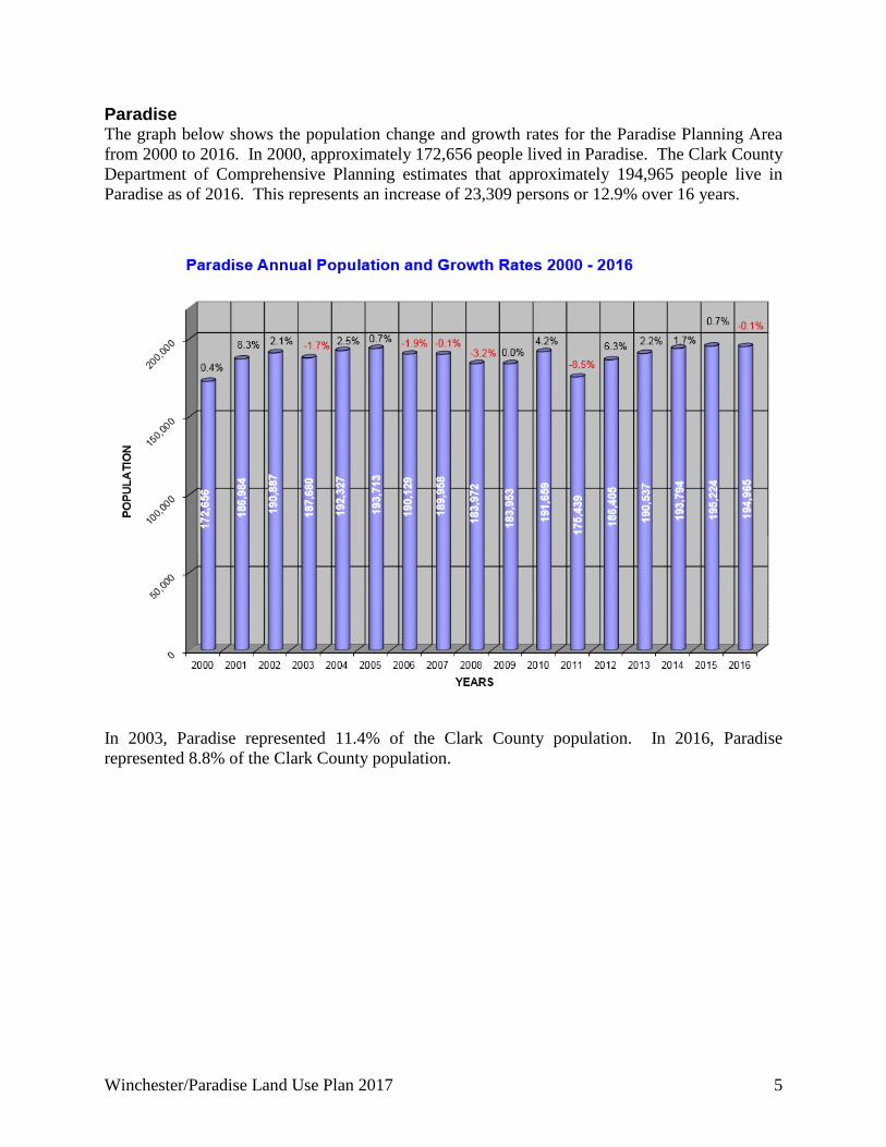
Paradise The graph below shows the population change and growth rates for the Paradise Planning Area from 2000 to 2016. In 2000, approximately 172,656 people lived in Paradise. The Clark County Department of Comprehensive Planning estimates that approximately 194,965 people live in Paradise as of 2016. This represents an increase of 23,309 persons or 12.9% over 16 years.
In 2003, Paradise represented 11.4% of the Clark County population. In 2016, Paradise represented 8.8% of the Clark County population.
6 Winchester/Paradise Land Use Plan 2017
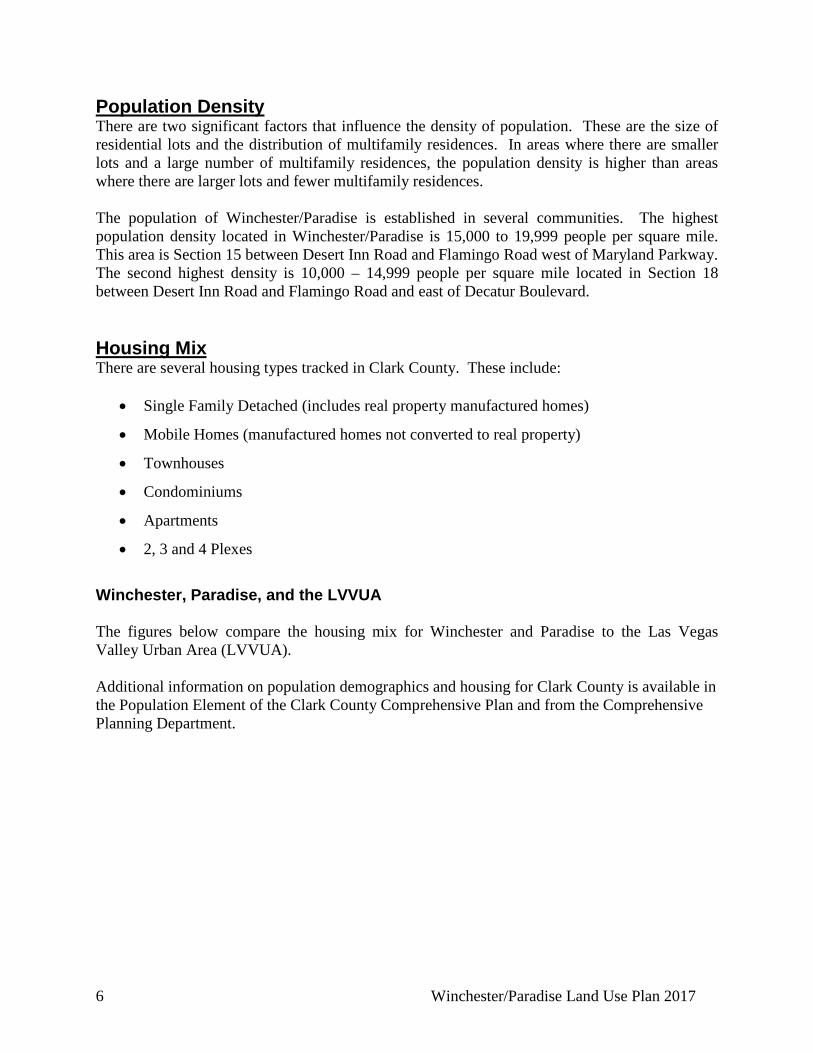
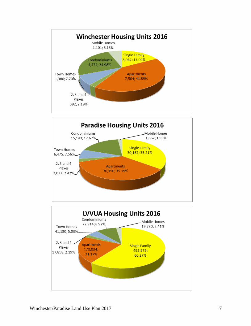
Population Density There are two significant factors that influence the density of population. These are the size of residential lots and the distribution of multifamily residences. In areas where there are smaller lots and a large number of multifamily residences, the population density is higher than areas where there are larger lots and fewer multifamily residences. The population of Winchester/Paradise is established in several communities. The highest population density located in Winchester/Paradise is 15,000 to 19,999 people per square mile. This area is Section 15 between Desert Inn Road and Flamingo Road west of Maryland Parkway. The second highest density is 10,000 – 14,999 people per square mile located in Section 18 between Desert Inn Road and Flamingo Road and east of Decatur Boulevard. Housing Mix There are several housing types tracked in Clark County. These include:
• Single Family Detached (includes real property manufactured homes)
• Mobile Homes (manufactured homes not converted to real property)
• Townhouses
• Condominiums
• Apartments
• 2, 3 and 4 Plexes
Winchester, Paradise, and the LVVUA The figures below compare the housing mix for Winchester and Paradise to the Las Vegas Valley Urban Area (LVVUA). Additional information on population demographics and housing for Clark County is available in the Population Element of the Clark County Comprehensive Plan and from the Comprehensive Planning Department.
Winchester/Paradise Land Use Plan 2017 7
8 Winchester/Paradise Land Use Plan 2017
Natural Conditions Geological Hazards Soils The U.S. Department of Agriculture survey identifies the potential and limitations of soil types. Soils within the Las Vegas Valley are primarily erosion remnants (sand, silt, etc.) from the surrounding mountains that have been deposited by flowing water to form alluvial fans. Soil related corrosion is a concern in Winchester/Paradise. Corrosion potential for uncoated steel and concrete could be high within the Drainage Soils. The Department of Development Services requires on-site soil analysis of proposed development sites in order to provide site-specific information that Soil Survey maps do not show. Slopes Slopes are an important planning consideration that can highly impact the cost of construction. Generally, public roads exceeding 12% are not approved based on inaccessibility of public services such as garbage and recycling pick-up and fire service. Slopes of 12% or greater may be graded to make it possible for road construction. Development in areas with severe slopes can be very expensive and is not recommended. Faults, slopes, and material corrosion are only a few points of potential problems which may arise due to development in inappropriate areas. Such problems could be mitigated through planning and more appropriate development choices on those sites. Faults Multistory level development in areas with soluble and clay material may not be suitable without appropriate engineering. The Federal Housing Administration (FHA) requires engineering studies and the development of possible mitigation measures for residential projects requesting federally-insured mortgages and located within 500 feet of a fault. There are several known fault areas in the northeast part of the planning area. Additional information on soils, faults, and slopes can be found in the Multiple Species Habitat Conservation Plan; Task One: Existing Conditions, Comprehensive Plan for Clark County Nevada; Conservation Element, Clark County Comprehensive Plan; and Clark County GIS Management Office.
Winchester/Paradise Land Use Plan 2017 9
Natural Environment Many federal and state agencies follow environmental laws and policies. In 1995, Clark County moved forward with the development of a Multiple Species Habitat Conservation Plan (MSHCP). Map 2 displays the various conservation areas within Winchester and Paradise. Clark County, as Plan Administrator and on behalf of our fellow permittees the cities of Las Vegas, Henderson, North Las Vegas, City of Boulder City, Mesquite and the Nevada Department of Transportation (NDOT), is responsible for compliance with the federal Endangered Species Act, compliance with a Section 10(a) (1) (B) incidental take permit (ITP), and for implementing the MSHCP. The MSHCP’s 10(a)(1)(B) ITP covers all non-Federal (private, municipal, State), lands within Clark County and NDOT activities within Clark, Nye and Esmeralda Counties south of the 38th parallel and below 5,000 feet in elevation. The Clark County MSHCP provides conservation for 78 species of plants and animals, including the desert tortoise and their habitats. The regulations for this mitigation are established in the Unified Development Code (Title 30, Sections 30.32 and 30.80). The ITP requires a mitigation fee. This fee is used to implement the MSHCP. Additional information can be found in the Clark County Multiple Species Habitat Conservation Plan; Task One: Existing Conditions, Comprehensive Plan for Clark County Nevada; Conservation Element, Comprehensive Plan for Clark County Nevada; and Clark County GIS Management Office.
10 Winchester/Paradise Land Use Plan 2017
Surface Hydrology Floods are natural events that may become a problem when urban and rural development competes with natural tributaries for use of the floodplain. Land inside of these washes is not suitable for development. The weather and topography of this area contribute to the creation of 100-year floodplains that are capable of causing death, personal injury, and/or property damage. To reduce flood hazards, the Federal Emergency Management Agency (FEMA) requires developments located in the 100-year floodplain to be protected by physical structures and insurance. The physical structures that are used to control flood hazards are drainage facilities. Drainage facilities are man made structures and include detention basins and conveyance systems. These facilities allow for land to be developed in and around flood zones. The Town of Winchester is traversed by the Flamingo Wash in the east. The Town of Paradise is traversed by four major washes and their tributaries. Flamingo Wash and Tropicana Wash pass from west to east through the center of Paradise. Duck Creek Wash and Pittman Wash cross through southern Paradise Additional information on surface hydrology can be found in the Clark County Regional Flood Control Master Plan; Conservation Element of the Clark County Comprehensive Plan; and Clark County GIS Management Office. Flood Control The Clark County Regional Flood Control District’s (CCRFCD) recommended Master Plan projects are a combination of detention and conveyance structures, designed to detain 100 year flow streams long enough to reduce downstream flows. For information on this program contact CCRFCD. The CCRFCD has adopted Uniform Regulations for the control of drainage. These regulations include land development policies and construction procedures regarding drainage. The agency responsible for enforcing these regulations in the planning area is the Clark County Department of Public Works, Development Review Division Services. Guidelines for submitting drainage studies and standards for drainage facilities can be obtained from the Regional Transportation Commission of Southern Nevada. Although a factor, drainage is not a primary concern when determining land use. Both the CCRFCD’s existing and planned improvements and CCDS guidelines allow for land in Winchester and Paradise to be developed in and around flood zones. Additional information on flood control may be found in the CCRFCD Master Plan; Conservation Element of the Clark County Comprehensive Plan; and Clark County GIS Management Office.
Winchester/Paradise Land Use Plan 2017 11
UTILITIES Electric Service NV Energy provides electricity to Winchester and Paradise through a series of major and minor service lines. NV Energy has the ability to supply existing and future development through their expanding system. There are no constraints on land use associated with electrical facilities in Winchester or Paradise at this time, other than incompatible uses directly adjacent to major facilities. NV Energy is a private utility company regulated by the State of Nevada. Services to new developments are determined by agreements between NV Energy and individual developers. For future expansion plans and history of electrical service, contact NV Energy. Solid Waste & Recycling All communities in the Winchester/Paradise Planning Area have curbside pick-up provided by an independent hauler under contract to Clark County. The refuse is then taken to the APEX Regional Waste Management Center located in the Northeast Clark County Planning Area. Natural Gas Service Transmission Southwest Gas (SWG) has several natural gas pipelines through the Winchester/Paradise Planning Area. Service Southwest Gas (SWG) provides natural gas service to Winchester and Paradise through a series of major and minor service lines. SWG has the ability to supply existing and future development through their expanding system. There are no constraints on land use associated with natural gas facilities in Winchester or Paradise at this time, other than incompatible uses directly adjacent to major facilities. Southwest Gas is a private utility company regulated by the State of Nevada. Services to new developments are determined by agreements between Southwest Gas and individual developers. For future expansion plans and a history of natural gas service, contact SWG.
12 Winchester/Paradise Land Use Plan 2017
Water Service Municipal Water The Las Vegas Valley Water District (LVVWD) provides water to Winchester and Paradise through a series of service lines, reservoirs and pressure zones. The water district has the ability to supply existing and future development through their expanding system. As the water district expands their service lines and facilities, development will follow. There are some service constraints on land use associated with the water supply facilities in Paradise at this time. Some of Paradise is undeveloped resulting in large areas of the planning area being unserviceable for potable water at this time. Developers have the responsibility for adequate water services to new development. The Winchester/Paradise Planning Area is within the Colorado River Basin. This basin is divided into 27 hydrographic areas. The areas applicable hydrographic area for this plan is the Las Vegas Valley (Basin 212). For future expansion plans and a history of the water district, contact the LVVWD. Community and Private Wells There are three community public water systems in the Winchester/Paradise Planning Area. Two are located near the northwest corner of Pecos Road and Warm Springs Road in a residential subdivision. The third well is west boulder highway near the Vegas Valley Drive alignment in a manufactured home park. The Wellhead Protection Report for the Clark County Comprehensive Plan discourages certain uses within 3,000 feet of these wellheads to reduce potential contamination of the water supply. Some areas of Paradise developed before public water service. These areas have private wells. Community and private wells are regulated by the Nevada State Engineer. More information about wells is available through the Nevada Department of Conservation and Natural Resources. Water Reclamation Service The Clark County Water Reclamation District (CCWRD) provides sanitary sewer service. For future expansion plans, operations information or a history, contact CCWRD. Their main facility is located at the east end of Flamingo Road. An ancillary facility is located at Desert Breeze Park near Flamingo and Durango. The Desert Breeze Water Resource Center is a joint project between CCWRD and the LVVWD. This facility supplies non-potable reclaimed water to golf courses and green belt areas for use in lieu of potable water. The remaining waste material from this center is then transported to the Flamingo facility through the regular sanitary sewer line for final processing.
Winchester/Paradise Land Use Plan 2017 13
Established neighborhoods within Winchester/Paradise that operate on individual sewage disposal systems (septic systems) are regulated by the Southern Nevada Health District (SNHD). More information about septic systems is available from them.
14 Winchester/Paradise Land Use Plan 2017
FACILITIES
Miscellaneous Facilities Police - Metro The agency responsible for providing police protection in the Winchester/Paradise Planning Area is the Las Vegas Metropolitan Police Department (METRO). METRO was formed by the Legislature in 1972 by merging the Clark County Sheriff’s Office and the Las Vegas Police Department. Both Clark County and the City of Las Vegas are responsible for funding METRO. Map 5 shows the location of all existing police stations in the immediate planning area. For more information, contact METRO. Fire Public safety is of vital importance to every citizen and visitor in Clark County and is one of the most fundamental and valuable services provided by government. The key factor in minimizing loss of life and reducing property damage is the ability to quickly deliver sufficient personnel and equipment to the site of the fire or emergency medical incident. Therefore, it is critical for fire units to have the lowest possible response time to when emergencies occur. Response time encompasses the travel distance required to get to the site and the availability of personnel and equipment to respond. The Clark County Fire Department (CCFD) provides fire protection and emergency medical response to Winchester/Paradise. The Clark County Fire Training Center is located at 4425 W. Tropicana Avenue. Fire Station 13 only responds to McCarran International Airport calls. Also, the City of Henderson has one station in the proximity of the Winchester/Paradise Planning Area. Henderson 98 is located at 891 Coronado Center Drive. More dense or intense land uses should not occur outside fire response areas. CCFD service delivery should be taken into account when new developments are proposed in areas where proposed fire stations are not yet built. For additional information on fire response, risk, and operations, contact Clark County Fire Department. For more information about the City of Henderson Fire Department, contact them.
Winchester/Paradise Land Use Plan 2017 15
Parks, Recreation and Open Space Facilities Public Park Facilities In Winchester and Paradise, Clark County provides a diverse system of public parks, trails and open space facilities. These facilities are managed through the Parks & Recreation Department and the Department of Real Property Management. Clark County has a goal of 2.5 acres of park land per 1,000 residents for the Urban Valley. Therefore, as of the last population count, Winchester and Paradise population would necessitate a minimum of 571 acres of parks. Winchester and Paradise currently have 374 acres of developed park land. There are two parks in Winchester, with a total of 18 acres and 17 parks in Paradise, accounting for 356 acres, with the majority of those acres in Sunset Regional Park. Park Level of Service Clark County has level of service (LOS) standards for each park facility type. These standards help in the determination of which facilities and locations are most in need of construction, remodeling and funding. Winchester and Paradise residents enjoy a nineteen (19) park facilities, two of which are in Winchester and the other 17 are in Paradise. Paradise currently maintains a LOS of 1.8 acres per 1,000 residents, whereas Winchester only maintains a LOS of 0.5 acres per 1,000 residents. Details of the existing parks and other recreation facilities are described and listed in the table below. Other Recreation Facilities There are private parks, common areas and leisure facilities in Winchester/Paradise. These include private parks, swimming pools at the local resort hotels and golf courses. There is no current information regarding the number and acreage of private parks and swimming pools. Private parks and leisure facilities are not included in the level of service for parks and recreation facilities for Clark County. There are several private golf courses within the Winchester/Paradise Planning Area. The Las Vegas National Golf Course is located on the southwest corner of Desert Inn Road and Eastern Avenue. The Las Vegas Country Club is located on the northwest corner of Karen Avenue and Maryland Parkway. The Wynn Golf Club is associated with Wynn Resort on the southeast corner of Las Vegas Boulevard South and Desert Inn Road. Also, the Bali Hai Golf Club on the southwest corner of Las Vegas Boulevard and Russell Road. Trail Facilities and Standards The Clark County Trails Program facilitates the development of recreational trail systems in urban and rural areas of the County to provide recreational opportunities, alternative off-street transportation options, and access from urban areas to federal lands for residents and visitors to Clark County. Trail Development Standards were adopted with the Trails Element on October 18, 2005. This document provides basic design and construction standards used to build trails, to accommodate trail users, and to minimize maintenance and environmental impacts. For more information about trails contact the Department of Comprehensive Planning.
16 Winchester/Paradise Land Use Plan 2017
Land Use Considerations The Clark County Parks, Trails and Open Space Report contains policies relating to parks and trails throughout Clark County. As the population continues to grow in Winchester and Paradise additional parks, trails and related amenities will be needed. For more information on parks, trails and open space, please contact the Advanced Planning Division of Clark County Comprehensive Planning or the Clark County Parks & Recreation Department.
Winchester and Paradise Existing Public Park Facilities
Park Facility Year Location Acres Facilities Offered
Cannon Middle School Park 1977 Euclid & Russell 8 Ball Fields, Open Turf, Tennis & Basketball Courts
Cashman Middle School Park (Winchester) 1967 Cameron &
Desert Inn 9 Ball Fields, Open Turf, Tennis & Basketball Courts, Picnic Areas, Covered Playgrounds, and Restrooms
Desert Bloom Park 1998 Maryland & Wigwam 20
Ball Fields, Open Turf, Basketball & Sand Volleyball Courts, Picnic Areas, Covered Playgrounds, Walking Path, and Restrooms
Desert Inn Park 1972 Vista Del Monte & Mar Vista Way 4 Open Turf, Picnic Areas, Covered Playgrounds,
Walking Path, Dog Runs, Splash Pad and Restrooms
Duck Creek Park 2002 Pollock & Wigwam 15
Open Turf, Basketball & Tennis Courts, Bocce Ball Courts, Horseshoes, Picnic Areas, Covered Playgrounds, Skate Park, Splash Pad, Walking Paths and Restrooms
Grapevine Springs Park 1997 Palm & Hacienda 5 Sand Volleyball Court, Picnic Areas, Covered Playgrounds, Horseshoes, Exercise Equipment, Dog Runs, Walking Path and Restrooms
Harmony Park 2001 Pearl & Harmon 1 Picnic Areas, Covered Playgrounds, Exercise Equipment, and Walking Path
Hidden Palms Park 1994 Hidden Palms & Pebble 7
Little League Ball Fields, Basketball & Tennis Courts, Sand Volleyball, Picnic Areas, Exercise Equipment, and Covered Playgrounds
Maslow Park 1969 Nellis & Pancho Villa Drive 4 Ball Field, Picnic Areas, Covered Playgrounds, Splash
Pad, Walking Path and Restrooms McCarran Marketplace
Park 2007 Surrey & Russell 8 Soccer Fields, Picnic Area, Covered Playgrounds and Restrooms
Molasky Family Park 2004 Cambridge & Twain 9
Open Turf, Picnic Areas, Sand Volleyball, Covered Playgrounds, Splash Pad, Exercise Equipment, Dog Runs, Walking Course and Restrooms
Myrna Torme Williams Campus Park &
Cambridge Center 2000 Cambridge &
Katie 7 Community Center, Picnic Areas, Covered Playgrounds, Skate Park and Outdoor Play Pool
Orr Middle School Park 1995 Spencer & Twain 10 Ball Fields, Open Turf, Basketball Courts, Picnic Area and Covered Playground
Paradise Park & Community Center
1964 / 1977
McLeod & Tropicana 21
Community Center, Ball Field, Open Turf, Basketball & Tennis Courts, Picnic Areas, Covered Playgrounds, Exercise Equipment, Outdoor Play Pool, Walking Path and Restrooms
Paradise Vista Park 1973 Stirrup & Roan Ave. 4 Open Turf, Picnic Areas, Covered Playgrounds and
Restrooms
Winchester/Paradise Land Use Plan 2017 17
Pebble Park 2007 Topaz & Pebble 7 Open Turf, Picnic Areas, Covered Playgrounds, Splash Pad and Walking Path
Siegfried and Roy Park 2015 Maryland & Russell 20
Open Turf, Public Art, Tennis Courts, Horseshoes, Bocce Ball, Picnic Areas, Splash Pad, Walking Paths and Restrooms
Sunset Regional Park 1967 / 2013 Eastern & Sunset 206
Ball Fields, Open Turf, Events Plaza, Administration Offices, Lake for Fishing and RC Boats, Disc Golf Course, Basketball and Tennis Courts, Sand Volleyball, Horseshoes, Dog Parks, Fitness Course, Picnic Areas, Covered and Themed Playgrounds, Splash Pad, Exercise Equipment, Dog Runs, Walking Path, Trails and Natural Preservation Areas, Memorials, and Restrooms
Winchester Park & Cultural Center (Winchester)
1981 Desert Inn & McLeod 9
Cultural Center, Open Turf, Botanical and Community Gardens, Performing Arts Facilities, Basketball and Tennis Courts, Picnic Areas, Covered Playgrounds, Skate Park, Splash Pad, Exercise Equipment, and Walking Path
Total Developed Acreage 374 Libraries The Las Vegas-Clark County Library District (LVCCLD) plays an important role in unincorporated Clark County, the City of Las Vegas, the City of Mesquite and parts of Henderson and North Las Vegas through 24 urban, suburban and rural branches. The library district is funded through property taxes, sales taxes and user fees. It is a separate municipal corporation from Clark County governed by a Board of Trustees. The district officially formed in 1985, although the Las Vegas Library District and the Clark County Library District had been operating as one consolidated library system since 1973. The provision for library services does not restrict the growth or land uses in Winchester/Paradise. Population growth will lead to higher circulation numbers for the existing system. More facilities may be needed to keep up with the level of service adopted by the LVCCLD. Currently, the LVCCLD has one site within the planning area. The Clark County Library located on the southeast corner of Flamingo Road and Escondido Road. This facility has a conference room, board room, meeting room, study room, Jewel Box Theater, story-time room, theater, gallery, and photographic gallery. For more information, contact LVCCLD.
18 Winchester/Paradise Land Use Plan 2017
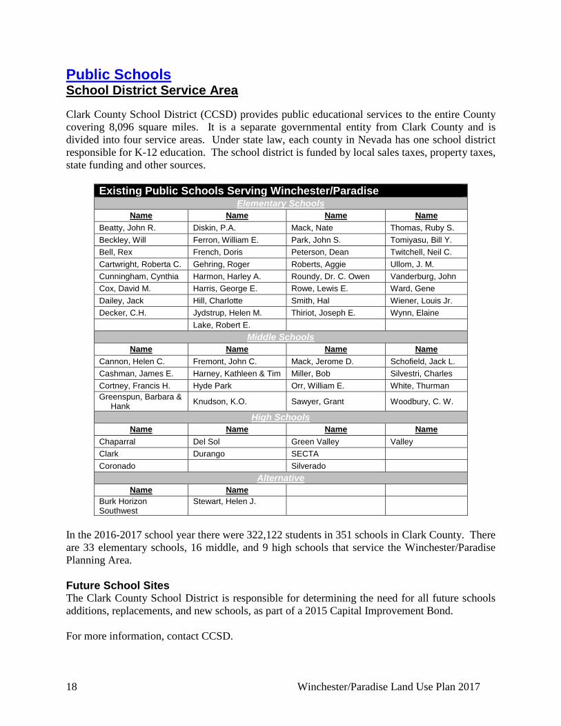
Public Schools School District Service Area Clark County School District (CCSD) provides public educational services to the entire County covering 8,096 square miles. It is a separate governmental entity from Clark County and is divided into four service areas. Under state law, each county in Nevada has one school district responsible for K-12 education. The school district is funded by local sales taxes, property taxes, state funding and other sources.
Existing Public Schools Serving Winchester/Paradise Elementary Schools
Name Name Name Name Beatty, John R. Diskin, P.A. Mack, Nate Thomas, Ruby S. Beckley, Will Ferron, William E. Park, John S. Tomiyasu, Bill Y. Bell, Rex French, Doris Peterson, Dean Twitchell, Neil C. Cartwright, Roberta C. Gehring, Roger Roberts, Aggie Ullom, J. M. Cunningham, Cynthia Harmon, Harley A. Roundy, Dr. C. Owen Vanderburg, John Cox, David M. Harris, George E. Rowe, Lewis E. Ward, Gene Dailey, Jack Hill, Charlotte Smith, Hal Wiener, Louis Jr. Decker, C.H. Jydstrup, Helen M. Thiriot, Joseph E. Wynn, Elaine Lake, Robert E.
Middle Schools Name Name Name Name
Cannon, Helen C. Fremont, John C. Mack, Jerome D. Schofield, Jack L. Cashman, James E. Harney, Kathleen & Tim Miller, Bob Silvestri, Charles Cortney, Francis H. Hyde Park Orr, William E. White, Thurman Greenspun, Barbara &
Hank Knudson, K.O. Sawyer, Grant Woodbury, C. W.
High Schools Name Name Name Name
Chaparral Del Sol Green Valley Valley Clark Durango SECTA Coronado Silverado
Alternative Name Name
Burk Horizon Southwest
Stewart, Helen J.
In the 2016-2017 school year there were 322,122 students in 351 schools in Clark County. There are 33 elementary schools, 16 middle, and 9 high schools that service the Winchester/Paradise Planning Area. Future School Sites The Clark County School District is responsible for determining the need for all future schools additions, replacements, and new schools, as part of a 2015 Capital Improvement Bond. For more information, contact CCSD.
Winchester/Paradise Land Use Plan 2017 19
TRANSPORTATION The Winchester/Paradise planning area is located on several maps in the Transportation Element. It can be found on Maps 1.1 Las Vegas Valley (NW), 1.2 Las Vegas Valley (NE), 1.3 Las Vegas Valley (SW), Map 1.4 Las Vegas Valley (SE), and Map 13 Public Pedestrian Grade Separations and Transit Stations. Air Transportation McCarran International Airport (LAS) was first established as McCarran Field in 1948. At that time the airport served 4 airlines and averaged 12 flights a day. More than 47,490,000 passengers were served in 2016. McCarran is operated by the Clark County Department of Aviation (CCDOA). New facilities are continually being added to meet increasing passenger demand. The completion of Terminal 3 will permit over 53,000,000 passengers to be served at LAS at a sustained level of service. Surface Transportation The Winchester/Paradise Planning Area has a surface transportation network that is somewhat consistent with a series of Arterial, Collector and Local streets following the Las Vegas square mile grid pattern. Arterial streets vary in right-of-way width from 100 to 150 feet, collectors are typically 80 feet, and local streets are anything less than 80 feet. Arterials and Collectors provide higher traffic capacity than local streets and are more appropriate locations for intense land uses with traffic distributed throughout the network. The right-of-way width and functional class for the Freeway, Arterial and Collectors in the Winchester/Paradise Planning area are consistent with the adopted Clark County Transportation Element and Clark County Public Works design criteria. All Capital Improvement Projects (CIPs) are planned, designed and constructed by Clark County Public Works. Interstate-15 (I-15) extends from Sunset Road to Sahara Avenue through western Winchester and Paradise and serves as the main access route for visitors to the Las Vegas Strip driving in from Southern California. Interstate-515 traverses the east portions of Winchester and Paradise. Interstate-215 traverses east/west through the southern section of Paradise. The Desert Inn Super Arterial extends from Valley View to Paradise Road and allows east-west traffic to bypass Las Vegas Blvd as well as I-15. Mass Transit The RTC has a Long Range Transit Plan. The purpose of this plan is to analyze and prioritize practical transit alternatives and identify future transit corridors. This long range plan may ultimately have an effect on some of the arterial systems within the Winchester/Paradise planning area.
20 Winchester/Paradise Land Use Plan 2017
Monorail The Las Vegas Monorail travels from Tropicana Avenue to Sahara Avenue in the Sahara Avenue. Possible expansion of the monorail would help move people within the resort corridor without adding to traffic congestion. For additional information on transportation and transit projects, contact Clark County Public Works Department, Regional Transportation Commission or the Las Vegas Monorail.
Winchester/Paradise Land Use Plan 2017 21
OTHER LAND USE CONSIDERATIONS Zoning Title 30, the Clark County Unified Development Code, is the implementation tool of the Comprehensive Plan of Clark County. It is adopted under the authority of Chapter 278 (Planning and Zoning) of the Nevada Revised Statutes (NRS). It sets forth the regulations that govern the subdivision, use, and/or development of land, divides the county into Zoning Districts, and sets forth the regulations pertaining to such districts. The Official Zoning Maps are maintained by Clark County Department of Comprehensive Planning. The Official Zoning Map can be changed at every BCC meeting. To check the current zoning of a parcel, contact Department of Comprehensive Planning. Cooperative Management Area (CMA) The CMA was established in 1992 to define land uses that are compatible and incompatible with the McCarran International Airport (LAS) and its associated aircraft operations, and as a result has implications to future land uses within the CMA. The Southern Nevada Public Land Management Act (SNPLMA) of 1998 transferred approximately 5,226 acres of federal land to Clark County. Under the terms of the SNPLMA, only land uses deemed compatible with the CMA will be permitted on those lands acquired by Clark County. Ideally, much of the CMA should develop as a multi-use employment and activity center for office, light manufacturing, service, and retail uses. As defined by the McCarran International Airport’s Airport Environs Overlay District (AEOD), residential uses are incompatible with high levels of aircraft noise. Therefore, residential uses are not encouraged within the CMA. However, residential land uses are used on the land use plan map inside of the CMA. Residential land uses are only used to address existing residential land uses and residential zoning as of April 2000, and residential land uses may not occur on deed restricted parcels or be within the AE-65 Airport Overlay Noise Zone (or greater). The following uses are deemed incompatible by the Cooperative Management Agreement and are prohibited on the parcels acquired from the BLM. Incompatible uses include, but are not limited to: Residential Uses of any Density Transient Lodging (hotels, motels, resorts, trailer parks, etc.) Hospitals Churches Care Centers and Nursing Homes Concert Halls, Outdoor Sports Arenas and Auditoriums Group Quarters Amusement Parks
22 Winchester/Paradise Land Use Plan 2017
Zoos Schools
It is also important to note that the land use limitations imposed by the CMA apply only to those properties acquired by Clark County. All privately owned properties within the CMA may be developed in accordance with the adopted Winchester/Paradise Land Use Plan and applicable Clark County land use regulations. OVERLAY DISTRICTS & REDEVELOPMENT Additional information about existing overlay districts in Title 30. Adult Use Overlay The Adult Use Overlay delineates appropriate locations for adult uses. Restricting these uses to specific areas helps to minimize the possible secondary effects of adult uses on nearby public and private property, and to protect existing communities from incompatible uses. Secondary effects are defined as the blighting or downgrading of the surrounding neighborhood, increased crime in the area, and exposure to non-First Amendment expressions. The overlay area extends generally from Interstate-15 west to Arville Street and from Desert Inn Road south to a line 660 feet north of Sunset Road. Airport Environs Overlay District The Airport Environs Overlay District provides for a range of compatible uses within the airport accident hazard and exposure areas by prohibiting the development of incompatible uses that are detrimental to the general health, safety and welfare. The overlay also requires some structures to contain noise attenuated construction to minimize the impacts from the normal operation of McCarran International Airport (LAS) within the planning area. Asian Design Overlay District The Asian Overlay protects and maintains the Asian character and cultural heritage of existing and proposed developments by implementing additional design standards that unify appropriate physical and architectural elements. This overlay focuses along the Spring Mountain Road corridor west of Valley View Boulevard between Desert Inn Road and Twain Avenue. Gaming Enterprise District (GED) The GED identifies the areas for potential expansion of gaming activities and to identify those areas not suitable for gaming, avoiding incompatible development with residential, schools, or place of worship uses and developments from resort hotels and the impacts associated with such intense uses. This overlay typically includes property along the Las Vegas Boulevard Corridor. Mixed Use Overlay District (MUD) The MUD identifies areas which are supported or will be supported by sufficiently adequate infrastructure to allow more intensive and/or interactive forms of development. Mixed Use developments often combine retail and residential in a single structure and will allow for a live-
Winchester/Paradise Land Use Plan 2017 23
work situation while providing pedestrian amenities and are often located adjacent to transit corridors. Residential Neighborhood Overlay District (RNP) The Residential Neighborhood Preservation Overlay District (RNP) preserves large lots and ensures that residential development is maintained. While there are many areas in the Winchester/Paradise planning with large lots, there is currently only one hard zoned Neighborhood Preservation Area located within Paradise. This established single family residential community has some undeveloped properties and is located in proximity to the McLeod Drive and Viking Road intersection. South of Sahara Avenue Area (SOSA) The South of Sahara Avenue Area Design Overlay District was created to implement design guidelines for future development and redevelopment. It is within the Mixed Use Overlay District bounded by Joe W. Brown, Sahara Avenue, Maryland Parkway, and Karen Avenue. Transition Corridor Overlay The Transition Corridor Overlay augments and/or complements the regulations and standards established for non-residential development through the application of special design standards required for the transition from residential to non-residential uses within 200 feet from the back of curb along Russell Road between Eastern Avenue and Mountain Vista Street. The regulations enumerated in this section are designed to preserve existing single family residential buildings for non-residential reuse where traffic patterns and the characteristic of existing structures no longer encourage a single family environment.
24 Winchester/Paradise Land Use Plan 2017
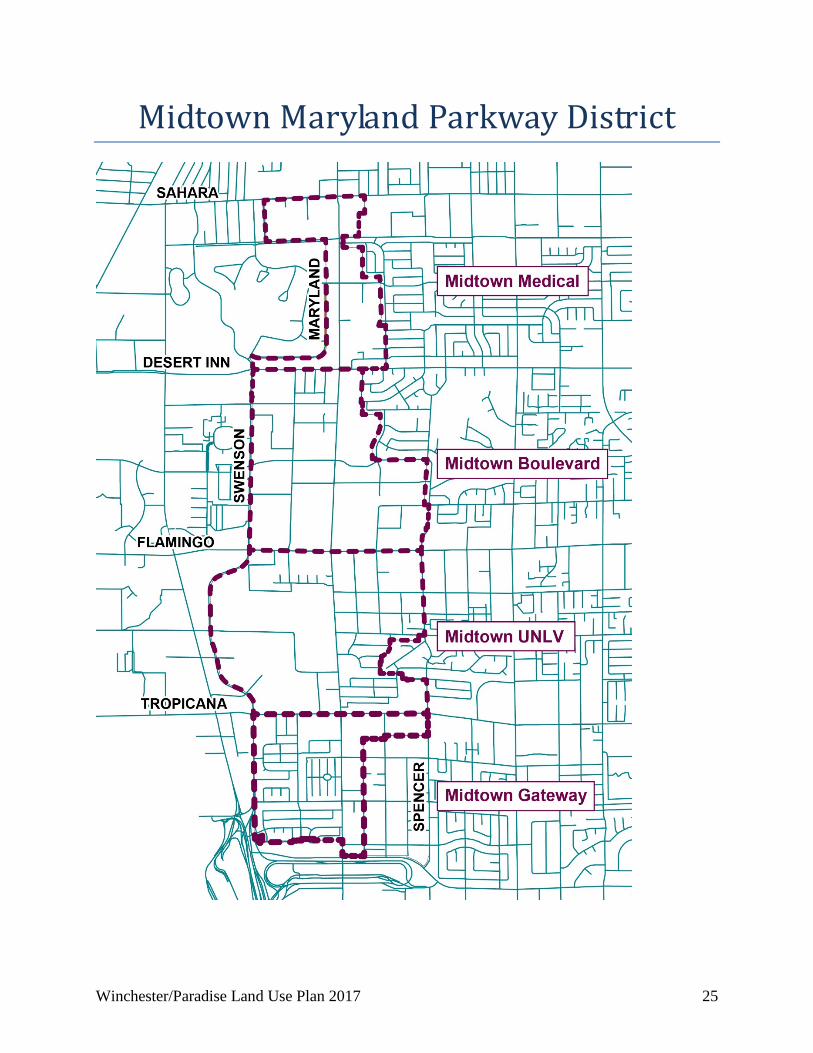
DISTRICT PLANS Midtown Maryland Parkway District
Background Maryland Parkway is a vital corridor for the Las Vegas Valley that connects many high-activity centers, including McCarran International Airport, University of Nevada, Las Vegas (UNLV), Boulevard Mall, Sunrise Hospital, and downtown Las Vegas. As a result, the Regional Transportation Commission of Southern Nevada (RTC) is pursuing a high-capacity transit (HCT) system within the corridor. Coinciding with the planned investment in a HCT system, the Midtown Maryland Parkway District will encourage transit-oriented, walkable, and sustainable development and revitalization that is compatible with the future HCT system, existing anchor uses, and key elements of each sub-district. The characteristics of each sub-district are described below. The Midtown Maryland Parkway District will guide development in the area consistent with the Maryland Parkway Implementation Strategy Report in the Southern Nevada Strong Regional Plan as well as the Maryland Parkway Public Art Strategic Plan. Additionally, specific zoning regulations for the Midtown Maryland Parkway District are the mechanisms to implement the plan. Sub-Districts
Midtown Medical Anchored by Sunrise Hospital, this is the northernmost area of the corridor, and it predominately consists of commercial and medical uses. Sahara Avenue is the northern boundary of this sub-district. Across Sahara Avenue to the north is commercial development in the City of Las Vegas, much of which is on subdivided parcels smaller than 0.5 acre in size. South of Sahara Avenue, the western boundary is adjacent to the Las Vegas Country Club and residential uses. The Las Vegas Convention Center is adjacent to the southwest portion of the sub-district, and multi-family and single family residences are adjacent to the eastern boundary.
Winchester/Paradise Land Use Plan 2017 25
Midtown Maryland Parkway District
26 Winchester/Paradise Land Use Plan 2017
Midtown Boulevard This sub-district is the traditional retail and shopping area of the Maryland Parkway corridor. The Boulevard Mall, which anchors the sub-district, was the first enclosed, climate-controlled shopping mall in Nevada. It now includes over 1 million square feet of retail space. More recently, the mall has begun to transition to more non-traditional uses such as office space and entertainment facilities. Paradise Palms, which in 2017 became the first neighborhood to obtain historical designation in Clark County, is adjacent to the east side of the sub-district. The future Spencer Greenway Transportation Trail bisects the southern portion of the sub-district. Two public schools (Orr Middle School and Petersen Elementary School), 2 public parks (Orr Middle School Park and Molasky Family Park), and the Cambridge Recreation Center are also located in this sub-district.
Midtown UNLV The main campus of UNLV occupies the western portion of this sub-district. Adjacent development includes multi-family residences to the north and commercial uses to the east along Maryland Parkway. Further east includes multi-family and single family residences. Two mixed-use projects are currently under construction, and these projects highlight the future transit-oriented design potential for the area.
Midtown Gateway McCarran International Airport is adjacent to the southern boundary of this sub-district, which mostly consists of residential development. The southern boundary, which includes the Dream Machine art sculpture in the Siegfried & Roy Park, provides a gateway to the Maryland Parkway Corridor. Single family and multi-family residences are located to the west of Maryland Parkway, and commercial uses and multi-family residences are located to the east of Maryland Parkway.
Winchester/Paradise Land Use Plan 2017 27
CHAPTER 3
ISSUES AND CHALLENGES Issues in Winchester/Paradise There are a number of issues affecting existing and future land uses within the Winchester/Paradise Planning Area. Some of these issues include incompatibility of land use with the planned property and the age of the building stock in the area. The impact of previous Non-Conforming Zone Changes also affected some development patterns of the community and how certain areas of Winchester/Paradise are planned. Incompatibility of Rural Neighborhood Preservation (RNP) areas Many of the properties within the current RNP designated areas are zoned to allow residential development up to 5 dwelling units per acre. The current land use designation of Rural Neighborhood Preservation limits development up to 2 dwelling units per acre. Keeping the current land use designation on these parcels can be misleading to future homeowners in the area. A recommendation to remedy this discrepancy is to designate the parcels as Residential Suburban which would be more consistent to the current R-1 zone. Deterioration of Buildings and Properties in the Planning Area The Paradise Town Advisory Board expressed some concerns about the maintenance of properties within the planning area. Much of the housing stock and some of the commercial and industrial complexes were developed decades ago. Some properties have been maintained, but others have deteriorated. Several policies for aesthetics, property appearance, and even suggesting items for physical improvement in the less maintained areas are in the Land Use Element. The intent of these policies is to minimize the impacts on the community by improving the aesthetics and property appearance of the less maintained developments. Non-Conforming Zone Changes Zone Boundary Amendments are non-conforming when the zoning district being requested is outside of the range of densities and intensities permitted in the land use category or when the change being requested is in conflict with the Community District Element. Winchester and Paradise have received applications for Non-conforming Zone Changes since the last plan update. Non-conforming Zone Changes can result in areas developing in unexpected ways from those planned. This often will have a significant impact on public facilities such as schools, police, fire, transit and transportation. These zone changes can be controversial and may lead to dramatic changes in existing neighborhoods.
28 Winchester/Paradise Land Use Plan 2017
Title 30 requires all Non-Conforming Zone Boundary Amendments to have a pre-application conference, a neighborhood meeting with public hearings at the Planning Commission (PC) and Board of County Commissioners (BCC). In addition a Non-Conforming Zone Boundary Amendment under Title 30 has submittal restrictions for two years after the adoption of a land use plan. Challenges in Winchester and Paradise There are several challenges affecting existing and future land uses within the Winchester and Paradise planning areas. Planned Warehousing and Manufacturing Land A strategic analysis of Southern Nevada’s economy provided indicates there is a need for more affordable land at least ten acres in size planned for warehousing and manufacturing uses. As land values have increased in the Las Vegas Valley it has forced light industrial uses to the outskirts of the Las Vegas Valley and heavy industrial out of the valley altogether. This in turn has increased the cost of operations for several businesses and potentially limits growth of new warehouses and manufacturing businesses. Cooperative Management Agreement (CMA) Deed Restrictions In the Winchester/Paradise Land Use Plan, the Cooperative Management Area (CMA) boundary outlines the primary airspace used for aircraft traffic to and from McCarran International Airport. Special goals, policies and restrictions are included in the land use element to ensure that development is compatible with the CMA. The CMA is approximately 20,543 acres with a portion of that within the Winchester/Paradise Land Use Plan. Under the provisions of the Southern Nevada Public Lands Management Act (SNPLMA) of 1998, passed into law by the U.S. Congress, approximately 5,226 acres of federal land holdings and interests, located within the CMA, were transferred to Clark County in March 1999. The 5,226 acres under the 1992 Cooperative Management Agreement between Clark County and the Bureau of Land Management (BLM) define land uses considered compatible with the airport and its associated aircraft operations. Only those land uses deemed compatible with airport operations are permitted on the CMA parcels acquired by Clark County under the terms of the SNPLMA of 1998. These parcels are deed restricted to not allow any residential development. Ideally, much of the CMA should develop as a multi-use employment and activity center for office, light manufacturing, service, and retail uses. As defined by the McCarran International Airport’s Airport Environs Overlay District (AEOD), residential uses are incompatible with high levels of aircraft noise. Therefore, residential uses are not encouraged within the CMA. However, residential land uses are used on the land use plan map inside of the CMA. Residential land uses are only used to address existing residential land uses and residential zoning as of April 2000, and residential land uses may not occur on deed restricted parcels or be within the AE-65 Airport Overlay Noise Zone (or greater). The following uses are deemed incompatible by the Cooperative Management Agreement and are prohibited on the parcels acquired from the BLM.
Winchester/Paradise Land Use Plan 2017 29
Incompatible uses include, but are not limited to: 1. Residential Uses of any Density 2. Transient Lodging (hotels, motels, resorts, trailer parks, etc.) 3. Hospitals 4. Churches 5. Care Centers and Nursing Homes 6. Concert Halls, Outdoor Sports Arenas and Auditoriums 7. Group Quarters 8. Amusement Parks 9. Zoos 10. Schools It is also important to note that the land use limitations imposed by the Cooperative Management Agreement apply only to those properties acquired by Clark County. All privately owned properties within the CMA may be developed in accordance with the adopted Winchester/Paradise Land Use Plan and applicable Clark County land use regulations. Development in this area should incorporate the design guidelines of the CMA Design Overlay District in Title 30. The intent is to encourage and promote a high level of quality developments that will produce a stable environment in harmony with existing and future development and protect the use and enjoyment of neighboring properties. Because of the amount of land acquired from the BLM, the County also intends to develop a system of paths, open space, trails, and parks within the CMA to serve the southwest Las Vegas Valley. The land uses planned for the CMA are intended to be compatible and complement each other, any adjacent existing or planned land uses, and any natural or man-made features. The same land use categories are used in the CMA as in the rest of Winchester and Paradise. A few additional policies help to further define the specific issues and limitations of the Cooperative Management Area. Important Note Regarding Future Development in Some Areas of the CMA: Residential developments (either freestanding or as part of a mixed use development) and transient lodging are incompatible with McCarran International Airport’s operation and thus not permitted on County-owned parcels within the Cooperative Management Area (CMA). This determination of incompatibility was based on the number of aircraft over-flights expected within the CMA and the aircraft-related noise levels associated with those over-flights. In the past decade, federal legislation and regulations have resulted in a quieter aircraft fleet within the United States. As older aircraft are phased out and newer technologies adopted, the hope is that noise levels will be reduced further still. Unfortunately, growth in the Las Vegas valley’s resident population and visitor volumes means that increases in aircraft flight activity may effectively cancel out this benefit. Should future Department of Aviation analysis show, in the long-term, that the noise exposure levels in some areas of the CMA has been reduced sufficiently, it may be appropriate for
30 Winchester/Paradise Land Use Plan 2017
Congress to re-consider the current restrictions on residential developments and/or transient lodging in these areas.
Winchester/Paradise Land Use Plan 2017 31
CHAPTER 4
LAND USE Policies During 2013 and 2014, a working group made up of representatives from the Enterprise, Laughlin, Paradise, Spring Valley, Whitney, and Winchester Town Advisory Boards and Lone Mountain Citizens Advisory Council; worked with staff to consolidate the land use policies into a uniform set of policies that are common to all these planning areas. The consolidated policies were adopted by the BCC in April 2015 for these areas. They are now available as part of the Land Use Element of the Comprehensive Plan.
32 Winchester/Paradise Land Use Plan 2017
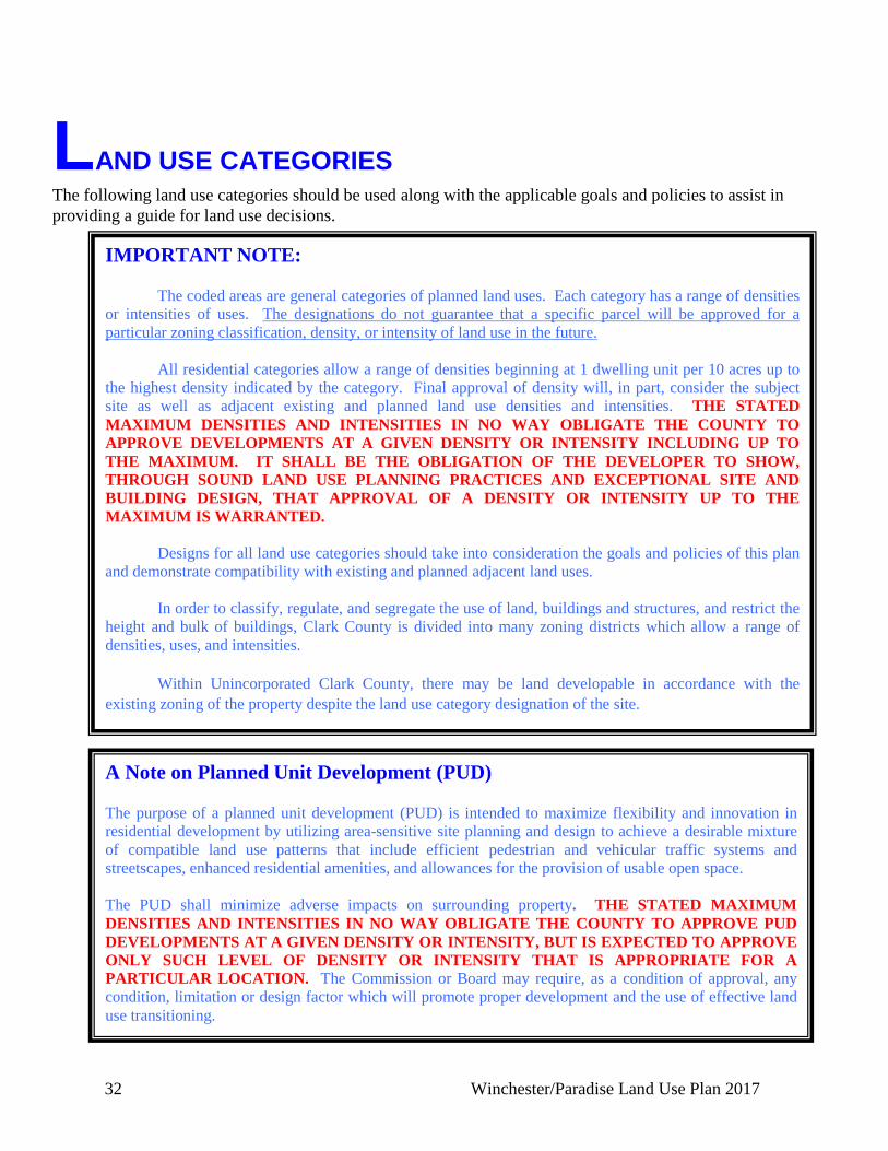
LAND USE CATEGORIES The following land use categories should be used along with the applicable goals and policies to assist in providing a guide for land use decisions.
IMPORTANT NOTE: The coded areas are general categories of planned land uses. Each category has a range of densities or intensities of uses. The designations do not guarantee that a specific parcel will be approved for a particular zoning classification, density, or intensity of land use in the future. All residential categories allow a range of densities beginning at 1 dwelling unit per 10 acres up to the highest density indicated by the category. Final approval of density will, in part, consider the subject site as well as adjacent existing and planned land use densities and intensities. THE STATED MAXIMUM DENSITIES AND INTENSITIES IN NO WAY OBLIGATE THE COUNTY TO APPROVE DEVELOPMENTS AT A GIVEN DENSITY OR INTENSITY INCLUDING UP TO THE MAXIMUM. IT SHALL BE THE OBLIGATION OF THE DEVELOPER TO SHOW, THROUGH SOUND LAND USE PLANNING PRACTICES AND EXCEPTIONAL SITE AND BUILDING DESIGN, THAT APPROVAL OF A DENSITY OR INTENSITY UP TO THE MAXIMUM IS WARRANTED. Designs for all land use categories should take into consideration the goals and policies of this plan and demonstrate compatibility with existing and planned adjacent land uses. In order to classify, regulate, and segregate the use of land, buildings and structures, and restrict the height and bulk of buildings, Clark County is divided into many zoning districts which allow a range of densities, uses, and intensities. Within Unincorporated Clark County, there may be land developable in accordance with the existing zoning of the property despite the land use category designation of the site.
A Note on Planned Unit Development (PUD) The purpose of a planned unit development (PUD) is intended to maximize flexibility and innovation in residential development by utilizing area-sensitive site planning and design to achieve a desirable mixture of compatible land use patterns that include efficient pedestrian and vehicular traffic systems and streetscapes, enhanced residential amenities, and allowances for the provision of usable open space. The PUD shall minimize adverse impacts on surrounding property. THE STATED MAXIMUM DENSITIES AND INTENSITIES IN NO WAY OBLIGATE THE COUNTY TO APPROVE PUD DEVELOPMENTS AT A GIVEN DENSITY OR INTENSITY, BUT IS EXPECTED TO APPROVE ONLY SUCH LEVEL OF DENSITY OR INTENSITY THAT IS APPROPRIATE FOR A PARTICULAR LOCATION. The Commission or Board may require, as a condition of approval, any condition, limitation or design factor which will promote proper development and the use of effective land use transitioning.
Winchester/Paradise Land Use Plan 2017 33
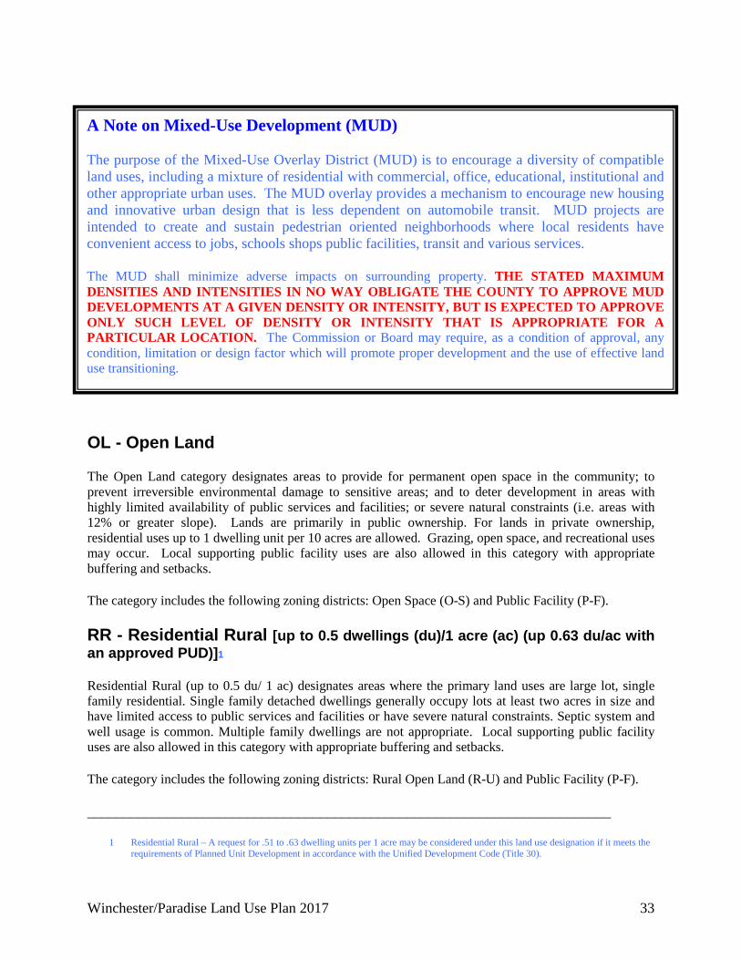
OL - Open Land The Open Land category designates areas to provide for permanent open space in the community; to prevent irreversible environmental damage to sensitive areas; and to deter development in areas with highly limited availability of public services and facilities; or severe natural constraints (i.e. areas with 12% or greater slope). Lands are primarily in public ownership. For lands in private ownership, residential uses up to 1 dwelling unit per 10 acres are allowed. Grazing, open space, and recreational uses may occur. Local supporting public facility uses are also allowed in this category with appropriate buffering and setbacks. The category includes the following zoning districts: Open Space (O-S) and Public Facility (P-F). RR - Residential Rural [up to 0.5 dwellings (du)/1 acre (ac) (up 0.63 du/ac with an approved PUD)]1
Residential Rural (up to 0.5 du/ 1 ac) designates areas where the primary land uses are large lot, single family residential. Single family detached dwellings generally occupy lots at least two acres in size and have limited access to public services and facilities or have severe natural constraints. Septic system and well usage is common. Multiple family dwellings are not appropriate. Local supporting public facility uses are also allowed in this category with appropriate buffering and setbacks. The category includes the following zoning districts: Rural Open Land (R-U) and Public Facility (P-F). ________________________________________________________________________
1 Residential Rural – A request for .51 to .63 dwelling units per 1 acre may be considered under this land use designation if it meets the requirements of Planned Unit Development in accordance with the Unified Development Code (Title 30).
A Note on Mixed-Use Development (MUD) The purpose of the Mixed-Use Overlay District (MUD) is to encourage a diversity of compatible land uses, including a mixture of residential with commercial, office, educational, institutional and other appropriate urban uses. The MUD overlay provides a mechanism to encourage new housing and innovative urban design that is less dependent on automobile transit. MUD projects are intended to create and sustain pedestrian oriented neighborhoods where local residents have convenient access to jobs, schools shops public facilities, transit and various services. The MUD shall minimize adverse impacts on surrounding property. THE STATED MAXIMUM DENSITIES AND INTENSITIES IN NO WAY OBLIGATE THE COUNTY TO APPROVE MUD DEVELOPMENTS AT A GIVEN DENSITY OR INTENSITY, BUT IS EXPECTED TO APPROVE ONLY SUCH LEVEL OF DENSITY OR INTENSITY THAT IS APPROPRIATE FOR A PARTICULAR LOCATION. The Commission or Board may require, as a condition of approval, any condition, limitation or design factor which will promote proper development and the use of effective land use transitioning.
34 Winchester/Paradise Land Use Plan 2017
RA - Residential Agriculture (up to 1 du/ac) Residential Agriculture (up to 1 du/ac) designates areas where the primary land uses are large lot, single family residential. Single family detached dwellings generally occupy lots at least one acre in size and have limited access to public services and facilities. Septic system and well usage is common. This category also includes areas where the primary land use is commercial farming, including but not limited to: crop production and raising livestock (not open range grazing). Typically, the agricultural areas are irrigated and cultivated, with single family detached dwellings and outbuildings as associated uses. Multiple family dwellings are not appropriate. Local supporting public facility uses are also allowed in this category with appropriate buffering and setbacks. The category includes the following zoning districts: Rural Open Land (R-U), Residential Agricultural (R-A), and Public Facility (P-F). RNP - Rural Neighborhood Preservation [up to 2 du/ac (a PUD is not allowed)] The Rural Neighborhood Preservation category allows a maximum of 2 dwelling units per gross acre. The Rural Neighborhood Preservation category is intended to protect areas within the planning area that are already developed and rural in character, from encroachment by more intense development. The predominant residential life-style is single family homes on large lots, many including equestrian facilities. Multiple family dwellings are not appropriate. Local supporting public facility uses are allowed in this category with appropriate buffering and setbacks. The category includes the following zoning districts: Rural Open Land (R-U), Residential Agricultural (R-A), Rural Estates Residential (R-E), and Public Facility (P-F). RN - Rural Neighborhood [up to 2 du/ac (up to 2.5 du/ac with an approved PUD)]2 The Rural Neighborhood (up to 2 du/ac) category allows a maximum of 2 dwelling units per gross acre. The predominant housing type in Rural Neighborhood (up to 2 du/ac) is detached single family residential development at low densities. Multiple family dwellings are not appropriate. Local supporting public facility uses are also allowed in this category with appropriate buffering and setbacks. The category includes the following zoning districts: Rural Open Land (R-U), Residential Agricultural (R-A), Rural Estates Residential (R-E), Rural Estates Residential PUD (R-E PUD) and Public Facility (P-F).\ ________________________________________________________________________ 2 Rural Neighborhood – A request for 2.01 to 2.5 dwelling units per acre may be considered under this land use designation if it meets
the requirements of Planned Unit Development in accordance with the Unified Development Code (Title 30).
Winchester/Paradise Land Use Plan 2017 35
RL - Residential Low (up to 3.5 du/ac) Residential Low (up to 3.5 du/ac) allows a maximum of 3.5 dwelling units per gross acre. Public infrastructure and service availability affect the intensity and density within this category. The predominant housing type in Residential Low (up to 3.5 du/ac) is single family detached development. Multiple family dwellings are not appropriate. Local supporting public facility uses are also allowed in the category with appropriate buffering and setbacks. The category includes the following zoning districts: Rural Open Land (R-U), Residential Agricultural (R-A), Rural Estates Residential (R-E), Suburban Estates Residential (R-D), Suburban Estates Residential PUD (R-D PUD) and Public Facility (P-F). RS - Residential Suburban [up to 8 du/ac (up to 10 du/ac with an approved PUD)]3
The Residential Suburban (up to 8 du/ac) category allows a maximum of 8 dwelling units per gross acre. Public infrastructure and service availability affect the intensity and density within this category. The predominant housing type in Residential Suburban (up to 8 du/ac) is single family residential detached development. Multiple Family dwellings are not appropriate. Local supporting public facility uses are also allowed in this category with appropriate buffering and setbacks. The category includes the following zoning districts: Rural Open Land (R-U), Residential Agricultural (R-A), Suburban Estates Residential (R-D), Rural Estates Residential (R-E), Single Family Residential (R-1), Medium Density Residential (R-2), Manufactured Home Residential (R-T), and Public Facility (P-F). 3 Residential Suburban – A request for 8.01 to 10 dwelling units per acres may be considered under this land use designation if it meets
the requirements of Planned Unit Development in accordance with the Unified Development Code (Title 30). RM - Residential Medium [from 3 du/ac to 14 du/ac (up to 16 du/ac with an approved PUD)]4 Residential Medium (from 3 du/ac to 14 du/ac) category permits a range from 3 dwelling units per gross acre up to 14 dwelling units per gross acre. The Residential Medium (from 3du/ac to 14 du/ac) category allows for single family uses and planned unit developments. It is appropriate for single family attached, but not multiple family housing. Local supporting public facility uses are also allowed in this category with appropriate buffering and setbacks. The category includes the following zoning districts: Suburban Estates Residential (R-D), Single Family Residential (R-1), Manufactured Home Residential (RT), Medium Density Residential (R-2), Residential Urban District (RUD), and Public Facility (P-F). 4 Residential Medium – A request for 14.01 to 16 dwelling units per acre may be considered under this land use designation if it meets
the requirements of Planned Unit Development in accordance with the Unified Development Code (Title 30).
36 Winchester/Paradise Land Use Plan 2017
RH - Residential High (from 8 du/ac to18 du/ac) The Residential High (from 8 du/ac to 18 du/ac) category permits a range from 8 dwelling units per gross acre to 18 dwelling units per gross acre. This category allows a variety of housing types including single family, residential multiplexes, town houses, and low density apartments. Density ranges within this category are dependent on development and design. In addition to the residential uses, mixed uses are permitted within appropriate zoning districts. Local supporting public facility uses are also allowed in this category with appropriate buffering and setbacks. The category includes the following zoning districts: Manufactured Home Residential (R-T), Residential Urban District (RUD), Multiple-Family Residential (R-3), and Public Facility (P-F). RUC - Residential Urban Center (from 18 du/ac to 32 du/ac) The Residential Urban Center (from 18 du/ac to 32 dwelling units/per acre) category permits a range from 18 dwelling units per gross acre up to 32 dwelling units per gross acre. This category allows a variety of housing types including single family, residential multiplexes, town homes, and apartments. In addition to the residential uses, mixed uses are permitted within appropriate zoning districts. Local supporting public facility uses are also allowed in this category with appropriate buffering and setbacks. The category includes the following zoning districts: Multiple-Family Residential (R-3), Multiple-Family Residential (high density) (R-4), and Public Facility (P-F). RHRC - Residential High-Rise Center (greater than 32 du/ac) The Residential High-Rise Center (greater than 32 du/ac) category allows high density/intensity residential, supporting commercial and office professional uses. This category allows for mixed and vertical mixed uses when located in activity centers or along major transportation corridors. Public facility uses are also allowed in this category. The category includes the following zoning districts: Apartment Residential (R-5), and Public Facility (P-F). OP - Office Professional The Office Professional category applies to areas where the primary uses are low intensity business and professional services and accessory service uses. With appropriate mitigation and design criteria, this category may provide a good buffer between higher intensity land uses and residential land uses. Typical uses include offices where medical, legal, financial, day care services and other business/professional services are performed. Accessory commercial uses are appropriate when associated with the principal use. Local supporting public facility uses are also allowed in this category with appropriate buffering and setbacks. The category includes the following zoning districts: Commercial Residential Transitional (CRT), Office Professional (C-P), and Public Facility (P-F).
Winchester/Paradise Land Use Plan 2017 37
CN - Commercial Neighborhood The Commercial Neighborhood category allows low to medium intensity retail and service commercial uses that serve primarily local area patrons, and do not include more intense general commercial characteristics. Examples include neighborhood shopping centers, banks, restaurants, hardware stores, and other similar retail and service uses. Developments should be sized to fit the surrounding neighborhood. This category also includes offices either singly or grouped as office centers with professional and business services. Local supporting public facility uses are also allowed in this category with appropriate buffering and setbacks. Commercial Neighborhood uses should be developed as nodes or centers and not configured in a “’Strip’ commercial” pattern. The category includes the following zoning districts: Commercial Residential Transitional (CRT), Office and Professional (C-P), Local Business (C-1), Recreational Vehicle Park (RVP) and Public Facility (P-F). CG - Commercial General The Commercial General category allows medium to high intensity retail and service commercial uses that serve primarily regional area patrons, and include more intense general commercial characteristics. Examples include shopping malls, banks, restaurants (with alcohol consumption), taverns, hardware stores, and other larger retail and service uses. This category also includes offices either singly or grouped as office centers with professional and business services. Public facility uses are also allowed in this category. Commercial General uses should be developed as nodes or centers and not configured in a “‘Strip’ commercial” pattern. The category includes the following zoning districts: Commercial Residential Transitional (CRT), Office and Professional (C-P), Local Business (C-1), General Commercial (C-2), Recreational Vehicle Park (RVP) and Public Facility (P-F). CT - Commercial Tourist The Commercial Tourist category designates areas for commercial establishments that primarily cater to tourists. The predominant land uses include casinos, resorts, hotels, motels (greater than three stories), recreational vehicle parks, time shared condominiums, amusement or theme parks. Planned hotel/resort gaming establishments are restricted to the Gaming Enterprise Overlay District as defined by Title 30 (Unified Development Code). Public facility uses are also allowed in this category. The category includes the following zoning districts: Commercial Residential Transitional (CRT), Office and Professional (C-P), Local Business (C-1), General Commercial (C-2), Recreational Vehicle Park (R-V-P), Apartment Residential (R-5), Limited Resort and Apartment (H-1), and Public Facility (P-F).
38 Winchester/Paradise Land Use Plan 2017
MDP - Major Development Project The Major Development Project category is most often applied to areas outside of the Community District 2 Boundary as referenced in Clark County’s Community District Element. It indicates areas where land uses of greater densities than two residential units per acre are considered premature and/or inappropriate unless guided by the County’s Major Projects Review Process. This process is designed to accommodate the timely and comprehensive review of projects and their impacts to the local community. Details of the Major Projects are found in Title 30, the Clark County Development Code. Some areas located outside of Community District 2 have been planned with a specific land use category. Although these areas have been planned, they are still considered premature for urban development unless they are developed in accordance with the County’s Major Projects Review Process or the Community District 2 boundary is amended to include these areas. BDRP – Business and Design/Research Park The Business and Design/Research Park category applies to areas where low intensity manufacturing and assembly developments, wholesale and distribution, office, professional services associated with warehousing, and other similar activities that promote industry and support a diversified economic base are intended. These developments are designed to assure minimal impact on surrounding areas. Major uses in the category include research and development, incubator businesses, wholesale businesses – such as food sales and distribution, postal and data processing centers, vehicle sales and repair (inside), general non-hazardous warehousing. Public facility uses are also allowed in this category with appropriate buffering and setbacks. The category includes the following zoning districts: Office and Professional (C-P), Designed Manufacturing (M-D), and Public Facility (P-F). IND - Industrial The Industrial category applies to areas of industrial use and provides areas for new and existing industrial development in proximity to major transportation facilities. These uses should be reviewed for safety and aesthetic reasons when they adjoin other uses. Public facility uses are also allowed in this category with appropriate buffering and setbacks. The category includes the following zoning districts: Designed Manufacturing (M-D), Light Industrial (M-1) and Public Facility (P-F).
Winchester/Paradise Land Use Plan 2017 39
HI - Heavy Industrial The Heavy Industrial category applies to areas of industrial use and provides areas for intense industrial operations and development in proximity to major transportation facilities. These areas are generally located outside the Las Vegas Valley for safety or nuisance reasons. Public Facility uses are also allowed in this category with appropriate buffering and setbacks. The category includes the following zoning districts: Designed Manufacturing (M-D), Light Industrial (M-1), Industrial (M-2) and Public Facility (P-F). IL – Institutional The Institutional category should be used for existing non-governmental, quasi-public organizations including, but not limited to: places of worship, private schools, service organizations, etc. These facilities can be found in any zoning district except the Public Facility (P-F) zone. PF - Public Facilities The Public Facilities category allows public parks and recreational areas such as public and private golf courses; trails and easements; drainage ways and detention basins; storm water control facilities; and any other large areas of permanent open land. Public Facilities include public schools, colleges and universities, governmental building sites and complexes, libraries, police and fire facilities. The designation also includes facilities that provide community services, such as publically regulated utilities. The appropriate zoning district for these uses would be the Public Facility (P-F) zone.
40 Winchester/Paradise Land Use Plan 2017
GLOSSARY The following general definitions were developed to assist in using the Land Use Plan: 100-year-flood event – A flood caused by a high intensity storm that is defined by the National
Flood Insurance Program as “a flood level with a 1 percent or greater chance of being equaled or exceeded in any given year”.
BLM (Bureau of Land Management) – The BLM is an agency of the federal Department of
the Interior responsible for administering a majority of the federal lands in Clark County. BLM’s policies on lands include a variety of public uses, conservation, resource management, and realty actions.
Buffering – Transitional land or space that is used between different or incompatible land uses
and is often accomplished with landscaping (see Title 30). Community District Element – The Community District Element of the Clark County
Comprehensive Plan provides a framework for identifying lands for urban expansion based on infrastructure availability and provision. The Element divides Clark County into six geographic districts, each of which has development guidelines for appropriate land uses and densities. The Community District boundaries are shown on the Enterprise Land Use Map.
Compact Building Design – Encourages buildings to grow vertically incorporating structured
rather than surface parking, so communities can reduce the footprint of new construction, and preserve more open space.
Compatible – Land Use categories, zoning districts, and/or land uses capable of existing
together in harmony. Cooperative Management Area (CMA) – An area established through an agreement signed in
November 1992 between Clark County and the U.S. Bureau of Land Management, located to the west and south of McCarran International Airport, the boundaries of which are defined by aircraft departure flight corridors and the 60 DNL noise contour. Most Clark County owned property within the CMA is subject to the terms of the Southern Nevada Public Lands Management Act of 1998, which restricts that County land to those uses defined in the Agreement as compatible with aircraft operations.
Disposal Boundary – The land disposal boundary that identifies developable land within Clark
County. It was established by the Southern Nevada Public Lands Management Act of 1998 and can be amended only through action of the United States Congress. Its purpose is to promote an orderly method of land disposal between public and private stakeholders. Limiting factors to this boundary include: federally designated lands, slope, environmentally sensitive lands, cultural resources, and buffers for these areas.
Winchester/Paradise Land Use Plan 2017 41
Goal – A concise statement describing a condition to be achieved. It does not suggest specific
action, but describes a desired outcome. Housing – Includes but is not limited to, apartments, condominiums, townhomes, manufactured
housing, duplexes, multiplexes, single family dwellings, etc. Incidental Take Permit (ITP) – This allows a lawful removal of a protected species from its
habitat to permit the development of a site. Land Use Plan – A document that is used to guide development in a defined area of Clark
County. A plan brings together information about community values, land use trends, public services, the natural environment and other factors and makes recommendations regarding future land uses in the area. Land use plan categories, maps and goals and policies serve as important guides for future zoning and land use decisions.
Mixed Use Development (MUD) – The development of a tract of land, building, or structure
with a variety of complementary and integrated uses, such as, but not limited to, residential, office, manufacturing, retail, public, or entertainment, in a compact urban form.
Off-site Circulation – The movement of pedestrians and/or vehicles off the project site. Off-site
circulation patterns normally affect site design. Planned Unit Development – A tract of land which is developed as an integrated unit under
single ownership or control, which includes two or more principal buildings, and where specific requirements of a given zoning district may be modified.
Planning – The process through which communities prepare for future development. Through a
process involving professional planners, service providers, elected officials, other public officials, and the general public, goals for the future are established and policies are developed to assist in the accomplishment of those goals.
Policy – A specific statement to guide decision making, derived from goals of the plan. Public Access Portion – That portion of the facility or project which has been designed for use
by the general public. Quasi-public – A facility under private ownership or control which is similar to a public facility;
examples include: electrical substations, water facilities, places of worship, schools, and hospitals.
Streets – Include all arterial, collector and local streets as defined by Section 52.30 of Title 30.
42 Winchester/Paradise Land Use Plan 2017
Strip Commercial – Intensive commercial use of properties, that are independently owned, abutting a right-of-way and configured in a linear pattern. Additionally, strip commercial is not developed in accordance with a coherent development plan that addresses project design issues such as: unified signage, unified architecture, shared parking and circulation systems, and coordinated ingress and egress points.
Structural Best Management Practices – Accepted structural methods for controlling non-
point source pollution as defined by the 1977 Clean Water Act: may include one or more conservation practices.
Title 30 – This is the current “Clark County Unified Development Code”. Traditional Development – Compact mixed use neighborhoods where residential, commercial
and civic buildings are within close proximity to each other. Transitional Land Uses – Land uses that consist of placing uses of intermediate density or
intensity between two incompatible uses. An example is placing an urban residential development between a residential suburban development and a neighborhood commercial development.
Zoning – A set of regulations, districts and administrative procedures governing the use of land.
Zoning is the tool used to implement the goals and policies of a land use plan. A zoning ordinance contains many specific land use districts, whereas a land use plan utilizes categories which describe generalized ranges of appropriate land uses, each containing several zoning districts.
Winchester/Paradise Land Use Plan 2017 43
Appendices