wicklow, ireland - hillforts study group · many thanks to james o [driscoll and billy o ... one of...
TRANSCRIPT
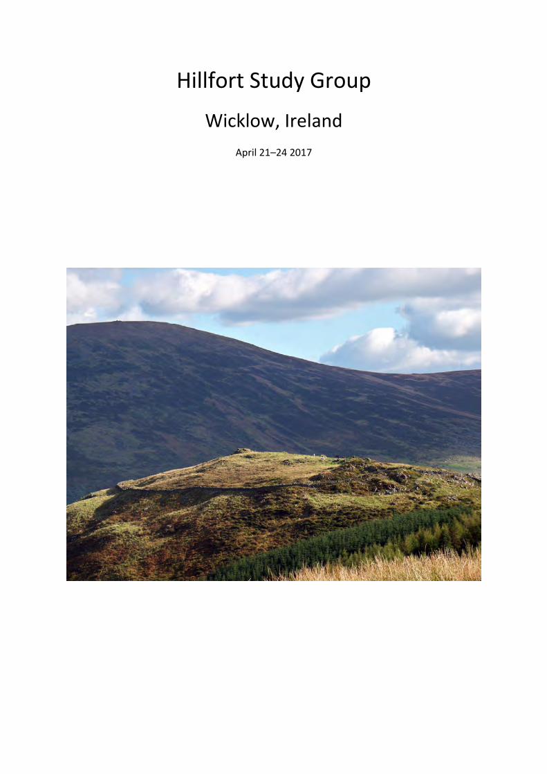
Hillfort Study Group
Wicklow, Ireland
April 21–24 2017
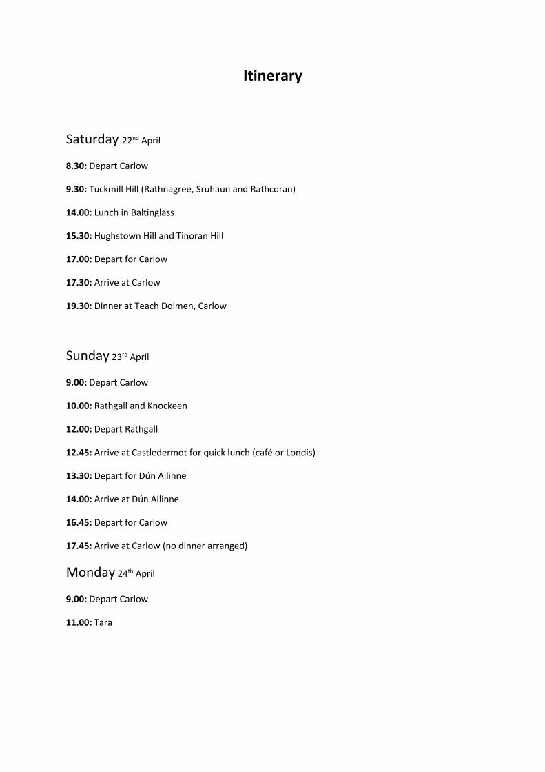
Itinerary
Saturday 22nd April
8.30: Depart Carlow
9.30: Tuckmill Hill (Rathnagree, Sruhaun and Rathcoran)
14.00: Lunch in Baltinglass
15.30: Hughstown Hill and Tinoran Hill
17.00: Depart for Carlow
17.30: Arrive at Carlow
19.30: Dinner at Teach Dolmen, Carlow
Sunday 23rd April
9.00: Depart Carlow
10.00: Rathgall and Knockeen
12.00: Depart Rathgall
12.45: Arrive at Castledermot for quick lunch (café or Londis)
13.30: Depart for Dún Ailinne
14.00: Arrive at Dún Ailinne
16.45: Depart for Carlow
17.45: Arrive at Carlow (no dinner arranged)
Monday 24th April
9.00: Depart Carlow
11.00: Tara
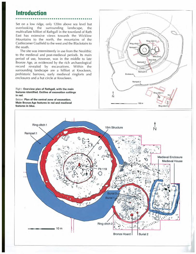
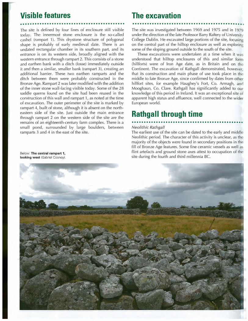
Introduction
County Wicklow has one of the largest
concentrations of hillforts in Ireland, with
some 14 sites in excess of 1ha (Figure 1). This
includes the famous Rathgall hillfort, as well as
the important cluster of forts in the Baltinglass
region. There are also a number of significant
prehistoric sites in the area, such as Browns Hill
Dolmen, Co. Carlow, the Iron Age royal
enclosure at Dún Ailinne, Co. Kildare and the
embanked stone circle at Castleruddery, Co.
Wicklow.
The physical landscape of the county is
dominated by the Wicklow Mountains, which
incorporates much of eastern and central parts
of the county. These are mostly igneous
geology and form part of the largest mass of
granite in north-west Europe. It also comprises
what Whittow (1975, 261) describes as
Ireland’s most significant metalliferous belt,
with evidence for minerals including copper,
sulphur, lead, zinc, iron, gold and silver.
Many thanks to James O’Driscoll and Billy
O’Brien for the production of this fieldguide.
Please find appended at the back the
Archaeology Ireland Heritage Guide #51 for
Rathgall. Also, Dr Rick Schulting has been kind
enough to allow us early access to the proofs
of his (co-authored) forthcoming paper on the
dating of the tomb at Baltinglass, which he felt
might be of interest to our membership.
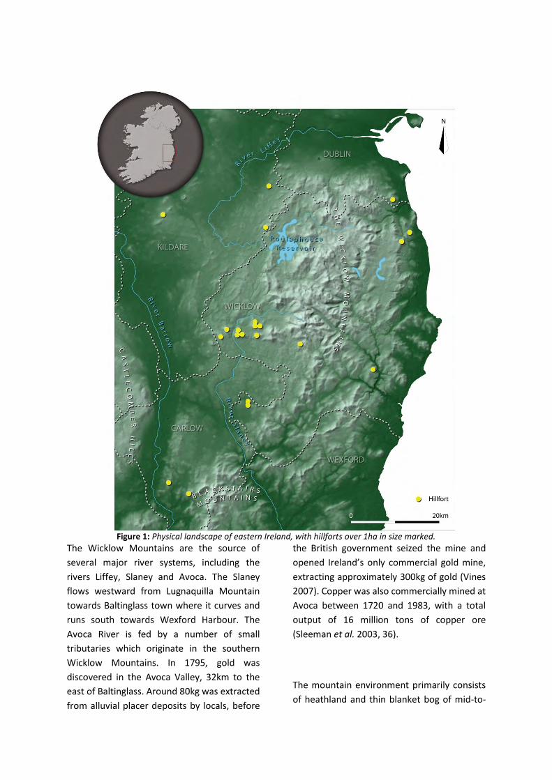
Figure 1: Physical landscape of eastern Ireland, with hillforts over 1ha in size marked.
The Wicklow Mountains are the source of
several major river systems, including the
rivers Liffey, Slaney and Avoca. The Slaney
flows westward from Lugnaquilla Mountain
towards Baltinglass town where it curves and
runs south towards Wexford Harbour. The
Avoca River is fed by a number of small
tributaries which originate in the southern
Wicklow Mountains. In 1795, gold was
discovered in the Avoca Valley, 32km to the
east of Baltinglass. Around 80kg was extracted
from alluvial placer deposits by locals, before
the British government seized the mine and
opened Ireland’s only commercial gold mine,
extracting approximately 300kg of gold (Vines
2007). Copper was also commercially mined at
Avoca between 1720 and 1983, with a total
output of 16 million tons of copper ore
(Sleeman et al. 2003, 36).
The mountain environment primarily consists
of heathland and thin blanket bog of mid-to-
late Holocene ages (Nairn and Crowley 1998,
20). Prior to this, the habitat was likely covered
in deciduous forest (ibid., 20). The
predominant soil types in Wicklow are brown
earths at lower elevations and brown podzols
with a skin of peat, blanket bog and lithosols at
higher elevations. At the foothills of the
Wicklow Mountains, a mixture of shallow
lithosolic and podzolic soils with peaty topsoil
dominates, with the low-land extending to the
south-east producing a mixture of brown and
grey-brown podzolics and brown earths more
amenable to intensive farming. Many of the
hillforts within the county are located at the
edge of this mountain range, provided the
hillfort communities with access to a variety of
eco-zones conductive to farming, hunting and
fishing.
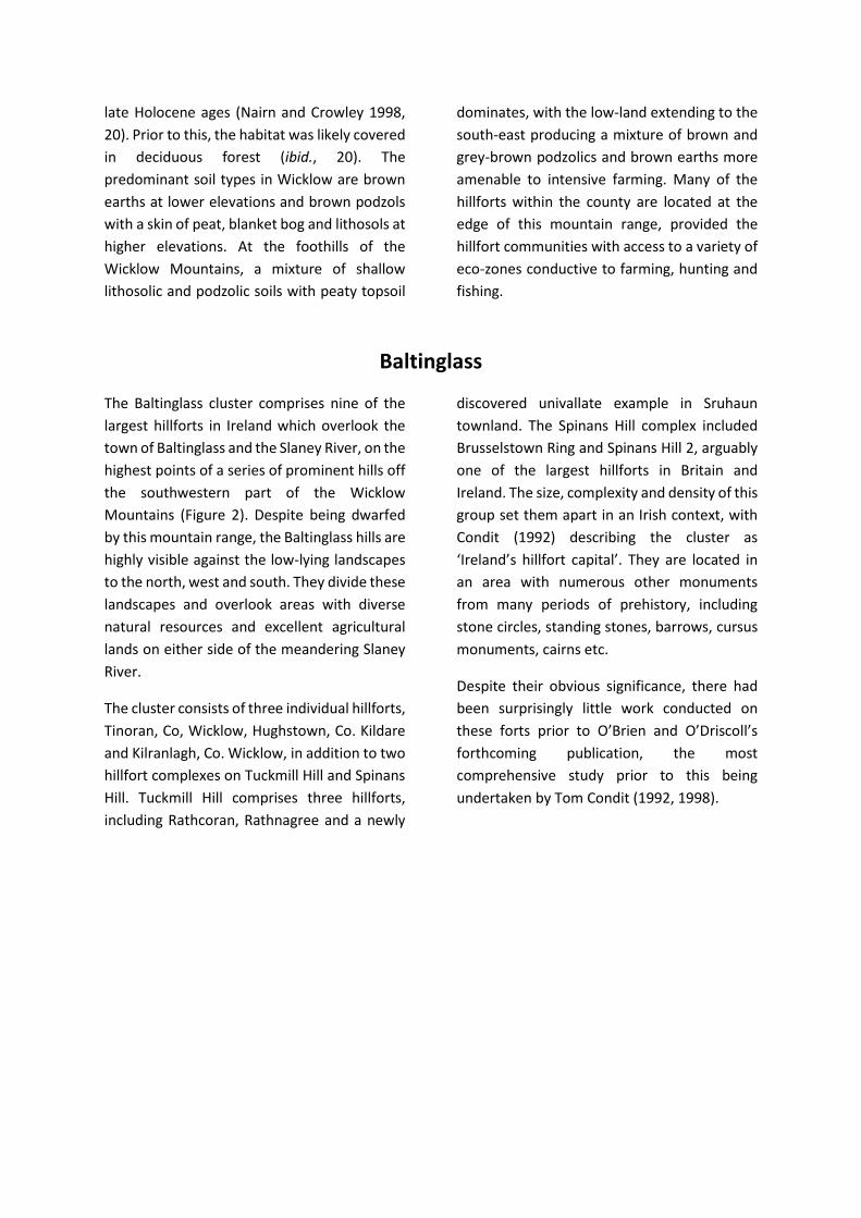
Baltinglass
The Baltinglass cluster comprises nine of the
largest hillforts in Ireland which overlook the
town of Baltinglass and the Slaney River, on the
highest points of a series of prominent hills off
the southwestern part of the Wicklow
Mountains (Figure 2). Despite being dwarfed
by this mountain range, the Baltinglass hills are
highly visible against the low-lying landscapes
to the north, west and south. They divide these
landscapes and overlook areas with diverse
natural resources and excellent agricultural
lands on either side of the meandering Slaney
River.
The cluster consists of three individual hillforts,
Tinoran, Co, Wicklow, Hughstown, Co. Kildare
and Kilranlagh, Co. Wicklow, in addition to two
hillfort complexes on Tuckmill Hill and Spinans
Hill. Tuckmill Hill comprises three hillforts,
including Rathcoran, Rathnagree and a newly
discovered univallate example in Sruhaun
townland. The Spinans Hill complex included
Brusselstown Ring and Spinans Hill 2, arguably
one of the largest hillforts in Britain and
Ireland. The size, complexity and density of this
group set them apart in an Irish context, with
Condit (1992) describing the cluster as
‘Ireland’s hillfort capital’. They are located in
an area with numerous other monuments
from many periods of prehistory, including
stone circles, standing stones, barrows, cursus
monuments, cairns etc.
Despite their obvious significance, there had
been surprisingly little work conducted on
these forts prior to O’Brien and O’Driscoll’s
forthcoming publication, the most
comprehensive study prior to this being
undertaken by Tom Condit (1992, 1998).
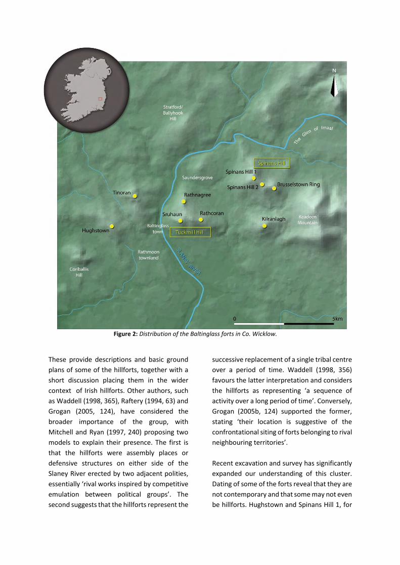
Figure 2: Distribution of the Baltinglass forts in Co. Wicklow.
These provide descriptions and basic ground
plans of some of the hillforts, together with a
short discussion placing them in the wider
context of Irish hillforts. Other authors, such
as Waddell (1998, 365), Raftery (1994, 63) and
Grogan (2005, 124), have considered the
broader importance of the group, with
Mitchell and Ryan (1997, 240) proposing two
models to explain their presence. The first is
that the hillforts were assembly places or
defensive structures on either side of the
Slaney River erected by two adjacent polities,
essentially ‘rival works inspired by competitive
emulation between political groups’. The
second suggests that the hillforts represent the
successive replacement of a single tribal centre
over a period of time. Waddell (1998, 356)
favours the latter interpretation and considers
the hillforts as representing ‘a sequence of
activity over a long period of time’. Conversely,
Grogan (2005b, 124) supported the former,
stating ‘their location is suggestive of the
confrontational siting of forts belonging to rival
neighbouring territories’.
Recent excavation and survey has significantly
expanded our understanding of this cluster.
Dating of some of the forts reveal that they are
not contemporary and that some may not even
be hillforts. Hughstown and Spinans Hill 1, for
example, are probably Early Neolithic in date.
Other forts, like Rathnagree and Sruhaun, have
been dated to the end of the Middle Bronze
Age and are two of the oldest known hillforts
in Ireland. Tinoran on the other hand, may
have been built in stages throughout the Late
Bronze Age, c.1200–800 BC. Geophysical and
topographical survey have revealed
concentrations of possible hut structures at
Rathcoran and Brusselstown Ring, and
highlight the destruction of some of these sites
by fire.
Rathcoran
Rathcoran is the largest of the three hillforts on
Tuckmill Hill (Figure 3, 4 and 5). The name
probably refers to a large prehistoric cairn at its
centre (‘fort of the cairn’). A field pattern
running through the hillfort divides the interior
into three. This forms the boundary between
the townlands of Coolinarrig Upper, Pinnacle
and Tuckmill Hill. The monument was
identified prior to the first edition Ordnance
Survey mapping of 1835, with
Figure 3: Distribution of monuments and hillforts on Tuckmill Hill, Co. Wicklow.
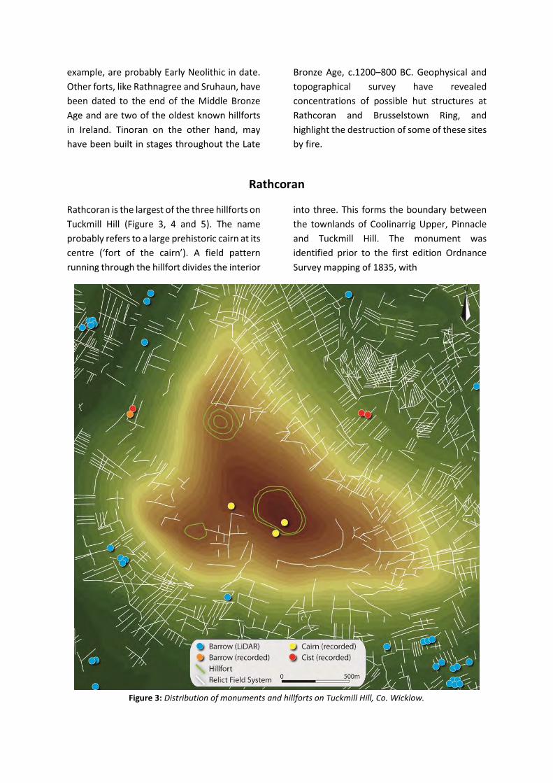
Figure 4: Slope model of Rathcoran hillfort LiDAR.
Lewis (1837, 174) recording that a hoard of
gold coins were discovered in one of the
enclosing banks. This explains why the hillfort
was known locally as the Golden Fort.
Westropp (1902a, 81), however, suggested
that this hoard was recovered from the interior
of the nearby hillfort of Rathnagree. There are
panoramic views from the summit (378m OD).
The hilltop itself is prominent within the local
landscape, particularly to the south. The
interior is covered by dense heather and peat
growth, and is grazed today by cattle and
sheep.
Rathcoran is a pear-shaped bivallate hillfort
that occupies a total area of 10.06ha (Figure 4).
The shape is dictated by the topography of the
hill which the enclosing elements largely
follow. The inner rampart lies between 353–
363m OD and the outer example 347–361m
OD. Waddell (1998) and Condit (1998)
interpreted Rathcoran as an unfinished hillfort,
due to the seemingly incomplete nature of the
enclosing elements and intervening quarry
features. The enclosing elements are most
complete at the north and north-west, where
the inner example is 16m in width and up to
3.1m high, while the outer defences are up to
2.2m high and 8m wide (Figure 6). Both
comprise a mixture of earth and stone and are
separated by approximately 28–35m, with no
evidence of associated ditches. In this area,
geophysical survey revealed a series of strong
magnetic anomalies along the crest of the
inner bank on the north-west side (Figure 7).
These may represent an intensive burning
Figure 5: Aerial photography of Rathcoran hillfort,
Co. Wicklow (Cambridge Aerial Photograph
Collection).
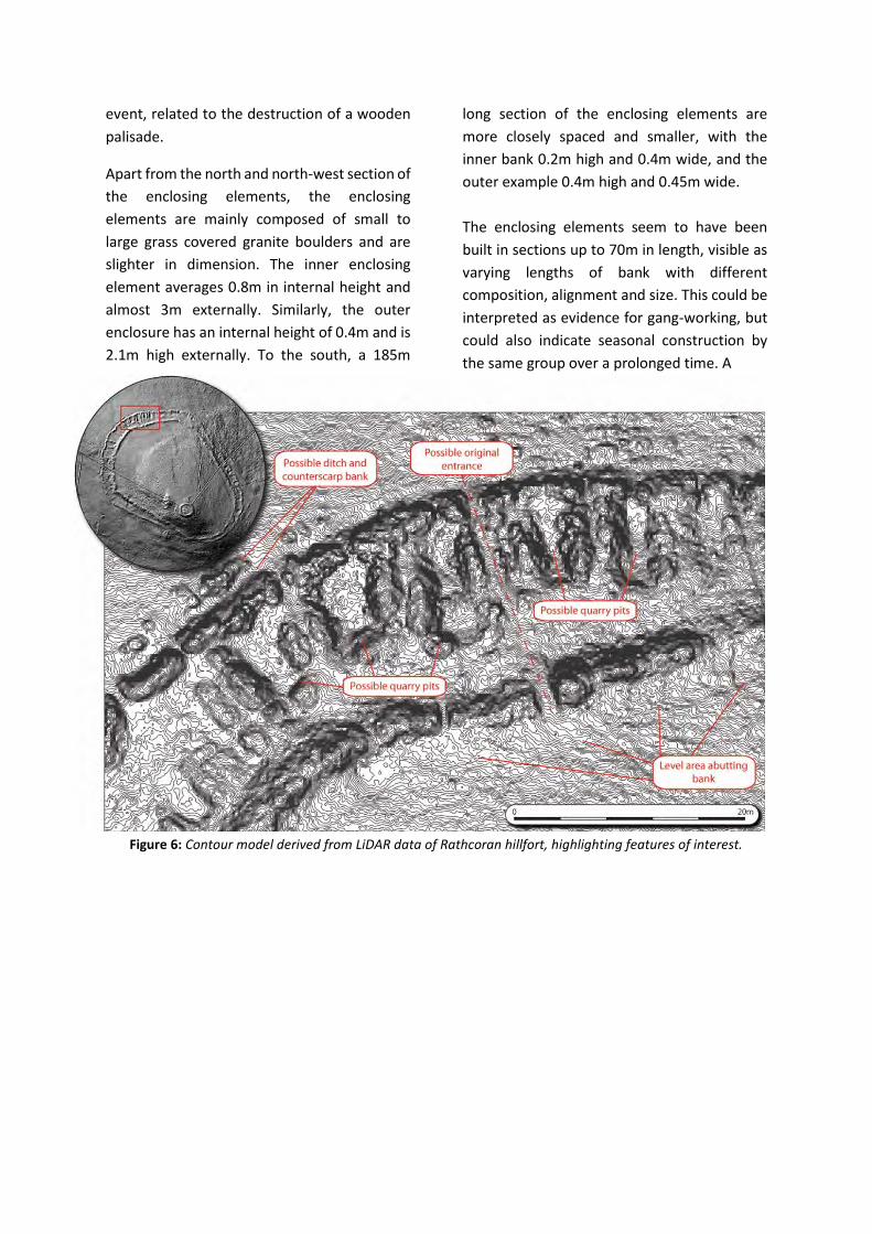
event, related to the destruction of a wooden
palisade.
Apart from the north and north-west section of
the enclosing elements, the enclosing
elements are mainly composed of small to
large grass covered granite boulders and are
slighter in dimension. The inner enclosing
element averages 0.8m in internal height and
almost 3m externally. Similarly, the outer
enclosure has an internal height of 0.4m and is
2.1m high externally. To the south, a 185m
long section of the enclosing elements are
more closely spaced and smaller, with the
inner bank 0.2m high and 0.4m wide, and the
outer example 0.4m high and 0.45m wide.
The enclosing elements seem to have been
built in sections up to 70m in length, visible as
varying lengths of bank with different
composition, alignment and size. This could be
interpreted as evidence for gang-working, but
could also indicate seasonal construction by
the same group over a prolonged time. A
Figure 6: Contour model derived from LiDAR data of Rathcoran hillfort, highlighting features of interest.
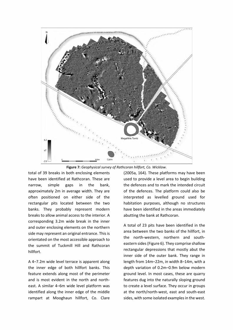
Figure 7: Geophysical survey of Rathcoran hillfort, Co. Wicklow.
total of 39 breaks in both enclosing elements
have been identified at Rathcoran. These are
narrow, simple gaps in the bank,
approximately 2m in average width. They are
often positioned on either side of the
rectangular pits located between the two
banks. They probably represent modern
breaks to allow animal access to the interior. A
corresponding 3.2m wide break in the inner
and outer enclosing elements on the northern
side may represent an original entrance. This is
orientated on the most accessible approach to
the summit of Tuckmill Hill and Rathcoran
hillfort.
A 4–7.2m wide level terrace is apparent along
the inner edge of both hillfort banks. This
feature extends along most of the perimeter
and is most evident in the north and north-
east. A similar 4–6m wide level platform was
identified along the inner edge of the middle
rampart at Mooghaun hillfort, Co. Clare
(2005a, 164). These platforms may have been
used to provide a level area to begin building
the defences and to mark the intended circuit
of the defences. The platform could also be
interpreted as levelled ground used for
habitation purposes, although no structures
have been identified in the areas immediately
abutting the bank at Rathcoran.
A total of 23 pits have been identified in the
area between the two banks of the hillfort, in
the north-western, northern and south-
eastern sides (Figure 6). They comprise shallow
rectangular depressions that mostly abut the
inner side of the outer bank. They range in
length from 14m–22m, in width 8–14m, with a
depth variation of 0.2m–0.9m below modern
ground level. In most cases, these are quarry
features dug into the naturally sloping ground
to create a level surface. They occur in groups
at the north/north-west, east and south-east
sides, with some isolated examples in the west.

At the north/north-west, the pits are
surrounded by low banks, the largest
measuring 1.2m high and 6m wide. The
eastern and south-eastern examples do not
have associated banks. Where the pits occur
the opposing banks are larger, with the size
and depth of the pits often reflecting the size
of the opposing enclosing elements (larger and
deeper pits often abut larger and wider
sections of bank). The partial remains of two
largely completed quarry pits are apparent at
the north-west, abutting the external face of
the most substantial section of the inner bank.
These quarry pits may have been used to
gather material for constructing the banks,
although loose stone and glacial erratics in the
interior may also have been used.
The summit of the hillfort is crowned by a large
passage tomb excavated in the 1930’s (Walshe
1941). The stone that originally covered the
monument now forms a protective wall
around the tomb and is often mistaken for the
hillfort. A second cairn abuts the exterior of the
outer enclosing element to the south. There
are three previously recorded hut structures
within the hillfort, though recent survey has
identified many more.
Rathnagree
Rathnagree is a multivallate hillfort with three
widely spaced enclosing elements, positioned
on a northern spur of Tuckmill Hill, 400m
north-north-west of Rathcoran (Figure 3 and
8). The name translates as ‘rath of the king’.
The hillfort is placed within two townlands:
Tuckmill Hill and Tuckmill Upper, with the
eastern section of the middle enclosing
elements forming the boundary. Recorded on
the first edition Ordnance Survey (1840), the
site occupies a total area of 5.78ha, with an
internal area of 0.69ha. There are excellent
views from the interior, however, visibility to
the south is restricted. The interior is under a
mixture of pasture on the southern side, gorse
at the centre and forestry to the north. The
latter also encroaches upon the hillfort at the
north-eastern side.
In contrast to Rathcoran, the enclosing
elements do not follow the contours of the hill.
The ramparts disregard topographical
variation to form three circular enclosures (in
plan). The inner and middle enclosing elements
are separated by approximately 37m, while the
middle and outer examples are 35m apart. The
enclosing elements do not have a uniform
composition, although the reason for this
became obvious after
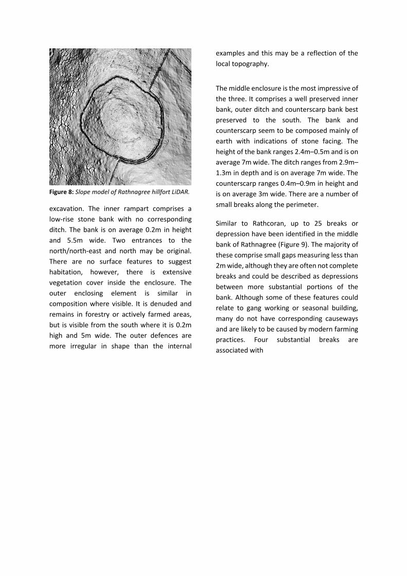
Figure 8: Slope model of Rathnagree hillfort LiDAR.
excavation. The inner rampart comprises a
low-rise stone bank with no corresponding
ditch. The bank is on average 0.2m in height
and 5.5m wide. Two entrances to the
north/north-east and north may be original.
There are no surface features to suggest
habitation, however, there is extensive
vegetation cover inside the enclosure. The
outer enclosing element is similar in
composition where visible. It is denuded and
remains in forestry or actively farmed areas,
but is visible from the south where it is 0.2m
high and 5m wide. The outer defences are
more irregular in shape than the internal
examples and this may be a reflection of the
local topography.
The middle enclosure is the most impressive of
the three. It comprises a well preserved inner
bank, outer ditch and counterscarp bank best
preserved to the south. The bank and
counterscarp seem to be composed mainly of
earth with indications of stone facing. The
height of the bank ranges 2.4m–0.5m and is on
average 7m wide. The ditch ranges from 2.9m–
1.3m in depth and is on average 7m wide. The
counterscarp ranges 0.4m–0.9m in height and
is on average 3m wide. There are a number of
small breaks along the perimeter.
Similar to Rathcoran, up to 25 breaks or
depression have been identified in the middle
bank of Rathnagree (Figure 9). The majority of
these comprise small gaps measuring less than
2m wide, although they are often not complete
breaks and could be described as depressions
between more substantial portions of the
bank. Although some of these features could
relate to gang working or seasonal building,
many do not have corresponding causeways
and are likely to be caused by modern farming
practices. Four substantial breaks are
associated with

Figure 9: Contour model derived from LiDAR data of Rathnagree hillfort, highlighting features of interest.
causeways and these could be original
entrances. They are positioned at the north,
south, east and west of the perimeter and
measure between 2.8–6.1m. The eastern
example is the most substantial. GPS survey
has identified a small internal avenue of
boulders and stones extending from the edge
of the bank terminals and this may have
formed a formal entrance. A level platform
approximately 4m in width abuts the inside of
the middle enclosing element. This is most
prevalent at the north-east and west where
the steep natural slope of the hilltop
emphasises this feature.
The LiDAR and GPS surveys revealed up to 19
possible hut structures in the interior of
Rathnagree hillfort. These are apparent as
circular terraces cut into the natural slope of
the hilltop and are concentrated at the west
and south-west.
Geophysical survey suggested that the slight
inner and outer defences may represent the
stone footing for a wooden palisade (Figure
10). Strong magnetic anomalies were recorded
over their perimeter. These are unlikely to
derive from the type of stone comprising the
banks, which mainly consist of non-magnetic
sandstones and granite. Similar
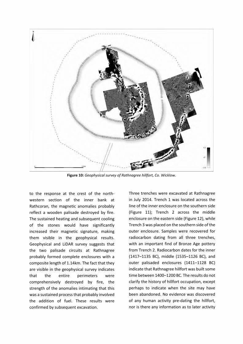
Figure 10: Geophysical survey of Rathnagree hillfort, Co. Wicklow.
to the response at the crest of the north-
western section of the inner bank at
Rathcoran, the magnetic anomalies probably
reflect a wooden palisade destroyed by fire.
The sustained heating and subsequent cooling
of the stones would have significantly
increased their magnetic signature, making
them visible in the geophysical results.
Geophysical and LiDAR survey suggests that
the two palisade circuits at Rathnagree
probably formed complete enclosures with a
composite length of 1.14km. The fact that they
are visible in the geophysical survey indicates
that the entire perimeters were
comprehensively destroyed by fire, the
strength of the anomalies intimating that this
was a sustained process that probably involved
the addition of fuel. These results were
confirmed by subsequent excavation.
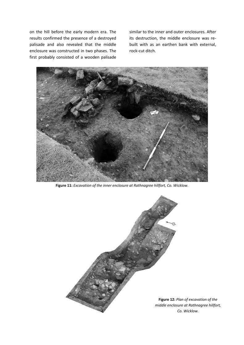
Three trenches were excavated at Rathnagree
in July 2014. Trench 1 was located across the
line of the inner enclosure on the southern side
(Figure 11); Trench 2 across the middle
enclosure on the eastern side (Figure 12), while
Trench 3 was placed on the southern side of the
outer enclosure. Samples were recovered for
radiocarbon dating from all three trenches,
with an important find of Bronze Age pottery
from Trench 2. Radiocarbon dates for the inner
(1417–1135 BC), middle (1535–1126 BC), and
outer palisaded enclosures (1411–1128 BC)
indicate that Rathnagree hillfort was built some
time between 1400–1200 BC. The results do not
clarify the history of hillfort occupation, except
perhaps to indicate when the site may have
been abandoned. No evidence was discovered
of any human activity pre-dating the hillfort,
nor is there any information as to later activity
on the hill before the early modern era. The
results confirmed the presence of a destroyed
palisade and also revealed that the middle
enclosure was constructed in two phases. The
first probably consisted of a wooden palisade
similar to the inner and outer enclosures. After
its destruction, the middle enclosure was re-
built with as an earthen bank with external,
rock-cut ditch.
Figure 11: Excavation of the inner enclosure at Rathnagree hillfort, Co. Wicklow.
Figure 12: Plan of excavation of the
middle enclosure at Rathnagree hillfort,
Co. Wicklow.
Sruhaun
An unrecorded univallate hillfort was recently
identified on the south-western spur of
Tuckmill Hill in Sruhaun townland. This new
site was identified by analysis of LiDAR data, as
the site is not visible in aerial photographs
(Figure 13). There are excellent views of the
lowlands to the west and south, although
visibility to the east is obscured by Tuckmill Hill
itself. Positioned on a level terrace with steep
slopes to the south and east, the enclosure
comprises a single low-rise bank approximately
4.5m wide, occupying a total area of 1.43ha.
The slight nature of the bank makes it difficult
to identify at ground level.
The perimeter of the hillfort is apparent in the
geophysical survey as an intense band of
magnetism (Figure 14). The results are similar
to those found at Rathcoran and Rathnagree
and may be suggestive of a prolonged burning
event, although excavation failed to produce
evidence to support this. There is a single 10m
wide break in the enclosing elements, visible in
the geophysical results at the north-east. Here,
the defences extend outwards toward the
summit of Tuckmill Hill and Rathcoran hillfort,
375m to the north-east. A modern field bank
runs through the eastern portion of
Figure 13: Slope model of Sruhaun hillfort LiDAR.
the interior. There are no obvious internal
features visible on the surface, in the LiDAR
data, or in the geophysical results. Some
surface outcrop indicates that the underlying
bedrock is close to the surface in some areas of
the interior.
Excavation revealed that the enclosing
elements consisted of a truncated bank of
stones with two shallow internal ditches which
were constructed at a much later date (Figure
15). There was little in the way of datable
deposits, and as such, a single radiocarbon
estimation of 1375–1225 BC was recovered
directly underneath the bank material.
Figure 14:
Geophysical
survey of
Sruhaun hillfort,
Co. Wicklow.
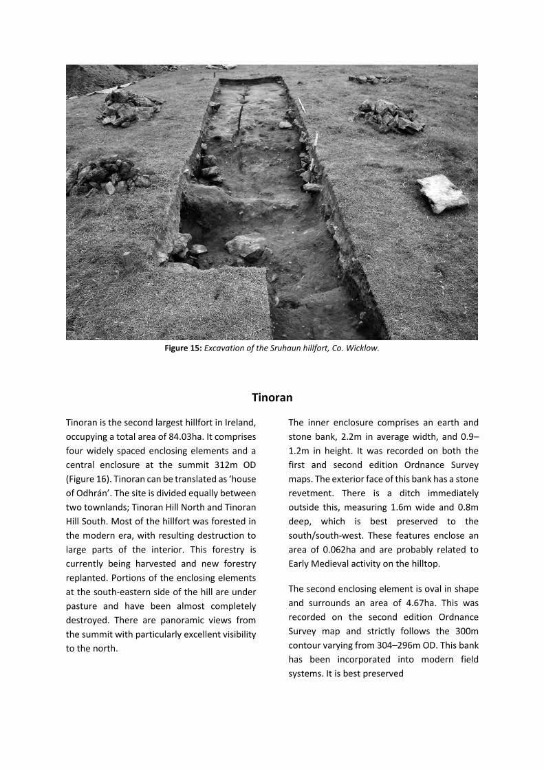
Figure 15: Excavation of the Sruhaun hillfort, Co. Wicklow.
Tinoran
Tinoran is the second largest hillfort in Ireland,
occupying a total area of 84.03ha. It comprises
four widely spaced enclosing elements and a
central enclosure at the summit 312m OD
(Figure 16). Tinoran can be translated as ‘house
of Odhrán’. The site is divided equally between
two townlands; Tinoran Hill North and Tinoran
Hill South. Most of the hillfort was forested in
the modern era, with resulting destruction to
large parts of the interior. This forestry is
currently being harvested and new forestry
replanted. Portions of the enclosing elements
at the south-eastern side of the hill are under
pasture and have been almost completely
destroyed. There are panoramic views from
the summit with particularly excellent visibility
to the north.
The inner enclosure comprises an earth and
stone bank, 2.2m in average width, and 0.9–
1.2m in height. It was recorded on both the
first and second edition Ordnance Survey
maps. The exterior face of this bank has a stone
revetment. There is a ditch immediately
outside this, measuring 1.6m wide and 0.8m
deep, which is best preserved to the
south/south-west. These features enclose an
area of 0.062ha and are probably related to
Early Medieval activity on the hilltop.
The second enclosing element is oval in shape
and surrounds an area of 4.67ha. This was
recorded on the second edition Ordnance
Survey map and strictly follows the 300m
contour varying from 304–296m OD. This bank
has been incorporated into modern field
systems. It is best preserved
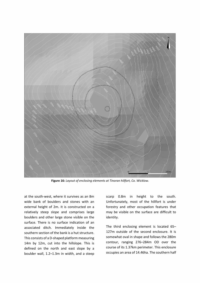
Figure 16: Layout of enclosing elements at Tinoran hillfort, Co. Wicklow.
at the south-west, where it survives as an 8m
wide bank of boulders and stones with an
external height of 2m. It is constructed on a
relatively steep slope and comprises large
boulders and other large stone visible on the
surface. There is no surface indication of an
associated ditch. Immediately inside the
southern section of the bank is a hut structure.
This consists of a D-shaped platform measuring
14m by 12m, cut into the hillslope. This is
defined on the north and east slope by a
boulder wall, 1.2–1.3m in width, and a steep
scarp 0.8m in height to the south.
Unfortunately, most of the hillfort is under
forestry and other occupation features that
may be visible on the surface are difficult to
identity.
The third enclosing element is located 65–
127m outside of the second enclosure. It is
somewhat oval in shape and follows the 280m
contour, ranging 276–284m OD over the
course of its 1.37km perimeter. This enclosure
occupies an area of 14.46ha. The southern half
of the enclosing elements have been
incorporated into a field wall, which is largely
responsible for its survival. The original bank
survives best at the south-west where it is
under dense scrub and gorse growth. It is of
similar construction to the second enclosure,
comprising a low-rise stone bank of boulders
and large stones measuring approximately 6m
wide and 3.2m in external height. There is no
surface indication of an associated ditch.
The partial remains of a fourth enclosure has
been identified by Condit (1998, 15). The
southern half of this enclosure survives as a
low-rise bank feature on agricultural land
rather than forestry and measures
approximately 6m wide and up to 0.3m high.
There is a slight indication of an outer ditch.
When projected, the enclosure occupies an
area of 55.74ha. The bank of this enormous
enclosure ranges from 221–244m OD. A large
ring-barrow abuts the enclosure to the east.
This comprises a low domed interior 16–22m
in width and 0.4m in height surrounded by a
ditch 7-9m in width and outer bank 11–18m in
width and 0.3m in average height. The barrow
is approximately 55m in diameter.
A possible fifth enclosure has recently been
identified, approximately 50–97m outside the
former example. This is best preserved at the
south where it survives as a low-rise bank with
an external ditch 8.2–11.6m wide and up to
1.2m deep. When projected, these defences
may enclose an area of 84.03ha.
LiDAR survey has also been used to identified a
considerable number of relict field patterns
surrounding the hilltop. The majority of these
are contained within upstanding boundaries
and were probably constructed at the same
time as the former. Most of the levelled
examples are not recorded in ancient mapping
and are therefore likely to pre-date the
completion of the first edition Ordnance
Survey mapping programme in 1842. They
probably date to the early 17th or 18th century.
Due to the extent of forestry, the majority of
Tinoran hillfort could not be surveyed with GPS
or using geophysical techniques. LiDAR survey
was obtained at 0.5m resolution, although
dense tree cover has negated the effectiveness
of this method. Despite this, the enclosing
elements of the hillfort were recorded in some
detail. The inner enclosure is under dense
forestry and was not recorded in the LiDAR
survey in any detail.
Up to 29 possible ring-barrows were identified
in the LiDAR survey. Three of these are
positioned at the north-east base of the hilltop.
The remainder are clustered at the
south/south-east side, between the third and
fourth enclosing elements of the hillfort. The
majority of these comprise circular terraces,
approximately 8–13m in diameter, cut into the
natural slope defined by narrow banks with
internal low-rise mounds.
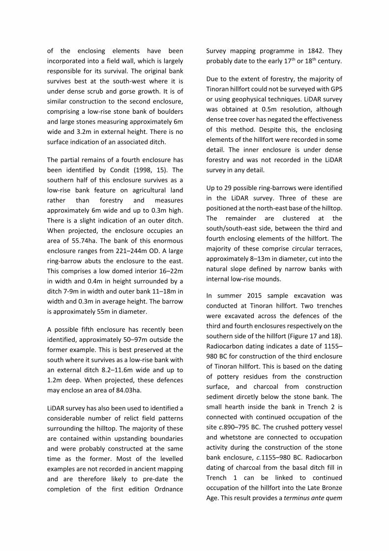
In summer 2015 sample excavation was
conducted at Tinoran hillfort. Two trenches
were excavated across the defences of the
third and fourth enclosures respectively on the
southern side of the hillfort (Figure 17 and 18).
Radiocarbon dating indicates a date of 1155–
980 BC for construction of the third enclosure
of Tinoran hillfort. This is based on the dating
of pottery residues from the construction
surface, and charcoal from construction
sediment dircetly below the stone bank. The
small hearth inside the bank in Trench 2 is
connected with continued occupation of the
site c.890–795 BC. The crushed pottery vessel
and whetstone are connected to occupation
activity during the construction of the stone
bank enclosure, c.1155–980 BC. Radiocarbon
dating of charcoal from the basal ditch fill in
Trench 1 can be linked to continued
occupation of the hillfort into the Late Bronze
Age. This result provides a terminus ante quem
for the defences of the fourth enclosure of the
hillfort.
Figure 17: Excavation of third enclosure at Tinoran hillfort, Co. Wicklow.
Figure 18: Excavation of fourth enclosure at Tinoran hillfort, Co. Wicklow.
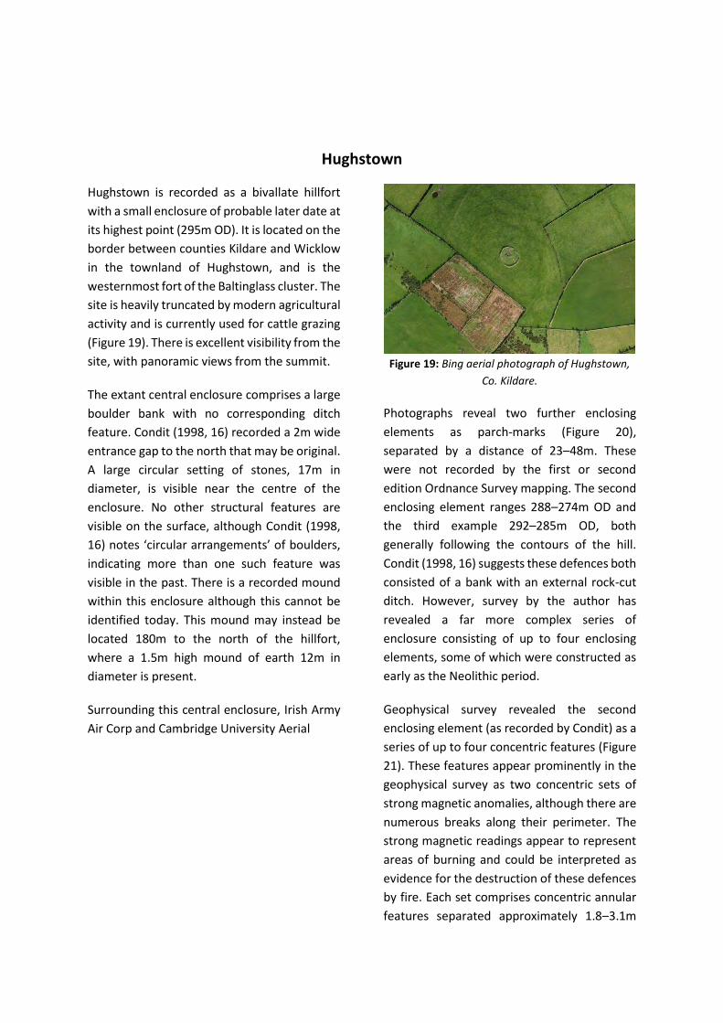
Hughstown
Hughstown is recorded as a bivallate hillfort
with a small enclosure of probable later date at
its highest point (295m OD). It is located on the
border between counties Kildare and Wicklow
in the townland of Hughstown, and is the
westernmost fort of the Baltinglass cluster. The
site is heavily truncated by modern agricultural
activity and is currently used for cattle grazing
(Figure 19). There is excellent visibility from the
site, with panoramic views from the summit.
The extant central enclosure comprises a large
boulder bank with no corresponding ditch
feature. Condit (1998, 16) recorded a 2m wide
entrance gap to the north that may be original.
A large circular setting of stones, 17m in
diameter, is visible near the centre of the
enclosure. No other structural features are
visible on the surface, although Condit (1998,
16) notes ‘circular arrangements’ of boulders,
indicating more than one such feature was
visible in the past. There is a recorded mound
within this enclosure although this cannot be
identified today. This mound may instead be
located 180m to the north of the hillfort,
where a 1.5m high mound of earth 12m in
diameter is present.
Surrounding this central enclosure, Irish Army
Air Corp and Cambridge University Aerial
Figure 19: Bing aerial photograph of Hughstown,
Co. Kildare.
Photographs reveal two further enclosing
elements as parch-marks (Figure 20),
separated by a distance of 23–48m. These
were not recorded by the first or second
edition Ordnance Survey mapping. The second
enclosing element ranges 288–274m OD and
the third example 292–285m OD, both
generally following the contours of the hill.
Condit (1998, 16) suggests these defences both
consisted of a bank with an external rock-cut
ditch. However, survey by the author has
revealed a far more complex series of
enclosure consisting of up to four enclosing
elements, some of which were constructed as
early as the Neolithic period.
Geophysical survey revealed the second
enclosing element (as recorded by Condit) as a
series of up to four concentric features (Figure
21). These features appear prominently in the
geophysical survey as two concentric sets of
strong magnetic anomalies, although there are
numerous breaks along their perimeter. The
strong magnetic readings appear to represent
areas of burning and could be interpreted as
evidence for the destruction of these defences
by fire. Each set comprises concentric annular
features separated approximately 1.8–3.1m

apart. There is some evidence for associated
pit-like features that could represent post-
holes and
Figure 20: Aerial photography of Hughstown, Co.
Kildare (Cambridge Aerial Photograph Collection).
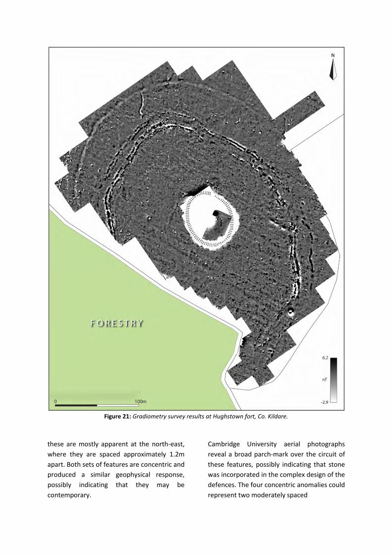
Figure 21: Gradiometry survey results at Hughstown fort, Co. Kildare.
these are mostly apparent at the north-east,
where they are spaced approximately 1.2m
apart. Both sets of features are concentric and
produced a similar geophysical response,
possibly indicating that they may be
contemporary.
Cambridge University aerial photographs
reveal a broad parch-mark over the circuit of
these features, possibly indicating that stone
was incorporated in the complex design of the
defences. The four concentric anomalies could
represent two moderately spaced
enclosing elements, each of which consists of a
stone bank and external ditch. Both banks
could have contained wooden elements that
were destroyed by fire. Subsequent erosion of
this material into the ditch may explain the
presence of two closely spaced magnetic
features.
The outer enclosing element (the third
enclosure recorded by Condit) may be partially
preserved at the north-east, where it
comprises a curving field bank of large
boulders in line with the circular vegetation
mark revealed in aerial photographs.
Geophysical survey also confirmed this bank
continued along its path at the north and
north-west and was approximately 5–7m wide.
There is no clear geophysical response
indicative of a ditch feature, although the
LiDAR data in this area suggests the presence
of a shallow external in-filled ditch. This slight
topographical feature continues along its path
and is visible in the LiDAR data at the west and
south-west. It is particularly evident at the
west where it measures up to 8.5m in width.
Vegetation marks on Irish Air Corp aerial
photographs support the identification of this
as a ditch feature. It is notable that the outer
enclosing element produced a notably
different geophysical response than the
complex series of enclosures that represents
Condit’s second enclosing element. It is also
apparent that the outer defences are not
concentric with these features.
Geophysical survey, therefore, has revealed a
complex system of enclosure. The first
enclosure comprises the small extant
enclosure at the summit which probably dates
to the Early Medieval period. The much larger
enclosures surrounding the hilltop probably
comprise three bank and ditch enclosures
which possibly incorporated wooden
elements. This has subsequently been
confirmed through excavation. There is no
clear evidence for an entrance in any of the
identified enclosing elements. A linear
arrangement of strong readings indicative of
an area of burning is visible at the north. This
could have marked a formal entrance to the
interior.
On the eastern slopes of Hughstown, the LiDAR
data reveals a series of unrecorded relict field
boundaries. None of these are apparent in
historic OS mapping and therefore may be of
pre-1840 date. These fields comprise
elongated and somewhat closely spaced
boundaries, ranging 15–28m apart. On the
southwestern edge of Hughstown, in an area
of newly planted forestry, a pair of extant
banks are separated approximately 26m apart.
These banks are larger than most field
boundaries and measure 9–12m in width and
extend north-east to south-west for
approximately 155m. These features were
noted in the RMP files as a pair of parallel
banks approaching the outer rampart on the
southwest side of the hill. They have been
interpreted as a field system or possible
cursus. The broad width of the banks and
apparent lack of an associated ditch may
correspond with the latter interpretation,
although this cannot be confirmed without
excavation.
A large, unrecorded, embanked pond 350m to
the east of the hillfort is cut into the slope of
the hilltop. The western side of this feature is
approximately 4m beneath the modern ground
surface. The northern, southern and western
edges of the pond are embanked, while the
eastern perimeter is level with the surface and
unprotected. The pond appears on early
Ordnance Survey maps and was therefore
constructed before 1842. Today, water is
continually drained from the pond to prevent
flooding. The source is likely to be a natural
spring. Approximately 150m to the south-east
is an unrecorded ring-barrow. The monument
is approximately 18m in diameter and
comprises a 4m wide band of stone, 0.3m high,
with a low-rise central mound.
Sample excavation was conducted at
Hughstown in August 2015 and July 2016
(Figure 22 and 23. Guided by magnetic
gradiometry readings, a single trench was
excavated across each of the enclosing
elements of the fort.
Radiocarbon dating of charcoal suggests that
construction and/or use of the second
enclosure at Hughstown occurred during the
Early Neolithic, c.3694–3533 BC. A result of
3661–3521 BC provides a terminus ante quem
for the digging of the enclosure ditch, while a
similar date range of 3694–3523 BC for
charcoal in the slot trench is probably (but not
certainly) part of the same construction event,
as is the result of 3704–3533 BC for an adjacent
pit (posthole?). These radiocarbon dates are
supported by the discovery of a single body
sherd of prehistoric pottery with parallels to
burnished wares of the Early/Middle Neolithic.
Radiocarbon dating of charcoal from a slot
trench suggests that the third enclosure at
Hughstown was built c. 3629–3376 BC. This is
supported by a date range of 3632–3373 BC for
charcoal from the lower fill of the adjacent
ditch. Radiocarbon dating of charcoal from the
lower ditch suggests that the fourth enclosure
at Hughstown was dug during or before 3627–
3376 BC.
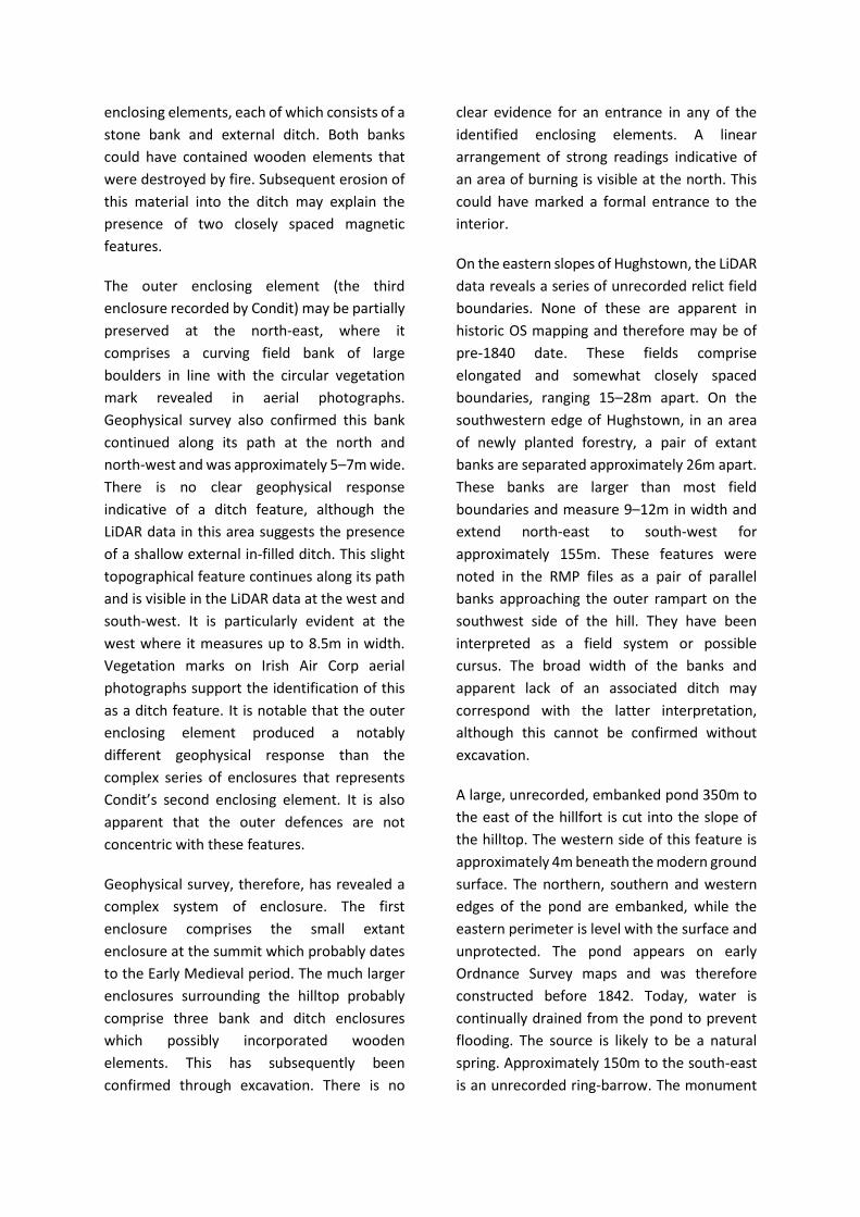
Figure 22: Excavation of the third enclosing element at Hughstown, Co. Kildare.
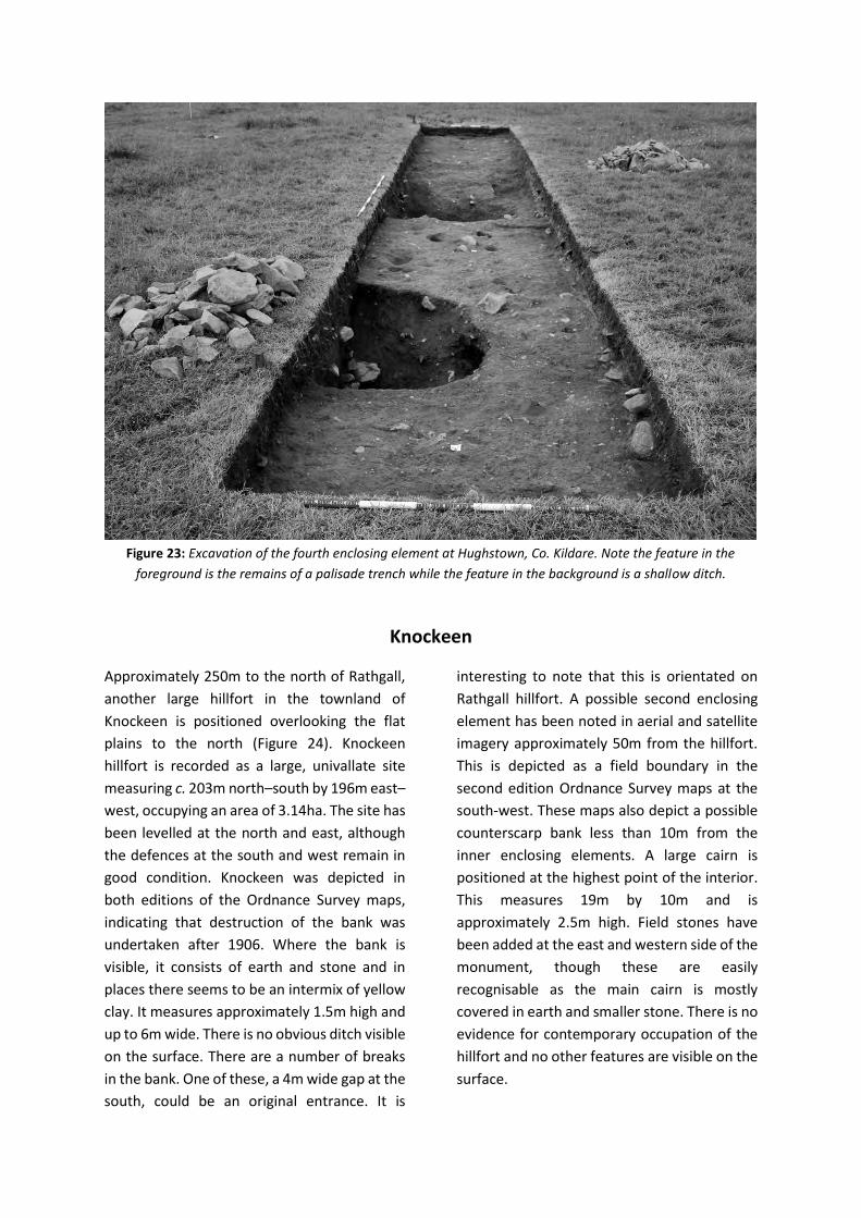
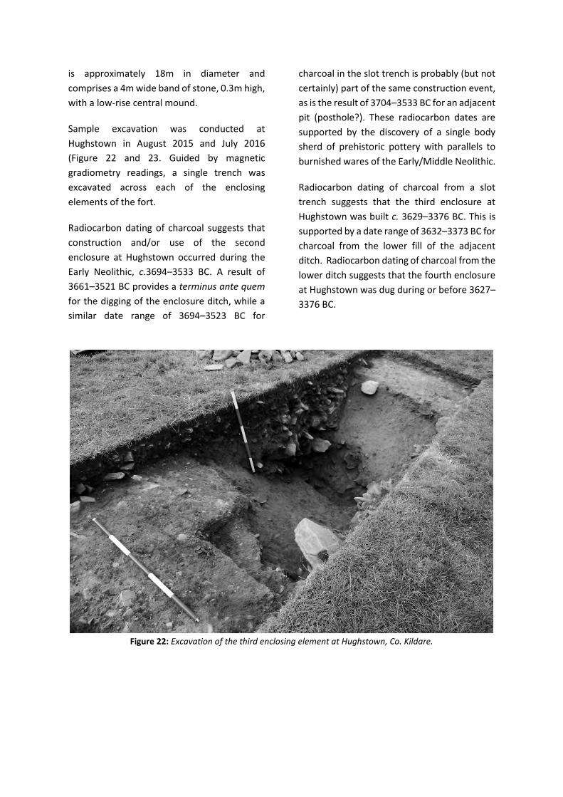
Figure 23: Excavation of the fourth enclosing element at Hughstown, Co. Kildare. Note the feature in the
foreground is the remains of a palisade trench while the feature in the background is a shallow ditch.
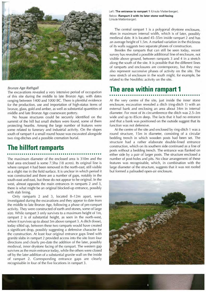
Knockeen
Approximately 250m to the north of Rathgall,
another large hillfort in the townland of
Knockeen is positioned overlooking the flat
plains to the north (Figure 24). Knockeen
hillfort is recorded as a large, univallate site
measuring c. 203m north–south by 196m east–
west, occupying an area of 3.14ha. The site has
been levelled at the north and east, although
the defences at the south and west remain in
good condition. Knockeen was depicted in
both editions of the Ordnance Survey maps,
indicating that destruction of the bank was
undertaken after 1906. Where the bank is
visible, it consists of earth and stone and in
places there seems to be an intermix of yellow
clay. It measures approximately 1.5m high and
up to 6m wide. There is no obvious ditch visible
on the surface. There are a number of breaks
in the bank. One of these, a 4m wide gap at the
south, could be an original entrance. It is
interesting to note that this is orientated on
Rathgall hillfort. A possible second enclosing
element has been noted in aerial and satellite
imagery approximately 50m from the hillfort.
This is depicted as a field boundary in the
second edition Ordnance Survey maps at the
south-west. These maps also depict a possible
counterscarp bank less than 10m from the
inner enclosing elements. A large cairn is
positioned at the highest point of the interior.
This measures 19m by 10m and is
approximately 2.5m high. Field stones have
been added at the east and western side of the
monument, though these are easily
recognisable as the main cairn is mostly
covered in earth and smaller stone. There is no
evidence for contemporary occupation of the
hillfort and no other features are visible on the
surface.
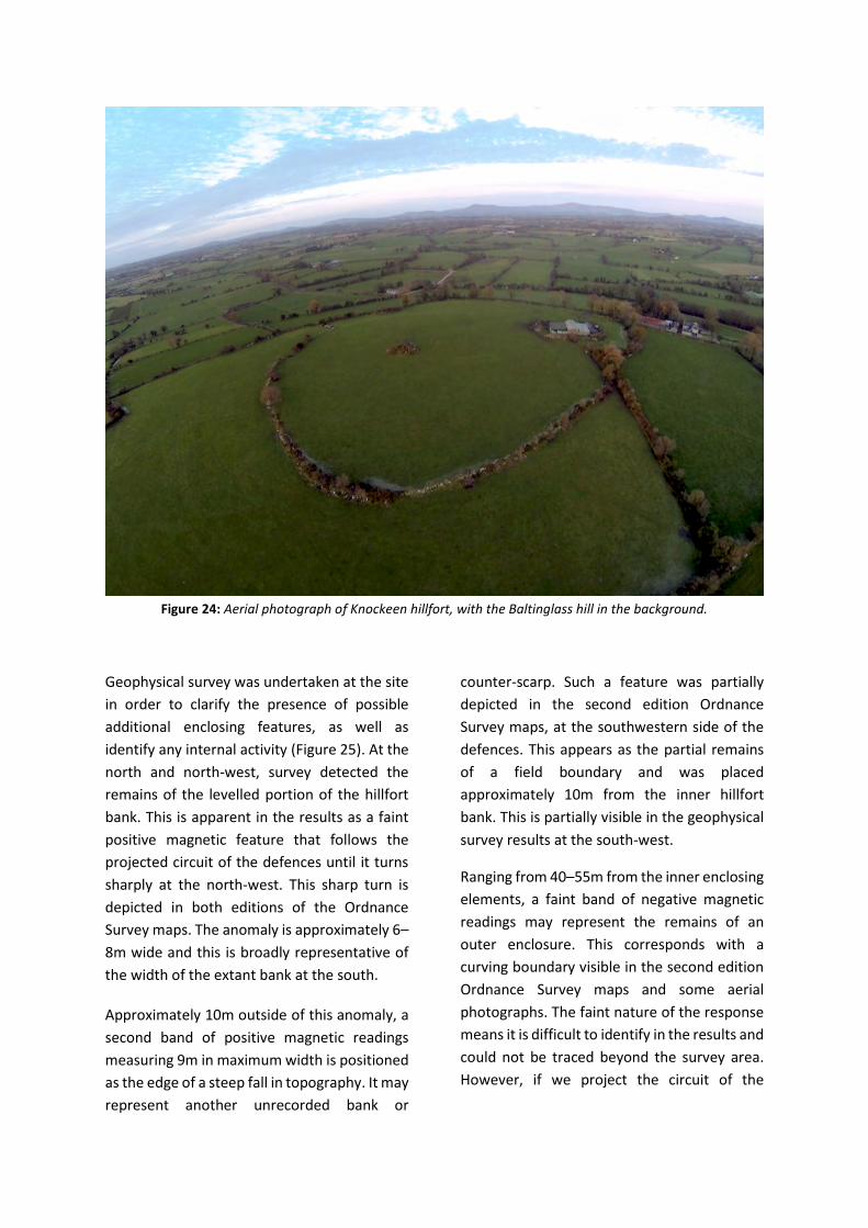
Figure 24: Aerial photograph of Knockeen hillfort, with the Baltinglass hill in the background.
Geophysical survey was undertaken at the site
in order to clarify the presence of possible
additional enclosing features, as well as
identify any internal activity (Figure 25). At the
north and north-west, survey detected the
remains of the levelled portion of the hillfort
bank. This is apparent in the results as a faint
positive magnetic feature that follows the
projected circuit of the defences until it turns
sharply at the north-west. This sharp turn is
depicted in both editions of the Ordnance
Survey maps. The anomaly is approximately 6–
8m wide and this is broadly representative of
the width of the extant bank at the south.
Approximately 10m outside of this anomaly, a
second band of positive magnetic readings
measuring 9m in maximum width is positioned
as the edge of a steep fall in topography. It may
represent another unrecorded bank or
counter-scarp. Such a feature was partially
depicted in the second edition Ordnance
Survey maps, at the southwestern side of the
defences. This appears as the partial remains
of a field boundary and was placed
approximately 10m from the inner hillfort
bank. This is partially visible in the geophysical
survey results at the south-west.
Ranging from 40–55m from the inner enclosing
elements, a faint band of negative magnetic
readings may represent the remains of an
outer enclosure. This corresponds with a
curving boundary visible in the second edition
Ordnance Survey maps and some aerial
photographs. The faint nature of the response
means it is difficult to identify in the results and
could not be traced beyond the survey area.
However, if we project the circuit of the
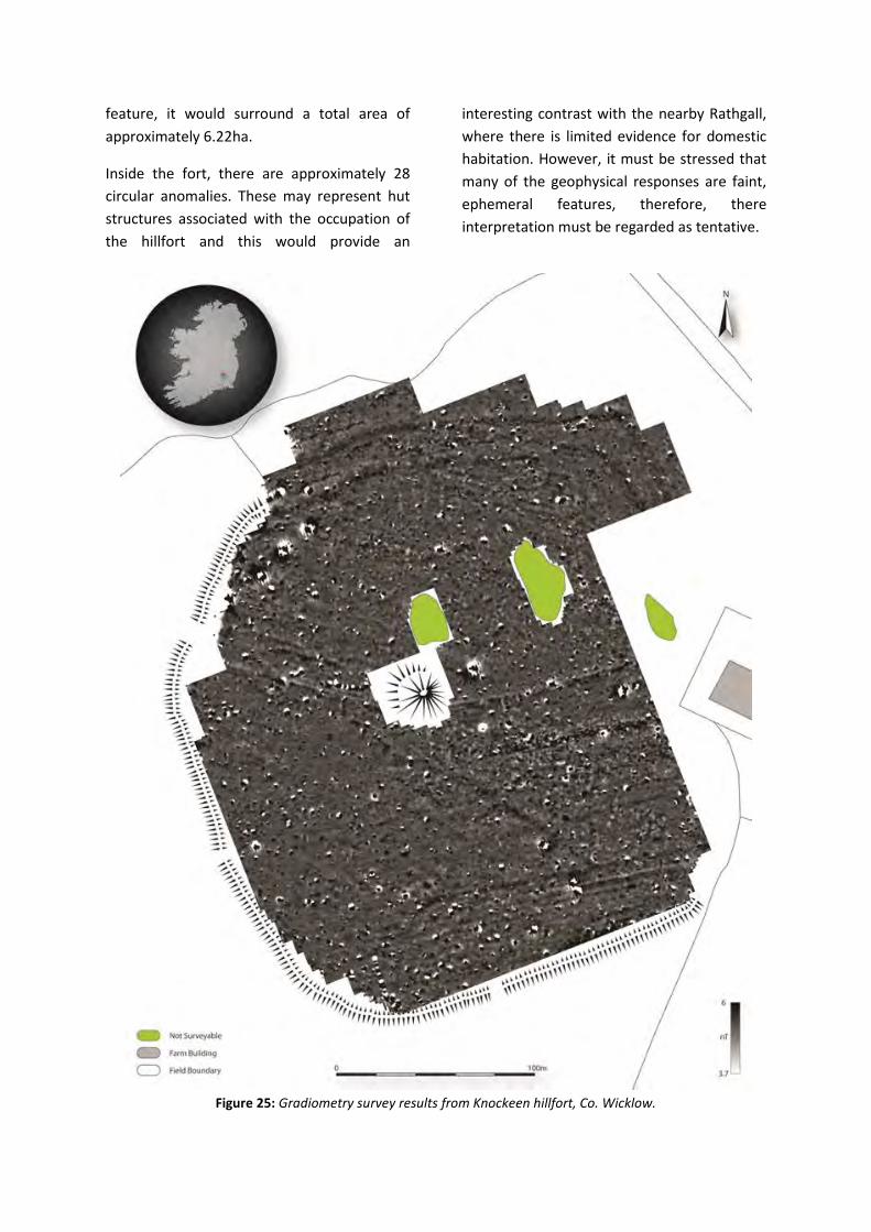
feature, it would surround a total area of
approximately 6.22ha.
Inside the fort, there are approximately 28
circular anomalies. These may represent hut
structures associated with the occupation of
the hillfort and this would provide an
interesting contrast with the nearby Rathgall,
where there is limited evidence for domestic
habitation. However, it must be stressed that
many of the geophysical responses are faint,
ephemeral features, therefore, there
interpretation must be regarded as tentative.
Figure 25: Gradiometry survey results from Knockeen hillfort, Co. Wicklow.
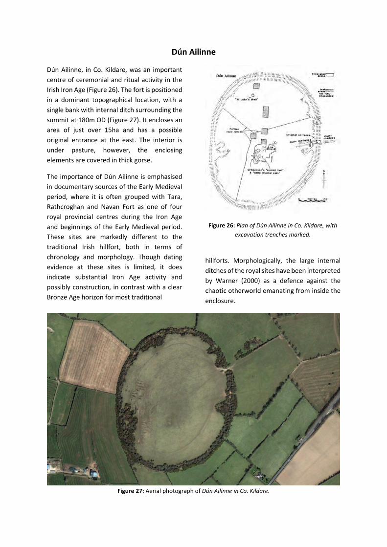
Dún Ailinne
Dún Ailinne, in Co. Kildare, was an important
centre of ceremonial and ritual activity in the
Irish Iron Age (Figure 26). The fort is positioned
in a dominant topographical location, with a
single bank with internal ditch surrounding the
summit at 180m OD (Figure 27). It encloses an
area of just over 15ha and has a possible
original entrance at the east. The interior is
under pasture, however, the enclosing
elements are covered in thick gorse.
The importance of Dún Ailinne is emphasised
in documentary sources of the Early Medieval
period, where it is often grouped with Tara,
Rathcroghan and Navan Fort as one of four
royal provincial centres during the Iron Age
and beginnings of the Early Medieval period.
These sites are markedly different to the
traditional Irish hillfort, both in terms of
chronology and morphology. Though dating
evidence at these sites is limited, it does
indicate substantial Iron Age activity and
possibly construction, in contrast with a clear
Bronze Age horizon for most traditional
Figure 26: Plan of Dún Ailinne in Co. Kildare, with
excavation trenches marked.
hillforts. Morphologically, the large internal
ditches of the royal sites have been interpreted
by Warner (2000) as a defence against the
chaotic otherworld emanating from inside the
enclosure.
Figure 27: Aerial photograph of Dún Ailinne in Co. Kildare.
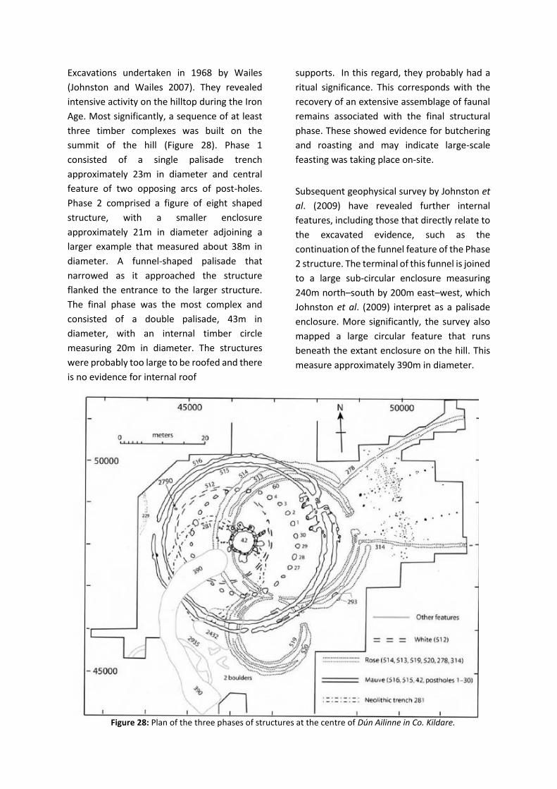
Excavations undertaken in 1968 by Wailes
(Johnston and Wailes 2007). They revealed
intensive activity on the hilltop during the Iron
Age. Most significantly, a sequence of at least
three timber complexes was built on the
summit of the hill (Figure 28). Phase 1
consisted of a single palisade trench
approximately 23m in diameter and central
feature of two opposing arcs of post-holes.
Phase 2 comprised a figure of eight shaped
structure, with a smaller enclosure
approximately 21m in diameter adjoining a
larger example that measured about 38m in
diameter. A funnel-shaped palisade that
narrowed as it approached the structure
flanked the entrance to the larger structure.
The final phase was the most complex and
consisted of a double palisade, 43m in
diameter, with an internal timber circle
measuring 20m in diameter. The structures
were probably too large to be roofed and there
is no evidence for internal roof
supports. In this regard, they probably had a
ritual significance. This corresponds with the
recovery of an extensive assemblage of faunal
remains associated with the final structural
phase. These showed evidence for butchering
and roasting and may indicate large-scale
feasting was taking place on-site.
Subsequent geophysical survey by Johnston et
al. (2009) have revealed further internal
features, including those that directly relate to
the excavated evidence, such as the
continuation of the funnel feature of the Phase
2 structure. The terminal of this funnel is joined
to a large sub-circular enclosure measuring
240m north–south by 200m east–west, which
Johnston et al. (2009) interpret as a palisade
enclosure. More significantly, the survey also
mapped a large circular feature that runs
beneath the extant enclosure on the hill. This
measure approximately 390m in diameter.
Figure 28: Plan of the three phases of structures at the centre of Dún Ailinne in Co. Kildare.
Bibliography
Condit, T. 1992. Ireland’s hillfort capital:
Baltinglass, Co. Wicklow. Archaeology
Ireland 6 (3), 16–20.
Condit, T. 1998. Observations of the Baltinglass
hillfort complex. In Corlett, C. and
O’Sullivan, A. (eds), Wicklow
Archaeology and History 1, 9–25.
Grogan, 2005. The North Munster Project Vol.
2. Wordwell, Dublin.
Johnson, S. and Wailes, B. 2007. Dún Ailinne:
Excavations at the Irish Royal Site, 1968–
1975. University of Pennsylvania
Museum of Archaeology and
Anthropology, Philadelphia.
Johnson, S., Campana, D. and Crabtree, P.
2009. A geophysical survey at Dún
Ailinne, County Kildare, Ireland. Journal
of Field Archaeology 34 (4), 385–402.
Lewis, S. 1837. A Topographical Dictionary of
Ireland. S. Lewis and Co., Dublin.
Mitchell, G. and Ryan, M. 1997. Reading the
Irish Landscape (Third Edition). Country
House, Dublin.
Nairn, R. and Crowley, M. 1998. Wild Wicklow:
Nature in the Garden of Ireland.
Townhouse, Dublin.
O’Brien, W. and O’Driscoll. Forthcoming.
Hillforts, Warfare and Society in Late
Bronze Age Ireland.
O’Driscoll, J. 2015. Hillfort construction at Baltinglass: building Irelands hillfort capital. West Wicklow Historical Journal 8. 10–29.
O’Driscoll, J. 2016. The Baltinglass Cluster and
the Bronze Age Hillforts of Ireland.
Unpublished PhD Thesis, University
College Cork.
https://cora.ucc.ie/handle/10468/3532
O’Driscoll, J. In press. The Baltinglass hillfort
cluster in context of the Irish Late Bronze
Age hillfort. In Brandherm, D.
Proceedings of the Bronze Age Forum.
Raftery, B. 1994. Pagan Celtic Ireland. Thames
and Hudson, London.
Sleeman, A., McConnell, B. and Gately, S. 2003.
Understanding Earth Processes, Rocks
and the Geological History of Ireland.
Geological Survey of Ireland, Dublin.
Vines, G. 2007. The Hunt for Wicklow Gold.
New Scientist 193 (2588), 48–49.
Waddell, J. 1998. The Prehistoric Archaeology
of Ireland. Wordwell, Dublin.
Walshe, P. 1941. The excavation of a burial
cairn on Baltinglass Hill, Co. Wicklow.
Proceedings of the Royal Irish Academy
56, 221–236.
Warner, R. 2000. Keeping out the otherworld:
the internal ditch at Navan and other
Iron Age ‘hengiform’ enclosures. Emania
18, 39–44.
Westropp, T. 1902. Ancient Forts of Ireland:
Being a Contribution Towards Our
Knowledge of Their Types, Affinities, and
Structural Features. Royal Irish
Academy, Dublin.
Whittow, J. 1975. Geology and Scenery in
Ireland. Penguin, London.
We would like to thank the Carlow County Museum for their kind
assistance with our Friday evening meeting and for hosting a lovely
reception for us in the Museum!
Particular thanks to Dermot Mulligan for all his help!


Proceedings of the Prehistoric Society 0, 2017 pp. 1–19 © The Prehistoric Society1 doi:10.1017/ppr.2017.1
2 Radiocarbon Dating of a Multi-phase Passage Tomb on3 Baltinglass Hill, Co. Wicklow, Ireland
4 By RICK J. SCHULTINGQ1 1, MERIEL McCLATCHIE2, ALISON SHERIDAN3, ROWAN McLAUGHLIN4, PHIL BARRATT4, and5 NICKI WHITEHOUSE4
6
7 Baltinglass is a multi-chamber Neolithic passage tomb in Co. Wicklow, Ireland, excavated in the 1930s.8 This paper presents the results of a radiocarbon dating programme on charred wheat grains and hazelnut9 shell found underlying the cairn, and on cremated human bone found within and near two of the monument’s10 five chambers. The results are surprising, in that three of the six determinations on calcined bone11 pre-date by one or two centuries the charred cereals and hazelnut shells sealed under the cairn, dating to12 c. 3600–3400 cal BC. Of the remaining three bone results, one is coeval with the charred plant remains, while the13 final two can be placed in the period 3300/3200–2900 cal BC, that is more traditionally associated with14 developed passage tombs. A suggested sequence of construction is presented beginning with a simple tomb15 lacking a cairn, followed by a burning event – perhaps a ritual preparation of the ground – involving the16 deposition of cereal grains and other materials, very rapidly and intentionally sealed under a layer of clay, in17 turn followed by at least two phases involving the construction of more substantial chambers and associated18 cairns. What was already a complex funerary monument has proven to be even more complex, with a history19 spanning at least six centuries.
20 Developments in scientific archaeology, including the21 ability to radiocarbon date calcined bone and the22 Bayesian modelling of radiocarbon dates, have23 contributed to a resurgence of interest in refining24 the chronology of Irish passage tombs (Bayliss &25 O’Sullivan 2013; Bergh & Hensey 2013; Hensey et al.26 2014; Kador et al. 2015; Schulting et al. forthcoming;27 Schulting 2014a). Aside from the important tomb28 of the Mound of the Hostages, Tara, Co. Meath29 (O’Sullivan 2005), the main focus has been on large30 passage tomb complexes, leaving a question over31 the place of more isolated sites. Baltinglass is a32 multi-phase, multi-chamber Neolithic passage tomb in33 Co. Wicklow, lying on the summit of a hill to the34 south-east of the Wicklow Mountains. The site is
35unusual for a passage tomb in yielding a deposit of36charred cereal grain, along with charred hazelnut37shells, a stone axehead, some flint scrapers, and a flint38javelin head, all within a layer of burnt material39underlying the cairn. Cremated human remains were40found in and near two of the chambers, and other41finds include burnt fragments of two bone pins, a few42sherds of pottery, a flint scraper, a smooth ovoid43pebble, and the partial remains of a single unburnt44skeleton. The presence of these various materials and45the site’s multi-phase nature provided the opportunity46for a radiocarbon dating programme, initially aimed47simply at an understanding of the relationship48between the deposit of charred cereals and the49cremated remains. The results, however, have50significance far beyond this, both for the monument’s51history, and for the wider typochronology of Irish52passage tombs.
53THE SITE
54The Baltinglass passage tomb is located on the summit55of the hill of the same name, at an altitude of c. 382m
1Institute of Archaeology 36 Beaumont St, Oxford, OX1 2PGEmail: Rick Schulting [email protected] Institute of Archaeology, 31–34 Gordon Square,London WC1H 0PY3National Museum of Scotland, Chambers Street,Edinburgh, EH1 1JF4Queen’s University Belfast 2017, University Road, Belfast,BT7 1NN, Northern Ireland
1
Email: Rick Schulting [email protected] Institute of Archaeology, 31–34 Gordon Square,UCL Institute of Archaeology, 31London WC1H 0PY
Edinburgh,4Queen’s University Belfast 2017, University Road, Belfast,s University Belfast 2017, University Road, Belfast,Queen s University Belfast 2017, University Road, Belfast,BT7 1NN, Northern Ireland
of Scotland, Chambers Street,
,4WHITEHOUSE

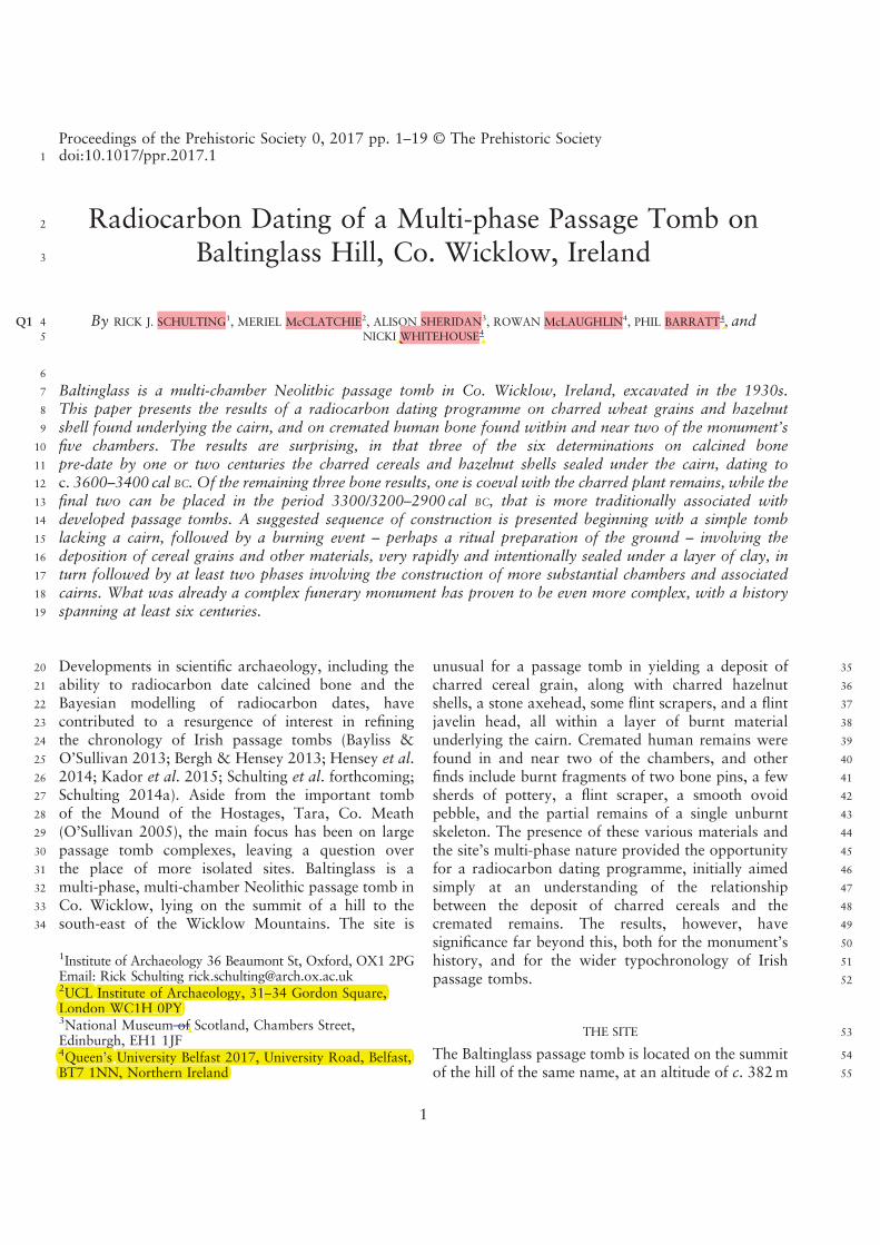
56 above sea level, on the junction of the townlands of57 Pinnacle, Coolinarrig Upper, and Tuckmill Hill, Co.58 Wicklow (Figs 1 & 2). This commanding position is59 typical of passage tombs, in contrast to the lower60 elevations characteristic of court and portal tombs61 (Bergh 1995, 130, 161; 2002; 140; Cooney 2000, 142;62 Herity 1974, 41, 71; O’Kelly 1989, 97). This is clearly63 seen in median elevations for Irish passage tombs64 (145m, n=147) in comparison to those for court65 tombs (89m, n=398) and portal tombs (81m,66 n= 185: McLaughlin et al. 2016, table 1).67 Patrick T. Walshe excavated the site over three68 seasons from 1934 to 1936 (Walshe 1941). At the time69 of its excavation, it measured 25.6m N–S by 27.7m70 E–W in diameter. There is some discrepancy in the71 cairn’s reported surviving height, which is given as 15 ft72 (c. 4.6m) in the text (Walshe 1941, 222), while the73 section drawing (ibid., pl. xviii, fig. 2) indicates a height74 of only c. 10 ft (3.0m). The latter measurement seems75 more reasonable, although the cairn would originally76 have been higher, since by 1907 it had already been77 partly denuded for the construction of a drystone wall.78 Large kerbstones were visible on three sides of the cairn79 even before excavation commenced, as were some80 of the stones of the large north chamber, Chamber I
81(Fig. 3; Walshe 1941). The excavations revealed a82multi-phase monument with five chambers of various83shapes, sizes and methods of construction (Figs 4 & 5).84What the excavator proposed as the earliest chamber to85be constructed, Chamber II, appears to have been86roughly of cruciform shape, with traces of a short87passage, around 3m long, leading to the south-west88edge of the first-phase cairn. The proposed subsequent89enlargements of the cairn did not impact upon the90southern quarter of the earlier cairn, so that Chamber II91could have remained accessible.92The placement of Chamber III in the sequence is less93clear, not helped by the modern boundary wall run-94ning through this part of the cairn. Walshe described95Chamber III as ‘a long low rudely built structure’96(Walshe 1941, 225); no trace of any covering mound97or cairn seems to have been found. A long passage,98defined by exceptionally small upright slabs just 2 in99(c. 5 cm) to 5 in (c. 13 cm) in height, ran between the100outer and inner kerbs, leading to a roughly circular –101though possibly originally cruciform – chamber,102presumably constructed of similarly low stones,103abutting the north-west edge of the first cairn. The104passage was divided into four small compartments by105three small slabs laid cross-wise (ibid.); this is seen106most clearly in an early draft of the site plan in the107National Museum of Ireland (NMI) archives, which108also specifies where cremated bone was found109(Fig. 5a). A subsequent draft plan refers to the passage110as a ‘series of chambers’ (Fig. 5b), which is how this111area is presented on the final plan (Fig. 4). In all three112plans it appears that the kerb of the inner cairn113overlies the stones of the chamber, although this is not114explicitly stated in the published account. As will be115seen, the position of Chamber III in the monument’s116construction sequence is of central importance in this117paper, and will be revisited in the discussion.118Chamber I is the largest, most imposing and best-119preserved chamber in the monument, though it lacks120any finds that would aid with its dating. The circular121chamber had been built into the body of the earlier122cairn, breaking the line of its kerb, with a partly123surviving roofed passage running directly north for1245m. Against the upright of the back wall was a large125recumbent stone (c. 1.8m long by 0.9m wide and1260.6m high) with what the excavator interpreted as an127artificial depression, 15 cm deep, on its upper surface128(Walshe 1941, 224), recalling the well-known basin129stones of the Brú na Bóinne passage tombs. This130affinity is emphasised further by the presence of an
Fig. 1.Map showing location of the Baltinglass passage tomb and
other key sites mentioned in the text
THE PREHISTORIC SOCIETY
2

131 incised motif on the side of the stone facing into the132 chamber and down the passage (Fig. 4). Chamber I133 and its associated cairn extension is clearly late in the134 Neolithic sequence, post-dating Chambers II and III.135 Minimal information is available concerning the final136 two chambers, IV and V. Chamber IV takes the form of137 a small ‘beehive’ chamber, and is seen by the excavator138 as pre-dating Chamber I; the fact that it lies within the139 first-phase cairn material, with its entrance opening out140 between two kerbstones, strongly suggests that it must141 have been constructed when that cairn was built (Walshe142 1941, 235, pl. xvii). Chamber V is described as a small143 ruined chamber or cist, enclosing an area around 6×3 ft144 (1.83×0.91m; Walshe 1941, 226). It held no finds other145 than some charcoal and a lump of clay that may146 represent disintegrated pottery. On the plan its stones147 appear large enough to suggest a rectangular megalithic148 chamber but too little information is available regarding149 its structure to say much more. Walshe considered it to
150be probably a late addition, post-dating even Chamber I151(1941, 235), although he did not explain his reasoning.152If it had indeed been an Early Bronze Age cist, as seems153quite possible, then it might have been associated with a154final episode of cairn enlargement during the Early155Bronze Age, building out from the Chamber I cairn156extension. There is, after all, ample evidence for Early157Bronze Age re-use of passage tombs elsewhere, most158notably at the Mound of the Hostages, Tara (O’Sullivan159et al. 2013), as well as of court and portal tombs160(Schulting 2014b; Schulting et al. 2012).
161THE FINDS
162Underlying the stones of the central part of the cairn163was a layer of ‘loam, rubble, and clay’ 0.23m thick,164under which was found an intermittent thin black layer,165another layer of firmer clay 0.15m thick, and then166another irregular black layer 1–2 cm thick. Between this
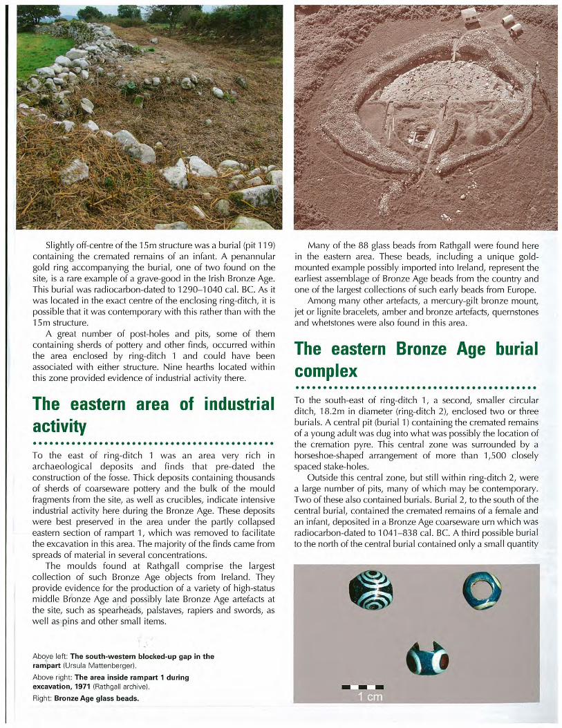
Fig. 2.Baltinglass its landscape setting, with Chamber I to the left and Chamber III in immediate middle foreground. View to ~west.
Photo: Professor William O’Brien
R. Schulting et al. C14DATING, MULTI-PHASE PASSAGE TOMB, BALTINGLASS HILL, CO. WICKLOW
3
167 and the bedrock was a layer of burnt yellow clay (Fig. 4;168 Walshe 1941, 227). The lowermost black layer –
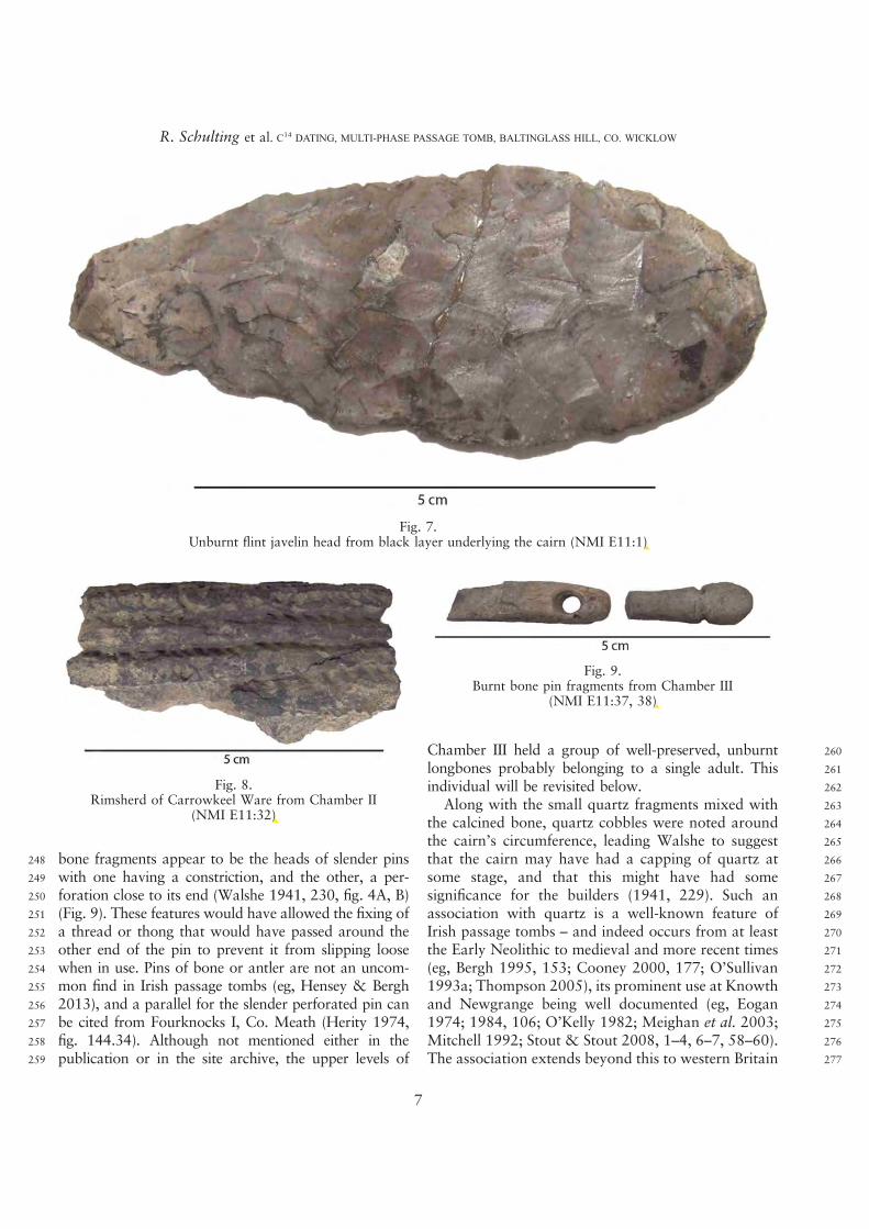
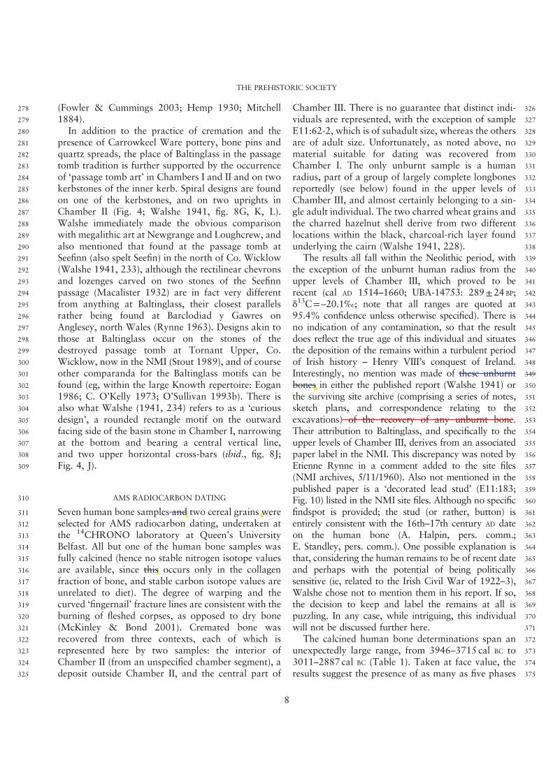
169 Walshe’s ‘fire site’ – contained abundant charcoal and170 two concentrations of charred hazelnut shells. Near one171 of these concentrations was found a polished stone172 axehead (Fig. 6). Outside of the ‘fire site’ was found a173 bifacially-flaked flint javelin head with a broken tip,174 with a surviving length of c. 8 cm (ibid.) (Fig. 7).175 In addition to those found in Chamber III, five flint176 scrapers – one of which had been burnt – were177 recovered from the black layer underlying the cairn178 (ibid., 229, fig. 7). In a separate concentration of burnt179 material from the hazelnuts, between Chambers I and III180 and the cairn’s centre, was a quantity of charred wheat181 grains (Triticum sp.), most probably emmer, though182 identification in the absence of chaff is difficult. Upon183 recent examination for sampling, both the hazelnut184 shells and the cereal grains were found to be extremely185 well preserved, suggesting burial soon after charring.
(|Note that O’Connor (in Walshe 1941, 236) is
186mistaken in his statement that the hazelnut shells and187cereal grains were preserved by some inherent ‘chemical188disintegration’ rather than by charring.) Since flotation189was not practised in the 1930s, the charred grains must190have been hand-collected, implying that there had been191a dense concentration, and probably a much larger total192than the extant c. 200 grains in the NMI.193Aside from cremated human remains, finds in and194around the chambers at Baltinglass were limited.195Other than a flint scraper, Chamber I was empty. This196could suggest that material was removed at some point197before the recorded excavation – a not unlikely198scenario given the easy access to the passage and199chamber. Alternatively, as suggested by ApSimon200(1986, 9), the chamber may have held inhumed human201remains that have not survived. (The presence of202unburnt human remains in good condition in the203upper levels of Chamber III does not contradict this204since, as will be seen, those remains are of relatively205recent date.) But since cremation is very much part of
Fig. 3.Baltinglass, Chamber I. Part of Chamber II is visible to the upper right. View to ~south. Photo: Professor William O’Brien
THE PREHISTORIC SOCIETY
4
Fig. 4.Plan and section of the Baltinglass passage tomb (after Walshe 1941, pl. xviii, with overlain rock art rubbings from figs 8 and 9,
not to scale), with approximate locations of main finds: 1) polished stone axe; 2) flint javelin head; 3) flint scrapers;4) smooth, oval white pebble; 5) calcined bone pin & needle; 6) Carrowkeel pot sherds; 7) coarse pot sherd
R. Schulting et al. C14DATING, MULTI-PHASE PASSAGE TOMB, BALTINGLASS HILL, CO. WICKLOW
5
not to scale), with approximate locations of mainnot to scale), with approximate locations of main
206 the passage tomb tradition, with the deposition of207 cremated and unburnt bones occurring as alternative,208 contemporary rites in several passage tombs (Cooney209 2014; Schulting et al. forthcoming), the absence of210 even tiny fragments of cremated bone from Chamber I211 is somewhat puzzling, given the evident care with
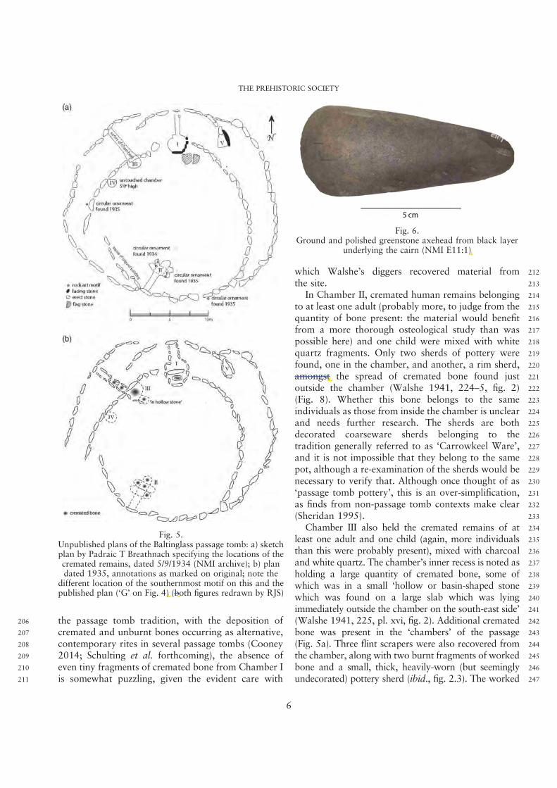
212which Walshe’s diggers recovered material from213the site.214In Chamber II, cremated human remains belonging215to at least one adult (probably more, to judge from the216quantity of bone present: the material would benefit217from a more thorough osteological study than was218possible here) and one child were mixed with white219quartz fragments. Only two sherds of pottery were220found, one in the chamber, and another, a rim sherd,221amongst the spread of cremated bone found just222outside the chamber (Walshe 1941, 224–5, fig. 2)223(Fig. 8). Whether this bone belongs to the same224individuals as those from inside the chamber is unclear225and needs further research. The sherds are both226decorated coarseware sherds belonging to the227tradition generally referred to as ‘Carrowkeel Ware’,228and it is not impossible that they belong to the same229pot, although a re-examination of the sherds would be230necessary to verify that. Although once thought of as231‘passage tomb pottery’, this is an over-simplification,232as finds from non-passage tomb contexts make clear233(Sheridan 1995).234Chamber III also held the cremated remains of at235least one adult and one child (again, more individuals236than this were probably present), mixed with charcoal237and white quartz. The chamber’s inner recess is noted as238holding a large quantity of cremated bone, some of239which was in a small ‘hollow or basin-shaped stone240which was found on a large slab which was lying241immediately outside the chamber on the south-east side’242(Walshe 1941, 225, pl. xvi, fig. 2). Additional cremated243bone was present in the ‘chambers’ of the passage244(Fig. 5a). Three flint scrapers were also recovered from245the chamber, along with two burnt fragments of worked246bone and a small, thick, heavily-worn (but seemingly247undecorated) pottery sherd (ibid., fig. 2.3). The worked
Fig. 5.Unpublished plans of the Baltinglass passage tomb: a) sketchplan by Padraic T Breathnach specifying the locations of thecremated remains, dated 5/9/1934 (NMI archive); b) plandated 1935, annotations as marked on original; note the
different location of the southernmost motif on this and thepublished plan (‘G’ on Fig. 4) (both figures redrawn by RJS)
Fig. 6.Ground and polished greenstone axehead from black layer
underlying the cairn (NMI E11:1)
THE PREHISTORIC SOCIETY
6
on Fig. 4) (bothon Fig. 4) (both
ngst
E11:1)
248 bone fragments appear to be the heads of slender pins249 with one having a constriction, and the other, a per-250 foration close to its end (Walshe 1941, 230, fig. 4A, B)251 (Fig. 9). These features would have allowed the fixing of252 a thread or thong that would have passed around the253 other end of the pin to prevent it from slipping loose254 when in use. Pins of bone or antler are not an uncom-255 mon find in Irish passage tombs (eg, Hensey & Bergh256 2013), and a parallel for the slender perforated pin can257 be cited from Fourknocks I, Co. Meath (Herity 1974,258 fig. 144.34). Although not mentioned either in the259 publication or in the site archive, the upper levels of
260Chamber III held a group of well-preserved, unburnt261longbones probably belonging to a single adult. This262individual will be revisited below.263Along with the small quartz fragments mixed with264the calcined bone, quartz cobbles were noted around265the cairn’s circumference, leading Walshe to suggest266that the cairn may have had a capping of quartz at267some stage, and that this might have had some268significance for the builders (1941, 229). Such an269association with quartz is a well-known feature of270Irish passage tombs – and indeed occurs from at least271the Early Neolithic to medieval and more recent times272(eg, Bergh 1995, 153; Cooney 2000, 177; O’Sullivan2731993a; Thompson 2005), its prominent use at Knowth274and Newgrange being well documented (eg, Eogan2751974; 1984, 106; O’Kelly 1982; Meighan et al. 2003;276Mitchell 1992; Stout & Stout 2008, 1–4, 6–7, 58–60).277The association extends beyond this to western Britain
Fig. 7.Unburnt flint javelin head from black layer underlying the cairn (NMI E11:1)
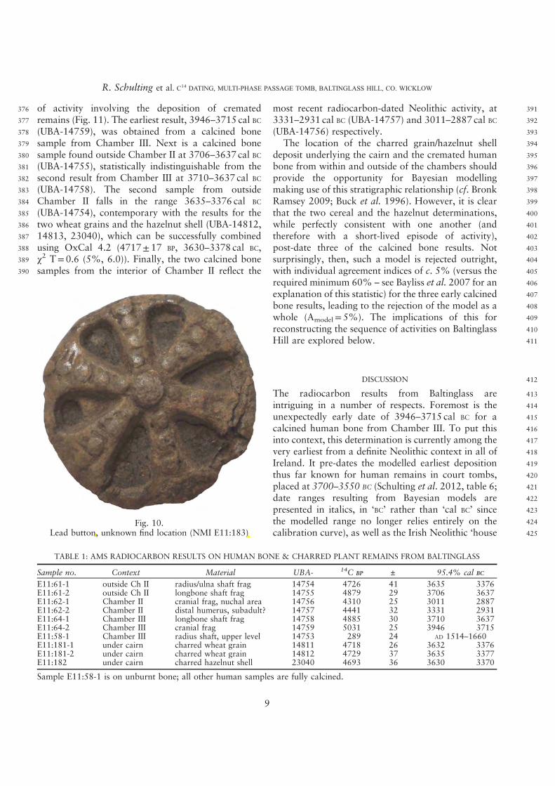
Fig. 8.Rimsherd of Carrowkeel Ware from Chamber II
(NMI E11:32)
Fig. 9.Burnt bone pin fragments from Chamber III
(NMI E11:37, 38)
R. Schulting et al. C14DATING, MULTI-PHASE PASSAGE TOMB, BALTINGLASS HILL, CO. WICKLOW
7
E11:1)
38)
E11:32)
278 (Fowler & Cummings 2003; Hemp 1930; Mitchell279 1884).280 In addition to the practice of cremation and the281 presence of Carrowkeel Ware pottery, bone pins and282 quartz spreads, the place of Baltinglass in the passage283 tomb tradition is further supported by the occurrence284 of ‘passage tomb art’ in Chambers I and II and on two285 kerbstones of the inner kerb. Spiral designs are found286 on one of the kerbstones, and on two uprights in287 Chamber II (Fig. 4; Walshe 1941, fig. 8G, K, L).288 Walshe immediately made the obvious comparison289 with megalithic art at Newgrange and Loughcrew, and290 also mentioned that found at the passage tomb at291 Seefinn (also spelt Seefin) in the north of Co. Wicklow292 (Walshe 1941, 233), although the rectilinear chevrons293 and lozenges carved on two stones of the Seefinn294 passage (Macalister 1932) are in fact very different295 from anything at Baltinglass, their closest parallels296 rather being found at Barclodiad y Gawres on297 Anglesey, north Wales (Rynne 1963). Designs akin to298 those at Baltinglass occur on the stones of the299 destroyed passage tomb at Tornant Upper, Co.300 Wicklow, now in the NMI (Stout 1989), and of course301 other comparanda for the Baltinglass motifs can be302 found (eg, within the large Knowth repertoire: Eogan303 1986; C. O’Kelly 1973; O’Sullivan 1993b). There is304 also what Walshe (1941, 234) refers to as a ‘curious305 design’, a rounded rectangle motif on the outward306 facing side of the basin stone in Chamber I, narrowing307 at the bottom and bearing a central vertical line,308 and two upper horizontal cross-bars (ibid., fig. 8J;309 Fig. 4, J).
310 AMS RADIOCARBON DATING
311 Seven human bone samples and two cereal grains were312 selected for AMS radiocarbon dating, undertaken at313 the 14CHRONO laboratory at Queen’s University314 Belfast. All but one of the human bone samples was315 fully calcined (hence no stable nitrogen isotope values316 are available, since this occurs only in the collagen317 fraction of bone, and stable carbon isotope values are318 unrelated to diet). The degree of warping and the319 curved ‘fingernail’ fracture lines are consistent with the320 burning of fleshed corpses, as opposed to dry bone321 (McKinley & Bond 2001). Cremated bone was322 recovered from three contexts, each of which is323 represented here by two samples: the interior of324 Chamber II (from an unspecified chamber segment), a325 deposit outside Chamber II, and the central part of
326Chamber III. There is no guarantee that distinct indi-327viduals are represented, with the exception of sample328E11:62-2, which is of subadult size, whereas the others329are of adult size. Unfortunately, as noted above, no330material suitable for dating was recovered from331Chamber I. The only unburnt sample is a human332radius, part of a group of largely complete longbones333reportedly (see below) found in the upper levels of334Chamber III, and almost certainly belonging to a sin-335gle adult individual. The two charred wheat grains and336the charred hazelnut shell derive from two different337locations within the black, charcoal-rich layer found338underlying the cairn (Walshe 1941, 228).339The results all fall within the Neolithic period, with340the exception of the unburnt human radius from the341upper levels of Chamber III, which proved to be342recent (cal AD 1514–1660; UBA-14753: 289±24 BP;343δ
13C= –20.1‰; note that all ranges are quoted at34495.4% confidence unless otherwise specified). There is345no indication of any contamination, so that the result346does reflect the true age of this individual and situates347the deposition of the remains within a turbulent period348of Irish history – Henry VIII’s conquest of Ireland.349Interestingly, no mention was made of these unburnt350bones in either the published report (Walshe 1941) or351the surviving site archive (comprising a series of notes,352sketch plans, and correspondence relating to the353excavations) of the recovery of any unburnt bone.354Their attribution to Baltinglass, and specifically to the355upper levels of Chamber III, derives from an associated356paper label in the NMI. This discrepancy was noted by357Etienne Rynne in a comment added to the site files358(NMI archives, 5/11/1960). Also not mentioned in the359published paper is a ‘decorated lead stud’ (E11:183;360Fig. 10) listed in the NMI site files. Although no specific361findspot is provided; the stud (or rather, button) is362entirely consistent with the 16th–17th century AD date363on the human bone (A. Halpin, pers. comm.;364E. Standley, pers. comm.). One possible explanation is365that, considering the human remains to be of recent date366and perhaps with the potential of being politically367sensitive (ie, related to the Irish Civil War of 1922–3),368Walshe chose not to mention them in his report. If so,369the decision to keep and label the remains at all is370puzzling. In any case, while intriguing, this individual371will not be discussed further here.372The calcined human bone determinations span an373unexpectedly large range, from 3946–3715 cal BC to3743011–2887 cal BC (Table 1). Taken at face value, the375results suggest the presence of as many as five phases
THE PREHISTORIC SOCIETY
8
this
bones in either the published report (Walshe 1941) or
es and two cereal grains werees and two cereal grains were
376 of activity involving the deposition of cremated377 remains (Fig. 11). The earliest result, 3946–3715 cal BC378 (UBA-14759), was obtained from a calcined bone379 sample from Chamber III. Next is a calcined bone380 sample found outside Chamber II at 3706–3637 cal BC381 (UBA-14755), statistically indistinguishable from the382 second result from Chamber III at 3710–3637 cal BC
383 (UBA-14758). The second sample from outside384 Chamber II falls in the range 3635–3376 cal BC
385 (UBA-14754), contemporary with the results for the386 two wheat grains and the hazelnut shell (UBA-14812,387 14813, 23040), which can be successfully combined388 using OxCal 4.2 (4717± 17 BP, 3630–3378 cal BC,389 χ
2 T= 0.6 (5%, 6.0)). Finally, the two calcined bone390 samples from the interior of Chamber II reflect the
391most recent radiocarbon-dated Neolithic activity, at3923331–2931 cal BC (UBA-14757) and 3011–2887 cal BC393(UBA-14756) respectively.394The location of the charred grain/hazelnut shell395deposit underlying the cairn and the cremated human396bone from within and outside of the chambers should397provide the opportunity for Bayesian modelling398making use of this stratigraphic relationship (cf. Bronk399Ramsey 2009; Buck et al. 1996). However, it is clear400that the two cereal and the hazelnut determinations,401while perfectly consistent with one another (and402therefore with a short-lived episode of activity),403post-date three of the calcined bone results. Not404surprisingly, then, such a model is rejected outright,405with individual agreement indices of c. 5% (versus the406required minimum 60% – see Bayliss et al. 2007 for an407explanation of this statistic) for the three early calcined408bone results, leading to the rejection of the model as a409whole (Amodel=5%). The implications of this for410reconstructing the sequence of activities on Baltinglass411Hill are explored below.
412DISCUSSION
413The radiocarbon results from Baltinglass are414intriguing in a number of respects. Foremost is the415unexpectedly early date of 3946–3715 cal BC for a416calcined human bone from Chamber III. To put this417into context, this determination is currently among the418very earliest from a definite Neolithic context in all of419Ireland. It pre-dates the modelled earliest deposition420thus far known for human remains in court tombs,421placed at 3700–3550 BC (Schulting et al. 2012, table 6;422date ranges resulting from Bayesian models are423presented in italics, in ‘BC’ rather than ‘cal BC’ since424the modelled range no longer relies entirely on the425calibration curve), as well as the Irish Neolithic ‘house
Fig. 10.Lead button, unknown find location (NMI E11:183)
TABLE 1: AMS RADIOCARBON RESULTS ON HUMAN BONE & CHARRED PLANT REMAINS FROM BALTINGLASS
Sample no. Context Material UBA- 14C BP ± 95.4% cal BC
E11:61-1 outside Ch II radius/ulna shaft frag 14754 4726 41 3635 3376E11:61-2 outside Ch II longbone shaft frag 14755 4879 29 3706 3637E11:62-1 Chamber II cranial frag, nuchal area 14756 4310 25 3011 2887E11:62-2 Chamber II distal humerus, subadult? 14757 4441 32 3331 2931E11:64-1 Chamber III longbone shaft frag 14758 4885 30 3710 3637E11:64-2 Chamber III cranial frag 14759 5031 25 3946 3715E11:58-1 Chamber III radius shaft, upper level 14753 289 24 AD 1514–1660E11:181-1 under cairn charred wheat grain 14811 4718 26 3632 3376E11:181-2 under cairn charred wheat grain 14812 4729 37 3635 3377E11:182 under cairn charred hazelnut shell 23040 4693 36 3630 3370
Sample E11:58-1 is on unburnt bone; all other human samples are fully calcined.
R. Schulting et al. C14DATING, MULTI-PHASE PASSAGE TOMB, BALTINGLASS HILL, CO. WICKLOW
9
button, nd location (NMI E11:183)
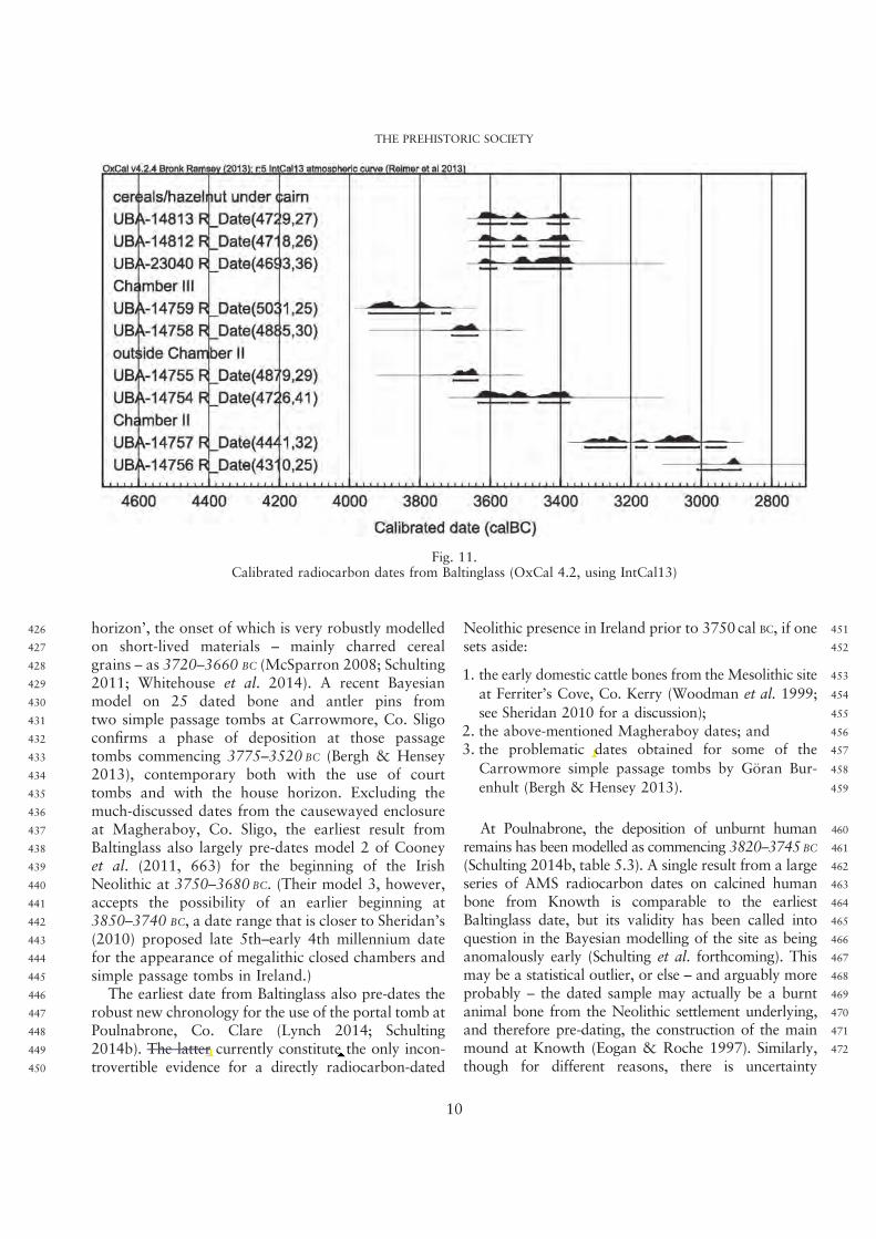
426 horizon’, the onset of which is very robustly modelled427 on short-lived materials – mainly charred cereal428 grains – as 3720–3660 BC (McSparron 2008; Schulting429 2011; Whitehouse et al. 2014). A recent Bayesian430 model on 25 dated bone and antler pins from431 two simple passage tombs at Carrowmore, Co. Sligo432 confirms a phase of deposition at those passage433 tombs commencing 3775–3520 BC (Bergh & Hensey434 2013), contemporary both with the use of court435 tombs and with the house horizon. Excluding the436 much-discussed dates from the causewayed enclosure437 at Magheraboy, Co. Sligo, the earliest result from438 Baltinglass also largely pre-dates model 2 of Cooney439 et al. (2011, 663) for the beginning of the Irish440 Neolithic at 3750–3680 BC. (Their model 3, however,441 accepts the possibility of an earlier beginning at442 3850–3740 BC, a date range that is closer to Sheridan’s443 (2010) proposed late 5th–early 4th millennium date444 for the appearance of megalithic closed chambers and445 simple passage tombs in Ireland.)446 The earliest date from Baltinglass also pre-dates the447 robust new chronology for the use of the portal tomb at448 Poulnabrone, Co. Clare (Lynch 2014; Schulting449 2014b). The latter currently constitute the only incon-450 trovertible evidence for a directly radiocarbon-dated
451Neolithic presence in Ireland prior to 3750 cal BC, if one452sets aside:
4531. the early domestic cattle bones from the Mesolithic site
454at Ferriter’s Cove, Co. Kerry (Woodman et al. 1999;
455see Sheridan 2010 for a discussion);4562. the above-mentioned Magheraboy dates; and4573. the problematic dates obtained for some of the
458Carrowmore simple passage tombs by Göran Bur-
459enhult (Bergh & Hensey 2013).
460At Poulnabrone, the deposition of unburnt human461remains has been modelled as commencing 3820–3745BC
462(Schulting 2014b, table 5.3). A single result from a large463series of AMS radiocarbon dates on calcined human464bone from Knowth is comparable to the earliest465Baltinglass date, but its validity has been called into466question in the Bayesian modelling of the site as being467anomalously early (Schulting et al. forthcoming). This468may be a statistical outlier, or else – and arguably more469probably – the dated sample may actually be a burnt470animal bone from the Neolithic settlement underlying,471and therefore pre-dating, the construction of the main472mound at Knowth (Eogan & Roche 1997). Similarly,
though for different reasons, there is uncertainty
Fig. 11.Calibrated radiocarbon dates from Baltinglass (OxCal 4.2, using IntCal13)
THE PREHISTORIC SOCIETY
10
2014b). The latter currently constitute the only incon-2014b). The latter currently constitute the only incon-
problematic dat
473 concerning the interpretation of two early outlying474 dates on calcined bone from the court tomb at475 Altanagh, Co. Tyrone: 3942–3710cal BC (UBA-14390:476 5020±29 BP) and 3912–3693 cal BC (UBA-14392:477 4987±26 BP: Murphy &ÓDonnabháin forthcoming) –478 although such dates are not impossibly early for the479 traditional Carinated Bowl pottery that was also found480 in this monument.481 One possibility for the early date from Baltinglass is482 that cremated bone fragments were brought to the site483 and placed in Chamber III some centuries after the484 cremation of the body. A selection of calcined bone485 may either have been curated or retrieved from an486 earlier site. A similar practice was initially suggested as487 an explanation for the early dates on human bone from488 the Poulnabrone portal tomb and the lack of any489 correlation with the deposit’s stratigraphy (Lynch &490 Ó Donnabháin 1994). However, the final publication491 of that site – which includes new analyses of the human492 skeletal assemblage and a new series of AMS493 radiocarbon determinations on unburnt bone – makes494 it clear that this is very unlikely, and that instead the495 tomb saw successive primary inhumations, with496 considerable subsequent disturbance (Schulting 2014b).497 While one cannot rule out the ‘curated bone’ hypothesis498 for Baltinglass, it is difficult to find a comparable499 example of the practice of placing older human bone in500 a Neolithic monument, in either Ireland or Britain, that501 holds up to close scrutiny (cf. Schulting et al. 2010).502 Another possible explanation that could apply to all503 the aforementioned early dates on calcined bone from504 Neolithic monumental mortuary contexts is that they505 have been affected by carbon from the fuel used in the506 cremation pyre. Experiments have shown that, during507 cremation, bone becomes susceptible to incorporating508 carbon from the CO2 emitted by the pyre fuel (Huls509 et al. 2010; Snoeck et al. 2014; Zazzo et al. 2009;510 2012). In most circumstances, the wood used for511 cremation pyres was probably branch wood or small512 trunks with an age measured in decades, making it513 comparable to the age of the adult human corpse, given514 the slow turnover rate of radiocarbon in bone collagen515 (Hedges et al. 2007). Thus, early comparisons of516 cremated human bone and associated charcoal did not517 identify significant offsets between the two, implying518 that the dating of calcined bone gave reliable results for519 the actual age of the sample (Lanting & Brindley 1998;520 Lanting et al. 2001; Sheridan 2003). However, if older521 wood – such as structural oak timbers from an Early522 Neolithic house (cf. McLaughlin et al. 2016) – had been
523used for the cremation pyre fuel, then it is entirely524possible (indeed, almost certain) that the resulting AMS525radiocarbon measurement on calcined bone would be5261–2 centuries too old (Snoeck et al. 2014). This issue527will be very difficult to resolve and comes down to an528interpretation based ultimately on the accumulation of529more radiocarbon dates from similar contexts and a530balance of probabilities regarding the likelihood of531precocious outliers from such contexts. This issue does532not arise with Poulnabrone, since the human remains533there were unburnt, well preserved, and not subject to534any discernible reservoir offsets from either marine or535freshwater resources: in other words, the associated536δ
13C and δ15N values indicate no appreciable
537consumption of such resources (Ditchfield 2014). As far538as the Baltinglass date is concerned, the ‘old wood’539effect cannot be ruled out as a possible explanation.540If, however, the early date is indeed valid, and if we541are not dealing with the importation of curated ancient542cremated remains, then this raises the intriguing possi-543bility that Chamber III – an anomalous structure as far544as the canon of Irish passage tomb architecture is545concerned – had genuinely been constructed and used546early in the 4th millennium BC. That Chamber III547belongs to the passage tomb tradition is suggested by548several characteristics: its hilltop position; the later549presence of unquestionable passage tomb chambers in550the monument; the presence of bone pin fragments; the551practice of cremation; and the deposition of some552cremated remains within a stone basin-like receptacle.553However, there are no parallels for the use of basin554stones among the earliest dated passage tombs in555Ireland; and despite a vague similarity in ground plan to556some of the simple passage tombs in the Carrowmore557cemetery (Burenhult 1984; 2001), Chamber III558contrasts with Ireland’s simple passage tombs in the559diminutive scale of its construction and in the absence560of a large (or indeed any) capstone. The single abraded561sherd found in Chamber III fails to provide any562additional clues. The absence of decoration suggests563that it is not of Carrowkeel Ware, yet its thickness and564coarse appearance shows that it unlikely to be an565example of traditional Carinated Bowl pottery either.566While occasional thick and relatively coarse-textured567pots have been found in the traditional Carinated Bowl568repertoire, other characteristics of Chamber III point569away from an association with the ‘Carinated Bowl570Neolithic’ (Sheridan 2010).571Aside from the intriguing early date of 3946–5723715 cal BC, perhaps the most important result of the
R. Schulting et al. C14DATING, MULTI-PHASE PASSAGE TOMB, BALTINGLASS HILL, CO. WICKLOW
11
573 present dating programme is the evidence for the574 monument’s use from c. 3700/3600 to 3400 cal BC,575 based on multiple AMS radiocarbon dates on cremated576 human bone from Chamber III and outside Chamber II,577 and on charred wheat grains and hazelnut shell from578 underneath the cairn (Fig. 10).579 As regards the question of whether the three580 cremated bone dates might display an ‘old fuel’ effect,581 this appears unlikely: while a single outlier might be582 regarded as a possible candidate, having three early583 dates is harder to explain in such terms – and besides,584 had the use of old timbers for funerary pyres been a585 common practice, one would expect to have encoun-586 tered several such outliers among the large series of587 cremated bone dates obtained from Knowth and the588 Mound of the Hostages, Tara (and not just the single589 potential candidate from Knowth, discussed above).590 Support for the idea that the Baltinglass cremated bone591 dates are accurate comes from the fact that the charred592 cereal and hazelnut shell results confirm activity at593 Baltinglass prior to c. 3370 cal BC, a date that is clearly594 earlier than that of the use of the large developed pas-595 sage tombs in the Brú na Bóinne and of the Mound of596 the Hostages, Tara, Co Meath, as discussed further597 below. This pre-c. 3370 cal BC date is also consistent598 with what we understand to be the currency of flint599 javelin heads in Ireland (Nelis 2004; cf. Woodman et al.600 2006, 144–9). This artefact type has been found601 associated not only with passage tombs (as here –
602 indirectly – and at Listoghil in the Carrowmore603 cemetery, Co. Sligo), but also with court and portal604 tombs (Collins 1981; Bergh 1995, 199; Herity 1974,605 264 & fig. 149.15).606 In an island-wide context, this phase of activity at607 Baltinglass is contemporary with the initial use of608 court tombs (Schulting et al. 2012), the continuing use609 of the earliest portal tombs (Schulting 2014b), the use610 of simple passage tombs at Carrowmore (Bergh &611 Hensey 2013), and the onset of the Irish Neolithic612 ‘house horizon’ (McSparron 2008; Schulting 2011;613 Whitehouse et al. 2014). More locally, it is con-614 temporary with the use of a Linkardstown-type cist at615 Ballintruer More, less than 5km to the north of616 Baltinglass (Fig. 1; Raftery 1973). The radiocarbon617 determination of 3705–3372 cal BC (GrN-10469:618 4800±70 BP) on a single disarticulated unburnt619 adult skeleton from here (Brindley et al. 1983) is fully620 contemporary with this second phase of burial activity621 at Baltinglass. While portal tombs and court tombs622 have long been accepted as at least partly contemporary
623(Schulting et al. 2012, fig. 10), the apparent624contemporaneity of two strikingly different funerary625traditions, located in very different topographic settings626is remarkable (Ballintruer More lies at an elevation of627170m, which is high for this monument class, but is628still ‘low-lying’ in the context of its setting in the629Wicklow Mountains, in contrast to the 382m, hilltop630setting of Baltinglass).631The presence of the charred wheat grains, hazelnut632shells, and artefacts (including an axehead and a flint633javelin head) underlying the cairn associated with634Chamber II requires an explanation. That the cereals,635nuts, and artefacts had not simply trickled down from636the overlying cairn material is clear from their position637in a sealed stratigraphic context: they were found in a638layer of burnt (and unburnt) material underlying a639layer of compact clay some 0.15m thick, in turn640capped by 0.23m of clay and rubble, the whole sealed641by cairn material. Was this material, as Walshe642implied, related to a preparatory rituals associated643with the construction of the cairn and its chamber?644Does it relate to funerary pyres, for cremating the645individuals whose remains ended up in Chamber II?646Or could it derive from a pre-cairn settlement?647Of these three suggestions, the last is the least648probable. The hilltop position is a most unlikely649location for a Neolithic domestic structure (Smyth6502014) and the site is clearly not a hilltop causewayed651enclosure (in contrast, for example, to Donegore Hill,652Co. Antrim: Mallory et al. 2011). The discovery of a653saddle quern in 1980 amongst the cairn stones inside654the southern kerb, near where the passage entrance to655Chamber II would have been (Cooney 1981, fig. 29),656does not support a ‘Neolithic hilltop settlement’657interpretation since, quite apart from its stratigraphic658dissociation with the burnt layer, the quern could659easily relate to much later activity associated with the660bivallate hillfort of Rathcoran on Baltinglass Hill, as661Cooney points out (ibid., 105). Finally, the dating662evidence does not fit with this in any case, since the site663had seen earlier use for mortuary purposes.664If the burning layer recognised during the excava-665tions is, in fact, the remnant of a funeral pyre, or a666series of pyres, then it might be suggested that wheat667and hazelnuts were thrown onto the fire as part of the668rites, as seems to have been the case with some Bronze669Age cremations (Johnston 2007). That such finds are670not duplicated at other passage tombs could then relate671to fact that pyre sites are rarely encountered (a notable
exception being Fourknocks II; Hartnett 1971).
THE PREHISTORIC SOCIETY
12
Age cremations (Johnston 2007). That such
traditions, located in very different topographic settings
in 1980 amongst the cairn stones inside
t with this in any case, since the site
to fact that pyre sites are rarely encountered (a notableexception being Fourknocks II; Hartnett 1971).
672 However, the total absence of cremated remains from673 the burning layer – despite the fact that the excavators674 had been sufficiently careful and observant as to675 recover small charred wheat grains and hazelnut shells676 – militates against the ‘pyre hypothesis’.677 Thus, the most plausible interpretation is that this678 material does indeed relate to the ritual preparation of679 the site prior to the construction of Chamber II and680 its associated cairn. Such a practice appears to have681 antecedents in the court tomb tradition (Collins 1954;682 O’Kelly 1958). The fact that one of the two dates on683 cremated bone found outside Chamber II (UBA-14754)684 is contemporary with the cereal grain/hazelnut shell685 dates is consistent with this hypothesis. It suggests – as686 Walshe had indeed argued – that there had not been a687 long interval between the episode of burning and the688 construction of the cairn (which, as we have seen,689 appears to be related to the construction of Chamber II).690 It remains to be seen whether the wheat could have been691 grown locally: Cooney had suggested that during the692 Neolithic, arable farming could theoretically have been693 possible near the hill’s summit (ibid., 105). In any case,694 cultivation would certainly have been possible in the695 area immediately below the hill.696 The nearest palaeoenvironmental sequence to the697 site is c. 10 km away, at Arts Lough, Co. Wicklow, a698 small upland lake situated at an altitude of 490m.699 During the main period of usage of Baltinglass, Pinus,700 Ulmus, Quercus, Corylus, and Betula dominate the701 landscape, with increasing levels of Alnus (Bradshaw702 & McGee 1988). Ulmus habitats decline just703 before 3000 cal BC, coinciding with a relatively brief704 expansion of Fraxinus, a tree that often occupies705 secondary gaps in the forest. In-wash of organic706 material into the lake and low levels of Plantago707 pollen (an agricultural indicator of disturbance) are708 also evident at this time, suggesting disturbance709 and clearance within the lake catchment from710 c. 3000 cal BC. Plantago does not become persistent711 until after c. 2000 cal BC, however, while cereal-type712 pollen appears only from c. 1500 cal BC. This record713 suggests that upland areas around Arts Lough, and by714 extension around Baltinglass Hill, probably remained715 relatively undisturbed during the 4th millennium. It716 was only during the Late Neolithic and Bronze Age717 that we see much evidence for sustained agricultural718 activities. Of course, sheltered areas away from the719 hilltops likely supported agricultural activities as has720 been previously demonstrated (McClatchie et al.721 2014; 2016; see also Bulfin et al. 1979).
722As for the other dates on cremated bone relating723to Chamber II, the fact that UBA-14755 (3706–7243637 cal BC) on bone from just outside the chamber is725contemporary with UBA-14758 (3710–3637 cal BC)726on bone from Chamber III could be interpreted to727mean that the contents of Chamber III were disturbed728when Chamber II was built. It could be that some of729the by-then ancestral human remains were transferred730from Chamber III to Chamber II, only to be cast out731of that chamber during a subsequent episode of732disturbance.733The other two dates from cremated bone associated734with Chamber II are from inside the chamber and they735fall towards the end of the monument’s Neolithic736use-life, at least in terms of the dates presented here737(it is highly likely that the Carrowkeel Ware sherds738found inside and outside Chamber II belong to this739phase of activity.) Yet these two results, lying in the740range 3300–2900 cal BC, are the only ones that are741consistent with the increasingly well-supported742chronology of the developed passage tombs of the743Brú na Bóinne, the Mound of the Hostages, Tara, Co.744Meath and Carrowkeel, Co. Sligo. The preferred745Bayesian model for a large series of dates on both746cremated and unburnt human remains from the747passage tomb complex at Knowth places the start of748burial activity there between 3160 and 3045 BC
749(Schulting et al. forthcoming, table 4.10). The start of750burial deposition at the Mound of the Hostages, Tara,751is similarly modelled at 3285–3075 BC (Bayliss &752O’Sullivan 2013). While no human bone dates are yet753available for Newgrange, a Bayesian model of the754available dates relating to various phases of con-755struction suggest that the turf mound was initiated756sometime in the range 3305–3125 BC, and the over-757lying cairn in the range 3190–2865 BC (Schulting7582014a). The wider ranges for Newgrange are the result759of the much smaller number of dates, combined with760the uncertainties introduced by the well-known late7614th millennium plateau in the calibration curve762(Ashmore 2004; Schulting et al. forthcoming). New763results on cremated human bone from Carrowkeel fall764in this same period (Hensey et al. 2014; Kador et al.7652015). It is noteworthy that Chamber II held766the ‘Carrowkeel’ sherds and the spiral motifs on its767uprights; again, both are classic passage tomb768associations.769At first glance these results are not in agreement770with the excavator’s suggestion that Chamber II771belonged to the earliest phase of the monument.
R. Schulting et al. C14DATING, MULTI-PHASE PASSAGE TOMB, BALTINGLASS HILL, CO. WICKLOW
13
s likely supported agricultural activities as has
at least in terms of the dates presented here(it
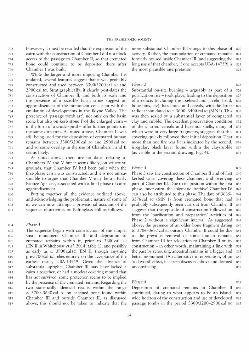
772 However, it must be recalled that the expansion of the773 cairn with the construction of Chamber I did not block774 access to the passage to Chamber II, so that cremated775 bone could continue to be deposited there after776 Chamber I was built.777 While the larger and more imposing Chamber I is778 undated, several features suggest that it was probably779 constructed and used between 3300/3200 cal BC and780 2900 cal BC. Stratigraphically, it clearly post-dates the781 construction of Chamber II, and both its scale and782 the presence of a sizeable basin stone suggest an783 aggrandisement of the monument consistent with the784 emulation of developments in the Boyne Valley. The785 presence of ‘passage tomb art’, not only on the basin786 stone but also on kerb stone F of the enlarged cairn –
787 in the form of a crude spiral – offer further pointers in788 the same direction. As noted above, Chamber II was789 still being used for the deposition of cremated human790 remains between 3300/3200 cal BC and 2900 cal BC,791 and so some overlap in the use of Chambers I and II792 seems likely.793 As noted above, there are no dates relating to794 Chambers IV and V but it seems likely, on structural795 grounds, that Chamber IV had been built when the796 first-phase cairn was constructed, and it is not unrea-797 sonable to argue that Chamber V may be an Early798 Bronze Age cist, associated with a final phase of cairn799 aggrandisement.800 Putting together all the evidence outlined above,801 and acknowledging the problematic nature of some of802 it, we can now attempt a provisional account of the803 sequence of activities on Baltinglass Hill as follows.
804 Phase 1
805 The sequence began with construction of the simple,806 small monument Chamber III and deposition of807 cremated remains within it, prior to 3600 cal BC
808 (EN II in Whitehouse et al. 2014, table 1), and possibly809 as early as c. 3900 cal BC (EN I), though anything810 pre-3700 cal BC relies entirely on the acceptance of the811 earliest result, UBA-14759. Given the absence of812 substantial uprights, Chamber III may have lacked a813 cairn altogether, or had a modest covering mound that814 has not survived: some protection seems to be implied815 by the presence of the cremated remains. Regarding the816 two statistically identical results within the range817 c. 3700–3640 cal BC on calcined bone found within818 Chamber III and outside Chamber II, as discussed819 above, this should not be taken to indicate that the
820more substantial Chamber II belongs to this phase of821activity. Rather, the manipulation of cremated remains822formerly housed inside Chamber III (and suggesting the823long use of that chamber, if one accepts UBA-14759) is824the most plausible interpretation.
825Phase 2
826Substantial on-site burning – arguably as part of a827purification rite – took place, leading to the deposition828of artefacts (including the axehead and javelin head,829bone pins, etc), hazelnuts, and cereals, with the latter830radiocarbon dated to c. 3600–3400 cal BC (MN I). This831was then sealed by a substantial layer of compacted832clay and rubble. The excellent preservation condition833of the charred cereals and hazelnut shells, many of834which were in very large fragments, suggests that this835covering quickly followed their initial deposition. That836more than one fire was lit is indicated by the second,837irregular, black layer found within the clay/rubble838(as visible in the section drawing, Fig. 4).
839Phase 3
840Phase 3 saw the construction of Chamber II and of first841kerbed cairn covering these chambers and overlying842part of Chamber III. Due to its position within the first843phase, inner cairn, the enigmatic ‘beehive’ Chamber IV844can also be attributed to this phase. The date of 3635–8453376 cal BC (MN I) from cremated bone that had846probably subsequently been cast out from Chamber II847suggests that this episode of construction followed on848from the ‘purification and preparation’ activities of849Phase 2 without a significant interval. As suggested850above, the presence of an older bone fragment dating851to 3706–3637 cal BC outside Chamber II could be due852to the previous removal of some human remains853from Chamber III for relocation to Chamber II on its854construction – in other words, maintaining a link with855the past by rehousing ancestral remains in a bigger and856better monument. (An alternative interpretation, of an857‘old wood’ effect, has been discussed above and deemed858unconvincing.)
859Phase 4
860Deposition of cremated remains in Chamber II861continued, dating to what appears to be an island-862wide horizon of the construction and use of developed863passage tombs in the period 3300/3200–2900 cal BC
THE PREHISTORIC SOCIETY
14
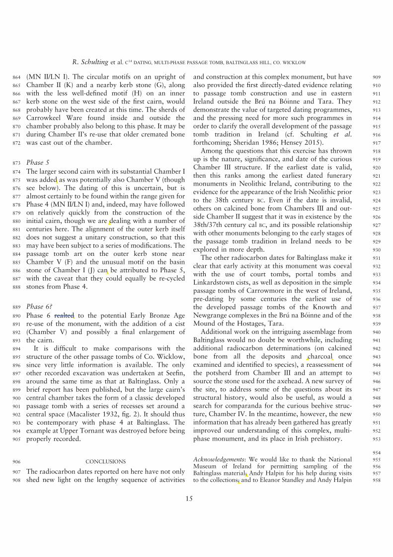
864 (MN II/LN I). The circular motifs on an upright of865 Chamber II (K) and a nearby kerb stone (G), along866 with the less well-defined motif (H) on an inner867 kerb stone on the west side of the first cairn, would868 probably have been created at this time. The sherds of869 Carrowkeel Ware found inside and outside the870 chamber probably also belong to this phase. It may be871 during Chamber II’s re-use that older cremated bone872 was cast out of the chamber.
873 Phase 5
874 The larger second cairn with its substantial Chamber I875 was added as was potentially also Chamber V (though876 see below). The dating of this is uncertain, but is877 almost certainly to be found within the range given for878 Phase 4 (MN II/LN I) and, indeed, may have followed879 on relatively quickly from the construction of the880 initial cairn, though we are dealing with a number of881 centuries here. The alignment of the outer kerb itself882 does not suggest a unitary construction, so that this883 may have been subject to a series of modifications. The884 passage tomb art on the outer kerb stone near885 Chamber V (F) and the unusual motif on the basin886 stone of Chamber I (J) can be attributed to Phase 5,887 with the caveat that they could equally be re-cycled888 stones from Phase 4.
889 Phase 6?
890 Phase 6 realted to the potential Early Bronze Age891 re-use of the monument, with the addition of a cist892 (Chamber V) and possibly a final enlargement of893 the cairn.894 It is difficult to make comparisons with the895 structure of the other passage tombs of Co. Wicklow,896 since very little information is available. The only897 other recorded excavation was undertaken at Seefin,898 around the same time as that at Baltinglass. Only a899 brief report has been published, but the large cairn’s900 central chamber takes the form of a classic developed901 passage tomb with a series of recesses set around a902 central space (Macalister 1932, fig. 2). It should thus903 be contemporary with phase 4 at Baltinglass. The904 example at Upper Tornant was destroyed before being905 properly recorded.
906 CONCLUSIONS
907 The radiocarbon dates reported on here have not only908 shed new light on the lengthy sequence of activities
909and construction at this complex monument, but have910also provided the first directly-dated evidence relating911to passage tomb construction and use in eastern912Ireland outside the Brú na Bóinne and Tara. They913demonstrate the value of targeted dating programmes,914and the pressing need for more such programmes in915order to clarify the overall development of the passage916tomb tradition in Ireland (cf. Schulting et al.917forthcoming; Sheridan 1986; Hensey 2015).918Among the questions that this exercise has thrown919up is the nature, significance, and date of the curious920Chamber III structure. If the earliest date is valid,921then this ranks among the earliest dated funerary922monuments in Neolithic Ireland, contributing to the923evidence for the appearance of the Irish Neolithic prior924to the 38th century BC. Even if the date is invalid,925others on calcined bone from Chambers III and out-926side Chamber II suggest that it was in existence by the92738th/37th century cal BC, and its possible relationship928with other monuments belonging to the early stages of929the passage tomb tradition in Ireland needs to be930explored in more depth.931The other radiocarbon dates for Baltinglass make it932clear that early activity at this monument was coeval933with the use of court tombs, portal tombs and934Linkardstown cists, as well as deposition in the simple935passage tombs of Carrowmore in the west of Ireland,936pre-dating by some centuries the earliest use of937the developed passage tombs of the Knowth and938Newgrange complexes in the Brú na Bóinne and of the939Mound of the Hostages, Tara.940Additional work on the intriguing assemblage from941Baltinglass would no doubt be worthwhile, including942additional radiocarbon determinations (on calcined943bone from all the deposits and charcoal once944examined and identified to species), a reassessment of945the potsherd from Chamber III and an attempt to946source the stone used for the axehead. A new survey of947the site, to address some of the questions about its948structural history, would also be useful, as would a949search for comparanda for the curious beehive struc-950ture, Chamber IV. In the meantime, however, the new951information that has already been gathered has greatly952improved our understanding of this complex, multi-953phase monument, and its place in Irish prehistory.
954
955Acknowledgements: We would like to thank the National956Museum of Ireland for permitting sampling of the957Baltinglass material, Andy Halpin for his help during visits958to the collections, and to Eleanor Standley and Andy Halpin
R. Schulting et al. C14DATING, MULTI-PHASE PASSAGE TOMB, BALTINGLASS HILL, CO. WICKLOW
15
added as was potentially also Chamber V (though
we are dealing with a number of
6 realted to the potential Early Bronze Age
charcoal
of Chamber I (J) can be attributed to Phase 5,
material, Andyto the collections, and to Eleanor Standley and Andy Halpin
959 for their comments on the dating of the lead button. We are960 grateful to the anonymous referees for their comments, from961 which this paper has benefitted. Radiocarbon dating was962 undetaken at the 14CHRONO facility of the School of963 Geography, Archaeology and Palaeoecology, Queen’s964 University Belfast. Many thanks to Eileen Murphy and Barra965 Ó Donnabháin for allowing us to cite the early dates from966 Altanagh prior to publication, and to Billy O’Brien for the967 site photos. This research was undertaken and funded968 as part of the Heritage Council INSTAR Programme’s969 (2008–2010) project entitled ‘Cultivating Societies:970 Investigating the evidence for agriculture in Neolithic971 Ireland’ (Ref: 16682)
972 BIBLIOGRAPHY
973 ApSimon, A.M. 1986. Chronological contexts for Irish974 megalithic tombs. Journal of Irish Archaeology 3, 5–15975 Ashmore, P.J. 2004. Absolute chronology. In I.A.G.976 Shepherd & G.J. Barclay (eds), Scotland in Ancient977 Europe: the Neolithic and Early Bronze Age of Scotland978 in their European context, 125–36. Edinburgh: Society of979 Antiquaries of Scotland980 Bayliss, A., Bronk Ramsey, C., van der Plicht, J. & Whittle, A.981 2007. Bradshaw and Bayes: towards a timetable for the982 Neolithic. Cambridge Archaeological Journal 17, 1–28983 Bayliss, A. & O’Sullivan, M. 2013. Interpreting chronologies984 for the Mound of the Hostages, Tara and its985 contemporary contexts in Neolithic and Bronge Age986 Ireland. In M. O’Sullivan, C. Scarre & M. Doyle (eds),987 Tara – From the Past to the Future. Towards a New988 Research Agenda, 26–104. Dublin: Wordwell989 Bergh, S. 1995. Landscape of the Monuments. Stockholm:990 Arkeologiska Undersökningar Skrifter 6991 Bergh, S. 2002. Knocknarea: The ultimate monument.992 Megaliths and mountains in Neolithic Cúil Irra, north-993 west Ireland. In C. Scarre (ed.),Monuments and Landscape994 in Atlantic Europe, 139–51. London: Routledge995 Bergh, S. & Hensey, R. 2013. Unpicking the chronology of996 Carrowmore.Oxford Journal of Archaeology 32(4), 343–66997 Bradshaw, R. & McGee, E. 1988. The extent and time-998 course of mountain blanket peat erosion in Ireland. New999 Phytologist 108, 219–241000 Brindley, A.L., Lanting, J.N. & Mook, W.G. 1983.1001 Radiocarbon dates from the Neolithic burials at1002 Ballintruer More, Co. Wicklow, and Ardcrony, Co.1003 Tipperary. Journal of Irish Archaeology 1, 1–91004 Bronk Ramsey, C. 2009. Bayesian analysis of1005 radiocarbon dates. Radiocarbon 51(1), 337–601006 Buck, C.E., Cavanagh, W.G. & Litton, C.D. 1996. Bayesian1007 Approach to Interpreting Archaeological Data.1008 Chichester: Wiley1009 Bulfin, M., Radford, T. & Comey, A. 1979. Upland soils of1010 Wicklow have good potential. Farm and Food Research1011 10(2), 36–81012 Burenhult, G. 1984. The Archaeology of Carrowmore.1013 Stockholm: Theses and Papers in North-European1014 Archaeology 14
1015Burenhult, G. 2001. The Megalithic Cemetery of1016Carrowmore, Co. Sligo. Tjörnarp: Göran Burenhult1017Collins, A.E.P. 1954. The excavation of a double horned1018cairn at Audleystown, Co. Down. Ulster Journal of1019Archaeology 17, 7–561020Collins, A.E.P. 1981. The flint javelin heads of Ireland. In1021D. Ó'Corráin (ed.), Irish Antiquity: essays and studies1022presented to Professor M.J. O’Kelly, 111–33. Dublin:1023Four Courts Press1024Cooney, G. 1981. A saddle quern from Baltinglass Hill, Co.1025Wicklow. Journal of the Royal Society of Antiquaries of1026Ireland 111, 102–61027Cooney, G. 2000. Landscapes of Neolithic Ireland. London:1028Routledge1029Cooney, G. 2014. The role of cremation in mortuary1030practice in the Irish Neolithic. In I. Kuijt, C.J. Quinn &1031G. Cooney (eds), Transformation by Fire: the archaeology1032of cremation in cultural context, 189–206. Tucson:1033University of Arizona Press1034Cooney, G., Bayliss, A., Healy, F., Whittle, A., Danaher, E.,1035Cagney, L., Mallory, J.P., Smyth, J., Kador, T. &1036O’Sullivan, M. 2011. Ireland. In A. Whittle, F. Healy &1037A. Bayliss (eds), Gathering Time: dating the Early1038Neolithic enclosures of southern Britain and Ireland,1039562–669. Oxford: Oxbow Books1040Ditchfield, P. 2014. Stable isotope analysis. In A. Lynch1041(ed.), Poulnabrone, Co. Clare. Excavation of an Early1042Neolithic Portal Tomb, 86–92. Dublin: Department of1043Arts, Heritage and the Gaeltacht, Archaeological1044Monograph Series 91045Eogan, G. 1974. Report on the excavations of some passage1046graves, unprotected inhumation burials and a settlement1047site at Knowth. Proceedings of the Royal Irish Academy104874C, 11–1121049Eogan, G. 1984. Excavations at Knowth 1. Smaller Passage1050Tombs, Neolithic Occupation and Beaker Activity.1051Dublin: Royal Irish Academy, Monographs in1052Archaeology1053Eogan, G. 1986. Knowth and the Passage-Tombs of Ireland.1054London: Thames & Hudson1055Eogan, G. & Roche, H. 1997. Pre-tomb Neolithic house1056discovered at Knowth, Co. Meath. Archaeology Ireland105711(2), 311058Fowler, C. & Cummings, V. 2003. Places of transformation:1059building monuments from water and stone in the1060Neolithic of the Irish Sea. Journal of the Royal1061Anthropological Institute 9, 1–201062Hartnett, P.J. 1971. The excavation of two tumuli at1063Fourknocks (sites II and III), Co. Meath. Proceedings of1064the Royal Irish Academy 71C, 35–891065Hedges, R.E.M., Clement, J.G., Thomas, C.D.L. &1066O’Connell, T.C. 2007. Collagen turnover in the adult1067femoral mid-shaft: modeled from anthropogenic1068radiocarbon tracer measurements. American Journal of1069Physical Anthropology 133(2), 808–161070Hemp, W.J. 1930. The chambered cairn of Bryn Celli Ddu.1071Archaeologia 30, 179–2141072Hensey, R. 2015. First Light: The Origins of Newgrange.1073Oxford: Oxbow Books, Oxbow Insights in Archaeology 1
THE PREHISTORIC SOCIETY
16
1074 Hensey, R. & Bergh, S. 2013. ‘The inns at Sligo are better than1075 those at Auray… and the scenery far more beautiful’ –
1076 Carrowmore re-visited. In M.A. Timoney (ed.), Dedicated to1077 Sligo, 41–3. Keash: Publishing Sligo’s Past1078 Hensey, R., Meehan, P., Dowd, M. & Moore, S. 2014.1079 A century of archaeology – historical excavation and modern1080 research at the Carrowkeel passage tombs, County Sligo.1081 Proceedings of the Royal Irish Academy 114C, 57–871082 Herity, M. 1974. Irish Passage Graves. Dublin: Irish1083 University Press1084 Hüls, C.M., Erlenkeuser, H., Nadeau, M.-J., Grootes, P.M. &1085 Andersen, N. 2010. Experimental study on the origin of1086 cremated bone apatite carbon. Radiocarbon 52(2–3), 587–991087 Johnston, P. 2007. Analysis of carbonised plant remains. In1088 E. Grogan, L. O’Donnell & P. Johnston (eds), The Bronze1089 Age Landscapes of the Pipeline to the West: an integrated1090 archaeological and environmental assessment, 70–9. Bray:1091 Wordwell1092 Kador, T., Geber, J., Hensey, R., Meehan, P. & Moore, S.1093 2015. New dates from Carrowkeel. PAST 79, 12–141094 Lanting, J.N. & Brindley, A.L. 1998. Dating cremated bone: the1095 dawn of a new era. Journal of Irish Archaeology 8, 25–421096 Lanting, J.N., Aerts-Bijma, A.T. & van der Plicht, J. 2001.1097 Dating of cremated bones. Radiocarbon 43(2), 249–4541098 Lynch, A. (ed.), 2014. Poulnabrone: An Early Neolithic Portal1099 Tomb in Ireland. Dublin: Department of Arts, Heritage and1100 the Gaeltacht, Archaeological Monograph Series 91101 Lynch, A. & Ó Donnabháin, B. 1994. Poulnabrone1102 portal tomb. The Other Clare 18, 5–71103 Macalister, R.A.S. 1932. A burial cairn on Seefin Mountain,1104 Co. Wicklow. Journal of the Royal Society of Antiquaries1105 of Ireland 62, 153–71106 Mallory, J.P., Nelis, E. & Hartwell, B. 2011. Excavations on1107 Donegore Hill, Co. Antrim. Dublin: Wordwell1108 McClatchie, M., Bogaard, A., Colledge, S., Whitehouse, N.J.,1109 Schulting, R.J., Barratt, P. & McLaughlin, R. 2014. Neolithic1110 farming in north-western Europe: archaeobotanical1111 evidence from Ireland. Journal of Archaeological Science 51,1112 206–151113 McClatchie, M., Bogaard, A., Colledge, S., Whitehouse, N.J.,1114 Schulting, R.J., Barratt, P. & McLaughlin, R. 2016. Farming1115 and foraging in Neolithic Ireland: a review of the evidence1116 from plant macro-remains. Antiquity 90, 302–181117 McKinley, J.I. & Bond, J.M. 2001. Cremated bone.1118 In D.R. Brothwell & A.M. Pollard (eds), Handbook of1119 Archaeological Sciences, 281–92. Chichester: Wiley1120 McLaughlin, T.R., Whitehouse, N.J., Schulting, R.J.,1121 McClatchie, M. & Barratt, P. 2016. The changing face1122 of Neolithic and Bronze Age Ireland: a Big Data approach1123 to the settlement and burial records. Journal of World1124 Prehistory 29(2), 117–531125 McSparron, C. 2008. Have you no homes to go to?1126 Archaeology Ireland 22, 18–211127 Meighan, I.G., Simpson, D.D.A., Hartwell, B., Fallick, A. &1128 Kennan, P. 2003. Sourcing the quartz at Newgrange, Brú na1129 Bóinne, Ireland. In G. Burenhult & S.Westergaard (ed.), Stones1130 and Bones. Formal Disposal of the Dead in Atlantic Europe1131 During the Mesolithic–Neolithic Interface 6000–3000BC,1132 247–51. Oxford: British Archaeological Report S1201
1133Mitchell, A. 1884. On white pebbles in connection with1134Pagan and Christian burials, a seeming survival of an1135ancient custom. Proceedings of the Society of Antiquaries1136of Scotland 18, 286–911137Mitchell, F. 1992. Notes on some non-local cobbles at the1138entrances to the passage-graves at Newgrange and1139Knowth, County Meath. Journal of the Royal Society of1140Antiquaries of Ireland 122, 128–451141Murphy, E. & Ó Donnabháin, B. forthcoming. The People1142of Prehistoric Ireland. Dublin: Four Courts Press1143Nelis, E.L. 2004. Neolithic flint-work from the north of1144Ireland: some thoughts on prominent tool types and their1145production. In A. Gibson & A. Sheridan (eds), From1146Sickles to Circles. Britain and Ireland at the Time of1147Stonehenge, 155–75. Stroud: Tempus1148O’Kelly, C. 1973. Passage-grave art in the Boyne Valley.1149Proceedings of the Prehistoric Society 39, 354–821150O’Kelly, M.J. 1958. A horned-cairn at Shanballyedmond,1151Co. Tipperary. Journal of the Cork Historical &1152Archaeological Society 63, 37–721153O’Kelly, M.J. 1982. Newgrange: Archaeology, Art and1154Legend. London: Thames & Hudson1155O’Kelly, M.J. 1989. Early Ireland. Cambridge: Cambridge1156University Press1157O’Sullivan, M. 1993a. Recent investigations at Knockroe1158passage tomb. Journal of the Royal Society of Antiquaries1159of Ireland 123, 5–181160O’Sullivan, M. 1993b. Megalithic Art in Ireland. Dublin:1161Country House1162O’Sullivan, M. 2005. Duma na nGiall – The Mound of the1163Hostages, Tara. Dublin: Wordwell and University College1164Dublin1165O’Sullivan, M., Scarre, C. & Doyle, M. (eds) 2013. Tara –
1166From the Past to the Future. Towards a New Research1167Agenda. Dublin: Wordwell1168Raftery, J. 1973. A Neolithic burial mound at Ballintruer1169More, Co. Wicklow. Journal of the Royal Society of1170Antiquaries of Ireland 103, 214–191171Rynne, E. 1963. The decorated stones at Seefin. Journal of1172the Royal Society of Antiquaries of Ireland 93(1), 85–61173Schulting, R.J. 2011. The radiocarbon dates from Tullahedy.1174In R.M. Cleary & H. Kelleher (eds), Excavations at1175Tullahedy, Co. Tipperary, Neolithic Settlement in North1176Munster, 145–61. Cork: Collins Press1177Schulting, R.J. 2014a. Dating the construction of1178Newgrange, 46–50 in A. Lynch, Newgrange revisited:1179new insights from excavations at the back of the mound11801984–5. Journal of Irish Archaeology 23, 13–821181Schulting, R.J. 2014b. The dating of Poulnabrone, Co.1182Clare. In A. Lynch (ed.), Poulnabrone: An Early Neolithic1183Portal Tomb in Ireland, 93–113. Dublin: Department of1184Arts, Heritage and the Gaeltacht, Archaeological1185Monograph Series 91186Schulting, R.J., Murphy, E., Jones, C. & Warren, G. 2012.1187New dates from the north, and a proposed chronology for1188Irish court tombs. Proceedings of the Royal Irish Academy1189112C, 1–601190Schulting, R.J., Sheridan, J.A., Crozier, R. & Murphy, E. 2010.1191Revisiting Quanterness: new AMS dates and stable isotope
R. Schulting et al. C14DATING, MULTI-PHASE PASSAGE TOMB, BALTINGLASS HILL, CO. WICKLOW
17
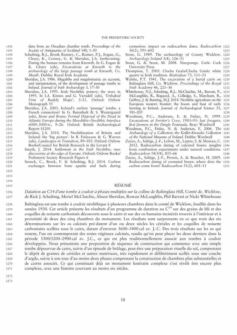
1192 data from an Orcadian chamber tomb. Proceedings of the1193 Society of Antiquaries of Scotland 140, 1–501194 Schulting, R.J., Bronk Ramsey, C., Reimer, P.J., Eogan, G.,1195 Cleary, K., Cooney, G. & Sheridan, J.A. forthcoming.1196 Dating the human remains from Knowth. In G. Eogan &1197 K. Cleary (eds), Excavations at Knowth 6: the1198 archaeology of the large passage tomb at Knowth, Co.1199 Meath. Dublin: Royal Irish Academy1200 Sheridan, J.A. 1986. Megaliths and megalomania: an account,1201 and interpretation, of the development of passage tombs in1202 Ireland. Journal of Irish Archaeology 3, 17–301203 Sheridan, J.A. 1995. Irish Neolithic pottery: the story in1204 1995. In I.A. Kinnes and G. Varndell (eds), ‘Unbaked1205 Urns of Rudely Shape’, 3–21. Oxford: Oxbow1206 Monograph 551207 Sheridan, J.A. 2003. Ireland’s earliest ‘passage’ tombs: a1208 French connection? In G. Burenhult & S. Westergaard1209 (eds), Stone and Bones. Formal Disposal of the Dead in1210 Atlantic Europe during the Mesolithic–Neolithic Interface1211 6000–3000 BC, 9–26. Oxford: British Archaeological1212 Report S12011213 Sheridan, J.A. 2010. The Neolithization of Britain and1214 Ireland: the ‘big picture’. In B. Finlayson & G. Warren1215 (eds), Landscapes in Transition, 89–105. Oxford: Oxbow1216 Books/Council for British Research in the Levant 81217 Smyth, J. 2014. Settlement in the Irish Neolithic: new1218 discoveries at the edge of Europe. Oxford: Oxbow Books/1219 Prehistoric Society Research Papers 61220 Snoeck, C., Brock, F. & Schulting, R.J. 2014. Carbon1221 exchanges between bone apatite and fuels during
1222cremation: impact on radiocarbon dates. Radiocarbon122356(2), 591–6021224Stout, G. 1989. The archaeology of County Wicklow.1225Archaeology Ireland 3(4), 126–311226Stout, G. & Stout, M. 2008. Newgrange. Cork: Cork1227University Press1228Thompson, T. 2005. Clocha Geala/Clocha Uaisle: white1229quartz in Irish tradition. Béaloideas 73, 111–331230Walshe, P.T. 1941. The excavation of a burial cairn on1231Baltinglass Hill, Co. Wicklow. Proceedings of the Royal1232Irish Academy 46, 221–361233Whitehouse, N.J., Schulting, R.J., McClatchie, M., Barratt, P.,1234McLaughlin, R., Bogaard, A., Colledge, S., Marchant, R.,1235Gaffrey, J. & Bunting, M.J. 2014. Neolithic agriculture on the1236European western frontier: the boom and bust of early1237farming in Ireland. Journal of Archaeological Science 51,1238181–2051239Woodman, P.C., Andersen, E. & Finlay, N. 1999.1240Excavations at Ferriter’s Cove, 1983–95: last foragers,1241first farmers in the Dingle Peninsula. Bray: Wordwell1242Woodman, P.C., Finlay, N. & Anderson, E. 2006. The1243Archaeology of a Collection: the Keiller-Knowles Collection1244of the National Museum of Ireland. Dublin: Wordwell1245Zazzo, A., Saliège, J.-F., Lebon, M., Lepetz, S. & Moreau, C.12462012. Radiocarbon dating of calcined bones: insights1247from combustion experiments under natural conditions.1248Radiocarbon 54(3/4), 855–661249Zazzo, A., Saliège, J.-F., Person, A. & Boucher, H. 2009.1250Radiocarbon dating of cremated bones: where does the1251carbon come from? Radiocarbon 51(2), 601–11
1252
1253
1254
1255 RÉSUMÉ
1256 Datation au C14 d’une tombe à couloir à phases multiples sur la colline de Baltinglass Hill, Comté de. Wicklow,1257 de Rick J. Schulting, Meriel McClatchie, Alison Sheridan, Rowan McLaughlin, Phil Barratt et Nicki Whitehouse
1258 Baltinglass est une tombe à couloir néolithique à plusieurs chambres dans le comté de Wicklow, fouillée dans les1259 années 1930. Cet article présente les résultats d’un programme de datation au C14 sur des grains de blé et des1260 coquilles de noisette carbonisés découverts sous le cairn et sur des os humains incinérés trouvés à l’intérieur et à1261 proximité de deux des cinq chambres du monument. Les résultats sont surprenants en ce que trois des six1262 déterminations sur les os calcinés pré-datent d’un ou deux siècles les céréales et les coquilles de noisette1263 carbonisées scellées sous le cairn, datant d’environ 3600–3400 cal av. J.-C. Des trois résultats sur les os qui1264 restent, l’un est contemporain des restes végétaux calcinés, tandis qu’on peut placer les deux derniers dans la1265 période 3300/3200–2900 cal av. J.C., ce qui est plus traditionnellement associé aux tombes à couloir1266 développées. Nous présentons une proposition de séquence de construction qui commence avec une simple1267 tombe dépourvue de cairn, suivie d’un épisode de brûlage, peut-être une préparation rituelle du sol, comprenant1268 le dépôt de graines de céréales et autres matériaux, très rapidement et délibérément scellés sous une couche1269 d’argile, suivie à son tour d’au moins deux phases comprenant la construction de chambres plus substantielles et1270 de cairns associés. Ce qui constituait déjà un monument funéraire complexe s’est révélé être encore plus1271 complexe, avec une histoire couvrant au moins six siècles.
1272
1273
THE PREHISTORIC SOCIETY
18
1274 ZUSSAMENFASSUNG
1275 Die Radiokarbondatierung eines mehrperiodigen Megalithgrabs von Baltinglass Hill, Co. Wicklow, von Rick J.1276 Schulting, Meriel McClatchie, Alison Sheridan, Rowan McLaughlin, Phil Barratt und Nicki Whitehouse
1277 Baltinglass ist ein neolithisches Megalithgrab mit mehreren Kammern im Co. Wicklow, das in den 1930ern1278 ausgegraben wurde. Dieser Beitrag stellt die Resultate eines C14-Datierungsprogramms von verkohlten1279 Weizenkörnern und Haselnussschalen vor, die unter dem zugehörigen Hügel gefunden worden waren, und von1280 Leichenbrand, der innerhalb und nahe von zwei der fünf Kammern des Megalithgrabes gefunden wurde. Die1281 Ergebnisse sind überraschend, da drei der sechs Bestimmungen an kalzinierten Knochen um ein oder zwei1282 Jahrhunderte vor den Daten des verkohlten Getreides und der Haselnussschalen liegen, die unter dem Hügel1283 versiegelt lagen und zwischen ca. 3600 und 3400 cal BC datieren. Von den verbleibenden drei Ergebnissen an1284 Knochen ist eines zeitgleich mit den Daten der Pflanzenreste, während die beiden anderen in den Zeitraum 3300/1285 3200 bis 2900 cal BC fallen, also in die Zeitspanne, die traditionell eher mit den entwickelten Kammergräbern in1286 Verbindung gebracht wird. Eine mögliche Abfolge der Errichtung wird vorgeschlagen, die mit einem einfachen1287 Grab ohne Hügel beginnt, gefolgt von einem Brandereignis – vielleicht einer rituellen Präparation des Bodens –1288 das die Deponierung von Getreidesamen und anderen Materialien einschloss und das sehr schnell und1289 intentionell unter einer Lehmschicht versiegelt wurde, wiederum gefolgt von mindestens zwei Phasen des Baus1290 größerer Kammern und zugehöriger Hügel. Ein Grabmonument, das bereits als komplex gelten konnte, erweist1291 sich als noch weit komplexer, mit einer Geschichte, die mindestens sechs Jahrhunderte umspannt.
1292 RESUMEN
1293 Datación radiocarbónia de una tumba de corredor multifase en Baltinglass Hill, Co. Wicklow, por Rick J.1294 Schulting, Meriel McClatchie, Alison Sheridan, Rowan McLaughlin, Phil Barratt y Nicki Whitehouse
1295 Baltinglass es una tumba de corredor neolítica con varias cámaras en el condado de Wicklow, excavada en la1296 década de 1930. En este artículo se presentan los resultados obtenidos en el programa de dataciones1297 radiocarbónicas realizadas a partir de semillas de trigo carbonizadas y cáscaras de avellanas documentadas bajo1298 el túmulo de piedras, y de los restos humanos cremados hallados en el interior y en las cercanías de dos de las1299 cinco cámaras. Los resultados obtenidos son sorprendentes ya que tres de las seis dataciones realizadas sobre1300 hueso calcinado datadas en ca. 3600–3400 cal BC, preceden en dos siglos a los cereales y las cáscaras de1301 avellanas carbonizadas documentadas bajo el túmulo. De los otros tres resultados obtenidos a partir de hueso,1302 uno es contemporáneo a los restos vegetales carbonizados, mientras que los otros dos se sitúan en el período1303 3300/3200–2900 cal BC que tradicionalmente se asocia a las tumbas de corredor desarrolladas. Se presenta una1304 posible secuencia de construcción que comenzaría con un enterramiento simple sin túmulo, seguido de un evento1305 de cremación -quizá un ritual preparatorio del terreno- que supondría la deposición de granos de cereal y otros1306 materiales, rápida e intencionalmente sellados por un nivel de arcilla, y a su vez seguirían al menos dos fases que1307 supondrían la construcción de las cámaras más significativas y los túmulos asociados. Lo que era ya un1308 monumento funerario complejo ha demostrado ser más complejo aún, con una historia que abarca al menos seis1309 siglos.
1310
R. Schulting et al. C14DATING, MULTI-PHASE PASSAGE TOMB, BALTINGLASS HILL, CO. WICKLOW
19