wi-fly: widespread opportunistic connectivity via...
TRANSCRIPT
Wi-Fly: Widespread Opportunistic Connectivity viaCommercial Air Transport
Talal AhmadNew York [email protected]
Ranveer ChandraMicrosoft Research
Ashish KapoorMicrosoft Research
Michael DaumMicrosoft Research
Eric HorvitzMicrosoft Research
ABSTRACTMore than half of the world’s population face barriers in ac-cessing the Internet. A recent ITU study estimates that 2.6billion people cannot afford connectivity and that 3.8 billiondo not have access. Recent proposals for providing low-costconnectivity include the fielding of long-lasting drones andballoons in the stratosphere. We propose a more economicalalternative, which we refer to as Wi-Fly, that leverages ex-isting commercial planes to provide Internet connectivity toremote regions. In Wi-Fly we enable communication betweena lightweight Wi-Fi device on commercial planes and groundstations, resulting in connectivity in regions that do not oth-erwise have low-cost Internet connectivity. Wi-Fly leveragesexisting ADS-B signals from planes as a control channel toensure that there is a strong link from the plane to the ground,and that the stations intelligently wake up and associate tothe appropriate AP. For our experimentation, we have cus-tomized two airplanes to conduct measurements. Throughempirical experiments with test flights and simulations, weshow that Wi-Fly and its extensions have the potential to pro-vide connectivity to the most remote regions of the world at asignificantly lower cost than existing alternatives.
1 INTRODUCTION4.4 billion people around the world live without Internet con-nectivity [1]. Most of the world’s offline population (64 per-cent) live in impoverished rural settings, where poor electricpower and communications infrastructure and lack of hard-ware for base stations and end-user devices impede Internetadoption[11]. More than 80 percent of people who are cur-rently disconnected from the Internet are younger than 55years old, and more than 42 percent are younger than 25 years
Permission to make digital or hard copies of all or part of this work forpersonal or classroom use is granted without fee provided that copies are notmade or distributed for profit or commercial advantage and that copies bearthis notice and the full citation on the first page. Copyrights for componentsof this work owned by others than ACM must be honored. Abstracting withcredit is permitted. To copy otherwise, or republish, to post on servers or toredistribute to lists, requires prior specific permission and/or a fee. Requestpermissions from [email protected], November 30-December 1, 2017, Palo Alto, CA, USA© 2017 Association for Computing Machinery.ACM ISBN 978-1-4503-5569-8/17/11. . . $15.00https://doi.org/10.1145/3152434.3152458
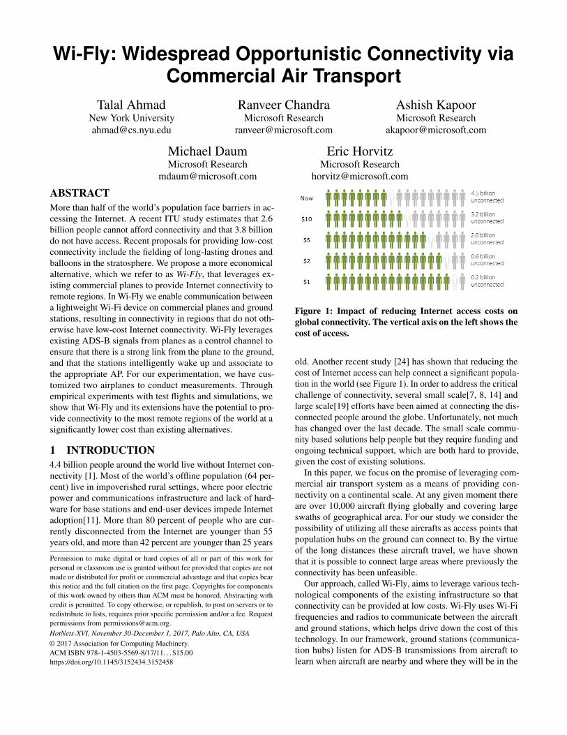
Figure 1: Impact of reducing Internet access costs onglobal connectivity. The vertical axis on the left shows thecost of access.
old. Another recent study [24] has shown that reducing thecost of Internet access can help connect a significant popula-tion in the world (see Figure 1). In order to address the criticalchallenge of connectivity, several small scale[7, 8, 14] andlarge scale[19] efforts have been aimed at connecting the dis-connected people around the globe. Unfortunately, not muchhas changed over the last decade. The small scale commu-nity based solutions help people but they require funding andongoing technical support, which are both hard to provide,given the cost of existing solutions.
In this paper, we focus on the promise of leveraging com-mercial air transport system as a means of providing con-nectivity on a continental scale. At any given moment thereare over 10,000 aircraft flying globally and covering largeswaths of geographical area. For our study we consider thepossibility of utilizing all these aircrafts as access points thatpopulation hubs on the ground can connect to. By the virtueof the long distances these aircraft travel, we have shownthat it is possible to connect large areas where previously theconnectivity has been unfeasible.
Our approach, called Wi-Fly, aims to leverage various tech-nological components of the existing infrastructure so thatconnectivity can be provided at low costs. Wi-Fly uses Wi-Fifrequencies and radios to communicate between the aircraftand ground stations, which helps drive down the cost of thistechnology. In our framework, ground stations (communica-tion hubs) listen for ADS-B transmissions from aircraft tolearn when aircraft are nearby and where they will be in the

near future, and power up and fine-tune their Wi-Fi hardwareaccordingly. Such a capability helps increase the throughputof the system by determining the best aircraft to communicatewith when multiple planes and ground stations are operating.
Wi-Fly aims to provide connectivity to delay-tolerant appli-cations by leveraging the existing Internet available in com-mercial planes using Ku and Ka bands. The goal of Wi-Flyis to support two primary scenarios. First, we seek to enablepeople to communicate with each other using emails, instantmessages, and by downloading popular content. Second, weseek to provide communication to "things", such as sensorsthat would otherwise be disconnected in remote regions, e.g.in forests, deserts and agricultural tracts.
This work is a significant departure from Google’s recentlyproposed Project Loon and Facebook’s Aquila efforts. Insteadof creating custom aerial vehicles, we aim to keep the costsdown by utilizing existing infrastructure. Another key benefitof our approach is that Wi-Fly is much easier to deploy on alarge scale. Finally, the design of our system is much moreflexible and robust, consequently it has the potential to adaptto various aircraft scheduling constraints. In summary, thekey contributions of this work are:• Solution to the connectivity problem that leverages ex-
isting air transport infrastructure.• Using ADS-B to detect the presence of aircraft and
build a predictive model of connectivity.• Real-world experiments with real aircraft data that
shows the promise of the framework.• Real-world deployment on general aviation aircraft that
demonstrates empirical performance.
2 MOTIVATIONIn order to assess the efficacy of our connectivity model, webuilt a simulator using flight data from the website FlightAware [2]along with experimental data collected using our platform,detailed in Section 5. In May 2016, we downloaded the infor-mation of all planes flying over a single day in the continentalUS and Africa regions. The data was downloaded in the formof snapshots of currently flying airplanes at a given time.Each snapshot was downloaded approximately 5 to 10 min-utes apart. For each flight that was in the snapshot, we notedthe plane height, speed, and exact location in the region. In or-der to make sure that we were only using commercial planesthat were in the air (versus parked at airports), we made surethat every plane under consideration were at an altitude above20,000 feet and had an airspeed of over 200 Knots1.
As a preprocessing step we studied the data carefully andworked to remove all potential discrepancies. We particularlylooked at flights’ unique IDs across snapshots and made surethat their locations were different, so as to ensure that weonly considered flights that are constantly moving and to re-move stationary aircraft. We discovered several such flightswhich were stationary at airports but were being erroneouslyreported as flying by the FlightAware API. These flights were1Knot is unit of speed equaling 1.15078 miles per hour
removed from the data. As mentioned earlier the data com-prised a single day. We used a single day’s data because flightsfollow a similar pattern for most days.
Along with gathering FlightAware data of planes in air, wealso conducted experiments using a custom built measurementplatform detailed in Section 5. In our experiments, we placeda commodity high-power Wi-Fi router which had a measuredtransmission power of 25dbm 2 in a modified single engineairplane shown in Figure 6. We placed the AP in the wingtipof the airplane which is made of fiberglass, a non-conductor,and allowed us to avoid making any structural changes to theplane. We attached dipole antennae with an estimated gainof less than 5 dbm in the plane and collected beacon packetssent by the router at a ground station. While the plane was inflight, we also collected a time-synchronized GPS log of theflight which gave us the exact distance between the receiverand the transmitter at all times.
2.1 Wireless propagation parametersWe chose to use the free space propagation model in thesimulator as supported by previous studies[17, 18]. Whilemulti-path models have also been used, they were based onspecial receivers (for example parabolic receivers followingthe airplane[21]) and in special terrain settings [17]. For theline of sight component independent of the terrain, the use offree space propagation is precedent. The free space propaga-tion model is summed up by Friis equation:
PrPt= GtGr
λ2
16π 2R2
In the above equation, Pr and Pt denote the receive andtransmit power respectively.Gr andGt denote the receive andtransmit gain. λ and R denote the wavelength and distancebetween transmitter and receiver respectively.
In order to fit a path loss model based on our experiments,we assumed that R is raised to a variable γ and we estimatedthis parameter γ by using experimental data we collected.
We used the received power(gathered from the measure-ment platform in Section 5), antenna gain of receiving andtransmitting antennae and applied curve fitting to calculatethe value of the parameter γ . For wavelength calculation weused the value of center frequency of channel 1 (2412 MHz),which the router was using to transmit the packets. In orderto have diversity, we used two different receiving stationswith two different receiving antennae. We used MATLAB forapplying regression for estimation of γ .
We collected the data by flying the plane at various altitudesand using two different laptops to decode the packets. We flewthe plane in circular pattern above the receivers at varying al-titudes. We recorded the packets received and post-processedthem with the flight log from the plane. The estimated valueof γ using this data was 2.12.
2This is significantly lower than the legal limit.
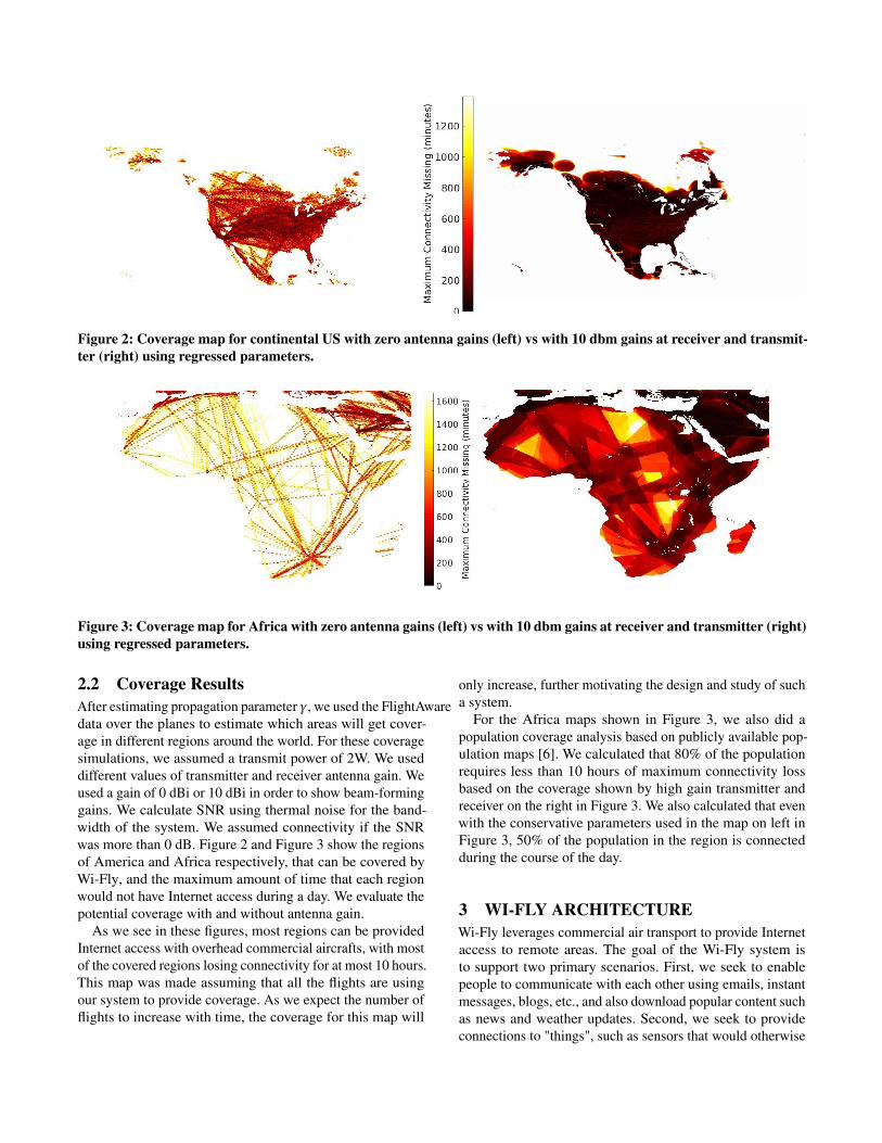
Figure 2: Coverage map for continental US with zero antenna gains (left) vs with 10 dbm gains at receiver and transmit-ter (right) using regressed parameters.
Figure 3: Coverage map for Africa with zero antenna gains (left) vs with 10 dbm gains at receiver and transmitter (right)using regressed parameters.
2.2 Coverage ResultsAfter estimating propagation parameterγ , we used the FlightAwaredata over the planes to estimate which areas will get cover-age in different regions around the world. For these coveragesimulations, we assumed a transmit power of 2W. We useddifferent values of transmitter and receiver antenna gain. Weused a gain of 0 dBi or 10 dBi in order to show beam-forminggains. We calculate SNR using thermal noise for the band-width of the system. We assumed connectivity if the SNRwas more than 0 dB. Figure 2 and Figure 3 show the regionsof America and Africa respectively, that can be covered byWi-Fly, and the maximum amount of time that each regionwould not have Internet access during a day. We evaluate thepotential coverage with and without antenna gain.
As we see in these figures, most regions can be providedInternet access with overhead commercial aircrafts, with mostof the covered regions losing connectivity for at most 10 hours.This map was made assuming that all the flights are usingour system to provide coverage. As we expect the number offlights to increase with time, the coverage for this map will
only increase, further motivating the design and study of sucha system.
For the Africa maps shown in Figure 3, we also did apopulation coverage analysis based on publicly available pop-ulation maps [6]. We calculated that 80% of the populationrequires less than 10 hours of maximum connectivity lossbased on the coverage shown by high gain transmitter andreceiver on the right in Figure 3. We also calculated that evenwith the conservative parameters used in the map on left inFigure 3, 50% of the population in the region is connectedduring the course of the day.
3 WI-FLY ARCHITECTUREWi-Fly leverages commercial air transport to provide Internetaccess to remote areas. The goal of the Wi-Fly system isto support two primary scenarios. First, we seek to enablepeople to communicate with each other using emails, instantmessages, blogs, etc., and also download popular content suchas news and weather updates. Second, we seek to provideconnections to "things", such as sensors that would otherwise
be disconnected in remote regions, e.g. in forests, deserts, andagricultural tracts, to enable access to sensed data.
Planes in Wi-Fly have local Internet access either using asatellite connection over the Ku [10, 12] or Ka bands [3], orfrom another ground station [4]. Nearly 70 airlines aroundthe world offer Wi-Fi in flight. Worldwide 39% of airline pas-sengers already have an internet connection, 68% of whichis high quality Internet [9]. This percentage is on the risewith US taking the lead with 80% of flights having Wi-Fi [9].Furthermore, governments of many countries are exploringopening up additional spectrum [5, 12] that will enable air-planes to provide even higher bandwidth Internet connectivityin the near future. In an alternate approach, the methods wepropose can also be fielded in the absence of plane connectiv-ity via special satellite or ground stations; planes employingthe local communication with the ground stations can cacheand sync content when they land at airports.
Wi-Fly extends the connectivity in the planes to variouskinds of ground stations including connectivity hubs for peo-ple and sensors. Each plane is equipped with antennas, and atransceiver that communicate with special Wi-Fly ground sta-tions. This equipment is in addition to the other transceiversthat are used on the plane. Although excess weight could be apotential concern, our experimental setup adds only a smalladditional weight of three lbs, which is acceptable, per ourprivate communications with commercial flight companies.
The ground stations also have a transceiver and an antennapointed at the sky. In our current design, aimed at high band-width applications, Wi-Fly requires a phased array antenna tomaximize the coverage of the horizon, while also providinghigh gain. Since the antenna configuration of each stationis cumbersome, the Wi-Fly system for broadband connec-tivity uses an alternative technology such as Open Cellularplatforms[7, 8, 14], TV white spaces[22], Wi-Fi access points,point to point links [20], or GPRS, for the eventual last mileconnectivity. For IoT applications, that have a much lowerthroughput requirement, Wi-Fly modulates the signal over anarrow bandwidth that has a much lower noise floor. Hence,the antennas do not need as much gain, and therefore eachsensor has an attached omni-directional antenna, and eachsensor also directly communicates with the plane.
To achieve good connectivity between the ground stationsand the planes, Wi-Fly needs to solve three main challenges:
• First, to ensure good throughput between the planeand the ground station, Wi-Fly needs to dynamicallyadapt its wireless parameters. Using Wi-Fi, or any exist-ing ground communication system as is, leads to poorthroughput. Existing Air-to-Ground systems, such asthe ATG4 used by Gogo Wireless use a much slowerEVDO technology.• Second, Wi-Fly needs to scale to multiple airplanes and
ground stations. This requires the design of a uniquemedia access control (MAC) protocol. In contrast toWi-Fi or cellular systems where the clients are mobile,
in Wi-Fly, the airplanes (base stations) are mobile. Fur-thermore, we seek to do an optimization that considersmultiple parameters: the clients need to associate withthe plane that is close enough to provide a sufficient sig-nal, that is also least lightly loaded, and that promisesassociation for the longest period of time.• Third, Wi-Fly ground stations need to support a low-
power mode to allow IoT devices to communicate withthe planes. Having them always on would consumea great deal of power, and heavily duty cycling thesensors might miss communication opportunities withan overhead plane.
4 ADS-B ASSISTED CONTROL CHANNELThe challenges highlighted at the end of the previous sectionrequire techniques for ground stations to learn about the pres-ence of nearby aircraft. If a ground station is aware of all theplanes, they can connect with a correct plane to maximizethroughput and if there is no plane they can deactivate thebase station to save power and reactivate at a later time whenthere is a plane available.
One approach could be to download a schedule of planeflights. However, planes may be delayed and may deviatefrom scheduled flight paths (e.g., due to wind and/or weather).Another approach is to perform active polling, where groundstations periodically probe for incoming planes. However,such an approach adds latency in establishing the link, andintroduces extra overhead messages on the channel.
To circumvent these challenges, Wi-Fly uses a control-channel–based approach. However, instead of using a sepa-rate radio on the plane to implement the control channel, theWi-Fly control channel uses existing ADS-B (Automatic De-pendent Surveillance - Broadcast) [23] signals sent by planes.ADS-B signals are sent on 1090 MHz or 978 MHz, with a 50KHz or 1.3 MHz bandwidth respectively, and encoded usingPPM. Planes use these signals as an alternative to secondaryRADAR. The aircraft transmits its latitude, longitude, speed,bearing, pressure, altitude, callsign, etc. in separate messagesof 10 bytes each, with a total packet size of 112 bits.
Each packet in ADS-B is identified using some data fieldsknown as Downlink Format (bits 1 to 5) and Type Codes (bits33 to 37). Wi-Fly proposes sending of some extra packetsfrom the plane using unused type codes carrying useful infor-mation like current load and available capacity. We call ourtechnique ADS-B Assisted Control Channel, using which theaircraft can send small amounts of data to the ground stations.We use the Downlink Format 17 which is meant for broadcastand caps the maximum packets sent to a very few packetsper second. This enables Wi-Fly to have a lightweight, push-based approach, where planes signal their presence withoutclogging the data channel. We would like to note that wecollected ADS-B data over several weeks in different citiesand realized that there are several unused Type Codes, inparticular Type Codes 5-8, 25-27 and 30 are not being used.
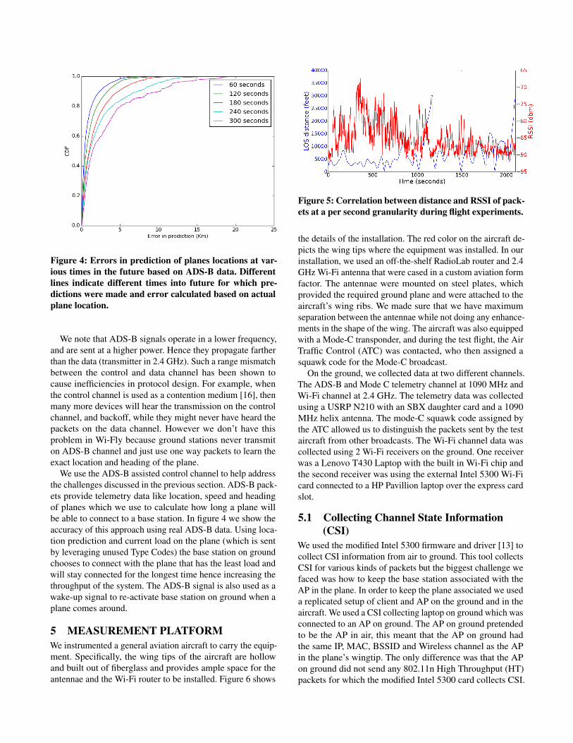
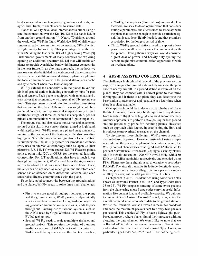
Figure 4: Errors in prediction of planes locations at var-ious times in the future based on ADS-B data. Differentlines indicate different times into future for which pre-dictions were made and error calculated based on actualplane location.
We note that ADS-B signals operate in a lower frequency,and are sent at a higher power. Hence they propagate fartherthan the data (transmitter in 2.4 GHz). Such a range mismatchbetween the control and data channel has been shown tocause inefficiencies in protocol design. For example, whenthe control channel is used as a contention medium [16], thenmany more devices will hear the transmission on the controlchannel, and backoff, while they might never have heard thepackets on the data channel. However we don’t have thisproblem in Wi-Fly because ground stations never transmiton ADS-B channel and just use one way packets to learn theexact location and heading of the plane.
We use the ADS-B assisted control channel to help addressthe challenges discussed in the previous section. ADS-B pack-ets provide telemetry data like location, speed and headingof planes which we use to calculate how long a plane willbe able to connect to a base station. In figure 4 we show theaccuracy of this approach using real ADS-B data. Using loca-tion prediction and current load on the plane (which is sentby leveraging unused Type Codes) the base station on groundchooses to connect with the plane that has the least load andwill stay connected for the longest time hence increasing thethroughput of the system. The ADS-B signal is also used as awake-up signal to re-activate base station on ground when aplane comes around.
5 MEASUREMENT PLATFORMWe instrumented a general aviation aircraft to carry the equip-ment. Specifically, the wing tips of the aircraft are hollowand built out of fiberglass and provides ample space for theantennae and the Wi-Fi router to be installed. Figure 6 shows
Figure 5: Correlation between distance and RSSI of pack-ets at a per second granularity during flight experiments.
the details of the installation. The red color on the aircraft de-picts the wing tips where the equipment was installed. In ourinstallation, we used an off-the-shelf RadioLab router and 2.4GHz Wi-Fi antenna that were cased in a custom aviation formfactor. The antennae were mounted on steel plates, whichprovided the required ground plane and were attached to theaircraft’s wing ribs. We made sure that we have maximumseparation between the antennae while not doing any enhance-ments in the shape of the wing. The aircraft was also equippedwith a Mode-C transponder, and during the test flight, the AirTraffic Control (ATC) was contacted, who then assigned asquawk code for the Mode-C broadcast.
On the ground, we collected data at two different channels.The ADS-B and Mode C telemetry channel at 1090 MHz andWi-Fi channel at 2.4 GHz. The telemetry data was collectedusing a USRP N210 with an SBX daughter card and a 1090MHz helix antenna. The mode-C squawk code assigned bythe ATC allowed us to distinguish the packets sent by the testaircraft from other broadcasts. The Wi-Fi channel data wascollected using 2 Wi-Fi receivers on the ground. One receiverwas a Lenovo T430 Laptop with the built in Wi-Fi chip andthe second receiver was using the external Intel 5300 Wi-Ficard connected to a HP Pavillion laptop over the express cardslot.
5.1 Collecting Channel State Information(CSI)
We used the modified Intel 5300 firmware and driver [13] tocollect CSI information from air to ground. This tool collectsCSI for various kinds of packets but the biggest challenge wefaced was how to keep the base station associated with theAP in the plane. In order to keep the plane associated we useda replicated setup of client and AP on the ground and in theaircraft. We used a CSI collecting laptop on ground which wasconnected to an AP on ground. The AP on ground pretendedto be the AP in air, this meant that the AP on ground hadthe same IP, MAC, BSSID and Wireless channel as the APin the plane’s wingtip. The only difference was that the APon ground did not send any 802.11n High Throughput (HT)packets for which the modified Intel 5300 card collects CSI.
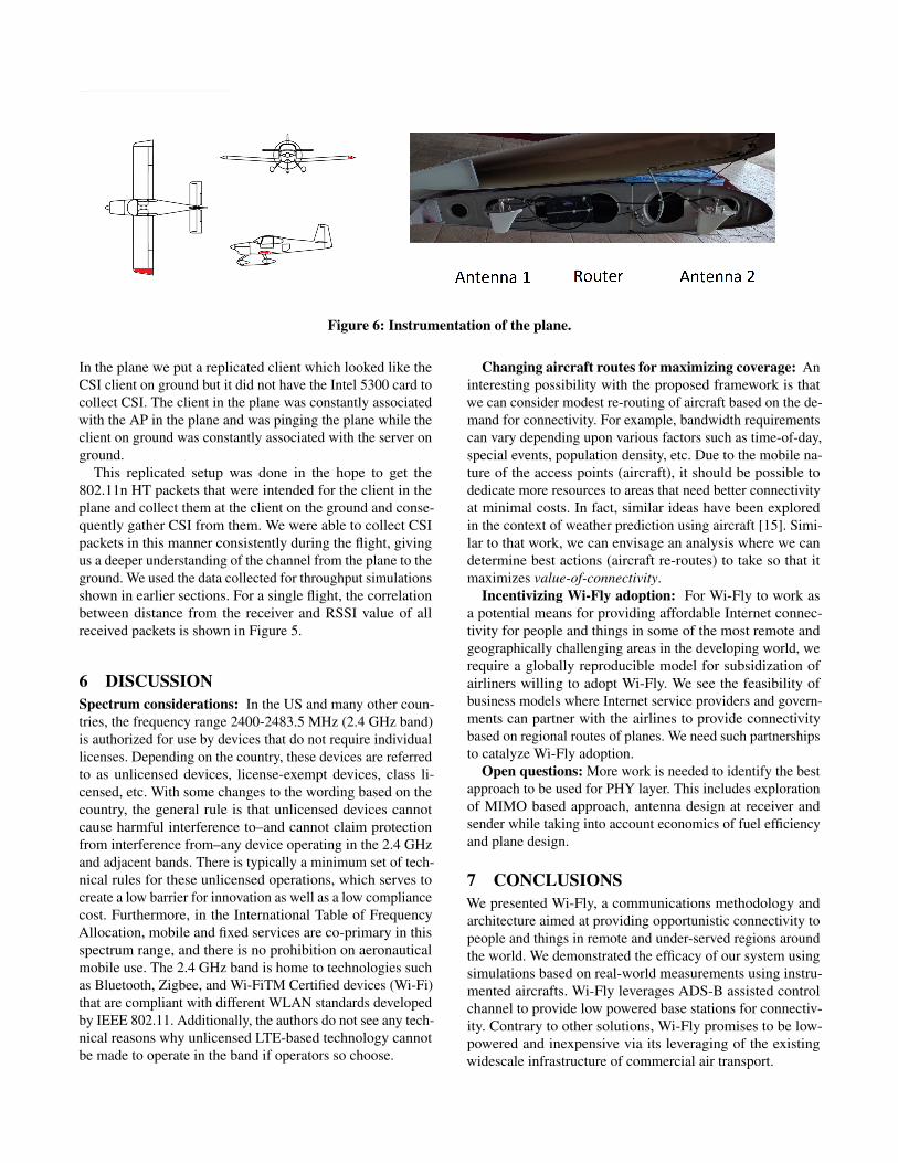
Figure 6: Instrumentation of the plane.
In the plane we put a replicated client which looked like theCSI client on ground but it did not have the Intel 5300 card tocollect CSI. The client in the plane was constantly associatedwith the AP in the plane and was pinging the plane while theclient on ground was constantly associated with the server onground.
This replicated setup was done in the hope to get the802.11n HT packets that were intended for the client in theplane and collect them at the client on the ground and conse-quently gather CSI from them. We were able to collect CSIpackets in this manner consistently during the flight, givingus a deeper understanding of the channel from the plane to theground. We used the data collected for throughput simulationsshown in earlier sections. For a single flight, the correlationbetween distance from the receiver and RSSI value of allreceived packets is shown in Figure 5.
6 DISCUSSIONSpectrum considerations: In the US and many other coun-tries, the frequency range 2400-2483.5 MHz (2.4 GHz band)is authorized for use by devices that do not require individuallicenses. Depending on the country, these devices are referredto as unlicensed devices, license-exempt devices, class li-censed, etc. With some changes to the wording based on thecountry, the general rule is that unlicensed devices cannotcause harmful interference to–and cannot claim protectionfrom interference from–any device operating in the 2.4 GHzand adjacent bands. There is typically a minimum set of tech-nical rules for these unlicensed operations, which serves tocreate a low barrier for innovation as well as a low compliancecost. Furthermore, in the International Table of FrequencyAllocation, mobile and fixed services are co-primary in thisspectrum range, and there is no prohibition on aeronauticalmobile use. The 2.4 GHz band is home to technologies suchas Bluetooth, Zigbee, and Wi-FiTM Certified devices (Wi-Fi)that are compliant with different WLAN standards developedby IEEE 802.11. Additionally, the authors do not see any tech-nical reasons why unlicensed LTE-based technology cannotbe made to operate in the band if operators so choose.
Changing aircraft routes for maximizing coverage: Aninteresting possibility with the proposed framework is thatwe can consider modest re-routing of aircraft based on the de-mand for connectivity. For example, bandwidth requirementscan vary depending upon various factors such as time-of-day,special events, population density, etc. Due to the mobile na-ture of the access points (aircraft), it should be possible todedicate more resources to areas that need better connectivityat minimal costs. In fact, similar ideas have been exploredin the context of weather prediction using aircraft [15]. Simi-lar to that work, we can envisage an analysis where we candetermine best actions (aircraft re-routes) to take so that itmaximizes value-of-connectivity.
Incentivizing Wi-Fly adoption: For Wi-Fly to work asa potential means for providing affordable Internet connec-tivity for people and things in some of the most remote andgeographically challenging areas in the developing world, werequire a globally reproducible model for subsidization ofairliners willing to adopt Wi-Fly. We see the feasibility ofbusiness models where Internet service providers and govern-ments can partner with the airlines to provide connectivitybased on regional routes of planes. We need such partnershipsto catalyze Wi-Fly adoption.
Open questions: More work is needed to identify the bestapproach to be used for PHY layer. This includes explorationof MIMO based approach, antenna design at receiver andsender while taking into account economics of fuel efficiencyand plane design.
7 CONCLUSIONSWe presented Wi-Fly, a communications methodology andarchitecture aimed at providing opportunistic connectivity topeople and things in remote and under-served regions aroundthe world. We demonstrated the efficacy of our system usingsimulations based on real-world measurements using instru-mented aircrafts. Wi-Fly leverages ADS-B assisted controlchannel to provide low powered base stations for connectiv-ity. Contrary to other solutions, Wi-Fly promises to be low-powered and inexpensive via its leveraging of the existingwidescale infrastructure of commercial air transport.
REFERENCES[1] 4.4 billion people around the world still don’t have internet.
http://wapo.st/2jGAe2o. Accessed: 2017-01-05.[2] Flightaware. https://flightaware.com/commercial/flightxml/. Accessed:
2017-01-05.[3] Fly-fi. http://www.jetblue.com/flying-on-jetblue/wifi/. Accessed:2017-
01-05.[4] Gogo. https://www.gogoair.com/. Accessed:2017-01-05.[5] Gogo gets FAA approval for 70 mbps in-flight wi-fi service, but most
rollouts coming in 2016. http://www.fiercewireless.com/wireless/gogo-gets-faa-approval-for-70-mbps-flight-wi-fi-service-but-most-rollouts-coming-2016. Accessed:2017-01-05.
[6] Nasa sedac. http://sedac.ciesin.columbia.edu/. Accessed: 2017-01-01.[7] Openbts. http://openbts.org/. Accessed:2017-01-05.[8] Osmobts. https://projects.osmocom.org/projects/osmobts.
Accessed:2017-01-05.[9] routehappy 2017 wi-fi report. https://www.routehappy.com/insights/wi-
fi/2017. Accessed:2017-01-05.[10] Row 44. https://www.linkedin.com/company/row-44-inc.
Accessed:2017-01-05.[11] T. Ahmad, S. Kalyanaraman, F. Amjad, and L. Subramanian. Solar vs
diesel: Where to draw the line for cell towers? In Proceedings of theSeventh International Conference on Information and CommunicationTechnologies and Development, page 7. ACM, 2015.
[12] Y. Chen, M. P. van der Heijden, and D. M. Leenaerts. A 1-watt ku-bandpower amplifier in sige with 37.5% pae. In Radio Frequency IntegratedCircuits Symposium (RFIC), 2016 IEEE, pages 324–325. IEEE, 2016.
[13] D. Halperin, W. Hu, A. Sheth, and D. Wetherall. Tool release: Gathering802.11n traces with channel state information. ACM SIGCOMM CCR,41(1):53, Jan. 2011.
[14] K. Heimerl, S. Hasan, K. Ali, E. Brewer, and T. Parikh. Local, sus-tainable, small-scale cellular networks. In Proceedings of the Sixth
International Conference on Information and Communication Tech-nologies and Development: Full Papers-Volume 1, pages 2–12. ACM,2013.
[15] A. Kapoor, Z. Horvitz, S. Laube, and E. Horvitz. Airplanes aloft as asensor network for wind forecasting. In Proceedings of the 13th Inter-national Symposium on Information Processing in Sensor Networks,IPSN ’14, pages 25–34, Piscataway, NJ, USA, 2014. IEEE Press.
[16] P. Kaur, M. Uddin, and A. Khosla. Throughput analysis for opportunis-tic spectrum access among unlicensed devices. In Communications(NCC), 2012 National Conference on, pages 1–5. IEEE, 2012.
[17] J. Kunisch, I. de la Torre, A. Winkelmann, M. Eube, and T. Fuss.Wideband time-variant air-to-ground radio channel measurements at 5ghz. In Proceedings of the 5th European Conference on Antennas andPropagation (EUCAP), pages 1386–1390. IEEE, 2011.
[18] D. W. Matolak. Air-ground channels & models: Comprehensive re-view and considerations for unmanned aircraft systems. In AerospaceConference, 2012 IEEE, pages 1–17. IEEE, 2012.
[19] M. Mueller. Universal service and the telecommunications act: mythmade law. Communications of the ACM, 40(3):39–47, 1997.
[20] R. K. Patra, S. Nedevschi, S. Surana, A. Sheth, L. Subramanian, andE. A. Brewer. Wildnet: Design and implementation of high performancewifi based long distance networks. In NSDI, volume 1, page 1, 2007.
[21] M. Rice, A. Davis, and C. Bettweiser. Wideband channel model foraeronautical telemetry. IEEE Transactions on aerospace and Electronicsystems, 40(1):57–69, 2004.
[22] S. Roberts, P. Garnett, and R. Chandra. Connecting africa using thetv white spaces: from research to real world deployments. In Localand Metropolitan Area Networks (LANMAN), 2015 IEEE InternationalWorkshop on, pages 1–6. IEEE, 2015.
[23] M. Strohmeier, M. SchaÌLfer, V. Lenders, and I. Martinovic. Realitiesand challenges of nextgen air traffic management: the case of ads-b.IEEE Communications Magazine, 52(5):111–118, 2014.
[24] R. Thanki. The economic significance of licence-exempt spectrum tothe future of the internet. White Paper, 2012.