why digital cameras are claimed to be superior to film cameras john trinder university of new south...
TRANSCRIPT
Why Digital Cameras are Why Digital Cameras are Claimed to be Superior to Film Claimed to be Superior to Film
CamerasCameras
John TrinderJohn TrinderUniversity of New South University of New South
WalesWalesSydney,Sydney,AustraliaAustralia
Topics discussedTopics discussed Statement on history of development of Statement on history of development of
digital camerasdigital cameras Requirements for development of digital Requirements for development of digital
aerial camerasaerial cameras Two solutions in development of digital Two solutions in development of digital
aerial camerasaerial cameras– Pushbroom systemPushbroom system
Leica Geosystems ADS40Leica Geosystems ADS40
– Multiple frame camerasMultiple frame cameras Intergraph DMCIntergraph DMC Vexcel UltraCamVexcel UltraCamDD
Characteristics of Digital Aerial ImagesCharacteristics of Digital Aerial Images Reported Experiences with Digital CamerasReported Experiences with Digital Cameras Advantages of digital camerasAdvantages of digital cameras Unresolved questionsUnresolved questions
Development of Digital CamerasDevelopment of Digital Cameras Steve Sasson (Kodak) developed the first digital Steve Sasson (Kodak) developed the first digital
camera 30 years agocamera 30 years ago Based on small CCD sensors from Fairchild Based on small CCD sensors from Fairchild
Corporation with 100x100 pixels.Corporation with 100x100 pixels. Now 20-25 years on, digital cameras have Now 20-25 years on, digital cameras have
adequate resolution and size to match the quality adequate resolution and size to match the quality of film camerasof film cameras
Sasson states that film will still be used for Sasson states that film will still be used for photography for some niche areasphotography for some niche areas
Digital imaging will largely replace film for almost Digital imaging will largely replace film for almost all applications – [all applications – [but how much for aerial but how much for aerial photography?]photography?]
Future developments in photography are hard to Future developments in photography are hard to predict, but almost limitless. predict, but almost limitless.
There are more uses for images and more images There are more uses for images and more images being taken than ever before.being taken than ever before.
High Resolution Digital Aerial CamerasHigh Resolution Digital Aerial Cameras Digital photogrammetry has developed Digital photogrammetry has developed
significantly over the past 15 yearssignificantly over the past 15 years Include efficient software for the production of Include efficient software for the production of
DEMs, orthophotos and vector mapping DEMs, orthophotos and vector mapping Development of digital aerial cameras has taken Development of digital aerial cameras has taken
time, due to demands of:time, due to demands of: – Large area coverageLarge area coverage– High spatial resolution – of the order of High spatial resolution – of the order of
400Mpixels or GSD of 10cm to 20cm 400Mpixels or GSD of 10cm to 20cm – High geometric accuracyHigh geometric accuracy– Efficient management of TBytes of image data Efficient management of TBytes of image data
during imagingduring imaging It is expected that developments will take It is expected that developments will take
advantage of the characteristics of digital advantage of the characteristics of digital technologiestechnologies
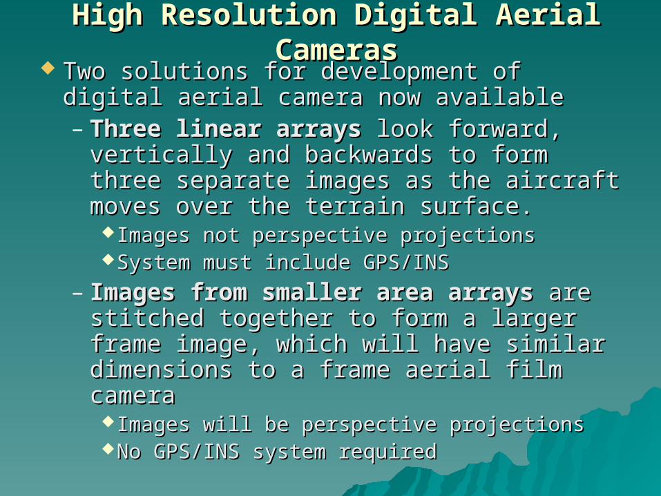
High Resolution Digital Aerial CamerasHigh Resolution Digital Aerial Cameras Two solutions for development of digital Two solutions for development of digital
aerial camera now availableaerial camera now available– Three linear arraysThree linear arrays look forward, look forward,
vertically and backwards to form three vertically and backwards to form three separate images as the aircraft moves separate images as the aircraft moves over the terrain surface. over the terrain surface. Images not perspective projections Images not perspective projections System must include GPS/INSSystem must include GPS/INS
– Images from smaller area arraysImages from smaller area arrays are are stitched together to form a larger frame stitched together to form a larger frame image, which will have similar image, which will have similar dimensions to a frame aerial film dimensions to a frame aerial film camera camera Images will be perspective projectionsImages will be perspective projectionsNo GPS/INS system requiredNo GPS/INS system required
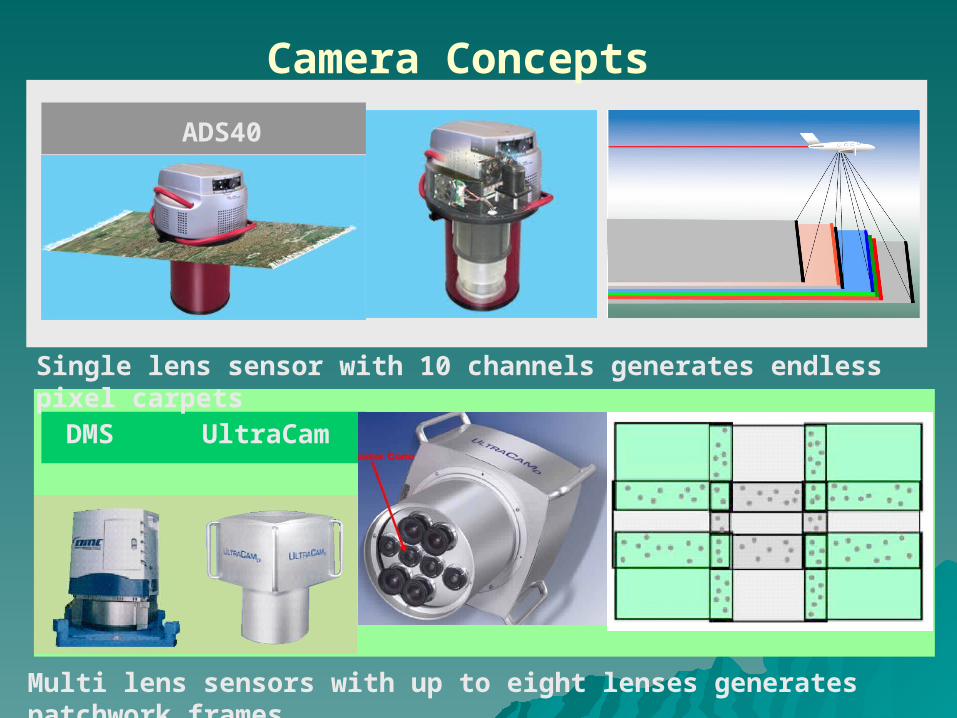
Camera Concepts
DMS
ADS40
Multi lens sensors with up to eight lenses generates patchwork frames
Single lens sensor with 10 channels generates endless pixel carpets
UltraCam
pixel carpets
digital frames
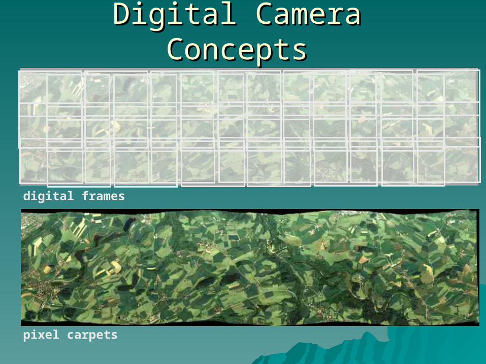
Digital Camera ConceptsDigital Camera Concepts
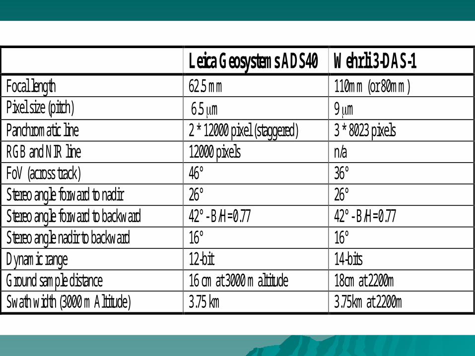
Leica Geosystems ADS40 Wehrli 3-DAS-1 Focal length 62.5 mm 110mm (or 80mm) Pixel size (pitch) 6.5 m 9 m Panchromatic line 2 * 12000 pixel (staggered) 3 * 8023 pixels RGB and NIR line 12000 pixels n/a FoV (across track) 46° 36° Stereo angle forward to nadir 26° 26° Stereo angle forward to backward 42° - B/H=0.77 42° - B/H=0.77 Stereo angle nadir to backward 16° 16° Dynamic range 12-bit 14-bits Ground sample distance 16 cm at 3000 m altitude 18cm at 2200m Swath width (3000 m Altitude) 3.75 km 3.75km at 2200m

DATA ACQUISITION BY LEICA GEOSYSTEMS ADS40DATA ACQUISITION BY LEICA GEOSYSTEMS ADS40
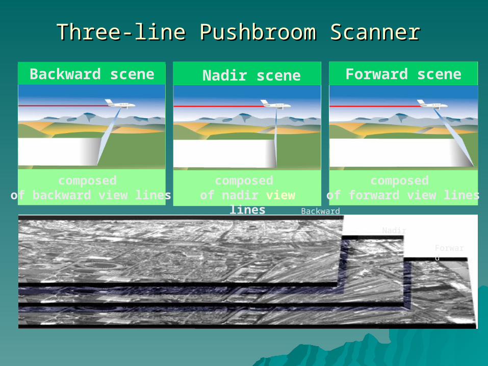
composed of backward view lines
composed of nadir view lines
composed of forward view lines
Backward scene Nadir scene Forward scene
Backward
Nadir
Forward
Three-line Pushbroom ScannerThree-line Pushbroom Scanner
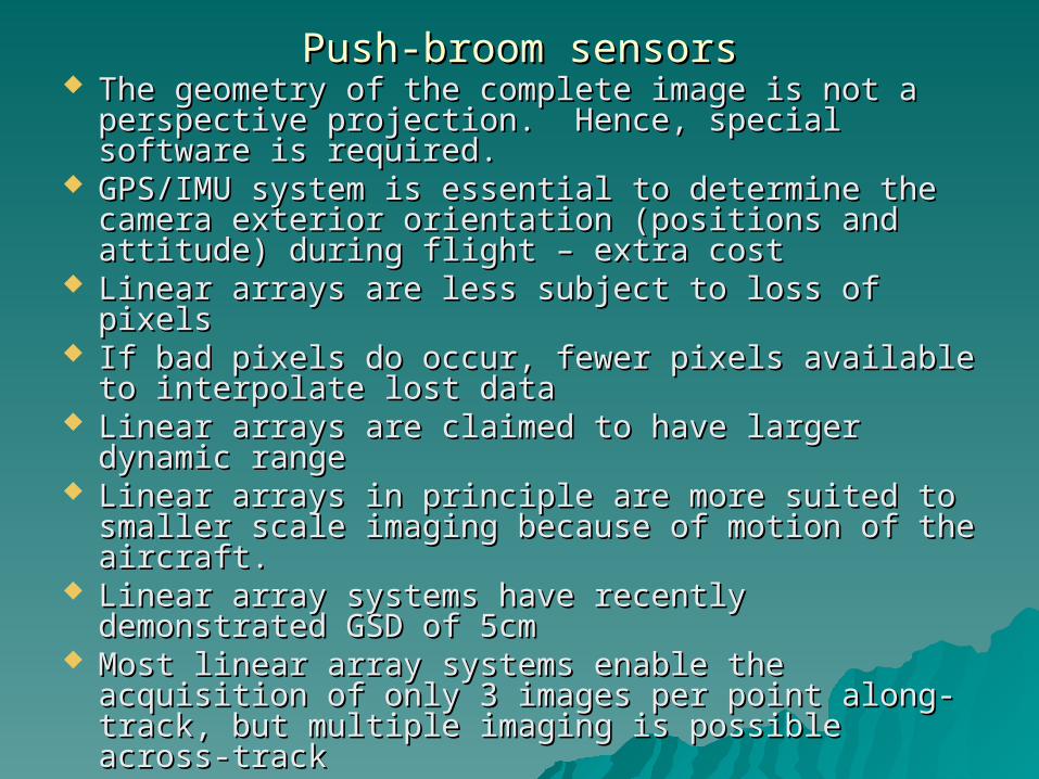
Push-broom sensorsPush-broom sensors The geometry of the complete image is not a The geometry of the complete image is not a
perspective projection. Hence, special software is perspective projection. Hence, special software is required.required.
GPS/IMU system is essential to determine the GPS/IMU system is essential to determine the camera exterior orientation (positions and camera exterior orientation (positions and attitude) during flight – extra cost attitude) during flight – extra cost
Linear arrays are less subject to loss of pixels Linear arrays are less subject to loss of pixels If bad pixels do occur, fewer pixels available to If bad pixels do occur, fewer pixels available to
interpolate lost datainterpolate lost data Linear arrays are claimed to have larger dynamic Linear arrays are claimed to have larger dynamic
range range Linear arrays in principle are more suited to Linear arrays in principle are more suited to
smaller scale imaging because of motion of the smaller scale imaging because of motion of the aircraft. aircraft.
Linear array systems have recently demonstrated Linear array systems have recently demonstrated GSD of 5cmGSD of 5cm
Most linear array systems enable the acquisition Most linear array systems enable the acquisition of only 3 images per point along-track, but of only 3 images per point along-track, but multiple imaging is possible across-trackmultiple imaging is possible across-track
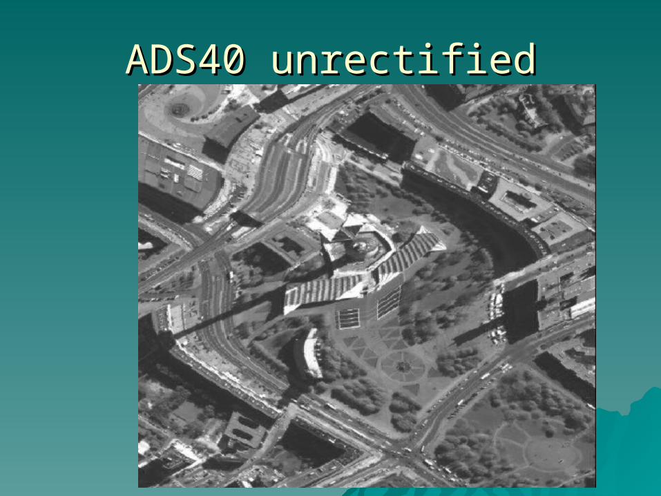
ADS40 unrectifiedADS40 unrectified
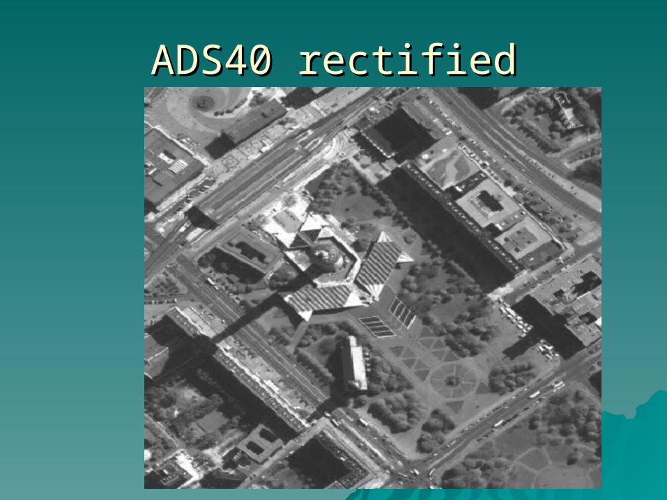
ADS40 rectifiedADS40 rectified
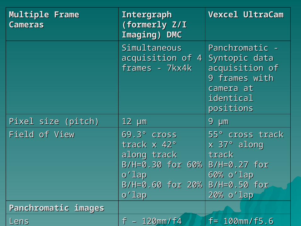
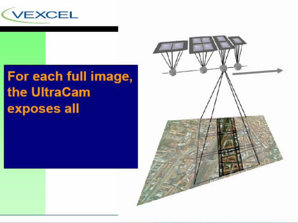
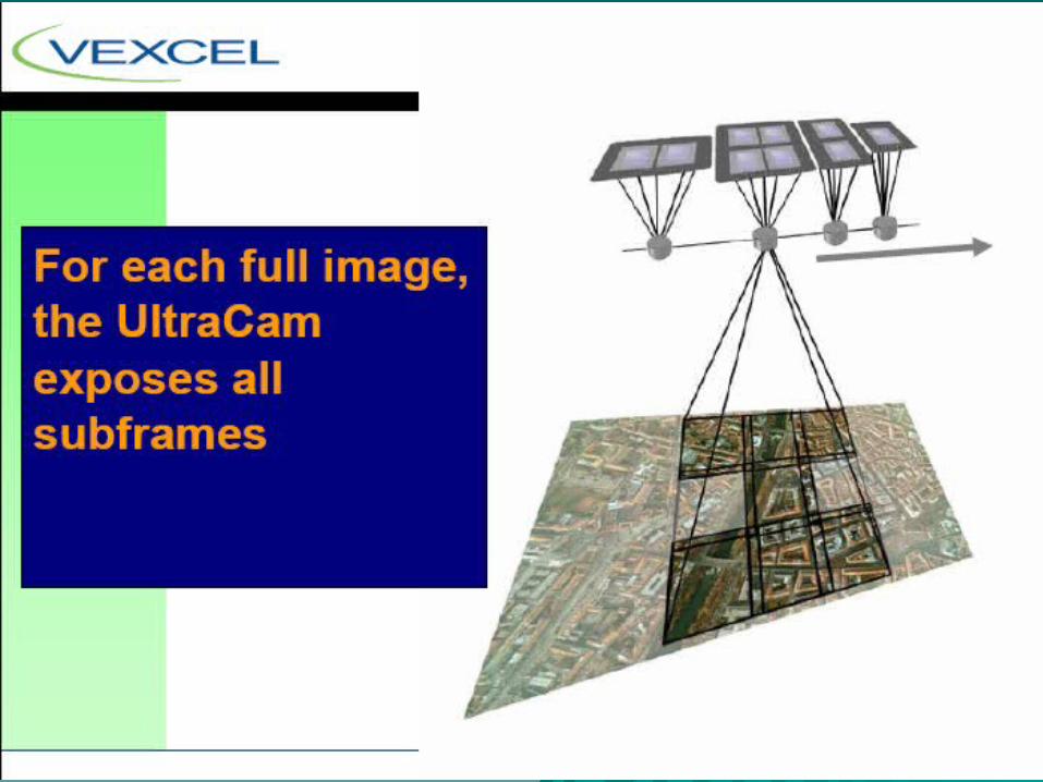
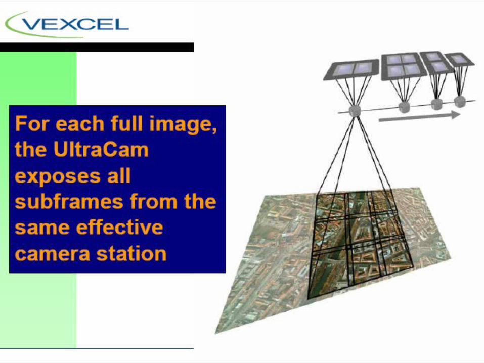
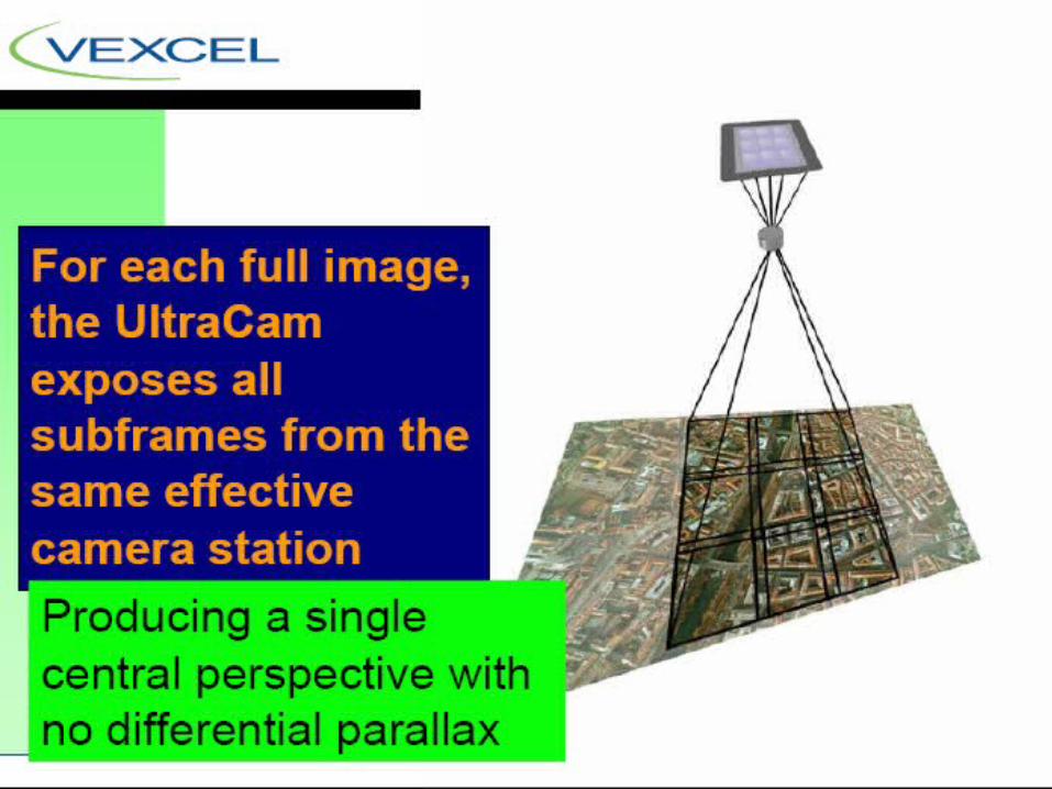
Multiple Frame Multiple Frame CamerasCameras
Intergraph (formerly Intergraph (formerly Z/I Imaging) DMCZ/I Imaging) DMC
Vexcel UltraCamVexcel UltraCam
Simultaneous Simultaneous acquisition of 4 frames acquisition of 4 frames - 7kx4k- 7kx4k
Panchromatic - Panchromatic - Syntopic data Syntopic data acquisition of 9 frames acquisition of 9 frames with camera at with camera at identical positionsidentical positions
Pixel size (pitch)Pixel size (pitch) 12 12 μμmm 9 9 μμmm
Field of ViewField of View 69.3° cross track x 42° 69.3° cross track x 42° along track along track B/H=0.30 for 60% B/H=0.30 for 60% o’lapo’lapB/H=0.60 for 20% B/H=0.60 for 20% o’lapo’lap
55° cross track x 37° 55° cross track x 37° along track along track B/H=0.27 for 60% B/H=0.27 for 60% o’lapo’lapB/H=0.50 for 20% B/H=0.50 for 20% o’lapo’lap
Panchromatic imagesPanchromatic images
LensLens f – 120mm/f4f – 120mm/f4 f= 100mm/f5.6f= 100mm/f5.6
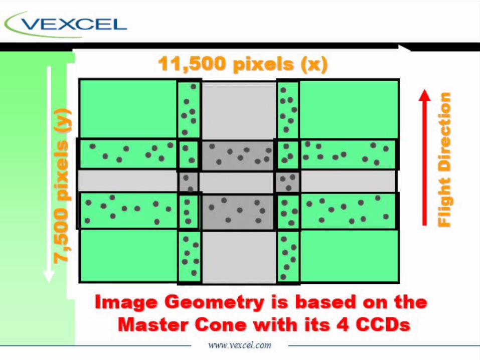
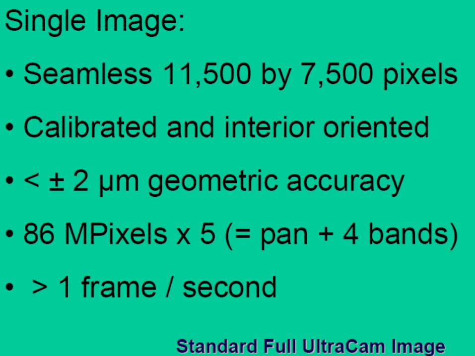
Final outputFinal output 7,680 x 13,824 pixels7,680 x 13,824 pixels 7,500 (flight direction) 7,500 (flight direction) x11,500 pixelsx11,500 pixels
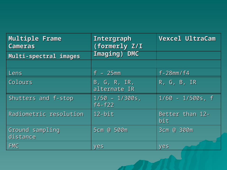
Multi-spectral imagesMulti-spectral images
LensLens f – 25mmf – 25mm f-28mm/f4f-28mm/f4
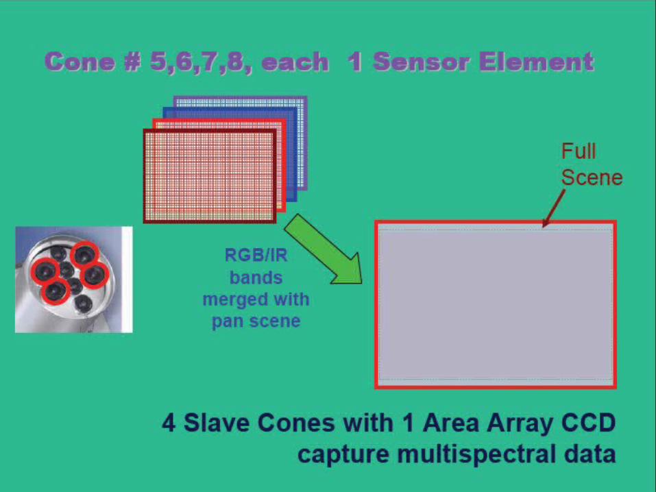
ColoursColours B, G, R, IR, alternate IRB, G, R, IR, alternate IR R, G, B, IRR, G, B, IR
Shutters and f-stopShutters and f-stop 1/50 – 1/300s, f4-f221/50 – 1/300s, f4-f22 1/60 - 1/500s, f1/60 - 1/500s, f
Radiometric resolutionRadiometric resolution 12-bit12-bit Better than 12-bitBetter than 12-bit
Ground sampling distanceGround sampling distance 5cm @ 500m5cm @ 500m 3cm @ 300m3cm @ 300m
FMCFMC yesyes yesyes
Multiple Frame Multiple Frame CamerasCameras
Intergraph (formerly Intergraph (formerly Z/I Imaging) DMCZ/I Imaging) DMC
Vexcel UltraCamVexcel UltraCam
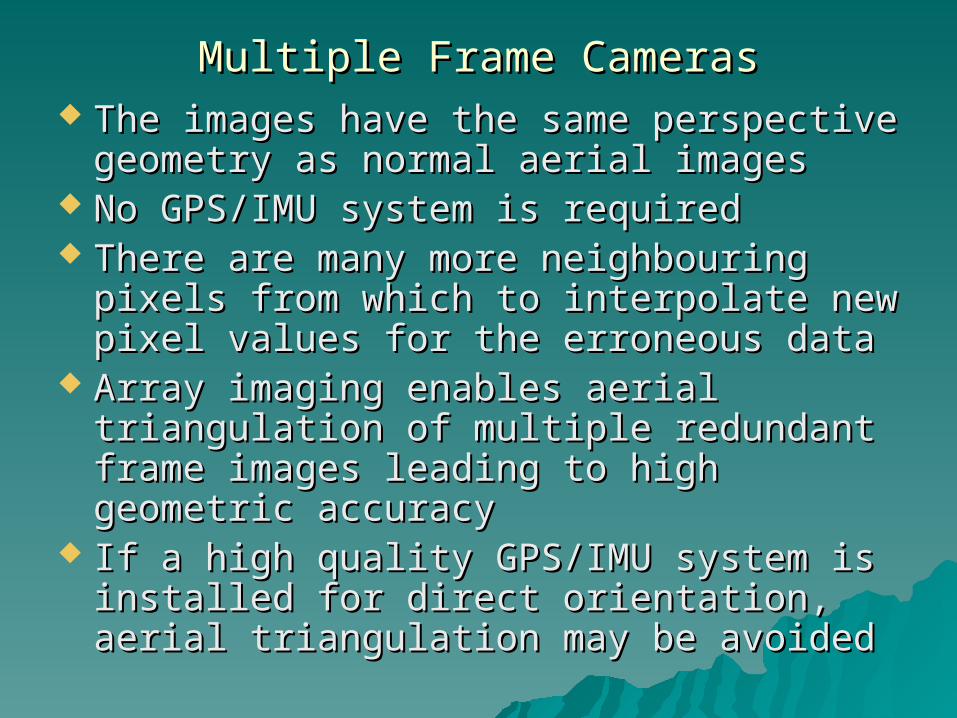
Multiple Frame CamerasMultiple Frame Cameras The images have the same perspective The images have the same perspective
geometry as normal aerial imagesgeometry as normal aerial images No GPS/IMU system is required No GPS/IMU system is required There are many more neighbouring pixels There are many more neighbouring pixels
from which to interpolate new pixel values from which to interpolate new pixel values for the erroneous datafor the erroneous data
Array imaging enables aerial triangulation Array imaging enables aerial triangulation of multiple redundant frame images of multiple redundant frame images leading to high geometric accuracyleading to high geometric accuracy
If a high quality GPS/IMU system is If a high quality GPS/IMU system is installed for direct orientation, aerial installed for direct orientation, aerial triangulation may be avoided triangulation may be avoided
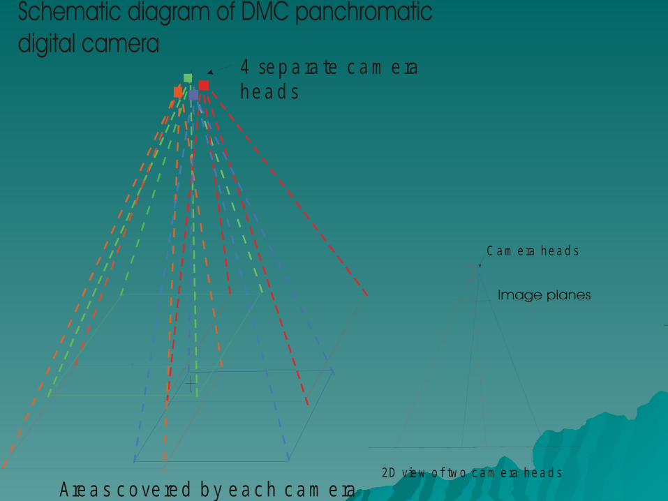
4 se p a ra te c a m e ra he a d s
Are a s c o ve re d b y e a c h c a m e ra2D vie w o f two c a m e ra he a d s
C a m e ra he a d s
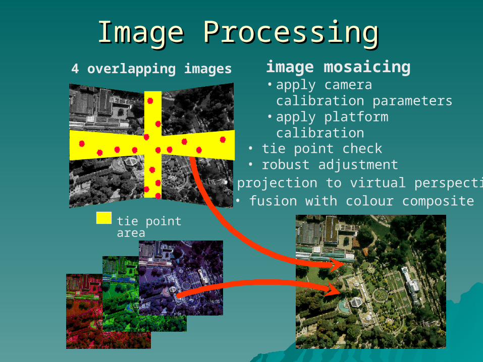
4 overlapping images image mosaicing• apply camera calibration
parameters• apply platform calibration
• fusion with colour composite
• projection to virtual perspective
tie point area
• tie point check • robust adjustment
Image ProcessingImage Processing
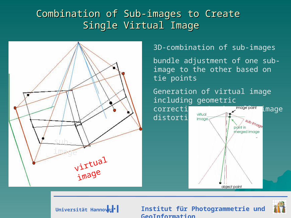
Combination of Sub-images to Create Combination of Sub-images to Create Single Virtual ImageSingle Virtual Image
3D-combination of sub-images
bundle adjustment of one sub-image to the other based on tie points
Generation of virtual image including geometric corrections virtually image distortion free
virtual image
sub-image
Universität Hannover Institut für Photogrammetrie und GeoInformation
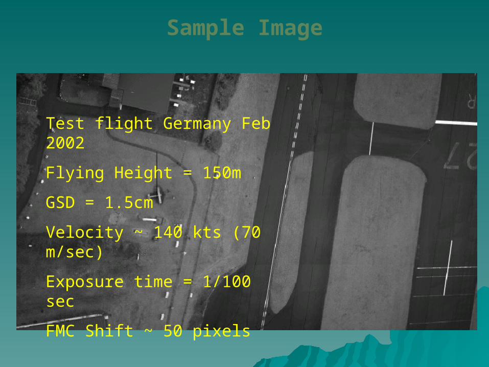
Test flight Germany Feb 2002
Flying Height = 150m
GSD = 1.5cm
Velocity ~ 140 kts (70 m/sec)
Exposure time = 1/100 sec
FMC Shift ~ 50 pixels
Sample Image
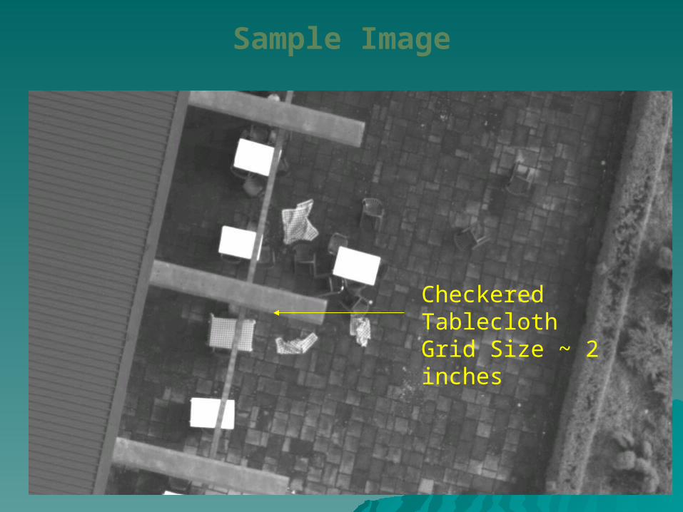
Checkered Tablecloth Grid Size ~ 2 inches
Sample Image
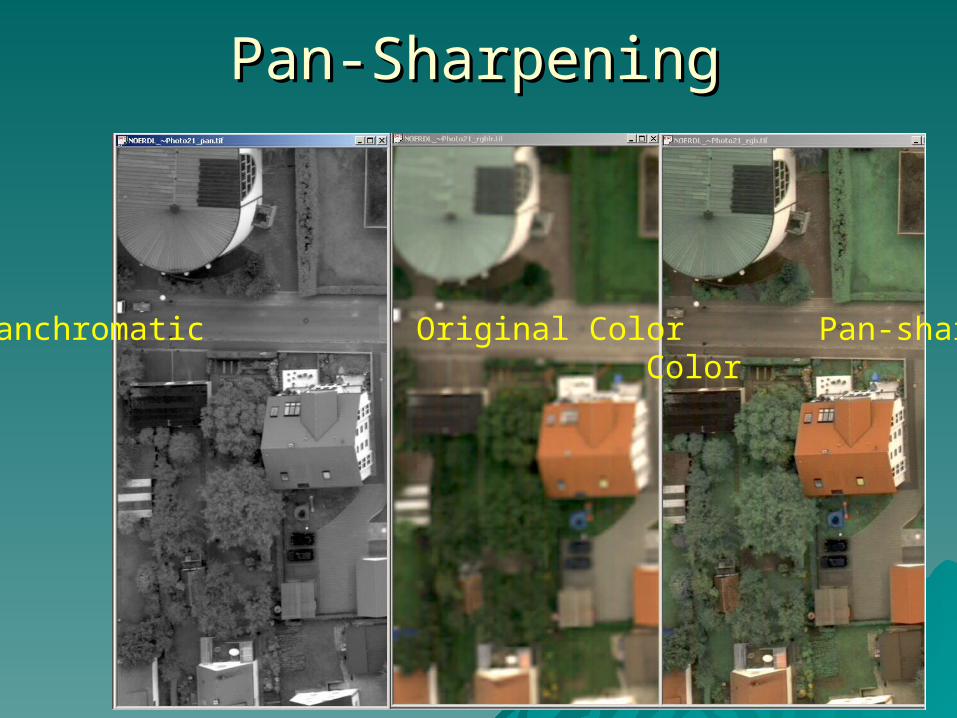
Pan-SharpeningPan-Sharpening
Panchromatic Original Color Pan-sharpened Color
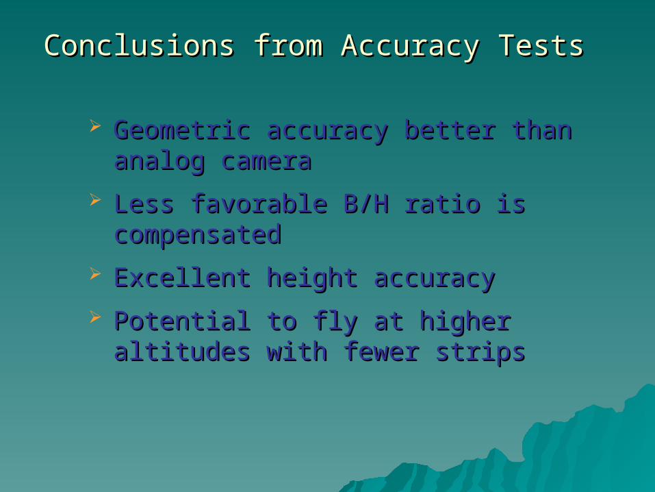
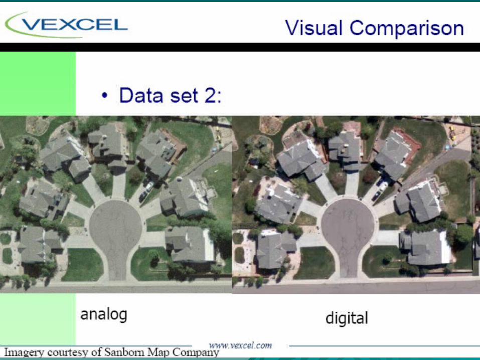
Conclusions from Accuracy TestsConclusions from Accuracy Tests
Geometric accuracy better than analog Geometric accuracy better than analog cameracamera
Less favorable B/H ratio is Less favorable B/H ratio is compensatedcompensated
Excellent height accuracyExcellent height accuracy
Potential to fly at higher altitudes with Potential to fly at higher altitudes with fewer strips fewer strips
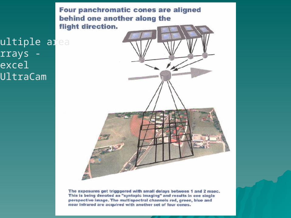
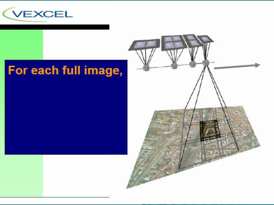
Multiple area arrays -Vexcel UltraCam
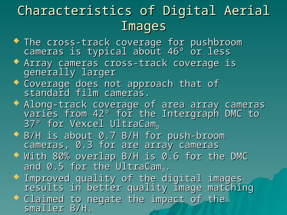
Characteristics of Digital Aerial ImagesCharacteristics of Digital Aerial Images
The cross-track coverage for pushbroom cameras The cross-track coverage for pushbroom cameras is typical about 46º or lessis typical about 46º or less
Array cameras cross-track coverage is generally Array cameras cross-track coverage is generally larger larger
Coverage does not approach that of standard film Coverage does not approach that of standard film cameras. cameras.
Along-track coverage of area array cameras Along-track coverage of area array cameras varies from 42º for the Intergraph DMC to 37º for varies from 42º for the Intergraph DMC to 37º for Vexcel UltraCamVexcel UltraCamDD
B/H is about 0.7 B/H for push-broom cameras, 0.3 B/H is about 0.7 B/H for push-broom cameras, 0.3 for are array camerasfor are array cameras
With 80% overlap B/H is 0.6 for the DMC and 0.5 With 80% overlap B/H is 0.6 for the DMC and 0.5 for the UltraCamfor the UltraCamDD. .
Improved quality of the digital images results in Improved quality of the digital images results in better quality image matchingbetter quality image matching
Claimed to negate the impact of the smaller B/H. Claimed to negate the impact of the smaller B/H.
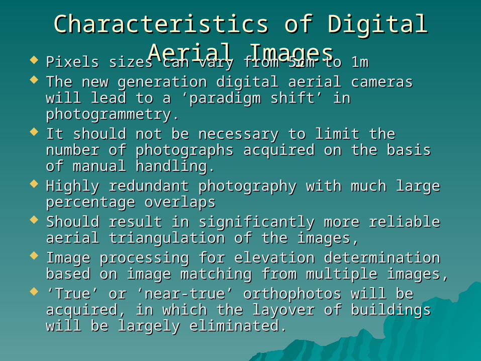
Characteristics of Digital Aerial ImagesCharacteristics of Digital Aerial Images Pixels sizes can vary from 5cm to 1mPixels sizes can vary from 5cm to 1m The new generation digital aerial cameras will The new generation digital aerial cameras will
lead to a ‘paradigm shift’ in photogrammetry. lead to a ‘paradigm shift’ in photogrammetry. It should not be necessary to limit the number of It should not be necessary to limit the number of
photographs acquired on the basis of manual photographs acquired on the basis of manual handling. handling.
Highly redundant photography with much large Highly redundant photography with much large percentage overlaps percentage overlaps
Should result in significantly more reliable aerial Should result in significantly more reliable aerial triangulation of the images, triangulation of the images,
Image processing for elevation determination Image processing for elevation determination based on image matching from multiple images, based on image matching from multiple images,
‘‘True’ or ‘near-true’ orthophotos will be acquired, True’ or ‘near-true’ orthophotos will be acquired, in which the layover of buildings will be largely in which the layover of buildings will be largely eliminated.eliminated.
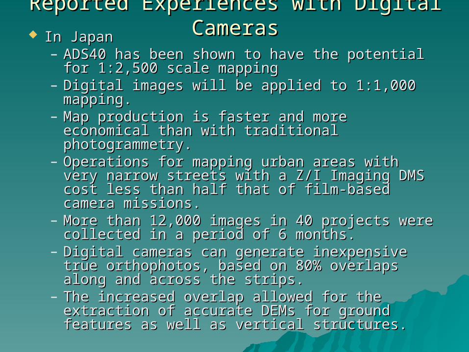
Reported Experiences with Digital CamerasReported Experiences with Digital Cameras In Japan In Japan
– ADS40 has been shown to have the potential ADS40 has been shown to have the potential for 1:2,500 scale mapping for 1:2,500 scale mapping
– Digital images will be applied to 1:1,000 Digital images will be applied to 1:1,000 mapping. mapping.
– Map production is faster and more economical Map production is faster and more economical than with traditional photogrammetry. than with traditional photogrammetry.
– Operations for mapping urban areas with very Operations for mapping urban areas with very narrow streets with a Z/I Imaging DMS cost less narrow streets with a Z/I Imaging DMS cost less than half that of film-based camera missions. than half that of film-based camera missions.
– More than 12,000 images in 40 projects were More than 12,000 images in 40 projects were collected in a period of 6 months. collected in a period of 6 months.
– Digital cameras can generate inexpensive true Digital cameras can generate inexpensive true orthophotos, based on 80% overlaps along and orthophotos, based on 80% overlaps along and across the strips. across the strips.
– The increased overlap allowed for the The increased overlap allowed for the extraction of accurate DEMs for ground extraction of accurate DEMs for ground features as well as vertical structures.features as well as vertical structures.
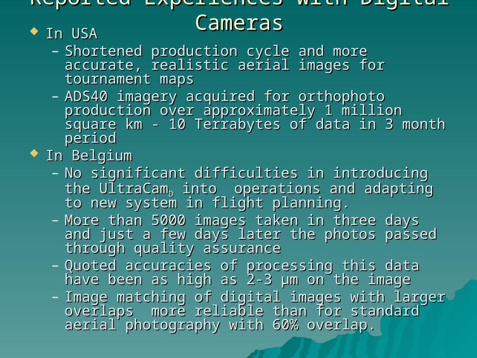
Reported Experiences with Digital CamerasReported Experiences with Digital Cameras In USAIn USA
– Shortened production cycle and more accurate, Shortened production cycle and more accurate, realistic aerial images for tournament maps realistic aerial images for tournament maps
– ADS40 imagery acquired for orthophoto ADS40 imagery acquired for orthophoto production over approximately 1 million square production over approximately 1 million square km - 10 Terrabytes of data in 3 month periodkm - 10 Terrabytes of data in 3 month period
In BelgiumIn Belgium– No significant difficulties in introducing the No significant difficulties in introducing the
UltraCamUltraCamDD into operations and adapting to into operations and adapting to new system in flight planning.new system in flight planning.
– More than 5000 images taken in three days More than 5000 images taken in three days and just a few days later the photos passed and just a few days later the photos passed through quality assurance through quality assurance
– Quoted accuracies of processing this data have Quoted accuracies of processing this data have been as high as 2-3 µm on the imagebeen as high as 2-3 µm on the image
– Image matching of digital images with larger Image matching of digital images with larger overlaps more reliable than for standard aerial overlaps more reliable than for standard aerial photography with 60% overlap. photography with 60% overlap.
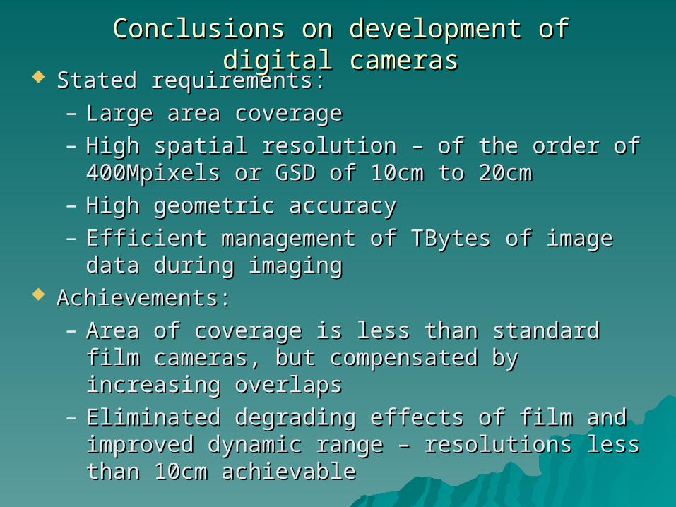
Conclusions on development of digital camerasConclusions on development of digital cameras Stated requirements:Stated requirements:
– Large area coverageLarge area coverage– High spatial resolution – of the order of High spatial resolution – of the order of
400Mpixels or GSD of 10cm to 20cm 400Mpixels or GSD of 10cm to 20cm – High geometric accuracyHigh geometric accuracy– Efficient management of TBytes of image data Efficient management of TBytes of image data
during imagingduring imaging Achievements:Achievements:
– Area of coverage is less than standard film Area of coverage is less than standard film cameras, but compensated by increasing cameras, but compensated by increasing overlaps overlaps
– Eliminated degrading effects of film and Eliminated degrading effects of film and improved dynamic range – resolutions less than improved dynamic range – resolutions less than 10cm achievable10cm achievable
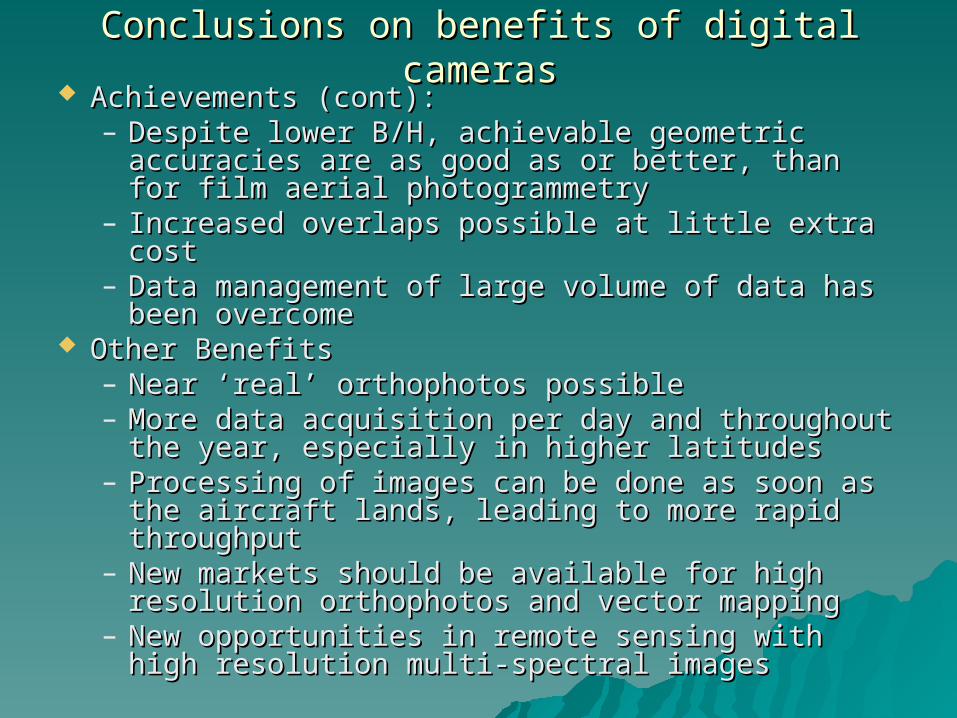
Conclusions on benefits of digital camerasConclusions on benefits of digital cameras Achievements (cont):Achievements (cont):
– Despite lower B/H, achievable geometric Despite lower B/H, achievable geometric accuracies are as good as or better, than for accuracies are as good as or better, than for film aerial photogrammetry film aerial photogrammetry
– Increased overlaps possible at little extra costIncreased overlaps possible at little extra cost– Data management of large volume of data has Data management of large volume of data has
been overcomebeen overcome Other BenefitsOther Benefits
– Near ‘real’ orthophotos possibleNear ‘real’ orthophotos possible– More data acquisition per day and throughout More data acquisition per day and throughout
the year, especially in higher latitudesthe year, especially in higher latitudes– Processing of images can be done as soon as Processing of images can be done as soon as
the aircraft lands, leading to more rapid the aircraft lands, leading to more rapid throughputthroughput
– New markets should be available for high New markets should be available for high resolution orthophotos and vector mappingresolution orthophotos and vector mapping
– New opportunities in remote sensing with high New opportunities in remote sensing with high resolution multi-spectral imagesresolution multi-spectral images
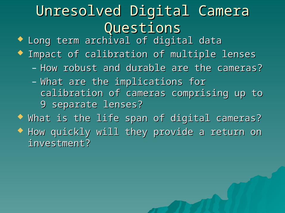
Unresolved Digital Camera QuestionsUnresolved Digital Camera Questions Long term archival of digital dataLong term archival of digital data Impact of calibration of multiple lensesImpact of calibration of multiple lenses
– How robust and durable are the cameras?How robust and durable are the cameras?– What are the implications for calibration of What are the implications for calibration of
cameras comprising up to 9 separate lenses?cameras comprising up to 9 separate lenses? What is the life span of digital cameras?What is the life span of digital cameras? How quickly will they provide a return on How quickly will they provide a return on
investment?investment?