west point fortifications staff ide rides/west... · west point fortifications staff ride note...
TRANSCRIPT
WEST POINT FORTIFICATIONS STAFF RIDE
NOTE CARDS
Prepared: January 1994
Modified: March 1998, August 2008
West Point Fortifications Staff Ride Note Cards 1
USMA History Department 3d Edition, August 2008
Preface
Welcome to the second edition of the USMA History Department West Point Fortifications Staff Ride
Cards. These cards were originally developed to aid instruction in the history of the military art here at
West Point. We make these cards available to support staff rides and historical tours of the historic
Revolutionary War fortifications at West Point by local military organizations.
You may reproduce these cards for local use. Please do not cite or republish
these cards without the express written permission of the Department of History,
United States Military Academy.
Please note that this version of the cards does not currently include any maps or illustrations. We hope to
add them to future editions. If you require those maps and illustrations please contact the Staff Ride
Coordinator, Department of History, United States Military Academy, West Point, NY 10998. (914) 938-
4003. The Staff Ride Coordinator can also assist you in planning your staff ride and direct you to the best
preliminary study materials.
In planning and executing your staff ride, we strongly encourage you to follow the guidelines contained in
William G. Robertson’s The Staff Ride, (Washington, D.C.: Center of Military History, United States
Army), 1987 [CMH Pub 70-21, Supt. of Docs. no.: D114.2:r43] This document is also available on-line at:
http://www.dean.usma.edu/history/outreach/staffrides/how2.html
West Point Fortifications Staff Ride Note Cards 2
USMA History Department 3d Edition, August 2008
Safety Briefing
In the interest of your safety and the preservation of the West Point and Constitution Island historical sites,
please observe the following rules:
• Walk at all times.
• Watch your footing when traveling off paved trails.
• Stay off of walls and cannons.
• Remain at least one foot from the edges of redoubt walls.
• No smoking.
• Remove all trash.
• Supervise children to ensure they comply with these rules.
West Point Fortifications Staff Ride Note Cards 3
USMA History Department 3d Edition, August 2008
• Explain the Scheme of Maneuver & Time Schedule
• Historical Setting
Discuss social, political & economic conditions of Colonial America in the late 1700s.
• Geography
- Importance of rivers in general. . .importance of the Hudson
-- Major means of transportation. . . extremely poor road network
-- Crossing sites limited to Fishkill and King‟s Ferry (between Stony & Verplanck‟s Point
-- Two routes to Canada: Hudson>Albany>Mohawk>L. Oneida>L. Ontario
Hudson>L. Champlain>St. Lawrence
-- Long recognized and utilized as a two-way invasion route
-- Hudson navigable by heavy ships as far as Albany
- Significance of Highlands
-- 15 mile barrier extending from New England SW across Hudson Valley
-- Trails support only small unit movements, easily blocked
-- Otherwise, Hudson Valley is rolling and easy to traverse
West Point Fortifications Staff Ride Note Cards 4
USMA History Department 3d Edition, August 2008
Hudson River
• Discovered by Henry Hudson aboard the Half Moon in 1609.
• Width
- 400m wide at West Point and Bear Mountain
- 1 1/6 mile wide at Cornwall, widest point in the area
• Depth: 40-200‟ with deepest point in the center of the river, marked by buoy, opposite Gee‟s Point (204‟).
• Tide
- Tidal from New York City to Troy with rise and fall of 1 yard at West Point and 1 foot at Albany
- Significant salt water penetration from Peekskill to Bear Mountain
• Traffic
- Sloops sailed Hudson since founding of NYC in 1613 and Albany in 1614 continuing until as late
as 1915
- Steamship traffic began in 1807 with Fulton‟s Clermont and continued until 1851
- Erie Canal opened 1825
- Hudson River Day Line began operating in 1826; Night Line in 1831
- River still extensively used for pleasure craft, oil tankers, cement barges, and trap rock barges
with occasional visits from ocean freighters and Coast Guard icebreakers.
• Railroads parallel both banks and have prevented extensive development thus preserving scenery. Conrail
operates freight trains on west bank and passenger service on east bank.
West Point Fortifications Staff Ride Note Cards 5
USMA History Department 3d Edition, August 2008
The Naval Threat
• Categories of Revolutionary War period sailing ships:
- Ships of the line: 50+ guns (usually 74)
- Frigates: 28-42 guns
- Sloops: 20-28 guns
- Galleys: 4-10 cannon (2-24 pdrs)
• Sloops and galleys were major ships used on Hudson River; larger ships needed elsewhere and ran risk of
running aground in Hudson
- Sloops: square-rigged, maneuverable, fast
- Galleys: propelled by sail or oar, more frequently employed than sloop, varied in size from 70-
90‟ and crews varied from 40-80 men
• British and American galleys fought at Forts Clinton and Montgomery in Oct 1777
• Frigates were used on river, though not often
- Constructed of white oak with 7” thick hulls
- Vulnerable to direct hit by 12 or 18 pdrs
- Could not make bend at West Point in one tack
- Unlikely a naval vessel alone would try to force the West Point narrows
West Point Fortifications Staff Ride Note Cards 6
USMA History Department 3d Edition, August 2008
Logistics & Strategy
• Logistics
- Control of river allows British to supply Indians from Canada; stays open longer
- Severs inter-colonial trade (finished goods from NE for raw materials)
- Blocks movement of agricultural goods (flour, timber, draft animals) from NY interior
• Strategy
- Isolates rebel hotbed. . . New England
- Denies American Army largest source of manpower
- Limits American flexibility and maneuverability
- Fixes British in Canada
West Point Fortifications Staff Ride Note Cards 7
USMA History Department 3d Edition, August 2008
Overview of the West Point Fortifications
• Piecemeal approach to building a defensive system capable of preventing the British from seizing the
Hudson River-Lake Champlain one, thus separating the colonies and facilitating their defeat.
• Not constructed to sustain itself for an indefinite period
- Designed to delay British land or naval force moving up from NYC until state militia or the
Continental Army could respond
- Consists of mutually-supporting positions, all-around depth, and mobile forces
• Successfully discouraged British from pursuing the divide-and-conquer strategy and freed the Continental
Army to shadow the British
West Point Fortifications Staff Ride Note Cards 8
USMA History Department 3d Edition, August 2008
Typical 18th Century Fortifications
• Vertical medieval castle stone walls replaced by fortifications with sunken profiles, bastion traces, and
earthen walls
• Principal parts: ditch, rampart, parapet, glacis
• Fort provides protection against enemy artillery while maximizing effectiveness of defensive fires.
• Vauban, master fortifications and siege engineer
West Point Fortifications Staff Ride Note Cards 9
USMA History Department 3d Edition, August 2008
Why West Point?
• Continental Congress tasks NY Congress to defend NYC and the Highlands
- Dispatch Clinton and Tappan to recon. . . seeking area which met following criteria:
-- narrow enough to engage with cannon from shore
-- strong ebb tide (tidal river with 3‟ variance at West Point
-- unpredictable and treacherous air currents
-- good fields of fire and protected from assault from the landward side
-- difficult to approach from NYC,but accessible to militia
• Assessment of sites meeting criteria:
- Dunderburg (Peekskill): too wide, more predictable winds and tides, and closest to NY
- Anthony‟s Nose: trails leading to mouth of Popolopen Creek inadequate for transportation of
materials required to build forts; more difficult for militia to reach
- West Point: 90° S-curves tightest in Hudson, heart of highlands, strongest ebb time and swiftest
current south of Albany, treacherous air currents, CI commands first turn
West Point Fortifications Staff Ride Note Cards 10
USMA History Department 3d Edition, August 2008
Warner House
• Originally a British land grant to the Phillips family and remained in their possession until 1836
• Little use of defenses after the war
- Western part of house dates to Revolution, probably barracks
- Eastern side added by the Warners
- Currently a museum furnished with original Warner family possessions
• Island sold to Henry Warner in 1836
- Brother Thomas was Chaplain and Professor of Geography, History, and Ethics at USMA from
1828-1838. Thomas encouraged Henry, a wealthy Manhattan lawyer, to erect a resort on the site.
• Due to financial difficulties related to the Panic of 1837, Henry lost his law practice and all his Manhattan
real estate. The family moved permanently to the island. Anna and Susan began writing
- Published 105 books
- Wrote Christian hynm “Jesus Loves Me” (1860)
- Considered the Bronte sisters of America
• Family maintained close relationship with USMA offering grounds for cadet recreation, Sunday school,
and bible classes for over 40 years
- Anna Warner willed island to US government specifying that its use be reserved for USMA
- Both sisters buried in USMA cemetery (Susan d.1885 (65); Anna d. 1915 (87))
- Anna given military funeral with volunteer cadet escorts
- Also willed Gilbert Stuart portrait of Washington in the Cadet Library
West Point Fortifications Staff Ride Note Cards 11
USMA History Department 3d Edition, August 2008
Fort Constitution
• Background
- 25 May 1775: CC votes for war and tasks NY to fortify Highlands
- 2-10 Jun: Colonel James CLINTON (resident of Hudson Valley, surveyor/militia captain) and
Christopher TAPPAN recon and recommend fortifying West Point and Martelear‟s Island,
garrison of 500 men and boom across river
- Aug 1775: NY appoints five man commission and to supervise fortification and appoint Bernard
ROMANS as engineer
• Bernard ROMANS: Dutch-born, educated in England, a botanist with some training (read a book) but
little experience in engineering and fortifications. Earned living as surveyor, cartographer, botanist.
• Roman’s Plan: 5 blockhouses and several batteries in 4 locations - key fort, the Grand Bastion
- Weaknesses: too grandiose and expensive (show picture or use metal plate), poorly sited (only
24/61 guns could cover bend and only 9/24 large enough), and originally lacked chain, dominated
by West Point although he had planned a blockhouse and battery at that location, lack of rear
security
- Greatest problem was starting Grand Bastion first, neglecting other positions, and alienating
commissioners
• Inspections by NY Congress and CC in Nov-Dec resulted in modification of the Roman‟s plan and
eventual shift of effort to Anthony‟s Nose site
- Romans added Marine, Gravel Hill, and Hill Cliff batteries in response to criticisms, but couldn‟t
save himself and was fired in Jan 1776
West Point Fortifications Staff Ride Note Cards 12
USMA History Department 3d Edition, August 2008
Romans’ Blockhouse and Battery
• Romans’ Blockhouse
- Began in Oct 1775 and completed 11 Nov 1775
- Center of the Grand Bastion
-- mounted eight 4-pdr in upper story
-- Lord Stirling “ a log house or tower on the highest cliff, near the water, mounted with 8
cannons, pointed out of the garret windows, and looks very picturesque.”
• Romans’ Battery
- SW curtain of the Grand Bastion, began in Oct 1775 and nearly completed by Dec 1775
- Reported completed by Romans‟ replacement, CPT William Smith, on 1 Mar 1776
- 200‟ long
- mounted thirteen 6-pdrs, one 9-pdr
- 15 embrasures 12‟ apart
- 11‟ thick rampart, exterior face- dry stone masonry, interior face- mortared stone, core was stone
rubble
- Parapet was probably 10‟ thick (normal was 12‟)
- stone scarp with timber cribs filled with earth 7‟ deep
- 12x18‟ brick powder magazine in SW corner (discovered during excavation in 1972)
West Point Fortifications Staff Ride Note Cards 13
USMA History Department 3d Edition, August 2008
Marine Battery
• Construction began in autumn 1778 in response to Duportail‟s recommendations following his inspection
of West Point‟s defenses that year.
• Construction
- Begun as SE curtain of Grand Bastion in Dec 1775
- Nicolls, Drake, and Palmer recommend in Dec 1775 that curtain be made into a battery of 4-6
cannon facing West Point
- Completed in Mar 1776
- Stone rubble rampart 130‟ long and 4‟ high with earthen parapet held in place by timber and
supported by a stone scarp or foundation
- Interior and exterior faces reveted with dry-laid stone masonry
- Rampart and parapet (at base) - 10‟ thick. Parapet constructed with timber revetments filled with
earth
- Rear foundation had a forward pitch to offset cannon‟ recoil and facilitate return to fireing
position
- Mounted seven 9-pdrs and one 6-pdr (eight embrasures)
• Destroyed in 1777, but partially rebuilt in 1778 to protect eastern end of the Great Chain
• Manpower: 40 men recommended by DuPortail in 1779
West Point Fortifications Staff Ride Note Cards 14
USMA History Department 3d Edition, August 2008
Unfinished Redoubt
• North and slightly east of Romans‟ Blockhouse
• Dominated by three other eminences
• Never completed, probably started during Nicoll‟s tenure as commander, Jan-Jun 1776, but not mentioned
by Lord Stirling in his report.
• Remains include only small sections of wall from 6-8‟ wide, 3‟ high. . .shows how walls were seated on
bedrock which helps explain why they have lasted for so long
West Point Fortifications Staff Ride Note Cards 15
USMA History Department 3d Edition, August 2008
Gravel Hill Battery (1776-77)
• Purpose: Enabled cannon to engage ships at longer ranges as they attempted to negotiate S-curve.
• Construction
- Recommended by Nicoll, Drake, and Palmer report (commissioned by NY Congress to inspect
Romans‟ progress). Emphasized keeping the construction simple.
- Represents shift away from the European -style bastions to cheaper and more practical
fortifications (sod and fascines) and shift to eastern portion of island.
- Construction ordered by Congress on 15 Feb 1776 to remedy weakness in Romans‟ plan - built
Apr-May 1776
- Continued construction after shift of effort to southern chokepoint
- Parapets of logs or fascines (describe fascines) filled with gravel and soil and probably covered
with sod. Parapets averaged 10‟ width, two embrasure still visible.
- May have had a defensive ditch in front of parapet
- Probably mounted eleven 18 or 12-pdrs
• Destroyed in 1777, rebuilt in 1778 as Greaton‟s Battery to protect the eastern end of the Great Chain.
Mounted five 6 pdrs and one 9 pdr. Constructed hurriedly, and completed before Greaton departed in Jul
1778.
• Significance of bend in river
- Engagement Area (or kill zone) created by dead water, not the narrow river
- Becalmed ships had to “kedge” (tow) move upstream
- Slow process maximized time under fire from shore
West Point Fortifications Staff Ride Note Cards 16
USMA History Department 3d Edition, August 2008
Greaton’s Battery (1778)
• Purpose: To protect the eastern end of the Great Chain.
• Located on site of old Gravel Hill battery
• Probably held in place much like Gravel Hill battery with earthen parapets and timber or fascines.
Construction began in May 1778
• Contained five 6-pdrs and one 9-pdr as early as Jun 1778
• Only battery on island during Duportail‟s inspection in Aug 1779.
• Manpower: 60 men recommended by Duportail in 1779
West Point Fortifications Staff Ride Note Cards 17
USMA History Department 3d Edition, August 2008
Hill Cliff Battery
• PURPOSE: Construction recommended by Nicoll, Drake, and Palmer report (commissioned by NY
Congress to inspect Romans‟ progress) specifically to prevent Fort and Gravel Hill Battery from being
enveloped and to maintain the LOC between them.
• Recommended by Romans in his revised plan to correct deficiencies of Fort Constitution (1775)
• Built in May 1776 with scarp materials as part of the extension of fortifications east from Fort Constitution
- Position complemented Gravel Hill Battery
- Designed to be completely enclosed, but doubtful that it occurred
• CONSTRUCTION
- Only rampart remains, 26‟ width x 77‟ length
- Scarp wall of dry masonry with a slight talus
- Small stone wall down hill forward of battery may have been to obstruct an assault from the river
- Designed to mount only four 4-pdr cannon
• Not rebuilt after destruction in 1777.
West Point Fortifications Staff Ride Note Cards 18
USMA History Department 3d Edition, August 2008
Lord Stirling’s Report (June 1776)
• Third and final comprehensive review of early fortifications
• Sent by General Israel Putnam (in compliance with order from GW) to inspect Fort Constituion
• “Upon the whole, Mr. Romans has desplayed his genius at a very great expense and to very little publick
advantage. The works in their present open condition and scattered situation are defenceless; nor is there
one good place on the island on which a redoubt may be erected that will command the whole; however, I
have marked in the plan (No. 3) those heights which are most commanding; yet every work on the island is
commanded by the hill on the West Point, on the opposite side of the river, within five hundred yards,
where there is a level piece of land near fifty acres i extent. A redoubt on this West Point is absolutely
necessary not only for preservation of Fort Constitution, but for its own importance on many accounts.”
• Vulnerable to ground attack
• Recommended some modifications of Gravel Hill and Hill Cliff batteries
West Point Fortifications Staff Ride Note Cards 19
USMA History Department 3d Edition, August 2008
Stirling’s Barracks
• Troop barracks located behind Hill Cliff
• 20x57‟ wooden barracks with brick fireplaces, glazed windows, and probably two stories
• Drylaid foundation
• Probably destroyed by fire when British evacuated in Oct 1777
West Point Fortifications Staff Ride Note Cards 20
USMA History Department 3d Edition, August 2008
Fall of Fort Constitution, 1777
• HUDSON DEFENSIVE PLAN, 1776-1777
- Construct Fts Clinton and Montgomery at Popolopen Creek and emplace chain across river.
- Continue to man Fort Constitution and existing defenses; garrison in May 1776: tow companies
of COL James Clinton‟s NY Regiment (100 men) and 40 men from CPT Wisner‟s militia.
• BRITISH STRATEGY IN 1777: Isolate New England by cutting Hudson River
- Burgoyne attacks south from Canada along L. Champlain to Albany
- Barry St. Leger attacks east along Mohawk Valley
- Howe attacks north from NYC to Albany
• EXECUTION
- St. Leger‟s Indian allies desert upon hearing of great numbers accompanying Arnold. . .
ultimately turned back at Ft. Stanwix
- Howe, for reasons unknown, sails up Chesapeake and takes Philadelphia
- Burgoyne takes Ft. Ticonderoga, but is delayed by loss of boats on L. Champlain and forced to
move overland. Attack culminates after repeated minor defeats (Bennington, Freeman‟s Farm,
Bemis Heights) and surrenders at Saratoga - TURNING POINT IN WAR since French now join
American cause.
- Sir Henry CLINTON attack up Hudson to aid Burgoyne; takes Forts Clinton & Montgomery by
feinting east, then landing and moving overland from Stony Point. Cuts chain and moves north
-- Americans at CI fire a single shot and abandon Fort Constitution
-- Learning of Burgoyne‟s defeat, Clinton destroys fortifications and withdraws after 3 wks
West Point Fortifications Staff Ride Note Cards 21
USMA History Department 3d Edition, August 2008
Constition Island, 1778-1783
• Americans reoccupied in 1777, but decided to fortify West Point
• Constitution Island neglected until 1778
- Greaton‟s Battery (old Gravel Hill site) constructed of earth with timber or fascines began on 30
May 1778 by men from COL Greaton‟s Regiment
-- mounted five 6-pdrs and one 9-pdr
-- built in Jun 1778
• Duportail, Washington‟s chief engineer, recommends fortifying CI in Sep 1778
- Construction of Redoubts 5 and 7 and old Marine Battery began in fall 1778 and continued to
1780
- Redoubt 6 begun in Jul-Aug 1779
- All three redoubts of stone scarp with earth parapets and may have had abatis to front
West Point Fortifications Staff Ride Note Cards 22
USMA History Department 3d Edition, August 2008
Redoubt 5
(A redoubt is a small fortification designed to protect an important feature such as a hill or a pass.
Redoubts contain infantry and, often, cannon.)
• Purpose: Located behind Greaton‟s battery on knoll, oriented west, to protect against attack from the
marsh against batteries protecting chain. Provided mutual support for Redoubt 6, island to north, and North
Redoubt
• Construction began in autumn 1778 in response to Duportail‟s recommendations following his
inspection of West Point‟s defenses that year.
- May have contained a blockhouse and probably had palisades on parapet
- Parapet probably very high due to large amounts of remaining earth on scarp and interior
revetment.
- Scarp was 2-3‟ high and appx 7‟ wide on the eastern side
- Barbette (gun platform) battery may have been able to fire along the wall in NW corner
- Exterior stone scarp is 8‟ high
- Entrance on N side, facing most likely enemy AA, explains elaborate protection
- Probably included an abatis surrounding redoubt
- Existence of banquettes suggests that no heavy artillery was present
• Required external battery to cover southern marsh - no evidence of battery exists
• May have mounted two 12-pdrs, two 6-pdrs, four 3- or 4-pdrs
• Manpower: 160 men (lived outside redoubt in huts
West Point Fortifications Staff Ride Note Cards 23
USMA History Department 3d Edition, August 2008
Redoubt 6
(A redoubt is a small fortification designed to protect an important feature such as a hill or a pass.
Redoubts contain infantry and, often, cannon.)
• Purpose: Located in center of island oriented to protect against attack from the marsh against batteries
protecting chain.
• Construction:
- Constructed in 1779; first mentioned in Aug
- Reentrant angle oriented along north infantry avenue of approach
- Overlooks most of island and can support both Redoubts 5 and 7
- Probably had palisades on parapet
- Steep sides of knoll eliminated need for a high parapet
- Scarp wall averages 9‟ height and 8-10‟ width
- Entrance at reentrant angle like Redoubt #5
- Dry masonry construction still intact after 200 years
- No ditch due to difficulty of digging
- Existence of banquettes suggests that no heavy artillery was present
• May have mounted a cannon or been supported by an external battery
- Recommended armament was four 6-pdrs
- L‟Enfant‟s sketch shows embrasure on S. wall and blockhouse
- Duportail reported that it had a battery in Sep 1778.
• Manpower: 120 men (lived in huts outside redoubt)
West Point Fortifications Staff Ride Note Cards 24
USMA History Department 3d Edition, August 2008
Redoubt 7
(A redoubt is a small fortification designed to protect an important feature such as a hill or a pass.
Redoubts contain infantry and, often, cannon.)
• Purpose: Located at western end of island oriented to protect against attack from the marsh against
batteries protecting chain.
• Construction began in autumn 1778 in response to Duportail‟s recommendations following his
inspection of West Point‟s defenses that year.
- An excellent example of dry masonry construction--best and most complete on the island
- 17‟ high in places, 1:6 talus on outside
- Walls vary in thickness at top from 6-9‟
- Most of foundation still intact whereas stone from other redoubts may have been sold to local
inhabitants. Possibly due to difficult access to position.
- May have had small fraise between scarp and parapet to prevent scaling
- 12‟x18‟ powder magazine or bombproof from 1782-1797
- No ditch due to difficulty of digging
- L‟Enfant‟s sketch shows a gabled roof
- Existence of banquettes suggests that no heavy artillery was present
• May have mounted as many as 7 small cannon, but no trace of int. or ext. gun positions exists.
• Manpower: 80 men
• May have survived because location on remote w. side of the island made stone difficult to retrieve.
West Point Fortifications Staff Ride Note Cards 25
USMA History Department 3d Edition, August 2008
North Redoubt
(A redoubt is a small fortification designed to protect an important feature such as a hill or a pass.
Redoubts contain infantry and, often, cannon.)
• Purpose: Part of final expansion of fortifications during late spring/summer of 1779 to control high
ground surrounding West Point on both sides of the river. Included Redoubts 1, 2, 3, North, and South.
• Construction underway by Jul 1779.
• Overlooks Garrison and Nelson‟s Point
• Similar in construction to Fort Wyllys and Redoubts 1, 2, and 3
- Benedict Arnold (1780): “built of stone four feet high; above the stone, wood filled in with earth,
very dry, no ditch, a bomb proof, 3 batteries w/o the fort, a poor abatis”
- parapet wall facing South Redoubt was much higher for protection in case the southern position
was lost
- bombproof and magazine
- no reentrant angles
• 3 external batteries mounting three 18-pdrs, three 12-pdrs
-- Battery #1: NE, 6.5‟ stone scarp wall, no evidence of embrasures
-- Battery #2: Connected to #1 by small stone wall, oriented NW, prevented enemy from
controlling Nelson‟s Point, 8‟ epaulment on SW flank to protect cannoneers from fire from the
river and Garrison
-- Battery #3: S, prevented assault from South Redoubt
• Manpower: 150 men
West Point Fortifications Staff Ride Note Cards 26
USMA History Department 3d Edition, August 2008
South Redoubt
(A redoubt is a small fortification designed to protect an important feature such as a hill or a pass.
Redoubts contain infantry and, often, cannon.)
• Purpose: Part of final expansion of fortifications during late spring/summer of 1779 to control high
ground surrounding West Point on both sides of the river. Included Redoubts 1, 2, 3, North, and South.
• Construction: underway by Jul 1779.
- 1/2 mile south of North Redoubt
- Raised parapets protect inside from higher ground to east
- S and W parapets: 4-5‟ high
- E and NE parapets: 8.5‟ high
- Enclosed by ditch 4‟ below the surrounding ground, 13.5 below parapet, and faced with a stone
counterscarp
• Batteries mounted one 12 pdr and four 6 pdrs
- Battery #1: stone rampart and two walls facing N and E
- Battery #2: stone rampart, guns firing “en barbette”
- Battery #3: one embrasure on S flank, 6‟ epaulment on N flank
• Manpower: 160 men
West Point Fortifications Staff Ride Note Cards 27
USMA History Department 3d Edition, August 2008
The Chain (Card #1)
• The Chain Is The Focal Point Of Fortress West Point. Installation recommended by Putnam and both
Clintons to obstruct navigation of the river.
• Thomas MACHIN engineered, assembled, and installed chain applying lessons learned at Popolopen
Creek
• Earlier chains at Popolopen Creek were 1 1/2” square. First chain broke, but second chain survived until
cut by British during attack in 1777
Construction
Forged at Sterling Ironworks (owned by Peter Townsend), Warwick (near Chester), NY
- Completed ahead of schedule and under budget (cost approximately $60K, contracted in Feb
1778/completed in April)
- 500 yards long, 2 1/4” square iron bars, each link weighed 114 lbs, 2 feet long = total wt 65T
• Assembly
- Assembled in units of ten links and a clevis (about 100‟ and 1000 lbs).
- Clevises and swivels used to adjust for rotation and vertical flexibility
- Assembled in New Windsor, then floated down river to Moore‟s House (Target Hill Field) for
final assembly on 16 Apr 1778.
- Suspended on rafts of four 16‟ sharpened logs (cut from 40-50‟ trees) waterproofed with tar and
oakum and held together by 12‟ timbers
- Chains stapled across logs
- Took forty men four days to complete movement
West Point Fortifications Staff Ride Note Cards 28
USMA History Department 3d Edition, August 2008
The Chain (Card #2)
- Emplacement was completed on 30 Apr 1778
- Probably anchored to huge log cribs and adjusted with pulleys, ropes, capstans, and mid-stream anchors.
North end under Marine Battery, southern end under Chain Battery.
• Almost lost chain to ice during the first winter (1778-79). Until 1783, chain was removed each winter and
reinstalled in spring to avoid destruction by freezing river.
• Log boom installed first year 100m south of chain as buffer, but half of logs rotted. High maintenance
costs probably caused abandonment of boom. Part , recovered in 1855, is on display at Washington‟s HQ
in Newburgh.
- Boom constructed for Fort Montgomery, but not installed before British took positions
- Logs were 18‟ long, 15‟ diameter, with an iron band around each end, held together by chains on
nearly 2” iron bar.
• Initially planned to be installed below Sherburne‟s redoubt, but need to emplace immediately led to
temporary emplacement in cove below Fort Arnold.
• Cadets used computer model to test ability of chain to withstand weight of frigate and determined that it
couldn‟t even stop a sloop.
West Point Fortifications Staff Ride Note Cards 29
USMA History Department 3d Edition, August 2008
Fort Clinton (Arnold) (Card #1)
• Originally known as Fort (James) Clinton after the colonel of the regiment which had constructed it;
McDougall named the fort “Arnold” in April 1778 after hero Benedict Arnold possibly to antagonize the
incoming commander of the Highlands, Horatio Gates, a former foe of Arnold‟s dating to the Saratoga
campaign. Renamed Fort Clinton after Arnold‟s treason in 1780.
• Purpose: Defend the water batteries protecting the chain for up to 14 days until a relieving force for
Continentals and/or militia could arrive.
• Background
- Following British withdrawal on 20 Oct 1777 , patriots reoccupied, but debated location for new
defenses
- Captain Louis de la RADIERE, new French engineer assigned to assist Israel Putnam (Highlands
Commander), wanted to refortify S. . . better suited to resisting siege because rocky soil would
prevent digging parallels and plain at WP supported siege operations (incorrect application of
Vauban‟s principles)
- Overruled by Washington siding with American officers. . . selected West Point in Jan 78
-- Plain provided earth needed for walls and good roads for moving construction materials, 300
yards less chain required, and many access points for relief force
-- Toughest part of river
- Garrisoned by regiment from Parson‟s brigade in Jan 1778. . .constantly manned ever since.
West Point Fortifications Staff Ride Note Cards 30
USMA History Department 3d Edition, August 2008
Fort Clinton (Arnold) (Card #2)
• Radiere planned Vauban-style fortress with masonry lined walls to prevent deterioration, covered way and
glacis (too expensive and time-consuming). Parsons (cdr after Israel Putnam) and George Clinton (NY
Governor) recommended simpler field fortifications to be ready by spring in time to protect the chain.
- Construction began 12 Mar 1778 with priority to S and W walls and SW bastion
• McDougall named new Highlands commander (Parsons remained garrison commander), with complete
authority, and Kosciusko replaced Radiere in April 1778 - better relationship with Americans
• Kosciuszko‟s modifications to Radiere‟s plan
- added Lanthorn Battery (Gee‟s Point) and South Battery
- Modified plan for Fort Arnold to reflect Parson‟s desires for cheaper, earthen works and to add
barracks and magazines within the walls
• Construction
- Top priority W and S walls built to protect against land approach, H: 9‟, D: 20‟, ditch 24‟ base
and 34‟ top. . . dirt for walls came from ditch
- N and E walls built on cliff face, 2 1/2‟ high and 10‟ thick to defend against infantry attack from
the river and support fire on ships
West Point Fortifications Staff Ride Note Cards 31
USMA History Department 3d Edition, August 2008
Fort Clinton (Arnold) (Card #3)
- Glacis provides grazing fire from fort on to plain facing west
- All walls no longer than 240 yards (effective range of artillery against infantry)
- Mounted 8 cannon in 4 pairs of embrasures; 4 in SW, 2 ea. in NW and SE for crossfire
- two cannon in each of the flanks of the SW bastion (en barbette)
- two cannon in flanks of demibastions in NW and SE corners (en barbette)
- embrasures were 2‟ on inside and 9‟ on outside
- Gate in W curtain 3-4” thick with small door (3‟) cut into it
- Chevaux-de-frise on bridge 4‟ in front of gate and at far end; fraise above gate
- Also contained storehouse, powder magazine, guard house, commissary, and well
• Manpower: 600 men in two story barracks, 19‟x19‟ (18 beds, 2 men per bed, 3‟ wide)
• Problems
- Lack of artillery required water batteries to remain unmanned
- Maintenance. 1780 “Black Year” saw fortifications in worst state of repair due to bad weather
and Arnold‟s deliberate neglect, lack of materials, sickness, and weather. Latter three conditions
remained problems throughout history of fort.
• Fort Clinton and water batteries completed by Nov 1780 under Kosciusko‟s replacement, Major
Villefranche. Sherbourne‟s redoubt was not repaired because it was deemed unnecessary
• Still needed significant work as late as 1782
• Post-Revolution History: Used by Military Academy for engineering and artillery instruction
West Point Fortifications Staff Ride Note Cards 32
USMA History Department 3d Edition, August 2008
Kosciuszko (1746-1817) • Born in Poland, youngest of 4 children, into family of modest means and of lower nobility
• Educated by Jesuits from 13 until 18, then attended Royal Military School (Warsaw) in Dec, 1765
• Commissioned in Polish army, instructed at Military School
• Promoted to CPT and elected to study mil engineering and artillery in France at Mezieres in 1769
- Significant because France was hotbed of new thought
• Returned to Poland in 1774 to impoverished family and broken love affair
• Borrowed money to travel to North America
• Arrived Philadelphia in Aug 1776 and worked as a civilian engineer
• Commissioned as colonel of engineers by CC on 18 Oct 1776 and worked on Delaware R. defenses.
• Gates‟ engineer, Mar 77 - Planned defense at Ticonderoga - his first practical combat experience,
• Assigned to West Point on Gates‟ recommendation on 5 March 1778; served there until Jun 1780
• Departed West Point to serve with Gates in Southern Army in Jun 1780 where he proved to be a
successful cavalry officer (Gates relieved before he arrived; so he served with Greene)
• Promoted to BG 13 Oct 1783; founding member of Society of the Cincinnati
• Returned to Europe in 1784 and joined Polish Army as MG in 1789
• Fought with Polish resistance to Russian invasion in 1792; emigrated to Paris when defeated
• Commander in chief of revolutionary forces in 1794 and instituted liberal reforms patterned on American
experience until again defeated by Russians in Oct 1794
• Returned to US to hero‟s welcome in Aug 1797 (collected $12K and 500 acres); returned to France again
to work for Polish independence. Wrote horse artillery manual later used at West Point.
• Died on 15 Oct 1817 in Switzerland - body buried in Poland; heart in Switzerland.
West Point Fortifications Staff Ride Note Cards 33
USMA History Department 3d Edition, August 2008
Chain Battery
• Purpose: Sited to provide grazing fire across chain and to cover ships tacking on east side of river, but
placed higher because guns couldn‟t fire across river to bend and interlock with Water Battery south of
Gee‟s Point (most vulnerable point)
- Moved guns 25 meters higher as a compromise
- Meant close in targets would be engaged with plunging fire, but close range would reduce chance
of missing
- Addition of third battery at Gee‟s Point would have solved problem, but lack of artillery may
have limited him to two choices. . .he chose the best sites under these conditions
• Construction:
- Site selected by Radiere, construction began in Mar 1778
- Scarp wall of glacial stone built higher than gun platform
- 4‟ parapet of timber or fascines filled with gravel
- 4 embrasures, number/type of cannon unknown
- Epaulments (flank protection) on both sides
- Exterior parapet built partially of stone, feature not found in other batteries at West Point,
indicating that Radiere engineered both of them.
West Point Fortifications Staff Ride Note Cards 34
USMA History Department 3d Edition, August 2008
Lanthorn (Lantern) Battery
• Purpose: Added by Kosciusko in spring 1778 to overcome flaws in Radiere‟s plan. Covered chain,
point, and south and forced ships away from point into dead area on lee side of CI
• Construction
- At Gee‟s Point near lighthouse at same height as Chain Battery so suffered same defects
concerning plunging and grazing fire
- Stone scarp
- 6-7‟ thick wood/fascine parapet filled with gravel (not very thick considering engagement
ranges)
- embrasures
• Mounted 3 guns: 18-pdr, 12-pdr, 9 pdr
West Point Fortifications Staff Ride Note Cards 35
USMA History Department 3d Edition, August 2008
Water (or Green) Battery
• Purpose: Located south of Gee‟s Point, oriented to cover point, southern reach, and playing fields
(South Dock), half way between the river and the plain.
- Could only attain plunging fire due to location on steep terrain
• Construction:
- Half size of Chain Battery, 2 embrasures, with epaulments on both ends
- Parapet estimated at 3.5-4‟ thick constructed of glacial gravel supported by timber of fascines on
top of a stone scarp
West Point Fortifications Staff Ride Note Cards 36
USMA History Department 3d Edition, August 2008
South (Knox) Battery
• Purpose: Added by Kosciusko in spring 1778 to overcome flaws in Radiere‟s plan south of Water
Battery. Covered South Dock from position high above river on cliff. . . capable of plunging fire only.
Due to speed of ships at that point in the river, battery could only annoy ships.
• Construction: No current trace, evidently a low-priority effort. . . BOQ parking lot
West Point Fortifications Staff Ride Note Cards 37
USMA History Department 3d Edition, August 2008
Fort Meigs
(named for the commander of the militia regiment that built it) (A battery, not a fort)
• Purpose: Identified by Parsons and Kosciuszko in 1778 as necessary to protect Fort Clinton from
southern approaches along the river. Integrated with Forts Wyllys and Webb, all three were integrated
infantry redoubts and artillery batteries with primary emphasis on the construction of positions to locate and
fight the artillery. Located 150m SE of Fort Wyllys and 60‟ lower on a steep sided spur astride the
approach to Fort Clinton to fire on ships on river or troops approaching along road on bluff.
• Construction (began in Apr 1778 probably completed by Aug 1778)
- “U”-Shaped with the front at the base of the “U”
- Front wall was strongest with battery facing south and opening to the rear
- Primarily of earth and wood although scarps and ramparts were of stone
- Dry masonry scarp up to 5‟ high with little talus
- Base of parapet 5-8‟ thick
- No evidence of gun platforms or embrasures today. But L‟Enfant‟s 1780 sketch shows one
embrasure. Only foundation walls remain.
- Battery open in back
- May have attempted to connect with Fort Wyllys with parapet (140‟)
- Ruins to east may have been part of the Meigs complex. 1778 sketch map shows two small
fortifications below the battery to the E of the road on the bluff above the river. Kosciuszko‟s
“Ruff Map” shows a guardhouse and an open work at identical locations.
• Manpower provided by Fort Wyllys.
West Point Fortifications Staff Ride Note Cards 38
USMA History Department 3d Edition, August 2008
Fort Wyllys (Card #1)
(named for the commander of the militia regiment that built it) (A redoubt, not a fort)
• Purpose: Identified by Parsons and Kosciuszko in 1778 as necessary to protect Fort Clinton from
southern approaches along the river. Wyllys appears to have been conceived primarily as an infantry
fortification from which infantry could deny the ridgeline to the enemy while conducting sorties to protect
the artillery in front of Wyllys and Meigs.
• Integrated with Forts Meigs and Webb as part of a combination of infantry redoubts and artillery batteries
with primary emphasis on the construction of positions to locate and fight the artillery.
• Construction (began in Apr 1778). Among best preserved redoubts at West Point
- Redoubt
- Pentagonal shape with 86 yard perimeter
- One embrasure on S side to cover approach up ridge and to support battery
- Bombproof and magazine as early as 1782
-- bombproof had 3 levels each 3‟ apart
-- lowest section may have been magazine, but CPT Sergent‟s sketch shows it on W wall
-- magazine may still exist beneath the soil in the NW corner
- W wall was thickest (13‟) and appears to be highest to protect from artillery firing from higher
ground to W and S
- Dry masonry ramparts and scarp
- Earth parapets held in place by fascines and timber
- Entry by steps through upper portion of northern rampart
West Point Fortifications Staff Ride Note Cards 39
USMA History Department 3d Edition, August 2008
Fort Wyllys (Card #2)
- Mounted three cannon two facing E and one facing S
- Battery mounted two 18 pdrs, three 3 or 4 pdrs
- Dry masonry ramparts and scarp
- Earth parapets (102‟ in lengtj) held in place by fascines and timber
- Four embrasures cut in the parapets (2-SW, 2-SE)
- Used novel technique to support the wooden gun platform: stone sleepers constructed about 2.5‟
high and 3‟ apart (instead of wooden sleepers)
- Huge epaulment built on W side (19‟x55‟). Surviving stonework is at least 13‟ high at one point.
Probably capped with timbers and fascines filled with earth.
- Palisade and parapet may have connected redoubt with battery
• Manpower: 170 men, entire garrison had to be present to prevent surprise attack
• Benedict Arnold (25 Sep 1780): “built of stone, 5‟ high, the Work above plank filled with Earth, the stone
work 15‟, the Earth 9‟ thick. -- No Bomb Proof, the Batteries without the Fort.” Later report indicates that
bombproof and battery completed by that winter.
• Villefrance (15 Apr 1782) reports that bombproof needs 2‟ of earth, inside parapet needs to be raised 4‟4”
higher than the banquette, south part of wall must be rebuilt, and palisade needed to join the battery and
fort.

West Point Fortifications Staff Ride Note Cards 40
USMA History Department 3d Edition, August 2008
Fort Webb (Card #1)
(named for the commander of the militia regiment that built it) (A redoubt, not a fort)
• Purpose: Identified by Parsons and Kosciuszko in 1778 as necessary to protect Fort Clinton from
southern approaches along the river.
• Integrated with Forts Wyllys and Meigs, all three were integrated infantry redoubts and artillery batteries
with primary emphasis on the construction of positions to locate and fight the artillery.
• Combination infantry redoubt and artillery battery
• Construction (No visible traces remain. . . must rely on Sergeant‟s 1782 sketch)
- Began in Apr 1778; 26 Jul 1778 - regiment posted on outworks, 200 men to complete in two
weeks; named after commander of the regiment that built it.
- 1782 sketch by CPT Ephraim Sergeant showed 4 embrasures, bombproof, and magazine inside a
134 yard perimeter (twice size of other redoubts)
- Primarily of earth and wood although scarps and ramparts were of stone
- SW guns oriented along ridge toward Fort Wyllys; NW guns oriented toward base of Crown Hill
and SW edge of the plain; other two guns oriented SE corner of plain where enemy infantry would
begin their assault if advancing from the river.
- Cannons, probably two 6-pdrs and four 4/3-pdrs, mounted on raised gun platforms and infantry
aided by raised step (banquette)
- Parapets on W and S thicker (8‟) for artillery protection
- Benedict Arnold (25 Sep 1780): “built of fascines and wood, a slight work, very dry and liable to
be set on fire, as the approaches are very easy, without defenses, save a slight abatis.”
West Point Fortifications Staff Ride Note Cards 41
USMA History Department 3d Edition, August 2008
Fort Webb (Card #2)
• Manpower: 200 men - Not constantly garrisoned since secured from surprise attacks by other redoubts.
Manned only to keep vandals from taking wood from platforms and fascines for firewood.
• Eventually lost its value with construction of Fort Putnam on dominant ground and Fort Wyllys farther
south along the ridge.
West Point Fortifications Staff Ride Note Cards 42
USMA History Department 3d Edition, August 2008
Sherburne’s Redoubt
• Constructed 100m NW of Fort Clinton to protect northwestern approach. (100 m SW of Japanese and
German display guns)
• Manning: 120 men, infantry and artillery
• Kosciuszko‟s plan: square redoubt, 12‟ thick rampart, 18‟ w ditch, low parapet topped with palisades
connecting fort to redoubt
• McDougall‟s modifications:
- emphasized ability to withstand 12lb cannon on SW and NE sides (largest that could be moved
overland) = 12‟ thickness
- Only ditched the side of the redoubt facing Crown Hill
- Mount two cannon raised high enough (18‟) to protect garrison from enemy fire on the hill
- North face of redoubt to be raised 14‟ and strongly abatised
- dropped connecting parapet
• Unlikely that enemy could attack from this position because landing could only have occurred after
forcing defenses on both CI and WP as well as breaking chain.
West Point Fortifications Staff Ride Note Cards 43
USMA History Department 3d Edition, August 2008
Fort Putnam (Card #1)
Named for the commander of the militia regiment that built it. Although one of the most important forts at
West Point, little is known about it. Barrels of records sold as waste paper. Reported by Augustus
Pleasanton in diary on 22 Oct 1839: “How true it is that the Americans are without the organ of reverence.”
• Purpose: To dominate the plain upon which Fort Arnold was built and to support Forts Meigs, Wyllys,
and Webb. Not designed to fire on the hudson.
• Fort was one of the two principal works in the WP complex capable of withstanding a 10-day siege
conducted with relatively heavy cannon.
• Became the key fort in the defense: McDougall to Parsons (11 Apr 1778) “ The hill which Col. Putnam is
fortifying is the most commanding and important of any that we can now attend to . . . the eastern-most face
of this work must be so constructed as to command the plain. . . Should the enemy force the regiments of
Wyllis, Meigs, and Webb from their works. . . those corps should retire to defend to the last extremity, the
avenues leading to Col. Putnam‟s redoubt. . . the enemy‟s possessing the works first mentioned, will not be
so fatal to the Post as his getting possession of the Fort (Arnold), or Putnam‟s redoubt.”
• Background:
- McDougall decided to fortify Crown Hill following reconnaissance of high ground in Apr 1778.
Initially, McDougall followed recommendations of Parsons, James Clinton, and Radiere (10 Apr) not to
fortify Crown Hill, but changed his mind the next day. May have been influenced by Kosciuszko, who
recognized significance of high ground as a result of his experience at Fort Ticonderoga in 1777 when
British occupation of surrounding heights rendered fort untenable.
West Point Fortifications Staff Ride Note Cards 44
USMA History Department 3d Edition, August 2008
Fort Putnam (Card #2)
- Assigned COL Rufus Putnam to move 5th Massachusetts Regiment to hill and to construct
redoubt that would become one of the largest and a key fort in the system.
• Construction:
- Atop 50‟ high rock cliff that dominated plain and complemented other redoubts. Plan
complemented the terrain on which it was located taking advantage of steep slopes and general rise
in elevation from E to W across top of knoll.
- Current trace closely follows Kosciuszko‟s sketch from 1779.
- Secure against infantry assault, but vulnerable to artillery on Rock Hill.
- Fort was to be large enough to contain a 10-day supply of salt meat and biscuits.
- Original rampart of dry stone masonry, reinforced and expanded with lime mortar in 1782 or
1783.
- W. walls higher to protect against artillery from Rocky Hill
- Three casemates and
- Construction begins on 11 Apr 1778
• Benedict Arnold (25 Sep 1780): “Fort Putnam Stone wanting great repairs, wall on eastside broke down
and rebuilding from foundation. At the west and south side have been a Chevaux-de-Frise on the west side
broke in many places. The east side open; two bomb proofs and Provision Magazine in the Fort, and slight
Wooden Barrack.”
• Ordnance (5 Sep 1780): five 18-pdrs, two 12-pdrs (both types made of iron and mounted on garrison
carriages); two 6-pdrs, one 4-pdrs (both types mounted on travelling carriages), and four 5.5” mortars
• Manpower: 420 men probably housed in barracks and huts outside fort.
West Point Fortifications Staff Ride Note Cards 45
USMA History Department 3d Edition, August 2008
Rufus Putnam (1738-1824)
• Colonel commanding 5th Massachusetts Regiment when assigned to construct redoubt on Crown Hill on
11 Apr 1778.
• One of most capable American engineers with experience in F&I War as well as civil engineering.
• Suggestion to build moveable breastworks to emplace on frozen ground of Dorchester Heights during the
siege of Boston contributed to Patriot success and led to commission as Colonel of Continental Army
(1776) and assignment as acting Chief of Engineers. Resigned, since there was no Corps of Engineers, and
took command of 5th Mass. Regt.
• As Cdr of 5th Mass. Regt., served under Gates in campaign against Burgoyne, then stationed in Highlands.
Participated in numerous small-scale engagements including Stony Point
• Engineering expertise explains his assignment to the Crown Hill job.
• Appointed BG in Jan 1783
• Instrumental in founding Ohio Company for development of NW Territory
• 1790: Appointed judge in NW Territory
• 1796: Appointed Surveyor-General by Washington; removed by Jefferson in 1803
• Washington described him as of a strong mind, discreet and firm, with nothing conspicuous about his
character.
West Point Fortifications Staff Ride Note Cards 46
USMA History Department 3d Edition, August 2008
Israel Putnam (1718-1790)
• Cousin of Rufus Putnam
• Served w/Connecticut troops in F&I War
- Commissioned as LT; served near L. George and joined Rogers‟ Rangers
- 1756-CPT; 1758-MAJ; captured by Indians; exchanged.
- 1759: LTC, 4th Conn. Regt.; participated in expedition against Ft. Ticonderoga
- 1760-61: Participated in northern campaigns
- 1762: Participated in expedition that captured Havana (400/1200 casualties)
• 1764: Participated in quelling of Pontiac‟s Rebellion, then settled down as farmer.
• 1772-73: Sons of Liberty
• 1775: Appointed BG, 3rd ranking officer in the colonies; a major player at Bunker Hill, “ Don‟t fire until
you see the whites of their eyes.”
• 1776: Organized defense of NYC. Commanded half of force on Long Island.
• 1776-77: Participated in defense of Philadelphia.
• 1777-78: Assigned to defend Hudson Highlands with HQ in Highland Falls. Replaced in 1778 due to
death of wife and departure from post. Exonerated of charges of failing to comply with Washington‟s
orders for defense of Highlands.
• 1779: Replaced Charles Lee in command of right wing of Continental Army. Suffered stroke and left
paralyzed while on leave ending Army career.
West Point Fortifications Staff Ride Note Cards 47
USMA History Department 3d Edition, August 2008
West Point Fortifications “System” (Card #1)
• Mission: Fortress West Point defends West Point NLT spring thaw to prevent British destruction of
chain and navigation along Hudson R.
• West Point site recommended by Governor George CLINTON, brother James CLINTON (defenders of
Forts Montgomery and Clinton in 1777), and military commander, Israel Putnam. Planning and
construction occurred simultaneously in 1778 due to fear of attack after spring thaw - resulted in a
disjointed and confused approach
• Radiere’s Concept Of Operation: - Extend chain and boom from CI to a point west of Gee‟s Point
- Defend chain and boom with two batteries at water level and floating batteries
-- Chain Battery planned at water level to obtain grazing fire, but found guns cound not
range the river unless positioned higher
- Defend land approaches to water batteries with fortification on plain
-- Forts to defend for 10-14 days until Continental Army or militia could relieve
• Kosciusko’s Modifications - Added two water batteries and modified Fort Clinton from rock to
earth construction
West Point Fortifications Staff Ride Note Cards 48
USMA History Department 3d Edition, August 2008
West Point Fortifications “System” (Card #2)
• MCDOUGALL and KOSCIUSZKO:
- Three concentric rings
-- water batteries and Fort Clinton
-- Forts Putnam, Webb, Wyllys, and Meigs / Redoubts 5, 6, 7, and Sherburne‟s Redoubt
-- Redoubts 1, 2, 3, 4 / North and South Redoubts (original plan included a third redoubt
on east side of river south of South Redoubt called Sugarloaf Redoubt. . . deemed
unnecessary).
- Fort Putnam and Fort Clinton were to hold out for 10 days until militia or Continental Army
could arrive.
- All positions were mutually supporting and reinforcing by fire (not troops)
- Key to defense was Fort Putnam
- Forts and redoubts were positions from which mobile infantry forces could maneuver to defeat an
attacker or parry his blows.
• Role Of Militia: 1) construct fortifications, 2) garrison troops, 3) maneuver and security forces, 4) raise
any siege (McDougall, w/HQ in Fishkill, would rally militia while Parsons held WP)
• Flaws In Early Defense Plans
- No batteries planned on CI
- No batteries originally planned to cover South Dock
- Troops for garrison and mobile force not available
- No attempt to fortify hills west of Fort Arnold
West Point Fortifications Staff Ride Note Cards 49
USMA History Department 3d Edition, August 2008
West Point Fortifications “System” (Card #3)
• Washington’s Concept - Fort Clinton holds for at least 14 days while militia and/or Continentals move to relieve garrison.
- In 1779, believed main British attack would occur against West Point: assembled 2300 man
force at West Point, placed McDougall in command of garrison, and moved his own HQ to the Moore
House at West Point.
- Directed defense to be neither static nor passive . . . a mobile army would sally forth to delay the
enemy force enroute to West Point.
• Final Disposition = 16 mutually supporting enclosed positions and 10 major batteries forming three
roughly concentric rings around the Great Chain
- RING #1: Water batteries directly defend the chain. Fort Clinton protects water batteries on
West Point side, adds firepower to water batteries, dominates batteries on Constitution Island, and
withstands siege
- RING #2: Fort Putnam secures high ground overloooking Fort Clinton and blocks westward AA,
Forts Webb, Wyllys, and Meigs protect southern AAs along heights next to river and up draw between
ridge and high ground to the west, and Redoubts 5, 6, and 7 protect Constitution Island water batteries from
landward AA.
- RING #3: Redoubts 1-4 added depth to western defenses while North and South Redoubts
guarded Nelson‟s Point and landward approaches to Constitution Island.
-All but Forts Putnam and Clinton were for early warning and to force enemy to deploy. Main
forts were to hold long enough for relief force to arrive.
West Point Fortifications Staff Ride Note Cards 50
USMA History Department 3d Edition, August 2008
Redoubt 1 (Card #1)
(A redoubt is a small fortification designed to protect an important feature such as a hill or a pass.
Redoubts contain infantry and, often, cannon.)
• Purpose: Part of final expansion of fortifications during late spring/summer of 1779 to control high
ground surrounding West Point on both sides of the river. Included Redoubts 1, 2, 3, North, and South.
Construction underway by Jul 1779.
• Construction
- Redoubt:
- Irregular,hexagonal redoubt protecting two external batteries
- Similar to Wyllys
- No embrasures, gun platforms, bombproof
- Parapet of earth and fascines
- Rampart included banquette steps, 12-20‟ wide
- Thickest walls faced W (Redoubt #2) and SW (Bare Rock Mtn.) in the event that Redoubt #2
should fall to the enemy.
West Point Fortifications Staff Ride Note Cards 51
USMA History Department 3d Edition, August 2008
Redoubt 1 (Card #2)
- Battery #1
- Oriented SE to cover river and southern landing sites
- Combination battery/redoubt?. . . evidence of embrasure
- SW wall thicker, probably higher
- Battery #2
- Oriented W (Redoubt #2) and SW (Bare Rock Mtn.)
- 4 embrasures
- Entire parapet of stone
• Ordnance consisted of eight 9-pdrs
• 170 men for redoubt and battery; an additional 40 for Battery #1
• Benedict Arnold (25 Sep 1780): “on the south side wood 9‟ thick. . . (other sides) 4‟ thick, no cannon in
the walls; a slight and single abattis, no ditch or pickett. Cannon on two batteries. no Bomb Proofs.”
• Villefrance (15 April 1782) indicates that the two batteries are complete but the redoubt still needs a
bombproof, powder magazine, magazine for provisions, and barracks for the garrison.
West Point Fortifications Staff Ride Note Cards 52
USMA History Department 3d Edition, August 2008
Redoubt 2
(A redoubt is a small fortification designed to protect an important feature such as a hill or a pass.
Redoubts contain infantry and, often, cannon.)
• Purpose: Part of final expansion of fortifications during late spring/summer of 1779 to control high
ground surrounding West Point on both sides of the river. Included Redoubts 1, 2, 3, North, and South.
Construction underway by Jul 1779.
• Construction:
- Redoubt
- Irregular hexagon similar to Redoubt #1 except for the walls may have incl a bombproof
- Rampart measures 21-30‟ but includes banquette
- Outer scarp walls may have been built only half-way up suggesting use to support main inner wall
or ICW an upthrusting fraise.
- Walls facing NW (Redoubt #3) and Bare Rock Mt. are thickest and highest
- Battery mounted five 9-pdrs and one 6-pdr
- Faces Bare Rock Mt. with thick front wall
- Parapet has a scarp 6‟ high in places
- Five embrasures: twoin front parapet and three in E. parapet covering Redoubt #1
- Gun platform probably laid directly on soil
- Large epaulment 12-15‟ thick on W. flank protects against seizure of Redoubt #3 200‟ higher to
the west.
• Manpower: 170 men
West Point Fortifications Staff Ride Note Cards 53
USMA History Department 3d Edition, August 2008
Redoubt 3 (Card #1)
(A redoubt is a small fortification designed to protect an important feature such as a hill or a pass.
Redoubts contain infantry and, often, cannon.)
• Purpose: Part of final expansion of fortifications during late spring/summer of 1779 to control high
ground surrounding West Point on both sides of the river. Included Redoubts 1, 2, 3, North, and South.
Construction underway by Jul 1779.
• Construction:
- Redoubt
- Pentagonal , with low parapet foundation of stone (2‟ high)
- Some of the best stonework at West Point
- Some interior structure unexplainable. . . may have been fireplaces
- Low stone walls outside SE wall may have been elaborate entrance or a second battery.
- Parapet constructed entirely of timber or facscines (no earth on top of foundation today)
- May have had a roof (according to L‟Enfant‟s sketch)
- S and SW walls protected by the battery. . . not as thick as others
- SE wall (facing Redoubt #2) required additional depth
- Two N walls thickest to counter enemy artillery placed on high ground 250 yard NE along ridge
West Point Fortifications Staff Ride Note Cards 54
USMA History Department 3d Edition, August 2008
Redoubt 3 (Card #2)
- Battery mounted five 6-pdrs
- Oriented toward Redoubt #2 and Bare Rock Mtn.
- Guns on short right flank fired SW down the ridge along likely infantry AA
- Stone scarp walls 6-7‟ wide and 6-8‟ high
- Parapet constructed entirely of timber or facscines (no earth on top of foundation today)
- Gun platform rested on stone sleepers similar to Fort Wyllys, 22‟ wide
- May have been a palisade along low wall outside the battery
- Small, square stone structure (4‟ high) on outside of angle formed by juncture of battery flanks
may have been the foundation for an observation tower oriented along ridge to SW outside of artillery
range. Observation SW along ridge masked by two small knolls at 250 and 350 yards.
• Manpower: 130 men to man redoubt and two batteries
• Benedict Arnold (25 Sep 1780): wood 3‟ thick, very dry, no bombproofs, no cannon
• Villefrance (15 Apr 1782): Needs bombproof, powder magazine, provision magazine, and a barracks for
the garrison. One battery is begun. Another battery established to defend the valley towards the north.
West Point Fortifications Staff Ride Note Cards 55
USMA History Department 3d Edition, August 2008
Redoubt 4 (Card #1)
(A redoubt is a small fortification designed to protect an important feature such as a hill or a pass.
Redoubts contain infantry and, often, cannon.)
• Purpose: To protect Fort Putnam
• Kosciuszko’s Plan. Orignally proposed by Kosciuszko in 1778 after viewing dominant hill 750m west
and 300‟ higher than Fort Putnam. His concern for the high ground may have developed from his
experience at Fort Ticonderoga. Kosciuszko‟s plan called for a redoubt positioned with three sides
protected by steep slopes and an elevated gun platform inside redoubt to cover hollow to west. Parapet
facing west designed to be higher and thicker than other sides to protect from even higher hills 700m further
west. Chiveaux-de-frise and fraise would prevent escalade. Kosciuszko submitted plans as early as 6 Feb
1779
• McDougall provides specific instructions on 25 Apr 1779
- Make blockhouse bombproof
- Size not to exceed quarters for 100 men
- If practicable, build the cellar to hold 30 days of supplies (previous standard was 14 days)
- Enclose the blockhouse in a redoubt
- Parapet should withstand artillery, especially from the west
West Point Fortifications Staff Ride Note Cards 56
USMA History Department 3d Edition, August 2008
Redoubt 4 (Card #2)
• Construction began in 1779; probably completed by 25 Jun 1779
- Blockhouse erected in spring, but ground still to hard to dig
- Only redoubt with large reentrant angle at rear (w) side; designed to provide crossfire
- No evidence that gun platforms or bombproof were built IAW Kosciuszko‟s design. . .lack of
materials? time? labor? Distracted by British activity at Stony Point?
- Only redoubt with existent formal ditch (N and W sides)
- Dry masonry scarp walls (2‟ high)
- Double exterior wall on NE side (9‟ wide)
- Remains of parapet (soil) still fairly high (8‟ from bottom of ditch) and about 18‟ thick.
- One embrasure visible in NE wall; guns covered NW and SW approaches to Fort Putnam
- Entrance probably on eastern side
• Ordnance: two 6-pdrs
• Garrison: 100 men (probably safe from surprise attack due to good observation/FofF)
• Benedict Arnold (25 Sep 1780): wood 10‟ high and 4-5‟ thick. West wall faced w/stone 10‟ high and 4‟
thick. No bombproof. Two cannon (six pounders).
West Point Fortifications Staff Ride Note Cards 57
USMA History Department 3d Edition, August 2008
Duportail’s Report (Sep 1778 And Aug 1779)
1778
• Greatly concerned with undefended eastern terminus of chain. . .proposed addition of battery and three
redoubts
- One redoubt at Romans‟ blockhouse (never constructed)
- New battery = Marine Battery (construction began in 1778)
- Redoubts 5 and 7 (construction began in 1778)
1779
• The Threat: Most likely enemy course of action was OVERLAND APPROACH FROM THE WEST.
• Concept:
- Defend attack from the west with Redoubts 1-4.
- Construct abatis between Redoubts #1 and #2 to further delay enemy.
- Use mobile forces (Continentals) between West Point and Popolopen Creek; militia responsible
for landing south of that point.
- Construct barracks with protected routes to redoubts.
West Point Fortifications Staff Ride Note Cards 58
USMA History Department 3d Edition, August 2008
Troop Strengths At West Point 1775-1781 (Card #3)
• Difficult to pinpoint strengths due to: lack of standardized unit sizes and use of terms, desertion,
casualties, recruiting shortfalls, constant moving of units, and differentiating between militia, laborers, and
invalids (frequently interchanged jobs). Data from The River and the Rock.
• 1775 (Nov): 2 understrength companies from NY Committee of Safety (Minutemen) guard
commissioners studying the Highlands followed by 200 soldiers / laborers stationed on CI to work on
Romans scheme
• 1776
- Mar: 150 NY Minutemen on CI under COL Nicoll along with some Continentals (<160)
- Jul: 700 militia stationed at Fort Montgomery
- Nov: 750 troops at Anthony‟s Nose
400 troops at CI
2000 Continentals in winter quarters at Fishkill
• 1777
- Jan: CI down to 156 and Fort Montgomery down to 6
- Jul: 4000 Continentals under Washington in Highlands anticipating Howe‟s move. Move S. to protect Philadelphia.

West Point Fortifications Staff Ride Note Cards 59
USMA History Department 3d Edition, August 2008
Troop Strengths At West Point 1775-1781 (Card #2)
• 1778
- Jan: One regiment of Parson‟s Continental Brigade arrives at West Point
- Apr: Parson‟s Brigade complete
- May: Portions of several militia regiments arrive
- Jun: Most Continentals withdrawn to threaten NYC, but by Jul Malcolm‟s Brigade returns
- Sep: Entire Continental Army positioned between NYC and West Point under Washington
• 1779
- May: Washington orders 2500 Continentals to West Point to discourage British attack
- Jul: Washington again takes charge of Highlands using WP as HQ for 10,000 man army
- Nov: As British threat subsides for season, Washington moves army from Highlands for winter.
• 1780
-Jun: Washington calls for 2500 to occupy West Point; Arnold reports 1500 present
- Sep: 826 men from MA militia brigade, two regiments of NH militia, COL Lamb‟s 167
Continentals
West Point Fortifications Staff Ride Note Cards 60
USMA History Department 3d Edition, August 2008
Troop Strengths At West Point 1775-1781 (Card #3)
• 1781
- Jun: Washington orders 440, mostly militia, to garrison West Point while French and American armies remain close by. Corps of Invalids reinforces.
- Oct: While Army is on Yorktown campaign, West Point garrisoned by 17 New England Regiments,
Corps of Invalids, horse legion, and artillery regiment. After Yorktown, Army returns to Highlands for
next two years
West Point Fortifications Staff Ride Note Cards 61
USMA History Department 3d Edition, August 2008
Alexander McDougall
• Replaced Israel Putnam in command of Highlands in Mar 1778 and first to be given complete authority
over fortifications at West Point
• Born in Scotland; immigrated to America at age 6 settling in Lake George, NY; then moving to NYC
when settlement failed.
• Commanded privateers Barrington and Tiger during the F&I War and became a successful merchant from
the profits.
• Self-educated
• One of the earliest radicals, jailed in 1770 for writing inflammatory pamphlet and not released until one
year later.
• One of NY‟s most prominent radical leaders serving in Provincial Congresses and as Colonel of the 1st
NY Regiment.
• 9 Aug 1776: BG in Continental Army; participated in White Plains, Germantown
• 20 Oct 1777: MG
West Point Fortifications Staff Ride Note Cards 62
USMA History Department 3d Edition, August 2008
Living In The Highlands
• Huts
- 6.5‟ high, 15x19 wooden buildings with fireplace at one end
• Long Barracks (West Point)
- two-story building between Sherburne‟s Redoubt and Fort Arnold
- Living conditions required strict sanitation
• Laundry washed by local women at inflated prices
• Occasionally held military balls and invited local girls to attend
• “Black Year” of 1780
- Jan 1780, one of worst 3-day blizzards in Highlands history. Wind swept away tents.
- Shortage of supplies, hunger, defection of Arnold
- See quotation
- Fires a constant problem: barracks serious fire hazards due to cold, dry weather. . . Washington ordered
that anyone starting a fire would “instantly suffer death.”
West Point Fortifications Staff Ride Note Cards 63
USMA History Department 3d Edition, August 2008
Benedict Arnold (Card #1)
Background
Born 1741 in Norwich, CT.
Ran away from home twice as a teenager to join the military
Successful merchant, bookseller, & druggist in New Haven
Captain in CT militia, just missed Lexington fight
May ‟75 participated in Ethan Allen‟s raid that captures FT Ticonderoga
June ‟75 first wife died
Sept – May ‟76 commanded invasion of Canada. Makes BG. Wounded, surrendered, and exchanged.
Oct ‟76 hero of Valcour Island
Feb „77 Congress promoted five men junior to him to MG. Washington convinced him not to resign.
May ‟77 promoted to MG, but remains junior to the five who overtook him. Congress refused to
backdate his commission despite numerous appeals by Arnold and his partisans.
Aug-Oct ‟77 major hero of the Saratoga Campaign. Wounded again. Congress rewarded him by back-
dating his promotion to make him superior to five who overtook him.
Oct‟77-Jun‟78 Arnold convalescing in Albany at his own expense.
Jun 78 Still healing, made commander of Continental troops in Philadelphia. Lived beyond his means and
was charged with embezzlement. Washington let him off with only a letter of reprimand. Arnold was
furious that he had not been cleared of the charges instead.
Apr ‟79, at age 38 he married Peggy Shippen, 18, daughter of prominent Philadelphia loyalist.
Immediately begins plotting treason.
West Point Fortifications Staff Ride Note Cards 64
USMA History Department 3d Edition, August 2008
Benedict Arnold (Card #2)
Treason at West Point
May ‟79 began negotiating with British General Clinton‟s aide John Andre. For 16 months works as a
British agent under the code name “Moore.”
Peggy Shippen was active partner in Arnold‟s treason, but there is no credible evidence that she was the
cause of his treason.
Actively sought the command of West Point in order to hand the fort and its 3,000 man garrison over to
the British for £20,000.
August ‟80 Arnold turned down command of a wing of the French & American main army and assumed
command of the West Point garrison, Stony and Verplanck‟s Points, and the American lines watching
the British forces in NYC.
Deliberately allowed fortifications to deteriorate.
Night 21-22 „Sep ‟80 Arnold met with Andre (traveling under an assumed name with a civilian overcoat
covering his uniform) on shore just below King‟s Ferry. The meeting ended to late for Andre to make
it back to the HMS Vulture, an armed sloop waiting on the Hudson. Andre stayed at a Tory‟s house
nearby. The next morning COL James Livingston, the local American commander, on his own
initiative attacked the Vulture with artillery, driving it downstream before Andre could evacuate.
Andre was now stranded on shore behind American lines carrying documents Arnold had provided.
Arnold arranges for him to travel overland back to the British lines vic. White Plains carrying a pass
signed by Arnold. Arnold then departed for his quarters after sending Andre on his way.
West Point Fortifications Staff Ride Note Cards 65
USMA History Department 3d Edition, August 2008
Benedict Arnold (Card #3)
Treason at West Point (cont.)
1000 23 Sep Andre was captured vic. Tarrytown by a 3-man “volunteer militia” patrol. These men were
operating under a NY law that allowed them to keep any property they seized from enemy troops they
captured.
Thinking that these militiamen were Loyalists, Andre neglected to show his pass until after he had been
searched. The militiamen took Andre to their commander, who sent Andre to his superior, Arnold.
Significantly, the officer sent the papers captured on Andre to General Washington, then in Danbury,
CT, who was traveling to meet with Arnold.
Arnold got word of Andre‟s capture within an hour of Washington‟s expected arrival. Arnold quickly
told his wife what was happening then headed down river toward the Vulture.
It took Washington and his aides about six hours to make sense of the situation they found upon their
arrival. Unable to intercept Arnold and fearing an imminent British attack, Washington set about
immediately ordering repairs and troop deployments that would address the flaws in the West Point
defenses Arnold had described in the documents captured on Andre.
29 Sep Andre tried and convicted of espionage at Tappan by a board of distinguished generals, including
Knox, von Steuben, and Greene. Washington rejected Andre‟s appeal to be shot like a soldier instead
of hung like a spy. Br. General Clinton attempted to secure Andre‟s release but would not consider the
exchange for Arnold that Washington offered.
2 Oct Andre was hanged by the neck until dead.
West Point Fortifications Staff Ride Note Cards 66
USMA History Department 3d Edition, August 2008
Benedict Arnold (Card #4)
After the Treason
Commissioned as a BG in British Army
Compensated for loss of property and given a £500/year pension
With difficulty, raised a small loyalist legion that conducted raids along the Virginia and Connecticut
coasts.
Neither fully trusted nor accepted by British officers in America
Dec ‟81 recalled to London where he languished
1785-91 set himself up as a merchant in Canada
1801 died a broken debtor in England
Grandson killed as a British LTG at Sevastopol
Great grandson was a British MG in WWI.
West Point Fortifications Staff Ride Note Cards 67
USMA History Department 3d Edition, August 2008
Forts Montgomery and Clinton
• Purpose: To block British advance up the Hudson River
• Background:
- One of 3 sites meeting criteria for fortifications on Hudson River.
- Preferred by NY Congressional Committee after inspection of Constitution Island fortifications in Dec
1775
• Construction
- Clinton brothers (George/Gov and head of NY militia, James/Col in Continental Army) were key
proponents of fort. James Clinton in overall command of both forts
- CPT William Smith begins construction in spring, 1776 on plateau north of Popolopen Creek
- Lord Stirling emphasizes vulnerability from south side of creek, leading to construction of second fort
by COL James Clinton in Aug, 1776.
- Lack of engineer direction and committee work hampers construction. Construction begun by Thomas
Palmer and Gilbert Livingston, followed by LT Thomas Machin, then completed by William Bedlow.
- Earth and stone construction
- Defended chain installed in Nov 1776 (broken) and again in Apr 1777.
- Set fires under Anthony‟s Nose to silhouette ships attempting to run river at night.
- Both forts vulnerable to land attack from W and S without use of delaying positions.
- Although manned by 150 unruly militia during winter of 1776. . . landward defenses unfinished as late
as Sep 1777.
• Manpower: Fort Montgomery at peak contained 29 cannons and 750 soldiers (Nov 1776)
West Point Fortifications Staff Ride Note Cards 68
USMA History Department 3d Edition, August 2008
Defense of Forts Montgomery and Clinton
• Attack from NYC an attempt to relieve Burgoyne at Saratoga. British plan feint on eastern bank
simulating repeat of earlier raid on Peekskill, then launch main attack against Popolopen Creek forts and
Fort Constitution. Loyalist Beverly Robinson guided British forces
• The Attack
- British move upriver begins 6 Oct with feint at Verplank‟s Point and landing at Stony Point
- George Clinton alerts forts and sends message to Israel Putnam to send reinforcements.
- American commander at Timp‟s Pass, guarding southern approach from Stony Point, was ill and unsure
of his mission. . . withdrew his forces from pass.
- G. Clinton ordered new party to pass. British advance party of 100 men execute ambush drives them
away from pass.
- Main body (800) arrives by afternoon 7 Oct and splits into two columns around Bear Mtn.
- Western column encountered LT Machin‟s force on way to “Hell Hole” NW of BM and drove them
back to Fort Montgomery. Eastern column drove resistance back to Fort Clinton.
- Messengers sent to Israel Putnam failed to arrive due to treachery of one (in British pay) and lack of
urgency of the other.
- British soldiers and loyalists advanced to within 50-80m of each fort by crawling under cover.
- British sloops and frigates arrived to duel with forts and American ships north of chain.
- British gained time by negotiating with American commander at Fort Montgomery.
- Fort Clinton, then Fort Montgomery, fall to bayonet assaults. (G. Clinton escapes by boat; J. Clinton
escapes overland). British cut chain and bury dead from both sides in Hessian Lake before continuing
attack.
West Point Fortifications Staff Ride Note Cards 69
USMA History Department 3d Edition, August 2008
Chronology (Card #1)
1775
1775 Apr Lexington and Concord
1775 10 May Fort Ticonderoga captured. Continental Congress intervenes.
1775 25 May Continental Congress requests NY to defend NYC and fortify a post in the Hudson
Highlands
1775 2-10 Jun COL James Clinton and Mr. Christopher Tappen recon Hudson.
1775 Jun Bunker Hill. Washington assumes command.
1775 18 Aug NY Provincial Congress appoints 5-man commission to supervise fortification of
Highlands.
1775 Aug Bernard Romans appointed engineer.
1775 29 Aug Romans and commissioners occupy Martelaer‟s Rock.
1775 Oct Romans‟ plan approved by Continental Congress. Construction begins.
1775 Nov-Dec SW curtain of Grand Bastion, blockhouse, and barracks completed.
1775 17 Nov Congressional Committee inspects fortifications and renders critical report.
1775 14 Dec NY Congressional Committee recommends fortification of Hill Cliff, Gravel Hill, and
Popolopen Creek site.
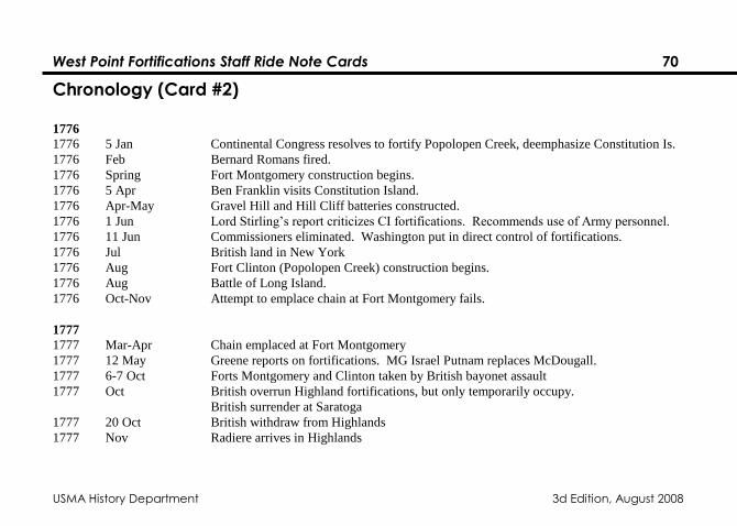
West Point Fortifications Staff Ride Note Cards 70
USMA History Department 3d Edition, August 2008
Chronology (Card #2)
1776
1776 5 Jan Continental Congress resolves to fortify Popolopen Creek, deemphasize Constitution Is.
1776 Feb Bernard Romans fired. 1776 Spring Fort Montgomery construction begins.
1776 5 Apr Ben Franklin visits Constitution Island.
1776 Apr-May Gravel Hill and Hill Cliff batteries constructed.
1776 1 Jun Lord Stirling‟s report criticizes CI fortifications. Recommends use of Army personnel.
1776 11 Jun Commissioners eliminated. Washington put in direct control of fortifications.
1776 Jul British land in New York
1776 Aug Fort Clinton (Popolopen Creek) construction begins.
1776 Aug Battle of Long Island.
1776 Oct-Nov Attempt to emplace chain at Fort Montgomery fails.
1777
1777 Mar-Apr Chain emplaced at Fort Montgomery
1777 12 May Greene reports on fortifications. MG Israel Putnam replaces McDougall.
1777 6-7 Oct Forts Montgomery and Clinton taken by British bayonet assault
1777 Oct British overrun Highland fortifications, but only temporarily occupy.
British surrender at Saratoga
1777 20 Oct British withdraw from Highlands
1777 Nov Radiere arrives in Highlands
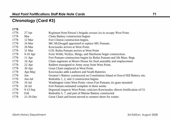
West Point Fortifications Staff Ride Note Cards 71
USMA History Department 3d Edition, August 2008
Chronology (Card #3)
1778
1778 27 Jan Regiment from Parson‟s brigade crosses ice to occupy West Point.
1778 Mar Chain Battery construction begins
1778 12 Mar Fort Clinton construction begins.
1778 16 Mar MG McDougall appointed to replace MG Putnam.
1778 26 Mar Kosciuszko arrives at West Point.
1778 31 Mar COL Rufus Putnam arrives at West Point
1778 9-10 Apr Forts Webb, Wyllys, Meigs, and Sherburne begin construction.
1778 11 Apr Fort Putnam construction begins by Rufus Putnam and 5th Mass. Regt.
1778 16 Apr Chain segments at Moore House for final assembly and emplacement
1778 22 Apr Radiere reassigned to Army away from West Point.
1778 30 Apr Great Chain emplaced at West Point.
1778 Apr-May Kosciuszko adds Lanthorn and South Batteries
1778 Jun Greaton‟s Battery constructed on Constitution Island at Gravel Hill Battery site.
1778 Jun-Jul Redoubts 1, 2, and 3 construction begins
1778 16 Jul Washington visits West Point; views Fort Putnam; six guns mounted
1778 26 Jul Fort Putnam estimated complete in three weeks
1778 9-13 Sep Duportail inspects West Point; criticizes Kosciuszko; directs fortification of CI.
1778 Fall Redoubts 5, 7, and part of Marine Battery constructed
1778 21-29 Dec Great Chain and boom moved to western shore for winter.
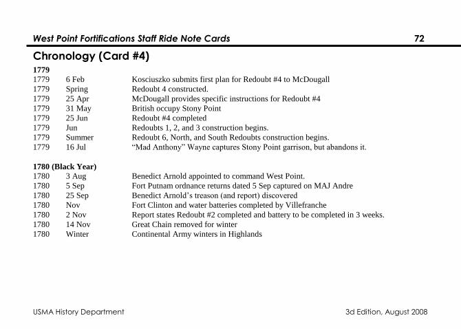
West Point Fortifications Staff Ride Note Cards 72
USMA History Department 3d Edition, August 2008
Chronology (Card #4) 1779
1779 6 Feb Kosciuszko submits first plan for Redoubt #4 to McDougall
1779 Spring Redoubt 4 constructed.
1779 25 Apr McDougall provides specific instructions for Redoubt #4
1779 31 May British occupy Stony Point
1779 25 Jun Redoubt #4 completed
1779 Jun Redoubts 1, 2, and 3 construction begins.
1779 Summer Redoubt 6, North, and South Redoubts construction begins.
1779 16 Jul “Mad Anthony” Wayne captures Stony Point garrison, but abandons it.
1780 (Black Year)
1780 3 Aug Benedict Arnold appointed to command West Point.
1780 5 Sep Fort Putnam ordnance returns dated 5 Sep captured on MAJ Andre
1780 25 Sep Benedict Arnold‟s treason (and report) discovered
1780 Nov Fort Clinton and water batteries completed by Villefranche
1780 2 Nov Report states Redoubt #2 completed and battery to be completed in 3 weeks.
1780 14 Nov Great Chain removed for winter
1780 Winter Continental Army winters in Highlands
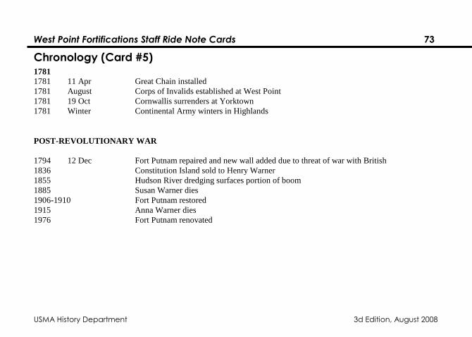
West Point Fortifications Staff Ride Note Cards 73
USMA History Department 3d Edition, August 2008
Chronology (Card #5) 1781
1781 11 Apr Great Chain installed
1781 August Corps of Invalids established at West Point
1781 19 Oct Cornwallis surrenders at Yorktown
1781 Winter Continental Army winters in Highlands
POST-REVOLUTIONARY WAR
1794 12 Dec Fort Putnam repaired and new wall added due to threat of war with British
1836 Constitution Island sold to Henry Warner
1855 Hudson River dredging surfaces portion of boom
1885 Susan Warner dies
1906-1910 Fort Putnam restored
1915 Anna Warner dies
1976 Fort Putnam renovated
West Point Fortifications Staff Ride Note Cards 74
USMA History Department 3d Edition, August 2008
General Staff Ride Leader Questions
• What purpose does this position serve? (MISSION)
• How would you defend this site?
• How would you assault this site?
• What are its weaknesses?
• What are its strengths?
• Is these a better position from which to accomplish the defensive mission?
• How does the terrain support the selection of this position?
• What advantages do high ground and low ground afford soldiers fighting in this area?
• What is the difference between plunging and grazing fire?
• Which type of fire does this position afford?
• What are the characteristics of the weapons used by the West Point defenders?
• What is the range from this point to ________?
• How does this position support/is this position supported by other positions?
• How thick and of what materials would the parapet have been constructed to protect the defenders?
• How would West Point commander communicate with his forces during an attack?
• What kind of defense does the West Point fortifications system represent?
• What are the advantages and disadvantages of the system?
West Point Fortifications Staff Ride Note Cards 75
USMA History Department 3d Edition, August 2008
Suggested Role Playing Responsibilities & Questions (Card #1)
1. On the boat to Constitution Island
a. Washington: Why did you think the Hudson River and the West Point of the Hudson were
strategically significant?
b. Tappan and James Clinton: What was your reconnaissance mission and why did you pick the
West Point of the Hudson and Martelear‟s Rock for the Hudson‟s key fortifications?
c. Israel Putnam: How did you intend to exploit the S-shaped curve in the river at West Point?
How would you defend against British attack?
d. Burgoyne and Henry Clinton: Why did you want to secure the Hudson river in 1777 and what
was your plan?
e. George and James Clinton and Lamb: Why did you lose Forts Clinton and Montgomery in
October, 1777?
West Point Fortifications Staff Ride Note Cards 76
USMA History Department 3d Edition, August 2008
Suggested Role Playing Responsibilities & Questions (Card #2)
2. Constitution Island
a. Romans: What was your plan of defense? Describe your battery. Why were you fired?
b. Tappan and James Clinton: What did you think of Roman‟s Plan? What were Fort
Constitution‟s flaws? What changes did you recommend and where?
c. Lord Stirling: What was your analysis of Romans‟ work? Would it have worked? Describe the
Blockhouse.
d. Henry Clinton: How did you take Fort Constitution in October 1777?
e. DuPortail: How did engineers construct these type fortifications?
f. Martin: Describe Redoubt 6 and how your soldiers did their work.
g. McDougal: What purpose did Redoubts 5, 6, and 7 serve?
h. Susan and Anna Warner: Why did you live here? How did you help the Academy and why did
you will the island to the cadets?
West Point Fortifications Staff Ride Note Cards 77
USMA History Department 3d Edition, August 2008
Suggested Role Playing Responsibilities & Questions (Card #3)
3. Fort Putnam
a. De la Radiere: What was your plan for West Point? What difficulties did you face? Why did
you leave West Point?
b. Kosciuszko and McDougall: What was you concept for fortifying West Point and blocking the
Hudson? Why did you choose to build Fort Putnam?
c. Duportail: What were you criticisms of Kosciuszko‟s work? What additions did you
recommend?
d. Rufus Putnam: Describe Fort Putnam in 1780. How did you build it?
e. Parsons: What did West Point look like when your brigade arrived in January 1778?
f. Washington: Why did you insist on fortifying the Lusk ridge line? (See the letter I gave you.)
g. Kosciuszko and McDougal: Why did you construct Redoubt 4?
h. Benedict Arnold: Why and how did you intend to turn West Point over to the British?
i. Kosciuszko and McDougal: Why did you construct Redoubts 1, 2, and 3?
j. Henry Knox and Lamb: What were the capabilities of the artiillery at West Point and in Fort
Putnam?
k. The Common Soldier: What was life and work like for you at West Point? What was the winter
of 1779-80 like? Why did you serve?
West Point Fortifications Staff Ride Note Cards 78
USMA History Department 3d Edition, August 2008
Suggested Role Playing Responsibilities & Questions (Card #4)
4. Fort Wyllys:
a. Parsons: Describe the Redoubt
b. Griffin: What type of work did you do to construct Fort Webb?
c. Washington and McDougal: Why was this ridge line critical?
d. DuPortail: What do you think of the location and construction of Wyllys?
West Point Fortifications Staff Ride Note Cards 79
USMA History Department 3d Edition, August 2008
Suggested Role Playing Responsibilities & Questions (Card #5)
5. Trophy Point and Flirtation Walk
a. Machin: Describe the function of the chain and chain battery. Describe the boom and its use.
b. Knox: What type of artillery would you use here and what type of fire- plunging or grazing?
c. Parsons: How would you ensure the success of the chain as an obstacle?
d. Delafield: What is the significance of the carvings on flirtation walk? Why did you choose the
ones you did?
e. Machin, Kosciuszko, and McDougal: Describe and explain the significance of Lanthorn and
Water batteries?
f. Knox and Lamb: What type of fire would you use from Lanthorn and Water batteries?
g. De la Radiere: Why did you site Ft. Clinton where it is? What type of fortification did you
intend to build?
h. James Clinton: Describe Ft. Clinton as built. What was it supposed to accomplish?
i. Kosciuszko and McDougal: How did Fort Clinton fit into your overall plan?
j. Machin: Describe the construction and capabilities of the chain. Why was the chain successful at
West Point but not at Forts Clinton and Montgomery?
k. McDougal: Why was Sherburne‟s battery important?
l. Arnold, Andre, and Peggy Shippen Arnold: What were your roles in the conspiracy to sell West
Point to the British?
m. Kosciuszko: What was your overall plan of defense here at West Point?
West Point Fortifications Staff Ride Note Cards 80
USMA History Department 3d Edition, August 2008
Selected Bibliography
1. Available in the History Department Library:
Spiller, Roger J., Joseph G. Dawson, and T. Harry Williams, Eds. Dictionary of American
Military Biography. 4 Vols. Westport, CT: Greenwood Press, 1984. (U52.D53)
2. The following references are available in the reference area, Cadet Library:
Biographical Compilations:
Boatner, Mark M. Encyclopedia of the American Revolution, Bicentennial Edition. New York:
David McKay Company, 1974. (E208.B68)
Johnson, Allan. Dictionary of American Biography. 11 Vols. New York: Charles Scribner‟s
Sons, 1990. (E176.D563)
McGraw-Hill Encyclopedia of World Biography., An International Reference Work. 9 Vols. New
York: McGraw-Hill, 1972. (CT103.M27)
Webster‟s Biographical Dictionary. Springfield, MA: G & C Merriam Company, 1972.
(CT103.W4)
West Point Fortifications Staff Ride Note Cards 81
USMA History Department 3d Edition, August 2008
Wilson, James G. and John Fiske. Appleton‟s Cyclopedia of American Biography. 7 Vols.
Detroit: Gale Research Company, 1968. (E76.A65
Fortification Studies:
Miller, Charles E., Donald V. Lockey, and Joseph Visconti. Highland Fortress: The Fortification
of West Point During the American Revolution, 1775-1783. West Point, NY: Department of
History, United States Military Academy, 1988. (UG405.M58)
Roberts, Robert B. Encyclopedia of Historic Fort: The Military, Pioneer, and Trading Posts of the
United States. New York: Macmillan Publishing Company, 1988. (UA26.A45)
3. The following sources are available in the Cadet Library.
Diamant, Lincoln. Bernard Romans: Forgotten Patriot of the American Revolution. Harrison,
NY: Harbor Hill Books, 1985. (GA407.R65.D5)
. Chaining the Hudson: The Fight for the River in the American Revolution. New York:
Carol Publishing Group, 1989. (E230.5.N4)
Haiman, Miecislaus. Kosciuszko in the American Revolution. New York: Polish Institute of Arts
and Sciences in America, 1943. (E207.K8H3)
West Point Fortifications Staff Ride Note Cards 82
USMA History Department 3d Edition, August 2008
Leake, Isaac Q. Memoir of the Life and Times of General John Lamb. New York: Benchmark
Publishing Company, 1970. (E207.L22.L4)
Martin, Joseph P. Private Yankee Doodle, George F. Scheer, Ed. Boston: Little, Brown and
Company, 1962. (E275.M38)
Palmer, Dave R. The River and the Rock. New York: The Greenwood Publishing Company,
1969. (F129.W7)
Sheffield, Merle G. The Fort that Never Was: A Discussion of the Revolutionary War
Fortifications Built on Constitution Island, 1775-1783. West Point, NY: Constitution Island
Association, 1969. (F129.C76S5)