west pennway streetscape plan - lawrence, kansas l. mchenry ... the west pennway streetscape plan...
TRANSCRIPT
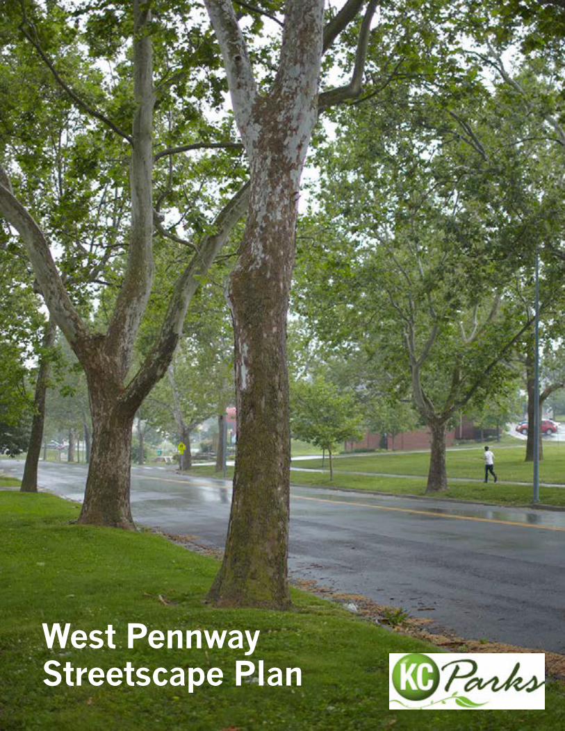
West PennwayStreetscape Plan

3
i n t r oduc t i on
Acknowledgements
MayorSly James
City ManagerTroy Schulte
City CouncilDick Davis............................................................................1st DistrictScott Wagner...........................................................1st District-at-LargeRuss Johnson.......................................................................2nd DistrictEd Ford..................................................................2nd District-at-LargeJermaine Reed......................................................................3rd DistrictMelba Curls.............................................................3rd District-at-LargeJan Marcason.......................................................................4th DistrictJim Glover................................................................4th District-at-LargeMichael Brooks.....................................................................5th DistrictCindy Circo..............................................................5th District-at-LargeJohn A. Sharp.......................................................................6th DistrictScott Taylor.............................................................6th District-at-Large
Parks CommissionersJean Paul Chaurand.................................................................PresidentMcClain Bryant.................................................................CommissionerAllen Dillingham................................................................CommissionerAimee Gromowsky.............................................................CommissionerDavid Mecklenburg............................................................CommissionerMark L. McHenry........................................................................Director
4 WeST PennWAy STReeTSCAPe PlAn
i n t r oduc t i on
Stakeholder Group
Lynda Callon Westside CAN CenterJulie Robinson Irene H. Ruiz BibliotecaMonica Banks Villa del SolVonda Jensen Land Owner Darby Trotter Riverfront Heritage TrailJohn Fierro Resident, KCMO Parks & RecreationEric Rogers BikeWalkKCDavid Johnson Crossroads Community AssociationEzekiel Amador ResidentMarcela Morales Gaona ResidentJohn DeBauche KCMO City Planning Victore Pecina KCMO Public Works – Street Lights Jerry Nelson KCMO Public Works – Street & Traffic Tony Nasseri KCMO Public Works – Street & Traffic Gerri Doyle MODOTFrancis Reddy KCMO Water Services DepartmentMario Vasquez KCMO Public Works
5
i n t r oduc t i on
KCMO Parks and Recreation
Steven Hatfield, ASLA – Project Manager
Consultant Team
el dorado inc (Hub Zone Certified) – urban design, architecture
David Dowell, AIA – Project Manager Douglas Stockman, AIA Gavin Snider
SK Design Group (MBe) – civil engineering John Chamberlin, PE Matt Kist, PE
Patti Banks Associates (WBe) – landscape architecture Stephen Rhodes, ASLA Robin Fordyce Matthew Schoell-Shaffer, ASLA
nevue ngan Associates (DBe) – landscape architecture Kevin Robert Perry, ASLA
R3C (MBe) – traffic engineering Shashi Gannavaram, PE
Architectural and Historical Research, llC (WBe) – cultural resources historian Cydney E. Millstein

Table of Contents Introduction Executive Summary 9
Project Goals 11
1. Pre-Design 1.1 Precedent Analysis 17
1.2 Historical Analysis 27
1.3 Site Analysis 37
2. Conceptual Design 2.1 Overall Site Plan 59
2.2 Roadway/Trail Sections 61
2.3 Intersection Designs 66
2.4 Enlarged Plans and Vignettes 68
2.5 Recommended Plant Species 76
3. Implementation 3.1 Recommended Phasing 79
3.2 Preliminary Cost Estimates 80
3.3 Funding Opportunities 96
3.4 Maintenance 97
4. Appendix 4.1 Water Maps/Utility Maps 99
4.2 Traffic Technical Memorandum 103
8 WeST PennWAy STReeTSCAPe PlAn
i n t r oduc t i on
9
i n t r oduc t i on
Executive Summary
The West Pennway Streetscape Plan defines the future of West Pennway as a 21st Century Parkway – a
multi-modal corridor that will become a national model of sustainable infrastructure and an enhanced
neighborhood asset, while continuing to demonstrate the wisdom of Kansas City’s one hundred+ year old
Parks and Boulevard System. The Plan seeks to reinstate connectivity with the broader network of trails and
parks throughout downtown Kansas City. The Plan unifies a number of projects and ideas proposed over the
years, while adding newly beneficial ones that emerged over the course of preliminary design. The design
process involved a significant effort to engage local stakeholders. Efforts ranged from public meetings to
open site visits to a dedicated project website and design team member participation in seasonal events
occurring along West Pennway. The Plan presented here is an expression of community-driven vision.
The West Pennway Streetscape Plan is ambitious. Overall changes will occur in how space is structured
and utilized – from modifying intersection designs to favor multi-modal movement to reconfiguring the
space between curbs to include bicycle lane, additional landscaping and stormwater facilities. We also
propose improving pedestrian safety, connectivity amongst historical park assets and park facilities,
improved wayfinding and measures to secure the health and longevity of the character-defining canopy of
London Plane trees along the West Pennway corridor. Cost estimates value the overall project at more than
$10,000,000. However, the overall project is broken into a series of smaller projects ranging in cost from
$200,000 to $3,000,000. Projects can be implemented individually as funding is secured. The final result
will be a much improved community asset that is a destination in its own right.
The Plan is presented in five sections. The first section – Introduction – describes the project goals in
greater detail. Beyond the ambitious goal of defining the characteristics of a 21st Century Parkway, the
basic goals are to enrich the street section, allowing more uses than merely vehicular to take advantage of
the generous 50’ curb-to-curb street section, to make West Pennway a park as opposed to purely a roadway
to convey vehicles and to prepare for the future by addressing deferred maintenance and defining new uses
of Park land to support community desires. These goals are derived from many conversations with Parks
Department staff and community stakeholders.
The second section – Pre-Design – presents a three-part analysis to better conceive of the unique
opportunity offered by re-designing the West Pennway corridor. A review of similar projects, some in Kansas
City, some elsewhere, conveys an expansive view of potential improvements. A historical analysis presents
images from when West Pennway was newly constructed, in addition to showing original Kessler design
documents. These are useful in more clearly understanding the original intent for and circumstance of
West Pennway. Finally a comprehensive site analysis identifies the unique strengths and weaknesses of this
particular site and sets the stage for our site improvement design strategies.
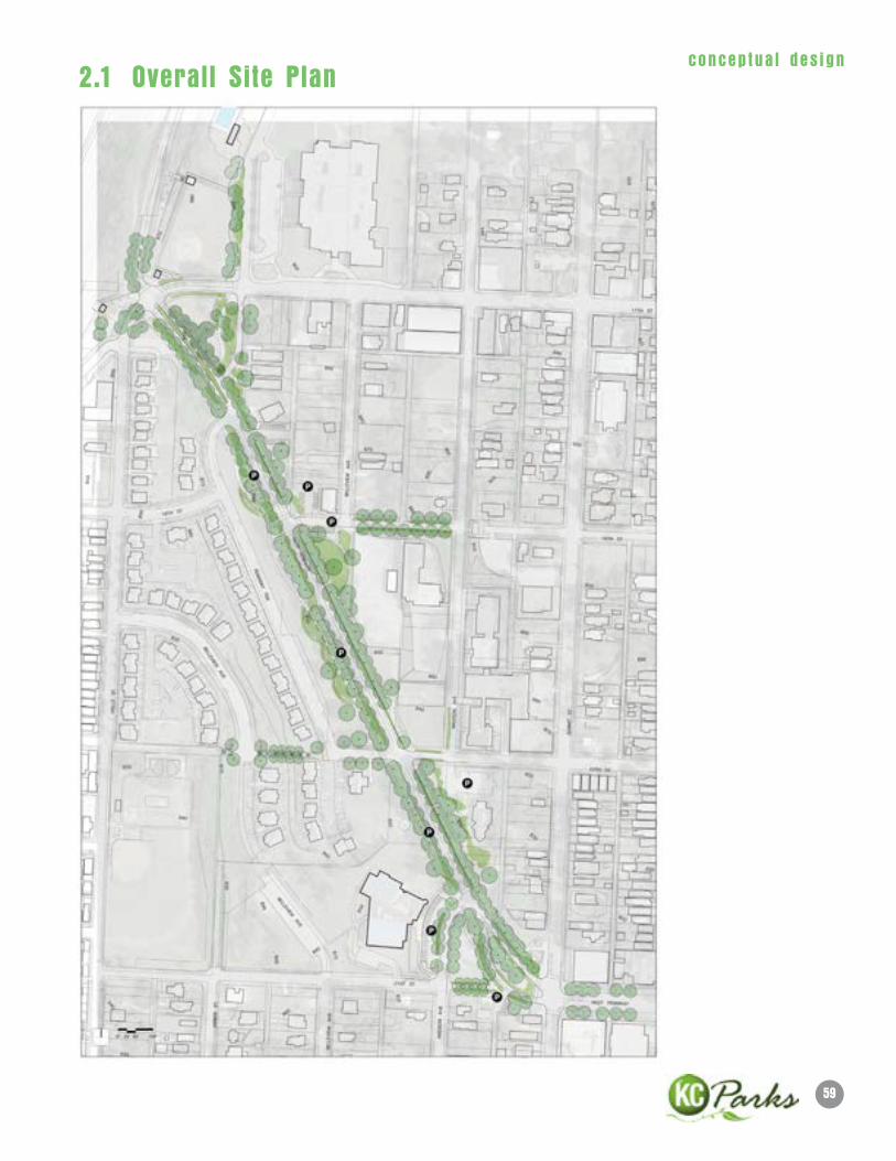
The third section – Conceptual Design – shows the entire range of design ideas explored over the course
of the first phase of the project. An overall site plan shows the entire proposed improvements. A series
of street sections show the existing conditions and proposed improved sections running from 17th Street
to 21st Street. One of the most important issues to be addressed is the redesign of the intersections at
10 WeST PennWAy STReeTSCAPe PlAn
i n t r oduc t i on
17th and 21st Street. The range of options considered is shown as well as more developed designs for
the preferred options. A series of vignettes illustrate recommended improvements along the corridor,
from improved connections to Jarboe Park at 17th Street, to better use of triangular park space along the
corridor to a dramatic re-configuration of West Pennway where it meets Summit Street and 21st Street.
The fourth section – Implementation – discusses a recommended approach to phasing along with detailed
preliminary cost estimates. We also present a series of sources for possible funding. Finally, we briefly
discuss the essential need to develop a viable maintenance plan that recognizes the need for a public/
private partnership. Early in the design process the concept of developing a Friends of West Pennway was
suggested by community stakeholders. This seems a strong possibility and we recommend defining the
necessary steps to achieve this organization once funding for the next phase of the project is in hand.
Finally, in the Appendix we present a series of useful graphic information including water and utility
maps as well as a traffic technical memorandum. This information played a role in many of the design
considerations discussed and recommended.
11
i n t r oduc t i on
Project Goals
West Pennway Parkway was formerly designated Alternate US 40
before construction of I-670. Now after completion of the Interstate
system and decades of an organic Westside Neighborhood resurgence,
neighborhood values and character have begun to reshape streets in
the Westside to be multi-modal and context sensitive. The Riverfront
Heritage Trail, Jarboe Park and enhancements such as limestone
structures, public art and transit shelters line West Pennway Parkway.
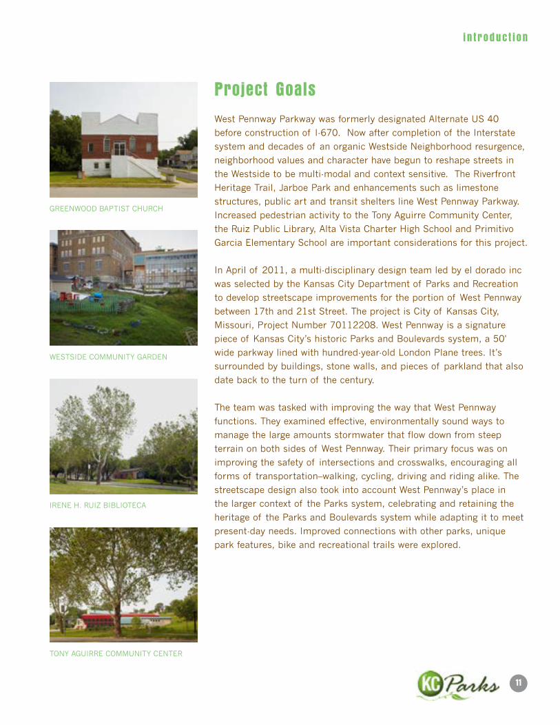
Increased pedestrian activity to the Tony Aguirre Community Center,
the Ruiz Public Library, Alta Vista Charter High School and Primitivo
Garcia Elementary School are important considerations for this project.
In April of 2011, a multi-disciplinary design team led by el dorado inc
was selected by the Kansas City Department of Parks and Recreation
to develop streetscape improvements for the portion of West Pennway
between 17th and 21st Street. The project is City of Kansas City,
Missouri, Project Number 70112208. West Pennway is a signature
piece of Kansas City’s historic Parks and Boulevards system, a 50'
wide parkway lined with hundred-year-old London Plane trees. It’s
surrounded by buildings, stone walls, and pieces of parkland that also
date back to the turn of the century.
The team was tasked with improving the way that West Pennway
functions. They examined effective, environmentally sound ways to
manage the large amounts stormwater that flow down from steep
terrain on both sides of West Pennway. Their primary focus was on
improving the safety of intersections and crosswalks, encouraging all
forms of transportation–walking, cycling, driving and riding alike. The
streetscape design also took into account West Pennway’s place in
the larger context of the Parks system, celebrating and retaining the
heritage of the Parks and Boulevards system while adapting it to meet
present-day needs. Improved connections with other parks, unique
park features, bike and recreational trails were explored.
GREENWOOD BAPTIST CHURCH
WESTSIDE COMMUNITY GARDEN
IRENE H. RUIZ BIBLIOTECA
TONY AGUIRRE COMMUNITY CENTER
12 WeST PennWAy STReeTSCAPe PlAn
i n t r oduc t i on
Community engagement
The Westside Neighborhood is one of Kansas City’s most diverse and
culturally rich urban neighborhoods. Given its proximity to downtown
Kansas City, inspiring topography and connection to the Parks and
Boulevard system it has experienced and will continue to experience
intense development interest. Acknowledging the sensitivity of this fact
extra efforts were made to ensure a broad range of opportunities for
public participation and awareness in this planning process. Outreach
efforts included:
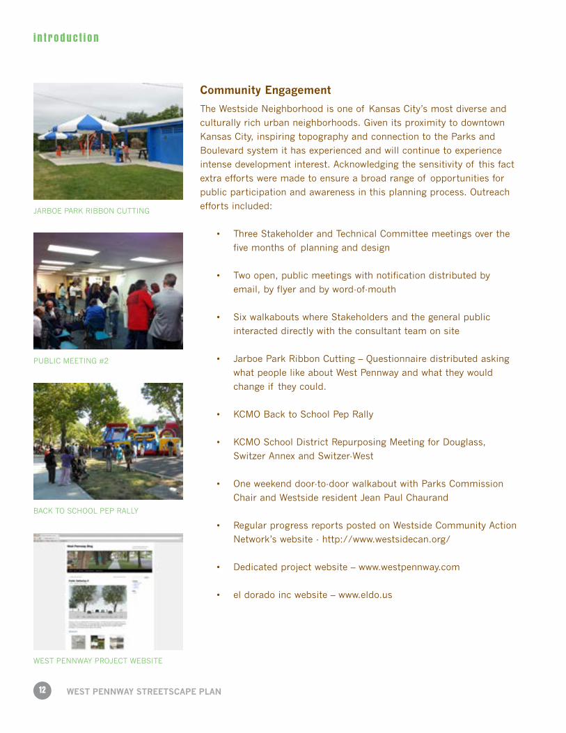
• ThreeStakeholderandTechnicalCommitteemeetingsoverthe
five months of planning and design
• Twoopen,publicmeetingswithnotificationdistributedby
email, by flyer and by word-of-mouth
• SixwalkaboutswhereStakeholdersandthegeneralpublic
interacted directly with the consultant team on site
• JarboeParkRibbonCutting–Questionnairedistributedasking
what people like about West Pennway and what they would
change if they could.
• KCMOBacktoSchoolPepRally
• KCMOSchoolDistrictRepurposingMeetingforDouglass,
Switzer Annex and Switzer-West
• Oneweekenddoor-to-doorwalkaboutwithParksCommission
Chair and Westside resident Jean Paul Chaurand
• RegularprogressreportspostedonWestsideCommunityAction
Network’s website - http://www.westsidecan.org/
• Dedicatedprojectwebsite–www.westpennway.com
• eldoradoincwebsite–www.eldo.us
JARBOE PARK RIBBON CUTTING
PUBLIC MEETING #2
BACK TO SCHOOL PEP RALLY
WEST PENNWAY PROJECT WEBSITE
13
i n t r oduc t i on
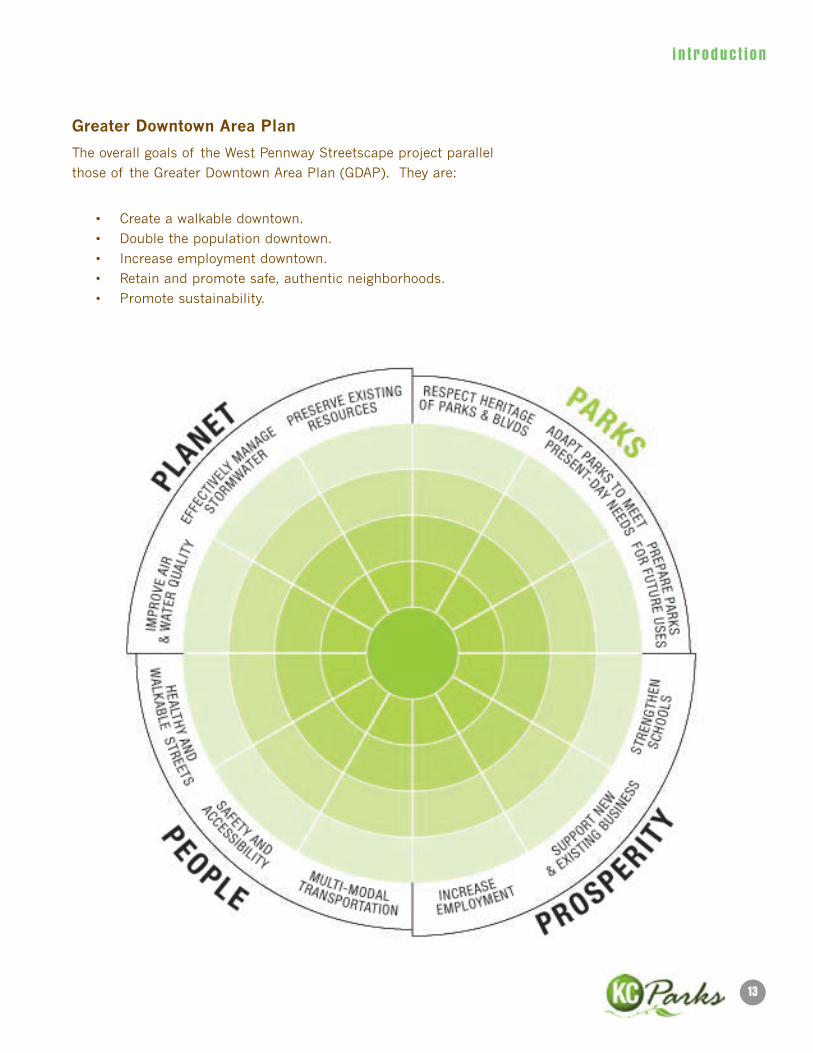
Greater Downtown Area Plan
The overall goals of the West Pennway Streetscape project parallel
those of the Greater Downtown Area Plan (GDAP). They are:
• Createawalkabledowntown.
• Doublethepopulationdowntown.
• Increaseemploymentdowntown.
• Retainandpromotesafe,authenticneighborhoods.
• Promotesustainability.
14 WeST PennWAy STReeTSCAPe PlAn
i n t r oduc t i on
Recommendations
The Schematic Design phase included a number of important conceptual developments, all in support
of the project goals. One was the notion that West Pennway be thought of as a 21st Century Parkway, a
consciously and conscientiously evolved type of place within Kansas City’s historic Parks and Boulevard
system. A ten-step sequence of improvements was identified:
• Putthe“Park”inParkway
• BeastewardofNaturalandCulturalResources
• PutPeopleFirst
• CreateaNorthandaSouthEntry
• ReinforceandReestablishConnections
• InfillLondonPlaneAlleeandAddressDeferredMaintenance
• PlantSuccessionCanopyandAddPlantDiversity
• CreateMulti-functionalStreetSections
• LeverageParksHeritage
• Establisha“FriendsofWestPennway”
Within each step a series of specific recommendations was explored.
Eventually the ten steps were concentrated into three:
• EnrichtheStreetSection
• MakeWestPennwayaPark
• PreparefortheFuture
Alternative intersection designs were explored as were roadway and trail sections.
15
pre -des ign
Conceptual Park/Trail Alignment
We approached park and trail alignment with three goals:
1. Connect to existing and future possible trails.
2. Prepare for connection with 17th and 20th Street improvements.
3. Provide pedestrian connections to Park features – historical stairs and walls.
18TH & MADISON STAIR OBSERVATION PARKOBSERVATION PARK

17
pre -des ign
1.1 Precedent AnalysisAs we began the design process, we researched similar projects happening globally, nationally, and right
here in Kansas City.
The purpose of a precedent analysis is to take a snapshot of similar projects occurring elsewhere. We are
looking for ideas that will help inspire the design team, the stakeholders and the stewards of West Pennway
as we look to the creation of a 21st Century Parkway. Projects range from on-site stormwater management
examples to wayfinding to park design, some are current while others are historical.
Bikeway Belem | Lisbon, Portugal
P-O6 Atelier
18
pre -des ign
WeST PennWAy STReeTSCAPe PlAn
Tanner Springs Park | Portland, OR
Atelier Dreiseitl
19
pre -des ign
18 Broadway | Kansas City, MO
360 & Patti Banks Associates
20
pre -des ign
WeST PennWAy STReeTSCAPe PlAn
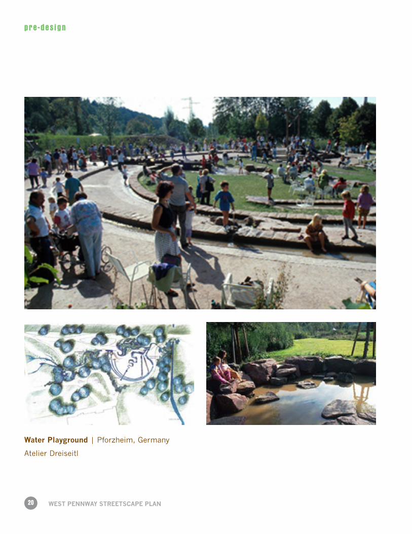
Water Playground | Pforzheim, Germany
Atelier Dreiseitl
21
pre -des ign
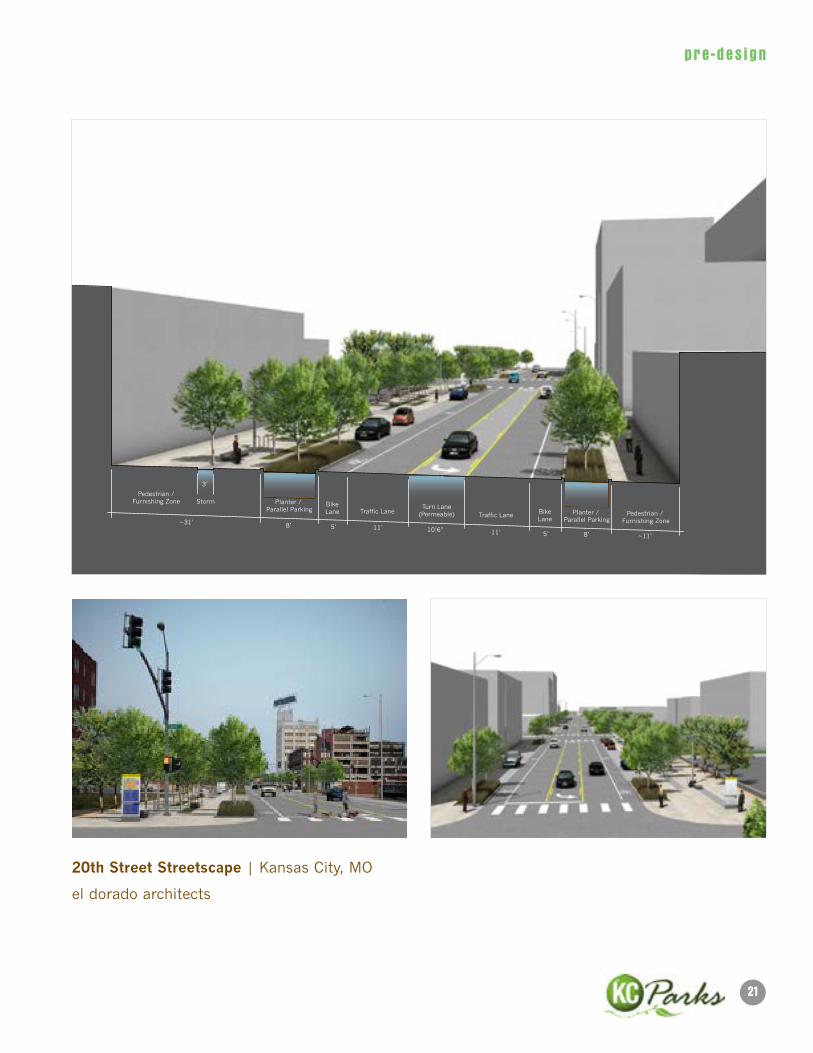
20th Street Streetscape | Kansas City, MO
el dorado architects
Pedestrian /Furnishing Zone Planter /
Parallel ParkingStorm
3’
~31’ 8’
8’ ~11’
5’5’
11’11’10’6”
BikeLane Bike
LanePlanter /
Parallel ParkingPedestrian /
Furnishing ZoneTraffic Lane
Traffic LaneTurn Lane
(Permeable)
22
pre -des ign
WeST PennWAy STReeTSCAPe PlAn
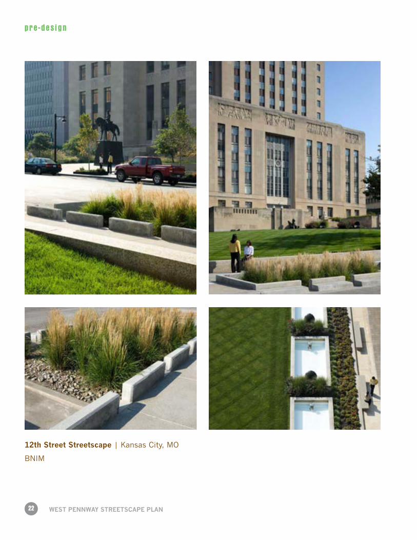
12th Street Streetscape | Kansas City, MO
BNIM
23
pre -des ign
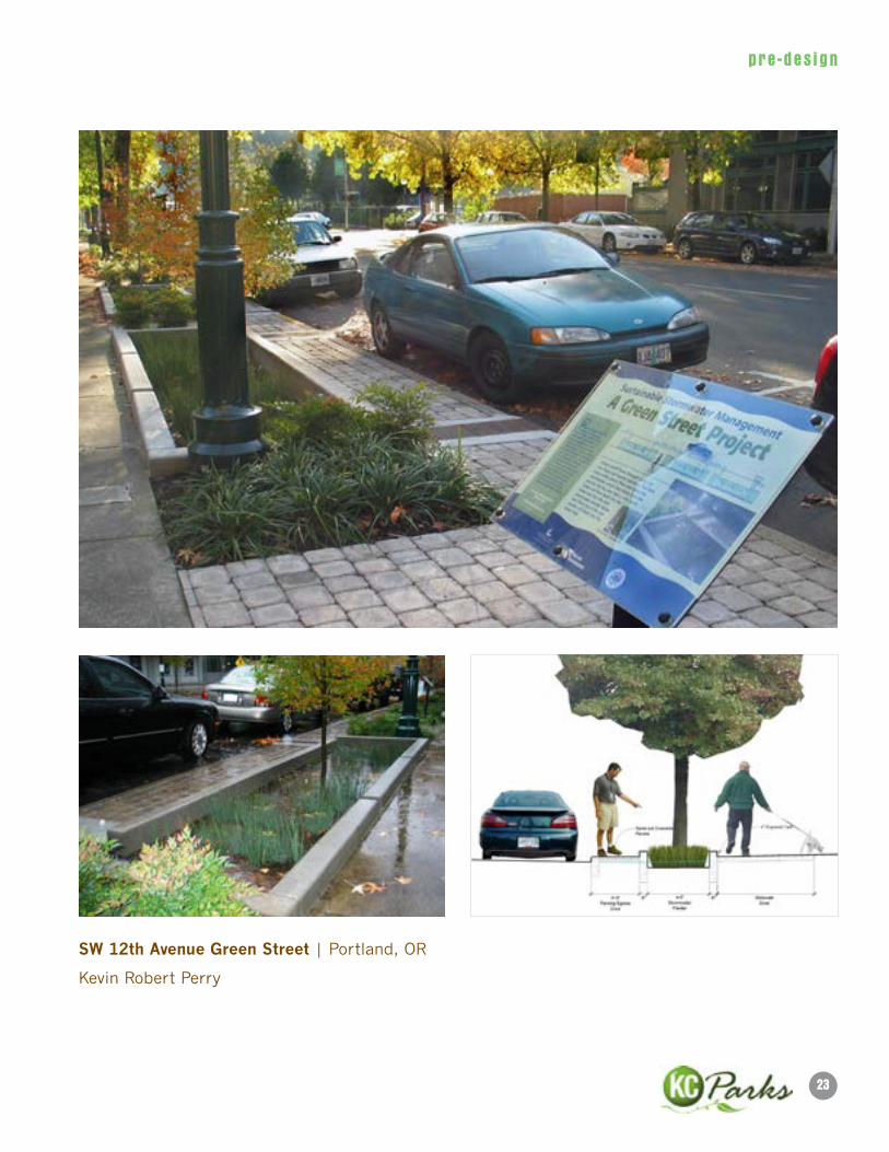
SW 12th Avenue Green Street | Portland, OR
Kevin Robert Perry
24
pre -des ign
WeST PennWAy STReeTSCAPe PlAn
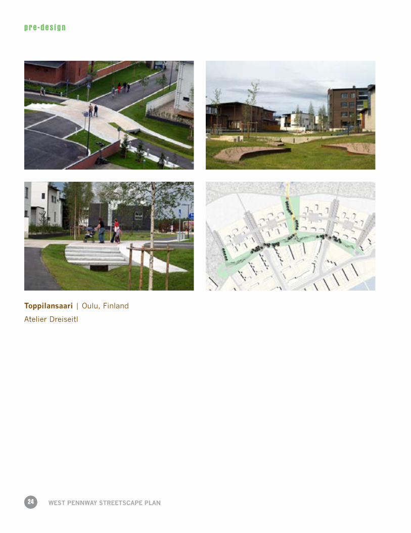
Toppilansaari | Oulu, Finland
Atelier Dreiseitl
25
pre -des ign
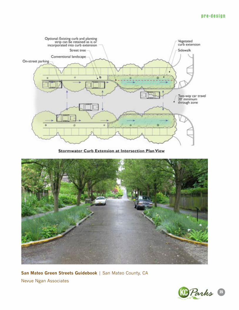
San Mateo Green Streets Guidebook | San Mateo County, CA
Nevue Ngan Associates
26
pre -des ign
WeST PennWAy STReeTSCAPe PlAn
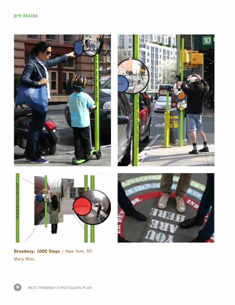
Broadway: 1000 Steps | New York, NY
Mary Miss
27
pre -des ign
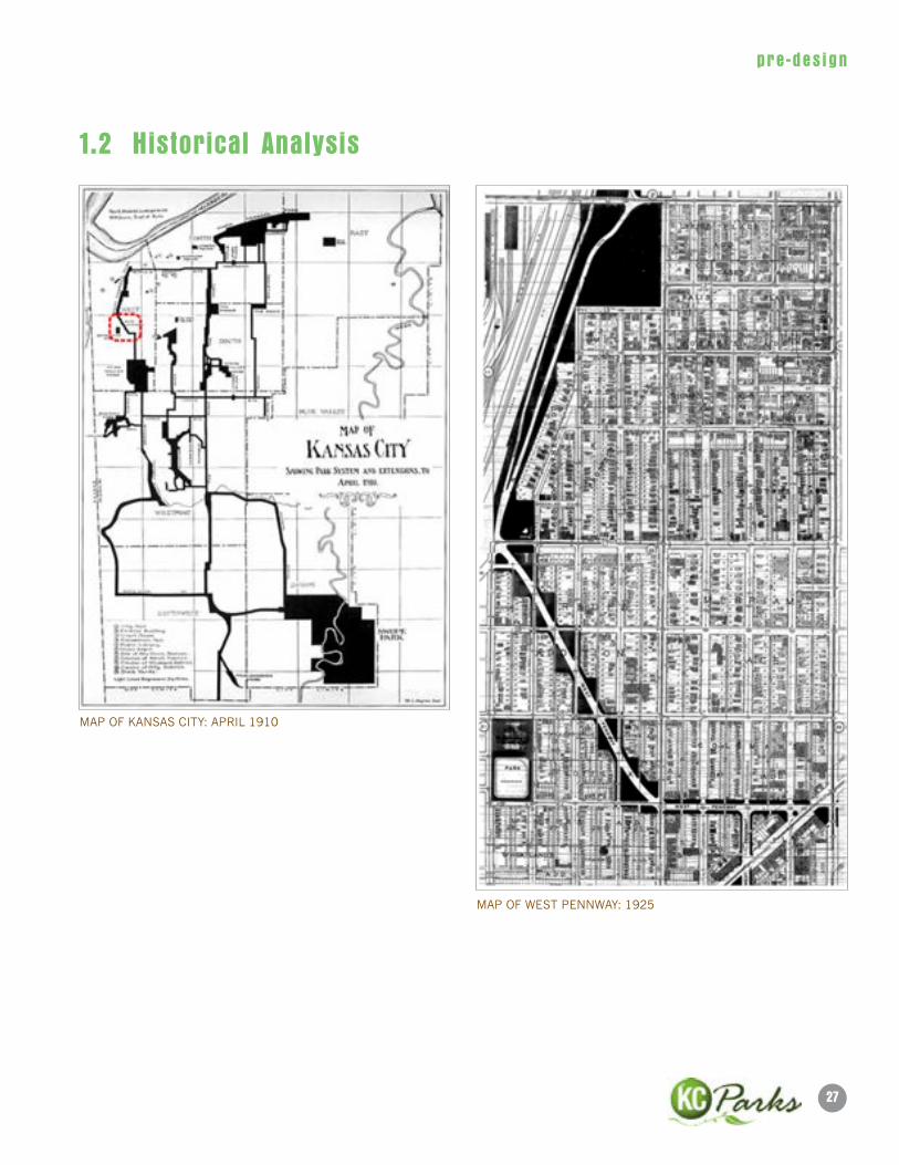
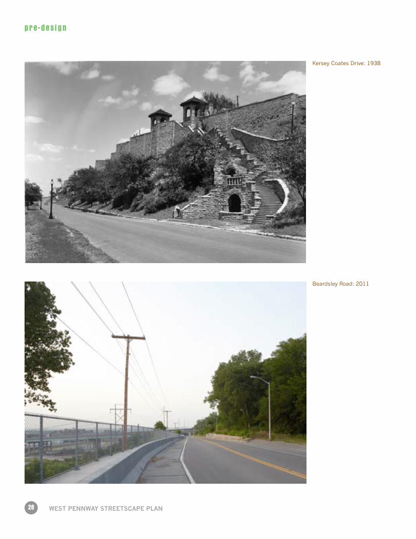
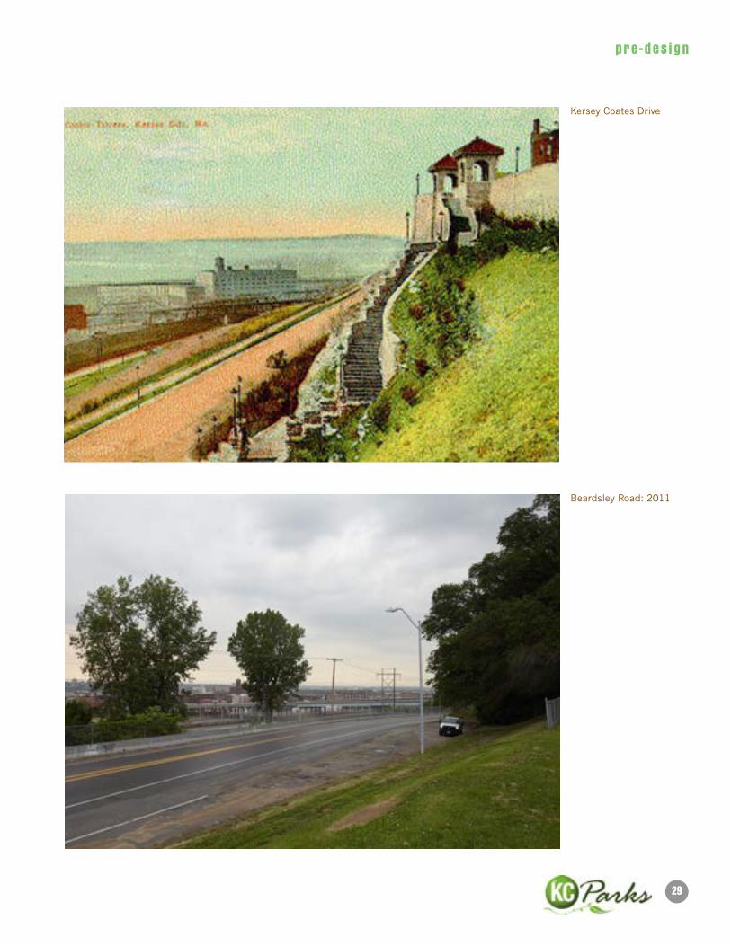
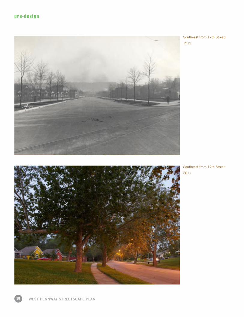
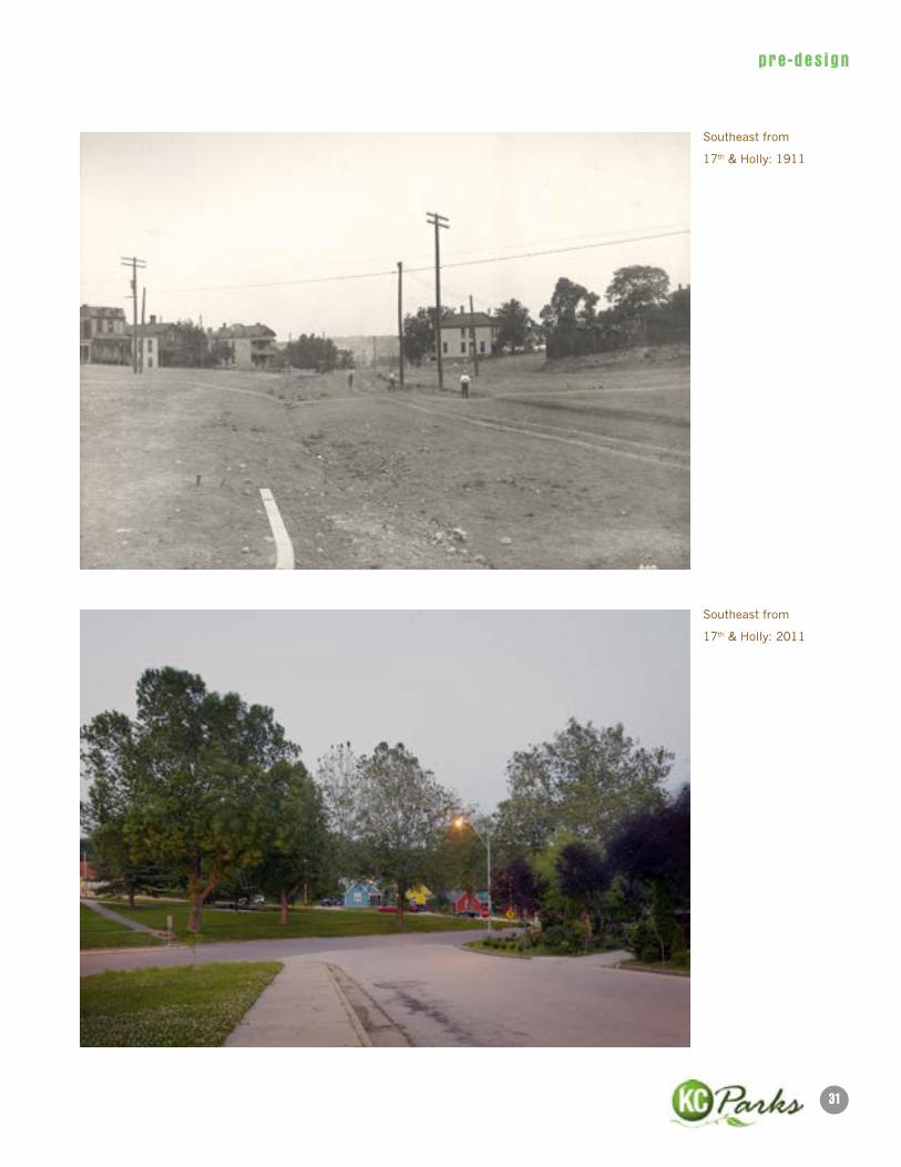
1.2 Historical Analysis
MAP OF KANSAS CITY: APRIL 1910
MAP OF WEST PENNWAY: 1925
28
pre -des ign
WeST PennWAy STReeTSCAPe PlAn
Kersey Coates Drive: 1938
Beardsley Road: 2011
29
pre -des ign
Kersey Coates Drive
Beardsley Road: 2011
30
pre -des ign
WeST PennWAy STReeTSCAPe PlAn
Southeast from 17th Street:
1912
Southeast from 17th Street:
2011
31
pre -des ign
Southeast from
17th & Holly: 1911
Southeast from
17th & Holly: 2011
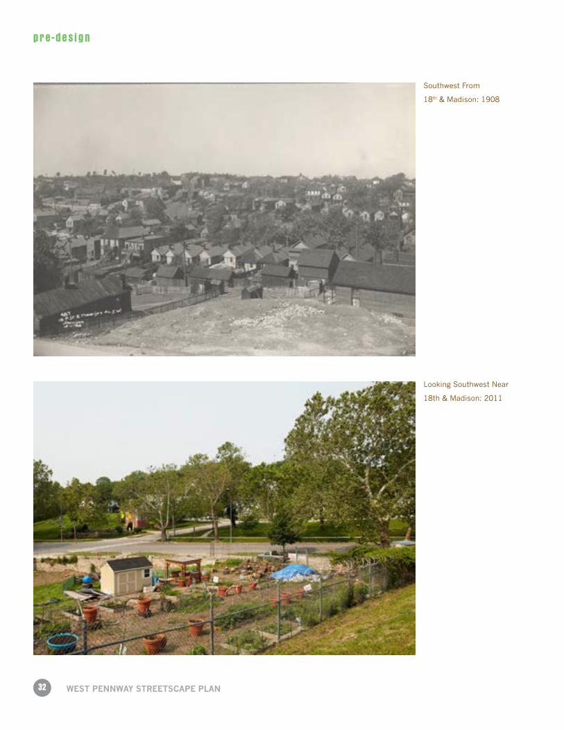
32
pre -des ign
WeST PennWAy STReeTSCAPe PlAn
Looking Southwest Near
18th & Madison: 2011
Southwest From
18th & Madison: 1908
33
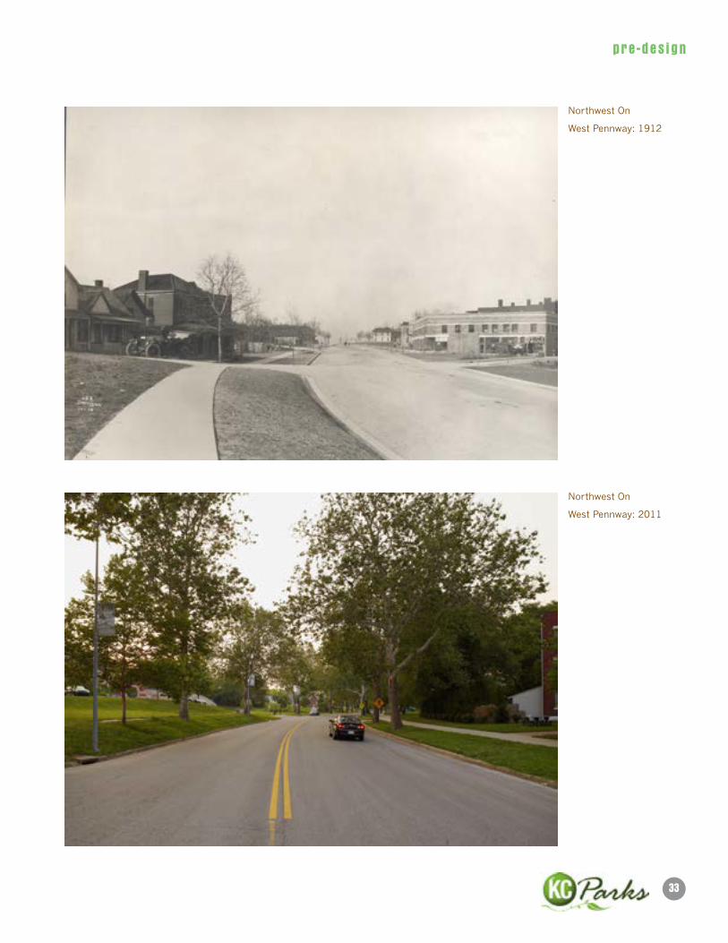
pre -des ign
Northwest On
West Pennway: 2011
Northwest On
West Pennway: 1912
34
pre -des ign
WeST PennWAy STReeTSCAPe PlAn
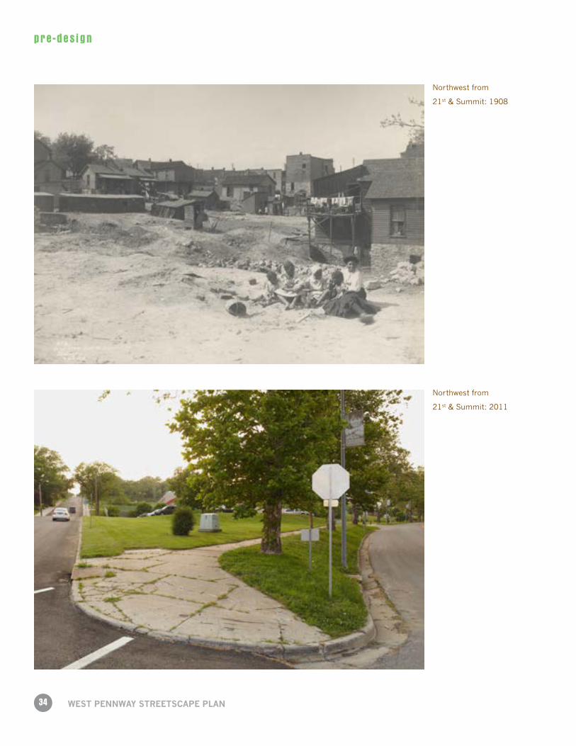
Northwest from
21st & Summit: 1908
Northwest from
21st & Summit: 2011
35
pre -des ign
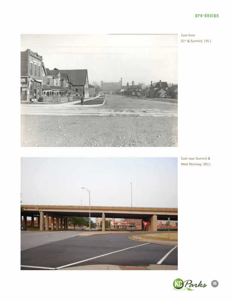
East from
21st & Summit: 1911
East near Summit &
West Pennway: 2011

37
pre -des ign
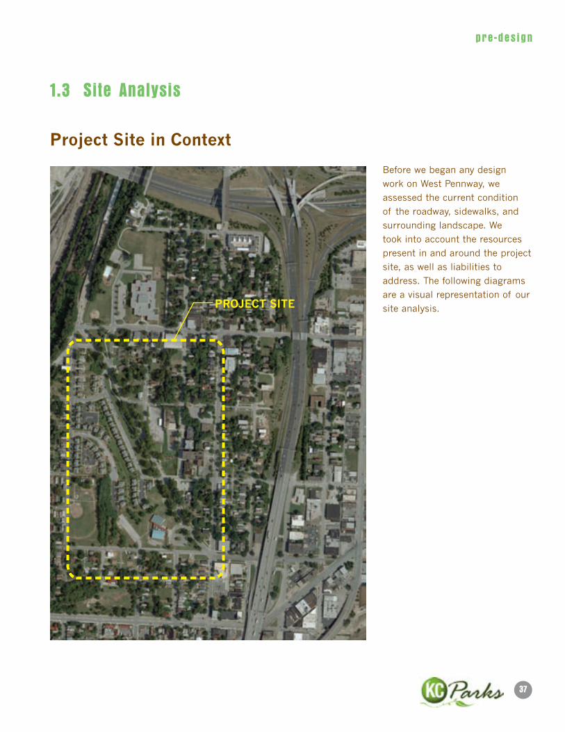
1.3 Site Analysis
Project Site in Context
PROJeCT SITe
Before we began any design
work on West Pennway, we
assessed the current condition
of the roadway, sidewalks, and
surrounding landscape. We
took into account the resources
present in and around the project
site, as well as liabilities to
address. The following diagrams
are a visual representation of our
site analysis.

38
pre -des ign
WeST PennWAy STReeTSCAPe PlAn
Parkland in Context
1. Andrew Dripps Park
2. Jarboe Park
3. Westside CAN Center Community Garden/ Switzer Neighborhood
Farm
4. Irene H. Ruiz Library Lawn
5. Observation Park
6. Tony Aguirre Community Center
7. Gage Park
8. Triangle Park
9. Westside Orchard & Berry Patch
Parkland
Greenspace9
39
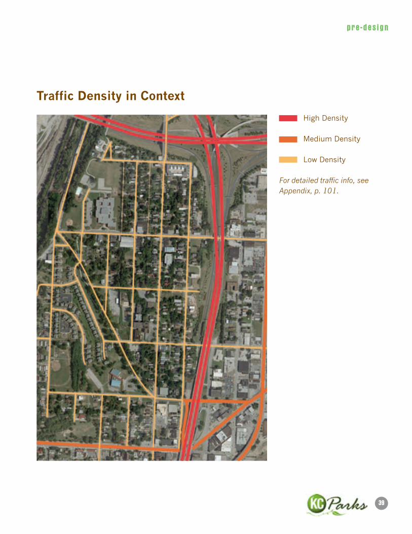
pre -des ign
Traffic Density in Context
High Density
Medium Density
Low Density
For detailed traffic info, see Appendix, p. 101.
40
pre -des ign
WeST PennWAy STReeTSCAPe PlAn
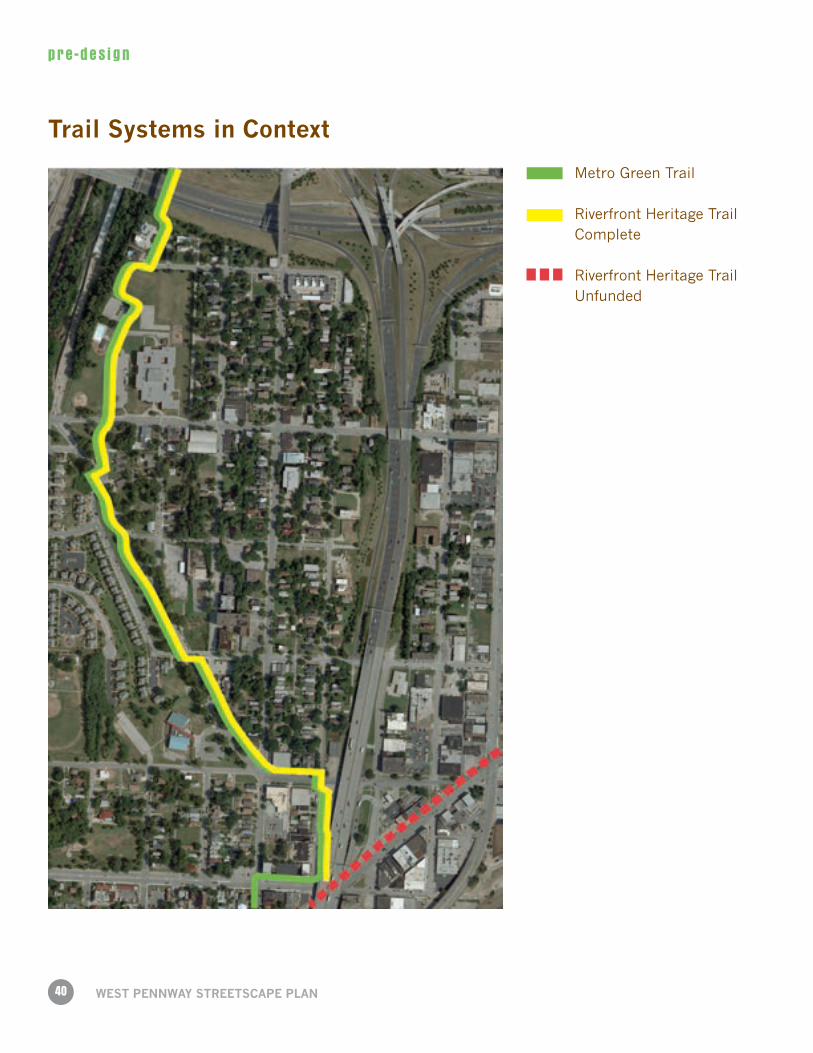
Trail Systems in Context
Metro Green Trail
Riverfront Heritage Trail Complete
Riverfront Heritage Trail Unfunded
41
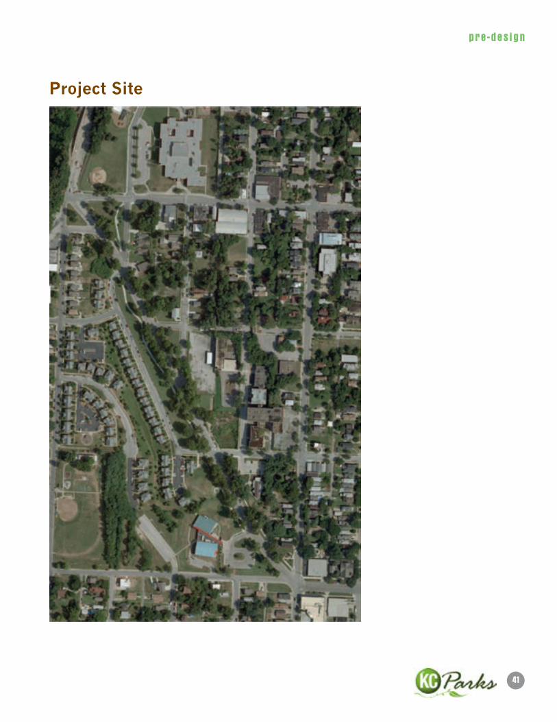
pre -des ign
Project Site
42
pre -des ign
WeST PennWAy STReeTSCAPe PlAn
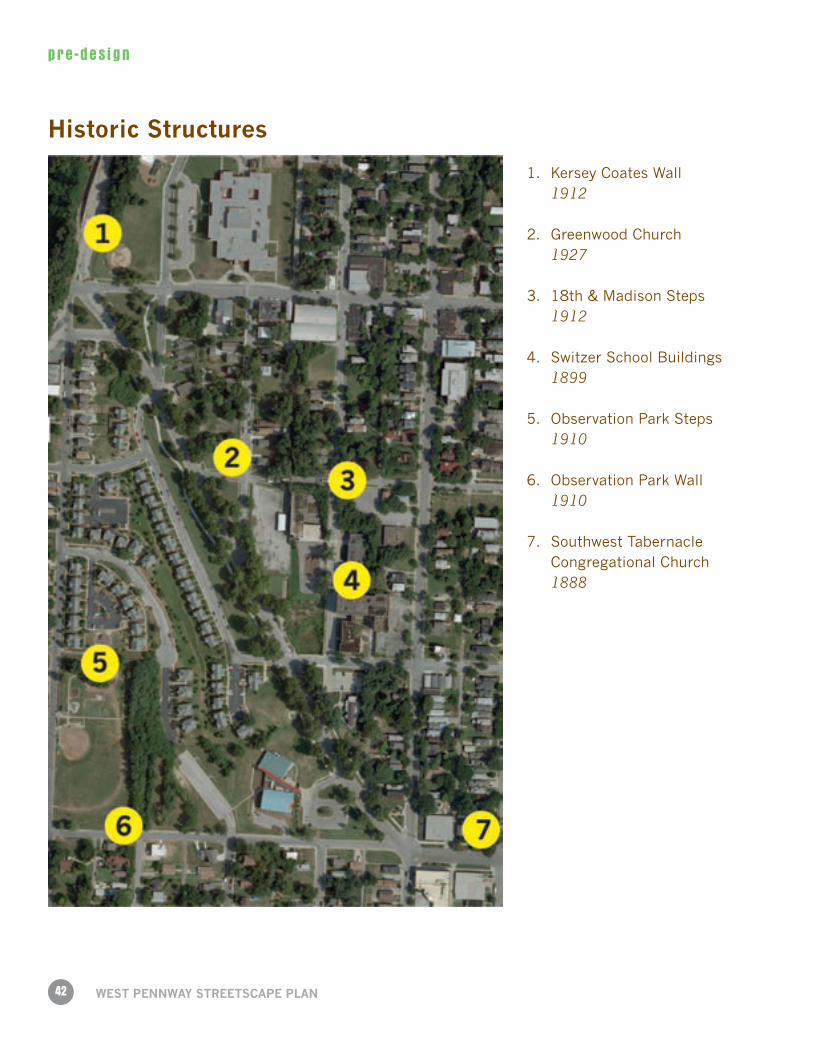
Historic Structures
1. Kersey Coates Wall 1912
2. Greenwood Church 1927
3. 18th & Madison Steps 1912
4. Switzer School Buildings 1899
5. Observation Park Steps 1910
6. Observation Park Wall 1910
7. Southwest Tabernacle Congregational Church 1888
43
pre -des ign
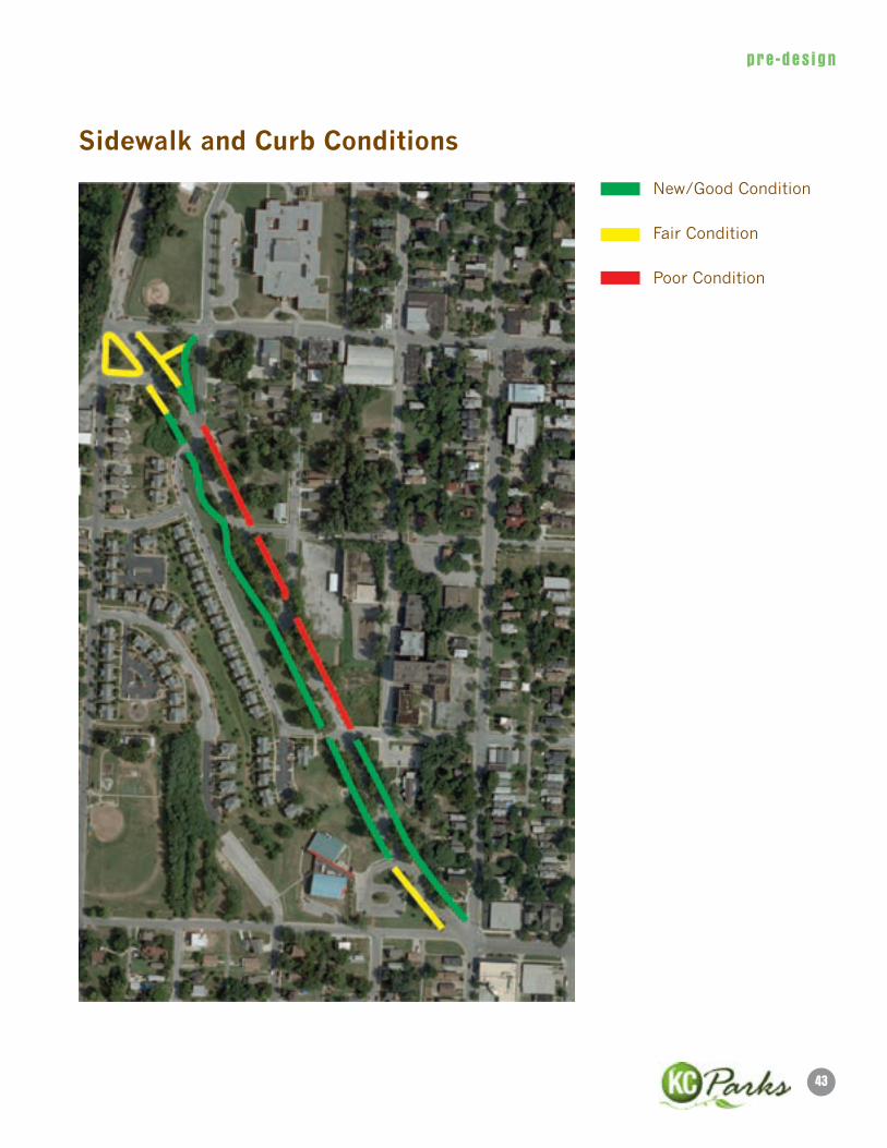
Sidewalk and Curb Conditions
New/Good Condition
Fair Condition
Poor Condition
44
pre -des ign
WeST PennWAy STReeTSCAPe PlAn
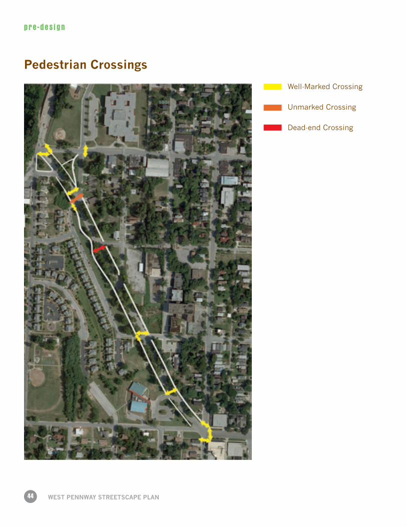
Pedestrian Crossings
Well-Marked Crossing
Unmarked Crossing
Dead-end Crossing
45
pre -des ign
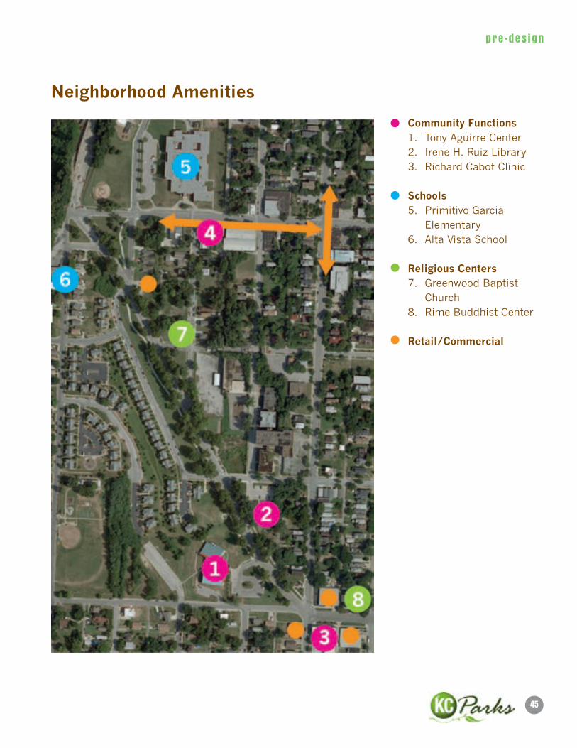
neighborhood Amenities
Community Functions 1. Tony Aguirre Center 2. Irene H. Ruiz Library 3. Richard Cabot Clinic
Schools 5. Primitivo Garcia Elementary 6. Alta Vista School
Religious Centers 7. Greenwood Baptist Church 8. Rime Buddhist Center
Retail/Commercial

46
pre -des ign
WeST PennWAy STReeTSCAPe PlAn
Tree locations
London Plane Trees (Sycamores)
Other Deciduous Trees
47
pre -des ign
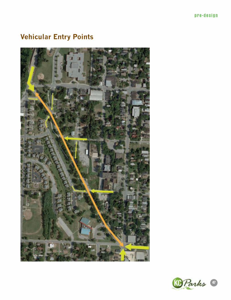
Vehicular entry Points
48
pre -des ign
WeST PennWAy STReeTSCAPe PlAn
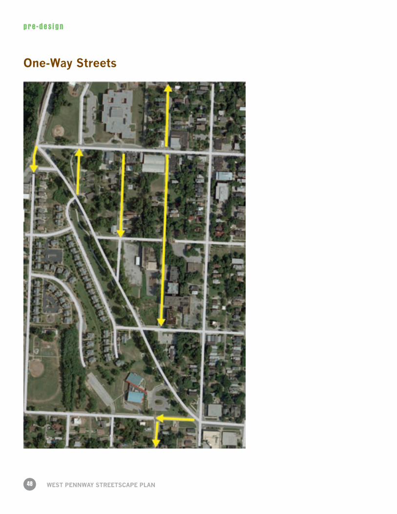
One-Way Streets
49
pre -des ign
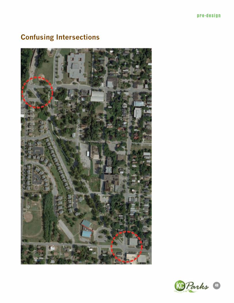
Confusing Intersections
50
pre -des ign
WeST PennWAy STReeTSCAPe PlAn
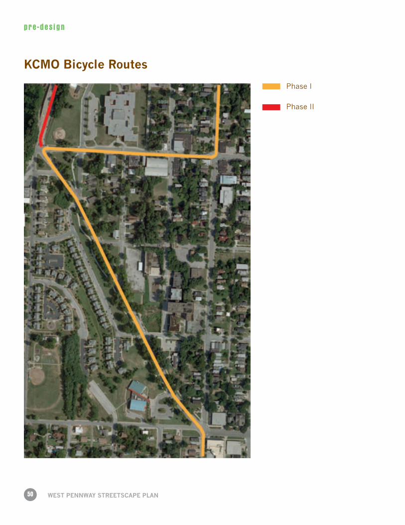
KCMO Bicycle Routes
Phase I
Phase II
51
pre -des ign
Seating/Meeting Areas
52
pre -des ign
WeST PennWAy STReeTSCAPe PlAn
Public Art
1. NeoMellenic Pedestrian Lighting
2. Westside Pequeño Miramide
3. Westside Transit Oasis
53
pre -des ign
Institutions
Trail Signage
Wayfinding Signs
54
pre -des ign
WeST PennWAy STReeTSCAPe PlAn
Parking lot locations
55
pre -des ign
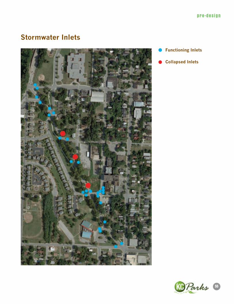
Stormwater Inlets
Functioning Inlets
Collapsed Inlets
56
pre -des ign
WeST PennWAy STReeTSCAPe PlAn
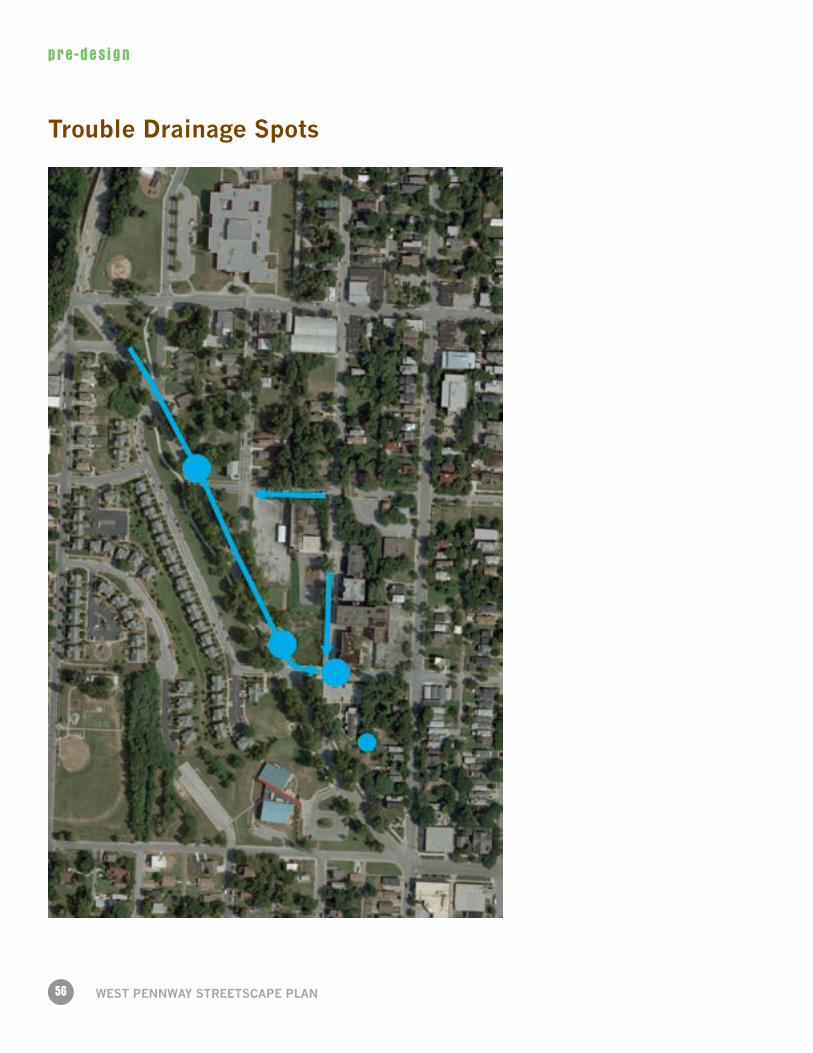
Trouble Drainage Spots
57
pre -des ign
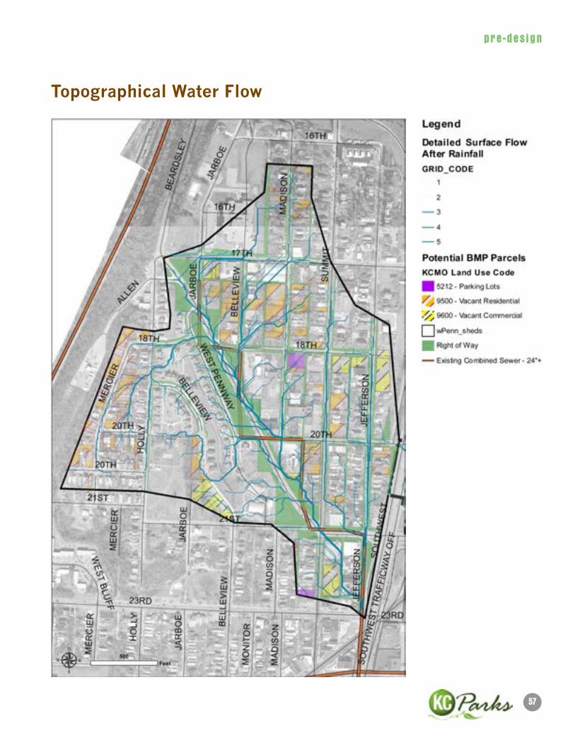
Topographical Water Flow

59
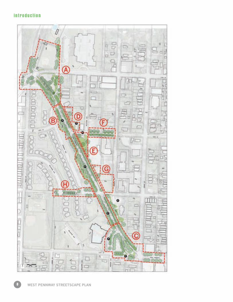
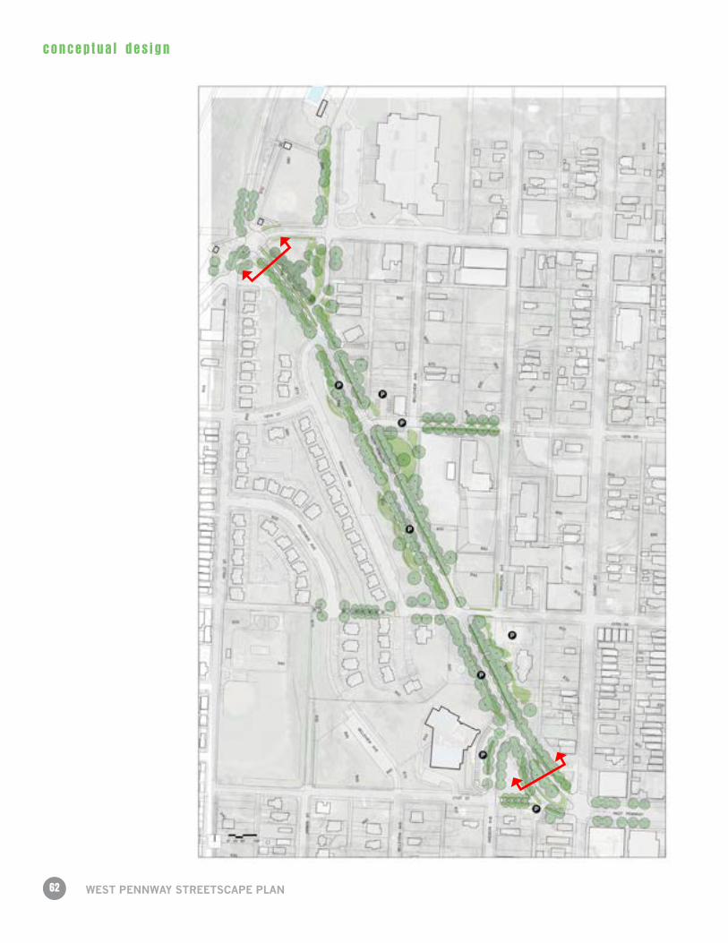
concep tua l des ign2.1 Overall Site Plan
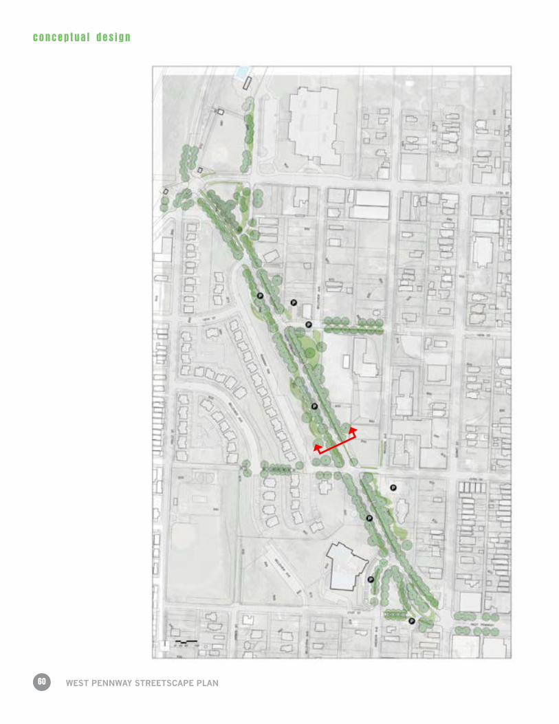
60
concep tua l des ign
WeST PennWAy STReeTSCAPe PlAn
61
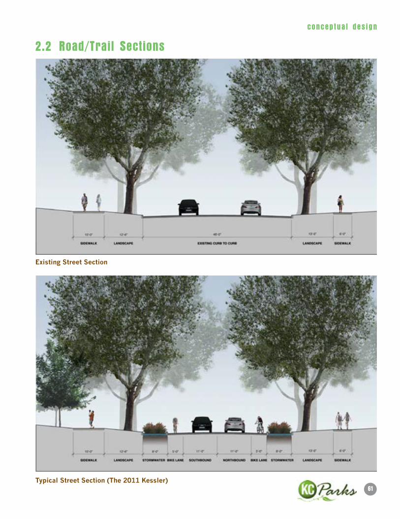
concep tua l des ign
existing Street Section
Typical Street Section (The 2011 Kessler)
2.2 Road/Trail Sections
62
concep tua l des ign
WeST PennWAy STReeTSCAPe PlAn
63
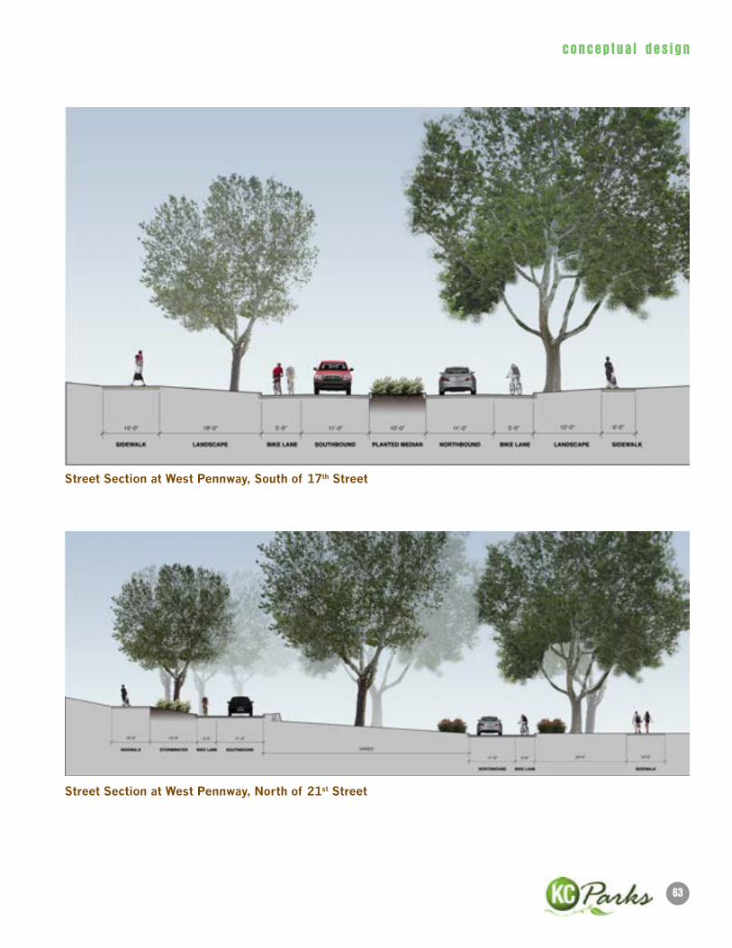
concep tua l des ign
Street Section at West Pennway, South of 17th Street
Street Section at West Pennway, north of 21st Street
64
concep tua l des ign
WeST PennWAy STReeTSCAPe PlAn
65
concep tua l des ign
Section through Stormwater Park at 18th & Belleview
Alternate Street Section (The 2011 Kessler meet the Mini-Missouri)
66
concep tua l des ign
WeST PennWAy STReeTSCAPe PlAn
West Pennway/Beardsley/17th Street Intersection- Option 1
West Pennway/Beardsley/17th Street Intersection- Option 2
2.3 Intersection Designs
67
concep tua l des ign
West Pennway/Summit/21st Street Intersection- Option 1
West Pennway/Summit/21st Street Intersection- Option 2
68
concep tua l des ign
WeST PennWAy STReeTSCAPe PlAn
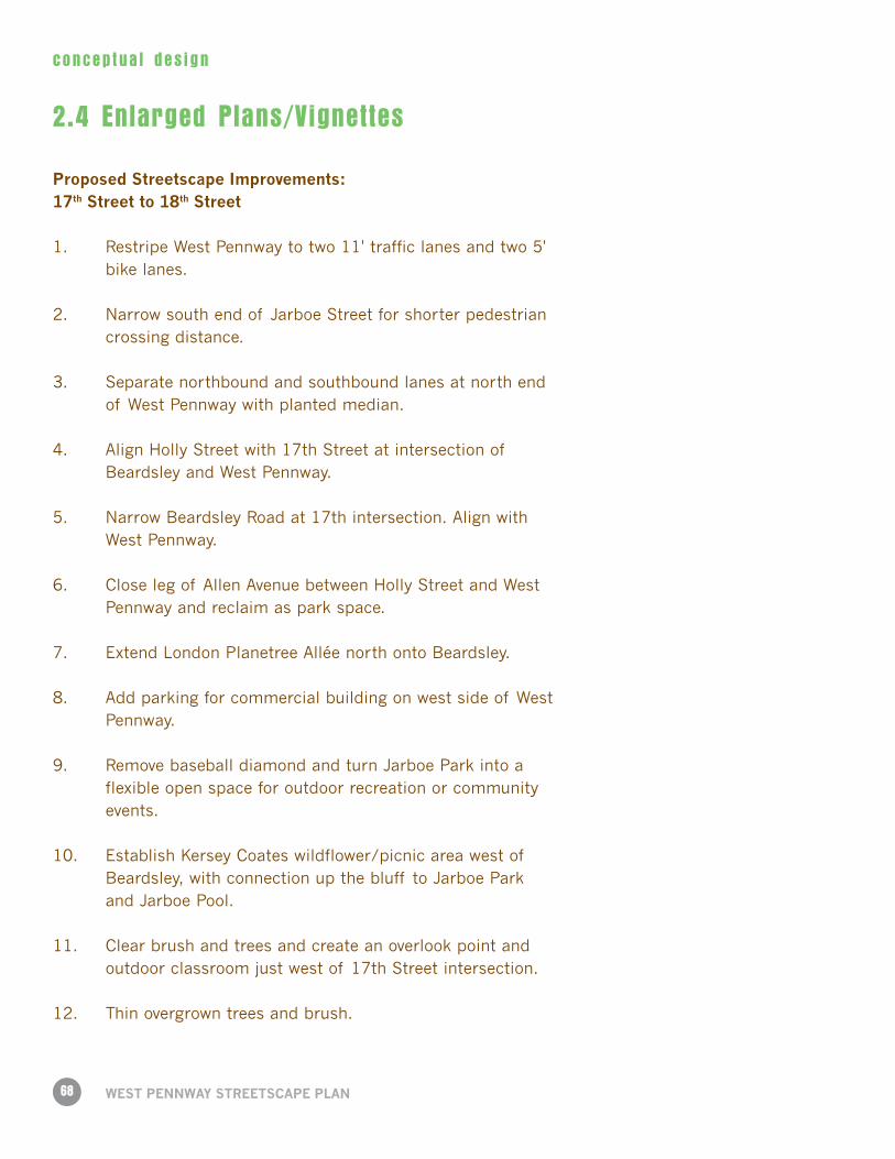
2.4 Enlarged Plans/Vignettes
Proposed Streetscape Improvements: 17th Street to 18th Street
1. Restripe West Pennway to two 11' traffic lanes and two 5' bike lanes.
2. Narrow south end of Jarboe Street for shorter pedestrian crossing distance.
3. Separate northbound and southbound lanes at north end of West Pennway with planted median.
4. Align Holly Street with 17th Street at intersection of Beardsley and West Pennway.
5. Narrow Beardsley Road at 17th intersection. Align with West Pennway.
6. Close leg of Allen Avenue between Holly Street and West Pennway and reclaim as park space.
7. Extend London Planetree Allée north onto Beardsley.
8. Add parking for commercial building on west side of West Pennway.
9. Remove baseball diamond and turn Jarboe Park into a flexible open space for outdoor recreation or community events.
10. Establish Kersey Coates wildflower/picnic area west of Beardsley, with connection up the bluff to Jarboe Park and Jarboe Pool.
11. Clear brush and trees and create an overlook point and outdoor classroom just west of 17th Street intersection.
12. Thin overgrown trees and brush.
69
concep tua l des ign
1
2
3
45
6
7
8
9
10
11
12
70
concep tua l des ign
WeST PennWAy STReeTSCAPe PlAn
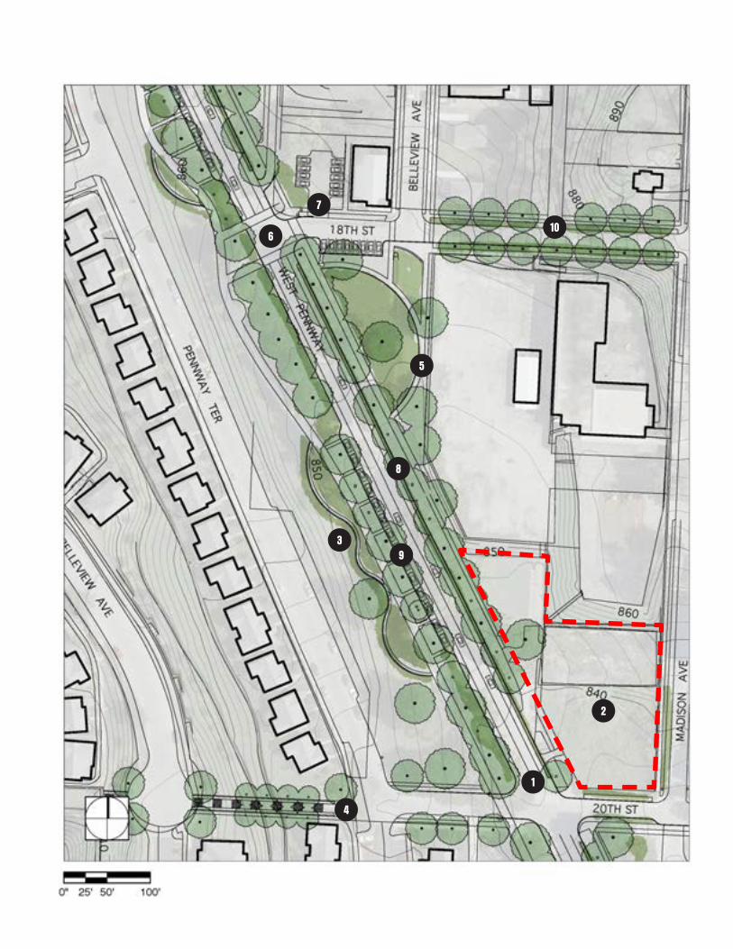
Proposed Streetscape Improvements: 18th Street to 20th Street
1. Restripe West Pennway to two 11' traffic lanes and two 5' bike lanes.
2. Regrade southern end of Westside Community Garden to create public plaza. Area to include community garden plots, hillside seating, orchard, and retaining wall for vertical gardening. See page following two pages for detailed plan.
3. Serpentine benches cut into hill provide resting place along riverfront trail.
4. Connect West Pennway and Villa del Sol to Observation Park with tree-lined pedestrian stair.
5. Close leg of Belleview Avenue between West Pennway and 18th Street and adapt triangle lot into a stormwater park.
6. Restripe crosswalks at 18th Street and West Pennway. Extend sidewalk to connect to Riverfront Heritage Trail.
7. Add parking for Greenwood Baptist Church in lot to the west, as well as on north end of stormwater park.
8. Green gutter on east side of West Pennway
9. Street parking on west side of West Pennway.
10. Replace sidewalk and plant trees on both sides of 18th Street between Belleview and Madison. Connect West Pennway to historic stair at intersection of 18th Street and Madison.
71
concep tua l des ign
1
2
3
4
5
6
7
8
9
10
72
concep tua l des ign
WeST PennWAy STReeTSCAPe PlAn
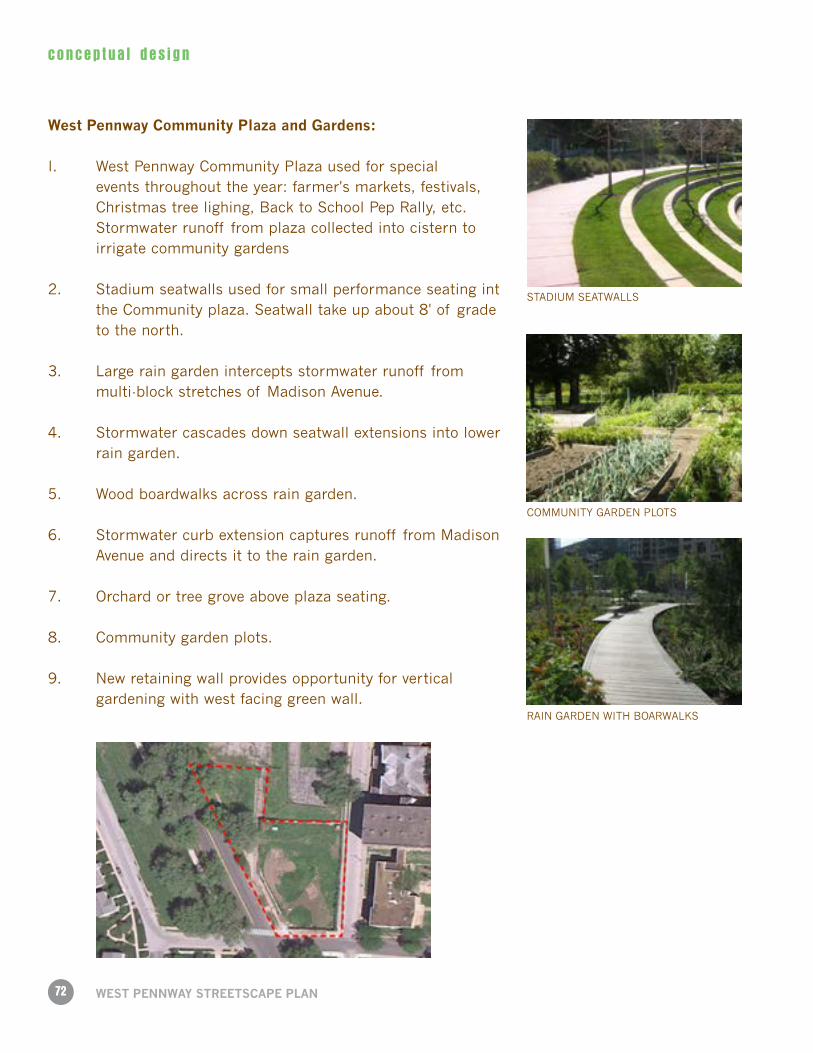
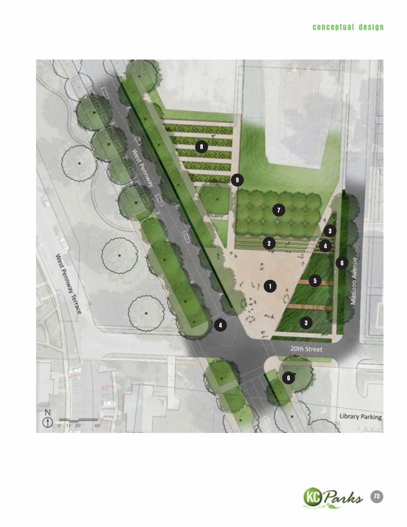
West Pennway Community Plaza and Gardens:
I. West Pennway Community Plaza used for special events throughout the year: farmer's markets, festivals, Christmas tree lighing, Back to School Pep Rally, etc.
Stormwater runoff from plaza collected into cistern to irrigate community gardens
2. Stadium seatwalls used for small performance seating int the Community plaza. Seatwall take up about 8' of grade to the north.
3. Large rain garden intercepts stormwater runoff from multi-block stretches of Madison Avenue.
4. Stormwater cascades down seatwall extensions into lower rain garden.
5. Wood boardwalks across rain garden.
6. Stormwater curb extension captures runoff from Madison Avenue and directs it to the rain garden.
7. Orchard or tree grove above plaza seating.
8. Community garden plots.
9. New retaining wall provides opportunity for vertical gardening with west facing green wall.
STADIUM SEATWALLS
COMMUNITY GARDEN PLOTS
RAIN GARDEN WITH BOARWALKS
73
concep tua l des ign
1
2
7
8
9
3
3
4
4
5
6
6
74
concep tua l des ign
WeST PennWAy STReeTSCAPe PlAn
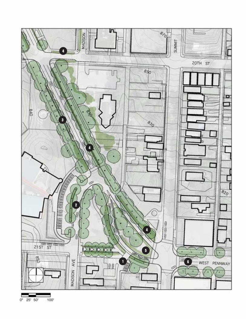
Proposed Streetscape Improvements: 20th Street to 21st Street
I. Close one-way portion of 21st Street. Replace with additional parking for businesses on Summit Street and a pedestrian connection up the hill.
2. Connect Madison Avenue to West Pennway. Reconfigure parking lot of Tony Aguirre Center, moving all parking spaces west of Madison Avenue.
3. Stripe on-street parking across from Irene H. Ruiz Biblioteca and adjacent to Tony Aguirre Center. Connect parking spaces back to sidewalk.
4. Implement stormwater features, including green gutter on the east side of West Pennway in front of Ruiz Library, and vegetated swales at the south end of Madison and the south end of West Pennway.
5. Divide portion of West Pennway just west of Summit Street into two lanes with a planted median. This realigns the roadway with the portion of West Pennway that runs east to west. It also reduces pedestrian crossing distances.
6. Extend allée of London planetrees past Summit Street, to east-west portion of West Pennway.
75
concep tua l des ign
1
2
3
4
4
4
5
6
76
concep tua l des ign
WeST PennWAy STReeTSCAPe PlAn
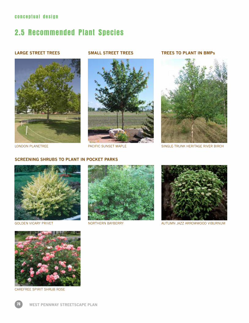
GOLDEN VICARY PRIVET
PACIFIC SUNSET MAPLE
SMAll STReeT TReeSlARGe STReeT TReeS
SCReenInG SHRUBS TO PlAnT In POCKeT PARKS
TReeS TO PlAnT In BMPs
SINGLE-TRUNK HERITAGE RIVER BIRCH
CAREFREE SPIRIT SHRUB ROSE
NORTHERN BAYBERRY
LONDON PLANETREE
AUTUMN JAZZ ARROWWOOD VIBURNUM
2.5 Recommended Plant Species
77
concep tua l des ign
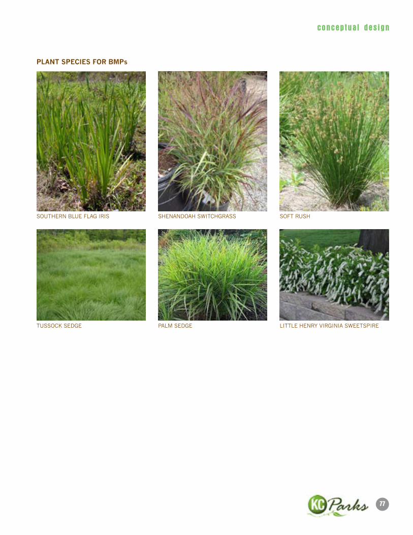
PlAnT SPeCIeS FOR BMPs
PALM SEDGE
SHENANDOAH SWITCHGRASS
LITTLE HENRY VIRGINIA SWEETSPIRETUSSOCK SEDGE
SOUTHERN BLUE FLAG IRIS SOFT RUSH
78
imp lemen ta t i on
WeST PennWAy STReeTSCAPe PlAn
79
imp lemen ta t i on
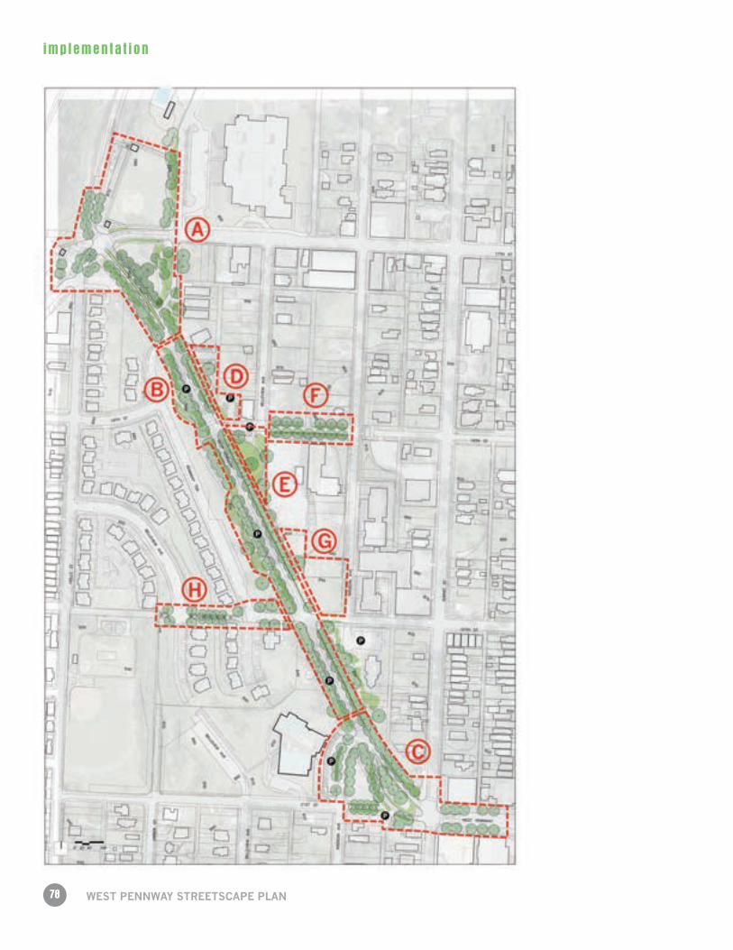
3.1 Recommended Phasing
Phase 1 Stakeholder Consensus Building
Site Analysis
Concept Design
Preliminary Cost Estimates
Phase 2 Technical Design: Parts A, B and C
Phase 3 Bidding and Construction: Parts A, B and/or C
Phase 4 Technical Design: D, E, F, G, and H
Phase 5 Bidding and Construction: D, E, F, G, and/or H
80
imp lemen ta t i on
WeST PennWAy STReeTSCAPe PlAn
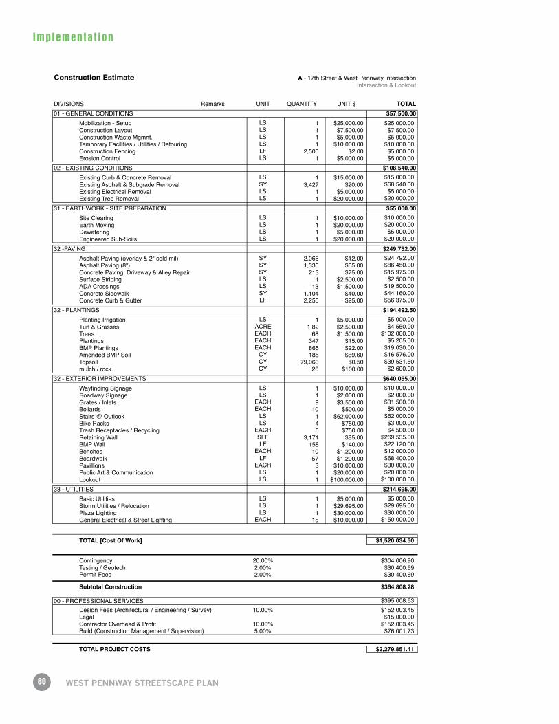
Construction Estimate A - 17th Street & West Pennway IntersectionIntersection & Lookout
DIVISIONS Remarks UNIT QUANTITY UNIT $ TOTAL01 - GENERAL CONDITIONS $57,500.00
Mobilization - Setup LS 1 $25,000.00 $25,000.00Construction Layout LS 1 $7,500.00 $7,500.00Construction Waste Mgmnt. LS 1 $5,000.00 $5,000.00Temporary Facilities / Utilities / Detouring LS 1 $10,000.00 $10,000.00Construction Fencing LF 2,500 $2.00 $5,000.00Erosion Control LS 1 $5,000.00 $5,000.00
02 - EXISTING CONDITIONS $108,540.00Existing Curb & Concrete Removal LS 1 $15,000.00 $15,000.00Existing Asphalt & Subgrade Removal SY 3,427 $20.00 $68,540.00Existing Electrical Removal LS 1 $5,000.00 $5,000.00Existing Tree Removal LS 1 $20,000.00 $20,000.00
31 - EARTHWORK - SITE PREPARATION $55,000.00Site Clearing LS 1 $10,000.00 $10,000.00Earth Moving LS 1 $20,000.00 $20,000.00Dewatering LS 1 $5,000.00 $5,000.00Engineered Sub-Soils LS 1 $20,000.00 $20,000.00
32 -PAVING $249,752.00Asphalt Paving (overlay & 2" cold mil) SY 2,066 $12.00 $24,792.00Asphalt Paving (8") SY 1,330 $65.00 $86,450.00Concrete Paving, Driveway & Alley Repair SY 213 $75.00 $15,975.00Surface Striping LS 1 $2,500.00 $2,500.00ADA Crossings LS 13 $1,500.00 $19,500.00Concrete Sidewalk SY 1,104 $40.00 $44,160.00Concrete Curb & Gutter LF 2,255 $25.00 $56,375.00
32 - PLANTINGS $194,492.50Planting Irrigation LS 1 $5,000.00 $5,000.00Turf & Grasses ACRE 1.82 $2,500.00 $4,550.00Trees EACH 68 $1,500.00 $102,000.00Plantings EACH 347 $15.00 $5,205.00BMP Plantings EACH 865 $22.00 $19,030.00Amended BMP Soil CY 185 $89.60 $16,576.00Topsoil CY 79,063 $0.50 $39,531.50mulch / rock CY 26 $100.00 $2,600.00
32 - EXTERIOR IMPROVEMENTS $640,055.00Wayfinding Signage LS 1 $10,000.00 $10,000.00Roadway Signage LS 1 $2,000.00 $2,000.00Grates / Inlets EACH 9 $3,500.00 $31,500.00Bollards EACH 10 $500.00 $5,000.00Stairs @ Outlook LS 1 $62,000.00 $62,000.00Bike Racks LS 4 $750.00 $3,000.00Trash Receptacles / Recycling EACH 6 $750.00 $4,500.00Retaining Wall SFF 3,171 $85.00 $269,535.00BMP Wall LF 158 $140.00 $22,120.00Benches EACH 10 $1,200.00 $12,000.00Boardwalk LF 57 $1,200.00 $68,400.00Pavillions EACH 3 $10,000.00 $30,000.00Public Art & Communication LS 1 $20,000.00 $20,000.00Lookout LS 1 $100,000.00 $100,000.00
33 - UTILITIES $214,695.00Basic Utilities LS 1 $5,000.00 $5,000.00Storm Utilities / Relocation LS 1 $29,695.00 $29,695.00Plaza Lighting LS 1 $30,000.00 $30,000.00General Electrical & Street Lighting EACH 15 $10,000.00 $150,000.00
TOTAL [Cost Of Work] $1,520,034.50
Contingency 20.00% $304,006.90Testing / Geotech 2.00% $30,400.69Permit Fees 2.00% $30,400.69
Subtotal Construction $364,808.28
00 - PROFESSIONAL SERVICES $395,008.63Design Fees (Architectural / Engineering / Survey) 10.00% $152,003.45Legal $15,000.00Contractor Overhead & Profit 10.00% $152,003.45Build (Construction Management / Supervision) 5.00% $76,001.73
TOTAL PROJECT COSTS $2,279,851.41
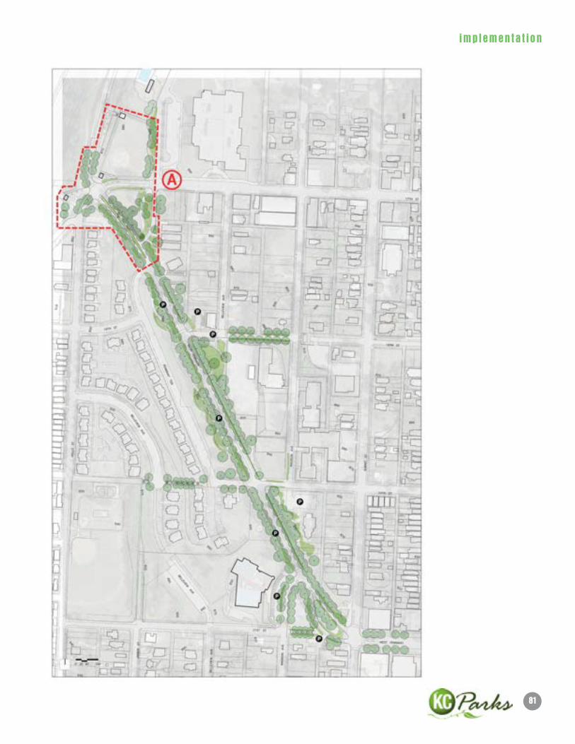
81
imp lemen ta t i on
82
imp lemen ta t i on
WeST PennWAy STReeTSCAPe PlAn
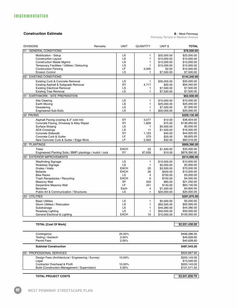
Construction Estimate B - West PennwayPennway Terrace to Madison Avenue
DIVISIONS Remarks UNIT QUANTITY UNIT $ TOTAL01 - GENERAL CONDITIONS $79,500.00
Mobilization - Setup LS 1 $25,000.00 $25,000.00Construction Layout LS 1 $10,000.00 $10,000.00Construction Waste Mgmnt. LS 1 $12,000.00 $12,000.00Temporary Facilities / Utilities / Detouring LS 1 $15,000.00 $15,000.00Construction Fencing LF 5,000 $2.00 $10,000.00Erosion Control LS 1 $7,500.00 $7,500.00
02 - EXISTING CONDITIONS $144,340.00Existing Curb & Concrete Removal LS 1 $35,000.00 $35,000.00Existing Asphalt & Subgrade Removal SY 4,717 $20.00 $94,340.00Existing Electrical Removal LS 1 $7,500.00 $7,500.00Existing Tree Removal LS 1 $7,500.00 $7,500.00
31 - EARTHWORK - SITE PREPARATION $62,500.00Site Clearing LS 1 $10,000.00 $10,000.00Earth Moving LS 1 $25,000.00 $25,000.00Dewatering LS 1 $7,500.00 $7,500.00Engineered Sub-Soils LS 1 $20,000.00 $20,000.00
32 -PAVING $329,135.00Asphalt Paving (overlay & 2" cold mil) SY 3,077 $12.00 $36,924.00Concrete Paving, Driveway & Alley Repair SY 1,826 $75.00 $136,950.00Surface Striping LS 1 $5,000.00 $5,000.00ADA Crossings LS 11 $1,500.00 $16,500.00Concrete Sidewalk SY 1,123 $40.00 $44,920.00Concrete Curb & Gutter LF 273 $25.00 $6,825.00New Concrete Curb & Gutter / Edge Work LF 2,563 $32.00 $82,016.00
32 - PLANTINGS $909,390.00Trees EACH 22 $1,500.00 $33,000.00Engineered Planting Soils / BMP/ plantings / mulch / rock SY 87,639 $10.00 $876,390.00
32 - EXTERIOR IMPROVEMENTS $214,690.00Wayfinding Signage LS 1 $10,000.00 $10,000.00Roadway Signage LS 1 $5,000.00 $5,000.00Grates / Inlets EACH 20 $3,500.00 $70,000.00Bollards EACH 26 $500.00 $13,000.00Bike Racks LS 4 $750.00 $3,000.00Trash Receptacles / Recycling EACH 6 $750.00 $4,500.00Masonry Wall SF 250 $85.00 $21,250.00Serpentine Masonry Wall LF 451 $140.00 $63,140.00Benches Each 4 $1,200.00 $4,800.00Public Art & Communication / Structures LS 1 $20,000.00 $20,000.00
33 - UTILITIES $291,875.00Basic Utilities LS 1 $5,000.00 $5,000.00Storm Utilities / Relocation LS 1 $92,595.00 $92,595.00Subdrainage LS 1 $44,280.00 $44,280.00Roadway Lighting LS 1 $50,000.00 $50,000.00General Electrical & Lighting EACH 10 $10,000.00 $100,000.00
TOTAL [Cost Of Work] $2,031,430.00
Contingency 20.00% $406,286.00Testing / Geotech 2.00% $40,628.60Permit Fees 2.00% $40,628.60
Subtotal Construction $487,543.20
00 - PROFESSIONAL SERVICES $522,857.50Design Fees (Architectural / Engineering / Survey) 10.00% $203,143.00Legal $15,000.00Contractor Overhead & Profit 10.00% $203,143.00Build (Construction Management / Supervision) 5.00% $101,571.50
TOTAL PROJECT COSTS $3,041,830.70
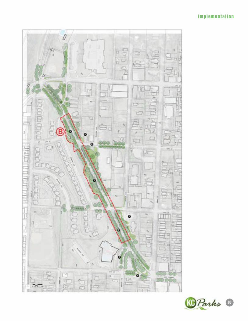
83
imp lemen ta t i on
84
imp lemen ta t i on
WeST PennWAy STReeTSCAPe PlAn
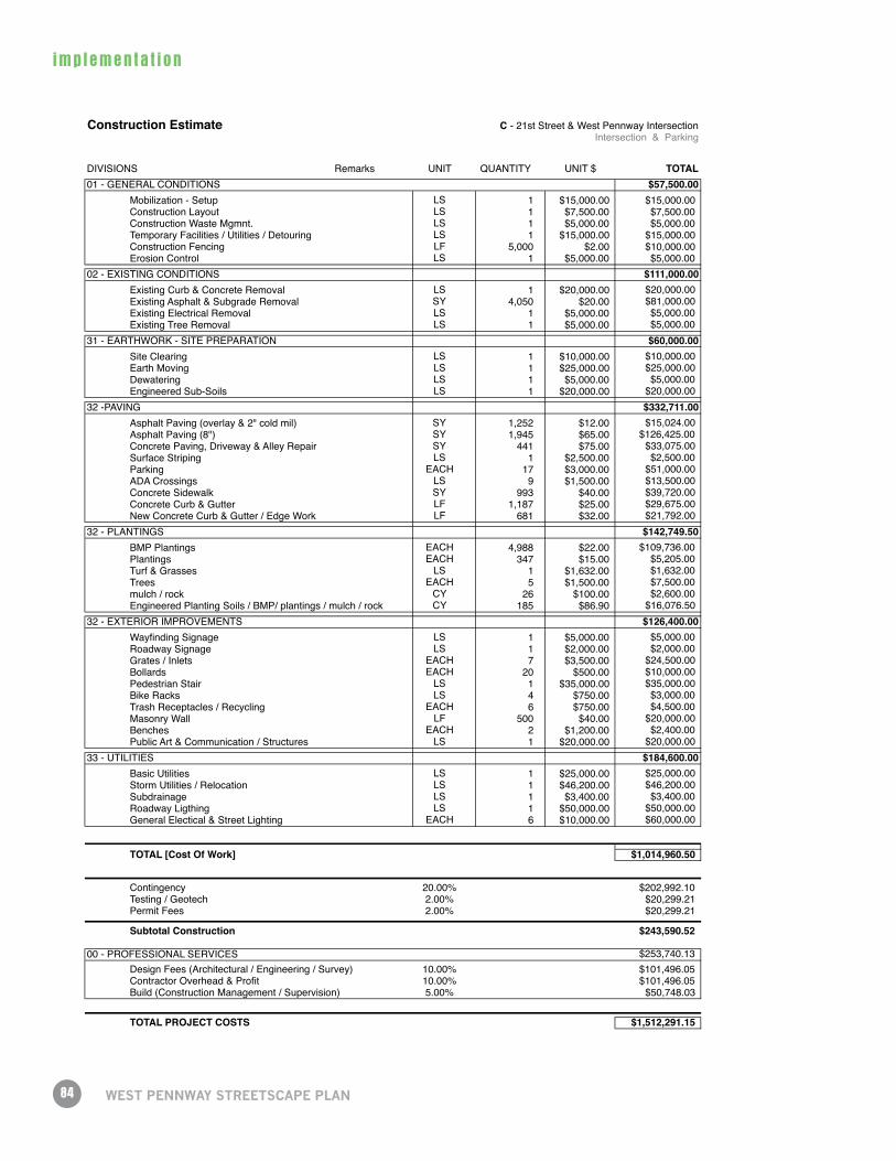
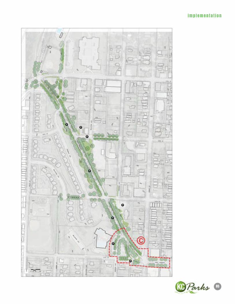
Construction Estimate C - 21st Street & West Pennway IntersectionIntersection & Parking
DIVISIONS Remarks UNIT QUANTITY UNIT $ TOTAL01 - GENERAL CONDITIONS $57,500.00
Mobilization - Setup LS 1 $15,000.00 $15,000.00Construction Layout LS 1 $7,500.00 $7,500.00Construction Waste Mgmnt. LS 1 $5,000.00 $5,000.00Temporary Facilities / Utilities / Detouring LS 1 $15,000.00 $15,000.00Construction Fencing LF 5,000 $2.00 $10,000.00Erosion Control LS 1 $5,000.00 $5,000.00
02 - EXISTING CONDITIONS $111,000.00Existing Curb & Concrete Removal LS 1 $20,000.00 $20,000.00Existing Asphalt & Subgrade Removal SY 4,050 $20.00 $81,000.00Existing Electrical Removal LS 1 $5,000.00 $5,000.00Existing Tree Removal LS 1 $5,000.00 $5,000.00
31 - EARTHWORK - SITE PREPARATION $60,000.00Site Clearing LS 1 $10,000.00 $10,000.00Earth Moving LS 1 $25,000.00 $25,000.00Dewatering LS 1 $5,000.00 $5,000.00Engineered Sub-Soils LS 1 $20,000.00 $20,000.00
32 -PAVING $332,711.00Asphalt Paving (overlay & 2" cold mil) SY 1,252 $12.00 $15,024.00Asphalt Paving (8") SY 1,945 $65.00 $126,425.00Concrete Paving, Driveway & Alley Repair SY 441 $75.00 $33,075.00Surface Striping LS 1 $2,500.00 $2,500.00Parking EACH 17 $3,000.00 $51,000.00ADA Crossings LS 9 $1,500.00 $13,500.00Concrete Sidewalk SY 993 $40.00 $39,720.00Concrete Curb & Gutter LF 1,187 $25.00 $29,675.00New Concrete Curb & Gutter / Edge Work LF 681 $32.00 $21,792.00
32 - PLANTINGS $142,749.50BMP Plantings EACH 4,988 $22.00 $109,736.00Plantings EACH 347 $15.00 $5,205.00Turf & Grasses LS 1 $1,632.00 $1,632.00Trees EACH 5 $1,500.00 $7,500.00mulch / rock CY 26 $100.00 $2,600.00Engineered Planting Soils / BMP/ plantings / mulch / rock CY 185 $86.90 $16,076.50
32 - EXTERIOR IMPROVEMENTS $126,400.00Wayfinding Signage LS 1 $5,000.00 $5,000.00Roadway Signage LS 1 $2,000.00 $2,000.00Grates / Inlets EACH 7 $3,500.00 $24,500.00Bollards EACH 20 $500.00 $10,000.00Pedestrian Stair LS 1 $35,000.00 $35,000.00Bike Racks LS 4 $750.00 $3,000.00Trash Receptacles / Recycling EACH 6 $750.00 $4,500.00Masonry Wall LF 500 $40.00 $20,000.00Benches EACH 2 $1,200.00 $2,400.00Public Art & Communication / Structures LS 1 $20,000.00 $20,000.00
33 - UTILITIES $184,600.00Basic Utilities LS 1 $25,000.00 $25,000.00Storm Utilities / Relocation LS 1 $46,200.00 $46,200.00Subdrainage LS 1 $3,400.00 $3,400.00Roadway Ligthing LS 1 $50,000.00 $50,000.00General Electical & Street Lighting EACH 6 $10,000.00 $60,000.00
TOTAL [Cost Of Work] $1,014,960.50
Contingency 20.00% $202,992.10Testing / Geotech 2.00% $20,299.21Permit Fees 2.00% $20,299.21
Subtotal Construction $243,590.52
00 - PROFESSIONAL SERVICES $253,740.13Design Fees (Architectural / Engineering / Survey) 10.00% $101,496.05Contractor Overhead & Profit 10.00% $101,496.05Build (Construction Management / Supervision) 5.00% $50,748.03
TOTAL PROJECT COSTS $1,512,291.15
85
imp lemen ta t i on
86
imp lemen ta t i on
WeST PennWAy STReeTSCAPe PlAn
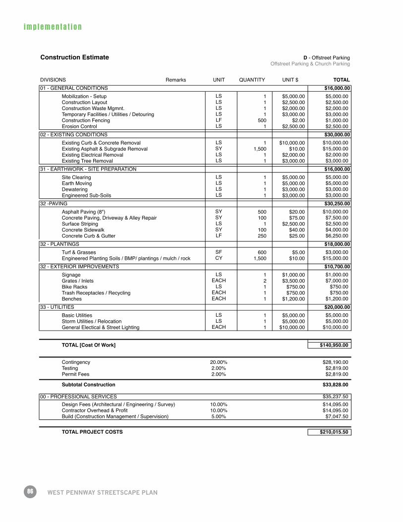
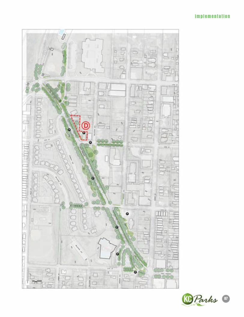
Construction Estimate D - Offstreet ParkingOffstreet Parking & Church Parking
DIVISIONS Remarks UNIT QUANTITY UNIT $ TOTAL01 - GENERAL CONDITIONS $16,000.00
Mobilization - Setup LS 1 $5,000.00 $5,000.00Construction Layout LS 1 $2,500.00 $2,500.00Construction Waste Mgmnt. LS 1 $2,000.00 $2,000.00Temporary Facilities / Utilities / Detouring LS 1 $3,000.00 $3,000.00Construction Fencing LF 500 $2.00 $1,000.00Erosion Control LS 1 $2,500.00 $2,500.00
02 - EXISTING CONDITIONS $30,000.00Existing Curb & Concrete Removal LS 1 $10,000.00 $10,000.00Existing Asphalt & Subgrade Removal SY 1,500 $10.00 $15,000.00Existing Electrical Removal LS 1 $2,000.00 $2,000.00Existing Tree Removal LS 1 $3,000.00 $3,000.00
31 - EARTHWORK - SITE PREPARATION $16,000.00Site Clearing LS 1 $5,000.00 $5,000.00Earth Moving LS 1 $5,000.00 $5,000.00Dewatering LS 1 $3,000.00 $3,000.00Engineered Sub-Soils LS 1 $3,000.00 $3,000.00
32 -PAVING $30,250.00Asphalt Paving (8") SY 500 $20.00 $10,000.00Concrete Paving, Driveway & Alley Repair SY 100 $75.00 $7,500.00Surface Striping LS 1 $2,500.00 $2,500.00Concrete Sidewalk SY 100 $40.00 $4,000.00Concrete Curb & Gutter LF 250 $25.00 $6,250.00
32 - PLANTINGS $18,000.00Turf & Grasses SF 600 $5.00 $3,000.00Engineered Planting Soils / BMP/ plantings / mulch / rock CY 1,500 $10.00 $15,000.00
32 - EXTERIOR IMPROVEMENTS $10,700.00Signage LS 1 $1,000.00 $1,000.00Grates / Inlets EACH 2 $3,500.00 $7,000.00Bike Racks LS 1 $750.00 $750.00Trash Receptacles / Recycling EACH 1 $750.00 $750.00Benches EACH 1 $1,200.00 $1,200.00
33 - UTILITIES $20,000.00Basic Utilities LS 1 $5,000.00 $5,000.00Storm Utilities / Relocation LS 1 $5,000.00 $5,000.00General Electical & Street Lighting EACH 1 $10,000.00 $10,000.00
TOTAL [Cost Of Work] $140,950.00
Contingency 20.00% $28,190.00Testing 2.00% $2,819.00Permit Fees 2.00% $2,819.00
Subtotal Construction $33,828.00
00 - PROFESSIONAL SERVICES $35,237.50Design Fees (Architectural / Engineering / Survey) 10.00% $14,095.00Contractor Overhead & Profit 10.00% $14,095.00Build (Construction Management / Supervision) 5.00% $7,047.50
TOTAL PROJECT COSTS $210,015.50
87
imp lemen ta t i on
88
imp lemen ta t i on
WeST PennWAy STReeTSCAPe PlAn
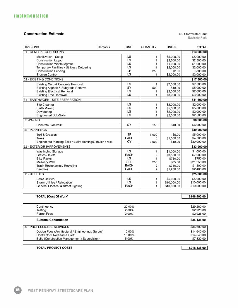
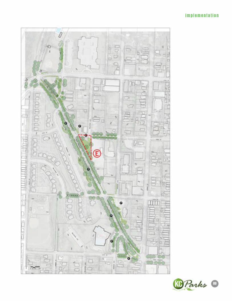
Construction Estimate D - Stormwater ParkEastside Park
DIVISIONS Remarks UNIT QUANTITY UNIT $ TOTAL01 - GENERAL CONDITIONS $13,000.00
Mobilization - Setup LS 1 $5,000.00 $5,000.00Construction Layout LS 1 $2,500.00 $2,500.00Construction Waste Mgmnt. LS 1 $1,000.00 $1,000.00Temporary Facilities / Utilities / Detouring LS 1 $2,000.00 $2,000.00Construction Fencing LF 250 $2.00 $500.00Erosion Control LS 1 $2,000.00 $2,000.00
02 - EXISTING CONDITIONS $17,500.00Existing Curb & Concrete Removal LS 1 $7,500.00 $7,500.00Existing Asphalt & Subgrade Removal SY 500 $10.00 $5,000.00Existing Electrical Removal LS 1 $2,000.00 $2,000.00Existing Tree Removal LS 1 $3,000.00 $3,000.00
31 - EARTHWORK - SITE PREPARATION $11,500.00Site Clearing LS 1 $2,000.00 $2,000.00Earth Moving LS 1 $5,000.00 $5,000.00Dewatering LS 1 $2,000.00 $2,000.00Engineered Sub-Soils LS 1 $2,500.00 $2,500.00
32 -PAVING $6,000.00Concrete Sidewalk SY 150 $40.00 $6,000.00
32 - PLANTINGS $39,500.00Turf & Grasses SF 1,000 $5.00 $5,000.00Trees EACH 3 $1,500.00 $4,500.00Engineered Planting Soils / BMP/ plantings / mulch / rock CY 3,000 $10.00 $30,000.00
32 - EXTERIOR IMPROVEMENTS $33,900.00Wayfinding Signage LS 1 $1,000.00 $1,000.00Grates / Inlets EACH 2 $3,500.00 $7,000.00Bike Racks LS 1 $750.00 $750.00Masonry Wall SFF 250 $85.00 $21,250.00Trash Receptacles / Recycling EACH 2 $750.00 $1,500.00Benches EACH 2 $1,200.00 $2,400.00
33 - UTILITIES $25,000.00Basic Utilities LS 1 $5,000.00 $5,000.00Storm Utilities / Relocation LS 1 $10,000.00 $10,000.00General Electical & Street Lighting EACH 1 $10,000.00 $10,000.00
TOTAL [Cost Of Work] $146,400.00
Contingency 20.00% $29,280.00Testing 2.00% $2,928.00Permit Fees 2.00% $2,928.00
Subtotal Construction $35,136.00
00 - PROFESSIONAL SERVICES $36,600.00Design Fees (Architectural / Engineering / Survey) 10.00% $14,640.00Contractor Overhead & Profit 10.00% $14,640.00Build (Construction Management / Supervision) 5.00% $7,320.00
TOTAL PROJECT COSTS $218,136.00
89
imp lemen ta t i on
90
imp lemen ta t i on
WeST PennWAy STReeTSCAPe PlAn
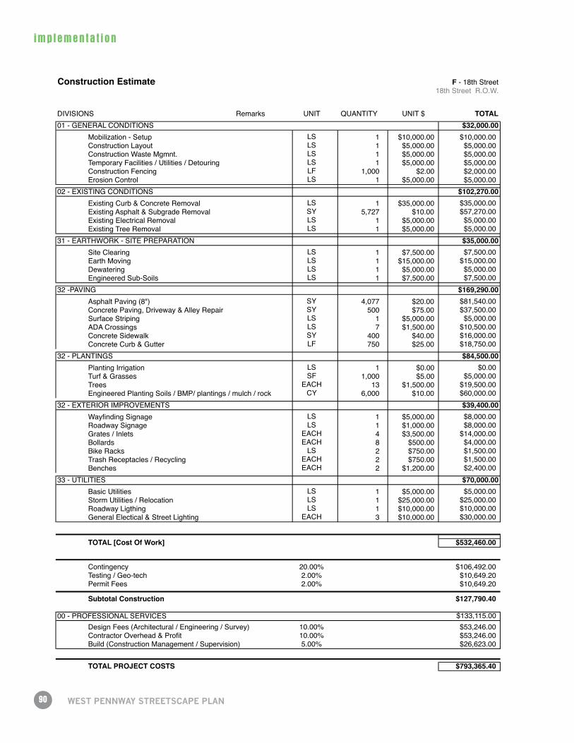
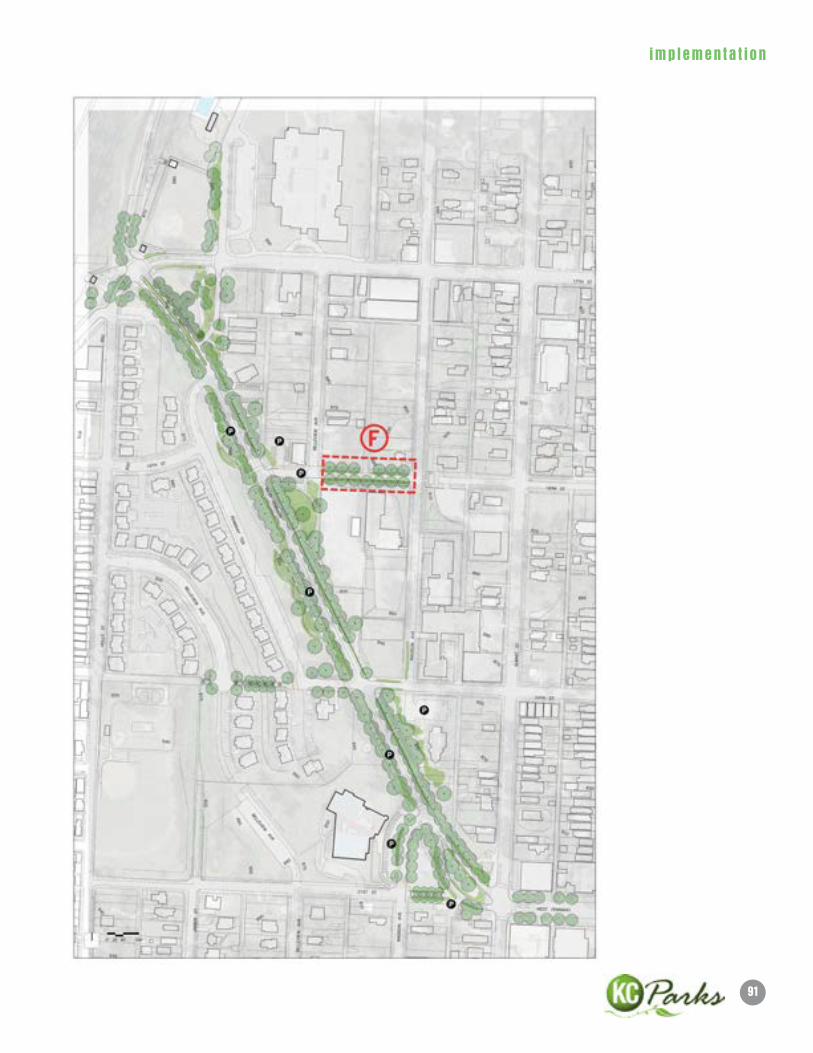
Construction Estimate F - 18th Street18th Street R.O.W.
DIVISIONS Remarks UNIT QUANTITY UNIT $ TOTAL01 - GENERAL CONDITIONS $32,000.00
Mobilization - Setup LS 1 $10,000.00 $10,000.00Construction Layout LS 1 $5,000.00 $5,000.00Construction Waste Mgmnt. LS 1 $5,000.00 $5,000.00Temporary Facilities / Utilities / Detouring LS 1 $5,000.00 $5,000.00Construction Fencing LF 1,000 $2.00 $2,000.00Erosion Control LS 1 $5,000.00 $5,000.00
02 - EXISTING CONDITIONS $102,270.00Existing Curb & Concrete Removal LS 1 $35,000.00 $35,000.00Existing Asphalt & Subgrade Removal SY 5,727 $10.00 $57,270.00Existing Electrical Removal LS 1 $5,000.00 $5,000.00Existing Tree Removal LS 1 $5,000.00 $5,000.00
31 - EARTHWORK - SITE PREPARATION $35,000.00Site Clearing LS 1 $7,500.00 $7,500.00Earth Moving LS 1 $15,000.00 $15,000.00Dewatering LS 1 $5,000.00 $5,000.00Engineered Sub-Soils LS 1 $7,500.00 $7,500.00
32 -PAVING $169,290.00Asphalt Paving (8") SY 4,077 $20.00 $81,540.00Concrete Paving, Driveway & Alley Repair SY 500 $75.00 $37,500.00Surface Striping LS 1 $5,000.00 $5,000.00ADA Crossings LS 7 $1,500.00 $10,500.00Concrete Sidewalk SY 400 $40.00 $16,000.00Concrete Curb & Gutter LF 750 $25.00 $18,750.00
32 - PLANTINGS $84,500.00Planting Irrigation LS 1 $0.00 $0.00Turf & Grasses SF 1,000 $5.00 $5,000.00Trees EACH 13 $1,500.00 $19,500.00Engineered Planting Soils / BMP/ plantings / mulch / rock CY 6,000 $10.00 $60,000.00
32 - EXTERIOR IMPROVEMENTS $39,400.00Wayfinding Signage LS 1 $5,000.00 $8,000.00Roadway Signage LS 1 $1,000.00 $8,000.00Grates / Inlets EACH 4 $3,500.00 $14,000.00Bollards EACH 8 $500.00 $4,000.00Bike Racks LS 2 $750.00 $1,500.00Trash Receptacles / Recycling EACH 2 $750.00 $1,500.00Benches EACH 2 $1,200.00 $2,400.00
33 - UTILITIES $70,000.00Basic Utilities LS 1 $5,000.00 $5,000.00Storm Utilities / Relocation LS 1 $25,000.00 $25,000.00Roadway Ligthing LS 1 $10,000.00 $10,000.00General Electical & Street Lighting EACH 3 $10,000.00 $30,000.00
TOTAL [Cost Of Work] $532,460.00
Contingency 20.00% $106,492.00Testing / Geo-tech 2.00% $10,649.20Permit Fees 2.00% $10,649.20
Subtotal Construction $127,790.40
00 - PROFESSIONAL SERVICES $133,115.00Design Fees (Architectural / Engineering / Survey) 10.00% $53,246.00Contractor Overhead & Profit 10.00% $53,246.00Build (Construction Management / Supervision) 5.00% $26,623.00
TOTAL PROJECT COSTS $793,365.40
91
imp lemen ta t i on
92
imp lemen ta t i on
WeST PennWAy STReeTSCAPe PlAn
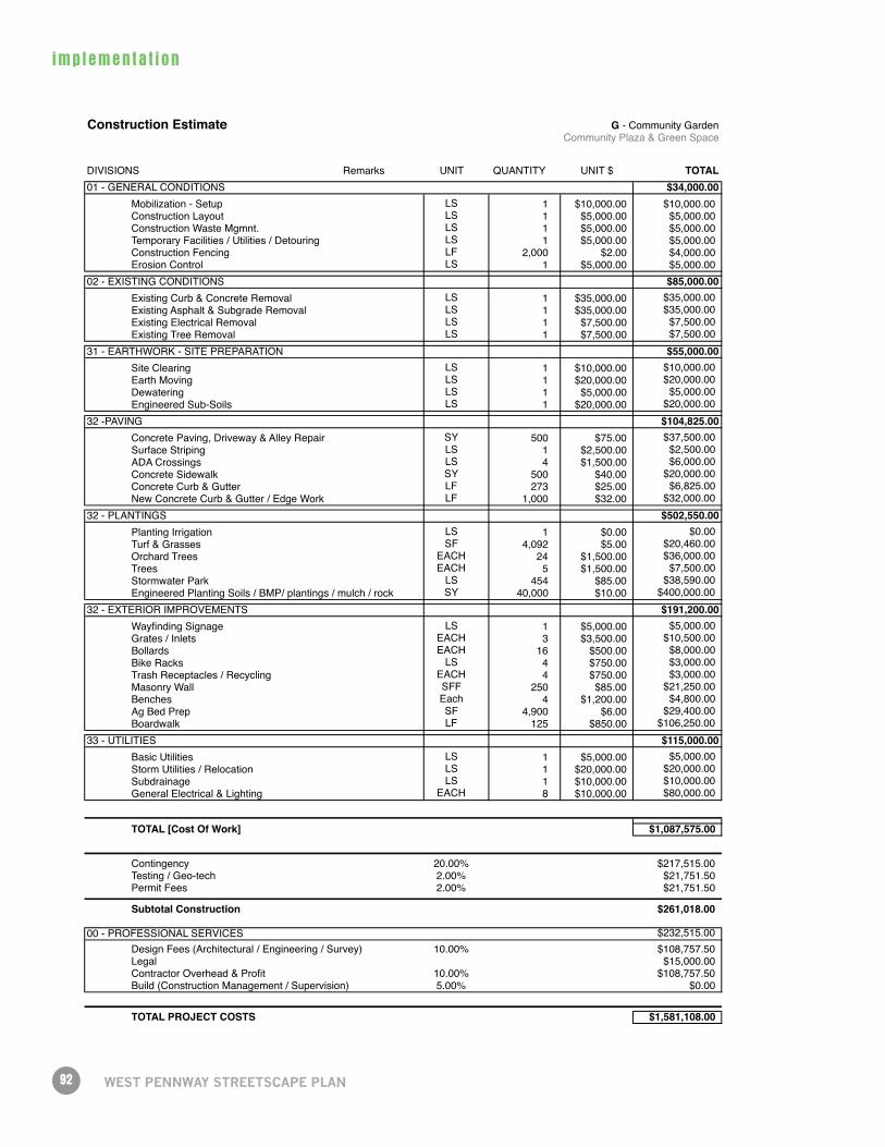
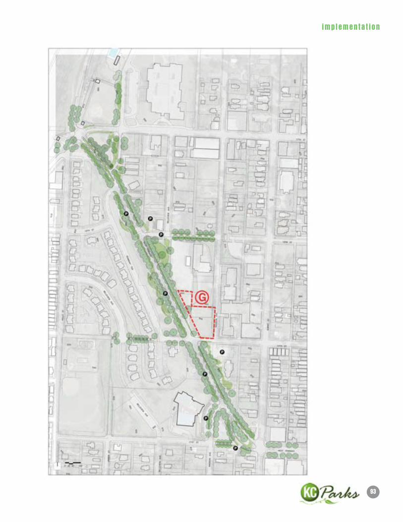
Construction Estimate G - Community GardenCommunity Plaza & Green Space
DIVISIONS Remarks UNIT QUANTITY UNIT $ TOTAL01 - GENERAL CONDITIONS $34,000.00
Mobilization - Setup LS 1 $10,000.00 $10,000.00Construction Layout LS 1 $5,000.00 $5,000.00Construction Waste Mgmnt. LS 1 $5,000.00 $5,000.00Temporary Facilities / Utilities / Detouring LS 1 $5,000.00 $5,000.00Construction Fencing LF 2,000 $2.00 $4,000.00Erosion Control LS 1 $5,000.00 $5,000.00
02 - EXISTING CONDITIONS $85,000.00Existing Curb & Concrete Removal LS 1 $35,000.00 $35,000.00Existing Asphalt & Subgrade Removal LS 1 $35,000.00 $35,000.00Existing Electrical Removal LS 1 $7,500.00 $7,500.00Existing Tree Removal LS 1 $7,500.00 $7,500.00
31 - EARTHWORK - SITE PREPARATION $55,000.00Site Clearing LS 1 $10,000.00 $10,000.00Earth Moving LS 1 $20,000.00 $20,000.00Dewatering LS 1 $5,000.00 $5,000.00Engineered Sub-Soils LS 1 $20,000.00 $20,000.00
32 -PAVING $104,825.00Concrete Paving, Driveway & Alley Repair SY 500 $75.00 $37,500.00Surface Striping LS 1 $2,500.00 $2,500.00ADA Crossings LS 4 $1,500.00 $6,000.00Concrete Sidewalk SY 500 $40.00 $20,000.00Concrete Curb & Gutter LF 273 $25.00 $6,825.00New Concrete Curb & Gutter / Edge Work LF 1,000 $32.00 $32,000.00
32 - PLANTINGS $502,550.00Planting Irrigation LS 1 $0.00 $0.00Turf & Grasses SF 4,092 $5.00 $20,460.00Orchard Trees EACH 24 $1,500.00 $36,000.00Trees EACH 5 $1,500.00 $7,500.00Stormwater Park LS 454 $85.00 $38,590.00Engineered Planting Soils / BMP/ plantings / mulch / rock SY 40,000 $10.00 $400,000.00
32 - EXTERIOR IMPROVEMENTS $191,200.00Wayfinding Signage LS 1 $5,000.00 $5,000.00Grates / Inlets EACH 3 $3,500.00 $10,500.00Bollards EACH 16 $500.00 $8,000.00Bike Racks LS 4 $750.00 $3,000.00Trash Receptacles / Recycling EACH 4 $750.00 $3,000.00Masonry Wall SFF 250 $85.00 $21,250.00Benches Each 4 $1,200.00 $4,800.00Ag Bed Prep SF 4,900 $6.00 $29,400.00Boardwalk LF 125 $850.00 $106,250.00
33 - UTILITIES $115,000.00Basic Utilities LS 1 $5,000.00 $5,000.00Storm Utilities / Relocation LS 1 $20,000.00 $20,000.00Subdrainage LS 1 $10,000.00 $10,000.00General Electrical & Lighting EACH 8 $10,000.00 $80,000.00
TOTAL [Cost Of Work] $1,087,575.00
Contingency 20.00% $217,515.00Testing / Geo-tech 2.00% $21,751.50Permit Fees 2.00% $21,751.50
Subtotal Construction $261,018.00
00 - PROFESSIONAL SERVICES $232,515.00Design Fees (Architectural / Engineering / Survey) 10.00% $108,757.50Legal $15,000.00Contractor Overhead & Profit 10.00% $108,757.50Build (Construction Management / Supervision) 5.00% $0.00
TOTAL PROJECT COSTS $1,581,108.00
93
imp lemen ta t i on
94
imp lemen ta t i on
WeST PennWAy STReeTSCAPe PlAn
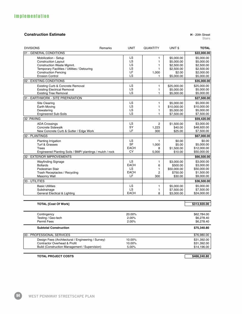
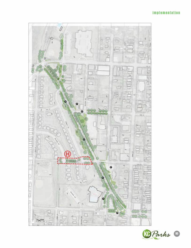
Construction Estimate H - 20th Street Stairs
DIVISIONS Remarks UNIT QUANTITY UNIT $ TOTAL01 - GENERAL CONDITIONS $22,000.00
Mobilization - Setup LS 1 $5,000.00 $5,000.00Construction Layout LS 1 $5,000.00 $5,000.00Construction Waste Mgmnt. LS 1 $2,500.00 $2,500.00Temporary Facilities / Utilities / Detouring LS 1 $2,500.00 $2,500.00Construction Fencing LF 1,000 $2.00 $2,000.00Erosion Control LS 1 $5,000.00 $5,000.00
02 - EXISTING CONDITIONS $35,000.00Existing Curb & Concrete Removal LS 1 $25,000.00 $25,000.00Existing Electrical Removal LS 1 $5,000.00 $5,000.00Existing Tree Removal LS 1 $5,000.00 $5,000.00
31 - EARTHWORK - SITE PREPARATION $27,500.00Site Clearing LS 1 $5,000.00 $5,000.00Earth Moving LS 1 $10,000.00 $10,000.00Dewatering LS 1 $5,000.00 $5,000.00Engineered Sub-Soils LS 1 $7,500.00 $7,500.00
32 -PAVING $59,420.00ADA Crossings LS 2 $1,500.00 $3,000.00Concrete Sidewalk SY 1,223 $40.00 $48,920.00New Concrete Curb & Gutter / Edge Work LF 300 $25.00 $7,500.00
32 - PLANTINGS $67,000.00Planting Irrigation LS 1 $0.00 $0.00Turf & Grasses SF 1,000 $5.00 $5,000.00Trees EACH 8 $1,500.00 $12,000.00Engineered Planting Soils / BMP/ plantings / mulch / rock CY 5,000 $10.00 $50,000.00
32 - EXTERIOR IMPROVEMENTS $66,500.00Wayfinding Signage LS 1 $3,000.00 $3,000.00Bollards EACH 6 $500.00 $3,000.00Pedestrian Stair LS 1 $50,000.00 $50,000.00Trash Receptacles / Recycling EACH 2 $750.00 $1,500.00Masonry Wall LF 300 $30.00 $9,000.00
33 - UTILITIES $36,500.00Basic Utilities LS 1 $5,000.00 $5,000.00Subdrainage LS 1 $7,500.00 $7,500.00General Electical & Lighting EACH 8 $3,000.00 $24,000.00
TOTAL [Cost Of Work] $313,920.00
Contingency 20.00% $62,784.00Testing / Geo-tech 2.00% $6,278.40Permit Fees 2.00% $6,278.40
Subtotal Construction $75,340.80
00 - PROFESSIONAL SERVICES $76,980.00Design Fees (Architectural / Engineering / Survey) 10.00% $31,392.00Contractor Overhead & Profit 10.00% $31,392.00
5.00% $14,196.00
TOTAL PROJECT COSTS $466,240.80
Build (Construction Management / Supervision)
95
imp lemen ta t i on
96
imp lemen ta t i on
WeST PennWAy STReeTSCAPe PlAn
3.3 Funding OpportunitiesAdvocating for future funding is the responsibility of the Westside neighbors and institutions most directly
benefitting from improvements to the West Pennway Streetscape. Depending on funding opportunities,
some of the recommended phases may be split into smaller projects or combined into larger projects than
are defined here. Funding for these phases may come from a variety of local, state, federal and/or private
sources including:
• USDepartmentof Transportation– Transportation, Community, and System Preservation Program (TCSP), Missouri Department of Transportation, Bryan Ross, [email protected], 573-526-4398
• SurfaceTransportationProgram–TransportationEnhancementFunds(STP-TE), Andrew Mueller, State DOT TE Coordinator, TE Program Contact Missouri Department of Transportation MO DOT 3025 East Kearney Street P.O. Box 868 Springfield, MO 65801 Tel: 417-895-7685 Fax: 417-895-7652 [email protected]
• Mid-AmericaRegionalCouncil(MARC)SustainableCommunitiesInitiative/HUDGrant, 816-474-4240, www.marc.org
• FederalHighwayAdministrationCongestionMitigationandAirQualityImprovementProgram(CMAQ) Mid-America Regional Council, Marc Hansen or Amanda Graor, 816-474-4240, www.marc.org
• AmericanReinvestmentandRecoveryActFunding(ARRA), Mid-America Regional Council, 816-474-4240, www.marc.org
• FederalRecreationalTrailsProgram/RTPNon-MotorizedTrailProjects, Missouri Department of Natural Resources, 573-751-1010, www.dnr.mo.gov
• KansasCity,MissouriCapitalImprovementProgram(CIP), Rose Rhodes, 816-513-1322, www.kcmo.org
• CommunityImprovementDistrictFunds(CID)
• NeighborhoodImprovementDistrictFunds(NID)
• PublicImprovementAdvisoryCommittee(PIAC), Deb Hermann, Chairman, 816-454-3763, www.kcmo.org
• FundingthroughpartnershipwithKCMOCityPlanningandDevelopment
97
imp lemen ta t i on
• FundingthroughpartnershipwithKCMOParksandRecreationDepartment
• FundingthroughpartnershipwithKCMOWaterDepartment
• FundingthroughpartnershipwithKCMOPublicWorksDepartment
• Privatefundingforimprovementsonprivateproperty
• Public/privatepartnershipsalongthecorridor
3.4 MaintenanceImplementation of the West Pennway Streetscape Plan is dependent upon the successful creation of a
Friends of West Pennway group, working in close collaboration with various city agencies, most importantly
Kansas City, Missouri, Parks and Recreation.

99
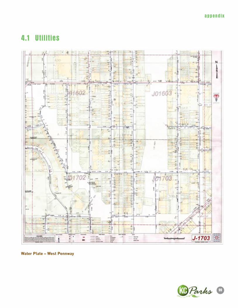
append i x
Water Plate – West Pennway
4.1 Utilities
100
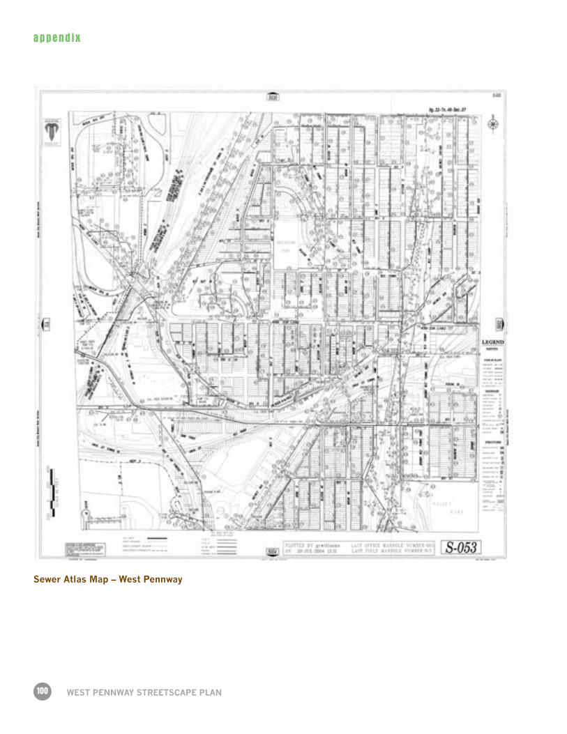
append i x
WeST PennWAy STReeTSCAPe PlAn
Sewer Atlas Map – West Pennway
101
append i x
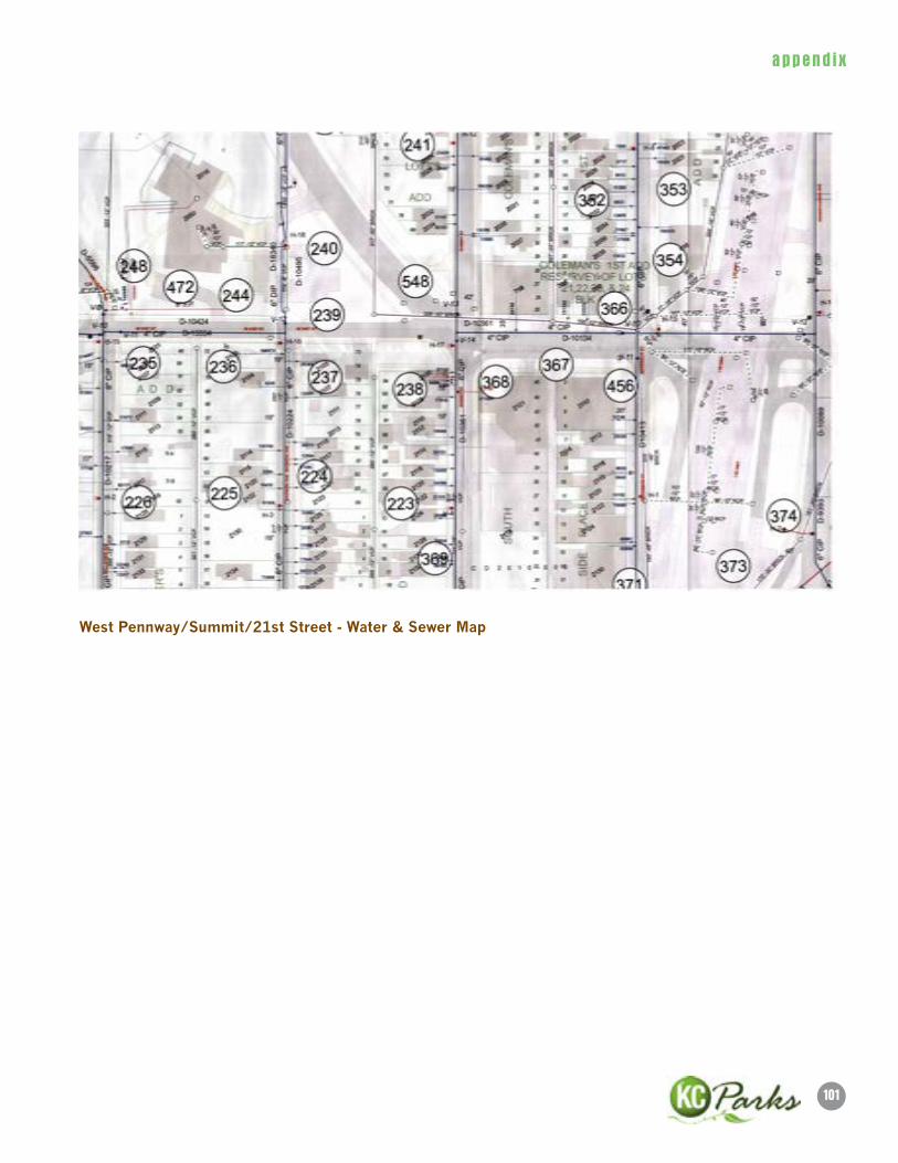
West Pennway/Summit/21st Street - Water & Sewer Map
102
append i x
WeST PennWAy STReeTSCAPe PlAn
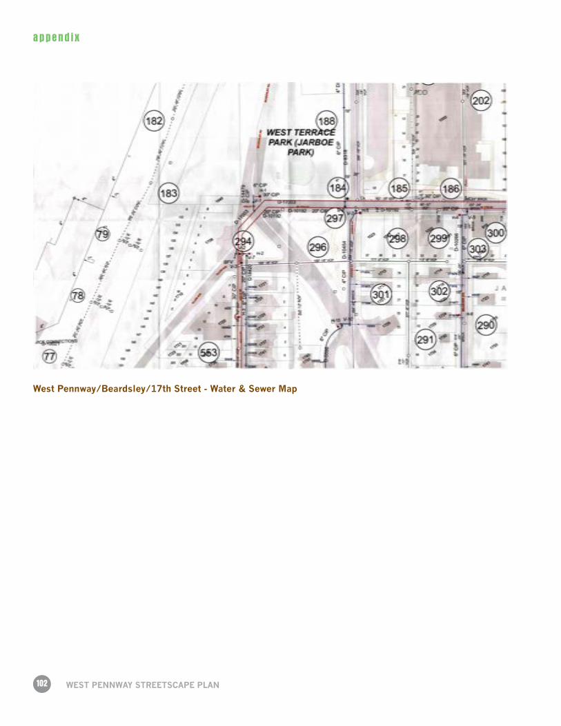
West Pennway/Beardsley/17th Street - Water & Sewer Map
memo
Page 1 of 27
INTRODUCTION
R^3C Design Group has been selected to complete a traffic operations analysis for two key intersections on West Pennway Boulevard, at 17th Street and 21st Street, by the Kansas City Parks and Recreation Department. The goal of the project is to make West Pennway pedestrian friendly, while also balancing the historical nature of the Kessler designed Boulevard with traffic flow needs through the corridor. Figure 1 shows the location of the corridor.
This memo outlines the analysis methods used to determine current operational standards in order to establish a baseline. Further, through a public outreach program, the design team lead by el dorado, inc., developed two options at each of the intersections. This memo outlines the completed testing for each of the options.
EXISTING CONDITIONS REVIEW
Through the existing conditions analysis, we evaluate the current operations of intersections and determine deficiencies that need to be addressed for improvement.
To: David Dowell, AIA
From: Shashi Gannavaram, P.E, PTP, AICP, PTOE
CC:
Date: 9/2/2011
Re: Technical Memorandum for West Pennway Boulevard Traffic Analysis
memo
Page 2 of 27
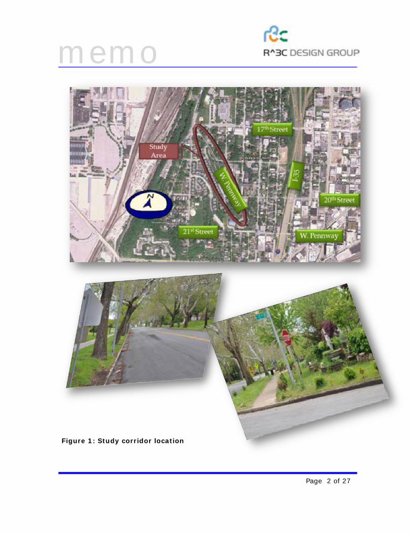
Figure 1: Study corridor location
memo
Page 3 of 27
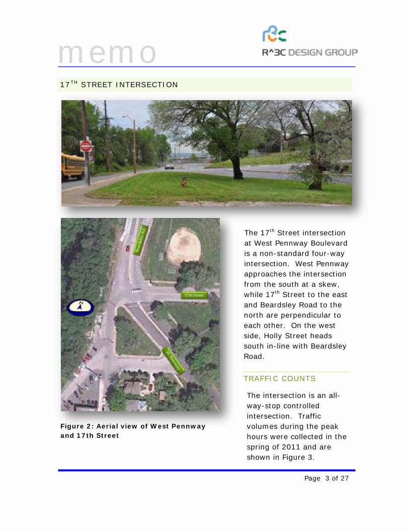
Figure 2: Aerial view of West Pennway and 17th Street
17TH STREET INTERSECTION
The 17th Street intersection at West Pennway Boulevard is a non-standard four-way intersection. West Pennway approaches the intersection from the south at a skew, while 17th Street to the east and Beardsley Road to the north are perpendicular to each other. On the west side, Holly Street heads south in-line with Beardsley Road.
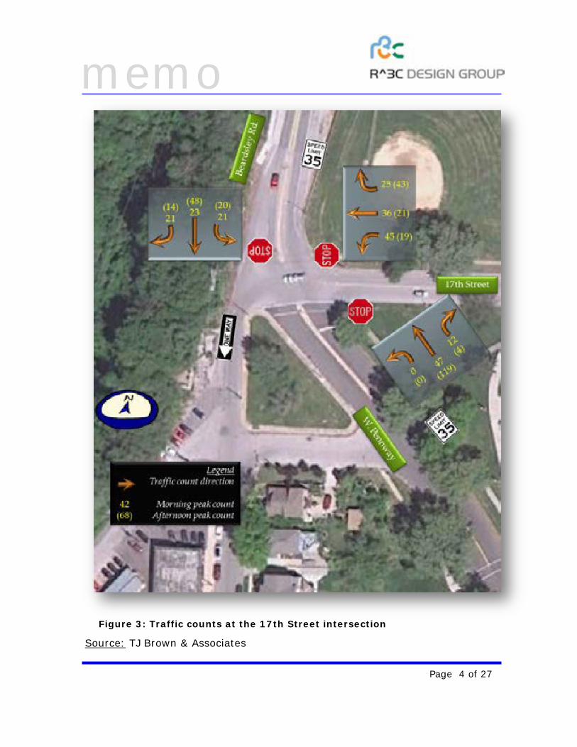
TRAFFIC COUNTS
The intersection is an all-way-stop controlled intersection. Traffic volumes during the peak hours were collected in the spring of 2011 and are shown in Figure 3.
memo
Page 4 of 27
Source: TJ Brown & Associates
Figure 3: Traffic counts at the 17th Street intersection
memo
Page 5 of 27
This intersection provides access to a commercial corridor to the east, and two schools located north of 17th Street and west of Holly Street. Despite the land-uses that are accessing the intersection, the volume of traffic is significantly lower than expected because each of the land-uses peak at different times during the day. For example, the school traffic typically peaks before commuter traffic, and the commercial traffic peaks after the commuter traffic. Further, the commercial traffic is primarily local traffic and is not destination based.
The predominant traffic flow is from West Pennway to Beardsley Road, heading north towards downtown Kansas City, Missouri. This traffic flow is however only observed during the afternoon peak hour. Under normal circumstances we would expect this flow to reverse during the morning peak hour. The lack of a morning peak reversal in traffic flow leads us to believe that the afternoon peak traffic is more cut-through in nature, and a result of motorists trying to avoid the congested freeways located just east of the West Pennway corridor.
CAPACITY ANALYSIS
Using the traffic counts, we evaluate and rank intersection operations based on the methods prescribed in the Highway Capacity Manual (HCM), published by the Transportation Research Board (TRB) in association with the Federal Highway Administration (FHWA), 2010. The HCM uses the average delays experienced by the user during the analysis period resulting in a letter grade from A through F. This letter grade is known as the Level-of-Service (LOS). LOS A represents minimal average delays to the user, while LOS F represents a complete break-down in the system and users experience severe congestion.
HCM results vary slightly between two-way stop controlled intersections and all-way stop controlled intersections. A two-way stop controlled intersection is one where only the minor street traffic is stopped, or major street turning movements yield to opposing major street through traffic. An all-way stop controlled intersection is one where all the traffic approaching the intersection has to stop prior to entering the intersection.
At a two-way stop intersection, since only minor street movements stop or major street movements yield, they are the only ones that experience
memo
Page 6 of 27
delays. Therefore, LOS is computed only for those movements and an intersection wide delay or LOS is not computed.
At an all-way stop control intersection, all movements stop and experience delays. Therefore, along with individual movement delays and LOS, intersection wide delay and LOS is computed.
The analysis at the 17th Street (and later the 21st Street) intersection are completed using the Highway Capacity Software (HCS), released by the University of Florida, version 5.6. HCS is the industry leading software for analysis of intersections using HCM methodology.
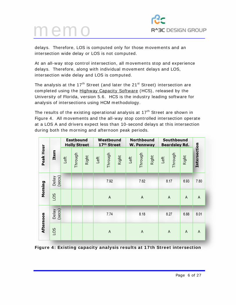
The results of the existing operational analysis at 17th Street are shown in Figure 4. All movements and the all-way stop controlled intersection operate at a LOS A and drivers expect less than 10-second delays at this intersection during both the morning and afternoon peak periods.
Figure 4: Existing capacity analysis results at 17th Street intersection
memo
Page 7 of 27
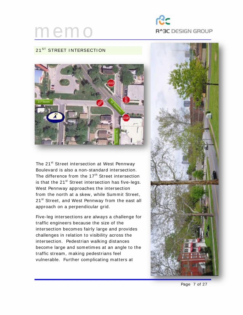
21ST STREET INTERSECTION
The 21st Street intersection at West Pennway Boulevard is also a non-standard intersection. The difference from the 17th Street intersection is that the 21st Street intersection has five-legs. West Pennway approaches the intersection from the north at a skew, while Summit Street, 21st Street, and West Pennway from the east all approach on a perpendicular grid.
Five-leg intersections are always a challenge for traffic engineers because the size of the intersection becomes fairly large and provides challenges in relation to visibility across the intersection. Pedestrian walking distances become large and sometimes at an angle to the traffic stream, making pedestrians feel vulnerable. Further complicating matters at
memo
Page 8 of 27
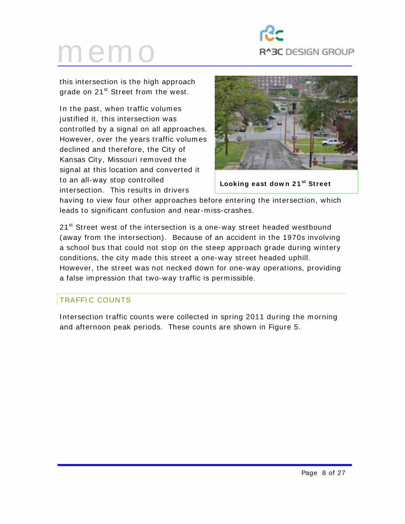
this intersection is the high approach grade on 21st Street from the west.
In the past, when traffic volumes justified it, this intersection was controlled by a signal on all approaches. However, over the years traffic volumes declined and therefore, the City of Kansas City, Missouri removed the signal at this location and converted it to an all-way stop controlled intersection. This results in drivers having to view four other approaches before entering the intersection, which leads to significant confusion and near-miss-crashes.
21st Street west of the intersection is a one-way street headed westbound (away from the intersection). Because of an accident in the 1970s involving a school bus that could not stop on the steep approach grade during wintery conditions, the city made this street a one-way street headed uphill. However, the street was not necked down for one-way operations, providing a false impression that two-way traffic is permissible.
TRAFFIC COUNTS
Intersection traffic counts were collected in spring 2011 during the morning and afternoon peak periods. These counts are shown in Figure 5.
Looking east down 21st Street

memo
Page 9 of 27
There is a high volume of traffic that uses Summit Street going north-south in the morning and afternoon peak periods. Significantly higher traffic volumes use Summit Street to go north on West Pennway.
South of the intersection, Summit Street is well used to access Interstate 35 (I-35), just east of this intersection. However, the traffic volume performing this movement during the peak periods is not high.
CAPACITY ANALYSIS
As with the 17th Street intersection, we completed a capacity and operational analysis of this intersection to document current operational levels. Being a five legged intersection, standard methods of analysis do not apply. The
Figure 5: Traffic counts at 21st Street and West Pennway
memo
Page 10 of 27
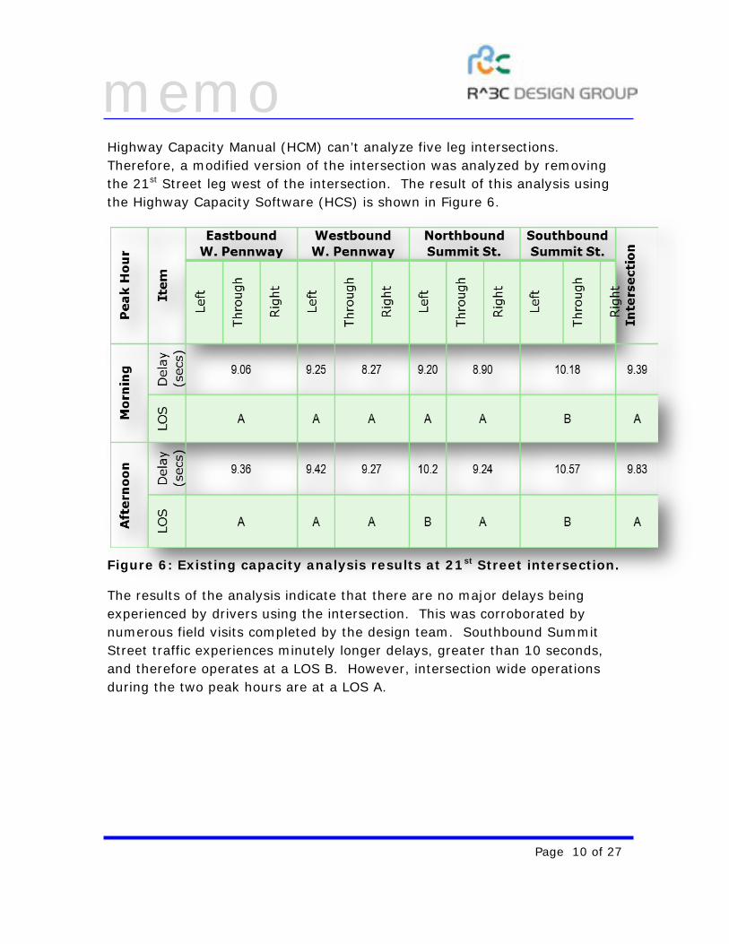
Highway Capacity Manual (HCM) can’t analyze five leg intersections. Therefore, a modified version of the intersection was analyzed by removing the 21st Street leg west of the intersection. The result of this analysis using the Highway Capacity Software (HCS) is shown in Figure 6.
Figure 6: Existing capacity analysis results at 21st Street intersection.
The results of the analysis indicate that there are no major delays being experienced by drivers using the intersection. This was corroborated by numerous field visits completed by the design team. Southbound Summit Street traffic experiences minutely longer delays, greater than 10 seconds, and therefore operates at a LOS B. However, intersection wide operations during the two peak hours are at a LOS A.
memo
Page 11 of 27
ADDITIONAL STUDIES
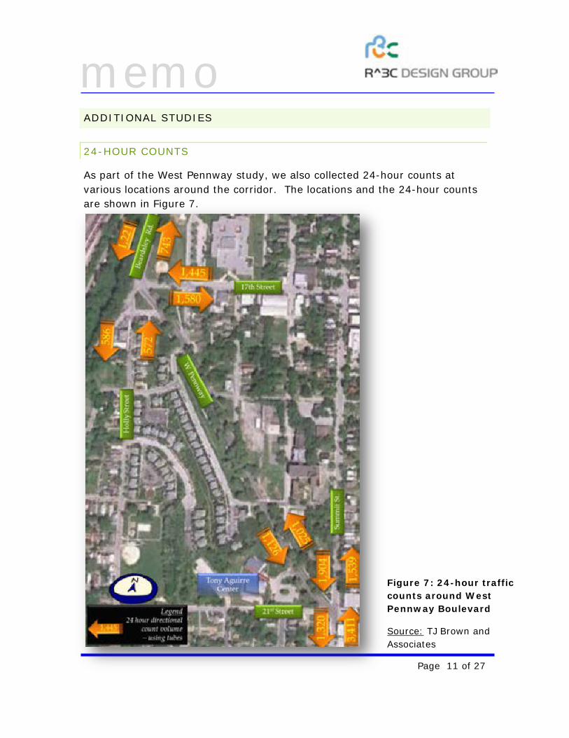
24-HOUR COUNTS
As part of the West Pennway study, we also collected 24-hour counts at various locations around the corridor. The locations and the 24-hour counts are shown in Figure 7.
Figure 7: 24-hour traffic counts around West Pennway Boulevard
Source: TJ Brown and Associates
memo
Page 12 of 27
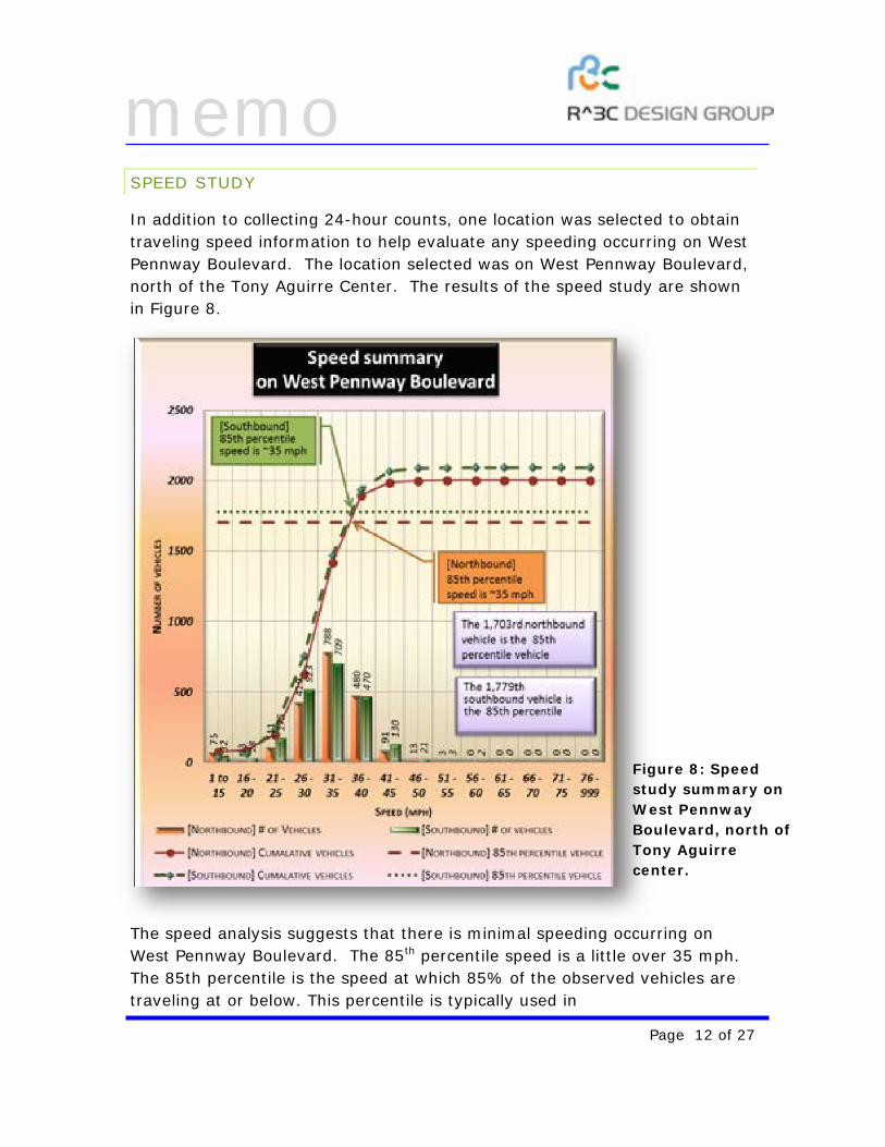
SPEED STUDY
In addition to collecting 24-hour counts, one location was selected to obtain traveling speed information to help evaluate any speeding occurring on West Pennway Boulevard. The location selected was on West Pennway Boulevard, north of the Tony Aguirre Center. The results of the speed study are shown in Figure 8.
The speed analysis suggests that there is minimal speeding occurring on West Pennway Boulevard. The 85th percentile speed is a little over 35 mph. The 85th percentile is the speed at which 85% of the observed vehicles are traveling at or below. This percentile is typically used in
Figure 8: Speed study summary on West Pennway Boulevard, north of Tony Aguirre center.
memo
Page 13 of 27
evaluating/recommending posted speed limits based on the assumption that 85% of the drivers are traveling at a speed they perceive to be safe.
However, we should note that 107 of the 1,703 (approximately 6.5%) northbound vehicles were traveling at speeds greater than 40 mph. Similarly, 156 of the 2,093 (approximately 7.5%) southbound vehicles are traveling at speeds greater than 40 mph.
DEVELOPING FUTURE ALTERNATIVES
As we have observed during the existing conditions analysis, the traffic volumes are comparatively lower than similar intersections in the Kansas City Metro area. However, both the 17th Street and the 21st Street intersections are awkward, non-standard intersections which could confuse the driver, and are not conducive to developing the walking/biking environment that the Parks and Recreation Department, the stakeholders and community leaders desire. Because of the opportunities that present themselves due to the lower-than-usual traffic volumes, a series of geometric improvements at the intersections were presented to the stakeholders. A brief discussion of each is presented here.
17TH STREET INTERSECTION
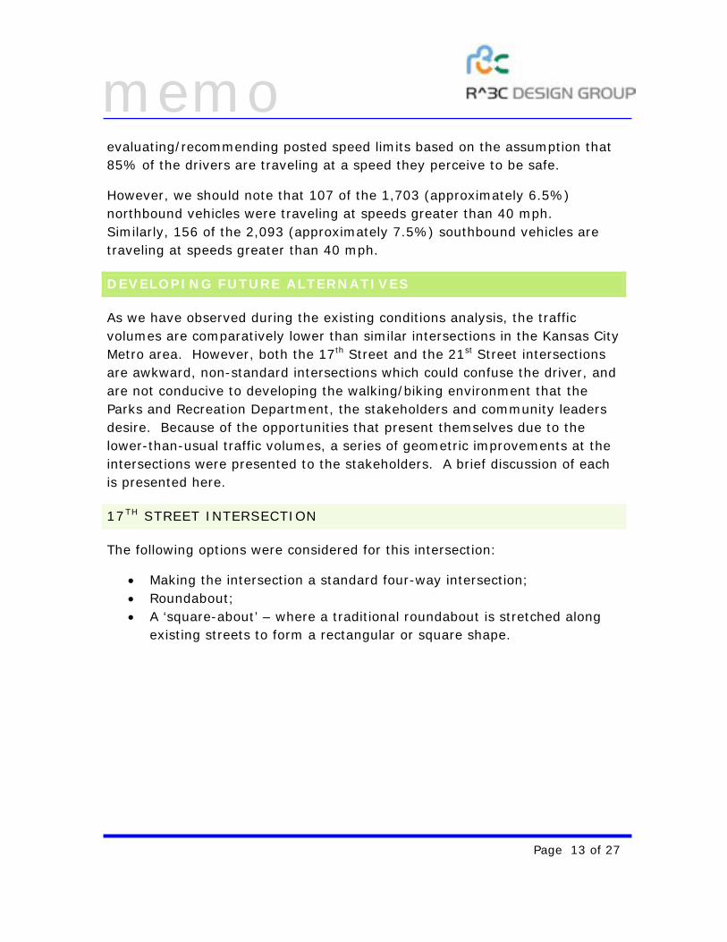
The following options were considered for this intersection:
• Making the intersection a standard four-way intersection; • Roundabout; • A ‘square-about’ – where a traditional roundabout is stretched along
existing streets to form a rectangular or square shape.
memo
Page 14 of 27
STANDARD FOUR-WAY INTERSECTION
In this option, West Pennway Boulevard follows its current alignment. Holly Street, Beardsley Road and 17th Street are curved to form a standard four-way intersection. Intersection control here can be a less restrictive two-way stop control intersection, or a more-restrictive all-way stop control intersection.
ROUNDABOUT
The roundabout option realigns the roadways as discussed in the standard four-way intersection. However, intersection control would be achieved using a roundabout. Roundabouts are more pedestrian friendly options, and assist in slowing down traffic using the intersection. However, they are not as friendly to larger vehicles as school buses, and emergency vehicles.
With two schools accessing this intersection, a large number of buses would continue to be expected. A roundabout could pose a challenge for these buses.
Further, for a roundabout to operate at optimal operational levels, the volumes of traffic from all four approaches of the roundabout should be near equal. This distribution is not available at this
memo
Page 15 of 27
location. During stakeholder meetings, minimal interest was shown towards building a roundabout at this intersection, and therefore, we are not pursuing analysis for this option.
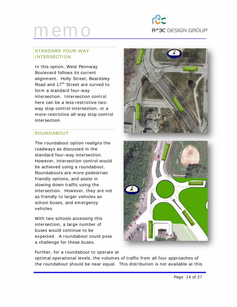
SQAURE-ABOUT
The square-about is a modified roundabout where the existing roadway network is used to develop an island in West Pennway that could serve as an entry feature to the boulevard. The island could service any use from retail to civic. The first version of the square-about was a one-way rectangle. However, during stakeholder and design team meetings, it was decided that it was best to retain truck traffic going east on 17th Street instead of rerouting truck traffic to residential frontages. Therefore, the one-way square about was changed by making 17th Street a two-way street. Further, this would assist with the school bus traffic at the intersection.
Because of stakeholder and public reactions, only the standard four-way intersection and the square-about options are being further considered for analysis.
21ST STREET INTERSECTION
The following options were recognized and presented for this intersection:
• Roundabout, • Improving the existing intersection and • Eliminating the 21st Street leg.
memo
Page 16 of 27
ROUNDABOUT
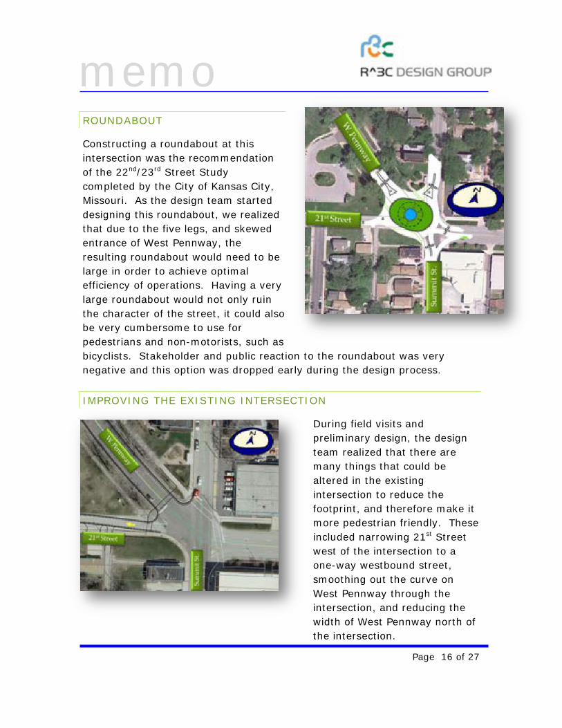
Constructing a roundabout at this intersection was the recommendation of the 22nd/23rd Street Study completed by the City of Kansas City, Missouri. As the design team started designing this roundabout, we realized that due to the five legs, and skewed entrance of West Pennway, the resulting roundabout would need to be large in order to achieve optimal efficiency of operations. Having a very large roundabout would not only ruin the character of the street, it could also be very cumbersome to use for pedestrians and non-motorists, such as bicyclists. Stakeholder and public reaction to the roundabout was very negative and this option was dropped early during the design process.
IMPROVING THE EXISTING INTERSECTION
During field visits and preliminary design, the design team realized that there are many things that could be altered in the existing intersection to reduce the footprint, and therefore make it more pedestrian friendly. These included narrowing 21st Street west of the intersection to a one-way westbound street, smoothing out the curve on West Pennway through the intersection, and reducing the width of West Pennway north of the intersection.
memo
Page 17 of 27
ELIMINATING THE 21ST STREET LEG
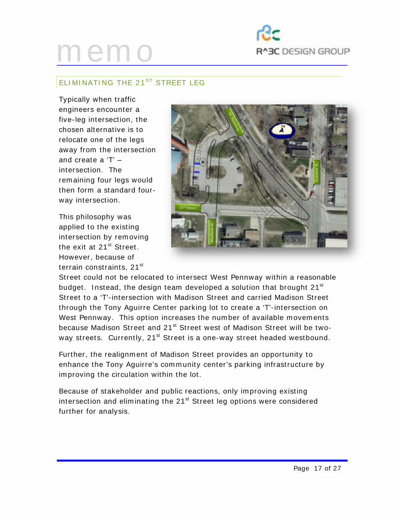
Typically when traffic engineers encounter a five-leg intersection, the chosen alternative is to relocate one of the legs away from the intersection and create a ‘T’ –intersection. The remaining four legs would then form a standard four-way intersection.
This philosophy was applied to the existing intersection by removing the exit at 21st Street. However, because of terrain constraints, 21st Street could not be relocated to intersect West Pennway within a reasonable budget. Instead, the design team developed a solution that brought 21st Street to a ‘T’-intersection with Madison Street and carried Madison Street through the Tony Aguirre Center parking lot to create a ‘T’-intersection on West Pennway. This option increases the number of available movements because Madison Street and 21st Street west of Madison Street will be two-way streets. Currently, 21st Street is a one-way street headed westbound.
Further, the realignment of Madison Street provides an opportunity to enhance the Tony Aguirre’s community center’s parking infrastructure by improving the circulation within the lot.
Because of stakeholder and public reactions, only improving existing intersection and eliminating the 21st Street leg options were considered further for analysis.
memo
Page 18 of 27
FUTURE YEAR TRAFFIC OPERATIONS ANALYSIS
As discussed in the prior section, two options for each intersection were carried forward for further analysis. Analysis was completed using the Highway Capacity Software (HCS) based on the methods prescribed in the Highway Capacity Manual (HCM).
TRAFFIC VOLUMES
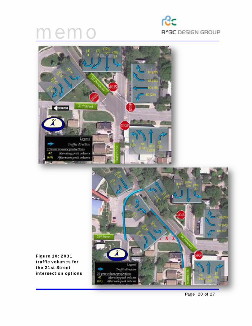
Because any improvement should last well into the future, we tested the four options for operations during the year 2031. We assume that the traffic demand on the corridor will increase at a one-percent (1%) growth rate over the next 20-years. This increases traffic by approximately 22% over the next 20-years. The 1% growth rate was determined appropriate for this analysis because these intersections and the West Pennway corridor lie in a well-established and developed area of the Kansas City Metro area.
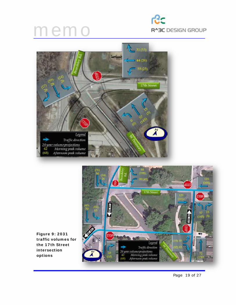
Using the 1% growth rate, current traffic counts shown in Figures 3 and 5 are reallocated and expanded for each of the options at each of the intersections being considered. These future reallocated volumes are summarized in Figures 9 and 10.
memo
Page 19 of 27
Figure 9: 2031 traffic volumes for the 17th Street intersection options
memo
Page 20 of 27
Figure 10: 2031 traffic volumes for the 21st Street intersection options
memo
Page 21 of 27
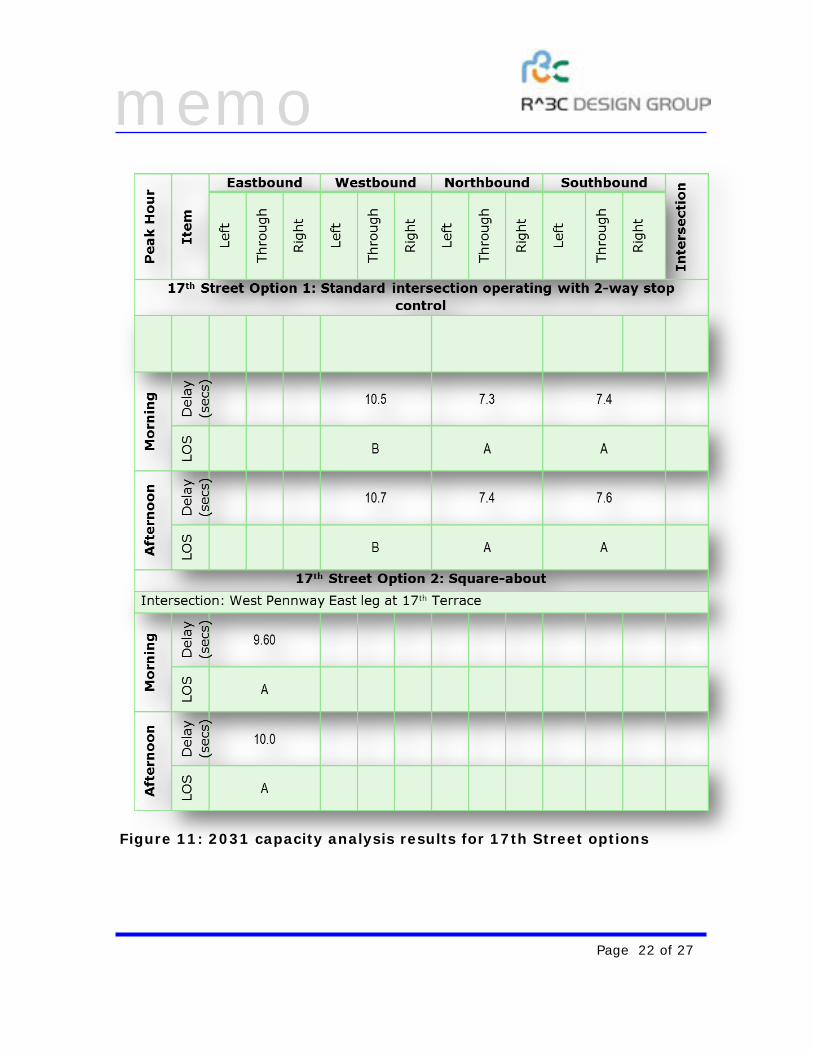
CAPACITY ANALYSIS
Using the traffic volumes shown in Figures 9 and 10, capacity and operational analysis was completed for the two options at each intersection. Because West Pennway is the primary through street, we first test the system for a less-restrictive two-way stop condition at both intersections.
Therefore, for the 17th Street standard four-way intersection, only traffic on 17th Street / Holly Avenue is stopped. Similarly, for the eliminate 21st Street leg option at the 21st Street intersection, Summit Street traffic is stopped while the West Pennway traffic is allowed to flow freely.
The results of the analysis at each of the intersections are presented in Figure 11 for the 17th Street intersection and Figure 12 for the 21st Street intersection options.
memo
Page 22 of 27
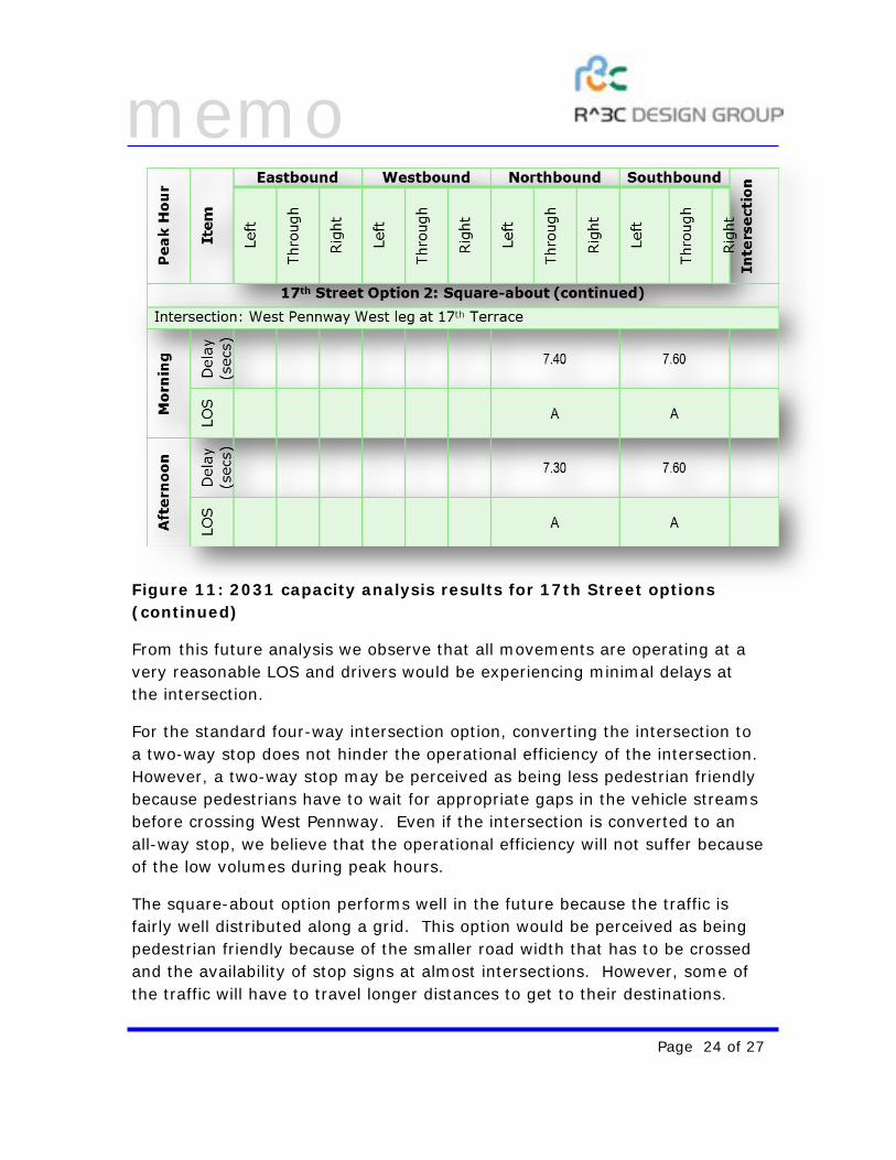
Figure 11: 2031 capacity analysis results for 17th Street options
memo
Page 23 of 27
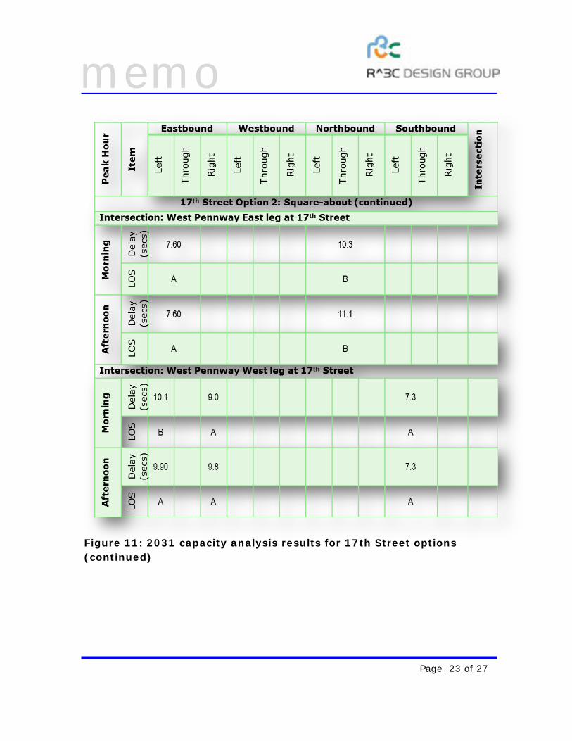
Figure 11: 2031 capacity analysis results for 17th Street options (continued)
memo
Page 24 of 27
Figure 11: 2031 capacity analysis results for 17th Street options (continued)
From this future analysis we observe that all movements are operating at a very reasonable LOS and drivers would be experiencing minimal delays at the intersection.
For the standard four-way intersection option, converting the intersection to a two-way stop does not hinder the operational efficiency of the intersection. However, a two-way stop may be perceived as being less pedestrian friendly because pedestrians have to wait for appropriate gaps in the vehicle streams before crossing West Pennway. Even if the intersection is converted to an all-way stop, we believe that the operational efficiency will not suffer because of the low volumes during peak hours.
The square-about option performs well in the future because the traffic is fairly well distributed along a grid. This option would be perceived as being pedestrian friendly because of the smaller road width that has to be crossed and the availability of stop signs at almost intersections. However, some of the traffic will have to travel longer distances to get to their destinations.
memo
Page 25 of 27
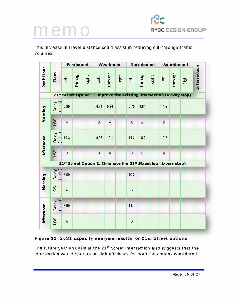
This increase in travel distance could assist in reducing cut-through traffic volumes.
Figure 12: 2031 capacity analysis results for 21st Street options
The future year analysis at the 21st Street intersection also suggests that the intersection would operate at high efficiency for both the options considered.
memo
Page 26 of 27
Option 1 – cleaning up the existing five-legged intersection does not hinder traffic flow. However, the existing driver confusion in navigating a five-way intersection remains. Converting the intersection to a two-way stop with five-legs could reduce vehicular safety because of its complexity. Further, because of its large footprint and angled crossings, the five-leg option may continue to be perceived as being unfriendly and cumbersome to pedestrians.
The second option of eliminating the 21st Street leg to the west and creating two ‘T’ intersections, one at Madison Street and at West Pennway, provides a standardized solution in tough terrain conditions. The intersection footprint reduces considerably, creating a favorable walking environment. We also believe that traffic circulation into and out of the Tony Aguirre Community Center improves with this option.
SUGGESTIONS FOR IMPROVEMENTS
R^3C Design Group as part of a design team lead by el dorado, inc., was charged with analyzing intersection operations at the 17th Street and 21st Street intersection on West Pennway Boulevard for the Kansas City, Missouri, Parks and Recreation Department. The Parks Department desires to improve the roadway for:
• Improved traffic flow in the corridor bounded by 17th Street to the north, and 21st Street to the south;
• Improve the pedestrian experience on the George Kessler designed Boulevard and convert it to a 21st century parkway.
Existing traffic counts and speed data were analyzed to show that no major congestion issues or speeding issues were prevalent in the corridor. Because both the 17th Street and 21st Street intersections are skewed, non-standard and awkward intersections, driver confusion and pedestrian unfriendliness abound.
Because challenges at the intersection were not operational, many suggestions with few constraints presented themselves. One of the primary constraints at the 21st Street intersection was the rough terrain west of the intersection. Numerous options were presented to the stakeholders and
memo
Page 27 of 27
citizens of the corridor and two options were selected for each intersection. Based on stakeholder reactions, the options are as follows:
• 17th Street: o Standard four-way intersection with three of the four legs to the
intersection realigned to create a four-way intersection, and; o A square-about created by modifying existing streets south of
17th Street to one-way operations while maintaining 17th Street as two-way in order to accommodate truck traffic.
• 21st Street: o Clean-up the existing intersection by narrowing down West
Pennway and the 21st Street one-way exit from the intersection to standard widths for operation, and;
o Eliminate the 21st Street leg by creating a ‘T’ intersection with Madison Street and then continuing Madison Street through to West Pennway to create another T-intersection. This improves traffic circulation to the neighborhood because both Madison Street and 21st Street will be converted to two-way operations.
The four options were analyzed for projected traffic volumes generated by increasing the existing traffic counts by one-percent (1%) per year for 20 years. The 2031 analysis did not indicate any developing operational constraints, and all four options are projected to perform reasonably well with drivers experiencing minimal delays.
Because all options being considered are operationally efficient, the final selection for each intersection should be based on stakeholder, citizen and Parks Department preferences. Because all concerned groups prefer a walk-able environment, consideration should be given to the following selections:
17th Street – standard 4-way intersection 21st Street – eliminate the 21st Street leg at the intersection.