wellington park no. 1 well · ing, mud logging, coring. cuttings examination. and electric logging...
TRANSCRIPT
,'"
COMMONWEALTH OF AUSTRALIA
DEPARTMENT OF NATIONAL DEVELOPMENT
BUREAU OF MINERAL RESOURCES, GEOLOGY AND GEOPHYSICS
Petroleum Search Subsidy Acts
PUBLICATION No. 71
SUMMARY OF DATA AND RESULTS
GIPPSLAND BASIN, VICTORIA
Wellington Park No. 1 Well
OF
WOODSIDE (LAKES ENTRANCE) OIL COMPANY N.L.
Issued under the Authority of the Hon. David Fairbairn
Minister for National Development1966\'L

COMMONWEALTH OF AUSTRALIA
DEPARTMENT OF NATIONAL DEVELOPMENT
MINISTER: THE HON. DAVID FAIRBAIRN, D.F.C., M.P.
SECRETARY: R. W. BOSWELL
BUREAU OF MINERAL RESOURCES, GEOLOGY AND GEOPHYSICS
DIRECTOR: J. M. RAYNER
THIS REPORT WAS PREPARED FOR PUBLICATION IN THE PETROLEUM EXPLORATION BRANCH
ASSISTANT DIRECTOR: M. A. CONDON
Published by rhe Bureau of Mineral Resources, Geology and Geophysics
Canberra A.C.T.

FOREWORD
Under the Petroleum search Subsidy Act 1959, agreements relating to subsidizedoperations provide that the information obtained may be published by the CommonwealthGovernment twelve months after the completion of field work.
The growth of the exploration effort has greatly increased the number ofsubsidized projects and this increase has led to delays in publishing the results of operations.
The detailed results of subsidized operations may be examined at the office ofthe Bureau of Mineral Resources in Canberra (after the agreed period) and copies of thereports may be purchased.
In order to make the main results of operations available early, short summariesare being prepared for publication. These will be grouped by area and date of completionas far as practicable. Drilling projects and geophysical projects will be grouped separately.In due course, full reports will be published concerning those operations which have producedthe more important new data.
This Publication contains a summary of data and results of the drilling operationundertaken at Wellington Park No. 1 in the Gippsland Basin, Victoria. The information hasbeen abstracted by the Petroleum Exploration Branch of the Bureau of Mineral Resourcesfrom the well completion report furnished by Woodside (Lakes Entrance) Oil Company NoLiability.
J.M. RAYNERDIRECTOR
,
CONTENTS
SUMMARY
WELL HISTORY
General data
Drilling data
Logging and testing
GEOLOGY
General
Stratigraphy
Structure
Relevance to occurrence of petroleum
Contribution to geological concepts resulting fromdrilling
REFERENCES
ADDITIONAL DATA FILED IN THE BUREAU OF MINERAL
RESOURCES
ILLUSTRAnONS
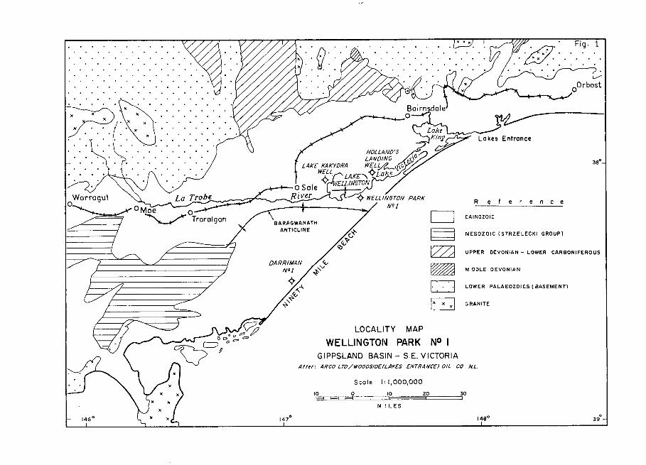
Figure 1: Locality Map, Wellington Park No. 1
Plate 1: Composite Well Log, Wellington Park No. 1(Five sheets)
1
2
2
2
3
4
4
4
6
6
7
7
7
Frontispiece
At back of report
.........\J .B· '. '.'
x .)( l( ••
x .• ')(. . '. )(. . . . . .........
Reference
c=J CAINOZOIC
~ MESOZOIC (STRZELECKI GROUP)
~ UPPER DEVONIAN - LOWER CARBONIFEROUS
~ MIDDLE DEVONIAN
c==J LOWER PALAEOZOICS l BASEMENT)
~ GRANITE
20 30==r:======,
10E
M I L ES
Scale 1'1,000,000
LOCALITY MAP
WELLINGTON PARK NO IGIPPSLAND BASIN - S.E. VICTORIA
10 0E3 F3 F3
After: ARCO LTO/WOOOSIOE(LAKES ENTRANCE) OIL CO NL.
La Trobe
°Moe °~ Trorolgon
Worrogul
°

WELLINGTON PARK NO. 1
SUMMARY OF DATA AND RESULTS.
SUMMARY
Wellington Park No. 1 Well was located in the Gippsland Basin, Victoria, on thesouth-eastern shore of Lake Wellington. about 25 1/2 miles south-west of Bairnsdale. Thewell was drilled by Oil Drilling and Exploration Limited for Woodside (Lakes Entrance)Oil Company No Liability. to a total depth of 12,011 feet. Drilling commenced on 6th December.1961 and was completed on 3rd April. 1962. A comprehensive programme of drilling engineer.ing, mud logging, coring. cuttings examination. and electric logging was conducted, but nosignificant shows of oil or gas were encountered.
The well penetrated Quaternary sediments from surface to 120 feet. Tertiarysediments from 120 to 3370 feet. and Mesozoic non-marine sediments from 3370 feet. andbottomed in the Lower Cretaceous - (?)Jurassic Strzelecki Group at 12,011 feet. Palaeozoicrocks. one of the main objectives. were not reached because of the extreme thickness of theMesozoic section.
Five open hole formation tests over variOUS intervals between 7348 and 9930feet were undertaken, but only three were successful. These tests produced mud filtrate,mud, and formation water. The well was plugged and abandoned as a dry hole on 7th April,1962.
The stratigraphic drilling operation at Wellington Park No. 1 was subsidizedunder the Petroleum Search Subsidy Act 1959. from 3391 feet to total depth.
• Abstracted from:F.T. Ingram, ArcoJuly. 1962.
Well Completion Report Wellington Park No. 1 Well, Victoria, byLimited, for Woodside (Lakes Entrance) Oil Company No Liability.
1
General Data
Well name and number:
Location:
Name and address ofTenement Holder:
Details of PetroleumTenement:
Total Depth:
Date drilling commenced:
Date drilling completed:
Date well abandoned:
Date rig released:
Elevation (ground):
Elevation (K.B.):
Status:
Cost:
Drilling Data
Drilling Plant:
Make:
Type:
WELL HISTORY
Wellington Park No. 1o
Latitude 38 08'25"'8.o
Longitude 147 22' 30"E.
Woodside (Lakes Entrance) Oil Company No Liability,792 Elizabeth Street,Melbourne, Victoria
Petroleum Exploration Permit No. 44, issued by theState of Victoria
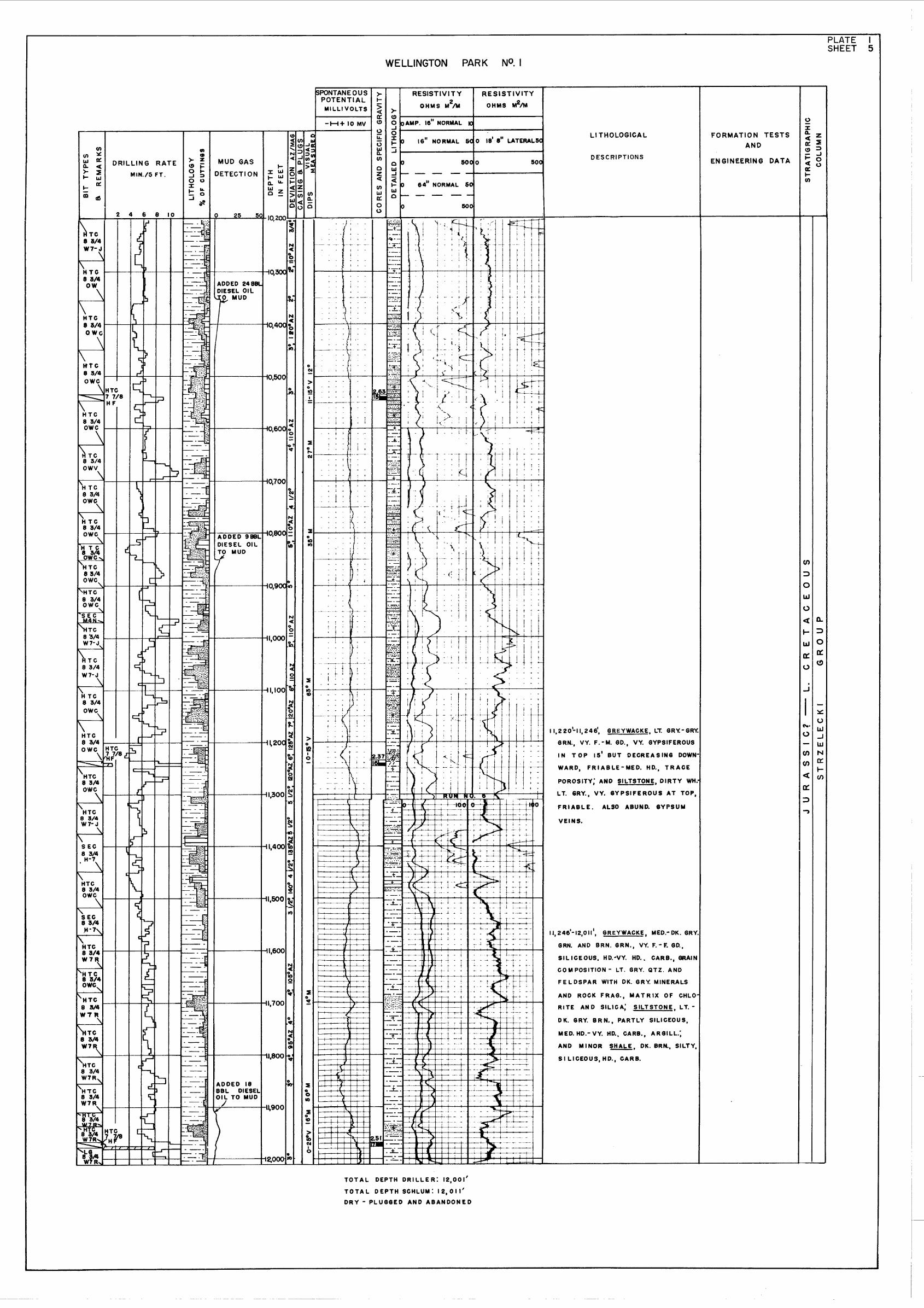
12,011 feet (Schlumberger)
6th December, 1961
3rd April, 1962
7th April, 1962
7th April, 1962
2 feet
21 feet (datum for depths)
Dry hole; plugged and abandoned
£221,953
National-Ideal
55
Hole sizes and depths: 17 J!2" to 736 feet
12 J!4" to 5379 feet
8 ;V4" to 12011 feet
Casing details:
Size (in.): 20 13 ;V8 9 &18
Weight (lb.lft): 94 48 36
Grade: HAO HAO J.55
Range: 1 2 2
Setting depth (ft): 19 726 5379
2
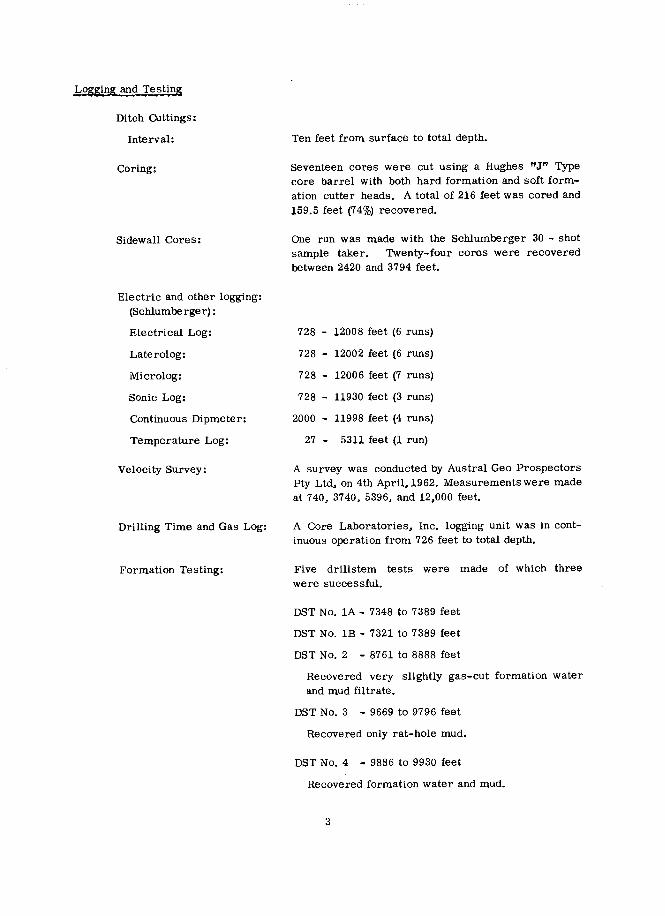
Loggi;ng and Testing
Ditch Cuttings:
Interval:
Coring:
Sidewall Cores:
Ten feet from surface to total depth.
Seventeen cores were cut using a Hughes "JI9 Typecore barrel with both hard formation and soft formation cutter heads. A total of 216 feet was cored and159.5 feet (74%) recovered.
One run was made with the Schlumberger 30 - shotsample taker. Twenty-four cores were recoveredbetween 2420 and 3794 feet.
728 - 12008 feet (6 runs)
728 - 12002 feet (6 runs)
728 - 11930 feet (3 runs)
2000 - 11998 feet (4 runs)
27 - 5311 feet (1 run)
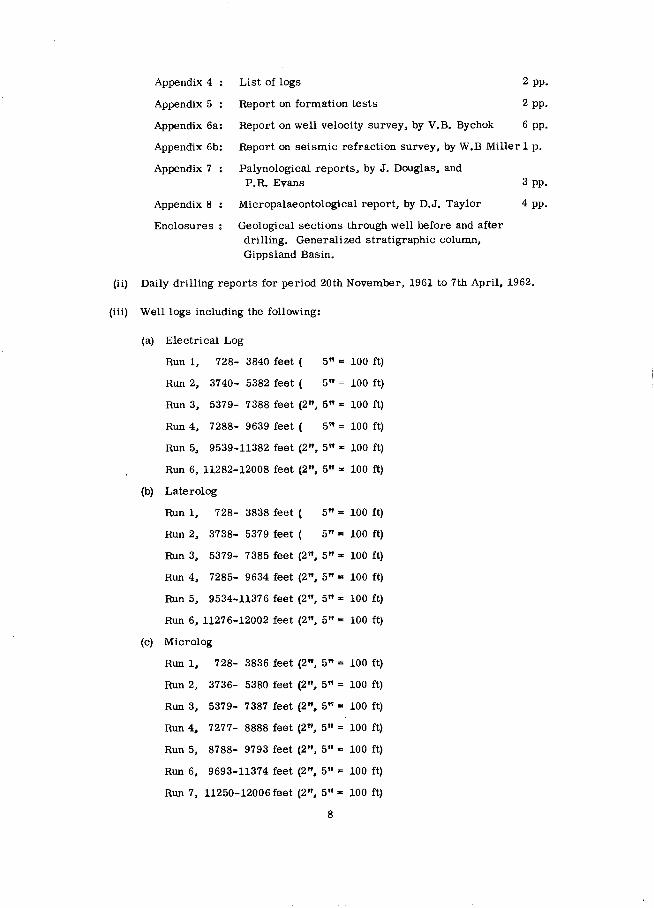
Electric and other logging:(Schlumberger) :
Electrical Log:
Laterolog:
Microlog:
Sonic Log:
Continuous Dipmeter:
Temperature Log:
728 12006 feet (7 runs)
Velocity Survey:
Drilling Time and Gas Log:
Formation Testing:
A survey was conducted by Austral Geo ProspectorsPty Ltd, on 4th April,1962. Measurements were madeat 740, 3740, 5396, and 12,000 feet.
A Core Laboratories, Inc. logging unit was in continuous operation from 726 feet to total depth.
Five drillstem tests were made of which threewere successful.
DST No. lA - 7348 to 7389 feet
DST No. 1B - 7321 to 7389 feet
DST No. 2 - 8761 to 8888 feet
Recovered very slightly gas-cut formation waterand mud filtrate.
DST No. 3 - 9669 to 9796 feet
Recovered only rat-hole mud.
DST No. 4 - 9886 to 9930 feet
Recovered formation water and mUd.
3

GEOLOGY
General
The area around the well location is flat-lying, and covered by Quaternarysand a.nd clay.
The geology of the Tertiary sediments in the Gippsland Basin is well knownfrom numerous water bores, wells drilled for oil by private companies, and core holes drilledby the Victorian Department of Mines. The geology of the Mesozoic section in the Basin,prior to drilling Wellington Park No. 1, was known from reports on outcrops in the StrzeleckiRanges, and from wells drilled through the Tertiary sequence. At least thirteen wells haveentered Mesozoic rocks, but only six of these penetrated more than about 100 feet of the section.The deepest well drilled in the area before Wellington Park No. 1 was the Woodside No. 2 Well,which bottomed in sediments of the Strzelecki Group at 8862 feet.
The Palaeozoic rocks, which are believed to underlie the Mesozoic section inthe Lake Wellington area, are exposed along the northern side of the Gippsland Basin.Numerous reports, by private companies and the Victorian Department of Mines, describe thestratigraphy and structure of these rocks. Only one well in the vicinity of Wellington ParkNo. 1" Frome Lakes Pty Ltd No. 5, located about six miles south-west of Bairnsdale, and completedin 1957 at 1550 feet, has encountered these Palaeozoic rocks.
Stratigraphy
The stratigraphic sequence encountered in Wellington Park No. 1 Well is shownin the Table below:
Quaternary
Upper Pliocene
Lower Pliocene
Upper Miocene
Miocene
Oligocene
Lower Oligocene Upper Eocene
(?) Lower Cretaceous
Lower Cretaceous -
(?)Jurassic
Formation
Alluvium
Haunted Hill Gravels
Jemmy's Point Formation
Tambo River Formation
Gippsland Limestone
Lakes Entrance Formation
Latrobe Valley CoalMeasures
Unnamed
Strzelecki Group
4
DeEth Intervals Thickness(feet) (feet)
21 - 120 99
120 - 380 260
380 - 460 80
460 - 725 265
725 - 2150 1425
2150 - 2385 235
2385 - 3370 985
3370 - 3800 430
3800 -12011 8211+

Detailed:
Quaternary; Alluvium: Surface to 120 feet
White to red. medium to coarse-grained. subrounded sand with scatteredpebbles; and blue-green-brown clay.
Haunted Hill Gravels (U-e-eer Pliocene): 120 to 380 feet (260 feet)
Fine to coarse-grained. micaceous sand consisting of quartz grains of severalcolours. fragments of igneous and metamorphic rocks. traces of lignite and pyrite.with some pebbles.
Jemmy's Point Formation (Lower Pliocene): 380 to 460 feet (80 feet)
Sand similar to the Haunted Hill Gravels, with abundant remains of gastropods,pelecypods. bryozoa,and foraminifera. and with traces of soft. argillaceous siltstone.
Tambo River Formation (U-e-eer MiOcene): 460 to 725 feet (265 feet)
Brown to grey-green. silty and slightly sandy. friable to hard. glauconitic marl.with abundant fossil fragments.
Qippsland Limestone (Miocenel: 725 to 2150 feet (1425 feet)
Light to dark grey. sandy. argillaceous. glauconitic marl. with abundant bryozoaand other fossils. intercalated with grey to cream. fine-grained. fossiliferous limestonedown to 1600 feet. Below this depth the formation consists of soft, glauconitic. fossiliferous. silty mar! becoming more argillaceous towards the base.
Lakes Entrance Formation (Oligocene): 2150 to 2385 feet (235 feet)
Grey. green. and brown. soft. calcareous. glauconitic shale with abundantforaminifera.
Latrobe Valley Coal Measures (Lower Oligocene to U-e~rEocene): 2385 to 3370 feet (985 feet)
Brown, grey. and green. fine to coarse-grained, quartz sand, clean to argillaceousand lignitic; earthy. silty, and shaly brown coal; brown to grey-green. argillaceoussiltstone, mostly soft; light to dark brown lignitic clay; and traces of hard. tight,fine-grained. sucrosic, brown dolomite between 3029 and 3036 feet.
Unnamed Formation(Lower Cretaceous ?): 3370 to 3800 feet (430 feet)
Interbedded. brown to green. fine to coarse-grained, quartzose sandstone;commonly with weathered feldspar and white kaolin, and claystone and mudstone inwhich occur thin seams and laminations of black coal. The unit, which is lithologicallysimilar to the Lower Cretaceous Waarre Formation of the Otway Basin. grades downward into the Strzelecki Group.
5
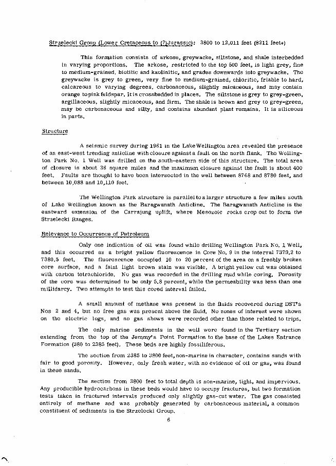
Strzelecki GrouE (Lower Cretaceous to (?)Jurassic): 3800 to 12,011 feet (8211 feet+)
This formation consists of arkose, greywacke, siltstone, and shale interbeddedin varying proportions. The arkose, restricted to the top 500 feet, is light grey, fineto medium-grained, biotitic and kaolinitic. and grades downwards into greywacke. Thegreywacke is grey to green, very fine to medium-grained, chloritic, friable to hard,calcareous to varying degrees, carbonaceous, slightly micaceous, and may containorange to pink feldspar. It is crossbedded in places. The siltstone is grey to grey-green.argillaceous, slightly micaceous, and firm. The shale is brown and grey to grey-green,may be carbonaceous and silty, and contains abundant plant remains. It is siliceousin parts.
Structure
A seismic survey during 1961 in the Lake Wellington area revealed the presenceof an east-west trending anticline with closure against a fault on the north flank. The Wellington Park No. 1 Well was drilled on the south-eastern side of this structure. The total areaof closure is about 36 square miles and the maximum closure against the fault is about 400feet. Faults are thought to have been intersected in the well between 8768 and 8780 feet, andbetween 10,088 and 10,110 feet.
The Wellington Park structure is parallel to alarger structure a few miles southof Lake Wellington known as the Baragwanath Anticline. The Baragwanath Anticline is theeastward extension of the Carrajung uplift. where Mesozoic rocks crop out to form theStrzelecki Ranges.
Relevance to Occurrence of Petroleum
Only one indication of oil was found while drilling Wellington Park No. 1 Well,and this occurred as a bright yellow fluorescence in Core No. 9 in the interval 7379.2 to7380.5 feet. The fluorescence occupied 10 to 20 percent of the area on a freshly brokencore surface, and a faint light brown stain was visible. A bright yellow cut was obtainedwith carbon tetrachloride. No gas was recorded in the drilling mud while coring. Porosityof the core was determined to be only 5.8 percent, while the permeability was less than onemillidarcy. Two attempts to test this cored interval failed.
A small amount of methane was present in the fluids recovered during DST'sNos 2 and 4, but no free gas was present above the fluid. No zones of interest were shownon the electric logs, and no gas shows were recorded other than those related to trips.
The only marine sediments in the well were found in the Tertiary sectionextending from the top of the Jemmy's Point Formation to the base of the Lakes EntranceFormation (380 to 2385 feet). These beds are highly fossiliferous.
The section from 2385 to 3800 feet, non-marine in character, contains sands withfair to good porosity. However, only fresh water, with no evidence of oil or gas, was foundin these sands.
The section from 3800 feet to total depth is non-marine, tight, and impervious.Any producible hydrocarbons in these beds would have to occupy fractures, but two formationtests taken in fractured intervals produced only slightly gas-cut water. The gas consistedentirely of methane and was probably generated by carbonaceous material, a commonconstituent of sediments in the Strzelecki Group.
6
Contribution to Geological Concepts resulting from Drilling,
Because of the lack of recognizable "key" beds in the Strzelecki Group, and thestructural complexity in the areas of outcrop, estimates of the thickness of this sequence haveranged from 2000 to 20,000 feet. Wellington Park No. 1 Well has proved a thicknessof possibly 8641 feet for the Strzelecki Group in the Lake Wellington area. The informationgained from the refraction survey profile through the well suggests the th~ckness may begreater than 10,000 feet.
The Strzelecki Group, equivalent in lithology and approximate age to theOtway Group in south-western Victoria, is now thought to be mostly Lower Cretaceous inage, with possible Upper Jurassic in the basal part. Palynological work on cores fromWellington Park No. 1 suggests that the well was still in Lower Cretaceous at 11,246 feet.The last core from 11,969 to 11,975 feet was barren of recognizable spores.
The section from 3370 to 3800 feet, consisting of poorly consolidated sands, shales.,mudstones, and minor coal, is similar in lithology and thickness to the sediments of theWaarre Formation in the Otway Basin, where they represent a transition from marine MiddleCretaceous above to the non-marine Otway Group below. These same poorly consolidatedbeds were encountered in the Rosedale No. 1 Well in the interval 2345 to 2800 feet. Thereis no sharp boundary at the base of the poorly consolidated unit; rather, it appears to be
gradational downward into kaolinitic arkose, which in turn grades into grey-green greywacke.
REFERENCES
BOUTAKOFF, N.,
DUDLEY, P.H.,
RINGWOOD, A.E.,
1955:
1959:
1955:
A new approach to petroleum geologyand oil possibilities in Gippsland. ~.geol. J. 5 (4-5).
Oil possibilities of Petroleum Prospecting Licence 212 in the South GippslandHighlands, Victoria. Report for Victorian Oil N.L. (Unpubl.).
The geology of the Mitchell River area.Report for Frome-Lakes Pty Ltd (Unpubl.).
ADDITIONAL DATA FILED IN THE
BUREAU OF MINERAL RESOURCES
The follOWing additional data relating to Wellington Park No. 1, have been filedin the Bureau of Mineral Resources, Canberra, and are available for reference:
(i) Well Completion Report, By F.T. Ingram 22 pp.
AppendiX 1
Appendix 2
Appendix 3
Core descriptions
Core analyses
Sidewall core descriptions
7
5 pp.
2 pp.
2 pp.
Appendix 4 List of logs 2 pp.
Appendix 5 Report on formation tests 2 pp.
Appendix 6a: Report on well velocity survey, by V.B. Bychok 6 pp.
Appendix 6b: Report on seismic refraction survey, by W.B Miller 1 p.
Appendix 7 Palynological reports, by J. Douglas. andP.R. Evans 3 pp.
Appendix 8: Micropalaeontological report, by D.J. Taylor 4 pp.
Enclosures: Geological sections through well before and afterdrilling. Generalized stratigraphic column,Gippsland Basin.
(ii) Daily drilling reports for period 20th November, 1961 to 7th April. 1962.
(Hi) Well logs including the following:
(a) Electrical Log
Run I, 728- 3840 feet ( 5" .. 100 ft)
Run 2, 3740- 5382 feet ( 5" = 100 it)
Run 3, 5379- 7388 feet (2", 5" .. 100 it)
Run 4, 7288- 9639 feet ( 5" = 100 ft)
Run 5, 9539-11382 feet (2", 5" "" 100 ft)
Run 6, 11282-12008 feet (2", 5" '" 100 ft)
(b) Laterolog
Run 1, 728- 3838 feet ( 5" .. 100 it)
Run 2, 3738- 5379 feet ( 5" .. 100 it)
Run 3. 5379- 7385 feet (2", 5" '" 100 ft)
Run 4, 7285- 9634 feet (2", 5" "" 100 it)
Run 5, 9534-11376 feet (2", 5" .. 100 it)
Run 6, 11276-12002 feet (2", 5" .. 100 ft)
(c) Microlog
Run 1. 728- 3836 feet (2", 5" = 100 ft)
Run 2, 3736- 5380 feet (2". 5" = 100 ft)
Run 3. 5379- 7387 feet (2". 5" '"' 100 ft)
Run 4. 7277- 8888 feet (2", 5" = 100 ft)
Run 5, 8788- 9793 feet (2", 5" .. 100 it)
Run 6, 9693-11374 feet (2". 5" = 100 it)
Run 7, 11250-12006 feet (2". 5" .. 100 it)
8
(d) Sonic Log
Run 1. 728- 3756 feet (2", 5" = 100 ft)
Run 2,5375- 9622 feet (2", 5" ,. 100 ft)
Run 3, 9520-11930 feet (2", 5" ,. 100 ft)
(e) Continuous Dipmeter
Composite log, plotted, Runs 1 to 4 (1.2" = 100 ft)
Run 1, 2000- 3772 feet
Run 2, 7994- 9440 feet
Run 3. 5375- 7994 feet
Run 3, 9440-11368 feet
Run 4. 11368-11998 feet
(f) Temperature Log
/..
Run 1, 27- 5311 feet (2" = 100 ft)
(g) Grapholog (Core Laboratories, Inc.)
Continuous log, 726-12011 feet (2" '" 100 ft)
9

WELL NUM 8 ER
COMPANY ARCO
COMPOSITE WELL LOG
L TD./WOODSIDE(LAKES ENTRANCE) OIL
WELLINGTON PARK N O. I
CO. N. L.
PLATESHEET
PETROLEUM TENEMENT: P.E.P. 44 ST ATE: VI CTORIA 4-MILE SHEET: WARRAGUL BASIN: GIPPSLAND WELL STATUS'. ABANDONED
l.OCATION - LAT. 3Bo08~ 25"S LONG. 1470 22' 3O"E
El.EVATION-REFERENCE PT. KB 21.1' ASL6ROUND 2.0' AS L
pATE SPUDDED DECEMBER 6,1 i61
::.DA:::.T:..;EI:-.:::D~R.:.l1L=.:L:.:.IJ:lN:.::G:....:S::.T.:..O~P~P..::E.:.D APRIL 3, 19e2
DATE RIG OFF APRIL 1,1962TQTAL DEPTH DRILLER 12,001'
E. LOG I 2, 0 I I'
CEMENT PL U GS SACKS25
100
~,-OPEN HO LE RECORD
OTHER BORE HOLE l.OGS
CQMPILED AND DRAWN BY FRANK T. INGRAM
SONIC 728'-37561 a 5375'-11,950' RUNS 1-3LATEROLQG 728'-12.002' RUNS 1-6MICRQLQG 728'-12,008' RUN' 1-7,DIPMETER 728'-5940' a 5579- n,-99B RUNS 1-4TEMPERATURE 27~5511' RUN ICQRE LAB MUD LOG 726'-12,011
1
CASING RECORD
RUN NC SIZE WT.-L8!INTERVAL- FT. BIT SIZE INTERVAL- FT.
INCHES TQ INCHES TO
I 13 3/8 48 SURF. 726 12 1/4 SURF. 756
2 9 5/8 36 3250 5379 11 1/2 SURF. 736
8 3/4 7!6 lS37t12 1/4 736 53798 !/4 5379 12011
ELECTRIC LOG DATA
RUN NUMBER I 2 3 4 5 6
DATE 14-12- 61 24-12-61 23-1-62 18-2-62 21-3-62 ~- 4-62
FOQTAGE LOGGED 311 2' '1642' 2009' 2351' 184-3 726'
LQGGED FROM 3840 5382 7388 9639 11382' 12008'
LQGGED TQ 728' 3740' 5379 7288 9539' 11,282
TQTAL DEPTH- E. LOG 3841 5383 7389 9640 11 313 12 011
TOTAL DEPTH-DRILLER 3839' 5381 7389' 9635 1I 376 12001
CASING SHOE- E. LOG 728 5379,CASING SHQE-DRILLER 726 726 5379 5379 5319 5379
BIT SIZE 83/4 83/4" 8 3/4 8 3/4 8 3/4 8 3/4
MUD KIND BENT. SPERSENE SPERSENE SPERSENE SPERSENE SPERSENE
TREATMENT SPERSENE XP 20 IXp 20/9IL I)(p 2Q/QIL IXP 2<YQIL IXP 2Q1QIL
WTR. LQSS eal50 M 9.5 4.5 7.0 11.4 5.8 S.2
WEIGHT LBSICU FT. 9.6 10.1 10.2 10.0 9.5 9.7VISCOSITY (SEC.) 36 39 42 47 43 52
pH 9.0 11.0 11.0 11.0 10.0 9.5
RESISTIVITY AM~M 1.36 0.75 0.8 0.62 0.62 0.49
AT TEMP. F 92° 96° ~ 20° 68° 90" 104°
MAX. RECQRDED TEMP. 127° 152" 190° 208° 240· 276"
ELECTRQDE SPACING 16" 16" 16" I 6-0' 16" 16
SYMMETRICAL 64 64 64 64" 64 64
18 8" 18 8 18 8" 18 8"- 11 8 18 8
NQN-SYMMETRICALRECQRDED BY WHITE WHITE IMETENIER WHITE WHITE WHITE
TQ
736'
6379'
12,011'
eMT. CMT'D TODRIVEN
460 SX SURF.625 SX 5250'
FRQM0'
736'
537i'
FRQM20'
5082'
IN.
17 V212 1/4
8 3/4
SR. DEPTHH-40 19'H-40 726'J-5lS 5379'
CASINI
IN. WT.20 94
13 a/8 4895/8 36
HOLE SIZE
~La.
l&J ~
Z ILll.IJ >(,) o ~
~ 0m
::j ~
er:....
C'I'
en.Jl&J>er:
l&J ~Z (!)l&J .J(,) .Jo X:J~ 0
l&J::j ...
Z::)
er:X
oZer:.J
en~
~
l.IJ
Z
o...enl.IJ
::il.IJ _
Z .Jl.IJ(,)
o
~ CALCAREQUS
B GLAUCONITIC
~ CARBQNACEQUS
o GYPSIFERQUS
FORMATION TESTS
AND
ENGINEERING DATA
HQLE R EAMED WITH
17 1/2" BIT TO 736'
DOLQMITE
LIMESTQNE
• CQAL
I
~ MICACEQUS
20'-38e', !M!Q. Wfi., YELL., CLEAR,MILKY
AND RED QTZ., F.-CRS. GD., OCC.
PEBBLES, TRACE~ OF LIGNITE AND
PYRITE; AND CLAY, BLUE. GRN. AND-r-LT. BRN., SOFT, $TICKY.
LI THOLOGICAL
460'-725', tdAB.L.. BRN., GRY. AND GRY.
GRN., SILTY AND SLY. SANDY,
FRIABLE- SLY. HARD, GLAUC., ABUND.
FOSSIL FRAG. !M!.2, AS ABOVE,
PROBABLY CAVINGS.
725~1600', ~,LT.-DK. 6RY., SQF,T
FIRM, VARYING ARGILL. CONTENT,
PARTLY SANDY, GLAUC., ABUND.
BRYQZOA AND OTHER FQSSlLS;
AND INTERCALATED LIMESTQNE,
TAN. GRY. AND CREAM, F. GD.,
FIRM-SLY. HARD, VER:f FOSS.,
TRACES OF INTERGRANULAR PQR.,
G LAUC.
DESCRIPTIONS
1600~2150', ~, LT.- MED. GRY., BRN.
AND TAN, FRIABLE-SOFT AND
GUMMY, VERY FOSS., GLAUC.,
BECOMIN-6 MQRE ARGILL. DOWNWARD,
PARTLY SILTY.
3801-460', Ul::I.Q, AS ABQVE WITH ABUND.
MACRO AND MICRO FQSSILS
500
t rI
!
I ; !
1 1r
,, i
1 ~.- .i i 1
I '
i ,
i ! I
, 1
! : j
I I, J
1 1 I• 1 '
1 I! I :
I I
t- +-l--,~I :
j I I
MUDSTQNE
ARKOSE
GREYWACKE
LITHOLOGIC REFERENCE
t I
I I I
! II
II •
~ I •
I !
I II I
1 , !
l I
, I II '
,t I l
I II I
I
i I~ +- t
j I
i !
I---- --
- f-
J t. .+ 1 j
I.
,
Ii1r i
RESISTIVITY
OHMS M2/M
l i
, I
~-.-
"T'" -.- MARL"T"" -.-
~~_.
g.,.,p._•.:.....~::;;.........
r~··:gj•• e;:,. '.'/:7.• /C7.
I '---- + -1-
50e 0
64" NORMAL SC
- ---SOC
RESISTIVITY
OHMS M2/M
....
>(!)l---~---~--------1o IoAMP. 16" NQRMAL IC-I1-------~I---------1o~ 10 16" NORMAL S( 0 18' 8" LATERAL5e
-1 .....--------+--------1
. ,.
' ...,' .
.,.
'~'.' NQTE CHANGE IIN SCALE AT: :~.:. RUN NQ.5
1::.=I- -~::1--------1--------1
.0.
.1' .
'0
:~'.+.
.-t..
t' .
: ....
','
>I-
~ex:(!)Q1It)UJa..(J)
oz«(J)
UJex:ot)
SILTSTON E
SANDSTONE
/SPONTANEOUSPOTENTIAL
MlbLIVQLTS
-H+IO MV
~ ~ CLAYSTONE
~ SHALE
1-------1---1. _~+_-------I---------I
1-------f---1'•.
I
D'·... ' . ..' ~.". ..
lX UJI- UJa.. 11-
UJ z0_
seI
25
MUD GAS
DETECTION
oI
Cl)
CD>- zQ) ~o ...-I ~o Co)::E:... I&.:::i 0
~
4 ~ 8 10
DRILLING RATE
MIN./5 FT.
Nt TED.e. - CEP H
( OR ~EC
..
IONI::.2K=~
t-+-+-+-+-+-F....:--==::..:-::=t------+- I...:_ --=- 100 rvCl)
o.J
er:IIItIIIs
~------4-' 200 ~
soetIL
::r::...~
1-------4-300 :ENC
o IAS SHQW, SLIGHT r.c CQRE,INTERVAL,~ NUMBER AND
et DEAD QIL SHQW RECQVERY (BLACK)
• LIVE QIL SH QW, SLIGHT • SIDE-WALL CQRE
o TLlTo-R~SCENCE
JL CIRCULATIQN LQSS, PARTIALX PLUGGED INTERVAL
AND S..... QF MUD t FQRMATIQN TESTFQSSILS INTEIRVAL a NUMBER
~ MACRO ~ PLANT 0 Q.H., @ IN CASING
A MICRO 0 SPQRE, PQLLEN
en(J) :lCUJ a::a.. «>- ~... UJ
... ex:CD c6
GLOBE
12. V4S 4 C t--+--+-+--+--+--I
WELL SYMBOLS
WELL HE~~ FITTINGS HALF CQLLAR QN13 3 'CASING WITH 1/1/' WELDED STEEL PLAT E
DRILLED BY QIL DRILLING a EXPLORATIQN LTD.
LQIGED BY SCHLUMBERGERMUD LOIIINI BY CQRE LAB
CEM ENTE D BY 01 L DRILLIN I a EXPLORATIQN LTD.
DRILLING, METHQD RQTAR Y

PLATE ISHEET 2
WELLINGTON PARK
en
enLIJtt::::>en«LIJ
LIJ~
Z
LIJ-I
0«00<!)o
uJ
~.
-u 0UJ
« ~
I- ~J.&J Z
::::J0:-
-1>-LIJ
o -I
J -I
I ~LIJ
Z LIJLIJo coo 0LIJ a::::5 t-
«-I
U)
::>o
o -I
en:::>oLIJ
o ~
« :::>t-LJJ 0
a:: a::o <!)
...J
C\.. LIJ
enN
en a:« ...a::
..,
FORMATION TESTS
AND
ENGINEERING DATADESCRIPTIONS
LI THOLOGICAL
2 IS01-238S'. !.!:!ill. GRN.-GRY. GRN. AND
BRN., SOFT AND GUMMY, VERY
CALC., ABUND. FORAMINIFE'RA,
ABUND. GLAUC., ESPECIALLY AT
BASE.
4290'- 4920'. MOSTLY SJ::!.A.!&. MED. GRY., GR"l
GRN. AND LAV., GRY., FIRM, CARB.,
ABUND. PLANT FOSSILS, PARTLY SlLTY;
AND SILTSTONE, LT.-MED. GRAY, LAV.
AND GRY. GRN.. , ARGILL., CARB., SLY.
MIC.; WITH OCC. THICK BEDS OF
GREYWACKE, LT. GRY.-eRY. GRN.,
CHLORITlC WITH ABUND. PINK FELl>'
SPAR, VY. F.- F. GO., FRIABLE- MED.
HD., CARB. LAMINAE COMMON, SLY.
VY. CALC., SLY. MIC., TIGHT•
COMMON, FRIABLE, FAIR POR.,
CARB.. ABUND. PLANT FOSSILS,POORL't
SORTED; CLAYSTON E AN['l MUDSTONE:
LT. BRN.- LT. GRY. AND CREAM, SOFT,
OFTEN LAMINATED WITH BLACK COAL,
ALSO THIN SEAMS OF COAL. GRADES
DOWNWARD INTO OONSOLrDATED
SEDIMENTS.
F.- CRS. GD., QTZ •• ANG.-SUBANG,
WEATHERE D FELDSPAR AND KAOLIN
'3800'-4290', ARKOSE, LT. GRY., F.- MED. GD.
ABUND. BIOTITE, WEATHERED FEl.DSPAf;
AND KAOLIN,· GRADING DOWNWARD
INTO GREYWACKE, GRY. GRN., F.- MED
GD.• FR IABLE-SLY, HARD. CAR B.,
CROSS-BEDDED; AND SHALE, LAVEN
DAR, SIL TY, FIRM, CARB. ALSO
THIN COAL SEAMS.
3370'-3800', (VERY POOR SAMPLES, UN
CONSOLIDATED SEDIMENTS WITH
ABUND. CAVINGS OF TERTI ARY
COAL AND SHALE) SANDSTONE,
2385'-3370', ~, BROWN, LT. GRY. AND
GRY. GRN., F.-CRS. GD., QTZ .• CLEAN
ARGILL., LIGNITlC, CALC. IN TOP
10', FAIR - GOOD POR.; BROWN
COAL, EARTHY, 0 FTEN SILTY AND
SHALY; SILTSTONE, BR". - GRY. GRN
ARGILL., SOFT, CALC. AND HARD
AT 5029'-se' AN D 3182'- 75': 2.!:.!!.LT.-DK. BRN., LIGNITIC~ AND TRACE
DOLOM ITE, BRN., F. GD., SUCROSIC,
BRITTLE -MED. HARD, TIGHT" AT
3029'-3e'.
RED BRN., LT. G~Y. AND GRN. GRY.,
50C
; ....
-l- -.--I i :i !! I
RESISTIVITY
OHMS M2tM
50C 0
j !,
: '
, !
i II !: ,
~.
'.,
6411
NORMAL se
RESISTIVITY
OHMS M21M
11,.:
'\.J-
:) ~~./
>-0t--------.f-------~o toAMP. 16
11NORMAL le...1 ..... -4- --1
oi: ~ 16
11 NORMAL SC 0 ISI
ell LATERALSC
..Jt--------.f-------~
·0" •
......'" ' .. -."
lli~ '-; ,'- ~ - ': t:: I
2.2 ~-F.-: (.. " ,-':?: I I
3 ~"- .\ ~ ; I,·s:= . r'=-:--' J.,.:, (t7"L-: '"<-, r I
~ ?:') i '[
- •. tt
1I
. . -:- l--~---=--I
-H+ 10 MV
---~--If--- -
. ..\~r :.~
[SPONTANEOUSPOTENTIAL
MI LLI VOLTS
,1- -'- L ~ ---
f~" . '\- i Ip.;t. l·· t I: I I I ,': -,.:. -t-T ---'- . t • '. ' I I +-4 • ~.~~ •• t I I I!1--' , ' I' " L. i!
. \; :;.;. ~~: ~~ 1 _~:; !: I I
t------+l-i -+-~t-:::::"'~-'''' >" I '>',: !'tI i ~ :
~ I 'J: j I--,--t'-'~' 5 I. - .-- .-.- t + e-f-i--+-.. I'·,,·; ..' t' I " i j !
i f I I i: 1 i fti ~.- I l?t I 1
~---++I;--J---1t~ .~ I 'r ~ j 1;::I-'~ '> . t i-' I t
~~: { .='~ - -? ~~~ t+t-i ,-~,~,~1--.": .?: I iC!::::: - '''-~: i I i ;
. "l' I I 1-;= .,~ I I i [ I
~---f---I--_fl-_.:±:.. / : ~'-- i / , I i i
~~-:: ·~:,:\jt I'1-- . I. . t ! : f ; I ~
':"'-=1;':' 5' ~ I ; i I '
t~~ - - ~ -- . I ! - :)~~ irrr i' ~-- --.LI.: .r- C ' I~ .It-~~.-: I-
'> .
I---~ -----
1---:lE •
L •
:lEoIfl t--~~--I-~"
- :\.... -'"
1:7'
-·--:c~ : ...)
t----~--+__1..:lE ...o....
:lEoCD
:lEo11)
:lEoco . -.
ot\I
o
~
oo...
400C
;;400
2700
.:J: l&J.- l&Jo..u..l&Jo
.. ~--
'NC
3000 ~
:s
MUD GAS
DETECTION
-!--------I1-3700
o
~
-+-----1-3600
-+-----1-3400
-+-----+-3100
1-t------t-2500 ~
:,oIf)
1-+------+-3300
o1-+-----,-+-,3500 ~
..
....I
.. "
enCD>- z
o ....o .......I :;)o Co):J:.- ...:::i 0
;,!
DRILLING RATE
MIN./5 FT.
J
HTC,~77/8HF
L--
.J...,.L...l,..!....y...............,.....
~-+)...J--+--I--+--I=~~~::::t+------1-2300.I..
1J.r--+--~___l_--.jI--_I_...... . .' :I~;-----_-t--?,,6,00
;·;dI . 'f--I-Ir--+--+-+---+--+-~'.. f---
I =•• 1-1-r--.. ,
"brILr--
. c!:::::::::::I-+-----i-2800Il ::g1 ~3----
j..,J.-+--+--+--oI--1--4I_- iiirt-------t-2:90~I-,..
SEC
8314
S6J
HTC8 S/4OWV
>I-
~C!o
r---.---------r--~----......,,__-_r_"T"'""r___1_----_12
~ (J) .~ lA.
~ 0~~ ~N:::>:::i:: 0..~ ...I (I)~ (J)
0.. -:i: 0 toZ >::E 0 l&J0 16 Z ...11--
.-0 et ~IftetZ (J) '"
~ >C;;(J) l&J ~~ _
I~I~ a ~ to 60C
h_-1f.:--...;2:,-..;.4_.;:6_:;:.8-..:1~0:'-'-_~I-¥-0_....J:2~S_-2S(~21.01....0+-++-f-~..."..--~---l~(.)-1---+------~-I------~-+------------------+------------+----..,.--~I J' t-r---.-r-,- rr~" - I I I I ! :
Il. ~~=~ L ~.. : ; l LU l :~
............ f-:i::r~: ' , I'IJI,-'-r" ~" I:'
~ ~ , I i :
~_+.....)-l--_+-+__+___J:~~=1-+_----_I_2200 "t-_f- +-~I.;;;z:~If_1~--~--'-_I:---'-_U--__I__ij_+i_+_i41-+-1
:I ~ j j"
!...... .>- I t
j---r- • ~ I. t • ~ t
, I ' I..) I ! i~ > I I I
[,~D :::~D ';'.IrlOALE CHANGE .•
L-JO 50 40 50
~ I~
I\SEC r D8 5/4 ~Se-J
1oc::o---\-lI ~ HTC
~l( 8$18~ SF
:~~ ~:: ?Se-J ~~r~JI-=-LT-t~~H-------1-3800 ~
RERU~I 1..,-,__ ' ~ ~'8 HF D.b.=~
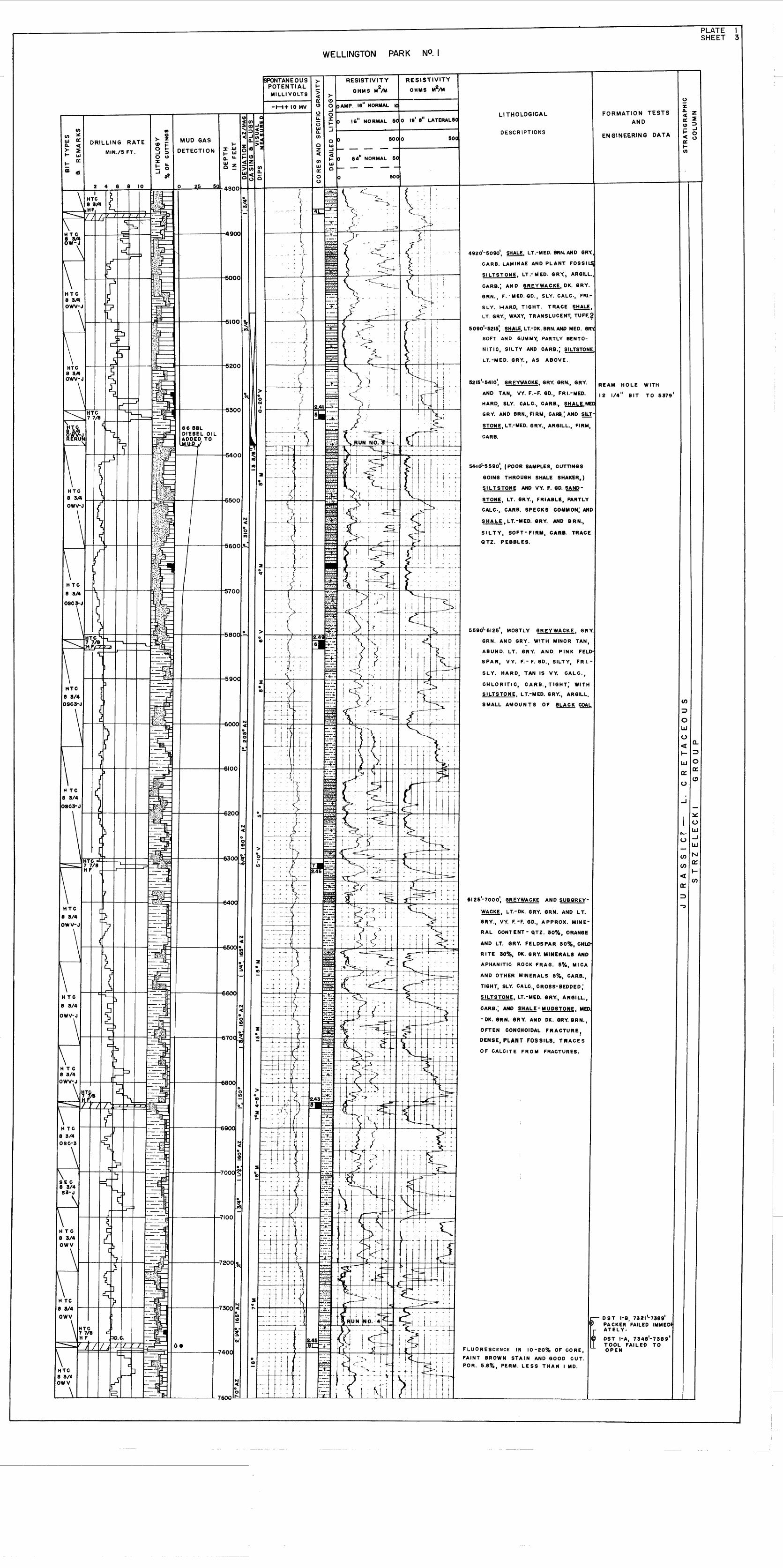
PLATE (SHEET 3
WELLINGTON PARK
en
~
U
C'o' LLJU ...J
LLJ
en N
en 0:::I-
...J
«0:::
~
en~
oLLJ
U« a.I- ~
LLJ 00::: 0:::
(!)U
r-- 0 S T I-B, 73211-7389'
~ PACKER FAILED IMMEDATELY.
~ DST I-A, 7348'-7389'TOOL FAILED TOOPEN
FORMATION TESTS
AND
EN GINEERING DATA
REAM HOLE WITH
12 1/4" BIT TO 5379'
DESCR \PTlONS
LI THOLOGICAL
5590'-6125', MOSTLY GREYWACKE, GRY.
GRN. AN 0 GRY. WITH MINOR TAN,-
ABUND. LT. GRY. AND PINK FELD"
SPAR, VY. F.-F.GD.,SILTY, FRI.-
SLY. HARD, TAN IS VY. CALC.,
CHLORITlC, CARB., TIGHT; WITH
SILTSTONE, LT.-MED. GRY., ARGILL.
SMALL AMOUNTS OF ~ COAL
5410'-5590', (POOR SAMPLES, CUTTINGS
GOING THROUGH SHALE SHAKER.)
SIL TSTONE AND VY. F. GO.~
!!.!..Q!!, LT. GRY., FRIABLE, PARTLY
CALC., CARB. SPECKS COMMON; AND
SHALE ,LT.-MED. GRY. AND BRN.,
SILTY, SOFT-FIRM. CARB. TRACE
QTZ. PEBBLES.
FLUORESCENCE IN 10-20% OF CORE,
FAINT BROWN STAIN AND GOOD CUT.
POR. 5.8%, PERM. LESS THAN I MD.
6125'-7000', GREYWACKE AND SUBGREV
~. LT.-OK. GRY. GRN. AND LT.
GRY., VY. F.-F. GD., APPROX. MINE
RAL CONTENT - QTZ. 30%, ORANGE
AND LT. GRY. FELDSPAR 30%. CHLO'
RITE 30%, OK. 6RY. MINERALS AND
APHANITIC ROCK FRAG. 5%, MI CA
AND OTHER MINERALS 5%, CARB.,
TIGHT. SLY. CALC., CROSS-BEDDED;
SILTSTONE, LT.-MED. GRY., ARGILL.,
CARB.; AND !!:!A!:!- MUDSTONE. MED.
- OK. GRN. GRY. AND OK. GRY. BRN.,
OFTEN CONCHOIDAL FRACTURE,
DENSE, PLANT FOSSILS. TRACES
OF CALCITE FROM FRACTURES.
15215'-5410', GREYWACKE, GRY. GRN., GRY.
AND TAN, VV. F.-F. GO., FRI.-MED.
HARD, SLY. CALC., CARB., !!.!:!ill,MEt
GRY. AND SRN., FiRM, CARB.: AND SILT
~,LT.-MED. GRY., ARGILL., FIRM,
CARB.
4920'-5090' SHALE LT.-MED. SRN. AND GRY.,'-'
CARB. LAMINAE AND PLANT FOSSILSl
SI LTSTONE, LT.- MW. GRY.) ARGILL.,
CARB.; AN 0 GREYWACKE, OK. GRY.
GRN., F.-MED.GD" SLY. CALC., FRI.
SLY. HARD, TIGHT. TRACE ~,
LT. GRY., WAXY, TRANSLUCENT, TUFF.?
5090'-5215: SHALE, LT.-OK. BRN. AND MED. GR"'C
50FT AND GUMMY, PARTLY BENTO-
N ITlC, SIL TY AND CARB.; SILTSTONE,
LT.-MED. GRY., AS ABOVE.I
500
RESISTIVITY
OHMS M2tM
SOC 0
--64" NORMAL 5el
RESISTIVITY
OHMS M2/M
~~_--_---+_~------to pAMP. 16" NORMAL 10-11.- + ---1o~ la 16" NORMAL &C 0 18
1 e" LATERAL5C
:J1-------+--------1
-H+ 10 MV
SPONTANEOUSPOTENTIALMILLIVOLTS
DRILLING RATE
MIN./5 FT.
\
H Te8 3/4
050\
~EC8 3/4
S3-,
:::200 <....... ~!!- .~ "'-I-~')' ~\' I '",----..n ,- I: I . I J I .!
8 3A '- . ,,~ ~. ..:.. ,. I I ~ I '!
OWV\-J "'l--+--4 -.·.:~',·~..;...\..:..li,:.:::" ••..I. i -- } : : -----r--~ l'. > ~---~ ~_l- . -- ~ ~ ~--__ ., ,~ ~ -+ 1.1.: :I!'\:-L?i
l•. '
~ 0 ~ ' ..... : I--S" ~'_':_'"_. 0 ~. I i
I,... ~.~ ~300 ~ 2.41~t": f I ~ i i~ HTC ...~ ~~~I-----------J-5__ 0
~SH"T2. 77/".r-.-. ~~~ •••IL c} ~<;'J I" ~ DIESEL OIL " .. t . I'::·;:" 1 I! 1 t '"
R RU!II ~ I·t;~.::..t= 1~'?.o_ED, TO - - . ' : - ~ . RUN !No. !--r-.'>--. ' ." ~,f:~.'..:I';~.'•., l...M\Ul J ~---~~-+---t I .. ~, 'ie =~ - j ~"1" .. + . W~;;::f' .. ~! 1 -- ~ .. r......-
(~ .t:';:""""(';';:::':"":":"I':'~';""~ =-00 ; 2 -~ i~:' ~·i i ~1~ I; I I +' +' + ..
f-~_.---+---t---~..~ ~ -~- - --~·-Il~1n . B$ ~~ j: I ill , '
, ;( !Lh i I~~ I j I ~: ~
(J)
(J) x:UJ Cl::Q.. c(~ ~I- UJI- a::ID c6
~I-
~Cl::<!)
....-_........ -r--__r-----I-I=~n-:::t-C-----4if~:~! ~
en N ::l ~; Q..
~ ~ MUD GAS « "i!!~ (J) 0 0<!) j: I- Z >: 0 UJg ~ DETECTION J:- ~ 0 c6 OIl z« ~-ou t~j:<!) ~~J: c(Z (J) UJt::..J~ ~~>C;;(J) ~ 0-
UJ c( Q.. .-it Q <.) 0 0 0 SOu
L--\-J.I-H~Tt~~4~~.;.6~8~~IO:..-f:~~:W~;E:::~:::::J~O~--J2t;:5:..---::;5~a48oo[~_lrl---....,...1";"'"s.-,-~rn-~C,)~~=:~':=..<_h~-L-:::::::::----.-~--' -,~-.~_;{.;-,-",:,-,.~:,"'il,-.:-.:.--,f,---------------1---------1111t~r4 L ~~1t= - _~::7": .~ -
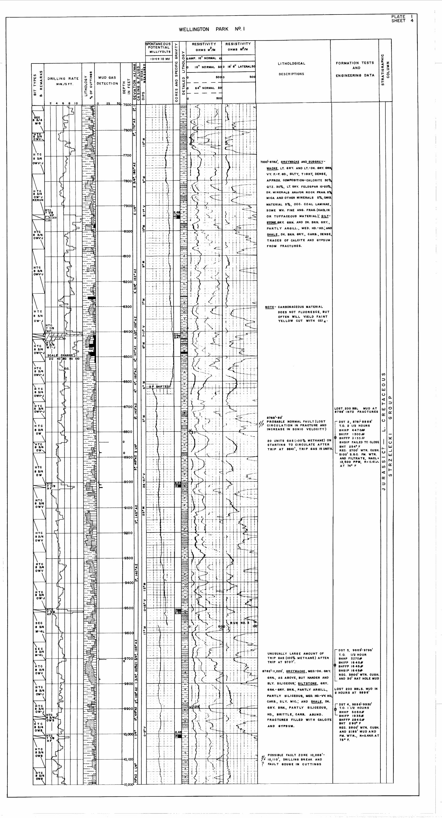
PLATE ISHEET 4
WELLINGTON PARK
>-01--------+----------1o pAMP. 16
11NORMAL 10
J~------__1------__;oi= ~ 1611 NO RMAL &C 0 18
1ell LATERAL50
JI--------+--------t
en
...J
en:::::>
oLLJ
U<t 0-
f- :::>LLJ 0a:: a::
(!)u
FORMATION TESTS
AND
ENGINEERING DATA
LOST 200 8BL MU 0 AT8798' I NTO FRACTURES
.... DST 3. 966d- 9796'
T. O. 1/2 HOURBHHP 5270#
a BHIFP 1645#, BHFFP 1645,.,-
BHSIP 1645*REC;. 3800' WTR. CUSH.AND 30' RAT HOLE MUD
I-
LOST 200 BBLS. MUD IN2 HOURS AT 9896
1
fDST 4, 9886'-9930'T. O. I 1/2 HOUR S
BHHP 5050#BHIFP 1935,f1!BHFFP 2840118HT 2900 F
REC. 3800' WTR. CUSH.AND 2185' MUD AND
FM. WTR., R=0.441l AT75 0 F.
- OST 2, 8761!.88881
T.O. 2 1/2 HOURS
BHHP 4470#BHIFP 1300 #
o IC~ BHFFP 3155# ~20 UNITS GAS (lOO rll METHANE) ON BHSIP FAILED TO CLOSE I USTARTING TO .CIRC;ULATE AFTER BHT 2540 F LIJTRIP AT 8841, TRIP GAS 15 UNITS REC. 2700' WTR. CUSH. (\- . ...J
U- 5100' S.G.C. FM. WTR. LLJ
AND FILTRATE, NACL= - N13,500 PPM, R= 0.41A enAT 740 F en a::
<t I-
a:::::::>
AND eYPSUM.
POSSIBLE FAULT ZONE 10,088'
10,110', DRILLING BREAK AND
FAULT eOUGE IN CUTTINGS
APPROX. COMPOSITION-CHLORITE 300/.
GR~, AS ABOVE, BUT HARDER AND
SLY. SILICEOUS: SILTSTONE, GRY.
LI THOLOGICAL
DESCR IPTIONS
FROM FRACTURES.
SHALE, OK. BRN. GRY., CARB., DENSE,
TRACES OF CALCITE AND GYPSUM
!!2.!'!!,GRY. GRN. AND OK. BRN. GRY.,
PARTLY ARGILL., MED. HD.-HO.;AND
MATERIAL 50/0 , OCC. COAL LAMINAE,
SOME WHo FINE ANG. FRAG. (KAOLIN
OR TUFFACEOOS MATERIAL):!!b!-
8768'-80'PROBABLE NORMAL FAULT (LOSTCIRCULATION IN FRACTURE ANDINCREASE IN SONIC VELOCITY)
QTZ. 30%, LT. GRY. FELDSPAR 10'"20%,
DK. MINERALS ANP/OR ROCK FRA•. 6~
MICA AND OTHER MINERALS 5%, CARB.
HD., BRITTL E, CARB. ABUND.
FRACTURES FILLED WIT H CALCITE
GRN.- GRY. BRN., PARTLY AReIL",.,
PARTLY SILICEOUS. MED. HD.-VY. HIl,
CARB., SLY. MIC.; AND !!!:!A.!:!, DK.
G,RY. BRN., PA RT LY SILICEOUS,
r1Q!.!- CARBONACEOUS MATERIAL
DOES NOT FLUORESCE, BUT
OFTEN WILL YIELD FAI NTYEL LOW CUT WITH CCI 4 •
70001-8782', GREYWA~KE AND SUBGREY
~, LT. GRY. AND LT.-OK. GRY. GR~
VY. F.-F. GO., SILTY, TIGHT, DENSE,
500
RESISTIVITY
OHMS M2tM
5000
RESISTIVITY
OHMS M2/M
-H+ 10 MV
fSPONTANEOUSPOTENTIALMILLIVOLTS
MUD GAS
DETECT I ON
enCD
>- zo ~o ~J ;:)o U3:.... I&.
:::i 0
~
:---. -
DRILLING RATE
MIN./5 FT.
~TC
WELLINGTON PARK
PLATE I'SHEET 5
)-(!)1--------_�_--------1o IoAMP. 16" NORMAL K..Jf----------l~-----~o~ 10 16" NORMAL 6'C ° 18"" LATERAL5C
~I--------_I_-------i(I)
(/) ~u.J ~Q. cc:)- ~
.... u.J
.... ~
ID dS
DRILLING RATE
MIN./5 FT.
enCD
)- Z(!) ~o .....J ::;)o U::I:.... ~
:::i 0
~
MUD GAS
DETECTION....
::I:u.J.... u.JQ.~
~~
ISPONTANE0 USPOTENTIALMILLIVOLTS
-H+ 10 MV
RESISTIVITY
OHMS M21M
SOC °64" NORMAL SCl
--60Cl
RESISTIVITY
OHMS M2tM
50C
LI THOLOGICAL
DESCRIPTIONS
FORMATION TESTS
AND
ENGINEERING DATA
o::I:Q. Z: ~(!) ;:)j:: ..Jcc: 0« 0....tJ)
TOTAL DEPTH DRILLER: 12,001'
TOTAL DEPTH SCHLUM: 12,011'
DRY - PLUGGED AND ABANDONED
11,220'-11,246', GREYWACKE, LT. GRY.-GRY.
GRN., VY. F. -M. GD., VY. GYPSlfEROUS
I N TOP I 5' BUT DE CR E A SiN G DOWN
WARD, FRIABLE-MED. HD., TRACE
POROSITY; AND SILTSTONE, DIRTY WHo'
LT. GRY., VY. GYPSIFEROUS AT TOP,
FRIABLE. ALSO ABUND. 8YPSUM
VEINS.
, IIl, 246 -12,011, GREYWAGKE, MED.- DK. GRY.
GRN. AND BRN. GRN., VY. F. - f. GO.,
SlL ICEOUS. HO.-VY. HO•• CARB., GRAIN
CO M POSITION - LT. GRY. QTZ. AND
FELDSPAR WITH OK. GRY. MINERALS
AND ROCK FRAG., MATRIX OF CHLO
RITE AN 0 SILICA; SILTSTONE, LT.
OK. GRY. BRN., PARTLY SILICEOUS,
MED. HD.- VY. HD., CARB., ARGILL.:
AND MINOR SHALE, OK. BRN., SILTY,
SI LICEOUS, HO., CARB.
en:::>
oUJ
o0:{ Q.
.... ::>UJ 0
a: a:o (!)
...J
~
Ul'o' UJo ..J- l1J
en Nen et:
....0:{ (J)
a:
..,