weddin shire council development control plan 2014
TRANSCRIPT
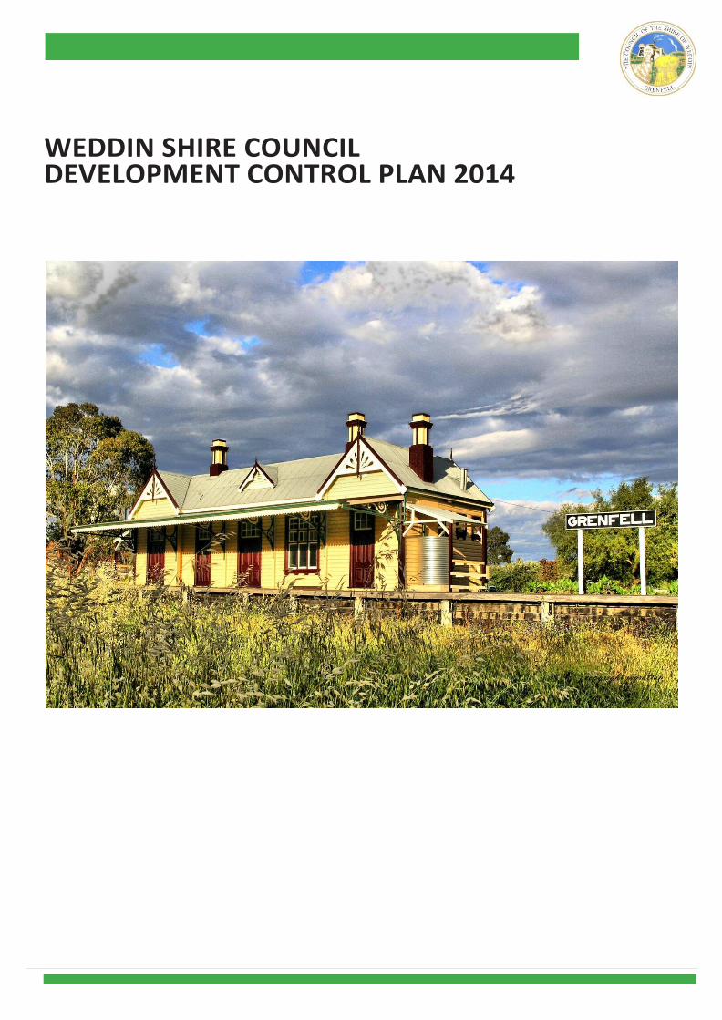
WEDDIN SHIRE COUNCIL DEVELOPMENT CONTROL PLAN 2014

WEDDIN DEVELOPMENT CONTROL PLAN 2014
FORWARD
Weddin Shire Council has reviewed its current controls that guide development in the Shire.
It understands that the public need to be aware of what development can occur in the Shire
and standards it needs to be development to.
The overall guiding mantra are the objectives of each chapter that give to outcome of an
appropriate, contemporary and sustainable development.
These objectives have been developed as performance based so as to allow the proponent to
utilize the development standards set out in the plan or place before Council a proposal that
may differ from the development standard while still satisfying the adopted objectives.
This allows innovation both in design and development without loss of overall Council adopted
direction.
WEDDIN DEVELOPMENT CONTROL PLAN 2014
WEDDIN SHIRE COUNCIL DEVELOPMENT CONTROL PLAN 2014
TABLE OF CONTENTS
Chapter 1 - Administration 4
Chapter 2 - Guide to Development Applications 6
Chapter 3 - Subdivision 14
Chapter 4 - Flooding and Flood Affected Land 18
Chapter 5 - Urban Residential Development 34
Chapter 6 - Multi Dwelling Housing, Second Dwellings and Dual Occupancy Development 41
Chapter 7 - Large Lot Residential Development & Primary Production 47
Chapter 8 - Village Development 51
Chapter 9 - Rural Development 55
Chapter 10 - Commercial Development 64
Chapter 11 - Industrial Development 69
Chapter 12 - Demolition 76
Chapter 13 - Heritage 79
Chapter 14 - Salinity 90
Chapter 15 - Public Consultation 92
APPENDICES
Appendix 1 - Integrated Development Requirements 96
Appendix 2 - Species Listing Recommended for the Weddin Shire - Native & Introduce Species 101
4 | P a g e
CHAPTER 1 – ADMINISTRATION
1.1 Name of Plan
This plan is cited as Weddin Development Control Plan 2014,
as provided under Section 72 of the Environmental Planning
and Assessment Act, 1979 (as amended) and Clauses 20 – 24
of the Environmental Planning and Assessment Regulation,
2000.
Objectives of this Plan
1.2 Adoption
This plan was adopted by Weddin Shire Council and came into
force on 26 November 2014 in accordance with Clauses 21(4)
of the Environmental Planning and Assessment Regulation,
2000.
1.3 Land to which this Plan Applies
This plan applies to all land within the Weddin Shire Local
Government Area.
1.4 Relationship with other Plans This plan supplements Weddin Local Environmental Plan 2011 and provides more detailed provisions to specific
developments where appropriate. It supersedes all other
existing Development Control Plans, namely Weddin Rural
Residential Control Plan 2004 and Development Control
plan; Grenfell and Environs.
1.5 How to use this Plan
This plan is a matter to be taken into consideration by
applicants when proposing development of the land and
by Council in assessing development applications under
Section 79C of the Environmental Planning and Assessment
Act, 1979 (as amended). In assessing development
applications Council shall have regard to the Weddin Local
Environmental Plan 2011, this Development Control
Plan and those matters detailed in Section 79C of the
Environmental Planning and Assessment Act, 1979 (as
amended) and any other relevant legislation that may be
applicable.
Council’s requirements are identified as “Objectives” which
have been underpinned with appropriate “Development
Standards” which seek to guide and control the residential
development.
The Objectives state what Council is endeavoring to
achieve in its control of the development. Each Objective is
supported by Development Standards, which outline the
preferred method of achieving the objective/s.
5 | P a g e
Council may vary the development standards where it
can be demonstrated that the resultant development is
consistent with the objective/s of that development
standard and is likely to provide a better design and
planning solution.
1.6 Variation to the Requirements of this Plan
The objectives for specific design elements are
supported by minimum numerical standards, which are
intended
to provide a guide for developers. Each application is
assessed on its merits having regard to the specific site
and strict compliance with the numerical standards
does not guarantee development consent will be
granted. Council has adopted a performance based
approach to residential development and may vary
these standards where the applicant can demonstrate
that such variation will meet the underlying objectives
and is likely to provide a better planning solution.
Any applicant wishing to vary a standard in this DCP must
request the variation in writing, providing a detailed
justification for the request and evidence that a better
design outcome will result from the variation. Council
will not approve any variation unless it is fully satisfied
with the argument for non-compliance.
1.7 Definitions
The “Dictionary” attached to Weddin Local
Environmental Plan 2011 defines the words and
expressions used in this Plan.
1.8 Structure of DCP
This Development Control Plan comprises the following
Chapters.
Chapter 1 – Administration
Chapter 2 – Guide to Development Application
Chapter 3 – Subdivision
Chapter 4 – Flooding and Flood Affected Land
Chapter 5 – Urban Residential Development
Chapter 6 – Multi Dwelling Housing, Second Dwellings
and Dual Occupancy Development
Chapter 7 – Large Lot Residential Development & Primary
Production
Chapter 8 – Village Development
Chapter 9 – Rural Development
Chapter 10 – Commercial Development
Chapter 11 – Industrial Development
Chapter 12 – Demolition
Chapter 13 – Heritage
Chapter 14 – Salinity
Chapter 15 – Public Notification and Exhibition
Appendix 1 – Integrated Development
Appendix 2 – Species Listing Recommended for the Weddin
Shire (Native & Introduced Species)
Only those Chapters relevant to a particular development
need to be taken into consideration in its design and
application to the proposed development.

6 | P a g e
CHAPTER 2 – GUIDE TO DEVELOPMENT APPLICATIONS
2.1 Introduction
This chapter explains how to prepare and lodge a
development application. It provides a simple, step-by-
step guide to all the things you need to do before
submitting a development application to Council for
consideration.
You can use this Development Application Guide as a
checklist for completing your plans and other supporting
documentation. If your application includes all the
required details, Weddin Shire Council can deal with it
much more effectively and efficiently.
2.2 What’s a ‘DA’?
A Development Application (or DA) is a formal request
for permission to carry out a proposed development.
The carrying out of development without approval (or
development consent) of Council is illegal and carries
severe penalties.
Development is legally defined under the Environmental
Planning and Assessment Act, 1979 (as amended) as being:
• the erection, including alteration in whole or part, of a
building;
• work in, on, over or under land;
• the use of land or of a building;
• the subdivision of land;
2.3 Do I need to make a ‘DA’?
You need to make a development application if you propose
to do any of the following works:
• erect a new building or structure, including outbuildings,
swimming pools, retaining walls, etc
• add to, or alter, an existing building
• demolish a building
• change the use of an existing building or premises to
another use
• subdivide land
• display or erect an advertising sign
• carry out earthworks, excavation or filling
Minor developments may be identified under State
Environmental Planning Policy (Exempt and Complying
Development Codes) 2008 and Weddin Local Environmental
Plan 2011 as being development which does not require a
Development Application (DA). This may be either as:
7 | P a g e
• Exempt Development or
• Complying Development.
Exempt Development:
Development that does not need the development consent of
Council where it complies with the established criteria for the
type of development proposed.
Complying Development:
Development for which appropriate “Complying Development
Certificates” may be submitted to Council certifying the
appropriate works have been undertaken in lieu of the
development application process.
Note: Sometimes it is not clear whether something requires a
Development Application. Please check with Council if you are
unsure before proceeding
2.3 Pre-Lodgement Meeting
Council offers a pre-lodgement service, whereby you can
bring in draft plans and discuss your development
proposal in detail with Council’s Development and
Engineering Staff.
While pre-lodgement meetings are not mandatory they
have proven to be beneficial in ensuring awareness of
State and Local Planning Controls, development
application requirements and procedures, timelines and
likely controls to be imposed upon the perspective
development. Pre- lodgement meetings have proven to
provide a better understanding of development
application for both the applicant and Council and assist
the preparation of all relevant information to greatly
reduce the time taken to consider the application.
2.4 How to Lodge A Development
Application
To make a development application, follow the five steps:
1. Investigate Planning Controls (SEPP’s, LEP, DCP) -
The rules, which apply.
2. Prepare plans; drawings; specifications and
complete your BASIX Certificate (as required).
3. Prepare a Statement of Environmental Effects –
The detail required is relative to the complexity
of the proposed development.
4. Complete the Development Application Form.
5. Complete Lodgement Checklist and submit
your application and pay the fees.
Step 1 Applicable Development Controls
The first step in preparing a development application is to find out
about our policies and the rules, which apply to your
development. Before you start designing/preparing your
proposal, you need to know about:
• Approval requirements under the Environmental Planning
legislation;
• State Environmental Planning Policies
• Weddin Local Environmental Plan 2011
• Weddin Development Control Plan 2014; and
• relevant Council Policies.
Most initial enquiries can be answered over the phone but it is
better to call in personally to the Council.
For large or complex proposals it is always advisable to have a pre-
lodgement meeting. You are likely to save time and money if you
sort out any problems before you submit your application.
Need approval from other agencies? – Integrated Development – Refer to Appendix 1
Your proposal may require approval from other government
agencies. Where possible, we can help you identify relevant
agencies. Circumstances requiring Integrated Development
Approvals are outlined in Appendix 1. However, it is your
responsibility to ascertain which approvals are required. Agencies
from which you may need an approval include:
• NSW Office of Water
• Office of Environment and Heritage
• NSW Department of Primary Industries
• NSW Fisheries
• Roads and Maritime Service
We strongly recommend that you consult with the relevant agencies
as early as possible.
Any Questions?
If you need more information or advice, phone us on 63431212 or
come in and speak to our Customer Service staff.
8 | P a g e
Step 2 Prepare plans and drawing
The following is a general guide to types of plans you will need to
prepare.
A. Site plan
This plan illustrates and analyses existing conditions at the
site in relation to surrounding land and buildings. Draw
the plan at a standard scale such as 1:100 or 1:200 and
include the following details, which are relevant to your
proposal:
Orientation
• north point
• scale (show ratio and bar scale)
Property details
• property boundaries
• easements, rights of way, sewer mains
Landform and vegetation
• contours or spot levels
Access
• public roads, laneways, pathways
• driveways, parking areas, loading bays
Existing development
• show existing buildings on the site proposed buildings
(show outline only)
• fences, walls and swimming pools
B. Scaled Plans and elevations
These drawings will clearly show the proposed building/s
and works. Draw plans, elevations and sections at
standard scales such as 1:100 or 1:200, and include the
following details:
Plans
• north point (true north)
• scale (show ratio and bar scale)
• location of proposed new buildings, alterations or works
(show setback distances from boundaries and adjoining
buildings)
• existing buildings (show outline only)
• room layout, partitioning, location of windows and doors
• room dimensions, areas and proposed uses
• vehicle entrance and exit driveways
• car parking and loading areas (show dimensions)
C. Subdivision plan
This plan will clearly show the proposed subdivision layout.
Draw the plan to a standard scale such as 1:100 or 1:200, and
show the following details:
• north point (true north)
• scale (show ratio and bar scale)
• existing and proposed boundaries
• lot and deposited plan numbers
• relationship to adjoining roads and subdivision boundaries
(show width of roads)
• proposed boundary dimensions (metres)
• proposed lot areas (square metres)
• proposed roads, pathways (indicate width)
• proposed easements and rights of way
• proposed public reserves, drainage reserves
• existing and finished levels (contours or spot heights with
Australian Height Datum values)
• long sections and cross sections of proposed roads
• any environmental constraints
D. BASIX Certificate
‘BASIX Certificate’ The Building Sustainability Index (BASIX)
is a web-based planning tool designed to assess the
potential performance of residential buildings against a
range of sustainability indices, www.basix.nsw.gov.au.
A BASIX Certificate identifies the sustainability features
required to be incorporated in the building design. These
features may include sustainable design elements such as
recycled water, rainwater tanks, AAA-rated showerheads
and taps, native landscaping, heat pump or solar water
heaters, gas space heaters, roof eaves/awnings and wall
ceiling insulation.
The applicant is required to submit the BASIX Certificate
with the Development Application or Complying
Development Certificate application. The plans and
specifications must also identify the BASIX commitments
which will be checked by a professional building Certifier
during construction. Where submitted plans or
specifications are inconsistent with the relevant BASIX
Certificate, Council should require applicants to submit
consistent applications before progressing the assessment
process, either by amending plans/specifications or by
submitting a new BASIX Certificate with commitments that
match the rest of the application.
9 | P a g e
Note: Applicants can generate the BASIX Certificate only on the
NSW Department of Planning and Infrastructure’s BASIX website:
www.basix.nsw.gov.au. For more information, phone DoPI’s BASIX
Help Line on 1300 650 908.
Step 3 Prepare the Statement of Environmental
Effects
What is a Statement of Environmental Effects (SEE)?
A Statement of Environmental Effects (SEE) is a short report,
which explains the likely impacts of the proposal and how you
will minimise these impacts. The matters required to be
addressed and level of detail will depend upon the nature and
scale of the proposed development. Some of the more standard
matters covered in a standard SEE include:
• Site suitability
• Present and previous uses
• Compliance with development standards
• DCP and/or other design guidelines
• Operation and Management
• Access and Traffic
• General pedestrian or other accessibility
• Privacy, views and overshadowing
• Air and noise
• Drainage
• Erosion and sediment control
• Heritage
• Waste
• Site Management
All development applications require a Statement of
Environmental Effects.
Step 4 Complete the Application Form
The following questions on the Application Form require
particular attention:
Owner’s consent/signature
You must obtain the consent of the landowner. If there is
more than one landowner, every owner must sign. If the
owner is a company or owners’ association (body
corporate), the application must be signed by an
authorised person under common seal. If the application
form is not signed by the landowner/s and by you as the
applicant Council cannot determine the application.
Estimated cost
We will check the estimated cost of work stated in your
application by using an appropriate building cost guide. The
cost should be an accurate estimate of the actual costs of the
development.
Proposed development
You must describe the proposed development in detail. Tell
us exactly what you propose to do. If you can’t fully describe
your proposal in the space provided on the application form
you will need to include a full description in your Statement of
Environmental Effects.
Other agency approvals
Under the planning laws you must indicate on the
application form whether you need an approval from
another Government agency in addition to development
consent. If your proposal does require another approval, we
will deal with it as ‘integrated development’. Our application form contains a list of other approvals that
may be required which include the following:
Approval Body: Law Requiring Approval
DPI Fisheries Management Act 1994, s 144, 201, 205, 219
OE&H Heritage Act 1977, s 58
DPI Mine Subsidence Compensation Act 1961, s 15
DPI Mining Act 1992, ss 63, 64
OE&H National Parks and Wildlife Act 1974, s 90
OE&H Petroleum (Onshore) Act 1991, s 9
OE&H Protection of the Environment Operations Act 1997,
ss 43 (a), 47 and 55, ss 43 (b), 48 and 55
RMS Roads Act 1993, s 138
RFS Rural Fires Act 1997, s 100B
OE&H Water Management Act 2000, ss 89, 90, 91
If you are unsure whether another approval is required,
please consult the relevant agency. Similarly, if your
proposal involves any of the above matters, we strongly
recommend that you consult with the agency concerned
before you lodge your application Applications for ‘integrated development’ will be referred to
the relevant agency to obtain their ‘general terms of
approval’. These requirements will then be incorporated in
the conditions of any development consent issued by
Council. Should the relevant approval body not be prepared
to issue their general terms, Council cannot approved the
application.
10 | P a g e
Applications for ‘integrated development’ attract an extra
fee ($320.00) and an extra set of plans per approval body.
The additional fee is payable to the approval body
therefore the fee must be submitted separately by
cheque to Council so we can forward it to the Approval
Body with your application
Local Government Act Approvals
If your proposal also requires a Council approval under
the Local Government Act you should include this in your
development application. By doing this you will avoid the
need to make a separate application later. An additional
fee may also apply. Please check with our Environmental
Services Division for further information on these
approvals.
Step 5 How to lodge your application
We prefer that you lodge your application personally at
our Customer Service Section. This is because we can
check
to see that you have completed the form and have all the
necessary information.
Please check that your Development Application includes
• Application Form - signed by all landowners and applicant.
• Lodgement checklist.
• Application fees.
• One copy of Statement of Environmental Effects.
• Three copies of plans. They should fold to A4 size sheets.
• Two copies of any relevant specifications.
• BASIX Certificate (where required).
Fees
Fees are calculated on a scale based on the estimated cost of
development (or the number of lots in the case of subdivision)
Plan first
A separate fee is payable to the State Government under the
planfirst initiative, calculated by Council on a scale based on the
estimated cost of development (or the number of lots in the
case of subdivision)over $50,000
Long Service Levy
If your proposal involves building work with a value of $25,000
or more you need to pay the Building Industry Long Service
Levy. You must pay this with your development application.
Under the new planning laws, we cannot grant development
consent until the levy is paid in full (or the first instalment is
paid, in the case of instalment payers)
Payment options
Cheque: Make your cheque payable to ‘Weddin Shire Council’ Cash: Only for applications lodged at our Customer Service
Section. You can pay cash between 8.30am and 4.00pm
Monday to Friday Cards: Bankcard, Mastercard, Visa and EFTPOS
11 | P a g e
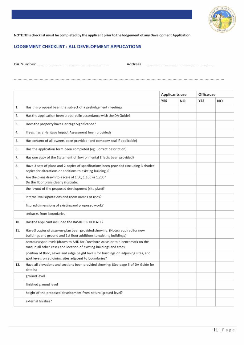
NOTE: This checklist must be completed by the applicant prior to the lodgement of any Development Application
LODGEMENT CHECKLIST : ALL DEVELOPMENT APPLICATIONS
DA Number ………………………………………………………. … Address: ……………………………………………………….
………………………………………………………………………………………………………………………………………………………
Applicants use Office use
YES NO YES NO
1. Has this proposal been the subject of a prelodgement meeting?
2. Has the application been prepared in accordance with the DA Guide?
3. Does the property have Heritage Significance?
4. If yes, has a Heritage Impact Assessment been provided?
5. Has consent of all owners been provided (and company seal if applicable)
6. Has the application form been completed (eg. Correct description)
7. Has one copy of the Statement of Environmental Effects been provided?
8. Have 3 sets of plans and 2 copies of specifications been provided (including 3 shaded
copies for alterations or additions to existing building.)?
9. Are the plans drawn to a scale of 1:50, 1:100 or 1:200?
Do the floor plans clearly illustrate:
the layout of the proposed development (site plan)?
internal walls/partitions and room names or uses?
figured dimensions of existing and proposed work?
setbacks from boundaries
10. Has the applicant included the BASIX CERTIFICATE?
11. Have 3 copies of a survey plan been provided showing: (Note: required for new
buildings and ground and 1st floor additions to existing buildings)
contours/spot levels (drawn to AHD for Foreshore Areas or to a benchmark on the
road in all other case) and location of existing buildings and trees
position of floor, eaves and ridge height levels for buildings on adjoining sites, and
spot levels on adjoining sites adjacent to boundaries?
12. Have all elevations and sections been provided showing: (See page 5 of DA Guide for
details)
ground level
finished ground level
height of the proposed development from natural ground level?
external finishes?
12 | P a g e
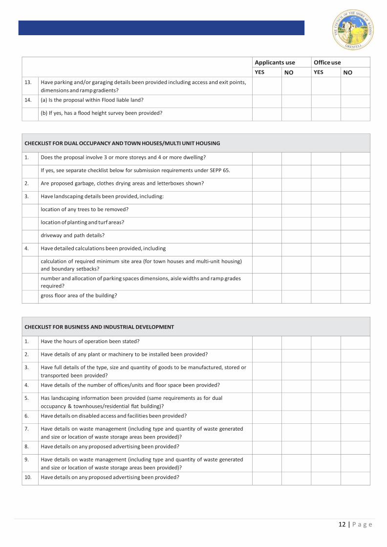
Applicants use Office use
YES NO YES NO
13. Have parking and/or garaging details been provided including access and exit points,
dimensions and ramp gradients?
14. (a) Is the proposal within Flood liable land?
(b) If yes, has a flood height survey been provided?
CHECKLIST FOR DUAL OCCUPANCY AND TOWN HOUSES/MULTI UNIT HOUSING
1. Does the proposal involve 3 or more storeys and 4 or more dwelling?
If yes, see separate checklist below for submission requirements under SEPP 65.
2. Are proposed garbage, clothes drying areas and letterboxes shown?
3. Have landscaping details been provided, including:
location of any trees to be removed?
location of planting and turf areas?
driveway and path details?
4. Have detailed calculations been provided, including
calculation of required minimum site area (for town houses and multi-unit housing)
and boundary setbacks?
number and allocation of parking spaces dimensions, aisle widths and ramp grades
required?
gross floor area of the building?
CHECKLIST FOR BUSINESS AND INDUSTRIAL DEVELOPMENT
1. Have the hours of operation been stated?
2. Have details of any plant or machinery to be installed been provided?
3. Have full details of the type, size and quantity of goods to be manufactured, stored or
transported been provided?
4. Have details of the number of offices/units and floor space been provided?
5. Has landscaping information been provided (same requirements as for dual
occupancy & townhouses/residential flat building)?
6. Have details on disabled access and facilities been provided?
7. Have details on waste management (including type and quantity of waste generated
and size or location of waste storage areas been provided)?
8. Have details on any proposed advertising been provided?
9. Have details on waste management (including type and quantity of waste generated
and size or location of waste storage areas been provided)?
10. Have details on any proposed advertising been provided?

13 | P a g e
CHECKLIST FOR SUBDIVISIONS
1. See Special conditions in Councils Subdivision Development Guide
Phone: (02) 6343 1212
Fax: (02) 6343 1203 Post:
Cnr Camp & Weddin Streets
GRENFELL NSW 2810 Post Box:
PO BOX 125 GRENFELL 2810 E-mail [email protected]
Hours 8.30.am to 4.00pm Mon – Fri
14 | P a g e
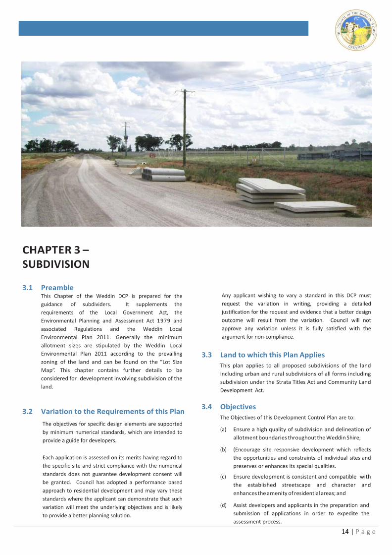
CHAPTER 3 – SUBDIVISION
3.1 Preamble This Chapter of the Weddin DCP is prepared for the
guidance of subdividers. It supplements the
requirements of the Local Government Act, the
Environmental Planning and Assessment Act 1979 and
associated Regulations and the Weddin Local
Environmental Plan 2011. Generally the minimum
allotment sizes are stipulated by the Weddin Local
Environmental Plan 2011 according to the prevailing
zoning of the land and can be found on the “Lot Size
Map”. This chapter contains further details to be
considered for development involving subdivision of the
land.
3.2 Variation to the Requirements of this Plan
The objectives for specific design elements are supported
by minimum numerical standards, which are intended to
provide a guide for developers.
Each application is assessed on its merits having regard to
the specific site and strict compliance with the numerical
standards does not guarantee development consent will
be granted. Council has adopted a performance based
approach to residential development and may vary these
standards where the applicant can demonstrate that such
variation will meet the underlying objectives and is likely
to provide a better planning solution.
Any applicant wishing to vary a standard in this DCP must
request the variation in writing, providing a detailed
justification for the request and evidence that a better design
outcome will result from the variation. Council will not
approve any variation unless it is fully satisfied with the
argument for non-compliance.
3.3 Land to which this Plan Applies
This plan applies to all proposed subdivisions of the land
including urban and rural subdivisions of all forms including
subdivision under the Strata Titles Act and Community Land
Development Act.
3.4 Objectives
The Objectives of this Development Control Plan are to:
(a) Ensure a high quality of subdivision and delineation of
allotment boundaries throughout the Weddin Shire;
(b) (Encourage site responsive development which reflects
the opportunities and constraints of individual sites and
preserves or enhances its special qualities.
(c) Ensure development is consistent and compatible with
the established streetscape and character and
enhances the amenity of residential areas; and
(d) Assist developers and applicants in the preparation and
submission of applications in order to expedite the
assessment process.
15 | P a g e
3.1 Submission
(a) All plans are to be drawn to scale;
(b) Subdivision plans shall be prepared by a registered
surveyor to ensure the accuracy of existing and
proposed allotment boundaries.
(c) All plans shall contain a proper description of the
land by Lot and Deposited Plan;
(d) Any easement, right-of-way or restriction shall be
created pursuant to Section 88B of the Conveyancing
Act, 1919.
3.2 Consideration of Physical Constraints
Prior to the preparation of a proposed plan of subdivision
it will be necessary to identify the physical constraints to
the site/land which are likely to have an influence upon
perspective allotment boundaries. This consideration
should be in the form of a Site Analysis Plan which
includes identification of the following elements:
• Orientation - North
• Existing structures/improvements on the land
• Improvements upon immediately adjoining land
• Slope
• Natural & existing drainage
• Existing hazards such as bushfire or flooding
• Any easements encumbrances
• Existing/proposed accesses
• Existing/Proposed Service arrangements
3.3 Size of Allotments
3.7.1 Residential
(a) Residential lot size is to be not less than 900 m2.
As far as possible new lots should have at least a
frontage of 20 m and a depth of 45 m. Irregular lots
such as truncated or wedge shaped lots at the end
of cul-de-sacs must have a mean width of at least 18
m and a width of 16 m at a distance of 6 m from the
street alignment. Exceptional circumstances will be
dealt with on their merits.
(b) Corner lots are to be provided with 4 m cut off for
splay purposes. When the corner angle is less than
a right angle a deeper cut off may be required by
the Council.
(c) Council does not consider the creation of battle-axe
allotments from undeveloped land as an acceptable
form of subdivision. A battle-axe subdivision will
only be considered in isolation and will be
determined on its merits having regard for the size,
shape, location and amenity of the
surrounding area. A battle-axe allotment shall
have an access way of not less than 6 m in
width and shall have a minimum area exclusive
of the access way of 900 m2.
3.7.2 Large Lot Residential
(a) Large Lot Residential blocks are basically used
for residential purposes and not created to
sustain a rural income.
(b) Minimum allotment sizes are typically
characteristic of service availability and identified
in Councils LEP Minimum Lot Size Maps
(c) Allotments W - 4000m2
(d) Allotments AA – 5 ha
(e) Allotments AB - 10 ha
(f) Large Lot Residential allotments while they may
have cut off corners and some irregular shaped
boundaries must have a reasonable overall
shape with a maximum ratio of depth to width of
4:1. The creation of battle-axe blocks is not an
acceptable form of subdivision.
3.7.3 Primary Production (a) The minimum lot size for rural land is as set out in
the Weddin Local Environmental Plan 2011 being
400 hectares for land within the RU1 – Primary
Production Zone.
3.7.4 Commercial
In established and proposed shopping areas, the
minimum frontage of any shop is to be 6m, unless
such shop forms part of a block of shops built on
land, under the one title and this land has a minimum
frontage of 6m. Where the proposal is in an
established shopping area, the existing setback
should be maintained.
3.7.5 Industrial
Where land for industrial or similar uses is proposed,
the size and dimensions of lots abutting or across
streets from residential lots should be appropriate
and available for development that provides an
effective high amenity transition.
3.7.6 Strata & Community Title Subdivision
The minimum allotment size for a strata or community
title allotment within a subdivision shall be 250m2.
The minimum allotment upon which a strata or
community titled subdivision shall be 740m2.
16 | P a g e
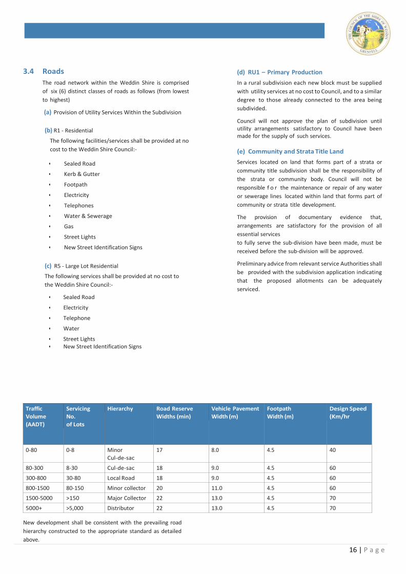
3.4 Roads
The road network within the Weddin Shire is comprised
of six (6) distinct classes of roads as follows (from lowest
to highest)
(a) Provision of Utility Services Within the Subdivision
(b) R1 - Residential
The following facilities/services shall be provided at no
cost to the Weddin Shire Council:-
• Sealed Road
• Kerb & Gutter
• Footpath
• Electricity
• Telephones
• Water & Sewerage
• Gas
• Street Lights
• New Street Identification Signs
(c) R5 - Large Lot Residential
The following services shall be provided at no cost to
the Weddin Shire Council:-
• Sealed Road
• Electricity
• Telephone
• Water
• Street Lights • New Street Identification Signs
(d) RU1 – Primary Production
In a rural subdivision each new block must be supplied
with utility services at no cost to Council, and to a similar
degree to those already connected to the area being
subdivided.
Council will not approve the plan of subdivision until utility arrangements satisfactory to Council have been made for the supply of such services.
(e) Community and Strata Title Land
Services located on land that forms part of a strata or
community title subdivision shall be the responsibility of
the strata or community body. Council will not be
responsible f o r the maintenance or repair of any water
or sewerage lines located within land that forms part of
community or strata title development.
The provision of documentary evidence that,
arrangements are satisfactory for the provision of all
essential services
to fully serve the sub-division have been made, must be
received before the sub-division will be approved.
Preliminary advice from relevant service Authorities shall
be provided with the subdivision application indicating
that the proposed allotments can be adequately
serviced.
Traffic
Volume
(AADT)
Servicing
No.
of Lots
Hierarchy Road Reserve
Widths (min)
Vehicle Pavement
Width (m)
Footpath
Width (m)
Design Speed
(Km/hr
0-80 0-8 Minor
Cul-de-sac
17 8.0 4.5 40
80-300 8-30 Cul-de-sac 18 9.0 4.5 60
300-800 30-80 Local Road 18 9.0 4.5 60
800-1500 80-150 Minor collector 20 11.0 4.5 60
1500-5000 >150 Major Collector 22 13.0 4.5 70
5000+ >5,000 Distributor 22 13.0 4.5 70
New development shall be consistent with the prevailing road
hierarchy constructed to the appropriate standard as detailed
above.
17 | P a g e
3.9 Storm Water Drainage
A. Surface Drainage
Subdividers are required to show the means by which
both natural and increased run-off shall be disposed of
and the location of any necessary easements.
B. Internal Stormwater Drainage
This work shall be paid for by the subdivider as part of the
road works and drainage requirements. Where several
adjacent subdividers wish to proceed at the same time
and use the same system of internal pipelines
arrangements should be made to share the cost on an
area drained basis.
C. External Stormwater Drainage
External Storm water drainage facilities must be adequate
before Council will approve the subdivision.
3.10 Trees
Existing trees both street trees and within the site are to
be preserved as far as practicable. Trees proposed to be
removed are to be identified and submitted for Council’s
consideration.
Where a prevailing street tree pattern (in terms of species
and location) exist the theme shall be maintained within
all new development.
3.11 Land for Public Recreation
In the case of subdivision of land for new urban
residential development, Council may require the
subdivider to provide land to cater for the public
recreation needs of future residents or alternatively, to
make an equivalent financial contribution for the
provision of such services elsewhere.
18 | P a g e
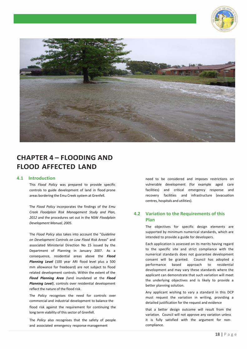
CHAPTER 4 – FLOODING AND FLOOD AFFECTED LAND
4.1 Introduction This Flood Policy was prepared to provide specific
controls to guide development of land in flood prone
areas bordering the Emu Creek system at Grenfell.
The Flood Policy incorporates the findings of the Emu
Creek Floodplain Risk Management Study and Plan,
2012 and the procedures set out in the NSW Floodplain
Development Manual, 2005.
The Flood Policy also takes into account the “Guideline
on Development Controls on Low Flood Risk Areas” and
associated Ministerial Direction No 15 issued by the
Department of Planning in January 2007. As a
consequence, residential areas above the Flood
Planning Level (100 year ARI flood level plus a 500
mm allowance for freeboard) are not subject to flood
related development controls. Within the extent of the
Flood Planning Area (land inundated at the Flood
Planning Level), controls over residential development
reflect the nature of the flood risk.
The Policy recognises the need for controls over
commercial and industrial development to balance the
flood risk against the requirement for continuing the
long term viability of this sector of Grenfell.
The Policy also recognises that the safety of people
and associated emergency response management
need to be considered and imposes restrictions on
vulnerable development (for example aged care
facilities) and critical emergency response and
recovery facilities and infrastructure (evacuation
centres, hospitals and utilities).
4.2 Variation to the Requirements of this Plan
The objectives for specific design elements are
supported by minimum numerical standards, which are
intended to provide a guide for developers.
Each application is assessed on its merits having regard
to the specific site and strict compliance with the
numerical standards does not guarantee development
consent will be granted. Council has adopted a
performance based approach to residential
development and may vary these standards where the
applicant can demonstrate that such variation will meet
the underlying objectives and is likely to provide a
better planning solution.
Any applicant wishing to vary a standard in this DCP
must request the variation in writing, providing a
detailed justification for the request and evidence
that a better design outcome will result from the
variation. Council will not approve any variation unless
it is fully satisfied with the argument for non-
compliance.
19 | P a g e
4.3 What does this policy do? The Policy provides information and guidelines to assist
people who want to develop or use land affected by
potential flooding in Grenfell. Development may include,
among other things:
dwelling construction, including additions to existing dwellings;
filling land to provide building platforms above flood level;
commercial and industrial development;
sub-dividing land.
4.4 What are the Objectives of the Plan?
The objectives of this policy are:-
(a) To provide detailed flood related development
controls for the assessment of applications on land
affected by floods in accordance with the
provisions of Weddin LEP 2011 (and as amended
in future editions) and the findings of the Emu Creek
Floodplain Risk Management Study and Plan, 2012.
(b) To alert the community to the hazard and extent of land affected by floods.
(c) To inform the community of Council’s policy in
relation to the use and development of land
affected by the potential floods in Grenfell.
(d) To reduce the risk to human life and damage to
property caused by flooding through controlling
development on land affected by floods.
(e) To ensure new development is consistent with the
flood response strategy set out in the Weddin Shire
Local Flood Plan, 2009 published by the State
Emergency Service (SES) and does not impose
additional burdens on, or risk to, SES personnel during
flood emergencies.
Definitions of flood related terms used herein are
provided in the Glossary in Section 3 of this document
4.5 Will the Policy affect my Property?
The Policy applies to all development permissible with the consent of Council on land that:
i) is zoned R1, RU1, R5, B2, IN1, RE1, RE2, SP2 & E3
under Weddin LEP 2011 and as subsequently amended; and
ii) lies within the extent of the Flood Planning Area
(FPA), as shown in Figure A1.1.
4.6 How to use this Policy? The Policy provides criteria which Council will use for the
determination of development applications in areas within
the extent of the FPA in Grenfell.
The criteria recognise that different controls apply to
different land uses and levels of potential flood inundation
or hazard.
The procedure Council will apply for determining the
specific controls applying to proposed development
within the FPA is set out below. Upon enquiry by a
prospective applicant, Council will make an initial
assessment of the flood affectation and flood levels at
the site using the following procedure:
i) Determine which part of the floodplain the development is located in from Figure A1.1.
ii) Identify the category of the development from
Annexure 1: Land Use Category. iii) Determine the appropriate Flood Planning Level and
flood related development controls for the category
of development from Figure A1.1 and Annexure 2:
Development Controls Matrix. iv) Determine the flood level at the site using flood
contour data shown on Figure A1.1 and
information contained in the Emu Creek Floodplain
Risk Management Study and Plan, 2012 and confirm
that the development conforms with the controls set
out in Annexure 2.
With the benefit of this initial information from
Council, the Applicant will prepare the Documentation
to support the development application according to
Annexures 2 and 4.
A survey plan showing natural surface levels over the
site will be required as part of the Development.
4.7 Other Documents Which May Need to be read in Conjunction with this Plan
Weddin Local Environmental Plan 2011, and as subsequently amended;
Emu Creek Floodplain Risk Management Study and Plan, 2012;
Emu Creek Flood Study, 2007;
NSW Government Floodplain Development Manual,
2005; associated Guideline on Development Controls on
Low Flood Risk Areas; and Ministerial Direction No. 15,
January 2007.
Relevant Council policies, development control plans
and specifications;
20 | P a g e
21 | P a g e
22 | P a g e
4.7 What are the Criteria for Determining Applications?
4.7.1 General 4
Development controls on flood prone land are set
out in Annexure 2 of this Flood Policy. The controls
recognise that different controls are applicable to
different land uses, the location within the floodplain
and levels of potential flood inundation and flood
hazard.
The controls applicable to proposed development depend upon:
The type of development.
The Flood Hazard zone where the development is located.
Peak Flood Levels at the site of the development.
4.7.2 Land and Use Categories and Flood Planning
Levels
Eight land use categories have been adopted. The specific land uses, in each category are listed in Annexure 1.
The Flood Planning Level (FPL) is the minimum floor level for the land uses:
For new residential development in Grenfell, the
FPL is the peak 100 year ARI flood level at the
particular development site, plus an allowance of
500 mm for freeboard.
For commercial and industrial development the
FPL is the peak 100 year ARI flood level plus an
allowance of 500 mm for freeboard. Council may
at its discretion allow an amendment to this FPL,
subject to local conditions (refer Section 2.4).
Essential Community Facilities and Critical
Utilities require a higher level of flood
protection. The FPL is the 100 year ARI flood plus
500 mm freeboard. In addition, these uses are to
be designed to be able to continue to function
and suffer minimal damage to structure and
valuable contents in the event of a PMF (refer
Section 2.5).
For Flood Vulnerable Residential Development
(nursing homes, aged care facilities and the like) the
FPL is the peak 100 year ARI flood level plus an
allowance of 500 mm for freeboard. Council will
require an area at a higher level (to be nominated by
Council) for the temporary storage of valuable
equipment and will also require the applicant to
demonstrate that there is safe access to the site in the
event of a flood emergency (refer Section 2.6).
4.7.3 Division of the Floodplain into Flood
Hazard Zones
The types of controls set out in Annexure 2 have
been graded relative to the severity and frequency of
potential floods, having regard to the following Flood
Hazard Zones within the floodplain:
“High Hazard Floodway” this is the most
flood affected land and the area where the
highest flow velocities would be expected at
the 100 year ARI flood. This zone should be
kept clear of future development, although
minor additions to existing residences and
small outbuildings may be permitted by
Council, subject to conformance with the
controls specified in Annexure 2 and the
provision of a satisfactory Flood Risk Report
demonstrating that the development is
capable of withstanding hydraulic forces and
is sited to minimise adverse re-directions of
flow to adjacent properties. Site filling in this
zone is to be avoided (ref. Section 2.11).
“Low Hazard Floodway” this area is located on
the O’Brien Tributary, specifically in the
developed area between the Oliver Court
residential units, through Camp, Short and Nash
Streets and extending as far as Melyra Street.
Along this reach overland flows through
residential and commercial allotments may
occur when the piped drainage system
surcharges, but low hazard conditions will
occur due to the shallow depth and low
velocities. All land uses would be permitted in
this zone, but the development would need to
be capable of withstanding hydraulic forces
and sited within the allotment to minimise
adverse
23 | P a g e
re-directions of flow towards adjacent
properties. Council may require a Flood Risk
Report for commercial and industrial
development proposals in this zone (typically for
larger scale developments) if it considers that
the proposal has the potential to significantly
re-direct flows towards adjacent properties.
There are restrictions on site filling in this zone
(ref. Section 2.11).
“Intermediate Floodplain” is the remaining land
lying outside the extent of the floodway zones,
but within the Flood Planning Area (land
inundated by the 100 year ARI flood levels plus
500 mm). Within this area, there would only be
the requirement for minimum residential floor
levels to be set at 100 year ARI flood levels plus
500 mm. All land uses would be permitted in
this zone. However, as noted in Section 2.2
above, Essential Community Facilities, Critical
Utilities and Flood Vulnerable development such
as housing for aged and disabled persons would
be subject to additional controls, which are
identified in subsequent sections and in Annexure
2.
“Outer Floodplain” is the remainder of the
floodplain between the Flood Planning Area and
the extent of the PMF (that is, the extent of the
floodplain). In this area, no controls would apply
for residential development. However, the
flood hazard zones have been mapped using
available survey information on natural surface
levels and their extents are therefore indicative.
Council would check proposed floor levels of
developments to ensure that they are no lower
than the FPL.
4.7.4 Assessing Commercial and Industrial
Development Proposals
The Flood Policy nominates the same FPL as for
residential development. However, where it is
not practicable to achieve this level, Council
may approve a lesser level commensurate with
the local streetscape. In this eventuality, the
applicant is to provide an area within the
development for the temporary storage of goods
at a minimum level equal to the FPL. This area
should be at least 20% of the gross floor area, or
as nominated by Council.
4.7.5 Critical Utilities and Essential Services
Whilst the Flood Policy nominates the same FPL for
these categories of development as for residential
development, critical utilities and essential services
necessary for emergency management need to be
designed to be capable of operating during extreme
flood events and constructed of flood resistant
materials so as to suffer minimal damages at a
higher level of flooding than the FPL.
Development proposals are to ensure that valuable
equipment necessary for the operation of the
facility is located at or above the PMF, either
permanently or via relocation to a temporary
storage area suitable for this purpose, or otherwise
protected from extreme flooding. Council will also
require development proposals to provide safe and
reliable access to facilities during major flooding.
4.7.6 Vulnerable Residential Development
The Flood Policy nominates the residential FPL for
Flood Vulnerable Residential Development (which
includes nursing homes, aged care facilities and the
like). However, the applicant is to ensure that
valuable equipment necessary for the operation of
the facility is located at or above the FPL, either
permanently or via relocation to a temporary
storage area suitable for this purpose. Council will
also require development proposals to provide safe
and reliable access to developments to the FPL during
major flooding.
4.7.7 Minor Additions (Residential)
Council has nominated the floor levels of minor
additions to residences to be no lower than the FPL.
However, where it can be demonstrated by the
applicant that this is not practicable, Council at its
discretion may allow a reduction in minimum floor
levels, provided that the level is at least 500 mm
above natural surface level, or as otherwise
nominated by Council so as to be above the level
of frequent flooding and max 15% addition of
habitable floor space.
24 | P a g e
4.7.8 Checking of Completed Finished Floor
Height
After the building has been built to the relevant
FPL, Council officers will check compliance with
this requirement at the relevant inspection
stage. The applicant is to provide a benchmark
on the site, levelled to Australian Height Datum
(AHD).
4.7.9 Fencing
Any proposed fencing is to be shown on the plans
accompanying a development application to
allow Council to assess the likely effect of such
fencing on flood behaviour.
In the Floodway zones, where flow velocities may
be significant, fences which minimise obstructions
to flow are to be adopted. Where impermeable
fences such as Colorbond, galvanised metal,
timber or brush are proposed, fencing panels
should be either:
a) Removal so that panels can be laid flat; or
b) horizontally hinged where a portion of at
least 1 m high is capable of swinging open to
allow floodwater to pass. Trees/landscaping and
other structures are not to impede the ability of a
hinged fence to open.
4.7.10 Other Uses and Works
All other development, building or other works
within any of the categories that require
Council’s consent will be considered on their
merits. In consideration of such applications,
Council must determine that the proposed
development is in compliance with the objectives
of this Policy.
4.7.11 Land Filling and Obstructions to Flow
No filling or alteration of the land surface is
permissible in the High Hazard Floodway due
to the potential for filling or obstructions to flow
to adversely re-direct flows. Any minor
extensions or repairs permitted by Council should
be located on piers to minimise obstructions to
the passage of flow, with the underside of any
structure supporting the buildings to be above the
100 year ARI flood level.
Building pads up to 1 m high may be permitted
for residential blocks in the Low Hazard
Floodway. However, the fill and other
obstructions are not to extend across more than
50% of the width of the allotment at right angles
to the direction of flow.
In order not to significantly obstruct flows,
Council may require at least part of the
development to be located on piers to minimise
obstructions to the passage of flow, with the
underside of any structure supporting the buildings
to be above the 100 year ARI flood level. Sub-
surface drainage of building pads is required.
4.7.12 Flood Related Information to be Submitted
to Council
4.7.12.1 Survey Details – Existing Site and
Proposed Development
A Survey Plan prepared by a Registered Surveyor
is required to be lodged with the Development
Application for properties located on flood
affected land as shown on Figure A1.1. The
Survey Plan will enable Council to assess extents
and depths of inundation over the site (at
existing natural surface levels) and must indicate
the following:
The location of existing building or structures;
The floor levels and ceiling heights of all existing buildings or structures to be retained;
Existing and/or proposed drainage easements
and watercourses or other means of
conveying flood flows that are relevant to the
flood characteristics of the site;
100 year ARI Flood Level(s) over the site (to be provided by Council); and flood extents;
0.2 metre natural surface contour intervals across the entire property (existing and proposed).
Note: All levels must be relative to Australian Height Datum (AHD)
Annexure 4 outlines requirements for survey data required by Council for the proposed development.
25 | P a g e
4.7.12.2 Evaluation of Development Proposals
4.7.12.3 Flood Risk Report – High and Low
Hazard Floodways
A. Scope of Work – General
Council will require a Flood Risk Report for any
(minor) residential development located in the
High Hazard Floodway. Depending on its
nature and scale, Council may also require a
Flood Risk Report for a development situated
in the Low Hazard Floodway, where lesser but
still significant flow velocities may be expected.
Typically such a report may be required for a
large commercial or industrial development
which Council considers has the potential to
adversely re-direct flows. This report is to be
prepared by a suitably qualified Consulting
Engineer and must address the following:
a) Confirm the Flood Planning Level for the
particular category of development
through enquiries of Council.
b) Specify proposed floor levels (and
existing floor levels where they are to
be retained) of habitable and non-
habitable structures.
c) Include a site-specific flood assessment
that may require flood modelling to
demonstrate that there will be no
adverse impact on surrounding properties
as a result of the development, up to the
100 year ARI flood.
d) Propose measures to minimise risk to
personal safety of occupants and the risk
of property damage, addressing the flood
impacts on the site of the 100 year ARI
flood. These measures shall include but
are not limited to the following:
Types of materials to be used, up
to the Flood Planning Level to
ensure the structural integrity for
immersion and impact of velocity and
debris.
Waterproofing methods including,
but not limited to electrical
equipment, wiring, fuel lines or any
other service pipes and connections.
The Applicant will need to demonstrate,
using Council supplied flood information,
that:
1. The development conforms with
the requirements of this Policy for
the particular Flood Hazard Zone in
which it is located.
2. Depending on the nature and extent
of the development and its location
within the floodplain, Council may
request the Applicant to prepare a
Flood Risk Report to demonstrate
that its construction does not
increase the flood hazard to
existing and future occupiers of the
floodplain (see Section 2.12.3).
Council will make its evaluation
and confirm requirements
regarding the proposed site
development, based on the Existing
Site Survey Plan and accompanying
survey data on the proposed
development (see Annexure 4) and
provision of information set out in
the Development Controls Matrix –
Annexure 2 and Chapter 2.
26 | P a g e
e) Confirm the structural adequacy of the development, taking into account the following:
all piers and all other parts of the
structure which are subject to the
force of flowing waters or debris
have been designed to resist the
stresses thereby induced.
all forces transmitted by supports
to the ground can be adequately
withstood by the foundations and
ground conditions existing on the
site.
the structure will be able to
withstand stream flow pressure,
force exerted by debris, and
buoyancy and sliding forces caused
by the full range of flooding up to
the 100 year ARI.
f) all electrical connections to be located above the 100 year ARI flood level plus 500 mm.
Council will also require all electrical
circuit connections to be automatically
isolated in the event of flood waters having
the potential to gain access to exposed
electrical circuits, either internal or external
of the building (see also Annexure 3A).
g) all materials used in the construction to be
flood compatible to a minimum level
equivalent to a 100 year ARI flood level plus
500 mm (Annexure 3B).
B. Additional Items (Commercial and Industrial Development)
h) For commercial and industrial
developments (in the Low Hazard
Floodway), include flood warning
signs/depth indicators for areas that may
be inundated, such as open car parking
areas.
27 | P a g e
4.8 DESCRIPTION OF TERMS Note: For expanded list of definitions, refer to Glossary contained within the NSW Government Floodplain Development Manual, 2005.
Annual Exceedance Probability (AEP) – The chance of a
flood of a given or larger size occurring in any one year,
usually expressed as a percentage. For example, if a peak
flood discharge of 500 m3/s has an AEP of 5%, it means
that there is a 5% change (that is one-in-20 chance) of a
peak flood discharge of 500 m3/s or larger occurring in
any one year (see average recurrence interval).
Average Recurrence Interval (ARI) – The average return
period between the occurrence of a particular flood
event. For example, a 100 year ARI flood has an average
recurrence interval of 100 years.
Australian Height Datum (AHD) - A common national
surface level datum corresponding approximately to
mean sea level.
Flood Affected Properties – Properties that are either
encompassed or intersected by the Flood Planning Level
(FPL).
Floodplain – Area of land which is subject to inundation
by floods up to and including the Probable Maximum
Flood event, that is, flood prone land.
Flood Planning Level (FPL) (General Definition) – The
combination of flood levels and freeboards selected for
planning purposes, as determined in floodplain risk
management studies and incorporated in floodplain risk
management plans.
Flood Planning Level (for Emu Creek) – Flood levels
selected for planning purposes, as determined in the
Emu Creek Floodplain Risk Management Study and Plan,
2012. For residential development in the floodplain, it is
the 100 year ARI flood level at the particular site, plus
the addition of a Freeboard of 500mm. For commercial
and industrial development it is the 100 year ARI flood
level plus 500mm Freeboard, unless otherwise allowed
by Council and with the requirement for a temporary
storage area at the FPL.
For the essential community facilities, essential services
and vulnerable residential development it is the 100
year ARI flood level plus 500 mm Freeboard with
additional requirements for storage and safe
access/evacuation as nominated in the Policy.
Flood Prone/Flood Liable Land – Land susceptible to
flooding by the PMF. Flood Prone land is synonymous with
Flood Liable land.
Floodway – Those areas of the floodplain where a
significant discharge of water occurs during floods. They
are often aligned with naturally defined channels.
Floodways are areas that, even if only partially
blocked, would cause a significant redistribution of
flood flow, or a significant increase in flood levels.
Freeboard – A factor of safety typically used in
relation to the setting of floor levels, levee crest
levels, etc. It is usually expressed as the difference
in height between the adopted FPL and the flood
used to determine the FPL. Freeboard provides a
factor of safety to compensate for uncertainties in
the estimation of flood levels across the floodplain,
such as wave action, localised hydraulic behaviour
and impacts that are specific event related, such as
levee and embankment settlement, and other
effects such as “greenhouse” and climate change.
Freeboard is included in the FPL.
Habitable Room - In a residential situation: a living
or working area, such as a lounge room, dining room,
kitchen, bedroom or workroom.
In an industrial or commercial situation: an area
used for offices or to store valuable possessions
susceptible to flood damage in the event of a flood.
Intermediate Floodplain - This is defined as the
strip of land on each side of the Floodway. It
encompasses the zone between the Floodway and
the line defining the indicative extent of flooding
resulting from the occurrence of the 100 year ARI
flood plus 500 mm. In this zone there would still
be a significant risk of flood damages, but these
damages may be minimised by the application of
appropriate development controls.
Outer Floodplain - This is defined as the strip of land
between the residential FPL and the extent of the
PMF. In this zone there would be no flood related
development controls over residential development.
Probable Maximum Flood (PMF) - The largest flood
that could conceivably occur at a particular location.
Generally, it is not physically or economically
possible to provide complete protection against this
event. The PMF defines the extent of flood prone
land, that is, the floodplain.
28 | P a g e
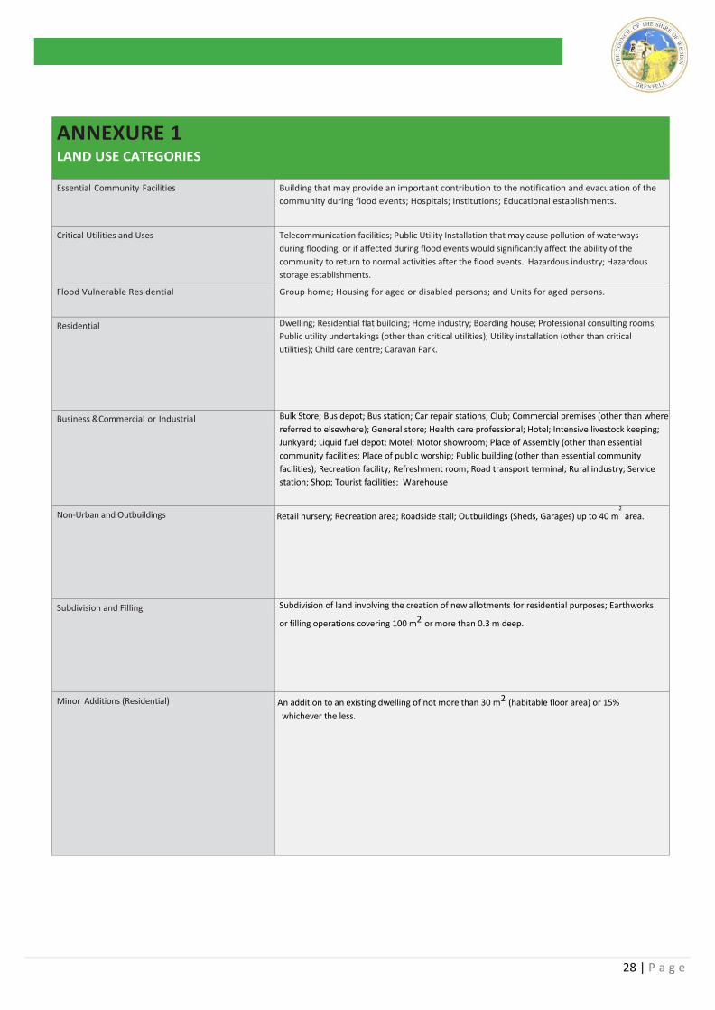
ANNEXURE 1
LAND USE CATEGORIES
Essential Community Facilities Building that may provide an important contribution to the notification and evacuation of the
community during flood events; Hospitals; Institutions; Educational establishments.
Critical Utilities and Uses Telecommunication facilities; Public Utility Installation that may cause pollution of waterways
during flooding, or if affected during flood events would significantly affect the ability of the
community to return to normal activities after the flood events. Hazardous industry; Hazardous
storage establishments.
Flood Vulnerable Residential Group home; Housing for aged or disabled persons; and Units for aged persons.
Residential Dwelling; Residential flat building; Home industry; Boarding house; Professional consulting rooms;
Public utility undertakings (other than critical utilities); Utility installation (other than critical
utilities); Child care centre; Caravan Park.
Business &Commercial or Industrial Bulk Store; Bus depot; Bus station; Car repair stations; Club; Commercial premises (other than where
referred to elsewhere); General store; Health care professional; Hotel; Intensive livestock keeping;
Junkyard; Liquid fuel depot; Motel; Motor showroom; Place of Assembly (other than essential
community facilities; Place of public worship; Public building (other than essential community
facilities); Recreation facility; Refreshment room; Road transport terminal; Rural industry; Service
station; Shop; Tourist facilities; Warehouse
Non-Urban and Outbuildings Retail nursery; Recreation area; Roadside stall; Outbuildings (Sheds, Garages) up to 40 m2 area.
Subdivision and Filling Subdivision of land involving the creation of new allotments for residential purposes; Earthworks
or filling operations covering 100 m2 or more than 0.3 m deep.
Minor Additions (Residential) An addition to an existing dwelling of not more than 30 m2 (habitable floor area) or 15%
whichever the less.
29 | P a g e
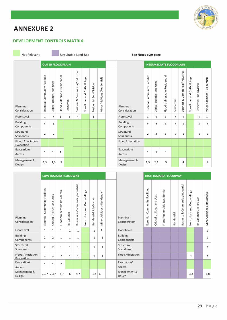
ANNEXURE 2
DEVELOPMENT CONTROLS MATRIX
Not Relevant Unsuitable Land Use See Notes over page
Planning
Consideration
OUTER FLOODPLAIN
Planning
Consideration
INTERMEDIATE FLOODPLAIN
Esse
nti
al C
om
mu
nit
y Fa
cilit
ies
Cri
tica
l Uti
litie
s a
nd
Use
s
Flo
od
Vu
lne
rab
le R
esi
de
nti
al
Res
iden
tial
Bu
sin
ess
& C
om
mer
cial
/In
du
stri
al
No
n-U
rban
an
d O
utb
uild
ings
Res
iden
tial
Su
b-D
ivis
ion
Min
or
Ad
dit
ion
s (R
esid
enti
al)
Esse
nti
al C
om
mu
nit
y Fa
cilit
ies
Cri
tica
l Uti
litie
s a
nd
Use
s
Flo
od
Vu
lne
rab
le R
esi
de
nti
al
Res
iden
tial
Bu
sin
ess
& C
om
mer
cial
/In
du
stri
al
No
n-U
rban
an
d O
utb
uild
ings
Res
iden
tial
Su
b-D
ivis
ion
Min
or
Ad
dit
ion
s (R
esid
enti
al)
Floor Level 1 1 1 1 1 1 111 Floor Level 1 1 1 1 1 1 1
Building
Components 2 2
Building
Components 2 2 1 1 1 1 1
Structural
Soundness 2 2
Structural
Soundness 2 2 1 1 1 1 1
Flood Affectation Evacuation
Flood Affectation
Evacuation/
Access 1 1 1
Evacuation/
Access 1 1 1
Management &
Design 2,3 2,3 5
Management &
Design 2,3 2,3 5 4 6
Planning
Consideration
LOW HAZARD FLOODWAY
Planning
Consideration
HIGH HAZARD FLOODWAY
Esse
nti
al C
om
mu
nit
y Fa
cilit
ies
Cri
tica
l Uti
litie
s a
nd
Use
s
Flo
od
Vu
lne
rab
le R
esi
de
nti
al
Res
iden
tial
Bu
sin
ess
& C
om
mer
cial
/In
du
stri
al
No
n-U
rban
an
d O
utb
uild
ings
Res
iden
tial
Su
b-D
ivis
ion
Min
or
Ad
dit
ion
s (R
esid
enti
al)
Esse
nti
al C
om
mu
nit
y Fa
cilit
ies
Cri
tica
l Uti
litie
s a
nd
Use
s
Flo
od
Vu
lne
rab
le R
esi
de
nti
al
Res
iden
tial
Bu
sin
ess
& C
om
mer
cial
/In
du
stri
al
No
n-U
rban
an
d O
utb
uild
ings
Res
iden
tial
Su
b-D
ivis
ion
Min
or
Ad
dit
ion
s (R
esid
enti
al)
Floor Level 1 1 1 1 1 1 1 Floor Level 1
Building
Components 2 2 1 1 1 1 1
Building
Components 1
Structural
Soundness 2 2 1 1 1 1 1
Structural
Soundness 1
Flood Affectation Evacuation
1 1 1 1 1 1 1 Flood Affectation 1 1
Evacuation/
Access 1 1 1
Evacuation/
Access
Management &
Design 2,3,7 2,3,7 5,7 6 4,7 1,7 6
Management &
Design 3,8 6,8
30 | P a g e
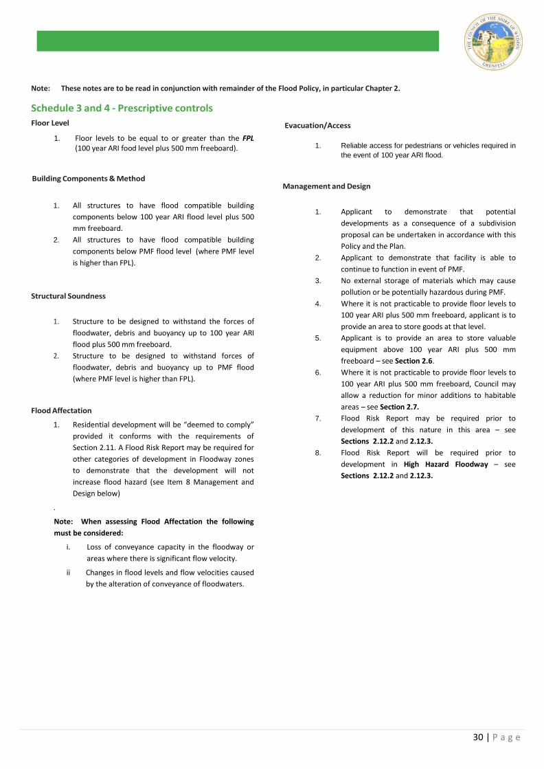
Note: These notes are to be read in conjunction with remainder of the Flood Policy, in particular Chapter 2.
Schedule 3 and 4 - Prescriptive controls
Floor Level
1. Floor levels to be equal to or greater than the FPL (100 year ARI food level plus 500 mm freeboard).
Building Components & Method
1. All structures to have flood compatible building
components below 100 year ARI flood level plus 500
mm freeboard.
2. All structures to have flood compatible building
components below PMF flood level (where PMF level
is higher than FPL).
Structural Soundness
1. Structure to be designed to withstand the forces of
floodwater, debris and buoyancy up to 100 year ARI
flood plus 500 mm freeboard.
2. Structure to be designed to withstand forces of
floodwater, debris and buoyancy up to PMF flood
(where PMF level is higher than FPL).
Flood Affectation
1. Residential development will be “deemed to comply”
provided it conforms with the requirements of
Section 2.11. A Flood Risk Report may be required for
other categories of development in Floodway zones
to demonstrate that the development will not
increase flood hazard (see Item 8 Management and
Design below)
.
Note: When assessing Flood Affectation the following
must be considered:
i. Loss of conveyance capacity in the floodway or
areas where there is significant flow velocity.
ii Changes in flood levels and flow velocities caused
by the alteration of conveyance of floodwaters.
Evacuation/Access
1. Reliable access for pedestrians or vehicles required in
the event of 100 year ARI flood.
Management and Design
1. Applicant to demonstrate that potential
developments as a consequence of a subdivision
proposal can be undertaken in accordance with this
Policy and the Plan.
2. Applicant to demonstrate that facility is able to
continue to function in event of PMF.
3. No external storage of materials which may cause
pollution or be potentially hazardous during PMF.
4. Where it is not practicable to provide floor levels to
100 year ARI plus 500 mm freeboard, applicant is to
provide an area to store goods at that level.
5. Applicant is to provide an area to store valuable
equipment above 100 year ARI plus 500 mm
freeboard – see Section 2.6.
6. Where it is not practicable to provide floor levels to
100 year ARI plus 500 mm freeboard, Council may
allow a reduction for minor additions to habitable
areas – see Section 2.7.
7. Flood Risk Report may be required prior to
development of this nature in this area – see
Sections 2.12.2 and 2.12.3.
8. Flood Risk Report will be required prior to
development in High Hazard Floodway – see
Sections 2.12.2 and 2.12.3.
31 | P a g e
ANNEXURE 3A
GENERAL BUILDING MATTERS
Electrical and Mechanical Equipment
For dwellings constructed on land to which this policy applies,
the electrical and mechanical materials, equipment and
installation should conform to the following requirements.
Main power supply
Subject to the approval of the relevant authority the incoming
main commercial power service equipment, including all
metering equipment, shall be located above the FPL. Means
shall be available to easily isolate the dwelling from the main
power supply. Wiring
All wiring, power outlets, switches, etc, should be, to the
maximum extent possible, located above the FPL. All
electrical wiring installed below this level should be suitable
for continuous underwater immersion and should contain no
fibrous components. Earth leakage circuit breakers (core
balance relays) must be installed. Only submersible type
splices should be used below the FPL. All conduits located
below the relevant designated flood level should be so
installed that they will be self-draining if subjected to flooding.
Equipment
All equipment installed below or partially below the FPL
should be capable of disconnection by a single plug and socket
assembly. Reconnection
Should any electrical device and/or part of the wiring be
flooded it should be thoroughly cleaned or replaced and
checked by an approved electrical contractor before
reconnection.
Heating and Air Conditioning Systems
Where viable, heating and air conditioning systems should be
installed in areas and spaces of the house above the FPL.
When this is not feasible, every precaution should be taken to
minimise the damage caused by submersion according to the
following guidelines:
i) Fuel
Heating systems using gas or oil as a fuel should have a
manually operated valve located in the fuel supply line to
enable fuel cut-off.
ii) Installation
The heating equipment and fuel storage tanks should be
mounted on and securely anchored to a foundation pad
of sufficient mass to overcome buoyancy and prevent
movement that could damage the fuel supply line. All
storage tanks should be vented to the FPL.
iii) Ducting
All ductwork located below the FPL should be provided
with openings for drainage and cleaning. Self-draining
may be achieved by constructing the ductwork on a
suitable grade. Where ductwork must pass through a
watertight wall or floor below the relevant flood level, a
closure assembly operated from above the FPL should
protect the ductwork.
Sewer
All sewer connections to properties in flood prone areas
are to be fitted with reflux valves
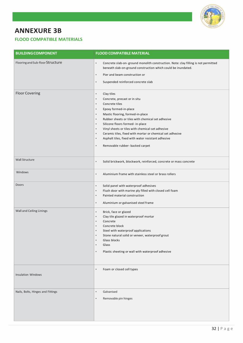
32 | P a g e
ANNEXURE 3B
FLOOD COMPATIBLE MATERIALS
BUILDING COMPONENT FLOOD COMPATIBLE MATERIAL
Flooring and Sub-floor Structure • Concrete slab-on- ground monolith construction. Note: clay filling is not permitted
beneath slab-on-ground construction which could be inundated.
• Pier and beam construction or
• Suspended reinforced concrete slab
Floor Covering • Clay tiles
• Concrete, precast or in situ
• Concrete tiles
• Epoxy formed-in-place
• Mastic flooring, formed-in-place
• Rubber sheets or tiles with chemical set adhesive
• Silicone floors formed- in-place
• Vinyl sheets or tiles with chemical-set adhesive
• Ceramic tiles, fixed with mortar or chemical set adhesive
• Asphalt tiles, fixed with water resistant adhesive
• Removable rubber- backed carpet
Wall Structure • Solid brickwork, blockwork, reinforced, concrete or mass concrete
Windows • Aluminium frame with stainless steel or brass rollers
Doors • Solid panel with waterproof adhesives
• Flush door with marine ply filled with closed cell foam
• Painted material construction
• Aluminium or galvanised steel frame
Wall and Ceiling Linings • Brick, face or glazed
• Clay tile glazed in waterproof mortar
• Concrete
• Concrete block
• Steel with waterproof applications
• Stone natural solid or veneer, waterproof grout
• Glass blocks
• Glass
• Plastic sheeting or wall with waterproof adhesive
Insulation Windows
• Foam or closed cell types
Nails, Bolts, Hinges and Fittings • Galvanised
• Removable pin hinges
33 | P a g e
ANNEXURE 4
DEVELOPMENT APPLICATION REQUIREMENTS
FOR FLOOD AFFFECTED LOTS Planning & Development Controls
Step 1
Check with Council staff to see whether or not the proposal:
Is located on Flood Prone Land
Is permissible in the Flood Risk zone and determined the FPL for the particular category of land use
Note: an existing site survey (see Section 2.12.1 of the
Policy) is to accompany development proposals to
confirm the flood affectation of the allotment and its
location within the flood risk zoning system.
Step 2
Plans – A Development Application should include the
following plans showing the nature of the proposed
development and its extent within the allotment:
A locality plan identifying the location of the property.
Plan of the existing site layout including the site dimensions (in metric), site area, contours
(0.20 m intervals), existing trees, other natural
features, existing structures, north point, location
of building on adjoining properties (if development
involves a building), floor plans located on a site
plan, roof plan, elevations and sections of the
proposed building, finished levels of floors, paving
and landscaped areas, vehicular access and parking.
Plans should indicate:
a) The existing ground levels to Australian
Height Datum around the perimeter of the
proposed building; and
b) The existing or proposed floor levels to Australian Height Datum.
Minor additions to an existing dwelling must be
accompanied by documentation from a registered
surveyor confirming existing floor levels.
In the case of subdivision, four (4) copies of the
proposed site layout showing the number of lots to
be created (numbered as proposed lot 1, 2, 3 etc),
the proposed areas of each lot in square metres, a
north point, nearest roads and the like.
Council require plans presented on A3 sheets as a minimum A
scale of 1:200 is recommended for site plans
Extent of Cut and Fill – All areas subject to cut and fill require
the depths of both to be shown as well as the measures
proposed to retain both. Applications shall be accompanied
by a survey plan (with existing and finished contours at 0.20 m
intervals) showing relative levels to Australian height datum.
Vegetation Clearing – Landscaping details including a
description of trees to be removed existing and proposed
planting, retaining walls, detention basins, fences and paving.
Stormwater Drainage – Any existing and all proposed
stormwater drainage to be indicated on the site plan.
34 | P a g e
CHAPTER 5 – URBAN RESIDENTIAL DEVELOPMENT
5.1 Preamble
The Weddin Shire prides its self in providing a high quality
residential living environment for its resident population
located in its rural setting. The protection of quality
residential areas is vital to maintaining Weddin’s image as
an attractive place to live.
This Chapter of the Weddin Development Control Plan has
been prepared by Weddin Shire Council to advise owners
and builders of Council’s objectives to ensure high quality
residential development throughout the Weddin Shire. It
provides basic minimum standards to assist developers in
achieving these objectives and provides an outline
Council’s of requirements for the submission of relevant
information to accompany development applications for all
forms of residential development, including single
dwellings.
The implementation of basic minimum standards for
residential development will protect the existing
streetscape quality and ensure new development
complements residential character and amenity throughout
Weddin.
Development principles in the form of Objectives
supported by underlying Development Standards will
provide a flexible approach to control and enable
developments to address their individual location,
contribute to the streetscape whilst also providing for the
individual design treatments and desires of the land owner.
Accordingly it is considered appropriate to prepare this
Development Control Plan to clearly establish Council’s
requirements.
5.2 Variation to the Requirements of this Plan The objectives for specific design elements are supported
by minimum numerical standards, which are intended to
provide a guide for developers. Each application is
assessed on its merits having regard to the specific site and
strict compliance with the numerical standards does not
guarantee development consent will be granted. Council
has adopted a performance based approach to residential
development and may vary these standards where the
applicant can demonstrate that such variation will meet the
underlying objectives and is likely to provide a better
planning solution.
Any applicant wishing to vary a standard in this DCP must
request the variation in writing, providing a detailed
justification for the request and evidence that a better
design outcome will result from the variation. Council will
not approve any variation unless it is fully satisfied with the
argument for non-compliance.
5.3 Land to which this Plan Applies
This chapter applies to all single dwelling residential
development throughout the urban areas of Weddin being
zones R1 – Residential and R5 - Village being the erection of
single detached dwellings upon all land.
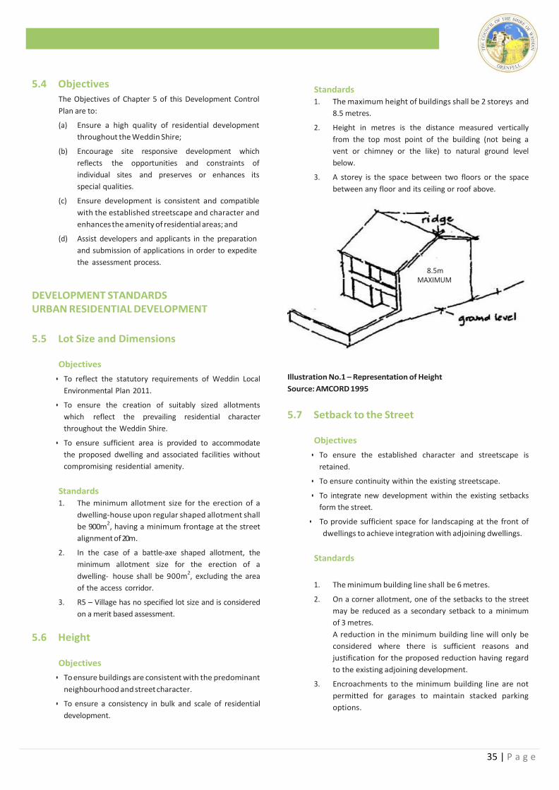
35 | P a g e
5.4 Objectives
The Objectives of Chapter 5 of this Development Control
Plan are to:
(a) Ensure a high quality of residential development
throughout the Weddin Shire;
(b) Encourage site responsive development which
reflects the opportunities and constraints of
individual sites and preserves or enhances its
special qualities.
(c) Ensure development is consistent and compatible
with the established streetscape and character and
enhances the amenity of residential areas; and
(d) Assist developers and applicants in the preparation
and submission of applications in order to expedite
the assessment process.
DEVELOPMENT STANDARDS URBAN RESIDENTIAL DEVELOPMENT
5.5 Lot Size and Dimensions
Objectives
• To reflect the statutory requirements of Weddin Local
Environmental Plan 2011.
• To ensure the creation of suitably sized allotments
which reflect the prevailing residential character
throughout the Weddin Shire.
• To ensure sufficient area is provided to accommodate
the proposed dwelling and associated facilities without
compromising residential amenity.
Standards
1. The minimum allotment size for the erection of a
dwelling-house upon regular shaped allotment shall
be 900m2, having a minimum frontage at the street
alignment of 20m.
2. In the case of a battle-axe shaped allotment, the
minimum allotment size for the erection of a
dwelling- house shall be 900m2, excluding the area
of the access corridor.
3. R5 – Village has no specified lot size and is considered
on a merit based assessment.
5.6 Height
Objectives
• To ensure buildings are consistent with the predominant
neighbourhood and street character.
• To ensure a consistency in bulk and scale of residential
development.
Standards
1. The maximum height of buildings shall be 2 storeys and
8.5 metres.
2. Height in metres is the distance measured vertically
from the top most point of the building (not being a
vent or chimney or the like) to natural ground level
below.
3. A storey is the space between two floors or the space
between any floor and its ceiling or roof above.
8.5m
MAXIMUM
Illustration No.1 – Representation of Height
Source: AMCORD 1995
5.7 Setback to the Street
Objectives
• To ensure the established character and streetscape is
retained.
• To ensure continuity within the existing streetscape.
• To integrate new development within the existing setbacks
form the street.
• To provide sufficient space for landscaping at the front of
dwellings to achieve integration with adjoining dwellings.
Standards
1. The minimum building line shall be 6 metres.
2. On a corner allotment, one of the setbacks to the street
may be reduced as a secondary setback to a minimum
of 3 metres.
A reduction in the minimum building line will only be
considered where there is sufficient reasons and
justification for the proposed reduction having regard
to the existing adjoining development.
3. Encroachments to the minimum building line are not
permitted for garages to maintain stacked parking
options.
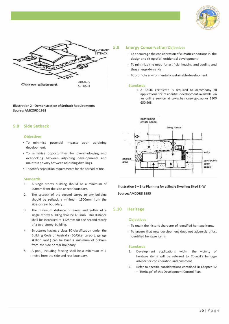
36 | P a g e
SECONDARY
SETBACK
PRIMARY SETBACK
Illustration 2 – Demonstration of Setback Requirements
Source: AMCORD 1995
5.8 Side Setback
Objectives
• To minimise potential impacts upon adjoining
development.
• To minimise opportunities for overshadowing and
overlooking between adjoining developments and
maintain privacy between adjoining dwellings.
• To satisfy separation requirements for the spread of fire.
Standards
1. A single storey building should be a minimum of
900mm from the side or rear boundary.
2. The setback of the second storey to any building
should be setback a minimum 1500mm from the
side or rear boundary.
3. The minimum distance of eaves and gutter of a
single storey building shall be 450mm. This distance
shall be increased to 1125mm for the second storey
of a two storey building.
4. Structures having a class 10 classification under the
Building Code of Australia (BCA)(i.e. carport, garage
skillion roof ) can be build a minimum of 500mm
from the side or rear boundary.
5. A pool, including fencing shall be a minimum of 1
metre from the side and rear boundary.
5.9 Energy Conservation Objectives
• To encourage the consideration of climatic conditions in the
design and siting of all residential development.
• To minimize the need for artificial heating and cooling and
thus energy demands.
• To promote environmentally sustainable development.
Standards 1. A BASIX certificate is required to accompany all
applications for residential development available via an online service at www.basix.nsw.gov.au or 1300 650 908.
Illustration 3 – Site Planning for a Single Dwelling Sited E -W
Source: AMCORD 1995
5.10 Heritage
Objectives
• To retain the historic character of identified heritage items.
• To ensure that new development does not adversely affect
identified heritage items.
Standards
1. Development applications within the vicinity of
heritage items will be referred to Council’s heritage
advisor for consideration and comment.
2. Refer to specific considerations contained in Chapter 12
– “Heritage” of this Development Control Plan.
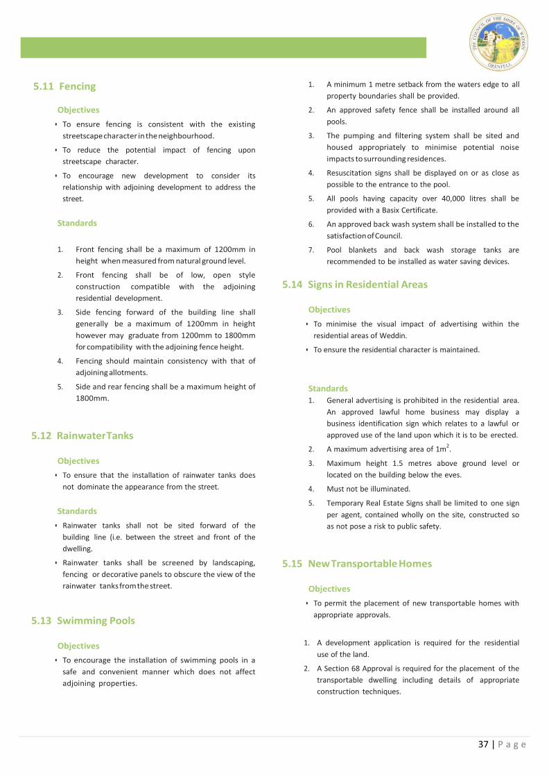
37 | P a g e
1.11 Fencing
5.11 Fencing Objectives
• To ensure fencing is consistent with the existing
streetscape character in the neighbourhood.
• To reduce the potential impact of fencing upon
streetscape character.
• To encourage new development to consider its
relationship with adjoining development to address the
street.
Standards
1. Front fencing shall be a maximum of 1200mm in
height when measured from natural ground level.
2. Front fencing shall be of low, open style
construction compatible with the adjoining
residential development.
3. Side fencing forward of the building line shall
generally be a maximum of 1200mm in height
however may graduate from 1200mm to 1800mm
for compatibility with the adjoining fence height.
4. Fencing should maintain consistency with that of
adjoining allotments.
5. Side and rear fencing shall be a maximum height of
1800mm.
5.12 Rainwater Tanks
Objectives
• To ensure that the installation of rainwater tanks does
not dominate the appearance from the street.
Standards
• Rainwater tanks shall not be sited forward of the
building line (i.e. between the street and front of the
dwelling.
• Rainwater tanks shall be screened by landscaping,
fencing or decorative panels to obscure the view of the
rainwater tanks from the street.
5.13 Swimming Pools
Objectives
• To encourage the installation of swimming pools in a
safe and convenient manner which does not affect
adjoining properties.
Standards
1. A minimum 1 metre setback from the waters edge to all
property boundaries shall be provided.
2. An approved safety fence shall be installed around all
pools.
3. The pumping and filtering system shall be sited and
housed appropriately to minimise potential noise
impacts to surrounding residences.
4. Resuscitation signs shall be displayed on or as close as
possible to the entrance to the pool.
5. All pools having capacity over 40,000 litres shall be
provided with a Basix Certificate.
6. An approved back wash system shall be installed to the
satisfaction of Council.
7. Pool blankets and back wash storage tanks are
recommended to be installed as water saving devices.
5.14 Signs in Residential Areas
Objectives
• To minimise the visual impact of advertising within the
residential areas of Weddin.
• To ensure the residential character is maintained.
Standards
1. General advertising is prohibited in the residential area.
An approved lawful home business may display a
business identification sign which relates to a lawful or
approved use of the land upon which it is to be erected.
2. A maximum advertising area of 1m2.
3. Maximum height 1.5 metres above ground level or
located on the building below the eves.
4. Must not be illuminated.
5. Temporary Real Estate Signs shall be limited to one sign
per agent, contained wholly on the site, constructed so
as not pose a risk to public safety.
5.15 New Transportable Homes
Objectives
• To permit the placement of new transportable homes with
appropriate approvals.
1. A development application is required for the residential
use of the land.
2. A Section 68 Approval is required for the placement of the
transportable dwelling including details of appropriate
construction techniques.
38 | P a g e
Standards
3. A BASIX Certificate is not required for transportable
homes.
4. The front of the transportable dwelling shall be
orientated toward the primary street frontage.
5. A subfloor curtain shall be provided to obscure the
footing from public view.
6. Certification that the transportable house has been
constructed in accordance with the BCA is to be
provided prior to the transportation of the dwelling.
5.16 Relocation of Existing Dwellings Relocated Homes
Objectives
• To permit the relocation of existing dwellings within the
residential area within keeping of existing residential
development.
Standards
1. A photographic profile shall be provided with the
DA including floor plans and elevations.
2. Structural certification of the building and cut lines
shall be provided prior to the issue of the
Construction Certificate.
3. Certification from a qualified Hygienist that the
relocated dwelling is free from asbestos shall be
provided prior to the issue of the Construction
Certificate.
4. A BASIX Certificate is not required for relocated homes.
5. The front of the dwelling shall be orientated toward
the primary street frontage.
6. A subfloor curtain shall be provided to obscure the
footing from public view.
7. Final inspection and Occupation Certificate shall be
completed within 12 months including all external
finishes.
8. A bond (as detailed in Council’s Management Plan)
will be held by Council to ensure completion of
satisfactory works. This bond may be waivered
upon preparation of an approved Management Plan
for the proposed works.
5.17 Lawson Estate
Objectives
• To control the construction of dwellings within Council’s
Lawson Estate subdivision.
• To enhance the visual appearance and presentation of new
development within this new residential estate.
Standards
1. Restrictions have been imposed upon the Lawson
Estate subdivision identified below.
2. The following restrictions have been imposed upon the
title of affected lots:
Lots Burdened Restriction Imposed
112-131 inclusive Easement for drain sewage 3 wide, variable width
101-111 inclusive Easement for drain sewer 3m wide, variable width, 3.5m wide, and 4.5m wide
113, 114 and 131
Easement to drain water 1.5m wide and variable width.
113 Easement for drain sewage 3 wide, variable width
123-131 Easement for drain sewage 3 wide, variable width
101-131 Restriction as to user
113 & 123-131 inclusive Restriction as to user
Terms of restriction as to user fifthly referred to in the plan:
1. No fence shall be erected on the Lot Burdened or on its boundaries without the prior written consent of Midgi Developments Pty Ltd, but such consent shall be deemed to have been given if:
(a) The fence is constructed at no cost to Midgi Developments Pty Limited;
(b) The fence is no higher than 1.8 metres and is constructed of colour bond or brushwood or such other materials as may be approved in writing by Midgi Developments Pty Limited;
(c) No fence is erected forward of any designated building alignment and in the case of those lots having two street frontages only one fence is to be erected on one such frontage; and
(d) The fencing otherwise meets the requirements of Weddin Shire Council.
39 | P a g e
Lots Burdened Restriction Imposed
2. No dwelling shall be constructed on any Lot Burdened, or shall be permitted to remain erected on the Lot unless:
(a) It has a minimum floor area (excluding garages, verandas, patios and the like) of 160m2.
(b) The external walls are predominatly of brick, or brick with a rendered finish, or such other materials may be approved in writing by Midgi Developments Pty Limited.
(c) The roofing material is tile, slate or colour bond.
(d) As part of the construction of the main dwelling a driveway of either plain, stamped or stenciled concrete, or alternatively of pavers is constructed.
3. No commercial vehicle shall be parked on or operated from the Lot Burdened. In this respected a commercial vehicle is any vehicle with a net weight in excess of four tonnes and in particular includes any lorry, prime mover or truck.
4. The following additional restriction as to user applies to lots 101-130 inclusive;
(a) No dwellings of the type known as duplexes shall be built on the Lot Burdened.
Terms of restriction as to user sixthly referred to in the plan:
1. The Owner of the Lot Burdened will not require Weddin Shire Council to maintain the interallotment storm water drainage infrastructure on the Lot, and acknowledges the maintenance is the responsibility of the Owner.
The person or authority empowered to release, vary or modify the fifthly referred to Restriction As To User in the plan is Midgi Developments Pty Limited or if such company is no longer in existence then by Weddin Shire Council and the person or authority empowered to release, vary or modify the costs of such release, variation or modification being met by the person seeking the same.
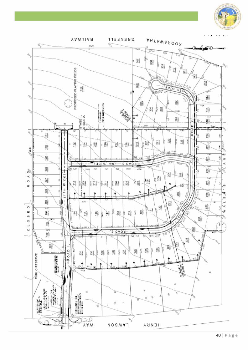
40 | P a g e
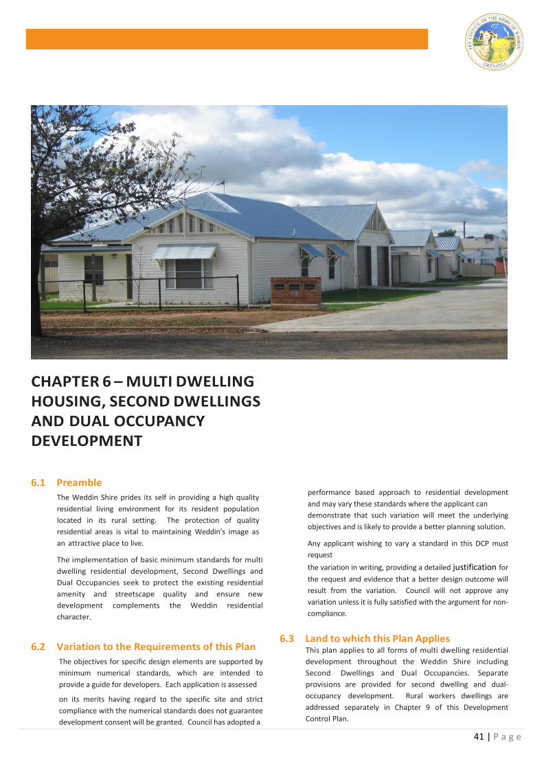
41 | P a g e
CHAPTER 6 – MULTI DWELLING HOUSING, SECOND DWELLINGS AND DUAL OCCUPANCY DEVELOPMENT
6.1 Preamble
The Weddin Shire prides its self in providing a high quality
residential living environment for its resident population
located in its rural setting. The protection of quality
residential areas is vital to maintaining Weddin’s image as
an attractive place to live.
The implementation of basic minimum standards for multi
dwelling residential development, Second Dwellings and
Dual Occupancies seek to protect the existing residential
amenity and streetscape quality and ensure new
development complements the Weddin residential
character.
6.2 Variation to the Requirements of this Plan
The objectives for specific design elements are supported by
minimum numerical standards, which are intended to
provide a guide for developers. Each application is assessed
on its merits having regard to the specific site and strict
compliance with the numerical standards does not guarantee
development consent will be granted. Council has adopted a
performance based approach to residential development
and may vary these standards where the applicant can
demonstrate that such variation will meet the underlying
objectives and is likely to provide a better planning solution.
Any applicant wishing to vary a standard in this DCP must
request
the variation in writing, providing a detailed justification for
the request and evidence that a better design outcome will
result from the variation. Council will not approve any
variation unless it is fully satisfied with the argument for non-
compliance.
6.3 Land to which this Plan Applies This plan applies to all forms of multi dwelling residential
development throughout the Weddin Shire including
Second Dwellings and Dual Occupancies. Separate
provisions are provided for second dwelling and dual-
occupancy development. Rural workers dwellings are
addressed separately in Chapter 9 of this Development
Control Plan.
42 | P a g e
Objectives
6.4 Objectives
The Objectives of this Development Control Plan are to:
(a) Ensure a high quality of residential development
throughout the Weddin Shire;
(b) Encourage site responsive development which
reflects the opportunities and constraints of
individual sites and preserves or enhances its special
qualities;
(c) Ensure development is consistent and compatible
with the established streetscape and character and
enhances the amenity of residential areas; and
(d) Assist developers and applicants in the preparation
and submission of applications in order to expedite
the assessment process.
DEVELOPMENT STANDARDS 6.5 Lot Size and Dimensions
Objectives
• To reflect the statutory requirements of Weddin Local
Environmental Plan 2011.
• To ensure that allotments are capable of
accommodating more than one dwelling and the
associated site facilities.
• To preserve existing residential streetscape character
and amenity.
Standards
1. The minimum allotment size for the erection of
multi- unit housing development (more than two
dwellings on a single allotment) shall be 740m2,
having a minimum frontage at the street alignment
of not less than 20m.
2. The above minimum standards are Statutory
controls reflected in Weddin Local Environmental
Plan 2011 and cannot be varied without preparation
of an Objection prepared in accordance with Clause
4.6 – Exceptions to Development Standards of
Weddin LEP2012.
6.6 Density
Objectives
• To restrict overdevelopment of individual allotments.
• To ensure that allotments are capable of
accommodating the number of dwelling proposed
upon an individual site.
• To ensure sufficient area is available to accommodate the
dwelling unit, private open space, parking and necessary
site facilities.
• To preserve existing residential and streetscape
character and amenity.
Standards
1. A maximum of one (1) dwelling per 250m2 of site area
shall be permitted.
6.7 Floor Space Ratio
Objectives
• To control the bulk and scale of development and restrict
over development of individual allotments.
• To ensure sufficient area is available to accommodate the
dwelling unit, private open space, parking and necessary
site facilities.
• To preserve existing residential streetscape character and
amenity.
Standards 1. The maximum floor space ratio for single storey
development is 0.4:1.
2. The maximum floor space ration for two (2) storey
developments is 0.8:1.
3. Floor Space Ratio means the ratio of the site area to the
gross floor area of all units including all habitable and
non-habitable rooms and garages or car parking
necessary to meet any requirements of Council.
6.8 Height
Objectives
• To ensure buildings are consistent with the predominant
neighbourhood and street character
• To ensure a consistency in bulk and scale of residential
development
Standards
1. The maximum height of buildings shall be 2 storeys and
8.5 metres.
2. Height in metres is the distance measured vertically
from the top most point of the building (not being a
vent or chimney or the like) to natural ground level
below.
3. A storey is the space between two floors or the space
between any floor and its ceiling or roof above.
6.9 Setback to the Street
Objectives
• To ensure the established character and streetscape is
retained.
• To ensure continuity within the existing streetscape.
• To integrate new development within the existing setbacks
from the street.
43 | P a g e
• To provide sufficient space for landscaping at the front of
dwellings to achieve integration with adjoining dwellings.
• To ensure sufficient separation from secondary frontages
to ensure adequate vision for traffic and pedestrian safety.
• To maintain privacy to the secondary frontage from road
users.
Standards
1. The minimum building line shall 6 metres.
2. On a corner allotment, one of the setbacks to the
street may be reduced to a minimum of 3 metres.
3. A reduction in the minimum building line will only be
considered where immediately adjoining dwellings,
not being a secondary setback on a corner allotment,
encroach on the minimum building line.
4. Encroachments to the minimum 6m building line are
not permitted for garages to maintain stacked parking
options.
6.10 Side Setback
Objectives
• To minimise potential impacts upon adjoining
development.
• To minimise opportunities for overshadowing and
overlooking between adjoining developments and
maintain privacy between adjoining dwellings.
• To satisfy separation requirements for the spread of fire.
Standards
1. A single storey building should be a minimum of
900mm from the side or rear boundary.
2. The setback of the second storey to any building
should be setback a minimum 1500mm from the side
or rear boundary.
3. The minimum distance of eves and gutter of a single
storey building shall be 450mm. This distance shall be
increased to 1125mm for the second storey of a two
storey building.
4. Structures having a class 10 classification under the
Building Code of Australia (BCA)(i.e. carport, garage
skillion roof ) can be build a minimum of 500mm from
the side or rear boundary.
5. A pool, including fencing shall be a minimum of 1
metre from the side and rear boundary.
6.11 Minimum Floor Area
Objectives
• To ensure the construction of suitably sized or undersized
dwelling units.
• To restrict over development of individual allotments.
• To prevent opportunities for the creation of excessive
“granny flat” units within the rear garden of existing
dwellings.
Standards
1. The minimum floor area for an individual unit is 60m2
and includes habitable and non-habitable rooms and
garages or car parking necessary to meet any
requirements of Council.
6.12 Landscaped Open Space Objectives
• To ensure the landscape character of residential areas is
maintained.
• To provide separation and enhance privacy between
dwellings, surrounding development and the street.
• To encourage developers to consider the appearance of
their development at the early stage in the development
process.
Standards
1. All development applications for new multi-unit
development are to be accompanied by a Landscape
Plan.
2. The Landscape Plan is to be prepared to a suitable scale
identifying the following:
• Opportunities and constraints for landscaping;
• Vegetation species to be planted;
• Areas to be planted - including dimensions;
• Details of all “hard” elements such as paving, fencing,
retaining walls, ornamental elements etc.;
• Mature height of species to be planted; Existing street trees shall be maintained and replicated
where possible. The spacing of such trees shall be a
minimum of 1.5 times the mature canopy of the
proposed tree and a maximum 2 times the mature tree
canopy.
6.13 Private Open Space Objectives
• To accommodate the private out-door recreation needs of
future residents.
• To ensure private open space is provided for all housing,
clearly defined for private use and is usable and accessible
from internal living areas.
• To ensure private open space is appropriately located to
best utilize site constraints, has adequate access to sunlight
as well as minimise the impact on adjoining buildings.
• To provide space for service functions including clothes
drying.
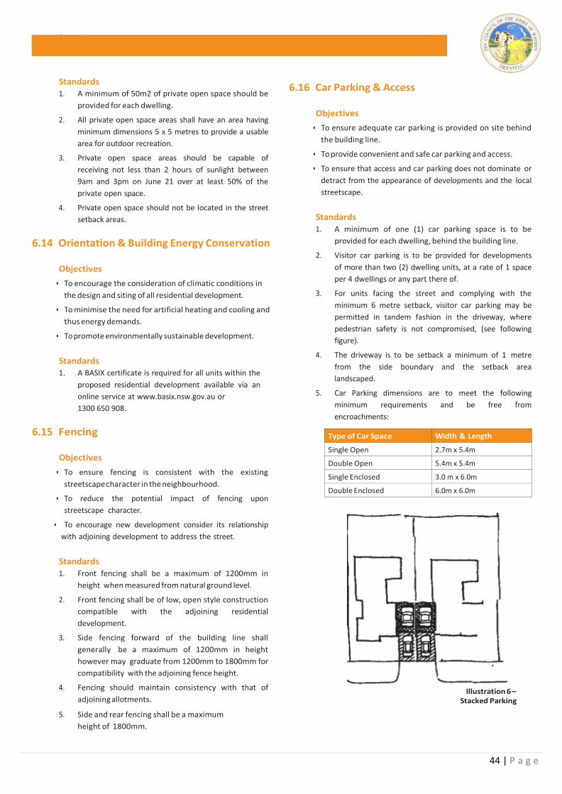
44 | P a g e
Stan
Standards 1. A minimum of 50m2 of private open space should be
provided for each dwelling.
2. All private open space areas shall have an area having
minimum dimensions 5 x 5 metres to provide a usable
area for outdoor recreation.
3. Private open space areas should be capable of
receiving not less than 2 hours of sunlight between
9am and 3pm on June 21 over at least 50% of the
private open space.
4. Private open space should not be located in the street
setback areas.
6.14 Orientation & Building Energy Conservation
Objectives
• To encourage the consideration of climatic conditions in
the design and siting of all residential development.
• To minimise the need for artificial heating and cooling and
thus energy demands.
• To promote environmentally sustainable development.
Standards 1. A BASIX certificate is required for all units within the
proposed residential development available via an
online service at www.basix.nsw.gov.au or
1300 650 908.
6.15 Fencing
Objectives
• To ensure fencing is consistent with the existing
streetscape character in the neighbourhood.
• To reduce the potential impact of fencing upon
streetscape character.
• To encourage new development consider its relationship
with adjoining development to address the street.
Standards
1. Front fencing shall be a maximum of 1200mm in
height when measured from natural ground level.
2. Front fencing shall be of low, open style construction
compatible with the adjoining residential
development.
3. Side fencing forward of the building line shall
generally be a maximum of 1200mm in height
however may graduate from 1200mm to 1800mm for
compatibility with the adjoining fence height.
4. Fencing should maintain consistency with that of
adjoining allotments.
5. Side and rear fencing shall be a maximum
height of 1800mm.
6.16 Car Parking & Access
Objectives
• To ensure adequate car parking is provided on site behind
the building line.
• To provide convenient and safe car parking and access.
• To ensure that access and car parking does not dominate or
detract from the appearance of developments and the local
streetscape.
Standards
1. A minimum of one (1) car parking space is to be
provided for each dwelling, behind the building line.
2. Visitor car parking is to be provided for developments
of more than two (2) dwelling units, at a rate of 1 space
per 4 dwellings or any part there of.
3. For units facing the street and complying with the
minimum 6 metre setback, visitor car parking may be
permitted in tandem fashion in the driveway, where
pedestrian safety is not compromised, (see following
figure).
4. The driveway is to be setback a minimum of 1 metre
from the side boundary and the setback area
landscaped.
5. Car Parking dimensions are to meet the following
minimum requirements and be free from
encroachments:
Type of Car Space Width & Length
Single Open 2.7m x 5.4m
Double Open 5.4m x 5.4m
Single Enclosed 3.0 m x 6.0m
Double Enclosed 6.0m x 6.0m
Illustration 6 – Stacked Parking
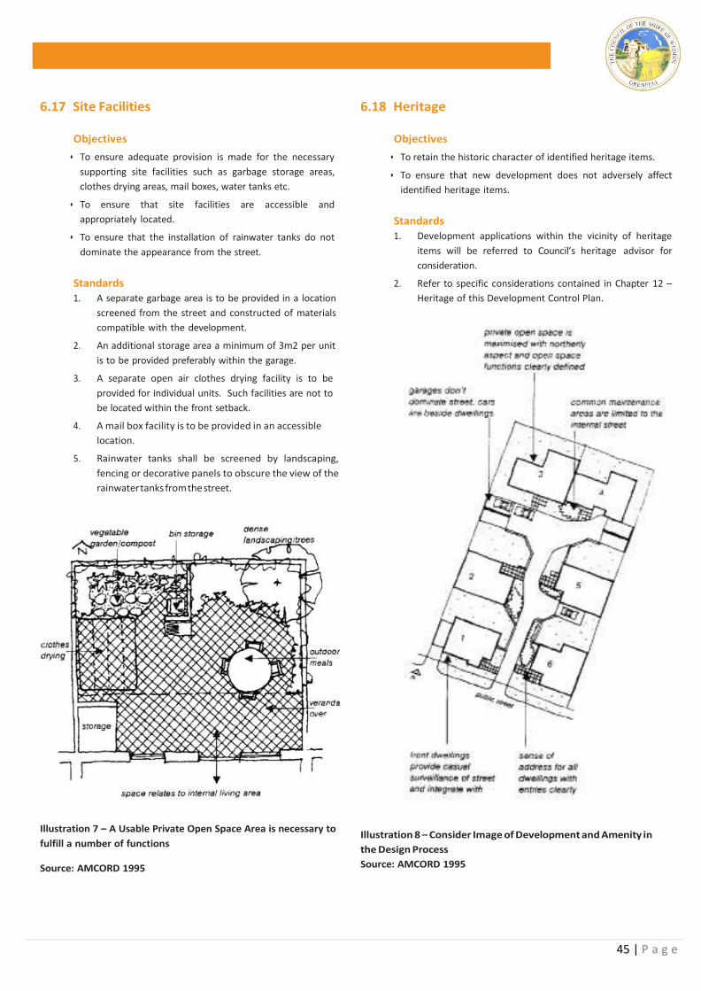
45 | P a g e
6.17 Site Facilities
Objectives
• To ensure adequate provision is made for the necessary
supporting site facilities such as garbage storage areas,
clothes drying areas, mail boxes, water tanks etc.
• To ensure that site facilities are accessible and
appropriately located.
• To ensure that the installation of rainwater tanks do not
dominate the appearance from the street.
Standards
1. A separate garbage area is to be provided in a location
screened from the street and constructed of materials
compatible with the development.
2. An additional storage area a minimum of 3m2 per unit
is to be provided preferably within the garage.
3. A separate open air clothes drying facility is to be
provided for individual units. Such facilities are not to
be located within the front setback.
4. A mail box facility is to be provided in an accessible
location.
5. Rainwater tanks shall be screened by landscaping,
fencing or decorative panels to obscure the view of the
rainwater tanks from the street.
Illustration 7 – A Usable Private Open Space Area is necessary to
fulfill a number of functions
Source: AMCORD 1995
6.18 Heritage
Objectives
• To retain the historic character of identified heritage items.
• To ensure that new development does not adversely affect
identified heritage items.
Standards
1. Development applications within the vicinity of heritage
items will be referred to Council’s heritage advisor for
consideration.
2. Refer to specific considerations contained in Chapter 12 –
Heritage of this Development Control Plan.
Illustration 8 – Consider Image of Development and Amenity in
the Design Process
Source: AMCORD 1995
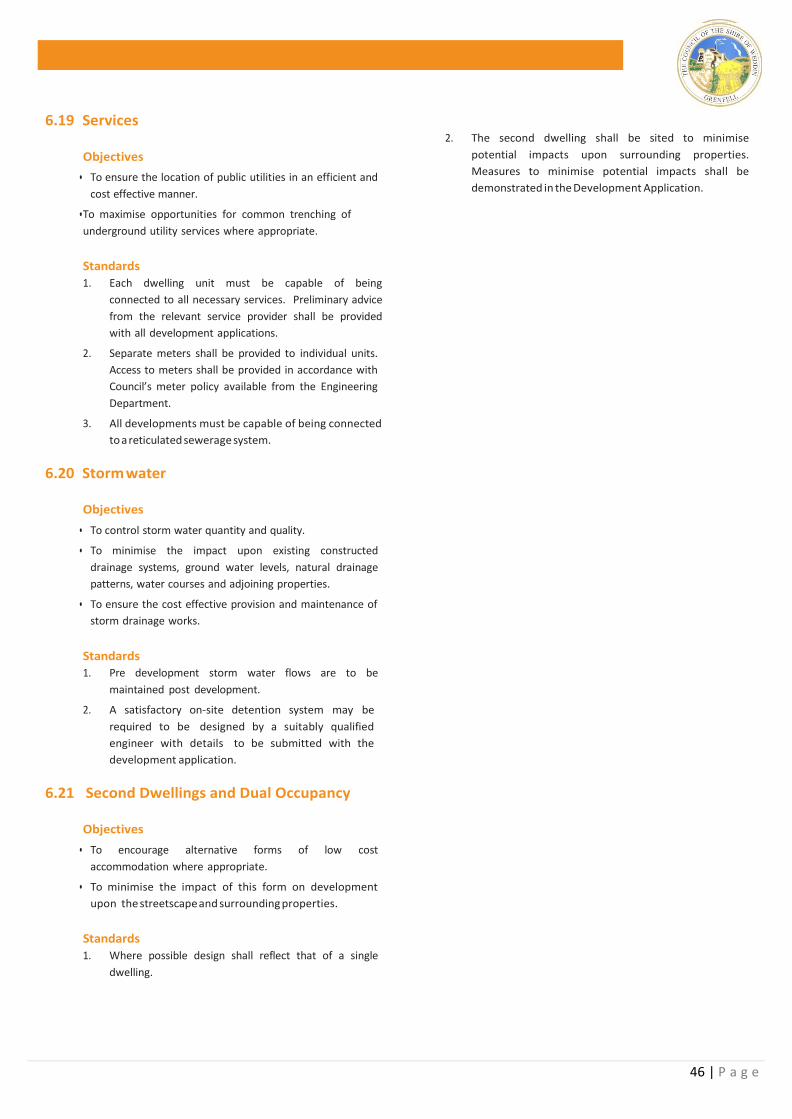
46 | P a g e
6.19 Services
Objectives
• To ensure the location of public utilities in an efficient and
cost effective manner.
• To maximise opportunities for common trenching of
underground utility services where appropriate.
Standards
1. Each dwelling unit must be capable of being
connected to all necessary services. Preliminary advice
from the relevant service provider shall be provided
with all development applications.
2. Separate meters shall be provided to individual units.
Access to meters shall be provided in accordance with
Council’s meter policy available from the Engineering
Department.
3. All developments must be capable of being connected
to a reticulated sewerage system.
6.20 Storm water
Objectives
• To control storm water quantity and quality.
• To minimise the impact upon existing constructed
drainage systems, ground water levels, natural drainage
patterns, water courses and adjoining properties.
• To ensure the cost effective provision and maintenance of
storm drainage works.
Standards 1. Pre development storm water flows are to be
maintained post development.
2. A satisfactory on-site detention system may be
required to be designed by a suitably qualified
engineer with details to be submitted with the
development application.
6.21 Second Dwellings and Dual Occupancy
Objectives
• To encourage alternative forms of low cost
accommodation where appropriate.
• To minimise the impact of this form on development
upon the streetscape and surrounding properties.
Standards
1. Where possible design shall reflect that of a single
dwelling.
2. The second dwelling shall be sited to minimise
potential impacts upon surrounding properties.
Measures to minimise potential impacts shall be
demonstrated in the Development Application.
47 | P a g e
CHAPTER 7 – LARGE LOT RESIDENTIAL DEVELOPMENT
7.1 Preamble
Under the Standard Instrument (LEP’s) traditional rural
residential development is prescribed Large Lot Residential
Development.
The predominant use of the land use for “Large Lot
Residential” development is for residential purposes with
the main feature being the residential dwelling.
Typically these allotments form transitional lands between
urban and rural land.
The Weddin Shire prides its self in providing a diverse range
of rural residential living opportunities for its resident
population located in its rural setting. The protection of
quality fringe living opportunities is vital to maintaining
Weddin’s image as an attractive place to live.
This Development Control Plan has been prepared by
Weddin Shire Council to advise of Council’s objectives to
ensure high quality development throughout the Weddin
Shire. It provides basic minimum standards to assist
developers in achieving these objectives and provides an
outline of Council’s requirements for the submission of
relevant information to accompany development
applications for all forms of rural residential development.
7.2 Land to which this plan applies
This plan applies to all forms of “Large Lot Residential”
throughout the Weddin Shire.
7.3 Objectives
The Objectives of this Development Control Plan are to:
(a) Ensure a high quality of rural residential development
throughout the Weddin Shire;
(b) Encourage site responsive development which reflects
the opportunities and constraints of individual sites and
preserves or enhances its special qualities.
(c) Ensure development is consistent and compatible with
the established streetscape and character and
enhances the amenity of residential areas; and
(d) Assist developers and applicants in the preparation and
submission of applications in order to expedite the
assessment process.
7.4 Variation to the Requirements of this Plan The objectives for specific design elements are supported by
minimum numerical standards, which are intended to
provide a guide for developers. Each application is assessed
on its merits having regard to the specific site and strict
compliance with the numerical standards does not
guarantee development consent will be granted. Council
has adopted a performance based approach to residential
development and may vary these standards where the
applicant can demonstrate that such variation will meet the
underlying objectives and is likely to provide a better
planning solution.
48 | P a g e
Any applicant wishing to vary a standard in this DCP must
request the variation in writing, providing a detailed
justification for the request and evidence that a better
design outcome will result from the variation. Council will
not approve any variation unless it is fully satisfied with the
argument for non-compliance.
7.5 Minimum Allotment Sizes
Objectives
• To protect the valuable agricultural land resource within
Weddin.
• To implement minimum allotment sizes which reflect site
hazards in particular flooding and the land needed to
accommodate necessary services.
Standards
1. The minimum allotment size for Large Lot Residential
Development ranges from 4000 square metres to 10
ha dependant upon locality and minimum lot size
mapping.
2. Large Lot Residential Development not serviced with
reticulated effluent disposal ranges from 4000 square
metres (1 hectare) to 100,000m² (10Ha).
3. As onsite effluent disposal is proposed upon a l l Large
Lot Residential lots a geotechnical report may be
required to identify satisfactory area for effluent
disposal in the given location. Preference will be given
to aerated onsite effluent disposal systems.
7.6 Location within Agriculturally Productive
Area
Objectives
• To recognise and protect the valuable agriculturally
productive land of the Weddin Shire.
• To increase awareness of the realities of developing and
living in the country.
Standards
1. Applicants need to recognise they are proposing to
develop within an agriculturally productive area and
consider the impacts of agriculture upon the proposed
development and the impact of the proposed
development upon agriculture.
2. Council may impose conditions or requirements upon
development consents or land covenants in order to
address any potential impacts upon agriculture.
7.7 Servicing
Objectives
• To ensure that an adequate level of services is provided to
all allotments.
• To ensure that block sizes in unsewered areas are of
sufficient shape and size to accommodate on-site effluent
disposal.
• To ensure development does not place an unreasonable
demand upon service authorities, Council and the
community.
Standards
1. Large Lot Residential Development sha l l be serv iced
by an approved on-site effluent disposal system and
shall be installed in accordance with the requirements
of “Environment and Health Protection Guidelines
Onsite Sewage Management for Single Households
1998.
2. All septic tanks shall be provided with an overflow relief
drain located between the dwelling and tank to protect
the dwelling from septic surges and overflows.
3. Electrical Services are to be provided in accordance with
the requirements of Essential Energy. Service availability
is to be confirmed prior to approval of the associated
development application.
Telephone lines shall be installed in accordance with
the requirements of Telstra. Service availability is to be
confirmed prior to approval of the associated
development application.
4. Where reticulated water is not available roof water
collection tanks shall be installed capable of storing a
minimum of 90,000 litres. A reduction in water storage
capacity will only be permitted where approval of a
stock and domestic bore can be provided and a dual
(potable and non-potable) water reticulation system has
been installed. All secondary roof structures in excess
of 15 square metres shall be connected to the primary
water reticulation system.
5. An additional 22,000 litres of water storage shall be
provided for bush fire fighting purposes.
6. All necessary easements shall be created in favour of the
relevant service authority at the cost to the developer.
7. Boundary fencing is to be of a rural nature. No colourbond
fencing or similar solid infill fencing is permitted.
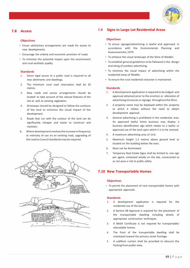
49 | P a g e
7.8 Access
Objectives
• Ensue satisfactory arrangements are made for access to
new developments.
• Encourage the orderly and economic provision of roads.
• To minimise the potential impact upon the environment
and rural aesthetic quality.
Standards
1. Direct legal access to a public road is required to all
new allotments and dwellings.
2. The minimum rural road reservation shall be 20 metres.
3. New roads and access arrangements should be
located to take account of the natural features of the
site as well as existing vegetation.
4. Driveways should be designed to follow the contours
of the land to minimise the visual impact of the
development.
5. Roads that run with the contour of the land can be
significantly cheaper and easier to construct and
maintain.
6. Where development involves the increase in frequency
or intensity of use on an existing road, upgrading of
the road to Council standards may be required.
7.9 Signs in Large Lot Residential Areas
Objectives
• To ensue signage/advertising is lawful and approved in
accordance with the Environmental Planning and
Assessment Act, 1979.
• To enhance the visual landscape of the Shire of Weddin.
• To establish general guidelines to be followed in the design
and siting of outdoor advertising.
• To minimise the visual impact of advertising within the
residential areas of Weddin.
• To ensure the rural residential character is maintained.
Standards
1. A development application is required to be lodged and
approval obtained prior to the erection or alteration of
advertising structures or signage throughout the Shire.
2. A property name may be displayed within the property
to which it relates without the need to obtain
development approval.
3. General advertising is prohibited in the residential area.
An approved lawful home business may display a
business identification sign which relates to a lawful or
approved use of the land upon which it is to be erected.
4. A maximum advertising area of 1m2.
5. Maximum height 1.5 metres above ground level or
located on the building below the eves.
6. Must not be illuminated.
7. Temporary Real Estate Signs shall be limited to one sign
per agent, contained wholly on the site, constructed so
as not pose a risk to public safety.
7.10 New Transportable Homes
Objectives
• To permit the placement of new transportable homes with
appropriate approvals.
Standards 1. A development application is required for the
residential use of the land.
2. A Section 68 Approval is required for the placement of
the transportable dwelling including details of
appropriate construction techniques
3. A BASIX Certificate is not required for transportable/
relocatable homes.
4. The front of the transportable dwelling shall be
orientated toward the primary street frontage.
5. A subfloor curtain shall be provided to obscure the
footing from public view.
50 | P a g e
7.11 Relocation of Existing Dwellings
Relocated Homes
Objectives
• To permit the relocation of existing dwellings within the
residential area within keeping of existing residential
development.
Standards
1. A development application is required for the
residential use of the land.
2. A Section 68 Approval is required for the placement
of the transportable dwelling including details of
appropriate construction techniques.
3. A photographic profile shall be provided with the
DA including floor plans and elevations.
4. Structural certification of the footings and cut lines
shall be provided prior to the issue of the
Occupation Certificate.
5. Certification from a qualified Hygienist that the
relocated dwelling is free from asbestos shall be
provided prior to the issue of the Occupation
Certificate.
6. A BASIX Certificate is not required for relocated homes.
7. The front of the dwelling shall be orientated toward
the primary street frontage.
8. A subfloor curtain shall be provided to obscure the
footing from public view.
9. Final inspection and Occupation Certificate shall be
completed within 12 months including all external
finishes.
10. A bond as listed in the fees and charges section of
Council’s Management Plan will be held by Council
to ensure completion of satisfactory works.
7.12 Replacement of an Existing Dwelling
Objectives
• To increase potential for rural living opportunities
without fragmenting the existing land resource.
Standards 1. Where an existing dwelling is being replaced with a
new dwelling however the existing dwelling is to
remain the existing dwelling shall be altered so it
is not capable of being inhabited as a separate
domicile.
2. Generally a dwelling shall be rendered
uninhabitable where the kitchen has been
removed.
7.13 Keeping of Animals Objectives
• To Permit personal desires regarding pets and
animals within or surrounding the urban area.
• To mitigate any potential adverse impacts upon
surrounding residents and the environment.
• To enforce relevant requirements of the Local
Government Act in regard to keeping of Animals.
Standards
1. Generally Council will not regulate the keeping if
animals within the urban area. Where complaints
arise however, the requirements of the Local
Government Act will be enforced.
2. Animals shall be kept in accordance with the
requirements of the Companion Animals Act 1998.
3. Suitable facilities shall be provided as deemed
appropriate, to accommodate the desired animal
husbandry within the Weddin urban area. Where
conflicts arise Council will consult with the
Department of Primary Industries.
7.14 Swimming Pools
Objectives
• To encourage the installation of swimming pools in a
safe and convenient manner which does not affect
adjoining properties.
Standards
1. A minimum 1 metre setback from the water’s
edge to all property boundaries shall be provided.
2. An approved safety fence shall be installed around
all pools.
3. The pumping and filtering system shall be sited
and housed appropriately to minimize potential
noise impacts to surrounding residents.
4. Resuscitation signs shall be displayed on or as
close as possible to the entrance to the pool.
5. All pools having capacity over 40,000 litres shall be
provided with a BASIX Certificate.
6. An approved back wash system shall be installed
to the satisfaction of Council.
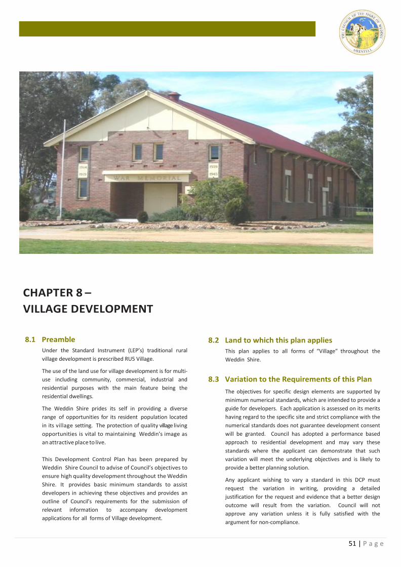
51 | P a g e
CHAPTER 8 –
VILLAGE DEVELOPMENT
8.1 Preamble
Under the Standard Instrument (LEP’s) traditional rural
village development is prescribed RU5 Village.
The use of the land use for village development is for multi-
use including community, commercial, industrial and
residential purposes with the main feature being the
residential dwellings.
The Weddin Shire prides its self in providing a diverse
range of opportunities for its resident population located
in its village setting. The protection of quality village living
opportunities is vital to maintaining Weddin’s image as
an attractive place to live.
This Development Control Plan has been prepared by
Weddin Shire Council to advise of Council’s objectives to
ensure high quality development throughout the Weddin
Shire. It provides basic minimum standards to assist
developers in achieving these objectives and provides an
outline of Council’s requirements for the submission of
relevant information to accompany development
applications for all forms of Village development.
8.2 Land to which this plan applies
This plan applies to all forms of “Village” throughout the
Weddin Shire.
8.3 Variation to the Requirements of this Plan
The objectives for specific design elements are supported by
minimum numerical standards, which are intended to provide a
guide for developers. Each application is assessed on its merits
having regard to the specific site and strict compliance with the
numerical standards does not guarantee development consent
will be granted. Council has adopted a performance based
approach to residential development and may vary these
standards where the applicant can demonstrate that such
variation will meet the underlying objectives and is likely to
provide a better planning solution.
Any applicant wishing to vary a standard in this DCP must
request the variation in writing, providing a detailed
justification for the request and evidence that a better design
outcome will result from the variation. Council will not
approve any variation unless it is fully satisfied with the
argument for non-compliance.
52 | P a g e
8.4 Objectives
The Objectives of this Development Control Plan are to:
(a) Ensure a high quality of village development
throughout the Weddin Shire;
(b) Encourage site responsive development which
reflects the opportunities and constraints of
individual sites and preserves or enhances its special
qualities.
(c) Ensure development is consistent and compatible
with the established streetscape and character and
enhances the amenity of Village areas; and
(d) Assist developers and applicants in the preparation
and submission of applications in order to expedite
the assessment process.
8.5 Minimum Allotment Sizes
Objectives
• To protect the valuable agricultural land resource within
Weddin.
• To implement minimum allotment sizes which reflect site
c onstraints in particular the land needed to
accommodate necessary services.
Standards
1. As onsite effluent disposal is proposed upon a l l Village
a geotechnical report shall be provided to identify
satisfactory area for effluent disposal in the given
location. Preference will be given to aerated onsite
effluent disposal systems.
8.6 Location within Agriculturally Productive Area
Objectives
• To recognise and protect the valuable agriculturally
productive land of the Weddin Shire.
• To increase awareness of the realities of developing and
living in the country.
Standards
1. Applicants need to recognise they are proposing to
develop within an agriculturally productive area and
consider the impacts of agriculture upon the proposed
development and the impact of the proposed
development upon agriculture.
2. Council may impose conditions or requirements upon
development consents or land covenants in order to
address any potential impacts upon agriculture.
8.7 Servicing
Objectives
• To ensure that an adequate level of services is provided to
all allotments.
• To ensure that block sizes in unsewered areas are of
sufficient shape and size to accommodate on-site effluent
disposal.
• To ensure development does not place an unreasonable
demand upon service authorities, Council and the
community.
Standards 1. Village Development sha l l be serviced by an
approved on-site effluent disposal system and shall be
installed in accordance with the requirements of
“Environment and Health Protection Guidelines Onsite
Sewage Management for Single Households 1998.
2. All septic tanks shall be provided with an overflow relief
drain located between the dwelling and tank to protect
the dwelling from septic surges and overflows.
3. Electrical Services are to be provided in accordance with
the requirements of Essential Energy. Service availability
is to be confirmed prior to approval of the associated
development application.
4. Telephone lines shall be installed in accordance with
the requirements of Telstra. Service availability is
to be confirmed prior to approval of the associated
development application.
5. Where reticulated water is not available roof water
collection tanks shall be installed capable of storing a
minimum of 22,000 litres.
8.8 Access
Objectives
• Ensue satisfactory arrangements are made for access to
new developments.
• Encourage the orderly and economic provision of roads.
• To minimise the potential impact upon the environment
and rural aesthetic quality.
Standards
1. Direct legal access to a public road is required to all
allotments and dwellings.
2. New roads and access arrangements should be located
to take account of the natural features of the site as well
as existing vegetation.
3. Driveways should be designed to follow the contours of
the land to minimise the visual impact of the
development.
4. Where development involves the increase in frequency
or intensity of use on an existing road, upgrading of the
road to Council standards may be required.
53 | P a g e
8.9 Signs in Village Areas Objectives
• To ensure signage/advertising is lawful and approved in
accordance with the Environmental Planning and
Assessment Act, 1979.
• To enhance the visual landscape of the Shire of Weddin.
• To establish general guidelines to be followed in the
design and siting of outdoor advertising.
• To minimise the visual impact of advertising within the
residential areas of Weddin.
• To ensure the village character is maintained.
Standards
1. A development application is required to be lodged
and approval obtained prior to the erection or
alteration of advertising structures or signage
throughout the Shire.
2. A property name may be displayed within the
property to which it relates without the need to obtain
development approval.
3. General advertising is prohibited in the residential
area. An approved lawful home business may display
a business identification sign which relates to a lawful
or approved use of the land upon which it is to be
erected.
4. A maximum advertising area of 1m2.
5. Maximum height 1.5 metres above ground level or
located on the building below the eves.
6. Must not be illuminated.
7. Temporary Real Estate Signs shall be limited to one
sign per agent, contained wholly on the site,
constructed so as not pose a risk to public safety.
8.10 New Transportable Homes
Objectives
• To permit the placement of new transportable homes
with appropriate approvals.
Standards
1. A development application is required for the
residential use of the land.
2. A Section 68 Approval is required for the placement
of the transportable dwelling including details of
appropriate construction techniques
3. A BASIX Certificate is not required for transportable/
relocatable homes.
4. The front of the transportable dwelling shall be
orientated toward the primary street frontage.
5. A subfloor curtain shall be provided to obscure the
footing from public view.
8.11 Relocation of Existing Dwellings Relocated Homes Objectives
• To permit the relocation of existing dwellings within the
residential area within keeping of existing residential
development.
Standards
1. A development application is required for the
residential use of the land.
2. A Section 68 Approval is required for the placement of
the transportable dwelling including details of
appropriate construction techniques.
3. A photographic profile shall be provided with the DA
including floor plans and elevations.
4. Structural certification of the footings and cut lines
shall be provided prior to the issue of the Occupation
Certificate.
5. Certification from a qualified Hygienist that the
relocated dwelling is free from asbestos shall be
provided prior to the issue of the Occupation
Certificate.
6. A BASIX Certificate is not required for relocated homes.
7. The front of the dwelling shall be orientated toward the
primary street frontage.
8. A subfloor curtain shall be provided to obscure the
footing from public view.
9. Final inspection and Occupation Certificate shall be
completed within 12 months including all external
finishes.
10. A bond as listed in the fees and charges section of
Council’s Management Plan will be held by Council to
ensure completion of satisfactory works.
54 | P a g e
8.12 Replacement of an Existing Dwelling
Objectives
• To increase potential for rural living opportunities without
fragmenting the existing land resource.
Standards 1. Where an existing dwelling is being replaced with a
new dwelling however the existing dwelling is to
remain the existing dwelling shall be altered so it is
not capable of being inhabited as a separate
domicile.
2. Generally a dwelling shall be rendered uninhabitable
where the kitchen has been removed.
8.13 Keeping of Animals Objectives
• To Permit personal desires regarding pets and animals
within or surrounding the urban area.
• To mitigate any potential adverse impacts upon
surrounding residents and the environment.
• To enforce relevant requirements of the Local
Government Act in regard to keeping of Animals.
Standards
1. Animals shall be kept in accordance with the
requirements of the Companion Animals Act 1998.
2. Suitable facilities shall be provided as deemed
appropriate, to accommodate the desired animal
husbandry within the Weddin urban area. Where
conflicts arise Council will consult with the
Department of Primary Industries.
8.14 Swimming Pools Objectives
• To encourage the installation of swimming pools in a
safe and convenient manner which does not affect
adjoining properties.
Standards
1. A minimum 1 metre setback from the water’s edge to
all property boundaries shall be provided.
2. An approved safety fence shall be installed around all
pools.
3. The pumping and filtering system shall be sited and
housed appropriately to minimize potential noise
impacts to surrounding residents.
4. Resuscitation signs shall be displayed on or as close as
possible to the entrance to the pool.
5. All pools having capacity over 40,000 litres shall be
provided with a BASIX Certificate.
6. An approved back wash system shall be installed to
the satisfaction of Council.
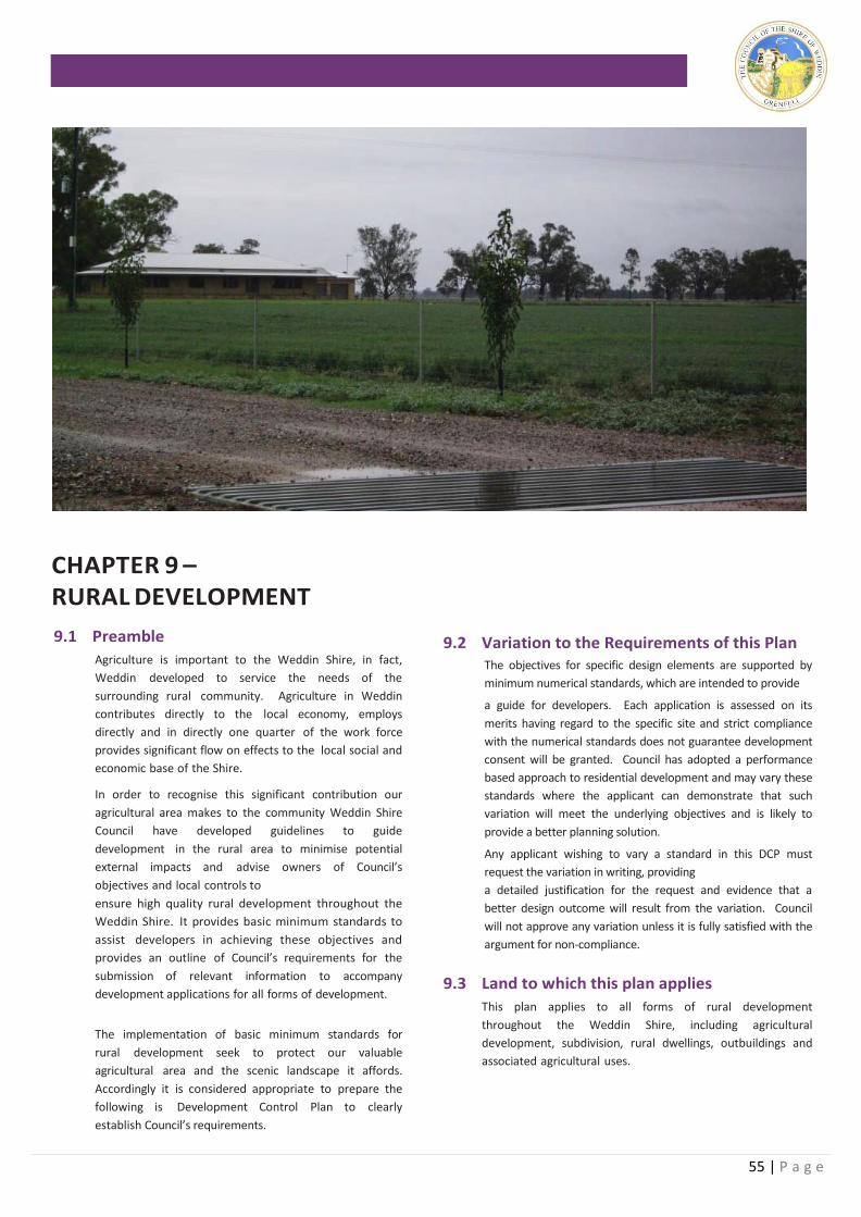
55 | P a g e
CHAPTER 9 – RURAL DEVELOPMENT
9.1 Preamble
Agriculture is important to the Weddin Shire, in fact,
Weddin developed to service the needs of the
surrounding rural community. Agriculture in Weddin
contributes directly to the local economy, employs
directly and in directly one quarter of the work force
provides significant flow on effects to the local social and
economic base of the Shire.
In order to recognise this significant contribution our
agricultural area makes to the community Weddin Shire
Council have developed guidelines to guide
development in the rural area to minimise potential
external impacts and advise owners of Council’s
objectives and local controls to
ensure high quality rural development throughout the
Weddin Shire. It provides basic minimum standards to
assist developers in achieving these objectives and
provides an outline of Council’s requirements for the
submission of relevant information to accompany
development applications for all forms of development.
The implementation of basic minimum standards for
rural development seek to protect our valuable
agricultural area and the scenic landscape it affords.
Accordingly it is considered appropriate to prepare the
following is Development Control Plan to clearly
establish Council’s requirements.
9.2 Variation to the Requirements of this Plan The objectives for specific design elements are supported by
minimum numerical standards, which are intended to provide
a guide for developers. Each application is assessed on its
merits having regard to the specific site and strict compliance
with the numerical standards does not guarantee development
consent will be granted. Council has adopted a performance
based approach to residential development and may vary these
standards where the applicant can demonstrate that such
variation will meet the underlying objectives and is likely to
provide a better planning solution.
Any applicant wishing to vary a standard in this DCP must
request the variation in writing, providing
a detailed justification for the request and evidence that a
better design outcome will result from the variation. Council
will not approve any variation unless it is fully satisfied with the
argument for non-compliance.
9.3 Land to which this plan applies
This plan applies to all forms of rural development
throughout the Weddin Shire, including agricultural
development, subdivision, rural dwellings, outbuildings and
associated agricultural uses.
56 | P a g e
9.4 Objectives
The Objectives of this section of the Weddin
Development Control Plan are to:
(a) To protect the agriculturally productive capacity of
our rural land;
(b) Ensure that rural living developments are integrated
with the landscape;
(c) Ensure subdivision potential is compatible with the
capability of the land;
(d) To minimise rural land use conflict; and
(e) Maintain existing stands of vegetation.
9.5 Minimum Allotment Size
Objectives
• To protect the valuable agricultural land resource within
Weddin.
• To implement minimum allotment sizes which reflect the
amount of land needed to accommodate sustainable
agriculture.
Standards 1. There is no minimum allotment size for land proposed
for the purposes of agriculture. Minimum allotments
sizes are attributed to dwelling house entitlements.
i) The minimum allotment size for an allotment
seeking a dwelling entitlement is 400 hectares.
9.6 Location within Agriculturally Productive
Area
Objectives
• To recognise and protect the valuable agriculturally
productive land of the Weddin Shire.
• To increase awareness of the realities of developing and
living in the country.
Standards 1. Applicants need to recognise they are proposing to
develop within an agriculturally productive area.
2. Council may impose conditions or requirements
upon development consents or land covenants
acknowledging the diversity of agriculture and
potential external impacts.
9.7 Rural Land Use Conflict
Objectives
• To acknowledge rural land use conflict as a major threat
to the sustainability of agriculture within the Weddin Shire.
• To minimise the opportunities for rural land use conflicts.
• To maintain the rural visual character of agriculture within
the Weddin Shire.
• To provide separation between residential uses and noise
generating sources.
Standards
1. A minimum separation distance of 150 metres as well
as landscape screening shall be provided in new
developments which adjoin incompatible land uses to
accommodate noise, odours and chemical spray.
2. A minimum set back of 30 metres is required for all
rural dwellings to all existing public roads.
9.8 Identification of Building Envelope
Objectives
• To plan for and consider the location of future buildings
prior to establishing new allotment boundaries.
Standards
1. All applications for subdivision shall identify future
building envelopes prior to subdivision approval.
Council may impose a restriction upon the title of any
new allotments restricting buildings to within
identified locations.
2. Building envelopes should be of sufficient size to
accommodate a dwelling and associated outbuildings
including adequate effluent disposal requirements
taking into consideration the topography and soil
conditions.
3. Building envelopes should be on land which is
predominantly flat and clear to minimize surface runoff,
cut, fill and stability issues.
4. Building envelopes should where possible avoid high
quality agricultural land.
9.9 Building Siting and Design
Objectives
• To minimise the impact of development upon the rural
landscape
• To encourage applicants to consider the overall layout of
their development in conjunction with the site upon which
it is proposed.
Standards
1. The location of buildings should minimize the removal
of existing vegetation.
2. Buildings should complement the characteristics of the
landform as depicted below.
57 | P a g e
OUTBUILDINGS
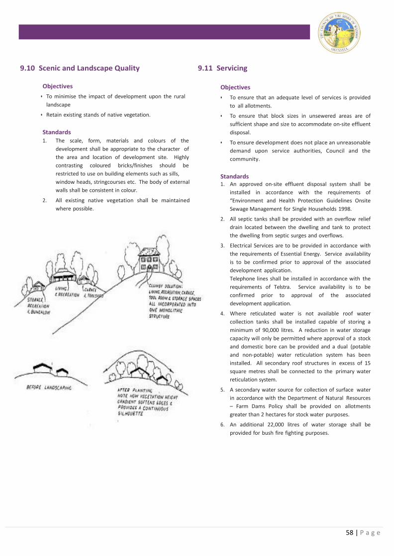
58 | P a g e
9.10 Scenic and Landscape Quality 9.11 Servicing
Objectives
• To minimise the impact of development upon the rural
landscape
• Retain existing stands of native vegetation.
Standards
1. The scale, form, materials and colours of the
development shall be appropriate to the character of
the area and location of development site. Highly
contrasting coloured bricks/finishes should be
restricted to use on building elements such as sills,
window heads, stringcourses etc. The body of external
walls shall be consistent in colour.
2. All existing native vegetation shall be maintained
where possible.
Objectives
• To ensure that an adequate level of services is provided
to all allotments.
• To ensure that block sizes in unsewered areas are of
sufficient shape and size to accommodate on-site effluent
disposal.
• To ensure development does not place an unreasonable
demand upon service authorities, Council and the
community.
Standards 1. An approved on-site effluent disposal system shall be
installed in accordance with the requirements of
“Environment and Health Protection Guidelines Onsite
Sewage Management for Single Households 1998.
2. All septic tanks shall be provided with an overflow relief
drain located between the dwelling and tank to protect
the dwelling from septic surges and overflows.
3. Electrical Services are to be provided in accordance with
the requirements of Essential Energy. Service availability
is to be confirmed prior to approval of the associated
development application.
Telephone lines shall be installed in accordance with the
requirements of Telstra. Service availability is to be
confirmed prior to approval of the associated
development application.
4. Where reticulated water is not available roof water
collection tanks shall be installed capable of storing a
minimum of 90,000 litres. A reduction in water storage
capacity will only be permitted where approval of a stock
and domestic bore can be provided and a dual (potable
and non-potable) water reticulation system has been
installed. All secondary roof structures in excess of 15
square metres shall be connected to the primary water
reticulation system.
5. A secondary water source for collection of surface water
in accordance with the Department of Natural Resources
– Farm Dams Policy shall be provided on allotments
greater than 2 hectares for stock water purposes.
6. An additional 22,000 litres of water storage shall be
provided for bush fire fighting purposes.
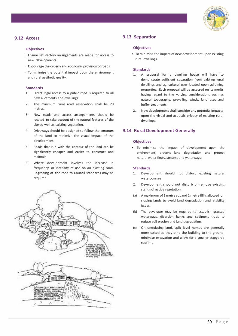
59 | P a g e
9.12 Access
Objectives
• Ensure satisfactory arrangements are made for access to
new developments
• Encourage the orderly and economic provision of roads
• To minimise the potential impact upon the environment
and rural aesthetic quality.
Standards
1. Direct legal access to a public road is required to all
new allotments and dwellings.
2. The minimum rural road reservation shall be 20 metres.
3. New roads and access arrangements should be
located to take account of the natural features of the
site as well as existing vegetation.
4. Driveways should be designed to follow the contours
of the land to minimize the visual impact of the
development.
5. Roads that run with the contour of the land can be
significantly cheaper and easier to construct and
maintain.
6. Where development involves the increase in
frequency or intensity of use on an existing road,
upgrading of the road to Council standards may be
required.
9.13 Separation
Objectives
• To minimise the impact of new development upon existing
rural dwellings.
Standards 1. A proposal for a dwelling house will have to
demonstrate sufficient separation from existing rural
dwellings and agricultural uses located upon adjoining
properties. Each proposal will be assessed on its merits
having regard to the varying considerations such as
natural topography, prevailing winds, land uses and
buffer treatments.
2. New development shall consider any potential impacts
upon the visual and acoustic privacy of existing rural
dwellings.
9.14 Rural Development Generally
Objectives
• To minimise the impact of development upon the
environment, prevent land degradation and protect
natural water flows, streams and waterways.
Standards
1. Development should not disturb existing natural
watercourses
2. Development should not disturb or remove existing
stands of native vegetation.
(a) A maximum of 1 metre cut and 1 metre fill is allowed on
sloping lands to avoid land degradation and stability
issues.
(b) The developer may be required to establish grassed
waterways, diversion banks and sediment traps to
reduce soil erosion and land degradation.
(c) On undulating land, split level homes are generally
more suited as they bind the building to the ground,
minimise excavation and allow for a smaller staggered
roof line
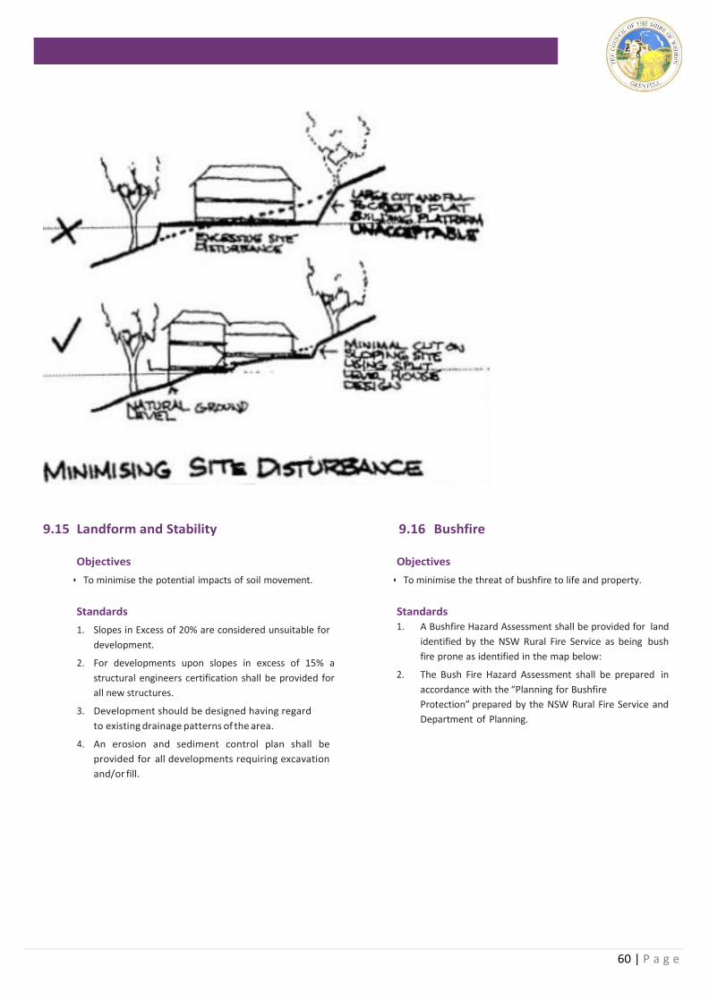
60 | P a g e
9.15 Landform and Stability
Objectives
• To minimise the potential impacts of soil movement.
Standards
1. Slopes in Excess of 20% are considered unsuitable for
development.
2. For developments upon slopes in excess of 15% a
structural engineers certification shall be provided for
all new structures.
3. Development should be designed having regard
to existing drainage patterns of the area.
4. An erosion and sediment control plan shall be
provided for all developments requiring excavation
and/or fill.
9.16 Bushfire
Objectives
• To minimise the threat of bushfire to life and property.
Standards 1. A Bushfire Hazard Assessment shall be provided for land
identified by the NSW Rural Fire Service as being bush
fire prone as identified in the map below:
2. The Bush Fire Hazard Assessment shall be prepared in
accordance with the “Planning for Bushfire
Protection” prepared by the NSW Rural Fire Service and
Department of Planning.
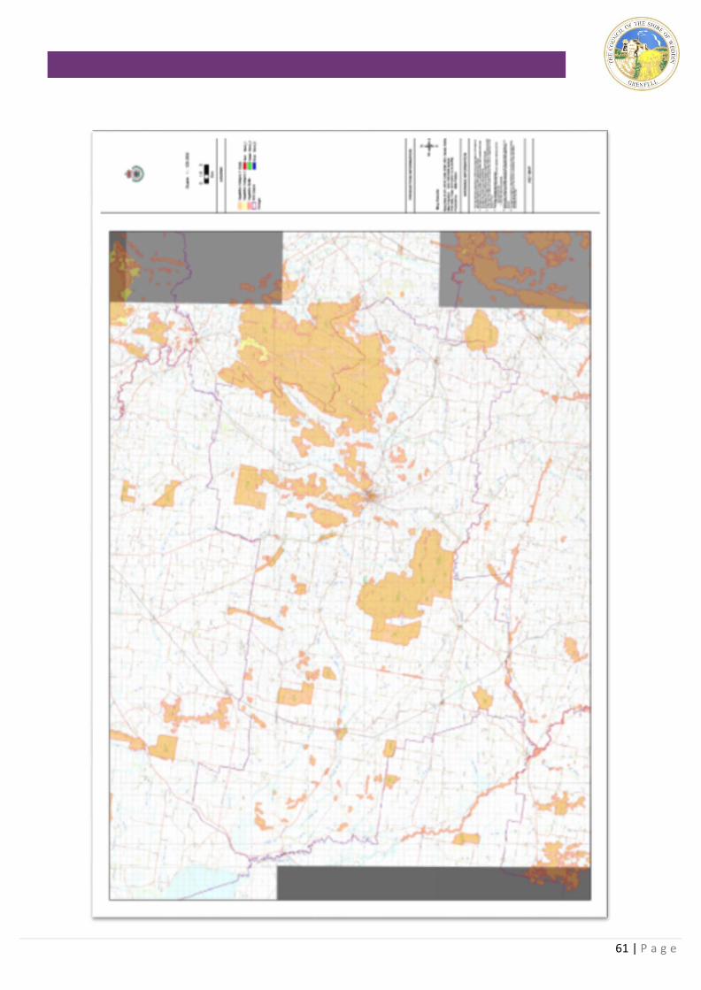
61 | P a g e
62 | P a g e
9.17 Outdoor Advertising/Signage
Objectives
• To ensue outdoor advertising is lawful and approved in
accordance with the Environmental Planning and
Assessment Act, 1979.
• To enhance the visual landscape of the Shire of Weddin.
• To establish general guidelines to be followed in the
design and siting of outdoor advertising.
• To avoid the proliferation of signage along the Shires
Roads
Standards
1. A development application is required to be lodged
and approval obtained prior to the erection or
alteration of business identification signage and
advertising signage throughout the Shire.
2. A property name may be displayed within the
property to which it related without the need to
obtain development approval.
3. The sign must relate to a lawful or approved use of
the land and located upon the land where the
activity is carried out.
4. A maximum of one (1) sign per site is permitted.
5. The advertising sign must be located upon private
land and not within the road reserve or upon public
land.
6. A maximum advertising panel of 2.5m2 is permitted.
7. The maximum height of the entire advertising
structure is 2 metres.
8. The sign must be made of non-reflective material.
9. The sign must be setback 3 metres from a corner or
intersection of the road.
10. The advertising sign must be free standing.
11. Illumination is not permitted.
12. No advertising structures are permitted on rural land.
9.18 New Transportable Homes
Objectives
• To permit the placement of new transportable homes
with appropriate approvals.
Standards 1. A development application is required for the
residential use of the land.
2. A Section 68 Approval is required for the placement
of the transportable dwelling including details of
appropriate construction techniques
3. A BASIX Certificate is not required for transportable/
relocatable homes.
4. The front of the transportable dwelling shall be
orientated toward the primary street frontage where it
can be easily seen from the street.
5. A subfloor curtain shall be provided to obscure the
footing from public view.
9.19 Relocation of Existing Dwellings – Relocated Homes
Objectives
To permit the relocation of existing dwellings within the
residential area within keeping of existing residential
development.
Standards
1. A development application is required for the residential
use of the land.
2. A Section 68 Approval is required for the placement of
the transportable dwelling including details of
appropriate construction techniques.
3. A photographic profile shall be provided with the DA
including floor plans and elevations.
4. Structural certification of the footings and cut lines shall
be provided prior to the issue of the Occupation
Certificate.
5. Certification from a qualified Hygienist that the
relocated dwelling is free from asbestos shall be
provided prior to the issue of the Occupation
Certificate.
6. A BASIX Certificate is not required for relocated homes.
7. The front of the dwelling shall be orientated toward the
primary street frontage.
8. A subfloor curtain shall be provided to obscure the
footing from public view.
9. Final inspection and Occupation Certificate shall be
completed within 12 months including all external
finishes.
10. A bond as indicated in the fees and charges section of
Council’s management plan will be held by Council to
ensure completion of satisfactory works. This bond may
be withheld in lieu of an approved Management Plan
for
the proposed works.
63 | P a g e
9.20 Intensive Agriculture
Objectives
• To promote intensive agricultural development in
appropriate locations.
• To minimise potential impacts upon surrounding
properties and the environment.
Standards
1. Separation of intensive agricultural developments
from existing dwellings shall be based upon
potential land use conflict investigations including,
noise, odour, spray drift etc.
2. Relevant industry guidelines should be followed in
the design of intensive agricultural developments
and will form an important part of Council’s
assessment of proposed developments.
3. Applications for development likely to generate
noise, odour or other environmental nuisance shall
be accompanied by an assessment report prepared
by a suitably qualified practitioner considering the
environmental standards of the Department of
Environment and Conservation. Consideration
should be given to amelioration techniques and the
location of existing surrounding rural dwellings in
regard to prevailing winds.
9.21 Non-Agricultural Development
Objectives
• To permit non-agricultural development within the
rural area where it will not adversely potential
agricultural production nor impact upon adjoining
properties.
Standards
1. Developments which have the potential to generate
traffic should consider the likely traffic generation
and the condition and capacity of the road system.
2. Any necessary road upgrades to cater for the
proposed development will be the responsibility of
the applicant.
3. Applications for development likely to generate
noise, odour or other environmental nuisance shall
be accompanied by an assessment report prepared
by a suitably qualified practitioner considering the
environmental standards of the Department of
Environment and Conservation. Consideration
should be given to amelioration techniques and the
location of existing surrounding rural dwellings in
regard to prevailing winds.
4. Low scale rural tourist facilities are encouraged in the form of farm stay and bed and breakfast facilities. Larger proposals will be considered on their merits.
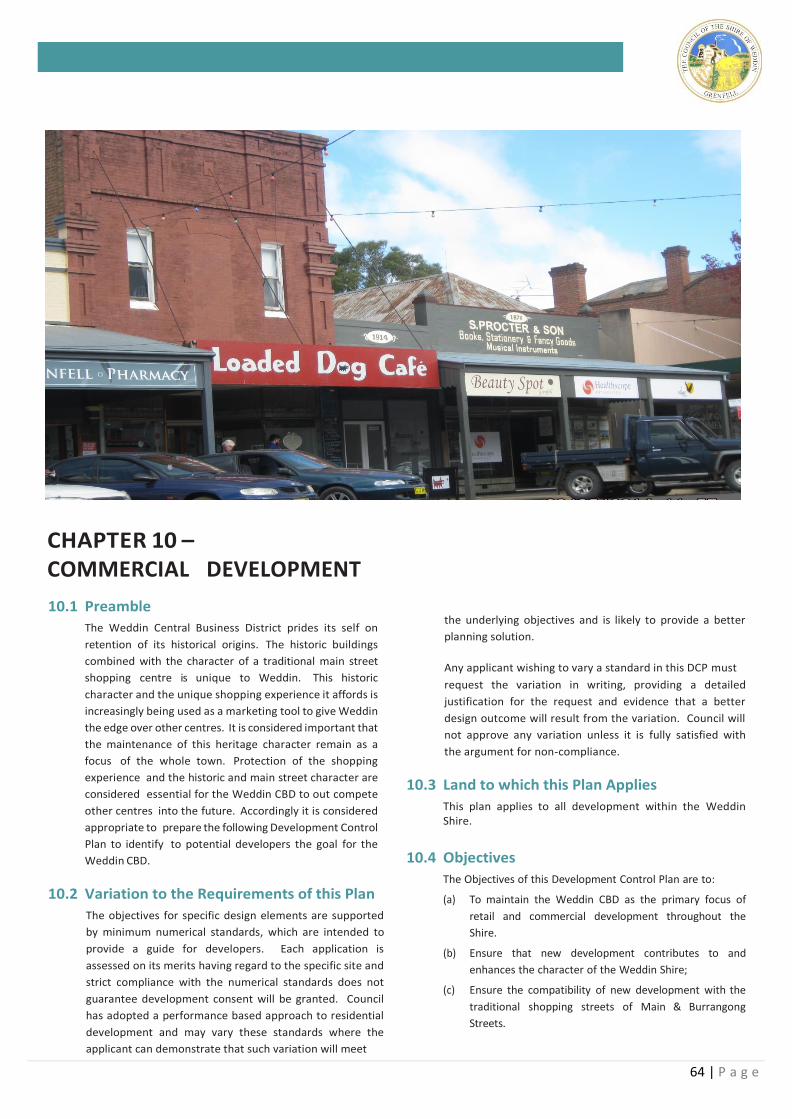
64 | P a g e
CHAPTER 10 – COMMERCIAL DEVELOPMENT
10.1 Preamble
The Weddin Central Business District prides its self on
retention of its historical origins. The historic buildings
combined with the character of a traditional main street
shopping centre is unique to Weddin. This historic
character and the unique shopping experience it affords is
increasingly being used as a marketing tool to give Weddin
the edge over other centres. It is considered important that
the maintenance of this heritage character remain as a
focus of the whole town. Protection of the shopping
experience and the historic and main street character are
considered essential for the Weddin CBD to out compete
other centres into the future. Accordingly it is considered
appropriate to prepare the following Development Control
Plan to identify to potential developers the goal for the
Weddin CBD.
10.2 Variation to the Requirements of this Plan
The objectives for specific design elements are supported
by minimum numerical standards, which are intended to
provide a guide for developers. Each application is
assessed on its merits having regard to the specific site and
strict compliance with the numerical standards does not
guarantee development consent will be granted. Council
has adopted a performance based approach to residential
development and may vary these standards where the
applicant can demonstrate that such variation will meet
the underlying objectives and is likely to provide a better
planning solution.
Any applicant wishing to vary a standard in this DCP must
request the variation in writing, providing a detailed
justification for the request and evidence that a better
design outcome will result from the variation. Council will
not approve any variation unless it is fully satisfied with
the argument for non-compliance.
10.3 Land to which this Plan Applies
This plan applies to all development within the Weddin Shire.
10.4 Objectives
The Objectives of this Development Control Plan are to:
(a) To maintain the Weddin CBD as the primary focus of
retail and commercial development throughout the
Shire.
(b) Ensure that new development contributes to and
enhances the character of the Weddin Shire;
(c) Ensure the compatibility of new development with the
traditional shopping streets of Main & Burrangong
Streets.
65 | P a g e
10.5 Change of Occupancy/Tenancy
Objectives
• To permit minor and incidental change of occupancies to
occur without the need to lodge a development
application.
Standards
1. The change of use of retail and office and industrial
premises is controlled by State Environmental
Planning Policy (Exempt and Complying
Development Codes) 2008. All other changes in the
use of premises requires lodgement of a
Development Application.
2. Any necessary internal alterations to accommodate
the new use shall require separate construction
certificate detailing compliance with the BCA.
3. Any changes to external advertising/signage will
require separate development approval
4. Disabled access will be required to be incorporated in
any remodelling of shopfronts or access
reconfigurations.
10.6 Building Line/Street Frontage
Objectives
• To promote consistency in the streetscape and commercial
amenity of the commercial street.
• To promote new developments to consider their visual
appearance and contribution to the streetscape.
Standards
1. There is no formal building line setback, however the
siting of buildings is to be harmonious with
immediately adjoining buildings and the existing
streetscape within the vicinity of the proposed
development.
2. All commercial developments are to be harmonious
in terms of their size, scale and bulk with surrounding
properties and the general area in which they are
located.
3. Proposed car parking within the front setback area is
to be incorporated in the design and landscape
solution for this area of the development.
10.7 Side and Secondary Setbacks Objectives
• To provide adequate areas for site landscaping.
• To ensure internal separation to minimise potential
impacts between adjoining developments.
Standards
1. Side and secondary setbacks are to be considered on
merit in regard to consistency within the streetscape
and impacts upon adjoining properties.
2. Consideration shall be given to screening of storage/
loading areas etc from public view.
3. Landscaped areas shall consider potential impacts
between developments and opportunities to reduce
conflict.
10.8 Building Height
Objectives
• To maintain a consistency in the urban streetscape.
• To minimise impacts upon adjoining properties.
Standards
1. The maximum height of buildings shall be 2 storeys
and 17 metres.
2. Consideration shall be given to the height of a
development in regard to its consistency with the
urban streetscape and minimise impacts upon
adjoining properties.
10.9 Materials
Objectives
• To maintain a consistency in the streetscape.
• To protect the heritage qualities of the building and/or
immediate area
Standards
1. New development shall be compatible with the
character of an existing building and that of
immediately surrounding properties.
2. Where there is no prevailing character, new
development shall respect the qualities of
surrounding properties in integrating new
development within the commercial core.
10.10 Advertising
Objectives
• To ensue outdoor advertising is considered and assessed
in accordance with the Environmental Planning and
Assessment Act, 1979.
• To enhance the visual landscape of the Shire of Weddin.
• To ensure the traditional historical character of the
Weddin commercial centre is maintained.
• To prevent the over proliferation of advertising associated
with any single property.
• To reduce the visual complexity of the streetscape by
providing fewer, more effective advertising.
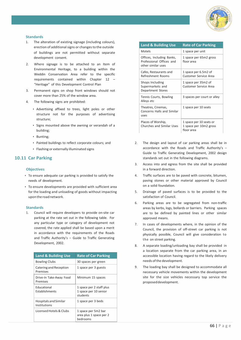
66 | P a g e
Land & Building Use Rate of Car Parking
Bowling Clubs 30 spaces per green
Catering and Reception Premises
1 space per 3 guests
Drive-In Take-Away Food Premises
Minimum 15 spaces
Educational Establishments
1 space per 2 staff plus 1 space per 10 senior students
Hospitals and Similar Institutions
1 space per 3 beds
Licensed Hotels & Clubs 1 space per 5m2 bar area plus 1 space per 2 bedrooms
Standards
1. The alteration of existing signage (including colours),
erection of additional signs or changes to the outside
of buildings are not permitted without separate
development consent.
2. Where signage is to be attached to an Item of
Environmental Heritage, to a building within the
Weddin Conservation Area refer to the specific
requirements contained within Chapter 12 –
“Heritage” of this Development Control Plan
3. Permanent signs on shop front windows should not
cover more than 25% of the window area.
4. The following signs are prohibited:
• Advertising affixed to trees, light poles or other
structure not for the purposes of advertising
structure;
• Signs mounted above the awning or verandah of a
building;
• Bunting;
• Painted buildings to reflect corporate colours; and
• Flashing or externally illuminated signs
10.11 Car Parking
Objectives
• To ensure adequate car parking is provided to satisfy the
needs of development.
• To ensure developments are provided with sufficient area
for the loading and unloading of goods without impacting
upon the road network.
Standards 1. Council will require developers to provide on-site car
parking at the rate set out in the following table. For
any particular type or category of development not
covered, the rate applied shall be based upon a merit
in accordance with the requirements of the Roads
and Traffic Authority’s – Guide to Traffic Generating
Development, 2002.
2. The design and layout of car parking areas shall be in
accordance with the Roads and Traffic Authority’s –
Guide to Traffic Generating Development, 2002 design
standards set out in the following diagrams.
3. Access into and egress from the site shall be provided
in a forward direction.
4. Traffic surfaces are to be paved with concrete, bitumen,
paving stones or other material approved by Council
on a solid foundation.
5. Drainage of paved surfaces is to be provided to the
satisfaction of Council.
6. Parking areas are to be segregated from non-traffic
areas by kerbs, logs, bollards or barriers. Parking spaces
are to be defined by painted lines or other similar
approved means.
7. In cases of developments where, in the opinion of the
Council, the provision of off-street car parking is not
physically possible, Council will give consideration to
the on street parking.
8. A separate loading/unloading bay shall be provided in
a location separate from the car parking area, in an
accessible location having regard to the likely delivery
needs of the development.
9. The loading bay shall be designed to accommodate all
necessary vehicle movements within the development
site for the size vehicles necessary top service the
proposed development.
Land & Building Use Rate of Car Parking
Motels 1 space per unit
Offices, Including Banks, Professional Offices and other similar uses
1 space per 65m2 gross floor area
Cafes, Restaurants and Refreshment Rooms
1 space per 6.5m2 of Customer Service Area
Shops Including Supermarkets and Department Stores
1 space per 35m2 of Customer Service Area
Tennis Courts, Bowling Alleys etc
3 spaces per court or alley
Theatres, Cinemas, Concerns Halls and Similar uses
1 space per 10 seats
Places of Worship, Churches and Similar Uses
1 space per 10 seats or 1 space per 10m2 gross floor area
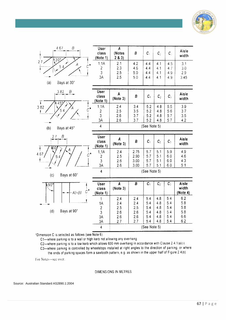
67 | P a g e
Source: Australian Standard AS2890.1:2004
68 | P a g e
10.12 Landscaping
Objectives
• To provide adequate areas for site landscaping in order to
soften the potential impacts (in particular visual) of
development.
• To ensure Council has adequate information to consider
and assess proposed landscaping to be provided in
conjunction with development applications.
• To provide a reference plan for the installation and
implementation of landscaped areas.
• To encourage the use of native vegetation for its tolerance
to the climate of Weddin including hot, dry summers and
cold, frosty winters.
• To retain where possible all existing native vegetation.
Standards
1. All development applications for new commercial
developments are to be accompanied by a Landscape
Plan.
2. Commercial developments upon vacant land shall
provide a minimum 10% of the site for landscaping.
3. All landscaped areas are to use predominantly native
vegetation. A minimum 80% of landscaping shall
utilise native vegetation. A list of recommended plant
species are identified in Appendix 1. These plant
species have been shown to be suited to the climate
of the Central West many are native to the Weddin
district.
4. Landscaping proposed in Saline areas shall use a
minimum 80% Salt tolerant and water wise plant
species. Recommended plant species for such
situations are identified in Appendix 2. Not attached.
5. All existing native vegetation is to be retained and
where possible enhanced with additional plantings
and landscaping.
6. Existing street trees shall be maintained and
replicated. The spacing of such trees shall be a
minimum of 1.5 times the mature canopy of the
proposed tree and a maximum 2 times the mature
tree canopy.
10.13 Side Walk Dining
Objectives
• To encourage side walk dining where it can be
accommodated without impacting upon pedestrian
movement or adjoining properties.
Standards
1. A S68 Application is required for use of the Council
footway.
2. Applications for use of the Council footway will be
considered and assessed on their merits.
69 | P a g e
CHAPTER 11– INDUSTRIAL DEVELOPMENT 11.1 Preamble
Weddin Shire actively promotes and seeks new industrial
development to support the existing agricultural base
and bolster the Shires economy. Industrial use of the
land should not however be at the expense of the
environment, both natural and physical. Accordingly it is
considered appropriate to prepare the following
Development Control Plan to identify the controls
imposed upon industrial development in order to inform
potential developers and promote a sustainable urban
environment.
11.2 Variation to the Requirements of this Plan
The objectives for specific design elements are supported by minimum numerical standards, which are intended to provide a guide for developers. Each application is assessed on its merits having regard to the specific site and strict compliance with the numerical standards does not guarantee development consent will be granted.
Council has adopted a performance based approach to residential development and may vary these standards where the applicant can demonstrate that such variation will meet the underlying objectives and is likely to provide a better planning solution.
Any applicant wishing to vary a standard in this DCP must
request the variation in writing, providing a detailed justification for the request and evidence that a better design outcome will result from the variation. Council will
not approve any variation unless it is fully satisfied with the argument for non-compliance.
11.3 Land to which this Plan Applies
This plan applies to all industrial development (including
light industrial development) within the Weddin Shire.
11.4 Objectives
The Objectives of this Development Control Plan are to:
(a) Ensure that industrial developments do not have an
adverse impact on surrounding land use or the
environment.
(b) To ensure that industrial developments contribute to
and enhances the visual and landscape character of the
Weddin Shire.
(c) To ensure good access, circulation and loading facilities
on sites and adequate services and the disposal of
waste.
11.5 Change of Occupancy/Tenancy
Objectives
To permit minor and incidental change of occupancies to
occur without the need to lodge a development application.
Standards
1. The change of use of retail and office and industrial
70 | P a g e
premises is controlled by State Environmental
Planning Policy (Exempt and Complying
Development Codes) 2008. All other changes in the
use of premises requires lodgement of a
Development Application.
2. Any necessary internal alterations to accommodate
the new use shall require separate construction
certificate detailing compliance with the BCA.
3. Any changes to external advertising/signage will
require separate development approval.
4. Disabled access will be required to be incorporated in
any re-modeling of business fronts or access
reconfigurations.
11.6 Dwellings On Industrial Land
Objectives
• To restrict dwellings upon industrial allotments to those
legitimately needed in conjunction with the industrial use
conducted upon the land.
• To manage. where possible, the natural conflicts between
residential and industrial use of land.
Standards
1. Upon general industrial land dwelling-houses will be
permitted on industrial land only where it meets the
following development standards
• Only one dwelling or care takers cottage is
permitted per allotment
• Dual occupancy development is not permitted
on industrial land
• The dwelling is subsidiary to the industrial use of
the land
• The dwelling does not have a floor area greater
than 90m²
• The dwelling is constructed over the rear 30% of
the allotment.
2. Alterations and additions are permitted to an existing
dwelling located upon industrial land to a maximum
floor area of 90m2.
11.7 Building Line
Objectives
• To maintain a consistency in the streetscape and promote
the urban amenity.
• To encourage industrial developments presentation to the
street.
Standards
1. Generally the building line is 6 metres for light
industrial development and 15 metres for general and
heavy industrial development, however the siting of
buildings is to be harmonious with the existing
streetscape, adjoining developments and the
immediately surrounding area.
2. The area in front of the building shall be suitably
landscaped;
3. All waste and storage areas are to be located behind
the building line and obscured from view.
11.8 Site Coverage and Floor Space Ratio
Objectives
• To restrict the overdevelopment of land within the
industrial area.
• To ensure satisfactory provision of all necessary facilities in
conjunction with industrial development are contained
within the development site.
Standards 1. The floor space ratio shall not exceed 1:1 with a
maximum site coverage of 50%.
11.9 Advertising in Industrial Areas
Objectives
• To prevent the proliferation of signage throughout the
industrial areas of Weddin while enabling business
identification and display.
Standards 1. The advertising sign must be located upon the land
where the activity is carried out.
2. Advertising should be integrated with building design,
landscaping and general site operation.
3. One pole, pylon or post mounted sign is permitted per
site
4. The advertising area must not exceed 4m2.
5. The maximum height of the entire advertising structure
is 4 metres.
6. Signs for each unit in a multiple occupancy
development should be of uniform size and design.
7. The following signs are prohibited:
(a) Advertising affixed to trees, light poles or other
structure not for the purposes of advertising structure.
(b) Signs mounted above the awning or verandah of a
building.
(c) Bunting
(d) Painted buildings to reflect corporate colours
(e) Flashing or externally illuminated signs
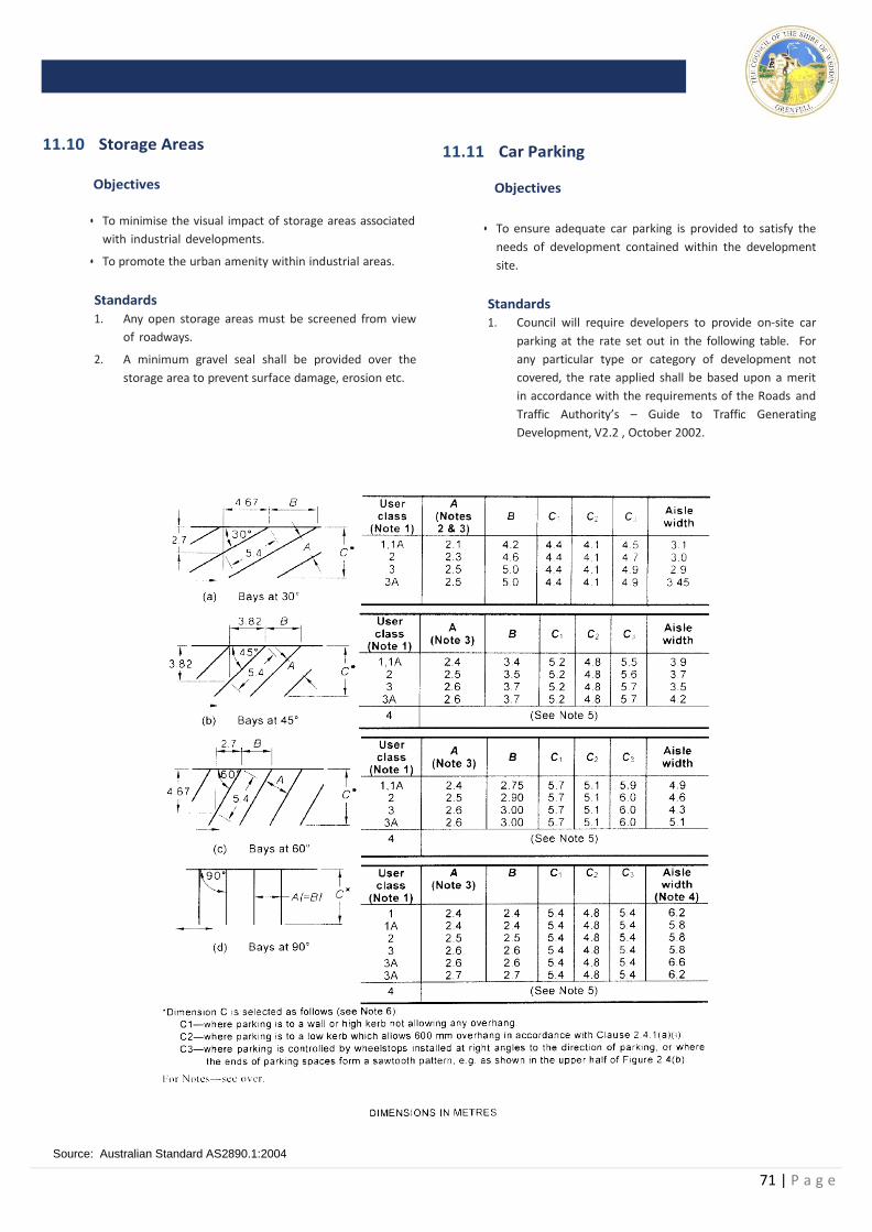
71 | P a g e
11.10 Storage Areas
Objectives
• To minimise the visual impact of storage areas associated
with industrial developments.
• To promote the urban amenity within industrial areas.
Standards
1. Any open storage areas must be screened from view
of roadways.
2. A minimum gravel seal shall be provided over the
storage area to prevent surface damage, erosion etc.
11.11 Car Parking Objectives
• To ensure adequate car parking is provided to satisfy the
needs of development contained within the development
site.
Standards 1. Council will require developers to provide on-site car
parking at the rate set out in the following table. For
any particular type or category of development not
covered, the rate applied shall be based upon a merit
in accordance with the requirements of the Roads and
Traffic Authority’s – Guide to Traffic Generating
Development, V2.2 , October 2002.
Source: Australian Standard AS2890.1:2004
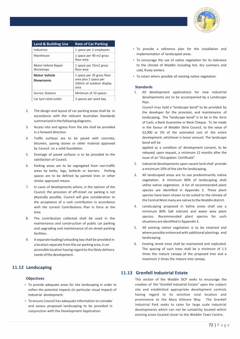
72 | P a g e
Land & Building Use Rate of Car Parking
Industries 1 space per 2 employees
Warehouse 1 space per 90 m2 gross floor area
Motor Vehicle Repair Workshops
1 space per 55m2 gross floor area
Motor Vehicle
Showrooms
1 space per 35 gross floor area plus 1 space per 160m2 of outdoor display area
Service Stations Minimum of 10 spaces
Car tyre retail outlet 3 spaces per work bay
• To provide a reference plan for the installation and
implementation of landscaped areas.
• To encourage the use of native vegetation for its tolerance
to the climate of Weddin including hot, dry summers and
cold, frosty winters.
• To retain where possible all existing native vegetation.
2. The design and layout of car parking areas shall be in
accordance with the relevant Australian Standards
summarised in the following diagrams.
3. Access into and egress from the site shall be provided
in a forward direction.
4. Traffic surfaces are to be paved with concrete,
bitumen, paving stones or other material approved
by Council on a solid foundation.
5. Drainage of paved surfaces is to be provided to the
satisfaction of Council.
6. Parking areas are to be segregated from non-traffic
areas by kerbs, logs, bollards or barriers. Parking
spaces are to be defined by painted lines or other
similar approved means.
7. In cases of developments where, in the opinion of the
Council, the provision of off-street car parking is not
physically possible, Council will give consideration to
the acceptance of a cash contribution in accordance
with the current Contributions Plan in force at the
time.
8. The contribution collected shall be used in the
maintenance and construction of public car parking
and upgrading and maintenance of on-street parking
facilities.
9. A separate loading/unloading bay shall be provided in
a location separate from the car parking area, in an
accessible location having regard to the likely delivery
needs of the development.
11.12 Landscaping
Objectives
• To provide adequate areas for site landscaping in order to
soften the potential impacts (in particular visual impact) of
industrial development.
• To ensure Council has adequate information to consider
and assess proposed landscaping to be provided in
conjunction with the Development Application.
Standards 1. All development applications for new industrial
developments are to be accompanied by a Landscape
Plan.
Council may hold a “landscape bond” to be provided by
the developer for the provision, and maintenance of
landscaping. The “landscape bond” is to be in the form
of Cash, a Bank Guarantee or Bank Cheque. To be made
in the favour of Weddin Shire Council, to the value of
$2,000 or 5% of the estimated cost of the entire
development, whichever is lesser amount. The landscape
bond will be
applied as a condition of development consent, to be
released, upon request, a minimum 12 months after the
issue of an “Occupation Certificate”.
2. Industrial developments upon vacant land shall provide
a minimum 10% of the site for landscaping.
3. All landscaped areas are to use predominantly native
vegetation. A minimum 80% of landscaping shall
utilise native vegetation. A list of recommended plant
species are identified in Appendix 2. These plant
species have been shown to be suited to the climate of
the Central West many are native to the Weddin district.
4. Landscaping proposed in Saline areas shall use a
minimum 80% Salt tolerant and water wise plant
species. Recommended plant species for such
situations are identified in Appendix 3.
5. All existing native vegetation is to be retained and
where possible enhanced with additional plantings and
landscaping.
6. Existing street trees shall be maintained and replicated.
The spacing of such trees shall be a minimum of 1.5
times the mature canopy of the proposed tree and a
maximum 2 times the mature tree canopy.
11.13 Grenfell Industrial Estate
This section of the Weddin DCP seeks to encourage the
creation of the “Grenfell Industrial Estate” upon the subject
site and established appropriate development controls
having regard to its sensitive rural location and
prominence to the Mary Gilmore Way. The Grenfell
Industrial Park seeks to cater for large scale industrial
developments which can not be suitability located within
existing areas located closer to the Weddin Town Centre.
73 | P a g e
.
Objectives
• To establish a “Masterplan” to guide the development of
the “Grenfell Industrial Estate”;
• To facilitate and control the industrial development of the
site to cater for large industrial developments not suitably
located within existing industrial areas located closer to
the Weddin Town Centre;
• To encourage and promote the orderly and economic
development of the site;
• To achieve a high quality integrated development having
regard to its visual prominence and environmental
sensitivity;
• To provide for a variety of industrial allotments to serve
the demands for the industrial and economic growth of
Weddin; and
• To ensure the provision of appropriate on-site servicing
requirements in an environmentally acceptable manner.
11.13.1 Allotments and Land Use
Objectives
• To ensure that each allotment has an appropriate
minimum area in regard to environmental and industrial
needs.
• To provide a variety of allotment sizes in an endeavour to
meet the demands of potential developments.
• To ensure allotments are economically viable and
developable having regard to specific site and servicing
needs.
• To minimise land use conflict.
Standards 1. The subdivision of the subject site for industrial
purposes shall be generally in accordance with the
Weddin Industrial Park Masterplan below. Alternative
allotment configurations have been identified to cater
for varying market requirements.
2. The creation of allotments of less than 4000m2 in area
will not be permitted. Regularly shaped allotments
shall be provided with a road frontage of not less
than 50 metres.
3. Applications for the further subdivision of allotments
identified on the Weddin Industrial Park Masterplan
shall demonstrate that the proposed
industrial development cannot be suitably located
within the traditional industrial area located adjacent
to the Weddin urban area and that each allotment to
be created can cater for the traffic and on-site
servicing needs for the intended development.
4. Developments which occupy more than one allotment
shall cause the consolidation of all immediately
adjoining allotments prior to the commencement of
operation.
11.13.2 Setbacks
Objectives
• To provide a visual buffer to the development when viewed
from surrounding rural areas and the Newell Highway.
• To provide adequate areas for site landscaping.
• To ensure internal separation to minimise potential
impacts between adjoining developments.
Standards
1. A minimum set back of 15 metres shall be provided to
all other roads.
2. A minimum side set back of 7.5 metres shall be
provided to all buildings and trafficable areas.
3. Front setback areas shall be used for landscaping and
car parking purposes. No industrial activities or open
storage shall occur within the front setback.
11.13.3 Traffic Management
Objectives
• To provide a road layout for the Weddin Industrial Park
suitable to it’s likely future needs.
• To encourage circular traffic movement to ease access
needs particularly for heavy vehicles.
Standards 1. The Mary Gilmore Way is an access denied road and no
direct vehicular access shall be permitted to internal
allotments.
2. All internal roads shall be provided with a minimum
road reserve of 30 metres. A minimum pavement
width of 15 metres is to be provided serviced by
grassed table drains rather than kerb and gutter.
3. All traffic servicing needs for individual developments
shall be accommodated on site.
74 | P a g e
11.13.4 Car Parking, Access, Loading and
Unloading
Objectives
• To ensure adequate car parking is provided on-site for
clients and employees.
• To ensure the smooth flow of traffic in and around the
Weddin Industrial Park.
• To ensure access parking and loading facilities are
integrated into the development to service individual
needs.
Standards
1. All access, parking and loading areas are to be
designed in accordance with the RMS
– Guide to Traffic Generating Development, V2.2 ,
October 2002. and Australian Standards AS2890 –
Parking Facilities and AS2890.1-1993 - Off Street Car
Parking, or as amended.
2. Individual site accesses provided are restricted to 1
driveway capable of accommodating B -Double
vehicles.
3. All trafficable areas are to be screened by landscaped
buffers a minimum of 2 metres wide.
4. All developments are to be provided with car parking,
loading and unloading facilities within the curtilage of
the site.
11.13.5 Urban Design
Objectives
• To encourage a high standard of architectural design
utilising high quality materials and finishes.
• To ensure development has regard to its rural location.
Standards
1. Development should avoid large blank wall surfaces.
Substantial elevations should be articulated either by
structural variation of external finishes.
2. Prominent elevations, such as street frontages should
be treated with suitable architectural features.
3. Attention should be given to energy efficiency
principles in building design.
11.13.6 Drainage, Soil Erosion and Control
Objectives
• To ensure the provision of on-site surface and storm water
drainage control.
• To ensure site drainage does not impact upon adjoining
properties.
• To ensure that development does not cause land
degradation through erosion and sedimentation.
Standards
1. All surface and storm water shall be catered for on-site.
Pre development flow volumes will be accepted into
the drainage reserves.
2. The Developer shall design and construct necessary
surface drainage works to be provided in the form of
“drainage reserves” to be dedicated to Council upon
creation of the relevant allotments.
3. An on-site drainage and storm water control system
shall be designed by a suitably qualified engineer and
constructed to cater for the drainage requirements of
each individual development.
4. The maintenance of on-site servicing works will be the
responsibility of the land owner and will be included as
a “Section 88B Restriction” upon the title of the
property”.
5. All roof water is to be collected and recycled for use
where possible in the resultant industrial development.
6. Suitable erosion and sediment control measures shall
be implemented during all construction works.
Note: Reference to “Section 88B restriction” refers to Section 88B
of the Conveyancing Act, 1919 (as amended).
11.13.7 Site Servicing
Objectives
• To promote the orderly and economic provision of
services.
• To coordinate the provision of services with the relevant
Service Authority.
• To minimise the burden upon Council’s and Service
Authority resources.
• To ensure the provision of suitable on-site drainage and
storm water management systems.
Standards
1. The developer will be responsible for the upgrading of
existing and the provision of new roads to service the
industrial estate.
75 | P a g e
2. The Developer or relevant Service Authority (at the
cost of the developer) will provide electricity and
telecommunication services.
3. The provision of all other services including the
extension of services within individual allotments
will be the responsibility of developers and owners.
4. An aerated on-site effluent disposal systems may be
required to be provided for all developments unable
to be serviced by reticulated system.
5. Effluent, Drainage and Storm water control shall be
provided within the confines of individual
allotments.
6. Open storage and waste collection areas are to be
suitably sited and screened to avoid view from
public areas and prominent rural views.
11.13.8 Landscaping
Objectives
• To enhance the visual appearance of individual
developments and the industrial estate generally.
• To screen undesirable views and reduce the visual
impact of the development having regard to it’s rural
setting.
• To provide functional areas of planting that enhance
the visual appearance of development.
• To assist in addressing salinity upon the subject site.
Standards
1. A landscape plan shall be submitted and approved
by Council with all development applications.
2. All front and side set back areas shall be landscaped
to Council’s satisfaction.
3. All security fencing shall be located behind the front
landscape setback. Species selection for planting
within this area shall have regard to site security.
4. Landscaping is to include predominantly native
vegetation. A minimum 80% are to be salt tolerant
and water-wise vegetation species.
11.13.9 Advertising
Objectives
• To ensure signage is integrated into the design of all
buildings.
• To prevent distraction to motorists and potential for
traffic conflicts.
Standards
1. One (1) business identification sign a maximum 2m x
1m shall be displayed within the front building setback
area.
2. A maximum of three (3) signs per development will be
permitted, only one of which is to be visible when the
development is viewed from any point external to the
site.
11.13.10 On-Site Living
Objectives
• To restrict residential living opportunities in the industrial
area
Standards 1. Residential development will not be supported by
Council in this industrial area.
2. Residential living opportunities will only be permitted
as single caretakers/security quarters where it can be
demonstrated it is a vital component of the development and it does not interfere with the industrial
development of the estate. Such quarters shall be
integrated into the design of the industrial
development.
3. A maximum of 90 square metres of Gross Floor Area
shall be permitted for residential purposes.
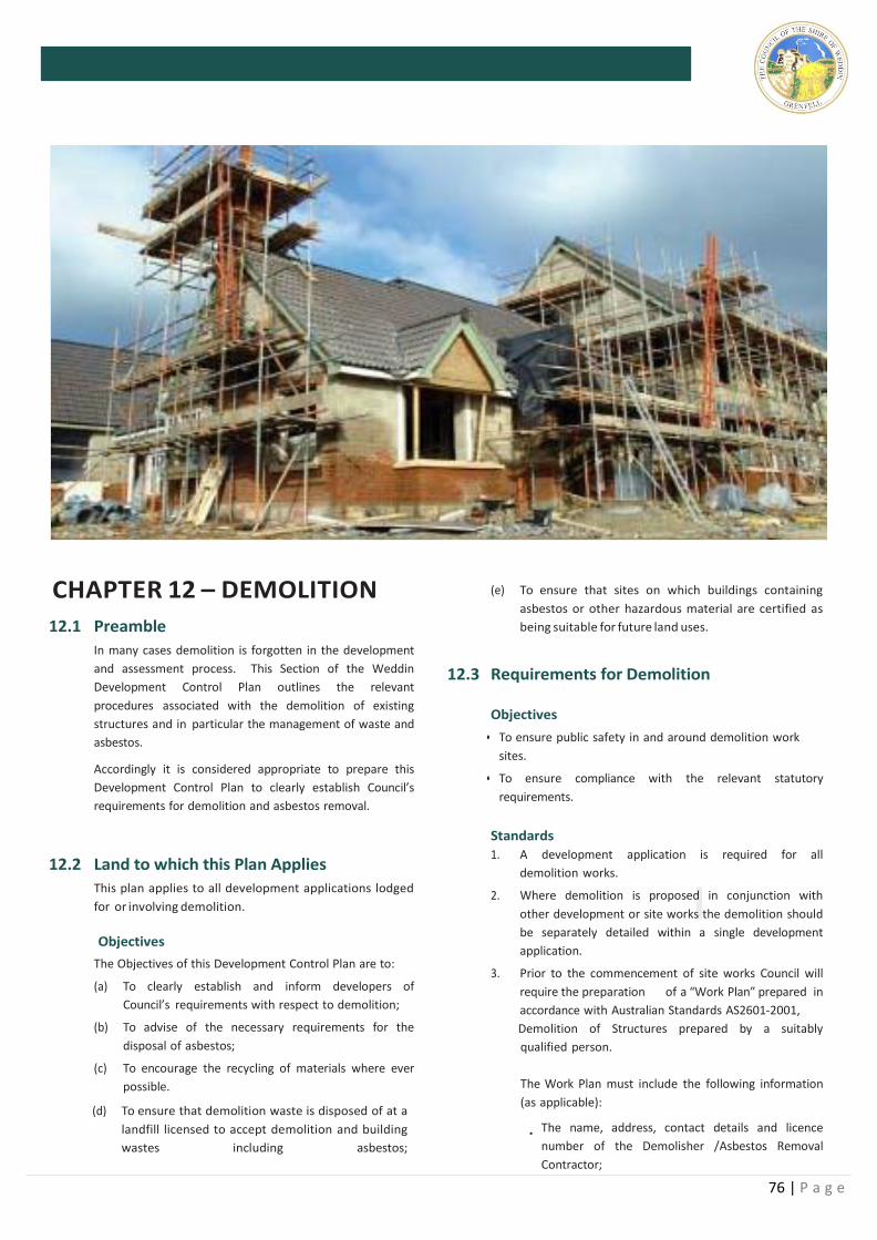
76 | P a g e
CHAPTER 12 – DEMOLITION
12.1 Preamble
In many cases demolition is forgotten in the development
and assessment process. This Section of the Weddin
Development Control Plan outlines the relevant
procedures associated with the demolition of existing
structures and in particular the management of waste and
asbestos.
Accordingly it is considered appropriate to prepare this
Development Control Plan to clearly establish Council’s
requirements for demolition and asbestos removal.
12.2 Land to which this Plan Applies
This plan applies to all development applications lodged
for or involving demolition.
Objectives
The Objectives of this Development Control Plan are to:
(a) To clearly establish and inform developers of
Council’s requirements with respect to demolition;
(b) To advise of the necessary requirements for the
disposal of asbestos;
(c) To encourage the recycling of materials where ever
possible.
(d) To ensure that demolition waste is disposed of at a
landfill licensed to accept demolition and building
wastes including asbestos;
(e) To ensure that sites on which buildings containing
asbestos or other hazardous material are certified as
being suitable for future land uses.
12.3 Requirements for Demolition
Objectives
• To ensure public safety in and around demolition work
sites.
• To ensure compliance with the relevant statutory
requirements.
Standards
1. A development application is required for all
demolition works.
2. Where demolition is proposed in conjunction with
other development or site works the demolition should
be separately detailed within a single development
application.
3. Prior to the commencement of site works Council will
require the preparation of a “Work Plan” prepared in
accordance with Australian Standards AS2601-2001,
Demolition of Structures prepared by a suitably
qualified person.
The Work Plan must include the following information
(as applicable):
· The name, address, contact details and licence
number of the Demolisher /Asbestos Removal
Contractor;
77 | P a g e
• Details of hazardous materials, including asbestos
with location and quantities;
• Method/s of demolition and removal of asbestos;
• Measures and processes to be implemented to ensure
the health & safety of workers and community;
• Measures to be implemented to minimise any
airborne asbestos and dust;
• Methods and location of disposal of any asbestos or
other hazardous materials;
• Other relevant details, measures and requirements to
be implemented as identified in the Asbestos Survey;
and
• The date the demolition and removal of asbestos will
commence.
4. All site works shall comply with the occupational
health and safety requirements of WorkCover NSW.
5. Demolition works shall not commence until
appropriate site fencing and notices advising of public
access restrictions have been erected.
6. The demolition work area shall be left at all times in a
safe and practical manner.
7. All opportunities for the recycling of materials shall be
considered and identified in the demolition work plan.
8. Details of sediment control are to be provided prior to
the commencement of demolition work.
12.4 Demolition Involving Hazardous Material Including Asbestos
Objectives
• To identify and appropriately manage asbestos removal.
• To ensure compliance with the relevant statutory
requirements.
Standards
1. All hazardous or intractable wastes and materials
(including asbestos) shall be removed and disposed
of in accordance with the requirements of WorkCover
NSW, the Environmental Protection Authority,
including the following provisions:
• Occupational Health and Safety Act 2000
• Occupational Health and Safety (Hazardous
Substances) Regulation 2001
• Occupational Health and Safety (Asbestos Removal
Work) Regulation 2001; and
• WorkCover NSW Code of Practice for the Safe Removal
of Asbestos
• Australian Standard 2601 (2001) – Demolition of
Structures
• The Protection of the Environment Operations Act
1997 and Protection of the Environment Operations
(Waste) Regulation 1996.
• Relevant Department of Environment & Heritage
/Environment Protection Authority (EPA) and
WorkCover NSW Guidelines.
2. Hazardous dust must not be allowed to escape from the
site. The use of fine mesh dust proof screens or other
relevant measures is recommended. Existing
accumulations of dust (eg, ceiling voids and wall
cavities) must be removed by the use of an industrial
vacuum fitted with a high efficiency particulate air
(HEPA)
filter or equally effective methods. All dusty surfaces
and dust created from work is to be suppressed by a fine
water spray. Water must not be allowed to enter the
street and stormwater systems. Demolition is not to be
performed during high winds, which may cause dust to
spread beyond site boundaries.
3. Since 2008 a WorkCover licensed demolition or asbestos
removal contractor must undertake removal of
asbestos:
• AS1 Licensed operator for friable and bonded
asbestos
• AS2 Licensed operator for bonded asbestos only.
(Note: Bonded asbestos up to 10m2 may be removed
by an unlicensed person in accordance with
WorkCover requirements)
4. A professionally manufactured sign must be clearly
displayed in a prominent visible position at the front of
the site, containing the words ‘DANGER ASBESTOS
REMOVAL IN PROGRESS” and include details of the
licensed contractor. The sign shall measure not less than
400mm x 300mm and the sign is to be installed
prior to demolition work commencing and is to remain
in place until such time as all asbestos has been safely
removed from the site.
5. Asbestos waste must be stored, transported and
disposed of in compliance with the Protection of the
Environment Operations Act 1997 and the Protection of
the Environment Operations (Waste) Regulation 1996.
6. Asbestos waste must be disposed of at the Grenfell
Landfill and not transported out of the Shire. Copies of
all receipts detailing method and location of disposal
must be maintained on site and be provided to Council
officers upon request, as evidence of correct disposal.
78 | P a g e
7. A Certificate or Statement, prepared by a suitably
qualified person (i.e. an occupational hygienist or
licensed asbestos contractor), must be provided to
Council upon completion of the works (prior to an
Occupation Certificate being issued), which confirms
that the relevant requirements contained in the
Asbestos Survey and conditions of consent, in relation
to the safe removal and disposal of asbestos, have
been satisfied.
8. Where a building containing asbestos has been
damaged by a fire the site will be considered to contain
friable asbestos requiring containment and demolition
by an AS1 Licensed Asbestos contractor.
9. Where unauthorised demolition works occurs or
Council suspects that asbestos has been removed
contrary to WorkCover guidelines certification of the
site will be required by an occupational hygienist.
12.5 Safe Work Practices
Objectives
• To ensure safety practices are implemented in and
around demolition work sites.
• To ensure applicants are aware of appropriate
protection when dealing with the hazards of
demolition.
Standards
1. Consider the need for:
• Breathing mask or respirator fitted with appropriate
filter;
• Suitable clothing including the need for disposable
coveralls;
• Establishment of a decontamination area;
• Disposal/Washing/shower facilities in suitable
proximity;
• Minimise work on windy days;
• Consider the need for use of ground sheeting to
catch dust and debris;
• Remove play equipment, personal belongings and
vehicles from the work area;
• Isolate the work area;
• Use only non-powered hand tools;
• Work in well-ventilated areas where possible;
• Clearly wrap and label hazardous material for
dumping at approved locations.
2. Please consider the following Brochure produced by
the Department of Environment, Climate Change and
Water NSW in relation to Guidenance Material:
Asbestos and Fire-Damaged Buildings.
http://www.environment.nsw.gov.au/resources/waste/
asbestos/09561asbestosfdb.pdf

79 | P a g e
CHAPTER 13 – HERITAGE
13.1 Preamble Gold was discovered in 1866 and within three months 10,000
men occupied the various goldfields. The field concentrated
around Emu Creek and the settlement subsequently grew up
along George Street. The town was proclaimed in January
1867, laid out using a standard Georgian grid that was
modified to accommodate the existing development in what
became known as George and Main streets.
The country entered economic depression in the early 1890s
and it was at about this time that wheat production started to
gain momentum in the district with the improvements in
machinery and introduction of the share farming system.
Although the train line was extended to Grenfell in 1901,
drought and low returns for wheat yields minimised benefits
of improved rail transport.
A significant economic upturn in the period 1906 – 1913 saw
house numbers grow from 201 in 1901 to 611 by 1911 – most
constructed after 1905. The extent of residential development
in the 1920s is not clear, however the number of "bungalow
style " dwellings with details more typical of the 1920s would
suggest some residential consolidation up to the great
depression. There has been a slow pace of development from
the 1930s to the end of the 20th century due to low
population growth.
The dominant role of the builder, who both designed and
constructed the dwellings, is reflected in the adoption of
standard, traditional and often repeated styles of building. Individual builder's preference for construction and decorative details may be evident in the dwellings that they erected, and it is likely that similar buildings in the town were erected by a particular builder working in his own "house style". Predominant building materials were timber and brick. Two steam saw mills were established by 1873 and presumably provided sawn framing timber as well as sawn weatherboards for external cladding, and sawn and machined boards for internal floors, walls and ceilings. Brick and lime kilns were established in Brickfields Road in the late 1870s. However it was not uncommon in remote areas for bricks to be fired on site or nearby for a specific building project. Some early administrative and religious buildings were constructed in brick - Courthouse 1873 and Catholic church in 1877, however the more popular adoption of brick occurred in the mid 1880's
13.2 Land to which this Plan Applies
This plan applies to all items of Environmental Heritage both
those identified in Schedule 5 of the Weddin Local
Environmental Plan 2011 and those undiscovered items
protected under the Heritage Act as well as the Weddin
Conservation Areas. The provisions contained in this
instrument may also apply to certain development within the
vicinity of Heritage Items, in circumstances where there may
be a potential impact as a result of a proposed development.
80 | P a g e
13.3 Objectives (a) The Objectives of this Development Control Plan are
to:
(b) To conserve the heritage significance of the built and
natural environments;
(c) To ensure that new development is sympathetic to
the identified heritage significance;
(d) To ensure the retention of heritage items and
contributory items;
(e) To provide planning and design guidelines for
developments associated with heritage items and
conservation areas;
(f) To provide guidance to owners and perspective
developers of heritage items concerning the most
appropriate method for their development to
proceed without detracting from the heritage
significance and its value to the site.
13.4 Development Standards
Council’s requirements are identified as “Objectives” which
have been underpinned with appropriate “Development
Standards” which seek to guide and control the provision
of landscaping.
The Objectives state what Council is endeavoring to
achieve in its control of the development. Each Objective
is supported by Development Standards, which outline the
preferred method of achieving the objective/s. Council
may vary the development standards where it can be
demonstrated that the proposed development is consistent
with the objective/s and is likely to provide a better
planning solution.
13.5 Heritage Listings
Objectives
• To advise of statutory listings and applicable statutory
controls to items of environmental heritage throughout
the Weddin Shire.
• To inform of the relative levels of significance of identified
heritage items.
Standards
1. There are three levels of heritage significance being of
Local, State and National significance.
• Heritage items of National Significance are items
having significance beyond the State level and are
considered under the Australian Heritage Council
Act 2003. The Act affects property owned by the
Commonwealth Government and its Agencies.
• State significant items are identified in the State
Heritage Register and are protected by the Heritage
Council and Heritage Office under the NSW Heritage
Act, 1977.
• Items of Local heritage significance result from
previous Heritage Studies, the National Trust listings,
the Main Street Study and the Weddin Shire
Community Based Heritage Study and are identified
in Schedule 5 of Weddin Local Environmental Plan
2011.
13.6 NSW Heritage Assessment Criteria
Objectives
• To advise of relevant criteria to be considered in the
assessment of heritage significance.
Standards
1. Consideration of heritage significance should be based
upon consideration of the following criteria:
Criterion (a) an item is important in the course, or pattern,
of NSW’s cultural or natural history (or the
cultural or natural history of the local area);.
Criterion (b) an item has strong or special association with
the life or works of a person, or group of
persons, of importance in NSW’s cultural or
natural history (or the cultural or natural
history of the local area);
Criterion (c) an item is important in demonstrating
aesthetic characteristics and/or a high degree
of creative or technical achievement in NSW
(or the local area);
Criterion (d) an item has strong or special association with
a particular community or cultural group in
NSW (or the local area) for social, cultural or
spiritual reasons;
Criterion (e) an item has potential to yield information
that will contribute to an understanding of
NSW’s cultural or natural history (or the
cultural or natural history of the local area);
Criterion (f ) an item possesses uncommon, rare or
endangered aspects of NSW’s cultural or
natural history (or the cultural or natural
history of the local area);
Criterion (g) an item is important in demonstrating the
principal characteristics of a class of NSW’s
• cultural or natural places; or
• cultural or natural environments.
• (or a class of the local area’s
• cultural or natural places; or
• cultural or natural environments.)
81 | P a g e
• An item is not to be excluded from the Register on the
ground that items with similar characteristics have
already been listed on the Register
Source: Local Government Heritage Guidelines, NSW Heritage
Office, 2002
13.7 Conservation Areas
Objectives
• To retain and enhance the environmental heritage of
Weddin as a primary attraction to the town and local
area.
• To conserve existing significant fabric, settings, relics,
views and movable items associated with the heritage
significance of heritage items and heritage conservation
areas.
• To reinstate significant building elements which have
been removed, such as verandahs, awnings and colour
schemes.
• To ensure that new development is sympathetic to the
character of heritage items and Conservation Areas.
• To provide incentives for property owners to heritage
items and sites within conservation areas.
Standards
1. The Weddin Conservation Areas are identified below.
2. Individual developments shall not have a detrimental
impact upon the prevailing streetscape character for
the Grenfell Urban Conservation Area, Grenfell
Conservation Area No 2 and Greenethorpe
Conservation Area.
3. Traditional building elements and façade treatments
shall be reinstated with any redevelopment within the
Grenfell Urban Conservation Area, Grenfell
Conservation Area No 2 and Greenethorpe
Conservation Area.
4. Signs and external advertising and external colour
schemes shall not have a detrimental impact upon
the heritage significance of the listed heritage place
or the Conservation Area
5. All applications for development within this area shall
consider the impact of the development proposal
upon the heritage significance of the subject land
and land within its immediate vicinity as well as any
potential impacts upon the broader conservation area.
13.8 Heritage Advisory Service
Objectives
· To consider the impact of development upon the heritage
significance of an individual item or broader conservation
area.
To inform applicants of the availability and role of Council’s
Heritage Advisor.
Standards 1. To assist owners of heritage assets, Council has
appointed a heritage advisor who is available to
provide a free advisory service offering advice on the
best way for your development to occur whilst
maintaining heritage significance.
2. Council will refer all development applications relating
to heritage items or within the Weddin Conservation
Area for the Heritage Advisors consideration.
3. It is recommended you review the Weddin Heritage
Inventory and consult with the Heritage Advisor before
preparing your development application.
13.9 Heritage Impact Statement
Objectives
• To consider the impact of development upon the heritage
significance of an individual item or conservation area.
• To inform applicants of specific heritage considerations
necessary to accompany applications for development with
the potential to impact upon heritage significance.
Standards
1. Basic considerations of heritage impacts associated with
the vast majority of developments can be
accommodated within the Statement of Environmental
Effects Report. Council will refer all development
applications including relevant considerations relating
to heritage items or within the Weddin Conservation
Area for the Heritage Advisors consideration.
2. A Separate and suitably detailed Heritage Impact
Statement (prepared in accordance with the current
guidelines of the NSW Heritage Office) will be required
for applications involving demolition of heritage items
or where there is disagreement or departure from the
considerations of Council’s Heritage Advisor.
3. The level of detail to be provided is dependent upon
the nature and extent of the proposed development
and its potential impact upon significant elements of
the site. Consult with Council, Council’s Heritage
Advisor or your own independent professional for
guideance upon the detail required within the Heritage
Impact Statement however will generally be required in
accordance with
the following schedule:
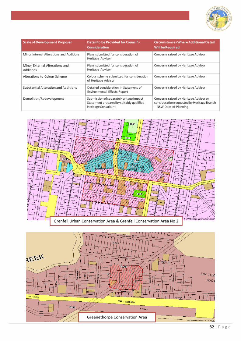
82 | P a g e
Scale of Development Proposal Detail to be Provided for Council’s
Consideration
Circumstances Where Additional Detail
Will be Required
Minor Internal Alterations and Additions Plans submitted for consideration of Heritage Advisor
Concerns raised by Heritage Advisor
Minor External Alterations and Additions
Plans submitted for consideration of Heritage Advisor
Concerns raised by Heritage Advisor
Alterations to Colour Scheme Colour scheme submitted for consideration of Heritage Advisor
Concerns raised by Heritage Advisor
Substantial Alteration and Additions Detailed consideration in Statement of Environmental Effects Report
Concerns raised by Heritage Advisor
Demolition/Redevelopment Submission of separate Heritage Impact Statement prepared by suitably qualified Heritage Consultant
Concerns raised by Heritage Advisor or consideration requested by Heritage Branch – NSW Dept of Planning
Grenfell Urban Conservation Area & Grenfell Conservation Area No 2
Greenethorpe Conservation Area
83 | P a g e
13.10 Authenticity
Objectives
• To protect the original fabric that contributes to the
significance of a heritage asset.
Standards 4. Original and significant fabric of a premises should
be retained in situ.
5. Original character and fabric should not be
fundamentally altered or irreversibly changed by
new work.
6. Traditional building elements should only be
removed where there is a firm proposal to restore or
replace something sympathetic in that some
location or where specifically identified for removal
by a heritage assessment.
7. Traditional elements are to be reconstructed based
upon historic research of a particular building in
preference to details that are simply typical for a
period.
8. Traditional construction materials and techniques
should be used where possible for the repair or
alteration to a heritage asset.
13.11 Streetscape
Objectives
• To protect the unique streetscape character and
appearance of the main shopping streets of the
Weddin commercial area.
• To conserve and promote the heritage streetscape
character as a marketing tool for encouraging tourism
within the Shire.
Standards
1. Development should consider its relationship to the
following elements of the streetscape:
• Front setback
• Materials, colours, textures
• Roof form and pitch
• Scale, height and proportion of buildings
• Landscaping and gardens
• Spaces between buildings
• Façade treatments
• Verandahs
• Window placement and treatment
• Provision of new services, in particular air
conditioning out of sight
• Height and design of fences
• Placement and design of driveways, garages and
carports
• Placement and design of external signs and
advertising
• Existing street trees
2. The design of new buildings should complement and
not dominate in the existing streetscape.
3. Development should be designed to minimise any
impact upon the heritage significance and character of
the street.
4. Development should be consistent with but not
replicate the heritage character of immediately
adjoining properties.
13.12 Alterations and Additions
Objectives
• To ensure that subsequent alterations and additions do not
detract from heritage significance.
• To provide guideance on the most common alterations and
the best method for such works to be undertaken.
Standards
1. Development must consider the following principles
for Alterations and Additions.
Compatible Design: Maintain the character of the building.
Scale: The scale and bulk of any new work should not
dominate and be of similar size or smaller in relation to the
original building.
Siting: Avoid altering sympathetic street facades, with new
work best located to the rear or side of the building.
Materials: Reuse existing materials where possible or use
matching or compatible new materials
Use: The best use for a building is usually the one for which it
was built. Where this is not possible to retrofit one which is
suited to the overall design of the building or one which
requires minimal structural alterations.
Repair rather than replace: The original fabric of the building
is unique to the time and place it was built and contains
information about materials and construction techniques of
the day. It is therefore important, where possible, to repair
rather than replace.
The aging process: The age of a building and often
successive changes add much to its character and
significance, do not try to hide age or sympathetic changes.
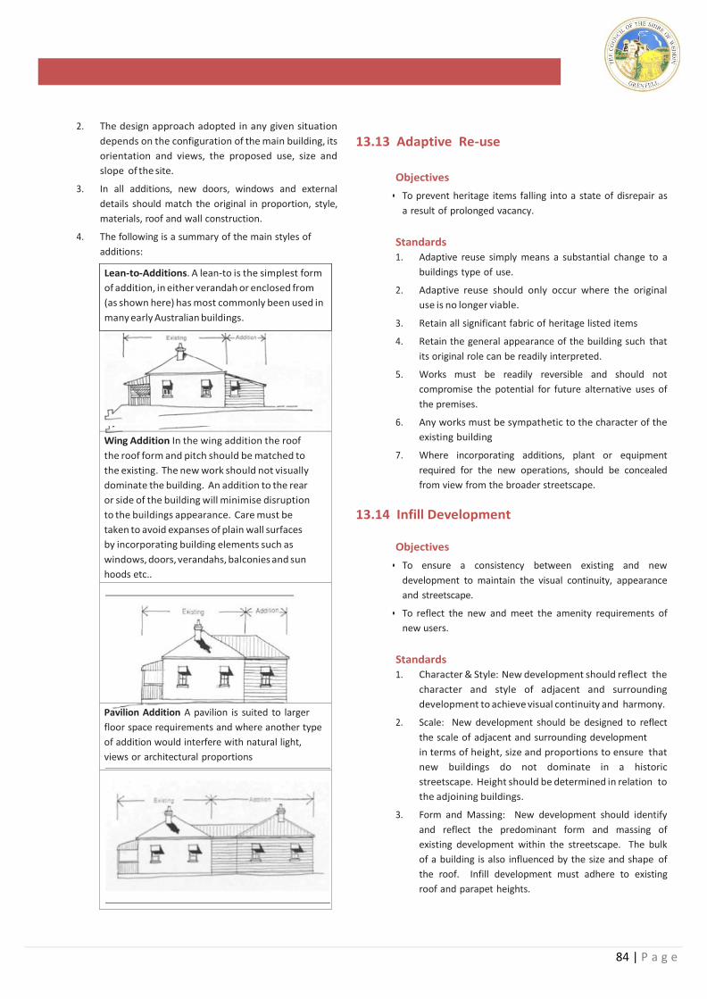
84 | P a g e
Lean-to-Additions. A lean-to is the simplest form
of addition, in either verandah or enclosed from
(as shown here) has most commonly been used in
many early Australian buildings.
Wing Addition In the wing addition the roof
the roof form and pitch should be matched to
the existing. The new work should not visually
dominate the building. An addition to the rear
or side of the building will minimise disruption
to the buildings appearance. Care must be
taken to avoid expanses of plain wall surfaces
by incorporating building elements such as
windows, doors, verandahs, balconies and sun
hoods etc..
Pavilion Addition A pavilion is suited to larger
floor space requirements and where another type
of addition would interfere with natural light,
views or architectural proportions
2. The design approach adopted in any given situation
depends on the configuration of the main building, its
orientation and views, the proposed use, size and
slope of the site.
3. In all additions, new doors, windows and external
details should match the original in proportion, style,
materials, roof and wall construction.
4. The following is a summary of the main styles of
additions:
13.13 Adaptive Re-use
Objectives
• To prevent heritage items falling into a state of disrepair as
a result of prolonged vacancy.
Standards 1. Adaptive reuse simply means a substantial change to a
buildings type of use.
2. Adaptive reuse should only occur where the original
use is no longer viable.
3. Retain all significant fabric of heritage listed items
4. Retain the general appearance of the building such that
its original role can be readily interpreted.
5. Works must be readily reversible and should not
compromise the potential for future alternative uses of
the premises.
6. Any works must be sympathetic to the character of the
existing building
7. Where incorporating additions, plant or equipment
required for the new operations, should be concealed
from view from the broader streetscape.
13.14 Infill Development
Objectives
• To ensure a consistency between existing and new
development to maintain the visual continuity, appearance
and streetscape.
• To reflect the new and meet the amenity requirements of
new users.
Standards 1. Character & Style: New development should reflect the
character and style of adjacent and surrounding
development to achieve visual continuity and harmony.
2. Scale: New development should be designed to reflect
the scale of adjacent and surrounding development
in terms of height, size and proportions to ensure that
new buildings do not dominate in a historic
streetscape. Height should be determined in relation to
the adjoining buildings.
3. Form and Massing: New development should identify
and reflect the predominant form and massing of
existing development within the streetscape. The bulk
of a building is also influenced by the size and shape of
the roof. Infill development must adhere to existing
roof and parapet heights.
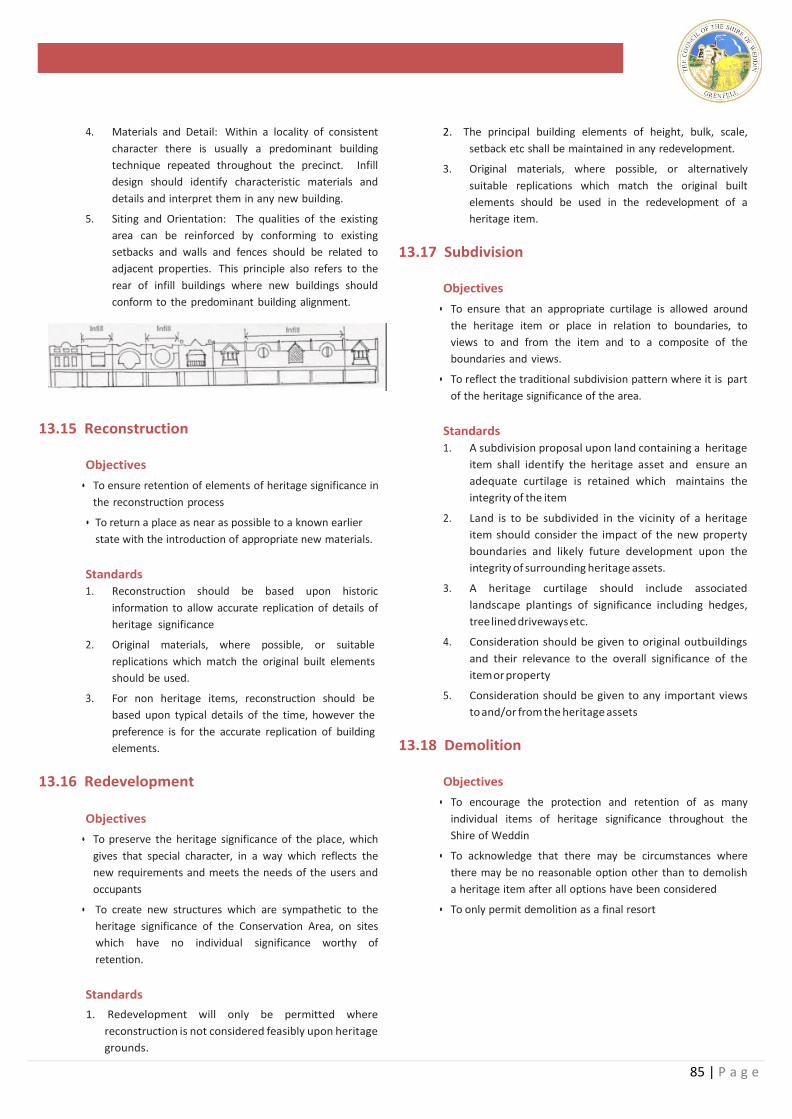
85 | P a g e
4. Materials and Detail: Within a locality of consistent
character there is usually a predominant building
technique repeated throughout the precinct. Infill
design should identify characteristic materials and
details and interpret them in any new building.
5. Siting and Orientation: The qualities of the existing
area can be reinforced by conforming to existing
setbacks and walls and fences should be related to
adjacent properties. This principle also refers to the
rear of infill buildings where new buildings should
conform to the predominant building alignment.
13.15 Reconstruction
Objectives
• To ensure retention of elements of heritage significance in
the reconstruction process
• To return a place as near as possible to a known earlier
state with the introduction of appropriate new materials.
Standards 1. Reconstruction should be based upon historic
information to allow accurate replication of details of
heritage significance
2. Original materials, where possible, or suitable
replications which match the original built elements
should be used.
3. For non heritage items, reconstruction should be
based upon typical details of the time, however the
preference is for the accurate replication of building
elements.
13.16 Redevelopment
Objectives
• To preserve the heritage significance of the place, which
gives that special character, in a way which reflects the
new requirements and meets the needs of the users and
occupants
• To create new structures which are sympathetic to the
heritage significance of the Conservation Area, on sites
which have no individual significance worthy of
retention.
Standards
1. Redevelopment will only be permitted where
reconstruction is not considered feasibly upon heritage
grounds.
2. The principal building elements of height, bulk, scale,
setback etc shall be maintained in any redevelopment.
3. Original materials, where possible, or alternatively
suitable replications which match the original built
elements should be used in the redevelopment of a
heritage item.
13.17 Subdivision
Objectives
• To ensure that an appropriate curtilage is allowed around
the heritage item or place in relation to boundaries, to
views to and from the item and to a composite of the
boundaries and views.
• To reflect the traditional subdivision pattern where it is part
of the heritage significance of the area.
Standards
1. A subdivision proposal upon land containing a heritage
item shall identify the heritage asset and ensure an
adequate curtilage is retained which maintains the
integrity of the item
2. Land is to be subdivided in the vicinity of a heritage
item should consider the impact of the new property
boundaries and likely future development upon the
integrity of surrounding heritage assets.
3. A heritage curtilage should include associated
landscape plantings of significance including hedges,
tree lined driveways etc.
4. Consideration should be given to original outbuildings
and their relevance to the overall significance of the
item or property
5. Consideration should be given to any important views
to and/or from the heritage assets
13.18 Demolition
Objectives
• To encourage the protection and retention of as many
individual items of heritage significance throughout the
Shire of Weddin
• To acknowledge that there may be circumstances where
there may be no reasonable option other than to demolish
a heritage item after all options have been considered
• To only permit demolition as a final resort
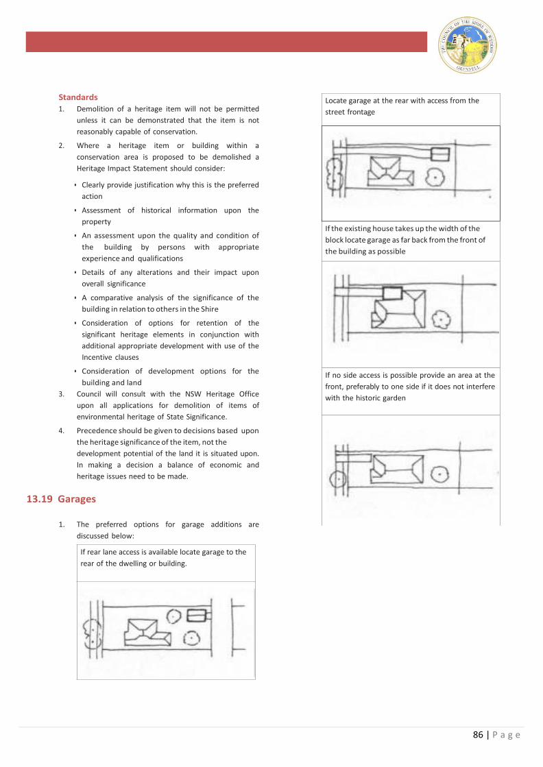
86 | P a g e
Locate garage at the rear with access from the
street frontage
If the existing house takes up the width of the
block locate garage as far back from the front of
the building as possible
If no side access is possible provide an area at the
front, preferably to one side if it does not interfere
with the historic garden
Standards
1. Demolition of a heritage item will not be permitted
unless it can be demonstrated that the item is not
reasonably capable of conservation.
2. Where a heritage item or building within a
conservation area is proposed to be demolished a
Heritage Impact Statement should consider:
• Clearly provide justification why this is the preferred
action
• Assessment of historical information upon the
property
• An assessment upon the quality and condition of
the building by persons with appropriate
experience and qualifications
• Details of any alterations and their impact upon
overall significance
• A comparative analysis of the significance of the
building in relation to others in the Shire
• Consideration of options for retention of the
significant heritage elements in conjunction with
additional appropriate development with use of the
Incentive clauses
• Consideration of development options for the
building and land
3. Council will consult with the NSW Heritage Office
upon all applications for demolition of items of
environmental heritage of State Significance.
4. Precedence should be given to decisions based upon
the heritage significance of the item, not the
development potential of the land it is situated upon.
In making a decision a balance of economic and
heritage issues need to be made.
13.19 Garages
1. The preferred options for garage additions are
discussed below:
If rear lane access is available locate garage to the
rear of the dwelling or building.
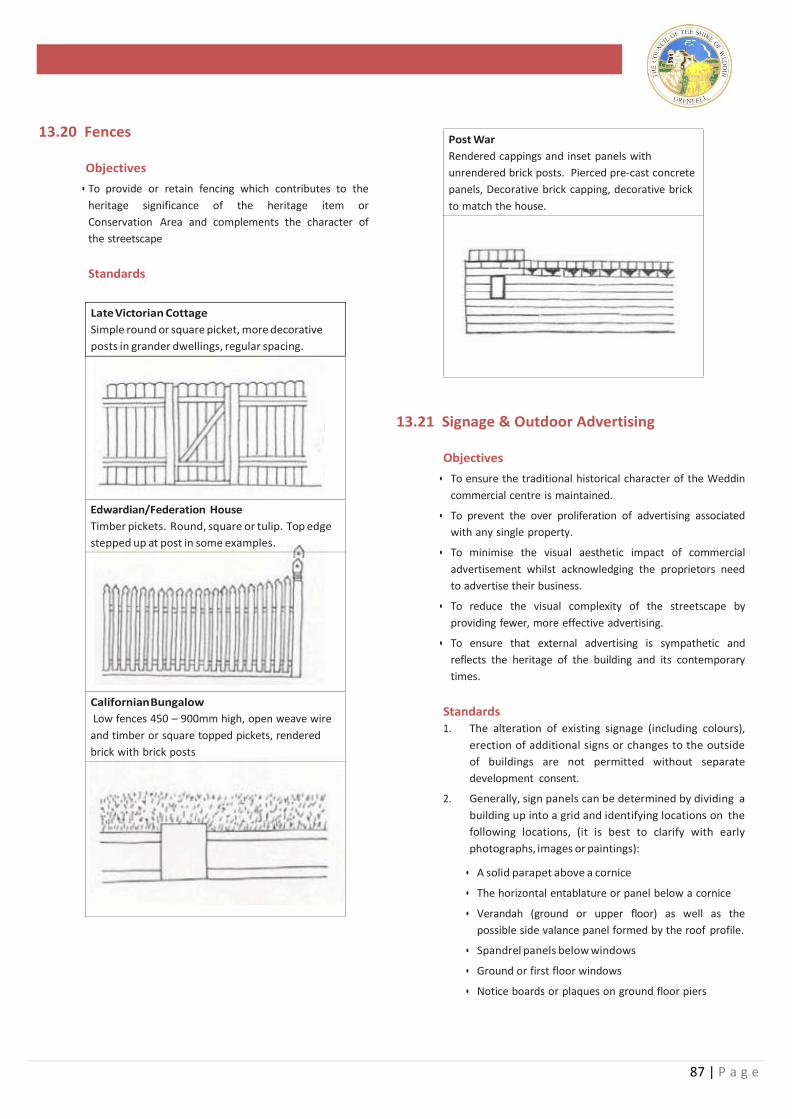
87 | P a g e
Late Victorian Cottage
Simple round or square picket, more decorative
posts in grander dwellings, regular spacing.
Edwardian/Federation House
Timber pickets. Round, square or tulip. Top edge
stepped up at post in some examples.
Californian Bungalow
Low fences 450 – 900mm high, open weave wire
and timber or square topped pickets, rendered
brick with brick posts
13.20 Fences
Objectives
• To provide or retain fencing which contributes to the
heritage significance of the heritage item or
Conservation Area and complements the character of
the streetscape
Standards
Post War
Rendered cappings and inset panels with
unrendered brick posts. Pierced pre-cast concrete
panels, Decorative brick capping, decorative brick
to match the house.
13.21 Signage & Outdoor Advertising
Objectives
• To ensure the traditional historical character of the Weddin
commercial centre is maintained.
• To prevent the over proliferation of advertising associated
with any single property.
• To minimise the visual aesthetic impact of commercial
advertisement whilst acknowledging the proprietors need
to advertise their business.
• To reduce the visual complexity of the streetscape by
providing fewer, more effective advertising.
• To ensure that external advertising is sympathetic and
reflects the heritage of the building and its contemporary
times.
Standards 1. The alteration of existing signage (including colours),
erection of additional signs or changes to the outside
of buildings are not permitted without separate
development consent.
2. Generally, sign panels can be determined by dividing a
building up into a grid and identifying locations on the
following locations, (it is best to clarify with early
photographs, images or paintings):
• A solid parapet above a cornice
• The horizontal entablature or panel below a cornice
• Verandah (ground or upper floor) as well as the
possible side valance panel formed by the roof profile.
• Spandrel panels below windows
• Ground or first floor windows
• Notice boards or plaques on ground floor piers
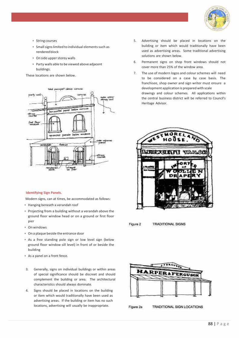
88 | P a g e
• String courses
• Small signs limited to individual elements such as
rendered block
• On side upper storey walls
• Party walls able to be viewed above adjacent
buildings.
These locations are shown below.
Identifying Sign Panels.
Modern signs, can at times, be accommodated as follows:
• Hanging beneath a verandah roof
• Projecting from a building without a verandah above the
ground floor window head or on a ground or first floor
pier
• On windows
• On a plaque beside the entrance door
• As a free standing pole sign or low level sign (below
ground floor window sill level) in front of or beside the
building
• As a panel on a front fence.
3. Generally, signs on individual buildings or within areas
of special significance should be discreet and should
complement the building or area. The architectural
characteristics should always dominate.
4. Signs should be placed in locations on the building
or item which would traditionally have been used as
advertising areas. If the building or item has no such
locations, advertising will usually be inappropriate.
5. Advertising should be placed in locations on the
building or item which would traditionally have been
used as advertising areas. Some traditional advertising
solutions are shown below.
6. Permanent signs on shop front windows should not
cover more than 25% of the window area.
7. The use of modern logos and colour schemes will need
to be considered on a case by case basis. The
franchisee, shop owner and sign writer must ensure a
development application is prepared with scale
drawings and colour schemes. All applications within
the central business district will be referred to Council’s
Heritage Advisor.
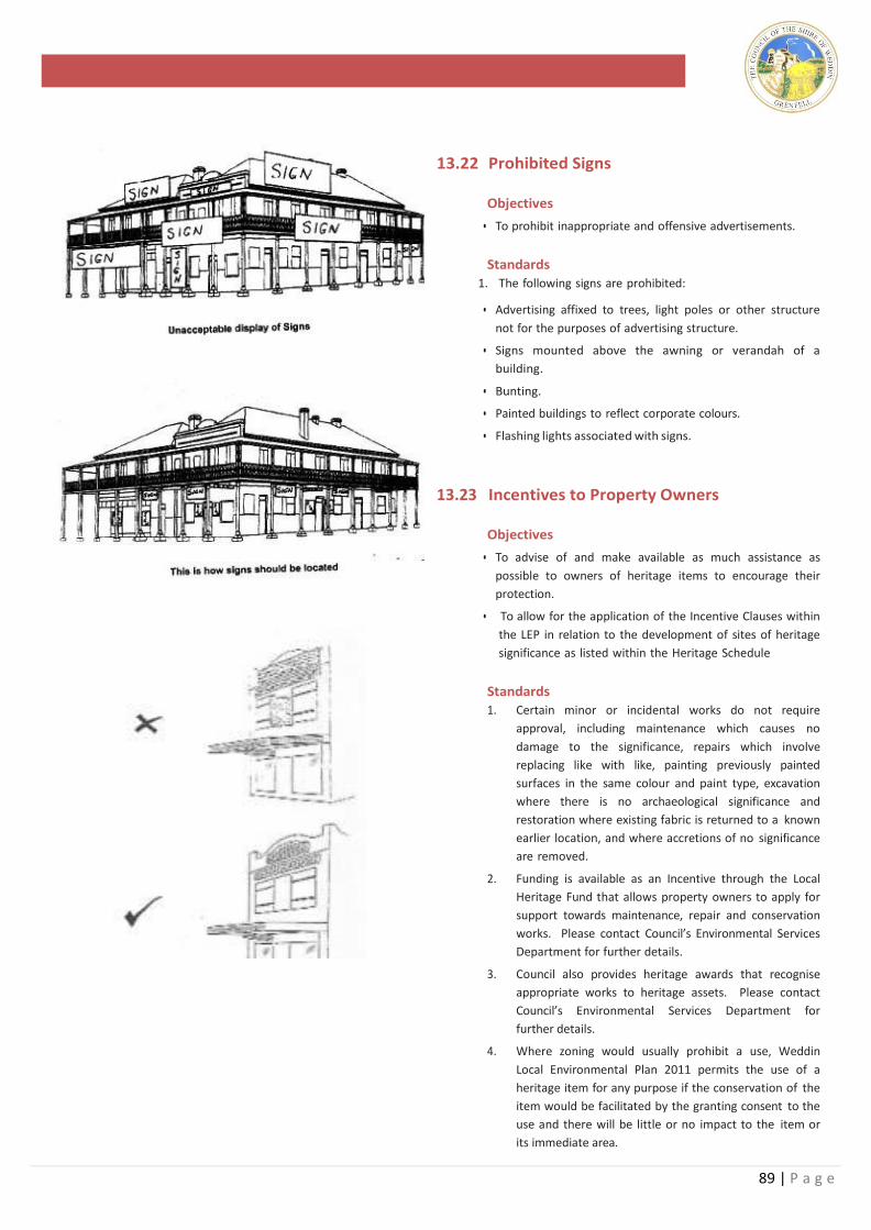
89 | P a g e
13.22 Prohibited Signs
Objectives
• To prohibit inappropriate and offensive advertisements.
Standards
1. The following signs are prohibited:
• Advertising affixed to trees, light poles or other structure
not for the purposes of advertising structure.
• Signs mounted above the awning or verandah of a
building.
• Bunting.
• Painted buildings to reflect corporate colours.
• Flashing lights associated with signs.
13.23 Incentives to Property Owners
Objectives
• To advise of and make available as much assistance as
possible to owners of heritage items to encourage their
protection.
• To allow for the application of the Incentive Clauses within
the LEP in relation to the development of sites of heritage
significance as listed within the Heritage Schedule
Standards
1. Certain minor or incidental works do not require
approval, including maintenance which causes no
damage to the significance, repairs which involve
replacing like with like, painting previously painted
surfaces in the same colour and paint type, excavation
where there is no archaeological significance and
restoration where existing fabric is returned to a known
earlier location, and where accretions of no significance
are removed.
2. Funding is available as an Incentive through the Local
Heritage Fund that allows property owners to apply for
support towards maintenance, repair and conservation
works. Please contact Council’s Environmental Services
Department for further details.
3. Council also provides heritage awards that recognise
appropriate works to heritage assets. Please contact
Council’s Environmental Services Department for
further details.
4. Where zoning would usually prohibit a use, Weddin
Local Environmental Plan 2011 permits the use of a
heritage item for any purpose if the conservation of the
item would be facilitated by the granting consent to the
use and there will be little or no impact to the item or
its immediate area.
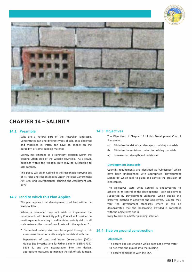
90 | P a g e
CHAPTER 14 – SALINITY
14.1 Preamble
Salts are a natural part of the Australian landscape.
Concentrated salt and different types of salt, once dissolved
and mobilised in water, can have an impact on the
durability of some building material.
Salinity has emerged as a significant problem within the
existing urban area of the Weddin Township. As a result,
buildings within the Weddin Shire may be susceptible to
salt damage.
This policy will assist Council in the reasonable carrying out
of its roles and responsibilities under the local Government
Act 1993 and Environmental Planning and Assessment Act,
1979.
14.2 Land to which this Plan Applies
This plan applies to all development of all land within the
Weddin Shire.
Where a developer does not wish to implement the
requirements of this salinity policy Council will consider on
merit arguments relating to a diminished salinity risk. In all
such instances the onus of proof rests with the applicant*.
* Diminished salinity risk may be argued through a risk
assessment based on a site analysis consistent with the
Department of Land and Water Conservation (2002)
Guide: Site Investigations for Urban Salinity (ISBN: 0 7347
5303 5, and the incorporation into site design,
appropriate measures to manage the risk of salt damage.
14.3 Objectives
The Objectives of Chapter 14 of this Development Control
Plan are to:
(a) Minimise the risk of salt damage to building materials
(b) Minimise the moisture contact to building materials
(c) Increase slab strength and resistance
Development Standards
Council’s requirements are identified as “Objectives” which
have been underpinned with appropriate “Development
Standards” which seek to guide and control the provision of
landscaping.
The Objectives state what Council is endeavouring to
achieve in its control of the development. Each Objective is
supported by Development Standards, which outline the
preferred method of achieving the objective/s. Council may
vary the development standards where it can be
demonstrated that the landscaping provided is consistent
with the objective/s and is
likely to provide a better planning solution.
14.4 Slab on ground construction Objectives
• To ensure slab construction which does not permit water
to rise from the ground into the building.
• To ensure compliance with the BCA.
91 | P a g e
Standards
1. For slab on ground construction, a layer of at least
50mm of sand must be provided under the slab to
prevent saline water from soaking into the slab and
tearing the damp proof membrane.
2. A damp proof membrane (rather than a vapour proof
membrane) must be laid under the slab.
Membrane product types include:
• Vapour proof - black industrial, orange industrial
(differ only in colour)
• Damp proof - orange premium and orange super.
3. The damp proof membrane must be extended to the
outside face of the external edge beam up to the
finished ground level (clause 3.2.2.6 and Figure 3.2.2.3
of the BCA)
4. Class 32 Mpa (N32) concrete must be used or a
sulphate resisting SR cement with a water cement
ratio of 0.5 must be used.
5. Slabs must be vibrated and cured for a minimum of 3
days
6. The minimum cover to reinforcement must be 50mm
from unprotected ground.
7. The minimum cover to reinforcement must be 30 mm
from a membrane in contact with the ground.
8. The minimum cover to reinforcement must be 50mm
for strip footings and beams irrespective of whether a
damp proof membrane is used.
9. Admixtures for waterproofing and/or corrosion
prevention may be used.
14.5 Brick Pier Construction
Objectives
• To ensure footing construction which does not permit
water to rise from the ground into the building.
• To ensure compliance with the BCA.
Standards 1. For brick piers the damp proof course must consist of
polyethylene or polyethylene coated metal and be
correctly placed as per SA BCA 3.3.4.4.
2. Exposure Class masonry units must be used below
the damp proof course including for strip footings.
3. Appropriate mortar and mixing ratio must be used
with exposure class masonry units
Note; The resistance of bricks to water and salt vary
between different brick companies. When buying bricks
you should enquire as to the water and salt
resistance test results. Factors such as clay, type and location
in the kiln may affect brick resistance. Some companies
routinely test batches of bricks and class the more resistant
bricks as “exposure class bricks”.
Admixtures for waterproofing and/or corrosion prevention
may be used.
14.6 Requirements For All Buildings
Objectives
• To minimise the potential for salt to enter a new building
thus reducing the potential for salt damage.
Standards
1. Once installed the damp proof course must not be
breached by any later works or additions such as steps,
verandahs, walls, rendering, bagging, pointing, paving
or landscaping.
2. Appropriate subsoil drainage must be installed for all
slabs , footings, retaining, walls and driveways.
3. The dwelling must be designed to suit the topography.
The installation of the damp course proofing must be
above finished ground level.
4. Landscaping and garden designs should not be placed
against walls of the building.
14.7 Recommendations For All Buildings
Objectives
• To make a series of recommendations to minimise the
potential for salt damage to property to improve building
health, reduce maintenance and increase life span
construction.
Standards
1. Be water wise in the garden.
2. Low water requiring plants and water wise garden
designs are preferred.
3. Buy a tap timer.
4. Water in the morning or evening and avoid watering on
windy days.
5. Mulch garden beds.
6. Avoid fine mist sprays, use low trajectory sprinklers.
7. Sweep paths rather than water the
8. Divert roof water from your rubble pit if you have one Install a water tank for reuse in the garden and/or connect to a storm water system if possible
92 | P a g e
.
CHAPTER 15 – PUBLIC CONSULTATION
15.1 Preamble
To ensure an open and fair consideration of development
proposals and ensure consistency in the approach to public
notification and exhibition of development proposals, a plan
outlining the relevant requirements and procedures has
been prepared. It will also ensure a consistent approach in
accordance with the legislative requirements appropriate for
Weddin.
This section of the Weddin Development Control Plan
addresses Council’s administrative procedures associated
with the notification of development applications.
Accordingly it is considered appropriate to prepare this
section of the Weddin Development Control Plan to clearly
establish Council’s requirements.
15.2 Land to which this Plan Applies
This plan applies to all development applications lodged
for the consideration of Weddin Shire Council.
15.3 Objectives
The Objectives of this Development Control Plan are to:
(a) To detail the circumstances when notice of
development applications will be given;
(b) To provide opportunities for comment from persons
likely to be affected by a development proposal;
(c) To set out the rights of land owners in making
submissions on a development application; and
(d) To outline the processes Council follows in determining
applications where submissions are made.
15.4 Applications Not Requiring Notification
Objectives
• To minimize unnecessary complication of the assessment
process for minor or incidental works.
• To expedite the assessment process.
Standards
1. The following applications of minor impact do require
notification or public exhibition
• Exempt and Complying Development;
• Internal Alterations to dwellings, commercial premises
and industrial buildings;
• A change of use from a shop to a shop or a
commercial premises to a commercial premises;
• Strata or community subdivision of an approved
development; and
• A modified application which is substantially the same
as an application which has been previously notified.
93 | P a g e
15.5 Notification of Development Applications:
Objectives
• To ensure likely affected land owners are given the
opportunity to provide their views in the assessment
process.
• To advise of standard notification periods and
requirements.
Standards
1. Residential Development in areas zoned R1 General Residential, R5 Village, B2 Local Centre, IN1 General Industrial and R5 Large Lot Residential (<2ha)
i. Proposed multiple storey dwellings, multiple occupancy or multiple dwellings are to be advertised in the Grenfell Record for a period of at least 14 calendar days from the date of the advertisement. Submissions concerning the development are to be made in writing to Council within the advertised period.
ii. Adjoining properties of proposed multiple storey dwellings, multiple occupancy or multiple residential developments are to be notified in writing with a closing date for submissions being the same date as the date stated in the advertisement.
iii. All other residential developments within the above stated zones will be individually assessed and advertised in accordance with points (i) and/or (ii) above as required.
2. Residential Developments in zones Other Than areas listed in 1.
i. Adjoining properties of proposed multiple storey dwellings, multiple occupancy or multiple residential developments nearer than 30 metres to the allotment boundary or are located in a visually prominent position are to be notified in writing with a closing date for submissions being 14 calender days from the date of the letter of notification.
ii. All other residential developments within the above stated zones will be individually assessed and advertised in accordance with point (i) above if required.
3. Sheds and garages in areas zoned listed in 1
i. Proposed sheds and garages with a floor area greater than 100 square metres are to be advertised in the Grenfell Record for a period of at least 14 calendar days from the date of the advertisement. Submissions concerning the development are to be made in writing to Council within the advertised period.
ii. Adjoining properties of proposed sheds and
garages with a floor area greater than 100 square metres are to be notified in writing with a closing date for submissions being the at least 14 calendar days from the date of the letter of notification.
iii. All other developments within the above stated zones will be individually assessed and advertised in accordance with points (i) and/or (ii) above if required.
4. COMMERCIAL and INDUSTRIAL DEVELOPMENT
i. All proposed new commercial or industrial developments which are not Advertised or Designated Development are to be advertised in the Grenfell Record for a period of at least 21 calendar days from the date of the advertisement. Submissions concerning the development are to be made in writing to Council within the advertised period.
ii. Adjoining properties of proposed new commercial or industrial developments are to be notified in writing with a closing date for submissions being the same date as the date stated in the advertisement.
iii. Advertised or Designated Developments shall follow notification procedures as stated in the Environmental Planning & Assessment Act.
5. Subdivisions - Residential subdivisions in zones listed in 1
i. All proposed multiple residential subdivisions’ (3 or more lots) are to be advertised in the Grenfell Record for a period of at least 14 calendar days from the date of the advertisement. Submissions concerning the development are to be made in writing to Council within the advertised period.
ii. Adjoining properties of proposed multiple residential subdivisions (3 or more lots) are to be notified in writing with a closing date for submissions being the same date as the date stated in the advertisement.
iii. All other subdivisions within the above stated zones will be individually assessed and advertised in accordance with points (i) and/or (ii) above if required.
6. Subdivisions in zones Other Than zones listed in 1
i. All proposed multiple residential subdivisions (3 or more lots) are to be advertised in the Grenfell Record for a period of at least 14 calendar days from the date of the advertisement. Submissions concerning the development are to be made in writing to Council within the advertised period.
ii. Adjoining properties of proposed multiple residential subdivisions (3 or more lots) are to be notified in writing with a closing date for submissions being the same date as the date stated in the advertisement.
7. All other subdivisions within the above stated zones will be individually assessed and advertised in accordance with points (i) and/or (ii) above if required. The
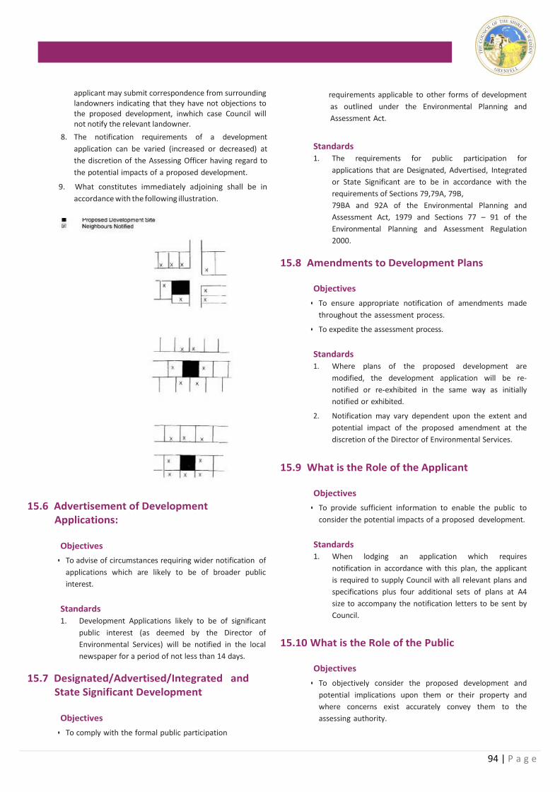
94 | P a g e
applicant may submit correspondence from surrounding landowners indicating that they have not objections to the proposed development, inwhich case Council will not notify the relevant landowner.
8. The notification requirements of a development
application can be varied (increased or decreased) at
the discretion of the Assessing Officer having regard to
the potential impacts of a proposed development.
9. What constitutes immediately adjoining shall be in
accordance with the following illustration.
15.6 Advertisement of Development
Applications:
Objectives
• To advise of circumstances requiring wider notification of
applications which are likely to be of broader public
interest.
Standards
1. Development Applications likely to be of significant
public interest (as deemed by the Director of
Environmental Services) will be notified in the local
newspaper for a period of not less than 14 days.
15.7 Designated/Advertised/Integrated and State Significant Development
Objectives
• To comply with the formal public participation
requirements applicable to other forms of development
as outlined under the Environmental Planning and
Assessment Act.
Standards
1. The requirements for public participation for
applications that are Designated, Advertised, Integrated
or State Significant are to be in accordance with the
requirements of Sections 79,79A, 79B,
79BA and 92A of the Environmental Planning and
Assessment Act, 1979 and Sections 77 – 91 of the
Environmental Planning and Assessment Regulation
2000.
15.8 Amendments to Development Plans
Objectives
• To ensure appropriate notification of amendments made
throughout the assessment process.
• To expedite the assessment process.
Standards
1. Where plans of the proposed development are
modified, the development application will be re-
notified or re-exhibited in the same way as initially
notified or exhibited.
2. Notification may vary dependent upon the extent and
potential impact of the proposed amendment at the
discretion of the Director of Environmental Services.
15.9 What is the Role of the Applicant
Objectives
• To provide sufficient information to enable the public to
consider the potential impacts of a proposed development.
Standards 1. When lodging an application which requires
notification in accordance with this plan, the applicant
is required to supply Council with all relevant plans and
specifications plus four additional sets of plans at A4
size to accompany the notification letters to be sent by
Council.
15.10 What is the Role of the Public
Objectives
• To objectively consider the proposed development and
potential implications upon them or their property and
where concerns exist accurately convey them to the
assessing authority.

95 | P a g e
Standards
1. As an adjoining owner or interested member of the
public you may make a submission in respect of the
proposed development. Any submission must be
made in writing within the specified period clearly
outlining your concerns with the proposed
development.
2. Should you not have any concerns regarding the proposed development, there is no necessity to reply to Council.
3. Should you wish to discuss the proposal further,
Council staff will be available to assist with your
enquiry.
15.11 What form and content should submissions take?
Objectives
• To ensure submission contain sufficient information for
Council to address the concerns and/or make contact
with the author.
Standards
1. Submission relating to a notifiable matter must be
made in writing addressed to the General Manager.
2. Each submission must:
• Clearly identify the matter to which the
submission relates;
• State the grounds for any support or objection
expressed in the submission;
• Be signed by the person making the submission
• Include appropriate contact details.
3. Submissions relating to a notifiable matter must be
lodged with the Council by 4.00pm on the final day
of the public exhibition period.
15.12 Late Submissions
Objectives
• To make the notification and submission process as fair
as possible.
Standards
1. Late submissions will be considered at the Council’s
discretion until a determination has been made.
15.13 Are Submissions Confidential
Objectives
• To comply with the privacy requirements whilst seeking
to resolve the concerns raised.
Standards
1. The substance of written submissions will be included
in reports for consideration by Council. Once in a
Council business paper these reports become public
documents. The name, address and personal details of
the person making the submission will be withheld
from Council’s reporting.
15.14 What is the Role of the Council
Objectives
• To ensure an open and fair development assessment
process.
• To institute appropriate procedures as required by the
Environmental Planning and Assessment Act.
Standards
1. Council will advise immediately adjoining owners with
written notification, and where considered appropriate
by the Director Environmental Services, the general
public, with local advertisement of the receipt of the
development application. It will make copies of relevant
information available for viewing and staff available to
assist with any enquiries.
2. Council will consider written submissions with an
endeavour to address concerns raised.
3. Where no agreement can be reached and an objection is
considered to have significant merit on planning grounds
by the Assessing Officer, a report will be prepared for
Councils determination of the development application at
a public council meeting.
96 | P a g e
APPENDIX 1 INTEGRATED DEVELOPMENT REQUIREMENTS

97 | P a g e
98 | P a g e
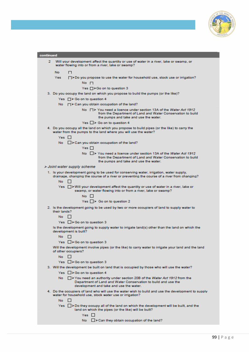
99 | P a g e
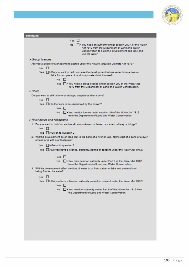
100 | P a g e
101 | P a g e
APPENDIX 2 - SPECIES LISTING
RECOMMENDED FOR THE WEDDIN SHIRE NATIVE AND INTRODUCED SPECIES
Note: This species listing is not exhaustive, rather a list of recommended species to serve as a guide to establishing a landscape plan. The species
identified have been sourced from: Weddin Tree Species List, Weddin Urban Landcare Group and Weddin Shire Council, 2003; The Mid-Lachlan
Regional Vegetation Management Plan and Native Vegetation Resource Package, Department of Infrastructure, Planning and Natural Re-
sources. 2001; Weddin Shire Council Policy - Street & Footpath Trees in Urban Areas.
* indicates an introduced species
SPECIES COMMON NAME
Acacia acinacea Gold-dust Wattle
Acacia amblgona Fan Wattle
Acacia ausfeldii Ausfeld's Wattle
Acacia baileyana Cootamundra Wattle
Acacia brachybotrya Grey Mulga
Acacia buxifolia Box-leaved Wattle
Acacia dealbata Silver Wattle
Acacia deanei subsp. deanei Deane's Wattle
Acacia deanei subsp. paucijuga Green Wattle
Acacia decora Western Golden Wattle
Acacia doratoxylon Currawang
Acacia genistifolia Early Wattle
Acacia gunnii Ploughshare Wattle
Acacia hakeoides Hakea Wattle
Acacia harpophylla Brigalow
Acacia implexa Hickory Wattle
Acacia lineata Streaked Wattle
Acacia melvillei Yarran
Acacia mollifolia
Acacia oswaldii Miljee
Acacia paradoxa Kangaroo Thorn
Acacia pendula Myall
Acacia penninervis Mountain Hickory
Acacia pravifolia Coil-pod Wattle
Acacia spectabilis Mudgee Wattle
Acacia stenophylla River Cooba
Acacia trineura Three-nerved Wattle
Acacia verniciflua Varnish Wattle
Acacia vestita Weeping Boree
Acaena ovina
Acetosella vulgari*s Sorrel
Acianthus collinus
Acianthus exsertus Mosquito Orchid
Actinobole uliginosum Flannel Cudweed
Adiantum aethiopicum Common Maidenhair
Aira cupaniana* Silvery Hairgrass
Ajuga australis Austral Bugle
Alectryon oleifolius subsp. elongatus Rosewood
Allocasuarina diminuta subsp. diminuta
Allocasuarina luehmannii Bulloak
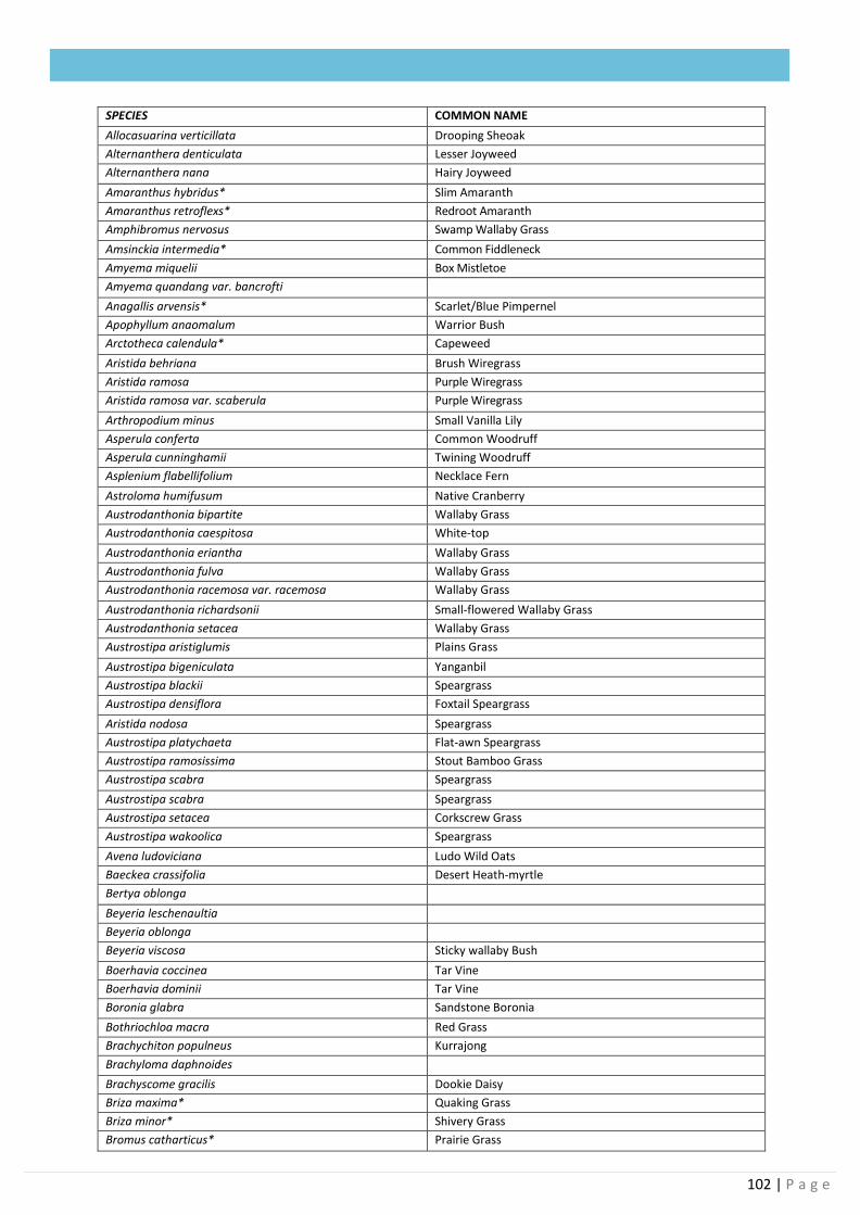
102 | P a g e
SPECIES COMMON NAME
Allocasuarina verticillata Drooping Sheoak
Alternanthera denticulata Lesser Joyweed
Alternanthera nana Hairy Joyweed
Amaranthus hybridus* Slim Amaranth
Amaranthus retroflexs* Redroot Amaranth
Amphibromus nervosus Swamp Wallaby Grass
Amsinckia intermedia* Common Fiddleneck
Amyema miquelii Box Mistletoe
Amyema quandang var. bancrofti
Anagallis arvensis* Scarlet/Blue Pimpernel
Apophyllum anaomalum Warrior Bush
Arctotheca calendula* Capeweed
Aristida behriana Brush Wiregrass
Aristida ramosa Purple Wiregrass
Aristida ramosa var. scaberula Purple Wiregrass
Arthropodium minus Small Vanilla Lily
Asperula conferta Common Woodruff
Asperula cunninghamii Twining Woodruff
Asplenium flabellifolium Necklace Fern
Astroloma humifusum Native Cranberry
Austrodanthonia bipartite Wallaby Grass
Austrodanthonia caespitosa White-top
Austrodanthonia eriantha Wallaby Grass
Austrodanthonia fulva Wallaby Grass
Austrodanthonia racemosa var. racemosa Wallaby Grass
Austrodanthonia richardsonii Small-flowered Wallaby Grass
Austrodanthonia setacea Wallaby Grass
Austrostipa aristiglumis Plains Grass
Austrostipa bigeniculata Yanganbil
Austrostipa blackii Speargrass
Austrostipa densiflora Foxtail Speargrass
Aristida nodosa Speargrass
Austrostipa platychaeta Flat-awn Speargrass
Austrostipa ramosissima Stout Bamboo Grass
Austrostipa scabra Speargrass
Austrostipa scabra Speargrass
Austrostipa setacea Corkscrew Grass
Austrostipa wakoolica Speargrass
Avena ludoviciana Ludo Wild Oats
Baeckea crassifolia Desert Heath-myrtle
Bertya oblonga
Beyeria leschenaultia
Beyeria oblonga
Beyeria viscosa Sticky wallaby Bush
Boerhavia coccinea Tar Vine
Boerhavia dominii Tar Vine
Boronia glabra Sandstone Boronia
Bothriochloa macra Red Grass
Brachychiton populneus Kurrajong
Brachyloma daphnoides
Brachyscome gracilis Dookie Daisy
Briza maxima* Quaking Grass
Briza minor* Shivery Grass
Bromus catharticus* Prairie Grass
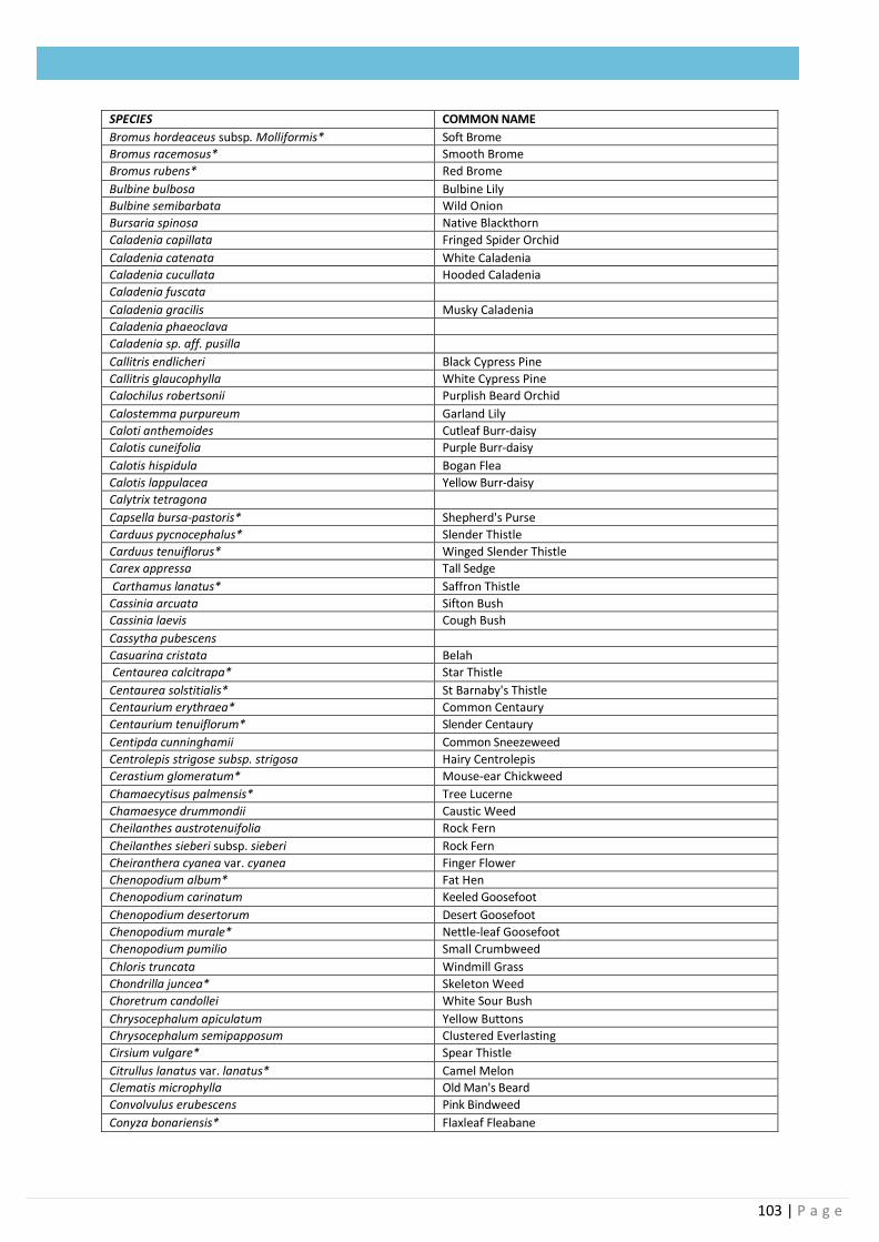
103 | P a g e
SPECIES COMMON NAME
Bromus hordeaceus subsp. Molliformis* Soft Brome
Bromus racemosus* Smooth Brome
Bromus rubens* Red Brome
Bulbine bulbosa Bulbine Lily
Bulbine semibarbata Wild Onion
Bursaria spinosa Native Blackthorn
Caladenia capillata Fringed Spider Orchid
Caladenia catenata White Caladenia
Caladenia cucullata Hooded Caladenia
Caladenia fuscata
Caladenia gracilis Musky Caladenia
Caladenia phaeoclava
Caladenia sp. aff. pusilla
Callitris endlicheri Black Cypress Pine
Callitris glaucophylla White Cypress Pine
Calochilus robertsonii Purplish Beard Orchid
Calostemma purpureum Garland Lily
Caloti anthemoides Cutleaf Burr-daisy
Calotis cuneifolia Purple Burr-daisy
Calotis hispidula Bogan Flea
Calotis lappulacea Yellow Burr-daisy
Calytrix tetragona
Capsella bursa-pastoris* Shepherd's Purse
Carduus pycnocephalus* Slender Thistle
Carduus tenuiflorus* Winged Slender Thistle
Carex appressa Tall Sedge
Carthamus lanatus* Saffron Thistle
Cassinia arcuata Sifton Bush
Cassinia laevis Cough Bush
Cassytha pubescens
Casuarina cristata Belah
Centaurea calcitrapa* Star Thistle
Centaurea solstitialis* St Barnaby's Thistle
Centaurium erythraea* Common Centaury
Centaurium tenuiflorum* Slender Centaury
Centipda cunninghamii Common Sneezeweed
Centrolepis strigose subsp. strigosa Hairy Centrolepis
Cerastium glomeratum* Mouse-ear Chickweed
Chamaecytisus palmensis* Tree Lucerne
Chamaesyce drummondii Caustic Weed
Cheilanthes austrotenuifolia Rock Fern
Cheilanthes sieberi subsp. sieberi Rock Fern
Cheiranthera cyanea var. cyanea Finger Flower
Chenopodium album* Fat Hen
Chenopodium carinatum Keeled Goosefoot
Chenopodium desertorum Desert Goosefoot
Chenopodium murale* Nettle-leaf Goosefoot
Chenopodium pumilio Small Crumbweed
Chloris truncata Windmill Grass
Chondrilla juncea* Skeleton Weed
Choretrum candollei White Sour Bush
Chrysocephalum apiculatum Yellow Buttons
Chrysocephalum semipapposum Clustered Everlasting
Cirsium vulgare* Spear Thistle
Citrullus lanatus var. lanatus* Camel Melon
Clematis microphylla Old Man's Beard
Convolvulus erubescens Pink Bindweed
Conyza bonariensis* Flaxleaf Fleabane
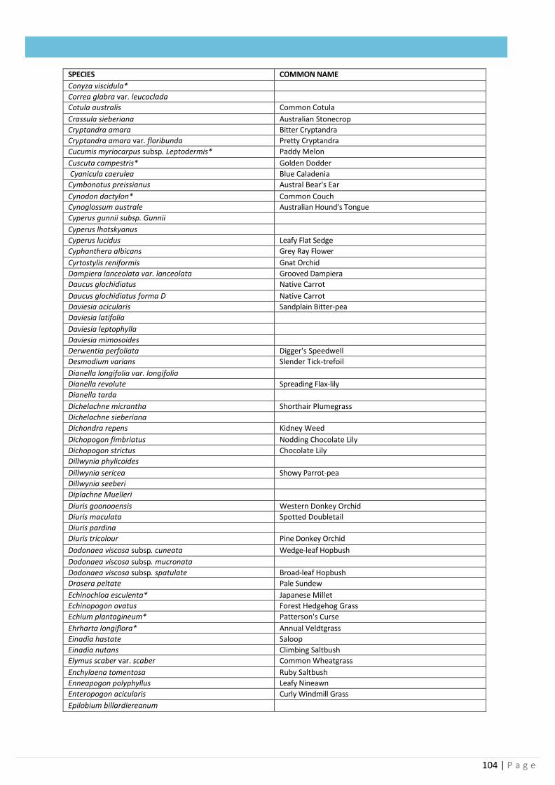
104 | P a g e
SPECIES COMMON NAME
Conyza viscidula*
Correa glabra var. leucoclada
Cotula australis Common Cotula
Crassula sieberiana Australian Stonecrop
Cryptandra amara Bitter Cryptandra
Cryptandra amara var. floribunda Pretty Cryptandra
Cucumis myriocarpus subsp. Leptodermis* Paddy Melon
Cuscuta campestris* Golden Dodder
Cyanicula caerulea Blue Caladenia
Cymbonotus preissianus Austral Bear's Ear
Cynodon dactylon* Common Couch
Cynoglossum australe Australian Hound's Tongue
Cyperus gunnii subsp. Gunnii
Cyperus lhotskyanus
Cyperus lucidus Leafy Flat Sedge
Cyphanthera albicans Grey Ray Flower
Cyrtostylis reniformis Gnat Orchid
Dampiera lanceolata var. lanceolata Grooved Dampiera
Daucus glochidiatus Native Carrot
Daucus glochidiatus forma D Native Carrot
Daviesia acicularis Sandplain Bitter-pea
Daviesia latifolia
Daviesia leptophylla
Daviesia mimosoides
Derwentia perfoliata Digger's Speedwell
Desmodium varians Slender Tick-trefoil
Dianella longifolia var. longifolia
Dianella revolute Spreading Flax-lily
Dianella tarda
Dichelachne micrantha Shorthair Plumegrass
Dichelachne sieberiana
Dichondra repens Kidney Weed
Dichopogon fimbriatus Nodding Chocolate Lily
Dichopogon strictus Chocolate Lily
Dillwynia phylicoides
Dillwynia sericea Showy Parrot-pea
Dillwynia seeberi
Diplachne Muelleri
Diuris goonooensis Western Donkey Orchid
Diuris maculata Spotted Doubletail
Diuris pardina
Diuris tricolour Pine Donkey Orchid
Dodonaea viscosa subsp. cuneata Wedge-leaf Hopbush
Dodonaea viscosa subsp. mucronata
Dodonaea viscosa subsp. spatulate Broad-leaf Hopbush
Drosera peltate Pale Sundew
Echinochloa esculenta* Japanese Millet
Echinopogon ovatus Forest Hedgehog Grass
Echium plantagineum* Patterson's Curse
Ehrharta longiflora* Annual Veldtgrass
Einadia hastate Saloop
Einadia nutans Climbing Saltbush
Elymus scaber var. scaber Common Wheatgrass
Enchylaena tomentosa Ruby Saltbush
Enneapogon polyphyllus Leafy Nineawn
Enteropogon acicularis Curly Windmill Grass
Epilobium billardiereanum
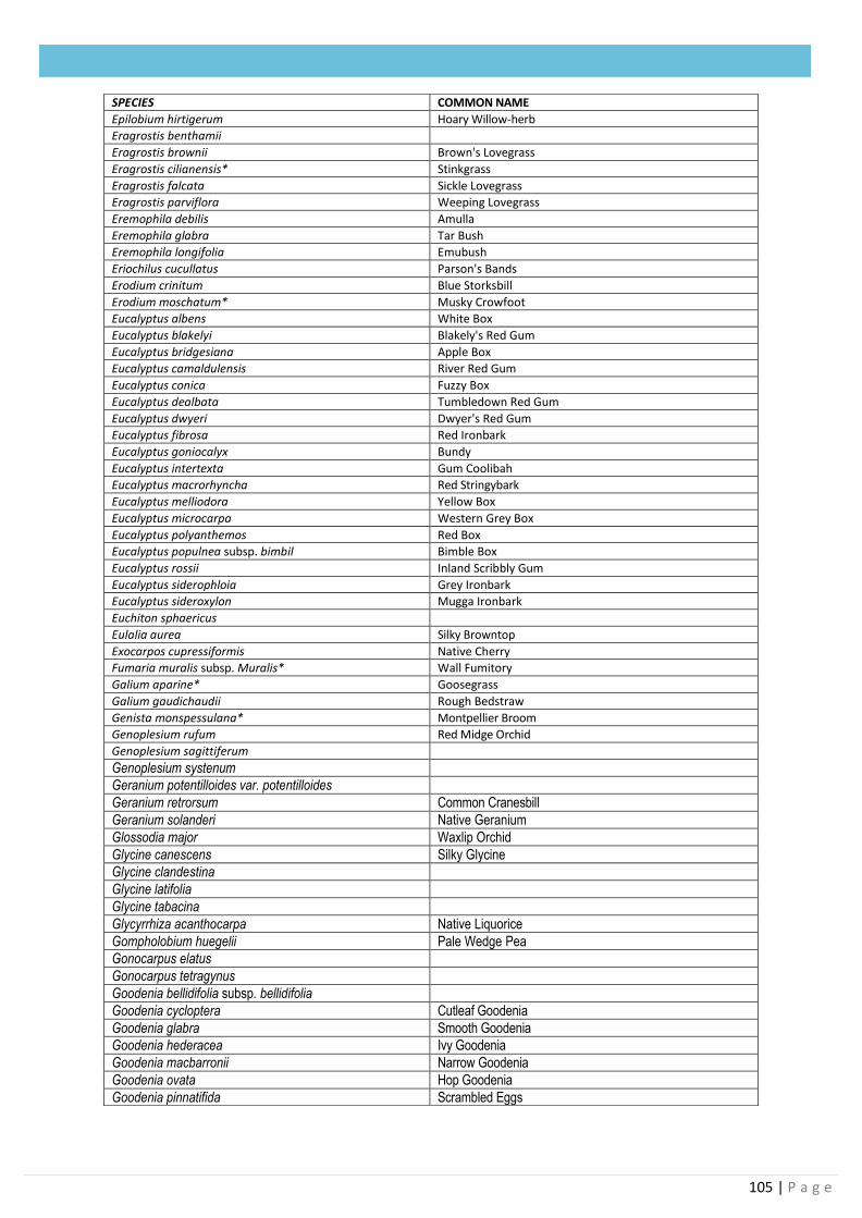
105 | P a g e
SPECIES COMMON NAME
Epilobium hirtigerum Hoary Willow-herb
Eragrostis benthamii
Eragrostis brownii Brown's Lovegrass
Eragrostis cilianensis* Stinkgrass
Eragrostis falcata Sickle Lovegrass
Eragrostis parviflora Weeping Lovegrass
Eremophila debilis Amulla
Eremophila glabra Tar Bush
Eremophila longifolia Emubush
Eriochilus cucullatus Parson's Bands
Erodium crinitum Blue Storksbill
Erodium moschatum* Musky Crowfoot
Eucalyptus albens White Box
Eucalyptus blakelyi Blakely's Red Gum
Eucalyptus bridgesiana Apple Box
Eucalyptus camaldulensis River Red Gum
Eucalyptus conica Fuzzy Box
Eucalyptus dealbata Tumbledown Red Gum
Eucalyptus dwyeri Dwyer's Red Gum
Eucalyptus fibrosa Red Ironbark
Eucalyptus goniocalyx Bundy
Eucalyptus intertexta Gum Coolibah
Eucalyptus macrorhyncha Red Stringybark
Eucalyptus melliodora Yellow Box
Eucalyptus microcarpa Western Grey Box
Eucalyptus polyanthemos Red Box
Eucalyptus populnea subsp. bimbil Bimble Box
Eucalyptus rossii Inland Scribbly Gum
Eucalyptus siderophloia Grey Ironbark
Eucalyptus sideroxylon Mugga Ironbark
Euchiton sphaericus
Eulalia aurea Silky Browntop
Exocarpos cupressiformis Native Cherry
Fumaria muralis subsp. Muralis* Wall Fumitory
Galium aparine* Goosegrass
Galium gaudichaudii Rough Bedstraw
Genista monspessulana* Montpellier Broom
Genoplesium rufum Red Midge Orchid
Genoplesium sagittiferum
Genoplesium systenum
Geranium potentilloides var. potentilloides
Geranium retrorsum Common Cranesbill
Geranium solanderi Native Geranium
Glossodia major Waxlip Orchid
Glycine canescens Silky Glycine
Glycine clandestina
Glycine latifolia
Glycine tabacina
Glycyrrhiza acanthocarpa Native Liquorice
Gompholobium huegelii Pale Wedge Pea
Gonocarpus elatus
Gonocarpus tetragynus
Goodenia bellidifolia subsp. bellidifolia
Goodenia cycloptera Cutleaf Goodenia
Goodenia glabra Smooth Goodenia
Goodenia hederacea Ivy Goodenia
Goodenia macbarronii Narrow Goodenia
Goodenia ovata Hop Goodenia
Goodenia pinnatifida Scrambled Eggs
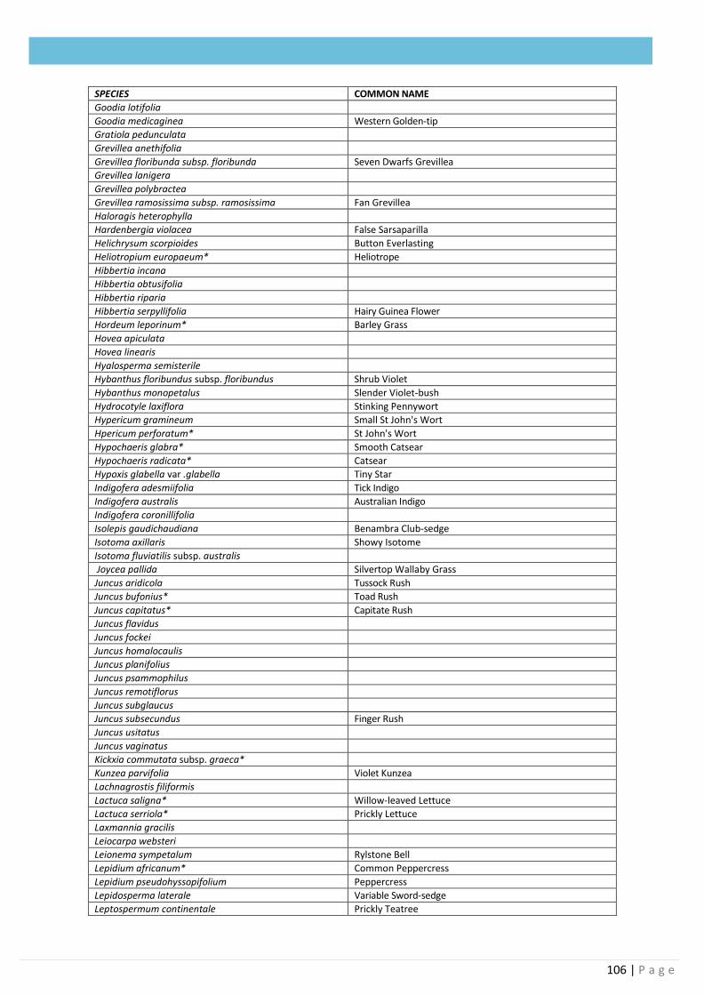
106 | P a g e
SPECIES COMMON NAME
Goodia lotifolia
Goodia medicaginea Western Golden-tip
Gratiola pedunculata
Grevillea anethifolia
Grevillea floribunda subsp. floribunda Seven Dwarfs Grevillea
Grevillea lanigera
Grevillea polybractea
Grevillea ramosissima subsp. ramosissima Fan Grevillea
Haloragis heterophylla
Hardenbergia violacea False Sarsaparilla
Helichrysum scorpioides Button Everlasting
Heliotropium europaeum* Heliotrope
Hibbertia incana
Hibbertia obtusifolia
Hibbertia riparia
Hibbertia serpyllifolia Hairy Guinea Flower
Hordeum leporinum* Barley Grass
Hovea apiculata
Hovea linearis
Hyalosperma semisterile
Hybanthus floribundus subsp. floribundus Shrub Violet
Hybanthus monopetalus Slender Violet-bush
Hydrocotyle laxiflora Stinking Pennywort
Hypericum gramineum Small St John's Wort
Hpericum perforatum* St John's Wort
Hypochaeris glabra* Smooth Catsear
Hypochaeris radicata* Catsear
Hypoxis glabella var .glabella Tiny Star
Indigofera adesmiifolia Tick Indigo
Indigofera australis Australian Indigo
Indigofera coronillifolia
Isolepis gaudichaudiana Benambra Club-sedge
Isotoma axillaris Showy Isotome
Isotoma fluviatilis subsp. australis
Joycea pallida Silvertop Wallaby Grass
Juncus aridicola Tussock Rush
Juncus bufonius* Toad Rush
Juncus capitatus* Capitate Rush
Juncus flavidus
Juncus fockei
Juncus homalocaulis
Juncus planifolius
Juncus psammophilus
Juncus remotiflorus
Juncus subglaucus
Juncus subsecundus Finger Rush
Juncus usitatus
Juncus vaginatus
Kickxia commutata subsp. graeca*
Kunzea parvifolia Violet Kunzea
Lachnagrostis filiformis
Lactuca saligna* Willow-leaved Lettuce
Lactuca serriola* Prickly Lettuce
Laxmannia gracilis
Leiocarpa websteri
Leionema sympetalum Rylstone Bell
Lepidium africanum* Common Peppercress
Lepidium pseudohyssopifolium Peppercress
Lepidosperma laterale Variable Sword-sedge
Leptospermum continentale Prickly Teatree
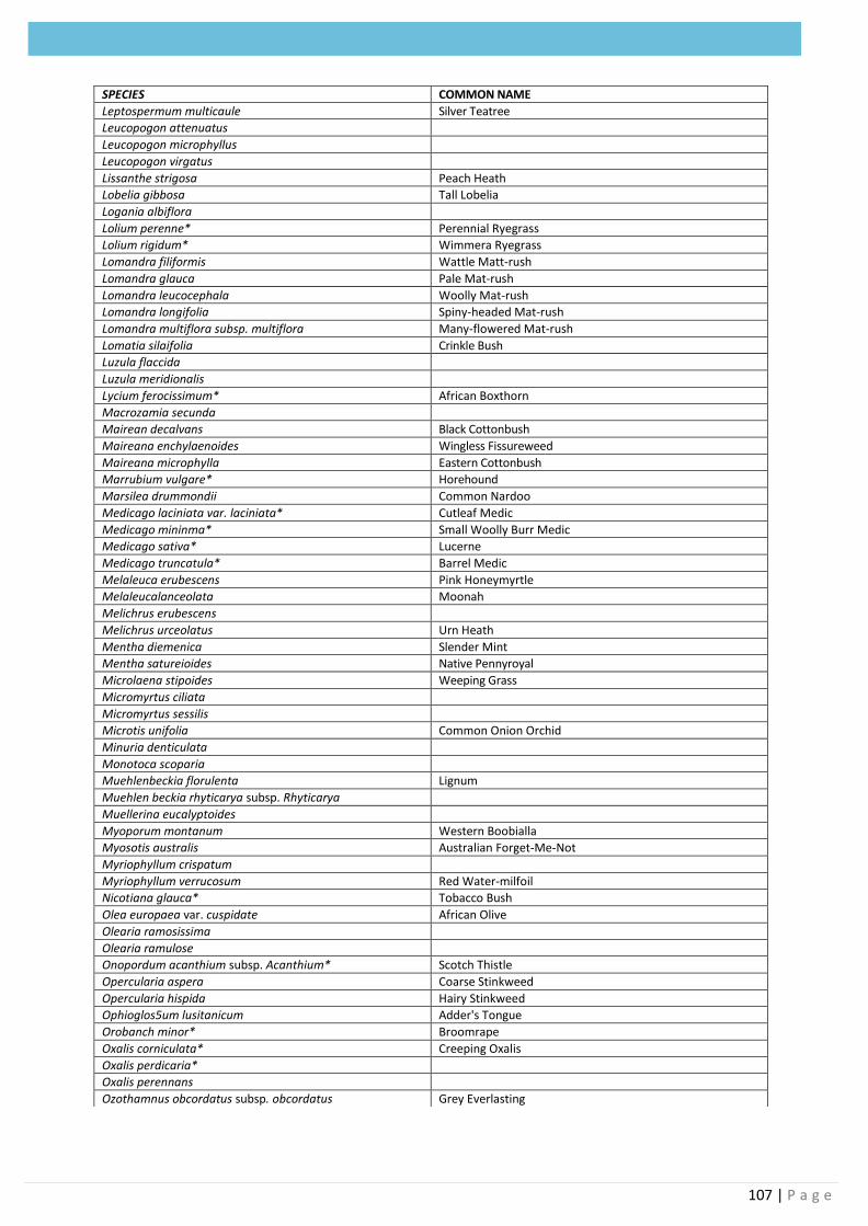
107 | P a g e
SPECIES COMMON NAME
Leptospermum multicaule Silver Teatree
Leucopogon attenuatus
Leucopogon microphyllus
Leucopogon virgatus
Lissanthe strigosa Peach Heath
Lobelia gibbosa Tall Lobelia
Logania albiflora
Lolium perenne* Perennial Ryegrass
Lolium rigidum* Wimmera Ryegrass
Lomandra filiformis Wattle Matt-rush
Lomandra glauca Pale Mat-rush
Lomandra leucocephala Woolly Mat-rush
Lomandra longifolia Spiny-headed Mat-rush
Lomandra multiflora subsp. multiflora Many-flowered Mat-rush
Lomatia silaifolia Crinkle Bush
Luzula flaccida
Luzula meridionalis
Lycium ferocissimum* African Boxthorn
Macrozamia secunda
Mairean decalvans Black Cottonbush
Maireana enchylaenoides Wingless Fissureweed
Maireana microphylla Eastern Cottonbush
Marrubium vulgare* Horehound
Marsilea drummondii Common Nardoo
Medicago laciniata var. laciniata* Cutleaf Medic
Medicago mininma* Small Woolly Burr Medic
Medicago sativa* Lucerne
Medicago truncatula* Barrel Medic
Melaleuca erubescens Pink Honeymyrtle
Melaleucalanceolata Moonah
Melichrus erubescens
Melichrus urceolatus Urn Heath
Mentha diemenica Slender Mint
Mentha satureioides Native Pennyroyal
Microlaena stipoides Weeping Grass
Micromyrtus ciliata
Micromyrtus sessilis
Microtis unifolia Common Onion Orchid
Minuria denticulata
Monotoca scoparia
Muehlenbeckia florulenta Lignum
Muehlen beckia rhyticarya subsp. Rhyticarya
Muellerina eucalyptoides
Myoporum montanum Western Boobialla
Myosotis australis Australian Forget-Me-Not
Myriophyllum crispatum
Myriophyllum verrucosum Red Water-milfoil
Nicotiana glauca* Tobacco Bush
Olea europaea var. cuspidate African Olive
Olearia ramosissima
Olearia ramulose
Onopordum acanthium subsp. Acanthium* Scotch Thistle
Opercularia aspera Coarse Stinkweed
Opercularia hispida Hairy Stinkweed
Ophioglos5um lusitanicum Adder's Tongue
Orobanch minor* Broomrape
Oxalis corniculata* Creeping Oxalis
Oxalis perdicaria*
Oxalis perennans
Ozothamnus obcordatus subsp. obcordatus Grey Everlasting
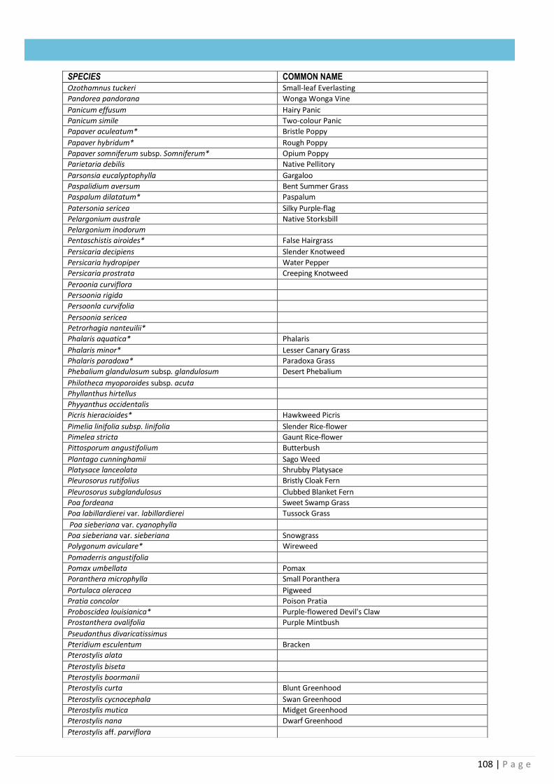
108 | P a g e
SPECIES COMMON NAME Ozothamnus tuckeri Small-leaf Everlasting
Pandorea pandorana Wonga Wonga Vine
Panicum effusum Hairy Panic
Panicum simile Two-colour Panic
Papaver aculeatum* Bristle Poppy
Papaver hybridum* Rough Poppy
Papaver somniferum subsp. Somniferum* Opium Poppy
Parietaria debilis Native Pellitory
Parsonsia eucalyptophylla Gargaloo
Paspalidium aversum Bent Summer Grass
Paspalum dilatatum* Paspalum
Patersonia sericea Silky Purple-flag
Pelargonium australe Native Storksbill
Pelargonium inodorum
Pentaschistis airoides* False Hairgrass
Persicaria decipiens Slender Knotweed
Persicaria hydropiper Water Pepper
Persicaria prostrata Creeping Knotweed
Peroonia curviflora
Persoonia rigida
Persoonla curvifolia
Persoonia sericea
Petrorhagia nanteuilii*
Phalaris aquatica* Phalaris
Phalaris minor* Lesser Canary Grass
Phalaris paradoxa* Paradoxa Grass
Phebalium glandulosum subsp. glandulosum Desert Phebalium
Philotheca myoporoides subsp. acuta
Phyllanthus hirtellus
Phyyanthus occidentalis
Picris hieracioides* Hawkweed Picris
Pimelia linifolia subsp. linifolia Slender Rice-flower
Pimelea stricta Gaunt Rice-flower
Pittosporum angustifolium Butterbush
Plantago cunninghamii Sago Weed
Platysace lanceolata Shrubby Platysace
Pleurosorus rutifolius Bristly Cloak Fern
Pleurosorus subglandulosus Clubbed Blanket Fern
Poa fordeana Sweet Swamp Grass
Poa labillardierei var. labillardierei Tussock Grass
Poa sieberiana var. cyanophylla
Poa sieberiana var. sieberiana Snowgrass
Polygonum aviculare* Wireweed
Pomaderris angustifolia
Pomax umbellata Pomax
Poranthera microphylla Small Poranthera
Portulaca oleracea Pigweed
Pratia concolor Poison Pratia
Proboscidea louisianica* Purple-flowered Devil's Claw
Prostanthera ovalifolia Purple Mintbush
Pseudanthus divaricatissimus
Pteridium esculentum Bracken
Pterostylis alata
Pterostylis biseta
Pterostylis boormanii
Pterostylis curta Blunt Greenhood
Pterostylis cycnocephala Swan Greenhood
Pterostylis mutica Midget Greenhood
Pterostylis nana Dwarf Greenhood
Pterostylis aff. parviflora
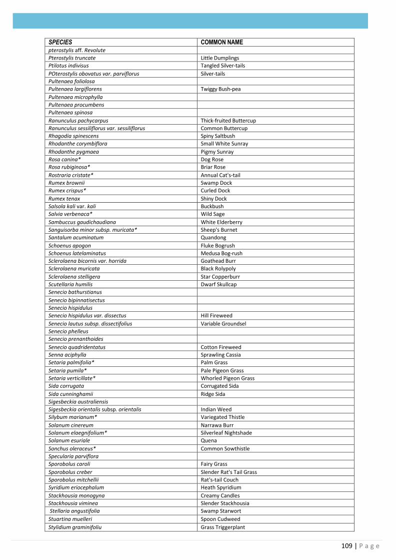
109 | P a g e
SPECIES COMMON NAME pterostylis aff. Revolute
Pterostylis truncate Little Dumplings
Ptilotus indivisus Tangled Silver-tails
POterostylis obovatus var. parviflorus Silver-tails
Pultenaea foliolosa
Pultenaea largiflorens Twiggy Bush-pea
Pultenaea microphylla
Pultenaea procumbens
Pultenaea spinosa
Ranunculus pachycarpus Thick-fruited Buttercup
Ranunculus sessiliflorus var. sessiliflorus Common Buttercup
Rhagodia spinescens Spiny Saltbush
Rhodanthe corymbiflora Small White Sunray
Rhodanthe pygmaea Pigmy Sunray
Rosa canina* Dog Rose
Rosa rubiginosa* Briar Rose
Rostraria cristate* Annual Cat's-tail
Rumex brownii Swamp Dock
Rumex crispus* Curled Dock
Rumex tenax Shiny Dock
Salsola kali var. kali Buckbush
Salvia verbenaca* Wild Sage
Sambuccus gaudichaudiana White Elderberry
Sanguisorba minor subsp. muricata* Sheep's Burnet
Santalum acuminatum Quandong
Schoenus apogon Fluke Bogrush
Schoenus latelaminatus Medusa Bog-rush
Sclerolaena bicornis var. horrida Goathead Burr
Sclerolaena muricata Black Rolypoly
Sclerolaena stelligera Star Copperburr
Scutellaria humilis Dwarf Skullcap
Senecio bathurstianus
Senecio bipinnatisectus
Senecio hispidulus
Senecio hispidulus var. dissectus Hill Fireweed
Senecio lautus subsp. dissectifolius Variable Groundsel
Senecio phelleus
Senecio prenanthoides
Senecio quadridentatus Cotton Fireweed
Senna aciphylla Sprawling Cassia
Setaria palmifolia* Palm Grass
Setaria pumila* Pale Pigeon Grass
Setaria verticillate* Whorled Pigeon Grass
Sida corrugata Corrugated Sida
Sida cunninghamii Ridge Sida
Sigesbeckia australiensis
Sigesbeckia orientalis subsp. orientalis Indian Weed
Silybum marianum* Variegated Thistle
Solanum cinereum Narrawa Burr
Solanum elaegnifolium* Silverleaf Nightshade
Solanum esuriale Quena
Sonchus oleraceus* Common Sowthistle
Specularia parviflora
Sporobolus caroli Fairy Grass
Sporobolus creber Slender Rat's Tail Grass
Sporobolus mitchellii Rat's-tail Couch
Syridium eriocephalum Heath Spyridium
Stackhousia monogyna Creamy Candles
Stackhousia viminea Slender Stackhousia
Stellaria angustifolia Swamp Starwort
Stuartina muelleri Spoon Cudweed
Stylidium graminifoliu Grass Triggerplant
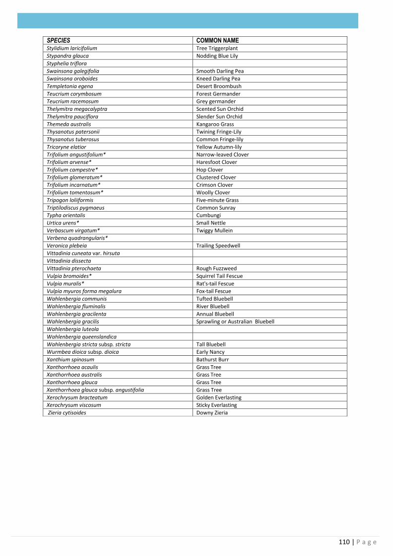
110 | P a g e
SPECIES COMMON NAME
Stylidium laricifolium Tree Triggerplant
Stypandra glauca Nodding Blue Lily
Styphelia triflora
Swainsona galegifolia Smooth Darling Pea
Swainsona oroboides Kneed Darling Pea
Templetonia egena Desert Broombush
Teucrium corymbosum Forest Germander
Teucrium racemosum Grey germander
Thelymitra megacalyptra Scented Sun Orchid
Thelymitra pauciflora Slender Sun Orchid
Themeda australis Kangaroo Grass
Thysanotus patersonii Twining Fringe-Lily
Thysanotus tuberosus Common Fringe-lily
Tricoryne elatior Yellow Autumn-lily
Trifolium angustifolium* Narrow-leaved Clover
Trifolium arvense* Haresfoot Clover
Trifolium campestre* Hop Clover
Trifolium glomeratum* Clustered Clover
Trifolium incarnatum* Crimson Clover
Trifolium tomentosum* Woolly Clover
Tripogon loliiformis Five-minute Grass
Triptilodiscus pygmaeus Common Sunray
Typha orientalis Cumbungi
Urtica urens* Small Nettle
Verbascum virgatum* Twiggy Mullein
Verbena quadrangularis*
Veronica plebeia Trailing Speedwell
Vittadinia cuneata var. hirsuta
Vittadinia dissecta
Vittadinia pterochaeta Rough Fuzzweed
Vulpia bromoides* Squirrel Tail Fescue
Vulpia muralis* Rat's-tail Fescue
Vulpia myuros forma megalura Fox-tail Fescue
Wahlenbergia communis Tufted Bluebell
Wahlenbergia fluminalis River Bluebell
Wahlenbergia gracilenta Annual Bluebell
Wahlenbergia gracilis Sprawling or Australian Bluebell
Wahlenbergia luteola
Wahlenbergia queenslandica
Wahlenbergia stricta subsp. stricta Tall Bluebell
Wurmbea dioica subsp. dioica Early Nancy
Xanthium spinosum Bathurst Burr
Xanthorrhoea acaulis Grass Tree
Xanthorrhoea australis Grass Tree
Xanthorrhoea glauca Grass Tree
Xanthorrhoea glauca subsp. angustifolia Grass Tree
Xerochrysum bracteatum Golden Everlasting
Xerochrysum viscosum Sticky Everlasting
Zieria cytisoides Downy Zieria