weather forecast activity at mzs (terra nova bay)weather ... · production using grads graphic...
TRANSCRIPT
Weather Forecast Activity at MZS (Terra Nova Bay):Weather Forecast Activity at MZS (Terra Nova Bay):Automated Antarctic ECMWF Data Processing and Distribution Automated Antarctic ECMWF Data Processing and Distribution
Management Management [email protected]
A. Piscini1, M. Bider2
1 INGVPNRA SCrl (Rome, Italy)2ARPASIM (Bologna, Italy)
Bibliography
Manuale Operativo Previsori Meteo, PNRA S.C.r.l.;
Anders Persson, Federico Grazzini, User Guide to ECMWF forecast products;
GrADS Documentation, http://www.iges.org/grads/gadoc;
Doing GRIB in GrADS, http://www.iges.org/grads/gadoc/grib2.html;
The WMO format for the storage of weather information and the exchange of weather product messages in gridded binary form, John D. Stackpole Automation Division, National, Meteorological Center, National Weather Service, NOAA, February 18, 1994
Weather Forecast service at “Mario Zucchelli Station”, the Italian base in Antarctica, is operated by Aeronautica Militare Italiana (Italian Air Force) staff and is very important to support activities during the summer expeditions. It allows to manage the base activities in order to use resources in a very safe mode.
Currently, weather forecasts are based on the Global Model of European Centre for Medium Weather Forecast (ECMWF, Reading, UK) data, and on the AMPS forecasts provided by NCAR.
ECMWF forecast data acquisition, processing and distribution if fully managed by PNRA staff by mean of a special computer system network, connecting Centro Nazionale Meteorologia e Climatologia of Aeronautica Militare (CNMCA the Italian Meteorological Service) in Pratica di Mare, PNRA premises in Casaccia and MZS in Antarctica.
Daily this system handles automated ECMWF data acquisition in GRIB format from CNMCA, GRIB unpacking and forwarding to Antarctica (performed at PNRA premises in Casaccia), map production using GRADS graphic package (performed at MZS in Antarctica). GRADS produces maps are used by base staff for their routine weather forecast activity.
During the XXI Antarctic expedition the system architecture was changed. All software was migrated from SUN/Solaris to Intel/LinuxRed Hat open source platform and it was improved in order to: 1. to supply a more reliable system in term of data distribution and 2. to upgrade the product in the respect of the technical requirements suggested by the meteorological staff.
Terra Nova Bay and Mario Zucchelli Station location in a DMSP satellite image. Images of PNRA SCrl Remote Sensing Data Archive.
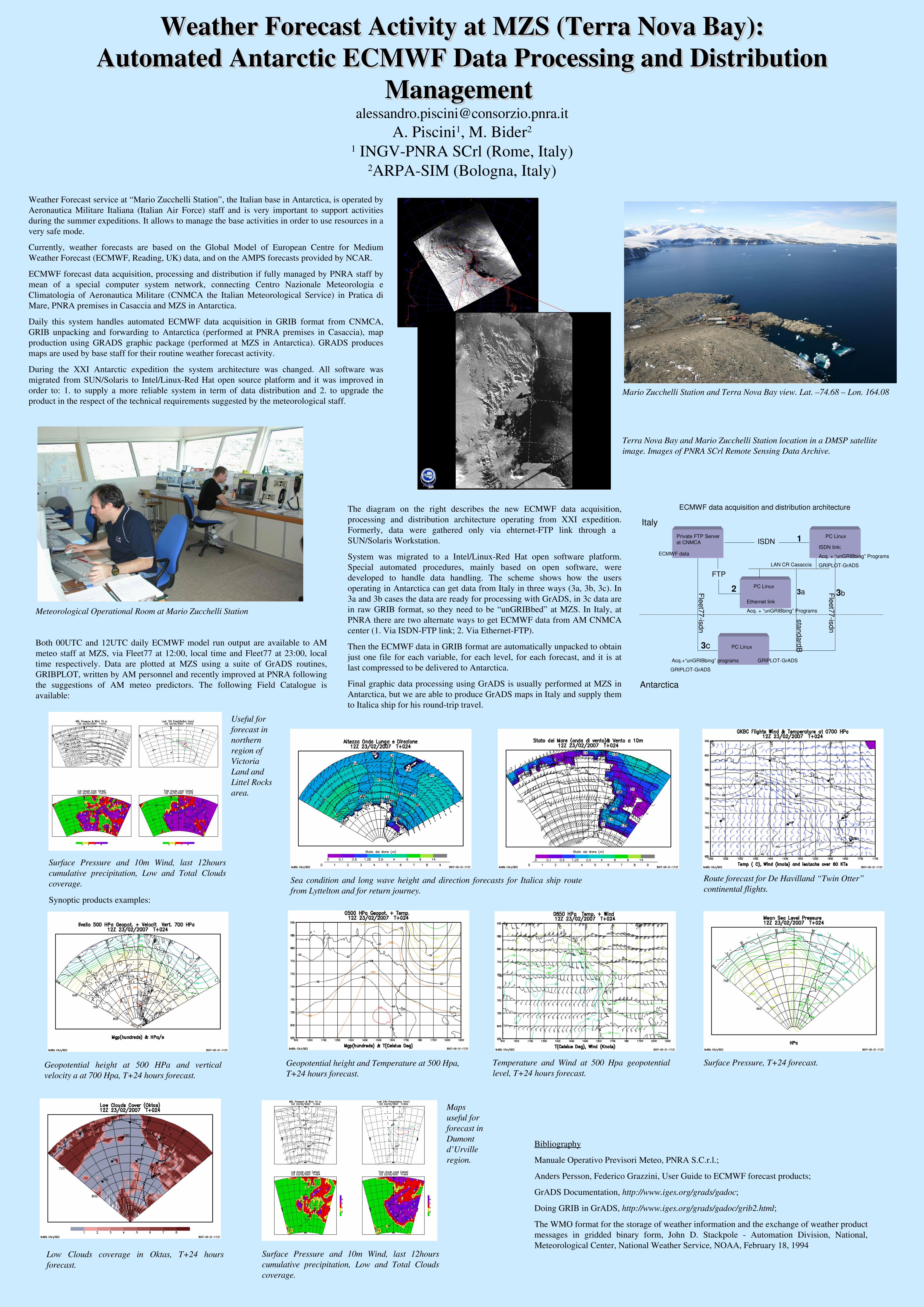
The diagram on the right describes the new ECMWF data acquisition, processing and distribution architecture operating from XXI expedition. Formerly, data were gathered only via ehternetFTP link through a SUN/Solaris Workstation.
System was migrated to a Intel/LinuxRed Hat open software platform.Special automated procedures, mainly based on open software, were developed to handle data handling. The scheme shows how the users operating in Antarctica can get data from Italy in three ways (3a, 3b, 3c). In 3a and 3b cases the data are ready for processing with GrADS, in 3c data are in raw GRIB format, so they need to be “unGRIBbed” at MZS. In Italy, at PNRA there are two alternate ways to get ECMWF data from AM CNMCA center (1. Via ISDNFTP link; 2. Via EthernetFTP).
Then the ECMWF data in GRIB format are automatically unpacked to obtain just one file for each variable, for each level, for each forecast, and it is at last compressed to be delivered to Antarctica.
Final graphic data processing using GrADS is usually performed at MZS in Antarctica, but we are able to produce GrADS maps in Italy and supply them to Italica ship for his roundtrip travel.
Mario Zucchelli Station and Terra Nova Bay view. Lat. –74.68 – Lon. 164.08
Meteorological Operational Room at Mario Zucchelli Station
Useful for forecast in northern region of Victoria Land and Littel Rocks area.
Both 00UTC and 12UTC daily ECMWF model run output are available to AM meteo staff at MZS, via Fleet77 at 12:00, local time and Fleet77 at 23:00, local time respectively. Data are plotted at MZS using a suite of GrADS routines, GRIBPLOT, written by AM personnel and recently improved at PNRA following the suggestions of AM meteo predictors. The following Field Catalogue is available:
Sea condition and long wave height and direction forecasts for Italica ship route from Lyttelton and for return journey.
Synoptic products examples:
Route forecast for De Havilland “Twin Otter” continental flights.
Geopotential height at 500 HPa and vertical velocity a at 700 Hpa, T+24 hours forecast.
Geopotential height and Temperature at 500 Hpa, T+24 hours forecast.
Temperature and Wind at 500 Hpa geopotential level, T+24 hours forecast.
Surface Pressure, T+24 forecast.
Low Clouds coverage in Oktas, T+24 hours forecast.
Surface Pressure and 10m Wind, last 12hours cumulative precipitation, Low and Total Clouds coverage.
Surface Pressure and 10m Wind, last 12hours cumulative precipitation, Low and Total Clouds coverage.
Maps useful for forecast in Dumont d’Urville region.
Italy
Antarctica
ISDN
PC Linux
Private FTP Serverat CNMCA
PC Linux
ISDN link;Acq. + “unGRIBbing” ProgramsGRIPLOTGrADS
GRIPLOTGrADSAcq.+“unGRIBbing” programsGRIPLOTGrADS
Fleet77isdn
Fleet77isdn
3b
1
3c
LAN CR Casaccia
standardB
3a
ECMWF data
ECMWF data acquisition and distribution architecture
PC Linux
Ethernet linkAcq. + “unGRIBbing” Programs
2FTP