water saving scenarios for cotton under surface irrigation...
TRANSCRIPT
Water saving scenarios for cotton under surface irrigation: analysis withthe DSS [Decision Support Systems] SADREG
Darouich H., Gonçalves J.M., Pereira L.S.
in
Lamaddalena N. (ed.), Bogliotti C. (ed.), Todorovic M. (ed.), Scardigno A. (ed.). Water saving in Mediterranean agriculture and future research needs [Vol. 1]
Bari : CIHEAMOptions Méditerranéennes : Série B. Etudes et Recherches; n. 56 Vol.I
2007pages 381-396
Article available on line / Article disponible en ligne à l’adresse :
--------------------------------------------------------------------------------------------------------------------------------------------------------------------------http://om.ciheam.org/article.php?IDPDF=800127 --------------------------------------------------------------------------------------------------------------------------------------------------------------------------
To cite th is article / Pour citer cet article
--------------------------------------------------------------------------------------------------------------------------------------------------------------------------Darouich H., Gonçalves J.M., Pereira L.S. Water saving scenarios for cotton under surface
irrigation: analysis with the DSS [Decision Support Systems] SADREG. In : Lamaddalena N.(ed.), Bogliotti C. (ed.), Todorovic M. (ed.), Scardigno A. (ed.). Water saving in Mediterranean agriculture
and future research needs [Vol. 1]. Bari : CIHEAM, 2007. p. 381-396 (Options Méditerranéennes : SérieB. Etudes et Recherches; n. 56 Vol.I)--------------------------------------------------------------------------------------------------------------------------------------------------------------------------
http://www.ciheam.org/http://om.ciheam.org/

381
WATER SAVING SCENARIOS FOR COTTON UNDER SURFACE IRRIGATION: ANALYSIS WITH THE DSS SADREG
H. Darouich *, J. M. Gonçalves ** and L. S. Pereira ** *Irrigation and Drainage Research Institute, Damascus, Syria
**Centro de Estudos de Engenharia Rural, 1349-017 Lisboa, Portugal
SUMMARY - The improvement and modernization of surface irrigation systems plays an important role to achieve the sustainability of the Mediterranean irrigated agriculture. These techniques are actual farmer practices in many regions, are low investment and energy costs, and have the potential to achieve high application performances. To support developing improved solutions, the application of a decision support system (DSS) to design, analyze and rank alternative surface irrigation scenarios is helpful. In fact, the performance of surface irrigation systems highly depends upon the design process, including decisions on land leveling, field shape and dimensions, and inflow rates. In addition, it depends on farmer decisions such as land leveling maintenance and timeliness and duration of irrigation events. The variety of aspects influencing irrigation performances makes the decision process quite complex and often out of the farmers experience and empirical knowledge. The adopted SADREG DSS includes a database, simulation models and a multi-criteria analysis model. The database concerns field sizes and topography, soil, crop and irrigation management data, which is created through interactive simulations with the ISAREG model, and economic data. The simulation tools include a land leveling module and the SIRMOD simulation and design model. The models were parameterized and validated using field data before the DSS application. The analysis includes cost and benefit calculations, and attributes relative to environmental impacts. The paper describes the model and its application to furrow and border irrigation in Ras-El-Ain, Syria, focusing water savings and cotton water productivity, and socio-economic issues. Key words: Furrow irrigation, cotton, irrigation performances, design, multi-criteria analysis, decision support systems (DSS), Syria. RESUME � L�amélioration et modernisation des systèmes d�irrigation de surface peut jouer un rôle important en vu de la durabilité de l�agriculture irriguée en Méditerranée. Telles techniques sont communes en plusieurs régions, ont de bas coûts d�investissement et d�énergie et présentent un potentiel élevé pour atteindre de bonnes performances. L�application des systèmes de support à la décision (DSS) pour la conception et le choix de sénaires alternatifs en irrigation de surface irrigation est très utile vu que la performance de ces systèmes dépend de leur projet, notamment les choix relatifs au nivellement à la forme et dimension des parcelles et aux débits utilisés. En plus, elle dépend des décisions relatives à la maintenance du nivellement et à la conduite des arrosages. Le grand nombre d�aspects qui influencent les performances fait que le processus de décision soit complexe et souvent en dehors de l�expérience et savoir-faire des irrigants. Le DSS SADREG inclue une base de données, des modèles de simulation et un modèle d�analyse multicritère. La base de données concerne les dimensions et topographie des parcelles, le sol, la culture et la gestion de l�irrigation, dont les données sont crées par simulation interactive avec le modèle ISAREG, aussi bien que des données économiques. Les modèles de simulation incluent un module pour le nivellement et le modèle SIRMOD de simulation et projet. Les modèles étaient calibrés et validés avec des données de terrain avant l�application DSS. L�analyse inclue les coûts et bénéfices et des attributs relatifs aux impactes environnementaux. Cet article décrit le DSS et son application à des améliorations alternatives de l�irrigation à la raie et par calant à Ras-El-Ain, Syria, orientée vers l�épargne d�eau et la productivité de l�eau du Cotton et pour d�autres questions socio-économiques. Mot-clés: Irrigation à la raie, Cotton, performances de l�irrigation, projet, analyse multicritère, systèmes de support â la décision (DSS), Syrie.

382
INTRODUCTION
Surface irrigation systems are of great importance in the Mediterranean irrigated agriculture. Commonly, farmers apply traditional irrigation methods and related performances are often low. However, surface irrigation has high potential to achieve high performances, requires low level technology with low investment and energy costs (Pereira et al., 2002). Thus, the modernization and improvement of surface irrigation systems are recommended. This is the case for the Northeast of Syria (Fig. 1), where wheat and cotton are grown under surface irrigation, predominantly short basins and furrow irrigation. This study refers to a case study in Ras-El-Ain area, where a project developed by the Italian Cooperation and the IAM-Bari is being implemented aiming at rationalizing irrigation in the region and focus on irrigation water savings.
Fig. 1. Location map of Ras El Ain irrigation district.
The Ras El Ain irrigation district is located in Mesopotmia, in the Euphrates basin (Fig. 1), with an elevation range from 165 to 325 m over the sea level, with an annual rainfall of 200-250 mm and an annual potential evaporation of 1600-2800 mm. Ras El Ain is considered one of the most critical regions in Syria because it is heavily affected by water scarcity and the drawdown of the ground water table. This phenomenon is influenced by several factors related to climate aridity, heavy use of available resources and decrease of flow in most of the rivers due to the construction of dams in the upper parts of the basins inside Turkey. This situation led to set up a group of wells to feed the Al Kabour river in the Ras El Ain area, and to a high ground water use for irrigation. Ras El Ain area is an ancient arable and fertile land where the farmers plant cotton and wheat since long time. These crops are strategic ones, and the farmers are supported with soft loans and various facilities in order to keep planting these crops. However, cotton requires quite large amounts of water. Traditional basin, furrow and border irrigation prevails there, using earthen distribution ditches. For cotton, several irrigation methods may be used and all have advantages and disadvantages but micro-irrigation, particularly subsurface drip irrigation, has the highest potential for water saving and high water productivity (Raine and Foley, 2002). However, considering the investment and energy costs of pressurized systems, the respective technological requirements, and the fact that cotton is in rotation with winter wheat, it was decided to assess the potential for improving surface irrigation to be used by both crops.
383
The performance of surface irrigation systems is highly dependent on the design process, which is related with the appropriateness and precision of land leveling, field shape and dimensions, and inflow discharge. Moreover, the irrigation performance also depends on farmer decisions, namely in relation to land leveling maintenance, timeliness and time duration of every irrigation event, and his ability to overcome difficulties in water supply, such as uncertainty or scheduling constraints. The improvement of farm irrigation systems in large surface irrigation projects can be well supported by decision support systems (DSS), namely using multi-criteria analysis for ranking alternative solutions (Roy and Bouyssou, 1993; Raju and Pillai, 1999).
DSS are often applied to land use (Santé and Crecente, 2005) or to irrigation planning and water delivery (Bazzani, 2003; Oad et al., 2006) but very few applications are developed for surface irrigation (Gonçalves and Pereira, 1999; McClymont, 1999). However, surface irrigation applications of the DSS SADREG could be successfully performed at field level for cotton and wheat irrigation in Central Asia (Gonçalves et al., 2005a; 2006) as well as at sector level when linked with a geographic information system (GIS) database (Gonçalves et al., 2005c), including to perform a detailed analysis of soil infiltration impacts on irrigation performances (Gonçalves et al., 2005b). The variety of aspects influencing irrigation performances makes the decision process quite complex and often out of the farmers experience and empirical knowledge. This complexity makes the problem adequate for considering multi-criteria analysis when ranking alternative solutions for improving irrigation performances, achieving water saving or higher water productivity taking into account not only physical factors but also economic and environmental ones. The DSS methodology using multi-criteria analysis for both design and irrigation management may help farmers to make the best decisions due to the enlargement of available solutions set.
The objective of this study is to assess the potential of surface irrigation modernization, mainly furrows and border irrigation to achieve water saving and high water productivity of the cotton crop following several agriculture sustainability criterion which combine water savings and higher farmers� incomes. Several water saving scenarios concerning alternative technical solutions have been developed with this purpose.
MATERIAL AND METHODS
The DSS SADREG
SADREG is a DSS tool to search and analyze modernization solutions for surface irrigation � furrow, basin and border irrigation. Because designing surface irrigation systems imply the selection among a large number of combinations of main factors such as soil infiltration and water holding capacity; field sizes, slopes and topography; crop irrigation requirements, and inflow rates, it becomes easier to manipulate all information and ranking solutions through a DSS tool. When several fields within an irrigation district are considered, then the task becomes only feasible if a spatially distributed database is also available. SADREG is conceived in such a manner that the user may learn through the application process. This DSS software integrates databases, design and simulation models, and user knowledge that allow generating and ranking alternative improvement scenarios according to user criteria. It comprises two components: design and selection. The first one applies database information relative to the area of application, and produces a set of alternative design solutions, which performance characteristics are used for selection. The decision-maker participates in all decision process, by expressing preferences and priorities required for selection through interface dialog structures.
SADREG is applied to rectangular shape fields, with uniform soil intake characteristics. The database concerns field sizes and topography, soil intake rates, soil water holding capacity, crop data, irrigation management data created through interactive simulations with the ISAREG model (Pereira et al., 2003), and economic information. The surface irrigation models include: a land leveling module that performs an iterative optimization of land forms, and the SIRMOD simulation model for surface irrigation design (Walker, 1998), which is a very powerful model and well adapted for supporting a decision process (Hornbuckle et al., 2005). The on-farm distribution systems refer to continuous and surge-flow (automatic or manual controlled) with lay flat tubing with gates, gated pipes, concrete canals with lateral holes, and unlined canals with or without siphons. The user may consider other design options. The evaluation analysis includes cost and benefit calculations, and the determination of attributes relative to environmental impacts.

384
The main steps on a SADREG application are:
(i) Identification of field characteristics; (ii) Scenario development relative to decision variables such as field water supply, crop irrigation,
furrow spacing, management allowed depletion (MAD), and furrows inflow regime (continuous vs. surge irrigation);
(iii) Data input referring to soil water data, infiltration and roughness parameters based on field experiments and/or databases, crop data, operation and equipment costs, labor and machine time durations, and water supply characteristics, such as the hydraulic head, and number and discharge of field outlets;
(iv) Design procedure to create alternatives using both design models referred above relative to the considered scenarios (item ii above); and
(v) Ranking and selection of alternative designs using multi-criteria analysis where weights are defined according the user priorities.
To carry out this sequence of operations it is necessary to understand the main concepts and the
hierarchy of the elements that compose the SADREG data structure:
(i) Field - is an rectangular shape on-farm land parcel, with a well known geographical location, with an uniform soil intake characteristics and a water supply hydrant;
(ii) Hydrant - is a gate on the network delivery system that supply the field; and (iii) Outlet - is a discharge point, inside the field, connected to the field distribution system (a field
can have one or more outlets).
The SADREG data structure can be described as follows (Fig. 2):
(i) Workspace - is the basic element of SADREG data structure; corresponds to an individual Field and include all its data files. The information for each Field include: location; dimension; agronomic data; topographic survey, etc;
(ii) Project - each Project is a Field Scenario to develop a design for the selected field. Several projects can be created for each Workspace receiving different names;
(iii) Alternative - is a complete design solution for the selected field; (iv) Group of alternatives - a cluster that are differentiated by structural decision variables (e.g. land
leveling, irrigation method, equipments); within a group, the alternatives are differentiated by the operative values (unitary inflow rate and application time) and the number of sub-units;
(v) Unit � it is a field subdivision irrigated by a single outlet; it is assumed that all units of a field are similar; and
(vi) Sub-unit � it is the fraction of a unit that is irrigated at the same time.
Fig. 2. SADREG data structure elements.
385
Experimental data
Field experiments were carried out in two sites within the Ras El Ain irrigation areas, Arnan and Bab Al Faraj, representing different local typical areas. Field experiments consist essentially of evaluation alternative field sizes, discharges, land leveling and management of furrows and borders, including those used by local farmers. Field data provided for appropriate parameterization of the irrigation-scheduling model ISAREG and the surface irrigation simulation model SIRMOD integrated in the DSS. Experiments are described with detail by Darouich (2006).
An irrigation scheduling study for cotton allowed the parameterization and further use of the ISAREG model. Field observations were carried out at Arnan. The methodology follows that described by Oweis et al. (2003) for wheat in Aleppo, Syria, and by Cholpankulov et al. (2005) for cotton in Central Asia, where climate and cultivation conditions are similar to those in Ras El Ain. The crop coefficients methodology proposed by Allen et al. (1998) was adopted. Observations included an upgraded scheduling and those followed by farmers. It was observed that farmers common apply less appropriate schedules with excessive gross irrigation depths per event (160-200 mm), much above the soil water deficits at time of irrigation, leading to high percolation. Using ISAREG, improved irrigation schedules were defined (Darouich, 2006) adopting net irrigation depths (NID) of 80 mm: (a) to maximize yields, 12 irrigation events are considered; for deficit irrigation, allowing 30% depletion below the soil water threshold șp for no stress, i.e. assuming șMAD = 70% șp, 11 irrigation events are adopted.
Several field evaluations were performed in farmers� fields using the traditional zigzag furrows and
improved graded furrows. The zigzag furrows method is a local technique aimed at overcoming problems resulting from the irregularity of the slopes and the lower permeability of the soil; despite it is acceptably adapted to existing field conditions, the resulting distribution uniformity and application efficiency are low, it is labor consuming, and it imposes limitations to mechanization. To well irrigate the entire field, zigzag furrows require high application depths as referred above. Results from field observations indicate that it is not possible to improve that method but change to graded furrows, borders or basins, in all cases with adoption of improved land leveling. An experimental field where such methods were implemented has been installed at Arnan, while furrow systems adopted by a farmer at Bab El Faraj were also utilized to assess the irrigation performance of such improvements.
Several field evaluations provided for assessing the performance of furrow irrigation with different
slopes and lengths for the first and second irrigation, including open and blocked furrows, including the case for deficit irrigation. The field evaluation methodology followed that described by Walker and Skogerboe (1987), ASAE (2003) and Horst et al. (2005), including for deriving infiltration and roughness parameters. The performance indicators used are those defined by these authors.
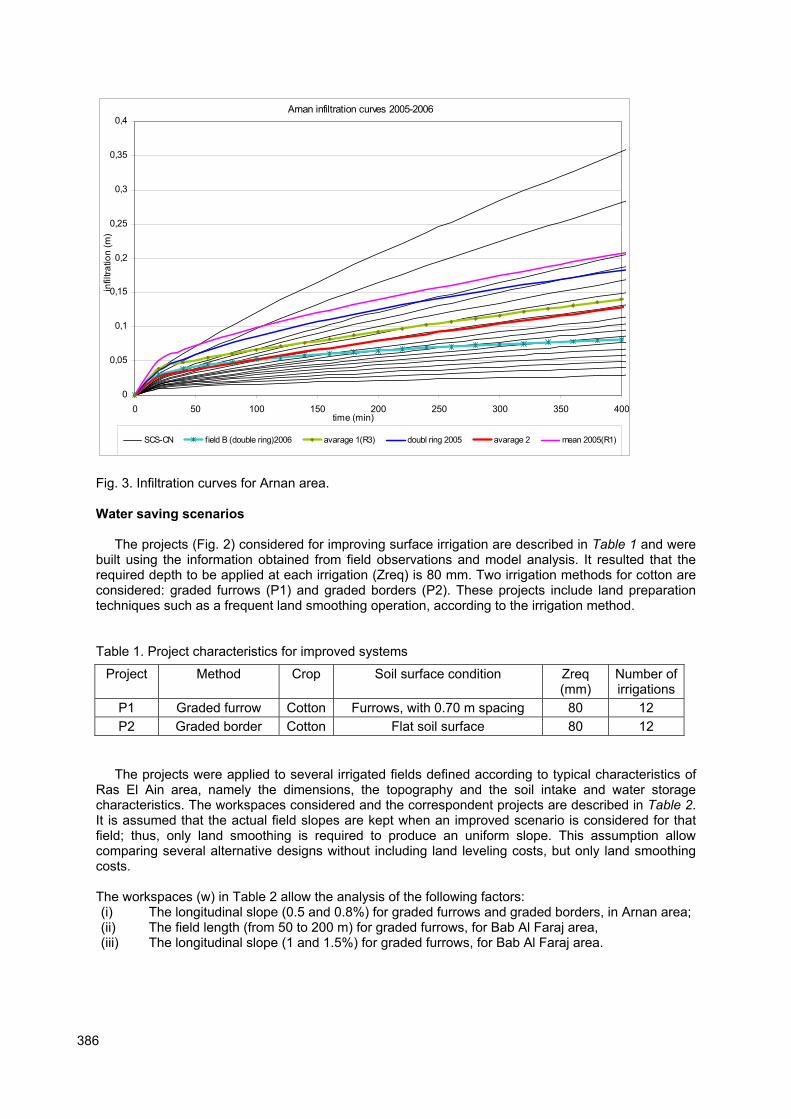
Infiltration tests with the double ring infiltrometer and with furrow and basin observations of advance and recession led to define average infiltration curves for Arnan and Bab Al Faraj. The respective infiltration parameters have been selected from using the SIRMOD model in the reverse mode i.e. comparing the advance and recession curves simulated with those observed in the field and optimizing the parameters until achieving the best matching of observed and simulate advance and recession curves (Katopodes et al., 1990; Calejo et al., 1998: Horst et al., 2005). This allowed adequate parameterization for further using SIRMOD integrated in the DSS SADREG for design and ranking of alternative solutions for surface irrigation improvement.
The input infiltration data to SADREG consisted of observed data from Arnan and Bab El Faraj as well as published data (Walker, 1989, Horst et al., 2005). Fig. 3 shows those infiltration curves for Arnan. The average infiltration curve relative to Arnan is referred raselain3 and is the following:
ττ ⋅+⋅= 00021.00229.01175.0
Z (1)
For Bab Al Faraj the average infiltration curve, referred as raselain2, is:
ττ ⋅+⋅= 00010.00071.04304.0
Z (2)
Where Z is cumulative infiltration (m3/m) and τ is time (min).
386
Arnan infiltration curves 2005-2006
0
0,05
0,1
0,15
0,2
0,25
0,3
0,35
0,4
0 50 100 150 200 250 300 350 400time (min)
infiltra
tio
n (
m)
SCS-CN field B (double ring)2006 avarage 1(R3) doubl ring 2005 avarage 2 mean 2005(R1)
Fig. 3. Infiltration curves for Arnan area.
Water saving scenarios
The projects (Fig. 2) considered for improving surface irrigation are described in Table 1 and were built using the information obtained from field observations and model analysis. It resulted that the required depth to be applied at each irrigation (Zreq) is 80 mm. Two irrigation methods for cotton are considered: graded furrows (P1) and graded borders (P2). These projects include land preparation techniques such as a frequent land smoothing operation, according to the irrigation method.
Table 1. Project characteristics for improved systems
Project Method Crop Soil surface condition Zreq (mm)
Number of irrigations
P1 Graded furrow Cotton Furrows, with 0.70 m spacing 80 12
P2 Graded border Cotton Flat soil surface 80 12
The projects were applied to several irrigated fields defined according to typical characteristics of Ras El Ain area, namely the dimensions, the topography and the soil intake and water storage characteristics. The workspaces considered and the correspondent projects are described in Table 2. It is assumed that the actual field slopes are kept when an improved scenario is considered for that field; thus, only land smoothing is required to produce an uniform slope. This assumption allow comparing several alternative designs without including land leveling costs, but only land smoothing costs.
The workspaces (w) in Table 2 allow the analysis of the following factors: (i) The longitudinal slope (0.5 and 0.8%) for graded furrows and graded borders, in Arnan area; (ii) The field length (from 50 to 200 m) for graded furrows, for Bab Al Faraj area, (iii) The longitudinal slope (1 and 1.5%) for graded furrows, for Bab Al Faraj area.

387
Table 2. Characteristics of the Workspaces and respective applied projects.
Length Slope = 0.5% Slope = 0.8% Slope = 1.0% Slope = 1.5%
L = 50 m w1.1 Arnan P1,P2
w1.2 Arnan P1,P2
w1.3 Bab Al Faraj
P1
w1.4 Bab Al Faraj
P1 L = 100 m w2.1
Arnan P1, P2
w2.2 Arnan P1, P2
w2.3 Bab Al Faraj
P1
w2.4 Bab Al Faraj
P1 L = 150 m w3.3
Bab Al Faraj P1
w3.4 Bab Al Faraj
P1 L = 200 m w4.3
Bab Al Faraj P1
w4.4 Bab Al Faraj
P1
Note: w is for identification of workspaces and P for projects
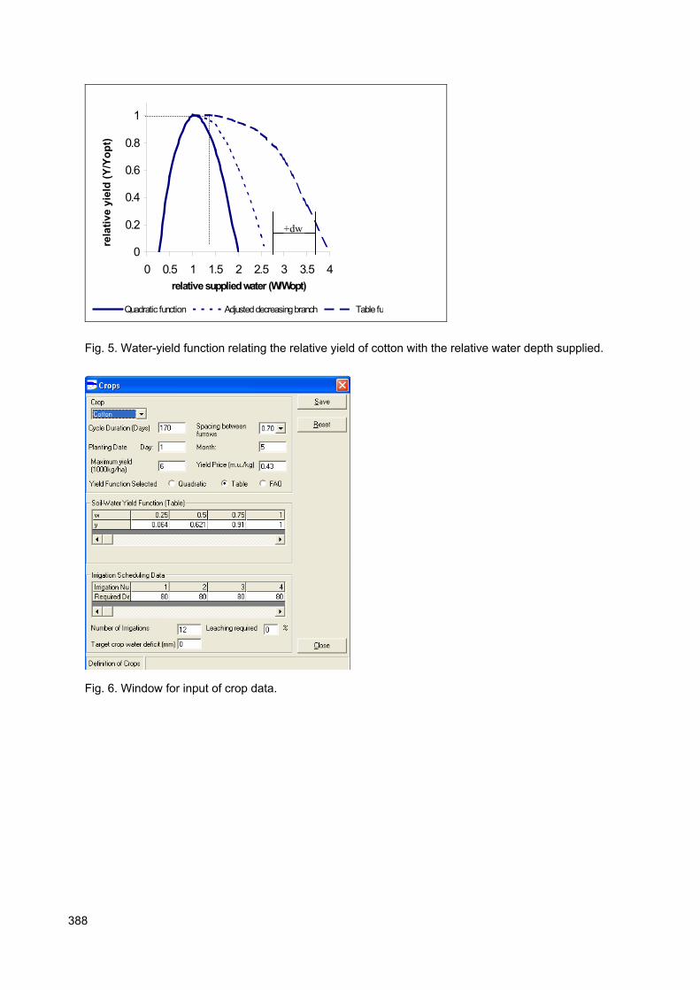
Fig. 4 shows the input window relative to field forms, including the size, slopes and infiltration curves. Fig. 5 shows the water-yield function (Gonçalves et al., 2005a, b) adopted for modeling the impacts of under- and over-irrigation on cotton yields.
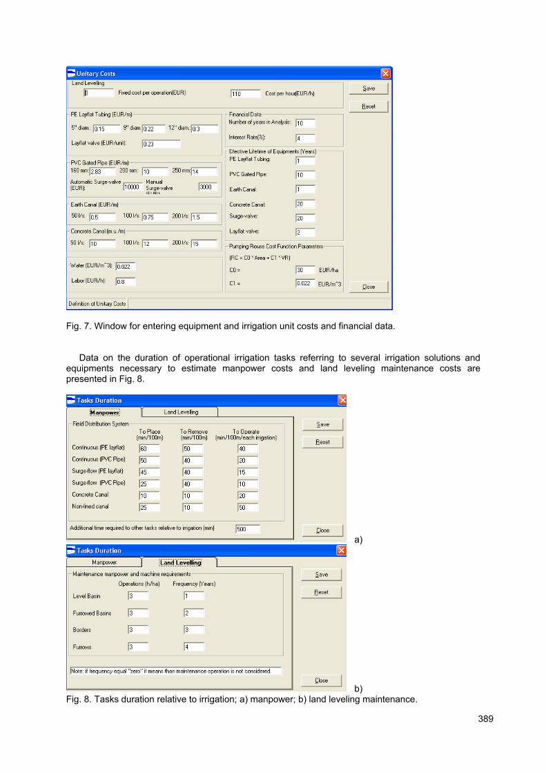
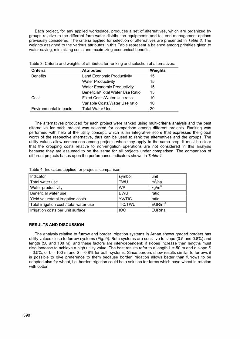
Crop input data is supplied through the window shown in Fig. 6 and concerns information on the vegetative period, the water-yield function and irrigation scheduling. Fig. 7 refers to the unit costs of irrigation equipments, labor and other irrigation costs, water costs and other financial data.
a)
b)
Fig. 4. SADREG window for (a) field sizes and slopes, and (b) for the infiltration curves.
388
0
0.2
0.4
0.6
0.8
1
0 0.5 1 1.5 2 2.5 3 3.5 4
relative supplied water (W/Wopt)
rela
tiv
e y
ield
(Y
/Yo
pt)
Quadratic function Adjusted decreasing branch Table fu
Fig. 5. Water-yield function relating the relative yield of cotton with the relative water depth supplied.
Fig. 6. Window for input of crop data.
+dw
389
Fig. 7. Window for entering equipment and irrigation unit costs and financial data.
Data on the duration of operational irrigation tasks referring to several irrigation solutions and equipments necessary to estimate manpower costs and land leveling maintenance costs are presented in Fig. 8.
a)
b) Fig. 8. Tasks duration relative to irrigation; a) manpower; b) land leveling maintenance.
390
Each project, for any applied workspace, produces a set of alternatives, which are organized by groups relative to the different farm water distribution equipments and tail end management options previously considered. The criteria applied for selection of alternatives are presented in Table 3. The weights assigned to the various attributes in this Table represent a balance among priorities given to water saving, minimizing costs and maximizing economical benefits. Table 3. Criteria and weights of attributes for ranking and selection of alternatives.
Criteria Attributes Weights
Benefits Land Economic Productivity 15
Water Productivity 15
Water Economic Productivity 15
Beneficial/Total Water Use Ratio 15
Cost Fixed Costs/Water Use ratio 10
Variable Costs/Water Use ratio 10
Environmental impacts Total Water Use 20
The alternatives produced for each project were ranked using multi-criteria analysis and the best alternative for each project was selected for comparison among different projects. Ranking was performed with help of the utility concept, which is an integrative score that expresses the global worth of the respective alternative, thus can be used to rank the alternatives and the groups. The utility values allow comparison among projects when they apply to the same crop. It must be clear that the cropping costs relative to non-irrigation operations are not considered in this analysis because they are assumed to be the same for all projects under comparison. The comparison of different projects bases upon the performance indicators shown in Table 4.
Table 4. Indicators applied for projects� comparison.
Indicator symbol unit
Total water use TWU m3/ha
Water productivity WP kg/m3
Beneficial water use BWU ratio
Yield value/total irrigation costs YV/TIC ratio
Total irrigation cost / total water use TIC/TWU EUR/m3
Irrigation costs per unit surface IOC EUR/ha
RESULTS AND DISCUSSION
The analysis relative to furrow and border irrigation systems in Arnan shows graded borders has utility values close to furrow systems (Fig. 9). Both systems are sensitive to slope (0.5 and 0.8%) and length (50 and 100 m), and these factors are inter-dependent: if slopes increase then lengths must also increase to achieve a high utility value. The best results refer to a length L = 50 m and a slope S = 0.5%, or L = 100 m and S = 0.8% for both systems. Since borders show results similar to furrows it is possible to give preference to them because border irrigation allows better than furrows to be adopted also for wheat, i.e. border irrigation could be a solution for farms which have wheat in rotation with cotton

391
furrows S=0.5%furrows S=0.8%
border S=0.5%
border S=0.8%
L=50m
L=100m
0.68
0.75
0.68
0.710.75
0.68
0.72
0.67
0,5
0,55
0,6
0,65
0,7
0,75
0,8
Fig. 9. Utility values relative to furrows and borders with slopes of 0.5 and 0.8 % and lengths of 50 and 100 m, cotton irrigation, Arnan farm.
Furrow systems at Bab Al Faraj, considering slopes of 1.0% to 1.5% and lengths varying from 50 up to 200 m, show utility values that do not change significantly (Fig. 10). These would indicate that for this type of soils lengths and slopes may be selected close to actual field characteristics, thus without requiring large investments in land leveling when providing for the respective modernization. However, results from comparing main performance indicators allow further selection.
L=50mL=100m
L=150m
L=200m
S=1.0%
S=1.5%
0.670.67
0.68 0.68
0.670.67
0.68 0.68
0,5
0,55
0,6
0,65
0,7
Fig. 10. Utility values for furrows with lengths from 50 to 100 m and slopes 1 and 1.5 %, Bab Al Faraj.
Analyzing the performances of graded furrows and borders in Arnan relative to the total water use (TWU) results indicate that lower TWU values are obtained for the combinations of 0.5% slope and 50 m length or S = 0.8% and L = 100 m (Fig. 11), i.e. larger slopes with short furrows and smaller slopes with long furrows require that more water be applied for achieving the same satisfaction of the crop requirements. This is explained by the infiltration characteristics of the soils.
392
furrows S=0.5%furrows S=0.8%
border S=0.5%border S=0.8%
L=50m
L=100m0
2000
4000
6000
8000
10000
12000
14000
16000
a)
furrows S=0.5%furrows S=0.8%
border S=0.5%
border S=0.8%
L=50m
L=100m0
0,1
0,2
0,3
0,4
0,5
0,6
b)
Fig. 11. Comparing furrow and border irrigation with slopes of 0.5 and 0.8% and lengths of 50 and 100 m relative to a) total water use (m
3/ha) and b) water productivity (kg/m
3), cotton, Arnan.
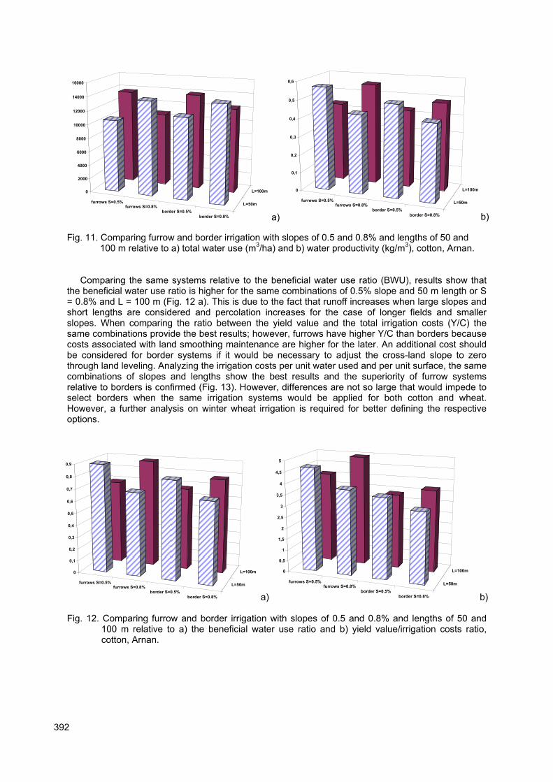
Comparing the same systems relative to the beneficial water use ratio (BWU), results show that the beneficial water use ratio is higher for the same combinations of 0.5% slope and 50 m length or S = 0.8% and L = 100 m (Fig. 12 a). This is due to the fact that runoff increases when large slopes and short lengths are considered and percolation increases for the case of longer fields and smaller slopes. When comparing the ratio between the yield value and the total irrigation costs (Y/C) the same combinations provide the best results; however, furrows have higher Y/C than borders because costs associated with land smoothing maintenance are higher for the later. An additional cost should be considered for border systems if it would be necessary to adjust the cross-land slope to zero through land leveling. Analyzing the irrigation costs per unit water used and per unit surface, the same combinations of slopes and lengths show the best results and the superiority of furrow systems relative to borders is confirmed (Fig. 13). However, differences are not so large that would impede to select borders when the same irrigation systems would be applied for both cotton and wheat. However, a further analysis on winter wheat irrigation is required for better defining the respective options.
furrows S=0.5%furrows S=0.8%
border S=0.5%
border S=0.8%
L=50m
L=100m0
0,1
0,2
0,3
0,4
0,5
0,6
0,7
0,8
0,9
a)
furrows S=0.5%furrows S=0.8%
border S=0.5%border S=0.8%
L=50m
L=100m0
0,5
1
1,5
2
2,5
3
3,5
4
4,5
5
b)
Fig. 12. Comparing furrow and border irrigation with slopes of 0.5 and 0.8% and lengths of 50 and 100 m relative to a) the beneficial water use ratio and b) yield value/irrigation costs ratio, cotton, Arnan.

393
furrows S=0.5%furrows S=0.8%
border S=0.5%
border S=0.8%
L=50m
L=100m0
0,01
0,02
0,03
0,04
0,05
0,06
0,07
a)
furrows S=0.5%furrows S=0.8%
border S=0.5%
border S=0.8%
L=50m
L=100m0
100
200
300
400
500
600
700
800
b)
Fig. 13. Comparing furrow and border irrigation with slopes of 0.5 and 0.8% and lengths of 50 and 100 m relative to a) irrigation costs per unit water used (�/m
3) and b) irrigation costs per unit
area (�/ha), Arnan.
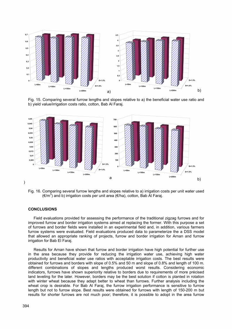
For Bab Al Faraj, results in Fig. 14 show that long furrows (150-200 m) lead to reduced irrigation water use and higher water productivity because for this type of soils both percolation and runoff are smaller than for short furrows. However, differences are small. Results are not sensitive to the slope in the range 1.0-1.5%. This indicates that both lengths and slopes are not strongly influencing design options of furrow systems in the area. The preference could go to long furrows because these highly favour crop mechanization, which could decrease the farming costs. Results for the BWU ratio (Fig. 15 a) are coherent with those for TWU, i.e. BWU tends to increase with furrow length. Also coherently with results analysed before, the yield value/irrigation costs ratio is higher for long furrows (Fig. 15 b). Results for irrigation costs per unit water used (�/m
3) and irrigation costs per unit area (�/ha) are
similar showing a trend in favour of long furrows (Fig. 16).
L=50mL=100m
L=150mL=200m
S=1.0%
S=1.5%0
2000
4000
6000
8000
10000
12000
14000
16000
a)
L=50mL=100m
L=150m
L=200m
S=1.0%
S=1.5%0
0,05
0,1
0,15
0,2
0,25
0,3
0,35
0,4
0,45
b)
Fig. 14. Comparing several furrow lengths and slopes relative to a) total water use (m3/ha) and b)
water productivity (kg/m3), cotton, Bab Al Faraj.
394
L=50mL=100m
L=150mL=200m
S=1.0%
S=1.5%0
0,1
0,2
0,3
0,4
0,5
0,6
0,7
a)
L=50mL=100m
L=150mL=200m
S=1.0%
S=1.5%0
0,5
1
1,5
2
2,5
3
3,5
4
4,5
b)
Fig. 15. Comparing several furrow lengths and slopes relative to a) the beneficial water use ratio and b) yield value/irrigation costs ratio, cotton, Bab Al Faraj.
L=50mL=100m
L=150mL=200m
S=1.0%
S=1.5%0
0,005
0,01
0,015
0,02
0,025
0,03
0,035
0,04
0,045
0,05
a)
L=50mL=100m
L=150m
L=200m
S=1.0%
S=1.5%0
100
200
300
400
500
600
700
b)
Fig. 16. Comparing several furrow lengths and slopes relative to a) irrigation costs per unit water used
(�/m3) and b) irrigation costs per unit area (�/ha), cotton, Bab Al Faraj.
CONCLUSIONS
Field evaluations provided for assessing the performance of the traditional zigzag furrows and for
improved furrow and border irrigation systems aimed at replacing the former. With this purpose a set of furrows and border fields were installed in an experimental field and, in addition, various farmers furrow systems were evaluated. Field evaluations produced data to parameterize the a DSS model that allowed an appropriate ranking of projects, furrow and border irrigation for Arnan and furrow irrigation for Bab El Faraj.
Results for Arnan have shown that furrow and border irrigation have high potential for further use in the area because they provide for reducing the irrigation water use, achieving high water productivity and beneficial water use ratios with acceptable irrigation costs. The best results were obtained for furrows and borders with slope of 0.5% and 50 m and slope of 0.8% and length of 100 m. different combinations of slopes and lengths produced worst results. Considering economic indicators, furrows have shown superiority relative to borders due to requirements of more précised land leveling for the later. However, borders may be the best solution if cotton is planted in rotation with winter wheat because they adapt better to wheat than furrows. Further analysis including the wheat crop is desirable. For Bab Al Faraj, the furrow irrigation performance is sensitive to furrow length but not to furrow slope. Best results were obtained for furrows with length of 150-200 m but results for shorter furrows are not much poor; therefore, it is possible to adopt in the area furrow

395
lengths and slopes close to actual ones, which could lead to less costs of modernization when replacing the traditional zigzag furrows. However, further studies involving the assessment of equipment for water distribution are desirable.
Acknowledgements
This work was developed as part of the Project �Rationalization of Ras El Ain Irrigation System�, in charge of IAM-Bari and funded by the Cooperazione Italiana. Thanks are due to the project director, Mr. Luigi Cavestro, to the scientific coordinator of IAM-Bari, Dr. Nicola Lamaddalena, and to the project staff. The support by Ms. Paula Paredes, CEER-ISA, is acknowledged.
REFERENCES
Allen, R.G., Pereira, L.S., Raes, D., Smith, M. (1998). Crop Evapotranspiration. Guidelines for Computing Crop Water Requirements. FAO Irrigation & Drainage Paper 56, Rome.
ASAE (2003). Evaluation of irrigation furrows. EP 419.1. In: ASAE Standards, ASAE, S. Joseph, MI. pp. 919-924.
Bazzani, G.M. (2003). A DSS for an integrated analysis of irrigation at farm and catchments level: DSIRR. In: D.A. Post (ed.) MODSIM 2003 International Congress on Modeling and Simulation. Modeling and Simulation Society of Australia and New Zealand, pp.1655-1660.
Calejo, M.J., Sousa, P.L., Pereira, L.S. (1998). Evaluation of performance of surface irrigation systems: optimisation of infiltration and roughness parameters. In: Pereira, L.S., Gowing, J.W. (eds.), Water and the Environment: Innovation Issues in Irrigation and Drainage (1st Inter-Regional Conference on Environment�Water, Lisbon). E&FN Spon, London, pp. 140�148.
ɋholpankulov, E.D., Inchenkova, O.P., Paredes, P., Pereira, L.S. (2005). Testing the irrigation scheduling simulation model ISAREG for cotton and winter wheat in Central Asia In: L.S. Pereira, V.A. Dukhovny, M.G. Horst (eds.). Irrigation Management for Combating Desertification in the Aral Sea basin. Assessment and Tools. Vita Color Publ., Tashkent, pp. 97-124.
Darouich, H. (2006). Surface Irrigation for Cotton and Wheat at Ras El Ain: Assessment and Issues for Improvement. MSc. Thesis, IAM-Bari.
Gonçalves, J.M., Pereira, L.S. (1999) Design of sustainable on-farm surface irrigation systems with a decision support system. In: Musy A, Pereira LS and Fritsch M (eds.) Emerging Technologies for Sustainable Land Use and Water Management, Presses Polytechniques et Universitaires Romandes, Lausanne: CD-ROM Paper 8.10.
Gonçalves, J.M., Horst, M.G., Pereira, L.S., Rolim, J., Muga, A. (2005a). SADREG, a DSS for Improving Surface Irrigation Systems. In: J. Boaventura Cunha and R. Morais (eds.) Proceedings of the EFITA/WCCA 2005 Joint Conference on Information Technologies in Agriculture, Food and Environment and Computers in Agriculture and Natural Resources (5th EFITA Conference and 3rd WCCA, Vila Real), UTAD, Vila Real, CD-ROM, pp. 160-165.
Gonçalves, J.M., Horst, M., Muga, A., Rolim, J., Pereira, L.S. (2005b). Impacts of soil infiltration on alternative furrow irrigation scenarios and performance using the DSS SADREG. In: A. Hamdy (ed.) Water, Land and Food Security in the Arid and Semi-Arid Regions (Proc. Int. Conf. CIHEAM/MAIBari, September 6 � 11, 2005), IAM, Bari, CD-ROM.
Gonçalves, J.M., Horst, M., Rolim, J., Muga ,A. (2005c). SADREG, a DSS for surface irrigation. In: L.S. Pereira, V.A. Dukhovny and M.G. Horst (eds.) Irrigation Management for Combating Desertification in the Aral Sea Basin. Assessment and Tools. Vita Color Publ., Tashkent: 337-373.
Gonçalves, J. M., Muga, A., Pereira, L. S., Rolim, J., Horst ,M. G. (2006). SADREG, a DSS for design and management of farm surface irrigation systems. In: Proceedings of "2006 World Congress of CIGR: Agricultural Engineering for a Better World", 4-7 September, Bonn.
Hornbuckle, J.W. Christen, E.W, Faulkner, R.D. (2005). Use of SIRMOD as a quasi real time surface irrigation decision support system. In. A. Zerger and R.M. Argent (eds) MODSIM 2005 International Congress on Modelling and Simulation. Modelling and Simulation Society of Australia and New Zealand, pp. 217-223.
Horst M.G., Shamutalov, Sh.S., Pereira, L.S., Gonçalves, J.M. (2005). Field assessment of the water saving potential with furrow irrigation in Fergana, Aral Sea Basin. Agric. Water Manage. 77: 210-231.
Katopodes, N.D., Tang, J.H., Clemmens, A.J. (1990). Estimation of surface irrigation parameters. J. Irrig. Drain. Engng., 116(5): 676-696.

396
McClymont, D., (1999). FIDO v2: Furrow irrigation design optimiser. In: Multiple Objective Decision Support Systems Conference, Brisbane (http://www.ncea.org.au/Irrigation/FIDO/Project_FIDO.htm)
Oad, R., Garcia, L., Kinzli, K.-D., Patterson, D. (2006). Decision support systems for efficient irrigated agriculture. In: G. Lorenzini and C.A. Brebbia (eds.) WIT Transactions on Ecology and the Environment, Vol 96, WIT Press, Wessex.
Oweis, T., Rodrigues, P.N., Pereira, L.S. (2003). Simulation of supplemental irrigation strategies for wheat in Near East to cope with water scarcity. In: G. Rossi, A. Cancelliere, L. S. Pereira, T. Oweis, M. Shatanawi, A. Zairi (eds.) Tools for Drought Mitigation in Mediterranean Regions. Kluwer, Dordrecht, pp. 259-272.
Pereira, L.S., Oweis, T., Zairi, A. (2002). Irrigation management under water scarcity. Agric. Water Manag. 57: 175-206.
Pereira, L.S., Teodoro P.R., Rodrigues P.N., Teixeira J.L. (2003). Irrigation scheduling simulation: the model ISAREG. In: G. Rossi, A. Cancelliere, L. S. Pereira, T. Oweis, M. Shatanawi, A. Zairi (eds) Tools for Drought Mitigation in Mediterranean Regions. Kluwer, Dordrecht, pp. 161-180.
Raine, S.R., Foley, J.P. (2002). Comparing application systems for cotton irrigation - what are the pros and cons? Field to Fashion, 11th Australian Cotton Conference, Australian Cotton Growers Research Association, Brisbane.
Raju, K.S., Pillai, C.R.S. (1999). Multicriterion decision making in performance evaluation of an irrigation system. European Journal of Operational Research 112: 479-488
Roy, B., Bouyssou, D. (1993). Aide Multicritère: Méthodes et Cas. Economica, Paris. Santé, I., Crecente, R. (2005). Decision support system for agroforestry land use modelling In: J.
Boaventura Cunha and R. Morais (eds.) Proceedings of the EFITA/WCCA 2005 Joint Conference on Information Technologies in Agriculture, Food and Environment and Computers in Agriculture and Natural Resources (5th EFITA Conference and 3rd WCCA, Vila Real), UTAD, Vila Real, CD-ROM, pp.142-149.
Walker, W. (1989). Guidelines for Designing and Evaluating Surface Irrigation Systems: FAO Irrig. Drain. Paper 45, Rome.
Walker, W. (1998). SIRMOD � Surface Irrigation Modeling Software. Utah State University, Logan. Walker, W.R., Skogerboe, G., (1987). Surface Irrigation: Theory and Practice. Prentice-Hall, Inc.,
Englewood Cliffs, New Jersey. 5 EFITA/WCCA JOINT CONGRESS ON IT IN AGRICULTURE