water resources andciwr.ucanr.edu/files/231158.pdf-water resources-wood products-biodiversity,...
TRANSCRIPT

Water resources and
ecosystem services
Matthew C. Larsen
Director
examples from Panamá, Puerto Rico,
and Venezuela

- water resources
- wood products
- biodiversity, genetic resources, enhanced resilience to wildfire, pathogens, invasive species
- recreation, ecotourism
- reduced peak river flow during storms
- increased availability of groundwater and base flow in streams during dry annual dry season & droughts
- reduced soil erosion and landslide probability
- buffer to storm surge and tsunamis [forested coastlines]
Ecosystem services from forested watershedsmainly product and goods

Ecosystem service challenges
Land use and governance
- deforestation
- forest fragmentation
- increased wildfire frequency
- urban encroachment on forest margins
Climate-change- temperature & precipitation, both averages & extremes
- intensity, frequency, duration of storms & droughts
- sea level rise
- rising atmospheric carbon dioxide concentration

Climate change:What have we already observed?
- 1983 to 2012: warmest 30-year period of last 1400 years
northern hemisphere
- 1880 to 2012: globally averaged air temps over land &
ocean show warming of 0.85 °C
- since 1901: increase in average mid-latitude northern
hemisphere land area precipitation
- 1979 to 2012: annual mean Arctic sea-ice extent decreased
3.5 to 4.1% per decade
- 1901 to 2010: global mean sea level rose 0.19 m
- since mid-19th century: rate of sea level rise has been larger
than mean rate during previous 2000 years
Source: IPCC, 2014: Climate Change 2014: Synthesis Report. Contribution of Working Groups I, II
and III to the Fifth Assessment Report of the Intergovernmental Panel on Climate Change [Core
Writing Team, R.K. Pachauri and L.A. Meyer (eds.)]. IPCC, Geneva, Switzerland, 151 pp.South Cascade Glacier, U.S
1928
2003
2010

http://www.esrl.noaa.gov/gmd/ccgg/trends/
C.D. Keeling, R.B. Bacastow, A.E. Bainbridge, C.A. Ekdahl, P.R. Guenther, and L.S. Waterman,
Atmospheric carbon dioxide variations at Mauna Loa Observatory, Hawaii, Tellus, vol. 28, 538-551, 1976
Keeling curve: CO2 rise & importance of monitoring
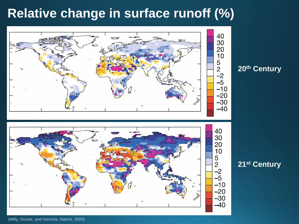
Relative change in surface runoff (%)
(Milly, Dunne, and Vecchia, Nature, 2005)
20th Century
21st Century

Climatic uncertainty and synoptic systems
impact water resources and temperature

Rainfall
Central
America
December 2015 to
January 2016

- > 50% of world population lives in urban areas
- urban areas expected to absorb all population growth in next 40 years
- 23 megacities with 10+ M inhabitants; all but six in developing world
- more people now at risk as megacities encroach on riparian corridors, floodplains, mountain fronts, and coastlines
Locations of urban agglomerations with at least 0.5M inhabitants, 2014.
Source: United Nations, 2014.
Global population expansion and urbanization

Panama Canal watershed
- 3,313 km2 area at 9° north latitude
- 300 m elevation or less with several peaks of 1,000 m
- annual rainfall: 1600 mm on Pacific to >3,000 mm on Caribbean
- half of watershed in forest

Panama Canal watershed: ecosystem services
- multiple high-value services with national, regional, and global significance
- shipping
- recreation, biodiversity, carbon sequestration
- water most important control
- streamflow: 4.4 km3, with 2.6 km3 lockages of vessels (59%) $2B/y
- hydroelectric power: 1.2 km3 (27%) $246M/y
- drinking water supply 0.27 km3 (6%) $29M/y
- balance, 7%, lost to evaporation & groundwater infiltration

Mature forests have 125 Mg Ha-1
Carbon sequestration, secondary forests, Panamá

Mastodons
HorsesDogs
Pigs
Bears
Camels
Armadillos
Marsupial
sabertooth
tigers
Porcupines
Opossums
Giant sloths
Biotic
Interchange
- joining of two continents
- began as isthmus closed,
starting as long ago as
~10M y ago
- full closure of isthmus
at ~3.5M y ago
Ant eaters

Mammals
at present
Three species
survive from SouthPorcupine
Possum
Armadillo
60% of mammals
are from North
but, wait, there’s more:other interchanges in progress
• Coyotes (Canis latrans) moving
southward from Mexico
• Crab-eating Fox, (Cerdocyon
thous) moving northward from
Colombia & Venezuela

Forests in Panamá: rich in biodiversity

- Sloths carry wide variety of micro- and
macro-organisms on their coarse outer hair
- 84 fungi isolates obtained in culture from surface
of hair collected from living three-toed sloths
(Bradypus variegatus)
- broad range of activities against strains of
parasites that cause malaria (Plasmodium falciparum)
and Chagas disease (Trypanosoma cruzi), and against the human breast cancer
cell line MCF-7
- one fungal extract had unusual pattern of bioactivity against Gram-negative
bacteria--suggests a potentially new mode of action
- results reveal the importance of exploring novel
environments for bioactive fungi
citation: Sloth Hair as a Novel Source of Fungi with Potent
Anti-Parasitic, Anti-Cancer and Anti-Bacterial Bioactivity
Sarah Higginbotham et al., PLoS One, 2014
Known unknowns and importance of maintaining biodiversity

Ecosystem service and hydrology:
forest soils act like a sponge

forested
deforested
Ogden, Crouch, Stallard, and Hall, 2013. Effect of land cover and use on dry season river runoff, runoff
efficiency and peak storm runoff in the seasonal tropics of central Panama. Water Resources Research.
Services provided by the sponge effect:

Too little water:2013 drought, Lake Bayano, Panamá

Too much water:2010 storm Gatun dam, Panamá
Espinosa, J. A., 2011. Water management in the Panama Canal during the December 2010 extreme flood, in Second International Symposium on Building Knowledge Bridges for a Sustainable Water Future, Panama, Republic of Panama. edited by A. Tarte et al., 41–45, 301 p., Panama Canal Authority and UNESCO, Panama, Republic of Panama.
- 760 mm rainfall in 24 hours
- 908 m3/s mean streamflow, Chagres River
- 235M m3 total 3-day steamflow volume
- recurrence interval of ~300 years
- all canal locks opened to discharge water
- halted ship transit for 17 hours
- >500 landslides

Landslide scars, Chagres watershed, 2010 | Photo by R.F. Stallard, USGS
Panama Canal watershed:ecosystem services and 2010 storm
- 50% of watershed is forested
- if less forest had been present, peak flows and total runoff volume would likely have exceeded maximum capacities of lock and dam designs

Puerto Rico, 1989,
after Hurricane Hugo
- Rainfall: 1,600 mm
- Runoff: 910 mm
- >30% of island in forest (mainly broadleaf evergreen)
Puerto Rico
Luquillo
Experimental
Forest

Luquillo mountains
Puerto Rico:Luquillo mountains & ecosystem services
19th century
- wood products and charcoal
20th & 21st century- water
- recreation
- carbon sequestration
- biodiversity
Rio Mameyes

Puerto Rico:Luquillo mountains & ecosystem services
- public-supply water drawn from 34 locations along nine rivers
- 70% of streamflow diverted before reaching ocean
- most from two intakes:Río Mameyes 18,940 m3/dayRío Fajardo 45,460 m3/day
- total of 0.252M m3/day of water withdrawn from streams
- at $1.06 per m3 for residential customers, value is $270,000/d
- $32,000/d in hydroelectric energy
- recreational use: >1M visitors/y, generates $3.2M/y

Ecosystem services are
enhanced with good
governance:
Debris flows, Peñuelas
Barrio Mameyes, PonceDebris flow deposit, Peñuelas
Forest cover enhances water
supply & reduces hazard but not
if structures are poorly located
Puerto Rico
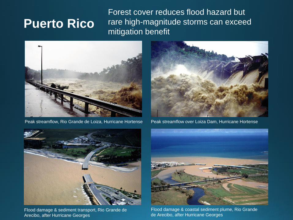
Peak streamflow over Loiza Dam, Hurricane HortensePeak streamflow, Rio Grande de Loiza, Hurricane Hortense
Flood damage & sediment transport, Rio Grande de
Arecibo, after Hurricane Georges
Flood damage & coastal sediment plume, Rio Grande
de Arecibo, after Hurricane Georges
Forest cover reduces flood hazard but
rare high-magnitude storms can exceed
mitigation benefitPuerto Rico

Sierra de Avila, view to east
Sierra de Avila, view to north,
Caracas in foreground
Vargas state
Caribbean Sea- 10o 36’ north latitude on Caribbean coast
- 2,000 m high east-west trending mountain range; peak at 2,765 m above sea level
- forested preserve established in 1958
- rivers and streams mostly drain to the north; emerge from steep canyons onto alluvial fans
- rainy season May to October, 750 to 1,000 mm/y
- multiple forest types:
- mainly evergreen forest
- xeric and dry tropical forest in the low elevations
- montane wet forest and sub-páramo forest at
upper elevations
- cloud forest near the mountains crests
Sierra de Ávila, Vargas, Venezuela:

Rio San Julianwatershed
Caraballeda
Stream channel with debris flow barriers, Sierra de Ávila
Sierra de Ávila, Vargas, Venezuela:ecosystem services
- potable freshwater withdrawal limited:
steep gradients & narrow canyons,
few locations for water storage
- water extraction: local, low-volume run-of-river intakes & small impoundments
- strong seasonal rainfall variation:
water supply unreliable
- no hydropower: streams too short
- recreation is greatest economic value:
serves visitors & residents of Caracas, pop. 5.2M
- carbon sequestration
- maintenance of biodiversity
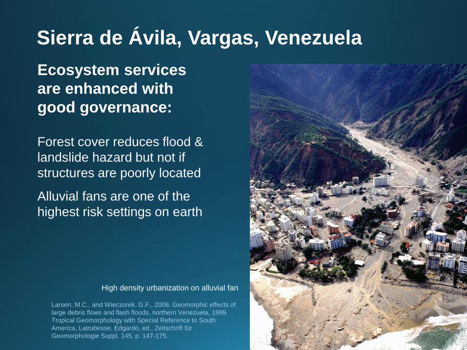
High density urbanization on alluvial fan
Larsen, M.C., and Wieczorek, G.F., 2006. Geomorphic effects of
large debris flows and flash floods, northern Venezuela, 1999.
Tropical Geomorphology with Special Reference to South
America, Latrubesse, Edgardo, ed., Zeitschrift für
Geomorphologie Suppl. 145, p. 147-175.
Sierra de Ávila, Vargas, Venezuela
Ecosystem services
are enhanced with
good governance:
Forest cover reduces flood &
landslide hazard but not if
structures are poorly located
Alluvial fans are one of the
highest risk settings on earth

Damaged high cost structures in path of large debris flows
Sierra de Ávila, Vargas, Venezuela
Ecosystem services are enhanced
with good governance:
Forest cover reduces hazard but
not if structures are poorly located

View to west, 100’s of landslide scars, extensive urbanization in vulnerable locations
Sierra de Ávila, Vargas, Venezuela

Discussion: challenges to ecosystem services
Governance:
Mountains and rivers are transboundary, crossing political and cultural divisions
Management of ecosystem services is dependent on local stakeholders & strong governance, regional and national institutions, and international institutions
Zoning, planning, and enforcement assure that maximum benefits available
Climate change:
The IPCC Fifth Assessment Report (2014): climate change has begun to affect the frequency, intensity, and length of extreme events, thus increasing the need for adaptation
Weather and climate are highly stochastic: timing and amount of precipitation needed for water resources is increasingly uncertain

What can be done?
Combination of mitigation & adaptation
Will we effectively adapt to and mitigate the human-induced management
and climate-change challenges we face?
Do we have the political will and social cohesion to make the necessary
costly investment? in:
- Modifying our management of water, energy, and other systems
- Making water, land, & environmental resources, and agricultural production sustainable and resilient
- Helping vulnerable communities adapt

2015, the end of denial?
At the Paris climate conference (COP21),
December 2015, 195 countries adopted the first-
ever universal, legally binding global climate deal.
Agreement sets out a global action plan to put the
world on track to avoid dangerous climate change
by limiting global warming to well below 2°C.
The agreement is due to enter into force in 2020.
