water-quality treatment best management practice...
TRANSCRIPT
WATER-QUALITY TREATMENT BEST MANAGEMENT PRACTICE DESIGN:
A CASE STUDY FOR HIGHWAY IMPROVEMENTS
Becky Lyne, Michael Baker Jr., Inc., Hamilton, New Jersey
The New Jersey Department of Transportation (NJDOT) Route 52 Causeway Replacement Project is
one of the largest transportation infrastructure improvement projects ever undertaken in the State. The
project involves reconstruction of approximately three miles of State Route 52 including replacement of
the existing bridges and causeway over two miles of the Great Egg Harbor Bay. The Causeway crosses
Great Egg Harbor Bay connecting the coastal communities of Ocean City and Somers Point and serves
as the principal evacuation route. The project consists of replacing the 2.2 mile causeway, including 4
bridges as well as reconstructing the approach roadways. The Great Egg Harbor Bay is a shallow,
tidally controlled bay composed of large expanses of open water and scattered islands. The bay is
valued for its commercial shellfish resources, wetlands, wildlife habitat, and important recreational and
commercial fisheries. Since the project involves significant increase in impervious area and roadway
runoff, the potential for adverse impacts to numerous environmentally sensitive natural resources has
made storm water runoff quality a critical design issue. Therefore, measures to provide water quality
treatment of stormwater runoff have been incorporated into the project to the greatest extent possible
while balancing the need to protect sensitive resources.
The reconstruction is being accomplished in two separate construction contracts (A and B). Contract A
was completed in 2009 and involved the construction of the low level structures over Elbow Thorofare
and Rainbow Channel. Construction of Contract B has commenced and involves the construction of the
high level bridges over Ship Channel and Beach Thorofare, the Ocean City Visitor’s Center and Scenic
Overlook, elimination of the Somers Point Circle, roadway reconstruction in Somers Point and Ocean
City, as well as wetland mitigation, restoration and shoreline stabilization on the existing bay islands.
Multiple recreational areas are also proposed throughout the project area, including fishing piers,
bulkheads, boat launching facilities, public parking areas, scenic overlooks along the bridge, and a
pedestrian/bicycle sidewalk along the entire length of the bridge. Construction is anticipated to be
substantially complete by December 2012. Please refer to Figure 1 for an aerial view of the project area.
STATE STORMWATER MANAGEMENT REGULATIONS
In New Jersey, the New Jersey Department of Environmental Protection (NJDEP) regulates stormwater
discharges through the Stormwater Management Rules (N.J.A.C. 7:8). Projects that meet the definition
of a major development are reviewed by the NJDEP for compliance with the Stormwater Management
Rules. The Rules define a major development as “any development that provides for ultimately
disturbing one or more acres of land or increasing impervious surface by one-quarter acre or more.” The
Route 52 Causeway Replacement Project introduces 11.87 acres of new impervious surface and will
result in approximately 30 acres of land disturbance. As such, the project meets the definition of a major
development.
Major developments must be designed to meet criteria for groundwater recharge, water quantity, and
water quality. To the maximum extent practicable, the Rules require that the criteria be met by
incorporating nonstructural stormwater management strategies into the design. Some examples of
nonstructural stormwater management strategies include minimizing impervious surfaces, protecting
existing natural drainage features and vegetation, minimizing land disturbance and soil compaction,
among others. Because of the magnitude of the project and the ultimate project need to replace the
deteriorating causeway, structural stormwater management strategies were necessary to supplement the
nonstructural elements to meet the requirements of the rules.
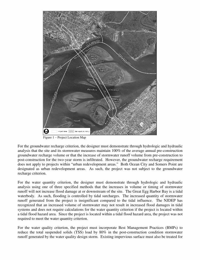
Figure 1 – Project Location Map
For the groundwater recharge criterion, the designer must demonstrate through hydrologic and hydraulic
analysis that the site and its stormwater measures maintain 100% of the average annual pre-construction
groundwater recharge volume or that the increase of stormwater runoff volume from pre-construction to
post-construction for the two-year storm is infiltrated. However, the groundwater recharge requirement
does not apply to projects within “urban redevelopment areas.” Both Ocean City and Somers Point are
designated as urban redevelopment areas. As such, the project was not subject to the groundwater
recharge criterion.
For the water quantity criterion, the designer must demonstrate through hydrologic and hydraulic
analysis using one of three specified methods that the increases in volume or timing of stormwater
runoff will not increase flood damage at or downstream of the site. The Great Egg Harbor Bay is a tidal
waterbody. As such, flooding is controlled by tidal surcharges. The increased quantity of stormwater
runoff generated from the project is insignificant compared to the tidal influence. The NJDEP has
recognized that an increased volume of stormwater may not result in increased flood damages in tidal
systems and does not require calculations for the water quantity criterion if the project is located within
a tidal flood hazard area. Since the project is located within a tidal flood hazard area, the project was not
required to meet the water quantity criterion.
For the water quality criterion, the project must incorporate Best Management Practices (BMPs) to
reduce the total suspended solids (TSS) load by 80% in the post-construction condition stormwater
runoff generated by the water quality design storm. Existing impervious surface must also be treated for
50% TSS removal. The water quality design storm is designated as 1.25 inches of rainfall in two hours.
As calculated, the pre-construction condition of the project site contains 10.65 acres of impervious
surface. The proposed project will introduce an additional 11.87 acres of impervious surface.
Weighted, the Rules require 66% TSS removal through structural BMPs for the project.
DESIGN CHALLENGES
In order to meet the water quality requirement, the project was divided into three drainage areas for the
analysis and includes the Ocean City drainage area, the Bay Islands drainage area, and the Somers Point
drainage area. Numerous engineering constraints restricted where BMPs could be placed in each
drainage area including, but not limited to site topography, existing developed uplands, valuable wildlife
habitat, right-of-way, underground utilities, maintenance access, and seasonal high groundwater.
Ocean City is a highly developed coastal tourist destination. Within the limits of the project, the entire
area consists of impervious pavement and commercial properties line Route 52 on both sides. In order
to minimize right-of-way impacts, the bridge was designed to meet the existing roadway alignment.
Due to the right-of-way acquisitions that would be required to construct a BMP within the Ocean City
drainage area and the developed nature of the drainage area, no feasible options for water quality
treatment were identified.
The Bay Islands drainage area presents its own unique constraints. The bridge traverses three flood tide
delta islands: Elbow Island, Rainbow Island, and Garrets Island from north to south. The islands
consist primarily of salt marsh communities with some upland areas associated with the existing
causeway embankments. The islands are also encumbered by the NJDEP Green Acres Program, which
provides money to governmental and non-profit organizations to purchase parkland and subsequently
protects it from development. As such, constructing basins outside of the existing right-of-way requires
authorization from the NJDEP Green Acres Program for impacts to parkland and the NJDEP and
USACE for impacts to jurisdictional wetlands. Additionally, the bay islands have high groundwater
tables and poor soils, limiting the types of BMPs that can be constructed. Access must also be provided
for routine maintenance of the BMPs.
The Somers Point drainage area is also highly developed with limited right-of-way available. However,
within the project area, the land use is primarily residential and commercial. As such, additional
considerations including the aesthetics and safety of the BMPs must be accounted for. Pedestrian
facilities are also proposed along the Route 52 corridor where BMPs can be accommodated so the ability
to blend the BMPs into the existing environment was a priority.
DESIGN SOLUTIONS
A combination of BMPs was selected for the Somers Point and Bay Island drainage areas that could be
designed within the existing engineering constraints while meeting the criteria for TSS removal. The
TSS removal requirements for each drainage basin were calculated separately.
Within the Somers Point drainage area, there is 6.87 acres of existing impervious surface in the project
limits and the project proposes to introduce an additional 1.01 acres of new impervious surface for a
weighted TSS removal of 54%. Since existing development limits right-of-way availability in Somers
Point, only BMPs that can be effective in small areas were considered. Additionally, since the BMPs
would be constructed within the viewshed of residential neighborhoods and within the pedestrian facility
complex, the selected BMPs must be aesthetically pleasing and safe. To meet these design guidelines
and requirements, a system consisting of a series of small bioretention basins was developed. Within the
0.6 mile segment of the project from its most northern limits to the Somers Point circle, the project
proposes 14 bioretention basins. The basins range in size from about 400 ft2 to 8,700 ft
2 treating 0.08
acres and 3.68 acres respectively.
The NJDEP BMP Manual establishes TSS credit for each BMP and provides minimum design standards
for stormwater management facilities. The project was submitted to the NJDEP for review in July 2004
and was one of the first major transportation projects to be reviewed under the February 2004
stormwater management rules. Each basin consists of a 3 feet thick soil planting bed, with a 1 foot
outlet structure for stormwater quantity control. To conform to mosquito control requirements, the
basins were designed to drain within 72 hours. Working with a Landscape Architect, a planting scheme
consisting of native shrubs, grasses, and trees was developed to facilitate TSS removal while also
blending the basins in with the proposed pedestrian facility.
It should be noted that since the initial review of the stormwater management design, the NJDEP BMP
Manual has been amended. At the time of the design, all bioretention basins that met the standards in
the BMP Manual were accredited with 90% TSS removal. Currently, the TSS removal credit varies
based on the thickness of the soil planting bed and the bioretention vegetation in use. Ninety percent
TSS removal is given to those bioretention basins that have a 2.0 feet thick soil planting bed and are
planted with a terrestrial forested community. Although the proposed basins meet the soil planting bed
thickness criteria, the plantings would not be considered a terrestrial forested community. As such, if
the design were to be reviewed under the current standards, the basins would likely only receive 80%
TSS removal credit.
The Route 52 Causeway Replacement Project implemented a thorough and aggressive public outreach
campaign with numerous public meetings, formation of committees involving the public, and public
notices, during the construction of the basins, adaptive management strategies were implemented to
address the public’s concerns pertaining to the basins. The members of the neighborhood located along
Route 52 southbound in Somers Point were particularly concerned with screening their houses from the
roadway. The pedestrian facility proposed along Route 52 southbound consists of a rolling landscape
with berms and low areas to accommodate the bioretention basins. The pedestrian facility is separated
from the houses by an existing local road. Residents whose homes were not screened by a berm section
were concerned about the aesthetics of the bioretention basins and the ability of the proposed
landscaping to screen their houses. Numerous meetings were held with the interested residents to
discuss why the basins were required, how they were designed, and to discuss their concerns.
Subsequent field meetings at the site of the basins were held. Various landscaping schemes were
discussed and later rendered. The residents then had the opportunity to review each rendering and select
their preferred landscaping scheme. Although revising the landscaping scheme during construction
required additional design, change orders and coordination with the contractor, educating the residents
of the neighborhood about the importance of the stormwater management facilities will likely result in a
vested interest in their proper operation.
The project area is located in the outer coastal plain geologic province. The soils are typically sandy and
well drained. As such, during the initial design, underdrains were not proposed as part of the system.
After final grading, the construction inspection team identified that water was retained in three of basins
longer than 72 hours after a storm event and was not infiltrating as designed. Each basin was checked
for soil compaction which may have occurred during construction activities. When it was determined
that soil compaction was not the root cause, underdrains were designed and installed to facilitate
draining. The need to design underdrains during construction may have been avoided if soil test pits
were performed during the design phase. At the time project was reviewed for stormwater compliance
by the NJDEP, soil test pits were not required. Since then, the NJDEP has required that all applications
include soil test pit data and identify the depth of the seasonal high groundwater table and test the
permeability of the native soil.
The use of surface BMPs was maximized within the Somers Point drainage area, but due to numerous
constraints these could not be designed to provide enough TSS removal to meet the water quality
criterion. As such, three subsurface manufactured treatment devices (MTDs) were proposed to
supplement the stormwater management design. NJDEP credits MTDs with 50%-80% TSS removal
depending on the device. Each MTD must go through a rigorous application process with the NJDEP
and New Jersey Corporation for Advanced Technologies to obtain TSS removal credit. Since MTDs are
a propriety item, the contract documents specified the design attributes and performance criteria that the
MTDs should posses including 50% TSS removal credit. In most cases, the NJDEP prefers that the
MTDs be installed offline in order to ensure that drainage can bypass the MTD during flows in excess of
the stormwater quality design storm to the downstream drainage system or when the flow in the MTD
may be obstructed. Using a combination of bioretention basins and MTDs, the project was able to
obtain 60% TSS removal, which exceeded the calculated 54% TSS removal requirement for the
drainage area.
Within the Bay Islands drainage area, there is 3.78 acres of existing impervious surface in the project
limits and the proposed proposes to introduce 10.86 acres of new impervious surface for a weighted TSS
removal of 72%. The drainage system was designed to discharge the stormwater into the basins. In
order to avoid impacts to regulated environmental resources, potential locations for BMPs were limited
to the footprint of the existing bridge and limited upland areas. Based on the space available and the
existing conditions at the site, infiltration basins were proposed and 80% TSS removal credit was
received. As proposed, the stormwater management system for the Bay Islands drainage area meets the
72% TSS removal requirement.
As of May 2011, three of the seven infiltration basins have been constructed and are working properly.
However, based on design criteria for infiltration basins in the amended NJDEP BMP Manual, the
basins may not have met for requirement for 80% TSS removal credit. As discussed above, soil test pits
and permeability rates were previously not required during the initial review of the design. Infiltration
basins are only appropriate in locations with high permeability soils that meet the required permeability
rates. The infiltration basins are proposed within the footprint of the existing bridge which is
characterized by roadway fill underlain by the native marshland soil. Marshland soils typically have low
permeability rates. In order to account for the impermeable soils, the basins were built with a two-foot
deep infiltration layer above the native soil. Based on infiltration tests performed since the construction
of the basins, all three basins are performing as designed.
The bridge section over the islands presented an opportunity to construct BMPs beneath the bridge and
avoid wetland impacts and acquisition of additional right-of-way. In order to maximize use of the area
beneath the bridge, infiltration basins were proposed on all three bay islands. The design of the new
bridge and auxiliary features presented opportunities as well as constraints to the design and future
maintenance of the basins. For instance, on Elbow Island, the northernmost island, access is not
provided onto the island from the bridge. In order to perform routine maintenance, crews will need to
access the infiltration basin from the bay.
On Rainbow Island, the causeway is supported mostly on embankment. As such, there is little available
area to accommodate BMPs. Infiltration basins were constructed as part of Contract A underneath the
structure to the immediate north and south of the bridge abutments. To maximize use of the existing
upland area, a long, linear infiltration basin was constructed along the northbound retaining wall.

Access is easily provided to the infiltration basins near the abutments from the proposed recreational
parking facilities. However, the location and configuration of the linear infiltration basin presents a
challenge for future maintenance. The linear infiltration basin consists of several sand filters separated
by riprap scour pads, which dissipate the energy from the concreted roadway drainage prior to entering
the basins. In total, the linear basin is approximately 950 feet in length with access available at either
end. A geoweb load support system was installed to distribute the load, allowing maintenance vehicles
to drive over the basins, accessing the middle portion of the basin complex, without compacting the
substrate.
Three interconnected infiltration basins are proposed for Garrets Island, the southernmost island.
Initially, the project proposed to construct a large single basin. However, during final design, the plans
were revised in order to meet commitments made to the City of Ocean City. In addition to the
replacement of the causeway, the project proposes to construct numerous recreational facilities including
a fishing pier at the northern shore of Garrets Island. The NJDOT had committed to the City of Ocean
City to provide access routes for emergency vehicles to the fishing piers. During final design it was
determined that the preliminary access scheme would not provide the proper vertical clearance for
emergency vehicles as a result of the super-structure alternate selected by the Contract A Contractor. As
such, the access was redesigned through the proposed infiltration basin. The infiltration basin was
redesigned into a system of three interconnected basins to accommodate emergency access while still
meeting the water quality treatment requirements.
CONCLUSION
Designing a successful stormwater management system requires identification of the engineering
constraints, coordination with key stake holders, and determining regulatory requirements early in the
project design. Stormwater management design for roadway projects is typically guided by adapting to
existing engineering and environmental constraints. For the Route 52 Causeway Replacement Project,
constraints were identified early on and included limited right-of-way availability, sensitive coastal
environmental features, aesthetics impacts to neighboring residential properties, and limited access for
future maintenance. Regulatory requirements were determined at the beginning of preliminary design to
ensure that the design solution was able to meet those requirements within the constraints of the project
site. However, as demonstrated by the Route 52 Causeway Replacement Project, construction of the
design may result in unanticipated outcomes. The ability of the designer to actively monitor the
construction process and develop adaptive management solutions will aid in a successfully executed
stormwater management system.