wallkill watershed conservation and management plan...
TRANSCRIPT
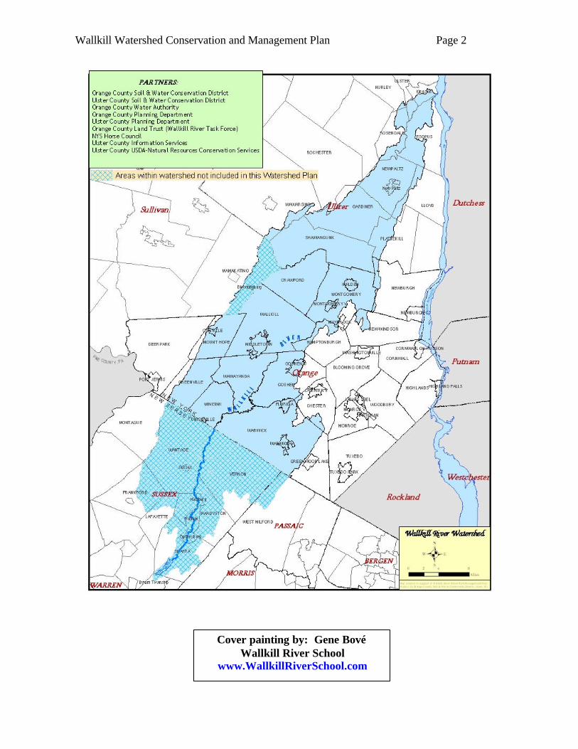
Wallkill Watershed Conservation and Management Plan Page 2
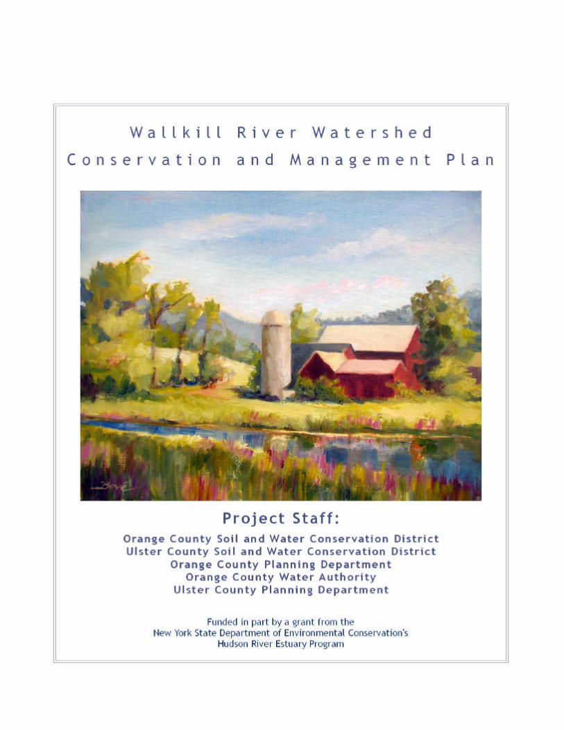
Cover painting by: Gene Bové
Wallkill River School www.WallkillRiverSchool.com
Wallkill Watershed Conservation and Management Plan Page 3
Project Steering Committee James Beaumont Orange County Water Authority Kris Breitenfeld Orange County Soil and Water Conservation District Gary Capella Ulster County Soil and Water Conservation District Virginia Craft Ulster County Planning Department Scott Cuppett NYSDEC Estuary Program Leonard DeBuck Farmer, Warwick Town Councilman Kelly Dobbins Orange County Planning Department John Gebhards Orange County Land Trust Patricia Henighan Wallkill River Task Force Jill Knapp Wallkill River Task Force Lewis Lain Town Supervisor, Minisink Nick Miller Biologist, Metropolitan Conservation Alliance Nathaniel Sadjek NJ Wallkill River Management Group Karen Schneller-McDonald Biologist, Hickory Creek Consulting William Tully Orange County Citizens Foundation, Chester Town Supervisor James Ullrich Environmental Scientist, Alpine Group Ed Sims Orange County Health Department Kevin Sumner Orange County Soil and Water Conservation District Jake Wedemeyer Ulster County Soil and Water Conservation District Chip Watson Orange County Horse Council/NY Horse Council Alan Dumas Ulster County Health Department
GIS/Mapping Committee Kelly Dobbins Orange County Planning Department Jake Wedemeyer Ulster County Soil and Water Conservation District Daniel Munoz Orange County Water Authority/Orange County Dept. of Information Services Kevin Sumner Orange County Soil and Water Conservation District
Education and Outreach Committee
Kris Breitenfeld Orange County Soil and Water Conservation District Lucy Joyce Cornell Cooperative Extension-Orange County Gary Capella Ulster County Soil and Water Conservation District Mary Ellen Matisse Village of Walden Trustee
Biodiversity Committee
Kelly Dobbins Orange County Planning Department Leslie Zucker NYS Department of Environmental Conservation Jake Wedemeyer Ulster County Soil and Water Conservation District Karen Schneller-McDonald Hickory Creek Consulting Karen Strong NYS Department of Environmental Conservation
ACKNOWLEDGMENTS A crucial development in the history of Wallkill Watershed protection efforts was the scheduling of a Wallkill River conference in 1998. Held at Orange County Community College and organized by the Orange County Land Trust (OCLT), this conference could be considered the birth of the Wallkill River Task Force (WRTF) – a ‘project’ of the OCLT. While some focus on this Watershed was already occurring amongst government agencies, the WRTF created a non-governmental group that actively sought the volunteer participation of farmers, business people and other ‘ordinary’ citizens, in addition to government and conservation agency employees, to provide for broad-based leadership in protecting the Wallkill River and its watershed lands. The first coordinator of the WRTF was Ann Botshon, and it would be difficult to overstate her contribution to Wallkill (and Orange County-wide) natural resource protection. Her impassioned efforts gave inspiration to many people, myself included. Former OCLT Executive Director John Gebhards fostered the formation of the WRTF, and has actively participated in the Watershed Management Plan process. Former WRTF Coordinators Jill Knapp and Patricia Henighan have also provided invaluable support. Former Orange County Water Authority (OCWA) Executive Director, Jay Beaumont, provided generous technical support to the Project from his staff, notably Dan Munoz, and was a member of the Project Steering Committee (PSC). Jamie Lo, a former employee of OCWA and intern at Orange County Soil and Water Conservation District, provided crucial mapping assistance as well as contagious enthusiasm to the Project. Kelly Dobbins, a planner with the Orange County Planning Department, made huge contributions to many sections of the Plan, served on the Biodiversity and GIS/Mapping committees, and prepared many of the maps. Simon Gruber, an environmental consultant, provided key writing and research assistance. My colleague Kris Breitenfeld endured a seemingly endless barrage of additions and changes in the final editing process. Scott Cuppett and the NYSDEC Hudson River Estuary Program provided grant funding and ‘hands-off’ Project oversight that allowed us to make the Plan our own. Gary Capella and all his partners on the Ulster side helped us transcend municipal boundaries and more nearly approach a true watershed plan. I would like to personally thank all these people, and let them know how much I valued working with them on this project. Finally, I would like to thank all the watershed residents, too numerous to list, who took time out of their schedules to attend Project Steering Committee meetings and review and comment on the working Plan, as well as those who quietly toil on projects - some of which are mentioned in the Plan, but all of which help to provide inspiration to the rest of us to continue working to protect and improve the Wallkill River and its Valley. Kevin Sumner Orange County Soil and Water Conservation District
Wallkill Watershed Conservation and Management Plan Page 4
Table of Contents
I. INTRODUCTION Page Background 6 Purpose of the Plan 7 Goals of the Plan 7 Overall Planning Approach 7 II. EXISTING CONDITIONS River and Watershed Characteristics 11 History of the Wallkill River 11 Land Resources 12 Biological Resources 20 Water Resources 26 Water-related Recreation 32 Wastewater Management 35 Stormwater Management 35 III. WATERSHED ISSUES Citizen Survey 38 Agricultural Issues 38 Education 45 Challenges to Biodiversity 45 Water Quality Degradation 46 Wetlands Degradation 46 Stormwater Management 47 Water Supply, Quantity and Allocation Issues 50 Quality of Existing Wastewater Infrastructure 51 Natural Resource Management in a Home Rule System 52 IV. RECOMMENDATIONS AND IMPLEMENTATION STRATEGY
Black Dirt Region 54 Horse Farms 54 Other Agriculture 55 Ulster County Agricultural Environmental Management 55 Education 56 Stream Buffer/Riparian Corridors 56 Stormwater Management 56 Impervious Surfaces Analysis 57 Biological Resources 57 Wetlands Degradation 58 Targeted Assistance to Municipalitie s 59 Low Impact Development (LID) and Better Site Design (BSD) 60 Increase Water-related Recreational Opportunities 60 Research and Monitoring 60 Water Supply 60 Protecting Streamflow,Groundwater and Wetlands 61 Wastewater Management 61 Local Planning and Regulations 62
V. CONCLUSION 64
Wallkill Watershed Conservation and Management Plan Page 5
**NOTE: These two appendices are quite lengthy so are only available in digital format or by special request in hard copy format.
TABLES Page Table1: Subwatershed Characteristics 9 Table 2: Comparison of Developed & Undeveloped Land by Subwatershed 13 MAPS Map 1: Priority Waterbodies 6 Map 2: Wallkill River Subwatersheds 10 Map 3: Dams on the Wallkill River 12 Map 4: Land Use Comparison – 1993 to 2004 (Orange County) (11X17) END Map 5: Protected Lands 14 Map 6: Imperviousness by Subwatershed (Map 6a- Orange Co. Map 6b- Ulster Co.) END Map 7: Stream Corridor Study (11X17) END Map 8: Farm Locations 21 Map 9: Biologically Important Areas 23 Map 10: Stream Biomonitoring Sites 30 Map 11: Suspended Sediment Study Sampling Points 31 Map 12: Public Access Points 34 Map 13: Areas Serviced by Municipal Wastewater Facilities 37 Map 14: Regulated MS4 Areas 36 Map 15: DEC Construction Permits 49 FIGURES Figure 1: As imperviousness approaches 10%, streams are likely to be degraded 9 Figure 2: Natural and new channels of the Wallkill River 11 Figure 3: Black Dirt fields are in intimate association with the surface water via the 19 drainage ditch network Figure 4: Stoneflies suggest good water quality 27 Figure 5: BAP Scale 27 Figure 6: Biological Assessment Profile scores 28 Figure 7: Distribution of stream biomonitoring assessments 29 Figure 8: Groundwater being pumped into well 51
APPENDICES Appendix A: Muskrat and Beaver War Appendix B: Hudsonia Study “Environmental Quality of the Wallkill River in
Orange County, NY” ** Appendix C: Citizen Survey and Results Summary Appendix D: Wallkill River Task Force’s Erosion Study ** Appendix E: Horse Farm Survey and Results Summary Appendix F: Discussion of Dams on the Wallkill River Appendix G: Inventory of Planning Department Findings Appendix H: Agencies with Information About the Wallkill River Appendix I: Stream Protection Tools
Wallkill Watershed Conservation and Management Plan Page 6
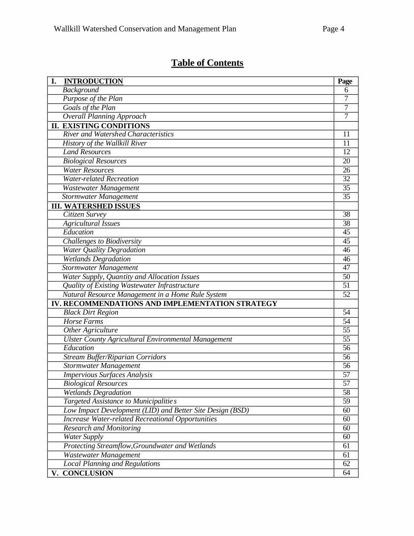
Map 1: Priority Waterbodies
Background Conservation activities have been underway in the Wallkill Watershed for decades, as they have been in watersheds across the country. For example, farmers have been implementing runoff control practices, and developers have been required by most local planning boards to address stormwater management. In recent years, though, financial and technical resources available to conservation agencies have increasingly been targeted to watersheds with documented water quality problems or with well-formulated plans that identify and prioritize management needs. Anticipating this trend, and recognizing the value of having a proactive long term plan, the Orange County Soil and Water Conservation District (SWCD) and USDA Soil Conservation Service (SCS) developed a water management plan for the Wallkill River Watershed in the late 1980’s. Although not as sophisticated as current-day watershed management plans supported by computer-generated maps and other new technologies, this early planning effort began a twenty-five year period in Orange County of elevated attention on this watershed. Similar attention was being given to the Wallkill in neighboring municipalities as well. The SWCD/SCS plan received no formal funding, but was a precursor to and impetus for the Wallkill-Rondout USDA Water Quality Demonstration Program (1990-1998) – a multi-agency and multi-county effort that directed in excess of $1 million in federal funding, primarily to agricultural water management. While generally deemed a great success – both in terms of enhancing interagency/inter-county coordination and accelerating the adoption of farm management practices (notably Integrated Pest Management in the Black Dirt Region) – project partners were frustrated with their limited ability to address other water quality issues including urban and suburban runoff. During this same time frame, a forward-thinking USDA employee named Malcolm Henning convinced the Wallkill
Valley Drainage Improvement Association – a group of Black Dirt Region farmers charged with overseeing Wallkill River drainage matters – that nominating the Wallkill and several of its tributaries for inclusion on New York State’s newly forming Priority Waterbodies List (PWL) (Map 1) was a good idea. Over the succeeding
twenty years, many proposals involving the Wallkill have received more favorable review at least partially because of the emphasis placed on the PWL by current funding sources. More funding is available for agricultural and non-agricultural conservation work in both Orange and Ulster Counties.
Wallkill Watershed Waterbodies Listed on NYSDEC’s Priority Waterbodies List: ??Upper Wallkill River Main Stem ??Quaker Creek ??Wawayanda Creek ??Rutgers Creek ??Lower Wallkill River Main Stem
II.. IINNTTRROODDUUCCTTIIOONN
Wallkill Watershed Conservation and Management Plan Page 7
Grass strip buffers Rutgers Creek tributary from cropland.
Purpose of the Plan While water quality managers felt that problem sources were fairly well understood and significant resources were already being targeted to nonpoint source control programs, it was recognized that preparation of a comprehensive management plan for the Wallkill Watershed held the potential to direct existing resources more efficiently and increase the likelihood of securing additional resources. Various documents, including Water Quality Strategies prepared by County Water Quality Coordinating Committees (WQCC) and Nonpoint Source Assessments prepared by the Lower Hudson Coalition of Conservation Districts (LHCCD) had already begun the process of identifying and prioritizing management needs on a watershed basis. In September of 2001, Orange and Ulster SWCD’s and the Orange County Land Trust, in cooperation with numerous other agencies, submitted a proposal to the New York State Department of Environmental Conservation’s Hudson River Estuary Program (HREP) to prepare a Conservation and Management Plan for the Wallkill River Watershed. The proposal was approved, and work on the Management Plan formally began in spring of 2004.
Goals of the Plan Specific goals of this Plan include:
° consolidating existing information on the watershed's resources, and establishing a foundation for future research and educational efforts;
° identifying gaps in information that are pertinent to future planning efforts, and developing a research strategy for obtaining needed data;
° assessing trends that will impact both water quality and quantity;
° presenting maps, tables and related informational formats that summarize key aspects of the watershed and management needs;
° providing guidance to communities and other stakeholders on management practices that are environmentally, socially and economically sustainable; and providing assistance to them in the adoption of these practices; and
° providing a ready list of projects and actions that can be implemented to protect and improve the watershed.
The last two items are in bold to reinforce the emphasis the authors wish to place on practical implementation measures. We are hopeful and confident that the data, maps and related information presented in the Plan will be useful for many purposes. More importantly, though, we want the Plan to lead directly to action. Many of the recommended actions, such as construction projects, will have direct expenses and will require dedicated funding to implement. Some ideas for sources of funding are presented. For other recommended actions, such as policy or program changes, costs may be more related to the personnel needed to promote and carry out the changes. These costs are sometimes less well recognized by potential funders, but are equally important to achieving goals.
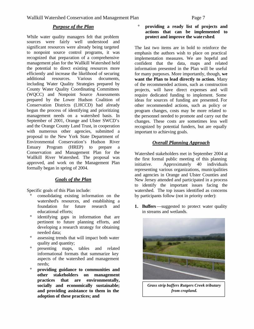
Overall Planning Approach Watershed stakeholders met in September 2004 at the first formal public meeting of this planning initiative. Approximately 40 individuals representing various organizations, municipalities and agencies in Orange and Ulster Counties and New Jersey attended and participated in a process to identify the important issues facing the watershed. The top issues identified as concerns by participants follow (not in priority order): 1. Buffers —suggested to protect water quality
in streams and wetlands.
Wallkill Watershed Conservation and Management Plan Page 8
2. Biodiversity/Habitat –identified as major concerns for both terrestrial and aquatic ecosystems in the watershed.
3. Regulations - Implementation, Enforcement
& Funding – enforcing existing regulations and providing funding for implementation of practices was especially of concern.
4. Recreation Opportunities – increasing
access to the river received widespread support.
5. Wastewater Issues– cited in various forms,
including the need to revamp old infrastructure, the impacts of failing septic systems, the concern about managing development, and capacity of existing treatment facilities.
6. Pesticides and other Pollutants – received
considerable attention and are tied closely with both the agricultural and the (sub)urban use of the land in the watershed.
7. Agriculture –listed regarding both concerns
for maintaining the industry, as well as its impacts on water quality.
8. Development/Sprawl –associated with
stormwater runoff, the need to implement local land use planning, the loss of habitat, and concerns about maintaining safe and adequate water supplies.
9. Wetlands –cited as an issue in terms of both
loss and degradation. 10. Groundwater – ensuring sufficient recharge
and concerns about contamination. 11. Public awareness & local planning. 12. Non Point Source (NPS) Issues –was
mentioned separately and included in many of the other issues - particularly stormwater runoff.
It is the intention and the hope of the Plan writers that all of these issues have been addressed to the extent practical.
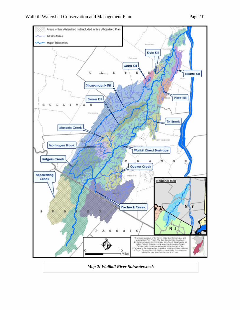
Guidance in the development of watershed plans has been presented by, among others, the Center for Watershed Protection (CWP) (cwp.org) and the US Environmental Protection Agency (EPA) (epa.gov). Documents such as CWP’s ‘Rapid Watershed Assessment Planning Manual’ and EPA’s ‘Community-based Watershed Management’ were consulted by the preparers of this Plan. In addition, representatives from several of the project partners attended a two-day workshop on watershed planning in July of 2005 presented by staff from the CWP. It goes without saying that the level of detail and scope of any watershed plan will be strongly influenced by the level of human and financial resources devoted to its preparation. The primary source of support for this Plan was a $40,000 grant from the NYSDEC Hudson River Estuary Program. An enormous amount of value was added to the project by contributions from many agencies and individuals who did not charge their time or expenses to the $40,000 grant. Nevertheless, we are dealing with a watershed nearly 800 square miles in size extending into four counties and two states. Even excluding the NJ portion, which received limited attention in this Plan, some 600 square miles remain. An example to put this issue in perspective is provided by guidance from CWP which suggests that $150,000 to $200,000 be budgeted for planning watersheds less than 50 square miles. Obviously then, given the size of the Wallkill and the available funding, a somewhat different approach was necessary. As recommended by the Center for Watershed Protection, the Wallkill Watershed was divided into smaller watersheds, or subwatersheds (also called subbasins). The creation of smaller units of analysis enabled the project partners to assess different parts of the Watershed individually, and then make comparisons among the subwatersheds. (Map 2) This approach yielded a total of 14 study areas for the Orange and Ulster portions of the Wallkill. For planning purposes, the direct drainage to the Wallkill (not via a major tributary) was treated as two sub-watershed areas, one each for Ulster and Orange. The name and size of these study areas is summarized in Table 1.
Wallkill Watershed Conservation and Management Plan Page 9
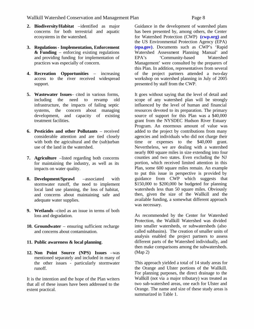
Figure 1: As imperviousness approaches 10%, streams are likely to be degraded.
Although it is not defined entirely by drainage divides, the Black Dirt Region of Orange County will receive some attention as a separate study area given its unique, and in many ways homogeneous, characteristics. One important factor in determining the approach to a given watershed plan is the percentage of impervious surfaces in the study area. Extensive research has been devoted to this topic. This research demonstrates that when 10% of a sub- watershed’s land area has been converted to impervious surfaces, significant impacts will be discernable in the receiving stream. (Figure 1) When impervious cover exceeds 25%, stream impacts become more severe and difficult to mitigate. These numbers can provide guidance to planners. When imperviousness is in the ‘threatened’ 5 to 10% range, management efforts to avoid further stream impacts would be an important goal. Typically, such planning efforts would be done at a ‘sub-watershed’ level equating to approximately 10 square miles. When watershed imperviousness is lower (below 5-10 %), water quality degradation is likely caused by factors other than impervious land cover. Therefore, management efforts should take a different approach.
With this guidance in mind, the Plan Partners decided to make impervious surface mapping a priority project early in the planning process. To the extent possible, the Plan uses impervious area concerns as a primary factor in sections dealing with sub-watersheds.
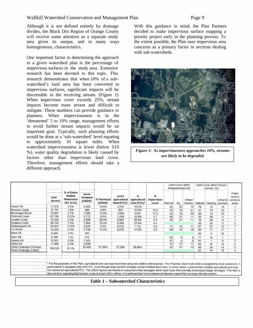
Table 1 – Subwatershed Characteristics
Wallkill Watershed Conservation and Management Plan Page 10
Map 2: Wallkill River Subwatersheds
Wallkill Watershed Conservation and Management Plan Page 11
New channel
Natural channel
Skinner’s Lane
Pulaski Highway
Figure 2: Natural and new channels of the Wallkill River
River and Watershed Characteristics
A tributary of the Hudson River, the Wallkill River flows through two states, from its source in Lake Mohawk in Sparta Township, New Jersey. Flowing 27 miles in New Jersey, the watershed drains 208 square miles in 13 municipalities. Approximately 96% of the NJ portion of watershed is in Sussex County, the remaining 4% in Passaic County. In Orange County, New York, the river drains 382 square miles, nearly half of the county, as it flows for 40 miles before reaching Ulster County. Twenty-two towns, villages and cities in Orange County drain wholly or partially to the Wallkill. In Ulster County, the river flows 26 miles draining 170 square miles before merging with Rondout Creek near Kingston, then flowing on to the Hudson River. The total watershed is about 785 square miles in size. In New York State, the Wallkill River is fed by 69 tributaries. In Orange County, there are 16 named tributaries. In Ulster County, there are 14 named tributaries. The water quality of the tributaries is variable (see sub-watershed sections of the Plan for more information). Land use within the watershed is extremely diverse, ranging from agriculture and forestland to extensive commercial and residential development. Refer to Map 4 for land use breakdowns for the whole watershed and for major sub-watersheds. As can be seen from the comparison of 1993 and 2004 land use data, the trend in this watershed is towards decreasing agricultural land and increasing urban/suburban land use. This trend undoubtedly comes as no surprise to watershed residents, though presentation of these data provides greater validity and a degree of measure to this common understanding.
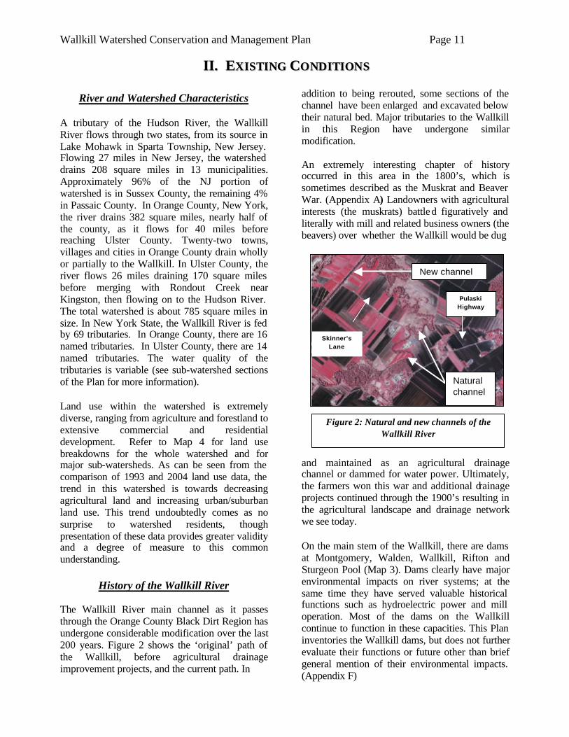
History of the Wallkill River The Wallkill River main channel as it passes through the Orange County Black Dirt Region has undergone considerable modification over the last 200 years. Figure 2 shows the ‘original’ path of the Wallkill, before agricultural drainage improvement projects, and the current path. In
addition to being rerouted, some sections of the channel have been enlarged and excavated below their natural bed. Major tributaries to the Wallkill in this Region have undergone similar modification. An extremely interesting chapter of history occurred in this area in the 1800’s, which is sometimes described as the Muskrat and Beaver War. (Appendix A) Landowners with agricultural interests (the muskrats) battled figuratively and literally with mill and related business owners (the beavers) over whether the Wallkill would be dug
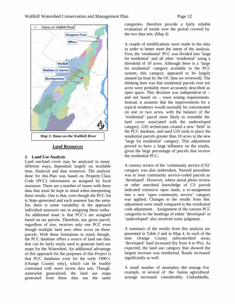
and maintained as an agricultural drainage channel or dammed for water power. Ultimately, the farmers won this war and additional drainage projects continued through the 1900’s resulting in the agricultural landscape and drainage network we see today. On the main stem of the Wallkill, there are dams at Montgomery, Walden, Wallkill, Rifton and Sturgeon Pool (Map 3). Dams clearly have major environmental impacts on river systems; at the same time they have served valuable historical functions such as hydroelectric power and mill operation. Most of the dams on the Wallkill continue to function in these capacities. This Plan inventories the Wallkill dams, but does not further evaluate their functions or future other than brief general mention of their environmental impacts. (Appendix F)
IIII.. EEXXIISSTTIINNGG CCOONNDDIITTIIOONNSS
Wallkill Watershed Conservation and Management Plan Page 12
Land Resources 1. Land Use Analysis Land use/land cover may be analyzed in many different ways, dependant largely on available time, financial and data resources. The analysis done for this Plan was based on Property Class Code (PCC) information as assigned by local assessors. There are a number of issues with these data that must be kept in mind when interpreting these results. One is that, even though the PCC list is State-generated and each assessor has the same list, there is some variability in the approach individual assessors use in assigning these codes. An additional issue is that PCC’s are assigned based on tax parcels. Therefore, any given parcel, regardless of size, receives only one PCC even though multiple land uses often occur on these parcels. With these limitations in mind, though, the PCC database offers a source of land use data that can be fairly easily used to generate land use maps for the Watershed. An additional advantage of this approach for the purposes of this Project is that PCC databases exist for the early 1990’s (Orange County only), which can be readily contrasted with more recent data sets. Though somewhat generalized, the land use maps generated from these data use the same
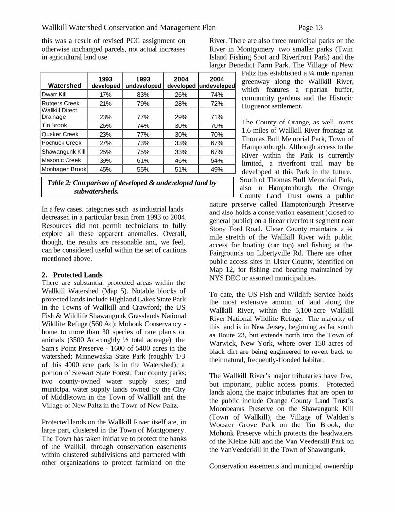
categories- therefore provide a fairly reliable evaluation of trends over the period covered by the two data sets. (Map 4) A couple of modifications were made to the data in order to better meet the intent of the analysis. First, the ‘residential’ PCC was divided into ‘large lot residential’ and all other ‘residential’ using a threshold of 10 acres. Although there is a ‘large lot residential’ category available in the PCC system, this category appeared to be largely unused (at least by the OC data we reviewed). The thinking here was that residential parcels over ten acres were probably more accurately described as open space. This decision was independent of – and not based on – town zoning requirements. Instead, it assumes that the improvements for a typical residence would normally be concentrated on one or two acres, with the balance of the ‘residential’ parcel more likely to resemble the land cover associated with the undeveloped category. GIS technicians created a new ‘field’ in the PCC database, and used GIS tools to place the residential parcels greater than 10 acres in the new ‘large lot residential’ category. This adjustment proved to have a large influence on the results, given the large percentage of parcels that receive the residential PCC. A cursory review of the ‘community service (CS)’ category was also undertaken. Normal procedure was to treat community service-coded parcels as ‘developed’. However, where aerial photo review or other anecdotal knowledge of CS parcels indicated extensive open lands, a re-assignment into a new ‘open community service’ category was applied. Changes to the results from this adjustment were small compared to the residential code adjustment. Assignment of the various PCC categories to the headings of either ‘developed’ or ‘undeveloped’ also involved some judgment. A summary of the results from this analysis are presented in Table 2 and in Map 4. In each of the nine Orange County subwatershed areas, ‘developed’ land increased (by from 4 to 9%). As expected, the land use category that showed the largest increase was residential. Roads increased significantly as well. A small number of anomalies did emerge. For example, in several of the basins agricultural acreage increased considerably. Undoubtedly,
Map 3: Dams on the Wallkill River
Wallkill Watershed Conservation and Management Plan Page 13
this was a result of revised PCC assignment on otherwise unchanged parcels, not actual increases in agricultural land use.
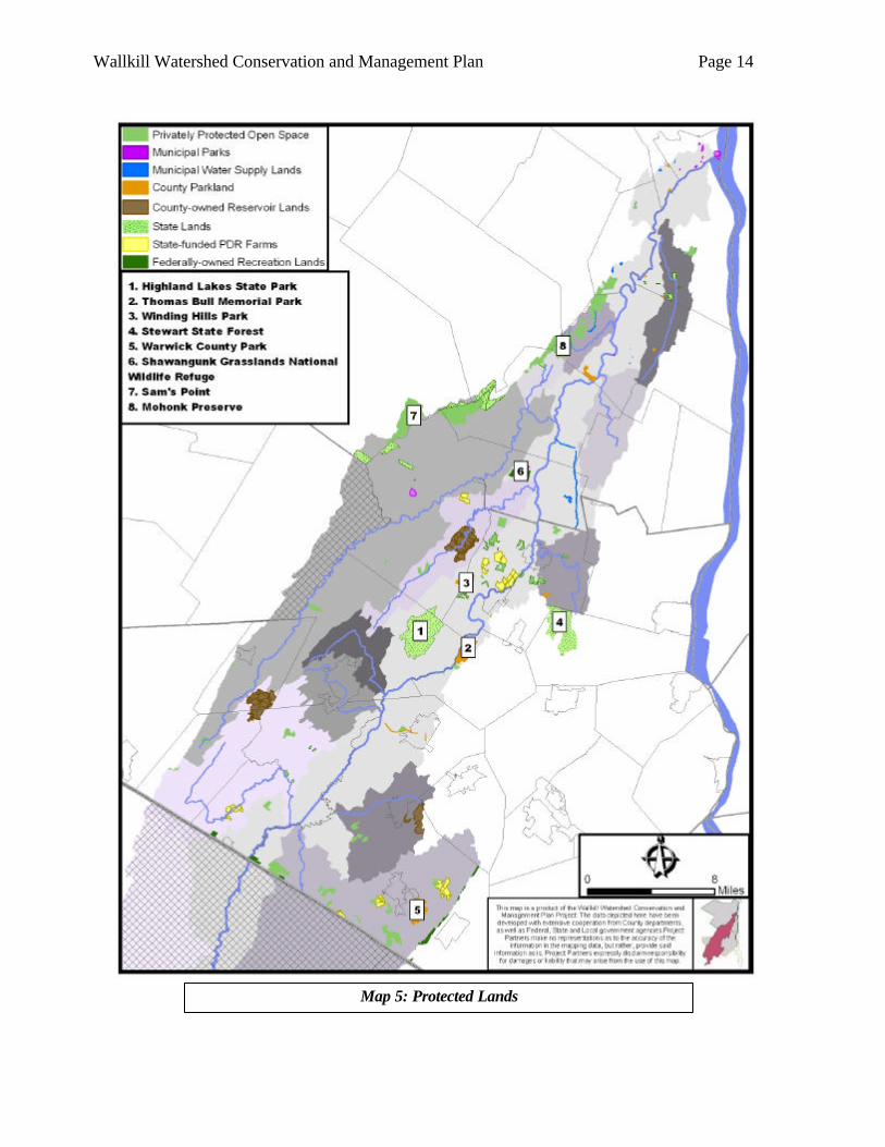
In a few cases, categories such as industrial lands decreased in a particular basin from 1993 to 2004. Resources did not permit technicians to fully explore all these apparent anomalies. Overall, though, the results are reasonable and, we feel, can be considered useful within the set of cautions mentioned above. 2. Protected Lands There are substantial protected areas within the Wallkill Watershed (Map 5). Notable blocks of protected lands include Highland Lakes State Park in the Towns of Wallkill and Crawford; the US Fish & Wildlife Shawangunk Grasslands National Wildlife Refuge (560 Ac); Mohonk Conservancy - home to more than 30 species of rare plants or animals (3500 Ac-roughly ½ total acreage); the Sam's Point Preserve - 1600 of 5400 acres in the watershed; Minnewaska State Park (roughly 1/3 of this 4000 acre park is in the Watershed); a portion of Stewart State Forest; four county parks; two county-owned water supply sites; and municipal water supply lands owned by the City of Middletown in the Town of Wallkill and the Village of New Paltz in the Town of New Paltz. Protected lands on the Wallkill River itself are, in large part, clustered in the Town of Montgomery. The Town has taken initiative to protect the banks of the Wallkill through conservation easements within clustered subdivisions and partnered with other organizations to protect farmland on the
River. There are also three municipal parks on the River in Montgomery: two smaller parks (Twin Island Fishing Spot and Riverfront Park) and the larger Benedict Farm Park. The Village of New
Paltz has established a ¼ mile riparian greenway along the Wallkill River, which features a riparian buffer, community gardens and the Historic Huguenot settlement. The County of Orange, as well, owns 1.6 miles of Wallkill River frontage at Thomas Bull Memorial Park, Town of Hamptonburgh. Although access to the River within the Park is currently limited, a riverfront trail may be developed at this Park in the future.
South of Thomas Bull Memorial Park, also in Hamptonburgh, the Orange County Land Trust owns a public
nature preserve called Hamptonburgh Preserve and also holds a conservation easement (closed to general public) on a linear riverfront segment near Stony Ford Road. Ulster County maintains a ¼ mile stretch of the Wallkill River with public access for boating (car top) and fishing at the Fairgrounds on Libertyville Rd. There are other public access sites in Ulster County, identified on Map 12, for fishing and boating maintained by NYS DEC or assorted municipalities. To date, the US Fish and Wildlife Service holds the most extensive amount of land along the Wallkill River, within the 5,100-acre Wallkill River National Wildlife Refuge. The majority of this land is in New Jersey, beginning as far south as Route 23, but extends north into the Town of Warwick, New York, where over 150 acres of black dirt are being engineered to revert back to their natural, frequently-flooded habitat. The Wallkill River’s major tributaries have few, but important, public access points. Protected lands along the major tributaries that are open to the public include Orange County Land Trust’s Moonbeams Preserve on the Shawangunk Kill (Town of Wallkill), the Village of Walden’s Wooster Grove Park on the Tin Brook, the Mohonk Preserve which protects the headwaters of the Kleine Kill and the Van Veederkill Park on the VanVeederkill in the Town of Shawangunk. Conservation easements and municipal ownership
Watershed 1993
developed 1993
undeveloped 2004
developed 2004
undeveloped Dwarr Kill 17% 83% 26% 74% Rutgers Creek 21% 79% 28% 72% Wallkill Direct Drainage 23% 77% 29% 71% Tin Brook 26% 74% 30% 70% Quaker Creek 23% 77% 30% 70% Pochuck Creek 27% 73% 33% 67% Shawangunk Kill 25% 75% 33% 67% Masonic Creek 39% 61% 46% 54% Monhagen Brook 45% 55% 51% 49%
Table 2: Comparison of developed & undeveloped land by subwatersheds.
Wallkill Watershed Conservation and Management Plan Page 14
Map 5: Protected Lands
Wallkill Watershed Conservation and Management Plan Page 15
for water supply protect other lands containing major tributaries, but are not open to the public. Open Space Values of Agricultural Lands Although usually not formally protected, agri- cultural lands afford benefits to the community similar to those provided by public lands as described above. Therefore, a brief discussion follows on the open space values of agricultural lands. Several portions of this Plan discuss the potential water quality impacts from agriculture. Poorly managed agricultural land clearly can negatively impact water and related natural resources. Well-managed agricultural land, though, is widely believed to be preferable to other land uses such as urban/suburban land use – both in terms of water quality and enhancement of other natural resources such as wildlife. One example that supports this contention is that of the New York City Watershed management program. Nationally recognized as a successful model for protecting drinking water supplies via land management (avoiding the more costly option of filtration plant construction), this program recognizes agriculture as a preferred land use. As regards wildlife, vast expanses of monoculture, it can be argued, do not provide the variety of habitats required by most wildlife species. In the Hudson Valley and the Wallkill Watershed, habitat loss from vast expanses of agriculture is hardly a concern. Instead, agricultural lands are being lost at an alarming rate – usually being replaced by residential and commercial development with much lower habitat value. Where farmlands can be maintained, they most often enhance wildlife habitat by providing food sources and cover types that would otherwise be in short supply in the local landscape. Farm water quality protection efforts in the Watershed are described in some detail in this Plan, and local farmer participation in these programs is quite high. Plan writers, therefore, are confidant in endorsing vigorous farmland preservation efforts as a major recommendation of this Plan. Such efforts are well underway in the Watershed. Over 3,000 acres of farmland in the Orange County portion of the Wallkill Watershed have been protected via conservation easements purchased with various combinations of State, federal and local funding. Momentum is gaining
in Ulster County, also, where 400 acres are in the process of closing conservation easements. It should be noted in this context that interest amongst landowners in these easement programs far out-paces available funding. This Plan, therefore, recommends active lobbying to study and secure additional sources and mechanisms of funding for farmland easement programs. Additionally, it must be recognized that deed-restricted farmland will be of limited value in preserving commercial agriculture if farming cannot remain profitable. Though largely outside the scope of this Plan, we also endorse vigorous support for farm profitability enhancement projects through such avenues as the Orange and Ulster County Agricultural and Farmland Protection Boards (AFPB’s). For both profitability support and easement purchase, we believe that Watershed residents will generally be supportive. The citizen survey conducted through this planning process, described elsewhere in the Plan, ranked “loss of family farms” and “expansion of housing developments into rural areas” as major concerns. Although this was an informal survey, it lends credence to the suggestion that the public will support such efforts. Further evidence is provided by recent public referendums in at least three Watershed Towns (Warwick, Goshen and New Paltz) that established locally generated funds to purchase farmland easements. Preservation of a viable farmland base, in combination with other non-farm protected open space, should be considered a crucial and necessary element of a healthy Wallkill Watershed. 3. Impervious Surfaces Analysis The importance of impervious cover to watershed planning is described earlier in this Plan. There are many potential approaches to such mapping – ranging from direct measurement from aerial photography to more generalized estimations derived by applying various coefficients to land use data such as Property Class Codes assigned by local taxing authorities. After extensive study and consideration, Orange County Water Authority and Plan partners decided to use a methodology for impervious cover calculation that is based on extent of roads in the given sub-watershed.
Wallkill Watershed Conservation and Management Plan Page 16
Through literature review, consultation with other experienced GIS users such as Rockland County government, and in-house testing, it was determined that a reliable relationship existed between linear feet of roads in any given spatial region (calculable by GIS tools) and percent impervious cover.1 Using this relationship, OCWA technicians calculated % imperviousness for over 200 sub-watersheds and for major sub-basins. (Map 6) Results Map 6 presents the results of the impervious surface analysis for the Wallkill basin. Table 1 summarizes these findings by major sub-basins within the Wallkill. The ‘Overall Planning Approach’ section of this Plan describes the rationale for measuring imperviousness as part of the watershed planning process. In summary, it notes that watershed planning as it relates to imperviousness should be done at a sub-watershed level equating to approximately 10 square miles, and that impacts to receiving streams tend to become apparent when imperviousness reaches 10%. It also notes that when imperviousness is lower (below 5%), water quality degradation is likely caused by factors other than imperviousness. Watershed areas exceeding 10% imperviousness are depicted in red on Map 6. Areas in the 5 to 10% range are shown in yellow, areas below 5% are green. An interesting sidebar to this issue is the relationship between impervious cover, feet of roads, and stream salinity (see, for example, Kaushal, et al in the September 20, 2005 PNAS). Work in Orange County by Kelly Nolan, Hudson Basin River Watch, described below in this Plan, also found a relationship between conductivity and macroinvertebrate community health. While available resources limited the degree to which this impervious cover information could guide sub-watershed level planning, future efforts will benefit from its calculation as part of this planning effort.
1 Beaumont, J. and O’Brien, D. 2005 Impervious Cover, Road Density, Land Use, and Population Density in Urban and Rural Areas in Orange County and Rockland County, New York. Orange County Water Authority.
4. Stream Corridor Study Multiple studies have documented the relationship between streamside vegetation and stream health. In general, wider swaths of forest next to a stream are associated with higher water quality due to the capacity of natural vegetation to slow and filter water that flows on the ground surface. Streamside trees also help to shade the waterbody, thus lowering the water temperature, and create a more diverse stream habitat through the contribution of woody debris such as limbs and branches. Vegetated banks are also structurally more stable and thus less susceptible to erosion. Because both stream corridor infringement and water quality problems have been well documented within the Watershed, this watershed planning effort included an inventory of land cover within 534 feet2 of all 14 major tributaries within the Watershed and the Wallkill River itself. The data was created by visually interpreting 2004 aerial photography and defining the land as one of four major categories: Developed, Natural, Water, or Agriculture/Field. A summary of the resulting land cover information is included in Table 1. The results of the study render useful comparisons between the major tributaries. For example, the Monhagen Brook, which flows through the City of Middletown, was found to have the highest proportion of developed land within the designated stream corridor, followed by the Tin Brook and the Mara Kill. This information suggests that these waterbodies should be priorities for streamside mitigation and restoration efforts. Conversely, the Swarte Kill has the highest percentage of natural land within its corridor, with the Klein Kill and the Dwaar Kill trailing slightly behind. These streams are therefore good candidates for stream corridor protection efforts that would maintain their ecological processes and integrity. Both the Quaker and Pochuck Creeks flow through the Black Dirt region, which led them to have the highest amount of agricultural land within the buffer area. These two streams should thus be priorities for restoration and mitigation efforts that
2 Howard, T.G. (draft) 2004. Buffering natural communities for community persistence. September 6, 2004. NY Natural Heritage Program, Albany, NY.
Wallkill Watershed Conservation and Management Plan Page 17
seek to improve water quality while maintaining agricultural production. Aside from assessing broad-scale trends for the Wallkill River and its major tributaries, this stream corridor study also initiated the process of identifying opportunities for future stream corridor protection, mitigation, and restoration projects. Since this component of the Planning project was entirely a remote sensing procedure with no on-the-ground verification of conditions, the resulting information and recommendations should be considered a screening of potential corridor opportunities, but by no means a complete list of possible protection/mitigation sites. (Map 7) Potential sites for future work (i.e. potential project sites) were identified by reviewing the 2004 aerial photography in conjunction with the land cover information and, in some cases, the location of protected open space (e.g. parkland or land protected by a conservation easement). Potential project sites fell into one of seven categories. Provided below is a generic description of each category as well as typical protection/mitigation activities that might be appropriate for each. To be clear, additional field inspection and interaction with the local community or site representatives would determine what, if any, further actions would be appropriate. Implementation of this Plan would logically include expansion of this project.
A. Agricultural Lands – This category was used where substantial blocks of agricultural fields adjoined designated stream channels without the presence of a naturally vegetated buffer exceeding 20 or 30 feet in width. In general, agricultural lands are preferable to most urban land uses within stream corridors because of their ecological benefits (see Biodiversity section for more information). However, water quality can be impacted if certain agricultural uses occur too closely to streams. Ideally, a buffer of thirty feet or more is maintained between cropland and stream channels. While woody buffers offer more water quality and wildlife benefits than herbaceous buffers, they are often not compatible in agricultural settings when farmers wish to maximize
their use of productive streamside soils. In certain agricultural settings, however, wider and more diverse buffers are possible.
Potential project options - In many cases, cost-sharing is available for farmland operators to install a wide variety of stream protection practices including: establishing grass buffers or tree/shrub buffers, livestock exclusion fencing, alternative watering facilities, protected stream crossings, wetland enhancement projects, wildlife plantings and related measures. Some programs, such as the Conservation Reserve Program (CRP) and the Wetland Reserve Program (WRP) also offer annual rental payments for properly protected riparian lands.
B. Agricultural Lands – Black Dirt –A primary issue in this area is streambank erosion (see Ag Issues section of this Plan) because of easily eroded soils. Very narrow natural buffers, or the absence of any buffer, exacerbate this dilemma and were common in the Black Dirt region because, understandably, farmers wish to maximize their use of the productive Black Dirt soils. In some cases, owing primarily to low position in the landscape (flood-prone) and/or poor soils, lands next to these waterways are already in forested or successional growth. Potential project options - All of the cost-share options described above for Agricultural Lands are available for Black Dirt lands, although a shorter list of practices is suitable in this special setting. Efforts are already underway to fund and design streambank stabilization measures in this region (see Agricultural Recommendations section of the Plan). Additionally, planners can explore options for expanding protection/ mitigation measures beyond the stream-bank in conjunction with bank repairs.
C. Mitigation - Golf Courses – A number of golf courses are either bordered or traversed by streams in the Corridor study
Wallkill Watershed Conservation and Management Plan Page 18
area and, in some cases, fairways or other intensively managed areas extend into the stream corridor. The level of management often associated with golf course turf has the potential to have negative water quality impacts through pesticide, herbicide, and fertilizer applications.
Potential project options – Though cost-share/funding options are generally more limited for non-agricultural lands than for farmland, many of the same protection/restoration measures can be employed. These include: managed naturally-vegetated buffers, Integrated Pest Management (IPM) and Nutrient Management. Audubon International offers a program called the Audubon Cooperative Sanctuary Program that helps to enhance the valuable natural areas that golf courses can provide and minimize potentially harmful impacts of golf operations. The SWCDs and Cornell Cooperative Extensions in both counties provide technical assistance to local golf courses on water quality measures.
D. Mitigation - Stormwater Retrofit – Any reach of the Corridor study areas where extensive red zones (developed lands) were mapped would be a potential site to further investigate the need and feasibility of stormwater retrofits, especially where the development was built before current stormwater regulations were in place. Buffers of varying width often exist between the buildings/parking lots and stream channel.
Potential project options - In many cases, funding constraints and other logistical issues will limit options. Nevertheless, where sufficient will and creativity are applied, some communities have successfully installed such measures. Typical practice choices for these areas include higher cost, manufactured products such as water quality inlets (oil/grit separators) and hydrodynamic structures (eg. Stormceptor) that take up limited space, and built-on-site practices such as bioretention basins and water quality swales. See such technical
documents as the NY State Stormwater Design Manual for more information on these practices.
E. Restoration/Mitigation - Commercial/ Industrial Sites - These sites are few in number but usually include large buildings, associated parking, and often outdoor storage of equipment within the stream corridor, leaving natural buffers of varying width. Most, if not all, of these facilities were built before modern stormwater management regulations were in place.
Potential project options These facilities could be ideal locations for construction of stormwater retrofits, which provide some level of stormwater quality treatment for older urban areas (see stormwater section of this Plan). As well, existing streamside buffers and land uses could be evaluated, and additional protection possibilities could be presented to site managers. Possible recommendations inc lude: plantings, flow control practices (ie. level spreaders), and land management changes (ie. less mowing).
F. Conservation – This designation was used for stream corridor areas where extensive forest/natural cover was discerned in association with the existence of already protected or municipally-owned lands or significant biological resources. Potential project options - Based upon the interest of relevant landowners, these could be focus areas for future land protection efforts.
G. Educational – This designation was used
for stream corridor areas that appeared to be good locations for watershed and/or stream corridor public education activities to be undertaken because land alongside the stream is owned by a school, municipality or another appropriate public or nonprofit entity. Some sites were assigned the label of Restoration/Educational if the site
Wallkill Watershed Conservation and Management Plan Page 19
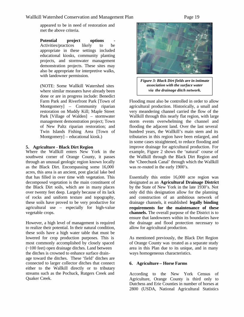
Figure 3: Black Dirt fields are in intimate association with the surface water via the drainage ditch network.
appeared to be in need of restoration and met the above criteria.
Potential project options - Activities/practices likely to be appropriate in these settings included educational kiosks, community planting projects, and stormwater management demonstration projects. These sites may also be appropriate for interpretive walks, with landowner permission. (NOTE: Some Wallkill Watershed sites where similar measures have already been done or are in progress include: Benedict Farm Park and Riverfront Park [Town of Montgomery] – Community riparian restoration on Muddy Kill; Maple Street Park [Village of Walden] – stormwater management demonstration project; Town of New Paltz riparian restoration; and Twin Islands Fishing Area [Town of Montgomery] – educational kiosk.)
5. Agriculture - Black Dirt Region Where the Wallkill enters New York in the southwest corner of Orange County, it passes through an unusual geologic region known locally as the Black Dirt. Encompassing some 16,000 acres, this area is an ancient, post glacial lake bed that has filled in over time with vegetation. This decomposed vegetation is the main constituent of the Black Dirt soils, which are in many places over twenty feet deep. Largely because of its lack of rocks and uniform texture and topography, these soils have proved to be very productive for agricultural use – especially for high-value vegetable crops. However, a high level of management is required to realize their potential. In their natural condition, these soils have a high water table that must be lowered for crop production purposes. This is most commonly accomplished by closely spaced (~100 feet) open drainage ditches. Land between the ditches is crowned to enhance surface drain- age toward the ditches. These ‘field’ ditches are connected to larger collector ditches that connect either to the Wallkill directly or to tributary streams such as the Pochuck, Rutgers Creek and Quaker Creek.
Flooding must also be controlled in order to allow agricultural production. Historically, a small and very meandering channel carried the flow of the Wallkill through this nearly flat region, with large storm events overwhelming the channel and flooding the adjacent land. Over the last several hundred years, the Wallkill’s main stem and its tributaries in this region have been enlarged, and in some cases straightened, to reduce flooding and improve drainage for agricultural production. For example, Figure 2 shows the ‘natural’ course of the Wallkill through the Black Dirt Region and the ‘Cheechunk Canal’ through which the Wallkill was re-routed in the early 1900’s. Essentially this entire 16,000 acre region was designated as an Agricultural Drainage District by the State of New York in the late 1930’s. Not only did this designation allow for the planning and construction of an ambitious network of drainage channels, it established legally binding requirements for the maintenance of these channels. The overall purpose of the District is to ensure that landowners within its boundaries have the drainage and flood protection necessary to allow for agricultural production. As mentioned previously, the Black Dirt Region of Orange County was treated as a separate study area in this Plan due to its unique, and in many ways homogeneous characteristics. 6. Agriculture – Horse Farms According to the New York Census of Agriculture, Orange County is third only to Dutchess and Erie Counties in number of horses at 2800 (USDA, National Agricultural Statistics
Wallkill Watershed Conservation and Management Plan Page 20
Service, 2002). One of the largest livestock operations in Ulster County is a horse breeding farm right along the Dwaar Kill, which has a rolling average of 500 horses year round. We believe the scope of this agricultural sector to be underestimated in this region of the state, since there are a burgeoning number of small recreational horse owners – who may not be reflected in the agricultural census numbers. A major initiative of this planning project was to better assess the status and needs of the horse industry in the watershed. 7. Other Agricultural Uses Beyond Black Dirt and horse farms, a wide variety of agricultural enterprises occur in the Wallkill Valley. Historically, dairy farming has been the mainstay of agriculture in the Valley. The rocky, silty-textured glacial till soils that dominate the Watershed landscape have limited suitability for many types of agriculture such as vegetable production, but are well-suited to the hay, field corn and pasture needs of the typical dairy farm. While dairy farms have declined drastically in the last 25 years, they are still responsible for keeping significant Watershed acreage in agricultural use. Since dairy farmers commonly rent additional acreage beyond their home farms to supply the crop needs for their herds, we estimate that 60 dairy farms in the NY portion of the Watershed operate land tracts totaling some 15,000 acres. In areas of the Watershed with ample deposits of lighter textured glacial outwash and alluvial soils, more diverse and intensive agricultural uses are common, including some fairly large commercial vegetable operations. These vegetable operations are most commonly located directly on the main stem of the Wallkill River and its tributaries. This holds especially true as the Wallkill River flows north and the tillable land narrows between the Shawangunk Mountains and Hudson Highlands. There are two large operations (Watchtower Farms and NYS Correctional Facility, Town of Shawangunk) which together control more than 2000 acres of field crops in the watershed. Orchards and vineyards occur on both till and outwash soils, benefiting from the air drainage afforded by sloping topography. Various specialty or ‘niche’ operations also occur in the Watershed, such as Community Supported
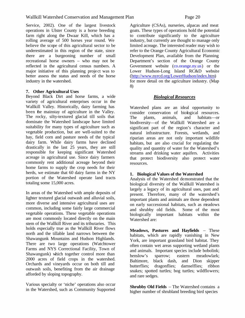
Agriculture (CSAs), nurseries, alpacas and meat goats. These types of operations hold the potential to contribute significantly to the agriculture industry, but currently are thought to manage only limited acreage. The interested reader may wish to refer to the Orange County Agricultural Economic Development Plan, available from the Planning Department’s section of the Orange County Government website (co.orange.ny.us) or the Lower Hudson-Long Island RC&D website (http://www.nyrcd.org/LowerHudson/index.htm) for more detail on the agriculture industry. (Map 8)
Biological Resources Watershed plans are an ideal opportunity to consider conservation of biological resources. The plants, animals, and habitats—or biodiversity—of the Wallkill Watershed are a significant part of the region’s character and natural infrastructure. Forests, wetlands, and riparian areas are not only important wildlife habitats, but are also crucial for regulating the quality and quantity of water for the Watershed’s streams and drinking water aquifers. Activities that protect biodiversity also protect water resources. 1. Biological Values of the Watershed Analysis of the Watershed demonstrated that the biological diversity of the Wallkill Watershed is largely a legacy of its agricultural uses, past and present. Therefore, many of the watershed’s important plants and animals are those dependent on early successional habitats, such as meadows and shrubby old fields. Some of the most biologically important habitats within the Watershed are: Meadows, Pastures and Hayfields – These habitats, which are rapidly vanishing in New York, are important grassland bird habitat. They often contain wet areas supporting wetland plants and animals. Important species include bobolink; henslow’s sparrow; eastern meadowlark; Baltimore, black dash, and Dion skipper butterflies; dragonflies; damselflies; ribbon snakes; spotted turtles; bog turtles; wildflowers; and rare sedges. Shrubby Old Fields – The Watershed contains a higher number of shrubland breeding bird species
Wallkill Watershed Conservation and Management Plan Page 21
Map 8: Farm Locations. Please note that this map is a work in progress. Ulster County has completed more farm location mapping than Orange County.
Wallkill Watershed Conservation and Management Plan Page 22
compared to other regions, creating a greater responsibility for maintaining these populations. They are typically found in conjunction with agricultural land uses. Important species include Leonard’s skipper; cobweb skipper; Aphrodite fritillary; yellow warbler; yellow-throated vireo; warbling vireo; and blue-winged warbler. Box turtles also utilize shrubby old fields. As their populations are declining in New York State, this resource should be given additional conservation attention. Forests – Though largely fragmented by roads and urban areas, the Watershed includes substantial tracts of intact forest, the largest being on the Shawangunk Ridge. Forested land positively affects water quality by filtering water and stabilizing soils, and streamside trees help to shade and cool surface water. Many animal species require large, unspoiled forest and thus have become increasingly rare as the Watershed is developed. Smaller forest blocks of just 200 acres are significant to wildlife, particularly woodland birds such as scarlet tanager, wood thrush, and red-eyed vireo. Wetlands – Wetlands are exceptionally important because of the myriad of services they provide to natural and human communities. These include habitat, groundwater recharge, water storage and flood mitigation, open space, and others. They also serve as transitional zones between land environments and water bodies. They house a unique assemblage of species. Wetlands are integral to healthy watershed function. They store and clean water and provide essential habitats. Stream-associated wetlands are important for riparian biodiversity. Notable wetland types in the Watershed include Atlantic white cedar swamp and the largely unprotected vernal pools (or seasonal woodland pools). Some of the most sensitive wetland animals found in the Watershed include the spotted turtle, bog turtle, blue-spotted salamander, Jefferson salamander, and northern cricket frog. Streams - Stream corridors are one of the most diverse and extensive portions of the Watershed landscape. High quality stream habitat usually requires a patchwork of riffles, pools, and woody debris to maximize aquatic habitat diversity and maintain sufficient oxygen levels for aquatic life. Healthy stream corridors have naturally vegetated
buffers and are undisturbed by development immediately adjacent to the channel. In addition to fish, stream channels are used by a number of species, including salamanders, turtles, mussels, and insects such as damselflies and dragonflies. Bats prefer to forage over stream channels and some birds nest almost exclusively near water. Sensitive species found within stream corridors of the Wallkill include brook trout, wood turtle, cerulean warbler, longtail salamander, rare plants, and rare freshwater mussels. 2. Subwatershed Analysis Comparing the biological landscapes of the Wallkill River Watershed’s subwatersheds helps to identify broad needs and impairments, as well as prioritize regions for restoration and protection. The following section outlines the known biological values of each subwatershed. The New York State Department of Environmental Conservation’s (DEC) Hudson River Estuary Program has partnered with the New York Natural Heritage Program to create maps that show areas important to the health of rare animals, rare plants, and significant ecosystems in the Hudson Valley. These maps, known as Important Areas maps, were developed to assist local land use decision makers in their planning for the protection of biological resources and will soon be available for all municipalities within the Wallkill River Watershed. Map 9 shows the Important Area data available for the Watershed, divided by subwatershed. The colored areas represent regions that are essential to the health of known locations of rare animals, rare plants, and significant ecosystems documented by the New York Natural Heritage Program. Because Important Areas indicate where significant biological resources may be found, guidance in local planning and project review is strongly encouraged. Knowing where your Important Areas are is just one step in gathering biological information for your town’s natural resource inventory, comprehensive plan, open space plan, or watershed plan. This map is useful as a general guide to areas within the Watershed that are known to be biologically valuable and should thus be prioritized for further biological research and/or protection. The Natural Heritage Program’s biological data-
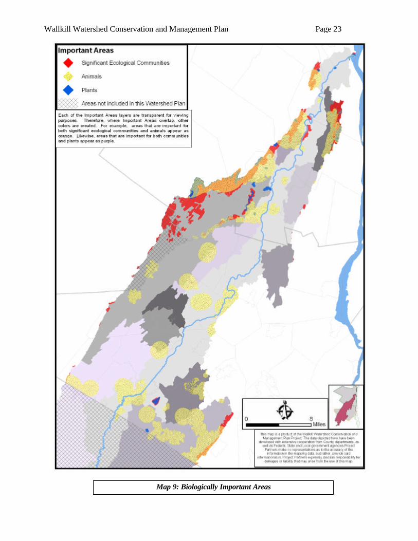
Wallkill Watershed Conservation and Management Plan Page 23
Map 9: Biologically Important Areas
Wallkill Watershed Conservation and Management Plan Page 24
base was used in combination with the NYS Breeding Bird Atlas, NYS Amphibian and Reptile Atlas, and land use/land cover data to render the following descriptions of the major biological features of each subwatershed of the Wallkill River. The codes in parentheses following some species names indicate rarity: (sc) is a state species of special concern, (st) is a state threatened species, (se) is a state endangered species, (ft) is a federally threatened species, and (fe) is a federally endangered species. Dwaar Kill ° Habitats: A 67-acre red maple-hardwood and shrub swamp and another 367-acre partially forested wetland run along the Dwaar Kill. The Dwaar Kill’s agricultural matrix of active crop fields, old fields, pasture, hay land, shrubland, and young forest co-exists with stands of hardwood forest, creating a diverse landscape. ° Species of Concern: Wood turtle (sc), bog turtle (ft), red-shouldered hawk (sc), black-billed cuckoo, brown thrasher, willow flycatcher, scarlet tanager, wood thrush, red-eyed vireo, bobolink and Eastern meadowlark. Possible species of concern include Indiana bat (fe), Black rat snake, Eastern hognose snake (sc), Northern black racer, Northern red salamander, longtail salamander (sc), spotted turtle (sc). Tin Brook ° Habitats: Many stream-associated wetlands. Large wetland complex totaling over 200 acres form the headwaters of the largest tributary to the Tin Brook. Wetland encompassing over 325 acres within Stewart State Forest. Vernal pool complex at Stewart. ° Species of Concern: Eastern box turtle, spotted turtle, wood turtle; blue-spotted salamander (sc), four-toed salamander, gray treefrog, Jefferson’s salamander (sc), marbled salamander (sc), Northern dusky salamander, spotted salamander; Indiana bat (fe) roost trees and foraging area. Monhagen Brook ° Habitats: Two large wetlands (greater than 100 acres) are fragmented by rail and roads. Presence of spotted salamanders indicates vernal pools. ° Species of Concern:
Wood turtle (sc); amphibian concentration area; Upland sandpiper (st); Indiana bat (fe) roost trees and foraging area. Masonic Creek ° Habitats: Large wetlands (over 50 acres) are fragmented by roads and rail. ° Species of Concern: Wood turtle (sc); Jefferson’s salamander (sc); Red shouldered hawk (sc); Indiana Bat (fe) roost trees and foraging area. Pochuck Creek ° Habitats: Nearly intact 1165 acre Class I wetland in the eastern portion of the Watershed. The Wildlife Conservation Society has identified high quality habitat throughout this watershed in its Southern Wallkill Biodiversity Plan. Significant wetland communities: Inland Atlantic White Cedar Swamp (11 acres), Rich shrub fen (3 acres), Rich Graminoid fen (2 acres, 1.5 acre), Spruce –fir swamp (43 acres) Significant upland communities (all found on Bellvale mountain): Appalachian Oak-hickory forest (1565 acres), Hemlock – Northern Hardwood forest (570 acres), Chestnut-Oak Forest (981 acres). ° Species of Concern: Bog turtle (ft), Eastern box turtle (sc), Eastern hognose snake (sc), ribbon snake, spotted turtle (sc), timber rattlesnake (st) wood turtle (sc); blue-spotted salamander (sc), chorus frog, four-toed salamander, Northern Dusky Salamander, Jefferson salamander complex, longtail salamander (sc), spotted salamander, wood frog; cerulean warbler (sc), Cooper’s hawk (sc), red-headed woodpecker (sc), red-shouldered hawk (sc), sharp-shinned hawk (sc); Indiana bat (fe) roost trees and foraging area; Atlantic white cedar tree, blue tipped dancer damselfly; see also Southern Wallkill Biodiversity Plan (Miller et al, 2005). Quaker Creek ° Habitats: The Wildlife Conservation Society has identified high quality habitat throughout this watershed in its Southern Wallkill Biodiversity Plan. ° Species of Concern: Eastern box turtle (sc), five-lined skink, spotted turtle (sc); longtail salamander (sc), Northern Cricket Frog (se), wood frog; Upland sandpiper
Wallkill Watershed Conservation and Management Plan Page 25
(st); Indiana bat (fe) roost trees and foraging area; falcate orangetip butterfly; See also Southern Wallkill Biodiversity Plan (Miller et al, 2005). Rutgers Creek ° Habitats: Mt. Hope has 390 acre wetland. Vernal pools are scattered throughout subwatershed, which also has many stream-associated wetlands. There is a matrix of active crop fields, old fields, pasture, hay land, shrubland, and successional habitats that coexist with stands of hardwood forest, creating a diverse landscape. ° Species of Concern: Bog turtle (st), Eastern Box turtle (sc), spotted turtle (sc), timber rattlesnake (st), wood turtle (sc); Amphibian concentration area, Jefferson’s salamander (sc), Jefferson’s salamander complex, marbled salamander (sc), northern dusky salamander, wood frog, spotted salamander; cerulean warbler (sc), Cooper’s hawk (sc), Indiana bat (fe) roost trees and foraging area. Shawangunk Kill ° Habitats: Large forest areas on the Shawangunk Ridge: vernal pools, Chestnut-oak forest, Hemlock-northern hardwood forest, pitch-pine oak heath rocky summit, acidic talus slope woodland. See also maps of conservation targets from the Shawangunk Ridge Biodiversity Partnership. The Shawangunk Kill is the only stream where we have documentation of a high quality stream biodiversity. Significant natural communities found there are confined river, and floodplain forest. ° Species of Concern: Black rat snake, Eastern box turtle (sc), Northern black racer, spotted turtle (sc), wood turtle (sc), timber rattlesnake (st); four toed salamander, Jefferson’s salamander (sc), gray treefrog, Northern red salamander, spotted salamander, wood frog; Acadian flycatcher, American kestrel, American redstart, barred owl, black throated green warbler, Eastern towhee, Eastern wood-pewee, field sparrow, least flycatcher, Louisiana waterthrush, ovenbird, spotted sandpiper, veery, Northern goshawk, red-shouldered hawk (sc), scarlet tanager, worm-eating warbler; brook floater mussel, brook snaketail dragonfly, Rapids clubtail dragonfly, beakgrass, Davis’ sedge.
Mara Kill ° Habitats: 390 acre wetland in the Town of Gardiner, vernal pools. ° Species of Concern: Bog turtle (st), Eastern Box turtle (sc), spotted turtle (sc), timber rattlesnake (st), wood turtle (sc); Amphibian concentration area, Jefferson’s salamander (sc), Jefferson’s salamander complex, marbled salamander (sc), northern dusky salamander, wood frog, spotted salamander; cerulean warbler (sc), Cooper’s hawk (sc), Indiana bat (fe) roost trees and foraging area. Swarte Kill ° Habitats: Exceptional habitat for northern cricket frog (se) within NYS; large 1546-acre Class 1 regulated wetland complex and 421-acre Class 2 regulated wetland along the Swarte Kill; 206-acre red maple-hardwood swamp (Grand Pond) and marshes on tributary to the Swarte Kill; 52-acre lake and marsh complex (Auchmoody Pond); other 50-70 acre wetlands; vernal pools; mature, undisturbed hemlock-northern hardwood forest, Appalachian oak-hickory and beech-maple mesic forests on Shaupeneak Mountain extending south. ° Species of Concern: Northern cricket frog (se), Jefferson salamander (sc), four-toed salamander, worm-eating warble r, Louisiana waterthrush, black-throated green warbler; black-billed cuckoo, northern flicker, Eastern wood pewee, wood thrush, yellow-throated vireo, blue-gray gnatcatcher, black-and-white warbler, cerulean warbler (sc), scarlet tanager, rose-breasted grosbeak, red-shouldered hawk (sc); large twayblade (st). Platte Kill ° Habitats: Small part of Red maple hardwood swamp that extends from Town of Plattekill to Town of Newburgh. ° Species of Concern: Spotted turtle (sc), Northern cricket frog (se). Klein Kill ° Habitats: Chestnut Oak Forest, vernal pools. ° Species of Concern: Timber rattlesnake (st), black rat snake, five lined skink, Eastern box turtle (sc), Northern copperhead, spotted turtle (sc), Northern black
Wallkill Watershed Conservation and Management Plan Page 26
racer; Jefferson’s salamander (sc), spotted salamander, wood frog. Wallkill Direct Drainage (Orange) ° Habitats: Highland Lakes State Park has Appalachian oak hickory forest, oak-tulip tree forest, Hemlock-Northern hardwood forest, successional southern hardwoods, successional old field, successional shrubland, red maple -hardwood swamp, vernal pools, shallow emergent marsh, shrub swamp, rocky headwater stream. The Southern Wallkill Biodiversity Plan identifies high quality habitat in the portions of this watershed within the towns of Goshen and Warwick (Miller et al., 2005). ° Species of Concern: Eastern Box turtle (sc), Eastern Hognosed snake (sc), spotted turtle (sc), wood turtle (sc); blue spotted salamander (sc), gray treefrog, N. dusky salamander, N. red salamander, spotted salamander, wood frog; American bittern, Cerulean warbler (sc), Cooper’s hawk (sc), Grasshopper sparrow (sc), least bittern (st), Northern harrier (st), red-headed woodpecker (sc), red-shouldered hawk, short-eared owl (se), Up-land sandpiper (st); Indiana bat (fe) roost trees and foraging areas; blue-tipped dancer, cobra clubtail dragonfly, midland clubtail dragonfly, spine-crowned clubtail dragonfly; see also Southern Wallkill Biodiversity Plan (Miller et al, 2005). Wallkill Direct Drainage (Ulster) ° Habitats: Floodplain forest remnants on Wallkill River, Shawangunk Ridge: vernal pools, chestnut oak forest, high quality grassland bird habitat. ° Species of Concern: Bog turtle (st), Eastern box turtle (sc), spotted turtle (sc), timber rattlesnake (st), wood turtle (sc), gray treefrog, spotted salamander, wood frog, American kestrel, American redstart, American woodcock, bald eagle (ft), Baltimore oriole, blue-winged warbler, bobolink, brown thrasher, Eastern meadowlark, Eastern towhee, Eastern wood-pewee, field sparrow, Northern harrier (st), ovenbird, prairie warbler, savannah sparrow, scarlet tanager, sedge wren (st), short eared owl (se), upland sandpiper (st), willow flycatcher, wood thrush; rare plant species on Shawangunk ridge.
Water Resources
Water resources in the Wallkill River Watershed include surface water in streams, lakes, and wetlands, and groundwater. Groundwater and surface water resources, while they may appear to be separate and distinct, are really interconnected and influence each other both in terms of quantity and quality. Groundwater aquifers, whether in sand and gravel formations or in the fractures and cracks in bedrock, are recharged by the downward flow of precipitation from the surface. Surface water bodies including streams and wetlands, conversely, are also supplied by groundwater in some cases. A significant portion of the dry weather flow in smaller streams, for example, originates from groundwater that flows laterally and upward into streams, which is known as base flow. Developing a complete perspective on protecting and managing water resources, therefore, requires knowledge of the interactions between groundwater and surface water bodies in the Watershed and consideration of how these interactions may be impacted by changes in land use, withdrawal of water, and other activities. In many areas, existing information about these interactions is not adequate to enable development of detailed protection plans for groundwater, streams and wetlands and one recommendation is for more research and monitoring to fill these gaps. (See Water Supply, Quantity and Allocation section for more information.) A detailed analysis of existing information about water resources and drinking water supplies was beyond the scope of this management plan. Some of the studies and data available include completed and/or ongoing studies by the Orange County Water Authority of groundwater, municipal water supply systems, and of surface water quality in streams; data available from the County’s Department of Health; studies by the US Geological Survey, NYS DEC, and other agencies; studies and reports done for individual municipalities; and data included in environmental impact statements or other documents for proposed development projects. Below are summaries of several research, monitoring and regulatory programs relevant to water resources planning and protection in the watershed. 1. Priority Waterbodies List
The Priority Waterbodies List (PWL), published and maintained by the NYSDEC, provides
Wallkill Watershed Conservation and Management Plan Page 27
summaries of water quality conditions for a great number of lakes, streams and rivers in New York. The initial inclusion of the Wallkill and several of its tributaries on the PWL is described briefly in the introduction to this Plan. While some waterbodies on the original list were removed due to inadequate documentation, the Wallkill and several of its tributaries have remained on the List through several updates. (Map 1) Better documentation of water quality conditions has been added over this period. To some extent, the often turbid appearance of the Wallkill, especially in the Black Dirt Region, has caused public concern about water quality. This is reflected by the PWL’s listing of aesthetics as being stressed. It is unclear, however, how much of this turbid appearance is a result of human influences and how much is a natural condition owing to the Beyond aesthetics, though, work done in 1997 by Dr. Simon Litten of the DEC detected the presence of DDT residues in the Wallkill, starting around the NJ line, at levels above those found in other Hudson Valley rivers. This work is summarized in the PWL.
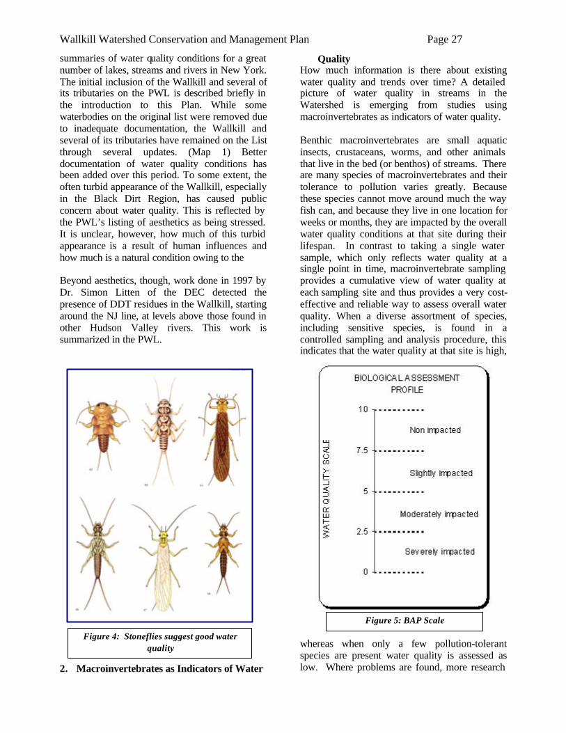
2. Macroinvertebrates as Indicators of Water
Quality How much information is there about existing water quality and trends over time? A detailed picture of water quality in streams in the Watershed is emerging from studies using macroinvertebrates as indicators of water quality. Benthic macroinvertebrates are small aquatic insects, crustaceans, worms, and other animals that live in the bed (or benthos) of streams. There are many species of macroinvertebrates and their tolerance to pollution varies greatly. Because these species cannot move around much the way fish can, and because they live in one location for weeks or months, they are impacted by the overall water quality conditions at that site during their lifespan. In contrast to taking a single water sample, which only reflects water quality at a single point in time, macroinvertebrate sampling provides a cumulative view of water quality at each sampling site and thus provides a very cost-effective and reliable way to assess overall water quality. When a diverse assortment of species, including sensitive species, is found in a controlled sampling and analysis procedure, this indicates that the water quality at that site is high,
whereas when only a few pollution-tolerant species are present water quality is assessed as low. Where problems are found, more research
Figure 4: Stoneflies suggest good water quality
Figure 5: BAP Scale
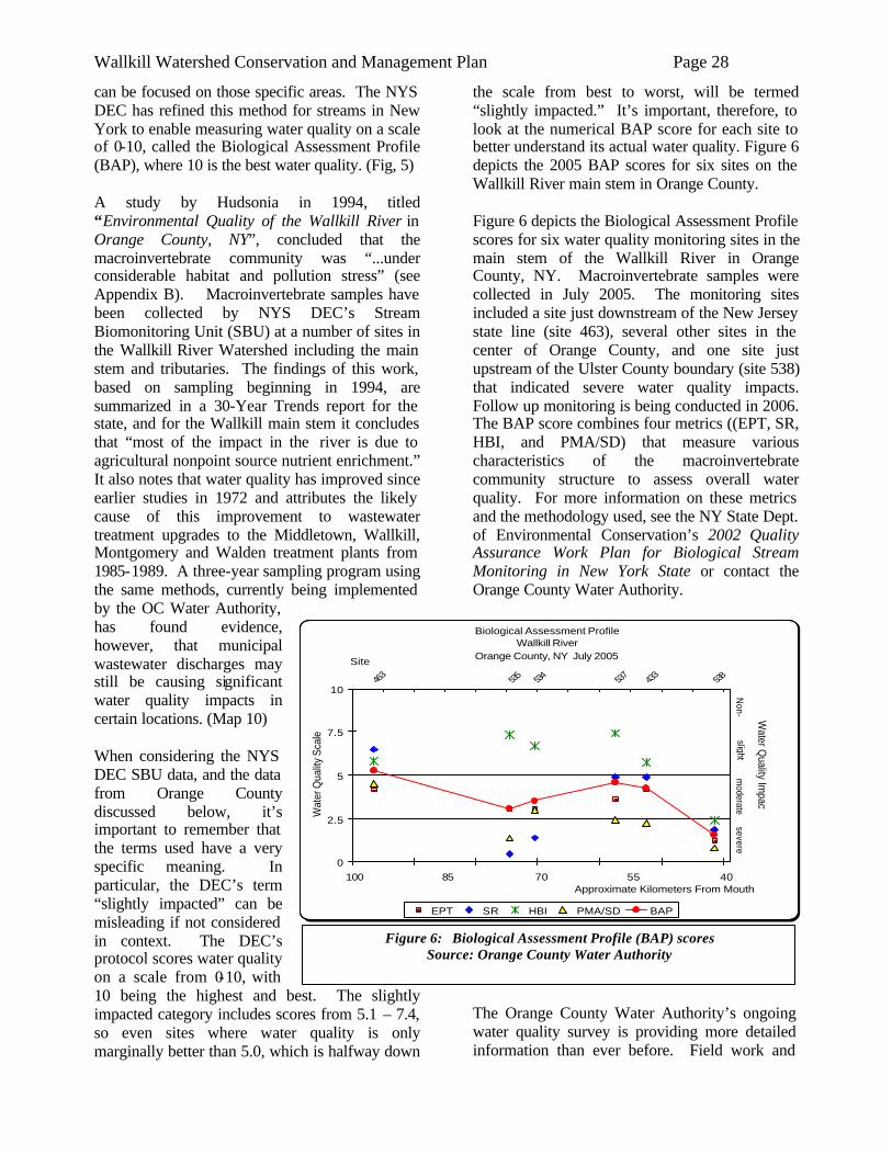
Wallkill Watershed Conservation and Management Plan Page 28
can be focused on those specific areas. The NYS DEC has refined this method for streams in New York to enable measuring water quality on a scale of 0-10, called the Biological Assessment Profile (BAP), where 10 is the best water quality. (Fig, 5) A study by Hudsonia in 1994, titled “Environmental Quality of the Wallkill River in Orange County, NY”, concluded that the macroinvertebrate community was “...under considerable habitat and pollution stress” (see Appendix B). Macroinvertebrate samples have been collected by NYS DEC’s Stream Biomonitoring Unit (SBU) at a number of sites in the Wallkill River Watershed including the main stem and tributaries. The findings of this work, based on sampling beginning in 1994, are summarized in a 30-Year Trends report for the state, and for the Wallkill main stem it concludes that “most of the impact in the river is due to agricultural nonpoint source nutrient enrichment.” It also notes that water quality has improved since earlier studies in 1972 and attributes the likely cause of this improvement to wastewater treatment upgrades to the Middletown, Wallkill, Montgomery and Walden treatment plants from 1985-1989. A three-year sampling program using the same methods, currently being implemented by the OC Water Authority, has found evidence, however, that municipal wastewater discharges may still be causing significant water quality impacts in certain locations. (Map 10) When considering the NYS DEC SBU data, and the data from Orange County discussed below, it’s important to remember that the terms used have a very specific meaning. In particular, the DEC’s term “slightly impacted” can be misleading if not considered in context. The DEC’s protocol scores water quality on a scale from 0-10, with 10 being the highest and best. The slightly impacted category includes scores from 5.1 – 7.4, so even sites where water quality is only marginally better than 5.0, which is halfway down
the scale from best to worst, will be termed “slightly impacted.” It’s important, therefore, to look at the numerical BAP score for each site to better understand its actual water quality. Figure 6 depicts the 2005 BAP scores for six sites on the Wallkill River main stem in Orange County. Figure 6 depicts the Biological Assessment Profile scores for six water quality monitoring sites in the main stem of the Wallkill River in Orange County, NY. Macroinvertebrate samples were collected in July 2005. The monitoring sites included a site just downstream of the New Jersey state line (site 463), several other sites in the center of Orange County, and one site just upstream of the Ulster County boundary (site 538) that indicated severe water quality impacts. Follow up monitoring is being conducted in 2006. The BAP score combines four metrics ((EPT, SR, HBI, and PMA/SD) that measure various characteristics of the macroinvertebrate community structure to assess overall water quality. For more information on these metrics and the methodology used, see the NY State Dept. of Environmental Conservation’s 2002 Quality Assurance Work Plan for Biological Stream Monitoring in New York State or contact the Orange County Water Authority.
The Orange County Water Authority’s ongoing water quality survey is providing more detailed information than ever before. Field work and
Biological Assessment ProfileWallkill River
Orange County, NY July 2005
0
2.5
5
7.5
10
100 85 70 55 40Approximate Kilometers From Mouth
Wat
er Q
ualit
y Sc
ale
463 535 534 537 433 538Site
Water Q
uality Impact
EPT SR HBI PMA/SD BAP
Non-
slightm
oderatesevere
Figure 6: Biological Assessment Profile (BAP) scores Source: Orange County Water Authority
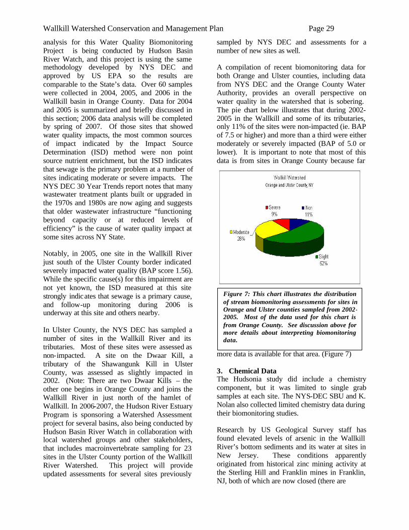
Wallkill Watershed Conservation and Management Plan Page 29
analysis for this Water Quality Biomonitoring Project is being conducted by Hudson Basin River Watch, and this project is using the same methodology developed by NYS DEC and approved by US EPA so the results are comparable to the State’s data. Over 60 samples were collected in 2004, 2005, and 2006 in the Wallkill basin in Orange County. Data for 2004 and 2005 is summarized and briefly discussed in this section; 2006 data analysis will be completed by spring of 2007. Of those sites that showed water quality impacts, the most common sources of impact indicated by the Impact Source Determination (ISD) method were non point source nutrient enrichment, but the ISD indicates that sewage is the primary problem at a number of sites indicating moderate or severe impacts. The NYS DEC 30 Year Trends report notes that many wastewater treatment plants built or upgraded in the 1970s and 1980s are now aging and suggests that older wastewater infrastructure “functioning beyond capacity or at reduced levels of efficiency” is the cause of water quality impact at some sites across NY State. Notably, in 2005, one site in the Wallkill River just south of the Ulster County border indicated severely impacted water quality (BAP score 1.56). While the specific cause(s) for this impairment are not yet known, the ISD measured at this site strongly indicates that sewage is a primary cause, and follow-up monitoring during 2006 is underway at this site and others nearby. In Ulster County, the NYS DEC has sampled a number of sites in the Wallkill River and its tributaries. Most of these sites were assessed as non-impacted. A site on the Dwaar Kill, a tributary of the Shawangunk Kill in Ulster County, was assessed as slightly impacted in 2002. (Note: There are two Dwaar Kills – the other one begins in Orange County and joins the Wallkill River in just north of the hamlet of Wallkill. In 2006-2007, the Hudson River Estuary Program is sponsoring a Watershed Assessment project for several basins, also being conducted by Hudson Basin River Watch in collaboration with local watershed groups and other stakeholders, that includes macroinvertebrate sampling for 23 sites in the Ulster County portion of the Wallkill River Watershed. This project will provide updated assessments for several sites previously
sampled by NYS DEC and assessments for a number of new sites as well. A compilation of recent biomonitoring data for both Orange and Ulster counties, including data from NYS DEC and the Orange County Water Authority, provides an overall perspective on water quality in the watershed that is sobering. The pie chart below illustrates that during 2002-2005 in the Wallkill and some of its tributaries, only 11% of the sites were non-impacted (ie. BAP of 7.5 or higher) and more than a third were either moderately or severely impacted (BAP of 5.0 or lower). It is important to note that most of this data is from sites in Orange County because far
more data is available for that area. (Figure 7) 3. Chemical Data The Hudsonia study did include a chemistry component, but it was limited to single grab samples at each site. The NYS-DEC SBU and K. Nolan also collected limited chemistry data during their biomonitoring studies. Research by US Geological Survey staff has found elevated levels of arsenic in the Wallkill River’s bottom sediments and its water at sites in New Jersey. These conditions apparently originated from historical zinc mining activity at the Sterling Hill and Franklin mines in Franklin, NJ, both of which are now closed (there are
Figure 7: This chart illustrates the distribution of stream biomonitoring assessments for sites in Orange and Ulster counties sampled from 2002-2005. Most of the data used for this chart is from Orange County. See discussion above for more details about interpreting biomonitoring data.
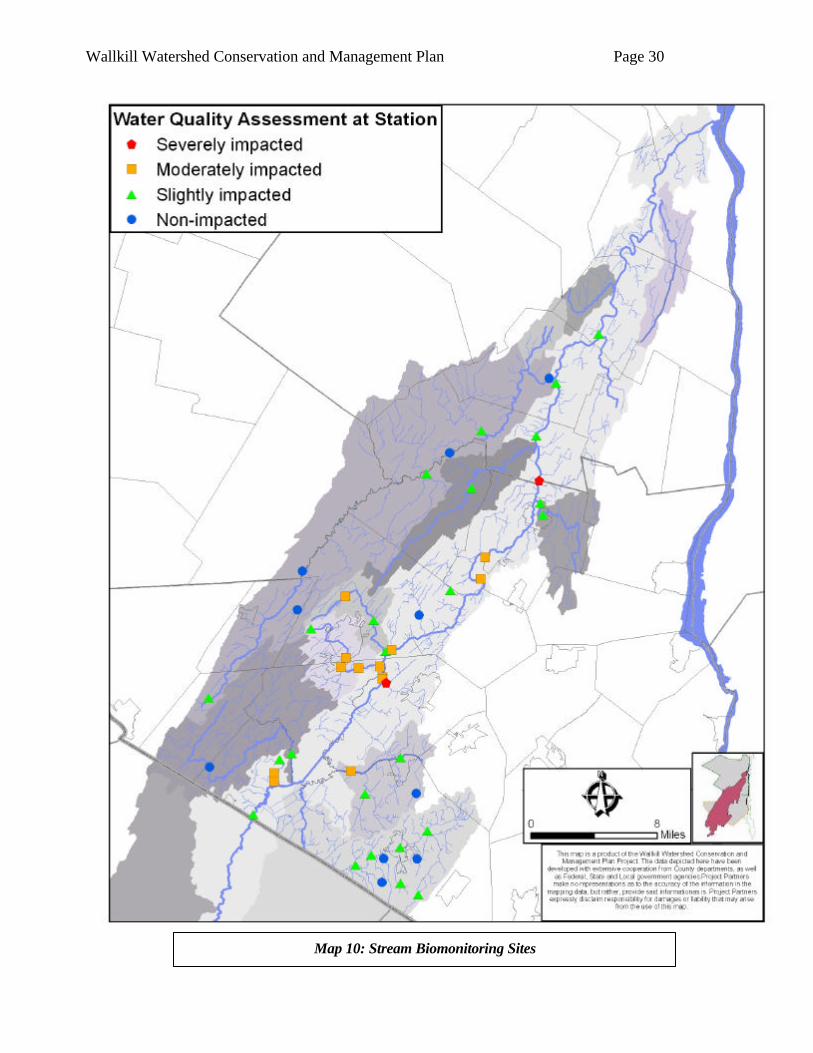
Wallkill Watershed Conservation and Management Plan Page 30
Map 10: Stream Biomonitoring Sites
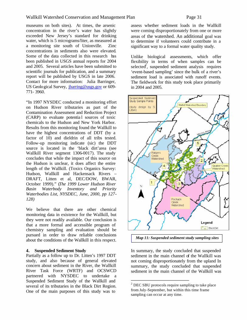
Wallkill Watershed Conservation and Management Plan Page 31
museums on both sites). At times, the arsenic concentration in the river’s water has slightly exceeded New Jersey’s standard for drinking water, which is 5 micrograms/liter, as measured at a monitoring site south of Unionville. Zinc concentrations in sediments also were elevated. Some of the data collected in this research has been published in USGS annual reports for 2004 and 2005. Several articles have been submitted to scientific journals for publication, and a summary report will be published by USGS in late 2006. Contact for more information: Julia Barringer, US Geological Survey, [email protected] or 609-771- 3960. “In 1997 NYSDEC conducted a monitoring effort on Hudson River tributaries as part of the Contamination Assessment and Reduction Project (CARP) to evaluate potentia l sources of toxic chemicals to the Hudson and New York Harbor. Results from this monitoring found the Wallkill to have the highest concentrations of DDT (by a factor of 10) and dieldrin of all tribs tested. Follow-up monitoring indicate (sic) the DDT source is located in the ‘black dirt’area (see Wallkill River segment 1306-0017). The study concludes that while the impact of this source on the Hudson is unclear, it does affect the entire length of the Wallkill. (Toxics Organics Survey: Hudson, Wallkill and Hackensack Rivers – DRAFT, Litten et al, DEC/DOW, BWAR, October 1999).” (The 1999 Lower Hudson River Basin Waterbody Inventory and Priority Waterbodies List, NYSDEC, June, 2000, pp 127-128) We believe that there are other chemical monitoring data in existence for the Wallkill, but they were not readily available. Our conclusion is that a more formal and accessible program of chemistry sampling and evaluation should be pursued in order to draw reliable conclusions about the conditions of the Wallkill in this respect. 4. Suspended Sediment Study Partially as a follow up to Dr. Litten’s 1997 DDT study, and also because of general elevated concern about sediment in the River, the Wallkill River Task Force (WRTF) and OCSWCD partnered with NYSDEC to undertake a Suspended Sediment Study of the Wallkill and several of its tributaries in the Black Dirt Region. One of the main purposes of this study was to
assess whether sediment loads in the Wallkill were coming disproportionately from one or more areas of the watershed. An additional goal was to determine if volunteers could contribute in a significant way to a formal water quality study. Unlike biological assessments, which offer flexibility in terms of when samples can be selected2, suspended sediment analysis requires ‘event-based sampling’ since the bulk of a river’s sediment load is associated with runoff events. The fieldwork for this study took place primarily in 2004 and 2005.
In summary, the study concluded that suspended sediment in the main channel of the Wallkill was not coming disproportionately from the upland In summary, the study concluded that suspended sediment in the main channel of the Wallkill was
2 DEC SBU protocols require sampling to take place from July-September, but within this time frame sampling can occur at any time.
Map 11: Suspended sediment study sampling sites
Wallkill Watershed Conservation and Management Plan Page 32
not coming disproportionately from the upland portions of major tributaries (Pochuck, Rutgers, & Quaker). The main researcher postulated, at the December 2004 meeting of the Project Steering Committee, that the banks of the River itself and the banks of major drainage channels within the study area were the major contributors. (See Black Dirt section for more on this issue and how it impacts recommended actions of the Plan). It is worth noting that all involved with the study agreed that the volunteer component of the study worked extremely well. Despite being required to visit sampling sites (Map 11) on short notice during often inclement weather, volunteer samplers (4 out of 5 of which were Black Dirt farmers) performed their duties accurately and reliably. The success of the effort can also be attributed largely to the diligence of OCSWCD’s Kris Breitenfeld, who coordinated the sampling locally. 5. Water Supply, Quantity and Allocation
Issues Water for human use in the Wallkill basin is obtained from private wells and municipal supplies. Municipal systems in Orange County are supplied by reservoirs (which serve the City of Middletown and the villages of Florida, Warwick, and Goshen) and by municipal wells. Municipal wells are located both in sand and gravel aquifers, which tend to be relatively shallow and can provide high yields, and in bedrock formations, which are generally deeper. Some of these wells are located close to the Wallkill River and water levels and water quality are directly affected by the River. While water consumption from the municipal systems has not increased significantly in most cases over the past 10-15 years, Orange County is currently working with a number of communities, including Crawford, Goshen, Middletown, Wawayanda and Wallkill, to study the potential for new drinking water supply projects. These projects will potentially lead to increased withdrawals of water from the Wallkill River, some of its tributaries, and/or from groundwater aquifers. Some farmers will also take water for irrigation. In Ulster County, New Paltz's upland reservoirs are an auxiliary source of supply for the Village of New Paltz and Town of New Paltz water district. The contributing watersheds of these surface
supplies lie within the Wallkill Watershed and serve 6000 customers in an emergency capacity. The hamlet of Wallkill relies on municipal wells located on the eastern edge of the Town of Shawangunk. This area is recharged by a pitted outwash plain extending from Wallkill south into Orange County. The majority of the residents of this area rely on individual wells drilled into bedrock or driven into unconsolidated aquifers. The average depth of these wells in the unconsolidated aquifers is 73' and yield an average of 93 gallons per minute (gpm). When, however, a bedrock well is required, the depth increased to 200' and the yields dropped to 33 gpm. The Water Supply Study 1989, prepared by Stearns and Wheler, evaluated existing and long range needs of the county and recommended system improvements and consolidations to satisfy those needs. It is projected that at the current rate of growth, all of the municipalities will experience a water deficit. The only exception to this is New Paltz, which has access to water from the NYC-DEP Aqueduct System.
Water-Related Recreation When people are able to enjoy a water resource through recreational opportunities such as swimming, boating, or fishing, they are more likely to be concerned about the health and welfare of that resource. Even hiking along a river or viewing a water body from a park can create a feeling of ownership that can lead to greater public stewardship of the waterway. The Wallkill River has long suffered from a low public profile as a recreational resource, due to many factors. Only recently have riverside parks and river access points become a focus for communities along the Wallkill, but today there are many points where the public can enjoy the River (Map 12). Public access points to the Wallkill River in New York, from south to north, consist of:
1. Wallkill River National Wildlife Refuge (Warwick) – The 5,100-acre Refuge is mainly in New Jersey, but its New York acreage includes a riverfront parcel with interpretive signage, benches and a boat launch.
2. Orange County Land Trust’s Hamptonburgh Preserve (Hamptonburgh) – A nature preserve consisting of forests,
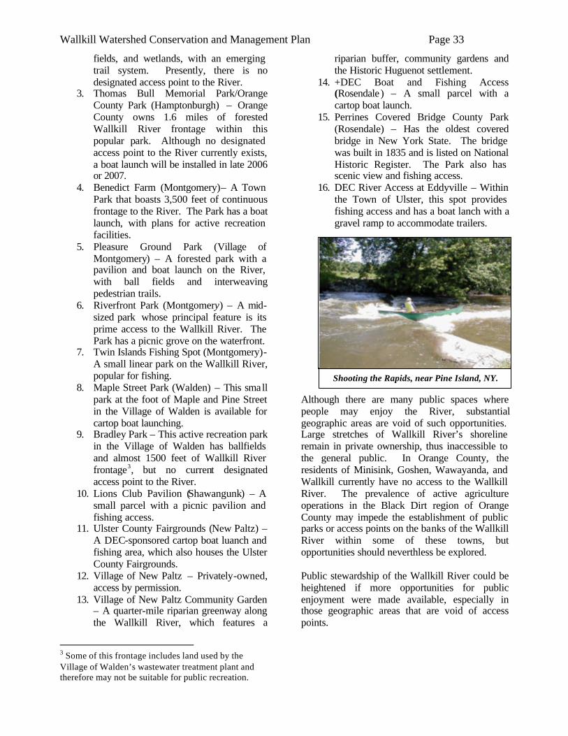
Wallkill Watershed Conservation and Management Plan Page 33
Shooting the Rapids, near Pine Island, NY.
fields, and wetlands, with an emerging trail system. Presently, there is no designated access point to the River.
3. Thomas Bull Memorial Park/Orange County Park (Hamptonburgh) – Orange County owns 1.6 miles of forested Wallkill River frontage within this popular park. Although no designated access point to the River currently exists, a boat launch will be installed in late 2006 or 2007.
4. Benedict Farm (Montgomery)– A Town Park that boasts 3,500 feet of continuous frontage to the River. The Park has a boat launch, with plans for active recreation facilities.
5. Pleasure Ground Park (Village of Montgomery) – A forested park with a pavilion and boat launch on the River, with ball fields and interweaving pedestrian trails.
6. Riverfront Park (Montgomery) – A mid-sized park whose principal feature is its prime access to the Wallkill River. The Park has a picnic grove on the waterfront.
7. Twin Islands Fishing Spot (Montgomery)- A small linear park on the Wallkill River, popular for fishing.
8. Maple Street Park (Walden) – This small park at the foot of Maple and Pine Street in the Village of Walden is available for cartop boat launching.
9. Bradley Park – This active recreation park in the Village of Walden has ballfields and almost 1500 feet of Wallkill River frontage3, but no current designated access point to the River.
10. Lions Club Pavilion (Shawangunk) – A small parcel with a picnic pavilion and fishing access.
11. Ulster County Fairgrounds (New Paltz) – A DEC-sponsored cartop boat luanch and fishing area, which also houses the Ulster County Fairgrounds.
12. Village of New Paltz – Privately-owned, access by permission.
13. Village of New Paltz Community Garden – A quarter-mile riparian greenway along the Wallkill River, which features a
3 Some of this frontage includes land used by the Village of Walden’s wastewater treatment plant and therefore may not be suitable for public recreation.
riparian buffer, community gardens and the Historic Huguenot settlement.
14. +DEC Boat and Fishing Access (Rosendale) – A small parcel with a cartop boat launch.
15. Perrines Covered Bridge County Park (Rosendale) – Has the oldest covered bridge in New York State. The bridge was built in 1835 and is listed on National Historic Register. The Park also has scenic view and fishing access.
16. DEC River Access at Eddyville – Within the Town of Ulster, this spot provides fishing access and has a boat lanch with a gravel ramp to accommodate trailers.
Although there are many public spaces where people may enjoy the River, substantial geographic areas are void of such opportunities. Large stretches of Wallkill River’s shoreline remain in private ownership, thus inaccessible to the general public. In Orange County, the residents of Minisink, Goshen, Wawayanda, and Wallkill currently have no access to the Wallkill River. The prevalence of active agriculture operations in the Black Dirt region of Orange County may impede the establishment of public parks or access points on the banks of the Wallkill River within some of these towns, but opportunities should neverthless be explored. Public stewardship of the Wallkill River could be heightened if more opportunities for public enjoyment were made available, especially in those geographic areas that are void of access points.
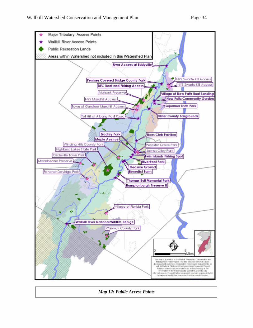
Wallkill Watershed Conservation and Management Plan Page 34
Map 12: Public Access Points
Wallkill Watershed Conservation and Management Plan Page 35
At present, the public has five opportunities to enjoy the major tributaries of the Wallkill River. The Orange County Land Trust’s Moonbeams Preserve provides public access to the Shawangunk Kill, which is stocked with trout by the DEC. The Village of Walden’s Wooster Grove Park is enveloped by the Tin Brook and provides an opportunity for Village residents to wade and fish in the Brook. The NYS DEC provides multiple access points to major tributaries in Ulster County: one on the Mara Kill and two on the Swarte Kill. These areas are typically for fishing and for launching cartop boats. The Town of Gardiner also has an access point to the Mara Kill and the Mohonk Preserve has a small access point on the Klein Kill. Other water-related recreation opportunities within the Watershed include public parks with lakes and ponds that the public can appreciate through fishing, boating, or swimming. The towns of Minisink, Goshen, and Wawayanda, unfortunately, have no opportunities for the public to enjoy water-related recreation. While these towns may have small tributaries flowing through some of their public parks, such natural features may or may not be promoted and used as a public resource. It is therefore important that land with access to water within these geographic areas be prioritized for future parkland acquisitions.
Wastewater Management
Wastewater discharges in the Wallkill watershed include individual onsite systems (commonly referred to as septic systems) and municipal collection and treatment plants (Map 13 depicts areas served by municipal wastewater systems.) Larger municipal discharges in Orange County include systems owned by Middletown, Town of Wallkill, Town of Montgomery, Town of Crawford (serving Pine Bush), and villages of Florida, Warwick, Goshen, Montgomery, and Walden. There are also other smaller systems, some of which are privately owned and operated. In Ulster County, municipal systems serve the hamlet of Wallkill and two prisons in the Town of Shawangunk, part of the Town of Gardiner, and the Village of New Paltz. Several smaller privately owned systems serve the Watchtower farm in the Town of Shawangunk and the Maple Ridge Bruderhof in Esopus. The Town of
Rosendale has a municipal system that discharges to the Rondout Creek downstream of the confluence with the Wallkill. All of these systems discharge to the Wallkill River or to tributaries of the Wallkill. Outside of these communities, with the exception of some small community systems, all wastewater is managed using individual onsite systems that discharge to subsurface absorption fields. Depending on their daily flow, wastewater discharges are regulated either by each county’s Department of Health for smaller systems or by the NY State Department of Environmental Conservation. Regulations governing municipal systems generally require regular inspections, monitoring and reporting to ensure that treated wastewater meets certain standards in the discharge permit. For individual onsite systems, however, there is no state requirement for any regular inspection, monitoring, or maintenance activities. It is up to individual property owners to conduct inspections, pump septic tanks and take other steps to ensure that systems are operating properly. More information on wastewater management issues can be found in the Watershed Issues section.
Stormwater Management The original focus of many water quality programs growing out of the 1972 Clean Water Act was wastewater treatment for municipal and industrial discharges, which are termed point sources because they emanate from a pipe. More recently, a whole array of contaminants known together as non-point source pollution have been recognized as a major cause of impairment to many waterbodies. It’s estimated that non-point source pollution now comprises somewhere between 50-90% of the total pollution load in many water bodies. These pollutants include silt and sediment, fertilizer, pesticides, automotive fluids, road salt, pet waste, septic effluent, and others. These materials are carried to streams and lakes in rainwater and snow melt when it runs off the land. Current water quality programs, therefore, now include a major focus on reducing non-point source pollution and managing stormwater. These programs include education for property owners
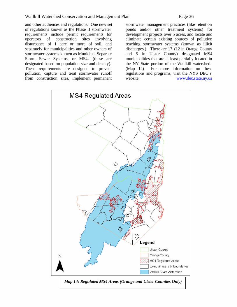
Wallkill Watershed Conservation and Management Plan Page 36
Map 14: Regulated MS4 Areas (Orange and Ulster Counties Only)
and other audiences and regulations. One new set of regulations known as the Phase II stormwater requirements include permit requirements for operators of construction sites involving disturbance of 1 acre or more of soil, and separately for municipalities and other owners of stormwater systems known as Municipal Separate Storm Sewer Systems, or MS4s (these are designated based on population size and density). These requirements are designed to prevent pollution, capture and treat stormwater runoff from construction sites, implement permanent
stormwater management practices (like retention ponds and/or other treatment systems) for development projects over 5 acres, and locate and eliminate certain existing sources of pollution reaching stormwater systems (known as illicit discharges.) There are 17 (12 in Orange County and 5 in Ulster County) designated MS4 municipalities that are at least partially located in the NY State portion of the Wallkill watershed. (Map 14) For more information on these regulations and programs, visit the NYS DEC’s website: www.dec.state.ny.us
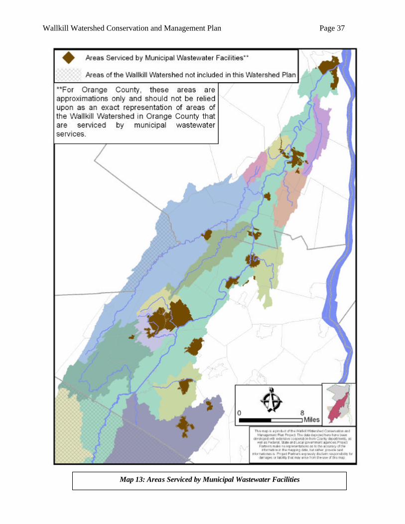
Wallkill Watershed Conservation and Management Plan Page 37
Map 13: Areas Serviced by Municipal Wastewater Facilities
Wallkill Watershed Conservation and Management Plan Page 38
Citizen Survey Early in the Management Plan development, the Project Steering Committee (PSC) decided that they wanted to formulate a survey that assessed people’s attitudes, knowledge of, and important issues relating to the Wallkill River and its watershed. Several other management plans reviewed by the PSC had done so, and it was deemed to be a useful process for our project. The education sub-committee of the PSC developed a survey form, which was distributed to the full PSC for review and input. The method of distribution of the survey was an additional topic of discussion. Given the generally low return rate that can be expected from mailed surveys, the PSC decided that a large mass mailing was not a good use of Project resources. Therefore, it was decided that PSC members would individually make efforts to distribute the surveys at various events such as county fairs, farm markets, street festivals, chance meetings, etc. Using this approach, 230 citizen surveys were completed. An example of the Citizen Survey form, and a summary of the survey results are presented in Appendix C. Though it is not surprising that land development was cited more than any other as a watershed concern, the degree to which this concern outweighed the others is noteworthy. 73 respondents listed land development as their top watershed concern, the next highest concern was litter and debris dumping with 48 respondents listing it as their top concern. Similarly, 112 respondents ranked “expansion of housing development into rural areas” as a “serious problem”, while only 10 indicated that this was “not a problem”. The next highest ranked “serious problem” was “loss of family farms” (107 survey respondents). Only 11 of 230 respondents ranked loss of family farms as “not a problem”. It is not the intent of this Plan to suggest that land development be stopped. Despite these survey results, Plan writers realize that this would be an unrealistic and undesirable recommendation.
However, we do feel the results lend increased emphasis to and support for other recommendations in the Plan, such as accelerated adoption of smart growth/low impact development techniques, farmland/open space preservation programs, regional planning approaches, and related measures that more effectively control the myriad negative impacts of unbridled (sub)urban development.
Agricultural Issues 1. Black Dirt Region The high productivity of the muck soils in the Black Dirt Region has led farmers to convert – through methods such as channelizing natural waterways and creating ditches to drain fields – most of the Region from swamp to some of the most productive agricultural land in the area. The high degree of land alteration that has occurred in this Region, however, has been accompanied by many challenges. Natural resource management concerns in this Region are, in many respects, unlike the remainder of the Watershed. The intent of this Plan, as it relates to the Black Dirt Region, will be to promote continued agricultural production while mitigating any associated natural resource impacts to the greatest extent feasible. In nearby mineral soil areas of the Watershed, farms are inexorably being replaced by homes and related urban development. One might assume that Black Dirt farms were much more secure due to their poor suitability for urban development. However, despite the lack of high land speculation pressures, the economics of farming the Black Dirt is by no means without challenges. Over the past two years, nearly 1,000 acres have been voluntarily removed from production by Black Dirt landowners for a period of ten to fifteen years. Entered into USDA’s Conservation Reserve Enhancement Program (CREP), these lands will be maintained in grass/legume cover while the landowner receives an annual rental payment from USDA. There are laudable benefits associated with such land conservation programs, but the extent of acreage removed from crop production raises serious concerns about the economics of farming in the Region.
IIIIII.. WWAATTEERRSSHHEEDD IISSSSUUEESS
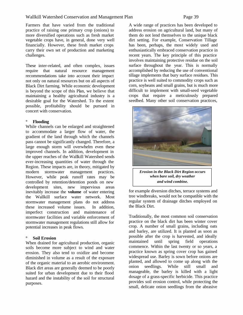
Wallkill Watershed Conservation and Management Plan Page 39
Erosion in the Black Dirt Region occurs when bare soil, dry weather
and wind combine.
Farmers that have varied from the traditional practice of raising one primary crop (onions) to more diversified operations such as fresh market vegetable crops have, in general, done very well financially. However, these fresh market crops carry their own set of production and marketing challenges. These inter-related, and often complex, issues require that natural resource management recommendations take into account their impact not only on natural resources but on all aspects of Black Dirt farming. While economic development is beyond the scope of this Plan, we believe that maintaining a healthy agricultural industry is a desirable goal for the Watershed. To the extent possible, profitability should be pursued in concert with conservation. ° Flooding While channels can be enlarged and straightened to accommodate a larger flow of water, the gradient of the land through which the channels pass cannot be significantly changed. Therefore, a large enough storm will overwhelm even these improved channels. In addition, development in the upper reaches of the Wallkill Watershed sends ever-increasing quantities of water through the Region. These impacts are, in theory, mitigated by modern stormwater management practices. However, while peak runoff rates may be controlled by retention/detention ponds on new development sites, new impervious areas inevitably increase the volume of water entering the Wallkill surface water network. Most stormwater management plans do not address these increased volume issues. In addition, imperfect construction and maintenance of stormwater facilities and variable enforcement of stormwater management regulations still allow for potential increases in peak flows. ° Soil Erosion When drained for agricultural production, organic soils become more subject to wind and water erosion. They also tend to oxidize and become diminished in volume as a result of the exposure of the organic material to an aerobic environment. Black dirt areas are generally deemed to be poorly suited for urban development due to their flood hazard and the instability of the soil for structural purposes.
A wide range of practices has been developed to address erosion on agricultural land, but many of them do not lend themselves to the unique black dirt setting. For example, Conservation Tillage has been, perhaps, the most widely used and enthusiastically embraced conservation practice in recent years. The key principle of this practice involves maintaining protective residue on the soil surface throughout the year. This is normally accomplished by reducing the use of conventional tillage implements that bury surface residues. This practice is well suited to commodity crops such as corn, soybeans and small grains, but is much more difficult to implement with small-seed vegetable crops that require a meticulously prepared seedbed. Many other soil conservation practices,
for example diversion ditches, terrace systems and tree windbreaks, would not be compatible with the regular system of drainage ditches employed on the Black Dirt. Traditionally, the most common soil conservation practice on the black dirt has been winter cover crop. A number of small grains, including oats and barley, are utilized. It is planted as soon as possible after the crop is harvested, and ideally maintained until spring field operations commence. Within the last twenty or so years, a practice known as spring cover crop has gained widespread use. Barley is sown before onions are planted, and allowed to come up along with the onion seedlings. While still small and manageable, the barley is killed with a light dosage of a grass-specific herbicide. This practice provides soil erosion control, while protecting the small, delicate onion seedlings from the abrasive
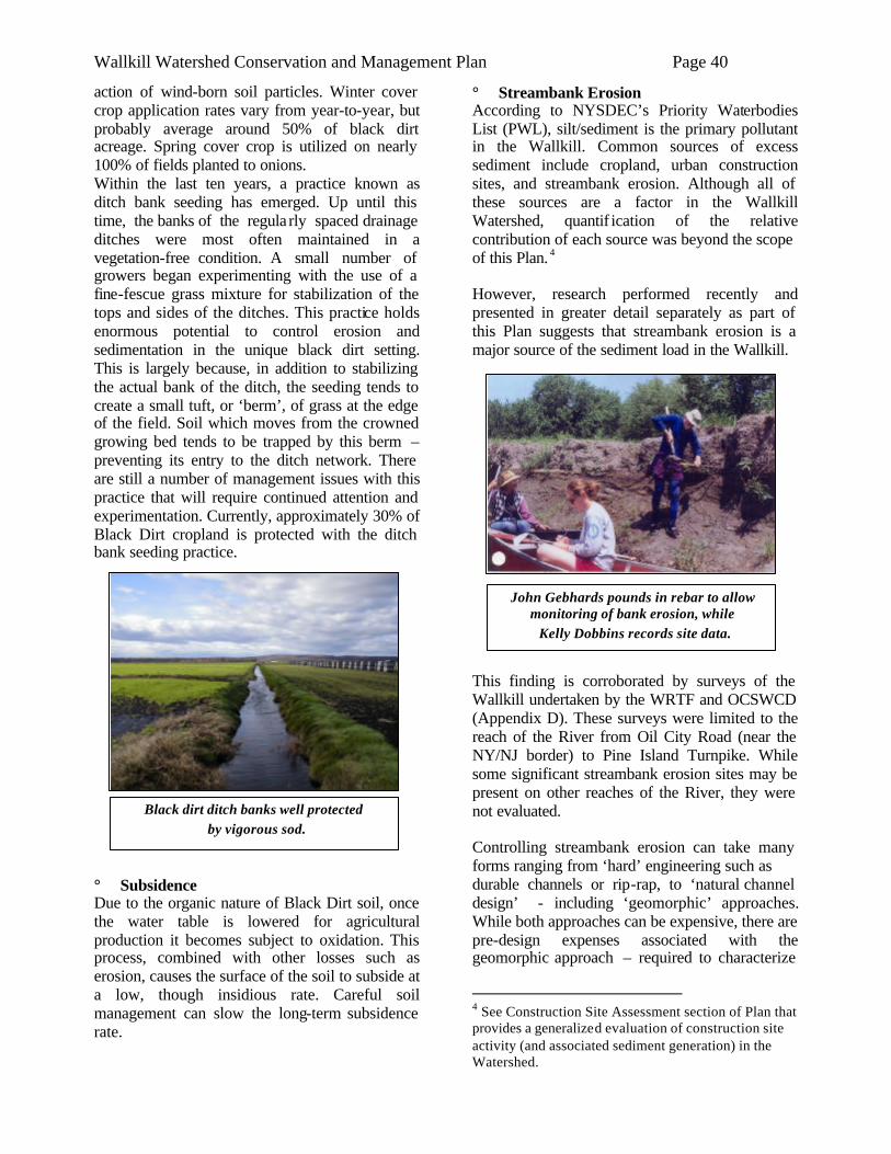
Wallkill Watershed Conservation and Management Plan Page 40
Black dirt ditch banks well protected by vigorous sod.
action of wind-born soil particles. Winter cover crop application rates vary from year-to-year, but probably average around 50% of black dirt acreage. Spring cover crop is utilized on nearly 100% of fields planted to onions. Within the last ten years, a practice known as ditch bank seeding has emerged. Up until this time, the banks of the regula rly spaced drainage ditches were most often maintained in a vegetation-free condition. A small number of growers began experimenting with the use of a fine-fescue grass mixture for stabilization of the tops and sides of the ditches. This practice holds enormous potential to control erosion and sedimentation in the unique black dirt setting. This is largely because, in addition to stabilizing the actual bank of the ditch, the seeding tends to create a small tuft, or ‘berm’, of grass at the edge of the field. Soil which moves from the crowned growing bed tends to be trapped by this berm – preventing its entry to the ditch network. There are still a number of management issues with this practice that will require continued attention and experimentation. Currently, approximately 30% of Black Dirt cropland is protected with the ditch bank seeding practice.
° Subsidence Due to the organic nature of Black Dirt soil, once the water table is lowered for agricultural production it becomes subject to oxidation. This process, combined with other losses such as erosion, causes the surface of the soil to subside at a low, though insidious rate. Careful soil management can slow the long-term subsidence rate.
° Streambank Erosion According to NYSDEC’s Priority Waterbodies List (PWL), silt/sediment is the primary pollutant in the Wallkill. Common sources of excess sediment include cropland, urban construction sites, and streambank erosion. Although all of these sources are a factor in the Wallkill Watershed, quantif ication of the relative contribution of each source was beyond the scope of this Plan. 4 However, research performed recently and presented in greater detail separately as part of this Plan suggests that streambank erosion is a major source of the sediment load in the Wallkill.
This finding is corroborated by surveys of the Wallkill undertaken by the WRTF and OCSWCD (Appendix D). These surveys were limited to the reach of the River from Oil City Road (near the NY/NJ border) to Pine Island Turnpike. While some significant streambank erosion sites may be present on other reaches of the River, they were not evaluated. Controlling streambank erosion can take many forms ranging from ‘hard’ engineering such as durable channels or rip-rap, to ‘natural channel design’ - including ‘geomorphic’ approaches. While both approaches can be expensive, there are pre-design expenses associated with the geomorphic approach – required to characterize
4 See Construction Site Assessment section of Plan that provides a generalized evaluation of construction site activity (and associated sediment generation) in the Watershed.
John Gebhards pounds in rebar to allow monitoring of bank erosion, while Kelly Dobbins records site data.
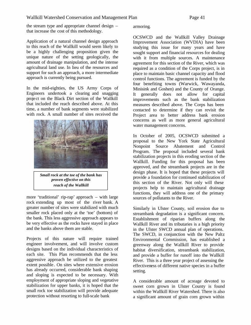
Wallkill Watershed Conservation and Management Plan Page 41
Small rock at the toe of the bank has proven effective on this
reach of the Wallkill
the stream type and appropriate channel design – that increase the cost of this methodology. Application of a natural channel design approach to this reach of the Wallkill would seem likely to be a highly challenging proposition given the unique nature of the setting geologically, the amount of drainage manipulation, and the intense agricultural land use. In lieu of the resources and support for such an approach, a more intermediate approach is currently being pursued. In the mid-eighties, the US Army Corps of Engineers undertook a clearing and snagging project on the Black Dirt section of the Wallkill that included the reach described above. At this time, a number of bank segments were stabilized with rock. A small number of sites received the
more ‘traditional’ rip-rap’ approach – with large rock extending up most of the river bank. A greater number of sites were stabilized with much smaller rock placed only at the ‘toe’ (bottom) of the bank. This less aggressive approach appears to be very effective as the rocks have stayed in place and the banks above them are stable. Projects of this nature will require trained engineer involvement, and will involve custom designs based on the individual characteristics of each site. This Plan recommends that the less aggressive approach be utilized to the greatest extent possible . On sites where extensive erosion has already occurred, considerable bank shaping and sloping is expected to be necessary. With employment of appropriate sloping and vegetative stabilization for upper banks, it is hoped that the small rock toe stabilization will provide adequate protection without resorting to full-scale bank
armoring. OCSWCD and the Wallkill Valley Drainage Improvement Association (WVDIA) have been studying this issue for many years and have sought support and financial resources for dealing with it from multiple sources. A maintenance agreement for this section of the River, which was required as a condition of the Corps project, is in place to maintain basic channel capacity and flood control functions. The agreement is funded by the four benefiting towns (Warwick, Wawayanda, Minisink and Goshen) and the County of Orange. It generally does not allow for capital improvements such as the bank stabilization measures described above. The Corps has been contacted to determine if they can revisit the Project area to better address bank erosion concerns as well as more general agricultural water management concerns. In October of 2005, OCSWCD submitted a proposal to the New York State Agricultural Nonpoint Source Abatement and Control Program. The proposal included several bank stabilization projects in this eroding section of the Wallkill. Funding for this proposal has been approved, and the streambank projects are in the design phase. It is hoped that these projects will provide a foundation for continued stabilization of this section of the River. Not only will these projects help to maintain agricultural drainage functions, they will address one of the primary sources of pollutants to the River. Similarly in Ulster County, soil erosion due to streambank degradation is a significant concern. Establishment of riparian buffers along the Wallkill River and its tributaries is a high priority in the Ulster SWCD annual plan of operations. The SWCD, in conjunction with the New Paltz Environmental Commission, has established a greenway along the Wallkill River to provide habitat diversification, streambank stabilization, and provide a buffer for runoff into the Wallkill River. This is a three year project of assessing the effectiveness of different native species in a buffer setting. A considerable amount of acreage devoted to sweet corn grown in Ulster County is found within the Wallkill River Watershed. There is also a significant amount of grain corn grown within
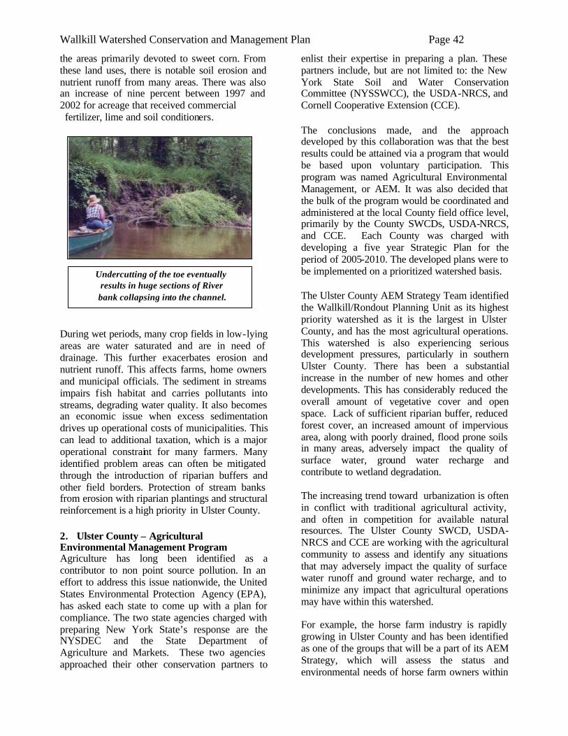
Wallkill Watershed Conservation and Management Plan Page 42
Undercutting of the toe eventually results in huge sections of River bank collapsing into the channel.
the areas primarily devoted to sweet corn. From these land uses, there is notable soil erosion and nutrient runoff from many areas. There was also an increase of nine percent between 1997 and 2002 for acreage that received commercial fertilizer, lime and soil conditioners.
During wet periods, many crop fields in low-lying areas are water saturated and are in need of drainage. This further exacerbates erosion and nutrient runoff. This affects farms, home owners and municipal officials. The sediment in streams impairs fish habitat and carries pollutants into streams, degrading water quality. It also becomes an economic issue when excess sedimentation drives up operational costs of municipalities. This can lead to additional taxation, which is a major operational constraint for many farmers. Many identified problem areas can often be mitigated through the introduction of riparian buffers and other field borders. Protection of stream banks from erosion with riparian plantings and structural reinforcement is a high priority in Ulster County.
2. Ulster County – Agricultural Environmental Management Program Agriculture has long been identified as a contributor to non point source pollution. In an effort to address this issue nationwide, the United States Environmental Protection Agency (EPA), has asked each state to come up with a plan for compliance. The two state agencies charged with preparing New York State’s response are the NYSDEC and the State Department of Agriculture and Markets. These two agencies approached their other conservation partners to
enlist their expertise in preparing a plan. These partners include, but are not limited to: the New York State Soil and Water Conservation Committee (NYSSWCC), the USDA-NRCS, and Cornell Cooperative Extension (CCE). The conclusions made, and the approach developed by this collaboration was that the best results could be attained via a program that would be based upon voluntary participation. This program was named Agricultural Environmental Management, or AEM. It was also decided that the bulk of the program would be coordinated and administered at the local County field office level, primarily by the County SWCDs, USDA-NRCS, and CCE. Each County was charged with developing a five year Strategic Plan for the period of 2005-2010. The developed plans were to be implemented on a prioritized watershed basis. The Ulster County AEM Strategy Team identified the Wallkill/Rondout Planning Unit as its highest priority watershed as it is the largest in Ulster County, and has the most agricultural operations. This watershed is also experiencing serious development pressures, particularly in southern Ulster County. There has been a substantial increase in the number of new homes and other developments. This has considerably reduced the overall amount of vegetative cover and open space. Lack of sufficient riparian buffer, reduced forest cover, an increased amount of impervious area, along with poorly drained, flood prone soils in many areas, adversely impact the quality of surface water, ground water recharge and contribute to wetland degradation. The increasing trend toward urbanization is often in conflict with traditional agricultural activity, and often in competition for available natural resources. The Ulster County SWCD, USDA-NRCS and CCE are working with the agricultural community to assess and identify any situations that may adversely impact the quality of surface water runoff and ground water recharge, and to minimize any impact that agricultural operations may have within this watershed. For example, the horse farm industry is rapidly growing in Ulster County and has been identified as one of the groups that will be a part of its AEM Strategy, which will assess the status and environmental needs of horse farm owners within
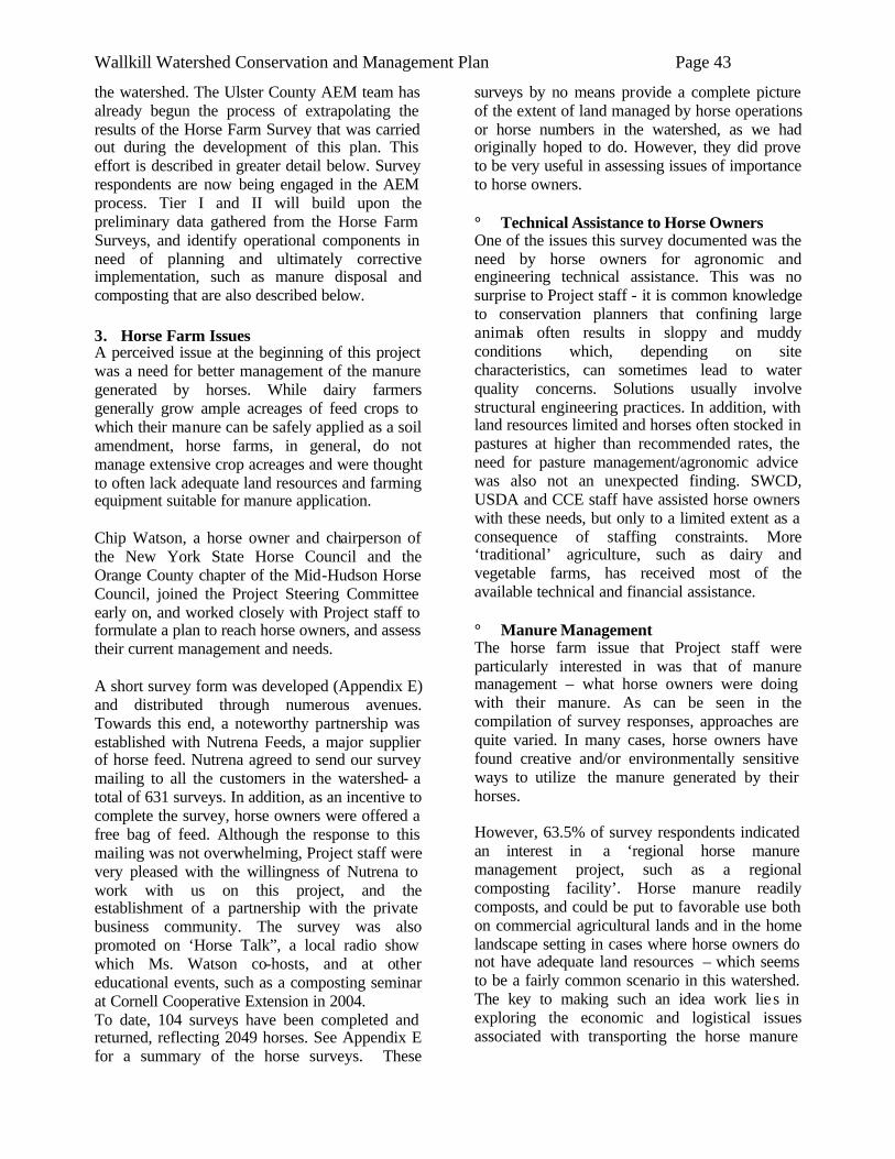
Wallkill Watershed Conservation and Management Plan Page 43
the watershed. The Ulster County AEM team has already begun the process of extrapolating the results of the Horse Farm Survey that was carried out during the development of this plan. This effort is described in greater detail below. Survey respondents are now being engaged in the AEM process. Tier I and II will build upon the preliminary data gathered from the Horse Farm Surveys, and identify operational components in need of planning and ultimately corrective implementation, such as manure disposal and composting that are also described below. 3. Horse Farm Issues A perceived issue at the beginning of this project was a need for better management of the manure generated by horses. While dairy farmers generally grow ample acreages of feed crops to which their manure can be safely applied as a soil amendment, horse farms, in general, do not manage extensive crop acreages and were thought to often lack adequate land resources and farming equipment suitable for manure application. Chip Watson, a horse owner and chairperson of the New York State Horse Council and the Orange County chapter of the Mid-Hudson Horse Council, joined the Project Steering Committee early on, and worked closely with Project staff to formulate a plan to reach horse owners, and assess their current management and needs. A short survey form was developed (Appendix E) and distributed through numerous avenues. Towards this end, a noteworthy partnership was established with Nutrena Feeds, a major supplier of horse feed. Nutrena agreed to send our survey mailing to all the customers in the watershed- a total of 631 surveys. In addition, as an incentive to complete the survey, horse owners were offered a free bag of feed. Although the response to this mailing was not overwhelming, Project staff were very pleased with the willingness of Nutrena to work with us on this project, and the establishment of a partnership with the private business community. The survey was also promoted on ‘Horse Talk”, a local radio show which Ms. Watson co-hosts, and at other educational events, such as a composting seminar at Cornell Cooperative Extension in 2004. To date, 104 surveys have been completed and returned, reflecting 2049 horses. See Appendix E for a summary of the horse surveys. These
surveys by no means provide a complete picture of the extent of land managed by horse operations or horse numbers in the watershed, as we had originally hoped to do. However, they did prove to be very useful in assessing issues of importance to horse owners. ° Technical Assistance to Horse Owners One of the issues this survey documented was the need by horse owners for agronomic and engineering technical assistance. This was no surprise to Project staff - it is common knowledge to conservation planners that confining large animals often results in sloppy and muddy conditions which, depending on site characteristics, can sometimes lead to water quality concerns. Solutions usually involve structural engineering practices. In addition, with land resources limited and horses often stocked in pastures at higher than recommended rates, the need for pasture management/agronomic advice was also not an unexpected finding. SWCD, USDA and CCE staff have assisted horse owners with these needs, but only to a limited extent as a consequence of staffing constraints. More ‘traditional’ agriculture, such as dairy and vegetable farms, has received most of the available technical and financial assistance. ° Manure Management The horse farm issue that Project staff were particularly interested in was that of manure management – what horse owners were doing with their manure. As can be seen in the compilation of survey responses, approaches are quite varied. In many cases, horse owners have found creative and/or environmentally sensitive ways to utilize the manure generated by their horses. However, 63.5% of survey respondents indicated an interest in a ‘regional horse manure management project, such as a regional composting facility’. Horse manure readily composts, and could be put to favorable use both on commercial agricultural lands and in the home landscape setting in cases where horse owners do not have adequate land resources – which seems to be a fairly common scenario in this watershed. The key to making such an idea work lies in exploring the economic and logistical issues associated with transporting the horse manure
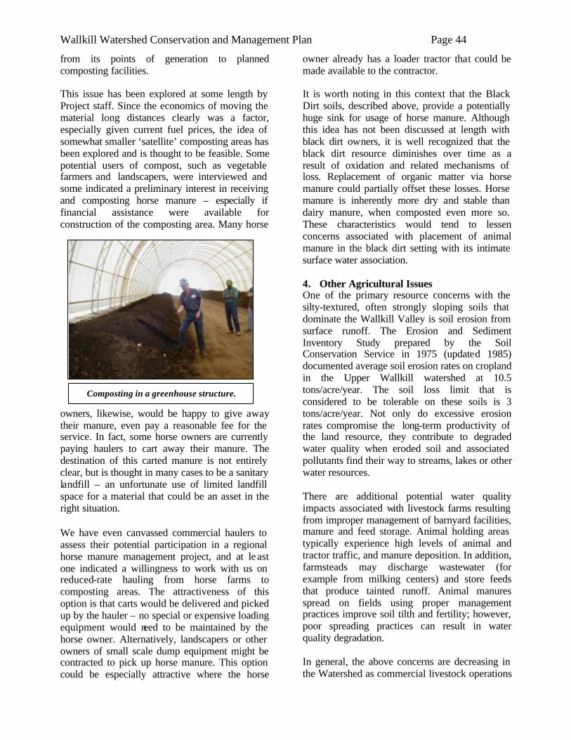
Wallkill Watershed Conservation and Management Plan Page 44
Composting in a greenhouse structure.
from its points of generation to planned composting facilities. This issue has been explored at some length by Project staff. Since the economics of moving the material long distances clearly was a factor, especially given current fuel prices, the idea of somewhat smaller ‘satellite’ composting areas has been explored and is thought to be feasible. Some potential users of compost, such as vegetable farmers and landscapers, were interviewed and some indicated a preliminary interest in receiving and composting horse manure – especially if financial assistance were available for construction of the composting area. Many horse
owners, likewise, would be happy to give away their manure, even pay a reasonable fee for the service. In fact, some horse owners are currently paying haulers to cart away their manure. The destination of this carted manure is not entirely clear, but is thought in many cases to be a sanitary landfill – an unfortunate use of limited landfill space for a material that could be an asset in the right situation. We have even canvassed commercial haulers to assess their potential participation in a regional horse manure management project, and at least one indicated a willingness to work with us on reduced-rate hauling from horse farms to composting areas. The attractiveness of this option is that carts would be delivered and picked up by the hauler – no special or expensive loading equipment would need to be maintained by the horse owner. Alternatively, landscapers or other owners of small scale dump equipment might be contracted to pick up horse manure. This option could be especially attractive where the horse
owner already has a loader tractor that could be made available to the contractor. It is worth noting in this context that the Black Dirt soils, described above, provide a potentially huge sink for usage of horse manure. Although this idea has not been discussed at length with black dirt owners, it is well recognized that the black dirt resource diminishes over time as a result of oxidation and related mechanisms of loss. Replacement of organic matter via horse manure could partially offset these losses. Horse manure is inherently more dry and stable than dairy manure, when composted even more so. These characteristics would tend to lessen concerns associated with placement of animal manure in the black dirt setting with its intimate surface water association. 4. Other Agricultural Issues One of the primary resource concerns with the silty-textured, often strongly sloping soils that dominate the Wallkill Valley is soil erosion from surface runoff. The Erosion and Sediment Inventory Study prepared by the Soil Conservation Service in 1975 (updated 1985) documented average soil erosion rates on cropland in the Upper Wallkill watershed at 10.5 tons/acre/year. The soil loss limit that is considered to be tolerable on these soils is 3 tons/acre/year. Not only do excessive erosion rates compromise the long-term productivity of the land resource, they contribute to degraded water quality when eroded soil and associated pollutants find their way to streams, lakes or other water resources. There are additional potential water quality impacts associated with livestock farms resulting from improper management of barnyard facilities, manure and feed storage. Animal holding areas typically experience high levels of animal and tractor traffic, and manure deposition. In addition, farmsteads may discharge wastewater (for example from milking centers) and store feeds that produce tainted runoff. Animal manures spread on fields using proper management practices improve soil tilth and fertility; however, poor spreading practices can result in water quality degradation. In general, the above concerns are decreasing in the Watershed as commercial livestock operations
Wallkill Watershed Conservation and Management Plan Page 45
go out of business and associated cropland areas go out of agricultural use. As noted elsewhere in this Plan, there are ample and important reasons for trying to preserve agriculture. Hopefully, existing and future efforts to maintain a viable agricultural industry will be successful, and resources will continue to made available for agencies such as Soil and Water Conservation Districts and USDA NRCS to assist these remaining farms in addressing soil quality and runoff control measures.
Education
The importance of education efforts – for municipal officials, builders, engineers and others – in effecting improved watershed protection is mentioned in several sections of this Plan. An area of education often neglected, though, is that of youth education. It can be argued that instilling natural resource stewardship values in young people is an effective, if not essential, component of watershed protection. Yet financial resources available to support such efforts can be very difficult to secure. Orange County SWCD has found this to be one of the most challenging program areas to fund. Despite these challenges, Orange County has to be considered a leader in terms of youth conservation education efforts. Currently, a full-time staff person at OCSWCD devotes most of her time to youth conservation education (focused largely on the formal school setting), and two contract educators from the Orange County Water Authority conduct complementary programming. Many other organizations deliver conservation education programming, though the availability of these programs often seems to depend on the vagaries of annual budget decisions. As our young people grow up and become decision makers in their communities, we are convinced that locally oriented lessons they experienced will stay with them and influence their adult behavior.
Challenges to Biodiversity
Major impacts that humans have had on the watershed’s biological diversity can be outlined as:
° Degradation of Habitat Few, if any, habitats in the Wallkill Watershed are unaffected by the presence of humans. We eliminate natural cover such as trees or shrubs to make way for buildings, pavement, or non-native plant life, while polluting or disturbing other habitats that we don’t remove. Even areas that are out of direct human reach are still vulnerable to acid precipitation, groundwater pollution, and the effects of human-induced global warming. ° Creation of a Fragmented Landscape Construction of roads, canals, railroads, airports, drainage ditches, dams, power lines and fences; a dramatic rise in the rate of housing construction and tree removal, notably in the last few decades; and increases in the average residential lot size (which spreads the impacts across more area) all slice the natural landscape into smaller, less valuable tracts of land. Fragmentation reduces the ability of individual animals to move from one place to another and can lead to habitat isolation. Wildlife populations in isolated fragments are stressed more readily than populations with more land area, food, water, and habitat. Fragmentation and isolation seriously threaten biological diversity and the functioning of natural systems.5 ° Wetland Degradation and Loss Though wetlands serve many valuable functions, they are frequently assaulted through contamination, isolation (from adjacent habitats), drainage, filling, or other destruction. A historic example is the Black Dirt Region in southern Orange County, which was originally a vast Atlantic white cedar swamp. It was cleared and drained for agricultural uses due to its fertile muck soils. Today, there are only a handful of Atlantic white cedar swamps in the County. This natural community is extremely rare elsewhere in New York State as well. ° Channelization of Wallkill River In the 1940s, the Army Corps of Engineers created an alternate route for the Wallkill’s channel, digging a straighter, deeper channel in order to move water downstream faster and 5 Soulé, M. 1991. Land use planning and wildlife maintenance: Guidelines for conserving wildlife in an urban landscape. Journal of the American Planning Assoc. 57(3):313-323. Forman, R. 1995. Land Mosaics: The Ecology of Landscape and Regions. Cambridge University Press, Cambridge.
Wallkill Watershed Conservation and Management Plan Page 46
alleviate much of the frequent flooding the Wallkill triggered. Unfortunately, this channelization has reduced species diversity and impaired water quality in the River. Channelization directly removes fish, invertebrate, amphibian and reptile habitat. In addition, it aggravates stream sedimentation that smothers habitat. Today, fish species are minimal and a high percentage of those present are not native to the River. In 1936, there were 48 species of fish in the River; in the early 1990s, only 16 species were found and at number totals just one quarter of the total fish population that was present in 1936. As well, water levels and biological diversity of wetlands flanking the river have also decreased, because the channelization has separated them from the water flow. ° Modifications to Riparian Zone The greatest threat to stream biodiversity may be the total clearing of riparian vegetation for residential or commercial development. Forested areas along streams have many crucial functions. They act as wildlife refuges; provide shading and woody debris important to the stream ecosystem; mitigate flood damage; help protect the stream bank from erosion; and filter out pollutants from upland runoff. ° Creation of Impervious Surface Construction of buildings and the paving of the ground not only displace species by eliminating habitat, but increase impervious surfaces that directly impact water quality and local species distribution.
Water Quality Degradation Some symptoms of impaired water quality for fish and wildlife include: ° Sedimentation is excess suspended sediments in surface water caused by soil erosion along stream banks or in upland areas of the watershed. It can smother the nests of fish, salamanders, and invertebrates eaten by predatory fish such as trout. ° Excess nutrients in surface water results from sewage outfalls into streams as well as from land uses that involve fertilizers. Too many nutrients (mainly nitrogen and phosphorous) cause algal blooms that lead to low dissolved
oxygen levels , often killing large populations of fish and other aquatic life. ° Temperature increases result from deforestation along stream banks, eliminating shade, and increasing warm surface water runoff into streams. Warming of water changes the species composition within streams. ° Toxic substances have the potential to accumulate in the tissues of animals and cause harmful effects. Though little is known about toxins in the watershed, potent chemicals continue to be discovered throughout the area. DDT and PCBs have already been documented within the Wallkill River, while substances such as dioxin, polycyclic aromatic hydrocarbons (PAHs), prescription and over-the-counter drugs, brominated diphenyl ethers (BDEs), and other endocrine disruptors all have the potential to be harmful and require more study to determine their effects on wildlife. ° Stormwater contaminants arrive in many streams through storm drains that empty runoff from streets and parking lots. Myriad pollutants, liquid and solid, in this water impair the health of streams and stream banks. ° Dam construction – Of all of the dams that were installed along the rivers and streams to produce hydropower for mills, scores of them were never demolished. Presently, there are four major dams in the watershed, located at Montgomery, Walden, Wallkill and Rifton, which are still used to generate hydroelectric power for industrial and other users. Dams impede migration of fish and other aquatic species. They increase water temperature, lower the amount of oxygen dissolved in the water, decrease water flow, and ultimately change the aquatic environment. (Appendix F)
Wetlands Degradation There are thousands of acres of mapped wetlands in the Wallkill Watershed. In addition, many thousand more acres that have not been mapped could be expected to meet federal wetland criteria based on soil and vegetation if watershed-wide mapping were to be done. As an example, new development sites of any substantial size commonly contain federal jurisdictional wetlands
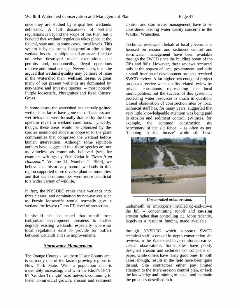
Wallkill Watershed Conservation and Management Plan Page 47
once they are studied by a qualified wetlands delineator. A full discussion of wetland regulations is beyond the scope of this Plan, but it is noted that wetland regulation takes place at the federal, state and, in some cases, local levels. This system is by no means fool-proof at eliminating wetland losses – multiple small areas are filled or otherwise destroyed under exemptions and permits and, undoubtedly, illegal operations remove additional acreage. Nevertheless, it can be argued that wetland quality may be more of issue in the Watershed than wetland losses. A great many of our present wetlands are dominated by non-native and invasive species – most notably Purple loosestrife, Phragmites and Reed Canary Grass. In some cases, the watershed has actually gained wetlands as farms have gone out of business and wet fields that were formally drained by the farm operator revert to wetland conditions. Typically, though, these areas would be colonized by the species mentioned above as opposed to the plant communities that comprised the wetland before human intervention. Although some reputable authors have suggested that these species are not as valueless as commonly believed (see, for example, writings by Eric Kiviat in “News from Hudsonia”, Volume 14, Number 2, 1999), we believe that historically natural wetlands in this region supported more diverse plant communities, and that such communities were more beneficial to a wider variety of wildlife. In fact, the NYSDEC ranks their wetlands into three classes, and domination by non-natives such as Purple loosestrife would normally give a wetland the lowest (Class III) level of protection. It should also be noted that runoff from (sub)urban development threatens to further degrade existing wetlands, especially where no local regulations exist to provide for buffers between wetlands and site improvements.
Stormwater Management The Orange County - southern Ulster County area is currently one of the fastest growing regions in New York State. With a population that is inexorably increasing, and with the Rte.17/I-84/I-87 ‘Golden Triangle’ road network continuing to foster commercial growth, erosion and sediment
control, and stormwater management, have to be considered leading water quality concerns in the Wallkill Watershed.
Technical reviews on behalf of local governments focused on erosion and sediment control and stormwater management have been available through the SWCD since the building boom of the 70’s and 80’s. However, these reviews occurred only at the request of local government, and only a small fraction of development projects received SWCD review. A far higher percentage of project proposals receive water quality-related review by private consultants representing the local municipalities, but the success of this system in protecting water resources is much in question. Casual observation of construction sites by local technical staff has, for many years, suggested that very little knowledgeable attention was being paid to erosion and sediment control. (Witness, for example, the common construction site benchmark of the silt fence – as often as not ‘flapping in the breeze’ while silt flows
underneath, or, improperly installed up-and-down the hill – concentrating runoff and causing erosion rather than controlling it.). More recently, largely as a result of funding made available through NYSDEC which supports SWCD technical staff, scores of in-depth construction site reviews in the Watershed have reinforced earlier casual observations. Some sites have poorly designed erosion and sediment control plans on paper, while others have fairly good ones. In both cases, though, results in the field have been quite dismal. Site contractors either pay limited attention to the site’s erosion control plan, or lack the knowledge and training to install and maintain the practices described in it.
Uncontrolled urban erosion.
Wallkill Watershed Conservation and Management Plan Page 48
While the erosion and siltation associated with urban construction activities are primarily limited to the active construction phase when large areas tend to be disturbed and unprotected with vegetation, the impacts can be severe. For example, the New York Standards and Specifications for Erosion and Sediment Control offers sample calculations for a typical NY construction site where the erosion rate during the active construction phase is over 100 tons per acre per year (page A.2). For comparison purposes, erosion from a forested or grassy area would be expected to be less than 1 ton per acre per year. Where water resources such as streams are associated with the construction sites, there is high potential for movement of soil and related pollutants to enter and degrade the aquatic system.
The suggestion that urban pollutants are impacting water resources in the Wallkill Watershed is corroborated by NYS DEC’s Priority Waterbodies List. The Wallkill River, and a number of its tributaries, are listed in this document. Silt/sediment is cited as a primary pollutant (of the Upper Wallkill), and urban runoff is cited as a suspected source. So far as we know, no research has been conducted to assess the portion of the Wallkill’s sediment load that originates from (sub)urban as opposed to other sources. But given the documented high rates of erosion from con- struction sites, the rapid pace of development in the Watershed, and the questionable effectiveness of erosion and sediment control efforts on these sites as alluded to above, targeting urban sources must be considered a prudent management goal. See page 31 of this Plan for a summary of the suspended sediment study that was undertaken on the Wallkill in 2004/2005. In an effort to gain a slightly greater understanding of urban erosion threats and where they are most concentrated in the Watershed, an investigation was made using construction permit data from the NYSDEC. For convenience of GIS analysis, the map (Map 15) is organized by zip code areas (note that some areas outside the Watershed boundary are included in this study area). The map shows which zip code areas have the highest acreage under construction as reported in NYS’s stormwater phase II general permit database. While calculation of tons of sediment generated was not possible, this
procedure at least provides a general measure of construction activity. Given the potentially huge per acre erosion rates from urban construction sites, as described earlier in this Plan, this evaluation underscores the need for accelerated urban erosion and sediment control efforts. It is well recognized that, even after urban development projects have completed construction and stabilized bare soils, water quality threats continue. These impacts will not be elaborated here since they are well described already in many publications (see, for example, the New York State Stormwater Management Design Manual), but include both quantity (eg. flooding, streambank erosion), and quality (eg. eutrophication, bacteria) issues. Construction phase and post-development water quality concerns are regulated in NYS by the Stormwater Phase II program mentioned above, but regulation does not automatically mean adequate protection of water resources. As of 4/06, there were approximately 222 (Orange County) active construction permits in the zip code areas intersecting the Watershed. (All sites disturbing more than 1 acre are required to gain coverage under this general permit. Given this low threshold and the relative newness of the regulation, it is thought that many additional construction sites are operating without having gained coverage under the permit program; therefore are not reflected in these numbers). Despite accelerated efforts of NYSDEC and SWCD’s, technical staffing is currently far inadequate to allow for comprehensive oversight of this program. It is worth noting that the construction permit includes, for most sites, a requirement that weekly inspections be done by a ‘qualified professional’. Unfortunately, despite enormous costs associated with these weekly inspections, it can be argued that these required inspections are of limited usefulness in improving water protection efforts. The reasons for this lack of effectiveness are as described above, combined with the fact that the consulting engineering firms performing the inspections have limited authority/influence to enforce their inspection recommendations. As with site operators/ developers, education is also an issue with some private inspectors. While the regulation states that the inspections will be done by a ‘qualified professional’ (or a technician working under
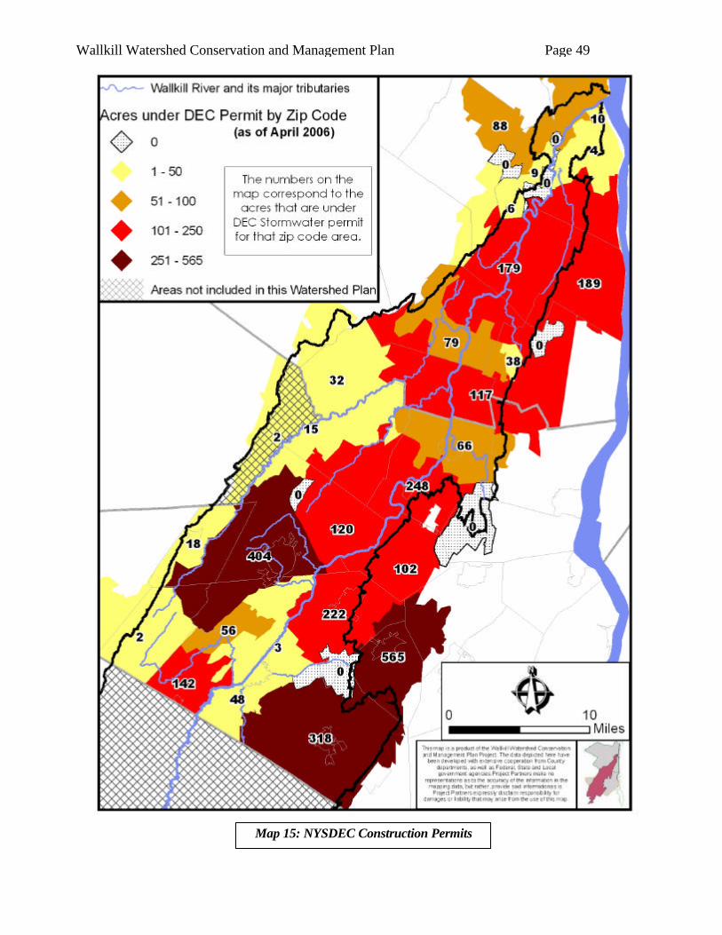
Wallkill Watershed Conservation and Management Plan Page 49
Map 15: NYSDEC Construction Permits
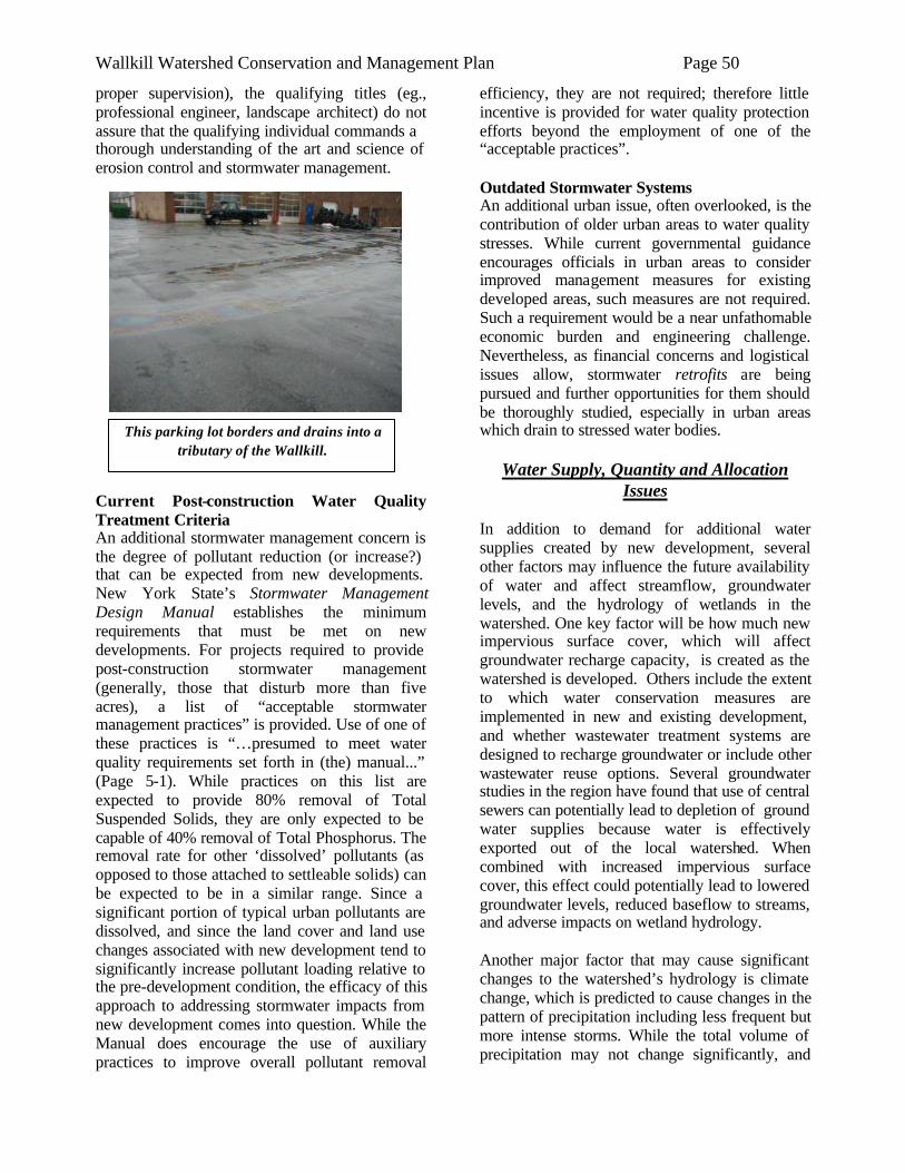
Wallkill Watershed Conservation and Management Plan Page 50
This parking lot borders and drains into a tributary of the Wallkill.
proper supervision), the qualifying titles (eg., professional engineer, landscape architect) do not assure that the qualifying individual commands a thorough understanding of the art and science of erosion control and stormwater management.
Current Post-construction Water Quality Treatment Criteria An additional stormwater management concern is the degree of pollutant reduction (or increase?) that can be expected from new developments. New York State’s Stormwater Management Design Manual establishes the minimum requirements that must be met on new developments. For projects required to provide post-construction stormwater management (generally, those that disturb more than five acres), a list of “acceptable stormwater management practices” is provided. Use of one of these practices is “…presumed to meet water quality requirements set forth in (the) manual...” (Page 5-1). While practices on this list are expected to provide 80% removal of Total Suspended Solids, they are only expected to be capable of 40% removal of Total Phosphorus. The removal rate for other ‘dissolved’ pollutants (as opposed to those attached to settleable solids) can be expected to be in a similar range. Since a significant portion of typical urban pollutants are dissolved, and since the land cover and land use changes associated with new development tend to significantly increase pollutant loading relative to the pre-development condition, the efficacy of this approach to addressing stormwater impacts from new development comes into question. While the Manual does encourage the use of auxiliary practices to improve overall pollutant removal
efficiency, they are not required; therefore little incentive is provided for water quality protection efforts beyond the employment of one of the “acceptable practices”. Outdated Stormwater Systems An additional urban issue, often overlooked, is the contribution of older urban areas to water quality stresses. While current governmental guidance encourages officials in urban areas to consider improved management measures for existing developed areas, such measures are not required. Such a requirement would be a near unfathomable economic burden and engineering challenge. Nevertheless, as financial concerns and logistical issues allow, stormwater retrofits are being pursued and further opportunities for them should be thoroughly studied, especially in urban areas which drain to stressed water bodies.
Water Supply, Quantity and Allocation Issues
In addition to demand for additional water supplies created by new development, several other factors may influence the future availability of water and affect streamflow, groundwater levels, and the hydrology of wetlands in the watershed. One key factor will be how much new impervious surface cover, which will affect groundwater recharge capacity, is created as the watershed is developed. Others include the extent to which water conservation measures are implemented in new and existing development, and whether wastewater treatment systems are designed to recharge groundwater or include other wastewater reuse options. Several groundwater studies in the region have found that use of central sewers can potentially lead to depletion of ground water supplies because water is effectively exported out of the local watershed. When combined with increased impervious surface cover, this effect could potentially lead to lowered groundwater levels, reduced baseflow to streams, and adverse impacts on wetland hydrology. Another major factor that may cause significant changes to the watershed’s hydrology is climate change, which is predicted to cause changes in the pattern of precipitation including less frequent but more intense storms. While the total volume of precipitation may not change significantly, and
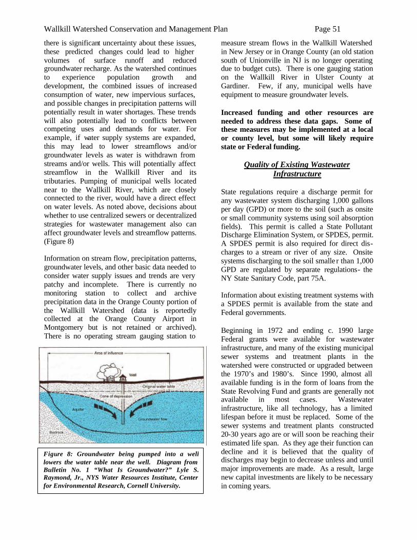
Wallkill Watershed Conservation and Management Plan Page 51
there is significant uncertainty about these issues, these predicted changes could lead to higher volumes of surface runoff and reduced groundwater recharge. As the watershed continues to experience population growth and development, the combined issues of increased consumption of water, new impervious surfaces, and possible changes in precipitation patterns will potentially result in water shortages. These trends will also potentially lead to conflicts between competing uses and demands for water. For example, if water supply systems are expanded, this may lead to lower streamflows and/or groundwater levels as water is withdrawn from streams and/or wells. This will potentially affect streamflow in the Wallkill River and its tributaries. Pumping of municipal wells located near to the Wallkill River, which are closely connected to the river, would have a direct effect on water levels. As noted above, decisions about whether to use centralized sewers or decentralized strategies for wastewater management also can affect groundwater levels and streamflow patterns. (Figure 8) Information on stream flow, precipitation patterns, groundwater levels, and other basic data needed to consider water supply issues and trends are very patchy and incomplete. There is currently no monitoring station to collect and archive precipitation data in the Orange County portion of the Wallkill Watershed (data is reportedly collected at the Orange County Airport in Montgomery but is not retained or archived). There is no operating stream gauging station to
measure stream flows in the Wallkill Watershed in New Jersey or in Orange County (an old station south of Unionville in NJ is no longer operating due to budget cuts). There is one gauging station on the Wallkill River in Ulster County at Gardiner. Few, if any, municipal wells have equipment to measure groundwater levels. Increased funding and other resources are needed to address these data gaps. Some of these measures may be implemented at a local or county level, but some will likely require state or Federal funding.
Quality of Existing Wastewater Infrastructure
State regulations require a discharge permit for any wastewater system discharging 1,000 gallons per day (GPD) or more to the soil (such as onsite or small community systems using soil absorption fields). This permit is called a State Pollutant Discharge Elimination System, or SPDES, permit. A SPDES permit is also required for direct dis- charges to a stream or river of any size. Onsite systems discharging to the soil smalle r than 1,000 GPD are regulated by separate regulations- the NY State Sanitary Code, part 75A. Information about existing treatment systems with a SPDES permit is available from the state and Federal governments. Beginning in 1972 and ending c. 1990 large Federal grants were available for wastewater infrastructure, and many of the existing municipal sewer systems and treatment plants in the watershed were constructed or upgraded between the 1970’s and 1980’s. Since 1990, almost all available funding is in the form of loans from the State Revolving Fund and grants are generally not available in most cases. Wastewater infrastructure, like all technology, has a limited lifespan before it must be replaced. Some of the sewer systems and treatment plants constructed 20-30 years ago are or will soon be reaching their estimated life span. As they age their function can decline and it is believed that the quality of discharges may begin to decrease unless and until major improvements are made. As a result, large new capital investments are likely to be necessary in coming years.
Figure 8: Groundwater being pumped into a well lowers the water table near the well. Diagram from Bulletin No. 1 “What Is Groundwater?” Lyle S. Raymond, Jr., NYS Water Resources Institute, Center for Environmental Research, Cornell University.
Wallkill Watershed Conservation and Management Plan Page 52
Another well-known issue that affects the quality of wastewater discharges and the ability of infrastructure to protect water quality is known as infiltration and inflow, or I&I. This results when rainwater at the surface or underground leaks into sewers and manholes. In larger storms, this can lead to large volumes of stormwater flowing to wastewater treatment plants, sometimes causing overflows of untreated sewage when the flow exceeds the plant’s capacity. Another problem that receives less attention is the reverse – when wastewater leaks out of sewers through leaky joints or cracks. This can lead to discharges of raw (untreated) wastewater to groundwater. These problems are generally hard to measure so their extent is not well documented, but it stands to reason that water will flow through cracks and leaky joints in either direction. Finally, centralized sewers may cause another problem – localized lowering of the water table because the trenches in which sewers are installed act as large French drains. While these problems are generally known to exist throughout NY and the US, the specific locations and extent of such problems in the Wallkill watershed is not well-documented. The Village of New Paltz recognizes this condition exists with their infrastructure and is researching the remediation and funding required to address this situation. One preliminary analysis of the larger SPDES discharges to the Wallkill River in Orange County was conducted recently by the Wallkill River Task Force. This study, based only on data available from routine reports submitted by the municipal permitees, found that several municipal systems are apparently very often in violation of their discharge permits for various parameters. This analysis, and other scientific and anecdotal information suggesting that wastewater discharges may be causing significant water quality problems, indicate the need for more detailed research on these questions. In any case, it’s quite clear that there is a major gap between existing resources and funding needed to upgrade existing wastewater infrastructure, let alone build new systems. This is true nationwide, and NY alone needs about $20 billion for wastewater system upgrades over the
next 20 years, the largest funding shortfall of any state. Individual onsite (septic) treatment systems, as noted above, are permitted by the Departments of Health (DOH) in most counties in NY State, including Orange and Ulster. The regulations focus on system siting and design and there are certain differences between the two counties. In general, though, unlike larger treatment systems, there are no regulations requiring ongoing monitoring, inspection, or maintenance of onsite systems. It is up to property owners to decide whether and how often to have septic tanks inspected and pumped out. Nationally, 10-20% of septic systems are estimated to be failing at any given time, but this is based on very incomplete data and may not be reliable. Anecdotal reports suggest that even today, septic systems are being installed and/or operated improperly in the Wallkill Watershed and other parts of NY State. In any case, there is general agreement that more training is needed for installers and inspectors, and the NY State Onsite Training Network, based at SUNY Delhi, is a partnership of NYS DEC and other organizations that provides training workshops around the state to address this need. The US EPA and NYS DEC are also encouraging local municipalities to develop management programs for onsite systems. The NYS DEC and SUNY-Delhi co-sponsor a statewide training program, called the Onsite Training Network, intended to improve the quality of onsite wastewater system siting, design, inspection and management. Workshops are held around NY State and can be arranged at the request of local governments or other organizations. Information about this program is available online at: http://www.delhi.edu/corporateservices/otn_wastewater_programs.asp, or at 800-96-DELHI. Natural Resources Management in a Home
Rule System New York is a ‘Home Rule’ state, a factor that impacts the delivery of environmental protection programs as much or more than it does other public policy. This is evidenced perhaps most in the role of local planning boards. While developers are obligated to comply with both federal and state regulations in the areas of,
Wallkill Watershed Conservation and Management Plan Page 53
for example, wetlands protection, transportation issues, and sewer and water, the local planning board holds enormous influence over the nature and specific characteristics of Site/Subdivision plans that come before the municipality. Admittedly, the rules/guidelines under which the planning board operates may have been designed by another municipal entity such as the Town Board. In any event, the potential impact in terms of successful natural resource protection programming, of an effective partnership with local municipal government cannot be overstated. For example, wetland and watercourse protection beyond the minimum protections offered by state and federal regulations is most commonly and effectively done by local law or ordinance. Local government employees can obviously keep much closer tabs on activities in their own jurisdiction than federal or state employees with often wide-ranging geographic areas of responsibility. Other innovative [but not mandatory] land use principles such as Low Impact Development, which hold tremendous potential to mitigate the negative impacts of (sub)urbanization on natural systems, can best be brought into the mainstream by local governments. To understand how municipalities compared to one another in terms of local regulations, the Planning Departments from Ulster and Orange Counties completed a review of municipal plans and codes. Both Orange and Ulster County Planning Departments examined the master plans, zoning codes, subdivision regulations, and other relevant municipal land use documents for all municipalities within the Watershed during this planning process. The intent of this study was both to develop an inventory of existing municipal land use goals and regulations, as well as to determine if any generalizations could be made in regards to local environmental regulations within the Watershed. Appendix G contains the spread-sheet developed by the two Planning Departments. A primary finding of the research was a widespread disconnect between master plans and the local codes and regulations that were meant to implement the visions within the master plans. Master plans were nearly unanimous in their support for maintaining rural character and protecting natural features, while activities within the municipality (development and construction
activities, for example) did not support the stated vision. There are myriad explanations and reasons for this trend - which was not a surprising find - and there are indeed many courses of action that could be taken to improve this scenario. The development of focused advisory councils, such as conservation advisory councils (CACs), could potentially help to make this connection if those councils were both comprehensive in their inventories of natural and cultural resources, as well as effective at protecting these resources through their advisory role to the municipal boards and officials. Other key findings include: ° A lack of adequate protections for wetlands,
watercourses and steep slopes ° A higher proportion of Ulster County
communities have a council committed to environmental or natural resource protection as compared to Orange County communities
° Few communities required that sensitive or unbuildable environmental areas be subtracted from net area during calculation of lot number during the subdivision process
° Orange County communities are more likely than Ulster County communities to utilize overlay zones as methods of protecting natural resources
Wallkill Watershed Conservation and Management Plan Page 54
Black Dirt Region 1. Soil Conservation Continued promotion and support for black dirt soil conservation measures, especially winter cover crop and ditch bank seeding, is necessary. In addition to financial support for implementing these practices, resources are needed to support staff to work with growers on practice adoption, address technical issues, develop new practice approaches and perform related administrative functions.
2. Streambank Stabilization Given the clear identification of sediment as a priority pollutant in the Wallkill, and the contribution of streambank erosion to this problem, we recommend efforts to identify potential stream corridor restoration and streambank stabilization sites, and to conduct additional planning on promising sites. Stabilization of already-failing bank sections as well as a continued maintenance program is expected to be a long-term effort. Staff will be needed to manage all technical, regulatory and administrative matters. Identification of additional funding sources will be important since work of this nature, even if full-bank rip-rap is not undertaken, will involve considerable expense. Combining funding from multiple sources will most likely be necessary to make the projects feasible. The exact approach taken to stabilize the River banks may undergo adjustment as projects are completed and evaluated, but this issue clearly needs continued attention and resources in order to address documented water quality conditions. Starting new projects and meeting the involved stakeholders inevitably leads to ideas for additional projects. As feasible, new staff would allow for consideration of more extensive stream corridor restoration projects as investigations are undertaken for identified bank stabilization projects. 3. Flood Control The importance of effective flood measures to
continued agricultural use of the Black Dirt is discussed in the Issues section of this Plan. While the planning and procurement of improved flood control measures is largely beyond the scope of the Plan, we do advocate for such initiatives. There are conflicting opinions regarding human activities in flood-prone areas. For example, while new development in floodplains is widely recognized to be undesirable, what should be done about existing commercial, residential or agricultural development in these areas is a more complex issue. The values of having agriculture in the watershed landscape are discussed at some length in this Plan, as is the high productivity of the Black Dirt soils. Therefore, this Plan supports continued efforts to implement flood control measures for protection of the Black Dirt agricultural lands. In 2005, the Orange County SWCD requested that the USDA NRCS investigate the feasibility of a Public Law 566 flood control project for the Black Dirt. This investigation is still in the early stages. In addition, the Army Corps of Engineers, who undertook a clearing and snagging project on the Black Dirt section of the Wallkill in the mid-eighties, has been asked by local growers and legislators to evaluate which current programs under their purview could be accessed to address Black Dirt flooding, drainage and soil stabilization issues. Ideally, the various federal agencies with program responsibilities in these areas would coordinate and combine their efforts. Continued strong lobbying by local growers and officials will undoubtedly be necessary, given the limited staffing and other priorities these agencies are facing.
Horse Farms Recent investigations indicate that there are over 600 horse owners in the Watershed. While many of these are smaller, ‘backyard’-type operations, the sheer number of owners argues for more attention to this issue. In addition, there are approximately 100 ‘commercial’ horse operations in the watershed – many of them concentrated along the main stem of the Wallkill.
IIVV.. RREECCOOMMMMEENNDDAATTIIOONNSS AANNDD IIMMPP LLEEMMEENNTTAATTIIOONN SSTTRRAATTEEGG YY
Wallkill Watershed Conservation and Management Plan Page 55
1. Coordinate Regional Manure Composting System
We recommend efforts to coordinate and foster partnerships between horse owners and potential composters by various means including meetings, mailings, web postings and direct farmer/horse owner contacts. We would also provide technical assistance on manure holding/transfer facilities, composting methods and manure utilization. We would also explore opportunities for equipment borrowing and demonstration projects – for example, compost turners, and promote the use of composted manure in the ever-growing home landscape setting as a beneficial use, as well as in the commercial agriculture setting. This outreach and partnership initiative will also be aimed at commercial landscapers who may play a role in the collection, composting and beneficial use of manure. An initial short term (2 year) goal would be to establish three composting facilities that receive manure from neighboring horse owners. 2. Identify Habitat Enhancement
Opportunities The outreach and dialogue with horse owners will also include discussions about habitat enhancement methods that are compatible with horse farming, with an initial short term goal of identifying 25 owners interested in participating in habitat enhancement projects on their land. Longer term goals would include seeking funding for these projects and implementing them.
Other Agriculture
Similar to the Black Dirt Region, erosion is an ongoing resource concern throughout the Watershed. In addition, animal agriculture beyond horse farms (for example, dairy, dairy replacement, beef and miscellaneous other livestock) maintains a respectable position, and demands attention to associated water quality concerns. This Plan recommends maintaining strong levels of staff support from SWCD’s, USDA-NRCS and Cornell Cooperative Extension to ensure that all interested farmers receive technical support and access to funding opportunities for erosion control, water quality protection, and related natural resource management projects.
Ulster AEM
Through the Tiered AEM approach, both watershed enhancement opportunities and prospective partnerships will be identified, which can facilitate overall improvement in water and environmental quality. Through the application of the County AEM Strategies, both restoration (C-corrective) and protective (P-preventative) actions will be defined on each agricultural operation which include but are not necessarily limited to: 1) Evaluating the potential for increased participation in USDA Farm Bill, NYS Ag Non Point Source Water Quality Grants, and other available programs for conservation. (C); 2) Work with the Ulster County Agricultural and Farmland Protection Board and the local citizens working groups to update the Farmland Protection Plan for Ulster County, which can identify new issues and opportunities. (P); 3) Inventory and identify critical wetland and buffer areas in the vicinity of agricultural operations. (C); 4) Provide additional outreach and education to agricultural producers and the community (and groups such as Citizens Advisory Committees) on watershed stewardship issues. (P); 5) Implement USDA Farm Bill, NYS Ag Non Point Source Water Quality Grants and other available conservation programs. (C); and 6) Participate with local municipal boards in updating town master and open space plans, (P). Among the long term goals that will hopefully be derived as a result of actively implementing the County AEM strategies would be the following: 1. Promote Vegetative Cover and Riparian
Buffers Establish and enhance vegetative cover, and riparian buffers in identified areas that will reduce cropland erosion, overall loss in forest and vegetative cover, and streambank erosion. 2. Address non point source runoff attributed
to agricultural activity. 3. Education and Outreach Strive to improve community relations between agricultural producers and new arrivals from urban areas through education and outreach, as needed.
Wallkill Watershed Conservation and Management Plan Page 56
Education
The greatest cost of a viable youth conservation education program is associated with staffing. The continuation of these programs should not depend on grants or other soft, unreliable funding streams. Conservation Educators should be considered essential staff for local conservation agencies. School budget issues, by and large, make it very difficult for schools to pay for conservation educators to come in to the classrooms. Therefore, we believe it is incumbent on conservation agencies to secure funding support for these programs. Achieving success will likely require creative funding efforts, combining both locally generated base funding and continued pursuit of grants and other opportunities. We hope, and recommend that, governments and other funding agencies maintain a commitment to youth conservation education programs such as that demonstrated by Orange County. The Town of Montgomery and the Wallkill River Task Force have proposed the development of a Wallkill River Watershed Interpretive Center at the Benedict Farm Park, a town-owned site on the banks of the Wallkill River that is being developed for recreational and educational uses. This site is centrally located in the northern part of Orange County, accessible to people in Ulster County, and includes several existing buildings as well as ample open space that can house interpretive trails, indoor exhibits, workshops and meetings, and other educational programs. The development of this Interpretive Center, which could potentially also house a small office for organizations working on watershed issues, would provide a good centerpiece and foundation for ongoing implementation of watershed projects and programs and is recommended as an action item in this Plan. The site can also include demonstration projects for low impact development stormwater practices and other strategies needed to protect water quality, habitat and open space, and can be used for training workshops for local officials, engineers, planners, and other audiences.
Stream Buffers/Riparian Corridors 1. Protect Valuable Intact and Restore
Degraded Riparian Corridors
We recommend that all municipalities within the Watershed adopt regulations to protect riparian areas from encroachment. We advocate for a tiered approach to stream protection and adoption of all or selected elements of the Stream Buffer Model Ordinance that is referenced in Appendix I to this Plan. The tiered approach in the Model Ordinance has three buffer zones; regulations are stricter for zones closer to the stream. Streams with certain features, such as being a high order stream or being bordered by steep slopes, are given protections supplemental to the standard zone protections. We urge the completion of further investigation and study of the projects sites shown on Map 7 to determine which sites are appropriate for future work. 2. Outreach to Municipalities on Stream
Buffers Local Planning Boards have authority to regulate streamside activities through the subdivision and site plan review process, but their power is constrained by the content of both the local master plan and the local zoning code. Project partners should work cooperatively to educate municipalities on both the values of stream corridors as well as the tools they can use to protect these resources.
Stormwater Management 1. Increase Erosion Control Compliance at
Construction Sites As noted already, current regulations require that an erosion control plan, prepared by a qualified professional, be prepared and implemented at every construction site disturbing more than one acre. Also noted is the observed poor performance of, or lack of, erosion and sediment control measures at the majority of sites visited by erosion control specialists from the SWCD. In many cases, though, once deficiencies are explained to site contractors, significant improvements are observed in subsequent site visits. We therefore believe that providing more staff for site visits would result in major improvements to overall construction site erosion and sediment control efforts and, consequently, to water quality protection. We believe that vast improvements can be expected by expansion of current initiatives such as the cooperative NYSDEC-
Wallkill Watershed Conservation and Management Plan Page 57
SWCD arrangement whereby non-regulatory SWCD staff visit sites as an alternative to visits from State inspectors. Non-regulatory stature often facilitates SWCD staff efforts to establish a good working relationship with site representatives. Nevertheless, a close working relationship between SWCD, NYSDEC and local municipal (e.g. Town, Village, and City) officials is considered essential in order for SWCD construction site inspections efforts to be successful. It should be noted that some site operators are not responsive to non-regulatory efforts to improve erosion and sediment control measures. Therefore, continued education about – and enforcement of – existing stormwater runoff regulations will be necessary to fully address erosion control compliance issues. As municipalities adopt local laws to comply with Stormwater Phase II regulations, local inspection and enforcement activities will, assumedly, become more commonplace and effective. However, not all Watershed municipalities are required to adopt these measures (see map 14 of regulated MS4 areas), leaving a potentially large gap in compliance efforts. Plus, even regulated municipalities will need technical and related assistance to achieve compliance goals. The Plan recommends that expanded staffing be sought, primarily at Soil and Water Conservation District offices, to assist with construction site erosion and sediment control compliance programs, and to generally assist communities with improving erosion and sediment control and stormwater management programs. 2. Stormwater Retrofit Planning As noted, current Stormwater Phase II regulations require stormwater controls on new development, but do not require treatment of runoff from existing urban areas. Given the extensive urban areas in our Watershed that were in place before current regulations went into effect, we recommend that a stormwater retrofit opportunity survey be a priority action for all municipalities in the Watershed. Since technical and financial resources will almost certainly be limited for such an initiative, we recommend that this survey focus on sites with amenable features (ie, room for more affordable, above-ground
facilities; publicly owned land or a cooperative private landowner). The Orange County MS4 Cooperation Project, funded by NYSDEC and currently underway, will conduct a preliminary retrofit survey, but only in MS4 regulated areas. Ulster County is in the process of further developing an intermunicipal agreement pertaining to shared services between some of its MS4 municipalities as well. Similar opportunities need to be explored in non-MS4 areas in both counties. Plus, site identification is only the first step. Considerable time and effort is required to build community support, secure necessary funding, and undertake technical investigations. We propose that this Plan include a component designed to pick up where the MS4 Cooperation Project left off. This will require devotion of staff time and related resources to fostering further planning of potential retrofit sites identified through the MS4 Cooperation Project, and to similarly assisting non-MS4 communities.
Impervious Surfaces Analysis
As more detailed watershed planning occurs in the future on the major sub-basins within the Wallkill, said planning should pay special attention to the Map 6 ‘red zones’ to ensure that planning efforts in these areas address imperviousness concerns. And while efforts to minimize the creation of new impervious areas should be promoted throughout the Watershed, planning in areas of lower imperviousness should thoroughly examine threats originating from agriculture, streambanks and other sources not related to impervious cover. The Plan recommends that the future percent impervious cover be studied through a build out analysis of the Watershed.
Biological Resources
1. Protect Stream-associated Wetlands Stream-associated wetlands are especially important natural areas to protect due to their intimate relationship with the water quality and biodiversity of the stream. Practices that would benefit both water quality and streamside wildlife include: ° maintaining natural flows and flooding regimes, ° leaving buffers around wetlands to prevent water contamination, and
Wallkill Watershed Conservation and Management Plan Page 58
° minimizing disturbance and development within riparian zones. The Plan recommends that existing mature and/or wide forest buffers be considered for conservation easement, as they are particularly valuable for wildlife. 2. Promote Biological Research within the
Watershed While some subwatersheds have a substantial amount of biological data available, other subwatersheds have had very few surveys conducted within their bounds. While all subwatersheds could benefit from further research, we recommend that those subwatersheds with the least amount of information be prioritized for future biological research. These include:
- Tin Brook - Dwaar Kill - Masonic Creek - Monhagen Brook
3. Protect Important Habitats The most biologically important habitats within the Watershed were outlined in the Biological Resources section of this Plan. Protecting these areas from encroachment, degradation, and destruction will help to ensure that the biological health and diversity within the Watershed is enjoyed by future generations. Protection can occur via conservation easement, purchase by a conservation organization, local regulation, incentive programs, and beneficial development and land management practices. In addition to land protection, the following land management actions are beneficial to biological diversity: ?? directing development away from sensitive and large, intact habitats, ?? maintaining early successional (grassland and shrubland) habitats, ?? encouraging mowing and haying schedules that avoid disruption of grassland bird breeding, ° implementing water management practices that maintain the hydrology of vernal pools and other wetlands, and ° implementing forestry practices that maintain woodland buffers around vernal pools. Woodland buffers around vernal pools and other wetlands are needed for specialized frogs and salamanders to complete their life cycles.
4. Create or Maintain Buffers Around Water Resources
Buffering these habitats is an essential step in protecting their functionality, health and quality, as well as the plants and animals that utilize them. Buffers preserve transition zones between land and waterbodies. Protecting and maintaining this connectivity is especially important to those species requiring both habitats during their life histories. 5. Reduce Fragmentation and Maintain
Habitat Connectivity Maintaining connectivity between similar habitat types within the watershed is important since transportation networks and other impervious surfaces commonly bisect otherwise contiguous habitats. This fragmentation often creates habitat islands within the landscape. Isolation and habitat degradation eventually lead to population decline, especially for those species characterized as having low motility, high sensitivity to habitat edge, or requiring large tracts of habitat for their survival. One way of enabling the persistence of species over time is by protecting large tracts of contiguous land while restoring connectivity in fragmented landscapes through the utilization of land use buffers and migration corridors. 6. Educate Landowners and Land Use
Decision makers Natural resource protection measures must occur over time and at multiple spatial scales. One method of ensuring such protection is by reaching out to landowners and land use decision makers. These two groups play a crucial role in deciding how land is managed within the watershed. Tailoring technical assistance and outreach programs to their particular needs promotes best management practices and better understanding of conservation issues and needs. In addition, cost sharing and collaboration commonly result as conservation goals are selected and as management plans are implemented.
Wetlands Degradation We would like to see a more formal evaluation/compilation of the quality and health of existing wetlands in the watershed. Some of this information may be available from NYSDEC and/or other sources. Some additional fieldwork will likely also be needed to complete such an
Wallkill Watershed Conservation and Management Plan Page 59
evaluation. In addition, we recommend a program to identify candidate wetland areas for improvement projects. There are numerous existing government programs that include wetland improvement as eligible projects, including but not limited to the USDA’s Wetland Reserve Program (WRP) and Wildlife Habitat Incentive Program (WHIP) and US Fish and Wildlife’s Partners for Wildlife program. However, utilization of these programs in the watershed is limited by the attention existing staff can devote to promoting these programs due to other workload demands. We believe that, with adequate outreach and dedicated attention, many more WRP, WHIP and other wetland-benefiting projects could be developed and implemented in the Watershed. Improvement projects could take many forms, but some examples are water table manipulation, biological controls (eg. release of loosestrife-eating beetles), other forms of non-native/invasive plant control, plantings of selected desirable species, or even controlled grazing to provide improved conditions for certain desired species such as bog turtles. Wetland losses must continue to be controlled via existing regulatory and educational efforts. In addition, though, we believe that accelerated efforts to identify, plan and implement wetland improvement projects should be considered a necessary component to a comprehensive watershed conservation plan.
Targeted Assistance to Municipalities There are 30 towns, villages and cities in the New York portion of the Wallkill Watershed. Local municipal boards play a crucial role in land use planning and can therefore have a major impact on addressing many of the priority watershed issues identified by the Watershed Project Steering Committee such as wetland protection, open space, biodiversity, stream protection, riparian buffers, sprawl and stormwater runoff. While the MS4 Cooperation Project mentioned elsewhere in this Plan will help to address some of these issues, biodiversity, wetland and stream protection are largely beyond the scope of the Phase II Stormwater Regulations.
1. Provide Technical Assistance to Munici-palities on Natural Resource Protection
Promoting higher levels of natural resource protection via proactive local programs is a goal identified in the Management Plan. We propose to provide targeted technical support to all receptive municipalities in the watershed directed at fostering such local efforts, which may include new local ordinances, or incentive-based programs such as Purchase of Development Rights or riparian buffer establishment where participants may receive financial or other incentives for participation. For example, in Ulster County, as mentioned above, there is already collaboration ongoing between the Village of New Paltz, the Soil and Water Conservation District, and USDA-NRCS which has resulted in the establishment of, and on-going maintenance of a riparian buffer system along the Wallkill River that is approximately one quarter of a mile in length. This effort is now in its second year. 2. Coordinate Local Conservation Advisory
Councils (CACs) CACs exist in four of the 20 municipa lities in the Orange County portion of the Watershed and in seven Ulster County municipalities. We propose to form a loose affiliation between the existing CAC’s where applicable to enhance exchange of ideas, promote the formation of additional CAC’s, and identify implementation projects similar to the above mentioned riparian buffer system established in the Village of New Paltz. Since CAC’s typically have limited resources, we propose to provide networking, training and related support to CAC’s. Ideas such as sample watercourse/wetland protection local laws, low impact development approaches, and stream-front landowner riparian improvement projects will be shared and highlighted, through a targeted newsletter aimed at – and contributed to by – CAC’s. Where no potential seems to exist for CAC formation, we will work directly with the appropriate municipal body to promote the same goals. This initiative will also include initial outreach to other potential partners for ideas. This would include, but not be limited to, landscaping contractors, garden centers, garden clubs, growers of landscaping plants, and others who can be involved in educating landowners and other decision-makers about landscape management
Wallkill Watershed Conservation and Management Plan Page 60
practices that can protect water quality and biodiversity. Low Impact Development (LID) and Better
Site Design (BSD)
The issues section of this Plan raises concerns with current New York State technical requirements for water quality treatment. Beyond water quality, concerns exist regarding other impacts of new development such as loss of open space and wildlife habitat, and other, less easily defined ‘quality of life’ considerations. LID (low impact development) and BSD (better site design) describe conceptual approaches to site design that attempt to minimize these potentially adverse impacts. Full discussion of these concepts is beyond the scope of this Plan, but plugging either term into an internet search engine will yield copious references and examples. A related term is ‘stormwater treatment trains’, which denotes routing stormwater runoff through multiple treatment practices, thereby offsetting the reduced pollutant removal efficiency of single -practice treatment, and providing insurance against poor performance of a single practice as a result of lack of maintenance or other reasons. The NYSDEC is currently working on a guidance document dealing with LID/BSD related concepts and how they can be employed within the framework of current stormwater management regulations. This Plan encourages local municipalities to fully explore opportunities to incorporate principles such as LID, BSD and stormwater treatment trains into the site plan approval process, and supports increasing local agency technical support to municipalities to provide education and assistance on these approaches.
Increase Water-Related Recreational Opportunities
Access to the Wallkill River: We recommend that those municipalities with no current access to the Wallkill River establish at least one public access point in order to increase public awareness and stewardship of the River. These municipalities include:
1. Town of Minisink
2. Town of Wawayanda 3. Town of Goshen 4. Town of Wallkill 5. Town of Gardiner 6. City of Kingston
Access to Major Tributaries Few major tributaries of the Wallkill River enjoy public usage due to scarce public lands along their banks. We recommend that the following tributaries, which have no current public access point, be prioritized for future public access:
1. Rutgers Creek 2. Pochuck Creek 3. Quaker Creek 4. Monhagen Creek 5. Masonic Creek 6. Platte Kill
Access to All Water-related Recreation Opportunities We recommend that water-related recreation opportunities, including access to lakes and ponds, be created in those municipalities without any such access. These municipalities include:
1. Town of Minisink 2. Town of Wawayanda 3. Town of Goshen
Research and Monitoring As discussed in the Plan, existing data on basic questions such as precipitation, stream flow, and groundwater levels is very patchy and incomplete in the Wallkill Watershed. The number of USGS stream gauging stations in the watershed and elsewhere has declined. Funding for basic monitoring of these and other parameters, including ambient water quality monitoring, is not sufficient.
Water Supply
Decisions about water supply planning, including development of new municipal and private water supply systems, are generally made incrementally by individual municipalities and developers. Since the Orange County Water Loop project was abandoned in the early 1990’s due to high cost and apparent lack of demand, there had not been any major intermunicipal water projects until
Wallkill Watershed Conservation and Management Plan Page 61
Orange County Executive Edward Diana convened the ongoing Mid-County committee to consider water supply and other infrastructure options. The Orange County Water Authority will also potentially be developing the county’s first Water Master Plan during 2007. These plans and projects should consider watershed hydrology, including the long-term sustainability of existing and proposed water supply sources and ways of designing new development and new water supply projects to maximize groundwater recharge using low impact development/better site design practices. New water supply projects should prioritize protecting streamflow, maintaining pre-development hydrology, and protecting water quality in surface and groundwater resources. Water conservation measures can be used in new development to reduce the need for additional water supplies. Water reuse and efficiency measures can be considered, including strategies currently being developed by NYS DEC, NYS DOH and other agencies under a state law adopted in 2005. At the state level, according to available information, it seems that there is insufficient attention being paid to the sustainability of water resources, particularly groundwater. The existing permitting system does not include real consideration of the cumulative impacts of multiple groundwater withdrawals on a regional basis. Existing permitting processes and policies also do not include provisions to protect in-stream flows that may be reduced or altered by increased impervious surfaces, diversions, groundwater withdrawals, etc. These issues should be addressed either at the local, county or state level, but this is probably best done at a regiona l or state level, at least in the near term, because local municipalities are not currently organized to work on an intermunicipal level to address these kinds of challenging issues.
Protecting Streamflow, Groundwater, and Wetlands
As discussed in various sections of this Plan and in other recommendations, land use and land cover changes caused by development can lead to dramatic changes in watershed hydrology. Open space conservation strategies including purchase of development rights, clustering, transfer of development rights, and local laws to protect
aquifer recharge areas, stream buffers, wetlands and other resources should be used to protect sensitive areas that are needed to maintain in-stream flows and recharge groundwater. For individual development projects, low impact development/better site design (LID) practices should be used as much as possible to support these goals. Unless and until state regulations are adopted to address gaps in existing wetlands and stream protection laws, local laws are needed to protect smaller wetlands and riparian buffers. Providing training, model ordinances and other tools for local government to support local protection measures for these resources are high priority action items in this Plan. Demonstration projects incorporating these ideas and issues into new development will also be useful to broaden awareness and acceptance among engineers, developers and planning officials. Technical assistance, funding, and education about why and how existing local ordinances and design standards should be revised to allow LID practices is also a priority.
Wastewater Management
Much of the existing wastewater infrastructure in the Wallkill Watershed is nearing the end of its design lifespan and requires upgrades or replacement. Some of this work is currently being done but it is almost certain that for the next 3-5 years and potentially beyond, the funding needed to fully implement needed upgrades will not be available from state or Federal sources. Local officials, therefore, are faced with the hard choices involved in funding very expensive projects in their municipal budgets. At the same time, a number of municipal wastewater systems are implementing sewer line extension projects that will lead to increased flows to treatment plants, and private developers are proposing small (package) treatment plants for individual projects. Many such small systems, especially when privately owned and operated, have historically had a poor track record in terms of their operations, maintenance, and performance. For all of these upgrades, expansions, and new treatment systems, more attention should be given to addressing the full life-cycle costs and environmental impacts before plans are finalized. Decentralized strategies for managing wastewater that are properly designed and effectively managed can potentially provide better
Wallkill Watershed Conservation and Management Plan Page 62
performance, lower costs to the end users, and better protection of water resources than larger centralized systems. Decentralized wastewater strategies that maximize the potential for groundwater recharge and nutrient removal using soil-based discharges should be strongly considered whenever new infrastructure is planned. Even in urbanized areas with existing centralized sewer systems, decentralized technology for new or existing development can be used to mitigate excessive flows that cause overflows during wet weather. Stormwater catchment systems and repairs to leaking sewer lines should both be priorities to address wet weather overflows (which cause release of partially treated sewage) where they exist in the Wallkill watershed. At the state and Federal level, increased funding to repair existing infrastructure is a high priority. At the state level, revised regulations and policies can help enable full consideration of decentralized wastewater strategies. The current development of water reuse and efficiency regulations by NYSDEC and other agencies will potentially be a useful step in this direction. For individual onsite systems, better training and oversight is needed to ensure that systems are properly sited, designed, installed, inspected and maintained. Local municipalities, especially in sensitive watershed areas, should consider local laws and/or other programs to require regular pumpout, maintenance and inspection of private onsite systems. Municipalities should also consider formation of management districts for onsite and small community/decentralized systems to provide municipal oversight.
Local Planning and Regulations
1. We recommend increased use of overlay zones within municipal zoning codes as a method of protecting natural resources. Overlay zones are an appropriate approach to natural resources protection due to their flexibility in following natural boundaries and their relative simplicity to understand and implement. 2. We recommend the use of incentive zoning as a way to make natural resource protections more palatable and widespread. Incentives could include density bonuses during the subdivision review process, a waiving of certain fees (such as recreation fees during the
subdivision review process), and a decrease in the amount of time taken to secure a municipal approval. 3. We recommend the creation of a county-wide environmental management council (EMC) for Orange County. The regulatory review pointed out how CACs, by that or some other name, were more abundant in Ulster County than in Orange and we feel that a county-wide EMC could advocate for, organize, and coordinate municipal conservation advisory councils (CACs) in Orange County. An EMC would also have a unique position to tackle politically-sensitive environmental issues of County-wide concern. (It is noted that, in lieu of an Orange County EMC, the OCSWCD has proposed a project to provide staff assistance and coordination services to CAC’s. The Orange County Planning Department anticipates devoting accelerated staff resources to this area as well.) 4. We recommend the adoption of the NYS Model Law for Sediment and Erosion and Stormwater by all municipalities. There should be a clear responsible party within each municipality, such as a building inspector, to ensure that the regulations are being enforced. Additional study will be needed to determine how best to achieve the necessary program oversight given the already large scope of responsibilities maintained by local building officials. A clear penalty schedule would also help to ensure compliance, with a clear benchmark for the issuance of a stop work order. A ‘level playing field’ for developers and their consultants is a concern that has been raised by the local engineering community, and wide adoption of the NYS model law would help to achieve such a situation from town to town. 5. We recommend municipal protection of wetlands and watercourses. State and national laws should be supplemented by local ordinances that establish buffers for or otherwise protect these surface water resources from degradation. 6. We recommend increased protections for steep slopes. Most important is prohibition of development on steep slopes, especially those in excess of 25%. Also critical is the subtraction of steep areas when a calculation of net area is done during the subdivision review process.

Wallkill Watershed Conservation and Management Plan Page 63
7. We recommend that municipalities require that all nonbuildable areas be subtracted from the calculation of net area during the subdivision review process. Nonbuildable areas should at least include steep slopes, wetlands, hydric soils, and floodplains. Other potential subtractions could include rare species habitats, a wellhead protection area, and buffers of waterbodies & wetlands.
Wallkill Watershed Conservation and Management Plan Page 64
Not only is the Wallkill Watershed large, it is extremely diverse – ranging from the unique Black Dirt farming region to the orchards of New Paltz, suburban landscapes dotted with high-value homes, and highly urban cityscapes like Middletown and Kingston. Crafting a management plan that thoroughly addresses the myriad special issues and needs encompassed by these diverse settings would be a challenge, indeed, even with a generous supporting budget. The funding constraints with which this project was faced are described in some detail in the preceding sections. Despite these constraints, Plan writers worked vigorously to add innovative and useful elements to the Plan. The stream corridor study, conceived by Kelly Dobbins of the Orange County Planning Department, combined advanced remote sensing and GIS techniques with local knowledge of land use to produce a extensive list of potential future water quality and habitat improvement projects. Skillful and diligent efforts by technicians at the Orange County Water Authority and others produced a detailed map of % imperviousness in the Watershed. The importance of this parameter is now common knowledge amongst all watershed protection professionals. The collective knowledge and experience of Soil and Water Conservation District and USDA/NRCS staff regarding farm operations in their respective counties allowed for in-depth treatment of agricultural issues and needs. Ideally, funding and qualified staff will be available to both expand on important topics given limited treatment in this Plan, and to conduct more detailed planning in the sub-basins of the Wallkill using the imperviousness, biodiversity and related data in this Plan as a starting point. Even in lieu of more detailed planning efforts, though, an emphasis of this Plan was to produce recommendations that could lead directly to actions that will protect and improve the Watershed. We believe this goal was achieved in the Recommendations section of the Plan. In fact, an implementation project funded by the Hudson River Estuary Program is expected to
follow closely on the heels of the completion of this Plan. This Plan will not be a success if other recommended action items, beyond those included in the HREP implementation grant project, are not embraced and pursued by Wallkill Watershed communities. A final issue that deserves reinforcement is the importance of dedicated staff to the level of accomplishments that can be expected of any project of this scope. Many of the agencies and groups partner to this Plan are committing, and will continue to commit, staff resources to watershed protection efforts. We firmly believe, though, a watershed of this size demands a full-time coordinator to orchestrate partner agency activities, garner public support, seek and secure funding, and generally advocate for the River and its watershed. Seeking support for, and securing, such a pos ition is a major recommendation of this Plan. The Wallkill Watershed is fortunate to have a large number of dedicated and knowledgeable people working to balance human needs and interests with environmental stewardship. We hope this Plan in some small way fosters these efforts.
VV.. CCOONNCCLLUUSSIIOONN
LIST OF ACRONYMS
ACOE Army Corps of Engineers
AEM Agricultural Environmental Management
AFPB Agricultural and Farmland Protection Board
BSD Better Site Design
CAC Conservation Advisory Council
CCE Cornell Cooperative Extension
CREP Conservation Reserve Enhancement Program (USDA)
CRP Conservation Reserve Program (USDA)
CS Community Service (a property class code)
CSA Community-Supported Agriculture
CWP Center for Watershed Protection
DEC/NYS DEC New York State Department of Environmental Conservation
DOH Department of Health
EMC Environmental Management Council
EPA/US EPA United States Environmental Protection Agency
EPT Ephemeroptera Plectoptera Tricoptera
GIS Geographic Information System
GPD Gallons Per Day
HBI Hilsenhoff Biotic Index
HREP Hudson River Estuary Program (NYS DEC)
IPM Integrated Pest Management
ISD Impact Source Determination
LHCCD Lower Hudson Coalition of Conservation Districts
LID Low Impact Development
MS4 Municipal Separate Storm Sewer Systems
NRCS Natural Resources Conservation Service
NYC-DEP New York City's Department of Environmental Protection
NYSSWCC New York State Soil and Water Conservation Committee
OCWA Orange County Water Authority
PCC Property Class Code
PMA/SD Percent Model Affinity/Species Dominance
PSC Project Steering Committee-Wallkill River Watershed Conservation & Management Plan
PWL Priority Waterbodies List
RC&D Resource, Conservation & Development Council
SBU Stream Biomonitoring Unit of the NYS DEC
SCS Soil Conservation Service (USDA)
SPDES State Pollutant Discharge Elimination System
SR Species Richness
SUNY State University of New York
SWCD Soil & Water Conservation District (OC- Orange County UC- Ulster County)
USDA United States Department of Agriculture
USGS United States Geological Survey
WHIP Wildlife Habitat Incentive Program (USDA)
WQCC Water Quality Coordinating Committee
WRP Wetland Reserve Program (USDA)
WRTF Wallkill River Task Force
WVDIA Wallkill Valley Drainage Improvement Association
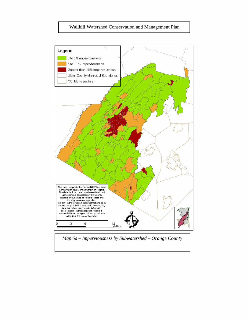
Wallkill Watershed Conservation and Management Plan
Map 6a – Imperviousness by Subwatershed – Orange County
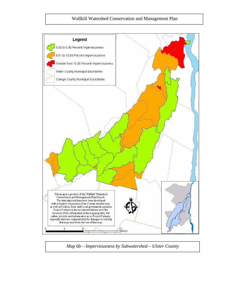
Wallkill Watershed Conservation and Management Plan
Map 6b – Imperviousness by Subwatershed – Ulster County