village confines: eastcote cherrycotage penbryn valley...
TRANSCRIPT
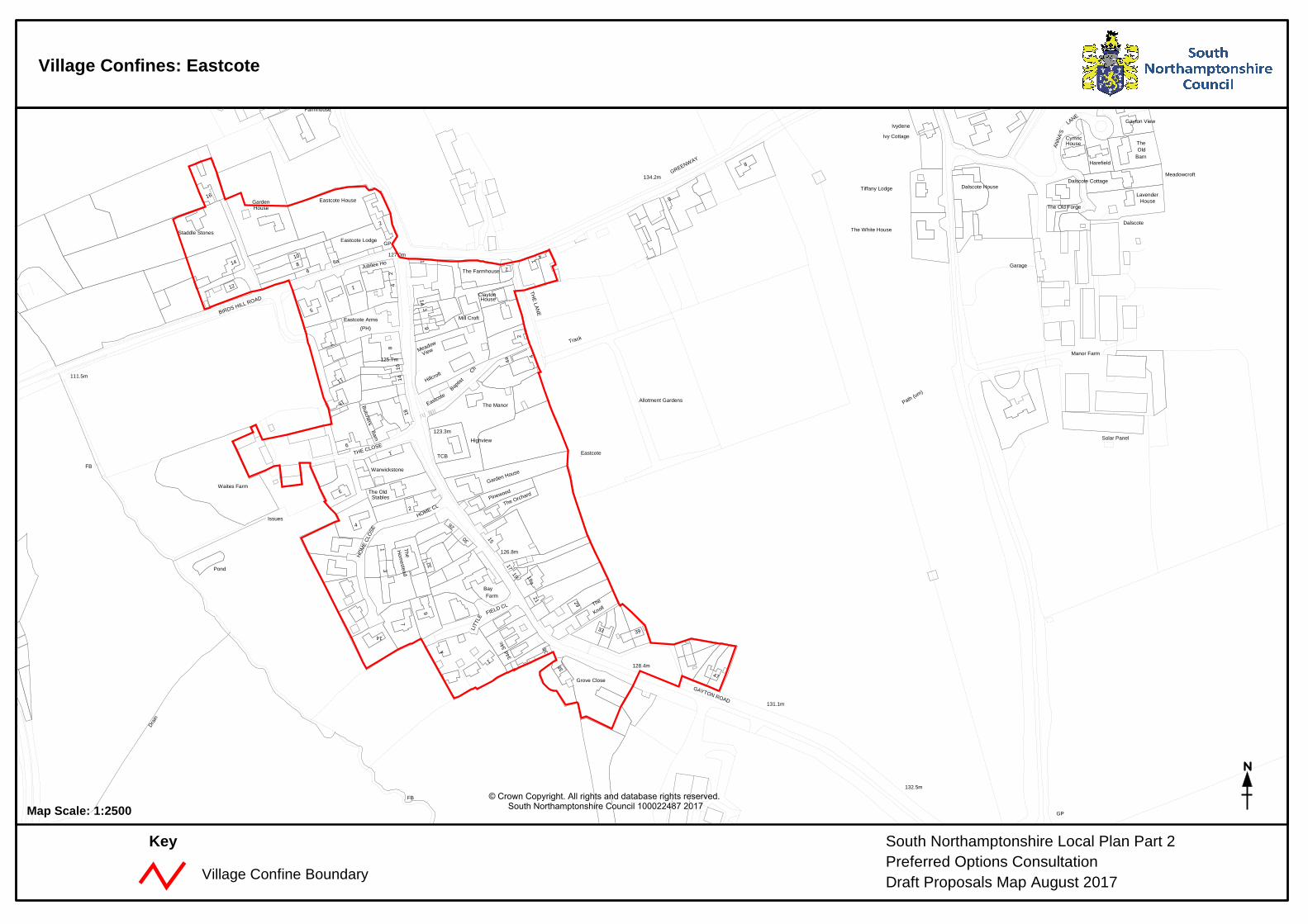
Village Confines: Eastcote
Village Confine Boundary
South Northamptonshire Local Plan Part 2Preferred Options ConsultationDraft Proposals Map August 2017
Key
House
1
Eastcote House
39
Staddle Stones
34c
View
5
14
(PH)
7
Gayton View
1
11
Manor Farm
Clayton
2
27
Mill Croft
8
House
18
The OldStables
19
4a
14 Hillcroft
9
7
The Orchard
16
3
Eastcote Lodge
The
4
Garden House
Farm
33
Eastcote
4
29
1
42
32
64
The Farmhouse
15
Bay
4
Knoll
30Ch
Highview
Baptist
2The White House
Cymric
12
Farmhouse
34d
814 6a
Valley View
4
Meadowcroft
Cherry Cottage
The Old Forge
6
15
Barn
2
The New
Ivy Cottage
Old
26
10
Garden
House
3
Lavender
House
Penbryn
6
Dalscote House
21
17
36
The Manor
1
Tiffany Lodge
9
The
8
Dalscote Cottage
Garage
Harefield
Bay Farm
Ivydene
Pinewood
Grove Close
Garage
Hom
estead
6
1
1
47
19a
Barn
25
Butchers
Jubilee Ho
2
10
66
Hall
52
30
Waites Farm
3
31
The
2
Warwickstone
4
38
Meadow
1A
Eastcote Arms
Eastcote
Dalscote
ETL
ETL
Allotment
Allotment Gardens
Tennis Court
Drain
Pond
Issues
Drain
Ponds
Dra
in
Pond
Issues
POU
ND LAN
E
BIRDS HILL ROAD
THE CLOSE
ANN
A'S
BIRDS HILL ROAD
HOME CL
LITT
LE
BANBURY LANE
FIELD CL
SCHO
OL R
OAD
THE LAN
E
GREENWAY
HOM
E CL
OSE
GAYTON ROAD
LANE
Path (um)
GP
GP
GP
GP
Track
FB
FB
FB
TCB
Solar Panel
FB
FB
Tanks
131.1m
122.6m
134.2m
136.4m
128.4m
127.0m
132.5m
123.3m
111.5m
133.6m
125.7m
126.8m
© Crown Copyright. All rights and database rights reserved. South Northamptonshire Council 100022487 2017Map Scale: 1:2500
Village Confine Boundary
Broughton Terrace
42
29
22
35
115
18
Hall
6
2
5
40
45
7
91
52
30
15
13
25
2
Pump House
10
17
5
10
17
23
5
3943
35a
5
9
5
5
23
26
1
9
3
2
4
11
7
2
17
41
34
24
16
11
2
28
11
PO
28
25
8
Red Lion
College
3a
Farmhouse
5
54
8
2
1
4
4A
5
816
1
1
1a
2
1
College Farm
Farm
(PH)
4
5
59
33
218
Hall
12
32
Piggery
14
4
Evenley
Sewage Works
Cricket Ground
WoodGardenEvenley
The Green
Ponds Pond
Dra
in
Pond
Pond
Issues
Issues
Spring
Issues
Issues
Spring
Fish P
ool
New
Pond
Pond
Pond
Spring
Pond
Spring
Drain
Issues
MIXBURY ROAD
LAWYERS CLOSE
RUDGEWAY
BROAD LANE
CHURCH LANE
SCHOOL LANE
BICESTER
HILL
SPEN
CE
R C
LOSE
Track
Track
Track
Track
Track
Path
(um
)
Track
GP
Path
Mast
LB
TCB
War Memorial
Wd Pp
FB
Silos FB
FB
131.0m
131.6m
135.2m
134.5m
127.5m
127.4m
122.9m
116.7m
115.0m
121.1m
125.8m
123.0m
120.4m
125.4m
122.0m
The
Barn
stea
d
26
30
Evenley Lawn
44
20
27
28
Grounds
The
Barn
George's
Ston
ecro
ft
10
18
ChurchSt
24
16
25
21
19a
Evenley Hall(Childrens Home)
11
Farm HouseRectory
Hill
23
36
Beechwood
17
26
23
9
39 Piran House
19
46
21
19
20
22
House
32
15
29
17
Robinia Farm
GridCattle
Solitary Spinney
Hill Ground Spinney
Mortarpits Covert
Thorny Covert
Ash
Beds
Tennis Court
Tenn
is C
ourts
Drain
Overflow
Pond
Pond
Drain
Issues
Drai
n
PondDrain
Drain
Pond
Drai
n
Pond
Pond
Overflow
Drain
A 43
CHURCH LEYS
CHURCH LANE
A 43
BROAD LANE
Track
MS
Track
Cycle
Trac
k and
Pat
h
Track
Lay-
by
Path (um)
Path (um)
Trac
k
Sundial
FB
Sluice
FB
FB
FB
123.5m
119.4m
126.9m
129.9m
124.0m
120.8m
136.3m
134.3m
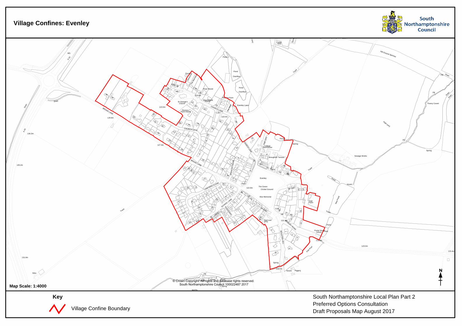
South Northamptonshire Local Plan Part 2Preferred Options ConsultationDraft Proposals Map August 2017
Key
Village Confines: Evenley
© Crown Copyright. All rights and database rights reserved. South Northamptonshire Council 100022487 2017Map Scale: 1:4000
Village Confine Boundary
The Bothy
LodgeSouth
Hall
St Nicholas's Church
Eydon
Takoradi
Cattle Grid
Cattle Grid
The Rookery
Reservoir(covered)
(restored)Cross
Pond
Track
Tk
165.5m
163.7m
168.2m
2
38
32
12
28
16
4
Royal Oak
51
35
5
6
(PH)
Oriel House
Hall Farmhouse5 a
12
30Manor
27
53
Rectory
7
11
11
7
2
1
42
Rectory
10125
55
The Old Rectory
14
4
12
46
2a
14
2
Farm
8
73
9
8
1
3
44
10
5
7
6
1
1
14
44
39
25
20
67
50
3
Barn
20
6
8
The Folly
10
28a
23
61
47
10
12
East of Eydon
15
10
34
16
26
23
1b1a
5b
45
El S
ub S
ta
Pavilion
10a
1
4
36
Mannings Farm
18
2
The Post House
41
33
29
11
6
12
Ashby's Farm
15
PO
30a
4
a
2
8
4
32
36
52
Hall
33
3
Farmhouse
1
4
46
Hall Farm
2
4
30
63
2
Cedars Farm
38
22
1
48
2
6
24
Farm
1
28
1
18
2
26
1
4
8
15
3
5
18
3731
5
17
6a
3
8
43
Sewage Works
EydonCG
Cemetery
The
Sub Sta
Court
El
Green
Tennis Court
Allotment Gardens
Cricket Ground
Tennis
Pond
Pond
Pond
Pond
Issues
Pond
Pond
Pond
Pond
Issues
Pond
Dismantled Railway
MANNINGS YARD
DOCTORS LANE
BYFIELDROAD
MAN
ITO
BA
LANE
MANITOBA PLACE
BLACKSMITHS LANE
WAY
MORETON ROAD
WAY
PR
ES
TON
RO
AD
HOLLOW
WOODFORD ROAD
PARTRIDGE LANE
HIG
H S
TREE
T
LIM
E AV
ENU
E
HILL
SCHOOL
VIEW
Posts
GP
Track
Track
GP
GP
Track
Track
GP
Stocks
Sludge Tanks
TCB
168.9m
173.1m
171.0m
167.3m
137.2m
158.2m
165.2m160.6m
160.0m
158.8m163.4m
144.5m
159.
7m
148.4m
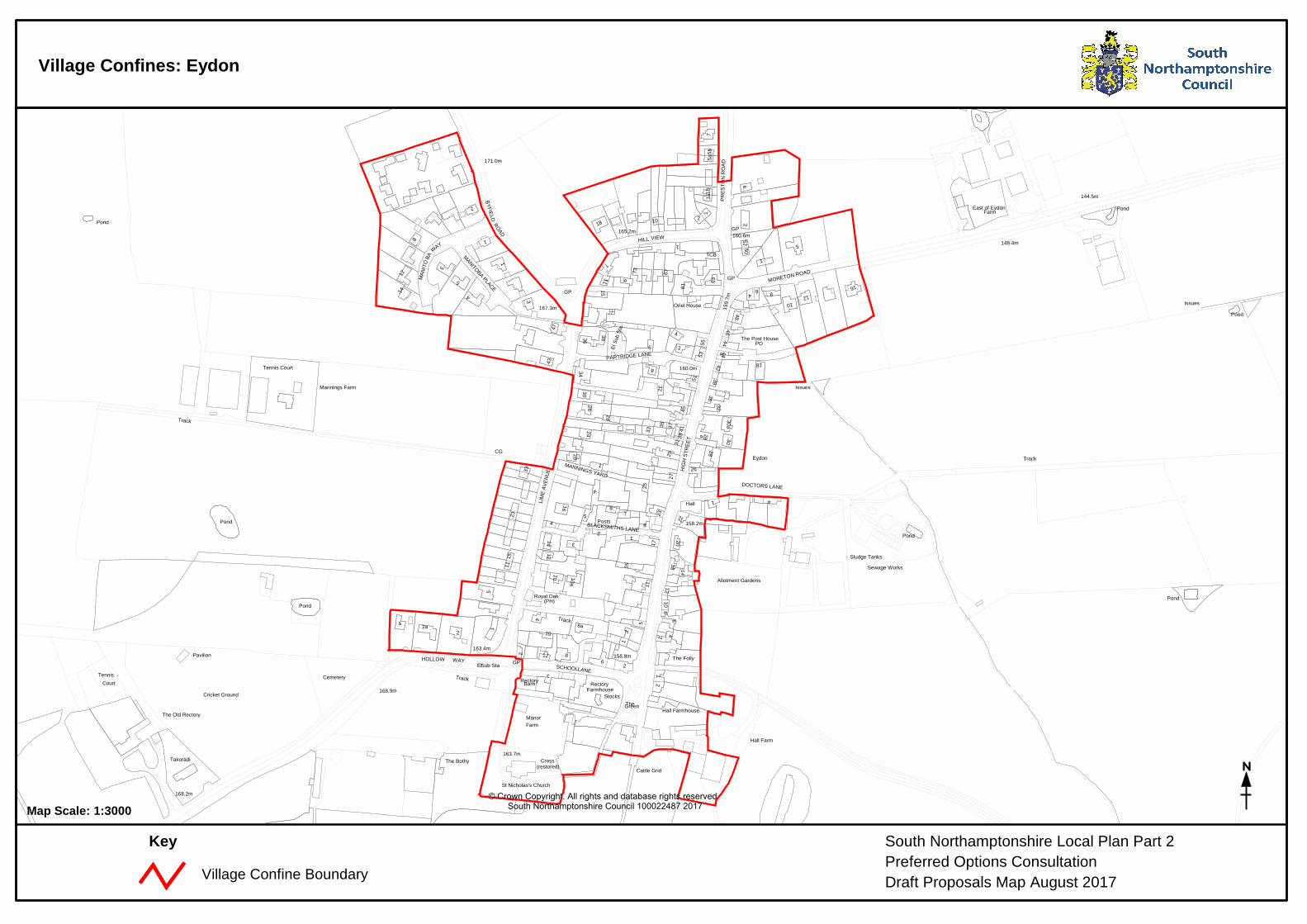
South Northamptonshire Local Plan Part 2Preferred Options ConsultationDraft Proposals Map August 2017
Key
Village Confines: Eydon
© Crown Copyright. All rights and database rights reserved. South Northamptonshire Council 100022487 2017Map Scale: 1:3000
Cot
tage
Millers Barn
Kirkstone
The Old Rectory
House
Cottage
Garage
Ivy
Hill View
The Old Bakery
Willow
1
Church Piece Cottages
3
Water Tower
Mal
thus
Clo
se
7
Syberis
Silver
Cherry Gables
Auriol
Granary Cottage
13
Byland House(PH)
The Old Chapel
Little
Jasmine Cottage
House
Grafton
Abbey
Hall
Close
Barn Cottage
The Cottage
Grey
Cottage
The
3
Corner
New HouseGateHouse
5
11
The
But
ts
The Cottage
Bel
l Co t
t
Oak
5
North End
Condor Cottage
Virginia House
Charlecote
1
Astwick
Lingra
Cottage
House
Duck End
Bungalow
House
The Cottage
The Odd
Abbeyfields House
The Manor
The Limes 9
The
6
2
1
San
Copper
Thickness Cottage
Gables
Horseshoe Lea
Ridge
Heritage
Cuporth
Leaf
Cor
ner C
otta
ge
The Forge
Highfield
AlmshousesHoneysuckle House
Mayfield
The Cottage
Chamomile
The Warren
Beechtree
2
The Walltree
2
Mal
t Hou
se
The Pump House
Strathmore
Magdalen
16
Cobwebs Cottage
The Hollies
London
Close
Cottages
1
1
School Ho
Barn
6
3
The Limes
Folly
The
Shelter
St Michael's Church
10b
Farthinghoe Lodge
Homeland
Manor
12
Lodge
1
10a
Cottage
Hawthorns
Cottage
Barn
Farfield
Bla
c kt h
o rn e
16
Far View House
Uphill Cottage
Lodge
Stones
House
Park
The Fox
Greenfield
Limes Farm
Steane
Ho u
s e
Primary School
Grenville
Gable End
Bee
ch T
ree
Hou
se2
1
Briar
1
Farthinghoe
Oak
Cottages
Invicta
2
10
Birch
Farm House
6
The Old Post Office
Barn
Limes Cottage
Magnolia
Cottage
Farthinghoe Lodge Farm
1
Alandale
Tora
Windy
House
1
Farthinghoe
CattleGrid
Allotment
Tennis Court
Tennis Court
Gardens
Play Area
Drain
Pond
Swimming Pool
Pond
QUEENS STREET
A 422
SEVEN SISTERS CLOSE
CLA
RK
S L
AN
E
CO
CKL
EY R
OAD
MANOR LANE
COCKLEY ROAD
OLD LANE
MAIN ROAD
CH
ARLT
ON
WAY
BA
KE
R S
TRE
ET
BO
WLIN
G G
RE
EN
CH
AP
EL
LAN
E
NEW R
OAD
MS
GP
Trac
k
GP
GP
Track
Track
TCB
Fountain
153.3m
154.5m
156.6m
147.2m
153.6m
151.6m
144.8m
154.8m
156.2m
157.5m
155.1m
152.0m
Pheasant Lodge
Pond
Issues
Drain
A 422
(disused)
Sewage Works
157.9m
137.5m
134.1m
Village Confine Boundary
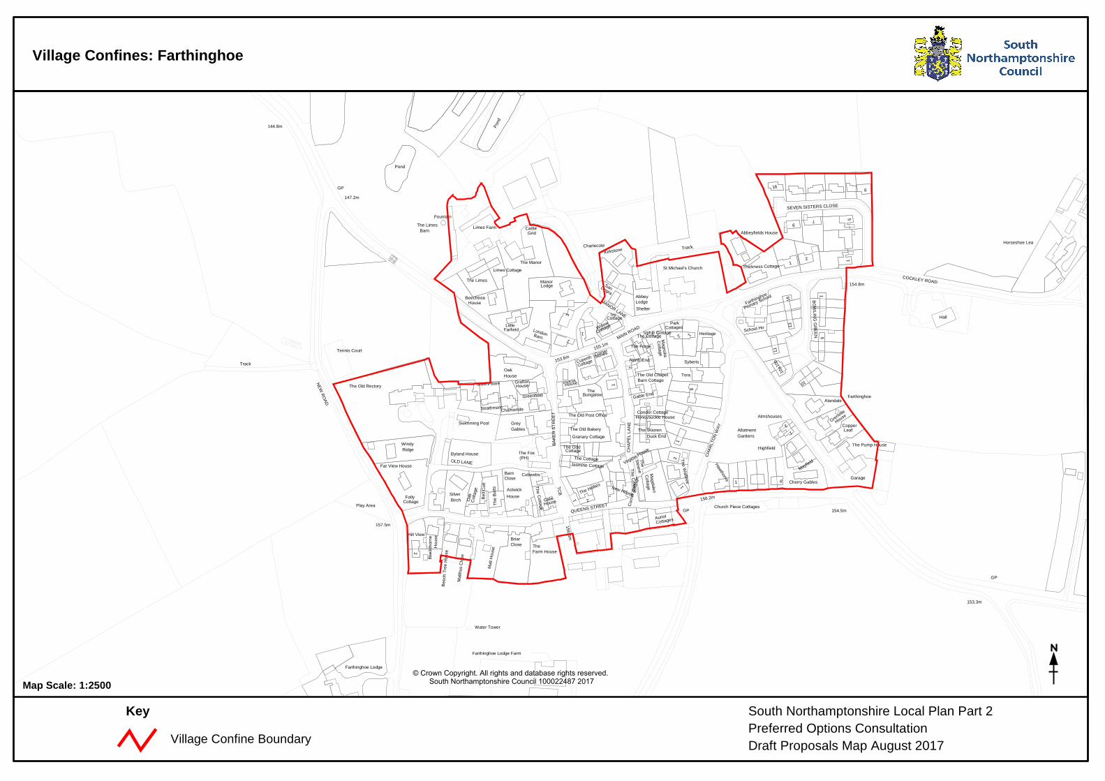
South Northamptonshire Local Plan Part 2Preferred Options ConsultationDraft Proposals Map August 2017
Key
Village Confines: Farthinghoe
© Crown Copyright. All rights and database rights reserved. South Northamptonshire Council 100022487 2017Map Scale: 1:2500
Village Confine Boundary
17a
Works
Col dw
e lls
House
19
Honeysuckle H
ouse
The Retreat
Westgate
17b
Duncton H
ouse
Cricket
EAST
COTE
RO
AD
BUGBROOKE ROAD
Track
Track
Ruins
135.3m
130.8m
136.4m
6
Farm
2
Eykyn
24
Arms
Evergreen
Garage
Cottage
14
6a
2
8
4
13
3
34
Tree
38
1
St Mary's Church
The Rectory
(PH)
4
22
Cherry
oake
2
Corner Cottage
22
17a
8
4
4
Primrose
Farm17 Heavenwood House
Glebe6
8
29
Homestead
Hall
36
Primary SchoolGayton C of E
32
11
The Laurels
The HIF
Fair View
Wendover
12
Victoria
PH
12
5
The Paddocks
13
23
Orchard
26
12
14
Kildonan
15
17
28
10
2
Tops
2
1
10
7
16
3
High
Courtyard Cottage
14
6
2
11
Gayton House
9
1
5
13
4
24
Outback
28
21
12
19
Linthorpe
27
Court Ho
16
27
The
24
18
Langleys
House
2a
Home Farmhouse
1
Gable End
1
Cottage
8
Fiveways
Trees
8
House
17
Queen
7
25
Deersleap
3
1
Hillside House
Five
way
s
1
6
7
1
Melliah Ho
911
BrittainCottages
Britain
Gayton
El Sub Sta
Allotment Gardens
Play Area
Manor House
Swimming Pool
Issues
Pond
Pond
Issues
Pond
Pond
Railw
ay
Dism
antle
d
MILTON ROAD
PARK
BACK LANE
HIG
H S
TREE
T
TIFFIELD R
OAD
DEANS ROW
BLISWORTH ROAD
LANE
BUGBROOKE ROAD
ST MARYS CT
EASTCOTE ROAD
HIL
LCR
ES
T R
OA
D
BAKE
R S
TREE
T
GP
GP
GP
GP
Track
GP
Track
Trac
k
GP
Track
Path
( um
)
Pat
h (u
m) LB
TCB
Pump
119.9m
129.9m
133.9m
137.1m
139.0m
125.2m
127.7m
133.8m
137.7m132.6m
136.6m
132.2m
135.4m
134.2m 133.4m
136.9m
134.3m
135.8m
Sewage Works
Trac
k
Sludge Tanks
124.4m
South Northamptonshire Local Plan Part 2Preferred Options ConsultationDraft Proposals Map August 2017
Key
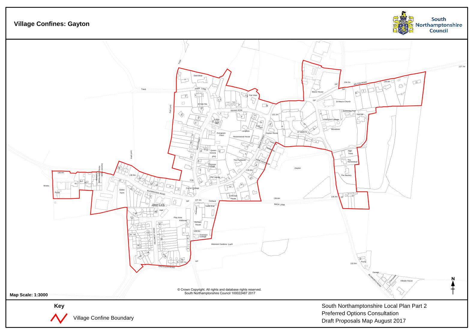
Village Confines: Gayton
© Crown Copyright. All rights and database rights reserved. South Northamptonshire Council 100022487 2017Map Scale: 1:3000
1
Rosebud Cottage
Paddocks
The Cabin
Manor
1
The Manor
The Rouene
Bank
Barley
CottageGrove
Cottages
Old Barn Cottages
2
Cottage
8
Cedar Cottage
Top
Tudor Cottage
The Dovecote
Chantry
The
Toft WoodGrafton House
Pear Tree Cottage
2
Ivy Cottage
Meadow Court
Farm
The Beeches
Old Rectory
(PH)
Sunshine
Hall
Hill
The Cottage
Barns
4
House
1
Pump
(C of E)
White Hart
The
Home View
Grastone House
Bolelyn Cottage
CottageMillstones
El Sub Sta
St Mary's Church
The
Grafton Regis
Cattle Grid
Cattle Grid
Sheep Dip
Issues
Drain
Ponds
Pond
Issues
Pond
Collects
Collects
Drain
Issues
EER, Co Const & UA Bdy
CD
THE LANE
CHURCH LANE
BOZENHAM MILL
LANE
A 508
NORTHAMPTON ROAD
GP
Lay-by
GP
Lay-by
Lay-by
Lay-by
GP
Path
(um
)
LB
Sl
Pp
73.3m
73.2m
82.1m
98.5m
100.9m
87.1m
80.0m
80.3m
83.8m
73.2m
73.2m
73.1m
91.4m
Village Confine Boundary
South Northamptonshire Local Plan Part 2Preferred Options ConsultationDraft Proposals Map August 2017
Key
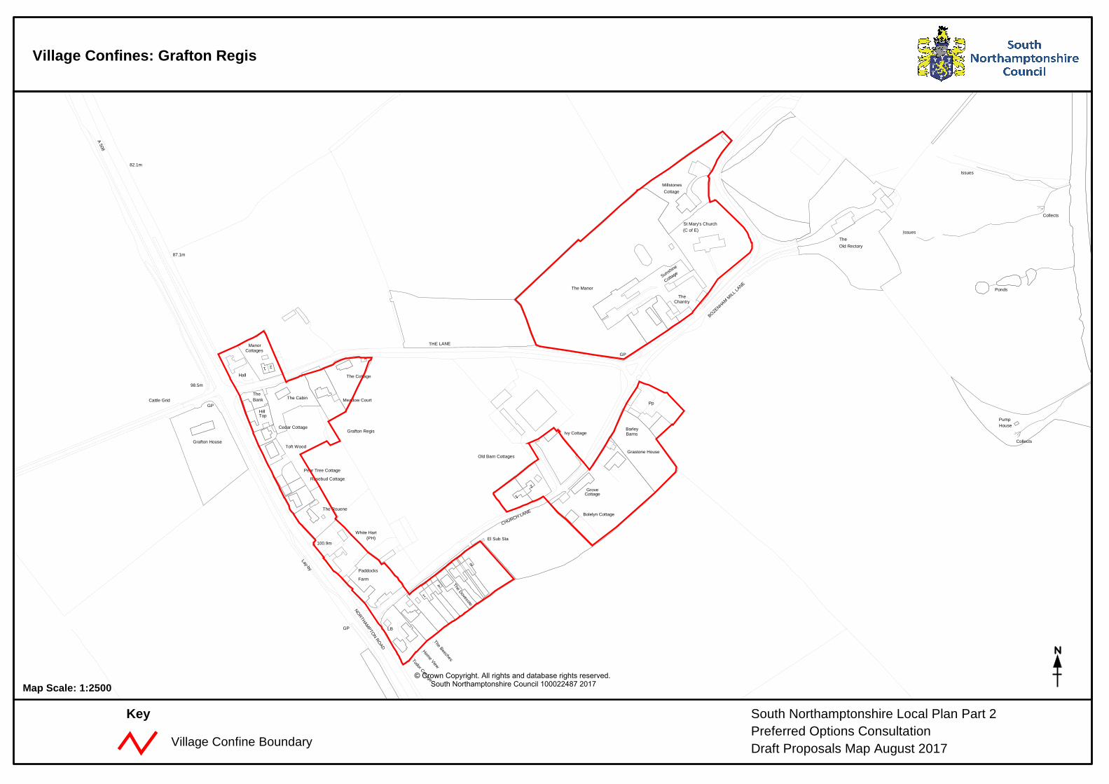
Village Confines: Grafton Regis
© Crown Copyright. All rights and database rights reserved. South Northamptonshire Council 100022487 2017Map Scale: 1:2500
Village Confine Boundary
South Northamptonshire Local Plan Part 2Preferred Options ConsultationDraft Proposals Map August 2017
Key
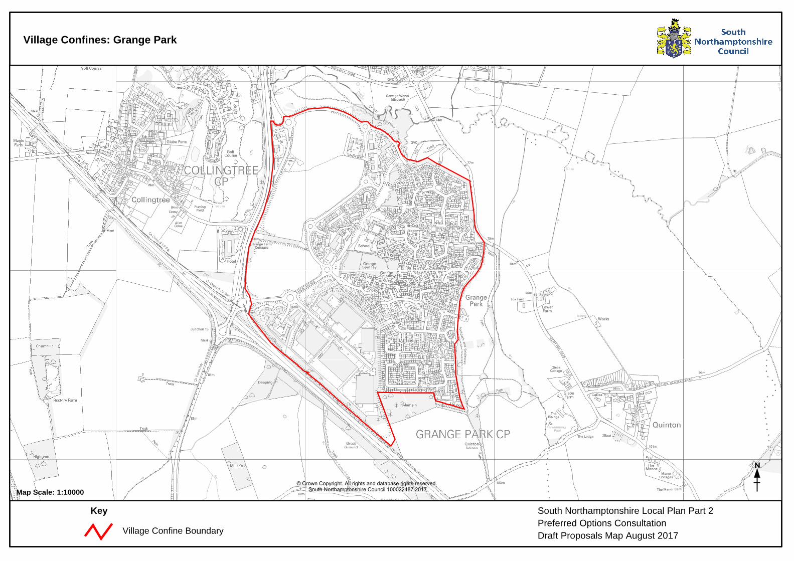
Village Confines: Grange Park
© Crown Copyright. All rights and database rights reserved. South Northamptonshire Council 100022487 2017Map Scale: 1:10000
Village Confine Boundary
Keeper's
Meadow
Cartwheel
ViewBayCottage
13
3
9
Cottage
Cottage
19
Ston e H
ouse
25
5
The Ol d
House
13
Round
7
41
ESS
WorksSewage
Nursery
Cattle Grid
ETL
Spinney
SpinneyOldbarn
Hanging
Issues
PondPond
Sinks
Spring
Issues
Spring
Issues
Issues
Sinks
Def CHCH
CH
CH
CH
CH
Def
Und
Def
Und
Ward Bdy
Def
CF
CH
CF
War
d Bd
y
War
d Bd
yH
ICK
MA
N C
LOS
E
SOUTH CLOSE
Path (um)
Guide Post
FB
124.4m
166.7m
159.1m
123.1m
163.1m
137.8m
121.3m
163.7m155.1m
165.8m
125.9m
129.2m
Greatworth Park
The Cabin
HouseAstral
1to8
41
12
5
43
Mal
t
(PH)
The
Church
16
Fernworthy Cottage
29
Cottag
e
1Fourwinds
The Reading Room
Whitman's Farm
23
59 Midway
GablesGreen
Cottage
3
1
Odds On
The Lane
5
Dormer
Deben
1
Cottage
House
The White House
Cherry Tree
20
Summer
Church Cottage
GreatworthCromwell Cottage
Glebe
Somerfields
PO
House
1
5
Wickets
1
The
El Sub Sta
Neal House
26a
Cottage
Upfield House
The
HouseParish
12
The Cedars
30
St Peter's Church
Grey
Hous
e
Westhorpe
15
1a
6
27
Red Cottage
13
8
Stone Lea
Cottage
8
40
Court
Lime
Letchmere
Doralea
33
Hayfield
Bacon
3
Cottage
2751
25
13
Club
6
40
Fern
leig
h
Mavis Bank
37
Briar
Astra
l Row
Cott
32
Bontiki
24
Floyd's
11
Barn CottManor
The
Barn
Hou
se
38
2
The
35a
Mountside
The Gable
Rose
wood
Spring Cottage6a
4
Milestone
Almond House
Batch End Cottage
1
Manor
Farm
1
1
50
10Floyds Chetwynd
7
20
Greystone House
Primary14
22a
4a
Applecross
The Inn
28
Whitsend
The Old Rectory
6
4
Greatworth
28
Jerash
Hareth
Stonerise
The School House
Kepple Gate
6
1
Fleet House
12
26
Whitman's Cottage
5
1
13
Farm
The
62
2
8
Manor
Dering
Cot
tage
s
Barn
Tile Cottage
40
1
26
Greatworth
Cottages
New House
11
5 3
7
The Water Tower
8
12
Greetings
School
GreatworthCourt
35
Greatworth
Playing Field
El Sub Sta
Play Area
Allotment
WT Station
Gardens
Issues
Pond
Issues
Pond
Issues
Pond
Def
Disman
tled R
ailway
Dismantled Railway
Disman
tled R
ailway
BRACKLEY R
OAD
PEVERIL ROAD
THE SQUARE
CHUR
CH R
OAD
PARGETER CLOSE
CHAPEL R
OAD
THECLOSE
WIN
DR
USH
HELM
DON ROAD
HELMDON ROAD
WES
THO
RP
VIEW
WHITTON CLOSE
EAST
B 4525
MARSTO
N RD
Track
Track
Track
GP
Track
GP
Path
Track
Path
TCB
LB
169.5m
162.5m
170.1m
155.8m
158.5m
160.3m
157.6m
157.3m
154.8m
South Northamptonshire Local Plan Part 2Preferred Options ConsultationDraft Proposals Map August 2017
Key
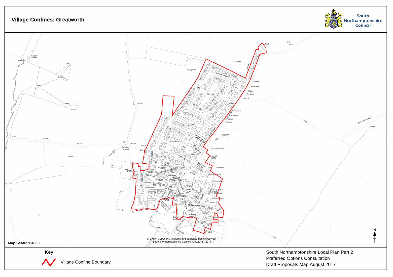
Village Confines: Greatworth
© Crown Copyright. All rights and database rights reserved. South Northamptonshire Council 100022487 2017Map Scale: 1:4000