ux-process update: free software for digital geophysical mapping
TRANSCRIPT
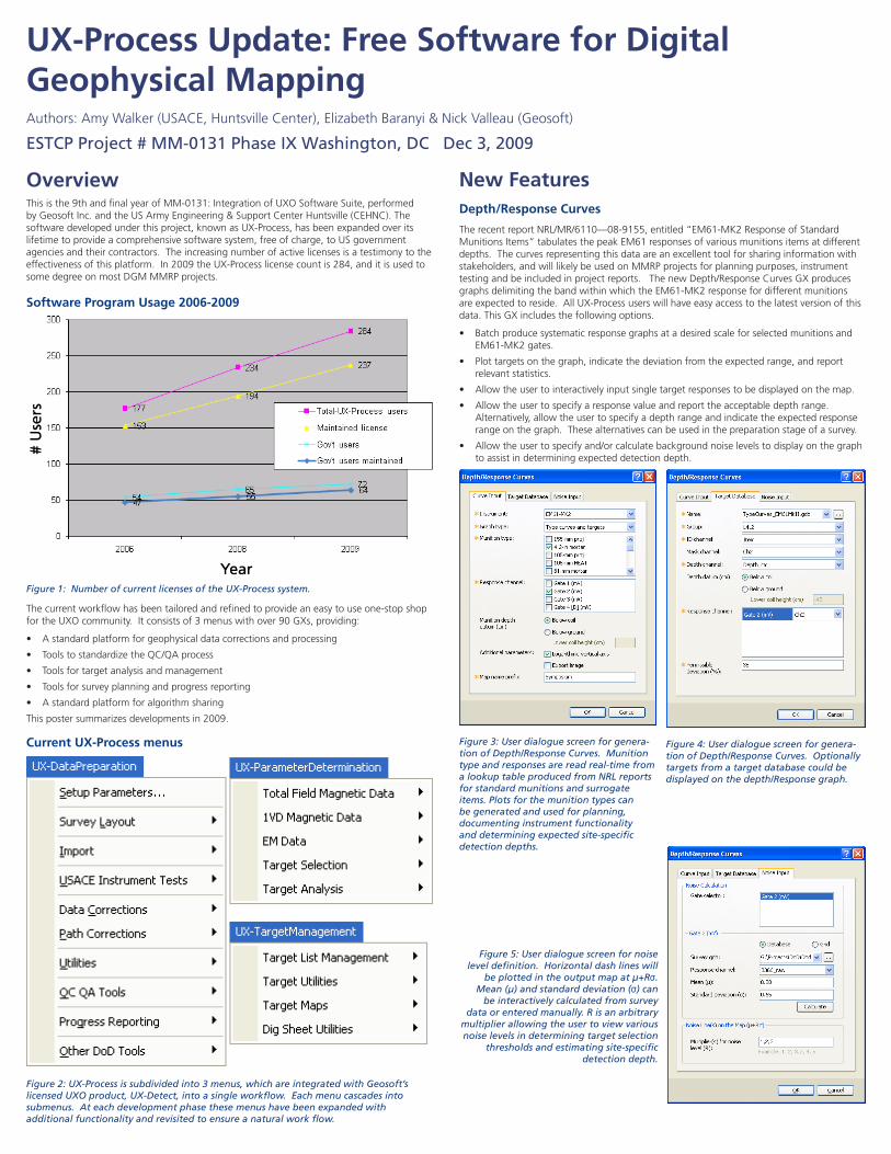
OverviewThis is the 9th and final year of MM-0131: Integration of UXO Software Suite, performed by Geosoft Inc. and the US Army Engineering & Support Center Huntsville (CEHNC). The software developed under this project, known as UX-Process, has been expanded over its lifetime to provide a comprehensive software system, free of charge, to US government agencies and their contractors. The increasing number of active licenses is a testimony to the effectiveness of this platform. In 2009 the UX-Process license count is 284, and it is used to some degree on most DGM MMRP projects.
Software Program Usage 2006-2009
Figure 1: Number of current licenses of the UX-Process system.
The current workflow has been tailored and refined to provide an easy to use one-stop shop for the UXO community. It consists of 3 menus with over 90 GXs, providing:
• Astandardplatformforgeophysicaldatacorrectionsandprocessing
• ToolstostandardizetheQC/QAprocess
• Toolsfortargetanalysisandmanagement
• Toolsforsurveyplanningandprogressreporting
• Astandardplatformforalgorithmsharing
Thispostersummarizesdevelopmentsin2009.
Current UX-Process menus
Figure 2: UX-Process is subdivided into 3 menus, which are integrated with Geosoft’s licensed UXO product, UX-Detect, into a single workflow. Each menu cascades into submenus. At each development phase these menus have been expanded with additional functionality and revisited to ensure a natural work flow.
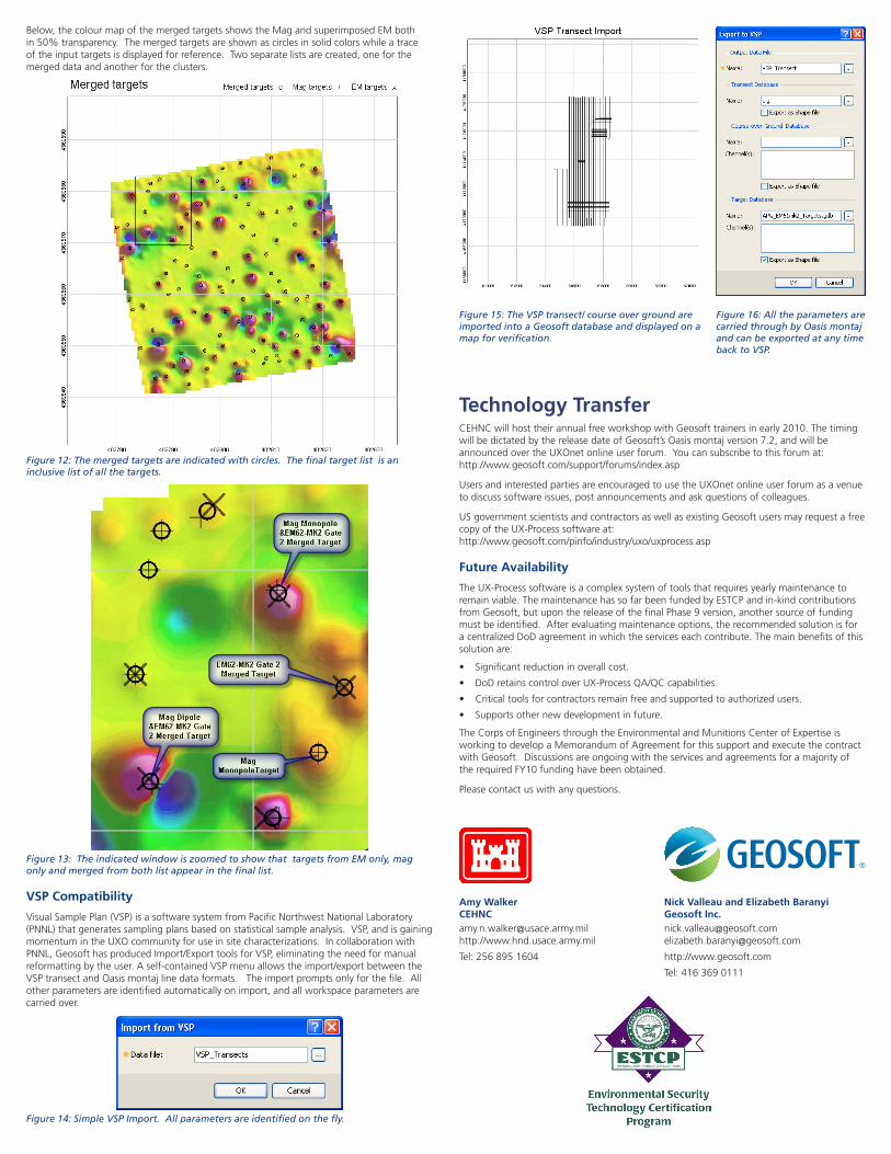
New FeaturesDepth/Response Curves
TherecentreportNRL/MR/6110—08-9155,entitled“EM61-MK2ResponseofStandardMunitionsItems”tabulatesthepeakEM61responsesofvariousmunitionsitemsatdifferentdepths. The curves representing this data are an excellent tool for sharing information with stakeholders, and will likely be used on MMRP projects for planning purposes, instrument testingandbeincludedinprojectreports.ThenewDepth/ResponseCurvesGXproducesgraphsdelimitingthebandwithinwhichtheEM61-MK2responsefordifferentmunitionsare expected to reside. All UX-Process users will have easy access to the latest version of this data. This GX includes the following options.
• BatchproducesystematicresponsegraphsatadesiredscaleforselectedmunitionsandEM61-MK2gates.
• Plottargetsonthegraph,indicatethedeviationfromtheexpectedrange,andreportrelevant statistics.
• Allowtheusertointeractivelyinputsingletargetresponsestobedisplayedonthemap.
• Allowtheusertospecifyaresponsevalueandreporttheacceptabledepthrange.Alternatively, allow the user to specify a depth range and indicate the expected response range on the graph. These alternatives can be used in the preparation stage of a survey.
• Allowtheusertospecifyand/orcalculatebackgroundnoiselevelstodisplayonthegraphto assist in determining expected detection depth.
Figure 4: User dialogue screen for genera-tion of Depth/Response Curves. Optionally targets from a target database could be displayed on the depth/Response graph.
Figure 3: User dialogue screen for genera-tion of Depth/Response Curves. Munition type and responses are read real-time from a lookup table produced from NRL reports for standard munitions and surrogate items. Plots for the munition types can be generated and used for planning, documenting instrument functionality and determining expected site-specific detection depths.
Figure 5: User dialogue screen for noise level definition. Horizontal dash lines will
be plotted in the output map at µ+Rσ. Mean (µ) and standard deviation (σ) can
be interactively calculated from survey data or entered manually. R is an arbitrary
multiplier allowing the user to view various noise levels in determining target selection
thresholds and estimating site-specific detection depth.
UX-Process Update: Free Software for Digital Geophysical MappingAuthors:AmyWalker(USACE,HuntsvilleCenter),ElizabethBaranyi&NickValleau(Geosoft)
ESTCP Project # MM-0131 Phase IX Washington, DC Dec 3, 2009
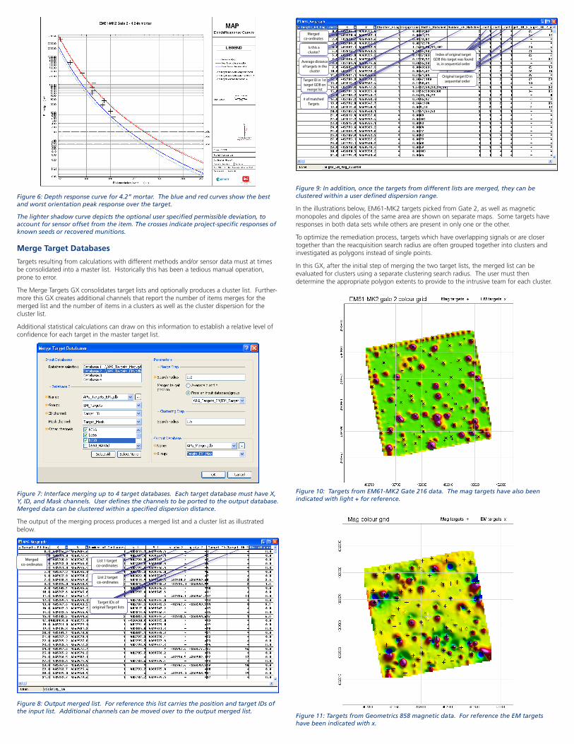
Figure 6: Depth response curve for 4.2” mortar. The blue and red curves show the best and worst orientation peak response over the target.
The lighter shadow curve depicts the optional user specified permissible deviation, to account for sensor offset from the item. The crosses indicate project-specific responses of known seeds or recovered munitions.
Merge Target Databases
Targetsresultingfromcalculationswithdifferentmethodsand/orsensordatamustattimesbe consolidated into a master list. Historically this has been a tedious manual operation, prone to error.
The Merge Targets GX consolidates target lists and optionally produces a cluster list. Further-more this GX creates additional channels that report the number of items merges for the merged list and the number of items in a clusters as well as the cluster dispersion for the cluster list.
Additional statistical calculations can draw on this information to establish a relative level of confidence for each target in the master target list.
Figure 7: Interface merging up to 4 target databases. Each target database must have X, Y, ID, and Mask channels. User defines the channels to be ported to the output database. Merged data can be clustered within a specified dispersion distance.
The output of the merging process produces a merged list and a cluster list as illustrated below.
Figure 8: Output merged list. For reference this list carries the position and target IDs of the input list. Additional channels can be moved over to the output merged list.
Figure 9: In addition, once the targets from different lists are merged, they can be clustered within a user defined dispersion range.
Intheillustrationsbelow,EM61-MK2targetspickedfromGate2,aswellasmagneticmonopoles and dipoles of the same area are shown on separate maps. Some targets have responses in both data sets while others are present in only one or the other.
Tooptimizetheremediationprocess,targetswhichhaveoverlappingsignalsorareclosertogether than the reacquisition search radius are often grouped together into clusters and investigated as polygons instead of single points.
In this GX, after the initial step of merging the two target lists, the merged list can be evaluated for clusters using a separate clustering search radius. The user must then determine the appropriate polygon extents to provide to the intrusive team for each cluster.
Figure 10: Targets from EM61-MK2 Gate 216 data. The mag targets have also been indicated with light + for reference.
Figure 11: Targets from Geometrics 858 magnetic data. For reference the EM targets have been indicated with x.
Merged co-ordinates
Is this a cluster?
Average distance of targets in the
cluster
Index of original target GDB this target was found
in, in sequential order
Original target ID in sequential orderTarget ID in 1st
target GDB on merge list
# of matched Targets
Merged co-ordinates
List 1 target co-ordinates
List 2 target co-ordinates
Target IDs of
original Target lists
Below,thecolourmapofthemergedtargetsshowstheMagandsuperimposedEMbothin50%transparency.Themergedtargetsareshownascirclesinsolidcolorswhileatraceof the input targets is displayed for reference. Two separate lists are created, one for the merged data and another for the clusters.
Figure 12: The merged targets are indicated with circles. The final target list is an inclusive list of all the targets.
Figure 13: The indicated window is zoomed to show that targets from EM only, mag only and merged from both list appear in the final list.
VSP Compatibility
VisualSamplePlan(VSP)isasoftwaresystemfromPacificNorthwestNationalLaboratory(PNNL)thatgeneratessamplingplansbasedonstatisticalsampleanalysis.VSP,andisgainingmomentumintheUXOcommunityforuseinsitecharacterizations.IncollaborationwithPNNL,GeosofthasproducedImport/ExporttoolsforVSP,eliminatingtheneedformanualreformattingbytheuser.Aself-containedVSPmenuallowstheimport/exportbetweentheVSPtransectandOasismontajlinedataformats.Theimportpromptsonlyforthefile.Allother parameters are identified automatically on import, and all workspace parameters are carried over.
Figure 14: Simple VSP Import. All parameters are identified on the fly.
Figure 15: The VSP transect/ course over ground are imported into a Geosoft database and displayed on a map for verification.
Figure 16: All the parameters are carried through by Oasis montaj and can be exported at any time back to VSP.
Technology Transfer CEHNC will host their annual free workshop with Geosoft trainers in early 2010. The timing will be dictated by the release date of Geosoft’s Oasis montaj version 7.2, and will be announced over the UXOnet online user forum. You can subscribe to this forum at: http://www.geosoft.com/support/forums/index.asp
Users and interested parties are encouraged to use the UXOnet online user forum as a venue to discuss software issues, post announcements and ask questions of colleagues.
US government scientists and contractors as well as existing Geosoft users may request a free copy of the UX-Process software at: http://www.geosoft.com/pinfo/industry/uxo/uxprocess.asp
Future Availability
The UX-Process software is a complex system of tools that requires yearly maintenance to remain viable. The maintenance has so far been funded by ESTCP and in-kind contributions from Geosoft, but upon the release of the final Phase 9 version, another source of funding must be identified. After evaluating maintenance options, the recommended solution is for acentralizedDoDagreementinwhichtheserviceseachcontribute.Themainbenefitsofthissolution are:
• Significantreductioninoverallcost.
• DoDretainscontroloverUX-ProcessQA/QCcapabilities.
• Criticaltoolsforcontractorsremainfreeandsupportedtoauthorizedusers.
• Supportsothernewdevelopmentinfuture.
The Corps of Engineers through the Environmental and Munitions Center of Expertise is working to develop a Memorandum of Agreement for this support and execute the contract with Geosoft. Discussions are ongoing with the services and agreements for a majority of the required FY10 funding have been obtained.
Please contact us with any questions.
Amy Walker [email protected]://www.hnd.usace.army.mil
Tel:2568951604
Nick Valleau and Elizabeth Baranyi Geosoft [email protected]@geosoft.com
http://www.geosoft.com
Tel:4163690111