usa crop circles - madisonville, tn: iccra analysis 2007-2008
TRANSCRIPT

Copyright 2009 © Jeffrey M. Wilson
Jeffrey M. Wilson Director, ICCRA
ICCRA - Independent Crop Circle Researchers’ Association [International]
Madisonville, Monroe County, Tennessee Crop Circle Formations Analysis 2007-08

ICCRA Crop Circle Methodology LEVEL 1 ANALYSIS - Collect basic,
objective information about reported crop circles
“Authentic” [Not mechanically-made by people]
Inconclusive [Not enough evidence to discern]
Man-made
[mechanically constructed]
Deceptive Hoaxes
$ Commercial Commissions / Land Art
Researcher Experiments
LEVEL 2 Analysis
Geometric / Symbolic / Diatonic Analysis
• L-NEAT, Plant/Soil Tests
• E-M Readings
• Radiation Readings
• Magnetometer Readings
• Ground Measurements

May 16, 2007 Madisonville, TN

• Double, overlapping “Celtic Cross” design
• All circles were swirled counter-clockwise in wheat ranging in size of 23-45 feet in diameter; swirled centers were ‘off-center’
• Detected increased radioactivity, E-M fields, and was L-NEAT positive for node elongation
• There were no tramlines in the field, and when first reported, there were no tracks leading into the formation
• Located in an area of unusual number of geologic features such as springs, caverns, and faultlines
• Located in an area of ancient Native American sites
• Investigated on-site by several members of the ICCRA
Madisonville, Monroe County, TN May 16, 2007
Photo courtesy: Mark Boring, Monroe County Buzz


ICCRA Crop Circle Investigative Techniques • L-NEAT Biological Testing Method – Dr. Chuck Leitzau
– Levengood Node Elongation Analysis Test
– Minimum 3 locations (31 plant samples each) + 5 control location samples
– Statistical Analysis (Student’s T-Test) available online allows for same-day results for testing authenticity
(Examples:)

May 16, 2007 Madisonville, Monroe County, TN – L-NEAT ANALYSIS
• Over 900 formation nodes and over 600 control sample nodes were measured and recorded
• Formation found to be L-NEAT “positive” for growth node elongation*
• Largest AVG node sizes: Circle 6 Node 3 = 4.80mm
Control 4 (200ft) Node 3 = 2.64mm • L-Neat report ran to 45 pages of statistics • Summary: Node 1, Node 2, and Node 3 from all
circles’ samples tested positive for node elongation vs. control samples taken from up to 500 ft. away
• Expulsion cavities were found in some Circle #3 samples
*A ‘positive’ L-NEAT result indicates a statistical increase in the node size of crop circle plants vs. control plants – indicating non-man made origin. No tested hoaxed formations have ever been found L-NEAT ‘positive’.
Madisonville 2007 Crop Circle Primary Analysis
Photo and diagram: Jeff Wilson, ICCRA
Formation Key:
Final analysis: the formation is L-NEAT ‘positive’ for node-elongation

ICCRA Crop Circle Investigative Techniques • Radiation Survey: Gamma-Scout® Ionizing Radiation Detector
• Measures alpha, beta, and gamma radiation (exposure rate in µSv/h [microSieverts] and/or mREMs)
• Reliable LND712 Geiger-Mueller detector
• Records data with two Kilobytes on board memory; Integrated USB data transfer port
• The Gamma-Scout® can detect changes in ambient radiation levels with precision below 1%
• The Gamma-Scout® will measure from below ambient radiation level to more than 400 uSv/hr, or 40 mrems/hr. This measures changes to radiation levels that would go virtually undetected with older Civil Defense type counters
• Ultra long life 12 year battery with 10 year battery warranty

May 16, 2007 Madisonville, Monroe County, TN
• Swirled centers were not in the same
place as the geometric centers – some
off by as much as 4-8 feet
• Complex layers, and woven plants
found in all the circles
Final analysis: the May 16, 2007 Madisonville, TN formation was NOT mechanically-made by people.

0.00
0.05
0.10
0.15
0.20
0.25
0.30
40
0' R
ad
Co
nto
ls3
50
' R
ad
Co
nto
ls3
00
' R
ad
Co
ntr
ols
25
0' R
ad
Co
nto
ls2
00
' R
ad
Co
nto
ls1
50
' R
ad
Co
ntr
ols
10
0' R
ad
Co
nto
ls1
00
' R
ad
Co
nto
ls7
5' R
ad
Co
nto
ls5
0' R
ad
Co
nto
lsC
irc
le 3
In
sid
e E
dg
eC
irc
le 5
In
sid
e E
dg
eC
IRC
LE
1C
IRC
LE
2C
IRC
LE
3C
IRC
LE
4
CIR
CL
E 5
CIR
CL
E 6
CIR
CL
E 7
CIR
CL
E 8
CIR
CL
E 9
CIR
CL
E 9
C
0.14
0.27
Sample Location
Madisonville, TN 5-26-2007 GammaScout Radiation Readings
(AVG µ Sv / h)
• Eight of the circle samples were significantly higher than the highest control sample; remaining four circle samples were above the avg. control
• There was a statistically-significant increase in recordable radioactivity in this formation (as compared to controls)
• The radiation detected inside most of the circles exceeded the controls – only the 75’ control managed to exceed any of the circles’ readings
• The highest readings were taken on the inside edge of circle 5 at 0.27µ Sv / h
• The average of the radiation readings from the circles were +23.8% higher than the average of the control readings
Madisonville 2007 Crop Circle Primary Analysis
Highest control
reading line

ICCRA Crop Circle Investigative Techniques • Electric Field / Magnetic Field Survey: TriField Natural Electro-Magnetic Field Detector
• Measures Electric Field Strength (Volts/meter)
• Measures Magnetic Field Strength (microteslas)
• Measures direct power levels of Radio waves / Microwaves (Watts/Meter³)
• SUM measurements = xx
• Detects changes in EXTREMELY weak static (DC or "natural") electric and magnetic fields
• Designed to ignore powerlines, appliances and other man-made EMF sources, eliminating nearly all false positives and negatives
• Use with or without the additional extra high sensitivity external magnetic coil

0.00
0.50
1.00
1.50
2.00
2.50
40
0' R
ad C
on
tols
35
0' R
ad C
on
tols
30
0' R
ad C
on
trols
25
0' R
ad C
on
tols
20
0' R
ad C
on
tols
15
0' R
ad C
on
trols
10
0' R
ad C
on
tols
50
' Rad
Co
nto
ls
Circle
3 In
side
Edge
Circle
5 In
side
Edge
0.90
2.50
Sample Locations
Madisonville, TN 5-27-2007 TriField Natural E-M Meter - SUM Measurements
Formation: Battery Overload!
Madisonville, TN 5-27-2007 TriField Natural E-M Meter
SUM Measurements
• The SUM measurements detected inside most of the circles reached battery overload – no readings were able to be taken inside the circles
Exception: we were able to take readings just on the inside edge of circles 3 & 5, and both readings were higher than any controls
• The highest readings were taken on the inside edge of circle 3 at 2.5 SUM
• Notwithstanding the battery overload, the average of the SUM readings from the circles were +59.8% higher than the average of the control readings
Madisonville 2007 Crop Circle Primary Analysis
SUM adds change in the magnetic field +
Radio/Microwave

May 16, 2007 Madisonville, TN – Plant Lay Analysis
• Swirled centers were not in the same place as the geometric centers – some off by as much as 4-8 feet
• Complex layers, and woven plants found in all the circles
Conclusions from all Primary analysis: the May 16, 2007 Madisonville, TN formation was NOT mechanically-made by people.


Examples of earlier Reports of Celtic Cross-type formations in North America:
Howick, Quebec 8-3-2002 Allen County, Ohio 6-1999
Aloha, Oregon 6-14-1994 Adna, Washington 10-16-1994

Note the last example Madisonville, Monroe County, TN

Note the last example Madisonville, Monroe County, TN

© 2009 Jeffrey Wilson
The Music of the Crop Circles • What is a diatonic ratio? How does this relate to music?
Notes in music are related to each other by specific ratios. These ratios determine the 'space' between each tone, and in turn define the notes. Although to the human ear the notes sound as if they are equally spaced, when in fact the ratios are more complex. For example, the ratio between C and D is 9/8:
These ratios maximize the harmonics in music. The white keys on a piano form a diatonic scale.
A Pythagorean tuning of the diatonic scale creates only two different sized steps: a major tone (9:8) and the Pythagorean semitone (256:243)--hence the name diatonic.

© 2009 Jeffrey Wilson
“The measurements of these patterns enabled me to find simple ratios. In one type of pattern, circles were separated from each other, like a big circle surrounded by a group of so-called satellites. In this case, the ratios were the ratios of diameters.”
“A second type of pattern had concentric
rings like a target. In this case, I took the ratios of areas. The ratios I found, such as 3/2, 5/4, 9/8, 'rang a bell' in my head because they are the numbers which musicologists call the 'perfect' intervals of the major scale.”
For satellite circles - Take the ratio of the circles’ diameters
For Concentric rings - take the ratio of the circles’ areas
Crop Circles – Diatonic Ratios Hawkins’ Crop Circle - Diatonic Ratio Analysis Methodology

May 16, 2007 Madisonburg, TN Diatonic Ratio Analysis
2
4
*Diatonic Ratios calculated by Dee Gragg
Circle Diatonic
Ratio
Fraction Musical
Note
Frequency
(Hz)
2 1.22 9/8 D 297
4 1.22 9/8 D 297
ICCRA USA Crop Circle Investigative Results
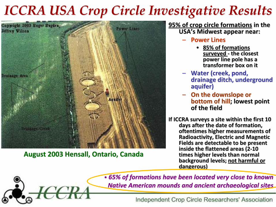
August 2003 Hensall, Ontario, Canada
95% of crop circle formations in the USA’s Midwest appear near:
– Power Lines • 85% of formations
surveyed - the closest power line pole has a transformer box on it
– Water (creek, pond, drainage ditch, underground aquifer)
– On the downslope or bottom of hill; lowest point of the field
If ICCRA surveys a site within the first 10 days after the date of formation, oftentimes higher measurements of Radioactivity, Electric and Magnetic Fields are detectable to be present inside the flattened areas (2-10 times higher levels than normal background levels; not harmful or dangerous)
• 65% of formations have been located very close to known Native American mounds and ancient archaeological sites
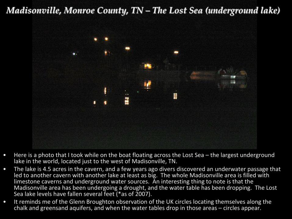
• Here is a photo that I took while on the boat floating across the Lost Sea – the largest underground lake in the world, located just to the west of Madisonville, TN.
• The lake is 4.5 acres in the cavern, and a few years ago divers discovered an underwater passage that led to another cavern with another lake at least as big. The whole Madisonville area is filled with limestone caverns and underground water sources. An interesting thing to note is that the Madisonville area has been undergoing a drought, and the water table has been dropping. The Lost Sea lake levels have fallen several feet (*as of 2007).
• It reminds me of the Glenn Broughton observation of the UK circles locating themselves along the chalk and greensand aquifers, and when the water tables drop in those areas – circles appear.
Madisonville, Monroe County, TN – The Lost Sea (underground lake)

• Near to the Madisonville, TN 2007 crop circle are a number of prehistoric Native American archaeological sites • A number of these were part of the Cherokee ancestral homeland which was flooded courtesy of the Tennessee Valley Authority (TVA) who dammed up the Little Tennessee River more than 30 years ago. The project to create Tellico Lake was to provide electrical power to the region, but it also destroyed over a dozen important archaeological sites in the valley with over 40 mounds now under the water – and flooded the very heart of the Cherokee Nations’ ancestral lands.

Tellico Lake with the Chota Memorial Peninsula in the center – Photo by Jeffrey Wilson

Each of the 8 outside pillars has a design for the named Clans of the Cherokee: Paint Clan, Wolf Clan, Wild Potato Clan, Bird Clan, Long Hair Clan, Blue Clan, and one pillar for the “Cherokees in the Little Tennessee Valley”. The short concave pillar in the center appears to be an offering altar.
Chota Memorial is located on a small peninsula in Tellico Lake:
Madisonville, Monroe County, TN
Photos by Jeffrey Wilson

Across the bay is located the Tanasi Memorial (actual site under water offshore):
Here is the Tanasi Memorial from the ground (note the 7 pointed star for the Clans):
Madisonville, Monroe County, TN
Photos by Jeffrey Wilson

• One of the nearest archaeological sites to the Madisonville, TN crop circle was the site of the Cherokee village of Toqua, about 8-9 miles to the east of the formation.
• At Toqua was the largest of all the earthen mounds in the whole of the Little Tennessee River valley, a mound the locals called “Big Toco” (the archaeologists called it Mound A). The “Big Toco” Mound was very similar in form to the elongated Seip Mound in Bainbridge, Ohio.
– In 2000 and 2003 crop circles were discovered near Seip Mound
• “Big Toco” was 154’ x 138’ in length/width and was 24’ tall at its highest point. Fifty-seven burials were found inside this mound.
• The “Big Toco” Mound, is now under Tellico Lake
“Big Toco” Mound at Toqua, TN
Seip Mound in Bainbridge, OH
Madisonville, Monroe County, TN

• When the “Big Toco” Mound was excavated by the Smithsonian Institution in the late 1800’s, one of the artifacts recovered was a shell gorget with a “Celtic-cross”-type insignia design (a second shell gorget was reported to have been found was not depicted in the Smithsonian Report). The drawing of the gorget, below, was taken from the 12th Annual Report of the Smithsonian Bureau of Ethnology, Pg. 383):
Madisonville, Monroe County, TN 2007
Madisonville, TN Crop Circle Design 2007

• This “Celtic-cross”-type symbology was frequently used in the creation of these shell gorgets. In 2006, I was able to photograph another shell gorget with a similar design on display at the Angel Mounds Museum in southern Indiana while we were investigating a nearby crop circle formation in Huntingburg, IN (note the distinctive swirled center – this design characteristic was often used):
• Here is another example of this “Celtic-cross”-type design created in copper by the ‘Hopewell’ culture in Ohio nearly 2,000 years ago:
Madisonville, Monroe County, TN
Note the last example (the lower right gorget in the drawing left) – the “Celtic-cross” symbol is formed by the central circle and the eyes of the four birds; the interlocking swirls create a second cross oriented at 45 degrees to the first – symbolically much like the Madisonville, TN crop circle formation. Artifact Photos by Jeffrey Wilson
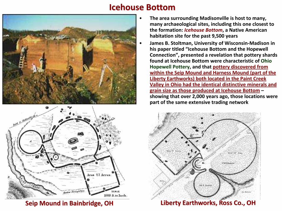
• The area surrounding Madisonville is host to many, many archaeological sites, including this one closest to the formation: Icehouse Bottom, a Native American habitation site for the past 9,500 years
• James B. Stoltman, University of Wisconsin-Madison in his paper titled “Icehouse Bottom and the Hopewell Connection”, presented a revelation that pottery shards found at Icehouse Bottom were characteristic of Ohio Hopewell Pottery, and that pottery discovered from within the Seip Mound and Harness Mound (part of the Liberty Earthworks) both located in the Paint Creek Valley in Ohio had the identical distinctive minerals and grain size as those produced at Icehouse Bottom – showing that over 2,000 years ago, those locations were part of the same extensive trading network
Icehouse Bottom
Seip Mound in Bainbridge, OH Liberty Earthworks, Ross Co., OH

Old County Map of Monroe County (1934) found in the Charles Hall Museum, Tellico Plains - Note the two known (unnamed) Cherokee Indian Town Sites located
near Madisonville - The (unnamed) Cherokee Indian Town Site to the east of Madisonville is
located just to the northeast of the 2007 crop circle formation site - Ancient figurine found by Charles Hall in Monroe County (photo by
Jeffrey Wilson)
2007 crop circle

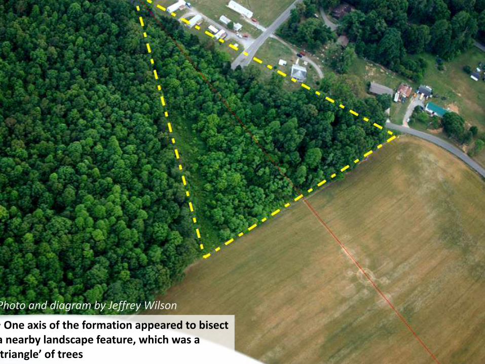
• One axis of the formation appeared to bisect a nearby landscape feature, which was a ‘triangle’ of trees
Photo and diagram by Jeffrey Wilson

• the formation also appeared to be tangential to another large-scale landscape feature, which was a large circle created by a watercourse and trees
Photo and diagram by Jeffrey Wilson

• One axis of the formation bisects a landscape ‘triangle’ and the formation is tangential to a landscape circle
Photo and diagram by Jeffrey Wilson

Summary of USA Crop Circle Alignments
• All crop circle formations in the USA which have been mapped accurately, and that have a straight-line geometric component as part of its’ design – it has been found that its’ geometric element always aligns to another USA crop circle formation
• Several formations are aligned to repeatedly
• The USA crop circles appear to be “self-referencing” each other Note: There is some small level of error in the methodology because of limitations of GPS and aerial photo precision, but it is further reduced by using alignment lines only 4-10 feet wide
This observation of these alignments raises several new questions about the nature of crop circles:
Were the crop circles all planned in advance, but are slowly unfolding across time and space?
Do the crop circles appear at nodal points of some underlying geometric grid of energy?
Are there additional forces acting upon where/when crop circles form that we have yet to consider?
There are (as yet) no answers to these complex questions. Many ideas have been put forward to explain these observations, but no one (as yet) has
collected enough evidence to support their ideas.

Photo courtesy: Mark Boring, Monroe County Buzz

Madisonville, TN 2007 Crop Circle Alignments

• Madisonville, Tennessee – May 2007
• eight crop circles are aligned from this formation:
• Locust Grove, OH 8-26-2003
• Oakvale, WV 4-2004
• Fairfield, CA 7-14-2004
• Geneseo, IL 8-17-2006 (another ‘Celtic-cross’ formation)
• Beloit, KS 9-10-2006
• Epps, LA x-x-200x
• Lawton, MI 8-24-2004 (RDF)
• Bedford, VA 5-3-2009 (RDF)
Summary of Madisonville’s Crop Circle Alignments
• Madisonville, Tennessee – May 2007
• one crop circle formation is aligned to this formation:
• Kalispell, MT 8-30-2000 : ~1,748 miles away
• two major pre-historic mound sites are aligned from this formation:
• Etowah
• Natchoochee
• Farthest aligned crop circle: ~2,075 miles to Fairfield, CA

We found an interesting little detail while measuring out the formation. As we began our measuring, we noticed that there was a tall, standing thistle that our north orientation ran directly though. Later when we got to measuring south, we found that another standing thistle was right on the south alignment; then at SW there was another thistle, then W, then NW, so we doubled back and found that there was a tall thistle at each of the major and minor compass points. Here’s a map of their locations (the purple bursts
indicating the thistle locations):
Madisonville, Monroe County, TN 2007 – interesting observation
Copyright 2008 © Jeffrey M. Wilson
Jeffrey M. Wilson Director, ICCRA
ICCRA - Independent Crop Circle Researchers’ Association [International]
May 14, 2008
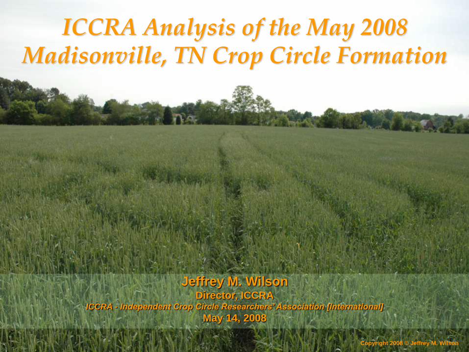
ICCRA Analysis of the May 2008 Madisonville, TN Crop Circle Formation


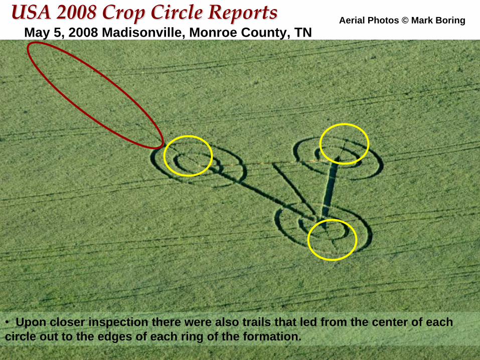
May 5, 2008 Madisonville, Monroe County, TN
USA 2008 Crop Circle Reports Aerial Photos © Mark Boring
• The first aerial photos were taken
just hours after the formation was
reported – yet there were visible
tracks in the field when no known
person(s) had been in the field to
visit the formation.
May 5, 2008 Madisonville, Monroe County, TN
USA 2008 Crop Circle Reports Aerial Photos © Mark Boring
• Upon closer inspection there were also trails that led from the center of each
circle out to the edges of each ring of the formation.

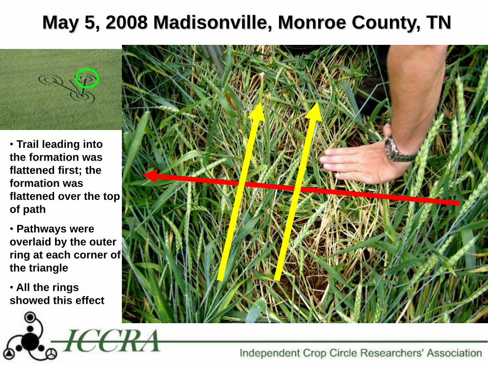
May 5, 2008 Madisonville, Monroe County, TN
USA 2008 Crop Circle Reports Aerial Photos © Mark Boring

May 5, 2008 Madisonville, Monroe County, TN
• Pathways were not exactly laid out very straight…
May 5, 2008 Madisonville, Monroe County, TN
• Trail leading into
the formation was
flattened first; the
formation was
flattened over the top
of path
• Pathways were
overlaid by the outer
ring at each corner of
the triangle
• All the rings
showed this effect

May 5, 2008 Madisonville, Monroe County, TN Triangle Pathways all aligned to ground lights

• The 2008 formation‟s plants had no elongation when
compared to control plants (L-NEAT negative).
• There was no detectable levels of electric fields,
magnetic fields or radio/microwave emission.
• There was no increased levels of radioactivity
(example next slide).
May 5, 2008 Madisonville, Monroe County, TN Science testing results:
Final analysis: the May 5, 2008 Madisonville, TN formation was mechanically-made by people.

Madisonville, TN 5-13-2008
GammaScout Radiation Readings (AVG µ Sv / h)
0.00
0.05
0.10
0.15
0.20
0.25
0.30
Helms' Backyard 450' Rad Contols 250' Rad Contols 100' Rad Contols Triangle 1 Triangle 2 Triangle 3 Outer Ring 1 Triangle Center
Bottom
Sample Location
Control Readings Formation Readings
There was virtually NO statistical difference in the two sets of samples.


West Union, Adams Co., Ohio - October 25, 2003
– This four-circle, three-ring, three pathway formation was in dry, ripe soybeans, and
located on a slope adjacent to a drainage ditch along a busy highway. No obvious
mechanical damage found, but because of the time frame between formation and
investigation, no firm conclusions could be drawn as to its authentication.
– 8 green plants that still had their stems intact showed the necrotic leaf base damage
that we had seen in both the Locust Grove and Bainbridge soybean formations


May 5, 2008 Madisonville, Monroe County, TN
USA 2008 Crop Circle Reports
Santa Rosa, Sonoma County. CA 4-1995
• Not an original design?
• Very simple design to construct
in the field, yet still poorly
executed. . .

• There was clear forensic evidence of man-made tracks leading into
the formation area that were made prior to the plants in the
formation being flattened.
• The pathways that led from each point of the triangle out to the ring
edges were laid down first, then the rings were flattened down OVER
these pathways – showing a clear order of man-made construction
• This formation‟s plants had no elongation when compared to control
plants (L-NEAT negative).
• There was no detectable levels of electric fields, magnetic fields or
radio/microwave emission.
• There was no increased levels of radioactivity.
• Scenario of typical „copycat‟ hoax seems evident
May 5, 2008 Madisonville, Monroe County, TN
Investigative SUMMARY:

Thank You to:
ICCRA Investigators List (2007 formation):
• Jeffrey Wilson
• Delsey Wilson
• Ted Robertson
• Roger Sugden
• Douglas McIlwaine
ICCRA Investigators List (2008 formation):
• Jeffrey Wilson
• Delsey Wilson
• Douglas McIlwaine

Jeffrey Wilson, Director ICCRA
Independent Crop Circle Researchers’ Association
www.iccra.org
Contact Network