uralla heritage inventory shi number · uralla heritage inventory shi number ... peter myers and...
TRANSCRIPT
2540351SHI NumberUralla Heritage Inventory
Item Name: Pise Outbuildings, Binnalong StationLocation: Arding [Uralla]
State Heritage Inventory Study Number231
Current Use:
Former Uses:
Statement of Significance:
The Binnalong pise out building demonstrates the use of locally available materials for vernacular structures that is quickly becoming rare at a regional level. Pise construction was a popular construction method for both shelter and to preserve food due to its stable thermal qualities. Possible historic association with local pise builder Fred Rixon.
Historical Notes or Provenance:
This small outbuilding dates to the 1860’s. Pise construction was quite popular in the Uralla, Rocky River, Arding and Saumarez Ponds districts. Using suitable gravels and clays, the earth is rammed firmly between a formwork of timber planks; this is the basic technique. In 1984 a few buildings were recorded as being extant in the Arding district but since decayed through weathering, neglect and lack of protective outer coatings many have since vanished.Mr Fred Rixon, Jnr was probably the most experienced pise man in the area between 1870-1910. Being the son of a goldminer he no doubt had experience with the properties of various soil types.
Physical Description: The timber members which were adzed smoothly were in place as needed for door steps, window sills and headings and door lintels. When the walls were carried up to the desired height a top plate was secured into the wall and a roof, usually of round saplings, were pitched. Walls were rendered with fine sand (both inside and out) to seal the surface and
Designer:
Maker / Builder:
Year Started: Year Completed: Circa: No
Endorsed Significance:Assessed Significance: Local
Item Type: Built Category: Other - Farming & GraGroup: Farming and Grazing
Admin Codes: Code 2: Code 3:
Curtilage/Boundary:
Owner: Private - Individual
Other/Former Names:
Area/Group/Complex: Group ID:
Themes:
Aboriginal Area: Anaiwan
Local Govt Area: Uralla
DUAP Region: NorthernHistoric region: New England
Address:Suburb / Nearest Town: Arding 2358
State: NSWParish: Arding
County: Sandon
Date: 04/01/2013 Page 1 Full Report with ImagesState Heritage Inventory
This report was produced using State Heritage Inventory database software provided by the Heritage Office of New South Wales.
2540351SHI NumberUralla Heritage Inventory
Item Name: Pise Outbuildings, Binnalong StationLocation: Arding [Uralla]
State Heritage Inventory Study Number231
protect it from weathering.
Physical Condition:
Modification Dates:Recommended
Management:
References:
Studies:
Further Comments: Encourage maintenance of outer protective coatings and using traditional techniques
Criteria a)
Criteria c) Pise is an excellent and sustainable building technique, and retains an even temperature throughout the year irrespective of temperature variations. Hence Pise was the choice for dairies and homes
Criteria d) Noted in community and thematic studies
Criteria e) The pise structure provides an opportunity for research into traditional and sustainable building techniques which remain valid today, and into the provision of shelters in the region
Criteria g) The building is representative of the construction technique and of an era when such buildings were both an economical and temperature controlled method of vernacular construction
Criteria f) Once common, pise structures are disappearing very quickly despite their continuing sustainability factors
Integrity / Intactness:
Criteria b) Historic associations with stable temperature control, and hence the preservation of foods, and possibility local pise builder Fred Rixon
Parcels:
Management:
Author Title Year
R Edwards Bushcrafts p29
Website accessed 2012oct: ‘Rammed earth’ from Wikipedia free encyclopaedia.
Website: ‘Pise in Australia’ by Prof. Miles Lewis, Melbourne University.
The Uralla Times, 10 March 1906
Unpublished study by A Goode, 1985
Author Title YearNumberPeter Myers and Anna Rubbo Uralla Heritage Study 1987231
Susan Jackson - Stepowski Part 2 - Uralla Community Based Heritage Study - Inventory
2012
Date: 04/01/2013 Page 2 Full Report with ImagesState Heritage Inventory
This report was produced using State Heritage Inventory database software provided by the Heritage Office of New South Wales.
2540351SHI NumberUralla Heritage Inventory
Item Name: Pise Outbuildings, Binnalong StationLocation: Arding [Uralla]
State Heritage Inventory Study Number231
Custom Field One:
Listings:
Date Updated: 20/12/2012 Status: BasicDate First Entered: 18/09/2012Data Entry:
Custom Field Two:
Custom Field Three:
Custom Field Four:
Custom Field Five:
Custom Field Six:
Latitude: -30 34 00 Longitude: 151 33 00
AMG Zone: Easting: Northing:
Map Name: Armidale 9236 Map Scale: 1:100000
Spatial Accuracy:Location validity:
Date: 04/01/2013 Page 3 Full Report with ImagesState Heritage Inventory
This report was produced using State Heritage Inventory database software provided by the Heritage Office of New South Wales.
2540351SHI NumberUralla Heritage Inventory
Item Name: Pise Outbuildings, Binnalong StationLocation: Arding [Uralla]
State Heritage Inventory Study Number231
Date: 04/01/2013 Page 4 Full Report with ImagesState Heritage Inventory
This report was produced using State Heritage Inventory database software provided by the Heritage Office of New South Wales.
2540352SHI NumberUralla Heritage Inventory
Item Name: Steel-Box Shaped Utility PolesLocation: Gwydir River Road, Bundarra [Uralla]
State Heritage Inventory Study Number233
Current Use: Electricity Poles
Former Uses: Electricity Poles
Statement of Significance:
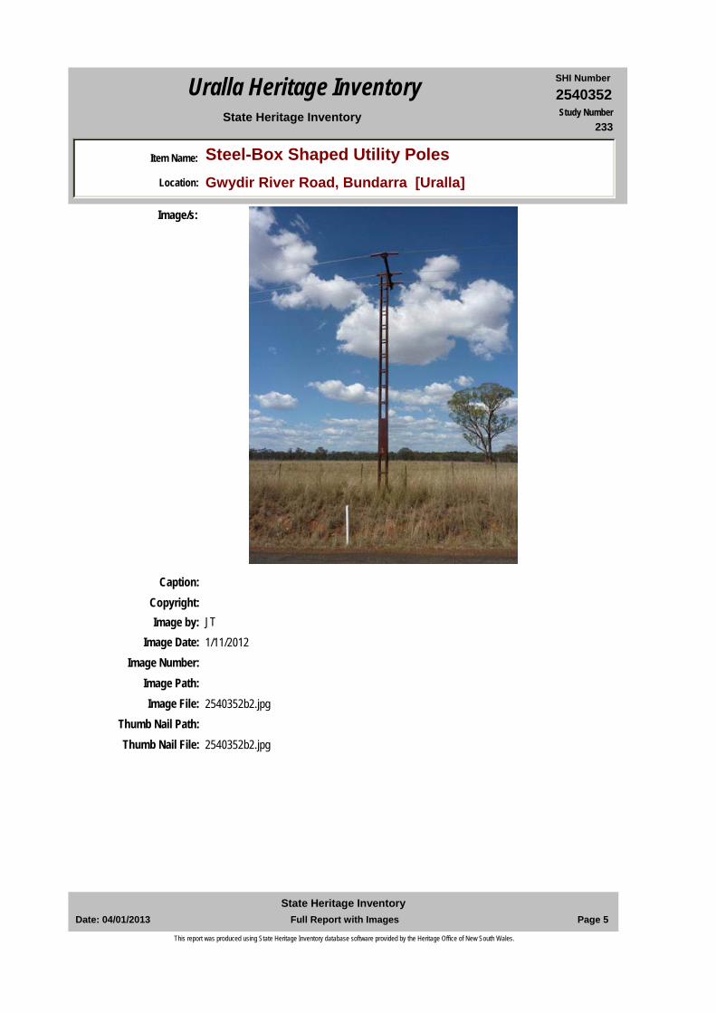
Surviving steel box-shaped utility poles are rare at a regional level. They are local landmarks in the wider cultural landscape arising from their height and use of steel material. Historically the poles are significant for the provision of electricity to out-lying rural areas. They are representative of the application of early 20th century technologies, and when timber was scare or easily attached by termites. The technology is related to the invention of ‘scobie’ poles in South Australia.
Historical Notes or Provenance:
From 1908 there was an identified shortage of hardwood in the New England and most timbers were sourced from the North Coast. Termites attach and high winds were also a consideration. Utility poles for telephone and electrical lines were mainly constructed of wood. Other utility poles were constructed of steel and concrete. A patented utility pole used in Australia was the ‘stobie pole’, which are made up of two vertical steel posts with a slab of concrete in between. Scobie poles were designed by Adelaide Electricity Supply design engineer James Cyril Stobie 1895-1953, and commenced production in 1926. The ‘steel box’ utility poles are related to the ‘scobie poles’ but rather than use concrete, structural integrity is achieved via welded metal straps. Electriciity was connected to this area near Bundarra after World War Two in the early 1950s. The structures were fabricated in the workshop of what was North West Electricity based at Inverell approximately 30 years ago. (John O'Meager, Regional Works Program Manager Northern) On 1 March 2011 the Country Energy retail business transferred to Origin Energy. The network operation then continued un der the Essential Energy name.
Endorsed Significance:Assessed Significance: Local
Item Type: Built Category: Other - Utilities - ElectrGroup: Utilities - Electricity
Admin Codes: Code 2: Code 3:
Curtilage/Boundary:
Owner: Private - Corporate
Other/Former Names: Bundarra-Torryburn Road steel poles
Area/Group/Complex: Group ID:
Themes:
Aboriginal Area:
Local Govt Area: Uralla
DUAP Region: NorthernHistoric region: New England
Address: Gwydir River RoadSuburb / Nearest Town: Bundarra 2359
State: NSWParish:
County:
National Theme State Theme Local Theme
3. Economy Technology Steel electrical poles
Date: 04/01/2013 Page 1 Full Report with ImagesState Heritage Inventory
This report was produced using State Heritage Inventory database software provided by the Heritage Office of New South Wales.
2540352SHI NumberUralla Heritage Inventory
Item Name: Steel-Box Shaped Utility PolesLocation: Gwydir River Road, Bundarra [Uralla]
State Heritage Inventory Study Number233
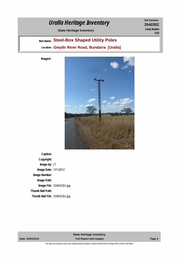
Physical Description: Located south of Bundarra on the Gwydir River Road, formally called the Bundarra-Torryburn Road. * Four (4) poles are located on ‘Coruna’ 2633 Gwydir River Road, approx. 11 kms south of Bundarra. John O'Meager, Regional Works Program Manager described them as lattice box frame steel poles.* one (1) is located on the road verge 5 kms south of Bundarra.
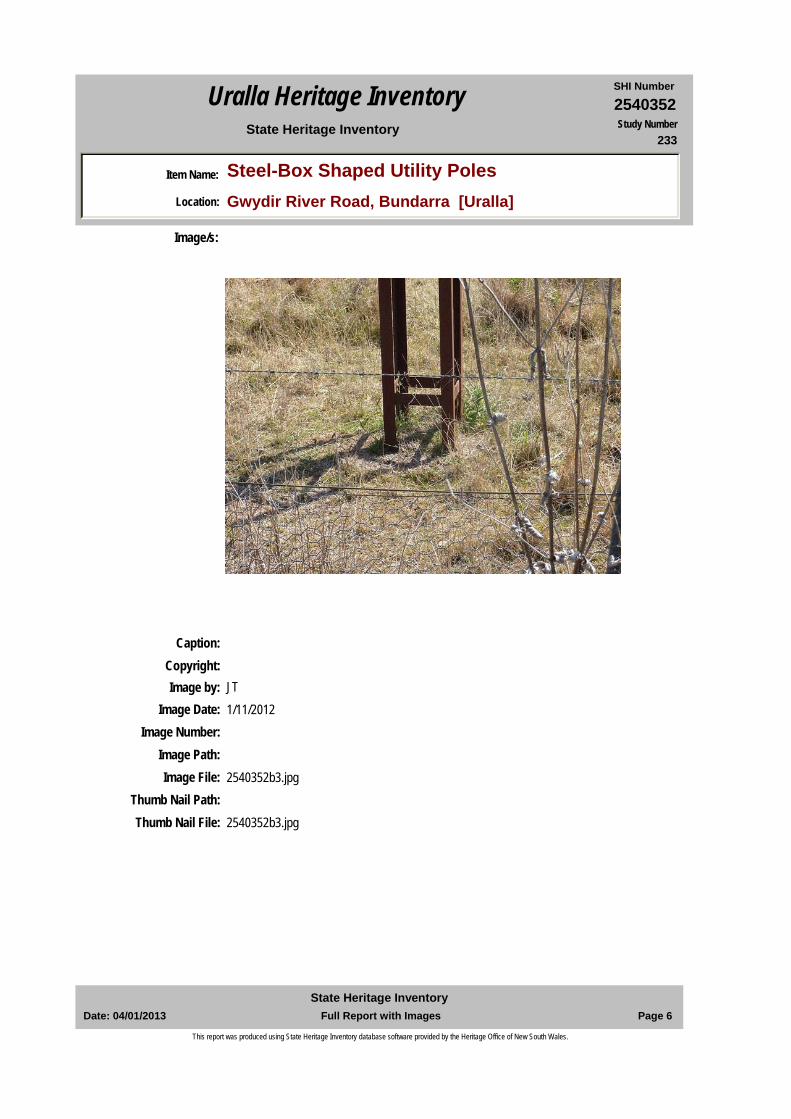
Steel fabricated poles, each made of four vertical angle steel elements, about 1-2 metals above the ground is a metal sheet to reinforce the structure, and then at rhythmic approx. 0.5m intervals up the structure are welded flat steel bracing straps. At the top are three (3) large porcelain insulators and above these is a horizontal steel support through which run up to four electricity wires.
Physical Condition:
Modification Dates:
Designer:
Maker / Builder:
Year Started: Year Completed: Circa: No
Recommended Management:
Further Comments:
Criteria a) Steel box poles demonstrate how the emerging steel technologies were used in the 20th century to provide for the roll-out of essential services, such as electricity.
Criteria c) The steel box poles are distinctive in the open landscape. They demonstrate a technical solution for the roll-out of early 20th century electivity provision.
Criteria d) Noted by the community in studies.
Criteria e) The steel box poles provide an opportunity to research the roll out and provision of essential
Criteria b) Steel box design is historically related to the South Australian ‘scobie’ pole design.
Management:
4. Settlement Utilities Provision of electricity5. Working Labour Electrical employment7. Governing Government and administra Provision of electricity
Date: 04/01/2013 Page 2 Full Report with ImagesState Heritage Inventory
This report was produced using State Heritage Inventory database software provided by the Heritage Office of New South Wales.
2540352SHI NumberUralla Heritage Inventory
Item Name: Steel-Box Shaped Utility PolesLocation: Gwydir River Road, Bundarra [Uralla]
State Heritage Inventory Study Number233
Custom Field One:
References:
Studies:
Listings:
Date Updated: 20/12/2012 Status: BasicDate First Entered: 18/09/2012Data Entry:
services and use of steel technologies for such structures in New England district.
Criteria g) The steel box poles are representative of technologies used the 20th century to provide utilities in rural areas.
Criteria f) The use of steel for utility services, and in the form of ‘steel box ‘ design, are rare in the New England district.
Integrity / Intactness:
Custom Field Two:
Custom Field Three:
Custom Field Four:
Custom Field Five:
Custom Field Six:
Parcels:
Latitude: Longitude:
AMG Zone: Easting: Northing:
Map Name: Map Scale:
Spatial Accuracy:Location validity:
Author Title Year
Observations made by Local Historian Goode and Archaeologist Luke Godwin March 1987
1987
Australian Dictionary of Biography, vol. 16, Melbourne University Press, 2002, pp.314-315.
Website: Utility pole- Wikipedia, the free encyclopaedia
Website: Stobie pole- Wikipedia, the free encyclopaedia
John O'Meagher, Regional works Program Manager Northern
Email to Libby Cumming, Director of Planning, 17 December 2012.
Author Title YearNumberPeter Myers and Anna Rubbo Uralla Heritage Study 1987233
Susan Jackson - Stepowski Part 2 - Uralla Community Based Heritage Study - Inventory
2012
Date: 04/01/2013 Page 3 Full Report with ImagesState Heritage Inventory
This report was produced using State Heritage Inventory database software provided by the Heritage Office of New South Wales.
2540352SHI NumberUralla Heritage Inventory
Item Name: Steel-Box Shaped Utility PolesLocation: Gwydir River Road, Bundarra [Uralla]
State Heritage Inventory Study Number233
Caption:Copyright:
Image/s:
Image by: JTImage Date: 1/11/2012
Image Number:Image Path:Image File: 2540352b1.jpg
Thumb Nail Path:Thumb Nail File: 2540352b1.jpg
Date: 04/01/2013 Page 4 Full Report with ImagesState Heritage Inventory
This report was produced using State Heritage Inventory database software provided by the Heritage Office of New South Wales.
2540352SHI NumberUralla Heritage Inventory
Item Name: Steel-Box Shaped Utility PolesLocation: Gwydir River Road, Bundarra [Uralla]
State Heritage Inventory Study Number233
Caption:Copyright:
Image/s:
Image by: JTImage Date: 1/11/2012
Image Number:Image Path:Image File: 2540352b2.jpg
Thumb Nail Path:Thumb Nail File: 2540352b2.jpg
Date: 04/01/2013 Page 5 Full Report with ImagesState Heritage Inventory
This report was produced using State Heritage Inventory database software provided by the Heritage Office of New South Wales.
2540352SHI NumberUralla Heritage Inventory
Item Name: Steel-Box Shaped Utility PolesLocation: Gwydir River Road, Bundarra [Uralla]
State Heritage Inventory Study Number233
Caption:Copyright:
Image/s:
Image by: JTImage Date: 1/11/2012
Image Number:Image Path:Image File: 2540352b3.jpg
Thumb Nail Path:Thumb Nail File: 2540352b3.jpg
Date: 04/01/2013 Page 6 Full Report with ImagesState Heritage Inventory
This report was produced using State Heritage Inventory database software provided by the Heritage Office of New South Wales.
2540354SHI NumberUralla Heritage Inventory
Item Name: Railways Gatekeeper's Cottage (Former)Location: Eastern Ave/ Martin's Lane cnr, Kentucky [Uralla]
State Heritage Inventory Study Number235
Current Use: Private Residence
Former Uses: Railway Gatekeer's Cottage
Statement of Significance:
Distinctive standardised form of Railway Gatekeeper’s cottage, one of three remaining in the Uralla Shire. Its context remains, being on key routes into Kentucky village, and demonstrates how railways operated especially at road crossing points. It continues to tell the story of how the railway operated and via its modesty, the life of a railway employee. The railway gatekeeper's cottage has landmark, historical association, aesthetic, social, rarity and representative significance
Historical Notes or Provenance:
The NSW Parliament approved extension of the Great Northern Railway line to Tenterfield on 16 May 1878. There was a fierce debate in Parliament whether the line should pass through Armidale or Inverell. The contract from West Tamworth to Uralla, a distance of 63 miles (100.2 kilometres) was let on 18 January 1881 to Amos and Co for a price of 612,963 pounds with a completion date of 31May 1882. Tenders closed for construction of the passenger station platform, carriage dock, stationmaster's house, gate house and other works at Uralla on Wednesday 25 May 1881. By September the Armidale Express reported 'the contractors for the terminus buildings, including a passenger station, good's shed, station master's residence, and also a gate keeper's residence’ had commenced (Armidale Express, 9 September 1881) The buildings were well underway by April 1882.The 1889 Annual Report to the Railway Commissioner indicates the following rates of pay for railway gatekeepers: the male gatekeeper two pounds five shillings and six pence and female gatekeeper two shillings and six pence per week.The extensions on north and west sides are indicative of the way that a relatively small cottage is modified to meet the changing needs of the gatekeeper's family.
Endorsed Significance:Assessed Significance: Local
Item Type: Built Category: Railway Residence/QuGroup: Transport - Rail
Admin Codes: Code 2: Code 3:
Curtilage/Boundary:
Owner: Private - Individual
Other/Former Names:
Area/Group/Complex: Group ID:
Aboriginal Area: Anaiwan
Local Govt Area: Uralla
DUAP Region: NorthernHistoric region: New England
Address: Eastern Ave/ Martin's Lane cnrSuburb / Nearest Town: Kentucky 2354
State: NSWParish: Kentucky
County: Sandon
Date: 04/01/2013 Page 1 Full Report with ImagesState Heritage Inventory
This report was produced using State Heritage Inventory database software provided by the Heritage Office of New South Wales.
2540354SHI NumberUralla Heritage Inventory
Item Name: Railways Gatekeeper's Cottage (Former)Location: Eastern Ave/ Martin's Lane cnr, Kentucky [Uralla]
State Heritage Inventory Study Number235
In the early 1990s the State Rail Authority planned to demolish the gatekeeper's cottage but Uralla Shire Council refused to permit demolition.
Physical Description: A distinctive feature is the central chimney iconic of gatekeepers’ cottage design. The symmetrical brick building with central doorway, either side timber, vertical proportioned, double hung, windows and other pairs on side elevations, detached skillions to front and rear (as accommodation addition). Interlocking brickwork including ‘Armidale blues’, arch soldier courses above windows, terra-cotta hooded walls vents.
Physical Condition:
Modification Dates:
Designer:
Maker / Builder:
Year Started: Year Completed: Circa: No
Recommended Management:
Further Comments:
Criteria a) This small building is but one of a number of identical buildings which housed the gatekeeper and his family at important roadway and railway junctions throughout NSW, the design being standardised by 1880s. .The design for the building had become standardised by the 1880’s; and the one here is one of three identical houses along the Great Northern Railway within the Uralla Shire.
C it i ) Th hit t l d i i i i i ti d f A
Criteria b) The gatekeeper's cottage is historically linked with the provision of the many similar cottages built throughout the state as the NSW railway system developed. The Cottage’s context demonstrates the need to first see and then manage conflicts between the railway line and the many road crossing points that were needed for pedestrian and initially horses and later vehicles. As vehicles increased in numbers, many manned-gated crossings were closed as automatic gates and flashing lights were introduced.
Themes:
Management:
National Theme State Theme Local Theme
3. Economy Transport Gatekeeper's cottage4. Settlement Accommodation (Housing) Gatekeeper's Cottage5. Working Labour Railway employment7. Governing Government and administra Railway housing
Date: 04/01/2013 Page 2 Full Report with ImagesState Heritage Inventory
This report was produced using State Heritage Inventory database software provided by the Heritage Office of New South Wales.
2540354SHI NumberUralla Heritage Inventory
Item Name: Railways Gatekeeper's Cottage (Former)Location: Eastern Ave/ Martin's Lane cnr, Kentucky [Uralla]
State Heritage Inventory Study Number235
Custom Field One:
References:
Studies:
Listings:
Criteria c) distinctive feature is the central brick chimney set with the centre of the hip roofline.
Criteria d) Social significance arises from many memories being evoked by such distinctive cottages of both working and living along the line. It remains locally well known as demonstrated by the refusal to allow its demolition. Noted in community and thematic studies
Criteria e) The positioning and design of the gatekeeper's cottage provides the opportunity for a research project to determine how many similar cottages were constructed along the northern railway line from Tamworth to Tenterfield.
Criteria g) The construction of the railway is representative of the lobbying power of politicians and communities, and changing government policy in relation to providing then withdrawing services.
Criteria f) Gatekeeper's cottages were once found along the railway lines throughout New South Wales but since the 1980s many have been demolished by the railway authorities. The Uralla gatekeepers' cottage is representative of such buildings which survived because the Uralla Shire's intervention in the demolition process. One of 3 identical cottages in the Uralla Shire
Integrity / Intactness:
Custom Field Two:
Custom Field Three:
Custom Field Four:
Custom Field Five:
Custom Field Six:
Parcels:
Latitude: Longitude:
AMG Zone: Easting: Northing:
Map Name: Map Scale:
Spatial Accuracy:Location validity:
Author Title Year
Commissioners for NSW Government Railways, Annual Report, 1889 quoted in the Armidale and District Historical Society Journal, Railway Issue, Vol.20
1977
Author Title YearNumberPeter Myers and Anna Rubbo Uralla Heritage Study 1987235
Susan Jackson - Stepowski Part 2 - Uralla Community Based Heritage Study - Inventory
2012
Date: 04/01/2013 Page 3 Full Report with ImagesState Heritage Inventory
This report was produced using State Heritage Inventory database software provided by the Heritage Office of New South Wales.

2540354SHI NumberUralla Heritage Inventory
Item Name: Railways Gatekeeper's Cottage (Former)Location: Eastern Ave/ Martin's Lane cnr, Kentucky [Uralla]
State Heritage Inventory Study Number235
Date Updated: 20/12/2012 Status: BasicDate First Entered: 18/09/2012Data Entry:
Date: 04/01/2013 Page 4 Full Report with ImagesState Heritage Inventory
This report was produced using State Heritage Inventory database software provided by the Heritage Office of New South Wales.
2540354SHI NumberUralla Heritage Inventory
Item Name: Railways Gatekeeper's Cottage (Former)Location: Eastern Ave/ Martin's Lane cnr, Kentucky [Uralla]
State Heritage Inventory Study Number235
Date: 04/01/2013 Page 5 Full Report with ImagesState Heritage Inventory
This report was produced using State Heritage Inventory database software provided by the Heritage Office of New South Wales.
2540355SHI NumberUralla Heritage Inventory
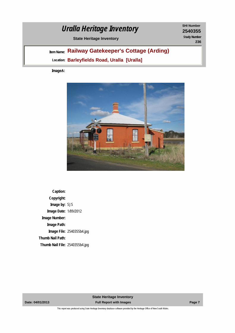
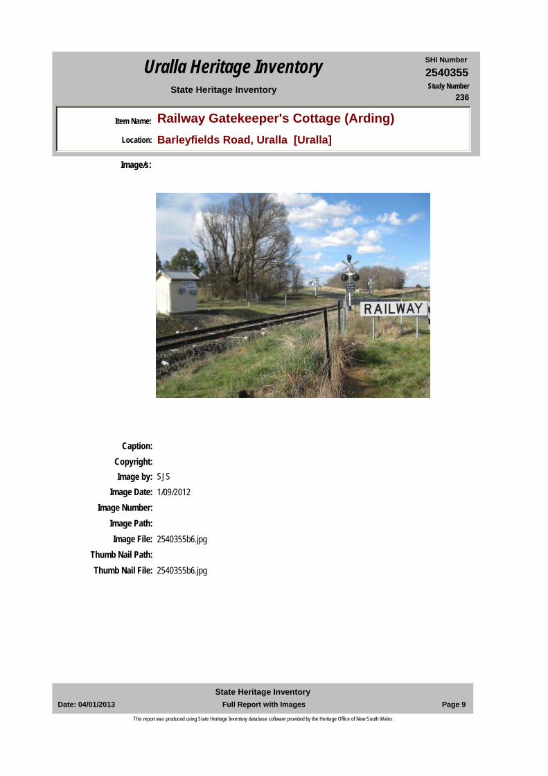
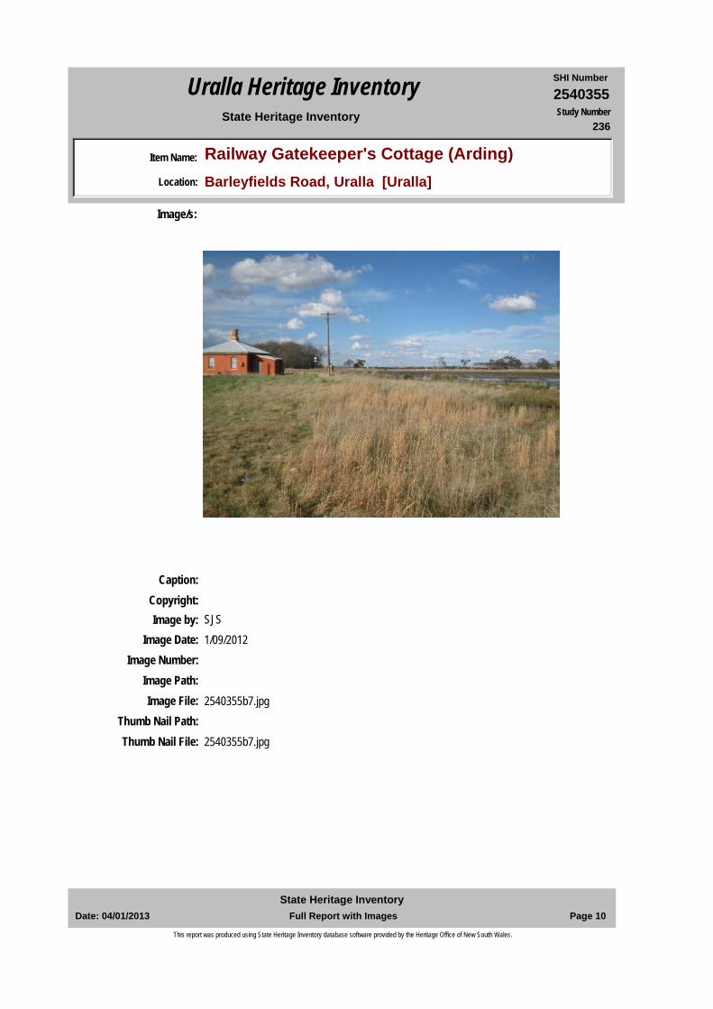
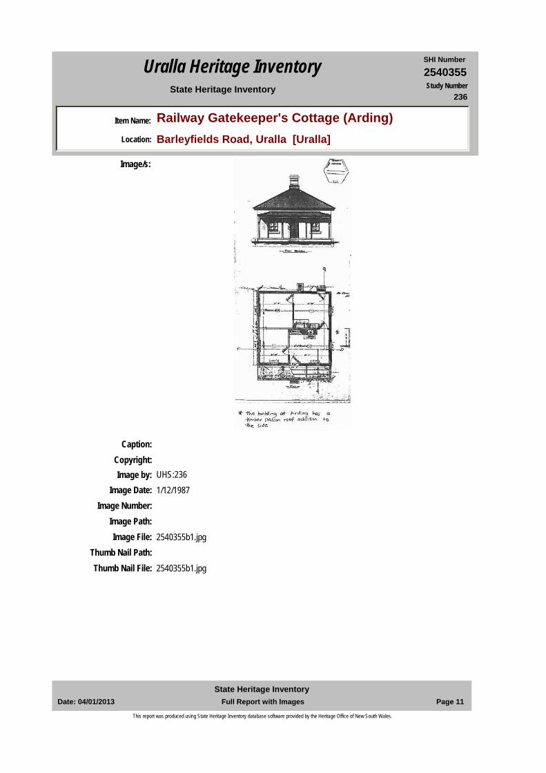
Item Name: Railway Gatekeeper's Cottage (Arding)Location: Barleyfields Road, Uralla [Uralla]
State Heritage Inventory Study Number236
Current Use: Unoccupied
Former Uses: Railway gate keeper's cottage
Statement of Significance:
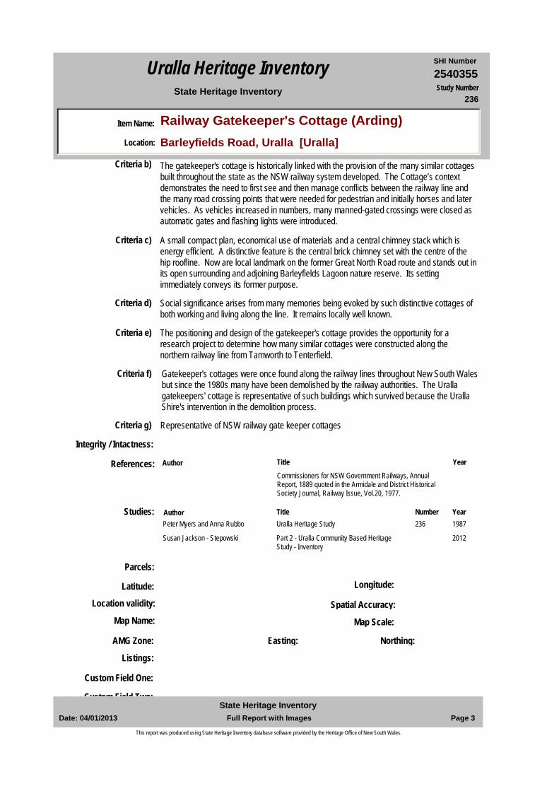
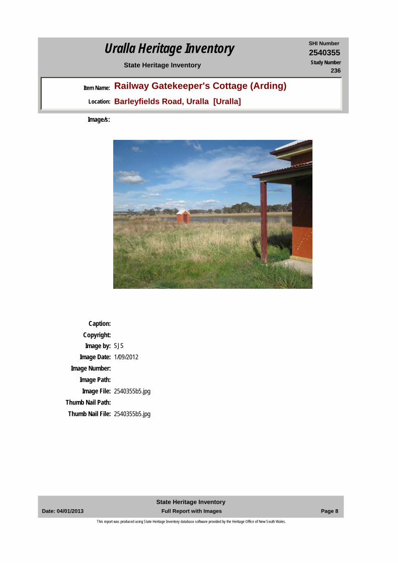
Distinctive standardised form of the Railway Gatekeeper’s Cottage at the Barleyfields crossing at Arding, it remains a local landmark on the former route of the main northern road to Armidale and adjoining the Barleyfields Lagoon nature sanctuary. The local community fought to save these modest structures. Its context, viewlines and position demonstrates how railways operated especially at road crossing points. It continues to tell the story of how railway operated and of a modest of life of an employee. The railway gatekeeper's cottage has landmark, historical association, aesthetic, social, rarity and representative significance
Historical Notes or Provenance:
The NSW Parliament approved extension of the Great Northern Railway line to Tenterfield on 16 May 1878. There was a fierce debate in Parliament whether the line should pass through Armidale or Inverell. The contract from West Tamworth to Uralla, a distance of 63 miles (100.2 kilometres) was let on 18 January 1881 to Amos and Co for a price of 612,963 pounds with a completion date of 31May 1882. Tenders closed for construction of the passenger station platform, carriage dock, stationmaster's house, gate house and other works at Uralla on Wednesday 25 May 1881. By September the Armidale Express reported 'the contractors for the terminus buildings, including a passenger station, good's shed, station master's residence, and also a gate keeper's residence’ had commenced (Armidale Express, 9 September 1881) The buildings were well underway by April 1882.The 1889 Annual Report to the Railway Commissioner indicates the following rates of pay for railway gatekeepers: the male gatekeeper two pounds five shillings and six pence and female gatekeeper two shillings and six pence per week.The extensions on north and west sides are indicative of the way that a relatively small
Endorsed Significance:Assessed Significance: Local
Item Type: Built Category: Railway Residence/QuGroup: Transport - Rail
Admin Codes: Code 2: Code 3:
Curtilage/Boundary:
Owner: Private - Individual
Other/Former Names:
Area/Group/Complex: Group ID:
Aboriginal Area: Anaiwan
Local Govt Area: Uralla
DUAP Region: NorthernHistoric region: New England
Address: Barleyfields RoadSuburb / Nearest Town: Uralla 2358
State: NSWParish:
County:
Date: 04/01/2013 Page 1 Full Report with ImagesState Heritage Inventory
This report was produced using State Heritage Inventory database software provided by the Heritage Office of New South Wales.
2540355SHI NumberUralla Heritage Inventory
Item Name: Railway Gatekeeper's Cottage (Arding)Location: Barleyfields Road, Uralla [Uralla]
State Heritage Inventory Study Number236
cottage is modified to meet the changing needs of the gatekeeper's family.In the early 1990s the State Rail Authority planned to demolish the gatekeeper's cottage but Uralla Shire Council refused to permit demolition
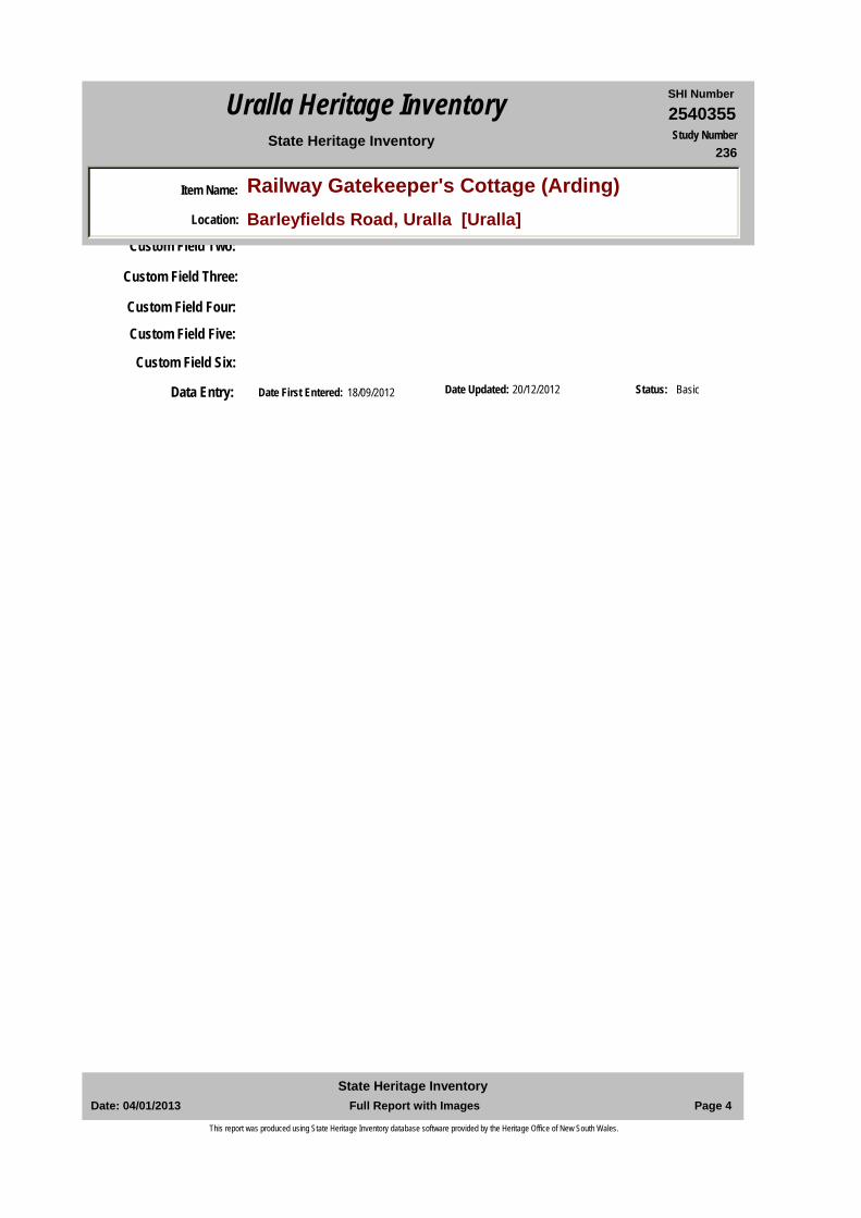
Physical Description: A distinctive feature is the central chimney used for all gatekeepers’ cottage designs. The symmetrical brick building has a central doorway and either side window openings now masonry and painter to emulate timber double hung 4 pane windows s of glass, as are those on the south elevation; a detached concave front verandah on the railway line side (which also happens to be where the road crossing is located), with simple square timber verandah supports. The verandah floor is concrete. On the Lagoon (east) side is a skillion extension and a skillion extension clad in vertical sheets of corrugated galvanised iron, paint to match the masonry portion. Roofs are clad in corrugate short sheet iron with traditional ridge cappings and chimney flashing. The building is painted in traditional scheme. It retains its original brick outside toilet some distance to the north. The surrounding are open grass lands that merge in with the adjoining lagoon habitat. The building is highly visible on immediate exit from the by-pass and travelling along the original Great North Road route.
Physical Condition:
Modification Dates:
Designer:
Maker / Builder:
Year Started: Year Completed: Circa: No
Recommended Management:
Further Comments:
Criteria a) The gatekeeper's cottage is tangible evidence of the history of the extensive 19th century debates about their routes and then the roll-out of railway lines. The 1880s building standardised form demonstrates how gatekeeper's cottages throughout the State were provided for the gatekeeper's family and 24 hour operations.
Themes:
Management:
National Theme State Theme Local Theme
3. Economy Transport Gatekeeper's cottage4. Settlement Accommodation (Housing) Gatekeeper's Cottage5. Working Labour Railway employment7. Governing Government and administra Railway housing
Date: 04/01/2013 Page 2 Full Report with ImagesState Heritage Inventory
This report was produced using State Heritage Inventory database software provided by the Heritage Office of New South Wales.
2540355SHI NumberUralla Heritage Inventory
Item Name: Railway Gatekeeper's Cottage (Arding)Location: Barleyfields Road, Uralla [Uralla]
State Heritage Inventory Study Number236
Custom Field One:
References:
Studies:
Listings:
Criteria c) A small compact plan, economical use of materials and a central chimney stack which is energy efficient. A distinctive feature is the central brick chimney set with the centre of the hip roofline. Now are local landmark on the former Great North Road route and stands out in its open surrounding and adjoining Barleyfields Lagoon nature reserve. Its setting immediately conveys its former purpose.
Criteria d) Social significance arises from many memories being evoked by such distinctive cottages of both working and living along the line. It remains locally well known.
Criteria e) The positioning and design of the gatekeeper's cottage provides the opportunity for a research project to determine how many similar cottages were constructed along the northern railway line from Tamworth to Tenterfield.
Criteria g) Representative of NSW railway gate keeper cottages
Criteria f) Gatekeeper's cottages were once found along the railway lines throughout New South Wales but since the 1980s many have been demolished by the railway authorities. The Uralla gatekeepers' cottage is representative of such buildings which survived because the Uralla Shire's intervention in the demolition process.
Integrity / Intactness:
Custom Field Two:
Criteria b) The gatekeeper's cottage is historically linked with the provision of the many similar cottages built throughout the state as the NSW railway system developed. The Cottage’s context demonstrates the need to first see and then manage conflicts between the railway line and the many road crossing points that were needed for pedestrian and initially horses and later vehicles. As vehicles increased in numbers, many manned-gated crossings were closed as automatic gates and flashing lights were introduced.
Parcels:
Latitude: Longitude:
AMG Zone: Easting: Northing:
Map Name: Map Scale:
Spatial Accuracy:Location validity:
Author Title Year
Commissioners for NSW Government Railways, Annual Report, 1889 quoted in the Armidale and District Historical Society Journal, Railway Issue, Vol.20, 1977.
Author Title YearNumberPeter Myers and Anna Rubbo Uralla Heritage Study 1987236
Susan Jackson - Stepowski Part 2 - Uralla Community Based Heritage Study - Inventory
2012
Date: 04/01/2013 Page 3 Full Report with ImagesState Heritage Inventory
This report was produced using State Heritage Inventory database software provided by the Heritage Office of New South Wales.
2540355SHI NumberUralla Heritage Inventory
Item Name: Railway Gatekeeper's Cottage (Arding)Location: Barleyfields Road, Uralla [Uralla]
State Heritage Inventory Study Number236
Date Updated: 20/12/2012 Status: BasicDate First Entered: 18/09/2012Data Entry:
Custom Field Two:
Custom Field Three:
Custom Field Four:
Custom Field Five:
Custom Field Six:
Date: 04/01/2013 Page 4 Full Report with ImagesState Heritage Inventory
This report was produced using State Heritage Inventory database software provided by the Heritage Office of New South Wales.
2540355SHI NumberUralla Heritage Inventory
Item Name: Railway Gatekeeper's Cottage (Arding)Location: Barleyfields Road, Uralla [Uralla]
State Heritage Inventory Study Number236
Caption:Copyright:
Image/s:
Image by: SJSImage Date: 1/09/2012
Image Number:Image Path:Image File: 2540355b2.jpg
Thumb Nail Path:Thumb Nail File: 2540355b2.jpg
Date: 04/01/2013 Page 5 Full Report with ImagesState Heritage Inventory
This report was produced using State Heritage Inventory database software provided by the Heritage Office of New South Wales.
2540355SHI NumberUralla Heritage Inventory
Item Name: Railway Gatekeeper's Cottage (Arding)Location: Barleyfields Road, Uralla [Uralla]
State Heritage Inventory Study Number236
Caption:Copyright:
Image/s:
Image by: SJSImage Date: 1/09/2012
Image Number:Image Path:Image File: 2540355b3.jpg
Thumb Nail Path:Thumb Nail File: 2540355b3.jpg
Date: 04/01/2013 Page 6 Full Report with ImagesState Heritage Inventory
This report was produced using State Heritage Inventory database software provided by the Heritage Office of New South Wales.
2540355SHI NumberUralla Heritage Inventory
Item Name: Railway Gatekeeper's Cottage (Arding)Location: Barleyfields Road, Uralla [Uralla]
State Heritage Inventory Study Number236
Caption:Copyright:
Image/s:
Image by: SJSImage Date: 1/09/2012
Image Number:Image Path:Image File: 2540355b4.jpg
Thumb Nail Path:Thumb Nail File: 2540355b4.jpg
Date: 04/01/2013 Page 7 Full Report with ImagesState Heritage Inventory
This report was produced using State Heritage Inventory database software provided by the Heritage Office of New South Wales.
2540355SHI NumberUralla Heritage Inventory
Item Name: Railway Gatekeeper's Cottage (Arding)Location: Barleyfields Road, Uralla [Uralla]
State Heritage Inventory Study Number236
Caption:Copyright:
Image/s:
Image by: SJSImage Date: 1/09/2012
Image Number:Image Path:Image File: 2540355b5.jpg
Thumb Nail Path:Thumb Nail File: 2540355b5.jpg
Date: 04/01/2013 Page 8 Full Report with ImagesState Heritage Inventory
This report was produced using State Heritage Inventory database software provided by the Heritage Office of New South Wales.
2540355SHI NumberUralla Heritage Inventory
Item Name: Railway Gatekeeper's Cottage (Arding)Location: Barleyfields Road, Uralla [Uralla]
State Heritage Inventory Study Number236
Caption:Copyright:
Image/s:
Image by: SJSImage Date: 1/09/2012
Image Number:Image Path:Image File: 2540355b6.jpg
Thumb Nail Path:Thumb Nail File: 2540355b6.jpg
Date: 04/01/2013 Page 9 Full Report with ImagesState Heritage Inventory
This report was produced using State Heritage Inventory database software provided by the Heritage Office of New South Wales.
2540355SHI NumberUralla Heritage Inventory
Item Name: Railway Gatekeeper's Cottage (Arding)Location: Barleyfields Road, Uralla [Uralla]
State Heritage Inventory Study Number236
Caption:Copyright:
Image/s:
Image by: SJSImage Date: 1/09/2012
Image Number:Image Path:Image File: 2540355b7.jpg
Thumb Nail Path:Thumb Nail File: 2540355b7.jpg
Date: 04/01/2013 Page 10 Full Report with ImagesState Heritage Inventory
This report was produced using State Heritage Inventory database software provided by the Heritage Office of New South Wales.
2540355SHI NumberUralla Heritage Inventory
Item Name: Railway Gatekeeper's Cottage (Arding)Location: Barleyfields Road, Uralla [Uralla]
State Heritage Inventory Study Number236
Caption:Copyright:
Image/s:
Image by: UHS:236Image Date: 1/12/1987
Image Number:Image Path:Image File: 2540355b1.jpg
Thumb Nail Path:Thumb Nail File: 2540355b1.jpg
Date: 04/01/2013 Page 11 Full Report with ImagesState Heritage Inventory
This report was produced using State Heritage Inventory database software provided by the Heritage Office of New South Wales.
2540358SHI NumberUralla Heritage Inventory
Item Name: Railway Viaduct, part of boundary fenceLocation: Barleyfield Road, Uralla [Uralla]
State Heritage Inventory Study Number239
Current Use: Railway viaduct
Former Uses: Railway viaduct
Statement of Significance:
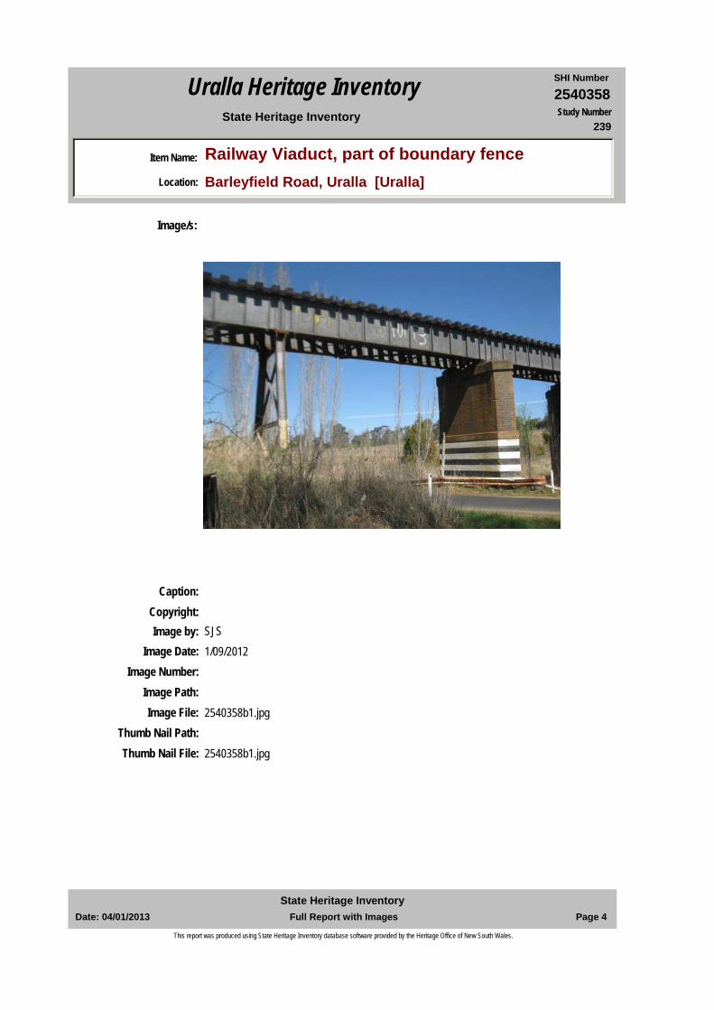
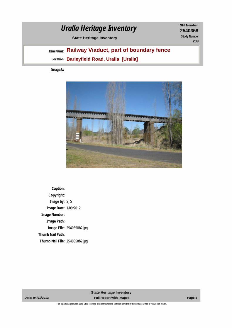
The 1882 Railway Viaduct over Uralla Creek marks the original northern entry in the township of Uralla. It remains a dominant man-made feature in the wider landscape. Massive piers built in 1910 of ‘Armidale blue’ bricks support a steel super-structure for the railway tracks above. Historically the Viaduct marks the crossing of two transport modes of the Great Northern Railway and the Great Northern Road. The Viaduct is part of serial group relating to construction of the Great Northern Railway including the Test Pit and the Steep Incline
Historical Notes or Provenance:
A viaduct was constructed over Uralla Creek and the Great Northern Railway during the railway extension to Wallengarra in 1882. Originally a timber trestle viaduct was erected but these were replaced with brick piers in 1910. Prior to 1910 trains had to reduce speed on this section of the line because of the unstable nature of the timber trestles. The extant brick piers are made of ‘Armidale Blue’ brick. The Viaduct crosses the Great North Road, which was the primary route to Armidale prior to the building of a new section of the New England Highway in 1982 which bypassed this section road section. The road is now known as Barley Fields Road.Boundary Fence: This section of the railway boundary fence adjacent to the Railway Viaduct could very well be part of the original 1882. Over subsequent years the timber 2 rail fence was replaced with galvanised wire. Whilst evident in c1987 only a few split log posts can be seen dividing off the adjoining paddock west of the railway to the north of the Barley Fields Road in 2012.
Endorsed Significance:Assessed Significance: Local
Item Type: Built Category: Railway Bridge/ ViaduGroup: Transport - Rail
Admin Codes: Code 2: Code 3:
Curtilage/Boundary:
Owner: State Government
Other/Former Names:
Area/Group/Complex: Group ID:
Themes:
Aboriginal Area: Anaiwan
Local Govt Area: Uralla
DUAP Region: NorthernHistoric region: New England
Address: Barleyfield RoadSuburb / Nearest Town: Uralla 2358
State: NSWParish: Uralla
County: Sandon
National Theme State Theme Local Theme
4. Settlement Utilities Railway viaduct
Date: 04/01/2013 Page 1 Full Report with ImagesState Heritage Inventory
This report was produced using State Heritage Inventory database software provided by the Heritage Office of New South Wales.
2540358SHI NumberUralla Heritage Inventory
Item Name: Railway Viaduct, part of boundary fenceLocation: Barleyfield Road, Uralla [Uralla]
State Heritage Inventory Study Number239
Physical Description: A steel bridge supported by two massive brick piers either side of the Uralla Creek underneath. The north pier is in two stages (about 8m high) and the southern is high in three stages (about 12m high). On the northern side are further steel pier track supports; on south side the track super-structure joins onto an earthen embankment. Barley Fields Road passes between the north brick pier and a steel pier. On the eastern side of the railway line is a Travelling Stock Route, and to east of the TSR was the site of the former Uralla brickworks in c1880-1920s. Alongside the Uralla creek to the east and west of the Viaduct are remnant Poplar trees marking this entry into Uralla township planted as a World War One memorial.
Physical Condition:
Modification Dates:
Designer:
Maker / Builder:
Year Started: Year Completed: Circa: No
Recommended Management:
References:
Further Comments:
Criteria a) Historically the Viaduct marks a crossing of the Great Northern Railway over the former Great Northern Road.
Criteria c) The viaduct marks the original northern entry in the township of Uralla. It remains a dominant man-made feature in the wider landscape
Criteria d) Noted in community studies
Criteria e)
Criteria g) Representative of steel trestle type construction
Criteria f) This is the only railway viaduct in Uralla Shire
Integrity / Intactness:
Criteria b) Historic associations with the NSW railways
Management:
Author Title Year
7. Governing Government and administra Railway viaduct
Date: 04/01/2013 Page 2 Full Report with ImagesState Heritage Inventory
This report was produced using State Heritage Inventory database software provided by the Heritage Office of New South Wales.
2540358SHI NumberUralla Heritage Inventory
Item Name: Railway Viaduct, part of boundary fenceLocation: Barleyfield Road, Uralla [Uralla]
State Heritage Inventory Study Number239
Custom Field One:
Studies:
Listings:
Date Updated: 28/12/2012 Status: BasicDate First Entered: 18/09/2012Data Entry:
Custom Field Two:
Custom Field Three:
Custom Field Four:
Custom Field Five:
Custom Field Six:
Parcels:
Latitude: -30 39 00 Longitude: 151 30 00
AMG Zone: Easting: Northing:
Map Name: Bendemeer 9136 Map Scale: 1:100000
Spatial Accuracy:Location validity:
Observations by Arnold Goode and L Godwin April 1987 1987
Uralla Times 1910
Uralla Times Reports of Railway Extension 1882
Author Title YearNumberPeter Myers and Anna Rubbo Uralla Heritage Study 1987239
Susan Jackson - Stepowski Part 2 - Uralla Community Based Heritage Study - Inventory
2012
Date: 04/01/2013 Page 3 Full Report with ImagesState Heritage Inventory
This report was produced using State Heritage Inventory database software provided by the Heritage Office of New South Wales.
2540358SHI NumberUralla Heritage Inventory
Item Name: Railway Viaduct, part of boundary fenceLocation: Barleyfield Road, Uralla [Uralla]
State Heritage Inventory Study Number239
Caption:Copyright:
Image/s:
Image by: SJSImage Date: 1/09/2012
Image Number:Image Path:Image File: 2540358b1.jpg
Thumb Nail Path:Thumb Nail File: 2540358b1.jpg
Date: 04/01/2013 Page 4 Full Report with ImagesState Heritage Inventory
This report was produced using State Heritage Inventory database software provided by the Heritage Office of New South Wales.
2540358SHI NumberUralla Heritage Inventory
Item Name: Railway Viaduct, part of boundary fenceLocation: Barleyfield Road, Uralla [Uralla]
State Heritage Inventory Study Number239
Caption:Copyright:
Image/s:
Image by: SJSImage Date: 1/09/2012
Image Number:Image Path:Image File: 2540358b2.jpg
Thumb Nail Path:Thumb Nail File: 2540358b2.jpg
Date: 04/01/2013 Page 5 Full Report with ImagesState Heritage Inventory
This report was produced using State Heritage Inventory database software provided by the Heritage Office of New South Wales.
2540359SHI NumberUralla Heritage Inventory
Item Name: Steep Railway Incline, Great Northern RailwayLocation: Great Northern Railway, Uralla [Uralla]
State Heritage Inventory Study Number240
Current Use:
Former Uses:
Statement of Significance:
The 1882 Railway Steep Incline between Uralla Creek and Station demonstrates how the original route was altered despite being more difficult for rolling stock to negotiate. As such it is part of group of related construction devices including the Test Pit and the Viaduct. Aesthetic significance of the Incline arises from its landmark value and scale arising from the movement of significant amounts of soil and granite rock. It dominates the landscape more so than the southern approach of the railway line to the town. Construction of the Incline provides the opportunity to research the engineering skills of the Amos Bros., experienced railway construction firm for this section of the line, as well as the other railway lines that the company constructed. Construction of this Incline is representative of the power of the lobby groups to ensure that Armidale was not by-passed. It has landmark, historical association, aesthetic, technical, research and representative significance.
Historical Notes or Provenance:
This section of railway line was constructed by the. Amos Brothers who had the line contract between West Tamworth and Uralla Viaduct. The natural incline for this section of line was so steep that it necessitated the construction of a viaduct over Uralla Creek and the cutting through the ridge just north of the Railway Station; and even after this it still left a gradient of 1:40 – which is quite steep for trains.It took about 20 years of planning before the Great Northern Railway was completed and officially opened to Armidale on 1 January 1883. In 1878 the Minister for Works, John Sutherland (and a member of the Parkes in the Robinson coalition government) announced the chosen route being from West Tamworth bypassing Armidale to connect with Glen Innes and Tenterfield. The by-passing of Armidale caused much agitation which forced the government to alter the original proposal to the present route and include Armidale. After leaving Uralla, the original route would have only necessitated a shallow cutting. A number
Endorsed Significance:Assessed Significance: Local
Item Type: Built Category: RailwayGroup: Transport - Rail
Admin Codes: Code 2: Code 3:
Curtilage/Boundary:
Owner: State Government
Other/Former Names:
Area/Group/Complex: Group ID:
Aboriginal Area: Anaiwan
Local Govt Area: Uralla
DUAP Region: NorthernHistoric region: New England
Address: Great Northern RailwaySuburb / Nearest Town: Uralla 2358
State: NSWParish: Uralla
County: Sandon
Date: 04/01/2013 Page 1 Full Report with ImagesState Heritage Inventory
This report was produced using State Heritage Inventory database software provided by the Heritage Office of New South Wales.
2540359SHI NumberUralla Heritage Inventory
Item Name: Steep Railway Incline, Great Northern RailwayLocation: Great Northern Railway, Uralla [Uralla]
State Heritage Inventory Study Number240
of test pits were dug along this route so that compaction studies of the soil could be made. The altered route also necessitated the building of the Uralla Creek Viaduct.
Physical Description: The Steep incline is a steep 1:40 gradient that forms part of serial group of railway structures required for the construction of the Great Northern Railway, including the Test Pit and the Uralla Creek Viaduct.
Physical Condition:
Modification Dates:
Designer:
Maker / Builder:
Year Started: Year Completed: Circa: No
Recommended Management:
References:
Further Comments:
Criteria a) The steep incline is a historic marker of how a more easily built railway route was overturned by politically lobbying that resulted in this route with its subsequent construction obstacles to be overcome.
Criteria c) Aesthetic significance arises from its landmark and visual dominance through the granite landscape. The sense of scale arises from the construction techniques adopted which led to the movement of significant amounts of soil and rock. The steep railway incline dominates the landscape more so than the southern approach of the railway line to the town.
Criteria d) Noted in community studies
Criteria e) Construction of this railway incline provides the opportunity to research the engineering skills of the Amos Bros. railway construction firm as well as the other railway lines that the company constructed.
Criteria g) Construction of this railway incline is representative of the power of the lobby groups to ensure that Armidale was not by-passed. The original line was to be constructed west of present day Armidale.
Criteria f) This steep railway line is not rare on the line but is unusual because few changes have taken place in the original design of the railway line in the 1880s.
Integrity / Intactness:
Criteria b) This section of the Great Northern Railway is historically linked to the experienced railway construction firm, the Amos Bros. Amos Bros. constructed railway throughout NSW.
Themes:
Management:
Author Title Year
Date: 04/01/2013 Page 2 Full Report with ImagesState Heritage Inventory
This report was produced using State Heritage Inventory database software provided by the Heritage Office of New South Wales.
2540359SHI NumberUralla Heritage Inventory
Item Name: Steep Railway Incline, Great Northern RailwayLocation: Great Northern Railway, Uralla [Uralla]
State Heritage Inventory Study Number240
Custom Field One:
References:
Studies:
Listings:
Date Updated: 20/12/2012 Status: BasicDate First Entered: 18/09/2012Data Entry:
Custom Field Two:
Custom Field Three:
Custom Field Four:
Custom Field Five:
Custom Field Six:
Parcels:
Latitude: Longitude:
AMG Zone: Easting: Northing:
Map Name: Map Scale:
Spatial Accuracy:Location validity:
Author Title Year
President's Report
Dept of Railways NSW survey Reports
Votes and Proceedings, Legislative Assembly 1878 1878
Armidale Souvenir Booklet 1863-1938
Goode, Arnold Great Northern Railway Extension Contract : Messrs Amos Brothers 1876-1882
1876
Author Title YearNumberPeter Myers and Anna Rubbo Uralla Heritage Study 1987240
Susan Jackson - Stepowski Part 2 - Uralla Community Based Heritage Study - Inventory
2012
Date: 04/01/2013 Page 3 Full Report with ImagesState Heritage Inventory
This report was produced using State Heritage Inventory database software provided by the Heritage Office of New South Wales.
2540359SHI NumberUralla Heritage Inventory
Item Name: Steep Railway Incline, Great Northern RailwayLocation: Great Northern Railway, Uralla [Uralla]
State Heritage Inventory Study Number240
Date: 04/01/2013 Page 4 Full Report with ImagesState Heritage Inventory
This report was produced using State Heritage Inventory database software provided by the Heritage Office of New South Wales.
2540360SHI NumberUralla Heritage Inventory
Item Name: Original Railway Route Test Pit SiteLocation: Ferris Lane, Saumarez Ponds [Uralla]
State Heritage Inventory Study Number241
Current Use:
Former Uses:
Statement of Significance:
The 1882 Railway Viaduct over Uralla Creek marks the original northern entry in the township of Uralla. It remains a dominant man-made feature in the wider landscape. Massive piers built in 1910 of ‘Armidale blue’ bricks support a steel super-structure for the railway tracks above. Historically the Viaduct marks the crossing of two transport modes of the Great Northern Railway and the Great Northern Road. The Test Pit is part of serial group relating to construction of the Great Northern Railway including the Steep Incline and the Uralla Creek Viaduct
Historical Notes or Provenance:
It took about 20 years of planning before the Great Northern Railway was completed and officially opened to Armidale on 1st January 1883. In 1878 the Minister for Works, Mr John Sutherland (and a member of the Parkes in the Robinson coalition government) announced that a route had been chosen. A line from West Tamworth would pass Armidale and connect with Glen Innes and Tenterfield. The by-passing of Armidale caused much agitation and forced the government to alter the original proposal to the present route to included Armidale. The original route, after leaving Uralla, was to travel north past Barleyfields Lagoon, along the west side of Mt John and across Saumarez sheep station for the journey onto Glen Innes. The line would only necessitate a shallow cutting. A number of test pits were dug along this route so that compaction studies of the soil could be made. In 1984 Mr Alan Ferris and 80 members and friends of the Armidale and District Historical Society erected a memorial to mark the location for one of these test survey holes and the direction of the original railway route
Designer:
Endorsed Significance:Assessed Significance: Local
Item Type: Landscape Category: Other - Exploration, SuGroup: Exploration, Survey a
Admin Codes: Code 2: Code 3:
Curtilage/Boundary:
Owner: Private - Individual
Other/Former Names:
Area/Group/Complex: Group ID:
Themes:
Aboriginal Area: Arakwal
Local Govt Area: Uralla
DUAP Region: NorthernHistoric region: New England
Address: Ferris LaneSuburb / Nearest Town: Saumarez Ponds 2350
State: NSWParish: Butler
County: Sandon
Date: 04/01/2013 Page 1 Full Report with ImagesState Heritage Inventory
This report was produced using State Heritage Inventory database software provided by the Heritage Office of New South Wales.
2540360SHI NumberUralla Heritage Inventory
Item Name: Original Railway Route Test Pit SiteLocation: Ferris Lane, Saumarez Ponds [Uralla]
State Heritage Inventory Study Number241
Physical Description: The Steep incline is part of serial group relating to construction of the Great Northern Railway including the Test Pit and the Uralla Creek Viaduct
Physical Condition:
Modification Dates:
Maker / Builder:
Year Started: Year Completed: Circa: No
Recommended Management:
References:
Studies:
Further Comments:
Criteria a) Historically the test site is an important marker of the logistics of building a railway and of the political lobbying that cause the route to be changed to a different, steeper incline route. The Test Pit is part of a group of railway related place associated with the building of the line, including the steep railway incline section
Criteria c) Archaeologically the Test Pit site demonstrated industrial technologies used at the time of the building of the Great Northern Railway line
Criteria d) High social values at a regional level as demonstrated by recent marking of the site. Noted in community and thematic studies
Criteria e)
Criteria g) The test site is representative of 19th century railway construction
Criteria f) This is the only marked railway test site in the Uralla area which has survived.
Integrity / Intactness:
Criteria b) Historic associations with the expansion of the NSW railway network
Parcels:
Management:
Author Title Year
President's Report
Dept of Railways NSW Survey Reports
Votes and Proceedings, Legislative Assembly, 1878 1878
Armidale Souvenir Booklet 1863-1938
Author Title YearNumberPeter Myers and Anna Rubbo Uralla Heritage Study 1987241
Susan Jackson - Stepowski Part 2 - Uralla Community Based Heritage Study - Inventory
2012
Date: 04/01/2013 Page 2 Full Report with ImagesState Heritage Inventory
This report was produced using State Heritage Inventory database software provided by the Heritage Office of New South Wales.
2540360SHI NumberUralla Heritage Inventory
Item Name: Original Railway Route Test Pit SiteLocation: Ferris Lane, Saumarez Ponds [Uralla]
State Heritage Inventory Study Number241
Custom Field One:
Listings:
Date Updated: 20/12/2012 Status: BasicDate First Entered: 18/09/2012Data Entry:
Custom Field Two:
Custom Field Three:
Custom Field Four:
Custom Field Five:
Custom Field Six:
Latitude: -30 34 00 Longitude: 151 33 00
AMG Zone: Easting: Northing:
Map Name: Armidale 9236 Map Scale: 1:100000
Spatial Accuracy:Location validity:
Date: 04/01/2013 Page 3 Full Report with ImagesState Heritage Inventory
This report was produced using State Heritage Inventory database software provided by the Heritage Office of New South Wales.
2540360SHI NumberUralla Heritage Inventory
Item Name: Original Railway Route Test Pit SiteLocation: Ferris Lane, Saumarez Ponds [Uralla]
State Heritage Inventory Study Number241
Date: 04/01/2013 Page 4 Full Report with ImagesState Heritage Inventory
This report was produced using State Heritage Inventory database software provided by the Heritage Office of New South Wales.