upper norwood triangle conservation area appraisal … · upper norwood triangle conservation area...
TRANSCRIPT

UPPER NORWOOD TRIANGLE
CONSERVATION AREAAPPRAISAL AND
MANAGEMENT PLAN
SUPPLEMENTARY PLANNING DOCUMENT
CROYDON COUNCIL

ISSUESupplementary Planning Document (SPD) adopted at full Council 24 March 2014
This document is available to view and download online at:www.croydon.gov.uk/environment/conservation/conservation-areas
PUBLISHED BYSpatial Planning Service, Croydon CouncilZone B, 6 FloorBernard Weatherill House,8 Mint WalkCroydon CR0 1EAwww.croydon.gov.uk
Email: [email protected]: 0208 4071385
IMAGE CREDITSHistoric photographs supplied by the Croydon Local Studies and Archives Centre unless other-wise specifi ed
All other photographs supplied by London Borough of Croydon
Maps reproduced by permission of Ordnance Survey on behalf of HMSO. © Crown copyright and database right 2014. Ordnance Survey Licence Number 100019257, courtesy of Croydon Council
Aerial photography: ‘Cities Revealed’ aerial photography © ’The GeoInformation Group’ 2006
CONSERVATION AREA DESIGNATIONThe Upper Norwood Triangle Conservation Area was designated in April 1989
CONSERVATION AREA GENERAL GUIDANCEPlease read this document alongside the Croydon Conservation Area General Guidance SPD (adopted April 2013). This document is available online at: www.croydon.gov.uk/environment/conservation/conservation-areas
CROYDON LOCAL PLANThe Croydon Local Plan and other Supplementary Planning Documents are available online at:http://www.croydon.gov.uk/planningandregeneration/framework/localplan/
© Croydon Council 2014

CONTENTS1.0 INTRODUCTION1.1 What is a Conservation Area?1.2 What is a Conservation Area Appraisal and Management Plan?1.3 What is the Status of this Document?1.4 Community Involvement 1.5 Designation Background1.6 Statement of Special Character1.7 Streets within the Conservation Area
PART 1: APPRAISAL
2.0 CONTEXT2.1 Location and Setting2.2 Historic Development 2.3 Archaeological Signifi cance
3.0 TOWNSCAPE CHARACTER3.1 Layout and Plan Form 3.2 Density and Land Uses3.3 Building Height and Massing3.4 Topography and Views
4.0 STREETSCAPE CHARACTER4.1 Public Realm and Open Space4.2 Permeability4.3 Street Furniture 4.4 Greenery and Trees
5.0 ARCHITECTURAL CHARACTER5.1 General Architectural Character 5.2 Shopfronts5.3 Historic and Architectural Signifi cance of Buildings 5.4 Key Architectural Features and Building Materials
6.0 CHARACTER AREAS6.1 Westow Street6.2 Westow Hill (including part of Central Hill)6.3 Church Road6.4 St Aubyn’s Road6.5 Carberry Road, Child’s Lane and Stoney Lane6.6 Ovett, Telford and Brunel Closes 6.7 Paddock Gardens 6.8 Haynes Lane 6.9 Coxwell Road, Gatestone Road and Bedwardine Road
7.0 CONDITION AND THREATS7.1 General Condition7.2 Buildings at Risk7.3 Key Threats and Negative Issues
PART 2: MANAGEMENT PLAN
8.0 ADDITIONAL CONSIDERATIONS8.1 Statutorily Listed Buildings8.2 Locally Listed Buildings8.3 Article 4 Directions8.4 Building Regulations 8.5 Archaeological Investigations8.6 Planning Enforcement8.7 Trees in Private Gardens
9.0 DEVELOPMENT GUIDELINES9.1 Demolition9.2 New Development 9.3 Conversion of properties9.4 Extensions 9.5 Window Replacement 9.6 Brick Walls9.7 Historic Features9.8 Shopfront Design and Signage9.9 Development Affecting the Conservation Area’s Setting
10.0 ENHANCEMENT10.1 Building Maintenance10.2 Repair, Restoration and Reinstatement of Architectural Features10.3 Energy Effi ciency Improvements 10.4 Shopfront Improvements10.5 Conservation Area Signage10.6 Commemoriative Plaques10.7 Public Realm Improvements10.8 Street Lighting
11.0 APPENDIX11.1 Websites and Other Relevant Information11.2 Contacts
010303
0303030304
05
06060813
1414141516
1818191920
21212123
23
262627
282929
29303030
31313132
33 3434343434343434
35353536363737373738
393939
393940404040
4242
43
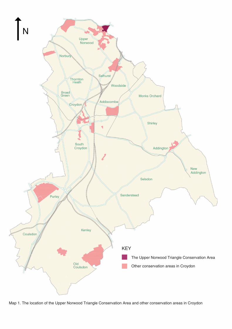
Map 1. The location of the Upper Norwood Triangle Conservation Area and other conservation areas in Croydon
N
The Upper Norwood Triangle Conservation Area
Other conservation areas in Croydon
KEY

1
INTRODUCTION

2
Above: Map 2. The boundary of the Upper Norwood Triangle Conservation AreaPrevious Page: Terraced buildings on Westow Street
N
KEY Boundary of the Upper Norwood Triangle Conservation Area
Borough boundary
LONDON BOROUGH OF LAMBETH
LONDON BOROUGH OF
BROMLEY

3
1.0 INTRODUCTION
1.1 WHAT IS A CONSERVATION AREA?1.1.1 A conservation area is an area of special architectural or historic interest, the character and appearance of which it is desirable to preserve or enhance. Please see section 1.3 of Croydon’s Conservation Area General Guidance SPD for further information.
1.2 WHAT IS A CONSERVA-TION AREA APPRAISAL AND MANAGEMENT PLAN?1.2.1 A Conservation Area Appraisal and Management Plan is a document produced to supplement Croydon’s Local Plan, the London Plan, and Croydon’s Conservation Area General Guidance SPD.
1.2.2 An Appraisal defi nes the principal qualities that constitute the conservation area’s special character and identifi es threats to this character. It is important to note that assessments made in this document are non-exhaustive, and further elements of architectural or historic interest may be present. A Management Plan addresses the issues raised in the Appraisal and provides area-specifi c development guidelines to supplement those provided in Croydon’s Conservation Area General Guidance SPD; potential enhancement schemes are also explored. For further information please see section 1.5 of the Conservation Area General Guidance SPD.
1.3 WHAT IS THE STATUS OF THIS DOCUMENT?1.3.1 This document is a Supple-mentary Planning Document (SPD) to the Croydon Local Plan: Strategic Policies (adopted April 2013) and is a material consideration when planning applications affecting
Terraced houses on St Aubyn’s Road with the Crystal Palace radio mast in the background
the conservation area are assessed.
1.3.2 All planning applications for sites within the Upper Norwood Triangle Conservation Area should be informed by both this SPD and the Croydon Conservation Area General Guidance SPD.
1.4 COMMUNITY INVOLVEMENT1.4.1 A meeting with representatives of the Crystal Palace Community Association and the North Croydon Conservation Area Advisory Panel (see section 1.5 of the Conservation Area General Guidance SPD) was held to inform the production of this document prior to public consultation, which ran from 2 September - 14 October 2013. The draft document was available to view and download on the Council’s website and hard copies were available from local libraries. Site notices were placed in the conservation area, letters were sent to all properties located within its boundary, an article was published in the Croydon Guardian and two Church of St Augustine and St Helen
Looking west along Westow Hill

4
events were held at the Central Croydon Library and the Living Water Satisfi es Cafe in Crystal Palace on 23 and 26 September respectively.
1.4.2 Following the consultation all responses were considered and where appropriate, the document was amended prior to a recommendation to full Council for adoption.
1.5 DESIGNATION BACKGROUND1.5.1 Following a growing interest in the local history of the Crystal Palace area, a proposal and petition for the designation of the Upper Norwood Triangle Conservation Area was submitted to the Council in 1988 by the Crystal Palace Triangle Community Association. The Upper Norwood Triangle Conservation Area was designated in April 1989.
1.6 STATEMENT OF SPECIAL CHARACTER1.6.1 The Upper Norwood Triangle Conservation Area is a historic settlement of late 18th century origins, which developed due to its geographically signifi cant location at the meeting point of several parishes. The modest 1-2 storey early 19th century buildings that survive now sit alongside 3-4 storey later 19th century buildings. The latter were constructed following the arrival of the Crystal Palace in 1851, which, along with the arrival of the railways, stimulated the development of the Triangle as a local commercial and residential centre.
1.6.2 The Upper Norwood Triangle Conservation Area has a lively and bustling character and is part of the vibrant Crystal Palace District Centre. Its special
character is defi ned by its fi ne urban grain, varied scale of buildings and historic buildings of high architectural quality and detailing. A high proportion of the buildings within the area are either locally listed or high quality unlisted historic buildings that make a positive contribution towards its special character. The Triangle is formed by three streets, Westow Street, Westow Hill and Church Road. The area inside the Triangle, largely consisting of a series of smaller-scale interconnected streets, many of which were laid out in the later 20th century, has a more intimate character, with residential and light industrial uses.
1.7 STREETS WITHIN THE CONSERVATION AREA1.7.1 All or part (as listed) of the following streets are located within the Upper Norwood Triangle Conservation Area:• Westow Street (all)• Westow Hill (south side)• Central Hill (part)• Church Road (part)
• St Aubyn’s Road (all)• Carberry Road (all)• Child’s Lane (all)• Stoney Lane (all)• Ovett, Telford and Brunel
Closes (all)• Paddock Gardens (all)• Haynes Lane (all)• Coxwell Road (all)• Gatestone Road (all)• Bedwardine Road (part)
1.7.2 Section 6 of this document discusses each street in the order above.
1.7.3 Throughout this document the area contained within the Triangle, including Stoney Lane, Ovett, Telford and Brunel Closes, Paddock Gardens and Victory Place is often referred to as the ‘inner Triangle’.
View south down Westow street towards the spire of St Augustine and St Helen’s Church, painted by local artist Audrey Hammond - although painted several decades ago, this image captures the street’s character that is preserved today (reproduced with kind permission of the artist)

5
APPRAISAL

6
The following Appraisal defi nes the characteristics that make the Upper Norwood Triangle Conservation Area special, including its wider context, historic development, townscape, streetscape and architectural character. It also describes its current condition.
2.0 CONTEXT
2.1 LOCATION AND SETTING2.1.1 The Upper Norwood Triangle Conservation Area forms Croydon’s north-eastern tip, at the meeting point with the London Boroughs of Lambeth and Bromley and a short distance away from the London Boroughs of Southwark and Lewisham (see Map 3 on p.7). The conservation area’s northern boundary, along Westow Hill, abuts the borough of Lambeth and its south-eastern boundary, along Church Road, similarly abuts the London Borough of Bromley (please refer to Map 3). The Triangle is located at the top of the Upper Norwood Ridge, which forms part of the southern edge of the Thames Basin.
2.1.2 There are several other conservation areas immediately adjoining the Upper Norwood Triangle Conservation Area: Westow Hill and Gipsy Hill Conservation Areas (Lambeth) Belvedere Road and Crystal Palace Park Conservation Areas (Bromley) and the Harold Road and Church Road Conservation Areas (Croydon). The Beulah Hill Conservation Area is also located in Upper Norwood, further to the west (please see Map 3).
2.1.3 The Croydon-Lambeth borough boundary is marked by Westow Hill and the Croydon-Bromley boundary is marked by Church Road. Many buildings on the north side of Westow Hill and on the east side of Church Road share characteristics with those located within the Croydon borough boundary and make an important contribution to the character of the area. The Upper Norwood Library (see photo on p.37), located on Westow Hill, is particularly noteworthy, constructed of red brick with stone dressings and
Previous page: looking north up Westow Street
Buildings on the north side of Westow Hill located in the Westow Hill Conservation Area (Lambeth)
Buildings opposite the White Hart public house in the Belvedere Road Conservation Area (Bromley)
two prominent gable ends and arched corner entrance.
2.1.4 Westow Park and the Upper Norwood Recreation Ground are areas of public open space located to the south-east of the Triangle. In addition Crystal Palace Park is located to the north-east of the Triangle, in the London Borough of Bromley.
2.1.5 The surrounding area largely consists of residential development with a mix of housing types. There are several good transport links nearby, including mainline and overground rail stations.

7
Map 3. Aerial photograph showing surrounding context of the Upper Norwood Triangle Conservation Area and its relationship with adjacent and nearby London Boroughs and conservation areas
N
LONDON BOROUGH OF
BROMLEY
LONDON BOROUGH OF
LAMBETH
LONDON BOROUGH OF SOUTHWARK
LONDON BOROUGH OF
CROYDON
KEY:CROYDON CONSERVATION AREAS BROMLEY CONSERVATION AREAS LAMBETH CONSERVATION AREAS
Upper Norwood TriangleHarold RoadChurch Road
Crystal Palace Park Belvedere Road
Gipsy HillWestow Hill
WESTOW PARK
CRYSTAL PALACE PARK
UPPER NORWOOD
RECREATION GROUND

8
2.2 HISTORIC DEVELOPMENT2.2.1 The Upper Norwood area has been a site of human activity for thousands of years. Historically locals were able to graze pigs in the woodland, although evidence of permanent settlement is virtually non-existent before the 18th and 19th centuries. The lack of development can be explained by the geology of the ridge, which is formed of heavy London clay and made a poor environment for agriculture and building.
EARLY DEVELOPMENT 2.2.2 The Great North Wood, from which ‘Norwood’ is a contraction, formerly covered the narrow ridge above the Thames Basin on which the Triangle is situated. The Great North Wood was named during the Anglo-Saxon period to distinguish the large wooded area, which stretched from the present-day Croydon town centre to Camberwell, from the Great South Wood in the Weald of Kent and Surrey. The part of the Great North Wood within the parish of Croydon is recorded in the Domesday Book as belonging to the Archbishop of Canterbury and used for ‘pleasure hunting, fuel and pannage for 200 swine’.
18TH CENTURY2.2.3 In 1745 the Great North Wood, known for its many oak trees, gypsies, smugglers and highwaymen, was mapped by John Rocque (Map 3), which marks the Vicar’s Oak, the most famous of the boundary oaks located at the point where the parishes of Croydon, Lambeth, Camberwell and a detached portion of Battersea met. Boundary Oaks were planted to help parish authorities navigate the wooded area on the annual ‘‘beatings of the bounds’’
(parish surveys). The meeting point marked by the Vicar’s Oak is now marked by the cross roads of Anerley Hill, Church Road, Westow Hill and Crystal Palace Parade.
2.2.4 At the end of the 18th century, as shown by the 1800 Enclosures Map (Map 4), the Triangle remained common land with only a few permanent dwellings. The Enclosure Commissioners set out the basic road network between 1797 and 1800, in most cases following the established tracks across the Common, including Central Hill, but also laying new roads, including Church Road. By this time the boundaries of Lambeth, Bromley, Southwark and Croydon had been defi ned, meeting at the top of Anerley Hill. The strategic location of the area as a crossing point between boroughs and parishes prompted its fi rst phase of development.
19TH CENTURY TO 18542.2.5 The common land within the newly created Triangle was not released for building until 1807. Throughout the fi rst half of the 19th century the area gradually developed from one of dispersed farmhouses and cottages to a more concentrated village settlement (see Maps 4, 5 and 6). By 1847 the Triangle was an established local shopping centre. By the middle of the 19th century (see Map 6) the area had acquired a certain amount of residential and commercial development, including cottages in the inner triangle area and two storey narrow fronted buildings on the high streets (see photos on the following page).
2.2.6 Two of the fi rst buildings in the Triangle built between 1800-1820 were the Woodman
Map 5: Extract from the 1800 Croydon Enclosures Map, clearly showing the Upper Norwood Triangle
Map 4: Extract from the 1745 John Rocque Map of the Great North Wood.
Map 6: Extract from the 1830s Croydon Tithe Map

9
Inn on Westow Hill and White Hart Inn on the corner of Westow Street and Church Road, serving passing travellers. The original White Hart (see photo) was a weatherboarded structure with an adjoining public meeting room, thought to have been part of this original Inn.
2.2.7 A windmill, located behind the present day Royal Albert public house on Westow Hill, was built in the early 19th century to provide for the growing population of the village; it functioned until 1853 after which it was demolished. The fi rst large house in the area was The Mount on Westow Street built 1816-17, where the Salvation Army Hall now stands.
2.2.8 In c.1820 a school for poor children was erected on land behind the White Hart, apparently occupying up to one quarter of the Triangle. It was run by Frederick Aubin (or Aubyn) from 1825 and was demolished by 1860, leaving behind its chapel (see photo), built in 1854 and opened by the Archbishop of Canterbury.
2.2.9 The Beulah Spa Gardens were opened in 1831, located to the south-west of the Triangle. These fashionable pleasure gardens, open until 1856, helped to attract visitors to the area and to raise its profi le in London society. The offi cial Beulah Spa guide described Norwood as ‘a village situated on the outskirts of an extensive wood, and long famed for the salubrity of its air, and the beauty of its surrounding scenery with smiling villas’.
2.2.10 The London to Croydon Railway was opened in 1839 with a station at nearby Annerley (now Anerley), and amalgamated
St Aubyn’s Church, viewed from the north on St Aubyn’s Road
The fi rst White Hart public house, built between 1800-1820 on the same site as the current public house. The public meeting hall is just visible to the left, behind the public house. Picture from J. Gent: Norwood Past
Early 19th century commercial premises on Westow Street
Map 7: Extract from the 1847 Roberts Map of the Croydon Parish, showing the location of the Beulah Spa Gardens to the south west. The current boundary of the Upper Norwood Triangle is overlaid in red.
10
with the London and Brighton Railway in 1846 to form part of the London, Brighton and South Coast Railway.
THE CRYSTAL PALACE AND ITS INFLUENCE2.2.11 The reconstruction of Joseph Paxton’s Crystal Palace at Penge Place in 1854 brought massive change to the area. The immense glass exhibition hall, which had originally been designed for the 1851 Great Exhibition in Hyde Park, was rebuilt, altered and enlarged with expansive pleasure gardens laid out to the south, complete with such attractions as artifi cial lead mines and model dinosaurs. The Palace itself was prominently visible from within the Triangle, in particular the South Water Tower (see photo on p.11).
2.2.12 The Crystal Palace Low Level and Upper Level Stations were opened in 1854 and 1865 respectively. The earlier Low Level Station (now Crystal Palace Station) was linked to the Palace by a 72ft glass walkway named the ‘Crystal Colonnade’ and the High Level Station (demolished 1961) by a fan-vaulted subway, which survives today and is Grade II listed. Along with the Palace itself these new stations inevitably had a signifi cant impact on the character and development of the Triangle, including increasing numbers of residents (many of whom commuted into central London), local businesses and visitors.
2.2.13 The requirements of the growing number of new residents and visitors were catered for by a range of new services in and around the Triangle, including the Queens Hotel on Church Road dating from the 1850s, the Post Offi ce,
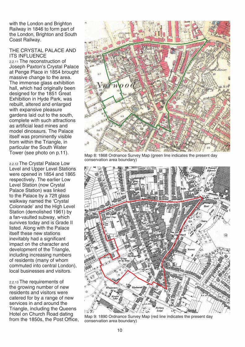
Map 8: 1868 Ordnance Survey Map (green line indicates the present day conservation area boundary)
Map 9: 1890 Ordnance Survey Map (red line indicates the present day conservation area boundary)

11
View east along Westow Hill c.1916, with the South Tower of the Crystal Palace prominently visible
Westow Street in the late 19th century, looking south. The east side of the street (left) is much as it is today
Church Road in the 1960s, with the tower of the now demolished St Aubyn’s Church visible behind the rear of the St Aubyn’s Road terraced houses
and the rebuilt or expanded White Hart and Woodman Inns. The housing development of Norwood New Town, now practically all demolished, was built to the west of Central Hill to accommodate those working on the construction of the Crystal Palace and other railway infrastructure. This was reportedly enclosed by a high wall to shield it from public view.
2.2.14 From the 1860s, large new buildings designed in a Victorian Classical style were completed on Westow Street and Westow Hill including most of the grand four storey brick buildings with shops at ground fl oor, still visible today. The prosperity of the area during this period is evident in the quality of craftsmanship, materials and decoration used in building work.
2.2.15 The Royal Normal College for the Blind was founded in 1872 to provide good education for blind pupils, with a specialism in music training. The college began with just two small houses in Paxton Terrace, but by 1878 had purchased a large house, The Mount, and its grounds.
2.2.16 Within the Triangle large terraced houses were built between 1854 and 1868 on both sides of St Aubyn’s Road and smaller terraced cottages on Carberry Road and later on Haynes Lane, built between 1868 and 1890. St Andrew’s Church, now the Greek Orthodox Church of St Augustine and St Helen, was erected on Westow Street in 1878 to a design attributed to architect Edward Power.
2.2.17 From 1898-1899 the French writer Emile Zola stayed at the Queens Hotel in Church

12
Map 10: 1910 Ordnance Survey Map (red line indicates the present day conservation area boundary)
Map 11: 1933 Ordnance Survey Map (red line indicates the present day conservation area boundary)
Street while in exile from Paris and took many photographs of the area, including of the Triangle.
20TH CENTURY2.2.18 By the time the Crystal Palace was destroyed by fi re in 1936, it had fallen into decline. Following the fi re the site was left derelict. The prominent water towers were dismantled early in the World War II to re-use the metal and to avoid German bombers using them as a landmark on their fl ight into London.
2.2.19 The Triangle maintained its role as a shopping area serving a large residential population, but the loss of the Palace’s economic infl uence meant that no signifi cant new development took place during the following decades.
2.2.20 During the fi rst half of the 20th century the area was increasingly used for light industry. In 1954 the Triangle was recorded in a Croydon Development Plan as being used for small scale industry within the triangle and retail for the street frontages. In the 1970s there were strategic road widening proposals for the area that were never realised and deterred other large-scale development occurring in the area.
2.2.21 The Crystal Palace Transmitting Station was constructed in the mid-1950s on site of the former Crystal Palace aquarium; construction of the mast, which came to be over 200m tall, began in 1954. The smaller Croydon Transmitting Station located on Beulah Hill was established in 1955, and the current mast, around 150m in height, was constructed in 1962. Both towers are visible from long distances across London.

13
2.2.22 Many of the workshops and yards, including the former Woodman Inn stable yard, were lost when much of the inner Triangle was re-developed with housing between 1975 and 1981 by Clifford Davies Partnerships for Barratt Homes, described in the Pevsner guide as being ‘better-than-average’. This development included the laying out of Ovett Close (demolishing early Victorian cottages), Brunel and Telford Closes.
2.2.23 Since 1980 other development has occurred in the Triangle, including the Norwood Heights Complex on Westow Street, which opened in 1984 and won the 1985 Croydon Design Award. Four large blocks of fl ats were constructed in 1981-2 on St Aubyn’s Road, built for the Croydon Churches Housing Association on the site of the Grade II listed St Aubyn’s Church, which, despite its listed status, was demolished in 1980. The fl ats won the 1983 Croydon Design Award and are described in the Pevsner guide as having ‘elevations with very fancy coloured brickwork’. In the later 1980s, Nesbitt Square was constructed to the south west of Westow Street, also winning a Croydon Design Award in 1988.
REFERENCES• A. Hammond & B. Dann,
Crystal Palace - Norwood Heights, 1988
• P. Brewer, The Crystal Palace, 1982
• J. Gent, Norwood Past, 1996• Pevsner & Cherry, London 2:
South, 1983• A. Warwick, The Pheonix
Suburb, 1972
2.3 ARCHAEOLOGICAL SIGNIFICANCE2.3.1 At present the Upper Norwood Triangle is not located within or in close proximity to any Archaeological Priority Zones (please see section 4.5 of Croydon’s Conservation Area General Guidance SPD for further information). There are no scheduled monuments in the immediate area.
2.3.2 There are no archaeological fi nds from within the conservation area boundary offi cially recorded on relevant databases, which is surprising considering the amount of continuous development the area has been subject to over the past two centuries. This may either be explained by the lack of settlement in the area prior to 1800, or that the dense urban form has prohibited
archaeological survey work. /In 1953 a 13th-14th century coin hoard was found at the ‘Woodlands’ estate on Beulah Hill (close to the Upper Norwood Triangle Conservation Area0 which is now housed at the British Museum.
St Aubyn’s Church painted prior to its demolition in 1980 by local artist Audrey Hammond (reproduced with kind permission from the artist)

14
3.0 TOWNSCAPE CHARACTER3.0.1 Townscape is the arrangement and appearance of buildings, spaces and other physical features in the built and natural environments.
3.1 LAYOUT AND PLAN FORM3.1.1 The Upper Norwood Triangle Conservation Area has a distinctive historical triangular plan form relating to the convergence of three principal straight roads that make up the perimeter of the Triangle: Church Road, Westow Street and Westow Hill. There are also several narrower side streets leading off these busy thoroughfares to its interior and exterior. St Aubyn’s Road is an exception, being a wide road within the Triangle severing its north east corner.
3.1.2 Buildings are generally street-facing with consistent building lines, apart from part of the large Norwood Heights Shopping Centre, which is set back from the road. There is also smaller-scale development located within the Triangle that is more irregularly laid out, although there are some consistent buildings lines present. The layout of development to the west of the Triangle, on Gatestone Road and the bottom of Haynes Lane is more irregular in nature, with the exception of the uniform terrace of houses in Haynes Lane.
3.1.3 Due to the layout of the area there are a number of corner plots created by the sharp angles of roads. Most prominent are 64 Church Road and the Cambridge and the White Hart public houses, but there are many other examples of corner buildings in the Triangle where their design has carefully considered this corner treatment.
The White Hart public house
Consistent building lines along the east side of Westow Street
3.2 DENSITY AND LAND USES3.2.1 The density of development is high, with terraced buildings of a variety of scales lining the commercial streets in long narrow plots with little or no associated amenity space (please see Map 12). The Norwood Heights Shopping Centre is an exception to this established layout, as a single large development partly set back from the road behind a small area of publicly accessible open green space.
3.2.2 The inner triangle has a relatively high density of two-storey residential terraced buildings, with little accompanying public open space. There are also some detached and semi-detached industrial warehouses, workshops and outbuildings in this area.
3.2.3 To the west of Westow Street the density of development is generally lower, with open space around the residential blocks of Gatestone Court and the Triangle Day Centre.
3.2.4 There is a variety of land uses present in the area, many of which support the Triangle’s thriving commercial vitality. On the three roads that make up the Triangle land uses are retail or cafe / restaurant at ground fl oor level, with residential or offi ce space on the fl oors above. The Norwood Heights complex is an exception to this being primarily in retail use with some community use functions and a large car park beneath. Public houses mark each apex of the Triangle: the White Hart, the Sparrowhawk, until recently known as the Hollybush, and the Cambridge (see photos). Other public houses in the Triangle include the Royal Albert, set back from the street on Westow
The Sparrowhawk public house
The Cambridge public house

15
Hill, and the Postal Order, on Westow Street.
3.2.5 Most of the inner Triangle is now residential in use, with some remaining light industrial uses on Stoney Lane and Carberry Road, reminiscent of the area’s industrial heritage.
3.2.6 There are two churches present in the area, the Greek Orthodox Church of St Augustine and St Helen, located on Westow Street and the Celestial Church of Christ, located on St Aubyn’s Road.
3.2.7 The area to the west of Westow Street has a mix of land uses, including the Post Offi ce Sorting Offi ce, residential uses at Gatestone Court, Nesbitt Square and on Bedwardine Road, creative industries to the south of Haynes Lane and the Upper Norwood Children’s Centre on the edge of Westow Park.
3.3 BUILDING HEIGHT AND MASSING3.3.1 An important component of the area’s special character is the contrasting building heights, sizes and ages of the historic properties that make a positive contribution to the character of the conservation area. This is particularly evident on Westow Street, Westow Hill and Central Hill where the contrast of historic two storey early/mid 19th century buildings with taller three storey mid-late Victorian buildings provides depth of character and variety to the streetscapes.
3.3.2 The upper fl oors of some buildings on Westow Hill are set back from the street behind their projecting shopfronts (26-32 - even). The established building lines are broken up by the setback and height of the Royal Albert public house.
Map 12: Building Heights in the Upper Norwood Triangle Conservation Area
Contrasting heights of two and three storey buildings on Westow Street The Royal Albert public house, a break
in the Westow Hill street frontage
KEY: Building Heights
Single storey
Two storeys
Two storeys with roof accomodation
Three storeys
Three storeys with raised ground fl oor or roof accomodation)
Four storeys +
N
WE
STO
W S
TRE
ET

16
3.3.3 Buildings on Church Road are generally three storeys in height, with a row of single storey retail premises at 26-48 behind which the rear of the three storey terraced houses on St Aubyn’s Road can be seen.
3.3.4 The massing of buildings on Westow Street, Church Road, Westow Hill and Central Hill is largely defi ned by the terraced houses that directly abut the street. Roofs are generally visible from the street when viewed at an angle. Terraced properties usually have shallow pitched roofs, with those to two storey buildings often set behind a parapet. The massing of the terraces on these commercial streets is broken up by the rhythm of the narrow plots, the attractive variety of building heights and by breaks in terraces created by streets leading into or away from the Triangle.
3.3.5 Building heights in the rest of the conservation area off the commercial streets are generally two storeys, including the terraced cottages and workshops within the Triangle and the terraces of houses on Haynes Lane. Workshops and warehouses, including those located to the south of Haynes Lane, are predominantly of two storeys in height.
3.3.6 Modern blocks of fl ats, including Gatestone Court, Mollie Davis Court, the two blocks on Stoney Lane and the two blocks on St Aubyn’s Road, are four storeys in height, and have a bulky cubic massing that contrasts with the established character of the Triangle and detracts from its special character.
3.3.7 The Norwood Heights complex is 1-3 storeys in
height. The main supermarket is a single storey set back from the street, which rises to two storeys where the complex directly abuts Westow Street with shops at ground fl oor level. To the rear the complex extends to three storeys including two storeys of car parking, the massing of which is concealed from Westow Street by the steep change in land levels that falls away from Westow Street.
3.4 TOPOGRAPHY AND VIEWS3.4.1 The Triangle lies approximately 110m above sea level on the Norwood Ridge, a band of London Clay that marks the edge of the Thames Basin. Land levels drop signifi cantly to the north of Westow Hill and the
View to the north from Westow Hill looking down Woodland Road
View north down Gipsy Hill past the landmark tower of Christ Church
west of Westow Street and to the east of Church Road.
3.4.2 The elevated position creates a series of spectacular long distance views north, out of the borough, towards London from Westow Hill along residential side streets. Each of these views is subtly different due to the width, angle and character of each side street, which act as frames to the views (see photos). There are also views to the west from Central Hill, Haynes Lane and Coxwell Road, which are more visible during the winter months due to the loss of leaf on trees. The Crystal Palace Transmitting Station tower is also prominently visible from within the Upper Norwood Triangle Conservation Area.
View of central London looking north from Westow Hill

17
Map 13: Topography (within the London Borough of Croydon) and views within and without the Upper Norwood Triangle Conservation Area
N
KEY:
Long or Linear View

18
4.0 STREETSCAPE CHARACTER
4.0.1 Streetscape is the outward visual appearance and character of a street or locality. For information on standards set for Croydon’s public realm please see the Croydon Public Realm Design Guide (2012).
4.1 PUBLIC REALM AND OPEN SPACE4.1.1 The public realm of the Triangle has an urban character. The only area of usable public open space present is in front of the Norwood Heights Shopping Centre on Westow Street, where the war memorial is also located (see photo).
4.1.2 The condition of the public realm the conservation area (surveyed 2013-14) is generally good. Signifi cant improvements were made to the public realm of the area in 1999 as part of the Conservation Area Partnership funding scheme.
4.1.3 Footway widths on Westow Street and Westow Hill are approximately 2m in width, with some areas up to 3.5m in width; on Church Road footway widths vary from approximately 1m-4.5m. Footway widths on smaller streets leading off the main streets are more constricted, with some narrower streets, including Paddock Gardens, Haynes Lane, Carberry Road having little or no pedestrian walkways.
4.1.4 Footways on the commercial streets are laid with york stone paving that makes a positive contribution to the quality of the public realm. Some streets leading into the Triangle, including Albert Yard (see photo) ,and the access road between 54 and 56 Westow Hill, are laid with attractive cobble stones. Other streets in the conservation area, including those in the inner Triangle, have asphalt footways
Public Open Space in front of the Norwood Heights Shopping Centre
that are generally in a good condition with some exceptions.
4.1.5 The public realm within the Triangle on Ovett Close, Brunel Close and Telford Close is generally of a high quality with stone paving and areas of planting. Properties generally have front gardens, which are well maintained and make a positive contribution to the character of the public realm (see photo).
Cobbled pedestrian route through the Triangle from Albert Yard
Vehicular and pedestrian routes
Pedestrian only routes
Conservation area boundary
Area of open space
KEY
Map 14: Permeability and public open space in the Upper Norwood Triangle Conservation Area
4.1.6 The blocks at Gatestone Court are set within generous open space, which helps to reduce their impact on the character of the street. The Upper Norwood Children’s Centre is located within a signifi cant amount of open space, adjacent to Westow Park. This helps to provide an important buffer between the rear of the Norwood Heights Complex and the park.

19
4.1.7 Despite the limited amount of open space, the Triangle is located in close proximity to several parks (see section 2.1) and the long distance views (see section 3.4) from within the conservation area help to provide a sense of spaciousness.
4.2 PERMEABILITY4.2.1 The Triangle has a high level of permeability for pedestrians (see Map 14). This is largely a result of the 1980s residential development at Ovett, Brunel and Telford Closes that created a series of walkways, allowing pedestrians to navigate through the Triangle. There are some roads within the Triangle that, at present, do not interconnect with the link of public walkways, including Stoney Lane, Victory Place and Paddock Gardens. Coxwell Road provides a pedestrian route to Westow Park.
4.3 STREET FURNITURE4.3.1 There is a wide variety of street furniture on commercial streets, including bins, bicycle racks, signage, pedestrian crossings, phone booths/boxes, salt boxes and telecommunications boxes. There is a concentration of street furniture around the public space in front of the Norwood Heights Shopping Centre, including benches, signage, telephone cubicles and a bus stop. Historic street furniture includes the War Memorial (see photo on p.18), an Elizabeth II cast iron post box on Westow Street and several traditional street signs (see photos).
4.3.2 The impact of modern street furniture on the appearance of the conservation area is partly mitigated by the urban character, the width of the footways and the fact that the street furniture is generally
Stoney Lane, leading off Church RoadPaddock Gardens, off Westow Street
Bench in front of the Norwood Heights Shopping Centre
Historic street signs
Cast iron post box on Westow Street Cluttered signage in the inner Triangle

20
well sited. There is some unnecessary street furniture that could be removed to de-clutter the streets. Some street furniture in the inner Triangle, including road signs, pedestrian signs, bollards and fences, is in a poor condition, detracting from the quality of the public realm.
4.4 GREENERY AND TREES4.4.1 There are few trees and there is a minimal amount of planting in public areas in the Upper Norwood Triangle Conservation Area, refl ecting its urban character.
4.4.2 The mature London Plain and Horsechestnut trees and other greenery in front of the Norwood Heights Shopping Centre (see photo) make an important contribution to the quality of the public space in this part of the conservation area. There are also two trees planted in raised beds at the point where St Aubyn’s Road meets Church Road (see photo). There are some newly planted trees at the top of Haynes Lane, and some more mature trees further down. Terraced houses on Haynes Lane have planting beds in front of them, which contribute to the high quality appearance of the street.
4.4.3 There are some trees and planting on private land in the inner Triangle (see photo) and some areas of planting in public areas, which positively contribute to the quality of the public realm. There are mature trees in the area at the southern end of St Aubyn’s Road.
4.4.4 Mature trees in front of Gatestone Court onto Central Hill and Gatestone Road help to soften the impact of the large blocks of fl ats on the streetscape.
Mature trees in front of the Norwood Heights Shopping Centre
Newly planted trees at the top of Haynes Lane
Trees in raised beds where St Aubyn’s Road meets Church Road
Public realm in the inner Triangle, with stone paving, attractive front gardens, trees and planting

21
5.0 ARCHITECTURAL CHARACTER
5.1 GENERAL ARCHITEC-TURAL CHARACTER 5.1.1 The architectural character of the Upper Norwood Triangle Conservation Area is defi ned by the concentration of high quality Georgian, Victorian and early 20th century buildings, which vary in scale, age, design and detailing. A key characteristic of the area is the contrast of the early 19th century two storey buildings with the later 19th and early 20th century three/four storey grander buildings, constructed after the arrival of the Crystal Palace. The two storey buildings have modest Georgian design with simple detailing, often with only a few features such as architraves and parapets. In contrast the taller buildings constructed in the late 19th and early 20th centuries often contain a range of prominent features and decorative detailing. Many of these buildings are contained within uniform terraces with repeating features, such as those of Westow Hill, St Aubyn’s Road and Haynes Lane (see photos).
5.1.2 Due to the shape and road layout, corner buildings are often present. These buildings are specifi cally designed to fi t their plots and buildings are often truncated with detailing, including eaves brackets and shopfronts, continuing over two elevations of the building. Public Houses are placed at the corners of the Triangle (the White Hart, the Sparrowhawk and the Cambridge). These are particularly attractive and ornate buildings that mark the entrance points into the conservation area and identify the transition from surrounding residential areas to the District Centre. Please see section 6 for further information on individual buildings.
5.1.3 There are also several buildings that refl ect the area’s historic industrial character. These include those located in the inner Triangle and at the bottom of Haynes Lane, which contribute to the historic character of the area.
5.2 SHOPFRONTS5.2.1 There are several surviving historic shopfronts, including ‘The Picture Palace’ at 65 Westow Street, the ‘Opticians’ (formerly Kennedy’s butchers) at 20 Westow Hill (see photos) and ‘Abode’ at 80 Westow Hill. Historic and traditional-style shopfronts throughout the conservation area make an important contribution to its character and appearance and often contain many traditional architectural features, including stallrisers, pilasters, consoles, fascias, awning and cornices.
5.2.2 The design of new shopfronts plays a crucial role in maintaining the architectural character of the conservation area; poor quality shopfront design and materials (see photo on p.31) have a negative impact on the character of the conservation area.
Stallriser
Console or Corbel
Pilaster
External lighting
Historic shopfront at 20 Westow Hill
Surviving Victorian shopfront at 65 Westow Street, with labelled shopfront features
Historic shopfront at 80 Westow Hill
Traditionally designed modern shop-front at 47-49 Westow Street
Plinth
Mullion
CorniceFascia
Transom
Cill

22
Map 15. The level of contribution buildings make to the special character of the Upper Norwood Conservation Area.
N
KEY: Designations and Level of Contribution Buildings make to the Character and Appearance of the Upper Norwood Triangle Conservation Area
Statutory Listed
Locally Listed
Positive Unlisted
Neutral
Detract from Special Character

23
5.3 HISTORIC AND ARCHI-TECTURAL SIGNIFICANCE OF BUILDINGS 5.3.1 Please see Map 15, which is colour coded to illustrate the different levels of contribution buildings make to the character and appearance of the conservation area A) LISTED BUILDINGS 5.2.2 At present the Greek Orthodox Church of St Peter and St Helen is the only statutorily listed building (Grade II) within the Upper Norwood Triangle Conservation Area and is of national heritage signifi cance. For further information please see section 8.1.
B) LOCALLY LISTED BUILDINGS5.2.3 At present there are seventy-one buildings within the Upper Norwood Triangle Conservation Area that are on Croydon’s Local List of Buildings of Architectural or Historic Interest.
5.2.4 These buildings have a signifi cant level of local value and make a positive contribution to the special character of the conservation area. For further information please see section 8.2.
C) POSITIVE UNLISTED BUILDINGS5.2.5 Many other buildings in the conservation area make a positive contribution to its character and appearance. These buildings are considered to have signifi cant heritage value and collectively constitute the conservation area’s special character.
D) NEUTRAL BUILDINGS5.2.6 There are several buildings in the conservation area that do not positively contribute nor
actively detract from the area’s special character.
E) BUILDINGS THAT DETRACT FROM THE AREA’S SPECIAL CHARACTER5.2.7 There are some buildings in the conservation area that have a negative impact on its character and appearance.
5.4 KEY ARCHITECTURAL FEATURES AND BUILDING MATERIALS5.4.1 There are a wide variety of architectural styles, features and materials throughout the Upper Norwood Triangle Conservation Area that contribute to its special character. The table on the following page sets out a list of architectural features and building materials found in the Upper Norwood Triangle Conservation Area. There is no building that contains all the architectural features listed on p. 24, but many will contain a selection.
The locally listed Forester’s Hall on Westow Street
Church of St Augustine and St Helen on Westow Street
Locally listed terrace on Haynes Lane

24
KEY ARCHITECTURAL FEATURES1
1. Arched entrances, sometimes recessed2. Brick chimney stacks3. Dutch gables4. Feature dormer windows5. Parapets6. Timber barge boards7. Quoins8. Cornices9. Dentils10. Console brackets11. Bands or string courses 12. Decorative brickwork13. Stucco, stone or brick decorative mouldings14. Brick or terracotta motifs15. Sash windows16. Bay windows17. Architraves18. Brick or stucco lintels with decorative keystones19. Projecting window cills supported by brackets20. Ironwork railings or window boxes21. Decorative tiles22. Corbels (shopfronts)23. Pilasters (shopfronts)24. Stallrisers (shopfronts)25. Clock on the facade of Forester’s Hall
MATERIALS
26. London stock bricks27. Red bricks28. Natural slate roof tiles29. Stucco render or detailing30. Stucco / stone detailing31. Terracotta32. Timber (windows, doors and shopfronts)33. Clay (tiles and chimney pots)34. Iron railings
1 Please see glossary of relevant terms in the Conservation Area General Guidance SPD
2, 9, 11, 26
15, 17
13, 27, 30
8, 15, 17, 30
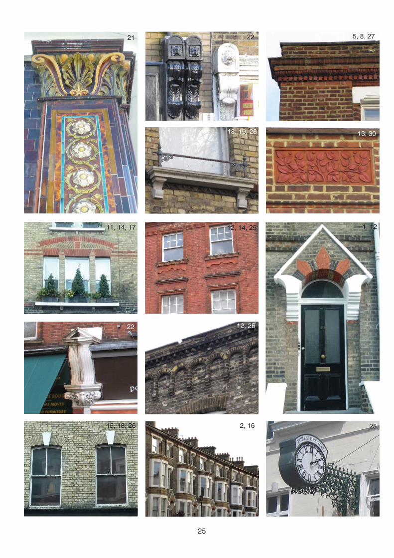
25
21
11, 14, 17
22
15, 18, 26 2, 16
12, 26
12, 14, 25
18, 19, 26
22 5, 8, 27
13, 30
1, 12
25

26
6.0.1 This section provides an overview of the character of roads, or groups of roads, within the conservation area. It analyses individual characteristics and identifi es prominent buildings and features that particularly contribute towards the conservation area’s special character.
6.1 WESTOW STREETStatutory listed buildings: Church of St Augustine and St HelenLocally listed buildings: 1-4 Hollybush Terrace, 19, 25-27, 35, 47-49 (odd), 65, 67 and 73-74 Westow StreetPositive unlisted buildings: 1, 2-26 (even), 3, 17, 21, 23, 36-44 (even), 29-33 (odd), 41-45 (odd), 61, 63, 69, 69A, 73
6.1.1 Westow Street has an interesting mixture of 19th century buildings of a variety of scales and designs, which reveals the area’s origins and pattern of historic development and creates a lively and engaging built environment. It has a traditional high street character and benefi ts from the grouping of an open green, war memorial and church which create a ‘village-like’ character to the high street. This is emphasised by the fact that it feels wider and more spacious than the other roads in the conservation area.
6.1.2 Three storey properties are mostly terraced, with commercial premises at ground fl oor level with offi ces or fl ats above. Shopfronts are generally of a traditional design and many include attractive historic features including corbels and pilasters. Historic buildings contain a range of attractive architectural features (see section 5.4). Numbers 47-49
have particularly distinctive decorative terracotta motifs incorporated into their facades.
6.1.3 Other buildings that are of particular interest include the Old Post Offi ce (number 35), an imposing building of Classical proportions and detailing, including architraves, cornices and timber boxing for ‘Florentine blinds’. Hollybush Terrace also stands out with its dark red brick, decorative brickwork mouldings and large corbels with moulded decoration above the pilaster dividing the shopfronts. Forrester’s Hall, once used as one of the Croydon Crown Courts, has a striking presence in the street. It is of a simple design with attractive gables and a decorative projecting clock with intricate cast ironwork.
6.1.4 The surviving two storey Georgian properties (see photos p.15 and 21) are important historic buildings of a modest scale with Georgian proportions, simple detailing and features including sash windows and parapets. They include the terraces of 1-3 (odd) and 2-8 (even), 40-44 (even) and 41-45 (odd). Numbers 40-44 are a particularly well preserved terrace with attractive consoles and architraves.
6.1.5 The tall spire of the Greek Orthodox Church of St Augustine and St Helen (see photo p.3) is a signifi cant local landmark, and the church’s contrasting architectural style and materials contribute to its distinctive presence on the street. The building is in an Early English style, fronted in Kentish Ragstone, with side elevations of London stock bricks with red brick arches. The church is in good external order following stonework repairs in c.1999.
6.0 CHARACTER AREAS
The Old Post Offi ce, 35 Westow Street
Three storey terraced buildings on Westow Street
40-44 Westow Street, historic two storey early 19th century buildings

27
6.1.6 The White Hart public house (see photo p.14) is an important landmark that marks the corner of the street with Church Road when viewed from the south. The building has an elaborate and varied roofl ine, with half hip gables to two elevations and a prominent tower with a pyramidal roof. The Sparrowhawk Public House (formerly the Hollybush) marks the corner of the street with Westow Hill (see section 6.2)
6.1.7 Much of the western side of the street is dominated by the Norwood Heights Shopping Centre. Although the massing of the supermarket is well shielded from the street by mature trees, the street facing element is of a poor quality design that does not contribute to the character of the area. Greystoke House (numbers 80-86), located at the southern apex of the Triangle, also has a harmful impact on its surroundings due to its over large scale. The modern development at numbers 55-59, whilst following established building lines, is of a poor quality design that imitates features found elsewhere in the area.
6.1.8 Several streets and lanes lead off Westow Street, including Coxwell Road, Victory Place, Carberry Road, Haynes Lane, Ovett Close and Paddock Gardens.
6.2 WESTOW HILL (INCLUD-ING PART OF CENTRAL HILL)Locally listed buildings: Royal Albert and Sparrowhawk public houses, 20, 42-44 (even), 46-54 (even), 68-88 (even) Westow HillPositive unlisted buildings: 4-10 (even), 16, 18, 28-40 (even), 58-60 (even) Westow Hill; 1, 5-15 (odd), 19 Central Hill
6.2.1 Westow Hill has an urban character, emphasised by
the high concentration of commercial premises at ground fl oor level with offi ces or fl ats above and the fact that it is a busy traffi c route. The sense of enclosure created by the narrow pavements is partly relieved by the long views towards the City along streets running to the north and by the forecourt to the Royal Albert Public House (see photo p.15) and the adjoining cobbled alleyway that break the otherwise consistent street line.
6.2.2 The quality of shopfront design varies with some high quality timber framed shopfronts of a traditional design and some lesser quality aluminium framed shopfronts. No. 20, formerly Kennedy’s butchers, has a striking 1930s facade with red brick and green tiling to the shopfront (see photo on p.21).
6.2.3 Unfortunately the unity of some of the Westow Hill parades has been partly lost through a number of alterations to individual properties, including window replacements, the rendering of brickwork and the removal of original balconies and historic features. Parades at Westow Hill
6.2.4 The late Victorian parades of numbers 62-68 and numbers 70-88 (including The Cambridge public house) were completed in one phase, illustrated by the consistent design, proportions and decorative features present, including decorative pilasters and vermiculated quoins. The Cambridge public house (see photo p.14) is a prominent building on the corner of the street with Church Road. The building’s corner is emphasized by quoins and decorative iron railings above the fascia. At street level there are chocolate brown glazed bricks with decorative pilasters formed by yellow and green moulded tiles surrounding windows and doorways.
The Cambridge Public House and adjacent terrace, Westow Hill

28
6.2.5 The consistent building line is broken at number 56, which is the site of the former Woodman Inn. Numbers 58-60 is a distinctive 1950s building of red brick with a full height rendered panel encasing several steel-framed windows.
6.2.6 Numbers 46-54 form a tall late Victorian parade, of stock brick with rendered architrave mouldings around Venetian-type windows. The survival of the majority of the sash windows contributes to the historic character of the street.
6.2.7 Numbers 12-24 and 34-40 are examples of early 19th century historic buildings, although several have been subject to unsympathetic alterations to their front elevations. Numbers 26-32 are a three storey Victorian parade with projecting shopfronts that retain their original decorative pilasters.
6.2.8 The Sparrowhawk Public House is a prominent Victorian pub with Classical architectural proportions and detailing; number 4 Westow Hill has similar design and detailing. Numbers 6-10 form a three-storey terrace of a simple design with attractive brick detailing at parapet level.
6.2.9 Central Hill is a continuation of Westow Hill beyond its junction with Westow Street /Gipsy Hill. There is a small parade of buildings within the conservation area of varying styles and characters with mid-19th century stock brick houses with projecting shopfronts (7, 9, 11) butting up to the three storey red brick of 13-15, and terminated by the rendered facade of number 19 which has a Dutch gable
and paired Venetian Gothic windows.
6.3 CHURCH ROADLocally listed buildings: Cambridge public house, 20, 52-64 (even), 70 84-88 (even), 94, 99, 104, 106 and 113 Church RoadPositive unlisted buildings: 10-18 (even), 22, 24, 66-82 (even) and 101-111 (odd) Church Road
6.3.1 Church Road is slightly winding and contains a mix of buildings, of which most have commercial premises at ground fl oor level. Antique furniture shops spill out onto the pavement where it is wider. Buildings are mainly mid-late 19th century and of a consistently larger scale than those on other streets in the conservation area.
Numbers 46-54 Westow Hill
6.3.2 Numbers 10-24 form a three storey uniform terrace of buildings, with feature keystones at fi rst fl oor level and a row of timber shopfronts. Numbers 26-48 are shop extensions to rear of plots on St Aubyn’s Road, occupying their former rear gardens.
6.3.3 St Aubyn’s Parade (see photo on p.29), numbers 52-64, dates from 1893 and is a red brick terrace of shops with a distinctive stone tourelle (part turret), with curved sash windows, and decorative gabled bays marking the centre and end. The roofl ine was formally surmounted by a series of terracotta urns, with just two remaining above 56. A variety of windows and shopfronts of varying standards have disrupted the unity of the terrace, as have a proliferation
Commercial terraces on Westow Hill

29
of satellite dishes that are visible from the street.
6.3.4 Numbers 66-82 form a terrace of Victorian properties of a simple but attractive design. Numbers 84-88 is a symmetrical brick building with high quality detailing.
6.3.5 Numbers 99-115, situated to the south of the crossroads with Westow Street, is a terrace of properties of a high quality design. Number 113 is a prominent red brick building with high quality detailing.
6.3.6 Numbers 104 and 106 are early 19th century Classical-style villas of a high architectural quality, which share characteristics with properties to the south within the Church Road Conservation Area.
6.4 ST AUBYN’S ROAD Locally listed buildings: 17-32
6.4.1 The terrace of four-storey houses on the east of St Aubyn’s Road are grand in appearance and have feature bay windows projecting to second fl oor level, which have been removed from two houses harming the unity of the terrace. Their most distinctive features are their pointed entrance canopies with details picked out in red brick and stock brick projecting bands running across the entire terrace at the same level. The blocks of fl ats on the west of the road were built in the 1980s replacing Victorian terraced housing.
6.4.2 The Celestial Church of Christ is a modest single storey stone building with a slate roof. It is a former Sunday School, likely to have been associated with the former St Andrew’s presbyterian church (now the
St Aubyn’s Parade, Church Road
Terraced houses on the east side of St Aubyn’s Road
84-88 Church Road 104 Church Road
Stone tourelle (part turret) at the end of St Aubyn’s Parade, Church Road

30
Church of St Augustine and St Helen).
6.5 CARBERRY ROAD, CHILD’S LAND AND STONEY LANE6.5.1 Carberry Road is one of several side streets leading from Westow Street. It includes a collection of mid-19th century cottages (see photo). Some residential properties have suffered from unsympathetic alterations, however the road retains a light industrial character due to a grouping of brick workshops and a large converted warehouse building behind the Forester’s Hall. Child’s Lane runs parallel to Carberry Road to the north and is a very small industrial alleyway with workshops.
6.5.2 Stoney Lane is a cul-de-sac with a narrow entrance off Church Road. There are several industrial buildings and a group of blocks of fl ats.
6.6 OVETT, TELFORD AND BRUNEL CLOSES6.6.1 Brunel Close and Telford Close were laid out as part of redevelopment of most of the inner Triangle in the 1980s with two storey houses. The houses are laid out in irregular terraces in cul-de-sacs with pedestrian links formed through the Triangle.
6.7 PADDOCK GARDENSPositive unlisted buildings: 6 Paddock Gardens
6.7.1 There are several modern developments located on Paddock Gardens (see photos pp.35-36), which vary in the quality of their design and materials. Number 14 is historic brick building in use as an artist’s co-operative (see photo).
Haynes Lane workshops, with 10-11 Haynes Lane visible behind
Early 20th century brick building in the grounds of the Upper Norwood Children’s centre
6.8 HAYNES LANELocally listed buildings: 1-11Positive unlisted buildings: 18
6.8.1 The row of cottages on the north side of Haynes Lane (see photo on p.22), one of the conservation area’s most attractive groupings dating from c1860, are of London stock brick with red brick details. The houses are in a good state of repair and all retain their original rounded tripartite sash windows at ground fl oor level, timber sash windows at upper fl oor levels and timber doors.
6.8.2 Haynes Lane also contains an attractive collection of workshops arranged around a courtyard, which provides premises for small businesses.
6.9 COXWELL ROAD, GATESTONE ROAD AND BEWARDINE ROAD6.9.1 Coxwell Road leads west from Westow Street to the car park of the Norwood Heights Complex and to Westow Park.
6.9.2 The large residential blocks of Gatestone Court do not correspond to the general layout and scale of the conservation area, although the surrounding trees and landscaped setting help to soften their impact.
6.9.3 The early 20th century building in the grounds of Upper Norwood Children’s centre, which forms an important buffer between the rear of the Norwood Heights shopping centre and Westow Park, is a historic structure that contains a range of early 20th century architectural features, including brick arches, brick quoins and Crittall windows.
Mid 19th century cottages on Carberry Road
The Artist’s Co-operative on Paddock Gardens (change photo)

31
7.1 GENERAL CONDITION7.1.1 The overall condition of the conservation area in 2013-14 is varied. The buildings are mostly occupied and a large number of properties are maintained to a high standard. However, some buildings suffer from a lack of maintenance, which could mean that historic features may come under threat from further deterioration, removal or inappropriate replacement. The Upper Norwood Triangle Conservation Area was included on the English Heritage Buildings at Risk Register in 2010 but was removed in 2011.
7.1.2 The public realm is generally in a good condition, with high quality paving and largely well-sited street furniture. Generally bins have adequate storage and are not visible from the highway. Some street furniture is in a poor condition and would benefi t from repair, replacement or removal.
7.0 CONDITION AND THREATS
Inappropriate render applied to a building on Westow Hill that has harmed the unity of the terrace
Victorian buildings in a poor state of repair
69A Westow Street in 2013
Unauthorised replacement uPVC windows that have had a negative impact on the character of the host building, which would originally have had timber sash windows
Numbers 46-48 Church Road
7.2 BUILDINGS AT RISK7.2.1 The Council will seek positive solutions to those heritage assets identifi ed as “at risk” and demolition will not be considered acceptable (see section 9.1) unless in exceptional circumstances.
7.2.2 Regrettably, one of the conservation areas oldest buildings, 69A Westow Street (see photo), has been subject to Planning Inquiry and is considered to be beyond repair following full investigation and justifi cation as set out in the National Planning Policy Framework. This case is exceptional and demolition is subject to a replacement planning proposal which demonstrably sustains and enhances the character of the conservation area.
7.2.3 The incomplete shopfronts at 46-48 Church Road (see photo) are in a poor physical condition.

32
7.3 KEY THREATS AND NEGATIVE ISSUES7.2.1 While insensitive development can instantly harm the conservation area’s special character, negative change can often occur incrementally through alterations that do not require planning permission. The installation of inappropriate materials in historic buildings, for example uPVC windows or doors, can have a signifi cant negative impact on their character and appearance.
7.2.2 The conservation area’s character is also at risk from poorly designed new shopfronts constructed from inappropriate materials and / or including unauthorised solid shutters. The quality of the public realm also has a signifi cant impact on the character and appearance of the area.
7.2.3 Although not an issue at present due to the thriving commercial character of the area, future retail trends could result in an increase in vacancy rates and pressures for changes of use that could negatively affect the conservation area’s character.
7.2.4 The conservation area is at risk from threats to its special character and appearance. Existing and potential threats are outlined in the box to the right, categorised as to whether they impact directly on buildings or the wider streetscape.
THREATS TO BUILDINGS
1. Partial or total demolition of historic buildings2. Poor maintenance of buildings 3. Poor quality new development 4. Loss of historic architectural features, including
bay windows on St Aubyn’s Road5. Introduction of poor quality new features and
materials, including uPVC windows6. Poor quality design and materials of new shop
fronts and signage 7. Poorly designed and / or oversized extensions8. Mansard roof extensions or dormer windows to
street-facing roofs9. Replacement of timber windows with uPVC or
aluminium alternatives10. Application of render / pebbledash render to
exposed brick elevations11. Re-pointing of brick walls with cement mortar12. Installation of satellite dishes to roofscapes or
front elevations13. Solid shutters installed to shopfronts14. Plot amalgamation resulting in buildings out of
scale with the area’s established urban grain15. Loss of chimneys 16. Installation of poorly-sited renewable energy
technologies and other building services17. Commercial signage, particularly estate agents
boards, cluttering building elevations
THREATS TO STREETSCAPE
1. Poor condition of footway surfacing 2. Excessive traffi c road markings3. Loss of historic cobbled streets4. Poor siting and condition of street furniture 5. Street clutter from street furniture, including
A-boards and estate agents boards6. Loss or unsympathetic alterations to boundary
walls, fences or hedges 7. Graffi ti8. Fly-tipping9. Damage to road / footway surfaces from service
utility works10. Dominance of road traffi c

33
MANAGEMENT PLAN

34
This Management Plan provides area-specifi c guidance on development and maintenance in and enhancement of the Upper Norwood Triangle Conservation Area. It supplements, and should be read in conjunction with, Croydon’s Conservation Area General Guidance SPD, which provides general development and maintenance guidance for all conservation areas in Croydon.
8.0.1 It is the responsibility of the property owner to be aware of the designations that apply to their building and the area within which it is situated.
8.1 STATUTORY LISTED BUILDINGS8.1.1 At present there is one statutorily listed building within the Upper Norwood Triangle Conservation Area (please see section 5.3). Listed building consent is required for all building works, both external and internal, that affect the building’s character. For more information on the implications of statutory listing please see section 4.5 of the Conservation Area General Guidance SPD.
8.2 LOCALLY LISTED BUILDINGS8.2.1 Many buildings in the Upper Norwood Triangle Conservation Area are locally listed (please see section 5.3). Demolition of these buildings is considered to cause substantial harm to the Upper Norwood Triangle Conservation Area. Careful consideration must be given towards protecting important features. For further information please see Croydon’s Locally Listed Buildings SPD.
8.3 ARTICLE 4 DIRECTIONS8.3.1 The Council maintains the right to serve an Article 4 Direction, if deemed appropriate, to protect the special character of the conservation area. For further information please see section 2.5 of the Conservation Area General Guidance SPD.
8.4 BUILDING REGULATIONS 8.4.1 All building work must comply with Building Regulations. Please see section 8 of the Conservation Area General Guidance SPD.
8.5 ARCHAEOLOGICAL INVESTIGATIONS 8.5.1 As the Upper Norwood Triangle is not located in an Archaeological Priority Zone (see section 2.3) it is unlikely that development would require archaeological investigations.
8.6 PLANNING ENFORCEMENT8.6.1 If you feel that unauthorised development has occurred in the area, including the replacement of windows or installation of satellite dishes, please report this to the Council’s planning enforcement team. For further information please see section 7 of the Conservation Area General Guidance SPD.
8.6.2 As part of this assessment a full photographic survey of the conservation area as visible from the street has been made, which will be used as evidence when reviewing any reports of unauthorised development.
8.7 TREES IN PRIVATE GARDENS8.7.1 Please see sections 5.14 and 7.3 of the Conservation Area General Guidance SPD.
8.0 ADDITIONAL CONSIDERATIONS
35
9.0.1 General guidance for development in conservation areas is provided in the Conservation Area General Guidance SPD. The development guidelines provided below supplement these general guidelines, providing area-specifi c principles that respond to the particular challenges for proposed development in the Upper Norwood Triangle Conservation Area.
9.0.2 Most work undertaken to buildings in the Upper Norwood Triangle requires planning permission.
9.1 DEMOLITION9.1.1 The demolition of listed buildings, locally listed buildings and unlisted Georgian, Victorian and early 20th century buildings that make a positive contribution to the special character of the Upper Norwood Triangle Conservation Area, as outlined in section 5.3 of this document, is considered to cause substantial harm to the conservation area’s special character and will be resisted.
9.1.2 Historic two-storey late Georgian buildings are particularly at risk from redevelopment. Due to their historic signifi cance and increasing rarity, demolition of these buildings will be resisted.
9.1.3 Demolition of buildings will only be permitted where the building in question has been identifi ed in section 5.3 of this document as making a neutral contribution to or detracting from the conservation area’s special character and there are acceptable plans for the site following demolition. For further advice please see section 5.1 of the Conservation Area General Guidance SPD.
9.2 NEW DEVELOPMENT9.2.1 There are no vacant development sites of a signifi cant size in the Upper Norwood Triangle Conservation Area. Therefore opportunities for new development could only result from the redevelopment of sites containing buildings that either make a neutral contribution or detract from the area’s special character (see Map 15).
9.2.2 The layout of proposed new development should respect the established urban grain and historic building lines of existing development in the Upper Norwood Triangle Conservation Area, as well as the height, scale and massing of adjacent and nearby buildings (please
9.0 DEVELOPMENT GUIDELINES
see section 3.3). The impact of development on oblique views of the street should be carefully considered.
9.2.3 Careful attention should be paid to introducing amenity space where possible. All development within the Triangle should include through access and amenity space.
9.2.4 Materials should be chosen to complement and respect the predominant materials found throughout the conservation area, as identifi ed in section 5.4.
9.2.5 For general guidance on new development in conservation areas please see section 5.2 of the Conservation Area General Guidance SPD.
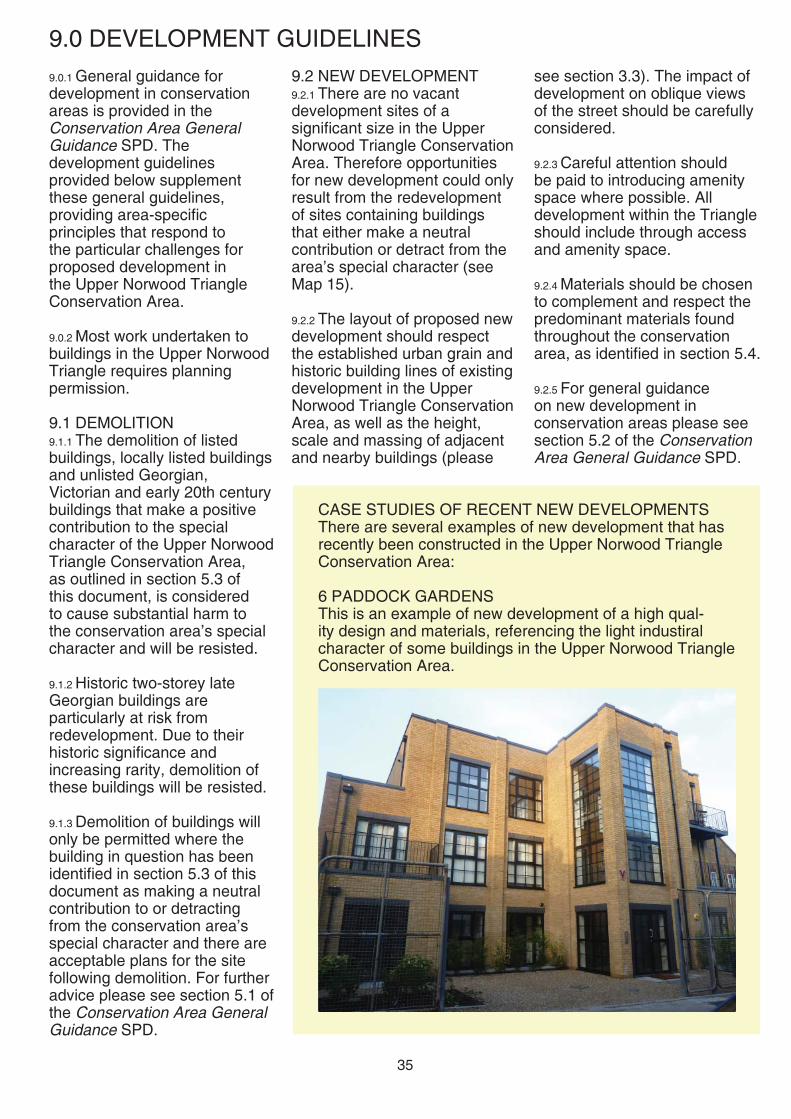
CASE STUDIES OF RECENT NEW DEVELOPMENTS There are several examples of new development that has recently been constructed in the Upper Norwood Triangle Conservation Area:
6 PADDOCK GARDENSThis is an example of new development of a high qual-ity design and materials, referencing the light industiral character of some buildings in the Upper Norwood Triangle Conservation Area.

36
9.3 CONVERSION OF PROPERTIES9.3.1 All proposed conversions should not result in harm to the external character and appearance of buildings. All properties facing onto commercial high streets should maintain a commercial use at ground fl oor level.
9.4 EXTENSIONS 9.4.1 Roof extensions visible from a public highway are unlikely to be permitted due to the disruption of the characteristic rhythm and form of the existing roofscapes in the conservation area. Mansard roofs and large dormer windows to front roofscapes, as well as roof extensions to two storey Georgian buildings will generally not be permitted due to the detrimental impact on the design and character of the original building.
9.4.2 If it is considered possible to accommodate a roof extension to a property, it should be set back from the front building line to not be visible from the street and should be of a simple, unobtrusive and visually light-weight design to avoid dominating the host building.
9.4.3 Most proposed rear extensions will not be visible from the street and therefore not have a direct impact on the character and appearance of the conservation area. However all rear extensions must be careful not to adversely impact on the visual amenity of adjacent occupiers and should be subservient in scale to the host building. Where a proposed rear extension is visible from the street, careful consideration must be given to its impact and design.
15-20 PADDOCK GARDENSThis development, built on land to the rear of 22-34 Westow Hill has not succesfully integrated with its sur-rounding context. Unlike other developments in the inner Triangle it has no through access and its design does not respond to the character of the wider area.
53-55 WESTOW STREETThis development of two blocks in many ways respects the established character of the street. However it is consid-ered to be of a poor quality design, lacking articulation and depth, resulting in a pastiche imitation of adjacent buildings (numbers 51 and 57) rather than a modern interpretation of the area’s historic character.

37
9.4.4 All proposals for extensions should be in line with the requirements of SPD2: Residential Extensions and Alterations and section 5.3 of the Conservation Area General Guidance SPD.
9.5 WINDOW REPLACEMENT 9.5.1 Many historic buildings in the Upper Norwood Triangle Conservation Area have timber sliding sash or casement windows. Original or traditional style windows should be retained and repaired.
9.5.2 If, following advice from a professional joiner, windows are found to be beyond repair then replacements, which in most cases will require planning permission, should match the original window design and be of timber construction and should be double glazed. The proposed use of uPVC or aluminium as a replacement material for original or traditional style timber windows will not be permitted as their proportions, opening methods, shiny plastic appearance, and light refl ection are all at odds with the character of historic buildings.
9.5.2 Windows of other traditional materials should also be retained and repaired if possible. If replacements are sought then they should also be on a like-for-like basis in terms of design and materials.
9.6 BRICK WALLS9.6.1 Originally exposed brick walls should not be clad, rendered or painted as the colour and texture of existing brick walls contributes towards the conservation area’s special character.
9.6.2 All re-pointing of walls should be carried out with a lime based mortar to ensure
An example of an high quality new traditional style shopfront successfully inte-grated within a new development on Westow Street.
historic buildings can extract any moisture that might build up in the walls to prevent the problems of damp. The use of cement mortar can harm the performance of historic buildings.
9.7 HISTORIC FEATURES9.7.1 Historic architectural features make an important contribution to the conservation area’s special character (see section 5.4). Special attention should be paid towards preserving important historic features present on these buildings. All development
proposals should seek to retain and restore historic features.
9.8 SHOPFRONT DESIGN AND SIGNAGE9.8.1 Historic shopfronts and shopfront features, including corbels, cornices and pilasters (see sections 5.2 and 5.4) should be retained.
9.8.2 The design of all proposed new shopfronts should respond to the established local context of traditionally designed shopfronts (see section 5.2) and should respect the period and character of their host

38
buildings. Shopfronts of a contemporary design will generally not be considered appropriate in historic buildings. All shopfronts should be of timber construction.
9.8.2 All proposed signage should respect the conservation area’s character in terms of their scale, design and materials and should be externally, not internally, illuminated.
9.8.3 For further guidance on shopfronts and signage please refer to Croydon’s Shopfronts and Signage SPG and section 5.15 of the Conservation Area General Guidance SPD.
9.9 DEVELOPMENT AFFECT-ING SETTING OF THE CON-SERVATION AREA9.9.1 As the conservation area boundary runs down the middle of Westow Hill and Church Road, there is potential for development or changes to existing buildings in close proximity to the conservation area to affect its setting.
9.9.2 All proposed development in close proximity to the Upper Norwood Triangle conservation area should seek to preserve and enhance its setting.
The historic Upper Norwood Library makes an important contribution to the streetscape of Westow Hill, within the setting of the Upper Norwood Triangle Conservation Area

39
10.0 ENHANCEMENT
• The re-fi xing of loose roof tiles or slates
• The regular re-painting of timber features
10.1.2 For more information please see section 6 of the Conservation Area General Guidance SPD..
10.2 REPAIR, RESTORATION AND REINSTATEMENT OF ARCHITECTURAL FEATURES10.2.1 The conservation area would be enhanced through the repair, restoration or reinstatement of damaged or lost architectural features, including:• Decorative window and door
surrounds• Stucco / stone detailing and
plasterwork mouldings• Decorative motifs or string
courses• Ironwork railings
10.2.2 All development proposals that include existing buildings should incorporate the
10.0.1 In principle the Council supports and welcomes schemes for enhancement of the area proposed by property owners and / or the local community. It is recognised that there is a strong sense of community in Crystal Palace, and the Crystal Palace Community Association plays an important role in maintaining and promoting this.
10.0.2 Property owners are strongly encouraged to maintain their properties and undertake minor works that would improve their condition and appearance, which will have a wider positive impact on the conservation area as a whole. Much enhancement of buildings and the wider area does not require planning permission. For advice on what works require planning permission please either see the Planning Portal or contact the Council’s Development Management service (see Appendix for details).
10.1 BUILDING MAINTENANCE 10.1.1 In order to ensure the survival of important architectural features regular attention is required to stop them falling into a state of disrepair. The Council therefore recommends that regular maintenance is undertaken to retain the collective value of the attractive features present in the area. The need for minor works, if left unattended, may result in unnecessary decay and damage, which could lead to more complex and expensive repair works at a later date. Basic maintenance recommendations include:• The regular clearing of debris
in gutters and rainwater pipes• The pruning of vegetation in
close proximity to buildings
re-instatement of lost features and the removal of later additions that have harmed a building’s character
10.3 ENERGY EFFICIENCY IMPROVEMENTS10.3.1 The Council supports the principle of works to buildings to improve their energy effi ciency, provided that the original character of the building is not harmed.
10.3.2 There are some retrofi tting measures that can be explored for buildings in this conservation area to improve their energy effi ciency and thermal performance. For further information please see section 9 of the Conservation Area General Guidance SPD.
10.4 SHOPFRONT IMPROVEMENTS10.4.1 Business owners should regularly maintain shopfronts and street-facing elevations. Opportunities for more
Historic features in the process of being repaired at 26 Westow Hill
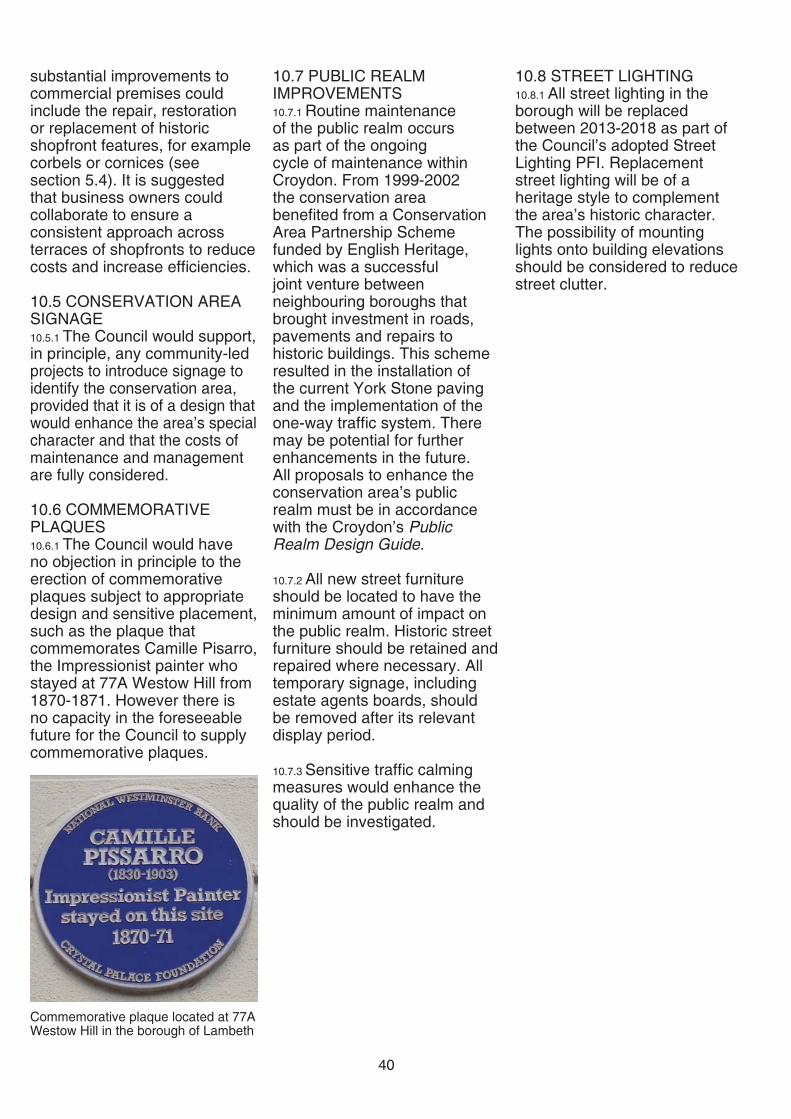
40
substantial improvements to commercial premises could include the repair, restoration or replacement of historic shopfront features, for example corbels or cornices (see section 5.4). It is suggested that business owners could collaborate to ensure a consistent approach across terraces of shopfronts to reduce costs and increase effi ciencies.
10.5 CONSERVATION AREA SIGNAGE10.5.1 The Council would support, in principle, any community-led projects to introduce signage to identify the conservation area, provided that it is of a design that would enhance the area’s special character and that the costs of maintenance and management are fully considered.
10.6 COMMEMORATIVE PLAQUES 10.6.1 The Council would have no objection in principle to the erection of commemorative plaques subject to appropriate design and sensitive placement, such as the plaque that commemorates Camille Pisarro, the Impressionist painter who stayed at 77A Westow Hill from 1870-1871. However there is no capacity in the foreseeable future for the Council to supply commemorative plaques.
10.7 PUBLIC REALM IMPROVEMENTS 10.7.1 Routine maintenance of the public realm occurs as part of the ongoing cycle of maintenance within Croydon. From 1999-2002 the conservation area benefi ted from a Conservation Area Partnership Scheme funded by English Heritage, which was a successful joint venture between neighbouring boroughs that brought investment in roads, pavements and repairs to historic buildings. This scheme resulted in the installation of the current York Stone paving and the implementation of the one-way traffi c system. There may be potential for further enhancements in the future. All proposals to enhance the conservation area’s public realm must be in accordance with the Croydon’s Public Realm Design Guide.
10.7.2 All new street furniture should be located to have the minimum amount of impact on the public realm. Historic street furniture should be retained and repaired where necessary. All temporary signage, including estate agents boards, should be removed after its relevant display period.
10.7.3 Sensitive traffi c calming measures would enhance the quality of the public realm and should be investigated.
Commemorative plaque located at 77A Westow Hill in the borough of Lambeth
10.8 STREET LIGHTING10.8.1 All street lighting in the borough will be replaced between 2013-2018 as part of the Council’s adopted Street Lighting PFI. Replacement street lighting will be of a heritage style to complement the area’s historic character. The possibility of mounting lights onto building elevations should be considered to reduce street clutter.

41
11.0 APPENDIX
11.1 WEBSITES AND OTHER RELEVANT INFORMATIONA) USEFUL WEBSITES• Croydon Council Planning and Conservation web pages: www.croydon.gov.uk/environment/conservation www.croydon.gov.uk/planningandregeneration• English Heritage web pages: www.english-heritage.org.uk www.helm.org.uk - (for access to English Heritage documents www.english-heritage.org.uk/your-property/saving-energy• National Planning Policy Framework and associated guidance: www.gov.uk/government/publications/national-planning-policy -framework--2• The Planning Portal www.planningportal.gov.uk• Greater London Historic Environment Record:
www.heritagegateway.org.uk (managed by English Heritage) • Greater London Authority (for the London Plan):
www.london.gov.uk/thelondonplan• Department for Communities and Local Government
www.communities.gov.uk• Building Conservation Directory:
www.buildingconservation.com• Sustainable Traditional Buildings Alliance:
www.sdfoundation.org.uk/stba
B) RELEVANT CROYDON COUNCIL DOCUMENTS (DOWNLOADABLE FROM ABOVE WEBLINK)• Croydon Conservation Area General Guidance SPD• Planning Application Validation Checklist • Local List of Buildings of Architectural or Historic Interest SPD• Residential Extensions and Alterations SPD• Shopfronts and Signage SPG and Shopfront Security Addendum• Advertisement Hoardings & Other Advertisements SPG• Landscape Design SPG• Public Realm Design Guide
C) RELEVANT NATIONAL GUIDANCE DOCUMENTS • Archaeology and Planning in Greater London (English Heritage
2011) • The Setting of Heritage Assets (English Heritage 2012)• Understanding Place: Conservation Area Designation, Appraisal
and Management (English Heritage 2011)• Understanding Place: Historic Area Assessments (English
Heritage 2011)• Energy Effi ciency and Historic Buildings, which is a series of
English Heritage guidance documents available to view and download at www.helm.org.uk/climatechange
• By Design: Urban Design in the Planning System (CABE, 2000)• The Urban Design Compendium (English Partnerships,
2000/2007) • Responsible Retrofi t of Traditional Buildings (Sustainable
Traditional Buildings Alliance 2012)• A Stitch in Time (IHBC and the Society for the Protection of
Ancient Buildings, 2002)
42
11.2 CONTACTSCroydon Council, Bernard Weatherill House, 8 Mint Walk, Croydon CR0 1EA; www.croydon.gov.ukTel/Email: 0208 7266000; [email protected]
• Spatial Planning (including Urban Design and Conservation offi cers): Tel: 0208 4071385; Email: [email protected]
• Development Management (including Enforcement & Tree Offi cers): Email: [email protected]
• Building Control Team, Croydon Council: Email: [email protected]
• Waste Management Team, Community Services, Croydon Council: Tel: 0208 7266200
• Croydon Local Studies Library and Archives Centre: www.croydon.gov.uk/libraries Tel:0208 7266900; Email: [email protected]
English Heritage, London Region1 Waterhouse Square, 138-142 Holborn, London EC1N 2STTel/Email: 0207 9733000; [email protected]
The Victorian SocietyTel/Email: 0208 9941019; [email protected] www.victoriansociety.org.uk
The Society for the Protection of Ancient Buildings (SPAB)Tel/Email: 0207 3771644; [email protected]; www.spab.org.ukTechnical helpline: 0207 456 0916
The Building Conservation DirectoryTel/Web: 01747 871717; www.buildingconservation.com
The Energy Saving TrustTel/Web: 0800 512012; www.energysavingtrust.org.uk Register of Building Conservation Accredited ArchitectsTel/Web: 01625 523784; www.aabc-register.co.uk
Royal Institute of British Architects (RIBA)Tel/Web: 0207 3073700; www.architecture.com
North Croydon Conservation Area Advisory Panel (please contact the Spatial Planning Team for details)
Crystal Palace Community AssociationContact: John Payne (Chairman): Email: [email protected]
Croydon Natural History and Scientifi c Society Contact: Brian Lancaster (Secretary): Email: [email protected]
Norwood SocietyContact: Philip Goddard (Chairman of the Planning Sub-committee)Email: [email protected]

43
COMMUNITY LANGUAGES
If English is not your first language and you need help to understand the information contained in this brochure, please contact Croydon Council on Tel: 020 8726 6400. We will then arrange for an interpreter to help you.
French
Czech
Bengali
0208 726 6400
0208 726 6400
0208 726 6400.
Gujerati
0208 726 6400
Panjabi0208 726 6400
Somali
0208 726 6400.
Turkish
0208 726 6400
Tamil
0208 726 6400
Urdu
0208 726 6400.
Albanian
0208 726 6400.
