upper green—flaming gorge reservoir watershed
TRANSCRIPT

United States Department of Agriculture
Natural Resources Conservation Service
Lakewood, Colorado
RWA 14040106
July 2010
Upper Green—Flaming Gorge Reservoir Watershed
Hydrologic Unit Code 14040106

Upper Green—Flaming Gorge Reservoir Watershed — 14040106
2

Upper Green—Flaming Gorge Reservoir Watershed — 14040106
3
The United States Department of Agriculture (USDA) prohibits discrimination in all its programs and activities on the basis of race, color, national origin, sex, religion, age, disability, political beliefs, sexual orientation, and marital or family status. (Not all prohibited bases apply to all programs.)
Persons with disabilities who require alternative means for communication of program information (Braille, large print, audiotape, etc.) should contact USDA’s TARGET Center at 202-720-2600 (voice and TDD).
To file a complaint of discrimination, write USDA, Director, Office of Civil Rights, Room 326W, Whitten Building, 14th and Independence Avenue, SW, Washington DC 20250-9410, or call (202) 720-5964 (voice and TDD). USDA is an equal opportunity provider and employer.

Upper Green—Flaming Gorge Reservoir Watershed — 14040106
4
Introduction
Background Information
The Natural Resources Conservation Service (NRCS) is encouraging the development of rapid watershed assessments in order to increase the speed and efficiency generating information to guide conservation implementation, as well as the speed and efficiency of putting it into the hands of local decision makers.
Rapid watershed assessments provide initial estimates of where conservation investments would best address the concerns of landowners, conservation districts, and other community organizations and stakeholders. These assessments help land-owners and local leaders set priorities and determine the best actions to achieve their goals.
Benefits of these Activities
While rapid assessments provide less detail and analysis than full-blown studies and plans, they do provide the benefits of NRCS locally-led planning in less time and at a reduced cost. The benefits include:
Quick and inexpensive tools for setting priorities and taking action
Providing a level of detail that is sufficient for identifying actions that can be taken with no further watershed-level studies or analyses
Actions to be taken may require further Federal or State permits or ESA or NEPA analysis but these activities are part of standard requirements for use of best management practices (BMPs) and conservation systems
Identifying where further detailed analyses or watershed studies are needed
Plans address multiple objectives and concerns of landowners and communities
Plans are based on established partnerships at the local and state levels
Plans enable landowners and communities to decide on the best mix of NRCS programs that will meet their goals
Plans include the full array of conservation program tools (i.e. cost-share practices, easements, technical assistance)
Rapid Watershed Assessments provide information that helps land-owners and local leaders set conservation priorities.
Upper Green—Flaming Gorge Reservoir Watershed — 14040106
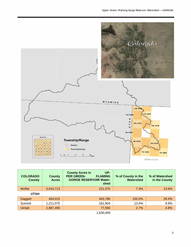
5
COLORADO County
County Acres
County Acres in UP-PER GREEN- FLAMING
GORGE RESERVOIR Water-shed
% of County in the Watershed
% of Watershed in the County
Moffat 3,043,713 221,070 7.3% 13.6%
UTAH
Daggett 464,015 463,786 100.0% 28.4%
Summit 1,211,075 161,904 13.4% 9.9%
Uintah 2,887,490 77,590 2.7% 4.8%
1,630,493

Upper Green—Flaming Gorge Reservoir Watershed — 14040106
6

Upper Green—Flaming Gorge Reservoir Watershed — 14040106
7
MLRA CRA CRA NAME CRA DESCRIPTION
34A
34A.1
Cool Central Desertic Basins and Plateaus--Green River Basin
This unit is in the cool semiarid basins, plateaus, and low mountains that are west of the Continental Divide in MLRA 34A. Soils have an aridic moisture regime and frigid tempera-ture regime. Vegetation is sagebrush or shadscale and bunch-grasses. Major use is range. Precipitation ranges from 7 to 14 inches. Elevations range from about 4,000 to 7,000 feet.
47
47.1
Wasatch and Uinta Moun-tains - Low Mountains and Foothills; Utah, Wyoming, and Colorado
This unit is in the gently sloping to steep semiarid low moun-tains and hills in the Wasatch and Uinta Mountains. Soils have xeric or ustic moisture regimes with frigid or cryic tem-perature regimes. Precipitation ranges from 10 to about 18 inches. Elevations are about 5,000 to 8 ,000 feet. Range and cropland are the predominant land uses.
47
47.2
Wasatch and Uinta Moun-tains- High Mountains
This area is in the higher elevations of the Wasatch & Uinta Mountains. Precipitation ranges from 16 to about 30 inches. Elevations are usually more than 6,000 feet and range to more than 10,000 feet. The mountains are covered in a mixture of mountain big sagebrush, mountain brush, and coniferous for-ests; with alpine vegetation on the highest mountain summits.

Upper Green—Flaming Gorge Reservoir Watershed — 14040106
8

Upper Green—Flaming Gorge Reservoir Watershed — 14040106
9

Upper Green—Flaming Gorge Reservoir Watershed — 14040106
10
UPPER GREEN-FLAMING GORGE RESERVOIR Land Use
Total Acreage Vegetation Acreage
Cropland 458 Irrigated Ag* 458.0
Rangeland/Grassland 196,457
Bitterbrush Community 1,303.0
Bitterbrush/Grass Mix 680.9
Grass Dominated 500.1
Grass/Forb Mix 9,165.1
Greasewood 5,286.4
Juniper 104.6
Juniper/Sagebrush Mix 6,695.5
Manzanita 1.5
Mesic Mountain Shrub Mix 14,037.7
PJ-Mtn Shrub Mix 10,117.1
PJ-Sagebrush Mix 9,910.0
Pinon-Juniper 13,076.4
Sagebrush Community 47,123.5
Sagebrush/Grass Mix 66,735.0
Sagebrush/Greasewood 1,797.2
Sagebrush/Mesic Mtn Shrub Mix 1,119.5
Salt Desert Shrub Community 681.2
Saltbush Community 5,203.3
Serviceberry/Shrub Mix 87.1
Sparse Juniper/Shrub/Rock Mix 2,492.4
Sparse PJ/Shrub/Rock Mix 339.0
Forest 15,232
Aspen 2,489.7
Aspen/Mesic Mountain Shrub Mix 1,698.8
Douglas Fir 3,595.4
Lodgepole Pine 432.0
Lodgepole Pine/Aspen Mix 838.5
Lodgepole/Spruce/Fir Mix 690.4
Ponderosa Pine 5,135.2
Spruce/Fir/Lodgepole/Aspen Mix 351.7
Riparian 5,582
Cottonwood 41.2
Forested Riparian 457.9
Herbaceous Riparian 4,364.3
Shrub Riparian 573.9
Willow 144.7
Water 1,906 Water 1,906.3
Other 1,234 Rock 61.8
Soil 1,171.7
~Total Watershed Acres 220,868
* Colorado Decision Support Systems Data

Upper Green—Flaming Gorge Reservoir Watershed — 14040106
11
Precipitation Droughts are regular visitors to the watershed as with the rest of Colorado. Statewide, in the 1900's alone, four prolonged dry spells occurred. There was one in the 1910s. Another, in the '30s, caused the dust-bowl period. The second worst drought on record in the state occurred in the mid-50s. A series of hot, dry summers following a period of scant mountain snowpack created water shortages. The fourth drought hit parts of Colorado in the late 1970s. In this century, the most severe drought since 1723 hit the state in 2002. Prior to the 1700's, researchers looking at tree ring records have found evidence of even more severe droughts, some lasting many years.

Upper Green—Flaming Gorge Reservoir Watershed — 14040106
12

Upper Green—Flaming Gorge Reservoir Watershed — 14040106
13
Class 1 - soils have few limitations that restrict their use.
Class 2 - soils have moderate limitations that reduce the choice of plants or that require moderate conservation practices.
Class 3 - soils have severe limitations that reduce the choice of plants or that require special conservation practices, or both.
Class 4 - soils have very severe limitations that reduce the choice of plants or that require very careful management, or both.
Class 5 - soils are subject to little or no erosion but have other limitations, impractical to remove, that restrict their use mainly to pasture, rangeland, forestland, or wildlife habitat.
Class 6 - soils have severe limitations that make them generally unsuitable for cultivation and that restrict their use mainly to pasture, rangeland, forestland, or wildlife habitat.
Class 7 - soils have very severe limitations that make them unsuitable for cultivation and that restrict their use mainly to grazing, forestland, or wildlife habitat.
Class 8 - soils and miscellaneous areas have limitations that preclude commercial plant production and that restrict their use to recreational purposes, wildlife habitat, watershed, or aesthetic purposes.

Upper Green—Flaming Gorge Reservoir Watershed — 14040106
14
The Wind Erodibility Index (WEI): numerical value indicating the susceptibility of soil to wind erosion, or the tons per acre per year that can be expected to be lost to wind erosion if it is assumed there is no vegetative cover or management.
Soils with an erodibility index equal to or greater than 8 are considered highly erodible.

Upper Green—Flaming Gorge Reservoir Watershed — 14040106
15
State and Federal Threatened, Endangered, and Candidate Species and Species of Special Con-cern in Upper Green-Flaming Gorge Reservoir Watershed
Common Name Scientific Name Class State
Status Federal Status
Comments
American Peregrine Falcon
Falco peregrinus anatum
Birds Concern None Occurs in the watershed
Bald Eagle Haliaeetus leuco-cephalus
Birds Threatened None Winters in the watershed
Black-footed Ferret Mustela nigripes Mammals Endangered Endangered May occur in the watershed
Bonytail Gila elegans Fish Endangered Endangered Water depletions in the watershed may affect downstream habitats/fish
Colorado Pikemin-now
Ptychocheilus lucius Fish Threatened Endangered Water depletions in the watershed may affect downstream habitats/fish
Canada Lynx Lynx canadensis Mammals Endangered Threatened May occur in the watershed
Colorado River Cut-throat Trout
Oncorhynchus clarki pleuriticus
Fish Concern None May occur in the watershed
Colorado Roundtail Chub
Gila robusta Fish Concern None May occur in the watershed
Greater Sage Grouse
Centrocercus uro-phasianus
Birds Concern None Occurs in the watershed
Humpback Chub Gila cypha Fish Threatened Endangered Water depletions in the watershed may affect downstream habitats/fish
Mountain Sucker Catostomus platyrhynchus
Fish Concern None May occur in the watershed
Northern leopard frog
Rana pipiens Amphibians Concern None May occur in the watershed
River Otter Lontra Canadensis Mammals Threatened None Occurs in the watershed
Razorback Sucker Xyrauchen texanus Fish Endangered Endangered Water depletions in the watershed may affect downstream habitats/fish
Townsend’s Big-eared Bat
Corynorhinus town-sendii pallescens
Mammals Concern None May occur in the watershed
Western Yellow-billed Cuckoo
Coccyzus ameri-canus
Birds Concern Candidate May occur in the watershed
The terrestrial habitats in this watershed are composed primarily of shrubs with extensive acreage of big sagebrush, saltbush, and pinyon-juniper; and some desert shrub and xeric upland shrub habitats. Small amounts of lodgepole pine, Douglas fir, and aspen comprise the forested habitats. Riparian areas and stock ponds provide aquatic habitats in the watershed.
Economically important species in the watershed include: black bear, elk, mule deer, mountain lion, and sport fish throughout most of the watershed; pronghorn, in the northern and eastern parts; bighorn sheep, moose, and snow geese in the southern part of the watershed and in the Green River area.

Upper Green—Flaming Gorge Reservoir Watershed — 14040106
16
Social Data Moffat
Demographics (US Census, American Factfinder)
Total population 13,184
Male 6,836
Female 6,348
Median age (years) 35.4
White 12,341
Black or African American 28
American Indian and Alaska Native 116
Asian 44
Native Hawaiian and Other Pacific Islander 3
Some other race 418
Hispanic or Latino (of any race) 1247
Economic Characteristics (US Census, American Factfinder)
In labor force (population 16 years and over) 6,875
Median household income (dollars) 41,528
Median family income (dollars) 45,511
Per capita income (dollars) 18,540
Families below poverty level 249
Individuals below poverty level 1086
County Agricultural Characteristics (Colorado Agricultural Census, county data tables)
Farms (number) 443
Land in farms/ranches (acres) 1,017,612
Average size farm/ranch (acres) 2,297
Median size farm (acres) 400
Average age of farmer or rancher 52.7
Net cash return from ag sales ($1,000) 1,407
Cattle and calves (number) 32,000

Upper Green—Flaming Gorge Reservoir Watershed — 14040106
17

Upper Green—Flaming Gorge Reservoir Watershed — 14040106
18
Selected Conservation Practices Applied, FY 2005 through FY 2009
Practice Code Practice Name Practice Unit Applied Amount Applied Count
645 Upland Wildlife Habitat Manage-ment ac 25,609 249
449 Irrigation Water Management ac 264 1
528 Prescribed Grazing ac 3,940 13
511 Forage Harvest Management Ac 3,328 88
Grazed Rangeland—The grazing Resources need improved plant condition (similarity index), productivity, health and vigor. Animals need feed, forage, and shelter. The animals are adapted to the climatic and ecological condition of the resources.
CO 34.1-GR-01
Practices Description Resource Concerns Addressed
314 Brush Management 338 Prescribed Burning 378 Pond 382 Fence 528 Prescribed Grazing 574 Spring Development 595 Pest Management 614 Watering Facility 645 Upland Wildlife Habitat Management 666 Forest Stand Improvement
This area encompasses the lower eleva-tion mesas and Plateaus that represent the transition to the Southern Rocky Mountains. The typical vegetation is a scattered overstory of two needle pin-yon and Utah juniper with a understory of big sagebrush and perennial bunch-grasses. In some areas pinyon and juni-per can increase and become a domi-nant species.
Fish and Wildlife - T&E Species: Declining Species, Species of Concern Plant Condition - Productivity, Health and Vigor Soil Erosion - Sheet and Rill Soil Erosion - Wind
Conservation Systems to Address Major Resource Concerns from the Field Office Technical Guide
Estimated Costs of Application of Conservation Systems
Landuse Estimated Acres Need to be Treated
Estimated Average Cost per Acre ($) Costs ($)
Range 10,000 30 300,000
Total Costs: $300,000

Upper Green—Flaming Gorge Reservoir Watershed — 14040106
19
FOOTNOTES/ BIBLIOGRAPHY
Threatened and Endangered Species information was gathered using data from the Colorado Division of Wild-life (CDOW) Natural Diversity Information Source (NDIS). NDIS GIS data may be downloaded at http://ndis.nrel.colostate.edu. For more information on Colorado’s Endangered & Threatened Species, as well as Spe-cies of Concern, visit http://wildlife.state.co.us/WildlifeSpecies/SpeciesOfConcern/ThreatenedEndangeredList/ListOfThreatenedAndEndangeredSpecies.htm or http://mountainprairie.fws.gov/endspp/CountyLists/COLORADO.htm
Resource Concerns were identified using the Colorado Association of Conservation Districts’ (CACD) long range (10 year) plans from the period of 1996-2000. Only the top three environmental resource concerns for each district were used. For more information on Colorado’s Conservation Districts, visit http://www.cacd.us.
Maps were generated using Soil Survey Geographic Database (SSURGO) tabular and spatial data. SSURGO data was downloaded for the following Colorado surveys:
Moffat County Area (CO686) Published 2/4/2008
Dinosaur National Monument (CO692) Published 1/13/2007
To download SSURGO data, visit http://soildatamart.nrcs.usda.gov. The surveys were then loaded into Soil Data Viewer http://soildataviewer.nrcs.usda.gov (a tool built as an extension to ArcMAP for quick geospatial analysis of soil data for use in resource assessment) and the subsequent data was exported to a GIS shapefile.
Vegetation data was generated using the Colorado Division of Wildlife’s “Colorado Vegetation Classification Pro-ject” (CVCP) data. Completed in 2003, the CVCP is a landscape level vegetation dataset created using Landsat TM imagery and then formatted for GIS use. The species identified are an overview of the most common species associated in each cover type, in order of greatest occurrence. For more information on the Colorado Vegetation Classification Project, visit http://ndis.nrel.colostate.edu/coveg.
All border state (if applicable) vegetation data courtesy of the National Land Cover Dataset (NLCD). For more information visit http://www.mrlc.gov/mrlc2k_nlcd.asp
Common Resource Area (CRA), a subdivision of the Major Land Resource Area (MLRA), is a geographical area where resource concerns, problems, or treatment needs are similar. Geographic boundaries of a CRA are deter-mined by landscape conditions, soil, climate, human considerations and other natural resource information. For more information on Common Resource Areas visit http://soils.usda.gov/survey/geography/cra.html.
Average Annual Precipitation data was developed through a partnership between the Natural Resources Con-servation Service’s (NRCS) National Water and Climate Center (NWCC), the National Cartography and Geospa-tial Center (NCGC), and the PRISM (the Parameter-elevation Regressions on Independent Slopes Model) group at Oregon State University (OSU), developers of PRISM. Mean annual precipitation maps were developed calcu-lating averages of rainfall for the period of 1961-1990. For more information on PRISM data visit http://www.ncgc.nrcs.usda.gov/products/datasets/climate/docs/fact-sheet.html or for more information about technical aspects of PRISM, visit the PRISM website at http://www.ocs.orst.edu/prism.
Land Ownership (status,07/22/2006 dataset) data was obtained from the Bureau of Land Management, Colo-rado State Office. For more information, visit http://www.blm.gov/co/st/en/BLM_Programs/geographical_sciences/gis.html
Relief & Elevation maps were created using the National Elevation Dataset (NED), 30m Digital Elevation Model (DEM) raster product assembled by the U.S. Geological Survey (USGS). A hillshade grid was created from the 30m DEM to create a 3D effect. For more information about the NED visit http://ned.usgs.gov. The data was downloaded from the NRCS Geospatial Data Gateway at http://datagateway.nrcs.usda.gov.