upper green river basin sage-grouse conservation plan
TRANSCRIPT

1
Upper Green River Basin Sage-Grouse Conservation Plan Addendum – 2014
2
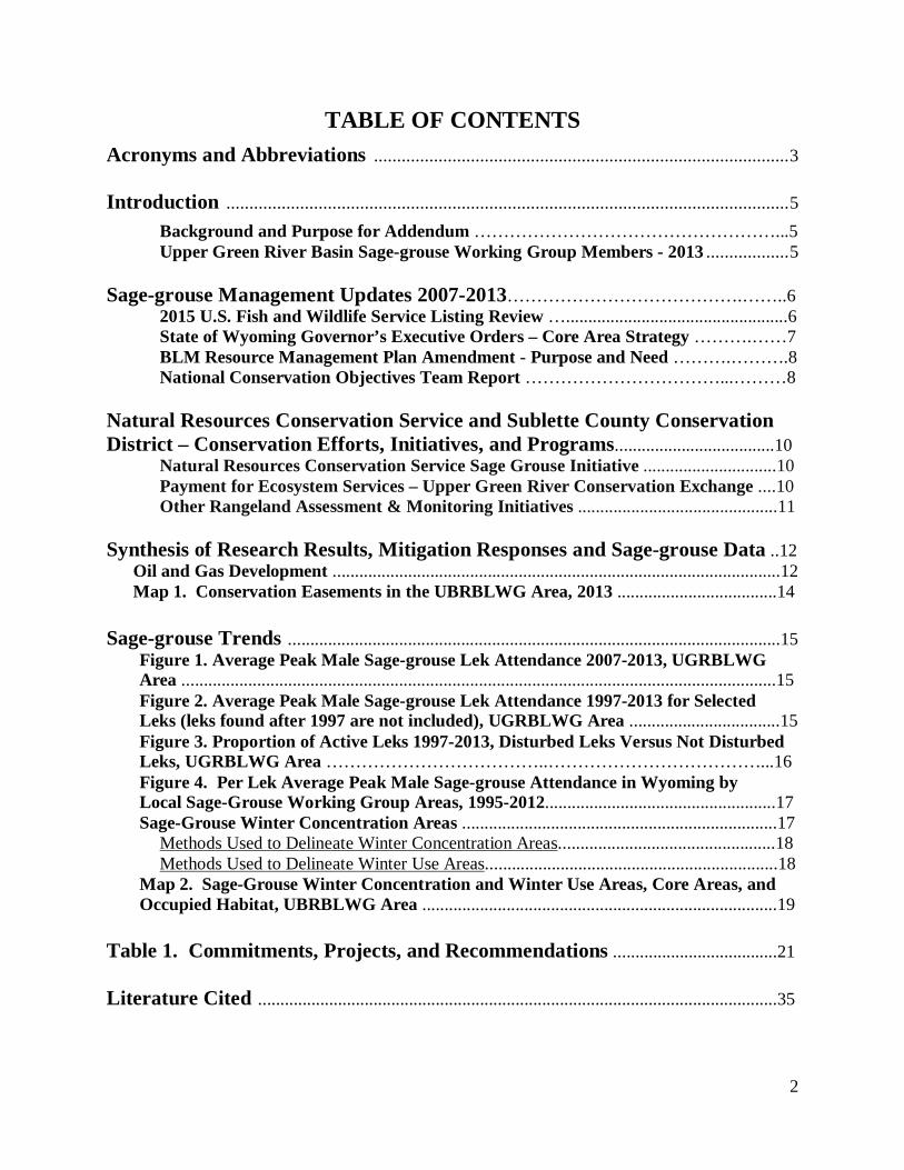
TABLE OF CONTENTS Acronyms and Abbreviations .......................................................................................... 3 Introduction .......................................................................................................................... 5
Background and Purpose for Addendum ……………………………………………...5 Upper Green River Basin Sage-grouse Working Group Members - 2013 .................. 5
Sage-grouse Management Updates 2007-2013………………………………….……..6
2015 U.S. Fish and Wildlife Service Listing Review …..................................................6 State of Wyoming Governor’s Executive Orders – Core Area Strategy ……….……7 BLM Resource Management Plan Amendment - Purpose and Need ……….……….8 National Conservation Objectives Team Report ……………………………...………8
Natural Resources Conservation Service and Sublette County Conservation District – Conservation Efforts, Initiatives, and Programs....................................10
Natural Resources Conservation Service Sage Grouse Initiative ..............................10 Payment for Ecosystem Services – Upper Green River Conservation Exchange ....10
Other Rangeland Assessment & Monitoring Initiatives .............................................11
Synthesis of Research Results, Mitigation Responses and Sage-grouse Data ..12 Oil and Gas Development .....................................................................................................12 Map 1. Conservation Easements in the UBRBLWG Area, 2013 ....................................14 Sage-grouse Trends ...............................................................................................................15
Figure 1. Average Peak Male Sage-grouse Lek Attendance 2007-2013, UGRBLWG Area ......................................................................................................................................15 Figure 2. Average Peak Male Sage-grouse Lek Attendance 1997-2013 for Selected Leks (leks found after 1997 are not included), UGRBLWG Area ..................................15 Figure 3. Proportion of Active Leks 1997-2013, Disturbed Leks Versus Not Disturbed Leks, UGRBLWG Area ………………………………..………………………………...16 Figure 4. Per Lek Average Peak Male Sage-grouse Attendance in Wyoming by Local Sage-Grouse Working Group Areas, 1995-2012....................................................17 Sage-Grouse Winter Concentration Areas .......................................................................17
Methods Used to Delineate Winter Concentration Areas.................................................18 Methods Used to Delineate Winter Use Areas..................................................................18
Map 2. Sage-Grouse Winter Concentration and Winter Use Areas, Core Areas, and Occupied Habitat, UBRBLWG Area ................................................................................19
Table 1. Commitments, Projects, and Recommendations .....................................21 Literature Cited .....................................................................................................................35
3
Acronyms and Abbreviations ADMB – Wyoming Animal Damage Management Board AMP - Allotment Management Plan
ANOVA – Analysis of Variance ANSI – American National Standards Institute ARS – U.S. Department of Agriculture, Agricultural Research Service BLM - U.S. Department of Interior, Bureau of Land Management BP – British Petroleum CCA - Candidate Conservation Agreements CCAA – Candidate Conservation Agreements with Assurances CD – compact disc CIG – Conservation Innovation Grant CO - Colorado COT - Conservation Objectives Team CWMA - Coordinated Weed Management Area dB - decibels dBA – A-weighted decibels DOI - U.S. Department of the Interior DDCT - Density Disturbance Calculation Tool EA – Evaluation Area ac - acre EnCana – Encana Corporation EQIP - Environmental Quality Incentives Program ESA - Endangered Species Act ES – Ecological Site ESD - Ecological Site Description FRPP - Farm and Ranchland Protection Program FFA - Future Farmers of America FS - U.S. Department of Agriculture, Forest Service FWS - U.S. Department of Interior, Fish and Wildlife Service GPS – global positioning system GRP - Grassland Reserve Program GRVLT - Green River Valley Land Trust, now the Wyoming Land Trust ha - hectare JHLT – Jackson Hole Land Trust JIO – Jonah Interagency Office km – kilometer lb - pound LGS – liquid or condensate and produced water gathering system LIDAR – an optical remote sensing technology using laser and radar LMP - Land Management Plan m - meter mi – mile

4
NA – not applicable NAD – North American Datum NEPA – National Environmental Policy Act NPL – Normally Pressured Lance (an EnCana proposed natural gas development) NRCS – U.S. Department of Agriculture, Natural Resources Conservation Service NTT – Bureau of Land Management Sage-grouse National Technical Team PAPA – Pinedale Anticline Project Area PAPO – Pinedale Anticline Project Office PES - Payment for Ecosystem Services PFO – Bureau of Land Management, Pinedale Field Office QEP – QEP Energy Company RMEF – Rocky Mountain Elk Foundation RMG - BLM State Office Reservoir Management Group RMP - Resource Management Plan RSF – Resource Selection Function model Sage-grouse – greater sage-grouse (Centrocercus urophasianus) SCCD - Sublette County Conservation District SCWP - Sublette County Weed and Pest SGI - Sage-Grouse Initiative SGIT - Wyoming Governor’s Sage-Grouse Implementation Team Shell – Shell Rocky Mountain Production, LLC SOS - Seeds of Success TBD – to be determined TNC - Wyoming Chapter of The Nature Conservancy UGRBSG -Upper Green River Basin Sage-Grouse UGRBLWG - Upper Green River Basin Local Sage-Grouse Working Group UGRCE - Upper Green River Conservation Exchange Ultra –Ultra Petroleum Corporation UTM – Universal Transverse Mercator UW - University of Wyoming USDA – U.S. Department of Agriculture VHF – very high frequency WHIP - Wildlife Habitat Incentives Program WGFD - Wyoming Game and Fish Department WLCI – Wyoming Landscape Conservation Initiative WLT – Wyoming Land Trust WNV - West Nile Virus WSGLT – Wyoming Stock Growers Land Trust WWC - Wyoming Wildlife Consultants, LLC WWNRTF – Wyoming Wildlife and Natural Resource Trust Fund WY – Wyoming WYDOT – Wyoming Department of Transportation WYGISC – Wyoming Geographic Information Service Center

5
Introduction
Background and Purpose for Addendum The Wyoming Sage-grouse Management Plan was finalized in 2003 after which the State’s eight local working groups developed their respective plans. The Upper Green River Basin Sage-Grouse (UGRBSG) Local Working Group (UGRBLWG) was established in the spring of 2004 with an initial task of developing a local conservation plan, which was finalized in May 2007. Since that time, a significant amount of information has been gathered through research, completed and ongoing projects, and development of subsequent conservation measures such as the Wyoming Core Area Strategy. This addendum updates the UGRBSG Conservation Plan (May 24, 2007) with the latest information, primarily updating the status of projects that focus on the threats identified in the 2010 U.S. Fish and Wildlife Service (FWS) listing decision. This addendum also identifies new projects and strategies the UGRBLWG will undertake in upcoming years. This addendum does not replace the UGRBSG Conservation Plan and should be used as a supplement, as the 2007 Plan still provides considerable information that remains relevant. This Conservation Plan can be accessed on the Wyoming Game and Fish Department (WGFD) website at: http://wgfd.wyo.gov/web2011/Departments/Wildlife/pdfs/SG_UGRCONSERVATIONPLAN0000681.pdf . In addition to those principal population threats identified by the FWS in their listing decision (habitat loss/fragmentation, inadequate regulatory mechanisms); additional threats specific to our area will be discussed in part to support our projects (i.e., raven control, cheatgrass mapping/control). Currently 10 members, representing various interests, make up the UGRBLWG, one more member than when the Conservation Plan was completed in 2007. Current members are shown below: Upper Green River Basin Sage-grouse Working Group Members - 2013 Bob Barrett1, Sportsman
Jim Bousman1, Agriculture/Rancher
Dean Clause1, Wyoming Game & Fish Department
John Dahlke1, Wyoming Wildlife Consultants, LLC
Aimee Davison1, Shell Rocky Mountain Production, LLC
Rusty Kaiser, Bureau of Land Management, Pinedale Field Office
Pete Guernsey, QEP Energy Company
Jennifer Hayward, Natural Resources Conservation Service
Melanie Purcell, Sublette County Conservation District
Albert Sommers, Agriculture/Rancher & State Legislature 1: Original working group member (since 2004)

6
Sage-grouse Management Updates 2007-2013 2015 U.S. Fish and Wildlife Service Listing Review On March 5, 2010 the FWS announced its 12-month finding on a petition to list the greater sage-grouse (sage-grouse) as threatened or endangered under the Endangered Species Act (ESA). The FWS found that a sage-grouse listing is warranted, but precluded by higher priority listing actions. The FWS identified two threats which contribute to the vulnerability of healthy and sustainable sage-grouse populations: 1) the present or threatened destruction, modification, or curtailment of its habitat or range and 2) the inadequacy of existing regulatory mechanisms. The warranted, but precluded finding resulted in the sage-grouse becoming a “candidate” species for listing which requires the FWS to conduct an annual status review. Candidate listings receive no protections under the ESA. In February 2012 a federal court judge rejected a challenge from environmental groups to force the FWS to list the sage-grouse as threatened or endangered. However, another federal court settlement requires the FWS to review the candidate status of 251 species including the sage-grouse to determine if these species warrant protection by the ESA or should be removed from the candidate list. The deadline for the decision on the sage-grouse is September 30, 2015. In the 2010 decision, the FWS concluded that predation was not a range-wide threat (FWS 2010 p. 13,970-13,973 and references therein). However, they stated, “The studies presented here suggest that, in areas of intense habitat alteration and fragmentation, sage-grouse productivity and, therefore, populations could be negatively affected by increasing predation. Predators could already be limiting sage-grouse populations in southwestern Wyoming and northeastern Nevada (Coates 2007, p. 131; Bui et al. 2010). The influence of synanthropic predators in southwestern Wyoming may be particularly significant as this area has one of the few remaining sagebrush landscapes and the most highly connected network of sage-grouse leks...” “Unfortunately, except for the few studies presented here, data are lacking that definitively link sage-grouse population trends with predator abundance. However, where habitats have been altered by human activities, we believe that predation could be limiting local sage-grouse populations. As more habitats face development, even dispersed development, we expect the risk of increased predation to spread, possibly with negative effects on the sage-grouse population trends. Studies of the effectiveness of predator control have failed to demonstrate an inverse relationship between the predator numbers and sage-grouse success or population numbers.” The UGRBSG Conservation Plan, together with this addendum, recognizes predation, especially by ravens, to be an issue in the plan area. Management actions have been taken to address the threat (Table 1). Additionally, successful implementation of Wyoming’s Core Area Strategy (described below) will result in minimizing artificial raven nesting substrates and foraging opportunities thereby managing raven distribution and population. Furthermore, Wyoming’s Core Area Strategy addresses the FWS-identified threats of habitat loss and inadequate regulatory mechanisms to protect sage-grouse habitat. Current FWS information is available at http://www.fws.gov/mountain-prairie/species/birds/sagegrouse/.

7
State of Wyoming Governor’s Executive Orders – Core Area Strategy In July 2007 Wyoming Governor Freudenthal convened a summit and created the Wyoming Governor’s Sage-grouse Implementation Team (SGIT) to develop a conservation strategy, the Wyoming Core Population Area strategy, to manage sage-grouse to prevent listing under the ESA and retain State authority in management decisions. The strategy identified the most important sage-grouse habitat in Wyoming using a lek density map showing areas of the state which supported the highest densities of breeding activity from 2005 thru 2007. The Governor issued Executive Order 2008-2 in August 2008 outlining the core area strategy with 21 recommendations that conserve Wyoming’s most important sage-grouse habitats while allowing for development outside core areas. Statewide, core areas accounted for approximately 34% of the current sage-grouse range while encompassing leks with 81% of the 2008 peak males. Intentionally excluded from “core” habitat were existing, planned, and authorized energy development areas in the Upper Green River Basin. Following the March 2010 listing decision of “warranted, but precluded” by the FWS, Governor Freudenthal asked the SGIT to revisit Wyoming’s sage-grouse management strategy. The group’s three tasks were to: 1) review core area boundaries; 2) review development guidelines inside and outside core habitats; and 3) identify connectivity areas to ensure movement corridors between populations to preserve genetic integrity. At the direction of the SGIT, the eight local working groups held meetings to review core area boundaries and make adjustments based on finer scale mapping of existing and planned development, suitable and unsuitable habitats, seasonal habitat data and connectivity between core areas. Following revisions, Governor Freudenthal signed Executive Order 2010-4 which updated Wyoming’s core area strategy as the framework to guide sage-grouse management in Wyoming. The revision incorporated connectivity areas and select recommendations for connectivity management. This was a significant milestone as the FWS had already approved the core area strategy as a sound framework for a policy by which to conserve sage-grouse. Currently the UGRBLWG area encompasses approximately 2,630,744 total acres, with 1,726,232 acres of occupied sage-grouse habitat (66% of the UGRBLWG area), and 847,893 acres of Core Area habitat (49% of occupied sage-grouse habitat). Subsequent to the 2010 gubernatorial election, Governor Mead signed a 2011 version of the Executive Order (2011-5), reiterating and clarifying the Wyoming Core Area Strategy (see: http://wgfd.wyo.gov/web2011/Departments/Wildlife/pdfs/SAGEGROUSE_EO_COREPROTECTION0000651.pdf). In June 2011 the FWS wrote in a letter to Governor Mead, “In summary, the Service believes the Greater Sage-grouse Core Area Protection provides an excellent model for meaningful conservation of sage-grouse if fully supported and implemented. We believe that when fully realized, this effort could ameliorate many threats to the Greater sage-grouse in Wyoming.” In Wyoming, local, state and federal resource agencies are working to develop conservation strategies including Candidate Conservation Agreements with Assurances (CCAA) for private lands and Candidate Conservation Agreements (CCA) for public lands (see: http://www.fws.gov/wyominges/PDFs/Species_Listed/Umbrella_CCAA/Sage-grouse%20CCAA%20Draft%2012-19-2012.pdf).

8
These agreements provide a mechanism for conserving sage-grouse through proactive conservation measures that reduce the potential for additional regulatory requirements that could result if the species is listed as threatened or endangered. The Bureau of Land Management (BLM) is working to adopt Wyoming’s Core Area Strategy into their local Resource Management Plans (RMPs). With this addendum the UGRBLWG acknowledges the Wyoming Core Area Strategy and its adoption by managers and regulators as the primary mechanism by which the identified threats of habitat loss and fragmentation and the inadequacy of regulatory mechanisms are addressed. BLM Resource Management Plan Amendment - Purpose and Need The BLM and the Forest Service (FS) are preparing RMP and Land Management Plan (LMP) amendments, respectively, with associated Environmental Impact Statements (EISs) for land use plans in areas containing greater sage-grouse habitat that are not currently undergoing amendment or revision. This effort responds to the recent “warranted, but precluded” ESA listing petition decision from the FWS (75 Fed. Reg. 13910, March 23, 2010). Throughout the range of sage-grouse, approximately 51% of sagebrush habitat is on BLM-administered land; the FS has management authority for 8% of sagebrush habitat. Changes in management of sage-grouse habitats are deemed necessary to avoid the continued decline of populations that are anticipated across the species’ range. These plan amendments will focus on areas affected by threats to sage-grouse habitat identified by the FWS in the March 2010 listing decision. Because the federal land management agencies administer a large portion of the habitat, changes in BLM and FS management of sage-grouse habitats are anticipated to have a considerable beneficial impact on existing sage-grouse populations and could reduce the need to list the species as threatened or endangered under the ESA. The purpose for the RMP/LMP amendments is to identify and incorporate appropriate “regulatory mechanisms” to conserve, enhance and/or restore greater sage-grouse habitats to support greater sage-grouse population management objectives. Inadequacy of regulatory mechanisms was identified as a significant threat in the FWS finding on the petition to list the greater sage-grouse. The FWS identified the principal regulatory mechanisms for the BLM and the FS as conservation measures embedded in RMPs and LMPs, respectively. There is a need for RMP/LMP amendments because comprehensive and consistent conservation measures would have beneficial impacts on existing sage-grouse populations and habitat. Additionally, BLM has prepared a report, commonly referred to as the “NTT” report, identifying science-based conservation measures for sage-grouse (U.S. Department of Interior, 2011; see: http://www.blm.gov/pgdata/etc/medialib/blm/wo/Information_Resources_Management/policy/im_attachments/2012.Par.52415.File.dat/IM%202012-044%20Att%201.pdf). Conservation measures identified in this report will be considered in the upcoming RMP amendment process. National Conservation Objectives Team Report In December 2011, Wyoming Governor Matt Mead and Secretary of the Interior Ken Salazar co-hosted a meeting to address coordinated conservation of the sage-grouse across its range. Ten

9
states within the range of the sage-grouse were represented, as were the FS, NRCS, and the U.S. Department of the Interior (DOI) and its BLM and FWS. The primary outcome of the meeting was the creation of a Sage-grouse Task Force (Task Force) chaired by Governors Mead (WY) and Hickenlooper (CO) and the Director of the BLM. The Task Force was directed to develop recommendations on how to best move forward with a coordinated, multi-state, range-wide effort to conserve the sage-grouse, including the identification of conservation objectives to ensure the long-term persistence of the species. The FWS was tasked by its Director with the development of conservation objectives for the sage-grouse. Recognizing that state wildlife agencies have management expertise and retain management authority for this species, the FWS created a Conservation Objectives Team (COT) of state and FWS representatives to accomplish this task. Each member was selected by his or her state or agency. Bob Budd was the Wyoming representative to the COT. The purpose of the COT was to develop conservation objectives by defining the degree to which the threats need to be reduced or ameliorated to conserve the sage-grouse so that it is no longer in danger of extinction or likely to become in danger of extinction. In summary, the report prepared by the COT (FWS 2013) listed energy development, infrastructure, improper livestock and/or wildlife grazing practices and recreation as broad-scale threats to sage-grouse in the Wyoming portions of the Wyoming Basin Management Zone with localized threats being sagebrush elimination, fire, conifer encroachment, weeds/annual grasses, mining, feral/wild horses, and urbanization. The Upper Green River Basin lies within this zone, and the UGRBSG Conservation Plan, together with this addendum and the Wyoming Core Area Strategy (described below) has implemented management actions and projects designed to address the threats (Table 1). The general conservation objectives identified by the COT are:
1. Stop population declines and habitat loss. 2. Implement targeted habitat management and restoration. 3. Develop and implement state and federal sage-grouse conservation strategies and
associated incentive-based conservation actions and regulatory mechanisms. 4. Develop and implement proactive, voluntary conservation actions. 5. Develop and implement monitoring plans to track the success of state and federal
conservation strategies and voluntary conservation actions. 6. Prioritize, fund and implement research to address existing uncertainties.
Additionally the report identified many specific conservation objectives relative to identifying “Priority Areas for Conservation” (synonymous with Wyoming “Core Areas”) as well as threat reduction objectives and conservation measures to accomplish those reductions. The UGRBLWG has sought to make this conservation plan addendum consistent with these general and specific objectives. The UGRBLWG encourages users of this plan and the Wyoming Core Area Strategy to review and use the COT Report. The complete final report can be viewed/downloaded at: http://www.fws.gov/mountain-prairie/species/birds/sagegrouse.

10
Natural Resources Conservation Service and Sublette County Conservation District – Conservation Efforts, Initiatives, and Programs Natural Resources Conservation Service Sage Grouse Initiative (www.sagegrouseinitiative.com ) The Natural Resources Conservation Service (NRCS) initiated an 11 state Sage Grouse Initiative (SGI) in 2010. The SGI initiative targets financial resources to the sage-grouse in hopes that collectively, enough conservation practices can be accomplished which will keep the species from being listed. The SGI encompasses many of the Farm Bill Conservation Title Programs and includes funding for the following programs: Environmental Quality Incentives Program (EQIP), Wildlife Habitat Incentives Program (WHIP), Grassland Reserve Program (GRP) and the Farm and Ranchland Protection Program (FRPP). Additional funds are targeted for the sage-grouse within each of these different programs. Within our UGRBLWG area, most of the interest for SGI has come from the FRPP area. Four producers have or will be participating within the EQIP program under SGI. Over 10 landowners have applied for consideration under the FRPP program. The Sublette County Conservation District (SCCD) has hired an employee to work with the NRCS SGI. The purpose of this position is to actively seek out and work with agricultural producers in designing projects and developing strategies which have as their objective improving the sustainability of sage-grouse habitat. The SGI employee uses the conservation planning processes to evaluate management and potential projects (which may be funded by NRCS programs), and to suggest alternatives to the producer which they may then evaluate for applicability to their operations. This position is also charged with providing sage-grouse education to landowners in the county. Payment for Ecosystem Services – Upper Green River Conservation Exchange Payment for Ecosystem Services (PES) is an innovative way to provide financial incentives or compensation to private landholders for engaging in environmentally or socially beneficial activities. Through an NRCS Conservation Innovation Grant (CIG), the SCCD, in partnership with the University of Wyoming (UW) and Wyoming Chapter of The Nature Conservancy (TNC), have been evaluating the feasibility of a PES market in the Upper Green River Basin. The ecosystem services being focused on include: maintenance/enhancement of native sagebrush habitats for wildlife, especially sage-grouse and other sagebrush-obligate species, as well as riparian function. The Upper Green River Conservation Exchange (UGRCE) workgroup expanded from the above CIG participants through partnerships and stakeholder involvement. A habitat exchange is a market mechanism by which willing sellers and buyers can pursue conservation actions to yield individual outcomes. The UGRCE work group is currently working on three components of the market structure: 1) Development of protocols or guidelines for the process of how exchanges can/will occur; 2) A quantification tool to assess credit verification, providing a level of accountability to both buyers and sellers; and 3) Ensuring a

11
level of regulatory certainty for those buyers and sellers where and if appropriate (e.g., continued use of public permits for sellers, permits to drill or develop for buyers). Other Rangeland Assessment & Monitoring Initiatives Given the vegetation resource information garnered by Cooperative Permittee Monitoring in the 4-C’s area, the Sublette County Commissioners and the SCCD initiated a project in 2007, expanding upon these efforts. The Commission and District had noted the challenges the BLM Pinedale Field Office (PFO) was having in gathering range monitoring information suitable to make informed decisions with regard to permit renewals. The SCCD has a Cooperative Agreement with the PFO which provides for SCCD employees to supplement and support the time and effort of the BLM range staff. The County Commission funds this initiative, and the SCCD currently has several full time range specialists to contribute time and support toward range monitoring and inventory projects. The range specialists work closely with the wildlife and habitat program specialists to help identify issues and opportunities for rangeland management that are beneficial for both livestock and wildlife in the area. Additional assessments and annual monitoring methods (e.g., utilization and stubble height) are being used to assist with BLM PFO Allotment Management Plans (AMPs) and Rangeland Health Assessments. Selected methods are project dependent and based on goals and objectives outlined by the management agencies and stakeholders associated with the allotments. Assessment and monitoring have been conducted in various areas on BLM PFO allotments. Furthermore, SCCD in 2012 accepted invitations to implement work from the FS Pinedale and Big Piney Districts. More information on SCCD sage-grouse activities can be found on their website: http://www.sublettecd.com.

12
Synthesis of Research Results, Mitigation Responses and Sage-grouse Data Oil and Gas Development Oil and gas development is an issue for sage-grouse conservation in Wyoming and across the Intermountain West because development has increased since 1990 and many of the areas being developed contain large sage-grouse populations (Copeland et al. 2009). The bulk of studies researching the impact of oil and gas development to sage-grouse have been conducted in Wyoming and numerous peer-reviewed research papers were published after Wyoming’s local conservation plans were completed in 2007 and 2008. Sage-grouse populations show an impact at oil and gas well densities commonly permitted in Wyoming (Naugle et al. 2011, Hess and Beck 2012, Kirol 2012); however, the magnitude of loss has varied among oil and gas fields, but generally increased effects occur with increased well densities (Harju et al. 2010). High site fidelity (loyalty) of adult males to leks and adult females to nesting habitat, and lower survival of adult sage-grouse, combined with lek avoidance by younger birds (Holloran et al. 2010) result in time lags of 2-10 years between when development began and the loss of local sage-grouse leks (Holloran 2005, Walker et al. 2007a, Harju et al. 2010). Energy development also impacts sage-grouse habitats and vital rates (e.g., nest and hatching success and survival) outside the breeding season away from leks (Taylor et al. 2012). The risk of chick death has been shown to be 1.5 times higher for each additional well site visible within 0.6 mi of brood locations compared to random locations (Aldridge and Boyce 2007), and sage-grouse avoid otherwise suitable winter habitat disturbed by energy development (Doherty et al. 2008, Carpenter et al. 2010, Dzailak et al. 2012, 2013, Wyoming Wildlife Consultants, LLC [WWC] 2012). The specific mechanisms that lead to avoidance and decreased fitness have not been empirically tested but rather suggested from multiple correlative and observational studies. For example, abandonment may increase if leks are repeatedly disturbed by raptors perching on power lines near leks (Ellis 1984), by vehicle traffic on nearby roads (Lyon and Anderson 2003), or by noise and human activity associated with energy development during the breeding season (Remington and Braun 1991, Holloran 2005, Kaiser 2006, Holloran et. al. 2010, Blickley and Patricelli 2012). However, recently completed research in Wyoming (Blickley et al. 2012), experimentally demonstrated that simulated noise from natural gas drilling and roads resulted in a decline of 29% and 73% respectively in male peak attendance at leks relative to paired controls; declines were immediate and sustained throughout the experiment. Collisions with nearby power lines and vehicles and increased predation by raptors may also increase mortality of birds at leks (Connelly et al. 2000a). Alternatively, roads and power lines may indirectly affect lek persistence by altering productivity of local populations or survival at other times of the year. For example, sage‐grouse deaths associated with power lines and roads occur year‐round (Beck et al. 2006, Aldridge and Boyce 2007), and anthropogenic developments (e.g., produced water features and distance to wells) appear to facilitate depredation (Dzialak et al. 2011, Webb et al. 2012). Loss and degradation of sagebrush habitat can also reduce carrying capacity of local breeding populations (Swenson et al. 1987, Connelly et al. 2000a, 2000b, Crawford et al. 2004). Birds may avoid otherwise suitable habitat as the density of roads, power lines, or energy

13
development increases (Lyon and Anderson 2003, Holloran 2005, Kaiser 2006, Doherty et al. 2008, Carpenter et al. 2010, Hess and Beck 2012, Kirol 2012). Additionally, greater sage-grouse appear to locate nesting and brood-rearing in areas with reduced numbers of avian predators (Dinkins et. al. 2012). Long‐term studies in the Pinedale Anticline Project Area (PAPA) in southwest Wyoming present the most complete picture of impacts over time. Early in development, nest sites were farther from disturbed than undisturbed leks, the rate of nest initiation from disturbed leks was 24 percent lower than for birds breeding on undisturbed leks, and 26 percent fewer females from disturbed leks initiated nests in consecutive years (Lyon and Anderson 2003). As development progressed, adult females remained in traditional nesting areas regardless of increasing levels of development, but yearlings that had not yet imprinted on habitats inside the gas field avoided development by nesting farther from roads (Holloran 2005). The most recent study confirmed that yearling females avoided gas field infrastructure when selecting nest sites, and yearling males avoided leks inside of development and were displaced to the periphery of the gas field (Holloran et al. 2010). Recruitment of males to leks also declined as distance within the external limit of development increased, indicating a high likelihood of lek loss near the center of developed oil and gas fields (Kaiser 2006). The Pinedale work also showed that population level sage‐grouse declines are explained in part by lower annual survival of female sage‐grouse (Holloran 2005). Many oil and gas companies in the Upper Green River Basin with support and authorization by BLM have established operations and programs designed to reduce project impacts and quantify effects in order to maintain operations in an economical manner. Operational mitigations have included:
• Construction of liquids gathering systems to reduce truck traffic and human presence throughout gas fields by piping liquids (produced water and condensate) from well locations rather than trucking these materials, eliminating over 150,000 truck trips annually on the PAPA;
• Concentrated development operations providing larger blocks of undisturbed acreage with reduced human presence; and
• Accelerated and sagebrush-focused reclamation efforts. Oil and Gas companies have also contributed to mitigation and monitoring funds that provide monies for defining impacts and supporting regional mitigation efforts (i.e., Pinedale Anticline Mitigation and Monitoring Fund, Jonah Mitigation Fund). Current projects supported by these funds and having potential benefit for grouse are provided in Table 1 and include sage-grouse monitoring, supporting conservation easement acquisitions (Map 1) and habitat improvement projects, and additional sage-grouse focused mitigation projects are currently being planned.

14
Map 1. Conservation Easements in the UGRBLWG Area, 2013.

15
Sage-grouse Trends The WGFD prepares annual job completion reports detailing population data and management for each of the eight local sage-grouse conservation planning areas in the state. These reports are available on the WGF website http://wgfd.wyo.gov/web2011/WILDLIFE-1000496.aspx . The following is a general summary of the population trend in the Upper Green River Basin. The number of males per active lek and the number of active leks continue to be the most reliable indicators of sage-grouse abundance not only in the Upper Green River Basin of Wyoming, but across the range of the species. Since the working group plan was completed in 2007, observed average peak male sage-grouse lek attendance has declined by 49% (2007-2013; Figure 1). Since 2007, the trend is likely a combination of the cyclic nature of sage-grouse populations combined with documented influences from habitat fragmentation in the Upper Green River Basin. The last peak in attendance occurred in 2007 and was the highest level ever recorded for the area since consistent lek surveys began in the early 1990s.
Figure 1. Average Peak Male Sage-grouse Lek Attendance 2007-2013, UGRBLWG Area.
A total of 152 leks are currently documented in the UGRBLWG area. These leks are classified as follows: 129 occupied, 20 unoccupied, and 3 undetermined. During 2013, a total of 123 occupied leks (94%) were checked (survey or count). Lek monitoring efforts in 2013 primarily focused on counts (93%) over surveys (7%). Results from the counts and surveys showed that 75% of the leks were active and 25% were inactive. The average number of males/lek for all active leks decreased since the peak in 2007 of 69 males/lek to 60 in 2008, 52 in 2009, 38 in 2010, 35 in 2011, 37 in 2012, and 35 in 2013 (Figure 1). The declining trends from 2008 to 2012) were preceded by increasing trends from 2003 to 2007 (27 males/lek in 2003 to 69 in 2007; Figure 2).
Figure 2. Average Peak Male Sage-grouse Lek Attendance 1997-2013 for Selected Leks (leks found after 1997 are not included), UGRBLWG Area.

16
Generally, the proportion of leks checked that are confirmed “active” has stayed relatively stable during the past 10 years, ranging from 71% to 82%. Although there has been increased lek inactivity and abandonment in areas associated with gas development activity, additional lek monitoring efforts and searches have resulted in locating new or undiscovered leks (46 new leks since 2004) negating the downward trend in the proportion of active leks in the UGRBLWG area. Caution is warranted when analyzing long-range data sets within the UGRBLWG area as the number of known (documented) leks have more than doubled during the past 15 years. Since many of these newly documented leks probably existed but were not monitored, there is some speculation in regards to what the average number of males/lek actually was prior to the mid 1990s. An analysis was performed to show a longer history of population trends in the UGRBLWG area using only the reliable data from known leks with some level of activity in about 1997. The start year of 1997 was used since lek monitoring became more structured about this time, and this was the first year that actual “count” data were collected in the UGRBLWG area. Fifty-one of the 66 known leks were used in this trend analysis (1997-2013). These leks were tracked from 1997 through 2013 to represent population trends (Figure 2). This trend in average peak males/active lek represents a stable grouse population from 1997-2001, declining through 2003, increasing through 2007, declining through 2010, then slightly increasing and stabilizing between 2011 and 2013. Although this trend analysis is only a sub-set of all the known leks in the UGRBWG area, statewide trends are similar. Previous lek analyses to assess natural gas development impacts in the Pinedale area have shown higher rates of decline and increased levels of inactivity on leks near or within gas field development compared to leks away from gas development (Figure 3; see WGFD Sage-Grouse JCR 2008-2013 at: http://wgfd.wyo.gov/web2011/WILDLIFE-1000496.aspx).
Figure 3. Proportion of Active Leks 1997-2013, Disturbed Leks Versus Not Disturbed Leks, UGRBLWG Area.
0 10 20 30 40 50 60 70 80 90
100
1997
1998
1999
2000
2001
2002
2003
2004
2005
2006
2007
2008
2009
2010
2011
2012
2013
% Active
Year
Disturbed Leks
NotDisturbed Leks

17
The UGRBWG area currently has the highest average peak male per lek attendance in the State, averaging 35 males per active lek in 2013 compared to the statewide average of 17 males per active lek (Figure 4; for a map of Wyoming sage-grouse working group areas, see: http://wgfd.wyo.gov/web2011/Departments/Wildlife/pdfs/SG_LWGMAP0000672.pdf ). Male lek attendance for the other working group areas in 2013 ranged from 9 to 19 males per active lek.
Figure 4. Per Lek Average Peak Male Sage-grouse Attendance in Wyoming by Local Sage-Grouse Working Group Areas, 1995-2013.
Sage-Grouse Winter Concentration Areas Starting in 2004 aerial surveys were conducted in portions of the Upper Green River Basin to document wintering sage-grouse and habitats being used, primarily within and near the PAPA and Jonah Gas Field Project area, but also in other areas as well. Since 2009, the majority of the working group area has been flown annually to document wintering sage-grouse habitats. By 2013 most if not all potential winter habitat (lower elevation basins dominated by sagebrush) will have been surveyed during multiple years. These aerial surveys were conducted by flying transects spaced one half to one mile apart using helicopters flying at low elevations (50-150 feet above ground surface). GPS locations were recorded for all live grouse observations and flock
0
10
20
30
40
50
60
70
80
Mal
es/A
ctiv
e Le
k
Wyoming Sage-Grouse Males/Lek by Local Working Group, 1995-2013
Statewide Bates Hole Big Horn Basin Northeast South-Central Southwest Upper Green Upper Snake Wind/Sweetwater

18
size was also documented. When snow and light conditions were favorable to document sage-grouse sign (tracks) where no live birds were found, these locations were also recorded. Using this flight data along with other anecdotal winter grouse observations (big game flights, ground observations, etc.), sage-grouse winter concentration areas and winter use areas were first delineated in 2008 as described below. Since 2008, winter concentration areas continue to be updated (using the same analysis described below) as additional data became available. The most recent update includes all data thru the winter of 2011-2012 (Map 2). Development of winter concentration areas only used live grouse observation of flocks with 50 or more birds, as defined by the WGFD, therefore not all live observations or documented sage grouse use (sign, tracks) are being used to identify winter concentration areas. Methods Used to Delineate Winter Concentration Areas Purpose: To geospatially identify known sage-grouse winter concentration areas so managers can apply habitat protection measures in those areas. The current sage-grouse habitat protection stipulations for sage-grouse winter habitat reads, “Where it has been designated, avoid human activity in sage-grouse winter habitat from November 15 – March 14”. How Winter Concentration Areas were Defined and Identified: Datasets were created from data collected by multiple agencies and organizations. Live sage-grouse observations from December through March 15th from 1980-2011 were sorted by year with the number of birds present at the observation location. All observations with less than 50 birds were dropped from the analysis. Group sizes of 50-99 were buffered at 0.5 mile, groups of 100-199 were buffered at 0.75 mile, groups of 200-499 were buffered at 1.0 mile and groups of greater than 500 were buffered at 1.5 miles. These buffers were then merged together and aggregated at 1 mile to provide increased connectivity of the polygons and to better represent habitat use by those bird groups. Methods Used to Delineate Winter Use Areas Purpose: To geospatially identify known sage-grouse winter use areas. These winter use areas will help managers identify other areas where current winter sage-grouse documentation exists, but does not meet the criteria for definition as a winter concentration area (group size of 50 or more birds). How Winter Use Areas were Defined and Identified: Datasets were created from data collected by multiple agencies and organizations. Live sage- grouse observations from December through March 15th from 1980-2008 were sorted by year with the number of birds present at the observation location. All observations of less than 49 birds were used in this analysis--observations greater than 50 live birds were used to determine the winter concentration areas. These points, observations of 49 or less birds, were then used to run a 95 Percent Volume Contour not weighted using Hawth's Analysis Tools

19
Map 2. Sage-Grouse Winter Concentration and Winter Use Areas, Core Areas, and Occupied Habitat, UGRBLWG Area.

20
(<http://www.spatialecology.com/htools/pctvolcontour.php>) to better represent habitat use by those birds. These lines were then converted to polygons. The winter concentration areas were erased from the winter use areas, leaving just the winter use areas present in this shapefile. During the spring of 2013 a science based team of experts through The Wildlife Society evaluated the current methodology and winter concentration area delineations produced by the WGFD and BLM. This science team provided recommendations on how the winter sage-grouse data could be used to refine or re-delineate winter concentration areas, specific to the proposed Normally Pressure Lance gas field, which may be more defensible than the previously mentioned efforts. The development and application of a resource selection function (RSF) model was the main recommendation identified from the science team to better refine or delineate winter concentration areas. Future efforts will most likely exploit the application and usefulness of these RSF models. Other noteworthy findings associated with this recent winter sage-grouse flight data shows that winter habitats do not vary to a large degree in the Upper Green River Basin regardless of differing winter conditions. In addition, most winter habitat used by sage-grouse is located relatively close (within 3 miles) of lek locations.
21
TABLE 1. COMMITMENTS, PROJECTS, AND RECOMMENDATIONS The intent of this table is to provide a quick reference with limited detail identifying commitments, recommendations, proposals, projects, or other activities that have the potential to benefit or have a positive influence on sage-grouse. Although the listed projects and programs associated with mitigation are thought to reduce impacts to grouse, project benefits may not yet have been quantified. This table is structured to provide some insight on: the issue topic; description; responsible parties for implementation; current status; funding or potential funding source; and the geographic area.
Farming and Agriculture
Action/Description Responsible Parties
Time Schedule Funding Source
Total Amount
Funded by UGRBLWG
Occupied Leks
within 4 miles of project
Approx. Acres
Occupied Range
directly influenced
Core /
Non-Core Area
Threat(s) Addressed
Project
Conservation Easements in Sublette County (see Map 1)
GRVLT (WLT), NRCS, TNC, RMEF, JHLT, WY Landscape Conservation Initiative (WLCI), BLM, WSGLT, WGFD, JIO, PAPO, UGRBLWG, Landowners, others
Ongoing Various (see Responsible Parties)
$100,000 Cross Lazy 2 Conservation Easement (2009-10)
95 85,687 Both Subdivision Development
Summary: Conservation easement information was compiled to illustrate private agricultural lands that had incentive to participate in these types of programs. Agreements made to not subdivide these properties for residential or commercial use conserves existing open space and reduces the risk of further habitat fragmentation in sage-grouse habitats. Multiple easements have been secured in Sublette County, with additional easements pending. Many easements were established to provide off-site mitigation for impacts occurring in the Jonah and Pinedale Anticline fields. Perpetual conservation easements limit the potential for future development actions. Additional acres will be benefitted through: improved grazing management on easements and associated federal and state lands; the preservation and enhancement of wildlife habitats, including multiple sage-grouse habitats; and improved water management and riparian area health. Habitat monitoring and the development of conservation/habitat management plans are identified for many of these easements.
Invasive Plants Action/Description Responsible Parties
Time Schedule Funding Source
Total Amount
Funded by UGRBLWG
Occupied Leks
within 4 miles of project
Approx. Acres
Occupied Range
directly influenced
Core /
Non-Core Area
Threat(s) Addressed
Project
Cheatgrass Inventory and Control Projects
SCWP, Invasive Species Task Force, WGFD, BLM, SCCD, Green River Basin Coordinated Weed Management Area (CWMA), Headwaters, TRC, Others
Ongoing UGRBLWG, SCWP, BLM, WGFD, WLCI, SCCD, TNC, Others
$116,000 95 367,000 (survey);
4,959 (treatment)
Both Invasive Species
Summary: Sublette County Weed and Pest (SCWP) in coordination with the UGRBLWG and other regional entities (i.e., WLCI, WGFD, Sublette County Invasive Species Task Force, Green River Basin Coordinated Weed Management Area (CWMA), SCCD, and TNC) have and

22
will continue to implement cheatgrass inventories and control projects in the area. To date inventory work has focused on BLM lands in sage-grouse core areas in central portions of the upper Green River Basin. Consultant- and agency-implemented inventories along two-track and state and county roads and at selected areas in 2011 and 2012 covered approximately 367,000 acres. Cheatgrass and listed noxious weed species were found at over 720 locations. Follow-up treatments at these and other locations have involved aerial and ground-based pesticide spraying (Imazapic or Matrix) on about 4,959 acres. It is recommended that inventories and control efforts continue particularly along county roads which appear to be a primary vector for cheatgrass dispersal in the area. Potential funding sources remain numerous and SCWP will likely continue to support efforts and may increase efforts in the event cheatgrass is declared noxious by the county or listed by the state. Project Horse Creek Fire –
Weed Control SCWP Completed in
2009 SCWP, CWMA
$5,000 0 0
No Invasive Species
Summary: This project in the Upper Green River/Pinedale Front EA was aimed at reducing the potential introduction of a noxious weed, Canada Thistle (Cirsium arvense), into important sage-grouse habitat areas following a wildfire. While the fire did not occur in an area that has high use by sage-grouse, it was located within the headwaters of a watershed that leads directly into an important sage-grouse area. The Horse Creek Fire burned 8,600 acres in the Wyoming Range in 2007. Ten acres were treated during an Upper Green River Basin Coordinated Weed Management Work Day in August 2009. Volunteers from five different agencies and private landowners turned out and treated weeds with backpack sprayers. A biological control, Ceutorhynchus litura, was also released on a few weed populations which were located in environmentally sensitive areas or were more difficult to access.
Livestock Grazing and Ranchland
Management
Action/Description Responsible Parties
Time Schedule Funding Source
Total Amount
Funded by UGRBLWG
Occupied Leks
within 4 miles of project
Approx. Acres
Occupied Range
directly influenced
Core /
Non-Core Area
Threat(s) Addressed
Project
Time Controlled Grazing Systems
BLM, NRCS, Grazing Permittees
Ongoing efforts to develop
SGI, EQIP None N/A N/A N/A Grazing Management
Summary: Time-controlled grazing systems have been under discussion for implementation for some time. These types of systems can include various ways to execute deferred and rest-rotation grazing management within a public/private land interface. This can be accomplished with different tools including water developments, riders, fencing, timing/condition of permits, etc. The benefits include increasing residual grass height and providing a diverse mosaic of vegetation, important for sage-grouse nesting success and early brood-rearing. Project
Agriculture and Wildlife Planning and Management Project
Lockman Ongoing Rimfire Ranch, NRCS, Shell, EnCana, WWNRTF, Mule Deer Foundation, others
None 7 3,587 Yes Grazing Management
Summary: This project was designed and conducted, between 2005 and 2010, to develop tools that ranchers and managers could use to assist them in the management of sagebrush and associated plant communities in agricultural landscapes. This project was funded by EnCana, Shell, and the Tom Thorne Sage Grouse Conservation Fund and was conducted in the Ryegrass/Bench Corral EAs. Seven ranch families were involved in this project and worked closely with Wildlife Management Services of the Rockies, LLC the principals in the project. Three ranches and associated BLM allotments and state land leases, totaling about 256,000 acres, in central and western Wyoming were studied and evaluated. These ranches represented a wide-range of agricultural practices, seasonal livestock grazing regimes, and a diversity of plant communities associated with the sagebrush community. Baseline data were collected on selected wildlife species, representing each of the major plant communities, and the seasonal uses of each selected species. Emphasis was given to the sagebrush community, agricultural cropland, and riparian areas for species like the sage-grouse. Intensive and extensive data on shrub canopy, herbaceous understory, ecological site, litter cover, and insect biomass were collected in the sagebrush community in each area for three consecutive years. Demographics and habitat use data were collected seasonally on selected wildlife. As a result of this project, Shell and the Mule Deer Foundation sponsored a Landowners’ Landscape Initiative on 190,000 acres of BLM, private, state, and checkerboard lands in the south Farson area. This project is in its fourth phase of range and habitat improvements and was first initiated in 2009. Projects have included developing water sources to extend use of areas not otherwise being grazed, planting desired species for sage-grouse at perimeters of fields for added forage and cover, improving existing water sources that can be utilized throughout the year by both cattle and wildlife to improve vegetation at the water’s edge and drainage areas, and modifying haying equipment with flush bars. It has been cooperatively funded by Shell, the WWNRTF and the Mule Deer Foundation. Another habitat improvement project, funded by EnCana USA was initiated on private lands in the Frenchie Draw Oil and Gas field near Lysite. This project is in its final stages of implementation. Four projects have been completed to date. These projects are all on lands (private, BLM, and state) with three years of baseline data from the Ag and Wildlife project. A 450 slide power point book with illustrations and informational tools for landowners and land managers is in a final draft stage, and has been edited by agency biologists, project landowners, and agriculture specialists. The book (on CD) is in two parts: 1) A Landowner and Managers Guide for Managing Sagebrush Communities; and 2) A Landowner and Manager’s Guide – for Planning and Integrating Wildlife into Agricultural Operations.

23
Project
Permittee Monitoring - Voluntary Cooperative Rangeland Monitoring
BLM, Grazing Permittees, SCCD
Ongoing SCCD, BLM None 110 261,197 Both Grazing Management
Summary: The idea of voluntary permittee monitoring in the BLM PFO area was originally based on DOI, Secretary Gale Norton’s 4C’s concept: Communication, Consultation and Cooperation, all in the service of Conservation. The project was proposed and supported by a consortium of permittees, along with the Green River Valley Cattlemen’s Association, Sublette County Commissioners, SCCD, and UW Cooperative Extension, as well as agency personnel from BLM, FS, NRCS and WGFD, and was implemented in the Mesa and East Fork EAs in several BLM allotments. Since its inception, the 4C’s has moved forward in accomplishing the following goals: • Develop a Cooperative Permittee Monitoring program; • Develop an education outreach effort to expand the project; • Complete a Third Order Soil survey for Sublette County which is still in process but is close to field work completion
(http://websoilsurvey.nrcs.usda.gov); and • Develop Ecological Site Descriptions (ESDs) for the project area, based upon the soil survey.
Current efforts and new partnerships have encouraged voluntary participation in range monitoring programs. A number of permittees within the PFO have allotments with permanent monitoring transects established. To date, some 41 allotments (633,849 acres) on and adjacent to the UGRBLWG area have been inventoried and monitored at some level. Monitoring work has included: trend, line-point intercept, utilization, photo points, BLM Rangeland Health Assessments, and ESD inventories.
Project and Recommendation
Installation of Fence Markers
Anyone interested
(government agencies,
landowners, public)
Ongoing WGFD, BLM,
UGRBLWG, Local
government
None N/A N/A Both Fence Mortality
Summary: Fence collisions by sage-grouse can be widespread and numerous studies and other efforts have been taken to document sage-grouse fence collisions and methods to reduce fence strikes. Fence collision and marking efforts are documented in unpublished reports, but the first replicated and published study was completed across four areas in central Idaho (Stevens et al. 2012a). This study showed that markers reduced fence collisions by 83% over unmarked fences. This study along with other efforts has led to the development of a Fence Collision Risk Tool as a technical tool for the NRCS SGI, designed to map potential fence collision risk in breeding habitat across the west. For more information about this fence collision risk tool access the following website www.sagegrouseinitiative.com. Although mapped areas are not available of marked fences within the UGRBLWG area, several fences near sage-grouse leks have been marked in recent years. How to make and install fence markers for sage-grouse can be found at http://sagegrouseintiative.com/sites/default.files/nrcs_sg_fencemarkers_instruction.pdf.
Oil and Gas Development
Action/Description Responsible Parties
Time Schedule Funding Source
Total Amount
Funded by UGRBLWG
Occupied Leks
within 4 miles of project
Approx. Acres
Occupied Range
directly influenced
Core /
Non-Core Area
Threat(s) Addressed
Regulatory Mechanism
Protocol to evaluate sage-grouse values during issuance or renewal of mineral
leases to help determine
management actions and protective
measures. See BLM IM No. WY-2012-019
pg. 13-15.
BLM Feb. 2012 - present
BLM None Multiple Many Both Habitat Loss and Fragmentation
Summary: Oil and Gas recommendation addressed in BLM Instruction Memorandum No WY-2012-019 - Many sage-grouse seasonal habitats within and outside of core areas are encumbered by valid existing rights, such as mineral leases or existing rights-of-way. Fluid mineral leases often will include less stringent lease stipulations than the timing, distance, and density requirements identified for consideration in this policy. BLM WY Field Offices will work with project proponents in these situations to promote measurable sage-grouse conservation objectives such as but not limited to, consolidation of project related infrastructure to reduce habitat fragmentation and loss and to promote effective conservation of seasonal habitats and connectivity areas that support population management objectives set by the State. BLM WY Field Offices will continue

24
to work with project proponents (including those from within the BLM) to site their projects in locations that meet the purpose and need for their project, but have been determined to contain the least sensitive habitats and resources whether inside or outside of core areas. Valid existing rights will be recognized and respected. In some cases, the goals of this strategy may not be met but, it remains the objective of the BLM to limit habitat loss and fragmentation within core areas. Project
Shell Habitat Seed Mix
Shell, BLM Ongoing Shell None 20 620 No Habitat Degradation
Summary: In an effort to offset the removal of sage-grouse and ungulate habitat in the sage-grassland ecosystem due to natural gas development, Shell in partnership with the BLM PFO has developed a habitat seed mixture and application methods to provide for more native forbs and shrubs tailored to be beneficial for mule deer, pronghorn and sage-grouse. Understanding that some of the drill sites have been drastically disturbed, and in some cases topsoil reapplication was not an option, soil samples are collected for analysis. Site and/or area specific soil amendment packages are developed in conjunction with an organic bio-stimulant and soil builders to help re-establish the soil microbial community essential for the sustained health of most native plant species. Shell and BLM have developed a series of control sites in an effort to gauge the relative success of a variety of seeding approaches. Follow-up monitoring allows the Shell team to evaluate the respective success of the various seeding approaches. Results from the study have concluded that it is possible to re-establish sagebrush ecosystems that will directly benefit sage grouse, mule deer and pronghorn. The time it takes to bring a site back is variable, and depends in part on soil conditions, the amount of time from initial soil disturbance, and available moisture for seedling establishment. Time, however, is greatly reduced for re-establishment of sagebrush and forbs (6-10 years) from the more traditional method of natural encroachment (upwards of 20 years). This pilot project in Pinedale, Wyoming, illustrates what is possible through proactive native re-vegetation and is significant to the people and wildlife of the region. The reclamation techniques utilized in the project are successfully used in native habitat restoration and can be utilized by the gas operators for interim reclamation and at a minimal cost per acre. This work was done in the Mesa and Sand Springs Draw/Jonah EAs. Project
NRCS, BLM, WGFD, Shell Cooperative Field Evaluation Planting Project
Shell, BLM, NRCS, WGFD
Completed 2010 Shell, NRCS None 3 5 No Habitat Degradation
Summary: Critical wildlife habitat supporting mule deer, pronghorn, and sage-grouse in the high elevation rangeland and sagebrush ecosystems of southwest Wyoming is threatened by energy development and residential sprawl, resulting in a declining forage base. Restoring disturbances with diverse plant communities is needed. Objectives were to assess establishment and persistence of native grasses, forbs, and shrubs, and to test seed mixtures and seeding techniques. In October 2005, 72 entries of 50 native species were drill-seeded on a reclaimed well-pad site, in single-species plots in a randomized complete block design with four replications. Also, two seed mixtures were broadcast- and drill-seeded, and one seed mixture was hydro-seeded on disturbed areas adjacent to the plots. In replicated plots, density of seeded species was recorded in each of the 3 years post-seeding, and biomass was clipped from grass plots in 2008. Density by species was counted in mixture plots. In replicated plots, ANOVA showed plant counts depended on seeded species. Of the grasses, densities of L-46 basin wildrye (72 plants/m2), ‘Sodar’ streambank wheatgrass (47 plants/m2), and ‘Critana’ thickspike wheatgrass (37 plants/m2) were greater than other grasses; ‘Appar’ blue flax (11 plants/m2), Richfield Eaton’s and Old Works fuzzy tongue penstemon (5 plants/m2) were greater than other forbs; and ‘Wytana’ fourwing saltbush (7 plants/m2), Snake River Plains fourwing saltbush (4 plants/m2), and 9016134 Gardner’s saltbush (1.4 plants/m2) were greater than other shrubs. The most biomass was produced by L-46, Washoe, and ‘Trailhead’ basin wildryes, and Critana thickspike wheatgrass. Establishment of the broadcast-seeded Shell and Bridger mixtures were 140,923 and 78,309 plants/ha, respectively. Establishment of the drill-seeded Bridger and Shell mixtures were 45,865 and 34,706 plants/ha, respectively. The Shell mixture hydro-seeding was unsuccessful. Short-term results provide recommendations for native plant restoration. Relatively low establishment of forbs and shrubs indicate more work is needed to develop these plant materials and technologies. This work was done in the Mesa and Sand Springs Draw/Jonah EAs. Project
2006 NRCS, BLM, WGFD, and Questar Cooperative Field Evaluation Planting and 2012 NRCS, BLM, QEP, and EnCana Forb and Shrub Inter-seeding and Seeds Of Success (SOS) Trials
QEP, EnCana, NRCS, BLM, WGFD
Ongoing QEP, EnCana, NRCS, BLM, WGFD
None 2 10 No Habitat Degradation
Summary: The initial 2006 segregated planting of 30 shrub and forb accessions on a 0.69-acre fenced reclamation plot on The Mesa had scant plant establishment due in part to adverse weather conditions (windy during fall planting and dry in spring/early summer) and rodent herbivory. Evaluations were therefore concluded and the area was designated for an alternate project. In fall 2012 the aforementioned fenced area (now dominated by a healthy stand of reclamation grasses) and an approximately 5-acre reclaimed pad in the Jonah Field were inter-seeded with a forb and shrub mix to test methods for increasing the abundance of forbs and shrubs in grass reclamation. This evaluation is being conducted to evaluate procedures to improve sage-grouse, mule deer, pronghorn, and other wildlife habitats on reclamation areas with established grass stands by providing higher levels of plant diversity (more forbs and shrubs). Reclaimed areas were partially chiseled (and an herbicide applied at Jonah) to provide an improved planting medium. A modified drill seeder

25
was then used to seed directly into chiseled rows. In addition, selected species of locally collected, cleaned SOS seeds were hand planted on the Mesa area to determine their suitability for use in reclamation. Evaluations will be conducted for a minimum of 5 years post-planting and will consist of qualitative and quantitative methods. Annually, each site will be evaluated for the following parameters:
a) Photo points; b) Germination/Emergence – A qualitative assessment will be made during years 1 and 2 to look for seedling germination and emergence; c) Frequency – seedling survival and stand diversity will be measured using frequency methods common in reclamation monitoring using a 0.5
meter sized quadrat on a transect parallel to each replication; d) Health – ocular estimate of plant condition using a vigor rating; e) Species Composition – compare planted density to actual species composition; f) Palatability (Jonah only) – after the initial evaluation period (estimated at 5 years), and once fence is removed from the site, the area will be
visited at least once to determine use and relative palatability of all plants in the trial area. At the end of the evaluation period, results of the trial will be published by NRCS for use by others in addressing reclamation, forage production, and wildlife habitat issues. The results will be available to a wide audience, including but not limited to: private landowners; Soil & Water Conservation Districts; Oil & Gas Companies; NRCS Field Offices in Wyoming, Colorado, Montana, Idaho, and Utah; BLM Field Offices; and WGFD Regional Offices. It is anticipated that the results will extend to other areas of the intermountain west with similar site conditions (soils, elevation, precipitation, growing days, etc.). In addition, this evaluation will scientifically augment and support data from other trials such as the 2005 Shell Trial. This work was done in the Mesa and Sand Springs Draw/Jonah EAs. Project
Jonah and Pinedale Anticline Reclamation Evaluation Programs.
EnCana, QEP, Shell, Ultra, other oil & gas and pipeline companies, BLM, JIO, PAPO
Ongoing EnCana, QEP, Shell, Ultra, other oil & gas and pipeline companies
None 50 197,949 Both Habitat Degradation
Summary: Beginning in 2005 in the Jonah Field and 2008 in the PAPA (Mesa and Sand Springs Draw/Jonah EAs), natural gas and pipeline companies initiated long-term reclamation evaluation programs to develop and demonstrate successful science-based reclamation techniques to be used field-wide. Reclamation plans have been developed and implemented, baseline soils and vegetation communities have been described, and various reclamation processes and seed mixes have been applied and evaluated. Processes have included various tillage methods; planting techniques and equipment; amendments including fertilizer and mulches at various rates; weed control practices; and irrigation. Success evaluations are conducted annually in compliance with BLM, Jonah Interagency Office (JIO), and/or Pinedale Anticline Project Office (PAPO) criteria by operators, consultants, and the JIO and PAPO. Based upon past successes/failures, modifications to reclamation techniques are applied, increasing reclamation success potentials. Annual reclamation evaluations will continue and reclamation enhancement operations will be applied as needed until successful reclamation is achieved. Reclamation success is based in part on the provision of functional wildlife habitat that includes forbs and shrubs (primarily sagebrush). Project
EnCana Experimental Well Development Techniques
EnCana, BLM
Complete EnCana None 11 240 No Habitat Degradation
Summary: In 2005, EnCana initiated research and monitoring on pad development techniques in the Jonah Field (WY-100-EA05-345; Sand Springs Draw/Jonah EA). The project allowed for the evaluation of drilling techniques that utilized wooden mats and various soil and vegetation treatments at pad locations. The project was implemented at 105 pads and research revealed that wooden mats reduced surface disturbance (by about 2.2 acres/pad), reduced vegetation impacts (vegetation was returned to near pre-disturbance conditions after 3 years with only Hood’s phlox and wild buckwheat not returning), and had no apparent reduction in effects to wildlife use. To reduce vegetation/habitat effects it is recommended that mat pads be strongly considered for use at locations that are less than 4.2 acres in size on slopes of 1% or less. Mats also appear to be best suited for sandy/sandy-loam soils. Vegetation need not be removed prior to mat placement.
Parasites and Diseases
Action/Description Responsible Parties
Time Schedule Funding Source
Total Amount
Funded by UGRBLWG
Occupied Leks
within 4 miles of project
Approx. Acres
Occupied Range
directly influenced
Core /
Non-Core Area
Threat(s) Addressed
Project
West Nile Virus Monitoring
WGFD and Arthropod-Borne Animal Diseases Research Lab, USDA, ARS, BLM,
Complete BLM,WGFD None NA NA Both Disease
Summary: A study was conducted in 2004 in Fremont and Sublette Counties to document the risk of West Nile Virus (WNV) among sage

26
grouse populations by documenting adult and larval mosquito species and abundance. As a mosquito-transmitted arbovirus, WNV is transmitted and maintained among mosquito populations, particular the genus Culex, that become infected by feeding on viremic birds. Other Wyoming mosquitoes were thought to be of lesser concern as vectors of WNV because they are mostly abundant in early summer tied to flood waters, and feed infrequently from birds. Sampling results in Sublette County suggest the primary species of mosquito is from the genus Aedes that is low risk for transmission of WNV, while presence of Culex appears to be minimal. Summer temperatures common to the high elevation upper Green River drainage produce fewer degree day accumulations of heat energy required for rapid WNV amplification and transmission by mosquitoes.
Predation Action/Description Responsible Parties
Time Schedule Funding Source
Total Amount
Funded by UGRBLWG
Occupied Leks
within 4 miles of project
Approx. Acres
Occupied Range
directly influenced
Core /
Non-Core Area
Threat(s) Addressed
Project
Local Raven Control ADMB, Wildlife Services
Ongoing ADMB None NA NA Both Predation
Summary: In February of 2013, at the request of the WGFD and others for the protection of sage-grouse and to alleviate roosting problems at industrial sites, USDA Wildlife Services, Southwest District began lethal control of ravens at 7 landfills in Sublette and other Wyoming counties. Landfills harbor hundreds of foraging ravens, especially during the colder months of the year. These foraging ravens then travel to industrial facilities to roost. In the spring they disperse and often forage on nesting bird eggs and newborn livestock. In an effort to reduce damage caused by this overpopulation of ravens, an avicide labeled for use for the control of ravens, called DRC-1339 (USDA Wildlife Services is the only entity that may apply this product), was placed repeatedly at landfills from mid-February to mid-March. Prior to treatment, raven population estimates were made, and an estimate of >300 was made at the Big Piney Landfill. The USDA Wildlife Services’ intention was to use a sight/re-sight method of estimating take. Unfortunately, the late start in applying the avicide required application of the avicide into the early spring after birds began to disperse making it unclear at what level the difference in populations post treatment could be attributed to the application. However, 120 bird carcasses were recovered from roost sites in Sublette County. This equates to a minimum reduction in population of 40%. A marked decline in complaints from industry regarding roosting ravens and from livestock producers about raven depredation has been noted. USDA Wildlife Services intends to apply avicide bait at the landfills again in winter 2013-2014, and will begin in December and finish about the end of January. This timeframe will allow sight/re-sight methods of take to be far more accurate as birds will likely remain congregated at the landfill throughout the cold weather period. Project
Reduce trash availability to ravens and other scavengers
All Completed UGRBLWG $2,000 NA NA Both Predation
Summary: Information and educational postcards (n=5,000) were distributed in 2008 and beyond to industry, businesses, and residents throughout Sublette County to encourage efforts to make trash, and trash storage unavailable to ravens and other scavengers. Recommendations were also made to the Big Piney landfill, which has resulted in increased efforts to cover trash. Project
Raven Research within the Upper Green River Basin
Craighead Beringia South, University of Washington
Complete ADMB, UGRBLWG, Tom Thorne Sage-grouse Fund, WWC,
$55,000 NA NA Both Predation
Summary: Common Raven Activity in Relation to Land Use in Western Wyoming: Implications for Greater Sage Reproductive Success Abstract: Anthropogenic changes in landscapes can favor generalist species adapted to human settlement, such as the Common Raven (Corvus corax), by providing new resources, and increased densities of predators can negatively affect prey, especially rare or sensitive species. Jackson Hole and the upper Green River valley in western Wyoming are experiencing accelerated rates of human development and increased raven populations in these areas may negatively influence sage-grouse. Landscape-level patterns in raven behavior and distribution and the correlation of the raven data with the grouse’s reproductive success in western Wyoming were investigated. Towns provide ravens with supplemental food, water, and nest sites, leading to locally increased density but with apparently limited (<3 km) movement by ravens from towns to adjacent areas of undeveloped sagebrush. Raven density and occupancy were greatest in land covers with frequent human activity. In sagebrush with little human activity, raven density near incubating and brooding sage-grouse was elevated slightly relative to that expected and observed in sagebrush not known to hold grouse. Raven occupancy near sage-grouse nests and broods was more highly correlated with sage-grouse success than were raven density and behavior, suggesting that the majority of nest predation by ravens is most likely carried out by resident territorial individuals. Integrated region-wide improvement of sagebrush habitat, removal of anthropogenic subsidies, and perhaps removal or aversive conditioning of offending ravens might benefit sage-grouse populations in our study area (Bui et al. 2010). Project
Reduce Availability of Animal Carrion Sources from Predators/Scavengers
County and State Government, UGRBLWG
Ongoing County and State Government, UGRBLWG
None numerous NA Both Predation
Summary: Efforts initiated in 2008 to reduce the availability of dead animal carcasses to scavengers and predators were conducted to reduce un-naturally elevated populations. Implemented activities included: an animal carcass disposal site at the Pinedale Transfer Station, trucking carcasses collected by WYDOT to dumps, and educational brochures sent to companies, businesses, and residents encouraging covering trash sources are some activities that have been implemented.

27
Project
Raven Nest Control and Windmill Deterrent Installation Project
UGRBLWG, WGFD, BLM
2011-Ongoing WGFD, UGRBLWG
$15,000 numerous NA Both Predation
Summary: The UGRBLWG and the WGFD’s goal of this project was to deter nesting and occupancy on artificial (manmade) substrates by ravens in important sage-grouse habitats (primarily nesting and early brood rearing) during the spring. The UGRBLWG planned to take proactive measures to remove raven eggs and remove/destroy raven nests from manmade structures prior to egg laying as mechanisms to deter nesting. Efforts to destroy raven nests and eggs primarily focused on areas near gas fields (PAPA and Jonah) and where raven nests have been documented on artificial structures, such as windmills used for pumping water. The UGRBLWG had no intentions to have nests or eggs destroyed from natural structures, as very few of these structures exist in important sage-grouse breeding habitats (nesting and early brood rearing). One of the findings and recommendation from the raven studies (Bui et al. 2010) was that territorial breeding pairs in areas near important sage-grouse habitats have learned to effectively search for grouse nests, and any activity to reduce occupancy of breeding pairs in those habitats could improve grouse productivity. Although little quantitative data exists on the specific impacts to sage-grouse caused by ravens in this area, the UGRBLWG determined that deterring occupancy of ravens through nest control efforts from man-made structures would likley be beneficial to sage-grouse. 2011 Results: 241 potential sites were checked for raven nests.
A total of 59 nests were removed (including re-nesting attempts) at 56 individual sites. Approximately half of he tnests were located on gas structures; the majority of these were located on condensate tank catwalks. The remaining were located on water development structures; the majority of these were located on windmill gearboxes or platforms.
Thirty-six of 46 individual locations where nests were removed were checked for re-nesting attempts (15 on condensate tank catwalks and 21 on water development structures); 27 locations (75%) showed no attempts to re-nest after the initial.
As identified in the FWS and WGFD Chapter 56 permits, only 25 nests with eggs and/or chicks were removed (17 nests with eggs, 8 with chicks; 59 eggs and 31 chicks destroyed).
2012 Results: A total of 28 nests were removed, including re-nesting attempts, from 61 visited sites. All but 13 of these 61 sites were windmills associated with BLM grazing allotments. There were 15 ‘nest takes’ of raven eggs/chicks from a permitted amount of 30 (FWS and WGFD Permits). There was also one raven pair of adults taken by Wildlife Services personnel by request of the UGRBLWG. 2013 Results: A total of 16 nests were removed, including re-nesting attempts, from 31 visited sites. There were 16 nest removals (10 ‘takes’ consisting of 38 raven eggs and 9 chicks from a permitted amount of 30 (FWS and WGFD Permits). Deterrents were built and installed at five windmill sites designated by WGFD, based upon their proximity to active sage grouse leks. Success of
these deterrents will be documented. During 2012, letters were distributed to all active energy development companies within the Upper Green River Basin to inform and educate
work force personnel in regards to raven nest control, and encourage nest removal activities within gas development areas.
Vegetation Management
Action/Description Responsible Parties
Time Schedule Funding Source
Total Amount
Funded by UGRBLWG
Occupied Leks
within 4 miles of project
Approx. Acres
Occupied Range
directly influenced
Core /
Non-Core Area
Threat(s) Addressed
Project
Basin-wide Vegetation Inventories
BLM, WGFD, NRCS, JIO, Northwind, Teton Science School, grazing permittees
Completed
WGFD, JIO, BLM, NRCS, WWNRT, Wildlife Heritage Foundation, grazing permittees, WY Governor’s Big Game License; Tom Thorne Sage-Grouse Fund, North American Grouse Partnership
$33,875 95 + 261,993+ Both Habitat Degradation
Summary: Vegetation inventories have been conducted in many areas and continued efforts remain as these inventories are useful for various resource management and conservation actions. Following is a description of known inventory occurrences:
North Wind, Inc., an environmental consulting and engineering firm headquartered in Idaho Falls, Idaho, was contracted by the JIO to inventory

28
rangeland habitat within Sublette County BLM allotments in 2008, 2009 and 2010. The baseline data collected provides information on the current species composition, productivity and overall canopy structure of sage-steppe habitat sampled within specified areas and is to be used to assist JIO in its mission of mitigating impacts to wildlife from Jonah gas field development through off-site mitigation. More specific purposes were to assist in the development of conservation plans and to direct the location and methods of potential future habitat improvement projects towards projects that would have the greatest habitat benefit. In 2008, inventories occurred in the Boulder Lake allotment; while in 2009, inventories were conducted across the Wind River Front in Fremont Butte, Fremont Butte Individual, Bousman, Chalk Butte, East Fork and Square Top allotments, as well as in the Ryegrass area for the Brodie Draw, East Aspen Ridge and Jewett Ryegrass allotments; and in 2010, the Ryegrass area inventories continued for the West Aspen, Ryegrass Individual, James Ryegrass, Upper Horse Creek Individual, Lower Horse Creek, Round Valley Ryegrass Individual, Horse Creek Ryegrass, Camp Creek Individual, Upper Muddy Creek, Upper Bench Corral, Lower Bench Corral, Upper Billies Individual, Red Canyon, Mickelson Bray, Dead Indian Dome, Q5 Soaphole, Grindstone, Soaphole, Home, South Ridge Soaphole, Lander Cutoff, Chapel Individual, East of DLE, Piney Bridge Individual, Muleshoe and Muddy Creek. It is recommended that in the event habitat improvements are proposed for areas where inventories were conducted, that the inventory data be utilized in directing the locations and types of potential habitat improvement efforts.
Wyoming Range Mule Deer Habitat Assessment – This assessment was completed in 2009 and was completed by Teton Science School. The area was evaluated for potential treatment and discussion with interested parties occurred in 2010 and 2011. After public input was provided, a plan was developed focused on six management issues. This work was initiated from the statewide Mule Deer Initiative from WGFD in 2007. The purpose is to at a minimum sustain existing Mule Deer Populations. Within this assessment area, current vegetation conditions were estimated from transects and field observations and habitat management actions were recommended. Habitat projects will be developed from this assessment. Projects are currently being evaluated and some are planned for implementation in 2014. The final 2011 report can be found at: http://wgfd.wyo.gov/web2011/wildlife-1000400.aspx
References: Smith, Megan and Brenda Younkin. 2010. Wyoming Range Mule Deer Habitat Assessment: Deer Hills, Calpet and Little Colorado Desert
Study Area. Teton Science Schools. Jackson, WY. Smith, M., and B. Younkin. 2010. Wyoming Range mule deer habitat assessment: South LaBarge study area. Teton Science Schools. Jackson,
WY. Moose Habitat Assessment - The Teton Science School was contracted to evaluate moose habitat in 2009. The final report will assist in design and development of potential habitat enhancements. Much of this data was collected on private lands. Much of the land evaluated in this study occupies riparian corridors, which are important to sage-grouse during late brood rearing stages. SCCD has undertaken rangeland inventories for cooperative planning projects in the proposed NPL area at the behest of permittees and EnCana Oil and Gas, USA. The range inventory consisting of mapping ESD’s and associated plant communities, as well as mapping of fences, water sources and wildlife habitat will be conducted on the NPL. Project
Baseline Habitat Inventory in the Pinedale Anticline Area of Sublette County, Wyoming
TRC Mariah Completed 2010 Ultra, Shell, QEP
None 49 30,458 Both Habitat Fragmentation
Summary: A baseline habitat inventory was conducted on the PAPA (primarily the Mesa, Sand Springs Draw/Jonah EAs). Information collected includes shrub canopy cover, height, density, frequency, species composition and age class: herbaceous vegetative cover, height species composition and frequency; and total ground cover. Results of the inventory will be used to plan overall habitat management and reclamation and restoration efforts and to identify potential habitat mitigation projects, as well as areas likely to be most vital to the three target wildlife species – sage-grouse, mule deer, and pronghorn – during various season/life stages. Prior to implementation of fieldwork, the Wyoming Geographic Information Science Center (WYGISC) refined an existing BLM vegetation map of the PAPA using available aerial imagery, remote sensing and modeling. Analyses were performed on habitat focus area (i.e. patches of remaining habitat outside of the core development areas/potential development area and a specified buffer). These areas were addressed based on species-specific criteria such as habitat use by season, life stage, patch size, and or vegetation type. Project Vegetation
assessment of past treatments
BLM, WGFD, NRCS
On-Going WGFD None multiple many Y Habitat Condition
Summary: Conduct vegetation assessments of past treatments to determine plant recovery and wildlife benefits from various treatments and locations. This information will be valuable when planning future treatments. Currently, vegetation monitoring is being conducted on 23 treatments along the Wyoming Range and 20 treatments along the Wind River Range ranging from a variety of mechanical, chemical, and prescribed burn treatments. Project
Mesa Sagebrush Enhancement Plots
QEP, BLM, WGFD, University of Idaho
Complete (additional data gathering anticipated for 2016)
QEP, WGFD, BLM
None 8 277 acres No Habitat Condition
Summary: Nine 30-acre study plots were variously treated in 2006 in a BLM-authorized (WY-100-EA05-253) project to evaluate plant

29
treatment responses on The Mesa (Mesa EA). The project was supported by the BLM, WGFD, Questar (now QEP), and the University of Idaho and was designed to determine which treatment type(s) provided the greatest benefit within the shortest time period for enhancing winter mule deer and year-long sage-grouse habitats; thus allowing for more informed decisions regarding the best treatment types to apply at potential future mitigation sites. Treatments included a prescribed burn (low intensity mosaic), Lawson aerator, Dixie harrow, Ely chain (one-way), mowing at three heights with the mid height including forb seeding, and Spike treatments at two rates. Additionally, approximately 1/2 of each treatment sampling area was fenced to exclude livestock for 3 years post treatment. Vegetation sampling, including cover by species, sagebrush density and age class, and above-ground plant productivity by life form, was conducted pre-treatment and every year for 5 years post treatment (2006-2011) on all treatment sites and an untreated control area. Two University of Idaho Master’s Theses were generated from the project (Hatch 2008, Santini 2012), and sampling is slated to continue every five-years to further describe long-term treatment responses. Fifth year project results indicate that while sagebrush cover was reduced on all treatments, most notably on the mid-height mow treatment, sagebrush cover was increasing on all treatments at year 5, and cover was increasing at the fastest pace on the mid-mow treatment. The Dixie harrow, mid-mow, and prescribed fire treatments resulted in the reduction of sagebrush cover and density while retaining the same pre-treatment age-class distribution. Young sagebrush showed the greatest increase on the Ely chain treatment. Grass cover increased on all treatments first year post-treatment except the high mow and Lawson aerator, with the largest increase found with the Dixie harrow (grass biomass however was lowest on the Dixie harrow). Grass cover was declining on all treatments at year 5. While forb cover across all treatments increased in the first year, forb cover had returned to pre-treatment or lower levels in year 5. The greatest increase in forb cover was found on the prescribed burn while the greatest increase in forb biomass was found on the mid-mow. It is recommended that sampling be conducted at years 10, 15, and 20 post-treatment (2016, 2021, 2026) to provide greater insight as to treatment efficacy for provision of sage-grouse habitats, particularly nesting, brood-rearing, and wintering habitats. This information can then be used to guide any additional regional habitat treatments designed for improving sage-grouse habitat conditions. Project
Arambel/Juel Reservoir Project
EnCana, JIO, John Arambel
Complete EnCana, JIO, John Arambel
None 3 1,837 acres Yes Habitat Fragmentation
Summary: This EnCana/JIO funded habitat improvement pilot project in the Little Colorado Desert EA directly affects 1,837 acres and indirectly affects an estimated 73,518 acres of the Rock Springs BLM Sublette allotment. Habitat improvement actions included reservoir dam repair, development/repair of 2 water wells, removal of raptor perches, fencing of the Sublette Springs to reestablish riparian areas, and upland habitat improvement test plots using Lawson aerator, snow fences, and weed control. Green areas associated with livestock watering structures were also provided. Through improved livestock distribution on the allotment, improved riparian habitat conditions, and increased available moisture in the area, wildlife habitat improvements will occur, including brood-rearing habitats for sage-grouse. Project
Past Vegetative Treatment Inventory and Mapping Project
WWC & WGFD & WYGISC
Completed and WGFD has been working with Teton Science School to update and correct errors/omissions Available online Fall 2012.
Tom Thorne Sage Grouse Trust Fund
$10,000 Numerous 1,726,232 Both Habitat Condition
Summary: A comprehensive project was undertaken and completed in 2007 by Wyoming Wildlife Consultants (WWC) to map and identify vegetative treatments completed in Sublette County. Since the layer was completed and provided to the public for use, approximately 24 edits have been completed to incorporate new treatments, include a few private land treatments or correct errors that were found in the original product due to the nature of discerning information from past photography. This layer has proven so beneficial to evaluating proposed habitat manipulations, that a variant of this dataset is being developed statewide. The plan is to have it updated annually for all areas to aid in the analysis of proposed treatments using the Density Disturbance Calculation Tool (DDCT). Currently the WGFD is evaluating the compiled data and working toward identifying the protocol for maintaining the spatial database. Soon, a separate local database will not need to be maintained. Project
Sublette County Soil Survey
NRCS Ongoing BLM, Sublette Co., NRCS
None 152 1,726,232 Both Habitat Condition
Summary: The soil survey for Sublette County, conducted by the NRCS, has been in process since 2004. The majority of the county has been mapped and plans for completing the field portion are targeted for 2013, pending budgetary priority. A soil survey provides classification of the soils and loosely correlates ESDs to soil mapping units. Soils are the building block for habitat type. Knowing the type of soil, aids land managers in designing appropriate treatments and can help to provide realistic expectations. To obtain more information about soil surveys or to download the current soils data for Sublette County (WY635), visit the Web Soil Survey found at: http://websoilsurvey.nrcs.usda.gov/app/. This data is being updated continually and until the survey is finalized, should be downloaded occasionally to ensure the most current data is being used. Data provided during a progressive soil survey is subject to change. Project
The Nature Conservancy Development by
TNC, QEP, BP, EnCana
Compete TNC, BP, QEP
None 116 1,232,401 Both Habitat Fragmentation

30
Design Projects Summary: Biodiversity offset projects were implemented for both the Jonah (Kiesecker et al. 2009) and PAPA (Copeland and Kiesecker 2010) developments to identify optimum locations in the region for maximizing the biodiversity benefits of off-site conservation/mitigation efforts. Project-affected species, including sage-grouse, and habitats were identified for each project area and Marxan modeling was applied to surrounding areas to identify those locations holding the greatest importance (high quality habitats and known locations) for these species and habitats. The goals of the project included the identification of off-site locations for impact offsets that are: ecologically equivalent to impacted sites, would persist at least as long as onsite impacts, and if protected would achieve a net neutral or positive outcome for impacted wildlife. It is recommended that model outputs be investigated in advance of any mitigation projects and where mitigation/conservation project locations are flexible, that project locations be situated or adjusted to maximize benefits for sage-grouse. Project Ryegrass Mowing
Treatments JIO, grazing permittees, BLM
Complete BLM None 13 517 Yes Habitat loss/fragmentation (habitat condition)
Summary: Mowing treatments were applied between 2005 and 2009 in the James Ryegrass and Ryegrass Individual Allotments (Ryegrass and Bench Corral EAs) with the objective of improving ecological condition in these allotments (restoring early seral stages in sagebrush communities). This project is expected to have beneficial effects to sage-grouse and pronghorn by increasing grass and forb diversity in the understory vegetation throughout the entirety of the approximately 5,600-acre allotments area. It is recommended that vegetation and relative wildlife use monitoring programs be established at these treatment sites and at suitable control(s), to determine plant and wildlife responses. Project Mesa fertilization
treatments
WWC, PAPO
October 2012 to early 2014
PAPO None 9 1,564 Both Habitat loss/fragmentation (habitat condition)
Summary: The PAPO initiated fertilization treatments on the Mesa mule deer crucial winter range south of Pinedale, Wyoming. The goal of the treatments was to enhance winter habitat for mule deer to mitigate declines in populations on the PAPA. Although targeted for mule deer, this project is included here since sage-grouse share many of the same seasonal habitats as mule deer. In 2010, nitrogen fertilizer of 40 lb/ac was applied on 236 acres and 80 lb/ac was applied on a separate 272 acres. A distinct application of 40 lb/ac was applied to a third site of 1,000 acres in 2011; all applications were conducted along the northwest edge of what is locally known as “The Mesa”. WWC was contracted by the PAPO through the WGFD to assess the effects of treatments for the 2012 and 2013 growing seasons. Five randomly located 0.4-ha blocks were used to sample each site (3 treatment and 2 control sites). Within each block, line point intercept methods were used along five 50-m transects to evaluate plant community attributes. Shrub and herbaceous productivity and nutritionally quality was assessed. Analysis of variance (program R) will be used to test for vegetation differences within blocks, between blocks within sites, and between sites (e.g., treatments vs. control). This analytical technique allows for an estimate of treatment (e.g., fertilization) effect and variation estimation within blocks and treatments which will result in a more accurate account of the effect of treatment across sites. Information collected and analyzed includes sagebrush and herbaceous biomass production, nutrient quality and utilization. Nutrient quality data is designed to ascertain if a soil fertilizer amendment influences nutritional quality of plant tissue (e.g., crude protein, acid detergent fiber, and neutral detergent fiber). Nutrient analysis will be conducted by the Colorado State University Soil, Plant, and Water Analysis Laboratory. A final report will be generated in summer of 2014, after 2013 winter utilization data collection in May of 2014. Project
Wyoming Range Mule Deer Habitat Project
WGFD, BLM
2014-2024 multiple None Multiple Many Both Habitat Loss/Fragmentation (habitat condition)
Summary: Approximately 40,000 acres of shrub, aspen, and weed treatments have been proposed to enhance the long-term quality of habitat for mule deer in the Wyoming Range herd. Treatments include prescribed burning, mechanical, and chemical methods. The project is expected to begin implementation in Fall of 2014. Project Sublette Mule Deer
Mitigation Project PAPO, BLM, WGFD
2013 to 2023 PAPO None Multiple Many Both Habitat Loss/Fragmentation (habitat condition)
Summary: In response to declining mule deer populations on the PAPA, PAPO staff developed a plan to assess habitats and provide traditional and nontraditional habitat enhancements on areas used by the Sublette Herd mule deer. Primary efforts will be focused on winter and transitional mule deer ranges which exist primarily within sage-grouse core areas. Thus, enhancements will be designed to also improve habitat conditions for sage-grouse. Treatment goals include: 1) on transitional ranges create early seral patches in stands of older-aged, dense stands of mountain big-sage, and mixed shrub communities to enhance spring/fall nutrition and variety/diversity of vegetation, including forbs and grasses; 2) on winter ranges increase leader growth (production) and/or palatability of sagebrush and other important browse species, and where possible, add or enhance second or third browse species to improve diversity (e.g. reclamation/shrub plantings) and enhance forb and grass productivity and diversity; and on all seasonal ranges increase vegetative diversity through all methods including nontraditional enhancement methods. Many habitat assessments have been completed and NEPA and cultural resource survey work are currently underway with the first phase of implementation planned for fall 2013. Treatments will be consistent with the Wyoming Core Area Strategy.

31
Project
Wyoming Range Front Aspen Restoration Project
BLM, WGFD
2008-2018 Multiple None Multiple None No Habitat Loss/Fragmentation (habitat condition)
Summary: Approximately 9,000 acres of conifer encroached aspen will be treated over a 10 year period to promote healthier aspen communities along the Wyoming Range. Currently no measurable sagebrush has been burnt during this project as the focus is in conifer encroached aspen stands. As of December 2012, 2,632 acres of the proposed 9000 acres have been treated. This will improve late brood-rearing habitat. Projects
Private Lands Upland Project - NRCS
NRCS and Private Land Owners
Ongoing (Completed two projects since 2004)
NRCS Farm Bill Programs and WGFD
None Multiple Many Yes Habitat Loss/Fragmentation (habitat condition)
Summary: Since the plan was completed in 2007, NRCS has worked cooperatively with three landowners to complete four sagebrush treatment projects, adhering to the current sagebrush manipulation recommendations in place during the time of the treatment. The SCCD has also assisted in the effort. NRCS has worked with two landowners on implementation of introduction of forbs/legumes into a transitional zone between upland and pasture habitat. WGFD has been an important partner in the planning process of all projects as well as providing the equipment to implement the treatment and assistance in monitoring. It is estimated that conversations with four to six additional landowners concerning sagebrush treatment have occurred. These conversations focused on current statewide direction in reference to the Governor’s Executive Order, current protocol, value of upland species to ecosystems, as well as completing treatments in a mosaic pattern as opposed to a block design. Project Sage-grouse Nesting
and Early Brood-rearing Habitat
Suitability of Wyoming Basin Ecological Sites
UW, WWC Field work completed
Renewable Resources Department and School of Energy Resources, UW, UGRBLWG, WWC
$99,822.00
NA NA Both Habitat Loss/Fragmentation (habitat condition)
Summary: Ecological sites (ES) and state and transition models have recently become the paradigm for describing vegetation dynamics on rangelands. However, quantified information linking measures of wildlife habitat suitability with ES measures is lacking, and several steps, including quantifying vegetative spatial arrangement and structural diversity of a site, are required prior to establishing these links. It is critical that correlations between habitat suitability and ESDs are established to facilitate effective use of ES and state and transition models to manage habitats for wildlife. ESDs are critical to state and transition models as they explicitly define various vegetation states, transitions, and thresholds that may occur on a site in response to natural and management events. Fundamental concepts required to establish links between ES characteristics and sage-grouse habitat suitability were investigated. Three objectives were established for this study: (1) quantify structural and spatial complexity of vegetation on ESs in sagebrush-dominated landscapes by correlating intensive field-based monitoring and ground-based LiDAR, (2) tie common vegetation sampling measures used in sage-grouse habitat studies to structural complexity; and (3) develop a user-friendly tool to spatially display and analyze habitat and site characteristics using common field monitoring methods. The original spatial analyses were expanded in 2011. Data from 60 nest sites revisited in 2011 were analyzed in 2012. A draft manuscript was submitted to peer review in summer 2013 and is in revision. A master’s thesis is scheduled for completion in May 2014, and a doctoral project continues using UW funding. The results from this project will provide direction for using current range monitoring paradigms to determine sage-grouse habitat suitability. In developing the tools necessary to quantify habitat for sage-grouse in an ESD context, this project will address a major management concern; that of inclusion of wildlife habitat characteristics into ESDs.
Sage Grouse Data
Action/Description Responsible Parties
Time Schedule Funding Source
Total Amount
Funded by UGRBLWG
Occupied Leks
within 4 miles of project
Approx. Acres
Occupied Range
directly influenced
Core /
Non-Core Area
Threat(s) Addressed
Project Greater Sage-Grouse Seasonal Habitat
Selection and Demographics in the Upper Green River Basin of Western
Wyoming
WWC Field Work Completed
Tom Thorne Sage-grouse Fund, UGRBLWG, WWC
$75,050 Multiple 366,000 Yes Habitat Loss/Fragmentation
(habitat use)
Summary: Sage-grouse demographics and habitat associations were documented for three years beginning in 2006 along the northwestern slopes of the Green River Valley. A cohort of approximately 100 instrumented female grouse was maintained throughout the project. The effort was initiated to provide baseline information on sage-grouse prior to the development of another major natural gas field. The gas resources have not yet been developed, with traditional grazing still the primary use of the area. The area offers an important opportunity to investigate non-conventional gas field development options, and will allow for a proactive approach to research that has the potential to identify development
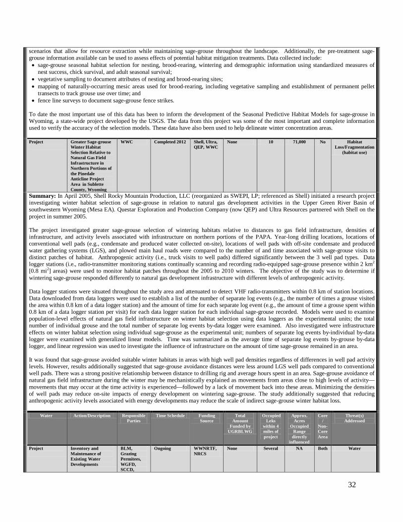
32
scenarios that allow for resource extraction while maintaining sage-grouse throughout the landscape. Additionally, the pre-treatment sage-grouse information available can be used to assess effects of potential habitat mitigation treatments. Data collected include: • sage-grouse seasonal habitat selection for nesting, brood-rearing, wintering and demographic information using standardized measures of
nest success, chick survival, and adult seasonal survival; • vegetative sampling to document attributes of nesting and brood-rearing sites; • mapping of naturally-occurring mesic areas used for brood-rearing, including vegetative sampling and establishment of permanent pellet
transects to track grouse use over time; and • fence line surveys to document sage-grouse fence strikes.
To date the most important use of this data has been to inform the development of the Seasonal Predictive Habitat Models for sage-grouse in Wyoming, a state-wide project developed by the USGS. The data from this project was some of the most important and complete information used to verify the accuracy of the selection models. These data have also been used to help delineate winter concentration areas. Project
Greater Sage-grouse Winter Habitat Selection Relative to Natural Gas Field Infrastructure in Northern Portions of the Pinedale Anticline Project Area in Sublette County, Wyoming
WWC Completed 2012 Shell, Ultra, QEP, WWC
None 10 71,000 No Habitat Loss/Fragmentation
(habitat use)
Summary: In April 2005, Shell Rocky Mountain Production, LLC (reorganized as SWEPI, LP; referenced as Shell) initiated a research project investigating winter habitat selection of sage-grouse in relation to natural gas development activities in the Upper Green River Basin of southwestern Wyoming (Mesa EA). Questar Exploration and Production Company (now QEP) and Ultra Resources partnered with Shell on the project in summer 2005. The project investigated greater sage-grouse selection of wintering habitats relative to distances to gas field infrastructure, densities of infrastructure, and activity levels associated with infrastructure on northern portions of the PAPA. Year-long drilling locations, locations of conventional well pads (e.g., condensate and produced water collected on-site), locations of well pads with off-site condensate and produced water gathering systems (LGS), and plowed main haul roads were compared to the number of and time associated with sage-grouse visits to distinct patches of habitat. Anthropogenic activity (i.e., truck visits to well pads) differed significantly between the 3 well pad types. Data logger stations (i.e., radio-transmitter monitoring stations continually scanning and recording radio-equipped sage-grouse presence within 2 km2 [0.8 mi2] areas) were used to monitor habitat patches throughout the 2005 to 2010 winters. The objective of the study was to determine if wintering sage-grouse responded differently to natural gas development infrastructure with different levels of anthropogenic activity. Data logger stations were situated throughout the study area and attenuated to detect VHF radio-transmitters within 0.8 km of station locations. Data downloaded from data loggers were used to establish a list of the number of separate log events (e.g., the number of times a grouse visited the area within 0.8 km of a data logger station) and the amount of time for each separate log event (e.g., the amount of time a grouse spent within 0.8 km of a data logger station per visit) for each data logger station for each individual sage-grouse recorded. Models were used to examine population-level effects of natural gas field infrastructure on winter habitat selection using data loggers as the experimental units; the total number of individual grouse and the total number of separate log events by-data logger were examined. Also investigated were infrastructure effects on winter habitat selection using individual sage-grouse as the experimental unit; numbers of separate log events by-individual by-data logger were examined with generalized linear models. Time was summarized as the average time of separate log events by-grouse by-data logger, and linear regression was used to investigate the influence of infrastructure on the amount of time sage-grouse remained in an area. It was found that sage-grouse avoided suitable winter habitats in areas with high well pad densities regardless of differences in well pad activity levels. However, results additionally suggested that sage-grouse avoidance distances were less around LGS well pads compared to conventional well pads. There was a strong positive relationship between distance to drilling rig and average hours spent in an area. Sage-grouse avoidance of natural gas field infrastructure during the winter may be mechanistically explained as movements from areas close to high levels of activity—movements that may occur at the time activity is experienced—followed by a lack of movement back into these areas. Minimizing the densities of well pads may reduce on-site impacts of energy development on wintering sage-grouse. The study additionally suggested that reducing anthropogenic activity levels associated with energy developments may reduce the scale of indirect sage-grouse winter habitat loss.
Water Action/Description Responsible Parties
Time Schedule Funding Source
Total Amount
Funded by UGRBLWG
Occupied Leks
within 4 miles of project
Approx. Acres
Occupied Range
directly influenced
Core /
Non-Core Area
Threat(s) Addressed
Project
Inventory and Maintenance of Existing Water Developments
BLM, Grazing Permitees, WGFD, SCCD,
Ongoing WWNRTF, NRCS
None Several NA Both Water

33
others Summary: This project was aimed at conducting inventories of all past existing water development or improvement projects to determine current effectiveness and maintenance needs and/or to identify new areas where new water development or improvement projects might be beneficial. This assists in evaluating the current value of the said water source in determining effects to wildlife, including sage-grouse. Several efforts have occurred and will continue to occur during rangeland assessments and inventories. As a result, examples of projects thus far have included conversion of windmills to solar-powered water sources, thereby removing man-made perching and nesting sites for raptors, especially ravens; and overflow areas to create seeps for sage-grouse. In 2012, sage-grouse hens and their broods were seen foraging in riparian and other wet areas to find forbs and bugs, illustrating the importance of these locations during dry periods. This project has also facilitated more collaboration of stakeholders in management activities to come up with alternatives for management and reduce habitat fragmentation in sage-grouse habitats. Project
Use of Industry Water Wells for Wildlife Benefits
BLM, Industry
Ongoing Industry None 20 113,325 Both Water
Summary: One of the necessary components for drilling operations in the gas fields is fresh water. Water wells are present at many natural gas well pads and are utilized for development operations. Opportunities occasionally exist to use these existing water wells to benefit wildlife. Operators of these wells regularly fill area reservoirs for livestock and wildlife use, more so in drought years. To provide potential benefit for grouse broods, in 2013 selected reservoirs on and adjacent to the PAPA were maintained with water into September, well after livestock have left the area. This work primarily occurs in the Mesa and Sand Springs Draw EAs. Project
Solar Conversions Existing Water Wells
WGFD, BLM, private landowners
TBD various $71,757 NA NA Both Predation
Summary: Numerous existing water wells (primarily pumped by windmills) in the UGRBLWG area produce water for livestock use. Since 2007, 13 windmills have been converted to solar units; and in 2 instances water overflow pits were fenced to create ‘green areas’ for sage-grouse use. Sage-grouse hens and chicks have been observed using water in the seeps and foraging for insects and forbs in the green areas. Grazing permittees plan to convert additional wells to solar pumping systems. This project is aimed at water enhancements and infrastructure improvements that will benefit both livestock and wildlife by providing more reliable water sources and better control of those sources, as well as enhancing sage-grouse habitat. Brood-rearing sage-grouse, pronghorn and other sagebrush-obligate species will all benefit. The project also includes the removal of windmill towers and reconstruction of tanks. Removing these windmill structures may decrease predation of sage-grouse eggs and chicks by territorial breeding ravens, which are known to perch and/or nest on such structures. The project goal is to remove windmill and generator water sources and replace them with solar systems, thus increasing habitat effectiveness for sage-grouse and big game species by adding a reliable water source and green area from the overflow throughout the summer months and removing nesting structures of ravens that predate on sage-grouse eggs and chicks. This may prevent the hens from having to move farther to reach the private land corridors too early when chicks are yet small and vulnerable to predation.
Others Action/Description Responsible Parties
Time Schedule Funding Source
Total Amount
Funded by UGRBLWG
Occupied Leks
within 4 miles of project
Approx. Acres
Occupied Range
directly influenced
Core /
Non-Core Area
Threat(s) Addressed
Commitment Jonah Interagency Mitigation and Reclamation Office (JIO) and Pinedale Anticline Project Office (PAPO)
WDA, WGFD, WDEQ, BLM, Sublette County Commission
Ongoing (specific projects are listed elsewhere in this table)
EnCana, QEP, Shell, Ultra
None 22+ >33,200 acres
Both Habitat Mitigation, Habitat
Fragmentation
Summary: These offices were developed through compensatory mitigation funding provided by developers of the Jonah (JIO) and Pinedale Anticline (PAPO) fields and are staffed by individuals from the BLM, WGFD, Wyoming Department of Environmental Quality (WDEQ), Wyoming Department of Agriculture (WDA), and a County Commissioner (PAPO only). Office responsibilities include selection and oversight of offsite mitigation projects, inspection and compliance verification of surface reclamation, monitoring of key wildlife species, including sage-grouse, and provision of impact, monitoring, and mitigation data to agencies and the public. Specific mitigation projects are identified below. Project JIO Noble-Cora
Wildlife Project JIO, Grazing Permittee, BLM
In progress JIO None 6 2,345 (allotment
total)
Yes Water, Habitat Condition
Summary: Project components include: an existing spring upgrade and installation of a sediment diversion maintaining the spring’s current provision of vegetation for sage-grouse brood rearing, and drinking water for all forms of wildlife; development of a new watering well with facilities for wildlife and livestock which will allow water to run-off into the draw and an old reservoir, potentially creating vegetation essential for sage-grouse brood rearing and further providing drinking water for wildlife (wildlife fencing may also be installed around the reservoir); and development of an additional water well and watering facility in the northeast area of allotment to provide drinking water for pronghorn and mule deer, especially during migrations, as well as for livestock. The potential exists to develop plans for vegetation improvements if warranted,

34
and the allotment permittee will use the new watering systems to implement a rotational grazing pattern throughout the allotment. The projects occur in the Upper Green River/Pinedale Front EA. Project JIO Range
Improvement Water Trough Bird Ramps
JIO, WLT, FFA, Pheasants Forever, volunteers, BLM
Complete JIO None Multiple NA Yes Water
Summary: To reduce the potential for wildlife entrapment (particularly birds) in livestock watering facilities on BLM lands, wildlife escape ramps were installed on all BLM range water improvement tanks in the BLM PFO area. Project JIO Squaretop
Water Wells JIO, Squaretop Grazing Assoc., BLM
Complete JIO None 7 NA Yes Habitat Condition
Summary: This project in the East Fork EA improved three watering facilities in the Squaretop allotment and created “wildlife only areas” at each improvement facility. An overflow on each well created a pond or green-up zone fenced for wildlife only access. The watering facilities provide essential drinking water to wildlife and livestock and improve livestock grazing distribution across the allotment. Projects JIO and PAPO
Wildlife Friendly Fencing Initiatives
JIO, PAPO, WLT, BLM
Ongoing JIO, PAPO, WLT, NRCS, FS, BLM, and others
None 28 110,022 Both Mortality
Summary: These ongoing projects involve fence inventories across major portions of the UGRBLWG area, particularly within big game (pronghorn and mule deer) migration routes and associated bottlenecks. Fence locations are mapped and evaluated (i.e., which fences most affect big game migration). Subject to the consent of the owners and obtaining necessary access to do the work, the fences are modified, reconstructed, or removed to facilitate improved big game movements during migrations. Fence markers are also being installed at selected locations proximal to sage-grouse leks and at other key sage-grouse use areas. Efficacy monitoring is also proposed. Studies/Research
Noise Research and Recommendations (Patricelli, et al.)
University of California,
Davis (Patricelli
and others)
Complete UGRBLWG and others
192,155 (all Working Groups
combined)
NA NA Both Indirect Impacts
Summary: Recent research has demonstrated that noise from natural gas development negatively impacts sage-grouse abundance, stress levels and behaviors (Blickley et al. 2012; Blickley & Patricelli 2012; Blickley et al. In review). Other types of anthropogenic noise sources (e.g. infrastructure from oil, geothermal, mining and wind development, off-road vehicles, highways and urbanization) are similar to gas-development noise and thus the response by sage-grouse is likely to be similar. These results suggest that effective management of the natural soundscape is critical to the conservation and protection of sage-grouse. A report “The Impacts of noise on sage-grouse: A discussion of current management strategies in Wyoming with recommendations for further research and interim protections” was prepared for the Wyoming BLM and WGFD. The goals of this report are to (1) discuss current approaches in the management of new and existing noise sources within and outside sage-grouse core areas of Wyoming, (2) recommend research priorities for establishing effective noise management strategies, and (3) provide managers and policy makers with recommendations for the interim protection of sage-grouse from known or expected impacts of increased noise levels using the best available science. New state policy on noise is being developed in part from this research. Further information can be found at: http://www.wy.blm.gov/jio-papo/papo/wildlife/reports/sage-grouse/2012sgNoiseMon.pdf.
Project Funding
WLCI BLM, USGS,
FS, FWS, WGFD,
WDA, others
Ongoing BLM, USGS, FS, FWS, WGFD,
WDA, others
None NA NA Habitat Condition
Summary: The WLCI is an interagency working group of partners that is establishing a much larger coalition of government and non-government organizations. Local Project Development Teams identify local issues that are important to the landscape and cooperatively create projects to address identified needs for local wildlife, habitat, and other resource issues. Each Local Project Development Team includes local biologists, range managers, conservation districts, landowners, county commissioners, and other interested parties. Further information and projects funded by WLCI can be accessed at www.WLCI.gov.

35
Literature Cited
Aldridge, C. L., and M. S. Boyce. 2007. Linking occurrence and fitness to persistence: habitat based
approach for endangered greater sage-grouse. Ecological Applications 17:508-526. Beck, J.L. K. P. Reese, J. W. Connelly, and M. B. Lucia. 2006. Movements and survival of juvenile
greater sage‐grouse in southeastern Idaho. Wildlife Society Bulletin 34:1070‐1078. Blickley, J. L., D. Blackwood and G. L. Patricelli. 2012. Experimental evidence for the effects of
chronic anthropogenic noise on abundance of greater sage-grouse at leks. Conservation Biology 26: 461-471.
Blickley, J. L., Blackwood, D. L., Hardy, E. L. and G. L. Patricelli, G. L. in prep Temporal flexibility in greater sage-grouse (Centrocercus urophasianus) signaling behavior in response to chronic industrial noise playback.
Blickley, J. L. and G.L Patricelli. 2010. Impacts of Anthropogenic Noise on Wildlife: Research Priorities for the Development of Standards and Mitigation. Journal of International Wildlife Law and Policy 13, 274-292.
Blickley, J. L. and G. L. Patricelli., 2012. Potential acoustic masking of greater sage-grouse display components by chronic industrial noise. Ornithological Monographs. 74: 23-35.
Blickley, J. L., Word, K. R., Krakauer, A. H., Phillips, J. L., Sells, S. N., Wingfield, J. C. & Patricelli, G. L. In review Experimental chronic noise exposure is related to elevated fecal corticosteroid metabolites in lekking male greater sage-grouse (Centrocercus urophasianus). PloS ONE.
Bui, T.V., Marzloff, J.M., and B. Bedrosian. 2010. Common Raven Activity in Relation to Land Use in Western Wyoming: Implications for Greater Sage-Grouse Reproductive Success. The Condor 112(1): 65-78.
Carpenter, J., C. Aldridge, and M. S. Boyce. 2010. Sage-grouse habitat selection during winter in Alberta. Journal of Wildlife Management 74:1806-1814.
Coates, P.S. 2007. Greater sage-grouse (Centrocercus urophasianus) nest predation and incubation behavior. Ph.D. Idaho State University, Pocatello, Idaho.
Connelly, J.W., A. D. Apa, R. B. Smith, and K. P. Reese. 2000a. Effects of predation and hunting on adult sage grouse Centrocercus urophasianus in Idaho. Wildlife Biology 6:227–632.
Connelly, J. W., M. A. Schroeder, A. R. Sands, and C. E. Braun. 2000b. Guidelines to manage sage grouse populations and their habitats. Wildlife Society Bulletin 28:967‐985.
Copeland, H.E., K.E. Doherty, D. E. Naugle, A. Pocewicz, and J.M. Kiesecker. 2009. Mapping Oil and Gas Development Potential in the US Intermountain West and Estimating Impacts to Species. PLoS ONE 4(10): e7400. doi:10.1371/journal.pone.0007400.
Copeland, H. and J. Kiesecker. 2010. Development by Design, Mitigation Planning for the Pinedale Anticline, Wyoming. See: http://www.wy.blm.gov/jio-papo/papo/wildlife/mitigation/mitigation_report_122110.pdf
Crawford, J.A., R.A. Olson, N.E. West, J.C. Mosley, M.A. Schroeder, T.D. Whitson, R.F. Miller, M.A. Gregg, and C.S. Boyd. 2004. Ecology and management of sage‐grouse and sage‐grouse habitat. Journal of Range Management 57: 2‐19.
Dinkins, J.B., M.R. Conover, C.P. Kirol, and J.L. Beck. 2012. Greater Sage-grouse (Centrocercus urophasianus) Select Nest Sites and Brood Sites Away from Avian Predators. The Auk 129(4):600-610.Doherty, K. E., D. E. Naugle, B. L. Walker, and J. M. Graham. 2008. Greater sage-grouse winter habitat selection and energy development. Journal of Wildlife Management 72:187-195.

36
Doherty, K.E., D.E. Naugle, B.L. Walker, and J.M. Graham. 2008. Greater Sage-Grouse Winter Habitat Selection and Energy Development. Journal of Wildlife Management 72(1):187-195.
Doherty, K. E., D. E. Naugle, and J. S. Evans. 2010. A currency for offsetting energy development impacts: horse-trading sage-grouse on the open market. PLoS One 5:e10339.
Dzialak, M.R., C.V. Olson, S.M. Harju, S.L. Webb, J.P. Mudd, J.B. Winstead, and L.D. Hayden-Wing. 2011. Identifying and prioritizing greater sage-grouse nesting and brood rearing habitat for conservation in human-modified landscapes. PLoS ONE 6(10): e26273.
Dzialak, M.R., C.V. Olson, S.L. Webb, S.M. Harju, and J.B. Winstead. 2012. Temporal and hierarchical spatial components of animal occurrence: conserving seasonal habitat for greater sage-grouse. Ecosphere 3:art30.
Dzialak, M.R., S.L. Webb, S.M. Harju, C.V. Olson, J.B. Winstead, and L.D. Hayden-Wing. 2013. Greater sage-grouse and severe winter conditions: identifying habitat for conservation. Rangeland Ecology and Management 66:10-18.
Ellis, K.L. 1984. Behavior of lekking sage grouse in response to a perched golden eagle. Western Birds 15:37–38.
Harju, S. M., M. R. Dzialaka, R. C. Taylor, L. D. Hayden-Wing, and J. B. Winstead. 2010. Thresholds and time lags in effects of energy development on greater sage-grouse populations. Journal of Wildlife Management 74:437-448.
Hess, J.E., and J.L. Beck. 2012. Disturbance factors influencing greater sage-grouse lek abandonment in north-central Wyoming. Journal of Wildlife Management 76:1625-1634.
Hatch, S. 2008. Wyoming Big Sagebrush: The Effects of Chemical, Mechanical, and Prescribed Fire Treatments on Vegetation Age Class and Diversity in the Wyoming Basin. Master Thesis, University of Idaho, Boise, Idaho. 73pp.
Hess, J.E., and J.L. Beck. 2012. Disturbance factors influencing greater sage-grouse lek abandonment in north-central Wyoming. Journal of Wildlife Management 76:1625-1634.
Holloran, M. J. 2005. Greater sage-grouse (Centrocercus urophasianus) population response to natural gas field development in western Wyoming. Dissertation, University of Wyoming, Laramie, WY, USA.
Holloran, M. J., R. C. Kaiser, and W. A. Hubert. 2010. Yearling greater sage-grouse response to energy development in Wyoming. Journal of Wildlife Management 74:65-72.
Johnson, D. H., M. J. Holloran, J. W. Connelly, S. E. Hanser, C. L. Amundson and S. T. Knick. 2011. Influences of environmental and anthropogenic features on greater sage-grouse populations, 1997-2007. Pages 407-450 in Greater sage-grouse: ecology and conservation of a landscape species and its habitats, S. T. Knick, J. W. Connelly, C. E. Braun (editors). Studies in Avian Biology, Number 38, University of California Press, Berkeley, CA, USA.
Kaiser, R.C. 2006. Recruitment by greater sage‐grouse in association with natural gas development in western Wyoming. Thesis, University of Wyoming, Laramie.
Kiesecker, J.M., H. Copeland, A. Pocewicz, N. Nibbelink, B. McKenney, J. Dahlke, M. Holloran, and D. Stroud. 2009. A Framework for implementing Biodiversity Offsets: Selecting Sites and Determining Scale. Bioscience 59 (1): 77-84.
Kirol, C. P. 2012. Quantifying habitat importance for greater sage-grouse (Centrocercus urophasianus) population persistence in an energy development landscape, Thesis, University of Wyoming, Laramie.
Knick, S. T., D. S. Dobkin, J. T. Rotenberry, M. A. Schroeder, W. M. Vander Haegen, and C. Van Riper III. 2003. Teetering on the edge or too late? Conservation and research issues for avifauna of sagebrush habitats. Condor 105:611-634.

37
Lyon, A.G. and S.H. Anderson. 2003. Potential gas development impacts on sage grouse nest initiation and movement. Wildlife Society Bulletin 31: 486‐491.
Naugle D. E., K. E. Doherty, B. L. Walker, M. J. Holloran, and H. E. Copeland. 2011. Energy development and greater sage-grouse. Pages 489-529 in Greater sage-grouse: ecology and conservation of a landscape species and its habitats, S. T. Knick, J. W. Connelly, C. E. Braun (editors). Studies in Avian Biology, Number 38, University of California Press, Berkeley, CA, USA.
Remington, T.E., and C.E. Braun. 1991. How surface coal mining affects sage grouse, North Park, Colorado. Proceedings, Issues and Technology in the Management of Impacted Western Wildlife. Thorne Ecological Institute 5:128‐132.
Santini, K. 2012. Vegetation Treatment Effects in a Wyoming Big Sagebrush Community and a Comparison of Two Methods for Estimating Shrub Canopy Cover. Master Thesis, University of Idaho, Boise, Idaho. 102pp.
Stevens, B.S., J.W. Connelly, and D.D. Musil. 2012a. Greater sage-grouse and fences: Does marking reduce collisions? Wildlife Society Bulletin. 36:297-303.
Swenson, J. E., A. S. Claire, and D. E. Charles. 1987. Decrease of Sage Grouse (Centrocercus Urophasianus) after ploughing of sagebrush steppe. Biological Conservation 41.
Tack, J. D. 2009. Sage-grouse and the human footprint: implications for conservation of small and declining populations. Thesis, University of Montana, Missoula, MT, USA.
Taylor, R. L., B. L. Walker, D. E. Naugle, and L. Scott Mills. 2012. Managing multiple vital rates to maximize greater sage-grouse population growth. Journal of Wildlife Management 76:336-347.
Walker, B.L., D.E. Naugle, K.E. Doherty, and T.E. Cornish. 2004. Outbreak of West Nile virus in greater sage grouse and guidelines for monitoring, handling, and submitting dead birds. Wildlife Society Bulletin 32:1000–6.
Walker, B. L., D. E. Naugle, and K. E. Doherty. 2007a. Greater sage-grouse population response to energy development and habitat loss. Journal of Wildlife Management 71:2644-2654.
Walker, B.L. D.E. Naugle, K.E. Doherty, and T.E. Cornish. 2007b. West Nile Virus and greater sage‐grouse: estimating infection rate in a wild bird population. Avian Diseases 51:691‐696.
Webb, S.L., C.V. Olson, M.R. Dzialak, S.M. Harju, J.B. Winstead, and D. Lockman. 2012. Landscape features and weather influence nest survival of a ground-nesting bird of conservation concern, the greater sage-grouse, in human-altered environments. Ecological Processes 1:part4.
Wyoming Widlife Consultants. 2012. Greater Sage-Grouse Winter Habitat Selection in Relation to Natural Gas Field Infrastructure in Northern Portions of the Pinedale Anticline Project Area Sublette County, Wyoming. Prepared for Shell Western Exploration and Production, LP, QEP Energy Company, and Ultra Petroleum by Wyoming Wildlife Consultants, LLC, Pinedale, Wyoming. 27p.
U.S. Department of the Interior. 2011. A Report on National Greater Sage‐Grouse. Sage-Grouse National Technical Team.
U. S. Fish and Wildlife Service. 2010. Endangered and threatened wildlife and plants; 12-month findings for petitions to list the greater sage-grouse as threatened or endangered; proposed rule. Federal Register 75:13,910-14,014.
U.S. Fish and Wildlife Service. 2013. Greater Sage-grouse (Centrocercus urophasianus) Conservation Objectives: Final Report. U.S. Fish and Wildlife Service, Denver, CO. February 2013. http://www.fws.gov/mountain-prairie/species/birds/sagegrouse/COT/COT-Report-with-Dear-Interested-Reader-Letter.pdf.

38
Zou, L., S.N. Miller, and E.T. Schmidtmann. 2006. Mosquito larval habitat mapping using remote sensing and GIS: Implications of coalbed methane development and West Nile virus. Journal of Medical Entomology 43:1034–41.

Upper Green River Basin Sage-Grouse Conservation Plan
May 24, 2007
The Upper Green River Basin Sage-Grouse Working Group

EXECUTIVE SUMMARY The Upper Green River Basin Sage-grouse Working Group was established in March 2004 to develop and facilitate implementation of a local conservation plan for the benefit of sage-grouse and, whenever feasible, other species that use sagebrush habitats. This conservation plan identifies strategies and commitments for the purpose of improving sage-grouse numbers and precluding the need for listing under the Endangered Species Act. The Working Group includes 9 members representing government agencies, industry, agriculture and wildlife stakeholders. The Upper Green River Basin Sage-Grouse Conservation Plan encompasses most of the upper Green River drainage/basin of Wyoming. Conservation Assessment According to the recently completed range-wide Conservation Assessment of Greater Sage-Grouse and Sagebrush Habitats (Connelly et al. 2004), sage-grouse have declined across their range during the past 50 years, as has the quality and distribution of the bird’s requisite sagebrush-steppe habitat. Sage-grouse are found throughout the sagebrush grassland habitats of the Green River Basin. Occupied habitat is contiguous east of the Wyoming Range Mountains to the Wind River Mountains located on the east side of this Green River Basin. Sagebrush-grassland habitat in the upper Green River Basin generally has moderate to high densities of sagebrush that is continuous across this Basin, with the exception of agricultural lands located along major river and streams. Habitats support greater numbers of sage-grouse, probably one of the highest densities with all of occupied sage-grouse habitats range-wide. Most of the occupied sage-grouse habitats in Upper Green River Basin are public lands, primarily managed by the Bureau of Land Management (BLM). Approximately 90 percent of known leks, or strutting grounds used during the breeding season, are found on public land; the remaining 10 percent are found on private and State Land Trust lands. Sagebrush habitat is essential for sage-grouse survival. Suitable habitat consists of plant communities dominated by sagebrush and a diverse native grass and forb (flowering herbaceous plants) understory. The composition of shrubs, grasses and forbs varies with the subspecies of sagebrush, the condition of the habitat at any given location, and range site potential. Seasonal habitats must occur in a patchwork or mosaic across the landscape. Both quantity and quality of the sagebrush environment determines suitability for, and productivity of sage-grouse. Providing for all habitat needs on the scale required by sage-grouse may be the most challenging element of managing the landscape in the context of other existing land uses. There is also a need to identify structure and cover components. These challenges are greatest in breeding (pre-nesting, nesting and early brood-rearing) habitats. Winter range is increasingly being recognized as a critical component of sage-grouse habitat. The Working Group identified oil and gas development, vegetation management and livestock grazing as the factors with both the most influence on the sage-grouse population and as those factors that might most effectively be addressed to provide the greatest benefit for sage-grouse conservation in northeast Wyoming. Weather is considered to be an important influence on sage-grouse. Although sage-grouse evolved with weather fluctuations for thousands of years, it remains
2

a significant factor in determining the status and well being of their populations. Habitat fragmentation, degradation, disturbance and loss are some influences affecting sage-grouse in the UGRBWGA. The Upper Green River Working Group plans to meet at least annually to continue efforts towards getting projects identified in this Conservation Plan implemented. Additional functions of the working group will be distribution and allocation of funds provided to the working group, and supporting and commenting on other proposed sage-grouse projects. Conservation Strategy The goals of this conservation plan are to:
• Maintain, restore and/or enhance sage-grouse habitat to maintain and/or increase the abundance of sage-grouse based on the 2005 population level.
• Manage factors contributing to the direct mortality of sage-grouse to maintain and/or increase sage-grouse abundance and distribution based on the 2005 population level.
• Conduct research to better understand sage-grouse ecology and determine the extent to which identified factors affect populations.
• Monitor sage-grouse populations and habitats at a level adequate to assess trends and benefits of conservation efforts.
• Inform and educate the public, landowners, government agencies and others whose interests are affected by sage-grouse conservation within the UGRBWGA.
Commitments, recommended actions and recommended management practices to achieve goals and objectives are listed in the plan. These action items are based upon the general biology of the species, their seasonal habitat requirements specific to the area, and the potential and documented impacts and issues associated with the long-term management of the species. The Working Group will be soliciting additional projects for evaluation for the group’s support and recommendation for financing as project funding becomes available. This plan discusses all the issues that were identified in the Wyoming State Plan as they relate to potential impacts to sage-grouse in the Upper Green River Basin. This plan also breaks out seven distinct areas, called Evaluation Areas, to further discuss issues and recommendations within those areas. In addition, information is provided from past and ongoing sage-grouse research projects conducted within this Working Group Area. Several proposed and ongoing projects, recommendation, and commitments are identified in the Table of Commitments, Projects, and Recommendations of this plan. Public input on the draft conservation plan was gathered during a public meeting held in Pinedale Wyoming and through written comments during January 2007. A significant number of comments were provided from the public and the Working Group discussed these comments and made modifications to the plan where necessary.
2

PREFACE
The Upper Green River Basin (UGRB) Sage-Grouse Local Working Group was established in March 2004 with an organizational mission statement to “develop and implement strategies that maintain and improve sagebrush communities for sage-grouse and other species”. The Wyoming Game and Fish Department established local working groups within the State in order to develop local conservation plans, design projects that benefit sage-grouse and other sagebrush obligate species, and to implement on-the-ground habitat and population related projects for the species. The group includes nine members representing major interests within the UGRB Working Group Area (UGRBWGA). Working Group representation includes the Wyoming Game and Fish Department (WGFD), the Bureau of Land Management (BLM), the Natural Resources Conservation Service (NRCS), agriculture, oil and gas industry, conservation groups, and sportspersons. Working Group members represent their particular interests and provide liaison with the groups they represent. Significant activities of the UGRB Working Group to date included information gathering regarding sage-grouse populations, trends, harvest, habitat use, distribution, and current status; field trips to learn more about sagebrush grassland habitats, gas development, and grazing management; information gathering regarding mineral (gas) leases and National Environmental Protection Act (NEPA) documents; a publication providing a beneficial seed matrix brochure for sage-grouse, mule deer, and antelope; hosting presentations about local sage-grouse research findings and ongoing studies; obtaining information about past habitat treatments, reclamation efforts, and future vegetation planning efforts; brainstorming for projects that will benefit sage-grouse; submitted a proposal to learn more about nest predation and implemented (supervised) that study; and prioritizing sage-grouse project proposals to be funded through the Wyoming Sage-Grouse Conservation Fund. Working Group meetings are conducted about every month typically lasting 6 hours, and always include opportunity to hear public comment regarding the program. The first major task of the Working Group was to develop a local conservation management plan for sage-grouse within UGRBWGA. The results of the conservation planning effort serve as the basis for this report.
3

TABLE OF CONTENTS EXECUTIVE SUMMARY................................................................................................. 2 PREFACE.................................................................................................................................... 3 TABLE OF CONTENTS..................................................................................................... 4 LIST OF FIGURES................................................................................................................. 6 UPPER GREEN RIVER BASIN SAGE-GROUSE WORKING GROUP MEMBERS ................................................................................................................................. 7 INTRODUCTION ................................................................................................................... 8
Background................................................................................................................................. 8 Purpose ...................................................................................................................................... 11
CONSERVATION ASSESSMENT............................................................................. 13 General Sage–grouse Biology.............................................................................................. 13 Sage-grouse Research Applicable to the UGRBWGA.................................................. 13 Conservation Plan Area......................................................................................................... 15 Sage-grouse Population Status, Trend, and Recommended Management Practices...................................................................................................................................................... 18
Current Status And Short-Term Trends ............................................................................. 18 Historic Status And Long-Term Trends.............................................................................. 24
Sage-grouse Habitat and Recommended Management Practices ............................... 28 Winter Habitat ....................................................................................................................... 28 Breeding Habitat (Leks) - Early Spring............................................................................... 29 Nesting Habitat - Late Spring ............................................................................................... 30 Early Brood-Rearing Habitat - June to Mid-July .............................................................. 31 Late Brood-Rearing Habitat - Mid-July through Mid-September ................................... 32 Fall Habitat - Mid-September to First Major Snow........................................................... 33 Landscape Context................................................................................................................. 33
CONSERVATION STRATEGY................................................................................... 35 Conservation Goals................................................................................................................. 35 Potential Issues Affecting Sage-grouse ............................................................................. 35 Evaluation Area Descriptions .............................................................................................. 36 Discussion of Issues & Recommended Management Practices, and Specific Management Recommendations and Projects for Issues Common to all Evaluation Areas........................................................................................................................................... 38
Conflicting Wildlife Management ........................................................................................ 38 Wild Horses ............................................................................................................................ 41 Farming/Agriculture.............................................................................................................. 41 Hunting ................................................................................................................................... 43 Invasive Plants........................................................................................................................ 44 Livestock Grazing/Rangeland Management ....................................................................... 45 Mineral Development ............................................................................................................ 50 Parasites/Diseases................................................................................................................... 59
4

Pesticides/Herbicides ............................................................................................................. 59 Predation................................................................................................................................. 61 Recreation ............................................................................................................................... 64 Residential Development ....................................................................................................... 65 Vegetation Management........................................................................................................ 67 Weather................................................................................................................................... 74 Other Basin-Wide Specific Recommendations And Projects ............................................ 75
Discussion of Issues Specific to Evaluation Areas, Management Recommendations, and Projects ......................................................................................... 78
Calpet / Deer Hills Evaluation Area..................................................................................... 78 Ryegrass / Bench Corral Evaluation Area........................................................................... 80 Upper Green River/ Pinedale Front Evaluation Area........................................................ 83 Mesa Evaluation Area ........................................................................................................... 84 East Fork Evaluation Area ................................................................................................... 91 Sand Springs Draw / Jonah Evaluation Area ..................................................................... 92 Little Colorado Desert Evaluation Area .............................................................................. 96
TABLE OF COMMITMENTS, PROJECTS, AND RECOMMENDATIONS ................................................................................................... 98 MONITORING AND ADAPTIVE MANAGEMENT STRATEGY ....... 111 FUNDING................................................................................................................................ 112 GLOSSARY ........................................................................................................................... 113 LITERATURE CITED...................................................................................................... 116 APPENDICIES ..................................................................................................................... 119
Appendix A. Standards and guidelines for healthy rangelands & livestock grazing management on BLM lands. .............................................................................................. 119 Appendix B. Riparian Proper Functioning Condition Summary (Grouped by Allotment) for the UGRBWGA. ....................................................................................... 122 Appendix C. Documented information for past vegetation treatments in the UGRBWGA. .......................................................................................................................... 125 Appendix D. Beneficial Seed Matrix for Sage-grouse, Mule Deer, and Antelope Brochure .................................................................................................................................. 130 Appendix E. List Of Potential Funding Sources For Sage-Grouse Projects......... 132 Appendix F. Support Letter for Local Working Groups – Use Of Technical Team Identify Livestock Management Options From Literature Review. ........................ 137 Appendix G. Palmer Drought Indicies For Wyoming Division 3 (Southwest Wyoming), short-term (2002-2006) and long-term (1895-2005) ............................. 139
5

LIST OF FIGURES (Includes tables, graphs, maps, and photos)
Figure 1. Male Sage-grouse densities on leks in the Upper Green River Basin Working Group Area
as compared to other areas in Wyoming, 2003-2005. ............................................................. 12 Figure 2. The Upper Green River Basin Local Working Group area............................................. 16 Figure 3. Landownership and Sage-Grouse Lek Locations in the Upper Green River Basin
Working Group Area. .............................................................................................................. 17 Figure 4. The Upper Green River Basin Local Working Group area (light green color) and WGFD
Upland Game Bird Management Areas (outlined in black). ................................................... 18 Figure 5. Weather Reporting Map for different Divisions in the State of Wyoming. .................... 22 Figure 6. Trend summary of leks monitored in the late 1950’s....................................................... 25 Figure 7. Lek complex summary for the Upper Green River Basin Sage-grouse Working Group
Area.......................................................................................................................................... 26 Figure 8. Comparison of hunting season length and opening dates to harvest (averages) and wing
collections (averages) in the UGRBWGA (1991-2005). ......................................................... 27 Figure 9. Evaluation Areas within the Upper Green River Basin Sage-grouse Working Group
Area.......................................................................................................................................... 37 Figure 10. Distribution of sagebrush habitat within the UGRBWGA............................................ 69 Figure 11. Estimated Total Surface Disturbance in the PAPA as a Result of Natural Gas
Development through 2006 (Draft SEIS for the Pinedale Oil and Gas Exploration and Development Project (December 2006)). ................................................................................ 86
Figure 12. Summary of projected surface disturbances for alternatives in the Draft SEIS for the Pinedale Oil and Gas Exploration and Development Project (December 2006). .................... 87
Figure 13. Anticipated disturbances within sage-grouse lek and nesting buffers by Alternatives identified in the Draft SEIS for the Pinedale Oil and Gas Exploration and Development Project (December 2006). ........................................................................................................ 87
6

UPPER GREEN RIVER BASIN SAGE-GROUSE WORKING GROUP MEMBERS
Bob Barrett, Sportsman
Jim Bousman, Agriculture/Rancher
Dean Clause, Wyoming Game & Fish Department
John Dahlke, Wyoming Wildlife Consultants, LLC
Aimee Davison, Shell Rocky Mountain Production, LLC
Mark Gocke, Facilitator
Cally McKee, Ultra Resources, Inc
Suzy Michnevich, Agriculture/Rancher/County Planning
Lisa Solberg, Bureau of Land Management
Ruben Vasquez, Natural Resources Conservation Service
7

INTRODUCTION
Background From the beginning of recorded history, sage-grouse have been part of Wyoming and the Wyoming way of life. Native Americans mimicked them, early travelers wrote about them, and pioneers subsisted on them. For generations of Wyoming hunters, the opening day of “sage chicken” season was the first official day of autumn. In recent years, wildlife enthusiasts have been fascinated by the birds’ dramatic spring courtship rituals. Up until the middle of the 20th century, sage-grouse flourished in Wyoming and throughout most of the West. In 1952, the Wyoming Game and Fish Commission (WGFC) published R. L. Patterson’s, “The Sage-grouse in Wyoming”. It was then, and still remains, the most exhaustive scientific publication about the bird and its habitat requirements within the state. By the mid-1950s other biologists in the western states began to express similar concerns about populations of sage-grouse and sagebrush-steppe habitats. That led the Western Association of Fish and Wildlife Agencies – of which Wyoming was, and is, a member – to establish the Western States Sage-grouse Technical Committee in 1956. Since that time, much sage-grouse information has been amassed, including the initial “Guidelines for the Protection of Sage-grouse”, first published in 1977. In 2000, this document was revised, updated and expanded to become the “Guidelines to Manage Sage-grouse Populations and their Habitats”. The guidelines represent management suggestions for biologists and land managers to use in managing sage-grouse populations and sagebrush-steppe habitats throughout the West. The technical committee continues to meet regularly to address the needs of this species. By most accounts, including the recently completed range-wide Conservation Assessment of Greater Sage-Grouse and Sagebrush Habitats (Connelly et al. 2004), the numbers of sage-grouse have declined across their range during the past 50 years, as has the quality and distribution of the bird’s requisite sagebrush-steppe habitat. The Upper Green River Basin Working Group Area (UGRBWGA) is located in the upper watershed of the Green River drainage, which includes all of Sublette County, except that portion southeast of the Big Sandy River, and a very small portion of Lincoln County that lies north of LaBarge Creek. Sage-grouse are found in suitable sagebrush uplands throughout the Upper Green River Basin. Sage-grouse habitats within Sublette County are expansive and relatively intact outside of developing natural gas fields and residential subdivisions. Habitats for sage-grouse within Sublette County occur throughout mixed land ownership jurisdictions. Most of the documented sage-grouse leks are found on Bureau of Land Management (BLM) Lands (91%), with fewer leks documented on private (5%), and state (4%). Nesting and early brood rearing habitats are also found predominantly on BLM lands, while many birds move to moist meadow habitat located on private or public/private interfaces during late brood rearing and/or summer. Birds will also move to productive sagebrush habitats at higher elevations, typically below 8500 feet, during the summer. Fall movements away from these moist areas to sagebrush-dominated uplands, primarily located on BLM lands, occur in late September/early October. As winter
8

progresses, birds concentrate on sagebrush upland habitats, the location of which is determined by snow accumulations and winter severity. These winter concentration areas are also located primarily on BLM lands. Traditionally, sage-grouse data collection within the UGRB has focused on lek surveys, with some effort made to collect information from harvest surveys and wing collections from harvested birds. Prior to 1994, relatively few leks were monitored and prior to 2000, standardized efforts were not used to collect sage-grouse lek information. Since 2000, efforts have been made to increase data collection on sage-grouse leks and standardize data collection methods. Efforts to collect data on more leks, along with increasing the number of site visits per lek have been made. Current lek monitoring has shifted from “lek surveys” to “lek counts” as described below. These techniques are defined in the WGFD Wildlife Monitoring Techniques Manual. Lek monitoring consists of different inventory methods called “lek counts” or “lek surveys”. A lek count consists of at least 3 site visits during the strutting season, with each visit conducted at least 7 days apart. Lek counts are used to determine annual status (active or inactive) along with determining population trends. A lek count can also be a census technique that documents the actual number of male sage-grouse observed on a lek complex. A lek complex is defined as a group of leks in close proximity between which male sage-grouse may be expected to interchange from one day to the next. In order to be classified as an accurate lek complex count (or census), a lek observation must include all leks within a complex on the same morning. These simultaneous observations must be performed at least 3 times during the strutting season, with at least 7 days separating each lek observation. Lek complex counts have not routinely been conducted due to manpower and logistical restraints. Lek complex counts are only practical where a few leks comprise a complex. Managers continue to struggle to determine what criteria should be used to define a “lek complex”. Current identified lek complexes are essentially a manager’s best determination of where birds from different leks interchange, typically without any documentation. A lek survey consists of only 1 or 2 site visits during the strutting season. Lek surveys are primarily important to identify annual status (active or inactive) of a particular lek or lek complex and not for estimating population trends. Overall, lek counts are preferred over surveys and recent emphasis has been placed on collecting lek counts. Based on the findings at each lek, the lek will be assigned an annual status of “Active” (attended by more than one male sage-grouse), “Inactive” (it was known that there was no strutting activity during the breeding season), and “Unknown” (either active or inactive status has not been determined). Based on the past and current status, leks are assigned one of the three categories for management and protection purposes. The category “Occupied” is a lek that has been active during at least one strutting season within the last ten years. Management protection will be afforded to occupied leks. An “Unoccupied” lek has not been active during the past 10 years, although there must be sufficient data to justify placing a lek into this category. A lek survey or count must have been conducted 4 out of 10 years during non-consecutive years (i.e. every other year) without activity to be placed in the “Unoccupied” category. Unoccupied leks are also broken down into two sub-categories (“Destroyed” – habitat no longer exists or “Abandoned” – habitat still exists). Management protection will not be afforded to unoccupied leks. The third category is “Undetermined” which is a lek that has not been documented as being active in the past 10 years,
9

10
but doesn’t have sufficient data documentation to be considered unoccupied (as mentioned above). Management protection will be afforded to undetermined leks. Prior to 2000, no standardized guidelines or criteria were identified to define what constitutes a lek, lek status, and lek category as identified above. Further modifications were made in 2006 to standardize lek monitoring and definitions. This lack of consistency in the past has led to erroneous lek classification when compared to the “new” lek definitions. The review of past lek monitoring data in the Upper Green River Basin indicated that several leks did not meet the criteria to be identified as a lek. In addition, several leks identified in the Sage Grouse Database kept by the WGFD had no monitoring data at all. A common mistake was the establishment of a new lek based on one sighting of displaying males without any follow-up site visits during that same year and following annual visits to the same location revealed no grouse. It is most likely these one-time observations were probably birds that were displaced from a nearby lek and continued to display that particular morning. During January of 2005, leks that did not meet the new lek definitions were deleted from this database. This database clean-up effort eliminated 67 leks, 2 lek complexes, and over 1,184 records. Elimination of these leks and records from the database has changed all previous lek data statistics reported in years prior to 2005. Productivity information obtained from brood surveys (# chicks/hen) has been sporadic and often yields very low sample sizes. Only one permanent brood survey route has been established that has consistently been monitored during the past ten years. Since 1998, ongoing research in the UGRBWGA has annually collected nest success and brood information from radio-collared birds. Data collected from radio-collared birds provides excellent production information. Information on the sex/age composition of harvested birds is collected through the use of wing barrels distributed throughout Sublette County each fall. Productivity information can also be estimated from this data set, as the number of chicks/hen can be calculated. Wing collection using wing barrels also provide valuable harvest trend data. Total harvest estimates for each Upland Game Bird Management Area are obtained through a hunter harvest questionnaire that is conducted annually. With declining long-term sage-grouse populations, both locally and range-wide, increased effort has been placed on collecting sage-grouse data. In addition, the increase in natural gas exploration and development within Sublette County has raised concerns regarding the impact of such large-scale landscape developments on sage-grouse populations. In response, several sage-grouse research projects have been initiated in this region. Implementation of existing habitat stipulations (conditions of approval) intended to preserve sage-grouse and sage-grouse habitats on BLM lands have been scrutinized for actual effectiveness, along with exceptions granted to those stipulations (conditions). Current habitat protection stipulations for sage-grouse include: 1) Avoid surface disturbance or occupancy within a ¼ mile of the perimeter of occupied leks. 2) Avoid human activity between 8:00pm and 8:00am from March 1 – April 15 within a ¼ mile of the perimeter of occupied sage-grouse leks. 3) AAvvooiidd ssuurrffaaccee ddiissttuurrbbiinngg aaccttiivviittiieess,, ggeeoopphhyyssiiccaall ssuurrvveeyyss,, aanndd oorrggaanniizzeedd rreeccrreeaattiioonnaall aaccttiivviittiieess ((eevveennttss)) wwhhiicchh rreeqquuiirree aa ssppeecciiaall uussee ppeerrmmiitt iinn ssuuiittaabbllee ssaaggee--ggrroouussee nneessttiinngg aanndd eeaarrllyy bbrroooodd--rreeaarriinngg hhaabbiittaatt wwiitthhiinn 22 mmiilleess ooff aann ooccccuuppiieedd lleekk oorr iinn iiddeennttiiffiieedd ssaaggee--ggrroouussee nneessttiinngg aanndd eeaarrllyy bbrroooodd--rreeaarriinngg hhaabbiittaatt oouuttssiiddee tthhee 22--mmiillee bbuuffffeerr ffrroomm MMaarrcchh 1155 –– JJuullyy 1155..

44)) WWhheerree iitt hhaass bbeeeenn ddeessiiggnnaatteedd,, aavvooiidd hhuummaann aaccttiivviittyy iinn ssaaggee--ggrroouussee wwiinntteerr hhaabbiittaatt ffrroomm NNoovveemmbbeerr 1155 –– MMaarrcchh 1144.. With the exception of sage-grouse monitoring efforts in the past 10-15 years and recent sage-grouse research mainly tied to areas with current gas development, very little known data exists in regards to sage-grouse populations and trends in the UGRBWGA. Although, the UGRB currently has some of the largest sage-grouse populations and densities compared to anywhere within their occupied range. Figure 1 shows densities of males on lek from 2003-2005 within the UGRBWGA and throughout Wyoming, which demonstrates the high number (density) of males in the UGRB compared to other parts of the State. In addition, very limited comprehensive vegetation data exists within these occupied sage-grouse habitats. Weather, in particular precipitation, can be one of the most important influences on sage-grouse populations. Lower than normal precipitation can affect sage-grouse by reducing the amount of herbaceous vegetation necessary for successful nesting, reduce insect and forb production for early brood success, and reduce the quantity and quality of sagebrush in sage-grouse habitats. Not only the amount of annual precipitation, but the timing of precipitation events can be a very significant influence on sage-grouse populations. Generally speaking, most of the western states (as with the UGRBWGA) have experienced drier climatic conditions during the past 20 years compared to the previous 20 years. Purpose The purpose of the Upper Green River Basin Sage-Grouse Working Group is to develop and facilitate implementation of local conservation plans for the benefit of sage-grouse and, whenever feasible, other species that use sagebrush habitats. This conservation plan identifies management practices and the financial and personnel means to accomplish these practices, within an explicit time frame, for the purpose of improving sage-grouse numbers and precluding the need for listing under the Endangered Species Act. Current management activities are evaluated during the process used by the U.S. Fish and Wildlife Service (USFWS) to determine whether federal protection of a particular species is warranted. Local and regional conservation plans can provide valuable information to the USFWS while evaluating the merits for federal protection and should contain for key elements: 1) status and distribution of the species; 2) identification and analysis of existing and foreseeable threats to the species; 3) identification of actions to address these threats and a demonstrated high level of certainty that the conservation effort will be implemented; and 4) demonstrated certainty that the conservation effort will be effective in conserving the species in question. This UGRB Sage-Grouse Conservation Plan attempts to address these four key elements as well as possible. The goal of the Upper Green River Basin Sage-Grouse Working Group is to use the statewide plan as a guideline to develop and implement strategies that will improve or maintain sage-grouse populations and habitats.
11

Figure 1. Male Sage-grouse densities on leks in the Upper Green River Basin Working Group Area as compared to other areas in Wyoming, 2003-2005.
12
CONSERVATION ASSESSMENT
This section provides information on sage-grouse requirements, past and ongoing research, the working group area, sage-grouse monitoring and trends, seasonal habitat requirements, and general recommended management practices for the UGRBWGA. General Sage–grouse Biology The greater sage-grouse (Centrocercus urophasianus) is the largest species of grouse in North America. It is appropriately named due to its year-round dependence on sagebrush (Artemisia spp.) for both food and cover. Insects and forbs also play an important role in there food habits, but primarily during the breeding season. In general, the sage-grouse is a mobile species, capable of movements greater than 50 km between seasonal ranges. Despite this mobility, sage-grouse appear to display substantial amounts of fidelity to seasonal ranges. Sage-grouse populations are characterized by relatively low productivity and high survival. Sage-grouse depend on sagebrush (Artemisia spp.) for much of their annual food and cover. This close relationship is reflected in the North American distribution of sage-grouse, which is closely aligned with sagebrush, and in particular big sagebrush (A. tridentata) and silver sagebrush (A. cana). This relationship is perhaps tightest in the late autumn, winter, and early spring when sage-grouse are dependent on sagebrush for both food and cover. However, sage-grouse also depend on sagebrush at other times of year, primarily for protective cover, such as for nests during the breeding season. Other habitat characteristics may be less important than sagebrush, but may be nearly as important. For example, herbaceous cover provides both food and cover during the nesting and early brood-rearing seasons, thus playing a major role in the population dynamics of sage-grouse. For detailed discussions see Chapters 3 and 4 in Connelly et al. 2004. Sage-grouse Research Applicable to the UGRBWGA Girard, George L. 1937. Life History, Habits and Food of the Sage Grouse. University of Wyoming
Publications in Science Vol. III, No. 1. 56pp. University of Wyoming Press, Laramie. This was the first study of sage-grouse in Wyoming and it was undertaken in Sublette County in 1934. The author noted that much of the information concerning sage-grouse at the time was based on casual observation, and popular articles were written "with little regard for established facts". The purpose of the study was to investigate the life history, habits, and food of the sage grouse, and "to secure information that may be of use to the governments of western states in formulating measures designed to increase or maintain the species in its present habitat". The report details the bird's physical description, distribution, life history, behavioral habits and factors impacting sage-grouse at the time. Suggested management actions included hunting restrictions, establishment of refuges, livestock grazing management, habitat management, and a public education campaign. Lyon, Alison. G., Potential effects of natural gas development on sage grouse near Pinedale, Wyoming. M.S.,
Department of Zoology and Physiology, May, 2000. Sage grouse (Centrocercus urophasianus) populations have been declining over the last half of the century due to such factors as habitat degradation and loss. As natural gas development has increased in Wyoming, so has the concern over how this type of development might affect sage-grouse populations. Therefore a study was initiated on the Pinedale Mesa to examine the effects of natural gas and oil development on use, productivity, general movements and
13

habitat use of sage grouse. A total of 80 grouse (60 adults and 20 chicks) were captured and radio-collared on six leks on the Pinedale Mesa between March-August 1998. Lek classification was determined by the presence of natural gas development within a 3km buffer and topographic features surrounding the leks. The grouse were monitored and located (using radio telemetry techniques) on a weekly basis to determine lek use, nest site, early brood rearing, late brood rearing, summer and winter habitat selection. Vegetation data collected at use and random sites included: sagebrush density, canopy cover and height, grass and residual grass height and cover and forb cover. Results from the study indicated that hens captured on the disturbed leks demonstrated lower nest initiation rates, traveled twice as far to nest sites, and selected higher total shrub canopy cover and live sagebrush canopy cover than hens captured off of undisturbed leks. Also, most grouse chicks were lost during the early brood rearing period from hens that mated on all leks. Therefore extreme early brood survival appears to be the limiting factor in sage-grouse population stability on the Pinedale Mesa. Finally, four roosters, and five hens moved up to 60 miles to breed and nest after capture on the Mesa. Consequently we hypothesize that the Mesa is critical winter range for multiple populations of sage-grouse spanning a large demographic area. Holloran, Matthew J., Greater Sage-Grouse (Centrocercus urophasianus) Population Response to Natural Gas
Field Development in Western Wyoming. PhD, Department of Zoology and Physiology, December, 2005.
Sage-grouse (Centrocercus spp.) populations have declined dramatically throughout the western United States since the 1960s. Increased gas and oil development during this time has potentially contributed to the declines. This study investigated impacts of development of natural gas fields on greater sage-grouse (C. urophasianus) breeding behavior, seasonal habitat selection, and population growth in the upper Green River Basin of western Wyoming. Greater sage-grouse in western Wyoming appeared to be excluded from attending leks situated within or near the development boundaries of natural gas fields. Declines in the number of displaying males were positively correlated with decreased distance from leks to gas-field-related sources of disturbance, increased levels of development surrounding leks, increased traffic volumes within 3 km of leks, and increased potential for greater noise intensity at leks. Displacement of adult males and low recruitment of juvenile males contributed to declines in the number of breeding males on impacted leks. Additionally, responses of predatory species to development of gas fields could be responsible for decreased male survival on leks situated near the edges of developing fields and could extend the range-of-influence of gas fields. Generally, nesting females avoided areas with high densities of producing wells, and brooding females avoided producing wells. However, the relationship between selected nesting sites and proximity to gas field infrastructure shifted between 2000 – 2003 and 2004, with females selecting nesting habitat farther from active drilling rigs and producing wells in 2004. This suggests that the long-term response of nesting populations is avoidance of natural gas development. Most of the variability in population growth between populations that were impacted and non-impacted by natural gas development was explained by lower annual survival buffered to some extent by higher productivity in impacted populations. Seasonal survival differences between impacted and non-impacted individuals indicates that a lag period occurs between when an individual is impacted by an anthropogenic disturbance and when survival probabilities are influenced, suggesting negative fitness consequences for females subjected to natural gas development during the breeding or nesting periods. It was suggested that currently imposed development stipulations are inadequate to protect greater sage-grouse, and that stipulations need to be modified to maintain populations within natural gas fields. Kaiser, Rusty C., Recruitment by greater sage-grouse in association with natural gas development in western
Wyoming, M.S., Department of Zoology and Physiology, University of Wyoming, Laramie, Wyoming. August, 2006.
Abstract: The area near Pinedale, Wyoming, in the upper Green River Basin has some of the highest densities of greater sage-grouse in the world. Decreasing counts of males attending leks and evidence of overall population reductions, coupled with increasing natural gas development, have raised concern for conservation of greater sage-grouse in the area. Low yearling recruitment could be causing a decline in the numbers of birds using leks near natural gas development. This study investigated recruitment of males and females to determine if they continued to breed in areas with natural gas development, were displaced to other areas to breed, or did not breed at all. Results indicated that yearling males tended to avoid leks highly immersed into developing gas fields. Females that bred or nested in the gas fields had later nest hatching dates and fewer and smaller broods than birds outside the fields. Both males and females showed low fidelity to natal leks and nest sites. This study suggests that assessing the potential influence of a natural gas field on greater sage-grouse should involve multiple variables to describe the developing field and
14

incorporate the cumulative effects they may have on lek use as the spatial orientation of the leks relative to the developing field changes over time. An ongoing noise study, examining the effects of noise from energy exploration and development on the breeding biology of the greater sage-grouse (Centrocercus urophasianus), is currently being conducted. The Principal Investigator is Gail L. Patricelli, Assistant Professor, at the University of California, Davis. Below is a summary of updated activities from this study. Summary of Activities: One potential means by which energy development might impact sage-grouse populations is through the production of noise. Acoustic communication is known to be important in the reproductive behaviors of sage-grouse, and energy exploration and development activities generate substantial noise; it is therefore important to determine whether noise produced from energy development affects sage-grouse breeding biology. Sage-grouse mate during the early spring (March-April). During this mating season, males aggregate on display sites called “leks” where females visit to observe male display behaviors and choose their mates. There is evidence that the acoustic displays produced by males on leks facilitate reproduction in at least two ways. First, females use these vocalizations to find leks within the habitat. Second, after arrival at a lek, there is evidence that females use male vocalizations (and other aspects of male display) to choose a mate. Anthropogenic noise in the sage grouse habitat may mask vocalizations produced by males, interfering both with females’ ability to locate leks and to choose mates. The overall goal of this research is to investigate the potential effects of noise from natural gas development on sage-grouse lekking behaviors. This research has three major lines of inquiry: 1) Descriptive- the characterization of sounds produced by energy development and by sage-grouse, and how these sounds propagate through the environment, 2) Experimental - playback of recorded noise to sage-grouse leks to determine whether noise impacts sage-grouse breeding behaviors, and 3) Predictive - landscape-level modeling of sound propagation in the sagebrush habitat. Work Accomplished: Descriptive Acoustics: Two autonomous recording units (ARUs) were built to record and measure noise sources. During March and April, we measured gas field noise primarily on the Anticline Project Area in Sublette County near Pinedale WY using the ARUs. We measured noise at 5-20 minute intervals throughout the day, we sampled noise at between 2 to 8 locations at each site (2 microphones per ARU, 1-4 ARUs per site). We also took noise measurements with a precision sound level meter (purchased with UCD funds) and GPS (purchased with WSGCF funds) circling each site and along line transects radiating from the source. This year we measured sound at two drilling sites, two large compressor stations, and on three roads. Transects were done to characterize vegetation cover. We will use these for modeling of sound propagation (objective 3 of the overall project). Noise data is currently being analyzed at UC Davis. Experimental: In spring 2006, we began an experiment to test the hypothesis that noise from energy development affects sage grouse reproductive behavior. To do so, we played back recorded noise to 4 leks and monitored another 4 leks as controls. We placed leks in groups to balance for size and location, and then randomly assigned them to noise or control groups. We plan to continue this experiment for at least 2 more seasons, so results are not available at this time. We monitored the leks daily by video-taping and photo-identification of birds, and by counting males and females at multiple times during the lekking period. We placed a line of markers at 25-meter intervals along the far edge of the lek relative to the observer to divide the lek into sections. Birds were counted by section each day, allowing us to examine the spatial distribution of birds on the lek relative to the playback speakers. We encountered difficulty building an amplifier/speaker system to play noise during the playback experiment. Our target amplitude was 70 dB SPL—the average level of noise measured at 1/4 mile from drilling stations in Pinedale in 2006. Playback of drilling noise at this amplitude caused 6 speakers to fail; correction of this problem and replacement of speakers delayed the beginning of the experiment. This delay had one positive consequence: we improved our baseline data on lek attendance and behaviors on experimental and control leks. A second difficulty was that our experimental noise did not propagate well across the lek, such that not all birds on a lek experienced the noise at a sufficient level. We will seek funding to add additional speakers to correct this problem for next year. Conservation Plan Area The UGRBWGA is described as the entire Green River drainage that lies within Sublette County, including a very small portion of Lincoln County north of Labarge Creek and excluding that
15

portion of Sublette County that lies south and east of the Big Sandy River (Figure 2). The Wyoming, Gros Ventre, and Wind River mountain ranges border the west, north, and east sides, while the Sublette/Sweetwater County line and portion of the Big Sandy River border the south end of the UGRBWGA. This area is managed by: the Bureau of Land Management (Pinedale Resource Area, and partially by the Rock Springs Resource Area), the Bureau of Reclamation, the United States Forest Service (Bridger-Teton National Forest), the State of Wyoming and private landowners (Figure 3). Major habitat types within the area include: sagebrush/grassland, salt desert shrub, mixed mountain shrub, mixed forests (conifers and aspen), agricultural crops, riparian corridors, and urban areas. Figure 2. The Upper Green River Basin Local Working Group area.
The UGRBWGA encompasses all of the WGFD’s Upland Game Bird Management Area (UGBMA) 3, and the north portion of Area 7 that lies within Sublette County (Figure 4). The management areas do not correspond to sage-grouse population boundaries. Instead, management areas are used for general data collection and reporting for all small and upland game species. All harvest information for UGBMA 7 will be reported in the Southwest Working Group Job Completion Report (JCR).
16

Figure 3. Landownership and Sage-Grouse Lek Locations in the Upper Green River Basin Working Group Area.
17

Figure 4. The Upper Green River Basin Local Working Group area (light green color) and WGFD Upland Game Bird Management Areas (outlined in black).
3
7
Sage-grouse Population Status, Trend, and Recommended Management Practices Current Status And Short-Term Trends This section is referenced from 2006 Sage-Grouse Job Completion Report - Upper Green River Basin Summary written by the Wyoming Game & Fish Department that primarily covers data from the most recent five-year period (2002-2006). Lek Monitoring All but 13 of the 119 known occupied sage grouse leks (97%) in the Upper Green River Basin were checked during 2006. This compares to 98%, 78%, 80%, 60%, and 62%, checked during 2005, 2004, 2003, 2002, and 2001, respectively. With increased lek monitoring efforts the past few years, a total of 12 new leks were located during the 2004-2006 breeding seasons. The BLM conducted aerial lek searches in 2005 and 2006 that may result in additional new leks once ground
18

surveys are conducted in 2007. Of the 106 leks checked in 2005, 87% were lek counts and 13% were lek surveys. The percent of leks where count data was collected has continued to increase from 41 in 2001 to 73 in 2004. Results from the counts and surveys showed that 74 (70%) leks were active, and 32 (30%) were inactive. The average number of males/lek for all active leks has continued to increase the last three years from 21 in 2003 to 24 in 2004 to 35 in 2005, and 46 in 2006. Generally, the proportion of leks checked that are active has gradually declined from 2001 to 2006. Data from the lek searches in 2001 showed 88% of the leks were active, while 70% were active during 2006. Part of this decline can be attributed to increased abandonment in areas with increased gas development activity. Lek Complexes There are currently 25 known occupied lek complexes in the Upper Green River Basin for a total of 125 leks (includes unknown and unoccupied leks). This equates to an average of 5.0 leks per complex, with a range of 1 to 16 leks per complex. Lek complex designations are somewhat arbitrary and show great variation due to lek numbers and assignments within each complex. During 2005, 24 of 25 lek complexes (96%) were documented as “active”. If one lek was found to have been active within a complex the entire complex is classified “Occupied”. This represents another reason why current lek complex delineations and analysis should continue to be re-examined. A total of 21 (84%) lek complexes were counted (count data collected) in 2006, which is similar to the previous three years (2002 – 2005), and much better than the 10 counted in 2001. All the counted lek complexes in 2006 had at least one active lek. An average of 146 males per complex was observed in 2006, which is significantly higher than any of the previous four years. Average counts during 2001-2005 were 117, 79, 57, 88, and 134 respectively. Some lek search efforts were classified as lek complex counts even when the “count protocol” was not strictly adhered to in order to lend some continuity to data analysis. Adjusting the protocol was necessary because several lek complexes are very large and coordinating efforts to survey them on the same day can be extremely difficult. The appropriateness of doing this should be examined, or perhaps the assumptions made when defining lek complexes themselves should be re-evaluated. Of the 24 lek complexes that were checked (counts and surveys combined) in 2006, the average number of males/complex was 143. This is an increase of 14 males/complex compared to 2005 and an increase of 60 males/complex compared to 2004. Population Trends and Estimates No reliable population estimate can be made from data collected during 2006 (or any of the previous years), due to unknown sex ratios for grouse and the fact that not all active leks have been located. An increasing population trend during 2004 - 2006 is indicated by an increase in the average number of males/lek and males/complex since 2003.
19

Harvest The 2005 sage grouse season was September 23 through October 3, which allowed for an 11-day hunting season. A nine day hunting season was initiated during both 2002 and 2003. Essentially these recent hunting seasons allow for the season to remain open through two consecutive weekends and ending the first Sunday in October. From 1995 – 2001 hunting seasons were shortened to a 15-16 day season that typically opened during the third week of September and closed in early October. Prior to 1995, the traditional sage grouse seasons opened on September 1 with a 30 day season. Seasons have gradually been shortened with later opening dates to increase survival of successful nesting hens, as they are usually more dispersed later in the fall, and reduced overall harvest. Bag limits in 2003 - 2005 were 2 per day and 4 in possession. 2003 was the first year that bag/possession limits have been this conservative. The bag limit has traditionally(approximately past 30 years) been 3 birds/day, while the possession limit changed from 9 to 6 birds in 1994. In 2000, the hunting of sage grouse was closed in the drainages of the Snake River (Hoback Basin, Jackson Hole, Star Valley), UGBMA 1 & 2. These areas have remained closed to hunting since that time. Thus, harvest data presented in this report for 2000 -2003 represents only UGBMA 3. A portion of UGBMA 7 also lies within the Jackson/Pinedale Region, but since the majority of this area lies within the Green River Region, the data is analyzed in that report. The 2005 harvest survey estimated that 223 hunters bagged 669 sage grouse and spent 564 days hunting. The average number of birds per day was 1.2, the average number of birds per hunter was 3.0, and the number of days spent hunting was 2.5. This data indicates there was decreased hunter participation and harvest in 2005 compared to 2004 when 398 hunters killed 1,040 birds. Although hunter participation decreased in 2005, the number of birds harvested per day and birds taken per hunter increased, while days spent/hunter remained similar to 2004. In general, harvest rates have significantly declined since seasons have been altered (shortened and moved to a later date) beginning in 1995. Brood Count Surveys One permanent brood survey route has been established on Muddy Creek near the Bench Corral elk feedground. Surveys for the past five years documented 8 hens, 1 chick, and 2 males in 2002; 5 hens, 3 chicks, and 2 males during 2003; 13 hens, 11 chicks, 2 males in 2004; and 13 hens, 32 chicks in 2005; and 19 hens, 33 chicks in 2006. Most brood counts are random searches or opportunistic sightings. It may be useful to establish new permanent brood survey routes in the future. Sage-grouse research has been ongoing in the Upper Green River Basin for nine years, which provides very good nest establishment, nest success, and brood production data. Of 113 radio-collared hens (yearlings and adults) in 2006, 100 (88%) birds initiated nests. Nest success was 51% (n=100) in 2006, 62% (n=69) in 2005, 63% (n=57) in 2004, 45% (n=53) in 2003, and 40% (n=52) in 2002. Brood count data (collect in July) from these hens with successful nests showed an average brood size of 2.6 chicks per brood in 2006 (n=21 broods), which compared to 3.2 in 2005 and 2.9 in 2004. The ratio of chicks per total hens (successful and unsuccessful hens combined) was 0.77 in 2006, 0.85 in 2005, 0.81 in 2004, 0.58 in 2003, and 0.55 in 2002.
20

Wing Collections A total of 18 sage grouse wing barrels were distributed throughout Sublette County in 2005 (UGBMA 3 & a portion of 7). Barrels were placed immediately prior to the sage grouse season opener and were taken down immediately following the closing date. Wing collections were made following each weekend of the hunting season (collected twice). The Primary feathers of these wings are used to determine age and sex based on molting patterns. A total of 537 sage grouse wings were collect during the 2005 season, which was higher than the 402 wings collected in 2004 and 265 collected in 2003. Of the 537 collected wings in 2005, 220 (41%) were from adult birds, 58 (11%) from yearling birds, and 259 (48%) from juvenile birds. The proportion of harvest by age class in 2004 was similar for adults at 40%, lower for yearlings at 4%, and higher for juveniles at 56% when compared to the 2005 harvest. In 2003, wing collections accounted for 45% adults, 12% yearlings, and 43% juveniles. The overall composition of wings in 2005 indicated a ratio of 1.6 chicks per hen (adult and yearling females), slightly lower than the ratio of 1.8 in 2004. The 2002 and 2003 harvest showed a lower ratio of chicks/hen at 1.1. A similar trend of an increased chicks/ total hens ratio was also documented from collared birds in the UW research study from 2003 - 2005. Winter Distribution Surveys During February 2004 winter distribution flights were conducted by the WGFD and TRC-Mariah in the following areas: Jonah and Anticline Gas Field Project Areas, east and west of Jonah and Anticline Project areas to the East Fork River and Green River, Grindstone Butte/Soapholes area, and Meadow/Billy Canyon area. A total of 5,471 grouse were estimated along with numerous other locations where sage grouse tracks were observed during approximately 24 hours of flight time. In February of 2005 winter distribution flights were conducted by the WGFD and TRC-Mariah in the similar areas as covered in 2004. A total of 5,801 grouse were estimated during approximately 24 hours of flight time. A smaller flight budget allowed for approximately 18 hours of survey time that was conducted by WGFD during February of 2006. Areas covered included: Anticline Gas Field Project Area, a small portion of the north end of the Jonah Gas Field Project Area, west of the Anticline Gas Field Project area to the Green River, Grindstone Butte/Soapholes area, Ryegrass area, and Meadow/Billy Canyon area. This 2006 survey resulted in an estimated 3,332 grouse and numerous other locations where tracks were observed. Weather Data The National Climatic Data Center (NOAA Satellite and Information Service) weather site has been utilized to gather moisture and temperature data. This website at the following address http://lwf.ncdc.noaa.gov/oa/climate/onlineprod/drought/xmgrg3.html breaks down Wyoming into 10 different weather reporting Divisions. Division 3 covers the entire southwestern portion of Wyoming and is used in this UGRBWGA to report precipitation and temperature trends (Figure 5). The Palmer Drought Indices and The Standardized Precipitation Index are used to report precipitation as defined below. In addition to precipitation data, temperature data is also reported from this website.
21

Figure 5. Weather Reporting Map for different Divisions in the State of Wyoming.
The Palmer Drought Indices: The Palmer Z Index measures short-term drought on a monthly scale.
The Palmer Drought Severity Index (PDSI) (known operationally as the Palmer Drought Index (PDI)) attempts to measure the duration and intensity of the long-term drought-inducing circulation patterns.
The Palmer Hydrological Drought Index (PHDI), another long-term drought index, was developed to quantify these hydrological effects. The PHDI responds more slowly to changing conditions than the PDSI (PDI).
While Palmer's indices are water balance indices that consider water supply (precipitation), demand (evapotranspiration) and loss (runoff), the Standardized Precipitation Index (SPI) is a probability index that considers only precipitation.
Data indicates that precipitation and drought conditions improved during 2004 and 2005, compared to 2002-2003. Precipitation levels then dropped off during 2006 resulting in increased drought severity.
22
Data of long-term data sets (1895 – 2005) for precipitation and the above “drought indices” are a little difficult to analyze due to the small scale, but do show long-range annual changes and trends. Drought conditions and lower precipitation levels are apparent during this past 20 year period compared to the previous 20 year period. Temperature Data: Annual temperature trends are also reported at the above website. Graphs are reported in Appendix G that show precipitation data and Palmer Drought Indices for 2002-2006 (definitions identified above). The “0” mark on the graphs represent what is considered normal from a long term data set, negative numbers represent below normal, and positive numbers represent above normal conditions for the drought indices. This data indicates that precipitation and drought conditions improved during 2004 and 2005, compared to 2002-2003. Precipitation levels then dropped off during 2006 resulting in increased drought severity. Graphs of long-term data sets (1895 – 2005) for precipitation and the above drought indices are included in Appendix G. These long-term data graphs are a little difficult to analyze due to the small scale, but do show long-range annual changes and trends. A graph is also included in Appendix G that shows the long-range data (1895-2005) average monthly temperature. Annual temperature trends are apparent from this data set. Management Summary Data collected and reported in the 2006 Sage Grouse Job Completion Report gives insight to population trends. Analysis of the past five years of data indicate that the sage-grouse populations declined in 2002 - 2003 compared to 2000 - 2001. Grouse populations then have gradually increased in 2004 - 2006. Lek monitoring showed a 118% increase in the peak number of males per lek from 2003 to 2006. A broader look also showed the average number of males per lek complex increased from 54 males/complex in 2003 to 143 males/complex in 2006. Sage-grouse hunting seasons length and bag limits have varied during the past 5 years but remained similar during 2003 - 2005. The hunter harvest survey indicated a total harvest of 440 in 2003, 1,040 in 2004, and 669 in 2005, which directly correlates with hunter participation. The number of days per hunter and birds harvested per hunter was only slightly higher in 2004 compared to 2003. Hunter participation most likely increased from 2003 to 2004 due to improved bird numbers. Wing collections from wing barrels (drop locations) showed a similar trend to the harvest survey with an increase from 265 wings in 2003 to 402 wings in 2004, but showed conflicting trends in 2005 as wing collections also increased to 535 and reported harvest declined. Nest success, brood counts, chick/hen ratios, and wing collections all indicate improved sage grouse production during 2004 and 2005, while production dropped off somewhat in 2006. Research data from collared birds (sample size varied from 50 to 113) show nest success at 40-
23

45% in 2002 and 2003, increasing to 62-63% in 2004 and 2005, and dropped to 51% during 2006. The number of chicks per total hens (successful and unsuccessful hens) improved from 0.55 chicks/hen in 2002 to 0.85 chicks/hen in 2005, and dropped to 0.77 chicks/hen in 2006. Wing collections indicated that proportionately more juveniles were harvested during 2004 and 2005, compared to previous years. The 2002 and 2003 chicks/hen ratio determined from wing collections was 1.1 for both years and increased to 1.8 and 1.6 chicks/hen in 2004 and 2005. The percent of juveniles in the harvest from wing collections increased to 56% and 48% in 2004 and 2005, compared to 42% and 43% in 2002 and 2003. Above normal precipitation during 2004 and 2005 during key periods (specifically in the spring and early summer) contributed to increased sage grouse numbers due to enhanced production and juvenile survival in the Upper Green River Basin. Sage grouse and habitat management activities basically have remained static during the past 5+ years. It is anticipated that grouse numbers will stabilize in 2007 due to decrease chick survival during 2006 and lower chick production in 2007 caused by severe drought conditions in the Upper Green River Basin during the spring and summer 2006. Although overall sage grouse numbers have increased in the past three years, the amount and rate of natural gas development (in addition to other development) in the Upper Green River Basin has and will continue to impact sage grouse habitat. Lek monitoring data, along with results from past and ongoing sage grouse research, has shown lower male attendance and in some cases total bird abandonment on leks within and adjacent to developing gas fields. Direct, indirect, and cumulative impacts to sage grouse from a variety of land uses and environmental factors will continue to challenge managers to maintain current grouse numbers. Historic Status And Long-Term Trends Lek Monitoring The first documentation of counting grouse on leks in the Upper Green River Basin was in 1958. Early monitoring efforts occurred on a small number of leks (8 total leks), probably due to personnel and logistical restraints to locate and monitor additional leks. It is assumed that many more leks existed at that time, although the total number is unknown. Data continued to be collected on most of these leks through 1964. For the next 25 years (1965 to 1990), no known sage-grouse lek monitoring data exists within the Upper Green River Basin. Since 1990, emphasis to locate and monitor leks has steadily increased to date (107 known leks). The absence of lek data in the 1970’s and 1980’s makes long-term trend analysis from the eight leks that where monitored from 1958 –1964 very difficult. Existing data from these eight leks show that four are currently “Occupied” and were active in 2005. Two leks are currently “Unoccupied”, and two leks are “Undetermined” due to lack of recent data. Due to this small sample size of leks and some doubt about lek location comparability, grouse trends from the early 1960’s to 2005 cannot be determined. Figure 6 summarizes data collected from these eight leks. The Mt Airy Fence lek was thought to have moved, sometime prior to 1990, to what is currently the Oil Road Fork lek.
24

Figure 6. Trend summary of leks monitored in the late 1950’s.
Lek Name
range of years
monitored# years
monitored
highest # males (year)
lowest #
males (year)
average # males
% change (2005 data compared
to long term
average) long term trend
Antelope State 1959-2004 10
21 (1962-4)
0 (since 2001) 10 -100% Decreasing
Blown-Out Reservoir 1959-2005 13
159 (2005)
0 (1961-
2, 1964) 81 96% Increasing
Fremont Butte Well 2B 1959-2005 18
47 (1959)
0 (1961, 1996) 18 -33% Decreasing
June 2 1959-1964 6 41
(1963) 17
(1964) 29 NA NA Mesa Road 3 1958-2005 21
210 (1958)
2 (1964) 46 87% Increasing
Mt. Airy Fence 1958-2005 22
47 (1958)
0 (1998-2003, 2005) 16 -100% Decreasing
Oil Road Fork 1990-2005 16
147 (2000)
0 (1996) 82 66% Increasing
Sand Springs Draw 1959-2004 13
72 (1959)
0 (1992-2000) 22 -91% Decreasing
Sand Springs Well 2 1959-2004 11
22 (1959)
0 (since 1992) 6 -100% Decreasing
Lek Complexes A trend analysis comparing lek complexes (average of all the leks within the complex) was compiled that summarized and compared long-term average number of males compared to the most recent number of males (Figure 7). Since very little lek data was collected prior to 1990, Figure 6 represents roughly a 10-15 year trend in male lek attendance. The percent of leks within the lek complex that were active when last monitored is also summarized in Figure 7. Of the 22 lek complexes, five (23%) showed a declining number of males when compared to 2005 (or most recent data). Four of the five declining lek complexes are located in areas with some amount of gas field activity. It is unclear at this time if birds are being displaced to surrounding areas without gas field activity or are being lost from the population. Overall, for all lek complexes combined (n=22), the long-term average number of males/lek is 24 and the 2005 average number of males/lek is 33 resulting in a 38% increase during 2005. In addition, figure 7 identifies what geographic area each lek complex lies within, called Evaluation Areas (described on page 36 and mapped on page 37 (Figure 9)).
25

Figure 7. Lek complex summary for the Upper Green River Basin Sage-grouse Working Group Area.
Lek Complex (# leks)
% of leks that were "Active"
when last monitored
Long Term Average #
Males
2005 or most
recent Average #
Males
% Change in # Males
(long term average
compared to most recent
data) Evaluation Area All Complexes/Leks (111) 69% (77) 24 33 38%
Central Calpet (4) 25% 6 1 -83% Calpet/DeerHills Deer Hill (6) 67% 11 15 36% Calpet/DeerHills North Calpet (4) 50% 13 37 185% Calpet/DeerHills South Calpet (2) 50% 12 6 -50% Calpet/DeerHills East Fork (7) 71% 22 27 23% East Fork Speedway (6) 83% 77 114 48% EastFork Little Colorado Desert(2) 100% 11 2 -82%
Little Colorado Desert
Mesa (13) 46% 26 29 12% Mesa Billy Canyon (6) 33% 36 36 0% Ryegrass/BenchC Meadow Canyon (4) 100% 25 26 4% Ryegrass/BenchC Muddy Creek (7) 86% 25 39 56% Ryegrass/BenchC Ryegrass (15) 93% 18 30 67% Ryegrass/BenchC Duke's Triangle (4) 75% 22 12 -45% SSDraw/Jonah Yellowpoint (12) 50% 20 15 -25% SSDraw/Jonah Boulder (4) 100% 41 45 10% UpperGR/PinedaleFCora Butte (5) 80% 15 17 13% UpperGR/PinedaleFForty Rod (1) 100% 56 66 18% UpperGR/PinedaleFGreen/Beaver (1) 100% 90 208 131% UpperGR/PinedaleFPinedale North (3) 100% 40 43 8% UpperGR/PinedaleFWarren Bridge (2) 50% 5 10 100% UpperGR/PinedaleFBig Sandy (3) 67% 26 41 58% UpperGR/PinedaleF
Harvest and Wing Collections Although harvest estimates exist prior to the 1990, harvest data with wing collection data only exist from 1991-2005 in the UGRBWGA. Harvest trends and wing collections directly correlate with season lengths, although the date the season opens has been just as influential on grouse harvest as season length. Hunting seasons that open earlier typically increase harvest due to improved hunter participation from overlap with antelope season opening dates and enhanced opportunities to locate grouse near water sources. During 1991-1994, sage-grouse seasons opened the beginning of September and were 30 days long, which resulted in an average reported harvest of 4,268 birds and a average of 888 collected wings. During 1995-2001, the season length varied from 14-16 days and opened in mid-September, which resulted in an average harvest of 2,216 birds and an average of 612 collected wings. During 2002-2005, the season opened around the 23rd of September and varied from 9-11 days in length, which resulted in an average harvest of 605 birds, and an average of 363 collected wings (Figure 8). This reported harvest only includes
26

estimates from UGBMA 3 and doesn’t estimate harvest within the portion of UGBMA 7 that lies within the UGRBWGA . Figure 8. Comparison of hunting season length and opening dates to harvest (averages) and wing collections (averages) in the UGRBWGA (1991-2005).
4268
2216
605888
612363
0500
10001500200025003000350040004500
30 days (1991-94)Sept. 1
15 days (1995-2001)Sept. 15
10 days (2002-05)Sept. 23
Length and Opening Date of Hunting Season
# Sa
ge-g
rous
e
harvestwings
Management Summary Since very little sage-grouse data existed prior to 1990 in the UGRBWGA, other than the data previously mentioned in this “Conservation Assessment” section, long-term population trends and estimates are not possible. Sage-Grouse Population and Population Monitoring Goals
1) Maintain or increase cyclical peak sage-grouse numbers as measured by a consistently applied monitoring protocol using data from the year 2005 as a baseline (35 males/lek).
2) Do not allow the average number of males/count lek to decline below 21 (average males/lek in 2003) during cyclical lows.
3) Maintain or increase active sage-grouse leks at or above the number of known leks in 2005 (n=77).
4) Provide for the long-term and short-term monitoring of sage-grouse in Wyoming. 5) Reflect as accurately as possible the historic and current distribution and status of sage-
grouse. 6) Continue to implement established protocols for future population monitoring and record
keeping, including mechanisms to insure consistent implementation. Sage-Grouse Population Monitoring Recommended Management Practices
1) Prepare local annual summaries of sage-grouse data utilizing the primary database that includes information on the location and status of all known leks, hunter harvest and wing data.
2) Implement a monitoring protocol that will more accurately document long-term population trends.
27

3) Develop and refine techniques to measure productivity where wing data are unavailable. Review population data annually to determine three and ten year trends.
Sage-grouse Habitat and Recommended Management Practices Sagebrush and sagebrush habitats are essential for sage-grouse survival. Suitable habitat consists of plant communities dominated by sagebrush and a diverse native grass and forb (flowering herbaceous plants) understory. The composition of shrubs, grasses, and forbs varies with the subspecies of sagebrush, the condition of the habitat at any given location, and ecological site potential. Seasonal habitats must occur in a patchwork or mosaic across the landscape. Their spatial arrangement, the amount of each seasonal habitat, and the vegetative condition determine the landscape's potential for sage-grouse. This arrangement is an important factor in determining if a population is migratory or non-migratory in nature. Both quantity and quality of the sagebrush environment determines suitability and productivity of sage-grouse. Winter Habitat During winter, sage-grouse feed almost exclusively on sagebrush leaves and buds. Suitable winter habitat requires sagebrush above snow. Sage-grouse tend to select wintering sites where sagebrush is 10-14 inches above the snow. Sagebrush canopy cover utilized by sage-grouse above the snow may range from 10 to 30 percent. Sage-grouse generally return to traditional wintering areas before heavy snowfall. Movements to wintering areas vary widely, ranging from a few miles to over 50 miles, depending on the area. Foraging areas tend to be gentle southwest facing slopes and windswept ridges. Sage-grouse roost in open, low-growing sagebrush sites on clear, calm nights. During windy periods or during snowstorms sage-grouse seek taller shrubs with greater canopy cover. Sage-grouse will fly considerable distances (>5 miles) and elevations (>1,000 feet) between winter feeding sites and suitable snow roosting sites. Sage-grouse will burrow in deep powdery snow to conserve energy. During severe winters, the amount of suitable available habitat is greatly reduced. Severe winter habitat may, or may not, be considered crucial habitat. Some severe winter habitat may be essential and used to a great extent during severe winters, while others may only be used occasionally. The main sagebrush species located in the UGRBWGA that provides winter habitat are basin big sagebrush (Artemisia tridentata), Wyoming sagebrush (Artemisia tridentata ssp. wyomingensis), and early sagebrush (Artemisia longiloba) . Other species of sagebrush occurring to a much lesser extent that may have some importance to wintering grouse are bud sage (Picrothamnus desertorum), fringed sagewort (Artemisia fridgida), and black sage (Artemisia nova). Most winter habitat in the UGRBWGA lies at elevations below 7200 feet. Basin big sage can be a very important species on severe winters when most of the other sagebrush species are covered with snow. Winter Habitat Goal
1) Maintain winter habitats in a manner that results in sustained or improved health with no long-term net loss of severe winter habitat.
Winter Habitat Recommended Management Practices
28

1) Use aerial photos, surveys, other remote sensing techniques, local knowledge and anecdotal information to identify winter habitat.
2) Map winter habitat by vegetation type and seral stage. 3) Manage winter habitat for robust annual growth of leaves and leaders on sagebrush. 4) When planning sagebrush altering activities, consider winter habitat needs on a landscape
scale. 5) Integrate knowledge of wintering habitat with planning and management activities that will
affect sagebrush habitats. Breeding Habitat (Leks) - Early Spring Breeding occurs on strutting grounds (leks) during late March and April. Leks are generally situated on sites with minimal sagebrush, broad ridge tops, grassy openings, and disturbed sites such as burns, dry reservoir beds, abandoned well locations, airstrips or roads. Sage-grouse select spots with lower herbaceous height and less shrub cover than surrounding areas as lek sites. Leks are generally proximal to nesting habitat. There are migratory and non-migratory populations of sage-grouse. In some areas both migratory and non-migratory birds may use the same lek. If all of the components of their habitat are available within one area, some sage-grouse may not migrate. For these non-migratory populations, the lek may be an approximate center of their annual range. Migratory sage-grouse populations may move seasonally through hundreds of square miles of widely distributed habitats. There is evidence that sage-grouse hens exhibit fidelity to lek and nesting areas, and males return to leks where they have achieved stature in the breeding hierarchy. As populations decrease, leks can be abandoned; however as populations increase and expand, leks can become active again. Lek-Associated Habitat Stands of sagebrush surrounding leks are used extensively by sage-grouse. During breeding, sage-grouse use the habitat surrounding a lek for foraging, loafing and protection from weather and predators. Pre-nesting habitats should contain areas of early-to-mid seral stage vegetative communities at fine scales with relatively open sagebrush canopies and a robust, leafy forb understory. These areas should be interspersed throughout potential nesting habitats. A small-grained mosaic of early to late seral stages of sagebrush communities is desired. Plant composition diversity of forbs in early spring habitat contributes to nesting success. At green-up, forbs are more nutritious than sagebrush. Sage-grouse hens need these protein, calcium, and phosphorus rich foods to support nest initiation, increased clutch size, and improved hatch success as well as early chick survival. Low growing leafy forbs, especially milky-stemmed composites (e.g. dandelion), represent potential food forbs. Commonly identified important food forb species include common dandelion (Taraxacum officinale), curlycup gumweed (Grindelia squarrosa), western salsify (Tragopogon dubius), western yarrow (Achillea millefolium), prickly lettuce (Lactuca serriola), marsh cudweed (Gnaphalium palustre), fleabane (Erigeron spp.), sweetclover (Melilotus spp.), milkvetch (Astragalus spp.), alfalfa (Medicago sativa), winterfat
29

(Krascheninnikovia lanata) and fringed sagewort, although most forb species, when they are young and succulent, are eaten by sage-grouse. Breeding Habitat Goal
1) Maintain breeding habitat in a manner that provides adequate protein, calcium and phosphorus rich foods, especially forbs to support nest initiation, clutch size hatching success and chick survival that will maintain robust populations and increase depressed populations.
Breeding Habitat Recommended Management Practices
1) Limit the distribution of lek site information to avoid stressing birds. Avoid disturbance on lek sites while birds are on the lek, generally from March through May.
2) Identify and map lek and lek associated habitats. 3) Maintain areas of low sagebrush canopy cover and high herbaceous composition adjacent
to nesting habitat. 4) Avoid habitat alteration on or within ¼ mile of the perimeter of lek sites (although local
research data suggests this perimeter should be larger). Nesting Habitat - Late Spring Approximately two-thirds of hens nest within 3 miles of the lek where they were bred. The remainder of the birds usually nest within 15 miles of the lek, but one collared bird in western Wyoming ranged 60 miles. Sage-grouse typically nest under sagebrush, but may use other large shrubs. Sage-grouse select mid-height, denser sagebrush stands for nesting. Studies conducted in southern and southwestern Wyoming indicate that the nest bush heights (Artemisia tridentata wyomingensis) ranged between 8 to 18 inches for sage-grouse, but individual plants (all subspecies of Artemisia tridentata) utilized range wide by sage-grouse may reach 32 inches in height. Sagebrush canopy cover at nesting sites ranged between 6% and 40%. Wyoming studies indicate greater total shrub and dead sagebrush canopy cover and residual grass cover are vegetative attributes sage-grouse choose in the nest selection process when compared to surrounding vegetation. These sagebrush stands should have sagebrush of varying heights with good residual grass under the sagebrush canopy, and the areas between the sagebrush should have good forb cover while maintaining some grass and litter cover. Live grass heights measured immediately after hatch ranged between 4 and 9 inches with residual grass heights of 2 to 6 inches. Herbaceous cover was quite variable and ranged between 1% and 85%. Although dead sagebrush canopy cover has been shown to be statistically significant in nest selection, it represented only 12% to 21% of the overall canopy cover in the stand. Dead sagebrush may provide screening cover while allowing for increased amounts of herbaceous understory. In general, at nest sites, dense residual grasses at least as tall as the bottom of the canopy on mid-height sagebrush plants appear to positively influence hatching success. Areas that support a diverse forb understory should be in close proximity to these nesting sites for feeding during incubation and brood-rearing. Hatch success appears to improve with increased forb cover. The
30

vegetative composition of an area depends upon site potential, seral stage, and past management activities. Nesting Habitat Goal
1) Maintain nesting habitat in a manner that provides adequate sagebrush, residual grass and forb cover in order to maintain robust populations and increase depressed populations of sage-grouse.
Nesting Habitat Recommended Management Practices
1) Any activity that removes sagebrush should leave adequate areas for nesting sage-grouse in occupied sage-grouse habitat. Areas with sagebrush canopy cover exceeding 30% should be evaluated for treatment.
2) Where understory is limiting, vegetation manipulations should be considered to restore the grass and forb component in sagebrush stands to meet the needs of nesting sage-grouse.
3) Monitor nesting habitat to determine limitations on nesting suitability and success. 4) Manage for forb abundance and diversity to benefit hen nutrition. 5) Under sagebrush plants suitable for nesting, allow grass to achieve its annual growth
potential. The percentage of nesting habitat existing in this condition should be determined on a site-specific basis.
6) Manage interstitial areas between sagebrush in nesting habitat to enhance food forbs. Early Brood-Rearing Habitat - June to Mid-July Early brood-rearing habitats are used during the brood's first month of life. Hens move their brood immediately upon hatching from the nest site to brood-rearing areas. Sites used during the first 10-14 days after hatching are typically within 1 1/2 miles of the nest. The vast majority of chick mortality (87% of total brood loss in four studies occurring in Wyoming) occurs during this period. After the first 10 days, broods may have dispersed five or more miles from the nest. A highly diverse vegetation mosaic is essential to early brood-rearing. Early brood-rearing habitat is more open (10-15% sagebrush canopy cover and similar sagebrush height) with higher herbaceous cover than nesting habitat. Brood survival is tied to an abundance of insects and green vegetation, primarily forbs, in close proximity to sagebrush cover that provides adequate protection from weather and predators. Food forb species important to chick survival are very similar to those listed as important for pre-laying hens. Vegetation diversity increases insect diversity. Insects are crucial during the first ten days post-hatch. Studies suggest insects can make up to 75% of chick diets. Insects remain an important source of protein throughout the summer. Early Brood-rearing Habitat Goal
1) Maintain early brood-rearing habitat near nest sites in a manner that provides adequate areas with less sagebrush cover, higher herbaceous cover (especially forbs) and greater insect abundance and diversity as compared to nest sites.
Early Brood-rearing Habitat Recommended Management Practices 1) Manage sagebrush understory and interstitial areas in early brood-rearing habitats to
provide an abundance of forbs, insects and herbaceous cover.
31
2) Identify and monitor insect availability, abundance, and diversity within specific sites to gain an understanding of their importance to sage-grouse.
The main sagebrush species located in the UGRBWGA that comprises breeding (lek and nesting) and early brood-rearing habitats are basin big sagebrush, Wyoming sagebrush, and early sagebrush. Other species of sagebrush occurring to a much lesser extent that may have some importance to grouse during the breeding period are bud sage, fringed sagewort, and black sage. Most breeding and early brood-rearing habitat in the UGRBWGA lies at elevations below 7200 feet, with the exception of some sage-grouse located at a little higher elevation. Sage-grouse located at elevations above 7200 feet are typically associated with mountain big sagebrush (Artemisia tridentata ssp. vaseyana and pauciflora). Grouse readily move into these mountain sagebrush habitats during this early brood-rearing period. Herbaceous communities located in these habitats are composed of cool season bunch grasses (bluegrass, wheatgrass, needlegrass), rhizomatous wheatgrass, and a diversity of forbs (some of which are mentioned above in the “lek associated habitat” section). Late Brood-Rearing Habitat - Mid-July through Mid-September As summer progresses and food plants mature and dry, sage-grouse move to areas still supporting succulent herbaceous vegetation. They continue to rely on adjacent sagebrush for protection from weather and predators, and for roosting and loafing. These areas may be lower elevation native or irrigated meadows where uplands lack green vegetation. Sage-grouse will also migrate to higher elevations, seeking habitats where succulent forbs are still available in sagebrush habitats or select sites such as moist grassy areas or upland meadows. A delay in maturing of forbs has a noticeable effect on bird movements. In years with above-normal summer precipitation, sage-grouse may find succulent forbs on upland sites all summer. In more arid areas or in years with below normal precipitation, riparian meadows become more important to survival of broods in the late summer. From mid to late summer, wet meadows, springs and streams are the primary sites that produce the forbs and insects necessary for juvenile birds. The drier the summer, the more sage-grouse are attracted to the remaining green areas. In the UGRBWGA, sage-grouse will be located to some extent in all the previously mentioned habitats (winter, breeding, and early brood-rearing), although birds tend to concentrate on and adjacent to riparian, sub-irrigated, and irrigated lands with surrounding sagebrush communities. Birds also tend to move to higher sagebrush dominated habitat at 7200 to 8500 feet in elevation where mountain big sagebrush, silver sagebrush, low sagebrush (Artemisia arbuscula), and alpine (spiked) sagebrush (Artemisia tridentata ssp. speciformis) are located. Late Brood-Rearing Habitat Goal
1) Maintain a mosaic of riparian habitats and wet meadows (including hay fields) that provide an abundance of green forbs near sagebrush cover.
Late Brood-rearing Habitat Recommended Management Practices
1) Manage riparian habitats, wetlands, springs and water sources in close proximity to sagebrush for food forbs and insects while maintaining the integrity of the riparian system.
2) Maintain sagebrush cover close to hay meadows or riparian areas.
32

3) Consider creating water overflow on developed water sources, and fencing spring sources and overflow areas to provide food forbs.
Fall Habitat - Mid-September to First Major Snow Time spent in fall habitat is highly dependent upon weather conditions. Sage-grouse normally move off late brood-rearing habitat onto transitional fall habitat before moving onto winter range. As fall precipitation increases and temperatures decrease, sage-grouse move into mixed sagebrush-grassland habitats in moist upland and mid-slope draws where fall green-up of cool-season grasses and some forbs occur. As the meadows dry and frost kills forbs, sagebrush consumption increases. Fall movements to winter ranges are slow and meandering from late August to December. With major snowfall accumulation, sage-grouse move onto winter range. Sage-grouse in the UGRBWGA will be located in all the previously mentioned habitats during the fall period at elevations below 8500 feet. Fall Habitat Goal
1) Maintain linkages of sagebrush habitats that allow birds to move between late brood-rearing and winter habitats.
Fall Habitat Recommended Management Practices
1) Avoid loss of fall habitat. Landscape Context Providing for all habitat needs on the scale required by sage-grouse may be the most challenging element of managing the landscape. The value of the various successional stages of sagebrush communities to sage-grouse is not well understood. Therefore, there is debate about how they should be managed to maximize benefits to sage-grouse. There is also a need to identify structure and cover components. These challenges are greatest in breeding (pre-nesting, nesting and early brood-rearing) habitats. These habitats have to be in proximity to one another and constitute a small-grained mosaic of seral stages and vegetation structure (height and cover). All habitat types are important, and an overabundance of one type will not make up for a lack of another. For example, managing for a late-seral stage on a landscape scale will not necessarily provide for early brood-rearing habitat, and conversely managing for early seral sagebrush habitats on a large scale usually fails to provide the nesting and security cover needs of sage-grouse. Because leks have been shown to be reliable indicators of nesting habitat, it is suggested that habitat assessment focus on nesting and early brood-rearing habitat associated with leks. Landscape scale is highly variable because the landscape may contain migratory or resident populations, or both. It is assumed that, if upland vegetation is managed at a variety of early, mid, and late seral stages at the landscape scale, the area will provide sage-grouse with the variety of habitats required annually. Issues relating to the landscape scale habitat needs of sage-grouse must consider seasonal habitat (pre-nesting, nesting, early brood-rearing, late brood-rearing, fall, and winter),
33

juxtaposition, seral stages of vegetation, site potential, vegetative structure, and past and future management. The ideal or required percentages of each seasonal habitat and the juxtaposition of these habitats on the landscape are not well known. Landscape Habitat Goals
1) Maintain and enhance healthy sagebrush ecosystems, which provide a diversity of sagebrush seral stages and types (age, structure, cover classes, density) plant and animal species diversity, and patches of appropriate habitat, including riparian areas.
2) Maintain a healthy sagebrush understory with a diversity and abundance of forbs and grasses.
3) Maintain a healthy, diverse and abundant sage-grouse food source including insects. 4) Maintain seasonal habitats in amounts and proportions that provide for the needs of sage-
grouse on a landscape scale. 5) Maintain a variety of human uses, including traditional and emerging uses, while providing
for the needs of sage-grouse. 6) Maintain soil stability, watershed function, integrity of nutrient cycles and energy flow, and
presence of recovery mechanisms. Landscape Habitat Recommended Management Practices
1) Design and implement vegetation manipulations that benefit sagebrush ecosystems in the long-term with consideration for the needs of sage-grouse. (see Vegetation Management Section)
2) Manage for age class diversity and patchiness (within and between habitat types) in sagebrush habitats.
3) Treat noxious weeds and other invasive plants of concern aggressively where they threaten quality of sagebrush habitat.
4) Within three years, identify and map seasonal sage-grouse habitats statewide.
34

CONSERVATION STRATEGY This section defines conservation goals, identifies and explains potential issues/activities affecting sage-grouse, discusses relevance of these issues in the entire UGRBWGA and for smaller geographic areas (where applicable), identifies recommended management practices, commitments, ongoing projects, proposed projects, and other specific recommendations. Additionally, this section will also provide information (where applicable) in regards to responsible parties, funding, and time schedules for implementation of those identified and recommended projects. Conservation Goals The strategy for sage-grouse conservation in the UGRBWGA is to meet the goals set forth below through the development and implementation of action items identified in this section. These action items are based upon the general biology of the species, their seasonal habitat requirements specific to the area, and the potential and documented impacts and issues associated with long-term management of the species. Some proposals and management actions may be valid for several conservation goals.
• Maintain, restore and/or enhance sage-grouse habitat to maintain and/or increase the abundance of sage-grouse based on the 2005 population level.
• Manage factors contributing to the direct mortality of sage-grouse to maintain and/or increase sage-grouse abundance and distribution based on the 2005 population level.
• Conduct research to better understand sage-grouse ecology and determine the extent to which identified factors affect populations.
• Monitor sage-grouse populations and habitats at a level adequate to assess trends and benefits of conservation efforts.
• Inform and educate the public, landowners, government agencies and others whose interests are affected by sage-grouse conservation within the UGRBWGA.
Potential Issues Affecting Sage-grouse The Wyoming Greater Sage-grouse State Conservation Plan was completed in May of 2003 and formally adopted by the Wyoming Game & Fish Commission in July of 2003. This State Plan identified 13 potential issues affecting sage-grouse. The State Plan recommends that local conservation efforts consider these issues (listed below) when developing local plans. The UGRBWG discussed and ranked these issues to help determine the importance of each issue as it relates to sage-grouse management for the entire WG area. This exercise of ranking issues showed that some issues are similar throughout the WG area, and some issues have varying importance or potential to impact grouse at different locations within the WG area. Potential Issues Affecting Sage-grouse (as identified in the Wyoming State Plan). These issues are not ranked in any particular order of importance.
• Conflicting Wildlife Management • Wild Horses
35

• Hunting • Invasive Plants • Livestock Grazing • Mineral Development • Parasites/Diseases • Pesticides • Predation • Recreation • Residential Development • Vegetation Management • Weather
The UGRBWG concluded that sage-grouse planning efforts would be most useful by consolidating certain areas with similar issues and that are distinct from other areas in regards to one or more of the following factors; land management activities, grouse trends, grouse use, habitat characteristics, topography and climate. Seven geographic areas were identified within the UGRBWG area, referred to as “Evaluation Areas” (Figure 9). These seven identified Evaluation Areas (EA’s) are described below. Evaluation Area Descriptions Calpet/Deer Hills: This Evaluation Area encompasses all lands south of North Piney Creek, west of the Green River, north of Sublette/Lincoln County line and onto the U.S. Forest Service administered lands where occupied habitat exists. Ryegrass/Bench Corral: This Evaluation Area encompasses all lands south of Horse Creek, west of the Green River, north of North Piney Creek and onto the U.S. Forest Service administered lands where occupied habitat exists. Upper Green River/Pinedale Front: This Evaluation Area encompasses all lands north of Horse Creek, northeast of Hwy 191 between Daniel Junction and Boulder, northeast of Hwy 353 (including County Road 118) to the Big Sandy River, north of the Big Sandy River, and onto the U.S. Forest Service administered lands where occupied habitat exists. Mesa: This Evaluation Area encompasses all lands south and west of Hwy 191 from Cora Y Junction (Hwy 352/Trappers Point) area to Boulder, northwest of the New Fork River from confluence with Boulder Creek to the confluence with the Green River, and east of the Green River to the Trappers Point area. East Fork: This Evaluation Area encompasses lands south and west of Hwy 353 (including County Road 118) to the Big Sandy River, northwest of the Big Sandy River to Hwy 191 (where BS River comes close to Hwy 191 at Mile Post 59), and east of Hwy 191 to Boulder. Sand Springs Draw/Jonah: This Evaluation Area encompasses the all lands south of the New Fork River and west of Hwy 191 within the Pinedale Anticline and Jonah Project Areas as defined by the BLM.
36

Figure 9. Evaluation Areas within the Upper Green River Basin Sage-grouse Working Group Area.
37

Little Colorado Desert: This Evaluation Area encompasses all lands east of the Green River from Sublette-Lincoln County line to the New Fork River confluence, south of the New Fork River from the Green River-New Fork River confluence to the Pinedale Anticline Project Area west boundary, west and south of the Pinedale Anticline and Jonah Project Areas to Hwy 191, west of Hwy 191 from the south Jonah Project Area to the Sublette-Sweetwater County line, and north of the Sublette-Sweetwater/Lincoln County. Discussion of Issues & Recommended Management Practices, and Specific Management Recommendations and Projects for Issues Common to all Evaluation Areas Of the 13 issues identified above, seven issues were determined to be similar for all the Evaluation Areas (EA’s) in regards to affects on sage-grouse. These issues that are common to all EA’s are identified and described below. In addition, general information, general recommended management practices, specific management recommendations and projects for all 13 issues are identified in this section. Issues specific to individual EA’s are discussed later in this Plan. “Recommended Management Practices” (RMPs) are those that are most appropriate in a certain set of conditions. The user determines the relevance and appropriateness of the RMP, which may require modification to meet site-specific conditions. RMPs are not implied regulations although some are based on current regulation/policy. The UGRBSGWG does not have the authority to enforce implementation of RMPs but some may become future policy via established agency procedures outside the authority of the Upper Green River Basin Sage-Grouse Working Group. The majority of RMPs identified in this Conservation Strategy section of the plan were taken from the Wyoming Conservation Plan (2003) with some modifications made by the UGRBSGWG. Conflicting Wildlife Management Management goals for other wildlife species utilizing sagebrush ecosystems can conflict with sage-grouse population and habitat management goals. Managing a single sagebrush site for all wildlife species that may inhabit sagebrush communities is impractical or not possible because practices that benefit some species can be detrimental to others. Approximately 100 bird species, 70 mammal species, and several reptiles are found in sagebrush habitats including many sagebrush obligates or near-obligates such as the sage-grouse, sage sparrow, Brewer’s sparrow, sage thrasher, pygmy rabbit, sagebrush vole, sagebrush lizard, and pronghorn. A number of other priority or sensitive wildlife species are dependent upon or inhabit the sagebrush ecosystem including white-tailed prairie dog, ferruginous hawk, and mountain plover among others. Each has specific micro-site habitat requirements that often conflict with the seasonal habitat requirements of sage-grouse. On a landscape scale, with a mosaic of seral stages and vegetation types, the specific seasonal habitat requirements of the various wildlife species that inhabit sagebrush ecosystems can be accommodated. Elk, mule deer, and pronghorn are the primary wild ungulates that occur within occupied sage-grouse habitat in the UGRBWGA. Grazing and browsing can contribute to long-term changes in plant communities and can alter various habitat components that contribute to the health of sagebrush ecosystems and the sage-grouse habitat it supports. As with livestock, these
38

grazing/browsing effects may be positive, negative or neutral depending on site specific conditions. Areas of concern may be where there is annual heavy sagebrush browsing by large winter concentrations of mule deer and/or pronghorn or where high densities of wild horses or wintering elk reduce residual grasses in nesting habitat. Federal and state laws, and rules and regulations have been enacted that limit management options for various wildlife or plants. Some may conflict with sage-grouse management goals. Some threatened, endangered or candidate species may have habitat requirements or other needs that directly conflict with sage-grouse habitat requirements or preferences. Conflicting Wildlife Management Goal
1) Minimize negative impacts to sage-grouse caused by management practices and habitat improvement projects intended for other species.
Conflicting Wildlife Recommended Management Practices
1) Evaluate effects to sage-grouse caused when managing for other wildlife species. 2) Document areas where conflicting species management goals may negatively impact sage-
grouse and minimize those impacts. 3) Assess how proposed habitat improvement projects geared toward other species could
impact sage-grouse and minimize those impacts. 4) When planning mitigation projects to benefit another species, avoid negative impacts to
sage-grouse. 5) Review big game herd goals, and modify and implement big game seasons to meet harvest
objectives as necessary to maintain or improve habitat conditions for sage-grouse. 6) Incorporate sage-grouse needs into management plans for wildlife, especially big game.
Recent and Ongoing Research in the UGRBWGA Pygmy Rabbits Purcell, Melanie J. 2006. Pygmy rabbit (Brachylagus idahoensis) distribution and habitat selection in
Wyoming, M.S., Department of Zoology and Physiology. Melanie Purcell’s thesis research on the pygmy rabbit from 2006 was designed with three main objects: (1) to refine the recognized distribution boundary of pygmy rabbits in Wyoming by surveying for pygmy rabbits east, north, and south of the known zone of distribution in the state; (2) to define fine-spatial scale habitat associations of the pygmy rabbit among geographically separated areas in Wyoming; and (3) to examine patterns of fine-scale habitat use among a sample of geographically dispersed areas in Wyoming. Pygmy rabbits can be found in areas with habitat characteristics consisting of large homogenous stands of sagebrush, patches of sagebrush, sand dunes, mima mounds, drainages, and swales. In areas occupied with pygmy rabbits the soil composition exhibits an average of 81% sand and non-use areas contain 51.6% of sand. The clay component is composed of 5.1 % in occupied areas and 14.4% in non-use areas. Areas with occupied burrow complexes also exhibit greater relative cover and density of total live shrubs (Purcell 2006). Pygmy rabbits are generally restricted to the sagebrush-grass complex. Pygmy rabbits diet consists of sagebrush throughout the year, however in the summer months in lesser amounts (51% in summer and 99% in winter) supplemented by grasses and forbs (Green and Flinders 1980).
39
Pronghorn Berger, J., K. Murray Berger, and J. Beckmann. 2006. Wildlife and energy development: pronghorn of the
Upper Green River Basin-yr 1 summary. Wildlife Conservation Society, Bronx, NY. Available for download from http://www.wcs.org/yellowstone
Specific goals of the 5-year project are to assess
• Seasonal changes in pronghorn distribution, movements, and migration routes • Influences of configuration of gas field infrastructure on pronghorn • Threshold point(s) at which road and well pad densities alter habitat use • Production and survival of pronghorn • Physical and biotic correlations and the human footprint in areas used and avoided by pronghorn • Interactive effects of human disturbance and weather on body condition, pregnancy rates and subsequent
affects on population dynamics Mule Deer Sawyer, H., and F. Lindzey. 2001. The Sublette Mule Deer Study. Wyoming Cooperative Fish and Wildlife
Research Unit, University of Wyoming, Laramie, USA. Sawyer, H., R. Nielson, D. Strickland, and L. McDonald. 2006. 2006 Annual Report. Sublette Mule Deer Study
(Phase II): Long-term monitoring plan to assess potential impacts of energy development on mule deer in the Pinedale Anticline Project Area. Western Ecosystems Technology, Inc. Cheyenne, Wyoming, USA.
In 1998 the Wyoming Cooperative Fish and Wildlife Research Unit began the Sublette Mule Deer Study; a collaborative effort with industry, agencies, and private organizations intended to examine movement patterns and population characteristics of the Sublette mule deer herd in western Wyoming.
The Sublette Mule Deer Study was originally designed to have two phases. The first phase of the study was intended to gather information needed by agencies to improve management of the deer herd, including the identification of seasonal ranges, determination of migration routes, and estimation of survival rates (Sawyer and Lindzey 2001, Sawyer et al. 2005). Additionally, these data were collected so that pre-development information on the mule deer population would be available if Phase II of the study materialized. Phase II was envisioned as a long-term study that would examine the potential impacts of energy development on mule deer, using a treatment and reference area, with energy development as the treatment.
Phase II of the Sublette Mule Deer Study identified 3 key components for assessing potential impacts to mule deer, including 1) direct habitat losses, 2) indirect habitat losses, and 3) population performance. The first component, direct habitat loss (i.e., surface disturbance), occurs when native vegetation is converted to infrastructure, such as access roads, well pads, or pipelines. Phase II uses satellite imagery to estimate direct habitat losses that occur every year from development. The second component includes indirect habitat losses that occur if or when mule deer use declines (i.e., avoidance or displacement) in areas adjacent to or near infrastructure. Phase II uses a combination of radio-collars equipped with global positioning system (GPS) and sophisticated statistical analyses to identify mule deer distribution and habitat selection patterns, and then evaluates how or if those patterns are influenced by gas development. The third component includes several measures of population performance, including estimates of mule deer abundance, survival, and recruitment in a treatment (the Mesa) and reference (the Pinedale Front) area, such that population performance of mule deer in a gas field can be compared to a nearby area with no gas development.
40

Wild Horses Wild horses were ranked of low importance to sage-grouse in the UGRBWGA. Free-ranging horses (wild/feral) currently only exist in the Little Colorado Desert, and the south portion of the Sand Springs Draw/Jonah and the East Fork Evaluation Areas. Only part of the UGRBWGA lies within a BLM management zone for free-ranging horses. Current management objectives are 69-100 horses. The number of free ranging horses is estimated at relatively low numbers, and most likely are having no significant impact to sage-grouse. Horses have the potential to be very harsh on the vegetative resource, and potentially could have a negative affect on sage-grouse and other wildlife if numbers were to increase. Wild Horse Management Goal
1) Minimize negative impacts to sage-grouse caused by management practices and habitat improvement projects intended for wild horses.
Wild Horse Management Recommended Management Practices
1) Evaluate effects wild horses have on sage-grouse. 2) Review federal Appropriate Management Levels (AML) for wild horses as they relate
to habitat conditions for sage-grouse. Until such review is complete, maintain wild horse numbers no higher than AML.
3) Document areas where wild horse management goals may negatively impact sage-grouse.
4) Assess how proposed habitat improvement projects geared toward wild horses could impact sage-grouse.
5) When planning mitigation projects, avoid negative impacts to sage-grouse. Farming/Agriculture Farming and agricultural practices can either enhance or degrade sage-grouse habitat. The UBRBWGA has large expansive sagebrush habitats located in the uplands that are primarily public lands, while most of the agricultural lands are located along riparian areas and flood plains of larger waterways (streams and rivers). Most existing farming and agricultural lands produce a native or introduced grass crop using irrigation practices that provide brood-rearing and summer habitat for grouse. With the existing configuration of private agricultural lands and public lands, seasonal habitat needs are complimented very well. Conversion of these agricultural lands to non-productive habitats (residential developments) on a large scale will certainly have a negative impact on overall sage-grouse populations in the UGRBWGA. The sale, rezoning and subdividing of agricultural lands has significantly increased during the past 5-10 years with the demand for residential property. The Natural Resources Conservation Service (NRCS) is a federal agency that assists landowners with management and conservation efforts on private lands by providing information, technical assistance, and funding (cost share programs) for management practices. The NRCS is a source of information for private landowners regarding sage-grouse friendly practices. Several programs that may benefit sage-grouse and their habitats if used in the right place include: Environmental
41

Quality Incentives Program (EQIP); Wetland Restoration Program (WRP); Wildlife Habitat Incentives Program (WHIP), and some agricultural easements programs. Farming/Agriculture Recommended Management Practices
1. Map suitable sage-grouse habitat and focus conservation and management efforts on areas where the most benefit can be realized.
2. Identify the types of agricultural practices that are beneficial or detrimental to sage-grouse. 3. Develop and provide information on funding options available to landowners who wish to
improve sage-grouse habitat. 4. Work with private landowners to prepare habitat maps, which identify seasonal habitats for
sage-grouse and to develop a voluntary site-specific management program. 5. Provide landowners with information on sage-grouse and how to provide for and protect
sage-grouse habitat. 6. Develop water sources to benefit forage production, healthy riparian habitat and better
distribution of livestock and wildlife on rangelands. Avoid surface and sub-surface water depletion that impacts sage-grouse and wildlife habitats.
7. Improve visibility of new fences and existing fences, where problems have been documented, in sage-grouse habitats.
8. Research and develop incentives that would reward landowners who provide the type of habitat that maintains and enhances sage-grouse populations.
9. Use a flushing bar on haying equipment, and when possible, hay from the center of the field out, or from one side to the other. This will provide escape routes to sage-grouse in the path of haying equipment.
10. Use certified seed for planting to avoid the introduction of undesirable species. 11. Where feasible, implement activities to protect and enhance sage-grouse habitat (grazing
management, food plots, forb seeding, etc.) Specific Recommendations Conservation Easements: Use the Green River Valley Land Trust (GRVLT), NRCS, or similar organization that can be used for conservation easements or other incentive programs to keep existing agricultural and private lands with sage-grouse value from being subdivided for residential or commercial use. Conservation easements can be purchased to protect or maintain various values and resources on deeded lands. Conservation easements are an individual contract between willing buyer(s) and seller(s), thus easements can differ greatly based on what rights are agreed upon and purchased/sold by those individuals. In particular, the purchase of “development rights” though conservation easements on a parcel of land provides assurances that the land will not be sub-divided into parcels, which maintains open space and undeveloped habitat. Currently there are at least 18,000+ acres within Sublette County enrolled into some type of conservation easements. Green River Valley Land Trust (GRVLT) holds easements on 13,733 acres, The NRCS on 2,642 acres, The Nature Conservancy (TNC) on 1,099 acres, The Jackson Hole Land Trust holds easements on 1,306 acres, and The Rocky Mountain Elk Foundation (RMEF) owns 160 acres.
42

Hunting Sage-grouse hunting in Wyoming is a traditional recreation activity in modern times and was one means of human subsistence prehistorically. Sage-grouse have been hunted annually under regulation of the WGFD since 1948. From 1937 to 1947 the hunting season was closed because of concern over low populations of grouse. Native Americans traditionally hunt male sage-grouse in the spring. This practice continues at minimal levels on the Wind River Indian Reservation. Sage-grouse hunting provides recreational, cultural and economic values. The biological data the harvested birds provide via harvest surveys and wing collections serve as important indicators of population status. In addition, hunting creates a constituency of sage-grouse advocates who are interested in seeing that grouse and their needs as a population are met. However, concern has been expressed about the impacts of recreational hunting to sage-grouse populations in Wyoming. For many years it was traditional in Wyoming to hunt sage-grouse in late August or early September. However, data indicates hunting at this time makes adult hens more susceptible to harvest, because hens with chicks are still concentrated on late brood-rearing habitats. Sage-grouse are relatively long lived with lower reproductive rates and lower annual turnover than other game birds. Adult female grouse are more successful hatching clutches and raising chicks than are yearling hens. Thus, maintaining a higher proportion of adult hens in the population allows the population to grow faster under favorable habitat conditions. In order to relieve harvest pressure on adult hens, hunting seasons have been moved to late-September when typically cooler, wetter weather, along with the fact that chicks are more independent, results in dispersal of these family groups. This dispersal makes adult hens less vulnerable to harvest since they are more scattered across their habitat and mixed with barren hens and males. Harvest rates of successfully nesting hens have declined since the hunting season dates were changed in 1995. Overall harvest declined as well due to a dramatic decrease in hunter participation since other hunting seasons, especially big game in western Wyoming, begin in mid-September. Complete closure of hunting seasons has not been documented to result in subsequent increases in breeding populations. However, two areas in Wyoming have been closed to hunting, southeast Wyoming and northwest Wyoming. Sage-grouse habitat and numbers are limited in these areas and while Wyoming has chosen a conservative approach to hunting in these areas, it is not anticipated the closures will result in increasing populations. Research to document the impact of closing hunting seasons on local bird populations was recently conducted in Idaho (Connelly, 2003). The results of this research suggest hunting seasons as currently structured in Wyoming are conservative and do not harm sage-grouse populations or prevent their ability to increase under favorable conditions. Based on available sage-grouse data in the UGRBWGA, as identified in the “Conservation Assessment” section of this Plan, current hunting seasons and harvest levels are insignificant in regards to having negative impacts on sage-grouse. Based solely on lek monitoring data, the Calpet/Deer Hills Evaluation Area (EA) has the lowest number of sage-grouse when compared to the other six EA’s. Bird numbers and distribution are not well known during late summer, fall,
43

and winter periods in this EA. There is potential for grouse to move into or out of this EA throughout the year. As expected in areas with a low density of birds, harvest and hunting pressure has shown to be very low based on wing barrel collection efforts. Based on the current amount of continuous sage-grouse habitat and documented movements within the UGRBWGA, there are no known isolated “sub-populations” or geographic areas that are in need of protection from hunting. Hunting Goal
1) Conduct hunting of sage-grouse in a manner that is compatible with maintaining robust populations and allows depressed populations to increase.
Hunting Recommended Management Practices
1) In stable to increasing populations (based on lek count information), maintain a 2 to 4 week hunting season with a 3 bird daily bag limit beginning no earlier than September 15.
2) If populations are declining (for 3 or more consecutive years based on lek count information) implement more conservative regulations that might include: reduced bag limits, adjusted season dates, limited quota seasons or closed seasons.
3) Populations should not be hunted where less than 300 birds comprise the breeding populations. (i.e. less than 100 males are counted on leks).
4) Collect hunter harvest data via hunter surveys and wing barrels. 5) Inform and educate the public about hunting impacts and benefits. 6) Determine the effects of hunting on sage-grouse populations.
Invasive Plants The Sublette County Weed & Pest (SCWP) reports that Sublette County is one of the cleanest counties in the western United States for noxious weeds. Sublette County has promoted weed education, identification and elimination, to maintain low levels of invasive and noxious weeds. The SCWP is responsible for noxious weed control along Federal and State Highways, and County road right-of-ways. The SCWP are often contracted to control weeds on public lands managed by BLM, Forest Service and Game & Fish. They have cost sharing agreements with many private landowners and contracts with oil and gas producing companies. Aerial flights are also used to identify the spread of noxious weeds. Most of the forested lands in the Bridger-Teton National Forests and foothills of the Wind River Range have few weeds. Areas that have had high disturbance levels for prolonged periods of time are the largest contributors to the spread of noxious weeds. The SCWP is in the process of putting together an inventory of weed free areas, which will be mapped and monitored for change. They are also actively involved in weed management area projects to involve the public, landowners, government, and agencies in cleaning up areas with high volumes of weeds while educating those involved. The two most difficult noxious weeds to eliminate are spotted knapweed, of which there is very little in the County, and perennial pepperweed, which is more widespread across the county. Cheatgrass, though not listed as a noxious weed, is of concern due to its ability to spread and lack
44

of control methods. Cheatgrass is found in areas of manipulation, roadsides and impacted areas of surface disturbance. This plant is an annual with a short reproductive cycle and is incredibly adaptive. Its seeds thrive after fire and fire often increases abundance of the plant. Additional weed information will be discussed in the “Issues Specific to Evaluation Areas and Management Recommendations” section of this report. Invasive/Noxious Plants Recommended Management Practices
1. Identify invasive/noxious plants of concern in sage-grouse habitats. 2. Map areas where invasive/noxious plants of concern already exist, and weed free areas. 3. Implement strategies to assist in prevention of the spread of noxious weeds or invasive
plants detrimental to sage-grouse. 4. Prioritize and aggressively treat invasive/noxious plants in identified areas of concern. 5. Employ appropriate site preparation techniques and timely reseeding with approved seed
mixes of any disturbed areas to prevent encroachment of invasive/noxious plants. 6. Maintain cumulative records for invasive/noxious plants treatment and prevention
programs to evaluate site specific and cumulative impacts to sage-grouse habitats. 7. Educate public on invasive weeds and how to control them. 8. Encourage use of wash stations or vehicle cleaning for vehicles or equipment that have a
high potential to spread weeds. 9. Encourage enforcement of travel plans on public lands.
Specific Recommendations and Projects Cheatgrass Inventory Project: Conduct an intensive inventory of the distribution of cheatgrass in the UGRBWGA. Upon completion of this inventory, present information to management agencies, county government, and other interested groups to identify management options. Potential funding sources are numerous (see list of potential funding sources – Appendix E) and a master’s student, SCWP, or private consultant could possibly implement this project.
Livestock Grazing/Rangeland Management Cattle and sheep grazing were fairly well established in the Upper Green River Basin by the end of the 19th century. During that time there was no “range management” as is practiced today, rather, the range was grazed on a “first come, first served” basis. When it became apparent that there were more livestock than the range could support, the ranchers began to attempt regulation through associations and organized roundups. Unauthorized fences appeared across the public domain to define use areas. History and Setting: In the1890's, cattlemen began to winter their livestock in the area's protected valleys. By the 1900’s, homesteaders had taken up ranching and farming along the major streams and rivers. Because of the high elevation and low precipitation, the climate is not suitable for growing crops requiring longer growing seasons. Therefore, hay was the primary crop produced using irrigation water diverted from rivers and streams. The rangelands surrounding the irrigated pastures were still part of the public domain, and were used as livestock pasture through most of the spring, summer and fall. In the winter, cattle and sheep were trailed to the rancher’s private
45
land where they were fed hay produced during the summer. Livestock returned to the publicly owned rangelands in the spring after lambing or calving on the ranch. All livestock permittees running on BLM administered public lands within the Pinedale Resource Area today are cattle operations, with a few horse owners. Although the majority of the ranches in this area would be considered cow/calf operations, many ranches retain their yearlings and graze them a second year before selling them. There are a few ranches in this area that run exclusively yearlings. These yearling cattle graze the public lands as well. Initially, the public rangelands were grazed in common on a first-come, first-serve basis. With passage of the Taylor Grazing Act in 1934, the Federal Government regulated the use of public lands for grazing and ranchers were given an authorization for a certain number of livestock and season of use. This grazing use was limited to a specified geographical area or allotment. Following the initial authorizations, the U.S. Government (U.S. Grazing Service between 1934 – 1936 and the BLM from 1946 – Present) began to fence smaller allotments and complete surveys to determine the total amount of forage within each allotment. During this period (1934-1960) many grazing permits were reduced and the majority of the allotment boundaries were fenced. There were also numerous water projects constructed during this time period to improve livestock distribution within these allotments. Today, there are over 200 BLM grazing allotments in the Green River valley, ranging in size from 40 acres to 100,000 acres. However, the initial stocking rates on the allotments were based on applications by the ranchers, and not necessarily on the actual productive potential of the rangeland. The Upper Green River Basin rangelands underwent a Range Survey in 1962-63 to determine the carrying capacity of the public rangelands. This resulted in reductions in stocking rates on many of the basin’s allotments by as much as 50%. Today’s approach to grazing management is based on the physiological needs of the vegetation, needs of the permittee and other users. Seasons of use and length of grazing periods ensure proper use of the forage. Objectives are set for certain rangeland attributes, such as forage utilization targets, species occurrence, etc. and monitoring for the achievement of these objectives is a regular process carried out by agency rangeland specialists. The range permittees also have their objectives, which are related to animal performance, and are considered in rangeland management as well. Rangeland improvements, primarily water, fencing, and vegetation treatment projects, have been incorporated into rangeland management programs to ensure the accomplishment of objectives by optimizing use and distribution of livestock throughout the grazing allotments. Season of Use: The majority of the allotments in the Pinedale Resource Management Plan Planning Area (Pinedale RMPPA) would be considered lower elevation allotments, and typically livestock turnout occurs in these allotments anytime from May 1 through June. After 4 to 6 weeks, the livestock on these allotments are moved to higher elevation pastures. The higher elevation pastures could be entirely private land, USFS administered allotments or other BLM administered allotments. There are several BLM administered allotments at higher elevations where grazing does not begin until late June or early July. The season of use for these allotments is typically 2 to 3 months. Two allotments (each containing approximately 100,000 acres) have a 5-month season of use.
46

Because of variations in weather and range readiness, the turn-on dates for the USFS allotments are sometimes delayed and occasionally moved forward. These variations in turn-on dates sometimes cause an extended or abbreviated period of use on the BLM-administered allotments. The USFS and BLM cooperate in determining range readiness for the allotments and coordinate movement of livestock from BLM allotments to USFS allotments. Therefore, consultation with permittees and the Forest Service is required to determine if changes to turn on dates in specific allotments would benefit range health. In addition, preferred forage species in some areas are grazed repeatedly during May and June, which is the peak plant growth period for these plants. This type of use may impact long term forage vigor, health, and species composition. Seventy-three allotments are small and scattered federal acreage, fenced in with larger tracts of private and state land. Annual grazing authorizations for these allotments contain a stipulation that states: “seasons of use and livestock numbers are not restricted as long as over-use of forage and range deterioration do not occur”. Management Categories and Allotment Management Plans: Three management categories for allotments are used to define the level of management needed to properly administer these grazing lands are identified in the BLM Resource Management Plans (RMP). The allotments are categorized as Custodial (C) allotments, Maintain (M) allotments, or Improve (I) allotments. Twenty-six allotments, which encompass 20,878 acres of public land, were determined to be in the C category; 147 allotments (475,802 acres of public land) were determined to be in the M category; and 40 allotments (556,966 acres of public land) were determined to be in the I category (BLM 1988). The C category allotments are small parcels of public land intermingled with larger tracts of private and/or state land. Due to the small amount of public land the level of administrative effort on these lands is low. The M category allotments are either in good condition, or the allotment does not contain many sensitive resources. Although some investment in time or money would be justified in these allotments, they are not as high a priority as I category allotments. The I category allotments are either in unsatisfactory vegetation condition, or contain significant sensitive resources that would justify investments of time and money. These allotments have the highest priority for monitoring and range improvement development. Allotment management plans (AMP) have been developed to improve livestock management on BLM administered lands. An AMP describes the grazing practices to be used such as livestock rotation through pastures within the allotment, pasture deferment schedules or pasture rest schedules. An AMP also outlines the season of use, range improvements, salting practices, and management objectives such as vegetation condition goals or livestock performance targets. Roughly 40 percent of the Pinedale Resource Area is under some kind of grazing management plan, and currently there are 13 completed AMPs. Some of these AMPs were prepared in the mid 1970’s, and may need to be evaluated and revised. Since 1988, two AMPs have been created and implemented, and three AMPs have been revised. Rangeland Condition: The last ecological condition inventory in the Pinedale Resource Area occurred in the mid-1980s. This was based solely on an ocular estimate of plant species composition by weight, and applied over a broad landscape. These estimates were compared to Range Sites as described in the Soil Conservation Service Range Site Guide (1977), though the range site determinations were approximated based only on existing vegetation. Large blocks of
47

land were rated as Excellent, Good, Fair, or Poor. This approach was not sufficient, primarily for its lack of soils data and site specificity, to be considered an Ecological Site Inventory. Today, (and beginning in the mid 1990’s), evaluation of grazing allotments against the Wyoming Standards for Rangeland Health is the basis for determining the “condition” of an allotment. About 65% of the Pinedale RMPPA has been evaluated using the Wyoming BLM Standards for Rangeland Health (see Appendix A). These assessments indicated that 58 allotments (348,131 acres) are meeting the standards, 29 allotments (310,912 acres) are not meeting one or more standards, but the cause is unknown or undocumented. No allotment in the basin failed Standard 4 (See appendix A). In recent years grazing management has centered on riparian habitat since these areas can receive concentrated use by livestock due to the availability of water and green lush forage throughout the summer. Willows and cottonwoods found in these areas also provide shade. The Proper Functioning Condition (PFC) surveys were conducted to assess riparian areas within each allotment. All known streams on public land within the Pinedale RMPPA have been assessed. These data indicated that 60% of the streams are in proper functioning condition, 39% are functioning but are at risk of degradation and 1% is not functioning. The PFC assessments by allotment are identified in Appendix B. There is a strong need for monitoring data throughout all of UGRBWGA. Livestock Grazing Recommended Management Practices
1. Actively educate stakeholders about grazing strategies that can be used to improve or maintain sage-grouse habitats. Create and distribute a Wyoming guide to enhancing sage-grouse habitat.
2. In general, yearlong and spring-to-fall continuous grazing schemes in sage-grouse habitat should be avoided. Yearlong and spring-to-fall grazing may be a tool if it is not continued each year.
3. Where appropriate, implement livestock grazing systems that provide for areas and times of rest or deferment.
4. Avoid heavy utilization of grazed pastures to compensate for rested pastures (a year of rest cannot compensate for a year of excessive use).
5. Design grazing systems that provide sage-grouse habitat in riparian areas and around water sources.
6. During periods of forage drought utilize grazing schemes that reduce impacts to sage-grouse (e.g. adjust intensity, timing and/or duration of grazing).
7. Investigate the possibility of developing forage banks for use during periods of drought to reduce use by grazing animals on sage-grouse habitat.
8. Reduce disturbance to sage-grouse habitat from livestock management activities (e.g. salting or mineral placement, turnout or gathering, bed ground/camp locations, etc.)
9. Develop and implement management plans for grazing that take into consideration the seasonal sage-grouse habitat needs. These management plans could include a variety of grazing systems designed to reach habitat goals, including short-duration, rest rotation, etc.
48

10. Look for ways to minimize negative impacts and enhance sage-grouse habitat when establishing livestock range improvement projects (e.g. water overflow for sage-grouse from water developments, water trough escape ramps, placement of fences, facilities that provide raptor perch sites, construction of roads, salt grounds).
11. Avoid human activity near leks during the breeding season between the hours of 8 p.m. to 8 a.m.
12. Except for livestock guard dogs, avoid allowing dogs to run unchecked in sage-grouse habitats.
13. Experiment with types of grazing to improve sage-grouse habitat accompanied by monitoring to determine effects on sage-grouse.
14. Use techniques such that increase visibility, alternate locations, or different designs in areas where fences are problems to flying grouse.
15. Install sage-grouse “ladders” at stock water developments (tanks, troughs, etc.) to allow safe access.
16. Evaluate and include acceptable grazing “Best Management Practices” that will be derived from the Wyoming Technical Team sometime in 2008 (see Appendix F).
17. Encourage individuals with grazing permits (permittee’s) to meet with BLM range conservationists (and possibly others) to discuss ways to improve range health or sage-grouse habitat.
Specific Recommendations and Projects Time Controlled Grazing System Experiment with Water Developments and Habitat Treatments: Objectives for this proposed project are to increase residual grass height and create a diverse mosaic of vegetation which are important to sage-grouse nesting success and early brood raising by applying a combination of a time-controlled grazing system, water developments, habitat treatments on a BLM administered grazing allotment. Initially, the allotment would be inventoried to identify grouse distribution, densities and important habitats. In cooperation with the participating grazing permittee(s), existing and newly developed water wells would be temporarily enclosed to manage livestock distribution to increase residual grass height in known nesting habitats. Various habitat treatments may be applied near nesting sites to promote habitat diversity and improve forb production. Long-term monitoring would be required, along with an adjoining “control” allotment to measure the success of the project. A potential area to implement this proposed project is currently being pursued by the BLM and UGRBWG members. Any change in a grazing plan or AMP should be a decision based upon grazing history, current monitoring programs and considered on a allotment-by-allotment basis. Implement “Voluntary Cooperative Rangeland Monitoring” (4C’s): The idea of voluntary permittee monitoring in the BLM’s Pinedale Field Office resource area was originally based on Department of the Interior, Secretary Gale Norton’s 4C’s concept—Communication, Consultation, and Cooperation, all in the service of Conservation. The project was proposed and supported by a consortium of permittees, agency personnel from BLM, USFS, NRCS, Wyoming Game and Fish, Green River Valley Cattlemen’s Association, County Commissioners, County Conservation District, and Cooperative Extension. Since it’s inception, the 4C’s has moved forward in accomplishing it’s goals, mainly 1) develop a Cooperative Permittee Monitoring program, 2) develop an education outreach effort to expand the project, 3) complete a Third Order Soil survey
49

(which has expanded to all of Sublette County, and 4) develop ecological site descriptions for the project area, based upon the soil survey. As of winter 2004/2005, 21 grazing permittees who manage 90,000 acres of public land were using the newly established cooperative monitoring programs, with 3 more permittees representing 6 more allotments stepping forward. It would be useful and simple to expand the 4C’s concept to as many allotments as possible in the Pinedale Field Office area. Cooperative Extension has already developed training materials and presentations (Peterson 2005) based upon the experience and knowledge surrounding the Pinedale 4C’s project, and all a permittee must do is notify their BLM range conservationist that they are interested. Some key components of the current permittee monitoring include the following:
1) The program is voluntary, which encourages permittee cooperation. 2) The objectives set must be obtainable, measurable, and within the realm of the
permittees ranching operation. 3) The monitoring methods used must be scientific and depend entirely on the objectives
for rangeland attributes being studied. A simple cover-by-lifeform line transect using point intercept (i.e. basil intercept) is currently being used, and is very useful. Cover-by-lifeform doesn’t require permittees to be experts in plant ID. However, it may be determined that a specific species should be identified, and if so, with minimal training, a specific species of concern could by singled out individually. Cover-by-lifeform has been tested scientifically, and has proven to collect data accurately at 90% confidence in comparison to photographic imaging (Bousman et.all., 2004). The cover-by-lifeform point intercept method along a line transect can be adapted to many situations based upon individual monitoring objectives.
4) A complete and organized set of official monitoring data is maintained by both the permittees and BLM PFO.
5) The data this information is used to measure progress toward grazing management objectives and facilitate management decisions.
The 4C’s voluntary joint cooperative monitoring concept could be expanded over the Green River Basin, incorporating monitoring objectives specifically addressing sage grouse habitat and management issues as a useful addition to more customary monitoring objectives. For this 4C’s monitoring to be useful for detecting changes in vegetation useful for sage-grouse management, it is recommended that cover data (as described above) be collected by plant species and not just by lifeform. Mineral Development The Upper Green has some of the largest populations of sage-grouse in the world, and it also contains large areas of natural gas reserves. These two natural resources are often found in overlapping geological expanses. It has become apparent to many oil and gas operators that conservation of sage-grouse and other wildlife habitat needs to be incorporated into development plans. Operators are finding better ways to balance the needs of sage-grouse and still be able to extract enormous quantities of natural gas, which is in high demand in our country. By grouping development activities as much as possible, allowing for greater expanses of continuous habitat, sage-grouse are more likely to occupy suitable habitat. Efforts to reduce the amount of disturbed acreage from pads through directionally drilling several wells from one surface location are
50

thought to reduce impacts over conventional field development techniques. The use of pit-less drilling, along with the benefits of not having an open pit, is desirable. Drilling rigs that have noise dampening equipment and air emissions controls, along with flare-less well completions that reroute gas volumes from atmosphere to production pipelines, are proactive efforts that help minimize impacts to wildlife and the environment. Liquid pipeline gathering systems reduce the amount of truck traffic, dust and activity on pad locations and roadways. Computerized Assisted Operations (CAO's) assist in data gathering via communication towers to receive well data from remote locations, thus reducing human activity and truck traffic in critical areas. Reclamation of pad locations that are not in use or as soon as possible after wells are on production is very important. Reclamation can be completed at a much greater pace if all wells planned to be drilled from a single pad are drilled and completed, continuously, through a closed system. A closed system allows reclamation to take place directly following completion. When a gathering system and CAO's are installed at the well location, more surface acreage is available for reclamation. Currently, there are many ongoing efforts to improve the success of reclamation to provide benefits to sage-grouse and other wildlife. The UGRBWG encourages industry to incorporate many of the practices that are thought to reduce impacts to the ecosystem. Management Recommendations and Consideration from Recent Sage-grouse Research in the UGRBWGA Greater Sage-Grouse (Centrocercus Urophasianus) Population Response To Natural Gas Field Development In
Western Wyoming. Authors: Holloran, M. J. Year: 2005 Publication: PhD Dissertation, University of Wyoming, Laramie, WY, USA. Species: Greater sage-grouse (Centrocercus urophasianus) Manuscript Premise: Doctoral dissertation based on original research; reviewed and accepted by a 5-member
committee. General Location of Study: Upper Green River Basin; western Wyoming. General Methods: Radio-telemetry used to identify greater sage-grouse seasonal habitat selection and demographics;
lek counts used to assess male lek attendance. Changes in the numbers of males occupying leks compared between natural gas field impacted (treatment) and non-impacted (control) leks and in terms of differing levels of gas field development surrounding leks. Female selected and available nesting and early brood-rearing habitats compared in terms of natural gas field development levels surrounding locations. Demographics associated with nesting and early brood-rearing compared between natural gas field infrastructure influenced (treatment) and uninfluenced (control) individuals. Fidelity to nesting areas compared in terms of levels of development occurring within selected nesting areas between nesting seasons. Population growth of female population compared between natural gas development impacted (treatment) and non-impacted (control) populations. Specific gas field variables examined included drilling rigs, producing well locations, and main haul roads.
Synopsis: The number of males occupying leks was negatively influenced relative to control leks if a lek was situated within 5 km of an active drilling rig, 3 km of a producing well location, or 3 km of a main haul road. Leks located downwind (based on prevailing wind direction) of active drilling rigs were more severely affected relative to leks located upwind; the author suggested this result indicated noise was a component of gas field development negatively influencing the number of males occupying a lek. Drilling rig visibility from a lek was not a confounding factor influencing male attendance. The number of males on leks with >5 producing wells within 3 km was negatively influenced, and leks situated where more than half of the directions from the lek were occupied by a producing well within 5 km were negatively influenced (i.e., leks surrounded by development). The author combined these results and concluded that well densities >1 well per 283 ha (>1 well/699 acres) within 3 km of a lek negatively influenced male attendance. Direction to wells
51

did not influence lek attendance. Male lek attendance was negatively influenced by >5 km of main haul road within 3 km. Declines in the number of males were positively associated with increased traffic levels, and >1 vehicle per day on average negatively influenced attendance. Roads with traffic activity during the daily strutting period (i.e., early morning) had a more pronounced negative effect on male lek attendance compared to roads with no vehicle activity during the strutting period. The proportion of main haul road within 3 km visible from a lek did not influence attendance. The author compared adult male desertion probabilities (i.e., males leaving the lek-of-capture), breeding season male survival, annual variation in the number of males counted on leks, breeding season male day-use habitat selection, proportions of trapped male yearlings, and annual dates of peak male attendance between leks categorized as heavily impacted (i.e., ≥3 natural gas impacts occurring within the buffer distances stated above), lightly impacted (1 or 2 impacts), and controls (no impacts) to determine potential causes of declines. Adult male desertion probabilities were higher for heavily impacted leks compared to controls. Male survival during the breeding season was lower for lightly impacted leks compared to heavily impacted and control leks. Variation in lek attendance was higher for lightly impacted leks compared to controls. Impacted leks (i.e., combination of heavily and lightly impacted leks) had fewer yearling males and earlier dates of peak attendance compared to controls. Day roost habitat selection in terms of distance to lek was not influenced by development. The author concluded that declines in the number of males on natural gas development impacted leks was a result of adult male dispersal, low yearling male recruitment, and decreased survival on peripherally located leks (i.e., lightly impacted leks). He suggested that raptors may be avoiding gas field development, confounding development impacts on peripherally located leks. Nesting female greater sage-grouse avoided areas with high well densities (i.e., 16 ha well spacing). Nesting adult females remained within selected nesting areas regardless of changes in gas development levels between years. Nesting yearling females avoided road related disturbance relative to adults; nesting habitat selection in terms of drilling rig and well variables did not differ by age. Natural gas field development did not influence nest success probabilities. A temporal shift in nesting habitat selection occurred during the latter years of the study. The author suggested that nesting area fidelity was resulting in a lag period between the onset of development and eventual nesting population response to development, and that within 5 to 9 years (based on adult female annual survival) nesting females would avoid the gas field. Early brooding females avoided producing wells; no avoidance of drilling rig or road variables was detected. Natural gas field development did not influence brood survival. Female population growth rates were negatively influenced by natural gas field development. Lower annual survival probabilities for treatment individuals was consistently the primary cause of reduced population growth; lower survival occurred during the early brood-rearing and summer seasons (1 June – 31 August). Nesting and brood-rearing demographics were not consistently influenced by natural gas field development. Comparing population growth rates and lek count declines, the author again suggest that witnessed lek count declines resulted from emigration and decreased survival. Management Recommendations: The author suggests that currently imposed development stipulations (i.e., timing restrictions within 1 [protection of breeding grouse] and 2 miles [protection of nesting grouse] of leks, no surface occupancy within 0.25 miles of leks) are inadequate to maintain sage-grouse breeding populations in natural gas fields. To protect lekking sage-grouse, the author recommends that: • Well densities do not exceed 1 well per square mile (i.e., 1 well per section) within 3 km of leks. • Sound muffling devices be installed on noisy equipment within 5 km of leks. • Traffic activity be minimized or eliminated on roads within 3 km of leks. To protect nesting sage-grouse, he recommends that: • All areas within 5 km of a lek meeting established breeding habitat shrub requirements (refer to Connelly et. al.,
2000, Guidelines to manage sage grouse populations and their habitats, Wildlife Society Bulletin 28:967-985) be protected.
• Potential food sources be removed and perch deterrents be employed on gas field structures to reduce corvid densities within gas fields.
• Habitat enhancement within areas around the periphery of natural gas fields could offset potential density-dependent
52
issues arising from dispersal caused artificially high populations in these areas. • Increasing female annual survival would be the most effective way of increasing population growth. Greater Sage-Grouse Population Response To Natural Gas Development In Western Wyoming: Are Regional
Populations Affected By Relatively Localized Disturbance? Authors: Holloran, M. J., and S. H. Anderson Year: In Press Publication: Transactions North American Wildlife and Natural Resources Conference 70:000-000. Species: Greater sage-grouse (Centrocercus urophasianus) Manuscript Premise: Publication associated with transactions based on original research; editor reviewed. General Location of Study: Upper Green River Basin; western Wyoming. General Methods: The numbers of males occupying leks compared in terms of differing levels of gas field
development surrounding leks. Leks categorized as controls if <5 natural gas wells were within 5 km, lightly impacted if 5 to 15 wells were located within 5 km, and heavily impacted if >15 wells were located within 5 km. Radio-telemetry used to assess female demographics; demographics used to estimate population growth for comparison with population estimates from lek counts.
Synopsis: The number of males on heavily impacted leks declined 51% from the year prior to inclusion into this category and 2004 (over a ≤6 year period); the 3 most heavily impacted leks declined 89% during the same time period (control leks declined 3%). The authors were able to reproduce the witnessed declines on the 3 most heavily impacted leks by assuming adult male tenacity and minimal yearling male recruitment (<16% yearling recruitment annually; 55 to 65% yearling recruitment required for lek stability given average adult male annual survival). Population growth rates established valley wide were compared to changes in the number of males occupying leks valley wide to assess whether males displaced from the gas field were moving to other known leks or not breeding. The data suggested that a portion of the population was moving to other known leks, but a portion was not recorded as breeding. The authors concluded that leks within a natural gas field will ultimately become unoccupied, and that at least a portion of the displaced birds will not breed, resulting in region-wide population declines. Management Recommendations: The authors recommended: • Habitat enhancement within areas around the periphery of natural gas fields to offset potential density-dependent
issues arising from dispersal caused artificially high populations in these areas. • Establishing refugia areas around fields to maintain sage-grouse on the landscape for reestablishment within the field
following reclamation. The authors cautioned that natural gas development in established refugia areas should not occur until adequate reestablishment of vegetation within the reclaimed field; and suggested phased development.
Recruitment By Greater Sage-Grouse In Association With Natural Gas Development In Western Wyoming. Authors: Kaiser, R. C. Year: 2006 Publication: MS thesis, University of Wyoming, Laramie, WY, USA. Species: Greater sage-grouse (Centrocercus urophasianus) Manuscript Premise: Masters thesis based on original research; reviewed and accepted by a 3-member committee. General Location of Study: Upper Green River Basin; western Wyoming. General Methods: Radio-telemetry used to identify greater sage-grouse seasonal habitat selection and demographics.
Yearling male lek visitation and establishment, and seasonal survival compared in terms of the spatial orientation of leks to designated natural gas field area-of-influence. Yearling female nesting propensity, timing of nest establishment, nest success, chick productivity, and seasonal survival compared in terms of the spatial orientation of leks (where bred) and nest sites to designated natural gas field area-of-influence. Yearling sample obtained by equipping juveniles (i.e., hatch-year birds) with radio-transmitters in the fall of 2004 (spring of 2005 represented sample’s first breeding season). Natural gas field area-of-influence designated as all areas within 5 km of a drilling rig, 3 km of producing gas wells, and 3 km of main haul roads (>200 axle hits / day). Nesting area-of-influence designated as all areas within 740 m of drilling rigs, producing gas wells, and main haul roads.
53

Synopsis: Yearling male greater sage-grouse avoided leks influenced by natural gas field development, and potentially were displaced to leks situated near the periphery of the designated area-of-influence. The number of documented lek visits by yearling males and the proportion of new males establishing on leks (i.e., the difference in the total number of birds counted on leks in 2004 versus 2005) declined as lek distance inside the area-of-influence increased. Additionally, the mean number of yearling males establishing on leks tended to decline as lek distance inside the area-of-influence increased. No relationships were observed for timing of visitation, timing of establishment, or for seasonal survival relative to lek distance inside the area-of-influence. Lek visitation by yearling female greater sage-grouse did not appear to be influenced by natural gas field development during the breeding season. No relationships were observed for lek where bred and lek visitation timing relative to the distance inside the area-of-influence. Yearling females tended to avoid natural gas field infrastructure when selecting nesting sites. Lek-to-nest distances were not statistically different, but on average were >2.6 times farther for yearling females breeding outside the area-of-influence compared to those breeding inside. The author suggested that suitable habitat was limiting within the area-of-influence, resulting in the clumping of nests within remaining habitats around leks. Overall productivity was negatively influenced by natural gas field development. Although sample sizes were small (e.g., between 8 and 2), brood survival through August and the number of chicks per brooding female were lower for birds nesting inside the nest area-of-influence compared to outside. Additionally, hatching dates were later for birds nesting within compared to outside the area-of-influence. The author suggested that later hatch dates potentially resulted in chicks not reaching maturity levels necessary to move to summering habitats by the time range desiccation forced the move. Nest success, early brood success (i.e., chick survival to 2 weeks post-hatch), and seasonal survival did not differ substantially between groups. Management Recommendations: The author recommended that: • Surface disturbance standards be such that leks do not become surrounded by development. • Habitat enhancement around the periphery of natural gas fields could counteract some of the density-dependent
issues arising from yearling displacement to these areas from the interior of the fields. The Potential Effects Of Natural Gas Development On Sage Grouse Near Pinedale, Wyoming. Authors: Lyon, A. G. Year: 2000 Publication: MS thesis, University of Wyoming, Laramie, WY, USA. Species: Greater sage-grouse (Centrocercus urophasianus) Manuscript Premise: Masters thesis based on original research; reviewed and accepted by a 3-member committee. NOTE: Data presented in this thesis used to publish Lyon and Anderson 2003 (Potential gas development impacts on
sage grouse nest initiation and movement, Wildlife Society Bulletin, 31:486-491). General Location of Study: Upper Green River Basin; western Wyoming. General Methods: Radio-telemetry used to identify greater sage-grouse seasonal habitat selection and demographics.
Leks categorized as disturbed if within 3 km of natural gas development infrastructure (i.e., haul roads or well pads) and undisturbed if >3 km or topographically isolated from development. Female nesting habitat selection and demographics and brood-rearing (early and late) habitat selection and demographics, and male fidelity to lek locations between years were compared between greater sage-grouse captured (assumed to be the lek where bred) from disturbed and undisturbed leks.
Synopsis: Female greater sage-grouse moved significantly farther from disturbed compared to undisturbed leks to nest, and significantly fewer females from disturbed leks nested within 3 km of the lek compared to undisturbed leks. Nest initiation probabilities were significantly lower for females disturbed during the breeding season compared to undisturbed females. Females breeding on disturbed leks nested statistically closer to roads than undisturbed females. Nesting locations of disturbed females had statistically higher total shrub canopy cover and live sagebrush height compared to nest sites of undisturbed females. Nest success probabilities were similar between disturbed and undisturbed females.
54

Females successful through the early brood-rearing stages from disturbed leks raised broods significantly farther from roads compared to disturbed females unsuccessful through early brooding (i.e., females that hatched nests successfully but had no chicks 2 to 3 weeks post-hatch). There were no differences in early brood-rearing success or in movement distances from nests to early brood-rearing locations between females breeding on disturbed and undisturbed leks. Additionally, there were no differences in late brood-rearing (3 weeks post-hatch to 15 August) success or in movement distances from early to late brood-rearing locations between females breeding on disturbed and undisturbed leks. Male fidelity to specific leks between years (i.e., probability of male returning in the second year of the study to the lek where it had established the first year of the study) did not differ between disturbed and undisturbed leks. Management Recommendations: The author recommended that: • Traffic activity be restricted during hours of lek attendance to reduce impacts to breeding females. • Wintering habitat be identified and protected from natural gas field development (because many populations utilize
the study area as winter habitat). • Road construction through early brood-rearing and nesting (because of the close proximity of the two) habitats be
minimized. Potential Gas Development Impacts On Sage Grouse Nest Initiation And Movement. Authors: Lyon, A. G., and S. H. Anderson. Year: 2003 Publication: Wildlife Society Bulletin, 31(2):486-491. Species: Greater sage-grouse (Centrocercus urophasianus) Manuscript Premise: Peer-reviewed publication based on original research. General Location of Study: Upper Green River Basin; western Wyoming. General Methods: Radio-telemetry used to identify greater sage-grouse seasonal habitat selection. Leks categorized as
disturbed if within 3 km of natural gas development infrastructure (i.e., haul roads or well pads) and undisturbed if >3 km or topographically isolated from development. Nesting habitat selection and nesting demographics compared between females captured (assumed to be the lek where bred) from disturbed and undisturbed leks.
Synopsis: Female greater sage-grouse moved significantly farther from disturbed compared to undisturbed leks to nest, and significantly fewer females from disturbed leks nested within 3 km of the lek compared to undisturbed leks. Nest initiation probabilities were significantly lower for females disturbed during the breeding season compared to undisturbed females. Nest success probabilities were similar between disturbed and undisturbed females. Vegetation within 3 km of leks did not differ between disturbed and undisturbed leks, and yearling and adult nest initiation probabilities were similar. Most of the witnessed disturbance associated with the natural gas field during this study was traffic related; the mean number of vehicles using the main haul road investigated was ≤12 per day. Management Recommendations: The authors suggest that: • BLM imposed stipulations restricting travel on haul roads within the study area between midnight and 9 a.m. were insufficient to reduce impacts to breeding female sage-grouse. General Mineral Development Recommended Management Practices
1. Evaluate and address the needs of sage-grouse when placing well sites, mines, pits and infrastructure. Develop a plan for roads, pipelines, etc. to minimize impacts to sage-grouse
2. Consider developing travel management plans that would allow seasonal closure of roads, except for permitted uses and encourage the reclamation of unnecessary or redundant roads.
3. Where mineral development occurs in sage-grouse habitat, tailor reclamation to restore, replace or augment needed habitat types.
4. Where necessary to build or maintain fences, evaluate whether increased visibility, alternate location, or different fence design will reduce hazards to flying grouse.
55

5. Avoid construction of overhead lines and other perch sites in occupied sage-grouse habitat. Where these structures must be built, or presently exist, bury the lines, locate along existing utility corridors or modify the structures to prevent perching raptors, where possible.
6. Reduce noise from industrial development or traffic especially in breeding and brood-rearing habitats.
7. Manage water production to enhance or maintain sage-grouse habitat. 8. Avoid surface and sub-surface water depletion that impacts sage-grouse habitats. 9. Control dust from roads and other surface disturbances within the population’s seasonal
habitats. 10. Continue research efforts to determine the effects of mineral development on sage-grouse
populations. 11. Consider off-site mitigation as an alternative mitigation for mineral development impacts
on known sage-grouse habitat. Work with mineral entities to develop and implement acceptable offsite mitigative measures for enhancing sage-grouse or habitat, as needed, to offset impacts of surface disturbing activities.
12. Fence off all surface condensate storage/collection facilities to discourage use by sage-grouse.
Oil and Gas Development and Sand and Gravel Mining Recommended Management Practices
1. As a general rule, do not drill or permit new or expand existing sand and gravel activities within two miles of active leks between March 15 and July 15. As seasonal habitat mapping efforts are completed, re-direct efforts towards protecting nesting habitat.
2. Avoid surface disturbance or occupancy on or within 1/4 mile of known active lek sites. (Note: This is the current BLM stipulation, but existing information suggests this may not be adequate and may need to be expanded.)
3. Where sage-grouse are present or desired, avoid human activity adjacent to leks during the breeding season between the hours of 8 p.m. and 8 a.m.
4. Where facilities are developed within sage-grouse habitat, minimize potential use by predators.
5. Encourage the development of new technologies that would reduce total surface disturbance within occupied sage-grouse habitat.
6. Group development activities as much as possible, allowing for greater expanses of undisturbed, continuous habitat. Sage-grouse are more likely to occupy unaltered habitat.
7. Directional drill several wells from one surface location. This may reduce impacts through efforts to reduce the amount of surface acreage for pads.
8. The use of pit less drilling, along with the benefits of not having an open pit, is desirable. 9. Drilling rigs that have noise dampening equipment and air emissions controls are
encouraged. 10. Completions that are able to defer initial gas volumes through specialized equipment rather
than flaring to atmosphere is a proactive effort that is beneficial for all elements of the environment. "Green Completions" reduces noise levels, visual effects from flaring, reduces air pollution, and is an economic gain in many cases.
11. Centralized gathering systems reduce the amount of truck traffic, dust, and physical activity on pad locations and roadways.
56

12. Computerized Assisted Operations (CAO's) assist in data gathering via communication towers to receive well data from remote locations, thus reducing physical activity and truck traffic in critical areas.
13. Reclaim areas of pad locations that are not in use as soon as possible after wells are on production.
14. Where impacts from development is anticipated, sage-grouse thresholds should be identified to trigger changes in operations, plans, and management to maintain grouse at those levels.
Other Solid Mineral Mining Operations Recommended Management Practices
1. When feasible, new or expanded exploration and/or mining activities within two miles of active leks should occur prior to March 15th or after July 15th. Following initiation of mining (i.e. topsoil stripping) this recommendation would not be applied. As seasonal habitat mapping efforts are completed, re-direct efforts towards protecting nesting habitat.
2. When feasible, plan to avoid new surface occupancy or disturbance activities on or within 1/4 mile of the perimeter of known active lek sites from March 1 to May 15. (Note: This is the current BLM stipulation, but existing information suggests this may not be adequate and may need to be expanded.)
3. Where sage-grouse are present or desired, avoid human activity adjacent to leks during the breeding season between the hours of 8 p.m. and 8 a.m. This RMP may not be practical in active coal mining areas.
The UGRWG agrees that seasonal stipulations are very important for protecting sage-grouse. The group also agrees that the relaxation of seasonal stipulation should only be made on a case-by-case basis. Specific Recommendations and Projects Mineral Lease Options to Protect Important Habitats: When mineral leases are up for renewal there should be a type of protocol that identifies certain criteria to evaluate the wildlife value (importance) tied to the surface acreage of that particular lease. Based on the importance of a particular lease to wildlife, actions associated with renewing the lease will be considered (such as renew, not to renew, renew with stipulations, etc.). At a minimum, the BLM and WGFD should consult to discuss the protocol and criteria associated with lease renewals. Deferring or suspending development activity on mineral leases could be a useful option to protect important wildlife habitats, especially to help offset impacts to wildlife from other areas that are being developed. This deferral/suspension period should vary based on the amount of time the lease could not be developed, and depending on other surrounding activities. This may allow willing lease-holder’s options to mitigate wildlife impacts when planning full field development activities. Deferring, setting aside, or suspending leases may be more appealing if the 10-year lease could be retained beyond actual renewal period (typically 10 years). Forfeiture of leases may also be an option with willing lease holders in certain situations. Mineral Lease Sales and Development Planning: If possible, lump or block mineral leases together when they are up for bid (sale) if located in areas that have important wildlife habitat.
57

Blocking together individual leases (numerous sections of land together) during sale periods will alleviate intermingled lease-holders, varying renewal dates, and complicated mineral development planning. Large continuous tracts of land in which one company controls the mineral leases provides better opportunities for proactive development planning, such as phased or clustered development. In many cases, phased development may reduce the potential impacts to wildlife, especially during full field development. Lumping large tracts of leases may prevent smaller independent companies from competing and pricing them out of the market. In instances where multiple companies hold leases in an area that is proposed for full field development, responsible management agencies (such as the BLM) should clearly identify methods for gas extraction prior to plan approval. Reclamation of Disturbed Habitat: Mineral extraction activities are all associated with some form of vegetation and/or soil disturbance. All efforts using the best available research/science should be used to restore a healthy and desirable plant community on all altered habitats. As a standard rule, reclamation goals should strive to successfully establish disturbed habitats back towards native conditions or agreed upon desired plant communities. The UGRBWG, in conjunction with industry and government personnel, have compiled a brochure that identifies desirable plant species for grouse and other wildlife, and seeding rates that will be useful in reclamation efforts. Several research and experimental seeding trials are being conducted to learn about successful seed planting techniques, site preparation, seed mixtures, and plant establishment in relation to soil types. Revising Habitat Protection Stipulations: Current and past sage-grouse research in the Upper Green River Basin has shown that currently used habitat protection stipulations (guidelines) are not effective. The No-Surface-Occupancy ¼ mile buffer around sage-grouse leks during the breeding season has proven to be an inadequate distance and should be of greater distance. In addition, annual lek monitoring data has shown that male attendance has declined or been eliminated on leks with nearby development activities around them and that decline can not be attributed to any other factors (i.e. climate). New and past research, in addition to monitoring data, needs to be used to modify these habitat protection stipulations to minimize impacts on grouse. In addition, the existing habitat protections stipulations primarily focused on ground disturbing activities (direct impacts) and have failed to address activity levels and indirect impacts, which has been demonstrated in recent research to also have impacts to sage-grouse. When possible, research methods and results should be peer reviewed and submitted for publication. Pre-Development Planning: Prior to decisions by land managers in regards to mineral development activities, especially in areas where full-field development is being considered, it would be beneficial to collect and consider the following information:
1. Sage-grouse demographics – identification of potentially limiting seasons and the critical habitats associated with these seasons.
2. Noise – identify existing and consider effects of increased noise levels. 3. Disturbance – identify existing disturbance and consider all types of new disturbance. 4. Topography – identify the topography and consider how the terrain intensify or buffer
impacts associated with noise and disturbance.
58

5. Buffer important habitats from activities Land managers that are aware of important sage-grouse habitats and knowledge on how development activities can impact (direct, indirect, and cumulative) sage-grouse, have the potential to make better decisions to protect grouse. Several completed and ongoing research studies provide valuable information in regards to effects of mineral development activities on sage-grouse. The primary goal is to get all parties involved from the outset (land managers, city planners, transportation people, conservationists, operators, etc.). Given all being involved, use pre-development information to determine how to develop the field while minimizing impacts to sage-grouse, taking into account potential secondary effects. This planning process should be adaptive (and the adaptive nature is put in writing) so that information learned during development is put to use. Basically, this process could be like an EIS process, but make the process more inclusive in terms of parties involved and adaptive so that management options can be initiated throughout the development as they become apparently needed. Parasites/Diseases Sage-grouse are known to harbor a number of different parasites and diseases. Most diseases and parasites have evolved with sage-grouse over time. Many of these afflictions are often not a serious concern unless the sage-grouse are stressed. Diseases and parasites that affect sage-grouse include various bacteria, protozoa, worms and ecto-parasites. Many of the common parasites and diseases carried by sage-grouse appear to be non-pathogenic, but may increase the vulnerability of infected birds that are stressed or concentrated. Coccidiosis is one disease that has been identified as a cause of sage-grouse mortality. The potential effects of the newly emergent West Nile Virus are unknown at this time. Diseases and parasites may potentially become an issue if sage-grouse come into contact with captive raised birds released into the wild. In general, it is not believed that diseases and parasites are a major cause of sage-grouse declines in the UGRBWGA. No documented cases of West Nile Virus (WNV) or other diseases that impact sage-grouse have been identified in the UGRBWGA. Mosquito research was conducted in UGRB during the summer of 2004 to document the presence and abundance of the primary species of mosquito (Culex tarsalis) that transmits the virus. Study results showed that the Culex tarsalis mosquito was found in low abundance. In addition, due to high elevation and cool temperatures in this area, it is believed to limit the potential for disease transmission. Parasites and Diseases Goal
1) Minimize impacts of parasites or disease on sage-grouse in UGRBWGA. Parasites and Diseases Recommended Management Practices
1) Investigate and record deaths that could be attributed to parasites or disease. 2) Develop and implement strategies to deal with disease outbreaks where appropriate.
Pesticides/Herbicides
59

Pesticides (herbicides, insecticides and rodenticides) are used throughout the state for a variety of purposes and have been identified as a possible influence on sage-grouse. However, it is not believed that pesticides are currently a major issue for sage-grouse under existing application practices in Wyoming. No direct research on the effects of the field applications of currently used pesticides on sage-grouse has been conducted in Wyoming. Toxicity under laboratory conditions does not equate well to wildlife hazards under field conditions. Sage-grouse exposure and potential risk are dependent on numerous factors, such as application rate, pesticide formulation, and timing of treatment. Pesticide impacts on sage-grouse in the field are difficult to quantify. This is exacerbated by the fact that these effects are believed to be sub lethal, such as predisposing animals to predation or reducing reproductive success. Elimination of insects, or reduction of forbs has been documented and may be locally significant, but not widespread. Loss of sagebrush to large-scale chemical treatments can eliminate sage-grouse habitat. Pesticides in the UGRBWGA are considered to be of low importance in regards to sage-grouse populations as identified in the State Plan (as identified above). Pesticides currently being used or administed by Sublette County Weed and Pest include the following: Malathion for mosquito abatement; Sevin (carbaryl) to control grasshoppers; 2,4-D (many formulations) for broad leaf weed control; Spike (tebuthiuron) for sagebrush thinning and control; Telar (chlorsulfuron) for hoary cress, thistle, dalmation toadflax, and mustard species control; Tordon (picloram) for knapweed, dalmation toadflax, and Canada thistle control; Roundup (glyphosate) & Plateau (imazapic) for dalmation toadflax and cheatgrass control; Curtail (clopyralid + 2,4-D) for thistle and knapweed control; and Escort (metsulfuron) for mustards species control. Pesticide Goals
1) Conduct pesticide application efforts in a manner that is compatible with sage-grouse health and habitat needs.
2) Encourage development of a statewide pesticide use database. Pesticide Recommended Management Practices
1) Determine the extent of pesticide use within sage-grouse habitats. 2) Examine what, if any, effects each pesticide use may have on sage-grouse populations. 3) Where possible, adjust alfalfa harvest timing instead of applying pesticides to control
weevils. 4) Make use of current laboratory analysis procedures where sage-grouse mortality is
observed. Report where pesticides have caused mortality in sage-grouse. 5) Determine which pesticides and application strategies are simultaneously beneficial to
agriculture and least harmful to sage-grouse. 6) Research effects of pesticides on sage-grouse in Wyoming with a specific goal of testing
impacts of actual rangeland applications. 7) Work with county Weed and Pest Districts to identify low-toxicity alternatives to pesticides
classified as a medium to very high risk to game birds.
60

8) Provide Wyoming retail dealers, Weed and Pest Districts, and county Extension Agents with information intended for users regarding product toxicity levels to sage-grouse, and alternatives that are effective while less toxic.
9) Encourage simple, standardized record-keeping formats for all Weed and Pest Districts, that would allow access to pesticide use information in their counties and statewide.
10) Address grasshopper issues using Reduced Area Application Treatments (RAATs) approach.
Predation As should be expected, predation is and has always been a major cause of sage-grouse mortality. Predation during nesting and early brood-rearing has the greatest influence on sage-grouse populations. Nest predators identified in Wyoming studies include badgers, red foxes, ravens and ground squirrels. In addition, golden eagles, red foxes, ravens, coyotes, various hawks, bobcats, and weasels prey on sage-grouse throughout the year. Humans have altered the landscape and influenced predator-prey relationships that evolved between sage-grouse and native predators. These activities have led to a change in the number, distribution, and type of predators that prey on sage-grouse. As habitats are altered, and/or where predators dramatically increase in number or in type, impacts of predation may be magnified. “Newcomer” predators such as red fox and raccoons have expanded their range into sage-grouse habitats where they were not previously a factor. These newcomers and traditional sage-grouse predators have increased in numbers largely as a result of readily available food associated with human activities. Migratory bird protection has also allowed avian predator populations to expand. Lethal predator control to increase production and recruitment in bird populations has only been shown to be effective on small, intensively managed areas where efforts are continual. Management of predators may be necessary in localized situations to maintain a sage-grouse population. Predator management may mean lethal control, but may also include removing key elements that attract predators (e.g. perches, food sources) and/or increasing the quantity and quality of habitat for sage-grouse. As with many issues surrounding sage-grouse management, predator-prey relationships are complex and difficult to quantify. It is important to identify potential unintended consequences of predator control as it relates to sage-grouse. Large-scale predator removal is not indicated as a statewide objective. Where predation is demonstrated to be of significant concern, planning groups should consider localized predator management. Sage-grouse predators in the UGRBWGA exist throughout all occupied habitats, although anecdotal observations and information indicate that both ravens and golden eagles have increased during the past decades. During lek monitoring efforts, golden eagles are reported as the primary predator killing and displacing grouse. Coyotes are also annually documented harassing and displacing, and occasionally killing grouse from leks. Studies conducted in the UGRBWGA from 1998-2005 report nest success rates from collared grouse ranging from 46% to 63%, while
61

predation rates ranged from 38% to 50% on all (n=237) initiated nests (Lyon 2000, Holloran 2005, Kaiser, 2006). Predation Goals
1) Minimize the negative effects of predation in order to increase sage-grouse recruitment. 2) Maintain habitat quality that discourages predation.
Predation Recommended Management Practices
1. Develop and distribute educational materials regarding human practices that may allow establishment/expansion of predator populations. Examples of these activities include landfills and other garbage/waste disposal that may provide artificial food sources for a variety of predators, and buildings/structures that provide nesting/roosting habitat for ravens/raptors.
2. Avoid construction of overhead lines and other perch sites in occupied sage-grouse habitat. Where these structures must be built, or presently exist, bury the lines, locate lines along existing utility corridors or modify the structures in key areas.
3. Predator control to enhance sage-grouse survival should be targeted only to predators identified as impacting that sage-grouse population.
4. Better quantify and qualify the role of predation on sage-grouse in Wyoming. 5. Discourage “newcomer” predators in sage-grouse habitat 6. Promptly remove road kill and dispose of carcasses in designated landfills. 7. Monitor the effectiveness of any predator control efforts that are implemented. 8. Request the U.S. Fish and Wildlife Service to do a species assessment on the raven.
Encourage the FWS to include ravens in 50CFR21.43 “Control of Depredating Birds.” Specific Recommendations and Projects
Nest Predator Study: During the nesting period in 2005 a nest predation study was conducted in the UGRBWGA. This study was proposed by the UGRB Working Group and funded through Animal Damage Management Board, industry, and private individuals. The primary goal of this project was to document predators that predate sage-grouse nests using digital cameras. Cameras were placed adjacent to both live and artificial nests to definitively determine specific nest predators and the evidence left behind by evaluation of the nest and eggs. Past research efforts in Wyoming have documented 300+ predated nests in which determination of the exact predator is questionable. Conclusive documentation using cameras along with follow-up field evaluations of nests and eggs could greatly help determine primary nest predators by applying results of this project/research to past and future nest predation data. This study resulted in no live nests being predated and some predation on the artificial nests. Animal species that were photographed at predated nests but not necessarily the nest predator included: 418 raven pictures, 203 cattle pictures, 26 magpie pictures, 18 antelope pictures, 11 songbird pictures, 4 coyote pictures, 3 ground squirrel pictures, and 1 crow picture. Positive identification of predation based on photographs could only be associated to ravens. Several photos show a raven with an egg in its beak. In one predation event it can be presumed that cattle crushed several eggs, as cattle were the only animal species recorded for the predation event. The photos from the predation event showed cattle with their heads in the nest bowl numerous times. It turns out that it is somewhat difficult to
62
attract mammalian predators to a nest even with attractants (broken eggs, annous oil, fish) placed near the artificial nest. A mammalian predator (coyote) was recorded at only one site. It can’t be determined the coyote predated the nest, as ravens and magpies were at the nest site prior to the coyote. In summary this nest predator study has some merit in the management of sage-grouse. Although camera documentation from a variety of nest predators was limited in this study, conclusive evidence shows that ravens are actively searching within sage-grouse nesting areas. As documented from this study, ravens primarily take eggs from the nest and presumably eat them elsewhere. The significance of raven predation on sage-grouse nest success is not known, and the study was not designed to document predator impacts on sage-grouse. Recommendations from this study:
1. The study objectives from this nest predation still has merit and could be continued, although a much greater sample size of study nests would be necessary to obtain nest predation documentation from other predators besides ravens.
2. It would be useful to pursue additional research or studies to document current and changing raven densities and correlate to changes in sage-grouse nest success.
3. Research could also be designed to look at a raven control in an area compared to a non-control area to identify impacts from ravens on nesting sage-grouse.
Information, Education, and Outreach Program to Reduce the Availability of Non-Natural Food Sources to Wildlife: Formulate and distribute information about covering and protecting human trash sources from ravens and all other wildlife and how it relates to sage-grouse conservation. This information, through a brochure or other document, will be distributed to gas company operators, businesses, residents, and media outlets in the UGRBWGA for awareness, education, and compliance. Encourage Sublette County Planning and Zoning to adopt a covered garbage can ordinance for all future residential development conveyances. City and county officials are encouraged to pass ordinances to enforce covered trash cans and dumpsters as well as focusing on better management of available food sources at landfills and carcass dumps. Suggested verbiage for this document - "On behalf of the Local Sage Grouse Working Group, we are asking for cooperation in decreasing raven food sources. The raven population has increased dramatically in the past several years. Ravens have been known to predate nests, including sage-grouse eggs. In an effort to minimize the raven's food sources, the Upper Green River Basin Sage Grouse Working Group (UGRBSGWG) is asking operators, business owners, citizens to inspect their trash cages, garbage cans and any other collection areas. Trash cages, garbage cans and other collection sources should have lids that remain closed at all times. Spring loaded lids help to guarantee the lids will remain in a closed position while not in use. This will also aid in limiting the amount of garbage that escapes to the surrounding landscapes. In addition to trash containment, we ask that food remains/trash are not thrown from vehicles or left behind on sites, as this becomes available food sources for the ravens to scavenge. Please deposit such food and trash in appropriate trash containers. Together we can make a difference". Reduce Animal (Carrion) Sources from Predators: Efforts to reduce the availability of dead animal carcasses to predators will help stabilize predator levels that primarily rely on natural forage sources. Ravens, eagles, magpies, and potentially other predators are most likely being maintained above
63

natural levels due to the availability of non-natural food sources. With the high rate of road-killed wildlife in the UGRBWGA, there is a surplus of available carrion to predators. Currently the Wyoming Department of Transportation (WYDOT) picks up carcasses along the State Highways when time allows, and has been disposing the carcasses along the road on East Fork Hill. One landfill exists in the southeast portion of Sublette County (east of Big Piney) where animal carcasses can be disposed. A “transfer station” is located west of Pinedale that is used to transfer trash from that site to the landfill and currently doesn’t allow animal carcasses to be dumped. Livestock producers typically have a location on their private land where domestic livestock carcasses are dumped, which also provides an unnatural food source for predators. Efforts to fund and organize actions/activities associated with removal and disposal of carcasses are needed. Some recommendations include: 1) encourage County government decision makers to allow a facility (shipping box) at the Pinedale transfer station where animal carcasses can be dumped, and periodically taken to the landfill; 2) use private sanitation businesses as a means to dump and transfer carcasses; 3) identify areas and get approval to allow sites for burying animals; 4) encourage landowners that have existing animal disposal sites to cover/bury those sites frequently. Raven Impacts on Sage-grouse Research Project: A study designed to identify the role ravens have on sage-grouse could provide valuable information for future management efforts for sage-grouse. The primary objectives for this study would be to 1) assess the impacts of ravens on sage-grouse populations; 2) identify control techniques that can be implemented to reduce raven populations if they are determined to have significant impacts to sage-grouse; 3) identify feasible sage-grouse monitoring criteria to evaluate implemented management activities. The UGRBWG arranged and conducted a meeting in August 2006 in which researchers, technical experts, and wildlife control personnel met in an effort to gain knowledge about past raven studies and research to assist in the development of future studies. Various researchers and specialists at this meeting that was documented by video coverage gave presentations. In December 2006, the UGRBWG announced a Request For Proposals (RFP) for the study identified above. A proposal was accepted in March, 2007, from Craighead Berengia South entitled Raven Distribution and Interactions With Sage-Grouse and Human Development in the Pinedale - Upper Green River Area. In collaboration with the University of Washington, research will commence in the summer of 2007 to document and index the distribution of ravens in the study area, quantify raven nesting densities in the core areas of the study area, and quantify the interactions between ravens and sage-grouse. Recreation Recreational impacts to sage-grouse populations include potential disturbance of breeding and nesting activities, and habitat fragmentation due to road usage. Research suggests that road-related disturbances during the breeding season may cause sage-grouse leks to become inactive over time, cause fewer hens bred on disturbed leks to initiate nests, and increase the distance from the lek hens will move to selected nesting habitat. Dust from roads and other surface disturbances can adversely affect plants and animals. Recreational viewing of leks can cause disruption of breeding activities, especially when it is conducted from too close a distance and/or on a long-term basis. The increased use of off-road vehicles and other outdoor recreational activities may result in
64

greater disturbance of sage-grouse and degradation of habitats. These impacts are more likely to occur on public lands, or on leks adjacent to public roads. Recreational activities in the UGRBWGA having impact on sage-grouse populations are considered to be minimal. Types of recreation identified during the breeding, nesting, and early brood-rearing habitats are antler hunting, off-road vehicle use, rock hunting, hiking, wildlife observation, and other unidentified uses. Recreation Goals
1) Conduct recreational activities in a manner that is not disruptive to sage-grouse or their habitat.
Recreation Recommended Management Practices
1. Develop travel management plans and enforce existing plans. 2. Restrict off-road-vehicle use in occupied sage-grouse habitats 3. Avoid recreational activities in sage-grouse nesting habitat during the nesting season.
(Recommendation: Restrict organized recreational activities between March 15 and July 15 within two miles of a lek site.)
4. Evaluate recreational facilities with regard to sage-grouse (Recommendation: Recreational facilities should be located at least two miles from lek sites and in areas that are not in crucial sage-grouse habitat)
5. Agencies should not provide all lek locations to individuals simply interested in viewing birds. (Recommendation: Establish and maintain a small number of lek viewing sites and minimize viewing impacts on these sites. Viewing sage-grouse on leks (and censusing leks) should be conducted so that disturbance to birds is minimized or preferably eliminated.)
6. Develop and provide information related to recreation and its impacts on sage-grouse habitat.
7. Discourage dispersed camping within important riparian habitats occupied by sage-grouse during late summer.
8. Avoid construction of perch sites in occupied sage-grouse habitat. 9. Control dust from roads and other surface disturbances. 10. Inform the public that dog training on sage-grouse outside the hunting season is illegal.
Residential Development Little or no research is available that directly addresses the effects of residential development on sage-grouse, but some of the effects are obvious. Residential development can cause direct loss of lek sites and seasonal habitats as well as fragmentation of those habitats. Other factors that may impact sage-grouse populations include increased roads, fencing, power lines, human activity, and density of cats and dogs. In addition, new landfills/trash facilities may increase predator populations. Research suggests that road-related disturbances during the breeding season may cause sage-grouse leks to become inactive over time, cause fewer hens bred on disturbed leks to initiate nests, and increases the distance from the lek hens will move to selected nesting habitat. Dust from roads and other surface disturbances can adversely affect plants and animals. Transmission and power
65

line construction does not cause direct habitat loss, but sage-grouse tend to avoid areas associated with these lines (as they provide potential raptor perch sites), thus resulting in an indirect loss of habitat in the vicinity of overhead lines. The potential effects of noise on sage-grouse include masking sounds that influence courtship, mate selection, grouping, escape, etc. A report of Recent Growth Trends and Future Growth Projections for Sublette County, 2004-2014 published by Sonoran Institute (2004) was written to inform policymakers in Sublette County about recent growth trends and likely future growth trends. This publication reports that the Sublette County population grew by 22% from 1990-2000, with an additional increase of 11.5% by 2004, for a total population growth of 36% from 1990-2004. A 36% increase in housing units was also reported for this same period (1990-2004). Population and housing projections for this report indicate that between 676 and 1,201 new housing units will be built in the county from 2004-2014, or an increase of 17% to 30%. Population growth projections were estimated between 1,106 and 1,933 persons, or an increase of 17% to 29%. Private lands with various vegetation types (sagebrush, irrigated meadow, riparian, and forested) have been sold and converted to residential lots. For the most part, the majority of new development has occurred in the north part of Sublette County in all directions from Pinedale and Daniel. To a lesser extent, new residential developments have occurred southeast of Boulder and near Big Piney. Figure 8 (page 36) identifies (purple) all private lots that are less than 40 acres in size for the entire UGRBWGA. Most of the demands for residential property can be attributed to the recent increase in gas development activities south of Pinedale (Anticline and Jonah Project Areas). With the projections for development activities in these gas fields to be long-term (30+ years), it is anticipated the demand and development of residential property will continue. Residential property has also steadily been purchased in Sublette County for retirement and vacationing property. The continued rate of growth is unknown since it primarily depends on demand. If residential growth continues as it has during the past years or at projected levels, negative impacts (direct, indirect, and cumulative) to sage-grouse are expected. Residential Land Use Recommended Management Practices
1. Encourage assimilation of sage-grouse information into county plans and zoning changes as they are developed.
2. Develop and distribute appropriate literature for developers and county planners. 3. Limit free-roaming dogs and cats. 4. Maintain appropriate stocking rates of livestock on small acreages. 5. Encourage cluster development, road consolidation and common facilities that would have
a reduced impact on sage-grouse. 6. Where necessary to build or maintain fences, evaluate whether increased visibility,
alternate location, or different fence design will reduce hazards to flying sage-grouse. 7. Maintain healthy sagebrush communities on small acreages. 8. Plan development to allow for sage-grouse movement. 9. Where possible, protect habitat through conservation. (i.e. land exchanges, conservation
easements, leases, or CRP type programs) 10. Develop or locate funding sources to encourage maintenance or improvement of sage-
grouse habitat on private lands.
66

11. Locate and manage sanitary landfills, dumps and trash transfer stations to reduce predator impacts to sage-grouse. Educate and inform residential home owners, developers, and businesses to cover and conceal trash to reduce predator impacts.
12. Provide education on the effects of residential development on sage-grouse habitat and populations. Facilitate Conservation Districts and Extension Agents' ability to educate the public about sage-grouse.
13. Consider developing travel management plans that would allow seasonal closure and reclamation of roads.
14. Reduce noise from residential or industrial development, or traffic especially in breeding and brood-rearing habitats.
15. Avoid construction of overhead lines and other perch sites in occupied sage-grouse habitat. Where these structures must be built, or presently exist, bury the lines located along existing utility corridors or modify structures in key areas.
16. Control dust from roads and other surface disturbances. Vegetation Management Of Wyoming’s 62 million acres, approximately 32 million acres are dominated by sagebrush. Sagebrush communities evolved as dynamic landscapes with climatic and soil type variation driving changes in fire frequencies, and in adaptive development of different sagebrush species. These sagebrush communities occur commonly in tracts occupying hundreds or thousands of acres. The combination of active fire suppression and inappropriate livestock grazing are believed to have contributed to dense, old, monotypic stands of sagebrush, reduction of herbaceous understories, and simplification of plant community diversity. Habitat conversion, sagebrush habitat treatments, and the introduction of invasive species have also affected these sagebrush communities. Historic sagebrush communities were a mosaic of successional shrub age classes created and maintained by fire cycles ranging in frequency from 10 to greater than 100 years, depending on the sagebrush species and site. Patchy fires appear to have been the norm in most sagebrush communities; while larger fires at lower frequencies occurred in other areas, depending on climate, topography, plant composition, sagebrush species, and aridity of the site. Vegetation management can be achieved through biological, mechanical, or chemical treatments. Biological treatments include prescribed fire, designed domestic livestock grazing, and insect pathogens. Fire, floods, insects, mammal and bird herbivory, plant diseases and allelopathy (chemical inhibition) are also biological processes. Chemical treatments to manipulate, control, enhance and/or remove sagebrush include a variety of herbicides and fertilizer. Mechanical brush control treatments in sagebrush systems include mowing, roto-beating, chaining, disking, roller harrowing, railing, and blading. Reseeding and planting shrubs is also common. The use of fire and other treatments for improving habitat should be evaluated carefully prior to implementation. Removal of large tracts of sagebrush is detrimental to sage-grouse populations. While some birds may be able to adjust by using adjacent sagebrush habitats, sage-grouse hens show fidelity for nesting in the same general area. Mosaic patches of sagebrush of different ages and structures benefit sage-grouse. Vegetation treatments influence the abundance and diversity of
67

insects in sagebrush ecosystems. Use of vegetative treatments requires planning and understanding of the sagebrush ecosystem so that sufficient stands of desirable sagebrush remain. These stands should provide adequate cover and food for the appropriate seasonal habitat within the area being treated. Cite reference here (Stroud)! Ongoing research conducted in brood-rearing habitats indicates that sage-grouse tend to use untreated sagebrush habitat and adjacent treated areas or natural openings equally within 60 meters of the edge separating these two habitat types. Efforts should be made to maximize the amount of sagebrush grassland habitat that is within 60 meters (200 feet) of an edge of an untreated area allowing the birds the greatest use of the treated area and maximizing brood-rearing benefits from treatment dollars. For instance, where brood-rearing habitat is of the greatest concern, attempt to create treated and untreated habitat patches no greater than 120 meters (400 feet) in width. This may be reflected in relatively long narrow or patchy burns rather than large treated areas. However, treatments will vary based on the seasonal habitat type. Sagebrush communities in the UGRBWGA are quite extensive and continuous, and sage-grouse can be located throughout this basin below about 8500 feet during certain seasons of the year (see Figure 10). Generally, Wyoming big sage – early sagebrush communities dominate upland habitats below about 7200 feet in elevation, with basin big sage located in the bottoms of some of the larger ephemeral draws. Mountain big sage – low sage communities dominate uplands above 7200 feet in elevation, with silver sage located on some of the wetter upland/floodplain sites. Other sagebrush species that can be found within the UGRBWGA that may have some significance to sage-grouse, but are confined to certain smaller soil types are bud sagewort, fringed sage, black sage, and alpine (spiked) sage. Numerous treatments have been implemented in the UGRBWGA for various purposes (see Appendix C). Some of the earliest documented treatments were herbicide treatments conducted in the 1960’s to kill sagebrush and enhance grass production for the benefit of livestock. Some of the more recent treatments were conducted using various techniques (herbicide, mechanical, and prescribed fire), and are located near foothill habitats above 7200 feet in elevation, to enhance forage production for big game and livestock. Very few known treatments have been conducted in Wyoming big sage – early sage communities.
68

Figure 10. Distribution of sagebrush habitat within the UGRBWGA.
Vegetation Management Recommended Management Practices
1. Develop priorities and effective methods to implement habitat enhancements in areas currently occupied by sage-grouse.
2. Develop priorities and effective methods to implement habitat enhancements in historical or potential sage-grouse habitats.
3. Develop and implement wildfire suppression guidelines that address sage-grouse habitat health and management.
4. Remove juniper and other conifers where they have invaded sagebrush sites important to sage-grouse.
5. Ensure vegetation treatments and post-treatment management actions are appropriate to the soil, climate, and landform of the area.
69

6. Recognize that fire provides a natural diversity component in sagebrush habitats; manage fire on a landscape and patch scale.
7. Conduct prescribed fire in xeric sagebrush communities only where it is likely to promote sagebrush ecosystem health.
8. In higher-elevation, wetter sagebrush communities, prescribed fire should maintain, enhance or promote sagebrush ecosystem health by mimicking natural fire frequencies.
9. Where sage-grouse are present or desired, fire management objectives should recognize that fire generally burns the better sage-grouse nesting and severe winter habitat.
10. Evaluate all wildfires greater than 40 acres in occupied sage-grouse habitat to determine if rehabilitation of the burned area is needed with emphasis placed on habitats that would be susceptible to invasion by annual grasses.
11. When rehabilitation is necessary, the first priority is protection of the soil resource. Use appropriate mixtures of sagebrush, native grasses, and forbs that permit burned areas to recover to a sagebrush-perennial grass habitat.
12. Grazing management following sagebrush treatments or manipulations should be designed to benefit long-term sagebrush diversity and ecosystem health. Grazing management strategies should be designed to permit reestablishment of native sagebrush, grasses, and forbs that benefit sage-grouse.
13. Experiments in habitat manipulation should be relatively small in comparison to a specific grouse population.
14. Determine threshold levels of habitat alteration that can occur without negatively impacting specific sage-grouse populations. As a general rule, treat no more than 20% of any seasonal habitat type until results are evaluated.
15. Treat sagebrush in patches rather than contiguous blocks. 16. Protect patches of sagebrush within burned areas from disturbance and manipulation. 17. Consider all alternatives and continue to experiment with new techniques when designing
sagebrush treatments. 18. Additional treatments in adjacent areas should be deferred until the previously treated area
again provides suitable sage-grouse habitat. 19. Avoid removing sagebrush adjacent to sage-grouse foraging areas along riparian zones,
meadows, lakebeds and farmland unless such removal is necessary to achieve habitat management goals.
20. Use mechanical or other appropriate treatments (herbicides, reseeding, etc.) in areas with relatively high shrub cover (>30%) and a poor herbaceous component in order to improve brood-rearing habitats.
21. Implement inventory and monitoring plans to determine the effectiveness of vegetation treatments.
22. Develop and maintain cumulative records for all vegetation treatments to determine and evaluate site specific and cumulative impacts to sage-grouse habitats and identify best management practices for successful vegetation treatments.
Specific Habitat Treatment Recommendations – Sage-grouse Nesting and Brood-rearing Areas Treatment widths and leave widths: The following quotes were taken from: 2004 Annual Report – Parker Mountain Adaptive Resource Management Plan (January, 2005)
70

Recommendations for creating distance to edge with Dixie harrow or Lawson aerator in mountain big sagebrush treatments in sage-grouse brood-rearing habitat. Treatment By Averaged data By Frequency data ARTR TMNT ARTR TMNT Dixie 50 m 40 m 40-60 m 40-60 m Lawson 60 m 120 m 60-80 m 160 m+ ARTR – width of intact mountain big sagebrush TMNT – width of treatment “Spike plots showed sage-grouse using areas closer to the edge (<20m) as well. If the same guidelines for Spike data as the mechanical treatments are followed, these areas should be no more than 70 meters wide with 70 meters of untreated mountain big sagebrush in between. The frequency data for Spike areas would suggest 20-30 meters of big sagebrush be left with 40-50 meters treated….” “Sage-grouse on Parker Mountain are using treated areas for brood-rearing and other habitat requirements. They may prefer treated areas to other areas due to the increase in herbaceous cover, though they seem to prefer the edge of treatments where intact sagebrush cover is available. In the future managers can use this information to help guide their efforts for sage-grouse conservation as they conduct habitat treatments. A mosaic of different aged stands of sagebrush is probably most desirable in brood-rearing habitats on Parker Mountain. More sinuous treatment designs with treatment width following the above guidelines when using the Dixie harrow or Lawson aerator would create more edge habitat, and may be better for sage-grouse using the area….Based on this research, we believe a mosaic of different-aged stands of sagebrush is probably most desirable in brood-rearing habitats on Parker Mountain.” Total treated area: The following quotes were taken from: Wyoming Guidelines for Managing Sagebrush Communities with Emphasis on Fire Management, November 15, 2002. General Guidelines: Treatment Recommendations for Wyoming Big Sagebrush: From a landscape or burn unit perspective, a portion of the terrain historically did not carry fire well; and fire events were infrequent to rare. Examples are windswept ridge tops and sites having shallow soils where fine fuel production is limited. Such sites need to be identified during the pre-burn inventory and removed from the potentially treatable portion of the burn unit. These areas may total 10-40% (25% average) of the burn unit. …Approximately 10% of the treatable area should be maintained in an earlier seral stage with 0-5% sagebrush canopy cover. Twenty-five percent should be maintained in a mid-seral stage with 5-15% sagebrush canopy cover. Areas should not be retreated until sagebrush canopy is >15% or vascular plant species diversity objectives are not being met. The remaining 34% of the landscape should be maintained in a later seral stage with sagebrush canopy >15%. Specific Recommendations: Wyoming Big Sagebrush – In addition to the above, no more than 20% of the treatable nesting habitat should be treated at any one time (e.g. within a 2-mile radius of a lek) (From Connelly et al. 2000). Canopy cover as a guide for prioritizing treatment targets (recommendations based on various sage-brush literature): >30% canopy cover of sagebrush – Priority 1 >20% canopy cover of sagebrush – Priority 2 <20% - Should be further evaluated for any treatments – evaluations should take into account the amount of existing nesting cover within the 2-mile radius of a lek versus condition of the overall sagebrush canopy and associated forb/graminoid understory. It would be obvious if sagebrush site conditions were rated in good to excellent condition, regardless of the canopy cover, treatments would be debatable, and probably not needed. Forb and grass understory should be one of the primary factors considered for any treatments, along with the overall picture of shrub age strata and diversity of age classes. From a perspective of other wildlife species and sagebrush ecology, it is the opinion of this author that fine mosaics would be preferred over areas of similar, monotypic stands of sagebrush to provide vegetative diversity, edge, etc.
71

Areas where treatments are being done successfully should be used as examples of “how to” implement overall planning and habitat implementations for sage-grouse. Known examples of this include the following: 1. 2004 Annual Report – Parker Mountain Adaptive Resource Management Plan (January, 2005). 2. A Community-Based Approach to Applying Innovative Technologies for Monitoring and Restoring Sagebrush Habitats in Northern Johnson County, Wyoming. 3. Sage Grouse Ecology and Management in Northern Utah Sagebrush-Steppe, a Deseret Land and Livestock Wildlife Research Report, 2002 by R. E. Danvir. Grazing Strategies – Strategies for managing livestock should consider overall needs and conditions of sage-grouse habitats. Generally, there appears to be a lack of forb diversity and in many places, bunchgrass abundance throughout a lot of the Upper Green River Basin. Strategies for both habitat treatments and grazing should be tiered together and include the following considerations:
- Avoid grazing allotments/pastures at the same time every year. - Seek to implement some kind of rotation of livestock to achieve the above and to reduce utilization in
differing areas over time. Preference would be given to any kind of rest-rotation grazing in order to allow some ungrazed areas to maximize and maintain grass heights for nesting within allotment/pasture boundaries.
- With rotational types of systems, habitat projects can potentially be performed and receive desirable periods of rest.
In some cases, changes in grazing management/strategies may not produce any benefit due to the stage of the sagebrush communities, and added work may have to be done to provide any change in grass/forb diversity. This will usually necessitate some decrease in sagebrush canopy cover. Specific Recommendations and Projects Beneficial Seed Matrix for Sage-grouse, Mule Deer, and Antelope Brochure: The UGRBWG in conjunction with several local natural resource specialists designed a seed mix brochure to assist with reclamation and habitat improvement efforts. This brochure, Beneficial Seed Matrix for Sage Grouse, Mule Deer, Antelope and Associated Sage Steppe Species of the Upper Green River, has been published and is currently being distributed at various locations, including the WGFD website. The brochure identifies plant species, seeding rates, site preference (soil type and precipitation zone) for each plant species, plant growth form, available seed sources, and other information (see Appendix D). Basin-wide Vegetation Inventory: Currently there is very little quantitative or qualitative vegetation data from sagebrush habitats (particularly the high basin desert shrub communities) in the upper Green River Basin. A comprehensive vegetation layer would characterize individual areas by plant species associations, diversity, condition, cover, nutritional quality, and successional stage. If this vegetation data were collected it would provide a very valuable tool for all types of vegetation and wildlife management. Furthermore, modeling exercises that correlate certain habitats (vegetation types) with important wildlife use could be extrapolated over the entire landscape to identify preferred/important habitats. This baseline data will also be very useful to identify potential locations for on-site and off-site vegetation mitigation work. There has recently been some mapping efforts initiated that will be useful for this basin-wide inventory. Sublette County currently has an on-going soil survey (mapping) project that was initiated in 2004. Correlating soil types with current and potential vegetation will be a very useful tool. Collection of baseline vegetation data should initially be prioritized in areas where soil survey mapping has been complete. In addition to soil mapping, satellite imagery (landsat) is
72
available throughout the UGR Basin. The satellite layer was collected at a 30-meter resolution in which broad vegetation cover types can be identified. Snow cover information may also be available from the satellite imagery project. This satellite layer will also be of value in identifying and prioritizing areas to collect on the ground vegetation data as well as available habitat during winter months. The Pinedale WGFD habitat biologists currently have a project proposal (draft) that identifies the need for and specifies how the project could be implemented. Specific inventory methodology still needs to be determined. With current staff shortages in government (State and Federal) range/habitat/ecologist positions, this basin-wide vegetation inventory project would most likely need to be implemented by a private contractor with potential funding sources coming from numerous sources (Appendix E). Vegetation Assessment of Past Treatments: Numerous vegetation treatments have taken place in the UGR Basin in the past (30+ years). With the exception of a few treatment areas, most of the known past treatments have little to no inventory or monitoring data to identify pre and post-treatment vegetation changes. Collecting current vegetation data from past treatments could be very useful in determining what results and benefits may be expected from new vegetation treatments. Knowledge about where, when, and how the treatment took place, along with pre-treatment vegetation data would provide valuable information when planning similar treatments in the future. The overall goal in assessing past treatments and management on those areas is to see if the treatments resulted in suitable habitat for sage-grouse and other wildlife. The UGRBWG, in conjunction with the Pinedale Anticline Working Group (PAWG) Wildlife Task Group, has compiled a list of past treatments and other pertinent information about each treatment (Appendix C). This current list of treatments most likely does not identify all the past treatments or all the existing data. Additional efforts will need to be taken to research information about past treatments. GIS Mapping of Past Vegetation Treatments: Wyoming Wildlife Consultants, LLC (WWC) is providing an initial GIS layer of all the known past vegetation treatments. This data layer will be available to all management agencies. This effort is funded by State of Wyoming SG Trust Fund monies that was approved by the UGRBSGWG members. This baseline vegetation treatment layer will assist any future efforts to evaluate past treatments. Cooperating with BLM, identifiable vegetation treatments located on archived aerial photographs will be digitized With current staff shortages in government (State and Federal) range/habitat/ecologist positions, this vegetation assessment project would most likely need to be implemented by a private contractor. Potential funding sources area numerous (Appendix E). Soil Survey Project: An ongoing Soil Survey is being conducted by the Natural Resources Conservation Service (NRCS) within Sublette County. Field work was initiated during 2004 and is projected for completion in 2009. With the completion of this survey, most of the lower elevation foothills, sagebrush, and riparian habitats within the county will have a complete soil inventory and classification. In addition to this soil classification information, ecological site descriptions will be correlated to these soils providing potential plant community information.
73

This Soil Survey project is not collecting current plant community information, but it would very useful to collect current plant community data to compare with potential plant community information. Identification of Suitable Wildlife Habitats: A project is currently being conducted by The Nature Conservancy (TNC) to use existing wildlife data to identify occupied habitats and then use those occupied habitats to identify similar attributes. These attributes are then used in modeling exercises that identify similar habitats throughout the Upper Green River Basin. These models are being developed to identify suitable habitats for the following species; pygmy rabbits, sage-grouse, pronghorn, Brewer’s and sage sparrows, mountain plovers, and prairie dogs. A compilation of these modeled habitat layers for each species is projected for January of 2007. This effort is being funded by BP America. Weather Sage-grouse evolved with long term climatic change, and survived multiple ice-ages and droughts. Annual weather fluctuations, multi-year weather events, and long term climatic change all influence sage-grouse populations by physically stressing them and by modifying their habitats. Annual variations in precipitation and temperature can affect annual sage-grouse production and can be very site-specific. Cold, wet weather during early-brood-rearing can physically stress and kill young chicks and have adverse affects on insect populations. However, cool, wet springs can be advantageous to sage-grouse by promoting herbaceous growth, especially forbs. Extremely hot, dry conditions during the early summer concentrate sage-grouse on the few riparian areas that remain well hydrated, and thereby increase the potential for predation and the risk of disease. Typically, wet years are good for sage-grouse production and dry years can inhibit production. Short-term climatic cycles affect the length of the growing season and influence plant succession and the abundance and duration of herbaceous cover and forb availability. Typically, wet cycles benefit sage-grouse while dry cycles or drought may reduce the amount of grass and forb production to levels that are inadequate for sage-grouse survival. Periodic weather events such as extreme winters can increase snow depths to levels that cover most of the sagebrush and limit areas available for foraging and cover. Long term and/or extreme drought can cause changes in vegetative communities that decrease the effectiveness of sage-grouse habitats for long periods, and result in reductions in productivity that culminate in population declines. A multi-year weather cycle of above normal precipitation can enhance sage-grouse populations due to the positive influence moisture has on vegetative communities. Multi-year weather events usually occur on a larger geographical scale than annual fluctuations, and influence sage-grouse populations at the regional level. Even more significant to sage-grouse production and chick survival in the short-term is the seasonal amount and duration of precipitation, independent of annual levels. Spring and early summer precipitation is critical for overall plant productivity, regardless of amount of precipitation during others seasons of the year. Although sage-grouse have evolved with weather fluctuations for thousands of years, it remains a significant factor in determining the status and well being of their populations. Weather can have either a positive or negative affect upon sage-grouse populations, and wildlife managers must understand these effects in order to correctly assess the extent to which they are limiting a
74

population or contributing to its decline. The short-term role that weather plays and long-term climate change effects on sage-grouse populations must be considered when management practices for sage-grouse are selected. Within the UGRBWGA there has been a strong correlation with nest success and chick survival on years following good herbaceous growth due to adequate spring precipitation (good herbaceous residual cover). Good herbaceous residual cover, along with favorable temperature, typically provides improved grouse production, as observed in 2004 and 2005. Precipitation events during April and May are the most critical period for annual plant production for this area. Nest success from collared birds was 63% during 2004, a 40% increase from 2003 (Holloran 2005). This good nest success resulted in an increased overall harvest along with an increase in the proportion of chicks in the harvest at 56%. This progression was also apparent during the breeding season of 2005 as the average number of males/lek increased by 47%. Weather Goals
1) Better define weather and climate related effects on sage-grouse populations and their interactions with other limiting factors in order to correctly understand and assess fluctuations in sage-grouse populations.
2) Determine cause and effect relationships between forage, drought, multiple uses, and sage-grouse recruitment.
Weather Recommended Management Practices
1) Correlate, on a local level, historical and present weather data with historical and present sage-grouse population data to determine weather impacts to sage-grouse populations and habitat.
2) Where “forage drought” has been documented for two consecutive years, consider implementation of Recommended Management Practices in year three that may include drought management of livestock and wildlife grazing, protection of critical sage-grouse habitats from wildfire and prescribed fire, reduced bag limits during sage-grouse hunting seasons, predator management programs to enhance nesting and early-brood-rearing success of impacted populations, water hauling and protection of water sources from evaporation, installation of guzzlers, snow fences, fencing of water source overflows, insure bird ladders are in place on existing water sources, cloud seeding, and other appropriate management options developed by local sage-grouse working groups.
Other Basin-Wide Specific Recommendations And Projects Water Increasing the amount and distribution of water on the landscape can be beneficial to grouse in xeric areas with limited water sources. Consideration of current sage-grouse seasonal use and the potential to attract additional ungulate use should be identified prior to implementing water projects. Water improvement projects located in known important nesting / early brood rearing habitat that has the potential to reduce herbaceous cover by attracting additional livestock/wildlife use should be considered prior to project implementation. Past water development projects exist throughout the UGRBWGA. From 1938 to 1996 there were 508 water developments constructed
75

on BLM lands within the Pinedale Resource Area. Although some of these past water developments are currently functional and providing water for sage-grouse and other wildlife, many have not been properly maintained and no longer hold or store any water. Some water sources, primarily developments of well water, only provide water to wildlife during the period when livestock use the area and then are shut off. Inventory and Maintenance of Existing Water Developments: The goal of this project is to inventory all past existing water development or improvement projects to determine current effectiveness and maintenance needs. This inventory should also include specific information on current conditions (pictures, location, size, soil characteristic/samples, etc.) and what maintenance or construction would be necessary to maintain the site as a functional water source. Some of this inventory information may already exist through the BLM, grazing permittees, WGFD, or others. Upon completion of this inventory, affected managers, interests, and other parties would meet to evaluate, prioritize, and discuss the importance of these water development projects. This evaluation effort should lead to a priority list of water development projects in which funding and implementation will need pursued. Inventory work could potentially be conducted by anyone, and funding sources for both the inventory and maintenance are numerous (Appendix E). Data Compilation Project Project Title: Enhanced GIS Data on Sagebrush Habitats to Improve Energy-Related Resource Decisions for the Upper Green River Basin, Wyoming: This project takes initial steps to link ongoing biological studies, Geographic Information Systems (GIS) efforts, and habitat work in a single, accessible GIS database that can help visualize and analyze a variety of information to support better decisions about energy development sighting and mitigation in the basins of western Wyoming. Based on the results of this initial phase of the project, broader, long-term future components of this project will help develop viable comprehensive conservation strategies for the basin. Project Goals:
a) Form an identified, collaborative framework for prioritization, acquisition, and access to a GIS data source to support decisions about habitats where one does not exist.
b) Catalyze broader resource planning efforts in the Basin leading to comprehensive strategic plans for sage and other habitats.
Project Objectives:
a) Develop an inventory of existing databases, ongoing monitoring, and long-term studies in the Basin with emphasis on sage brush dependant birds, mammals and other wildlife.
b) Bring together extant sage habitat data and make it accessible to the public, citizen working groups, and State and Federal agencies responsible for managing public resources.
c) Establish as a central data repository an existing program, such as the Sagebrush And Grassland Ecosystem Map Assessment Project of the U. S. Geological Survey (SAGEMAP), the Wyoming Geographic Information Science Center of the University
76

of Wyoming (WyGISC), or other, as appropriate. Additional copies of project deliverables will be provided to government agencies, and the Wyoming GIS office.
d) Identify a subset of sites where field information should be gathered to determine the effectiveness of past habitat treatments. These sites would be selected in cooperation with the Wyoming Game and Fish Department (WGFD), Natural Resources Conservation Service (NRCS), and United States Forest Service to provide baseline data for restoration.
Wyoming Wildlife Consultants, LLC (WWC) provided this GIS project proposal and currently has not secured funding to implement this project. The UGRBWG supports this GIS project. Sage-grouse Inventory and Monitoring Recommendations Analysis Of All Known Sage-Grouse Movement Data: Analyze past radio collared bird locations from past sage-grouse research projects in the UGRBWGA to obtain a better understanding of movement patterns and use areas through the entire year. This data will also help identify important seasonal habitats. Use Of Radio-Collared Grouse To Identify Important Habitats: Collect sage-grouse location data from collared birds to document distribution and improve our knowledge of seasonal habitat use. This data, in conjunction with other available information, will assist with efforts to delineate important areas for creation of sage-grouse seasonal habitat maps to be utilized by land managers during permitting and planning activities. Maintaining about 100 radio-collared grouse on the ground would be optimal. Methods For Collecting Sage-Grouse Production Data: Establish methods to collect grouse production data, such as permanent brood survey routes. Wing collection from harvested birds has been the primary methods for collecting this data. Past research has also provided valuable brood and nest success data. Retaining a certain number of collared females (n=80 to 100) may be one of the most useful techniques to determine nest success. If wing collection efforts become inadequate, other methods to collect production will be needed. Forage Selection vs. Preference Study: Since sage-grouse chick survival is most critical during their first month (early brood-rearing period), it would be very useful to identify forage selected vs. preferred as it relates to availability. Of the limited diet/forage information that exists for sage-grouse, most is based on information from crop analysis. Crop analysis data is useful to determine forage selection, but could have more relevance if the plant selection information was correlated with forage availability information to determine preferred vegetation. Managing for truly preferred forage would benefit managers that are attempting to enhance brood-rearing or other seasonal habitats for grouse. Miscellaneous Highly Impacted Evaluation Area Management Proposal: Three Evaluation Areas within the UGRBWGA - the Mesa EA, Calpet/Deer Hills EA, and the Sand Springs/Jonah EA - are impacted by natural gas development. A pilot project has been suggested for such areas that addresses all
77

other uses or influences on sagebrush habitats in an attempt to develop a rigorous plan to mitigate the negative impacts to sage-grouse from mineral development. A combination of management actions would be applied simultaneously for a period of five years in an effort to increase local sage-grouse populations and may include habitat improvement projects, hunting closures, livestock grazing reductions, vehicle travel restrictions, predator control, and possibly others. Grouse populations would be monitored and compared with those on an appropriate control area. The scientific value of this proposal is limited by its inability to isolate study variables; however, the objective of such a project would be to enhance grouse populations locally through a comprehensive effort in a highly impacted area otherwise likely to see significant population declines in the future. Discussion of Issues Specific to Evaluation Areas, Management Recommendations, and Projects Information, issues, RMP’s, and projects that are specific to the Evaluation Areas (Figure 9) as defined in the previous section are covered within this section. Calpet / Deer Hills Evaluation Area Conflicting Wildlife Management – This Evaluation Area is determined to have a high potential for conflicting wildlife management issues due to important big game winter range. With the exception of the northern third of this Evaluation Area, most of this area provides crucial winter range for a portion of the Wyoming Range Mule Deer Herd. This area comprises one of the three primary winter ranges for this deer herd. The west side of this area also provides native winter range for a segment of the Piney Elk Herd. Mountain foothill habitat located adjacent to the Forest Service land provides most of the native winter range in this elk herd unit. Antelope crucial winter range is located along both the east and west sides of Hwy 189 between Big Piney and LaBarge. Invasive Plants – The potential for invasive plants to impact sage-grouse habitat is considered to be moderate. With past and present gas development activities that disturb the soil in this area, an increased chance for a weed problem exists. The County Weed and Pest has documented the most prominent noxious weeds are hoary cress, perennial pepperweed, leafy spurge, and henbane. These noxious weeds are primarily found in areas of previous disturbances such as roadways, oil and gas development, elk feedgrounds (Finnegan), and some cultivated lands near the Green River. Canada thistle can also be found in riparian areas of major waterways in this EA. Livestock Grazing – The Calpet/Deer Hills EA contains 38 grazing allotments that are administered by the BLM. The area is difficult to evaluate from a grazing perspective because it has been impacted by historic oil and gas development and continues to be today. Much of the industrial activity occurred before environmental stipulations and guidelines were implemented, so recent challenges exist with watershed-wide concerns over riparian and upland conditions. Those allotments that failed Standards, in part due to livestock grazing, have been treated with vegetation manipulation, fencing, water development, and periodic rest from grazing. Mineral Development – With the past, current, and future development for gas (natural and methane) in this area, potential impacts to sage-grouse is considered high.
78

A Decision Record and approved Coordinated Activity Plan (CAP) for the Big Piney/La Barge area was approved in August 1991. There is not a limit to the level of additional oil and gas drilling development that can be conducted in the CAP area. Should development levels reach 500 wells within a ten-year span, an environmental evaluation would need to be conducted to determine the level of impacts occurring. The average producing well, including roads and production facilities, requires a long-term surface disturbance of approximately 3 acres. The Big Piney/La Barge field was discovered in 1964. There are currently 107 abandoned wells, 445 plug and abandoned wells, 1016 producing wells, 6 water disposal wells and 85 water injection wells, 1143 miles of roads and 258 miles of power lines. There is a variety of approved well spacing in the area from 160 to 5 acre well spacing per section; recoverable resources include H2S, condensate, crude oil, and natural gas taken from various geological depths. In addition to the CAP, this field is comprised of several individual projects: Mobil's Tip Top /Hogsback Unit Natural Gas Project (1994) which allows for 167 gas wells at 80 acre spacing, 729 acres of disturbance for natural gas wells, 30 miles of additional disturbance for access roads and 9 miles of pipelines. Infinity Oil and Gas Coal Bed Methane Pilot (2005) is comprised of 6.9 acres of disturbance for roads and pipelines, 8.4 acres of disturbance for 4 well pads, and 2.5 acres of existing disturbance. Riley Ridge EIS (1983) allows for 238 wells, 335 miles of roads, 183 miles of transmission lines and 527.6 miles of pipelines. There are currently 17,006 acres disturbed, and 12,211 acres reclaimed. There is currently a seismic project on 123 square miles of this area. Residential Development – Currently there is some residential development outside the city limits of Big Piney. Most of the housing developments are located south and north of Big Piney along Hwy 189. Although residential development is currently considered to have little impact on sage-grouse, this area has high potential for increased residential development in the future due to the large amount of private lands located along the Piney Creeks (North, Middle, South, and Dry) and the Green River. Most of these private lands are currently working ranch operations. With the current and anticipated future population growth into Sublette County, primarily due to developing gas fields, there is a very good possibility residential development will increase in this EA, which has potential to impact sage-grouse habitat. Vegetation Management – Several prescribed treatments have been implemented within this area in the past 20 years. Since little post-treatment data exists from these treatments, it is unknown what impact or benefit these treatments have on sage-grouse. Some of the known treatments in this area include Gentle Annie prescribed burn, Mobil mowing, spike treatment in Deer Hills, Cretaceous prescribed burn, Chimney Butte chaining, and other spray and re-seeding projects. Some treatment monitoring data is available from the WGFD. Vegetation inventory and monitoring data, shrub utilization in particular, has also been collected by the WGFD. The BLM is unaware of any monitoring data from past reclamation efforts in this EA. The following seed mixtures and application rates were provided for EOGs reclamation efforts for mineral development in the CAP: ‘Rosana’ Western Wheatgrass at 6 lbs per acre, Critana
79

Thickspike Wheatgrass 6 lb. per acre, Bluebunch Wheatgrass at 2 lb per acre, Great Basin Wildrye at 1 lb per acre, Indian Ricegrass at 1 lb per acre, Fourwing Saltbush at 2 lbs per acre, Quick Guard at 4 lbs per acre, and Wyoming Big Sage at .5 lbs per acre seeded on the snow. By seeding the sagebrush over the snow, EOG has been able to attain successful sagebrush seedling establishment. If reclamation efforts are not successful in achieving vegetation standards, as stated in the above mentioned documents, reseeding must occur before the mineral bonds can be released. Ryegrass / Bench Corral Evaluation Area Conflicting Wildlife Management – This Evaluation Area is determined to have a high potential for conflicting wildlife management issues due to important big game winter range. The northern and eastern portion of this Evaluation Area (Ryegrass, Grindstone Butte, Soapholes areas) provides crucial winter range for a portion of the Sublette Mule Deer Herd. The south portion of this EA, known as the Bench Corral area, provides native elk winter range in addition to the Bench Corral elk feedground within the Piney Elk Herd. A no-human-presence closure also exists from November 15 to May 1 in the majority of this Bench Corral area to reduce elk disturbance. The North Piney and Jewett elk feedgrounds are also located in this EA, along the foothills of the Wyoming Range, adjacent to Forest Service land. Antelope crucial winter and winter-year-long habitat is identified in the southeast portion and spring-summer-fall habitat exists throughout the remaining portion of this EA. Invasive Plants – Overall, this Evaluation Area has very little problems with invasive plants. The most prominent noxious weeds in this EA are hoary cress and perennial pepperweed. These two weeds are most prominent on private lands near drainage corridors. There is some movement of perennial pepperweed from the valleys to the higher benches in the Bench Corral area. A Weed Cooperative Management Area (CWMA), is designated in this EA starting in 2006. Heavily impacted areas, such as elk feedgrounds and areas with soil disturbance, are potential problem areas. Canada thistle can also be found in riparian areas of major waterways in this EA. Livestock Grazing – The Ryegrass/Bench Corral Evaluation Area contains 59 grazing allotments. Overall, the area meets the Standards for rangeland health. Bench Corral Individual Allotment failed the Standards evaluation based on sub-standard riparian conditions, however, guidelines were implemented to improve cattle distribution in the area and improve riparian conditions. Lower Bench Corral allotment also failed the evaluation based on a very small portion of riparian area, which resulted in a management action to construct a fence and reduce grazing pressure. Agriculture and Wildlife Management Project – Rimfire Ranch: The goal of the Wyoming Ranch Agriculture and Wildlife Planning and Management Project is to design a model for Wyoming ranchers that provides the tools to integrate wildlife management into a ranch’s agricultural management plans and projects. By going through a planning process on each of three Wyoming ranches in different parts of Wyoming and with differing types of livestock grazing systems and operations, information will be used to design a system that can be applied to any Wyoming ranch. Each project area consists of a ranch operation’s private land area, and adjoining BLM and state
80

lands, which are used by the landowner. As sage-grouse and sagebrush habitat will be a major focus, sagebrush communities will be an important component of each project area. Each project area will go through the following basic phases: 1) Conduct a seasonal inventory of distribution, habitat use, and relative densities of selected wildlife species, including sage-grouse and species groups (i.e. non-game birds and mammals). This will be an intensive survey conducted over two biological years. 2) Survey and evaluate habitats that are currently providing wildlife values. Identify those biological and physical attributes and determine if habitat enhancement could result in greater capabilities to increase and/or sustain wildlife. Habitat characteristics defined and accepted by professional management biologists will be used in the process of evaluation, as well as other tools designed by the project biologist which are specific to each ranch. 3) The rancher will then set management goals for wildlife. 4) The rancher, project biologist, and other specialist assistance desired by the landowner will then identify management strategies and habitat improvement projects that can be integrated into the agricultural management practices. These practices, if implemented, would enhance the capabilities of the habitat to sustain wildlife. 5) The project biologist, working with the landowner and project cooperators, will design management strategies and projects to accomplish the goals and integrate into the ranches agricultural management program. 6) The rancher and project biologist will establish wildlife and habitat monitoring systems that are feasible and practical for the rancher to accomplish and will monitor changes from the two years of baseline data. Currently, two Wyoming ranches are involved in the project. A pilot project was initiated in December 2004 on the Rimfire Ranch in Sublette County, Wyoming. This ranch is in its final year of the project. This project will seek funding from mitigation monies provided by EnCana (USA) Inc. This project area is about 15,200 acres. Sage-grouse, mule deer, pronghorn, sandhill crane, waterfowl, non-game birds, and non-game mammals and their habitats are being emphasized. Mineral Development – There has been limited mineral development in most of the Ryegrass/Bench Corral EA, although this area is currently being explored. There have been 54 wells drilled, and only 22 of those wells are producing. Wells in the area generally produce natural gas with some condensate and crude oil. There are currently 260,551 acres leased for mineral development, but there are no current plans for oil/gas development in this EA. Residential Development – Currently, very little residential development is located within this EA and consequently, little impact to sage-grouse. The town of Daniel and surrounding areas, lower Muddy Creek, and lower Meadow Canyon Creek are the only areas with small residential lots (<40 acres). Although, residential development is currently considered to have a low impact on sage-grouse, this area has high potential for increased residential development in the future due to the large amount of private lands located along Cottonwood Creek (North and South), Green River, Meadow Canyon Creek areas. Most of these private lands are currently working ranch operations. With the current and anticipated future population growth into Sublette County, primarily due to developing gas fields, there is a good possibility residential development will increase in this EA, which has some potential to impact sage-grouse habitat.
81

Vegetation Management – Although the effect of past treatments on sage-grouse has not been well documented, this Evaluation Area has had several treatments that may have had a negative impact on sage-grouse habitat. Some relatively large sagebrush treatments (burns, mowing, spraying) have been conducted on private lands in the Cottonwood drainage in the vicinity of Ryegrass Junction. Other treatments in this EA include the Brodie Draw prescribed burn, Bench Corral mechanical treatments (pitting and ripping), and just recently, mowing treatments in the Ryegrass area. Additional mowing treatments in the Ryegrass area are planned. Ryegrass Mowing Treatments: During 2005 between 300-400 acres were treated in the James Ryegrass and Ryegrass Individual Allotments. Additional mowing treatments are planned in this same area to treat 400 acres during both 2007 and 2009. The objective of the project is to improve ecological condition in these allotments. The planned enhancement consists of mechanical treatment of sagebrush. The treatment is expected to benefit plant community health, wildlife habitat, livestock management, and restore the diversity of a fire-adapted ecosystem. Several objectives have been developed for the James Ryegrass Individual Allotment enhancement: 1) Remove decadent and dead sagebrush. 2) Increase age class diversity of sagebrush in a mosaic pattern. 3) Increase the vigor and production of the existing perennial grass and forb species. 4) Maintain or increase herbaceous diversity. 5) Improve wildlife habitat for mule deer, antelope, elk, and sage-grouse. Sage-grouse Inventory and Monitoring Recommendations Project Title: Greater Sage-grouse Seasonal Habitat and Demographic Documentation to Support Planning of Future Land-Use Strategies: This project was initiated during the spring of 2006. Greater sage-grouse seasonal (nesting, brood-rearing, wintering) habitat selection will be documented through radio-telemetry on birds captured and collared throughout areas west of the Green River from approximately Daniel to Big Piney. This baseline project will span three years. The distributional data gathered over the three years will be used to map critical habitats, information that could subsequently be used to designate areas that need to be protected as well as areas where sagebrush manipulating habitat improvements could be implemented. By collecting demographic information (nest success, chick survival, adult seasonal survival), the data could also be used to identify limiting seasonal habitats, thus focusing any habitat improvements toward the areas where habitat manipulations could be beneficial. This pre-treatment information is critical for quantifying population response to habitat manipulations, information required to evaluate project success and proactively adapt management protocol. The distribution and demographic information will provide pre-treatment data necessary to evaluate potential gas field development options; that could minimize impacts to sage-grouse populations throughout the west where oil and gas development has and will be proposed. Project Goals:
a) Determine seasonal distributions of greater sage-grouse throughout the project area. b) Establish off-site mitigation protocol and the steps necessary to maximize the probability of success.
82

Project Objectives: a) Delineate and map seasonally critical areas for greater sage-grouse.
b) Document nest success, chick survival, and seasonal adult survival (demographic information).
c) Determine the potentially limiting seasonal habitat for sage-grouse using the demographic information and propose management options and potential locations to improve these habitats.
d) Establish baseline information to be used as pre-treatment data for evaluating the success of habitat manipulation projects.
Upper Green River/ Pinedale Front Evaluation Area Conflicting Wildlife Management – This Evaluation Area has a high potential for conflicting wildlife management issues due to important big game winter habitat, migration routes, and elk feedgrounds. The southeast portion (Pole Creek to the Big Sandy River) of this Evaluation Area provides crucial winter range for a portion of the Sublette Mule Deer Herd. The remaining portion of this EA provides Spring-Summer-Fall habitat for this deer herd, especially at elevations above 7500 feet. The entire area is used by migrating deer when traveling to and from wintering areas, with a couple of very important restricted areas, known as bottlenecks, located in this EA. The Trapper’s Point Bottleneck is located southeast of Cora Butte in the vicinity of the Hwy 191/ Hwy 352, and Fremont Lake Bottleneck is located in the vicinity of the outlet of Fremont Lake. Six elk feedgrounds and some native crucial elk winter habitat is located within this EA, but it is doubtful these areas conflict with sage-grouse due to their locations. The Soda Lake elk feedground probably has the highest potential to conflict with sage-grouse management, since this area provides breeding, summer, and fall habitat for sage-grouse. All elk feedgrounds currently have a no-human-presence closure from November 15 to May 1 on or adjacent to these feeding areas to reduce elk disturbance. No antelope crucial winter range is located within this EA and Spring-Summer-Fall habitat exists throughout the entire EA. Crucial winter, winter-yearlong, and summer-spring-fall habitat is scattered throughout this area for the Sublette Moose Herd Unit. Invasive Plants – This Evaluation Area currently has very little problems with invasive plants and is the cleanest of all the areas in Sublette County. The most prominent noxious weeds include: hoary cress, perennial pepperweed, and leafy spurge. A little Canada thistle can be found in some areas that have had habitat treatments. Musk thistle and perennial pepperweed are found on some feedground locations in this area. Livestock Grazing –The Upper Green/Pinedale Front EA contains 81 grazing allotments. Almost all of the allotments evaluated to date have met Standards. A number of allotments in this complex have not been evaluated, but are scheduled for evaluation in the upcoming years. It is anticipated that there are no issues or concerns that would result in the Standards not being met. Mineral Development - Mineral development is currently at an exploratory level of existence. There are currently 9 wells drilled in the area, of which 2 are producing and 3 are plugged and abandoned. There is currently not a plan for development for this area, although most of the mineral rights are leased.
83

Residential Development – Compared to all the other Evaluation Areas, the Upper Green River/ Pinedale Front EA has highest amount of past and current residential development activity. Several housing developments and subdivisions are located within historically occupied sage-grouse habitat and have had some amount of impact on sage-grouse. General areas within this EA where relatively large tracts of land have been subdivided for residential developments include: 40-Rod, Merna/Aspen Ridge/Jim Bridger Estates, Green River Ranches/Warren Bridge, Cora, Thunder, Bargerville/ High Meadow Estates, Trappers Point (Cora Y), Pole Creek, Gypsum Creek. Smaller residential subdivisions in this EA include Black Butte, Marsh Creek, South Bench Road, Daniel Junction, Rock Creek, and New Fork. With the current and anticipated population growth in Sublette County, primarily due to developing gas fields, there is a very good possibility residential development will increase in this EA, which has potential to impact sage-grouse habitat. Vegetation Management – Most of the past vegetation treatments that are associated with habitats along the foothills of the Wind River Mountain Range lie within summer sage-grouse habitats. There have been some public and private land prescribed burn and herbicide (Spike) treatments that lie within breeding and summer habitats. These treatments were implemented in the following areas: Soda Lake, Warren Bridge Access, South Beaver (Miller sections), Willow Creek, Marsh Creek, Halfmoon Mountain, Boulder Lake, and Cottonwood Creek. Prescribed burn treatments on Forest Service lands are planned as early as the fall of 2007 in the Pinyon Ridge area. Mesa Evaluation Area Conflicting Wildlife Management – This Evaluation Area is determined to have a high potential for conflicting wildlife issues due to important big game winter range located in this EA. The majority of this EA, excluding the southeast portion of the Mesa, which is designated winter range, provides crucial winter range for a portion of the Sublette Mule Deer Herd. A vehicle closure also exists from January 15 to May 1 in the majority of this EA that is intended to reduce disturbance to wintering animals. Antelope crucial winter and winter-year-long habitat is identified in roughly the south one-third of this area and spring-summer-fall habitat exists throughout the remaining EA. Invasive Plants – This EA has relatively few weeds, however, with the increase of surface disturbance there is potential for the area to become more infested. The most prominent noxious/undesirable weeds include hoary cress, Russian thistle, perennial pepperweed, and henbane. There are some areas along the Green River where perennial pepperweed has become more apparent. Canada thistle can also be found in riparian areas of major waterways in this EA. Livestock Grazing – The Mesa EA contains 6 grazing allotments. All of these allotments have met Standards, however, based on existing gas development and projected development for the Anticline area, this evaluation may become irrelevant. Mineral Development – The first well drilled on the Mesa was in 1938. This area has significant amounts of gas reserves, but it has taken recent technological advances to allow for the capture of the gas. In 2000, the Record of Decision (ROD) for the Pinedale Anticline Project Area (PAPA) EIS was signed, allowing for 900 well pads, 121 miles of pipeline, 276 miles of access road, and 280 miles of gathering pipelines. There are currently 288 producing wells, 3 plugged and abandoned wells, 3,330 acres of disturbance from well pads, 2,346 acres of developed access roads
84

with adjacent gathering pipelines, and 6,787 acres of disturbance for sales pipelines. Natural gas wells are typically drilled to approximately 13,000 feet and have some condensate associated with production. Nearly all mineral rights within this EA have been leased and many are held by production. Many of the areas have checker-boarded leases with different operators. The diversity of operators and abundant wildlife in this EA makes development planning difficult. The Questar Winter Drilling Environmental Assessment was approved in 2004, allowing Questar to operate 6 rigs on up to three pad locations from November 15-April 30. Questar agreed to: equip their drill rigs with tier II emissions controls; coordinate pad drilling each season with the Wyoming Game & Fish and BLM with up to two rigs on a single location; continue to fund the mule deer research study to determine the impacts of winter drilling on mule deer populations; have a maximum of 61 well pads within Questar's leasehold, install condensate and produced water pipeline gathering system, flareless completions, fund habitat enhancement projects, and install remote telemetry at each producing well. The Anschutz-Shell-Ultra (ASU) Year-Round Drilling Demonstration Project EA was approved in 2005, allowing Anschutz Pinedale Corporation, Shell Exploration & Production Company, and Ultra Resources Inc. to drill on one pad with two drill rigs for one winter season on the Mesa area. ASU agreed to modify their drill rigs with tier II or bi-fuel engines, drill without reserve pits for several locations, pre-stage drilling materials to reduce truck traffic trips during winter, bus employees to the rigs, install an access station to check traffic entering/exiting the Mesa area, install access gates, conduct public awareness and outreach programs as well as contractor and crew awareness, sponsor an antelope study to analyze the impacts of natural gas development on pronghorn, conduct a study to document sage-grouse habitat use, mitigate air quality impacts, and fund habitat enhancement projects. An estimated total surface disturbance that currently exists in the PAPA as a result of natural gas development through 2006 is 5,059 acres (Figure 11). Lek monitoring efforts in this EA have shown declines of male grouse attending leks within or near gas field development since 2000. Two leks appear to be abandoned and have been inactive since 2003, in which both leks showed downwards trends prior to abandonment. There is currently a proposal being evaluated by the BLM, a Supplemental Environmental Impact Statement (SEIS) to the existing Pinedale Anticline Project Area Environmental Impact Statement, which is intended to: 1) reduce surface use to maintain habitat function and minimize habitat fragmentation; 2) reduce human activity to lessen disturbance to wildlife and reduce impacts to community, county, and state infrastructure; and 3) reduce air emissions through consolidation of locations and associated development and production activities.
85

Figure 11. Estimated Total Surface Disturbance in the PAPA as a Result of Natural Gas Development through 2006 (Draft SEIS for the Pinedale Oil and Gas Exploration and Development Project (December 2006)).
Wellfield Component Number or Miles
Total Area Disturbed (acres)
Before PAPA ROD
Well Pads 56 pads 332.1
Roads 32.7 miles 168.7
Gathering Pipelines 12.1 miles 60.2
Total 561.0
Since PAPA ROD
Well Pads 266 pads 1,808.0
Roads 176.5 miles 913.0
Gathering Pipelines 134.2 miles 804.8
Sales Pipelines 14.5 miles 437.9
Compressor Stations 3 sites 27.2
Stabilizer Facility 1 site 5.7
Anticline Disposal Facility 1 site 72.0
Yards 6 sites 48.9
Total 4,117.5
Proposed 2006
Well Pads 26 pads 300.5
Roads 5.9 miles 30.7
Gathering Pipelines 7.9 miles 47.1
Compressor Station 1 site 2.6
Total 380.9
Grand Total 5,059.4 In December, 2006 the BLM released for comment the Draft Supplemental Environmental Impact Statement (SEIS) evaluation of several Alternatives for future gas development with the PAPA. Figures 12 and 13 provide total surface and sage-grouse habitat disturbances anticipated for the alternatives identified in the Draft SEIS for the Pinedale Oil and Gas Exploration and Development Project. Although no decision has been made from the BLM at this time, Alternative B represents their proposed/preferred Alternative.
86

Figure 12. Summary of projected surface disturbances for alternatives in the Draft SEIS for the Pinedale Oil and Gas Exploration and Development Project (December 2006).
Total Number, Area (acres), or Length (miles) of Component
Project Component
Alternative A No
Action(2011)
Alternative B Proposed
Action (2011)
Alternative C (2011)
Alternative B Proposed
Action (2023)
Alternative C (2023)
New Well Pads 245 179 179 250 250 Initial Surface Disturbance (all wellfield components - acres)
4,484.5 6,845.0 6,856.6 12,278.4 12,271.6
LOP Acres Surface Disturbance (all wellfield components – acres)
1,314.5 2,065.8 2,069.0 4,093.3 4,095.6
Initial Surface Disturbance (Well pads, roads and gathering pipelines – acres)
3,890.3 5,917.6 5,929.2 11,351.0 11,344.2
LOP Surface Disturbance (Well pads, roads and gas gathering pipelines – acres)
1,179.5 1,800.8 1,804.0 3,828.3 3,830.6
Initial Surface Disturbance Other Components (acres) 594.2 927.4 927.4 927.4 927.4
LOP Surface Disturbance Other Components – acres 135.0 265.0 265.0 265.0 265.0
Miles of Local and Resource Roads 108.0 88.7 89.3 120.8 120.8
Miles of Gas Gathering Pipelines 105.6 93.1 87.1 118.6 117.5
Miles of Liquid Gathering Pipeline 6.0 235.8 236.3 295.0 295.0
Number of Wells Drilled 1,139 1,453 1,453 4,399 4,399 LOP=life of project Figure 13. Anticipated disturbances within sage-grouse lek and nesting buffers by Alternatives identified in the Draft SEIS for the Pinedale Oil and Gas Exploration and Development Project (December 2006).
Potential Additional Surface Disturbance (acres) by Alternative
Greater Sage-Grouse Lek Buffer
Estimated Existing Wellfield
Disturbance (acres)
No Action2011
ProposedAction 2011
Alternative C2011
ProposedAction 2023
Alternative C2023
0.25-Mile Buffer 56.8 26.0 95.5 91.6 204.3 198.3 2-Mile Buffer and Sage Grouse SRMZ
3,907.1 3,290.2 4,995.4 5,136.8 9,372.5 9,660.4
87

Regardless of effort to minimize surface disturbance and activity levels within the PAPA, if development continues at any of levels identified in the Draft SEIS, additional impacts to sage-grouse and other wildlife is anticipated within the PAPA. The BLM draft document acknowledges these impacts by stating that “continued loss of habitat function is likely” and “effectiveness of greater sage-grouse breeding, nesting and brood-rearing habitats would continue to decline with the levels of development under all of the alternatives”. The ability of habitats within the PAPA to still provide even some function to sage-grouse by 2023 is considered “uncertain”. Noise, traffic and habitat elimination are predicted to “contribute to diminished effectiveness of habitats used by sage-grouse during winter, during breeding, nesting and brood-rearing”. Highly impacted leks are described as “very likely” to follow similarly impacted leks to total abandonment. The UGRWG agrees that seasonal stipulations are very important for protecting sage-grouse. The group also agrees that the relaxation of seasonal stipulation should only be made on a case-by-case basis and the proposal in the Anticline SEIS should not be precedent setting. Vigorous discussions by the WG in regards to the recommendation on the SEIS proposal and the waiver of seasonal stipulations resulted in consensus not being reached. Reclamation Projects Shell Habitat Seed Mix: In an effort to offset the removal of sage-grouse and ungulate habitat in the sage-grassland ecosystem due to natural gas development, Shell in partnership with the Pinedale Wyoming BLM Field Office have developed a habitat seed mixture and application methods to provide for more native forbs and shrubs. These new techniques should lessen the current dominance of grass species contained in the existing mixture used for interim reclamation, and reduce the time required to re-establish desired habitats. Understanding that some of the drill sites have been drastically disturbed, and in some cases topsoil reapplication was not an option, soil samples were collected for analysis. Site and/or area specific soil amendment packages were developed in conjunction with an organic biostimulant and soil builders to help re-establish the soil microbial community essential for the sustained health of most native plant species. Shell and BLM have developed a series of control sites in an effort to gauge the relative success of a variety of seeding approaches. Follow-up monitoring will enable the Shell team to evaluate the respective success of the various seeding approaches. First year monitoring of the plantings showed positive results for shrub and forb growth as well as weed control. As vegetative improvements begin, the lag time between the adverse impacts and the beneficial effects are greatly reduced. This pilot project in Pinedale, Wyoming illustrates what is possible through proactive native re-vegetation and its significance to the people and wildlife of the region. The reclamation techniques utilized in the project are successfully used in native habitat restoration and can be utilized by the gas operators for interim reclamation and at a minimal cost per acre (Dick Carr, Leadership in the Use of Oil, Gas, or Geothermal Environmental BMPs Award Program Submittal 2005). NRCS, BLM, WY Game & Fish, Shell Cooperative Field Evaluation Planting Project: The objectives of this ongoing Cooperative Field Evaluation Planting Project in the Pinedale Anticline is to test grass, forb and shrub species for adaptation to the Pinedale Resource Area with emphasis
88

on plant species native to the Rocky Mountain Region. These test species provide forage production, a diverse ecosystem, and habitat for sage-grouse, pronghorn antelope, mule deer and other wildlife species dependent on sagebrush ecosystems. Another objective of the study is to test available cultivars and varieties of grass, forb, and shrub species native to the Rocky Mountains. The last objective is to test seeding mixtures and rates for adaptation and desired ecological diversity in the Pinedale Resource Area. Test plots were seeded in October 2005 with germination in 100% of the grass plots , 86% of the forb plots, and 86% of the shrub plots. Despite dismal spring precipitation, initial emergence looks promising, and more information will be available after first year stand evaluations are be done in July of 2006. NRCS, BLM, WY Game & Fish, and Questar Cooperative Field Evaluation Planting and 2006 Shrub Trial: Objectives to be addressed in this proposal include:
1. Test grass, forb, and shrub species for adaptation to the Pinedale Resource Area with emphasis on plant species native to the Rocky Mountain Region that provide forage production, a diverse ecosystem, and habitat for sage-grouse, mule deer, antelope and other wildlife species, especially those dependent upon sagebrush communities.
2. Test cultivars and varieties of grass, forb, and shrub species for adaptation to the Pinedale Resource Area with emphasis on plant species native to the Rocky Mountain Region that provide forage production, a diverse ecosystem, and habitat for sage-grouse, mule deer, antelope and other wildlife species, especially those dependent upon sagebrush communities.
3. Test seeding mixtures and rates for adaptation and desired ecological diversity in the Pinedale Resource Area.
The site is a previously disturbed .69 acre well pad that currently is being reclaimed. Materials and methods: Questar provided a .69 acre fenced area and partially reclaimed well pad that will remain undisturbed, except for routine and prescribed seeding maintenance, for a duration of up to 15 years for plant materials evaluation. Fence duration will be based on stand establishment success and plans for future evaluation. Once the evaluation period has passed, the fence will be removed within one year of the evaluation team’s recommendation. A firm, clean, weed-free seedbed was prepared during the growing seasons of 2005 and 2006, and the area was seeded in October of 2006. A total of 30 accessions are planned for trial all of which are shrubs or sub-shrubs. Evaluation methods: Evaluations will be conducted for up to 15 years post-planting and will consist of qualitative (photo points) and quantitative (survival, health, etc) methods. At the end of the evaluation period, results of the trial will be published under multiple authorship (NRCS lead author) for use by others in addressing reclamation, forage production, and wildlife habitat issues. The results will be available to a wide audience, including but not limited to: private landowners, Soil & Water Conservation Districts, Industry, NRCS Field Offices in Wyoming, Colorado, Montana, Idaho, and Utah, BLM Field Offices, and Wyoming Game & Fish Department Regional Offices. It is anticipated that the results will extend to other areas of the intermountain west that have similar site conditions (soils, elevation, precipitation, growing days, etc). In addition, this
89

evaluation will scientifically augment and support data from other trials such as the one completed at Soda Lake near Pinedale, Wyoming in 1996. Residential Development – Since the Mesa EA is mostly public lands, there is less opportunity for residential development. The private lands located within this EA are located along the riparian corridors of the Green and New Fork Rivers. Currently, the majority of these private lands are working ranches and do provide brood rearing and summer habitat for sage-grouse. If a significant amount of this private land were subdivided and converted to residential lots, there would be impacts to sage-grouse in this EA. Vegetation Management – The only known past habitat treatments conducted in this EA are spray (2,4-D) treatments from 30+ years ago. Some vegetation inventory and monitoring data exists within this EA. With the current amount of ground disturbing activity associated with gas development, it will be important that habitat reclamation efforts are timely and effectively restore desirable plant communities. Planning efforts have been initiated to identify and implement habitat treatments and mitigation projects to help minimize impacts to wildlife in this EA. With the diversity of important wildlife habitats, planning efforts to identify treatments that don’t jeopardize other wildlife has been difficult for managers. Mesa Sagebrush Enhancement Study Plots: An Environmental Assessment (WY-100-EA05-253) was approved in the fall of 2005 to treat up to 2,000 acres through various small study plots (30 acres or less) using various enhancement techniques (chemical, mechanical, and prescribed fire) that will be intensively monitored to evaluate the plant response and overall benefits. The proposed action identifies 10 treatment sites that will have a paired plot at each treatment site in which one of the paired plots will be open to livestock grazing and the other fenced to exclude livestock use. Results of these habitat treatments will then be evaluated to determine desirable enhancement techniques for further habitat enhancement and mitigation work within the north portion of the Anticline (known as the Mesa) on up to 23,000 acres over the next 20 years. Implementation of habitat enhancements were conducted in the summer of 2006. Baseline Habitat Inventory in the Pinedale Anticline Area of Sublette County, Wyoming: Ultra Resources, Inc., Shell Exploration and Production Company and Questar Market Resources (USQ) have engaged in a baseline habitat inventory for the Pinedale Anticline Project Area. TRC Mariah began the work to assemble the existing information of data sources available such as previous vegetative analyses and imagery. Existing information and data must be ground truthed (i.e., field checked and verified) as they are used for analyses. Information needs include vegetation type descriptions and cover classes, relative habitat/vegetative condition/health and potential associated habitat management needs, and wildlife presence/relative use information. This information is needed for various purposes including overall habitat management (including habitat improvements), reclamation-restoration related efforts, and identification of short- and long-term habitat improvement needs and potential habitat mitigation projects. The information and prioritization of data collection areas will be based to a large extent on habitat needs for greater sage-grouse, pronghorn antelope, and mule deer. Focus will also be on sagebrush and other shrub-dominated communities, especially those impacted or with the potential for impact by development in the reasonable foreseeable future.
90

Water Development Project Use of Industry Water Wells for Wildlife Benefits: One of the necessary components for drilling operations in the gas fields is water. At some (but not all) well pads, water is provided for drilling operations from water wells that are drilled at the pad location. Opportunities may exist to use these existing water wells to benefit wildlife. An inventory of existing water developments within the gas fields will help identify and prioritize where new water sources would be beneficial to sage-grouse and other wildlife. Coordination with gas companies and the BLM would be required to initiate this project. Sage-grouse Project Greater Sage-grouse Winter Habitat Selection in the Upper Green River Basin, Wyoming: The overall goal of this study is to determine if year-long drilling for natural gas influences grouse seasonal habitat selection within the Pinedale Anticline Project Area (PAPA) through the use of data loggers and radio collared grouse. This study was initiated in 2005 and will be completed in 2009. Funding sources include Shell, Ultra, Questar, and Wyoming Wildlife Consultants (WWC). East Fork Evaluation Area Conflicting Wildlife Management – The very north portion (Fremont Butte area) of this East Fork EA provides crucial winter range for a portion of the Sublette Deer Herd Unit. Although no antelope winter range is identified within this EA, there are antelope that annually spend the winter along the east side of this EA near the East Fork River. This entire EA provides spring-summer-fall habitat for a portion of the Sublette Antelope Herd Unit. Invasive Plants – The most prominent noxious weeds in this EA are perennial pepperweed, musk thistle, and spotted knapweed. There are some small pockets of spotted knapweed found on private lands, which are moving toward the upper elevations. Overall, weeds are not wide spread in this area. Canada thistle can also be found in riparian areas of major waterways in this EA. Livestock Grazing – The East Fork EA contains 15 grazing allotments. All of the allotments that have been evaluated have met Standards. A number of allotments are scheduled for evaluation, however, it is anticipated there are no issues or concerns that would result in the Standards not being met. A voluntary cooperative rangeland monitoring program, known as the 4C’s project (Communication, Consultation, and Cooperation, in the service of Conservation), is underway in this EA and is intended improve the quantity of data available for the area. Generally, these BLM allotments and pastures are grazed in the spring and early summer. Monitoring for this project has occurred over the last three years, however, the results have not been analyzed. Mineral Development – Many of the East Fork mineral leases are currently being held by the BLM, which have vistas of the Wind River Mountains as a backdrop. There has been little mineral development in leases held by industry. There are currently 3 wells drilled in the area, of which 1 is producing, 1 is shut in and the other is a water disposal well. A total of 85,009 acres are currently leased. There are currently no plans for development in this area, although mineral rights have been leased in portions of this EA. Residential Development – Since the East Fork EA is mostly public lands, there is less opportunity for residential development. Private lands located within this EA are located along the East Fork
91

River and its tributaries (Silver, Cottonwood, Pocket, and Muddy Creeks). Currently, the majority of these private lands are working ranches and provide important brood-rearing and summer habitat for sage-grouse. If a significant amount of these private lands were subdivided and converted to residential lots, there would be impacts to sage-grouse in this EA. Vegetation Management – Besides some past herbicide treatments (2,4-D and Spike) conducted 30+ years ago, very few habitat treatments have been conducted in this EA. Several water developments projects have been implemented in this area, primarily for livestock use. Water Development Recommendation Maintenance or Conversion of Existing Water Wells in the East Fork/Square Top Allotments: There are several existing water wells (primarily pumped by windmills) in this EA that produce water while livestock use the area. Many of these wells are shut down when livestock leave these allotments in early July due to maintenance concerns and constraints. Grazing permittees are responsible for maintenance of those pumping facilities (windmills). Opportunities may exist to fund someone to maintain these windmills outside the livestock grazing period for the benefit of sage-grouse and other wildlife. Conversion of some of the dilapidated windmills to solar pumps may be more feasible and practical. Sand Springs Draw / Jonah Evaluation Area Conflicting Wildlife Management – Crucial winter range for a portion the Sublette Antelope Herd Unit is located in the northern portion of this Evaluation Area. Although it is not well documented and not identified as crucial winter range, the western portion of this EA annually supports some antelope during the winter months. Antelope also migrate through this area to wintering grounds further south. The entire area is spring-summer-fall habitat for this antelope herd. Invasive Plants – Portions of this EA have large amounts of surface disturbance, which allows an avenue for noxious weeds to enter. Oil and gas companies, through the APD process with the BLM, currently provide most of the control of noxious weeds. The most prominent noxious weeds include hoary cress, perennial pepperweed, leafy spurge, henbane, and halogeton. The Sand Springs Draw area is relatively free of weeds. Canada thistle can also be found in riparian areas of major waterways in this EA. Livestock Grazing – The Sand Springs Draw/Jonah EA contains 11 grazing allotments. Standards were evaluated and met in the majority of those allotments, however, based on existing gas development and projected development for the south Anticline area and Jonah Field, this evaluation may not be relevant. Potential exists for impacts from livestock on reclaimed sites. Redistributing livestock through water development is currently being planned. Mineral Development – The lower half of the Pinedale Anticline Project Area (PAPA) is located in the northern two-thirds of this EA. This development is consistent with the terms set forth in the 2000 Record of Decision (ROD) for the PAPA. See information in regards to the PAPA in the “mineral development” section for the Mesa Evaluation Area.
92

The Jonah Field was discovered in 1977 with its first Record of Decision signed in 1994. The Jonah Field II Natural Gas Project was signed in 1998, with the Modified Jonah Field II Natural Gas Project approved in 2000. Six years later, the EIS/ROD for the Jonah Infill Drilling Project was approved. The Jonah Field II Natural Gas Project allowed for 450 wells at 8 wells per section, 5,130 acres of disturbance for well locations and 2,880 acres for roads and 2,250 acres for Rights-of-Ways associated with the project. The Modified Jonah Field II Natural Gas Project allowed for 497 additional wells at 16 wells per section, 1,710 acres of new initial disturbance for well locations, 1,599 acres of resource roads and gathering pipelines, 239 acres of collector roads, 87 acres for ancillary facilities and 133 acres of sales pipelines. Most recently, the Jonah Infill Drilling Project was approved, allowing for 3,100 gas wells with a minimum of 64 well pads per section. A total of 16,200 acres of new disturbance was approved as well as 465 miles of resources roads, 8 miles of collector roads, 41 acres of new surface disturbance for ancillary facilities, and 100 acres of new surface disturbance for exploration of other formations within the project area. There are currently 692 producing wells, 114 wells being drilled, 7 plugged and abandoned wells, 64 well pads, 10 abandoned gas wells, 8 shut in wells, 428 miles of developed access roads with adjacent gathering pipelines, and 37.95 miles of power lines. All mineral rights within the Jonah Field have been leased, and many are held by production. Natural gas wells are typically drilled to between 10,000 and 12,800 feet deep. There is some condensate associated with production. The Jonah Field is home to antelope, sage-grouse, hawks, burrowing owls, pygmy rabbits, mountain plover, and many other animals. The field is overlaid by 3 grazing allotments and part of the year, roads, locations, and pipeline ROW's are shared by cattle. The Jonah Field is dominated by one operator (EnCana) although a multitude of other operators have acreage positions (BP, Ultra, Forest, Devon, and Yates). The contiguous nature of the lease holdings and the domination of one operator make development planning in the Jonah Field a little easier. With the issuance of the ROD for the Jonah Infill Drilling Project in March of 2006, development of the Jonah Field is moving forward and the drilling phase is projected to be complete in 7 to 10 years. With the levels of natural gas development identified in ROD for the Jonah Infill Drilling Project (January 2006), as summarized above, significant impacts with a high likelihood for sage-grouse abandonment is anticipated in this area. Reference this document for further analysis for identified impacts to sage-grouse. EnCana Jonah Field Pilot Reclamation Program: In the spring of 2005, EnCana Oil & Gas (USA) Inc. (EnCana) initiated a multi-year land reclamation pilot program at its gas producing facilities in the Jonah Field, Sublette County, Wyoming. The overall goal of EnCana’s Jonah Pilot
93

Reclamation Program is to develop and demonstrate successful science-based reclamation techniques that will be implemented on a large scale during the Jonah Infill Drilling Project. Reclamation Plan Development: EnCana staff prioritized drill pads where land reclamation would be instituted. Field scientists assessed the soil and plant resources at each pad site, which averaged 4.3 acres, and this evaluation was used to design a reclamation prescription. Reserve pits were backfilled, drill pad areas were ripped and graded to the approximate original contour, and stockpiled topsoil was applied. The seedbed was prepared with tillage and the site was seeded with a native grass mix based on the species composition of adjacent undisturbed rangeland. Based on scientific assessment of each drill pad site, custom designed soil treatments, grass seed mixes, forb and shrub establishment methods, straw mulch techniques, weed control methods, erosion control practices, and irrigation practices were instituted on each drill pad. Reclamation Goals and Accomplishments in 2005: The goal was to backfill, contour and seed 250 acres of drill pads in the Jonah Field during 2005. During 2005, a total of 88 drill pads were seeded to grass, which equates to approximately 381.3 acres. A total of 156 reserve pits associated with drill pads were backfilled during 2005. Final grading was completed on 137 drill pads (approximately 575.5 acres). Topsoil material was applied to 131 drill pads (approximately 547.1 acres). A scientific assessment and associated soil analyses were completed for 135 drill pads (588.9 acres). Reclamation prescriptions were completed for 91 drill pads (391.3 acres). Chemical fertilizer application was completed on 84 drill pads and a 3-mile section of pipeline (354.5 acres). Sprinkler irrigation was instituted on 24 drill pads to facilitate seedling establishment associated with summer seeding, while an additional 3 drill pads were used to propagate weed species to facilitate control with herbicides (119.7 acres). Fencing was completed on 24 of 88 seeded drill pads (107 acres) to preclude entry of grazing animals from impacting grass seedlings. Weed control using herbicides was applied on 57 drill pads (229.3 acres). On 27 seeded drill pads (approximately 104.4 acres) that were being sprinkler irrigated, monitoring was instituted to evaluate use of these lands by wildlife. Methods of establishing shrubs and forbs on drill pads are being evaluated on 9 different drill pads. Both seeding and transplant methods are being tested to determine an effective procedure to establish these important plant species on all drill pads in the Jonah Field. The goal of seeding 250 acres of drill pads in the Jonah Field was exceeded during 2005. Success of this effort will be determined in 2006 when plant establishment measurements are made on every seeded drill pad. Seed Mixes and Seeding: Following several weeks of field investigation, the Jonah Field was divided into three regions based on plant species composition. Regional seed mixes were then developed reflecting variability in the plant community across the field. Shell Seed Mix Project: See information provided in the Mineral Development section for the Mesa Evaluation Area. Experimental Well Pad Development Techniques: During September of 2005, a decision (EA #WY-100-EA05-345) was approved to allow research and monitoring on Pad Development
94

Techniques in the Jonah Field. Implementation of this Proposed Action will allow EnCana to research and monitor drilling techniques on 43 locations using wooden mats for drilling pad locations, soil and vegetation treatments, and monitoring of these techniques. Implementation was initiated during the winter of 2005-2006. Residential Development – Due to the very small amount of private land located within this Sand Springs Draw/Jonah EA, the potential for any residential development to impact sage-grouse is minimal. Vegetation Management – Very little documentation or knowledge exists in regards to habitat treatments in this EA, except historical spraying 30+ years ago. With the past and current amount of ground disturbing activity associated with gas development, it will be important that habitat reclamation efforts are timely and effectively restore desirable plant communities. Little known vegetation inventory or baseline data exists in this EA. Water Development Project Use of Industry Water Wells for Wildlife Benefits: One of the necessary components for drilling operations in the gas fields is fresh water. At some (but not all) well pads, water is provided for drilling operations from fresh water wells that are drilled at the pad location. Opportunities may exist to use these existing water wells to benefit wildlife. An inventory of existing water developments within the gas fields will help identify and prioritize where new water sources would be beneficial to sage-grouse and other wildlife. Coordination with gas companies and the BLM would be required to initiate this project. Other Projects Jonah Interagency Mitigation and Reclamation Office (JIO) Purpose: The JIO will provide the services necessary to execute plans, monitoring, and other activities necessary to assure the effectiveness of land management recommendations, reclamation actions, and mitigation in the vicinity of the Jonah Natural Gas Field in accordance with the Record of Decision (ROD) for the Jonah Infill Drilling Project. In addition the Project Office will provide oversight of funds available for reclamation monitoring and mitigation (offsite and onsite). The scope of the work for the Project Office includes the following:
• Oversee the selection and effectiveness of 30,000 – 90,000 acres of offsite mitigation • Inspect and verify compliance on up to 15,000 acres of surface reclamation • Inspect and monitor reclamation on up to 3,100 new well locations. • Insure compliance with the Wyoming DEQ Air Quality and Water Quality rules and
regulations • Monitor big game and sage grouse populations • Assure habitat restoration • Monitor livestock utilization of existing permits • Validate, coordinate, and oversee research • Coordinate transportation planning • Assure vegetation surveys and invasive species control • Provide information to the respective agencies and the public regarding impacts,
monitoring data, and mitigation success.
95

Office Objectives and Duties: The Project Office will be staffed by full time employees or contractors of the responsible agencies (Wyoming Department of Agriculture, Wyoming Game and Fish Department, Wyoming Department of Environmental Quality, and United States Department of the Interior/Bureau of Land Management). All personnel will have primary duties related to the implementation or support of monitoring and environmental compliance and permitting, focusing on, but not limited to, air, water, wildlife, and reclamation monitoring of onsite and designated offsite mitigation acres related to Jonah Field development. Little Colorado Desert Evaluation Area Conflicting Wildlife Management – Crucial winter range for a portion the Wyoming Range Mule Deer Herd Unit is located along the west side of this EA. The canyons and breaks located east of the Green River, from Ross Ridge south to Steed Canyon provide winter habitat for this deer herd. Antelope crucial winter range for a portion of the Sublette Herd Unit is also identified in the lower elevation basins near the previous described wintering area identified for deer. These areas include, Alkali Draw, Reardon Draw, Chapel Canyon, Figure Four, and Bird Canyon. Although it is not well documented and not identified as crucial winter range, the south portion (Buckhorn Draw and Juel Reservoir areas) annually supports some antelope during the winter months. The entire area is spring-summer-fall habitat for this antelope herd. Invasive Plants – The most prominent known noxious weeds in this EA are hoary cress, henbane and perennial pepperweed. Most likely this area has the least amount of weed information and inventory data of all the Evaluation Areas. Livestock Grazing – The Little Colorado Desert EA has eight total grazing allotments that are administered by the BLM. Within the Pinedale BLM Resource Area office, five grazing allotments lie within this EA and three grazing allotments lie within the Rock Springs BLM Resource Area. Season of use is yearlong by both cattle and sheep in several grazing allotments. The Standards evaluation was acceptable in all the allotments, except Alkali Draw, in the Pinedale Resource Area. This allotment failed based on riparian conditions that were not directly related to livestock grazing within the Pinedale Resource Area. Of the three grazing allotments located within the Rock Springs Resource Area, two allotments (Sublette and Figure Four), monitoring data indicates grazing management changes are needed to improve rangeland conditions. Mineral Development – The west side of the Little Colorado EA has several older wells, with few new developments. There are currently 12 producing wells drilled, 10 abandoned, 1 shut in well, 2 plug and abandoned wells. There is currently not a plan for development for this area, although most of the mineral rights have been leased. Residential Development – With the exception of private lands located directly east of the Green River, most of this area is comprised of public lands. Therefore, very little opportunity for any residential development exists in this EA. Vegetation Management – Very little knowledge or documentation of habitat treatments is known in this EA. Recent treatments with a Lawson aerator were initiated near Juel Reservoir during 2005.
96

The WGFD collected sagebrush data in regards to evaluating winter range conditions for antelope in the southeast portion of this EA in the late 1980’s.
97

TABLE OF COMMITMENTS, PROJECTS, AND RECOMMENDATIONS
The intent of this table is to provide a quick reference with a very limited amount of detail that identifies commitments, recommendations, proposals, projects, or other activities that have the potential to benefit or have a positive influence on sage-grouse. This table is structured to provide some insight on: the issue topic; description; responsible parties for implementation; current status; funding or potential funding source; and the geographic area. Additionally, a reference page is listed to direct the reader to the area within the Plan where that commitment, recommendation, project, proposal, or activity is described in more detail. Some columns in this table may not provide any information if that information is unavailable or unknown.
Conflicting Wildlife
Management
Action/Description Responsible Parties
Time Schedule
Funding Source
Evaluation Area
Reference Page
Recommendation Pronghorn and mule deer populations are managed so that utilization on key vegetation species does not exceed 35%
WGFD & BLM
Ongoing WGFD & BLM
All None
Recommended Management Practices
See reference page(s) for RMP’s
BLM, FS, WGFD
All 39
Wild Horses Action/Description Responsible
Parties Time
Schedule Funding Source
Evaluation Area
Reference Page
Recommended Management Practices
See reference page(s) for RMP’s
BLM All 41
Farming and Agriculture
Action/Description Responsible Parties
Time Schedule
Funding Source
Evaluation Area
Reference Page
Recommendation Use the Green River Valley Land Trust (GRVLT) or NRCS to pursue the formulation of funding source and repository that can be used for conservation easements or other incentive programs to keep existing agricultural and private lands with sage-grouse value from being developed.
GRVLT, NRCS and others
Ongoing Various, mainly private donors
All 42
Commitments Conservation Easements within Sublette County have been secured on more than 18,000 acres
GRVLT, NRCS, TNC, RMEF, JHLT
Indefinite various several 42
98

Recommended Management Practices
See reference page(s) for RMP’s
Private landowner, NRCS
All 42
Hunting Action/Description Responsible
Parties Time
Schedule Funding Source
Evaluation Area
Reference Page
Recommended Management Practices
See reference page(s) for RMP’s
WGFD All 44
Invasive Plants Action/Description Responsible
Parties Time
Schedule Funding Source
Evaluation Area
Reference Page
Recommendation Conduct inventory of cheatgrass distribution throughout entire WG area to identify management options for control.
County Weed & Pest. Others
To be determined (TBD)
Sublette Co., Weed & Pest, BLM, WGFD, Others
All 45
Recommended Management Practices
See reference page(s) for RMP’s
County Weed & Pest, Industry, others
All 45
Livestock
Grazing and Ranchland
Management
Action/Description Responsible Parties
Time Schedule
Funding Source
Evaluation Area
Reference Page
Project Implement a time-controlled grazing system in combination with water developments and habitat treatments to increase residual grass height. Document sage-grouse response.
BLM, , Grazing Permittee(s)
TBD UGRBWG, BLM, Other
TBD 49
Project Wyoming Ranch Agriculture and Wildlife Planning and Management Project on the Rimfire Ranch. The goal of the project is to design a model for Wyoming rancher’s that provides the tools to integrate wildlife management into agricultural management plans and projects.
Lockman Ongoing Rimfire Ranch, NRCS, EnCana, others?
Ryegrass / Bench Corral
80
Project Implement “Voluntary Cooperative Rangeland Monitoring” (4C’s): The idea of voluntary
BLM, Grazing Permittee’s
Ongoing East Fork. All EA’s
49
99

permittee monitoring in the BLM’s Pinedale Field Office resource area was originally based on Department of the Interior, Secretary Gale Norton’s 4C’s concept—Communication, Consultation, and Cooperation, all in the service of Conservation.
Recommended Management Practices
See reference page(s) for RMP’s
Private landowners, NRCS, BLM
All 48
Oil and Gas Development
Action/Description Responsible Parties
Time Schedule
Funding Source
Evaluation Area
Reference Page
Recommendation Formulate a protocol to evaluate wildlife values during issuance or renewal of mineral leases to help determine management actions and protective measures
BLM TBD BLM All 57
Recommendation Provide options for deferring or suspending leases to protect wildlife habitats, especially to help offset impacts to wildlife from other areas that are being developed.
BLM, Mineral lease holders
TBD BLM All 57
Recommendation Blocking or lumping mineral leases together during sale periods to alleviate intermingled lease-holders and varying renewal dates to minimize complicated mineral development planning. Improve pre-development planning efforts to identify wildlife conflicts and clearly identify acceptable methods for development
BLM, Mineral lease holders
TBD BLM All 57
Recommendation All efforts should be utilized to insure the best available research and science is used to restore healthy and
BLM, Industry, NRCS
Ongoing BLM, Industry, Others
All 58
100

desirable plant communities on all altered habitats.
Recommendation Revising sage-grouse habitat protection stipulations and implementation of these stipulations based on findings from past, current, and ongoing sage-grouse research.
WGFD, BLM, Other land management agencies.
TBD WGFD, BLM
All 58
Project Shell Habitat Seed Mix: The primary goal of this project is to experiment with various seed mixes and methods to achieve successful reclamation that provides sage-grouse and other wildlife habitat
Shell, BLM, others?
Ongoing Shell Mesa and Sand Springs Draw / Jonah
88
Project NRCS, BLM, WGFD, Shell Cooperative Field Evaluation Planting Project: This project is identified to test various species and cultivars of native plants beneficial to wildlife to determine plant establishment success. Seeding rates and mixes are also being studied.
Shell, BLM, NRCS, WGFD
Ongoing Shell, NRCS
Mesa and Sand Springs Draw / Jonah
89
Project Cooperative Field Evaluation Planting and 2006 Shrub Trial: The objectives for this project is to identify and test various species and cultivars of native plants beneficial to wildlife to determine plant establishment success. Seeding rates and mixes are also being studied
Questar, NRCS, BLM, WGFD
Ongoing Questar, NRCS, BLM, WGFD
Mesa 89
Project EnCana Jonah Field Pilot Reclamation Program: The overall goal of this project is to develop and demonstrate successful science-based reclamation techniques that will be
EnCana Ongoing EnCana Sand Springs Draw / Jonah
93
101

implemented on a large scale during the Jonah Infill Drilling Project.
Project Experimental Well Pad Development Techniques: The goals of this project is research and monitor drilling techniques on 43 well locations using wooden mats for drilling pad locations, soil and vegetation treatments, and monitoring of these techniques.
EnCana Ongoing, initiated in the fall of 2005
EnCana, Others?
Sand Springs Draw / Jonah
95
Recommendation Pre-Development Planning: Prior to decisions by land managers in regards to mineral development activities, especially in areas where full-field development is being considered, it would be beneficial collect and consider the following information: Sage-grouse demographics, Noise, Topography, and Buffers.
BLM, WGFD, Industry
All 58
Recommended Management Practices
See reference page(s) for RMP’s
Private landowners, NRCS, BLM
All 53-57
Parasites and
Diseases Action/Description Responsible
Parties Time
Schedule Funding Source
Evaluation Area
Reference Page
Recommended Management Practices
See reference page(s) for RMP’s
Private landowners, NRCS, BLM
All 59
Pesticides and
Herbicides Action/Description Responsible
Parties Time
Schedule Funding Source
Evaluation Area
Reference Page
Recommended Management Practices
See reference page(s) for RMP’s
Private landowners, NRCS, BLM
All 60
Predation Action/Description Responsible
Parties Time
Schedule Funding Source
Evaluation Area
Reference Page
Project Nest Predator Study: During the nesting period in 2005 a nest predation study was conducted in the
UGRBWG Completed ADMB, Industry, private sources
Mesa, East Fork, Sand Springs Draw/ Jonah
62
102

UGRBWGA. This study was proposed by the UGRB Working Group and funded through Animal Damage Management Board, industry, and private individuals. The primary goal of this project was to document predators that predate sage-grouse nests using digital cameras.
Project Information and educational document to be distributed to industry, businesses, and residents in regards to trash storage as it relates to food sources for ravens.
All TBD Several All 63
Project Raven demographics and impacts on sage-grouse – Research. Research initiated in March 2007
BLM, WGFD, or Private
TBD ADMB, UGRBWG, Other
All 64
Recommendation Reduce Animal Carrion Sources from Predators: Efforts to reduce the availability of dead animal carcasses to predators will help stabilize predator levels that primarily rely on natural forage sources.
All TBD County, State, Various
All 63
Recommended Management Practices
See reference page(s) for RMP’s
Private landowners, NRCS, BLM
All 62
Recreation Action/Description Responsible
Parties Time
Schedule Funding Source
Evaluation Area
Reference Page
Recommended Management Practices
See reference page(s) for RMP’s
Private landowners, NRCS, BLM
All 65
Residential
Development Action/Description Responsible
Parties Time
Schedule Funding Source
Evaluation Area
Reference Page
Recommended Management Practices
See reference page(s) for RMP’s
Private landowners, NRCS, BLM
All 66
Vegetation
Management Action/Description Responsible
Parties Time
Schedule Funding Source
Evaluation Area
Reference Page
Beneficial Seed Matrix UGRBWG Completed WGFD and All 72
103

for Sage-grouse, Mule Deer, and Antelope Brochure: The brochure identifies plant species, seeding rates, site preference (soil type and precipitation zone) for each plant species, plant growth form, available seed sources, and other information
Shell
Project Conduct a basin-wide vegetation inventory that will characterize plant communities by plant associations, diversity, condition, cover, nutritional quality, and successional stage. This information will be a valuable resource to identify areas with important wildlife values and potential areas for mitigation work.
BLM, WGFD,
Proposal written
various All 72
Project Baseline Habitat Inventory in the Pinedale Anticline Area of Sublette County, Wyoming: Collect baseline habitat inventory for the Pinedale Anticline Project Area.
TRC Mariah Initiated in 2007
Ultra, Shell, Questar
Mesa, Sand Springs Draw/ Jonah
90
Project Conduct vegetation assessments of past treatments to determine plant recovery and wildlife benefits from various treatments and locations. This information will be valuable when planning future treatments.
BLM, WGFD, NRCS
TBD various All 73
Project Mesa Sagebrush Enhancement Study Plots: The first phase of this project is to implement several small but different treatments on various sites throughout the Mesa to evaluate plant
Questar, BLM, WGFD, University of Idaho
Initiated in summer and fall of 2006
Questar, WGFD, BLM
Mesa 90
104

recovery. This data will then be used to determine desirable treatment techniques for future habitat enhancement and mitigation work.
Project Juel Reservoir Reconstruction and Lawson Aerator Treatments Mitigation Project: Reconstruction of breached dike on Juel Reservoir and experiment and monitor Lawson aerator treatments to determine benefits to wildlife. Offsite mitigation project.
EnCana, WWC
Ongoing, initiated in 2005
EnCana Little Colorado Desert
None
Project Provide a GIS layer of past treatments for use by management agencies.
WWC Completion date April 2007
SG Trust Fund
All 73
Project Soil Survey Project: An ongoing Soil Survey is being conducted by the Natural Resources Conservation Service (NRCS) within Sublette County.
NRCS Ongoing. To be completed in 2009
BLM, Sublette Co., NRCS
All 73
Project Identification of Suitable Wildlife Habitats: A project is currently being conducted to use existing wildlife data to identify occupied habitats and then use those occupied habitats to identify similar attributes. These attributes will then used in modeling exercises that identify similar habitats throughout the Upper Green River Basin.
TNC Ongoing BP America
All 74
Project Ryegrass Mowing Treatments: During 2005 between 300-400 acres were treated in the James Ryegrass and Ryegrass Individual Allotments. Additional
BLM 2005-2009 BLM Ryegrass / Bench Corral
82
105

mowing treatments are planned in this same area to treat 400 acres. The objective of the project is to improve ecological condition in these allotments.
Recommended Management Practices
See reference page(s) for RMP’s
Private landowners, NRCS, BLM
All 29-34, 69,70
Weather Action/Description Responsible
Parties Time
Schedule Funding Source
Evaluation Area
Reference Page
Recommended Management Practices
See reference page(s) for RMP’s
Private landowners, NRCS, BLM
All 75
Sage Grouse
Data Action/Description Responsible
Parties Time
Schedule Funding Source
Evaluation Area
Reference Page
Recommendation Analyze radio collared bird locations from past sage-grouse research projects in the UGRBWGA to obtain a better understanding of movement patterns and use areas through the entire years. This data will also help identify important seasonal habitats.
WGFD, private consultant
TBD WGFD, BLM, various
All 77
Recommendation Collect grouse location data from collared birds to document distribution and improve our knowledge of seasonal habitat use. This data, in conjunction with other available information will assist with efforts to delineate important areas for creation of sage-grouse seasonal habitat.
WGFD Ongoing WGFD, BLM, Industry
All 77
Recommendation Establish methods to collect grouse production data. Retaining a certain number of collared females (n=80 to 100) which may be one of the most useful alternative techniques to wing collections to
WGFD Ongoing WGFD, BLM, Industry, other
All 77
106

determine nest success. Project Forage Preference
Study: Since sage-grouse chick survival is most critical during their first month (early brood-rearing period), it would be very useful to identify forage selected vs. preferred as it relates to availability
WGFD or Other
TBD Various All 77
Project Greater Sage-grouse Seasonal Habitat and Demographic Documentation to Support Planning of Future Land-use Strategies: The goal of this project is to determine seasonal distribution by collaring and relocating grouse. This data will be used to determine important seasonal habitats for future management and land use decisions.
WWC Ongoing SG Trust Fund, Tom Thorne Fund ?
Ryegrass / Bench Corral
82
Project Greater Sage-grouse Winter Habitat Selection in the Upper Green River Basin, Wyoming. The overall goal of this study is to determine if year-long drilling for natural gas influences grouse seasonal habitat selection within the Pinedale Anticline Project Area (PAPA).
WWC Ongoing Shell, Ultra, Questar, WWC
Mesa, Sand Springs Draw/ Jonah
91
Recommended Management Practices
See reference page(s) for RMP’s
Private landowners, NRCS, BLM
All 27
Water Action/Description Responsible
Parties Time
Schedule Funding Source
Evaluation Area
Reference Page
Project Inventory, maintain and improve past/existing water development projects to provide benefits to sage-grouse. Identify new areas for water development and construct. Consideration of
BLM, Grazing Permittees, WGFD, Others
TBD various All 76
107

current sage-grouse seasonal habitats prior to conducting water improvement, as projects in the vicinity of nesting and early brood rearing habitat should be considered.
Project Use of Industry Water Wells for Wildlife Benefits: One of the necessary components for drilling operations in the gas fields is water. At many (but not all) well pads, water is provided for drilling operations from water wells that are drilled at the pad location. Opportunities may exist to use these existing water well to benefit wildlife.
BLM, Industry
TBD Industry and others
Mesa and Sand Springs Draw / Jonah
90, 95
Project Maintenance or Conversion Existing Water Wells in the East Fork/Square Top Allotments: There are several existing water wells (primarily pumped by windmills) in this EA that produce water while livestock use the area. Opportunities may exist to fund someone to maintain these windmills outside the livestock grazing period for the benefit of sage-grouse and other wildlife. Conversion of some of the dilapidated windmills to a solar pump many be more feasible and practical.
WGFD, BLM
TBD various East Fork 92
Others Action/Description Responsible
Parties Time
Schedule Funding Source
Evaluation Area
Reference Page
Project Consolidate all resource data (biological, GIS, habitat, etc..) into a single database that will be accessible for managers to support
WWC Proposal written.
numerous All 76
108

better decisions associated with gas development, habitat and mitigation work, and other projects.
Commitment Jonah Interagency Mitigation and Reclamation Office (JIO) Purpose: The JIO will provide the services necessary to execute plans, monitoring, and other activities necessary to assure the effectiveness of land management recommendations, reclamation actions, and mitigation in the vicinity of the Jonah Natural Gas Field
WDA, WGFD, WDEQ, BLM
Initiated in 2006 (funded for 6+ years)
EnCana Sand Springs Draw / Jonah and surrounding areas
95
Project Highly Impacted Evaluation Area Management Proposal: Two Evaluation Areas within the UGRBWGA - the Mesa EA and the Sand Springs/Jonah EA - are impacted by natural gas development. A pilot project has been suggested for such areas that addresses all other uses or influences on sagebrush habitats in an attempt to develop a rigorous plan to mitigate the negative impacts to sage-grouse from mineral development. A combination of management actions would be applied simultaneously for a period of five years in an effort to increase local sage-grouse populations and may include habitat improvement projects, hunting closures, livestock grazing reductions, vehicle
Various TBD Various Mesa, Sands Springs Draw/Jonah, Calpet/Deer Hills
77
109

travel restrictions, predator control, and possibly others.
110

MONITORING AND ADAPTIVE MANAGEMENT STRATEGY
The distribution, trend and abundance of sage-grouse populations are the ultimate indicators of success of the conservation strategies presented in this document. Therefore reliable and comparable methods of estimating populations are critical to evaluate effectiveness of conservation actions implemented across the landscape. Consistent monitoring of sage-grouse populations and sage-grouse habitats will provide the data needed to measure the long-term success of this plan as well as provide the basis adapting management to take advantage of newly acquired information. Techniques currently used for monitoring sage-grouse populations in the Upper Green River Basin are consistent with those recommended by the Western Association of Fish and Wildlife Agencies’ Sage-Grouse and Columbian Sharp-Tailed Grouse Technical Committee. In 2005, this Committee organized a sub-committee to develop and/or update protocols for sage-grouse population monitoring. Updated protocols recommended by the Technical Committee will be implemented in Wyoming as they become available. The current protocol can be found in the recently updated Wildlife Management Techniques Manual of the Wyoming Game and Fish Department. Also in 2005, the Bureau of Land Management began a process to identify appropriate methods for assessing and monitoring sagebrush habitats at multiple scales. These methods should be available for implementation in 2007 and should be the means by which sagebrush habitats are monitored across the range including UGRBWGA. Adaptive management incorporates monitoring and research into land use planning and implementation. It integrates project implementation with monitoring and research to test project planning assumptions. This kind of management assumes projects will be changed if monitoring or research data indicate future conditions were wrongly predicted. Quantitative (measurable, not subjective) data must be collected for adaptive management to succeed. The Upper Green River Basin Sage-Grouse Working Group will continue to meet at least annually to evaluate population and habitat monitoring results, research results, plan implementation status, and potential for new conservation projects or commitments. Results of these meetings will be incorporated into annual addendums/updates to this Conservation Plan.
111

FUNDING In 2005, Governor Freudenthal requested a supplemental budget appropriation of $500,000 from the Wyoming State Legislature to be used to fund administration of the eight local sage-grouse working groups and conservation projects endorsed by them. The legislature approved this request. $425,000 of the $500,000 appropriation was to be used for conservation projects of which the UGRBWG approved projects received $79,739 that fully or partially funded three projects (Ryegrass Sage-Grouse Demographics Study, Effects of Gas Development Noise on Sage-Grouse, and Formulation of GIS Data Layer of Past Treatments). In 2006, the State of Wyoming’s General Fund budget passed by the legislature included a $1.1 million appropriation for sage-grouse conservation. This includes about $135,000 for the administrative costs of local working group functions and mapping in addition to $1million for implementation of local conservation plan projects. This funding is available for expenditure from July 1, 2006 – June 30, 2008. Seven of the 8 Local Working Groups (LWGs), Bates Hole, Big Horn Basin, Northeast, South-Central, Southwest, Upper Green River and Wind River/Sweetwater, shall receive $134,000 over the biennium ($67,000/yr) while the Jackson Hole LWG shall receive $62,000 over the biennium ($31,000/yr). The funding is to be used for plan implementation as opposed to the interim funding that was used to fund the 2005-2006 projects. Projects the groups support (via consensus) should be outlined and justified in the LWG plans. Projects may be funded before plan finalization if necessary, but the project should then be included in the plan. The groups may choose to utilize a revised project proposal form and solicit projects within their local communities. Or they may choose to fund projects already identified through their planning process. There will not be statewide ranking and evaluation aside from ensuring the projects follow state fiscal policies and procedures. The funding may be spent at any time over the two-year period between July 1, 2006 and June 30, 2008 (with the possibility of encumbrance through the field season). Cooperative funding partnerships are encouraged and a list of potential funding sources aside from the General Fund appropriation are listed in Appendix E. Additional funding sources via the Western Association of Fish and Wildlife Agencies’ Greater Sage-Grouse Conservation Strategy and/or other national scale funding sources may materialize in the coming years
112

GLOSSARY Abandoned. No longer used for any energy development activities, including piping of gas from a well pad location. No longer used by sage-grouse, although the habitat at that site still exists (unaltered). Avoid. The term “avoid” in this document means that there is flexibility to allow an activity consistent with goals and objectives of this plan. BMP (Best Management Practice). A management action that may result in a desired result under favorable conditions. Crucial Habitat. An identified habitat or group of habitats that has been documented as a limiting factor to sustain a particular population over the long-term. Degraded Habitat. Habitat that is reduced in quality as a result of fragmentation, invasive plants, overgrazing/browsing and/or shrub decadence or lack of understory due to advanced succession. Drought. A prolonged chronic shortage of water, as compared to the norm, often associated with high temperatures and winds during spring, summer and fall or a period without precipitation during which the soil water content is reduced to such an extent that plants suffer from lack of water. (Society for Range Management) Flare-less Completions. An activity associated with fracturing down-hole pipe casing at gas producing seams that results in piping excess and highly pressurized gas into a closed system to separate gas from sands. Flaring Completion. An activity associated with fracturing down-hole pipe casing at gas producing seams that results in burning excess and highly pressurized gas at a surface flare pit located at the well pad. Forb. Any broad-leafed herbaceous plant, other than grasses, sedges and rushes. These are generally flowering plants with tap roots, broad leaves, netlike veins and solid non-joint stems. Habitat Fragmentation. The emergence of discontinuities (fragmentation) in an animal’s preferred environment (habitat). Habitat fragmentation can be caused by geological processes that slowly alter the layout of the physical environment or by human activity such as land conversion, which can alter the environment on a much faster time scale. Herbaceous. Refers to a group of plants that have non-woody stems (grasses and forbs) and which dies back at the end of the growing season. Interstitial. Meaning in between, in this document it refers to the herbaceous vegetation between sagebrush plants. Invasive Plants. A species that is 1) primarily a non-native to the ecosystem under consideration and 2) whose introduction causes or is likely to cause economic or environmental harm or harm to human health. Landscape. The exact boundaries or scale of a landscape are established according to the objectives of a study or discussion. The area included may be as small as a pond or as large as several counties or states, but in all cases, ecologists recognize that energy, water, nutrients and organisms move back and forth across whatever boundaries are established (Knight 1994) Lek. A traditional courtship display area attended by male sage-grouse in or adjacent to sagebrush dominated habitat. Designation of the site as a lek requires observation of two or more male sage-grouse engaged in courtship displays. In addition new leks must be confirmed by a survey conducted during the appropriate time of day and during the strutting season. Observation of sign of strutting activity can also be used to confirm a suspected lek.
113

Annual status – Each year a lek will be determined to be in one of the following status categories: Active. A lek that has been attended by at least two male sage-grouse during the strutting season. Presence can be documented by observation of birds using the site or by signs of strutting activity. Inactive. A lek where sufficient data indicates there was no strutting activity through the course of the strutting season. A single visit without strutting grouse being seen is not adequate documentation to designate a lek as inactive. This designation requires documentation of either an absence of birds on the lek during multiple (3+) ground visits under ideal conditions (4/1-5/7, no precipitation, light or no wind, ½ hour before to 1 hour after sunrise) or a ground check of the exact known lek site late in the strutting season (after 4/15) that fails to find any sign (droppings/feathers) of strutting activity. Data collected by aerial surveys may not be used to designate inactive status. Unknown. A lek with insufficient documentation to determine activity status during the strutting season. Based on annual status a lek may be put into one of the following categories for management purposes: Occupied Lek. A lek that has been active during at least one strutting season within the last ten years. Management protection will be afforded to occupied leks. Unoccupied Lek: (Formerly termed “historical lek”.) A lek that has not been active during the past ten years and sufficient documentation exists (4 out of 10 years during non-consecutive years). There are two types of unoccupied leks, “destroyed” or “abandoned”. Management protection will not be afforded to unoccupied leks. Destroyed lek: An unoccupied lek site where the habitat that has been destroyed and no longer capable of supporting sage-grouse breeding activity. A lek site that has been strip-mined, paved, converted to cropland or undergone other long-term habitat type conversion is considered destroyed. Destroyed leks do not require monitoring unless the site is reclaimed to suitable sage-grouse habitat. Abandoned lek: An unoccupied lek site where the habitat is still intact. Once designated “abandoned”, the site should be surveyed at least once every ten years to determine whether or not the lek has been reoccupied. Undetermined Lek. Any lek that has not been documented as being active in the last ten years but does not have sufficient documentation to be designated unoccupied. Management protection will be afforded to undetermined leks until their status has been documented as unoccupied. Lek Complex. A group of leks in close proximity between which male sage-grouse may be expected to interchange from one day to the next. A specific distance criteria does not yet exist. Lek Count. A census technique that documents the actual number of male sage-grouse observed on a particular lek or complex of leks using the methods described below. Lek Survey. A monitoring technique designed primarily to determine whether leks are active or inactive and not for establishing population trends. Monitor. To systematically and repeatedly watch, observe or measure environmental conditions to track changes. Mosaic. A landscape composed of patches of discrete ecological sites and/or seral stages in a variety of sizes and shapes. “Newcomer” Predator. Predators that did not occur or have expanded their range in Wyoming in recent times as the result of changes in management practices and other human activities (e.g. red
114

fox, raccoon, etc.). “Newcomer” predators may also apply to native species such as ravens which have increased in number (as opposed to range) due to human activity. Plugged and Abandoned. A previously drilled well that is no longer used for any energy development activities. Reclaimed. Establishment of a plant community from some type of disturbance that is similar to the pre-existing condition. RMP (Resource Management Plan). A planning document used by the BLM that directs management activities and decisions at a Resource Area/Field level (i.e. Pinedale Resource Area). RMP typically are revised every 15 to 20 years. Sagebrush Obligate. Species dependent on sagebrush habitat for all or part of its life and is therefore considered to serve as an indicator of the condition and trend of this habitat type. Seral Stage. The certain plant association at a particular time, generally described as early, mid and late seral stages, as is relates to the transitional change in plant communities known as plant succession. The mix of seral or successional stages on the landscape can be the result of disturbances, topography and soil, climate, uses of the land, management prescriptions, vegetation classification categories and evaluation procedures. Site Potential. The potential plant community that a particular area (ecological site) is capable of producing as a result of relatively natural and undisturbed conditions.
115

LITERATURE CITED Berger, J., K. Murray Berger, and J. Beckmann. 2006. Wildlife and energy development:
pronghorn of the Upper Green River Basin-yr 1 summary. Wildlife Conservation Society, Bronx, NY.
Carpenter, R., 2004. Recent growth trends and future growth projections for Sublette County
2004-2014. Sonoran Institute, Bozeman, Montana, USA. Clause, D. A.. 2006. 2006 Sage Grouse Job Completion Report – Upper Green River Basin Working
Group Summary. Wyoming Game & Fish Department, Pinedale, Wyoming, USA Connelly, J. W., S. T. Knick, M. A. Schroeder, and S. J. Stiver. 2004. Conservation assessment of
greater sage-grouse and sagebrush habitats. Western Association of Fish and Wildlife Agencies. Unpublished Report. Cheyenne, Wyoming, USA.
Connelly, J. W., K. P. Reese, and M. A. Schroeder. 2003. Monitoring of greater sage-grouse habitats and
populations. College of Natural Resources Experiment Station publication No. 979, University of Idaho, Moscow, ID, USA.
Connelly, J. W., M. A. Schroeder, A. R. Sands, and C. E. Braun. 2000. Guidelines to manage
sage-grouse populations and their habitats. Wildlife Society Bulletin 28:976-985. Green, J. S. and J.T. Flinders. 1980. Habitat and dietary relationships of the pygmy rabbit.
Journal of Range Management 33(2): 136-142. Holloran, M. J., Greater Sage-Grouse (Centrocercus urophasianus) Population Response to
Natural Gas Field Development in Western Wyoming. PhD, Department of Zoology and Physiology, December, 2005.
Kaiser, R. C., Recruitment by greater sage-grouse in association with natural gas development in
western Wyoming, M.S., Department of Zoology and Physiology, University of Wyoming, Laramie, Wyoming. August, 2006.
Lyon, A. G., Potential effects of natural gas development on sage grouse near Pinedale, Wyoming.
M.S., Department of Zoology and Physiology, May, 2000. Patterson, R.L. 1952. The Sage-Grouse in Wyoming. Sage Books Incorporated, Denver, Colorado,
USA. Peterson, E. Sublette County Extension – Implementing a Cooperative Permittee Monitoring
Program, Wyoming Cooperative Extension Service, March 2005. Purcell, M. J., Pygmy rabbit (Brachylagus idahoensis) distribution and habitat selection in
Wyoming, M.S., Department of Zoology and Physiology, August 2006. Sawyer, H., and F. Lindzey. 2001. The Sublette Mule Deer Study. Wyoming Cooperative Fish and
Wildlife Research Unit, University of Wyoming, Laramie, USA.
116

Sawyer, H., R. Nielson, D. Strickland, and L. McDonald. 2006. 2006 Annual Report. Sublette
Mule Deer Study (Phase II): Long-term monitoring plan to assess potential impacts of energy development on mule deer in the Pinedale Anticline Project Area. Western Ecosystems Technology, Inc. Cheyenne, Wyoming, USA.
USDI, Bureau of Land Management. 1994. McMurry Oil Company Jonah Prospect field Natural Gas
Development Decision Record and Finding of No Significant Impact. Rock Springs District Office, Pinedale and Green River Resource Areas, Pinedale Field Office, Pinedale, Wyoming.
USDI, Bureau of Land Management. 1994. McMurry Oil Company Jonah Prospect Field Natural Gas
Development Environmental Assessment. Rock Springs District Office, Pinedale and Green River Resource Areas, Pinedale Field Office, Pinedale, Wyoming.
USDI, Bureau of Land Management. 1997. Draft Environmental Impact Statement Jonah II Natural Gas
Project. Rock Springs District, Pinedale and Green River Resource Areas, Pinedale Field Office, Pinedale Wyoming.
USDI, Bureau of Land Management. 1998. Final Environmental Impact Statement Jonah Field II Natural
Gas Project. Rock Springs District, Pinedale and Green River Resource Areas, Pinedale Field Office, Pinedale Wyoming.
USDI, Bureau of Land Management. 1998. Record of Decision for Jonah Field II Natural Gas
Development Project Environmental Impact Statement. Rock Springs District, Pinedale and Green River Resource Areas, Pinedale Field Office, Pinedale Wyoming.
USDI, Bureau of Land Management. 2000. Environmental Assessment and Finding of No Significant
Impact for the Modified Jonah Field II Natural Gas Project. Rock Springs District, Pinedale and Green River Resource Areas, Pinedale Field Office, Pinedale Wyoming.
USDI, Bureau of Land Management. 2000. Decision Record and Finding of No Significant Impact for the
Modified Jonah Field II Natural Gas Project. Rock Springs District, Pinedale Field Office, Pinedale, Wyoming.
USDI, Bureau of Land Management. 2006. Final Environmental Impact Statement Jonah Infill Drilling
Project Sublette County Wyoming Volume 1 of 2. Pinedale and Rock Springs Field Offices, Pinedale, Wyoming.
USDI, Bureau of Land Management. 2006. Final Environmental Impact Statement Jonah Infill Drilling
Project Sublette County Wyoming Volume 2 of 2. Pinedale and Rock Springs Field Offices, Pinedale, Wyoming.
USDI, Bureau of Land Management. 2006. Record of Decision Jonah Infill Drilling Project Sublette
County Wyoming. Pinedale and Rock Springs Field Offices, Pinedale, Wyoming. USDI, Bureau of Land Management. 1999. Draft Environmental Impact Statement for the Pinedale
Anticline Oil and Gas Exploration and Development Project. Sublette County, Wyoming, Wyoming State Office, Pinedale Field Office, Pinedale, Wyoming.
117

USDI, Bureau of Land Management. 2000. Environmental Impact Statement for the Pinedale Anticline Oil and Gas Exploration and Development Project. Sublette County, Wyoming, Wyoming State Office, Pinedale Field Office, Pinedale, Wyoming.
USDI, Bureau of Land Management. 2000. Final Environmental Impact Statement for the Pinedale
Anticline Oil and Gas Exploration and Development Project. Sublette County, Wyoming, Wyoming State Office, Pinedale Field Office, Pinedale, Wyoming.
USDI, Bureau of Land Management. 2006. Draft Supplemental Environmental Impact Statement for the
Pinedale Anticline Oil and Gas Exploration and Development Project. Sublette County, Wyoming, Wyoming State Office, Pinedale Field Office, Pinedale, Wyoming.
USDI, Bureau of Land Management. 1994. Decision Record, Finding of No Significant Impact, and
Environmental Assessment for Mobil’s Tip Top/Hogsback Unit Natural Gas Project, Big Piney/La Barge Coordinated Activity Plan Area. Rock Springs District Office, Pinedale Resource Area, Pinedale, Wyoming.
USDI, Bureau of Land Management. 1990. Big Piney/La Barge Area Coordinated Activity Plan
Environmental Assessment. Rock Springs District Office, Pinedale Resource Area, Pinedale, Wyoming.
USDI, Bureau of Land Management. 1991. Decision Record and Approved Coordinated Activity Plan for
the Big Piney/La Barge Area. Rock Springs District Office, Pinedale Resource Area, Pinedale, Wyoming.
USDI, Bureau of Land Management and Department of Agriculture Forest Service. 1983. Riley Ridge
Natural Gas Project Final Environmental Impact Statement. Pinedale Field Office and Bridger-Teton National Forest, Wyoming.
USDI, Bureau of Land Management and Department of Agriculture Forest Service. 1983. Riley Ridge
Natural Gas Project Draft Environmental Impact Statement. Pinedale Field Office and Bridger-Teton National Forest, Wyoming.
Wyoming Sage-Grouse Working Group. 2003. Wyoming Greater Sage-Grouse Conservation Plan.
Wyoming Game & Fish Department, Cheyenne, Wyoming, USA. Wyoming Interagency Vegetation Committee. 2002. Wyoming Guidelines for Managing
Sagebrush Communities with Emphasis on Fire Management. Wyoming Game & Fish Department and Wyoming BLM. Cheyenne, Wyoming. 53pp.
118

APPENDICIES
Appendix A. Standards and guidelines for healthy rangelands & livestock grazing management on BLM lands.
Standards for Healthy Rangelands
and Guidelines for Livestock Grazing Management for the
Public Lands Administered by the BLM in the State of Wyoming
Updated December 3, 2004 Introduction
According to the Department of the Interior's final rule for grazing administration, effective August 21, 1995, the Wyoming Bureau of Land Management (BLM) State Director is responsible for the development of standards for healthy rangelands and guidelines for livestock grazing management on 18 million acres of Wyoming's public rangelands. The development and application of these standards and guidelines are to achieve the four fundamentals of rangeland health outlined in the grazing regulations (43 CFR 4180.1). Those four fundamentals are: (1) watersheds are functioning properly; (2) water, nutrients, and energy are cycling properly; (3) water quality meets State standards; and (4) habitat for special status species is protected.
Standards address the health, productivity, and sustainability of the BLM administered public rangelands and represent the minimum acceptable conditions for the public rangelands. The standards apply to all resource uses on public lands. Their application will be determined as use-specific guidelines are developed. Standards are synonymous with goals and are observed on a landscape scale. They describe healthy rangelands rather than important rangeland by-products. The achievement of a standard is determined by measuring appropriate indicators. An indicator is a component of a system whose characteristics (e.g., presence, absence, quantity, and distribution) can be measured based on sound scientific principles.
Guidelines provide for, and guide the development and implementation of, reasonable, responsible, and cost-effective management practices at the grazing allotment and watershed level. The guidelines in this document apply specifically to livestock grazing management practices on the BLM administered public lands. These management practices will either maintain existing desirable conditions or move rangelands toward statewide standards within reasonable timeframes. Appropriate guidelines will ensure that the resultant management practices reflect the potential for the watershed, consider other uses and natural influences, and balance resource goals with social, cultural/historic, and economic opportunities to sustain viable local communities. Guidelines, like standards, apply statewide.
Quantifiable resource objectives and specific management practices to achieve the standards will be developed at the BLM Field Office level and will consider all reasonable and practical options available to achieve desired results on a watershed or grazing allotment scale. The objectives shall be reflected in site-specific activity or implementation plans as well as in livestock grazing permits/leases for the public lands. Interdisciplinary activity or implementation plans will be used to maintain or achieve the Wyoming standards for healthy rangelands. These plans may be developed formally or informally through mechanisms available and suited to local needs (such as Coordinated Resource Management [CRM] efforts).
The development and implementation of standards and guidelines will enable on-the-ground management of the public rangelands to maintain a clear and responsible focus on both the health of the land and its dependent natural and human communities. This development and implementation will ensure that any mechanisms currently being employed or that may be developed in the future will maintain a consistent focus on these essential concerns.
119

These standards and guidelines are compatible with BLM's three-tiered land use planning process. The first tier includes the laws, regulations, and policies governing BLM's administration and management of the public lands and their uses. The previously mentioned fundamentals of rangeland health specified in 43 CFR 4180.1, the requirement for BLM to develop these state (or regional) standards and guidelines, and the standards and guidelines themselves, are part of this first tier. Also part of this first tier are the specific requirements of various federal laws and the objectives of 43 CFR 4100.2 that require BLM to consider the social and economic well-being of the local communities in its management process.
These standards and guidelines will provide for statewide consistency and guidance in the preparation, amendment, and maintenance of BLM land use plans, which represent the second tier of the planning process. The BLM land use plans provide general allocation decisions concerning the kinds of resource and land uses that can occur on the BLM administered public lands, where they can occur, and the types of conditional requirements under which they can occur. In general, the standards will be the basis for development of planning area-specific management objectives concerning rangeland health and productivity, and the guidelines will direct development of livestock grazing management actions to help accomplish those objectives.
The third tier of the BLM planning process, activity or implementation planning, is directed by the applicable land use plan and, therefore, by the standards and guidelines. The standards and guidelines, as BLM statewide policy, will also directly guide development of the site-specific objectives and the methods and practices used to implement the land use plan decisions.
Activity or implementation plans contain objectives, which describe the site-specific conditions desired. Grazing permits/leases for the public lands contain terms and conditions, which describe specific actions, required to attain or maintain the desired conditions. Through monitoring and evaluation, the BLM, grazing permittee's, and other interested parties determine if progress is being made to achieve activity plan objectives.
Wyoming rangelands support a variety of uses, which are of significant economic importance to the state and its communities. These uses include oil and gas production, mining, recreation and tourism, fishing, hunting, wildlife viewing, and livestock grazing. Rangelands also provide amenities, which contribute to the quality of life in Wyoming such as open spaces, solitude, and opportunities for personal renewal. Wyoming's rangelands should be managed with consideration of the state's historical, cultural, and social development and in a manner which contributes to a diverse, balanced, competitive, and resilient economy in order to provide opportunity for economic development. Healthy rangelands can best sustain these uses.
To varying degrees, BLM management of the public lands and resources plays a role in the social and economic well-being of Wyoming communities. The National Environmental Policy Act (part of the above-mentioned first planning tier) and various other laws and regulations mandate the BLM to analyze the socioeconomic impacts of actions occurring on public rangelands. These analyses occur during the environmental analysis process of land use planning (second planning tier), where resource allocations are made, and during the environmental analysis process of activity or implementation planning (third planning tier). In many situations, factors that affect the social and economic well-being of local communities extend far beyond the scope of BLM management or individual public land users' responsibilities. In addition, since standards relate primarily to physical and biological features of the landscape, it is very difficult to provide measurable socioeconomic indicators that relate to the health of rangelands. It is important that standards be realistic and within the control of the land manager and users to achieve.
120

Implementation of the Wyoming standards and guidelines will generally be done in the following manner. Grazing allotments or groups of allotments in a watershed will be reviewed based on the BLM's current allotment categorization and prioritization process. Allotments with existing management plans and high-priority allotments will be reviewed first. Lower priority allotments will then be reviewed as time allows. The permittee’s and interested publics will be notified when allotments are scheduled for review and encouraged to participate in the review. The review will first determine if an allotment meets each of the six standards. If it does, no further action will be necessary. If any of the standards aren't being met, rationale explaining the contributing factors will be prepared. If livestock grazing practices are found to be among the contributing factors, corrective actions consistent with the guidelines will be developed and implemented. If a lack of data prohibits the reviewers from determining if a standard is being met, a strategy will be developed to acquire the data in a timely manner.
121

Appendix B. Riparian Proper Functioning Condition Summary (Grouped by Allotment) for the UGRBWGA.
RATING (miles) FAR DATE STREAM REACH
PFC up n/a down
NF TOTAL (miles)
1998/1999 Alkali Draw Individual Allotment 10.00 2.00 12.00
1999 Ball Individual Allotment 1.00 1.00
1996 Bench Corral Individual Allotment 5.00 5.50 10.50
1995/1998 Beecher Creek Individual Allotment 2.00 0.50 1.25 3.75
1997 Boulder Lake Common Allotment 1.75 1.75
1995/1996/1998
Camp Creek Individual Allotment 4.33 4.33
1994/1998 Cora SDW Allotment 1.75 0.50 2.25
1998 Cottonwood Common Allotment 1.25 1.25 2.50
1998 Cranor Building Individual Allotment 0.50 0.50
1996 East Fork Common Allotment 7.00 7.00
1995 Fish Creek Individual Allotment 1.00 1.00
1995 Flying W Fish Creek Allotment 1.50 1.50
1994/1997 Fox-Yose Common Allotment 0.25 0.50 0.75
1997 Fremont Butte Common Allotment 2.50 2.50
1997 Gilchrist DLE Individual Allotment 0.25 0.25
1997 Guio Sections Individual Allotment 1.25 0.50 0.50 0.25 2.50
1996 Hay Gulch Individual Allotment 0.25 0.25
1998 Heifer Pasture Individual Allotment 0.50 0.50
1997 Hoback Rim Individual Allotment 1.50 1.50
1998 Horse Creek Road Individual Allotment 0.25 0.25
122
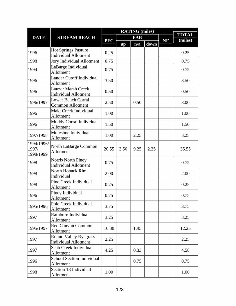
RATING (miles) FAR DATE STREAM REACH
PFC up n/a down
NF TOTAL (miles)
1996 Hot Springs Pasture Individual Allotment 0.25 0.25
1998 Jory Individual Allotment 0.75 0.75
1994 LaBarge Individual Allotment 0.75 0.75
1996 Lander Cutoff Individual Allotment 3.50 3.50
1996 Lauzer Marsh Creek Individual Allotment 0.50 0.50
1996/1997 Lower Bench Corral Common Allotment 2.50 0.50 3.00
1996 Maki Creek Individual Allotment 1.00 1.00
1996 Muddy Corral Individual Allotment 1.50 1.50
1997/1998 Muleshoe Individual Allotment 1.00 2.25 3.25
1994/1996/1997/ 1998/1999
North LaBarge Common Allotment 20.55 3.50 9.25 2.25 35.55
1998 Norris North Piney Individual Allotment 0.75 0.75
1998 North Hoback Rim Individual 2.00 2.00
1998 Pine Creek Individual Allotment 0.25 0.25
1996 Piney Individual Allotment 0.75 0.75
1995/1996 Pole Creek Individual Allotment 3.75 3.75
1997 Rathburn Individual Allotment 3.25 3.25
1995/1997 Red Canyon Common Allotment 10.30 1.95 12.25
1997 Round Valley Ryegrass Individual Allotment 2.25 2.25
1997 Scab Creek Individual Allotment 4.25 0.33 4.58
1996 School Section Individual Allotment 0.75 0.75
1998 Section 18 Individual Allotment 1.00 1.00
123
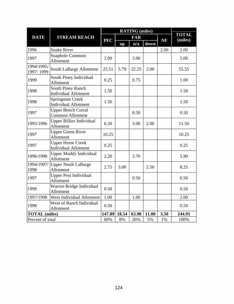
RATING (miles) FAR DATE STREAM REACH
PFC up n/a down
NF TOTAL (miles)
1996 Snake River 2.00 2.00
1997 Soaphole Common Allotment 2.00 3.00 5.00
1994/1995/1997/ 1999 South LaBarge Allotment 25.51 5.79 22.25 2.00 55.55
1999 South Piney Individual Allotment 0.25 0.75 1.00
1998 South Piney Ranch Individual Allotment 1.50 1.50
1998 Springman Creek Individual Allotment 1.50 1.50
1997 Upper Bench Corral Common Allotment 0.50 0.50
1995/1996 Upper Billies Individual Allotment 6.50 3.00 2.00 11.50
1997 Upper Green River Allotment 10.25 10.25
1997 Upper Horse Creek Individual Allotment 0.25 0.25
1996/1998 Upper Muddy Individual Allotment 2.20 3.70 5.90
1994/1997/1998
Upper North LaBarge Allotment 2.75 3.00 2.50 8.25
1997 Upper Post Individual Allotment 0.50 0.50
1999 Warren Bridge Individual Allotment 0.50 0.50
1997/1998 West Individual Allotment 1.00 1.00 2.00
1998 West of Ranch Individual Allotment 0.50 0.50
TOTAL (miles) 147.89 18.54 63.98 11.00 3.50 244.91 Percent of total 60% 8% 26% 5% 1% 100%
124

Appendix C. Documented information for past vegetation treatments in the UGRBWGA. Allotment Treatment Name Twp Range Section Date Acres Treatment Existing Veg Data Veg community Chimney Butte 1990 1700 Mowing
Chimney Butte 1990 800 Seeding
Bench Corral 1994 256 Range Pitting
Bench Corral 1994 320 Ripping
Bench Corral 1994 384 Spike 20P
Bench Corral 1994 148 Spike 20P
McNinch/O'Neil 1994 600 Spike 20P
McNinch/O'Neil 1994 222 Spike 20P
Moble Mowing 1996 734 Mowing
Moble Mowing 1996 734 Mowing
Moble Mowing 1996 734 Mowing
Chain Lakes 2003 650 Spike 20P
Administrative Allotment 2004 400 Spike 20P
Hoback Ranches 2005 75 Thinning
40 Rod Common 40 Rod 35 111 13 1990 400 Prescribed Burn
40 Rod Brush 35 110 1 1970 900 Brush (mowing?)
Piney Ind Beaver Creek Budd Sandy Unit 1963 200 Spray
Scab Creek Ind. Beaver Creek Budd Sandy Unit 1963 320 Spray
Southwest Past Ind Beaver Creek Budd Sandy Unit 1963 479 Spray
Square Top Common Beaver Creek Budd Sandy Unit 1963 1760 Spray
Beaver Creek Budd Sandy Unit 1963 1760
Steele Ind Beaver Creek Budd Sandy Unit 1963 640 Spray
West Cora Peak Ind Beaver Creek Budd Sandy Unit 1963 200 Spray
Winkleman Beaver Creek Budd Sandy Unit 1963 200 Spray
Bench Corral Common Low Big Piney 31 112 15 1967 1550 Spray
D Budd Deer Hill Ind Big Piney 30 113 19 1967 1529 Spray
James Ryegrass Big Piney 34 112 27 1967 740 Spray
Lower Horse Creek-1 Big Piney 31 112 15 1967 1550 Spray
Big Piney 27 114 1 1967 1590 Spray
Southwest Past Ind Big Sandy 30 106 5 1968 2581 Spray
Square Top Common Big Sandy 30 106 15 1969 100 Spray
Big Sandy 1969 100 Spray
125

Allotment Treatment Name Twp Range Section Date Acres Treatment Existing Veg Data Veg community Square Top Common Big Sandy 1968 2581 Spray
Boulder Lake Boulder Lake 33 107 29 1955 800 Spray
North LaBarge Com Calpet 26 113 10 1968 976 Spray
North LaBarge Com Calpet 27 113 26 1968 130 Reseeding
South LaBarge Common Coal Creek 1996 1000 Prescribed Burn
West Cora Peak Ind Cora Peak 34 111 11 1968 400 Reseeding
Cora Stock Driveway Cora Y 35 110 6 1983 1000 Spray
Boulder Cottonwood 1997 1000 Prescribed Burn
Cottonwood Common Cottonwood RX 1998 1500 Prescribed Burn
North LaBarge Com Cretaceous Mtn 1994 1 Prescribed Burn
North LaBarge Com Cretaceous Mtn 1993 400 Prescribed Burn
Upper North LaBarge Ind Deadline 27 114 8 1970 100 Slash Burn
Deer Hills Ind Deer Hills 1992 200 Prescribed Burn
D Budd Deer Hill Ind Deer Hills 1959 720 Spray
Upper Muddy Deer Hills 1959 1649 Spray
N LaBarge Com Dry Basin 29 112 21 1965 400 Reseeding
North LaBarge Com Dry Basin 29 113 35 1966 1000 Reseeding
Bousman Ind E Soda Lake 33 107 21 1968 340 Spray
Pole Creek Ind Fall Creek 34 108 34 1959 175 Spray
North LaBarge Com Fish Creek 29 113 20 1974 23 Reseeding
North LaBarge Com Fish Creek 29 114 30 1976 50 Thistle spraying
North LaBarge Com Fish Creek 29 114 30 1975 50 Thistle spraying
Upper North LaBarge Ind Gentle Annie 1998 1320 Prescribed Burn
Antelope Ridge Ind Green River Spray 1966 180 Spray
Aspen Ridge Ind Green River Spray 1966 1803 Spray
Beaver Cr. Meadow Ind Green River Spray 29 113 18 1966 680 Spray
Bench Corral Com UP Green River Spray 31 112 4 1966 1756 Spray
Brodie Draw Ind. Green River Spray 33 113 1 1966 2000 Spray
Chapel Ind Green River Spray 1966 1736 Spray
James Ryegrass Green River Spray 1966 200 Spray
Mount Airy Com Green River Spray 33 109 30 1966 924 Spray
Mount Airy Com Green River Spray 1962 320 Spray
New Fork Ind. Green River Spray 31 110 28 1966 1693 Spray
O'Neil Ind Green River Spray 1966 705 Spray
126

Allotment Treatment Name Twp Range Section Date Acres Treatment Existing Veg Data Veg community Green River Spray 29 113 4 1966 1805 Spray
Green River Spray 29 112 10 1966 705 Spray
Green River Spray 31 110 28 1966 1736 Spray
Green River Spray 29 113 14 1966 300 Spray
Piney Bridge Ind Horse Cr. Green River 1961 500 Spray
Bousman Ind Horse Creek Green R 1961 640 Spray
Long Pasture Horse Creek Green R 1961 220
Lumen Ind. Mesa 32 110 23 1960 1830 Spray
South LaBarge Common Miller MT 1992 350 Prescribed Burn
South LaBarge Common Miller MT FR 26 0 0 1963 40 Reseeding
Mount Airy Com MT Airy 33 109 29 1967 63 Browse Seeding
Fremont Butte Mt Airy Green River 1962 60 Spray
Grindstone Soaphole Mt Airy Green River 1962 640
Square Top Common Mt Airy Green River 1962 400 Spray
Square Top Common Mt Airy Green River 1962 400 Spray
Bench Coral Common Muddy Creek Spray 1 1969 250 Spray
North LaBarge Com Muddy Creek Spray 1 28 112 6 1969 250 Spray
Bench Corral Com UP Muddy Creek Spray 2 31 112 4 1969 250 Spray
Hay Gulch N Soda Lake 34 109 4 1968 257 Reseeding
Blue Rim Desert NW Pasture 29 109 13 1969 1911 Reseeding
RND-VLY Ryegeass Ind Onion Creek 33 112 10 1970 285 Spray
North LaBarge Com Pine Grove Clack 28 114 5 1970 1675 Spray
Bousman Ind Pinedale Area 33 107 17 1967 430 Spray
Square Top Common Pinedale Area 1967 3433 Spray
Pinedale Area 32 107 23 1967 607 Spray
Boulder Lake Pinedale Spray 1964 738 Spray
Hay Gulch Pinedale Spray 1964 620
Soda Lake Com Pinedale Unit 1964 480 Spray
Steele Ind Pinedale Unit 1967 504 Spray
Price-Beecher Cr. Price-Beecher 32 114 28 1993 160 Spray
North LaBarge Com Reed Ridge 29 114 14 1968 1996 Spray
RND-VLY Ryegeass Ind Road Fork 33 111 18 1968 1516 Spray
RND-VLY Ryegeass Ind Road Fork 33 111 16 1969 100 Spray
Mesa Com S Mesa Browse 30 110 2 1970 40 Reseeding
127

Allotment Treatment Name Twp Range Section Date Acres Treatment Existing Veg Data Veg community North LaBarge Com S Piney Spray 1 29 114 14 1969 200 Spray
North LaBarge Com S Piney Spray 2 29 113 19 1969 600 Spray
North LaBarge Com S Piney Spray3 29 113 34 1969 700 Spray
Scab Creek Ind. Scab Creek 32 107 3 1960 250 Reseeding
Fox Yose Common Sheep Creek 1970 320 Spray
Upper North LaBarge Ind Sheep Creek 27 114 22 1970 410 Spray
N LaBarge Com Spring Cr 29 114 20 1965 18 Burn
N LaBarge Com Sublette Spray 1 29 112 24 1965 6300 Spray
Hay Gulch Sublette Spray 2 1965 235
West Fremont Ridge Com Sublette Spray 2 34 109 9 1965 235 Spray
Bench Corral Ind. Sublette Spray 3 32 113 29 1965 700 Spray
Upper Muddy Sublette Spray 3 1965 1280 Spray
Budd Fish Creek Ind. Sublette Spray 4 30 114 31 1965 236 Spray
Spade Ind Sublette Spray 5 35 111 4 1965 500 Spray
Tip Top Hogsback 1996 1970 Mowing
Tip Top Hogsback 1998 750 Mowing
Tip Top Hogsback 1999 750 Mowing
Homestead Ind WD Alexander SQB 36 111 25 1967 160 Spray
South Desert Allotment Wild Horse 28 110 29 1975 3875 Brush (mowing?)
Boulder Lake 1997 1000 Prescribed Burn
Brodie Draw Ind. 1999 5765 Prescribed Burn
Miller Mnt 26 115 1991 1000 Burn
Spade Ind 36 111 33 1995 306.5 Prescribed Burn
Deer Hills Burn 1991 100 Prescribed Burn yes - perm transect Sagebrush
Cretaceous Burn 1993 500 Prescribed Burn yes - perm transect Sagebrush
Beaver Ridge (Tripod Hill) Burn 1996 140 Prescribed Burn yes - perm transect Aspen
Gentle Annie Burn 1998 600 Prescribed Burn yes - perm transect Sagebrush/Aspen
Brodie Draw Burn 1999 2200 Prescribed Burn yes - perm transect Sagebrush
McDowell Flats 1988 500 Prescribed Burn yes - perm transect Sagebrush
Soda Lake North 1992 1800 Prescribed Burn yes - perm transect Sagebrush/Aspen
Little Flattop 1993 500 Prescribed Burn yes - perm transect Sagebrush/Aspen
Fayette Ranch/Halfmoon Mt. 1996 5000 Prescribed Burn yes - perm transect Sagebrush/Bitterbrush
Boulder Ridge 1997 600 Prescribed Burn yes - perm transect Sagebrush/Bitterbrush
Burnt Lake 1997 400 Prescribed Burn yes - perm transect Sagebrush/Aspen
128

Allotment Treatment Name Twp Range Section Date Acres Treatment Existing Veg Data Veg community South Boulder 1998 1200 Prescribed Burn yes - perm transect Sagebrush/Bitterbrush
Cottonwood Allotment 1998 1100 Prescribed Burn yes - perm transect Sagebrush/Bitterbrush
Fremont Ridge (Phase 1) 1999/2000 1375 Prescribed Burn yes - perm transect Sagebrush/Bitterbrush
Blatts Burn (Willow Ck Ranch) 2003? 836 Prescribed Burn ? Sagebrush
New Fork / Boulder 2004 1260 Prescribed Burn yes - perm transect Sagebrush/Aspen
Chimney Butte 1990 1700 Chaining yes - perm transect Sagebrush
Bench Corral 1994/1995 256 Range Pitting yes - perm transect Sagebrush
Bench Corral 1994/1995 320 Range Ripping yes - perm transect Sagebrush
Mobil Mowing 1996-98 2200 Mowing yes - perm transect Sagebrush
Burnt Lake 1997 30 Cutting yes - perm transect Aspen
Soda Lake 1992 80 Cutting yes - perm transect Aspen
Little Soda Lake 2002 50 Cutting yes - perm transect Aspen/Conifer
Blatts Pitting and Harrowing 2002? 300 Pitting/Harrowing ? Sagebrush
Bench Corral 1994/1995 900 Spike 20P yes - perm transect Sagebrush
McNinch/O'Neil 1994/1995 222 Spike 20P yes - perm transect Sagebrush
West Boulder 1998 600 Spike 20P yes - perm transect Sagebrush/Bitterbrush
Burnt Lake 1998 20 Spike 20P no Sagebrush/Bitterbrush
129

Appendix D. Beneficial Seed Matrix for Sage-grouse, Mule Deer, and Antelope Brochure
130

131

Appendix E. List Of Potential Funding Sources For Sage-Grouse Projects.
Funding Opportunities for Wyoming Sage-Grouse Conservation Efforts
This list of potential funding sources is not intended to be all encompassing. Various private foundations, companies and individuals not listed below often partner in conservation efforts. Finding and making contact with these potential partners is best accomplished on a local level. The list below includes funding sources that can address various scales of projects ranging from the individual landowner to multi-state efforts. Contact the sources for detailed information, eligibility and application criteria. State of Wyoming Sources: Wyoming Wildlife and Natural Resource Trust Account - Created by legislative action in 2005 for the purposes of preserving and enhancing Wyoming’s wildlife and natural resources. Income from the trust account is used to fund a wide variety of conservation programs. (web site TBA) Wyoming Game and Fish Department (WGFD) Trust Fund - Matching grants program for riparian or upland habitat improvement, water development, and industrial water projects. http://gf.state.wy.us WGFD/U.S. Fish & Wildlife Service – Landowner Incentive Program (LIP) - Provides Federal funds to enhance habitats for sensitive fish and wildlife species on private lands. Priorities in Wyoming are grassland, sagebrush and prairie watersheds. Matching funds, goods or services are required. http://gf.state.wy.us WGFD/Wyoming State General Fund – Wyoming Sage-Grouse Conservation Fund - Funding approved by the legislature via the Governor’s budget request designed to implement projects identified in local Sage-Grouse Conservation Plans. http://gf.state.wy.us Wyoming Animal Damage Management Board (ADMB) - Provides funding for the purposes of mitigating damage caused to livestock, wildlife and crops by predatory animals, predacious birds and depredating animals or for the protection of human health and safety. http://www.wyadmb.com Federal Sources: U.S. Dept. of Interior, Fish and Wildlife Service http://www.fws.gov Partners for Fish and Wildlife Program – Provides assistance to private landowners who want to restore or improve habitat on their property. The landowner is reimbursed based on the cost sharing formula in the agreement, after project completion. Private Stewardship Program – Provides grants or other assistance to individuals and groups engaged in private conservation efforts that benefits species listed or proposed as endangered or
132

threatened under the Endangered Species Act, candidate species, or other at-risk species on private lands. Maximum Federal share is 90%. Cooperative Conservation Initiative - Supports efforts to restore natural resources and establish or expand wildlife habitat. Maximum Federal share is 50%. Multistate Conservation Grant Program - Supports sport fish and wildlife restoration projects identified by the International Association of Fish and Wildlife Agencies. Maximum Federal share is 100%. Tribal Landowner Incentive Program - For actions and activities that protect and restore habitats that benefit Federally listed, proposed, or candidate species, or other at-risk species on tribal lands. Maximum Federal share is 75%. Tribal Wildlife Grants – Provides for development and implementation of programs for the benefit of tribal wildlife and their habitat. Maximum Federal share is 100%. Conservation Grants - Provides financial assistance to States to implement wildlife conservation projects such as habitat restoration, species status surveys, public education and outreach, captive propagation and reintroduction, nesting surveys, genetic studies and development of management plans. Maximum Federal share is 75 % for a single state or 90% for two or more states implementing a joint project. U.S.D.A. Farm Service Agency (FSA) http://www.fsa.usda.gov/pas/ Conservation Reserve Program (CRP) - A voluntary program for agricultural landowners. Through CRP, you can receive annual rental payments and cost-share assistance to establish long-term, resource conserving covers and enhance wildlife habitat on eligible agricultural land. U.S.D.A. Natural Resource Conservation Service (NRCS) http://www.wy.nrcs.usda.gov Conservation Innovation Grants (CIG) - CIG is a voluntary program that enables the NRCS to work with public and private entities to accelerate the development and adoption of innovative conservation approaches and technologies in conjunction with agricultural production. Conservation Technical Assistance (CTA) - Provides voluntary conservation technical assistance to land-users, communities, units of state and local government, and other Federal agencies in planning and implementing conservation systems. This assistance is for planning and implementing conservation practices that address natural resource issues. Environmental Quality Incentives Program (EQIP) - Provides a voluntary conservation program for farmers and ranchers that promotes agricultural production and environmental quality as compatible goals. EQIP offers financial and technical help to assist eligible participants install or implement structural and management practices on eligible agricultural land.
133

Wildlife Habitat Incentives Program (WHIP) – Provides a voluntary program to develop and improve wildlife habitat primarily on private land by providing both technical assistance and up to 75% cost-share assistance to establish and/or improve fish and wildlife habitat. Sage-Grouse Restoration Project (SGRP) – Cooperative effort involving private landowners, agencies, organizations and universities in a process to evaluate and document, through research and demonstration areas, the effects of NRCS conservation practices in restoring sage-grouse habitat and populations. Grazing Land Conservation Initiative (GLCI) grants - A nationwide collaborative process of individuals and organizations working to maintain and improve the management, productivity, and health of the Nation’s privately owned grazing land. This process has formed coalitions that actively seek sources to increase technical assistance and public awareness activities that maintain or enhance grazing land resources. Cooperative Conservation Partnership Initiative (CCPI) - A voluntary program established to foster conservation partnerships that focus technical and financial resources on conservation priorities in watersheds and airsheds of special significance. Under CCPI, funds are awarded to State and local governments and agencies; Indian tribes; and non-governmental organizations that have a history of working with agricultural producers. Conservation Security Program (CSP) - A unique program that goes beyond the past approach of installing conservation practices. Instead, CSP offers rewards to those who have been good stewards of the soil and water resources on their working agricultural land. It also offers incentives for those who wish to exceed the minimum levels of resource protection and enhance the natural resources on the land they manage. The program is available in designated watersheds. U.S. Dept. of Interior, Bureau of Land Management http://www.blm.gov Challenge Cost Share – This program is designed to leverage funds with partners to monitor and inventory resources; implement habitat improvement projects; develop recovery plans; protect or document cultural resources; provide enhanced recreational experiences; and to better manage wild horse and burro populations. Matching funds, goods or services are required. Cooperative Conservation Initiative (CCI) – CCI was designed to remove barriers to citizen participation in the stewardship of our natural resources and to help people take conservation into their own hands by undertaking projects at the local level. Projects must seek to achieve the actual restoration of natural resources and/or the establishment or expansion of habitat for wildlife. Matching funds, goods or services are required. U.S.D.A. Forest Service http://www.fs.fed.us
134

Cooperative project funding – Contact local U.S. Forest Service staff for information about opportunities to develop partnerships in projects involving National Forests or National Grasslands. Partnership Resource Center - The Partnership Resource Center of the National Forest Foundation (NFF) and the USDA - Forest Service (FS) provides partnering organizations and FS staff with the information to enhance working relationships. Partnerships expand opportunities for obtaining grants. Many funding sources prefer or require them because projects involving partnerships have an increased potential for success. http://www.partnershipresourcecenter.org Other potential funding sources include but are not limited to: Wildlife Heritage Foundation of Wyoming - The Wyoming Wildlife Heritage Foundation is an independent, charitable organization whose purpose is to provide financial support, through philanthropy, to critical wildlife conservation efforts in Wyoming. http://whfw.org Wyoming Governor’s Big Game License Coalition - Funding generated from the sale of Governor’s licenses placed in five accounts: bighorn sheep, moose, elk, mule deer and general wildlife. Funds administered by the Wildlife Heritage Foundation of Wyoming. http://whfw.org National Fish and Wildlife Foundation (NFWF) - General Matching Grant Program - Provides matching grants to priority projects that address fish and wildlife conservation and the habitats on which they depend, work proactively to involve other conservation and community interests, leverage NFWF funding, and evaluate project outcomes. Government agencies, educational institutions, and nonprofit organizations may apply. Grants typically range from $10,000-$150,000. http://www.nfwf.org National Fish and Wildlife Foundation - Native Plant Conservation Initiative (NPCI) - NPCI grants of federal dollars are provided to non-profit organizations and agencies for conservation of native plants. NPCI grants range from $5,000 to $40,000, averaging $15,000. Non-Federal matching funds, goods or services are required. There is a strong preference for "on-the-ground" projects that involve local communities and citizen volunteers in the restoration of native plant communities. http://www.nfwf.org/programs/npci.cfm National Fish and Wildlife Foundation - Pulling Together Initiative (PTI) - Provides support for the formation of local Weed Management Area (WMA) partnerships. These partnerships engage federal resource agencies, state and local governments, private landowners, and others in developing weed management projects within an integrated pest management strategy. Non-Federal matching funds, goods or services are required. http://www.nfwf.org/programs/pti.cfm Intermountain West Joint Venture (IWJV) - Joint Venture Cost-Share - Habitats within the IWJV area support nearly 100% of the range of all high priority sagebrush steppe landbird species, such as: Sage Sparrow, Sage Thrasher, Sage-Grouse and Brewer’s Sparrow. The purpose of Cost-Share is long-term conservation of bird habitat through partnerships. http://iwjv.org/costshare.htm
135

The Nature Conservancy (TNC) - TNC works with conservation supporters and partner organizations to create funding for conservation worldwide using a variety of creative methods. http://nature.org Tom Thorne Sage-Grouse Conservation Fund – Provides grants for the conservation of sage-grouse in the Upper Green River Basin. The fund was created by Shell Exploration & Production Co. and managed by a board overseen by the Wyoming Community Foundation. www.wycf.comRocky Mountain Elk Foundation (RMEF) - RMEF is a wildlife conservation organization with an emphasis on elk. It advocates sustainable, ethical use of resources and seeks common ground among stakeholders. RMEF funds habitat restoration and improvement projects, acquires land or conservation easements. http://www.rmef.org Mule Deer Foundation (MDF) - MDF’s goals center on restoring, improving and protecting mule deer habitat. MDF achieves its goals through partnering with state and federal wildlife agencies, conservation groups, businesses and individuals to fund and implement habitat enhancement projects on both public and private lands. http://www.muledeer.org One Shot Antelope Foundation -Water for Wildlife - Water for Wildlife is a conservation program designed to benefit wildlife and the environment in arid regions of the West. Emphasis focuses on the development of supplemental water resources in areas where both the habitat and wildlife are being impaired by lack of this vital resource. http://www.waterforwildlife.com North American Grouse Partnership (NAGP) - Promotes the conservation of prairie grouse and the habitats necessary for their survival and reproduction. http://www.grousepartners.org Pheasants Forever (PF) – Some sage-grouse populations in Wyoming occur within areas that have a local PF chapter. Local chapters determine how their funds are spent. Game birds other than pheasants may be eligible for funding. http://www.pheasantsforever.org/chapters/
136

Appendix F. Support Letter for Local Working Groups – Use Of Technical Team Identify Livestock Management Options From Literature Review.
137

138

Appendix G. Palmer Drought Indices For Wyoming Division 3 (Southwest Wyoming), short-term (2002-2006) and long-term (1895-2005)
139

140

141
142

143
144

145

146