upkar prakashan, agra–2 · 2018-03-22 · nearest-neighbour analysis; scaling techniques; rank...
TRANSCRIPT
UPKAR PRAKASHAN, AGRA–2
By
Ritesh Kumar&
Sujit Kumar
Fourth Edition : 2016
© Publishers
Publishers
UPKAR PRAKASHAN2/11A, Swadeshi Bima Nagar, AGRA–282 002Phone : 4053333, 2530966, 2531101Fax : (0562) 4053330E-mail : [email protected], Website : www.upkar.in
Branch Offices :4845, Ansari Road, Daryaganj,New Delhi—110 002Phone : 011–23251844/66
Paras Bhawan(First Floor),Khazanchi Road,Patna—800 004Phone : 0612–2673340
1-8-1/B, R.R. Complex (Near SundaraiahPark, Adjacent to Manasa Enclave Gate),Bagh Lingampally,Hyderabad—500 044Phone : 040–66753330
28, Chowdhury Lane, ShyamBazar, Near Metro Station,Gate No. 4Kolkata—700 004 (W.B.)Phone : 033–25551510
B-33, Blunt Square, Kanpur TaxiStand Lane, Mawaiya,Lucknow—226 004 (U.P.)Phone : 0522–4109080
8-310/1, A. K. House,Heeranagar, Haldwani,Distt.—Nainital—263 139 (Uttarakhand)Mob. : 7060421008
1461, Juni Shukrawari,Sakkardara Road,Opp. Hanuman Mandir,Nagpur—440 009Phone : 0712–6564222
63-64, Kailash Marg,Ground Floor,Shreeji Avenue, Malharganj,Indore—452 002 (M.P.)Mob. : 08899588088
● The publishers have taken all possible precautions in publishing this book, yet if any mistakehas crept in, the publishers shall not be responsible for the same.
● This book or any part thereof may not be reproduced in any form by Photographic,Mechanical, or any other method, for any use, without written permission from the Publishers.
● Only the courts at Agra shall have the jurisdiction for any legal dispute.
ISBN : 978-93-5013-203-6
Code No. 1735
Printed at : UPKAR PRAKASHAN (Printing Unit) Bye-pass, AGRA
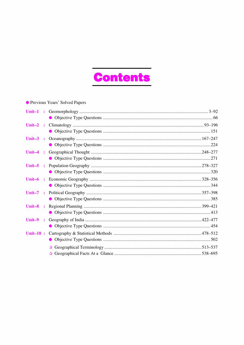
CCCCoooonnnntttteeeennnnttttssss
● Previous Years’ Solved Papers
Unit–1 : Geomorphology .................................................................................................................. 3–92● Objective Type Questions ................................................................................................. 66
Unit–2 : Climatology .................................................................................................................... 93–196● Objective Type Questions ............................................................................................... 151
Unit–3 : Oceanography ............................................................................................................... 167–247● Objective Type Questions ............................................................................................... 224
Unit–4 : Geographical Thought .................................................................................................. 248–277● Objective Type Questions ............................................................................................... 271
Unit–5 : Population Geography .................................................................................................. 278–327● Objective Type Questions ............................................................................................... 320
Unit–6 : Economic Geography ................................................................................................... 328–356● Objective Type Questions ............................................................................................... 344
Unit–7 : Political Geography ...................................................................................................... 357–398● Objective Type Questions ............................................................................................... 385
Unit–8 : Regional Planning ........................................................................................................ 399–421● Objective Type Questions ............................................................................................... 413
Unit–9 : Geography of India ....................................................................................................... 422–477● Objective Type Questions ............................................................................................... 454
Unit–10 : Cartography & Statistical Methods .............................................................................. 478–512● Objective Type Questions ............................................................................................... 502
✰ Geographical Terminology ...................................................................................... 513–537✰ Geographical Facts At a Glance ............................................................................. 538–695
Syllabus
Paper–II
Unit-1Geomorphology : Fundamental concepts; Endogenetic and Exogenetic forces; Denudation and weathering;
Geosynclines, Continental drift and plate tectonics; Concept of geomorphic cycle; Landforms associated withfluvial, glacial, arid, coastal and karst cycles.
Unit-2Climatology : Composition and structure of the atmosphere; Heat budget of the earth; Distribution of
temperature; Atmospheric pressure and general circulation of winds; Monsoon and jet stream; Tropical andtemperate cyclones; Classification of world climates; Koppen’s and Thornthwaite’s schemes.
Unit-3(A) Oceanography : Ocean deposits; Coral reefs. Temperature and salinity of the oceans; Density of sea
water; Tides and ocean currents.(B) Bio-Geography : World distribution of plants and animals; Forms and functions of ecosystem;
Conservation and management of ecosystems; Problems of pollution.
Unit-4Geographic Thought : General character of geographic knowledge during the ancient, and medieval period;
Foundations of modern geography; Determinism and possibilism; Areal differentiation and spatial organisation.
Unit-5(A) Population Geography : Patterns of world distribution; Growth and density of population; Patterns and
processes of migration; Demographic transition.(B) Settlement Geography : Site, situation, types, size, spacing and internal morphology of rural and urban
settlements; City-region; Primate city; Rank-size rule; Settlement hierarchy; Christaller’s Central Placetheory; August Lösch’s theory of market centres.
Unit-6Economic Geography : Sectors of economy : primary, secondary, tertiary and quaternary; Natural resources :
renewable and non-renewable :(A) Measurement of agricultural productivity and efficiency; Crop combination and diversification. Von
Thünen’s model.(B) Classification of industries : Weber’s and Losch’s approaches; Resource based and footloose industries.(C) Models of transportation and transport cost : Accessibility and connectivity.
Unit-7(A) Political Geography : Heartland and Rimland theories; Boundaries and frontiers.(B) Social Geography : Ethnicity; tribe; dialect, language, caste and religion; Concept of social well-being.(C) Cultural Geography : Culture-areas and cultural regions; Human races; Habital, economy and society of
tribal groups.
Unit-8Regional Planning : Regional concept in geography; Concept of planning regions; Types of regions; Methods
of regional delineation; Regional planning in India; Indicators of development; Regional imbalances.
( vii )
Unit-9Geography of India : Physiographic divisions; Climate : its regional variations; Vegetation types and
vegetation regions; Major soil types; Irrigation and agriculture; Population distribution and growth; Settlementpatterns; Mineral and power resources; Major industries and industrial regions.
Unit-10(A) Cartography : Types of maps : Techniques for the study of spatial patterns of distribution; Choropleth;
Isopleth and Chorochromatic maps and pie diagram; Mapping of location-specific data; Accessibility andflow maps.Remote sensing and computer application in mapping; Digital mapping; Geographic Information System(GIS).
(B) Statistical Methods : Data sources and types of data; Frequency distribution and cumulative frequency;Measures of central tendency; Selection of class intervals for mapping; Measures of dispersion andconcentration; Standard deviation; Lorenz curve; Methods of measuring association among differentattributes; Simple and multiple correlation; Regression.Nearest-neighbour analysis; Scaling techniques; Rank score; Weighted score; Sampling techniques forgeographical analysis.
PAPER–III
Unit-1Geomorphology : Fundamental concepts; Factors controlling landform development; Endogenetic and
Exogenetic forces; Denudation process ; Weathering and erosion; Geosynclines, mountain building, continental driftand plate tectonics; Concept of Geomorphic Cycle; Landforms associated with fluvial, glacial, arid, coastal and karstcycles, Slope forms and processes; Environmental and Applied Geomorphology.
Unit-2Climatology : Composition and structure of the atmosphere; Insolation; Heat budget of the earth; Distribution
of temperature; atmospheric pressure and general circulation of winds; Monsoons and jet streams; Stability andinstability of the atmosphere; Air-masses; Fronts; temperate and tropical cyclones; Types and distribution ofprecipitation; Classification of world climates; Koppen’s and Thornthwaite’s schemes; Hydrological Cycle; Globalwarming.
Unit-3(A) Oceanography : Origin of oceans basins; Bottom relief of Indian, Atlantic and Pacific Oceans; Ocean
deposits; Coral reefs; Temperature and salinity of the Oceans; Density of sea water; Tides and oceancurrents; Sea-level changes.
(B) Bio-Geography : Physical factors influencing world distribution of plants and animals; Forms andfunctions of ecosystem : Forest, grassland, marine and mountain ecosystem; Bio-diversity and its depletionthrough natural and man-induced causes; Conservation and management of ecosystems; Environmentalhazards and problems of pollution; Ozone depletion.
Unit-4History of Geographic Thought : General character of geographic knowledge during the ancient, and
medieval period; Foundations of modern geography : Contribution of German, French, British and Americanschools; Conceptual and methodological developments during the 20th century; Changing paradigms; man andenvironment, determinism and possibilism, areal differentiation and spatial organisation; Quantitative revolution;Impact of positivism, humanism, radicalism and behaviouralism in geography.
Unit-5(A) Population Geography : Nature, scope, subject matter and recent trends : Patterns of world distribution,
growth and density of population; Policy issues; Patterns and processes of migration; Demographictransition; Population-resource regions.
(B) Settlement Geography : Site, situation, types, size, spacing and internal morphology of rural and urbansettlements; Ecological processes of urban growth; Urban fringe, City-region; Settlement systems; Primatecity; Rank-size rule; Settlement hierarchy; Christaller’s Central Place theory; August Losch’s theory ofmarket centres.
( viii )
Unit-6Economic Geography : Location of economic activities and spatial organization of economies; Classification
of economies; Sectors of economy : primary, secondary, tertiary and quaternary; Natural resources : Renewable andnon-renewable; Conservation of resources :
(A) Agricultural Geography : Concept and techniques of delimitation of agricultural regions; Measurementof agricultural productivity and efficiency; Crop combinations and diversification; Von Thünen’s model;Agricultural systems of the world.
(B) Industrial Geography : Classification of industries : Weber’s and Losch’s approaches; Resource basedand footloose industries.
(C) Geography of Transport and Trade : Models of transportation and transport cost; Accessibility andconnectivity : Inter-regional and Intra-regional : Comparative cost advantages.
Unit-7(A) Political Geography : Definition and scope of Political Geography; Geopolitics; Global strategic views
(Heartland and Rimland theories); Concept of nation, state and nation-state; Boundaries and frontiers;Politics of world resources; Geography and Federalism.
(B) Social Geography : Nature and scope of social geography; Social structure and social processes;Elements of Social Geography—ethnicity, tribe, dialect, language, caste and religion; Concept of Socialwell-being.
(C) Cultural Geography : Nature and scope of cultural geography; Environment and culture; Concept ofculture-areas and cultural regions; Theories of tribal groups; Dwelling places as cultural expressions.
Unit-8Regional Planning : Regional concept in geography; its application to planning; Concept of planning region;
Regional hierarchy; Types of regions and methods of regional delineation; Conceptual and theoretical framework ofregional planning; Regional planning in India : Concept of development; indicators of development; Regionalimbalances.
Unit-9Geography of India : Physiographic divisions; Climate : its regional variations; Vegetation types and
vegetation regions; Major soil types; Coastal and Marine resources; Water resources; Irrigation; Agriculture;Agroclimatic regions; Mineral and power resources; Major industries and industrial regions; Population distributionand growth; Settlement patterns; Regional disparities in social and economic development.
Unit-10(A) Cartography : Map as a tool in geographical studies; Types of maps : Techniques for the study of spatial
patterns of distribution; Single purpose and composite maps; Choropleth, Isopleth and Chorochromaticmaps and pie diagrams; Mapping of location specific data; Accessibility and flow maps.
Remote sensing and computer application in mapping; Digital mapping; Geographic Information System(GIS) : Thematic maps.
(B) Statistical Methods : Data sources and types of data; Statistical diagrams; Study of frequency distributionand cumulative frequency; Measures of central tendency; Selection of class intervals for mapping;Measures of dispersion and concentration; Standard deviation; Lorenz curve; Methods of measuringassociation among different attributes; Simple and multiple correlation; Regression.
Measurement of spatial patterns of distribution; Nearest-neighbour analysis; Scaling techniques, rankscore, weighted score; Sampling techniques for geographical analysis.
GeographyUGC-NET/JRF Exam.
(July 2016)
Solved Paper
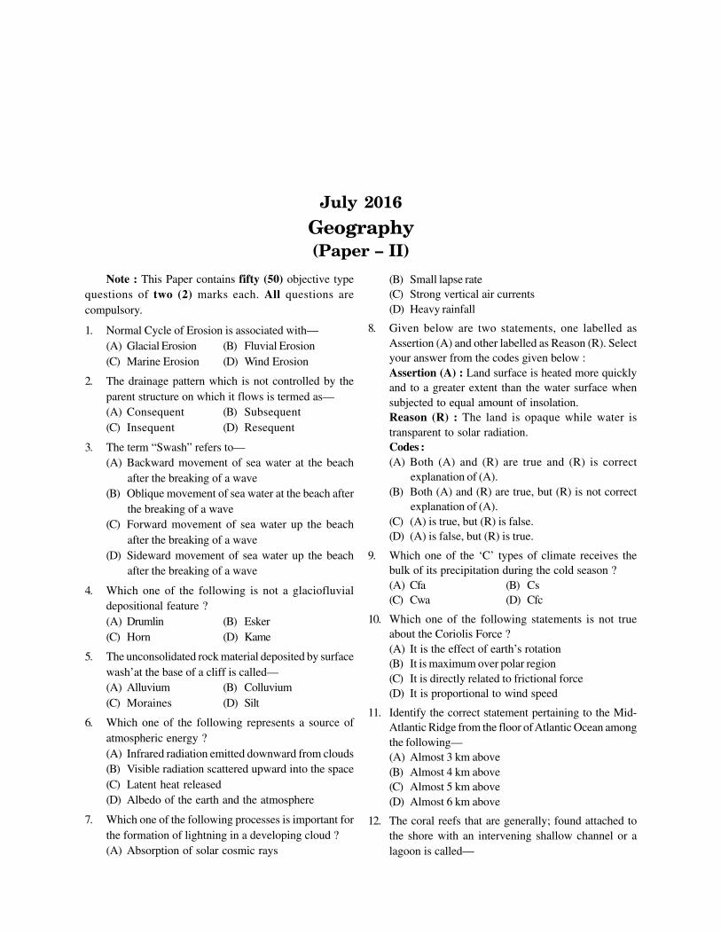
July 2016
Geography(Paper – II)
Note : This Paper contains fifty (50) objective typequestions of two (2) marks each. All questions arecompulsory.
1. Normal Cycle of Erosion is associated with—(A) Glacial Erosion (B) Fluvial Erosion(C) Marine Erosion (D) Wind Erosion
2. The drainage pattern which is not controlled by theparent structure on which it flows is termed as—(A) Consequent (B) Subsequent(C) Insequent (D) Resequent
3. The term “Swash” refers to—(A) Backward movement of sea water at the beach
after the breaking of a wave(B) Oblique movement of sea water at the beach after
the breaking of a wave(C) Forward movement of sea water up the beach
after the breaking of a wave(D) Sideward movement of sea water up the beach
after the breaking of a wave
4. Which one of the following is not a glaciofluvialdepositional feature ?(A) Drumlin (B) Esker(C) Horn (D) Kame
5. The unconsolidated rock material deposited by surfacewash’at the base of a cliff is called—(A) Alluvium (B) Colluvium(C) Moraines (D) Silt
6. Which one of the following represents a source ofatmospheric energy ?(A) Infrared radiation emitted downward from clouds(B) Visible radiation scattered upward into the space(C) Latent heat released(D) Albedo of the earth and the atmosphere
7. Which one of the following processes is important forthe formation of lightning in a developing cloud ?(A) Absorption of solar cosmic rays
(B) Small lapse rate(C) Strong vertical air currents(D) Heavy rainfall
8. Given below are two statements, one labelled asAssertion (A) and other labelled as Reason (R). Selectyour answer from the codes given below :Assertion (A) : Land surface is heated more quicklyand to a greater extent than the water surface whensubjected to equal amount of insolation.Reason (R) : The land is opaque while water istransparent to solar radiation.Codes :(A) Both (A) and (R) are true and (R) is correct
explanation of (A).(B) Both (A) and (R) are true, but (R) is not correct
explanation of (A).(C) (A) is true, but (R) is false.(D) (A) is false, but (R) is true.
9. Which one of the ‘C’ types of climate receives thebulk of its precipitation during the cold season ?(A) Cfa (B) Cs(C) Cwa (D) Cfc
10. Which one of the following statements is not trueabout the Coriolis Force ?(A) It is the effect of earth’s rotation(B) It is maximum over polar region(C) It is directly related to frictional force(D) It is proportional to wind speed
11. Identify the correct statement pertaining to the Mid-Atlantic Ridge from the floor of Atlantic Ocean amongthe following—(A) Almost 3 km above(B) Almost 4 km above(C) Almost 5 km above(D) Almost 6 km above
12. The coral reefs that are generally; found attached tothe shore with an intervening shallow channel or alagoon is called—
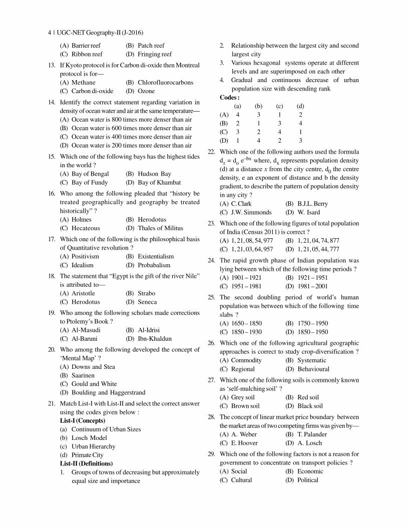
4 | UGC-NET Geography-II (J-2016)
(A) Barrier reef (B) Patch reef(C) Ribbon reef (D) Fringing reef
13. If Kyoto protocol is for Carbon di-oxide then Montrealprotocol is for—(A) Methane (B) Chlorofluorocarbons(C) Carbon di-oxide (D) Ozone
14. Identify the correct statement regarding variation indensity of ocean water and air at the same temperature—(A) Ocean water is 800 times more denser than air(B) Ocean water is 600 times more denser than air(C) Ocean water is 400 times more denser than air(D) Ocean water is 200 times more denser than air
15. Which one of the following bays has the highest tidesin the world ?(A) Bay of Bengal (B) Hudson Bay(C) Bay of Fundy (D) Bay of Khambat
16. Who among the following pleaded that “history betreated geographically and geography be treatedhistorically” ?(A) Holmes (B) Herodotus(C) Hecateous (D) Thales of Militus
17. Which one of the following is the philosophical basisof Quantitative revolution ?(A) Positivism (B) Existentialism(C) Idealism (D) Probabalism
18. The statement that “Egypt is the gift of the river Nile”is attributed to—(A) Aristotle (B) Strabo(C) Herodotus (D) Seneca
19. Who among the following scholars made correctionsto Ptolemy’s Book ?(A) Al-Masudi (B) Al-Idrisi(C) Al-Baruni (D) Ibn-Khaldun
20. Who among the following developed the concept of‘Mental Map’ ?(A) Downs and Stea(B) Saarinen(C) Gould and White(D) Boulding and Haggerstrand
21. Match List-I with List-II and select the correct answerusing the codes given below :List-I (Concepts)(a) Continuum of Urban Sizes(b) Losch Model(c) Urban Hierarchy(d) Primate CityList-II (Definitions)1. Groups of towns of decreasing but approximately
equal size and importance
2. Relationship between the largest city and secondlargest city
3. Various hexagonal systems operate at differentlevels and are superimposed on each other
4. Gradual and continuous decrease of urbanpopulation size with descending rank
Codes :(a) (b) (c) (d)
(A) 4 3 1 2(B) 2 1 3 4(C) 3 2 4 1(D) 1 4 2 3
22. Which one of the following authors used the formuladx = do e–bx where, dx represents population density(d) at a distance x from the city centre, d0 the centredensity, e an exponent of distance and b the densitygradient, to describe the pattern of population densityin any city ?(A) C. Clark (B) B.J.L. Berry(C) J.W. Simmonds (D) W. Isard
23. Which one of the following figures of total populationof India (Census 2011) is correct ?(A) 1, 21, 08, 54, 977 (B) 1, 21, 04, 74, 877(C) 1, 21, 03, 64, 957 (D) 1, 21, 05, 44, 777
24. The rapid growth phase of Indian population waslying between which of the following time periods ?(A) 1901 – 1921 (B) 1921 – 1951(C) 1951 – 1981 (D) 1981 – 2001
25. The second doubling period of world’s humanpopulation was between which of the following timeslabs ?(A) 1650 – 1850 (B) 1750 – 1950(C) 1850 – 1930 (D) 1850 – 1950
26. Which one of the following agricultural geographicapproaches is correct to study crop-diversification ?(A) Commodity (B) Systematic(C) Regional (D) Behavioural
27. Which one of the following soils is commonly knownas ‘self-mulching soil’ ?(A) Grey soil (B) Red soil(C) Brown soil (D) Black soil
28. The concept of linear market price boundary betweenthe market areas of two competing firms was given by—(A) A. Weber (B) T. Palander(C) E. Hoover (D) A. Losch
29. Which one of the following factors is not a reason forgovernment to concentrate on transport policies ?(A) Social (B) Economic(C) Cultural (D) Political
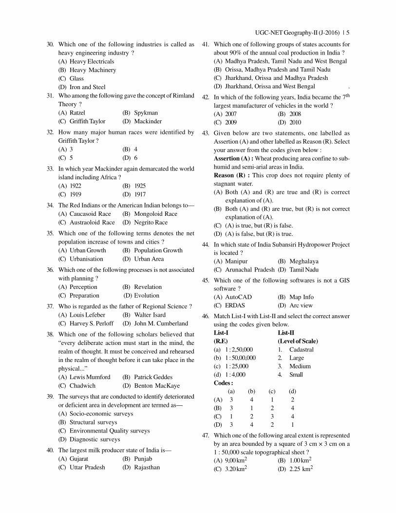
UGC-NET Geography-II (J-2016) | 5
30. Which one of the following industries is called asheavy engineering industry ?(A) Heavy Electricals(B) Heavy Machinery(C) Glass(D) Iron and Steel
31. Who among the following gave the concept of RimlandTheory ?(A) Ratzel (B) Spykman(C) Griffith Taylor (D) Mackinder
32. How many major human races were identified byGriffith Taylor ?(A) 3 (B) 4(C) 5 (D) 6
33. In which year Mackinder again demarcated the worldisland including Africa ?(A) 1922 (B) 1925(C) 1919 (D) 1917
34. The Red Indians or the American Indian belongs to—(A) Caucasoid Race (B) Mongoloid Race(C) Austraoloid Race (D) Negrito Race
35. Which one of the following terms denotes the netpopulation increase of towns and cities ?(A) Urban Growth (B) Population Growth(C) Urbanisation (D) Urban Area
36. Which one of the following processes is not associatedwith planning ?(A) Perception (B) Revelation(C) Preparation (D) Evolution
37. Who is regarded as the father of Regional Science ?(A) Louis Lefeber (B) Walter Isard(C) Harvey S. Perloff (D) John M. Cumberland
38. Which one of the following scholars believed that“every deliberate action must start in the mind, therealm of thought. It must be conceived and rehearsedin the realm of thought before it can take place in thephysical...”(A) Lewis Mumford (B) Patrick Geddes(C) Chadwich (D) Benton MacKaye
39. The surveys that are conducted to identify deterioratedor deficient area in development are termed as—(A) Socio-economic surveys(B) Structural surveys(C) Environmental Quality surveys(D) Diagnostic surveys
40. The largest milk producer state of India is—(A) Gujarat (B) Punjab(C) Uttar Pradesh (D) Rajasthan
41. Which one of following groups of states accounts forabout 90% of the annual coal production in India ?(A) Madhya Pradesh, Tamil Nadu and West Bengal(B) Orissa, Madhya Pradesh and Tamil Nadu(C) Jharkhand, Orissa and Madhya Pradesh(D) Jharkhand, Orissa and West Bengal .
42. In which of the following years, India became the 7th
largest manufacturer of vehicles in the world ?(A) 2007 (B) 2008(C) 2009 (D) 2010
43. Given below are two statements, one labelled asAssertion (A) and other labelled as Reason (R). Selectyour answer from the codes given below :Assertion (A) : Wheat producing area confine to sub-humid and semi-arial areas in India.Reason (R) : This crop does not require plenty ofstagnant water.(A) Both (A) and (R) are true and (R) is correct
explanation of (A).(B) Both (A) and (R) are true, but (R) is not correct
explanation of (A).(C) (A) is true, but (R) is false.(D) (A) is false, but (R) is true.
44. In which state of India Subansiri Hydropower Projectis located ?(A) Manipur (B) Meghalaya(C) Arunachal Pradesh (D) Tamil Nadu
45. Which one of the following softwares is not a GISsoftware ?(A) AutoCAD (B) Map Info(C) ERDAS (D) Arc view
46. Match List-I with List-II and select the correct answerusing the codes given below.List-I List-II(R.F.) (Level of Scale)(a) 1 : 2,50,000 1. Cadastral(b) 1 : 50,00,000 2. Large(c) 1 : 25,000 3. Medium(d) 1 : 4,000 4. SmallCodes :
(a) (b) (c) (d)(A) 3 4 1 2(B) 3 1 2 4(C) 1 2 3 4(D) 3 4 2 1
47. Which one of the following areal extent is representedby an area bounded by a square of 3 cm × 3 cm on a1 : 50,000 scale topographical sheet ?(A) 9,00 km2 (B) 1.00 km2
(C) 3.20 km2 (D) 2.25 km2
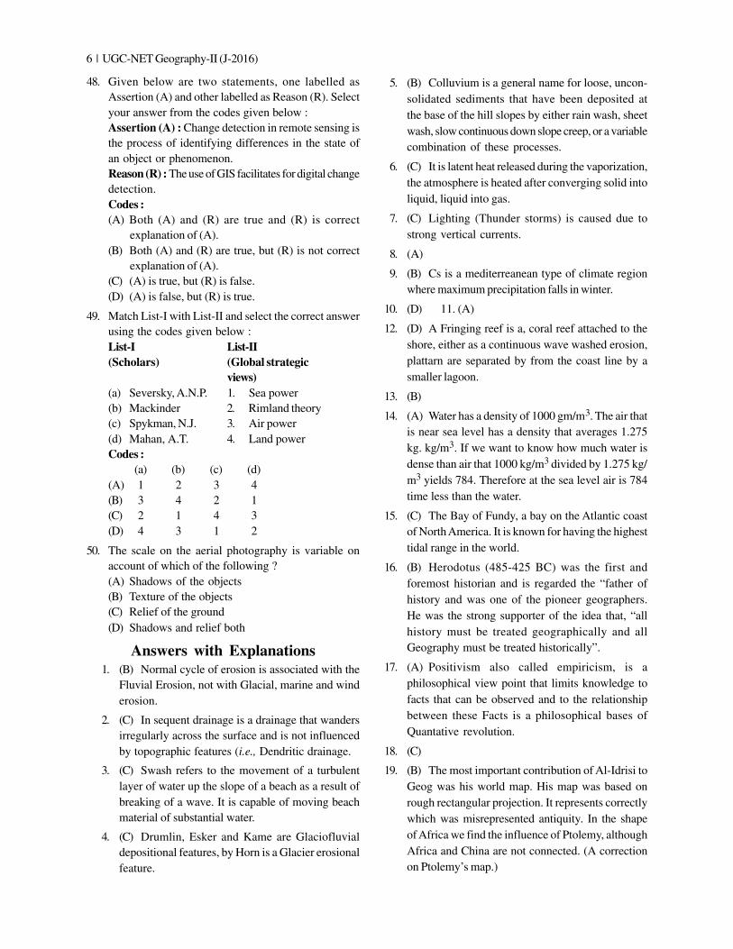
6 | UGC-NET Geography-II (J-2016)
48. Given below are two statements, one labelled asAssertion (A) and other labelled as Reason (R). Selectyour answer from the codes given below :Assertion (A) : Change detection in remote sensing isthe process of identifying differences in the state ofan object or phenomenon.Reason (R) : The use of GIS facilitates for digital changedetection.Codes :(A) Both (A) and (R) are true and (R) is correct
explanation of (A).(B) Both (A) and (R) are true, but (R) is not correct
explanation of (A).(C) (A) is true, but (R) is false.(D) (A) is false, but (R) is true.
49. Match List-I with List-II and select the correct answerusing the codes given below :List-I List-II(Scholars) (Global strategic
views)(a) Seversky, A.N.P. 1. Sea power(b) Mackinder 2. Rimland theory(c) Spykman, N.J. 3. Air power(d) Mahan, A.T. 4. Land powerCodes :
(a) (b) (c) (d)(A) 1 2 3 4(B) 3 4 2 1(C) 2 1 4 3(D) 4 3 1 2
50. The scale on the aerial photography is variable onaccount of which of the following ?(A) Shadows of the objects(B) Texture of the objects(C) Relief of the ground(D) Shadows and relief both
Answers with Explanations1. (B) Normal cycle of erosion is associated with the
Fluvial Erosion, not with Glacial, marine and winderosion.
2. (C) In sequent drainage is a drainage that wandersirregularly across the surface and is not influencedby topographic features (i.e., Dendritic drainage.
3. (C) Swash refers to the movement of a turbulentlayer of water up the slope of a beach as a result ofbreaking of a wave. It is capable of moving beachmaterial of substantial water.
4. (C) Drumlin, Esker and Kame are Glaciofluvialdepositional features, by Horn is a Glacier erosionalfeature.
5. (B) Colluvium is a general name for loose, uncon-solidated sediments that have been deposited atthe base of the hill slopes by either rain wash, sheetwash, slow continuous down slope creep, or a variablecombination of these processes.
6. (C) It is latent heat released during the vaporization,the atmosphere is heated after converging solid intoliquid, liquid into gas.
7. (C) Lighting (Thunder storms) is caused due tostrong vertical currents.
8. (A)
9. (B) Cs is a mediterreanean type of climate regionwhere maximum precipitation falls in winter.
10. (D) 11. (A)
12. (D) A Fringing reef is a, coral reef attached to theshore, either as a continuous wave washed erosion,plattarn are separated by from the coast line by asmaller lagoon.
13. (B)
14. (A) Water has a density of 1000 gm/m3. The air thatis near sea level has a density that averages 1.275kg. kg/m3. If we want to know how much water isdense than air that 1000 kg/m3 divided by 1.275 kg/m3 yields 784. Therefore at the sea level air is 784time less than the water.
15. (C) The Bay of Fundy, a bay on the Atlantic coastof North America. It is known for having the highesttidal range in the world.
16. (B) Herodotus (485-425 BC) was the first andforemost historian and is regarded the “father ofhistory and was one of the pioneer geographers.He was the strong supporter of the idea that, “allhistory must be treated geographically and allGeography must be treated historically”.
17. (A) Positivism also called empiricism, is aphilosophical view point that limits knowledge tofacts that can be observed and to the relationshipbetween these Facts is a philosophical bases ofQuantative revolution.
18. (C)
19. (B) The most important contribution of Al-Idrisi toGeog was his world map. His map was based onrough rectangular projection. It represents correctlywhich was misrepresented antiquity. In the shapeof Africa we find the influence of Ptolemy, althoughAfrica and China are not connected. (A correctionon Ptolemy’s map.)
UGC-NET Geography-II (J-2016) | 7
20. (C) The concept of mental-map was developed byGould and White.
21. (A) 22. (A) 23. (A)
24. (C) The Rapid growth phase of Indian populationwas from 1951-1981.
25. (C) World’s population was 500 million by 1650 andin 1850 it was estimated to be 1000 million. The periodfrom 1650 to 1850 was the first phase of doublingthe world’s population, from 1850 to 1930, the worldpopulation doubled again i.e., from 1000 million to2000 million. It is the second phase of doubling theworld’s population.
26. (C)
27. (D) A self-mulching soil is a soil that mixes itself itssurface layer shrink and swell farming deep cracks.This property of soil belongs to Block Soil.
28. (B) 29. (C)
30. (B) Heavy Engineering industry produces capitalgoods and consumer durables and its products canbe put into following Category i.e., industrialmachinery and capital goods, Power generation.
31. (B) Rimland concept was given by Spykman in1938-39 and published in 1944 in a book entitled
‘‘The Geography of Peace’’. In which he started whocontrols the Rimland rules Eurasia, who rules Eurasiacontrols the destinities of the world.
32. (C)
33. (C) It was after the first world war, that Mackinderchanged his field of world island in which heincluded Africa.
34. (B) 35. (A) 36. (D) 37. (B) 38. (D)
39. (D)
40. (C) Uttar Pradesh is the largest milk producer of india.
41. (D)
42. (C) In the year 2010, India became the seventh largestmanufacturer of Vehicles, 2009-10.
43. (B)
44. (C) Subansiri Lower Dam, officially known asSubansiri Hydro-electric project, is under con-struction gravity dam on subansiri river at Assamand Arunchal Pradesh.
45. (A) 46. (D) 47. (D) 48. (B) 49. (B)
50. (C)
July 2016
Geography(Paper – III)
Note : This Paper contains seventy five (75) objectivetype questions of two (2) marks each. All questions arecompulsory.
1. A drainage pattern which is not related to the structureof the region is known as—(A) Radial drainage(B) Trellis drainage(C) Dendritic drainage(D) Superimposed drainage
2. Crickmay while disagreeing with Davis supplementedpeneplain with the terms—(A) Pediplain (B) Panplane(C) Etchplain (D) Structural plain
3. Which of the following is strongly presumptive offault line scrap ?(A) Superimposed drainage(B) Frequent severe earthquakes(C) Actual fault plane identified along the scrap(D) Poor correlation between rock resistance and
topographic form
4. Given below are two statements, one labelled asAssertion (A) and other labelled as Reason (R). Selectyour answer from the codes given below :Assertion (A) : Deep chemical decay of rocks is oneof the outstanding features of humid tropical regions.Reason (R) : Intensity of chemical weathering dependsto a large, extent on abundance of water and higher airtemperature.Codes :(A) Both (A) and (R) are true and (R) is the correct
explanation of (A).(B) Both (A) and (R) are true, but (R) is not the correct
explanation of (A).(C) (A) is true, but (R) is false.(D) (A) is false, but (R) is true.
5. Given below are two statements, one labelled asAssertion (A) and other labelled as Reason (R). Selectyour answer from the codes given below :
Assertion (A) : The islands along the Mid-AtlanticRidge are highly prone to volcanic activity.Reason (R) : The sea-floor spreading is the main causeof earthquakes in the Atlantic Ocean.Codes :(A) Both (A) and (R) are true and (R) is the correct
explanation of (A).(B) Both (A) and (R) are true, but (R) is not the correct
explanation of (A).(C) (A) is true, but (R) is false.(D) (A) is false, but (R) is true.
6. Match List-I with List-II and select the correct answerusing the codes given below :List - I List - II(Authors) (Title of the Book)(a) Woolridge and 1. Principles of geomorphology
Morgan(b) Thornbury 2. Geomorphology(c) Von Richthofen 3. Spirit and Purpose of
Geography(d) Steers 4. Unstable EarthCodes :
(a) (b) (c) (d)(A) 1 2 3 4(B) 2 3 1 4(C) 3 1 2 4(D) 4 2 1 3
7. Which one of the following arrangements of Pleis-tocene Ice age is in a correct chronological order ?(A) Mindel – Wurm – Gunz – Rim(B) Gunz – Mindel – Rim – Wurm(C) Wurm – Mindel – Rim – Gunz(D) Rim – Mindel – Wurm – Gunz
8. Given below are two statements, one labelled asAssertion (A) and other labelled as Reason (R). Selectyour answer from the codes given below :Assertion (A) : Divergent plate margin cause sea floorspreading.
UGC-NET Geography-III (J-2016) | 9
Reason (R) : Construction plate margins result in theformation of faults.Codes :(A) Both (A) and (R) are true and (R) is the correct
explanation of (A).(B) Both (A) and (R) are true, but (R) is not the correct
explanation of (A).(C) (A) is true, but (R) is false.(D) (A) is false, but (R) is true.
9. Which one of the following pairs is not correctlymatched ?(A) Microscale – Turbulence(B) Planetary scale – Waves in the westerlies(C) Mesoscale – Tornadoes(D) Synepticscale – Valley and mountain winds
10. Which one of the following statements about polar jetstream is not true ?(A) It moves northwards during summer(B) It supplies energy to the circulation of surface
storms(C) Its velocity is greater during the summer(D) Its location roughly coincides with that of the
polar front
11. Supercooled water is water which is—(A) Produced from dry ice(B) A special form of ice(C) Still liquid at temperature below zero degree(D) Partly liquid and partly solid
12. A place located at a higher altitude generally expe-riences ................ than a low elevation place in anadjoining valley.(A) a greater daily temperature range(B) a lower annual mean temperature(C) a lower daily temperature range(D) both a greater daily temperature range and lower
annual mean temperature
13. Given below are two statements, one labelled asAssertion (A) and other labelled as Reason (R). Selectyour answer from the codes given below :Assertion (A) : Hurricane cannot develop along theequatorial region.Reason (R) : Coriolis force is at its maximum over theequator.Codes :(A) Both (A) and (R) are true and (R) is the correct
explanation of (A).(B) Both (A) and (R) are true, but (R) is not the correct
explanation of (A).(C) (A) is true, but (R) is false.(D) (A) is false, but (R) is true.
14. The actual amount of water vapour in a given quantityof air is greatest for which of the following temperature-relative humidity combinations ?(A) 40°C – 100% (B) 25°C – 100%(C) 0°C – 100% (D) 30°C – 50%
15. What happens when Chinook wind is drawn downthe leeward slopes of the mountain range ?(A) The saturation vapour pressure increases(B) The relative humidity decreases(C) Both (A) and (B) are correct(D) Both (A) and (B) are wrong
16. Match the List-I with List-II and select the correctanswer from the codes given below :List-I(a) Absolute humidity(b) Relative humidity(c) Specific humidity(d) Mixing ratioList-II1. The ratio of weight of water vapour to the weight
of per unit volume of dry air2. Mass of water vapour in grams contained in one
kilogram of air including water vapour3. The ratio of the amount of water vapour actually
present in the air having definite volume andtemperature to its maximum amount air can holdat that temperature.
4. The total weight of moisture content per unitvolume of air
Codes :(a) (b) (c) (d)
(A) 1 2 3 4(B) 4 3 2 1(C) 2 4 3 1(D) 4 2 1 3
17. The sea attained its present level during the geologicalperiod—(A) Holocene (B) Miocene(C) Cambrian (D) Jurassic
18. The pyramid of biomass is inverted in case of—(A) Forest ecosystem(B) Grassland ecosystem(C) Marine ecosystem(D) Fresh water ecosystem
19. Which one of the following percentages India con-tributes to world’s biodiversity ?(A) 2 % (B) 4 %(C) 6 % (D) 8 %
20. Which one of the following temperatures of sea wateris favourable for the formation of coral reefs ?(A) At least 20 °C (B) At least 15 °C(C) At least 10°C (D) At least 5 °C
UGC NET/JRF/SET Geography (Paper-IIAnd III)
Publisher : Upkar Prakashan ISBN : 9789350132036Author : Ritesh Kumar AndSujit Kumar
Type the URL : http://www.kopykitab.com/product/10403
Get this eBook
30%OFF