unmanned aerial system (uas) flight operations manual uas-operations-manual v1.6 final.pdf · uas...
TRANSCRIPT
1
City of Los Angeles
Department of Public Works Bureau of Engineering
Unmanned Aerial System (UAS) Flight Operations Manual
March 2017
2
Table of Contents
1. Preface ................................................................................................................................................................................ 5
2. Philosophy & Mission Statement .............................................................................................................................. 5
3. Protection of Rights and Privacy .............................................................................................................................. 5
3.1 Privacy ......................................................................................................................................................................... 5
3.2 Protection/Annoyance .......................................................................................................................................... 7
3.3 Public Notification .................................................................................................................................................. 8
4. Acronyms ........................................................................................................................................................................... 8
5. Administration ............................................................................................................................................................. 10
5.1 Operations Manual .............................................................................................................................................. 10
5.2 Organization ........................................................................................................................................................... 10
5.3 Personnel................................................................................................................................................................. 10
5.4 Facilities ................................................................................................................................................................... 12
5.5 Scheduling (Training and Proficiency) ........................................................................................................ 12
5.6 Miscellaneous ........................................................................................................................................................ 12
6. Safety ................................................................................................................................................................................ 13
6.1 Safety Policy ........................................................................................................................................................... 13
6.2 Operational Hazard and Occurrence Report (OHOR) and Investigations ..................................... 13
6.3 Safety Officer - Operator/Observer/Coordinator ................................................................................... 14
6.4 Safety Training ...................................................................................................................................................... 14
6.5 Medical Factors ..................................................................................................................................................... 14
6.6 Safety Equipment ................................................................................................................................................. 15
6.7 Airframe and Control Station Safety ............................................................................................................. 15
6.8 Battery Safety ........................................................................................................................................................ 16
6.9 Battery Charging Safety ..................................................................................................................................... 16
6.10 Safe Battery Transportation .......................................................................................................................... 17
6.11 Safe Battery Use, Storage and Disposal ..................................................................................................... 17
6.12 Operational Risk Management (ORM) ...................................................................................................... 18
6.13 Safety Risk Assessment ................................................................................................................................... 19
6.14 Risk Mitigation .................................................................................................................................................... 19
7. Training ........................................................................................................................................................................... 21
7.1 Objective .................................................................................................................................................................. 21
7.2 Instructors .............................................................................................................................................................. 21
7.3 Training Plans........................................................................................................................................................ 21
3
7.4 Initial Training ...................................................................................................................................................... 21
7.5 Recurrent Training .............................................................................................................................................. 22
7.6 Miscellaneous ........................................................................................................................................................ 22
8. General Operating Procedures ............................................................................................................................... 23
8.1 Request for UAS Support ................................................................................................................................... 23
8.2 Call-out Procedure ............................................................................................................................................... 24
8.3 Deployment Priorities ........................................................................................................................................ 25
8.4 Flight Boundaries ................................................................................................................................................. 26
8.5 Minimum Personnel Requirements .............................................................................................................. 26
8.6 Personnel Responsibilities for Deployments ............................................................................................ 26
8.7 Personal Equipment ............................................................................................................................................ 27
9. Pre-Flight/Post-Flight Actions ............................................................................................................................... 27
9.1 Aircraft Inspections ............................................................................................................................................. 27
9.2 Weather ................................................................................................................................................................... 28
9.3 Documentation ...................................................................................................................................................... 28
9.4 Planning ................................................................................................................................................................... 29
9.5 Checklists ................................................................................................................................................................ 29
9.6 Maintenance ........................................................................................................................................................... 29
9.7 Other ......................................................................................................................................................................... 29
10. Definitions ................................................................................................................................................................... 29
11. Checklists ..................................................................................................................................................................... 40
11.1 GENERAL SAFETY REQUIREMENTS AND WARNINGS ....................................................................... 40
(FOR THE TYPHOON H PRO, APPLICABLE FOR OTHER UAS) ................................................................... 40
11.2 EQUIPMENT / UAV / DRONE MONTHLY INSPECTION ...................................................................... 41
(TO BE CONDUCTED IN A CONTROLLED ENVIRONMENT) ....................................................................... 41
11.3 MISSION PLANNING ......................................................................................................................................... 42
11.4 AREA & ENVIRONMENT (FOR SITE EVAULATIONS PRIOR TO MISSION) ................................. 42
11.5 PUBLIC AWARENESS ....................................................................................................................................... 43
11.6 PRE-FLIGHT / RUN-UP .................................................................................................................................... 43
11.7 IN-FLIGHT ............................................................................................................................................................ 44
11.8 POST-FLIGHT (ONSITE) .................................................................................................................................. 45
11.9 FLIGHT LOGS ....................................................................................................................................................... 45
11.10 POST-FLIGHT (REPORTING REQUIREMENTS) ................................................................................... 46
11.11 EQUIPMENT STORAGE AND BATTERY HANDLING .......................................................................... 46
4
11.12 DATA HANDLING ............................................................................................................................................ 47
12. References ................................................................................................................................................................... 47
Appendix 1: Beaufort Scale .......................................................................................................................................... 49
Appendix 2: Hand Signals ............................................................................................................................................. 50
Appendix 3: Contingency Plan Checklist ................................................................................................................. 51
Appendix 4: Mission Planning Profile ...................................................................................................................... 53
Appendix 5: Emergency Contact List ........................................................................................................................ 54
5
1. Preface The following procedures are intended to promote safe, efficient and lawful operation of the City of Los Angeles, Department of Public Works, Bureau of Engineering (BOE), unmanned aerial systems (UAS). Safety, above all else, is the primary concern in each and every operation, regardless of the nature of the mission. (Many procedures adopted from Oak Ridge National Laboratory “Best Practices for Unmanned Aerial Systems” February 2017) American Civil Liberties Union (ACLU) “Protecting Privacy from Aerial Surveillance (recommendations for Government Use of Drone Aircraft) December 2011”, National Telecommunications and Information Administration (NTIA) “Voluntary Best Practices for UAS Privacy, Transparency and Accountability” and the Oak Ridge National Laboratory “Best Practices for the Use of Unmanned Aerial Systems… February 2015”, FAA Remote Pilot – Small Unmanned Aircraft Systems Study Guide” August 2016, Ruppert Law P.A. “Part 107 Study Guide” December 2016 as well as many other sources. (See reference index Section 12).
2. Philosophy & Mission Statement It shall be the mission of those personnel of BOE who are trained in the use of unmanned aircraft systems (UAS), to use this resource to perform aerial data collection for engineering purposes safely and effectively while also respecting private property and privacy of the citizens of the City of Los Angeles.
It shall be the intent of every UAS operator to make reasonable effort to not invade a person's reasonable expectation of privacy when operating the UAS. When operating the UAS, BOE operators shall abide by all Federal Aviation Administration (FAA) Regulations for flight and receive the proper authorization for flight.
3. Protection of Rights and Privacy
3.1 Privacy UAS operators and observers ensure the protection of private individuals’ Fourth Amendment Rights, civil rights and reasonable expectations of privacy before deploying the UAS. UAS operators and observers ensure and are held accountable for ensuring that operations of the UAS intrude to a minimal extent upon the private property, persons and businesses. To accomplish this primary goal, BOE observes the following:
1. BOE UAS will record video and still pictures (no audio) of features on the ground that relate to public property and City owned assets. Any data captured outside the focus of flight operations is unintentional or only as necessary due to the proximity to public property or City owned assets.
2. When the UAS is flown, the onboard cameras are turned so as to be facing away from occupied structures, etc. as much as practicable to minimize inadvertent video or still images of uninvolved persons or property.
3. When asked by a member of the public to delete personal data about him or her that has been gathered, do so, if at all possible.
6
4. All BOE UAS flights shall be conducted with video recording (low resolution) or still frame photos from take-off to landing to verify the positioning of the camera if any concerns are raised by the public. This data shall be retained for a minimum of one year.
5. BOE does not conduct random surveillance activities. The use of the UAS is tightly controlled and regulated and not in any way intended to document the activity of private citizens.
6. Hovering over private property shall be kept to a minimum or only as necessary to accomplish the goal of an individual flight operation.
7. Flight over private property shall be conducted a minimum of 30 feet away in any direction from any structures or people, and wherever practical well above the roofline of any privately owned structures.
8. Whenever possible, the UAS crew should divert sensors from occupied structures and
uninvolved persons to minimize inadvertent, unapproved data collection.
9. If a location is planned to be flown frequently for monitoring purposes (e.g. construction or hazard monitoring), owners of adjacent private property shall be notified in writing of the stated purpose of the flights, frequency, altitude, hours of operation, start/stop dates, where/how to address complaints/concerns, and BOE privacy policy for UAS operations.
10. All authorized missions for BOE UAS are for: a. Engineering purposes relating to construction monitoring and mapping. b. Presentation purposes c. Asset inspections, asset/facility documentation. d. Hazard assessment/mapping. e. BOE emergency operations.
11. All data gathered will be reviewed for any inadvertent intrusion to privacy. If found, reasonable efforts will be made to ensure that such information will be permanently masked or obscured within the data files prior to the release of photos or video internally within BOE, other City agencies, or to the public. There is no intention of the BOE to provide or release data to any law enforcement agency, unless specifically ordered to do so by a legal and valid court order.
12. A committee shall be formed to meet semi-annually for the purpose of reviewing the existing UAS procedures as well as new technologies, laws, and regulations on UAS usage. The committee shall consist of personnel from BOE.
13. Ad hoc unplanned operations should never be conducted except for emergency
response to manmade/natural disasters as authorized by the City Engineer; if used, the
application of the UAS emergency response work shall be tightly controlled and
regulated.
14. BOE UAS operate strictly within the Federal, State, and City laws and regulations. If in doubt, prior to operating the UAS we ensure that the proper forms and applications are applied for and obtained. We balance all operations with the need to accomplish the mission while maintaining public privacy and freedom from intrusion.
15. Public Relations. Any UAS flight open to misinterpretation by the public should be avoided. The following are examples of flights that would be considered controversial.
7
Flights of routine nature for which commercial or other public transportation or
ground based data gathering could be more economically substituted.
Flights coinciding with major sports events or civic celebrations within the
operating area.
3.2 Protection/Annoyance It is essential that the City of Los Angeles/Bureau of Engineering build a reputation for well-managed, minimally intrusive UAS use. A reputation of professionalism will support future, more complex applications of this new industrial tool. Any adverse incidents such as unprofessional and unsafe use have the potential to jeopardize the public trust, thus hindering future expansion of the far-reaching UAS capabilities. The following list of privacy and UAS etiquette best practices should be considered when operating UAS.
Aircraft Noise Abatement. UAS noise could create a public relations problem.
Operators should review their operating practices on a continuing basis with a view
toward minimizing this nuisance to the public.
Prohibited Operation Over Persons. Part 107 prohibits a person from flying a UAS
directly over a person who is not under a safe cover such as a protective structure or a
stationary vehicle that would protect the person from harm from the UAS.
Protecting the public from harm if the UAS were to crash into a person, structure or vehicle is the primary concern of the UAS flight crew. However, a UAS may be flown over a person who is directly participating in the operation of the UAS, such as the remote PIC (Pilot In Charge), other persons manipulating the controls, a VO (Visual Observer), a MPO )Mission , or crew members necessary for the safety of the UAS operation, as assigned and briefed by the remote PIC. There are several ways that the UAS remote PIC can comply with these requirements, including the following:
o If possible, selecting an operational area (site) that is clearly
unpopulated/uninhabited. If selecting a site that is populated/inhabited, the PIC
should have a plan of action that ensures persons remain clear of the operating
area, remain indoors, or remain under safe cover that would protect them from
harm until such time as the UAS flight has ended.
o Established an operational area that the remote PIC has taken reasonable
precautions to keep free of persons not directly participating in the operation of
the UAS.
o Choosing an operating area that is sparsely populated or, ideally, clear of
persons if operating sUAS from a moving vehicle.
o Having a plan of action that ensures the sUAS remains clear of persons who may
enter the operating area.
o Adopting an appropriate operating distance from persons not directly
participating in the operation of the sUAS.
8
Prohibited Maneuvers. The following maneuvers should be prohibited when flying in
support of commercial energy companies.
o Maneuvers solely for “thrill” purposes or in an adverse nature.
o Flying directly over a substation
o Flying within 30 ft. of energized power lines
In Summary, all UAS operators and assigned crew members should make every reasonable effort not to invade the public’s privacy in the execution of UAS work. All federal, state, and local regulations should be adhered to, and as required, the public should be notified before UAS operations.
3.3 Public Notification Landowners and associated parties are provided reasonable accommodations when necessitated by the specifics of the of ongoing and repeated UAS flight operations through adequate prior notification, which may include the following;
1. For all UAS operations being conducted in an area, provide a written notice addressing specifics, including intended takeoff and landing zones, at least 20 working days before the flight(s).
2. For all UAS flights being conducted near airports or other airborne operating area: Never fly within 5 miles of an airport without contacting airport authorities and the airport’s traffic control facility. The airport Advisory Area is an area of 5 miles encircling an airport. If this area is to be entered for UAS flight operations; the airport authorizes must be contacted before flight operations.
4. Acronyms
1. AP autopilot 2. AGL above ground level 3. ATC air traffic control 4. BOE Bureau of Engineering 5. BVLOS beyond visual line of sight 6. C2 Command and Control 7. CICA Convention on International Civil Aviation 8. COA certificate of authorization 9. CFR Code of Federal Regulations 10. COW certificate of waiver 11. CS control station 12. CTAF Common Traffic Advisory Frequency 13. DoD US Department of Defense 14. DROTAM Drone Notice to Airmen 15. EM electromagnetic 16. EMI electromagnetic interference 17. EPRI Electric Power Research Institute 18. FAA Federal Aviation Administration (US Department of Transportation)
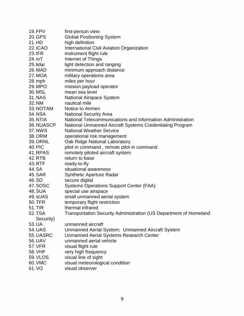
9
19. FPV first-person view 20. GPS Global Positioning System 21. HD high definition 22. ICAO International Civil Aviation Organization 23. IFR instrument flight rule 24. IoT Internet of Things 25. lidar light detection and ranging 26. MAD minimum approach distance 27. MOA military operations area 28. mph miles per hour 29. MPO mission payload operator 30. MSL mean sea level 31. NAS National Airspace System 32. NM nautical mile 33. NOTAM Notice to Airmen 34. NSA National Security Area 35. NTIA National Telecommunications and Information Administration 36. NUASCP National Unmanned Aircraft Systems Credentialing Program 37. NWS National Weather Service 38. ORM operational risk management 39. ORNL Oak Ridge National Laboratory 40. PIC pilot in command , remote pilot in command 41. RPAS remotely piloted aircraft system 42. RTB return to base 43. RTF ready-to-fly 44. SA situational awareness 45. SAR Synthetic Aperture Radar 46. SD secure digital 47. SOSC Systems Operations Support Center (FAA) 48. SUA special use airspace 49. sUAS small unmanned aerial system 50. TFR temporary flight restriction 51. TIR thermal infrared 52. TSA Transportation Security Administration (US Department of Homeland
Security) 53. UA unmanned aircraft 54. UAS Unmanned Aerial System; Unmanned Aircraft System 55. UASRC Unmanned Aerial Systems Research Center 56. UAV unmanned aerial vehicle 57. VFR visual flight rule 58. VHF very high frequency 59. VLOS visual line of sight 60. VMC visual meteorological condition 61. VO visual observer
10
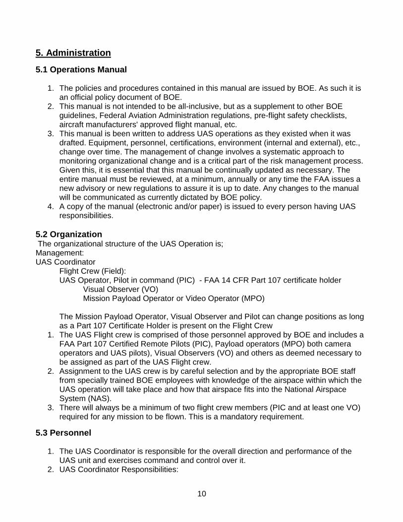
5. Administration
5.1 Operations Manual
1. The policies and procedures contained in this manual are issued by BOE. As such it is an official policy document of BOE.
2. This manual is not intended to be all-inclusive, but as a supplement to other BOE guidelines, Federal Aviation Administration regulations, pre-flight safety checklists, aircraft manufacturers' approved flight manual, etc.
3. This manual is been written to address UAS operations as they existed when it was drafted. Equipment, personnel, certifications, environment (internal and external), etc., change over time. The management of change involves a systematic approach to monitoring organizational change and is a critical part of the risk management process. Given this, it is essential that this manual be continually updated as necessary. The entire manual must be reviewed, at a minimum, annually or any time the FAA issues a new advisory or new regulations to assure it is up to date. Any changes to the manual will be communicated as currently dictated by BOE policy.
4. A copy of the manual (electronic and/or paper) is issued to every person having UAS responsibilities.
5.2 Organization The organizational structure of the UAS Operation is; Management: UAS Coordinator
Flight Crew (Field): UAS Operator, Pilot in command (PIC) - FAA 14 CFR Part 107 certificate holder
Visual Observer (VO) Mission Payload Operator or Video Operator (MPO)
The Mission Payload Operator, Visual Observer and Pilot can change positions as long as a Part 107 Certificate Holder is present on the Flight Crew
1. The UAS Flight crew is comprised of those personnel approved by BOE and includes a FAA Part 107 Certified Remote Pilots (PIC), Payload operators (MPO) both camera operators and UAS pilots), Visual Observers (VO) and others as deemed necessary to be assigned as part of the UAS Flight crew.
2. Assignment to the UAS crew is by careful selection and by the appropriate BOE staff from specially trained BOE employees with knowledge of the airspace within which the UAS operation will take place and how that airspace fits into the National Airspace System (NAS).
3. There will always be a minimum of two flight crew members (PIC and at least one VO) required for any mission to be flown. This is a mandatory requirement.
5.3 Personnel
1. The UAS Coordinator is responsible for the overall direction and performance of the UAS unit and exercises command and control over it.
2. UAS Coordinator Responsibilities:
11
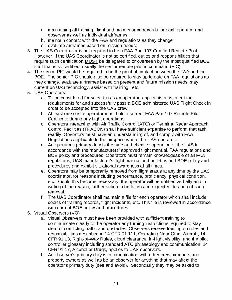
a. maintaining all training, flight and maintenance records for each operator and observer as well as individual airframes;
b. maintain contact with the FAA and regulations as they change c. evaluate airframes based on mission needs;
3. The UAS Coordinator is not required to be a FAA Part 107 Certified Remote Pilot. However, if the UAS Coordinator is not so certified, duties and responsibilities that require such certification MUST be delegated to or overseen by the most qualified BOE staff that is so certified, usually the senior remote pilot in command (PIC).
4. The senior PIC would be required to be the point of contact between the FAA and the BOE. The senior PIC should also be required to stay up to date on FAA regulations as they change, evaluate airframes based on present and future mission needs, stay current on UAS technology, assist with training, etc.
5. UAS Operators: a. To be considered for selection as an operator, applicants must meet the
requirements for and successfully pass a BOE administered UAS Flight Check in order to be accepted into the UAS crew.
b. At least one onsite operator must hold a current FAA Part 107 Remote Pilot Certificate during any flight operations.
c. Operators interacting with Air Traffic Control (ATC) or Terminal Radar Approach Control Facilities (TRACON) shall have sufficient expertise to perform that task readily. Operators must have an understanding of, and comply with FAA Regulations applicable to the airspace where the UAS operates.
d. An operator's primary duty is the safe and effective operation of the UAS in accordance with the manufacturers' approved flight manual, FAA regulations and BOE policy and procedures. Operators must remain knowledgeable of all FAA regulations; UAS manufacturer's flight manual and bulletins and BOE policy and procedures and exhibit situational awareness at all times.
e. Operators may be temporarily removed from flight status at any time by the UAS coordinator, for reasons including performance, proficiency, physical condition, etc. Should this become necessary, the operator will be notified verbally and in writing of the reason, further action to be taken and expected duration of such removal.
f. The UAS Coordinator shall maintain a file for each operator which shall include copies of training records, flight incidents, etc. This file is reviewed in accordance with current BOE policy and procedures.
6. Visual Observers (VO) a. Visual Observers must have been provided with sufficient training to
communicate clearly to the operator any turning instructions required to stay clear of conflicting traffic and obstacles. Observers receive training on rules and responsibilities described in 14 CFR 91.111, Operating Near Other Aircraft, 14 CFR 91.13, Right-of-Way Rules, cloud clearance, in-flight visibility, and the pilot controller glossary including standard ATC phraseology and communication. 14 CFR 91.17, Alcohol or Drugs, applies to UAS observers.
b. An observer's primary duty is communication with other crew members and property owners as well as be an observer for anything that may affect the operator's primary duty (see and avoid). Secondarily they may be asked to
12
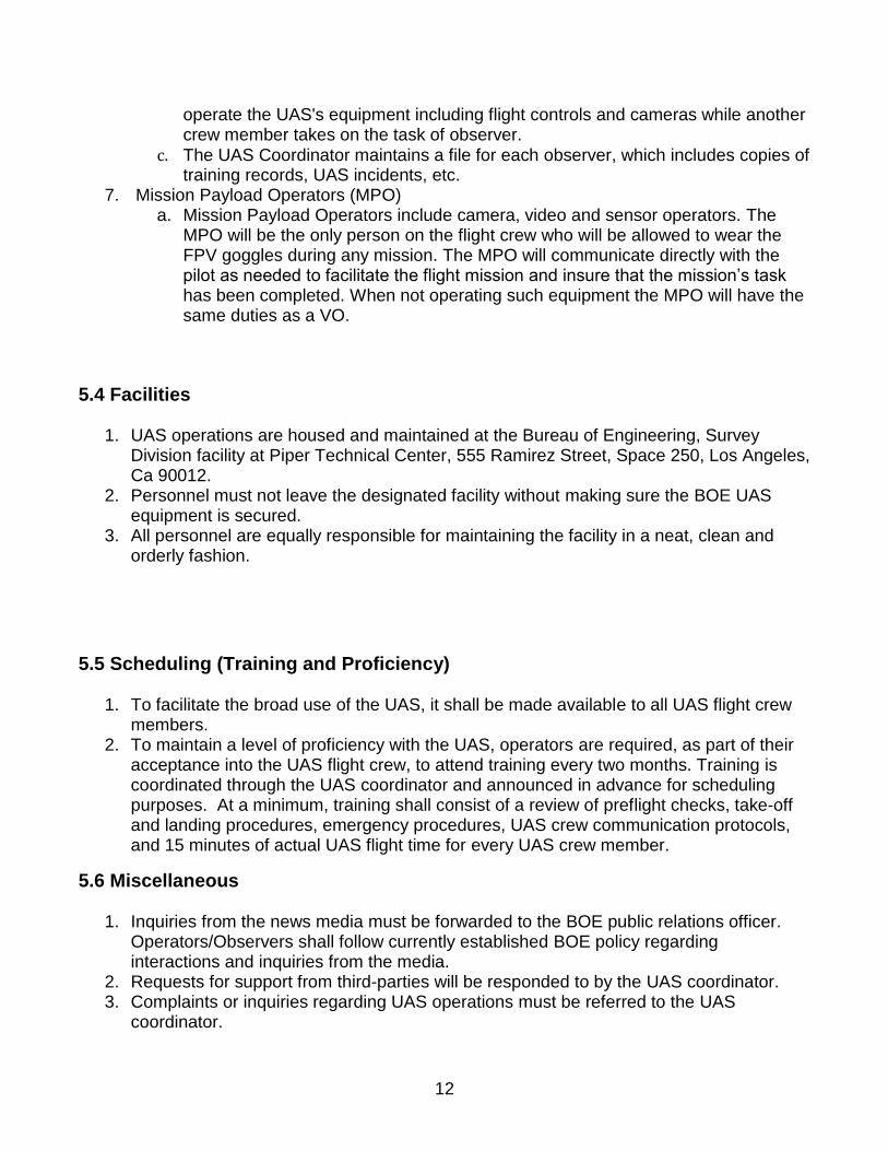
operate the UAS's equipment including flight controls and cameras while another crew member takes on the task of observer.
c. The UAS Coordinator maintains a file for each observer, which includes copies of training records, UAS incidents, etc.
7. Mission Payload Operators (MPO) a. Mission Payload Operators include camera, video and sensor operators. The
MPO will be the only person on the flight crew who will be allowed to wear the FPV goggles during any mission. The MPO will communicate directly with the pilot as needed to facilitate the flight mission and insure that the mission’s task has been completed. When not operating such equipment the MPO will have the same duties as a VO.
5.4 Facilities
1. UAS operations are housed and maintained at the Bureau of Engineering, Survey Division facility at Piper Technical Center, 555 Ramirez Street, Space 250, Los Angeles, Ca 90012.
2. Personnel must not leave the designated facility without making sure the BOE UAS equipment is secured.
3. All personnel are equally responsible for maintaining the facility in a neat, clean and orderly fashion.
5.5 Scheduling (Training and Proficiency)
1. To facilitate the broad use of the UAS, it shall be made available to all UAS flight crew members.
2. To maintain a level of proficiency with the UAS, operators are required, as part of their acceptance into the UAS flight crew, to attend training every two months. Training is coordinated through the UAS coordinator and announced in advance for scheduling purposes. At a minimum, training shall consist of a review of preflight checks, take-off and landing procedures, emergency procedures, UAS crew communication protocols, and 15 minutes of actual UAS flight time for every UAS crew member.
5.6 Miscellaneous
1. Inquiries from the news media must be forwarded to the BOE public relations officer. Operators/Observers shall follow currently established BOE policy regarding interactions and inquiries from the media.
2. Requests for support from third-parties will be responded to by the UAS coordinator. 3. Complaints or inquiries regarding UAS operations must be referred to the UAS
coordinator.
13
6. Safety
6.1 Safety Policy
1. BOE is committed to having a safe and healthy workplace, including: a. The ongoing pursuit of an accident free workplace, including no harm to people,
no damage to equipment, the environment and property. b. A culture of open reporting of all safety hazards in which management will not
initiate disciplinary action against any personnel who, in good faith, disclose a hazard or safety occurrence due to unintentional conduct.
c. Support for safety training and awareness programs. d. Conducting regular audits of safety policies, procedures and practices. e. Monitoring the UAS community to ensure best safety practices are incorporated
into the organization. 2. It is the duty of every member within the UAS flight crew to contribute to the goal of
continued safe operations. This contribution comes in many forms and includes always operating in the safest manner practicable and never taking unnecessary risks. Any safety hazard, whether procedural, operational, or maintenance related must be identified as soon as possible after, if not before, an incident occurs. Any suggestions in the interest of safety should be made to the UAS Coordinator.
3. If any member observes, or has knowledge of an unsafe or dangerous act committed by another member, the UAS coordinator is to be notified immediately so that corrective action may be taken.
4. The person manipulating the flight controls cannot operate a UAS and drive a moving vehicle in a safe manner and remain in compliance with FAA Part 107. (Many safety procedures adopted from Oak Ridge National Laboratory “Best Practices for Unmanned Aerial Systems” February 2017)
6.2 Operational Hazard and Occurrence Report (OHOR) and Investigations
1. Occurrences are unplanned safety related events, including accidents and incidents that could impact safety. A hazard is something that has the potential to cause harm. The systematic identification and control of all major hazards is foundational to safety.
2. The OHOR concept provides a mechanism to report hazards and occurrences, real and perceived, to those responsible for UAS operations.
3. There is no specific format for the OHOR as the information provided is what is important, not the format and should be used without hesitation to report any anticipated, current, or experienced safety hazard, or occurrence. Further, the OHOR can be submitted anonymously, and to whatever level in the chain of command, to get the matter proper attention, without fear of reprisal.
4. Written memorandums fully explaining the problem will be given to the UAS coordinator for investigation.
5. Every hazard and/or occurrence is investigated, with the results and corrective action taken communicated to all members. The investigation will be conducted by the UAS coordinator or designee. The services of an independent subject matter expert may be necessary in some cases to assure a thorough and complete investigation.
14
6. Hazards requiring immediate attention will be brought to the attention of the UAS coordinator, verbally, without delay.
7. ALL MEMBERS ARE AUTHORIZED TO TAKE ACTION TO CORRECT A HAZARD if in that member's opinion delay will result in accident or injury. The UAS coordinator will be notified immediately in such situations.
6.3 Safety Officer - Operator/Observer/Coordinator
1. In regards to safety, all members of the UAS flight crew are responsible for the following:
a. Ensuring all flight operations personnel understand applicable regulatory requirements, standards and organizational safety policies and procedures.
b. Observe and control safety systems by monitoring all operations. c. Review standards and the practices of BOE personnel as they impact operational
safety. d. Communicate all reported safety related problems and the corrective action
taken. If there were any in-flight problems (or learned experiences), the proper procedures for handling that problem should be discussed.
e. Copy and circulate pertinent safety information. f. Copy and circulate emergency safety bulletins. g. Place any electronic copies of safety information or bulletins in a conspicuous
location for all employees to access. h. It is emphasized again that safety is the responsibility of ALL members of the
UAS unit.
6.4 Safety Training
1. All members shall receive safety training in the following subjects prior to operating the UAS:
a. BOE commitment to safety b. BOE policy c. UAS member's role in safety d. Emergency safety procedures
2. All members shall review the BOE safety policy and procedures on an annual basis and that review shall be noted in their training history.
6.5 Medical Factors
1. Operator and Observers shall only deploy the UAS when rested and emotionally prepared for the tasks at hand.
2. Physical illness, exhaustion, emotional problems, etc., seriously impair judgment, memory and alertness. The safest rule is not to act as an operator or observer when suffering from any of the above. Members are expected to "stand down" when these problems could reasonably be expected to affect their ability to perform flight duties.
3. A self-assessment of physical condition shall be made by all members during pre-flight activities.
15
4. Performance can be seriously hampered by prescription and over-the-counter drugs. The UAS Coordinator must be advised anytime such drugs are being taken. If it is determined that the medication being taken could hamper an operator or observer, that member shall be prohibited from the
5. deployment or exercise. 6. No member shall act as an operator or observer within eight hours after consumption of
any alcoholic beverage, while under the influence of alcohol, or while having an alcohol concentration of 0.04
6.6 Safety Equipment
1. UAS flight crew personnel would be required to wear minimal Personal Protective Equipment during flight operations. This equipment should include class II safety vests, hard hats, and eye protection at a minimum. Certain missions will require the use of work/hiking boots and cut resistant gloves.
2. Other safety equipment for the flight crews: two-way radios (required), First Aid kit (required), fire extinguisher (desired).
6.7 Airframe and Control Station Safety
Among the top hazards involving flight are inadequate pre-flight preparation and/or planning and improper operation of flight controls. Even if the UAS manufacturer has a written pre-flight inspection procedure, it is recommended that the remote PIC ensure that the following inspection items are incorporated into the pre-flight inspection procedure required by FAA Part 107 to help determine that the UAS is in a condition for safe operation overall airworthiness. The pre-flight inspection should include a visual or functional check of the following items.
UAS components
Airframe structure (including undercarriage), all flight control surfaces, and linkages
Registration markings (for proper display and legibility)
Servomotors, including attachment points
Propulsion system, including power plants, propellers, rotors, ducted fans, etc. (For safety, rotors or fans may be shrouded to prevent entanglement.)
Energy supply [confirm all systems (e.g., aircraft and control unit) have an adequate energy supply for the intended operation and are functioning properly]
Avionics, including control link transceiver, communication/navigation equipment, and antennas
Compass (calibrate UAS compass before any flight)
Control link transceiver, communication/navigation data link transceiver, and antennas
Display panel, if used (confirm functioning properly)
Ground support equipment, including takeoff and landing systems (check for proper operation)
Control link functionality established between the aircraft and the flight control surfaces
Flight control surfaces using the CS
Onboard navigation and communication data links
Flight termination system operable, if installed
16
Aircraft and CS battery levels
Secure attachment of all equipment, including cameras and sensors
Communications with the UAS, including that the UAS has acquired GPS location from at least four satellites
UAS propellers; inspect for any imbalance or irregular operation
Controller operation If required by the flight path, walk through and verify any noted obstructions that may interfere with the UAS. At a controlled low altitude, fly within range of any interference and recheck all controls and stability. If available, whenever a UAS is started, personnel should be on hand with adequate fire extinguishing equipment. Note: These operating limitations are intended, among other things, to support the remote PIC’s ability to identify hazardous conditions relating to encroaching aircraft or persons on the ground and to take the appropriate actions to maintain safety. Additional safety considerations include the following.
No emergency parachute use [parachute use could be a hazard for some industries (e.g., electric)].
The person manipulating the flight controls cannot operate a UAS and drive a moving vehicle in a safe manner and remain in compliance with FAA Part 107.
6.8 Battery Safety
1. Lithium-ion (Li-ion) batteries are common in UASs. “A lithium polymer battery, or more correctly lithium-ion polymer battery (abbreviated variously as LiPo, LIP, Li-poly, and others), is a rechargeable battery of lithium-ion technology in a pouch format. Unlike cylindrical and prismatic cells, LiPos come in a soft package or pouch, which makes them lighter but also less rigid. The difference between a lithium battery and a Li-ion battery is that most Li-ion batteries are rechargeable. Li-ion batteries can be dangerous under some conditions and can pose a safety hazard because they, unlike other rechargeable batteries, contain a flammable electrolyte and are kept pressurized. In 2013, at least four aircraft suffered electrical system problems stemming from Li-ion battery use, and in at least two instances the batteries started fires. Therefore, it is extremely important that all Li-ion batteries be handled in accordance with the manufacturer’s recommendations. Even when fires have not resulted from Li-ion battery use, Li-ion batteries have been known to show signs of battery fatigue, including overheating and bloating of the battery cells. Misused or faulty batteries can lead to inconsistent power supply to the system. The aircraft may also experience erratic flight, loss of control authority, or premature landing due to improper amperage or low voltage spikes. A battery log will enable the operator to keep track of battery parameters like voltage before and after the mission. All batteries should be maintained by following guidelines in the UAS operator’s manual.
6.9 Battery Charging Safety
1. Li-ion batteries offer good charging performance at cooler temperatures and may even allow fast charging within a temperature range of 41°F to 113 °F (5°C to 45°C).
17
Consumer-grade lithium-ion batteries should not be charged at temperatures below 32°F (0°C). Current-generation cells typically can be fully charged in 45 min or less. If overheated or overcharged, Li-ion batteries may suffer what is known as “thermal runaway,” and cell rupture, and as mentioned previously, in extreme cases combustion can occur. Therefore, batteries should not be left unattended when charging. After flight operations are complete, batteries should be allowed to cool for about 20 min before being connected to a charging station.
2. You must always charge the LiPo battery in a safe, well-ventilated area away from flammable materials.
3. Always inspect the battery, charger and power supply before charging. 4. If at any time the LiPo battery begins to balloon or swell, discontinue charging or
discharging immediately. Quickly and safely disconnect the battery and then place it in a safe, open area away from flammable materials to observe it for at least 15 minutes. Continuing to charge or discharge a battery that has begun to balloon or swell can result in a fire or explosion. A battery that has ballooned or swollen even a small amount must be removed from service completely.
6.10 Safe Battery Transportation
1. Most people are unaware that Li-ion batteries are dangerous goods that can pose a safety risk. Concerns are so great that there are in fact regulations for their safe transport, and the International Civil Aviation Organization (ICAO) Council Air Navigation Commission has even taken the extreme step of prohibiting Li-ion batteries as cargo on passenger aircraft. [International Air Transport Association. However, for the purposes of field use, Li-ion batteries can be transported in stainless steel or plastic battery boxes capable of containing any free liquid. The battery holder should be securely fastened and the battery protected in such a manner as to prevent damage and short circuits. If possible, tape over the battery terminals and cables before transport.
6.11 Safe Battery Use, Storage and Disposal
1. When dealing with any power storage device, safety is key. First, one needs to reduce the probability of an unsafe event, and second, take steps to reduce the severity of the event, should one occur. Keep new batteries in their original battery packaging until ready for use. Keep original battery packaging to use for expended batteries. Safety devices are incorporated into the battery cell modules and battery packs to protect against abnormal conditions. These safety devices are used to manage both heat and gas generation, which are consequences of battery use. The remote PIC should land as soon as possible if a low battery is detected during flight operations.
2. To reduce the risks associated with Li-ion batteries, battery packs should contain fail-safe circuitry that disconnects the battery when its voltage is outside the safe range of 3–4.2 V per cell. When stored for long periods of time, the small current draw of the protection circuitry may drain the battery below its shut-off voltage; normal chargers may then be useless.
3. Store the LiPo batteries at room temperature and in a dry area for best results 4. Lock the batteries and aircraft in a cabinet when not in in use or being prepped for flight

18
5. Typically the safety devices work well, and battery leaks and explosions are rare, but if you suspect that you have a malfunctioning battery, exercise caution. Do not connect it to a power source. If the battery is swollen, it should be assumed to be in a dangerous state resulting from built-up gasses. Handle the battery with care as it could catch fire or explode. Try to carefully remove it from the device housing. If you are able to do so, place it in a safe, cool container. Do not place it in a hot location such as a vehicle until the vehicle is cooled. Then dispose of the battery at an authorized commercial or government battery disposal facility. If you are unable to remove the battery, seek assistance from the manufacturer or an electronics store. At the end of the flight day, check the charge levels of the batteries. If the charge level of any battery is over approximately 50% charged, utilize the aircraft to discharge to that approximate level. If appreciably lower than 50%, charge the batteries to ~50%. Do not leave the batteries in an over discharged state.
6. Do not store the battery or aircraft in a hot garage, car or direct sunlight. If stored in a hot garage or car as the battery can be damaged or even catch fire.
7. Replace the battery if it becomes exhausted or damaged. At the end of serviceable life, batteries should be disposed of at an authorized commercial or government collection facility. Additional safety considerations include the following.
8. To avoid malfunctioning batteries;
Use the appropriate power charger.
Do not leave the device plugged in to a power source all the time.
Keep the device (or battery) stored in a cool, dry environment.
6.12 Operational Risk Management (ORM)
One of the top hazards to fight is improper in-flight decisions or planning. Operational Risk Management (ORM) is a systematic decision-making process used to identify hazards that endanger the public or assigned resources and make informed decisions to manage them. Its purpose is to increase operational readiness by anticipating hazards and reducing the potential for loss, thereby increasing the probability for success. Below is a brief description of the ORM process.
ORM uses a five-step process.
o Identify hazards
o Assess hazards
o Make risk decisions
o Implement controls
o Supervise
19
The ORM process is used on three levels based upon time and available assets.
o Time critical: A quick mental review of the five-step process when time does not
allow for any more (i.e., in-flight mission/situation changes).
o Deliberate: Experience and brain-storming are used to identify hazards and are
best done in groups (i.e., aircraft moves, fly on/off).
o In-depth: More substantial tools are used to thoroughly study the hazards.
o The associated risk in complex operations (i.e., payload detachment).
The ORM process is guided by the following four principles.
o Accept risk when benefits outweigh the costs.
o Accept no unnecessary risk.
o Anticipate and manage risk by planning.
o Make risk decisions at the right level.
6.13 Safety Risk Assessment
When conducting a risk assessment, identify the present risks and look for ways to mitigate the hazards they create. Pre-flight familiarizations, inspections, and actions can be accomplished as part of an overall safety risk assessment. FAA encourages the remote PIC to complete the overall safety risk assessment as a method of compliance with the prohibition on operations over certain persons and the requirements to remain clear of other aircraft. Flight operations should be conducted at least 30 ft. from all nonparticipating persons, structures, vehicles, and vessels unless
1. Barriers, structures or setbacks are present that sufficiently protect nonparticipating
persons from the UAS and/or debris in the event of a mishap. If a situation arises
where nonparticipating persons leave such protection and are within 30 ft. of the
aircraft, flight operations must be terminated immediately in a manner ensuring the
safety of nonparticipating persons.
2. The owner/controller of any structures, vehicles, and/or vessels has granted permission
for operating closer to 30 ft. of those objects, and the operator has made a safety
assessment of the risk of operating closer to those objects and determined that is does
not present an undue hazard.
6.14 Risk Mitigation
1. Knowing the risk factors that can affect a successful operation is important. These risks range from the people involved to issues with the aircraft or the environment. Higher risk situations include taking off with a known problem, unstable approach when landing the aircraft, and deviating from standard operating procedures. Similar to manned-aircraft
20
pilots, UAS pilots see an increased workload during critical phases of flight, notable during takeoff, approach, and landing. Understanding the risks of flight is the first step to mitigating mishaps associated with these risks.
2. All of these risks are inherent but can be mitigated by proper planning, communication, and situational awareness. If applicable, file a NOTAM and/or DROTAM to inform other pilots about any UAS activity that is conducted within the airspace. NOTAMs/DROTAMs provide information considered useful to pilots for hazards, military exercises, airport notifications, and other UAS activity. Check for current NOTAMs in the mission area by visiting the FAA NOTAM search website at https//pilotweb.nas.faa.gov/PilotWeb/.
3. Crews should also review the causal factors, results, and lessons learned from other aircraft mishaps. Knowing the recommended corrective actions and preventive measures from other mishaps assists with contingency and safety planning and the ultimate mitigation of risk of accidents. Crews should not hesitate to recommend and promulgate recommended risk reduction procedures to enhance overall safe operations
4. Wind impacts and other data found in weather forecasts should be considered for proper flight planning. The aircraft operating manual should provide the wind limitation for safe flights. As part of the weather brief, checking the wind helps mitigate risks of the aircraft operating beyond the recommended condition. Do not hesitate to postpone operations until the winds are suitable, making the right decision helps prevent unnecessary harm to people and property.
5. Risk mitigation is crucial for the well-being of the crew members. Be aware of potential health issues and ensure that crew members are physically equipped for the environment in which you are operating. Heat exhaustion can be prevented by drinking fluids and staying out of direct sunlight as much as possible. When a crew member is suffering from heat exhaustion, the individual in question may not be aware of his/her condition. The PIC and crew members should look for early signs of danger such as heavy sweating or breathing, noticeable fatigue, and/or far off gaze from fellow crew members should take steps to prevent hypothermia by wearing proper clothing and staying as dry as possible. Onset signs of hypothermia include fatigue, slower breathing, loss of coordination, and confusion. Again, the PIC and crew members should look for signs in distress in other team members.
6. In the event that an emergency does occur, ensure that your company has the proper emergency procedures in place. For immediate, severe emergencies where every second is critical, call 911 immediately and provide first aid, as applicable. Consider all possible emergency scenarios, and plan for each situation accordingly. All crew members should have a compact emergency card containing phone numbers of all authorities to contact during an emergency. Examples include local law enforcement, emergency services, and ATC authorities. Operations in rural areas may not have the same emergency procedures as an urban area due to variance in communication and emergency response times at different locations. Always plan for any situation, and contact FAA for incidents and accidents that involve major damage, injury, or loss of property and life (see Appendix O, “FAA Accident Reporting and Regional Operations Centers Telephone List”).
21
7. Training
7.1 Objective
1. The key to continued safe operations is by maintaining a professional level of competency. The first step in this process is establishing minimum qualifications for selecting members, and the second step involves training those personnel.
7.2 Instructors
1. If any members are FAA certified remote pilots, they may be given instructor duties. Such duties can include developing training courses; provide training, and student evaluation and documentation.
2. Instructors are designated by those within the unit and approved by the UAS Coordinator.
7.3 Training Plans
1. All members have a training plan on file that outlines training objectives for the upcoming year. This training plan will be held in conjunction with the member's normal training file per BOE policy. UAS training sessions should be conducted in a dedicated training area free from non-participants and hazards. Training scenarios should simulate real world scenarios that UAS crew members are likely to encounter or consist of scenarios the UAS crew isn’t likely to encounter but which should elicit a predictable, trained response (e.g. emergencies, mishap drills etc…). Training scenarios should be briefed and debriefed as closely as possible to real world operations or events to include crew member roles, checklists, emergency procedures, etc.
2. The approved training plan is developed by the UAS coordinator. 3. All deployments or exercises are documented and count toward a member's training. 4. It is the member's responsibility to verify their training file contains all pertinent
information.
7.4 Initial Training 1. Remote Pilot (PIC) and Operators The remote pilot in command should complete UAS operator training before operating a UAS in the National Airspace System (NAS). The UAS Operator training must include, but is not limited to, the following topics,
Aircraft Components
Aircraft Systems
Airspace
Aerodynamics
FAA Regulations
Flight Operations
Flight Basics
Emergency Procedures
Mission Scenarios
22
MPO Responsibilities
Privacy
Safety
VO Responsibilities
Weather
2. Visual Observers (VO) Visual Observers must have completed sufficient training to communicate to the pilot any instructions required to remain clear of conflicting traffic. This training, at a minimum, shall include knowledge of the rules and responsibilities described (in 14 CFR)/Federal Aviation Regulations (FAR);
FAR 91.3, Responsibility and authority of the Pilot In Command (PIC)
FAR 91.13, Careless or reckless operation
FAR 91.17, Alcohol and drugs
FAR 91.25, Aviation safety reporting program
FAR 91.103, Preflight actions
FAR 91.111, Operating Near Other Aircraft;
FAR 91.113, Right-of-Way Rules: Except Water Operations; and
FAR 91.155, Basic VFR Weather Minimums
Knowledge of air traffic and radio communications, including the use of approved ATC/pilot phraseology; and knowledge of appropriate sections of the Aeronautical Information Manual.
3. In conjunction with fulfilling all training requirements for operator/observer duties, the new member must also become familiar with UAS operations, the aircraft and its equipment.
4. Any new member who fails to successfully complete the initial training may be denied as a member of the UAS flight crew.
5. Before a member can fly as an operator, they must complete at least 5 hours of flight training with the UAS instructors to show proficiency of the flight training exercises and the airframe. This must be accomplished to show their ability and knowledge of the UAS.
7.5 Recurrent Training
1. All members within the unit shall maintain proficiency in their operator/observer abilities. Members who do not have any documented training or flight time within a span of 90 days will have to show proficiency before being an operator/observer during a deployment or exercise.
2. Recurrent training is not limited to actual operating/observer skills but includes knowledge of all pertinent UAS/aviation matters.
3. Failure to prove proficiency can result in removal from UAS responsibilities.
7.6 Miscellaneous
1. Depending on the nature of the training request, all efforts are made to accommodate the hours of training so as little impact is made to staffing levels.
23
2. All requests for training shall be approved through the member's chain of command and timekeeping during those training hours are marked by the UAS coordinator in the training logs.
3. Members are encouraged to attend, and forward information on FAA sponsored safety seminars, industry conferences, UAS online training etc…
4. Training shall only be conducted at approved locations and follow the provisions within the approved FAA regulations.
8. General Operating Procedures
8.1 Request for UAS Support
1. Requests for UAS support shall be made through the UAS coordinator who has the most current list of UAS operators and observers to contact.
2. Requests for UAS support can be made at any time during the day or night (Flight operations are to only be conducted during daylight hours.)
3. The UAS coordinator will ensure that approval is granted before the proposed mission if such operations are intended to occur in a tower controlled airspace (e.g. within 5 miles of such an airport).
In order to properly direct workflow it is recommended that a ‘UAS Service Request’ webpage be created and linked through the BOE intranet website. This webpage should provide the basic constraints for safe and legal flight. It should also note that most of the constraints may be waived (*), but will require time to gain approval from the FAA. UAS OPERATION RULES The UAS; Shall not be operated outside of class G airspace without ATC permission Shall not fly over people (See bullet point below), Shall not fly with less than three mile minimum visibility from the control station Shall not be operated (flown) from a moving vehicle, Shall not exceed 100 MPH ground speed, Shall not be used for any surveillance activities, Must be flown within sight of the Operator or the Visual Observers (VO), Must always yield Right of Way to any manned aircraft, Must fly during daylight hours (30 minutes before sunrise and 30 minutes after sunset) Must fly no higher than 400’ Above the Ground Level (AGL), **(The above rules may be stipulated by FAA waiver)** Must only be operated by authorized personnel, Must follow all BOE and FAA Rules and Guidelines for UAS
• Operations will not be conducted during rain events, gusting winds, lightning, or in any other weather that could impede safe flight.
24
Prohibited Operation Over Persons. Part 107 prohibits a person from flying a sUAS
directly over a person who is not under a safe cover such as a protective structure or a
stationary vehicle that would protect the person from harm if the sUAS were to crash
The approved UAS Privacy Policy and mission priorities should also be included on the ‘UAS Service Request’ website to provide and understanding of the limitations and restrictions that BOE is placing on the UAS program. The Privacy Policy is found in Section 3 of the BOE UAS Flight Operations Manual. UAS support is prioritized as shown in Section 8.3 below. The UAS support request should be on a fillable form on the ‘UAS Service Request’ webpage. It should be sent to the UAS Coordinator by email at least two weeks before the preferred data collection date unless it is an emergency request. The UAS support request should include the following information: • The contact information of the requesting party • Mission Priority (standard or emergency) • The Mission location: closest cross streets, street address, and GPS coordinates
(lat/long in decimal degrees) of the center of the flight area • Radius of the proposed flight area (in feet) from the GPS coordinates • Maximum proposed altitude of overflight (in feet, above ground level) • Purpose of mission: assessment/inspection, documentation, mapping, etc. • Number of flights requested and frequency • Features of interest • Type of data to be collected: photos or video • For photos: specify altitude, direction and angle (if not down looking) • Preferred time of day for data collection • Preferred data product: videos, images, photomosaics, 3D models and topographic
maps in AutoCad format, etc. • Name and contact information of any Technical Specialist that may be required to be
onsite to oversee data collection (flight operations safety training must be scheduled for that person)
8.2 Call-out Procedure
1. The UAS coordinator will screen all initial requests to use a UAS. 2. The UAS coordinator will then contact the PIC to request the deployment of the UAS. 3. The UAS Coordinator will also contact the UAS flight crew who will screen the request
using the following factors: a. Is the proposed use of UAS within the capabilities of the UAS equipment and
personnel to perform? b. Does the proposed use of the UAS fall within the FAA and department policies
and regulations for UAS usage? c. Can the UAS be deployed safely given current weather conditions?
25
d. Are sufficient trained and qualified personnel available to safely operate the UAS?
4. The UAS coordinator will either accept or decline the request for UAS support. If the request is denied the UAS coordinator will provide a reason for declining the support request and will provide the requestor this information along with the reason for declining. If the UAS Coordinator accepts the support request they will contact a UAS operator who will be provided all available mission information.
5. The UAS coordinator will contact a visual observer from the list of available trained observers. The UAS operator is responsible for transporting the UAS and all required equipment to the scene. The UAS operator will contact the UAS coordinator to check in and receive a briefing on the mission requested. Upon arriving at the requested location the UAS operator will make an on scene determination of the ability of the UAS to perform the requested mission safely and within BOE and FAA policies and procedures.
6. If the UAS operator determines that the use of the UAS would violate BOE policy or directives then the UAS operator will inform the UAS coordinator of the potential conflict along with recommendations for modifying the requested mission to conform to BOE policies and procedures. As soon as possible after the completion of the mission, the UAS operator will make a full report of the circumstances and their concern through the UAS coordinator.
7. UAS operators will have sole discretion for declaring safety or violation of FAA rules. If the UAS operator determines that a requested mission would violate FAA rules or endanger person or property, then the UAS operator will immediately inform the UAS coordinator of the reasons for refusing to operate the UAS. The UAS will not be flown in this circumstance for any reason.
8. If the UAS operator determines that the requested mission will potentially damage the UAS or its associated equipment the UAS operator will inform the UAS coordinator of their concerns. The UAS operator will fully document and send a report to the UAS coordinator.
8.3 Deployment Priorities
1. The UAS shall not be used for the purpose of random surveillance. 2. If several separate requests for UAS support are received simultaneously, they shall be
prioritized. 3. In general terms, requests for UAS support are prioritized as:
a. Emergency response operations b. Damage/hazard assessment c. Hazard monitoring/mapping d. Construction monitoring/mapping e. Pre-construction mapping f. Asset/facility inspections g. Asset/facility documentation
26
8.4 Flight Boundaries
1. Although there may be requests for UAS support in controlled airspace, FAA regulations for UAS restrict UAS deployment inside restricted airspace.
2. At no time shall UAS support be granted inside controlled airspace without first obtaining permission from the FAA and approval by local authorities.
3. Maximum altitude shall not be set more than 400 feet per the FAA regulatory standards. 4. The operator will obtain the consent of all persons involved in the mission and ensure
that only consenting persons will be allowed within 30 feet of the flight operation, and this radius may be increased based upon an equivalent level of safety determination.
8.5 Minimum Personnel Requirements
1. Due to the nature of the mission, the current minimum personnel required on ALL missions will be an operator and observer. Until further notice, under no circumstances will an operator attempt to complete a deployment alone.
2. Although training is not considered a mission, an observer shall be used. 3. Deviations from the above rules to allow a deployment with only a pilot may be
considered in the future, but only with automated data capture to maintain flight control by VLOS of a Certified Remote Pilot.
8.6 Personnel Responsibilities for Deployments OPEN COMMUNICATION ACHIEVES SAFE OPERATIONS
1. Operator (PIC) a. The operator is directly responsible for, and is the final authority over the actual
operation of the UAS. b. Operators have absolute authority to reject a flight based on personnel safety or
violation of FAA regulations. No member of BOE, regardless of status, shall order an operator to make a flight when, in the opinion of the operator, it poses a risk to personnel or is in violation of FAA regulations.
c. Operators are responsible for compliance with this manual, BOE policy and procedure and FAA regulations.
d. The operator's main duty during the deployment of the UAS is to operate the UAS safely while accomplishing the goals of the deployment.
e. Operators shall see-and-avoid any obstacle that will lessen safety during the mission and maintain situational awareness at all times..
f. Operators shall be responsive to the requests of the observer in order to accomplish the deployment.
g. Operators shall be responsible for documentation for mission training and updating of flight books.
2. Visual Observer a. Observers shall see-and-avoid and communicate to the operator any obstacle
that will lessen safety during the mission.
27
b. Observers are responsible for the operational aspect of the deployment. c. MPO shall operate any attachments to the UAS, allowing the operator to
maintain complete focus on the operation of the UAS. d. Observers shall remain alert for suspicious persons or activities on the ground
and coordinate response by other UAS flight crewmembers. e. Observers shall assist the operator in the main objective of safe operations of the
UAS. f. Observers shall be responsible for documentation for mission training and
updating of flight books.
8.7 Personal Equipment
1. Operators/Observers shall wear eye protection at all times while the UAS is in flight. 2. Although there is no specific uniform for the UAS unit or required for proper operation of
the UAS, the operator/observer should take necessary measures to deploy in a professional matter, wear Hi-Visible safety vests and hard hats during operations and take into consideration that all deployments are subject to media requests.
3. Operators/Observers will take into consideration the current weather conditions when planning to deploy, and wear appropriate clothing to deploy comfortably.
4. There are no documented issues with the use of the radio or cellular phones during the deployment of the UAS, but the operator/observer should at all times take into consideration safe operation of the UAS when using a radio or another device (use of the radio or other device is strictly prohibited by the operator during flight).
5. Operators/Observers shall wear clothing that easily identifies them as BOE UAS Flight Crew members.
9. Pre-Flight/Post-Flight Actions
9.1 Aircraft Inspections
1. Operators/Observers are both responsible for a thorough preflight inspection of the UAS.
2. Before and after each deployment (whether a mission or training), the operator and observer shall conduct a thorough inspection of the UAS in accordance with the instructions contained in the manufactures user's manual.
3. Any issues found that will put in jeopardy the safe operation of the UAS shall be documented and resolved immediately prior to flight.
4. It has been recognized that the use of a checklist is a significant method to combat UAS accidents. A pre-flight checklist is contained with each UAS Base Station and is utilized prior to each flight.
5. Any physical equipment that cannot be resolved on-site, and which have an impact on safety or the mission, will override the deployment. All issues will be resolved before flight.
28
9.2 Weather
1. Before each deployment the operator/observer will ensure that he/she gathers enough information to become familiar with the weather situation existing throughout the area of deployment. The operator shall utilize FAA approved weather resources to obtain the latest and most current weather conditions.
2. If deemed necessary, an anemometer should be utilized in order to better estimate the wind speed and determine if it is within the capabilities of the airframe being flown.
3. Operators/Observers should use the Beaufort Scale when making deployment decisions in regards to wind conditions. No flight is allowed when wind exceeds a level four (4) on this scale.
4. The weather conditions reported for the operation shall be recorded in the pre-flight checklist.
5. The operator shall ensure that the flight will occur within FAA VFR weather requirements.
9.3 Documentation
1. Inspection and weather will be documented prior to flight within the log book. 2. After each flight, the operator will complete a statement documenting the UAS
operations.
All flight logs should include the following information:
Operator/PIC Name (Pilot in Command)
Camera Operator (if present)
Visual Observer(s) (if present)
Who was at the flight controls if not the PIC (noted by a ‘P’ after name)
Flight number (of that month)
Date (e.g. 12/03, dd/mm)
Time of day (morning, afternoon, noon (midday). Noted by AM, PM or N
Mission (client name or Division/Group)
Airframe (model, e.g. Typhoon H)
Location (e.g. H. Hills, Palisades, etc., or specific address)
Weather (cloudy, clear skies, scattered clouds, etc.)
Windspeed (approximate, e.g. 4G7knts, 4 knots Gusting 7 Knots based on Beaufort scale)
‘#’ number of batteries (e.g. 4 batteries flown)
M/T Type (Mission or Training. written down as M or T)
Flight duration (total flight duration in whole minutes with all batteries and battery levels)
Altitude (specifically, Max altitude or standard work altitude in feet)
Notes (Debrief moment! What could have gone better?)
Concerns/Issues (Debrief moment! safety/Flight OPS changes.)
Significant concerns regarding safety or maintenance issues should be noted in the log
and also reported in detail to the UAS Coordinator
29
9.4 Planning
1. The operator/observer shall familiarize themselves with all available information concerning the deployment including, but not limited to, the weather conditions, hazards, description of the incident, deployment goals, etc.
2. Operators will ensure that the location for take-off and emergency landing is adequate for a safe deployment.
a. The take-off/landing area should be clearly marked and identifiable with short cones or similar marking system if necessary.
b. At least one emergency landing area should be identified per deployment. 3. Operators & Visual Observers will ensure that they are aware of their surroundings in
the event that an emergency landing is necessary. This includes the ability to recover the UAS.
9.5 Checklists
1. Operators shall utilize pre-flight, flight and post-flight checklists to ensure the highest level of safety for deployment.
2. Prior to flight, the flight log shall be initiated. 3. Operational checklists are included in Appendix 1 of this document.
9.6 Maintenance
1. Although there are few parts on the UAS that need servicing, it is necessary that the manufacturer's maintenance schedule is followed and properly documented.
2. Any issues that arise during maintenance that cannot be resolved by routine methods shall be forwarded to the manufacturer for further technical support.
9.7 Other
1. Operators/Observers will ensure that no items are attached to the UAS prior to flight that are not required for safe operation and to complete the mission goal.
10. Definitions The following terms are defined as they apply to unmanned aerial system flight operations. Absolute Ceiling: Maximum height at which a particular airplane can operate.) Acrobatic Flight: Maneuvers a pilot intentionally performs, involving abrupt altitude change and abnormal attitude or acceleration. Aerial Work: Means an aircraft operation in which an aircraft is used for specialized services such as agriculture, construction, photography, surveying, observation and patrol search and rescue, aerial advertisement, etc. Aircraft: Any contrivance now known or hereafter invented, used, or designed for navigation of or flight in the air.

30
Airport: Defined area on land or water, including any buildings and installations, normally used for aircraft takeoff, parking, and landing. Airport Advisory Area: Area within 5 statute miles of an uncontrolled airport where a flight service station is located. Airspeed: The speed of an aircraft relative to the air Airworthy: Aircraft status indicating that it is suitable for safe flight Alert Area: Alert areas are depicted on aeronautical charts to inform nonparticipating pilots of areas that may contain a high volume of pilot training or an unusual type of aerial activity. Remote pilots in command should be particularly alert when flying in these areas. All activity within an alert area must be conducted in accordance with CFRs, without waiver, and pilots of participating aircraft as well as pilots transiting the area must be equally responsible for collision avoidance. Alert areas contain special hazards that remote PICs must take into consideration when entering the areas. Altimeter: Instrument that measures altitude using air pressure change with height, using sealed thin-walled metallic bellows as its sensitive element Altitude: Height expressed in units of distance above a reference plane, usually above mean seal level or ground. Anemometer: Any instrument for measuring the speed of wind Attitude: Airplane’s position determined by the inclination of the axes in relation to the horizon. Autopilot: Units and components used to automatically control the aircraft. Avionics: Avionics are the electronic systems used on aircraft, artificial satellites, and spacecraft. Avionic systems include communications, navigation, the display and management of multiple systems, and the hundreds of systems that are fitted to aircraft to perform individual functions. Axis: Theoretical line extending through the center of gravity of an airplane in each major plane: these are the longitudinal, lateral, and vertical axis. Balance: Condition of the aircraft load relative to the aircraft’s center-of-gravity. Buddy-Box System: A two-tier system, with one transmitter operating as the master controller while a second transmitter is linked or slaved to it allowing dual control of an aircraft. A switch provides instantaneous transfer of control from one transmitter to the other. This system is a means of achieving a position transfer of control from one pilot to another. Category: Describes the certification, ratings, privileges, and limitations of airmen. Examples include: airplane, rotorcraft, glider, and lighter-than-air. Also refers to aircraft based on intended use or operating limitations. Examples include: transport, normal, utility, acrobatic, limited, restricted, and provisional. Catenary: This wire curve that approximates the natural path of a wire strung between two points. Thus, the use of “catenary” to describe electric power lines. Caution: An operating procedure, practice, or condition that may result in damage to equipment if not carefully observed or followed. Caution Area: An area of defined dimensions within which the military training activities conducted, though not hazardous, are of interest to nonparticipating pilots. Certificate of Waiver (COW) or Certificate of Authorization (COA): A COA is an authorization issued by the Air Traffic Organization to a public operator for a specific UAS activity. After a complete application is submitted, FAA conducts a comprehensive operational and technical review. If necessary, provisions or limitations may be imposed as part of the approval to ensure the UAS can operate safely with other airspace users. In most cases, FAA
31
will provide a formal response within 60 days from the time a completed application is submitted. To better support the needs of its customers, FAA deployed a web-based application system. The UAS COA Online System provides applicants with an electronic method of requesting a COA or COW. Applicants need to obtain an account to access the online system. Chart: Graphic representation of a section of the earth’s surface specifically designed for navigational purposes (also called a map). Checklist: List of items requiring the airman’s attention for various flight operations. Checkpoint: Geographical reference point used for checking the position of an aircraft in flight. As generally used, it is a well-defined reference point easily seen. Its exact position is known or plotted on the navigational chart, and was selected in pre-flight planning for use in checking aircraft position in flight. Civil aircraft: an aircraft except a public aircraft. Class “G” Airspace: This class of airspace is uncontrolled airspace is mostly used for a small layer of airspace near the ground, but there are larger areas of Class G airspace in remote regions of US flight operations may be conducted under instrument flight rules or visual flight rules (VFRs). Air traffic control has no authority but VFR minimums are to be known by pilots. Traffic information may be given as far asis practical in respect of other flights. Note: The United States does not use the International Civil Aviation Organization Class F airspace designation. Class of Aircraft: Classification of aircraft within a category, differentiating between single-engine and multi-engine and land and water configurations. Clearance (instrument flight rules): Authorization to follow a specified flight outline. Clearances are issued by the control agency within which the flight will operate, and are used to prevent collisions between aircraft. Cloud: A visible cluster of minute water and/or ice particles existing in the atmosphere. Compass: An instrument which indicates direction, measured clockwise from magnetic north. Command and Control Link: Means the data link between the UAS and the control station for the purposes of managing the flight. Note: These links are the wireless means of connecting one location to another for the purpose of transmitting or receiving data. Control Station: An interface used by the remote pilot in command or the person manipulating the controls to control the flight path of the sUAS. Controlled Airspace: This airspace of defined dimensions within which air traffic control services are provided. The level of control varies with different classes of airspace. Controlled airspace usually imposes higher weather minimums than are applicable in uncontrolled airspace. It is the opposite of uncontrolled airspace. Course: Direction toward the destination as charted. A true course is measured from true north; magnetic course is measured from magnetic north. Crew Member: Means a person assigned to duties essential to the operation of the unmanned air vehicle system during flight time. Crosswind: A wind blowing across the line of flight of an aircraft. Danger Area: A specified area within or over which there may exist activities constituting a potential danger to aircraft. Danger Tree: Any tree on or off the right of way that could contact electric supply lines. Daylight Operations: Part 107 prohibits operation of a sUAS at night, which is defined in part 1 as the time between the end of evening civil twilight and the beginning of morning civil
32
twilight, as published in the Air Almanac, converted to local time. In the continental United States, evening civil twilight is the period of sunset until 30 min after sunset and morning civil twilight is the period of 30 min before sunrise until sunrise. In Alaska, the definition of civil twilight differs and is described in the Air Almanac. The Air Almanac provides tables which are used to determine sunrise and sunset at various latitudes. Drag: The force opposing the movement of the airplane through the air. Induced drag—the part of the total drag on an airplane produced by the flow of air over lifting surfaces. Parasite drag—drag produced by attachments to the aircraft and no-lift devices such as landing gear and struts. Drift: Defection of an airplane from its intended course by action of the wind. Drone NOTAM (DROTAM): Aviation charting website SkyVector has added a useful new feature—graphical depictions of drone NOTAMs, which it calls “DROTAMs”—that show dimensions of drone/UAS airspace and information about activity times and operating altitudes. DROTAMs are available as a graphical layer on any kind of chart available from SkyVector. (Aviation International News (AIN), 2016) Final Approach: A flight path of a landing aircraft in the direction of landing. First-Person View (FPV): Also known as remote-person view or simply video piloting, FPV is a method used to control a radio-controlled vehicle from the driver’s or remote pilot in command’s viewpoint. Most commonly it is used to pilot a radio-controlled aircraft or other type of UAS. The vehicle is either driven or piloted remotely from a first-person perspective via an onboard camera, fed wirelessly to video FPV goggles or a video monitor. More sophisticated setups include a pan-and-tilt gimbaled camera controlled by a gyroscope sensor in the pilot’s goggles, and with dual onboard cameras enabling a true stereoscopic view. Flare Out: To level off just above the landing area by decreasing the rate of decent and airspeed. Flight Control Surface: Aircraft flight control surfaces allow a remote pilot in command to adjust and control the aircraft’s flight attitude. The development of effective flight controls is what allowed stable flight. Flight Envelope: In aerodynamics, the flight envelope, service envelope, or performance envelope of an aircraft refers to the capabilities of a design in terms of airspeed and load factor or altitude. The term is somewhat loosely applied, and can also refer to other measurements such as maneuverability. When a plane is pushed, for instance by diving it at high speeds, it is said to be flown “outside the envelope,” something considered rather dangerous. Flight Plan: Specified information relating to the intended flight of an aircraft that is filed orally or in writing. Flight Termination System: Means the system that, upon initiation, terminates the flight of a UAS in a manner so as not to cause significant damage to property or severe injury to persons on the ground. Flight Time: The time from the moment the aircraft first moves under its own power for the purpose of flight until the moment it comes to rest at the next point of landing. Fly-away: Means an interruption or loss of the Command and Control link where the pilot is unable to affect control of the aircraft and the aircraft is longer following its preprogrammed procedures resulting in the UAS not operating in a predictable or planned manner. Glide: Sustained forward flight in which speed is maintained only by the loss of altitude. Gross Weight: The total weight of the UAS ready for flight. This weight consists of aircraft basic empty weight, fuel, cargo, and removable equipment.
33
Ground Speed: The speed of the aircraft relative to the ground. Handover: Means the act of passing pilot-in-command responsibilities from one control station or pilot to another. Hazard Tree: A structurally unsound tree that could strike electric supply lines when it fails. Heading: The direction in which the nose of the airplane points during flight. Corrections made to compensate for wind will cause differences to arise between track and heading. If no change is made in heading to compensate for wind, differences will arise between track and course as the aircraft drifts. In-Flight Emergency: An in-flight emergency is an unexpected and unforeseen serious occurrence or situation that requires urgent, prompt action. In case of an in-flight emergency, the remote pilot in command (PIC) is permitted to deviate from any rule of Part 107 to the extent necessary to respond to that emergency. A remote PIC who exercises this emergency power to deviate from the rules of Part 107 is required, upon FAA request, to send a written report to the FAA explaining the deviation. Emergency action should be taken in such a way as to minimize injury or damage to property. IFR Conditions: Weather conditions below the minimum prescribed for flight under visual flight rules. Inertial Measurement Unit: An electronic device that measures and reports a body’s specific force, angular rate, and sometimes the magnetic field surrounding the body using a combination of accelerometers and gyroscopes and sometimes also magnetometers. Inertial measurement units are typically used to maneuver aircraft, including unmanned aerial systems (UASs). Instrument Flight Rules: When weather conditions are below the minimums prescribed for visual meteorological conditions, pilots must fly in accordance with instrument flight rules (IFRs). Pilots may elect to fly an IFR flight plan during visual flight rule conditions. International Civil Aviation Organization (ICAO): An international body in the field of aeronautics. ICAO standards and recommended practices are not binding: final decision rest with the sovereign state. Knot: A unit of speed equal to 1 NM per hour. Landing: The act of terminating flight and bringing an airplane to rest. Landing area: a place on land or water, including an airport or intermediate landing field, used, or intended to be used, for the takeoff and landing of aircraft, even when facilities are not provided for sheltering, servicing, or repairing aircraft, or for receiving or discharging passengers or cargo Landing Gear: The under structure which supports the weight of the stationary airplane. Log: To make a flight-by-flight record of all operations of an airplane, engine, or remote PIC, listing flight time, area of operation, and other pertinent information. Lost Link: Means the loss of Command and Control link contact with the unmanned air vehicle such that the pilot can no longer manage the aircraft's flight. In this eventuality, many UASs will automatically initiate return-to-base profiles. Low Frequency: A frequency in the 30–300 kHz band normally received by an automatic direction finder navigation radio. Magnetic Course: The true course or track, corrected for magnetic variation between two points on the surface of the earth.
34
Maneuvering Speed: Maximum speed at which the flight controls can be fully deflected without damage to the aircraft structure. It may be found in the airplane flight manual and is useful for guidance in performing flight maneuvers, or normal operations in severe turbulence. Maximum Gross Weight: The maximum weight authorized by FAA for operation of the aircraft. May: “May” and “need not” mean procedure is optional. Mean Sea Level (MSL): The average level of the sea; used to compute barometric pressure to determine altitude. Military Operations Area (MOA): According to FAA, a MOA is “airspace established outside Class A airspace to separate or segregate certain nonhazardous military activities from instrument flight rule traffic and to identify for visual flight rule traffic where these activities are conducted.” Similar structures exist under international flight standards. These are designed for routine training or testing maneuvers. Areas near actual combat or other military emergencies are generally designated as restricted airspace. Mission Payload Operator (MPO): Supports UAS flight operations by performing duties as an MPO for a particular academic, industrial, or technical area. Controls high priority UAS mission intelligence collection sensors. Controls and manages data as required. The MPO is responsible for assisting the remote pilot in command in coordinating ground and flight operations including mission planning, execution, and debriefing; safe operation of the aircraft; aircrew resource management; and customer coordination and coordination with the public. An MPO may also be referred to as a sensor operator. Model Aircraft: A UAS that is (1) capable of sustained flight in the atmosphere, (2) flown within visual line of sight of the person operating the aircraft, and (3) flown for hobby or recreational purposes. National Airspace System (NAS): “The airspace, navigation facilities, and airports of the United States along with their associated information, services, rules, regulations, policies, procedures, personnel, and equipment. It includes components shared jointly with the military. It is one of the most complex aviation systems in the world and services air travel in the United States and over large portions of the world’s oceans. . . . As of February 2015, NAS was transitioning to a new system known as NextGen, which applies nonradar surveillance of aircraft equipped with GPS satellite-based navigation systems continuously reporting their locations. Aircraft also receive the broadcast location of others nearby, which improves safety. The system also allows pilots to use more precise and efficient landing paths, saving time and fuel. NextGen is being phased in piece by piece. About 14,500 air traffic controllers, 4,500 aviation safety inspectors, and 5,800 technicians operate and maintain services for NAS. It has more than 19,000 airports and 600 ATC facilities. In all, there are 41,000 NAS operational facilities. In addition, there are over 71,000 pieces of equipment, ranging from radar systems to communication relay stations. On average, about 50,000 flights use NAS services each day.” National Security Area (NSA): A designated airspace through which flight is discouraged for reasons of national security. Flight through NSAs is not prohibited, and no special advance clearance or authorization need be obtained to enter them. However, remote pilots in command are strongly encouraged to either stay clear of NSAs or obtain prior authorization to pass through them in order to reassure the controlling agency that no threat to national security exists. NSAs are a compromise between normal airspace and restricted or prohibited airspace. NSAs can be temporarily converted into restricted airspace by NOTAMs. On visual
35
flight rule sectional charts, NSAs are delimited by a heavy dashed magenta border and a special notation. Nautical Mile (NM): Unit of distance used in navigation, equaling 6,080 ft; the minimum length of one minute of longitude on the equator; about one minute of latitude; 1.15 statute miles. Navigation Light: Any one of a group of lights mounted on an aircraft to make its dimensions, position, and direction of motion visible at night or during poor visibility. Note: An operating procedure, practice, or condition that must be emphasized. Notice to Airmen (NOTAM): A NOTAM is a notice filed with an aviation authority to alert aircraft pilots of potential hazards along a flight route or at a location that could affect the safety of the flight. NOTAMs are unclassified notices or advisories distributed by means of telecommunication that contain information concerning the establishment, conditions or change in any aeronautical facility, service, procedure or hazard, the timely knowledge of which is essential to personnel and systems concerned with flight operations. NOTAMs are created and transmitted by government agencies and airport operators under guidelines specified by Annex 15: Aeronautical Information Services of the Convention on International Civil Aviation (CICA). The term NOTAM came into common use rather than the more formal “Notice to Airmen” following the ratification of the CICA, which came into effect on 4 April 1947. Notices to Airmen were normally published in a regular publication by each country's air authorities (e.g., in Flight Magazine in the UK). A number of developments and amendments to the CICA have resulted in the more automated system available today. Obstruction Light: A light, or a group of lights, usually red, mounted on a surface structure or natural terrain to warn pilots of the presence of a flight hazard. Operational Risk Management (ORM): ORM is defined as a continual cyclic process which includes risk assessment, risk decision making, and implementation of risk controls, which results in acceptance, mitigation, or avoidance of risk. ORM is the oversight of operational risk, including the risk of loss resulting from inadequate or failed internal processes and systems; human factors; or external events. Operator: In respect of an aircraft, means the person that has possession of the aircraft or the UAS system, as owner, lessee or otherwise. Owner: In respect of an aircraft, means the person who has legal custody and control of the aircraft. Park Flyer: “The term ‘park flyer’ denotes a class of small, primarily electric-powered, radio-controlled aircraft, so named because their size enables some of them to be operated within the confines of a large public park. Some are slow and docile enough to fly within an enclosed area such as a gymnasium, or even a living room, while others require the open space needed for larger models due to size and/or speed. Because of their size and relative ease of setup, ready-to-fly park flyers are among the most popular class of remote control aircraft for beginners and advanced pilots alike.” Payload: Means all elements of the aircraft that are not necessary for flight but are carried for the purpose of fulfilling specific mission objectives. This may include subsystems such as intelligence and surveillance assets, communication relay equipment, sensors, cargo, and cameras. Person Manipulating the Controls: A person other than the remote pilot in command (PIC) who is controlling the flight of a UAS under the supervision of the remote PIC. Pilot: A person holding a valid pilot certificate issued by the FAA. Pilotage: Navigation by visual reference to landmarks.
36
Pitch: The blade angle of a propeller. Also, the movement of an aircraft about its lateral axis. Positive Control: Control of all air traffic, within designated airspace, by air traffic control. Prohibited Airspace: “Refers to an area (volume) of airspace within which flight of aircraft is not allowed, usually due to security concerns. It is one of many types of special use airspace designations and is depicted on aeronautical charts with the letter “P” followed by a serial number. It differs from restricted airspace in that entry is typically forbidden at all times from all aircraft and is not subject to clearance from air traffic control or the airspace’s controlling body. According to FAA, “Prohibited areas contain airspace of defined dimensions identified by an area on the surface of the earth within which the flight of aircraft is prohibited. Such areas are established for security or other reasons associated with the national welfare. These areas are published in the Federal Register and are depicted on aeronautical charts.” Some prohibited airspace may be supplemented via NOTAMs. . . . Aircraft violating or about to violate prohibited airspace will often be warned beforehand on 121.5 MHz, the emergency frequency for aircraft.” Propeller: Device for propelling an aircraft, with blades mounted on an engine-driven shaft that, when rotated, produces a thrust approximately perpendicular to its plane of rotation. Radio Line of Sight: Means the limit of direct point-to-point contact between a transmitter and a receiver given the equipment being used and the prevailing conditions. Range Maximum: Maximum distance a given aircraft can cover under given conditions by flying at the most economical speed and altitude at all states of the flight. Ready to Fly: Ready-to-fly (RTF) model airplanes come preassembled and usually only require wing attachment or other basic assembly. Typically, everything that is needed is provided, including the transmitter, receiver, and battery. RTF airplanes can be up in the air in just a few minutes and have all but eliminated assembly time (at the expense of the aircraft model’s configuration options.) Recovery: Means the phase of a UAS flight that involves the return of an aircraft to the ground or to base. Remote Pilot in Command (Remote PIC or Remote Pilot): A person who holds a remote pilot certificate with a sUAS rating and has the final authority and responsibility for the operation and safety of a sUAS under Part 107. The remote PIC is responsible for coordinating ground and flight operations including mission planning, execution, and debriefing; safe operation of the aircraft; aircrew resource management; along with customer coordination and coordination with the public. Restricted Airspace: Restricted airspace is an area (volume) of airspace typically used by the military in which the local controlling authorities have determined that air traffic must be restricted (if not continually prohibited) for safety or security concerns. It is one of many types of SUA designations and is depicted on aeronautical charts with the letter “R” followed by a serial number. According to the FAA: “Restricted areas denote the existence of unusual, often invisible, hazards to aircraft such as artillery firing, aerial gunnery, or guided missiles. Penetration of restricted areas without authorization from the using or controlling agency may be extremely hazardous to the aircraft and its occupants.” Restricted airspace zones may not be active (“hot”) at all times; in such cases there are typically schedules of local dates and times available to aviators specifying when the zone is active, and at other times, the airspace is subject to normal visual flight rule/instrument flight rule operation for the applicable airspace class. A few zones are activated by NOTAM.
37
Rhumb Line: Line drawn on a chart between points for navigational purposes. In practice, it is the line on the map which the pilot attempts to follow. Roll: Movement of an aircraft about its longitudinal axis. Rotary Wing: A rotorcraft, or rotary-wing aircraft, is a heavier-than-air flying machine that uses lift generated by wings, called rotary wings or rotor blades, that revolve around a mast. Several rotor blades mounted on a single mast are referred to as a rotor. Rotorcraft generally include those aircraft where one or more rotors are required to provide lift throughout the entire flight. Route: Defined path, consisting of one or more courses, which an aircraft traverses in a horizontal plane over the surface of the earth. Runway: Strip, either paved or improved, on which takeoffs and landings are effected. Separation: In air traffic control, the spacing of aircraft to achieve safe and orderly movement in flight and while landing and taking off. Shall: Means a procedure that is mandatory. Should: Means a procedure that is recommended. Situational Awareness: Situational awareness is the perception of environmental elements with respect to time or space, the comprehension of their meaning, and the projection of their status after some variable such as time or a predetermined event has changed. It is also a field of study concerned with understanding the environment critical to decision makers in complex, dynamic areas from aviation, air traffic control, ship navigation, power plant operations, military command and control, and emergency services such as fire-fighting and policing to more ordinary but nevertheless complex tasks such as driving an automobile or riding a bicycle. Slant Range: The line-of-sight distance between two points not at the same elevation. Small Unmanned Aircraft: An aerial vehicle weighing less than 55 lb, including everything that is onboard or otherwise attached to the aircraft, that can be flown without the possibility of direct human intervention from within or on the aircraft. Small Unmanned Aerial System: A small unmanned aircraft (sUAS) and the associated elements (including communication links and the components that control the sUA) that are required for the safe and efficient operation of the sUAS in the National Airspace System. Special Use Airspace: “An area designated for operations of a nature such that limitations may be imposed on aircraft not participating in those operations. Often these operations are of a military nature. The designation of ‘SUA’ identifies for other users the areas where such activity occurs, provides for segregation of that activity from other users, and allows charting to keep airspace users informed of potential hazards. Most SUAs are depicted on aeronautical charts, and FAA maintains a page showing the current status of most SUAs. . . . Flights within restricted areas are only allowed with specific FAA clearance and may be subject to restrictions, while in prohibited areas flights are forbidden except in emergency situations. Flying in military operations areas or ‘Warning Areas’ is allowed by nonmilitary aircraft without clearance but can be hazardous.” Special Visual Flight Rule (VFR) Conditions (special VFR minimum weather conditions): Weather conditions which are less than basic VFR weather conditions and which permit flight under VFRs in a control zone. Spin: Prolonged stall in which an airplane rotates about its center of gravity while it descends, usually with its nose well down. Spiral: Prolonged gliding or climbing turn during which at least 360° change of direction is affected.
38
Stability: Tendency of an airplane in flight to remain in straight, level, upright flight, or to return to this attitude if displaced, without attention of the pilot. Stall: Flight maneuver or condition caused by an excessive angle of attack, which the air passing over and under the wings stops providing sufficient lift to hold the aircraft aloft. Statute Mile: 5,280 ft or 0.867 NM. Subject Matter Expert (SME): Supports UAS flight operations by performing duties as an SME for a particular academic, industrial, or technical area. The SME assists in the technical aspects of UAS mission operation and collection (e.g., sensor work). The SME is responsible for assisting the remote pilot in command in coordinating ground and flight operations including mission planning, execution, and debriefing; safe operation of the aircraft; aircrew resource management; along with customer coordination and coordination with the public. Temporary Flight Restriction (TFR): A TFR is a geographically limited, short-term, airspace restriction, typically in the United States. TFRs often encompass major sporting events, natural disaster areas, air shows, space launches, and presidential movements. Before the September 11, 2001, attacks, most TFRs were in the interest of safety to flying aircraft, with occasional small restrictions for presidential movements. Since the September 11 attacks, TFRs have been routinely used to restrict airspace for 30 NM around the president, with a 10 NM (20 km) radius no-fly zone for nonscheduled flights. They are also available to other important people such as presidential and vice-presidential candidates. The responsibility for screening requests for TFRs and for subsequently granting or denying them lies with the FAA Office of System Operations Security. Thrust: Forward force on an airplane in the air provided by the engine. Track: Flight path made good over the ground by an aircraft. A track may be called a course when in reference to the charted route and is described in terms of direction from north. Transponder: Airborne radar beacon receiver-transmitter which receives radio signals from all interrogators on the ground and selectively replies with specific radio wave pulses to only those interrogations being received on the specific radio frequencies to which it is set to respond. True Altitude: The altitude above mean sea level. Turbulence: Irregular motion of the atmosphere produced when air flows over a comparatively uneven surface, such as the surface of the earth, or when two currents of air flow past or over each other in different directions or at different speeds. Uncontrolled Airspace: Airspace where an air traffic control service is not deemed necessary or cannot be provided for practical reasons. According to the airspace classes set by the International Civil Aviation Organization, both class F and class G airspace are uncontrolled. It is the opposite of controlled airspace. Air traffic control does not exercise any executive authority in uncontrolled airspace, but may provide basic information services to aircraft in radio contact. Flight in uncontrolled airspace will typically be under visual flight rules. Aircraft operating under instrument flight rules should not expect separation from other traffic: however, in certain uncontrolled airspace, this might be provided on an 'as far as is practical' advisory basis. Unmanned Aircraft: An aircraft operated without the possibility of direct human intervention from within or on the aircraft. Useful Load: In airplanes, the difference, in pounds, between the empty weight and the maximum authorized gross weight.
39
Utility Forest: Consists of the land base supporting tree species that could now, or in the future, interfere with safe, reliable electric service. Vegetation Management: A broad term that includes tree pruning; brush removal through the use of power saws and mowers; the judicious use of herbicides and tree growth regulators; hazard tree identification and removal; the implementation of strategies to minimize the establishment of incompatible species under and near power lines; and the control of weeds. Very High Frequency: Frequency band from 30 to 300 MHz. Visibility: In weather observing practice, the greatest distance in a given direction at which it is possible to see and identify with the unaided eye (or the instrumentally determined equivalent) prominent unlighted objects by day and prominent lighted objects at night. For weather observing purposes, visibility is categorized as flight visibility, ground visibility, or runway visual range. Visual Flight Rules for UASs: When weather conditions are above the minimums prescribed for visual meteorological conditions, remote PICs may fly with visual reference to the UAS and other structures without continuous referral to other visual or locating aids. Visual Meteorological Conditions (VMCs): VMCs refers to an aviation flight category in which visual flight rules flight is permitted—that is, conditions in which remote pilots in command have sufficient visibility to fly the aircraft maintaining visual separation from terrain and other aircraft. They are the opposite of instrument meteorological conditions (IMCs). The boundary criteria between IMCs and VMCs are known as the VMC minima and are defined by visibility, cloud ceilings (for takeoffs and landings), and cloud clearances. Visual Observer (VO): A person acting as a flight crew member who assists the remote pilot in command (PIC) and the person manipulating the controls to see and avoid other air traffic or objects aloft or on the ground. The VO is responsible for supporting the remote PIC in coordinating ground and flight operations including mission planning, execution, and debriefing; safe operation of the aircraft; aircrew resource management; along with customer coordination and coordination with the public. A VO is sometimes referred to as a “Spotter.” Warning: An operating procedure, practice, or condition that may result in injury or death if not carefully observed or followed. Warning Areas: A warning area is airspace of defined dimensions, extending from 3 NM outward from the coast of the United States that contains activity that may be hazardous to nonparticipating aircraft. The purpose of such warning areas is to warn nonparticipating remote PICs of the potential danger. A warning area may be located over domestic or international waters or both. Waypoint: An intermediate point on a route or line of travel. (Merriam-Webster, 2016) Weather Depiction Chart: Weather analysis, portraying areas of precipitation and obstructions to vision, cloud cover, and cloud heights. Wind Shear: The change of either wind speed or direction or both, in any direction, conventionally expressed as vertical wind shear or horizontal wind shear. Wind Sock: Fabric sleeve, mounted aloft at and airport or operating area used to estimate wind direction and velocity. Will: Indicates futurity and never indicates any degree of requirement for application of a procedure. Yaw: To turn about the vertical axis. An airplane is said to yaw as the nose turns without the accompanying appropriate bank.
40
11. Checklists 11.1 GENERAL SAFETY REQUIREMENTS AND WARNINGS (FOR THE TYPHOON H PRO, APPLICABLE FOR OTHER UAS)
Keep your hands, face and other parts of your body away from the spinning
propellers/rotor blades and other moving parts at all times. Keep items that could impact
or become entangled away from the propellers/rotor blades including debris, parts,
tools, loose clothing, etc.
Always operate your aircraft in open areas that are free from people, vehicles and other
obstructions. Never fly near or above crowds, airports or buildings.
To ensure proper operation and safe flight performance never attempt to operate your
aircraft nearby buildings or other obstructions that do not offer a clear view of the sky
and can restrict GPS reception.
Do not attempt to operate your aircraft in areas with potential magnetic and/or radio
interference including areas nearby broadcast towers, power transmission stations, high
voltage power lines, electrical storms, etc.
Always keep a safe distance in all directions around your aircraft to avoid collisions
and/or injury. This aircraft is controlled by a radio signal subject to interference from
many sources outside your control. Interference can cause momentary loss of control.
To ensure proper and safe operation of the automatic landing function in Home Mode
you must start the motors with the aircraft in a position that has at least 10 feet
(approximately 3 meters) of clear and open space around it and achieve a proper GPS
lock.
Do not attempt to operate your aircraft with any worn and/or damaged components,
parts, etc. (including, but not limited to, damaged propellers/rotor blades, old batteries,
etc.).
Never operate your aircraft in poor or severe weather conditions including heavy winds,
precipitation, lightning, etc.
Always operate your aircraft starting with a fully charged battery. Always land as soon
as possible after the first level low voltage battery warning or land immediately after the
second level low voltage battery warning (as indicated by the vibrations and audible
alerts from the transmitter/personal ground station).
Always operate your aircraft when the voltage of the battery in the transmitter/personal
ground station is in a safe range (as indicated by the battery charge status icon on the
screen of the transmitter/personal ground station).
Always keep the aircraft in clear line of sight and under control, and keep the
transmitter/personal ground station powered on while the aircraft is powered on.
41
Always move the throttle control stick down fully and turn off the motors in the event the
propellers/rotor blades come into contact with any objects.
Always allow components and parts to cool after use before touching them and flying
again.
Always remove batteries after use and store/transport them per the corresponding
guidelines.
Avoid water exposure to all electronic components, parts, etc. not specifically designed
and protected for use in water. Moisture causes damage to electronic components and
parts.
11.2 EQUIPMENT / UAV / DRONE MONTHLY INSPECTION (TO BE CONDUCTED IN A CONTROLLED ENVIRONMENT)
Walk-around
Crack in joints and structural members
Loose or damaged screws, ties, fasteners, straps
Loose or damaged wiring
Loose or damaged connections (solder, plugs, etc.)
Inspect prop mounts and screws and apply slight counter pressure on arms to check for
loosened components
inspect/clean camera lens and insure it is secured and contacts are firmly attached
Camera settings are correct (still images, video, framerate)
Inspect FPV goggles and verify functionality
Batteries are fully charged, properly seated and secured
Obstacle avoidance system and equipment functioning and free of damage/obstructions
Test RTH (Return To Home)
Check for updates to Firmware
Verify that firmware Airport proximity detection is functioning
Props are smooth and free of damage / defect (check blade, surface and hub)
Prop adapters are tight / secure
Ensure voltage or low battery alarms are connected and audible
Ensure motor start and stop control settings are functioning and are properly configured
Correct model is selected in transmitter (if applicable)
Check RC transmitter shows the right range and centering for all sticks
Perform compass/GPS calibration
Perform IMU (Inertial Measurement Unit) calibration
Perform range test
Verify that altitude and range telemetry are accurate
42
If any above the inspections indicate damage or a malfunction, any planned mission should be aborted and the damage/defect should be documented in writing and reported to the UAS coordinator.
11.3 MISSION PLANNING Can this mission be conducted in compliance with FAA Part 107?
Can this mission be successfully completed with the available UAS?
All actions and contingencies for the mission planned.
Contingency planning should include safe routes in the event of a system failure,
degraded performance, or lost communication link, if such a failsafe exists.
Prepare as much as possible in the office by reviewing Google Earth,
NavigateLA/Pictometry, and Aviation weather reporting websites.
Review the flight location with B4UFly or AirMap applications to determine proximity to
airports and heliports
Prepare for automated mapping missions with a completed preliminary flight plan
Determine if a camera operator is needed
Determine how many VO’s are needed for safe and efficient operations
Verify that appropriate staffing can be allocated to the mission
Mission plans and flight plans should be shared with the entire mission flight crew and
other operators in the vicinity.
If the mission will have the UAS flying within five miles of an airport, obtain a FAA
airspace authorization from the FAA online portal
If the mission will have the UAS flying over people or moving vehicles, obtain a FAA
Waiver, or notify the UAS Coodinator the mission cannot be conducted
Verify that any applicable FAA approved waiver/authorization is current and carried with
the UAS
11.4 AREA & ENVIRONMENT (FOR SITE EVAULATIONS PRIOR TO MISSION) Hazards / Site selection
Check for wires / cables
Animals
People / Bystanders
Property in the vicinity
Air traffic in the vicinity
Site is away from nonessential participants
Ability to maintain adequate buffer zones between aircraft and personnel
Minimize departures and landings over populated areas
Take into account local topography, ensuring a visible line of sight towards the UAS at
all times. Ensure the telemetry connection is not obstructed.
Investigate potential alternative landing sites in case take-off site is obstructed.
43
Psychological/physiological considerations (are you well rested, rushed, “get there-itis”,
are you being pressured by client, at least 8 hours ‘bottle to throttle’?)
Weather considerations: Temperature, Visibility, Precipitation, Wind Speed, Upper
winds / at altitude
Rotor obstacle clearance
Notify any bystanders or nearby property owners of your intentions (permission)
Discuss flight plan with your co-pilot, camera operator, and visual observers
If flying in controlled airspace, do you have a proper airspace authorization or wavier?
Can you reach authorities in the case of an emergency?
Do you need to maintain communication? Ensure flight crew has the necessary number
of radios.
First Aid Kit stocked, readily accessible and visible to anyone in the area.
11.5 PUBLIC AWARENESS Be courteous and polite
You are an ambassador and your actions will affect other pilots and the industry in
general
Be professional / appear professional
If the flight plan will have the aircraft hovering over or adjacent to private property,
attempt to notify and inform a resident mission intent, duration, and scope
11.6 PRE-FLIGHT / RUN-UP Verify that any applicable FAA approved waiver is current and a copy is onsite
Verify FAA Remote Pilot Certification is current and onsite
Verify all transmitter, on-board aircraft and camera batteries are fully charged; (confirm
charges)
Start Flight Log
Ensure no frequency conflicts with both video and transmitter / receiver
Check all control surfaces for signs of damage, loose hinges, and overall condition;
Look over the rotors to ensure they are in good structural condition and properly
secured;
Check motor and mounting attachment points to the airframe;
Study propellers / mounting hardware (tight) / rotor blades for chips and deformation;
Check the landing gear for damage and function
Check obstacle avoidance sensors for any damage or obstruction
Test electrical connections, plugged in and secure
Ensure photo / video equipment mounting system is secure and operational.
Verify GPS signal strength and calibration, calibrate the GPS if necessary
Verify IMU calibration, calibrate if necessary
Check UAS markings for accuracy and legibility
44
UAS is in a level location safe for takeoff
For automated mapping missions: review preliminary flight plan with crew (modify if
necessary based on field conditions),
PPE (Personal Protective Equipment) check for all flight crew (hardhats and safety
vests required at a minimum)
Radio check of all flight crew
Position VO’s as necessary
Power up ground station/transmitter
FPV / Power up Video receiver / goggles
Remove lens cap/cover and confirm that the appropriate lens filter is in place
SD camera memory clear and inserted into the camera
Turn on UAS and camera system
Ensure led indicators and audible tones are correct
Camera settings are correct (still images, video, framerate)
Start recording video (at least low resolution, or highest if mission specified)
All transmitter controls move freely in all directions
All transmitter trims in neutral position
All transmitter switches in correct position( typically away)
Transmitter throttle to zero/neutral/hover
Radio transmitter on
Timer on (if applicable)
FPV, confirm video is in monitor / goggles
Scan for nearby cars/people/animals
Clearly define a 30 foot setback distance from the take-off area and flight path for other
City personnel and any bystanders
Say “CLEAR!”
Power on rotors and take-off
Increase throttle slightly listening for any abnormalities
Short 20-30 second hover at 3-5 feet (listen for vibrations / loose items)
Confirm power levels are correct
Test flight controls for ascent/decent, rotation, and four way directional flight
Verify obstacle avoidance system is on
Test obstacle avoidance system to verify that the aircraft stops or alters flight path to
avoid obstacles and the audible alarm sounds
Proceed with mission
11.7 IN-FLIGHT Basics: If flying manually, always keep your fingers on the controller/transmitter.
45
Never let the UAS out the sight of the flight crew even for a second.
If handing off Visual Observation to another person, utilize a call/respond to verify that
eyes are on the aircraft before looking anywhere else
Fly the UAS in the direction that the obstacle avoidance system is facing
Climb to a safe altitude away from potential hazards and to reduce noise pollution.
Keep aircraft at a safe operating distance from people, electric utility lines and buildings.
Only fly over people with a current FAA approved waiver that is valid for the mission
If the UAS must be flown over buildings or people, use a lightweight UAV and maintain
a safe altitude for recovery and make every effort to minimize exposure.
Fly above the roof line of structures on private property whenever possible
Spotter: Use a Visual Observer, or spotter whenever possible and appropriate, and
ALWAYS when flying by First Person View (FPV).
Do not fly UASs within distance defined by local laws of any private/commercial
airport/helipad
Do not fly around a pre-existing UAS flying site without a frequency-management
agreement.
Do not interfere with operations and traffic patterns at any airport
Return to land with 20% or more battery charge
Landing: Regardless of whether of a manual or automated UAS landing, scan landing
area for potential obstruction hazards.
Announce out loud “Preparing to Land”.
Carefully land the aircraft away from obstructions and people.
11.8 POST-FLIGHT (ONSITE) Stop recording video after landing
Shutting Down: Turn the power off to the aircraft and/or disconnect the batteries.
Turn off the transmitter.
Turn the power off to the photo equipment.
Visually check aircraft for signs of damage and/or excessive wear.
Secure the aircraft.
Check pictures/video: Verify that the UAS camera actually took the pictures/video.
LOG FLIGHT
11.9 FLIGHT LOGS All flight logs should include the following information:
PIC Name (Pilot in Command)
Camera Operator (if present)
Visual Observer(s) (if present)
Who was at the flight controls if not the PIC (denoted by a ‘P’ after their name)
Month
Flight number (of that month)
46
Date (e.g. 12/03, dd/mm)
Time of day (morning, afternoon, noon (midday). Written down by AM, PM or N )
Mission (client name or Division/Group)
Airframe (model, e.g. Typhoon H)
Location (e.g. H. Hills, Palisades, etc., or specific address)
Weather (cloudy, clear skies, scattered clouds, etc.)
Windspeed (approximate, e.g. 4G7knts, 4 knots Gusting 7 Knots)
‘#’ number of batteries (e.g. 4 batteries flown)
MT Type (Mission or Training. written down as M or T)
Flight duration (total flight duration in whole minutes with all batteries)
Altitude (AGL) (specifically, Max AGL or standard work AGL in feet)
Notes (Debrief moment! What could have gone better from a operators perspective)
Concerns/Issues (Debrief moment! safety/Flight OPS changes.)
Significant concerns regarding safety or maintenance issues should be noted in the log
and also reported in detail to the UAS Coordinator in a written report
11.10 POST-FLIGHT (REPORTING REQUIREMENTS) Prepare a written report of any observed damage to forward to the UAS Coordinator
Prepare a written report of any significant incident of note (e.g. UAS crash, public
concerns/complaints, safety concerns) etc., to forward to the UAS Coordinator
If property damage occurs of $500 or more (other than to the UAS), or a serious injury
occurs, it MUST be reported to the FAA
11.11 EQUIPMENT STORAGE AND BATTERY HANDLING At the beginning of a day with a planned mission or training exercise, charge all the
available batteries.
At the end of the flight day, check the charge levels of the batteries. If the charge level
of any battery is over approximately 50% charged, utilize the aircraft to discharge to that
approximate level. Do not leave the batteries in an over discharged state.
Do not store the battery or aircraft in a hot garage, car or direct sunlight. If stored in a
hot garage or car as the battery can be damaged or even catch fire.
Lock the batteries and aircraft in a cabinet when not in in use or being prepped for flight.
Store the LiPo batteries at room temperature and in a dry area for best results.
You must always charge the LiPo battery in a safe, well-ventilated area away from
flammable materials.
Always inspect the battery, charger and power supply before charging.
If at any time the LiPo battery begins to balloon or swell, discontinue charging or
discharging immediately. Quickly and safely disconnect the battery, then place it in a
47
safe, open area away from flammable materials to observe it for at least 15 minutes.
Continuing to charge or discharge a battery that has begun to balloon or swell can result
in a fire. A battery that has ballooned or swollen even a small amount must be removed
from service completely.
Never charge the LiPo battery unattended at any time. When charging the battery you
must always remain in constant observation to monitor the charging.
When charging, transporting or temporarily storing the LiPo battery the temperature
range should be from approximately 40–120° F (5–49° C).
For more detailed guidance on the handling of the LiPo batteries, please refer to page 25 of the Typhoon H user manual.
11.12 DATA HANDLING Back at the office, download the data (still pictures and video) from the UAS to a local
hard drive of the data processing computer
DO NOT PUT RAW DATA ON THE SERVER
DO NOT RELEASE ANY DATA (IMAGES, VIDEO, MOSAICS) UNTIL A PRIVACY
REVIEW IS COMPLETE AND PRIVACY CONERNS (IF NOTED) ARE ADDRESSED
Review the data for any inadvertent/potential intrusions into the privacy of the public
If the mission data product is a photomosaic and associated maps, process the raw
images into the mosaic and then permanently obscure any inadvertent or potential
privacy concerns that are noted before forwarding the mosaic internally or externally
If the mission data product is still images, permanently obscure any inadvertent or
potential privacy concerns that are noted or discard/delete such images before
forwarding photos internally or externally
If the mission data product is video, review the footage and edit out or obscure any
inadvertent or potential privacy concerns prior to forwarding internally or externally
Retain mission video (low resolution) on a local hard drive of the data processing
computer to verify positioning of the camera if any privacy concerns are raised by the
public
12. References 1. American Civil Liberties Union (ACLU) “Protecting Privacy from Aerial Surveillance
(recommendations for Government Use of Drone Aircraft) December 2011”, 2. National Telecommunications and Information Administration (NTIA) “Voluntary Best
Practices for UAS Privacy, Transparency and Accountability” 3. Oak Ridge National Laboratory “Best Practices for the Use of Unmanned Aerial
Systems” dated February 2017”, 4. FAA; “Remote Pilot – Small Unmanned Aircraft Systems Study Guide” FAA-G-8082-22
dated August 2016.
48
5. FAA: “Pilots Handbook of Aeronautical Knowledge” FAA-H-8083-25B dated August 2016
6. FAA: “Airman Knowledge Testing Supplement for Sport Pilot, Recreational Pilot, and Private Pilot “ FAA-CT-8080-2G dated 2016
7. FAA: 14 CFR Parts 21, 43, 61, et al. Operation and Certification of Small Unmanned Aircraft Systems; Final Rule dated January 28, 2016
8. Ruppert Law P.A.: “Part 107 Study Guide” December 2016 9. Department of the Interior: DOI Operational Procedures Memorandum (OPM) – 11
dated December 31, 2015 10. University of California: UAS Operations Manual dated November 01, 2015 11. FAA website http://knowbeforeyoufly.org. 12. Caltrans Division of Research, Innovation and System Information:
“The Use of Unmanned Aerial Systems for Steep Terrain Investigations” dated August 14, 2014
13. ResearchGate ; Handbook of Unmanned Aerial Vehicles, Clothier, Reece A. and Walker, Rodney A.: “The Safety Risk Management of Unmanned Aircraft Systems” dated January 2014
14. Drone Industry Insights, Safe Airspace Integration Project, Part One “Safety Risk Assessment for UAV Operations” dated November 2015
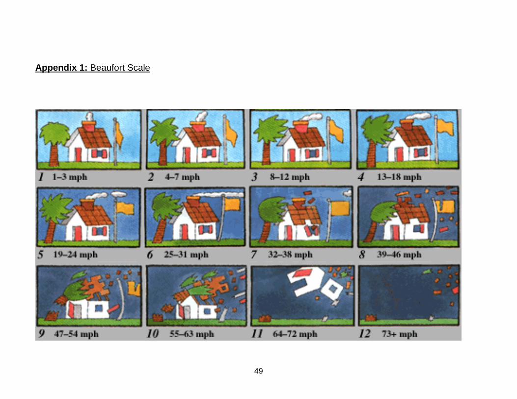
49
Appendix 1: Beaufort Scale
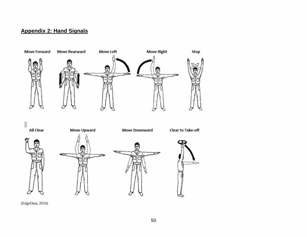
50
Appendix 2: Hand Signals
(EdgeData, 2016)

51
Appendix 3: Contingency Plan Checklist
Event Result Procedure
Battery Depletes Unmanned aerial system (UAS) incapable of
continuing flight operations
UAS return to base (RTB) as soon as practical; cease data collection
Ditch Procedures UAS incapable of continuing flight operations
Identify safe landing area; attempt a controlled landing; if able, land UAS in water
(shallow preferred for ease of recovery) away from public
Fuel Depletes UAS incapable of continuing flight operations UAS RTB as soon as practical; cease data collection
Hazardous Weather UAS incapable of continuing flight operations UAS RTB as soon as practical; cease data collection
Hostile Environment Mission impacted by hazard (e.g. air traffic,
public activity
See and avoid; take evasive action as required with safety taking precedence; UAS
RTB as soon as practical
Loss of
Communications
Mission impacted by lack of communications
hazard
Maintain visual line of sight (VLOS); take evasive action as required with safety
taking precedence; UAS RTB as soon as practical
Loss of Control
Signal
UAS not controllable Maintain VLOS; UAS RTB and land without harm to UAS or contacting
surrounding objects
Loss of Direct Visual UAS could become hazard if unable to regain
visual control
Regain direct visual of UAS; contact mission payload operator and/or visual
observer to determine status
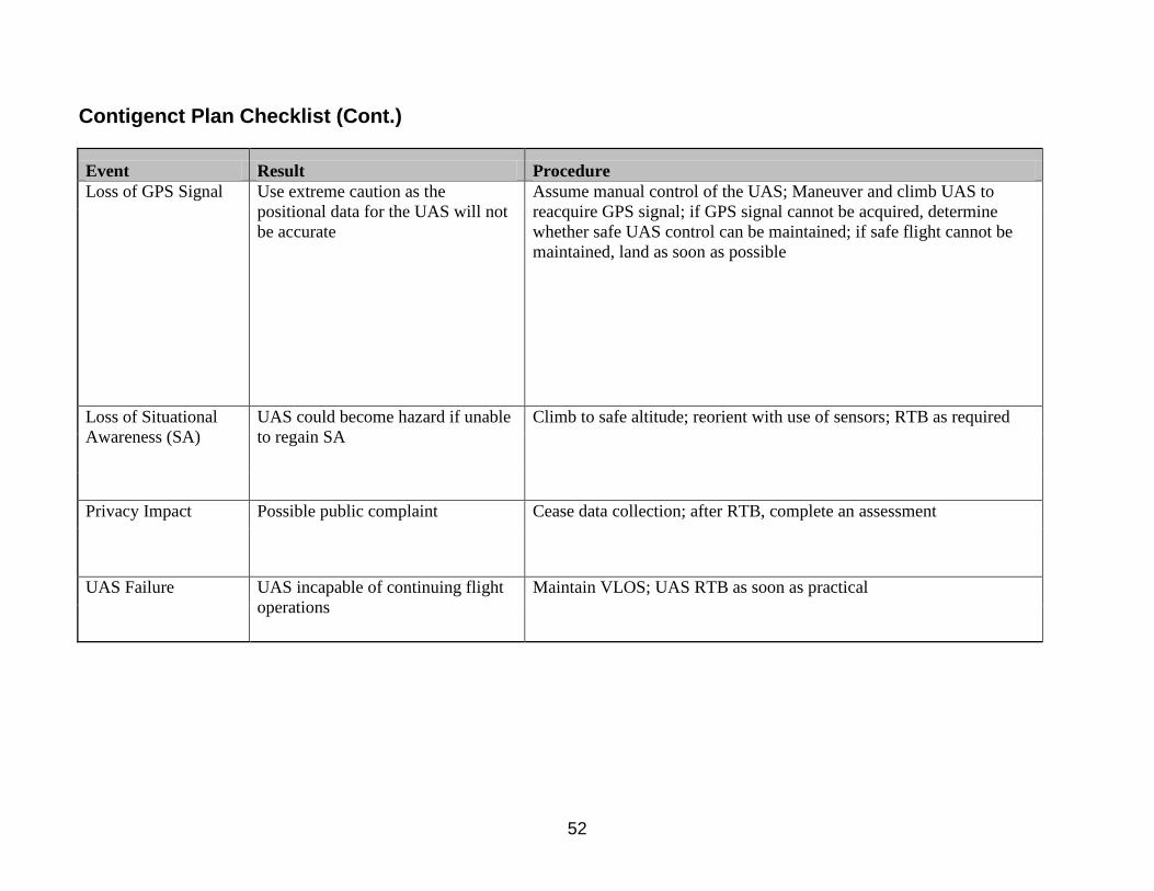
52
Contigenct Plan Checklist (Cont.)
Event Result Procedure
Loss of GPS Signal Use extreme caution as the
positional data for the UAS will not
be accurate
Assume manual control of the UAS; Maneuver and climb UAS to
reacquire GPS signal; if GPS signal cannot be acquired, determine
whether safe UAS control can be maintained; if safe flight cannot be
maintained, land as soon as possible
Loss of Situational
Awareness (SA)
UAS could become hazard if unable
to regain SA
Climb to safe altitude; reorient with use of sensors; RTB as required
Privacy Impact Possible public complaint Cease data collection; after RTB, complete an assessment
UAS Failure UAS incapable of continuing flight
operations
Maintain VLOS; UAS RTB as soon as practical
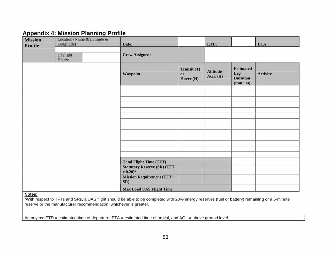
53
Appendix 4: Mission Planning Profile Mission
Profile
Location (Name & Latitude &
Longitude) Date: ETD: ETA:
Crew Assigned:
Daylight
Hours:
Waypoint
Transit (T)
or
Hover (H)
Altitude
AGL (ft)
Estimated
Leg
Duration
(mm : ss)
Activity
Total Flight Time (TFT)
Statutory Reserve (SR) (TFT
x 0.20)ᵃ
Mission Requirement (TFT +
SR)
Max Load UAS Flight Time
Notes:
ᵃWith respect to TFTs and SRs, a UAS flight should be able to be completed with 20% energy reserves (fuel or battery) remaining or a 5-minute
reserve or the manufacturer recommendation, whichever is greater.
Acronyms: ETD = estimated time of departure, ETA = estimated time of arrival, and AGL = above ground level.
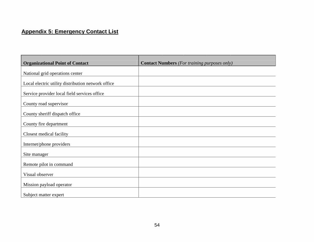
54
Appendix 5: Emergency Contact List
Organizational Point of Contact Contact Numbers (For training purposes only)
National grid operations center
Local electric utility distribution network office
Service provider local field services office
County road supervisor
County sheriff dispatch office
County fire department
Closest medical facility
Internet/phone providers
Site manager
Remote pilot in command
Visual observer
Mission payload operator
Subject matter expert