university of groningen geographically constrained ... fileuniversity of groningen geographically...
TRANSCRIPT

University of Groningen
Geographically constrained information retrievalAndogah, Geoffrey
IMPORTANT NOTE: You are advised to consult the publisher's version (publisher's PDF) if you wish to cite fromit. Please check the document version below.
Document VersionPublisher's PDF, also known as Version of record
Publication date:2010
Link to publication in University of Groningen/UMCG research database
Citation for published version (APA):Andogah, G. (2010). Geographically constrained information retrieval. Groningen: s.n.
CopyrightOther than for strictly personal use, it is not permitted to download or to forward/distribute the text or part of it without the consent of theauthor(s) and/or copyright holder(s), unless the work is under an open content license (like Creative Commons).
Take-down policyIf you believe that this document breaches copyright please contact us providing details, and we will remove access to the work immediatelyand investigate your claim.
Downloaded from the University of Groningen/UMCG research database (Pure): http://www.rug.nl/research/portal. For technical reasons thenumber of authors shown on this cover page is limited to 10 maximum.
Download date: 21-06-2019
Geographically Constrained Information
Retrieval
Geoffrey Andogah

ii
CLCGCenter for Language and Cognition Groningen
The work in this thesis has been carried out under the auspices of the Centerfor Language and Cognition Groningen (CLCG) with funding from NufficProject NPT/UGA/132 on “Building Sustainable ICT Training Capacity inthe Public Universities in Uganda”.
Groningen Dissertations in Linguistics 79ISSN 0928-0030©2010 Geoffrey AndogahISBN 978-90-367-4309-9
Cover design by: Peter KleiwegPrinted by Wohrmann Print Service, Zutphen, Netherlands.Document prepared with LATEX2ε using Stasinos Konstantopoulos’ RuGth-esis.cls.
Rijksuniversiteit Groningen
Geographically Constrained Information Retrieval
Proefschrift
ter verkrijging van het doctoraat in deWiskunde en Natuurwetenschappenaan de Rijksuniversiteit Groningen
op gezag van deRector Magnificus, dr. F. Zwarts,in het openbaar te verdedigen op
vrijdag 21 mei 2010om 14:45 uur
door
Geoffrey Andogah
geboren op 7 december 1968te Kampala, Uganda

Promotor: Prof. dr. ir. J. Nerbonne
Copromotor: Dr. G. Bouma
Beoordelingscommissie: Prof. dr. V. BaryamureebaProf. dr. F. de JongProf. dr. H. Sol

To God the Father, God the Son and God the Holy Spirit.
v

vi

Preface
I am honoured to thank all the people who directly or indirectly contributedto the realization of this thesis. Indeed I will not remember everyone of youwho helped me in one-way or another to achieve what I have reported inthis thesis. The one thing that I can promise you is that God Almighty, theFather of our Lord Jesus Christ knows you, and remembers your contributiontoward this thesis, and will indeed reward you abundantly.
This thesis would not have been possible without the encouragement,leadership and support of my promoter Prof. dr. ir. John Nerbonne, andco-promoter and supervisor Dr. Gosse Bouma. Thank you Prof. John andDr. Gosse for your patience to ensure that this thesis is completed. John, Ivividly remember the day you introduced me to Dutch soup, I will continueto enjoy it.
I am indebted to fellow PhD students at CLCG for the support andencouragement – Lonneke van der Plas, Jori Mur, Ismael Fahmi and JackyBenavides. I am also grateful to Wyke van der Meer for taking care of all thepractical stuff at CLCG. I want to say thank you to every member of staffof CLCG for your cooperation – Dr. Gertjan van Noord, Dr. Elwin Koster,Dr. Leonie Bosveld-de Smet, Drs. Peter Kleiweg.
It is a pleasure to thank the people at the International Bureau for takingcare of all the practical issues during my stay at Groningen – Erik Haarbrink,Gonny Lakerveld and Marieke Farchi.
I am deeply grateful to the members of the reading committee for theircritical and positive comments – Prof. dr. Venansius Baryamureeba, Prof.dr. Franciska de Jong and Prof. dr. Henk Sol. I am solely responsible forany error still lingering in this dissertation.
I thank my paranymphs Jelena Prokic and Peter Nabende for acceptingto stand by me. I am especially indebted to Jelena Prokic for making surethat all the paper work is completed for my defence.
I am indebted to Prof. dr. J.H. Nyeko Pen-Mogi, the Vice Chancellorof Gulu University for swaying me to pursue PhD studies way back in 2003.Thank you for sowing the seed of determination and courage in me to venture
vii

viii
into unknown territories.I am grateful to Prof. dr. Venansius Baryamureeba for making available
space to conduct my research at the Faculty of Computing and Informatics(FCI), Makerere University. I indeed enjoyed the company of FCI staff, notforgetting the wonderful meals at FCI.
I enjoyed the company of fellow PhD/Masters students at Groningensponsored under NPT Project NPT/UGA/132 on ‘Building a SustainableICT Training Capacity in four (4) Public Universities in Uganda’ – FlorenceTushabe, Julianne Sansa Otim and Proscovia Olango.
I also acknowledge the contribution of CLEF to this work by providingdataset and forum to evaluate our GIR system.
My sincere gratitude goes to the pastoral team and members of the RCCG– Embassy of God Groningen. Thank you for spiritual guidance and comfortyou accorded me at Church.
My deepest thanks and love goes to my dear wife Annastazia NicodemusChengulla for being supportive over the years. Your prayers, kindness andlove kept me going in times when things are at standstill. I am also indebtedto my children Glory Rong Babua, Samuel Godwill Babua and Victoria PeaceBabua for those questions I could not respond to knowing that I will be awayfor awhile – Dad are you coming back?
My gratitude also goes to my parents Stephen Babua and MargaretNguju; uncle Michael E. Nguma, brothers Edemah Fredrick and Alile Roland;and sisters Adiru Lydia and Robinah Angucia.
Contents
1 The thesis 11.1 Geographical information retrieval . . . . . . . . . . . . . . . . 21.2 Research . . . . . . . . . . . . . . . . . . . . . . . . . . . . . . 4
1.2.1 Problem statement . . . . . . . . . . . . . . . . . . . . 41.2.2 Research objective . . . . . . . . . . . . . . . . . . . . 51.2.3 Research justification . . . . . . . . . . . . . . . . . . . 61.2.4 Contribution . . . . . . . . . . . . . . . . . . . . . . . 7
1.3 Overview . . . . . . . . . . . . . . . . . . . . . . . . . . . . . . 9
2 State-of-the-art in GIR 112.1 Toponym resolution . . . . . . . . . . . . . . . . . . . . . . . . 12
2.1.1 Default sense heuristics . . . . . . . . . . . . . . . . . . 122.1.2 Pattern matching and hierarchy overlap . . . . . . . . 132.1.3 One referent per discourse . . . . . . . . . . . . . . . . 142.1.4 Summary . . . . . . . . . . . . . . . . . . . . . . . . . 14
2.2 Scope resolution . . . . . . . . . . . . . . . . . . . . . . . . . . 162.2.1 Country scope . . . . . . . . . . . . . . . . . . . . . . . 162.2.2 A graph ranking algorithm . . . . . . . . . . . . . . . . 162.2.3 Taxonomy hierarchy . . . . . . . . . . . . . . . . . . . 172.2.4 Geographical distribution . . . . . . . . . . . . . . . . 182.2.5 Summary . . . . . . . . . . . . . . . . . . . . . . . . . 19
2.3 Query Expansion . . . . . . . . . . . . . . . . . . . . . . . . . 202.3.1 Knowledge-based expansion . . . . . . . . . . . . . . . 202.3.2 Relevance feedback expansion . . . . . . . . . . . . . . 212.3.3 Document geographic term expansion . . . . . . . . . . 222.3.4 Summary . . . . . . . . . . . . . . . . . . . . . . . . . 23
2.4 Relevance ranking . . . . . . . . . . . . . . . . . . . . . . . . . 232.4.1 Euclidean distance . . . . . . . . . . . . . . . . . . . . 232.4.2 Extent of overlap . . . . . . . . . . . . . . . . . . . . . 232.4.3 Containment relations . . . . . . . . . . . . . . . . . . 242.4.4 Query footprint as filter . . . . . . . . . . . . . . . . . 24
ix

x CONTENTS
2.4.5 Geographic scope indexing . . . . . . . . . . . . . . . . 242.4.6 Other criteria . . . . . . . . . . . . . . . . . . . . . . . 242.4.7 Summary . . . . . . . . . . . . . . . . . . . . . . . . . 25
2.5 Conclusion . . . . . . . . . . . . . . . . . . . . . . . . . . . . . 25
3 Data and tools 273.1 Geographical database . . . . . . . . . . . . . . . . . . . . . . 27
3.1.1 Geonames.org database . . . . . . . . . . . . . . . . . . 283.1.2 Other GeoDBs . . . . . . . . . . . . . . . . . . . . . . 29
3.2 Corpus . . . . . . . . . . . . . . . . . . . . . . . . . . . . . . . 313.2.1 TR-CLEF . . . . . . . . . . . . . . . . . . . . . . . . . 313.2.2 TR-RNW . . . . . . . . . . . . . . . . . . . . . . . . . 383.2.3 Other collections . . . . . . . . . . . . . . . . . . . . . 41
3.3 Tools . . . . . . . . . . . . . . . . . . . . . . . . . . . . . . . . 443.3.1 Alias-i Lingpipe . . . . . . . . . . . . . . . . . . . . . . 453.3.2 OpenNLP tools . . . . . . . . . . . . . . . . . . . . . . 473.3.3 WordFreak . . . . . . . . . . . . . . . . . . . . . . . . . 473.3.4 GATE ANNIE . . . . . . . . . . . . . . . . . . . . . . 473.3.5 Apache UIMA . . . . . . . . . . . . . . . . . . . . . . . 47
3.4 Conclusion . . . . . . . . . . . . . . . . . . . . . . . . . . . . . 47
4 Scope resolution 494.1 Resolution with place names . . . . . . . . . . . . . . . . . . . 50
4.1.1 Approach . . . . . . . . . . . . . . . . . . . . . . . . . 514.1.2 Reference scope . . . . . . . . . . . . . . . . . . . . . . 604.1.3 Implementation . . . . . . . . . . . . . . . . . . . . . . 64
4.2 Resolution with person names . . . . . . . . . . . . . . . . . . 724.2.1 Person name ambiguity resolution . . . . . . . . . . . . 764.2.2 Approach . . . . . . . . . . . . . . . . . . . . . . . . . 784.2.3 Implementation . . . . . . . . . . . . . . . . . . . . . . 81
4.3 Evaluation metric . . . . . . . . . . . . . . . . . . . . . . . . . 864.4 Evaluation . . . . . . . . . . . . . . . . . . . . . . . . . . . . . 87
4.4.1 Evaluating place name based strategy . . . . . . . . . . 884.4.2 Evaluating person name based strategy . . . . . . . . . 90
4.5 Conclusion . . . . . . . . . . . . . . . . . . . . . . . . . . . . . 93
5 Toponym resolution 955.1 Toponym resolution procedure . . . . . . . . . . . . . . . . . . 975.2 Evaluation metric . . . . . . . . . . . . . . . . . . . . . . . . . 1035.3 Evaluation . . . . . . . . . . . . . . . . . . . . . . . . . . . . . 1095.4 The big picture . . . . . . . . . . . . . . . . . . . . . . . . . . 113
CONTENTS xi
5.5 Conclusion . . . . . . . . . . . . . . . . . . . . . . . . . . . . . 114
6 Query expansion 117
6.1 Document processing . . . . . . . . . . . . . . . . . . . . . . . 118
6.2 Query expansion . . . . . . . . . . . . . . . . . . . . . . . . . 118
6.2.1 Top term-based expansion . . . . . . . . . . . . . . . . 121
6.2.2 Scope constrained expansion . . . . . . . . . . . . . . . 122
6.2.3 Query expansion evaluation . . . . . . . . . . . . . . . 124
6.3 Conclusion . . . . . . . . . . . . . . . . . . . . . . . . . . . . . 132
7 Relevance ranking 135
7.1 Non-geographic relevance measure . . . . . . . . . . . . . . . . 136
7.2 Scope-based relevance measure . . . . . . . . . . . . . . . . . . 136
7.3 Type-based relevance measure . . . . . . . . . . . . . . . . . . 137
7.4 Relevance measure unification . . . . . . . . . . . . . . . . . . 140
7.4.1 Linear interpolated combination . . . . . . . . . . . . . 140
7.4.2 Weighted harmonic mean combination . . . . . . . . . 140
7.4.3 Extended harmonic mean combination . . . . . . . . . 141
7.5 Evaluation . . . . . . . . . . . . . . . . . . . . . . . . . . . . . 141
7.5.1 Harmonic mean vs. linear interpolated combination . . 142
7.5.2 Extended harmonic mean combination . . . . . . . . . 144
7.6 Conclusion . . . . . . . . . . . . . . . . . . . . . . . . . . . . . 147
8 Conclusion 149
8.1 Achievements . . . . . . . . . . . . . . . . . . . . . . . . . . . 149
8.1.1 Scope resolution . . . . . . . . . . . . . . . . . . . . . . 150
8.1.2 Toponym resolution . . . . . . . . . . . . . . . . . . . . 151
8.1.3 Query expansion . . . . . . . . . . . . . . . . . . . . . 152
8.1.4 Relevance ranking . . . . . . . . . . . . . . . . . . . . . 153
8.1.5 Evaluation data . . . . . . . . . . . . . . . . . . . . . . 154
8.1.6 Reflection . . . . . . . . . . . . . . . . . . . . . . . . . 154
8.2 Future work . . . . . . . . . . . . . . . . . . . . . . . . . . . . 155
8.2.1 Scope resolution . . . . . . . . . . . . . . . . . . . . . . 155
8.2.2 Toponym resolution . . . . . . . . . . . . . . . . . . . . 156
8.2.3 Query expansion . . . . . . . . . . . . . . . . . . . . . 156
8.2.4 Relevance ranking . . . . . . . . . . . . . . . . . . . . . 157
8.2.5 Evaluation data . . . . . . . . . . . . . . . . . . . . . . 157
8.3 Final remark . . . . . . . . . . . . . . . . . . . . . . . . . . . 157
xii CONTENTS
A Sample stories 159A.1 News story about Mexico . . . . . . . . . . . . . . . . . . . . . 159A.2 News story about Thailand . . . . . . . . . . . . . . . . . . . 160A.3 News story about Lake Victoria . . . . . . . . . . . . . . . . . 161
B GeoCLEF topics 163B.1 GeoCLEF 2005 English topic titles . . . . . . . . . . . . . . . 163B.2 GeoCLEF 2006 English topic titles . . . . . . . . . . . . . . . 164B.3 GeoCLEF 2007 English topic titles . . . . . . . . . . . . . . . 165
Bibliography 167
Summary 177
Samenvatting 181
List of Figures
1.1 Common GIR processing procedure. . . . . . . . . . . . . . . . 31.2 Schematic of the research objectives. . . . . . . . . . . . . . . 6
2.1 Example taxonomy of places. . . . . . . . . . . . . . . . . . . 12
3.1 Schematic of the Geonames.org feature code hierarchy. . . . . 283.2 Potential ambiguity in GeoCLEF 2006 relevant documents. . . 363.3 Map showing the result of toponym resolution. . . . . . . . . . 393.4 Sample of a GeoCLEF document. . . . . . . . . . . . . . . . . 403.5 Sample of RNW story. . . . . . . . . . . . . . . . . . . . . . . 423.6 Example output of Alias-i’s LingPipe NLP tool. . . . . . . . . 46
4.1 Geographic terms in articles appendix A.1, A.2 and A.3. . . . 524.2 Geographical scopes of article A.1 (top) and A.2 (bottom). . . 534.3 Scope of plane crash in Lake Victoria in March 2009. . . . . . 544.4 Data model for geographical scope modeling. . . . . . . . . . . 564.5 Sample data model for scope of the Netherlands. . . . . . . . . 574.6 Directional sub-division of the Netherlands. . . . . . . . . . . 614.7 Example U.S.A & Canada GeoVIP grouping. . . . . . . . . . . 794.8 News story featuring Hillary Clinton and Stockwell Day. . . . 834.9 place name based scope resolution performance. . . . . . . . . 894.10 Sample pseudo documents. . . . . . . . . . . . . . . . . . . . . 914.11 VIP based resolution performance on pseudo document. . . . . 92
5.1 Toponym resolution schematic. . . . . . . . . . . . . . . . . . 965.2 Toponym resolution algorithm. . . . . . . . . . . . . . . . . . 985.3 Nearness to correct location. . . . . . . . . . . . . . . . . . . . 1045.4 Example hierarchy structure. . . . . . . . . . . . . . . . . . . . 1055.5 Sample Geonames.org feature code hierarchy. . . . . . . . . . . 1085.6 Mahali system architecture. . . . . . . . . . . . . . . . . . . . 114
6.1 Radio Netherlands Worldwide (RNW) summary. . . . . . . . . 1196.2 Schematic of scope constrained relevance feedback procedure. . 123
xiii
xiv LIST OF FIGURES
6.3 Sample scope hierarchy for Groningen and Rotterdam. . . . . 1246.4 GeoCLEF 2007 topic and pre-processed format. . . . . . . . . 1256.5 Interpolated recall vs precision average. . . . . . . . . . . . . . 1266.6 Performance of term-based query expansion procedure. . . . . 1286.7 Performance of scope-based query expansion procedure. . . . . 1306.8 Topic performance on residual collection. . . . . . . . . . . . . 131
7.1 Sample Geonames.org feature code hierarchy. . . . . . . . . . . 1387.2 Sample documents with geographic feature classes and types. . 1397.3 Variation of MAP as a factor of NIF λT . . . . . . . . . . . . . 1437.4 Variation of MAP as a factor of RIF β. . . . . . . . . . . . . . 1447.5 Variation of MAP as a function of RIF β. . . . . . . . . . . . 1467.6 GeoCLEF 2007 per topic performance. . . . . . . . . . . . . . 146
List of Tables
1.1 Sample keywords with geographical interest of Groningen . . . 7
2.1 Toponym resolution techniques in literature. . . . . . . . . . . 152.2 Scope resolution techniques in literature. . . . . . . . . . . . . 19
3.1 Geonames.org feature classification. . . . . . . . . . . . . . . . 293.2 Geonames.org feature statistics per classification. . . . . . . . 303.3 Example Geonames.org feature code. . . . . . . . . . . . . . . 303.4 Example Geonames.org database structure (as used in here). . 303.5 English monolingual GeoCLEF relevant document counts. . . 323.6 GeoCLEF 2006 topic. . . . . . . . . . . . . . . . . . . . . . . . 343.7 GeoCLEF 2006 relevant document characteristic. . . . . . . . 353.8 Fifteen most frequent and least frequent toponyms. . . . . . . 353.9 Inter-annotator agreement. . . . . . . . . . . . . . . . . . . . . 373.10 Inter-annotator agreement per feature types. . . . . . . . . . . 373.11 TR-RNW corpus characteristic. . . . . . . . . . . . . . . . . . 413.12 TR-RNW fifteen most frequent and least frequent toponyms. . 433.13 TR-CoNLL & TR-MUC4 corpus characteristic. . . . . . . . . 443.14 Named entity types defined in Chinchor (1997). . . . . . . . . 44
4.1 Zone index for the sample Netherlands scope data in Fig. 4.5. 594.2 Statistics of standard geographic scope. . . . . . . . . . . . . . 634.3 Example Lucene index for scope Europe. . . . . . . . . . . . . 674.4 Example Lucene index for scope the Netherlands. . . . . . . . 684.5 Reference scope data layout in Lucene index. . . . . . . . . . . 694.6 Place type and population weights. . . . . . . . . . . . . . . . 724.7 Place and people adjective occurrence on the Internet. . . . . 734.8 Example query formulation for per field querying. . . . . . . . 744.9 Example administrative division vs. position. . . . . . . . . . 754.10 Top ten surnames and first names in Wikipedia. . . . . . . . . 774.11 Example GeoVIP data for U.S.A. . . . . . . . . . . . . . . . . 804.12 Example GeoVIP sample data for Canada. . . . . . . . . . . . 81
xv

xvi LIST OF TABLES
4.13 Person name weight computation for VIPs in Fig. 4.8. . . . . . 824.14 Example scope resolution using VIP names in Fig. 4.8. . . . . 824.15 Example country scope Lucene index data source. . . . . . . . 844.16 Example district scope Lucene index data source. . . . . . . . 844.17 Fictitious sample data to illustrate metric performance. . . . . 874.18 CoNLL 2003 place name statistics. . . . . . . . . . . . . . . . 884.19 Scope resolution result using Eq. 4.12 and Eq. 4.13. . . . . . . 884.20 Results of PageRank and HITS on Reuters-21578 . . . . . . . 904.21 Performance of VIP based approach on news articles. . . . . . 92
5.1 Characteristics of TR-CoNLL, TR-CLEF & TR-RNW. . . . . 1095.2 Toponym resolution results on TR-CoNLL. . . . . . . . . . . . 1115.3 Toponym resolution results on TR-RNW and TR-CLEF. . . . 113
6.1 Query place name expansion illustration with Eq. 6.1. . . . . . 1226.2 Summary of term based relevance feedback evaluation. . . . . 1276.3 Result of term-based approach using relevant documents. . . . 1296.4 Summary of scope-based relevance feedback evaluation. . . . . 1296.5 Summary of feedback evaluation on residual collection. . . . . 132
7.1 Example topic grouping and query formulation . . . . . . . . . 1427.2 Comparison to GeoCLEF 2007 participants. . . . . . . . . . . 145

Chapter 1
The thesis
For every house is built by someone,
but He who built all things is God.
Hebrew 3:4(The New King James Version)
Information retrieval (IR) is the task of finding documents (usually an un-structured text) that satisfy an information need from within a large collec-tion (usually on a local computer system or the Internet) (Manning et al.,2007). Advancement in computer technology has revolutionized informationgeneration, storage and retrieval. Millions of documents are being generatedand stored daily on computers distributed across the global. Advancement incomputer network technology has made it possible for millions of people toaccess these documents from within their personal computing systems. TheInternet is the main gateway to information stored on networked computersystems across the globe. By September 30, 2009 the estimated populationof the Internet users was a staggering 1.7 million people. 1 The emergence ofthe so-called globe community is generating an enormous hunger for infor-mation about foreign places. To access information across the globe, a largepercentage of the Internet users use search engines such as Google, Yahoo,Bing, Baidu, etc.
The current state-of-the-art search engines model document contents asbags-of-words consisting of words extracted from the documents. Little orno attention is paid to the document’s syntactic and semantic structure.Moreover, majority of information seekers formulate short simplistic queriesconsisting of two words on average (Spink et al., 2001). But there is a need
1[05 December 2009]: http://www.internetworldstats.com/stats.htm
1

2 Chapter 1. The thesis
for the retrieval of semantically constrained information such as informationabout a particular locality, or in other words, for geographically constrainedinformation retrieval.
Eighteen percent of search queries to search engines on the Internet in-volve some kind of geographical orientation, e.g., find documents about “oildiscovery in Uganda” (Sanderson and Kohler, 2004). To satisfy these kindsof user information needs, both the non-geographical (i.e., thematic) aspectand geographical aspect of documents need consideration. This is the sphereof a novel information retrieval task known as Geographical Information Re-trieval (Gey et al., 2006) which considers both the thematic and geographicalaspects of the query and the documents being sought to meet the seekers’information need. The motivating argument for Geographical InformationRetrieval (GIR) is that the geographical information contained in the queriesand documents may be especially important to retrieve, prioritize and visu-alize search results.
This introductory chapter introduces the major constituencies of a stan-dard geographical information retrieval system before spelling out this thesis’specific research area. Figure 1.1 shows the general processing procedure fol-lowed in geographical information retrieval task.
1.1 Geographical information retrieval
Geographical Information Retrieval (GIR) is Information Retrieval (IR) withgeographical awareness added. It is poised to answers questions about thefollowing sorts of matters (Gey et al., 2007): (1) non-geographic subjects re-stricted to a place (e.g., music festivals in Germany); (2) geographic subjectswith non-geographic restrictions (e.g., rivers with vineyards); (3) geographicsubjects restricted to a place (e.g., cities in Germany); (4) non-geographicsubjects associated with a place (e.g., independence of Quebec); (5) non-geographic subjects that are a complex function of a place (e.g., Europeanfootball cup matches); (6) geographical relations among places (e.g., howare the Himalayas related to Nepal? Are they inside? Do the Himalayanmountains cross Nepal ’s borders?); (7) geographical relations among placesassociated with events (e.g., Did Waterloo occur further north than the battleof X? Were the findings of Lucy more to the south than those of the Cro-magnon in Spain?); and (8) relations between events which require a preciselocalization (e.g., Was it the same river that flooded last year and in whichkillings occurred in the XVth century?).
From these questions, we can identify four basic sorts of concepts rele-vant to geographically oriented questions (in addition to non-geographical
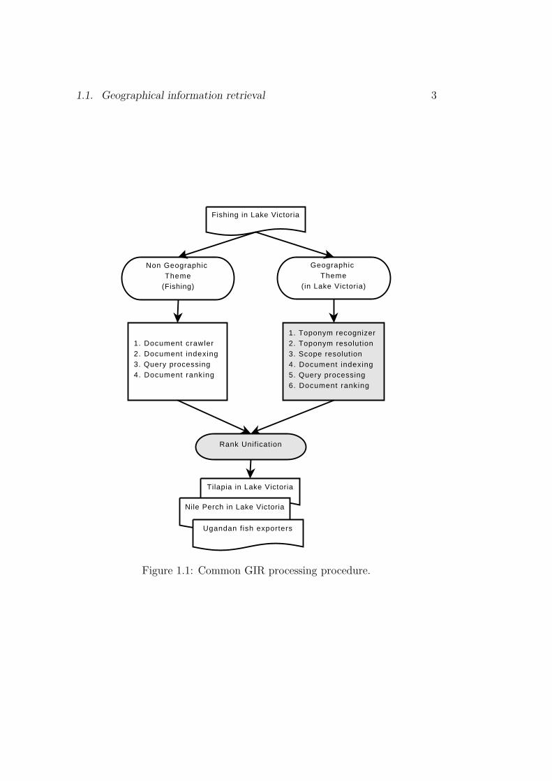
1.1. Geographical information retrieval 3
Geographic Theme
(in Lake Victoria)
Non Geographic Theme
(Fishing)
Fishing in Lake Victoria
1. Toponym recognizer2. Toponym resolution3. Scope resolution4. Document indexing5. Query processing6. Document ranking
1. Document crawler2. Document indexing3. Query processing4. Document ranking
Tilapia in Lake Victoria
Nile Perch in Lake Victoria
Ugandan fish exporters
Rank Unification
Figure 1.1: Common GIR processing procedure.

4 Chapter 1. The thesis
concepts), and these are: place-names (e.g., Germany, Quebec, Nepal, etc.),geographical relations (e.g., south, north, etc.), geographical concepts (e.g.,cities, rivers, etc.) and geographical adjectives (e.g., European, etc.). Thesegeographical terms participate in the definition of the geographical scopes ofdocuments and queries. However, besides these there are other terms thatare geographical in nature such as the names of people, the names of or-ganisations, etc. Documents and queries which do not mention geographicalterms explicitly can equally be considered to belong to a geographical scope.As a premise, it can be assumed that every document in a collectionand every search query issued to a search engine has a geograph-ical scope. Reasoning within a geographical scope domain could lead tocertain geographical information retrieval processes performing better. Forexample, toponym resolution, query expansion and relevance ranking pro-cedures could benefit from exploiting geographical scope information. Forthe work reported here geographical scope is the most important componentthat control the other objectives as shall be seen below. However, it shouldbe noted that this work is not the first to consider geographical scope as animportant concept to tackle geographical information retrieval problem (seealso Martins (2008)).
The initial phase of a geographical information retrieval system is to mineand/or analyse geographical information concealed in documents. The nextphase involves the use of the discovered information (i.e., the new knowledge)to build new models and concepts to aid in answering geographically motivateduser information needs.
1.2 Research
1.2.1 Problem statement
The assumption of this thesis is that every document in a collection and ev-ery search query issued to an information retrieval system has a geographicalscope. The thesis asks the question whether the geographical scopes of docu-ments and/or search queries can be exploited to improve information retrievalresults in terms of accuracy and relevance. Since the geographical scopes ofdocuments and search queries are not explicitly specified, they must be de-tected for intelligent exploitation by information retrieval systems. Most ofthis thesis elaborates on how geographical scopes can be detected automat-ically and how they can be exploited once detected for toponym resolution,query expansion and relevance ranking.

1.2. Research 5
1.2.2 Research objective
General objective
Analyse geographical information concealed in texts for geographical infor-mation retrieval tasks.
Specific objectives� Mining – Mine and/or analyse geographical information concealed intext.� Utilization – Utilize mined geographical knowledge to build new modelsand/or concepts to satisfy geographically motivated user informationneeds.
The two specific objectives are further split into subordinate objectives. Themining objective is split into toponym resolution and scope resolution objec-tives. The utilization objective is split into query expansion and relevanceranking objectives.
The scope resolution objective seeks to answer the following questions:� How can place names, geographical adjectives (i.e., adjectives referringto people and places) and names of people be used to automaticallydetermine the geographical scope(s) of documents? [Question of algo-rithm.]� How well do automatically determined geographical scopes of docu-ments compare to human assigned scopes? [Question of gold standardevaluation.]� How best can we compare the performance of scope resolution systems?[Question of binary vs. non-binary evaluation metric.]
The toponym resolution objective seeks to address the following concerns:� How effective is the document’s geographical scope(s) or coverage(s) inaiding the resolution of toponyms contained in the document or in otherwords, how effective is the document’s geographical scope in aiding thetoponym resolution process? [Question of heuristics.]� How best can we compare the performance of toponym resolution sys-tems? [Question of a binary vs. a non-binary evaluation metric; andthe question of reference evaluation corpora.]

6 Chapter 1. The thesis
toponym recognit ion scope resolution toponym resolut ion
relevance ranking
query expansion
document
Problem Statements
evaluation
1
2
3
43
3
3
4
Figure 1.2: Schematic of the research objectives.
The query expansion objective seeks to answer the following questions:� How effective is relevance feedback for the geographical informationretrieval task?� How effective is a scope-controlled toponym selection scheme in therelevance feedback procedure?
The relevance ranking objective seeks to answer the following question:� How well can geographical scope and feature type information be in-corporated in the document ranking procedure to prioritize documentsby geography.
Figure 1.2 shows the interaction among the objectives to answer the ques-tions raised in this thesis. The scope resolution objective is the heart of theproblem-solving strategy investigated in this work. How well the scope res-olution objective is answered determines how well the other objectives areanswered. The scope resolution objective influences the toponym resolutionobjective, the query expansion objective and the relevance ranking objective.
1.2.3 Research justification
There are two main justifications for research in geographical informationretrieval (GIR) – (1) infancy of GIR, and (2) user demand for geographicalintelligence in conventional search engines.
1.2. Research 7
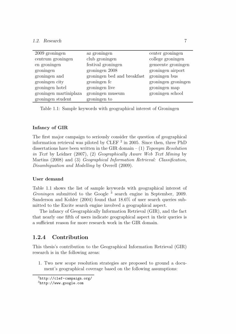
2009 groningen az groningen center groningencentrum groningen club groningen college groningenen groningen festival groningen gemeente groningengroningen groningen 2008 groningen airportgroningen and groningen bed and breakfast groningen busgroningen city groningen fc groningen groningengroningen hotel groningen live groningen mapgroningen martiniplaza groningen museum groningen schoolgroningen student groningen to
Table 1.1: Sample keywords with geographical interest of Groningen
Infancy of GIR
The first major campaign to seriously consider the question of geographicalinformation retrieval was piloted by CLEF 2 in 2005. Since then, three PhDdissertations have been written in the GIR domain – (1) Toponym Resolutionin Text by Leidner (2007), (2) Geographically Aware Web Text Mining byMartins (2008) and (3) Geographical Information Retrieval: Classification,Disambiguation and Modelling by Overell (2009).
User demand
Table 1.1 shows the list of sample keywords with geographical interest ofGroningen submitted to the Google 3 search engine in September, 2009.Sanderson and Kohler (2004) found that 18.6% of user search queries sub-mitted to the Excite search engine involved a geographical aspect.
The infancy of Geographically Information Retrieval (GIR), and the factthat nearly one fifth of users indicate geographical aspect in their queries isa sufficient reason for more research work in the GIR domain.
1.2.4 Contribution
This thesis’s contribution to the Geographical Information Retrieval (GIR)research is in the following areas:
1. Two new scope resolution strategies are proposed to ground a docu-ment’s geographical coverage based on the following assumptions:
2http://clef-campaign.org/3http://www.google.com
8 Chapter 1. The thesis� Places of the same type or under the same administrative jurisdic-tion or adjacent-to each other are more likely to be mentioned ina given discourse unit. For example, a discourse mentioning theNetherlands is more likely to mention places of the type country(e.g., United Kingdom, Uganda) or places under the jurisdiction ofthe Netherlands (e.g., Amsterdam, Rotterdam) or places adjacentto the Netherlands (e.g., Belgium, Germany).� VIPs (i.e., political leadership) in the same geographical regionor at the same leadership hierarchy level tend to be mentionedtogether in a unit of a discourse. That is, presidents are mostlikely to be mentioned together with the members of their ad-ministration or with presidents of other countries in a unit of adiscourse. For example, US President Barack Obama is most likelyto be mentioned in a discourse together with US Vice PresidentJoe Biden or President Yoweri Kaguta Museveni of Uganda in adiscourse.
2. A new strategy that defines and model geographical scopes as a kindof document, and then uses a standard search engine library to indexand search against the scope documents.
3. A new evaluation metric for the scope resolution task. The metric pro-vides a smoother scheme than the binary scheme by weighting smalldiscrepancies between systems. The metric incorporates the rank posi-tion information of all the correct scopes (in the result list) to evaluatesystems.
4. A new toponym resolution scheme grounded on the geographical scopesassigned to documents. Other features considered in the computationare the place types (e.g., city, mountain, etc.), classification of place(e.g., administrative unit, vegetation, etc.), population size, and fre-quency of non-ambiguous or resolved places.
5. A new set of evaluation metrics for the toponym resolution task. Themetrics incorporate the following features in their calculations: (1) thenumber of candidate places for a given reference, (2) the number ofregions to traverse from the system resolved referent to the correct goldstandard referent, and (3) the number of feature classes transversedfrom the system resolved referent type to the correct gold standardreferent type.
6. A new scope-controlled toponym selection scheme for relevance feed-back. The scheme selects toponyms to add to feedback query according

1.3. Overview 9
to: scope-based(toponyms) = {M ⊆ S}, where, M are the commonlyoccurring place names in the relevant documents and S the commonlyshared scopes among the relevant documents.
7. A new relevance ranking metric that exploits a ranked list of geograph-ical scopes assigned to query and documents. The non-geographic andgeographic relevance scores are combined through a linear interpolationand, alternatively, using a weighted harmonic-mean. The harmonicmean-based combination achieved a better performance than linear in-terpolation. A better performance is observed when the importanceattached to the non-geographical retrieval outweighs importance at-tached to the geographical retrieval.
All the components developed in the course of this work form the Mahalisystem. Mahali is a Kiswahili word meaning place.
1.3 Overview
This section gives an overview of the remaining chapters in this dissertation.Chapter 2 presents an overview of the state-of-the-art on geographical
information retrieval techniques in the literature. This ranges from toponymresolution, scope resolution, query expansion to relevance ranking strategies.
Chapter 3 describes the dataset and tools used to evaluate and implementvarious components of the Mahali system development in this work. Thefollowing datasets are described: TR-CoNLL, TR-CLEF and TR-RNW. Thetools described are the named entity recognition (NER) tools. The Alias-iLingpipe used to perform toponym recognition task is briefly described.
Chapter 4 describes the strategies proposed to handle the scope resolutionproblems. The strategies are grounded on two assumptions, that, (1) placesof the same type or under the same administrative jurisdiction or adjacent-to each other are more likely to be mentioned in a given discourse unit; (2)VIPs (i.e., political leadership) in the same geographical region or at thesame leadership hierarchy level tend to be mentioned together in a unit of adiscourse.
Chapter 5 describes a new strategy to address the problem of toponymresolution. The toponym resolution technique described exploits the geo-graphical scopes assigned to documents, place types (e.g., city, mountain,etc.), classification of place (e.g., administrative unit, vegetation, etc.), pop-ulation size, and frequency of non-ambiguous or resolved places to accomplishthe task of resolving an ambiguous place name to the location it refers to onthe surface of the earth. A novel metric to evaluate the toponym resolution

10 Chapter 1. The thesis
task is described as well. The metric is based on the argument that thenumber of candidate places, and closeness to the correct referent need to befactored when evaluating toponym resolution systems.
Chapters 6 and 7 describe utilization of geographical information minedin Chapters 4 and 5 for query expansion and relevance ranking. The queryexpansion investigates the application of relevance feedback (i.e., blind andexplicit feedback) procedures to improve retrieval by adding place namesfound in relevant documents. The relevance ranking schemes discussed ex-ploits the geographical scopes and feature types in documents and searchqueries to rank documents by geography.
Chapter 8 gives the summary of the work done in this thesis, and proposesareas that require more research in relation to what is accomplished in thisthesis.
Chapter 2
State-of-the-art in GIR
The words of the wise are like goads,
and the words of scholars are like well
driven nails, given by one Shepherd.
Ecclesiastes 12:11(The New King James Version)
Geographical Information Retrieval (GIR) concerns the retrieval of in-formation involving some kind of spatial awareness. The GIR communityrecently identified a number of themes deemed relevant to tackle challengesfacing the implementation of geographically intelligent information retrievalsystems (Jones and Purves, 2006; Mandl et al., 2007). This chapter reviewsthe state-of-the-art in some of the themes in relation to this thesis. Thethemes reviewed in this chapter include geographical scope resolution, to-ponym resolution, query processing and relevance ranking. The technologiesused to implement GIR, to validate its concepts and its hypotheses are brieflydescribed as well. To surmise, the objectives of this chapter are:� Review toponym resolution strategies in the literature.� Review geographical scope resolution strategies in the literature.� Review geographical query expansion strategies in the literature.� Review geographical relevance ranking strategies in the literature.� Reformulate or propose new strategies from existing strategies to ad-
dress the problem of toponym resolution, scope resolution, query ex-pansion and relevance ranking.
11
12 Chapter 2. State-of-the-art in GIR
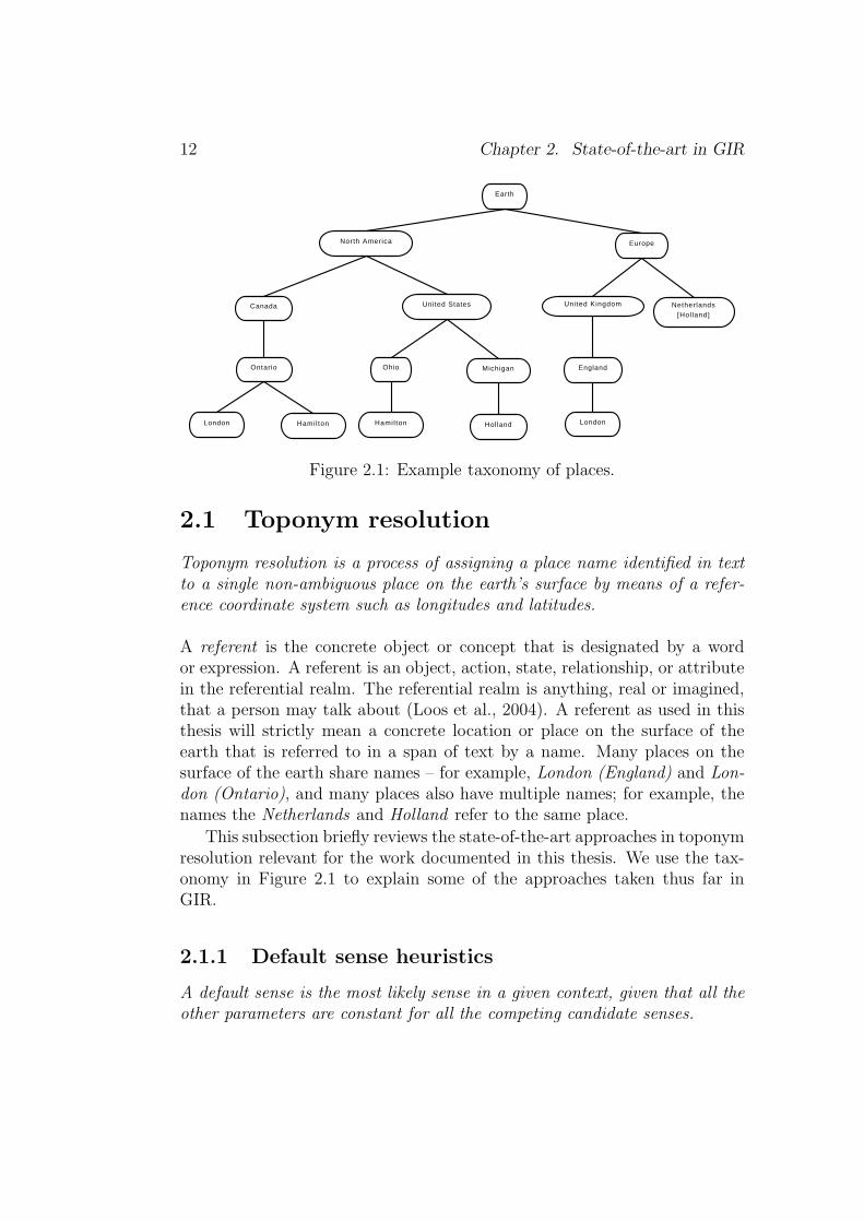
Earth
North America Europe
Canada United States United Kingdom Netherlands[Hol land]
England
London
Ohio Michigan
HollandHamil ton
Ontario
London Hamil ton
Figure 2.1: Example taxonomy of places.
2.1 Toponym resolution
Toponym resolution is a process of assigning a place name identified in textto a single non-ambiguous place on the earth’s surface by means of a refer-ence coordinate system such as longitudes and latitudes.
A referent is the concrete object or concept that is designated by a wordor expression. A referent is an object, action, state, relationship, or attributein the referential realm. The referential realm is anything, real or imagined,that a person may talk about (Loos et al., 2004). A referent as used in thisthesis will strictly mean a concrete location or place on the surface of theearth that is referred to in a span of text by a name. Many places on thesurface of the earth share names – for example, London (England) and Lon-don (Ontario), and many places also have multiple names; for example, thenames the Netherlands and Holland refer to the same place.
This subsection briefly reviews the state-of-the-art approaches in toponymresolution relevant for the work documented in this thesis. We use the tax-onomy in Figure 2.1 to explain some of the approaches taken thus far inGIR.
2.1.1 Default sense heuristics
A default sense is the most likely sense in a given context, given that all theother parameters are constant for all the competing candidate senses.

2.1. Toponym resolution 13
The above definition guides our categorization of default sense heuristicsused in the literature. A default sense may be determined by means of eitherexperiment, experience or intuition. The idea behind using default sensesin GIR is that words and phrases “normally” mean the same thing in mostcontext, and that exception would be signalled otherwise. The problem in us-ing default senses is how to determine which sense is the default dense, andvarious operationalization have been proposed (see below). Default senseheuristics is commonly applied as the last resort after all the other salientprocedures in a system are exhausted. However in some cases a default senseis invoked when initializing a procedure in a system, e.g., toponym Africawill always mean the continent of Africa (i.e., assign reference to a continentwhen a continent name is used). The likelihood of a candidate referent beingreferred to is determined by the importance attached to it, and the followingparameters have been used as indicators of importance:� land surface area, DS1 – selects the referent with the largest land
surface area as the place referred to in the text (Rauch et al., 2003;Pouliquen et al., 2004, 2006).� shortest hierarchy distance, DS2 – selects the place highest in the hi-erarchy of regions as the place referred to in the text (Clough, 2005;Martins et al., 2006). For example, Holland (Europe) will always bepreferred over Holland (Michigan) in Figure 2.1.� place type hierarchy, DS3 – selects a place in the order of place typeimportance: country → capital → city → town → village (Hill et al.,1999; Clough, 2005; Martins et al., 2006; Volz et al., 2007).� corpus popularity, DS4 – selects a place that occurs more commonlyin the document collection as the place being referred to (Smith andMann, 2003; Li et al., 2003; Martins et al., 2006).� population size, DS5 – selects a place with the largest population asthe place being referred to (Rauch et al., 2003; Amitay et al., 2004;Pouliquen et al., 2006; Martins et al., 2006).
2.1.2 Pattern matching and hierarchy overlap
This approach exploits local pattern matching, the hierarchical part-of re-lation and spatial distance. In the literature the following techniques havebeen used;

14 Chapter 2. State-of-the-art in GIR� feature type qualifier, TH1 – scans for the feature type of the targettoponym in the text, e.g., province of Groningen, capital city of Kam-pala, etc. The candidate referent with the matching type is selected(Martins et al., 2006; Volz et al., 2007).� text and hierarchy overlap, TH2 – computes overlap between toponymsin the text and spatial hierarchy relations (Clough, 2005; Martins et al.,2006). For instance, a text containing toponyms London, SouthernOntario, Canada grounds toponym London → London (Ontario).� country scope restriction, TH3 – assigns a country scope to document,and all the ambiguous toponyms are treated as belonging to the countryassigned to the document (Pouliquen et al., 2006).� smallest polygon, TH4 – resolves toponyms recognized in text to thesmallest polygon that completely grounds the whole set (Amitay et al.,2004; Leidner et al., 2003; Zong et al., 2005). Any other ambiguityis resolved using local pattern matching. This in a way is a scoperestriction technique.� shortest spatial distance, TH5 – decision is made on the basis of howclose a candidate referent is to the non-ambiguous referents. The refer-ent closest to all the non-ambiguous referents is chosen (Rauch et al.,2003; Zong et al., 2005; Pouliquen et al., 2006).
2.1.3 One referent per discourse
The one referent per discourse, ORD approach assumes one and only onemeaning for a toponym in a discourse (Leidner et al., 2003). As in wordsense disambiguation (Gale et al., 1992), subsequent mention of the sametoponym is presumed to convey the same meaning as the previous meaning.
2.1.4 Summary
Leidner (2007) provides pseudo-code, analysis and evaluation of approachesreported on in this subsection. The toponym resolution scheme described inthis dissertation borrows the following existing techniques (see Figure 2.1):place type hierarchy, population size, country scope restriction, and defaultsense. This work’s contributions to the area of toponym resolution will bediscussed in Chapter 5, but it is briefly mentioned here – (1) a toponymresolution scheme which is constrained to a document’s geographical scopes,(2) feature type and classification-based resolution, and (3) a new toponymresolution evaluation metric.

2.1.
Toponym
resolutio
n15
DS1 DS2 DS3 DS4 DS5 TH1 TH2 TH3 TH4 TH5 ORD
Rauch et al. (2003) � � �
Pouliquen et al. (2006, 2004) � � �
Clough (2005) � � �
Martins et al. (2006) � � � � � �
Hill et al. (1999) �
Smith and Mann (2003) �
Li et al. (2003) �
Amitay et al. (2004) � �
Volz et al. (2007) �
Leidner et al. (2003) � �
Zong et al. (2005) � �
Andogah et al. (2008) � � � �
Table 2.1: Toponym resolution techniques in literature.
16 Chapter 2. State-of-the-art in GIR
2.2 Scope resolution
The geographical scope of a document is the one or more geographical regionsor areas for which the document is geographically relevant. The geographicalscope resolution is therefore the process of automatically assigning geograph-ical scopes to a document.
A document’s geographical scope(s) is the one or more geographical re-gions or areas which the document is about. The geographical scopes of adocument can help in retrieving documents by imposing geographical restric-tions on the search query (Andogah and Bouma, 2007; Martins et al., 2007;Cardoso et al., 2007), and can also be used in the toponym resolution task(Pouliquen et al., 2006; Leidner, 2007). This subsection reviews recent workin geographical scope resolution.
2.2.1 Country scope
Pouliquen et al. (2006) and Leidner (2007) defined a document’s scope atcountry level. They then used the scopes to aid the toponym resolutionprocedure. Pouliquen et al. (2006) employed two techniques to determinethe country the document is about. The first technique used to determinethe country sets the country of the document’s publication as the context.The second approach extracts the most important unambiguous place names(e.g., capital cities and other major cities) from the text, and then sets theircountries as the context.
2.2.2 A graph ranking algorithm
The work reported in Martins and Silva (2005) uses the PageRank (Pageet al., 1999) algorithm to infer a single global scope for each document.First, geographical references are extracted from the text and associated withthe corresponding concepts in the geographical ontology. Each geographicalconcept in the ontology is defined by: (1) part-of and adjacent-to relationship,(2) all the known name aliases, and (3) concept type. The assumption is thateach concept in the ontology corresponds to a possible class (i.e., geographicalscope). Every document is represented by a set of features corresponding togeographical references from the text. Each feature associates a weight to aset of concepts in the ontology according to their occurrence frequency.
A graph is used to represent the association between the geographicalreferences and the ontology concepts in order to apply the PageRank algo-

2.2. Scope resolution 17
rithm to infer geographic scope. Each concept is represented as a node inthe graph, and a relationship statement is represented by two directed edges.Different types of relationship in the ontology correspond to different edgeweights in the graph (i.e., sub-region-of relations are weighted heavily, andadjacency relations are weighted as less important).
A PageRank formula that accounts for edge and node weights is used tocompute the ranking score for each node in the graph. The ranking scoreis normalized and the most general node that is ranked higher than an ap-propriate threshold is selected as the geographical scope of the document, orNULL if the threshold is not reached. The most general node correspondsto the common broadest concept at the ontology which is obtained from theset of all nodes sharing the highest score.
2.2.3 Taxonomy hierarchy
Amitay et al. (2004) represented a non-ambiguous toponym or a disam-biguated toponym as a taxonomy node using the hierarchy of city 7→ province7→country 7→ continent. For example, The Hague, the capital city of theNetherlands, would be captured as The Hague 7→ South Holland 7→ Nether-lands 7→ Europe. Each non-ambiguous toponym is assigned a score relativeto its importance in the page. Low scores are assigned to the enclosing hier-archies (e.g., South Holland 7→ Netherlands 7→ Europe). For example, for aplace with a taxonomy node of the form A 7→ B 7→ C whose disambiguationconfidence is p ∈ [0, 1], an importance score of p2 is added. The enclosing hi-erarchies are assigned scores of p2d (B 7→ C) and p2d2 (C) respectively, where0 < d < 1. The scores contributed by the non-ambiguous toponyms in thepage are summed up, and the taxonomy hierarchies sorted by their relativeimportance. Places that are part of a more important place or which includea more important place as a proper part, and places whose importance scoreis below a set threshold are ignored. The remaining places represent the setof the document’s geographical scopes.
In Zong et al. (2005), a web page is segmented, and a subtree of thegazetteer hierarchy is constructed to cover all places appearing in the seg-ment and their ancestor place names. For a given segment a score is computedfor each place name in the gazetteer subtree indicating its relevance to thesegment. For leaf place names in the gazetteer subtree, a score is the num-ber of its occurrences divided by the total number of terms in the segmentweighted by a factor in [0, 1]. For non-leaf place names, the score contri-bution from child place names is calculated based on: (1) the total scoreof the child place names which measures how relevant the children are tothe segment, and (2) the distribution of scores among the child place names

18 Chapter 2. State-of-the-art in GIR
which measures how evenly the children scores are distributed. The latterattribute measures the degree to which the children collectively contribute tothe parent place. Once the scores of place names in the gazetteer subtree arederived, place names with score greater or equal to a given threshold valueare assigned to the segment. Therefore, a document’s geographical scope ismade up of the geographical scopes assigned to individual segments.
2.2.4 Geographical distribution
Ding et al. (2000) describes a technique to automatically determine the geo-graphical scope of a web resource using web hyperlinks and the actual contentof web pages. The assumption is that the interest in the resource within theresource’s geographical scope will be expressed by hyperlinks from webpageswithin the scope. Using the distribution of hyperlinks, the geographical scopeof a web resource must satisfy two conditions: (1) a significant fraction ofthe web pages in the scope contain links to the resource, and (2) the webpages in the scope that contain links to the resource are distributed evenlyacross the scope. For example, the USA Today1 has a scope of the UnitedStates. We expect webpages within United States ’ scope to link to the USAToday website, and these webpages are to be evenly distributed across UnitedStates.
The second approach that exploits web page content requires that thegeographical scope of a resource satisfy two conditions: (1) a significantfraction of all locations mentioned in the resource are either the scope itselfor locations within the scope, and (2) the location references in the resourceare distributed smoothly across the scope. For example, a resource whosegeographical scope is the State of New York is expected to mention NewYork State or locations within New York State more frequently than placesbelonging to other states or countries.
Campelo and Baptista (2008) proposed a geographical scope modelingprocedure based on the statistics collected from the detected references, andthe spatial distribution of the places in a given document. The modeling pro-cess explores the mentioned hierarchy, from city to region aiming to producescope and calculate the relevance to the higher level scopes from referencesfound in the low level scopes. They named the process georeference expan-sion. A tree data structure is used to implement the georeference expansionapproach, in which the nodes represent the places which take part in the geo-graphic scope of the analyzed document. A geographic dispersion procedureis used to measure how far apart the geographic places which take part in
1[02 January 2008] http://www.usatoday.com
2.2. Scope resolution 19
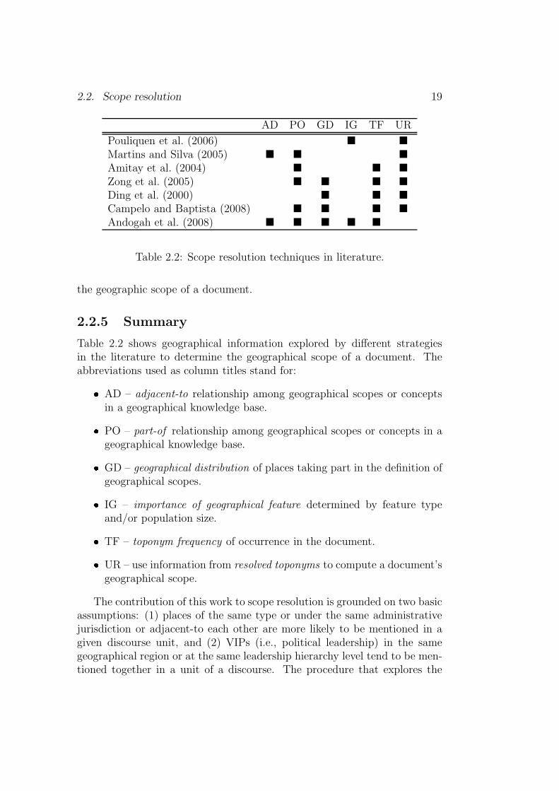
AD PO GD IG TF UR
Pouliquen et al. (2006) � �
Martins and Silva (2005) � � �
Amitay et al. (2004) � � �
Zong et al. (2005) � � � �
Ding et al. (2000) � � �
Campelo and Baptista (2008) � � � �
Andogah et al. (2008) � � � � �
Table 2.2: Scope resolution techniques in literature.
the geographic scope of a document.
2.2.5 Summary
Table 2.2 shows geographical information explored by different strategiesin the literature to determine the geographical scope of a document. Theabbreviations used as column titles stand for:� AD – adjacent-to relationship among geographical scopes or concepts
in a geographical knowledge base.� PO – part-of relationship among geographical scopes or concepts in ageographical knowledge base.� GD – geographical distribution of places taking part in the definition ofgeographical scopes.� IG – importance of geographical feature determined by feature typeand/or population size.� TF – toponym frequency of occurrence in the document.� UR – use information from resolved toponyms to compute a document’sgeographical scope.
The contribution of this work to scope resolution is grounded on two basicassumptions: (1) places of the same type or under the same administrativejurisdiction or adjacent-to each other are more likely to be mentioned in agiven discourse unit, and (2) VIPs (i.e., political leadership) in the samegeographical region or at the same leadership hierarchy level tend to be men-tioned together in a unit of a discourse. The procedure that explores the

20 Chapter 2. State-of-the-art in GIR
use of names of people to determine the geographical scope of documents isthe first of this kind to the best of the author’s knowledge. The row Ando-gah et al. (2008) in Table 2.2 shows the geographical knowledge explored toperform geographical scope resolution procedure reported in this work.
2.3 Query Expansion
Query expansion is the task of adding words or phrases deemed synonymousor closely related to user query terms with the view of retrieving more relevantdocuments. Query expansion techniques are categorized into global methodsand local methods (Xu and Croft, 1996; Manning et al., 2007). Global meth-ods expand or reformulate query terms independent of the query and resultsreturned from the query. With global approaches any change in query word-ing causes the new query to match other semantically similar terms. Globalmethods include: (1) query expansion with a thesaurus, (2) query expansionvia automatic thesaurus generation, and (3) techniques like spell checking.On the other hand, the local methods expand query terms relative to the topranked documents returned as a response to the initial or previous query.
The motivation for expanding geographic query terms is to retrieve doc-uments that are considered relevant to a location or group of locations evenwithout mentioning them in the original query. A document can be geo-graphically relevant to a query in many ways (Fu et al., 2005):� it can be geographically relevant to a query by involving a geographical
term that is considered to be an alternative name for the one appearingin the query,� it can be geographically relevant to a query by involving places whichsatisfy the specific geographical relationship (e.g., adjacent-to relation)with the one appearing in the query.
2.3.1 Knowledge-based expansion
Term-based query expansion
Term-based geographic query expansion involves adding geographic termsfrom a geographic knowledge source to the original query with the view ofretrieving additional relevant documents within the user’s geographic area ofinterest. In Buscaldi et al. (2006) and Leidner (2006) the query’s geographi-cal terms are expanded by means of WordNet synonyms and meronyms. InLarson et al. (2006) place names for regions or countries in the queries are
2.3. Query Expansion 21
expanded by adding the names of the countries or cities in those regionsor countries. The authors observed that geographic term expansions tendto harm the performance. Expansion of geographic spatial relations to aidretrieval of geographically restricted documents on the web is reported inDelboni et al. (2007). Spatial relations such as near are expanded to seman-tically equivalent spatial relations: close to, in-front of, in the vicinity of,etc.
Footprint-based query expansion
Footprint-based query expansion uses a geographic coordinate system to per-form query expansion. All identified place names in the query are translatedto their corresponding geographic coordinates such as the latitude/longitudecoordinates. In comparison to term-based query expansion, footprint-basedexpansion is superior in many ways (Fu et al., 2005):� because it involves exact location on the surface of the earth, it avoids
introducing too many query terms such as alternative names;� because the approach uses exact locations, it avoids retrieval of irrele-vant documents due to name sharing among different places; and� it is well suited for performing more accurate spatial relevance calcula-tion by analysing the query footprint and the document footprint.
The approach reported in Fu et al. (2005) performs footprint-based geo-graphic query expansion using both a domain and a geographic ontology.The approach is designed to expand both geographic terms such as placenames and fuzzy geographic relationships such as adjacency relationships.The types of geographic terms found in the geographical ontology, the typesof non-geographic terms found in the domain ontology, as well as the seman-tics of the geographic relationships and their context of usage are taken intoaccount.
2.3.2 Relevance feedback expansion
The relevance feedback is a popular technique to perform query expansion.Query expansion terms are obtained from documents returned as responsesto the previous search query. Three types of relevance feedback exist: ex-plicit feedback, implicit feedback and blind or pseudo-feedback. The explicitfeedback and the pseudo-feedback are discussed in this subsection as used inquery geographic term expansion.

22 Chapter 2. State-of-the-art in GIR
Implicit feedback
The implicit relevance feedback automatically learns from the searcher byobserving her/his preferences during searching. Based on the learned modelit performs relevance feedback expansion on the user’s query to retrieve morerelevant documents (Kelly and Teevan, 2003; Joachims et al., 2005; Manninget al., 2007). A number of user behaviors have been used as sources ofimplicit feedback: reading time, saving, printing and selecting (Kelly andBelkin, 2001).
Though no work is reported on using implicit reference feedback for ge-ographic term expansion, it might prove useful to implicitly infer the user’sgeographical preferences by observing geographical scopes or footprints ofdocuments the user spend more time reading on the Internet over a periodof time. Based on the geographical information gathered, geographical termexpansion could be performed to retrieve documents both thematically andgeographically relevant to the user.
Blind feedback
The blind or pseudo-relevance feedback method assumes that the top n doc-uments returned as a response to the query are relevant (Manning et al.,2007). Usually the top m most frequent terms from the top n documentsare added to the previous search query, and then resubmitted to performnew search over the collection. In Larson et al. (2006) standard blind rel-evance feedback improved performance for a German GIR task. The mostimproved queries added mostly proper names and word variations and veryfew irrelevant words.
Explicit feedback
In explicit feedback a user classifies documents returned as relevant or non-relevant (Manning et al., 2007). The terms from the relevant documentsare used to expand the previous query. A similar approach can be appliedto perform geographical term expansion where the user is asked to classifyreturned geographic scopes as relevant or non-relevant. Next, places foundwithin relevant geographical scopes are used to expand geographic terms ofthe query.
2.3.3 Document geographic term expansion
Apart from query geographic term expansion, document geographic term ex-pansion has been reported in the literature. In Buscaldi and Rosso (2007)

2.4. Relevance ranking 23
geographical terms in documents are expanded with WordNet2 holonyms andsynonyms, and then indexed separately from the content terms. The authorsfound that scaling down the importance of the query geographic terms byhalf or less than half relative to the importance of non-geographic termsimproves performance. Buscaldi et al. (2006) observed that document geo-graphical term expansion gives better performance than query geographicalterm expansion.
2.3.4 Summary
In the literature, geographical query term expansion, blind feedback and doc-ument geographical term expansion have been applied with inconsistent suc-cess. This work proposes a new scope-controlled toponym selection schemefor relevance feedback. The scheme selects toponyms to add to feedbackquery according to: scope-based(toponyms) = {M ⊆ S}, where, M are thecommonly occurring place names in the relevant documents and S the com-monly shared scopes among the relevant documents.
2.4 Relevance ranking
The objective of relevance ranking in GIR is to present the user with a rankedlist of documents satisfying both the non-geographic and geographic criteriain the query. Recently a number of approaches have been proposed in theliterature, and this section reviews some of the works relevant to this thesis.
2.4.1 Euclidean distance
The Euclidean distance measure geographically ranks documents by proxim-ity between the query’s geographical footprint and the document’s geograph-ical footprint. The shorter the distance between the query and documentfootprint, the more relevant a document is to the query location (Schliederet al., 2001; Jones et al., 2001; Alani et al., 2001; Markowetz et al., 2005;Vaid et al., 2005).
2.4.2 Extent of overlap
The extent of overlap between the query and document footprint can be usedto rank documents by geographic criteria. The greater the extent of overlapbetween the query and document footprint, the higher the relevance of the
2[25 October 2007] http://wordnet.princeton.edu
24 Chapter 2. State-of-the-art in GIR
document to the query (Beard and Sharma, 1997; Walker et al., 1992; Larsonand Frontiera, 2004; Jones et al., 2001).
2.4.3 Containment relations
Two cases are defined as a containment relation (Larson and Frontiera, 2004;Beard and Sharma, 1997; Jones et al., 2001) when: (1) the document foot-print is inside the query footprint, or (2) the document footprint containsthe query footprint. For case (1), the geographic score is assigned on basis ofthe ratio of document area to query area. On the other hand, the geographicscore for case (2) is assigned based on the ratio of query area to documentarea. Geographic scores that approach zero indicate that the document isless relevant to the query’s geographic criteria.
2.4.4 Query footprint as filter
All documents whose geographic footprint overlap with the query footprintare considered relevant. These documents are finally ranked according totheir non-geographic scores (Markowetz et al., 2005; Larson and Frontiera,2004).
2.4.5 Geographic scope indexing
Geographic scope indexing associates each geographic scope (i.e., region ofinterest) to a list of documents concerning it, and in the opposite directionassociates each document with a corresponding geographic scope. Likewise,a query is associated with a list of geographic scopes. Every document be-longing to a geographic scope is assigned a score based on how geographicallyrelevant the document is to the scope. The assigned scores are manipulatedby a ranking function to present a ranked list of geography-restricted andrelevant documents to the user (Martins et al., 2005).
2.4.6 Other criteria
Apart from the above mentioned approaches to determine the geographicrelevance of a document, the following criteria are also used: (1) travel timebetween query and document footprints, (2) boundary connectivity betweenquery and document footprints, (3) number of intervening places betweenquery and document footprints, and (4) place name emphasis in the docu-ment (Jones et al., 2001; Rauch et al., 2003).

2.5. Conclusion 25
2.4.7 Summary
This section reviewed geographical relevance ranking techniques used in pre-vious works. The techniques include Euclidean distance, extent of overlap,containment, footprint based filtering, and geographic scope indexing. Thework reported in this thesis proposes a new relevance ranking metric that ex-ploits a ranked list of geographical scopes assigned to query and documents.The non-geographic and geographic relevance scores are combined througha linear interpolation, and alternatively, using a weighted harmonic-mean.The harmonic mean-based combination achieved a better performance thanlinear interpolation. A better performance is observed when the importanceattached to the non-geographical retrieval outweighs importance attached tothe geographical retrieval.
2.5 Conclusion
This chapter reviewed previous works on toponym resolution, geographicalscope resolution, geographical query expansion and geographical relevanceranking. All the various approaches make specific assumptions about geo-graphic references and test these for their contribution to toponym resolution,scope resolution, query expansion and relevance ranking problem.
The reviewed toponym resolution strategies employ default sense, pat-tern matching, hierarchy overlap and one referent per discourse heuristics.On the other hand, the reviewed geographical scope resolution strategies usea range of geographical information to infer a document’s scope – adjacencyrelationships, contains/contained-by relationships, geographical distributionof places in the scope, importance of geographical feature determined by typeor population size, toponym occurrence frequency in the document, and re-solved toponym information. The geographical query expansion strategies re-viewed include knowledge-based expansion, relevance feedback expansion anddocument geographical term expansion. The geographical relevance rankingstrategies reviewed include the Euclidean distance, extent of overlap, con-tainment relations, query footprint-base filter and geographical scope.
The work reported in this dissertation combines existing strategies andalso introduces new approaches to address the geographical information re-trieval task. The toponym resolution techniques reported in the literatureoverlook scope restricted toponym selection, except the works by Leider andPouline which restricted the toponym selection at country scope. The to-ponym resolution task is performed before scope resolution routine. As a con-sequence, the toponym resolution routine does not benefit from geographical
26 Chapter 2. State-of-the-art in GIR
scopes of documents. The approach taken in this work is to initially solve theproblem of scope resolution before attempting toponym resolution problem.The general idea is that the scope-controlled toponym selection techniquesmay perform better than techniques that ignore or overlook geographicalscopes of documents when solving the problem of toponym resolution.
The one common feature exploited by scope resolution techniques re-viewed is the use of information from resolved toponyms to compute a docu-ment’s geographical scope. The approach reported in this thesis departs fromthis by using placenames spotted in documents before they are resolved tolocations they reference.The scope resolution technique reported in this workis grounded on two basic assumptions: (1) places of the same type or underthe same administrative jurisdiction or adjacent-to each other are more likelyto be mentioned in a given discourse unit; (2) VIPs (i.e., political leadership)in the same geographical region or at the same leadership hierarchy leveltend to be mentioned together in a unit of a discourse.
As noted in Section 1.2 Research, the answer to the scope resolutionproblem determines how well the toponym resolution, the query expansionand the relevance ranking problems are answered. Therefore, the importanceof geographical score can not be overemphasized in this work.

Chapter 3
Data and tools
A standard reference dataset for evaluation of toponym resolution and scoperesolution tasks consists of two components – a reference gazetteer and a ref-erence corpus (Leidner, 2007). The reference gazetteer lists toponyms withtheir associated spatial footprint information. The reference corpus consistsof documents with all toponyms found in them annotated with spatial foot-print information from the reference gazetteer.
This chapter describes the geographical databases, document collectionsand named entity recognition tools available to experiment with approachesproposed in this work. Two new corpora are developed from existing newscollections for the toponym resolution evaluation task. The TR-CLEF corpusis derived from the relevant documents to GeoCLEF campaign topics (Geyet al., 2006, 2007; Mandl et al., 2008, 2009), and the TR-RNW is derivedfrom the Radio Netherlands Worldwide1 summaries.
3.1 Geographical database
As noted above, geographically constrained information retrieval is Infor-mation Retrieval (IR) which makes use of an external knowledge base ongeography. As such a geographical database (GeoDB) is an important com-ponent of a GIR system. Among other processes, the GeoDB facilitates thefollowing tasks in a GIR system:
1. Geographical scope resolution (see Section 2.2).
2. Geographical referent ambiguity resolution or toponym resolution (seeSection 2.1).
1[06 February 2010] http://www.rnw.nl/english
27

28 Chapter 3. Data and tools
Feature Code
A H L PR S T UV
country province . . . ci ty town vil lage
Classes
Types
Figure 3.1: Schematic of the Geonames.org feature code hierarchy.
3. Expansion of geographically constrained queries (see Section 2.3).
4. Relevance ranking of documents by both non-geographical and geo-graphical themes (see Section 2.4).
5. Evaluating the performance of components that make up a GIR system.
3.1.1 Geonames.org database
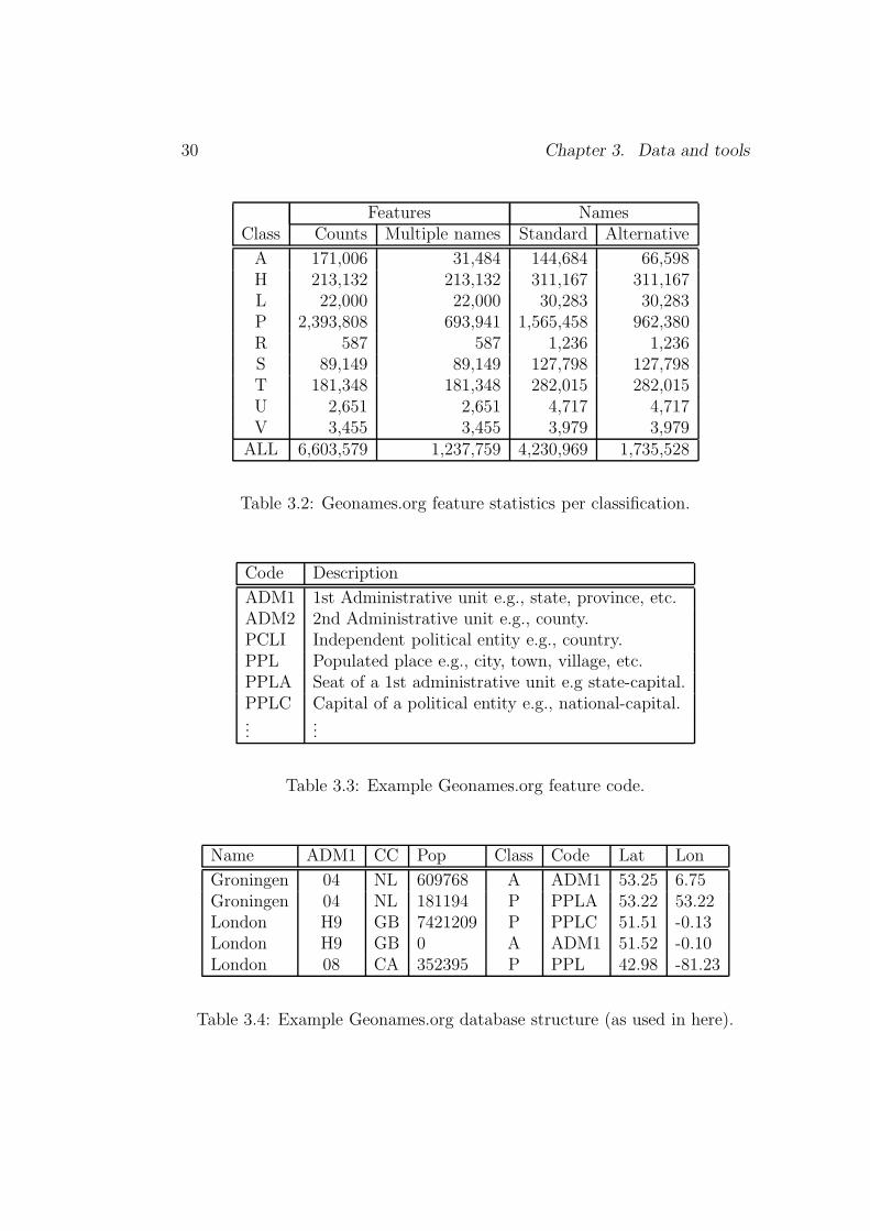
The approaches discussed in this dissertation use the Geonames.org2 databaseas the GeoDB of choice. The Geonames.org database is a free database ofgeographical features with a global coverage. This section briefly explainsthe structure of the Geonames.org database as used in this dissertation.
The Geonames.org database contains over eight million geographical namesand consists of 6.5 million unique features including 2.2 million populatedplaces and 1.8 million alternate names. All the features are categorizedinto one of the nine feature classes (see Table 3.1) and further subcatego-rized into one of the 645 feature codes3(see Table 3.3). Figure 3.1 showsthe schematic hierarchy structure of how features are classified in the Geon-ames.org database.
Table 3.2 shows feature classification statistics. The column Standardshows the number of the unique standard names, while Alternative showsthe number of the unique alternative names. The number of features withmore than one reference is shown in the columnMultiple names. For example,696,941 features of class P are referred to by multiple names, i.e., 982,380names (see corresponding statistics in column Alternative). The 6,603,579
2[11 March 2008] http://www.geonames.org/about.html3[11 March 2008] http://www.geonames.org/export/codes.html (See for detailed
feature class and code description.)

3.1. Geographical database 29
Class Description Example
A Administrative unit country, state, region, etc.H Hydrographic stream, lake, sea, etc.L Locality or area parks, area, gasfield, etc.P Populated place city, town, village, etc.R Roads or railroad street, highways, railroads, etc.S Spot building, farm, airport, etc.T Hypsographic mountain, hill, rock, etc.U Undersea arch, borderland, basin, etc.V Vegetation forest, grassland, bush, etc.
Table 3.1: Geonames.org feature classification.
features share 4,230,969 standard names, and 1,237,759 of the features arealso referred to by 1,735,528 alternative names.
The feature class and code are factored with other attributes such asfeature unique id, latitudes/longitudes, population, feature names, etc. tonon-ambiguously represent a feature in the database. Table 3.4 shows anexample of how features are presented in the database, where, the columnsADM1, CC, Pop, Class, Code, Lat and Lon store the first-order adminis-trative unit, country, population, feature class, feature code, latitude andlongitude of a geographical feature respectively.
3.1.2 Other GeoDBs
Although we chose to use the Geonames.org database, we include here adiscussion of alternatives for the sake of completeness.
GNS
The GEOnet Names Server (GNS) is a database of foreign geographic featurenames provided by the National Geospatial-Intelligence Agency (NGA) andthe U.S. Board on Geographic Names (US BGN). The database is the offi-cial repository of foreign place-name designation approved by the US BGN.Approximately 20,000 of the database’s features are updated monthly. Thegeographic area of coverage is worldwide excluding the United States andAntarctica. 4
4[29 November 2009]: http://earth-info.nga.mil/gns/html/index.html
30 Chapter 3. Data and tools
Features NamesClass Counts Multiple names Standard Alternative
A 171,006 31,484 144,684 66,598H 213,132 213,132 311,167 311,167L 22,000 22,000 30,283 30,283P 2,393,808 693,941 1,565,458 962,380R 587 587 1,236 1,236S 89,149 89,149 127,798 127,798T 181,348 181,348 282,015 282,015U 2,651 2,651 4,717 4,717V 3,455 3,455 3,979 3,979
ALL 6,603,579 1,237,759 4,230,969 1,735,528
Table 3.2: Geonames.org feature statistics per classification.
Code Description
ADM1 1st Administrative unit e.g., state, province, etc.ADM2 2nd Administrative unit e.g., county.PCLI Independent political entity e.g., country.PPL Populated place e.g., city, town, village, etc.PPLA Seat of a 1st administrative unit e.g state-capital.PPLC Capital of a political entity e.g., national-capital....
...
Table 3.3: Example Geonames.org feature code.
Name ADM1 CC Pop Class Code Lat Lon
Groningen 04 NL 609768 A ADM1 53.25 6.75Groningen 04 NL 181194 P PPLA 53.22 53.22London H9 GB 7421209 P PPLC 51.51 -0.13London H9 GB 0 A ADM1 51.52 -0.10London 08 CA 352395 P PPL 42.98 -81.23
Table 3.4: Example Geonames.org database structure (as used in here).

3.2. Corpus 31
GNIS
The Geographic Names Information System (GNIS) is the U.S. federal andnational standard for geographic nomenclature. The GNIS was developedby the U.S. Geological Survey in support of the U.S. Board on GeographicNames. It forms the the official repository of domestic geographic namesdata for all departments of the Federal Government of the United States.
The GNIS contains information about physical and cultural geographicfeatures of all types in the United States, associated areas including Antarc-tica, current and historical, but not including roads and highways. Thedatabase holds the federally recognized name of each feature and defines thefeature location by state, county, USGS topographic map, and geographic co-ordinates. Other attributes include names or spellings other than the officialname, feature designations, feature classifications, historical and descriptiveinformation, and for some categories the geometric boundaries. 5
TextGIS gazetteer
The TextGIS gazetteer is part of the TR-CoNLL reference corpus built byLeidner (2007). The gazetteer is created from the GNIS gazetteer of the U.S.Geographic Survey and the GNS gazetteers of the National Geospatial Intel-ligence Agency (NGA), and supplemented with the 267 CIA World Factbook(WFB) country centroid.
3.2 Corpus
3.2.1 TR-CLEF
The Cross-Language Evaluation Forum (CLEF)6 promotes R&D in multilin-gual information access by
1. Developing an infrastructure for the testing, tuning and evaluation ofinformation retrieval systems operating on European languages in bothmonolingual and cross-language contexts.
2. Creating test-suites of reusable data which can be employed by systemdevelopers for benchmarking purposes.
The Cross-Language Geographical Information Retrieval (GeoCLEF) taskwas first run as a pilot experiment in CLEF 2005 (Gey et al., 2006), and
5[29 November 2009]: http://geonames.usgs.gov/domestic/index.html6[25 November 2009]: http://www.clef-campaign.org/
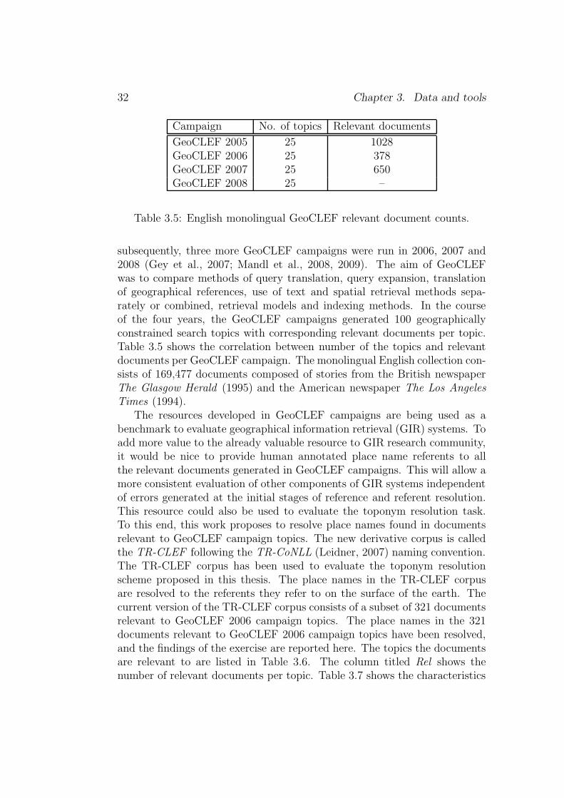
32 Chapter 3. Data and tools
Campaign No. of topics Relevant documents
GeoCLEF 2005 25 1028GeoCLEF 2006 25 378GeoCLEF 2007 25 650GeoCLEF 2008 25 –
Table 3.5: English monolingual GeoCLEF relevant document counts.
subsequently, three more GeoCLEF campaigns were run in 2006, 2007 and2008 (Gey et al., 2007; Mandl et al., 2008, 2009). The aim of GeoCLEFwas to compare methods of query translation, query expansion, translationof geographical references, use of text and spatial retrieval methods sepa-rately or combined, retrieval models and indexing methods. In the courseof the four years, the GeoCLEF campaigns generated 100 geographicallyconstrained search topics with corresponding relevant documents per topic.Table 3.5 shows the correlation between number of the topics and relevantdocuments per GeoCLEF campaign. The monolingual English collection con-sists of 169,477 documents composed of stories from the British newspaperThe Glasgow Herald (1995) and the American newspaper The Los AngelesTimes (1994).
The resources developed in GeoCLEF campaigns are being used as abenchmark to evaluate geographical information retrieval (GIR) systems. Toadd more value to the already valuable resource to GIR research community,it would be nice to provide human annotated place name referents to allthe relevant documents generated in GeoCLEF campaigns. This will allow amore consistent evaluation of other components of GIR systems independentof errors generated at the initial stages of reference and referent resolution.This resource could also be used to evaluate the toponym resolution task.To this end, this work proposes to resolve place names found in documentsrelevant to GeoCLEF campaign topics. The new derivative corpus is calledthe TR-CLEF following the TR-CoNLL (Leidner, 2007) naming convention.The TR-CLEF corpus has been used to evaluate the toponym resolutionscheme proposed in this thesis. The place names in the TR-CLEF corpusare resolved to the referents they refer to on the surface of the earth. Thecurrent version of the TR-CLEF corpus consists of a subset of 321 documentsrelevant to GeoCLEF 2006 campaign topics. The place names in the 321documents relevant to GeoCLEF 2006 campaign topics have been resolved,and the findings of the exercise are reported here. The topics the documentsare relevant to are listed in Table 3.6. The column titled Rel shows thenumber of relevant documents per topic. Table 3.7 shows the characteristics

3.2. Corpus 33
of the documents relevant to GeoCLEF 2006 campaign topics.
The 321 documents contain a total of 802 unique references to places.Out of the 802 unique references, 690 refer to more than one location onthe surface of the earth; i.e., 86% of references to locations are ambiguous.Figure 3.2 shows on the world map the level of potential ambiguity in the321 relevant documents in the GeoCLEF 2006 campaign. The fifteen mostfrequent toponyms, and the fifteen least frequent toponyms are shown inTable 3.8.
The manual referent resolution procedure follows the steps below:
1. Run Alias-i Lingpipe against the document collection to tag referencesto places (e.g. London, Netherlands, etc.), adjectives referring to peopleand places (e.g., British, Dutch, etc.), names of people (e.g., GordonBrown, Jan Peter Balkenende, etc.), names of organisations (e.g., Uni-versity of Groningen, Gulu University, etc.) and types of geographicalfeatures (e.g., city, lake, etc.).
2. Inspect the Lingpipe output and correct any incorrect tagging, i.e.,recognition and classification of named entities. For example, taggingGordon as entity of type Location instead of entity type Person iscorrected if the meaning in the source document is Person.
3. Manually map place names to locations they refer to in the source doc-ument, e.g., London 7→ 〈51◦ 30′ 30′′N 0◦ 7′ 31′′ W 〉. The Geonames.org 7
database is used as the reference geographical knowledge base for theresolution.
4. Evaluate inter-annotator agreement. There are bound to be inconsis-tencies in the interpretation of location referred to by the referenceamong human annotators. To measure inter-annotator agreement twoor more annotators are given the same set of documents to map oc-currences of place names to locations on the surface of the earth. Thedifference and/or the agreement in mapping place names to locationsis used as a measure of inter-annotator agreement.
The kappa coefficient, K is used to measure the pairwise agreement amongthe annotators (Carletta, 1996)
K =P (A)− P (E)
1− P (E)(3.1)
7http://www.geonames.org

34 Chapter 3. Data and tools
ID Title Rel
GC026 Wine regions around rivers in Europe 9GC027 Cities within 100km of Frankfurt 19GC028 Snowstorms in North America 19GC029 Diamond trade in Angola and South Africa 9GC030 Car bombings near Madrid 6GC031 Combats and embargo in the northern part of Iraq 59GC032 Independence movement in Quebec 31GC033 International sports competitions in the Ruhr area 20GC034 Malaria in the tropics 3GC035 Credits to the former Eastern Bloc 6GC036 Automotive industry around the Sea of Japan 0GC037 Archeology in the Middle East 16GC038 Solar or lunar eclipse in Southeast Asia 1GC039 Russian troops in the southern Caucasus 16GC040 Cities near active volcanoes 14GC041 Shipwrecks in the Atlantic Ocean 4GC042 Regional elections in Northern Germany 2GC043 Scientific research in New England Universities 8GC044 Arms sales in former Yugoslavia 38GC045 Tourism in Northeast Brazil 6GC046 Forest fires in Northern Portugal 3GC047 Champions League games near the Mediterranean 24GCO48 Fishing in Newfoundland and Greenland 48GC049 ETA in France 2GC050 Cities along the Danube and the Rhine 15
378
Table 3.6: GeoCLEF 2006 topic.

3.2. Corpus 35
Items Count
Tokens 360,559Unique tokens 18,043Documents 321Toponym instances 5,783Unique toponyms 802Unique and ambiguous toponyms 690Unique and non-ambiguous toponyms 112Annotators 2
Table 3.7: GeoCLEF 2006 relevant document characteristic.
Most frequent Less frequentToponyms Frequency Toponyms Frequency
Canada 394 Aberdeenshire 1Quebec 323 Abuja 1Iraq 224 Adana 1Bosnia 193 Akron 1Turkey 175 Albania 1United States 158 Alberta 1Europe 146 Algeria 1Russia 122 Algiers 1Spain 113 All Saints Bay 1Germany 107 Alps 1Britain 81 Alsace 1France 64 Alva 1Washington 63 America 1Croatia 59 Anaheim 1Yugoslavia 56 Andernach 1
Table 3.8: Fifteen most frequent and least frequent toponyms.

36Chapter3.
Data
andtools
Figure 3.2: Potential ambiguity in relevant documents in GeoCLEF 2006. Any of the squares may have been referredto in one of the GeoCLEF documents.
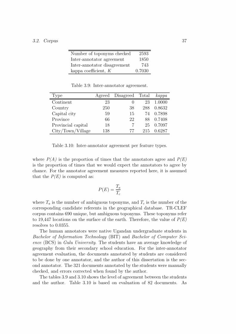
3.2. Corpus 37
Number of toponyms checked 2593Inter-annotator agreement 1850Inter-annotator disagreement 743kappa coefficient, K 0.7030
Table 3.9: Inter-annotator agreement.
Type Agreed Disagreed Total kappa
Continent 23 0 23 1.0000Country 250 38 288 0.8632Capital city 59 15 74 0.7898Province 66 22 88 0.7408Provincial capital 18 7 25 0.7097City/Town/Village 138 77 215 0.6287
Table 3.10: Inter-annotator agreement per feature types.
where P(A) is the proportion of times that the annotators agree and P(E)is the proportion of times that we would expect the annotators to agree bychance. For the annotator agreement measures reported here, it is assumedthat the P(E) is computed as:
P (E) =Ta
Tc
where Ta is the number of ambiguous toponyms, and Tc is the number of thecorresponding candidate referents in the geographical database. TR-CLEFcorpus contains 690 unique, but ambiguous toponyms. These toponyms referto 19,447 locations on the surface of the earth. Therefore, the value of P(E)resolves to 0.0355.
The human annotators were native Ugandan undergraduate students inBachelor of Information Technology (BIT) and Bachelor of Computer Sci-ence (BCS) in Gulu University. The students have an average knowledge ofgeography from their secondary school education. For the inter-annotatoragreement evaluation, the documents annotated by students are consideredto be done by one annotator, and the author of this dissertation is the sec-ond annotator. The 321 documents annotated by the students were manuallychecked, and errors corrected when found by the author.
The tables 3.9 and 3.10 shows the level of agreement between the studentsand the author. Table 3.10 is based on evaluation of 82 documents. As

38 Chapter 3. Data and tools
shown by this evaluation, toponym resolution is a non-trivial task even forwell-educated, but non-expert persons. A number of reasons can be adducedfor the low agreement between annotators of TR-CLEF corpus:� The student annotators had access to the document collection and a ge-
ographical knowledge base, but not the Internet. Therefore, they couldnot consult web resources such as web maps to aid their judgementwhenever they are not sure.� The student’s imperfect knowledge of the world geography.� The level of English language proficiency among the students may haveplayed a role.� Certain documents in TR-CLEF are very long with several toponymsreferring to relatively small places.
Among the six feature types in Table 3.10, toponyms referencing cities,towns and villages are more difficult to resolve. This may mean that thechallenge of toponym ambiguity resolution calls for development of toolsto help information seekers resolve toponym ambiguities while searching forinformation with geographical restriction. Figure 3.3 shows the result of thetoponym resolution after the inter-annotator evaluation step (i.e., after thecorrection and resolution of conflicts in annotation). The final TR-CLEFcorpus will consist of relevant documents to all GeoCLEF campaign topics.Figure 3.4 shows how the documents in TR-CLEF corpus are annotated. TheReferences element lists all recognised references in the document – names ofplaces, names of people, adjectives referring to people and places, etc. Thevalue of attribute rid in the GT tag is the unique id (i.e., Geonames.orgdatabase feature id) of the feature being referred to by the name. Attributesname, tf and type store the recognised reference, the number of times thereference occurred in the text, and reference type respectively.
3.2.2 TR-RNW
The TR-RNW corpus is derived from the Radio Netherlands Worldwide 8
(RNW) summaries. Radio Netherlands publishes an email review of leadingDutch newspapers every weekday in English. The TR-RNW consists of 556news summaries from RNW. Figure 3.5 shows an RNW example summaryin XML format adopted for document storage in this work. The value ofattribute rid in the GT tag is the unique id (i.e., Geonames.org database
8[30 November 2009]: http://www.radionetherlands.nl/

3.2.
Corpus
39
Figure 3.3: Map showing the result of toponym resolution. This can be compared to the unresolved set of possiblelocations shown in Figure 3.2
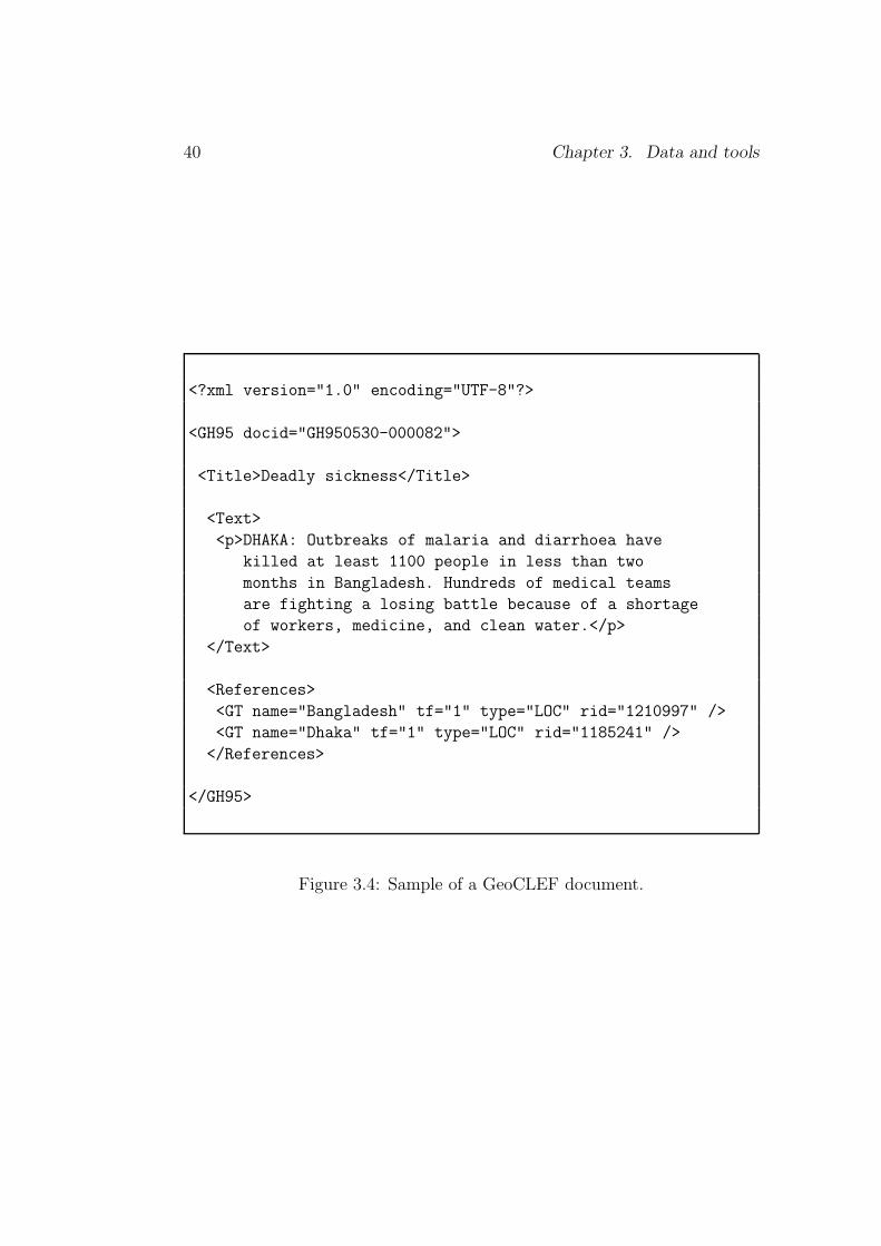
40 Chapter 3. Data and tools
<?xml version="1.0" encoding="UTF-8"?>
<GH95 docid="GH950530-000082">
<Title>Deadly sickness</Title>
<Text>
<p>DHAKA: Outbreaks of malaria and diarrhoea have
killed at least 1100 people in less than two
months in Bangladesh. Hundreds of medical teams
are fighting a losing battle because of a shortage
of workers, medicine, and clean water.</p>
</Text>
<References>
<GT name="Bangladesh" tf="1" type="LOC" rid="1210997" />
<GT name="Dhaka" tf="1" type="LOC" rid="1185241" />
</References>
</GH95>
Figure 3.4: Sample of a GeoCLEF document.

3.2. Corpus 41
Items Count
Tokens 68,010Unique tokens 6,940Documents 556Toponym instances 2,338Unique toponyms 432Unique and ambiguous toponyms 332Unique and non-ambiguous toponyms 102Annotators 1
Table 3.11: TR-RNW corpus characteristic.
feature id) of the feature being referred to by the name. The attributes name,tf and type store the recognised reference, the number of times the referenceoccurred in the text, and reference type respectively. The human annotationprocedure follows the steps outlined in Section 3.2.1, except that the Lingpipeoutputs were not checked for tagging errors. Table 3.11 shows the overallcharacteristic of the TR-RNW corpus, i.e., 76.5% of TR-RNW toponymsare ambiguous. The fifteen most frequent toponyms, and the fifteen leastfrequent toponyms are shown in Table 3.12.
3.2.3 Other collections
Although a new evaluation dataset was developed, we include here a briefdiscussion of alternatives for the sake of completeness. The scope and to-ponym resolution schemes developed in this work have been evaluated onthe CoNLL-2003 and TR-CoNLL corpus as well.
RCV1
The Reuters Corpus Volume 1 (RCV1) (Rose et al., 2002) is an archive of806,791 English language news stories that is freely available to the researchcommunity. It includes all English language stories produced by Reuters jour-nalists between 20/8/1996 and 19/8/1997. All the stories in RCV1 are codedfor topic, region (geography) and industry. The region or geographical codesare used to indicate the geographical regions referred to in a story. Theserepresent three types of grouping: (1) countries (e.g., UK), (2) geographi-cal groups (e.g., BENELUX), and, (3) economic groupings (e.g., GSEVEN).There is no explicit hierarchical structure in the region codes.

42 Chapter 3. Data and tools
<?xml version="1.0" encoding="UTF-8"?>
<RNW sid="28112009.1">
<title>UK, France set up 10 billion dollar climate
fund</title>
<p>Britain and France have pledged to pay developing nations
to help them combat global warming by calling for a
6.67-billion euro climate fund financed by rich countries.
Attending a Commonwealth summit in Trinidad, Prime
Minister Gordon Brown and President Nicolas Sarkozy
urged that the fund be adopted at the Copenhagen
climate summit in early December. Mr Brown said Britain
would contribute 0.86 billion euros over three years.</p>
<p>The fund is intended to help poor countries cut greenhouse
gas emissions and counter the effects of rising sea levels.
The Commonwealth summit is the last big international
gathering before the Copenhagen climate summit due in two
weeks’ time. UN Secretary-General Ban Ki-moon, who also
attended the Commonwealth summit, said that, despite
earlier pessimism, a new climate protocol now seems
within reach.</p>
<References>
<GT name="UK" tf="1" type="LOC" rid="2635167"/>
<GT name="France" tf="2" type="LOC" rid="3017382"/>
<GT name="Britain" tf="2" type="LOC" rid="2635167"/>
<GT name="Trinidad" tf="1" type="LOC" rid="3573591"/>
<GT name="Copenhagen" tf="2" type="LOC" rid="2618425"/>
<GT name="Gordon Brown" tf="1" type="PER" />
<GT name="Brown" tf="1" type="PER" />
<GT name="Nicolas Sarkozy" tf="1" type="PER" />
<GT name="Ban Ki-moon" tf="1" type="PER" />
<GT name="Commonwealth" tf="3" type="ORG" />
<GT name="UN" tf="1" type="ORG" />
</References>
</RNW>
Figure 3.5: Sample of RNW story.

3.2. Corpus 43
Most frequent Less frequentToponyms Frequency Toponyms Frequency
USA 178 Aalborg 1Afghanistan 68 Abidjan 1United States 67 Albania 1Iran 61 Alps 1Iraq 60 Annapolis 1China 49 Arezzo 1Netherlands 47 Arhus 1Australia 44 Aruba 1Russia 41 Arusha 1Pakistan 33 Asadabad 1Germany 33 Auckland 1Turkey 32 Baabda 1Israel 31 Bacau 1France 31 Baidoa 1Europe 28 Bali 1
Table 3.12: TR-RNW fifteen most frequent and least frequent toponyms.
CoNLL-2003
The CoNLL-2003 (Tjong Kim Sang and De Meulder, 2003) collection is aderivative of the Reuters English corpus (RCV1) (Rose et al., 2002). Geo-graphic scope(s) at country level is provided for every individual documentin the collection. The TR-CoNLL collection (Leidner, 2007) consisting of946 documents is the first toponym resolution evaluation benchmark corpusderived from the CoNLL-2003 collection. The collections provide a usefulresource for evaluating geographic scope and referent resolution techniques.Table 3.13 shows the overall profiles of TR-CoNLL and TR-MUC4 (see sub-section below) corpus as documented by Leidner (2007).
TR-MUC4
The TR-MUC4 (Leidner, 2007) consists of 100 documents in the FourthMessage Understanding Contest (MUC-4) (Sundheim, 1992). The collectionis made up of intelligence reports from the Foreign Broadcast InformationService (FBIS) covering Central America. It is specifically prepared as abenchmark to evaluate the place referent ambiguity resolution (PRAR) task.
44 Chapter 3. Data and tools
TR-CoNLL TR-MUC4
Corpus size (in tokens) 204,566 30,051Number of documents 946 100Toponym instances 6,980 278Unique toponyms 1,299 135Annotator agreement 0.9350 0.7840Human annotators 4 2
Table 3.13: TR-CoNLL & TR-MUC4 corpus characteristic.
Named entity type Examples
Location New York City, Groningen, Madi OkolloPerson Jesus Christ, Stephen Babua, Nicodemus ChengulaOrganisation ABN AMRO, Hispirit Limited, CNN, EUDate 07 December 1968, 10/03/1973, 22-02-2001Time 11 a.m. EAT, Midnight, last nightPercentage 19%, fifteen percent, 55%Money AC1,190.00, UGX 3.381 million, $1,765.58
Table 3.14: Named entity types defined in Chinchor (1997).
3.3 Tools
The Named Entity Recognition and Classification (NERC) is the first taskperformed in an automatic text analysis system. The Message UnderstandingConferences 7 (MUC-7) challenged participants to mark seven named entitytypes in a text span, namely; location, person, organisation, date, time,percentage and monetary amount (Chinchor, 1997).
Chinchor (1997) defined a named entity of type location as a name ofpolitically or geographically defined location (such as cities, provinces, coun-tries, international regions, bodies of water, mountains, etc.). An organiza-tion is defined as a named corporate, governmental or other organizationalentity. A person named entity is defined as a named person or family.
To perform the NERC task in this work, an off-the-shelf NERC taggeris chosen instead of building a new system to specifically tag place names inrunning text. The main reason is that the location tagging in the state-of-the-art NERC systems have recently achieved good performance with F-scoremeasure in the range of 87.00% and above on English text (Carreras et al.,2003; Chieu and Ng, 2003; Curran and Clark, 2003; Florian et al., 2003; Klein
3.3. Tools 45
et al., 2003; Zhang and Johnson, 2003). Toponym recognition is a subset ofthe broad NERC concerned with the recognition of names in running textand classification of the names as place names as opposed to names of otherentities.
Although our focus is on toponym recognition, we are aware that the othertypes of named entities indirectly do have geographical signature attached tothem. For example, the Presidents can be assumed to represent the countriesthey administer, and thereby, playing the role of implied toponyms to thecountries the represent.
3.3.1 Alias-i Lingpipe
The Alias-i LingPipe 9 is a suite of Java libraries for the linguistic analysis ofhuman language. Lingpipe’s information extraction and data mining toolscan do the following (among other things): (1) track mentions of entities(e.g. people or proteins); (2) link entity mentions to database entries; (3)uncover relations between entities and actions; (4) classify text passages bylanguage, character encoding, genre, topic, or sentiment; (5) correct spellingwith respect to a text collection; (6) cluster documents by implicit topic anddiscover significant trends over time; and, (7) provide part-of-speech taggingand phrase chunking.
In this work Lingpipe has been used to perform named entity tagging,i.e., names of places, adjectives referring to places and people, names of peo-ple, names of organisation, and types of geographical features. The LingPipeNERC module employs three methods: (1) supervised training of a statis-tical model, (2) dictionary matching, and (3) regular expression matching.The Place Reference Recognition and Classification (PRRC) task uses thepre-trained supervised model and dictionary matching method. The geo-graphical adjectives, place types and spatial relations are tagged using thedictionary matching method while the place name tagging used the pre-trained statistical model for English. Figure 3.6 shows an example Lingpipeoutput, and the list of geographical terms extracted to feed geographical scoperesolution and toponym resolution components described in Chapter 4 and5 respectively. Besides Lingpipe, other tools that could have been used toperform the toponym recognition task are the OpenNLP tools, WordFreak,Gate Annie and Apache UIMA. These tools are briefly described below.
9[29 November 2009]: http://alias-i.com/lingpipe/
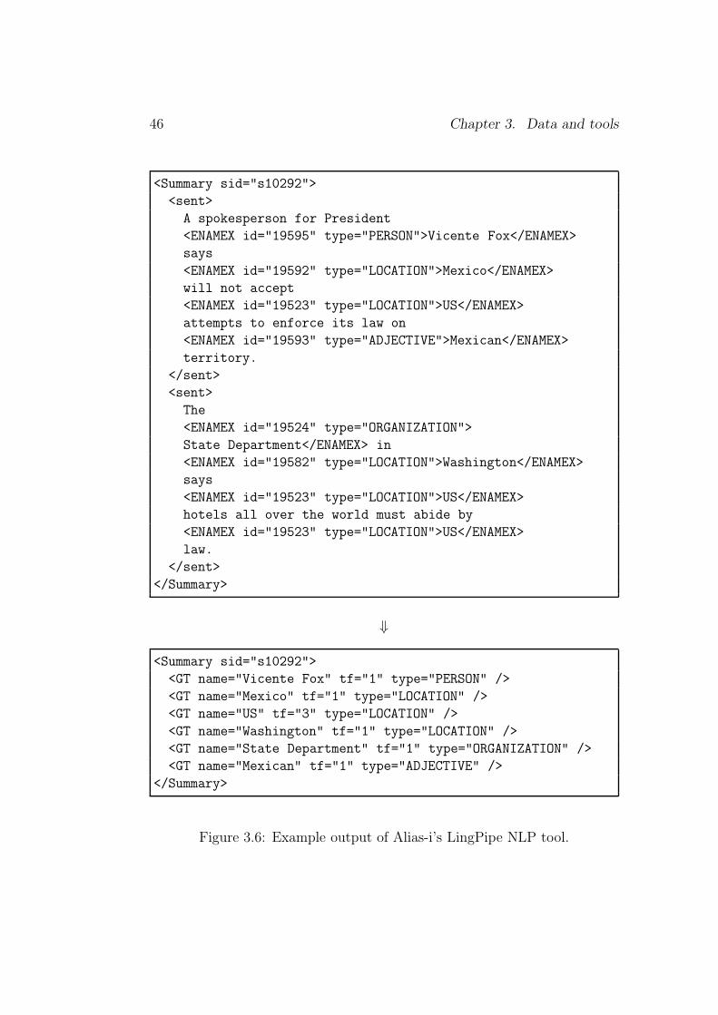
46 Chapter 3. Data and tools
<Summary sid="s10292">
<sent>
A spokesperson for President
<ENAMEX id="19595" type="PERSON">Vicente Fox</ENAMEX>
says
<ENAMEX id="19592" type="LOCATION">Mexico</ENAMEX>
will not accept
<ENAMEX id="19523" type="LOCATION">US</ENAMEX>
attempts to enforce its law on
<ENAMEX id="19593" type="ADJECTIVE">Mexican</ENAMEX>
territory.
</sent>
<sent>
The
<ENAMEX id="19524" type="ORGANIZATION">
State Department</ENAMEX> in
<ENAMEX id="19582" type="LOCATION">Washington</ENAMEX>
says
<ENAMEX id="19523" type="LOCATION">US</ENAMEX>
hotels all over the world must abide by
<ENAMEX id="19523" type="LOCATION">US</ENAMEX>
law.
</sent>
</Summary>
⇓
<Summary sid="s10292">
<GT name="Vicente Fox" tf="1" type="PERSON" />
<GT name="Mexico" tf="1" type="LOCATION" />
<GT name="US" tf="3" type="LOCATION" />
<GT name="Washington" tf="1" type="LOCATION" />
<GT name="State Department" tf="1" type="ORGANIZATION" />
<GT name="Mexican" tf="1" type="ADJECTIVE" />
</Summary>
Figure 3.6: Example output of Alias-i’s LingPipe NLP tool.
3.4. Conclusion 47
3.3.2 OpenNLP tools
The OpenNLP tools 10 are a collection of natural language processing toolswhich use maximum entropy models to resolve ambiguity. The OpenNLPtools package include a sentence detector, tokenizer, pos-tagger, shallow andfull syntactic parser, and named-entity detector. The OpenNLP tools canbe used by themselves, or as plugins with other Java frameworks such asWordFreak and UIMA.
3.3.3 WordFreak
WordFreak 11 is a Java-based linguistic annotation tool designed to supporthuman, and automatic annotation of linguistic data as well as employ active-learning for human correction of automatically annotated data.
3.3.4 GATE ANNIE
GATE 12 is framework for developing and deploying software componentsthat process human language. GATE is distributed with an Information Ex-traction (IE) component set called ANNIE (which stands for ”A Nearly-NewIE system”). The ANNIE system consists of a tokenizer, sentence splitter,POS tagger, gazetteers and orthomatcher (orthographic coreference).
3.3.5 Apache UIMA
UIMA 13 stands for Unstructured Information Management Architecture andis a component architecture and software framework implementation for theanalysis of unstructured content like text, video and audio data. The maingoal of UIMA is to transform unstructured information to structured infor-mation by orchestrating analysis engines to detect entities or relations andthus to build the bridge between the unstructured and the structured world.
3.4 Conclusion
This chapter described the geographical database, document collections andnamed entity recognition tools available to experiment with approaches pro-posed in this work. The Lingpipe linguistic analysis tool is used to preprocess
10[29 November 2009]: http://opennlp.sourceforge.net/11[29 November 2009]: http://wordfreak.sourceforge.net/12[30 November 2009]: http://gate.ac.uk/13[30 November 2009]: http://incubator.apache.org/uima/doc-uima-why.html
48 Chapter 3. Data and tools
text on which GIR procedures proposed in this work are applied. Two newcorpora are developed from existing news collections for the toponym resolu-tion evaluation task – the TR-CLEF and TR-RNW corpus. The TR-CLEFcorpus is derived from the relevant documents to GeoCLEF campaign top-ics, and the TR-RNW is from the Radio Netherlands Worldwide summaries.Evaluation of human performance shows that the toponym resolution is anon-trivial task for ordinary users with average secondary school geographyknowledge. It is also found that the resolution of toponyms of type city, townand village is more difficult than resolution of toponyms of type continent,country and capital city. The new corpora (i.e., TR-CLEF and TR-RNW)will be released to the geographical information retrieval (GIR) research com-munity during 2010.

Chapter 4
Scope resolution
[Parts of of this chapter are published in Andogah et al. (2008).]
The geographical scope of a document refers to the geographical region or areafor which the document is geographically relevant. Geographical scope reso-lution is therefore the process of automatically assigning geographical scopesto a document.
Every document has a target in terms of the theme or geographical cov-erage. The theme or geographical coverage may explicitly be defined inthe text or implied. For example, an article on peace talks between Israeland Palestine can be considered to have the theme ‘Peace’ and geographicalcoverage or scope ‘Israel and Palestine’. Identifying the theme or/and ge-ographical coverage of a document can aid categorization of documents bytheme or/and geographical coverage. The information about the theme orgeographical coverage of a document can be exploited to semantically retrieveinformation by theme or geographical coverage. The resolution of the themeor geographical coverage of a document is not trivial as documents may referto many themes and geographical areas. This chapter discusses strategies toautomatically determine the geographical coverage or scope of documents.The following research objectives are addressed in this chapter:
1. How can place names, geographical adjectives (i.e., adjectives referringto people and places) and names of people be used to automaticallydetermine the geographical coverage or scope of documents? [Questionof algorithm.]
2. How best to compare the performance of scope resolution systems?[Question of binary vs. non-binary evaluation metric.]
49

50 Chapter 4. Scope resolution
3. How well do automatically determined geographical scopes or coveragesof documents compare to human assigned scopes? [Question of goldstandard evaluation.]
A geographical scope resolution (GeoSR) task involves assigning a ge-ographical area or coverage to a document by exploiting the geographicalinformation1 (GI) found in the document. Candidate geographical informa-tion clues for GeoSR include:
1. Names of places, e.g., Amsterdam, Rotterdam, Netherlands, etc.
2. Adjectives referring to places or people, e.g., Dutch, German, British,etc. Combination of place or person adjective with certain keywordscan help in inferring the scope of a document. For instance the phrasethe Dutch Government or the Dutch Prime Minister is a strong indi-cator of the geographic scope of the Netherlands.
3. Names of people, e.g., De Jong, De Vries, Baraka, Amani, etc. Thenames of people especially, the names of very important persons (VIPs)such as political leaders provides a very strong clue to the geographiccoverage of the document. For instance, spotting the name BarackObama in a document is a strong evidence for the scope of the UnitedStates.
4. Names of organisations, e.g., Shell, Philips, KLM, ABN AMRO, etc.The knowledge about the origin of an organisation can be used as anindicator of the geographical scope of the document.
5. Language, e.g., Kiswahili, English, Chinese, Dutch, etc. The languageof a document is a clue about its target audience and therefore itsgeographical scope.
4.1 Resolution with place names
This section describes strategies used to answer the research objective – Howcan place-names and geographical adjectives (i.e., adjectives referring to peo-ple and places) be used to automatically determine the geographical coverageor scope of documents? [Question of algorithm]. The strategy is grounded
1Geographical Information (GI) - is information about objects or phenomena thatare associated with a location relative to the surface of the Earth. [16 October 2009:Association of Geographical Information http://www.agi.org.uk/default.asp]

4.1. Resolution with place names 51
on the assumption that places of the same type or under the same adminis-trative jurisdiction or adjacent-to each other are more likely to be mentionedin a given discourse unit.
4.1.1 Approach
The geographical scope resolution (GeoSR) approach reported in this thesisexploits the frequency of occurrence of place names in a document, geo-graphical adjectives, place types (e.g., country, city), importance of a placebased on population and place type, and vertical (transitive parent-of/child-of) and horizontal (adjacency or neighborliness) relationships. We furtherexperimented with names of political leaders to resolve geographical scope ofdocuments in Section 4.2.
Figure 4.1 shows geographic terms found in three news articles with scopesMexico, Thailand and Australia, and Uganda (see Appendix A.1, A.2 andA.3 for the three story articles). The stories A.1 and A.2 are authoredby the Reuters reporters, Reuters being an international news media house,whose stories are generally assigned scopes at the country level. On the otherhand the story in A.3 is assigned the scope of Entebbe by the local newsmedia houses in Uganda. The international and local news media housestend to assign geographical scopes at different levels, i.e., one ignores localscopes and the other ignores international scopes.
We can identify more geographical scopes or coverages for the three ar-ticles (see Fig. 4.1 ) than scopes assigned by the authors. Geographically,article A.1 (top) covers Mexico, USA and Brazil ; article A.2 (middle) coversThailand and Australia; and article A.3 (bottom) covers Uganda, Burundi,Somalia, South Africa, India, Russia, and Ukraine. A system that can assigngeographic scopes at all possible scope levels would make the stories availableto a wider geographical coverage, and hence wider reader community.
The geographical maps in Figure 4.2 and Figure 4.3 (on page 53 and 54)show the geographical coverage of stories A.1 and A.2, and A.3 respectively.We would like to be able to answer questions like How Mexican is the story inarticle A.1? or How Australian is the story in article A.2? Answers to thesequestions can help rank documents based on geographical constraints in theuser queries. For example, a document which is more Mexican in a givensubject (e.g., economics) should rank higher than a document which is lessMexican on the same subject (e.g., economics). How Mexican a documentis can be determined by resolving the geographical scope or coverage of adocument. The geographic scopes assigned to documents can also be used toelectronically distribute (i.e., make available) documents to target regions.For instance, we should be able to make article A.1 available to Brazilian,

52 Chapter 4. Scope resolution
MEXICO .............. Mexican ..........
................. Mexican ..............
MEXICO CITY
Mexico ............Mexican .............
.............Mexico.......... New York..
Mexico...................U.S ...........
.............Mexico..............Mexican
Mexico City...........U.S...............
.............Mexico City..........Brazil
South American........Mexico............
THAILAND Thais........Australian .......
BANGKOK
Thailand ...............Australian .....
............Bangkok.............Victoria
Klongprem...............Thailand........
............Westerners.......Australians
Thais...................Klongprem.......
Document: A.1Scopes: MX
Document: A.2Scopes: TH, AU
Lake Victoria...........................
Uganda..........Lake Victoria...........
Somalia....Entebbe International Airport
...........Uganda.........Burundian.....
Ugandans.......Indian......South African
........Russian.......Russians..........
Ukrainians.....Uganda.......Burundi.....
...........Somalia................Africa
Document: A.3Scopes: UG
Figure 4.1: Geographic terms in articles appendix A.1, A.2 and A.3.

4.1. Resolution with place names 53
Figure 4.2: Geographical scopes of article A.1 (top) and A.2 (bottom).
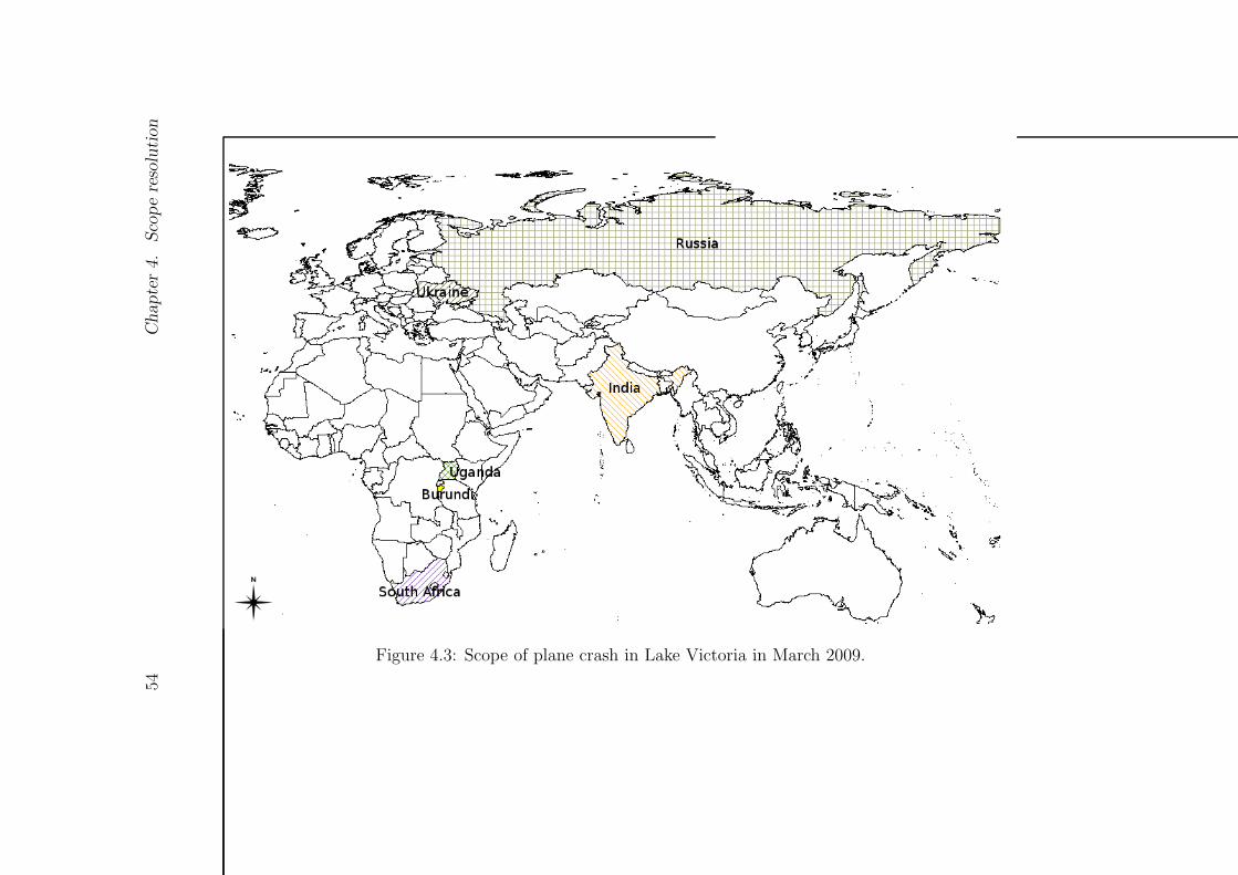
54Chapter4.
Scoperesolution
Figure 4.3: Scope of plane crash in Lake Victoria in March 2009.
4.1. Resolution with place names 55
Mexican and U.S.A sites automatically after scope resolution.The places mentioned in the three articles participate in one of the follow-
ing relationships with each other: part-of relationship, contain-by relation-ship, adjacency or neighbourliness relationship and feature type relationship.For example, Mexico is contained in Central America, is adjacent to UnitedStates of America; Mexico City is contained in Mexico; Mexico and UnitedStates of America share feature of type country. We can therefore, assumethat when authors of articles describe events in a given geographic area orscope, they tend to mention places that share one or more of the relationshipsmentioned above. The geographical scope resolution approach described inthis Section is grounded on Assumption 1 derived from the above observation.
Assumption 1 Places of the same type or under the same administrativejurisdiction or adjacent-to each other are more likely to be mentioned in agiven discourse unit. For example, a discourse mentioning ‘The Netherlands’is more likely to mention places of the type country (e.g., United Kingdom,Uganda) or places under the jurisdiction of ‘The Netherlands’ (e.g., Ams-terdam, Rotterdam) or places adjacent to ‘The Netherlands’ (e.g., Belgium,Germany).
To verify the assumption, six types of reference or model geographicalscopes are defined – three at administrative division level (e.g., Uganda,Province of Groningen, State of California, etc.) and three at a directionallevel (e.g., north west of Uganda, east of Groningen, etc.). The scopes atthe administrative level are confined to the level of continent, country andprovince. The directional scopes are confined to the level of continent (e.g.,western Europe), country (e.g., north east of Netherlands) and province (e.g.,north of Groningen). In this dissertation, the term province is used in abroader sense to refer to the first order administrative unit of a country e.g.,states in United States of America, provinces in The Netherlands, districtsin Uganda, etc.
Each geographical scope is organised around the model shown in Fig. 4.4,which is a pictorial depiction of the scope resolution assumption (see Assump-tion 1). The hollow diamond head arrows indicate part-of relation, and linehead arrow indicate the neighbor relationship. The target-region (also calledthe target-scope) is the geographical scope or area being described by thedataset. The target-region can have one and only one parent-region. A neigh-bor shares the same parent-region, common border and feature type with thetarget-region. The child-region (also called the primary administration di-vision) and primary-cities are direct descendants of the target-region. Thechild-child-regions and secondary cities are the secondary administrative di-visions and cities in the primary administration division. The smallest-cities

56 Chapter 4. Scope resolution
parent-region
target-region neighbors
primary-cit ieschild-regions
smallest-cit ies
secondary-cit ieschild-child-regions
Figure 4.4: Data model for geographical scope modeling.
are cities found both in the primary and secondary administrative divisions. 2
The parent-region shares a one-to-many relationship with the target-regionand the target-region’s neighbor; the target-region shares a one-to-many re-lationship with its immediate neighbor, child-region and primary-city ; child-region is in one-to-many relationships with the child-child-regions, secondary-cities and smallest-cities ; and child-child-region shares one-to-many relation-ship with primary-cities and smallest-cities.
The contribution of each geographical unit or region in Figure 4.4 to thetarget-region’s scope definition differs. For example in Figure 4.5, Amster-dam, Rotterdam and The Hague contribute more to the definition of theNetherlands than other cities in the Netherlands. This contribution repre-sents the importance attached to an entity in resolving the target-region’sgeographical scope. Through experiment or expert knowledge a weight isattached to each geographical entity in Figure 4.4.
The term city as used here has a broader sense referring to any of thefollowing municipalities: city, town or village. Figure 4.5 shows the referencescope model for the Netherlands demonstrating how the geographical scopemodeling data structure in Figure 4.4 is populated. To determine the geo-
2The terms primary administrative division and secondary administrative division areused in the context of the target region or scope. For example, the Dutch Province of
Groningen is a primary administrative division in the scope of the Netherlands, but asecondary administrative division in the scope of Europe.

4.1. Resolution with place names 57
BelgiumGermany
Netherlands
Europe
AmsterdamRotterdamThe Hague
etc.
North HollandSouth Holland
Groningenetc.
DelftLeiden
The HagueRotterdam
etc.
DelftGoudaLeiden
etc.
BoskopHil legom
LisseVlistetc
Figure 4.5: Sample data model for scope of the Netherlands.

58 Chapter 4. Scope resolution
graphical scope of a document, terms that refer to locations such as placenames and adjectives (referring to location and people) are extracted from thedocument. The extracted information is mapped against reference geograph-ical scopes of places, and a weighted list of geographical scopes associatedwith the document retrieved.
A number of algorithms can be used to implement the mapping from doc-ument to reference geographical scopes modeled according to Figure 4.4. Thealgorithms could be based on machine learning where the learner is trainedwith reference geographical scopes. Then the learner is used to assignedgeographical scopes to new unseen documents. Alternatively, informationretrieval algorithms such as vector space models could be used to index thereference geographical scope data. To assign scopes to documents, the searchquery consisting of place names extracted from the document would be runagainst the index, and a list of ranked scopes retrieved. The retrieved scopesare then considered to represent the geographical coverage of the document.In this work, an information retrieval based algorithm is used to implementthe mapping from document to reference geographical scopes.
The zone indexing (Manning et al., 2007) paradigm provides a suitablepath to map documents to reference geographical scopes. The zone indexingmodel sub-divides documents into zones, and creates inverted indexes foreach zone. The model supports querying against individual zones. Eachzone can be assigned a weight reflecting its importance in the document.These weights are either assigned by an expert or through experiment. Thescore of each zone for a given query is combined to form the document scorefor the query.
Let w1, ..., wn denote the importance attached to geographical units orregions in Figure 4.4 such that
∑n
i=1wi = 1. And for 1 ≤ i ≤ n, let si bethe Boolean score denoting a match or no match between a place name inthe document d and the place name in the ith geographical unit or region inFigure 4.4. If a match occurs between a document’s place name and a placename in a given unit, a Boolean value of 1 could be assigned, otherwise a 0value is assigned. The matching score between document d and geographicalscope g is computed as
score(g, d) =n
∑
i = 1
wi × si (4.1)
To illustrate the application of the zone indexing model, the sample scopedata for the Netherlands in Figure 4.5 is transformed to the zone indexingparadigm as shown in Table 4.1. On the basis of the zone indexing model, thegeographical scope model in Figure 4.4 becomes a document, and standard

4.1. Resolution with place names 59
Zone Data Weight
Target region Netherlands 0.30Parent region Europe 0.05Neighbors Belgium, Germany 0.03Primary cities Amsterdam, Rotterdam, The Hague 0.20Child regions North Holland, South Holland, Groningen 0.15Child-child regions Delft, Leiden, The Hague, Rotterdam 0.07Secondary cities Delft, Gouda, Leiden 0.15Smallest cities Boskop, Hillegom, Lisse, Vlist 0.05
Table 4.1: Zone index for the sample Netherlands scope data in Fig. 4.5.
queries can be issued against the index to retrieve a ranked list of scopedocuments. The retrieved scope documents represent geographical scopes ofthe query. Each query is made-up of place names extracted from documentswhose scopes are to be resolved. The weights are assigned to each zone byintuition. For example, a geographical reference in the query which is alsothe name of a scope is accorded more weight for a match in a target-regionzone than a match in parent-region zone.
To demonstrate the use of Equation 4.1, consider documents d1 and d2with the list of place names they contain:
(1) d1 = { Netherlands, Groningen, Leiden }(2) d2 = { Groningen, Leiden, Lisse }
Using the sample reference scope for the Netherlands shown in Table 4.1, thedocuments, d1 and d2 are resolved to the Netherlands as follows:
score(g, d1) = 0.30× 1 + 0.15× 1 + 0.07× 1 + 0.15× 1 = 0.67
score(g, d2) = 0.15× 1 + 0.15× 1 + 0.07× 1 + 0.05× 1 = 0.42
The score formula ranks document d1 higher than d2 in the scope ofNetherlands, i.e., document d1 is considered more Netherlands than docu-ment d2. The Boolean based score ignores the number of times a term occursin a document. This results in loss of frequency information which is impor-tant to guess to what degree a document is about a given term in the query.To include frequency count information, si is substituted with the frequencycount pfij of the jth place name in the source document for every zone iwhere a match occurs. Then Equation 4.1 becomes

60 Chapter 4. Scope resolution
score(g, d) =
n∑
i = 1
wi × pfij (4.2)
where wi is the weight of the ith zone and pfij is the frequency count of the jth
place name in the source document. Furthermore, places found in the sameregion or zone are not always of equal importance, e.g., in the Netherlands,The Hague can be considered more important than Rotterdam because it isthe seat of the national government. Therefore, each place is assigned animportance weight pij based on its type or population size or economy, andscore formula in Equation 4.2 becomes
score(g, d) =
n∑
i = 1
wi × pfij × pij (4.3)
where pij is the importance attached to place j in the zone or region. Todemonstrate consider document d3 and d4 with the list of place names theycontain.
(3) d3 = { The Hague }(4) d4 = { Rotterdam }
Assume that places of type capital city are considered more important thanother places, and therefore, are given an importance weight of 2.0, and tothe rest an importance weight of 1.0. Using Equation 4.3, documents d3 andd4 are resolved to the Netherlands with different scores
score(g, d3) = 0.20× 1 × 2.0 + 0.07 × 1 × 1.0 = 0.54
score(g, d4) = 0.20× 1 × 1.0 + 0.07 × 1 × 1.0 = 0.27
Document d3 is more about the Netherlands than document d4 though theplace names in them share zones.
4.1.2 Reference scope
This section describes how reference scopes are defined from the Geonames.orgdatabase. Features of the class administrative unit (A) and populated place(P) (see Table 3.1 on page 29 and Table 3.2 on page 30 for reference) are usedto define reference geographic scopes against which document scopes are re-solved. Each reference scope is modeled according to the data model shownin Fig. 4.4 (See sample in Fig. 4.5). In this thesis, we limit geographic scopesto: (1) continent (CT) e.g., Europe, (2) continent directional (CD) as defined

4.1. Resolution with place names 61
North
North West North East
SouthSouth West South East
West EastCentral
xL1 xL2
yL1
yL2
(xMin, yMin)
(xMax, yMax)
Figure 4.6: Directional sub-division of the Netherlands.
by the UN-statistics division3 e.g., Western Europe, (3) country (PC) e.g.,the Netherlands, (4) country directional (PD) e.g., north-east-of the Nether-lands, (5) province (AM) e.g., Groningen, and (6) province directional (AD)e.g., north Groningen.
Sanderson and Kohler (2004) found that directional terms were occasion-ally used to specify part of a larger area (e.g., a county or a state) contrary tobeing used in directional sense (e.g., north of Schipol Airport). For direction-ally oriented scopes at country and province levels, the regions are furthersub-divided into nine sections: north, north-east, east, south-east, south,south-west, west, north-west, and central. Country and province polygons
3http://unstats.un.org/unsd/default.htm

62 Chapter 4. Scope resolution
are sub-divided into nine directional regions by dividing a reference boundingbox about the polygon as shown in example in Figure 4.6. The partitioninglines xL1, xL2, yL1 and yL2 in Figure 4.6 are computed using Equation 4.4
xL1 = xMin + λ1 × (xMax − xMin)
xL2 = xMin + λ2 × (xMax − xMin)
yL1 = yMin+ λ1 × (yMax− yMin)
yL2 = yMin+ λ2 × (yMax− yMin)
(4.4)
where;
λ1 + λ2 = 1 (4.5)
and
0.0 < λ1 ≤ 0.5. (4.6)
For the work reported in this thesis, the λ1 values for province and coun-try directional scopes are intuitively set to 0.35 and 0.30 respectively. Theproblem associated with the use of bounding box as a reference to parti-tion a polygon is that the original polygon is usually unequally partitionedamong different directional regions. This is because any method exploiting abounding box as a reference guide is bound to be affected by both the shapeand the orientation (i.e., North-South and East-West) of the region to bepartitioned. As shown in Figure 4.6, the North West region of the Nether-lands covers a smaller portion of the Netherlands in comparison to the largerportion covered by North East. Motivated by the geographical informationretrieval (GIR) challenge, Van Kreveld and Reinbacher (2003) undertook acomprehensive study to equally partition a polygon into North, East, Westand South (NEWS).
We note that the sub-division of regions into compass directions is de-termined by many factors which are local, and varies from one region toanother. For example, the five regions of the United States (Northeast,Southeast, Midwest, Southwest, and the West) are grouped according to his-tory, traditions, economy, climate, and geography. This indicates that whensub-dividing regions into compass directions, local knowledge supercedes al-gorithmic alternatives.
Continent and continent-directional scopes
Continent and continent-directional scopes consist of the following constituents:continent, countries, country-capitals (LC), provinces, provincial-capitals (LA)and cities with over 49,999 inhabitants. Table 4.2 shows the distribution ofscopes, locations and names at continent and continent-directional level. The

4.1. Resolution with place names 63
average name-to-location ratio within the scopes is 4.68. There are 7 conti-nent scopes compared to 24 continent-directional scopes.
Country and country-directional scopes
Each country scope is defined by its child constituents, parent continentand adjacent countries. And each country-directional scope is defined by itschild constituents and parent country. The following make up country andcountry-directional child constituents: country, country-capital, provinces,provincial-capitals, counties and cities with over 9,999 inhabitants. Thedistribution of scopes, locations and names at the country and country-directional level is depicted in Table 4.2. The average name-to-location ratiowithin the scopes is 1.73. There are 190 country scopes compared to 1,089country-directional scopes.
Province and province-directional scopes
Each province scope is defined by its child constituents, parent country, andadjacent provinces. And each province-directional scope is defined by itschild constituents and parent province. Provinces and province-directionalunits consist of the following child constituents: province, provincial capitals,country-capitals, counties and all populated places. Table 4.2 shows the dis-tribution of scopes, locations and names at province and province-directionallevel. The average ratio of name-to-location within the scopes is 1.02. Thereare 4,749 province scopes compared to 20,761 province-directional scopes.
Scope No. scopes No. locations No. names
Continent (CT) 7 13,226 61,939Continent-directional (CD) 24 13,226 61,990Country (PC) 190 105,576 182,442Country-directional (PD) 1,089 105,569 182,442Province (AM) 4,749 2,311,244 2,354,716Province-directional (AD) 20,761 2,005,682 2,068,732
Total number of scopes 26,820
Table 4.2: Statistics of standard geographic scope.
64 Chapter 4. Scope resolution
4.1.3 Implementation
To evaluate the scope resolution assumption (see Assumption 1 on page 55),the Apache Lucene search engine library is used to implement the zone in-dexing concept described in Section 4.1. The Lucene’s default similaritymeasure is derived from vector space model (VSM) (Salton, 1989).4 Thevector space model views both the document and query as vectors ( i.e.,terms obtained from document and query texts with associated weights) ina multi-dimensional space.
Lucene similarity measure
The Lucene relevance score formula combines several factors to determinethe score of a document for a given query (Gospodnetic and Hatcher, 2005):
NonSim(q, d) =∑
t∈q
tf(t ∈ d) · idf(t) · bst · lN(t.f ield ∈ d) (4.7)
where, · operator stands for multiplication, tf(t ∈ d) is the term frequencyfactor for term t in document d, idf(t) is the inverse document frequency ofterm t in the document collection, bst is the field boost set during indexingand lN(t.f ield ∈ d) is the normalization value of a field given the numberof terms in the field (see Gospodnetic and Hatcher (2005) for more details).The purpose of boosting is to indicate how important a given term is relativeto other terms in the document.
Indexing documents in Lucene
The Apache Lucene system treats a document as a collection of fields (i.e.,similar to zones in zone indexing model). Each Lucene field corresponds to apiece of data that is either queried against or retrieved from the index duringsearch. Lucene provides four types of fields: (1) Keyword – is indexed andstored in the index, but not analysed, (2) UnIndexed – is neither analysednor indexed, but its value is stored in the index, (3) Unstored – is analysedand indexed, but not stored in the index, and (4) Text – is analysed, indexedand stored.
Each Lucene field consists of a name and a value. Values may be freetext, or they may be atomic keywords, which are not processed further.Such keywords may be used to represent dates, urls, names of places, namesof people, etc. Fields are optionally stored in the index, so that they may bereturned with hits on the document.
4Thank you to Dubin (2004) for correcting VSM citation confusion.
4.1. Resolution with place names 65
Searching documents in Lucene
The Lucene term is the basic unit for searching. Similar to a Lucene field,a term consists of a pair of string elements: the name of the field and thevalue of that field. Lucene also provides the capability to query on multiplefields, and a query term boosting factor.
As an example, assume a Lucene index consisting of three fields; conti-nent, country and capital. To query for documents containing place namesGroningen and Netherlands, one would enter
continent:(groningen netherlands) country:(groningen netherlands)capital:(groningen netherlands)
Now assume that one considers documents containing place namesGronin-gen and Netherlands in continent field to be more relevant. To achieve thiseffect, boasted query terms can be submitted to continent field as follows:
continent:(groningen∧4 netherlands∧4) country:(groningen∧2 netherlands∧2)capital:(groningen netherlands)
This implies that finding Groningen and Netherlands in the continent fieldof a document is more important than finding them in country and/or capitalfield.
The multi-field query and query term boosting capabilities of Lucene areleveraged to implement the zone indexing model for the scope resolutionassumption (see Assumption 1 on page 55) advanced in this work.
Indexing reference scopes in Lucene
The Lucene document for holding reference scope datasets (i.e., the 26,820reference scopes) defined in Sub-Section 4.1.2 is designed according to the ge-ographical scope model shown in Figure 4.4 (on page 56). The primary-citieszone in Figure 4.4 is split into two parts – a.primary-cities and b.primary-cities according to the type of the city (i.e., capital city, provincial capital,etc. ) and/or the population size of the city. The splitting of the primary-cities zone into two was arrived at through experiments and intuition for abetter performance achievement. A total of ten Lucene fields are defined toimplement the geographical scope model:
1. unique scope identifier - scope-id,
2. names of the scope or target region - target-region,
66 Chapter 4. Scope resolution
3. names of capitals and populated places (i.e., cities, towns & villages)with large population - a.primary-cities,
4. names of primary administrative units - child-region,
5. names of secondary administrative units - child-child-region,
6. names of primary cities, towns and villages - b.primary-cities,
7. names of secondary cities, towns and villages - secondary-cities,
8. names of adjacent regions of the same type - neighbors,
9. names of parent regions - parent-region, and
10. names of relatively smaller child places - smallest-cities.
The type of a place (e.g., capital city, provincial capital) and/or popu-lation size is used to group places within a scope category. For example, topopulate a.primary-cities field; cities, towns and villages with over 500,000inhabitants are considered in country scopes while the threshold is lowered to100,000 inhabitants in province scope. Table 4.3 and Table 4.4 show exampleLucene index data for the scope Europe and the Netherlands with weights ofeach zone in column Weights. A complete layout of reference geographicalscope data in Lucene index is shown in Table 4.5.
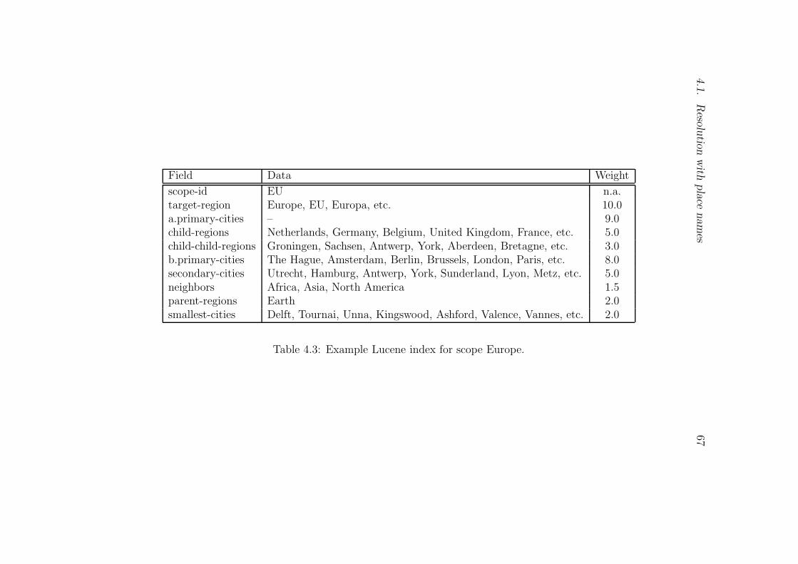
4.1.
Reso
lutio
nwith
place
names
67
Field Data Weight
scope-id EU n.a.target-region Europe, EU, Europa, etc. 10.0a.primary-cities – 9.0child-regions Netherlands, Germany, Belgium, United Kingdom, France, etc. 5.0child-child-regions Groningen, Sachsen, Antwerp, York, Aberdeen, Bretagne, etc. 3.0b.primary-cities The Hague, Amsterdam, Berlin, Brussels, London, Paris, etc. 8.0secondary-cities Utrecht, Hamburg, Antwerp, York, Sunderland, Lyon, Metz, etc. 5.0neighbors Africa, Asia, North America 1.5parent-regions Earth 2.0smallest-cities Delft, Tournai, Unna, Kingswood, Ashford, Valence, Vannes, etc. 2.0
Table 4.3: Example Lucene index for scope Europe.
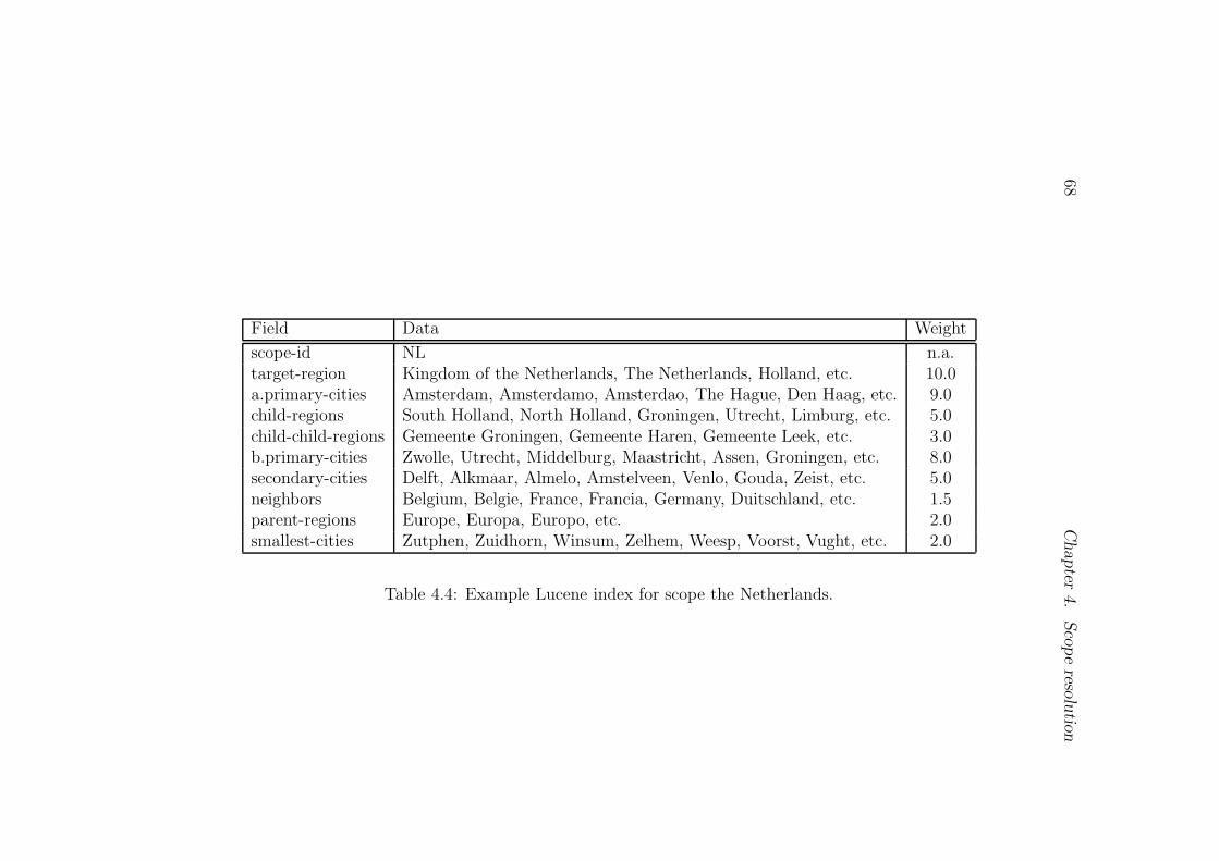
68Chapter
4.
Scopereso
lutio
n
Field Data Weight
scope-id NL n.a.target-region Kingdom of the Netherlands, The Netherlands, Holland, etc. 10.0a.primary-cities Amsterdam, Amsterdamo, Amsterdao, The Hague, Den Haag, etc. 9.0child-regions South Holland, North Holland, Groningen, Utrecht, Limburg, etc. 5.0child-child-regions Gemeente Groningen, Gemeente Haren, Gemeente Leek, etc. 3.0b.primary-cities Zwolle, Utrecht, Middelburg, Maastricht, Assen, Groningen, etc. 8.0secondary-cities Delft, Alkmaar, Almelo, Amstelveen, Venlo, Gouda, Zeist, etc. 5.0neighbors Belgium, Belgie, France, Francia, Germany, Duitschland, etc. 1.5parent-regions Europe, Europa, Europo, etc. 2.0smallest-cities Zutphen, Zuidhorn, Winsum, Zelhem, Weesp, Voorst, Vught, etc. 2.0
Table 4.4: Example Lucene index for scope the Netherlands.

4.1.
Reso
lutio
nwith
place
names
69Scope levels 7→ CTa CDb PCc PDd AMe ADf WTg
scope-id CT-ID CD-ID PC-ID PD-ID AM-ID AD-ID n.a.target-region CT PC AM 10.0a.primary-cities LC,P500 LC,P500 LA,LC,P150h LA,P150 9.0child-regions PC PC AM AM A2 A2 5.0child-child-regions AM AM A2i A2 3.0b.primary-cities LC,P500j LC,P500 LA,P100 LA,P100 P50 P50 8.0secondary-cities LA,P100k LA,P100 P50 P50 P5l,P10 P5,P10 5.0neighbors CT PC AM 1.5parent-regions EHm CT CT PC PC AM 2.0smallest-cities P50n P50 P10o P10 P0p P0 2.0
aCT: Continent, e.g., Europe, Africa, etc.bCD: Continent Directional, e.g., Western Europe, Eastern Africa, etc.cPC: Country, e.g., Netherlands, Uganda, United States, etc.dPD: Country Directional, e.g., north-east Netherlands, north-west Uganda, south-west United States, etc.eAM: Province (or state or district, etc.), e.g., Groningen Province, California State, Arua District, etc.fAD: Province ( or state or district, etc.) Directional, e.g., northern Groningen, southern California, central Arua, etc.gWT: Weight of the field or zone determined through experiment.hP150: Population centers (population ≥ 100,000).iA2: Second order administrative division of a country.jP500: Population centers (population ≥ 500,000).kP100: Population centers (100,000 ≤ population < 500,000).lP5: Population centers (5,000 ≤ population < 10,000).
mEH: Earth.nP50: Population centers (50,000 ≤ population < 100,000).oP10: Population centers (10,000 ≤ population < 50,000).pP0: Population centers (population < 5,000).
Table 4.5: Reference scope data layout in Lucene index.
70 Chapter 4. Scope resolution
Resolving document scope
The basic procedures to assign a geographic scope(s) to a document are:
1. extract geographical terms (i.e., place names, place types and adjectivesof places) from a document using a geographical tagger,
2. use geographical terms (i.e., plane names and/or adjectives) extractedin Step 1 above as query keywords, and compare the query against theLucene index previously populated with reference geographical scopes(see Section 4.1.3), and
3. return a ranked list of geographical scopes for the document.
The zone indexing concept adopted to implement the proposed geograph-ical scope resolution procedure is transformed into a Lucene implementationat two levels:
1. Zones are implemented as Lucene fields and processed accordingly.
2. A weighted zone score is implemented through the Lucene boostingand multi-field query capability.
To effectively resolve a document’s geographic scope within Lucene, queryformulation is crucial. The following features are considered in the queryformulation strategy for the weighted zone score parameters in Equation 4.3and Equation 4.8:
1. Lucene field importance (i.e., the perceived importance of the geo-graphic scope feature),
2. type of place,
3. importance of the place determined by population, and
4. the number of occurrences of the place name in a document.
The importance of assigning different weights to fields comes into playwhen the same place takes different roles in different scopes e.g., in thehierarchy Groningen 7→ Netherlands 7→ Europe 7→ Earth, Groningen is aprimary administrative unit in The Netherlands while a secondary admin-istrative unit within Europe. That is, Groningen carries more importancewithin the Netherlands scope than it does within Europe scope. Impor-tance is assigned to Lucene fields in the following order (i.e., descendingorder of importance): target-region 7→ a.primary-cities 7→ b.primary-cities
4.1. Resolution with place names 71
7→ child-regions 7→ secondary-cities 7→ child-child-regions 7→ parent-region7→ smallest-cities 7→ neighbors. And weights are assigned to types of placesaccording to the following order (i.e., descending order of importance): conti-nent (CT) 7→ country (PC) 7→ country-capital (LC) 7→ province-capital (LA)7→ province (AM) 7→ municipality (A2). Other cities are assigned weightsaccording to their population size.
The aforementioned features are factored into the query formulation strat-egy as place name boost factors using Equation 4.8 derived from Equation 4.3
P lacenameBoostFactor = wi × pfij × pij (4.8)
where wi is the weight of the ith zone or field, pfij is the frequency countof the jth place name in the source document, and pij is the importanceattached to place j in the zone or field. The importance pij of a place isdetermined by the type of the place and/or the population size of the place.
Besides query formulation attention is paid to how the index is searched.Each place name in the query is analyzed to determine which field or fieldsto query against (e.g., the query Netherlands is submitted to search the fieldvalues of target-region and child-region as the Netherlands can be the nameof scope Netherlands or the name of a primary administrative unit in scopeEurope). Table 4.6 shows place name importance weights implemented inthe query formulation strategy. The weight wi assigned to each zone orfield is shown in column WT in Figure 4.5. The values of the weights wereexperimentally determined.
Place or people adjectives occur frequently in documents (see Table 4.7),and exploitation of these adjectives to resolve a document’s geographic scopemay prove useful. However, geographic adjectives, like place names, arehighly ambiguous – seeing French in a document does not necessarily referto things explicitly connected to the nation of France (e.g., French in adocument may refer to a subject in school or a type of cooking). Nevertheless,if used judicially, geographic adjectives (i.e., place or people adjectives) canprovide useful information to geographically resolve document scopes. Inthis work, query geographic adjectives (e.g., Dutch, French) are mappedto their corresponding country names (e.g., Dutch mapped-to Netherlands,French mapped-to France) with a weight lower than the one assigned tomapped country names. No effort is made to resolve geographic adjectiveambiguities; instead it is assumed that the places the adjective refers to aremost likely mentioned (i.e., implicitly or explicitly) in the document, andtherefore, the geographic scope resolution engine simply uses the adjectiveto further reinforce scope resolution. This will result in some cases whereadjectives are incorrectly interpreted as referring to a place, but the overall
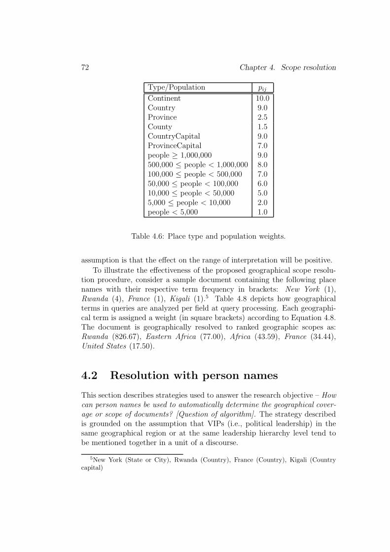
72 Chapter 4. Scope resolution
Type/Population pij
Continent 10.0Country 9.0Province 2.5County 1.5CountryCapital 9.0ProvinceCapital 7.0people ≥ 1,000,000 9.0500,000 ≤ people < 1,000,000 8.0100,000 ≤ people < 500,000 7.050,000 ≤ people < 100,000 6.010,000 ≤ people < 50,000 5.05,000 ≤ people < 10,000 2.0people < 5,000 1.0
Table 4.6: Place type and population weights.
assumption is that the effect on the range of interpretation will be positive.
To illustrate the effectiveness of the proposed geographical scope resolu-tion procedure, consider a sample document containing the following placenames with their respective term frequency in brackets: New York (1),Rwanda (4), France (1), Kigali (1).5 Table 4.8 depicts how geographicalterms in queries are analyzed per field at query processing. Each geographi-cal term is assigned a weight (in square brackets) according to Equation 4.8.The document is geographically resolved to ranked geographic scopes as:Rwanda (826.67), Eastern Africa (77.00), Africa (43.59), France (34.44),United States (17.50).
4.2 Resolution with person names
This section describes strategies used to answer the research objective – Howcan person names be used to automatically determine the geographical cover-age or scope of documents? [Question of algorithm]. The strategy describedis grounded on the assumption that VIPs (i.e., political leadership) in thesame geographical region or at the same leadership hierarchy level tend tobe mentioned together in a unit of a discourse.
5New York (State or City), Rwanda (Country), France (Country), Kigali (Countrycapital)

4.2. Resolution with person names 73
Adjective (Adj) People (Ppl)Country (Ctry) Adjective Adj/Ctry People Ppl/Ctry
Afghanistan Afghan 0.23602 Afghans 0.04616Afghanistan Afghani 0.01896 Afghanis 0.00427Albania Albanian 0.33250 Albanians 0.02658Algeria Algerian 0.09580 Algerians 0.00834Angola Angolan 0.02462 Angolans 0.00317Australia Australian 0.27196 Australians 0.02159Bulgaria Bulgarian 0.29286 Bulgarians 0.00879Czech Republic Czech 1.61176 Czechs 0.01618United Kingdom British 0.71228 Britons 0.01185Great Britain British 10.20062 Britons 0.16975Greece Greek 0.83200 Greeks 0.06240India Indian 0.51842 Indians 0.11310France French 0.41138 French 0.41138Norway Norwegian 0.42972 Norwegians 0.00835Poland Polish 0.49271 Poles 0.13294
Table 4.7: Place and people adjective occurrence on the Internet.
A VIP is an important or influential person whose actions and opinionsstrongly influence the course of events.6 The 2009 Time 100 Issue7 namedthe people who most affected our world in 2009. Time grouped them intofive categories: (1) leaders and revolutionaries, (2) builders and titans, (3)artists and entertainers, (4) heroes and icons, (5) scientists and thinkers. Thefollowing people made it into the leaders and revolutionaries group: EdwardKennedy, Gordon Brown, Christine Lagarde, Thomas Dart, Avigdor Lieber-man, Joaquın Guzman, Nouri al-Maliki, Hillary Clinton, Susilo BambangYudhoyono, Boris Johnson, Norah al-Faiz, Elizabeth Warren, Paul Kagame,Nicolas Sarkozy, Angela Merkel, Wang Qishan, Xi Jinping, David McKier-nan, Ashfaq Kayani, Barack Obama. The influence of people in the leadersand revolutionaries category is most felt within a geographic area over whichtheir authority extends. For example, Mr. Paul Kagame strongly influencescourse of events in Rwanda where he exercises his legal authority as thepresident of Rwanda.
6[16 September 2009]: http://www.thefreedictionary.com/very+important+
person7[16 September 2009]: http://www.time.com

74 Chapter 4. Scope resolution
Field Query Formulation
scope-id n.a.target-region new york[25.0] rwanda[360.0] france[90.0]a.primary-cities kigali[81.0]child-regions new york[12.5] rwanda[180.0] france[45.0]child-child-regions new york[7.5]b.primary-cities new york[56.0] kigali[72.0]secondary-cities new york[35.0]neighbors new york[3.75] rwanda[54.0] france[13.5]parent-region new york[5.0] rwanda[72.0] france[18.0]smallest-cities new york[12.0]
Table 4.8: Example query formulation for per field querying.
Assumption 2 VIPs (i.e., political leadership) in the same geographical re-gion or at the same leadership hierarchy level tend to be mentioned togetherin a unit of a discourse. That is, presidents are most likely to be mentionedtogether with the members of their administration or with presidents of othercountries in a unit of a discourse. For example, US President Barack Obamais most likely to be mentioned in a discourse together with US Vice PresidentJoe Biden or President Yoweri Kaguta Museveni of Uganda in a discourse.
In this dissertation, the people whose actions and opinions most determinecourse of events in a particular geographic scope or area shall be called theGeoVIPs. The political and government leaders fall under the GeoVIP cat-egory because their jurisdictions are geographically constrained. It is there-fore plausible to infer the geographical scope of a document from the listof GeoVIPs mentioned in a document. The people in other categories (i.e.,builders and titans, artists and entertainers, heroes and icons, and scientistsand thinkers) influence course of events at global scope.
To effectively map GeoVIPs to the geographic area of their jurisdictions,the administrative division of a country is used as a reference guide. Gen-erally a country is sub-divided into two main administrative divisions: (1)the primary administrative division (PAD), and (2) the secondary adminis-trative division (SAD). In different countries these administrative divisionsare referred to differently. For example; in the Netherlands, PAD and SADare respectively referred to as province and municipality, and in Uganda asdistrict and county. In other countries the SADs are sub-divided into smalleradministrative units for better service provision. For example, in Uganda acounty is sub-divided in sub-counties. For the case of Uganda, the admin-

4.2. Resolution with person names 75
istrative division of a country is as follows: country 7→ district 7→ county7→ sub-county 7→ parish 7→ village. At every level of administrative divisionthere is a GeoVIP who exercises an administrative jurisdiction over the area.As whatever happens in our neighborhood affects us in one way or another,GeoVIPs can influence course of events in nearby geographic areas outsidetheir jurisdictions. For example, President Barack Obama of United Statesof America (U.S.A.) can to some extent influence the course of events incountries bordering U.S.A. (i.e., in Canada and Mexico).
Division Administrative Position
Country President, Vice President, Prime Minister,Cabinet Ministers, Chief Justice, GovernorCentral Bank, Army Commander, etc.
District District Commissioner, Chief AdministrativeOfficer, Women MP, District LocalCouncil Chairman, District Judge,District Clerk, District Speaker, etc.
County Member of Parliament, Local Councilors toDistrict Council, County Chief, etc.
Sub-County Sub-County Local Council Chairman, etcParish Parish Local Council Chairman, etc.Village Village Local Council Chairman, etc.City City Mayor, City Clerk, etc.Municipality Municipality Mayor, Town Clerk, etc.
Table 4.9: Example administrative division vs. position.
In a country like Uganda the administrative and political positions can bemapped to administrative divisions as shown in Table 4.9. The organisationof administrative divisions of many countries is a variant of what is depictedfor Uganda in Table 4.9. The GeoVIPs exercising jurisdictions at variousadministrative units or levels can be used to perform geographic scope res-olution. The following are the challenges to the use of the GeoVIP list fordocument scope resolution:
1. Name ambiguity – many people share names locally and globally.
2. GeoVIPs are often limited in their terms of office, therefore, the main-tenance of a comprehensive, up-to-date GeoVIP information is non-trivial.
76 Chapter 4. Scope resolution
4.2.1 Person name ambiguity resolution
The names of people are highly ambiguous (Fleischman and Hovy, 2004;Mann and Yarowsky, 2003) and therefore, exploiting person names to im-plement automatic systems is a non-trivial task. Before an attempt is madeto resolve the geographical scope of documents using the names of peoplethey contain, some minimum level of person name resolution is required. Forexample, we should be able to resolve the name Mr. Brown to Prime Minis-ter Gordon Brown before attempting to resolve the geographical scope Mr.Brown indicates.
Generally the names of people are broadly grouped into three categories- first name, surname and middle name. Over the centuries people haveshared names within the three categories. Names can commonly be sharedonly within a given geographic space, e.g., surnames (e.g., Martin, Smith,Eriksson, etc.), and names can be shared at global scale, e.g., first names(e.g., William, Richard, John, etc.).
To perform automatic geographic scope resolution using the names ofGeoVIPs, the names of people are grouped into three: (1) global names,(2) local or country-level names and (3) GeoVIP names. The global namescategory takes care of the frequency of sharing names globally (e.g., John,Paul, Joseph), and local or country-level names category are commonly foundwithin a given geographic scope (e.g., Eriksson, Museveni, Kagame, Kabila,etc.). Table 4.10 list common ten names found in United States, UnitedKingdom and Australia. The surname Smith is commonly shared in all thethree countries. It is therefore more difficult to determine the country oforigin of Mr. Smith.
(5) Given Table 4.10, determine the country of origin of the followingpersons: 8
a. James Joseph Brownb. Evan Taylorc. Charlie Wilson
From Table 4.10, it is probably easier to infer that Evan Taylor and CharlieWilson are from United Kingdom. However, the same conclusion can not bereached for James Joseph Brown. The names in Table 4.10 are arranged withthe most commonly shared at the top to the least common at the bottom.For the question posed, assume that the top most names (i.e., Smith (USA),Aiden (USA), Smith (UK), etc.) are each shared by at least ten persons, thenext by nine, eight, until the last names at the bottom shared by one person.
8Wikipedia data accessed on 28 September 2009.
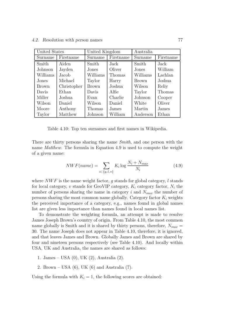
4.2. Resolution with person names 77
United States United Kingdom AustraliaSurname Firstname Surname Firstname Surname Firstname
Smith Aiden Smith Jack Smith JackJohnson Jayden Jones Oliver Jones WilliamWilliams Jacob Williams Thomas Williams LachlanJones Michael Taylor Harry Brown JoshuaBrown Christopher Brown Joshua Wilson ReliyDavis Ethan Davis Alfie Taylor ThomasMiller Joshua Evan Charlie Johnson CooperWilson Daniel Wilson Daniel White OliverMoore Anthony Thomas James Martin JamesTaylor Matthew Johnson William Anderson Ethan
Table 4.10: Top ten surnames and first names in Wikipedia.
There are thirty persons sharing the name Smith, and one person with thename Matthew. The formula in Equation 4.9 is used to compute the weightof a given name:
NWF (name) =∑
i⊂{g, l, v}
Ki logNi +Nmax
Ni
(4.9)
where NWF is the name weight factor, g stands for global category, l standsfor local category, v stands for GeoVIP category, Ki category factor, Ni thenumber of persons sharing the name in category i and Nmax the number ofpersons sharing the most common name globally. Category factor Ki weightsthe perceived importance of a category, e.g., names found in global nameslist are given less importance than names found in local names list.
To demonstrate the weighting formula, an attempt is made to resolveJames Joseph Brown’s country of origin. From Table 4.10, the most commonname globally is Smith and it is shared by thirty persons, therefore, Nmax =30. The name Joseph does not appear in Table 4.10, therefore, it is ignored,and that leaves James and Brown. Globally James and Brown are shared byfour and nineteen persons respectively (see Table 4.10). And locally withinUSA, UK and Australia, the names are shared as follows:
1. James – USA (0), UK (2), Australia (2).
2. Brown – USA (6), UK (6) and Australia (7).
Using the formula with Ki = 1, the following scores are obtained:
78 Chapter 4. Scope resolution
1. James - UK (2.13), Australia (2.13).
2. Brown - USA (1.51), UK (1.51), Australia (1.45).
Therefore, the scores for James Brown are; UK (3.64) and Australia (3.58),and James Brown is resolved to UK. The reason why James Brown resolvedto the UK is that there are more persons named Brown in Australia, so thatmore effort is required to resolve Mr. Brown in Australia.
4.2.2 Approach
For each geographical scope or area or region, GeoVIPs are grouped into fivelevels namely;� VIP1 - names of GeoVIPs at the top-most hierarchy, e.g., for a country
level scope, the top-most GeoVIP in the hierarchy is the president ofthe country.� VIP2 - names of GeoVIPs next in hierarchy to GeoVIPs listed in VIP1field. For example, at a country level scope, the cabinet ministers areincluded in this group.� VIP3 - names of GeoVIPs next in hierarchy to GeoVIPs listed in VIP2field. For example, at a country level scope, the members of the Par-liament or the Senate are included in this group.� VIP4 - names of GeoVIPs of neighboring administrative units. For ex-ample, at a country level scope, GeoVIPs of the immediate neighboringcountries are listed.� VIP5 - names of GeoVIPs of non-neighboring administrative units. Forexample, at a country level scope, GeoVIPs of non-neighboring coun-tries are listed. This category caters for the assumption that GeoVIPsat the same level tend to be mentioned together in news stories. Thatis, it is more likely that President Obama, Prime Minister Netanyahuand President Abbas will be mentioned in the same story on the MiddleEast.
An example GeoVIP grouping for Canada and United States of America isshown in Figure 4.7. As we noted above, the challenge to using the GeoVIPlist are:
1. Name ambiguity, e.g., many people share names locally and globally.

4.2. Resolution with person names 79
CALIFORNIA (CA)
VIP1: CA Governor, CA US Senators, etc.
VIP2: CA Cabinet Members, etc.
VIP3: CA Senators, etc.
VIP4: NV Governor, AZ Governor, etc.
VIP5: DC Governor, NY Governor, etc
ARIZONA (AZ)
VIP1: AZ Governor, AZ US Senators, etc.
VIP2: AZ Cabinet Members, etc.
VIP3: AZ Senators, etc.
VIP4: NV Governor, CA Governor, etc.
VIP5: TX Governor, NC Governor, etc.
UNITED STATES OF AMERICA
VIP1: President, Vice President, etc.
VIP2: Cabinet Members, etc.
VIP3: US Senators, etc.
VIP4: Canadan PM, Mexican President, etc.
VIP5: British PM, Israel PM, etc.
CANADA
VIP1: Governor General, Prime Minister, etc.
VIP2: Cabinet Members, etc.
VIP3: Members of Parliament, etc.
VIP4: US President, Mexican President, etc.
VIP5: French President, Dutch PM, etc.
NORTH AMERICA
Figure 4.7: Example U.S.A & Canada GeoVIP grouping.

80 Chapter 4. Scope resolution
Group USA GeoVIP WeightVIP1 Barack Obama, Joe Biden, Hillary Rodham Clinton, 0.40
Nancy Pelosi, John G. Roberts, Ben ShalomBernanke, Admiral Michael Mullen, etc.
VIP2 Timothy F. Geithner, Robert M. Gates, Kenneth 0.25L. Salazar, Thomas J. Vilsack, Hilda L. Solis,Kathleen Sebelius, etc.
VIP3 Senator Barbara Boxer, Senator Jay Rockefeller, 0.20Senator Pat Roberts, Senator John Mccain, SenatorBarbara Mikulski, Senator Claire McCaskill, etc.
VIP4 Michaelle Jean, Stephen Harper, Felipe de Jesus 0.15CALDERON Hinojosa, etc.
VIP5 Yoweri Kaguta Museveni, Jan Peter Balkenende, 0.10Gordon Brown, etc.
Table 4.11: Example GeoVIP data for U.S.A.
2. GeoVIPs serve limited terms in office, therefore, maintenance of a com-prehensive, up-to-date GeoVIP information is non-trivial.
Similar to the zone indexing concept applied to scope resolution with placenames (see Section 4.1 on page 50), the GeoVIP-based approach uses the zoneindexing strategy by modifying the formula in Equation 4.3 as follows:
score(g, d) =
n∑
i = 1
wi × fij × nij (4.10)
where wi is the weight of the ith VIP grouping, fij is the frequency count ofthe jth person name in the source document, nij is the weight of the j
th personname computed with Equation 4.9. To demonstrate, the news story featuringthe US Sectary of State Hillary Clinton, Canadian Minister of InternationalTrade & the Asia-Pacific Gateway Stockwell Day and Philippine PresidentGloria Macapagal-Arroyo in Figure 4.8 is used. nij is computed only fori = v (i.e., VIPs) in Equation 4.9 with Nmax = 42 (the number of themost commonly shared name John by world leaders in the CIA’s November2009 Chief of States 9):
nij = Kv logNv +Nmax
Nv
9[16 November 2009]: https://www.cia.gov/
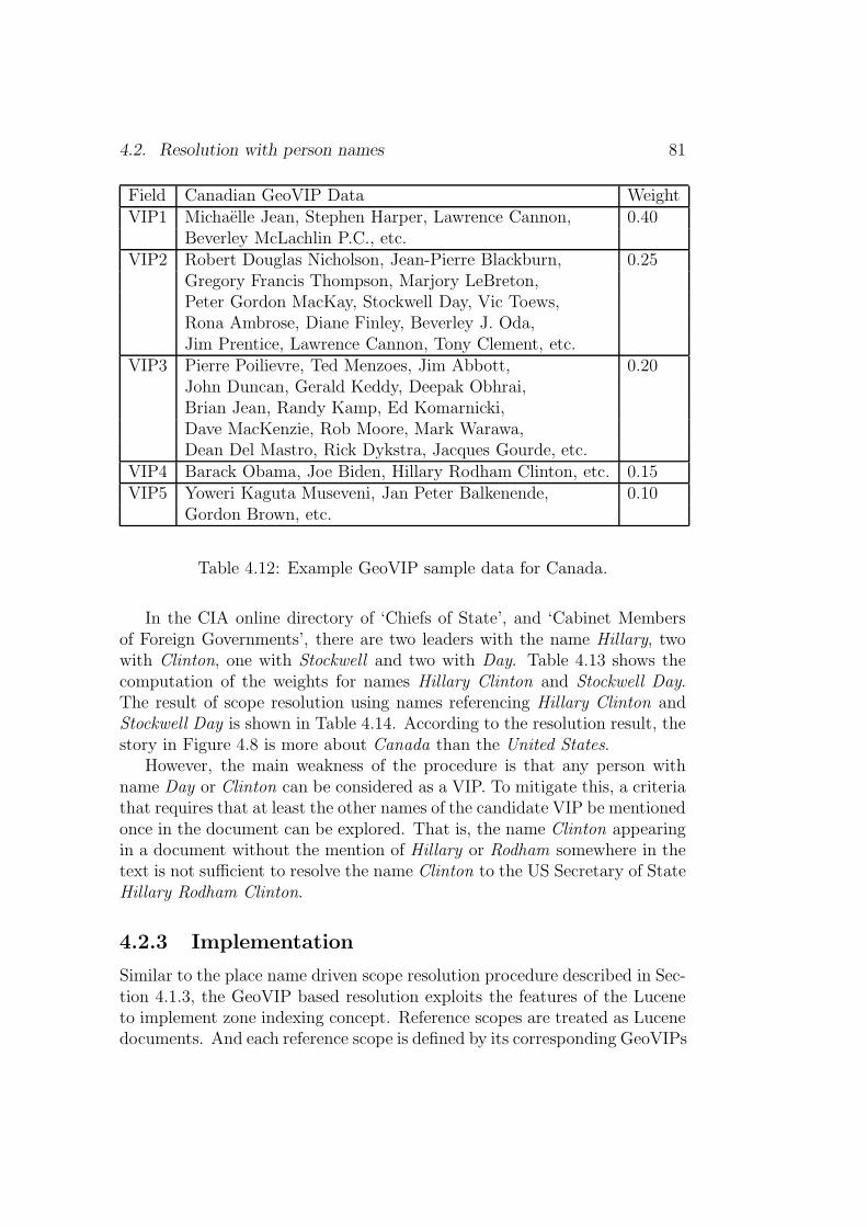
4.2. Resolution with person names 81
Field Canadian GeoVIP Data WeightVIP1 Michaelle Jean, Stephen Harper, Lawrence Cannon, 0.40
Beverley McLachlin P.C., etc.VIP2 Robert Douglas Nicholson, Jean-Pierre Blackburn, 0.25
Gregory Francis Thompson, Marjory LeBreton,Peter Gordon MacKay, Stockwell Day, Vic Toews,Rona Ambrose, Diane Finley, Beverley J. Oda,Jim Prentice, Lawrence Cannon, Tony Clement, etc.
VIP3 Pierre Poilievre, Ted Menzoes, Jim Abbott, 0.20John Duncan, Gerald Keddy, Deepak Obhrai,Brian Jean, Randy Kamp, Ed Komarnicki,Dave MacKenzie, Rob Moore, Mark Warawa,Dean Del Mastro, Rick Dykstra, Jacques Gourde, etc.
VIP4 Barack Obama, Joe Biden, Hillary Rodham Clinton, etc. 0.15VIP5 Yoweri Kaguta Museveni, Jan Peter Balkenende, 0.10
Gordon Brown, etc.
Table 4.12: Example GeoVIP sample data for Canada.
In the CIA online directory of ‘Chiefs of State’, and ‘Cabinet Membersof Foreign Governments’, there are two leaders with the name Hillary, twowith Clinton, one with Stockwell and two with Day. Table 4.13 shows thecomputation of the weights for names Hillary Clinton and Stockwell Day.The result of scope resolution using names referencing Hillary Clinton andStockwell Day is shown in Table 4.14. According to the resolution result, thestory in Figure 4.8 is more about Canada than the United States.
However, the main weakness of the procedure is that any person withname Day or Clinton can be considered as a VIP. To mitigate this, a criteriathat requires that at least the other names of the candidate VIP be mentionedonce in the document can be explored. That is, the name Clinton appearingin a document without the mention of Hillary or Rodham somewhere in thetext is not sufficient to resolve the name Clinton to the US Secretary of StateHillary Rodham Clinton.
4.2.3 Implementation
Similar to the place name driven scope resolution procedure described in Sec-tion 4.1.3, the GeoVIP based resolution exploits the features of the Luceneto implement zone indexing concept. Reference scopes are treated as Lucenedocuments. And each reference scope is defined by its corresponding GeoVIPs

82 Chapter 4. Scope resolution
Name fij nij (with Kv = 1) fij × nij
Hillary 1 1× log2 + 42
2= 3.09 3.09
Clinton 2 1× log2 + 42
2= 3.09 6.18
Stockwell 1 1× log1 + 42
1= 3.76 3.76
Day 5 1× log2 + 42
2= 3.09 15.45
Table 4.13: Person name weight computation for VIPs in Fig. 4.8.
Scope Name Group wi fij × nij wi × fij × nij Eq. 4.10
U.S.A Hillary VIP1 0.40 3.09 1.24 3.71Clinton VIP1 0.40 6.18 2.47
Canada Hillary VIP4 0.15 3.09 0.46 6.18Clinton VIP4 0.15 6.18 0.93Stockwell VIP2 0.25 3.72 0.93Day VIP2 0.25 15.45 3.86
Table 4.14: Example scope resolution using VIP names in Fig. 4.8.

4.2. Resolution with person names 83
MANILA, Philippines After United States State Secretary HillaryClinton, Canada’s International Trade Minister Stockwell Day isalso scheduled to visit the country on November 13, Canadas em-bassy here said Tuesday.
In a statement, the embassy said Day, who is also the minister forCanada’s Asia-Pacific Gateway, will visit the country to mark the60th anniversary of the establishment of diplomatic ties betweentwo countries.
During his visit, Day is expected to announce a new project tosupport local business development and highlighting the successesof Canadian companies in the Philippines in agriculture and food,transportation, infrastructure, and extractive sectors.
Like Clinton, Day will also tour the site devastated by typhoonOndoy and hand out relief goods to beneficiaries.
While in Manila, the minister will meet with President GloriaMacapagal-Arroyo, other senior officials, and important businessleaders to present Canada as an innovation and investment partnerof choice, as well as to promote Canada’s high-quality products andservices.
Day will also launch the Canadian Food Week in Makati City, andwill plant a tree at the Sun Life of Canada’s premises in Taguig City,in celebration of Sun Life’s success in the country and its strongcommitment to corporate social responsibility and the environment.(The company’s new headquarters here uses Leadership in Energyand Environmental certification.)
Source: http: // globalnation. inquirer. net/ , Accessed: 14November 2009
Figure 4.8: News story featuring Hillary Clinton and Stockwell Day.
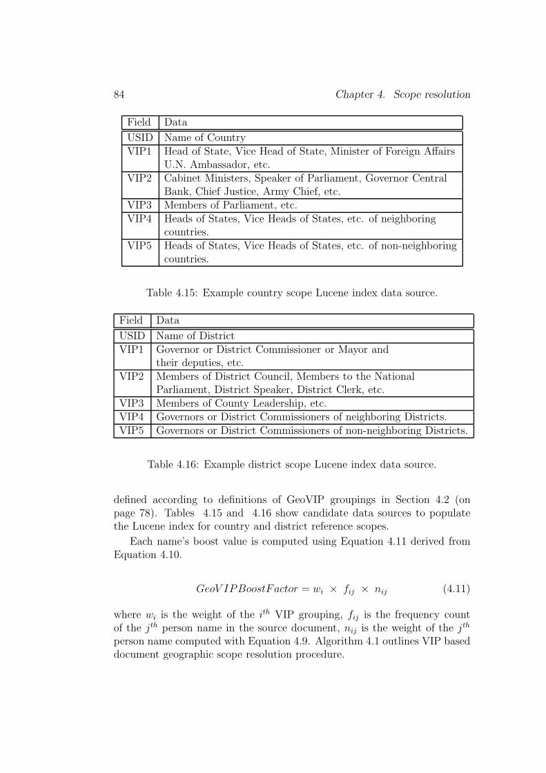
84 Chapter 4. Scope resolution
Field Data
USID Name of CountryVIP1 Head of State, Vice Head of State, Minister of Foreign Affairs
U.N. Ambassador, etc.VIP2 Cabinet Ministers, Speaker of Parliament, Governor Central
Bank, Chief Justice, Army Chief, etc.VIP3 Members of Parliament, etc.VIP4 Heads of States, Vice Heads of States, etc. of neighboring
countries.VIP5 Heads of States, Vice Heads of States, etc. of non-neighboring
countries.
Table 4.15: Example country scope Lucene index data source.
Field Data
USID Name of DistrictVIP1 Governor or District Commissioner or Mayor and
their deputies, etc.VIP2 Members of District Council, Members to the National
Parliament, District Speaker, District Clerk, etc.VIP3 Members of County Leadership, etc.VIP4 Governors or District Commissioners of neighboring Districts.VIP5 Governors or District Commissioners of non-neighboring Districts.
Table 4.16: Example district scope Lucene index data source.
defined according to definitions of GeoVIP groupings in Section 4.2 (onpage 78). Tables 4.15 and 4.16 show candidate data sources to populatethe Lucene index for country and district reference scopes.
Each name’s boost value is computed using Equation 4.11 derived fromEquation 4.10.
GeoV IPBoostFactor = wi × fij × nij (4.11)
where wi is the weight of the ith VIP grouping, fij is the frequency countof the jth person name in the source document, nij is the weight of the jth
person name computed with Equation 4.9. Algorithm 4.1 outlines VIP baseddocument geographic scope resolution procedure.
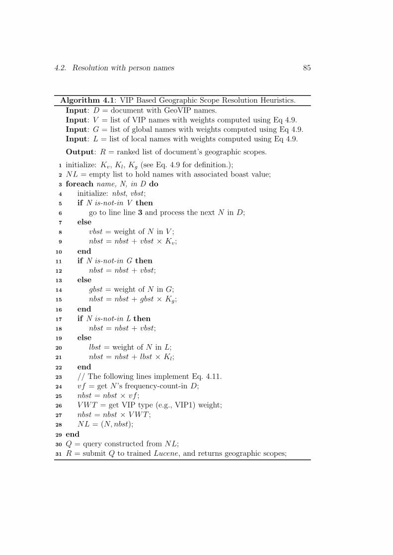
4.2. Resolution with person names 85
Algorithm 4.1: VIP Based Geographic Scope Resolution Heuristics.
Input: D = document with GeoVIP names.Input: V = list of VIP names with weights computed using Eq 4.9.Input: G = list of global names with weights computed using Eq 4.9.Input: L = list of local names with weights computed using Eq 4.9.
Output: R = ranked list of document’s geographic scopes.
initialize: Kv, Kl, Kg (see Eq. 4.9 for definition.);1
NL = empty list to hold names with associated boast value;2
foreach name, N, in D do3
initialize: nbst, vbst ;4
if N is-not-in V then5
go to line line 3 and process the next N in D;6
else7
vbst = weight of N in V ;8
nbst = nbst + vbst × Kv;9
end10
if N is-not-in G then11
nbst = nbst + vbst;12
else13
gbst = weight of N in G;14
nbst = nbst + gbst × Kg;15
end16
if N is-not-in L then17
nbst = nbst + vbst;18
else19
lbst = weight of N in L;20
nbst = nbst + lbst × Kl;21
end22
// The following lines implement Eq. 4.11.23
vf = get N ’s frequency-count-in D;24
nbst = nbst × vf ;25
VWT = get VIP type (e.g., VIP1) weight;26
nbst = nbst × VWT ;27
NL = (N, nbst);28
end29
Q = query constructed from NL;30
R = submit Q to trained Lucene, and returns geographic scopes;31

86 Chapter 4. Scope resolution
4.3 Evaluation metric
To measure the effectiveness of scope resolution systems in a standardizedfashion, two things are needed:
1. a gold standard dataset consisting of a reference gazetteer and a refer-ence document collection with each document marked with geographi-cal scopes.
2. an evaluation metric to assess the correctness of system assigned scopesagainst gold standard scopes.
The current state-of-the-art approach to evaluate scope resolution systemsuse a binary metric (Martins, 2008) . This section describes binary and non-binary evaluation metric to assess the effectiveness of the scope resolutionapproach. The non-binary evaluation metric is a new metric proposed inthis work. The research objective addressed in this section is How best canthe performance of scope resolution systems be compared? [Question of binaryvs. non-binary evaluation metric].
The binary metric in Equation 4.12 assigns a score of 1 to a documentwhen all the document’s n scopes are listed at the top n ranked positions,otherwise it assigns 0. No attention is paid to correct document scopesranked outside the top n ranked positions. The metric does not give a fairassessment of the overall system performance.
GSa =| documentswith correctly assigned scopes || documentswith scopes in the collection | (4.12)
To illustrate the performance of the binary metric in Equation 4.12, con-sider a fictitious scope resolution results of System A and System B in Ta-ble 4.17. Using Equation 4.12 the performance of System A and System Bare 0.67 and 0.50 respectively. Though System A performs better than Sys-tem B using the metric, it has worst performance for documents d02 and d05with two correct scopes ranked at the fifth and sixth positions. On the otherhand, System B ranked the correct scopes within the top three ranks.
To provide a smoother scheme that weights smaller discrepancies betweensystems, a new geographical scope evaluation metric in Equation 4.13 thatintegrates rank scope position in score calculation is proposed.
GSb =
∑N
i=1 P
N(4.13)
where:

4.4. Evaluation 87
Documents Scopes System A System B
d01 s01 s01, s02, s04 s04, s01, s02d02 s03 s02, s05, s06, s04 , s03 s03, s04d03 s05, s06 s06, s05, s07, s01 s05, s06d04 s04 s04, s08 s04, s07d05 s02, s07 s02, s01, s03, s05, s04, s07 s07, s03, s02d06 s08, s07 s07, s08, s02 s07, s05, s08
Table 4.17: Fictitious sample data to illustrate metric performance.
P =
{
1Ds
, if scope ranked within the top Ds positions.1Sp, if scope ranked outside the top Ds positions.
where Ds is the number of the document’s geographical scopes (i.e., fora document with 3 scopes, Ds equal to 3), and Sp is the position of thecorrect scope outside the top Ds rank position.
N is the total number of documents with geographic scopes in theevaluation dataset (i.e., if we had 90 documents in a dataset, and 20 ofthese had a geographic scopes assigned to them, then N is set to 20.).
Using Equation 4.13 the performance of System A and System B are 0.81 and0.86 respectively. Overall System B is a better system compared to SystemA, and Equation 4.13 is a better measure to compare systems with rankedscopes.
4.4 Evaluation
This section describes tests run to validate the performance of the proposedscope resolution strategies against the human annotated dataset. The perfor-mance of the proposed non-binary evaluation metric is also validated againstthe binary evaluation metric. The research objectives addressed in this sec-tion are – (1) How best can the performance of scope resolution systems com-pared? [Question of binary vs. non-binary evaluation metric]. (2) How welldo automatically determined geographical scopes of documents compare to hu-man assigned scopes? [Question of algorithms and question of gold standardevaluation].
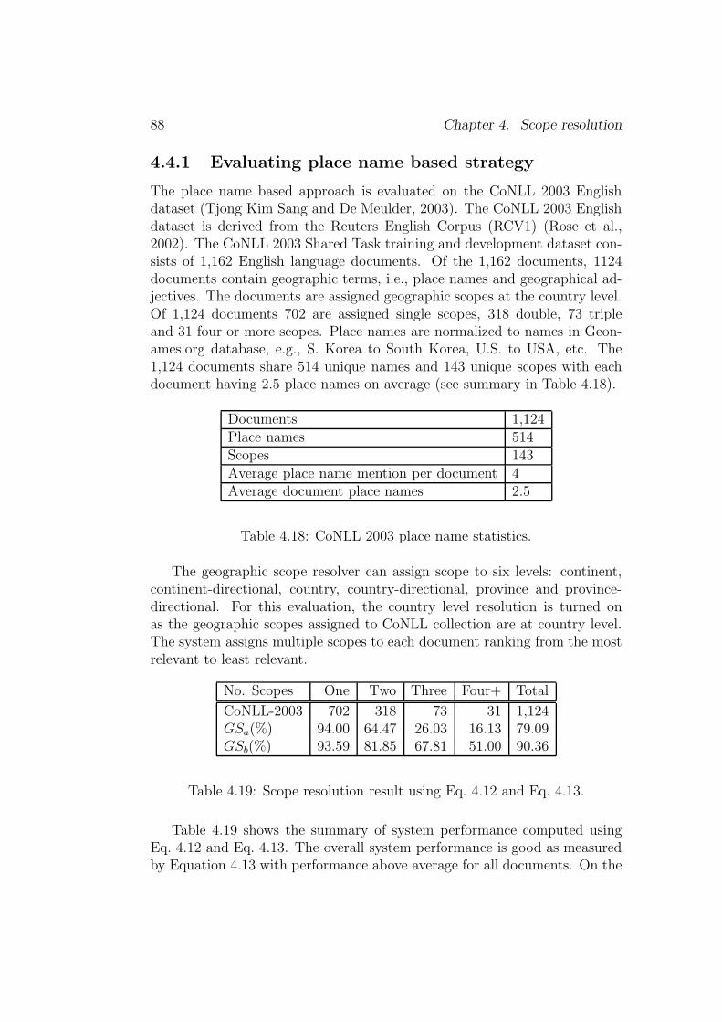
88 Chapter 4. Scope resolution
4.4.1 Evaluating place name based strategy
The place name based approach is evaluated on the CoNLL 2003 Englishdataset (Tjong Kim Sang and De Meulder, 2003). The CoNLL 2003 Englishdataset is derived from the Reuters English Corpus (RCV1) (Rose et al.,2002). The CoNLL 2003 Shared Task training and development dataset con-sists of 1,162 English language documents. Of the 1,162 documents, 1124documents contain geographic terms, i.e., place names and geographical ad-jectives. The documents are assigned geographic scopes at the country level.Of 1,124 documents 702 are assigned single scopes, 318 double, 73 tripleand 31 four or more scopes. Place names are normalized to names in Geon-ames.org database, e.g., S. Korea to South Korea, U.S. to USA, etc. The1,124 documents share 514 unique names and 143 unique scopes with eachdocument having 2.5 place names on average (see summary in Table 4.18).
Documents 1,124Place names 514Scopes 143Average place name mention per document 4Average document place names 2.5
Table 4.18: CoNLL 2003 place name statistics.
The geographic scope resolver can assign scope to six levels: continent,continent-directional, country, country-directional, province and province-directional. For this evaluation, the country level resolution is turned onas the geographic scopes assigned to CoNLL collection are at country level.The system assigns multiple scopes to each document ranking from the mostrelevant to least relevant.
No. Scopes One Two Three Four+ Total
CoNLL-2003 702 318 73 31 1,124GSa(%) 94.00 64.47 26.03 16.13 79.09GSb(%) 93.59 81.85 67.81 51.00 90.36
Table 4.19: Scope resolution result using Eq. 4.12 and Eq. 4.13.
Table 4.19 shows the summary of system performance computed usingEq. 4.12 and Eq. 4.13. The overall system performance is good as measuredby Equation 4.13 with performance above average for all documents. On the
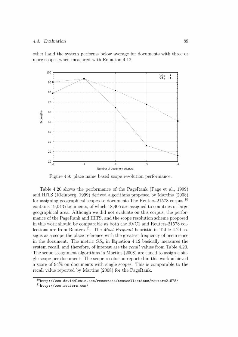
4.4. Evaluation 89
other hand the system performs below average for documents with three ormore scopes when measured with Equation 4.12.
10
20
30
40
50
60
70
80
90
100
0 1 2 3 4
Sco
res(
%)
Number of document scopes.
GSaGSb
Figure 4.9: place name based scope resolution performance.
Table 4.20 shows the performance of the PageRank (Page et al., 1999)and HITS (Kleinberg, 1999) derived algorithms proposed by Martins (2008)for assigning geographical scopes to documents.The Reuters-21578 corpus 10
contains 19,043 documents, of which 18,405 are assigned to countries or largegeographical area. Although we did not evaluate on this corpus, the perfor-mance of the PageRank and HITS, and the scope resolution scheme proposedin this work should be comparable as both the RVC1 and Reuters-21578 col-lections are from Reuters 11. The Most Frequent heuristic in Table 4.20 as-signs as a scope the place reference with the greatest frequency of occurrencein the document. The metric GSa in Equation 4.12 basically measures thesystem recall, and therefore, of interest are the recall values from Table 4.20.The scope assignment algorithms in Martins (2008) are tuned to assign a sin-gle scope per document. The scope resolution reported in this work achieveda score of 94% on documents with single scopes. This is comparable to therecall value reported by Martins (2008) for the PageRank.
10http://www.daviddlewis.com/resources/testcollections/reuters21578/11http://www.reuters.com/

90 Chapter 4. Scope resolution
PageRank HITS Most Frequent
Precision 99% 99% 99%Recall 95% 87% 65%F1 97% 93% 78%Accuracy 93% 86% 65%
Table 4.20: Results of PageRank and HITS on Reuters-21578 (see Mar-tins (2008))
4.4.2 Evaluating person name based strategy
The VIP based scope resolution approach is to evaluate on two types ofdatasets: pseudo-documents and news articles containing GeoVIP names.The evaluation is done on a Ugandan dataset with district scope. The Ugan-dan VIP list of 894 names is derived from the names of members of parlia-ment, resident district commissioners, chief administrative officers, cabinetministers, etc. gathered over the Internet. The list of 10,873 local Ugandannames is derived from the student admission list to Ugandan public univer-sities in 2005 and 2009.12 The global list of 5,163 names is derived from themost common person names in the United States of America.13
Evaluation on pseudo-documents
The motivation behind pseudo-document evaluation is to determine how wellthe GeoVIP proposition performs when provided with high quality GeoVIPinformation. A pseudo-document is constructed from randomly selected ge-ographical scopes, and randomly selected VIPs from each scopes. The geo-graphical scopes are restricted to Ugandan districts. For each document oneto five scopes are selected at random from 82 Ugandan districts. And foreach selected scope, one to three VIPs from the district are selected at ran-dom. Figure 4.10 depicts an example of three randomly generated pseudodocuments (i.e, d2825, d3216, d2824) presented in an XML format. Fordocuments d2825 and d3216, one scope is selected with one VIP from thedistrict. On the other hand, three scopes with a total of four VIPs is selectedfor document d2824.
A total of 4,973 pseudo documents were created with 1,005 documentshaving one scope, 987 documents with two scopes, 1,042 documents withthree scopes, and 1,939 documents with four or more scopes. The average
12[07 October 2009]: http://mak.ac.ug/13[07 October 2009]: http://names.mongabay.com/
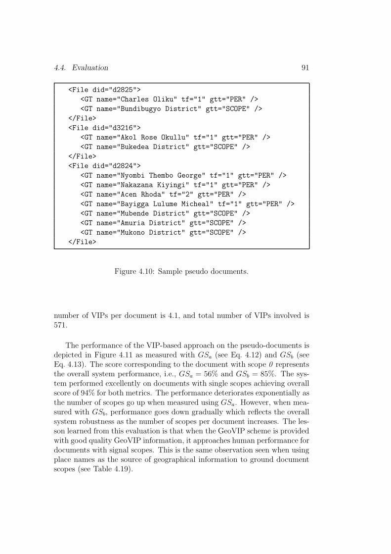
4.4. Evaluation 91
<File did="d2825">
<GT name="Charles Oliku" tf="1" gtt="PER" />
<GT name="Bundibugyo District" gtt="SCOPE" />
</File>
<File did="d3216">
<GT name="Akol Rose Okullu" tf="1" gtt="PER" />
<GT name="Bukedea District" gtt="SCOPE" />
</File>
<File did="d2824">
<GT name="Nyombi Thembo George" tf="1" gtt="PER" />
<GT name="Nakazana Kiyingi" tf="1" gtt="PER" />
<GT name="Acen Rhoda" tf="2" gtt="PER" />
<GT name="Bayigga Lulume Micheal" tf="1" gtt="PER" />
<GT name="Mubende District" gtt="SCOPE" />
<GT name="Amuria District" gtt="SCOPE" />
<GT name="Mukono District" gtt="SCOPE" />
</File>
Figure 4.10: Sample pseudo documents.
number of VIPs per document is 4.1, and total number of VIPs involved is571.
The performance of the VIP-based approach on the pseudo-documents isdepicted in Figure 4.11 as measured with GSa (see Eq. 4.12) and GSb (seeEq. 4.13). The score corresponding to the document with scope 0 representsthe overall system performance, i.e., GSa = 56% and GSb = 85%. The sys-tem performed excellently on documents with single scopes achieving overallscore of 94% for both metrics. The performance deteriorates exponentially asthe number of scopes go up when measured using GSa. However, when mea-sured with GSb, performance goes down gradually which reflects the overallsystem robustness as the number of scopes per document increases. The les-son learned from this evaluation is that when the GeoVIP scheme is providedwith good quality GeoVIP information, it approaches human performance fordocuments with signal scopes. This is the same observation seen when usingplace names as the source of geographical information to ground documentscopes (see Table 4.19).
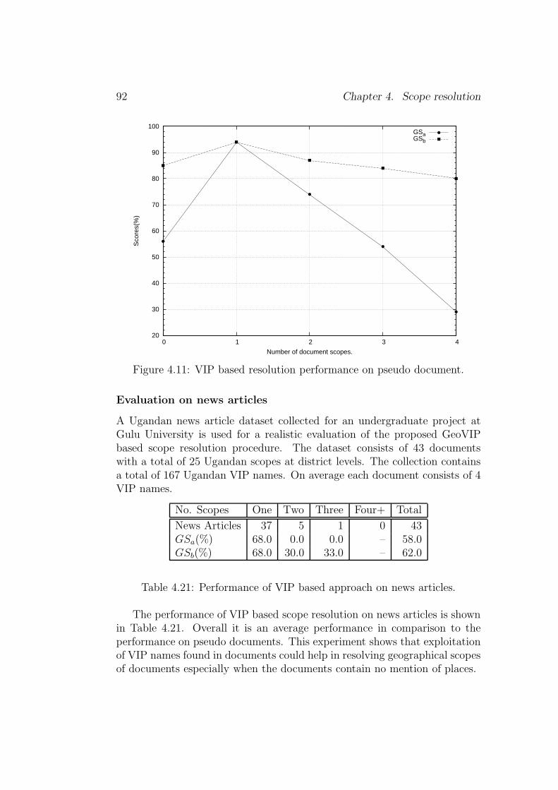
92 Chapter 4. Scope resolution
20
30
40
50
60
70
80
90
100
0 1 2 3 4
Sco
res(
%)
Number of document scopes.
GSaGSb
Figure 4.11: VIP based resolution performance on pseudo document.
Evaluation on news articles
A Ugandan news article dataset collected for an undergraduate project atGulu University is used for a realistic evaluation of the proposed GeoVIPbased scope resolution procedure. The dataset consists of 43 documentswith a total of 25 Ugandan scopes at district levels. The collection containsa total of 167 Ugandan VIP names. On average each document consists of 4VIP names.
No. Scopes One Two Three Four+ Total
News Articles 37 5 1 0 43GSa(%) 68.0 0.0 0.0 – 58.0GSb(%) 68.0 30.0 33.0 – 62.0
Table 4.21: Performance of VIP based approach on news articles.
The performance of VIP based scope resolution on news articles is shownin Table 4.21. Overall it is an average performance in comparison to theperformance on pseudo documents. This experiment shows that exploitationof VIP names found in documents could help in resolving geographical scopesof documents especially when the documents contain no mention of places.

4.5. Conclusion 93
4.5 Conclusion
This chapter described techniques and algorithms proposed to address thefollowing research objectives:
1. How can place names, geographical adjectives (i.e., adjectives referringto people and places) and names of people be used to automaticallydetermine the geographical scope(s) of documents? [Question of algo-rithm.]
2. How well do automatically determined geographical scopes of docu-ments compare to human assigned scopes? [Question of gold standardevaluation.]
3. How best can the performance of scope resolution systems compared?[Question of binary vs. non-binary evaluation metric.]
The scope resolution strategies are grounded on two basic assumptions:
1. Places of the same type or under the same administrative jurisdictionor adjacent-to each other are more likely to be mentioned in a givendiscourse unit. For example, a discourse mentioning the Netherlandsis more likely to mention places of the type country (e.g., United King-dom, Uganda) or places under the jurisdiction of the Netherlands (e.g.,Amsterdam, Rotterdam) or places adjacent to the Netherlands (e.g.,Belgium, Germany).
2. VIPs (i.e., political leadership) in the same geographical region or atthe same leadership hierarchy level tend to be mentioned together in aunit of a discourse. That is, presidents are most likely to be mentionedtogether with the members of their administration or with presidentsof other countries in a unit of a discourse. For example, US PresidentBarack Obama is most likely to be mentioned in a discourse togetherwith US Vice President Joe Biden or President Yoweri Kaguta Musev-eni of Uganda in a discourse.
The new scope resolution strategy with place names exploits place namefrequency of occurrence in a document, geographical adjectives (referring topeople and places), place type (e.g., country, city), importance of a placebased on population and place type, and vertical (transitive parent-of/child-of) and horizontal (adjacency or neighborliness) relationships. The placename derived scope resolution procedure defined a new data model to de-scribe a geographical scope. This model is used to define 26,820 refer-ence scopes which are implemented using the zone indexing concept within
94 Chapter 4. Scope resolution
Lucene IR system. Each reference scope is implemented as a document. Theweighted zone scoring concept is implemented through the Lucene queryterm boost and multi-field query capability. The place name based strategyachieved an evaluation score of 79.09% on a binary evaluation metric and90.36% on the newly proposed evaluation metric on news articles.
The proposed scope resolution strategy with person names exploits therelationship between GeoVIPs (i.e., political leaders) and administrative ar-eas over which they exercise their legal authority. Each GeoVIP is mappedto the area of his or her jurisdiction, and this mapping relationship is used toresolve the geographical scopes of documents mentioning the GeoVIPs. Thestrategy achieved an evaluation score of 58.0% on a binary evaluation metricand 62.0% on the newly proposed evaluation metric on news articles.
The new evaluation metric for the scope resolution task provides a smootherscheme than the binary scheme by weighting small discrepancies betweensystems. The scheme incorporates the rank position information of all thecorrect scopes (in the result list) to evaluate the system performance.
In future we intend to evaluate combining the place name-based strategyand the GeoVIP-based strategy. The new evaluation metrics will also beimplemented and tested.

Chapter 5
Toponym resolution
[Parts of of this chapter are published in Andogah et al. (2008).]
Toponym resolution is a process of assigning a place name identified in textto a single non-ambiguous place on the surface of the earth by means of areference coordinate system such as longitudes and latitudes.
In this chapter we return to one of the most central problems in geo-graphical information retrieval (GIR), toponym resolution. Now that wehave introduced the notion of document scope as well as the procedure de-signed to detect it, we are in a position to try to apply the notion to toponymresolution. In some sense, this chapter attempts to apply a top-down per-spective (from document space to toponym) to improve toponym resolution.We shall conclude that it is successful. The research objectives of this chapterare:
1. How effective is the document’s geographical scope or coverage in aidingthe resolution of toponyms contained in the document? [Question ofheuristics.]
2. How best can the performance of toponym resolution systems be com-pared? [Question of binary vs. non-binary evaluation metric; and thequestion of reference evaluation corpora.]
The study of place names, their origins, meanings, use and typology isreferred to as toponymy. A toponym is a named point of reference in boththe physical and cultural landscape on the Earth’s surface. This includesnatural features, such as streams (whose names are studied as hydronyms)and artificial ones (such as cities). Each toponym (or geographical name) is a
95

96 Chapter 5. Toponym resolution
Geo/Non-Geo Resolution(Split a verb or place name?)
Geo/Geo Resolution(London in UK or Canada?)
Split is a ...London will ...
Split, CroatiaLondon, UK
Figure 5.1: Toponym resolution schematic.
vital communication tool that reflect patterns of settlement, exploration, mi-gration, and heritage that may otherwise be overlooked by residents, visitors,and future generations.1
The names of places are ambiguous in many ways. They can referenceother named entities (e.g., names of people, names of organizations, etc.), andmay be used as common language vocabulary words (e.g., Split is a city inCroatia, Over a city in Germany, etc.). The use of place names outside theirgeographical or location context is sometimes referred to as Geo/Non-Geoambiguity (Amitay et al., 2004). Besides reference or geo/non-geo ambiguityissues, names of places are referentially ambiguous. Referential ambiguityoccurs when a single place name references multiple places. This is alsotermed as Geo/Geo ambiguity (Amitay et al., 2004). Many places are alsoreferred to by more than one name, e.g., Netherlands vs. Holland.
The task of toponym resolution (Leidner, 2007) is to map a place nameto a non-ambiguous location or a geographical point on the surface of theEarth. This mapping is normally done using a geographic reference coordi-nate system such as latitude and longitude. The terms geographical name,place name and toponym are synonymous, and they are used interchangeablyto mean the same thing (i.e., a name of a place) throughout this chapter.
Figure 5.1 shows a schematic diagram depicting the toponym resolutionprocess. In this work geo/non-geo ambiguity resolution is performed withthe help of an off-the-shelf named entity recognition tool, the Alias-i Ling-Pipe. 2 The motivation is that place name recognition components of thestate-of-the-art named entity recognizers have achieved near human perfor-mance (Tjong Kim Sang and De Meulder, 2003), therefore, existing off-the-shelf recognizers are sufficient to perform geo/non-geo resolution task. Inthis thesis we are concerned with geo/geo resolution task, i.e., mapping place
1[08 October 2009]: http://en.wikipedia.org/wiki/Toponymy2[08 October 2009]: http://alias-i.com/lingpipe/

5.1. Toponym resolution procedure 97
names to non-ambiguous geographical points on the surface of the Earth.The toponym approach reported in this thesis exploits 26, 820 geographi-
cal scopes automatically assigned to documents, the type of place (e.g., city),the classification of place (e.g., populated place, administrative division, etc.),the population of the place, and the frequency of non-ambiguous or resolvedplaces.
5.1 Toponym resolution procedure
This section answers the research objective – How effective is the document’sgeographical scope(s) in aiding the resolution of toponyms contained in thedocument. [Question of heuristics.]
This work proposes geographical scope-driven toponym resolution ap-proach. The approach builds on previous works discussed in Chapter 2. Theapproach reported here applies the following techniques at various stages ofresolution:
1. Single referent per discourse;
2. Scope restriction;
3. Population heuristics;
4. Place type restriction;
5. Default sense heuristics.
Figure 5.2 depicts geographic referent resolution routines, and the follow-ing is the explanation of how the various blocks work together to accomplishthe resolution task. For illustration purposes, we shall consider a documentcontaining the following place names:
(1) Sarajevo, Bosnia, Bihac, Tuzla, Britain, London
Our task is to resolve the place names to places they refer to on the surfaceof the earth.
Single referent per discourse and default sense heuristics
The toponym resolution algorithm starts by invoking the single referent perdiscourse and default sense heuristics. Place names mentioned more thanonce in a document are assumed to refer to the same place on the basis ofthe single referent per discourse heuristic. Next the default sense heuristic is
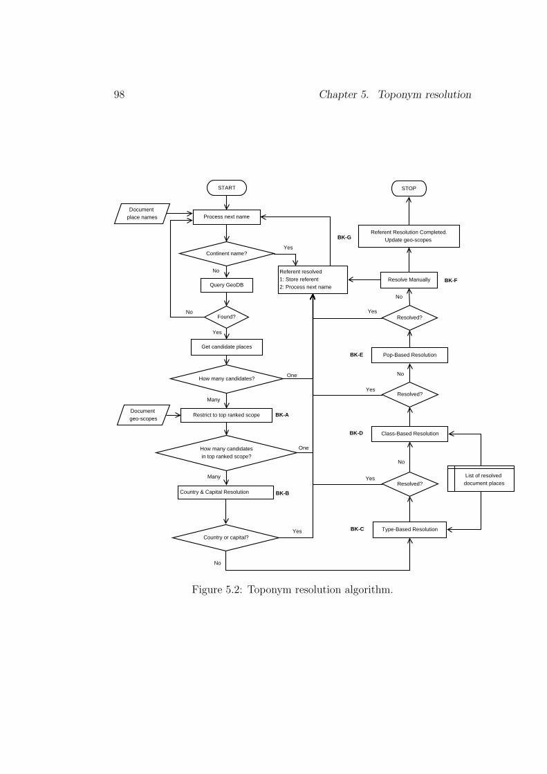
98 Chapter 5. Toponym resolution
Found?
Query GeoDB
No
Get candidate places
Yes
How many candidatesin top ranked scope?
One
Country & Capital Resolution
Continent name?Yes
No
How many candidates?
Many
One
Country or capital?Yes
Many
Type-Based Resolution
No
List of resolved document placesResolved?
Yes
Class-Based Resolution
Resolved?
No
Yes
Pop-Based Resolution
No
Resolved?
Resolve Manually
STOP
Yes
Restrict to top ranked scope
START
Process next name
Referent resolved1: Store referent2: Process next name
No
Document place names
Document geo-scopes
Referent Resolution Completed.Update geo-scopes
BK-A
BK-B
BK-C
BK-D
BK-E
BK-F
BK-G
Figure 5.2: Toponym resolution algorithm.

5.1. Toponym resolution procedure 99
invoked to assign place names with continent sense to the continents. Can-didate places for place names with senses other than continent senses areobtained from the geographical database (GeoDB). Place names with singlecandidate places are resolved to these places, and place names with multiplecandidates are passed to lower processing modules starting with the scoperestriction module. However, place names with no candidates in the GeoDBare ignored. This often happens when a geographic database lacks completecoverage.
Scope restriction heuristic
The scope restriction heuristic (see BK-A in Fig. 5.2) extends the countrylevel restriction reported by Pouliquen et al. (2006). The heuristic exploitsan elaborate list of ranked geographic scopes assigned to a document by thegeographic scope resolver described in Chapter 4. A place name with multi-ple candidate referents is assigned to a single most highly ranked documentgeographic scope. The other candidates belonging to lower ranked documentscopes are discarded. If a selected scope contains a single candidate, thecandidate is marked as the place referred to by the name. However, if aselected scope contains multiple candidates with the same name, it is passedto the next processing block in the hierarchy, i.e., country and capitals reso-lution heuristic (see BK-B in Fig. 5.2). The accuracy of the scope restrictionheuristic depends on how well the scope resolution performed. The greaterthe error in scope resolution the greater the error in referent resolution.
To illustrate the heuristics, refer to example (1) consisting of place namesfound in a document (see Sec. 5.1, page 97). The names are assigned to thefollowing scopes:
(2) Sarajevo:
a. (Capital City, P; pop 696,731) Sarajevo 7→ Federation of Bosniaand Herzegovina 7→ Bosnia and Herzegovina 7→ Europe
(3) Bosnia:
a. (Country, A) Bosnia and Herzegovina 7→ Europe
(4) Bihac:
a. (City, P; pop 75,641) Bihac 7→ Una-Sana County 7→ Federationof Bosnia and Herzegovina 7→ Bosnia and Herzegovina 7→ Europe
b. (Municipality, A) Bihac 7→ Una-Sana County 7→ Federation of
100 Chapter 5. Toponym resolution
Bosnia and Herzegovina 7→ Bosnia and Herzegovina 7→ Europe
(5) Tuzla:
a. (City, P; pop 142,486) Tuzla 7→ Tuzla County 7→ Federation ofBosnia and Herzegovina 7→ Bosnia and Herzegovina 7→ Europe
b. (Municipality, A) Tuzla 7→ Tuzla County 7→ Federation of Bosniaand Herzegovina 7→ Bosnia and Herzegovina 7→ Europe
c. (County, A) Tuzla 7→ Federation of Bosnia and Herzegovina 7→Bosnia and Herzegovina 7→ Europe
(6) Britain:
a. (Country, A) United Kingdom 7→ Europeb. (Island, T) Britain 7→ United Kingdom 7→ Europe
(7) London:
a. (Capital City, P; pop 7,421,209) London 7→ United Kingdom 7→Europe
b. (Administrative Area, A) London 7→ United Kingdom 7→ Europe
The six place names reference places within Europe. Sarajevo, Bosnia, Bi-hac and Tuzla are in Bosnia and Herzegovina, and Britain and London inthe United Kingdom. Within the Bosnia and Herzegovina scope, Sarajevoand Bosnia are non-ambiguous and are resolved to places in Bosnia andHerzegovina. Bihac, Tuzla, Britain and London remain ambiguous withinthe selected scopes. Note for instance that there are 55 places named Lon-don in the Geonames.org database used in this work. The scope-controlledheuristic eliminates the other candidates by selecting only candidates in thetop ranked scopes as the most likely referred to locations.
Country and capitals heuristic
The country and capitals heuristic (see BK-B in Fig. 5.2) is a kind of defaultsense heuristic, but restricted within the selected geographic scope for thename. A place name’s candidate place of type country or national capitalor provincial capital is selected as the place being referred to within theselected scope. The order of preference is: country 7→ country capital 7→provincial capital. From the previous sub-section, we had resolved Sarajevoand Bosnia, but Bihac, Tuzla, Britain and London remained ambiguouswithin their respective scopes. Invoking the country and capitals heuristic,Britain and London are resolved the Britain the country and London the

5.1. Toponym resolution procedure 101
capital city. This leaves Bihac and Tuzla still ambiguous.
Type based heuristic
The type-based heuristic (see BK-C in Fig. 5.2) exploits the types of resolvedplaces as a basis to resolve among competing candidate places. Commonlyoccurring types are preferred. The assumption is that places of the sametype are more likely to be mentioned in a discourse. The candidate place ofthe type matching the most commonly occurring type among the resolvedplaces is selected as the place being referenced in the text. With reference toour example, the following references are already resolved Sarajevo, Bosnia,Britain and London. Bihac and Tuzla remain ambiguous, and the type-basedheuristics applied to see if either of them will be resolved at this stage. Theresolved places are of two types: Sarajevo and London are of type capitalcity, and Bosnia and Britain are of type country. Note that the system doesnot exploit contextual clues from text segments surrounding the names intext for both scope and referent resolution. Therefore, we may be missingimportant clues such as place types that accompany place names in text.The name Bihac references a city and a municipality, and Tuzla referencesa city, a municipality and a county all in Bosnia and Herzegovina. None ofthe types of Bihac and Tuzla matches any of the types of the resolved places,and therefore, the type-based heuristic fails to resolve them at this stage ofprocessing.
Class based heuristic
The class-based heuristic (see BK-D in Fig. 5.2) exploits geographic featureclassifications in the Geonames.org3 database. As described in Chapter 3,the Geonames.org categorises geographic features into nine broad classes:
1. Administrative unit (i.e., country, state, region, etc.), A.
2. Hydrographic (i.e., stream, lake, bay, etc.), H.
3. Locality or area (i.e., parks, area, nature reserve, etc.), L.
4. Populated place (i.e., city, town, village, etc.), P.
5. Road or railroad (i.e., road, railroad, tunnel, etc.), R.
6. Spot (i.e., spot, building, farm, etc.), S.
3[03 October 2009] http://www.geonames.org/about.html
102 Chapter 5. Toponym resolution
7. Hypsographic (i.e., mountain, hill, island, etc.), T.
8. Undersea (i.e., basin, undersea, range, etc.), U.
9. Vegetation (i.e., forest, heath, pine grove, etc.), V.
The class-based heuristic procedure is similar to the type-based heuristic.Similar to the type-based heuristic assumption, the places of a similar classare more likely to be mentioned in a discourse. And therefore, this heuristicselects the candidate place of the class matching the most frequently oc-curring class among the resolved places as the referenced place. From theexample we have been following to illustrate referent resolution procedure,already resolved places belong to two feature classification types: Britain andBosnia are administrative units (A), and Sarajevo and London are populatedplaces (P). Again this does not help the resolution of Bihac with classifica-tion P, A, and Tuzla with classifications P, A, T. However, at this stage theTuzla candidate place with classification hypsographic, T is eliminated be-cause none of the resolved places have the classification type hypsographic,T.
Population based heuristic
The population-based heuristic (see BK-E in Fig. 5.2) is straightforward inthat the place with the largest population is selected as the place beingreferred to. However, this heuristic is applied to candidate places of the sametype and class, e.g., the town of Groningen in Germany with population of4,166, and the town of Groningen in Suriname with population of 3,216.The population-based heuristic can be effective only when the populationinformation of population centers is complete in the geographic database.Turning to the example referent resolution task we have followed to illustratereferent resolution procedure, Bihac and Tuzla still remain unresolved. Theyboth have two candidate places of class populated place and administration.Because the candidate places are of different type and class, the population-based heuristic can not handle the case and passes it on to be handled atnext process level.
Manual resolution
The manual resolution (see BK-F in Fig. 5.2) is the last option when allthe previous automated procedures fail to solve a given ambiguity problem.The task is passed over to the user to decide the meaning of the remainingambiguous places by exploiting other sources of information at her or his

5.2. Evaluation metric 103
disposal. The unresolved Bihac and Tuzla from our example is handed overto the user to perform manual resolution.
Geographic scope update
Because the toponym resolution component is part of the place ambiguityresolution system (i.e., the Mahali system), its output is also used improvethe accuracy of the scope resolution component. Therefore, upon completionof referent resolution (see BK-G in Fig. 5.2), the list of geographic scopesis updated by including scopes containing resolved places and their ancestorscopes. The other scopes remaining in the original ranked list are discarded.
5.2 Evaluation metric
An evaluation metric needs to consider the number of candidate places agiven place name refers to. Place names with more candidate referents aremore difficult to resolve than place names with fewer candidate referents.This diversity is in terms of both the number of locations and the number offeature types. For instance, the geographical reference Groningen refers tolocations in the Netherlands, Germany, Suriname, South Africa, etc. Theselocations are of different types as well – province, city and farm. Therefore, ametric that incorporates some of this information in its calculation could bea better judge than a scheme that uses a binary metric such as the precisionand recall metrics. Ignoring this in evaluation does not pass fair judgmenton systems that perform well in tackling these kinds of problems.
This section describes a new referent resolution evaluation metric that ex-ploits the number of candidate locations, geographical hierarchy and featuretype to measure the nearness of the system resolved referent to the correctreferent. The research objective addressed in this section is – How best canthe performance of toponym resolution systems be compared? [Question ofbinary vs. non-binary evaluation metric]. Consider the schematic in Fig-ure 5.3 showing three locations L1, L2 L3 all referred to by the name A.From the metric distance perspective location L1 is nearer to location L2
than to location L3. On the other hand, from hierarchical administrativedistance perspective location L1 is nearer to location L3 than to location L2
because they are under the same administrative jurisdiction (i.e., no passportis required to travel from L1 to L3, but one is required to have a relevanttravelling document to travel from L1 to L2). The interpretation of the mea-surements is subject to topics being addressed. The argument falls short forinstance when cases of disaster are considered – in case of spread of disease

104 Chapter 5. Toponym resolution
Border CrossingPassport needed
A A
A
200 km
20 km
System-A resolved reference A to location L2System-B resolved reference A to location L3
The correct location referred to by A is L1.Which system has performed better?
L1
L3
L2
Figure 5.3: Nearness to correct location.
location L1 is nearer to location L2 than to location L3.The proposed metric incorporates the following features in its calcula-
tions:
1. The number of candidate places sharing the ambiguous place name orreference.
2. The number of regions to traverse (or hop) from the system-resolvedreferent to the correct gold standard referent.
3. The number of feature classes to traverse (or hop) from the system-resolved referent type to the correct gold standard referent type.
The challenge of using hierarchical structure in a measurement metric isthat the structure of administrative divisions varies from country to countryand/or region to region. For the proposed metric to be effective a universallyagreed administrative hierarchy level is needed, for instance, first or secondadministrative divisions of countries.
The hierarchical structure in Figure 5.4 is used to illustrate the applica-tion of the proposed metrics. The acronyms following the names of placesin Figure 5.4 represent the types of the concerned geographical features –CONT stands for continent, PCLI stands for an independent political entity

5.2.
Evaluatio
nmetric
105
Groningen (CITY)
Groningen (ADM1)
Groningen (ADM2)
Netherlands (PCLI)
Europe (CONT)
Germany (PCLI)
Saxony (ADM1)
Groningen (CITY)
Africa (CONT)
South Africa (PCLI)
Free State (ADM1)
Groningen (FARM)
N. America (CONT)
United States (PCLI)
Missouri (ADM1)
Netherlands (CITY)
Mother Earth
Figure 5.4: Example hierarchy structure.

106 Chapter 5. Toponym resolution
(e.g., country), ADM1 stands for first administrative division of a country(e.g., province, state, district, etc.), ADM2 stands for second administrativedivision of a country (e.g., municipality, county, etc.). The metric in Equa-tion 5.1 uses hop counts or number of regions traversed with no considerationof the number of candidate locations sharing the name to be resolved.
Hop =
∑K
i=1Di
K(5.1)
Di =
∑M
j=11
Hij
M
where, Di is the score of the ith document, M is the number of references with
at least one candidate location, Hij is the hop count (for the jth referencein the ith document) from the system resolved location to the correct goldstandard location, K is the total number of documents in the collection.The hop count is defined as the number of nodes traversed from the startnode to the end node, inclusive of start and end nodes, e.g., the hop countfrom Groningen City, Netherlands to Groningen City, Germany is 7 (seeFigure 5.4). With reference to Figure 5.4, SystemA and SystemB attemptto resolve references Netherlands and Groningen (assume the correct goldstandard referents are Netherlands, Europe and Groningen City, Netherlandsrespectively) as follows:
(8) SystemA – Netherlands 7→ Netherlands, Europe and Groningen 7→Groningen (City), Germany.
(9) SystemB – Netherlands 7→ Netherlands, Missouri and Groningen 7→Groningen (City), Netherlands.
Using Equation 5.1 the scores of SystemA and SystemB are computed as
Hop(SystemA) =1 + 1/7
2= 0.57
and
Hop(SystemB) =1/7 + 1
2= 0.57
respectively. The second evaluation metric extends Equation 5.1 by incorpo-rating candidate location counts as follows:
eHop =
∑K
i=1Di
K(5.2)
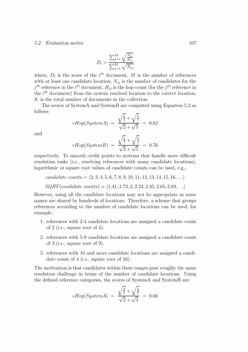
5.2. Evaluation metric 107
Di =
∑M
j=1
√
Nij
Hij
∑M
j=1
√
Nij
where, Di is the score of the ith document, M is the number of referenceswith at least one candidate location, Nij is the number of candidates for thejth reference in the ith document, Hij is the hop count (for the jth reference inthe ith document) from the system resolved location to the correct location,K is the total number of documents in the collection.
The scores of SystemA and SystemB are computed using Equation 5.2 asfollows
eHop(SystemA) =
√
21+√
57√
2 +√5
= 0.62
and
eHop(SystemB) =
√
27+√
51√
2 +√5
= 0.76
respectively. To smooth credit points to systems that handle more difficultresolution tasks (i.e., resolving references with many candidate locations),logarithmic or square root values of candidate counts can be used, e.g.,
candidate counts = 〈2, 3, 4, 5, 6, 7, 8, 9, 10, 11, 12, 13, 14, 15, 16, . . .〉SQRT (candidate counts) = 〈1.41, 1.73, 2, 2.24, 2.45, 2.65, 2.83, . . .〉
However, using all the candidate locations may not be appropriate as somenames are shared by hundreds of locations. Therefore, a scheme that groupsreferences according to the number of candidate locations can be used, forexample,
1. references with 2-4 candidate locations are assigned a candidate countof 2 (i.e., square root of 4).
2. references with 5-9 candidate locations are assigned a candidate countof 3 (i.e., square root of 9).
3. references with 10 and more candidate locations are assigned a candi-date count of 4 (i.e., square root of 16).
The motivation is that candidates within these ranges pose roughly the sameresolution challenge in terms of the number of candidate locations. Usingthe defined reference categories, the scores of SystemA and SystemB are:
eHop(SystemA) =
√
21+√
37√
2 +√3
= 0.66
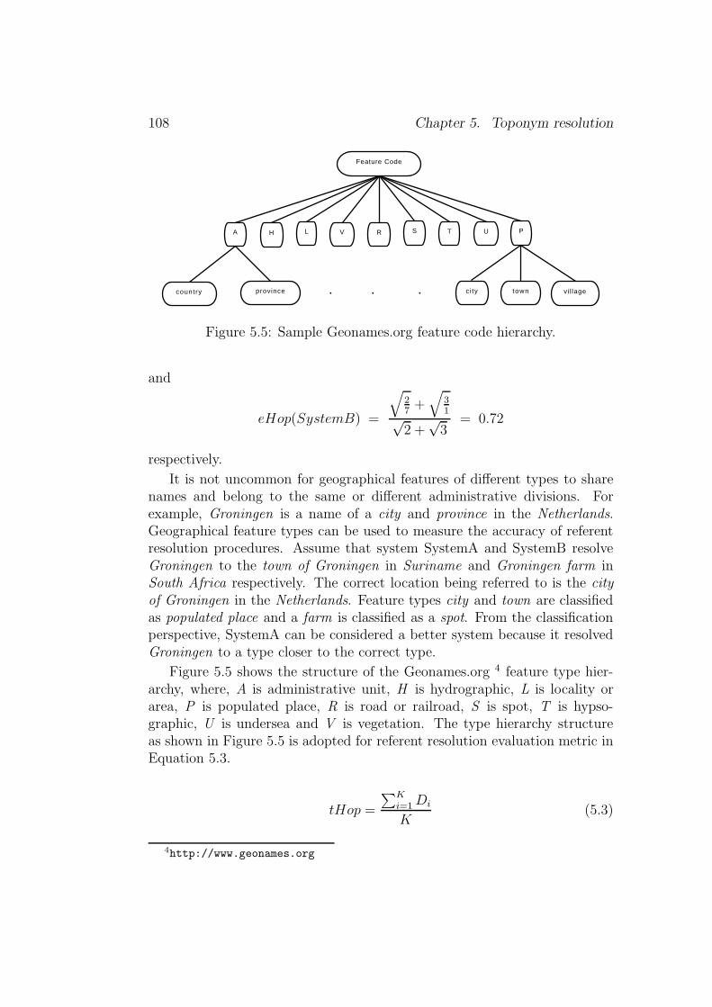
108 Chapter 5. Toponym resolution
Feature Code
A H L PR S T UV
country province . . . ci ty town vil lage
Figure 5.5: Sample Geonames.org feature code hierarchy.
and
eHop(SystemB) =
√
27+√
31√
2 +√3
= 0.72
respectively.
It is not uncommon for geographical features of different types to sharenames and belong to the same or different administrative divisions. Forexample, Groningen is a name of a city and province in the Netherlands.Geographical feature types can be used to measure the accuracy of referentresolution procedures. Assume that system SystemA and SystemB resolveGroningen to the town of Groningen in Suriname and Groningen farm inSouth Africa respectively. The correct location being referred to is the cityof Groningen in the Netherlands. Feature types city and town are classifiedas populated place and a farm is classified as a spot. From the classificationperspective, SystemA can be considered a better system because it resolvedGroningen to a type closer to the correct type.
Figure 5.5 shows the structure of the Geonames.org 4 feature type hier-archy, where, A is administrative unit, H is hydrographic, L is locality orarea, P is populated place, R is road or railroad, S is spot, T is hypso-graphic, U is undersea and V is vegetation. The type hierarchy structureas shown in Figure 5.5 is adopted for referent resolution evaluation metric inEquation 5.3.
tHop =
∑K
i=1Di
K(5.3)
4http://www.geonames.org

5.3. Evaluation 109
TR-CoNLL TR-CLEF TR-RNW
Corpus size (in tokens) 204,566 360,559 68,010Documents 946 321 556Toponym instances 6259 5783 2338Unique toponyms 763 802 432Ambiguous toponyms 629 690 332Non-ambiguous toponyms 134 112 102kappa coefficient, K 0.9350 0.7135 –Human annotators 4 2 1Percentage of ambiguity 0.8244 0.8603 0.7650
Table 5.1: Characteristics of TR-CoNLL, TR-CLEF & TR-RNW.
Di =
∑M
j=1
√
Nij
Hij×Tij
∑M
j=1
√
Nij
where, Di is the score of the ith document, M is the number of references with
at least one candidate location, Nij is the number of candidates for the jth
reference in the ith document, Hij is the hop count (for the jth reference in theith document) from the system resolved location to the correct location, Kis the total number of documents in the collection, Tij is the number of typenodes to traverse from the system resolved type to correct gold standardtype. The scores of SystemA and SystemB in Examples (8) and (9) withEquation 5.3 are 0.62 and 0.68 respectively. The metric in Equation 5.3penalized SystemB for wrong feature type, therefore, reducing its score fromthat scored by metric in Equation 5.2.
5.3 Evaluation
The toponym resolution scheme proposed in this work is evaluated on threenews story datasets – (1) TR-CoNLL, (2) TR-CLEF and (3) TR-RNW. Theresearch objective addressed in this section is – How well can automated to-ponym resolution systems perform against humans? [Question of algorithms;and question of gold standard evaluation]. Table 5.1 shows the overall char-acteristic of document collections used for the evaluation. More detailedinformation on the collections is found in Chapter 3.
The precision, recall and f-score measures are used in this evaluation. Themetrics proposed in Section 5.2 are yet to be implemented. Following thestraightforward instantiation of the standard definition from Leidner (2007),

110 Chapter 5. Toponym resolution
Precision, P is the ratio of the number of correctly resolved toponyminstances, TC and the number of toponym instances that the systemattempted to resolve (either correctly, TC or incorrectly, TI)
P =TC
TC + TI
(5.4)
Recall, R is the ratio of the number of correctly resolved toponyminstances, TC and the number of all toponym instances, TN (i.e., thenumber of resolvable toponyms in a text document or corpus)
R =TC
TN
(5.5)
Note that TN = TC + TI + TU where TU is the number of toponymoccurrences whose candidate referents are unresolved.
F-Score, Fβ for precision P and recall R is defined as
Fβ =(β2 + 1)PR
β2P +R(5.6)
and the F-Score at β = 1 is
Fβ=1 =2PR
P +R(5.7)
and all the F-Score values reported here are computed at β = 1.
Evaluation on TR-CoNLL corpus
The toponyms in TR-CoNLL corpus are annotated with a spatial footprint(i.e., latitude and longitude) information from the TextGIS (Leidner, 2007).The TextGIS gazetteer is created from the GNIS 5 gazetteer of the U.S.Geographic Survey and the GNS 6 gazetteers of the National Geospatial In-telligence Agency (NGA), and supplemented with the 267 CIA World Fact-book 7 (WFB) country centroid. On the other hand, the scope resolutionstrategies and referent resolution routines proposed in this work use the Geon-ames.org 8 database as the source of their spatial information. The difference
5http://geonames.usgs.gov/domestic/index.html6http://earth-info.nga.mil/gns/html/index.html7https://www.cia.gov/library/publications/the-world-factbook/8http://www.geonames.org
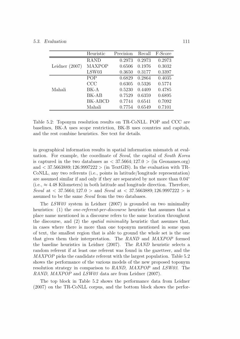
5.3. Evaluation 111
Heuristic Precision Recall F-Score
RAND 0.2973 0.2973 0.2973Leidner (2007) MAXPOP 0.6506 0.1976 0.3032
LSW03 0.3650 0.3177 0.3397POP 0.6829 0.2864 0.4035CCC 0.6305 0.5326 0.5774
Mahali BK-A 0.5230 0.4409 0.4785BK-AB 0.7529 0.6359 0.6895BK-ABCD 0.7744 0.6541 0.7092Mahali 0.7754 0.6549 0.7101
Table 5.2: Toponym resolution results on TR-CoNLL. POP and CCC arebaselines, BK-A uses scope restriction, BK-B uses countries and capitals,and the rest combine heuristics. See text for details.
in geographical information results in spatial information mismatch at eval-uation. For example, the coordinate of Seoul, the capital of South Koreais captured in the two databases as < 37.5664; 127.0 > (in Geonames.org)and < 37.5663889; 126.9997222 > (in TextGIS). In the evaluation with TR-CoNLL, any two referents (i.e., points in latitude/longitude representation)are assumed similar if and only if they are separated by not more than 0.04◦
(i.e., ≈ 4.48 Kilometers) in both latitude and longitude direction. Therefore,Seoul at < 37.5664; 127.0 > and Seoul at < 37.5663889; 126.9997222 > isassumed to be the same Seoul from the two databases.
The LSW03 system in Leidner (2007) is grounded on two minimalityheuristics: (1) the one-referent-per-discourse heuristic that assumes that aplace name mentioned in a discourse refers to the same location throughoutthe discourse, and (2) the spatial minimality heuristic that assumes that,in cases where there is more than one toponym mentioned in some spanof text, the smallest region that is able to ground the whole set is the onethat gives them their interpretation. The RAND and MAXPOP formedthe baseline heuristics in Leidner (2007). The RAND heuristic selects arandom referent if at least one referent was found in the gazetteer, and theMAXPOP picks the candidate referent with the largest population. Table 5.2shows the performance of the various models of the new proposed toponymresolution strategy in comparison to RAND, MAXPOP and LSW03. TheRAND, MAXPOP and LSW03 data are from Leidner (2007).
The top block in Table 5.2 shows the performance data from Leidner(2007) on the TR-CoNLL corpus, and the bottom block shows the perfor-

112 Chapter 5. Toponym resolution
mance of the Mahali 9 toponym resolution component on the TR-CoNLLcorpus. The heuristics CCC and POP are treated as the baseline schemes.CCC selects the candidate location that refers to country, national capitalor provincial capital as the place referred to. The POP heuristic picks thecandidate location that has the largest population as the place referred to.For schemes BK-A (scope restriction), BK-AB (i.e, combination of BK-Aand BK-B, countries and capitals), BK-ABCD (i.e, combination of BK-A,BK-B, BK-C and BK-D) and Mahali (i.e., when all models are activated)refer to Figure 5.2. The baseline heuristic CCC is very competitive on theTR-CoNLL corpus. This is the reflection of the types of toponyms used instories with global scopes (i.e., countries and capital cities are commonlymentioned in stories with global scopes). The TR-CoNLL corpus consists ofstories with scopes of the global, and therefore, a good performance is ex-pected with CCC heuristic. The performance of the POP heuristics matchesthe performance of MAXPOP heuristic in Leidner (2007). The BK-A heuris-tic which selects candidate locations found in the top ranked scopes shows agood performance as well. And as more heuristics are combined the perfor-mance increases smoothly as seen in BK-AB, BK-ABCD and Mahali. Overallthe scheme proposed in this work shows that it is very competitive.
Caution is needed in interpreting the performance of the toponym reso-lution strategy proposed in this thesis when it is compared to Leidner (2007)scheme on TR-CoNLL corpus because of the following disparities for whichwe have no explanation:
1. Leidner (2007) counted 6,980 toponym instances in TR-CoNLL whilethe proposed system counted 6,259 toponym instances.
2. Leidner (2007) counted 1,299 unique toponyms in TR-CoNLL whilethe proposed system counted 763 unique toponyms.
3. The toponyms in TR-CoNLL are annotated with TextGIS gazetteer,and the proposed system uses the Geonames.org database as its geo-graphical knowledge.
Evaluation on TR-RNW and TR-CLEF corpora
Table 5.3 shows the performances of the new toponym resolution modelson TR-RNW and TR-CLEF corpora. As noted on the evaluation on TR-CoNLL, the CCC heuristic is competitive on both the TR-RNW and TR-CLEF. On TR-RNW, CCC heuristic is highly robust at precision, recall and
9All the components developed in the course of this work form part of the system calledMahali system. Mahali means ‘place’ in Kiswahili.
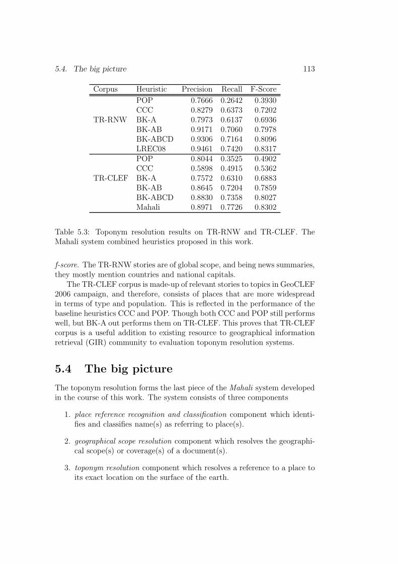
5.4. The big picture 113
Corpus Heuristic Precision Recall F-Score
POP 0.7666 0.2642 0.3930CCC 0.8279 0.6373 0.7202
TR-RNW BK-A 0.7973 0.6137 0.6936BK-AB 0.9171 0.7060 0.7978BK-ABCD 0.9306 0.7164 0.8096LREC08 0.9461 0.7420 0.8317POP 0.8044 0.3525 0.4902CCC 0.5898 0.4915 0.5362
TR-CLEF BK-A 0.7572 0.6310 0.6883BK-AB 0.8645 0.7204 0.7859BK-ABCD 0.8830 0.7358 0.8027Mahali 0.8971 0.7726 0.8302
Table 5.3: Toponym resolution results on TR-RNW and TR-CLEF. TheMahali system combined heuristics proposed in this work.
f-score. The TR-RNW stories are of global scope, and being news summaries,they mostly mention countries and national capitals.
The TR-CLEF corpus is made-up of relevant stories to topics in GeoCLEF2006 campaign, and therefore, consists of places that are more widespreadin terms of type and population. This is reflected in the performance of thebaseline heuristics CCC and POP. Though both CCC and POP still performswell, but BK-A out performs them on TR-CLEF. This proves that TR-CLEFcorpus is a useful addition to existing resource to geographical informationretrieval (GIR) community to evaluation toponym resolution systems.
5.4 The big picture
The toponym resolution forms the last piece of the Mahali system developedin the course of this work. The system consists of three components
1. place reference recognition and classification component which identi-fies and classifies name(s) as referring to place(s).
2. geographical scope resolution component which resolves the geographi-cal scope(s) or coverage(s) of a document(s).
3. toponym resolution component which resolves a reference to a place toits exact location on the surface of the earth.

114 Chapter 5. Toponym resolution
document Geo-taggerdocument geo-terms
Scope resolver
Referent resolver
list of rankedscopes
placenamereferents
predefinedscopes
geographicdatabase
Update scope
ranked scopeswith referents
Figure 5.6: Mahali system architecture.
The toponym recognition component is an off-the-shelf system while the othertwo components are developed in the course of this work. The details of thetoponym recognition component can be found in Chapter 3 Data and tools.Figure 5.6 shows the overall system configuration and how they interact tosolve the problem of place name ambiguity.
5.5 Conclusion
This chapter described a new strategy to address the problem of toponymresolution. A novel evaluation metric is proposed to evaluate the toponymresolution task as well. The research objectives addressed in this chapter are� How effective is the document’s geographical scope(s) in aiding the reso-
lution of toponyms contained in the document. [Question of heuristics].� How best can the performance of toponym resolution systems be com-pared? [Question of binary vs. non-binary evaluation metric].� How well can automated toponym resolution systems perform when
5.5. Conclusion 115
compared to humans? [Question of algorithms; and question of goldstandard evaluation].
The toponym resolution scheme proposed in this work exploits the ge-ographical scopes assigned to documents, place types (e.g., city, mountain,etc.), classification of place (e.g., administrative unit, vegetation, etc.), popu-lation size, and frequency of non-ambiguous or resolved places to accomplishthe task of resolving an ambiguous place name to the location it refers to onthe surface of the earth.
The proposed scheme performed robustly on the three evaluation corpora– TR-CoNLL, TR-CLEF, TR-RNW. It is noticed that the selection of coun-tries and national capitals as the location being referred to among compet-ing candidate locations performs extremely well on stories with global scopes.However, on collections with multiple scopes such as the TR-CLEF collection,the performance of CCC and POP deteriorates. The new proposed schemeperformed robustly on all the three corpora beating the baseline heuristics(CCC and POP) by a very significant margin.
The new proposed toponym resolution evaluation metrics integrates thefollowing features in its calculations: (1) number of candidate places for agiven reference, (2) number of regions to traverse from the system resolvedreferent to the correct gold standard referent, and (3) number of featureclasses transversed from the system resolved referent type to the correct goldstandard referent type.

116 Chapter 5. Toponym resolution
Chapter 6
Query expansion
[Parts of of this chapter are published in Andogah (2007).]
State-of-the-art search engines model document contents as bags-of-wordsconsisting of words extracted from the documents. Little or no attention ispaid to the document’s synactic and semantic structure. Moreover, the ma-jority of user queries are simplistic consisting of two words on average (Spinket al., 2001). Under the bag-of-words model, for a search engine to returndocuments as a response to the user query, the user’s query must containsome of the exact words in the search engine index. The motivation forquery expansion is to reduce the mismatch between query and document byexpanding the query terms using words or phrases which are synonymous toquery terms or share other statistical relationships with the terms containedin the set of relevant documents.
The research objectives addressed in this chapater are:
1. How effective is relevance feedback for the geographical informationretrieval task?
2. How effective is a scope-controlled toponym selection scheme in a rel-evance feedback procedure?
This chapter explores query expansion strategies for a geographically con-strained information retrieval task. The query expansion investigates theapplication of relevance feedback (i.e., blind and explicit feedback) proce-dures to improve retrieval by adding place names found in the relevant doc-uments. Two relevance feedback schemes are explored – one approach addsplace names found in the relevant documents directly, and the other addsplace names found in geographical scopes of relevant documents. The first
117
118 Chapter 6. Query expansion
approach is termed the term-based scheme and the second the scope-basedscheme. The term-based and scope-based scheme derive place names to addto queries as follows: term-based(names) = {M} and scope-based(names)= {M ⊆ S}, where, M are the commonly occurring place names in the rele-vant documents and S are the commonly shared scopes among the relevantdocuments.
6.1 Document processing
Figure 6.1 shows a sample of Radio Netherlands Worldwide 1 summary withtagged geographical information – the names of places, adjectives referringto people and places and geographical feature types. Every document in thecollection is geographically processed with the scope and toponym resolutionschemes proposed and described in Chapter 4. The content of the Text tagis indexed as Text in Lucene. The References and Scope tag contents areeither indexed in Lucene as Keywords or stored in a database for geographicalanalysis in query processing and relevance ranking phase.
6.2 Query expansion
Consider a geographically constrained search query in Example (1):
(1) Fish in Lake Victoria.
The query in Example (1) consists of two components - the non-geographical(thematic) component, Fish, and the geographical component, in Lake Vic-toria. Often the concepts in the search queries do not match terms usedto express the same concepts in relevant documents in the collection. Forexample, the concept Fish in Example (1) overlaps with the concepts Tilapiaand Nile Perch, which are species of fish commonly found in Lake Victoria.Likewise, for the purpose of querying, the geographic concept Lake Victoriacan be considered to overlap with islands in Lake Victoria and towns/citieson shores of Lake Victoria - Ssese Island, Rubondo Island, Ukerewe Island,Rufinga Island, Entebbe, Jinja, Mwanza, Musoma, Kisumu. The task ofquery expansion is to add such terms to the original or previous search querywith the view of retrieving more relevant documents matching the searcher’sinformation need (Xu and Croft, 1996; Manning et al., 2007). Query expan-sion would reformulate query in Example (1) close to what is in Example (2)(new terms are in italics)
1http://www.rnw.nl/english

6.2. Query expansion 119
<RNW>
<Summary sid="09022006.18">
<Text>
<title>Dutch town refuses to recognise third gender</title>
<p>The Dutch newspaper Het Parool reports that a resident
of the town of Enschede is fighting a legal battle with
the municipality to be recognised as neither male nor
female.
</p>
<p>The person in question was born as a male. After coming
to the conclusion that he was not a male he underwent a
sex-change operation and became a female. However, she
did not feel herself a female either and had another
operation. After much deliberation the person decided
that he or she was neither male nor female.
</p>
<p>However, the town of Enschede refused to register the
person as asexual, saying that Dutch law only
recognises the male and female sexes. The person’s
lawyer says his client, who has lost two court
battles, feels strongly about the issue and intends
to bring the case before the Dutch Supreme Court.
</p>
</Text>
<References>
<GT name="enschede" tf="2" gtt="LOC" rid="2756071" />
<GT name="dutch" tf="4" gtt="ADJ" />
<GT name="municipality" tf="1" gtt="TYPE" />
<GT name="town" tf="3" gtt="TYPE" />
<GT name="supreme court" tf="1" gtt="ORG" />
</References>
<Scopes>
<Scope name="Netherlands" rank="1" />
<Scope name="S.East Overijssel Province" rank="2" />
<Scope name="Overijssel Province" rank="3" />
<Scope name="Western Europe" rank="4" />
<Scope name="Europe" rank="5" />
</Scopes>
</Summary>
</RNW>
Figure 6.1: Radio Netherlands Worldwide (RNW) summary.

120 Chapter 6. Query expansion
(2) Fish tilapia, nile perch in Lake Victoria ssese island, rubondo is-land, ukerewe island, rufinga island, entebbe, jinja, mwanza, musoma,kisumu.
Two classes of query expansion approaches exist - global query expansionand local query expansion (Manning et al., 2007). The global query ex-pansion technique reformulates terms independent of the query and resultsreturned from it. The general idea is that the changes in the query wordingwill cause the new query to match other semantically similar terms. Theglobal query expansion technique mainly uses a knowledge base such as athesaurus. On the other hand, local query expansion techniques derive ex-pansion terms from documents initially returned as a match to the queryfrom the collection being searched. The relevance feedback approach is a lo-cal query expansion technique. Relevance feedback can be done manually orautomatically. The assumption of relevance feedback is that the top-rankeddocuments matching the original search query are relevant. Queries are re-formulated by adding terms from these top-ranked documents. And usuallyquery terms are reweighted before being added to the original search query.The following are the advantages of relevance feedback (Salton and Buckley,1990):
1. The user is shielded from query formulation details, and search state-ments are constructed without intimate knowledge of corpus and searchenvironment.
2. The search operation is broken down into a sequence of smaller searchsteps designed to approach the intended subject area gradually.
3. It provides for a controlled query alternation designed to emphasizesome terms and deemphasize other terms as required in certain searchenvironments.
This section reports on an experiment with pseudo or blind relevance feed-back and explicit relevance feedback techniques on the geographical compo-nent of search query – place names. Two techniques are explored – (1) termsderived from the top documents are directly added to the original query, and(2) terms derived from the top-ranked documents that belong to the mostcommonly occurring geographic scopes in the top documents are consideredmore relevant. The latter represents non-linguistic, external knowledge.

6.2. Query expansion 121
6.2.1 Top term-based expansion
The top term-based expansion approach adds geographical terms derivedfrom the top ranked documents to the original query with the view of tiltingsearch results towards documents within the user’s geographical region ofinterest. The overall geographical query expansion procedure is:
1. Run the initial search query against the document collection.
2. Retrieve the top N documents. These documents are assumed to beboth thematically and geographically relevant to the original searchquery.
3. Select the most frequently occurring M place names from the top Ndocuments, and add them to the original search query. Collectively,the M place names are assumed to represent a geographical area ofinterest to the original search query.
The new query vector of place names is formulated as
−→g new = −→g old + −→g rel (6.1)
where, −→g old is the vector of place names in the original search query, grelis the vector of place names in the top N relevant documents, and gnew isthe new vector of place names to the new search query for relevant feedback.The formula in Equation 6.1 is motivated by Rocchio’s feedback formula (seeManning et al., 2007, Chapter 9) shown below.
−→q m = α−→q o + β1
|Dr|∑
−→d j∈Dr
−→d j − γ
1
|Dnr|∑
−→d j∈Dnr
−→d j (6.2)
where, −→q o is the original query vector, Dr and Dnr are the set of knownrelevant and non-relevant documents retrieved by qo respectively, and α, β,and γ are weights attached to each term. We restrict our attention to the
geographical terms in the vectors of−→d j.
The relevant place name vector can be represented using its memberelements as follows
−→g rel ≡ 〈f1, f2, . . . , fn〉 (6.3)
where, fi is the ith place name in the top N relevant documents. The weights
of the place names in −→g rel are computed using
weight(fi) =rel(fi)
rel(fi) + non(fi)(6.4)
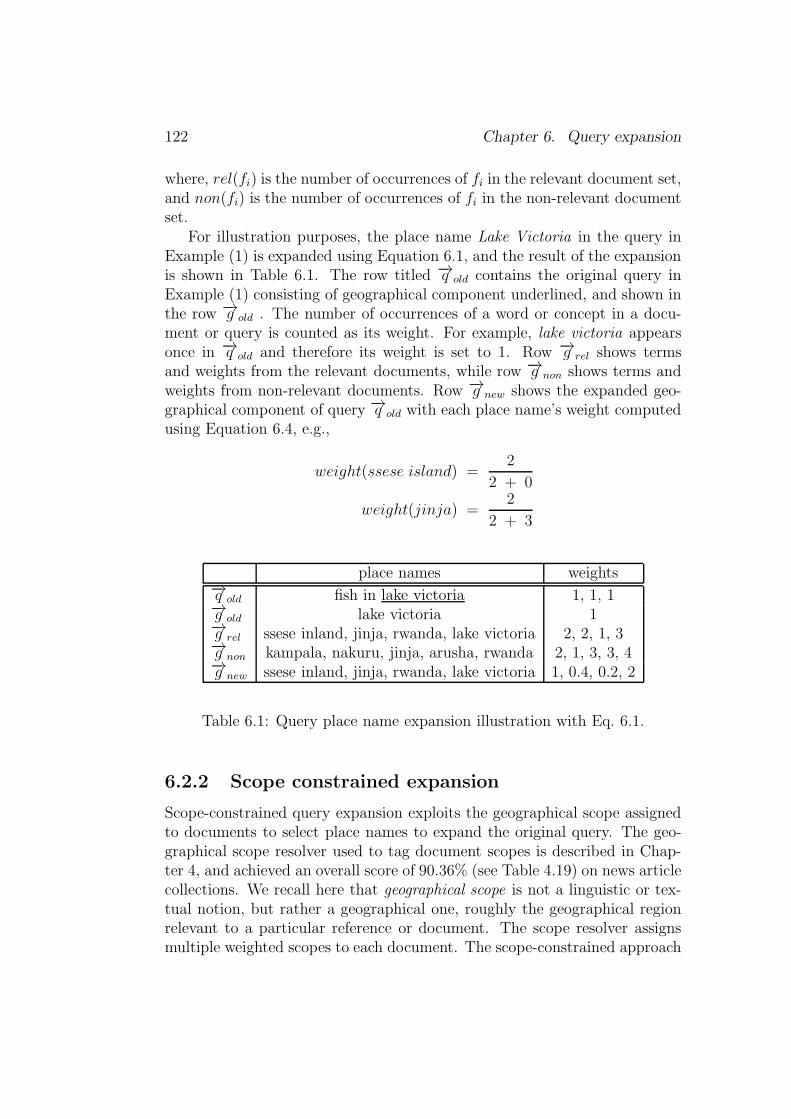
122 Chapter 6. Query expansion
where, rel(fi) is the number of occurrences of fi in the relevant document set,and non(fi) is the number of occurrences of fi in the non-relevant documentset.
For illustration purposes, the place name Lake Victoria in the query inExample (1) is expanded using Equation 6.1, and the result of the expansionis shown in Table 6.1. The row titled −→q old contains the original query inExample (1) consisting of geographical component underlined, and shown inthe row −→g old . The number of occurrences of a word or concept in a docu-ment or query is counted as its weight. For example, lake victoria appearsonce in −→q old and therefore its weight is set to 1. Row −→g rel shows termsand weights from the relevant documents, while row −→g non shows terms andweights from non-relevant documents. Row −→g new shows the expanded geo-graphical component of query −→q old with each place name’s weight computedusing Equation 6.4, e.g.,
weight(ssese island) =2
2 + 0
weight(jinja) =2
2 + 3
place names weights−→q old fish in lake victoria 1, 1, 1−→g old lake victoria 1−→g rel ssese inland, jinja, rwanda, lake victoria 2, 2, 1, 3−→g non kampala, nakuru, jinja, arusha, rwanda 2, 1, 3, 3, 4−→g new ssese inland, jinja, rwanda, lake victoria 1, 0.4, 0.2, 2
Table 6.1: Query place name expansion illustration with Eq. 6.1.
6.2.2 Scope constrained expansion
Scope-constrained query expansion exploits the geographical scope assignedto documents to select place names to expand the original query. The geo-graphical scope resolver used to tag document scopes is described in Chap-ter 4, and achieved an overall score of 90.36% (see Table 4.19) on news articlecollections. We recall here that geographical scope is not a linguistic or tex-tual notion, but rather a geographical one, roughly the geographical regionrelevant to a particular reference or document. The scope resolver assignsmultiple weighted scopes to each document. The scope-constrained approach
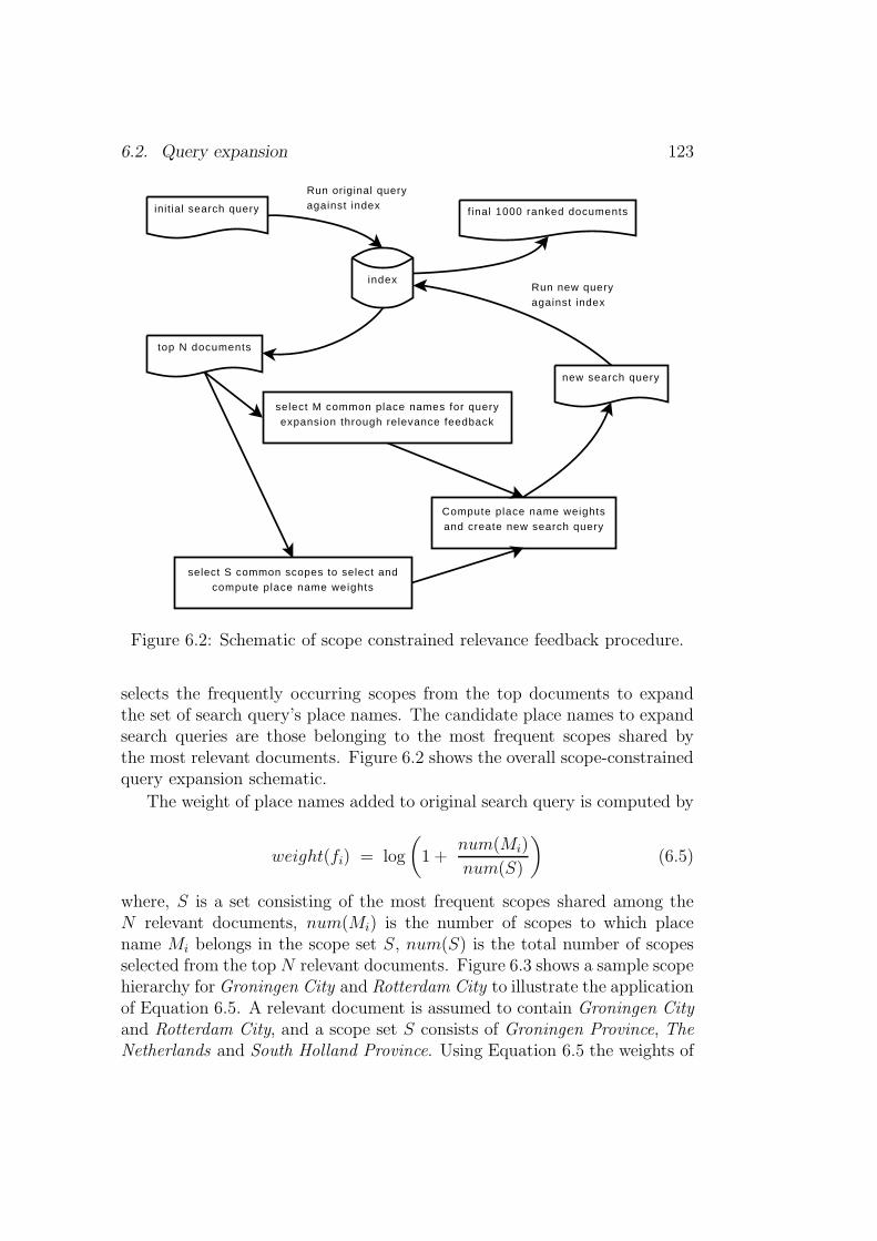
6.2. Query expansion 123
init ial search query
top N documents
index
select M common place names for queryexpansion through relevance feedback
select S common scopes to select andcompute place name weights
Compute place name weightsand create new search query
new search query
f inal 1000 ranked documents
Run new queryagainst index
Run original query against index
Figure 6.2: Schematic of scope constrained relevance feedback procedure.
selects the frequently occurring scopes from the top documents to expandthe set of search query’s place names. The candidate place names to expandsearch queries are those belonging to the most frequent scopes shared bythe most relevant documents. Figure 6.2 shows the overall scope-constrainedquery expansion schematic.
The weight of place names added to original search query is computed by
weight(fi) = log
(
1 +num(Mi)
num(S)
)
(6.5)
where, S is a set consisting of the most frequent scopes shared among theN relevant documents, num(Mi) is the number of scopes to which placename Mi belongs in the scope set S, num(S) is the total number of scopesselected from the top N relevant documents. Figure 6.3 shows a sample scopehierarchy forGroningen City and Rotterdam City to illustrate the applicationof Equation 6.5. A relevant document is assumed to contain Groningen Cityand Rotterdam City, and a scope set S consists of Groningen Province, TheNetherlands and South Holland Province. Using Equation 6.5 the weights of

124 Chapter 6. Query expansion
Groningen City Rotterdam City
Groningen Province The Netherlands South Holland Province
Figure 6.3: Sample scope hierarchy for Groningen and Rotterdam.
Groningen City and Rotterdam City are computed as:
weight(groningen city) = log
(
1 +2
3
)
weight(rotherdam city) = log
(
1 +2
3
)
The scope constrained query expansion procedure is outlined as below:
1. Run the original search query against a document collection, and re-trieve the top N documents. These documents are assumed to begeographically relevant to the query. They have not physically beenexamined.
2. From the N relevant documents choose S scopes and M place names.These are respectively the most commonly occurring scopes and placenames in M documents.
3. Assign weights to M place names according to Equation 6.5. Add theweighted M place names to the original search query, and resubmit thenew query against the document collection retrieving 1000 top rankeddocuments.
More concisely the final P place names used to expand the geographicalcomponent of the original query are derived as P = {M ∈ S}.
6.2.3 Query expansion evaluation
The query place name expansion procedures described in this section areevaluated on the GeoCLEF 2007 (Mandl et al., 2008) dataset. GeoCLEF2007 provided 25 geographically focused topics in the format shown in Fig-ure 6.4. Each topic is pre-processed by removing topic stopwords (such as‘documents, mention, are, or, promises, of, nor, relevant’, etc.) as shown inthe lower box in Figure 6.4 before running against the index of GeoCLEF

6.2. Query expansion 125
<top lang="en">
<num>10.2452/65-GC</num>
<title>Free elections in Africa</title>
<desc>Documents mention free elections held in countries
in Africa</desc>
<narr>Future elections or promises of free elections are
not relevant</narr>
</top>
⇓
<top lang="en">
<num>10.2452/65-GC</num>
<title>free elections africa</title>
<desc>free elections held countries africa</desc>
<narr>elections</narr>
</top>
Figure 6.4: GeoCLEF 2007 topic and pre-processed format.
2007 document collections. The final query submitted contains all the stringsincluding the duplicate strings such as free elections africa free elections heldcountries africa elections for the topic in Figure 6.4. Experience has shownthat the original search query terms should be preserved in the new feedbackquery formulation to achieve performance improvement (Salton and Buckley,1990). The TREC evaluation tool 2 is used to evaluate retrieval results.
Top term based expansion evaluation
The term-based expansion scheme adds the most commonly occurring placenames in the relevant documents to the original search query. The weight ofeach place name is computed using Equation 6.4. The following steps outlinehow the experiments were set-up for the reported results:
2[10 November 2009] http://trec.nist.gov/trec_eval/

126 Chapter 6. Query expansion
0
0.1
0.2
0.3
0.4
0.5
0.6
0 0.1 0.2 0.3 0.4 0.5 0.6 0.7 0.8 0.9 1
Pre
cisi
on
Recall
Interpolated Recall - Precision Averages
Top 20 common place namesTop 10 common place namesTop 05 common place names
Default Lucene
Figure 6.5: Interpolated recall vs precision average.
1. Run the pre-processed topic terms against GeoCLEF 2007 documentindex, and retrieve the top 1000 ranked documents.
2. Assume the top 30 returned documents to be relevant, and select the10 most frequently occurring place names from the 30 documents. The10 place names are assumed to cover the geographic area of interest.
3. Assume 250 documents selected from rank position 650 to 900 are out-side the geographic area of interest. The 250 documents could havealso been selected from documents ranked beyond the 1000 ranked po-sition. For experimental purpose it is assumed that place names fromrank position 650 and beyond would be irrelevant to geographic cover-age of interest.
4. Compute the weight of the 10 relevant place names using Equation 6.4,and submit the newly constructed query (see Equation 6.1) againstdocument index. Retrieve the top 1000 ranked documents.
Figure 6.5 shows the performance of relevance feedback approach at top20, 10 and 5 place names against default Lucene performance. The 20, 10 and5 place names are the commonly occurring place names in the top 30 relevantdocuments. Out of the total 650 relevant documents, Lucene retrieved 603
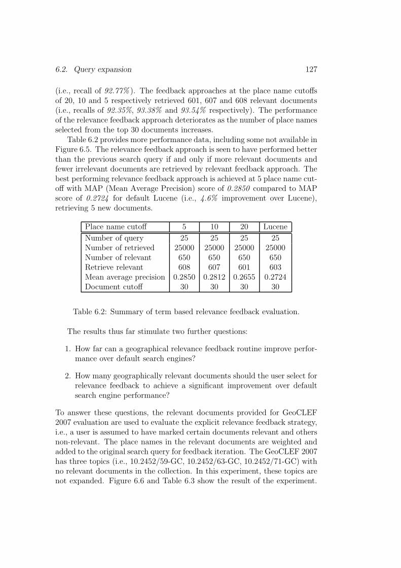
6.2. Query expansion 127
(i.e., recall of 92.77% ). The feedback approaches at the place name cutoffsof 20, 10 and 5 respectively retrieved 601, 607 and 608 relevant documents(i.e., recalls of 92.35%, 93.38% and 93.54% respectively). The performanceof the relevance feedback approach deteriorates as the number of place namesselected from the top 30 documents increases.
Table 6.2 provides more performance data, including some not available inFigure 6.5. The relevance feedback approach is seen to have performed betterthan the previous search query if and only if more relevant documents andfewer irrelevant documents are retrieved by relevant feedback approach. Thebest performing relevance feedback approach is achieved at 5 place name cut-off with MAP (Mean Average Precision) score of 0.2850 compared to MAPscore of 0.2724 for default Lucene (i.e., 4.6% improvement over Lucene),retrieving 5 new documents.
Place name cutoff 5 10 20 Lucene
Number of query 25 25 25 25Number of retrieved 25000 25000 25000 25000Number of relevant 650 650 650 650Retrieve relevant 608 607 601 603Mean average precision 0.2850 0.2812 0.2655 0.2724Document cutoff 30 30 30 30
Table 6.2: Summary of term based relevance feedback evaluation.
The results thus far stimulate two further questions:
1. How far can a geographical relevance feedback routine improve perfor-mance over default search engines?
2. How many geographically relevant documents should the user select forrelevance feedback to achieve a significant improvement over defaultsearch engine performance?
To answer these questions, the relevant documents provided for GeoCLEF2007 evaluation are used to evaluate the explicit relevance feedback strategy,i.e., a user is assumed to have marked certain documents relevant and othersnon-relevant. The place names in the relevant documents are weighted andadded to the original search query for feedback iteration. The GeoCLEF 2007has three topics (i.e., 10.2452/59-GC, 10.2452/63-GC, 10.2452/71-GC) withno relevant documents in the collection. In this experiment, these topics arenot expanded. Figure 6.6 and Table 6.3 show the result of the experiment.

128 Chapter 6. Query expansion
0
0.1
0.2
0.3
0.4
0.5
0.6
0.7
0.8
0.9
0 0.1 0.2 0.3 0.4 0.5 0.6 0.7 0.8 0.9 1
Pre
cisi
on
Recall
Interpolated Recall - Precision Averages
ALLR30.N250R05.N250R05.N05
Lucene
Figure 6.6: Performance of term-based query expansion procedure.
The graph labeled ALL shows that all the relevant and non-relevant docu-ments are used. And labels of format Rxx.Nyy denote that xx relevant and yynon-relevant documents are used. The performance improvement over thedefault search engine is significant. Five geographically relevant and non-relevant documents can achieve up to 55.84% of MAP score improvementover default search engine performance through relevance feedback approach.The lesson learned is that if a searcher is patient enough to select five relevantdocuments and five non-relevant documents, he or she can achieve significantimprovement over default search engine systems both in terms of recall andprecision.
Scope constrained expansion evaluation
The scope-constrained expansion routine selects the place names found inthe geographical scopes which are commonly shared by the top ranked doc-uments, i.e., scope-based(names) = {M ⊆ S}, where, M are the commonlyoccurring place names in the relevant documents and S are the commonlyshared scopes among the relevant documents. The result of the evaluationare shown in Figure 6.7 and Table 6.4. Graph 30.ASS shows the perfor-mance of scope-constrained query expansion with 30 top ranked documentsreturned from the initial query against the collection. The graphs 05.REL
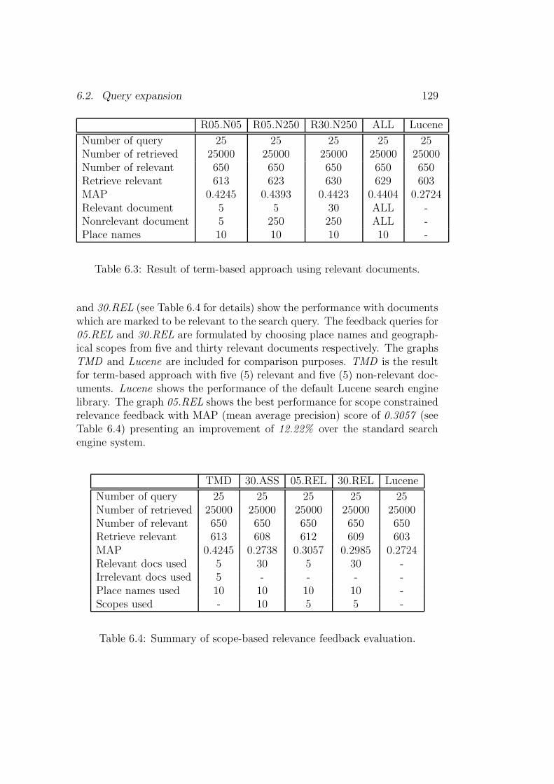
6.2. Query expansion 129
R05.N05 R05.N250 R30.N250 ALL Lucene
Number of query 25 25 25 25 25Number of retrieved 25000 25000 25000 25000 25000Number of relevant 650 650 650 650 650Retrieve relevant 613 623 630 629 603MAP 0.4245 0.4393 0.4423 0.4404 0.2724Relevant document 5 5 30 ALL -Nonrelevant document 5 250 250 ALL -Place names 10 10 10 10 -
Table 6.3: Result of term-based approach using relevant documents.
and 30.REL (see Table 6.4 for details) show the performance with documentswhich are marked to be relevant to the search query. The feedback queries for05.REL and 30.REL are formulated by choosing place names and geograph-ical scopes from five and thirty relevant documents respectively. The graphsTMD and Lucene are included for comparison purposes. TMD is the resultfor term-based approach with five (5) relevant and five (5) non-relevant doc-uments. Lucene shows the performance of the default Lucene search enginelibrary. The graph 05.REL shows the best performance for scope constrainedrelevance feedback with MAP (mean average precision) score of 0.3057 (seeTable 6.4) presenting an improvement of 12.22% over the standard searchengine system.
TMD 30.ASS 05.REL 30.REL Lucene
Number of query 25 25 25 25 25Number of retrieved 25000 25000 25000 25000 25000Number of relevant 650 650 650 650 650Retrieve relevant 613 608 612 609 603MAP 0.4245 0.2738 0.3057 0.2985 0.2724Relevant docs used 5 30 5 30 -Irrelevant docs used 5 - - - -Place names used 10 10 10 10 -Scopes used - 10 5 5 -
Table 6.4: Summary of scope-based relevance feedback evaluation.

130 Chapter 6. Query expansion
0
0.1
0.2
0.3
0.4
0.5
0.6
0.7
0.8
0.9
0 0.1 0.2 0.3 0.4 0.5 0.6 0.7 0.8 0.9 1
Pre
cisi
on
Recall
Interpolated Recall - Precision Averages
30.ASS30.REL05.REL
TMDLucene
Figure 6.7: Performance of scope-based query expansion procedure.
Evaluation on residual collection
The previous evaluations are carried against all the documents in the collec-tion (i.e., including documents used to construct the new feedback query).The problem is that much of the observed improvement is induced by thepreviously judged relevant documents which end up being ranked higher thanthey were before feedback iteration. An alternative is to use a residual col-lection (i.e., a set of documents minus previously judged relevant documentsused to construct feedback query) for the feedback iteration (Manning et al.,2007). Though this may seem a more realistic evaluation, the performancecan be far lower than for the original query. This is particularly true if thereare fewer relevant documents for each test query. An alternative to residualcollection evaluation is to have two sets of collections. One set used for theoriginal query and relevance judgment, and the second use for comparativeevaluation.
Here evaluation is performed on the residual collection. The residualcollection is prepared by assuming that the relevant documents used to con-struct the new feedback query are non-relevant to the user in the seconditeration. Therefore, all the relevant documents used to construct the feed-back query are marked non-relevant in the gold standard result list. For thisexperiment, five relevant documents were chosen to construct a new feedback

6.2. Query expansion 131
0
0.1
0.2
0.3
0.4
0.5
0.6
0.7
0.8
50 51 52 53 54 55 56 57 58 59 60 61 62 63 64 65 66 67 68 69 70 71 72 73 74 75 76
Mea
n A
vera
ge P
reci
sion
(M
AP
)
GeoCLEF 2007 Topics (51-75)
Topic performance on residual collection
LuceneTMD
05.REL
Figure 6.8: Topic performance on residual collection.
query, and these were the documents removed or marked non-relevant in theresidual collection for each query. As a result, six GeoCLEF 2007 queries arewithout relevant documents in the residual collection. This is because thequeries had fewer than six relevant documents in the whole collection.
Figure 6.8 and Table 6.5 shows the results of relevance feedback proce-dures on the residual document collection. TMD shows the result of theterm-based approach with five (5) relevant and five (5) non-relevant docu-ments. 05.REL shows the result of scope-based scheme using five (5) relevantdocuments for the query expansion procedure. The 05.REL chose the top 5scopes to constrain place name selection for feedback query expansion.
The following observation can be made from the results:
1. The term-based (TMD) scheme shows superiority when evaluated onthe whole set of document collection which includes documents usedto construct the new search query for relevance feedback. As notedbefore, the improvement is a result of ranking highly the documentsused to construct the new search query. When the scheme is evalu-ated against residual document collection it achieved the worst perfor-mance in comparison to the default Lucene system and the scope-based(05.REL) procedure. It deteriorates from the MAP score of 0.4245 to0.1524 on residual document collection evaluation which shows a 64%
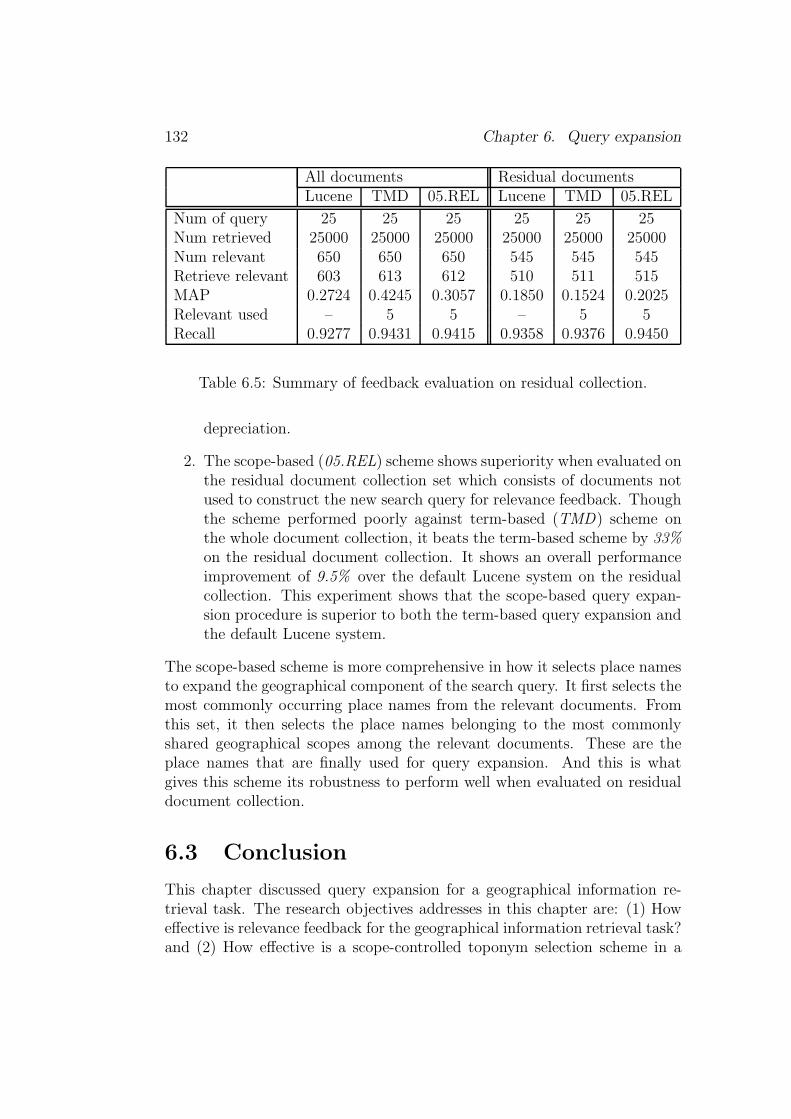
132 Chapter 6. Query expansion
All documents Residual documentsLucene TMD 05.REL Lucene TMD 05.REL
Num of query 25 25 25 25 25 25Num retrieved 25000 25000 25000 25000 25000 25000Num relevant 650 650 650 545 545 545Retrieve relevant 603 613 612 510 511 515MAP 0.2724 0.4245 0.3057 0.1850 0.1524 0.2025Relevant used – 5 5 – 5 5Recall 0.9277 0.9431 0.9415 0.9358 0.9376 0.9450
Table 6.5: Summary of feedback evaluation on residual collection.
depreciation.
2. The scope-based (05.REL) scheme shows superiority when evaluated onthe residual document collection set which consists of documents notused to construct the new search query for relevance feedback. Thoughthe scheme performed poorly against term-based (TMD) scheme onthe whole document collection, it beats the term-based scheme by 33%on the residual document collection. It shows an overall performanceimprovement of 9.5% over the default Lucene system on the residualcollection. This experiment shows that the scope-based query expan-sion procedure is superior to both the term-based query expansion andthe default Lucene system.
The scope-based scheme is more comprehensive in how it selects place namesto expand the geographical component of the search query. It first selects themost commonly occurring place names from the relevant documents. Fromthis set, it then selects the place names belonging to the most commonlyshared geographical scopes among the relevant documents. These are theplace names that are finally used for query expansion. And this is whatgives this scheme its robustness to perform well when evaluated on residualdocument collection.
6.3 Conclusion
This chapter discussed query expansion for a geographical information re-trieval task. The research objectives addresses in this chapter are: (1) Howeffective is relevance feedback for the geographical information retrieval task?and (2) How effective is a scope-controlled toponym selection scheme in a
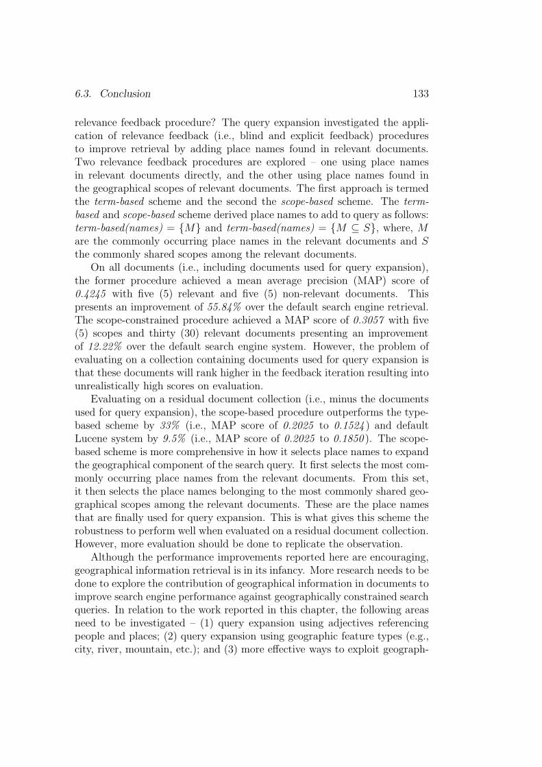
6.3. Conclusion 133
relevance feedback procedure? The query expansion investigated the appli-cation of relevance feedback (i.e., blind and explicit feedback) proceduresto improve retrieval by adding place names found in relevant documents.Two relevance feedback procedures are explored – one using place namesin relevant documents directly, and the other using place names found inthe geographical scopes of relevant documents. The first approach is termedthe term-based scheme and the second the scope-based scheme. The term-based and scope-based scheme derived place names to add to query as follows:term-based(names) = {M} and term-based(names) = {M ⊆ S}, where, Mare the commonly occurring place names in the relevant documents and Sthe commonly shared scopes among the relevant documents.
On all documents (i.e., including documents used for query expansion),the former procedure achieved a mean average precision (MAP) score of0.4245 with five (5) relevant and five (5) non-relevant documents. Thispresents an improvement of 55.84% over the default search engine retrieval.The scope-constrained procedure achieved a MAP score of 0.3057 with five(5) scopes and thirty (30) relevant documents presenting an improvementof 12.22% over the default search engine system. However, the problem ofevaluating on a collection containing documents used for query expansion isthat these documents will rank higher in the feedback iteration resulting intounrealistically high scores on evaluation.
Evaluating on a residual document collection (i.e., minus the documentsused for query expansion), the scope-based procedure outperforms the type-based scheme by 33% (i.e., MAP score of 0.2025 to 0.1524 ) and defaultLucene system by 9.5% (i.e., MAP score of 0.2025 to 0.1850 ). The scope-based scheme is more comprehensive in how it selects place names to expandthe geographical component of the search query. It first selects the most com-monly occurring place names from the relevant documents. From this set,it then selects the place names belonging to the most commonly shared geo-graphical scopes among the relevant documents. These are the place namesthat are finally used for query expansion. This is what gives this scheme therobustness to perform well when evaluated on a residual document collection.However, more evaluation should be done to replicate the observation.
Although the performance improvements reported here are encouraging,geographical information retrieval is in its infancy. More research needs to bedone to explore the contribution of geographical information in documents toimprove search engine performance against geographically constrained searchqueries. In relation to the work reported in this chapter, the following areasneed to be investigated – (1) query expansion using adjectives referencingpeople and places; (2) query expansion using geographic feature types (e.g.,city, river, mountain, etc.); and (3) more effective ways to exploit geograph-

134 Chapter 6. Query expansion
ical scopes for query expansion.

Chapter 7
Relevance ranking
[Parts of of this chapter are published in Andogah and Bouma (2008).]
In the context of information retrieval, relevance denotes how well a re-trieved set of documents (or a single document) meets the information needof the user. Relevance most commonly refers to topical relevance or about-ness, i.e. to what extent the topic of a result matches the topic of the query orinformation need. Relevance can also be interpreted more broadly, referringto generally how “good” a retrieved result is with regard to the informationneed. The latter definition of relevance, sometimes referred to as user rele-vance, encompasses topical relevance and possibly other concerns of the usersuch as timeliness, authority or novelty of the result.1 Relevance ranking isthe task of ordering the retrieved set of documents by relevance to the user’sinformation needs so that the most relevant documents are pushed to thetop of the ranked result list.
The research objective addressed in this chapter is – How well can geo-graphical scope and feature type information be integrated into the documentranking procedure to prioritize documents by geography? The chapter de-scribes two types of relevance ranking schemes which exploit geographicalscopes and feature types in documents and search queries to rank documentsby geography. The scope-based metric is used to rank documents for querieswhich are resolvable to at least one scope. On the other hand, the type-based metric is used to rank documents when a query mentions only thegeographical subjects, therefore, it is not resolvable to a scope. The scoresof the non-geographic component and the geographic components are com-bined through linear interpolation and through weighted harmonic means.
1[14 March, 2010]: http://en.wikipedia.org/wiki/Relevance_(information_
retrieval)
135
136 Chapter 7. Relevance ranking
The proposed relevance measures and weighting schemes are evaluated onthe GeoCLEF 2007 dataset with an encouraging performance improvementover the standard IR performance. The best performance is achieved whenthe importance of non-geographic relevance scores outweighs the importanceof geographic relevance scores.
7.1 Non-geographic relevance measure
The Apache Lucene search engine library is used to perform non-geographicsearch. Lucene’s default relevance measure is derived from the vector spacemodel (VSM) (Salton, 1989). The Lucene relevance score formula com-bines several factors to determine the score of a document for a given query(Gospodnetic and Hatcher, 2005):
NonSim(q, d) =∑
t∈q
tf(t ∈ d) · idf(t) · bst · lN(t.f ield ∈ d) (7.1)
where, · operator stands for multiplication, tf(t ∈ d) is the term frequencyfactor for term t in document d, idf(t) is the inverse document frequency ofterm t in the document collection, bst is the field boost set during indexingand lN(t.f ield ∈ d) is the normalization value of a field given the numberof terms in the field (see Gospodnetic and Hatcher (2005) for more details).The purpose of boosting is to indicate how important a given term is relativeto other terms in the document.
7.2 Scope-based relevance measure
The scope-based relevance measure (SBRM) uses geographical scopes as-signed to queries and documents to rank documents according to querygeographic restrictions similar to schemes explored in Andrade and Silva(2006). The geographical scope resolver (Andogah et al., 2008) assigns mul-tiple scopes to a document. The assigned scopes are ranked according to theirrelevance score from the most relevant to the least relevant per document.
The scopes are limited to six categories: continent scope, continent-directional scope (e.g. western Europe), country scope, country-directionalscope (e.g. north Netherlands), province2 scope, and province-directionalscope (e.g. south-east California).
2A province is the first order administrative division of a country.
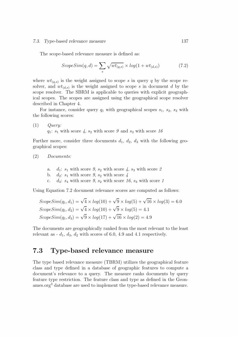
7.3. Type-based relevance measure 137
The scope-based relevance measure is defined as:
ScopeSim(q, d) =∑
s
√
wt(q,s) × log(1 + wt(d,s)) (7.2)
where wt(q,s) is the weight assigned to scope s in query q by the scope re-solver, and wt(d,s) is the weight assigned to scope s in document d by thescope resolver. The SBRM is applicable to queries with explicit geograph-ical scopes. The scopes are assigned using the geographical scope resolverdescribed in Chapter 4.
For instance, consider query q1 with geographical scopes s1, s2, s3 withthe following scores:
(1) Query:q1: s1 with score 4, s2 with score 9 and s3 with score 16
Further more, consider three documents d1, d2, d3 with the following geo-graphical scopes:
(2) Documents:
a. d1: s1 with score 9, s2 with score 4, s3 with score 2b. d2: s1 with score 9, s2 with score 4c. d3: s4 with score 9, s2 with score 16, s3 with score 1
Using Equation 7.2 document relevance scores are computed as follows:
ScopeSim(q1, d1) =√4× log(10) +
√9× log(5) +
√16× log(3) = 6.0
ScopeSim(q1, d2) =√4× log(10) +
√9× log(5) = 4.1
ScopeSim(q1, d3) =√9× log(17) +
√16× log(2) = 4.9
The documents are geographically ranked from the most relevant to the leastrelevant as - d1, d3, d2 with scores of 6.0, 4.9 and 4.1 respectively.
7.3 Type-based relevance measure
The type based relevance measure (TBRM) utilizes the geographical featureclass and type defined in a database of geographic features to compute adocument’s relevance to a query. The measure ranks documents by queryfeature type restriction. The feature class and type as defined in the Geon-ames.org3 database are used to implement the type-based relevance measure.

138 Chapter 7. Relevance ranking
Feature Code
A H L PR S T UV
country province . . . ci ty town vil lage
Classes
Types
Figure 7.1: Sample Geonames.org feature code hierarchy.
Figure 7.1 shows the structure of the Geonames.org 4 feature grouping hierar-chy, where, A is administrative unit, H is hydrographic, L is locality or area,P is populated place, R is road or railroad, S is spot, T is hypsographic, U isundersea and V is vegetation. The type based relevance measure is definedas:
TypeSim(q, d) =1.0
√
1 +NqFClass−NqFType
NqFClass
(7.3)
where; NqFClass is the number of occurrences of the required query featureclass in the document, and NqFType is the number of occurrences of therequired query feature type in the document. The maximum value of 1.0 isreached for Equation 7.3 when the number of NqFClass is equal to NqFType.This happens when all features of class FClass are of type FType. TheTBRM is applicable to queries that mention geographical subjects or typeswithout the mention of place names, e.g., lakes with monsters. The useof Equation 7.3 illustrated with GeoCLEF 2007 (Mandl et al., 2008) topic10.2452/56-GC: Lakes with monsters. Figure 7.2 shows geographic featuretypes in three relevance documents to topic 10.2452/56-GC.
The query feature type Lake (LK) belongs to class H (i.e., hydrographicfeatures such as river, stream, lake, bay, etc.). Each retrieved documentis queried for class H and feature type LK. The number of occurrence of H(i.e. NqFClass) and LK (i.e. NqFType) in the document is used to compute thedocument’s geographic relevance according to Equation 7.3. The documentsin Figure 7.2 are geographically ranked as: LA071094-0288 , LA090394-0008and GH950721-000028 with scores of 1.0, 0.89 and 0.77 respectively.
3http://www.geonames.org/export/codes.html4http://www.geonames.org

7.3. Type-based relevance measure 139
<Document did="LA071094-0288">
<GT name="village" tf="1" type="PPL" class="P" />
<GT name="lake" tf="1" type="LK" class="H" />
<GT name="town" tf="1" type="PPL" class="P" />
</Document>
<Document did="GH950721-000028">
<GT name="sea" tf="4" type="SEA" class="H" />
<GT name="lake" tf="2" type="LK" class="H" />
</Document>
<Document did="LA090394-0008">
<GT name="sea" tf="1" type="SEA" class="H" />
<GT name="lake" tf="3" type="LK" class="H" />
<GT name="city" tf="2" type="PPL" class="P" />
</Document>
Figure 7.2: Sample documents with geographic feature classes and types.

140 Chapter 7. Relevance ranking
7.4 Relevance measure unification
This section describes attempts that have been proposed to combine thenon-geographic relevance measures and the geographic relevance measuresto unified relevance measures.
7.4.1 Linear interpolated combination
The linear interpolated combination (LIC) is derived as:
LIC(q, d) = λT NonSim(q, d) + λG GeoSim(q, d) (7.4)
λT + λG = 1 (7.5)
where; λT is the non-geographic interpolation factor (NIF) and λG is thegeographic interpolation factor (GIF). The non-geographic and geographicscores are normalized to [0, 1] before linearly combining the ranked lists. TheGeoSim(q, d) in Equation 7.4 is replaced by either Equation 7.2 or Equa-tion 7.3 depending on the nature of the query.
7.4.2 Weighted harmonic mean combination
The weighted harmonic mean (WHM) combination borrows from the classicprecision and recall combination formula, the F-measure (see Van Rijsbergen,1979, Chapter 7) commonly used to measure performance of informationretrieval (IR) systems. The motivation is to determine the importance ofnon-geographic relevance relative to geographic relevance, and then use theinsight to rank documents by both non-geographic and geographic relevance.The weighted harmonic mean (WHM) combination is defined as:
WHM(q, d) =(1 + β)×GeoSim(q, d)×NonSim(q, d)
β ×GeoSim(q, d) +NonSim(q, d)(7.6)
where; β indicates the importance attached to either GeoSim(q, d) orNonSim(q, d)in the unification. The following special cases are derived as a consequenceof harmonic mean combination:
1. if β = 1, equal importance is attached to both non-geographic andgeographic relevance.
2. if β = 0, no importance is attached to non-geographic relevance.
3. if β = ∞, no importance is attached to geographic relevance.
7.5. Evaluation 141
The interesting feature of this combination is that an optimal value of βwhere the best performance is achieved can be spotted. The GeoSim(q, d)in Equation 7.6 is replaced by either Equation 7.2 or Equation 7.3 dependingon the nature of the query.
7.4.3 Extended harmonic mean combination
The extended harmonic mean (EHM) combination linearly adds the non-geographic relevance measure (see Eq. 7.1) to the weighted harmonic mean(WHM) combination (see Eq. 7.6) as follows:
EHM(q, d) = NonSim(q, d) +(1 + β)×GeoSim(q, d)×NonSim(q, d)
β ×GeoSim(q, d) +NonSim(q, d)(7.7)
The GeoSim(q, d) in Equation 7.7 is replaced by either Equation 7.2 or Equa-tion 7.3 depending on the nature of the query.
7.5 Evaluation
The proposed relevance measure and weighting schemes are evaluated onGeoCLEF 2007 (Mandl et al., 2008) dataset. Gey et al. (2007) categorizedgeographic topics into eight groups according to the way they depend ona place (e.g., Netherlands, Texas, etc), geographic subject (e.g., city, river,etc.) or geographic relation (e.g., north Groningen, western Europe, etc.).The ranking parameters in the formula for the experiment are tuned on theGeoCLEF 2006 dataset (i.e., the topics and document collection). The ulti-mate purpose of the experiment is to compare the proposed relevance rankingschemes against the default search engine relevance ranking. Therefore, ef-forts were made to construct high quality queries to run against the documentcollections.
In this experiment two groups of topics are distinguished:
1. GROUP1: Topics which explicitly mention places of interest by name,and are resolvable to geographical scopes. Topics which lack sufficientgeographical information or provide ambiguous geographic informationare geographically expanded. To generated high quality queries, geo-graphical expansion is done manually. For instance, GeoCLEF 2007topic 10.2452/65-GC: Free elections in Africa is manually expandedby adding the names of African countries and their capitals. TheGeoCLEF 2007 topics geographically expanded include: 10.2452/51-GC, 10.2452/59-GC, 10.2452/60-GC, 10.2452/61-GC, 10.2452/63-GC,10.2452/65-GC, 10.2452/66-GC, 10.2452/70-GC.

142 Chapter 7. Relevance ranking
Example GROUP1 TopicTopic num 10.2452/65-GCTopic title Free elections in AfricaGeo-expansion Add names of African countries and their capitalsQuery Formulated by content of topic title-desc-narr tagsGeo-relevance Scope based measure (see Eq.7.2)
Example GROUP2 TopicTopic num 10.2452/68-GCTopic title Rivers with floodsGeo-expansion –Query Formulated by content of topic title-desc-narr tagsGeo-relevance Type based measure (see Eq.7.3)
Table 7.1: Example topic grouping and query formulation
2. GROUP2: Topics which do not mention places, but mention a geo-graphic subject of interest (i.e., 10.2452/56-GC, 10.2452/67-GC,10.2452/68-GC, 10.2452/72-GC). Topics 10.2452/56-GC, 10.2452/68-GC, 10.2452/72-GC are characterized as geographical subjects with non-geographic restriction (Gey et al., 2007). Topic 10.2452/67-GC is morecomplex. Resolving the geographic scope of such topics to a specificplace is non-trivial. The most reasonable scope for these topics is ageographic subject scope: lake, river, beach, city, etc.
Table 7.1 shows GeoCLEF 2007 topics5 depicting the topic grouping,geographic expansion, query formulation and geographic relevance measureused. GROUP1 topics are ranked with the scope-based relevance rankingscheme because they either inferred or explicitly mentioned names of places,and therefore were assigned geographical scopes based on this. On the otherhand, GROUP2 topics are ranked with the type-based relevance rankingscheme because they only mentioned geographical subjects of interest with-out mentioning names of places, therefore, no geographical scope was as-signed to them.
7.5.1 Harmonic mean vs. linear interpolated combina-
tion
This sub-section compares harmonic mean combination (see Equation 7.6)retrieval performance against linear interpolated combination (see Equa-
5See Section B.3 in Appendix B for a complete list of GeoCLEF 2007 topic titles.
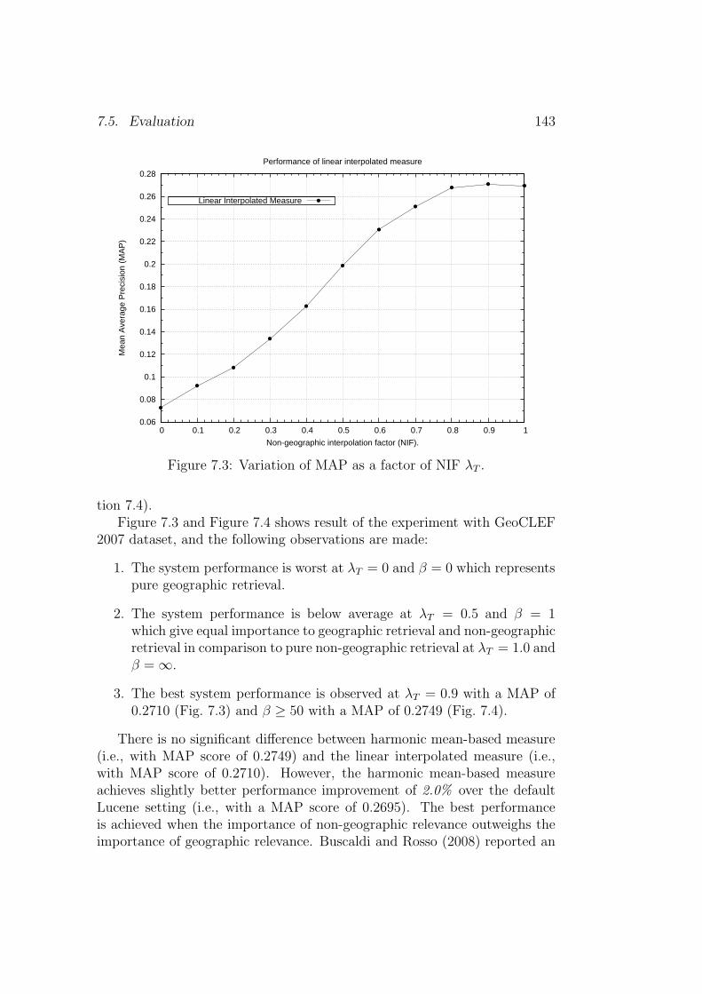
7.5. Evaluation 143
0.06
0.08
0.1
0.12
0.14
0.16
0.18
0.2
0.22
0.24
0.26
0.28
0 0.1 0.2 0.3 0.4 0.5 0.6 0.7 0.8 0.9 1
Mea
n A
vera
ge P
reci
sion
(M
AP
)
Non-geographic interpolation factor (NIF).
Performance of linear interpolated measure
Linear Interpolated Measure
Figure 7.3: Variation of MAP as a factor of NIF λT .
tion 7.4).Figure 7.3 and Figure 7.4 shows result of the experiment with GeoCLEF
2007 dataset, and the following observations are made:
1. The system performance is worst at λT = 0 and β = 0 which representspure geographic retrieval.
2. The system performance is below average at λT = 0.5 and β = 1which give equal importance to geographic retrieval and non-geographicretrieval in comparison to pure non-geographic retrieval at λT = 1.0 andβ = ∞.
3. The best system performance is observed at λT = 0.9 with a MAP of0.2710 (Fig. 7.3) and β ≥ 50 with a MAP of 0.2749 (Fig. 7.4).
There is no significant difference between harmonic mean-based measure(i.e., with MAP score of 0.2749) and the linear interpolated measure (i.e.,with MAP score of 0.2710). However, the harmonic mean-based measureachieves slightly better performance improvement of 2.0% over the defaultLucene setting (i.e., with a MAP score of 0.2695). The best performanceis achieved when the importance of non-geographic relevance outweighs theimportance of geographic relevance. Buscaldi and Rosso (2008) reported an

144 Chapter 7. Relevance ranking
0.06
0.08
0.1
0.12
0.14
0.16
0.18
0.2
0.22
0.24
0.26
0.28
0 20 40 60 80 100
Mea
n A
vera
ge P
reci
sion
(M
AP
)
Relevance importance factor (RIF).
Performance of weighted harmonic mean (WHM) measure
Weighted Harmonic Mean Measure
Figure 7.4: Variation of MAP as a factor of RIF β.
improvement when geographic terms in the query are weighed half or lessthan the weight of non-geographic terms, which is in agreement with ourobservation. The difference is that geographical scopes are used here insteadof geographic terms.
7.5.2 Extended harmonic mean combination
For the extended harmonic mean (EHM) evaluation, two variant of Equa-tion. 7.2 are implemented:
ScopeSimB(q, d) =∑
s
√
wt(q,s) ×√
wt(d,s) (7.8)
and
ScopeSimC(q, d) =∑
s
√
wt(d,s) × log(1 + wt(q,s)) (7.9)
The graphs ScopeSimA, ScopeSimB and ScopeSimC in Figure 7.5 showthe performance of EHM with GeoSim(q, d) in Equation 7.7 replaced byEquations 7.2, 7.8 and 7.9 respectively. In Figure 7.5, it can be seen thatthe GeoSim(q, d) formula in Equation 7.2 gives the best performance for βwith the value greater than 3.5 achieving the MAP score of 0.2935 which
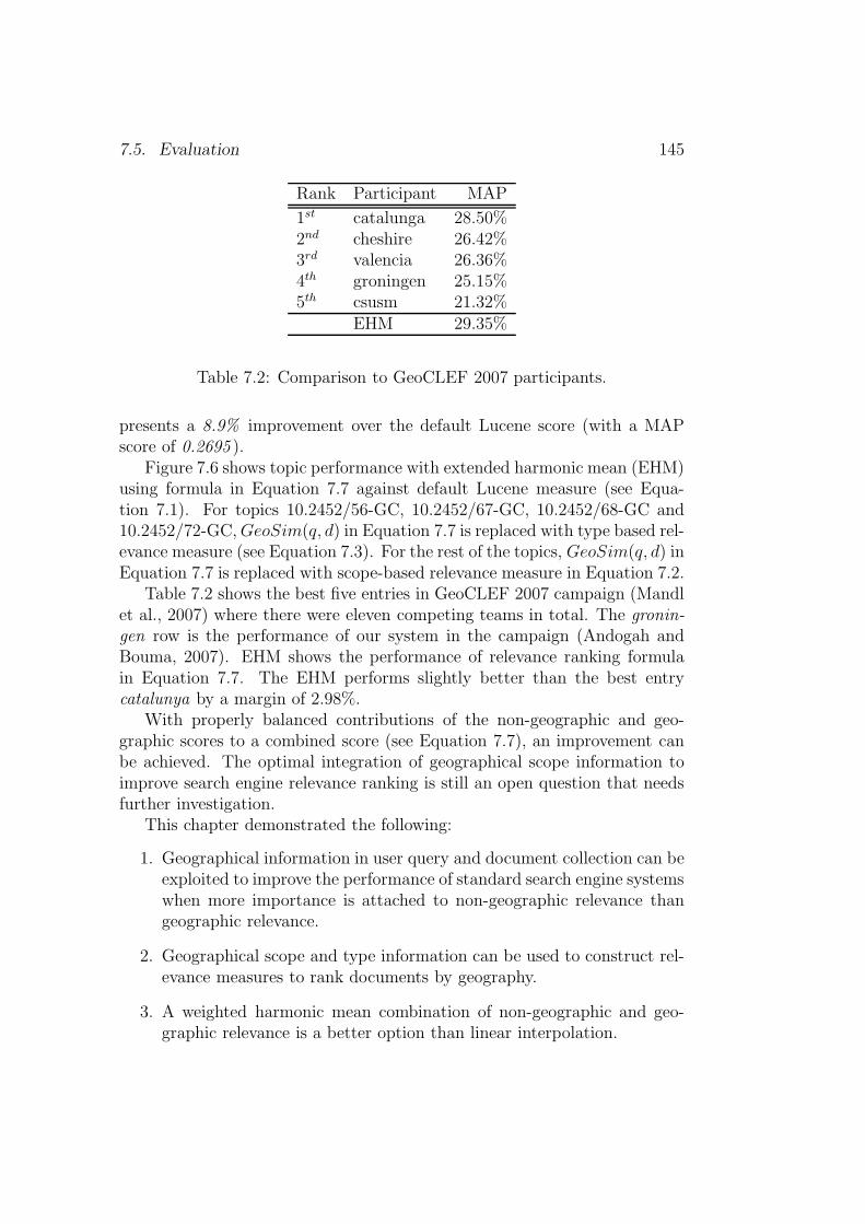
7.5. Evaluation 145
Rank Participant MAP
1st catalunga 28.50%2nd cheshire 26.42%3rd valencia 26.36%4th groningen 25.15%5th csusm 21.32%
EHM 29.35%
Table 7.2: Comparison to GeoCLEF 2007 participants.
presents a 8.9% improvement over the default Lucene score (with a MAPscore of 0.2695 ).
Figure 7.6 shows topic performance with extended harmonic mean (EHM)using formula in Equation 7.7 against default Lucene measure (see Equa-tion 7.1). For topics 10.2452/56-GC, 10.2452/67-GC, 10.2452/68-GC and10.2452/72-GC,GeoSim(q, d) in Equation 7.7 is replaced with type based rel-evance measure (see Equation 7.3). For the rest of the topics, GeoSim(q, d) inEquation 7.7 is replaced with scope-based relevance measure in Equation 7.2.
Table 7.2 shows the best five entries in GeoCLEF 2007 campaign (Mandlet al., 2007) where there were eleven competing teams in total. The gronin-gen row is the performance of our system in the campaign (Andogah andBouma, 2007). EHM shows the performance of relevance ranking formulain Equation 7.7. The EHM performs slightly better than the best entrycatalunya by a margin of 2.98%.
With properly balanced contributions of the non-geographic and geo-graphic scores to a combined score (see Equation 7.7), an improvement canbe achieved. The optimal integration of geographical scope information toimprove search engine relevance ranking is still an open question that needsfurther investigation.
This chapter demonstrated the following:
1. Geographical information in user query and document collection can beexploited to improve the performance of standard search engine systemswhen more importance is attached to non-geographic relevance thangeographic relevance.
2. Geographical scope and type information can be used to construct rel-evance measures to rank documents by geography.
3. A weighted harmonic mean combination of non-geographic and geo-graphic relevance is a better option than linear interpolation.

146 Chapter 7. Relevance ranking
0.2
0.21
0.22
0.23
0.24
0.25
0.26
0.27
0.28
0.29
0.3
0 1 2 3 4 5
Mea
n A
vera
ge P
reci
sion
(M
AP
)
Relevance importance factor (RIF).
Performance of extended harmonic mean (EHM) measure
ScopeSimAScopeSimBScopeSimC
Figure 7.5: Variation of MAP as a function of RIF β.
0
0.1
0.2
0.3
0.4
0.5
0.6
0.7
0.8
50 51 52 53 54 55 56 57 58 59 60 61 62 63 64 65 66 67 68 69 70 71 72 73 74 75 76
Mea
n A
vera
ge P
reci
sion
(M
AP
)
GeoCLEF 2007 Topics (51-75).
Scope-based and type-based relevance measure performance
Default LuceneExtended Harmonic Mean
Figure 7.6: GeoCLEF 2007 per topic performance.
7.6. Conclusion 147
7.6 Conclusion
This chapter described two relevance ranking schemes that exploit geograph-ical scopes and feature types in documents and search queries to rank docu-ments by geography. The scope-based metric is used to rank documents forqueries which are resolvable to at least one scope. On the other hand, thetype-based metric is used to rank documents when a query mentions only thegeographical subjects, so that it is not resolvable to a scope. The researchobjective addressed in this chapter is – How well can geographical scope andfeature type information be integrated into the document ranking procedureto prioritize documents by geography?
The non-geographic and geographic relevance scores are combined througha linear interpolation and weighted harmonic-means. The harmonic mean-based combination achieved a better performance than linear interpolation.A better performance is achieved when more importance is attached to non-geographical retrieval than geographical retrieval. The best performance isachieved with harmonic mean derived formula with MAP scope of 0.2935,an 8.9% improvement over standard search engine.
Although the performance is encouraging, more research is needed tobest incorporate geographical information mined from documents and searchqueries into the relevance ranking algorithm to improve search engine per-formance when answering geographically constrained information needs.

148 Chapter 7. Relevance ranking
Chapter 8
Conclusion
And the things that you have heard
from me among many witnesses, commit
these to faithful men who will be able to
teach others also.
2 Timothy 2:2(The New King James Version)
This thesis’s contribution to geographical information retrieval (GIR) re-search are in the following areas: (1) a new scope resolution strategy toresolve a document’s geographical coverage; (2) a new evaluation metric forgeographical scope resolution tasks; (3) a new toponym resolution schemegrounded on geographical scopes assigned to documents; (4) a new set ofevaluation metrics for toponym resolution tasks; (5) new insight into geo-graphical relevance feedback strategy for geographical information retrieval(GIR) tasks; and (6) a new relevance ranking metric exploiting geographicalscopes assigned to queries and documents. We have also initiated work on anew evaluation dataset for toponym resolution evaluation derived from doc-uments which are relevant to GeoCLEF topics (see Chapter 3). This chaptersummarises the work done in this thesis giving direction for future work incertain areas.
8.1 Achievements
We note in this section the achievements made in realizing the research objec-tives outlined in Chapter 1. The two main research objectives are: (1) how
149

150 Chapter 8. Conclusion
to mine and analyze the geographical information (GI) concealed in text,and (2) how to use geographical knowledge discovered to build models andconcepts to answer geography-dependent user information needs.
8.1.1 Scope resolution
Chapter 4 described new strategies to address the problem of a document’sgeographical scope resolution. The following research objectives are ad-dressed in the chapter:
1. How can place names, geographical adjectives (i.e., adjectives referringto people and places) and names of people be used to automaticallydetermine the geographical coverage or scope of documents? [Questionof algorithm.]
2. How best to compare the performance of scope resolution systems?[Question of binary vs. non-binary evaluation metric.]
3. How well do automatically determined geographical scopes or coveragesof documents compare to human assigned scopes? [Question of goldstandard evaluation.]
The scope resolution is grounded on two basic assumptions:
1. Places of the same type or under the same administrative jurisdictionor adjacent-to each other are more likely to be mentioned in a givendiscourse unit. For example, a discourse mentioning the Netherlandsis more likely to mention places of the type country (e.g., United King-dom, Uganda) or places under the jurisdiction of the Netherlands (e.g.,Amsterdam, Rotterdam) or places adjacent to the Netherlands (e.g.,Belgium, Germany).
2. VIPs (i.e., political leadership) in the same geographical region or atthe same leadership hierarchy level tend to be mentioned together in aunit of a discourse. That is, presidents are most likely to be mentionedtogether with the members of their administration or with presidentsof other countries in a unit of a discourse. For example, US PresidentBarack Obama is most likely to be mentioned in a discourse togetherwith US Vice President Joe Biden or President Yoweri Kaguta Musev-eni of Uganda in a discourse.
The new scope resolution strategy with place names exploits place namefrequency of occurrence in a document, geographical adjectives (referring to

8.1. Achievements 151
people and places), place type (e.g., country, city), importance of a placebased on population and place type, and vertical (transitive parent-of/child-of) and horizontal (adjacency or neighborliness) relationships. The placename derived scope resolution procedure defined a new data model to de-scribe a geographical scope. This model is used to define 26,820 refer-ence scopes which are implemented using the zone indexing concept withinLucene IR system. Each reference scope is implemented as a document. Theweighted zone scoring concept is implemented through the Lucene queryterm boost and multi-field query capability. The place name based strat-egy achieved an evaluation score of 79.09% on a binary evaluation metricand 90.36% on the newly proposed non-binary evaluation metric on newsarticles.
The proposed scope resolution strategy with person names exploits therelationship between GeoVIPs (i.e., political leaders) and administrative ar-eas over which they exercise their legal authority. Each GeoVIP is mappedto the area of his or her jurisdiction, and this mapping relationship is used toresolve the geographical scopes of documents mentioning the GeoVIPs. Thestrategy achieved an evaluation score of 58.0% on binary evaluation metricand 62.0% on the new proposed evaluation metric on news articles.
The new evaluation metric for the scope resolution task provides a smootherscheme than the binary scheme by weighting small discrepancies betweensystems. The scheme incorporates the rank position information of all thecorrect scopes (in the result list) to evaluate the system performance.
8.1.2 Toponym resolution
Chapter 5 described a toponym resolution strategy grounded on the doc-ument’s geographical coverage(s). In addition, a new evaluation metric isproposed to evaluate the toponym resolution task as well. The research ob-jectives of this chapter are:
1. How effective is the document’s geographical scope or coverage in aidingthe resolution of toponyms contained in the document? [Question ofheuristics.]
2. How best can the performance of toponym resolution systems be com-pared? [Question of binary vs. non-binary evaluation metric; and thequestion of reference evaluation corpora.]
The toponym resolution scheme exploits the geographical scopes assignedto documents, place types (e.g., city, mountain, etc.), classification of place(e.g., administrative unit, vegetation, etc.), population size, and frequency

152 Chapter 8. Conclusion
of non-ambiguous or resolved places to accomplish the task of resolving anambiguous place name to the location it refers to on the surface of the earth.
The proposed scheme performed robustly on three evaluation corpora –TR-CoNLL, TR-CLEF, TR-RNW. It was noted that the selection of coun-tries and national capitals (CCC) as the location being referred to among thecompeting candidate locations performs extremely well on stories with globalscopes. However, on collections with more varied geographical scopes, suchas the TR-CLEF collection, the performance of CCC and largest population(POP) heuristic drops. The new scheme proposed in this work performedrobustly on all the three corpora beating the baseline heuristics (CCC andPOP) by a very significant margin. The proposed scheme performed robustlyon news articles and summaries, and out-performed the state-of-the-art sys-tems (Leidner, 2007) reducing the error by 57.8%. On a human annotateddataset, the scheme achieved performance mean average precision (MAP)score in the range of 70% - 80%.
The new proposed toponym resolution evaluation metric integrates thefollowing features in its calculations: (1) the number of candidate places for agiven reference; (2) the number of regions to traverse from the system resolvereferent to the correct gold standard referent; and (3) the number of featureclasses traversed from the system resolved referent type to the correct goldstandard referent type.
8.1.3 Query expansion
Chapter 6 explored query expansion strategies for a geographically con-strained information retrieval task. The research objectives addressed inthis chapater are:
1. How effective is relevance feedback for the geographical informationretrieval task?
2. How effective is a scope-controlled toponym selection scheme in therelevance feedback procedure?
The application of relevance feedback (i.e., blind and explicit feedback) pro-cedures to improve retrieval by adding place names found in the relevantdocuments was investigated in depth. Two schemes were explored – onescheme adds place names found in the relevant documents directly, and theother adds place names found in the geographical scopes of documents whichare relevant to the search query. The first approach is termed the term-based scheme and the second the scope-based scheme. The term-based and
8.1. Achievements 153
scope-based scheme derived place names to add to query as follows: term-based(names) = {M} and scope-based(names) = {M ⊆ S}, where, M arethe commonly occurring place names in the relevant documents and S thecommonly shared scopes among the relevant documents.
On all documents (i.e., including documents used for query expansion),the term-based scheme achieved a mean average precision (MAP) score of0.4245 with five (5) relevant and five (5) non-relevant documents. Thispresents an improvement of 55.84% over the default search engine retrieval.The scope-based scheme achieved a MAP score of 0.3057 with five (5) scopesand thirty (30) relevant documents presenting an improvement of 12.22%over the default search engine system.
For a more realistic evaluation, a residual document collection consistingof documents previously not used for query expansion is used. On the residualdocument collection (i.e., minus the documents used for query expansion),the scope-based scheme outperformed the type-based scheme by 33% (i.e.,MAP score of 0.2025 as opposed to 0.1524 ) and default Lucene system by9.5% (i.e., MAP score of 0.2025 as opposed to 0.1850 ).
The scope-based scheme is more comprehensive in how it selects placenames to expand the geographical component of the search query. It firstselects the most commonly occurring place names from the relevant docu-ments. From this set, it then selects the place names belonging to the mostcommonly shared geographical scopes among the relevant documents. Theseare the place names that are finally used for query expansion. This is whatgives this scheme the robustness to perform well when evaluated on a residualdocument collection. However, more evaluation should be done to replicatethe observation.
8.1.4 Relevance ranking
Chapter 7 describes a new relevance ranking scheme which exploits the geo-graphical scopes and feature types in documents and search queries to rankdocuments by geography. The overall research objective of the chapter is toinvestigate how well the geographical scope and feature type information canbe incorporated into the document ranking procedure to prioritize documentsby geography. The scope-based metric is used to rank documents for querieswhich are resolvable to at least one scope. On the other hand, the type-basedmetric is used to rank documents when a query string contains a geograph-ical subject or type without place name or geographical adjectives referringto places or people.
The non-geographic and geographic relevance scores are combined throughlinear interpolation and weighted harmonic-means. The harmonic mean-
154 Chapter 8. Conclusion
based combination achieved a better performance than linear interpolation.A better performance is observed when the importance attached to the non-geographical retrieval outweighs the importance attached to the geographicalretrieval. The best performance is achieved with harmonic mean derived for-mula with MAP scope of 0.2935, an 8.9% improvement over standard searchengine.
8.1.5 Evaluation data
Chapter 3 described two new corpora we are developing from existing newscollections for toponym resolution evaluation task – the TR-CLEF and TR-RNW corpus. The TR-CLEF corpus is derived from the relevant documentsto GeoCLEF campaign topics, and the TR-RNW is derived from the RadioNetherlands Worldwide summaries. The evaluation of human performanceshows that the toponym resolution is a non-trivial task for ordinary userswith average secondary school geography knowledge. It is also found thatthe resolution of toponyms of type city, town and village is more difficultthan resolution of toponyms of type continent, country and capital city.
8.1.6 Reflection
As a way of reflection, we list here the significance of our results and conclu-sions drawn from them:
i Paying attention to the places mentioned in a document can help indetermining the geographical coverage of a document. For example,a document that mentions the Netherlands is more likely to mentionplaces within the Netherlands or countries adjacent to the Netherlandsor non-adjacent countries to the Netherlands.
ii Paying attention to the VIPs (e.g., political leaders) mentioned in adocument can be used to determine the geographical coverage of adocument. For example, US President Barack Obama is most likely tobe mentioned in a document together with the US Vice President JoeBiden or President Yoweri Kaguta Museveni of Uganda.
iii The concept of geographical scope can be defined and modelled asa kind of document. These documents can be indexed and searchedusing a standard search engine algorithm. The strategy achieved theperformance score of 58% (when the names of people are used) and89% (when the names of places are used).

8.2. Future work 155
iv The concept of geographical scope provides a promising framework toeffectively ground names of places to locations they refer to on thesurface the earth. The scheme proposed in this thesis out-performedthe state-of-the-art system (Leidner, 2007) reducing error by 57.8%.On evaluation against human annotated dataset, the scheme achievedperformance scores in the range 70% - 80%.
v The concept of geographical scope provides an effective framework toselect names of places to use in expanding query geographical terms forrelevance feedback scheme. The strategy achieved an improvement of9.5% over the state-of-the-art information retrieval system.
vi The concept of geographical scope provides a promising framework toincorporate geographical information into relevance ranking procedureto improve the performance of the state-of-the-art information retrievalsystem by 8.9%.
vii Two evaluation metrics that measure small discrepancies among thecompeting scope and toponym resolution system are proposed. Themetrics extend the state-of-the-art binary metrics for scope and to-ponym resolution evaluation.
8.2 Future work
8.2.1 Scope resolution
The scope resolution strategy described in Chapter 4 uses populated placesand administrative units to ground the scope of documents. Investigatingother types of geographical features to ground document scopes is needed tomeasure how well they can perform against populated place and administra-tive unit based resolution. Beside resolving a document’s scope to locations,feature type-based scope resolution needs to be investigated to help answeruser queries such as ‘lakes with monsters’.
The approaches that utilize the document’s geographical scope informa-tion appear to perform relatively well within the geographical informationretrieval (GIR) framework, for example, in relevance ranking and relevancefeedback scheme. More investigation is needed in these areas to explore andunderstand the implication of scope information in other areas of GIR sys-tem.
The preliminary investigation in the use of GeoVIPs (i.e., political leader-ship) to ground geographical scopes of documents looks promising especially

156 Chapter 8. Conclusion
when the only source of geographical information is the name(s) of politi-cal leaders. However, there is need to further investigate this at all levelsof administrative hierarchies, for example, from village to country and be-yond. Secondly, there is need to investigate how well the GeoVIP and placename-based approaches complement each other for a better result.
8.2.2 Toponym resolution
The evaluation of the toponym resolution procedure in Chapter 5 shows thatit offers a competitive alternative to existing systems. However, majority ofthe references in the evaluation dataset refer to countries, national capitals,cities, towns, etc. Evaluating the scheme on datasets that mention geograph-ical features of the type street, park, monument, etc. would go a long wayin validating the strategy proposed.
More comparative study of the proposed toponym resolution evaluationmetric against existing metrics, for example, the precision, recall and f-scoremetrics is needed to establish the suitability of the metric. Also there is needto investigate the possibility of adopting some of the features of proposedmetrics for relevance ranking in geographical information retrieval (GIR)task.
8.2.3 Query expansion
Chapter 6 explored query expansion strategies for geographically constrainedinformation retrieval task. Although the performance improvements reportedare encouraging, geographical information retrieval is still in its infancy.More research needs to be done to explore the contribution of geographi-cal information in documents to improve search engine performance againstgeographically constrained search queries. In relation to the work reportedin Chapter 6, the following areas need to be investigated:
1. Query expansion using adjectives (referencing people and places) andgeographical feature types (e.g., city, river, mountain, etc.).
2. Effective ways to exploit geographical scopes for query expansion.
3. A geographical map-based user interface to aid in selection of geograph-ical area(s) of interest for query expansion.
4. The use of two sets of document collections, such as the RCV1 (Roseet al., 2002) and the GeoCLEF (Mandl et al., 2009) collections to mea-sure the effectiveness of the query expansion strategies in GIR. One

8.3. Final remark 157
collection, e.g., the RCV1 could be used for the initial query and rel-evance judgments, and second collection, e.g., GeoCLEF corpus forcomparative evaluation (Manning et al., 2007).
5. A user study on how effective geographical query expansion strategy is,in particular by doing a time-based comparison. That is, how fast can auser find geographically relevant documents with relevance feedback vs.another strategy (such as query reformulation), or alternatively, howmany geographically relevant documents does a user find in a givenamount of time (Manning et al., 2007)?
8.2.4 Relevance ranking
Chapter 7 described a new relevance ranking strategy. However, the openquestion is how we can effectively utilize geographical information gatheredthrough scope and toponym resolutions to improve search engine effectivenessin answering geographically constrained user information needs. One sucharea to investigate vigorously is the relevance ranking algorithm. That is,how effectively and efficiently can geographical information be incorporatedinto a relevance ranking algorithm without harming the effectiveness of thenon-geographical retrieval task.
8.2.5 Evaluation data
Chapter 3 describes the two new evaluation datasets for the toponym res-olution task. The immediate future work in this area is to complete theannotation of toponyms contained in all documents which are relevant toGeoCLEF topics (see Appendix B). Beside annotating the toponyms found,geographical adjectives (referring to places and people), the names of per-sons and the names of organisation will be tagged. This information providesuseful clues for the resolution of the geographical scope of documents. Fur-thermore, all the documents will be assigned geographical scopes. The newcorpora (i.e., TR-CLEF and TR-RNW) will be released to the geographicalinformation retrieval (GIR) research community during 2010.
8.3 Final remark
This thesis sets out to investigate the argument that geographical informationcontained in documents and search query texts may be useful to improve thequality of information retrieval especially when the user formulates queriesin a geographical information retrieval (GIR) setting. New schemes were

158 Chapter 8. Conclusion
proposed to extract geographical information from documents, and the eval-uation of these techniques yielded promising results with both toponym andscope resolution routines achieving performance of 70% and above. An openquestion is how geographical information extracted from documents can beutilized to improve the quality of relevance ranking in GIR domain, or, howcan these information be used to improve user experience when performingGIR tasks.

Appendix A
Sample stories
A.1 News story about Mexico
MEXICO: Recovery excitement brings Mexican markets to life.
Headline: Recovery excitement brings Mexican markets to life.
By: Henry Tricks
Reuters
MEXICO CITY
Emerging evidence that Mexico’s economy was back on the recovery tracksent Mexican markets into a buzz of excitement Tuesday, with stocks closingat record highs and interest rates at 19-month lows.
”Mexico has been trying to stage a recovery since the beginning of this yearand it’s always been getting ahead of itself in terms of fundamentals,” saidMatthew Hickman of Lehman Brothers in New York.
”Now we’re at the point where the fundamentals are with us. The history isnow falling out of view.”
That history is one etched into the minds of all investors in Mexico: aneconomy in crisis since December 1994, a free-falling peso and stubbornlyhigh interest rates.
159

160 Appendix A. Sample stories
This week, however, second-quarter gross domestic product was reportedup 7.2 percent, much stronger than most analysts had expected. Interestrates on government Treasury bills, or Cetes, in the secondary market fell onTuesday to 23.90 percent, their lowest level since Jan. 25, 1995.
The stock market’s main price index rallied 77.12 points, or 2.32 percent,to a record 3,401.79 points, with volume at a frenzied 159.89 million shares.
Confounding all expectations has been the strength of the peso, which endedhigher in its longer-term contracts on Tuesday despite the secondary Cetesdrop and expectations of lower benchmark rates in Tuesday’s weekly auction.
With U.S. long-term interest rates expected to remain steady after the Fed-eral Reserve refrained from raising short-term rates on Tuesday, the attrac-tion of Mexico, analysts say, is that it offers robust returns for foreigners andgrowing confidence that they will not fall victim to a crumbling peso.
”The focus is back on Mexican fundamentals,” said Lars Schonander, headof researcher at Santander in Mexico City. ”You have a continuing decline ininflation, a stronger-than-expected GDP growth figure and the lack of anyupward move in U.S. rates.”
Other factors were also at play, said Felix Boni, head of research at JamesCapel in Mexico City, such as positive technicals and economic uncertaintyin Argentina, which has put it and neighbouring Brazil’s markets at risk.
”There’s a movement out of South American markets into Mexico,” he said.But Boni was also wary of what he said could be ”a lot of hype.”
The economic recovery was still export-led, and evidence was patchy thatthe domestic consumer was back with a vengeance. Also, corporate earningsneed to grow strongly to justify the run-up in the stock market, he said.
A.2 News story about Thailand
THAILAND: Thais hunt for Australian jail breaker.
Headline: Thais hunt for Australian jail breaker.
Reuters
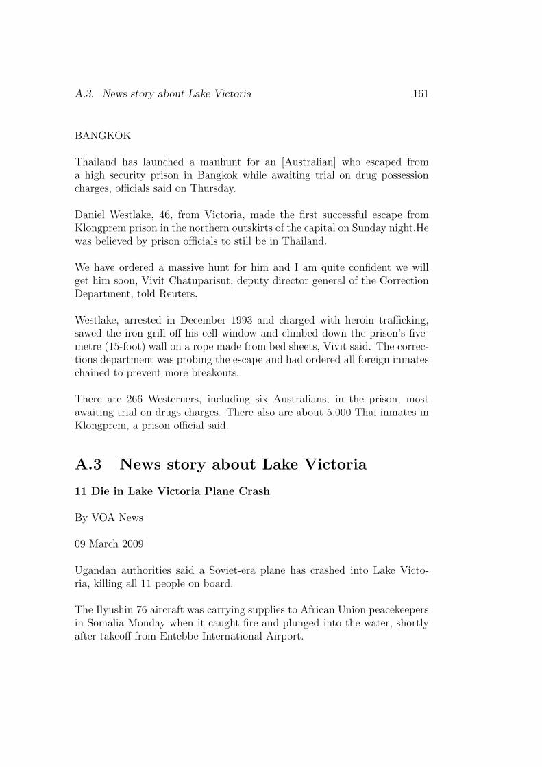
A.3. News story about Lake Victoria 161
BANGKOK
Thailand has launched a manhunt for an [Australian] who escaped froma high security prison in Bangkok while awaiting trial on drug possessioncharges, officials said on Thursday.
Daniel Westlake, 46, from Victoria, made the first successful escape fromKlongprem prison in the northern outskirts of the capital on Sunday night.Hewas believed by prison officials to still be in Thailand.
We have ordered a massive hunt for him and I am quite confident we willget him soon, Vivit Chatuparisut, deputy director general of the CorrectionDepartment, told Reuters.
Westlake, arrested in December 1993 and charged with heroin trafficking,sawed the iron grill off his cell window and climbed down the prison’s five-metre (15-foot) wall on a rope made from bed sheets, Vivit said. The correc-tions department was probing the escape and had ordered all foreign inmateschained to prevent more breakouts.
There are 266 Westerners, including six Australians, in the prison, mostawaiting trial on drugs charges. There also are about 5,000 Thai inmates inKlongprem, a prison official said.
A.3 News story about Lake Victoria
11 Die in Lake Victoria Plane Crash
By VOA News
09 March 2009
Ugandan authorities said a Soviet-era plane has crashed into Lake Victo-ria, killing all 11 people on board.
The Ilyushin 76 aircraft was carrying supplies to African Union peacekeepersin Somalia Monday when it caught fire and plunged into the water, shortlyafter takeoff from Entebbe International Airport.

162 Appendix A. Sample stories
The cause of the crash is under investigation.
Uganda’s information minister, Kabakumba Matsiko, said the crash killedthree senior Burundian military officers, two Ugandans, an Indian, a SouthAfrican and four Russian crew members.
Russian media said the crew consisted of two Russians and two Ukraini-ans.
Uganda and Burundi both provide soldiers to the AU mission in Somalia,where the interim government is battling an Islamist insurgency.
Air crashes are not unusual in Africa, where many airlines fly old planes.

Appendix B
GeoCLEF topics
B.1 GeoCLEF 2005 English topic titles
GC001 Shark Attacks off Australia and California
GC002 Vegetable Exporters of Europe
GC003 AI in Latin America
GC004 Actions against the fur industry in Europe and the U.S.A.
GC005 Japanese Rice Imports
GC006 Oil Accidents and Birds in Europe
GC007 Trade Unions in Europe
GC008 Milk Consumption in Europe
GC009 Child Labor in Asia
GC010 Flooding in Holland and Germany
GC011 Roman cities in the UK and Germany
GC012 Cathedrals in Europe
GC013 Visits of the American president to Germany
GC014 Environmentally hazardous Incidents in the North Sea
GC015 Consequences of the genocide in Rwanda
163

164 Appendix B. GeoCLEF topics
GC016 Oil prospecting and ecological problems in Siberia and theCaspian Sea
GC017 American Troops in Sarajevo, Bosnia-Herzegovina
GC018 Walking holidays in Scotland
GC019 Golf tournaments in Europe
GC020 Wind power in the Scottish Islands
GC021 Sea rescue in North Sea
GC022 Restored buildings in Southern Scotland
GC023 Murders and violence in South-West Scotland
GC024 Factors influencing tourist industry in Scottish Highlands
GC025 Environmental concerns in and around the Scottish Trossachs
B.2 GeoCLEF 2006 English topic titles
GC026 Wine regions around rivers in Europe
GC027 Cities within 100km of Frankfurt
GC028 Snowstorms in North America
GC029 Diamond trade in Angola and South Africa
GC030 Car bombings near Madrid
GC031 Combats and embargo in the northern part of Iraq
GC032 Independence movement in Quebec
GC033 International sports competitions in the Ruhr area
GC034 Malaria in the tropics
GC035 Credits to the former Eastern Bloc
GC036 Automotive industry around the Sea of Japan
GC037 Archeology in the Middle East
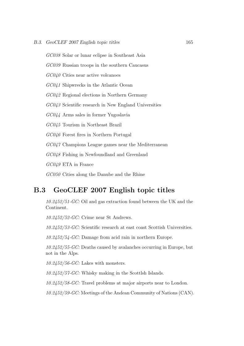
B.3. GeoCLEF 2007 English topic titles 165
GC038 Solar or lunar eclipse in Southeast Asia
GC039 Russian troops in the southern Caucasus
GC040 Cities near active volcanoes
GC041 Shipwrecks in the Atlantic Ocean
GC042 Regional elections in Northern Germany
GC043 Scientific research in New England Universities
GC044 Arms sales in former Yugoslavia
GC045 Tourism in Northeast Brazil
GC046 Forest fires in Northern Portugal
GC047 Champions League games near the Mediterranean
GC048 Fishing in Newfoundland and Greenland
GC049 ETA in France
GC050 Cities along the Danube and the Rhine
B.3 GeoCLEF 2007 English topic titles
10.2452/51-GC: Oil and gas extraction found between the UK and theContinent.
10.2452/52-GC: Crime near St Andrews.
10.2452/53-GC: Scientific research at east coast Scottish Universities.
10.2452/54-GC: Damage from acid rain in northern Europe.
10.2452/55-GC: Deaths caused by avalanches occurring in Europe, butnot in the Alps.
10.2452/56-GC: Lakes with monsters.
10.2452/57-GC: Whisky making in the Scottlsh Islands.
10.2452/58-GC: Travel problems at major airports near to London.
10.2452/59-GC: Meetings of the Andean Community of Nations (CAN).
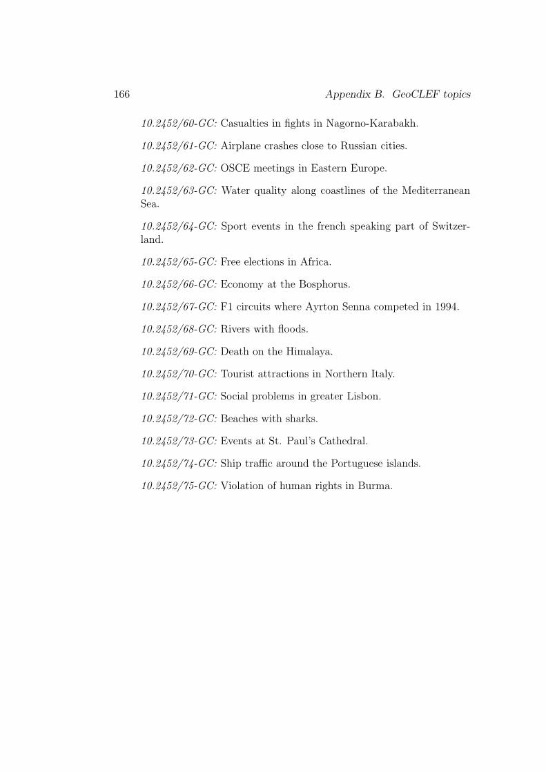
166 Appendix B. GeoCLEF topics
10.2452/60-GC: Casualties in fights in Nagorno-Karabakh.
10.2452/61-GC: Airplane crashes close to Russian cities.
10.2452/62-GC: OSCE meetings in Eastern Europe.
10.2452/63-GC: Water quality along coastlines of the MediterraneanSea.
10.2452/64-GC: Sport events in the french speaking part of Switzer-land.
10.2452/65-GC: Free elections in Africa.
10.2452/66-GC: Economy at the Bosphorus.
10.2452/67-GC: F1 circuits where Ayrton Senna competed in 1994.
10.2452/68-GC: Rivers with floods.
10.2452/69-GC: Death on the Himalaya.
10.2452/70-GC: Tourist attractions in Northern Italy.
10.2452/71-GC: Social problems in greater Lisbon.
10.2452/72-GC: Beaches with sharks.
10.2452/73-GC: Events at St. Paul’s Cathedral.
10.2452/74-GC: Ship traffic around the Portuguese islands.
10.2452/75-GC: Violation of human rights in Burma.

Bibliography
Harith Alani, Christopher B. Jones, and Douglas Tudhope. Voronoi-based re-gion approximation for geographical information retrieval with gazetteers.International Journal of Geographical Information Science, 15(4):287–306,2001.
Einat Amitay, Nadav Har’El, Ron Sivan, and Aya Soffer. Web-a-Where:GeotaggingWeb Content. In Proceedings of SIGIR-04, the 27th Conferenceon Research and Development in Information Retrieval, Sheffield, SouthYorkshire, UK, 2004.
Geoffrey Andogah. GIR Experimentation. In Evaluation of Multilin-gual and Multi-modal Information Retrieval, volume 4730/2009 of Lec-ture Notes in Computer Science LNCS, pages 881–888. Springer-VerlagBerlin/Heidelberg, 2007.
Geoffrey Andogah and Goose Bouma. Relevance measures using geographicscopes and types. In Advances in Multilingual and Multimodel InformationRetrieval, volume 5152/2008 of Lecture Notes in Computer Science LNCS,pages 794–801. Springer-Verlag Berlin/Heidelberg, 2008.
Geoffrey Andogah and Gosse Bouma. University of Groningen at GeoCLEF2007. In Working Notes for CLEF 2007, Budapest, Hungary, 2007.
Geoffrey Andogah, Goose Bouma, John Nerbonne, and Elwin Koster. Geo-graphical scope resolution. In Proceedings of the LREC 2008 Workshop onMethodologies and Resources for Processing Spatial Language, Marrakech,Morocco, 2008.
Leonardo Andrade and Mario J. Silva. Relevance Ranking for GeographicIR. In Proceedings of the Workshop on Geographical Information Retrieval,SIGIR’06, Seattle, USA, August 2006.
167
168 Bibliography
Kate Beard and Vyjayanti Sharma. Multidimensional ranking for data indigital spatial libraries. International Journal on Digital Libraries, 1:153–160, 1997.
Davide Buscaldi and Paolo Rosso. The UPV at GeoCLEF 2007. In WorkingNotes for CLEF 2007, 2007.
Davide Buscaldi and Paolo Rosso. On the Relative Importance of Toponymsin GeoCLEF. In Advances in Multilingual and Multimodel InformationRetrieval, volume 5152/2008 of Lecture Notes in Computer Science LNCS,pages 815–822. Springer-Verlag Berlin/Heidelberg, 2008.
Davide Buscaldi, Paolo Rosso, and Emilio Sanchis Arnal. Using the WordNetOntology in the GeoCLEF Geographical Information Retrieval Task. InAccessing Multilingual Information Repositories, volume 4022/2006, pages939–946. Springer (Lecture Notes in Computer Science LNCS), 2006.
Claudio Elızio Calazans Campelo and Claudio de Souza Baptista. Geographicscope modeling for web documents. In Proceedings of Workshop on Ge-ographic Information Retrieval (GIR’08), Napa Valley, California, USA,2008.
Nuno Cardoso, David Cruz, Marcirio Chaves, and Mario J. Silva. The Uni-versity of Lisbon at GeoCLEF 2007. In Working Notes for CLEF 2007,Budapest, Hungary, 2007.
Jean Carletta. Assessing agreement on classification tasks: The kappa statis-tic. In Computational Linguistics, volume 22 of 2, pages 249–254, Cam-bridge, MA, USA, June 1996. MIT Press.
Xavier Carreras, Lluıs Marquez, and Lluıs Padro. A Simple Named EntityExtractor using AdaBoost. In Proceedings of CoNLL-2003, Edmonton,Canada, 2003.
Hai Leong Chieu and Hwee Tou Ng. Named Entity Recognition with aMaximum Entropy Approach. In Proceedings of CoNLL-2003, Edmonton,Canada, 2003.
Nancy Chinchor. MUC-7 Named Entity Task Definition, 1997. 17 Octo-ber 2007: http://www.itl.nist.gov/iad/894.02/related_projects/
muc/.
Paul Clough. Extracting Metadata for Spatially-Aware Information Retrievalon the Internet. In Proceedings of Workshop on Geographic InformationRetrieval (GIR’05), CIKM2005, Bremen, Germany, 2005.
169
James R. Curran and Stephen Clark. Language Independent NER using aMaximum Entropy Tagger. In Proceedings of CoNLL-2003, Edmonton,Canada, 2003.
Bruno Emanuel da Graca Martins. Geographically Aware Web Text Min-ing. PhD thesis, Departamento de Informatica, Faculdade de Ciencias,Universidade de Lisboa, 2008.
Tiago M. Delboni, Karla A. V. Dorges, Alberto H. F. Laender, and ClodoveuA. Davis Jr. Semantic Expansion of Geographic Web Queries Based onNatural Language Positioning Expressions. In Transactions in GIS, pages377–397, 2007.
Junyan Ding, Luis Gravano, and Narayanan Shivakumar. Computing Geo-graphical Scopes of Web Resources. In Proceedings of the 26th Very LargeData Bases (VLDB) Conference, pages 545–556. Morgan Kaufmann Pub-lishers Inc., 2000.
David Dubin. The most influential paper gerard salton never wrote. Technicalreport, Graduate School of Library and Information Science. University ofIllinois at Urbana-Champaign., 2004.
Michael Ben Fleischman and Eduard Hovy. Multi-document person nameresolution. In ANNUAL MEETING OF THE ASSOCIATION FORCOMPUTATIONAL LINGUISTICS (ACL), REFERENCE RESOLU-TION WORKSHOP, pages 66–82, 2004.
Radu Florian, Abe Ittycheriah, Hongyan Jing, and Tong Zhang. NamedEntity Recognition through Classifier Combination. In Proceedings ofCoNLL-2003, Edmonton, Canada, 2003.
Gaihua Fu, Christopher B. Jones, and Alia I. Abdelmonty. Ontology-basedSpatial Query Expansion in Information Retrieval. In On the Move toMeaningful Internet Systems 2005: CoopIS, DOA, and ODBASE, volume3761/2005, pages 1466–1482. Springer (Lecture Notes in Computer ScienceLNCS), 2005.
William A. Gale, Kenneth W. Chruch, and David Yarowsky. One SensePer Discourse. In Proceedings of the Fourth DARPA Speech and NaturalLanguage Workshop, pages 233–237, 1992.
Fredric Gey, Ray Larson, Mark Sanderson, Hideo Joho, Paul Clough, andVivien Petras. GeoCLEF: the CLEF 2005 Cross-Language Geographic
170 Bibliography
Information Retrieval Track Overview. In Cross-Language Evaluation Fo-rum: CLEF 2005. Springer (Lecture Notes in Computer Science LNCS4022), 2006.
Fredric Gey, Ray Larson, Mark Sanderson, Kerstin Bischoff, Thomas Mandl,Christa Womser-Hacker, Diana Santos, Paulo Rocha, Giorgio M. Di Nun-zio, and Nicola Ferro. GeoCLEF 2006: The CLEF 2006 Cross-LanguageGeographic Information Retrieval Track Overview. In Evaluation of Mul-tilingual and Multi-modal Information Retrieval, volume 4730 of LectureNotes in Computer Science, pages 852–876. Springer Berlin / Heidelberg,2007.
Otis Gospodnetic and Eric Hatcher. Lucene in Action. Manning PublicationsCo., 206 Bruce Park Avenue, Greenwich, CT 06830, 2005.
Linda L. Hill, James Frew, and Qi Zheng. Geographic Names: The Imple-mentation of a Gazetteer in a Georeferenced Digital Library. In D-LibMagazine, volume 5 of 1, January 1999.
Thorsten Joachims, Laura Granka, and Bing Pan. Accurately InterpretingClickthrough Data as Implicit Feedback. In Proceedings of the 28th an-nual international ACM SIGIR conference on Research and developmentin information retrieval, Salvador, Brazil, 2005.
Christopher B. Jones and Ross Purves. GIR’05 2005 ACM workshop ongeographical information retrieval. ACM SIGIR Forum, 40(1):34–37, 2006.
Christopher B. Jones, Harith Alani, and Douglas Tudhope. Geographic In-formation Retrieval with Ontologies of Place. In Proceedings of the Inter-national Conference on Spatial Information Theory: Foundations of Geo-graphic Information Science, volume 2205/2001, pages 322–335. Springer(Lecture Notes in Computer Science LNCS), 2001.
Diane Kelly and Nicholas J. Belkin. Reading Time, Scrolling and Interac-tion: Exploring Implicit Sources of User Preferences for Relevance Feed-back During Interactive Information Retrieval. In Proceedings of the 24thannual international ACM SIGIR conference on Research and developmentin information retrieval, 2001.
Diane Kelly and Jaime Teevan. Implicit Feedback for Inferring User Prefer-ence: A Bibliography. ACM SIGIR Forum, 37(2):18–28, 2003.

171
Dan Klein, Joseph Smarr, Huy Nguyen, and Christopher D. Manning.Named Entity Recognition with Character-Level Models. In Proceedingsof CoNLL-2003, Edmonton, Canada, 2003.
Jon M. Kleinberg. Authoritative sources in a hyperlinked environment. Jour-nal of the ACM, 46:604–632, 1999.
Ray R. Larson and Patricia Frontiera. Spatial Ranking Methods for Geo-graphic Information Retrieval (GIR) in Digital Libraries. In Research andAdvanced Technology for Digital Libraries, volume 3232 of Lecture Notesin Computer Science, pages 45–56. Springer Berlin / Heidelberg, 2004.
Ray R. Larson, Fredric C. Gey, and Vivien Petras. Berkeley at GeoCLEF:Logistic Regression and Fusion for Geographic Information Retrieval. InAccessing Multilingual Information Repositories, volume 4022/2006, pages963–976. Springer (Lecture Notes in Computer Science LNCS), 2006.
Jochen L. Leidner. Experiments with Geo-Filtering Predicates for Geo-graphic IR. In Accessing Multilingual Information Repositories, volume4022/2006, pages 987–996. Springer (Lecture Notes in Computer ScienceLNCS), 2006.
Jochen L. Leidner, Gail Sinclair, and Bonnie Webber. Grounding spatialnamed entities for information extraction and question answering. In Ko-rnai, A. and Sundheim, B. (eds) Proceedings of the HTL-NAACL 2003Workshop on Analysis of Geographic References, pages 31–38, Alberta,Canada, 2003.
Jochen Lothar Leidner. Toponym Resolution in Text: Annotation, Evalua-tion and Applications of Spatial Grounding of Place Names. PhD thesis,Institute for Communicating and Collaborative Systems, School of Infor-matics, University of Edinburgh, 2007.
Huifeng Li, Rohini K. Srihari, Cheng Niu, and Wei Li. InfoXtract locationnormalization: a hybrid approach to geographic references in informationextraction. In Kornai, A. and Sundheim, B. (eds) Proceedings of the HTL-NAACL 2003 Workshop on Analysis of Geographic References, pages 39–44, Alberta, Canada, 2003.
Eugene E. Loos, Susan Anderson, Jr. Dwight H., Day, Paul C. Jordan, andJ. Douglas Wingate. Glossary of linguistic terms, 2004. 5 October 2007:http://www.sil.org/linguistics/.
172 Bibliography
Thomas Mandl, Fredric Gey, Giorgio Di Nunzio, Nicola Ferro, Ray Larson,Mark Sanderson, Diana Santos, Christa Womser-Hacker, and Xing Xie.GeoCLEF 2007: the CLEF 2007 Cross-Language Geographic InformationRetrieval Track Overview . In Working Notes for CLEF 2007, 2007.
Thomas Mandl, Fredric Gey, Giorgio Di Nunzio, Nicola Ferro, Ray Larson,Mark Sanderson, Diana Santos, Christa Womser-Hacker, and Xing Xie.GeoCLEF 2007: the CLEF 2007 Cross-Language Geographic InformationRetrieval Track Overview . In Advances in Multilingual and MultimodelInformation Retrieval, volume 5152/2008 of Lecture Notes in ComputerScience LNCS, pages 674–686. Springer-Verlag Berlin/Heidelberg, 2008.
Thomas Mandl, Paula Carvalho, Giorgio Maria Di Nunzio, Fredric Gey,Ray R. Larson, Diana Santos, and Christa Womser-Hacker. GeoCLEF2008: The CLEF 2008 Cross-Language Geographic Information RetrievalTrack Overview . In Evaluating Systems for Multilingual and MultimodalInformation Access, volume 5706/2009 of Lecture Notes in Computer Sci-ence LNCS, pages 808–821. Springer-Verlag Berlin/Heidelberg, 2009.
Gideon S. Mann and David Yarowsky. Unsupervised personal name disam-biguation. In Proceedings of the seventh conference on Natural languagelearning at HLT-NAACL 2003, pages 33–40. Association for Computa-tional Linguistics, 2003.
Christopher D. Manning, Prabhakar Raghven, and Hinrich Schutze. An In-toducation To Infromation Retrieval. Cambridge University Press, Cam-bridge, England, November 2007. Draft.
Alexander Markowetz, Yen-Yu Chen, Torsten Suel, Xiaohui Long, and Bern-hard Seefer. Design and Implementation of a Geographic Search Engine. InEighth International Workshop on the Web and Databases (WebDB 2005),2005.
Bruno Martins and Mario J. Silva. A Graph-Ranking Algorithm for Geo-Referencing Documents. In Proceedings of ICDM-05, the 5th IEEE Inter-national Conference on Data Mining, Texas, USA, Novermber 2005.
Bruno Martins, Mario J. Silva, and Leonardo Andrade. Indexing and Rank-ing in Geo-IR Systems. In Proceedings of the ACM Workshop on Geo-graphic Information Retrieval, pages 31–34. ACM New York, NY, USA,2005.
173
Bruno Martins, Mario J. Silva, Sergio Freitas, and Ana Paula Afonso. Han-dling Locations in Search Engine Queries. In Proceedings of the 3rd Work-shop on Geographic Information Retrieval held at The 29th Annual Inter-national ACM SIGIR Conference, Seattle, WA, USA, 2006.
Bruno Martins, Nuno Cardoso, Marcirio Chaves, Leonardo Andrade, andMario J. Silva. The University of Lisbon at GeoCLEF 2006. In Evalua-tion of Multilingual and Multi-modal Information Retrieval, 7th Workshopof the Cross-Language Evaluation Forum, CLEF 2006, Alicante, Spain,September 20-22, 2006, Revised Selected Papers, volume 4730/2007, pages986–994. Springer (Lecture Notes in Computer Science LNCS), 2007.
Simon E Overell. Geographic Information Retrieval: Classification, Disam-biguation and Modelling. PhD thesis, Department of Computing, ImperialCollege London, 2009.
Lawrence Page, Sergey Brin, Rajeev Motwani, and Terry Winograd. ThePageRank citation ranking: Bringing order to the Web, 1999. TechnicalReport SIDL-WP-1999-0120, Stanford Digital Library.
Bruno Pouliquen, Ralf Steinberger, Camelia Ignat, and Tom De Groeve. Ge-ographical Information Recognition and Visualisation in Texts Written inVarious Languages. In Proceedings of ACM (SAC2004), Nicosia, Cyprus,2004.
Bruno Pouliquen, Marco Kimler, Ralf Steinberger, Camelia Ignat, TamaraOellinger, Ken Blackler, Flavio Fluart, Wajdi Zaghouani, Anna Widi-ger, Ann-Charlotte Forslund, and Clive Best. Geocoding MultilingualTexts: Recognition, Disambiguation and Visualisation. In Proceedings ofThe Fifth International Conference on Language Resources and Evaluation(LREC), pages 53–58, 2006.
Erik Rauch, Michael Bukatin, and Kenneth Baker. A Confidence-BasedFramework for Disambiguating Geographic Terms. In Kornai, A. andSundheim, B. (eds) Proceedings of the HTL-NAACL 2003 Workshop onAnalysis of Geographic References, pages 50–54, Alberta, Canada, 2003.
Tony Rose, Mark Stevenson, and Miles Whitehead. Reuters Corpus Volume 1- from yesterday?s news to tomorrow?s language resources. In Proceedingsof the 3rd International Conference on Language Resources and Evaluation(LREC-2002), volume 3, pages 827–833, 2002.
174 Bibliography
Gerard Salton. Automatic Text Processing: The Transformation Analysisand Retrieval of Information by Computer. Addison-Wesley Series in Com-puter Science, 1989.
Gerard Salton and Chris Buckley. Improving retrieval performance by rele-vance feedback. In Journal of the American Society for Information Sci-ence, volume 41 of 4, pages 288–297. John Wiley & Sons, Inc., 1990.
Mark Sanderson and Janet Kohler. Analyzing geographic queries. In Pro-ceedings of the Workshop on Geographic Information Retrieval held at The27th Annual International ACM SIGIR Conference, Sheffield, Engand,UK, 2004.
Christoph Schlieder, Thomas Vogele, and Ubbo Visser. Qualitative SpatialRepresentation for Information Retrieval by Gazetteers. In Spatial Infor-mation Theory. Foundations of Geographic Information Science : Interna-tional Conference, COSIT 2001 Morro Bay, CA, USA, September 19-23,2001. Proceedings, volume 2205/2001, pages 336–351. Springer (LectureNotes in Computer Science LNCS), 2001.
David A. Smith and Gideon S. Mann. Bootstrapping Toponym Classifiers. InKornai, A. and Sundheim, B. (eds) Proceedings of the HTL-NAACL 2003Workshop on Analysis of Geographic References, pages 45–49, Alberta,Canada, 2003.
Amanda Spink, Dietmar Wolfram, Major B. J. Jansen, and Tefko Saracevic.Searching the web: The public and their queries. Journal of the AmericanSociety for Information Science and Technology, 52(2):226–234, 2001.
Beth M. Sundheim. Overview of the Fourth Message Understanding Evalua-tion and Conference. In Proceedings of the Fourth Message UnderstandingConference (MUC-4), pages 3–21. Morgan Kaufmann Publishers, 1992.
Erik F. Tjong Kim Sang and Fien De Meulder. Introduction to the CoNLL-2003 Shared Task: Language independent named entity recognition. InWalter Daelemans and Miles Osborne, Editors, Proceedings of CoNLL-2003, pages 142–147, 2003.
Subodh Vaid, Christopher B. Jones, Hideo Joho, and Mark Sanderson.Spatio-textual Indexing for Geographical Search on the Web. In Advancesin Spatial and Temporal Databases, volume 3633 of Lecture Notes in Com-puter Science, pages 218–235. Springer Berlin / Heidelberg, 2005.

175
Marc van Kreveld and Iris Reinbacher. Good NEWS: partitioning a simplepolygon by compass directions. In Proceedings of the Nineteenth AnnualSymposium on Computational geometry, pages 78–87. ACM New York,NY, USA, 2003.
Cornelis Joost van Rijsbergen. Information Retrieval. Butterworths, 2ndedition, 1979. 7:112-140.
Raphael Volz, Joachim Kleb, and Wolfgang Mueller. Towards ontology-baseddisambiguation of geographical identifiers. In Proceedings of WWW2007,May 2007.
David R. F. Walker, Ian A. Newman, David J. Medyckyj-Scott, and CliveL. N. Ruggles. A system for identifying datasets for GIS users. Interna-tional Journal of Geographical Information Systems, 6(6):511–527, 1992.
Jinxi Xu and W. Bruce Croft. Query expansion using local and global docu-ment analysis. In ACM SIGIR International Conference on Research andDevelopment in Information Retrieval, pages 4–11, New York, NY, USA,1996. ACM.
Tong Zhang and David Johnson. A Robust Risk Minimization based NamedEntity Recognition System. In Proceedings of CoNLL-2003, Edmonton,Canada, 2003.
Wenbo Zong, DanWu, Aixin Sun, Ee-Peng Lim, and Dion Hoe-Lian Goh. OnAssigning Place Names to Geography Related Web Pages. In Proceedingsof the Fifth ACM/IEEE-CS Joint Conference on Digital Libraries, pages354–362, 2005.

176 Bibliography

Summary
Eighteen percent of information seekers are demanding geographically in-telligent information retrieval systems (Sanderson and Kohler, 2004). Thestate-of-the-art information retrieval (IR) systems lack the geographical in-telligence to effectively answer geography-dependent queries. Geographicalinformation retrieval (GIR) is information retrieval (IR) with geographicalawareness or the capability to reason geographically. GIR seeks to retrievedocuments using both geographical and non-geographical information. Ge-ographical information is pervasive in both documents and user queries –explicitly in the names of places, and in adjectives referring to places, andimplicitly in the names of people and organisations, and in adjectives re-ferring to them, etc. Geographical information retrieval systems are posedto mine this information, and use the information to satisfy geographicallyconstrained information needs.
This dissertation seeks to answer the following research questions withrespect to GIR – (1) How can place names, geographical adjectives and thenames of people be used to automatically determine the geographical cov-erage of documents, something we call geographic scope? (2) How well dothe automatically determined geographical scopes of documents compare tohuman assigned scopes? (3) How best can the performance of scope resolu-tion systems be compared? (4) How effective is the document’s geographicalscope in aiding the resolution of toponyms (place names) contained in thedocument? (5) How best can the performance of toponym resolution sys-tems be compared? (6) How effective is relevance feedback for geographicallyconstrained information retrieval? (7) How effective is a scope-controlled to-ponym selection scheme in the relevance feedback procedure? (8) How cangeographical scope and type information be incorporated into the documentranking procedure to prioritise documents by geography?
How can place names, geographical adjectives and names of people be used toautomatically determine the geographical coverage of documents? How welldo automatically determined geographical scopes of documents compare to hu-
177

178 Summary
man assigned scopes?
To answer the research questions above, two assumptions are made (a)Places of the same type or under the same administrative jurisdiction oradjacent to each other are more likely to be mentioned in a given discourseunit. (b) VIPs (i.e., political leaders) in the same geographical region orat the same leadership hierarchy level tend to be mentioned together in aunit of discourse. These assumptions are used to detect the geographicalscopes of documents, and to resolve cases in which the scopes are ambigu-ous. Geographical scopes are modelled as documents using a zone-indexingconcept from information retrieval. The proposed schemes achieved a binaryevaluation score of 79.1% (using place information) and 58.0% (using VIPinformation).
How effective is the document’s geographical scope in aiding the resolutionof toponym ambiguity?
Toponym resolution is a key component within a GIR system. The taskof a toponym resolution system is to non-ambiguously assign to a toponymin a text a location on the surface of the earth, e.g.by means of longitudesand latitudes. The toponym resolution scheme proposed in this thesis ex-ploits the geographical scopes assigned to documents to control the selectionof candidate referents for a given toponym. Other features are also investi-gated, including place types (e.g., city, mountain), place classification (e.g.,administrative, vegetative), population size, and the frequency of mention ofnon-ambiguous or resolved places. The proposed scheme performed robustlyon news articles and summaries surpassing the performance of the state-of-the-art systems (Leidner, 2007) reducing error by 57.8%. On a humanannotated dataset, the scheme achieved performance scores in the range of70% - 80%.
How best can the performance of scope resolution systems be compared? Howbest can the performance of toponym resolution systems be compared?
Two things are needed to evaluate the performance of scope and toponymresolution systems, namely, (a) gold-standard datasets consisting of refer-ence gazetteers and document collections with human resolved scopes andtoponyms; and (b) an evaluation metric to assess the correctness of systemassigned scopes and toponyms as compared to the gold-standard resolutions.The state-of-the-art evaluation metrics to measure the performance of scopeand toponym resolution systems are binary in nature, e.g., precision and

179
recall. These metrics ignore finer discrepancies among systems under evalu-ation. This thesis therefore sought to improve the sensitivity of the metric.To measure finer differences among competing scope resolution systems, anew evaluation metric is proposed that integrates the ranked position ofcandidate scopes in its evaluation score. The proposed toponym resolutionevaluation metric extends the binary metric scheme by incorporating the fol-lowing features in its calculations: (a) the number of candidate places fora given reference (reflecting difficulty), (b) the number of regions needed totraverse from the system resolved referent to correct gold standard referent(reflecting proximity), and (c) the number of feature classes traversed fromthe system resolved referent type to the correct gold standard referent type(reflecting ontological similarity).
How effective is a scope-controlled toponym selection scheme in a relevancefeedback procedure?
The motivation for query expansion in IR is to enhance the user query byadding terms, which are semantically related, perhaps even synonymous withthe terms in the original query. The geographical query expansion schemeinvestigated in this work applies two kinds of relevance feedback strategies;one scheme adds place names found in the relevant documents directly, andthe other scheme adds place names belonging to geographical scopes assignedto relevant documents. The scope-controlled scheme selects place-names toadd to feedback queries according to: scope-based(toponyms) = {M ⊆ S},where M are the commonly occurring place-names in the relevant docu-ments, and S the commonly shared scopes among the relevant documents.The scope-controlled relevance feedback approach out-performed the defaultinformation retrieval system (Lucene IR system) by 9.5% on a residual doc-ument collection (i.e., collection consisting of documents not used for queryexpansion).
How can geographical scope and feature type information be incorporated intothe document ranking procedure so as to prioritise documents by geography?
The task of relevance ranking is to order a retrieved set of documents by rel-evance to the user’s information needs so that the more relevant documentsare closer to the top of the list of documents returned. To integrate geograph-ical scope and feature type information into the relevance ranking procedure,non-geographical relevance scores and geographical relevance scores (i.e., ge-ographical scope and scores derived from feature type) are combined linearlyand, alternatively, using a weighted harmonic mean. The weighted harmonic-

180 Summary
mean derived scheme out-performed the default information retrieval systemby 8.9%.

Samenvatting
Achttien procent van de gebruikers van het internet die informatie zoekenverlangen geografische intelligentie in zoeksystemen (Sanderson en Koller,2004). State-of-the-art information retrieval (IR) systemen missen de ge-ografische intelligentie die nodig is om zoekvragen met een geografische com-ponent effectief te beantwoorden. Een geografisch IR systeem (GIR) is eenIR systeem dat gebruik maakt van geografische kennis en dat kan redenerenmet deze kennis. GIR zoekt relevante documenten door gebruik te maken vangeografische en niet-geografische aspecten. Geografische informatie is volopaanwezig in documenten en zoekvragen: in plaatsnamen, namen van perso-nen en organisaties, bijvoeglijke naamwoorden die naar plaatsen en personenverwijzen, etc. GIR systemen zijn ontwikkeld om deze informatie in tekst teontdekken, en te gebruiken om het geografische aspect van zoekvragen beterte beantwoorden.
Deze dissertatie behandeld een aantal specifieke onderzoeksthema’s voorGIR: (1) Hoe kan geografische informatie die impliciet aanwezig is in plaat-snamen, in de namen van personen, en in geografische bijvoeglijke naam-woorden worden gebruikt om automatisch het geografisch bereik van eendocument te bepalen? (2) Hoe accuraat is het automatisch bepalen van ge-ografisch bereik in vergelijking met handmatig bepaald geografisch bereik?(3) Hoe kunnen de prestaties van verschillende systemen voor het bepalenvan geografisch bereik worden vergeleken? (4) Wat is de bijdrage van ge-ografisch bereik voor het bepalen van de plaats waarnaar wordt verwezendoor een toponiem, i.e. een plaatsnaam die naar verschillende plaatsen kanverwijzen? (5) Hoe kunnen de prestaties van verschillende systemen voor hetbepalen van de verwijzing van toponiemen worden vergeleken? (6) Hoe ef-fectief is ’relevance feedback’ voor GIR? (7) Hoe effectief is ’query expansion’met behulp van toponiemen gebaseerd op geografisch bereik voor ’relevancefeedback’? en (8) Hoe kan geografisch bereik worden gebruikt om de meestrelevante documenten voor een zoekvraag eerder aan de gebruiker te tonen?
Hoe kan geografische informatie die impliciet aanwezig is in plaatsnamen, in
181

182 Samenvatting
de namen van personen, en in geografische bijvoeglijke naamwoorden wordengebruikt om automatisch het geografisch bereik van een document te bepalen?Hoe accuraat is het automatisch bepalen van geografisch bereik in vergelijkingmet handmatig bepaald geografisch bereik?
We ontwikkelen een strategie om geografisch bereik te bepalen die uitgaatvan twee assumpties: (1) plaatsnamen in een tekst die van hetzelfde typezijn, die deel uitmaken van dezelfde bestuurlijke regio, of die nabijgelegenzijn, zullen vaak samen voorkomen in een tekst, en (2) prominenten (zoalspolitici) in dezelfde bestuurlijke regio of van hetzelfde type zullen vaak samenvoorkomen in een tekst. We maken gebruik van modellen voor geografischbereik die relevante plaatsnamen en persoonsnamen bevatten en die gerep-resenteerd zijn als een document voor IR. Door de overlap te bepalen tussende model-documenten en een document in de collectie kan het geografischbereik van het document worden bepaald. Deze techniek behaalt een accu-ratesse van 79% op basis van plaatsnamen en 58% op basis van prominentepersoonsnamen.
Wat is de bijdrage van geografisch bereik voor het bepalen van de plaats waar-naar wordt verwezen door een toponiem, i.e. een plaatsnaam die naar ver-schillende plaatsen kan verwijzen?
Resolutie van toponiemen is een essentieel onderdeel van GIR systemen.Resolutie van toponiemen is het bepalen van de cordinaten voor plaatsna-men in een tekstfragment die naar verschillende plaatsen kunnen verwijzen.Het resolutie-systeem dat hier wordt voorgesteld maakt gebruik van het ge-ografisch bereik van een document om de cordinaten van een toponiem tebepalen. Andere informatie waar gebruik van wordt gemaakt is het type vande naam (bv. stad of berg), de klasse (bv. regio of land), inwoneraantal,en de frequentie van niet-ambigue plaatsnamen of toponiemen waarvan decordinaten reeds bepaald zijn. De techniek werkt goed voor nieuwsartikelenen samenvattingen, en vermindert het aantal fouten ten opzichte van eerderestate-of-the-art systemen (Leidner, 2007) met 58%. Op handmatig geanno-teerd materiaal wordt een accuratesse van 70% 80% gehaald.
Hoe kunnen de prestaties van verschillende systemen voor het bepalen vangeografisch bereik worden vergeleken? Hoe kunnen de prestaties van ver-schillende systemen voor bepalen van de verwijzing van toponymen wordenvergeleken?
Twee zaken zijn nodig voor de evaluatie van system voor het bepalen van ge-
183
ografisch bereik en resolutie van toponiemen: (a) een gouden standaard in devorm van een lijst geografische namen en een document collectie waarin ge-ografisch bereik en de verwijzing van toponiemen handmatig is vastgesteld,en (b) evaluatie-criteria om de prestaties van een automatisch systeem tebepalen. De gangbare praktijk is om als evaluatie-criterium gebruik te makenvan precisie en recall scores die gebaseerd zijn op een binair systeem (goed/fout).Hier stellen we een fijnmaziger systeem voor dat rekening houdt met de posi-tie waarin het eerste goede antwoord gevonden wordt in de lijst van mo-gelijkheden voor geografische bereik en mogelijke verwijzingen van een to-poniem. Bovendien houden we rekening met het totaal aantal voorgesteldeplaatsen voor een toponiem, het aantal regio’s dat een voorgestelde plaatsscheidt van de correcte plaats, en de afstand in klassen tussen het type vande voorgestelde plaats en de correcte plaats.
Hoe effectief is toponiem selectie op basis van geografisch bereik als onderdeelvan een ’relevance feedback’ procedure?
Het idee achter ’query expansion’ is dat zoekresultaten kunnen worden verbe-terd door automatisch zoektermen aan een zoekvraag toe te voegen die synon-iem of semantisch verwant zijn aan de zoektermen in de originele zoekvraag.Voor GIR onderzoeken we twee methoden voor query expansion: het toevoe-gen van plaatsnamen die zijn gevonden in documenten die relevant zijn voorde oorspronkelijke zoekvraag (’relevance feedback’) en het toevoegen vanplaatsnamen die behoren tot het model document voor de het geografischbereik van relevante documenten. De laatste strategie voegt plaatsnamen= {M ⊆ S} toe, waar M een frequente plaatsnaam uit relevante documentenis, en S de meest relevante instanties van geografisch bereik voor relevantedocumenten zijn. Deze methode verbetert de prestaties van een standaardIR systeem (Lucene) met 9.5% op documenten die niet werden gebruikt voorhet bepalen van de query expansion zelf.
Hoe kan geografisch bereik worden gebruikt om de meest relevante documentenvoor een zoekvraag eerder aan de gebruiker te tonen?
Een IR systeem rangschikt documenten die corresponderen met een zoekvraagop relevantie, zodat de meest relevante documenten eerst getoond kunnenworden. Om geografische relevantie te integreren in het systeem dat derelevantie-score bepaalt, wordt de geografische relevantie score gecombineerdmet de standaard relevantie-score op basis van lineaire interpolatie en opbasis van een gewogen gemiddelde. De techniek die gebruik maakt van eengewogen gemiddelde verbetert de prestaties van een standaard IR systeem

184 Samenvatting
met 9%.

185
Groningen dissertations in linguistics (GRODIL)
1. Henriette de Swart (1991). Adverbs of Quantification: A GeneralizedQuantifier Approach.
2. Eric Hoekstra (1991). Licensing Conditions on Phrase Structure.
3. Dicky Gilbers (1992). Phonological Networks. A Theory of SegmentRepresentation.
4. Helen de Hoop (1992). Case Configuration and Noun Phrase Interpre-tation.
5. Gosse Bouma (1993). Nonmonotonicity and Categorial UnificationGrammar.
6. Peter I. Blok (1993). The Interpretation of Focus.
7. Roelien Bastiaanse (1993). Studies in Aphasia.
8. Bert Bos (1993). Rapid User Interface Development with the ScriptLanguage Gist.
9. Wim Kosmeijer (1993). Barriers and Licensing.
10. Jan-Wouter Zwart (1993). Dutch Syntax: A Minimalist Approach.
11. Mark Kas (1993). Essays on Boolean Functions and Negative Polarity.
12. Ton van der Wouden (1994). Negative Contexts.
13. Joop Houtman (1994). Coordination and Constituency: A Study inCategorial Grammar.
14. Petra Hendriks (1995). Comparatives and Categorial Grammar.
15. Maarten de Wind (1995). Inversion in French.
16. Jelly Julia de Jong (1996). The Case of Bound Pronouns in PeripheralRomance.
17. Sjoukje van der Wal (1996). Negative Polarity Items and Negation:Tandem Acquisition.
18. Anastasia Giannakidou (1997). The Landscape of Polarity Items.
19. Karen Lattewitz (1997). Adjacency in Dutch and German.

186 Samenvatting
20. Edith Kaan (1997). Processing Subject-Object Ambiguities in Dutch.
21. Henny Klein (1997). Adverbs of Degree in Dutch.
22. Leonie Bosveld-de Smet (1998). On Mass and Plural Quantification:The case of French ‘des’/‘du’-NPs.
23. Rita Landeweerd (1998). Discourse semantics of perspective and tem-poral structure.
24. Mettina Veenstra (1998). Formalizing the Minimalist Program.
25. Roel Jonkers (1998). Comprehension and Production of Verbs in apha-sic Speakers.
26. Erik F. Tjong Kim Sang (1998). Machine Learning of Phonotactics.
27. Paulien Rijkhoek (1998). On Degree Phrases and Result Clauses.
28. Jan de Jong (1999). Specific Language Impairment in Dutch: Inflec-tional Morphology and Argument Structure.
29. H. Wee (1999). Definite Focus.
30. Eun-Hee Lee (2000). Dynamic and Stative Information in TemporalReasoning: Korean tense and aspect in discourse.
31. Ivilin P. Stoianov (2001). Connectionist Lexical Processing.
32. Klarien van der Linde (2001). Sonority substitutions.
33. Monique Lamers (2001). Sentence processing: using syntactic, seman-tic, and thematic information.
34. Shalom Zuckerman (2001). The Acquisition of “Optional” Movement.
35. Rob Koeling (2001). Dialogue-Based Disambiguation: Using DialogueStatus to Improve Speech Understanding.
36. Esther Ruigendijk (2002). Case assignment in Agrammatism: a cross-linguistic study.
37. Tony Mullen (2002). An Investigation into Compositional Features andFeature Merging for Maximum Entropy-Based Parse Selection.
38. Nanette Bienfait (2002). Grammatica-onderwijs aan allochtone jon-geren.
187
39. Dirk-Bart den Ouden (2002). Phonology in Aphasia: Syllables andsegments in level-specific deficits.
40. Rienk Withaar (2002). The Role of the Phonological Loop in SentenceComprehension.
41. Kim Sauter (2002). Transfer and Access to Universal Grammar inAdult Second Language Acquisition.
42. Laura Sabourin (2003). Grammatical Gender and Second LanguageProcessing: An ERP Study.
43. Hein van Schie (2003). Visual Semantics.
44. Lilia Schrcks-Grozeva (2003). Binding and Bulgarian.
45. Stasinos Konstantopoulos (2003). Using ILP to Learn Local LinguisticStructures.
46. Wilbert Heeringa (2004). Measuring Dialect Pronunciation Differencesusing Levenshtein Distance.
47. Wouter Jansen (2004). Laryngeal Contrast and Phonetic Voicing: ALaboratory Phonology.
48. Judith Rispens (2004). Syntactic and phonological processing in devel-opmental dyslexia.
49. Danielle Bougaıre (2004). L’approche communicative des campagnesde sensibilisation en sante publique au Burkina Faso: Les cas de laplanification familiale, du sida et de l’excision.
50. Tanja Gaustad (2004). Linguistic Knowledge and Word Sense Disam-biguation.
51. Susanne Schoof (2004). An HPSG Account of Nonfinite Verbal Com-plements in Latin.
52. M. Begona Villada Moiron (2005). Data-driven identification of fixedexpressions and their modifiability.
53. Robbert Prins (2005). Finite-State Pre-Processing for Natural Lan-guage Analysis.
54. Leonoor van der Beek (2005) Topics in Corpus-Based Dutch Syntax.
188 Samenvatting
55. Keiko Yoshioka (2005). Linguistic and gestural introduction and track-ing of referents in L1 and L2 discourse.
56. Sible Andringa (2005). Form-focused instruction and the developmentof second language proficiency.
57. Joanneke Prenger (2005). Taal telt! Een onderzoek naar de rol vantaalvaardigheid en tekstbegrip in het realistisch wiskundeonderwijs.
58. Neslihan Kansu-Yetkiner (2006). Blood, Shame and Fear: Self-PresentationStrategies of Turkish Women’s Talk about their Health and Sexuality.
59. Monika Z. Zempleni (2006). Functional imaging of the hemisphericcontribution to language processing.
60. Maartje Schreuder (2006). Prosodic Processes in Language and Music.
61. Hidetoshi Shiraishi (2006). Topics in Nivkh Phonology.
62. Tamas Bıro (2006). Finding the Right Words: Implementing Optimal-ity Theory with Simulated Annealing.
63. Dieuwke de Goede (2006). Verbs in Spoken Sentence Processing: Un-raveling the Activation Pattern of the Matrix Verb.
64. Eleonora Rossi (2007). Clitic production in Italian agrammatism.
65. Holger Hopp (2007). Ultimate Attainment at the Interfaces in SecondLanguage Acquisition: Grammar and Processing.
66. Gerlof Bouma (2008). Starting a Sentence in Dutch: A corpus studyof subject- and object-fronting.
67. Julia Klitsch (2008). Open your eyes and listen carefully. Auditory andaudiovisual speech perception and the McGurk effect in Dutch speakerswith and without aphasia.
68. Janneke ter Beek (2008). Restructuring and Infinitival Complementsin Dutch.
69. Jori Mur (2008). Off-line Answer Extraction for Question Answering.
70. Lonneke van der Plas (2008). Automatic Lexico-Semantic Acquisitionfor Question Answering.

189
71. Arjen Versloot (2008). Mechanisms of Language Change: Vowel reduc-tion in 15th century West Frisian.
72. Ismail Fahmi (2009). Automatic term and Relation Extraction for Med-ical Question Answering System.
73. Tuba Yarbay Duman (2009). Turkish Agrammatic Aphasia: Word Or-der, Time Reference and Case.
74. Maria Trofimova (2009). Case Assignment by Prepositions in RussianAphasia.
75. Rasmus Steinkrauss (2009). Frequency and Function in WH QuestionAcquisition. A Usage-Based Case Study of German L1 Acquisition.
76. Marjolein Deunk (2009). Discourse Practices in Preschool. Young Chil-drens Participation in Everyday Classroom Activities.
77. Sake Jager (2009). Towards ICT-Integrated Language Learning: Devel-oping an Implementation Framework in terms of Pedagogy, Technologyand Environment.
78. Francisco Dellatorre Borges (2010). Parse Selection with Support Vec-tor Machines.
79. Geoffrey Andogah (2010). Geographically Constrained Information Re-trieval.
GRODILCenter for Language and Cognition Groningen (CLCG)P.O. Box 7169700 AS Groningen