united states gps/gnss update · united states gps/gnss update ken alexander ... • executive...
TRANSCRIPT

United States GPS/GNSS Update
Ken Alexander
Multiple - Positioning, Navigation and Time
1

Overview
• GPS Modernization and Interoperability
• National Differential GPS (NDGPS)
• Wide Area Augmentation System (WAAS) Satellite Based Augmentation System (SBAS)
• Ground Based Augmentation System (GBAS)
• RTCA Avionics Standards Development Activities
2

GPS Constellation Status
• Robust operational constellation – 12 Block IIR: L1 C/A, L1 P(Y), L2 P(Y) signals
– 7 Block IIR-M: adds L2C, L1M, L2M signals
– 12 Block IIF: adds L5 signal
• Additional satellites in residual or test status • Modified battery charge control is extending
GPS IIR and IIR-M life by 1-2 years per satellite • Global GPS civil service performance
commitment – 1 Jan 15: Best performance 43.8 cm User Range Error (URE)
– 23 Nov 14: Best weekly average 52.7 cm URE
– Performance improvements continue as new satellites replace older satellites
31 Operational Satellites (Baseline Constellation: 24)
3

2001 SPS PS 6 m RMS
3.4 3.1 3.0
3.2 3.3 3.1
2.9
0
1
2
3
4
5
6
7
8
2001 2002 2003 2004 2005 2006 2007 2008 2009 2010 2011 2012 2013 2014
Use
r R
an
ge
Err
or
(UR
E)
in M
ete
rs
1.6 1.4
1.2 1.2 1.1 1.1 1.0 1.0 0.9 0.9 0.9 0.8 0.8 0.7
Accuracy: Civil Commitments
System accuracy better than published standard
Be
tte
r P
erf
orm
ance
Across All Healthy Satellites (RMS, 68%) Worst of Any Healthy Satellite (95%)
Equivalent RMS Value from 2008 SPS PS (4 m)
2008 SPS Performance Standard (PS)
Worst of Any Healthy Satellite, 7.8 m @ 95%
4
Standard Positioning Service (SPS) Signal-in-Space Performance

GPS III Status • Newest block of GPS satellites (SV)
– 4 civil signals: L1 C/A, L1C, L2C, L5 • 1st satellites to broadcast common L1C signal
– 4 military signals: L1/L2 P(Y), L1/L2M – 3 improved Rubidium atomic clocks
• SV7/8 contract awarded 31 Mar 14 • Plan to purchase SV9/10 under current
Lockheed contract • SV 1 thermal vacuum testing complete
in Dec 2015 • GPS III Non-Flight Satellite Test bed
completed launch processing at Cape Canaveral – Reduced integration, test and launch
processing risk
5
Lockheed-Martin (Waterton, CO) - Prime
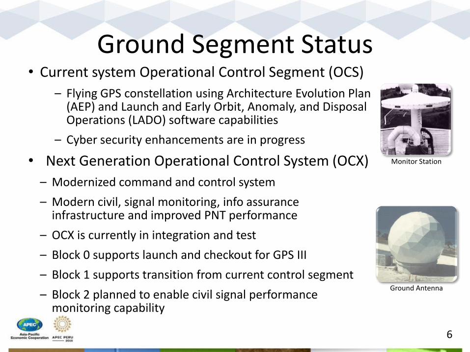
Ground Segment Status
6
• Current system Operational Control Segment (OCS)
– Flying GPS constellation using Architecture Evolution Plan (AEP) and Launch and Early Orbit, Anomaly, and Disposal Operations (LADO) software capabilities
– Cyber security enhancements are in progress
• Next Generation Operational Control System (OCX)
– Modernized command and control system
– Modern civil, signal monitoring, info assurance infrastructure and improved PNT performance
– OCX is currently in integration and test
– Block 0 supports launch and checkout for GPS III
– Block 1 supports transition from current control segment
– Block 2 planned to enable civil signal performance monitoring capability
Monitor Station
Ground Antenna

New GPS Civil Signals
• Second civil signal “L2C” – Designed to meet commercial needs
– Higher accuracy through ionospheric correction
• Third civil signal “L5” – Designed to meet demanding requirements for
transportation safety-of-life services – Aeronautical Radio Navigation Service (ARNS) protected
band
• L2C and L5 continuously broadcast since Apr 2014 – L2C message currently set “healthy” – L5 message currently set “unhealthy”
7

Complementary PNT (CPNT) • Executive Committee (EXCOM) examined need for
complement GPS – Assessment driven by many factors: from policy to technology
– U.S. coverage for GPS outage due to natural or man-made events
• Current Activity: Identify and develop requirements – Assesses a wide range of user requirements
• Decisions support FY18 investment actions
• Federal Register Notice in work to support public engagement
8

National Space-Based PNT Organization
9
WHITE HOUSE
ADVISORY BOARD
Sponsor: NASA
NATIONAL EXECUTIVE COMMITTEE FOR SPACE-BASED PNT
Executive Steering Group
Co-Chairs: Defense, Transportation
NATIONAL COORDINATION OFFICE
Host: Commerce
GPS International Working Group
Chair: State
Engineering Forum
Co-Chairs: Defense, Transportation
Ad Hoc Working Groups
Defense
Transportation
State
Interior
Agriculture
Commerce
Homeland Security
Joint Chiefs of Staff
NASA
Civil GPS Service Interface Committee
Chair: Transportation Deputy Chair: Coast Guard
GPS Summary • The U.S. supports free access to civilian GNSS signals and all
necessary public domain documentation • GPS is a critical component of the global information
infrastructure – Compatible with other satellite navigation systems and
interoperable at the user level – Guided at a national level as multi-use asset – Acquired and operated by the U.S. Air Force on behalf of USG
• The U.S. policy promotes open competition and market growth for commercial GNSS
• Modernization milestones: Multiple launches and new Civil Navigation messages broadcast
10
GPS: Continuous improvement,
predictable, dependable positioning performance

National Differential GPS (NDGPS) • Joint U.S. Coast Guard & Department of Transportation
Federal Register Notice in 2013 – Targeted outreach to user community
– Asked how NDGPS is used, impact/alternatives if discontinued
– Assessment driven by many factors: from policy to technology
• 2015 Federal Register Notice sought feedback on deactivation of 62 of 84 sites in Jan 2016 – Numerous responses received (one-third maritime related)
• Deactivation and decommissioning of sites temporarily on hold pending review and consideration user inputs
11

Wide Area Augmentation System (WAAS) Program Update
12

Current WAAS LPV Performance
13
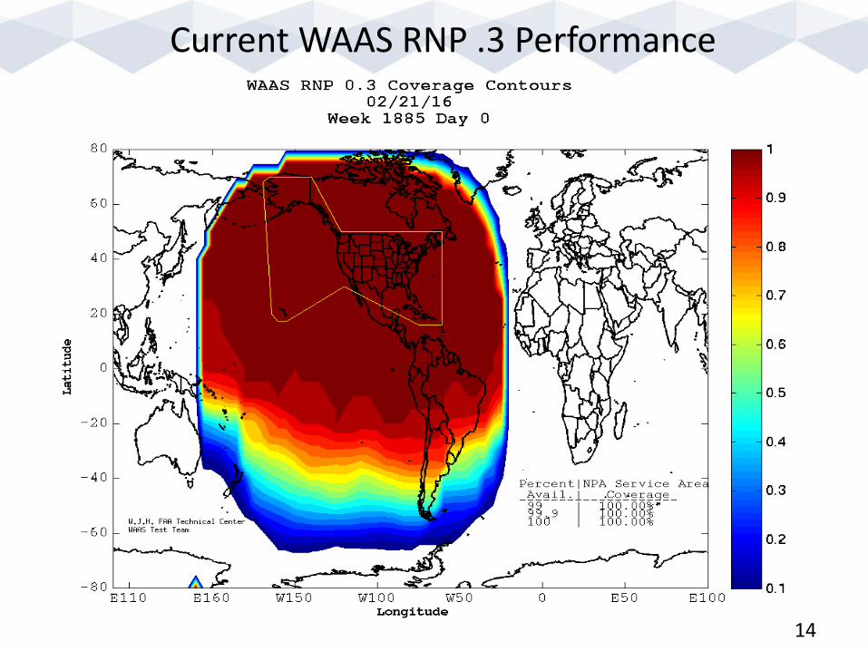
Current WAAS RNP .3 Performance
14

SBAS RNP 0.3 Coverage (Feb 22, 2016) Data based on FAA Tech Center tool located at : http://www.nstb.tc.faa.gov/sms/
15

SBAS LPV Coverage
16
Feb 22, 2016 Data based on FAA Tech Center tool located at : http://www.nstb.tc.faa.gov/sms/

WAAS GEO Activities
• Current WAAS GEO satellites – Intelsat Galaxy XV (CRW)
– Anik F1R (CRE)
– Inmarsat I4F3 (AMR)
• AMR set to “Not Monitored” on 7/18/2015
• Not available for ranging
17
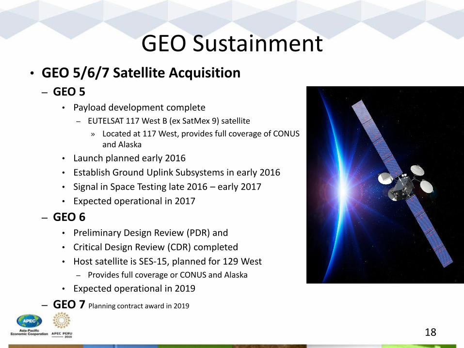
GEO Sustainment • GEO 5/6/7 Satellite Acquisition
– GEO 5 • Payload development complete
– EUTELSAT 117 West B (ex SatMex 9) satellite
» Located at 117 West, provides full coverage of CONUS and Alaska
• Launch planned early 2016
• Establish Ground Uplink Subsystems in early 2016
• Signal in Space Testing late 2016 – early 2017
• Expected operational in 2017
– GEO 6 • Preliminary Design Review (PDR) and
• Critical Design Review (CDR) completed
• Host satellite is SES-15, planned for 129 West
– Provides full coverage or CONUS and Alaska
• Expected operational in 2019
– GEO 7 Planning contract award in 2019
Eutelsat 117WB
18
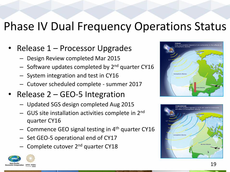
Phase IV Dual Frequency Operations Status
• Release 1 – Processor Upgrades – Design Review completed Mar 2015
– Software updates completed by 2nd quarter CY16
– System integration and test in CY16
– Cutover scheduled complete - summer 2017
• Release 2 – GEO-5 Integration – Updated SGS design completed Aug 2015
– GUS site installation activities complete in 2nd quarter CY16
– Commence GEO signal testing in 4th quarter CY16
– Set GEO-5 operational end of CY17
– Complete cutover 2nd quarter CY18
19
WAAS Phase IV Dual Frequency Operations Status (continued)
• Release 3 – GIII Multicast Update – Design scheduled for completion 1st quarter CY17
– Implementation of updated GIII Multicast 2nd quarter CY17
– Scheduled for verification and cutover CY18
• Release 4 – WMS Safety Computer (SC) Update – Initial 28 SC’s delivered by 2nd quarter CY17
– SC Design scheduled for 3rd quarter CY17
– Scheduled for validation testing and cutover in CY18
• Release 5 – GEO 6 Integration – SES tests planned for November 2016
– Payload delivery 1st quarter CY2017
– Satellite launch 3rd quarter CY2017
– Commence GEO signal testing in 1st quarter CY18
– Complete cutover mid 2019
20

Dual Frequency Investigations • Dual-Frequency Multi-constellation Capability (DFMC)
– International focus is on taking advantage of other constellations’ signals that are compatible and interoperable with GPS
• International Civil Aviation Organization (ICAO) Navigation Systems Panel (NSP) has developed work plan that supports development of standards for the use of other Global Navigation Satellite Systems (GNSS)
• ICAO CONOPS to address all DFMC applications (e.g. SBAS, GBAS)
• FAA supports SARPs inclusion of DFMC SBAS
– User equipment standards for Dual-Frequency operations • FAA working with SBAS Interoperability Working Group (IWG) to
develop DFMC SBAS Definition Document and Interface Control Document
• WAAS assisting with SBAS provider perspective on DFMC capability
• FAA supporting RTCA SC-159 MOPS development
21

Dual Frequency Investigations • Advanced RAIM (ARAIM)
– Avionics-centric approach to dual-frequency multi-constellation – ARAIM subgroup developing more detailed concept definition in
Milestone 3 report (recently published) • Will be used to coordinate standards development with ICAO,
RTCA and EUROCAE • US/EU Milestone 3 report published
– http://ec.europa.eu/growth/tools-databases/newsroom/cf/itemdetail.cfm?item_id=8690
– http://www.gps.gov/policy/cooperation/europe/2016/working-group-c/
– FAA focus on development of initial requirements for horizontal navigation (H-ARAIM)
• E.g., prototype airborne algorithms, prototype ground monitoring, preliminary ICAO/RTCA requirements, preliminary safety case
• Validation package to be developed to demonstrate H-ARAIM Feasibility (circa 2018)
22

Airports with WAAS LPV/LP Instrument Approaches
As of February 4, 2016
- 4,231 LP/LPVs combined
- 3,627 LPVs serving 1,762
Airports
- 941 LPV-200’s
- 2,480 LPVs to Non-ILS Runways
- 1,147 LPVs to ILS runways
- 1,698 LPVs to Non-ILS Airports
- 604 LPs serving 436 Airports
- 601 LPs to Non-ILS Runway
- 3 LPs to ILS Runways 23
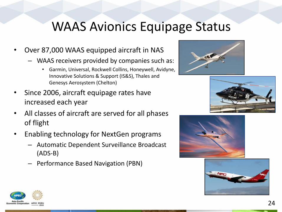
WAAS Avionics Equipage Status
• Over 87,000 WAAS equipped aircraft in NAS
– WAAS receivers provided by companies such as: • Garmin, Universal, Rockwell Collins, Honeywell, Avidyne,
Innovative Solutions & Support (IS&S), Thales and Genesys Aerosystem (Chelton)
• Since 2006, aircraft equipage rates have increased each year
• All classes of aircraft are served for all phases of flight
• Enabling technology for NextGen programs
– Automatic Dependent Surveillance Broadcast (ADS-B)
– Performance Based Navigation (PBN)
24

FAA Ground Based Augmentation System (GBAS) Activities
• ICAO GBAS GAST D Standards Promulgation
• System Design Approvals for Ground Facilities
• International Cooperation
• CAT I Implementation Support
25
CAT I /GAST C Activity • Honeywell granted System Design Approval (SDA) of ground
facility in 2009; SDA updated in 2012 and 2015 (See next slide) – Operational at Newark (EWR) in September 2012
– Operational at Houston (IAH) in April 2013
• FAA Ground-Based Performance Monitoring and Service Prediction Capability for installed Honeywell SLS-4000 – Tool supports issuance of NOTAMS when services are not expected to be
available
– Receives VHF Data Broadcast (VDB) and uses local GPS receiver with interface to GPS notices (NANUs)
• EWR (Newark, NJ; Memorandum of Understanding (MOU) with Port Authority of New York and New Jersey
• IAH (Houston, TX; MOU with Houston Airport Systems (HAS))
• MWH (Moses Lake, WA; MOU with Boeing)
26

CAT I /GAST C Activity • Honeywell SLS-4000 GAST-C Block II refines ground facility
– Intended to enhance system availability in U.S.
– Updates facilitate use in low-latitudes (e.g., equatorial regions)
• FAA design approval constrains tailoring parameters consistent with the U.S. ionosphere threat model
• Approval authorities (i.e., low-latitude States) must approve the design, regional threat models, etc. for their regions of interest.
– FAA Block II SDA approval completed October 2015 • Operational approval delayed pending training of FAA (ground facility) inspectors
• FAA is working with RTCA and ICAO to consider an “extended service volume” to include the Initial Approach Fix for extended approaches
27

U.S. Operations Update • Airport Operations (as of Feb 2016)
– Over 2600 approaches
– Newark, NJ / 1200+ Operations
– Houston, TX / 1400+ Operations
• U.S. Airlines – United Airlines Equipage
• (121) B-737 and (20) B-787 aircraft equipped
– Delta Airlines
• (62) B-737 equipped
• Expect 200+ aircraft by 2020
– American Airlines and Southwest Airlines receiving GBAS capable aircraft
United Airlines : Over 1,000 GBAS operations since Nov 2014
Delta Airlines: Houston operations - Dec 2014 Newark operations - Feb 2015
28

International Airline GBAS Ops in U.S. • Newark
– British Airways Boeing 787
– Lufthansa Boeing 747-8
– Airbus A350 Demo
• Houston (since Jan 2015) – Emirates – Airbus A380 (79 GLS Approaches)
– Lufthansa - Airbus A380 ( 70 GLS Approaches)
– Cathay Pacific – Boeing 747-8 (93 GLS Approaches )
29

CAT III / GAST D Validation Activities (1 of 2)
• GAST-D standards support approach and landing operations to CAT III minima by augmenting single frequency GPS (L1)
• FAA validation activities included commercial prototypes – Jan 2013: completed Avionics prototyping contract – May 2015: completed Ground System prototyping contract
• The following primary GAST-D SARPS requirements remain open and require further validation work – Dec 2016 Target: ICAO Navigation System Panel (NSP)
completion Ionospheric Gradient Mitigation • VDB compatibility with ILS and VHF Com equipment
work likely to continue (largely independent of GAST D)
30

CAT III / GAST D Activity (2 of 2)
• Finalizing avionics Minimum Operational Performance Standard (MOPS) requirements in RTCA
• Avionics requirements compliment ICAO Annex 10 standards – Planned completion: early-mid 2017
• Honeywell SLS-5000 GAST-D – ICAO GAST-D compliant configuration (CAT-III)
– System architecture updates similar to those prototyped and tested at the FAA’s William J Hughes Technical Center
– Current Design Approval target date: middle of 2019
31

FAA GBAS Programmatic Challenges
• GBAS is currently a non-Federally owned and operated system
– Implementation schedule is driven by the vendor and airport authorities
• FAA funding is required to support GBAS as a non-Federal system
– For example: design approval updates, specialist training, siting and installation support, National-level interface with manufacturer to address ops issues, etc.
• Benefits study initiated as result of congressional inquiry and PBN Aviation Rulemaking Committee study
– Results expected in July 2016 could effect U.S. implementation strategy
32

GBAS International Cooperation • International GBAS Working Group (IGWG)
– Organized by FAA and EUROCONTROL to foster communication and collaboration among states implementing GBAS
– Next Meeting: 18-21 April in Oslo, Norway
• FAA International Memorandums of Understanding
– EUROCONTROL
– Germany
– Spain
– Australia
– Brazil
• FAA assisting in development of ionospheric threat model for lower latitudes
33
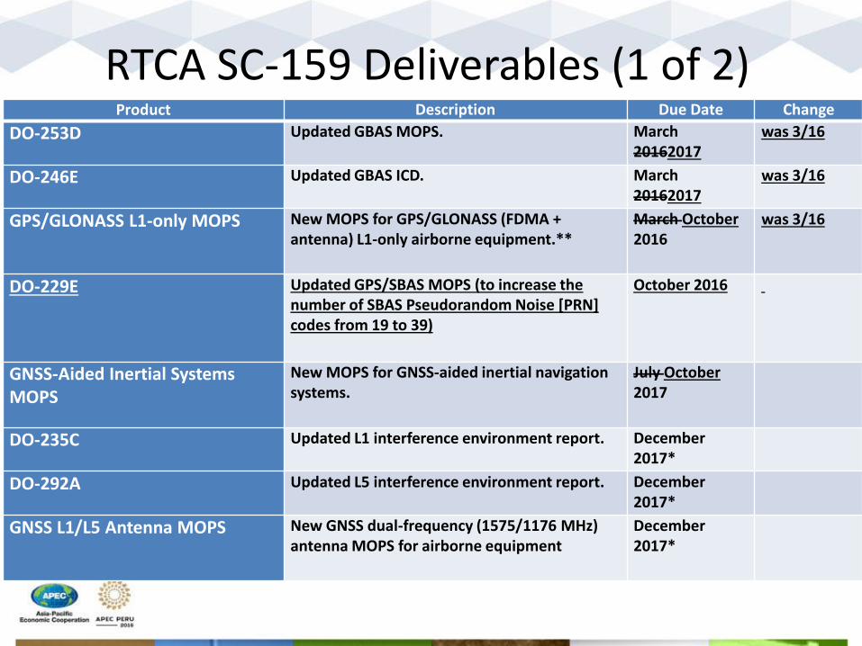
RTCA SC-159 Deliverables (1 of 2) Product Description Due Date Change
DO-253D Updated GBAS MOPS. March 20162017
was 3/16
DO-246E Updated GBAS ICD. March 20162017
was 3/16
GPS/GLONASS L1-only MOPS New MOPS for GPS/GLONASS (FDMA + antenna) L1-only airborne equipment.**
March October 2016
was 3/16
DO-229E Updated GPS/SBAS MOPS (to increase the number of SBAS Pseudorandom Noise [PRN] codes from 19 to 39)
October 2016
GNSS-Aided Inertial Systems MOPS
New MOPS for GNSS-aided inertial navigation systems.
July October 2017
DO-235C Updated L1 interference environment report. December 2017*
DO-292A Updated L5 interference environment report. December 2017*
GNSS L1/L5 Antenna MOPS New GNSS dual-frequency (1575/1176 MHz) antenna MOPS for airborne equipment
December 2017*
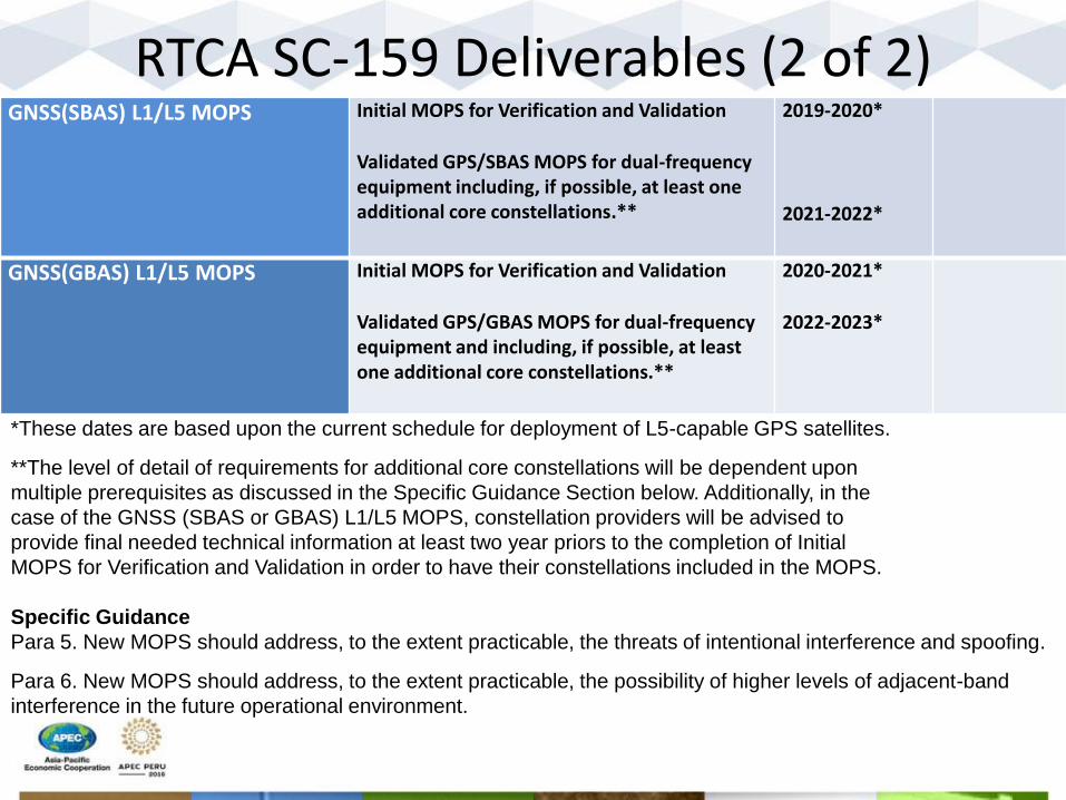
RTCA SC-159 Deliverables (2 of 2) GNSS(SBAS) L1/L5 MOPS Initial MOPS for Verification and Validation
Validated GPS/SBAS MOPS for dual-frequency equipment including, if possible, at least one additional core constellations.**
2019-2020*
2021-2022*
GNSS(GBAS) L1/L5 MOPS Initial MOPS for Verification and Validation
Validated GPS/GBAS MOPS for dual-frequency equipment and including, if possible, at least one additional core constellations.**
2020-2021*
2022-2023*
*These dates are based upon the current schedule for deployment of L5-capable GPS satellites.
**The level of detail of requirements for additional core constellations will be dependent upon
multiple prerequisites as discussed in the Specific Guidance Section below. Additionally, in the
case of the GNSS (SBAS or GBAS) L1/L5 MOPS, constellation providers will be advised to
provide final needed technical information at least two year priors to the completion of Initial
MOPS for Verification and Validation in order to have their constellations included in the MOPS.
Specific Guidance
Para 5. New MOPS should address, to the extent practicable, the threats of intentional interference and spoofing.
Para 6. New MOPS should address, to the extent practicable, the possibility of higher levels of adjacent-band
interference in the future operational environment.

Thank You!
36
Contact Information: National Coordination Office for Space-Based PNT
1401 Constitution Ave, NW – Room 2518 Washington, DC 20230 Phone: (202) 482-5809
www.gps.gov
Official public resource for U.S. Government Information about GPS and related topics
36