united nations cartographic section ungi working group and united nations geographic database...
Post on 19-Dec-2015
216 views
TRANSCRIPT

United Nations Cartographic SectionUnited Nations Cartographic Section
UNGI WORKING GROUPUNGI WORKING GROUP
ANDAND
UNITED NATIONS UNITED NATIONS
GEOGRAPHIC DATABASEGEOGRAPHIC DATABASEPresentedPresented
to the 8to the 8thth PCGIAP PCGIAP
Brunei Darussalam, 16 - 19 April 2002Brunei Darussalam, 16 - 19 April 2002
ByBy
Vladimir BessarabovVladimir Bessarabov
[email protected]@un.org

United Nations Cartographic SectionUnited Nations Cartographic Section
Address of UN Secretary-GeneralAddress of UN Secretary-Generalat AAG conference in March 2001at AAG conference in March 2001
““......last year we at the United Nations established a last year we at the United Nations established a Geographic Information Working GroupGeographic Information Working Group to improve the to improve the way in which the many entities in our far-flung system way in which the many entities in our far-flung system use cartographic and geographic information. One of the use cartographic and geographic information. One of the Group’s main goals is to establish a common Group’s main goals is to establish a common UN UN Geographic DatabaseGeographic Database. It will be working with national . It will be working with national mapping agencies, non-governmental organizations, mapping agencies, non-governmental organizations, industry groups and research institutions.”industry groups and research institutions.”
“…“…I encourage you to contact us and get involved, if you I encourage you to contact us and get involved, if you have not done so already.”have not done so already.”
United Nations Cartographic SectionUnited Nations Cartographic Section
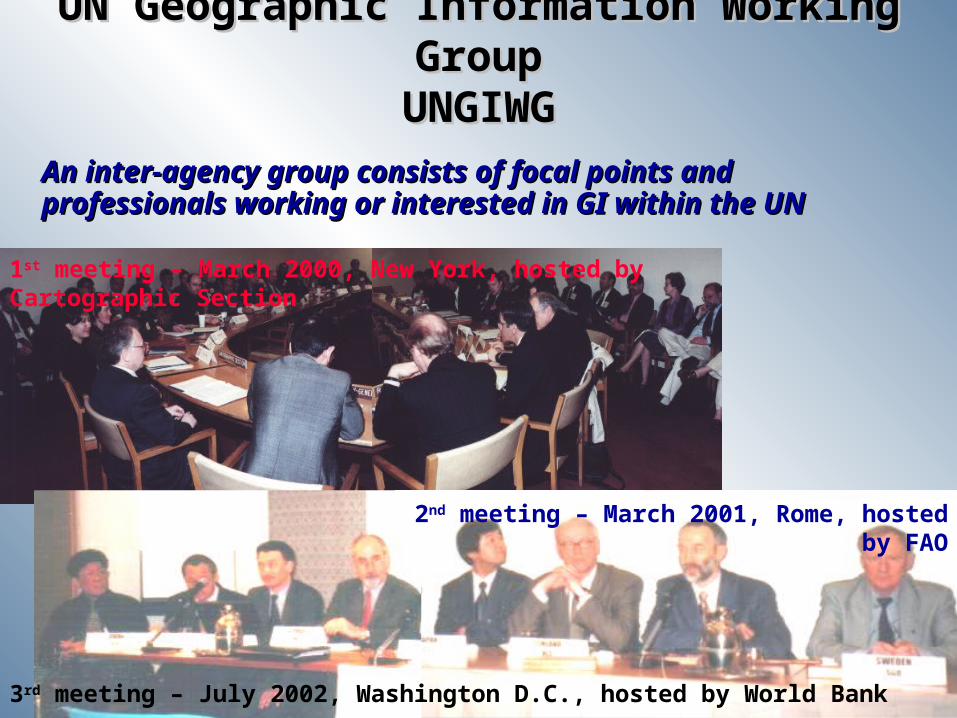
1st meeting – March 2000, New York, hosted by Cartographic Section
UN Geographic Information Working GroupUN Geographic Information Working GroupUNGIWGUNGIWG
An inter-agency group consists of focal points and An inter-agency group consists of focal points and professionals working or interested in GI within the UNprofessionals working or interested in GI within the UN
2nd meeting – March 2001, Rome, hosted by FAO
3rd meeting – July 2002, Washington D.C., hosted by World Bank

United Nations Cartographic SectionUnited Nations Cartographic Section
UNGIWG ObjectivesUNGIWG Objectives
To promote the use of geographic information within the To promote the use of geographic information within the United Nations system and Member States for United Nations system and Member States for better better decision-makingdecision-making
To identify and implement protocols for To identify and implement protocols for sharing, sharing, maintaining and assuring the qualitymaintaining and assuring the quality of geographic of geographic information within the United Nations system for efficient information within the United Nations system for efficient and cost effective use of such information with close and cost effective use of such information with close co-co-operationoperation with Member States, non-governmental with Member States, non-governmental organizations, research institutions and industryorganizations, research institutions and industry
To develop and maintain a To develop and maintain a common geographic databasecommon geographic database as as a crucial capacity-building effort to enhance normative, a crucial capacity-building effort to enhance normative, programme and operational capabilities and efficiencies programme and operational capabilities and efficiencies within the United Nations systemwithin the United Nations system

United Nations Cartographic SectionUnited Nations Cartographic Section
UNGIWG Task GroupsUNGIWG Task Groups
Metadata and clearinghousesMetadata and clearinghouses
Framework data – international boundaries Framework data – international boundaries (land and maritime) and coastlines(land and maritime) and coastlines
Framework data – administrative boundariesFramework data – administrative boundaries
Remote sensing and satellite imageryRemote sensing and satellite imagery
Field operationsField operations
Cartographic guidelinesCartographic guidelines
TrainingTraining
And a UN GI Strategic PlanAnd a UN GI Strategic Plan
United Nations Cartographic SectionUnited Nations Cartographic Section
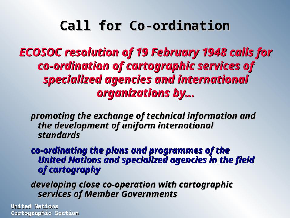
Call for Co-ordinationCall for Co-ordination
ECOSOC resolution of 19 February 1948 calls for ECOSOC resolution of 19 February 1948 calls for co-ordination of cartographic services of co-ordination of cartographic services of
specialized agencies and international specialized agencies and international organizations by…organizations by…
promoting the exchange of technical information and promoting the exchange of technical information and the development of uniform international standardsthe development of uniform international standards
co-ordinating the plans and programmes of the co-ordinating the plans and programmes of the United Nations and specialized agencies in the field United Nations and specialized agencies in the field of cartographyof cartography
developing close co-operation with cartographic developing close co-operation with cartographic services of Member Governmentsservices of Member Governments

United Nations Cartographic SectionUnited Nations Cartographic Section
UN Geographic DatabaseUN Geographic Database
UNViews
UNGeographic
Database
UNEP/FAO
TECHNOLOGIESTECHNOLOGIES
ISO/TC211
Industry
STANDARDSSTANDARDS
UNGIWG
MONITORINGMONITORING
Security Council
USERS andUSERS and
DECISION DECISION MAKERSMAKERS
UN Agencies
InternationalAnd Regional
NGOs
PCGIAP
GSDIISCGMPCIDEA
Industry
Member States
DATA PROVIDERSDATA PROVIDERS
UN Agencies

United Nations Cartographic SectionUnited Nations Cartographic Section
Database RequirementsDatabase Requirements
SHARE not re-create ; Interoperate not SHARE not re-create ; Interoperate not re-designre-design
Multi-scale ; SeamlessMulti-scale ; Seamless
Distributed network with participating Distributed network with participating agencies as the custodians of their agencies as the custodians of their respective data layersrespective data layers
Must be shared freely within the UN SystemMust be shared freely within the UN System
Must be MAINTAINABLEMust be MAINTAINABLE

United Nations Cartographic SectionUnited Nations Cartographic Section
Creating a UN Geographic DatabaseCreating a UN Geographic Database(Phase I)(Phase I)
Duration: 19 monthsDuration: 19 months
Implementing Partners:Implementing Partners:
Cartographic Section, Department of Public InformationCartographic Section, Department of Public Information
Department of Political AffairsDepartment of Political Affairs
Department of Peace-keeping OperationsDepartment of Peace-keeping Operations
Office for the Coordination of Humanitarian AffairsOffice for the Coordination of Humanitarian Affairs
UNGIWG serves as an advisory body and provide project UNGIWG serves as an advisory body and provide project monitoring and technical supportmonitoring and technical support

United Nations Cartographic SectionUnited Nations Cartographic Section
Programme ActivitiesProgramme Activities
Strategic PlanStrategic Plan
Needs assessmentNeeds assessment
Data models and ISO compliant standardsData models and ISO compliant standardsSystem architectureSystem architectureData policyData policyCollaborative arrangementCollaborative arrangementProject sustainability including capital investment planProject sustainability including capital investment plan
Metadata and ClearinghouseMetadata and ClearinghouseClearinghouse architecture and metadata conventionsClearinghouse architecture and metadata conventions
UN geographic data clearinghouseUN geographic data clearinghouse

United Nations Cartographic SectionUnited Nations Cartographic Section
Programme Activities (cont.)Programme Activities (cont.)
Quick Impact Data DevelopmentQuick Impact Data DevelopmentData format and coding schemeData format and coding scheme
Framework data setsFramework data setsCountry profile databaseCountry profile databaseAssemble available global data setsAssemble available global data sets
Application PilotApplication Pilot
Information disseminationInformation dissemination

United Nations Cartographic SectionUnited Nations Cartographic Section
Peacekeeper
RebelMission & Force HQ
GPS Satellite
Peacekeeping Missions
GISGIS
Security Council
Security Council
FALDFALD
MPSMPS
MilAdMilAdUN Geo
Database
Cartographic Section
Mission & Sector HQsPeacekeepers locations
RebelsGOSL Army, Refugees
LOC: roads, air/sea portsHydrographic features
Mine field & Land usageTopographic features . . . You will get a map . . . You will get a map
in a near real-time basis.in a near real-time basis.
Life Saving Technology !!!Life Saving Technology !!!
DPKODPKO
Logistics Operations/Planning
Special Map Storage
Operational Map StorageCurrent Operations
& Future Planning
Terrain AnalysisBase Map Storage
WFPWFP
UNDPUNDP
UNICEFUNICEF
UNHCRUNHCR
OCHAOCHA
GIS Operational Concept for PeacekeepingGIS Operational Concept for Peacekeeping
Situation Map Storage
Situation Center
United Nations Cartographic SectionUnited Nations Cartographic Section
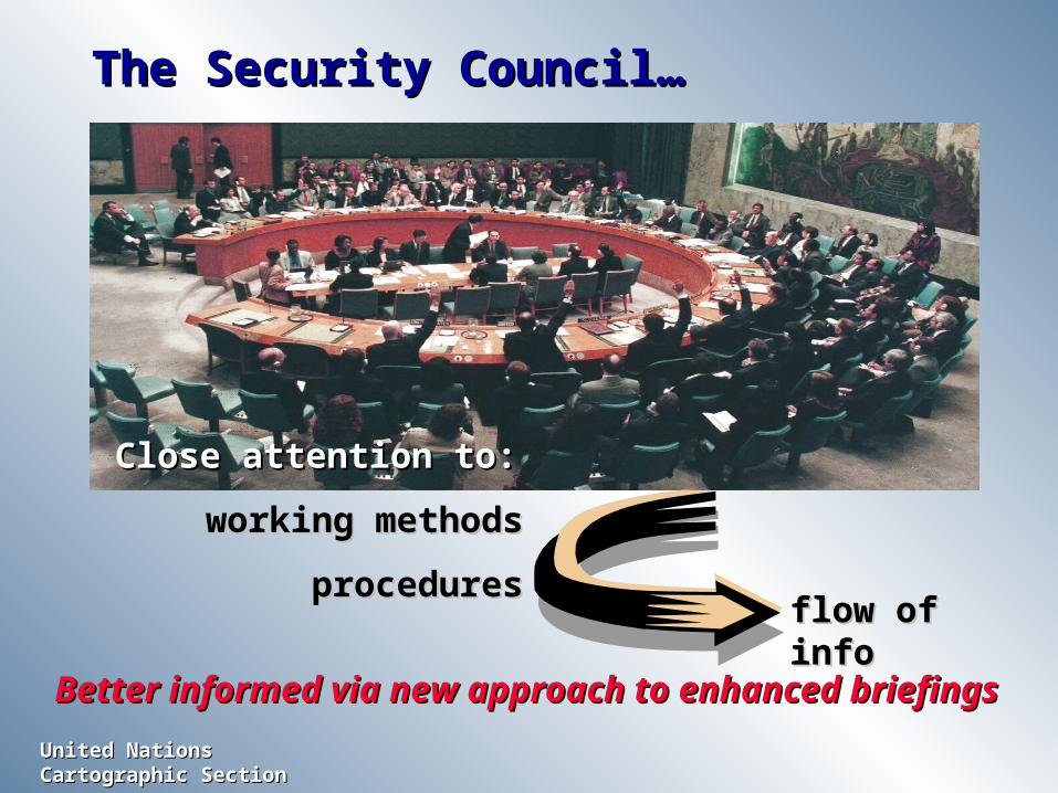
The Security Council…The Security Council…
Close attention to:Close attention to:
working methodsworking methods
proceduresproceduresflow of infoflow of info
Better informed via new approach to enhanced briefingsBetter informed via new approach to enhanced briefings

United Nations Cartographic SectionUnited Nations Cartographic Section
For more informationFor more information
Please visit our web site:Please visit our web site:www.ungiwg.orgwww.ungiwg.org
You can also visit the web site of You can also visit the web site of the UN Cartographic Section:the UN Cartographic Section:
www.un.org/Depts/Cartographic/english/htmain.htm