uas photogrammety with oblique images and … · uas photogrammety with oblique images and fish eye...
TRANSCRIPT
UAS PHOTOGRAMMETY WITH OBLIQUE IMAGES AND FISH EYE CAMERAS: FIRST
EXPERIMENTS AND PRELIMINARY RESULTS
Diana Pagliari, Daniele Passoni, Livio Pinto
Department of Civil and Environmental Engineering
Geodesy and Geomatics Section
Politecnico di Milano
EUROSDR/ISPRS WORKSHOP OBLIQUE 20179 - 10 October 2017 (Barcelona, Spain)
OUTLINE
• Open issues for use of oblique cameras in UAS photogrammetry
• PoliMI test • Block configurations
• Fish-eye camera calibration
• Conclusions
• Future Developments
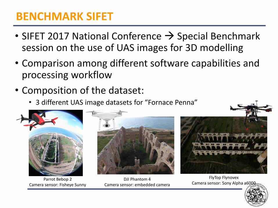
BENCHMARK SIFET
• SIFET 2017 National Conference Special Benchmark session on the use of UAS images for 3D modelling
• Comparison among different software capabilities and processing workflow
• Composition of the dataset:• 3 different UAS image datasets for “Fornace Penna”
Parrot Bebop 2Camera sensor: Fisheye Sunny
DJI Phantom 4Camera sensor: embedded camera
FlyTop FlynovexCamera sensor: Sony Alpha a6000
POLIMI TEST WITH BEBOP 2
• Open issues:• Use of oblique images in commercial close range
photogrammetric software packages
• Influence of the acquisition scheme on the final accuracies (i.e. crossed flight, N-S direction, W-E direction etc.)
• Influence of different GCP configurations
• Management of fish-eye distortions
The results have been evaluated in terms of residuals on the CP and comparing the final 3D model with a reference scanned Point Cloud
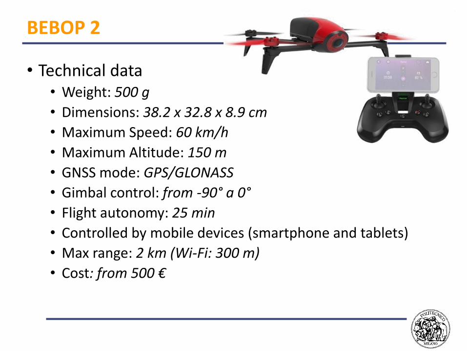
BEBOP 2
• Technical data• Weight: 500 g
• Dimensions: 38.2 x 32.8 x 8.9 cm
• Maximum Speed: 60 km/h
• Maximum Altitude: 150 m
• GNSS mode: GPS/GLONASS
• Gimbal control: from -90° a 0°
• Flight autonomy: 25 min
• Controlled by mobile devices (smartphone and tablets)
• Max range: 2 km (Wi-Fi: 300 m)
• Cost: from 500 €
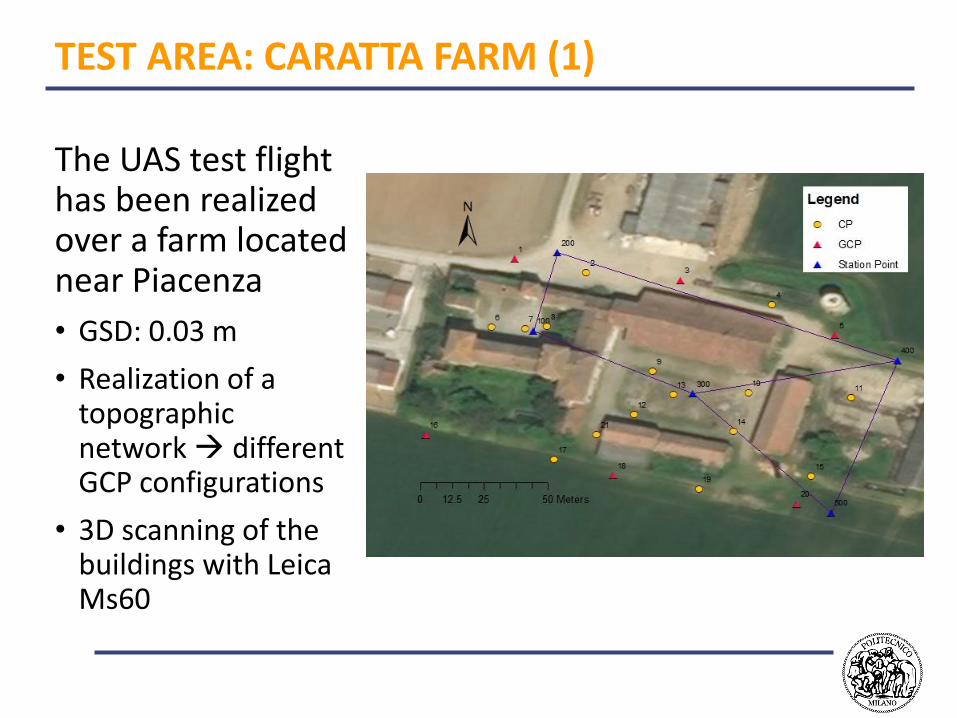
TEST AREA: CARATTA FARM (1)
The UAS test flight has been realized over a farm located near Piacenza
• GSD: 0.03 m
• Realization of a topographic network different GCP configurations
• 3D scanning of the buildings with Leica Ms60
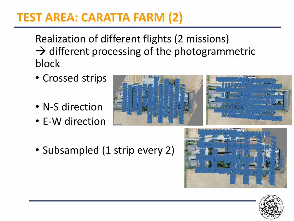
TEST AREA: CARATTA FARM (2)
Realization of different flights (2 missions) different processing of the photogrammetric block
• Crossed strips
• N-S direction
• E-W direction
• Subsampled (1 strip every 2)
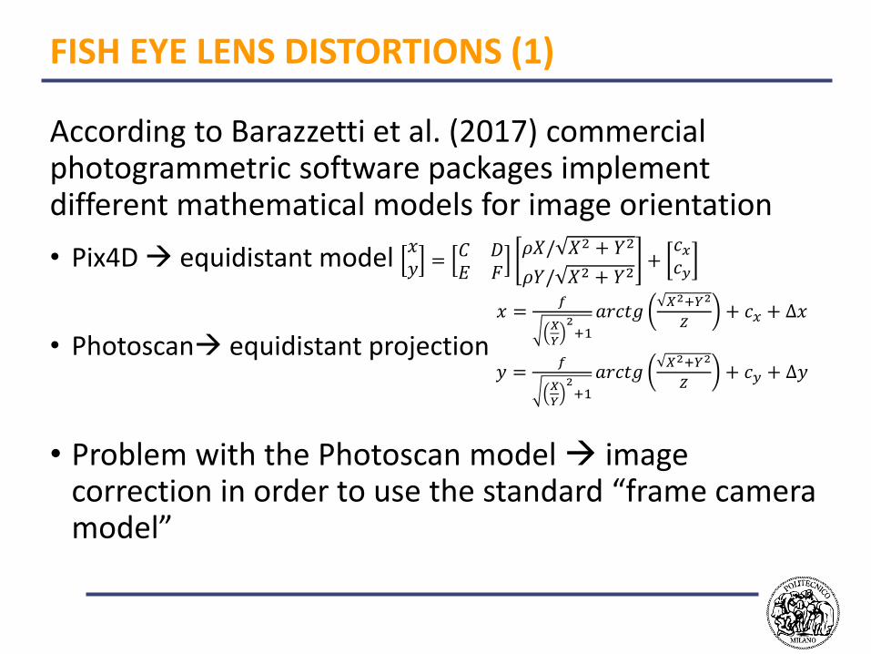
FISH EYE LENS DISTORTIONS (1)
According to Barazzetti et al. (2017) commercial photogrammetric software packages implement different mathematical models for image orientation
• Pix4D equidistant model 𝑥𝑦 =𝐶 𝐷𝐸 𝐹
𝜌𝑋/ 𝑋2 + 𝑌2
𝜌𝑌/ 𝑋2 + 𝑌2+
𝑐𝑥𝑐𝑦
• Photoscan equidistant projection
𝑥 =𝑓
𝑋
𝑌
2+1
𝑎𝑟𝑐𝑡𝑔𝑋2+𝑌2
𝑍+ 𝑐𝑥 + ∆𝑥
𝑦 =𝑓
𝑋
𝑌
2+1
𝑎𝑟𝑐𝑡𝑔𝑋2+𝑌2
𝑍+ 𝑐𝑦 + ∆𝑦
• Problem with the Photoscan model image correction in order to use the standard “frame camera model”
FISH EYE LENS DISTORTIONS (1)
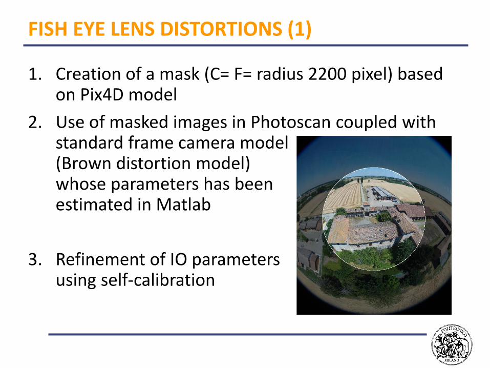
1. Creation of a mask (C= F= radius 2200 pixel) based on Pix4D model
2. Use of masked images in Photoscan coupled with standard frame camera model (Brown distortion model) whose parameters has been estimated in Matlab
3. Refinement of IO parameters using self-calibration
RESULTS – BUNDLE BLOCK ADJUSTMENT
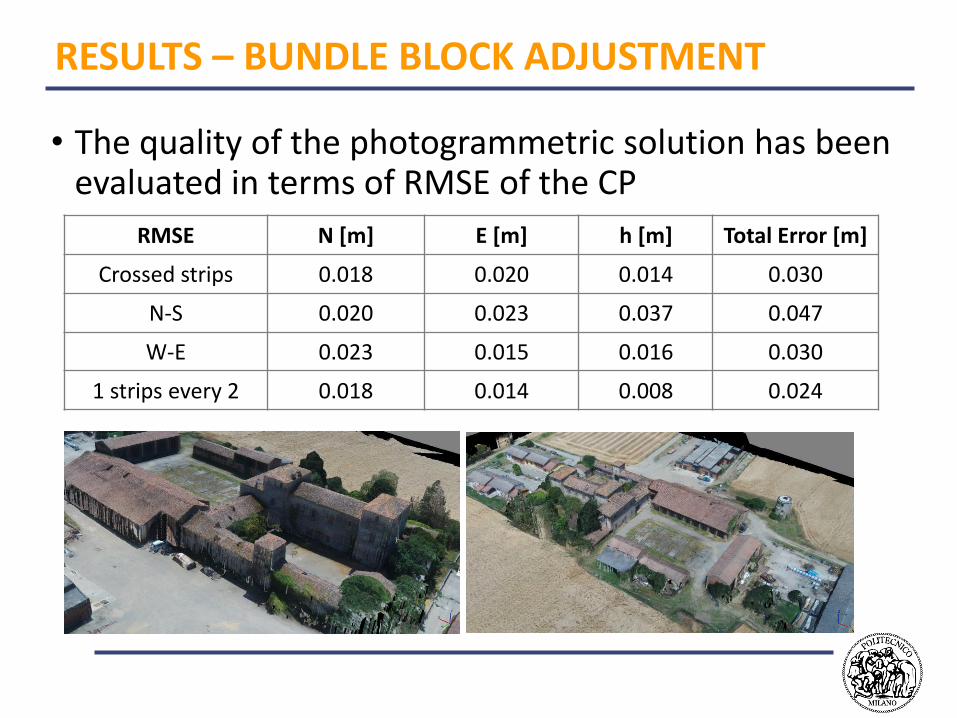
• The quality of the photogrammetric solution has been evaluated in terms of RMSE of the CP
RMSE N [m] E [m] h [m] Total Error [m]
Crossed strips 0.018 0.020 0.014 0.030
N-S 0.020 0.023 0.037 0.047
W-E 0.023 0.015 0.016 0.030
1 strips every 2 0.018 0.014 0.008 0.024
RESULTS: COMPARISON WITH POINT CLOUDS
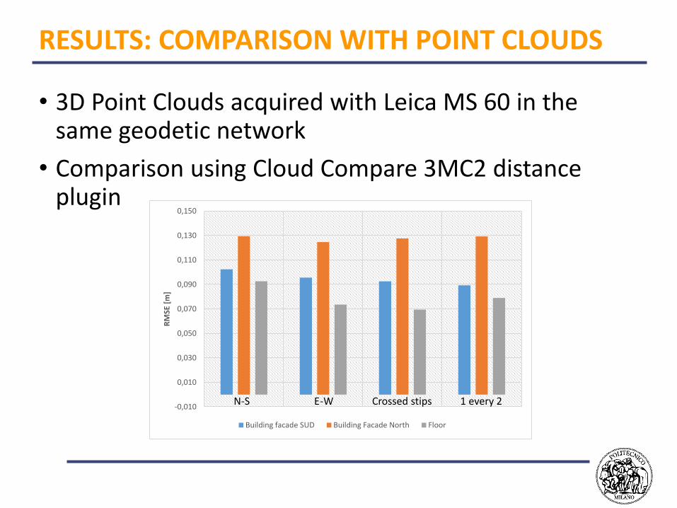
• 3D Point Clouds acquired with Leica MS 60 in the same geodetic network
• Comparison using Cloud Compare 3MC2 distance plugin
-0,010
0,010
0,030
0,050
0,070
0,090
0,110
0,130
0,150
RM
SE [
m]
Building facade SUD Building Facade North Floor
N-S E-W Crossed stips 1 every 2
CONCLUSIONS
• Commercial photogrammetric software can manage oblique images with some adjustments
• Problems with Photoscan embedded fish-eye camera model solved using masked images
• Final accuracy of the photogrammetric model in the order of 1.5 GSD (<0.05 m) for all the considered block configuration
• Differences between the photogrammetric point clouds and the MS 60 laser scanning in the order of 0.15 m
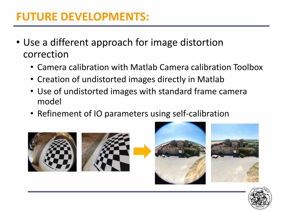
FUTURE DEVELOPMENTS:
• Use a different approach for image distortion correction• Camera calibration with Matlab Camera calibration Toolbox
• Creation of undistorted images directly in Matlab
• Use of undistorted images with standard frame camera model
• Refinement of IO parameters using self-calibration
THANKS FOR YOUR ATTENTION!